Aboriginal Due Diligence Assessment: Hepher Road, Campbelltown DRAFT REPORT Prepared for Geolyse Pty Ltd on behalf of Campbelltown City Council 17 January 2019

Welcome message from author
This document is posted to help you gain knowledge. Please leave a comment to let me know what you think about it! Share it to your friends and learn new things together.
Transcript
Aboriginal Due Diligence Assessment: Hepher Road, Campbelltown DRAFT REPORT
Prepared for Geolyse Pty Ltd on behalf of Campbelltown City Council
17 January 2019
Biosis Pty Ltd
This document is and shall remain the property of Biosis Pty Ltd. The document may only be used for the purposes for which it was commissioned and in accordance with the Terms of the Engagement for the commission. Unauthorised use of this document in any form whatsoever is prohibited.
Disclaimer:
Biosis Pty Ltd has completed this assessment in accordance with the relevant federal, state and local legislation and current industry best practice. The company accepts no liability for any damages or loss incurred as a result of reliance placed upon the report content or for any purpose other than that for which it was intended.
© Biosis 2019 - Leaders in Ecology and Heritage Consulting - www.biosis.com.au i
Biosis offices
NEW SOUTH WALES
Newcastle
Phone: (02) 4911 4040 Email: [email protected]
Sydney
Phone: (02) 9101 8700 Email: [email protected]
Wollongong
Phone: (02) 4201 1090 Email: [email protected]
Albury
Phone: (02) 6069 9200 Email: [email protected]
VICTORIA
Melbourne
Phone: (03) 8686 4800 Email: [email protected]
Ballarat
Phone: (03) 5304 4250 Email: [email protected]
Wangaratta
Phone: (03) 5718 6900 Email: [email protected]
Document information
Report to: Geolyse Pty Ltd on behalf of Campbelltown City Council
Prepared by: Charlotte Allen Taryn Gooley
Biosis project no.: 28930
File name: 28930.Hepher.Rd.ADDA.DFT00.20190117
Citation: Biosis (2019). Aboriginal Due Diligence Assessment: Hepher Road, Campbelltown. Report for Geolyse Pty Ltd on behalf of Campbelltown City Council. Authors: C Allen and T Gooley, Biosis Pty Ltd, Sydney. Project no. 28930
Document control
Version Internal reviewer Date issued
Draft version 01 Amanda Atkinson 17/01/2019
Final version 01 To be confirmed To be confirmed
Acknowledgements
Biosis gratefully acknowledges the contributions of the following people and organisations in preparing this report:
• Geolyse Pty Ltd: David Walker
Biosis staff involved in this project were:
• Amanda Atkinson (project management and quality assurance)
• Ashleigh Keevers-Eastman (archaeological survey)

© Biosis 2019 – Leaders in Ecology and Heritage Consulting II
Contents Glossary ................................................................................................................................................................. iv
Summary ................................................................................................................................................................. v
1 Introduction ................................................................................................................................................. 1
1.1 Project background ......................................................................................................................................... 1 1.2 Location of the study area ............................................................................................................................. 1 1.3 Planning approvals .......................................................................................................................................... 1 1.4 Scope of the assessment ................................................................................................................................ 1
2 Desktop assessment ................................................................................................................................... 5
2.1 Landscape context ........................................................................................................................................... 5 2.2 Geology, soils and landforms ........................................................................................................................ 5 2.3 Landscape resources .................................................................................................................................... 13
3 Aboriginal context .................................................................................................................................... 14
3.1 Ethnohistory and contact history ................................................................................................................ 14 3.2 Regional context ............................................................................................................................................ 15 3.3 Local context ................................................................................................................................................... 17
3.3.1 Identified Aboriginal archaeological sites ...................................................................................... 19 3.4 Predictive statements ................................................................................................................................... 22
4 Archaeological investigation ................................................................................................................... 25
4.1 Archaeological survey aims .......................................................................................................................... 25 4.2 Survey methods ............................................................................................................................................. 25 4.3 Constraints to the survey ............................................................................................................................. 25 4.4 Visibility ............................................................................................................................................................ 26 4.5 Exposure .......................................................................................................................................................... 27 4.6 Disturbances ................................................................................................................................................... 28 4.7 Investigation results ...................................................................................................................................... 33
5 Discussion and recommendations ......................................................................................................... 34
5.1 Discussion and conclusions ......................................................................................................................... 34 5.2 Recommendations ........................................................................................................................................ 36
References ............................................................................................................................................................ 37
Appendix 1 AHIMS search results .......................................................................................................... 40
Tables
Table 1 Blacktown soil landscape characteristics (Bannerman & Hazelton 1990a, pp.28–29) ................... 7 Table 2 AHIMS sites within the study area ....................................................................................................... 20

© Biosis 2019 – Leaders in Ecology and Heritage Consulting III
Table 3 Aboriginal site prediction statements ................................................................................................. 22
Figures
Figure 1 Location of the study area ...................................................................................................................... 3 Figure 2 Study area detail ...................................................................................................................................... 4 Figure 3 Geological units near the study area .................................................................................................... 8 Figure 4 Topography and hydrology .................................................................................................................... 9 Figure 5 Historical aerial imagery 1963 ............................................................................................................. 10 Figure 6 Historical aerial imagery 1979 .............................................................................................................. 11 Figure 7 Soil landscapes near the study area ................................................................................................... 12 Figure 8 AHIMS sites within the vicinity of the study area .............................................................................. 21 Figure 9 Areas of disturbance ............................................................................................................................ 32 Figure 10 Survey results ........................................................................................................................................ 35
Plates
Plate 1 Diagram showing Strahler stream order (Ritter et al 1995, p. 151) .................................................. 6 Plate 2 Study area facing west showing low levels of GSV ............................................................................ 26 Plate 3 Study area facing south west showing blackberry thickets and dumped rubbish pile ................ 27 Plate 4 GSV across the centre of the study area showing small area of moderate GSV ........................... 27 Plate 5 Area of exposure in western portion of the study area ................................................................... 28 Plate 6 Area of exposure in centre of the study area .................................................................................... 28 Plate 6 Modified drainage line facing south east ........................................................................................... 29 Plate 7 Causeway and modififed drainge line facing north .......................................................................... 30 Plate 8 Study area facing south east, note manmade embankemtn in foreground and
background creating an artifical basin in the centre of the study area ......................................... 30 Plate 8 Study area facing south east, note manmade embankment in foreground and
background creating an artifical basin in the centre of the study area ......................................... 31
© Biosis 2019 – Leaders in Ecology and Heritage Consulting iv
Glossary
AHIMS Aboriginal Heritage Information Management System
ACHA Aboriginal cultural heritage assessment
ADDA Aboriginal due diligence assessment
Due diligence code
Due diligence code of practice for the protection of Aboriginal objects in New South Wales
EP&A Act Environmental Planning and Assessment Act 1979
GSV Ground Surface Visibility
ICOMOS International Council on Monuments and Sites
LEP Local Environment Plan
LGA Local Government Area
NPW Act National Parks and Wildlife Act 1974
NSW New South Wales
OEH NSW Office of Environment and Heritage
PAD Potential Archaeological Deposit
Study area southern portion of Lot 104, DP 1056782
The code The Code of practice for archaeological investigation of Aboriginal objects in NSW
© Biosis 2019 – Leaders in Ecology and Heritage Consulting v
Summary
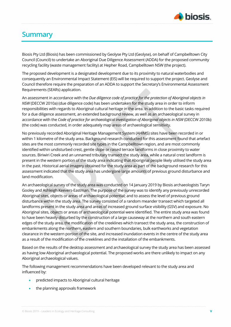
Biosis Pty Ltd (Biosis) has been commissioned by Geolyse Pty Ltd (Geolyse), on behalf of Campbelltown City Council (Council) to undertake an Aboriginal Due Diligence Assessment (ADDA) for the proposed community recycling facility (waste management facility) at Hepher Road, Campbelltown NSW (the project).
The proposed development is a designated development due to its proximity to natural waterbodies and consequently an Environmental Impact Statement (EIS) will be required to support the project. Geolyse and Council therefore require the preparation of an ADDA to support the Secretary’s Environmental Assessment Requirements (SEARs) application.
An assessment in accordance with the Due diligence code of practice for the protection of Aboriginal objects in NSW (DECCW 2010a) (due diligence code) has been undertaken for the study area in order to inform responsibilities with regards to Aboriginal cultural heritage in the area. In addition to the basic tasks required for a due diligence assessment, an extended background review, as well as an archaeological survey in accordance with the Code of practice for archaeological investigation of Aboriginal objects in NSW (DECCW 2010b) (the code) was conducted, in order adequately map areas of archaeological sensitivity.
No previously recorded Aboriginal Heritage Management System (AHIMS) sites have been recorded in or within 1 kilometre of the study area. Background research conducted for this assessment found that artefact sites are the most commonly recorded site types in the Campbelltown region, and are most commonly identified within undisturbed crest, gentle slope or raised terrace landforms in close proximity to water sources. Biriwiri Creek and an unnamed tributary transect the study area, while a natural crest landform is present in the western portion of the study area indicating that Aboriginal people likely utilised the study area in the past. Historical aerial imagery obtained for the study area as part of the background research for this assessment indicated that the study area has undergone large amounts of previous ground disturbance and land modification.
An archaeological survey of the study area was conducted on 14 January 2019 by Biosis archaeologists Taryn Gooley and Ashleigh Keevers-Eastman. The purpose of the survey was to identify any previously unrecorded Aboriginal sites, objects or areas of archaeological potential; and to assess the level of previous ground disturbance within the study area. The survey consisted of a random meander transect which targeted all landforms present in the study area and areas of increased ground surface visibility (GSV) and exposure. No Aboriginal sites, objects or areas of archaeological potential were identified. The entire study area was found to have been heavily disturbed by the construction of a large causeway at the northern and south eastern edges of the study area, the modification of the creeklines which transect the study area, the construction of embankments along the northern, eastern and southern boundaries, bulk earthworks and vegetation clearance in the western portion of the site, and increased inundation events in the centre of the study area as a result of the modification of the creeklines and the installation of the embankments.
Based on the results of the desktop assessment and archaeological survey the study area has been assessed as having low Aboriginal archaeological potential. The proposed works are there unlikely to impact on any Aboriginal archaeological values.
The following management recommendations have been developed relevant to the study area and influenced by:
• predicted impacts to Aboriginal cultural heritage
• the planning approvals framework

© Biosis 2019 – Leaders in Ecology and Heritage Consulting vi
• current best conservation practise, widely considered to include:
– ethos of the Australia ICOMOS Burra Charter (2013)
– the code.
Prior to any impacts occurring within the study area, the following is recommended:
Recommendation 1: No further archaeological assessment is required
No further archaeological work is required in the study area due to the entire study area assessed as having low archaeological potential.
Recommendation 2: Discovery of Unanticipated Aboriginal Objects or Aboriginal Ancestral Remains
All Aboriginal objects and Places are protected under the National Parks and Wildlife Act 1974 (NPW Act). It is an offence to knowingly disturb an Aboriginal site without a consent permit issued by the Office of Environment and Heritage (OEH). Should any Aboriginal objects be encountered during works associated with this proposal, works must cease in the vicinity and the find should not be moved until assessed by a qualified archaeologist. If the find is determined to be an Aboriginal object the archaeologist will provide further recommendations. These may include notifying the OEH and Aboriginal stakeholders.
Aboriginal ancestral remains may be found in a variety of landscapes in NSW, including middens and sandy or soft sedimentary soils. If any suspected human remains are discovered during any activity you must:
1. Immediately cease all work at that location and not further move or disturb the remains.
2. Notify the NSW Police and OEH’s Environmental Line on 131 555 as soon as practicable and provide details of the remains and their location.
3. Not recommence work at that location unless authorised in writing by OEH.
© Biosis 2019 – Leaders in Ecology and Heritage Consulting 1
1 Introduction
1.1 Project background
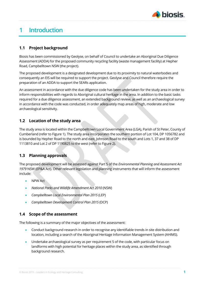
Biosis has been commissioned by Geolyse, on behalf of Council to undertake an Aboriginal Due Diligence Assessment (ADDA) for the proposed community recycling facility (waste management facility) at Hepher Road, Campbelltown NSW (the project).
The proposed development is a designated development due to its proximity to natural waterbodies and consequently an EIS will be required to support the project. Geolyse and Council therefore require the preparation of an ADDA to support the SEARs application.
An assessment in accordance with the due diligence code has been undertaken for the study area in order to inform responsibilities with regards to Aboriginal cultural heritage in the area. In addition to the basic tasks required for a due diligence assessment, an extended background review, as well as an archaeological survey in accordance with the code was conducted, in order adequately map areas of high, moderate and low archaeological sensitivity.
1.2 Location of the study area
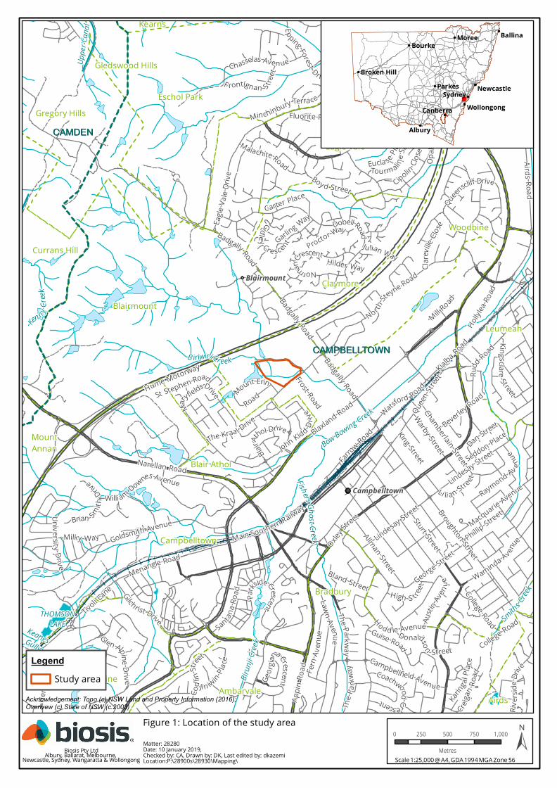
The study area is located within the Campbelltown Local Government Area (LGA), Parish of St Peter, County of Cumberland (refer to Figure 1). The study area incorporates the southern portion of Lot 104, DP 1056782 and is bounded by Hepher Road to the north and east, Johnson Road to the south and Lots 1, 37 and 38 of DP 1113810 and Lot 2 of DP 1190825 to the west (refer to Figure 2).
1.3 Planning approvals
The proposed development will be assessed against Part 5 of the Environmental Planning and Assessment Act 1979 NSW (EP&A Act). Other relevant legislation and planning instruments that will inform the assessment include:
• NPW Act
• National Parks and Wildlife Amendment Act 2010 (NSW)
• Campbelltown Local Environmental Plan 2015 (LEP)
• Campbelltown Development Control Plan 2015 (DCP)
1.4 Scope of the assessment
The following is a summary of the major objectives of the assessment:
• Conduct background research in order to recognise any identifiable trends in site distribution and location, including a search of the Aboriginal Heritage Information Management System (AHIMS).
• Undertake archaeological survey as per requirement 5 of the code, with particular focus on landforms with high potential for heritage places within the study area, as identified through background research.

© Biosis 2019 – Leaders in Ecology and Heritage Consulting 2
• Record and assess sites identified during the survey in compliance with the guidelines endorsed by the OEH.
• Determine levels of archaeological and cultural significance of the study area.
• Make recommendations to mitigate and manage any cultural heritage values identified within the study area.
!(
!(
Currans Hill
Blairmount
Claymore
Glen Alpine
Leumeah
Minto
MountAnnan
Airds
Bradbury
Eagle Vale
Woodbine
Blair Athol
Ambarvale
Campbelltown
Eschol Park
Kearns
St Andrews
Gregory Hills
Gledswood Hills
CAMPBELLTOWNCAMPBELLTOWN
CAMDENCAMDEN
Codl
inStre
et
Austin
Aven ue
NormanCrescent
Rivers
ideDri
ve
Broughton Street
Macquarie AvenueLindesay Street
Gidley Crescent
Airds Road
Badgally Road
The Kraal Drive
College Road
Hilder Way
Kialba Road
College Road
Brian SmithDrive
CoachwoodCrescent
Gilchrist Drive
High S treet
Blaxland Road
Waminda Av enu
e
Minchinbury Terrace
KingsclareStreet
Garling Way
Geor
gianaCrescent
Boy d Street
Traminer Place
Guise Road
Opal
Place
Proctor Way
Queenscliff Drive
Eucla se Place
Karinga
l Plac
e
F rontignan Street
Milky Way
Santana R
oad
Chasselas Avenue
Creigan
Road
MalachiteRoad Tourm aline S
tree
t
Cipolin
Close
CornelianA venue
Ji n iwin Place
Seddon Place
Granite Place
Beverley Road
Dan Street
Donaldson Street
Ju lian Way
Fluorite Place
Tivoli Lane
Carter Place
Raymond Av enue
C larev
illeClo
se
Li li an Stre et
Fern
Aven
ue
Lockheed St r eet
Bland Street
St Stephen Road
Mill Road
Phillip Street
King Street
Allman Street
Sturt Street
Frost Road
Hollylea
Road
Warby Street
Gould Road
Far
row Road
Mount Erin
Road
MaryfieldsDrive
Dobell Road
Epping Forest Drive
George Street
Willi am Downes Avenue
Emera ld D rive
Badgally Road
Goldsmith Avenue
Univ er si ty Drive
Glen Alpine Driv e
Chamberlain Street
Campbellfield Avenue
Lindesay Street
John Kidd Drive
The P
arkw
ay
The Parkway
Raby Road
Menangle Road
ParksideCrescent
Camp
bell to
wnRo
ad
Lawn Avenue
Rudd
Road
Eagle
Vale
Drive
BlairA
thol DriveQuee
n Street
Herita
geWay
NorthSteyne Road
Hodd le Avenue
Badgally Road
Watsford Road
Oxley Stre
et
Narellan Road
Appin
Road
Hume Motorway
Main Southern Railway
B iriwiri Creek
KeanesGully
Fishers GhostCreek
Thompson Creek
Bow Bowing Creek
Ken n y Cree
k
BowB
owing
Creek
Smiths Creek
Birun
ji Cree
k
Uppe
r Can
al
THOMSONLAKE
Blairmount
Campbelltown
MoreeBourke
Parkes
CanberraSydney
Wollongong
Albury
Ballina
Broken HillNewcastle
Acknowledgement: Topo (c) NSW Land and Property Information (2016); Overivew (c) State of NSW (c.2003)
Matter: 28280Date: 10 January 2019,Checked by: CA, Drawn by: DK, Last edited by: dkazemiLocation:P:\28900s\28930\Mapping\
LegendStudy area
Scale 1:25,000 @ A4, GDA 1994 MGA Zone 56
0 250 500 750 1,000
Metres ±Biosis Pty LtdAlbury, Ballarat, Melbourne, Newcastle, Sydney, Wangaratta & Wollongong
Figure 1: Location of the study area

78m
78m
72m
62m
76m
76m
72m
76m
76m
76m
80m
74m
76m
9 4 m
60m
90m
74m
70m
86m
76m
92m
80m
72m
78m
80m
76m
90m
74m
88m
62m
84m
72m
80m
74m76m
82m
72m
64m
66m
70m
70m 68m
Hume Motorway
Johnson Road
Badgally Road
Mount Erin Road
Mount Erin Road
Frost RoadHepher Road
Biriwiri Creek
0 20 40 60 80 100
Metres
LegendStudy area
±Matter: 28930, Date: 10 January 2019, Checked by: CA, Drawn by: DK, Last edited by: amurrayLocation:\\bio-data-01\matters$\28900s\28930\Mapping\28930_F2_ProjectArea.mxd
Biosis Pty LtdAlbury, Ballarat, Melbourne,
Sydney, Newcastle, Wangaratta & Wollongong
CAMDENCAMDEN
CAMPBELLTOWNCAMPBELLTOWN
Scale: 1:2,000 @ A3
Figure 2: Study area detail
Coordinate System: GDA 1994 MGA Zone 56
Acknowledgements: Basemap © Land and Property Information 2016
© Biosis 2019 – Leaders in Ecology and Heritage Consulting 5
2 Desktop assessment
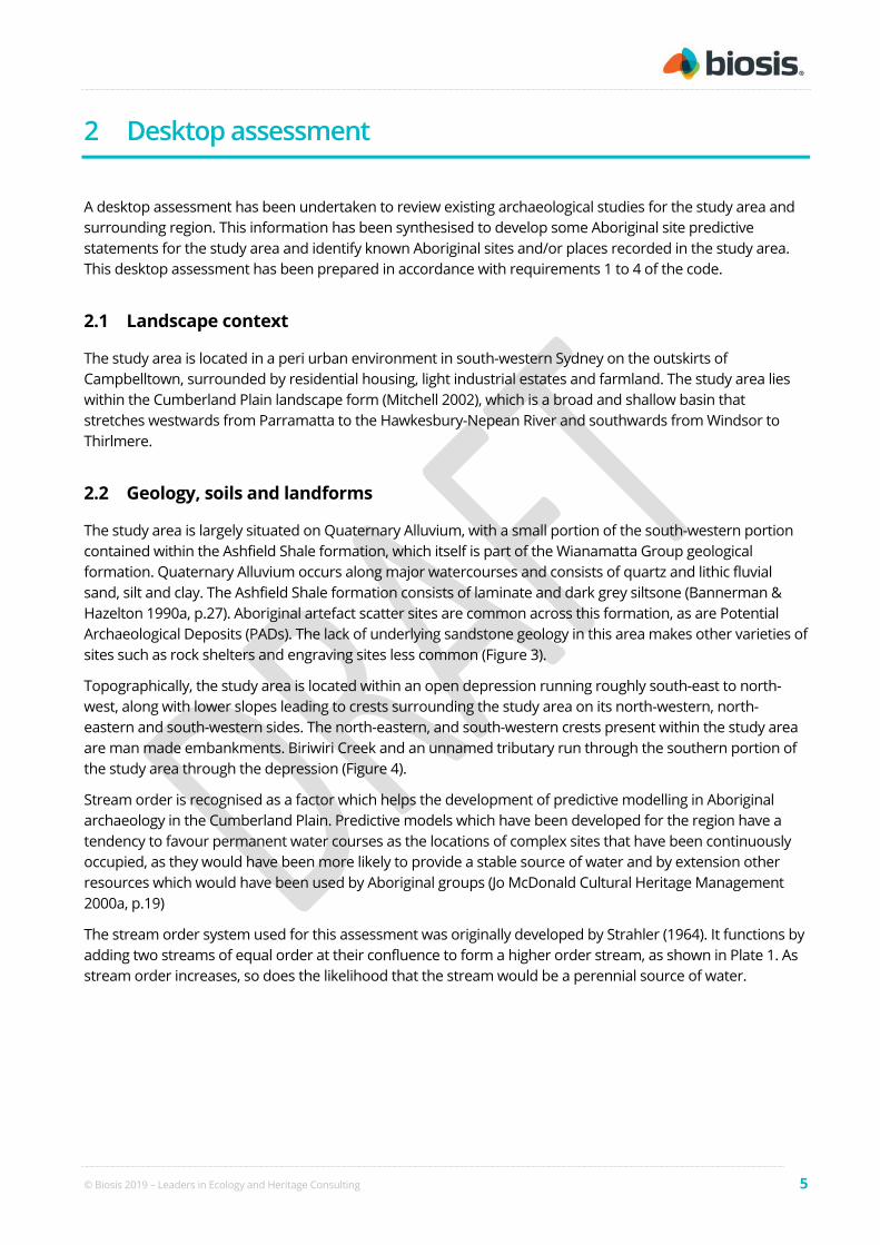
A desktop assessment has been undertaken to review existing archaeological studies for the study area and surrounding region. This information has been synthesised to develop some Aboriginal site predictive statements for the study area and identify known Aboriginal sites and/or places recorded in the study area. This desktop assessment has been prepared in accordance with requirements 1 to 4 of the code.
2.1 Landscape context
The study area is located in a peri urban environment in south-western Sydney on the outskirts of Campbelltown, surrounded by residential housing, light industrial estates and farmland. The study area lies within the Cumberland Plain landscape form (Mitchell 2002), which is a broad and shallow basin that stretches westwards from Parramatta to the Hawkesbury-Nepean River and southwards from Windsor to Thirlmere.
2.2 Geology, soils and landforms
The study area is largely situated on Quaternary Alluvium, with a small portion of the south-western portion contained within the Ashfield Shale formation, which itself is part of the Wianamatta Group geological formation. Quaternary Alluvium occurs along major watercourses and consists of quartz and lithic fluvial sand, silt and clay. The Ashfield Shale formation consists of laminate and dark grey siltsone (Bannerman & Hazelton 1990a, p.27). Aboriginal artefact scatter sites are common across this formation, as are Potential Archaeological Deposits (PADs). The lack of underlying sandstone geology in this area makes other varieties of sites such as rock shelters and engraving sites less common (Figure 3).
Topographically, the study area is located within an open depression running roughly south-east to north-west, along with lower slopes leading to crests surrounding the study area on its north-western, north-eastern and south-western sides. The north-eastern, and south-western crests present within the study area are man made embankments. Biriwiri Creek and an unnamed tributary run through the southern portion of the study area through the depression (Figure 4).
Stream order is recognised as a factor which helps the development of predictive modelling in Aboriginal archaeology in the Cumberland Plain. Predictive models which have been developed for the region have a tendency to favour permanent water courses as the locations of complex sites that have been continuously occupied, as they would have been more likely to provide a stable source of water and by extension other resources which would have been used by Aboriginal groups (Jo McDonald Cultural Heritage Management 2000a, p.19)
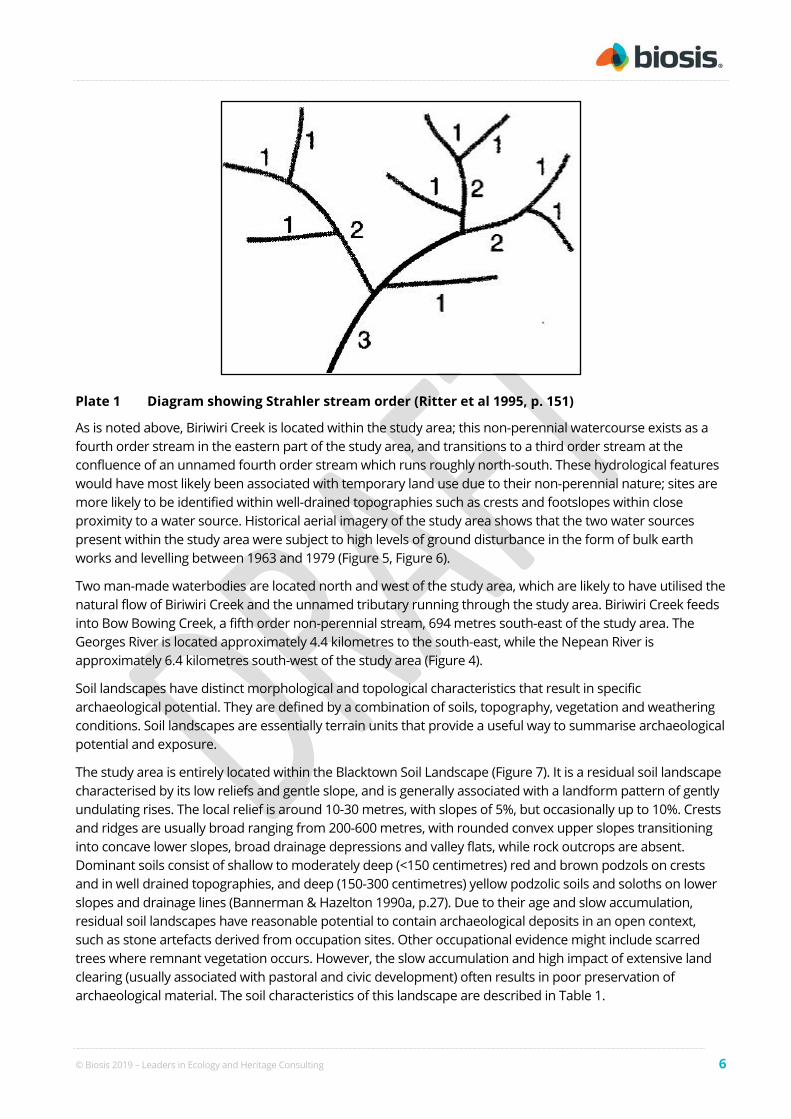
The stream order system used for this assessment was originally developed by Strahler (1964). It functions by adding two streams of equal order at their confluence to form a higher order stream, as shown in Plate 1. As stream order increases, so does the likelihood that the stream would be a perennial source of water.
© Biosis 2019 – Leaders in Ecology and Heritage Consulting 6
Plate 1 Diagram showing Strahler stream order (Ritter et al 1995, p. 151)
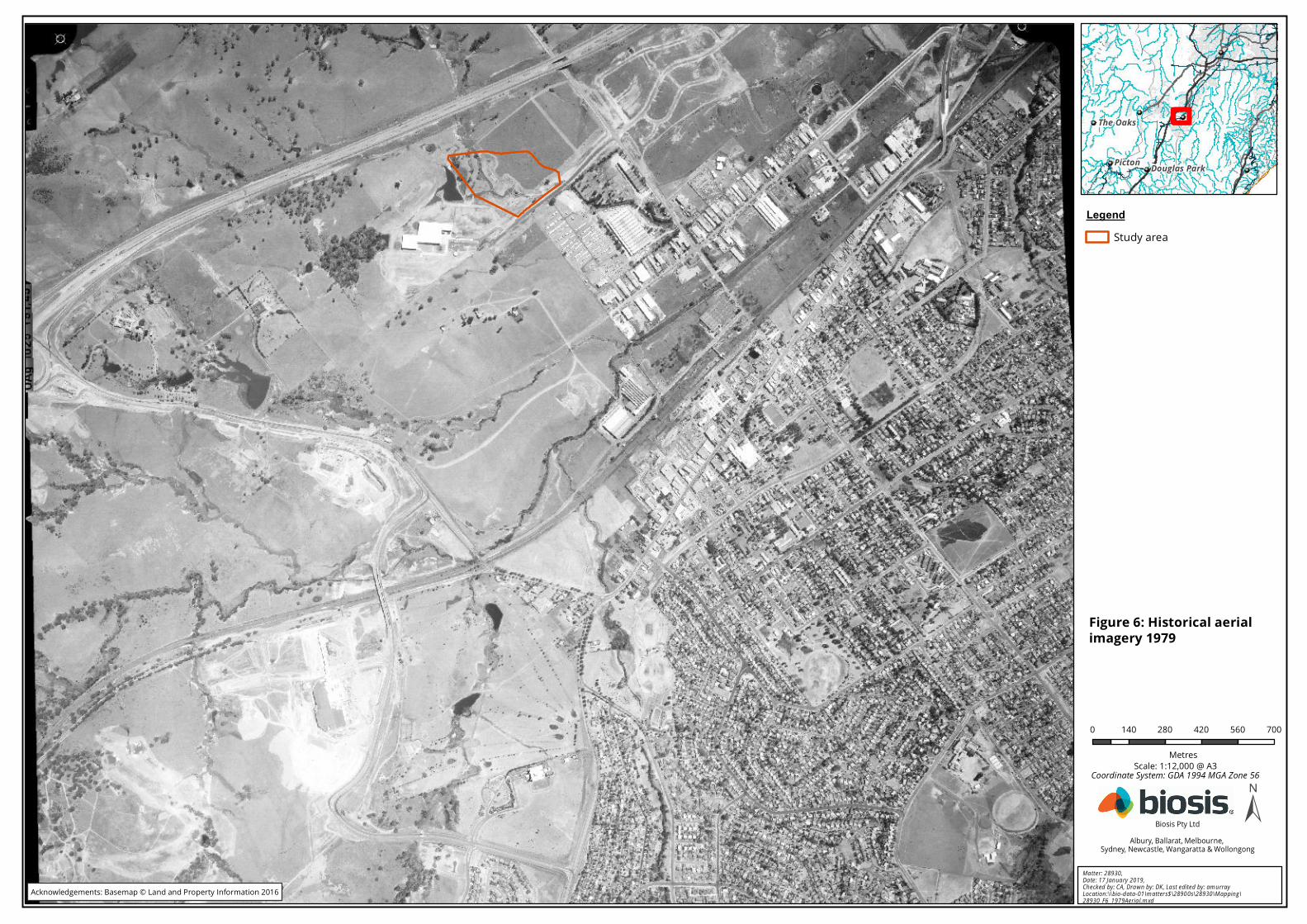
As is noted above, Biriwiri Creek is located within the study area; this non-perennial watercourse exists as a fourth order stream in the eastern part of the study area, and transitions to a third order stream at the confluence of an unnamed fourth order stream which runs roughly north-south. These hydrological features would have most likely been associated with temporary land use due to their non-perennial nature; sites are more likely to be identified within well-drained topographies such as crests and footslopes within close proximity to a water source. Historical aerial imagery of the study area shows that the two water sources present within the study area were subject to high levels of ground disturbance in the form of bulk earth works and levelling between 1963 and 1979 (Figure 5, Figure 6).
Two man-made waterbodies are located north and west of the study area, which are likely to have utilised the natural flow of Biriwiri Creek and the unnamed tributary running through the study area. Biriwiri Creek feeds into Bow Bowing Creek, a fifth order non-perennial stream, 694 metres south-east of the study area. The Georges River is located approximately 4.4 kilometres to the south-east, while the Nepean River is approximately 6.4 kilometres south-west of the study area (Figure 4).
Soil landscapes have distinct morphological and topological characteristics that result in specific archaeological potential. They are defined by a combination of soils, topography, vegetation and weathering conditions. Soil landscapes are essentially terrain units that provide a useful way to summarise archaeological potential and exposure.
The study area is entirely located within the Blacktown Soil Landscape (Figure 7). It is a residual soil landscape characterised by its low reliefs and gentle slope, and is generally associated with a landform pattern of gently undulating rises. The local relief is around 10-30 metres, with slopes of 5%, but occasionally up to 10%. Crests and ridges are usually broad ranging from 200-600 metres, with rounded convex upper slopes transitioning into concave lower slopes, broad drainage depressions and valley flats, while rock outcrops are absent. Dominant soils consist of shallow to moderately deep (<150 centimetres) red and brown podzols on crests and in well drained topographies, and deep (150-300 centimetres) yellow podzolic soils and soloths on lower slopes and drainage lines (Bannerman & Hazelton 1990a, p.27). Due to their age and slow accumulation, residual soil landscapes have reasonable potential to contain archaeological deposits in an open context, such as stone artefacts derived from occupation sites. Other occupational evidence might include scarred trees where remnant vegetation occurs. However, the slow accumulation and high impact of extensive land clearing (usually associated with pastoral and civic development) often results in poor preservation of archaeological material. The soil characteristics of this landscape are described in Table 1.

© Biosis 2019 – Leaders in Ecology and Heritage Consulting 7
Table 1 Blacktown soil landscape characteristics (Bannerman & Hazelton 1990a, pp.28–29)
Soil material Description
bt1—Friable brownish black loam
This is a friable brownish black loam to clay loam with moderately pedal subangular blocky (2–20 mm) structure and rough-faced porous ped fabric. This material occurs as topsoil (A horizon). Colour is brownish black (10YR 2/2) but can range from dark reddish brown (5YR 3/2) to dark yellowish brown (10YR 3/4). Rounded iron indurated fine gravel-sized shale fragments and charcoal fragments are sometimes present. Roots are common.
bt2—Hardsetting brown clay loam
This is a brown clay loam to silty clay loam which is hardsetting on exposure or when completely dried out. It occurs as an A2 horizon. This material is water repellent when extremely dry. Colour is dark brown (7.5YR 4/3) but can range from dark reddish brown (2.5YR 3/3) to dark brown (10YR 3/3). Platy, iron indurated gravel-sized shale fragments are common. Charcoal fragments and roots are rarely present.
bt3—Strongly pedal, mottled brown light clay
This is a brown light to medium clay with strongly pedal polyhedral or sub-angular to blocky structure and smooth-faced dense ped fabric. This material usually occurs as subsoil (B horizon). Colour is brown (7.5YR 4/6) but may range from reddish brown (2.5YR 4/6) to brown (10YR 4/6). Frequent red, yellow or grey mottles occur often becoming more numerous with depth. Fine to coarse gravel-sized shale fragments are common and often occur in stratified bands. Both roots and charcoal fragments are rare.
bt4—Light grey plastic mottled clay
This is a plastic light grey silty clay to heavy clay with moderately pedal polyhedral to subangular blocky structure and smoothfaced dense ped fabric. This material usually occurs as deep subsoil above shale bedrock (B3 or C horizon). Colour is usually light grey (10YR 7/1) or, less commonly, greyish yellow (2.5YR 6/2). Red, yellow or grey mottles are common. Strongly weathered ironstone concretions and rock fragments are common. Gravel-sized shale fragments and roots are occasionally present. Charcoal fragments are rare.
Crests will contain up to 30 centimetres of friable greyish brown loam (bt1) overlying 10-20 centimetres of hardsetting brown clay loam (bt2), and up to 100 centimetres of strongly pedal brown mottled light clay (bt3), while friable greyish loam (bt1) can be absent. Soil horizons are generally clear, and total soil depth is <150 centimetres. Upper slopes and midslopes feature up to 30 centimetres of bt1 overlying 10-20 centimetres of bt2 and 20-50 centimetres of bt3, under which lies up to 100 centimetres of light grey plastic mottled clay (bt4), with a total soil depth greater than 200 centimetres. As with crests, bt1 may be absent and soil boundaries are usually clear. Lower sideslopes consist of up to 30 centimetres of bt1 overlying 10-30 centimetres of bt2, followed by 40-100 centimetres of bt3, and usually greater than 100 centimetres of bt4 underlying bt3. Total soil depth is greater than 200 centimetres and boundaries between soil materials are clear. Drainage depressions and other areas of poor drainage will contain up to 20 centimetres of a hardsetting loam topsoil (bt1) usually overlying mottled brownish yellow clay subsoil (bt3); these soils can occasionally become waterlogged and are usually saline, at depths of up to 2 metres (Bannerman & Hazelton 1990a, p.29).

Currans Hill
Blairmount
Claymore
Menangle Park
Smeaton Grange
Glen Alpine
Leumeah
Minto
Ruse
Mount Annan
Airds
Bradbury
Eagle Vale
Woodbine
Blair Athol
Ambarvale
Campbelltown
Eschol Park St Andrews
Englorie Park
Gregory Hills
Gledswood Hills
CAMDENCAMDEN
CAMPBELLTOWNCAMPBELLTOWN
Angle Road
Badgally Road
Airds Road
Oxley Street
Narellan Road
Appin Road
Tindall Street
Hume Motorway
Moore Street
Main Southern Railway
TwimTwimTwim
Twia TwiaTuth
Twib_s
TwiaTwib
TwimTwia
TwimTwib
Twim Tuth
TwiaTwia
Twim
TwibTwib_s
TwibTwib
Twib_s
Twib_s
Twia
Tuth
Twia
TwiaTwiaTwim
TwimTwib Twia
TwimTwia
Twim
TwibTwib_s
TwibTwimTwiaTwim
TwibTwim
TwiaTwim
TwibTwib_s
TwibTwib_s
Tuth
Twib
TwibTwib_s
Twim
Twia
Twim
Twim
Twib_s
TwibTwib_s
Twia
Twia
Twia
Twia
Tuth
Twib_s
Twib_s
Twia
Twim
Twim
Twia
Twib
Twia
CZ_a
CZ_a
Q_aTwib
TuthTwib Twib
Twib
Mcbarron Creek
BiriwiriCree k
Fishers GhostCreek
Thompson Creek
Bi runjiC
reek
Keanes Gully
Kenny Creek
Bow Bowing Creek
Annan Creek
Leumeah CreekSmithsCreek
Upper Canal
THOMSONLAKEKEANES GULLY
KENNY CREEK
Campbelltown
Blairmount
0 200 400 600 800 1,000
Metres
LegendStudy areas
Geological unitsAlluviumAshfield ShaleBringelly ShaleBringelly Shale - sandstoneHawkesbury SandstoneMinchinbury Sandstone
±Matter: 28930, Date: 17 January 2019, Checked by: CA, Drawn by: DK, Last edited by: amurrayLocation:\\bio-data-01\matters$\28900s\28930\Mapping\28930_F3_Geology.mxd
Biosis Pty LtdAlbury, Ballarat, Melbourne,
Sydney, Newcastle, Wangaratta & Wollongong
Lithgow
Moss ValeExeter
WarrimooKurrajong
BlackheathLeura
PictonBargo
Bowral
Scale: 1:20,000 @ A3
Figure 3: Geological unitsnear the study area
Coordinate System: GDA 1994 MGA Zone 55
Acknowledgements: Basemap © NSW Land and Property Information 2016Geology ©

Currans Hill
Blairmount
Claymore
Smeaton Grange
Glen Alpine
Leumeah
Minto
Ruse
AirdsBradbury
Eagle Vale
Woodbine
Blair Athol
Ambarvale
Campbelltown
Eschol ParkSt Andrews
Englorie Park
Gregory Hills
Gledswood Hills
10 4m
126 m
56m
88m
114 m
140m
48m
64m
88m
48m
76m
68m
70m
68m
48m
76m
50m
118
m
78m
58m
56m
96m
90m92m
58m
86m
58m
114m
96m
96m
66m
66m
14 0m
96m
94 m
64m
80m
82m
52m
74m
12 2m
58 m
58m
58m
116m
48m
96m
102m
76m
82m
120m
60m
90m
98m
54m
94m
102
m
54m
92m
98m
80m
84m
70m
56m
118 m
58m
88m78m
76m
78m
98m
100m
134m
72m
80m
80m
134m
80m 66m
106
m
82m
96m
138m
8 4m
94 m
60m
92m
110m
94m
56m
60m
110m
134m
120 m
60m
110m
106 m
124m
126m
132m
158m
156m
130m
130m
100m
110 m
92m
88m
1 10m
78m
104m
54m
1 20m
1 2 0m
48m
90m
56m
80m
120m
134m
80m
86m
12
6 m
128m
8 8m
94m
68m
62m
64m
140m
64m
116m
8 8m
72m
44m
1 16 m
68m
56m
54m
98m
120m
132m
10 0 m
124m
12 2 m
98m
100m
74m
74m
1 02m
68 m
116m
108m
98m
88m
76 m
124m
78m
112m
116m
90m
12 2m
142m
126m
72m
110 m 56m
62m
108m
88m
92m
1 18
m
94m
58m
72m
76m
72m
100 m
1 1 2m
96m
116m
98m
60m
108 m
58m
100m
152m
8 2m
130m
82m
104m
124m
122m
98m
78m
76m
160m
116m
86m
130m
94m
1 08m126
m
100m
96m
14
8m
88 m
92m
120m
90m
1 02m
110m
8 2m 66m
52m
106m
134m116m
102m
114m
82m
64m
82m
58m
7 8 m
150m
114m
40m
100m
94m
84m
86m
104
m
44m
88m
100m
112m
88m
114m
120 m
110m
132m
90m
130m
118m
110m
15 6m
112m
132
m
108m
118m
98 m
60m
66m
82m
1 26m
108m
60m
11 8m
7 2m
56m
1
16m
10 0m
98m
80m
62m
64m
130m
116m
11
0m
114m
94m
84 m
114m
42m
116m
9 6m
112m
1
54m
80m
58m
128
m
1 06m
64m
160m
6 2m
6 2m
110m
1 16m
102m
1 24m
96m
11 2m
1 18m
158m
64m
11 2m
156m158m
154m
148
m
120m
11 6m
96 m
152m
15 0m
110m
11 8m
11 2m
98m
134m1 04m
100m
106m
9 6m
106m
64m
86m
110m
66m
12
0m
78m
116m
120m
66m
110 m
116m
58m
68m
98m
94m
60m
110m
148m
146m
66m
110m
144m
1 5 0m
106m
54m
80m
130m
6 0m
126m
1 1 8m
142m
104m
1 00m
90m
11
0m 98m
9 4m
92m
13 8m
116m 114m
14 0m
112m
94m
64m
128m
54m
54m
78m
56m
100m
56m
52m
70m
62m
146m
144m
72m
80m
110m
90m
60m
96m
96m
68m
90m
50m
160m
124m
11 6m114m
122m
12 2m
46m
124m
86m
138m
80m
88m
96m
84m
84m
88m
182m
4 6 m
146m
142m
58m
72m
1 58m
160m
1 80m
90m
1 80m
52m
62m
106m
86m
92m
104m
82m
114m
94m
58m
98m
146m
132m
58m
178m
14 0m
106m
156m
100
m
56m
54m
124m
114m
122m
96m96m
128m
102m
78m
148m
1 74m
82m
15 6m
44m
1 5 0m
58m
110
m
110m
122m
11 4m
116m
14 6m
54m
84m
114m
102m
114m
56m
94m
54m
1 14m
100m
82m
78m
96m
136m
170m
5 4m
56m
52m
100m
86m
98m
54m
118m
108m
152m
98m
9 2m
120
m
168m
10 8 m
112m
144m
144m
74m
114m
46m
166 m
150m
46m
7 6m
118m
164m
126m
90m
140m
116m
94m
112 m
110m
80m
96m
64m
106m
11 6m
126m
14 8m
74m
162m
130m
120m130 m
94m
112m
50m142
m
136m
110m
110m
11 8m
15 0m
42m
9 0 m
140m
94m
104m
146m
142m
160
m
62m
126m
108
m
56m
110m
92m
160
m
13 8m
88m
140m
150m
126m
144m
126m
15 8 m
128m
140m
92m
156m
82m 102m
44m
110m
142m
80m
92m
106m
100m
138m
112 m
96m
80m
96m
100m
136m124m
134m
46m
56m
108 m
132m
98m
154m
96m
136m
94m
106m94m
108m
130m
98m
90m
132m
60m
1 52m
92m
58m
90m
140m
96m
100m
5 2m
78m
138 m
130m
50m
80m
130m
60m
96m
130m
94m
130m
70m
92m
106m
86m
72m
66m
150m
76m
128m
98m
76m
132m
100m
74m
62m
64m
52m
150m
74m
148m
60m
76m
72m
92m
100m
120m
88m
146m
62m
70m
100m
118m
120m
90m
126m
104m
54m
140m
90m
102m
88m
13
4m
100m98m
132m
144m
130m
60m
136m
128m
96m
142m
134m130m
128m
140m
90m
48m
102m
124m
70m
94m
50m
104m
80m
106m
138m
60m
136m
1 34m
112m
108m
114m
104m
11 0m
112m
110m106m
108m
56m
102m
82m
120m
58m
64m
120m
11 8m
116m
72m
106m
108m
104m
84m
CAMDENCAMDEN
CAMPBELLTOWNCAMPBELLTOWN
Angle Road
Oxley Street
Narellan Road
Appin Road
Hume Moto
rway
Moore Street
Main Southern Railway
Mcbarron Creek
Biriwiri Creek
Fishers Ghost Creek
Thompson Creek
Birun
ji Cree
k
Keanes Gully
Kenny Creek
Bow Bowing Creek
Annan Creek
Leume
ahCre
ekSm
ithsCre
ek
Upper Canal
Campbelltown
Blairmount
0 200 400 600 800 1,000
Metres
LegendStudy areas
Strahler Order12345
±Matter: 28930, Date: 10 January 2019, Checked by: CA, Drawn by: DK, Last edited by: amurrayLocation:\\bio-data-01\matters$\28900s\28930\Mapping\28930_F4_Hydrology.mxd
Biosis Pty LtdAlbury, Ballarat, Melbourne,
Sydney, Newcastle, Wangaratta & Wollongong
Lithgow
Moss ValeExeter
WarrimooKurrajong
BlackheathLeura
PictonThe Oaks
Bargo
Bowral
Sydney
Wollongong
Scale: 1:20,000 @ A3
Figure 4: Topography andhydrology
Coordinate System: GDA 1994 MGA Zone 55
Acknowledgements: Basemap © NSW Land and Property Information 2016Geology ©

0 225 450 675 900 1,125
Metres
LegendStudy area
±Ma tter: 28930, Da te : 17 Jan ua ry 2019, Ch ecked by: CA, Dra w n by: DK , La st edited by: am u rrayLocation :\\bio -d ata-01\m atters$\2890 0s\28930\M ap pin g\28930_F5_1963Aeria l.m xd
Biosis Pty LtdAlbury, Ballarat, Melbourne,
Sydney, Newcastle, Wangaratta & Wollongong
Picton Douglas Park
The Oaks
Scale: 1:20,000 @ A3
Figure 5: Historical aerialimagery 1963
Coordinate System: GDA 1994 MGA Zone 56
Acknowledgements: Basemap © Land and Property Information 2016
0 140 280 420 560 700
Metres
LegendStudy area
±Ma tter: 28930, Da te : 17 Jan ua ry 2019, Ch ecked by: CA, Dra w n by: DK , La st edited by: am u rrayLocation :\\bio -d ata-01\m atters$\2890 0s\28930\M ap pin g\28930_F6_1979Aeria l.m xd
Biosis Pty LtdAlbury, Ballarat, Melbourne,
Sydney, Newcastle, Wangaratta & Wollongong
Picton Douglas Park
The Oaks
Scale: 1:12,000 @ A3
Figure 6: Historical aerialimagery 1979
Coordinate System: GDA 1994 MGA Zone 56
Acknowledgements: Basemap © Land and Property Information 2016

Currans Hill
Blairmount
Claymore
Menangle Park
Smeaton Grange
Glen Alpine
Leumeah
Minto
Ruse
Mount Annan
AirdsBradbury
Eagle Vale
Woodbine
Blair Athol
Ambarvale
Campbelltown
Eschol Park St Andrews
Englorie Park
Gregory Hills
Gledswood Hills
CAMDENCAMDEN
CAMPBELLTOWNCAMPBELLTOWN
Oxley Street
Narellan Road
Appin Road
Tindall Street
Hume Motorway
Moore Street
Main Southern Railway
Mcbarron Creek
BiriwiriCree k
Fi shersGhos t Cree k
Thomps on Creek
Birun ji C
re ek
Keanes Gully
Kenny Creek
Bow Bowing Creek
Annan Creek
Leumeah CreekSmithsCreek
Upper Canal
THOMSON LAKEKEANES GULLY
KENNYCREEK
Campbelltown
bt
bt
bt
lu
pn
lulu
lu
lhxx
xx
ha
sc
Blairmount
0 200 400 600 800 1,000
Metres
LegendStudy area
Soil landscape unitsBLACKTOWNDISTURBED TERRAINHAWKESBURYLUCAS HEIGHTSLUDDENHAMPICTONSOUTH CREEK
±Matter: [Matter No.], Date: 10 January 2019, Checked by: [Consultant], Drawn by: [GIS], Last edited by: amurrayLocation:\\bio-data-01\matters$\28900s\28930\Mapping\28930_F7_Soil.mxd
Biosis Pty LtdAlbury, Ballarat, Melbourne,
Sydney, Newcastle, Wangaratta & Wollongong
Sydney
Wollongong
Scale: 1:20,000 @ A3
Figure 7: Soil landscapesnear the study area
Coordinate System: GDA 1994 MGA Zone 55
Acknowledgements: Basemap © Land and Property Information 2016Soils ©

© Biosis 2019 – Leaders in Ecology and Heritage Consulting 13
2.3 Landscape resources
Within the Cumberland subregion of the Sydney Basin Bioregion there is a variety of vegetation types present. Grey Box, Forest Red Gum, Narrow-leaved Ironbark, and Spotted Gum are present on shale hills. Hard-leaved Scribbly Gum, Rough-barked Apple, and Old Man Banksia are identified on alluvial sands and gravels. Broad-leaved Apple, Cabbage Gum, Forest Red Gum, and Swamp Oak are present on river flats. Tall Spike-rush, and Juncus with Parramatta Red Gum is noted around lagoons and swamps (Dunn & Sahukar 2003, p.193).
The Blacktown soil landscape would have typically supported open-forest and open-woodland that has been extensively cleared since European contact. Originally the Blacktown soil landscape would have featured woodland and open-forest of Forest Red Gum, narrow-leaved Ironbark, Grey Box and Spotted Gum (Bannerman & Hazelton 1990b, p.29).
Native fauna that would have inhabited the area in the vicinity of the study area may have included the Eastern Grey Kangaroo, Feathertail Glider, Australian Brushtail Possum, Eastern Bent-wing Bat and Koala. Bird species which may have been present include the Australian Magpie, Eastern Rosella, Galah and White-faced Herron, while reptiles could have included the Eastern Water-kink, Eastern Brown Snake, Water Dragon and Eastern Blue-tongue (Atlas of Living Australia n.d.).
Plant resources were used in a variety of ways. Fibres were twisted into string which was used for many purposes including the weaving of nets, baskets and fishing lines. String was also used for personal adornment. Bark from eucalypts was used in the provision of shelter; a large sheet of bark being propped against a stick to form a gunyah (Attenbrow 2002, p.105). Swamp Oak bark could be used for the making of canoes, and Smooth-barked Apple for the making of baskets and bowls.
As well as being important food sources, animal products were also used for tool making and fashioning a myriad of utilitarian and ceremonial items. For example, tail sinews are known to have been used to make fastening cord, while ‘bone points’, which would have functioned as awls or piercers, are often an abundant part of the archaeological record. Animals such as Brush-tailed Possums, were highly prized for their fur, with possum skin cloaks worn fastened over one shoulder and under the other (Attenbrow 2002, p.107).

© Biosis 2019 – Leaders in Ecology and Heritage Consulting 14
3 Aboriginal context
3.1 Ethnohistory and contact history
It is generally accepted that people have inhabited the Australian landmass for at least 50,000 years (Allen & O’Connell 2003). The date of earliest occupation of the continent by Aboriginal people are subject to continued revision as more research is undertaken. The timing for the human occupation of the Sydney Basin is still uncertain. While there is some possible evidence for occupation of the region around 40,000 years ago, the earliest known radiocarbon date for the Aboriginal occupation of the Sydney Basin is associated with an archaeological deposit at Parramatta, which was dated to 30,735 ± 407 before present (BP) (Jo McDonald Cultural Heritage Management Pty Ltd 2005a, Jo McDonald Cultural Heritage Management Pty Ltd 2005b).
Archaeological evidence of Aboriginal occupation of the Cumberland Plains indicates that the area was intensively occupied from approximately 4000 years BP (Dallas 1982). Such ‘young’ dates are probably more a reflection of the conditions associated with the preservation of this evidence and the areas that have been subject to surface and subsurface archaeological investigations, rather than actual evidence of the Aboriginal people prior to this time. East of Campbelltown, a sandstone rock shelter site (known as Bull Cave) was excavated and yielded a basal date of 1820 + 90 BP (Koettig 1985). In general, the majority of both open and rock shelter sites in the Sydney region date to within the last 3,000 to 5,000 years. Dibden (2003) attributes the increase in apparent occupation intensity to sea level stabilisation after the last ice age at around 5,000 years ago:
“Following the stabilisation of seal levels, the development of coastal estuaries, mangrove flats and sand barriers would have increased the resource diversity, predictability, and the potential productivity of coastal environments for Aborigines” (Dibden 2003, p.27).
Our knowledge of Aboriginal people and their land-use patterns and lifestyles prior to European contact is mainly reliant on documents written by non-Aboriginal people. These documents are affected by the inherent bias of the class and cultures of their authors, who were also often describing a culture that they did not fully understand - a culture that was in a heightened state of disruption given the arrival of settlers and disease. Early written records can however be used in conjunction with archaeological information and surviving oral histories from members of the Aboriginal community in order to gain a picture of Aboriginal life in the region.
Despite a proliferation of Aboriginal heritage sites there is considerable ongoing debate about the nature, territory and range of pre-contact Aboriginal language groups in the greater Sydney region. These debates have arisen largely because, by the time colonial diarists, missionaries and proto-anthropologists began making detailed records of Aboriginal people in the late 19th century; pre-European Aboriginal groups had been broken up and reconfigured by European settlement activity. The following information relating to Aboriginal people on the Cumberland Plains is based on such early records.
There is some confusion relating to group names, which can be explained by the use of differing terminologies in early historical references. Language groups were not the main political or social units in Aboriginal life. Instead, land custodianship and ownership centred on the smaller named groups that comprised the broader language grouping. There is some variation in the terminology used to categorise these smaller groups; the terms used by Attenbrow (2002) will be used here.
The project area is in the vicinity of three language groups, Dharawal, Gundungurra and the hinterland Darug. Attenbrow (2002, p.34) suggests:
• The Gundungurra covered “the southern rim of the Cumberland Plain west of the Georges River, as well as the southern Blue Mountains”.

© Biosis 2019 – Leaders in Ecology and Heritage Consulting 15
• The Dharawal covered “the south side of Botany Bay, extending as far as the Shoalhaven River; from the coast to the Georges River and Appin, possibly as far west as Camden”.
• The hinterland Darug covered the area “from Appin in the south to the Hawkesbury River in the north; west of the Georges River, Parramatta, the Lane Cove River and Berowra Creek”.
These areas are considered to be indicative only and would have changed through time.
It has been estimated that may have been 3,000-5,000 Aboriginal people living in the Sydney region at the time of the British First Fleet’s arrival in 1788. The movement of Aboriginal hunter-gatherers began to be increasingly restricted from this time. European expansion along the Cumberland Plain was swift and soon there had been considerable loss of land to agriculture. This led to violence and conflict between Europeans and Aboriginal people as both groups sought to compete for the same resources. In the Camden region, it began following the murder of an Aboriginal woman and her children, resulting in violent clashes between several Aboriginal men and European settlers between 1814 and 1816. The violence had escalated in 1816 following the outlaw proclamation by Macquarie, and concluded with the massacre of 14 Aboriginal people at Appin. This event is known as the ‘Appin Massacre’ and is historically regarded as the destruction of the Aboriginal people of the Campbelltown and Camden region. At the same time diseases such as small pox were having a devastating effect on the Aboriginal population. Death, starvation and disease were some of the disrupting factors that led to a reorganisation of the social practices of Aboriginal communities after European contact. The formation of new social groups and alliances were made as Aboriginal people sought to retain some semblance of their previous lifestyle (Attenbrow 2002, pp.16, 158–159, Liston 1988, p.50,54).
3.2 Regional context
Jo McDonald Cultural Heritage Management (1996, 2000b) has developed a predictive model for Aboriginal site distribution on the Cumberland Plain that is applicable to the study area. This has been developed using the Aboriginal occupation models proposed for the Camden area by Haglund (1989) and data collected from other areas of the Cumberland Plain where trends in the distribution of archaeological sites have been apparent. The following predictive model for the Cumberland Plain has been taken from Jo McDonald Cultural Heritage Management (2000b).
• The size (density and complexity) of archaeological features will vary according to permanence of water, landscape unit and proximity to stone resources in the following way:
– At the headwaters of upper tributaries (first order creeks) archaeological evidence will be sparse and will comprise little more than background scatters of stone artefacts.
– At the middle reaches of minor tributaries (second order creeks) archaeological evidence will be sparse but indicate focussed activity.
– At the lower reaches of tributary creeks (third order creeks) archaeological evidence will indicate more frequent occupation and evidence of repeated, more concentrated activities.
– On major creek lines and rivers (fourth order creeks) archaeological evidence will indicate more permanent occupation, which is of greater complexity.
– Creek junctions and swamps may provide foci for site activity.
– Ridgetop locations between drainage lines will usually contain limited archaeological evidence.
• Where sandstone features occur (overhangs or platforms), these may have provided a focus for a number of activities including camping or art production or the sharpening of axes. Sandstone
© Biosis 2019 – Leaders in Ecology and Heritage Consulting 16
platforms may also have been used for the production of art (engravings), although these are very rare on the margins of the Cumberland Plain.
Australian Museum Business Services (1997) undertook a large scale regional Aboriginal heritage study of part of the Cumberland Plain. The assessment focused on the representativeness of Aboriginal sites on the Cumberland Plain, assessing the effectiveness of the planning framework to achieve the aims of heritage management, and producing guidelines on the recognition of silcrete artefacts. The study examined all previously recorded archaeological sites and studies completed across the region, including field survey and subsurface investigation work. The Plumpton Ridge silcrete source work completed by McDonald in 1985 was used as a case study in determining accurate identification of silcrete artefacts from naturally spalled silcrete. The report concluded:
• Previous archaeological investigation on the Cumberland Plain has not contributed significantly to a developed understanding of Aboriginal occupation and settlement patterns of the region. This was attributed to the isolated, small scale nature of the archaeological investigations dispersed throughout the region, and the use of intuitive and simple pattern recognition models and research designs. Further, where large scale research projects and models have been developed, they have not been adequately tested by ensuing investigations (Australian Museum Business Services 1997, p.i).
• Excavation projects have been limited and techniques have been restrictive and not interpreted the spatial structure of open sites adequately, as the focus of analysis has been on technology of the assemblages, limiting the interpretive potential of many archaeological investigations.
• The correct identification of silcrete artefacts is problematic, and the analysis of material excavated by McDonald (1985) at the Plumpton Ridge silcrete source revealed that a number of the artefacts did not exhibit attributes of cultural modification, but were naturally fractured or broken from farm machinery.
• Regional planning approaches are inadequate for the assessment and conservation of Aboriginal heritage throughout the region. This was attributed to development pressures, minor reserve coverage and limited opportunities for establishing new protected areas.
More recent archaeological work (AECOM 2010) has indicated that while the most recognised Cumberland Plain predictive modelling is most relevant, it is not always typical. Archaeological material tends to occur anywhere on the Cumberland Plain and that while the size and frequency of sites can be linked with stream order, the complexity of sites cannot.
Archaeological and Heritage Management Solutions Pty Ltd (AHMS) (2015) was commissioned by the Department of Planning and Environment (DPE) to undertake an Aboriginal and historic heritage gap analysis of the Greater Macarthur Investigation Area (GMIA). The purpose of the gap analysis was to identify the cultural heritage values of the area and to recommend any further investigations required. The assessment consisted of a review of existing Aboriginal and historical heritage assessments for the region, determination of areas which have been subject to minimal or no previous assessment, and the identification of areas of known Aboriginal and historical heritage significance. The assessment found that the GMIA contained a number of areas which may contain evidence of Aboriginal and European contact archaeology, particularly near Menangle and Menangle Park. A total of 323 AHIMS sites have been recorded within the GMIA, with the vast majority being recorded in areas which have been subject to previous assessment as a result of development activities. The assessment found that artefact sites are found commonly throughout the Cumberland Plain region which makes up the vast majority of the GMIA. Artefact sites are found generally within 200 metres of the larger river systems within the region, however some artefact sites were recorded up to 500 metres from a larger river system. The eastern portions of the GMIA located within the Sydney Cataract region, contained higher instances of rockshelters and other closed sites. These are frequently found along creek-lines where the sandstone geology allows for the formation of such natural features. Predictive
© Biosis 2019 – Leaders in Ecology and Heritage Consulting 17
modelling conducted as part of the assessment found that there is high potential for Aboriginal sites and objects to be identified in close proximity to the Nepean, Cataract and Georges Rivers, and Allens, Elladale, Clemens, Cascade, and Wallandoola, creeks. The Georges River, Allens Creek, Elladale Creek and headwaters of the Cataract River (including Wallandoola creek) were assessed as having the highest potential for scientifically significant deposits due to lower levels of development in these areas along with these areas having higher elevations suggesting they have not been heavily disturbed by inundation events.
3.3 Local context
A number of Aboriginal cultural heritage investigations have been conducted within an approximately 10 kilometre buffer of the study area. These investigations are briefly summarised below. Most of these investigations were development driven and include surface and sub-surface investigations.
Crew Archaeological Consultant (1998) conducted an archaeological survey of a proposed subdivision of Lot 204 at Mount Annan located to the west of the current study area. The proposed development was situated around a small gully that was associated with Narellan Creek. This survey focused on a number of exposures that were located within the study area however no new aboriginal or heritage sites were relocated during this survey.
New South Wales Archaeology (2003) undertook a cultural heritage assessment for Sydney Gas Operations Pty Ltd (Sydney Gas) at Glenlee, Menangle Park and Menangle (south-west of the study area) as part of Camden Gas Project. The predictive model developed for the site was based on earlier local and regional archaeological assessments, and proposed that areas of low to moderate archaeological potential, particularly open stone artefact scatter sites including isolated finds but also low to moderate/high density sites and potential archaeological deposits (PAD) on low graded, elevated land in close proximity to water, were likely to be located across the site, and impacted by development works. The possibility of locating extant scar trees was also noted, with the caveat that much of the land had been previously cleared. The survey covered areas where which would have some element of ground surface impact, and identified 20 previously unrecorded Aboriginal sites, including surface artefact scatters featuring chert, silcrete, quartz, tuff, a possible scarred tree.
AECOM (2010) completed an archaeological survey as part of the Camden Gas Project Northern Expansion project in rural areas of Currans Hill, Varroville, Raby and Denham Court in the Camden and Campbelltown LGAs. The general predictive model used for the Cumberland Plain was utilised, in that the most likely Aboriginal archaeological sites to be encountered would be stone artefact scatters or isolated finds. The results of the survey generally reflected the predictive modelling, with the majority of the 28 newly identified sites (11 isolated artefact finds, 12 open campsites, 3 scarred trees) were located close to first and second order drainage lines, or on ridge and hill crests, but also in a disturbed context.
White and McDonald (2010) authored an article on lithic artefact distribution on the Cumberland Plain, centring on the north-west Rouse Hill development area. The sample of artefacts used for the study consisted of assemblages from JMCHM sites in the Camden region conducted between 1999 and 2008, with a total of 4,429 artefacts. The study took into account distance from water, landforms, geology, and distances from silcrete sources, the most common raw material for stone artefacts on the Cumberland Plain. The study concluded that landform and distance from water had an impact on site distribution, with artefacts becoming more numerous closer to creeks, and along higher order creeks. The study also found that although artefacts are found on all landforms, landform type influences artefact distribution, with the preference being for slightly elevated, well-drained areas in the lower parts of valleys.
Australian Museum Business Services (2012) conducted an assessment of the Austral and Leppington North Precincts, north-west of the study area, prior to their development. An AHIMS search of the area identified 86

© Biosis 2019 – Leaders in Ecology and Heritage Consulting 18
previously recorded sites, including 39 artefact scatters, 37 isolated finds, eight PADs, and two scarred trees. The predictive model stated that stone artefact sites were most likely to be identified during archaeological survey of the area. The survey recorded six newly identified sites, including five isolated artefacts, and one artefact scatter and PAD. The majority of the artefacts found were made of silcrete, although chert was also present. Four of the artefacts were present on creek flats, and two were located on slopes.
Biosis (2012) undertook an Aboriginal cultural heritage assessment and archaeological survey for a large area in the Campbelltown and Camden areas as part of the Camden Gas Project. The predictive model prepared for the archaeological survey was based on site distribution in relation to landscape descriptions, consideration of site type, raw material types and site densities likely to be present within the site, findings of ethnohistorical research on the potential for material traces to be present, potential use of natural resources available or previously available within the project area, and consideration of the temporal and spatial relationships of sites within the site and surrounding region. The model proposed there was high potential for flakes stone artefact scatters and isolate artefacts and PADs, but low potential for other Aboriginal site types, such as grinding grooves, scarred trees and Aboriginal places. The survey consisted of 69 transects, which resulted in the identification of 39 Aboriginal sites and two PADs, of which there were five newly identified sites. The majority of sites were open lithic scatters and isolated artefact finds, with several scarred trees also identified. Almost all of the sites were considered to be situated within a disturbed context.
Niche Environment and Heritage (Niche) (2013) conducted an ADDA for a proposed residential and business zone development at Maryfields Estate, Campbelltown, NSW located approximately 950 metres to the south west of the current study area. The study area was found to have been subject to high levels of previous disturbance, however one area of PAD (Maryfields PAD1) was recorded along an undisturbed creekline, while one isolated artefact consisting of a broken ground edged axe fragment (Maryfields AS1) was identified in association with the area of PAD. The area of PAD measures 50 by 100 metres on the northern side of a creek terrace. The northern side of the creek was considered less likely to have been impacted on by inundation events and contained areas of remnant native vegetation. The area of PAD is located within the Blacktown soil landscape, a residual soil landscape. Residual soil landscapes have reasonable potential to contain archaeological deposits in an open context, such as stone artefacts derived from occupation sites. The potion of the study area within the Luddenham soil landscape was found to be highly disturbed and assessed as having a low potential for intact soil deposits due to the high erosion potential of the soils present. Niche recommended that further works in the form of an ACHA and AHIP would be required if the proposed works could not avoid Maryfields AS1 and Maryfields PAD1.
Biosis (2017) was commissioned by Mott MacDonald on behalf of Crownland Leppington Pty Ltd to undertake an ADDA for a proposed subdivision and residential development at 1432 Camden Valley Way, Leppington NSW located approximately 10 kilometres to the north of the current study area. A review of previous assessments in the local area identified a high potential for subsurface deposits to be present in close proximity to higher order creeklines locally, and further identified flats and alluvial terraces as landforms with the potential to contain subsurface deposits of artefacts. An archaeological survey of the study area was completed however dense grass coverage limited the surveyors potential to identify surface artefacts which may have been present within the study area. Further desktop assessment including a review of historical aerial imagery identified that the entire study area had been subject to previous ground disturbances. The archaeological assessment therefore did not identify and Aboriginal sites or areas of archaeological potential.
Biosis (2018a) was commissioned by Nettcorp to undertake an archaeological investigation in advance of proposed geotechnical works for the Macarthur Memorial Park, Varroville, NSW located approximately 5 kilometres to the north of the current study area. A total of 28 AHIMS sites were recorded within the study area. Archaeological test excavations were therefore required prior to geotechnical testing being undertaken in order to determine if the proposed works would require an AHIP to proceed. A total of 10 Aboriginal artefacts were identified across 88 test pits which were excavated across all landforms present within the

© Biosis 2019 – Leaders in Ecology and Heritage Consulting 19
study area. Previous archaeological test excavations conducted by Artefact Heritage (2018) in the study area found 184 stone artefacts across 155 test pits situated on level plains, wide crests, raised terraces, mid-slopes and spur crests. Spur crests, raised terrace and mid slope landforms produced the majority of artefacts identified at similar numbers (64, 53, and 54 respectively), with the majority of artefacts identified at a depth of 100-200 millimetres across the entire study area. Artefacts were not recovered from test areas located on upper slopes with steep gradients. The results of the Biosis (2018a) and Artefact Heritage (2018) test excavations indicate that the entire study area was utilized to some degree by Aboriginal people with activities concentrated on Spur crests, raised terraces and gently inclined slopes.
Biosis (2018b) was commissioned by Root Partnerships to undertake an Aboriginal cultural heritage assessment for the proposed Stage 2 of the Campbelltown Hospital Redevelopment, Campbelltown, NSW located approximately 3 Kilometres to the south east of the current study area. No Aboriginal sites registered on the AHIMS database were identifies in or within 1 kilometre of the study area. An archaeological survey was conducted with no Aboriginal sites or objects identified. The background research and field survey identified that the significant disturbances that have occurred within the study area over a long period of time have impacted upon the preservation and integrity of any cultural materials that may have been present. This is consistent with two previous Aboriginal heritage assessments undertaken of the study area by GML (2011) and Austral Archaeology (2012) who both concluded that there was low archaeological potential for Aboriginal sites to be located within an intact subsurface context and the likelihood of impacting any sites during works would be low.
Biosis (2018c) was commissioned by TSA Management to undertake an Aboriginal cultural heritage assessment, including a field investigation, for the proposed Leppington Public School development at Lot 9001 DP 1206596, Commissioners Drive, Denham Court, NSW located approximately 8 kilometres to the north west of the study area. Two previously recorded AHIMS sites were located within the study area while a further 102 AHIMS sites were identified within a 5 kilometre radius of the study area. A review of available background information and previous reports for the area found that isolated artefacts and artefact scatter sites were the most likely site time to be identified within the study area. Alluvial terraces within close proximity to permanent water sources were identified as having the highest likelihood of containing large Aboriginal archaeological site complexes, while ridge lines and slopes, and lower order creek lines were generally found to have been utilised by Aboriginal people only intermittently. A previous AHIP had been obtained for the study area and a site inspection conducted by Biosis confirmed that the AHIMS sites present had been destroyed by the development activities permitted by the AHIP.
Biosis (2018) was commissioned by Mott MacDonald to undertake an Aboriginal cultural heritage assessment for a proposed residential subdivision at 49 – 57 Kelly Street, Austral, located approximately 11 kilometres to the north of the current study area. The assessment determined that the western portion of the study area was considered to be of high archaeological potential due to its location on a broad gentle slope and close association to Kemps Creek. The remainder of the study area was determined to have been highly disturbed therefore possessed low potential for Aboriginal sites to be located within the study area. A total of 40 test pits were excavated, resulting in the identification of five stone artefacts, including one complete flake and five angular fragments.
3.3.1 Identified Aboriginal archaeological sites
An extensive search of the AHIMS database was conducted on 9 January 2019 (Client service ID: 391417). The search identified 113 Aboriginal archaeological sites within a 7.8 kilometre search area, centred on the proposed study area (Table 2 and Appendix 1). None of these registered sites are located within the study area (Figure 8). The mapping coordinates recorded for these sites were checked for consistency with their descriptions and location on maps from Aboriginal heritage reports where available. These descriptions and maps were relied where notable discrepancies occurred.

© Biosis 2019 – Leaders in Ecology and Heritage Consulting 20
It should be noted that the AHIMS database reflects Aboriginal sites that have been officially recorded and included on the list. Large areas of NSW have not been subject to systematic, archaeological survey; hence AHIMS listings may reflect previous survey patterns and should not be considered a complete list of Aboriginal sites within a given area.
Table 2 AHIMS sites within the study area
Site type Occurrences Frequency (%)
Artefact(s) 82 70
PAD 27 23
Modified tree (carved or scarred) 6 5
Shelter with art – art (pigment or engraved) 1 1
Art (pigment or engraved) 1 1
Total 117 100
A simple analysis of the Aboriginal cultural heritage sites registered within a 5 kilometre radius of the study area indicates that artefact sites (both artefact scatters and isolated artefacts area the dominant site type within the Campbelltown region representing 70% (n=82), followed by PAD sites at 23% (n=27). Modified trees (5% n=6), shelters with art (1%, n=1), and art sites (1%, n=1), have also been recorded in the Campbelltown area, however at much lower frequencies.
All the sites were located within close proximity to the reliable sources of water, were either exposed by the land clearing works (artefact scatters), in the areas with remnant native vegetation (scarred trees) or within areas of sandstone outcrops for overhang development (shelters with art/deposit).

!(
!(
!(
!(
!(
!(
!(
!(
!(
!(!(!(
!(
!(!( !(!(
!(
!(!(
!(
!(!(
!(
!(
!(!(
!(
!(!(!(
!(
!(
!(
!(
!(!(
!(
!(
!(
!(
!(
!(
!(
!(
!(
!(
!(
!(
!(
!(
!(
!(
!(
!(
!(!(
!(
!(!(!( !(
!(
!(
!(!(
!(
!(!(
!(!( !(
!(
!(
!(
!(!(
!(
!(
!(
!(
!(
!(
!(
!(!(
!(!(
!(
!(!(!(!(!(
!(!(
!(
!(
!(
!(
!(
!(
!(!(
!(
!(!(
!(
!(
!(
!(
!(
!(
52-2-3967
52-2-3060
52-2-0032
52-2-1725
52-2-0910
52-2-0911
52-2-0912
52-2-2115
52-2-2150
52-2-2657
52-2-2784
52-2-278552-2-2348
52-2-2349
52-2-2632
52-2-270252-2-270352-2-2704
52-2-270552-2-270652-2-270852-2-270952-2-2710
52-2-271152-2-2658
52-2-2712
52-2-2713
52-2-265952-2-2660
52-2-2661
52-2-271552-2-2717
52-2-2718
52-2-2978
52-2-2662
52-2-356152-2-3562
52-2-356352-2-3564
52-2-3566
52-2-3557
52-2-3558
52-2-3559
52-2-3560
52-2-2223
52-2-2220
52-2-387352-2-3874
52-2-4242
52-2-2116
52-2-1219
52-2-2151
52-2-3066
52-2-3045
52-2-3636
52-2-3637
52-2-3677
52-2-3966
52-2-3945
52-2-395652-2-3957
52-2-395852-2-3959
52-2-3919
52-2-4162
52-2-4163 52-2-4164
52-2-4165
52-2-416652-2-4196
52-2-4437
52-2-4438 52-2-4439
52-2-2221
52-2-2222
52-2-2122
52-2-228152-2-2269
52-2-2271
52-2-2274
52-2-2277
52-2-2312
52-2-322252-2-3057
52-2-3058
52-2-3059
52-2-3061
52-2-3062
52-2-3314
52-2-331652-2-331752-2-331852-2-3319
52-2-332052-2-3321
52-2-3322
52-2-3723
52-2-372452-2-3727
52-2-3728
52-2-3737
52-2-3738
52-2-3739 52-2-3740
52-2-3741
52-2-3742
52-2-374352-2-3744
52-2-3745
52-2-3747
52-2-3748
52-2-3749
52-2-3751
0 330 660 990 1,320 1,650
Metres
LegendStudy area
!( AHIMS Record
±Ma tter: Da te : 10 Jan ua ry 2019, Ch ecked by: a m u rra y, G enera ted by: am u rrayLocation :\\bio -d ata-01\m atters$\2890 0s\28930\M ap pin g\28930_F8_AH IMS.m xd
Biosis Pty LtdBallarat, Brisbane, Canberra, Melbourne,
Sydney,Wangaratta & Wollongong
Appin
Buxton WiltonOtford
Picton
Mulgoa
Tahmoor
Oakdale
Austral
MenangleThe Oaks
GrasmereCobbitty
Wallacia
Waterfall
LiverpoolBankstown
Sutherland
Silverdale
Stanwell Park
Scale: 1:33,000 @ A3
Figure 8: AHIMS recordsnear the Project Area
Coordinate System: GDA 1994 MGA Zone 56
Acknowledgements: © Department of Finance, Services & Innovation 2018
NOT TO BE MADE PUBLIC

© Biosis 2019 – Leaders in Ecology and Heritage Consulting 22
3.4 Predictive statements
A series of statements have been formulated to broadly predict the type and character of Aboriginal cultural heritage sites likely to exist throughout the study area and where they are more likely to be located.
These statements are based on:
• Local and regional site distribution in relation to landform features identified within the study area
• Consideration of site type, raw material types and site densities likely to be present within the study area
• Findings of the ethnohistorical research on the potential for material traces to present within the study area
• Potential Aboriginal use of natural resources present or once present within the study area
• Consideration of the temporal and spatial relationships of sites within the study area and surrounding region.
Table 3 below outlines the site types most likely to be encountered during the survey across the present study area The definition of each site type is described firstly, followed by the predicted likelihood of this site type occurring within the study area.
Table 3 Aboriginal site prediction statements
Site type Site description Potential
Flaked stone artefact scatters and isolated artefacts
Artefact scatter sites can range from high-density concentrations of flaked stone and ground stone artefacts to sparse, low-density ‘background’ scatters and isolated finds.
Moderate: Stone artefact sites have been previously recorded in the region on level, well-drained topographies in close proximity to reliable sources of fresh water. Biriwiri Creek and an unnamed tributary transect the study area indicating that the study area was likely used by Aboriginal people in the past. However, the level of previous ground disturbance which has occurred within the study area indicates that any Aboriginal sites present within the study are likely to have been heavily disturbed or destroyed. The potential for artefacts to be present within the study area is therefore assessed as moderate.
Potential Archaeological Deposits (PADs)
Potential sub surface deposits of cultural material.
Low: PADs have been previously recorded in the region across a wide range of landforms. PADs are likely to be present within areas adjacent to water courses or on high points in undisturbed landforms. The level of previous ground disturbance and frequent inundation events which have occurred in the study area indicate that the likelihood PAD occurring in the study area is low.

© Biosis 2019 – Leaders in Ecology and Heritage Consulting 23
Site type Site description Potential
Modified trees Trees with cultural modifications Low: Historical aerial imagery indicates that the entire study area, with the exception of a small cluster of trees in the western portion of the study area has been subject to vegetation clearance. There is therefore low potential for scarred trees to occur in the study area.
Grinding grooves Grooves created in stone platforms through ground stone tool manufacture.
Low: Grinding groove sites are unlikely to occur in the study area due to the absence of suitable rock outcrops.
Burials Aboriginal burial sites. Low: Aboriginal burial sites are generally situated within deep, soft sediments, caves or hollow trees. Areas of deep sandy deposits will have the potential for Aboriginal burials. The soil profiles associated with the study area are not commonly associated with burials.
Rock shelters with art and / or deposit
Rock shelter sites include rock overhangs, shelters or caves, and generally occur on, or next to, moderate to steeply sloping ground characterised by cliff lines and escarpments. These naturally formed features may contain rock art, stone artefacts or midden deposits and may also be associated with grinding grooves.
Low: Shelter sites are unlikely to occur in the study area due to the absence of suitable sandstone exposures or overhangs.
Aboriginal Ceremony and Dreaming sites
Such sites are often intangible places and features and are identified through oral histories, ethnohistoric data, or Aboriginal informants.
Low: There are currently no recorded mythological stories for the study area.
Quarries Raw stone material procurement sites. Low: There is no record of any quarries being within or surrounding the study area.
Post-contact sites These are sites relating to the shared history of Aboriginal and non-Aboriginal people of an area and may include places such as missions, massacre sites, post-contact camp sites and buildings associated with post-contact Aboriginal use.
Low: There are no post-contact sites previously recorded in the study area and historical sources do not identify one.

© Biosis 2019 – Leaders in Ecology and Heritage Consulting 24
Site type Site description Potential
Aboriginal places Aboriginal places may not contain any ‘archaeological’ indicators of a site, but are nonetheless important to Aboriginal people. They may be places of cultural, spiritual or historic significance. Often they are places tied to community history and may include natural features (such as swimming and fishing holes), places where Aboriginal political events commenced or particular buildings.
Low: There are currently no recorded Aboriginal historical associations for the study area.

© Biosis 2019 – Leaders in Ecology and Heritage Consulting 25
4 Archaeological investigation
An archaeological investigation of the study area was undertaken on 14 January 2019. The survey sampling strategy, methodology and a discussion of results are provided below.
4.1 Archaeological survey aims
The principle aims of the survey were to:
• Undertake a systematic survey of the study area targeting areas with the potential for Aboriginal heritage
• Identify and record Aboriginal archaeological sites visible on the ground surface
• Identify and record areas of Aboriginal archaeological and cultural sensitivity.
4.2 Survey methods
The survey was conducted on foot and followed the random meander technique. Recording during the survey followed the archaeological survey requirements of the code and industry best practice methodology. Information that recorded during the survey included:
• Aboriginal objects or sites present in the study area during the survey
• Survey coverage
• Any resources that may have potentially have been exploited by Aboriginal people
• Landform elements, distinguishable areas of land approximately 40m across or with a 20m radius (CSIRO 2009)
• Photographs of the site indicating landform
• Ground surface visibility (GSV) and areas of exposure
• Observable past or present disturbances to the landscape from human or animal activities
• Aboriginal artefacts, culturally modified trees or any other Aboriginal sites.
Where possible, the identification of natural soil deposits within the study area was undertaken. Photographs and recording techniques were incorporated into the survey including representative photographs of survey units, landform, vegetation coverage, GSV and the recording of soil information for each survey unit were possible. Any potential Aboriginal objects observed during the survey were documented and photographed. The location of Aboriginal cultural heritage and points marking the boundary of the landform elements were recorded using a hand-held Global Positioning System and the Map Grid of Australia (94) coordinate system.
4.3 Constraints to the survey
With any archaeological survey there are several factors that influence the effectiveness (the likelihood of finding sites) of the survey. The factor that contributed most to the effectiveness of the survey within the study area was low ground surface visibility (GSV).

© Biosis 2019 – Leaders in Ecology and Heritage Consulting 26
4.4 Visibility
In most archaeological reports and guidelines visibility refers to GSV, and is usually a percentage estimate of the ground surface that is visible and allowing for the detection of (usually stone) artefacts that may be present on the ground surface (DECCW 2010b). GSV across the study area was generally low (5%). The entire study area is heavily vegetated with thick grasses and weeds which limited the surveyors ability to see the ground surface (Plate 2). Large concentrations of blackberry thickets were also present along the drainage lines and in the western portion of the study area (Plate 3). Household rubbish located along the northern edge of the study area and in the western portion of the study area also impacted on the level of GSV. Areas of higher visibility (20%) were observed in the centre of the site along the modified creekline which transects the study area (Plate 4), and in areas of erosion in the western portion of the study area.
Plate 2 Study area facing west showing low levels of GSV

© Biosis 2019 – Leaders in Ecology and Heritage Consulting 27
Plate 3 Study area facing south west showing blackberry thickets and dumped rubbish pile
Plate 4 GSV across the centre of the study area showing small area of moderate GSV
4.5 Exposure
Exposure refers to the geomorphic conditions of the local landform being surveyed, and attempts to describe the relationship between those conditions and the likelihood the prevailing conditions provide for the exposure of (buried) archaeological materials. Whilst also usually expressed as a percentage estimate, exposure is different to visibility in that it is in part a summation of geomorphic processes, rather than a simple observation of the ground surface (Burke & Smith 2004, p.79, DECCW 2010b). Overall, the study area displayed low levels of exposure (5%). These were concentrated in the centre of the study area along the modified creekline and in areas of erosion observed on the rise located in the western portion of the study area (Plate 5, Plate 6).
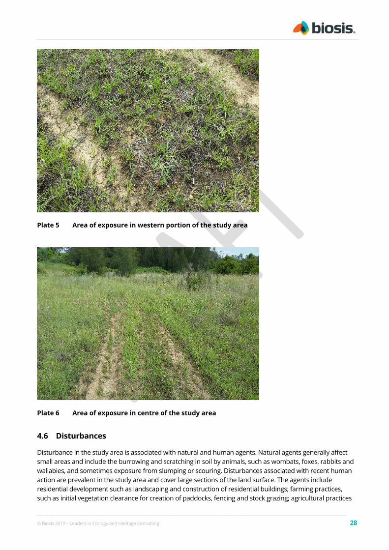
© Biosis 2019 – Leaders in Ecology and Heritage Consulting 28
Plate 5 Area of exposure in western portion of the study area
Plate 6 Area of exposure in centre of the study area
4.6 Disturbances
Disturbance in the study area is associated with natural and human agents. Natural agents generally affect small areas and include the burrowing and scratching in soil by animals, such as wombats, foxes, rabbits and wallabies, and sometimes exposure from slumping or scouring. Disturbances associated with recent human action are prevalent in the study area and cover large sections of the land surface. The agents include residential development such as landscaping and construction of residential buildings; farming practices, such as initial vegetation clearance for creation of paddocks, fencing and stock grazing; agricultural practices

© Biosis 2019 – Leaders in Ecology and Heritage Consulting 29
such as fruit orchards; light industrial practices such as nursery and creation of artificial dams throughout the entire study area.
The archaeological survey found that the entire study area has been subject to high levels of previous ground disturbance (Figure 9). Historical aerial imagery indicates that levelling and bulk earthwork activities occurred in the western and southern portions of the study area between 1963 and 1979 (Figure 5, Figure 6). The field investigation also observed that the creek lines present within the study area had been heavily modified by the installation of large causeways at the north western, and south eastern edges of the study area, and a cement drainage channel which transects the study area (Plate 7, Plate 8). The southern, eastern, and northern portions of the study area have been heavily disturbed by the installation of large artificial slopes or embankments which form an artificial basin type depression in the centre of the study area (Plate 8, Plate 9). The depression at the centre of the study area is likely impacted on by frequent inundation events as a result of the modification of the drainage channels and installation of artificial embankments. The western portion of the study area consisted of a crest landform, this area contained moderately dense regrowth vegetation and a large portion of the landform is currently utilised by squatters (Plate 2, Plate 3). A large amount of household rubbish was also observed in this area. The crest landform displayed evidence of sheet erosion. The observations made in the field supported the evidence from the background research that this area had been stripped of vegetation and top soils historically. The level of disturbance observed during the survey and found during the background research indicates that any Aboriginal sites which may have existed in the study area have been destroyed.
Plate 7 Modified drainage line facing south east

© Biosis 2019 – Leaders in Ecology and Heritage Consulting 30
Plate 8 Causeway and modififed drainge line facing north
Plate 9 Study area facing south east, note manmade embankemtn in foreground and background creating an artifical basin in the centre of the study area

© Biosis 2019 – Leaders in Ecology and Heritage Consulting 31
Plate 10 Study area facing south east, note manmade embankment in foreground and background creating an artifical basin in the centre of the study area
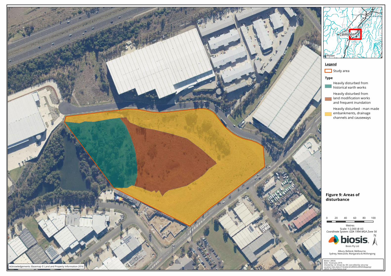
0 20 40 60 80 100
Metres
LegendStudy area
TypeHeavily disturbed fromhistorical earth worksHeavily disturbed fromland modification worksand frequent inundationHeavily disturbed - man madeembankments, drainagechannels and causeways
±Ma tter: 28930, Da te : 16 Jan ua ry 2019, Ch ecked by: CA, Dra w n by: DK , La st edited by: am u rrayLocation :\\bio -d ata-01\m atters$\2890 0s\28930\M ap pin g\28930_F9_D isturba nce .m xd
Biosis Pty LtdAlbury, Ballarat, Melbourne,
Sydney, Newcastle, Wangaratta & Wollongong
Scale: 1:2,000 @ A3
Figure 9: Areas ofdisturbance
Coordinate System: GDA 1994 MGA Zone 56
Acknowledgements: Basemap © Land and Property Information 2016
Camden
Picton

© Biosis 2019 – Leaders in Ecology and Heritage Consulting 33
4.7 Investigation results
The archaeological investigation was conducted on 14 January 2019 by Biosis archaeologists Taryn Gooley and Ashleigh Keevers-Eastman. The survey sampled all landforms present within the study area and targeted areas of higher GVS and exposure. No Aboriginal sites, objects or areas of archaeological potential were identified during the archaeological survey. As noted above, the study area was found to have been subject to high levels of previous ground disturbance as a result of the installation of manmade embankments along the northern, eastern and southern boundaries of the site, along with historical tree clearing activities and bulk earth works in the western portion of the study area. The creation of an artificial basin like depression in the centre of the study area along with the modification of the creek lines within the study area has also resulted in high levels of ground disturbances. The disturbances noted throughout the study area have likely resulted in the destruction of any Aboriginal sites or objects that may once have been present in the study area.

© Biosis 2019 – Leaders in Ecology and Heritage Consulting 34
5 Discussion and recommendations
5.1 Discussion and conclusions
The background research conducted as part of this assessment has identified that artefact sites (both open sites and isolated finds) are the most commonly recorded site type both within the wider Cumberland Plain region and the local Campbelltown area. Aboriginal sites are frequently located within close proximity to a water source both perennial and non perennial, however larger artefact sites are commonly located within close proximity to higher order creek lines (third order and above) (AECOM 2010, Jo McDonald Cultural Heritage Management 2000a, AMBS 1997, Jo McDonald Cultural Heritage Management Pty Ltd 1996). Artefact sites located within close proximity to lower order water ways (first and second order creek lines) generally consist of isolated artefacts or low density scatters indicative of intermittent or transitory land use by Aboriginal people. Modified trees can occur throughout the Cumberland plain region however due to wide spread tree clearing activities, they are restricted to areas of remnant native vegetation. Previous archaeological assessments in the local area indicate that Aboriginal occupation was concentrated on upper or raised creek terraces, spur crests, and gently inclined slopes in close proximity to water (Biosis 2018a, Artefact Heritage 2018, Niche 2013).
The study area consists of a crest landform, and mid and lower slope in the western portion of the study area, a man made basin like depression in the centre of the study area, and a man made embankment which runs along the northern, eastern and southern boundary of the study area. Biriwiri Creek (fourth order) and an unnamed tributary (third order) transect the study area. However based on a review of historical aerial imagery and observations made in the field, both creeklines have been heavily modified by historical land clearing, bulk earth works, and the installation of cause ways and dams from 1963 to the present day. These activities have modified the course of the creeklines, and have likely stripped away soil deposits within the study area. The installation of embankments along the northern, eastern and southern boundaries of the site have resulted in heavy disturbance to the study area both from the initial construction of the features and the increased flooding events which have occurred in the study area as a result of their installation.
The vegetation clearing activities, levelling and dam construction activities which have occurred in the western portion of the study area have resulted in heavy impacts to the crest and associated slope landforms present in the study area. Any Aboriginal sites, object or deposits which may have once existed in this landform have likely been destroyed as a result.
While the study area is located within the Blacktown Soil Landscape, a residual soil landscape known to contain the potential to preserve Aboriginal archaeological deposits, the high levels of previous disturbance within the study area have destroyed the natural soil profiles within the study area.
Based on the results of the desktop assessment and archaeological survey the study area has been assessed as having low Aboriginal archaeological potential (Figure 10). The proposed works are there unlikely to impact on any Aboriginal archaeological values.

0 20 40 60 80 100
Metres
LegendStudy areaLow archaeological potential
±Ma tter: 28930, Da te : 16 Jan ua ry 2019, Ch ecked by: CA, Dra w n by: DK , La st edited by: am u rrayLocation :\\bio -d ata-01\m atters$\2890 0s\28930\M ap pin g\28930_F10 _Resu lts.m xd
Biosis Pty LtdAlbury, Ballarat, Melbourne,
Sydney, Newcastle, Wangaratta & Wollongong
Scale: 1:2,000 @ A3
Figure 10: Survey results
Coordinate System: GDA 1994 MGA Zone 56
Acknowledgements: Basemap © Land and Property Information 2016
CAMDENCAMDEN
CAMPBELLTOWNCAMPBELLTOWN

© Biosis 2019 – Leaders in Ecology and Heritage Consulting 36
5.2 Recommendations
The following management recommendations have been developed relevant to the study area and influenced by:
• predicted impacts to Aboriginal cultural heritage
• the planning approvals framework
• current best conservation practise, widely considered to include:
– ethos of the Australia ICOMOS Burra Charter (2013)
– the code.
Prior to any impacts occurring within the study area, the following is recommended:
Recommendation 1: No further archaeological assessment is required
No further archaeological work is required in the study area due to the entire study area assessed as having low archaeological potential.
Recommendation 2: Discovery of Unanticipated Aboriginal Objects or Aboriginal Ancestral Remains
All Aboriginal objects and Places are protected under the NPW Act. It is an offence to knowingly disturb an Aboriginal site without a consent permit issued by the OEH. Should any Aboriginal objects be encountered during works associated with this proposal, works must cease in the vicinity and the find should not be moved until assessed by a qualified archaeologist. If the find is determined to be an Aboriginal object the archaeologist will provide further recommendations. These may include notifying the OEH and Aboriginal stakeholders.
Aboriginal ancestral remains may be found in a variety of landscapes in NSW, including middens and sandy or soft sedimentary soils. If any suspected human remains are discovered during any activity you must:
1. Immediately cease all work at that location and not further move or disturb the remains.
2. Notify the NSW Police and OEH’s Environmental Line on 131 555 as soon as practicable and provide details of the remains and their location.
3. Not recommence work at that location unless authorised in writing by OEH.

© Biosis 2019 – Leaders in Ecology and Heritage Consulting 37
References
AECOM 2010, Camden Gas project Northern Expansion. Environmental Assessment. Main Report. Prepared for AGL Energy Limited.
AHMS 2015, Greater Macarthur Aboriginal and Historic Cultural Heritage - Gap Analysis and Future Direction, Department of Planning and Environment.
Allen, J & O’Connell, J 2003, ‘The long and the short of it: archaeological approaches to determining when humans first colonised Australia and New Guinea.’, Australian Archaeology, vol. 57, pp. 5–19.
AMBS 1997, Cumberland Plain Aboriginal Cultural Heritage Assessment. Report prepared for National Parks and Wildlife (NPW).
Artefact Heritage 2018, Macarthur Memorial Park, Varroville. Archaeological Test Excavation Report., Catholic Metropolitan Cemeteries Trust.
Atlas of Living Australia n.d., Explore your Area, Atlas of Living Australia, viewed 27 September 2018, <https://biocache.ala.org.au/explore/your-area#-34.1102251|150.6736012|12|ALL_SPECIES>.
Attenbrow, V 2002, Sydney’s Aboriginal Past: Investigating the archaeological and historical records, University of New South Wales Press Ltd, Sydney.
Austral Archaeology 2012, Campbelltown Hospital Stage 1 Redevelopment: Aboriginal Archaeological and Cultural Heritage Assessment., NSW Health Infrastructure.
Australian Museum Business Services 1997, Cumberland Plain Regional Archaeological Study: Stage 1, Report to the National Parks and Wildlife Services.
Australian Museum Business Services 2012, Indigenous Heritage Assessment Project: Austral & Leppington North Precincts, South West Growth Centres. Report for NSW Department of Planning and Infrastructure.
Bannerman, SM & Hazelton, PA 1990a, Soil Landscapes of the Wollongong and Port Hacking 1:100,000 Map Sheet, Soil Conservation Service of NSW, Sydney.
Bannerman, SM & Hazelton, PA 1990b, Soil Landscapes of the Penrith 1:100,000 Map Sheet, Soil Conservation Service of NSW, Sydney.
Biosis 2017, 1432 Camden Valley Way Aboriginal Cultural Heritage Due Diligence Assessment, Mott MacDonald.
Biosis 2018a, Macarthur Memorial Park Geotechnical Investigations: Addendum Archaeological Report, Nettcorp.
Biosis 2018b, Campbelltown Hospital Redevelopment (Stage 2): Archaeological survey report, Root Partnerships.
Biosis 2018c, Leppington Public School: Archaeological Survey Report, TSA Management.

© Biosis 2019 – Leaders in Ecology and Heritage Consulting 38
Biosis Pty Ltd 2012, Camden Gas Project Amended Northern Expansion: Aboriginal Cultural Heritage Assessment Report. Camden Council and Campbelltown City Council LGAs. Report for AGL Upstream Investments Pty. Ltd.
Biosis Pty Ltd 2018, 49-57 Kelly Street, Austral, Archaeological Report. Report for Mott Macdonald on behalf of Crownland Kelly Street No. 2 Pty Ltd.
Burke, H & Smith, C 2004, The Archaeologist’s Field Handbook, Allen and Unwin, Crows Nest.
Crew Archaeological Consultants 1998, An archaeological survey of a proposed subdivision of Lot 204 Mt. Annan, near Campbelltown, NSW. A report to D.P. Hayes, Land Consultant for George Wimpey Australia Pty. Ltd.
CSIRO 2009, Australian soil and land survey field handbook, 3rd edn, CSIRO Publishing & National Committee on Soil and Terrain, Collingwood, Victoria.
Dallas, M 1982, ‘An Archaeological Survey at Riverstone, Schofields and Quakers Hill, NSW. Prepared for the Land Commission of NSW.’
DECCW 2010a, Due diligence code of practice for the protection of Aboriginal objects in New South Wales, Department of Environment and Climate Change, Sydney NSW.
DECCW 2010b, Code of practice for archaeological investigation of Aboriginal objects in New South Wales, Department of Environment and Climate Change, Sydney NSW.
Dibden, J 2003, Camden Gas Project Stage 2 - Camden New South Wales: Archaeological and Heritage Assessment. NA unpublished repot to Sydney Gas Operations Pty Ltd.
Dunn, I & Sahukar, R 2003, The Bioregions of New South Wales: their biodiversity, conservation and history NSW National Parks and Wildlife Service., National Parks and Wildlife Service, Hurstville, NSW.
GML 2011, Campbelltown Hospital Stage 1 Redevelopment: Heritage Assessment., Capital Insight Pty Ltd.
Haglund, L 1989, Department of Housing Project 144 Residential Estate – Narellan. Preliminary Archaeological Investigation of archaeological sites 2 and 5, A report to Benjamin M. T. Chow & Associates on behalf of the Department of Housing.
Jo McDonald Cultural Heritage Management 2000a, Archaeological Survey for Aboriginal Sites: Proposed Light Industrial Subdivision, ‘Austral Site’, Mamre Road, Erskine Park, NSW. Report to Gunninah Environmental Consultants for Austral Brick Company.
Jo McDonald Cultural Heritage Management 2000b, Archaeological survey for Aboriginal sites, proposed re-zoning for “Manooka Valley” Rural/Residential subdivision Currans Hill, NSW. A report prepared for Landcon (NSW) Pty Ltd.
Jo McDonald Cultural Heritage Management Pty Ltd 1996, Camden Bush Corridor Management Plan: Archaeological Study, Report to EDAW on behalf of Camden Shire Council.
Jo McDonald Cultural Heritage Management Pty Ltd 2005a, Archaeological Salvage Excavation of Site CG1 (NPWS #45-5-2648), at the corner of Charles and George Streets, Parramatta, NSW, Report to Meriton Apartments Pty Ltd.
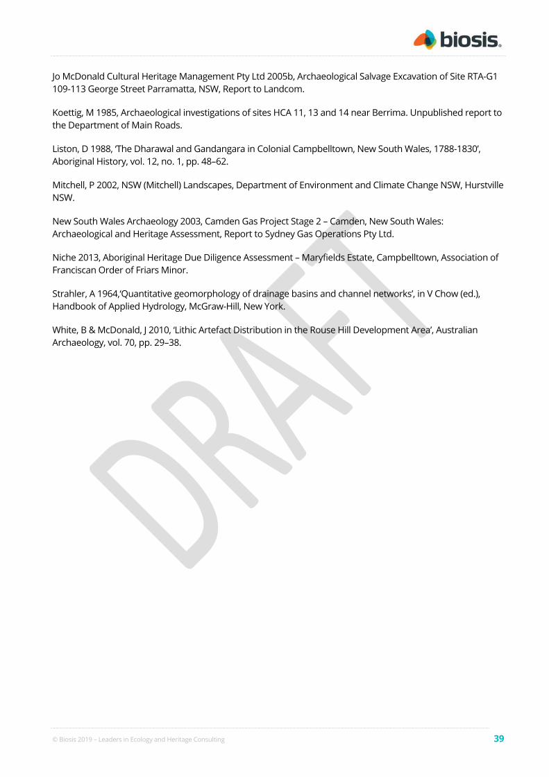
© Biosis 2019 – Leaders in Ecology and Heritage Consulting 39
Jo McDonald Cultural Heritage Management Pty Ltd 2005b, Archaeological Salvage Excavation of Site RTA-G1 109-113 George Street Parramatta, NSW, Report to Landcom.
Koettig, M 1985, Archaeological investigations of sites HCA 11, 13 and 14 near Berrima. Unpublished report to the Department of Main Roads.
Liston, D 1988, ‘The Dharawal and Gandangara in Colonial Campbelltown, New South Wales, 1788-1830’, Aboriginal History, vol. 12, no. 1, pp. 48–62.
Mitchell, P 2002, NSW (Mitchell) Landscapes, Department of Environment and Climate Change NSW, Hurstville NSW.
New South Wales Archaeology 2003, Camden Gas Project Stage 2 – Camden, New South Wales: Archaeological and Heritage Assessment, Report to Sydney Gas Operations Pty Ltd.
Niche 2013, Aboriginal Heritage Due Diligence Assessment – Maryfields Estate, Campbelltown, Association of Franciscan Order of Friars Minor.
Strahler, A 1964,‘Quantitative geomorphology of drainage basins and channel networks’, in V Chow (ed.), Handbook of Applied Hydrology, McGraw-Hill, New York.
White, B & McDonald, J 2010, ‘Lithic Artefact Distribution in the Rouse Hill Development Area’, Australian Archaeology, vol. 70, pp. 29–38.

© Biosis 2019 – Leaders in Ecology and Heritage Consulting 40
Appendix 1 AHIMS search results
This Appendix is not to be made public.
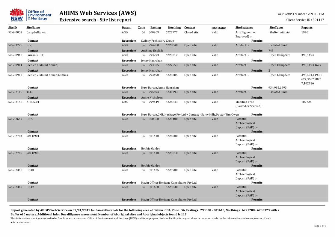
AHIMS Web Services (AWS)Extensive search - Site list report
SiteID SiteName Datum Zone Easting Northing Context SiteFeatures SiteTypes Reports
Your Ref/PO Number : 28930 - CLA
Client Service ID : 391417
Site Status
52-2-0032 Campbelltown; AGD 56 300269 6227777 Closed site Valid Art (Pigment or
Engraved) : -
Shelter with Art 1976
PermitsSydney Prehistory GroupRecordersContact
52-2-1725 IF 2; AGD 56 294780 6228640 Open site Valid Artefact : - Isolated Find
743PermitsAnthony EnglishRecordersContact
52-2-0910 Curran's Hill; AGD 56 293293 6229012 Open site Valid Artefact : - Open Camp Site 393,1194
PermitsJenny HanrahanRecordersContact
52-2-0911 Glenlee 1;Mount Annan; AGD 56 293505 6227553 Open site Valid Artefact : - Open Camp Site 393,1193,1677
2PermitsJenny HanrahanRecordersContact
52-2-0912 Glenlee 2;Mount Annan;Cluthas; AGD 56 293490 6228285 Open site Valid Artefact : - Open Camp Site 393,401,1193,1
677,3687,9826
7,102726
934,985,1993PermitsHuw Barton,Jenny HanrahanRecordersContact
52-2-2115 TLC3 AGD 56 295694 6230793 Open site Valid Artefact : 1 Isolated Find
PermitsAnnie NicholsonRecordersContact
52-2-2150 AIRDS-01 GDA 56 299449 6226643 Open site Valid Modified Tree
(Carved or Scarred) :
-
102726
PermitsHuw Barton,GML Heritage Pty Ltd + Context - Surry Hills,Doctor.Tim OwenRecordersContact
52-2-2657 H377 AGD 56 300360 6225400 Open site Valid Potential
Archaeological
Deposit (PAD) : -
PermitsRecordersContact
52-2-2784 Site H901 AGD 56 301410 6226000 Open site Valid Potential
Archaeological
Deposit (PAD) : -
PermitsBobbie OakleyRecordersContact
52-2-2785 Site H902 AGD 56 301410 6225810 Open site Valid Potential
Archaeological
Deposit (PAD) : -
PermitsBobbie OakleyRecordersContact
52-2-2348 H338 AGD 56 301475 6225900 Open site Valid Potential
Archaeological
Deposit (PAD) : -
PermitsNavin Officer Heritage Consultants Pty LtdRecordersContact
52-2-2349 H339 AGD 56 301460 6225830 Open site Valid Potential
Archaeological
Deposit (PAD) : -
PermitsNavin Officer Heritage Consultants Pty LtdRecordersContact
Report generated by AHIMS Web Service on 09/01/2019 for Samantha Keats for the following area at Datum :GDA, Zone : 56, Eastings : 293358 - 301610, Northings : 6225288 - 6233323 with a
Buffer of 0 meters. Additional Info : Due diligence assessment. Number of Aboriginal sites and Aboriginal objects found is 113
This information is not guaranteed to be free from error omission. Office of Environment and Heritage (NSW) and its employees disclaim liability for any act done or omission made on the information and consequences of such
acts or omission.
Page 1 of 9
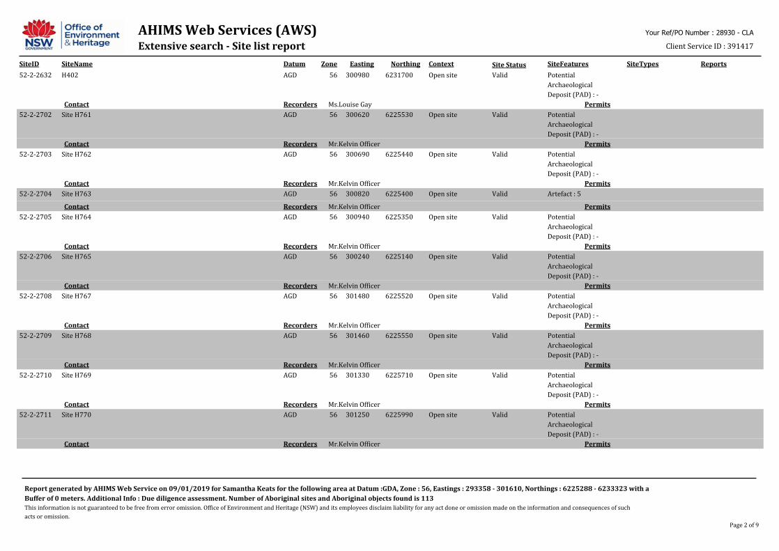
AHIMS Web Services (AWS)Extensive search - Site list report
SiteID SiteName Datum Zone Easting Northing Context SiteFeatures SiteTypes Reports
Your Ref/PO Number : 28930 - CLA
Client Service ID : 391417
Site Status
52-2-2632 H402 AGD 56 300980 6231700 Open site Valid Potential
Archaeological
Deposit (PAD) : -
PermitsMs.Louise GayRecordersContact
52-2-2702 Site H761 AGD 56 300620 6225530 Open site Valid Potential
Archaeological
Deposit (PAD) : -
PermitsMr.Kelvin OfficerRecordersContact
52-2-2703 Site H762 AGD 56 300690 6225440 Open site Valid Potential
Archaeological
Deposit (PAD) : -
PermitsMr.Kelvin OfficerRecordersContact
52-2-2704 Site H763 AGD 56 300820 6225400 Open site Valid Artefact : 5
PermitsMr.Kelvin OfficerRecordersContact
52-2-2705 Site H764 AGD 56 300940 6225350 Open site Valid Potential
Archaeological
Deposit (PAD) : -
PermitsMr.Kelvin OfficerRecordersContact
52-2-2706 Site H765 AGD 56 300240 6225140 Open site Valid Potential
Archaeological
Deposit (PAD) : -
PermitsMr.Kelvin OfficerRecordersContact
52-2-2708 Site H767 AGD 56 301480 6225520 Open site Valid Potential
Archaeological
Deposit (PAD) : -
PermitsMr.Kelvin OfficerRecordersContact
52-2-2709 Site H768 AGD 56 301460 6225550 Open site Valid Potential
Archaeological
Deposit (PAD) : -
PermitsMr.Kelvin OfficerRecordersContact
52-2-2710 Site H769 AGD 56 301330 6225710 Open site Valid Potential
Archaeological
Deposit (PAD) : -
PermitsMr.Kelvin OfficerRecordersContact
52-2-2711 Site H770 AGD 56 301250 6225990 Open site Valid Potential
Archaeological
Deposit (PAD) : -
PermitsMr.Kelvin OfficerRecordersContact
Report generated by AHIMS Web Service on 09/01/2019 for Samantha Keats for the following area at Datum :GDA, Zone : 56, Eastings : 293358 - 301610, Northings : 6225288 - 6233323 with a
Buffer of 0 meters. Additional Info : Due diligence assessment. Number of Aboriginal sites and Aboriginal objects found is 113
This information is not guaranteed to be free from error omission. Office of Environment and Heritage (NSW) and its employees disclaim liability for any act done or omission made on the information and consequences of such
acts or omission.
Page 2 of 9

AHIMS Web Services (AWS)Extensive search - Site list report
SiteID SiteName Datum Zone Easting Northing Context SiteFeatures SiteTypes Reports
Your Ref/PO Number : 28930 - CLA
Client Service ID : 391417
Site Status
52-2-2658 H376 AGD 56 300700 6225900 Open site Valid Potential
Archaeological
Deposit (PAD) : -
PermitsRecordersContact
52-2-2712 Site H771 AGD 56 301270 6226120 Open site Valid Modified Tree
(Carved or Scarred) :
-
PermitsMr.Kelvin OfficerRecordersContact
52-2-2713 Site H772 AGD 56 301190 6226440 Open site Valid Potential
Archaeological
Deposit (PAD) : -
PermitsMr.Kelvin OfficerRecordersContact
52-2-2659 H375 AGD 56 300860 6226090 Open site Valid Potential
Archaeological
Deposit (PAD) : -
PermitsRecordersContact
52-2-2660 H374 AGD 56 301340 6226170 Open site Valid Potential
Archaeological
Deposit (PAD) : -
PermitsRecordersContact
52-2-2661 H372 AGD 56 301401 6225600 Open site Valid Potential
Archaeological
Deposit (PAD) : -
PermitsRecordersContact
52-2-2715 Site H774 AGD 56 300100 6225180 Open site Valid Potential
Archaeological
Deposit (PAD) : -
PermitsMr.Kelvin OfficerRecordersContact
52-2-2717 Site H775 AGD 56 300060 6225230 Open site Valid Modified Tree
(Carved or Scarred) :
-
PermitsMr.Kelvin OfficerRecordersContact
52-2-2718 Site H776 AGD 56 300140 6225130 Open site Valid Potential
Archaeological
Deposit (PAD) : -
PermitsMr.Kelvin OfficerRecordersContact
52-2-2978 Pembroke Road IF1 AGD 56 300200 6230580 Open site Valid Artefact : -
1899,1948PermitsPaul Irish Consultant ArchaeologistRecordersContact
Report generated by AHIMS Web Service on 09/01/2019 for Samantha Keats for the following area at Datum :GDA, Zone : 56, Eastings : 293358 - 301610, Northings : 6225288 - 6233323 with a
Buffer of 0 meters. Additional Info : Due diligence assessment. Number of Aboriginal sites and Aboriginal objects found is 113
This information is not guaranteed to be free from error omission. Office of Environment and Heritage (NSW) and its employees disclaim liability for any act done or omission made on the information and consequences of such
acts or omission.
Page 3 of 9
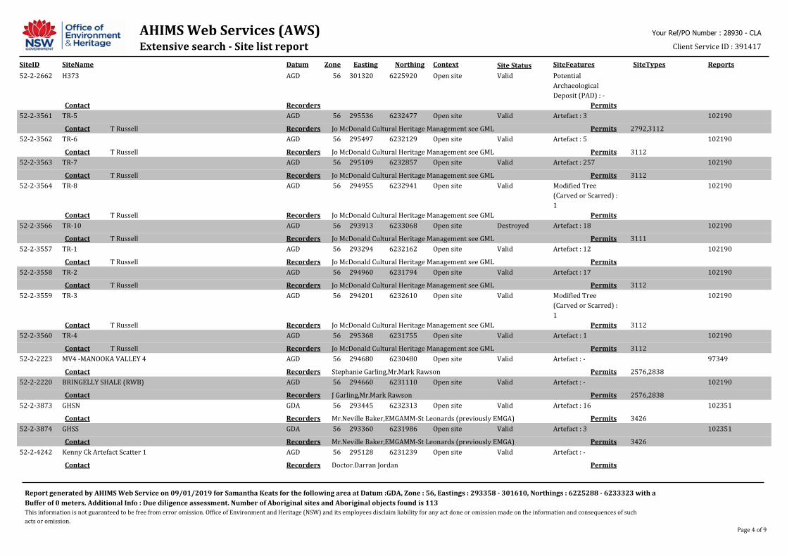
AHIMS Web Services (AWS)Extensive search - Site list report
SiteID SiteName Datum Zone Easting Northing Context SiteFeatures SiteTypes Reports
Your Ref/PO Number : 28930 - CLA
Client Service ID : 391417
Site Status
52-2-2662 H373 AGD 56 301320 6225920 Open site Valid Potential
Archaeological
Deposit (PAD) : -
PermitsRecordersContact
52-2-3561 TR-5 AGD 56 295536 6232477 Open site Valid Artefact : 3 102190
2792,3112PermitsJo McDonald Cultural Heritage Management see GMLRecordersT RussellContact
52-2-3562 TR-6 AGD 56 295497 6232129 Open site Valid Artefact : 5 102190
3112PermitsJo McDonald Cultural Heritage Management see GMLRecordersT RussellContact
52-2-3563 TR-7 AGD 56 295109 6232857 Open site Valid Artefact : 257 102190
3112PermitsJo McDonald Cultural Heritage Management see GMLRecordersT RussellContact
52-2-3564 TR-8 AGD 56 294955 6232941 Open site Valid Modified Tree
(Carved or Scarred) :
1
102190
PermitsJo McDonald Cultural Heritage Management see GMLRecordersT RussellContact
52-2-3566 TR-10 AGD 56 293913 6233068 Open site Destroyed Artefact : 18 102190
3111PermitsJo McDonald Cultural Heritage Management see GMLRecordersT RussellContact
52-2-3557 TR-1 AGD 56 293294 6232162 Open site Valid Artefact : 12 102190
PermitsJo McDonald Cultural Heritage Management see GMLRecordersT RussellContact
52-2-3558 TR-2 AGD 56 294960 6231794 Open site Valid Artefact : 17 102190
3112PermitsJo McDonald Cultural Heritage Management see GMLRecordersT RussellContact
52-2-3559 TR-3 AGD 56 294201 6232610 Open site Valid Modified Tree
(Carved or Scarred) :
1
102190
3112PermitsJo McDonald Cultural Heritage Management see GMLRecordersT RussellContact
52-2-3560 TR-4 AGD 56 295368 6231755 Open site Valid Artefact : 1 102190
3112PermitsJo McDonald Cultural Heritage Management see GMLRecordersT RussellContact
52-2-2223 MV4 -MANOOKA VALLEY 4 AGD 56 294680 6230480 Open site Valid Artefact : - 97349
2576,2838PermitsStephanie Garling,Mr.Mark RawsonRecordersContact
52-2-2220 BRINGELLY SHALE (RWB) AGD 56 294660 6231110 Open site Valid Artefact : - 102190
2576,2838PermitsJ Garling,Mr.Mark RawsonRecordersContact
52-2-3873 GHSN GDA 56 293445 6232313 Open site Valid Artefact : 16 102351
3426PermitsMr.Neville Baker,EMGAMM-St Leonards (previously EMGA)RecordersContact
52-2-3874 GHSS GDA 56 293360 6231986 Open site Valid Artefact : 3 102351
3426PermitsMr.Neville Baker,EMGAMM-St Leonards (previously EMGA)RecordersContact
52-2-4242 Kenny Ck Artefact Scatter 1 AGD 56 295128 6231239 Open site Valid Artefact : -
PermitsDoctor.Darran JordanRecordersContact
Report generated by AHIMS Web Service on 09/01/2019 for Samantha Keats for the following area at Datum :GDA, Zone : 56, Eastings : 293358 - 301610, Northings : 6225288 - 6233323 with a
Buffer of 0 meters. Additional Info : Due diligence assessment. Number of Aboriginal sites and Aboriginal objects found is 113
This information is not guaranteed to be free from error omission. Office of Environment and Heritage (NSW) and its employees disclaim liability for any act done or omission made on the information and consequences of such
acts or omission.
Page 4 of 9
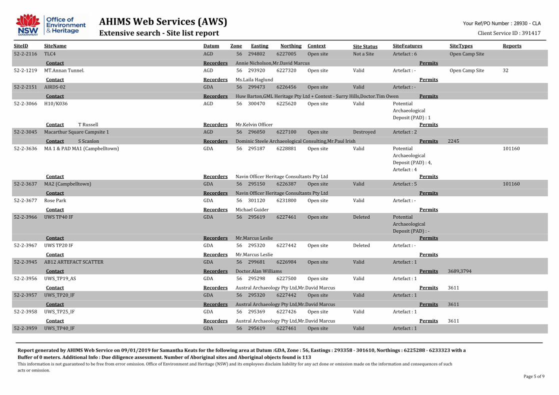
AHIMS Web Services (AWS)Extensive search - Site list report
SiteID SiteName Datum Zone Easting Northing Context SiteFeatures SiteTypes Reports
Your Ref/PO Number : 28930 - CLA
Client Service ID : 391417
Site Status
52-2-2116 TLC4 AGD 56 294802 6227005 Open site Not a Site Artefact : 6 Open Camp Site
PermitsAnnie Nicholson,Mr.David MarcusRecordersContact
52-2-1219 MT.Annan Tunnel. AGD 56 293920 6227320 Open site Valid Artefact : - Open Camp Site 32
PermitsMs.Laila HaglundRecordersContact
52-2-2151 AIRDS-02 GDA 56 299473 6226456 Open site Valid Artefact : -
PermitsHuw Barton,GML Heritage Pty Ltd + Context - Surry Hills,Doctor.Tim OwenRecordersContact
52-2-3066 H10/K036 AGD 56 300470 6225620 Open site Valid Potential
Archaeological
Deposit (PAD) : 1
PermitsMr.Kelvin OfficerRecordersT RussellContact
52-2-3045 Macarthur Square Campsite 1 AGD 56 296050 6227100 Open site Destroyed Artefact : 2
2245PermitsDominic Steele Archaeological Consulting,Mr.Paul IrishRecordersS ScanlonContact
52-2-3636 MA 1 & PAD MA1 (Campbelltown) GDA 56 295187 6228881 Open site Valid Potential
Archaeological
Deposit (PAD) : 4,
Artefact : 4
101160
PermitsNavin Officer Heritage Consultants Pty LtdRecordersContact
52-2-3637 MA2 (Campbelltown) GDA 56 295150 6226387 Open site Valid Artefact : 5 101160
PermitsNavin Officer Heritage Consultants Pty LtdRecordersContact
52-2-3677 Rose Park GDA 56 301120 6231800 Open site Valid Artefact : -
PermitsMichael GuiderRecordersContact
52-2-3966 UWS TP40 IF GDA 56 295619 6227461 Open site Deleted Potential
Archaeological
Deposit (PAD) : -
PermitsMr.Marcus LeslieRecordersContact
52-2-3967 UWS TP20 IF GDA 56 295320 6227442 Open site Deleted Artefact : -
PermitsMr.Marcus LeslieRecordersContact
52-2-3945 AB12 ARTEFACT SCATTER GDA 56 299681 6226984 Open site Valid Artefact : 1
3689,3794PermitsDoctor.Alan WilliamsRecordersContact
52-2-3956 UWS_TP19_AS GDA 56 295298 6227500 Open site Valid Artefact : 1
3611PermitsAustral Archaeology Pty Ltd,Mr.David MarcusRecordersContact
52-2-3957 UWS_TP20_IF GDA 56 295320 6227442 Open site Valid Artefact : 1
3611PermitsAustral Archaeology Pty Ltd,Mr.David MarcusRecordersContact
52-2-3958 UWS_TP25_IF GDA 56 295369 6227426 Open site Valid Artefact : 1
3611PermitsAustral Archaeology Pty Ltd,Mr.David MarcusRecordersContact
52-2-3959 UWS_TP40_IF GDA 56 295619 6227461 Open site Valid Artefact : 1
Report generated by AHIMS Web Service on 09/01/2019 for Samantha Keats for the following area at Datum :GDA, Zone : 56, Eastings : 293358 - 301610, Northings : 6225288 - 6233323 with a
Buffer of 0 meters. Additional Info : Due diligence assessment. Number of Aboriginal sites and Aboriginal objects found is 113
This information is not guaranteed to be free from error omission. Office of Environment and Heritage (NSW) and its employees disclaim liability for any act done or omission made on the information and consequences of such
acts or omission.
Page 5 of 9
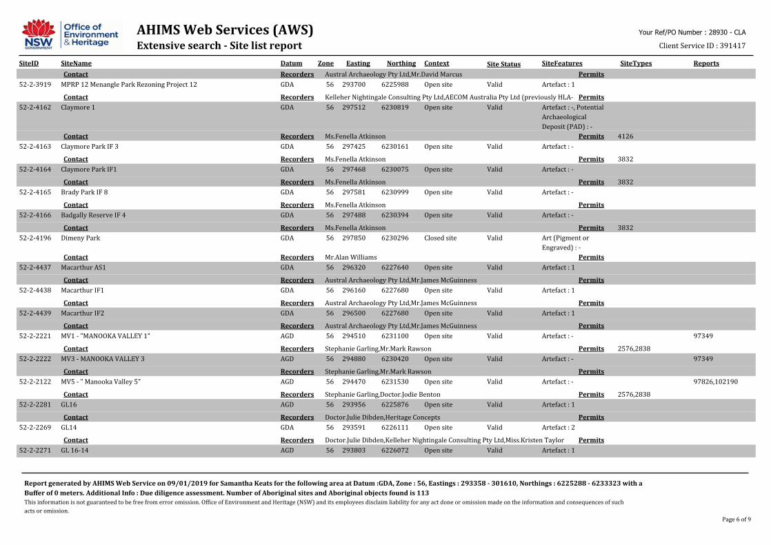
AHIMS Web Services (AWS)Extensive search - Site list report
SiteID SiteName Datum Zone Easting Northing Context SiteFeatures SiteTypes Reports
Your Ref/PO Number : 28930 - CLA
Client Service ID : 391417
Site Status
PermitsAustral Archaeology Pty Ltd,Mr.David MarcusRecordersContact
52-2-3919 MPRP 12 Menangle Park Rezoning Project 12 GDA 56 293700 6225988 Open site Valid Artefact : 1
PermitsKelleher Nightingale Consulting Pty Ltd,AECOM Australia Pty Ltd (previously HLA-Envirosciences),Ms.Norma Richardson,Miss.Kristen TaylorRecordersContact
52-2-4162 Claymore 1 GDA 56 297512 6230819 Open site Valid Artefact : -, Potential
Archaeological
Deposit (PAD) : -
4126PermitsMs.Fenella AtkinsonRecordersContact
52-2-4163 Claymore Park IF 3 GDA 56 297425 6230161 Open site Valid Artefact : -
3832PermitsMs.Fenella AtkinsonRecordersContact
52-2-4164 Claymore Park IF1 GDA 56 297468 6230075 Open site Valid Artefact : -
3832PermitsMs.Fenella AtkinsonRecordersContact
52-2-4165 Brady Park IF 8 GDA 56 297581 6230999 Open site Valid Artefact : -
PermitsMs.Fenella AtkinsonRecordersContact
52-2-4166 Badgally Reserve IF 4 GDA 56 297488 6230394 Open site Valid Artefact : -
3832PermitsMs.Fenella AtkinsonRecordersContact
52-2-4196 Dimeny Park GDA 56 297850 6230296 Closed site Valid Art (Pigment or
Engraved) : -
PermitsMr.Alan WilliamsRecordersContact
52-2-4437 Macarthur AS1 GDA 56 296320 6227640 Open site Valid Artefact : 1
PermitsAustral Archaeology Pty Ltd,Mr.James McGuinnessRecordersContact
52-2-4438 Macarthur IF1 GDA 56 296160 6227680 Open site Valid Artefact : 1
PermitsAustral Archaeology Pty Ltd,Mr.James McGuinnessRecordersContact
52-2-4439 Macarthur IF2 GDA 56 296500 6227680 Open site Valid Artefact : 1
PermitsAustral Archaeology Pty Ltd,Mr.James McGuinnessRecordersContact
52-2-2221 MV1 - "MANOOKA VALLEY 1" AGD 56 294510 6231100 Open site Valid Artefact : - 97349
2576,2838PermitsStephanie Garling,Mr.Mark RawsonRecordersContact
52-2-2222 MV3 - MANOOKA VALLEY 3 AGD 56 294880 6230420 Open site Valid Artefact : - 97349
PermitsStephanie Garling,Mr.Mark RawsonRecordersContact
52-2-2122 MV5 - " Manooka Valley 5" AGD 56 294470 6231530 Open site Valid Artefact : - 97826,102190
2576,2838PermitsStephanie Garling,Doctor.Jodie BentonRecordersContact
52-2-2281 GL16 AGD 56 293956 6225876 Open site Valid Artefact : 1
PermitsDoctor.Julie Dibden,Heritage ConceptsRecordersContact
52-2-2269 GL14 GDA 56 293591 6226111 Open site Valid Artefact : 2
PermitsDoctor.Julie Dibden,Kelleher Nightingale Consulting Pty Ltd,Miss.Kristen TaylorRecordersContact
52-2-2271 GL 16-14 AGD 56 293803 6226072 Open site Valid Artefact : 1
Report generated by AHIMS Web Service on 09/01/2019 for Samantha Keats for the following area at Datum :GDA, Zone : 56, Eastings : 293358 - 301610, Northings : 6225288 - 6233323 with a
Buffer of 0 meters. Additional Info : Due diligence assessment. Number of Aboriginal sites and Aboriginal objects found is 113
This information is not guaranteed to be free from error omission. Office of Environment and Heritage (NSW) and its employees disclaim liability for any act done or omission made on the information and consequences of such
acts or omission.
Page 6 of 9
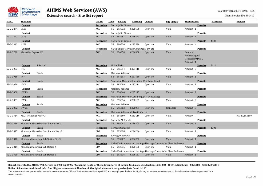
AHIMS Web Services (AWS)Extensive search - Site list report
SiteID SiteName Datum Zone Easting Northing Context SiteFeatures SiteTypes Reports
Your Ref/PO Number : 28930 - CLA
Client Service ID : 391417
Site Status
PermitsDoctor.Julie DibdenRecordersContact
52-2-2274 GL15 AGD 56 293932 6225688 Open site Valid Artefact : 1
PermitsDoctor.Julie DibdenRecordersContact
52-2-2277 GL18 AGD 56 294961 6226573 Open site Valid Artefact : 4
4322PermitsDoctor.Julie DibdenRecordersContact
52-2-2312 H299 AGD 56 300530 6225530 Open site Valid Artefact : -
PermitsNavin Officer Heritage Consultants Pty LtdRecordersContact
52-2-3222 Macarthur Square IF3 AGD 56 296250 6226950 Open site Valid Potential
Archaeological
Deposit (PAD) : -,
Artefact : 1
2416PermitsMr.Paul IrishRecordersT RussellContact
52-2-3057 IF 6 AGD 56 295014 6227116 Open site Valid Artefact : 5
PermitsMatthew KelleherRecordersSearleContact
52-2-3058 IF 7 AGD 56 294893 6227450 Open site Valid Artefact : 1
PermitsAustralian Museum Consulting (AM Consulting)RecordersSearleContact
52-2-3059 UWS 2 AGD 56 295089 6227211 Open site Valid Artefact : 3
PermitsMatthew KelleherRecordersSearleContact
52-2-3060 UWS 3 AGD 56 294944 6227145 Open site Valid Artefact : 2
PermitsAustralian Museum Consulting (AM Consulting)RecordersSearleContact
52-2-3061 UWS 4 AGD 56 295636 6228123 Open site Valid Artefact : 2
PermitsMatthew KelleherRecordersSearleContact
52-2-3062 UWS 5 AGD 56 295383 6228081 Open site Not a Site Artefact : 5
PermitsMatthew Kelleher,Mr.David MarcusRecordersSearleContact
52-2-3314 MV2 - Manooka Valley 2 AGD 56 294660 6231110 Open site Valid Artefact : - 97349,102190
PermitsDoctor.Jo McDonaldRecordersContact
52-2-3316 Mt Annan, Macarthur Sub Station Site - 1 GDA 56 294062 6226305 Open site Valid Artefact : 1
4303PermitsHeritage ConceptsRecordersSearleContact
52-2-3317 Mt Annan, Macarthur Sub Station Site - 2 GDA 56 293998 6226286 Open site Valid Artefact : 1
PermitsHeritage ConceptsRecordersSearleContact
52-2-3318 Mt Annan Macarthur Sub Station Site 3 GDA 56 293907 6226252 Open site Valid Artefact : 1
PermitsNiche Environment and Heritage,Heritage Concepts,Ms.Clare AndersonRecordersSearleContact
52-2-3319 Mt Annan Macarthur Sub Station 4 GDA 56 293676 6226185 Open site Valid Artefact : 1
PermitsNiche Environment and Heritage,Heritage Concepts,Ms.Clare AndersonRecordersSearleContact
52-2-3320 Mt Annan Macarthur Sub Station 5 GDA 56 293616 6226137 Open site Valid Artefact : 1
Report generated by AHIMS Web Service on 09/01/2019 for Samantha Keats for the following area at Datum :GDA, Zone : 56, Eastings : 293358 - 301610, Northings : 6225288 - 6233323 with a
Buffer of 0 meters. Additional Info : Due diligence assessment. Number of Aboriginal sites and Aboriginal objects found is 113
This information is not guaranteed to be free from error omission. Office of Environment and Heritage (NSW) and its employees disclaim liability for any act done or omission made on the information and consequences of such
acts or omission.
Page 7 of 9
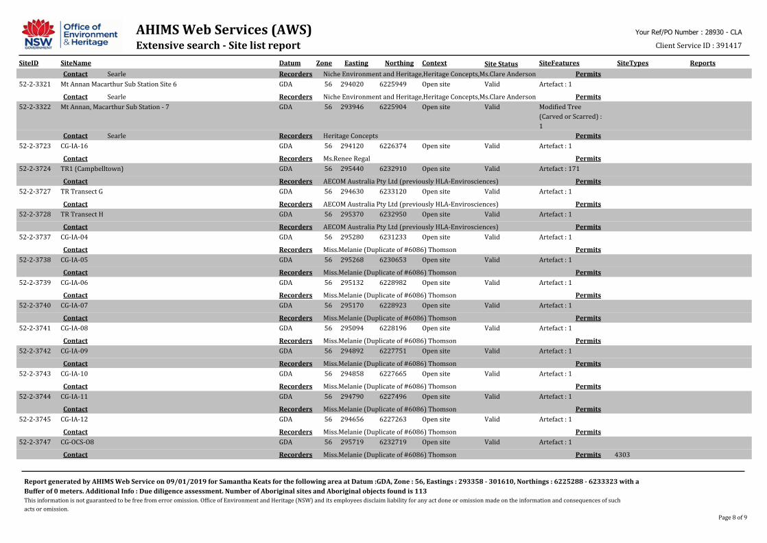
AHIMS Web Services (AWS)Extensive search - Site list report
SiteID SiteName Datum Zone Easting Northing Context SiteFeatures SiteTypes Reports
Your Ref/PO Number : 28930 - CLA
Client Service ID : 391417
Site Status
PermitsNiche Environment and Heritage,Heritage Concepts,Ms.Clare AndersonRecordersSearleContact
52-2-3321 Mt Annan Macarthur Sub Station Site 6 GDA 56 294020 6225949 Open site Valid Artefact : 1
PermitsNiche Environment and Heritage,Heritage Concepts,Ms.Clare AndersonRecordersSearleContact
52-2-3322 Mt Annan, Macarthur Sub Station - 7 GDA 56 293946 6225904 Open site Valid Modified Tree
(Carved or Scarred) :
1
PermitsHeritage ConceptsRecordersSearleContact
52-2-3723 CG-IA-16 GDA 56 294120 6226374 Open site Valid Artefact : 1
PermitsMs.Renee RegalRecordersContact
52-2-3724 TR1 (Campbelltown) GDA 56 295440 6232910 Open site Valid Artefact : 171
PermitsAECOM Australia Pty Ltd (previously HLA-Envirosciences)RecordersContact
52-2-3727 TR Transect G GDA 56 294630 6233120 Open site Valid Artefact : 1
PermitsAECOM Australia Pty Ltd (previously HLA-Envirosciences)RecordersContact
52-2-3728 TR Transect H GDA 56 295370 6232950 Open site Valid Artefact : 1
PermitsAECOM Australia Pty Ltd (previously HLA-Envirosciences)RecordersContact
52-2-3737 CG-IA-04 GDA 56 295280 6231233 Open site Valid Artefact : 1
PermitsMiss.Melanie (Duplicate of #6086) ThomsonRecordersContact
52-2-3738 CG-IA-05 GDA 56 295268 6230653 Open site Valid Artefact : 1
PermitsMiss.Melanie (Duplicate of #6086) ThomsonRecordersContact
52-2-3739 CG-IA-06 GDA 56 295132 6228982 Open site Valid Artefact : 1
PermitsMiss.Melanie (Duplicate of #6086) ThomsonRecordersContact
52-2-3740 CG-IA-07 GDA 56 295170 6228923 Open site Valid Artefact : 1
PermitsMiss.Melanie (Duplicate of #6086) ThomsonRecordersContact
52-2-3741 CG-IA-08 GDA 56 295094 6228196 Open site Valid Artefact : 1
PermitsMiss.Melanie (Duplicate of #6086) ThomsonRecordersContact
52-2-3742 CG-IA-09 GDA 56 294892 6227751 Open site Valid Artefact : 1
PermitsMiss.Melanie (Duplicate of #6086) ThomsonRecordersContact
52-2-3743 CG-IA-10 GDA 56 294858 6227665 Open site Valid Artefact : 1
PermitsMiss.Melanie (Duplicate of #6086) ThomsonRecordersContact
52-2-3744 CG-IA-11 GDA 56 294790 6227496 Open site Valid Artefact : 1
PermitsMiss.Melanie (Duplicate of #6086) ThomsonRecordersContact
52-2-3745 CG-IA-12 GDA 56 294656 6227263 Open site Valid Artefact : 1
PermitsMiss.Melanie (Duplicate of #6086) ThomsonRecordersContact
52-2-3747 CG-OCS-O8 GDA 56 295719 6232719 Open site Valid Artefact : 1
4303PermitsMiss.Melanie (Duplicate of #6086) ThomsonRecordersContact
Report generated by AHIMS Web Service on 09/01/2019 for Samantha Keats for the following area at Datum :GDA, Zone : 56, Eastings : 293358 - 301610, Northings : 6225288 - 6233323 with a
Buffer of 0 meters. Additional Info : Due diligence assessment. Number of Aboriginal sites and Aboriginal objects found is 113
This information is not guaranteed to be free from error omission. Office of Environment and Heritage (NSW) and its employees disclaim liability for any act done or omission made on the information and consequences of such
acts or omission.
Page 8 of 9

AHIMS Web Services (AWS)Extensive search - Site list report
SiteID SiteName Datum Zone Easting Northing Context SiteFeatures SiteTypes Reports
Your Ref/PO Number : 28930 - CLA
Client Service ID : 391417
Site Status
52-2-3748 CG-OCS-10 GDA 56 295189 6228881 Open site Valid Artefact : 1
PermitsMiss.Melanie (Duplicate of #6086) ThomsonRecordersContact
52-2-3749 CG-OCS-11 GDA 56 294871 6227709 Open site Valid Artefact : 1
PermitsMiss.Melanie (Duplicate of #6086) ThomsonRecordersContact
52-2-3751 CG-TRE-O4 GDA 56 296811 6230987 Open site Valid Artefact : 1
PermitsMiss.Melanie (Duplicate of #6086) ThomsonRecordersContact
Report generated by AHIMS Web Service on 09/01/2019 for Samantha Keats for the following area at Datum :GDA, Zone : 56, Eastings : 293358 - 301610, Northings : 6225288 - 6233323 with a
Buffer of 0 meters. Additional Info : Due diligence assessment. Number of Aboriginal sites and Aboriginal objects found is 113
This information is not guaranteed to be free from error omission. Office of Environment and Heritage (NSW) and its employees disclaim liability for any act done or omission made on the information and consequences of such
acts or omission.
Page 9 of 9
Related Documents