A STUDY OF DUNDONNELL CASTLE, CO. ROSCOMMON Daniel Curley, B.A. In partial fulfilment of the MA in Medieval Studies National University of Ireland, Galway July 2011 Dr. Stefan Bergh, Archaeology Department Head Dr. Kieran O‟Conor, Supervisor

Welcome message from author
This document is posted to help you gain knowledge. Please leave a comment to let me know what you think about it! Share it to your friends and learn new things together.
Transcript

A STUDY OF DUNDONNELL CASTLE, CO. ROSCOMMON
Daniel Curley, B.A.
In partial fulfilment of the MA in Medieval Studies
National University of Ireland, Galway
July 2011
Dr. Stefan Bergh, Archaeology Department Head
Dr. Kieran O‟Conor, Supervisor

ii
Table of Contents
Table of Figures .....................................................................................................................iv
Table of Plates ......................................................................................................................... v
Abstract ....................................................................................................................................vi
Acknowledgements ............................................................................................................ vii
Chapter 1: Aims, Methods and Sources .......................................................................... 1 1.0 – Introduction ........................................................................................................................... 1 1.1 - The aims of this thesis ......................................................................................................... 4 1.2 – Methodology ........................................................................................................................... 5 1.3- Previous work on Dundonnell .......................................................................................... 7 1.4 – Sources used in this thesis .............................................................................................. 10
1.4a - Documentary Sources: .............................................................................................................. 10 1.4b – Cartographic Sources ............................................................................................................... 13
1.5 – Conclusions ........................................................................................................................... 15
Chapter 2-The Historical Background ........................................................................ 16 2.0 – Introduction to the Chapter ............................................................................................ 16 2.1 - Early Medieval Ireland (c. 500AD – c. 1100AD) ....................................................... 16 2.2 - High Medieval Ireland (c. 1100 – c. 1380) .................................................................. 25 2.3 - Late Medieval Ireland (c. 1380 – c. 1650) .................................................................. 34 2.4 - Taughmaconnell parish .................................................................................................... 39 2.5 - Historical references to Onagh....................................................................................... 41
Chapter 3 – Physical description of the site .............................................................. 43 3.0 – Introduction ......................................................................................................................... 43 3.1 – Siting ....................................................................................................................................... 43 3.2 – Description of the Site (Fig. 8) ....................................................................................... 44
3.2a – The Earthwork ............................................................................................................................ 44 3.2b – The stronghouse ........................................................................................................................ 47
3.3 – Conclusions ........................................................................................................................... 57
Chapter 4 - The Siting Chapter ....................................................................................... 60 4.0 - Introduction .......................................................................................................................... 60 4.1 - Ringfort Siting ...................................................................................................................... 60 4.3 - Defensibility of the site ..................................................................................................... 70 4.4 - Conclusions ........................................................................................................................... 72
Chapter 5 - Phase 1 at Dundonnell: the postulated Ringfort phase .................. 74 5.0 - Introduction .......................................................................................................................... 74 5.1 - The postulated ringfort at Dundonnell ....................................................................... 74 5.2 - The ringfort in Ireland ...................................................................................................... 77
5.2a - Number & Distribution ............................................................................................................. 77 5.2b - Morphology ................................................................................................................................... 77 5.2c - Function .......................................................................................................................................... 78 5.2d - Dating .............................................................................................................................................. 80
5.3 - Conclusions ........................................................................................................................... 81
Chapter 6 - Phase 2 at Dundonnell: The postulated Ringwork .......................... 82 6.0 - Introduction .......................................................................................................................... 82
iii
6.1 - The postulated ringwork at Dundonnell .................................................................... 82 6.2 -The ringwork in Ireland .................................................................................................... 85
6.2a - Number and Distribution ........................................................................................................ 85 6.2b - Morphology ................................................................................................................................... 85 6.2c - Defences .......................................................................................................................................... 87 6.2d - Function ......................................................................................................................................... 87 6.2e - Dating............................................................................................................................................... 89
6.3 - Conclusions ........................................................................................................................... 89
Chapter 7 - The Third Phase at Dundonnell: The Stronghouse .......................... 91 7.0 - Introduction .......................................................................................................................... 91 7.1 - The stronghouse at Dundonnell .................................................................................... 91 7.2 – Stronghouse or Fortified House? .................................................................................. 92 7.3 - The outer defences at Dundonnell ................................................................................ 93 7.4 - Stronghouses in Ireland.................................................................................................... 93 7.5 - Other stronghouses in Roscommon ............................................................................. 96 7.6 - Conclusions ........................................................................................................................... 97
Chapter 8- Conclusions ..................................................................................................... 99 8.0 - Introduction .......................................................................................................................... 99 8.1 - Main conclusions of the thesis ........................................................................................ 99 8.2 - Future work ....................................................................................................................... 100
Primary Source Bibliography ...................................................................................... 101
Secondary Source Bibliography ................................................................................. 102
iv
Table of Figures
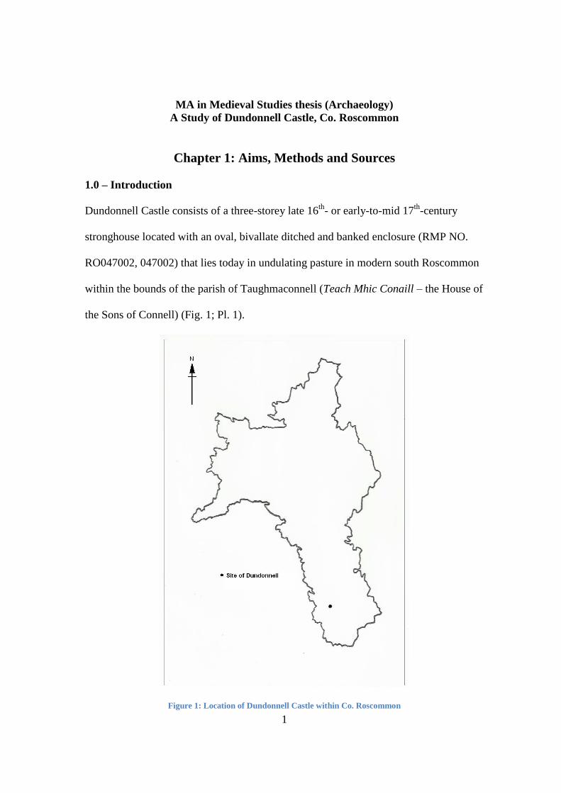
Figure 1: Location of Dundonnell Castle within Co. Roscommon ...................................... 1 Figure 2: Graham's sketch plan and cross-section (1988) ................................................... 9 Figure 3: Craig's ground floor sketch plan of stronghouse (1989) ................................... 9 Figure 4: Taughmaconnell in the Stafford Survey Map for the Barony of Athlone
(1636) .......................................................................................................................................... 14 Figure 5: Six Inch 1st edition Ordnance Survey Map of Dundonnell (1829) ................ 15 Figure 6: Territory of the kingdom of Uí Maine (expansion & decline taken into
account) ....................................................................................................................................... 20 Figure 7: Map of the King's Cantreds .......................................................................................... 31 Figure 8: Dundonnell 1829 Ordnance Survey Map (Figure 5 repeated) ....................... 44 Figure 9: Total Station of the earthwork, with the stronghouse situated in the north-
western quadrant. ................................................................................................................... 46 Figure 10: Reconstruction of what may have existed atop the earthwork at
Dundonnell c. mid 13th-century, courtesy of Carrie O'Malley (2011) ................. 47 Figure 11: Ground Floor plan of Stronghouse ......................................................................... 52 Figure 12: First floor plan of the stronghouse ........................................................................ 55 Figure 13: Reconstruction of the south facing walls of the stronghouse at
Dondonnell, courtesy of Carrie O'Malley (2011) .......................................................... 58 Figure 14: Reconstruction of the north walls of the stronghouse at Dundonnell,
courtest of Carrie O'Malley (2011) .................................................................................... 59 Figure 15: Location of Dundonnell with regard to the major medieval routeways of
the region .................................................................................................................................... 65 Figure 16: Ordnance Survey Map containing the extents of Dundonnell and Onagh
townlands ................................................................................................................................... 77
v
Table of Plates
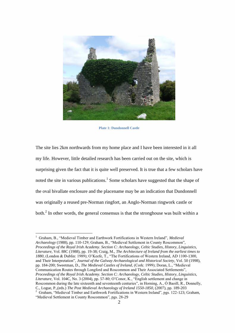
Plate 1: Dundonnell Castle ............................................................................................................... 2 Plate 2: North-eastern wall, largely broken out ..................................................................... 49 Plate 3: Ground floor fireplace and kitchen location on south-eastern gable wall ... 50 Plate 4: Gunloop on south-western wall (interior view) .................................................... 50 Plate 5: Gunloop on south-western wall (exterior wall) ..................................................... 50 Plate 6: Joist holes and corbel on south-western wall interior ........................................ 52 Plate 7: Windows on south-western wall exterior ................................................................ 53 Plate 8: North-western gable wall interior .............................................................................. 54 Plate 9: Evidence of machicolation on south-eastern gable wall ..................................... 57 Plate 10: Diamond-shaped chimneystacks .............................................................................. 57
vi
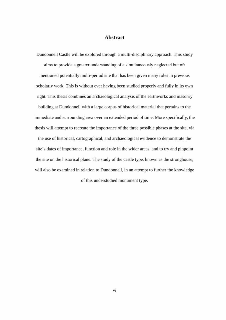
Abstract
Dundonnell Castle will be explored through a multi-disciplinary approach. This study
aims to provide a greater understanding of a simultaneously neglected but oft
mentioned potentially multi-period site that has been given many roles in previous
scholarly work. This is without ever having been studied properly and fully in its own
right. This thesis combines an archaeological analysis of the earthworks and masonry
building at Dundonnell with a large corpus of historical material that pertains to the
immediate and surrounding area over an extended period of time. More specifically, the
thesis will attempt to recreate the importance of the three possible phases at the site, via
the use of historical, cartographical, and archaeological evidence to demonstrate the
site‟s dates of importance, function and role in the wider areas, and to try and pinpoint
the site on the historical plane. The study of the castle type, known as the stronghouse,
will also be examined in relation to Dundonnell, in an attempt to further the knowledge
of this understudied monument type.
vii
Acknowledgements
Firstly, I would like to thank the Archaeology, History and Classics departments at
NUI, Galway for their inspiration and the dedication that they bring to their respective
disciplines. To this I would like to also show my appreciation for the staff of the said
departments and others, who helped me throughout my MA. Their enthusiasm was a
great motivation for my own work and I hope I showed my appreciation for their
efforts.
This leads me to Dr Kieran O‟Conor. Thank you for your direction and stalwart
encouragement and backing throughout the process of this study, along with providing
the spark for the thesis that accompanies this note. It was with your passion and love of
your work that inspired my own humble effort, and my hope is that it goes some of the
way to embodying the spirit of the MA.
I would like to thank also the immeasurable help provided by Joseph Fenwick and Rory
Sherlock. Joseph‟s hours of dedicated teaching in the mediums of digital surveying
were an invaluable addition to my work, along with being intensely interesting and
thoroughly enjoyable. The work done by Rory Sherlock provided a fresh pair of eyes
on the physical remains of Dundonnell, along with helping to plan said remains in a
manner best to analyse the site and, more specifically, its masonry phase. Thank you
both for your time, assistance and knowledge.
Thanks to Dr Mark Stansbury for your insightfulness and knowledge, and most of all
for your approachability and belief in my cause throughout the two years of the MA.
Our conversations were so often reassuring and your determination to further multi-
disciplinary studies has proved to be a major influence on my thought process, and for
that enlightenment I cannot possibly be able to adequately show my appreciation.
I would like to extend my gratitude to Kevin Flynn, the owner of the lands that
surround Dundonnell Castle for his permission to begin a study of this site and for his
wholehearted good wishes for my endeavours.
I would like to thank Josephine, Danny, Aishling and Niall Curley for their hard work
and grit in attempting to tidy up the swathes of overgrowth that hid Dundonnell, and
their patience with my attempts to master the Digital Survey. I would also like to thank
Denis Judge, for his generosity in providing me with the tools and equipment necessary
to help the work run smoothly and safely. I would also like to thank Carrie and Danielle
O‟Malley. Carrie for your immense artistic talents that served to illustrate my study,
and to Danielle for being you, and for keeping me sane and grounded when the stresses
of the research were starting to show! To all the above, I cannot even begin to show my
eternal indebtedness to your talents of listening and patience.
I wish to extend thanks to my colleagues in my MA, Mairead Keane, Sean Sullivan and
Kenneth Coyne, for being the like-minded individuals that led to a great working
relationship and constant help, but more importantly to being great and thoughtful
friends. Truer crusaders of the cause do not exist!
1
MA in Medieval Studies thesis (Archaeology)
A Study of Dundonnell Castle, Co. Roscommon
Chapter 1: Aims, Methods and Sources
1.0 – Introduction
Dundonnell Castle consists of a three-storey late 16th
- or early-to-mid 17th
-century
stronghouse located with an oval, bivallate ditched and banked enclosure (RMP NO.
RO047002, 047002) that lies today in undulating pasture in modern south Roscommon
within the bounds of the parish of Taughmaconnell (Teach Mhic Conaill – the House of
the Sons of Connell) (Fig. 1; Pl. 1).
Figure 1: Location of Dundonnell Castle within Co. Roscommon
2
Plate 1: Dundonnell Castle
The site lies 2km northwards from my home place and I have been interested in it all
my life. However, little detailed research has been carried out on the site, which is
surprising given the fact that it is quite well preserved. It is true that a few scholars have
noted the site in various publications.1 Some scholars have suggested that the shape of
the oval bivallate enclosure and the placename may be an indication that Dundonnell
was originally a reused pre-Norman ringfort, an Anglo-Norman ringwork castle or
both.2 In other words, the general consensus is that the stronghouse was built within a
1 Graham, B., “Medieval Timber and Earthwork Fortifications in Western Ireland”, Medieval
Archaeology (1988), pp. 110-129; Graham, B., “Medieval Settlement in County Roscommon”,
Proceedings of the Royal Irish Academy. Section C: Archaeology, Celtic Studies, History, Linguistics,
Literature, Vol. 88C (1988), pp. 19-38; Craig, M., The Architecture of Ireland from the earliest times to
1880, (London & Dublin: 1989); O‟Keefe, T., “The Fortifications of Western Ireland, AD 1100-1300,
and Their Interpretation”, Journal of the Galway Archaeological and Historical Society, Vol. 50 (1998),
pp. 184-200; Sweetman, D., The Medieval Castles of Ireland, (Cork: 1999); Doran, L., “Medieval
Communication Routes through Longford and Roscommon and Their Associated Settlements”,
Proceedings of the Royal Irish Academy. Section C: Archaeology, Celtic Studies, History, Linguistics,
Literature, Vol. 104C, No. 3 (2004), pp. 57-80; O‟Conor, K., “English settlement and change in
Roscommon during the late sixteenth and seventeenth centuries”, in Horning, A., Ó Baoill, R., Donnelly,
C., Logue, P.,(eds.) The Post Medieval Archaeology of Ireland 1550-1850, (2007), pp. 189-203 2 Graham, “Medieval Timber and Earthwork Fortifications in Western Ireland”, pgs. 122-123; Graham,
“Medieval Settlement in County Roscommon”, pgs. 28-29

3
pre-existing earthwork, which was then itself re-used as peripheral defences around the
latter building.
On one level, the fact that the masonry stronghouse seems to have been built within an
earlier monument of general medieval date means that the site of Dundonnell qualifies
as a suitable candidate for detailed study as part of NUI, Galway‟s MA in Medieval
Studies. In this respect, a legalistic, possibly Anglo-centric view might be that the
stronghouse at the site is not medieval in date and so this particular aspect of the
monument should not be studied in depth. However, certain Irish archaeologists, such
as Martin Jope, Tom McNeill and Kieran O‟Conor, have argued strongly that the
medieval period in Ireland ended in archaeological terms around 1650. This is argued
to have been particularly true of the Midlands and western half of the country.3 Duffy,
Edwards and FitzPatrick, in the 2001 book Gaelic Ireland c. 1260 –c. 1650: Land,
Lordship and Settlement state that the medieval period ends in Ireland around 1600.
The post medieval period is seen as beginning sometime around the latter year.4 It will
be argued below that the best time to see the construction of the stronghouse is
sometime in the last three decades of the 16th
-century – well within the time limits of
the medieval period in Ireland as set by scholars like McNeill and O‟Conor and even
Duffy, Edwards and FitzPatrick. Therefore, it is argued here that it is justified to study
the stronghouse in this thesis, as its construction falls within what scholars believe to be
the medieval, in particular the late medieval, period.
3 Jope, E. M., Jope, H. M., & Johnson, E. A., The Archaeological Survey of Co. Down, (Belfast: 1966);
McNeill, T. E., Castles in Ireland: Feudal Power in a Gaelic World, (London and New York: 1997) pgs.
228-299; O‟Conor, K., The Archaeology of Medieval Rural Settlement in Ireland, (Dublin: 1998) p. xi 4 Duffy, P. J., Edwards, D., & FitzPatrick, E., Gaelic Ireland c. 1250-1650: Land, Lordship and
Settlement, (Four Courts Press, Dublin: 2001), p. 17
4
The aim of the rest of this chapter is to outline the exact aims of this thesis, along with
the methods and sources used within it.
1.1 - The aims of this thesis
One of the aims of the thesis is to gain a better understanding of the way the site at
Dundonnell developed through time. Can we figure out what was the function (s) of the
site during different periods of its usage?
Very little work has been carried out on the stronghouse as a castle type. The
stronghouse belongs to the late 16th
and early-to-mid 17th
-centuries, but the information
known about castles from this period in Ireland usually begins and ends with the
detailed discussion of its more illustrious and elegantly designed cousins, the tower
house and fortified house. The latter type of castle balances Renaissance-influenced
aesthetics and defence in a way that the stronghouse cannot compare, and as a result,
their study has been largely neglected. As such, a major aim of this thesis is use the site
at Dundonnell as a means of learning more about the stronghouse in terms of its
architecture, function, construction, dating, use of internal space and defences.
No proper plan or description exists of the site at Dundonnell. Therefore, the last major
aim of the thesis is to carry out a Total Station survey of the site that will provide a
modern plan. A detailed description of the site will also be provided, which can be used
for future comparative studies elsewhere. It is clear that one of the weaknesses of Irish
castle studies (and, indeed, medieval studies in this country) is that most castles in
Ireland have not been properly planned and described. This is in direct contrast to the
5
situation in England, Wales and Scotland. It has been stated that for Irish castle studies
to progress, more plans and detailed, scientific descriptions of castles are needed.5 A
good plan and description of Dundonnell will be a valuable addition to medieval castle
studies in Ireland and will provide invaluable, trustworthy comparative data for anyone
interested in studying stronghouses in the future.
1.2 – Methodology
The methodology used in this thesis is based upon the interdisciplinary spirit that is
central to the ideas of the MA in Medieval Studies at NUI, Galway, and a method that
in this case combines historical documents, historical commentaries, archaeological
survey, analysis and GPS technology, cartographical studies and antiquarian sources in
order to achieve the aims provided above. This I feel is the best way of throwing light
on the monument at Dundonnell. It is an inclusive approach that leaves no avenue
unexplored and thus takes into account every possible situation before coming to any
conclusion.
This approach may seem logical but it is not always taken. For example, Sweetman‟s
1999 book The Castles of Ireland takes a purely archaeological approach. The historical
context of the castles analysed is not discussed and this means that the functions and
exact dates of these monuments is not fully understood by the latter author.6 In contrast,
it has recently been stated by the American settlement historian and archaeologist
Thomas Finan that “the exciting and innovative work in Irish medieval studies is taking
place in the margins between disciplines, where methodological and disciplinary
5 O‟Conor, K., “Castle Studies in Ireland”, Chateau Gaillard 23 (2008), pp. 329-39, pgs. 329-31
6 Sweetman, The Medieval Castles of Ireland
6
preoccupations break down and evidence can be re-analysed from a new perspective.”7
It is just such an interdisciplinary approach that I want to take at Dundonnell.
For the purposes of this thesis, a detailed archaeological survey of Dundonnell Castle,
the masonry monument and the earthwork, will take place, in order to record and
interpret the physical remains of the site, thus providing us with another form of
information with which to gain a better understanding of the monument and its place in
history. To do this, the masonry castle itself must be measured and planned out, with
specific digital tools to be applied to the earthwork. This comes in the form of digital
surveying - with the Trimble GPS, and the Total Station. The information gathered
from these devices can be collected, stored, and analysed on ArchGIS and Geosite
Office, programs that specialise in map production and analysis, to show how the site
was constructed, and to help understand and highlight any aspects of the monument that
may have gone unnoticed to the naked eye. These tools, therefore, add vital information
to this thesis, especially considering that the site will, unfortunately, not be excavated
for the purposes of this study.
The Trimble GPS (Global Positioning System) works by using satellites to pinpoint the
device‟s position on the landscape up to a centimetre of accuracy, and thus, the holder
can plot the device‟s position at regular intervals to record a feature on the landscape on
the Irish National Grid. With this, the archaeologist can create a map detailing all the
various features that make up a given site and its hinterland, providing important
distance and gradient information, drawing and plotting vital features, all via the
7 Finan, T., “Introduction: Moylurg and Lough Ce in the Later Middle Ages” in Finan, T., (ed.) Medieval
Lough Ce – History, Archaeology and Landscape, (Dublin: 2010), pp. 11-14, p. 11
7
National Grid. Its applications in regard to the site at hand would centre around aiding
the use of the Total Station in providing OS co-ordinates from which to work from, a
vital component of the digital process, without which the digital survey could never be
applied to the National Grid.
The Nikon DTM-322 Total Station is another vital tool in the surveying of
archaeological sites, through its utilisation of the recording of a series of X, Y & Z co-
ordinates on a plane that can again be placed in the co-ordinates of the Irish National
Grid. The Total Station itself uses a laser which it reflects off a prism situated on a
detail pole at whatever point has been chosen for recording. When each co-ordinate is
recorded and downloaded to the map producing programs of Geosite Office or
ArchGIS, they plot the landscape and can be manipulated to create anything from a line
drawing of the site, which is our primary concern, to 3D maps of the site, with the
crucial benefit of being able to pick up features that would be invisible to the naked
eye. Its applications here will be important to show the scale and details of the
earthwork, identifying specifics such as the entrance and the magnitude of the ditch and
bank systems. It is with the analysis of these details that we can garner an
understanding of how important this site may have been during its periods of
occupation, along with why it was positioned where it was and the benefits inherent to
same.
1.3- Previous work on Dundonnell
The first modern scholarly discussion of Dundonnell Castle, albeit brief, surfaces with
the work of Brian J. Graham in his two 1988 articles “Medieval Timber and Earthwork

8
Fortifications in Western Ireland” published in the journal Medieval Archaeology8 and
“Medieval Settlement in County Roscommon” published in the Proceedings of the
Royal Irish Academy.9 Graham provides a short description and some information on
the site and is mainly concerned with its ringwork/ringfort phase, inserting both a rough
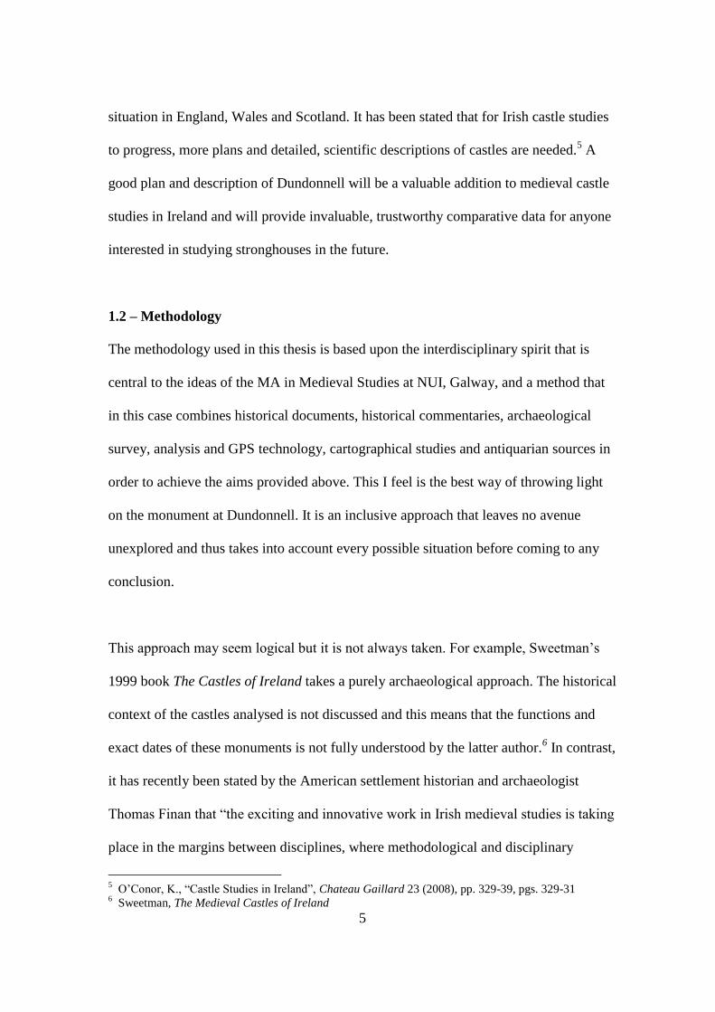
sketch plan and a cross-section of the earthwork in his second article (Fig 2).10
Maurice
Craig briefly mentions and includes an almost miniscule sketch plan of the stronghouse
in his 1989 book The Architecture of Ireland from the Earliest Times to 1880. He dates
this building to the first half of the 17th
century (Fig. 3).11
8 Graham, “Medieval Timber and Earthwork Fortifications in Western Ireland”, pgs. 122-123
9 Graham, “Medieval Settlement in County Roscommon”, pgs. 28-29
10 Graham, “Medieval Settlement in County Roscommon”, Fig. 3, p. 28
11 Craig, M., The Architecture of Ireland from the earliest times to 1880, pgs. 131 & 134
9
Figure 2: Graham's sketch plan and cross-section
(1988)
Figure 3: Craig's ground floor sketch plan of
stronghouse (1989)
Tadhg O‟Keeffe briefly discusses Dundonnell Castle also in his 1998 article “The
Fortifications of Western Ireland, AD 1100-1300, and Their Interpretation”, published
in The Journal of the Galway Archaeological and Historical Society.He believes that
the stronghouse was built within a pre-existing, unoccupied ringfort and does not
believe that the latter earthwork was re-used as a ringwork castle in the 13th
-century –
meaning that he sees only two phases at the site.12
David Sweetman also briefly
mentions Dundonnell on the basis of its stronghouse phase in his all-encompassing
1999 work The Medieval Castles of Ireland.13
However, it is again unfortunately
mentioned merely as one of a number of stronghouses that exist in Roscommon and is
not treated to any great extent on its own unique characteristics. Linda Doran‟s study of
medieval communication routes and roadways through the midlands also makes
mention of Dundonnell and notes its location in close proximity to both the Slíghe
12
O‟Keefe, T., “The Fortifications of Western Ireland, AD 1100-1300, and Their Interpretation”, p. 190
and note 54, p. 198 13
Sweetman, D., The Medieval Castles of Ireland, pgs. 197-198
10
Mhór (a major roadway of the time) and to an important secondary road perpendicular
to the Slíghe Mhór, which Dundonnell lies beside.14
Kieran O‟Conor discusses the site
in regard to its masonry stronghouse phase in his 2007 article on English settlement in
Roscommon during the late 16th
and early 17th
-centuries, and raises interesting
questions as to the history and the purpose of the site. He argues that there was no
Anglo-Norman ringwork phase at the site – believing that the site was originally a
ringfort refortified in Tudor and Jacobean times.15
Compilers at the Archaeological
Survey of Ireland visited the Dundonnell in the mid 1990s and classified the site as an
Anglo-Norman ringwork castle within which was situated a late 16th
or early-to-mid
17th
-century fortified house.16
In summary, it is clear that Dundonnell has been recognized as an important site by a
number of scholars but little detailed work has been carried out on it. No proper plan or
comprehensive description of the site has been published – a situation replicated right
across the country, as noted.
1.4 – Sources used in this thesis
1.4a - Documentary Sources:
Documentary sources are a vital addition to any archaeological study and can be used
by archaeologists in a variety of ways.17
In the case of this thesis, documentary
evidence will seek to play an even more important role, due to the author‟s own
14
Doran, L., “Medieval Communication Routes through Longford and Roscommon and Their
Associated Settlements”, p. 76 15
O‟Conor, K., “English settlement and change in Roscommon during the late sixteenth and seventeenth
centuries”, pgs. 191-192 16
Archaeological Survey of Ireland, 2010, National Monuments Service [online], available:
http://webgis.archaeology.ie/NationalMonuments/flexviewer/[accessed 9th June 2011] 17
Barry, T., The Archaeology of Medieval Ireland, (London & New York: 1987), pgs. 3-10
11
primary training in the historical discipline. Evidence from these historical sources can
help date and phase sites such as Dundonnell. They can provide information about the
occupants of any given site and inform us about the general political, economic and
social context within which the inhabitants of places like Dundonnell operated. They
can also help in understanding how a site looked when it was in use. For example, O‟
Conor has successfully used surviving late 13th
and early 14th
-century manorial extents
to reconstruct the appearance of certain motte castles in Leinster around c. 1300.18
Finally, we must not forget to analyse the language in use in the contemporary written
sources, as what is said, how it is phrased and what is potentially omitted can colour the
situation to an even greater degree, allowing us to understand as much as we can about
the topic at hand. The historical sources that will come into play in this thesis include
the native Irish annals and edited colonial sources emanating from the Dublin
government such as the four volumes of the Calendar of Documents Relating to
Ireland, 1171-130719
and the later twenty-three volumes of the Calendar of State
Papers, Ireland.20
Both colonial and native sources must be employed with caution, but
indeed it is this inherent bias in the texts that is often of most interest.
The Gaelic annals are an essential source of information for areas that saw little
intensive English settlement, such as modern Roscommon and much of the Midlands
and western Ireland. The entries within these annals are laconic in nature but are full of
references to ecclesiastical and secular settlements in the latter regions. They do
provide a certain amount of information about the economy and society of the more
18
O‟Conor, K., The Archaeology of Medieval Rural Settlement in Ireland, (Dublin: 1998), pgs. 28-33 19
Calendar of documents relating to Ireland, 1252-1284, Sweetman, H. S. (ed.), (Nendeln, 1974) 20
Calendar of State Papers relating to Ireland of the reigns of Henry VIII, Edward VI, and Elizabeth,
1509-[1603]. Hamilton, H. C. (ed.). P.R.O. (London: 1920-31)
12
Gaelic-dominated parts of the country, such as the Dundonnell area, after 1169 and, of
course, before that date as well.21
The entries in these annals are not recorded in any
given order on an annalistic year and they are simple notes recording an event that has
occurred in that year. This is a problem that is endemic of annals, but their usefulness
cannot be understated for the recording and comparison of events, and often for
providing events mentioned in literature and in longer narratives with a date, if it hadn‟t
been mentioned in the text itself. The annals of most interest to this study as that of the
Annals of Clonmacnoise edited by Rev. D. Murphy and published in 189622
, the Annals
of Connacht, edited by A. D. Freeman and published in 194423
, and The Annals of the
Four Masters, the four volumes of which were compiled and edited by John
O‟Donovan between 1848 and 1854.24
The Annals of Clonmacnoise, the most
important to my research,deals with the period from the mythical Biblical creation of
man until the year 1408, with a few entries missing. It gives the history of the island of
Ireland and the area surrounding Clonmacnoise in particular, which is very useful,
given its proximity to Dundonnell itself.
The colonial sources, particularly those emanating from the central government in
Dublin, are far more detailed in comparison to the native sources, both in terms of
numbers surviving and information.25
The five volumes of the Calendar of Documents
Relating to Ireland, 1171-1307 were used in this thesis and contain a multitude of
21
Barry, T., The Archaeology of Medieval Ireland, p. 9 22
The Annals of Clonmacnoise: Being annals of Ireland from the earliest period to A.D. 1408, Murphy,
Rev. D. (ed.), (Dublin: 1896, facsimile reprint 1993) 23
Annála Connacht: the Annals of Connacht, AD. 1224-1544, Freeman, A.D. (ed.), (Dublin: 1944; reprint
1977) 24
Annals of the kingdom of Ireland by the Four Masters: from the earliest period to 1171, O‟Donovan, J.,
(ed.), (Hodges and Smith, Dublin: 1854) 25
Barry, T., The Archaeology of Medieval Ireland, pgs. 3-9

13
references to Anglo-Norman castles and manorial centres.26
The 23 volumes of the
Calendar of State Papers, Ireland, edited by various authors in the 19th
and early 20th
century, are of importance to our general understanding of the stronghouse phase at
Dundonnell. These volumes contain a correspondence between English administrators
in Ireland and their counterparts and superiors at the seat of the royal government and
court in London.27
In addition to these sources, broader contemporary sources will be
consulted to understand the site and its hinterland in the years of its occupation, as
specifically in the cases of its ringwork and stronghouse phases, due to them coinciding
with periods of considerable transition and political and military activity in the region.
1.4b – Cartographic Sources
Late 16th
- and early-to-mid 17th
-century maps linked to the Tudor and Stuart reconquest
of Ireland are dotted with depictions of castles, artillery forts, abbeys, churches,
routeways and secular urban and rural settlements. These maps can be of great value to
archaeologists attempting to reconstruct the settlement patterns and landscape of late
medieval Ireland. These maps can also help date sites under study.28
The English-
controlled government in Dublin in the 17th-century ordered a number of surveys and
inquisitions. Much of these maps were drawn up to facilitate the large-scale
confiscation and redistribution of land to loyal English and Scots Protestant settlers.
One of these surveys was the Stafford Inquisition of Connacht in 1636. These included
26
Calendar of documents relating to Ireland, 1252-1284, & Barry, T., The Archaeology of Medieval
Ireland, p. 4 27
Calendar of State Papers relating to Ireland of the reigns of Henry VIII, Edward VI, and Elizabeth,
1509-[1603] 28
Prunty, J., Maps and Map Making in Local History, (Dublin: 2004)
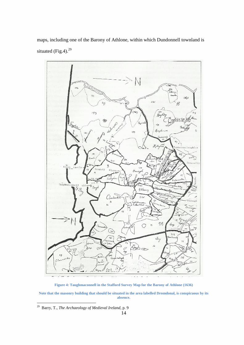
14
maps, including one of the Barony of Athlone, within which Dundonnell townland is
situated (Fig.4).29
Figure 4: Taughmaconnell in the Stafford Survey Map for the Barony of Athlone (1636)
Note that the masonry building that should be situated in the area labelled Dromdonal, is conspicuous by its
absence.
29
Barry, T., The Archaeology of Medieval Ireland, p. 9
15
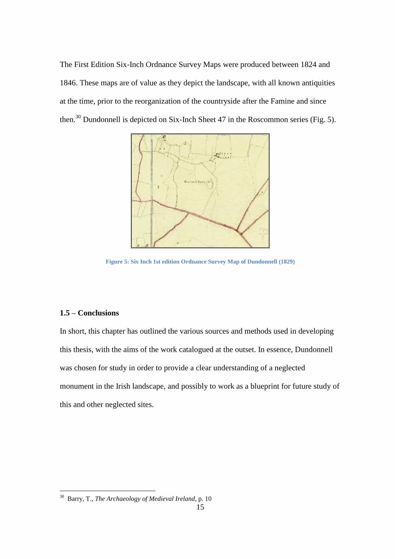
The First Edition Six-Inch Ordnance Survey Maps were produced between 1824 and
1846. These maps are of value as they depict the landscape, with all known antiquities
at the time, prior to the reorganization of the countryside after the Famine and since
then.30
Dundonnell is depicted on Six-Inch Sheet 47 in the Roscommon series (Fig. 5).
Figure 5: Six Inch 1st edition Ordnance Survey Map of Dundonnell (1829)
1.5 – Conclusions
In short, this chapter has outlined the various sources and methods used in developing
this thesis, with the aims of the work catalogued at the outset. In essence, Dundonnell
was chosen for study in order to provide a clear understanding of a neglected
monument in the Irish landscape, and possibly to work as a blueprint for future study of
this and other neglected sites.
30
Barry, T., The Archaeology of Medieval Ireland, p. 10
16
Chapter 2-The Historical Background
2.0 – Introduction to the Chapter
Given Dundonnell Castle‟s location in the landscape of south Roscommon, it has been
deemed necessary to provide a historical treatment of the area from the period that the
first habitation could have occurred at Dundonnell during the early medieval period up
until the 17th
century, when the stronghouse on the site was probably last occupied.
This treatment has to be constructed for the sake of context, without which, the site
itself would be suspended in a historical limbo that would inform us of little. This will
be followed by a brief discussion of Taughmaconnell parish itself, and what
information we can ascribe to the immediate area for the date range in question, in
order to further extend our understanding of Dundonnell. Finally, and most importantly,
the site itself will be discussed in its historical context. Its various references in the
historical record need to be documented and analysed.
2.1 - Early Medieval Ireland (c. 500AD – c. 1100AD)
Early Medieval Ireland or Early Christian Ireland is seen in popular histories as being a
Golden Age in Irish history, halcyon days for the Irish, with the archaeological and
historiographical evidence from the period rich in tales of learned monastic centres
producing great minds and texts. Ireland was a venerable land of saints and scholars.
Men such as St Columcille and St Columbanus were instrumental in converting
northern Britain and large parts of the Continent to Christianity.31
This idealised picture
of Early Christian Ireland is one that we, as a nation (within the Republic), cling dearly
to, as an authenticator of our own identity. We have seen it as a period of great
31
For example, Cahill, T., How the Irish Saved Civilisation, (London: 1995)
17
achievement for the Irish people – something that was destroyed by the English in
1169. Such long held attitudes affected the study of archaeology in Ireland with the post
1169 period receiving little attention until relatively recently due of its association with
English domination.32
In my opinion, based on my reading, 1169 should not be viewed
as the landmark date in Irish history that some historians and popular culture have often
ascribed to it.33
There was much continuity from the early medieval period into later
times and this will be discussed in more detail below. We have to remember, however,
that the Ireland that we picture today, like all modern countries, is a recent concept.
Prehistoric and Early Christian Ireland was much less a nation, much more a swathe of
petty kingdoms and saw a constant redrawing of boundaries. Resultantly, one must
constantly refer back to a different societal makeup when making conclusions.34
The
fact that the single unit of Britain first begins to take shape with the Romans cannot be
applied to its western neighbour until at least the early modern period, and it is with this
important fact in mind that we must proceed with a history of the area. John Morrissey
highlights this situation well in his period of study, and the futility of attempting to
assign such singular entities as, in his case, the Gaelic world, or the Anglo-Irish
equivalent.35
Despite the fact that for our purposes, we must transport this analogy back
over a millennium, oddly the situation is markedly similar, in that the whole way up
32
Barry, T., The Archaeology of Medieval Ireland, pgs. 1-2; McNeill, T. E., Castles in Ireland: Feudal
Power in a Gaelic World, p. 2; O‟Conor, K., The Archaeology of Medieval Rural Settlement in Ireland,
pgs. 10-12 33
See for instance the break between Ó Corráin, D., Ireland before the Normans (The Gill History of
Ireland 2: 1972) & Dolley, M., Anglo-Norman Ireland (The Gill History of Ireland 3: 1972), along with a
similar division in the more recent New History of Ireland series, both noteworthy scholarly series, but
both divided along mainstream lines. For popular culture see The Story of Ireland (2011) RTÉ, March.
10.15pm 34
MacCotter, P., Medieval Ireland: Territorial, Economic and Political Divisions, (Dublin: 2008) 35
Morrissey, J., “Cultural geographies of the contact zone: Gaels, Galls and overlapping territories in
late Medieval Ireland”, Social and Cultural Geography, Vol. 6, No. 4, August 2005, pp. 551-566, p. 562
18
through the history of the island of Ireland until at least the early modern period, the
kingdoms are so numerous, and their stories so divergent, that to provide a single
narrative would be potentially very limited and unsatisfactory.
In the same way as the island should not be viewed as a single entity in the writing of
history for these early periods, one must also be careful not to segment the timeline too
rigidly, as to do so effectively just sends the impression that there was a period of
tranquillity and purity before, say 1169, and everything post 1169 is somehow tainted.
It‟s an unfortunate situation that even occasionally rears its ugly head in scholarly
circles also, and is something I hope this study can stay away from. Only the
banishment of such divisions in this work will provide a working framework to discuss
the history of the area and the site properly. The author is aware of the necessary
division of the site itself into phases, and as such, will attempt to keep the possible
ramifications of this division to a minimum, as regards its probable change in
ownership at least.
The modern county boundaries that divide the country into thirty two entities have not,
obviously, been in existence from the dawn of time, mostly coming into existence in
the late 16th
-century, and as such, one of the prior divisions, into various „túath‟ or
ruling dynasties, becomes very important for our purposes. The title that Orpen puts to
the period immediately before the introduction of large-scale English influence
encapsulates the attitude of the political organisation of the island at the time.36
36
Orpen, G. H., Ireland under the Normans, (Dublin: 2005), p. 1 “Anarchic Ireland: Ninth to Eleventh
Centuries”. It must be noted that this is in spite of the content of the chapter, something that will not,
however, be dealt with any further in this study.
19
The early history of Connacht, alone among the other provinces, never seemed to have
had a strong tradition of over-kingship. In this regard, instead of having one or two
large túath challenging of the superiority of the province, in Connacht we had a series
of different kingdoms and intermittent wars over personal gains, but no overarching
organisation or higher ambition than that. This can be clearly seen from the 1937 article
on the “Christian Kings of Connacht”, by Rev. Walsh, which highlights that before AD
550 only three kings of Connacht can be cited with certainty.37
If, however, we add to
this the possibility that the later annotators of annals applied the title rí Connacht to an
individual posthumously,38
it serves to show that even post-550, there may not have
been a great change in practice. It is from this slightly different attitude and
organisation that we get the situation that arose in the case of our kingdom of interest,
Uí Maine, as it was this nuanced view of the overlordship that directly led to more
power secondary kingdoms, such as the aforementioned, in Early Medieval Connacht.
The ruling family during Early Medieval times in the region of south Roscommon and
east Galway, within which Dundonnell lies, was indeed the Uí Maine, or Hy-many, to
use the anglicised form (Fig. 6).
37
Walsh, P., “Christian Kings of Connacht”, Journal of the Galway Archaeological and Historical
Society, Vol. 17, No. ¾ (1937), pp. 124-143, p.142 38
Ó Cróinín, D., “Ireland 400-800”, in Ó Cróinín, D., (ed.), The New History of Ireland 1: Prehistoric
and Early Ireland, (Oxford: 2008), pp. 182-234, pgs. 227-228

20
Figure 6: Territory of the kingdom of Uí Maine (expansion & decline taken into account)
The Uí Maine had a rich history, which stretched back to their pseudo-genealogy,
summarised by Byrne39
, and semi-mythological arrival in the south Roscommon area
under the patronage of a follower of St. Patrick, St. Grellan, in the 5th
-century AD.40
39
Byrne, F. J., Irish Kings and High-Kings, (Dublin: 2001), p. 85 40
O‟Donovan, J., The Tribes and Customs of Hy-Many, commonly called O’Kelly’s country, (Dublin:
1843), pgs. 8-9
21
Tirechán, the late 7th
-century biographer of St. Patrick, makes brief reference to the Uí
Maine and describes the founding by Patrick of a church in their territory at Fidarta or
Fuerty, Co. Roscommon.41
Kelleher provides an important point with regard to the treatment of the Uí Maine in the
annals, specifically the Annals of Clonmacnoise, in that, although the monastery was in
the territory of Mide and was patronised by the Clann Colman Móir and the Uí Fhailge,
the Uí Maine regularly receive more frequent mention than the patrons themselves.
This he argued was because “Uí Maine territory lay along the west side of the Shannon
from just south of Loch Derg to some point on Loch Ree, and on both sides of the
lower Suck, (therefore) every military force that crossed in either direction at Athlone
or that moved up or down the Shannon came through their lands or impinged upon
them.”42
In other words, the Uí Maine were one of the closest tribes to Clonmacnoise
during Early Medieval times and were able to influence affairs at the monastery as a
result.
Thus, the kingdom of the Uí Maine was a powerful one, albeit „of the second rank of
importance‟ in Connacht due to its lack of a descent from Echu Mugmedón. In spite of
this, it was probably one of the largest petty kingdoms on the island in the Early
Medieval period.43
Its location on the Shannon also made the Uí Maine powerful as it
allowed them control this vital north/south routeway. Besides this, the Uí Maine were
also very influential in other spheres.
41
Ó Cróinín, D., “Ireland 400-800”, p. 231 42
Kelleher, J. V., “Uí Maine in the annals and genealogies to 1225”, Celtica, ix (1971), pp. 61-112, p.
62 43
Walsh, P., “Connacht in the Book of Rights”, Journal of the Galway Archaeological and Historical
Society, Vol. 19, No. ½ (1940), pp. 1-15, p. 12

22
Clonfert, Aughrim (Echdruim) and most importantly, the monastic „city‟ of
Clonmacnoise, a worthy rival for the „Patrician‟ Armagh, were all situated within or
close to Uí Maine territory, with Uí Maine kings even having the privilege of being laid
to rest in Clonmacnoise.44
The prestige associated with having religious communities
on one‟s land was not lost on the Uí Maine. Rich monasteries like Clonmacnoise
provided much wealth for adjacent tribes, albeit not always at the permission of the
incumbent abbot and his monks.45
The first annalistic reference to the Uí Maine comes in 538, with the Battle of
Clóenloch, and it is with this and certain later annalistic references concerning this
group that we can glean a very interesting power that the túath possessed. Essentially,
in order for a contender to obtain the overlordship of the province of Connacht, the
kingdom of the Uí Maine had to be dominated first.46
The position of the Uí Maine in
this regard in later years was not without challenge, and by the 8th
century, the Uí
Briúin were making advances on the overlordship of Connacht, slowly wearing down
the power of the Uí Maine on their way to becoming major players on the politics of the
island. But, for a period of nearly two centuries, the Uí Maine were the kingdom that
had to be appeased in order for another túath to have safe access to the kingship of
Connacht.
44
Byrne, Irish Kings and High-Kings, pgs. 92-93 & 252 45
Kelleher, “Uí Maine in the annals and genealogies”, p. 62 46
Ó Cróinín, “Ireland 400-800”, p. 232
23
Despite the eventual demise of their useful position as a powerbroker, an inevitable
situation really, given the ebb and flow of politics in Early Medieval Ireland, the Uí
Maine were still very powerful in the region and the island as a whole in the 10th
, 11th
and 12th
-centuries. For example, it is clear that at least one member of the Uí Maine
played a prominent part in the Battle of Clontarf in 1014. In the notes section of the
Tribes and Customs of Hy-Many, O‟Donovan includes biographical information on one
Tadhg Mór O‟Kelly, son of Murchadh, and chief of the Uí Maine for thirteen years
before he fell “like a wolf-dog fighting the Danes” in the battle. Around his heroism, a
unique one as the men of the Uí Fiachrach Aidne and the Uí Maine were the only two
non-Munster based kingdoms to provide contingents in Brian Bóruma‟s army in
101447
, grew a tale that said that a fabulous animal came from the sea to protect Tadhg
Mór‟s fallen corpse from the Danes.48
This is, no doubt, a tribute to the man who was
recorded as being one of the three coimmite or attendants of Brian Bóruma at this
time.49
So while the Uí Maine no longer held the balance of power in Connacht, they
still had the distinction of having powerful friends. It is also noteworthy that the
O‟Kellys had become the dominant sept of the Uí Maine by the time of Clontarf.
The intriguing characteristic that seems to make Uí Maine territory so central to the
politics of early medieval Ireland and Connacht is just that, its geographic centrality on
the island itself. This has been previously alluded to with regard to its proximity to the
Shannon and closeness to the borders of Mide and Leinster, but is compounded even
further by the presence of a number of key land routes that passed straight through Uí
47
Byrne, Irish Kings and High-Kings, p. 243 48
O‟Donovan, The Tribes and Customs of Hy-Many…, p. 99 49
Kelleher, “Uí Maine in the annals and genealogies”, p. 84
24
Maine territory, with the most prominent being the Slighe Mhór. This meant that many
major expeditions east to west or vice versa, be it martial or mercantile in motive, had
to pass through South Roscommon.
It was Colm Ó Lochlainn who initiated the first extensive study into the Early Medieval
routeways of the island. His mapping of the routes, using mythology and folklore as his
primary sources50
, has been generally accepted as correct and built on in more modern
studies, with Michelle Comber51
and, more specifically to the needs of this thesis,
Linda Doran52
providing much needed research in the fields of communication and
transport in Early Medieval Ireland. It is clear from these studies that a very important
routeway ran across Ui Maine territory in south Roscommon during Early Medieval
times. This road entered the latter territory at a ford over the River Shannon and crossed
the Suck at Ballinasloe. Both the Suck and Shannon were navigable rivers and so it can
be said that the wealth and power of the Uí Maine was linked to their access to and
control of the route.53
Transportation and communication links in relation to the site
will be given a full discussion later in the study.
In conclusion, for the Early Medieval period, the Uí Maine (whose main grouping
became the O‟Kellys) was a wealthy and politically important tribe. Important
routeways went across their territories, within which Dundonnell was situated. Rich
50
Ó Lochlainn, C., “Roadways in Ancient Ireland”, in Ryan, J., (ed.) Féilsgribhinn Eóin Mhic Néill,
(Dublin: 1940), pp. 465-474, p. 465 51
Comber, M., “Trade and Communication in Early Historic Ireland”, The Journal of Irish Archaeology,
Vol. 10 (2001), pp. 73-92 52
Doran, L., “Medieval Communication Routes through Longford and Roscommon and Their
Associated Settlements”. 53
Ó Lochlainn, C., “Roadways in Ancient Ireland”; Comber, M., “Trade and Communication in Early
Historic Ireland”; Doran, L., “Medieval Communication Routes through Longford and Roscommon and
Their Associated Settlements”.
25
monasteries occurred along the borders of their lands. In all, the kingdom of Uí Maine
was one of the most important and largest petty territories within the province of
Connacht.
2.2 - High Medieval Ireland (c. 1100 – c. 1380)
Indeed, in the early years after 1169, the situation in Uí Maine didn‟t change all that
much, when the populist readings of the situation are placed to one side.54
The arrival
of the English initially made little impact on Connacht in general and Uí Maine in
particular. The O‟Kellys remained the kings of Uí Maine. As the 12th
-century came to a
close, the political situation in South Roscommon is ultimately preoccupied with the
wider dynastic and political struggles of the O‟Conors, and the effect these struggles
had in their individual kingdoms, than the newly colonising English. The
unprecedented stranglehold that the O‟Conors held on power in both the region and the
island stretched back to the 10th
-century.55
Therefore their influence was felt the length
and breadth of the island, something that only started to deteriorate with the ever-
increasing power of the English.
O‟Conor power would eventually be eroded, however, not just by outside forces but
also by the intricate nature of Irish dynastic politics.56
Although this was not a new
occurrence in medieval Ireland, the position of the English would have great
implications regarding the future history of Uí Maine territory, Connacht, and the island
54
Gerald of Wales, The History and Topography of Ireland, trans. O‟Meara, J. J., (Penguin, London:
1982). Giraldus Cambrensis is the first to provide a detailed account of the English arrival, however, his
propagandistic text should be treated with extreme caution. 55
Byrne, Irish Kings and High-Kings, p. 253 56
Martin, F. X., “John, Lord of Ireland, 1185-1216”, in Cosgrove, A., (ed.) A New History of Ireland II:
Medieval Ireland 1169-1534, (Oxford: 2008), p. 130
26
as a whole, although the actions that led to this occurred much more subtly than
traditional historians like Orpen may have had you believe.57
The direct dealings between the Uí Maine and the Kings of Connacht in the early years
after 1169 are mixed, with the taciturn element being central to their dealings.
The first year after the arrival of the English on the island sees the Annals of Tigernach
and Annals of the Four Masters more concerned with the retaliatory expedition of the
then high-king of Ireland, Ruaidrí O‟Conor, against the tribes of the Úa Briain and the
Dál Cais, with Uí Maine providing assistance to the high-king by raiding the lands of
Ormond, directly to their south, raiding which continued into 1171.58
Here we see the
strategic advantage that allying with the Uí Maine provided, something that could
easily be transferred to raiding expeditions across the Shannon also. If, however, we
fast forward to 1180, we see a complete reversal of fortunes for the Uí Maine, and their
locational advantages counted for little, as the O‟Conors find themselves at war with
the men of Uí Maine. In this battle we find Conchobar Maenmaige, son of Ruaidrí,
defeating and killing the king of the Uí Maine, Conchobair O‟Kelly, along with much
of his kin59
, showing how quickly relations soured.
Ruaidrí was the king of Connacht and high-king of Ireland upon the arrival of the
English in 1169, and with Henry‟s visit in 1171-72, commentators of the period, such
57
Seán O‟Faolain introduces a very interesting hypothetical model for the more gradual subjugation of
the Irish „captains‟, as he puts it, with Donal O‟Conor Sligo being negotiated into the ‟Surrender and
Regrant‟ system in the 16th century reign of Henry VIII. The earlier precursors of this system were first
to be employed in Connacht with the English „mercenary‟ involvement into interfamilial strife, such as
the turmoil that enveloped the O‟Conor in the 12th and early 13th centuries. See O‟Faolain, S., The Great
O’Neill, (Mercier Press, Cork 1997), pgs. 11-14 58
Kelleher, “Uí Maine in the annals and genealogies”, p. 102 59
Kelleher, “Uí Maine in the annals and genealogies”, pgs. 102-103
27
as Giraldus Cambrensis, asserted that this was when the English effectively claimed
dominion of the island. However, just because a number of kings offered submission
does not mean that Henry was the de facto ruler.60
In fact, if we consult the other
sources and treat Giraldus with caution, we can come to the conclusion that Ruaidrí
indeed became Henry II‟s homo, but not as a submissive tribute, rather as King of
Connacht and ruler of all but the lands that Henry and his English subjects controlled,
in return for faithful and obedient service.61
However, the nature of English private adventuring meant that ambitious men would
always push the boundaries of agreements such as the Treaty of Windsor, signed in
1175. The first violations occurred one year later, with John de Courcy setting about the
invasion of Ulster, and in 1177, when, more specifically to our needs, Miles de Cogan,
a constable of the Dublin garrison, crossed the Shannon with a force of knights and
archers to invade Connacht. It seems that this was done effectively at the behest of
Murchad O„Conor, a son of Ruaidrí‟s, „for evil towards his father‟. This act of
mercenary activity was essentially the commencement of “a process which was to
become a regular feature of English involvement in Connacht, and which was usually
very rewarding for the English in terms of both wages and booty.”62
Although the De
Cogan expedition failed, it was merely the first venture across the Shannon, often at
Athlone in Uí Maine lands, to claim Connacht, showing the concrete aims that the
English had in mind for the province.
60
Walton, H., “The English in Connacht, 1171-1333”, (Unpublished PhD Trinity College Dublin: 1980),
p. 2 61
Walton, “The English in Connacht”, p. 8 62
Walton, “The English in Connacht”, p. 13
28
The year 1178 sees the action turn to Uí Maine territory specifically for the first time.
Another act of English aggression on the part of Hugh de Lacy was attempted at
Clonmacnoise in this year. However, an O‟Conor army, presumably supplemented by
Uí Maine troops, were steadfast in their determination to repel the English, both for the
prestige Clonmacnoise held for both their kingdoms, and the possibility that capturing
Clonmacnoise may have been used as a springboard into the south east of Connacht.63
The importance that Athlone held as gateway to Connacht, along with its proximity just
inside Uí Maine lands, makes its role in the 12th
and 13th
centuries very important for
our purposes. Orpen describes Athlone as such - “Whoever held Athlone, held the key
to communications between Connaught and Meath…The Irish used to make fords by
widening the channel of a river, and even by building a sub-aqueous tochar or
causeway. Such a tochar was made at Athlone in the year 1000.”64
To complement the
ford crossing at Athlone and to concrete its position as a base for incursions into Mide,
in 1129 Tairrdelbach O‟Conor, Ruaidrí‟s father, erected a wickerwork bridge and a
caislen or castle on the eastern bank of the Shannon at Athlone. Combined, the bridge
and fortification were to prove a constant nuisance to the lands and kings of Mide, as
seen by the fact that Tairrdelbach and, later, his son Ruaidrí, constructed a total of five
bridges at the crossing in the space of twenty-nine years. This was due, in no small part
to the fact that the kings of Mide were constantly pulling said bridges down.
63
Walton, “The English in Connacht”, p. 16, citing the Annals of Tigernach 64
Orpen, G. H., “Athlone Castle: Its Early History, with Notes on some Neighbouring Castles”, The
Journal of the Royal Society of Antiquaries of Ireland, Fifth Series, Vol. 37, No. 3, [Fifth Series, Vol. 17]
(Sep. 30, 1907), pp. 257-276, p. 258
29
With the arrival of the English on the island and their interest burgeoning in Connacht,
Athlone assumed an even greater position of importance in the destiny of the province,
and by 1200, the general consensus is that the settlement of Athlone was now in the
possession of the English. The entry in the annals of Loch Cé for 1199 certainly points
towards a situation of Cathal Crobderg, the younger brother of Ruaidrí, attacking the
bódhún of Ath, which has come to be thought of as a reference to the bawn of Athlone.
At this stage there was probably a fortification on the western bank of the Shannon65
,
on the site of the fortification that survives to present day. In the long run, the operation
of the „gateway‟ of Athlone changed hands, with the control of the bridge opening up
the whole of Connacht and the north of the country to the English66
, making it a key
advantage to their aspirations of expansion into these areas.
Athlone thereafter became the site of two peace settlements on the parts of Cathal
Crobderg and the English, in 1195 and 1210. The ambitious Crobderg had aspirations
of increasing his power on the island, thus starting to raid in neighbouring eastern
kingdoms. The English became aware of his ambitions, and met him at Athlone, where
his kingship was recognised in return for him ceasing his expeditions outside of his
own borders.67
The second Peace of Athlone (1210) continued this observance, after a
few instances of instability and uncertainty in the intervening period.68
The place that
Athlone held here gives us an indication of the kind of traffic that would have passed
through Uí Maine territory, and the O‟Kellys would no doubt have been present at these
summits on their lands.
65
Orpen, “Athlone Castle: Its Early History, with Notes on some Neighbouring Castles”, p. 259 66
Martin, F. X., “John, Lord of Ireland, 1185-1216”, p. 146 67
Dudley Edwards, “Anglo-Norman Relations with Connacht”, p. 146 68
Dudley Edwards, “Anglo-Norman Relations with Connacht”, p. 151

30
However, Cathal Crobderg‟s death in 1224 resulted in twelve years of war that would
change the political geography of Roscommon beyond recognition.69
Connacht was
granted to Richard de Burgh in 1227, with five cantreds to be set-aside for the O‟Conor
king of Connacht, essentially as royal tenants. The cantreds contained basically the
borders of modern day Roscommon - Uí Maine, Tír Maine, Mag nAí, Trí Tuatha and
Mag Luirg-Uí Aillelo (Fig. 7).
The rest of Connacht was to be settled by the English.70
This action was the first real
attempt to colonise Connacht, driven partly by the belligerence of the locals but also by
the ambition of individual English lords.
The mid 13th
century O‟Conor king was Fedlimid, who was in the strange position of
being both a vassal and a king. He spent his reign trying to hold on to these vastly
reduced lands, even visiting Henry III in attempts to show himself as true to his English
masters.71
This strategy of appeasement did succeed in Fedlimid transferring his
kingship onto his son, but the diplomacy Fedlimid toiled over was to be obliterated by
said son, Áed “na Gall”.72
69
Graham, “Medieval Settlement in Roscommon”, p. 23 70
Graham, “Medieval Settlement in Roscommon”, p. 23 71
The reasons for Fedlimid‟s visits are well documented in Verstaten, F., “Both King and Vassal:
Feidlim Ua Conchobair of Connacht, 1230-65”, Journal of the Galway Archaeological and Historical
Society, Vol. 55 (2003), pp. 13-37, pgs. 20-21. 72
The nickname Áed na Gall, rather than being reference to a link with the English, refers to his
marriage to the daughter of Mac Sumarlaide, King of the Hebrides, in 1259, in the process being granted
8 score Scottish mercenaries as a dowry. These are the first recorded mention of the gallowglasses in
Irish history, thus leading to his nickname. See Lydon, J., “A land of war”, in Cosgrove, A., (ed.) A New
History of Ireland II: Medieval Ireland 1169-1534, (Oxford: 2008), p. 245

31
Figure 7: Map of the King's Cantreds
The rise to power of Áed O‟Conor in the mid 13th
century was the result of a complete
change of policy in dealing with the English.73
Áed caused havoc for the English in
Connacht and adjacent to it, during an unusual period of time when a number of
73
Lydon, J., “A land of war”, p. 247
32
ascendant, militant and nonconformist Gaelic lords began to stop the hitherto fairly
straightforward English expansion. Áed first comes up on English radars when he lined
out on the Ó Neill side against the English at the Battle of Down (1260), narrowly
coming away with his life intact. Retaliation was swift. Connacht was invaded in 1262.
Between 1262-66, however, Áed was the one in the ascendancy. He sacked Athlone
and plundered many of the English settled lands in Connacht. He succeeded his father
to the kingship in 1265, and, when the English eventually summoned him to a meeting
in Athlone in 1268, Áed merely turned up with a large host and sacked it again.74
The
now cantred of Uí Maine was again seeing much of the fighting, due to its key position
as the gateway to Connacht.
English reaction came with the construction of the royal castle of Roscommon in 1270,
with the castle plans including the postern gatehouse,75
built specifically to look out
over a royal O‟Conor crannóg on the adjacent lake. Roscommon was planned
essentially to push the O‟Conors further and further north, thus letting Connacht be
settled peacefully. The justiciar, Robert d‟Ufford, even brought troops over to help in
the defence of the construction site, such was the priority endowed on the construction
of this fortification. This was common practice in hostile border areas; understandable
given the expense required even to recruit the high standard of worker needed to build a
fortress of this kind.76
Áed turned up and soon turned on them, with the troops having
74
Annála Connacht: the Annals of Connacht, AD. 1224-1544, p. 151 75
Murphy, M. & O‟Conor, K., Roscommon Castle: A Visitor’s Guide, (Roscommon County Council:
2008), p. 10 76
Warner, P., The Medieval Castle: Life in a Fortress in Peace and War, (Penguin Classic History:
2001), p. 151
33
to retreat back across the Shannon near Carrick-on-Shannon.77
The new castle was
knocked down, and from then on a near constant raiding occurred on towns and castles
across Roscommon, as Áed pushed the English out of east Connacht and the King‟s
Cantreds. This year saw the destruction of a Crown castle at Onagh.78
In 1272, he burnt Athlone again and destroyed the bridge, along with Roscommon and
Rindown and raided even as far as Granard. This belligerence was to come to an abrupt
end, however, on 3rd
May 1274, when Áed died, plunging Connacht into civil war and
undoing much, if not all, of his previous work in removing settlers from the lands west
of the Shannon.
Despite this being a physical end to the troublesome reign of Áed O‟Conor, the
financial ramifications recorded for the subsequent repairs and maintenance of the three
traditionally cited royal castles, along with the continued payment of rent on a number
of damaged sites79
show two things. First they show the extent of the headache and
worse that Áed provided for what had been, prior to this, a fairly uncomplicated
settlement of Connacht. But it also shows how determined the English were in holding
on to their lands and castles.
With the turn of the century, the once sustained push to hold Connacht was starting to
fade, with the near incessant fighting and destruction leaving the royal lands in Athlone
77
Ann. Conn., pp. 155-157 78
The Annals of Clonmacnoise: Being annals of Ireland from the earliest period to A.D. 1408, p. 249 79
Calendar of documents relating to Ireland, 1252-1284, (vol. 2), Sweetman, H. S. (ed.), (Nendeln,
1974), p. 550, entry 2329, year 1284: “Moylonach was wont to answer for 6l. 5s. as is contained
therein…”, this is in spite, obviously, of the fact, that it had been destroyed 14 years previous and with no
records of a bill for its repair with us, it has to be assumed that it was still in a state of disuse or reduced
function, but was still deemed important enough to be paying rent.
34
and Roscommon worth nothing, and with conflicts to fight elsewhere, resources to man
Connacht and the other hostile kingships were simply not there anymore.80
The three principles that, according to J. A. Watt, comprised the policy that the English
had in Ireland, had failed.81
Ireland went from being a source of revenue for the Crown
to being a charge on it,82
and the uncertain nature of the legal system83
being two of the
more prominent negatives that could be posited about the English continued dominion
over the island, pushed the situation to the brink of collapse.
It was during this period that many regions, such as Uí Maine, returned to their
previous owners, so that by 1347, by Nicholls calculation, Connacht was effectively
lost back to the Irish.84
The subsequent growing power of the O‟Kellys of Uí Maine can
be dated to around this time, with their influence in the wider political field lasting until
the early 16th
century.85
2.3 - Late Medieval Ireland (c. 1380 – c. 1650)
With the steadily decreasing influence that the English were having on the island, and
in our case eastern Connacht, the vacuum their absence created effectively allowed for
80
Lydon, “A land of war”, pgs. 250-251 81
Firstly, the colony must be self-sufficient and also provide resources for crown needs in the form of
revenue, men and provisions. Secondly, the legal system, the structures of same, and the institutions of
both church and state were to be the same in both the parent kingdom and the colony, thus helping with
law and its enforcement, along with general compliance and conformity. The third principle is an
offshoot of the second and concerns the supervision of the colony, which manifested itself in the real
world with the Dublin administration, who could act directly on behalf of the King himself, Watt, J. A.,
“The Anglo-Irish colony under strain, 1327-99”, in Cosgrove, A., (ed.) A New History of Ireland II:
Medieval Ireland 1169-1534, (Oxford: 2008), pgs. 374-375 82
Watt, “The Anglo-Irish colony under strain, 1327-1399”, p. 376 83
Watt, “The Anglo-Irish colony under strain, 1327-1399”, p. 377 84
Nicholls, K., Gaelic and Gaelicised Ireland in the Middle Ages, (The Gill History of Ireland 4: 1972),
p. 18 85
Nicholls, Gaelic and Gaelicised Ireland, p. 148-150
35
a resumption of the age old hostilities that gripped the politics of Connacht. The newly
ascendant O‟Kellys of Uí Maine capitalised on this situation in the 14th
century and
their strategic siding with the O‟Conor Roe.86
Indicative of this newly elevated status
that the O‟Kellys now possessed is seen with the production of the Leabhar Uí Maine
in 1394, right in the middle of wider dynastic struggles between two branches of the
O„Conors, showing it to be a profitable period for those who were allied to one branch
or the other.
The internal struggles of the O‟Conor was to preoccupy Connacht until the very end of
the 15th
century, when even this battle was growing stale and the two branches seemed
more content with putting their efforts into fighting one another than succeeding as a
political force.87
Two branches of the Burkes, those of Clanricard in the south, and the
MacWilliam Burkes in Mayo and Sligo, began to take temporary control in their
respective regions, as new alliances were formed, and older ones failed. Again, as is the
wont of the cyclical politics of túath based Ireland, the O‟Kellys in this period were
again on the decline, due mainly to as succession of weak central chiefs, undermining
the power they held in their own territory and the respect they commanded outside.88
Native politics was to get another overhaul, however, with the arrival of Henry VIII on
the English throne.
The change of policy that Henry VIII‟s Tudor government enacted in Ireland was, in
essence, the beginning of a struggle to return Ireland to the position that his
86
Cosgrove, A., “Ireland beyond the Pale, 1399-1460”, in Cosgrove, A., (ed.) A New History of Ireland
II: Medieval Ireland 1169-1534, (Oxford: 2008), p. 577 87
Quinn, D. B., “ „Irish‟ Ireland and „English‟ Ireland”, in Cosgrove, A., (ed.) A New History of Ireland
II: Medieval Ireland 1169-1534, (Oxford: 2008), p. 625 88
Nicholls, Gaelic and Gaelicised Ireland, p. 150
36
predecessors had held in Ireland. However, the real period of re-colonisation or
plantation of the country occurred in the reign of Queen Elizabeth I. The first
Elizabethan grant of land in Roscommon occurred in 1572 when Sir Edward Fitton,
appointed first president of Connacht in 1569, wrote to Lord Burghley for fifty men to
put the land of Roscommon to good use.89
Although, this was the first effective land
grant for the region in a number of centuries, it was simply perpetuating a policy of
colonisation that had been English practice in all their colonies, from their conquering
of the Welsh onwards. It was a theory of government that relied upon pinning down a
country with castles whose owners had a personal stake in the success of the venture.90
Fitton was merely one more wilful adherent to the policy.
Due to various problems from the locals91
, the situation that Fitton had gotten himself
into was one that he was adjudged not capable of dealing with one his own. Resultantly,
in 1576, Nicholas Malby was sent with a force by the queen in order to reduce the Irish
to submission. To these ends the lord deputy, Sir Henry Sidney, aided him and over the
winter of 1576-77, the duo succeeded in their objectives. After some minor incidents,
Malby had secured both the castles of Athlone and Roscommon, and the abbeys of
Roscommon and Boyle, so that in 1577 he had a list written up of the rents now due to
the queen in Connacht.92
He furthered his objectives in 1578 by requesting off the
queen that he be allowed to wall the settlements in Athlone and Roscommon and
garrison the latter. With all of this requested and granted, Malby, by now governor of
89
Calendar of State Papers relating to Ireland of the reigns of Henry VIII, Edward VI, and Elizabeth,
1509-[1603]. Hamilton, H. C. (ed.). 11 vols. P.R.O. (London: 1920-31), 1509-73, p. 424 90
Warner, P., The Medieval Castle: Life in a Fortress in Peace and War, pg. 137-138 91
Cronin, T., “The Elizabethan colony in Co. Roscommon”, in Murtagh, H. (ed.), Irish midlands
studies-essays in commemoration of N. W. English, 107-20, (Athlone, Old Athlone Society: 1980), p.
107-108 92
Calendar of State Papers relating to Ireland, 1574-85, p. 126
37
Connacht, was in a position to settle the province, populated, by on large, by the
horsemen who were under his charge when he commanded in Ulster.93
Malby may have portrayed the colonisation of Connacht in fairly rosy terms but the
reality was slightly more difficult. With his death came the appointment of Sir Richard
Bingham as governor of Connacht. Hostilities were rife in Roscommon as Bingham
took over, with the mere travel from Athlone to Roscommon a hazardous undertaking.
However, the problem lay much less with the fortifications themselves than with the
routeways. Bingham‟s men held a substantial number of strongholds in the region,
Athlone, Curraghboy, Lisdalon, Roscommon, abbeys Tulsk and Boyle being the most
important, but moving between these was a perilous maze in 1596, when
Castlesampson, Cornegee, Coolegarry and Moyvannon, all in the boggy and already
naturally treacherous hinterland of Athlone, Uí Maine lands, were in Irish hands. That‟s
even before moving northwards, closer to Roscommon,94
where the situation became
even bleaker.
This, however, was merely a sign of things to come. Roscommon Castle was besieged
in February and March 1596. The town destroyed, discontent spread throughout the
English garrisons of the county and mutiny seemed to be a very real possibility, in the
case of the soldiers of Athlone at least.95
Connacht was already being raided incessantly
by the O‟Donnells of Tír Connell as early as 1595, and the civil unrest only brought
more. A count of the buildings captured by the Irish in Roscommon was compiled in
93
Cronin, “The Elizabethan colony in Co. Roscommon”, p. 111 94
Cronin, “The Elizabethan colony in Co. Roscommon”, p. 116 95
Cronin, “The Elizabethan colony in Co. Roscommon”, p. 117
38
May 1596, and it reached, at its height, a total of nine abbeys, forty-four castles,
eighteen strongholds and nineteen forts of earth. In spite of this, all the major
strongholds were still in English hands.96
However, as before, this made
communication nigh on impossible, as the Nine Years War started to gain pace.
The results of the Nine Years War are obviously outside the scope of this history, save
to say that in the aftermath, Roscommon was never officially planted by English
settlers, adjudging the difficulty that they encountered in the years after 1572 to be
reason enough not to attempt it again. The Gaelic families of the county retained
control over the majority of their lands until their confiscations in the mid-to-late 17th
-
century97
, with English and old-English settlers at a premium. The likes of the
O‟Conor, MacDermot, and O‟Hanly in the north, and the O‟Kelly and Mac Keogh in
the south of the county were still the principle landowners at the end of our period.98
The ownership of the lands in South Roscommon, specifically Taughmaconnell, were
roundly transferred on the most part to Robert and Lady Talbot in the Cromwellian
Grants of 1654-1658, but in a number of instances, Mac Keoghs held on to some of the
lands of their kin99
, the Mac Keoghs being a sept of the Uí Maine that split from the
O‟Kellys in the 15th
century100
, in a practice probably akin to what Nicholls describes
occurred at May Day celebrations up until at least the mid 17th
-century.101
96
Cronin interestingly adds to his list of strongholds still in English hands in 1596, „probably
Dundonnell‟, but he doesn‟t provide a reason for his mention. See Cronin, “The Elizabethan colony in
Co. Roscommon”, p. 118 97
O‟Conor, K., “English settlement and change in Roscommon during the late sixteenth and seventeenth
centuries”, pp. 189-203 98
O‟Conor Don, C.O., The O’Conors of Connaught, (Hodges & Figgis, Dublin: 1891), pgs.213-243 99
Cromwellian Grantees 1654-1658: County Roscommon Tagh Mc : Connell Parish Athlone Bar:,
recorded in Taughmaconnell: a history, (Athlone: 2000), pgs. 19-26 100
Moore, M. (ed.), Taughmaconnell: a history, (Athlone: 2000), p. 16 & pgs. 246-248 101
Nicholls, Gaelic and Gaelicised Ireland, pgs. 61-62

39
2.4 - Taughmaconnell parish
As the modern parish of Taughmaconnell is situated in what was historically Uí Maine
territory, it is important to discuss its history throughout this period also, to understand
Dundonnell‟s history locally. According to a general history of the parish, the earliest
mentions of this area in the annals would not have used Teach Mac Conail, rather
utilising Magh Finn, anglicised to Moyfinn. The first recorded use of Teach Mac
Conail only occurs really with the publishing of the Stafford Survey in 1636.102
Interestingly, one of the first recorded mentions of the former, Magh Finn, occurs in
Tírechan‟s Life of Patrick, and a story concerning the confusion between the graves of a
pagan and a baptised Christian that Patrick put right.103
Parts of Moyfinn were parcelled off to the monastery of Clonmacnoise in donation by
the Uí Maine at an, unfortunately unknown, early date, showing again the close links
between the Uí Maine kings and the monastery. Given the area‟s relatively close
proximity to Clonmacnoise bolsters this theory, and there is a relatively widely held
local belief that Moyfinn was always „church lands‟.
With the demise of the power of Clonmacnoise, we get a division and distribution of
the lands to the various diocesan powers that grew up in the place of dying
monasticism. This transfer can be dated with some accuracy to a meeting of the local
bishops in Tuam in 1210, with the area being divided up between Clonfert, Tuam, and
Clonmacnoise diocese, Clontuskert Priory, Aughrim Priory and the Franciscans of
102
Taughmaconnell: a history, p. 36 103
Taughmaconnell: a history, p. 35

40
Athlone.104
Notable religious communities that were active in the area included the
monastic cell that was present as early in the 9th
century in the townland of
Bellaneeny,105
approximately 1 kilometre due north of the site of Dundonnell Castle,
with the 13th
century Augustinian cell at Cloonoghill, or Cloonlawhill106
lying within 4
kilometres east of same. Combined they show some signs of the kind of associated
buildings that regularly go hand in hand with castle location on the British Isles,
however, more on that later.
The later Middle Ages for Moyfinn can be summarised with noting the further
transferral of the lands, and the opposition they faced from the previous occupants.
Connacht was granted to Richard de Burgh in 1227,107
with the King‟s Cantreds being
the only lands left aside for the O‟Conor king. 1250 saw a whole succession of land
grants, reinforced by the policy of private castle building that led to the construction of
Roscommon castle and Onagh among others.
By the 14th
century, however, the tide was turning, and the resurgent Connacht tribes
were making English settlement unviable, only for the new wave, under Malby, and
later Bingham, to start the process all over again. Croinin asserts that two of Malby‟s
Ulster cavalry, John Willing and John More went on to hold parts of
104
Taughmaconnell: a history, p. 18 105
Egan, P. K., “The Carmelite Cell of Bealaneny”, Journal of the Galway Archaeology and Historical
Society, Vol. 26, No. ½ (1954/1955), pp. 19-25; Archaeological Survey of Ireland, 2010, National
Monuments Service [online], available: http://webgis.archaeology.ie/NationalMonuments/flexviewer/
[accessed 9th
June 2011], Ref. No. RO051-025001 106
Moore, Dr. A., “The Cell of the Canonesses Regular of St. Augustine at Clonoghill”, Old Athlone
Society (1969), pp. 15-16; Archaeological Survey of Ireland, 2010, National Monuments Service, Ref.
No.‟s RO051-061001, RO051-061005, RO051-061007 107
Which only became politically effective in 1235
41
Taughmaconnell,108
while the local history comes to the conclusion that the Dean of
Clonmacnoise leased the townland of Kilkenny in Taughmaconnell to one Brabazon109
,
presumably the same Anthony Brabazon, who led Malby‟s Ulster horsemen. The
hostility to the colonists was also well recorded for the area, with both Castlesampson
and Brideswell referred to in the State Papers for May 1596 as being held by the
Irish.110
The 1636 Stafford Survey provides us with the first detailed map of the
parish111
, while the Cromwellian Land Grants shows us the extent of the land
confiscation in Taughmaconnell between 1654-1658, while also revealing the names of
the landowners that were dispossessed. High on the list of dispossessed families for
Taughmaconnell was the Mac Keogh sept of the Uí Maine.112
2.5 - Historical references to Onagh
To conclude this chapter, it is important to record the historical references made to the
castle of Onagh, in order to analyse later if Dundonnell could represent it on the
physical plane. The earliest reference made to Onagh occurs in the Annals of
Clonmacnoise and the Annála Connacht for the year 1236, the year of it‟s founding.113
108
Cronin, “The Elizabethan colony in Co. Roscommon”, p. 115 109
Taughmaconnell: a history, p. 13 110
Cronin, “The Elizabethan colony in Co. Roscommon”, p. 116, citing P.R.O. London, S.P. 63/189,
X/K4048 111
Stafford Survey (1636), Fig. 1, in Taughmaconnell: a history, p. 14 112
Who Dr. Moore believes to have been the possible owners and habitants of Dundonnell Castle in the
early 17th
-century. See Moore, Dr. A., “Mac Keoghs of Moyfin”, [Continued], Old Athlone Society
Journal, Vol. II, No. 5, (1978), pp. 56-70, p. 60 113
“Phelym o‟Connor with an army came to Connaught again and marched on untill he came to John‟s
house, tooke all the spoiles of the town and Llands thereof, and left nothing that they could take or see,
from the doore of the castle forth. ffelym‟s camp lay at the market cross of the towne, many of the
meaner sort of ffelym‟s army were Drownded in the pudle of that towne, he left much of the small cattle
of the said prey…The castle of Ullemme Wanagh was founded.”, Annals of Clonmacnoise, p. 235; “The
castle at Onagh was built at this time as a stronghold against the men of Connacht”.Annála Connacht, p.
60
42
This is followed up by an entry in the English Calendar of Documents relating to
Ireland for Nov. 16, 1245, showing it to have been transferred from Adam Buse into the
stewardship of John Fitz Geoffrey, thus making it a possession of the Crown, and
elevating its importance along with the castles of Rindown and Athlone.114
We must return to the Annals of Clonmacnoise for the next mention of Onagh castle,
this time concerning its destruction at the hands of Áed O‟Conor in 1270115
along with
Rindown, in an attempt to push all vestiges of English settlement beyond the borders
dictated by the boundary of the Shannon. However, indicative of the English
determination to retaining a foothold in Connacht comes with an entry from 1284,
which shows how, despite the expense needed to repair and maintain the damage
wreaked by Áed up until a decade previous, these fortifications were not abandoned
outright.116
This shows that Onagh was still paying rent in 1284, in spite of the lack of
any written evidence for it having been restored. Added to this is the fact that, in the
dealing of the rent giving of the various fortifications and castles for Connacht in
1284, the only three castles mentioned were that of Athlone, Rindown and Onagh,
highlights just how little control the English now possessed in the troublesome King‟s
Cantreds and Connacht, something that was only going to shrink to nothing over the
next century.
114
“2792. Mandate to Philip de Interberg, constable of the K.‟s castle of Limerick and of Castle Coning,
to deliver those castles with the counties of Munster and Limerick, to John Fitz Geoffrey, justiciary of
Ireland,…John de Cravill, of the castle of Athlone, with the bailiwick thereto belonging…Robert de
Capella, the castle of Randon…Adam Buse, the castle of Mayllonach.”, Calendar of documents relating
to Ireland, p. 417, entry 2792, year 1245 115
“o‟Connor immediately tooke and brake down to the earth the Castles of Athengaille, the Castle of
Sliew-Louth, and the Castle of Kilcolman, alsoe he burnt Roscomon, Rwyn-Dwyne als Teadoyn and
Vllemanagh…”,Annals of Clonmacnoise, p. 249 116
“Moylonach was wont to answer for 6l. 5s. as is contained therein ;”,Calendar of documents
relating to Ireland, p. 550, entry 2329, year 1284
43
Chapter 3 – Physical description of the site
3.0 – Introduction
The aim of this chapter is to describe the site at Dundonnell in detail. This description
is aided by a detailed topographical survey of the site, plans of different floors of the
stronghouse and accompanying photographs. As noted above, a detailed analysis of
Dundonnell has never been carried out (see 1.3). In particular, O‟Conor has noted that
detailed plans of castles of all periods are lacking in Ireland and are badly needed to
bring their study onto a more scientific basis.117
The production of a top-rate plan and
description of Dundonnell is one of the aims of this thesis (see 1.2).
In short, the site consists of a bivallate oval enclosure within which can be seen a
three-storey stronghouse.
3.1 – Siting
The site girdles a very low knoll in undulating pastureland. The First Edition Ordnance
Survey Six-Inch Map (Sheet 47 in the Roscommon Series) indicates that the latter
knoll was really a promontory of dry land jutting out into bogland (Fig. 5). This
bogland lay to the east, south and west of the site originally and was reclaimed in the
late 19th
and early 20th
centuries.
117
O‟Conor, K., “Castle Studies in Ireland”, pgs. 329-31
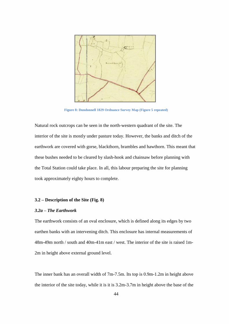
44
Figure 8: Dundonnell 1829 Ordnance Survey Map (Figure 5 repeated)
Natural rock outcrops can be seen in the north-western quadrant of the site. The
interior of the site is mostly under pasture today. However, the banks and ditch of the
earthwork are covered with gorse, blackthorn, brambles and hawthorn. This meant that
these bushes needed to be cleared by slash-hook and chainsaw before planning with
the Total Station could take place. In all, this labour preparing the site for planning
took approximately eighty hours to complete.
3.2 – Description of the Site (Fig. 8)
3.2a – The Earthwork
The earthwork consists of an oval enclosure, which is defined along its edges by two
earthen banks with an intervening ditch. This enclosure has internal measurements of
48m-49m north / south and 40m-41m east / west. The interior of the site is raised 1m-
2m in height above external ground level.
The inner bank has an overall width of 7m-7.5m. Its top is 0.9m-1.2m in height above
the interior of the site today, while it is it is 3.2m-3.7m in height above the base of the
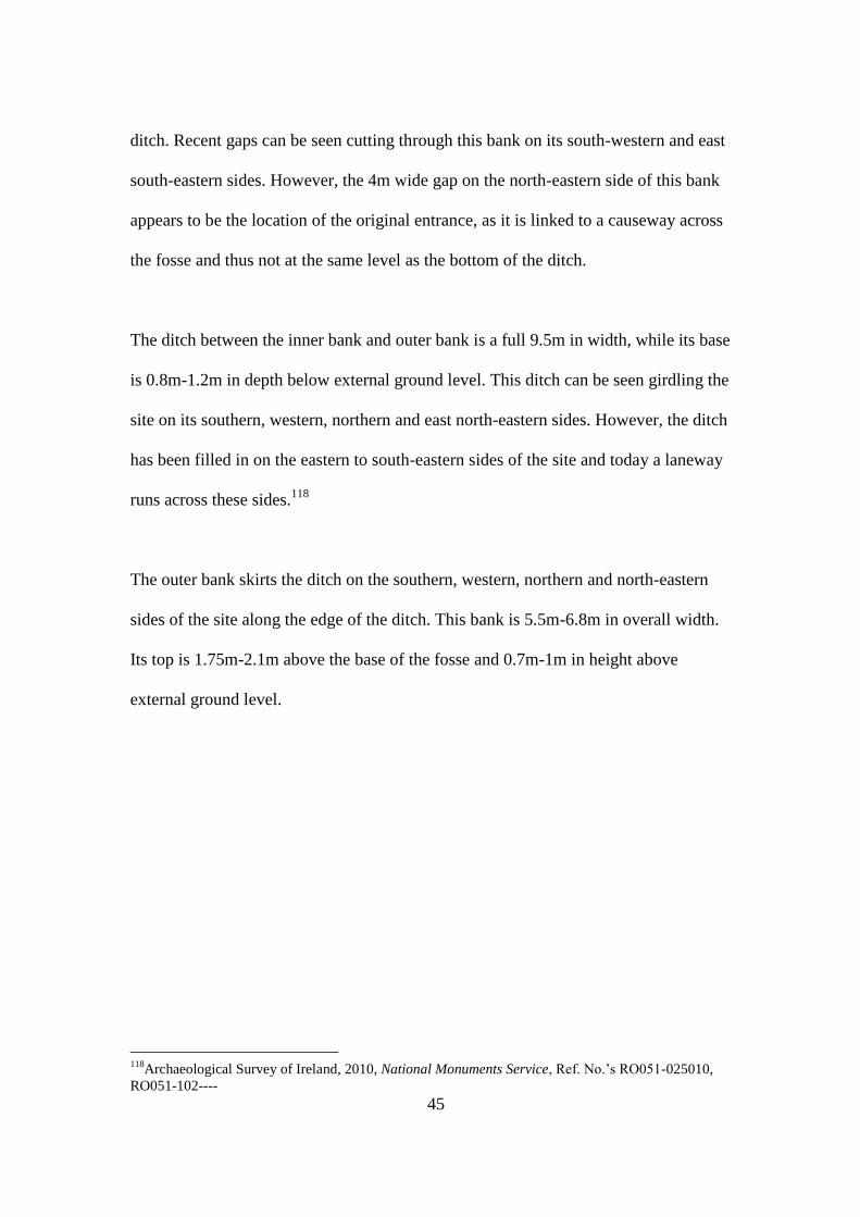
45
ditch. Recent gaps can be seen cutting through this bank on its south-western and east
south-eastern sides. However, the 4m wide gap on the north-eastern side of this bank
appears to be the location of the original entrance, as it is linked to a causeway across
the fosse and thus not at the same level as the bottom of the ditch.
The ditch between the inner bank and outer bank is a full 9.5m in width, while its base
is 0.8m-1.2m in depth below external ground level. This ditch can be seen girdling the
site on its southern, western, northern and east north-eastern sides. However, the ditch
has been filled in on the eastern to south-eastern sides of the site and today a laneway
runs across these sides.118
The outer bank skirts the ditch on the southern, western, northern and north-eastern
sides of the site along the edge of the ditch. This bank is 5.5m-6.8m in overall width.
Its top is 1.75m-2.1m above the base of the fosse and 0.7m-1m in height above
external ground level.
118
Archaeological Survey of Ireland, 2010, National Monuments Service, Ref. No.‟s RO051-025010,
RO051-102----

46
Figure 9: Total Station of the earthwork,with the stronghouse situated in the north-western quadrant.
(Note the incomplete nature of the southern and eastern sections of the outer bank are incomplete due to the
heavily overgrown nature of the site at large.)
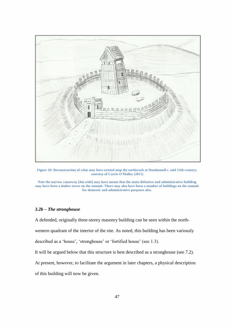
47
Figure 10: Reconstruction of what may have existed atop the earthwork at Dundonnell c. mid 13th-century,
courtesy of Carrie O'Malley (2011)
Note the narrow causeway [4m wide] may have meant that the main defensive and administrative building
may have been a timber tower on the summit. There may also have been a number of buildings on the summit
for domestic and administrative purposes also.
3.2b – The stronghouse
A defended, originally three-storey masonry building can be seen within the north-
western quadrant of the interior of the site. As noted, this building has been variously
described as a „house‟, „stronghouse‟ or „fortified house‟ (see 1.3).
It will be argued below that this structure is best described as a stronghouse (see 7.2).
At present, however, to facilitate the argument in later chapters, a physical description
of this building will now be given.
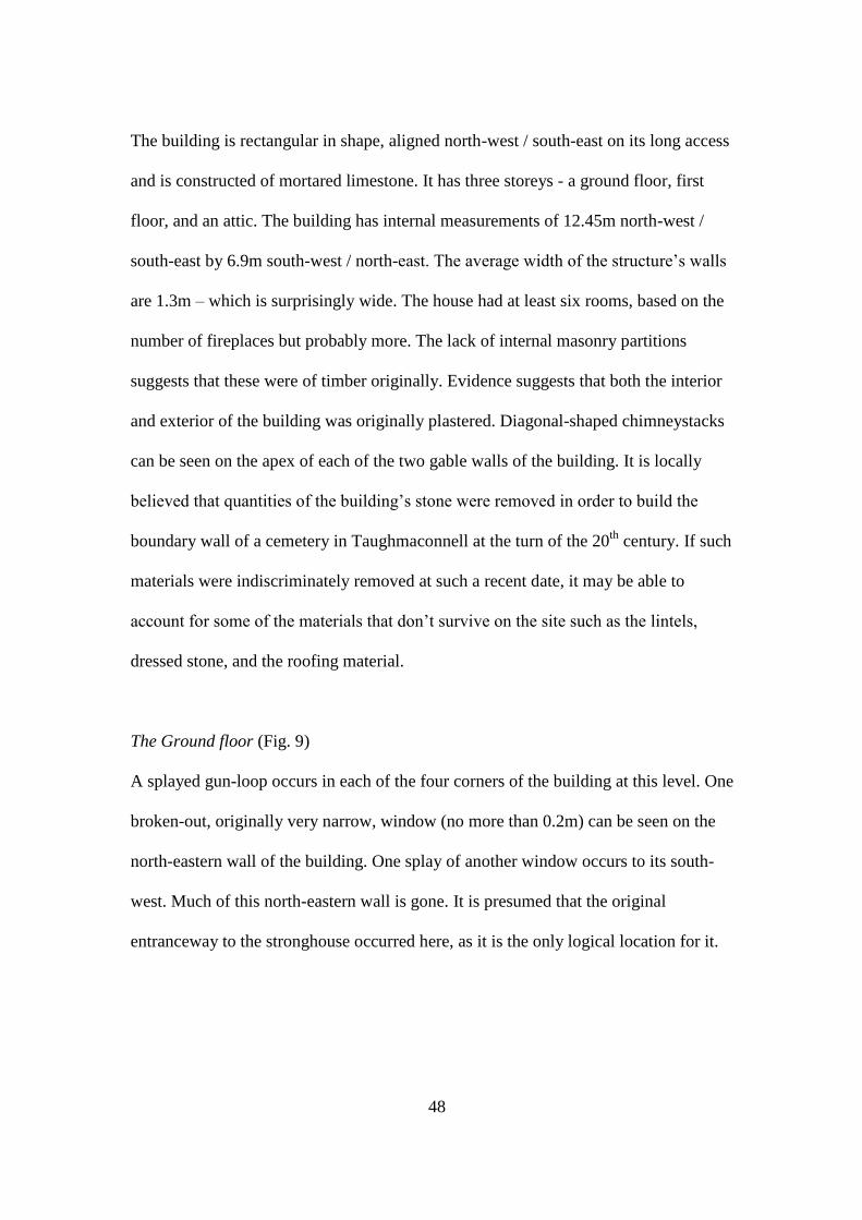
48
The building is rectangular in shape, aligned north-west / south-east on its long access
and is constructed of mortared limestone. It has three storeys - a ground floor, first
floor, and an attic. The building has internal measurements of 12.45m north-west /
south-east by 6.9m south-west / north-east. The average width of the structure‟s walls
are 1.3m – which is surprisingly wide. The house had at least six rooms, based on the
number of fireplaces but probably more. The lack of internal masonry partitions
suggests that these were of timber originally. Evidence suggests that both the interior
and exterior of the building was originally plastered. Diagonal-shaped chimneystacks
can be seen on the apex of each of the two gable walls of the building. It is locally
believed that quantities of the building‟s stone were removed in order to build the
boundary wall of a cemetery in Taughmaconnell at the turn of the 20th
century. If such
materials were indiscriminately removed at such a recent date, it may be able to
account for some of the materials that don‟t survive on the site such as the lintels,
dressed stone, and the roofing material.
The Ground floor (Fig. 9)
A splayed gun-loop occurs in each of the four corners of the building at this level. One
broken-out, originally very narrow, window (no more than 0.2m) can be seen on the
north-eastern wall of the building. One splay of another window occurs to its south-
west. Much of this north-eastern wall is gone. It is presumed that the original
entranceway to the stronghouse occurred here, as it is the only logical location for it.
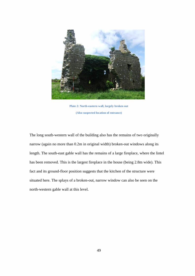
49
Plate 2: North-eastern wall, largely broken out
(Also suspected location of entrance)
The long south-western wall of the building also has the remains of two originally
narrow (again no more than 0.2m in original width) broken-out windows along its
length. The south-east gable wall has the remains of a large fireplace, where the lintel
has been removed. This is the largest fireplace in the house (being 2.8m wide). This
fact and its ground-floor position suggests that the kitchen of the structure were
situated here. The splays of a broken-out, narrow window can also be seen on the
north-western gable wall at this level.
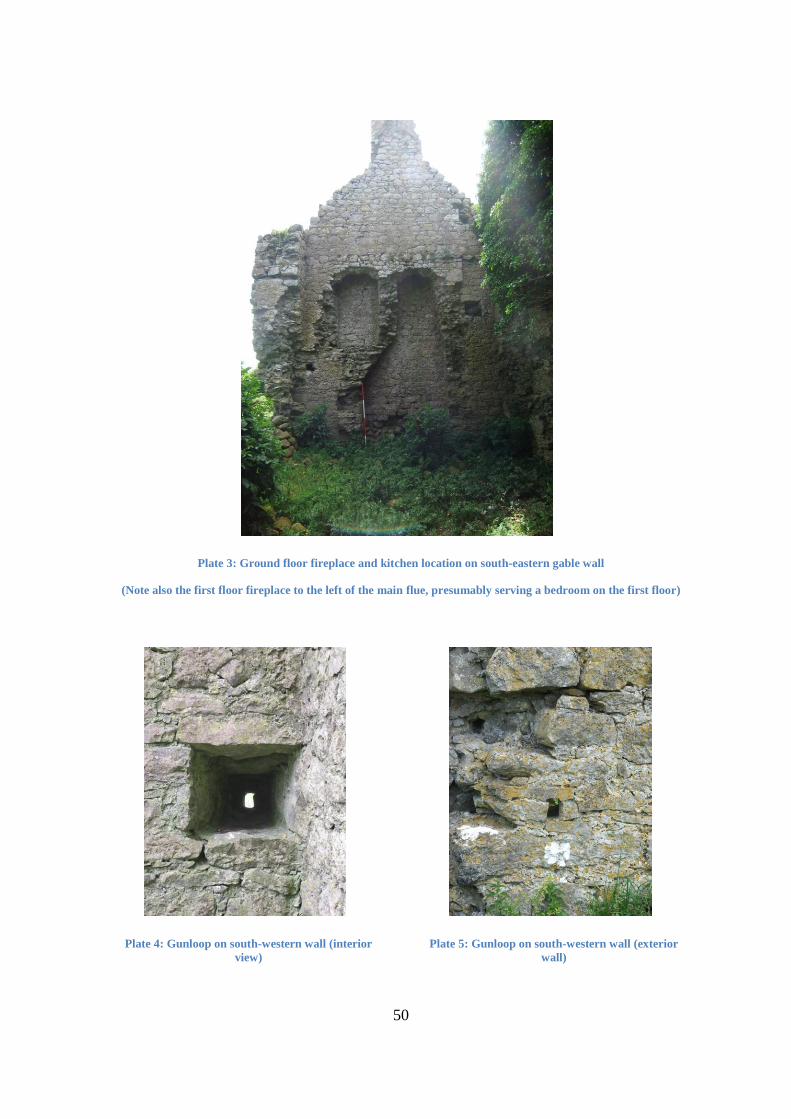
50
Plate 3: Ground floor fireplace and kitchen location on south-eastern gable wall
(Note also the first floor fireplace to the left of the main flue, presumably serving a bedroom on the first floor)
Plate 4: Gunloop on south-western wall (interior
view)
Plate 5: Gunloop on south-western wall (exterior
wall)
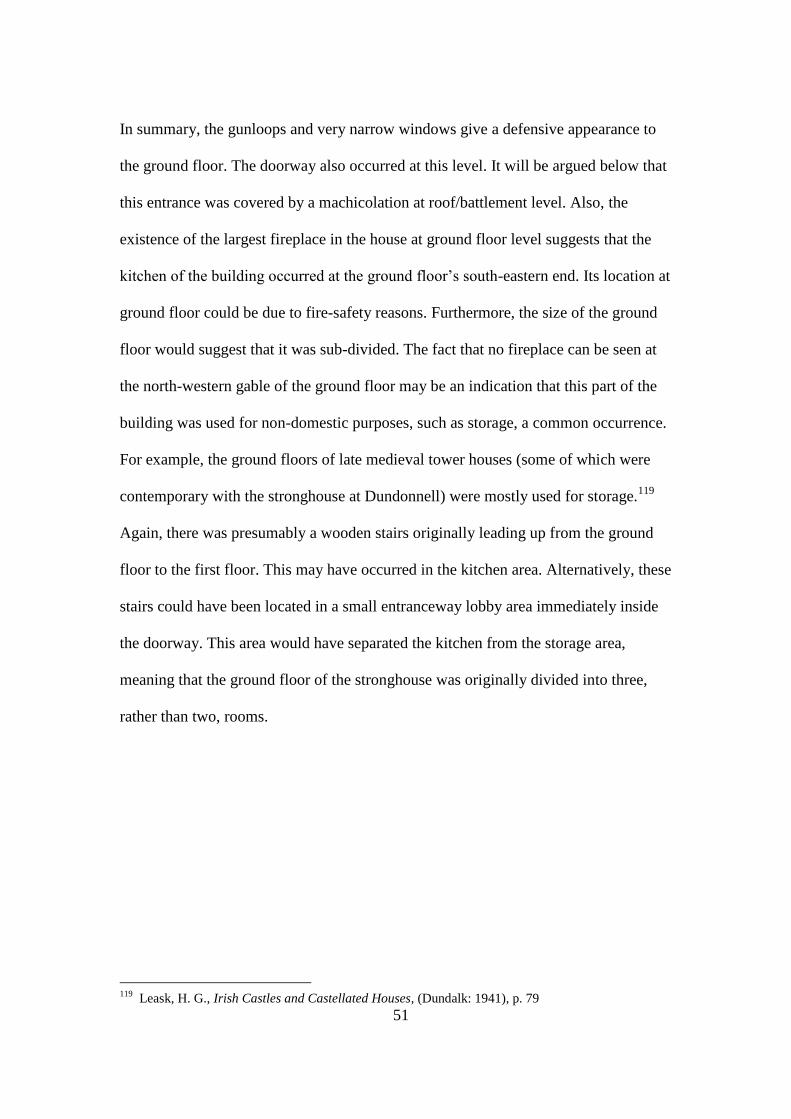
51
In summary, the gunloops and very narrow windows give a defensive appearance to
the ground floor. The doorway also occurred at this level. It will be argued below that
this entrance was covered by a machicolation at roof/battlement level. Also, the
existence of the largest fireplace in the house at ground floor level suggests that the
kitchen of the building occurred at the ground floor‟s south-eastern end. Its location at
ground floor could be due to fire-safety reasons. Furthermore, the size of the ground
floor would suggest that it was sub-divided. The fact that no fireplace can be seen at
the north-western gable of the ground floor may be an indication that this part of the
building was used for non-domestic purposes, such as storage, a common occurrence.
For example, the ground floors of late medieval tower houses (some of which were
contemporary with the stronghouse at Dundonnell) were mostly used for storage.119
Again, there was presumably a wooden stairs originally leading up from the ground
floor to the first floor. This may have occurred in the kitchen area. Alternatively, these
stairs could have been located in a small entranceway lobby area immediately inside
the doorway. This area would have separated the kitchen from the storage area,
meaning that the ground floor of the stronghouse was originally divided into three,
rather than two, rooms.
119
Leask, H. G., Irish Castles and Castellated Houses, (Dundalk: 1941), p. 79

52
Figure 11: Ground Floor plan of Stronghouse
The First floor
The joist holes and corbel to support the timber floor of this first floor can be seen in
the walls of the house.
Plate 6: Joist holes and corbel on south-western wall interior
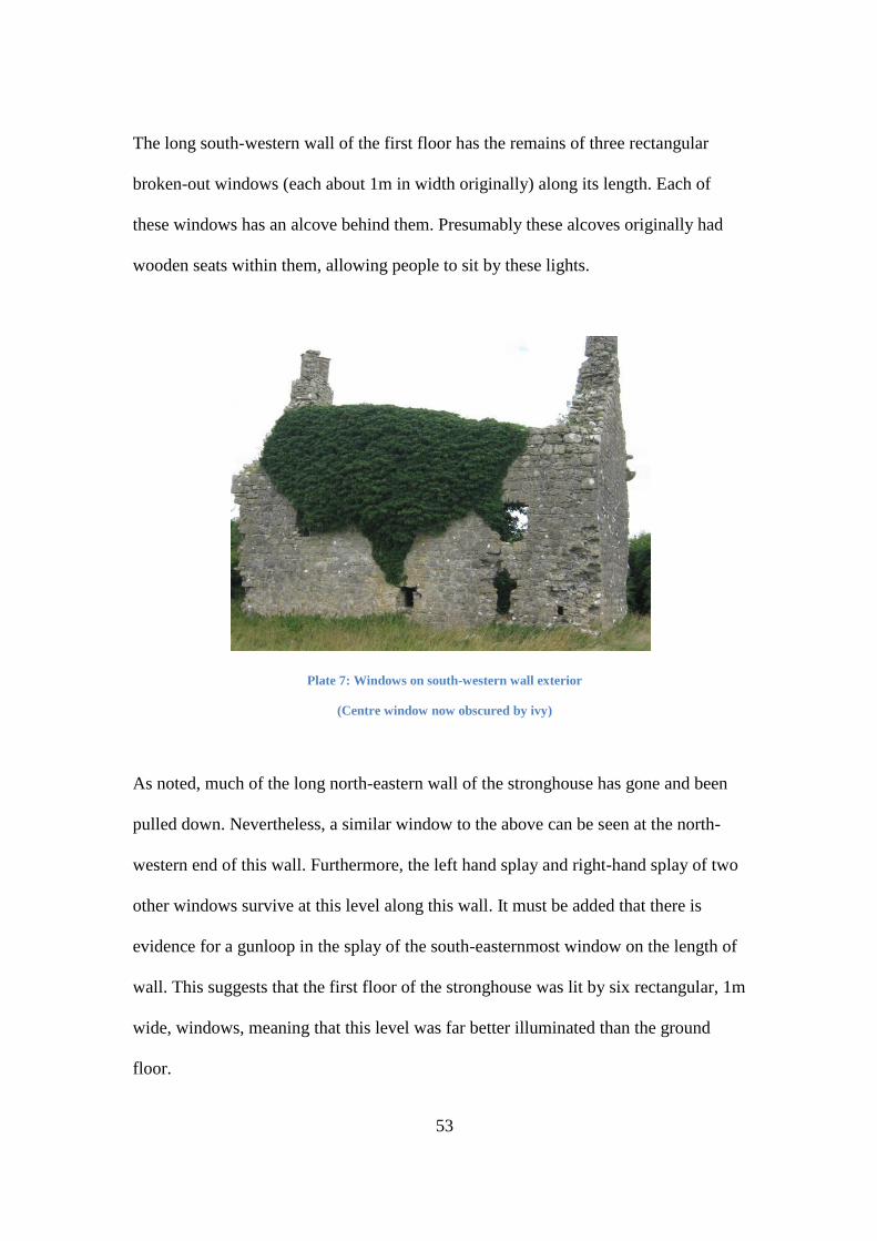
53
The long south-western wall of the first floor has the remains of three rectangular
broken-out windows (each about 1m in width originally) along its length. Each of
these windows has an alcove behind them. Presumably these alcoves originally had
wooden seats within them, allowing people to sit by these lights.
Plate 7: Windows on south-western wall exterior
(Centre window now obscured by ivy)
As noted, much of the long north-eastern wall of the stronghouse has gone and been
pulled down. Nevertheless, a similar window to the above can be seen at the north-
western end of this wall. Furthermore, the left hand splay and right-hand splay of two
other windows survive at this level along this wall. It must be added that there is
evidence for a gunloop in the splay of the south-easternmost window on the length of
wall. This suggests that the first floor of the stronghouse was lit by six rectangular, 1m
wide, windows, meaning that this level was far better illuminated than the ground
floor.
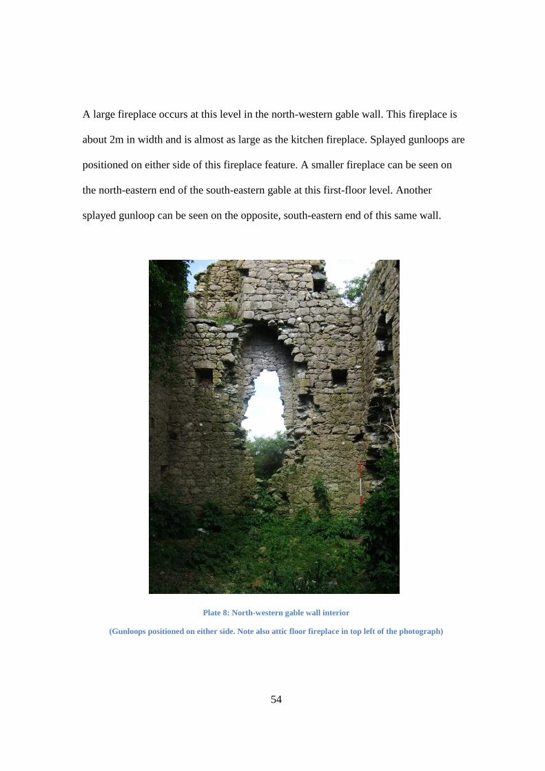
54
A large fireplace occurs at this level in the north-western gable wall. This fireplace is
about 2m in width and is almost as large as the kitchen fireplace. Splayed gunloops are
positioned on either side of this fireplace feature. A smaller fireplace can be seen on
the north-eastern end of the south-eastern gable at this first-floor level. Another
splayed gunloop can be seen on the opposite, south-eastern end of this same wall.
Plate 8: North-western gable wall interior
(Gunloops positioned on either side. Note also attic floor fireplace in top left of the photograph)
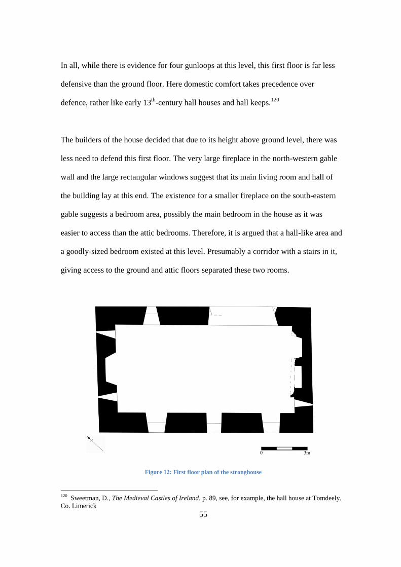
55
In all, while there is evidence for four gunloops at this level, this first floor is far less
defensive than the ground floor. Here domestic comfort takes precedence over
defence, rather like early 13th
-century hall houses and hall keeps.120
The builders of the house decided that due to its height above ground level, there was
less need to defend this first floor. The very large fireplace in the north-western gable
wall and the large rectangular windows suggest that its main living room and hall of
the building lay at this end. The existence for a smaller fireplace on the south-eastern
gable suggests a bedroom area, possibly the main bedroom in the house as it was
easier to access than the attic bedrooms. Therefore, it is argued that a hall-like area and
a goodly-sized bedroom existed at this level. Presumably a corridor with a stairs in it,
giving access to the ground and attic floors separated these two rooms.
Figure 12: First floor plan of the stronghouse
120
Sweetman, D., The Medieval Castles of Ireland, p. 89, see, for example, the hall house at Tomdeely,
Co. Limerick

56
The attic floor
The south-eastern gable wall of the attic has two splayed gunloops visible within it.
The opposite north-western gable wall has a fireplace located towards its south-
western corner end and a splayed gunloop exists on its north-eastern end. No windows
occur in the gable walls. It must be presumed that, now disappeared, dormer windows
in the roof of the building lighted this level, as no other option exists.
Presumably this level was used for sleeping quarters and it was more than likely
divided into at least two bedrooms. It is uncertain as to what material was used to roof
the house. It could have been straw or reed thatch but the defensive nature of both the
building and the site suggests that this would not have been the case as raiders could
easily have set it on fire. This leaves us with the possibility of either slate, stone slates
(used as slabs) or wooden tiles being used to roof the house.121
There also appears to have been a machicolation along the eastern corner of the house
at roof level. This seems to have covered this eastern corner but also, on analogy with
contemporary tower houses and fortified houses, the postulated doorway at the south-
eastern end of the north-eastern wall.122
A doorway led from the attic space out onto
the machicolation. It is possible that there was also a wall walk and battlement along
the long walls of the building but there is no evidence for this surviving and, so, it
could equally be said that they did not exist on the site. It is also possible (if not
121
Leask, Irish Castles and Castellated Houses, p. 87 122
Leask, Irish Castles and Castellated Houses, pgs. 19, 98, & Fig. 51, North Elevation of Clara
Castle, p. 84

57
probable) that an opening in the wall allowed the machicolation to be used by
defenders standing in the attic space itself.
Plate 9: Evidence of machicolation on south-eastern gable wall
(Which would originally have been extant over to the north-eastern wall, covering the entrance in case of
attack)
Plate 10: Diamond-shaped chimneystacks
(as discussed in 3.2b)
3.3 – Conclusions
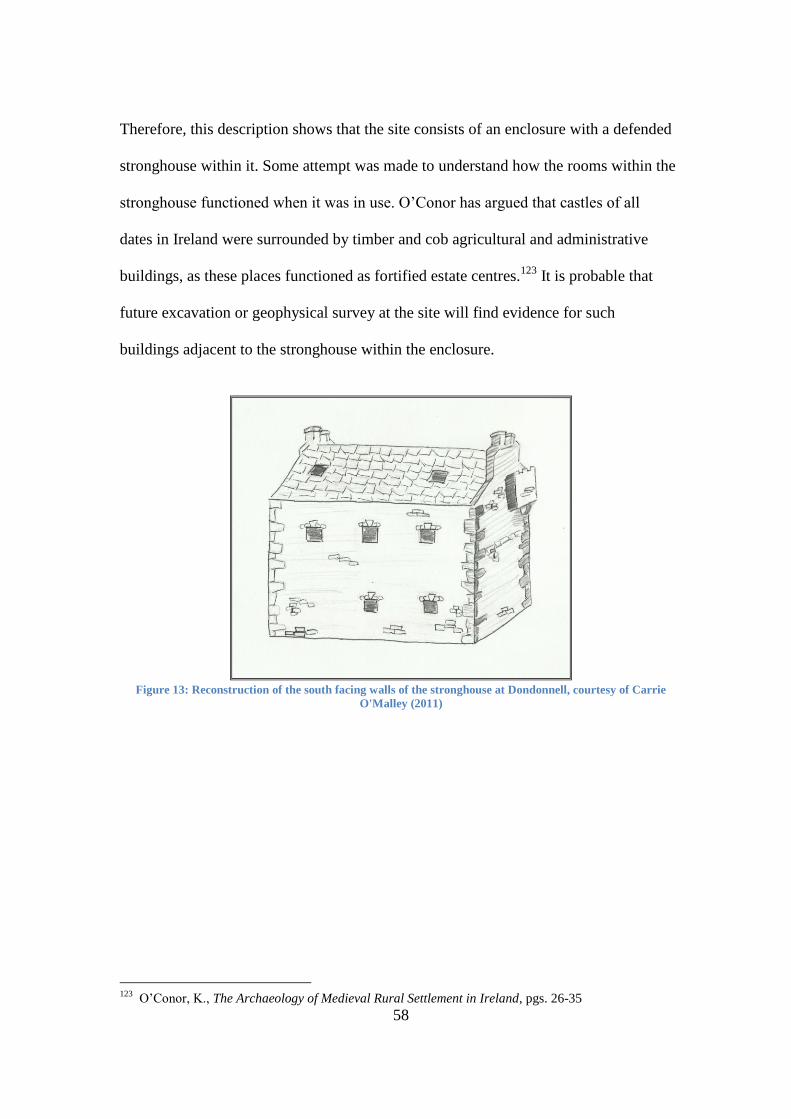
58
Therefore, this description shows that the site consists of an enclosure with a defended
stronghouse within it. Some attempt was made to understand how the rooms within the
stronghouse functioned when it was in use. O‟Conor has argued that castles of all
dates in Ireland were surrounded by timber and cob agricultural and administrative
buildings, as these places functioned as fortified estate centres.123
It is probable that
future excavation or geophysical survey at the site will find evidence for such
buildings adjacent to the stronghouse within the enclosure.
Figure 13: Reconstruction of the south facing walls of the stronghouse at Dondonnell, courtesy of Carrie
O'Malley (2011)
123
O‟Conor, K., The Archaeology of Medieval Rural Settlement in Ireland, pgs. 26-35
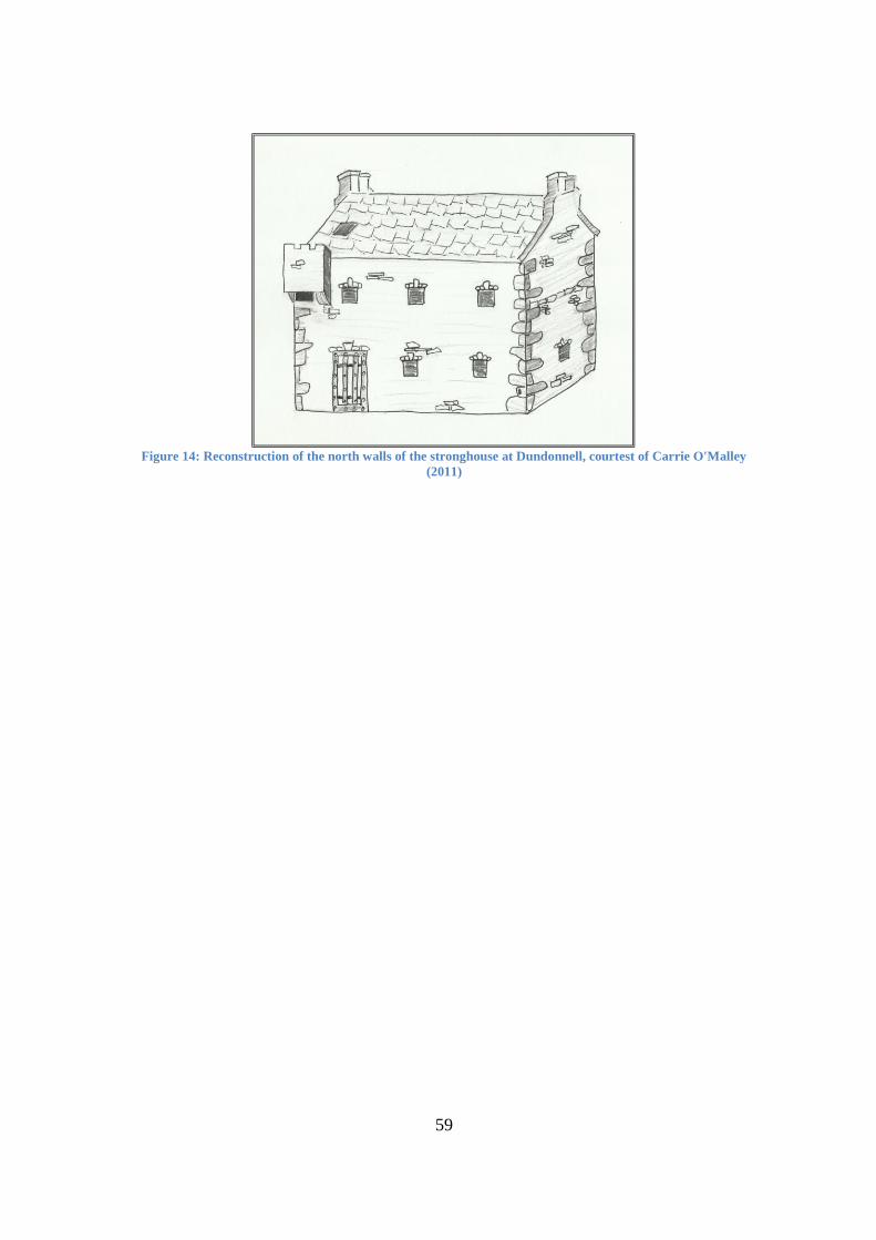
59
Figure 14: Reconstruction of the north walls of the stronghouse at Dundonnell, courtest of Carrie O'Malley
(2011)
60
Chapter 4 - The Siting Chapter
4.0 - Introduction
The location of Dundonnell in the surrounding landscape has been muted in the earlier
chapters, but this chapter will show just how the environment interacted with the site,
along with suggesting some of the decisions that may have resulted in Dundonnell
being placed where it was. This will be discussed chronologically from the first
possible phase, the postulated ringfort, followed by the postulated 13th
-century
ringwork castle and finally the masonry building that exists on its summit, dating to
the 16th
-or 17th
-century.
4.1 - Ringfort Siting
If we begin with the postulated ringfort124
, something that the archaeology to date has
deemed probable, we are next to encounter a contradiction between the two scholars to
have dealt with the castle in most detail to date, Graham and O‟Keeffe. Placename
evidence, used by both scholars, could influence the debate for or against the first
phase being a ringfort. Graham cited Orpen, who showed that the likes of dún or liss
could be added to a townland name after the erection of Norman fortifications125
,
while conversely, O‟Keeffe used the dún element of a place name to show its Irish,
pre-Norman origins,126
but not specifically with regard to Dundonnell itself. For my
124
Both Graham, in his 1988 work “Medieval Settlement in County Roscommon”, p. 28, and
O‟Keeffe, in his 1998 work “The Fortifications of Western Ireland, AD 1100-1300, and Their
Interpretation”, p. 190, believe Dundonnell may have had a ringfort as its initial phase, however, their
later conclusions on the site‟s development are, thereafter, completely polarized. 125
Orpen, G. H., “The mote of Lisardowlan, County Longford”, The Journal of the Royal Society of
Antiquaries of Ireland, Fifth Series, Vol. 40, No. 3, [Fifth Series, Vol. 20], (Sep. 30, 1910), pp. 223-225,
p. 225 126
O‟Keeffe, “The Fortifications of Western Ireland, AD 1100-1300, and Their Interpretation”, p. 188
61
part, I will attempt to provide the evidence that may signal it to be a ringfort also,
something that can only be answered conclusively through excavation.
Firstly, the site‟s location in relation to other ringforts in the area is interesting.
According to the Ordnance Survey Discovery Series 2nd
Edition, there are six ringforts
present in a 9km² area around the site, with the closest one located approximately 1km
north of Dundonnell.127
Stout highlights that the ringfort density in the area of South-
east Connacht is adjudged to be high in relation to the rest of the country.128
In this
alone, the likelihood of Dundonnell sitting on a ringfort is not beyond possibility.
Indeed there are areas of even higher density of ringfort distribution in the townlands
adjacent to Dundonnell townland. This density of distribution was inevitably linked to
defence and communication, as well as the more prosaic functions that would have
been ascribed to the smaller ringforts as little more than cattle enclosures. The
importance of, what Stout calls, overlapping „visual territories‟ is paramount to
defence in early medieval Ireland129
, and the site at Dundonnell has that in abundance.
The site itself is situated at approximately 54 metres above sea level, with the majority
of surrounding ringforts visible on the high ground to the south and east.
4.2 - Ringwork/Stronghouse Siting
If we entertain the possibility that a 13th
-century castle was built on the site of
Dundonnell, what aspects of the surrounding landscape would have become important
when choosing its location? What aspects of the site would make it a location to put a
127
Ordnance Survey Discovery Series, 2nd Edition, 47, with Dundonnell at Grid Ref. M 895 381;
Archaeological Survey of Ireland, 2010, National Monuments Service, Ref. No.‟s RO051-046----,
RO051-051001, RO051-050001, RO051-070----, RO050-024----, RO051-024. 128
Stout, M., The Irish Ringfort, (Four Courts Press: Dublin: 1997), p. 81-82 & Fig. 14 129
Stout, The Irish Ringfort, p. 20-21, especially Fig. 1
62
fortification to control and administer a region that in this period was very hostile?
Firstly, we must analysis the definite features of the landscape that could have been
favourable to constructing a castle there. In this regard, the features that would be
favourable for the construction of a ringwork should also be viewed with regard to the
stronghouse phase, as the factors that could have led to Dundonnell being chosen in
the 13th
-century are not altogether different from the masonry phase. The premise
behind the two phases is identical, in the sense that both would have been constructed
as private, fortified residences, positioned to control the surrounding area, during
hostile periods of time in South Roscommon.
There are two water sources in very close proximity to the site, and although the
importance of a water supply is obviously essential, Creighton leaves us in no doubt
about location choice in relation to water, with reference made to a statistical analysis
of 423 English castles and their water sources.130
In this regard, therefore, Dundonnell
is very well serviced with what is a very basic need to any permanent settlement, and
it would have served the postulated ringfort also.
The next feature that would have been favourable to the choice of Dundonnell as the
site of the 13th
-century ringwork is its position in relation to existing communication
routes. I am, of course, referring to the medieval road network that served Connacht in
the medieval period. The first routeway, and the one most directly associated to
Dundonnell, is „Route 9‟ from Linda Doran‟s study of medieval routeways through
Longford and Roscommon. She describes „Route 9‟ as being a secondary route of the
130
Creighton, O. H., Castles and Landscapes: Power, Community and Fortification in Medieval
England, (2002), p. 54
63
Slighe Mhór, linking Ballinasloe to Lough Croan, Roscommon and Boyle, eventually
linking it up to the other great road that served east and west in medieval Ireland, the
Slighe Assail.131
If we take the modern road linking Ballinasloe to Roscommon as the
basic successor to „Route 9‟, which, thanks to a comparison of maps, it invariably is,
then Dundonnell is less than 1km to the south east of the road.
Couple this with the fact that the Slighe Mhór itself is no more than 7km away from
Dundonnell, it being the most important road connecting Connacht with the east, gives
us some indication of the position that Dundonnell would have held if it was occupied
in the 13th
-century. The reason for its wider proximity to the Slighe Mhór can be
speculated further if we return to its postulated first phase and its position in relation to
the routeway. Stout noted that important secular ringforts were usually located away
from the main routes132
, presumably to lessen the impact that such an easily navigated
road would have in the practice of raiding, primarily of cattle.
The importance of holding these roads has been compared with having control of the
Shannon itself, and especially in these border areas, constant contesting of these
communication routeways would result in their changing hands regularly,133
something that does fit well with the annalistic evidence for castles in the area in the
mid-to-late 13th
-century.
131
Doran, “Medieval Communication Routes through Longford and Roscommon and Their Associated
Settlements”, p. 72, Table 1 132
Stout, The Irish Ringfort, p. 103, Fig. 29 133
Doran, “Medieval Communication Routes through Longford and Roscommon and Their Associated
Settlements”, p. 72-73
64
We know, from comparative research on the interaction of the Normans with Roman
roads in Britain, that English settlers would have had no problem with adopting the
pre-existing communications for their own uses, with, for instance, up to 80 per cent
of the castles of Hampshire being sited on or in the immediate vicinity of known
Roman roads.134
Therefore, to transfer the model to this island, the prospect of a 13th
-century ringwork
castle at Dundonnell on „Route 9‟ and in the close vicinity of the Slighe Mhór is not
beyond possibility. It may have been constructed there as a way of patrolling the vital
artery through an area that was both naturally treacherous135
and armed with hostile
locals. If this was the case, it was merely the continuity of a practice that had served
the English so well in the conquest of Britain. The importance of the road network to
this island in the medieval period has been largely overlooked by scholarship, with
notable exceptions, such as Ó Lochlainn,136
the first to treat it properly. The late
medieval and early modern history of this area shows quite well how important good
communication links were, due to a veritable absence of such links when the Irish
reacted to the re-colonisation of Connacht in the late 16th
century. (See 2.3) So for a
second phase site at Dundonnell to be placed where it was in relation to routeways,
shows the prior planning exhibited by the administrative powers in order to keep the
area under control.137
134
Creighton, Castles and Landscapes, p. 39, citing Hughes 1989:34 135
Doran twice refers to the significant hindrance and obstacle that bogland put on transport in this
period, therefore necessitating the important work of insuring the routeways remained free of raiders
and hostile locals. See Doran, “Medieval Communication Routes through Longford and Roscommon
and Their Associated Settlements”, pgs. 61 & 76 136
Ó Lochlainn, “Roadways in Ancient Ireland”, p. 465 137
A case could also be made for another road which connected Athlone to „Route 9‟ through the
bogland and an alternative route to Ballinasloe, which passes in very close vicinity to Dundonnell
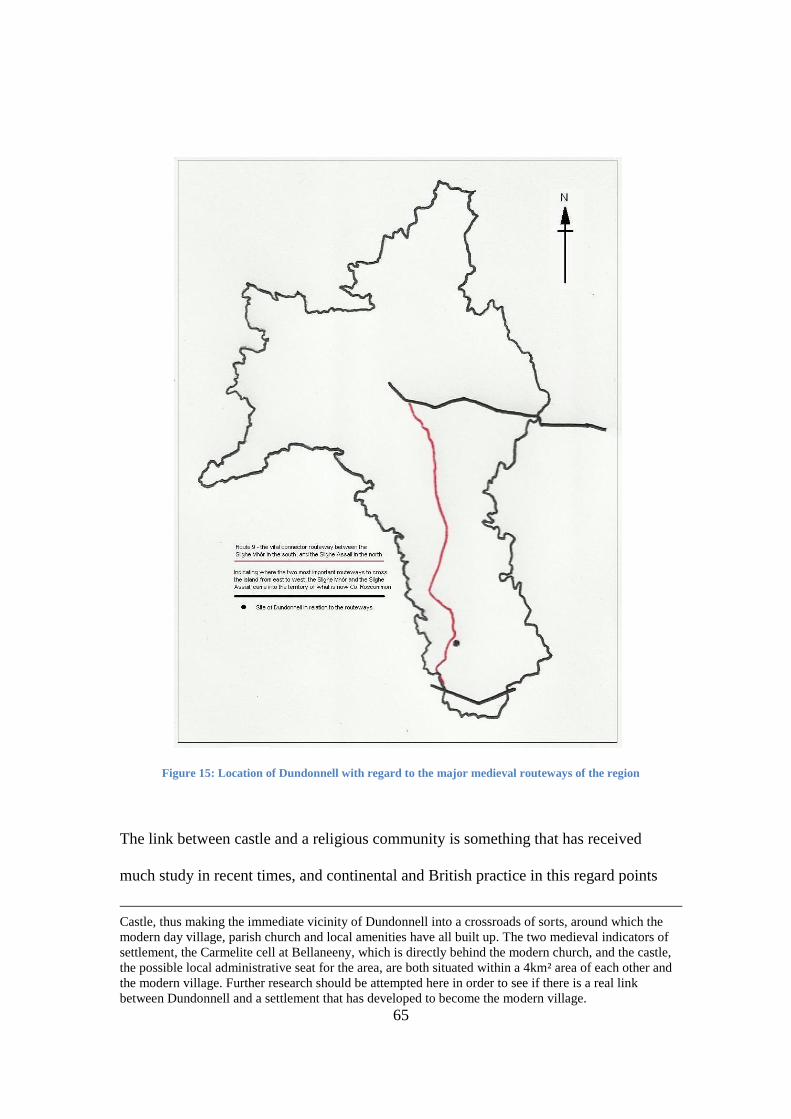
65
Figure 15: Location of Dundonnell with regard to the major medieval routeways of the region
The link between castle and a religious community is something that has received
much study in recent times, and continental and British practice in this regard points
Castle, thus making the immediate vicinity of Dundonnell into a crossroads of sorts, around which the
modern day village, parish church and local amenities have all built up. The two medieval indicators of
settlement, the Carmelite cell at Bellaneeny, which is directly behind the modern church, and the castle,
the possible local administrative seat for the area, are both situated within a 4km² area of each other and
the modern village. Further research should be attempted here in order to see if there is a real link
between Dundonnell and a settlement that has developed to become the modern village.
66
very definitely towards a joining of histories, either by embracing an existing
institution or by founding one in conjunction with the castle, in order to serve the
population at the site and in any settlement that has grown up out of the castle.
Creighton devoted an entire chapter to the subject138
, while various other authors have
discussed this issue at length that are too numerous to name. 11th
and 12th
-century
earthwork castles in the Grand Caux region of Normandy show said castles on average
lying within 500m of a church, while a study of ten English counties show that over 40
castles in these areas had a church within 50m of the castle.139
We know that from 1181, English custom was applied to the Irish Church140
, merely
as another natural feature of the colonisation process. That the Irish Church was to
conduct itself along the lines of the Church of England and have its episcopate
anglicised, was just a way of keeping all bastions of authority singing from the same
hymn sheet, enabling a smoother settlement of the island.141
The construction of
fortifications next or near religious houses and churches was just one, relatively crude,
way of linking church and state, and the Irish examples don‟t disappoint either.142
To
take our own subject, we know that Bellaneeny had been in use by at least the 9th
century, and still in operation by 1567, when it was recorded in the Fiants of
Elizabeth.143
This shows that by 1236, when the Annals of Clonmacnoise assert that
138
“Power, Patronage and Parish: Castles and Ecclesiastical Landscapes”, in Creighton, Castles and
Landscapes, p. 110-132 139
Creighton, Castles and Landscapes, p. 111 140
Watt, J. A., The Church and the Two Nations in Medieval Ireland, (Cambridge: 1970), p. 46 141
Watt, The Church and the Two Nations in Medieval Ireland, p. 83 142
Although castle and church are not as readily associated in Ireland as in Britain, examples show that
the practice was quite pronounced nonetheless. Castlerahan, Co. Cavan, Kilpipe, Co. Wicklow,
Rathangan, Co. Kildare, Milltown, Co. Meath, Cloncurry, Co. Kildare & Donohill motte, Moat quarter,
Co. Tipperary all show evidence of being closely located to medieval churches. See Sweetman, The
Medieval Castles of Ireland, Figs. 3,4,12, 18, 21, pgs. 8-31 for examples. 143
Egan, “The Carmelite Cell of Bealaneny”, pgs. 19-20
67
Onagh was built, Bellaneeny was in full operation and, as such, suggests that any 13th
-
century fortification to have been built at Dundonnell could have had the proximity to
the religious centre in mind also.
To go back briefly and deal with the relationship between ecclesiastical sites and
ringforts, where there is a possibility that the first phase of Dundonnell may have had
interaction with Bellaneeny. Stout notes that ringforts in the immediate environment of
churches and ecclesiastical sites generally points to patronage and/or lay communities
congregating around the site144
, but this is as detailed as we can get on this theory.
Having dealt with the possibility that a 13th
-century ringwork castle was constructed
over an earlier ringfort, we must now attempt and understand why it is sited
specifically over said structure. Having dealt already with the physical attributes that
building in that area provided; the water supply, and the proximity to pre-existing
communication routes and ecclesiastic centres, we must now try and understand why
the site itself, our first phase postulated ringfort, may have been chosen. Now,
obviously, at this point, we can only theorise, but with the backing of circumstantial
evidence, we can make some realistic claims.
Firstly, we must make a nod towards the practicality of building over existing sites.
The presence of existing fortifications reduced greatly the amount of time and labour
required in order to complete an earthwork, whether it was aided by a natural
144
Stout, The Irish Ringfort, pgs. 100-106
68
escarpment or feature, or a pre-existing constructed defence.145
Old Sarum in Wiltshire
and Mount Caburn in Glynde, East Sussex are just two English examples, while at
Dunsilly motte, Co. Antrim, and Lismahon and Rathmullan mottes, Co. Down, show
that the practice continued and adapted to the ringfort, for practical reasons at least.146
Cóilín Ó Drisceoil brings this argument even further when he asserts that eight of the
fifteen motte castles excavated in Ireland in the modern period have ringfort
precursors,147
a significant number, even if the sample size is pitifully small. The fact
also that great care was taken by castle builders in Ireland to construct over pre-
existing royal sites tells its own tale as regards their motives and how they sought to
pacify the local area.148
The symbolic or status-based relationship that this site could have had to the
surrounding area may also have been a reason for it being constructed over.149
Creighton discusses the re-occupation of Saxon sites with regal, high-status or
religious connotations in the Norman Conquest of England in this regard. He pointed
to a large and ever increasing corpus of archaeological evidence of Saxon élite
residences being expropriated and remodelled to suit a new Norman landlord.150
And
while he does insert the required provisos to ensure that we don‟t get carried away
with this idea, his image of what this could do to the local population is striking -
145
Creighton, Castles and Landscapes, p. 37-38 & 69 146
Sweetman, D., Irish Castles and Fortified Houses, (Dublin: 1995), p. 6 147
Ó Drisceoil, C., “Recycled Ringforts: The Evidence from Archaeological Excavation for the
Conversion of Pre-Existing Monuments to Motte Castles in Medieval Ireland”, Journal of the County
Louth Archaeological and Historical Society, Vol. 25, No. 2 (2002), pp. 189-201 148
Herity, M., “Motes and Mounds at Royal Sites in Ireland”, The Journal of the Royal Society of
Antiquaries of Ireland, Vol. 123 (1993), pp. 127-151 149
Here we must recall that the defence of a ringfort relied much more heavily on communication links
with the settlements surrounding it, than the physical defences of the homestead itself, along with the
power and prestige of the chief occupant being used to deter would be assailants from attack and
raiding. 150
Creighton, Castles and Landscapes, pgs. 70-71
69
“Saxon thegns tended to have expansive residences, and their appropriation by new
Norman landlords often meant their remodelling as more compact, heavily defended
and visually imposing units that presumably had a strong local psychological impact,
especially where a new motte towered over the tenants.”151
As with many of the features that characterised the Norman Conquest of Britain, they
can be transposed upon the English colonisation of Ireland, just over one century later,
with relative ease, increasing the possibility of Dundonnell having two phases by the
end of the 13th
-century.
Whether these ringforts were still inhabited and therefore held a level of prestige for
the occupants has to be taken in a case-by-case manner, and a new site may well have
been built over a long deserted ringfort. However, we must keep in mind that no
evidence exists that shows there may have been a widespread desertion of the ringfort
post 1169, and ringforts were still very much in use in the medieval, and maybe even
into the early modern period in some cases.152
Therefore, the likelihood of re-occupying an, until recently, inhabited site, be it
acquired pacify, conformingly, or through the force of arms, cannot be discounted
with regard to 13th
-century Dundonnell. As a result, the idea of assuming residence of
what may have been a powerful local chieftain, albeit something we cannot prove,
nevertheless, isn‟t out of the question.
151
Creighton, Castles and Landscapes, p. 71, citing Hinton, D. A., Archaeology, Economy and Society:
England from the Fifth to the Fifteenth Century, (London: 1990), p. 110 152
Barrett, G. F., Graham, B. J., Lynn, C. J., “Some Considerations concerning the Dating and
Distribution of Ring-Forts in Ireland”, Ulster Journal of Archaeology, Third Series, Vol. 38 (1975), pp.
33-47, p. 37
70
4.3 - Defensibility of the site
Now we must inevitably look at the defensibility of the site, in order to understand the
role of a castle in its traditional capacity. Here we come across a difficult balancing of
priorities with regard to the true military value that a castle brings to a region. There is
a constantly evolving argument with regard to the subject of a castle‟s defensibility,
and the position that defence holds in the list of attributes that come with the building
of same. If we look at the English examples of castles of even earlier construction than
the postulated ringwork at Dundonnell, such as the ones studied by Liddiard153
, we
find that the practical military features of some sites have become purely decorative,
leaving blind spots and other such problems, should the fortification have been
seriously attacked.154
On face value, this situation could also be seen with regard to places such as the 13th
-
century phase of Roscommon Castle, with its location choice traditionally being called
into question155
, along with the practicality of the fortifications themselves. However,
the political situation that Liddiard found in Norfolk was vastly different from the
situation that was to be played out in 13th
-century Roscommon, and a fresh look by
Murphy on the subject of Roscommon Castle has yielded much more fruitful, and in
the context, practically-based conclusions.156
153
Liddiard, R., “Landscapes of Lordship: Norman Castles and the Countryside in Medieval Norfolk,
1066-1200”, BAR British Series 309 (2000) 154
Liddiard, “Landscapes of Lordship”, p. 3 155
This argument goes as far back as Weld, I., Statistical Survey of the County of Roscommon, drawn
up under the directions of the Royal Dublin Society, (Dublin: 1832), p. 393 156
Murphy, M. “Roscommon Castle: Underestimated in Terms of Location?”, Journal of the Galway
Archaeological and Historical Society, Vol. 55 (2003), pp. 38-49
71
Therefore it is with these provisos in mind that we must carefully analyse the
defensibility of Dundonnell, primarily in a 13th
-century context, but this will suffice
also for the definite 16th
-to-17th
century 3rd
phase.157
The site is located on a lowland
stretch that is served to the south by an area of high ground. To the traditionalist, this
could be seen as compromising its defensibility due to a possible artillery or projectile
attack. However, this argument falls down as soon as the theoretical castle in question
is approximately two hundred metres away from the potentially dangerous high
ground.158
Range is the key factor, and with the high ground to the south of
Dundonnell petering out on average over five hundred metres before we reach the site,
the advantage of the high ground is effectively nullified. In addition to this, the First
Edition 6 inch Maps show that the earthwork is located (see 3.1) on what was a dry
promontory surrounded by bogland, meaning that it was only approached safely from
the north. The choice of the site here, along with the careful positioning of the entrance
to the north-east of the site, lessens any advantage that attacking from the southern
high ground could have had, if one were to be brave enough to traverse the now
disappeared bogland in the process.
This shows that the most obvious locations for a castle in the eyes of the modern
observer might not necessarily make it the best suited for the builders at the time. The
lower ground provided better access to water than the high ground; it was much closer
to the road that we can presume it sought to control, and the religious centre also.
157
Because, although there are, in essence, 200+ years of separation between the 2nd and 3rd phases,
the key aspects that made the site viable for defence, along with the other reasons that it was chosen for
in the 13th-century, remained relatively unchanged, despite the advance to firearms. 158
Liddiard, “Landscapes of Lordship”, pgs. 6-7
72
These factors show that defence was clearly not the sole preoccupation of the builders
of this fortification, pointing to the wider social and societal function that Dundonnell
could have served for this presumed period of its habitation. Creighton shows that
castles should not be pigeon-holed as strictly as their appearance would suggest, and
the more functions we can ascribe for a castle can only help to elaborate why a
location that would not seem easily defendable could still be chosen.159
We have also
seen that only through proper inspection of the landscape, not just as it is today, but
also exploring the possibility that these lands were modified over time by agriculture
and land reclamation, do we truly understand the factors pondered when it came to
constructing any of the three phases at the site of Dundonnell.
4.4 - Conclusions
To conclude the siting chapter, I would like to highlight a very important point made by
Lilliard in relation to the defensibility of a site, something that is often overlooked
when archaeological discussions concerning defence and siting is put forward. This is
the essential human element. If a fortification needs to be defended, be it a concentric
castle or a simple timber tower within an earthwork, it is as much about the conviction
and application of the defenders as it is about the materials and siting of the castle, that
decides the outcome.160
To recap, I have shown the aspects of the wider landscape and the possible pre-existing
elements that are present that could have served Dundonnell. The builders of each of
the phases had their own motives for constructing at Dundonnell, features that go
159
Creighton, Castles and Landscapes, p. 36 160
Lilliard, “Landscapes of Lordship”, p. 6

73
beyond the practical militaristic concerns. This has been undertaken in order to help in
analysing the site and will thus become of further use to this thesis presently.
74
Chapter 5 - Phase 1 at Dundonnell: the postulated Ringfort phase
5.0 - Introduction
The aim of this chapter is to explore the possibility that the earliest phase of habitation
at Dundonnell was that of an early medieval ringfort.
5.1 - The postulated ringfort at Dundonnell
The first studies to suggest that Dundonnell had at its origins as an early medieval
ringfort were the two Graham articles, written in 1988, “Medieval Settlement in
County Roscommon”161
and “Medieval Timber and Earthwork Fortifications in
Western Ireland”162
. O‟Keeffe follows these up, with his 1998 article “The
Fortifications of Western Ireland, AD 1100-1300, and Their Interpretation”.163
O‟Conor‟s 2007 article, “English settlement and change in Roscommon during the late
sixteenth and seventeenth centuries”164
, is the most recent to date to describe the site as
having a ringfort as its first phase. Therefore, why do we think that there was a ringfort
at the site of Dundonnell? The problem here is that none of the above scholars has
really explained why they believe that there was a ringfort here. Therefore, in order to
continue, I will once again discuss the evidence that I believe points to Dundonnell
having a 1st phase ringfort.
The first piece of evidence that points to Dundonnell having a ringfort is the
morphology of its earthwork. (Fig. 8) It is an oval, bivallate constructed earthwork,
161
Graham, B. J., “Medieval Settlement in County Roscommon”, pgs. 28-29 162
Graham, B. J., “Medieval Timber and Earthwork Fortifications in Western Ireland”, pgs. 122-123 163
O‟Keeffe, T., “The Fortifications of Western Ireland, AD 1100-1300, and Their Interpretation”,
p.190 164
O‟Conor, K., “English settlement and change in Roscommon during the late sixteenth and
seventeenth centuries”, pgs. 191-192

75
with a north-eastern facing entrance. (See 3.2a for full description) The morphology of
this site is highly indicative of the type of features associated with a large ringfort, the
bivallate bank and ditch system providing extra protection to what may have been a
relatively high-status dwelling. The north-eastern facing entrance, if it corresponds
with the original entrance, faced in the general direction of the morning sun, indicating
the probability of the site being used for human habitation.165
There is also the
likelihood that the entrance could have been preferably more easterly in position, if it
wasn‟t for the fact that it would probably result in the entrance having to cross bogland
in the process. (See 3.1) However, the formidable nature of the ditch and banks
suggests that at some point this site was refortified, something which will be discussed
later. Overall, however, the morphology the earthwork at Dundonnell does show
positive evidence for a ringfort.
The proximity of Dundonnell to a number of other ringforts, which would have
provided protection, its abundant water supply, its position adjacent to a prominent
local religious centre and its location away from the main, and therefore potentially
dangerous, routeway of the area, the Slighe Mhór, all show signs that a ringfort could
have been located at Dundonnell. (See 4.1) Although these factors are only
circumstantial in nature, when combined with the morphological evidence, it does aid
in the case for Dundonnell having a ringfort first phase.
Finally, the placename evidence provides us with an interesting source of information
with which to view Dundonnell. “Placenames as Indicators of Settlement”, published
165
Stout, The Irish Ringfort, pgs. 18-19
76
by A. S. Mac Shamhráin in 1991, provides a basis of Irish placename terminology, and
includes both dúnand lios as indicators of secular, earthen sites.166
This form of
evidence was incorporated into the work of both Graham and O‟Keeffe, resulted in
somewhat conflicting conclusions. Graham cited Orpen, who showed that the likes of
dún or liss could be added to a townland name after the erection of Norman
fortifications167
. Conversely, O‟Keeffe used the dún element of a place name to show
its Irish, pre-Norman origins,168
but not specifically with regard to Dundonnell itself.
Either way, the placename evidence does indicate quite clearly that a fortification of
some description existed at Dundonnell at an earlier period than the stronghouse.
The townland name of Dundonnell was first recorded as in 1420, with its mention in
the Registry of Clonmacnoise.169
This late date, along with its position adjacent to
Onagh townland (Fig. 12), means we cannot rule out the earlier positioning of the two
areas within an older, larger townland, something that is not without precedent in
Taughmaconnell, as seen with the 1636 Stafford Survey reports.170
This in itself
allows for the possibility that Dundonnell fell under the older townland name of
Onagh in the 13th
century sources, and its subsequent change in placename to
Dundonnell.
166
Mac Shamhráin, A.S., “Placenames as Indicators of Settlement”, Archaeology Ireland, Vol. 5, No. 3
(Autumn 1991), pp. 19-21, pgs. 20-21 167
Orpen, G. H., “The mote of Lisardowlan, County Longford”, The Journal of the Royal Society of
Antiquaries of Ireland, Fifth Series, Vol. 40, No. 3, [Fifth Series, Vol. 20], (Sep. 30, 1910), pp. 223-225,
p. 225 168
O‟Keeffe, “The Fortifications of Western Ireland, AD 1100-1300, and Their Interpretation”, p. 188 169
O‟Donovan, J., “The Registry of Clonmacnoise: With Notes and Introductory Remarks”, The Journal
of the Kilkenny and South-East of Ireland Archaeological Society, New Series, Vol. 1, No. 2 (1857),
pp.444-460, p. 455, referring to the donation of lands in Moyfinn to the monastery in the 6th
century. 170
Taughmaconnell: a history, p. 13

77
Figure 16: Ordnance Survey Map containing the extents of Dundonnell and Onagh townlands
5.2 - The ringfort in Ireland
5.2a - Number & Distribution
The ringfort is the most numerous but yet one of the most mysterious monument types
present on the Irish landscape today. The broad consensus holds that there are
approximately 40,000 remaining ringforts on the island today, with the number
possibly increased to 50,000 if we take into account the ones that have been removed
from the landscape due to modern land use and cultivation.171
The distribution of the
ringfort varies from region to region with density particularly high in South-East
Connacht, where Dundonnell is situated.172
The ringfort distribution for the area
around Dundonnell conforms to the statistics, with the total of six ringforts present in a
9km² area around our site.
5.2b - Morphology
171
Ó Corráin, D., “Ireland c.800: aspects of society”, in Ó Cróinín, D., (ed.), The New History of Ireland
1: Prehistoric and Early Ireland, (Oxford: 2008), pp. 549-608, p. 550 is merely one example of the
multitudes of studies that accept this figure. 172
Stout, M., The Irish Ringfort, p. 81-82 & Fig. 14, p. 60
78
Considering the huge corpus of examples and wide range of both dates and types of
ringfort in the Irish landscape, it is notoriously difficult to correctly provide a
morphological definition of the monument type.173
In order to provide the most
complete definition for the ringfort, therefore, I believe simplicity is best and refer to
the definition provided by Ó Ríordáin, largely accepted as the most accurate
description:
“In its simplest form the ringfort may be described as a space most frequently circular,
surrounded by a bank and fosse or simply by a rampart of stone. The bank is generally
built by piling up inside the fosse the material obtained by digging the latter. Ringforts
vary very considerably in size. In the more elaborately defended examples, the
defences take up a much greater area than that of the enclosure.”174
To apply anything more detailed or nuanced to the morphology would only serve to
limit the definition and, thus, the understanding of the site type. The only addition I
believe is needed here is to highlight that the range in complexity can often tell us a
great deal about the function behind any given ringfort, and should always be explored
in full.
5.2c - Function
Its primary functions seem to centre around habitation and defence and, in some cases,
prestige, which in the highly militaristic world of early medieval Ireland, are roles that
are intrinsically linked. The ditch and bank system is something that is evident in the
173
Edwards, N., The Archaeology of Early Medieval Ireland, (London: 1990), pgs. 12-14 174
Ó Ríordáin, S., Antiquities of the Irish countryside, 5th ed. (London: 1979), pgs. 29-30
79
vast majority of ringforts, with this feature obviously increasing the defensibility of a
site the deeper it was. The circular or oval shape of the site was also constructed in
order to lessen or eradicate the possibilities of blind spots in the defences in the case of
attack, something that moated sites were prone to upon their introduction.175
The
combination of the two, along with the likelihood of a fence or palisade to run along
the top of the bank176
, if not a sod, cob or stone defensive wall, show that these sites
espoused at least a minimal level of protection for the people, livestock, and
possessions within. Coupling this with the previously mentioned overlapping visual
defence that seemed even more important than the physical defences of the site, show
that serious considerations were as much given to location in relation to other sites as
to the depth of the ditch.
The fact the entrance faced east or south-east in over half of ringforts recorded on the
island also strongly suggests that many ringforts were much more than livestock
enclosures, and permanent habitation took place in many instances.177
With a
functionality range as wide as that of the ringfort, there are inevitably going to be
problems in successfully determining a conclusive role for the ringfort in society. The
problem is exacerbated when scholars fall into the easily trod route of generalising a
monument type due to the huge quantity apparent on the landscape. Therefore, I
believe that the only true way to study a ringfort is through case-by-case study, in
175
Stout, The Irish Ringfort, p. 15 176
Although Mallory and McNeill have stated that there were no palisades found on the ringforts in
their study, and used it as one of the five reasons why a ringfort wasn‟t realistically defensible. See
Mallory, J. & McNeill, T., The archaeology of Ulster, (Belfast: 1991), pgs. 196-199. However there is
reason to believe that palisades or timber barriers of a kind may have sat on top of a bank in some
instances, much like a wattle and daub wall, thus leaving little, if any, evidence on the archaeological
record. This is also besides the fact that there is a large body of evidence for timber palisades on sites
outside their study area. 177
Stout, The Irish Ringfort, pgs. 18-19
80
order to avoid generalisations that can only harm the field of research in the future. I
believe a similar approach should be taken on ringforts, despite the numbers, as is
currently occurring with castle studies by the likes of Creighton,178
espousing a more
thorough and analytical approach. In this way, generalisations such as the
conventional estimations of the ringfort being a poor defensive site can be explained
properly, with a view to the societal goals of the period. Factors such as the wealth
associated with cattle and cattle raiding and the lack of primogeniture show us the
reasons behind the construction of ringforts in Ireland over a more physically
imposing, and expensive site. Instead the preference of defence in depth was just one
such approach employed in Ireland.179
The problem for us, however, is that defence
like this is nigh on impossible to detect in the archaeological record.
5.2d - Dating
Dating, along with much of the other facets of ringfort study, is fraught with difficulty.
While its origins as a monument type has been dated back as far as the late Neolithic
and early Bronze Age in some cases180
, scholars have also argued that the ringfort was
still in use, if not being still constructed, into the 12th
and 13th
-centuries.181
So where
does one draw the line? The safest parameters with which to date the ringfort, in my
eyes, is in the period between the 5th
-century AD and the late 12th
to early 13th
-
178
Creighton, Castles and Landscapes: Power, Community and Fortification in Medieval England, p.
36 179
Stout, The Irish Ringfort, p. 20 180
Edwards, The Archaeology of Early Medieval Ireland, p. 17 181
Barrett, G. F., Graham, B. J., Lynn, C. J., “Some Considerations concerning the Dating and
Distribution of Ring-Forts in Ireland”, Ulster Journal of Archaeology, Third Series, Vol. 38 (1975), pp.
33-47, p. 35
81
centuries. Of course this can only be augmented through further research into what is,
an admittedly a small excavated sample size.182
5.3 - Conclusions
Dundonnell may have been a ringfort in its 1st phase; only excavation will ever
conclusively tell if this is the case. As a result, this has to be one of the main aims of
any future study that is ever undertaken at Dundonnell. As noted previously, (see 4.2)
colonisers, originally the Normans, often made ready use of older sites, which in the
Irish examples, were predominantly ringforts.183
Therefore, a 13th
-century castle being
placed on top of a pre-existing ringfort was part of the common practice of the English
in the 12th
and 13th
-centuries, and as a result, should be taken into account in the case
of Dundonnell also. The function of Dundonnell in the Early Medieval period may
have stretched to it being the residence of a wealthy member of the Uí Maine túath in
the strategically significant area of South Roscommon in the period before the arrival
of the English.
182
Stout, The Irish Ringfort, Fig. 2, p. 29 183
Sweetman, D., Irish Castles and Fortified Houses, (Dublin: 1995), p. 6 & Ó Drisceoil, C., “Recycled
Ringforts: The Evidence from Archaeological Excavation for the Conversion of Pre-Existing
Monuments to Motte Castles in Medieval Ireland”, Journal of the County Louth Archaeological and
Historical Society, Vol. 25, No. 2 (2002), pp. 189-201
82
Chapter 6 - Phase 2 at Dundonnell: The postulated Ringwork
6.0 - Introduction
The aim of this chapter is to explore the possibility that the second phase of habitation
at Dundonnell was a 13th
-century ringwork castle built by the English in 1236.
6.1 - The postulated ringwork at Dundonnell
The first advocate for Dundonnell possibly having a second phase ringwork was
Graham, in his two 1988 articles.184
Barry, in The Archaeology of Medieval Ireland,
echoed this thought, where he consulted Graham in relation to his labelling of
Dundonnell as a possible ringwork.185
While there have been detractors this theory in
more recent times186
, along with a suggestion made for an alternative location by a
local historian in 1974187
, Linda Doran is the most recent scholar to suggest that
Dundonnell could have had a ringwork phase in her 2004 article “Medieval
Communication Routes through Longford and Roscommon and Their Associated
Settlements”.188
The lively debate about the location of Onagh and the possibility of
Dundonnell being occupied in the 13th
-century shows just how divisive the point is.
Why, therefore, do I believe there was a ringwork at Dundonnell?
184
Graham, B., “Medieval Timber and Earthwork Fortifications in Western Ireland”, pgs. 122-123; &
Graham, B., “Medieval Settlement in County Roscommon”, pgs. 28-29 185
Barry, T., The Archaeology of Medieval Ireland, pgs. 52-53 186
O‟Conor, K., “English settlement and change in Roscommon during the late sixteenth and seventeenth
centuries”, pgs. 191-192; & O‟Keefe, T., “The Fortifications of Western Ireland, AD 1100-1300, and
Their Interpretation”, p. 190 and endnote 54, p. 198 187
Moore, Dr. A., “Mac Keoghs of Moyfin”, Old Athlone Society Journal, Vol. I, No. 4, (1974-75), pp.
234-237, p. 234. The problem with Moore‟s suggestion that it had no evidence to back up his choice as
being Onagh, along with the site in question being little more that a ringfort or ringbarrow on the
physical landscape. 188
Doran, L., “Medieval Communication Routes through Longford and Roscommon and Their
Associated Settlements”.
83
In order to prove the likelihood of Dundonnell having a ringwork second phase in its
history, three key issues must be dealt with - the morphology of the site, its location in
the wider landscape, and the association of Dundonnell with the castle of Onagh in the
historical sources.
The morphology of the site at Dundonnell, with reference to its earthworks
specifically, holds an oval enclosure that is surrounded on all sides by a system of
deep ditches and accompanying banks, that has been argued (See 5.1 & 3.2a) to be the
remnants of an early medieval ringfort of indeterminate date. However, it seems, due
to the extent of the defences, any ringfort on the site must have been refortified in
order to facilitate future habitation on it. This means that while it could have been
refortified to serve the masonry building dated to the 16th
and 17th
-centuries, it may
also be part of a ringwork castle, built sometime in the 13th
-century. If we analyse the
evidence that is available to us, a realistic claim can be made for Dundonnell having a
13th
-century ringwork as its second phase.
With regard to its location, Dundonnell is situated in close vicinity to a steady water
supply and in direct proximity to two vital land routeways, „Route 9‟ and the Slighe
Mhór. These essential characteristics of the location are supplemented by the potential
importance of having a local religious centre in the immediate area. These are all
factors that English settlers seek to utilise when they are determining a location for
their fortified residence and administrative centre. If we analyse the idea of building
over a pre-existing site with regard to English practice, the multitude of both Irish and
British examples of this adoption does allow us to postulate the likelihood of this
84
happening at Dundonnell also. This was done for both practical and symbolic reasons,
and either theory is valid in the case of Dundonnell (for full discussion see 4.2)
The historical references (see 2.5) to a castle being built at Onagh in 1236 provide us
simultaneously with a possible answer and a problem in relation to Dundonnell. If we
wish to associate Onagh with the postulated 13th
-century ringwork castle at
Dundonnell, we must deal with the fact that Onagh is a townland separate from
Dundonnell in itself. However, the lack of any feature of equivalent size and
complexity in the townland of Onagh, coupled with the two townlands being adjacent,
do pose some interesting points as to Onagh‟s location. The first reference for the
townland name of Dundonnell only surfaces in the 15th
-century189
, pointing towards a
possible amalgamation of the two townlands at an earlier date, when the castle of
Onagh was built. If we analyse the site type as being of ringwork/refortified ringfort
construction, it does fit with the historical accounts that state that eastern Connacht
was in a state of flux in the 1200s. A ringwork castle, built on a pre-existing defended
site190
, would be the most rapidly constructed fortification191
, thus facilitating the need
to swiftly control a hostile territory. Combined, they provide us with a viable location
for the castle of Onagh being that of Dundonnell on the physical plane. However, this
can only ever be verified conclusively through excavation.
189
O‟Donovan, J., “The Registry of Clonmacnoise: With Notes and Introductory Remarks”, p. 455 190
Sweetman, Irish Castles and Fortified Houses, p. 6, with Kenyon suggesting that the figure of
castles, mottes in his case, in Ireland being built over pre-existing fortifications could reach the 400s,
something, however, that could only be verified only with excavation. See Kenyon, Medieval
Fortifications, p. 7 191
De Meulemeester, J., O‟Conor, K., “Chapter 11: Fortifications”, in The Archaeology of Medieval
Europe: Vol. – Eighth to Twelfth Centuries AD, (Aarhus: 2007), pp. 316-341, pgs. 327-328
85
6.2 -The ringwork in Ireland
6.2a - Number and Distribution
The numbers of ringwork castles in the Irish landscape has been the source of much
debate for archaeologists in the modern era, due to a large degree to the features that
would have it readily confused with the ringfort. Its construction often lends itself to
being mistaken for a ringfort, and vice-versa.192
However, for the purposes of this
work, the numbers and distribution map provided by Barry in The Archaeology of
Medieval Ireland provides the vast majority of identified ringwork sites on the
island.193
The number of ringwork castles stretches to approximately fifty on the Irish
landscape to date, but it is their distribution that is most interesting. At least ten
survive in the modern county of Wexford, which is where the English first arrived in
1169. Other areas of relatively high distribution occur in Roscommon and North
Tipperary. This will be explained in more detail later in relation to the function of a
ringwork castle.
6.2b - Morphology
The position of the ringwork castle in the Irish archaeological landscape is an
intriguing and, often, difficult to analyse feature. The fact that the majority of modern
castle scholarship simplifies the study of earthworks into two varieties is, in itself,
rather archaic, and some scholars have deliberately sought to distance their work from
this clear-cut and, ultimately, misleading division.194
If we are to assign a castle a
certain type therefore, we must proceed with that label rather cautiously, as to over-
192
Barry, T., The Archaeology of Medieval Ireland, p. 45 193
Barry, The Archaeology of Medieval Ireland, Fig. 14, pgs. 52-53 194
One such revisionist study occurs with Higham, R. A., “Early Castles in Devon, 1068-1201”,
Château Gaillard 9-10, (1982), pp. 102-115
86
generalise the monument would be an unfortunate disservice to it and the discipline
itself. With this in mind, a fair definition of what a ringwork is, must be provided, with
Sweetman describing it as such:
“In England and Wales it (the ringwork) is, in its simplest form, an area enclosed by a
fosse and rampart. It has also been defined as having a minimum height of 2m above
the level of the outside defences with the enclosed area disproportionately small
compared to the massive enclosing elements. However, in Ireland we can expand on
these definitions by saying the bank(s) are more pronounced and the fosse is wider
than one would expect to find on a ringfort. The entrance to the ringwork is also
distinguishable from a ringfort in that it will often have a pronounced ramp and each
side of the gap in the rampart will be faced with stone.”195
Without generalising, there are two separate earthwork types evident on a Normanised
landscape, be it in Ireland or Britain. Some scholars have attempted to provide clarity
to situations where the monument in question has features of both castle types,
leading, unfortunately to such oddities as the „ring-motte‟.196
Instead, scholars are
better served if they study each individual monument on their merits, assigning the
earthwork type, be it motte or ringwork, as a broad umbrella with which to work from.
Realistically, function defines the morphology of any site, and over-categorisation
should be avoided.
195
Sweetman, The Medieval Castles of Ireland, p. 4, citing King, D. & Alcock, L., “The Ringworks of
England and Wales” in Château Gaillard 3, (1969), pp. 90-127 within. 196
Kenyon, J. R., Medieval Fortifications, (Leicester: 1996), p. 5
87
6.2c - Defences
The ringwork works as a castle type based primarily on a need to serve practical
issues. The motte, as seen with the longevity of construction needed to raise the large
earthwork, has much of its motives based around intimidating the surrounding
countryside, along with acting as a sign of prestige on the part of the owner of the
residence. On the other hand, the ringwork derives most of its defensive prowess from
the peripheral palisade, coupled with a ditch and bank system, along with a fortified
gate tower, or tower on the internal summit.197
6.2d - Function
There have been many attempts to provide concrete reasons why one castle type was
preferred over another, based on the morphology of the site type, its date range, its
speed of construction etc. These attempts seem to work on the grand scale, but don‟t
serve in the case of every individual site. As a result, conclusions drawn by more
recent research has accepted that the construction of one castle type over another
seems to be based primarily on personal preference.198
To take one example of
preference being at the heart of the decision, we see that ringworks were constructed in
south Glamorgan in a large number due primarily to the nature of the soil and
geology.199
Therefore, we can really only look at what makes one choose the ringwork
over the motte, in order to understand its function properly.
197
Barry, The Archaeology of Medieval Ireland, p. 45 198
Kenyon, Medieval Fortifications, p. 5 199
Spurgeon, C.J., “The castles of Glamorgan: some sites and theories of general interest”, Château
Gaillard 13, (1978b), pp. 203-226, pgs. 206-207
88
One of the advantages of constructing a ringwork deals primarily with the speed of
construction of such a site200
, thus leading to the belief that the ringwork may have
been chosen in some instances as a „campaign castle‟. This theory has substantial
evidence to back it up, given that many stone castles have been built over ringwork
precursors, such as Castle Neroche, Somerset, and the Tower of London201
in Britain,
and the castles of Clonmacnoise and Trim in Ireland. Coupling this with
aforementioned examples from Wexford202
, the landing point for English troops in
1169, and we get a clear idea of one of the reasons why a relatively low structure with
a substantial ditch and bank system and timber gate tower was chosen in these cases.
However, that isn‟t to say that these ringworks could not act in any capacity beyond
the realm of campaign and invasion. Ballysimon ringwork, Co. Limerick is one
example of many, of a permanently inhabited ringwork, which doesn‟t follow the
usual model of a „campaign castle‟.203
Initially, the ringwork acted as a way of quickly claiming the land, and as a practical
base from which to go forth into the surrounding landscape. The ringwork phase of the
Tower of London is a prime example of an early attempt to place a military
fortification in the largest settlement in Saxon England and thus start taking over
proceedings after Hastings. On a more local level, the ringwork phase at
Clonmacnoise was an attempt to control the power of the economic heartland of the
midlands with its artery on the Shannon. But as seen with the masonry castles that
200
Kenyon, Medieval Fortifications, p. 7 201
Kenyon, Medieval Fortifications, p. 7 202
Barry, The Archaeology of Medieval Ireland, p. 52-53, Fig. 14 203
Collins, T., & Cummins, A., “Excavation of a Medieval Ringwork at Ballysimon County Limerick”,
Aegis Archaeology Reports 1 (2001), pgs. 11-12
89
replaced them, their role in the region was deemed established enough to put the stone
castle on the site thereafter.
6.2e - Dating
The date ranges that apply for the ringwork castle in Ireland effectively begin in the
mid 12th
-century and end, depending on the area, by about the end of the 13th
-century,
when the masonry castle has already been employed on a large scale, however there
are some examples in Ireland as late as the 14th
-century.204
6.3 - Conclusions
Dundonnell may have been the royal castle of Onagh.205
The postulated ringwork
would have had serious timber defences to supplement the elaborate ditch and bank
system that surrounds the enclosure. The interior probably would have been full of
administrative and domestic buildings of timber and cob construction, along with a
heavily defended gatehouse, or more likely in this case, given the size of the
entranceway, a timber tower on its summit. The function of Onagh was to protect
settlers in the area of South Roscommon along with protecting the important and
economically profitable routeways that came through the South Roscommon area, the
cantred of Uí Maine. The pomp and imposing nature of a motte summit with a timber
tower could not be entertained for Dundonnell, as the pressing nature of the political
scene206
meant that practicality and speed won out over psychology. This is not to say
that the ringwork at Dundonnell was not intended for permanent habitation either, as
204
Higham, R., Barker, P., Timber Castles, (London: 1992), pgs. 67 & 83-88 205
Calendar of documents relating to Ireland, p. 417, entry 2792, year 1245 206
Annals of Clonmacnoise, p. 235

90
the parallel example of Ballysimon and the longevity of settlement at Onagh, at least,
are testament to.
91
Chapter 7 - The Third Phase at Dundonnell: The Stronghouse
7.0 - Introduction
The aim of this chapter is to analyse physical remains of the postulated third phase of
habitation at Dundonnell, the proposed 16th
or 17th
-century masonry stronghouse.
7.1 - The stronghouse at Dundonnell
What date is the stronghouse? Archaeologist and architectural historians often use
window types and different types of stone dressing to date medieval and post-medieval
buildings.207
Unfortunately no datable windows can be seen with the building.
However, some of the stones used in the structure are roughly punch dressed. This
form of dressing stone in Ireland dates from c. 1400 into the 17th
-century.208
This date
is, however, obviously too broad for our purposes. At least nine definite gunloops can
be seen in the building today. Gunloops can be seen in later tower houses of late 16th
and early-to-mid 17th
-century date.209
The earliest gunloop known in Roscommon
comes from Roscommon Castle, 27 kilometres north of our site and it dates to the
early 1580s.210
Furthermore, the diagonal-shaped chimneystacks seen on each of the
gable walls are important also. These occur on buildings, usually tower houses and
fortified houses of late 16th
and early-to-mid 17th
-century date.211
In architectural
terms, this all suggests that the stronghouse at Dundonnell is of late 16th
or early-to-
mid 17th
-century in date. The scholarship to date has been broad in its interpretation of
the date and function of the masonry phase of the site, ranging from it being proposed
207
Leask, H. G., Irish Castles and Castellated Houses, (Dundalk: 1941), pgs. 23-24, Fig. 14 208
McAffe, P., Irish Stone Walls, (Dublin: 1997) 209
Sweetman, D., The Medieval Castles of Ireland, (Cork: 1999), pgs. 148, 159 & 164, for example 210
Murphy, M. & O‟Conor, K., Roscommon Castle: A Visitor’s Guide, (Roscommon: 2008), p. 30 211
Leask, Irish Castles and Castellated Houses, Fig. 55, p. 90, of Derryhivenny Castle, Co. Galway circa
1643, & p. 104
92
as having been identified as Crown property, repossessed, then used as an English
garrison post in Roscommon during the Nine Year‟s War212
at the turn of the 17th
-
century, to its possible capacity as a Mac Keogh residence in the mid-17th
-century.213
The case can be made for both scenarios, or even the possibility of it occupied on both
occasions, something that we can only speculate on presently.
7.2 – Stronghouse or Fortified House?
The case for Dundonnell being classified as a stronghouse rather than a fortified
house,214
lies primarily on the architectural evidence, as described in chapter 3 (See
3.2b). The practical nature of the building, with its myriad of gun loops, small
windows, deep walls, and served by a machicolation strategically placed over the
entranceway, point to a class of building that doesn‟t correspond neatly with the near
contemporary fortified house. Whereas the fortified house was another step in the
direction towards what would become the undefended Elizabethan mansion of the late
17th
-century215
, the stronghouse was an entirely different creature. Dundonnell, with its
lack of aesthetic based architecture, features such as size, symmetry, high gables and
transomed and mullioned windows, instead makes heavy use of defence, thus inferring
that its function was much less residence-based, much more a military outpost in a
hostile territory.
212
Cronin, T., “The Elizabethan colony in Co. Roscommon”, pp. 107-120, in Murtagh, H. (ed.), Irish
midlands studies-essays in commemoration of N. W. English, (Athlone, Old Athlone Society: 1980), p.
118; Loeber, R., The Geography and Practice of English Colonisation in Ireland from 1534 to 1609,
(The Group for Study of Irish Historic Settlement: 1991), p. 19 & 34-36, the latter of which again gives
passing mention and, although inaccurate, description of Dundonnell;& O‟Conor, K., “English settlement
and change in Roscommon during the late sixteenth and seventeenth centuries”, in Horning, A., Ó Baoill,
R., Donnelly, C., Logue, P.,(eds.) The Post Medieval Archaeology of Ireland 1550-1850, (2007), pp.
189-203, p. 192 213
Moore, Dr. A., “Mac Keoghs of Moyfin”, Old Athlone Society Journal, No. 4 (1974), pp. 56-70, p. 60 214
Archaeological Survey of Ireland, 2010, National Monuments Service, Ref. No. RO051-047001
(Description) 215
Barry, The Archaeology of Medieval Ireland, p. 186
93
7.3 - The outer defences at Dundonnell
There are no visible surface remnants of any stonework on the banks defining the
enclosure at Dundonnell. This strongly suggests that the perimeter defences of the site
during the stronghouse phase were built of timber, possibly accompanied by a timber
gatehouse. Croinin has suggested that a number of seemingly reused ringforts were
occupied by English settlers post 1572, and were subsequently burned during the Nine
Years War.216
This increases the possibility that earth and timber bawns were still very
much in use to defend sites at this late date in Roscommon. This practice wasn‟t
confined to Roscommon either, as numerous examples from across the country for
fortified and stronghouses show perimeter defences constructed of earth and timber,
even cob or thick quickset thorn hedges in some instances.217
Therefore, be it a 16th
-
century English colonial site, or a 17th
-century defended residence of the Mac
Keogh218
, Dundonnell shows that not all defended masonry sites in this period had
masonry defences on the perimeter.
7.4 - Stronghouses in Ireland
The first building types to be developed from the earlier tower house in the Irish rural
landscape was that of the fortified house and stronghouse, both of which began to be
constructed in roughly in the mid-to-late 16th
and early-to-mid 17th
-centuries. A
discussion of tower houses is too broad to be making general remarks on here, save to
216
Cronin, “The Elizabethan colony in Co. Roscommon”, p. 118 217
Hill, G., An historical account of the plantation of Ulster at the commencement of the seventeenth
century, 1608-1620 (Belfast: 1877; reprint, Shannon: 1970), pgs. 481-561; Nicholls, K., “Gaelic society
and economy”, Cosgrove, A., (ed.) A New History of Ireland II: Medieval Ireland 1169-1534, (Oxford:
2008), p. 405; Cairns, C. T., Irish Tower Houses: a County Tipperary case study, (Athlone: 1987), p. 17 218
Moore, “Mac Keoghs of Moyfin” [Continued], p. 60
94
note Sweetman‟s 1999 book The Medieval Castles of Ireland for its informative study
of the tower house.219
The tower house provided a step away from the heavily
defended castles that dominated key positions in the landscape, allowing lesser men of
wealth to show their status by constructing a form of castellated house on their lands.
They were essentially a compromise between the aforementioned castle and the
undefended Elizabethan mansions that signalled the end of the castle as a valid
building type.
A further progression away from outright defensibility comes with the appearance of
the fortified house in the 16th
and early 17th
-centuries, where definite aspects of
architectural design and style become the order of the day. Aesthetically pleasing, with
increasingly comfortable living quarters, while retaining some features that imply that
it was designed with a certain degree of defence, without it being the primary concern.
Sweetman describes the fortified house as:
“usually symmetrical, contained large mullioned and transomed windows, had high
gables and massive lozenge or diamond-shaped chimney stacks.”220
Examples of fortified houses predominate in the more settled lands of Leinster and
Munster, with fine examples including Rathfarnham Castle, Burncourt, Co. Tipperary,
and Kanturk, Co. Cork. Often tower houses had fortified houses constructed onto the
original building, and the tower house was often incorporated into the Renaissance-
based designs of the fortified house, such as at Athlumney, Co. Meath, and Donegal
219
Sweetman, The Medieval Castles of Ireland, pgs. 137-174 220
Sweetman, The Medieval Castles of Ireland, p. 175

95
Castle, built in the early 17th
-century. For Connacht, we have a few interesting
examples of fortified houses that vary in terms of refinement, ranging from Portumna
Castle, Co. Galway to the fortified house with attached tower house at Deel, Co.
Mayo.221
There are also some examples extant from Roscommon, specifically in the
south, with Gort and Athleague some of the most prominent.222
If we shift our view from the fortified house to the stronghouse, therefore, we get
picture that on the surface seems to be just a less impressive version of the fortified
house. Sweetman describes the stronghouse as:
“far less impressive than the fortified houses and are usually only two storeys high
with the ground floor defended by slit opes. The first floor is slightly more
commodious, having a fireplace and larger plain windows. The chimneystacks are not
impressive and are set on either gable. Few of the stronghouses retain their bawn walls
but presumably they all had some type of outer defensive works. They also lack other
defensive features such as bartizans and machicolations, crennellations and mural
stairs and passages. They are in fact, as their name describes them, „stronghouses‟.
They mark the end of castle building in Ireland.”223
Sweetman‟s definition is one of the most extensive available on the subject of
stronghouses; however, I feel it is fundamentally flawed. The first sentence provides
the context from which he based his definition. The contrast was made instantaneously
221
All above examples from Sweetman, The Medieval Castles of Ireland, pgs. 175-193 222
O‟Conor, “English settlement and change in Roscommon during the late sixteenth and seventeenth
centuries”, p. 191 223
Sweetman, The Medieval Castles of Ireland, pgs. 175-176

96
between the Renaissance-influenced fortified house and the „far less impressive‟
stronghouse, and from there it seems to have merely been an exercise in what was less
remarkable about the stronghouse. I think that if the stronghouse and fortified house
are viewed separately in terms of design and rather discussed in terms of function and
role, we may have a more rounded look as to why the stronghouse was to feature so
heavily on the landscape of the midlands224
in the 16th
and 17th
-centuries. Sweetman
correctly asserts that while stronghouses are roughly contemporary with fortified
houses, they are in fact mainly confined to the first quarter of the 17th
-century, if not
the late 16th
-century, while, in some cases at least, the fortified house has a broader
and later timeline.
The theory I would like to put forward is based on the fact that in the last decades of
the 16th
-century, with the hostile nature of the midlands meaning that a fortified house
might not necessarily be the most prudent option as regards defence, the somewhat
more militarily and practically orientated stronghouse was indeed a better option. The
possibility also exists that this stronghouse was reoccupied in the early 17th
-century by
the native Mac Keogh landowners225
, but it wasn‟t deemed important enough at this
time to record on the Stafford Survey map for the Barony of Athlone in 1636. (Fig. 4)
7.5 - Other stronghouses in Roscommon
Along with Dundonnell, the masonry buildings at Cloonbigney, the recorded but
destroyed Tully, and Lowberry all fall into the category of stronghouse, according to
224
Sweetman, The Medieval Castles of Ireland, pgs. 193-194 225
Moore, Dr. A., “Mac Keoghs of Moyfin”[Continued], p. 60
97
Sweetman.226
With the cases of Tully and Cloonbigney both being in close proximity
to Dundonnell, it may indicate something of society in the period, as, at least in the
case of Cloonbigney, we know that the house was constructed by one of Malby‟s
Ulster cavalrymen, John Moore, on the site of a native tower house, to protect his
newly acquired lands in the years leading up to the Nine Years War.227
7.6 - Conclusions
Therefore to conclude this chapter, all that is left to be done is to attempt to provide a
new definition for the castle type that is the stronghouse, mindful to keep it separate
from any definition of the fortified house.
The stronghouse is one of the new, and final classes of masonry castle building in
Ireland and centres around the mid-16th
to mid-17th
-century. It is typically a semi-
defended house, often with either a bawn of timber or stone. It is often built with a
balance of gun loops and more architecturally influenced windows, but with the
ground floor well serviced defensively. It is usually of two-storey construction and
built in a practical rather than a commodious fashion, potentially portraying something
of its use. With stout walls and simple, usually timber partition interior, the
stronghouse is definitely built less for comfortable living than acting as a class of
defensive outpost of sorts. The military character of these buildings along with their
location in the hostile midlands stands at odds with the fortified houses that proliferate
226
Sweetman, The Medieval Castles of Ireland, pgs. 197-198 227
Moore, Dr. A., “Mac Keoghs of Moyfin”[Continued], p. 60 & Cronin, “The Elizabethan colony in Co.
Roscommon”, p. 115
98
in other parts of the country at this time, the stronghouse truly seen as the end point of
castle building in Ireland.
The presence of the stronghouse in the landscape shows a clear need for gentry to have
to defend themselves at such a late date. Indeed the existence of the hall house, a
building type not dissimilar to the stronghouse in design, are a reminder that minor
gentry, (who would have lived in undefended manor houses over most of
contemporary England) needed this protection from attack from the beginnings of the
colonial enterprise in Ireland during the late 12th
-century, right down to the mid 17th
-
century.
99
Chapter 8- Conclusions
8.0 - Introduction
The conclusion of this thesis serves to show whether the aims of the thesis have been
completed successfully, to highlight any future research that needs to be undertaken to
further the understanding of Dundonnell Castle and castle studies in general, in both
the archaeological and historical disciplines.
8.1 - Main conclusions of the thesis
The primary aim of this thesis was to gain a better understanding of Dundonnell and
its functions, along with how it developed through time. By approaching the site with
regard to its three potential phases, with both an historical and archaeological approach
in mind, I believe Dundonnell received the study it was due. The postulations of both
ringfort and ringwork phases were based upon solid archaeological foundations, with
the addition of historical and siting evidence serving to show how viable the
aforementioned phases would have been to the occupiers of the site in both periods.
The possibility of it being recognised by Tudor colonisers as a Crown castle and thus
refortified and reoccupied seems likely, based on parallel practice in the surrounding
and wider area for the same period. As a result, we now have a much more detailed
account of the often overlooked medieval history of the area, something that studying
Dundonnell has gone a small way to rectifying.
Another aim of the thesis was to further the study of the castle type that is the
stronghouse. This was achieved through the detailed plans and analysis of the
building, along with comparisons with similar sites, thus clarifying its function as

100
separate from that of the fortified house. I believe we now have a much more concrete
knowledge of the stronghouse and hopefully some idea as to why it may have been
built, when analysing it alongside the histories for the period of its occupation.
Which brings us to the plans and descriptions of the site itself. This endeavour was
deemed important, as it had never been done before with regard to Dundonnell,
something that is all too frequently seen with Irish castle studies. Therefore the most
up-to-date information-gathering equipment was employed to provide the earthwork at
Dundonnell with a modern plan, while the description and plan of the stronghouse was
achieved by more traditional, but equally as scientific, methods. Combined they give
us an understanding of the site that otherwise would be sadly obscured.
8.2 - Future work
More work needs to be done on the stronghouse as a castle type. The architectural and
functional links that the stronghouse has to the bastle houses of the Scottish Borders is
something that, due to space constraints, could not be pursued for this study, however,
is something that should be explored more.
Of course, excavation of the site must be undertaken in order to prove the theories
outlined and argued in this thesis conclusively.
Finally, I felt that this thesis was a small step in the right direction of pursuing a
multidisciplinary approach in studying the past, something that has to be built upon
substantially, in order to get the clearest and most detailed picture of our past,
irregardless of discipline.
101
Primary Source Bibliography Annála Connacht: the Annals of Connacht, AD. 1224-1544, Freeman, A.D., (ed.),
(Dublin: 1944; reprint 1977)
Calendar of documents relating to Ireland, 1252-1284, (vol. 2), Sweetman, H. S.
(ed.), (Nendeln, 1974)
Calendar of State Papers relating to Ireland of the reigns of Henry VIII, Edward
VI, and Elizabeth, 1509-[1603]. Hamilton, H. C. (ed.). 11 vols. P.R.O. (London:
1920-31)
Cromwellian Grantees 1654-1658: County Roscommon Tagh Mc : Connell Parish
Athlone Barony, recorded in Taughmaconnell: a history, (Athlone: 2000)
Gerald of Wales, The History and Topography of Ireland, trans. O‟Meara, J. J.,
(Penguin, London: 1982)
The Annals of Clonmacnoise: Being annals of Ireland from the earliest period to
A.D. 1408, Murphy, Rev. D., (ed.), (Dublin: 1896, facsimile reprint 1993)
Annals of the kingdom of Ireland by the Four Masters: from the earliest period to
1171, O‟Donovan, J., (ed.), (Hodges and Smith, Dublin: 1854)
102
Secondary Source Bibliography
Archaeological Survey of Ireland, 2010, National Monuments Service [online],
available: http://webgis.archaeology.ie/NationalMonuments/flexviewer/
[accessed 9th
June 2011]
Barrett, G. F., Graham, B. J., Lynn, C. J., “Some Considerations concerning the
Dating and Distribution of Ring-Forts in Ireland”, Ulster Journal of
Archaeology, Third Series, Vol. 38 (1975), pp. 33-47
Barry, T., The Archaeology of Medieval Ireland, (London & New York: 1987)
Byrne, F. J., Irish Kings and High-Kings, (Dublin: 2001)
Byrne, F. J., “The trembling sod: Ireland in 1169”, in Cosgrove, A., (ed.) A New
History of Ireland II: Medieval Ireland 1169-1534, (Oxford: 2008)
Cahill, T., How the Irish Saved Civilisation, (London: 1995)
Cairns, C. T., Irish Tower Houses: a County Tipperary case study, (Athlone:
1987)
Collins, T., & Cummins, A., “Excavation of a Medieval Ringwork at
Ballysimon County Limerick”, Aegis Archaeology Reports 1 (2001)
Comber, M., “Trade and Communication in Early Historic Ireland”, The
Journal of Irish Archaeology, Vol. 10 (2001), pp. 73-92
Cosgrove, A., “Ireland beyond the Pale, 1399-1460”, in Cosgrove, A., (ed.) A
New History of Ireland II: Medieval Ireland 1169-1534, (Oxford: 2008)
Craig, M., The Architecture of Ireland from the earliest times to 1880, (London
& Dublin: 1989)
Creighton, O. H., Castles and Landscapes: Power, Community and
Fortification in Medieval England, (2002)
Cronin, T., “The Elizabethan colony in Co. Roscommon”, pp. 107-20, in
Murtagh, H. (ed.), Irish midlands studies-essays in commemoration of N. W.
English, (Old Athlone Society, Athlone: 1980)
De Meulemeester, J., O‟Conor, K., “Chapter 11: Fortifications”, in The
Archaeology of Medieval Europe: Vol. – Eighth to Twelfth Centuries AD,
(Aarhus: 2007), pp. 316-341
Dolley, M., Anglo-Norman Ireland (The Gill History of Ireland 3: 1972)
Doran, L., “Medieval Communication Routes through Longford and
Roscommon and Their Associated Settlements”, Proceedings of the Royal Irish
Academy. Section C: Archaeology, Celtic Studies, History, Linguistics,
Literature, Vol. 104C, No. 3 (2004), pp. 57-80
Dudley Edwards, R., “Anglo-Norman Relations with Connacht, 1169-1224”,
Irish Historical Studies, Vol. 1, No. 2 (Sep., 1938), pp. 135-153
Duffy, P. J., Edwards, D., & FitzPatrick, E., Gaelic Ireland c. 1250-1650: Land,
Lordship and Settlement, (Four Courts Press, Dublin: 2001)
Edwards, N., The Archaeology of Early Medieval Ireland, (London: 1990)
Egan, P. K., “The Carmelite Cell of Bealaneny”, Journal of the Galway
Archaeology and Historical Society, Vol. 26, No. ½ (1954/1955)
Finan, T., (ed.), Medieval Lough Ce – History, Archaeology and Landscape,
(Dublin: 2010)
103
Graham, B., “Medieval Timber and Earthwork Fortifications in Western
Ireland”, Medieval Archaeology (1988b), pp. 110-129
Graham, B., “Medieval Settlement in County Roscommon”, Proceedings of the
Royal Irish Academy. Section C: Archaeology, Celtic Studies, History,
Linguistics, Literature, Vol. 88C (1988), pp. 19-38
Herity, M., “Motes and Mounds at Royal Sites in Ireland”, The Journal of the
Royal Society of Antiquaries of Ireland, Vol. 123 (1993), pp. 127-151
Higham, R. A., “Early Castles in Devon, 1068-1201”, Château Gaillard 9-10,
(1982), pp. 102-115
Higham, R., Barker, P., Timber Castles, (London: 1992)
Hill, G., An historical account of the plantation of Ulster at the commencement
of the seventeenth century, 1608-1620, (Belfast: 1877; reprint, Shannon: 1970)
Hinton, D. A., Archaeology, Economy and Society: England from the Fifth to
the Fifteenth Century, (London: 1990)
Jope, E. M., Jope, H. M., & Johnson, E. A., The Archaeological Survey of Co.
Down, (Belfast: 1966)
Kelleher, J. V., “Uí Maine in the annals and genealogies to 1225”, Celtica, ix
(1971), pp. 61-112
Kenyon, J. R., Medieval Fortifications, (Leicester: 1996)
King, D. & Alcock, L., “The Ringworks of England and Wales” in Château
Gaillard 3, (1969), pp. 90-127
Leask, H. G., Irish Castles and Castellated Houses, (Dundalk: 1941)
Liddiard, R., “Landscapes of Lordship: Norman Castles and the Countryside in
Medieval Norfolk, 1066-1200”, BAR British Series 309 (2000)
Loeber, R., The Geography and Practice of English Colonisation in Ireland
from 1534 to 1609, (The Group for Study of Irish Historic Settlement: 1991)
Lydon, J., “A land of war”, in Cosgrove, A., (ed.) A New History of Ireland II:
Medieval Ireland 1169-1534, (Oxford: 2008)
MacCotter, P., Medieval Ireland: Territorial, Economic and Political Divisions,
(Dublin: 2008)
Mac Shamhráin, A.S., “Placenames as Indicators of Settlement”, Archaeology
Ireland, Vol. 5, No. 3 (Autumn 1991), pp. 19-21
Mallory, J. & McNeill, T., The archaeology of Ulster, (Belfast: 1991)
Martin, F. X., “John, Lord of Ireland, 1185-1216”, in Cosgrove, A., (ed.) A New
History of Ireland II: Medieval Ireland 1169-1534, (Oxford: 2008)
McAffe, P., Irish Stone Walls, (Dublin: 1997)
McNeill, T. E., Castles in Ireland: Feudal Power in a Gaelic World, (London
and New York: 1997)
Morrissey, J., “Cultural geographies of the contact zone: Gaels, Galls and
overlapping territories in late Medieval Ireland”, Social and Cultural
Geography, Vol. 6, No. 4, August 2005, pp. 551-566
Moore, Dr. A., “The Cell of the Canonesses Regular of St. Augustine at
Clonoghill”, Old Athlone Society Journal, No. 1,(1969), pp. 15-16
Moore, Dr. A., “Mac Keoghs of Moyfin”, Old Athlone Society Journal, Vol. I,
No. 4, (1974-75), pp. 234-237
104
Moore, Dr. A., “Mac Keoghs of Moyfin”, [Continued], Old Athlone Society
Journal, Vol. II, No. 5, (1978), pp. 56-70
Moore, M., (ed.), Taughmaconnell: a history, (Athlone: 2000)
Murphy, M., “Roscommon Castle: Underestimated in Terms of Location?”,
Journal of the Galway Archaeological and Historical Society, Vol. 55 (2003),
pp. 38-49
Murphy, M. & O‟Conor, K., Roscommon Castle: A Visitor’s Guide,
(Roscommon County Council: 2008)
Nicholls, K., Gaelic and Gaelicised Ireland in the Middle Ages, (The Gill
History of Ireland 4: 1972)
Nicholls, K., “Gaelic society and economy”, Cosgrove, A., (ed.) A New History
of Ireland II: Medieval Ireland 1169-1534, (Oxford: 2008)
O‟Conor Don, C.O., The O’Conors of Connaught, (Hodges & Figgis, Dublin:
1891)
O‟Conor, K., The Archaeology of Medieval Rural Settlement in Ireland,
(Dublin: 1998)
O‟Conor, K., “English settlement and change in Roscommon during the late
sixteenth and seventeenth centuries”, in Horning, A., Ó Baoill, R., Donnelly, C.,
Logue, P., (eds.) The Post Medieval Archaeology of Ireland 1550-1850, (2007),
pp. 189-203
O‟Conor, K., “Castle Studies in Ireland”, Chateau Gaillard 23 (2008), pp. 329-
39
Ó Corráin, D., Ireland before the Normans (The Gill History of Ireland 2: 1972)
Ó Corráin, D., “Ireland c.800: aspects of society”, in Ó Cróinín, D., (ed.), The
New History of Ireland 1: Prehistoric and Early Ireland, (Oxford: 2008)
Ó Cróinín, D., “Ireland 400-800”, in Ó Cróinín, D., (ed.), The New History of
Ireland 1: Prehistoric and Early Ireland, (Oxford: 2008), pp. 182-234
O‟Donovan, J., The Tribes and Customs of Hy-Many, commonly called
O’Kelly’s country, (Dublin: 1843)
O‟Donovan, J., “The Registry of Clonmacnoise: With Notes and Introductory
Remarks”, The Journal of the Kilkenny and South-East of Ireland
Archaeological Society, New Series, Vol. 1, No. 2 (1857), pp.444-460
Ó Drisceoil, C., “Recycled Ringforts: The Evidence from Archaeological
Excavation for the Conversion of Pre-Existing Monuments to Motte Castles in
Medieval Ireland”, Journal of the County Louth Archaeological and Historical
Society, Vol. 25, No. 2 (2002), pp. 189-201
O‟Faolain, S., The Great O’Neill, (Mercier Press, Cork 1997)
O‟Keefe, T., “The Fortifications of Western Ireland, AD 1100-1300, and Their
Interpretation”, Journal of the Galway Archaeological and Historical Society,
Vol. 50 (1998), pp. 184-200
Ó Lochlainn, C., “Roadways in Ancient Ireland”, in Ryan, J., (ed.)
Féilsgribhinn Eóin Mhic Néill, (Dublin: 1940), pp. 465-474
Ó Ríordáin, S., Antiquities of the Irish countryside, 5th
ed. (London: 1979)
Ordnance Survey Discovery Series, 2nd
Edition, 47
Orpen, G. H., “Athlone Castle: Its Early History, with Notes on some
Neighbouring Castles”, The Journal of the Royal Society of Antiquaries of

105
Ireland, Fifth Series, Vol. 37, No. 3, [Fifth Series, Vol. 17] (Sep. 30, 1907), pp.
257-276
Orpen, G. H., “The mote of Lisardowlan, County Longford”, The Journal of the
Royal Society of Antiquaries of Ireland, Fifth Series, Vol. 40, No. 3, [Fifth
Series, Vol. 20], (Sep. 30, 1910), pp. 223-225
Orpen, G. H., Ireland under the Normans, (Dublin: 2005)
Prunty, J., Maps and Map Making in Local History, (Dublin: 2004)
Quinn, D. B., “ „Irish‟ Ireland and „English‟ Ireland”, in Cosgrove, A., (ed.) A
New History of Ireland II: Medieval Ireland 1169-1534, (Oxford: 2008)
Quinn, D. B., “The reemergence of English policy as a major factor in Irish
affairs, 1520-34”, in Cosgrove, A., (ed.) A New History of Ireland II: Medieval
Ireland 1169-1534, (Oxford: 2008)
Spurgeon, C.J., “The castles of Glamorgan: some sites and theories of general
interest”, Château Gaillard 13, (1978b), pp. 203-226
Stout, M., The Irish Ringfort, (Four Courts Press: Dublin: 1997)
Sweetman, D., Irish Castles and Fortified Houses, (Dublin: 1995)
Sweetman, D., The Medieval Castles of Ireland, (Cork: 1999)
The Story of Ireland (2011) RTÉ, March. 10.15pm
Verstaten, F., “Both King and Vassal: Feidlim Ua Conchobair of Connacht,
1230-65”, Journal of the Galway Archaeological and Historical Society, Vol.
55 (2003), pp. 13-37
Walsh, P., “Christian Kings of Connacht”, Journal of the Galway
Archaeological and Historical Society, Vol. 17, No. ¾ (1937), pp. 124-143
Walsh, P., “Connacht in the Book of Rights”, Journal of the Galway
Archaeological and Historical Society, Vol. 19, No. ½ (1940), pp. 1-15
Walton, H., “The English in Connacht, 1171-1333”, (Unpublished PhD Trinity
College Dublin: 1980)
Warner, P., The Medieval Castle: Life in a Fortress in Peace and War, (Penguin
Classic History: 2001)
Watt, J. A., The Church and the Two Nations in Medieval Ireland, (Cambridge:
1970)
Watt, J. A., “The Anglo-Irish colony under strain, 1327-99”, in Cosgrove, A.,
(ed.) A New History of Ireland II: Medieval Ireland 1169-1534, (Oxford: 2008)
Weld, I., Statistical Survey of the County of Roscommon, drawn up under the
directions of the Royal Dublin Society, (Dublin: 1832)
Related Documents