Proc. 2015 ION Pacific PNT Conference 1 Honolulu, Hawaii, April 20-23, 2015 BIOGRAPHY Susan H. Delay is a senior research analyst at Boston College’s Institute for Scientific Research. She received a B.A. in Mathematics from Trinity College and an MA from Boston College. Her interests are space weather, satellite communications and the Global Positioning System. Charles S. Carrano is a senior research physicist at Boston College’s Institute for Scientific Research. He received a B.S. in mechanical engineering from Cornell University and M.S. and Ph.D. degrees in aerospace engineering from The Pennsylvania State University. His research interests include ionospheric impacts on radar, satellite communications, and the Global Positioning System. Keith M. Groves is currently a Program Manager in the Space Vehicles Directorate of the Air Force Research Laboratory where he investigates ionospheric scintillation and its impact on satellite based communication and navigation systems. He has a Ph.D. in Space Physics from MIT and a B.S. in Physics from Andrews University. Patricia H. Doherty is the Director and a Senior Scientist of the Institute for Scientific Research (ISR) at Boston College (BC). As director of the Institute, she oversees the activities of staff members working on a variety of innovative research projects. As a scientist, Patricia’s own research interests are centered on the ionospheric effects on Satellite-Based Augmentation Systems (SBAS) and on promoting research and education in the science of navigation in developing countries. ABSTRACT GNSS navigation accuracy in the presence of ionospheric scintillation depends critically on tracking loop performance, which can be characterized in terms of the probability of loss-of- lock (LOL) and the time for signal reacquisition following LOL events. Due to the relatively recent introduction of the new GPS modernization signals L2C and L5, there have been few statistical studies comparing L1, L2C, and L5 tracking performance under real-world scintillation conditions. While the lower frequency carriers generally experience larger signal fluctuations (due to the well-known frequency dependence of scintillation), the different codes and tracking algorithms employed for the different carrier signals make it difficult to predict their vulnerabilities and potential benefits to the NextGen aviation systems that will leverage these signals. Moreover, different GNSS receiver models employ different tracking algorithms which may exhibit unique strengths and vulnerabilities, depending on the characteristics of the scintillating environment. The most direct way to assess the tracking performance for L1, L2C, and L5 during scintillation is by the statistical analysis of experimental data collected using multiple receiver models during the current solar maximum period. With funding and support from the Federal Aviation Administration (FAA), Boston College and National Institute for Space Research (INPE) have been collecting GNSS scintillation observations in Brazil since 2012. Both GPS legacy and triple frequency receivers (L1 C/A, L2C and L5) are represented. As part of our ongoing study to assess GNSS signal tracking performance and navigation accuracy during scintillation, in this paper we report on the probability of losing code lock on L1, L2C, and L5 with two widely used GNSS scintillation monitors, the NovAtel GPStation-6 and Septentrio PolaRxS Pro. The approach we have taken is to count the number of scintillation-induced gaps in the high rate (50 Hz) receiver-reported signal amplitudes. Next, we bin these data gaps as a function of the scintillation index S4. The ratio of the number of missing samples to the total number of samples for a given S4 yields the probability of interrupted code tracking as a function of S4. Only high elevation observations are included in the statistics to exclude fluctuations caused by multipath reflections from terrestrial objects. A Statistical Analysis of GPS L1, L2, and L5 Tracking Performance During Ionospheric Scintillation Susan H. Delay, Charles S. Carrano, Keith M. Groves, Patricia H. Doherty Institute for Scientific Research, Boston College, Chestnut Hill, MA

Welcome message from author
This document is posted to help you gain knowledge. Please leave a comment to let me know what you think about it! Share it to your friends and learn new things together.
Transcript
Proc. 2015 ION Pacific PNT Conference 1 Honolulu, Hawaii, April 20-23, 2015
BIOGRAPHY
Susan H. Delay is a senior research analyst at Boston
College’s Institute for Scientific Research. She
received a B.A. in Mathematics from Trinity College
and an MA from Boston College. Her interests are
space weather, satellite communications and the
Global Positioning System.
Charles S. Carrano is a senior research physicist at
Boston College’s Institute for Scientific Research. He
received a B.S. in mechanical engineering from
Cornell University and M.S. and Ph.D. degrees in
aerospace engineering from The Pennsylvania State
University. His research interests include ionospheric
impacts on radar, satellite communications, and the
Global Positioning System.
Keith M. Groves is currently a Program Manager in
the Space Vehicles Directorate of the Air Force
Research Laboratory where he investigates
ionospheric scintillation and its impact on satellite
based communication and navigation systems. He has
a Ph.D. in Space Physics from MIT and a B.S. in
Physics from Andrews University.
Patricia H. Doherty is the Director and a Senior
Scientist of the Institute for Scientific Research (ISR)
at Boston College (BC). As director of the Institute,
she oversees the activities of staff members working
on a variety of innovative research projects. As a
scientist, Patricia’s own research interests are
centered on the ionospheric effects on Satellite-Based
Augmentation Systems (SBAS) and on promoting
research and education in the science of navigation in
developing countries.
ABSTRACT
GNSS navigation accuracy in the presence of
ionospheric scintillation depends critically on
tracking loop performance, which can be
characterized in terms of the probability of loss-of-
lock (LOL) and the time for signal reacquisition
following LOL events. Due to the relatively recent
introduction of the new GPS modernization signals
L2C and L5, there have been few statistical studies
comparing L1, L2C, and L5 tracking performance
under real-world scintillation conditions. While the
lower frequency carriers generally experience larger
signal fluctuations (due to the well-known frequency
dependence of scintillation), the different codes and
tracking algorithms employed for the different carrier
signals make it difficult to predict their vulnerabilities
and potential benefits to the NextGen aviation
systems that will leverage these signals. Moreover,
different GNSS receiver models employ different
tracking algorithms which may exhibit unique
strengths and vulnerabilities, depending on the
characteristics of the scintillating environment. The
most direct way to assess the tracking performance
for L1, L2C, and L5 during scintillation is by the
statistical analysis of experimental data collected
using multiple receiver models during the current
solar maximum period.
With funding and support from the Federal Aviation
Administration (FAA), Boston College and National
Institute for Space Research (INPE) have been
collecting GNSS scintillation observations in Brazil
since 2012. Both GPS legacy and triple frequency
receivers (L1 C/A, L2C and L5) are represented. As
part of our ongoing study to assess GNSS signal
tracking performance and navigation accuracy during
scintillation, in this paper we report on the probability
of losing code lock on L1, L2C, and L5 with two
widely used GNSS scintillation monitors, the
NovAtel GPStation-6 and Septentrio PolaRxS Pro.
The approach we have taken is to count the number
of scintillation-induced gaps in the high rate (50 Hz)
receiver-reported signal amplitudes. Next, we bin
these data gaps as a function of the scintillation index
S4. The ratio of the number of missing samples to the
total number of samples for a given S4 yields the
probability of interrupted code tracking as a function
of S4. Only high elevation observations are included
in the statistics to exclude fluctuations caused by
multipath reflections from terrestrial objects.
A Statistical Analysis of GPS L1, L2, and L5
Tracking Performance During Ionospheric
Scintillation Susan H. Delay, Charles S. Carrano, Keith M. Groves, Patricia H. Doherty
Institute for Scientific Research, Boston College, Chestnut Hill, MA

Proc. 2015 ION Pacific PNT Conference 2 Honolulu, Hawaii, April 20-23, 2015
We find that both receivers the NovAtel GPStation-6
and Septentrio PolaRxS Pro generally experienced a
higher probability of losing lock on the lower
frequency carriers (L2C and L5), even when
quantified in terms of S4 on the same carrier, despite
the enhanced codes and advanced tracking techniques
available for these modernization signals.
INTRODUCTION
Ionospheric scintillations are fluctuations in the
intensity and phase of satellite signals caused by
scattering from electron density irregularities in the
ionosphere. The intensity of scintillations is
positively correlated with the solar cycle and the
associated signal fades often exceed 20 dB at L-band
frequencies during solar maximum. Scintillation is
generally most intense in the equatorial region of the
globe after sunset, but it also occurs in the northern
and southern high latitude regions. The occurrence
morphology of scintillation depends on season,
longitude, solar cycle, magnetic activity, and exhibits
a high degree of night-to-night variability (Aarons
1982; Aarons 1993).
Ionospheric scintillation affects GPS receivers in
multiple ways. Amplitude scintillations result in
errors decoding the GPS data messages and
estimating the ranges to the satellites. Phase
fluctuations stress the ability of the receiver to
maintain lock on the signals and can cause “cycle
slips” or breaks in the measured phase. These cycle
slips may prevent the receiver from using the phase
to refine its range measurements. When the receiver
is unable to maintain lock on at least four or more
GPS satellite signals, a temporary loss of positioning
service occurs. The duration of these “outages” in
service depends on the duration and severity of the
disturbances, the geometry of the satellites in view,
and the signal reacquisition time of the equipment
(Carrano et al., 2005, Carrano et al., 2010).
The S4 index is the standard deviation of normalized
signal intensity fluctuations and is directly related to
the probability that signal fades will reach a
particular level (Basu et al., 1987). Loss of lock is
more likely to occur when the GPS signal level drops
below the fade margin of the receiver’s internal
tracking loops. Therefore, it is not surprising that the
probability of losing lock varies as a function of the
S4 index (Carrano et al, 2010).
In this paper we explore the statistical relationship
between intensity fluctuations due to ionospheric
scintillation and loss of lock occurrence on the GPS
L1, L2C, and L5 for two widely used GNSS
scintillation monitors. We expect this information
will be useful in future modeling and simulation
studies concerning the impacts of scintillation on
GNSS navigation accuracy.
THE DATA COLLECTION SITE
The data considered in this study was collected at São
José dos Campos, Brazil, a location near the crest of
the Appleton anomaly where global scintillation
levels tend to be strongest (coordinates: S16°54.42' /
W47°42.50'16.9 degrees). Figure 1 shows the
location of the site. We initially selected scintillation
observations between November 2012 and January
2013 for this analysis but, for reasons we shall
discuss, we also considered data during the period
September to October 2014.
Figure 1. The asterisk indicates the location of São
José dos Campos, Brazil. The dashed line shows the
location of the magnetic dip equator.
GNSS RECEIVER HARDWARE
Two different GNSS receiver models were used to
collect the scintillation observations in this project,
namely the NovAtel GPStation-6 and the Septentrio
PolaRxS Pro. Both receivers were co-located at the
site but operated with separate L1/L2/L5 antennas
made by their respective manufacturers. Below, we
provide a brief description of the equipment.
Additional information is available from the receiver
manufacturers’ websites.
NovAtel GPStation-6
This GNSS scintillation monitor can track the GPS
L1/L2/L2C/L5, SBAS L1/L5, GLONASS L1/L2,
Galileo E1/E5a/E5b/Alt-BOC and BeiDou signals.
Signal power and phase measurements are provided
at a sampling rate of 50 Hz. A total of 120
independent channels are available for tracking
signals. Signal intensity measurements are provided
as the difference between narrow band and wide band

Proc. 2015 ION Pacific PNT Conference 3 Honolulu, Hawaii, April 20-23, 2015
power measured over 20 millisecond periods (Van
Dierendonck, et al., 1993; Falletti et al., 2010). An
Oven Controlled Crystal Oscillator (OCXO) is
employed for low phase noise. This receiver has no
direct access to the GPS P(Y) code. It monitors the
open codes on L2C and L5 to produce observations
on those carrier frequencies suitable for scintillation
analysis (Shanmugan et al., 2012).
Septentrio PolaRxS Pro
This Global Navigation Satellite System (GNSS)
receiver can monitor satellites from the following
constellations: GPS, GLONASS, Galileo, and SBAS.
Using 136 channels, it can track the L1, L2, L2C, L5,
and E5ab / AltBOC satellite signals. While this
receiver is capable of providing power and phase
measurements at 100 Hz, we operated it at 50 Hz. We
computed signal intensity from the post-correlator In-
phase (I) and Quadrature (Q) samples acquired
during 20 millisecond intervals. This receiver uses a
high-quality OCXO for low phase noise. This
receiver has no direct access to the GPS P(Y) code. It
monitors the open codes on L2C and L5 to produce
observations on those carrier frequencies suitable for
scintillation analysis (Spoglia et al., 2013).
METHODOLOGY
The approach we have taken is to count the number
of scintillation-induced gaps in the high rate (50 Hz)
receiver-reported signal amplitudes, and then
compute the probability of scintillation-induced loss
of lock as a function of S4. The steps we take to
accomplish this are as follows.
First we attempt to exclude data gaps which may be
caused by processes other than ionospheric
scintillation. These include multipath and receiver
noise. To avoid the former, we discard data from low
elevation satellites (<30) and also data gaps that last
longer than 5 minutes (setting satellites). To avoid the
latter, we consider only data for which S40.3. The
remaining data gaps are considered to be the result of
scintillation-induced loss of lock. We count the total
number of missing samples in these gaps.
Next, we interpolate the S4 index (computed every
60 sec) onto the high rate (50 Hz) data epochs, and
bin the scintillation-induced data gaps according to
S4. The ratio of the number of missing samples to the
total number of samples for each S4 yields the
probability of a scintillation-induced data gap
(interrupted code tracking) as a function of S4.
Both the NovAtel GPStation-6 and the Septentrio
PolaRxS Pro have been specifically designed to
provide robust signal tracking during ionospheric
scintillation. Nevertheless, loss of lock does occur
when the scintillations are sufficiently intense,
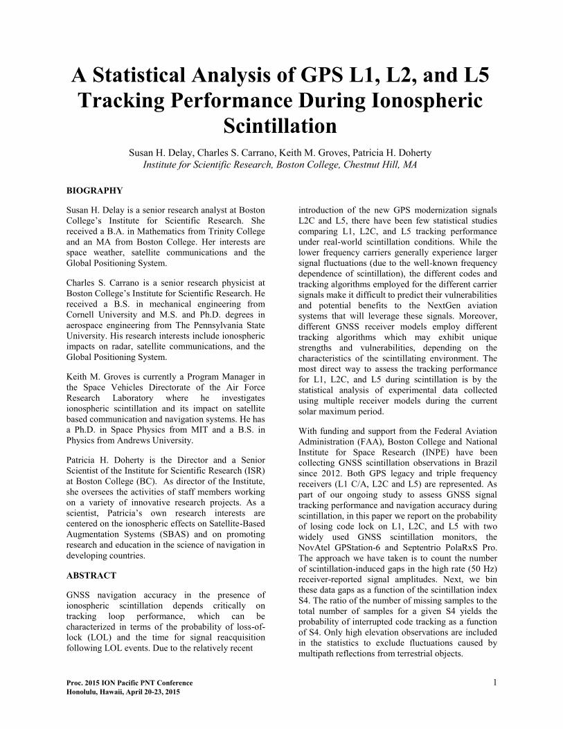
leading to gaps in the measured data. Figures 2 and 3
compare 50 Hz L1 signal power fluctuations
measured by the Novatel and Septentrio receivers,
respectively, between 0-4 UT on 16 November, 2012.
Only data for PRNs 21, 22, 24, 25, 26, 29, 30, and 31
are shown (the data for other tracked satellites are
omitted for clarity). Missing data samples (data gaps)
associated with loss of lock events are colored red,
whereas green indicates uninterrupted signal
tracking. Despite the label “C/No” used for the
vertical axes in Figures 3 and 4, the data plotted are
actually signal intensities, plus arbitrary offsets
(determined by us). Hence one should not compare
the absolute magnitudes of the C/No values shown
between the two receivers. Our LOL statistics will be
reported in terms of S4, which is computed from the
normalized signal intensity, so that the absolute
magnitude of signal intensity is unimportant.
A number of specific events have been identified in
Figure 2 for discussion. The events circled in yellow
were recorded while the transmitting satellites were
high in the sky (>30 elevation). Hence the data gaps
(red) that occurred during these events were likely
caused by the signal fluctuations associated with
ionospheric scintillation. Other events circled in red
were recorded while the transmitting satellites were
at low elevation angles. Signal fluctuations associated
with these events are due to multipath, ionospheric
scintillation, or some combination of both. Data gaps
associated with these low elevation events have been
excluded from our statistics.
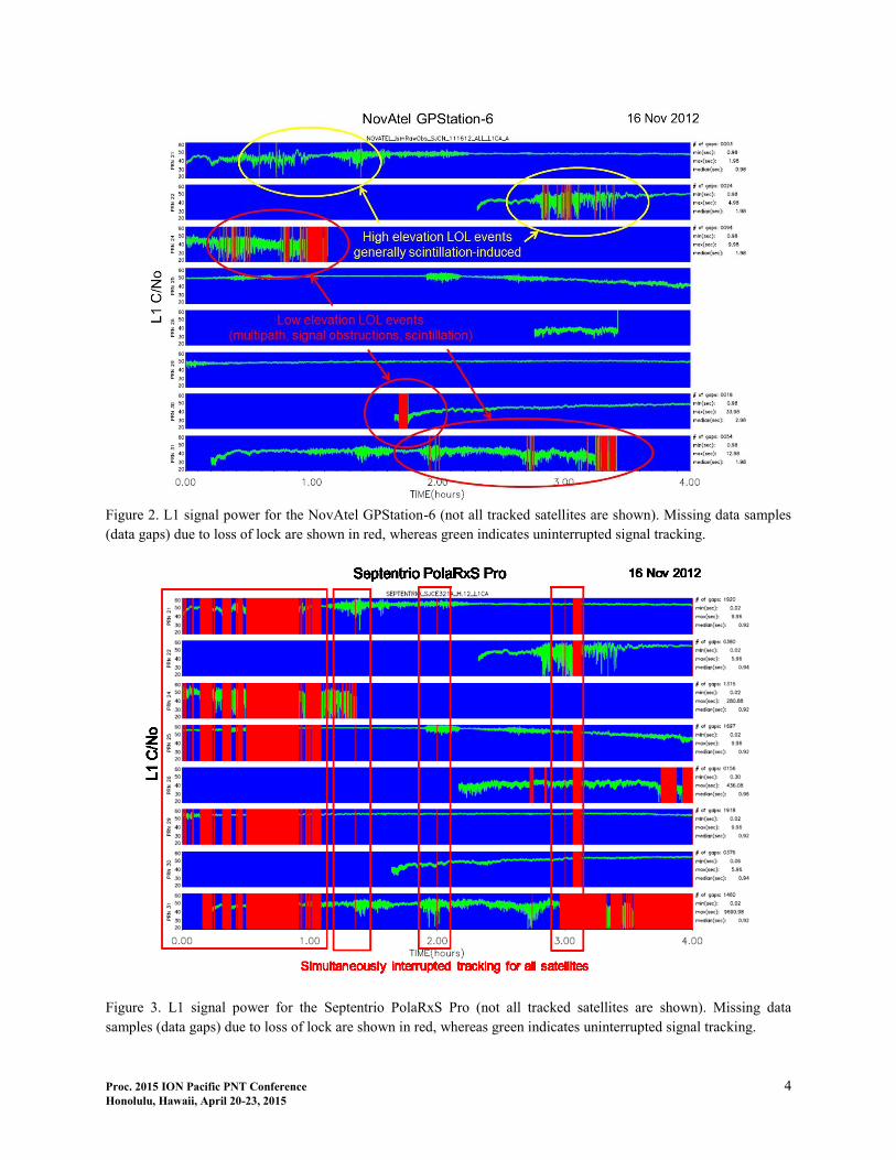
When we first examined the statistics of interrupted
signal tracking for the PolaRxS Pro receiver, we were
surprised to find many gaps in the data from high
elevation satellites, even in the absence of any
scintillation. This problem is evident in Figure 3,
which shows that there are multiple instances of
simultaneously interrupted tracking events for all
satellites tracked. Clearly this is not an environmental
effect but instead due to some problem with the
equipment. Since the PolaRxS Pro and GPStation-6
receivers were co-located, the problem is unlikely
due to the source of local RF interference. We
conjecture that either the receiver was unable to track
the requested satellite signals due to an overburdened
CPU, or it was unable to send the data to the
computer quickly enough over the manufacturer-
supplied USB to high-speed serial adaptor cable. In
any case, it became clear that we could not use the
data from this particular PolaRx Pro receiver for our
analysis.
Proc. 2015 ION Pacific PNT Conference 4 Honolulu, Hawaii, April 20-23, 2015
Figure 2. L1 signal power for the NovAtel GPStation-6 (not all tracked satellites are shown). Missing data samples
(data gaps) due to loss of lock are shown in red, whereas green indicates uninterrupted signal tracking.
Figure 3. L1 signal power for the Septentrio PolaRxS Pro (not all tracked satellites are shown). Missing data
samples (data gaps) due to loss of lock are shown in red, whereas green indicates uninterrupted signal tracking.

Proc. 2015 ION Pacific PNT Conference 5 Honolulu, Hawaii, April 20-23, 2015
We should note that when the Septentrio receiver was
tracking normally, it tended to experience fewer
scintillation-induced data gaps than the NovAtel
receiver when tracking L1 signals. For example,
compare the scintillation event circled in yellow
toward the upper-right hand corner of Figure 2 with
the corresponding scintillation event in Figure 3.
Thankfully, there is another Septentrio PolaRxS Pro
operating at São José dos Campos (about 10 km
distant from our site), as part of the CIGALA
network (Bougard et al., 2011). João Francisco
Galera Monico kindly provided data from the
CIGALA PolaRxS Pro receiver for the period
September-October 2014. We are very grateful to Dr.
Galera Monico and his team for supplying this data
for use in our study. From this point in the paper
onward, the Septentrio data we will discuss is from
the CIGALA receiver.
When we examined the data from the CIGALA
PolaRxS-Pro receiver, we noted elevated S4 values
throughout the day (as large as 0.5), even at high
elevation angles. A closer examination of the raw
signal intensities revealed evidence of simultaneous
fading (but not loss of lock) for all satellites tracked.
We suspect a source of local RF interference may be
responsible for the elevated S4 values, but thankfully
our LOL statistics should be unaffected, since (as we
shall see) the PolaRxS Pro maintained satellite
tracking on L1 when S4 was less than 0.6.
Figure 4. A comparison of L1 tracking performance between the GPStation-6 (left) and PolaRxS Pro (right).
Proc. 2015 ION Pacific PNT Conference 6 Honolulu, Hawaii, April 20-23, 2015
STATISTICS OF SCINTILLATION-INDUCED
TRACKING INTERRUPTIONS
Next we present the results of our statistical analysis.
Figure 4 compares the results for the GPStation-6
(left) and PolaRxS Pro (right) while tracking the GPS
L1 signal. The format of this figure, and the ones to
follow, is as follows. The top panel is a histogram
showing the total number of 50 Hz data samples
collected as a function of S4. Data for satellites
below 30 elevation and data gaps lasting longer than
5 minutes are excluded from this number. The middle
panel shows the number of missing 50 Hz data
samples as a function of S4. The lower panel shows
the ratio of the latter to the former, which gives the
probability of a scintillation-induced data gap as a
function of S4.
The statistics summarized in Figure 4 include 17 days
for the GPStation-6 (collected between Nov 2012 and
Jan 2013) and 46 days for the PolaRxS Pro (collected
between Sep and Oct 2014). For both receivers the
probability of interrupted tracking on L1 increases as
a function of S4, but this probability was significantly
larger for the NovAtel than for the Septentrio.
Figure 6 summarizes the statistics of L2C tracking
for the PolaRxS Pro. Unfortunately, the GPStation-6
did not track L2C signals (presumably due to a
receiver configuration issue), so we cannot compare
results between the two receivers. The plots on the
left are organized in terms of the S4 index computed
for the L2C signal, while the plots on the right are
organized in terms of the S4 index computed for the
L1 signal. We fully expected a higher probability of
interrupted tracking of L2 for the same level of
ionospheric disturbance, because scintillations are
generally more intense on lower frequency carriers
due to the well-known frequency dependence of
scintillation. Comparing the plots on the right side of
Figure 6 with those on the right side of Figure 5
shows this expectation is clearly met (the probability
of a data gap is at least 5 times larger on L2C than
L1, for a given S4 value on L1. Nevertheless, we
anticipated a similar probability of interrupted
tracking on L1 as L2C when parameterized in terms
of their own signal fluctuations (i.e. the S4 on the
same carrier). This turned out to not be the case.
Comparing the left hand plots in Figure 6 with the
right hand plots in Figure 5, we see that the
probability of interrupted tracking is larger on the
lower frequency carrier, even when viewed in terms
of its own S4.
Figure 7 summarizes the statistics of L5 tracking for
the GPStation-6. Unfortunately, the GPStation-6 did
not track L5 signals (presumably due to a receiver
configuration issue), so we cannot compare results
between the two receivers. The plots on the left are
organized in terms of the S4 index computed for the
L5 signal, while the plots on the right are organized
in terms of the S4 index computed for the L1 signal.
This receiver experienced a higher probability of a
data gap on L5 than L1, for a given S4 value on L1.
Similarly, the probability of interrupted tracking is
larger on the L5 than L1, even when viewed in terms
of its own S4. More precisely stated, the probability
of a data gap on L5 (when viewed as a function of S4
on L5) was higher than the probability of a data gap
on L1 (when viewed as a function of S4 on L1).
We found the observation that the probability of
interrupted tracking was larger on L2C and L5 than
on L1, even when viewed in terms of their own S4
values to unexpected. This seems to suggest that L2C
and L5 tracking may be less robust to scintillation
effects than L1 tracking, despite the availability of
new codes on these GPS modernization signals and
the advanced algorithms that can be employed to
track them.

Proc. 2015 ION Pacific PNT Conference 7 Honolulu, Hawaii, April 20-23, 2015
Figure 6. L2 tracking performance for the PolaRxS Pro as a function of S4 on L2 (left) and L1 (right).
Figure 7. L5 tracking performance for the GPStation-6 as a function of S4 on L5 (left) and L1 (right).
Proc. 2015 ION Pacific PNT Conference 8 Honolulu, Hawaii, April 20-23, 2015
CONCLUSIONS
As part of our ongoing study to assess GNSS signal
tracking performance and navigation accuracy during
scintillation we evaluated the probability of
scintillation-induced loss of code lock on L1, L2C,
and L5 as encountered by two widely used GNSS
scintillation monitors, the NovAtel GPStation-6 and
Septentrio PolaRxS Pro. The approach we have taken
is to count the number of scintillation-induced gaps
in the high rate (50 Hz) receiver-reported signal
amplitudes. Next, we bin these data gaps as a
function of the scintillation index S4. The ratio of the
number of missing samples to the total number of
samples for a given S4 yields the probability of
interrupted code tracking as a function of S4. Only
high elevation observations are included in the
statistics to exclude fluctuations caused by multipath
reflections from terrestrial objects.
We found the probability of scintillation-induced L1
tracking interruption appears to be significantly
larger for the GPStation-6 than the PolaRxS Pro. We
also found that both receivers experienced a higher
probability of losing lock on the lower frequency
carriers, as one might expect due to the well-known
frequency dependence of scintillation. Perhaps less
expected, however, was the observation that that the
probability of interrupted tracking was larger on the
lower frequency carriers than on L1, even when
parameterized in terms of the S4 for their own
carriers. This seems to suggest that L2C and L5
tracking may be less robust to scintillation effects
than L1 tracking, despite the availability of new
codes on these GPS modernization signals and the
advanced algorithms that can be employed to track
them.
This study has several inherent limitations. Firstly,
the probabilities of losing lock we report are specific
to the particular GNSS receiver model tested. Due to
problems with data from one of our receivers we
were unable to compare the performance of the
GPStation-6 than the PolaRxS Pro during the same
time period. Also, there are many external factors
which could affect our results. Differences in the
receiver installation such as antenna types, cables,
and placement are a few possible hindrances to a fair
comparison of receiver tracking performance during
scintillation. Furthermore, the number of samples
included in this study is limited (particularly for L2C
and L5). Back in 2012, 10 satellites transmitted the
L2C signal while only 3 transmitted L5. Currently,
16 satellites transmit L2C and 8 transmit L5. We
hope to expand this study to include more recent data
in the future.
AKNOWLEDGEMENTS
This research was supported by Boston College
Cooperative Agreement FAA 11-G-006, sponsored
by Deane Bunce. The authors are indebted to Eurico
de Paula and João Francisco Galera Monico for
providing GNSS data from São José dos Campos.
REFERENCES
Aarons, J. (1982), Global morphology of ionospheric
scintillations, Proc. IEEE, 70, 360–378,
doi:10.1109/PROC.1982.12314.
Aarons, J. (1993), The longitudinal morphology of
equatorial F-layer irregularities relevant to their
occurrence, Space Sci. Rev. 63, 209-243.
Bougard, B., Sleewaegen, J-M., Spogli, L., Veettil,
Sreeja Vadakke, Monico, J.F. Galera (2011),
CIGALA: Challenging the Solar Maximum in Brazil
with PolaRxS, Proceedings of the 24th International
Technical Meeting of The Satellite Division of the
Institute of Navigation (ION GNSS 2011), Portland,
OR, September 2011, pp. 2572-2579.
Carrano, C. S., and Groves, K.M. (2010), Temporal
Decorrelation of GPS Satellite Signals due to
Multiple Scattering from Ionospheric Irregularities,
Proceedings of the 23rd International Technical
Meeting of The Satellite Division of the Institute of
Navigation (ION GNSS 2010), Portland, OR,
September 2010, pp. 361-374.
Carrano, C. S., Groves, K. M., McNeil, W. J.,
Doherty, P. H. (2012), Scintillation Characteristics
Across the GPS Frequency Band, Proceedings of the
25th International Technical Meeting of The Satellite
Division of the Institute of Navigation (ION GNSS
2012), Nashville, TN, September 2012, pp. 1972-
1989.
Carrano, C. S., K. Groves and J. Griffin (2005),
Empirical Characterization and Modeling of GPS
Positioning Errors Due to Ionospheric Scintillation,
Proceedings of the Ionospheric Effects Symposium,
Alexandria, VA, May 3-5, 2005
Carroll, M., Y. Morton, and E. Vinande (2014),
Triple Frequency GPS Signal Tracking During
Strong Ionospheric Scintillations over Ascension
Island, Position, Location and Navigation
Symposium - PLANS 2014, 2014 IEEE/ION, 5-8
May 2014, Monterey, CA.

Proc. 2015 ION Pacific PNT Conference 9 Honolulu, Hawaii, April 20-23, 2015
Hlubek, N., J. Berdermann, V. Wilken, S. Gewies, N.
Jakowski, M. Wassaie, and B. Damtie (2014),
Scintillations of the GPS, GLONASS, and Galileo
signals at equatorial latitude, J. Space Weather Space
Clim. 4, A22.
Falletti E, Pini M, Presti L (2010), Are C/N0
algorithms equivalent in all situations, GNSS
Solutions, Inside GNSS, 5 (1), p. 20-27.
Peng, S., Y. Morton, W. Pelgrum, F. van Graas
(2011), High Latitude Ionosphere Scintillations at
GPS L5 Band, 24th International Technical Meeting
of the Satellite Division of the Institute of
Navigation, Portland, OR, September 19-23, 2011.
Shanmugam, S., J. Jones, and A. MacAulay, A.J.
Van Dierendonck (2012), Evolution to Modernized
GNSS Ionospheric Scintillation and TEC Monitoring,
IEEE/ION PLANS 2012 – April 24-26, Myrtle
Beach, SC.
Spoglia, L., Alfonsia, L., Romanoa, V., De
Franceschia, G.,Franciscob, G.,Shimabukurob, M.,
Bougarde, B., and Aquinod, M.(2013),Assessing the
GNSS scintillation climate over Brazil under
increasing solar activity, Journal of Atmospheric and
Solar-Terrestrial Physics Volumes 105–106,
December 2013, pp 199–206.
Van Dierendonck, A. J., J. Klobuchar, and Q. Hua
(1993), Ionospheric scintillation monitoring using
commercial single frequency C/A code receivers, in
ION GPS-93 Proceedings: Sixth International
Technical Meeting of the Satellite Division of the
Institute of Navigation, pp. 1333–1342, Inst. of
Navig., Salt Lake City, Utah.
Related Documents