A Spatial Planning Tool for Local Authorities: Strategic Environmental Assessment Assoc. Prof. Dr. Nuriye Peker SAY The Scientific and Technological Research Council of Turkey Çukurova University

Welcome message from author
This document is posted to help you gain knowledge. Please leave a comment to let me know what you think about it! Share it to your friends and learn new things together.
Transcript

A Spatial Planning Tool for Local Authorities: Strategic Environmental Assessment
Assoc. Prof. Dr. Nuriye Peker SAY
The Scientific and Technological Research Council of Turkey
Çukurova University

TURKEY
Area: 814.578 km2 Population: 73.722.988 (December, 2010) There are 81 administrative province

Strategic Environmental Assessment (SEA) • SEA can be defined as a systematic process,
evaluating the environmental, economic and social results of any suggested policy, plan or programme.
• SEA is developed as a more comprehensive evaluation system as a result of arising concerns related with the insufficiency of EIA carried at project level
The Current State of SEA in Turkey
FIG Commission 3 Workshop , Paris, 2011 3

There are four phases in the govermental activities related to the decision-making procedure.
• To constitute “policies” for future-oriented target • To make “plans” in relation to the policies • To make “programs” to reach the targets and • To make “projects”
The development plans in Turkey include all these four phases. Among these phases, environmental assessment is only practiced at the project level. This solely constitutes one part of the Integrated Environmental Management
Policy
Practice
Project EIA
Cumulatif effects assessment
EA of programs
Sectoral plans and policies
Determination of the area for invertments
Sectoral projects
Control and monitoring Environmental Management
SEA State of
environment
Tools for National Sustainable Development
Tools for Development
Tools for Development in Turkey
Determination of the area for land uses URBAN PLANNİNG
Integrated Environmental Managament
NATIONAL DEVELOPMENT PLAN
Macro Planning - Sectoral Planning - Micro Planning
in scope of draft SEA regulation
Project
not in scope of draft SEA regulation
Plan Program
in scope of EIA regulation

5
The Current Status of SEA in Turkey
Environmental Impact Assessment (EIA) has been applied to individual investments in Turkey since 1993
EIA is legal
SEA is not legal -Discussions and preparations was started about SEA regulation in 2000 - SEA draft regulation was prepared in 2005 and was prepared depending on the EU directive (SEA Directive 2001/42/EC) -This draft is including only physical plans and programs. -The Ministry is planning to enact this regulation end of this year. -The scientific approach into the subject is very new in Turkey, it take time to answer the questions about how and in what fields to practice the subject
FIG Commission 3 Workshop , Paris, 2011 5

• The practices of SEA are closely related to the administration system, planning sytem and decision
making procedure in central or local government in the countries. • SEA practices and SEA procedures may change from country to country. • The subjects that required strategic decision-making
process have been gathered in five groups for Turkey by taking into consideration national and international SEA systems.
FIG Commission 3 Workshop , Paris, 2011 6

The subjects that required strategic decision making process have been gathered in five groups for Turkey
National Development Plans (FYDPs) and Sectoral Plans: Socio-economic plans including macro economic targets and sectoral development policies prepared by Prime Ministry State Planning Organization (SPO).
Regional Development Plans: Plans, aiming to improve the socio-economically
underdeveloped regions, to provide the effective use of sources in the region and to improve income distribution in the country such as Southeastern Anatolia Project-SAP, Eastern Anatolia Project-EAP.
Legal Regulations: Laws and international convention for especially effective uses of
natural sources such as the Forest Law, Tourism Encouragement Law, Coast Law. Privatization Policies: Privatization activities have been in progress with the effect of
laissez-faire economy since 1985 in Turkey. Especially privatization policy in the energy and tourism sectors are effective on the environment.
Physical Plans: Urban developmental plans and other land use plans, Environmental plans
prepared by the Ministry of Environment and Forestry, urban master plans by municipalities, Infrastructure plans, tourism plans.
FIG Commission 3 Workshop , Paris, 2011 7

8
It is required to answer primarily two basic questions in order to approach SEA practice on urban development plans.
When? In which phase to practice SEA? How? How to conduct SEA?
This research project aims that analyzing, WHEN - -SEA integration into the decision-making
process of urban planning. HOW- -The practicability of SEA into the Urban
Development Plans prepared by local goverments

The research is based on two parts.
9
A procedure about how to practice SEA at the institutional level according to the urban development plans is offered. The basic steps was determined in legal process for SEA applications.
In the first part:
In the second part: SEA practice model for urban development plans is developed in the case of Adana City Plan. In the direction of the results of studies conducted in the first part, a proposal model was developed
FIG Commission 3 Workshop , Paris, 2011 9
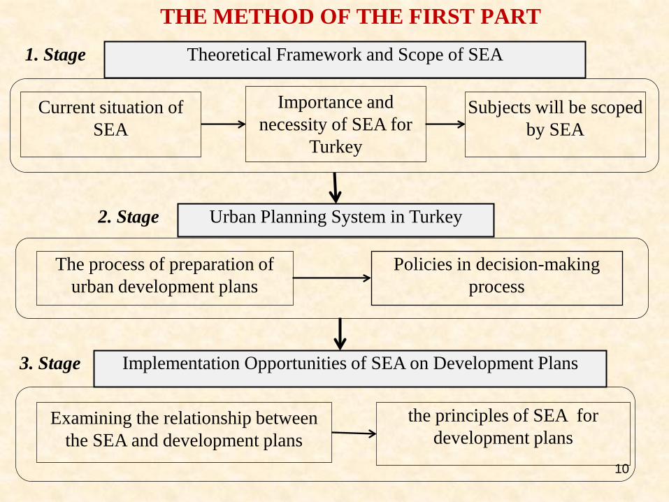
THE METHOD OF THE FIRST PART
the principles of SEA for development plans
Examining the relationship between the SEA and development plans
2. Stage
3. Stage
Theoretical Framework and Scope of SEA
Current situation of SEA
Importance and necessity of SEA for
Turkey
Subjects will be scoped by SEA
The process of preparation of urban development plans
Urban Planning System in Turkey
Policies in decision-making process
1. Stage
Implementation Opportunities of SEA on Development Plans
10

11
FIRST PART: SEA Integration to Urban Planning System • Our findings related to first part of project are presented as
follows subjects; – The phases of the SEA process on Urban Development
Plans – The issues to be solved for SEA process – Tools to be used on SEA process
• The main issues taken into account to reach these results: – The theoretical frame of SEA – The administrative system in Turkey – Planning hierarchy – The perspectives of the institutions responsable for the
planning (questionnaire-interview) – The content of the urban development plans – Draft SEA Regulation in Turkey. – The SEA Directive of the European Union

Responsible: Ministry of Environment and Forest (MEF) According to the screening method (apendix II), the Ministry of Environment and Forest decides whether SEA will be applied on a plan or program
1.SCREENING
Consultation of the related institutions Information of the public
Responsible: Authorised Institution The scoping document is prepared by considering the suggestions about public participation The scope determination meeting
First public participation meeting is held in order to get views about the format of the SEA report (Observer: Public, MEF)
Consultation of the MEF Consultation of the related institution
The format of the SEA report is determined Consultation of related institution
According to this format, the authorised institution prepares the SEA report. Public consultation
2.SCOPING
3.SEA-REPORT
The second public participation meeting is held to get views about the prepared report (Observer: Public, MEF)
Authorised institution completes the report by taking into account the views in the meeting and presents it to MEF The MEF analyses the report and shares the views with the authorised institution
The authorised institution decides on the plan or program. Information of The Ministry of Environment and Forests Information of the public Information of the related institution
6.MONITORING
4.QUALITY-CONTROL
5.DECISION-MAKING
The authorised institution presents the confirmed report to the MEF with the viewing and acknowledgement report
The authorised institution completes the missing points.
= obligatory = if required = facultative 12
The phases of the SEA process
In this project the content of this 6 phases were formed according to
the responsibility of municipalities,
the urban plan preparation process and
the draft regulation on SEA

THE SECOND PART: The Case Study
Border of development plan
Location : 36030’-38023’ kuzey enlemleri ile 34046’- 36026’ doğu boylamları
Population: 1 530 257 plan area
2 006 650 adana city
Adana Urban development plan approved by municipality in April 2008 cover 32 500 ha area

THE METHOD OF SECOND PART Status of Project Area (Plan Area)
-Topographic structure -Climatic data -Emission measurements -Air photos -Statistical information -GIS -Legal regulations and limit values -Questionnaire work
1 Natural Factors -Topography -Soil -Water -Climate -Flora-Fauna
Socio-Economic -Demographic structure -Education -Economic status -User preferences
Land Uses -Housing -Agriculture -Recreation -Industry
Current Pollution -Air pollution -Water pollution -Noise pollution -Visual pollution
Expectations-predictions 2
Population Land Uses Effects
-Statistical analysis -Single and multiple regression analysis -GEO statistic -IPCC method -Proposal plans
Evaluation of Applicability 3
•Assessment Results •Basic Planning Criteria •Planning Instruments
SECTORS -Housing Transportation -Industry -Agriculture
POLİTİCAL -Administrative structuring -Related national and international legislation
LOCAL -Regional investments -The selection of the appropriate fields belonging to investment -Local government -Provincial agencies
Natural increase correlation method
Map of sensitive areas
Map of population density
Distribution of pollutant factors
Pollution maps
Determination of risky areas
TOOLS

Risk Classification
Natural Structur
15

Current Land Use Risk Classification
Risk Classification of Natural Structure
FIG Commission 3 Workshop , Paris, 2011 16

17
Creating Risk Result Map and Overlay of Maps and
GIS analyzing
-Multy criteia analysis -Weighting risk pointing has been realized according to each effect level and risk degree -Questionnaire was made for weighting risk pointing with experts and - For final point, AHP (Analitik Hiyerarşi Prosesi) was used
FIG Commission 3 Workshop , Paris, 2011 17

18
To create the result map, risk degrees and effect levels of all inputs multiplied. With adding all factors risk degrees in database ArcView 9.2, obtained results divided in 3 groups.
Risk Classification for Urban Use –Result Map
How can be used this map in the SEA practice Risk map can be used basic planning decisions land use decision density direction of growth transportation
FIG Commission 3 Workshop , Paris, 2011 18

SEA On Urban Development Plans Phases Ancillary Tools
TODAY
1-Determination of the Present Situation
Land uses Sector production-consumption situation
Natural resources used by sector
Transportation, recration, housing, trade
building..)
Statistical data
The pollution
situation of the
research area
Pollution maps
Pollutions caused by sector
Meteorological and topographic data
GIS
Emission measurements
Scientific researhces
Statistical data
Limit values
Population of
research area
Population density, urban and rural
population
Sensitive Regions
and Protected area
in research area
Protected areas
Historical and cultural areas
Protection statutes
Maps for protection areas
19
The first category is based on the sector, sector practice and the analysis of the available situation of affected factors.

SEA On Urban Development Plans
FUTURE
2- Proposed Scenarios for the Future
Population Population growth Methods of
population
prediction
Land uses
Proposal plan
Effeccts
Impacts caused by sector
20
The following phases include future suggestions and the scenarios.

SEA On Urban Development Plans
PRECAUT
ION
3- Evaluation applicability
The Results
of the
Evaluation
Co-evaluation of subjects in
the 1. and 2.phases
Basic
Evaluation
Criteria
Criteria determining the
general frame of the policy
Activity determination for
the practice of criteria
Policy Tools Sectoral, Political, Local Local governments and their
policies
Administrative structuring
National and international law 21
Lastly, the findings from these two phases are evaluated and planning criteria are set.

Thank you [email protected]

Planning Hierarchy in the country
Planning Type Frame-Scale Scope
SOCIAL-ECONOMİC
PLANS
National Development Plan (Five-Year Development Plan)
Written statements-country plan
-Macro-economic targets, -Sectoral aims, objectives and policies, -Social development aims
Regioanal Plan Master Plan
Region - 1/500000, 1/100000 Metropolitan - 1/50 000
Superior physical plans or High-level physical plans
PHYSICAL PLANS
Environmental Plan URBAN PLANS Urban Master Plan Implementation Plan
Sub region, province - 1/2000, 50000, 100000 Urban-1/2000, 5000 Urban -1/1000
Local physical plans or Local development plans
Tourism development plan Reclamation development plan Rural development plan
Subregion-1/1000, 5000 Urban-1/5000 Rural-1/1000 Special aimed plans
FIG Commission 3 Workshop , Paris, 2011 2

Main Stages of The Regulative Plus Practical Process of SEA Phases Ancillary Tools
TODAY
1-Determination of the Present Situation Land uses Sector production-consumption situation
Natural resources used by sector Statistical data
The pollution situation of the research area
Pollution maps Pollutions caused by sector
Meteorological and topographic data GIS Emission measurements Scientific researhces Statistical data Limit values
Population of research area Population density, urban and rural population
Sensitive Regions and Protected area in research area
Protected areas Historical and cultural areas
Protection statutes Maps for protection areas
FUTURE
2- Proposed Scenarios for the Future The Development of the Sector Sector share in economic growth
Change in the sector production and consumption Economical analysis Statistical analysis
Economic Development Basic economic indicators towards economic growth Basic economic indicators in development plans
Projection of Population Population growth Methods of population prediction
Impact Assessment Impacts caused by sector
PRECAUTION
3- Evaluation applicability The Results of the Evaluation Co-evaluation of subjects in the 1. and 2.phases
Basic Evaluation Criteria Criteria determining the general framew of the polic Activity determination for the practice of criteria
Policy Tools Sectoral Political
Local governments and their policies Administrative structuring
The first category is based on the sector, sector practice and the analysis of the available situation of affected factors.
The following phases include future suggestions and the scenarios.
Lastly, the findings from these two phases are evaluated and planning criteria are set.
Related Documents