A simplified methodology for mapping groundwater vulnerability and contamination risk, and its first application in a tropical karst area, Vietnam Vu Thi Minh Nguyet & Nico Goldscheider Abstract A simplified methodology for mapping ground- water vulnerability and contamination risk is proposed, and the first application of the methodology, in a mountainous tropical karst area, is presented. The test site is the Tam Duong area, one of the poorest and remotest regions in northern Vietnam. The methodology requires a minimum of input data, which makes it particularly useful for developing countries. Vulnerability is assessed on the basis of two factors, which take into account the duality of recharge processes in karst aquifer systems: the overlying layers (O) and the concentration of flow (C). The risk map is obtained by putting together the vulnerability map and a simplified hazard assessment. The resulting maps provide a basis for groundwater protection zoning and land-use planning. Tracer tests and microbiological data confirmed the vulnerability and risk assessment in the test site. Résumé Une méthodologie simplifiée de cartographie de la vulnérabilité des eaux souterraines et du risque de contamination est proposée. Une première application est présentée, dans une zone karstique montagneuse sous climat tropical. Le site expérimental choisi est le secteur de Tam Duong, une des régions les plus pauvres et les plus isolées du Nord Vietnam. Cette approche ne nécessite qu’une quantité minimale de données d’entrée, ce qui en fait un outil utile pour les pays en voie de développement. L ’appréciation de la vulnérabilité est basée sur deux facteurs prenant en compte la dualité des processus de recharge des systèmes karstiques: les couches supérieures (“overlying layers”, facteur O), et la concentration des flux d’infiltration (“concentration of flow”, facteur C). Le recoupement de la carte de vulnérabilité avec l’estimation simplifiée des aléas permet d’établir la carte des risques. Les cartes résultantes fournissent une base pour le zonage de la protection des eaux souterraines et l’aménagement de l’espace. Traçages et données microbiologiques ont confirmé les évaluations de la vulnérabilité et des risques effectuées sur le site expérimental. Resumen Se propone una metodología simplificada para realizar la cartografía de la vulnerabilidad de agua subterránea y el riesgo a la contaminación y se presenta la primera aplicación de la metodología en un área kárstica tropical montañosa. El sitio evaluado es el área Tam Duong, una de las regiones más pobres y remotas del norte de Vietnam. La metodología requiere un mínimo de datos de entrada lo que la hace particularmente útil para países en desarrollo. La vulnerabilidad se evalúa en base a dos factores los cuales toman en cuenta la dualidad de los procesos de recarga en sistemas de acuíferos kársticos: las capas sobreyacientes (O) y la concentración de flujo (C). El mapa de riesgo se obtiene mediante la integración del mapa de vulnerabilidad y una evaluación simplificada de la amenaza. Los mapas producidos de esta manera aportan bases para la zonificación de la protección de aguas subterráneas y la planificación del uso de la tierra. Pruebas con trazadores y datos microbiológicos confirman la vulnerabilidad y la evaluación de riesgos en el sitio experimental. Keywords Groundwater vulnerability . Contamination risk . Tropical karst aquifer . Developing country . Socio-economic aspects Introduction Groundwater is the main drinking water resource in many parts of the world. Contamination resulting from industry, urbanisation and agriculture poses a threat to water quality. Wise management strategies are thus required to find a balance between groundwater protection on one hand and N. Goldscheider (*) Centre of Hydrogeology (CHYN), University of Neuchâtel, 2009 Neuchâtel, Switzerland e-mail: [email protected] Tel.: +41-32-7182645 V. T. M. Nguyet Department of Hydrology and Hydraulic Engineering, Free University of Brussels, 1050 Brussels, Belgium V. T. M. Nguyet Research Institute of Geology and Mineral Resources (RIGMR), Hanoi, Vietnam Published in Hydrogeology Journal, 1, 1-10, 2006 which should be used for any reference to this work 1

Welcome message from author
This document is posted to help you gain knowledge. Please leave a comment to let me know what you think about it! Share it to your friends and learn new things together.
Transcript
A simplified methodology for mapping groundwater vulnerabilityand contamination risk, and its first application in a tropicalkarst area, VietnamVu Thi Minh Nguyet & Nico Goldscheider
Abstract A simplified methodology for mapping ground-water vulnerability and contamination risk is proposed,and the first application of the methodology, in amountainous tropical karst area, is presented. The test siteis the Tam Duong area, one of the poorest and remotestregions in northern Vietnam. The methodology requires aminimum of input data, which makes it particularly usefulfor developing countries. Vulnerability is assessed on thebasis of two factors, which take into account the duality ofrecharge processes in karst aquifer systems: the overlyinglayers (O) and the concentration of flow (C). The risk mapis obtained by putting together the vulnerability map and asimplified hazard assessment. The resulting maps providea basis for groundwater protection zoning and land-useplanning. Tracer tests and microbiological data confirmedthe vulnerability and risk assessment in the test site.
Résumé Une méthodologie simplifiée de cartographie dela vulnérabilité des eaux souterraines et du risque decontamination est proposée. Une première application estprésentée, dans une zone karstique montagneuse sousclimat tropical. Le site expérimental choisi est le secteurde Tam Duong, une des régions les plus pauvres et lesplus isolées du Nord Vietnam. Cette approche ne nécessitequ’une quantité minimale de données d’entrée, ce qui enfait un outil utile pour les pays en voie de développement.L’appréciation de la vulnérabilité est basée sur deuxfacteurs prenant en compte la dualité des processus de
recharge des systèmes karstiques: les couches supérieures(“overlying layers”, facteur O), et la concentration des fluxd’infiltration (“concentration of flow”, facteur C). Lerecoupement de la carte de vulnérabilité avec l’estimationsimplifiée des aléas permet d’établir la carte des risques.Les cartes résultantes fournissent une base pour le zonagede la protection des eaux souterraines et l’aménagementde l’espace. Traçages et données microbiologiques ontconfirmé les évaluations de la vulnérabilité et des risqueseffectuées sur le site expérimental.
Resumen Se propone una metodología simplificada pararealizar la cartografía de la vulnerabilidad de aguasubterránea y el riesgo a la contaminación y se presentala primera aplicación de la metodología en un área kársticatropical montañosa. El sitio evaluado es el área TamDuong, una de las regiones más pobres y remotas delnorte de Vietnam. La metodología requiere un mínimo dedatos de entrada lo que la hace particularmente útil parapaíses en desarrollo. La vulnerabilidad se evalúa en base ados factores los cuales toman en cuenta la dualidad de losprocesos de recarga en sistemas de acuíferos kársticos: lascapas sobreyacientes (O) y la concentración de flujo (C).El mapa de riesgo se obtiene mediante la integración delmapa de vulnerabilidad y una evaluación simplificada dela amenaza. Los mapas producidos de esta manera aportanbases para la zonificación de la protección de aguassubterráneas y la planificación del uso de la tierra. Pruebascon trazadores y datos microbiológicos confirman lavulnerabilidad y la evaluación de riesgos en el sitioexperimental.
Keywords Groundwater vulnerability . Contaminationrisk . Tropical karst aquifer . Developing country .Socio-economic aspects
Introduction
Groundwater is the main drinking water resource in manyparts of the world. Contamination resulting from industry,urbanisation and agriculture poses a threat to water quality.Wise management strategies are thus required to find abalance between groundwater protection on one hand and
N. Goldscheider (*)Centre of Hydrogeology (CHYN),University of Neuchâtel,2009 Neuchâtel, Switzerlande-mail: [email protected].: +41-32-7182645
V. T. M. NguyetDepartment of Hydrology and Hydraulic Engineering,Free University of Brussels,1050 Brussels, Belgium
V. T. M. NguyetResearch Institute of Geology and Mineral Resources (RIGMR),Hanoi, Vietnam
Published in Hydrogeology Journal, 1, 1-10, 2006which should be used for any reference to this work
1

economic activities on the other hand (Foster and Chilton2003). The task of balancing groundwater protection andeconomic activities is particularly challenging for karstgroundwater, which is estimated as supplying water to onequarter of the world’s population (Ford and Williams1989). Karst aquifers are particularly vulnerable, ascontaminants can easily enter the subsurface through thinsoils and via swallow holes. Karst groundwater thusrequires special protection (Drew and Hötzl 1999). Asound knowledge of the hydrogeological system is aprerequisite for any protection strategy. However, karstsystems are more complicated than sand and gravelaquifers, because of their high degree of heterogeneityand the resulting duality of recharge (autogenic vs.allogenic), infiltration (diffuse vs. point) and porosity(conduits vs. fissured matrix; Bakalowicz 2005).
Contaminants usually enter the aquifer together withinfiltrating water. Therefore, recharge and infiltration pro-cesses are particularly relevant for groundwater vulnerabil-ity. Autogenic recharge originates from the karst area itselfand consists of diffuse infiltration into the soil or directlyinto exposed carbonate rocks, and subsequent percolationthrough the unsaturated zone. Allogenic recharge originateson non-karst formations that adjoin or overly the karstaquifer. It often enters the aquifer via swallow holes or otherpoints or zones of infiltration. Inside the aquifer, contami-nants can be rapidly transported over large distances in theconduit network together with the turbulent groundwaterflow, while some storage might occur in the fissured matrixblocks (Loop and White 2001; White 2002). As aconsequence of this duality, contaminants can either betransported and flushed out of the systems very rapidly ormay be stored for prolonged periods and released with along delay (e.g. Goldscheider 2005a).
Vulnerability and risk maps are valuable tools for land-use planning and groundwater protection zoning (Foster1987). A large number of methods of vulnerabilitymapping have been proposed. Comparative studies havedemonstrated that the application of different methodsoften leads to contradictory results, and that many of thecommon methods do not adequately consider the specificnature of karst (e.g. Gogu and Dassargues 2000; Gogu etal. 2003; Vias et al. 2005). Therefore, the EU COSTAction 620 was established in order to develop anapproach to “vulnerability and risk mapping for theprotection of carbonate (karst) aquifers” (Daly et al.2002; Zwahlen 2004). The methodology has successfullybeen applied in several karst areas in Europe (e.g. Andreoet al. 2006). However, it was developed by Europeanscientists having in mind the hydrogeological and socio-economic conditions in their countries. Consequently, it isrelatively complex and requires detailed data that are notavailable in many other parts of the world and particularlynot in developing countries.
Groundwater from karst aquifers is crucial for the day-to-day water supply in many regions in northern Vietnam(Tuyet 1998). Protection zones are often absent, and manykarst springs show contamination problems that mainlyresult from agricultural activities and untreated domestic
wastewaters. The implementation of protection schemescould help to improve the situation. Such schemes shouldbe as simple as possible and require a minimum of data.
This report presents the basic principles of vulnerabilityand risk mapping, mainly considering the conceptualframework proposed by COST 620. On this basis, asimplified methodology for mapping groundwater vulner-ability (“duality method”) and contamination risk isproposed. It can be applied to all types of aquifers whileproviding specific tools for karst systems. The newmethods were first applied in the Tam Duong karst area innorthern Vietnam, which is one of the remotest and poorestregions in the country. The last section of the reportdiscusses how the resulting maps could be used as tools forsustainable groundwater and land-use management.
Basic concepts
The concept of assessing groundwater vulnerability andcontamination risk is based on an origin-pathway-targetmodel. Origin is the term used to describe the location of apotential contaminant release. The pathway comprises thepassage of contaminants from the origin to the target, i.e.the water that shall be protected. Resource protection aimsto protect the whole aquifer; source protection aims toprotect a spring or well. For resource protection, thegroundwater surface is defined as the target, and thepathway consists of the unsaturated zone. For sourceprotection, the pathway additionally includes the flow inthe aquifer towards the spring or well (Goldscheider2004). From a quantitative point of view, three aspects areimportant for vulnerability assessment: the travel time of acontaminant from the origin to the target, the attenuationalong its pathway, and the duration of a contamination atthe target (Brouyère 2004). This approach makes itpossible to validate vulnerability assessments by meansof artificial tracer tests, and chemical and microbiologicalgroundwater quality data (Goldscheider et al. 2001;Holman et al. 2005; Perrin et al. 2004).
Margat (1968) introduced the term “vulnerability ofgroundwater to contamination”, which can be used as analternative to the term “natural protection against contam-ination”—the lower the natural protection, the higher thevulnerability. It is possible to distinguish between intrinsicand specific vulnerability (Daly et al. 2002; Vrba andZaporozec 1994). The intrinsic vulnerability takes intoaccount the hydrogeological characteristics of an area, butis independent of the nature of the contaminants. Thespecific vulnerability additionally considers the interactionbetween a specific contaminant type and the hydrogeolog-ical system. Both types of vulnerability maps can beprepared both for resource and source protection.
The pan-European approach to intrinsic karst ground-water vulnerability mapping considers four factors. Theoverlying layers (O) may provide some degree of protec-tion to the groundwater. In karst areas, however, allogenicrecharge may bypass these layers. Therefore, the concen-tration of flow (C) also has to be considered. The
2
precipitation regime (P) is important when comparinggroundwater vulnerability in different climatic regions butless relevant for vulnerability mapping at a more localscale. The K factor describes the hydraulic properties of thekarst aquifer. Resource vulnerability maps are created by acombination of the first three factors; source vulnerabilitymaps additionally consider the K factor (Goldscheider andPopescu 2004). Specific vulnerability maps can be createdfor different types of contaminants, e.g. pesticides orpathogenic microorganisms (Sinreich et al. 2004).
Groundwater protection zones are areas in which landuse is restricted in order to maintain good water quality(Adams and Foster 1992). Some countries use vulnerabil-ity maps as a basis for protection zoning. The importanceof the groundwater is often considered as an additionalcriterion (NRC 1997). In Ireland, for example, resourceprotection zones are delineated on the basis of thevulnerability map and the importance of the aquifer, whilesource protection zones are delineated on the basis of thevulnerability map and the travel time in the aquifer(DoELG/EPA/GSI 1999).
A hazard can be defined as a potential source ofgroundwater contamination resulting from human activi-ties (De Ketelaere et al. 2004). Three aspects are importantwhen evaluating hazards: the quality (toxicity) of thecontaminants, the quantity (mass, load), and the likelihoodof contaminant release (chronically or accidental). Adetailed rating, weighting and ranking system can be usedfor the evaluation of groundwater hazards.
The risk of groundwater contamination takes intoaccount different aspects: the presence and harmfulnessof hazards, the groundwater vulnerability, and, in somecases, the importance or value of the groundwater. COSTAction 620 proposed different types of risk assessment,including risk intensity, risk sensitivity, and total riskassessment (Hötzl et al. 2004). These risk maps can beprepared for the groundwater resource or for a particularsource, either for specific contaminants or on the basis ofthe intrinsic vulnerability map.
Proposed simplified methodology
OverviewThe proposed simplified methodology is mostly based onthe conceptual framework proposed by COST 620(Zwahlen 2004), which was described in the previoussection. However, the number of elements was reduced toform a methodology that includes only one type ofvulnerability map, one type of hazard map, and one typeof risk map. The number of factors was also reduced asmuch as possible, and the assessment schemes weresimplified. Vulnerability mapping is based on the assess-ment of two factors only (Fig. 1), and the risk map isobtained by combining the vulnerability map and a verysimple hazard assessment. The complete assessmentscheme is presented in Fig. 2. The methodology can beapplied in areas with limited available data and economicresources. It is applicable to different types of hydro-
geological environments, and it particularly considers thespecific nature of karst, i.e. the duality of recharge andinfiltration processes. The use of a GIS facilitates theapplication and makes it possible to update the hazard andrisk maps on a regular basis.
Groundwater vulnerability mapping - the dualitymethodThe first element of the proposed methodology is anintrinsic groundwater resource vulnerability map. The landsurface is defined as the origin, and the pathway includesthe passage from the origin to the groundwater table, whichis taken as the target. Only two factors are considered:overlying layers (O) and flow concentration (C).
These factors take into account the duality of rechargeprocesses in karst aquifer systems. The O factor describes the
Fig. 1 Illustration of the proposed “Duality method” of karstgroundwater vulnerability mapping, which takes into considerationthe duality of recharge processes in karst aquifers. The O factordescribes the protectiveness of the overlying layers, the C factorconsiders the concentration of flow towards swallow holes and otherzones of infiltration, and the vulnerability map is created byoverlying the O and C maps. L light; M medium; H high;E extreme
3
protectiveness of the layers overlying the aquifer. Thepresence and properties of these layers determine thevulnerability resulting from autogenic recharge, i.e. infiltra-tion and subsequent percolation of water and possiblecontaminants through the unsaturated zone. Autogenicrecharge also occurs in unconsolidated sediments andfractured rocks. Therefore, the O factor applies to all typesof aquifers. The C factor is specific to karst. It describes thevulnerability resulting from allogenic recharge processes.Surface flow originating on non-karst formations that sinksinto the karst aquifer via swallow holes or at the slope foot canrapidly transport contaminants into the groundwater (Fig. 1).
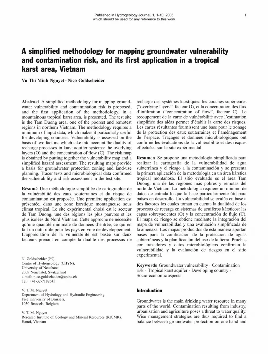
The assessment scheme for the O factor is simple(Fig. 2). A low protective function is assigned to situationswhere the aquifer is covered by less than 30 cm of soil.Thick layers of low to moderate permeability provide highnatural protection, e.g. >5 m of loam. A moderateprotection is assigned to intermediate situations, e.g. 1 mof soil overlying the aquifer.
The assessment scheme for the C factor consists oftwo steps (modified after Goldscheider et al. 2000 andGoldscheider 2005b). The first step is to determine thedominant flow process:
– Type A: Direct infiltration and percolation takes placeon high permeability formations
– Type B: Intermediate situations– Type C: Frequent surface runoff takes place on low
permeability formations
Type A indicates the predominance of autogenicrecharge, while Type C means that allogenic rechargemight occur if the given area actually drains towards apoint or zone of infiltration. Therefore, the second step isto subdivide the land surface into four types of zones:
– Zone 1: Swallow holes, sinking streams up to 1 kmupstream from the swallow holes, and 20 m bufferzones on both sides of the sinking streams
– Zone 2: The rest of the catchment areas of sinkingstreams
– Zone 3: Areas outside the catchments of sinkingstreams but within the karst area
– Zone 4: Areas that drain laterally out of the karsthydrogeological system
The C map is obtained by combining the “dominantflow process map” and the “surface catchment map”. Forunconsolidated and fractured aquifers, the O map candirectly be translated into a vulnerability map. For karstaquifers, the vulnerability map is obtained by overlying theO and C maps. In areas that generate runoff toward
Fig. 2 Proposed methodology for mapping groundwater vulnerability and risk of contamination
4

swallow holes, the C factor overrides the O factor, i.e. suchareas are always classified as highly to extremely vulner-able. Four classes of vulnerability are distinguished,symbolised by colours ranging from dark red for extremevulnerability, to light blue for low vulnerability. Thevulnerability map can be used as a basis for groundwaterresource protection zoning. Stringent land-use restrictionsare recommended in highly vulnerable zones.
Unlike other methods of karst groundwater vulnerabil-ity mapping, e.g. EPIK (Doerfliger and Zwahlen 1998),the proposed method does not explicitly include themapping of karren, dolines and other karst landforms.Tracing-irrigation experiments and other field observa-tions have revealed that the exokarst is not a reliableindicator for vulnerability (Goldscheider et al. 2001;Perrin et al. 2004). Contaminants might rapidly travelthrough shallow soils and the unsaturated zone even whenno karst landforms are visible, while dolines and karrenmight be clogged with sediments and thus provide somedegree of protection. Therefore, only dolines that actuallyact as swallow holes are considered for the proposedmethod and classified as zones of extreme vulnerability.The rest of the karst area that is covered with less than30 cm of soil is classified as highly vulnerable, indepen-dent of the surface karst landforms.
Hazard and risk mappingHazards can be classified on the basis of three aspects:quality, quantity, and likelihood of a potential contaminantrelease. As these aspects are difficult to quantify, theproposed methodology simply classifies hazards into high,moderate and low. Urbanisation, industry, waste disposalsites, main roads, petrol stations, intensive agriculture anduntreated domestic wastewater releases are classified as“high”; small roads, villages with wastewater treatmentsystems, and low-intensity agriculture are “moderate”;natural vegetation, forest and very low-intensity agricul-ture, e.g. organic fruit-tree-growing, are “low”.
The risk map is created by overlying the vulnerabilitymap with the hazard map (Fig. 2). However, for futureapplications, the assessment scheme could be extended byconsidering the importance of the groundwater resource, i.e.its ecological or socio-economic value, as an additionalelement. The risk map highlights the necessity to act bychanging land-use practices and removing existing pollu-tion hazards in zones of high risk.
Application in the test site
Description of the test siteThe Tam Duong karst area in NW Vietnam (Fig. 3) wasselected as a test site for the first application of theproposed methodology on the basis of four criteria. First,it is a typical tropical karst landscape and quite represen-tative of many other mountainous karst areas in SoutheastAsia; second, the local population largely depends ondrinking water from two karst springs, which are also used
for agriculture and a tea factory; third, it is an area withrapidly growing population and thus increasing freshwaterdemand and land-use pressure. Last but not least, theauthors also investigated the hydrogeology and ground-water quality in the same test site so that the vulnerabilityand risk mapping can be included in a wider framework(Nguyet and Goldscheider 2006). The area is among theremotest and poorest regions in the country. At present(2004), approximately 10,000 inhabitants live in therapidly expanding town of Tam Duong, which is situatedin a wide valley at an altitude of 800 m. The surroundingsteep conical hills reach altitudes of up to 1,400 m. Theclimate is tropical humid with an annual precipitation of2,600 mm and an average air temperature of 20°C. Thenatural vegetation is tropical mountainous forests, whichstill exist in the mountains. Agricultural land use predom-inates in the main and side valleys, and includes ricepaddies, tea, vegetable and fruit plantings, low-intensitycattle pasture and fishponds.
Geologically, the test site is formed of Mesozoicsedimentary rocks: the Early Triassic Tan Lac formationis 300–600 m thick and consists of siltstone and marl; theoverlying Middle Triassic Dong Giao limestone formationis 300–800 m thick; the Cretaceous Yen Chau formationincludes conglomerates and sandstones at the SW marginof the test site. The region is structured by NW–SEtrending folds, which are essentially formed of Dong Giaolimestone. The underlying marls are exposed along twoanticlines. Two main fault directions can be observed inthe area: NW–SE and NE–SW (My 1978; Thu and Ban1996).
The Dong Giao limestone is karstified, and the test siterepresents a typical tropical tower karst landscape (Tuyet1998). There are numerous caves and dolines. In mostparts of the area, shallow soils and vegetation cover thekarst rocks. Well-developed epikarst can be observed nearroads and in a quarry. Thick loamy soils and residualdeposits are locally present in the main valley. Hydro-geologically, the area is characterised by a thick karstaquifer (Dong Giao limestone) on top of a thick aquiclude(Tan Lac marl). Surface streams that flow over marl oftensink into the karst aquifer via swallow holes, which arelocated at faults and/or near the geological contactbetween the marl and limestone formations. Most springsin the area discharge from the karst aquifer. Tracer testsproved rapid and straightforward connection between twoswallow holes and the two above-mentioned karst springs,which are simply named spring 1 and spring 2 (Fig. 3;Nguyet and Goldscheider 2006). Each of the two springcatchments consequently includes an autogenic rechargearea, i.e. limestone outcrops with predominantly diffuseinfiltration via the overlying soil, and an allogenicrecharge area, i.e. marl outcrops that generate surfaceflow towards swallow holes.
Groundwater vulnerability mappingA geological and a topographic map (scale: 1:50,000), aswell as direct field observations served as a basis for the
5
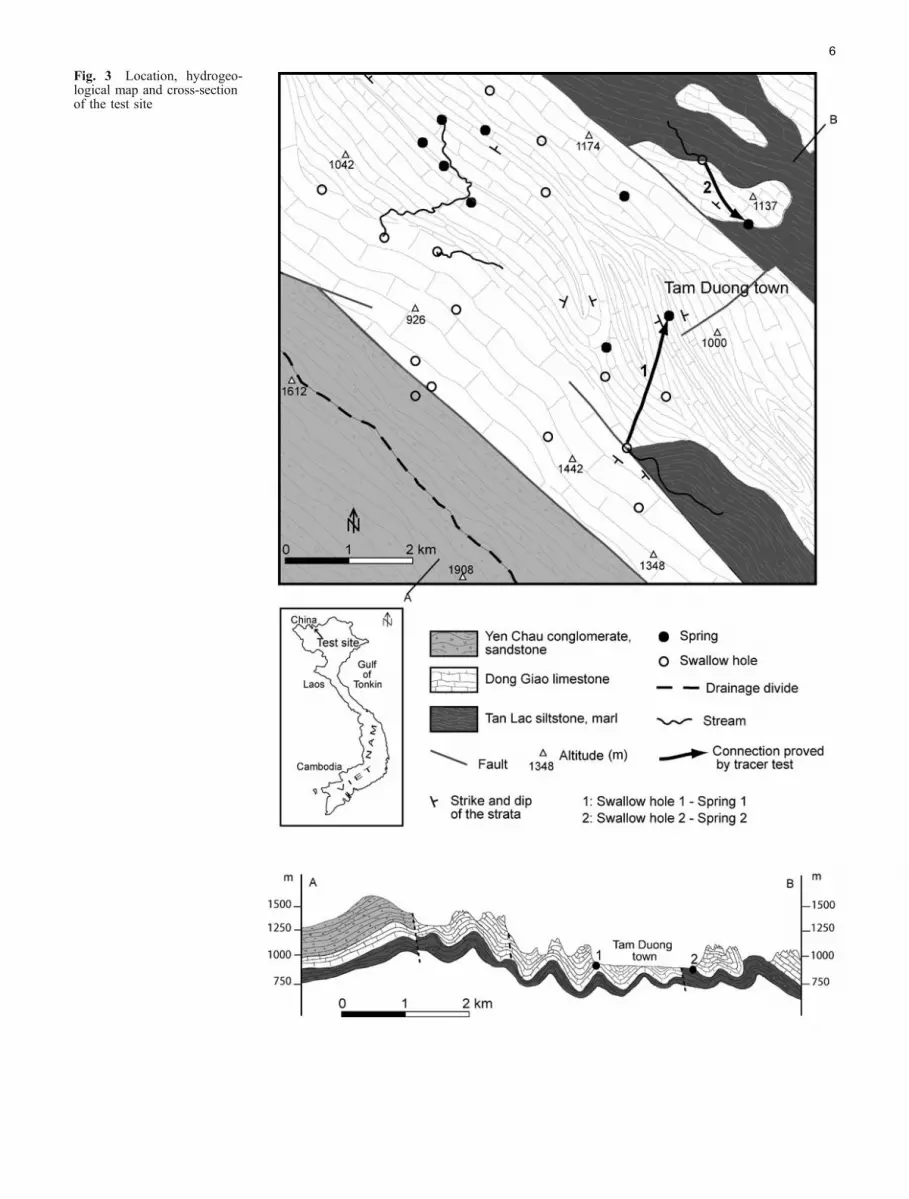
Fig. 3 Location, hydrogeo-logical map and cross-sectionof the test site
6
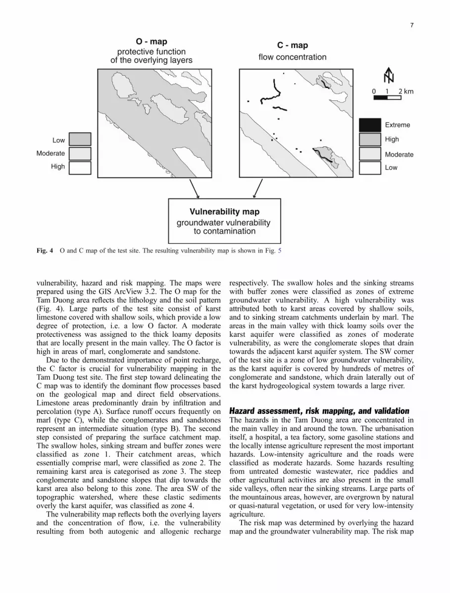
vulnerability, hazard and risk mapping. The maps wereprepared using the GIS ArcView 3.2. The O map for theTam Duong area reflects the lithology and the soil pattern(Fig. 4). Large parts of the test site consist of karstlimestone covered with shallow soils, which provide a lowdegree of protection, i.e. a low O factor. A moderateprotectiveness was assigned to the thick loamy depositsthat are locally present in the main valley. The O factor ishigh in areas of marl, conglomerate and sandstone.
Due to the demonstrated importance of point recharge,the C factor is crucial for vulnerability mapping in theTam Duong test site. The first step toward delineating theC map was to identify the dominant flow processes basedon the geological map and direct field observations.Limestone areas predominantly drain by infiltration andpercolation (type A). Surface runoff occurs frequently onmarl (type C), while the conglomerates and sandstonesrepresent an intermediate situation (type B). The secondstep consisted of preparing the surface catchment map.The swallow holes, sinking stream and buffer zones wereclassified as zone 1. Their catchment areas, whichessentially comprise marl, were classified as zone 2. Theremaining karst area is categorised as zone 3. The steepconglomerate and sandstone slopes that dip towards thekarst area also belong to this zone. The area SW of thetopographic watershed, where these clastic sedimentsoverly the karst aquifer, was classified as zone 4.
The vulnerability map reflects both the overlying layersand the concentration of flow, i.e. the vulnerabilityresulting from both autogenic and allogenic recharge
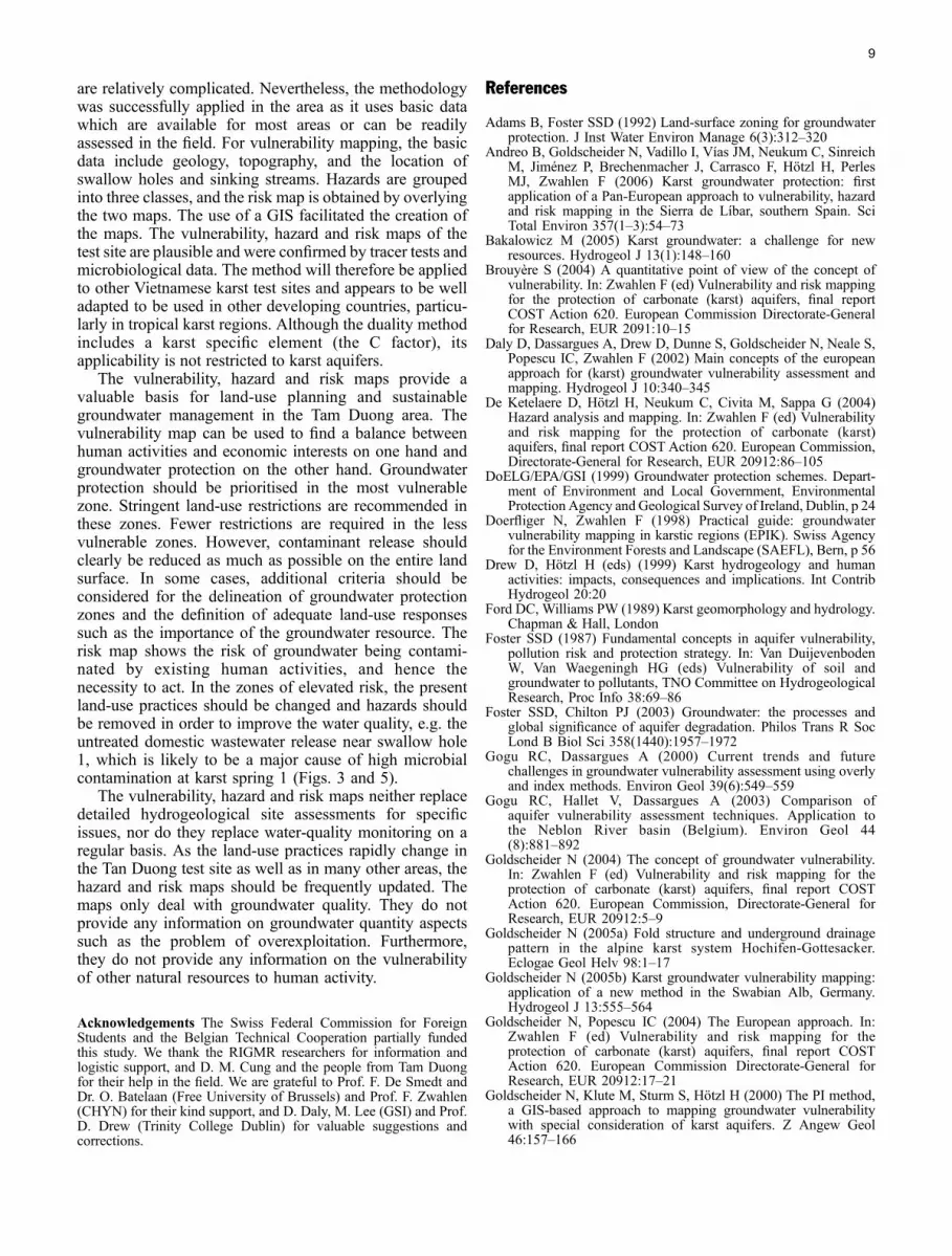
respectively. The swallow holes and the sinking streamswith buffer zones were classified as zones of extremegroundwater vulnerability. A high vulnerability wasattributed both to karst areas covered by shallow soils,and to sinking stream catchments underlain by marl. Theareas in the main valley with thick loamy soils over thekarst aquifer were classified as zones of moderatevulnerability, as were the conglomerate slopes that draintowards the adjacent karst aquifer system. The SW cornerof the test site is a zone of low groundwater vulnerability,as the karst aquifer is covered by hundreds of metres ofconglomerate and sandstone, which drain laterally out ofthe karst hydrogeological system towards a large river.
Hazard assessment, risk mapping, and validationThe hazards in the Tam Duong area are concentrated inthe main valley in and around the town. The urbanisationitself, a hospital, a tea factory, some gasoline stations andthe locally intense agriculture represent the most importanthazards. Low-intensity agriculture and the roads wereclassified as moderate hazards. Some hazards resultingfrom untreated domestic wastewater, rice paddies andother agricultural activities are also present in the smallside valleys, often near the sinking streams. Large parts ofthe mountainous areas, however, are overgrown by naturalor quasi-natural vegetation, or used for very low-intensityagriculture.
The risk map was determined by overlying the hazardmap and the groundwater vulnerability map. The risk map
O - mapprotective function
of the overlying layers
0 1 2 km
Extreme
High
Moderate
Low
Vulnerability mapgroundwater vulnerability
to contamination
High
Moderate
Low
C - mapflow concentration
Fig. 4 O and C map of the test site. The resulting vulnerability map is shown in Fig. 5
7
helps to identify zones where action is required to reducethe risk of groundwater contamination. In the test sitearea, extreme risk is present in small zones, whereimportant hazards are directly located at a swallow holeor near a sinking stream. The main valley and the sidevalleys are a mosaic of zones of high and moderate risk,which reflects the patterns of the vulnerability map and thehazard map. No significant risk is present in most parts ofthe mountainous areas, particularly in the SW corner of thearea, where thick conglomerates and sandstones cover thekarst aquifer.
The tracer tests and microbiological investigations inthe area can be used to validate the vulnerability and riskassessment. The tracers that were injected into the swallowholes reappeared at the springs 41.5 hours (spring 1) and2.5 hours (spring 2) after the injections, which correspondsto maximum linear flow velocities of 72 m/h and 700 m/h,respectively. The recovery rates of both tracers exceeded70% (Nguyet and Goldscheider 2006). These findingssupport the extreme vulnerability that was assigned to theswallow holes and sinking streams. For a more completevalidation of the vulnerability assessment, however, itwould be necessary to carry out several tracing-irrigation
experiments, also on sites that have been classified asareas of moderate to high vulnerability (Goldscheider etal. 2001). Both springs show highly variably microbialcontamination. Spring 1 generally shows higher contentsof thermotolerant coliform bacteria (up to 19,200 TTC/100 ml) than spring 2 (up to 3900 TTC/100 ml).According to the standards for drinking water defined bythe WHO (2004), thermotolerant coliforms must be absentin a 100-ml sample. The poor microbial water quality ofboth springs can be attributed to the zones of elevated riskin their catchments, particularly in the areas of allogenicand point recharge, i.e. the catchment areas of theconnected sinking streams. The very high contaminationat spring 1 corresponds to the zone of extreme risk nearswallow hole 1 and thus supports the risk assessment(Fig. 5, detail).
Discussion and conclusions
The proposed methodology was applied in a poor andremote area with limited data availability. The geological,topographic and hydrological characteristics of the test site
Extreme
High
Moderate
Low
Spring
Spring catchment
0 1 2 km
Tam Duong town
Tam Duong town
Vulnerability map Hazard map
Risk map
Villages
Agriculture
Fig. 5 Vulnerability, hazardand risk maps for the TamDuong test site. Both the tracertest results and the highcontents of bacteria in spring 1confirm the vulnerability andrisk assessment nearswallow hole 1 (detail)
8
are relatively complicated. Nevertheless, the methodologywas successfully applied in the area as it uses basic datawhich are available for most areas or can be readilyassessed in the field. For vulnerability mapping, the basicdata include geology, topography, and the location ofswallow holes and sinking streams. Hazards are groupedinto three classes, and the risk map is obtained by overlyingthe two maps. The use of a GIS facilitated the creation ofthe maps. The vulnerability, hazard and risk maps of thetest site are plausible and were confirmed by tracer tests andmicrobiological data. The method will therefore be appliedto other Vietnamese karst test sites and appears to be welladapted to be used in other developing countries, particu-larly in tropical karst regions. Although the duality methodincludes a karst specific element (the C factor), itsapplicability is not restricted to karst aquifers.
The vulnerability, hazard and risk maps provide avaluable basis for land-use planning and sustainablegroundwater management in the Tam Duong area. Thevulnerability map can be used to find a balance betweenhuman activities and economic interests on one hand andgroundwater protection on the other hand. Groundwaterprotection should be prioritised in the most vulnerablezone. Stringent land-use restrictions are recommended inthese zones. Fewer restrictions are required in the lessvulnerable zones. However, contaminant release shouldclearly be reduced as much as possible on the entire landsurface. In some cases, additional criteria should beconsidered for the delineation of groundwater protectionzones and the definition of adequate land-use responsessuch as the importance of the groundwater resource. Therisk map shows the risk of groundwater being contami-nated by existing human activities, and hence thenecessity to act. In the zones of elevated risk, the presentland-use practices should be changed and hazards shouldbe removed in order to improve the water quality, e.g. theuntreated domestic wastewater release near swallow hole1, which is likely to be a major cause of high microbialcontamination at karst spring 1 (Figs. 3 and 5).
The vulnerability, hazard and risk maps neither replacedetailed hydrogeological site assessments for specificissues, nor do they replace water-quality monitoring on aregular basis. As the land-use practices rapidly change inthe Tan Duong test site as well as in many other areas, thehazard and risk maps should be frequently updated. Themaps only deal with groundwater quality. They do notprovide any information on groundwater quantity aspectssuch as the problem of overexploitation. Furthermore,they do not provide any information on the vulnerabilityof other natural resources to human activity.
Acknowledgements The Swiss Federal Commission for ForeignStudents and the Belgian Technical Cooperation partially fundedthis study. We thank the RIGMR researchers for information andlogistic support, and D. M. Cung and the people from Tam Duongfor their help in the field. We are grateful to Prof. F. De Smedt andDr. O. Batelaan (Free University of Brussels) and Prof. F. Zwahlen(CHYN) for their kind support, and D. Daly, M. Lee (GSI) and Prof.D. Drew (Trinity College Dublin) for valuable suggestions andcorrections.
References
Adams B, Foster SSD (1992) Land-surface zoning for groundwaterprotection. J Inst Water Environ Manage 6(3):312–320
Andreo B, Goldscheider N, Vadillo I, Vías JM, Neukum C, SinreichM, Jiménez P, Brechenmacher J, Carrasco F, Hötzl H, PerlesMJ, Zwahlen F (2006) Karst groundwater protection: firstapplication of a Pan-European approach to vulnerability, hazardand risk mapping in the Sierra de Líbar, southern Spain. SciTotal Environ 357(1–3):54–73
Bakalowicz M (2005) Karst groundwater: a challenge for newresources. Hydrogeol J 13(1):148–160
Brouyère S (2004) A quantitative point of view of the concept ofvulnerability. In: Zwahlen F (ed) Vulnerability and risk mappingfor the protection of carbonate (karst) aquifers, final reportCOST Action 620. European Commission Directorate-Generalfor Research, EUR 2091:10–15
Daly D, Dassargues A, Drew D, Dunne S, Goldscheider N, Neale S,Popescu IC, Zwahlen F (2002) Main concepts of the europeanapproach for (karst) groundwater vulnerability assessment andmapping. Hydrogeol J 10:340–345
De Ketelaere D, Hötzl H, Neukum C, Civita M, Sappa G (2004)Hazard analysis and mapping. In: Zwahlen F (ed) Vulnerabilityand risk mapping for the protection of carbonate (karst)aquifers, final report COST Action 620. European Commission,Directorate-General for Research, EUR 20912:86–105
DoELG/EPA/GSI (1999) Groundwater protection schemes. Depart-ment of Environment and Local Government, EnvironmentalProtection Agency and Geological Survey of Ireland, Dublin, p 24
Doerfliger N, Zwahlen F (1998) Practical guide: groundwatervulnerability mapping in karstic regions (EPIK). Swiss Agencyfor the Environment Forests and Landscape (SAEFL), Bern, p 56
Drew D, Hötzl H (eds) (1999) Karst hydrogeology and humanactivities: impacts, consequences and implications. Int ContribHydrogeol 20:20
Ford DC, Williams PW (1989) Karst geomorphology and hydrology.Chapman & Hall, London
Foster SSD (1987) Fundamental concepts in aquifer vulnerability,pollution risk and protection strategy. In: Van DuijevenbodenW, Van Waegeningh HG (eds) Vulnerability of soil andgroundwater to pollutants, TNO Committee on HydrogeologicalResearch, Proc Info 38:69–86
Foster SSD, Chilton PJ (2003) Groundwater: the processes andglobal significance of aquifer degradation. Philos Trans R SocLond B Biol Sci 358(1440):1957–1972
Gogu RC, Dassargues A (2000) Current trends and futurechallenges in groundwater vulnerability assessment using overlyand index methods. Environ Geol 39(6):549–559
Gogu RC, Hallet V, Dassargues A (2003) Comparison ofaquifer vulnerability assessment techniques. Application tothe Neblon River basin (Belgium). Environ Geol 44(8):881–892
Goldscheider N (2004) The concept of groundwater vulnerability.In: Zwahlen F (ed) Vulnerability and risk mapping for theprotection of carbonate (karst) aquifers, final report COSTAction 620. European Commission, Directorate-General forResearch, EUR 20912:5–9
Goldscheider N (2005a) Fold structure and underground drainagepattern in the alpine karst system Hochifen-Gottesacker.Eclogae Geol Helv 98:1–17
Goldscheider N (2005b) Karst groundwater vulnerability mapping:application of a new method in the Swabian Alb, Germany.Hydrogeol J 13:555–564
Goldscheider N, Popescu IC (2004) The European approach. In:Zwahlen F (ed) Vulnerability and risk mapping for theprotection of carbonate (karst) aquifers, final report COSTAction 620. European Commission Directorate-General forResearch, EUR 20912:17–21
Goldscheider N, Klute M, Sturm S, Hötzl H (2000) The PI method,a GIS-based approach to mapping groundwater vulnerabilitywith special consideration of karst aquifers. Z Angew Geol46:157–166
9
Goldscheider N, Hötzl H, Fries W, Jordan P (2001) Validation of avulnerability map (EPIK) with tracer tests: 7th conference onlimestone hydrology and fissured Media. Besançon 20–22:167–170
Holman IP, Palmer RC, Bellamy PH, Hollis JM (2005)Validation of an intrinsic groundwater pollution vulnerabilitymethodology using a national nitrate database. Hydrogeol J13(5–6):665–674
Hötzl H, Delporte C, Liesch T, Malik P, Neukum C, Svasta J (2004)Risk mapping. In: Zwahlen F (ed) Vulnerability and riskmapping for the protection of carbonate (karst) aquifers, finalreport COST Action 620, European Commission Directorate-General for Research, EUR 20912:113–120
Loop CM, White WB (2001) A conceptual model for DNAPLtransport in karst ground water basins. Ground Water 39(1):119–127
Margat J (1968) Vulnérabilité des nappes d’eau souterraine à lapollution (vulnerability of groundwater to pollution). BRGM-Publication 68 SGL 198 HYD, Orléans
My BP (1978) Geological map of Vietnam 1:200.000, Lao Cai-KimBinh. Geological Survey of Vietnam
Nguyet VTM, Goldscheider N (2006) Tracer tests, hydrochemicaland microbiological investigations as a basis for groundwaterprotection in a remote tropical mountainous karst area, Vietnam.Hydrogeol J (in press). DOI 10.1007/s10040-006-0038-z
NRC-National Research Council (1997) Valuing groundwater:economic concepts and approaches. National Academic Press,Washington, DC, p 189
Perrin J, Pochon A, Jeannin PY, Zwahlen F (2004) Vulnerabilityassessment in karstic areas: validation by field experiments.Environ Geol 46(2):237–245
Sinreich S, Kozel R, Mudry J (2004) Specific vulnerability method.In: Zwahlen F (ed) Vulnerability and risk mapping for theprotection of carbonate (karst) aquifers, final report COSTAction 620 European Commission Directorate-General forResearch, EUR 20912, pp 67–83
Thu T, Ban NV (1996) Geology and mineral deposits of the PhongTho sheet. Intergeo, Hanoi
Tuyet D (1998) Karst geology investigation of the northwestregion. Research Institute of Geology and Mineral Resources,Hanoi, p 251
Vias JM, Andreo B, Perles MJ, Carrasco F (2005) A comparativestudy of four schemes for groundwater vulnerability mapping ina diffuse flow carbonate aquifer under Mediterranean climaticconditions. Environ Geol 47(4):586–595
Vrba J, Zaporozec A (eds) (1994) Guidebook on mappinggroundwater vulnerability. Int Contrib Hydrogeol 16:131
White WB (2002) Karst hydrology: recent developments and openquestions. Eng Geol 65(2–3):85–105
WHO (2004) Guidelines for drinking-water quality, 3rd edn.,vol 1, Recommendations, World Health Organisation, Geneva,p 515
Zwahlen F (ed) (2004) Vulnerability and risk mapping for theprotection of carbonate (karst) aquifers, final report COSTaction 620. European Commission, Directorate-General forResearch, EUR 20912:297
10
Related Documents