[1] A Report On “Assessment of Pollution of Drains Carrying Sewage /Industrial Effluent Joining River Ganga and its Tributaries (Kali-East/Ramganga) between Haridwar (Down) to Kanpur (Down)” Segment-B, Phase -I (Haridwar to Kanpur) (In the matter of M.C Mehta Vs. Union of India) Submitted to: Hon’ble National Green Tribunal (NGT) (November, 2016) -By- Uttar Pradesh Jal Nigam, Uttar Pradesh Pollution Control Board, National Mission for Clean Ganga, MoWR, RD & GR Central Pollution Control Board, MoEF&CC

Welcome message from author
This document is posted to help you gain knowledge. Please leave a comment to let me know what you think about it! Share it to your friends and learn new things together.
Transcript
[1]
A Report On
“Assessment of Pollution of Drains Carrying
Sewage /Industrial Effluent Joining River Ganga
and its Tributaries (Kali-East/Ramganga)
between Haridwar (Down) to Kanpur (Down)”
Segment-B, Phase -I (Haridwar to Kanpur)
(In the matter of M.C Mehta Vs. Union of India)
Submitted to:
Hon’ble National Green Tribunal (NGT) (November, 2016)
-By-
Uttar Pradesh Jal Nigam,
Uttar Pradesh Pollution Control Board, National Mission for Clean Ganga, MoWR, RD & GR
Central Pollution Control Board, MoEF&CC


[iii]
BEFORE THE NATIONAL GREEN TRIBUNAL
PRINCIPAL BENCH, NEW DELHI
ORIGINAL APPLICATION NO. 200/2014
IN THE MATTER OF
M.C. MEHTA
VS
UNION OF INDIA & ORS.
AND
ANIL KUMAR SINGHAL APPLICANT
VS
UNION OF INDIA & ORS. RESPONDENT(S)
AND
SOCIETY FOR PROTECTION OF ENVIRONMENT APPLICANT
& BIODIVERSITY & ANR.
VS
UNION OF INDIA & ORS. RESPONDENT (S)
Compliance Statement to the Hon’ble National Green Tribunal (NGT) order
dated 19th October, 2016
Regarding
“Assessment of pollution of drains carrying sewage /industrial effluent joining
River Ganga and its Tributaries (Kali- East/Ramganga) between Haridwar
Downstream to Kanpur Downstream (Segment B, Phase - I)
Submitted by
Uttar Pradesh Jal Nigam
Uttar Pradesh Pollution Control Board
National Mission for Clean Ganga
(Ministry of Water Resources, River
Development & Ganga Rejuvenation)
Central Pollution Control Board
(Ministry of Environment, Forest & Climate
Change)

[iv]

[v]
Contents 1. Introduction: .......................................................................................................... 1
2. The Earlier Report:............................................................................................... 1
3. Order of Hon’ble Tribunal: ................................................................................ 1
4. Process of Re-assessment: ............................................................................... 2
5. Procedures and Methods for Flow measurement, Sampling and Analysis of Samples ....................................................................................................... 2
6. Findings: .................................................................................................................. 2
7. Drains joining River Ganga: ............................................................................. 3
7.1 Ganga: ...................................................................................................................... 3
7.2 Ramganga: ............................................................................................................... 4
7.3 Kali-east: .................................................................................................................. 5
7.4 River Pandu: ............................................................................................................. 5
8. Observations: ......................................................................................................... 6
9. Suggestions (proposed): ................................................................................... 6
Annexures .......................................................................................................................... 7
I. Summary Statement of Drains .................................................................................... 7
II. List of Drains (Old/New) Joining River Ganga, Kali-East, Ramganga and Pandu. (Haridwar D/S to Kanpur D/S) ............................................................................................ 9
III. Data Sheet of Drains Joining River Ganga. ............................................................ 11
IV. Data Sheet of Drains Joining River Ram Ganga. .................................................. 109
V. Data Sheet of Drains Joining River Kali East. ....................................................... 129
VI. Data Sheet of Drains Joining River Pandu. .......................................................... 173
10. Comments of the Institutions ................................................................................. 191

[vi]
[1]
1. Introduction:
The main causes attributed to the Pollution of River Ganga are due to
disposal of industrial and domestic sewage effluent joining to it directly by
drains or indirectly through tributaries. The storm water drains designed
to flood-out the storm water during rainy season, are now being used for
disposal of sewage and trade effluents which ultimately joins River Ganga.
These drains exert pollution load into River Ganga in terms of Biochemical
Oxygen demand (BOD) and Faecal Coliform Bacteria. There are
possibilities that the drains may dispose toxic pollutants like metals and
pesticide which they may receive from catchment area.
Therefore, Assessment of Pollution of the drains is essential and in this
context CPCB which has presented data on drains before the Hon’ble
Tribunal and was further directed on 19.11.2016 for fresh survey and
analysis by a committee.
2. The Earlier Report:
The CPCB has placed a report on the drains joining River Ganga which was
reviewed by the Hon’ble Tribunal in the hearing held during 19th to 25th
October, 2016. CPCB has reported that based its survey, there were 30
drains joining River Ganga Directly. However, in the report the three
drains of Farrukhabad were missed inadvertently, so accordingly to CPCB,
the total drains seen physically were 33. Further, according to UP Jal
Nigam number of drains were informed to be more
3. Order of Hon’ble Tribunal:
The Hon’ble National Green Tribunal (NGT) in the Orders dated 19th
October, 2016 directed that the Member Secretary, CPCB, Chief Engineer
of U.P. Jal Nigam, Senior most Chief Environmental Officer of U.P.
Pollution Control Board and representative from the Ministry of Water
Resources shall personally visit the area falling in Segment ‘B’ of Phase-I
in terms of our Judgement and as afforested. They will identify how many
drains join river Ganga or its tributaries and make observations in relation
to quantum and quality of effluent that is going to river Ganga or its main

[2]
tributaries through them. Let this report be submitted before the next
date of hearing.
4. Process of Re-assessment:
In compliance to the Hon’ble Tribunal, CPCB immediately coordinated with
Uttar Pradesh Pollution Control Board (UPPCB), the U.P Jal Nigam and
National Mission for Clean Ganga (NMCG) and deputed the inspection
teams to physically inspect each drains joining River Ganga and its main
tributaries, Kali-East and Ramganga. The Member Secretary, CPCB has
also crosschecked the drains and the River Kali-East and Ganga. These
locations include i.e. Kadrabad Drain (Kali-East) Chhoiya Drain (Kali-East),
Fuldehra (Ganga), Ganga (Brij Ghat, Poonth) and Kali East at Hapur.
During the re-assessments of drains, identified drains have been
segregated into the following classes;
A. Drains carrying only storm water/irrigation water
B. Drains carrying sewage/industrial effluents of mixed effluents
C. The drains which are trapped/dry
5. Procedures and Methods for Flow measurement, Sampling
and Analysis of Samples
The Central Pollution Control Board (CPCB) collected samples from the
drains and followed the Standard Method (American Public Health
Association and approved protocols under National Accreditation Board for
Laboratories). The samples were preserved for Heavy Metals and
Pesticides prior to their instrumental analysis. The Ball float method was
adopted for flow measurement and accordingly, the flow of each drains
have been expressed in Million Litre per Day (MLD).
6. Findings:
Based on the re-assessment of drains and as per the directions of the
Hon’ble Tribunal, the following are the findings/observation and the
conclusion (with suggestions).

[3]
7. Drains joining River Ganga:
As per the recently carried out survey (During 25th October- 4th
November, 2016) the details of each drains along with sample analysis
results and the pictures are given in Annexure –III to VI.
7.1 Ganga: There are 33 drains seen physically by the Inspection Teams. Out of 33
drains, 4 drains were found to be trapped and 2 were dry. The details of
drains joining river Ganga during the present survey is as under:
List of the drains discharging into River Ganga directly
Sl.
No.
Catchment
area
Name of New
Drain
Trapped
(T)
/Dry(D)
Stagnant(ST)/
Flow (F)
Pollution
Sources
1. Sukratal Banganga River X Flow Domestic
2. Bijnor
Hemraj Drain X Flow Domestic
3. Malan River X Flow Mixed
4. Chhoiya Drain X Flow Mixed
5. Gajrola and
Babrala
Bagad River X Stagnant Industrial
6. Garh
Garh Drain X Flow Domestic
7. Fuldehra Drain X Flow Mixed
8. Badaun Sot River X Flow Domestic
9.
Anupsahar
Anupsahar STP
Drain-1
X Flow Domestic
10. Anupsahar STP
Drain-2
X Flow Domestic
11.
Farrukkaba
d
Dhinapur drain X Flow Mixed
12. Bhairoghat drain X Flow Mixed
13. Bargadiya Ghat
drain
X Flow Domestic
14. Hathikhana Nala X Flow (Partially
trapped)
Domestic
15.
Kanpur
Permiya Nala X Flow Domestic
16. Ranighat drain X Flow Domestic
17. Sisamau Nala X Flow Mixed
18. Tefco Nala Trapped X Domestic
19. Parmath drain X Flow (Could not be measured) – Underground
Domestic
20. Muir drain X Flow Domestic
21. Police drain* Dry X Domestic
22. Jail drain* Dry X Domestic
23. Golaghat Nala X Flow Domestic
24. Bhagwatdas Nala X Flow Domestic
25. Satti Chaura X Flow Domestic
26. Dabka Nalla-1 Trapped X Domestic
27. Dabka Nalla-2 Trapped X Domestic
28. Dabka Nalla-3 Trapped X Domestic
29. Shetla Bazar X Flow Mixed
30. Budhiyaghat
Drain
X Flow Mixed

[4]
31. Wazidpur Nalla X Flow Mixed
32. Unnao
City Jail Drain X Flow Mixed
33. Loni Drain X Flow Mixed
Total 4T & 2D 26F & 01 ST 21 (DM), 01
(In), 11 (Mix)
*Irrigation Canal, Shekhpur at Jajmau carried effluent of CETP and STP which is
used for irrigation.
7.2 Ramganga:
The joint teams have inspected 6 drains discharging effluents into
River Ramganga.
The details of drains joining river Ramganga as presented earlier and
during the present survey is an under:
Drains Discharged into Ramganga
Sl.
No.
Catchment
area
Name of
Old Drain
Name of
New Drain
Trapped
/Dry
Stagnant/
Flow
1. Dhampur
and Bijnor
Nohra Drain
Nohra Drain
X Flow
2. Afzalgarh
Dwarika
Sugar mill
Darin
X Discharge into Rachna
River,* tributaries of
Ramganga, UPPCB informed
to be dry before meeting
with River Rachna
3. Rampur Rampur
Drain Rampur Drain
X Flow (through River
Kosi)
4. Moradabad Moradabad
drain
Moradabad
drain
X Flow
5. Bareilly –
Aligarh to
Kannauj
X Nakatiya Nala X Flow
6. X Chawri Nala X Flow
7. X Deveranaiya
Nala
X Flow
Total 04 06
*Since, sub-tributaries were not considered, Rachna River was not inspected

[5]
7.3 Kali-east:
The joint teams have inspected 14 drains joining river Kali-east out of
which, 2 drains found to be dry.
The details of drains joining river Kali-east as presented earlier and
during the present survey is an under:
Drains Discharged into Kali East
Sl.No. Catchment
area
Name of Old
Drain
Name of New
Drain
Trappe
d
/Dry
Standing/F
low
1.
Meerut
AbuNallah-1 AbuNallah-1 X Flow
2. AbuNallah-2 AbuNallah-2 Dry X
3. Slaughter House
Drain /Odean
Nallah
Slaughter House
Drain /Odean
Nallah
X Flow
4. Mawana and
Meerut
Chhoiya Drain Chhoiya Drain X Flow
5. Hapur
Hapur Drain Hapur Drain X Flow
6. X Hapur Drain-1 X Flow
7. Modinagar
and Meerut
Kadarabad Drain Kadarabad Drain X Flow
8. Gulaothi Gulaothi Drain Gulaothi Drain X Flow
9.
Bulandshahar
Bulandshahar
Drain1
Bulandshahar
Drain1
X Flow
10. Bulandshahar
Drain2
Bulandshahar
Drain2
X Flow
11. X Aadil Nagar Nala X Flow
12. X Neem Nala Dry X
13. Amapur X Kasganj drain X Flow
14. Kannauj Patta Nala X Flow
Total 09 14 2 (D) 12 (F)
7.4 River Pandu: Five drains discharging into River Pandu in the Kanpur region have also
been inspected by the joint teams. The details are as follows;
Drains Discharged into Pandu River
Sl.No
.
Catchment
area
Name of
Old
Drain
Name of
New Drain
Trapped
/Dry
Stagnant
/Flow
1.
Kanpur
X Panki Nala X Flow
2. X ICI Nala X Flow
3. X Ganda Nala X Flow
4. X COD Nala X Flow
5. X Halwa
Khand Nala
Diverted to COD
drain, however
overflow goes to
Pandu
Flow
Total 00 05 - 5 (F)

[6]
8. Observations: a. It has been observed there are 33 drains joining River Ganga between
Haridwar to Kanpur down (Unnao) directly, 4 drains are trapped 2 are
found to be dried or being used for irrigation.
b. There are 14 drains joins of River Kali-East directly out of 2 drain found
to be dry.
c. There are 6 number of drains joining River Ramganga.
d. It has been observed that River Ganga was receiving 3515 MLD of
waste water directly. Accordingly flow measured at the moment of
time.
e. Except 4 drains (Banganga, Hemraj, Garh and Bargariya Ghat) all the
other drains joining directly into River Ganga indicates presents of
pesticides.
f. Four Drains of Kanpur carrying high concentration of Chromium
ranging from 2 mg/l to 84 mg/l.
g. Arsenic was found above permissible limits of drinking water in one
drain (Garh), Cadmium in one drain (Wazidpur Nalla), Lead was also
found in five drains.
9. Suggestions (proposed): a. All the drains should have flow measuring system before they join
River Ganga
b. The custodians of the drains should clean the drains regularly and
filthy material should be disposed off properly.
c. Effluent characteristics should be monitored on monthly basis.
d. An intermediate method should be adopted for treating sewage and
industrial effluents flowing in the drains.
e. Wherever possible and as per the availability of land, sewage
treatment plant should be set up and the treated effluents should meet
to the norms (BOD<10 mg/l and Faecal Coliform Bacteria < 230 MPN).
f. Treated effluent as far as possible and approachable can be used for
industrial and non-potable purpose.
g. Treated water can also be used for sprinkling on dusty roads and for
growing grass to supress dust emissions.
h. Treated sewage effluents (free form metals and pesticides) can be
used for aquaculture (Fish culture).

[7]
Annexures
I. Summary Statement of Drains
(Drains in Segment –B Phase-I, Haridwar D/S to Kanpur D/S)
Pollution Sources River
Ganga Ramganga Kali East Pandu River
Domestic 21 01 05 02
Effluent 01 00 00 00
Mixed 11 05 09 03
No. of drains 33 06 14 05
Total 58

[8]

[9]
II. List of Drains (Old/New) Joining River Ganga, Kali-East,
Ramganga and Pandu. (Haridwar D/S to Kanpur D/S)
Drains Discharging into River Ganga Sl.
No.
Catchment
area
Name of Old Drain Name of New Drain Trapped
/Dry
Standing/Flow Flow
(MLD)
1. Sukratal Banganga River 1. Banganga River X Flow 2347
2.
Bijnor
Hemraj Drain 2. Hemraj Drain X Flow 91
3. Bijnor Sewage Drain X Discharge into Hemraj Drain
4. Malan River 3. Malan River X Flow 100
5. Chhoiya Drain 4. Chhoiya Drain X Flow 276
6. Gajrola and
Babrala
Bagad River 5. Bagad River X Standing -
7. Garh
Garh Drain 6. Garh Drain X Flow 13
8. Fuldehra Drain 7. Fuldehra Drain X Flow 14
9. Badaun
Badaun Sewage Drain X Discharge into Sot River
10. Sot River 8. Sot River X Flow 60
11. Anupsahar
Anupsahar STP Drain-1 9. Anupsahar STP Drain-1 X Flow 1
12. Anupsahar STP Drain-2 10. Anupsahar STP Drain-2 X Flow 1
13.
Farrukhabad
Bhairoghat drain 11. Bhairoghat drain X Flow 34
14. Dhinapur drain 12. Dhinapur drain X Flow 2
15. X 13. Hathikhana Nala X Flow 27
16. Bargadiya Ghat drain 14. Bargadiya Ghat drain X Flow 4
17.
Bareilly –
Aligarh to
Kannauj
Deveranaiya Nala X Discharge into Ramganga
18. Chawri Nala X Discharge into Ramganga
19. Nakatiya Nala X Discharge into Ramganga
20. Kasganj drain X Discharge into Kali East
21. Patta Nala X Discharge into Kali East
22. Cherat drain X Discharge into Yamuna
23. Aligarh drain X Discharge into Yamuna
24.
Kanpur
Permiya Nala 15. Permiya Nala X Flow 151
25. X 16. Ranighat drain X Flow 1
26. Sisamau Nala 17. Sisamau Nala X Flow 200
27. X 18. Tefco Nala Trapped X -
28. X 19. Parmath drain X Flow (Could not be
measured) –
Underground …
-
29. X 20. Muir drain X Flow 13.
30. X 21. Police drain Dry X -
31. X 22. Jail drain Dry X -
32. Golaghat Nala 23. Golaghat Nala X Flow 1
33. Bhagwatdas Nala 24. Bhagwatdas Nala X Flow 17
34. Satti Chaura 25. Satti Chaura X Flow 2
35. Dabka Nalla-1 26. Dabka Nalla-1 Trapped X -
36. Dabka Nalla-2 27. Dabka Nalla-2 Trapped X -
37. Dabka Nalla-3 28. Dabka Nalla-3 Trapped X -
38. Shetla Bazar 29. Shetla Bazar X Flow 24
39. X 30. Budhiyaghat Drain X Flow 10
40. Wazidpur Nalla 31. Wazidpur Nalla X Flow 18
41. X Panki Nala Discharge into Pandu
42. X ICI Nala Discharge into Pandu
43. X Ganda Nala Discharge into Pandu
44. X COD Nala Discharge into Pandu
45. X Halwa Khand Nala Discharge into Pandu
46. Unnao
City Jail Drain 32. City Jail Drain X Flow 86
47. Loni Drain 33. Loni Drain X Flow 22
Total 33 33 3515

[10]
Drains Discharged into River Ramganga Sl.
No.
Catchment area Name of Old Drain Name of New Drain Trapped
/Dry
Standing/Flow Flow
(MLD)
1. Dhampur and
Bijnor
Nohra Drain
1. Nohra Drain
X Flow 15
2. Afzalgarh
Dwarika Sugar mill
Darin
X Discharge Rachna River
tributaries of Ramganga
-
3. Rampur Rampur Drain 2. Rampur Drain X Flow 34
4.
Moradabad Moradabad drain
3. Moradabad
drain
X Flow 57
5. Bareilly –Aligarh to
Kannauj
X 4. Deveranaiya
Nala
X Flow 398
6. X 5. Chawri Nala X Flow 19
7. X 6. Nakatiya Nala X Flow 170
Total 04 06 693
Drains Discharged into River Kali East Sl.No. Catchment area Name of Old Drain Name of New Drain Trapped
/Dry
Standing
/Flow
Flow
(MLD)
15.
Meerut
AbuNallah-1 1. AbuNallah-1 X Flow 60
16. AbuNallah-2 2. AbuNallah-2 X Flow 244
17. Slaughter House
Drain /Odean Nallah
3. Slaughter House
Drain /Odean
Nallah
X Flow 175
18. Mawana and
Meerut
Chhoiya Drain 4. Chhoiya Drain X Flow X
19. Hapur
Hapur Drain 5. Hapur Drain X Flow 28
20. X 6. Hapur Drain-1 X Flow 5
21. Modinagar and
Meerut
Kadarabad Drain 7. Kadarabad Drain X Flow 49
22. Gulaothi Gulaothi Drain 8. Gulaothi Drain X Flow 7
23.
Bulandshahar
Bulandshahar Drain1 9. Bulandshahar
Drain1
X Flow 147
24. Bulandshahar
Drain2
10. Bulandshahar
Drain2
X Flow 165
25. X 11. Aadil Nagar Nala X Flow 199
26. X 12. Neem Nala Dry X X
27. Amapur X 13. Kasganj drain X Flow 9
28. Kannauj X 14. Patta Nala X Flow 11
Total 09 14 1099
Drains Discharged into Pandu River Sl.No. Catchment area Name of Old
Drain
Name of New Drain Trapped
/Dry
Standing/ Flow Flow
(MLD)
6.
Kanpur
X 1. Panki Nala X Flow 114
7. X 2. ICI Nala X Flow 19
8. X 3. Ganda Nala X Flow 211
9. X 4. COD Nala X Flow 121
10. X 5. Halwa Khand
Nala
Diverted to COD drain,
however overflow goes to
Pandu
Flow 62
Total 00 05 527

[11]
III. Data Sheet of Drains Joining River
Ganga.

[12]

[13]
DRAIN MONITORING FORMAT
(Ganga)
Date & Time of sampling: 26.10.2016, 10:30 AM onwards
1. Name of the Drain : Banganga 2. Meeting Ganga : Left bank 3. Name of the Regional Office of SPCB : Muzaffarnagar 4. Source of pollution load: : Domestic 5. If Industrial /Mixed (Please indicate type
of sector)
: NA
6. Traceable length of drain (in Km) before
meeting Ganga (through google earth/map)
: Approx. 40-50 km
7. Catchment area Sukratal 8. Co-ordinate of the confluence
point (if not reachable
indirect though google earth/map) (Decimal units)
Latitude : 29°25'26.07"N
Longitude 78° 1'5.05"E
Distance from confluence point (may the
find out over google earth/map), KM
Approx. 5-7km
9. Co-ordinate of the sampling
point (Decimal units)
Latitude : 29°29'29.3"N
77°59'24.2"E Longitude 10. Landmarks / Address of the Location Sukratal Bridge, confluence point
between Solani and Banganga river 11. Flow if in MLD, if zero indicate whether
dry or stagnant : 2346.53
12. Observations : Banganga comes from Laksar,
Haridwar, Uttarakhand. 13. Name of all monitoring officers along
with Designation
Dr. Pankaj Kumar, Scientist ‘D’,
CPCB Dr. M. Jiban Singh, Research
Associate, CPCB
Sh. Neeraj Gahlawat, Project Office, NMCG
Sh. A.K. Tewari, Regional Officer, Bijnor/ Muzaffarnagar, UPPCB
Sh. Rajiv Tyagi, Executive Engineer, UPJN
Sh. R. K. Singh, AE, UPJN

[14]
DRAIN MONITORING FORMAT
(General parameters)
Sl. No. Parameters Results 1. Colour : ---- 2. pH : 7.97 3. BOD (mg/l) : 07 4. COD (mg/l) : 15 5. TSS (mg/l) : 12 6. TDS (mg/l) : 280 7. Cl- (mg/l) : 23 8. NH3-N (mg/l) : 09
9. NO3-(mg/l) : 1.96
10. DO (mg/l)* : ---- 11. TC (MPN/ 100 ml)# : 16x102 12. FC (MPN/ 100 ml)# : 450
*For Fresh water carrying drains/ rivers
#for sewage, mixed Drains & River
DRAIN MONITORING FORMAT
(Trace Metal/ Heavy Metal)
Sl. No. Parameters Results 1. Arsenic (As) mg/l : 0.01
2. Cadmium (Cd) mg/l : BDL
3. Total Chromium (Cr) mg/l : BDL
4. Copper (Cu) mg/l : BDL
5. Iron (Fe) mg/l : 1.32
6. Lead (Pb) mg/l : BDL
7. Manganese (Mn) mg/l : 0.14
8. Nickel (Ni) mg/l : BDL
9. Mercury (Hg) mg/l : ----
10. Zinc (Zn) mg/l : 0.01
11. Antimony (Sb) mg/l : ----
12. Cobalt (Co) mg/l : BDL
13. Selenium (Se) mg/l : BDL
14. Vanadium (V) mg/l : BDL

[15]
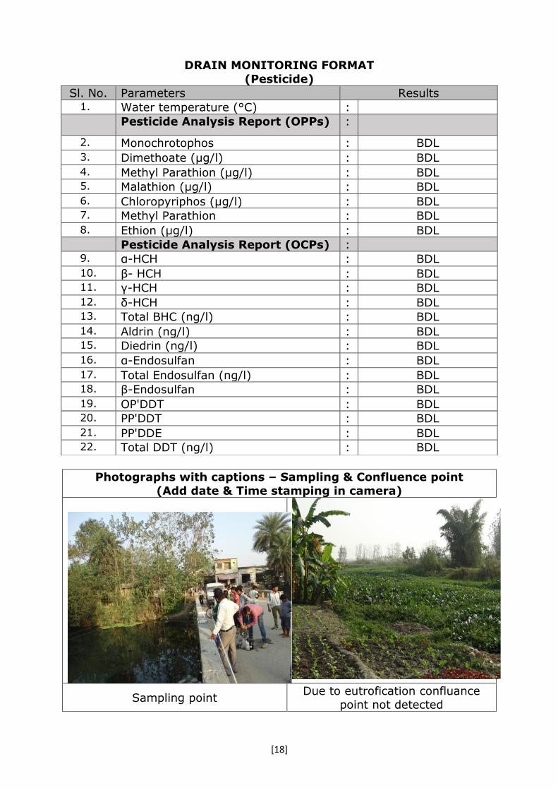
DRAIN MONITORING FORMAT
(Pesticide)
Photographs with captions – Sampling & Confluence point
(Add date & Time stamping in camera)
Sampling point Confluence point
Sl. No. Parameters Results 1. Water temperature (°C) : Pesticide Analysis Report (OPPs) :
2. Monochrotophos : --
3. Dimethoate (µg/l) : BDL
4. Methyl Parathion (µg/l) : BDL 5. Malathion (µg/l) : BDL
6. Chloropyriphos (µg/l) : BDL 7. Methyl Parathion : BDL
8. Ethion (µg/l) : BDL
Pesticide Analysis Report (OCPs) : 9. α-HCH : BDL
10. β- HCH : BDL 11. γ-HCH : BDL
12. δ-HCH : BDL 13. Total BHC (ng/l) : BDL
14. Aldrin (ng/l) : BDL 15. Diedrin (ng/l) : BDL
16. α-Endosulfan : BDL
17. Total Endosulfan (ng/l) : BDL 18. β-Endosulfan : BDL
19. OP'DDT : BDL 20. PP'DDT : BDL
21. PP'DDE : BDL 22. Total DDT (ng/l) : BDL

[16]
DRAIN MONITORING FORMAT
(Ganga)
Date & Time of sampling: 26.10.2016& 1:30 Pm onwards
1. Name of the Drain : Hemraj Drain 2. Meeting Ganga : Left bank 3. Name of the Regional Office of SPCB : Bijnor 4. Source of pollution load: : Domestic 5. If Industrial /Mixed (Please indicate type
of sector)
: NA
6. Traceable length (in Km) before meeting
Ganga (through google earth/map)
: Approx. 5-8 km
7. Catchment area Bijnor 8. Co-ordinate of the confluence
point (if not reachable indirect though google
earth/map) (Decimal units)
Latitude : 29°22'25.67"N
Longitude 78° 2'28.87"E
Distance from confluence point (may the find out over google earth/map), KM
Approx. 5 km
9. Co-ordinate of the sampling point (Decimal units)
Latitude : 29°22'28.4"N 78°05'08.2"E
Longitude
10. Landmarks / Address of the Location Near Hemraj Village 11. Flow (if in MLD) if zero indicate whether
dry or stagnant
: 91.260
12. Observations : Hemraj Drain actually over flow of
Ganga River after travelling 10-12
km it again confluence with Ganga river.
Bijnor Sewage drain meets this drain.
13. Name of all monitoring officers along with Designation
: Dr. Pankaj Kumar, Scientist ‘D’, CPCB
Dr. M. Jiban Singh, Research Associate, CPCB
Sh. Neeraj Gahlawat, Project
Office, NMCG Sh. A.K. Tewari, Regional Officer,
Bijnor/ Muzaffarnagar, UPPCB Sh. Rajiv Tyagi, Executive
Engineer, UPJN Sh. R. K. Singh, AE, UPJN

[17]
DRAIN MONITORING FORMAT (General parameters)
Sl. No. Parameters Results 1. Colour : --- 2. pH : 7.82 3. BOD (mg/l) : 5 4. COD (mg/l) : 24 5. TSS (mg/l) : 2.0 6. TDS (mg/l) : 204 7. Cl- (mg/l) : 12 8. NH3-N (mg/l) : 07
9. NO3-(mg/l) : BDL
10. DO (mg/l)* : --- 11. TC (MPN/ 100 ml)# : 92x104 12. FC (MPN/ 100 ml)# : 47x103
*For Fresh water carrying drains/ rivers
#for sewage, mixed Drains & River
DRAIN MONITORING FORMAT (Trace Metal/ Heavy Metal)
Sl. No. Parameters Results 1. Arsenic (As) mg/l : 0.02
2. Cadmium (Cd) mg/l : BDL
3. Total Chromium (Cr) mg/l : BDL
4. Copper (Cu) mg/l : 0.01
5. Iron (Fe) mg/l : 1.32
6. Lead (Pb) mg/l : BDL
7. Manganese (Mn) mg/l : 0.10
8. Nickel (Ni) mg/l : BDL
9. Mercury (Hg) mg/l : ---
10. Zinc (Zn) mg/l : 0.02
11. Antimony (Sb) mg/l : ---
12. Cobalt (Co) mg/l : BDL
13. Selenium (Se) mg/l : BDL
14. Vanadium (V) mg/l : BDL
[18]
DRAIN MONITORING FORMAT
(Pesticide)
Photographs with captions – Sampling & Confluence point
(Add date & Time stamping in camera)
Sampling point Due to eutrofication confluance
point not detected
Sl. No. Parameters Results 1. Water temperature (°C) : Pesticide Analysis Report (OPPs) :
2. Monochrotophos : BDL
3. Dimethoate (µg/l) : BDL 4. Methyl Parathion (µg/l) : BDL 5. Malathion (µg/l) : BDL 6. Chloropyriphos (µg/l) : BDL 7. Methyl Parathion : BDL 8. Ethion (µg/l) : BDL
Pesticide Analysis Report (OCPs) : 9. α-HCH : BDL 10. β- HCH : BDL 11. γ-HCH : BDL 12. δ-HCH : BDL 13. Total BHC (ng/l) : BDL 14. Aldrin (ng/l) : BDL 15. Diedrin (ng/l) : BDL 16. α-Endosulfan : BDL 17. Total Endosulfan (ng/l) : BDL 18. β-Endosulfan : BDL 19. OP'DDT : BDL 20. PP'DDT : BDL 21. PP'DDE : BDL 22. Total DDT (ng/l) : BDL

[19]
DRAIN MONITORING FORMAT
(Ganga)
Date & Time of sampling: 26.10.2016& 12 Noon onwards
1. Name of the Drain : Malan River 2. Meeting Ganga at - : Left bank 3. Name of the Regional Office of SPCB : Bijnor 4. Source of pollution load: : Mixed 5. If Industrial /Mixed (Please indicate type
of sector)
: Sugar, Distillery, Pulp & paper
6. Traceable length (in Km) before meeting
Ganga (through google earth/map)
: Approx. 140-150 km
7. Catchment area Bijnor 8. Co-ordinate of the confluence
point (if not reachable indirect though google
earth/map) (Decimal units)
Latitude : 29°26'53.30"N
Longitude 78° 3'52.61"E
Distance from confluence point (may the find out over google earth/map), KM
Approx. 100 m
9. Co-ordinate of the sampling point (Decimal units)
Latitude : 29°26'53.1"N 78°03'59.1"EE
Longitude
10. Landmarks / Address of the Location Near Hemraj Village 11. Flow (if in MLD) if zero indicate whether
dry or stagnant : 100.00
12. Observations : Malan River originated from
Kotdwar (Uttarakhand) and travelled about 140-150 km and
then meet in the Ganga River. It carries domestic waste of
Najibabad town, Nagar Palika Parshad Kiratpur, Bijor and Nagar
Panchayat Mandawar. 13. Name of all monitoring officers along
with Designation
: Dr. Pankaj Kumar, Scientist ‘D’,
CPCB
Dr. M. Jiban Singh, Research Associate, CPCB
Sh. Neeraj Gahlawat, Project Office, NMCG
Sh. A.K. Tewari, Regional Officer, Bijnor/ Muzaffarnagar, UPPCB
Sh. Rajiv Tyagi, Executive Engineer, UPJN
Sh. R. K. Singh, AE, UPJN

[20]
DRAIN MONITORING FORMAT
(General parameters)
Sl. No. Parameters Results 1. Colour : --- 2. pH : 8.3 3. BOD (mg/l) : 5 4. COD (mg/l) : 34 5. TSS (mg/l) : 88 6. TDS (mg/l) : 224 7. Cl- (mg/l) : 47 8. NH3-N (mg/l) : 7
9. NO3-(mg/l) : 0.27
10. DO (mg/l)* : --- 11. TC (MPN/ 100 ml)# : 790 12. FC (MPN/ 100 ml)# : 490
*For Fresh water carrying drains/ rivers
#for sewage, mixed Drains & River
DRAIN MONITORING FORMAT
(Trace Metal/ Heavy Metal)
Sl. No. Parameters Results 1. Arsenic (As) mg/l : BDL
2. Cadmium (Cd) mg/l : BDL
3. Total Chromium (Cr) mg/l : BDL
4. Copper (Cu) mg/l : BDL
5. Iron (Fe) mg/l : 2.40
6. Lead (Pb) mg/l : BDL
7. Manganese (Mn) mg/l : 0.29
8. Nickel (Ni) mg/l : BDL
9. Mercury (Hg) mg/l : ---
10. Zinc (Zn) mg/l : 0.01
11. Antimony (Sb) mg/l : ---
12. Cobalt (Co) mg/l : BDL
13. Selenium (Se) mg/l : BDL
14. Vanadium (V) mg/l : BDL
[21]
DRAIN MONITORING FORMAT
(Pesticide)
Photographs with captions – Sampling & Confluence point
(Add date & Time stamping in camera)
Sampling point Confluence point with Ganga
River
Sl. No. Parameters Results 1. Water temperature (°C) : Pesticide Analysis Report (OPPs) :
2. Monochrotophos : BDL
3. Dimethoate (µg/l) : BDL 4. Methyl Parathion (µg/l) : BDL 5. Malathion (µg/l) : BDL 6. Chloropyriphos (µg/l) : BDL 7. Methyl Parathion : BDL 8. Ethion (µg/l) : BDL
Pesticide Analysis Report (OCPs) : 9. α-HCH : BDL 10. β- HCH : BDL 11. γ-HCH : BDL 12. δ-HCH : BDL 13. Total BHC (ng/l) : BDL 14. Aldrin (ng/l) : BDL 15. Diedrin (ng/l) : BDL 16. α-Endosulfan : BDL 17. Total Endosulfan (ng/l) : BDL 18. β-Endosulfan : BDL 19. OP'DDT : BDL 20. PP'DDT : 0.05
21. PP'DDE : BDL 22. Total DDT (ng/l) : BDL

[22]
DRAIN MONITORING FORM
(Ganga)
Date & Time of sampling: 26.10.2016 (13.00hrs) 1. Name of the Drain : Chhoiya Drain 2. Meeting Ganga/Ramganga/Kali-east at - : meets Ganga at left bank 3. Name of the Regional Office of SPCB : SPCB, Bijnor 4. Source of pollution load: : (Domestic/Industrial/Mixed)- Mixed 5. If Industrial /Mixed (Please indicate type
of sector)
Mixed ( domestic and industrial,
mainly distillery and paper industries)
6. Traceable length (in Km) before meeting Ganga (through google earth/map)
: ----
7. Catchment area Bijnor 8. Co-ordinate of the
confluence point (if not
reachable indirect though google earth/map) (Decimal
units)
Latitude : 29005’49.6’’N
Longitude 078005’49.6’’E
Distance from confluence point (may the find out over google earth/map), KM
Sample taken near confluence point (at nearly 50 meter before
confluence ) 9. Co-ordinate of the sampling
point (Decimal units)
Latitude : 29005’ 49.6’’ N
078005’49.6’’E Longitude 10. Landmarks / Address of the Location Near Rasulpur bhawan village,
Datiyata Road, Khanpur 11. Flow (if in MLD) if zero indicate whether
dry or stagnant
: Due to back flow of river, flow
could not be measured (As per previous Inspection report, dated
04.10.2016, the flow was 275.616 MLD)
12. Observations : There was high back flow of river into the drain.
The water was visibly found slightly black.
Reaching confluence point was
found very difficult.
13. Urgent action required, if any : ---
14. Name of all monitoring officers along with Designation
1. Shri Rajeev Srivastava, ASO, SPCB-Bijnor
2. Shri Brahmanand, A.E., U.P. Jal Nigam
3. Shri Amit , Research Officer, NMCG
4. Dr Brajesh Shrivastava, Sc ‘C’, CPCB
5. Ms. Anshul Kumari, R.A., CPCB

[23]
DRAIN MONITORING FORMAT
(General parameters)
Sl. No. Parameters Results 1. Colour : -- 2. pH : 7.73 3. BOD (mg/l) : 7 4. COD (mg/l) : 56 5. TSS (mg/l) : 33 6. TDS (mg/l) : 416 7. Cl- (mg/l) : 35 8. NH3-N (mg/l) : 18
9. NO3-(mg/l) : -
10. DO (mg/l)* : - 11. TC (MPN/ 100 ml)# : 16x103 12. FC (MPN/ 100 ml)# : 35x102
*For Fresh water carrying drains/ rivers
#For sewage, mixed Drains & River
DRAIN MONITORING FORMAT (Trace Metal/ Heavy Metal)
Sl. No. Parameters Results 1. Arsenic (As) mg/l : 0.02
2. Cadmium (Cd) mg/l : BDL
3. Total Chromium (Cr) mg/l : BDL
4. Copper (Cu) mg/l : BDL
5. Iron (Fe) mg/l : 2.2
6. Lead (Pb) mg/l : BDL
7. Manganese (Mn) mg/l : 0.32
8. Nickel (Ni) mg/l : BDL
9. Mercury (Hg) mg/l : -
10. Zinc (Zn) mg/l : 0.02
11. Antimony (Sb) mg/l : -
12. Cobalt (Co) mg/l : BDL
13. Selenium (Se) mg/l : BDL
14. Vanadium (V) mg/l : BDL

[24]
DRAIN MONITORING FORMAT
(Pesticide)
Photographs with captions – Sampling & Confluence point
(Add date & Time stamping in camera)
View of confluence point
View of sampling point
Sl. No. Parameters Results 1. Water temperature (°C) : Pesticide Analysis Report (OPPs) :
2. Monochrotophos : -
3. Dimethoate (µg/l) : BDL
4. Methyl Parathion (µg/l) : BDL 5. Malathion (µg/l) : BDL
6. Chloropyriphos (µg/l) : BDL 7. Methyl Parathion : -
8. Ethion (µg/l) : BDL
Pesticide Analysis Report (OCPs) : 9. α-HCH : BDL
10. β- HCH : BDL 11. γ- HCH : BDL
12. δ-BHC : - 13. Total BHC (ng/l) : -
14. Aldrin (ng/l) : BDL 15. Diedrin (ng/l) : BDL
16. α-Endosulfan : BDL
17. Total Endosulfan (ng/l) : - 18. β-Endosulfan : BDL
19. OP'DDT : BDL 20. PP'DDT : 0.107
21. PP'DDE : BDL 22. Total DDT (ng/l) : -

[25]
DRAIN MONITORING FORMAT
(Ganga)
Date & Time of sampling: 02.11.2016 (13.00hrs) 1. Name of the Drain : Bagad River (drain) 2. Meeting Ganga/Ramganga/Kali-east at
-
: Does not meet Ganga, remains dry
after nearly 20 Km from Gajraula. 3. Name of the Regional Office of SPCB : Bijnor 4. Source of pollution load: : Industrial 5. If Industrial /Mixed (Please indicate
type of sector) Industrial (Silica, Pharma and Paper
industries etc.) 6. Traceable length (in Km) before
meeting Ganga (through google
earth/map)
: Does not meet Ganga as it remains dry after nearly 15 KM from Gajraula
7. Catchment area Gajraula 8. Co-ordinate of the
confluence point (if not reachable indirect though
google earth/map) (Decimal units)
Latitude :
Longitude -
Distance from confluence point (may
the find out over google earth/map), KM
-
9. Co-ordinate of the sampling point (Decimal
units)
Latitude : 280 48’ 23.90’’N 078012’59.8’’E Longitude
10. Landmarks / Address of the Location Near Jubilant industry in Gajraula, sampling point near to highway over
bridge 11. Flow in MLD, if zero indicate whether
dry or stagnant
: flow could not be measured due to
stagnant water 12. Observations : The water in the drain was found
carrying industrial effluents. As per
the information provided by the State officials, it originates near Dadiyal in
Amroha district and after travelling to nearly 20 KM from Gajraula, it
becomes dry. 13. Urgent action required, if any : ----
14. Name of all monitoring officers along with Designation
1. Dr Brajesh Shrivastava, Sc ‘C’, CPCB 2. Ms. Anshul Kumari, R.A., CPCB 3. Shri Rajeev Srivastava, A.S.O., Bijnor 4. Shri D. K. Jain, E.E., U.P. Jal Nigam 5. Shri Amit, Research Officer, NMCG

[26]
DRAIN MONITORING FORMAT
(General parameters)
Sl. No. Parameters Results 1. Colour : -- 2. pH : 7.74 3. BOD (mg/l) : 282 4. COD (mg/l) : 606 5. TSS (mg/l) : 479 6. TDS (mg/l) : 7948 7. Cl- (mg/l) : 116 8. NH3-N (mg/l) : 12
9. NO3-(mg/l) : -
10. DO (mg/l)* : - 11. TC (MPN/ 100 ml)# : 35x105 12. FC (MPN/ 100 ml)# : 11x105
*For Fresh water carrying drains/ rivers
#For sewage, mixed Drains & River
DRAIN MONITORING FORMAT
(Trace Metal/ Heavy Metal)
Sl. No. Parameters Results 1. Arsenic (As) mg/l : BDL
2. Cadmium (Cd) mg/l : BDL
3. Total Chromium (Cr) mg/l : 0.02
4. Copper (Cu) mg/l : 0.03
5. Iron (Fe) mg/l : 3.85
6. Lead (Pb) mg/l : 0.02
7. Manganese (Mn) mg/l : 0.32
8. Nickel (Ni) mg/l : BDL
9. Mercury (Hg) mg/l : -
10. Zinc (Zn) mg/l : 0.17
11. Antimony (Sb) mg/l : -
12. Cobalt (Co) mg/l : BDL
13. Selenium (Se) mg/l : BDL
14. Vanadium (V) mg/l : 0.02

[27]
DRAIN MONITORING FORMAT
(Pesticide)
Photographs with captions – Sampling & Confluence point
(Add date & Time stamping in camera)
View of Bagad river ( drain)
View of sampling point
Sl. No. Parameters Results 1. Water temperature (°C) : Pesticide Analysis Report (OPPs) :
2. Monochrotophos : -
3. Dimethoate (µg/l) : BDL
4. Methyl Parathion (µg/l) : BDL 5. Malathion (µg/l) : BDL
6. Chloropyriphos (µg/l) : BDL 7. Methyl Parathion : -
8. Ethion (µg/l) : BDL
Pesticide Analysis Report (OCPs) : 9. α-HCH : 0.264
10. β- HCH : 0.149 11. γ- HCH : -
12. δ-BHC : - 13. Total BHC (ng/l) : -
14. Aldrin (ng/l) : BDL 15. Diedrin (ng/l) : BDL
16. α-Endosulfan : BDL
17. Total Endosulfan (ng/l) : 18. β-Endosulfan : BDL
19. OP'DDT : 0.109 20. PP'DDT : 0.153
21. PP'DDE : BDL 22. Total DDT (ng/l) : -

[28]
DRAIN MONITORING FORMAT
(Ganga)
Date & Time of sampling: 27.10.2016, 11:20 am 1. Name of the Drain : Garh Drain 2. Meeting Ganga at : Right bank – Ganga 3. Name of the Regional Office of SPCB : Ghaziabad 4. Source of pollution load: : Domestic 5. If Industrial /Mixed (Please indicate
type of sector)
: NA
6. Traceable length of drain (in Km) before
meeting Ganga (through google earth/map)
: 20 KM (approx.)
7. Catchment area Garh 8. Co-ordinate of the
confluence point (if not
reachable indirect though google earth/map) (Decimal
units)
Latitude : 78.13648
Longitude 28.766984
Distance from confluence point (may the find out over google earth/map),
KM
20m (approx.)
9. Co-ordinate of the sampling
point (Decimal units)
Latitude : 78.13648
28.766984 Longitude
10. Landmarks / Address of the Location Near Brijghat, Garhmukteshwar, UP
11. Flow (if in MLD) if zero indicate whether
dry or stagnant
: 13.13
12. Observations : 1. Turbid. 2. Ichornia growth found. 3. Solid wastes were found floating
with drain.
13. Name of all monitoring officers along
with Designation
1. Ms. Garima Dublish, Research
Associate, CPCB
2. Dr. Sananda Sinha, Research
Associate, CPCB
3. Sh. Ajay Sharma, Attendant, CPCB
4. Sh. Shravan Kr. Kota, Research
Officer, NMCG
5. Sh. Ashutosh Yadav, Jal Nigam, UP
6. sh. Sushil Kumar, SA, Ghaziabad
RO, UP

[29]
DRAIN MONITORING FORMAT (General parameters)
Sl. No. Parameters Results 1. Colour : NA 13. pH : 7.58 14. BOD (mg/l) : 4 15. COD (mg/l) : 25 16. TSS (mg/l) : 31 17. TDS (mg/l) : 376 18. Cl- (mg/l) : 28 19. NH3-N (mg/l) : 4
20. NO3-(mg/l) : 0.89
21. DO (mg/l)* : 3.80 22. TC (MPN/ 100 ml)# : 92x103 23. FC (MPN/ 100 ml)# : 35x103
*For Fresh water carrying drains/ rivers #For sewage, mixed Drains & River
DRAIN MONITORING FORMAT
(Trace Metal/ Heavy Metal)
Sl. No. Parameters Results 1. Arsenic (As) mg/l : 01
2. Cadmium (Cd) mg/l : BDL
3. Total Chromium (Cr) mg/l : BDL
4. Copper (Cu) mg/l : BDL
5. Iron (Fe) mg/l : 1.15
6. Lead (Pb) mg/l : BDL
7. Manganese (Mn) mg/l : 0.15
8. Nickel (Ni) mg/l : BDL
9. Mercury (Hg) mg/l : NA
10. Zinc (Zn) mg/l : BDL
11. Antimony (Sb) mg/l : NA
12. Cobalt (Co) mg/l : BDL
13. Selenium (Se) mg/l : BDL
14. Vanadium (V) mg/l : BDL
[30]
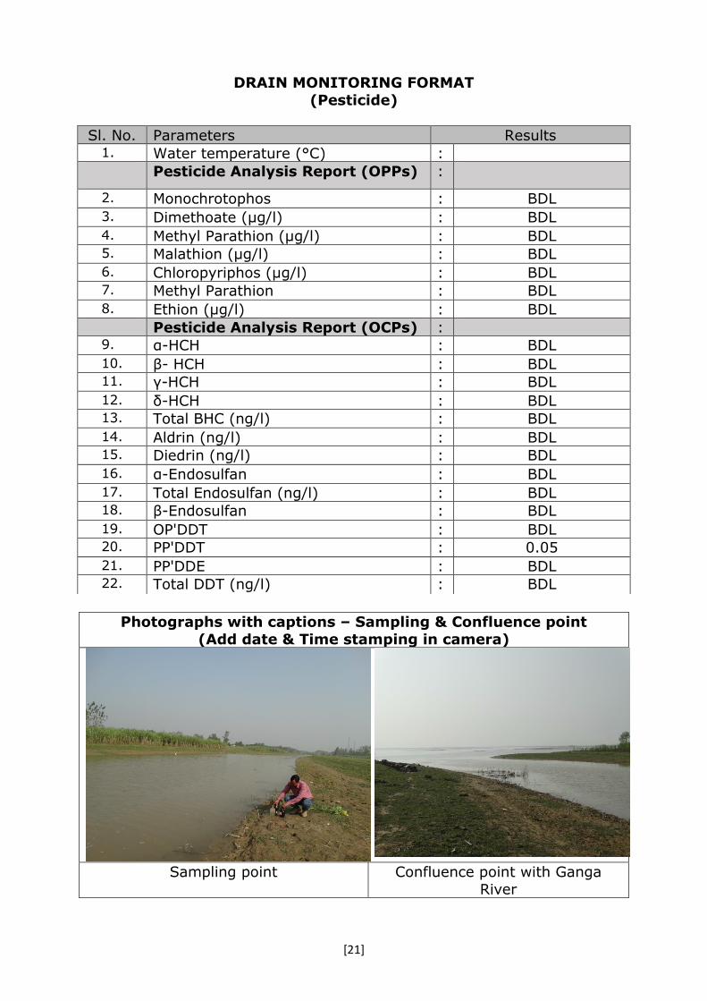
DRAIN MONITORING FORMAT
(Pesticide)
Photographs with captions – Sampling & Confluence point
(Add date & Time stamping in camera)
Sl. No. Parameters Results 1. Water temperature (°C) : Pesticide Analysis Report (OPPs) :
2. Monochrotophos : -
3. Dimethoate (µg/l) : BDL
4. Methyl Parathion (µg/l) : BDL 5. Malathion (µg/l) : BDL 6. Chloropyriphos (µg/l) : BDL 7. Methyl Parathion : BDL 8. Ethion (µg/l) : BDL
Pesticide Analysis Report (OCPs) : 9. α-BHC : BDL 10. β-BHC : BDL 11. γ-BHC : BDL 12. δ-BHC : - 13. Total BHC (ng/l) : BDL 14. Aldrin (ng/l) : BDL 15. Diedrin (ng/l) : BDL 16. α-Endosulfan : BDL 17. Total Endosulfan (ng/l) : BDL 18. β-Endosulfan : BDL 19. OP'DDT : BDL 20. PP'DDT : BDL 21. PP'DDE : BDL 22. Total DDT (ng/l) : BDL

[31]
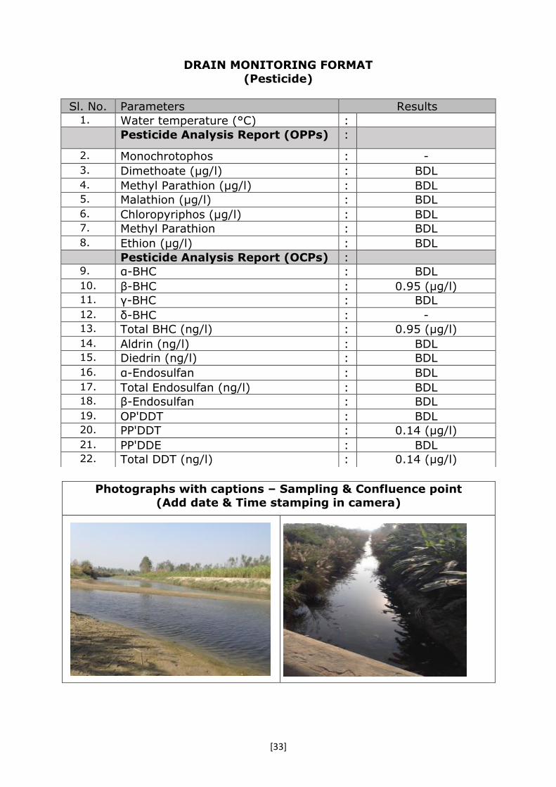
DRAIN MONITORING FORMAT
(Ganga)
Date & Time of sampling: 27.10.2016, 3.30 pm 1. Name of the Drain : Phuldera Drain 2. Meeting Ganga/Ramganga/Kali-east at - : Right bank 3. Name of the Regional Office of SPCB : Ghaziabad 4. Source of pollution load: : Mixed 5. If Industrial /Mixed (Please indicate type
of sector)
: Distillery
Sugar Food & Dairy
6. Traceable length of drain (in Km) of
drain before meeting River Ganga
(through google earth/map)
: 35 KM (approx.)
7. Catchment area Garh 8. Co-ordinate of the confluence
point (if not reachable
indirect though google
earth/map) (Decimal units)
Latitude : 78.17085
Longitude 28.669779
Distance from confluence point (may the
find out over google earth/map), KM
17 KM (Approx.)
9. Co-ordinate of the sampling
point (Decimal units)
Latitude : 78.125984
28.690947 Longitude 10. Landmarks / Address of the Location Near Bahadurgarh vill. After
confluence of drain into Siyana
escape 11. Flow (if in MLD) if zero indicate whether
dry or stagnant : 13.70
12. Observations : 1. Turbid.
2. Ichornia growth found.
3. Solid wastes were found floating with drain.
13. Urgent action required, if any : Solid wastes floating with the drain
should be stopped immediately. 14. Name of all monitoring officers along
with Designation 7. Ms. Garima Dublish, RA, CPCB
8. Dr. Sananda Sinha, RA, CPCB
9. Sh. Ajay Sharma, Attendant, CPCB
10.Sh. Shravan Kr. Kota, Research
Officer, NMCG
11.Sh. Ashutosh Yadav, Jal Nigam, UP
sh. Gupta, Ghaziabad RO, UP

[32]
DRAIN MONITORING FORMAT
(General parameters)
Sl. No. Parameters Results 1. Colour : N/A 2. pH : 7.25 3. BOD (mg/l) : 42 4. COD (mg/l) : 96 5. TSS (mg/l) : 51 6. TDS (mg/l) : 268 7. Cl- (mg/l) : 27 8. NH3-N (mg/l) : 7
9. NO3-(mg/l) : 1
10. DO (mg/l)* : NIL 11. TC (MPN/ 100 ml)# : 16x108 12. FC (MPN/ 100 ml)# : 11x107
*For Fresh water carrying drains/ rivers
#For sewage, mixed Drains & River
DRAIN MONITORING FORMAT
(Trace Metal/ Heavy Metal)
Sl. No. Parameters Results 1. Arsenic (As) mg/l : BDL
2. Cadmium (Cd) mg/l : BDL
3. Total Chromium (Cr) mg/l : BDL
4. Copper (Cu) mg/l : BDL
5. Iron (Fe) mg/l : 0.98
6. Lead (Pb) mg/l : 0.06
7. Manganese (Mn) mg/l : 0.24
8. Nickel (Ni) mg/l : BDL
9. Mercury (Hg) mg/l : N/A
10. Zinc (Zn) mg/l : 0.14
11. Antimony (Sb) mg/l : N/A
12. Cobalt (Co) mg/l : BDL
13. Selenium (Se) mg/l : BDL
14. Vanadium (V) mg/l : BDL
[33]
DRAIN MONITORING FORMAT
(Pesticide)
Photographs with captions – Sampling & Confluence point
(Add date & Time stamping in camera)
Sl. No. Parameters Results 1. Water temperature (°C) : Pesticide Analysis Report (OPPs) :
2. Monochrotophos : -
3. Dimethoate (µg/l) : BDL 4. Methyl Parathion (µg/l) : BDL 5. Malathion (µg/l) : BDL 6. Chloropyriphos (µg/l) : BDL 7. Methyl Parathion : BDL 8. Ethion (µg/l) : BDL
Pesticide Analysis Report (OCPs) : 9. α-BHC : BDL
10. β-BHC : 0.95 (µg/l) 11. γ-BHC : BDL
12. δ-BHC : - 13. Total BHC (ng/l) : 0.95 (µg/l)
14. Aldrin (ng/l) : BDL 15. Diedrin (ng/l) : BDL 16. α-Endosulfan : BDL 17. Total Endosulfan (ng/l) : BDL 18. β-Endosulfan : BDL 19. OP'DDT : BDL 20. PP'DDT : 0.14 (µg/l)
21. PP'DDE : BDL 22. Total DDT (ng/l) : 0.14 (µg/l)

[34]
DRAIN MONITORING FORMAT
(Ganga)
Date & Time of sampling: 25.10.2016 1. Name of the Drain : Sot River/ Drain
2. Meeting Ganga : Left bank
3. Name of the Regional Office of SPCB : Bulandshahar
4. Source of pollution load: : Domestic
5. If Industrial /Mixed (please indicate type
of sector.
: NA
6. Catchment area Badaun 7 Co-ordinate of the
confluence point (if not reachable indirect though
google earth/map) (Decimal units)
Latitude : 28°01’43.65”N
Longitude 79°06’39.76”E
Distance from confluence point (may the find out over google earth/map), KM
Approx. 15 km
8 Co-ordinate of the sampling
point (Decimal units)
Latitude : 28°01’53.12”N
79°07’05.11”E Longitude 9 Landmarks / Address of the Location Shekhupur Pul
10 Flow if in MLD (Approx) : Approx. 59.720
11 Observations : Its water used for irrigation
during its course. It becomes dry after few kilometers from
Badaun city before meeting to River Ganga.
River bed is being used for agriculture hence confluence
point was not explored 12 Name of all monitoring officers along
with Designation
1. Dr. Prashant Singh Sc. D
(CPCB) 2. Dr. Sarvesh Rai Sc. C (CPCB)
3. Mr. R. K. Gupta Ex. En. U.P. Jal Nigam
4. Mr. Avichal Singh A.E. UP Jal Nigam
5. Mr. Jitendra Sharma Lab Asst.
UPPCB, Bulandshahar

[35]
DRAIN MONITORING FORMAT
(General parameters)
Sl. No. Parameters Results 1. Colour : Turbid 2. pH : 7.90 3. BOD (mg/l) : 48 4. COD (mg/l) : 114 5. TSS (mg/l) : 42 6. TDS (mg/l) : 588 7. Cl- (mg/l) : 101 8. NH3-N (mg/l) : 34
9. NO3-(mg/l) : 2.96
10. DO (mg/l)* : 11. TC (MPN/ 100 ml)# : 35x105 12. FC (MPN/ 100 ml)# : 24x105
*For Fresh water carrying drains/ rivers
#For sewage, mixed Drains & River
DRAIN MONITORING FORMAT
(Trace Metal/ Heavy Metal)
Sl. No. Parameters Results 1. Arsenic (As) mg/l : -
2. Cadmium (Cd) mg/l : BDL
3. Total Chromium (Cr) mg/l : BDL
4. Copper (Cu) mg/l : BDL
5. Iron (Fe) mg/l : 20.78
6. Lead (Pb) mg/l : BDL
7. Manganese (Mn) mg/l : 0.13
8. Nickel (Ni) mg/l : BDL
9. Mercury (Hg) mg/l : -
10. Zinc (Zn) mg/l : 0.02
11. Antimony (Sb) mg/l : -
12. Cobalt (Co) mg/l : BDL
13. Selenium (Se) mg/l : -
14. Vanadium (V) mg/l : -

[36]
DRAIN MONITORING FORMAT
(Pesticide)
Photographs with captions – Sampling & Confluence point
(Add date & Time stamping in camera)
Sampling Point
River bed is being used for Agriculture
Sl. No. Parameters Results 1. Water temperature (°C) : Pesticide Analysis Report (OPPs) : 2. Monochrotophos :
3. Dimethoate (µg/l) : BDL
4. Methyl Parathion (µg/l) : BDL 5. Malathion (µg/l) : BDL
6. Chloropyriphos (µg/l) : BDL 7. Ethion (µg/l) : BDL
Pesticide Analysis Report (OCPs) : 8. α-HCH :
9. β-HCH : 0.101 10. γ-HCH : BDL
11. δ-HCH : BDL 12. Total HCH (ng/l) :
13. Aldrin (ng/l) : BDL 14. Diedrin (ng/l) : BDL
15. α-Endosulfan : BDL
16. Total Endosulfan (ng/l) : 17. β-Endosulfan : BDL
18. OP'DDT : BDL 19. PP'DDT : BDL
20. PP'DDE : BDL 21. Total DDT (ng/l) :

[37]
DRAIN MONITORING FORMAT
(Ganga)
Date & Time of sampling: 26-10-2016 at 15:10 hrs.
1. Name of the Drain : Anupshahr STP Drain – 1 2. Meeting Ganga - : Discharging to wetland near
Ganga 3. Name of the Regional Office of SPCB : Bulandshahar 4. Source of pollution load: : Domestic 5. If Industrial /Mixed (please indicate type
of sector.
: NA
6. Traceable length (in Km) before meeting
Ganga (through google earth/map)
: Doesn’t meet Ganga (meets an
adjacent wetland having a tracable length of 100 m )
7. Catchment area Part of city of Anupshahar 8. Co-ordinate of the confluence
point (if not reachable
indirect though google earth/map) (Decimal units)
Latitude : NA
Longitude NA
Distance from confluence point (may the
find out over google earth/map), KM
NA
9. Co-ordinate of the sampling
point (Decimal units)
Latitude : 28°22'10.9353"
78°15'46.4341" Longitude 10. Landmarks / Address of the Location STP Complex near Chamunda 11. Flow (if in MLD) if zero indicate whether
dry or stagnant
: 1.18
12. Observations : The treated water was discharging in a wetland situated about a
Kilometer away from River Ganga.
13. Name of all monitoring officers along
with Designation
1. Dr. Sarvesh Rai, Sc. ‘C’, CPCB 2. Ms. Shaddha Lonarkar, RA-I,
CPCB 3. Mr. Geetesh Chandra, ASO, RO,
UPPCB, Bulandshahr 4. Mr. Viany Rawat, AEE, UP Jal
Nigam
5. Mr. Jitendra Sharma, Lab. Assistant, RO, UPPCB,
Bulandshahr

[38]
DRAIN MONITORING FORMAT (General parameters)
Sl. No. Parameters Results 1. Colour : - 2. pH : 8.84 3. BOD (mg/l) : 26 4. COD (mg/l) : 114 5. TSS (mg/l) : 54 6. TDS (mg/l) : 704 7. Cl- (mg/l) : 80 8. NH3-N (mg/l) : 16
9. NO3-(mg/l) : 2.35
10. DO (mg/l)* : NA 11. TC (MPN/ 100 ml)# : 3400 12. FC (MPN/ 100 ml)# : 2200
*For Fresh water carrying drains/ rivers
#For sewage, mixed Drains & River
DRAIN MONITORING FORMAT
(Trace Metal/ Heavy Metal)
Sl. No. Parameters Results 1. Arsenic (As) mg/l : BDL
2. Cadmium (Cd) mg/l : BDL
3. Total Chromium (Cr) mg/l : BDL
4. Copper (Cu) mg/l : BDL
5. Iron (Fe) mg/l : 0.04
6. Lead (Pb) mg/l : BDL
7. Manganese (Mn) mg/l : 0.06
8. Nickel (Ni) mg/l : BDL
9. Mercury (Hg) mg/l : -
10. Zinc (Zn) mg/l : BDL
11. Antimony (Sb) mg/l : -
12. Cobalt (Co) mg/l : BDL
13. Selenium (Se) mg/l : BDL
14. Vanadium (V) mg/l : BDL

[39]
DRAIN MONITORING FORMAT
(Pesticide)
Photographs with captions – Sampling & Confluence point
(Add date & Time stamping in camera)
Oulet of STP Drain 1 (Chamunda)
(No confluence)
STP Drain 1 (Chamunda)
Sl. No. Parameters Results 1. Water temperature (°C) : Pesticide Analysis Report (OPPs) :
2. Monochrotophos : -
3. Dimethoate (µg/l) : BDL
4. Methyl Parathion (µg/l) : BDL 5. Malathion (µg/l) : BDL
6. Chloropyriphos (µg/l) : BDL 7. Methyl Parathion : BDL
8. Ethion (µg/l) : BDL
Pesticide Analysis Report (OCPs) : 9. α-BHC : BDL
10. β-BHC : BDL 11. γ-BHC : BDL
12. δ-BHC : BDL 13. Total BHC (ng/l) : BDL
14. Aldrin (ng/l) : BDL 15. Diedrin (ng/l) : BDL
16. α-Endosulfan : BDL
17. Total Endosulfan (ng/l) : BDL 18. β-Endosulfan : BDL
19. OP'DDT : BDL 20. PP'DDT : 0.056
21. PP'DDE : BDL 22. Total DDT (ng/l) : 0.056

[40]
DRAIN MONITORING FORMAT
(Ganga)
Date & Time of sampling: 26-10-2016 at 16:00 hrs.
1. Name of the Drain : Anupshahr STP Drain – 2 2. Meeting Ganga at - : Right bank 3. Name of the Regional Office of SPCB : Bulandshahar 4. Source of pollution load: : Domestic 5. If Industrial /Mixed (please indicate type
of sector. : NA
6. Traceable length (in Km) before meeting Ganga (through google earth/map)
: Approx. 0.025
7. Catchment area Part of city of Anupshahr 8. Co-ordinate of the confluence
point (if not reachable
indirect though google earth/map) (Decimal units)
Latitude : 28020’58.2207’’
Longitude 78016’19.5027’’
Distance from confluence point (may the
find out over google earth/map), KM
Approx. 0.03
9. Co-ordinate of the sampling
point (Decimal units)
Latitude : 28020’57.8658’’
78016’18.3871’’ Longitude 10. Landmarks / Address of the Location STP Complex near Sohan Tau Ka
Matth 11. Flow (if in MLD) if zero indicate whether
dry or stagnant : 1.08
12. Observations : Treated water was discharging
directly into River Ganga. However, there was a forest land
situated about 250 meter away from the STP, which may be
irrigated by the treated water. 13. Name of all monitoring officers along
with Designation 6. Dr. Sarvesh Rai, Sc. ‘C’, CPCB
7. Ms. Shaddha Lonarkar, RA-I, CPCB
8. Mr. Geetesh Chandra, ASO, RO, UPPCB, Bulandshahr
9. Mr. Viany Rawat, AEE, UP Jal Nigam
10.Mr. Jitendra Sharma, Lab.
Assistant, RO, UPPCB, Bulandshahr

[41]
DRAIN MONITORING FORMAT
(General parameters)
Sl. No. Parameters Results 1. Colour : - 2. pH : 8.94 3. BOD (mg/l) : 19 4. COD (mg/l) : 72 5. TSS (mg/l) : 36 6. TDS (mg/l) : 536 7. Cl- (mg/l) : 68 8. NH3-N (mg/l) : 14
9. NO3-(mg/l) : 2.34
10. DO (mg/l)* : NA 11. TC (MPN/ 100 ml)# : 1100 12. FC (MPN/ 100 ml)# : 450
*For Fresh water carrying drains/ rivers
#For sewage, mixed Drains & River
DRAIN MONITORING FORMAT
(Trace Metal/ Heavy Metal)
Sl. No. Parameters Results 1. Arsenic (As) mg/l : BDL
2. Cadmium (Cd) mg/l : BDL
3. Total Chromium (Cr) mg/l : BDL
4. Copper (Cu) mg/l : BDL
5. Iron (Fe) mg/l : 0.24
6. Lead (Pb) mg/l : BDL
7. Manganese (Mn) mg/l : 0.06
8. Nickel (Ni) mg/l : BDL
9. Mercury (Hg) mg/l : -
10. Zinc (Zn) mg/l : BDL
11. Antimony (Sb) mg/l : -
12. Cobalt (Co) mg/l : BDL
13. Selenium (Se) mg/l : BDL
14. Vanadium (V) mg/l : BDL

[42]
DRAIN MONITORING FORMAT
(Pesticide)
Photographs with captions – Sampling & Confluence point
(Add date & Time stamping in camera)
Outlet STP Drain – 2 (Sohan Tau ka Matth) Confluence with Ganga
STP Drain – 2 (Sohan Tau ka Matth)
Sl. No. Parameters Results 1. Water temperature (°C) : Pesticide Analysis Report (OPPs) :
2. Monochrotophos : -
3. Dimethoate (µg/l) : BDL
4. Methyl Parathion (µg/l) : BDL 5. Malathion (µg/l) : BDL
6. Chloropyriphos (µg/l) : BDL 7. Methyl Parathion : BDL
8. Ethion (µg/l) : BDL
Pesticide Analysis Report (OCPs) : 9. α-BHC : BDL
10. β-BHC : BDL 11. γ-BHC : BDL
12. δ-BHC : BDL 13. Total BHC (ng/l) : BDL
14. Aldrin (ng/l) : BDL 15. Diedrin (ng/l) : BDL
16. α-Endosulfan : BDL
17. Total Endosulfan (ng/l) : BDL 18. β-Endosulfan : BDL
19. OP'DDT : BDL 20. PP'DDT : 0.055
21. PP'DDE : BDL 22. Total DDT (ng/l) : 0.055

[43]
DRAIN MONITORING FORMAT
(Ganga)
Date & Time of sampling: Date & Time of sampling: 25 October, 2016 & 06:00PM
1. Name of the Drain : Bhairavghat drain or Tokaghat drain
2. Meeting Ganga at - : Right Bank
3. Name of the Regional Office of SPCB : RO UPPCB, Kanpur
4. Source of pollution load: : Mixed
5. If Industrial /Mixed (please indicate type of sector.
: Textiles Sector
6. Traceable length (in Km) before meeting Ganga (through google
earth/map)
: Approx. 6-7 Km
7. Catchment area Lal darwaja, salawat khan, Ganga nagar, Narkasa, Dhawari, Madaar
wadi, Khatakpura, Khatrana, Lingiganj
8. Co-ordinate of the
confluence point (if not reachable indirect though
google earth/map)
(Decimal units)
Latitude : 27024’22.57’’N
Longitude 79038’4.1’’E
Distance from confluence point (may
the find out over google earth/map), KM
Approx. 2.5 Km
9. Co-ordinate of the
sampling point (Decimal units)
Latitude : 27023’51.54’’N
Longitude 79037’32.63’’E
10. Landmarks / Address of the Location Near Bhairav temple at Bhairavghat
11. Flow (if in MLD) if zero indicate
whether dry or stagnant
: 33.52 MLD
12. Observations : 1. During monitoring it was found that a minor drain Puckapul drain
carries wastewater from Jatwara, naulkha, Bajariya,
Koonchabhawana, Chilpura, Saghwara, Gudaddi, Khadyaaye,
Chapatti, Bhaavtola, Mathiya devi, Nunbai and Palariya area and
meets to Tokaghat drain near Dharanagri.
2. It meets to river Ganga near
confluence of Dhirampur drain.
13. Name of all monitoring officers along
with Designation
1. Dr. Rajnish Kumar Sharma, RA-I,
CPCB ZO Lucknow
2. Dr. Poonam Pandey, RA-I, CPCB
ZO Lucknow

[44]
3. Dr A. K. Mathur, AEE, UPPCB,
Kanpur
4. Sh Ankit Kumar Mishra, JE, UPPCB,
Kanpur
5. Sh. D.C. Dixit, Supervisor, UP Jal
Nigam, Fatehgarh
DRAIN MONITORING FORMAT (General parameters)
Sl. No. Parameters Results 1. Colour : - 2. pH : 7.67 3. BOD (mg/l) : 28 4. COD (mg/l) : 108 5. TSS (mg/l) : 195 6. TDS (mg/l) : 1082 7. Cl- (mg/l) : 221 8. NH3-N (mg/l) : 37
9. NO3-(mg/l) : BDL
10. DO (mg/l)* : - 11. TC (MPN/ 100 ml)# : 790000 12. FC (MPN/ 100 ml)# : 140000
*For Fresh water carrying drains/ rivers #For sewage, mixed Drains & River
DRAIN MONITORING FORMAT
(Trace Metal/ Heavy Metal)
Sl. No. Parameters Results 1. Arsenic (As) mg/l : BDL
2. Cadmium (Cd) mg/l : BDL 3. Total Chromium (Cr) mg/l : BDL
4. Copper (Cu) mg/l : - 5. Iron (Fe) mg/l : 1.38
6. Lead (Pb) mg/l : BDL 7. Manganese (Mn) mg/l : 0.14
8. Nickel (Ni) mg/l : BDL
9. Mercury (Hg) mg/l : - 10. Zinc (Zn) mg/l : 0.12
11. Antimony (Sb) mg/l : - 12. Cobalt (Co) mg/l : BDL
13. Selenium (Se) mg/l : - 14. Vanadium (V) mg/l : -

[45]
DRAIN MONITORING FORMAT
(Pesticide)
Photographs with captions – Sampling & Confluence point
(Add date & Time stamping in camera)
Confluence point of Bhairavghat or Tokaghat drain at
Dhimarpurwa village
Sl. No. Parameters Results 1. Water temperature (°C) : Pesticide Analysis Report (OPPs) :
2. Monochrotophos :
3. Dimethoate (µg/l) :
4. Methyl Parathion (µg/l) : 5. Malathion (µg/l) :
6. Chloropyriphos (µg/l) : 7. Methyl Parathion :
8. Ethion (µg/l) :
Pesticide Analysis Report (OCPs) : 9. α-BHC : 0.08 10. β-BHC : 0.10 11. γ-BHC : BDL 12. δ-BHC : BDL 13. Total BHC (ng/l) : BDL 14. Aldrin (ng/l) : BDL 15. Diedrin (ng/l) : BDL 16. α-Endosulfan : BDL 17. Total Endosulfan (ng/l) : BDL 18. β-Endosulfan : BDL 19. OP'DDT : BDL 20. PP'DDT : 0.40 21. PP'DDE : BDL 22. Total DDT (ng/l) : BDL
Bhairavghat drain Ganga river

[46]
DRAIN MONITORING FORMAT
(Ganga)
Date & Time of sampling: 25 October, 2016 & 05:00PM
1. Name of the Drain : Dhirampur drain or Dhinapur 2. Meeting Ganga at - : Right Bank 3. Name of the Regional Office of SPCB : RO UPPCB, Kanpur 4. Source of pollution load: : Mixed (Industrial + domestic) 5. If Industrial /Mixed (Please indicate type
of sector) : Dairy
6. Traceable length (in Km) before meeting
Ganga (through google earth/map) : Approx. 1-1.5 Km
7. Catchment area Parag dairy, Bahadurpur,
Paanchaal ghat 8. Co-ordinate of the confluence
point (if not reachable indirect though google
earth/map) (Decimal units)
Latitude : 27024’22.57’’N
Longitude 79038’4.1’’E
Distance from confluence point (may the find out over google earth/map), KM
Approx. 0.5 km
9. Co-ordinate of the sampling point (Decimal units)
Latitude : 27013’51.4’’
Longitude 79038’4.1’’ 10. Landmarks / Address of the Location Near Parag dairy 11. Flow (if in MLD) if zero indicate whether
dry or stagnant : 1.62 MLD
12. Observations : 1. It is a minor drain.
2. It is Mixed drain which carries effluent of dairy and
domestic sewage. 3. During sampling wastewater
appears white in colour. Which indicates that wastewater
contains dairy effluent. 13. Name of all monitoring officers along
with Designation 6. Dr. Rajnish Kumar Sharma, RA-I,
CPCB ZO Lucknow
7. Dr. Poonam Pandey, RA-I, CPCB
ZO Lucknow
8. Dr A. K. Mathur, AEE, UPPCB,
Kanpur
9. Sh Ankit Kumar Mishra, JE,
UPPCB, Kanpur
10. Sh. D.C. Dixit, Supervisor, UP Jal
Nigam, Fatehgarh

[47]
DRAIN MONITORING FORMAT
(General parameters)
Sl. No. Parameters Results 1. Colour : - 2. pH : 7.34 3. BOD (mg/l) : 35.4 4. COD (mg/l) : 136 5. TSS (mg/l) : 35.4 6. TDS (mg/l) : 865 7. Cl- (mg/l) : 144 8. NH3-N (mg/l) : 38.1
9. NO3-(mg/l) : 3.03
10. DO (mg/l)* : - 11. TC (MPN/ 100 ml)# : 1400000 12. FC (MPN/ 100 ml)# : 700000
*For Fresh water carrying drains/ rivers
#For sewage, mixed Drains & River
DRAIN MONITORING FORMAT (Trace Metal/ Heavy Metal)
Sl. No. Parameters Results 1. Arsenic (As) mg/l : BDL
2. Cadmium (Cd) mg/l : BDL
3. Total Chromium (Cr) mg/l : 0.04
4. Copper (Cu) mg/l : -
5. Iron (Fe) mg/l : 0.62
6. Lead (Pb) mg/l : 0.04
7. Manganese (Mn) mg/l : 0.14
8. Nickel (Ni) mg/l : BDL
9. Mercury (Hg) mg/l : -
10. Zinc (Zn) mg/l : 0.54
11. Antimony (Sb) mg/l : -
12. Cobalt (Co) mg/l : BDL
13. Selenium (Se) mg/l : -
14. Vanadium (V) mg/l : -

[48]
DRAIN MONITORING FORMAT
(Pesticide)
Photographs with captions – Sampling & Confluence point
(Add date & Time stamping in camera)
Confluence point of drain at Dhimarpur village near confluence point of Bhairavghat drain , Farrukhabad
Sl. No. Parameters Results 1. Water temperature (°C) : Pesticide Analysis Report (OPPs) :
2. Monochrotophos :
3. Dimethoate (µg/l) :
4. Methyl Parathion (µg/l) : 5. Malathion (µg/l) :
6. Chloropyriphos (µg/l) : 7. Methyl Parathion :
8. Ethion (µg/l) :
Pesticide Analysis Report (OCPs) : 9. α-BHC : 0.07 10. β-BHC : 0.13 11. γ-BHC : 0.09 12. δ-BHC : BDL 13. Total BHC (ng/l) : BDL 14. Aldrin (ng/l) : BDL 15. Diedrin (ng/l) : BDL 16. α-Endosulfan : BDL 17. Total Endosulfan (ng/l) : BDL 18. β-Endosulfan : BDL 19. OP'DDT : BDL 20. PP'DDT : BDL 21. PP'DDE : BDL 22. Total DDT (ng/l) : BDL
Ganga river
Dhimarpur drain

[49]
DRAIN MONITORING FORMAT
(Ganga)
Date & Time of sampling: 25 October, 2016 & 02:00PM
1. Name of the Drain : Bargadiyaghat drain
2. Meeting Ganga at - : Right Bank
3. Name of the Regional Office of SPCB : RO, UPPCB, Kanpur
4. Source of pollution load: : Domestic Approx. 3.8MLD
5. If Industrial /Mixed (name of the units &
sector) and details may be obtained confirmed from the regional officers of SPCB
:
NA
6. Traceable length (in Km) before meeting Ganga (through google earth/map)
: Approx. 1-1.5 Km
7. Catchment area Talaiya lane, Machli tola, Daal mandi, Rangsajan, Gaadikhana, Kasaratta,
Vajaja sangat, Civil lines, Aanshik, Jagij colony
8. Co-ordinate of the confluence point (if not reachable indirect though google earth/map)
(Decimal units)
Latitude : It becomes dried in the catchment area of River Ganga after 500 m from the sampling point & no effluent is
being discharged into River Ganga.
Longitude
Distance from confluence point (may the
find out over google earth/map), KM
Effluent is not being discharged into
River Ganga.
9. Co-ordinate of the sampling
point (Decimal units)
Latitude : 27021’48.95’’N
Longitude 79037’54.69’’ E
10. Landmarks / Address of the Location Near Bargad tree and Kali maa Temple
11. Flow (if in MLD) if zero indicate whether dry or stagnant
: 3.8MLD
12. Observations : 1. Drain is monitored near Bargadia ghat Temple, Fatehgarh and carries domestic wastewater
from nearby areas. 2. It becomes dry after travelling
approx 500 m.
13. Name of all monitoring officers along with Designation
11. Dr. Rajnish Kumar Sharma, RA-I,
CPCB ZO Lucknow
12. Dr. Poonam Pandey, RA-I, CPCB
ZO Lucknow
13. Dr A. K. Mathur, AEE, UPPCB,
Kanpur
14. Sh Ankit Kumar Mishra, JE,
UPPCB, Kanpur
15. Sh. D.C. Dixit, Supervisor, UP Jal
Nigam, Fatehgarh

[50]
DRAIN MONITORING FORMAT
(General parameters)
Sl. No. Parameters Results 1. Colour : - 2. pH : 7.41 3. BOD (mg/l) : 34.5 4. COD (mg/l) : 106 5. TSS (mg/l) : 35.2 6. TDS (mg/l) : 711 7. Cl- (mg/l) : 86.5 8. NH3-N (mg/l) : 34.5
9. NO3-(mg/l) : 2.23
10. DO (mg/l)* : - 11. TC (MPN/ 100 ml)# : 2200000 12. FC (MPN/ 100 ml)# : 470000
*For Fresh water carrying drains/ rivers
#For sewage, mixed Drains & River
DRAIN MONITORING FORMAT
(Trace Metal/ Heavy Metal)
Sl. No. Parameters Results 1. Arsenic (As) mg/l : BDL
2. Cadmium (Cd) mg/l : BDL
3. Total Chromium (Cr) mg/l : BDL
4. Copper (Cu) mg/l : -
5. Iron (Fe) mg/l : 0.76
6. Lead (Pb) mg/l : BDL
7. Manganese (Mn) mg/l : 0.10
8. Nickel (Ni) mg/l : BDL
9. Mercury (Hg) mg/l : -
10. Zinc (Zn) mg/l : 0.14
11. Antimony (Sb) mg/l : -
12. Cobalt (Co) mg/l : BDL
13. Selenium (Se) mg/l : -
14. Vanadium (V) mg/l : -

[51]
DRAIN MONITORING FORMAT
(Pesticide)
Photographs with captions – Sampling & Confluence point
(Add date & Time stamping in camera)
Sampling location of Bargadiyaghat drain
After travelling approx 500 m it becomes dry
Sl. No. Parameters Results 1. Water temperature (°C) : Pesticide Analysis Report (OPPs) :
2. Monochrotophos :
3. Dimethoate (µg/l) :
4. Methyl Parathion (µg/l) : 5. Malathion (µg/l) :
6. Chloropyriphos (µg/l) : 7. Methyl Parathion :
8. Ethion (µg/l) :
Pesticide Analysis Report (OCPs) : 9. α-BHC : BDL 10. β-BHC : BDL 11. γ-BHC : BDL 12. δ-BHC : BDL 13. Total BHC (ng/l) : BDL 14. Aldrin (ng/l) : BDL 15. Diedrin (ng/l) : BDL 16. α-Endosulfan : BDL 17. Total Endosulfan (ng/l) : BDL 18. β-Endosulfan : BDL 19. OP'DDT : BDL 20. PP'DDT : BDL 21. PP'DDE : BDL 22. Total DDT (ng/l) : BDL

[52]
DRAIN MONITORING FORMAT
(Ganga)
Date & Time of sampling: 25 October, 2016 & 11:00AM
1. Name of the Drain : Hathikhana Nala
2. Meeting Ganga/Ramganga/Kali-east at - : Right Bank
3. Name of the Regional Office of SPCB : RO, UPPCB, Kanpur
4. Source of pollution load: : Domestic
5. If Industrial /Mixed (Please indicate type
of sector)
:
NA
6. Traceable length (in Km) before meeting Ganga (through google earth/map)
: Approx. 3-4 Km
7. Catchment area Granganj, Wakarganj, Civil lines, Nawadiya, Hathikhana, Nagladi, Pull mandi, J.N.V. road, Sainik colony,
Railway colony, Bholepur, Lal kothi, Officers colony
8. Co-ordinate of the confluence point (if not
reachable indirect though google earth/map) (Decimal
units)
Latitude : 27021’48.95’’N
Longitude 79037’54.69’’E
Distance from confluence point (may the find out over google earth/map), KM
Approx. 1.5 km
9. Co-ordinate of the sampling point (Decimal units)
Latitude : 27021’21.55’’N 79037’21.13’’ E Longitude
10. Landmarks / Address of the Location Near MPS at village Hathikhana
11. Flow (if in MLD) if zero indicate whether dry or stagnant
: Approx. 26.6 MLD
12. Observations : It is partially tapped by STP Fatehgarh 2.7 MLD.
It was seen during sampling a huge amount of wastewater is taken by farmers for irrigation
purpose. During sampling time it was found
that MPS was not operational due to power failure.
13. Name of all monitoring officers along with Designation
1. Dr. Rajnish Kumar Sharma, RA-I, CPCB ZO Lucknow
2. Dr. Poonam Pandey, RA-I, CPCB
ZO Lucknow 3. Dr A. K. Mathur, AEE, UPPCB,
Kanpur 4. Sh Ankit Kumar Mishra, JE,
UPPCB, Kanpur
5. Sh. D.C. Dixit, Supervisor, UP Jal Nigam, Fatehgarh

[53]
DRAIN MONITORING FORMAT
(General parameters)
Sl. No. Parameters Results 1. Colour : - 2. pH : 7.76 3. BOD (mg/l) : 23.0 4. COD (mg/l) : 98.5 5. TSS (mg/l) : 43.7 6. TDS (mg/l) : 704 7. Cl- (mg/l) : 94.5 8. NH3-N (mg/l) : 30.7
9. NO3-(mg/l) : 1.89
10. DO (mg/l)* : - 11. TC (MPN/ 100 ml)# : 2400000 12. FC (MPN/ 100 ml)# : 2400000
*For Fresh water carrying drains/ rivers
#For sewage, mixed Drains & River
DRAIN MONITORING FORMAT (Trace Metal/ Heavy Metal)
Sl. No. Parameters Results 1. Arsenic (As) mg/l : BDL
2. Cadmium (Cd) mg/l : BDL
3. Total Chromium (Cr) mg/l : BDL
4. Copper (Cu) mg/l : -
5. Iron (Fe) mg/l : 1.06
6. Lead (Pb) mg/l : BDL
7. Manganese (Mn) mg/l : 0.10
8. Nickel (Ni) mg/l : BDL
9. Mercury (Hg) mg/l : -
10. Zinc (Zn) mg/l : 0.42
11. Antimony (Sb) mg/l : -
12. Cobalt (Co) mg/l : BDL
13. Selenium (Se) mg/l : -
14. Vanadium (V) mg/l : -

[54]
DRAIN MONITORING FORMAT
(Pesticide)
Photographs with captions – Sampling & Confluence point
(Add date & Time stamping in camera)
Sampling location
Confluence point of hathikhana drain at Gariyakhare vill
Sl. No. Parameters Results 1. Water temperature (°C) : Pesticide Analysis Report (OPPs) :
2. Monochrotophos :
3. Dimethoate (µg/l) :
4. Methyl Parathion (µg/l) : 5. Malathion (µg/l) :
6. Chloropyriphos (µg/l) : 7. Methyl Parathion :
8. Ethion (µg/l) :
Pesticide Analysis Report (OCPs) : 9. α-BHC : 0.05 10. β-BHC : 0.09 11. γ-BHC : BDL 12. δ-BHC : BDL 13. Total BHC (ng/l) : BDL 14. Aldrin (ng/l) : BDL 15. Diedrin (ng/l) : BDL 16. α-Endosulfan : BDL 17. Total Endosulfan (ng/l) : BDL 18. β-Endosulfan : BDL 19. OP'DDT : BDL 20. PP'DDT : BDL 21. PP'DDE : BDL 22. Total DDT (ng/l) : BDL

[55]
DRAIN MONITORING FORMAT
(Ganga)
Date & Time of sampling: 25-10-2016 at 5:30 pm 1. Name of the Drain : Permiya Drain, Kanpur 2. Meeting Ganga at - : Right bank 3. Name of the Regional Office of SPCB : Kanpur SPCB 4. Source of pollution load: : Domestic 5. If Industrial /Mixed (name of the units &
sector) and details may be obtained confirmed from the regional officers of
SPCB
: N.A
6. Traceable length (in Km) before meeting
Ganga (through google earth/map)
: Approx. 2.0 Km
7. Catchment area Visnupur, Mandana, HBTI, Makdikheda, Kalyanpur, Indria
Nagar, Khewra vill., Jageswar vill., Jevravill., Machua vill., Ranighat
vill 8. Co-ordinate of the confluence
point (if not reachable
indirect though google earth/map) (Decimal units)
Latitude : N 26° 30' 1.9614"
Longitude E 80° 19' 12.0966"
Distance from confluence point (may the find out over google earth/map), KM
Approx. 30 m
9. Co-ordinate of the sampling
point (Decimal units)
Latitude : 26030’05.3”
80019’ 04.5” Longitude 10. Landmarks / Address of the Location CSJM University , (Near Ranighat) 11. Flow (if in MLD) if zero indicate whether
dry or stagnant
: 151.2 MLD
12. Observations : Sewage from the Nawab ganj area
directly meeting to Permiya drain which ultimately goes to R.Ganga.
- 13. Name of all monitoring officers along
with Designation 1.Sh. R.B. Singh, Sci. C, CPCB ZO
Lucknow
2.Sh. Rajesh Kumar, RA-1, CPCB ZO Lucknow
3.Sh. Shanu Sonkar, JEE, UPPCB, Kanpur
4. Sh. A.K. Trivedi, AEE, J.N. Kanpur

[56]
DRAIN MONITORING FORMAT (General parameters)
Sl. No. Parameters Results 1. Colour : - 2. pH : 7.16 3. BOD (mg/l) : 138 4. COD (mg/l) : 308 5. TSS (mg/l) : 196 6. TDS (mg/l) : 590 7. Cl- (mg/l) : 82.7 8. NH3-N (mg/l) : 52.2
9. NO3-(mg/l) : 2.73
10. DO (mg/l)* : - 11. TC (MPN/ 100 ml)# : 16,00,00,000 12. FC (MPN/ 100 ml)# : 9,20,00,000
*For Fresh water carrying drains/ rivers #For sewage, mixed Drains & River
DRAIN MONITORING FORMAT
(Trace Metal/ Heavy Metal)
Sl. No. Parameters Results 1. Arsenic (As) mg/l : BDL
2. Cadmium (Cd) mg/l : BDL 3. Total Chromium (Cr) mg/l : BDL
4. Copper (Cu) mg/l : - 5. Iron (Fe) mg/l : 1.42
6. Lead (Pb) mg/l : BDL 7. Manganese (Mn) mg/l : 0.14
8. Nickel (Ni) mg/l : BDL
9. Mercury (Hg) mg/l : - 10. Zinc (Zn) mg/l : 0.14
11. Antimony (Sb) mg/l : - 12. Cobalt (Co) mg/l : BDL
13. Selenium (Se) mg/l : - 14. Vanadium (V) mg/l : -

[57]
DRAIN MONITORING FORMAT
(Pesticide)
Photographs with captions – Sampling & Confluence point (Add date & Time stamping in camera)
Fig- Sampling point of Permiya
Drain
Fig- Confluence point of Permiya Drain &
River Ganga
Sl. No. Parameters Results 1. Water temperature (°C) : Awaited Pesticide Analysis Report (OPPs) :
2. Monochrotophos :
3. Dimethoate (µg/l) :
4. Methyl Parathion (µg/l) : 5. Malathion (µg/l) :
6. Chloropyriphos (µg/l) : 7. Methyl Parathion :
8. Ethion (µg/l) :
Pesticide Analysis Report (OCPs) : 9. α-BHC : 0.06 10. β-BHC : 0.65 11. γ-BHC : 0.05 12. δ-BHC : BDL 13. Total BHC (ng/l) : BDL 14. Aldrin (ng/l) : BDL 15. Diedrin (ng/l) : BDL 16. α-Endosulfan : BDL 17. Total Endosulfan (ng/l) : BDL 18. β-Endosulfan : BDL 19. OP'DDT : 0.07 20. PP'DDT : BDL 21. PP'DDE : BDL 22. Total DDT (ng/l) : BDL

[58]
DRAIN MONITORING FORMAT
(Ganga)
Date & Time of sampling: 25-10-2016 at 4:55 pm 1. Name of the Drain : Ranighat Nalla, Kanpur 2. Meeting Ganga at - : Right bank 3. Name of the Regional Office of SPCB : Kanpur UPPCB 4. Source of pollution load: : Domestic 5. If Industrial /Mixed (name of the units &
sector) and details may be obtained confirmed from the regional officers of
SPCB
: N.A
6. Traceable length (in Km) before meeting Ganga (through google earth/map)
: Approx. 2.17 Km
7. Catchment area Kanpur City 8. Co-ordinate of the confluence
point (if not reachable
indirect though google earth/map) (Decimal units)
Latitude : N 26° 29' 36.4302"
Longitude E 80° 19' 44.0004"
Distance from confluence point (may the
find out over google earth/map), KM
Approx. 25 m
9. Co-ordinate of the sampling
point (Decimal units)
Latitude : N 26° 29' 35.88"
E 80° 19' 43.392" Longitude 10. Landmarks / Address of the Location New Raw water Pumping station
(Canal) Ranighat 11. Flow (if in MLD) if zero indicate whether
dry or stagnant : 1.39 MLD
12. Observations : Nala is trapped and still sewage
meeting to the River Ganga.
13. Name of all monitoring officers along with Designation
1. 1.Sh. R.B. Singh, Sci. C, CPCB ZO Lucknow
2.Sh. Rajesh Kumar, RA-1, CPCB
ZO Lucknow 3.Sh. Shanu Sonkar, JEE, UPPCB,
Kanpur 4. Sh. A.K. Trivedi, AEE, J.N.
Kanpur

[59]
DRAIN MONITORING FORMAT (General parameters)
Sl. No. Parameters Results 1. Colour : - 2. pH : 7.37 3. BOD (mg/l) : 173 4. COD (mg/l) : 463 5. TSS (mg/l) : 354 6. TDS (mg/l) : 953 7. Cl- (mg/l) : 133 8. NH3-N (mg/l) : 76.2
9. NO3-(mg/l) : 2.02
10. DO (mg/l)* : - 11. TC (MPN/ 100 ml)# : 160000000 12. FC (MPN/ 100 ml)# : 160000000
*For Fresh water carrying drains/ rivers #For sewage, mixed Drains & River
DRAIN MONITORING FORMAT
(Trace Metal/ Heavy Metal)
Sl. No. Parameters Results 15. Arsenic (As) mg/l : BDL
16. Cadmium (Cd) mg/l : BDL 17. Total Chromium (Cr) mg/l : BDL
18. Copper (Cu) mg/l : - 19. Iron (Fe) mg/l : 1.42
20. Lead (Pb) mg/l : BDL 21. Manganese (Mn) mg/l : 0.14
22. Nickel (Ni) mg/l : BDL
23. Mercury (Hg) mg/l : - 24. Zinc (Zn) mg/l : 0.14
25. Antimony (Sb) mg/l : - 26. Cobalt (Co) mg/l : BDL
27. Selenium (Se) mg/l : - 28. Vanadium (V) mg/l : -

[60]
DRAIN MONITORING FORMAT
(Pesticide)
Photographs with captions – Sampling & Confluence point
(Add date & Time stamping in camera)
Fig-Confluent point of Ranighat Drain with River Ganga
Sl. No. Parameters Results 1. Water temperature (°C) : Awaited Pesticide Analysis Report (OPPs) :
2. Monochrotophos :
3. Dimethoate (µg/l) :
4. Methyl Parathion (µg/l) : 5. Malathion (µg/l) :
6. Chloropyriphos (µg/l) : 7. Methyl Parathion :
8. Ethion (µg/l) :
Pesticide Analysis Report (OCPs) : 9. α-BHC : 0.08 10. β-BHC : 0.75 11. γ-BHC : 0.07 12. δ-BHC : BDL 13. Total BHC (ng/l) : BDL 14. Aldrin (ng/l) : BDL 15. Diedrin (ng/l) : BDL 16. α-Endosulfan : BDL 17. Total Endosulfan (ng/l) : BDL 18. β-Endosulfan : BDL 19. OP'DDT : 0.08 20. PP'DDT : 0.22 21. PP'DDE : BDL 22. Total DDT (ng/l) : BDL

[61]
DRAIN MONITORING FORMAT
(Ganga)
Date & Time of sampling: 24.10.2016 1. Name of Drain : Sisamau Nalla, Jajmau Kanpur 2. Confluence with Ganga Right bank Ganga 3. Name of the Regional Office of SPCB RO Kanpur UPPCB 4. Source of Pollution Load Mixed (Mostly sewage) 5. If Industrial /Mixed (Please indicate
type of sector)
Some quantity of untreated
wastewater from slaughter houses at Fazalganj is discharged
into the Sisamau drain
6. Traceable length of drain (in Km)
before meeting Ganga (through Google earth/ map)
Around 7-8 Km
7. Catchment area Kanpur City 8. Co-ordinate of the
confluence point (if not
reachable indirect though Google earth/
map) (Decimal units)
Latitude 26°29'29.26"N
Longitude 80°19'59.68"E
Distance from confluence point (may
the find out over Google earth/map), Km
500 m
9. Co-ordinate of the
sampling point (decimal units)
Latitude 26°29'23"N
Longitude 80°19'53.74"E
10. Landmarks/ Address of the location Inside the power plant 11. Flow in MLD, if Zero indicate whether
dry or stagnant 200 MLD
12. Observations
01.The Sisamau drain is mostly carrying city sewage but some quantity of wastewater
from slaughter houses located at Fazalganj is also mixed into the drain.
02.The untreated sewage is discharged directly
into the river Ganga without any treatment. 03.The quantity measured and as indicated at Sr
No 12 is discharged directly into river Ganga without any treatment.
13. Name of all monitoring officers along with designation
Rajendra D Patil, Sci C
Zonal Office, CPCB Lucknow
A K Mathur, AEE
Regional Office, UPPCB Kanpur
Rajesh Kumar, RA
Zonal Office, CPCB Lucknow
Shnu Sonkar, Sci. Assistant
Regional Office, UPPCB Kanpur
A K Trivedi, Project Engineer
Jal Nigam Kanpur
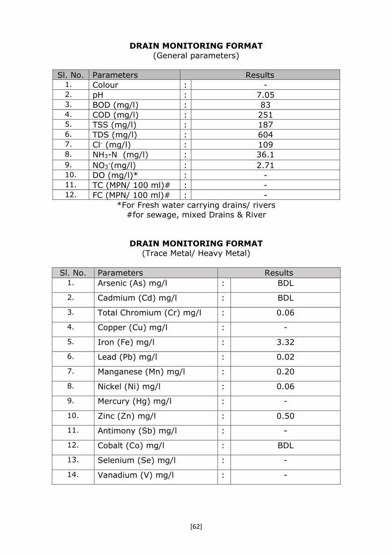
[62]
DRAIN MONITORING FORMAT
(General parameters)
Sl. No. Parameters Results 1. Colour : - 2. pH : 7.05 3. BOD (mg/l) : 83 4. COD (mg/l) : 251 5. TSS (mg/l) : 187 6. TDS (mg/l) : 604 7. Cl- (mg/l) : 109 8. NH3-N (mg/l) : 36.1
9. NO3-(mg/l) : 2.71
10. DO (mg/l)* : - 11. TC (MPN/ 100 ml)# : - 12. FC (MPN/ 100 ml)# : -
*For Fresh water carrying drains/ rivers
#for sewage, mixed Drains & River
DRAIN MONITORING FORMAT
(Trace Metal/ Heavy Metal)
Sl. No. Parameters Results 1. Arsenic (As) mg/l : BDL
2. Cadmium (Cd) mg/l : BDL
3. Total Chromium (Cr) mg/l : 0.06
4. Copper (Cu) mg/l : -
5. Iron (Fe) mg/l : 3.32
6. Lead (Pb) mg/l : 0.02
7. Manganese (Mn) mg/l : 0.20
8. Nickel (Ni) mg/l : 0.06
9. Mercury (Hg) mg/l : -
10. Zinc (Zn) mg/l : 0.50
11. Antimony (Sb) mg/l : -
12. Cobalt (Co) mg/l : BDL
13. Selenium (Se) mg/l : -
14. Vanadium (V) mg/l : -

[63]
DRAIN MONITORING FORMAT
(Pesticide)
Photographs with captions- Sampling & Confluence point (Add date & Time
stamping in camera)
Google Earth image of Sisamau Drain Sisamau drain at Confluence
point
Sl. No. Parameters Results 1. Water temperature (°C) : Pesticide Analysis Report (OPPs) :
2. Monochrotophos :
3. Dimethoate (µg/l) :
4. Methyl Parathion (µg/l) : 5. Malathion (µg/l) :
6. Chloropyriphos (µg/l) : 7. Methyl Parathion :
8. Ethion (µg/l) :
Pesticide Analysis Report (OCPs) : 9. α-HCH : BDL 10. β- HCH : 0.19 11. γ-HCH : BDL 12. δ-HCH : BDL 13. Total BHC (ng/l) : BDL 14. Aldrin (ng/l) : BDL 15. Diedrin (ng/l) : BDL 16. α-Endosulfan : BDL 17. Total Endosulfan (ng/l) : BDL 18. β-Endosulfan : BDL 19. OP'DDT : 0.08 20. PP'DDT : BDL 21. PP'DDE : BDL 22. Total DDT (ng/l) : BDL
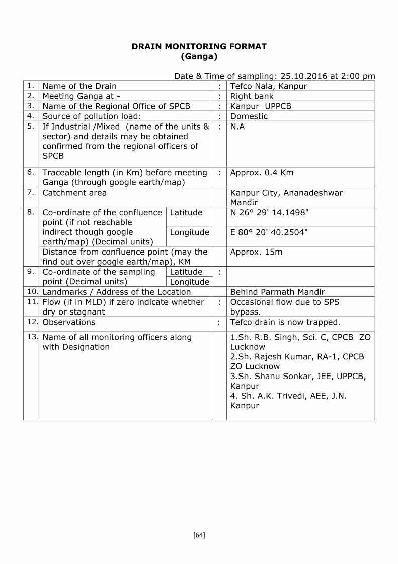
[64]
DRAIN MONITORING FORMAT
(Ganga)
Date & Time of sampling: 25.10.2016 at 2:00 pm 1. Name of the Drain : Tefco Nala, Kanpur 2. Meeting Ganga at - : Right bank 3. Name of the Regional Office of SPCB : Kanpur UPPCB 4. Source of pollution load: : Domestic 5. If Industrial /Mixed (name of the units &
sector) and details may be obtained confirmed from the regional officers of
SPCB
: N.A
6. Traceable length (in Km) before meeting Ganga (through google earth/map)
: Approx. 0.4 Km
7. Catchment area Kanpur City, Ananadeshwar
Mandir 8. Co-ordinate of the confluence
point (if not reachable indirect though google
earth/map) (Decimal units)
Latitude N 26° 29' 14.1498"
Longitude E 80° 20' 40.2504"
Distance from confluence point (may the find out over google earth/map), KM
Approx. 15m
9. Co-ordinate of the sampling point (Decimal units)
Latitude :
Longitude 10. Landmarks / Address of the Location Behind Parmath Mandir 11. Flow (if in MLD) if zero indicate whether
dry or stagnant : Occasional flow due to SPS
bypass. 12. Observations : Tefco drain is now trapped.
13. Name of all monitoring officers along with Designation
1.Sh. R.B. Singh, Sci. C, CPCB ZO Lucknow
2.Sh. Rajesh Kumar, RA-1, CPCB ZO Lucknow
3.Sh. Shanu Sonkar, JEE, UPPCB, Kanpur
4. Sh. A.K. Trivedi, AEE, J.N. Kanpur

[65]
DRAIN MONITORING FORMAT
(General parameters) (Dry – no sample was collected)
Sl. No. Parameters Results 1. Colour : 2. pH : 3. BOD (mg/l) : 4. COD (mg/l) : 5. TSS (mg/l) : 6. TDS (mg/l) : 7. Cl- (mg/l) : 8. NH3-N (mg/l) :
9. NO3-(mg/l) :
10. DO (mg/l)* : 11. TC (MPN/ 100 ml)# : 12. FC (MPN/ 100 ml)# :
*For Fresh water carrying drains/ rivers
#For sewage, mixed Drains & River
DRAIN MONITORING FORMAT
(Trace Metal/ Heavy Metal)
Sl. No. Parameters Results 1. Arsenic (As) mg/l : Awaited
2. Cadmium (Cd) mg/l :
3. Total Chromium (Cr) mg/l :
4. Copper (Cu) mg/l :
5. Iron (Fe) mg/l :
6. Lead (Pb) mg/l :
7. Manganese (Mn) mg/l :
8. Nickel (Ni) mg/l :
9. Mercury (Hg) mg/l :
10. Zinc (Zn) mg/l :
11. Antimony (Sb) mg/l :
12. Cobalt (Co) mg/l :
13. Selenium (Se) mg/l :
14. Vanadium (V) mg/l :

[66]
DRAIN MONITORING FORMAT
(Pesticide)
Photographs with captions – Sampling & Confluence point
(Add date & Time stamping in camera)
Fig- Tefco Drain
Fig- Confluent point of Tefco Drain &River
Ganga
Sl. No. Parameters Results 1. Water temperature (°C) : Awaited Pesticide Analysis Report (OPPs) :
2. Monochrotophos :
3. Dimethoate (µg/l) :
4. Methyl Parathion (µg/l) : 5. Malathion (µg/l) :
6. Chloropyriphos (µg/l) : 7. Methyl Parathion :
8. Ethion (µg/l) :
Pesticide Analysis Report (OCPs) : 9. α-BHC :
10. β-BHC : 11. γ-BHC :
12. δ-BHC : 13. Total BHC (ng/l) :
14. Aldrin (ng/l) : 15. Diedrin (ng/l) :
16. α-Endosulfan :
17. Total Endosulfan (ng/l) : 18. β-Endosulfan :
19. OP'DDT : 20. PP'DDT :
21. PP'DDE : 22. Total DDT (ng/l) :
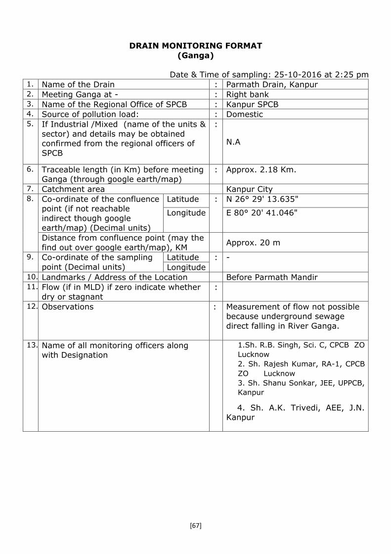
[67]
DRAIN MONITORING FORMAT
(Ganga)
Date & Time of sampling: 25-10-2016 at 2:25 pm 1. Name of the Drain : Parmath Drain, Kanpur 2. Meeting Ganga at - : Right bank 3. Name of the Regional Office of SPCB : Kanpur SPCB 4. Source of pollution load: : Domestic 5. If Industrial /Mixed (name of the units &
sector) and details may be obtained confirmed from the regional officers of
SPCB
:
N.A
6. Traceable length (in Km) before meeting Ganga (through google earth/map)
: Approx. 2.18 Km.
7. Catchment area Kanpur City 8. Co-ordinate of the confluence
point (if not reachable
indirect though google earth/map) (Decimal units)
Latitude : N 26° 29' 13.635"
Longitude E 80° 20' 41.046"
Distance from confluence point (may the
find out over google earth/map), KM
Approx. 20 m
9. Co-ordinate of the sampling
point (Decimal units)
Latitude : -
Longitude 10. Landmarks / Address of the Location Before Parmath Mandir 11. Flow (if in MLD) if zero indicate whether
dry or stagnant
:
12. Observations : Measurement of flow not possible because underground sewage
direct falling in River Ganga.
13. Name of all monitoring officers along with Designation
1.Sh. R.B. Singh, Sci. C, CPCB ZO
Lucknow
2. Sh. Rajesh Kumar, RA-1, CPCB
ZO Lucknow
3. Sh. Shanu Sonkar, JEE, UPPCB,
Kanpur
4. Sh. A.K. Trivedi, AEE, J.N. Kanpur

[68]
DRAIN MONITORING FORMAT
(General parameters)
(Dry – no sample was collected)
Sl. No. Parameters Results 1. Colour : 2. pH : 3. BOD (mg/l) : 4. COD (mg/l) : 5. TSS (mg/l) : 6. TDS (mg/l) : 7. Cl- (mg/l) : 8. NH3-N (mg/l) :
9. NO3-(mg/l) :
10. DO (mg/l)* : 11. TC (MPN/ 100 ml)# : 12. FC (MPN/ 100 ml)# :
*For Fresh water carrying drains/ rivers #For sewage, mixed Drains & River
DRAIN MONITORING FORMAT
(Trace Metal/ Heavy Metal)
Sl. No. Parameters Results 1. Arsenic (As) mg/l :
2. Cadmium (Cd) mg/l :
3. Total Chromium (Cr) mg/l :
4. Copper (Cu) mg/l :
5. Iron (Fe) mg/l :
6. Lead (Pb) mg/l :
7. Manganese (Mn) mg/l :
8. Nickel (Ni) mg/l :
9. Mercury (Hg) mg/l :
10. Zinc (Zn) mg/l :
11. Antimony (Sb) mg/l :
12. Cobalt (Co) mg/l :
13. Selenium (Se) mg/l :
14. Vanadium (V) mg/l :

[69]
DRAIN MONITORING FORMAT
(Pesticide)
Photographs with captions – Sampling & Confluence point (Add date & Time stamping in camera)
Fig – Sampling point of Parmath Drain
Fig -Confluence point of Parmath Drain &
River Ganga
Sl. No. Parameters Results 1. Water temperature (°C) : Pesticide Analysis Report (OPPs) :
2. Monochrotophos :
3. Dimethoate (µg/l) :
4. Methyl Parathion (µg/l) : 5. Malathion (µg/l) :
6. Chloropyriphos (µg/l) : 7. Methyl Parathion :
8. Ethion (µg/l) :
Pesticide Analysis Report (OCPs) : 9. α-BHC :
10. β-BHC : 11. γ-BHC :
12. δ-BHC : 13. Total BHC (ng/l) :
14. Aldrin (ng/l) : 15. Diedrin (ng/l) :
16. α-Endosulfan :
17. Total Endosulfan (ng/l) : 18. β-Endosulfan :
19. OP'DDT : 20. PP'DDT :
21. PP'DDE : 22. Total DDT (ng/l) :
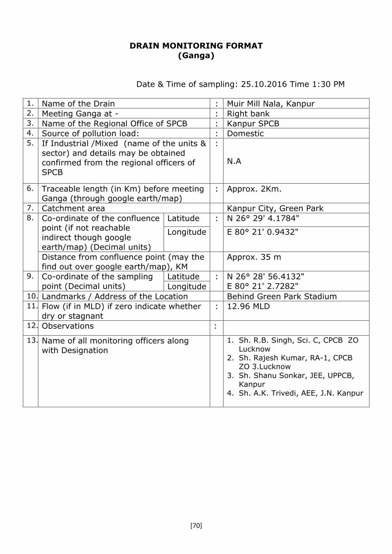
[70]
DRAIN MONITORING FORMAT
(Ganga)
Date & Time of sampling: 25.10.2016 Time 1:30 PM
1. Name of the Drain : Muir Mill Nala, Kanpur 2. Meeting Ganga at - : Right bank 3. Name of the Regional Office of SPCB : Kanpur SPCB 4. Source of pollution load: : Domestic 5. If Industrial /Mixed (name of the units &
sector) and details may be obtained confirmed from the regional officers of
SPCB
:
N.A
6. Traceable length (in Km) before meeting Ganga (through google earth/map)
: Approx. 2Km.
7. Catchment area Kanpur City, Green Park 8. Co-ordinate of the confluence
point (if not reachable
indirect though google earth/map) (Decimal units)
Latitude : N 26° 29' 4.1784"
Longitude E 80° 21' 0.9432"
Distance from confluence point (may the
find out over google earth/map), KM
Approx. 35 m
9. Co-ordinate of the sampling
point (Decimal units)
Latitude : N 26° 28' 56.4132"
E 80° 21' 2.7282" Longitude 10. Landmarks / Address of the Location Behind Green Park Stadium 11. Flow (if in MLD) if zero indicate whether
dry or stagnant
: 12.96 MLD
12. Observations :
13. Name of all monitoring officers along
with Designation
1. Sh. R.B. Singh, Sci. C, CPCB ZO
Lucknow 2. Sh. Rajesh Kumar, RA-1, CPCB
ZO 3.Lucknow
3. Sh. Shanu Sonkar, JEE, UPPCB, Kanpur
4. Sh. A.K. Trivedi, AEE, J.N. Kanpur

[71]
DRAIN MONITORING FORMAT (General parameters)
Sl. No. Parameters Results 1. Colour : - 2. pH : 7.38 3. BOD (mg/l) : 85.3 4. COD (mg/l) : 210 5. TSS (mg/l) : 421 6. TDS (mg/l) : 774 7. Cl- (mg/l) : 160 8. NH3-N (mg/l) : 40.9
9. NO3-(mg/l) : 2.01
10. DO (mg/l)* : - 11. TC (MPN/ 100 ml)# : 160000000 12. FC (MPN/ 100 ml)# : 160000000
*For Fresh water carrying drains/ rivers #For sewage, mixed Drains & River
DRAIN MONITORING FORMAT
(Trace Metal/ Heavy Metal)
Sl. No. Parameters Results 1. Arsenic (As) mg/l : BDL
2. Cadmium (Cd) mg/l : BDL
3. Total Chromium (Cr) mg/l : BDL
4. Copper (Cu) mg/l : -
5. Iron (Fe) mg/l : 2.34
6. Lead (Pb) mg/l : BDL
7. Manganese (Mn) mg/l : 0.16
8. Nickel (Ni) mg/l : 0.02
9. Mercury (Hg) mg/l : -
10. Zinc (Zn) mg/l : 0.28
11. Antimony (Sb) mg/l : -
12. Cobalt (Co) mg/l : BDL
13. Selenium (Se) mg/l : -
14. Vanadium (V) mg/l : -

[72]
DRAIN MONITORING FORMAT
(Pesticide)
Photographs with captions – Sampling & Confluence point
(Add date & Time stamping in camera)
Fig-Sampling point of Muir Mill Drain
Fig-Confluence point of Muir mill
Drain with River Ganga
Sl. No. Parameters Results 1. Water temperature (°C) : Pesticide Analysis Report (OPPs) :
2. Monochrotophos :
3. Dimethoate (µg/l) :
4. Methyl Parathion (µg/l) : 5. Malathion (µg/l) :
6. Chloropyriphos (µg/l) : 7. Methyl Parathion :
8. Ethion (µg/l) :
Pesticide Analysis Report (OCPs) : 9. α-BHC : 0.05 10. β-BHC : 0.49 11. γ-BHC : BDL 12. δ-BHC : BDL 13. Total BHC (ng/l) : BDL 14. Aldrin (ng/l) : BDL 15. Diedrin (ng/l) : BDL 16. α-Endosulfan : BDL 17. Total Endosulfan (ng/l) : BDL 18. β-Endosulfan : BDL 19. OP'DDT : BDL 20. PP'DDT : BDL 21. PP'DDE : BDL 22. Total DDT (ng/l) : BDL

[73]
DRAIN MONITORING FORMAT (Ganga)
Date & Time of sampling: 25-10-2016 at 1:50 pm
1. Name of the Drain : Police line Nala, Kanpur 2. Meeting Ganga at - : Right bank 3. Name of the Regional Office of SPCB : Kanpur SPCB 4. Source of pollution load: : Domestic (Dry) 5. If Industrial /Mixed (name of the units &
sector) and details may be obtained
confirmed from the regional officers of SPCB
:
N.A
6. Traceable length (in Km) before meeting
Ganga (through google earth/map)
: Approx. 0.12 Km
7. Catchment area Police line Colony, Kanpur City 8. Co-ordinate of the confluence
point (if not reachable indirect though google
earth/map) (Decimal units)
Latitude : N 26° 28' 44.8068"
Longitude E 80° 21' 32.925"
Distance from confluence point (may the find out over google earth/map), KM
Approx. 15 m
9. Co-ordinate of the sampling point (Decimal units)
Latitude : -
Longitude 10. Landmarks / Address of the Location Near Central Jail Road 11. Flow (if in MLD) if zero indicate whether
dry or stagnant : Dry
12. Observations : During monitoring no sewage was
found.
13. Name of all monitoring officers along with Designation
1.Sh. R.B. Singh, Sci. C, CPCB ZO Lucknow
2.Sh. Rajesh Kumar, RA-1, CPCB
ZO Lucknow 3.Sh. Shanu Sonkar, JEE, UPPCB,
Kanpur 4. Sh. A.K. Trivedi, AEE, J.N.
Kanpur

[74]
DRAIN MONITORING FORMAT
(General parameters)
Sl. No. Parameters Results 1. Colour : Awaited 2. pH : 3. BOD (mg/l) : 4. COD (mg/l) : 5. TSS (mg/l) : 6. TDS (mg/l) : 7. Cl- (mg/l) : 8. NH3-N (mg/l) :
9. NO3-(mg/l) :
10. DO (mg/l)* : 11. TC (MPN/ 100 ml)# : 12. FC (MPN/ 100 ml)# :
*For Fresh water carrying drains/ rivers
#For sewage, mixed Drains & River
DRAIN MONITORING FORMAT
(Trace Metal/ Heavy Metal)
Sl. No. Parameters Results 1. Arsenic (As) mg/l : Awaited
2. Cadmium (Cd) mg/l :
3. Total Chromium (Cr) mg/l :
4. Copper (Cu) mg/l :
5. Iron (Fe) mg/l :
6. Lead (Pb) mg/l :
7. Manganese (Mn) mg/l :
8. Nickel (Ni) mg/l :
9. Mercury (Hg) mg/l :
10. Zinc (Zn) mg/l :
11. Antimony (Sb) mg/l :
12. Cobalt (Co) mg/l :
13. Selenium (Se) mg/l :
14. Vanadium (V) mg/l :

[75]
DRAIN MONITORING FORMAT
(Pesticide)
Photographs with captions – Sampling & Confluence point
(Add date & Time stamping in camera)
Fig-Sampling point of Police Line
Drain (Dry)
Fig- Confluent point of Police Drain & River
Ganga.
Sl. No. Parameters Results 1. Water temperature (°C) : Awaited Pesticide Analysis Report (OPPs) :
2. Monochrotophos :
3. Dimethoate (µg/l) :
4. Methyl Parathion (µg/l) : 5. Malathion (µg/l) :
6. Chloropyriphos (µg/l) : 7. Methyl Parathion :
8. Ethion (µg/l) :
Pesticide Analysis Report (OCPs) : 9. α-BHC :
10. β-BHC : 11. γ-BHC :
12. δ-BHC : 13. Total BHC (ng/l) :
14. Aldrin (ng/l) : 15. Diedrin (ng/l) :
16. α-Endosulfan :
17. Total Endosulfan (ng/l) : 18. β-Endosulfan :
19. OP'DDT : 20. PP'DDT :
21. PP'DDE : 22. Total DDT (ng/l) :
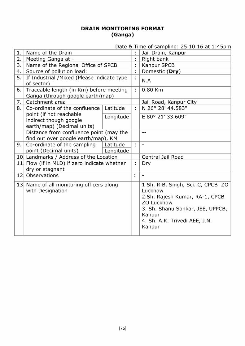
[76]
DRAIN MONITORING FORMAT
(Ganga)
Date & Time of sampling: 25.10.16 at 1:45pm
1. Name of the Drain : Jail Drain, Kanpur
2. Meeting Ganga at - : Right bank
3. Name of the Regional Office of SPCB : Kanpur SPCB
4. Source of pollution load: : Domestic (Dry)
5. If Industrial /Mixed (Please indicate type
of sector)
: N.A
6. Traceable length (in Km) before meeting
Ganga (through google earth/map)
: 0.80 Km
7. Catchment area Jail Road, Kanpur City
8. Co-ordinate of the confluence
point (if not reachable indirect though google
earth/map) (Decimal units)
Latitude : N 26° 28' 44.583"
Longitude E 80° 21' 33.609"
Distance from confluence point (may the find out over google earth/map), KM
--
9. Co-ordinate of the sampling point (Decimal units)
Latitude : -
Longitude
10. Landmarks / Address of the Location Central Jail Road
11. Flow (if in MLD) if zero indicate whether dry or stagnant
: Dry
12. Observations : -
13. Name of all monitoring officers along with Designation
1 Sh. R.B. Singh, Sci. C, CPCB ZO Lucknow
2.Sh. Rajesh Kumar, RA-1, CPCB ZO Lucknow
3. Sh. Shanu Sonkar, JEE, UPPCB, Kanpur
4. Sh. A.K. Trivedi AEE, J.N. Kanpur

[77]
DRAIN MONITORING FORMAT
(General parameters) (Dry – no sample was collected)
Sl. No. Parameters Results 1. Colour : 2. pH : 3. BOD (mg/l) : 4. COD (mg/l) : 5. TSS (mg/l) : 6. TDS (mg/l) : 7. Cl- (mg/l) : 8. NH3-N (mg/l) :
9. NO3-(mg/l) :
10. DO (mg/l)* : 11. TC (MPN/ 100 ml)# : 12. FC (MPN/ 100 ml)# :
*For Fresh water carrying drains/ rivers #For sewage, mixed Drains & River
DRAIN MONITORING FORMAT
(Trace Metal/ Heavy Metal)
Sl. No. Parameters Results 1. Arsenic (As) mg/l :
2. Cadmium (Cd) mg/l :
3. Total Chromium (Cr) mg/l :
4. Copper (Cu) mg/l :
5. Iron (Fe) mg/l :
6. Lead (Pb) mg/l :
7. Manganese (Mn) mg/l :
8. Nickel (Ni) mg/l :
9. Mercury (Hg) mg/l :
10. Zinc (Zn) mg/l :
11. Antimony (Sb) mg/l :
12. Cobalt (Co) mg/l :
13. Selenium (Se) mg/l :
14. Vanadium (V) mg/l :

[78]
DRAIN MONITORING FORMAT
(Pesticide)
Photographs with captions – Sampling & Confluence point (Add date & Time stamping in camera)
Fig- Sampling point of Jail Drain
Fig-Confluence point of Jail Drain & River
Ganga
Sl. No. Parameters Results 1. Water temperature (°C) : Pesticide Analysis Report (OPPs) :
2. Monochrotophos :
3. Dimethoate (µg/l) :
4. Methyl Parathion (µg/l) : 5. Malathion (µg/l) :
6. Chloropyriphos (µg/l) : 7. Methyl Parathion :
8. Ethion (µg/l) :
Pesticide Analysis Report (OCPs) : 9. α-BHC :
10. β-BHC : 11. γ-BHC :
12. δ-BHC : 13. Total BHC (ng/l) :
14. Aldrin (ng/l) : 15. Diedrin (ng/l) :
16. α-Endosulfan :
17. Total Endosulfan (ng/l) : 18. β-Endosulfan :
19. OP'DDT : 20. PP'DDT :
21. PP'DDE : 22. Total DDT (ng/l) :

[79]
DRAIN MONITORING FORMAT
(Ganga)
Date & Time of sampling: 25.10.2016 & 1:15 pm 1. Name of the Drain : Gola ghat nala, Kanpur 2. Meeting Ganga at - : Right bank -Ganga 3. Name of the Regional Office of SPCB : RO, UPPCB, Kanpur 4. Source of pollution load: : Domestic 5. If Industrial /Mixed (Please indicate type
of sector)
: N.A
6. Traceable length (in Km) before meeting
Ganga (through google earth/map)
: Approx. 0.5 Km
7. Catchment area Mal Road, Cantt , Kanpur City. 8. Co-ordinate of the confluence
point (if not reachable indirect though google
earth/map) (Decimal units)
Latitude : N 26° 28' 17.4246"
Longitude E 80° 22' 11.1966"
Distance from confluence point (may the find out over google earth/map), KM
Approx. 25 m
9. Co-ordinate of the sampling point (Decimal units)
Latitude : N 25°24’34.2” E 80°23’ 47.6” Longitude
10. Landmarks / Address of the Location Tannery/Cantt
(Near Gola ghat cantt. road) 11. Flow (if in MLD) if zero indicate whether
dry or stagnant
: 1.44 MLD
12. Observations : Golaghat is a minor drain. -
13. Name of all monitoring officers along
with Designation
1. Sh. R.B. Singh, Sci. C, CPCB
ZO Lucknow 2. Sh. Rajesh Kumar, RA-1, CPCB
Z O Lucknow 3. Sh. Shanu Sonkar, JEE, RO,
UPPCB, Kanpur
4. Sh. A.K. Trivedi, AEE, Jal Nigam, Kanpur

[80]
DRAIN MONITORING FORMAT (General parameters)
Sl. No. Parameters Results 1. Colour : - 2. pH : 7.34 3. BOD (mg/l) : 143 4. COD (mg/l) : 289 5. TSS (mg/l) : 234 6. TDS (mg/l) : 937 7. Cl- (mg/l) : 152 8. NH3-N (mg/l) : 42.9
9. NO3-(mg/l) : 0.876
10. DO (mg/l)* : - 11. TC (MPN/ 100 ml)# : 92000000 12. FC (MPN/ 100 ml)# : 92000000
*For Fresh water carrying drains/ rivers #For sewage, mixed Drains & River
DRAIN MONITORING FORMAT
(Trace Metal/ Heavy Metal)
Sl. No. Parameters Results 1. Arsenic (As) mg/l : BDL
2. Cadmium (Cd) mg/l : BDL
3. Total Chromium (Cr) mg/l : 0.02
4. Copper (Cu) mg/l : -
5. Iron (Fe) mg/l : 1.22
6. Lead (Pb) mg/l : BDL
7. Manganese (Mn) mg/l : 0.16
8. Nickel (Ni) mg/l : BDL
9. Mercury (Hg) mg/l : -
10. Zinc (Zn) mg/l : 0.52
11. Antimony (Sb) mg/l : -
12. Cobalt (Co) mg/l : BDL
13. Selenium (Se) mg/l : -
14. Vanadium (V) mg/l : -

[81]
DRAIN MONITORING FORMAT
(Pesticide)
Photographs with captions – Sampling & Confluence point
(Add date & Time stamping in camera)
Fig- Sampling point of Gola Ghat
Drain
Fig- Confluence point of Gola ghat
Drain & river Ganga
Sl. No. Parameters Results 1. Water temperature (°C) : Result awaited Pesticide Analysis Report (OPPs) :
2. Monochrotophos :
3. Dimethoate (µg/l) :
4. Methyl Parathion (µg/l) : 5. Malathion (µg/l) :
6. Chloropyriphos (µg/l) : 7. Methyl Parathion :
8. Ethion (µg/l) :
Pesticide Analysis Report (OCPs) : 9. α-BHC : 0.05 10. β-BHC : 0.07 11. γ-BHC : 0.06 12. δ-BHC : BDL 13. Total BHC (ng/l) : BDL 14. Aldrin (ng/l) : BDL 15. Diedrin (ng/l) : BDL 16. α-Endosulfan : BDL 17. Total Endosulfan (ng/l) : BDL 18. β-Endosulfan : BDL 19. OP'DDT : BDL 20. PP'DDT : BDL 21. PP'DDE : BDL 22. Total DDT (ng/l) : BDL

[82]
DRAIN MONITORING FORMAT
(Ganga)
Date & Time of sampling: 25.10.2016 & 12:25 pm 1. Name of the Drain : Bhagwat das ghat Drain, Kanpur 2. Meeting Ganga at : Right bank 3. Name of the Regional Office of SPCB : RO, UPPCB, Kanpur 4. Source of pollution load: : Domestic 5. If Industrial /Mixed (name of the units &
sector) and details may be obtained confirmed from the regional officers of
SPCB
:
N.A
6. Traceable length (in Km) before meeting
Ganga (through google earth/map)
: Approx. 1.3 Km
7. Catchment area Civil line area, Bhagwatdas ghat, mall road
8. Co-ordinate of the confluence point (if not reachable
indirect though google earth/map) (Decimal units)
Latitude : N 26° 28' 28.506"
Longitude E 80° 21' 56.6958"
Distance from confluence point (may the
find out over google earth/map), KM
Approx. 50m
9. Co-ordinate of the sampling
point (Decimal units)
Latitude : N 260 28’27.8”
E 80021’ 54.1” Longitude 10. Landmarks / Address of the Location Tannery/Cantt
(Near Bhagwat das ghat cantt.
road) 11. Flow (if in MLD) if zero indicate whether
dry or stagnant : 17.28 MLD
12. Observations : Bhagwat das ghat drain direct falling into R. Ganga.
13. Name of all monitoring officers along
with Designation
5. Sh. R.B. Singh, Sci. C, CPCB
ZO Lucknow 6. Sh. Rajesh Kumar, RA-1, CPCB
Z O Lucknow
7. Sh. Shanu Sonkar, JEE, RO, UPPCB, Kanpur
8. Sh. A.K. Trivedi, AEE, Jal Nigam, Kanpur

[83]
DRAIN MONITORING FORMAT
(General parameters)
Sl. No. Parameters Results 1. Colour : - 2. pH : 7.24 3. BOD (mg/l) : 95 4. COD (mg/l) : 261 5. TSS (mg/l) : 147 6. TDS (mg/l) : 722 7. Cl- (mg/l) : 139 8. NH3-N (mg/l) : 48.7
9. NO3-(mg/l) : 2.17
10. DO (mg/l)* : - 11. TC (MPN/ 100 ml)# : 92000000 12. FC (MPN/ 100 ml)# : 92000000
*For Fresh water carrying drains/ rivers
#For sewage, mixed Drains & River
DRAIN MONITORING FORMAT (Trace Metal/ Heavy Metal)
Sl. No. Parameters Results 1. Arsenic (As) mg/l : BDL
2. Cadmium (Cd) mg/l : BDL
3. Total Chromium (Cr) mg/l : BDL
4. Copper (Cu) mg/l : -
5. Iron (Fe) mg/l : 0.68
6. Lead (Pb) mg/l : BDL
7. Manganese (Mn) mg/l : 0.10
8. Nickel (Ni) mg/l : BDL
9. Mercury (Hg) mg/l : -
10. Zinc (Zn) mg/l : 0.24
11. Antimony (Sb) mg/l : -
12. Cobalt (Co) mg/l : BDL
13. Selenium (Se) mg/l : -
14. Vanadium (V) mg/l : -

[84]
DRAIN MONITORING FORMAT
(Pesticide)
Photographs with captions – Sampling & Confluence point
(Add date & Time stamping in camera)
Fig- Sampling point of Bhagwat
das Drain
Fig- Confluence point of Bhagwat das
drain & River Ganga
Sl. No. Parameters Results 1. Water temperature (°C) : Pesticide Analysis Report (OPPs) :
2. Monochrotophos : Awaited
3. Dimethoate (µg/l) :
4. Methyl Parathion (µg/l) : 5. Malathion (µg/l) :
6. Chloropyriphos (µg/l) : 7. Methyl Parathion :
8. Ethion (µg/l) :
Pesticide Analysis Report (OCPs) : 9. α-BHC : 0.05 10. β-BHC : 0.29 11. γ-BHC : BDL 12. δ-BHC : BDL 13. Total BHC (ng/l) : BDL 14. Aldrin (ng/l) : BDL 15. Diedrin (ng/l) : BDL 16. α-Endosulfan : BDL 17. Total Endosulfan (ng/l) : BDL 18. β-Endosulfan : BDL 19. OP'DDT : 0.14 20. PP'DDT : BDL 21. PP'DDE : BDL 22. Total DDT (ng/l) : BDL

[85]
DRAIN MONITORING FORMAT
(Ganga)
Date & Time of sampling: 25.10.2016 at 12:55 pm 1. Name of the Drain : Sattichaura ghat Drain, Kanpur 2. Meeting Ganga at - : Right bank 3. Name of the Regional Office of SPCB : Kanpur UPPCB 4. Source of pollution load: : Dmestic 5. If Industrial /Mixed (name of the units &
sector) and details may be obtained confirmed from the regional officers of
SPCB
: N.A
6. Traceable length (in Km) before meeting Ganga (through google earth/map)
: Approx. 0.7 Km
7. Catchment area Tannery/Cantt.
8. Co-ordinate of the confluence
point (if not reachable indirect though google
earth/map) (Decimal units)
Latitude N 26° 27' 34.8474"
Longitude E 80° 22' 50.0478"
Distance from confluence point (may the find out over google earth/map), KM
Approx. 20 m
9. Co-ordinate of the sampling point (Decimal units)
Latitude : N 260 27’34.2” E 80022’ 47.4” Longitude
10. Landmarks / Address of the Location Near Sattichaura ghat, cantt.
road 11. Flow (if in MLD) if zero indicate whether
dry or stagnant
: 1.54 MLD
12. Observations : Sattichaura ghat drain is a minor drain.-
13. Name of all monitoring officers along
with Designation
1.Sh. R.B. Singh, Sci. C, CPCB ZO
Lucknow
2.Sh. Rajesh Kumar, RA-1, CPCB ZO Lucknow
3.Sh. Shanu Sonkar, JEE, UPPCB, Kanpur
4. Sh. A.K. Trivedi, AEE, J.N. Kanpur
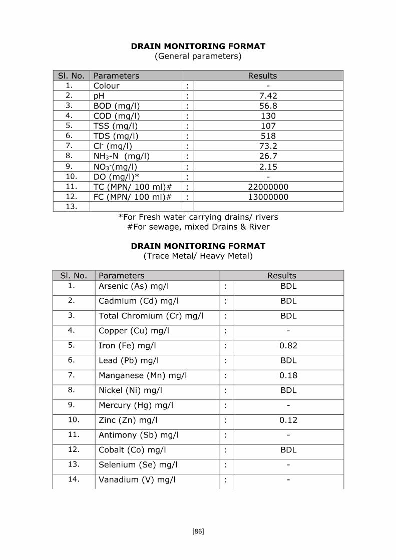
[86]
DRAIN MONITORING FORMAT
(General parameters)
Sl. No. Parameters Results 1. Colour : - 2. pH : 7.42 3. BOD (mg/l) : 56.8 4. COD (mg/l) : 130 5. TSS (mg/l) : 107 6. TDS (mg/l) : 518 7. Cl- (mg/l) : 73.2 8. NH3-N (mg/l) : 26.7
9. NO3-(mg/l) : 2.15
10. DO (mg/l)* : - 11. TC (MPN/ 100 ml)# : 22000000 12. FC (MPN/ 100 ml)# : 13000000 13.
*For Fresh water carrying drains/ rivers
#For sewage, mixed Drains & River
DRAIN MONITORING FORMAT (Trace Metal/ Heavy Metal)
Sl. No. Parameters Results 1. Arsenic (As) mg/l : BDL
2. Cadmium (Cd) mg/l : BDL
3. Total Chromium (Cr) mg/l : BDL
4. Copper (Cu) mg/l : -
5. Iron (Fe) mg/l : 0.82
6. Lead (Pb) mg/l : BDL
7. Manganese (Mn) mg/l : 0.18
8. Nickel (Ni) mg/l : BDL
9. Mercury (Hg) mg/l : -
10. Zinc (Zn) mg/l : 0.12
11. Antimony (Sb) mg/l : -
12. Cobalt (Co) mg/l : BDL
13. Selenium (Se) mg/l : -
14. Vanadium (V) mg/l : -
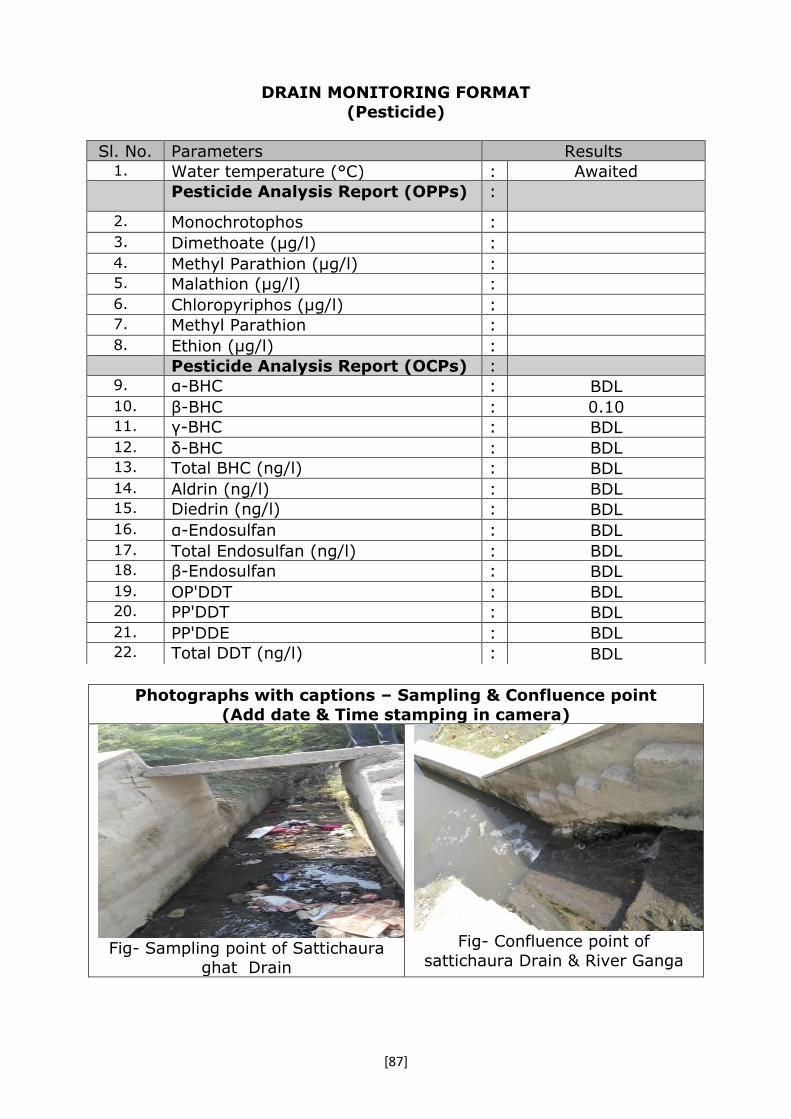
[87]
DRAIN MONITORING FORMAT
(Pesticide)
Photographs with captions – Sampling & Confluence point
(Add date & Time stamping in camera)
Fig- Sampling point of Sattichaura
ghat Drain
Fig- Confluence point of
sattichaura Drain & River Ganga
Sl. No. Parameters Results 1. Water temperature (°C) : Awaited Pesticide Analysis Report (OPPs) :
2. Monochrotophos :
3. Dimethoate (µg/l) :
4. Methyl Parathion (µg/l) : 5. Malathion (µg/l) :
6. Chloropyriphos (µg/l) : 7. Methyl Parathion :
8. Ethion (µg/l) :
Pesticide Analysis Report (OCPs) : 9. α-BHC : BDL 10. β-BHC : 0.10 11. γ-BHC : BDL 12. δ-BHC : BDL 13. Total BHC (ng/l) : BDL 14. Aldrin (ng/l) : BDL 15. Diedrin (ng/l) : BDL 16. α-Endosulfan : BDL 17. Total Endosulfan (ng/l) : BDL 18. β-Endosulfan : BDL 19. OP'DDT : BDL 20. PP'DDT : BDL 21. PP'DDE : BDL 22. Total DDT (ng/l) : BDL

[88]
DRAIN MONITORING FORMAT
(Ganga)
Date & Time of sampling: 24.10.2016
01 Name of Drain : Dabka Nalla Drain (1, 2, 3) ,
Jajmau Kanpur
03 Confluence with R. Ganga Right Bank
04 Name of the Regional Office of
SPCB
RO Kanpur UPPCB
05 Source of Pollution Load Mostly sewage
06 If Industrial /Mixed (Please
indicate type of sector)
Kanpur city sewage
07 Traceable length (in Km)
before meeting Ganga (through Google earth/ map)
Approx. 01 - 02 Km
08 Catchment area Kanpur City
09 Co-ordinate of the confluence point (if
not reachable indirect though Google earth/
map) (Decimal units)
Latitude
26°25'51"N
Longitude
80°23'40"E
Distance from confluence point (may the find out over Google
earth/map), Km
NA
10 Co-ordinate of the
sampling point
(decimal units)
Latitud
e
26°25'51"N
Longitude
80°23'40"E
11 Landmarks/ Address of the location
At confluence point
12 Flow (if in MLD) if Zero indicate
whether dry or stagnant
Zero, Drain was tapped and back
water of river Ganga was flowing into the drain at confluence point.
13 Characteristics Colour Not applicable as zero wastewater flow was found at the monitoring
point. pH
BOD (mg/l)
COD (mg/l)
TSS
TDS
PO43-
Cl-
NH3-N
NO3-
14 For Fresh water carrying
drains/rivers
DO
15 For sewage, TC

[89]
mixed Drains &
River
(MPN/100ml)
FC (MPN/100ml)
16 Photographs with captions- Sampling & Confluence point (Add date &
Time stamping in camera)
Google Earth image of Buriyaghat Drain

[90]
River water backflow into Dabka Drain at Confluence point
17 Observations 01.The Dabka drain is generally carrying domestic sewage of Kanpur
city.
02.The drain was tapped and the wastewater was taken to STPs for treatment.
03. At the time of visit river water was back flowing into the Dabka drain at Confluence point.
18 Urgent action required, if any NA
19 Name of all monitoring officers along with designation
Rajendra D Patil, Sci C
Zonal Office, CPCB Lucknow
A K Mathur, AEE
Regional Office, UPPCB Kanpur
Rajesh Kumar, RA
Zonal Office, CPCB Lucknow
Shnu Sonkar, Sci. Assistant
Regional Office, UPPCB Kanpur
A K Trivedi, Project Engineer
Jal Nigam Kanpur

[91]
DRAIN MONITORING FORMAT
(Ganga)
Date & Time of sampling: 24.10.2016
1. Name of Drain : Sheetlabazar Drain, Jajmau Kanpur
2. Confluence with R. Ganga Right bank
3. Name of the Regional Office of SPCB RO Kanpur UPPCB
4. Source of Pollution Load Mixed (Sewage + Tannery Wastewater)
5. IF Industrial/ Mixed (Name of the units & sector) and details may be obtained confirmed from the regional officers of SPCB
Around 400 tannery units located in Jajmau cluster.
6. Traceable length (in Km) before meeting Ganga (through Google earth/ map)
Around 01 Km
7. Catchment area Jamau industrial cluster
8. Co-ordinate of the confluence point (if not reachable indirect though Google earth/ map) (Decimal units)
Latitude 26°26'13"N
Longitude 80°24'13"E
Distance from confluence point (may the find out over Google earth/map), Km
Approx. 10 m
9. Co-ordinate of the sampling point (decimal units)
Latitude 26°26'13"N
Longitude 80°24'13"E
10. Landmarks/ Address of the location Confined path made by wastewater into the river Ganga.
11. Flow (if in MLD) if Zero indicate whether dry or stagnant
0.27 m3/sec = 23.63MLD
12. Characteristics Colour Black
pH 8.09
TSS 887
TDS 6065
Cl- 35.5
SO42- 1198
S 36.9
P 8.95
Nitrate as N 22.6
Nitrite as N BDL
Am Nitrogen 232
O & G 12.6
BOD (mg/l) 35.5533
COD (mg/l)
1649

[92]
13. Heavy Metal Arsenic (As) mg/l BDL
Cadmium (Cd) mg/l BDL
Total Chromium (Cr)
mg/l
11.04
Copper (Cu) mg/l -
Iron (Fe) mg/l 0.88
Lead (Pb) mg/l BDL
Manganese (Mn)
mg/l
0.22
Nickel (Ni) mg/l BDL
Mercury (Hg) mg/l
Zinc (Zn) mg/l 0.28
Antimony (Sb) mg/l
Cobalt (Co) mg/l BDL
Selenium (Se) mg/l
Vanadium (V) mg/l
14. DO (For Fresh water carrying drains/rivers)
NA
15. For sewage, mixed Drains & River
TC (MPN/100ml) 1.7 X 10⁷
FC (MPN/100ml) 1.3 X 10⁷

[93]
DRAIN MONITORING FORMAT (Pesticide)
16. Photographs with captions- Sampling & Confluence point (Add date & Time stamping in camera)
17. Google Earth image of Sheetlabazar Drain Sheetlabazar drain at monitoring and
Confluence point
Sl. No. Parameters Results 1. Water temperature (°C) : Awaited Pesticide Analysis Report (OPPs) :
2. Monochrotophos :
3. Dimethoate (µg/l) :
4. Methyl Parathion (µg/l) : 5. Malathion (µg/l) :
6. Chloropyriphos (µg/l) : 7. Methyl Parathion :
8. Ethion (µg/l) :
Pesticide Analysis Report (OCPs) : 9. α-BHC : BDL 10. β-BHC : 7.03 11. γ-BHC : BDL 12. δ-BHC : BDL 13. Total BHC (ng/l) : BDL 14. Aldrin (ng/l) : BDL 15. Diedrin (ng/l) : BDL 16. α-Endosulfan : BDL 17. Total Endosulfan (ng/l) : BDL 18. β-Endosulfan : BDL 19. OP'DDT : BDL 20. PP'DDT : BDL 21. PP'DDE : BDL 22. Total DDT (ng/l) : BDL

[94]
17 Observations 04. The Sheetlabazar drain is carrying tannery effluent along with inseparable sewage. 05. Out of total effluent generated in the area some of effluent is pumped to CETP
Jajmau, Kanpur through Sheetlabazar pumping station and surplus is discharged in to river Ganga through Sheetlabazar drain without any treatment.
06. The quantity measured and as indicated at Sr No 12 is discharged directly into river Ganga without any treatment.
18 Urgent action required, if any Treatment of wastewater before directly discharging into river Ganga without any treatment.
19 Name of all monitoring officers along with designation
Rajendra D Patil, Sci C
Zonal Office, CPCB Lucknow
A K Mathur, AEE
Regional Office, UPPCB Kanpur
Rajesh Kumar, RA
Zonal Office, CPCB Lucknow
Shnu Sonkar, Sci. Assistant
Regional Office, UPPCB Kanpur
A K Trivedi, Project Engineer
Jal Nigam Kanpur

[95]
DRAIN MONITORING FORMAT
(Ganga)
Date & Time of sampling: 24.10.2016
01 Name of Drain : Buriyaghat Drain,
Jajmau Kanpur
03 Confluence with R. Ganga Right bank
04 Name of the Regional Office of SPCB RO Kanpur UPPCB
05 Source of Pollution Load Mixed (Sewage + Tannery Wastewater)
06 IF Industrial/ Mixed (Name of the units & sector) and details may be obtained
confirmed from the regional officers of SPCB
Around 400 tannery units located in Jajmau
cluster.
07 Traceable length (in Km) before meeting
Ganga (through Google earth/ map)
Approx. 01 Km
08 Catchment area Jamau industrial cluster
09 Co-ordinate of the
confluence point (if not reachable indirect
though Google earth/ map) (Decimal units)
Latitude 26°25'51"N
Longitude 80°24'42"E
Distance from confluence point (may the find out over Google earth/map), Km
Approx. 20 m
10 Co-ordinate of the
sampling point (decimal units)
Latitude 26°25'51"N
Longitude 80°24'42"E
11 Landmarks/ Address of the location Discharge after Buriyaghat Pumping
station
12 Flow (if in MLD) if Zero indicate whether dry or stagnant
0.12 m3/sec = 10.15 MLD
13 Characteristics Colour Black
pH 8.14
TSS 741
TDS 10049
Cl- 62.2
SO42- 2024
S 41.7
P 5.48
Nitrate as N 80.6
Nitrite as N BDL
Am Nitrogen 229
O & G 10.8
BOD (mg/l) 523
COD (mg/l) 1621
14 Heavy Metal Arsenic (As) mg/l BDL

[96]
Cadmium (Cd) mg/l BDL
Total Chromium (Cr) mg/l
13
Copper (Cu) mg/l -
Iron (Fe) mg/l 0.54
Lead (Pb) mg/l BDL
Manganese (Mn)
mg/l
0.10
Nickel (Ni) mg/l 0.04
Mercury (Hg) mg/l -
Zinc (Zn) mg/l 0.10
Antimony (Sb) mg/l -
Cobalt (Co) mg/l BDL
Selenium (Se) mg/l -
Vanadium (V) mg/l -
15 For Fresh water
carrying drains/rivers
DO
16 For sewage, mixed
Drains & River
TC (MPN/100ml) ˂1.8
FC (MPN/100ml) ˂1.8
DRAIN MONITORING FORMAT
(Pesticide)
Sl. No. Parameters Results 1. Water temperature (°C) : Awaited Pesticide Analysis Report (OPPs) :
2. Monochrotophos :
3. Dimethoate (µg/l) :
4. Methyl Parathion (µg/l) : 5. Malathion (µg/l) :
6. Chloropyriphos (µg/l) : 7. Methyl Parathion :
8. Ethion (µg/l) :
Pesticide Analysis Report (OCPs) : 9. α-BHC : BDL 10. β-BHC : 5.34 11. γ-BHC : BDL 12. δ-BHC : BDL 13. Total BHC (ng/l) : BDL 14. Aldrin (ng/l) : BDL 15. Diedrin (ng/l) : BDL 16. α-Endosulfan : BDL 17. Total Endosulfan (ng/l) : BDL 18. β-Endosulfan : BDL

[97]
1 Photographs with captions- Sampling & Confluence point (Add date &
Time stamping in camera)
Google Earth image of
Buriyaghat Drain
Buriyaghat drain at monitoring
and Confluence point
2 Observations 01. The Buriyaghat drain is carrying tannery effluent along
with inseparable sewage. 02. The effluent of Buriyaghat drain is normally tapped and
pumped into the Wazidpur drain. However, on the time of visit the pumping station was under maintenance and the effluent
receiving was overflowing into the river Ganga without any treatment.
03. The quantity measured and as indicated at Sr No 12 is discharged directly into river Ganga without any treatment.
3 Urgent action required, if any Treatment of
wastewater before directly discharging
into river Ganga without any
treatment.
4 Name of all monitoring officers along with designation
Rajendra D Patil, Sci C
Zonal Office, CPCB Lucknow
A K Mathur, AEE
Regional Office, UPPCB Kanpur
Rajesh Kumar, RA
Zonal Office, CPCB Lucknow
Shnu Sonkar, Sci. Assistant
Regional Office, UPPCB Kanpur
A K Trivedi, Project Engineer Jal Nigam Kanpur
19. OP'DDT : BDL 20. PP'DDT : BDL 21. PP'DDE : BDL 22. Total DDT (ng/l) : BDL

[98]
DRAIN MONITORING FORMAT
(Ganga)
Date & Time of sampling: 24.10.2016
1. Name of Drain : Wazidpur, Jajmau Kanpur
2. Confluence with R. Ganga Right bank
3. Name of the Regional Office of SPCB RO Kanpur UPPCB
4. Source of Pollution Load Mostly sewage
5. IF Industrial/ Mixed (Sectors of
Industry)
Mixed (Sewage + Tannery
Wastewater)
6. Traceable length (in Km) before meeting
Ganga (through Google earth/ map)
Around 400 tannery units located in
Jajmau cluster.
7. Catchment area Around 01 Km
8. Co-ordinate of the
confluence point (if not
reachable indirect though
Google earth/ map)
(Decimal units)
Latitude 26°25'24"N
Longitude 80°25'8.87"E
Distance from confluence point (may the
find out over Google earth/map), Km
Approx. 500 m
9. Co-ordinate of the sampling
point (decimal units)
Latitude 26°25'15.95"N
Longitude 80°24'59.02"E
10. Landmarks/ Address of the location Discharge after Wazidpur pumping
station.
11. Flow (if in MLD) if Zero indicate whether
dry or stagnant
0.21 m3/sec = 17.93 MLD
12. Characteristics of
general parameter
Colour Black
pH 8.05
TSS 1911
TDS 11360
Cl- 36.4
SO42- 2017
S 53.3
P 4.45
Nitrate as N 67.1
Nitrite as N BDL
Am Nitrogen 206
O & G 7.41
BOD (mg/l) 870
COD (mg/l) 2796
13. Heavy Metal Arsenic (As) mg/l BDL
Cadmium (Cd) mg/l 0.02
Total Chromium
(Cr) mg/l
84.56
Copper (Cu) mg/l -

[99]
Iron (Fe) mg/l 2.16
Lead (Pb) mg/l 0.02
Manganese (Mn)
mg/l
0.26
Nickel (Ni) mg/l 0.06
Mercury (Hg) mg/l -
Zinc (Zn) mg/l 0.32
Antimony (Sb) mg/l -
Cobalt (Co) mg/l BDL
Selenium (Se) mg/l -
Vanadium (V) mg/l -
14. DO (For Fresh water carrying
drains/rivers)
NA
15. For sewage, mixed
Drains & River
TC (MPN/100ml) 1.7 X 10⁶
FC (MPN/100ml) 7.9 X 10⁵
DRAIN MONITORING FORMAT
(Pesticide)
Sl. No. Parameters Results
1. Water temperature (°C) : Awaited
Pesticide Analysis Report (OPPs) :
2. Monochrotophos :
3. Dimethoate (µg/l) :
4. Methyl Parathion (µg/l) :
5. Malathion (µg/l) :
6. Chloropyriphos (µg/l) :
7. Methyl Parathion :
8. Ethion (µg/l) :
Pesticide Analysis Report (OCPs) :
9. α-BHC : BDL
10. β-BHC : 3.19
11. γ-BHC : BDL
12. δ-BHC : BDL
13. Total BHC (ng/l) : BDL
14. Aldrin (ng/l) : BDL
15. Diedrin (ng/l) : BDL
16. α-Endosulfan : BDL
17. Total Endosulfan (ng/l) : BDL
18. β-Endosulfan : BDL
19. OP'DDT : BDL
20. PP'DDT : BDL
21. PP'DDE : BDL
22. Total DDT (ng/l) : BDL

[100]
1. Photographs with captions- Sampling & Confluence point (Add date & Time
stamping in camera)
Wazidpur drain at monitoring point Wazidpur drain at Confluence point
2 Observations 07.The wazidpur drain is carrying tannery effluent along with inseparable
sewage.
08.Out of the total effluent generated in the area around 4-5 MLD effluent is pumped to CETP Jajmau, Kanpur and surplus is discharged through Wazidpur
drain without any treatment into river Ganga. 09. The quantity measured and as indicated at Sr No 12 is discharged directly
into river Ganga without any treatment.
3 Name of all monitoring officers along with designation
Rajendra D Patil, Sci C
Zonal Office, CPCB Lucknow
A K Mathur, AEE
Regional Office, UPPCB Kanpur
Rajesh Kumar, RA
Zonal Office, CPCB Lucknow
Shnu Sonkar, Sci. Assistant
Regional Office, UPPCB Kanpur
A K Trivedi, Project Engineer
Jal Nigam Kanpur

[101]
DRAIN MONITORING FORMAT
(Ganga)
Date & Time of sampling: 24-25 October, 2016 at 12:00 pm
1. Name of the Drain : City Jail Drain
2. Meeting Ganga - : Confluence with R. Ganga at Left
Bank
3. Name of the Regional Office of SPCB : UPPCB, Unnao
4. Source of pollution load: : Mixed
5. If Industrial /Mixed (name of the units
& sector) and details may be obtained
confirmed from the regional officers of
SPCB
: Tannery, Textile, Chemical, Edible
Oil
Steel Industry, Slaughter House,
Tannery
Dog Chew, Leather Board
6. Traceable length (in Km) before
meeting Ganga (through google
earth/map)
: 30 Km. approx.
7. Catchment area Industrial Area Akrampur-
Magarwara& Leather Technology
Park Banthar, CETP Banthar
8. Co-ordinate of the
confluence point (if not
reachable indirect though
google earth/map)
(Decimal units)
Latitude : 26°20.503’
Longitude 080°32.077’
Distance from confluence point (may
the find out over google earth/map),
KM
22 Km. approx.
9. Co-ordinate of the sampling
point (Decimal units)
Latitude : 26°26.068’
080°24.196’ Longitude
10. Landmarks / Address of the Location VSGOI at NH 25 (Unnao Bypass)/
Azad Marg (Ata village)
11. Flow (if in MLD) if zero indicate
whether dry or stagnant
: 85.82 MLD
12. Observations : Sample collected at Unnao was
almost dark Black/ Brown. After
travelling of drain (aprox. 20-25
Km), it was observed that the water
quality of the same drain has been
improved and become almost clear
at the point of confluence with R.
Ganga (Majhra).

[102]
13. Name of all monitoring officers along
with Designation
1- Dr. Sanjay Kumar Singh,
Research Associate, CPCB
2- Dr. Vijya Singh, Research
Associate, CPCB
3- Sh. Kshitesh Patel , Scientific
Assistant, UPPCB
4- Sh. Vishal Maurya, Lab Assistant,
UPPCB
5- Er. Amit Kumar Sonkar, Project
Manager Construction Unit, U.P.
Jal Nigam, Lucknow
6- Er. Nikhil Prasad AE U.P. Jal
Nigam, Lucknow
DRAIN MONITORING FORMAT
(General parameters)
Sl. No. Parameters Results
1. Colour : -
2. pH : 7.38
3. BOD (mg/l) : 109
4. COD (mg/l) : 441
5. TSS (mg/l) : 277
6. TDS (mg/l) : 5266
7. Cl- (mg/l) : 1906
8. Sulphate : 1260
9. Sulphide : 16.3
10. Oil & Grease : 12.4
11. NH3-N (mg/l) : -
12. NO3-(mg/l) : -
13. DO (mg/l)* : -
14. TC (MPN/ 100 ml)# : 790000
15. FC (MPN/ 100 ml)# : 490000
*For Fresh water carrying drains/ rivers #For sewage, mixed Drains & River

[103]
DRAIN MONITORING FORMAT (Trace Metal/ Heavy Metal)
DRAIN MONITORING FORMAT
(Pesticide)
Sl. No. Parameters Results Awaited
1. Arsenic (As) mg/l : BDL
2. Cadmium (Cd) mg/l : BDL
3. Total Chromium (Cr) mg/l : 2.24
4. Copper (Cu) mg/l : -
5. Iron (Fe) mg/l : 1.48
6. Lead (Pb) mg/l : BDL
7. Manganese (Mn) mg/l : 0.52
8. Nickel (Ni) mg/l : 0.02
9. Mercury (Hg) mg/l : -
10. Zinc (Zn) mg/l : 3.02
11. Antimony (Sb) mg/l : -
12. Cobalt (Co) mg/l : BDL
13. Selenium (Se) mg/l : -
14. Vanadium (V) mg/l : -
Sl. No. Parameters Results Awaited
1. Water temperature (°C) :
Pesticide Analysis Report (OPPs) :
2. Monochrotophos :
3. Dimethoate (µg/l) :
4. Methyl Parathion (µg/l) :
5. Malathion (µg/l) :
6. Chloropyriphos (µg/l) :
7. Methyl Parathion :
8. Ethion (µg/l) :
Pesticide Analysis Report (OCPs) :
9. α-BHC : BDL
10. β-BHC : 0.53
11. γ-BHC : BDL
12. δ-BHC : BDL
13. Total BHC (ng/l) : BDL
14. Aldrin (ng/l) : BDL
15. Diedrin (ng/l) : BDL
16. α-Endosulfan : BDL
17. Total Endosulfan (ng/l) : BDL
18. β-Endosulfan : BDL
19. OP'DDT : BDL
20. PP'DDT : BDL
21. PP'DDE : BDL
22. Total DDT (ng/l) : BDL

[104]
Photographs with captions – Sampling & Confluence point
(Add date & Time stamping in camera)
Fig- Sampling location of City Jail
Drain at Azad Marg, Ata, Unnao
Fig- Confluence of City Jail Drain& R.
Ganga at village Majhra during Post Monsoon
R. Ganga
City Jail Drain
City Jail Drain

[105]
DRAIN MONITORING FORMAT
(Ganga)
Date & Time of sampling: 24-25 October, 2016 at 2:00 pm 1. Name of the Drain : Loni Drain
2. Meeting Ganga - : Confluence with R. Ganga at Left Bank
3. Name of the Regional Office of SPCB : Unnao UPPCB
4. Source of pollution load: : Mixed
5. If Industrial /Mixed (name of the units & sector) and details may be obtained
confirmed from the regional officers of SPCB
: Slaughter House
Dyeing Industry Tannery Slaughter House
Meat Processing Unit (Self Closed) Fat unit (Self Closed)
Dog Chew
6. Traceable length (in Km) before meeting
Ganga (through google earth/map)
: 150 Km. approx.
7. Catchment area Industrial Area Site-1, Site-2, Unnao
City
8. Co-ordinate of the confluence
point (if not reachable indirect though google earth/map) (Decimal units)
Latitude : 26°0.4.475’
Longitude 080°59.210’
Distance from confluence point (may the find out over google earth/map), KM
95 Km. approx.
9. Co-ordinate of the sampling point (Decimal units)
Latitude : 26°29.431’ 080°32.901’ Longitude
10. Landmarks / Address of the Location A small bridge over Loni drain, when we travel towards Jamuka from Korari
Kalan village.
11. Flow (if in MLD) if zero indicate whether dry
or stagnant
: 21.67 MLD
12. Observations : It is known as Loni River in Raebareli
district and the water was clean before confluence to R. Ganga at Bhiti
village.
13. Urgent action required, if any : -
14. Name of all monitoring officers along with
Designation
7- Dr. Sanjay Kumar Singh, Research
Associate, CPCB 8- Dr. Vijya Singh, Research
Associate, CPCB 9- Sh. Kshitesh Patel , Scientific
Assistant, UPPCB 10- Sh. Vishal Maurya, Lab
Assistant, UPPCB
11- Er. Amit Kumar Sonkar, Project Manager Construction Unit, U.P. Jal
Nigam, Lucknow 12- Er. Nikhil Prasad AE U.P. Jal
Nigam, Lucknow
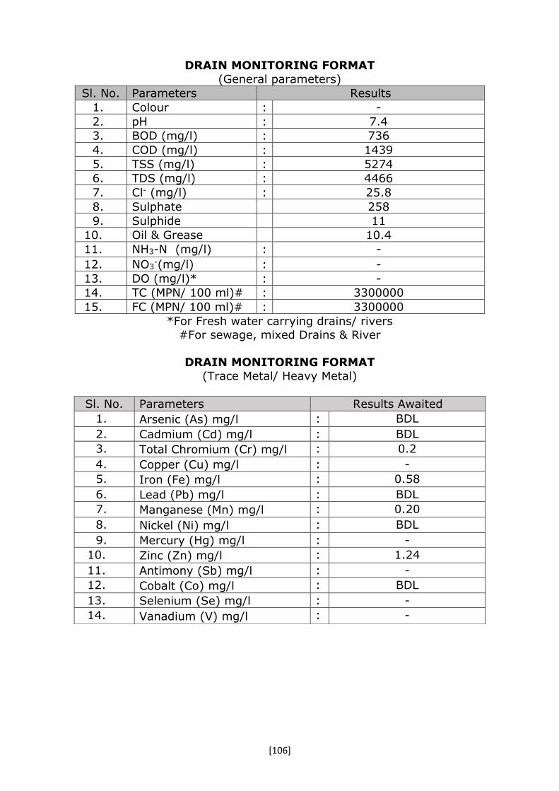
[106]
DRAIN MONITORING FORMAT
(General parameters)
Sl. No. Parameters Results
1. Colour : -
2. pH : 7.4
3. BOD (mg/l) : 736
4. COD (mg/l) : 1439
5. TSS (mg/l) : 5274
6. TDS (mg/l) : 4466
7. Cl- (mg/l) : 25.8
8. Sulphate 258
9. Sulphide 11
10. Oil & Grease 10.4
11. NH3-N (mg/l) : -
12. NO3-(mg/l) : -
13. DO (mg/l)* : -
14. TC (MPN/ 100 ml)# : 3300000
15. FC (MPN/ 100 ml)# : 3300000
*For Fresh water carrying drains/ rivers #For sewage, mixed Drains & River
DRAIN MONITORING FORMAT
(Trace Metal/ Heavy Metal)
Sl. No. Parameters Results Awaited
1. Arsenic (As) mg/l : BDL
2. Cadmium (Cd) mg/l : BDL
3. Total Chromium (Cr) mg/l : 0.2
4. Copper (Cu) mg/l : -
5. Iron (Fe) mg/l : 0.58
6. Lead (Pb) mg/l : BDL
7. Manganese (Mn) mg/l : 0.20
8. Nickel (Ni) mg/l : BDL
9. Mercury (Hg) mg/l : -
10. Zinc (Zn) mg/l : 1.24
11. Antimony (Sb) mg/l : -
12. Cobalt (Co) mg/l : BDL
13. Selenium (Se) mg/l : -
14. Vanadium (V) mg/l : -
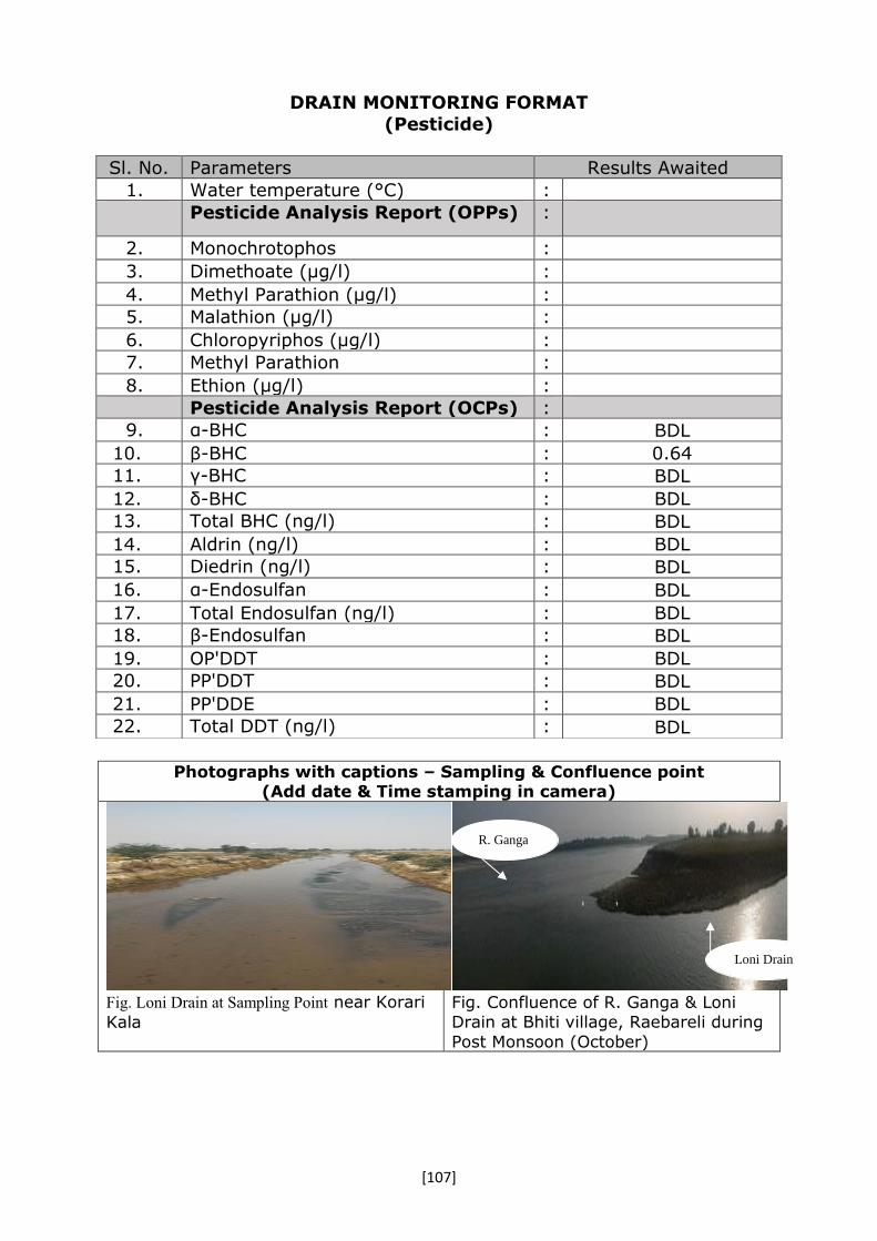
[107]
DRAIN MONITORING FORMAT
(Pesticide)
Photographs with captions – Sampling & Confluence point
(Add date & Time stamping in camera)
Fig. Loni Drain at Sampling Point near Korari
Kala
Fig. Confluence of R. Ganga & Loni Drain at Bhiti village, Raebareli during
Post Monsoon (October)
Sl. No. Parameters Results Awaited
1. Water temperature (°C) :
Pesticide Analysis Report (OPPs) :
2. Monochrotophos :
3. Dimethoate (µg/l) :
4. Methyl Parathion (µg/l) :
5. Malathion (µg/l) :
6. Chloropyriphos (µg/l) :
7. Methyl Parathion :
8. Ethion (µg/l) :
Pesticide Analysis Report (OCPs) :
9. α-BHC : BDL
10. β-BHC : 0.64
11. γ-BHC : BDL
12. δ-BHC : BDL
13. Total BHC (ng/l) : BDL
14. Aldrin (ng/l) : BDL
15. Diedrin (ng/l) : BDL
16. α-Endosulfan : BDL
17. Total Endosulfan (ng/l) : BDL
18. β-Endosulfan : BDL
19. OP'DDT : BDL
20. PP'DDT : BDL
21. PP'DDE : BDL
22. Total DDT (ng/l) : BDL
R. Ganga
Loni Drain

[108]

[109]
IV. Data Sheet of Drains Joining River Ram
Ganga.

[110]

[111]
DRAIN MONITORING FORMAT (Ramganga)
Date & Time of sampling: 02.11.2016 (17.00hrs)
14. Name of the Drain : Nohra drain (Nasia drain)
15. Meeting Ganga/Ramganga/Kali-east at - : Drain meets Ramganga at left bank
16. Name of the Regional Office of SPCB : SPCB, Bijnor
17. Source of pollution load: : (Domestic/Industrial/Mixed)- Mixed
18. If Industrial /Mixed Mixed ( but carries mostly domestic waste)
19. Traceable length (in Km) before meeting Ganga (through google earth/map)
: -
20. Catchment area Dhampur and Bijnor
21. Co-ordinate of the confluence
point (if not reachable indirect though google earth/map) (Decimal units)
Latitude : 29007’13.4’’N
Longitude 078040’0.81’’ E
Distance from confluence point (may the find out over google earth/map), KM
3 Km (approx.)
22. Co-ordinate of the sampling point (Decimal units)
Latitude : 29006’15.5’’ N 078038’52.4’’ E Longitude
23. Landmarks / Address of the Location Confluence point near Fazlabad and Rahimabad villages in chajlaut block in Moradabad District.
24. Flow (if in MLD) if zero indicate whether dry or stagnant
: 14.52
25. Observations : Since flow measurement and sampling was not possible at confluence point, it was done at nearly 3 Km away from the
confluence point. Reaching confluence point was difficult.
Confluence point falls under Moradabad district. However, drain flows mainly through Bijnor region carrying pollution
from Bijnor region. Hence, it was requested by AEE, UPPCB, Moradabad to monitor the same by Bijnor SPCB
officials.
26. Urgent action required, if any : ----
27. Name of all monitoring officers along with Designation
1. Dr Brajesh Shrivastava, Sc ‘C’, CPCB 2.Ms. Anshul Kumari, R.A., CPCB 3. Shri Vijay, AEE , UPPCB, Moradabad
4. Shri Rajeev Shrivastava A.S.O UPPCB Bijnor 5. Shri Anjani, UPPCB
6.Shri Vimal Kumar Rajpoot, S. A., UPPCB 7. Shri Bhramhanand A.E., U.P. Jal
Nigam. 8.Shri Amit, Research Officer, NMCG

[112]
DRAIN MONITORING FORMAT (General parameters)
Sl. No. Parameters Results
13. Colour : --
14. pH : 7.67
15. BOD (mg/l) : 3
16. COD (mg/l) : 19
17. TSS (mg/l) : 14
18. TDS (mg/l) : 180
19. Cl- (mg/l) : 23
20. NH3-N (mg/l) : NT
21. NO3-(mg/l) : 0.55
22. DO (mg/l)* : ---
23. TC (MPN/ 100 ml)# : 13x103
24. FC (MPN/ 100 ml)# : 33x102
*For Fresh water carrying drains/ rivers
#For sewage, mixed Drains & River
DRAIN MONITORING FORMAT
Sl. No. Parameters Results
15. Arsenic (As) mg/l : 0.01
16. Cadmium (Cd) mg/l : BDL
17. Total Chromium (Cr) mg/l : BDL
18. Copper (Cu) mg/l : BDL
19. Iron (Fe) mg/l : 0.81
20. Lead (Pb) mg/l : BDL
21. Manganese (Mn) mg/l : 0.3
22. Nickel (Ni) mg/l : BDL
23. Mercury (Hg) mg/l : -
24. Zinc (Zn) mg/l : BDL
25. Antimony (Sb) mg/l : -
26. Cobalt (Co) mg/l : BDL
27. Selenium (Se) mg/l : BDL
28. Vanadium (V) mg/l : BDL

[113]
DRAIN MONITORING FORMAT (Pesticide)
Photographs with captions – Sampling & Confluence point
(Add date & Time stamping in camera)
View of confluence point
View of sampling point
Sl. No. Parameters Results 23. Water temperature (°C) : Pesticide Analysis Report (OPPs) :
1. Monochrotophos : -
2. Dimethoate (µg/l) : BDL
3. Methyl Parathion (µg/l) : BDL 4. Malathion (µg/l) : BDL
5. Chloropyriphos (µg/l) : BDL 6. Methyl Parathion : -
7. Ethion (µg/l) : BDL
Pesticide Analysis Report (OCPs) : 1. α-HCH : BDL 2. β-HCH : BDL 3. γ-HCH : BDL 4. δ-BHC : 5. Total BHC (ng/l) :
6. Aldrin (ng/l) : BDL 7. Diedrin (ng/l) : BDL 8. α-Endosulfan : BDL 9. Total Endosulfan (ng/l) : 10. β-Endosulfan : BDL 11. OP'DDT : BDL 12. PP'DDT : BDL 13. PP'DDE : 14. Total DDT (ng/l) : BDL
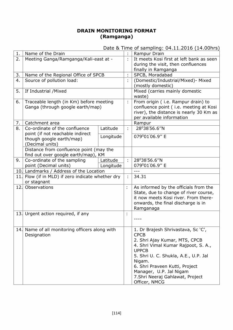
[114]
DRAIN MONITORING FORMAT
(Ramganga)
Date & Time of sampling: 04.11.2016 (14.00hrs) 1. Name of the Drain : Rampur Drain
2. Meeting Ganga/Ramganga/Kali-east at - : It meets Kosi first at left bank as seen during the visit, then confluences
finally in Ramganga
3. Name of the Regional Office of SPCB : SPCB, Moradabad
4. Source of pollution load: : (Domestic/Industrial/Mixed)- Mixed (mostly domestic)
5. If Industrial /Mixed Mixed (carries mainly domestic waste)
6. Traceable length (in Km) before meeting Ganga (through google earth/map)
: From origin ( i.e. Rampur drain) to confluence point ( i.e. meeting at Kosi
river), the distance is nearly 30 Km as per available information
7. Catchment area Rampur
8. Co-ordinate of the confluence
point (if not reachable indirect though google earth/map) (Decimal units)
Latitude : 28038’56.6’’N
Longitude 079001’06.9’’ E
Distance from confluence point (may the find out over google earth/map), KM
9. Co-ordinate of the sampling point (Decimal units)
Latitude : 28038’56.6’’N 079001’06.9’’ E Longitude
10. Landmarks / Address of the Location ---
11. Flow (if in MLD) if zero indicate whether dry or stagnant
: 34.31
12. Observations : As informed by the officials from the State, due to change of river course, it now meets Kosi river. From there-
onwards, the final discharge is in Ramganaga
13. Urgent action required, if any : ----
14. Name of all monitoring officers along with
Designation
1. Dr Brajesh Shrivastava, Sc ‘C’,
CPCB 2. Shri Ajay Kumar, MTS, CPCB 4. Shri Vimal Kumar Rajpoot, S. A.,
UPPCB 5. Shri U. C. Shukla, A.E., U.P. Jal
Nigam. 6. Shri Praveen Kutti, Project Manager, U.P. Jal Nigam
7.Shri Neeraj Gahlawat, Project Officer, NMCG
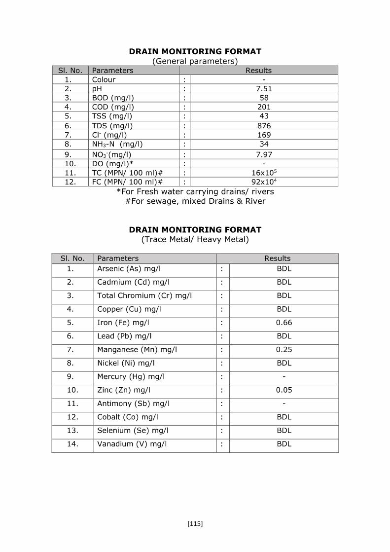
[115]
DRAIN MONITORING FORMAT
(General parameters) Sl. No. Parameters Results
1. Colour : -
2. pH : 7.51
3. BOD (mg/l) : 58
4. COD (mg/l) : 201
5. TSS (mg/l) : 43
6. TDS (mg/l) : 876
7. Cl- (mg/l) : 169
8. NH3-N (mg/l) : 34
9. NO3-(mg/l) : 7.97
10. DO (mg/l)* : -
11. TC (MPN/ 100 ml)# : 16x105
12. FC (MPN/ 100 ml)# : 92x104
*For Fresh water carrying drains/ rivers #For sewage, mixed Drains & River
DRAIN MONITORING FORMAT (Trace Metal/ Heavy Metal)
Sl. No. Parameters Results
1. Arsenic (As) mg/l : BDL
2. Cadmium (Cd) mg/l : BDL
3. Total Chromium (Cr) mg/l : BDL
4. Copper (Cu) mg/l : BDL
5. Iron (Fe) mg/l : 0.66
6. Lead (Pb) mg/l : BDL
7. Manganese (Mn) mg/l : 0.25
8. Nickel (Ni) mg/l : BDL
9. Mercury (Hg) mg/l : -
10. Zinc (Zn) mg/l : 0.05
11. Antimony (Sb) mg/l : -
12. Cobalt (Co) mg/l : BDL
13. Selenium (Se) mg/l : BDL
14. Vanadium (V) mg/l : BDL

[116]
DRAIN MONITORING FORMAT
(Pesticide)
Photographs with captions – Sampling & Confluence point (Add date & Time stamping in camera)
View of confluence point
View of sampling point
Sl. No. Parameters Results
1. Water temperature (°C) :
Pesticide Analysis Report (OPPs) :
1. Monochrotophos : -
2. Dimethoate (µg/l) : BDL
3. Methyl Parathion (µg/l) : BDL
4. Malathion (µg/l) : BDL
5. Chloropyriphos (µg/l) : BDL
6. Methyl Parathion : --
7. Ethion (µg/l) : BDL
Pesticide Analysis Report (OCPs) :
1. α-HCH : BDL
2. β-HCH : 0.075
3. γ-HCH : BDL
4. δ-HCH : -
5. Total BHC (ng/l) : -
6. Aldrin (ng/l) : BDL
7. Diedrin (ng/l) : BDL
8. α-Endosulfan : BDL
9. Total Endosulfan (ng/l) : -
10. β-Endosulfan : BDL
11. OP'DDT : BDL
12. PP'DDT : BDL
13. PP'DDE : BDL
14. Total DDT (ng/l) : -

[117]
DRAIN MONITORING FORMAT
(Ramganga)
Date & Time of sampling: 02.11.2016 (13.00hrs) 1. Name of the Drain : Moradabad drain (Karula drain)
2. Meeting Ganga/Ramganga/Kali-east at - : The drain meets Ramganga at left bank
3. Name of the Regional Office of SPCB : SPCB, Moradabad
4. Source of pollution load: : (Domestic/Industrial/Mixed)- Mixed
5. If Industrial /Mixed Mixed ( but carrying mostly domestic)
6. Traceable length (in Km) before meeting Ganga (through google earth/map)
: -----
7. Catchment area Moradabad
8. Co-ordinate of the confluence
point (if not reachable indirect though google earth/map) (Decimal units)
Latitude : 28046’19.7’’N
Longitude 078049.0’01.6’’ E
Distance from confluence point (may the find out over google earth/map), KM
9. Co-ordinate of the sampling point (Decimal units)
Latitude : 28052’51.6’’ N 078045’07.6’’ E Longitude
10. Landmarks / Address of the Location Khadakpur baje village
11. Flow (if in MLD) if zero indicate whether dry or stagnant
: 57.12
12. Observations : As reported by UPPCB officials, there are 26 drains falling into Ramganga directly. However, it was found out
that these are very small drains. Further inspection may be carried out
to see the status.
13. Urgent action required, if any : ----
14. Name of all monitoring officers along with
Designation
1. Dr Brajesh Shrivastava, Sc ‘C’, CPCB
2.Ms. Anshul Kumari, R.A., CPCB 3. Shri Vijay AEE , UPPCB, Moradabad
4.Shri Vimal Kumar Rajpoot, S. A., UPPCB 5. Shri Anil Kansal, A.E., U.P. Jal
Nigam. 6.Shri Praveen Kumar J.E U.P. Jal
Nigam 7.Shri Amit, Research Officer, NMCG

[118]
DRAIN MONITORING FORMAT
(General parameters)
Sl. No. Parameters Results
1. Colour : --
2. pH : 7.34
3. BOD (mg/l) : 44
4. COD (mg/l) : 128
5. TSS (mg/l) : 67
6. TDS (mg/l) : 548
7. Cl- (mg/l) : 123
8. NH3-N (mg/l) : 38
9. NO3-(mg/l) : 2.76
10. DO (mg/l)* : ---
11. TC (MPN/ 100 ml)# : 35x108
12. FC (MPN/ 100 ml)# : 24x107
*For Fresh water carrying drains/ rivers #For sewage, mixed Drains & River
DRAIN MONITORING FORMAT (Trace Metal/ Heavy Metal)
Sl. No. Parameters Results
1. Arsenic (As) mg/l : BDL
2. Cadmium (Cd) mg/l : BDL
3. Total Chromium (Cr) mg/l : 0.02
4. Copper (Cu) mg/l : 0.04
5. Iron (Fe) mg/l : 2.41
6. Lead (Pb) mg/l : BDL
7. Manganese (Mn) mg/l : 0.41
8. Nickel (Ni) mg/l : 0.07
9. Mercury (Hg) mg/l : -
10. Zinc (Zn) mg/l : 0.11
11. Antimony (Sb) mg/l : -
12. Cobalt (Co) mg/l : BDL
13. Selenium (Se) mg/l : BDL
14. Vanadium (V) mg/l : BDL

[119]
DRAIN MONITORING FORMAT
(Pesticide)
Photographs with captions – Sampling & Confluence point (Add date & Time stamping in camera)
View of confluence point
View of sampling point
Sl. No. Parameters Results
1. Water temperature (°C) :
Pesticide Analysis Report (OPPs) :
2. Monochrotophos : -
3. Dimethoate (µg/l) : 1.94
4. Methyl Parathion (µg/l) : BDL
5. Malathion (µg/l) : BDL
6. Chloropyriphos (µg/l) : BDL
7. Methyl Parathion : -
8. Ethion (µg/l) : BDL
Pesticide Analysis Report (OCPs) :
1. α-HCH : BDL
2. β- HCH : 0.483
3. γ- HCH : BDL
4. δ-BHC : -
5. Total BHC (ng/l) : -
6. Aldrin (ng/l) : BDL
7. Diedrin (ng/l) : BDL
8. α-Endosulfan : BDL
9. Total Endosulfan (ng/l) : -
10. β-Endosulfan : BDL
11. OP'DDT : BDL
12. PP'DDT : 0.053
13. PP'DDE : BDL
14. Total DDT (ng/l) : -
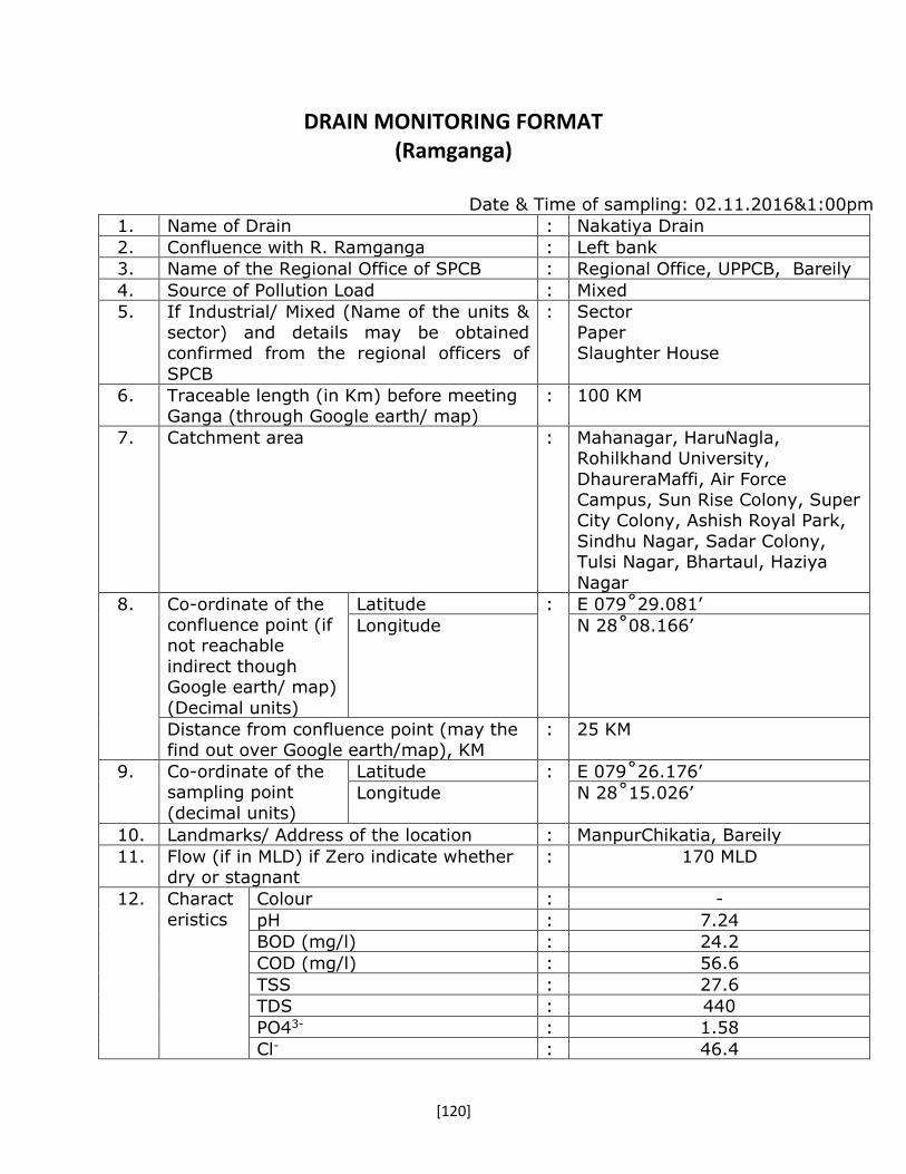
[120]
DRAIN MONITORING FORMAT (Ramganga)
Date & Time of sampling: 02.11.2016&1:00pm
1. Name of Drain : Nakatiya Drain
2. Confluence with R. Ramganga : Left bank
3. Name of the Regional Office of SPCB : Regional Office, UPPCB, Bareily
4. Source of Pollution Load : Mixed
5. If Industrial/ Mixed (Name of the units &
sector) and details may be obtained confirmed from the regional officers of
SPCB
:
Sector
Paper Slaughter House
6. Traceable length (in Km) before meeting Ganga (through Google earth/ map)
: 100 KM
7. Catchment area : Mahanagar, HaruNagla, Rohilkhand University,
DhaureraMaffi, Air Force Campus, Sun Rise Colony, Super City Colony, Ashish Royal Park,
Sindhu Nagar, Sadar Colony, Tulsi Nagar, Bhartaul, Haziya
Nagar
8. Co-ordinate of the confluence point (if not reachable
indirect though Google earth/ map)
(Decimal units)
Latitude : E 079˚29.081’
Longitude N 28˚08.166’
Distance from confluence point (may the find out over Google earth/map), KM
: 25 KM
9. Co-ordinate of the sampling point
(decimal units)
Latitude : E 079˚26.176’
Longitude N 28˚15.026’
10. Landmarks/ Address of the location : ManpurChikatia, Bareily
11. Flow (if in MLD) if Zero indicate whether dry or stagnant
: 170 MLD
12. Charact
eristics
Colour : -
pH : 7.24
BOD (mg/l) : 24.2
COD (mg/l) : 56.6
TSS : 27.6
TDS : 440
PO43- : 1.58
Cl- : 46.4

[121]
NH3-N : 15.4
NO3- : 0.4
13. Heavy
Metals
Arsenic (As) mg/l : -
Cadmium (Cd) mg/l : BDL
Total Chromium (Cr) mg/l : BDL
Copper (Cu) mg/l : 0.002
Iron (Fe) mg/l : -
Lead (Pb) mg/l : -
Manganese (Mn) mg/l : 0.21
Nickel (Ni) mg/l : -
Mercury (Hg) mg/l : -
Zinc (Zn) mg/l : 0.080
Antimony (Sb) mg/l : -
Cobalt (Co) mg/l : BDL
Selenium (Se) mg/l : -
Vanadium (V) mg/l : -
14. DO
(For Fresh water carrying drains/rivers)
: --
15. For sewage,
mixed Drains &
River
TC (MPN/100ml) : 17,000,00
FC (MPN/100ml) 17,000,00
16. Photographs with captions- Sampling & Confluence point (Add date & Time stamping in camera)
Nakatiya drain meeting R. Ramganga on its left bank at Khallpur
(AhirGautia) Village.

[122]
Sampling location of Nakatiya drain at Manpur Chikatia Village.
15. Observations : The drain touches the Bareily city on its
Eastern boundry and meets R. Ramganga on its left bank approx. 25 KM away from
Bareily cityKhallpur (AhirGautia) Village.
17. Name of all monitoring officers
along with designation
: 1. Sh. Ram Balak Singh, Scientist C,
CPCB, ZO(N) 2. Dr. Sanjay Kumar Singh, RA-I, CPCB,
ZO(N) 3. Dr. Anant Dubey, ASO, UPPCB, RO,
Bareily 4. Sh. Mohit Rai, AE, UP Jal Nigam, Bareily

[123]
DRAIN MONITORING FORMAT (Ramganga)
Date & Time of sampling: 02.11.2016& 3:00pm
1. Name of Drain : Chawari (Chaubari) Drain
3. Confluence with R. Ramganga : Left bank
4. Name of the Regional Office of
SPCB
: Regional Office,UPPCB, Bareilly
5. Source of Pollution Load : Domestic
6. If Industrial/ Mixed (Name of the
units & sector) and details may be obtained confirmed from the
regional officers of SPCB
:
N.A
7. Traceable length (in Km) before
meeting Ganga (through Google earth/ map)
: Approx. 20 KM
8. Catchment area : Subhash Nagar, Kargaina, Kareilly, Veer Bhatti
9. Co-ordinate of the confluence point (if
not reachable indirect though Google earth/
map) (Decimal units)
Latitude : E 079˚25.851’
Longitude N 28˚12.310’
Distance from confluence point
(may the find out over Google earth/map), KM
: Approx. 15 KM
10. Co-ordinate of the
sampling point (decimal units)
Latitude : N 28˚17.690’
Longitude E 079˚23.562’
11. Landmarks/ Address of the location : Near Chaubari Village, on Bareily-Budaun Road
12. Flow (if in MLD) if Zero indicate whether dry or stagnant
: 18.82
13.
Characteristics Colour : -
pH : 7.31
BOD (mg/l) : 25.8
COD (mg/l) : 72.5
TSS : 17.3
TDS : 710
PO43- : 2.94
Cl- : 43.7
NH3-N : 21
NO3- : 0.2

[124]
14 Heavy Metals Arsenic (As) mg/l -
Cadmium (Cd) mg/l
BDL
Total Chromium (Cr) mg/l
BDL
Copper (Cu) mg/l BDL
Iron (Fe) mg/l -
Lead (Pb) mg/l -
Manganese (Mn) mg/l
0.252
Nickel (Ni) mg/l -
Mercury (Hg) mg/l -
Zinc (Zn) mg/l 0.054
Antimony (Sb) mg/l
-
Cobalt (Co) mg/l 0.030
Selenium (Se) mg/l
-
Vanadium (V) mg/l
-
DO (For Fresh water carrying drains/rivers)
: -
For sewage, mixed Drains
& River
TC (MPN/100ml) : 490000
FC (MPN/100ml) 490000
15. Photographs with captions- Sampling & Confluence point (Add date & Time stamping in camera)
Chawari (Chaubari) drain meeting R. Ramganga on its left bank at Gomidpur Village.

[125]
Sampling location of Chawari (Chaubari) drain at Chaubari Village.
16. Observations : The drain originates from the
Southern part of Bareily city and meets R. Ramganga on its left bank
approx. 15 KM away from Bareily city at Gomidpur Village.
17. Name of all monitoring officers along with designation
: 5. Sh. Ram Balak Singh, Scientist C, CPCB, ZO(N)
6. Dr. Sanjay Kumar Singh, RA-I, CPCB, ZO(N)
7. Dr. Anant Dubey, ASO, UPPCB, RO, Bareily
8. Sh. Mohit Rai, AE, UP Jal Nigam, Bareily

[126]
DRAIN MONITORING FORMAT (Ramganga)
Date & Time of sampling: 01.11.2016& 4:00 pm
1. Name of Drain : Devraniya Drain
3. Confluence with R. Ramganga : Left bank
4. Name of the Regional Office of SPCB : Regional Office,UPPCB, Bareily
5. Source of Pollution Load : Mixed
6. If Industrial/ Mixed (Name of the units &
sector) and details may be obtained confirmed from the regional officers of SPCB
: Sector
Chemical Agro based
7. Traceable length (in Km) before meeting Ganga (through Google earth/ map)
: Approx. 130 KM
8. Catchment area : Durga Nagar, City railway Colony, Katghar, Beharipur,
Gulab Nagar, Alamgiriganj, Gangapur, Shrinath Puram, Shiv Vihar Colony, Asha Vihar Colony,
Shastri Nagar, Gandhi Puram, Karmchary Nagar, Greater
Akash Colony, BDA Colony, Ram Nagar, Raza Nagar, AnandVihar, Shikarpur, Chowki
Ashraf, Maula Nagar, Civil Lines, Englishganj, CheepiTola,
Bakarganj
9. Co-ordinate of the confluence
point (if not reachable indirect though Google earth/ map) (Decimal units)
Latitude : E 079˚22.260’
Longitude
N 28˚19.739’
Distance from confluence point (may the find out over Google earth/map), KM
: Approx. 5 KM
10.
Co-ordinate of the sampling point (decimal units)
Latitude : E 079˚22.702’
Longitude
N 28˚20.975’
11.
Landmarks/ Address of the location : Sarai Talfi Village, Bareily
12.
Flow (if in MLD) if Zero indicate whether dry or stagnant
: 398 MLD
13.
Characteristics Colour : -
pH : 6.99
BOD (mg/l) : 40.2
COD (mg/l) : 169
TSS : 104
TDS : 393
PO43- : 1.13

[127]
Cl- : 28.2
NH3-N : 8.38
NO3- : 0.6
14 Heavy Metals Arsenic (As) mg/l -
Cadmium (Cd) mg/l BDL
Total Chromium (Cr) mg/l
0.034
Copper (Cu) mg/l 0.008
Iron (Fe) mg/l
Lead (Pb) mg/l
Manganese (Mn) mg/l 0.086
Nickel (Ni) mg/l -
Mercury (Hg) mg/l -
Zinc (Zn) mg/l 0.058
Antimony (Sb) mg/l -
Cobalt (Co) mg/l BDL
Selenium (Se) mg/l -
Vanadium (V) mg/l -
For Fresh water
carrying drains/rivers
DO : -
For sewage, mixed
Drains & River
TC (MPN/100ml) : 2,20,00,000
FC (MPN/100ml) 1,70,00,000
15.
Photographs with captions- Sampling & Confluence point (Add date & Time stamping in camera)
:
Devraniya drain meeting R. Ramganga on its left bank at ViryaNarainpur Village.

[128]
Sampling location of Devraniya drain at Sarai Talfi Village.
16.
Observations : The drain touches the Bareily city on its Western boundry and meets R. Ramganga on its left
bank approx. 05 KM away from Bareily city at ViryaNarainpur
Village.
17
.
Name of all monitoring officers along with
designation
: 9. Sh. Ram Balak Singh,
Scientist C, CPCB, ZO(N) 10. Dr. Sanjay Kumar Singh,
RA-I, CPCB, ZO(N)
11. Dr. Anant Dubey, ASO, UPPCB, RO, Bareily
12. Sh. Mohit Rai, AE, UP Jal Nigam, Bareily
[129]
V. Data Sheet of Drains Joining River Kali East.

[130]
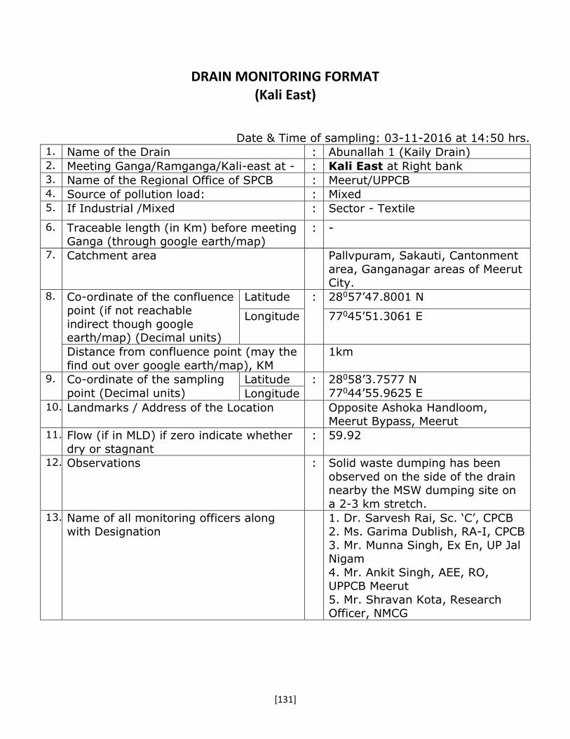
[131]
DRAIN MONITORING FORMAT (Kali East)
Date & Time of sampling: 03-11-2016 at 14:50 hrs. 1. Name of the Drain : Abunallah 1 (Kaily Drain) 2. Meeting Ganga/Ramganga/Kali-east at - : Kali East at Right bank 3. Name of the Regional Office of SPCB : Meerut/UPPCB 4. Source of pollution load: : Mixed 5. If Industrial /Mixed : Sector - Textile
6. Traceable length (in Km) before meeting Ganga (through google earth/map)
: -
7. Catchment area Pallvpuram, Sakauti, Cantonment
area, Ganganagar areas of Meerut City.
8. Co-ordinate of the confluence point (if not reachable
indirect though google earth/map) (Decimal units)
Latitude : 28057’47.8001 N
Longitude 77045’51.3061 E
Distance from confluence point (may the
find out over google earth/map), KM
1km
9. Co-ordinate of the sampling
point (Decimal units)
Latitude : 28058’3.7577 N
77044’55.9625 E Longitude 10. Landmarks / Address of the Location Opposite Ashoka Handloom,
Meerut Bypass, Meerut 11. Flow (if in MLD) if zero indicate whether
dry or stagnant
: 59.92
12. Observations : Solid waste dumping has been
observed on the side of the drain nearby the MSW dumping site on
a 2-3 km stretch. 13. Name of all monitoring officers along
with Designation 1. Dr. Sarvesh Rai, Sc. ‘C’, CPCB
2. Ms. Garima Dublish, RA-I, CPCB
3. Mr. Munna Singh, Ex En, UP Jal Nigam
4. Mr. Ankit Singh, AEE, RO, UPPCB Meerut
5. Mr. Shravan Kota, Research Officer, NMCG
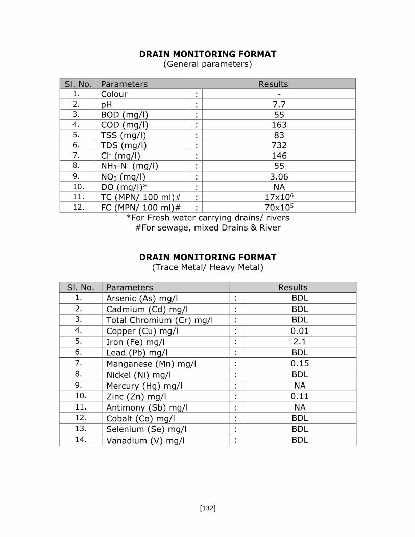
[132]
DRAIN MONITORING FORMAT
(General parameters)
Sl. No. Parameters Results 1. Colour : - 2. pH : 7.7 3. BOD (mg/l) : 55 4. COD (mg/l) : 163 5. TSS (mg/l) : 83 6. TDS (mg/l) : 732 7. Cl- (mg/l) : 146 8. NH3-N (mg/l) : 55
9. NO3-(mg/l) : 3.06
10. DO (mg/l)* : NA 11. TC (MPN/ 100 ml)# : 17x106 12. FC (MPN/ 100 ml)# : 70x105
*For Fresh water carrying drains/ rivers
#For sewage, mixed Drains & River
DRAIN MONITORING FORMAT
(Trace Metal/ Heavy Metal)
Sl. No. Parameters Results 1. Arsenic (As) mg/l : BDL
2. Cadmium (Cd) mg/l : BDL 3. Total Chromium (Cr) mg/l : BDL
4. Copper (Cu) mg/l : 0.01 5. Iron (Fe) mg/l : 2.1
6. Lead (Pb) mg/l : BDL 7. Manganese (Mn) mg/l : 0.15
8. Nickel (Ni) mg/l : BDL
9. Mercury (Hg) mg/l : NA 10. Zinc (Zn) mg/l : 0.11
11. Antimony (Sb) mg/l : NA 12. Cobalt (Co) mg/l : BDL
13. Selenium (Se) mg/l : BDL 14. Vanadium (V) mg/l : BDL
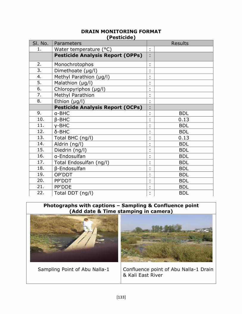
[133]
DRAIN MONITORING FORMAT
(Pesticide)
Photographs with captions – Sampling & Confluence point (Add date & Time stamping in camera)
Sampling Point of Abu Nalla-1
Confluence point of Abu Nalla-1 Drain & Kali East River
Sl. No. Parameters Results 1. Water temperature (°C) : Pesticide Analysis Report (OPPs) :
2. Monochrotophos :
3. Dimethoate (µg/l) :
4. Methyl Parathion (µg/l) : 5. Malathion (µg/l) :
6. Chloropyriphos (µg/l) : 7. Methyl Parathion :
8. Ethion (µg/l) :
Pesticide Analysis Report (OCPs) : 9. α-BHC : BDL
10. β-BHC : 0.13 11. γ-BHC : BDL
12. δ-BHC : BDL 13. Total BHC (ng/l) : 0.13
14. Aldrin (ng/l) : BDL 15. Diedrin (ng/l) : BDL
16. α-Endosulfan : BDL
17. Total Endosulfan (ng/l) : BDL 18. β-Endosulfan : BDL
19. OP'DDT : BDL 20. PP'DDT : BDL
21. PP'DDE : BDL 22. Total DDT (ng/l) : BDL

[134]
DRAIN MONITORING FORMA
(Kali East)
Date & Time of sampling: 03-11-2016 at 13:12 hrs. 1. Name of the Drain : Abu Nalla -2 (Main Abu Nalla) 2. Meeting Kali East at - : Kali East at Right bank 3. Name of the Regional Office of SPCB : Meerut/UPPCB 4. Source of pollution load: : Mixed 5. If Industrial /Mixed (Sector) : Brewery
6. Traceable length (in Km) before meeting
Ganga (through google earth/map)
:
7. Catchment area Meerut City 8. Co-ordinate of the confluence
point (if not reachable
indirect though google
earth/map) (Decimal units)
Latitude : 28054’58.3291’’ N
Longitude 77044’38.2469’’ E
Distance from confluence point (may the
find out over google earth/map), KM
1 km
9. Co-ordinate of the sampling
point (Decimal units)
Latitude : 28056’19.56” N
77045’12.94” E Longitude 10. Landmarks / Address of the Location On outer ring road near upcoming
72 mld STP, Meerut 11. Flow (if in MLD) if zero indicate whether
dry or stagnant
: 243.64
12. Observations : Confluence point was traced at a
distance of about 1.5 km through shrubs and hick vegetation area.
13. Name of all monitoring officers along
with Designation 1. Dr. Sarvesh Rai, Sc. ‘C’, CPCB
2. Ms. Garima Dublish, RA-I, CPCB
3. Mr. Munna Singh, Ex En, UP Jal Nigam
4. Mr. Ankit Singh, AEE, RO, UPPCB Meerut
5. Mr. Shravan Kota, Research Officer, NMCG

[135]
DRAIN MONITORING FORMAT (General parameters)
Sl. No. Parameters Results 1. Colour : - 2. pH : 7.4 3. BOD (mg/l) : 51 4. COD (mg/l) : 332 5. TSS (mg/l) : 192 6. TDS (mg/l) : 624 7. Cl- (mg/l) : 75 8. NH3-N (mg/l) : 26
9. NO3-(mg/l) : 4.7
10. DO (mg/l)* : NA 11. TC (MPN/ 100 ml)# : 70x106 12. FC (MPN/ 100 ml)# : 46x106
*For Fresh water carrying drains/ rivers
#For sewage, mixed Drains & River
DRAIN MONITORING FORMAT
(Trace Metal/ Heavy Metal)
Sl. No. Parameters Results 1. Arsenic (As) mg/l : BDL
2. Cadmium (Cd) mg/l : BDL 3. Total Chromium (Cr) mg/l : BDL
4. Copper (Cu) mg/l : 0.03 5. Iron (Fe) mg/l : 1.8
6. Lead (Pb) mg/l : BDL 7. Manganese (Mn) mg/l : 0.17
8. Nickel (Ni) mg/l : 0.02
9. Mercury (Hg) mg/l : NA 10. Zinc (Zn) mg/l : 0.15
11. Antimony (Sb) mg/l : NA 12. Cobalt (Co) mg/l : BDL
13. Selenium (Se) mg/l : BDL 14. Vanadium (V) mg/l : BDL

[136]
DRAIN MONITORING FORMAT
(Pesticide)
Photographs with captions – Sampling & Confluence point
(Add date & Time stamping in camera)
Confluence point of Abu Nalla-2 Drain
and Kali East River
Water withdrawn for irrigation from
Abu Nalla-2
Sl. No. Parameters Results 1. Water temperature (°C) : Pesticide Analysis Report (OPPs) :
2. Monochrotophos :
3. Dimethoate (µg/l) :
4. Methyl Parathion (µg/l) : 5. Malathion (µg/l) :
6. Chloropyriphos (µg/l) : 7. Methyl Parathion :
8. Ethion (µg/l) :
Pesticide Analysis Report (OCPs) : 9. α-BHC : BDL
10. β-BHC : 0.052 11. γ-BHC : BDL
12. δ-BHC : BDL 13. Total BHC (ng/l) : 0.369
14. Aldrin (ng/l) : BDL 15. Diedrin (ng/l) : BDL
16. α-Endosulfan : BDL
17. Total Endosulfan (ng/l) : BDL 18. β-Endosulfan : BDL
19. OP'DDT : 0.177 20. PP'DDT : BDL
21. PP'DDE : BDL 22. Total DDT (ng/l) : 0.177

[137]
DRAIN MONITORING FORMA (Kali East)
Date & Time of sampling: 03-11-2016 at 12:00 hrs.
1. Name of the Drain : Odean Nallah (Slaughter House
Drain) 2. Meeting Kali Eeast at - : Kali East at Right bank 3. Name of the Regional Office of SPCB : Meerut/UPPCB 4. Source of pollution load: : Mixed 5. If Industrial /Mixed : Illegal Slaughtering
6. Traceable length (in Km) before meeting Ganga (through google earth/map)
: -
7. Catchment area Meerut city 8. Co-ordinate of the confluence
point (if not reachable
indirect though google earth/map) (Decimal units)
Latitude : 28055’35.35’’ N
Longitude 77045’23.00’’ E
Distance from confluence point (may the
find out over google earth/map), KM
1.5 km
9. Co-ordinate of the sampling
point (Decimal units)
Latitude : 28055’56.8861’’ N
77044’59.4781’’ E Longitude 10. Landmarks / Address of the Location 11. Flow (if in MLD) if zero indicate whether
dry or stagnant
: 174.95
12. Observations : Adjacent farmlands are being irrigated by the drain water.
13. Name of all monitoring officers along with Designation
1. Dr. Sarvesh Rai, Sc. ‘C’, CPCB 2. Ms. Garima Dublish, RA-I, CPCB
3. Mr. Munna Singh, Ex En, UP Jal Nigam
4. Mr. Ankit Singh, AEE, RO,
UPPCB Meerut 5. Mr. Shravan Kota, Research
Officer, NMCG

[138]
DRAIN MONITORING FORMAT
(General parameters)
Sl. No. Parameters Results 1. Colour : - 2. pH : 7.3 3. BOD (mg/l) : 182 4. COD (mg/l) : 763 5. TSS (mg/l) : 565 6. TDS (mg/l) : 864 7. Cl- (mg/l) : 178 8. NH3-N (mg/l) : 47
9. NO3-(mg/l) : 10.29
10. DO (mg/l)* : NA 11. TC (MPN/ 100 ml)# : 35x106 12. FC (MPN/ 100 ml)# : 24x105
*For Fresh water carrying drains/ rivers
#For sewage, mixed Drains & River
DRAIN MONITORING FORMAT
(Trace Metal/ Heavy Metal)
Sl. No. Parameters Results 1. Arsenic (As) mg/l : BDL
2. Cadmium (Cd) mg/l : 0.05
3. Total Chromium (Cr) mg/l : 0.1
4. Copper (Cu) mg/l : 0.11
5. Iron (Fe) mg/l : 5
6. Lead (Pb) mg/l : 0.03
7. Manganese (Mn) mg/l : 0.36
8. Nickel (Ni) mg/l : 0.07
9. Mercury (Hg) mg/l : NA
10. Zinc (Zn) mg/l : 0.41
11. Antimony (Sb) mg/l : NA
12. Cobalt (Co) mg/l : BDL
13. Selenium (Se) mg/l : BDL
14. Vanadium (V) mg/l : BDL

[139]
DRAIN MONITORING FORMAT (Pesticide)
Photographs with captions – Sampling & Confluence point
(Add date & Time stamping in camera)
Sampling point of Odean Drain
Confluence point of Odean Drain &
Kali East River
Sl. No. Parameters Results 1. Water temperature (°C) : Pesticide Analysis Report (OPPs) :
2. Monochrotophos :
3. Dimethoate (µg/l) :
4. Methyl Parathion (µg/l) : 5. Malathion (µg/l) :
6. Chloropyriphos (µg/l) : 7. Methyl Parathion :
8. Ethion (µg/l) :
Pesticide Analysis Report (OCPs) : 9. α-BHC : BDL
10. β-BHC : 0.894 11. γ-BHC : BDL
12. δ-BHC : BDL 13. Total BHC (ng/l) : 0.894
14. Aldrin (ng/l) : BDL 15. Diedrin (ng/l) : BDL
16. α-Endosulfan : BDL
17. Total Endosulfan (ng/l) : BDL 18. β-Endosulfan : BDL
19. OP'DDT : 0.261 20. PP'DDT : BDL
21. PP'DDE : BDL 22. Total DDT (ng/l) : 0.261

[140]
DRAIN MONITORING FORM
(Kali-East)
Date & Time of sampling: 04.11.2016 (20.00hrs) 1. Name of the Drain : Chhoiya Drain 2. Meeting Ganga/Ramganga/Kali-east at - : Drain meets Kali-east at left bank 3. Name of the Regional Office of SPCB : SPCB, Ghaziabad 4. Source of pollution load: : (Domestic/Industrial/Mixed)-
Mixed 5. If Industrial /Mixed (name of the units
& sector) and details may be obtained
confirmed from the regional officers of
SPCB
Mixed
6. Traceable length (in Km) before meeting
Ganga (through google earth/map)
: -
7. Catchment area Merrut and Mawana 8. Co-ordinate of the
confluence point (if not reachable indirect though
google earth/map) (Decimal units)
Latitude :
-
Longitude -
Distance from confluence point (may the
find out over google earth/map), KM
Approx. 8 km
9. Co-ordinate of the sampling
point (Decimal units)
Latitude : 28038’56.6’’N
079001’06.9’’ E Longitude 10. Landmarks / Address of the Location Bachrauta village, near Babugarh
cant. In Ghaziabad district 11. Flow (if in MLD) if zero indicate whether
dry or stagnant : Could not be measured
12. Observations : Due to darkness ( 8 PM) and non-
feasibility of the site, flow could not be measured.
13. Urgent action required, if any : ---
14. Name of all monitoring officers along
with Designation 1.Dr. Brajesh Shrivastava
2. Shri Neeraj Gahlawat, P.O.,
NMCG 3. Shri Ajay Sharma, MTS, CPCB
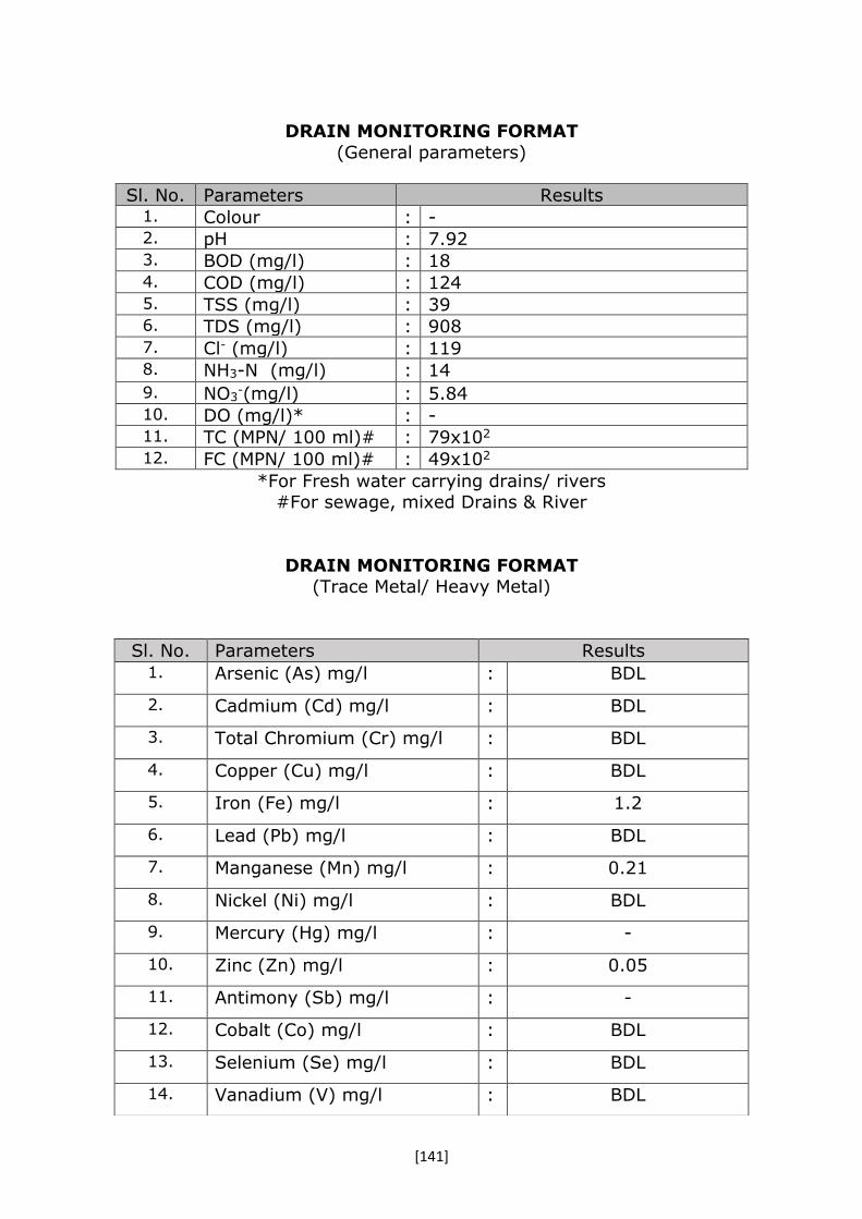
[141]
DRAIN MONITORING FORMAT
(General parameters)
Sl. No. Parameters Results 1. Colour : - 2. pH : 7.92 3. BOD (mg/l) : 18 4. COD (mg/l) : 124 5. TSS (mg/l) : 39 6. TDS (mg/l) : 908 7. Cl- (mg/l) : 119 8. NH3-N (mg/l) : 14
9. NO3-(mg/l) : 5.84
10. DO (mg/l)* : - 11. TC (MPN/ 100 ml)# : 79x102 12. FC (MPN/ 100 ml)# : 49x102
*For Fresh water carrying drains/ rivers #For sewage, mixed Drains & River
DRAIN MONITORING FORMAT (Trace Metal/ Heavy Metal)
Sl. No. Parameters Results 1. Arsenic (As) mg/l : BDL
2. Cadmium (Cd) mg/l : BDL
3. Total Chromium (Cr) mg/l : BDL
4. Copper (Cu) mg/l : BDL
5. Iron (Fe) mg/l : 1.2
6. Lead (Pb) mg/l : BDL
7. Manganese (Mn) mg/l : 0.21
8. Nickel (Ni) mg/l : BDL
9. Mercury (Hg) mg/l : -
10. Zinc (Zn) mg/l : 0.05
11. Antimony (Sb) mg/l : -
12. Cobalt (Co) mg/l : BDL
13. Selenium (Se) mg/l : BDL
14. Vanadium (V) mg/l : BDL

[142]
DRAIN MONITORING FORMAT (Pesticide)
Photographs with captions – Sampling & Confluence point
(Add date & Time stamping in camera)
Photographs are not clear due to darkness ( It was around 8 PM when the
visit was conducted)
Sl. No. Parameters Results 1. Water temperature (°C) : Pesticide Analysis Report (OPPs) :
2. Monochrotophos : -
3. Dimethoate (µg/l) : BDL
4. Methyl Parathion (µg/l) : BDL 5. Malathion (µg/l) : BDL
6. Chloropyriphos (µg/l) : BDL 7. Ethion (µg/l) : BDL
Pesticide Analysis Report (OCPs) : 8. α-HCH : BDL
9. β-HCH : 0.144 10. γ-HCH : BDL
11. δ-BHC : - 12. Total BHC (ng/l) : -
13. Aldrin (ng/l) : BDL 14. Diedrin (ng/l) : BDL
15. α-Endosulfan : BDL
16. Total Endosulfan (ng/l) : - 17. β-Endosulfan : BDL
18. OP'DDT : BDL 19. PP'DDT : 0.080
20. PP'DDE : BDL 21. Total DDT (ng/l) : -
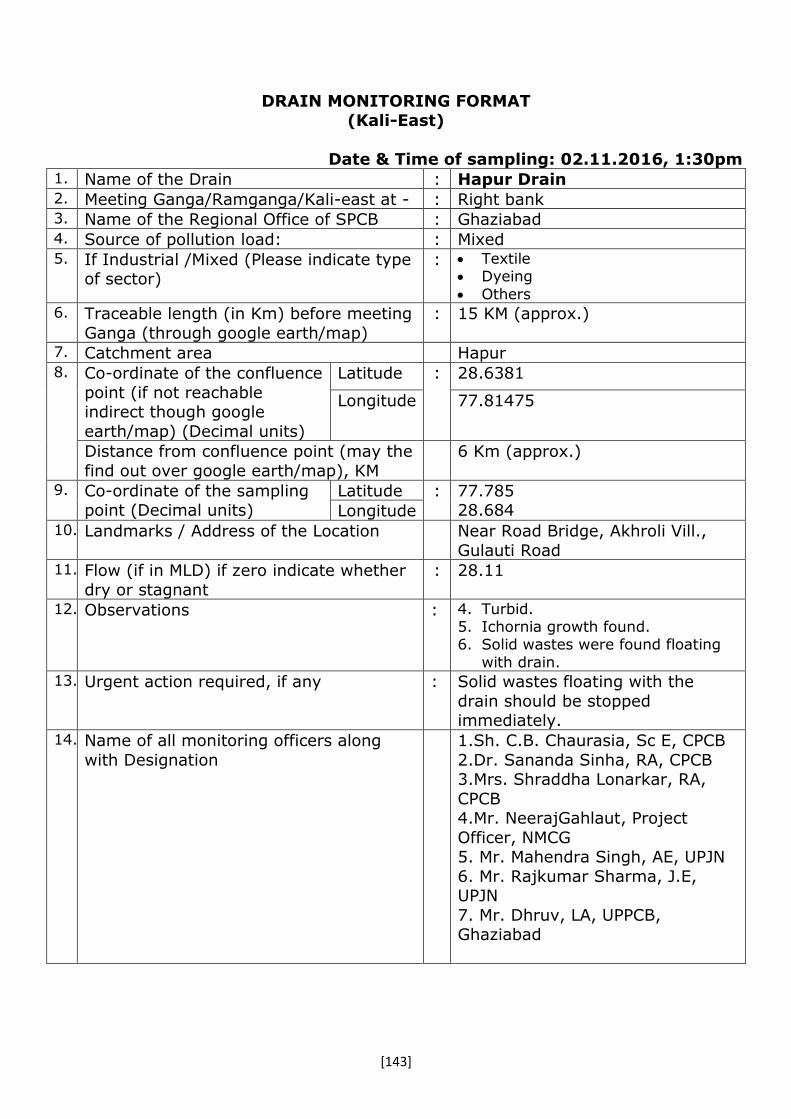
[143]
DRAIN MONITORING FORMAT (Kali-East)
Date & Time of sampling: 02.11.2016, 1:30pm
1. Name of the Drain : Hapur Drain 2. Meeting Ganga/Ramganga/Kali-east at - : Right bank 3. Name of the Regional Office of SPCB : Ghaziabad 4. Source of pollution load: : Mixed 5. If Industrial /Mixed (Please indicate type
of sector) : Textile
Dyeing
Others
6. Traceable length (in Km) before meeting
Ganga (through google earth/map)
: 15 KM (approx.)
7. Catchment area Hapur 8. Co-ordinate of the confluence
point (if not reachable indirect though google
earth/map) (Decimal units)
Latitude : 28.6381
Longitude 77.81475
Distance from confluence point (may the
find out over google earth/map), KM
6 Km (approx.)
9. Co-ordinate of the sampling point (Decimal units)
Latitude : 77.785 28.684 Longitude
10. Landmarks / Address of the Location Near Road Bridge, Akhroli Vill.,
Gulauti Road 11. Flow (if in MLD) if zero indicate whether
dry or stagnant
: 28.11
12. Observations : 4. Turbid. 5. Ichornia growth found. 6. Solid wastes were found floating
with drain.
13. Urgent action required, if any : Solid wastes floating with the
drain should be stopped immediately.
14. Name of all monitoring officers along
with Designation
1.Sh. C.B. Chaurasia, Sc E, CPCB
2.Dr. Sananda Sinha, RA, CPCB 3.Mrs. Shraddha Lonarkar, RA,
CPCB 4.Mr. NeerajGahlaut, Project
Officer, NMCG 5. Mr. Mahendra Singh, AE, UPJN
6. Mr. Rajkumar Sharma, J.E, UPJN
7. Mr. Dhruv, LA, UPPCB, Ghaziabad

[144]
DRAIN MONITORING FORMAT (General parameters)
Sl. No. Parameters Results 1. Colour : NA 2. pH : 7.52 3. BOD (mg/l) : 140 4. COD (mg/l) : 300 5. TSS (mg/l) : 230 6. TDS (mg/l) : 976 7. Cl- (mg/l) : 260 8. NH3-N (mg/l) : 38
9. NO3-(mg/l) : 3.91
10. DO (mg/l)* : NIL 11. TC (MPN/ 100 ml)# : 17x105 12. FC (MPN/ 100 ml)# : 17x105
*For Fresh water carrying drains/ rivers
#For sewage, mixed Drains & River
DRAIN MONITORING FORMAT
(Trace Metal/ Heavy Metal)
Sl. No. Parameters Results 1. Arsenic (As) mg/l : BDL
2. Cadmium (Cd) mg/l : BDL
3. Total Chromium (Cr) mg/l : 0.01
4. Copper (Cu) mg/l : 0.04
5. Iron (Fe) mg/l : 2.94
6. Lead (Pb) mg/l : 0.02
7. Manganese (Mn) mg/l : 0.24
8. Nickel (Ni) mg/l : BDL
9. Mercury (Hg) mg/l : NA
10. Zinc (Zn) mg/l : 0.10
11. Antimony (Sb) mg/l : NA
12. Cobalt (Co) mg/l : BLD
13. Selenium (Se) mg/l : BDL
14. Vanadium (V) mg/l : BDL

[145]
DRAIN MONITORING FORMAT (Pesticide)
Photographs with captions – Sampling & Confluence point (Add date & Time stamping in camera)
Drain View Sampling Location
*confluence was non approachable due to heavy growth of grasses
Sl. No. Parameters Results 1. Water temperature (°C) : Pesticide Analysis Report (OPPs) :
2. Monochrotophos : -
3. Dimethoate (µg/l) : BDL 4. Methyl Parathion (µg/l) : BDL 5. Malathion (µg/l) : BDL 6. Chloropyriphos (µg/l) : BDL 7. Methyl Parathion : BDL 8. Ethion (µg/l) : BDL
Pesticide Analysis Report (OCPs) : 9. α-BHC : BDL
10. β-BHC : 0.369(µg/L) 11. γ-BHC : BDL
12. δ-BHC : - 13. Total BHC (ng/l) : 0.369(µg/L) 14. Aldrin (ng/l) : BDL 15. Diedrin (ng/l) : BDL 16. α-Endosulfan : BDL 17. Total Endosulfan (ng/l) : BDL 18. β-Endosulfan : BDL 19. OP'DDT : BDL 20. PP'DDT : 0.241(µg/L)
21. PP'DDE : BDL 22. Total DDT (ng/l) : 0.241(µg/L)

[146]
DRAIN MONITORING FORMAT (Kali -East)
Date & Time of sampling: 02.11.2016, 11:20 am
1. Name of the Drain : Hapur Drain-1 2. Meeting Kali-east at - : Right bank – Kali-East 3. Name of the Regional Office of SPCB : Ghaziabad 4. Source of pollution load: : Mixed 5. If Industrial /Mixed (Please indicate type
of sector) : Textile
Dyeing
Others
6. Traceable length (in Km) before meeting
Ganga (through google earth/map)
: 4 KM (approx.)
7. Catchment area Hapur 8. Co-ordinate of the confluence
point (if not reachable indirect though google
earth/map) (Decimal units)
Latitude : 77.830
Longitude 28.726
Distance from confluence point (may the find out over google earth/map), KM
100 meter before the confluence
9. Co-ordinate of the sampling point (Decimal units)
Latitude : 77.830 28.726 Longitude
10. Landmarks / Address of the Location At road bridge near PWD Office
Babugarh vill. , Hapur 11. Flow (if in MLD) if zero indicate whether
dry or stagnant
: 4.60
12. Observations : 7. Turbid. 8. Ichornia growth found. 9. Solid wastes were found floating
with drain.
13. Urgent action required, if any : Solid wastes floating with the
drain should be stopped
immediately. 14. Name of all monitoring officers along
with Designation
1.Sh. C.B. Chaurasia, Sc. E, CPCB
2.Dr. Sananda Sinha, RA, CPCB 3.Mrs. Shraddha Lonarkar, RA,
CPCB 4.Mr. Neeraj Gahlaut, Project
Officer, NMCG 5. Mr. Mahendra Singh, AE, UPJN
6. Mr. Rajkumar Sharma, J.E,
UPJN 7. Mr. Dhruv, LA, UPPCB,
Ghaziabad

[147]
DRAIN MONITORING FORMAT (General parameters)
Sl. No. Parameters Results 1. Colour : NA 2. pH : 7.78 3. BOD (mg/l) : 41 4. COD (mg/l) : 114 5. TSS (mg/l) : 41 6. TDS (mg/l) : 784 7. Cl- (mg/l) : 192 8. NH3-N (mg/l) : 43
9. NO3-(mg/l) : 3.85
10. DO (mg/l)* : NIL 11. TC (MPN/ 100 ml)# : 13x108 12. FC (MPN/ 100 ml)# : 79x107
*For Fresh water carrying drains/ rivers
#For sewage, mixed Drains & River
DRAIN MONITORING FORMAT
(Trace Metal/ Heavy Metal)
Sl. No. Parameters Results 1. Arsenic (As) mg/l : BDL
2. Cadmium (Cd) mg/l : BDL
3. Total Chromium (Cr) mg/l : 0.02
4. Copper (Cu) mg/l : BDL
5. Iron (Fe) mg/l : 0.66
6. Lead (Pb) mg/l : BDL
7. Manganese (Mn) mg/l : 0.31
8. Nickel (Ni) mg/l : BDL
9. Mercury (Hg) mg/l : NA
10. Zinc (Zn) mg/l : 0.02
11. Antimony (Sb) mg/l : NA
12. Cobalt (Co) mg/l : BDL
13. Selenium (Se) mg/l : BDL
14. Vanadium (V) mg/l : BDL

[148]
DRAIN MONITORING FORMAT (Pesticide)
Photographs with captions – Sampling & Confluence point
(Add date & Time stamping in camera)
Sampling location Confluence with Kali -east
Sl. No. Parameters Results 1. Water temperature (°C) : Pesticide Analysis Report (OPPs) :
2. Monochrotophos : -
3. Dimethoate (µg/l) : BDL 4. Methyl Parathion (µg/l) : BDL 5. Malathion (µg/l) : BDL 6. Chloropyriphos (µg/l) : BDL 7. Methyl Parathion : BDL 8. Ethion (µg/l) : BDL
Pesticide Analysis Report (OCPs) : 9. α-BHC : BDL
10. β-BHC : 0.136(µg/l) 11. γ-BHC : BDL
12. δ-BHC : - 13. Total BHC (ng/l) : 0.136(µg/l) 14. Aldrin (ng/l) : BDL 15. Diedrin (ng/l) : BDL 16. α-Endosulfan : BDL 17. Total Endosulfan (ng/l) : BDL 18. β-Endosulfan : BDL 19. OP'DDT : BDL 20. PP'DDT : 0.156(µg/l)
21. PP'DDE : BDL 22. Total DDT (ng/l) : 0.156(µg/l)

[149]
DRAIN MONITORING FORMAT (Kali -East)
Date & Time of sampling: 20.10.2016, 1:00 PM
1. Name of the Drain : Kadarabad Drain 2. Meeting Kali-east at - : Right bank - Kali-East 3. Name of the Regional Office of SPCB : Ghaziabad 4. Source of pollution load: : Mixed 5. If Industrial /Mixed (Please indicate type
of sector) : Dyeing & Textile
6. Traceable length of drain (in Km) before meeting Ganga (through google
earth/map)
: Approx. 35 km
7. Catchment area Modinagar and Meerut 8. Co-ordinate of the confluence
point (if not reachable indirect though google
earth/map) (Decimal units)
Latitude : 28.63105
Longitude 77.8124
Distance from confluence point (may the find out over google earth/map), KM
1 km before confluence with river Kali-East
9. Co-ordinate of the sampling point (Decimal units)
Latitude : 28.6353 77.80482
Longitude
10. Landmarks / Address of the Location After D/s of village Hirdaypur 11. Flow in MLD, if zero indicate whether dry
or stagnant
: 48.56 MLD
12. Observations :
13. Name of all monitoring officers along
with Designation
1. Sh. C.B. Chourasia, Sc ‘E’,
NGRBA Cell, CPCB 2. Dr. Hema Patel, NGRBA Cell,
RA-I NGRBA Cell, CPCB 3. Sh. Sushil Kumar, SA, RO
Ghaziabad, UPPCB 4. Sh. Dhruv, Lab Assistant, RO,
Ghaziabad, UPPCB
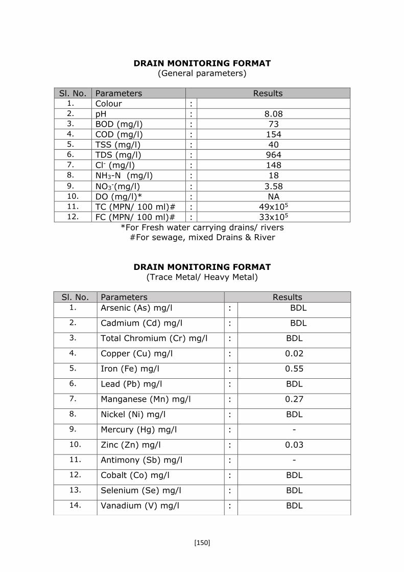
[150]
DRAIN MONITORING FORMAT (General parameters)
Sl. No. Parameters Results 1. Colour : 2. pH : 8.08 3. BOD (mg/l) : 73 4. COD (mg/l) : 154 5. TSS (mg/l) : 40 6. TDS (mg/l) : 964 7. Cl- (mg/l) : 148 8. NH3-N (mg/l) : 18
9. NO3-(mg/l) : 3.58
10. DO (mg/l)* : NA 11. TC (MPN/ 100 ml)# : 49x105 12. FC (MPN/ 100 ml)# : 33x105
*For Fresh water carrying drains/ rivers #For sewage, mixed Drains & River
DRAIN MONITORING FORMAT
(Trace Metal/ Heavy Metal)
Sl. No. Parameters Results 1. Arsenic (As) mg/l : BDL
2. Cadmium (Cd) mg/l : BDL
3. Total Chromium (Cr) mg/l : BDL
4. Copper (Cu) mg/l : 0.02
5. Iron (Fe) mg/l : 0.55
6. Lead (Pb) mg/l : BDL
7. Manganese (Mn) mg/l : 0.27
8. Nickel (Ni) mg/l : BDL
9. Mercury (Hg) mg/l : -
10. Zinc (Zn) mg/l : 0.03
11. Antimony (Sb) mg/l : -
12. Cobalt (Co) mg/l : BDL
13. Selenium (Se) mg/l : BDL
14. Vanadium (V) mg/l : BDL
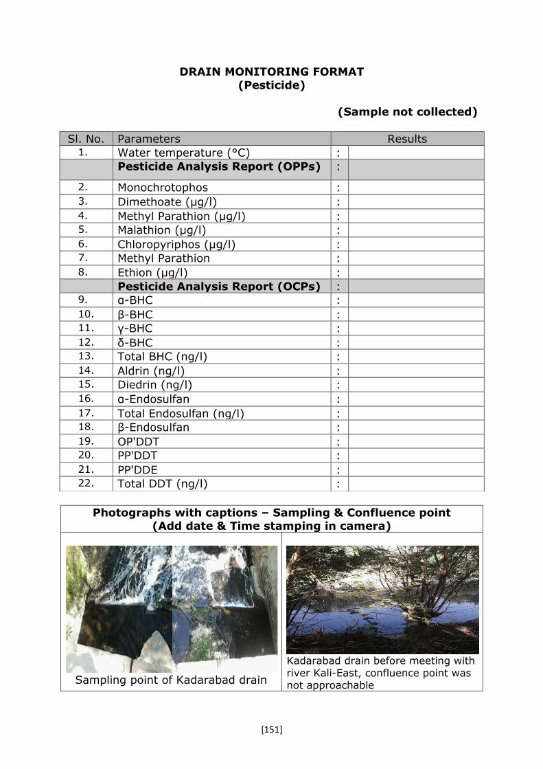
[151]
DRAIN MONITORING FORMAT
(Pesticide)
(Sample not collected)
Photographs with captions – Sampling & Confluence point (Add date & Time stamping in camera)
Sampling point of Kadarabad drain
Kadarabad drain before meeting with
river Kali-East, confluence point was not approachable
Sl. No. Parameters Results 1. Water temperature (°C) : Pesticide Analysis Report (OPPs) :
2. Monochrotophos :
3. Dimethoate (µg/l) :
4. Methyl Parathion (µg/l) : 5. Malathion (µg/l) :
6. Chloropyriphos (µg/l) : 7. Methyl Parathion :
8. Ethion (µg/l) :
Pesticide Analysis Report (OCPs) : 9. α-BHC :
10. β-BHC : 11. γ-BHC :
12. δ-BHC : 13. Total BHC (ng/l) :
14. Aldrin (ng/l) : 15. Diedrin (ng/l) :
16. α-Endosulfan :
17. Total Endosulfan (ng/l) : 18. β-Endosulfan :
19. OP'DDT : 20. PP'DDT :
21. PP'DDE : 22. Total DDT (ng/l) :
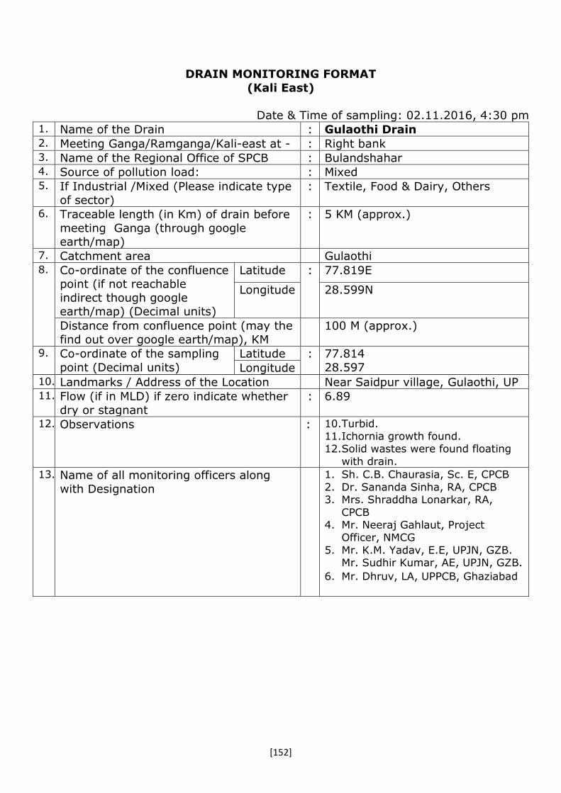
[152]
DRAIN MONITORING FORMAT
(Kali East)
Date & Time of sampling: 02.11.2016, 4:30 pm 1. Name of the Drain : Gulaothi Drain 2. Meeting Ganga/Ramganga/Kali-east at - : Right bank 3. Name of the Regional Office of SPCB : Bulandshahar 4. Source of pollution load: : Mixed 5. If Industrial /Mixed (Please indicate type
of sector)
: Textile, Food & Dairy, Others
6. Traceable length (in Km) of drain before
meeting Ganga (through google earth/map)
: 5 KM (approx.)
7. Catchment area Gulaothi 8. Co-ordinate of the confluence
point (if not reachable
indirect though google earth/map) (Decimal units)
Latitude : 77.819E
Longitude 28.599N
Distance from confluence point (may the
find out over google earth/map), KM
100 M (approx.)
9. Co-ordinate of the sampling
point (Decimal units)
Latitude : 77.814
28.597 Longitude 10. Landmarks / Address of the Location Near Saidpur village, Gulaothi, UP 11. Flow (if in MLD) if zero indicate whether
dry or stagnant
: 6.89
12. Observations : 10.Turbid. 11.Ichornia growth found. 12.Solid wastes were found floating
with drain.
13. Name of all monitoring officers along
with Designation
1. Sh. C.B. Chaurasia, Sc. E, CPCB
2. Dr. Sananda Sinha, RA, CPCB 3. Mrs. Shraddha Lonarkar, RA,
CPCB 4. Mr. Neeraj Gahlaut, Project
Officer, NMCG
5. Mr. K.M. Yadav, E.E, UPJN, GZB. Mr. Sudhir Kumar, AE, UPJN, GZB.
6. Mr. Dhruv, LA, UPPCB, Ghaziabad

[153]
DRAIN MONITORING FORMAT (General parameters)
Sl. No. Parameters Results 1. Colour : NA 2. pH : 7.51 3. BOD (mg/l) : 139 4. COD (mg/l) : 282 5. TSS (mg/l) : 196 6. TDS (mg/l) : 860 7. Cl- (mg/l) : 130 8. NH3-N (mg/l) : 38
9. NO3-(mg/l) : 3.64
10. DO (mg/l)* : NIL 11. TC (MPN/ 100 ml)# : 22X106 12. FC (MPN/ 100 ml)# : 22X106
*For Fresh water carrying drains/ rivers #For sewage, mixed Drains & River
DRAIN MONITORING FORMAT
(Trace Metal/ Heavy Metal)
Sl. No. Parameters Results 1. Arsenic (As) mg/l : BDL
2. Cadmium (Cd) mg/l : BDL
3. Total Chromium (Cr) mg/l : BDL
4. Copper (Cu) mg/l : 0.02
5. Iron (Fe) mg/l : 2.33
6. Lead (Pb) mg/l : 0.02
7. Manganese (Mn) mg/l : 0.22
8. Nickel (Ni) mg/l : BDL
9. Mercury (Hg) mg/l : NA
10. Zinc (Zn) mg/l : 0.09
11. Antimony (Sb) mg/l : NA
12. Cobalt (Co) mg/l : BDL
13. Selenium (Se) mg/l : BDL
14. Vanadium (V) mg/l : BDL

[154]
DRAIN MONITORING FORMAT
(Pesticide)
Photographs with captions – Sampling & Confluence point
(Add date & Time stamping in camera)
Sampling point, confluence point
was not reachable
Inspection team
Sl. No. Parameters Results 1. Water temperature (°C) : Pesticide Analysis Report (OPPs) :
2. Monochrotophos : -
3. Dimethoate (µg/l) : BDL 4. Methyl Parathion (µg/l) : BDL 5. Malathion (µg/l) : BDL 6. Chloropyriphos (µg/l) : BDL 7. Methyl Parathion : BDL 8. Ethion (µg/l) : BDL
Pesticide Analysis Report (OCPs) : 9. α-BHC : BDL
10. β-BHC : 0.874 (µg/L) 11. γ-BHC : BDL
12. δ-BHC : - 13. Total BHC (ng/l) : 0.874 (µg/L) 14. Aldrin (ng/l) : BDL 15. Diedrin (ng/l) : BDL 16. α-Endosulfan : BDL 17. Total Endosulfan (ng/l) : BDL 18. β-Endosulfan : BDL 19. OP'DDT : 0.106 (µg/L) 20. PP'DDT : BDL 21. PP'DDE : BDL 22. Total DDT (ng/l) : 0.106 (µg/L)
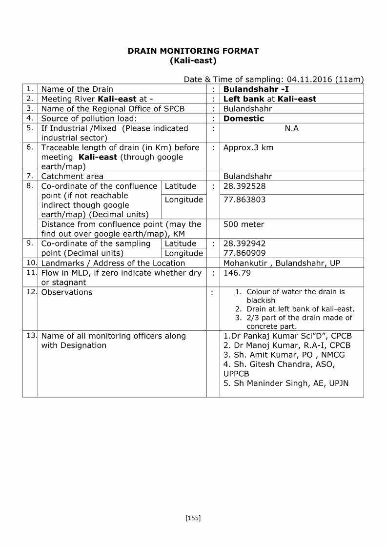
[155]
DRAIN MONITORING FORMAT
(Kali-east)
Date & Time of sampling: 04.11.2016 (11am) 1. Name of the Drain : Bulandshahr -I 2. Meeting River Kali-east at - : Left bank at Kali-east 3. Name of the Regional Office of SPCB : Bulandshahr 4. Source of pollution load: : Domestic 5. If Industrial /Mixed (Please indicated
industrial sector)
: N.A
6. Traceable length of drain (in Km) before
meeting Kali-east (through google earth/map)
: Approx.3 km
7. Catchment area Bulandshahr 8. Co-ordinate of the confluence
point (if not reachable
indirect though google earth/map) (Decimal units)
Latitude : 28.392528
Longitude 77.863803
Distance from confluence point (may the
find out over google earth/map), KM
500 meter
9. Co-ordinate of the sampling
point (Decimal units)
Latitude : 28.392942
77.860909 Longitude 10. Landmarks / Address of the Location Mohankutir , Bulandshahr, UP 11. Flow in MLD, if zero indicate whether dry
or stagnant
: 146.79
12. Observations : 1. Colour of water the drain is blackish
2. Drain at left bank of kali-east.
3. 2/3 part of the drain made of concrete part.
13. Name of all monitoring officers along with Designation
1.Dr Pankaj Kumar Sci”D”, CPCB 2. Dr Manoj Kumar, R.A-I, CPCB
3. Sh. Amit Kumar, PO , NMCG 4. Sh. Gitesh Chandra, ASO,
UPPCB
5. Sh Maninder Singh, AE, UPJN

[156]
DRAIN MONITORING FORMAT
(General parameters)
Sl. No. Parameters Results 1. Colour : - 2. pH : 7.56 3. BOD (mg/l) : 103 4. COD (mg/l) : 222 5. TSS (mg/l) : 231 6. TDS (mg/l) : 782 7. Cl- (mg/l) : 67 8. NH3-N (mg/l) : 38
9. NO3-(mg/l) : -
10. DO (mg/l)* : - 11. TC (MPN/ 100 ml)# : - 12. FC (MPN/ 100 ml)# : -
*For Fresh water carrying drains/ rivers
#For sewage, mixed Drains & River
DRAIN MONITORING FORMAT
(Trace Metal/ Heavy Metal)
Sl. No. Parameters Results 1. Arsenic (As) mg/l : BDL
2. Cadmium (Cd) mg/l : BDL
3. Total Chromium (Cr) mg/l : BDL
4. Copper (Cu) mg/l : 0.06
5. Iron (Fe) mg/l : 4.58
6. Lead (Pb) mg/l : 0.03
7. Manganese (Mn) mg/l : 0.27
8. Nickel (Ni) mg/l : 0.13
9. Mercury (Hg) mg/l : -
10. Zinc (Zn) mg/l : 0.19
11. Antimony (Sb) mg/l : -
12. Cobalt (Co) mg/l : BDL
13. Selenium (Se) mg/l : BDL
14. Vanadium (V) mg/l : 0.01
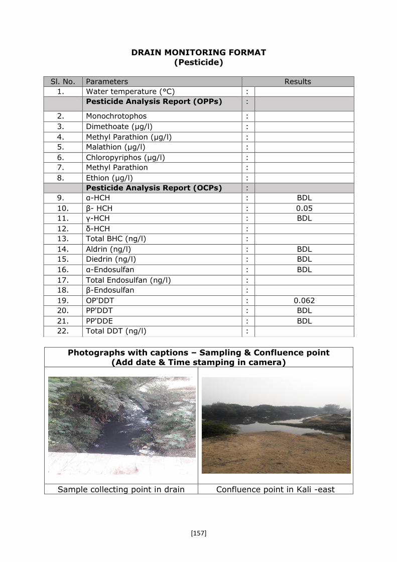
[157]
DRAIN MONITORING FORMAT
(Pesticide)
Photographs with captions – Sampling & Confluence point (Add date & Time stamping in camera)
Sample collecting point in drain Confluence point in Kali -east
Sl. No. Parameters Results
1. Water temperature (°C) :
Pesticide Analysis Report (OPPs) :
2. Monochrotophos :
3. Dimethoate (µg/l) :
4. Methyl Parathion (µg/l) :
5. Malathion (µg/l) :
6. Chloropyriphos (µg/l) :
7. Methyl Parathion :
8. Ethion (µg/l) :
Pesticide Analysis Report (OCPs) :
9. α-HCH : BDL
10. β- HCH : 0.05
11. γ-HCH : BDL
12. δ-HCH :
13. Total BHC (ng/l) :
14. Aldrin (ng/l) : BDL
15. Diedrin (ng/l) : BDL
16. α-Endosulfan : BDL
17. Total Endosulfan (ng/l) :
18. β-Endosulfan :
19. OP'DDT : 0.062
20. PP'DDT : BDL
21. PP'DDE : BDL
22. Total DDT (ng/l) :

[158]
DRAIN MONITORING FORMAT (Kali-east)
Date & Time of sampling: 04.11.2016(2.45pm)
1. Name of the Drain : Bulandshahr -II 2. Meeting Kali-east at - : Left bank at Kali-east 3. Name of the Regional Office of SPCB : Bulandshahr 4. Source of pollution load: : Domestic 5. If Industrial /Mixed (Please indicated
industrial sector) : N.A
6. Traceable length of drain (in Km) before meeting Kali-east (through google
earth/map)
: Approx.4-5 km
7. Catchment area Bulandshahr 8. Co-ordinate of the confluence
point (if not reachable indirect though google
earth/map) (Decimal units)
Latitude : 28.417947
Longitude 77.855664
Distance from confluence point (may the find out over google earth/map), KM
300 meter
9. Co-ordinate of the sampling point (Decimal units)
Latitude : 28.417007 77.85364 Longitude
10. Landmarks / Address of the Location Chandwadi devipura near women
police station, Bulandshahr, UP 11. Flow (if in MLD) if zero indicate whether
dry or stagnant
: 165.14
12. Observations : 4. Colour of water the drain is greyis
13. Name of all monitoring officers along
with Designation
1. Dr Pankaj Kumar Sci”D”, CPCB
2. Dr Manoj Kumar, R.A-I, CPCB 3. Sh. Amit Kumar, PO , NMCG
4. Sh. Gitesh Chandra, ASO, UPPCB
5. Sh Maninder Singh, AE, UPJN

[159]
DRAIN MONITORING FORMAT
(General parameters)
Sl. No. Parameters Results 1. Colour : - 2. pH : 7.56 3. BOD (mg/l) : 70 4. COD (mg/l) : 159 5. TSS (mg/l) : 81 6. TDS (mg/l) : 676 7. Cl- (mg/l) : 61 8. NH3-N (mg/l) : 32
9. NO3-(mg/l) : -
10. DO (mg/l)* : - 11. TC (MPN/ 100 ml)# : - 12. FC (MPN/ 100 ml)# : -
*For Fresh water carrying drains/ rivers
#For sewage, mixed Drains & River
DRAIN MONITORING FORMAT
(Trace Metal/ Heavy Metal)
Sl. No. Parameters Results 1. Arsenic (As) mg/l : BDL
2. Cadmium (Cd) mg/l : BDL
3. Total Chromium (Cr) mg/l : 0.04
4. Copper (Cu) mg/l : 0.12
5. Iron (Fe) mg/l : 10.08
6. Lead (Pb) mg/l : 0.04
7. Manganese (Mn) mg/l : 0.33
8. Nickel (Ni) mg/l : 0.06
9. Mercury (Hg) mg/l : -
10. Zinc (Zn) mg/l : 0.26
11. Antimony (Sb) mg/l : -
12. Cobalt (Co) mg/l : BDL
13. Selenium (Se) mg/l : BDL
14. Vanadium (V) mg/l : 0.02

[160]
DRAIN MONITORING FORMAT
(Pesticide)
Photographs with captions – Sampling & Confluence point
(Add date & Time stamping in camera)
Sample collecting point in drain Confluence point in Kali east
Sl. No. Parameters Results 1. Water temperature (°C) : Pesticide Analysis Report (OPPs) :
2. Monochrotophos :
3. Dimethoate (µg/l) :
4. Methyl Parathion (µg/l) : 5. Malathion (µg/l) :
6. Chloropyriphos (µg/l) : 7. Methyl Parathion :
8. Ethion (µg/l) :
Pesticide Analysis Report (OCPs) : 9. α-HCH : BDL
10. β- HCH : 0.182 11. γ-HCH : 0.259
12. δ-HCH : - 13. Total BHC (ng/l) : -
14. Aldrin (ng/l) : BDL 15. Diedrin (ng/l) : BDL
16. α-Endosulfan : BDL
17. Total Endosulfan (ng/l) : - 18. β-Endosulfan : BDL
19. OP'DDT : 0.174 20. PP'DDT : BDL
21. PP'DDE : BDL 22. Total DDT (ng/l) : -

[161]
DRAIN MONITORING FORMAT
(Kali East)
Date & Time of sampling: 04.11.2016 (12:15 pm) 1. Name of the Drain : Aadil Nalla 2. Meeting Kali-east at - : Left bank at Kali-east 3. Name of the Regional Office of SPCB : Bulandshahr 4. Source of pollution load: : Domestic 5. If Industrial /Mixed (Please indicated
industrial sector)
: N.A
6. Traceable length of drain (in Km) before
meeting Kali-east (through google earth/map)
: Approx.4 km
7. Catchment area Bulandshahr 8. Co-ordinate of the confluence
point (if not reachable
indirect though google earth/map) (Decimal units)
Latitude : 28.396283
Longitude 77.862681
Distance from confluence point (may the
find out over google earth/map), KM
50 meter
9. Co-ordinate of the sampling
point (Decimal units)
Latitude : 28.396283
77.862344 Longitude 10. Landmarks / Address of the Location Aadil Nagar Bulandshahr, UP 11. Flow in MLD, if zero indicate whether dry
or stagnant
: 199.24
12. Observations : 1. Drain made of concrete material 2. Water depth in the drain is
aprrox. 3-4 feet.
13. Name of all monitoring officers along
with Designation
1.Dr Pankaj Kumar Sci”D”, CPCB
2. Dr Manoj Kumar, R.A-I, CPCB 3. Sh. Amit Kumar, PO , NMCG
4. Sh. Gitesh Chandra, ASO, UPPCB
5. Sh Maninder Singh, AE, UPJN

[162]
DRAIN MONITORING FORMAT
(General parameters)
Sl. No. Parameters Results 1. Colour : - 2. pH : 7.51 3. BOD (mg/l) : 97 4. COD (mg/l) : 213 5. TSS (mg/l) : 219 6. TDS (mg/l) : 708 7. Cl- (mg/l) : 73 8. NH3-N (mg/l) : 36
9. NO3-(mg/l) : -
10. DO (mg/l)* : - 11. TC (MPN/ 100 ml)# : - 12. FC (MPN/ 100 ml)# : -
*For Fresh water carrying drains/ rivers
#For sewage, mixed Drains & River
DRAIN MONITORING FORMAT
(Trace Metal/ Heavy Metal)
Sl. No. Parameters Results 1. Arsenic (As) mg/l : BDL
2. Cadmium (Cd) mg/l : BDL
3. Total Chromium (Cr) mg/l : BDL
4. Copper (Cu) mg/l : BDl
5. Iron (Fe) mg/l : 0.84
6. Lead (Pb) mg/l : 0.01
7. Manganese (Mn) mg/l : 0.08
8. Nickel (Ni) mg/l : BDL
9. Mercury (Hg) mg/l : -
10. Zinc (Zn) mg/l : 0.09
11. Antimony (Sb) mg/l : -
12. Cobalt (Co) mg/l : BDL
13. Selenium (Se) mg/l : BDL
14. Vanadium (V) mg/l : BDL

[163]
DRAIN MONITORING FORMAT
(Pesticide)
Photographs with captions – Sampling & Confluence point
(Add date & Time stamping in camera)
Sample collecting point in drain Confluence point in Kali-east
Sl. No. Parameters Results 1. Water temperature (°C) : Pesticide Analysis Report (OPPs) :
2. Monochrotophos :
3. Dimethoate (µg/l) :
4. Methyl Parathion (µg/l) : 5. Malathion (µg/l) :
6. Chloropyriphos (µg/l) : 7. Methyl Parathion :
8. Ethion (µg/l) :
Pesticide Analysis Report (OCPs) : 9. α-HCH : BDL
10. β- HCH : 0.162 11. γ-HCH : BDL
12. δ-HCH : 13. Total BHC (ng/l) :
14. Aldrin (ng/l) : BDL 15. Diedrin (ng/l) : BDL
16. α-Endosulfan : BDL
17. Total Endosulfan (ng/l) : 18. β-Endosulfan : BDL
19. OP'DDT : 0.079 20. PP'DDT : BDL
21. PP'DDE : BDL 22. Total DDT (ng/l) :
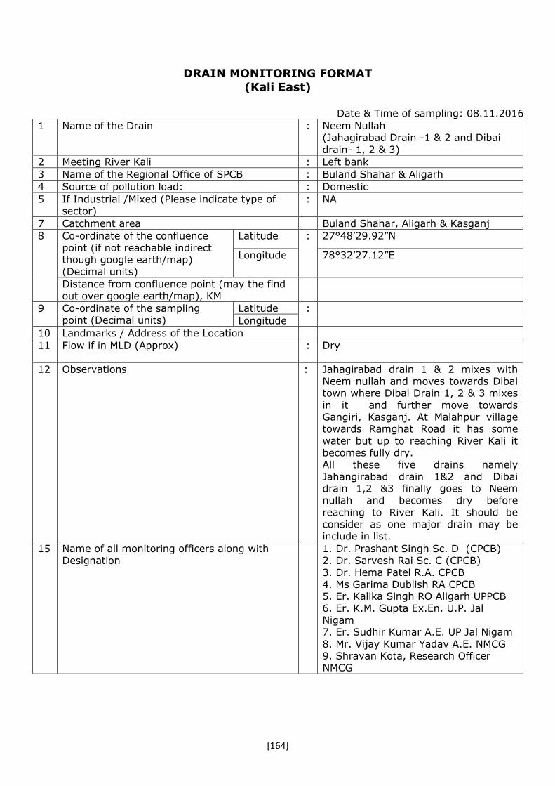
[164]
DRAIN MONITORING FORMAT
(Kali East)
Date & Time of sampling: 08.11.2016
1 Name of the Drain : Neem Nullah (Jahagirabad Drain -1 & 2 and Dibai
drain- 1, 2 & 3)
2 Meeting River Kali : Left bank
3 Name of the Regional Office of SPCB : Buland Shahar & Aligarh
4 Source of pollution load: : Domestic
5 If Industrial /Mixed (Please indicate type of sector)
: NA
7 Catchment area Buland Shahar, Aligarh & Kasganj
8 Co-ordinate of the confluence
point (if not reachable indirect though google earth/map) (Decimal units)
Latitude : 27°48’29.92”N
Longitude 78°32’27.12”E
Distance from confluence point (may the find out over google earth/map), KM
9 Co-ordinate of the sampling point (Decimal units)
Latitude :
Longitude
10 Landmarks / Address of the Location
11 Flow if in MLD (Approx) : Dry
12
Observations
:
Jahagirabad drain 1 & 2 mixes with Neem nullah and moves towards Dibai town where Dibai Drain 1, 2 & 3 mixes
in it and further move towards Gangiri, Kasganj. At Malahpur village towards Ramghat Road it has some
water but up to reaching River Kali it becomes fully dry. All these five drains namely
Jahangirabad drain 1&2 and Dibai drain 1,2 &3 finally goes to Neem nullah and becomes dry before
reaching to River Kali. It should be consider as one major drain may be include in list.
15 Name of all monitoring officers along with Designation
1. Dr. Prashant Singh Sc. D (CPCB) 2. Dr. Sarvesh Rai Sc. C (CPCB)
3. Dr. Hema Patel R.A. CPCB 4. Ms Garima Dublish RA CPCB 5. Er. Kalika Singh RO Aligarh UPPCB
6. Er. K.M. Gupta Ex.En. U.P. Jal Nigam 7. Er. Sudhir Kumar A.E. UP Jal Nigam
8. Mr. Vijay Kumar Yadav A.E. NMCG 9. Shravan Kota, Research Officer NMCG

[165]
DRAIN MONITORING FORMAT (General parameters)
Sl. No. Parameters Results 1. Colour : 2. pH : 3. BOD (mg/l) : 4. COD (mg/l) : 5. TSS (mg/l) : 6. TDS (mg/l) : 7. Cl- (mg/l) : 8. NH3-N (mg/l) :
9. NO3-(mg/l) :
10. DO (mg/l)* : 11. TC (MPN/ 100 ml)# : 12. FC (MPN/ 100 ml)# :
*For Fresh water carrying drains/ rivers #For sewage, mixed Drains & River
DRAIN MONITORING FORMAT
(Trace Metal/ Heavy Metal)
Sl. No. Parameters Results 1. Arsenic (As) mg/l :
2. Cadmium (Cd) mg/l :
3. Total Chromium (Cr) mg/l :
4. Copper (Cu) mg/l :
5. Iron (Fe) mg/l :
6. Lead (Pb) mg/l :
7. Manganese (Mn) mg/l :
8. Nickel (Ni) mg/l :
9. Mercury (Hg) mg/l :
10. Zinc (Zn) mg/l :
11. Antimony (Sb) mg/l :
12. Cobalt (Co) mg/l :
13. Selenium (Se) mg/l :
14. Vanadium (V) mg/l :

[166]
DRAIN MONITORING FORMAT
(Pesticide)
Photographs with captions – Sampling & Confluence point
(Add date & Time stamping in camera)
Confluence Point
Confluence Point
Sl. No. Parameters Results 1. Water temperature (°C) : Pesticide Analysis Report (OPPs) :
2. Monochrotophos :
3. Dimethoate (µg/l) :
4. Methyl Parathion (µg/l) : 5. Malathion (µg/l) :
6. Chloropyriphos (µg/l) : 7. Methyl Parathion :
8. Ethion (µg/l) :
Pesticide Analysis Report (OCPs) : 9. α-HCH :
10. β-HCH : 11. γ-HCH :
12. δ-HCH : 13. Total HCH (ng/l) :
14. Aldrin (ng/l) : 15. Diedrin (ng/l) :
16. α-Endosulfan :
17. Total Endosulfan (ng/l) : 18. β-Endosulfan :
19. OP'DDT : 20. PP'DDT :
21. PP'DDE : 22. Total DDT (ng/l) :

[167]
DRAIN MONITORING FORMAT
(Kali East)
Date & Time of sampling: 02.11.2016& 2 .57 p.m.
1. Name of the Drain : Kasgnaj Drain Kasganj(Amapur Bus
stand – Amarpur Road, Kasganj)
2. Meeting Kali : Left bank
3. Name of the Regional Office of SPCB : Regional Office, U.P. Pollution Control Board, Aligarh
4. Source of pollution load: : Domestic
5. If Industrial /Mixed (name of the units &
sector) and details may be obtained confirmed from the regional officers of SPCB
: NA
6. Traceable length (in Km) before meeting
Ganga (through google earth/map)
: Approx. 3-4 k.m.
7. Catchment area Amapur; Amarpur Kasganj area
8. Co-ordinate of the confluence point (if not reachable indirect though google earth/map)
(Decimal units)
Latitude : 27 º 72' 96" N
Longitude 78 º70' 86" E
Distance from confluence point (may the
find out over google earth/map), KM
500 m.
9. Co-ordinate of the sampling
point (Decimal units)
Latitude : 27 º 47' 45" N
78 º39' 8" E Longitude
10. Landmarks / Address of the Location Amarpur Road pulia, Kasganj (2 k.m distance from Amapur
11. Flow (if in MLD) if zero indicate whether dry or stagnant
: 09 MLD
12. Observations : The drain is directly fall in river Kali without treatment at 500 m from sampling point near Amarpur village
in Kasganj and flow was measured 09 MLD.
13. Name of all monitoring officers along with Designation
13. Dr. Ravi Prakash Mishra, RA-I, CPCB, ZO(N) Lucknow.
14. Mr.Arvind Kumar, SRF, CPCB, ZO(N) ) Lucknow.
15. Dr. J P Singh, ASO, UPPCB, Aligarh
16. Er. Khalid Ahamad Project
Manager Yamuna Pollution Control Unit, UP Jal Nigam, Agra.
17.Er.A K Singh , Junior Engineer , UP Jal Nigam, Agra.

[168]
DRNIN MONITORING FORMAT
(General parameters)
Sl. No. Parameters Results 1. Colour : - 2. pH : 6.94 3. BOD (mg/l) : 123 4. COD (mg/l) : 286 5. TSS (mg/l) : 176 6. TDS (mg/l) : 750 7. Cl- (mg/l) : 104 8. NH3-N (mg/l) : 42.3
9. NO3-(mg/l) : 0.271
10. DO (mg/l)* : - 11. TC (MPN/ 100 ml)# : 92000000 12. FC (MPN/ 100 ml)# : 54,000000
*For Fresh water carrying drains/ rivers
#For sewage, mixed Drains & River
DRAIN MONITORING FORMAT
(Trace Metal/ Heavy Metal)
Sl. No. Parameters Results 1. Arsenic (As) mg/l : -
2. Cadmium (Cd) mg/l : BDL
3. Total Chromium (Cr) mg/l : BDL
4. Copper (Cu) mg/l : 0.008
5. Iron (Fe) mg/l : -
6. Lead (Pb) mg/l : -
7. Manganese (Mn) mg/l : 0.144
8. Nickel (Ni) mg/l : -
9. Mercury (Hg) mg/l : -
10. Zinc (Zn) mg/l : 0.112
11. Antimony (Sb) mg/l : -
12. Cobalt (Co) mg/l : BDL
13. Selenium (Se) mg/l : -
14. Vanadium (V) mg/l : -
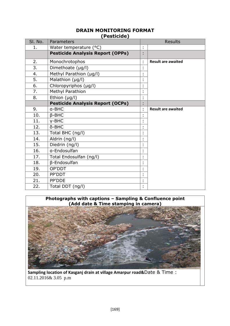
[169]
DRAIN MONITORING FORMAT
(Pesticide)
Photographs with captions – Sampling & Confluence point
(Add date & Time stamping in camera)
Sampling location of Kasganj drain at village Amarpur road&Date & Time : 02.11.2016& 3.05 p.m
Sl. No. Parameters Results
1. Water temperature (°C) :
Pesticide Analysis Report (OPPs) :
2. Monochrotophos : Result are awaited
3. Dimethoate (µg/l) :
4. Methyl Parathion (µg/l) :
5. Malathion (µg/l) :
6. Chloropyriphos (µg/l) :
7. Methyl Parathion :
8. Ethion (µg/l) :
Pesticide Analysis Report (OCPs) :
9. α-BHC : Result are awaited
10. β-BHC :
11. γ-BHC :
12. δ-BHC :
13. Total BHC (ng/l) :
14. Aldrin (ng/l) :
15. Diedrin (ng/l) :
16. α-Endosulfan :
17. Total Endosulfan (ng/l) :
18. β-Endosulfan :
19. OP'DDT :
20. PP'DDT :
21. PP'DDE :
22. Total DDT (ng/l) :

[170]
DRAIN MONITORING FORMAT
(Kali-East)
Date & Time of sampling: 03.11.2016 & 3.45 p.m.
1. Name of the Drain : Patta Nala
2. Meeting Kali River : Left bank -Kali-East
3. Name of the Regional Office of SPCB : R.O. U.P.P. C.B Kanpur Dehat
4. Source of pollution load: : (Domestic/Industrial/Mixed)
5. If Industrial /Mixed (name of the units &
sector) and details may be obtained confirmed from the regional officers of SPCB
: Sl. No. Name of
Industry
Sector
There is no industry of red or orange
category industry draining into pata nala but small scale industries like
Itra etc. are find
6. Traceable length (in Km) before meeting
Ganga (through google earth/map)
: 6 Km
7. Catchment area Sewage nala from Makrandnagar
kannauj city.
8. Co-ordinate of the confluence
point (if not reachable indirect though google earth/map) (Decimal units)
Latitude : 27 º08 ' 18" N
Longitude 79 º92 ' 74" E
Distance from confluence point (may the find out over google earth/map), KM
1.5
9. Co-ordinate of the sampling point (Decimal units)
Latitude : 27 º3 ' 57" N 79 º55 ' 8" E Longitude
10. Landmarks / Address of the Location Near Haji Sharif(Culvert near Hazi Sarif-Deedarganj road)
11. Flow (if in MLD) if zero indicate whether dry or stagnant
: At the time of sampling flow measured6.5 MLD.
(10.7 Average as per UP Jal Nigam Kannauj)
12. Observations : During inspection, flow was measured 6.5 MLD and waste water
are falling in to R. Kali and ultimately meets to R. Ganga without treatment
13. Name of all monitoring officers along with Designation
1. Dr. Ravi Prakash Mishra(RA-I,
CPCB)
2. Mr.Arvind kumar (S.R.F. CPCB)
3. Er. U.C. Verma (A.E.E. UPPCB)
4. Er. Neeraj Gupta (Asst. Engg.
UP Jal Nigam)
5. Er. Saurabh Shukla (Junior
Engg. UP jal Nigam)

[171]
DRAIN MONITORING FORMAT (General parameters)
Sl. No. Parameters Results 1. Colour : - 2. pH : 7.15 3. BOD (mg/l) : 31.1 4. COD (mg/l) : 112 5. TSS (mg/l) : 81.2 6. TDS (mg/l) : 808 7. Cl- (mg/l) : 116 8. NH3-N (mg/l) : 22.6
9. NO3-(mg/l) : 0.449
10. DO (mg/l)* : - 11. TC (MPN/ 100 ml)# : 5,40,00,000 12. FC (MPN/ 100 ml)# : 1,70,00,000
*For Fresh water carrying drains/ rivers #For sewage, mixed Drains & River
DRAIN MONITORING FORMAT
(Trace Metal/ Heavy Metal)
Sl. No. Parameters Results 1. Arsenic (As) mg/l : -
2. Cadmium (Cd) mg/l : BDL
3. Total Chromium (Cr) mg/l : BDL
4. Copper (Cu) mg/l : 0.042
5. Iron (Fe) mg/l : -
6. Lead (Pb) mg/l : -
7. Manganese (Mn) mg/l : 0.116
8. Nickel (Ni) mg/l : -
9. Mercury (Hg) mg/l : -
10. Zinc (Zn) mg/l : 0.152
11. Antimony (Sb) mg/l : -
12. Cobalt (Co) mg/l : BDL
13. Selenium (Se) mg/l : -
14. Vanadium (V) mg/l : -

[172]
DRAIN MONITORING FORMAT
(Pesticide)
Photographs with captions – Sampling & Confluence point (Add date & Time stamping in camera)
Sampling location of Patta Nala atKannauj
Sl. No. Parameters Results 1. Water temperature (°C) : Pesticide Analysis Report (OPPs) :
2. Monochrotophos :
3. Dimethoate (µg/l) :
4. Methyl Parathion (µg/l) : 5. Malathion (µg/l) :
6. Chloropyriphos (µg/l) : 7. Methyl Parathion :
8. Ethion (µg/l) :
Pesticide Analysis Report (OCPs) : 9. α-BHC :
10. β-BHC : 11. γ-BHC :
12. δ-BHC : 13. Total BHC (ng/l) :
14. Aldrin (ng/l) : 15. Diedrin (ng/l) :
16. α-Endosulfan :
17. Total Endosulfan (ng/l) : 18. β-Endosulfan :
19. OP'DDT : 20. PP'DDT :
21. PP'DDE : 22. Total DDT (ng/l) :

[173]
VI. Data Sheet of Drains Joining River Pandu.

[174]

[175]
DRAIN MONITORING FORMAT
(River Pandu)
Date & Time of sampling: October 26, 2016 at 11:45 am
1. Name of the Drain : Panki Thermal Power Plant, Drain
2. Meeting River Pandu at - : Left bank - Pandu
3. Name of the Regional Office of SPCB : Kanpur UPPCB
4. Source of pollution load: : Mixed
5. If Industrial /Mixed (name of the units &
sector) and details may be obtained confirmed from the regional officers of
SPCB
: N.A
6. Traceable length (in Km) before meeting Ganga (through google earth/map)
: Approx. 1.6 Km
7. Catchment area Kanpur City, New Transport
Nagar, Thermal Power Plant
8. Co-ordinate of the confluence
point (if not reachable indirect though google
earth/map) (Decimal units)
Latitude : N 26° 26' 17.2536"
Longitude E 80° 15' 9.5898"
Distance from confluence point (may the find out over google earth/map), KM
Approx. 50 m
9. Co-ordinate of the sampling point (Decimal units)
Latitude : N 26°27’60.0” E 80° 13’ 59.8” Longitude
10. Landmarks / Address of the Location New Transport Nagar, Panki,
Jhansi Bypass
11. Flow (if in MLD) if zero indicate whether
dry or stagnant
: 114.10 MLD
12. Observations : 1.Pank idrain is puckka drain and flowing Thaemal power Plant, Y-
block, KFCL area, Panki site I, Panki Industrial Area.
13. Name of all monitoring officers along
with Designation
1. Sh. R.B. Singh, Sci. C, CPCB
ZO Lucknow
2. Sh. Rajesh Kumar, RA-1,
CPCB ZO Lucknow
3. Dr. R.P. Mishra, RA-1, CPCB
ZO Lucknow
4. Sh. S.K. Awasthi, JEE,
UPPCB, Kanpur
5. Sh. Raguvendra Pratap,
AEE, J.N. Kanpur

[176]
DRAIN MONITORING FORMAT
(General parameters)
Sl. No. Parameters Results 1. Colour : - 2. pH : 7.14 3. BOD (mg/l) : 14.0 4. COD (mg/l) : 41.0 5. TSS (mg/l) : 60.2 6. TDS (mg/l) : 384 7. Cl- (mg/l) : 61.0 8. NH3-N (mg/l) : 16.9
9. NO3-(mg/l) : 2.93
10. DO (mg/l)* : - 11. TC (MPN/ 100 ml)# : 2200000 12. FC (MPN/ 100 ml)# : 1100000
*For Fresh water carrying drains/ rivers
#For sewage, mixed Drains & River
DRAIN MONITORING FORMAT
(Trace Metal/ Heavy Metal)
Sl. No. Parameters Results 1. Arsenic (As) mg/l : BDL
2. Cadmium (Cd) mg/l : BDL
3. Total Chromium (Cr) mg/l : BDL
4. Copper (Cu) mg/l : -
5. Iron (Fe) mg/l : 0.62
6. Lead (Pb) mg/l : BDL
7. Manganese (Mn) mg/l : 0.06
8. Nickel (Ni) mg/l : BDL
9. Mercury (Hg) mg/l : -
10. Zinc (Zn) mg/l : 0.20
11. Antimony (Sb) mg/l : -
12. Cobalt (Co) mg/l : BDL
13. Selenium (Se) mg/l : -
14. Vanadium (V) mg/l : -

[177]
DRAIN MONITORING FORMAT
(Pesticide)
Photographs with captions – Sampling & Confluence point
(Add date & Time stamping in camera)
Fig- Sampling point of Panki (TPP) Drain
Fig- Confluence point of Panki Drain with
River Pandu
Sl. No. Parameters Results 1. Water temperature (°C) : Awaited Pesticide Analysis Report (OPPs) :
2. Monochrotophos :
3. Dimethoate (µg/l) :
4. Methyl Parathion (µg/l) : 5. Malathion (µg/l) :
6. Chloropyriphos (µg/l) : 7. Methyl Parathion :
8. Ethion (µg/l) :
Pesticide Analysis Report (OCPs) : 9. α-BHC : BDL 10. β-BHC : 0.10 11. γ-BHC : BDL 12. δ-BHC : BDL 13. Total BHC (ng/l) : BDL 14. Aldrin (ng/l) : BDL 15. Diedrin (ng/l) : BDL 16. α-Endosulfan : BDL 17. Total Endosulfan (ng/l) : BDL 18. β-Endosulfan : BDL 19. OP'DDT : BDL 20. PP'DDT : BDL 21. PP'DDE : BDL 22. Total DDT (ng/l) : BDL

[178]
DRAIN MONITORING FORMAT
(River Pandu)
Date & Time of sampling: October 26, 2016 at 1:30 pm 1. Name of the Drain : ICI Drain, Kanpur 2. Meeting River Pandu at - : Left bank – Pandu 3. Name of the Regional Office of SPCB : Kanpur UPPCB 4. Source of pollution load: : Mixed 5. If Industrial /Mixed (Please indicate type
of sector)
: N.A
6. Traceable length (in Km) before meeting
Ganga (through google earth/map)
: Approx. 1.0 Km
7. Catchment area Kanpur city 8. Co-ordinate of the confluence
point (if not reachable indirect though google
earth/map) (Decimal units)
Latitude : N 26° 26' 8.682"
Longitude E 80° 15' 13.6038"
Distance from confluence point (may the find out over google earth/map), KM
Approx. 20 m
9. Co-ordinate of the sampling point (Decimal units)
Latitude : N 26° 26' 12.6996" E 80° 15' 15.6024" Longitude
10. Landmarks / Address of the Location Near LML Industry, Panki Kanpur 11. Flow (if in MLD) if zero indicate whether
dry or stagnant : 19.44 MLD
12. Observations : 1. ICI drain carries mixed
Industrial effluent & domestic
sewage direct falling into river Pandu which ultimately meets in
river Ganga.
2. At the time of inspection, its flow was measured to be 19.44
MLD.
13. Name of all monitoring officers along with Designation
1. Sh. R.B. Singh, Sci. C, CPCB
ZO Lucknow
2. Sh. Rajesh Kumar, RA-1, CPCB
ZO Lucknow
3. Dr. R.P. Mishra, RA-1, CPCB
ZO Lucknow
4. Sh. S.K. Awasthi, JEE, UPPCB,
Kanpur
5. Sh. Raguvendra Pratap, AEE,
J.N. Kanpur

[179]
DRAIN MONITORING FORMAT
(General parameters)
Sl. No. Parameters Results 1. Colour : - 2. pH : 8.16 3. BOD (mg/l) : 42.9 4. COD (mg/l) : 141 5. TSS (mg/l) : 146 6. TDS (mg/l) : 3122 7. Cl- (mg/l) : 1496 8. NH3-N (mg/l) : 193
9. NO3-(mg/l) : 9.85
10. DO (mg/l)* : - 11. TC (MPN/ 100 ml)# : 2400000 12. FC (MPN/ 100 ml)# : 790000
*For Fresh water carrying drains/ rivers
#For sewage, mixed Drains & River
DRAIN MONITORING FORMAT
(Trace Metal/ Heavy Metal)
Sl. No. Parameters Results 1. Arsenic (As) mg/l : BDL
2. Cadmium (Cd) mg/l : BDL
3. Total Chromium (Cr) mg/l : 0.06
4. Copper (Cu) mg/l : -
5. Iron (Fe) mg/l : 2.60
6. Lead (Pb) mg/l : 0.22
7. Manganese (Mn) mg/l : 0.72
8. Nickel (Ni) mg/l : BDL
9. Mercury (Hg) mg/l : -
10. Zinc (Zn) mg/l : 6.18
11. Antimony (Sb) mg/l : -
12. Cobalt (Co) mg/l : BDL
13. Selenium (Se) mg/l : -
14. Vanadium (V) mg/l : -

[180]
DRAIN MONITORING FORMAT
(Pesticide)
Photographs with captions – Sampling & Confluence point (Add date & Time stamping in camera)
Fig- Sampling point of ICI Drain
Fig- Confluence point of ICI Drain & River
Pandu
Sl. No. Parameters Results 1. Water temperature (°C) : Awaited Pesticide Analysis Report (OPPs) :
2. Monochrotophos :
3. Dimethoate (µg/l) :
4. Methyl Parathion (µg/l) : 5. Malathion (µg/l) :
6. Chloropyriphos (µg/l) : 7. Methyl Parathion :
8. Ethion (µg/l) :
Pesticide Analysis Report (OCPs) : 9. α-BHC : BDL 10. β-BHC : 1.21 11. γ-BHC : BDL 12. δ-BHC : BDL 13. Total BHC (ng/l) : BDL 14. Aldrin (ng/l) : BDL 15. Diedrin (ng/l) : BDL 16. α-Endosulfan : BDL 17. Total Endosulfan (ng/l) : BDL 18. β-Endosulfan : BDL 19. OP'DDT : BDL 20. PP'DDT : 0.08 21. PP'DDE : BDL 22. Total DDT (ng/l) : BDL

[181]
DRAIN MONITORING FORMAT
(River Pandu)
Date & Time of sampling: 26.10.2016 & 12.30 pm 1. Name of the Drain : Ganda Nalla, kanpur 2. Meeting River Pandu at - : Left bank - Pandu 3. Name of the Regional Office of SPCB : Kanpur UPPCB 4. Source of pollution load: : Domestic 5. If Industrial /Mixed (Please indicate type
of sector)
: N.A
6. Traceable length (in Km) before meeting
Ganga (through google earth/map)
: Approx. 13.50 Km
7. Catchment area Industrial area Panki, Gujani village. Kanpur City
8. Co-ordinate of the confluence point (if not reachable
indirect though google earth/map) (Decimal units)
Latitude : N 26° 25' 42.9954"
Longitude E 80° 16' 59.8548"
Distance from confluence point (may the
find out over google earth/map), KM
Approx. 0.5 km
9. Co-ordinate of the sampling
point (Decimal units)
Latitude : N 26 °26’46.3”
E 80°17’38.46” Longitude 10. Landmarks / Address of the Location Vijay Nagar, Barra -4 11. Flow (if in MLD) if zero indicate whether
dry or stagnant
: 210.5 MLD
12. Observations : 1. Ganda drain is a major drain this is directly meets into River Pandu which ultimately meeting in river Ganga at the time of inspection, its flow was measured 210.5 MLD. 2. The Panki canal mixing in to the Ganda Drain at U.P.Kirana Girls School and gets diluted.
13. Name of all monitoring officers along with Designation
1. Sh. R.B. Singh, Sci. C, CPCB ZO Lucknow
2. Sh. Rajesh Kumar, RA-1, CPCB ZO Lucknow
3. Dr. R.P. Mishra, RA-1, CPCB
ZO Lucknow 4. Sh. S.K. Awasthi, JEE, UPPCB,
Kanpur
5. Sh. Raguvendra Pratap, AEE,
J.N. Kanpur

[182]
DRAIN MONITORING FORMAT
(General parameters)
Sl. No. Parameters Results 1. Colour : - 2. pH : 7.17 3. BOD (mg/l) : 66.6 4. COD (mg/l) : 203 5. TSS (mg/l) : 105 6. TDS (mg/l) : 774 7. Cl- (mg/l) : 117 8. NH3-N (mg/l) : 55.2
9. NO3-(mg/l) : 2.87
10. DO (mg/l)* : - 11. TC (MPN/ 100 ml)# : 5,40,00,000 12. FC (MPN/ 100 ml)# : 3,50,00,000
*For Fresh water carrying drains/ rivers
#For sewage, mixed Drains & River
DRAIN MONITORING FORMAT
(Trace Metal/ Heavy Metal)
Sl. No. Parameters Results 1. Arsenic (As) mg/l : BDL
2. Cadmium (Cd) mg/l : BDL
3. Total Chromium (Cr) mg/l : 0.04
4. Copper (Cu) mg/l : -
5. Iron (Fe) mg/l : 1.64
6. Lead (Pb) mg/l : 0.02
7. Manganese (Mn) mg/l : 0.12
8. Nickel (Ni) mg/l : 0.02
9. Mercury (Hg) mg/l : -
10. Zinc (Zn) mg/l : 0.40
11. Antimony (Sb) mg/l : -
12. Cobalt (Co) mg/l : BDL
13. Selenium (Se) mg/l : -
14. Vanadium (V) mg/l : -

[183]
DRAIN MONITORING FORMAT
(Pesticide)
Photographs with captions – Sampling & Confluence point (Add date & Time stamping in camera)
Fig- Sampling point of Ganda Drain
Fig-Confluence point of Ganda Drain & R.
Pandu
Sl. No. Parameters Results 1. Water temperature (°C) : Pesticide Analysis Report (OPPs) :
2. Monochrotophos : Awaited
3. Dimethoate (µg/l) :
4. Methyl Parathion (µg/l) : 5. Malathion (µg/l) :
6. Chloropyriphos (µg/l) : 7. Methyl Parathion :
8. Ethion (µg/l) :
Pesticide Analysis Report (OCPs) : 9. α-BHC : BDL 10. β-BHC : 2.00 11. γ-BHC : BDL 12. δ-BHC : BDL 13. Total BHC (ng/l) : BDL 14. Aldrin (ng/l) : BDL 15. Diedrin (ng/l) : BDL 16. α-Endosulfan : BDL 17. Total Endosulfan (ng/l) : BDL 18. β-Endosulfan : BDL 19. OP'DDT : 0.06 20. PP'DDT : BDL 21. PP'DDE : BDL 22. Total DDT (ng/l) : BDL

[184]
DRAIN MONITORING FORMAT
(River Pandu)
Date & Time of sampling: 26.10.2016& 5:0 pm
1. Name of the Drain : COD Nalla, Panki, Kanpur
2. Meeting River Pandu at - : Left bank –Pandu
3. Name of the Regional Office of SPCB : RO UPPCB, Kanpur
4. Source of pollution load: : Mixed
5. If Industrial /Mixed (Please indicate type
of sector)
: N.A
6. Traceable length (in Km) before meeting
Ganga (through google earth/map)
: Approx. 6.2 Km
7. Catchment area Kanpur City
8. Co-ordinate of the confluence point (if not reachable
indirect though google earth/map) (Decimal units)
Latitude : N 26° 22' 13.4796"
Longitude E 80° 18' 27.1326"
Distance from confluence point (may the find out over google earth/map), KM
Approx. 20 m
9. Co-ordinate of the sampling point (Decimal units)
Latitude ” N 26 °25’35.4” E 80°20’96.4” Longitude
10. Landmarks / Address of the Location Neura Village
11. Flow (if in MLD) if zero indicate whether
dry or stagnant
: 120.96 MLD
12. Observations : 1. COD (Commercial Ordinance Depot)
drain carries wastewater from COD, Yashodanagar, Babupurwa,
Kidwainagar, Y block, defence Colony. 2. This drain meets to river Pandu which
ultimately meets river Ganga. At the
time of monitoring the drain was found tapped into STP (210 MLD)
13. Name of all monitoring officers along with Designation
6. Sh. R.B. Singh, Sci. C, CPCB ZO Lucknow
7. Sh. Rajesh Kumar, RA-1, CPCB ZO Lucknow
8. Dr. R.P. Mishra, RA-1, CPCB ZO
Lucknow 9. Sh. S.K. Awasthi, JEE, UPPCB,
Kanpur 10.Sh. Raguvendra Pratap, AEE, J.N.
Kanpur

[185]
DRAIN MONITORING FORMAT
(General parameters)
Sl. No. Parameters Results 1. Colour : - 2. pH : 7.47 3. BOD (mg/l) : 54.6 4. COD (mg/l) : 145 5. TSS (mg/l) : 73.5 6. TDS (mg/l) : 787 7. Cl- (mg/l) : 105 8. NH3-N (mg/l) : 48.9
9. NO3-(mg/l) : 2.59
10. DO (mg/l)* : - 11. TC (MPN/ 100 ml)# : 2200,000 12. FC (MPN/ 100 ml)# : 4,90,000
*For Fresh water carrying drains/ rivers
#For sewage, mixed Drains & River
DRAIN MONITORING FORMAT
(Trace Metal/ Heavy Metal)
Sl. No. Parameters Results 1. Arsenic (As) mg/l : BDL
2. Cadmium (Cd) mg/l : BDL
3. Total Chromium (Cr) mg/l : 0.04
4. Copper (Cu) mg/l : -
5. Iron (Fe) mg/l : 0.84
6. Lead (Pb) mg/l : BDL
7. Manganese (Mn) mg/l : 0.14
8. Nickel (Ni) mg/l : BDL
9. Mercury (Hg) mg/l : -
10. Zinc (Zn) mg/l : 0.22
11. Antimony (Sb) mg/l : -
12. Cobalt (Co) mg/l : BDL
13. Selenium (Se) mg/l : -
14. Vanadium (V) mg/l : -

[186]
DRAIN MONITORING FORMAT
(Pesticide)
Photographs with captions – Sampling & Confluence point (Add date & Time stamping in camera)
Fig- sampling point of COD Nalla,
Panki
Fig-COD Nala Tapped into STP
Sl. No. Parameters Results 1. Water temperature (°C) : Pesticide Analysis Report (OPPs) :
2. Monochrotophos : Awaited
3. Dimethoate (µg/l) :
4. Methyl Parathion (µg/l) : 5. Malathion (µg/l) :
6. Chloropyriphos (µg/l) : 7. Methyl Parathion :
8. Ethion (µg/l) :
Pesticide Analysis Report (OCPs) : 9. α-BHC : 0.05 10. β-BHC : 0.39 11. γ-BHC : BDL 12. δ-BHC : BDL 13. Total BHC (ng/l) : BDL 14. Aldrin (ng/l) : BDL 15. Diedrin (ng/l) : BDL 16. α-Endosulfan : BDL 17. Total Endosulfan (ng/l) : BDL 18. β-Endosulfan : BDL 19. OP'DDT : 0.09 20. PP'DDT : BDL 21. PP'DDE : BDL 22. Total DDT (ng/l) : BDL

[187]
DRAIN MONITORING FORMAT
(River Pandu)
Date & Time of sampling: 26-10-2016 at 4:00 pm
1. Name of the Drain : Halwa Khanda Nalla, Kanpur
2. Meeting River Pandu at - : Right bank- Pandu
3. Name of the Regional Office of SPCB : Kanpur UPPCB
4. Source of pollution load: : Domestic
5. If Industrial /Mixed (name of the units &
sector) and details may be obtained confirmed from the regional officers of SPCB
: N.A
6. Traceable length (in Km) before meeting
Ganga (through google earth/map)
: Approx. 6.7 Km
7. Catchment area Kanpur City
8. Co-ordinate of the confluence point (if not reachable indirect
though google earth/map) (Decimal units)
Latitude : N 26° 24' 22.2474"
Longitude E 80° 17' 21.141"
Distance from confluence point (may the find out over google earth/map), KM
Approx. 5 m
9. Co-ordinate of the sampling point (Decimal units)
Latitude : N 26° 24' 27.9036" E 80° 17' 24.6948" Longitude
10. Landmarks / Address of the Location Jarauli.
11. Flow (if in MLD) if zero indicate whether dry
or stagnant
: 62.29 MLD
12. Observations : 1. Halwa Khanda drain is diverted in
to the COD drain. 2. At the time of inspection, it was noticed that the over flow of check-
dam got its path towards R. Pandu, which ultimately meets R. Ganga.
3. At the time of inspection, its flow was measured to be 62.29 MLD.
13. Name of all monitoring officers along with Designation
11.Sh. R.B. Singh, Sci. C, CPCB
ZO Lucknow
12.Sh. Rajesh Kumar, RA-1, CPCB
ZO Lucknow
13.Dr. R.P. Mishra, RA-1, CPCB
ZO Lucknow
14.Sh. S.K. Awasthi, JEE, UPPCB,
Kanpur
15.Sh. Raguvendra Pratap, AEE,
J.N. Kanpur

[188]
DRAIN MONITORING FORMAT
(General parameters)
Sl. No. Parameters Results 1. Colour : - 2. pH : 7.23 3. BOD (mg/l) : 82.0 4. COD (mg/l) : 206 5. TSS (mg/l) : 88.9 6. TDS (mg/l) : 729 7. Cl- (mg/l) : 99.0 8. NH3-N (mg/l) : 50.6
9. NO3-(mg/l) : 2.0
10. DO (mg/l)* : - 11. TC (MPN/ 100 ml)# : 1,70,00,000 12. FC (MPN/ 100 ml)# : 33,00,000
*For Fresh water carrying drains/ rivers
#For sewage, mixed Drains & River
DRAIN MONITORING FORMAT
(Trace Metal/ Heavy Metal)
Sl. No. Parameters Results 1. Arsenic (As) mg/l : BDL
2. Cadmium (Cd) mg/l : BDL
3. Total Chromium (Cr) mg/l : BDL
4. Copper (Cu) mg/l : -
5. Iron (Fe) mg/l : 1.22
6. Lead (Pb) mg/l : BDL
7. Manganese (Mn) mg/l : 0.18
8. Nickel (Ni) mg/l : BDL
9. Mercury (Hg) mg/l : -
10. Zinc (Zn) mg/l : 2.18
11. Antimony (Sb) mg/l : -
12. Cobalt (Co) mg/l : BDL
13. Selenium (Se) mg/l : -
14. Vanadium (V) mg/l : -

[189]
DRAIN MONITORING FORMAT
(Pesticide)
Photographs with captions – Sampling & Confluence point
(Add date & Time stamping in camera)
Fig- Sampling point of Halwa Khanda Drain
Fig- Near Confluence point of Halwa
Khanda Drain & R. Pandu
Sl. No. Parameters Results 1. Water temperature (°C) : Awaited Pesticide Analysis Report (OPPs) :
2. Monochrotophos :
3. Dimethoate (µg/l) :
4. Methyl Parathion (µg/l) : 5. Malathion (µg/l) :
6. Chloropyriphos (µg/l) : 7. Methyl Parathion :
8. Ethion (µg/l) :
Pesticide Analysis Report (OCPs) : 9. α-BHC : 0.05 10. β-BHC : 0.56 11. γ-BHC : BDL 12. δ-BHC : BDL 13. Total BHC (ng/l) : BDL 14. Aldrin (ng/l) : BDL 15. Diedrin (ng/l) : BDL 16. α-Endosulfan : BDL 17. Total Endosulfan (ng/l) : BDL 18. β-Endosulfan : BDL 19. OP'DDT : 0.07 20. PP'DDT : BDL 21. PP'DDE : BDL 22. Total DDT (ng/l) : BDL

[190]

[191]
10. Comments of the Institutions

[192]

[193]

[194]
Central Pollution Control Board
Parivesh Bhawan, East Arjun Nagar Shahdara, Delhi - 110032
Related Documents