ASSESSMENT REPORT, 2012 GEOCHEMICAL SAMPLING PROGRAM REL PROPERTY WHITEHORSE MINING DISTRICT, YUKON, CANADA NTS MAP SHEET: 105J/05, NAD83 ZONE 9 347870 E, 6924441 N (NAD83 zone 9) CLAIMS AND OWNER: Claim Name Claim Number Grant Number Registered Owner REL 68‐80 YE02738‐YE02750 Golden Predator Canada Corp. ‐ 100% REL 82 YE02752 Golden Predator Canada Corp. ‐ 100% REL 118‐138 YE02788‐YE02808 Golden Predator Canada Corp. ‐ 100% REL 173‐194 YE02843‐YE02864 Golden Predator Canada Corp. ‐ 100% REL 229‐250 YE02899‐YE02920 Golden Predator Canada Corp. ‐ 100% REL 275‐294 YE02945‐YE02964 Golden Predator Canada Corp. ‐ 100% REL 309 YE02979 Golden Predator Canada Corp. ‐ 100% REL 311 YE02981 Golden Predator Canada Corp. ‐ 100% REL 313 YE02983 Golden Predator Canada Corp. ‐ 100% REL 315 YE02985 Golden Predator Canada Corp. ‐ 100% REL 317 YE02987 Golden Predator Canada Corp. ‐ 100% REL 319 YE02989 Golden Predator Canada Corp. ‐ 100% REL 321 YE02991 Golden Predator Canada Corp. ‐ 100% REL 323 YE02993 Golden Predator Canada Corp. ‐ 100% REL 38 YE02708 Golden Predator Canada Corp. ‐ 100% REL 89‐91 YE02759‐YE02761 Golden Predator Canada Corp. ‐ 100% REL 93 YE02763 Golden Predator Canada Corp. ‐ 100% REL 95 YE02765 Golden Predator Canada Corp. ‐ 100% REL 97 YE02767 Golden Predator Canada Corp. ‐ 100% REL 99 YE02769 Golden Predator Canada Corp. ‐ 100% REL 101‐102 YE02771‐YE02772 Golden Predator Canada Corp. ‐ 100% REL 104 YE02774 Golden Predator Canada Corp. ‐ 100% REL 106 YE02776 Golden Predator Canada Corp. ‐ 100% REL 145‐146 YE02815‐YE02816 Golden Predator Canada Corp. ‐ 100% REL 148 YE02818 Golden Predator Canada Corp. ‐ 100% REL 161‐163 YE02831‐YE02833 Golden Predator Canada Corp. ‐ 100% REL 165 YE02835‐ Golden Predator Canada Corp. ‐ 100% REL 167 YE02837 Golden Predator Canada Corp. ‐ 100% REL 169 YE02839 Golden Predator Canada Corp. ‐ 100% REL 171 YE02841 Golden Predator Canada Corp. ‐ 100% REL 199 YE02869 Golden Predator Canada Corp. ‐ 100% REL 201 YE02871 Golden Predator Canada Corp. ‐ 100% REL 259‐260 YE02929‐YE02930 Golden Predator Canada Corp. ‐ 100% REL 262 YE02932 Golden Predator Canada Corp. ‐ 100% REL 264 YE02934 Golden Predator Canada Corp. ‐ 100% REL 266 YE02936 Golden Predator Canada Corp. ‐ 100% REL 268 YE02938 Golden Predator Canada Corp. ‐ 100% REL 270 YE02940 Golden Predator Canada Corp. ‐ 100% REL 272 YE02942 Golden Predator Canada Corp. ‐ 100% REL 274 YE02944 Golden Predator Canada Corp. ‐ 100% PERIOD OF WORK: JUNE 27-28 2012 OPERATOR: GOLDEN PREDATOR CANADA CORP. 888 Dunsmuir St. Vancouver, V6C3K4 January 11 th , 2013 Prepared by: Gilles Dessureau, M.Sc., P.Geo.

Welcome message from author
This document is posted to help you gain knowledge. Please leave a comment to let me know what you think about it! Share it to your friends and learn new things together.
Transcript

ASSESSMENT REPORT, 2012 GEOCHEMICAL SAMPLING PROGRAM
REL PROPERTY WHITEHORSE MINING DISTRICT, YUKON, CANADA NTS MAP SHEET: 105J/05, NAD83 ZONE 9
347870 E, 6924441 N (NAD83 zone 9)
CLAIMS AND OWNER: Claim Name Claim Number Grant Number Registered Owner
REL 68‐80 YE02738‐YE02750 Golden Predator Canada Corp. ‐ 100%
REL 82 YE02752 Golden Predator Canada Corp. ‐ 100%
REL 118‐138 YE02788‐YE02808 Golden Predator Canada Corp. ‐ 100%
REL 173‐194 YE02843‐YE02864 Golden Predator Canada Corp. ‐ 100%
REL 229‐250 YE02899‐YE02920 Golden Predator Canada Corp. ‐ 100%
REL 275‐294 YE02945‐YE02964 Golden Predator Canada Corp. ‐ 100%
REL 309 YE02979 Golden Predator Canada Corp. ‐ 100%
REL 311 YE02981 Golden Predator Canada Corp. ‐ 100%
REL 313 YE02983 Golden Predator Canada Corp. ‐ 100%
REL 315 YE02985 Golden Predator Canada Corp. ‐ 100%
REL 317 YE02987 Golden Predator Canada Corp. ‐ 100%
REL 319 YE02989 Golden Predator Canada Corp. ‐ 100%
REL 321 YE02991 Golden Predator Canada Corp. ‐ 100%
REL 323 YE02993 Golden Predator Canada Corp. ‐ 100%
REL 38 YE02708 Golden Predator Canada Corp. ‐ 100%
REL 89‐91 YE02759‐YE02761 Golden Predator Canada Corp. ‐ 100%
REL 93 YE02763 Golden Predator Canada Corp. ‐ 100%
REL 95 YE02765 Golden Predator Canada Corp. ‐ 100%
REL 97 YE02767 Golden Predator Canada Corp. ‐ 100%
REL 99 YE02769 Golden Predator Canada Corp. ‐ 100%
REL 101‐102 YE02771‐YE02772 Golden Predator Canada Corp. ‐ 100%
REL 104 YE02774 Golden Predator Canada Corp. ‐ 100%
REL 106 YE02776 Golden Predator Canada Corp. ‐ 100%
REL 145‐146 YE02815‐YE02816 Golden Predator Canada Corp. ‐ 100%
REL 148 YE02818 Golden Predator Canada Corp. ‐ 100%
REL 161‐163 YE02831‐YE02833 Golden Predator Canada Corp. ‐ 100%
REL 165 YE02835‐ Golden Predator Canada Corp. ‐ 100%
REL 167 YE02837 Golden Predator Canada Corp. ‐ 100%
REL 169 YE02839 Golden Predator Canada Corp. ‐ 100%
REL 171 YE02841 Golden Predator Canada Corp. ‐ 100%
REL 199 YE02869 Golden Predator Canada Corp. ‐ 100%
REL 201 YE02871 Golden Predator Canada Corp. ‐ 100%
REL 259‐260 YE02929‐YE02930 Golden Predator Canada Corp. ‐ 100%
REL 262 YE02932 Golden Predator Canada Corp. ‐ 100%
REL 264 YE02934 Golden Predator Canada Corp. ‐ 100%
REL 266 YE02936 Golden Predator Canada Corp. ‐ 100%
REL 268 YE02938 Golden Predator Canada Corp. ‐ 100%
REL 270 YE02940 Golden Predator Canada Corp. ‐ 100%
REL 272 YE02942 Golden Predator Canada Corp. ‐ 100%
REL 274 YE02944 Golden Predator Canada Corp. ‐ 100%
PERIOD OF WORK: JUNE 27-28 2012
OPERATOR: GOLDEN PREDATOR CANADA CORP. 888 Dunsmuir St. Vancouver, V6C3K4 January 11th, 2013 Prepared by: Gilles Dessureau, M.Sc., P.Geo.

TABLE OF CONTENTS
TABLE OF CONTENTS .............................................................................................................................. 2
LIST OF FIGURES ...................................................................................................................................... 2
LIST OF TABLES ........................................................................................................................................ 2
LIST OF APPENDICES ............................................................................................................................... 3
1.0 INTRODUCTION ............................................................................................................................ 4
2.0 PROPERTY LOCATION AND DESCRIPTION ............................................................................ 4
3.0 INFRASTRUCTURE, CLIMATE AND PHYSIOGRAPHY .......................................................... 6
4.0 EXPLORATION HISTORY ............................................................................................................ 6
5.0 GEOLOGY ....................................................................................................................................... 6
5.1 Regional Geology ......................................................................................................................... 6
5.2 Property Geology .......................................................................................................................... 6
6.0 EXPLORATION ............................................................................................................................... 7
6.1 Exploration Program ..................................................................................................................... 7
6.2 Sampling Methodology and Protocols .......................................................................................... 7
6.3 Results ........................................................................................................................................... 9
7.0 CONCLUSIONS AND RECOMMENDATIONS ........................................................................... 9
8.0 2011 EXPENDITURES .................................................................................................................. 11
9.0 STATEMENT OF AUTHORSHIP ................................................................................................ 13
10.0 REFERENCES ............................................................................................................................... 14
LIST OF FIGURES
Figure 2.1. REL Property Location, Yukon Territory .................................................................................. 4
Figure 2.2. REL Project Claim Map ............................................................................................................. 6
Figure 5.1. Regional Geology of the REL Area (Gordey, S.P., 1996)......................................................... 7
Figure 6.1. Regional Geology of the Werg area showing Au in soils results. ............................................. 9
LIST OF TABLES
Table 2.1. REL claim information ................................................................................................................ 4
Table 8-1. 2011 Expenditures ..................................................................................................................... 11

LIST OF APPENDICES
Appendix 1 Certificate of Author Appendix 2 Analytical Summary and Sample Descriptions Appendix 3 Assay Certificates Appendix 4 Description of Analytical Methods and Detection Limits Appendix 5 Soil Geochemical Plots for Select Elements
lllewis
Cross-Out
lllewis
Text Box
Silt
1.0 INTRODUCTION
The REL property consists of 108 contiguous mineral claims covering an area of approximately 21.6km2, located in the Tay Lake Area, central Yukon. In 2011, Golden Predator Canada Corp. (Golden Predator) staked the claims and owns a 100% unencumbered interest in the property.
This report describes a 2 day field program where 40 stream sediment samples were collected from drainages on the property. Samples were collected under the supervision of Linda Lewis a senior geologist for Golden Predator Canada Corp who.
2.0 PROPERTY LOCATION AND DESCRIPTION
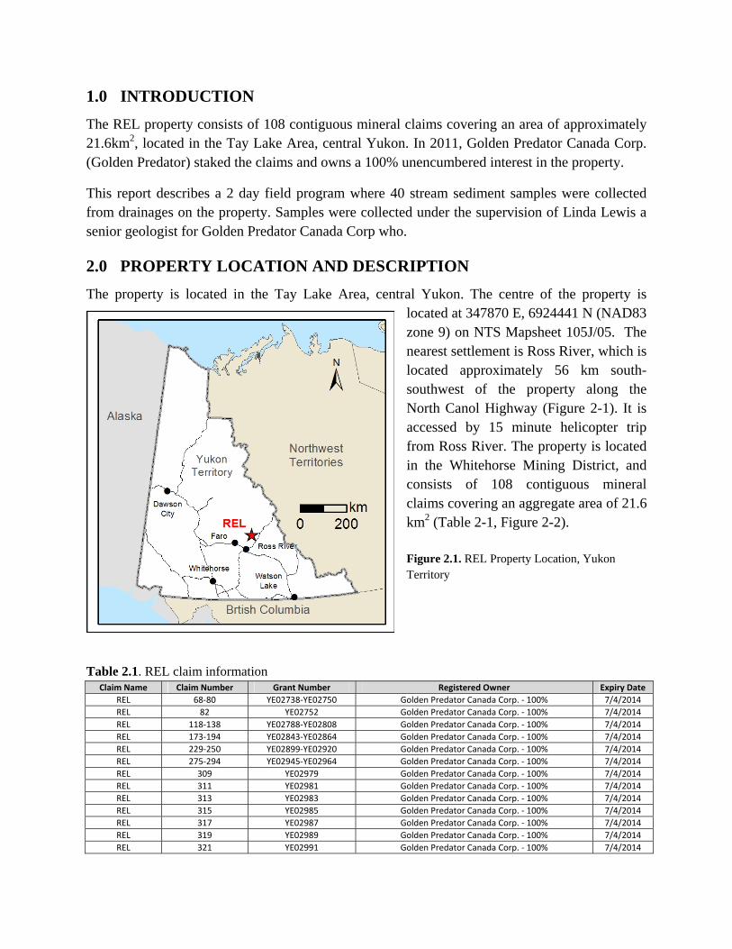
The property is located in the Tay Lake Area, central Yukon. The centre of the property is located at 347870 E, 6924441 N (NAD83 zone 9) on NTS Mapsheet 105J/05. The nearest settlement is Ross River, which is located approximately 56 km south-southwest of the property along the North Canol Highway (Figure 2-1). It is accessed by 15 minute helicopter trip from Ross River. The property is located in the Whitehorse Mining District, and consists of 108 contiguous mineral claims covering an aggregate area of 21.6 km2 (Table 2-1, Figure 2-2). Figure 2.1. REL Property Location, Yukon Territory
Table 2.1. REL claim information
Claim Name Claim Number Grant Number Registered Owner Expiry Date
REL 68‐80 YE02738‐YE02750 Golden Predator Canada Corp. ‐ 100% 7/4/2014
REL 82 YE02752 Golden Predator Canada Corp. ‐ 100% 7/4/2014
REL 118‐138 YE02788‐YE02808 Golden Predator Canada Corp. ‐ 100% 7/4/2014
REL 173‐194 YE02843‐YE02864 Golden Predator Canada Corp. ‐ 100% 7/4/2014
REL 229‐250 YE02899‐YE02920 Golden Predator Canada Corp. ‐ 100% 7/4/2014
REL 275‐294 YE02945‐YE02964 Golden Predator Canada Corp. ‐ 100% 7/4/2014
REL 309 YE02979 Golden Predator Canada Corp. ‐ 100% 7/4/2014
REL 311 YE02981 Golden Predator Canada Corp. ‐ 100% 7/4/2014
REL 313 YE02983 Golden Predator Canada Corp. ‐ 100% 7/4/2014
REL 315 YE02985 Golden Predator Canada Corp. ‐ 100% 7/4/2014
REL 317 YE02987 Golden Predator Canada Corp. ‐ 100% 7/4/2014
REL 319 YE02989 Golden Predator Canada Corp. ‐ 100% 7/4/2014
REL 321 YE02991 Golden Predator Canada Corp. ‐ 100% 7/4/2014

REL 323 YE02993 Golden Predator Canada Corp. ‐ 100% 7/4/2014
REL 38 YE02708 Golden Predator Canada Corp. ‐ 100% 7/4/2014
REL 89‐91 YE02759‐YE02761 Golden Predator Canada Corp. ‐ 100% 7/4/2014
REL 93 YE02763 Golden Predator Canada Corp. ‐ 100% 7/4/2014
REL 95 YE02765 Golden Predator Canada Corp. ‐ 100% 7/4/2014
REL 97 YE02767 Golden Predator Canada Corp. ‐ 100% 7/4/2014
REL 99 YE02769 Golden Predator Canada Corp. ‐ 100% 7/4/2014
REL 101‐102 YE02771‐YE02772 Golden Predator Canada Corp. ‐ 100% 7/4/2014
REL 104 YE02774 Golden Predator Canada Corp. ‐ 100% 7/4/2014
REL 106 YE02776 Golden Predator Canada Corp. ‐ 100% 7/4/2014
REL 145‐146 YE02815‐YE02816 Golden Predator Canada Corp. ‐ 100% 7/4/2014
REL 148 YE02818 Golden Predator Canada Corp. ‐ 100% 7/4/2014
REL 161‐163 YE02831‐YE02833 Golden Predator Canada Corp. ‐ 100% 7/4/2014
REL 165 YE02835‐ Golden Predator Canada Corp. ‐ 100% 7/4/2014
REL 167 YE02837 Golden Predator Canada Corp. ‐ 100% 7/4/2014
REL 169 YE02839 Golden Predator Canada Corp. ‐ 100% 7/4/2014
REL 171 YE02841 Golden Predator Canada Corp. ‐ 100% 7/4/2014
REL 199 YE02869 Golden Predator Canada Corp. ‐ 100% 7/4/2014
REL 201 YE02871 Golden Predator Canada Corp. ‐ 100% 7/4/2014
REL 259‐260 YE02929‐YE02930 Golden Predator Canada Corp. ‐ 100% 7/4/2014
REL 262 YE02932 Golden Predator Canada Corp. ‐ 100% 7/4/2014
REL 264 YE02934 Golden Predator Canada Corp. ‐ 100% 7/4/2014
REL 266 YE02936 Golden Predator Canada Corp. ‐ 100% 7/4/2014
REL 268 YE02938 Golden Predator Canada Corp. ‐ 100% 7/4/2014
REL 270 YE02940 Golden Predator Canada Corp. ‐ 100% 7/4/2014
REL 272 YE02942 Golden Predator Canada Corp. ‐ 100% 7/4/2014
REL 274 YE02944 Golden Predator Canada Corp. ‐ 100% 7/4/2014
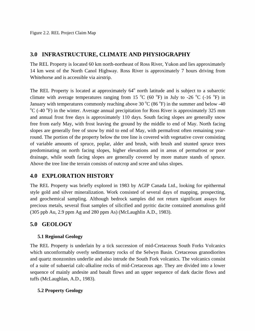
Figure 2.2. REL Project Claim Map
3.0 INFRASTRUCTURE, CLIMATE AND PHYSIOGRAPHY
The REL Property is located 60 km north-northeast of Ross River, Yukon and lies approximately 14 km west of the North Canol Highway. Ross River is approximately 7 hours driving from Whitehorse and is accessible via airstrip. The REL Property is located at approximately 64o north latitude and is subject to a subarctic climate with average temperatures ranging from 15 oC (60 oF) in July to -26 oC (-16 oF) in January with temperatures commonly reaching above 30 oC (86 oF) in the summer and below -40 oC (-40 oF) in the winter. Average annual precipitation for Ross River is approximately 325 mm and annual frost free days is approximately 110 days. South facing slopes are generally snow free from early May, with frost leaving the ground by the middle to end of May. North facing slopes are generally free of snow by mid to end of May, with permafrost often remaining year-round. The portion of the property below the tree line is covered with vegetative cover consisting of variable amounts of spruce, poplar, alder and brush, with brush and stunted spruce trees predominating on north facing slopes, higher elevations and in areas of permafrost or poor drainage, while south facing slopes are generally covered by more mature stands of spruce. Above the tree line the terrain consists of outcrop and scree and talus slopes.
4.0 EXPLORATION HISTORY
The REL Property was briefly explored in 1983 by AGIP Canada Ltd., looking for epithermal style gold and silver mineralization. Work consisted of several days of mapping, prospecting, and geochemical sampling. Although bedrock samples did not return significant assays for precious metals, several float samples of silicified and pyritic dacite contained anomalous gold (305 ppb Au, 2.9 ppm Ag and 280 ppm As) (McLaughlin A.D., 1983).
5.0 GEOLOGY
5.1 Regional Geology
The REL Property is underlain by a tick succession of mid-Cretaceous South Forks Volcanics which unconformably overly sedimentary rocks of the Selwyn Basin. Cretaceous granodiorites and quartz monzonites underlie and also intrude the South Fork volcanics. The volcanics consist of a suite of subaerial calc-alkaline rocks of mid-Cretaceous age. They are divided into a lower sequence of mainly andesite and basalt flows and an upper sequence of dark dacite flows and tuffs (McLaughlan, A.D., 1983).
5.2 Property Geology
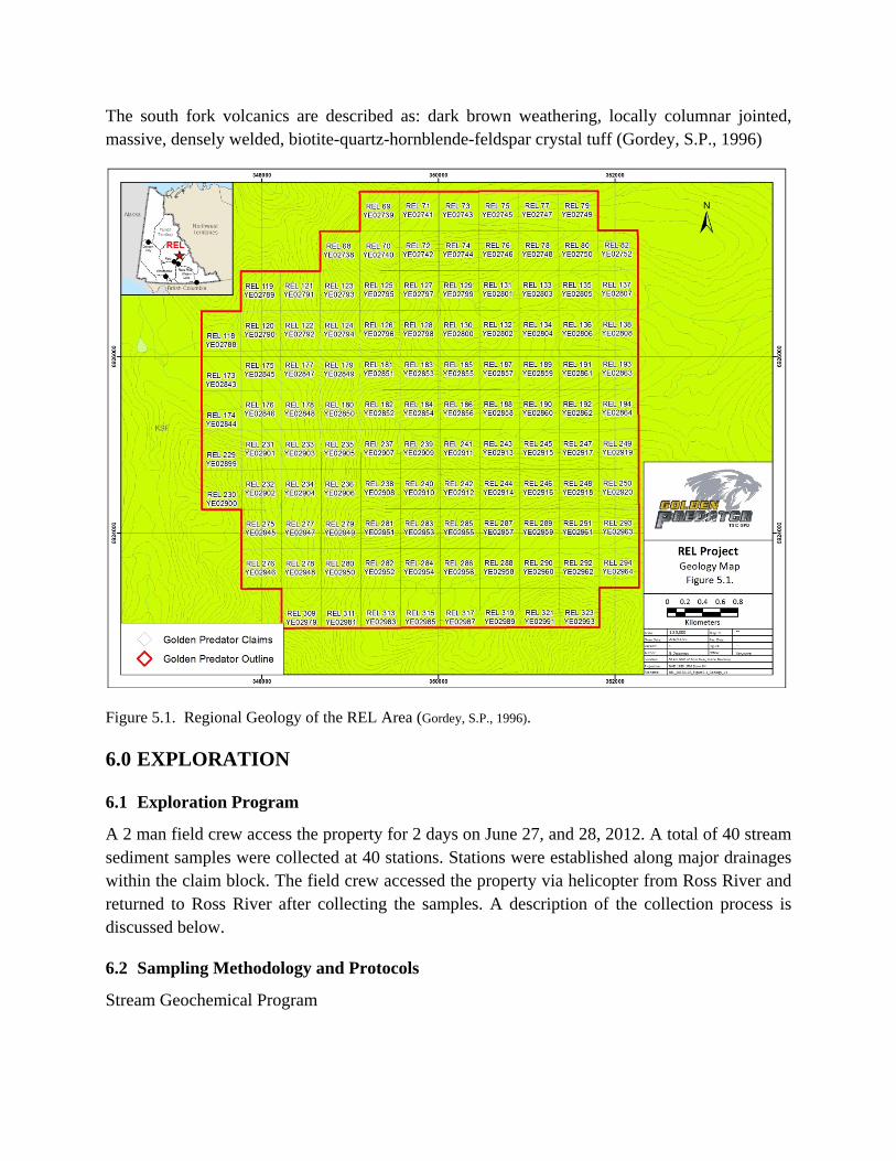
The south fork volcanics are described as: dark brown weathering, locally columnar jointed, massive, densely welded, biotite-quartz-hornblende-feldspar crystal tuff (Gordey, S.P., 1996)
Figure 5.1. Regional Geology of the REL Area (Gordey, S.P., 1996).
6.0 EXPLORATION
6.1 Exploration Program
A 2 man field crew access the property for 2 days on June 27, and 28, 2012. A total of 40 stream sediment samples were collected at 40 stations. Stations were established along major drainages within the claim block. The field crew accessed the property via helicopter from Ross River and returned to Ross River after collecting the samples. A description of the collection process is discussed below.
6.2 Sampling Methodology and Protocols
Stream Geochemical Program
Stream sediment samples were collected under the supervision of Linda Lewis along first, second and third order streams, and immediately upstream of confluences.
Each sample was collected from several points along the active stream bed to produce a representative composite sample. The uppermost sediment was discarded to avoid spurious high content of Fe and Mn oxide coating. The active silt and fine to medium sand that has been recently transported by the stream was the target sediment. This type of sediment was generally located: 1) in the lee of large boulders or logs; 2) in low energy pools at the tail-end of bars; and 3) infilling voids below the surface of cobble-gravel bars.
Samples were sieved in the field to a fraction of less than one-eight inch (<1/8” or 3.36 mm) and placed in labeled, double layered plastic sample bags. Sample sites were flagged and photographed. The sample weights varied between 4-12 kg. Large sample sizes were required to obtain sufficient fine material for the selected assay techniques.
If the drainage contained seasonal stream sediment deposition, but was currently dry, a sediment sample was collected by dry sieving the material. Occasionally the south-facing slopes had underground drainage that sporadically comes to surface, in which case sample spacing sometimes varied.
Sample data was recorded on data cards and included the following: geographic location, sample color, angularity of the clasts, sediment composition (percentage of gravel, sand, silt, clay and organics), slope direction, slope angle, stream flow, vegetation type and comments. Sample data is summarized in Appendix 3.
Samples were transported by air from the property to Whitehorse via helicopter. Samples were delivered by in-house personnel or insured professional expeditors to ALS Chemex’s ISO 9001 certified preparation facility in Whitehorse. Samples were dried and screened to 180 microns (80 mesh).
The pulps were analyzed at ALS Chemex’s ISO 9001 certified laboratory in North Vancouver using the ultra-trace ME-MS41 package. A 0.5 g sample is digested by aqua regia techniques and 51 elements are analyzed through a combination of ICP-AES and ICP-MS.
The Au-ST44 method was used to analyze gold using a 50 g sample of <80 micron material. This method provides the lowest possible detection limit for gold of 0.0001 – 0.1 ppm, using aqua regia digestion with analysis by ICP-MS. The larger sample size for the gold analysis is used in an effort to reduce potential nugget effects. Samples exceeding the upper limit of Au detection (0.1 ppm) were re-analyzed using Au-OG44, an ore grade assay technique. A 50 g sample of 180 microns sediment is digested in an aqua regia solution and finished with ICP-MS methods to provide an Au detection range between 0.01 – 100 ppm.
ALS completes quality assurance/ quality control (QA/QC) data verification of their assays through internally inserted duplicates, standards and blanks. In addition, Golden Predator followed a protocol for sample quality control and quality assurance throughout the regional exploration program. The QA/QC program involved the regular insertion of field duplicates, blanks and standard reference material into each stream sediment batch.
6.3 Results
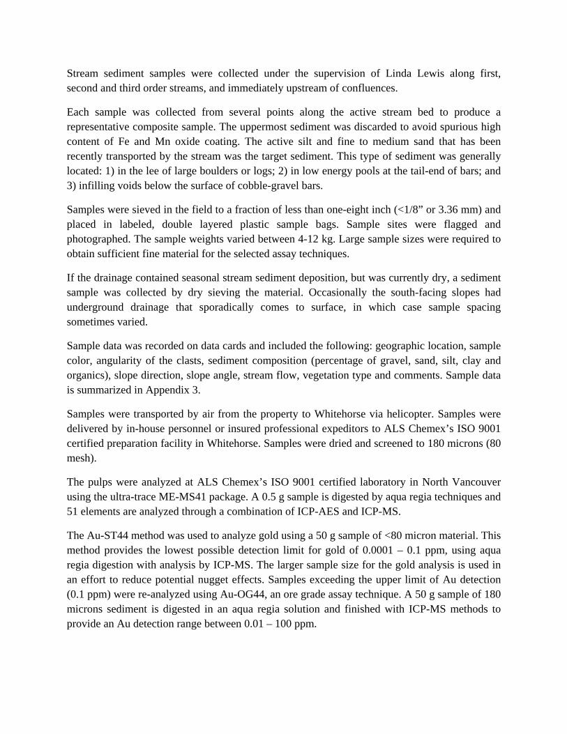
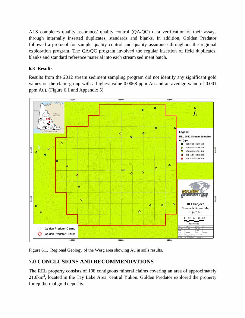
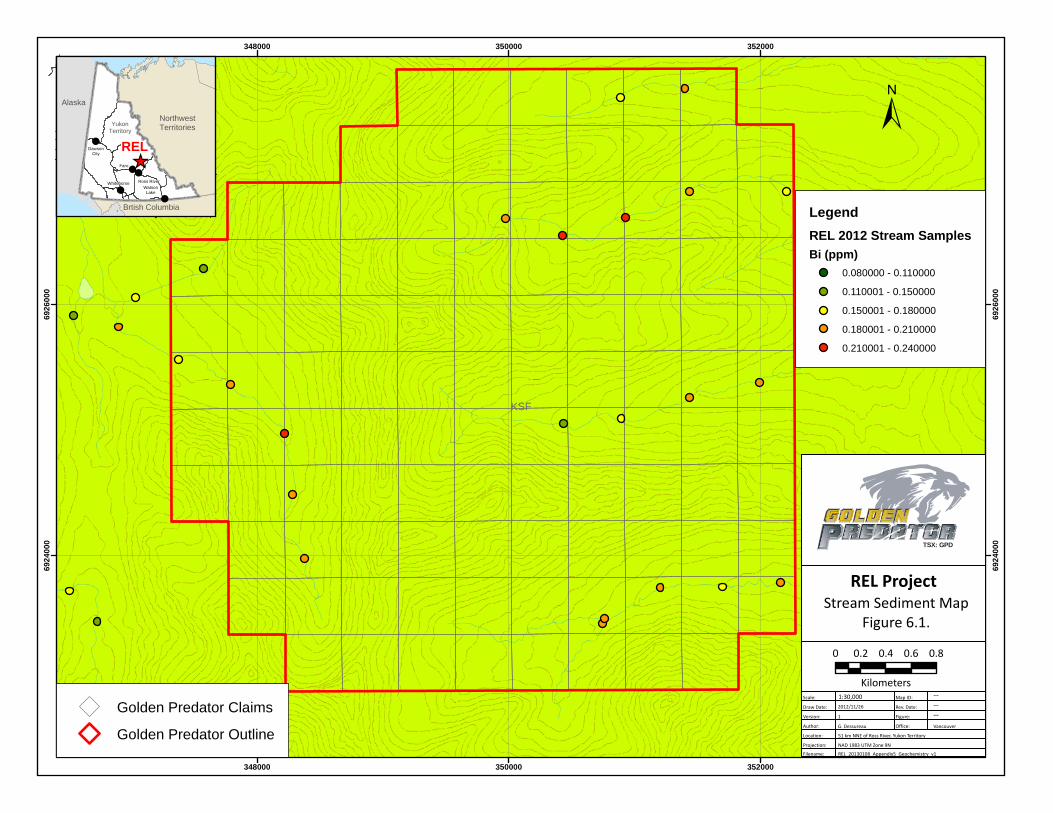
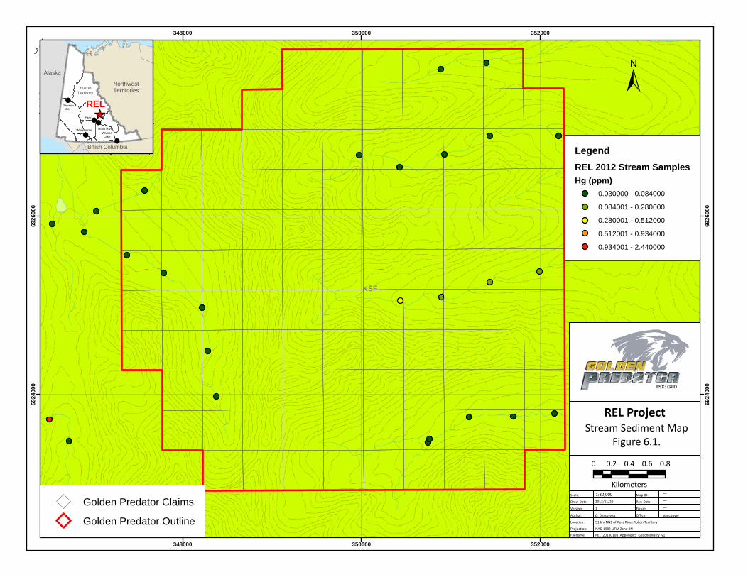
Results from the 2012 stream sediment sampling program did not identify any significant gold values on the claim group with a highest value 0.0068 ppm Au and an average value of 0.001 ppm Au). (Figure 6.1 and Appendix 5).
Figure 6.1. Regional Geology of the Werg area showing Au in soils results.
7.0 CONCLUSIONS AND RECOMMENDATIONS
The REL property consists of 108 contiguous mineral claims covering an area of approximately 21.6km2, located in the Tay Lake Area, central Yukon. Golden Predator explored the property for epithermal gold deposits.
lllewis
Cross-Out
lllewis
Text Box
silt
The 2012 stream sediment program consisted of 40 stream sediment samples collected on several major drainages on the property. The program did not identify any significant precious metals within the sampled area.
No further work is recommending for the REL property.

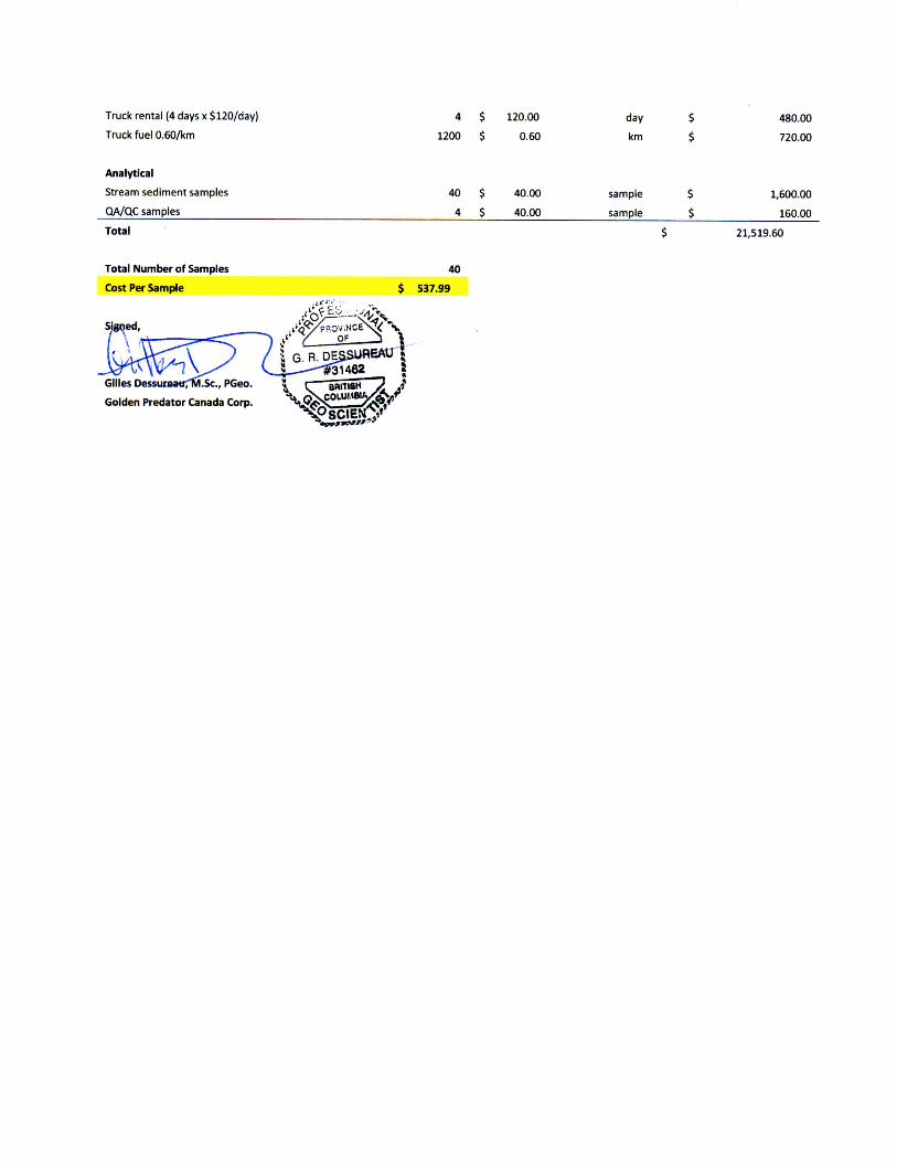
8.0 2012 EXPENDITURES
Expenditures for the 2012 exploration program were $21,519.60 as summarized in Table 8-1. Table 8-1. 2012 Expenditures
Expenditure June 25 ‐ July 4, 2012 Units Unit Cost Per Cost
Golden Predator Corp. 40 $537.99 sample $ 21,519.60
for detail breakdown, see below
DETAIL COST BREAKDOWN
Expenditure June 25 ‐ July 4, 2012 Units Unit Cost Per Cost
Wages
Golden Predator
June 25 ‐ Program planning 1 $ 500.00 day $ 500.00
June 26 ‐ Prep field gear, travel to Faro 1 $ 550.00 day $ 550.00
June 27 ‐ Field 1 $ 550.00 day $ 550.00
June 28 ‐ Field 1 $ 550.00 day $ 550.00
June 30 ‐ Travel Faro to Whitehorse 1 $ 550.00 day $ 550.00
July 3 ‐ Data entry, sample sort 1 $ 500.00 day $ 500.00
July 5 ‐ Samples to lab, Certificate of Work 1 $ 500.00 day $ 500.00
Report Writing 4 $ 500.00 day $ 2,000.00
Wages
Contractor ‐ Rafe Exploration Inc.
June 27 ‐ Field 3 $ 450.00 day $ 1,350.00
June 28 ‐ Field 3 $ 450.00 day $ 1,350.00
Transportation
Trans North Jet Ranger ‐ June 27, 28 6.1 $ 990.00 hour $ 6,039.00
Fuel from Ross River Base 834 $ 1.40 litre $ 1,167.60
Food & Accommodation in Faro 8 $ 100.00 person/day $ 800.00
Consumables
Field supplies ‐ sample bags, safety epuip, etc $ 75.00 $ 75.00
Communications ‐ rental
4 handheld radios 4 $ 28.75 week $ 115.00
4 satellite phones 4 $ 75.00 week $ 300.00
Golden Predator Travel Costs in Yukon
Meals (2 days x 1 person x $65/day) 2 $ 65.00 day $ 130.00
Truck rental (1 truck x 4 days x $100/day) 4 $ 100.00 day $ 400.00
Truck fuel (Whitehorse, Faro, Carmacks) $ 233.00 $ 233.00
Rafex Exploration Travel Costs in Yukon
June 26 ‐ day travel rate for crew 1 $ 450.00 day $ 450.00
June 29 ‐ day travel rate for crew 1 $ 450.00 day $ 450.00
Truck rental (4 days x $120/day)
Truck fuel 0.60/km 4
1200
$ 120.00
$ 0.60
day
km 480.00
720.00
Analytical
Stream sediment samples
QA/QC samples 40
4
$ 40.00
$ 40.00 sample
sample
1,600.00
160.00 Total 21,519.60
Total Number of Samples
Cost Per Sample 40
Gilles DessureatiffVI.Sc., PGeo. Golden Predator Canada Corp.
S 537.99
\ BRITISH 2 J
9.0 STATEMENT OF AUTHORSfflP
This Report titled "Assessment Report, 2012 Geocheraical Sampling Program REL Property,
Whitehorse Mining District, Yukon, Canada", and dated January 11* 2013 was prepared and
signed by the following author: , V .̂-v
C °f- J 5̂ (B, H DESSUREAU
#31462
Gilles Dessm^atCM.Sc, P.Geo.
Dated: January 11^2013
Vancouver, British Columbia
10.0 REFERENCES
McLaughlan, A.D., 1983. Assessment Report RAGS 1-8 claims Whitehorse Mining District, NTS 105J-05. Prospecting and Geochemical sampling August 15th, 1983. Yukon Assessment Report #091484. Gordey, S.P., 1996. Geology, Sheldon Lake Area, Yukon Territory,. Geological Survey of Canada, Map 19-1987 Sheet 1. Yukon Minfile 105J 038 FLOOD. Yukon Geological Survey.
Appendix 1 Statement of Qualifications
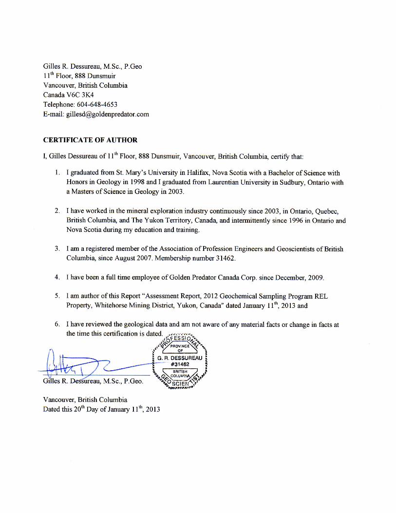
Gilles R. Dessureau, M.Sc, P.Geo 11* Floor, 888 Dimsmuir Vancouver, British Columbia Canada V6C 3K4 Telephone: 604-648-4653 E-mail: [email protected]
CERTIFICATE OF AUTHOR I, Gilles Dessureau of 11* Floor, 888 Dunsmuir, Vancouver, British Columbia, certify that:
1. I graduated from St. Mary's University in Halifax, Nova Scotia v/ith a Bachelor of Science with Honors in Geology in 1998 and I graduated from Laurentian University in Sudbury, Ontario with a Masters of Science in Geology in 2003.
2. I have worked in the mineral exploration industry continuously since 2003, in Ontario, Quebec, British Columbia, and The Yukon Territory, Canada, and intermittently since 1996 in Ontario and Nova Scotia diu-ing my education and training.
3. I am a registered member of the Association of Profession Engineers and Geoscientists of British Columbia, since August 2007. Membership number 31462.
4. I have been a full time employee of Golden Predator Canada Corp. since December, 2009.
5. I am author of this Report "Assessment Report, 2012 Geochemical Sampling Program REL Property, Whitehorse Mining District, Yukon, Canada" dated Januaiy 11*, 2013 and
6. I have reviewed the geological data and am not aware of any material facts or change in facts at the time this certification is dated.
Vancouver, British Columbia Dated this 20* Day of January 11"', 2013
Appendix 2 Analytical Summary

Sample ID
Sample
Code
Program
Code
Coords Grid
Code Coords X Coords Y
Coords Grid
Code
Sample
By
Sample
Date Au (ppm)
Ag
(ppm)
Cu
(ppm)
Pb
(ppm)
Zn
(ppm)
As
(ppm)
Bi
(ppm)
Hg
(ppm)
Sb
(ppm)
AA050401 SSed 2012 UTM83‐9 350744.3 6923458.42 UTM83‐9 Rafex 27‐Jun‐12 0.0009 0.063 11.4 11.7 68.8 44.1 0.2 0.062 0.658
AA050402 SSed 2012 UTM83‐9 351201.74 6923742.85 UTM83‐9 Rafex 27‐Jun‐12 0.0007 0.055 9.12 11.55 63.4 36.2 0.21 0.059 0.574
AA050403 SSed 2012 UTM83‐9 349971.89 6926680.53 UTM83‐9 Rafex 27‐Jun‐12 0.001 0.111 7.68 11.55 71.3 12.7 0.19 0.049 0.381
AA050404 SSed 2012 UTM83‐9 350425.69 6926548.25 UTM83‐9 Rafex 27‐Jun‐12 0.0007 0.076 7.34 12.5 78.3 6.92 0.24 0.03 0.251
AA050405 SSed 2012 UTM83‐9 350925.41 6926688.61 UTM83‐9 Rafex 27‐Jun‐12 0.0007 0.086 8.55 12.3 76.4 7.13 0.24 0.039 0.323
AA050406 SSed 2012 UTM83‐9 351437.97 6926900.97 UTM83‐9 Rafex 27‐Jun‐12 0.0006 0.093 8.06 10.75 73.6 6.17 0.21 0.043 0.333
AA050407 SSed 2012 UTM83‐9 352203.24 6926895.39 UTM83‐9 Rafex 27‐Jun‐12 0.0003 0.046 7.39 10.15 74 5.66 0.18 0.043 0.328
AA050408 SSed 2012 UTM83‐9 348378 6923977 UTM83‐9 Rafex 28‐Jun‐12 0.0009 0.074 9.01 14.05 70 15.95 0.19 0.045 0.428
AA050409 SSed 2012 UTM83‐9 348281 6924488 UTM83‐9 Rafex 28‐Jun‐12 0.0009 0.074 9.12 12.7 63.2 11.35 0.2 0.061 0.379
AA050410 SSed 2012 UTM83‐9 348219 6924974 UTM83‐9 Rafex 28‐Jun‐12 0.0038 0.106 10.2 13.8 70.1 14.5 0.22 0.057 0.449
AA050411 SSed 2012 UTM83‐9 347792 6925361 UTM83‐9 Rafex 28‐Jun‐12 0.001 0.107 9.49 13.1 69.9 16.7 0.21 0.069 0.509
AA050412 SSed 2012 UTM83‐9 347379 6925563 UTM83‐9 Rafex 28‐Jun‐12 0.0005 0.086 7.88 10.85 61.8 13.25 0.16 0.047 0.417
AA050413 SSed 2012 UTM83‐9 346900 6925820 UTM83‐9 Rafex 28‐Jun‐12 0.0004 0.085 8.01 11.15 63.4 13.8 0.19 0.06 0.444
AA050414 SSed 2012 UTM83‐9 346538 6925914 UTM83‐9 Rafex 28‐Jun‐12 0.0008 0.034 7.58 9.3 72.9 4.86 0.13 0.033 0.305
AA050415 SSed 2012 UTM83‐8 650714 6924507 UTM83‐8 Rafex 28‐Jun‐12 0.0068 0.122 14.1 12.3 73.4 6.41 0.2 0.28 0.709
AA050416 SSed 2012 UTM83‐8 651042 6924849 UTM83‐8 Rafex 28‐Jun‐12 0.0015 0.085 10.3 10.85 65.6 6.1 0.16 0.463 0.751
AA050417 SSed 2012 UTM83‐8 651600 6924881 UTM83‐8 Rafex 28‐Jun‐12 0.0024 0.106 9.84 10.3 62.1 4.33 0.15 0.719 0.643
AA050451 SSed 2012 UTM83‐9 350764.2 6923497.35 UTM83‐9 Llews 27‐Jun‐12 0.0015 0.087 9.82 10.65 67.2 25.8 0.2 0.057 0.589
AA050452 SSed 2012 UTM83‐9 351696.85 6923750.25 UTM83‐9 Llews 27‐Jun‐12 0.0008 0.061 8.32 10.6 65 30.3 0.18 0.043 0.528
AA050453 SSed 2012 UTM83‐9 352161.91 6923785.94 UTM83‐9 Llews 27‐Jun‐12 0.0011 0.067 6.99 10.65 63.5 19.65 0.21 0.055 0.455
AA050454 SSed 2012 UTM83‐9 350432.43 6925050.93 UTM83‐9 Llews 27‐Jun‐12 0.0013 0.089 8.34 12.15 74.3 56.9 0.14 0.384 1.41
AA050455 SSed 2012 UTM83‐9 350891.94 6925088.47 UTM83‐9 Llews 27‐Jun‐12 0.001 0.084 8.89 11.9 75.4 42.7 0.16 0.266 1.12
AA050456 SSed 2012 UTM83‐9 351437.81 6925257.64 UTM83‐9 Llews 27‐Jun‐12 0.0009 0.071 9.79 13.35 80.7 37.7 0.19 0.18 0.965
AA050457 SSed 2012 UTM83‐9 351990.1 6925380.66 UTM83‐9 Llews 27‐Jun‐12 0.0007 0.076 8.62 12.6 83.5 28.6 0.2 0.134 0.794
AA050458 SSed 2012 UTM83‐9 350884.55 6927649.77 UTM83‐9 Llews 27‐Jun‐12 0.0005 0.048 8.65 10.45 68.5 5.67 0.17 0.051 0.359
AA050459 SSed 2012 UTM83‐9 351400.22 6927718.42 UTM83‐9 Llews 27‐Jun‐12 0.0005 0.07 10.15 12.05 78.1 6.25 0.19 0.084 0.549
AA050460 SSed 2012 UTM83‐9 347571.52 6926283.56 UTM83‐9 Llews 27‐Jun‐12 0.0009 0.056 10.45 10.5 80.6 6.12 0.13 0.04 0.364
AA050461 SSed 2012 UTM83‐9 347037.14 6926058.15 UTM83‐9 Llews 27‐Jun‐12 0.0015 0.089 11 11.05 77.3 7.03 0.17 0.035 0.484
AA050462 SSed 2012 UTM83‐8 654732.96 6925452.98 UTM83‐8 Llews 28‐Jun‐12 0.0006 0.039 9.69 9.03 67.8 3.75 0.13 0.048 0.266
AA050463 SSed 2012 UTM83‐8 654650.3 6925828 UTM83‐8 Llews 28‐Jun‐12 0.0007 0.054 9.91 8.81 65.5 4.15 0.13 0.051 0.323
AA050464 SSed 2012 UTM83‐8 654468.16 6926255.98 UTM83‐8 Llews 28‐Jun‐12 0.001 0.081 9.43 9.66 71.7 5.39 0.13 0.148 0.346
AA050465 SSed 2012 UTM83‐8 653882.48 6926383.4 UTM83‐8 Llews 28‐Jun‐12 0.0006 0.083 9.13 9.36 76.4 5.28 0.14 0.18 0.34
AA050466 SSed 2012 UTM83‐8 653420.98 6926388.11 UTM83‐8 Llews 28‐Jun‐12 0.0005 0.07 8.28 8.73 77.2 4.45 0.13 0.155 0.314
AA050467 SSed 2012 UTM83‐8 653268.11 6926399.6 UTM83‐8 Llews 28‐Jun‐12 0.001 0.054 9.49 9.69 65.7 4.72 0.14 0.05 0.359
AA050468 SSed 2012 UTM83‐9 346508.27 6923718.22 UTM83‐9 Llews 28‐Jun‐12 0.0005 0.046 8.76 11.3 73.1 6.4 0.17 2.44 0.311
AA050469 SSed 2012 UTM83‐9 346728.43 6923475.27 UTM83‐9 Llews 28‐Jun‐12 0.0009 0.054 8.4 9.13 59.4 4.69 0.13 0.077 0.269
AA050470 SSed 2012 UTM83‐8 654386.32 6923763.85 UTM83‐8 Llews 28‐Jun‐12 0.0006 0.064 9.21 14.25 70.8 6.14 0.19 0.934 0.342
AA050471 SSed 2012 UTM83‐8 650858.18 6926302.69 UTM83‐8 Llews 28‐Jun‐12 0.0008 0.141 8.93 9.42 67.7 4.85 0.14 0.512 0.476
AA050472 SSed 2012 UTM83‐8 651630.85 6926401.23 UTM83‐8 Llews 28‐Jun‐12 0.0006 0.153 9.37 7.06 70.8 8.39 0.11 0.123 0.512
AA050473 SSed 2012 UTM83‐8 651769.1 6926860.33 UTM83‐8 Llews 28‐Jun‐12 0.0007 0.138 6.34 5.62 57.2 4.89 0.08 0.127 0.331

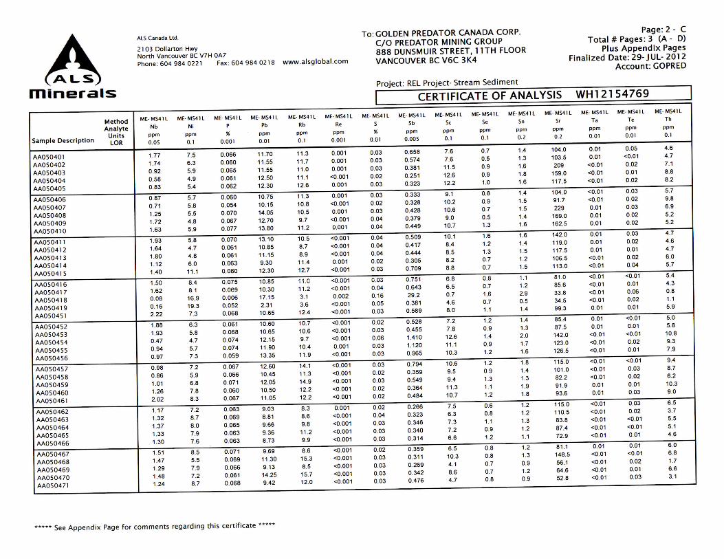
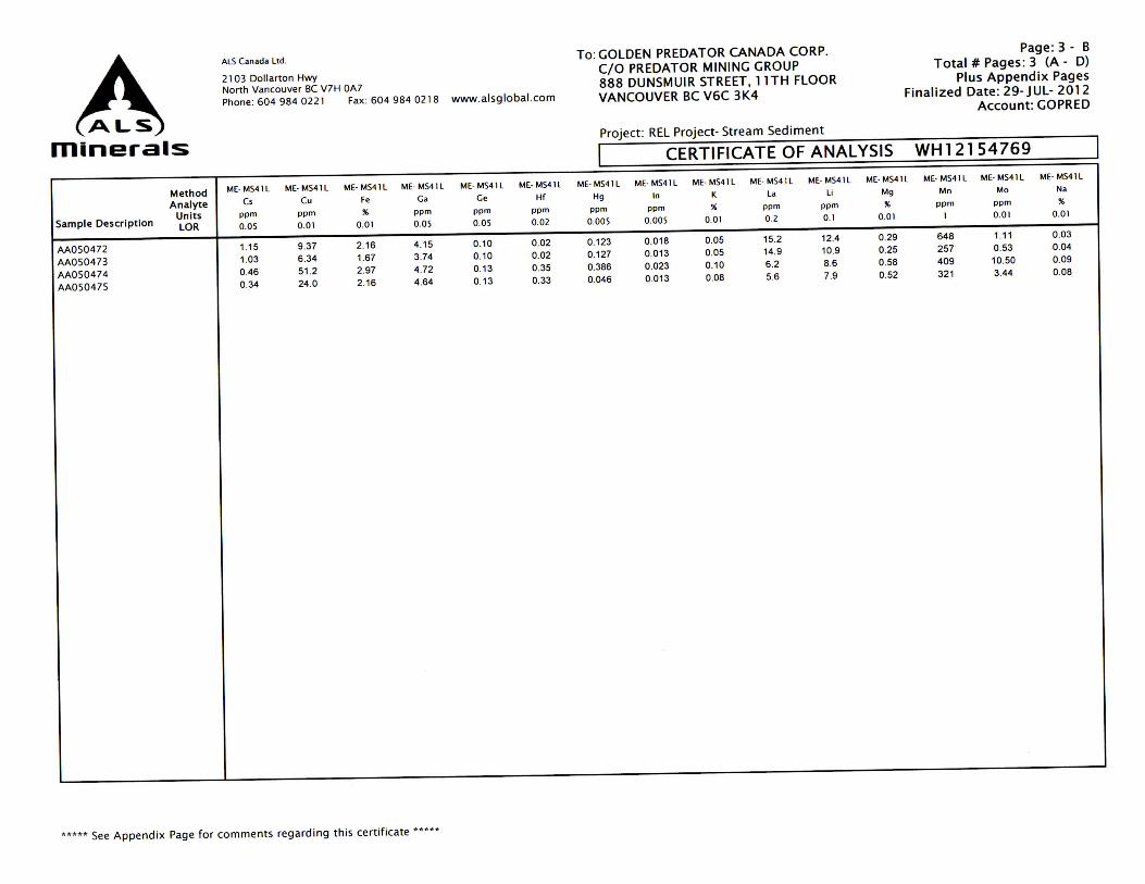
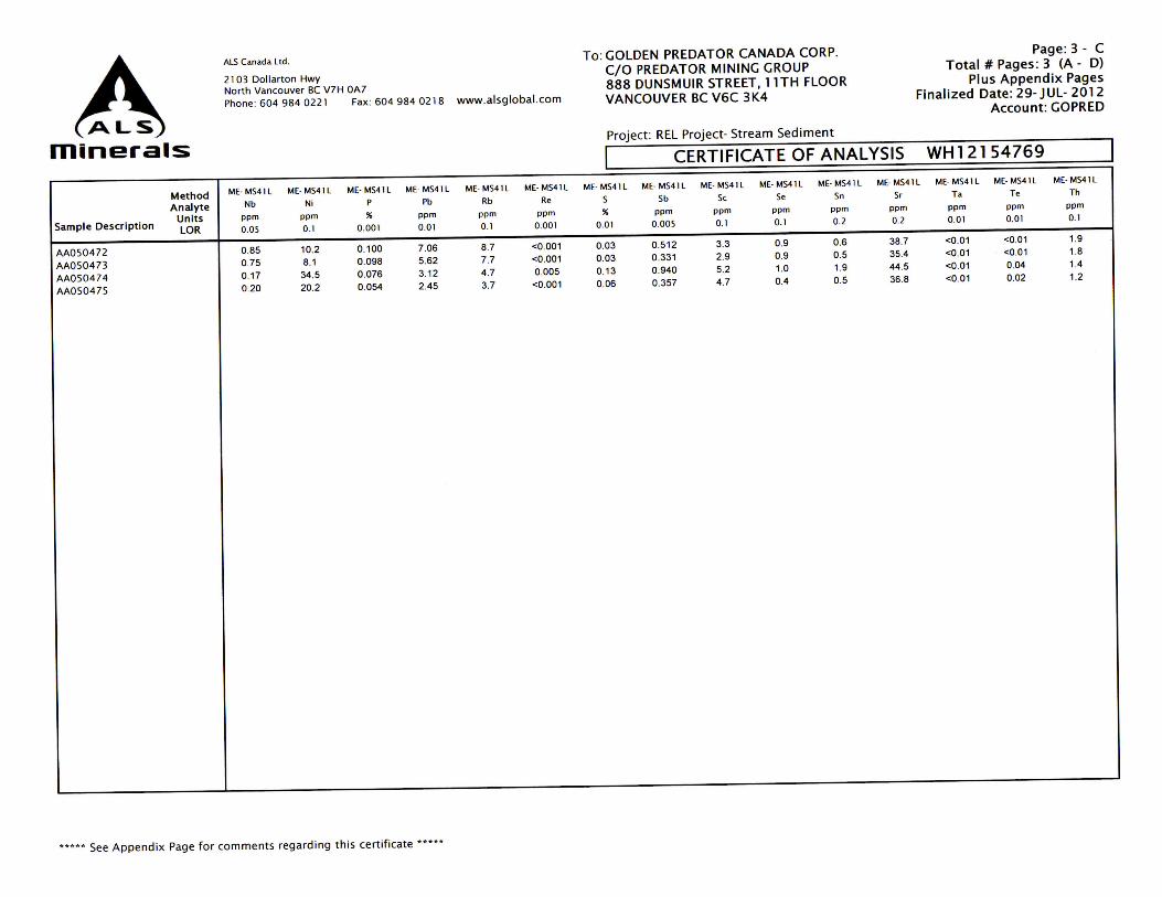
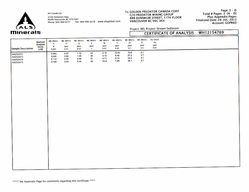
Appendix 3 Assay Certificates

ALS Canada Ltd.
21 03 Dollarton Hwy North Vancouver BC V7H 0A7 Phone: 604 984 02 21 Fax: 604 984 0218 www.alsglobal.com
minerals CERTIFICATE WHl 2154769
Project: REL Project- Stream Sediment
P.O. No.: REL- 2012- NK- 2303
This report is for 44 Stream Sediment samples submitted to our lab in Whitehorse , YT, Canada on 4- JUL- 2012 .
The following have access to data associated with this certificate :
LINDA LEWIS MIKE MASLOWSKI BILL SHERIFF MI KE BURKE I ANDREW CALDWELL I JACK COTE
To: GOLDEN PREDATOR CANADA CORP. ATTN: ANDREW CALDWELL C/O PREDATOR MINING GROUP 888 DUNSMUIR STREET, 11TH FLOOR VANCOUVER BC V6C 3K4
To: GOLDEN PREDATOR CANADA CORP. C/O PREDATOR MINING GROUP 888 DUNSMUIR STREET, 11TH FLOOR VANCOUVER BC V6C 3K4
Page: 1 Finalized Date: 29-JUL- 2012
Account: GOPRED
SAMPLE PREPARATION ALS CODE DESCRIPTION
WEl-21 Rece ived Sample Weigh t
LOG- 22 Sample log in · Red w/o BarCode
LOG· 24 Pulp Login - Red w/o Barcode
SCR- 41 Screen to · 1 80um and save both
DRY- 22 Drying - Max imum Temp 60C
ANALYTICAL PROCEDURES ALS CODE DESCRIPTION INSTRUMENT
Au- OG43 Ore Grade Au · 2 Sg AR ICP· MS
Au- ST4 3 Super Trace Au - 2 Sg AR ICP· MS
ME- MS41L 51 anal. aqua regia ICPMS
This is the Final Report and supersedes any prelim inary report with th is ce rtificate number. Results apply to samples as
subm itted. All pages of th is report have been checked and approved for release . Signature: ~---***** See Append ix Page for comments regarding this cert ificate * * *** Colin Ramshaw, Vancouver Laboratory Manager

ALS Canada Ltd.
21 03 Dollarto n Hwy North Vancouver BC V7 H OA7
Pho ne: 604 984 022 1 Fax : 604 984 021 8 www.alsglobal. com
minerals
Method WEl- 21 Au-ST43 ME· MS41 L ME· MS41L ME· MS41 L ME· MS41L
Analyte Recvd WL Au Au Ag Al As
Sample Description Un its kg ppm ppm ppm " ppm
LOR 0.02 0.0001 0.0002 0.002 0.01 0.02
AA0 50401 4.48 0.0009 0.0024 0.063 2.73 44.1
AA050402 4.39 0.0007 0.0007 0.055 2.67 36.2
AA050403 3.30 0.0010 0.0008 0 .111 3.59 12.70
AA050404 3.37 0.0007 0.0018 0 .076 3.21 6.92
AA050405 4.36 0.0007 0.0013 0.086 2.74 7.13
AA050406 4.38 0.0006 0.0020 0.093 2.48 6 .17
AA050407 2.86 0.0003 0.0011 0.046 2 .39 5.66
AA050408 3.20 0.0009 0.0020 0 .074 3.87 15.95
AA050409 3.78 0.0009 0.0025 0.074 3.30 11 .35
AA050410 2.49 0.0038 0.0038 0 .106 3.56 14.50
AA05041 1 3.55 0.001 0 <0.0002 0.107 3.41 16.70
AA050412 4.08 0.0005 0.0006 0.086 2.91 13.25
AA050413 3. 54 0.0004 0 ,0012 0.085 2.88 13.80
AA050414 3.36 0.0008 0.0012 0.034 2.17 4.86
AA050415 2.29 0.0068 0.0020 0.122 2.67 6.41
AA050416 3.29 0.0015 0.0013 0.085 2.27 6.10
AA0504 1 7 2.77 0.0024 0.0021 0.106 2 .23 4 .33
AA050418 0.11 >0.1000 0.151 0.138 0.18 466
AA0504 19 0.11 0.0022 0 .0067 0.448 1.16 3.84
AA05045 1 3.91 0.0015 0.0014 0 ,087 2.94 25.8
AA050452 4.10 0.0008 0.0005 0.061 2.41 30.3
AA050453 5.11 0.0011 0.0012 0.067 2.35 19.65
AA050454 6 .11 0.0013 0.0006 0.089 2.89 56.9
AA0 50455 3. 89 0.0010 0.0010 0.084 2.75 42.7
AA050456 4 .25 0.0009 0.0006 0.071 2.78 37.7
AA050457 4.64 0.0007 0.0004 0.076 2.59 28 .6
AA050458 4.25 0.0005 <0.0002 0.048 2.45 5.67
AA050459 4 .39 0.0005 0.0008 0.070 2.52 6.25
AA050460 4.15 0.0009 0.0009 0.056 2.80 6 .12
AA050461 5.46 0.0015 0.0013 0.089 2.84 7.03
AA0 50462 4.24 0.0006 0.0009 0.039 2.42 3.75
AA050463 4.20 0.0007 0.0006 0.054 2.44 4.15
AA0 50464 3.69 0.0010 0.0016 0.081 2.30 5.39
AA050465 4 .00 0.0006 0.0002 0.083 2.26 5.28
AA050466 5.04 0.0005 0.0004 0.070 2.06 4.45
AA050467 4.92 0.0010 0.0002 0.054 2.19 4.72
AA050468 3.68 0.0005 0.0016 0.046 2.62 6.40
AA050469 3.60 0.0009 0.0007 0.054 2.03 4 .69
AA050470 4.38 0.0006 0.0002 0.064 2.00 6 .14
AAOS0471 4.64 0.0008 0.0005 0.141 1.85 4 .85
***** See Ap pend ix Page for comments regarding th is cert ificate •••••
To: GOLDEN PREDATOR CANADA CORP. C/O PREDATOR MINING GROUP 888 DUNSMUIR STREET, 11TH FLOOR VANCOUVER BC V6C 3K4
Project: REL Project- Stream Sed iment
Page : 2 - A Total # Pages : 3 (A - D)
Plus Appendix Pages Finalized Date: 29- JUL- 2012
Accoun t: GOPRED
I CERTIFICATE OF ANALYSIS WH12154769
ME· MS4 1L ME- MS41L ME· MS4 ll ME· MS4 ll ME· MS4 ll ME- MS41L ME- MS4 ll ME· MS41 L ME-MS41L
B Ba Be Bi Ca Cd Ce Co Cr
ppm ppm ppm ppm " ppm ppm ppm ppm
10 o.s 0.05 0.01 0.01 0.01 0.02 0.1 o.s
<10 217 0.84 0.20 0.95 0.20 47.4 8.9 14.2
<10 237 0.84 0.21 0.94 0.22 47 .5 8 .1 12.5
<1 0 154.0 1.29 0.19 1.48 0.21 57.3 9.4 15.2
<1 0 178.0 1.16 0 .24 1.14 0.18 62 .7 10.4 15.0
<1 0 184.0 1.19 0.24 0.88 0.23 68.4 9.8 13.4
<10 192.0 0.97 0 .21 0.77 0.25 49 .2 7.9 13.6
<10 196.5 0.93 0.18 0.71 0.20 63 .1 8 .5 14.5
<1 0 186 .5 1.16 0.19 1.64 0.16 58.4 9.9 14.2
<1 0 163.0 1.05 0.20 1.40 0.16 52.8 8.9 12.8
<10 165.0 1.27 0.22 1.42 0.21 58.9 9.8 14.0
<10 159.5 1.21 0.21 1.27 0.20 64 .8 9.6 13.7
<10 140.5 1.03 0.16 1.05 0.14 52.7 7.9 12.5
<1 0 140.0 1.04 0.19 1.05 0.15 55.2 8 .0 12.4
<1 0 260 0.78 0.13 0 .71 0.23 51 .9 9.5 13.4
<1 0 276 0.94 0.20 0 ,88 0.30 57.6 9.3 15.7
<10 258 0.73 0.16 0.71 0.20 52.8 7.1 13.3
<1 0 282 0.72 0.15 0.74 0.29 51 .1 6.7 12.6
<1 0 1605 0.16 0.17 1.08 0.33 2.45 2.5 22.7
<10 89.7 0.23 0.05 0.74 0.22 11 .25 9.4 21 .2
<10 298 0.86 0.20 1.00 0.20 56.2 7.8 14.2
<1 0 210 0.78 0.18 0.83 0.18 47.3 7.6 11 .9
<1 0 202 0.72 0.21 0 .92 0.14 50.6 7.1 12.1
<1 0 149.0 1.20 0.14 1.22 0.15 78 .6 10.3 14.1
<1 0 174.0 1.03 0.16 0.98 0.18 64 .3 9.3 13.3
<10 216 1.11 0.19 0.94 0.22 58 .3 10 .0 14 .9
<10 225 0.97 0.20 0.83 0.24 67 .8 10.1 15.4
<10 226 1.02 0.17 0 .74 0.19 66 .9 8.7 11 .9
<10 245 1.05 0.19 0.76 0.31 61.4 9.3 12.7
<1 0 217 1.05 0.13 0 .95 0.24 61 .1 8.7 14 .7
<10 214 1.07 0.17 0 .98 0.21 60.3 8 .1 14.8
<10 245 0.73 0.13 0.83 0.20 53.0 7.9 13.0
<1 0 250 0.83 0.13 0.76 0.17 43 .5 7.3 13.4
<10 254 0.83 0.13 0.64 0.25 53.1 7.8 13.5
<1 0 275 0.85 0.14 0.65 0.32 53.3 7.8 13.3
<10 245 0.75 0.13 0.60 0.36 48.9 7.5 12.6
<1 0 238 0.68 0.14 0.72 0.26 51 .7 7.2 13.3
<10 322 0.95 0.17 0 .97 0.21 55.6 9.3 12.6
<1 0 215 0.69 0.13 0.61 0.15 33.3 6.6 13.1
<1 0 249 0.91 0 .19 0 .63 0.21 65.4 8.8 12.4
<10 285 0.62 0.14 0 .51 0.16 41 .6 5.3 11.4

ALS Canada Ltd.
21 03 Dollarton Hwy North Va nco uve r BC V7 H OA7
Pho ne : 604 984 0221 Fa x : 604 984 0218 www.alsglobal.com
minerals
Met hod ME· MS4 1 L ME· MS4 1 L ME· MS41 L ME· MS41L ME- MS4 1L ME· MS41 L
Analyte Cs Cu Fe Ga Ge Hf
Units ppm ppm " ppm ppm ppm
Sample Descri ption LOR 0.05 0.01 0.01 0.05 0.05 0.02
AA0 5040 1 2.94 11 .40 3.14 7.94 0.16 0.04
AA050402 2.88 9.12 2.94 7.81 0.15 0.03
AA050403 2.09 7.68 3.60 9.71 0.15 0.07
AA050404 2.36 7.34 4.12 9.35 0.16 0.09
AA050405 2.59 8.55 3.71 9.23 0.15 0.07
AA050406 2.11 8.06 3.32 7.67 0.16 0.05
AA050407 1.67 7.39 3.33 7.45 0.16 0.09
AA050408 4.87 9.01 3.60 9.86 0.17 0.05
AA050409 4 .17 9.12 3.37 8.80 0.16 0.04
AA0504 10 4.70 10.20 3.49 10.15 0.16 0.04
AA05041 l 4.47 9.49 3.48 10.20 0.15 0.04
AA0 50412 3.58 7.88 3.20 9.06 0.14 0.04
AA050413 3.60 8.0 1 3.20 9.07 0.15 0.03
AA050414 2.91 7.58 3.66 7 .55 0.12 0.05
AA0 50415 3.06 14.10 3.20 8.80 0.15 0.04
AA050416 2.07 10.30 2 .88 7.29 0.15 0.03
AA050417 2.10 9 .84 2.58 6.99 0.15 0.04
AA0504 18 0.37 63.0 3.92 0.81 0.09 0.42
AA050419 0.31 22.5 2.03 4.50 0.13 0.31
AA05045 1 2.40 9.82 2.90 8.22 0.16 0.04
AA050452 2.86 8.32 2 .92 7.84 0.13 0.03
AA0 50453 3.95 6.99 2 .85 7.50 0.14 0.04
AA050454 1.87 8.34 3.95 9.67 0 .16 0.12
AA050455 1.82 8.89 3.81 9.20 0.16 0.06
AA050456 1.91 9.79 3.74 8.90 0.15 0.07
AA050457 2.12 8.62 3.80 8.95 0.18 0.06
AA050458 2.12 8.65 3.36 8.08 0.15 0.06
AA050459 2.80 10.15 3.46 7.98 0.16 0.06
AA050460 3.09 10.45 3.45 9.51 0.16 0.11
AA050461 2.95 11.00 3.33 9.47 0.17 0.10
AA05046 2 1.85 9.69 3.16 7.45 0.12 0.06
AA050463 2.16 9.91 2.94 7.95 0.13 0.02
AA050464 1.89 9.43 2.92 7.89 0.14 0.03
AA050465 1.82 9.13 2.93 7.65 0.15 0.03
AA05046 6 1.63 8.28 2.84 7.09 0.14 0.02
AA050467 1.76 9.49 2.76 6.95 0.14 0.03
AA05046 8 7 .71 8.76 3.82 8.24 0.14 0.05
AA050469 2.68 8.40 2.54 6.19 0.11 0.02
AA050470 2.59 9.21 3.47 7 .84 0.16 0.03
AA0 504 71 1.41 8.93 2.27 6 .20 0.11 0 .05
***** See Ap p endix Pa g e for c o mments reg arding thi s c e rtificate *****
To: GOLDEN PREDATOR CANADA CORP.
C/O PREDATOR MINING GROUP 888 DUNSMUIR STREET, 11 TH FLOOR
VANCOUVER BC V6C 3K4
Project : REL Project- Stream Sediment
Page: 2 - B Total # Pages: 3 (A - D)
Plus Appendix Pages Final ized Date: 29- JUL- 2012
Account: GOPRED
I CERTIFICATE OF ANALYSIS WHl 2154769
ME· MS41 L ME· MS41 L ME· MS41L ME· MS4 IL ME· MS41 L ME· MS41 L ME· MS4 1L ME·MS41 L ME· MS4 1 L
Hg In K La Li Mg Mn Mo Na
ppm ppm " ppm ppm " ppm ppm " 0.005 0.005 0.01 0.2 0.1 0.0 1 I 0.01 0.01
0.062 0.032 0.12 24.4 23.9 0.70 597 0.69 0.08
0.059 0.036 0.12 23.4 23 .8 0.68 539 0.62 0.08
0.049 0.041 0.15 25.8 46 .7 0.88 836 0.53 0.09
0.030 0.044 0.15 28 .1 43 .3 1.03 901 0.31 0.07
0.039 0.047 0.13 33.8 39.5 0.82 803 0.43 0.06
0.043 0.039 0.12 26.3 31 .7 0.71 661 0.53 0.05
0.043 0.043 0.12 31 .3 34.3 0.73 553 0.39 0.05
0.045 0.037 0.15 28 .3 33.4 0.94 729 0.44 0.10
0.061 0.037 0.12 25.1 29 .9 0.85 659 0.41 0.08
0.057 0.042 0.13 28.7 32.9 0.86 716 0.51 0.08
0.069 0.042 0.11 31 .2 33.4 0.82 679 0.67 0.08
0.047 0.040 0.09 27 .7 30.4 0.73 472 0.53 0.07
0.060 0.033 0.10 28 .5 30.0 0.73 538 0.52 0.07
0.033 0.036 0.12 25 .5 23 .8 0.69 894 0.57 0.03
0.280 0.040 0.13 29.8 28 .8 0.67 642 0.76 0.07
0.463 0.031 0.11 29.6 21 .5 0.56 501 0.70 0.06
0.719 0.036 0.11 28.8 21 .5 0.54 393 0.61 0.06
3.31 <0.005 0.06 1.8 2.1 0.02 104 17.55 0.01
0.053 0.019 0.08 5.5 7.7 0.51 308 3.49 0.08
0.057 0.038 0.13 26 .3 23 .8 0.70 428 0.60 0.09
0.043 0.032 0.10 24 .7 23 .2 0.62 466 0.79 0.07
0.055 0.031 0.09 28 .2 24 .0 0.62 51 8 0.74 0.08
0.384 0.050 0.14 37.5 38.9 0.87 700 1.31 0.06
0.266 0.043 0.12 33.8 37.4 0.83 614 1.14 0.06
0.180 0.046 0.14 30.9 38.7 0.82 717 1.20 0.06
0.134 0.043 0.14 33.8 35.4 0.85 734 0.97 0.05
0.051 0.037 0.12 32.1 30.9 0.71 756 0.40 0.05
0.084 0 .035 0.15 29.8 29.9 0.69 977 0.57 0.05
0.040 0.042 0.13 30.4 44 .2 0.87 527 0.43 0.07
0.035 0 .047 0.13 31 .5 40.5 0.85 474 0.49 0.07
0.048 0.033 0.12 24 .3 23.9 0.74 478 0.41 0.04
0.051 0.030 0.09 24.2 21 .5 0.63 356 0.78 0.07
0.148 0.034 0.08 29.4 22 .6 0.61 414 0.91 0.05
0.180 0.031 0.09 28.1 24.1 0.60 435 0.76 0.05
0.155 0.036 0.08 28.4 22.5 0.54 401 0.69 0.04
0.050 0.029 0.08 27 .6 23 .6 0.57 412 0.66 0.05
2.44 0.040 0.18 27.5 25.4 0.83 650 0.42 0.06
0.077 0.028 0.07 16.5 19.6 0.51 339 0.56 0.02
0.934 0.043 0.12 36.7 21 .7 0,59 499 0.65 0.04
0.512 0.028 0.07 22.7 16.3 0.35 254 0.88 0.04
ALS Canada Ltd.
2 1 0 3 Dollarton Hwy North Vancouver BC V7H 0A7
Phone: 604 984 0221 Fax : 604 984 0218 www.alsglobal.com
minerals
Method ME- MS41L ME· MS41L ME- MS41L ME· MS41L ME· MS41 L ME- MS4 1L
Analyte Nb Ni p Pb Rb Re
Sample Descri ption Un its ppm ppm " ppm ppm ppm
LOR 0.05 0.1 0.001 0.01 0 .1 0.001
AA0 5040 1 1.77 7.5 0.066 11.70 11 .3 0.001
AA050402 1.74 6 .3 0.060 11 .55 11 .7 0.001
AA050403 0.92 5.9 0.065 11.55 11 .0 0.001
AA0 5040 4 0.58 4 .9 0.061 12.50 11 .1 <0.001
AA0 50405 0.83 5.4 0.062 12.30 12.6 0.001
AA050406 0.87 5.7 0.060 10.75 11 .3 0.001
AA050407 0.71 5.8 0.054 10.15 10.8 <0 .001
AA050408 1.25 5.5 0.070 14 .05 10.5 0.001
AA050409 1.72 4.8 0.067 12.70 9.7 <0.001
AA0504 10 1.63 5.9 0.077 13.80 11 .2 0.001
AA050411 1.93 5.8 0.070 13.10 10.5 <0.00 1
AA0504 12 1.64 4 .7 0.061 10.85 8 .7 <0.001
AA050413 1.80 4.8 0.061 11.15 8 .9 <0 .001
AA050414 1.12 6.0 0.063 9.30 11 .4 0.001
AA050415 1.40 11 .1 0.080 12.30 12.7 <0.001
AA0504 16 1.50 8.4 0.075 10.85 11.0 <0.001
AA050417 1.62 8 .1 0.069 10.30 11 .2 <0.00 1
AA050418 0.08 16.9 0.006 17.15 3.1 0.002
AA050419 0.16 19.3 0.052 2 .31 3.6 <0.001
AA050451 2 .22 7 .3 0.068 10.65 12.4 <0.00 1
AA0 50452 1.88 6 .3 0.061 10.60 10.7 <0.001
AA050453 1.93 5.8 0.068 10.65 10.6 <0.001
AA050454 0.47 4 .7 0.074 12.15 9.7 <0.001
AA050455 0 .94 5.7 0.074 11 .90 10.4 0.001
AA050456 0.97 7.3 0.059 13.35 11 .9 <0.001
AA050457 0.98 7.2 0.067 12.60 14.1 <0.001
AA050458 0.86 5.9 0.066 10.45 11 .3 <0.001
AA0 50459 1.01 6.8 0.071 12.05 14.9 <0.001
AA050460 1.26 7.8 0.060 10.50 12.2 <0 .001
AA050461 2.02 8 .3 0.067 11 .05 12.2 <0 .001
AA050462 1.17 7.2 0.063 9.03 8.3 0.001
AA050463 1.32 8 .7 0.069 8.81 8.6 <0.001
AA050464 1.37 8 .0 0.065 9.66 9.8 <0.001
AA050465 1.33 7.9 0.063 9.36 11.2 <0.001
AA050466 1.30 7 .6 0.063 8 .73 9.9 <0.001
AA050467 1.51 8 .5 0.07 1 9 .69 8 .6 <0.001
AA050468 1.47 5.5 0.069 11 .30 15.3 <0.001
AA050469 1.29 7 .9 0.066 9.13 8 .5 <0.001
AA0 50470 1.48 7 .2 0.06 1 14.25 15.7 <0.001
AA0504 71 1.24 8 .7 0.068 9.42 12.0 <0.001
***** See Ap pend ix Page for comments regard ing t his certificate *****
To: GOLDEN PREDATOR CANADA CORP. C/O PREDATOR MINING GROUP 888 DUNSMUIR STREET, 11TH FLOOR VANCOUVER BC V6C 3K4
Project: REL Project- Stream Sediment
Page: 2 - C Total # Pages : 3 (A - D)
Plus Append ix Pages Finalized Date: 29-JUL- 2012
Account: GOPRED
I CERTIFICATE OF ANALYSIS WHl 21 54769
ME- MS41 L ME- MS41L ME· MS41 L ME- MS4 1L ME- MS4 1L ME· MS41 L ME- MS41 L ME-MS41 L ME- MS41 L
s Sb Sc Se Sn Sr Ta Te Th
" ppm ppm ppm ppm ppm ppm ppm ppm
0.01 0.005 0. 1 0.1 0.2 0.2 0.01 0.01 0.1
0.03 0.658 7.6 0.7 1.4 104.0 0.01 0.05 4 .6
0.03 0.574 7 .6 0.5 1.3 103.5 0.01 <0.01 4.7
0.03 0.381 11.5 0.9 1.6 209 <0.01 0.02 7.1
0.02 0.251 12.6 0.9 1.8 159.0 <0.01 0.01 8.8
0.03 0.323 12.2 1.0 1.6 117.5 <0.01 0.02 8 .2
0.03 0.333 9.1 0.8 1.4 104.0 <0.0 1 0.03 5.7
0.02 0.328 10.2 0.9 1.5 91.7 <0.01 0.02 9.8
0.03 0.428 10.6 0.7 1.5 229 0 .01 0.03 6.9
0.04 0.379 9.0 0.5 1.4 169.0 0.01 0.02 5.2
0.04 0.449 10.7 1.3 1.6 162.5 0.01 0.02 5.2
0.04 0.509 10.1 1.6 1.6 142.0 0.01 0.03 4.7
0.04 0.417 8.4 1.2 1.4 119.0 0.01 0.02 4.6
0.04 0.444 8 .5 1.3 1.5 117.5 0.01 0.01 4 .7
0.02 0.305 8 .2 0.7 1.2 106.5 <0 .01 0.02 6.0
0.03 0.709 8 .8 0.7 1.5 113.0 <0.01 0.04 5.7
0.03 0.751 6 .8 0.8 1.1 81 .0 <0.01 <0.01 5.4
0.04 0.643 6 .5 0.7 1.2 85.6 <0.01 0.01 4.3
0.16 29 .2 0.7 1.6 2.9 33 .8 <0 .01 0.06 0.8
0.05 0.381 4 .6 0.7 0.5 34.5 <0.01 0.02 1.1
0.03 0.589 8 .0 1.1 1.4 99.3 0.01 0.01 5.9
0.02 0.528 7.2 1.2 1.4 85.4 O.Q1 <0.01 5.0
0.03 0.455 7 .8 0.9 1.3 87.5 0.01 0.01 5.8
0.06 1.410 12.6 1.4 2.0 142 .0 <0 .01 <0 .01 10.8
0.03 1.120 11.1 0.9 1.7 123.0 <0. 01 0.02 9.3
0.03 0.965 10.3 1.2 1.6 126.5 <0.01 0.01 7.9
0.03 0.794 10.6 1.2 1.8 115.0 <0.01 <0.01 9.4
0.02 0.359 9.5 0.9 1.4 101 .0 <0.01 0.03 8.7
0.03 0.549 9.4 1.3 1.3 82.2 <0.01 0.02 6.2
0.02 0.364 11 .3 1.1 1.9 91 .9 0.01 0.01 10.3
0.02 0.484 10.7 1.2 1.8 93 .6 0.01 0.03 9.0
0.02 0.266 7.5 0.6 1.2 11 5.0 <0 .01 0.03 6.5
0.04 0.323 6.3 0.8 1.2 110.5 <0.01 0.02 3.7
0.03 0 .346 7.3 1.1 1.3 83.8 <0.01 <0.01 5.5
0.03 0.340 7 .2 0.9 1.2 87.4 <0.01 <0 .01 5.1
0.03 0 .314 6.6 1.2 1.1 72.9 <0.01 0.01 4 .6
0.02 0.359 6 .5 0.8 1.2 81 .1 0.01 0.01 6.0
0.03 0.311 10.3 0.8 1.3 148.5 <0 .01 <0.01 6.8
0.03 0.269 4.1 0.7 0.9 56.1 <0.01 0.02 1.7
0.03 0.342 8.6 0.7 1.2 64 .6 <0.01 0.01 6.6
0.03 0.476 4.7 0.8 0.9 52.8 <0.01 0.03 3.1

ALS Canada Ltd.
2 1 03 Do ll arton Hwy North Va nco uver BC V7H OA7
Phone : 604 984 0 221 Fax: 604 9 84 02 18
minerals
Method ME· MS41 L ME· MS41L ME- MS41L ME- MS4 1L
Analyte Ti Tl u V
Units % ppm pp m ppm
Sample Description LOR 0.001 0.02 0.05 1
AA0 50401 0.109 0.11 2.66 51
AA050402 0.105 0.11 2.13 47
AA0 50403 0.042 0.07 3.12 55
AA050404 0.045 0.08 2.20 62
AA050405 0.041 0.07 3.30 55
AA050406 0.041 0.08 3.76 51
AA050407 0.048 0.06 2.10 50
AA050408 0.108 0.10 2.45 59
AA050409 0.088 0 .08 3.59 55
AA050410 0.086 0.10 4 .25 57
AA0504 11 0 .076 0.08 3.82 60
AA0504 12 0.080 0.06 3.77 57
AA0 504 13 0.080 0.07 3.07 57
AA050414 0.057 0.08 1.66 52
AA05041 5 0.092 0.11 2.53 56
AA0504 16 0.078 0.09 1.69 50
AA050417 0.074 0.07 1.84 43
AA050418 0.011 10.05 1.21 10
AA0504 19 0.119 0.06 0.33 48
AA05045 1 0 .131 0.10 2.59 49
AA050452 0.106 0.07 1.79 49
AA050453 0.102 0.07 2.45 47
AA050454 0.053 0.10 1.84 60
AA050455 0.060 0.08 1.81 61
AA0 50456 0.052 0.10 2.20 58
AA050457 0.069 0.09 2.13 61
AA050458 0.046 0.06 2.66 49
AA050459 0.048 0.09 3.33 50
AA050460 0.094 0.07 2.19 58
AA05046 1 0.086 0.07 2.65 56
AA050462 0.065 0.07 1.60 49
AA050463 0.066 0.06 1.57 52
AA050464 0.064 0.07 2.25 50
AA050465 0.063 0.06 2.10 49
AA050466 0.064 0.05 1.77 49
AA050467 0.076 0.06 2.04 48
AA050468 0.100 0.10 2.27 55
AA0 50469 0.063 0.06 2.67 46
AA050470 0.084 0.09 2.14 55
AA0504 7 1 0.051 0.06 1.78 43
* **** See Append ix Page for comments regard ing th is cert ificate * ****
www.alsglobal. com
ME· MS41L ME· MS41L
w y
ppm ppm
0.01 a.as
0.39 15.70
0.38 14.65 0.11 21 .6
0.08 21 .8 0.10 24 .3
0.09 19.95
0.09 17.95
0.27 20.1
0.25 18.00 0.27 22 .1
0.26 22.9 0.23 19.10
0.23 20.1
0.12 17.15
0.25 18.15
0.24 15.40
0.22 16.10 3.02 2.15
23.7 7.56
0.58 17.00
0.37 13.60 0.33 16.75
0.13 22 .7
0.16 19.50
0.14 19.40
0.13 19.10
0.10 19.40
0.11 20.8
0.17 20.0
0.20 20.8
0.15 13.15
0.20 14.15 0.18 15.60 0.14 16.90 0.13 15.85
0.37 14.50 0.15 17.40 0.21 10.45
0.14 17.05 0.17 12.55
To: GOLDEN PREDATOR CANADA CORP.
C/O PREDATOR MINING GROUP 888 DUNSMUIR STREET, 11TH FLOOR
VANCOUVER BC V6C 3K4
Project : REL Project- Stream Sed iment
I CERTIFICATE OF ANALYSIS
ME· MS41L ME· MS41L Au- OG43
Zn Zr Au
ppm ppm ppm
0.1 0.5 0.01
68.8 1.2
63 .4 1.2
71 .3 2.1
78.3 2.8
76.4 1.9
73.6 1.4
74.0 2.4 70.0 1.6
63.2 1.2 70.1 1.2
69 .9 1.2 61 .8 1.1
63 .4 1.3
72.9 1.5
73.4 1.6
65.6 1.3
62.1 1.5 17.1 13.1 0.20
35.0 9.2 67.2 1.8
65 .0 1.3
63 .5 1.4 74 .3 4.6
75.4 2.5
80.7 2.7
83.5 2.5
68 .5 2.1
78.1 1.7
80.6 4.1
77 .3 3.0
67 .8 1.8
65.5 0.7
71 .7 1.1
76.4 1.1
77.2 1.2
65.7 1.3 73.1 1.8
59.4 0.7
70.8 1.2
67 .7 1.5
Page : 2 - D Total # Pages : 3 (A - D)
Plus Append ix Pages Final ized Date: 29- JUL- 20 l 2
Account: GOPRED
WHl 21 54769

A ALS Canada Ltd.
21 03 Dollarton Hwy North Vancouver BC V7H OA7
Phone : 604 984 0221 Fax : 604 984 0218 www .alsg loba l.com
minerals
Method WEI- 21 Au- ST43 ME- MS4 IL ME- MS4 l L ME- MS4ll ME- MS4 l L
Analyte Recvd WL Au Au Ag Al As
Units kg ppm ppm ppm " ppm
Sample Description LOR 0.02 0.0001 0.0002 0.002 0.01 0.02
AA050472 4.49 0.0006 0.0006 0.153 1.24 8.39
AA050473 4.06 0.0007 <0.0002 0.138 1.17 4.89
AA050474 0.11 0.0723 0.149 0.114 1.27 49.6
AA050475 0.11 0.0021 0.0020 0.479 1.21 3.43
***** See A p p end ix Page for comments r egarding t his certifica te *****
To : GOLDEN PREDATOR CANADA CORP.
C/0 PREDATOR MINING GROUP 888 DUNSMUIR STREET, 11TH FLOOR
VANCOUVER BC V6C 3K4
Project : REL Project- Stream Sedi ment
Page : 3 - A Total # Pages : 3 (A - D)
Plus Append ix Pages Final ized Date: 29- JUL- 2012
Accoun t: GOPRED
I CERTIFICATE OF ANALYSIS WHl 2154769
ME· MS4 ll ME· MS4ll ME- MS4ll ME- MS4 ll ME- MS4 ll ME- MS4ll ME-MS4ll ME· MS4ll ME-MS4ll
B Ba Be Bi Ca Cd Ce Co Cr
ppm ppm ppm ppm " ppm ppm ppm ppm
10 0.S 0.05 0.01 0.01 0.01 0.02 0.1 0.5
<10 270 0.45 0.11 0.48 0.40 28.8 5.9 10.2
<1 0 237 0.37 0.08 0.45 0.28 26.2 4.3 9.1
<10 109.5 0.25 0.10 1.40 0.34 12.70 7.3 27.7
<10 90.3 0.23 0.05 0.78 0.24 11 .80 9.8 22.2
ALS Canada Ltd.
2 1 03 Dollarton Hwy North Vancouver BC V7H OA7
Phone : 604 984 0221 Fax : 604 984 0218 www.a lsg lob al.com
minerals
Method ME· MS41L ME· MS41L ME· MS41L ME· MS4 1 L ME- MS4 1 L ME· MS41L
Analyte Cs Cu Fe Ga Ge Hf
Units ppm ppm % ppm ppm ppm
Sample Descr iption LOR 0.0S 0.01 0.01 0.05 0.05 0.02
AA050472 1.15 9.37 2.16 4.15 0.10 0.02
AA050473 1.03 6.34 1.67 3.74 0.10 0.02
AA050474 0.46 51 .2 2.97 4.72 0.13 0.35
AA050475 0.34 24.0 2.16 4.64 0.13 0.33
***** See Ap p en d ix Pag e for comments re g arding t h is certifica te •••••
To : GOLDEN PREDAT OR CANADA CORP.
C/O PREDATOR MINING GROUP 888 DUNSMUIR STREET, 11TH FLOOR VANCOUVER BC V6C 3K4
Project: REL Project- Stream Sedimen t
Page: 3 - B Total # Pages : 3 (A - D)
Plus Append ix Pages Final ized Date: 29- JUL- 2012
Account: GOPRED
I CERTIFICATE OF ANALYSIS WHl 2154769
ME- MS41L ME· MS41L ME· MS41L ME- MS41L ME- MS41L ME· MS41L ME· MS4 IL ME- MS41L ME· MS41L
Hg In K La Li Mg Mn Mo Na
ppm ppm % ppm ppm % ppm ppm %
0.005 0.005 0.01 0.2 0.1 0.01 1 0.01 0.01
0.123 0.01 8 0.05 15.2 12.4 0.29 648 1.11 0.03
0.127 0.013 0.05 14.9 10.9 0.25 257 0.53 0.04
0.386 0.023 0.1 0 6.2 8.6 0.58 409 10.50 0.09
0.046 0.013 0.08 5.6 7.9 0.52 321 3.44 0.08
ALS Canada Ltd .
2 1 03 Dollarton Hwy North Vancouver BC V 7H OA7
Phone : 604 984 0221 Fax : 604 984 0218 www.alsglobal.com
minerals
Method ME· MS41L ME· MS4 IL ME- MS41l ME- MS4IL ME- MS4IL ME- MS4 I L
Analyte Nb Ni p Pb Rb Re
Units ppm ppm " ppm ppm ppm
Sample Descri ption LOR 0.05 0.1 0.00 1 0.0 1 0.1 0.001
AA050472 0.85 10.2 0.100 7 .06 8.7 <0.001
AA050473 0.75 8.1 0.098 5.62 7.7 <0.001
AA050474 0.17 34.5 0.076 3.12 4 .7 0.005
AA050475 0.20 20.2 0.054 2 .45 3.7 <0.001
•••• • See Appendix Page for comments regarding t hi s cert if icate •••••
To : GOLDEN PREDATOR CANADA CORP. C/O PREDATOR MINING GROUP 888 DUNSMUIR STREET, 11TH FLOOR VANCOUVER BC V6C 3K4
Project: REL Project- Stream Sedi ment
Page:3- C Total # Pages : 3 (A - D)
Plus Appendix Pages Final i zed Date : 29- JUL- 20 l 2
Account: GOPRED
I CERTIFICATE OF ANALYSIS WHl 2154769
ME· MS4 IL ME· MS4I L ME- MS4 IL ME- MS4 IL ME· MS4 IL ME- MS4 IL ME- MS4I L ME- MS4 IL ME- MS41L
s Sb Sc Se Sn Sr Ta Te Th
" ppm ppm ppm ppm ppm ppm ppm ppm
0.01 0.005 0.1 0.1 0.2 0.2 0.0 1 0.01 0.1
0.03 0 .512 3.3 0.9 0.6 38.7 <0.01 <0.01 1.9
0.03 0.331 2.9 0.9 0.5 35.4 <0.01 <0.01 1.8
0.13 0.940 5.2 1.0 1.9 44.5 <0.01 0.04 1.4
0.06 0.357 4 .7 0.4 0.5 36.8 <0.01 0.02 1.2
AL$ Canada Ltd .
2 1 03 Oollarton Hwy North Vancouver BC V7H OA7
Phone: 604 984 022 1 Fax: 604 984 0218 w w w .a lsg lobal.com
minerals
Met hod ME· MS41L ME- MS41L ME- MS41L ME· MS41 L ME· MS41L ME- MS41 l
Analyte Ti Tl u V w y
Sample Descr ip tion Un it s " ppm ppm ppm ppm ppm
LOR 0.001 0.02 0.05 I 0.01 0.05
AA050472 0.043 0.07 1.70 42 0.16 10.40
AA0 50473 0.040 0.05 1.39 36 0.13 6.49
AA050474 0.11 4 0.55 0.56 51 0.71 9.14
AA050475 0,126 0.04 0.34 50 25.6 7.60
***** See Append ix Pag e fo r co mments re g arding t hi s ce rtificate •••••
To : GOLDEN PREDATOR CANADA CORP.
C/ O PREDATOR MINING GROUP 888 DUNSMUIR STREET, 11TH FLOOR VANCOUVER BC V6C 3K4
Project : REL Project- Stream Sediment
I CERTIFICATE OF ANALYSIS
ME· MS4 ll ME- MS4 ll Au- OG43
Zn Zr Au
ppm ppm ppm
0.1 0.5 0.01
70.6 0.7
57.2 0.7
53.2 9.7
36.1 9.7
Page : 3 - D Total # Pages: 3 (A - D)
Plus Append ix Pages Final ized Date: 29- JUL- 2012
Account: GOPRED
WHl 2154769
minerals
Method
ME- MS4 l L
Al5 Canada Ltd.
21 03 Dollarton Hwy North Vancouver BC V7H 0A7
Phone : 604 984 0221 Fax : 604 984 0218 www.alsglobal.com
To : GOLDEN PREDATOR CANADA CORP. C/O PREDATOR MINING GROUP 888 DUNSMUIR STREET, 11TH FLOOR VANCOUVER BC V6C 3K4
Project: REL Project- Stream Sediment
I CERTIFICATE OF ANALYSIS
CERTIFICATE COMMENTS
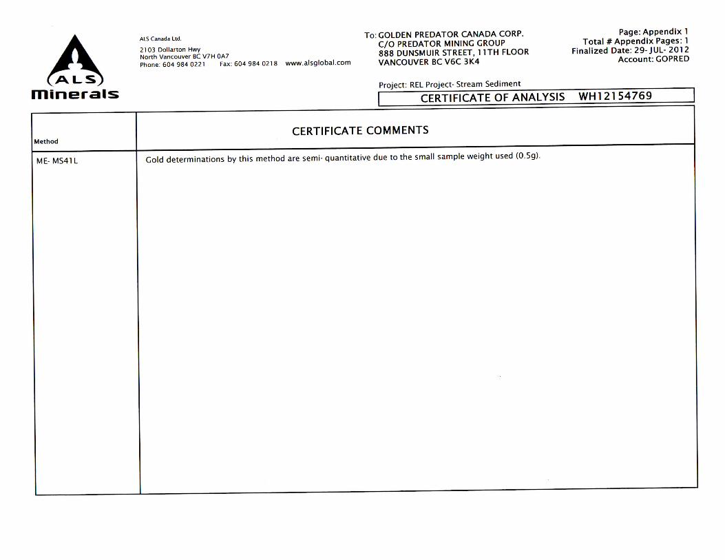
Gold determinations by this method are semi- quantitative due to the small sample weight used (0.Sg) .
Page: Appendix l Total# Appendix Pages : l
Finalized Date: 29-JUL- 2012 Account : GOPRED
WH12154769
Appendix 4 Analytical Methods and
Detection Limits

Geochemical Procedure
me- mS41ultra- trace level methodS uSinG icP- mS and icP- aeS
Revision 04.00 | sep 20, 2006 www.alsglobal.com
SamPle decomPoSitionAqua Regia Digestion (geo-aR01)
analytical methodInductively Coupled Plasma-Atomic Emission Spectroscopy (icp-aes) Inductively Coupled Plasma - Mass Spectrometry (icp-ms)
a prepared sample (0.50 g) is digested with aqua regia in a graphite heating block. after cooling, the resulting solution is diluted to with deionized water, mixed and analyzed by inductively coupled plasma-atomic emission spectrometry. Following this analysis, the results are reviewed for high concentrations of bismuth, mercury, molybdenum, ment spectral interferences.
element Symbol unitS lower limit uPPer limit
silver ag ppm 0.01 100
aluminum al % 0.01 25
arsenic as ppm 0.1 10 000
gold au ppm 0.2 25
boron b ppm 10 10 000
barium ba ppm 10 10 000
beryllium be ppm 0.05 1 000
bismuth bi ppm 0.01 10 000
calcium ca % 0.01 25
cadmium cd ppm 0.01 1 000
cerium ce ppm 0.02 500
cobalt co ppm 0.1 10 000
chromium cr ppm 1 10 000
cesium cs ppm 0.05 500
copper cu ppm 0.2 10 000
iron Fe % 0.01 50
gallium ga ppm 0.05 10 000
germanium ge ppm 0.05 500
Hafnium Hf ppm 0.02 500
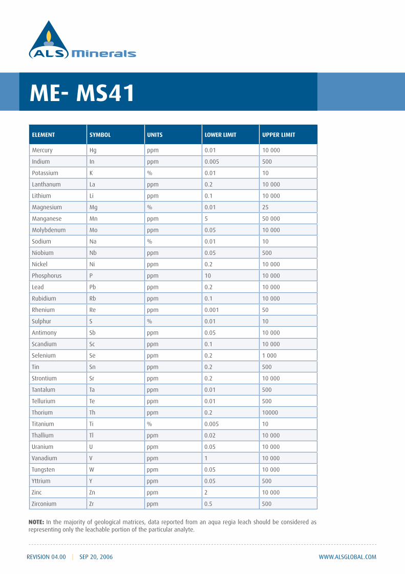
me- mS41
www.alsglobal.com
element Symbol unitS lower limit uPPer limit
mercury Hg ppm 0.01 10 000
indium in ppm 0.005 500
potassium K % 0.01 10
lanthanum la ppm 0.2 10 000
lithium li ppm 0.1 10 000
magnesium mg % 0.01 25
manganese mn ppm 5 50 000
molybdenum mo ppm 0.05 10 000
sodium na % 0.01 10
niobium nb ppm 0.05 500
nickel ni ppm 0.2 10 000
phosphorus p ppm 10 10 000
lead pb ppm 0.2 10 000
Rubidium Rb ppm 0.1 10 000
Rhenium Re ppm 0.001 50
sulphur s % 0.01 10
antimony sb ppm 0.05 10 000
scandium sc ppm 0.1 10 000
selenium se ppm 0.2 1 000
Tin sn ppm 0.2 500
strontium sr ppm 0.2 10 000
Tantalum Ta ppm 0.01 500
Tellurium Te ppm 0.01 500
Thorium Th ppm 0.2 10000
Titanium Ti % 0.005 10
Thallium Tl ppm 0.02 10 000
Uranium U ppm 0.05 10 000
vanadium v ppm 1 10 000
Tungsten w ppm 0.05 10 000
Yttrium Y ppm 0.05 500
Zinc Zn ppm 2 10 000
Zirconium Zr ppm 0.5 500
NOTE: in the majority of geological matrices, data reported from an aqua regia leach should be considered as representing only the leachable portion of the particular analyte.
Revision 04.00 | sep 20, 2006
Appendix 5 Soil Geochemical Plots
for Select Elements
lllewis
Cross-Out
lllewis
Text Box
Silt

KSF
348000
348000
350000
350000
352000
352000
692
4000
692
4000
692
6000
692
6000
±
NAD 1983 UTM Zone 9N
REL_20130108_Appendix5_Geochemistry_v1
‐‐
2012/11/26
1
G. Dessureau
51 km NNE of Ross River, Yukon Territory
‐‐
Vancouver
‐‐
REL ProjectStream Sediment Map
Appendix 5.
Filename:
Projection:
Scale:
Draw Date:
Author:
Location:
Version:
Rev. Date:
Figure:
Office:
Map ID:1:30,000
TSX: GPD
0 0.2 0.4 0.6 0.8
Kilometers
Golden Predator Claims
Golden Predator Outline
!
!!
!
!
NorthwestTerritories
Alaska
Brtish Columbia
[_REL
Faro
Whitehorse Ross River
DawsonCity
WatsonLake
YukonTerritory
Legend
REL 2012 Stream Samples
Au (ppm)
0.000300 - 0.000500
0.000501 - 0.000800
0.000801 - 0.001500
0.001501 - 0.003800
0.003801 - 0.006800

KSF
348000
348000
350000
350000
352000
352000
692
4000
692
4000
692
6000
692
6000
±
NAD 1983 UTM Zone 9N
REL_20130108_Appendix5_Geochemistry_v1
‐‐
2012/11/26
1
G. Dessureau
51 km NNE of Ross River, Yukon Territory
‐‐
Vancouver
‐‐
REL ProjectStream Sediment Map
Figure 6.1.
Filename:
Projection:
Scale:
Draw Date:
Author:
Location:
Version:
Rev. Date:
Figure:
Office:
Map ID:1:30,000
TSX: GPD
0 0.2 0.4 0.6 0.8
Kilometers
Golden Predator Claims
Golden Predator Outline
!
!!
!
!
NorthwestTerritories
Alaska
Brtish Columbia
[_REL
Faro
Whitehorse Ross River
DawsonCity
WatsonLake
YukonTerritory
Legend
REL 2012 Stream Samples
As (ppm)
3.750000 - 5.390000
5.390001 - 8.390000
8.390001 - 19.650000
19.650001 - 37.700000
37.700001 - 56.900000

KSF
348000
348000
350000
350000
352000
352000
692
4000
692
4000
692
6000
692
6000
±
NAD 1983 UTM Zone 9N
REL_20130108_Appendix5_Geochemistry_v1
‐‐
2012/11/26
1
G. Dessureau
51 km NNE of Ross River, Yukon Territory
‐‐
Vancouver
‐‐
REL ProjectStream Sediment Map
Appendix 5.
Filename:
Projection:
Scale:
Draw Date:
Author:
Location:
Version:
Rev. Date:
Figure:
Office:
Map ID:1:30,000
TSX: GPD
0 0.2 0.4 0.6 0.8
Kilometers
Golden Predator Claims
Golden Predator Outline
!
!!
!
!
NorthwestTerritories
Alaska
Brtish Columbia
[_REL
Faro
Whitehorse Ross River
DawsonCity
WatsonLake
YukonTerritory
Legend
REL 2012 Stream Samples
Ag (ppm)
0.034000 - 0.056000
0.056001 - 0.076000
0.076001 - 0.093000
0.093001 - 0.122000
0.122001 - 0.153000

KSF
348000
348000
350000
350000
352000
352000
692
4000
692
4000
692
6000
692
6000
±
NAD 1983 UTM Zone 9N
REL_20130108_Appendix5_Geochemistry_v1
‐‐
2012/11/26
1
G. Dessureau
51 km NNE of Ross River, Yukon Territory
‐‐
Vancouver
‐‐
REL ProjectStream Sediment Map
Figure 6.1.
Filename:
Projection:
Scale:
Draw Date:
Author:
Location:
Version:
Rev. Date:
Figure:
Office:
Map ID:1:30,000
TSX: GPD
0 0.2 0.4 0.6 0.8
Kilometers
Golden Predator Claims
Golden Predator Outline
!
!!
!
!
NorthwestTerritories
Alaska
Brtish Columbia
[_REL
Faro
Whitehorse Ross River
DawsonCity
WatsonLake
YukonTerritory
Legend
REL 2012 Stream Samples
Sb (ppm)
0.251000 - 0.314000
0.314001 - 0.428000
0.428001 - 0.589000
0.589001 - 0.965000
0.965001 - 1.410000
KSF
348000
348000
350000
350000
352000
352000
692
4000
692
4000
692
6000
692
6000
±
NAD 1983 UTM Zone 9N
REL_20130108_Appendix5_Geochemistry_v1
‐‐
2012/11/26
1
G. Dessureau
51 km NNE of Ross River, Yukon Territory
‐‐
Vancouver
‐‐
REL ProjectStream Sediment Map
Figure 6.1.
Filename:
Projection:
Scale:
Draw Date:
Author:
Location:
Version:
Rev. Date:
Figure:
Office:
Map ID:1:30,000
TSX: GPD
0 0.2 0.4 0.6 0.8
Kilometers
Golden Predator Claims
Golden Predator Outline
!
!!
!
!
NorthwestTerritories
Alaska
Brtish Columbia
[_REL
Faro
Whitehorse Ross River
DawsonCity
WatsonLake
YukonTerritory
Legend
REL 2012 Stream Samples
Bi (ppm)
0.080000 - 0.110000
0.110001 - 0.150000
0.150001 - 0.180000
0.180001 - 0.210000
0.210001 - 0.240000
KSF
348000
348000
350000
350000
352000
352000
692
4000
692
4000
692
6000
692
6000
±
NAD 1983 UTM Zone 9N
REL_20130108_Appendix5_Geochemistry_v1
‐‐
2012/11/26
1
G. Dessureau
51 km NNE of Ross River, Yukon Territory
‐‐
Vancouver
‐‐
REL ProjectStream Sediment Map
Figure 6.1.
Filename:
Projection:
Scale:
Draw Date:
Author:
Location:
Version:
Rev. Date:
Figure:
Office:
Map ID:1:30,000
TSX: GPD
0 0.2 0.4 0.6 0.8
Kilometers
Golden Predator Claims
Golden Predator Outline
!
!!
!
!
NorthwestTerritories
Alaska
Brtish Columbia
[_REL
Faro
Whitehorse Ross River
DawsonCity
WatsonLake
YukonTerritory
Legend
REL 2012 Stream Samples
Hg (ppm)
0.030000 - 0.084000
0.084001 - 0.280000
0.280001 - 0.512000
0.512001 - 0.934000
0.934001 - 2.440000
Related Documents