A Palimpsest of Faits Ur6ains in Taipei SHIH-WEI LO, Tunghai University This article analyzes the formal and semantic logic of the architectural displacements that Taipei, the current capital of Taiwan, experienced over the past hundred years. The first section of Chung-hua Road (Chinese Road) has gone through a series of major transformations,each corresponding to a historic phase in the develop- ment of the city. The first significant event was to intense international trade. As a frontier and with its communications with the out- side world, Taiwan was the first part of China to introduce and experience a certain modernization.^ During the next period (1895-1945), west, in accordance with the conventional Chinese city layout.5 The city wall itself, however, was only built several years later and did not follow the original plan, which had a street pattern laid out along the four cardinal directiom6 Instead, it displayed a the building ofihe city wall during the late Ching symbolized the centripetal link with the Ching government in Mainland China and acted a center for the De- Taiwan was-a Japanese colony. The first colony of the last colonial empire, it became a model for Japan’s Greater East Asian Co- more flexible and dynamic form because the rectangle of the wall was slightly rotated to be more in tune with Feng-sui requirements (1880-1882). The walled ripheral Taiwan people. The wall was pulled down by Japanese colonizers who replaced it with a three-lane boulevard around 1905. In 1949, after the Nationalist government moved to Taiwan. prosperity Sphere dream, as well as a labora- tory for processing western influences.2 During the last phase (1949-present), Tai- (literally, “wind and water”). The latter specified that the city should not only face south, but should also conform to the toPo- three rows of wooden sheds were built on the very same spot, as temporary shelter for new im- migrants. In 1961, these wooden constructions were replaced by eight blocks of three-story con- crete buildings-another blend of “wall.” They be- came the most popular shopping places in Taipei during the sixties and seventies, but were re- cently demolished to make way for a new, even more spacious boulevard. POLITICAL INTERVENTION, COLONIZATION, and acculturation played crucial roles in shaping the city of Taipei during the last one hundred years. The unique historical background of Taiwan contributed to ma- jor displacements in Taipei, resulting in dif- ferent modes of urbanity. Taiwan’s connection to Mainland China dates back to the eighteenth century, when Han Chi- nese began to move to the island. Meng- chia, a port along Tam-sui River and one of the first Chinese settlements, grew into the city of Taipei during the last quarter of the nineteenth century. Taiwan had an ambiva- lent relation to China; it was linked politi- cally but was physically separated. As a peripheral island, Taiwan’s orientation was toward the mother culture, but as a frontier base, it maintained a certain independence and developed a cosmopolitan character due Journal ofArchitertural Education, pp. 68-75 0 1998 ACSA, Inc. wan has been politically independent. In 1949, a large wave of immigrants from Main- land China fled to the island, transplanting an entire Chinese culture. A state government presides over the island, making it a central- ized periphery and virtually a nation-state.3 The development of Chinese Road in Taipei reflects this complex history. Its first section is the most transformed part of Taipei, its evolution mirroring the greater metamorphosis of the city, with traces of each earlier phase still identifiable. This street is a condensed complex offaits urbains unique to Taipei.* It is like a legend of the city, or rather, a legend of the instant city. The Wall as a Peripheral Pursuit for the Modern In 1878, Taiwan was reorganized by the Ching government into threeFs (regions), and Taipei, which up until then was not a major center, was made the capital of Tai- pei-fu. To make the city worthy of its new status, the prefect of Tai-pei-fu initiated a cooperative scheme in which the govern- ment, with the financial support of the resi- dents, would build a city wall. Some speculative-minded merchants already started the construction process inside the planned wall, gradually shaping the three main streets, oriented north-south and east- graphic conditions of its location to be well protected by mountains at its back and to face water at its front. This option caused a small shift in orientation (Figure 1). However, the shift in orientation was not the most significant displacement in the building of Taipei’s wall. A similar tension between Chinese orthodox principles (the cardinal orientation of wall, streets, and monuments as a unifying device all over the empire) and the more situational Feng-sui attitude (aiming at a contextual interpreta- tion of basic forces in nature) is common in Chinese practice. More peculiar for Taipei was that the construction of the wall was based on the joint effort of officials and local merchants. They considered this enterprise symbolic of the new Taipei (a newly built city with a new administrative status), as the affir- mation of an inalienable attachment to the mother empire Ching China, and as the sym- bol of an ethnic identification meant to counterbalance the rising cosmopolitan de- velopment resulting from trade with Westerners. To build the wall thus implied for peripheral Taipei a contradictory but never- theless strategically valuable attempt to cope with the complex situation it confronted in the late nineteenth century. The advantage of Taipei’s peripheral situation-its participa- tion in the developing oceanic trade-was combined with its growing significance as a new Chinese center, and this unique situa- November I998 JAE 52/2 68

Welcome message from author
This document is posted to help you gain knowledge. Please leave a comment to let me know what you think about it! Share it to your friends and learn new things together.
Transcript
A Palimpsest of Faits Ur6ains in Taipei
SHIH-WEI LO, Tunghai University
This article analyzes the formal and semantic logic of the architectural displacements that Taipei, the current capital of Taiwan, experienced over the past hundred years. The first section of Chung-hua Road (Chinese Road) has gone through a series of major transformations, each corresponding to a historic phase in the develop- ment of the city. The first significant event was
to intense international trade. As a frontier and with its communications with the out- side world, Taiwan was the first part of China to introduce and experience a certain modernization.^
During the next period (1895-1945),
west, in accordance with the conventional Chinese city layout.5 The city wall itself, however, was only built several years later and did not follow the original plan, which had a street pattern laid out along the four cardinal directiom6 Instead, it displayed a
the building ofihe city wall during the late Ching symbolized
the centripetal link with the Ching government in Mainland China and acted a center for the De-
Taiwan was-a Japanese colony. The first colony of the last colonial empire, it became a model for Japan’s Greater East Asian Co-
more flexible and dynamic form because the rectangle of the wall was slightly rotated to be more in tune with Feng-sui requirements
(1880-1882). The walled
ripheral Taiwan people. The wall was pulled down by Japanese colonizers who replaced it with a three-lane boulevard around 1905. In 1949, after the Nationalist government moved to Taiwan.
prosperity Sphere dream, as well as a labora- tory for processing western influences.2 During the last phase (1949-present), Tai-
(literally, “wind and water”). The latter specified that the city should not only face south, but should also conform to the toPo-
three rows of wooden sheds were built on the very same spot, as temporary shelter for new im- migrants. In 1961, these wooden constructions were replaced by eight blocks of three-story con- crete buildings-another blend of “wall.” They be- came the most popular shopping places in Taipei during the sixties and seventies, but were re- cently demolished to make way for a new, even more spacious boulevard.
POLITICAL INTERVENTION, COLONIZATION,
and acculturation played crucial roles in shaping the city of Taipei during the last one hundred years. The unique historical background of Taiwan contributed to ma- jor displacements in Taipei, resulting in dif- ferent modes of urbanity. Taiwan’s connection to Mainland China dates back to the eighteenth century, when Han Chi- nese began to move to the island. Meng- chia, a port along Tam-sui River and one of the first Chinese settlements, grew into the city of Taipei during the last quarter of the nineteenth century. Taiwan had an ambiva- lent relation to China; it was linked politi- cally but was physically separated. As a peripheral island, Taiwan’s orientation was toward the mother culture, but as a frontier base, it maintained a certain independence and developed a cosmopolitan character due
Journal ofArchitertural Education, pp. 68-75 0 1998 ACSA, Inc.
wan has been politically independent. In 1949, a large wave of immigrants from Main- land China fled to the island, transplanting an entire Chinese culture. A state government presides over the island, making it a central- ized periphery and virtually a nation-state.3
The development of Chinese Road in Taipei reflects this complex history. Its first section is the most transformed part of Taipei, its evolution mirroring the greater metamorphosis of the city, with traces of each earlier phase still identifiable. This street is a condensed complex offaits urbains unique to Taipei.* It is like a legend of the city, or rather, a legend of the instant city.
The Wall as a Peripheral Pursuit for the Modern
In 1878, Taiwan was reorganized by the Ching government into t h r e e F s (regions), and Taipei, which up until then was not a major center, was made the capital of Tai- pei-fu. T o make the city worthy of its new status, the prefect of Tai-pei-fu initiated a cooperative scheme in which the govern- ment, with the financial support of the resi- dents, would build a city wall. Some speculative-minded merchants already started the construction process inside the planned wall, gradually shaping the three main streets, oriented north-south and east-
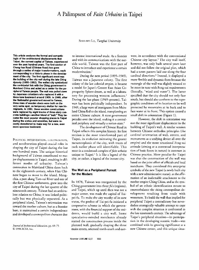
graphic conditions of its location to be well protected by mountains at its back and to face water at its front. This option caused a small shift in orientation (Figure 1).
However, the shift in orientation was not the most significant displacement in the building of Taipei’s wall. A similar tension between Chinese orthodox principles (the cardinal orientation of wall, streets, and monuments as a unifying device all over the empire) and the more situational Feng-sui attitude (aiming at a contextual interpreta- tion of basic forces in nature) is common in Chinese practice. More peculiar for Taipei was that the construction of the wall was based on the joint effort of officials and local merchants. They considered this enterprise symbolic of the new Taipei (a newly built city with a new administrative status), as the affir- mation of an inalienable attachment to the mother empire Ching China, and as the sym- bol of an ethnic identification meant to counterbalance the rising cosmopolitan de- velopment resulting from trade with Westerners. To build the wall thus implied for peripheral Taipei a contradictory but never- theless strategically valuable attempt to cope with the complex situation it confronted in the late nineteenth century. The advantage of Taipei’s peripheral situation-its participa- tion in the developing oceanic trade-was combined with its growing significance as a new Chinese center, and this unique situa-
November I998 JAE 52/2 68
tion raised Taipei’s status in the hierarchy of imperial Chinese cities. The people of Taipei believed that a walled city would optimize their chances for success because it enabled them to articulate their assimilation with the monarchical center of China, while at the same time taking advantage of their geo- graphically favorable condition for trade. Traditional practice, such as the construction of a city wall, was thus transformed by the people in Taipei into an instrument for de- velopment directed toward the future, which could be summed up as “modernization.’”
In another sense, however, building a walled city was also obsolete in a society of merchants because it impeded the free move- ment of people and materials. The fortifica- tions were even redundant for defense because Taipei’s political and geographic con- dition made it vulnerable anyhow-and in- deed, the Japanese took the city barely ten years after the wall was built. These circum- stances ironically turned Taipei’s city wall- the last wall built in Chinese history-into a misplaced fait urbuin, an out-of-place symbol. Taipei’s wall thus contains contradictions and displacements that reveal its fundamentally ambivalent role in the history of the city.
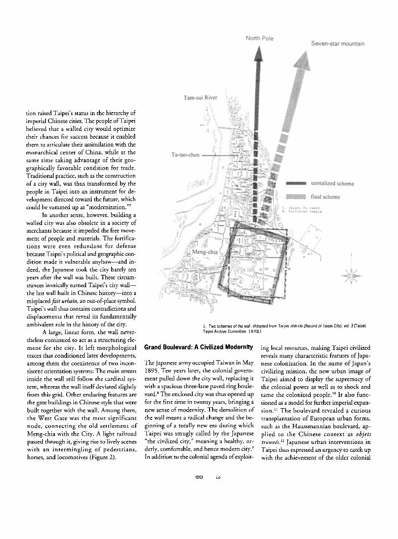
A large, linear form, the wall never- theless continued to act as a structuring ele- ment for the city. I t left morphological traces that conditioned later developments, among them the coexistence of two incon- sistent orientation systems: The main streets inside the wall still follow the cardinal sys- tem, whereas the wall itself deviated slightly from this grid. Other enduring features are the gate buildings in Chinese style that were built together with the wall. Among them, the West Gate was the most significant node, connecting the old settlement of Meng-chia with the City. A light railroad passed through it, giving rise to lively scenes with an intermingling of pedestrians, horses, and locomotives (Figure 2).
1 Two schemes of the wall. (Adapted from Taipei shih-chi Record of Taipei Cityl, vol. 3 Faipei. Taipei Archive Committee, 19701.)
Grand Boulevard: A Civilized Modernity
The Japanese army occupied Taiwan in May 1895. Ten years later, the colonial govern- ment pulled down the city wall, replacing it with a spacious three-lane paved ring boule- vard.8 The enclosed city was thus opened up for the first time in twenty years, bringing a new sense of modernity. The demolition of the wall meant a radical change and the be- ginning of a totally new era during which Taipei was smugly called by the Japanese “the civilized city,” meaning a healthy, or- derly, comfortable, and hence modern city.’ In addition to the colonial agenda of exploit-
ing local resources, making Taipei civilized reveals many characteristic features of Japa- nese colonization. In the name of Japan’s civilizing mission, the new urban image of Taipei aimed to display the supremacy of the colonial power as well as to shock and tame the colonized people.” It also func- tioned as a model for hrther imperial expan- sion.” The boulevard revealed a curious transplantation of European urban forms, such as the Haussmannian boulevard, ap- plied to the Chinese context as objets trouvks.” Japanese urban interventions in Taipei thus expressed an urgency to catch up with the achievement of the older colonial
69 Lo
2. West Gate with railroad. (From Kuo-fan Wang, ed., Taipei shih-shih huachi [Historical pictures of Taipei1 maipei: Taipei Archive Committee, 19801, p. 11.)
powers. Accordingly, urban reform in Taipei was financed by public funds from Tokyo.
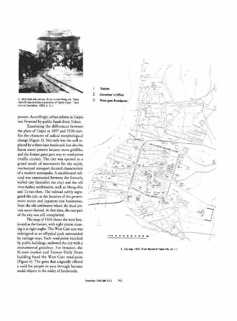
Examining the differences between the plans of Taipei in 1897 and 1920 clari- fies the character of radical morphological change (Figure 3). Not only was the wall re- placed by a three-lane boulevard, but also the linear street pattern became more gridlike, and the former gates gave way to rond-points (traffic circles). The city was opened to a grand mode of movement for the rapid, mechanized transport deemed characteristic of a modern metropolis. A southbound rail- road was constructed between the formerly walled city (hereafter the city) and the old river-harbor settlements, such as Meng-chia and Ta-tao-chen. The railroad subtly segre- gated the city, as the location of the govern- ment sector and Japanese-run businesses, from the old settlement where the local pri- vate sector thrived. At that time, the east part of the city was still unexploited.
The map of 1920 shows the west bou- levard as the busiest, with eight streets cross- ing it at right angles. The West Gate area was redesigned as an elliptical park surrounded by carriage ways. Such rond-points enriched by public buildings, endowed the city with a monumental grandeur. For instance, the Si-men market and Taiwan Daily News building faced the West Gate rond-point (Figure 4). The gates that originally offered a void for people to pass through became nodal objects in the midst of boulevards.
3. City map, 1920. (From Record of Taipei City, vol. 1.)
November 1998 JAE 52/2 70
4. West Gate fond-point. (From Senchan Hsieh, et al., Tai-wan hukhsiang [Recollection of Taiwan1 [Taipei: Chuan-i-li, 19941, pp. 236-37.)
site (2)
Main
6. Aerial view of the fair at the main site. (From Tai-pei Ku-chin tu-shuo-chi [Pictures of past and present Taipei1 Faipei: Taipei Archive Committee, 19921, p. 55.)
Traffic conditions at the time did not demand such spacious arteries, which corre- sponded to the colonial public buildings, whose grand scale overshadowed the existing built fabric. This redundant monumentality was compatible with Japan’s intention to make Taiwan the spearhead of an invasion into southeastern Asia. Nevertheless, the co- lonial interventions in Taipei did not present themselves as Japanese in style or reference. Rather, they were derived from European ex- amples that represented modernity. Civiliza- tion clearly meant western civilization for the Japanese, and it was more common for them to refer to colonial Taipei as “little Paris” than “little T ~ k y o . ” ’ ~ In this sense, the boulevard is afait urbain that simultaneously embodies the sublime and the absurd. Nevertheless, the configuration of the old city was not com- pletely erased since the demolition of the wall still provided a clear morphological continu- ity with the wall’s width and location. The new Japanese city was thus grafted onto the ground plan of the old Chinese
Exposition on the Boulevard
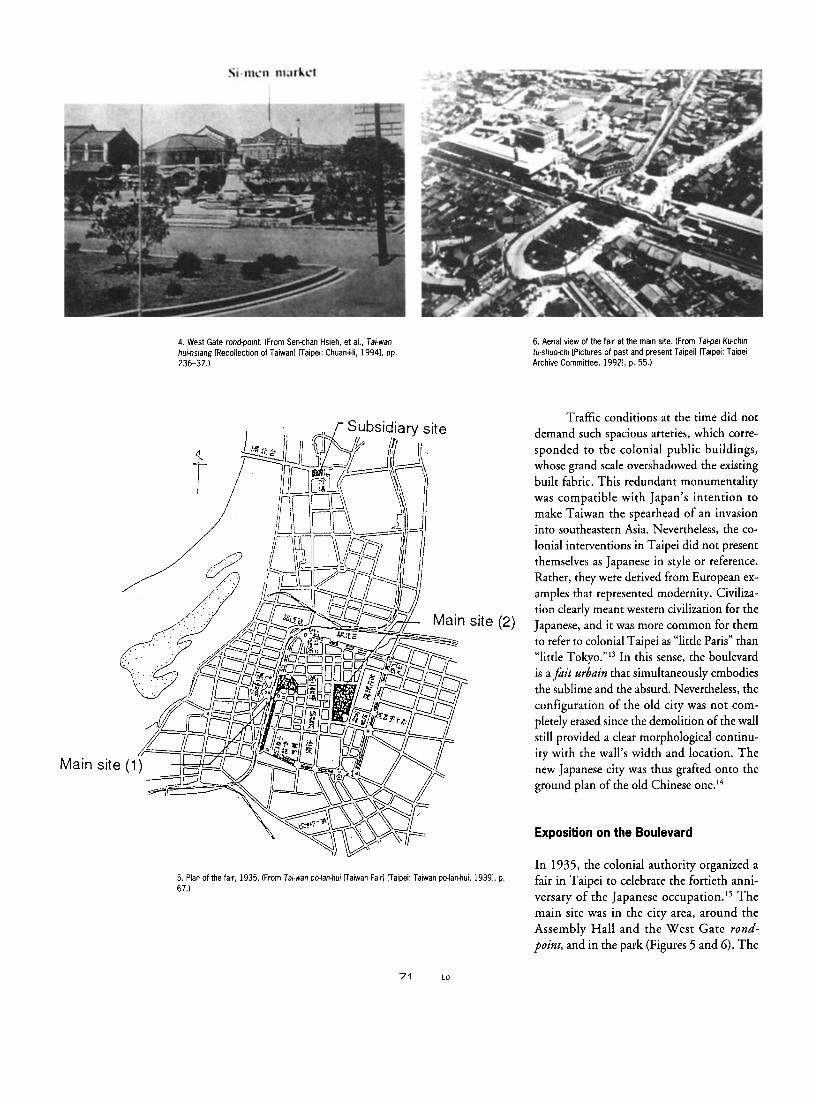
In 1935, the colonial authority organized a fair in Taipei &brate the fortieth anni- versary of the Japanese occ~pa t ion . ’~ The main site was in the city area, around the Assembly Hall and the West Gate rond- point, and in the park (Figures 5 and 6). The
5. Plan of the fair, 1935 (From Tai-wan pdan-hur Faiwan Fair1 [Taipei: Taiwan polan-hui, 19391, p. 67.)
7 1 Lo
intention of the fair was to exhibit the Japa- nese “colonial achievement,” to propagan- dize Japan’s advanced status, and to reveal the keen Japanese interest in southeast Asia. More significantly, the fair marked the final stage in the colonization of the city. The largest existing yamen building (formerly the headquarters and residence of a Chinese government official) built by the Ching gov- ernment in Taiwan was demolished in 193 1. In its place, the Japanese administration constructed the Public Assembly Hall, which was completed in 1935 and used for the exposition. By the time of the fair, al- most all Chinese-style public buildings in- side the ring boulevard had been cleared out. Furthermore, Japanese authorities carefully eliminated any references to Chinese styles in the architecture of the fair.
Therefore, for the people in Taiwan, the fair signaled a cultural displacement from their origins. The fair was a prologue to the Emperor’s Citizenship Movement, promoted by the Japanese from 1937 to the end of World War 11, in which the Taiwanese were forced to become Japanese and fight for the Japanese emperor.’‘ In addition, the fair also acted as a facade covering the confidential meeting of high-ranking officials in Taipei and from Tokyo, which served Japan’s top- secret plans for expansion into Mainland China and southeastern Asia.” For the colo- nized Taiwanese, the glory that the fair was supposed to demonstrate was in fact a fanfare for out-of-place purposes; more perversely, it took place around the busy west Gate rond- point, a place near the early immigrant settle- ment Meng-chia, and one full of historical memories for the Taiwanese people.
Makeshift Squatters
Colonial rule in Taiwan ended when the Japanese surrendered to the Chinese in
1945, after eight years of war on the Main- land. The government of the Republic of China (ROC) took over the resources and the infrastructure that the Japanese left be- hind in Taiwan. After a brief period of peace, the civil war in China exploded in 1948. By 1949, Nationalist armies had been defeated, and the central government of the ROC moved to Taiwan. As a result, about four hundred thousand Japanese who had remained after the end of World War I1 moved out, but they were replaced by 2 mil- lion Mainlanders between 1948 and 1952.’* Taipei became the political and economic center of Taiwan. Housing shortages be- came an urgent problem, and many squatter settlements emerged, sheltering more than one-third of the city’s population by 1963.19
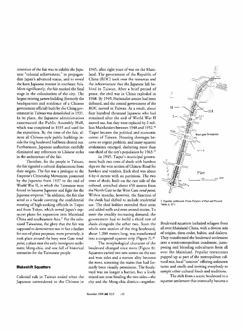
In 1949, Taipei’s municipal govern- ment built two rows of sheds with bamboo slips on the west section of Chinese Road for hawkers and vendors. Each shed was about 4-by-4 meters with no partitions. The two rows of sheds, built on the east side of the railroad, stretched about 650 meters from the North Gate to the West Gate rond-point. Within months, however, the function of the sheds had shifted to include residential use. The shed holders extended their units and added walls and even second stories. To meet the steadily increasing demand, the government had to build a third row of sheds alongside the other two. Soon the whole west section of the ring boulevard, about 1,200 meters long, was transformed into a congested squatter strip (Figure 7).’O
The morphological character of the boulevard changed once more (Figure 8). Squatters carved two new streets on the east and west sides and a narrow alley between the rows, screening the trains that had for- merly been visually prominent. The boule- vard was no longer a barrier, but a lively mixed-use zone binding the two sides-the city and the Meng-chia district-together.
foot
7. Squatter settlement. (From Pictures of Past and Present Taipei, p. 97.)
Boulevard squatters included refugees from all over Mainland China, with a diverse mix of origins, dress codes, habits, and dialects. They transformed the boulevard settlement into a semicosmopolitan condenser, juxta- posing and blending subcultures from all over the Mainland. Popular restaurants popped up as part of the metropolitan cul- tural mix, local “cuisines” offering unknown tastes and smells and inviting everybody to sample other cultural foods and traditions.
The shift from a scenic boulevard to a squatter settlement that eventually became a
November 1998 JAE 52/2 72
8. Railway through the squatter settlement. (From Arther F. Raper, et al., The Cities and Industry in Taiwan Faipei: National Taiwan University, 19541, p. 181.)
popular commercial strip pointed to some major changes in Taipei’s history. The settlement was in blatant disregard of the urban plan drafted by the Japanese. The dis- appearance of the boulevard was not only a drawback to the appearance of the city, but also a move from a planned, future-oriented urbanism to ad hoc practices. Ad hoc inter- ventions would indeed become a dominant mode of achieving instant urbanity. The squatter settlement can be seen as the result of a double displacement: displaced people in a setting, the boulevard, which is itself a displacement from an earlier period. As such, it fueled its own dynamics, turning the miserable squatter settlement into a popular commercial strip. This transformation re- veals the enormous resourcefulness of the informal sector, whose capacity for instant development would continue to influence the future of the Asian metropolis. Nonethe- less, the squatter settlement provoked offi- cial concern, so its days were numbered.
Strip of the Shopping Blocks
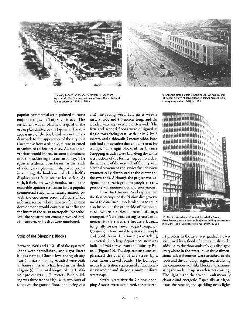
Between 1960 and 1961, all of the squatters’ sheds were demolished, and eight linear blocks named Chung-hwa-shang-ch’ang (the Chinese Shopping Arcades) were built to house those who had lived in the sheds (Figure 9). The total length of the 1,644- unit project was 1,171 meters. Each build- ing was three stories high, with two rows of shops on the ground floor, one facing east
and one facing west. The units were 2 meters wide and 4.5 meters long, and the arcaded walkways were 3.5 meters wide. The first and second floors were designed as single rows facing east, with units 2-by-6 meters, and a sidewalk 3 meters wide. Each unit had a mezzanine that could be used for storage.2’ The eight blocks of the Chinese Shopping Arcades were laid along the entire west section of the former ring boulevard, at the same site of the west side of the city wall. Vertical movement and service facilities were symmetrically distributed at the center and the two ends. Although the project was de- signed for a specific group of people, the end product was monotonous and anonymous.
That the Chinese Road represented the first attempt of the Nationalist govern- ment to construct a modernist image could also be seen at the other side of the boule- vard, where a series of new buildings emerged.” The pioneering structure in modernist style was the Industry Bureau (originally for the Taiwan Sugar Company). Continuous horizontal fenestration, simple and bold, formed its most eye-catching characteristic. A large department store was built in 1966 across from the Industry Bu- reau (Figure 10). The department store em- phasized the corner of the street by a continuous curved facade. The homoge- neous fenestration represented a functional- ist viewpoint and shaped a more uniform streetscape.
Several years after the Chinese Shop- ping Arcades were completed, the modern-
9. Shopping blocks. (From Chuang-yu Chu, Tai-wan hua-shih [Historical pictures of Taiwanl Faipei: Tal-wan hua-shih pian. chuang weiyuan-hui, 19621, p. 116.)
10. The first department store and the Industry Bureau. (FromTai-wan pankung ta-lo fachan [Office building development in Taiwan] Faipei: Chien-tsu yu chi-hua, 19701, p. 19.)
ist projects in the area were gradually over- shadowed by a flood of commercialism. In addition to the thousands of signs displayed everywhere in the street, huge three-dimen- sional advertisements were attached to the roofs and the buildings’ edges, rearticulating the continuous wall-like blocks and accentu- ating the nodal image at each street crossing. The signs made the street simultaneously chaotic and energetic. Especially at night- time, the moving and sparkling neon lights
73 Lo
11. Railway crossing. (From Yung-ming Chuang, Tai-pei lao-chieh Fhe old Taipei] Faipei: Shih-pau wen-hua, 19911, p. 116.1
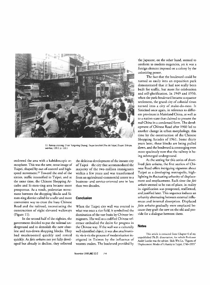
endowed the area with a kaleidoscopic at- mosphere. This was the new, tense image of Taipei, shaped by out-of-control and high- speed mo~ement.’~ Toward the end of the sixties, traffic intensified in Taipei, and at the same time, the Chinese Shopping Ar- cades and Si-men-ting area became more prosperous. As a result, pedestrian move- ment between the shopping blocks and Si- men-ting district called for a safer and more convenient way to cross the busy Chinese Road and the railroad, necessitating the construction of eight elevated walkways (Figure 11).
In the second half of the eighties, the government decided to put the railroad un- derground and to demolish the now obso- lete and run-down shopping blocks. They had mushroomed quickly and rotted quickly. As fa i t s urbains not yet fully devel- oped but already in decline, they reflected
the delirious development of the instant city of Taipei-the city that accommodated the majority of the two-million immigrants within a few years and was transformed from an agricultural-commercial center to a business- and service-oriented one in less than two decades.
Conclusion
When the Taipei city wall was erected in what was once a rice field, it symbolized the domination of the vast basin by Chinese im- migrants. The wall as a codified Chinese ref- erence embodied the desire for progress in the Chinese way. If the wall was a culturally well-identified object, it was also anachronis- tic vis-8-vis the process of modernization in- stigated in Taiwan by the influence of western traders. The boulevard provided by
the Japanese, on the other hand, seemed to conform to modern exigencies, yet it was a foreign element imposed on a colony by the colonizing power.
The fact that the boulevard could be turned so easily into an exposition park demonstrated that it had not really been built for traffic, but more for celebration and self-glorification. In 1949 and 1950, when the park-boulevard became a squatter settlement, the grand city of colonial times turned into a city of make-do-ness. I t Sinicized once again, in reference to differ- ent provinces in Mainland China, as well as to a nation-state that claimed to present the real China in a condensed form. The devel- opment of Chinese Road after 1960 led to another change in urban morphology, this time by the construction of the Chinese Shopping Arcades of 1961. Some thirty years later, these blocks are being pulled down, and the boulevard is reemerging even more spaciously now that the railway is be- ing submerged underground.
As the setting for this series of short- lived fa i t s urbains, the first section of Chi- nese Road offers intriguing vignettes about Taipei as a developing metropolis, high- lighting its fluctuating urbanity of displace- ment and emplacement. Each time the fait urbain seemed to be out-of-place, in reality its signification was postponed, reaffirmed, and justified later. This sequence induces an urbanity alternating between external influ- ences and internal absorption. Displaced faits urbains gradually were emplaced be- cause they graft the new on the old and pro- vide for a dialogue between them.
Notes
This article is extracted from Chapter 4 of my unpublished Ph.D. dissertation, for which Professor Andre Loeckx was the adviser. Shih-Wei Lo, “Figures of Displacement: Modes of Urbanity in Taipei, 1740-1995”
November 1998 JAE 52/2 74
(Ph.D. diss., Katholieke Universiteit Leuven, 1996). Many thanks to Professor Hilde Heynen for her invalu- able help in editing this article.
1. Around 1875, a Ching government official, Tin, attempted to exploit petroleum in Taiwan. This was the first such move in China. He also built the cable network on the island, which was the first one in China. In 1877, he completed the cable network be- tween Taiwan and Fu-chien (a province in the south- east of China). In 1885, Taipei was the first city in China lit with electric street lights. All of these ex- amples show that Taiwan was advanced compared to the rest of China.
2. Chao-yen Tu, Ji-pen di-kuo chu-yi hsia te Tai-wan (Taiwan under the Japanese imperialism) (Taipei: ]en-jien, 1991), p. 537; and W. G. Beasley, Japanese Imperialism (Oxford: Clarendon Press,
3. Chuan-cheng Chiao argues that Taiwan before 1949 was ruled by absentee governments. The central government exploited the periphery’s resources without presiding over it. See Chuan-cheng Chiao, Tai-wan di-chiu te hsin chung-shang chu-yi (New Mer- cantilism in Taiwan Region) (Taipei: National Policy Research and Data Center, 1989), p. 47.
4. Here I propose to return to the concept of fait urbain in its original French use in which it im- plies a complex of significant events or interventions in the process of urban development. Faits urbains in- volve not only physical constructions, but also histori- cal, geographic, and sociocultural aspects and the general way of living. See Aldo Rossi, The Architecture oftbe City (Cambridge, MA: MIT Press, 1986), p. 22.
5. Tai-pei sbib-chi (Record of Taipei City), vol. 1 (Taipei: Taipei Archive Committee, 1970), p. 47.
6. The street pattern laid out according to the cardinal directions is typical in traditional Chinese city planning, such as that of Chang-an, Luo-yang, and Ta-tung.
7. Modernization for the peripheral Taipei seemed rather complicated. O n the one hand, it meant upgrading and promoting the city to a higher officially recognized status by the monarchical center of the Chinese empire. In this sense, modernization was equivalent to a pursuit of the new and the vital. O n the other hand, modernization could hardly be dissociated from westernization. Ways of life intro- duced by Westerners were deemed “modern” by the local Taipei people. In the meantime, ethnic self-con-
1991), pp. 5-7, 251-53.
sciousness also rose among local people in an attempt to counterbalance the western influences they con- fronted. Therefore, modernization meant both west- ernization and antiwesternization for the people in Taipei.
8. This intervention is very similar to what happened nearly half a century earlier in European cit- ies. Vienna witnessed the building of its Ringstrasse around 1857; Berlin underwent the same develop- ment in about 1868.
9. Hifu Kanaka, Taipi shib-shih (Taipei City History) (Taipei: Taiwan Tung-hsing-she, 1930), pp. 10, 55-56,63-64; and Taiwan tu-sbi chi-bua cbiang- si-lu (Record of lectures on urban planning in Taiwan) (Taipai: Urban Planning Studio, Graduate Institute of Civil Engineering, 1987), p. 17.
10. Han-yu Chang and H. Myers Ramon, “Tai- wan tsai jih-jiuh shih-chi (1895-1945) chi chiming fa- chan cheng-tse” (Colonial policy of Taiwan under Japanese occupation, 1895-1945) Taipei Wen-bsien (Taipei archive) 16/3 (1965): 197; and Yu-chien Hsu, “Tu-shih kung-chien wen-hua hsing-shih chi pien chien: jih-jiuh shih-chi Tai-pei wei ke-an” (Transforma- tion of urban spatial and cultural form: Case study on Taipei during Japanese occupation) Ph.D. dissertation, National Taiwan University, 1993), pp. 84-85.
1 1. George H. Kerr, Formosa: Licensed Revolu- tion and Home Ruk Movement, 1895-1945 (Hawaii: University Press of Hawaii, 1974), p. 4.
12. Urban construction in Taipei was even more advanced than in the second-rank city in Japan. See Kanaka, Taipei City History, p. 63. For example, the three-lane boulevard was still foreign to Japanese cities around the 1910s. When the Japanese widened Ch’i-shih Street in Taipei between 1936 and 1940, they intended to match the street with Showa Street in Tokyo, which was widened in 1930 as a spacious tree- lined boulevard. See Akira Koshizawa, Taipei te tu-sbib chi-bua (Urban Planning in Taipei) Taipei Archive, special ed. (1993): 140; and Akira Koshizawa, Urban Planning in Tokyo (Tokyo: Sowashe, 1991), p. 70.
13. Naito Hideo, ed., A Record of Taiwan’s Progress (Tokyo: Kokusai Nippon Kyokai, 1936-37), pp. 207-8.
14. Kuo-hui Dai employs the concept ofgraft- ing to describe the Japanese construction in Taiwan over the Chinese fabric built during the late Ching period. Taipei of the Ching period served as a matrix for grafting the colonial Taipei. See K-h. Dai, Tai-
wan-sbihyen-cbiou: bui-ku yu teng-sou (Studies on Tai- wan history: Retrospection and search) (Taipei: Yuan- liu, 1985), pp. 65-66.
15. The fair was staged from October 10 to November 28, 1935.
16. From April 1, 1937, on, the Taiwanese were forbidden to speak their native language. The Chinese column in the newspaper was taken out. It was forbidden to perform or teach folk drama, music, and martial art. Even Taiwanese traditional worship was limited. The Taiwanese were required to speak Japanese, to change their names into Japanese, and to worship the Japanese god. Kuo-hui Dai, Tai-wan tsung-ti-hsiang: chu-ming, li-sbib, bring-bsin (A com- prehensive view of Taiwan: Residents, history, and mentality) (Taipei: Yuan-liu, 1989), p. 86.
17. This conference, known as the Tropical Industrial Research Conference, led to a plan for an industrial structure designed to receive and process iron ore, bauxite, crude oil, and rubber from Malay- sia and the Indies, all to be semifinished in Taiwan and there stockpiled until shipped on to great indus- trial centers in Japan. See Kerr, Formosa, pp. 172-75.
18. According to Chen Shao-hsing’s data, the total population of Taiwan in 1943 was 6,485,444, including 397,090 Japanese residents. The total popu- lation in 1952 was 8,128,374, but after deducting the Japanese who moved out, the population increase was around 2.1 million. Shao-hsing Ch’en, Taiwan tejen- ko pien-cbien yu she-hui pien-cbien (The population change and social change in Taiwan) (Taipei: Lien- chin, 1982), pp. 97, 552-53.
19. Tai-pei-sbih wei-chang cbien-tsu te yen-cbio (Study on squatters’ settlements in Taipei), Cbien-rbu yu chi-bua (Architecture and planning) 5 (May 1967): 20.
20. Arther F. Raper, Han-sheng Chuang, and Shao-hsing Ch’en, The Cities and Industry in Taiwan (Taipei: National Taiwan University, 1954), p. 180.
2 1. Taipei sbib Cbung-bua-sbang-cbang chcng- cbien chin-kuo chi-sbib (Record on the reconstruction of Chung-hua shopping arcade) (Taipei: Chung-hua Shop- ping Arcade Reconstruction Committee, 1961), p. 4.
22. Kuang-ting Wu, Cbeng-shib feng-kc yu cbien-tsu hsing-sbih (Urban style and architectural form) (Taipei: I-su-chia, 1994), p. 44.
23. Felix Tardio, “Kai-chang kung-chien te hsun-chiu” (Searching for open space), Chien-rbu- suan-yueh-kan (Architecture bimonthly) 14 (1964): 7.
75 Lo
Related Documents


![Design & Graphic Palimpsest Dialogue-Discourse-Discussiondcaconference2014.org/2014 Proceedings/1. DCA 2014 Proceedings_P I... · Design & Graphic Palimpsest [Dialogue-Discourse-Discussion]](https://static.cupdf.com/doc/110x72/5bade38009d3f2c87a8c0499/design-graphic-palimpsest-dialogue-discourse-discuss-proceedings1-dca-2014-proceedingsp.jpg)