Chapter 40 A New Scheme for Land Cover Classification in Aerial Images: Combining Extended Dependency Tree-HMM and Unsupervised Segmentation Mohamed El Yazid Boudaren and Abdel Bela¨ ıd Abstract An important challenge to any image pixels classification system is to correctly assign each pixel to its proper class without blurring edges delimiting neighboring regions. In this paper, we present an aerial image mapping approach that advantageously combines unsupervised segmentation with a supervised Markov model based recog- nition. The originality of the proposed system carries on three concepts: the intro- duction of an auto-adaptive circular-like window size while applying our stochastic classification to preserve region edges, the extension of the Dependency Tree–HMM to permit the computation of likelihood probability on windows of different shapes and sizes and a mechanism that checks the coherence of the indexing by integrat- ing both segmentations results: from unsupervised over segmentation, regions are assigned to the predominating class with a focus on inner region pixels. To validate our approach, we achieved experiments on real world high resolution aerial images. The obtained results outperform those obtained by supervised classification alone. Keywords Land cover classification hidden Markov model aerial images 40.1 Introduction Land Cover Classification (LCC) in high resolution aerial images is an important ap- plication of remote sensed data. It consists of identifying the natural objects present in a high resolution aerial image given a set of known patterns. In the most general case of aerial images, when the image contains several regions of different patterns, M.E.Y. Boudaren ( ) Applied Maths Lab., Military Polytechnic School, P.O. Box 17, Algiers, 16111, Algeria e-mail: [email protected] A. Bela¨ ıd LORIA Lab., Read Team, P.O.Box 239, Vandoeuvre-l` es-Nancy, 54506, France e-mail: [email protected] S.-I. Ao and L. Gelman (eds.), Electronic Engineering and Computing Technology, Lecture Notes in Electrical Engineering 60, DOI 10.1007/978-90-481-8776-8 40, c Springer Science+Business Media B.V. 2010 471

Welcome message from author
This document is posted to help you gain knowledge. Please leave a comment to let me know what you think about it! Share it to your friends and learn new things together.
Transcript
Chapter 40A New Scheme for Land Cover Classificationin Aerial Images: Combining ExtendedDependency Tree-HMM and UnsupervisedSegmentation
Mohamed El Yazid Boudaren and Abdel Belaıd
Abstract An important challenge to any image pixels classification system is tocorrectly assign each pixel to its proper class without blurring edges delimitingneighboring regions.
In this paper, we present an aerial image mapping approach that advantageouslycombines unsupervised segmentation with a supervised Markov model based recog-nition. The originality of the proposed system carries on three concepts: the intro-duction of an auto-adaptive circular-like window size while applying our stochasticclassification to preserve region edges, the extension of the Dependency Tree–HMMto permit the computation of likelihood probability on windows of different shapesand sizes and a mechanism that checks the coherence of the indexing by integrat-ing both segmentations results: from unsupervised over segmentation, regions areassigned to the predominating class with a focus on inner region pixels. To validateour approach, we achieved experiments on real world high resolution aerial images.The obtained results outperform those obtained by supervised classification alone.
Keywords Land cover classification � hidden Markov model � aerial images
40.1 Introduction
Land Cover Classification (LCC) in high resolution aerial images is an important ap-plication of remote sensed data. It consists of identifying the natural objects presentin a high resolution aerial image given a set of known patterns. In the most generalcase of aerial images, when the image contains several regions of different patterns,
M.E.Y. Boudaren (�)Applied Maths Lab., Military Polytechnic School, P.O. Box 17, Algiers, 16111, Algeriae-mail: [email protected]
A. BelaıdLORIA Lab., Read Team, P.O. Box 239, Vandoeuvre-les-Nancy, 54506, Francee-mail: [email protected]
S.-I. Ao and L. Gelman (eds.), Electronic Engineering and Computing Technology,Lecture Notes in Electrical Engineering 60, DOI 10.1007/978-90-481-8776-8 40,c� Springer Science+Business Media B.V. 2010
471
472 M.E.Y. Boudaren and A. Belaıd
the aim is to label each pixel with the corresponding texture. Evidently, the labelingprocess subsumes image segmentation but besides segmenting the image to differentregions, it assigns each region to one of the natural objects patterns.
Achieving the classification at pixel level is a big issue in LCC problem. In fact,it is easier to identify an image of a relatively big size than identifying a lonelypixel. In fact, pixel-wise approaches for image classification are not usually suitableto solve problems often found in remote sensing application [1, 2]. They result in adisgusting salt and pepper effect.
Recent researches clearly show the advantages of integrating spatial dimensionto spectral features by using segmentation based classification methods and, hence,focusing into image regions instead of pixels [3, 4].
More elaborated approaches use a family of Markov models to model the con-textual interactions between labels. However, genuine 2D-Markov modeling of thecontextual information is a time consuming iterative process [5].
On the other hand, reasonable complexity approaches identify each pixel by tak-ing into account its neighboring pixels, usually by computing a similarity measure(likelihood probability for instance) on square windows centered at concerned pixels[6]. The drawbacks of such approaches are the following:
� They adopt square windows which may introduce a bias toward rectangularregions. Moreover, corner pixels are more distant than other pixels. Adoptingnon-square windows is usually unaffordable due to the used model or measurenature.
� The bigger is the window, the more likely the identification is correct. However,adopting a too big window may penalize small regions. A tradeoff is gener-ally made.
� Since a static window size is adopted, the window size is then too small to per-form efficient classification for all image pixels and too high to preserve edgessince the classification of frontier pixels are biased through introduction of neigh-borhood pixels.
In this paper, we propose a system that overcomes the previous difficulties by intro-ducing the following:
� Segmentation is achieved through unsupervised segmentation which preserve re-gion edges even if it provides an over-segmented image.
� Each region is identified through stochastic supervised classification.� Likelihood probability may be computed on windows of different sizes and
shapes centered at considered pixels.� To determine window size and shape, an auto-adaptive distance is computed
based on the considered pixel position towards region edges.� To permit likelihood probability computation on non-rectangular windows, we
extended the Dependency Tree-hidden Markov model (DT-HMM) by allowingfour directional dependencies instead of two, and adopting the central pixel asroot instead of upper-left pixel when dealing with rectangular windows.
40 A New Scheme for Land Cover Classification in Aerial Images 473
The reminder of the paper is organized as follows: in Section 40.2, we introduceour Extended Dependency Tree-HMM (EDT-HMM) that extends DT-HMM.Section 40.3 describes our indexing scheme. Section 40.4 shows experimentalresults. Conclusion and future works are given in Section 40.5.
40.2 Extended Dependency Tree-Hidden Markov Models
Markov models (Markov Random Fields, Hidden Markov Fields, Hidden MarkovModels, Hidden Markov Trees : : :) were extensively and successfully used for tex-ture modeling and segmentation [7]. This is majorly due to their ability to modelcontextual dependencies and noise absorption [8]. However, their performance de-pends widely on the model architecture: genuine 2D-models yield better results butexhibits much higher computational complexity [8]. In general, the more complexis the model, the better are the performances.
Nevertheless, for computational complexity reasons, several approaches considerlinear models like HMM even if such a model is not suited for two-dimensional data[10]. More elaborated approaches resort to 2D-models with simplifying assumption.One simplifying assumption that provides good results with a linear complexityis that assumed in DT-HMM [11, 12]: one site (pixel) may depend on either thehorizontal or vertical predecessor, but not on both the same time.
The extension of DT-HMM in this work is motivated by two reasons: the needto compute likelihood probability on non-rectangular shaped windows of differentsizes and the need to adopt central pixel (to be labeled) as the dependency tree rootsince the root shows more interactions with neighbors than other pixels do.
40.2.1 EDT-HMM Overview
Before describing our model principles, let us define the applicability conditions ofthe EDT-HMM model on a window w with respect to root r .
The window w must fit the following condition:
� For each site s of w, s must have at least one neighbor v 2 Ns that belongs tow and fulfills: kv; rk < ks; rk where N is the 4-neighborhood and k k is theEuclidean distance.
Let w be a window verifying the condition above, and let r be the center of thewindow and Yr D fys=s.i; j / 2 wg be the set of features vectors (RGB for instance)of pixels inside w � Yr is then the observable process. Let X be the hidden process.The likelihood probability is given by:
P.Yr=�/ DXX
P.Yr=X; �/P.X=�/ (40.1)
474 M.E.Y. Boudaren and A. Belaıd
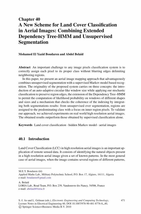
Fig. 40.1 Examples of random dependency trees according to DT-HMM (left) and EDT-HMM(right) formalisms
Unlike DT-HMM, where each pixel may have a predecessor chosen between twodirections, in the EDT-HMM modeling, a pixel s may have a predecessor v cho-sen randomly from the 4-Neighborhood (up, down, right or left) and verifying theEuclidean distance property. Note that, the neighborhood directions of all pixels ofw define a tree structure T like depicted in Fig. 40.1. We note T .s/ D v.
The likelihood probability to observe Yr given the parameters of the DT-HMM� .�;A;B/ can be approximated as follows:
P.Yr=�/ �X
T
P.Yr=T; �/
�X
T
XX
P.Yr=X; �/P.X=T; �/
�X
T
XX
(Ys2w
P.ys=xs ; �/P.xs=T; �/
)(40.2)
In this paper, we propose to evaluate the likelihood on a set of random dependencytrees � . The previous equation becomes:
P.Yr=�/ �XT2�
P.Yr=T; �/
�XT2�
XX
P.Yr=X; �/P.X=T; �/
�XT2�
XX
(Ys2w
P.ys=xs ; �/P.xs=T; �/
)(40.3)
40 A New Scheme for Land Cover Classification in Aerial Images 475
Thereafter, we remind the definition of the Model parameters �;A and B .
bi .O/ D P.ys D O=xs D i/ (40.4)
P.xs D j =xv D i; �/ D��j if s D raij otherwise
(40.5)
where i; j D 1; ::N represent hidden states.Note that aij only depends on i and j and not on the direction (horizontal or
vertical).To compute the likelihood probability of Eq. (40.3), we define the backward
function ˇi .s/ representing the probability of observing the data contained in thesub-tree of T with s as a root starting from the hidden state i .
ˇi .s/ D8<:bi .ys/ if s is a leafbi .ys/
QT .v/Ds
aijˇj .v/ otherwise (40.6)
Note that the likelihood probability of Eq. (40.3) can be evaluated as follows foreach dependency tree T :
P.Yr=T; �/ DNX
iD1
�iˇi .r/ (40.7)
This computation exhibits a reasonable complexity (linear with window size).The extension of the DT-HMM only concerns likelihood probability computation
and Viterbi decoding whereas learning is performed the same way as in DT-HMMcontext.
The Viterbi decoding process can be achieved in a similar way to the likelihoodprobability computation. On the other hand, learning is performed via an iterativeway the same as for the DT-HMM model, since the parameters are the same:
� Initialize model parameters� Choose a random dependency tree T as described above (respecting the
Euclidean distance constraint)� Perform learning as in a linear framework (like in 1D-HMM)
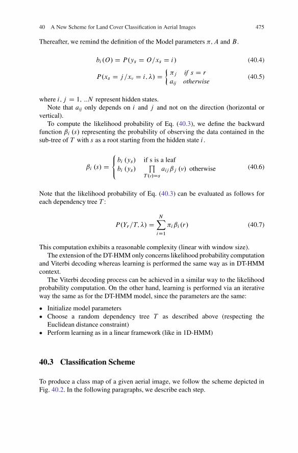
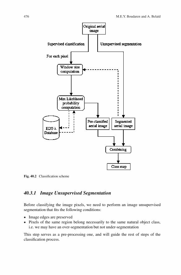
40.3 Classification Scheme
To produce a class map of a given aerial image, we follow the scheme depicted inFig. 40.2. In the following paragraphs, we describe each step.
476 M.E.Y. Boudaren and A. Belaıd
Fig. 40.2 Classification scheme
40.3.1 Image Unsupervised Segmentation
Before classifying the image pixels, we need to perform an image unsupervisedsegmentation that fits the following conditions:
� Image edges are preserved� Pixels of the same region belong necessarily to the same natural object class,
i.e. we may have an over-segmentation but not under-segmentation
This step serves as a pre-processing one, and will guide the rest of steps of theclassification process.
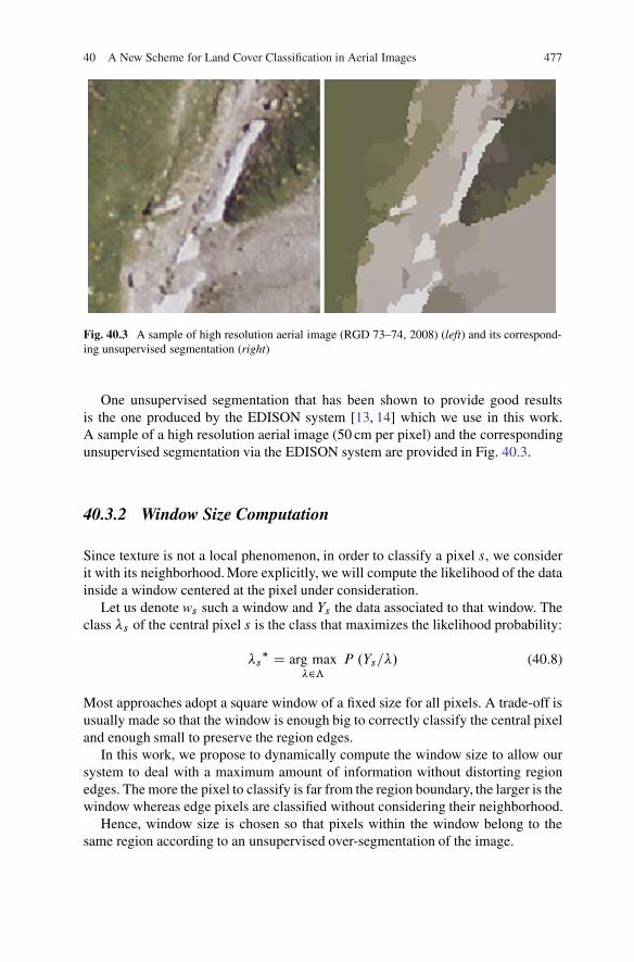
40 A New Scheme for Land Cover Classification in Aerial Images 477
Fig. 40.3 A sample of high resolution aerial image (RGD 73–74, 2008) (left) and its correspond-ing unsupervised segmentation (right)
One unsupervised segmentation that has been shown to provide good resultsis the one produced by the EDISON system [13, 14] which we use in this work.A sample of a high resolution aerial image (50 cm per pixel) and the correspondingunsupervised segmentation via the EDISON system are provided in Fig. 40.3.
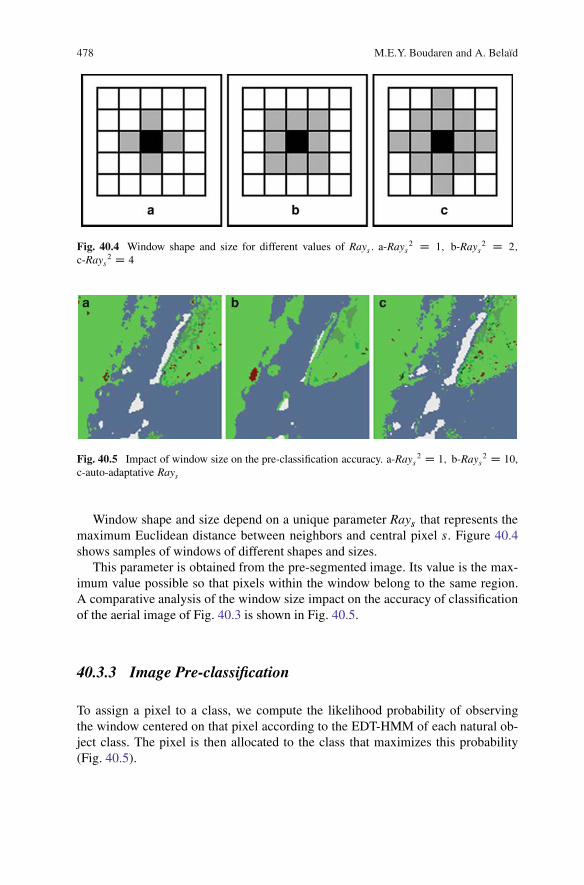
40.3.2 Window Size Computation
Since texture is not a local phenomenon, in order to classify a pixel s, we considerit with its neighborhood. More explicitly, we will compute the likelihood of the datainside a window centered at the pixel under consideration.
Let us denote ws such a window and Ys the data associated to that window. Theclass �s of the central pixel s is the class that maximizes the likelihood probability:
�s� D arg max
�2ƒ
P .Ys=�/ (40.8)
Most approaches adopt a square window of a fixed size for all pixels. A trade-off isusually made so that the window is enough big to correctly classify the central pixeland enough small to preserve the region edges.
In this work, we propose to dynamically compute the window size to allow oursystem to deal with a maximum amount of information without distorting regionedges. The more the pixel to classify is far from the region boundary, the larger is thewindow whereas edge pixels are classified without considering their neighborhood.
Hence, window size is chosen so that pixels within the window belong to thesame region according to an unsupervised over-segmentation of the image.
478 M.E.Y. Boudaren and A. Belaıd
Fig. 40.4 Window shape and size for different values of Rays : a-Rays2 D 1; b-Rays
2 D 2;
c-Rays2 D 4
Fig. 40.5 Impact of window size on the pre-classification accuracy. a-Rays2 D 1; b-Rays
2 D 10,c-auto-adaptative Rays
Window shape and size depend on a unique parameter Rays that represents themaximum Euclidean distance between neighbors and central pixel s. Figure 40.4shows samples of windows of different shapes and sizes.
This parameter is obtained from the pre-segmented image. Its value is the max-imum value possible so that pixels within the window belong to the same region.A comparative analysis of the window size impact on the accuracy of classificationof the aerial image of Fig. 40.3 is shown in Fig. 40.5.
40.3.3 Image Pre-classification
To assign a pixel to a class, we compute the likelihood probability of observingthe window centered on that pixel according to the EDT-HMM of each natural ob-ject class. The pixel is then allocated to the class that maximizes this probability(Fig. 40.5).
40 A New Scheme for Land Cover Classification in Aerial Images 479
The parameters of the EDT-HMM corresponding to each natural object class areobtained after a learning process achieved on mono-class aerial images. To representeach pixel, we used the classical RGB color space. To estimate the parameters ofthe DT-HMM of each class, we achieve K-Means clustering on pixels of mono-class image of the corresponding class to divide the image pixels on N sub-classes.Subsequently, we obtain the parameters of N Gaussian functions. These parametersserve as an initialization of our EDT-HMM. The final parameters of the model arethen obtained after an iterative process as described in the previous section.
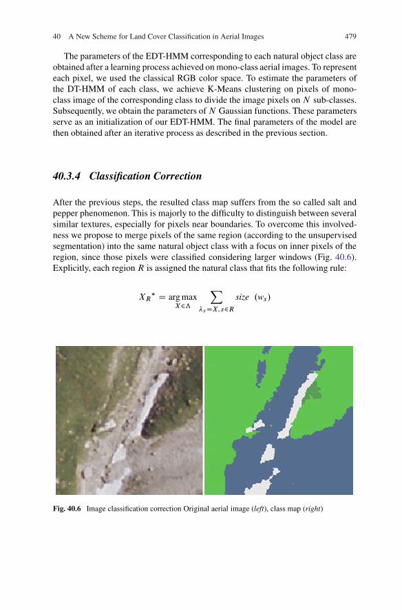
40.3.4 Classification Correction
After the previous steps, the resulted class map suffers from the so called salt andpepper phenomenon. This is majorly to the difficulty to distinguish between severalsimilar textures, especially for pixels near boundaries. To overcome this involved-ness we propose to merge pixels of the same region (according to the unsupervisedsegmentation) into the same natural object class with a focus on inner pixels of theregion, since those pixels were classified considering larger windows (Fig. 40.6).Explicitly, each regionR is assigned the natural class that fits the following rule:
XR� D arg max
X2ƒ
X�sDX; s2R
size .ws/
Fig. 40.6 Image classification correction Original aerial image (left), class map (right)
480 M.E.Y. Boudaren and A. Belaıd
40.4 Experimentation
40.4.1 Data Overview
For our experimentation, we consider real world aerial images with a resolution of50 cm per pixel (Fig. 40.6). The images were provided by La Regie de Gestion desDonnees des pays de Savoie, France ([9]).
The pictures were taken in relatively good light conditions; however, some im-ages suffer from presence of shadow in some parts.
40.4.2 Learning Database
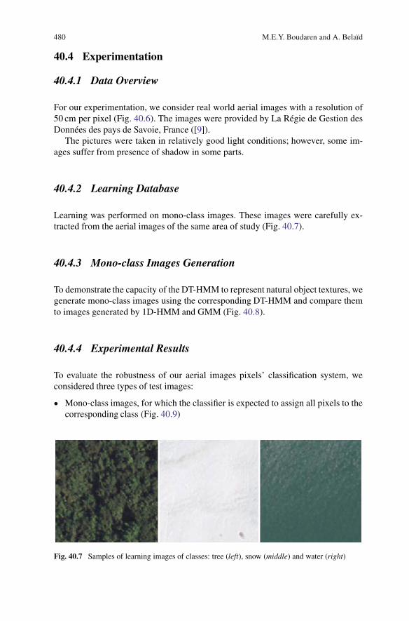
Learning was performed on mono-class images. These images were carefully ex-tracted from the aerial images of the same area of study (Fig. 40.7).
40.4.3 Mono-class Images Generation
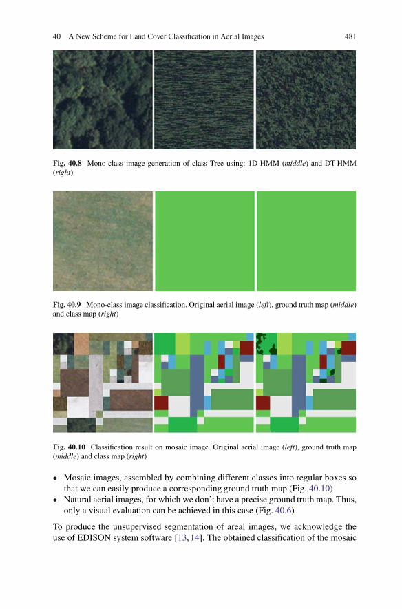
To demonstrate the capacity of the DT-HMM to represent natural object textures, wegenerate mono-class images using the corresponding DT-HMM and compare themto images generated by 1D-HMM and GMM (Fig. 40.8).
40.4.4 Experimental Results
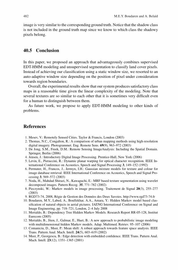
To evaluate the robustness of our aerial images pixels’ classification system, weconsidered three types of test images:
� Mono-class images, for which the classifier is expected to assign all pixels to thecorresponding class (Fig. 40.9)
Fig. 40.7 Samples of learning images of classes: tree (left), snow (middle) and water (right)
40 A New Scheme for Land Cover Classification in Aerial Images 481
Fig. 40.8 Mono-class image generation of class Tree using: 1D-HMM (middle) and DT-HMM(right)
Fig. 40.9 Mono-class image classification. Original aerial image (left), ground truth map (middle)and class map (right)
Fig. 40.10 Classification result on mosaic image. Original aerial image (left), ground truth map(middle) and class map (right)
� Mosaic images, assembled by combining different classes into regular boxes sothat we can easily produce a corresponding ground truth map (Fig. 40.10)
� Natural aerial images, for which we don’t have a precise ground truth map. Thus,only a visual evaluation can be achieved in this case (Fig. 40.6)
To produce the unsupervised segmentation of areal images, we acknowledge theuse of EDISON system software [13, 14]. The obtained classification of the mosaic
482 M.E.Y. Boudaren and A. Belaıd
image is very similar to the corresponding ground truth. Notice that the shadow classis not included in the ground truth map since we know to which class the shadowypixels belong.
40.5 Conclusion
In this paper, we proposed an approach that advantageously combines supervisedEDT-HMM modeling and unsupervised segmentation to classify land cover pixels.Instead of achieving our classification using a static window size, we resorted to anauto-adaptive window size depending on the position of pixel under considerationtowards region boundaries.
Overall, the experimental results show that our system produces satisfactory classmaps in a reasonable time given the linear complexity of the modeling. Note thatseveral textures are so similar to each other that it is sometimes very difficult evenfor a human to distinguish between them.
As future work, we propose to apply EDT-HMM modeling to other kinds ofproblems.
References
1. Mesev, V.: Remotely Sensed Cities. Taylor & Francis, London (2003)2. Thomas, N.C., Congalton, R.: A comparison of urban mapping methods using high-resolution
digital imagery. Photogrammet. Eng. Remote Sens. 69(9), 963–972 (2003)3. De Jong, S.M., Freek, D.M.: Remote Sensing ImageAnalysis: Including the Spatial Domain.
Springer, Berlin (2006)4. Jensen, J.: Introductory Digital Image Processing. Prentice-Hall, New York (2006)5. Levin, E., Pieraccini, R.: Dynamic planar warping for optical character recognition. IEEE In-
ternational Conference on Acoustics, Speech and Signal Processing 3, 149–152 (1992)6. Permuter, H., Francos, J., Jermyn, I.H.: Gaussian mixture models for texture and colour for
image database retrieval. IEEE International Conference on Acoustics, Speech and Signal Pro-cessing 3, 569–572 (2003)
7. Noda, H., Mahdad Shirazi, N., Kawaguchi, E.: MRF based texture segmentation using waveletdecomposed images. Pattern Recog. 35, 771–782 (2002)
8. Pieczynski, W.: Markov models in image processing. Traitement de Signal 20(3), 255–277(2003)
9. RGD73-74, 2008, Regie de Gestion des Donnees des Deux Savoies. http://www.rgd73-74.fr10. Boudaren, M.Y., Labed, A., Boulfekhar, A.A., Amara, Y.: Hidden Markov model based clas-
sification of natural objects in aerial pictures. IAENG International Conference on Signal andImage Engineering, pp. 718–721, London, 2–4 July 2008
11. Merialdo, B.: Dependency Tree Hidden Markov Models. Research Report RR-05-128, InstitutEurecom (2005)
12. Merialdo, B., Jiten, J., Galmar, E., Huet, B.: A new approach to probabilistic image modelingwith multidimensional hidden Markov models. Adap. Multimed. Retriev. 95–107 (2006)
13. Comaniciu, D., Meer, P.: Mean shift: A robust approach towards feature space analysis. IEEETrans. Pattern Anal. Mach. Intell. 24(5), 603–619 (2002)
14. Meer, P., Georgescu, B.: Edge detection with embedded confidence. IEEE Trans. Pattern Anal.Mach. Intell. 23(12), 1351–1365 (2001)
Related Documents


