Anent Ptan, Vol. -2) A New Look at Federally Aistered Tribal Areas Syed Hs d Fal-- at 123 It may look or yet e denomaon of yber Pakhwa ent new d pro quos. FATA esseny a Pukhtoon belt. Eicy and ecologicy it is ak to e seted area. e ea, coindtay conguous to e yber Pwa province of Pistan, storicy considered as e adle of many annt saons dag back to over 10,000 yes (i.e. e era of the earliest o hn snʦ) and according to l fables, e proir of Ad ved ound here. e reon situated on e ent a route along whi moved the A , Gs, Sakas, Ps, H, Perns, Ars, Turks d finly e htoon races om Afghanisn onwd to da-P subconnt. dentary elnt held on to mount, ors moved onto e pl. The ibal such caies e impnts of e cultures t e invaders brought along and left eir marks on its rocky teain. e be stood as t הst guard agt noe invads y ces but sucbing to psse some cs he even joined m, in casng his fone for deeפr paon to India. He prved whaver avble to during e Anglo-Afan ws: ut agnst Sovi' ocpaon of Afstan and stands today against Amecan onslaut. e bal area since mes io foed p of e subconnt of dia d Ptan. e B on e to s p of India, bcated e reon to seted d ted part. e settled ea ced ma of e Bsh system of aaon enaged for e Unid India where weste pe maa, poce and poc system was odud ou graduy for rest of In e ibal belt was leſt to its own no d rm. The ibesm ways posed asave d pocal proble to e rng house in De. Bri d mem and po to reg affrs and provided r aave ma cled polical agenes to deal wi em. The esblishment of e yber Ag in 18O was the first sp in s decon. It smed out of e Afan is d e oubles ere in. ay an was placed under a poc officer verd poco-sac knowled of e a. Such offirs were mostly drawn om e y but aduay e Bri rvanʦ were brout into e border manamt and desiated as polical anʦ. e foaon of oer agcies llowed in due course of me is detailed below al most esal charactscs and the area on its dweers. In 1892, the Kuam Ag was created (hrai 1938: D; Akbar 19M: 23) a year before e bir of the Durand Le i . Kurram Agency an area of 3380 Sq K is inhabid by a populaon of ǀ,310, wi iʦ headqs at Para i i . e Makand Agen ATA-Provinly Adminisred Tbal Area-now lakand Protecd Area), was formed in 1895. At me of its bi it was placed under conol of e Goveent of India, whe or agenes were wi jab Govent Lord-Curzo e Viceroy of India ad e o as a i Coonerp in 1901 (Obhr 70; Ahmad 23). Noneeless, e ibal areas today as always, have b direcy goveed by e cal auoes - bere and aſter the b of Pstan (ad 1977: 23). e same year (1895) two oer ages, Nor and Sou W astan, were also ead along e Pak- n border. e foer setches over an ea of 4,707 sq. km, wi a popaon of 361,2. wheras e lar has 6,620 sq.km a d 429,841 populaon iii. Since en oy ee oer new agenes have been ad. e first is e Mohmand Agency, unded in 1951, ur yes ar b of e Islc Repubc of Pakistan. Iʦ area 2,296 Sq.Km. and iʦ popaon,

Welcome message from author
This document is posted to help you gain knowledge. Please leave a comment to let me know what you think about it! Share it to your friends and learn new things together.
Transcript
Ancient Pakistan, Vol. XX-2009
A New Look at Federally Administered Tribal Areas
Syed Iftikhar Hussain and Fazal-ur-Rahim Marwat
123
It may look ordmary yet the denomination of Khyber Pakhtunkhwa entails new quid pro quos. FATA is essentially a Pukhtoon belt. Ethnically and ecologically it is akin to the settled area. The area, coincidentally contiguous to the Khyber Pakhtunkhwa province of Pakistan, is historically considered as the cradle of many ancient civilisations dating back to over 10,000 years (i.e. the era of the earliest known human settlements) and according to local fables, the progenitor of mankind, Adam, lived around here.
The region is situated on the ancient track route along which moved the Aryans, Greeks, Sakas, Parthians, Huns, Persians, Arabs, Turks and finally the Pukhtoon races from Afghanistan onward into the Inda-Pak subcontinent. Sedentary element held on to mountains, others moved onto the plains. The tribal belt as such carries the imprints of the cultures that the invaders brought along and left their marks on its rocky terrain. The tnbesman stood as the first guard against the northern invaders in many cases but succumbing to pressure in some cases he even joined him, in casting his fortune for deeper penetration into India. He preserved whatever available to him during the Anglo-Afghan wars: fought against Soviets' occupation of Afghanistan and stands firm today against American onslaught.
The tribal area since times immemorial formed part of the subcontinent of India and Pakistan. The British on their entry to this part of India, bifurcated the region into settled and unsettled part. The settled area carried charisma of the British system of administration envisaged for the United India where western type magistracy, police and political system was introduced though gradually for the rest of India, the tribal belt was left to its own norm and form.
The tribesman always posed adntinistrative and political problems to the ruling house in Delhi. The British instituted mechanism and policy to regulate their affairs and provided for administrative machinery called political agencies to deal with them. The establishment of the Khyber Agency in 1879 was the first step in this direction. It stemmed out of the Afghan crisis and the Afridi troubles there in. Initially an agency was placed under a political officer versed in politico-strategic knowledge of the area. Such officers were mostly drawn from the army but gradually the British civil servants were brought into the border management and designated as political agents. The formation of other agencies followed in due course of time is detailed below alongwith most essential characteristics and the area alongwith its dwellers.
In 1892, the Kurram Agency was created (Obhrai 1938: 68; Akbar 1977: 23) a year before the birth of the Durand Line i. Kurram Agency with an area of 3380 Sq Km, is inhabited by a population of 448,310, with its headquarters at Parachinarii.
The Malakand Agency (PATA-Provincially Administered Tribal Area-now Malakand Protected Area), was formed in 1895. At the time of its birth, it was placed under the control of the Government of India, while all the other agencies were with the Punjab Government until Lord-Curzon, the Viceroy of India created the NWFP Province as a Chief Commissionership in 1901 (Obhrai 70; Ahmad 23). Nonetheless, the tribal areas today as always, have been directly governed by the central authorities - before and after the birth of Pakistan (Ahmad 1977: 23).
The same year (1895) two other agencies, North and South W aziristan, were also created along the PakAfghan border. The former stretches over an area of 4,707 sq. km, with a population of 361,246 wheras the latter has 6,620 sq.km area and 429,841 population iii.
Since then only three other new agencies have been created. The first is the Mohmand Agency, founded in 1951, four years after the birth of the Islamic Republic of Pakistan. Its area is 2,296 Sq.Km. and its population,
Ancient Pakistan, Vol. XX-2009 124
according to 1998 census, is 334,453. In 1973, the Bajaur Agency came into being. It is spread over an area of 1290 Sq Km. with a population, according to 1998 census, of 595,227(ibid). It has its headquarters at Khar. Before the Agency, it was a sub-division of the Malakand Agency. Prior to 1960, this area was considered entirely inaccessible (Ahmad 1977: 30).
The same year, during 1973, another and the last agency so far, the Orakzai Agency, was formed (ibid: 33). It stretches over an area of 1538 Sq Km. with a population of 225,44F . Before its birth, the Orakzai tribal areas were parts of the F.R. Kohat and Hangu (Alunad 1977: 33).
Besides these agencies, there are seven Frontier Regions. They are small tribal pockets attached to various districts and administratively come under the direct control of the District Coordination Officer of the respective districts.
1. F.R. Peshawar spreads over an area of 261 sq. km. Its population in 1998 census was 53,841.
2. F.R. Kohat has an area of 446 sq. km and a population of 88,456'. This is administered by the DistrictCoordination Officer Kohat. Here live the Afridis of Darra Adamkhel. They are famous throughout theworld for their arms factories (Ahmad 1977: 37). In the early 1950s, they manufactured weapons without any
of the modern machine tools. Now they have established their own workshops, where they employ labouron daily wages as well as on monthly salary-"'.
3. F.R. Bannu has an area of 745 sq. km and a population of 19,593,ii. Here live the Bhittanis and Wazirs,coming under the jurisdiction of District Coordination Officer Bannu.
4. F.R. D.I. Khan is inhabited by the Bhittanis and Slteranis (Ahmad 1977: 37). Its area is 2,008 sq. km and itspopulation is 38,990•iii. They are administratively attached to the District Coordination Officer Dera IsmailKhan.
5. F.R. Lakki Marwat has an area of 132 sq. km and a population of 6,987. It is administered by DistrictCoordination Officer Lakki Marwat (ibid). F.R. Lakki Marwat is inhabited by the Baba, Bobak and Wargaraclans of the Bhittanis."
6. F.R. Tank has an area of 1,221 sq. km and a population of 27,216. It comes under the jurisdiction ofDistrict Coordination Officer Tank•. The area is mainly inhabited by the Bhittanis. In F.R. Tank there are 153Maliks and 45 Lungi holders''·
7. F.R. Mansehra comprises of the area all along Kala Dhaka. Its major tribes are, Akazai, Basi Khel, NusratKhel, Mada Khel and Hassanzai. Basi Khel is the biggest tribe of Kala Dhaka".
At the provincial level, Federally Administered Tribal Areas, come under the jurisdiction of the Governor rather than the Chief Minister. Since the former is the representative of the President. Thus all political agents are appointed by the Governor. The Governor is its incharge and he appoints the Political Agents to these Agencies, who are selected from the public service cadres.
Each agency has its own political agent, who runs the administration of the agency with the help of Assistant Political Agents, Tehsildars and Naib Tehsildars. For the maintenance of Law and Order he has a considerable
number of Khassadars•ii and Militia or Scouts, deployed in the prominent positions of the respective agency. During tense and politically inflammatory situations, troops from the regular army can also be drawn upon e.g. in the Kurram Agency, where Shia-Swmi conflict often occurs. All these armed personnel come under the command of Frontier Corps which has its headquarters at the famous Bala Hisar Fort in Peshawar. An
officer of the Pakistan Anny with the rank of a Major General is its officer commanding. His title is that of
Ancient Pakistan, Vol. XX-2009 125
Inspector General F.C. Almost all the Militias and Scouts have attractive names such as Tochi Scouts, Khyber Rifles, Mohmand Rifles, Kurram Militia etc. Such a battalion of scouts is commanded by a Lieutenant or Colonel of Pak Anny.
The Political Agent is provided with sufficient funds. Here one must mention that these funds are not
auditable which he gives to the Maliks and other tribal elders as grants, Moajibs, allowances or other special rewards. The political agent has unlimited powers in his agency which is necessary for the assurance of general peace and tranquility in the agency.
In Federally Administered Tribal Areas (FATA), a name recently given to the areas, coming under the control of Federal Government•i,, there 'were 4664 Primary, 444 Middle, and 279 High Schools during 2007-08. There were 33 Inter and Degree Colleges, 33 hospitals, 302 dispensaries, 56 Mother & Orild HealthCentre in FATA as recorded in 2007-08".
During the year 2007-08, there were 158 post offices, and no telegraph office with 59094 telephones installed (ibid). During the year 2007-08, there were 293820 electricity connections, in which 253040 were domestic, 28379 commercial, 4057 industrial, 8290 irrigation and 54 bulk (ibid). During the year 2006-07, there were 46 branches of the scheduled banks operating in FATA, out of which 8 branches were of National Bank, 14 of Habib Bank, 11 of United Bank, 3 of Allied Bank, 6 of Muslim Commercial Bank and 4 of Zarai Tarakiati
Bank (ibid).
There were 193 industrial units with 3800 employees in FATA during 2007-08. Twenty eight veterinary
hospitals and 221 dispensaries were working in FATA and F.R.s. during 2007-08. According to Pakistan Census Livestock report 2006, there were 1429609 cattle, 124881 buffaloes, 1531083 sheep, 3252694 goats, 17756 camels, 18141 horses, 142658 asses and 37173 mules in the tribal agencies and Frontier Regions excluding Malakand Agency (ibid).
The mentionable crops of the Tribal areas are wheat, (144.30 tonnes), maize (71.51 tonnes), rice (16.96 tonnes), sugar-cane (41.12 tonnes), barley (15.13 tonnes), gram (1.02 tonnes) and Rape seeds and Mustard
(1.87 tonnes) (ibid). As most of the tribal area is mountainous, that's why it is full of natural resources, including valuable minerals such as marbles, Fluorite, Quartz, coal, Lime stone, soap stone, Serpentine, Chromites and Mica.
FATA mineral production for the year 2007-08 shows that The Bajaur Agency produced 41143 tonnes marble, 6180 tonnes lime stone, 415 tonnes soapstone, 11485 tonnes chromite and 1 tonne mica. Khyber Agency produced 7860 tonnes marble, 2268 tonnes Flourite, 1318916 tonnes lime stone and 2356 tonnes soap
stone. Kurram Agency produced 36393 tonnes coal, 970 tonnes soap stone and 1070 tonnes chromite. Mohmand Agency produced 1016447 tonnes marble, 51480 tonnes Quartz, 4046 tonnnes lime stone, 13088 tonnes soap stone, 1890 tonnes Serpentine, 31615 tonnes Chromite and 72 tonnes mica. Orakzai Agency produced 139225 tonnes Coal and 2910 Litrate. North Waziristan agency produced 30 tonnes marble and 32180 tonnes chromite while the mineral production data in South Waziristan is zero during the year 2007-
08. Among the Frontier Regions, FR Kohat produced 83310 tonnes lime stone while FR Tank produced 43771tonnes coal during 2007-08'' i.
In a broader sense almost all the tribal area borders Afghanistan and most of the area lies in the seven
contiguous Agencies mentioned above. These tribal areas are situated amidst the high and dry mountains of Koh-,,-Sulaiman and Hindu Kush with their heights varying between 610 to 2,134 metres above sea level and
having narrow and shallow valleys. Of the total area, 5180 sq. km. is plain while the rest is mountainous.
The climate of the area is cold in winter and pleasant in summer. The average annual rainfall is from 205 to 690 m.
Ancient Pakistan, Vol. XX-2009 126
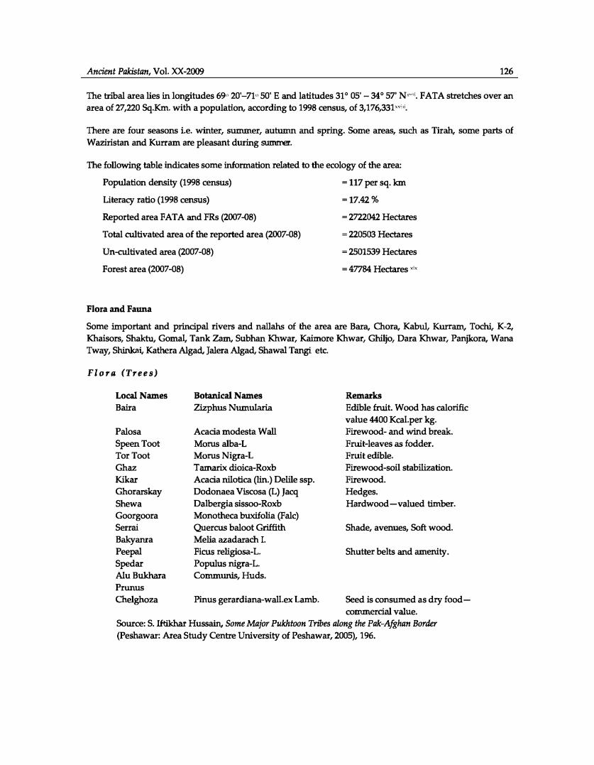
The tribal area lies in longitudes 69" 20'-71" 50' E and latitudes 31 ° 05' - 34° 57' N°'\ FATA stretches over anarea of 27,220 Sq.Km. with a population, according to 1998 census, of 3,176,331,,,,i.
There are four seasons i.e. winter, summer, autumn and spring. Some areas, such as Tir� some parts of
W aziristan and Kurr am are pleasant during summer.
The following table indicates some information related to the ecology of the area:
Population density (1998 census)
Literacy ratio (1998 census)
Reported area FATA and FRs (2007-08)
Total cultivated area of the reported area (2007-08)
Un-cultivated area (2007-08)
Forest area (2007-08)
Flora and Fauna
- 117 per sq. km
-17.42%
- 2722042 Hectares
- 220503 Hectares
- 2501539 Hectares
-47784 Hectares '''
Some important and principal rivers and nallahs of the area are Bara, Chara, Kabul, Kurram, Tochi, K-2, Khaisors, Shaktu, Gomal, Tank Zam, Subhan Khwar, Kaimore Khwar, Ghiljo, Dara Khwar, Panjkora, Wana Tway, Shinkai, Kathera Algae!, Jalera Algad, Shawal Tangi etc.
Flora (Trees)
Local Names Baira
Palosa Speen Toot Tor Toot Ghaz Kikar Ghorarskay
Shew a Goorgoora Serrai Bakyanra Peepal Spedar Alu Bukhara Prunus
Chelghoza
Botanical Names Zizphus Numularia
Acacia modesta Wall
Marus alba-L Marus Nigra-L Tamarix dioica-Roxb Acacia nilotica (]in.) Defile ssp. Dodonaea Viscosa (L) Jacq Dalbergia sissoo-Roxb Monotheca buxifolia (Falc) Quercus baloot Griffith Melia azadarach I. Ficus religiosa-L. Populus nigra-L. Communis, Huds.
Pinus gerardiana-wall.ex Lamb.
Remarks Edible fruit. Wood has calorific value 4400 Kcal.per kg. Firewood- and wind break. Fruit-leaves as fodder. Fruit edible. Firewood-soil stabilization. Firewood. Hedges. Hardwood-valued timber.
Shade, avenues, Soft wood.
Shutter belts and amenity.
Seed is consumed as dry food -commercial value.
Source: S. Iftikhar Hussain, Some Major Pukhtoon Tn"bes along the Pak-Afghan Border
(Peshawar: Area Study Centre University of Peshawar, 2005), 196.
Ancient Pakistan, Vol. XX-2009
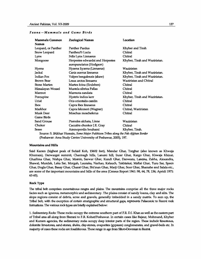
Fauna-Mammals and Game Birds
Mammals Common Names Leopard, or Panther Snow Leopard Lynx Mongoose
Hyena Jackal Indian Fox Brown Bear Stone Marten Himalayan Weasel Marmot Porcupine Urial Ibex Markhor Musk Deer Game Birds
Zoological Names
Panther Pardus Pantheu7r Lucia Fells Lynx Linnaeus Herpestes edwardsi and Herpestes auropunctatus (Hodgson) Hyaena liyaena (Linnaeus) Canis auerus linnaeus Valpes bengalensis (shaw) Lrsus arctos linnaens Martes foina (Erxleben) Mustela sibrica Pallas Marmota eandata Hystrix indica kerr Oris orientalis camlin Capra ibex linnaeus Capra falconeri (Wagner) Moschus moscheferus
Location
Khyber and Tirah Chi tr al Chitral Khyber, Tirah and W aziristan.
Waziristan Khyber, Tirah and W aziristan. Khyber, Tirah and W aziristan. W aziristan and Chitral Chi tr al Chitral Chitral Khyber, Tirah and Waziristan. Chitral Chitral Chi tr al, W aziristan Chi tr al
Sand Grouse Pterodes alchata, Linne W aziristan Chukor Caccabis chunkor J.E. Gray Chitral Sesee Ammoperdix bouhami Khyber, Tirah.
Source: S. Iftikhar Hussain, Some Major Pukhtoon Tnoes along the Pak-Afghan Border
(Peshawar: Area Study Centre University of Peshawar, 2005), 197.
Mountains and Hills
127
Said Karam (highest peak of Sufaid Koh, 15602 feet), Mandar Ghar, Torghar (also known as Khwaja Khurram), Darwazgai summit, Charmagh hills, Larurni hill, Inzar Ghar, Kargo Ghar, Khwaja Khizar, Gharlima Ghar, Nishpa Ghar, Momin, Sarwar Ghar, Kundi Ghar, Darwesta, Larema, Zakha, Alexandra, Shawal, Muzdak, Laka Sar, Morgah, Lauzaka, Narhao, Kalauch, Takhtakai, Mallai Ghar, Turu Sar, Speen Ghar, Dogla Ghar, Basay Ghar, Charat Ghar, Shi'man Ghar, Marji Ghar, Soar Ghar, Shamshe and Salala etc., are some of the important mountains and hills of the area (Census Report 1961: 98, 64, 78, 136; Apridi 1971: 63-65).
Rock Type
The tnbal belt comprises mountainous ranges and plains. The mountains comprise all the three major rocks fades such as igneous, metamorphic and sedimentary. The plains consist of sandy loams, clay and silts. The slope regions consist of debris, scree and gravels, generally imbedded in a sandy matrix. To sum up, the Tribal belt, with the exception of certain stratigraphic and structural gaps, represents Palaeozoic to Recent rock formations. The various rock types are briefly explained below:
1. Sedimentary Rocks: These rocks occupy the extreme southern part of F.R D.I. Khan as well as the eastern partof Tribal area all along from Sherani to F.R Kohat/Peshawar. In certain cases like Bajaur, Mohmand, Khyberand Kurram agencies, the sedimentary rocks occupy deep interior parts of the region. These include limestones,dolomite limestones, sand-stones, shales, clay..,tones, evaporites (gypsum) conglomerates, and gravel-beds etc. Inmajority of cases these rocks are fossiliferous. These range in age from Siluro-Devonian to Recent
Ancient Pakistan, Vol. XX-2009 128
2. Metamorphic Rocks: These are dominantly exposed in central parts of Bajaur, Southern Mohmand, NorthWestern and southern Khyber, northern Kurram and South-Western South Waziristan Agencies. These consist ofamphi-bolites, phyllitic schist, phyllites, slates and marbles etc. These are free of fossils and are grouped in Palaeozoicrocks.
3. Igneous Rocks: These rocks are predominantly exposed in Bajaur, Northern Mohmand and north-westernparts of North and South Waziristan Agencies. These igneous rocks belong to dilferent tectonic episodes andinclude (a) acidic to intermediate plutons such as granites, diorites; (b) basic to acid volcanic such as
rhyolites, and esites and basalts; ( c) ultra-basic plutonics such as peridotites, serpentinites and pyroxenites.
The intermediate to acid plutons are genetically related to Karakmtlm-Hnnalayan orogeny. The volcanic and ultrabasic plutonic rocks represent the oreanic crust material emplaced/obducted during collision of lndo-Pak plat with the land mass in the north during Upper-Paleocene to Lower-Eocene age.
The granites and diorites are devoid of any mineralization of economic importance. The volcanic and ultrabasic plutonics carry loads of certain metallic minerals such as chromile, manganese and copper etc (Hussain 1990: 14-1).
Soil Type
The central parts of the valleys and the major plains of the Tribal area consist of recent and sub-recent deposits. These include clays, silt, sand, sandy and clayey loams, gravels, pebbles, debris, talus and scree etc.
In case of valley, due to higher erosion speed, the soil is subject to constant denudation whereas in the plains the soil has attained a considerable thickness which may be measurable upto a couple of hundreds of feet or even more
Although the soil is fertile yet major part of it remains uncultivated. This is due to younger nature of the valleys where rivers have cut deeper thereby giving little water for irrigation. The land is thus not much productive. Soil in the mountainous area is eroding away rapidly. Deforestation has led to almost complete soil mass wasting. Cultivation depends mainly on seasonal rains. Some of the plains like those of Bajaur and Bara (Khyber); due to
water sources development schemes, have the soil quite productive. All types of crops are grown here (ibid: 16-17).
The People
The tribal area is inhabited by a large number of tribes as well as khels. The prominent and important among them are Afridis, Mohmands, W azirs, Shinwaris etc.
The Afridis
The Afridis, who inhabit the world's famous route the Khyber Pass, Tirah Bazar, and Kohat Pass, have a long history. However, their origin has always puzzled various Ethnologists. Many of them identify them with Arapura of Herodotus-even Bahadar Shah Zafar, a Pashto scholar, accepts this theory (Kakakhel n. d: 1378). Olaf Caroe, the last foreign writer of the history of the Pukhtoons so far, mentions them as admixture of Greek blood. He calls them not true Afghans, but Karlanris (Caroe 1985: 488). Another writer Sher Mohammad Gandapur says that the name of their ancestor was Usman alias Afridi, therefore, they were named as Afridis (Khan 1979: 519). Raza Hamdani, a scholar, writes that the word Afridi in local dialect is called 'Pariday' (Hamdani 1982: 28). The Afridis, in the early days of Islam were living in between the river Kabul and Kurram west of Sufed Koh. When during the 6th century, the Scythian tnbes invaded this area (on their way to the Indus Valley) across the Hindu
Kush, some of them settled here. Later they were seen in the hills of Tirah in the 14th century.
Ancient Pakistan, Vol. XX-2009 129
There are eight large lchels of the Afridis namely Malilc Din Khel, Qamber Khel, Kukikhel, Zakhakhel, Akakhel, Sipay, Qamer Khel and Adam Khel.
The Shinwaris
The Shinwaris belong to the Kansi branch of the Sarbani Pukhtoons. During the 16th century, they moved
eastwards with the Choriakhel tribe and displaced the Gigianis, Tarkanris and Mohammadzais from Ningrahar where a large number of them now live (Ridgway 1983: 156). Their particular area is across the
Durand Line, west of Kabul River in between Peshawar and Jalalabad. A large number of them inhabit the northern hills from the Khyber. One of their tribes Sangokhel lives on the western bank of Spin Ghar
alongwith the Khogianis. Some of them live in Bajaur, Kunar and Shingal Valley, while some families of the Shinwaris live in Kohat and Kashmir (Kakakhel n. d: 1327).
The Mullagoris
The genealogists have defined them as Sarbani Pukhtoons of the Ghoria-khel branch but Major R.T.I.
Ridgway says that the origin of the tribe is doubtful (Ridgway 1983: 130). Their major part inhabits the north of the Khyber Pass, extending from the Dabbar Pass of the west to the Peshawar district on the east. To its north lies the Kabul River. The Shinwaris are their neighbours to the west; to north, the Tarakzai
Mohmands and on the south the famous Kukikhel Afridis live.
The Mullagoris have other settlements at Sapri, in the Mohmand hills, in the Sirobi glen and along the Kunar River. They have an excellent reputation for courage and excel as mountaineers (ibid).
The Shilmanis or Shalmanis
The author tried his best to collect some valuable information on this tribe from diverse sources but in vain. In the available books, only one book mentions them and that is "A Glossary of the tribes and Castes of the
Punjab and North-West Frontier Province" Vol. III. According to it:
''The Shalmanis belong to a Tajik tribe and inhabit the Peshawar valley. It quotes Raverty who says that the Shalmanis came from Shalman (now Shalo-zan) and Karmaci in the Kunar valley
and occupied the area of Hashtnagar, becoming subjects of the Jahangiri Sultan, Awes, of Swat. This tract they lost when the Yousufzais and Mandanr Pukhtoons overran it and they are now reduced to a few small villages in the hills round the Tatara. Their rulers were
descendants of the Jahangiri Sultan (Behram and Pakhal), who held all the country north of
the Kabul river from the Tangao to the Pir Panjal range and likewise some parts on the south
bank of the Kabul as far south as the Sufed Koh. Sultan Awes was the Gabari Sultan of Swat. The Shalmanis, in Hazara, have adopted the name of Sulaimani, mostly live in the Khalsa tract
of that region and are closely connected with the Utmanzais" (Rose 1978: 401-02).
The Mullagoris as well as the Shalmanis are not as prominent in the Khyber as the Afridis or Shinwaris and
are not known to the public as well.
The Mohmands
The Mohmands genealogically come in 4th stage to Kharshbun. Their epical ancestor, Mohmand Baba, after whom the tribe takes its name, is buried at Ekka Ghund (Mohmand Agency) inside the Durand Line. It is a
branch of Ghoria Khel Pukhtoons. They are divided into the lower or plain Mohmands and upper of Bar Mohmands. The lower Mohmands occupy the south-west comer of the Peshawar district, north of the Bara River, headmen of whom is called 'Arbab'.
Ancient Pakistan, Vol. XX-2009 130
The Bar Mohmands separated from the Ghoria Khel, early in the 16th century, and crossing the Kabul at Dakka, occupied the hills to the north of that as far up as Lalpura (Afghanistan). Then they re-crossed the Kabul river and captured the area between its south bank and the west of the Afridi hills to the north of the Khyber Pass. According to Ahmad the Mohmands arrived in Peshawar valley after the Yusufzais who arrived
between 1485-1500 (Ahmad 1977: 61) Today the Mohmands are living in the areas across the Durand Line, Mohmand Agency and in some areas of Peshawar district.
The Wazirs
The Wazirs are the descendants of Wazir, who was the son of Sulaiman and grand-son of Karlanr. There are two branches of the Wazirs i.e., the Ahmad-zai Wazirs, living in the South Waziristan and the Utmanzai Wazirs, inhabiting the North Waziristan. Their famous areas are Shawal, Barrnal, Shaki, Razmak, Khaisor valley, Sharna, Shaktu W ana, Badar etc. The dialect of the W azirs, is a little more difficult to understand and to speak than that of the other Pukhtoons dialects. In the end of the 14th century they began to move eastwards. They first crossed the Khost range and captured Shawal from the Bannuchis. Later they occupied Tochi, Kaniguram etc.
Darweshkhel is another name given to the W azir tribe. At first they used to live a nomadic life but later they adopted the modes of modem living and became a civilised, cultured, organised and disciplined society. They
fought the mighty British forces and checked their movements on almost all fronts. That is why a British Viceroy and Governor-General of India compared the W aziristan disturbances to the whole of the other Agencies' disturbances (Coen 1971: 186; Kakakhel n. d: 1393-94; Hamdani 1982: 34-35; Caroe 1985: 21).
TheMahsuds
Their ancestor Mahsud was the uncle of the W azirs. The Mahsuds mostly inhabit the area of Kaniguram and Miskin. Today there are three major branches of the Mahsuds, i.e., Alizi, Bahlulzi and Shaman Khel (Kakakhel n. d: 1392). These are further subdivided into subgroups such as Shabikhel, Mansai Khel, Manakhel andAimalKhel.
In the recent years, a large number of Mahsuds have left their towns and have started working in semimilitary labour battalions, building roads in other parts of the N.W.F.P. The Mahsuds are mostly the shopkeepers in the Tank Bazar. The Mahsuds are smaller in nwnber than the Wazirs but are above the Wazirs in boldness and bravety. Abdullah Mahsud, Baitullah Mahsud and Hakimullab. Mahsud are now prominent in attracting
the public attention.
The Urmurs
Though the Urmurs themselves claim descent from Mir Barak and thus attach themselves with Barakki or Barak Pukhtoons but most genealogists do not accept this. Most of them call them a Tajik race. The Urmurs mostly inhabit three areas. The first group is in Kaniguram, the central town in the heart of the W aziristan mountains, the second in the Logar Valley, near Kabul and the third in three large villages in the Peshawar district namely, Urmur Bala, Urmur Payan and Urmur Miana. A good many are settled in Bahawalpur. The group that lives in Kaniguram, is bi-lingual. While tallcing to their neighbours such as Mahsuds, W azirs and other Pukhtoons, they speak Pukhto but among themselves they speak Urmuri, a quite distinct - East Iranian language classified as a separate tongue and by no means a dialect. However, their cousins living in Logar valley and Peshawar have lost their Urmuri. The Urmurs of Kaniguram have their own separate culture and have not been influenced by the neighbouring strong Pukhtoon culture of the Mahsuds and Wazirs.
The Urmuri or Bargista is even more closely related to the Ghalchan languages of the Pamirs than is Pashto itself. The Urmurs have an impossible tradition that they came from Ye-men and that their language was
invented for them by the very old and learned man Urmar Laban some 400 years ago (Caroe 1985: 23; Rose 1978: 163; Hamdani 1982: 20-21).
Ancient Pakistan, Vol. XX-2009 131
The Daurs
The Daurs are Ghurghust Pukhtoons of the Karlanri Branch, the descendants of Shitak. Their original home
was Shawal, from where they alongwith the Bannuchis, were driven out by the Wazirs during 14th century (Ridgway 1983: 83). The Daurs numbering 83000" constituted an important minor tribe in the North
Waziristan Agency. Some of their families live in Bannu. There are upper Daurs and lower Daurs. The former group occupies some area in Miranshah and Dattakhel tehsils of North Waziristan. The latter inhabits the Mirali tehsil of North Waziristan. The Daurs are emotional, short tempered through and through. Their
temper is frayed on the slightest pretext. Broadly speaking, the whole Daur community i.e.; the lower Daurs as well as the upper Daurs are split up in two distinct groups, namely the Tor Ghund and the Spin Ghund
(Shah 1981: 36-37).
In 1696, when Aurangzeb's son Bahadur Shah conquered the area of Bannu, he fixed an amount of 12000/rupees on the Daurs as annual Maliya (tax) and appointed Syed Hassan as their Halcim. During the reign of
Ahmad Shah Abdali, the Daurs were the nominal subjects and used to pay a little amount as tax but there was no Hakim, appointed by the King.
The Daurs do not mix up with the Wazirs. They have a long enmity with them and often fight each other but in case of an outsider enemy they say goodbye to their differences and face him unitedly (Kakakhel n. d:
1395-96).
The Orakzai
The Orakzai tribe takes its name, which literally means the lost son, (Orak) "lost", (Zoi) "Son", from a tradition that about 1000 years ago a Persian Prince named Sikandar Shah was exiled or lost. He spent his days in and around Kohat, married and ruled in Tirah.
Another version is that three brothers, Pridi, W azir and W arak came from Afghanistan to the Orakzai hills. They quarried over some trifle and Pridi then went North, Wazir to South and Warak remained there where he was (Ridgway 1983: 35). The Orakzai got their own agency in 1973.
The Orakzai tribe is divided into seven clans i.e. Sultanzai, Bahramzai, Ismailzai, Massuzai, Alizai, or Sturi Khel, Lashkarzai and Daulatzai. Their country is generally termed as Orakzai Tirah. There are four valleys in their area which are Khanki, Mastura, Khurmana and Bara valleys.
Caroe speaks of their colonies in India. Babur also mentions them. The Orakzais joined hands with Bayazid against the Moghuls (Caroe 1985: 132, 155, 202-3). They also fought against the British alongwith other tribes. Kakakhel mentions their settlements, apart from Tirah, in Kohat and Peshawar. He further writes that before
the arrival of the Bangash, the Orakzais were living in that area where the Bangash live today. The Orakzais
always used to fight with them. At last when both the tribes became tired of fighting, they held a Jirga at Barasmand. A man named Dayee brought them to an agreement. Dayee told them, "Dayee says that hills go to
the Orakzais while plain is given to the Bangash". It was decided upon unanimously (Kakakhel n. d: 1376).
The Bangash
According to tradition, the exact word was ban (root) and Kush (to tear up) which afterwards, due to use,
became Bangash. As they were very courageous, exterminators or radicals, therefore, they were called
''Bankush" (to tear up from roots) (Hamdani 1982: 33-34). Their first home is said to have been Gardez in Afghanistan, from where they were driven into the Kurram valley by the Ghilzais in the 14th century. The tribe appears to have originally been Quresh of Arab descent, but to have become merged into the Karlanri
branch of Ghurghust Pukhtoons, with a traditional genealogy from Suleman, a descendant of Kakai (Ridgway 1983: 75). The Bangash are also called Khalidi Afghans. Their ancestor's name was Ismail. He had two sons named Gar and Sama! (Kakakhel n. d: 1398).
Ancient Pakistan, Vol. XX-2009 132
There are three major branches of the Bangash i.e. Miranzai, Samalzai, and Baizai. The first historical mention of them occurs in Tuzuk-i-Baburi. They were the disciples of Bayazid Ansari which brought them to the verge of ruin. The Moghuls made constant expeditions against them (Rose 1978: 57-58). Today they live in Kurram Agency and Kohat. Kakakhel's mention of them in the Mazindran province, Iran and in the Farakh Abad, India is surprising. He further says that the Nawabs of Farakh Abad belonged to this tribe (Kakakhel n. d: 1398-99).
The Turis
The Turis are also called Turizi. The genealogists differ with each other on the origin of this tribe. According to the Pukhtoon traditions it is a branch of the Karlanris. Some genealogists call them a race of the Moghuls and some call them as Hindkis. Khushal Khan Khattak says that Turis are the Karlanri Pukhtoons (Kakakhel n. d: 1390).
The area, where the Turis live, is full of natural beauty. It is fertile, very beautiful and scenic. The tribe mostly belongs to Shia sect. They are very punctual in religious duty. When a male child is born in Turi family, the elders fire shots near his ear after Azan, so that he may become habitual to these voices and in future he may not be frightened of it (Hamdani 1982: 36).
There are five Khels of the Turis, ie.; Hamz.akhel, Masto Khel, Wapar,;i, Alikhel and Ghundi Khel. Without an escort a visitor cannot go to their area. According to Turis, there are two groups of the human being. One group is of rightists and goes the right way and the second group is of those who are wrong and go on the wrong way. They call themselves the rightists including those who mentally and religiously have some attachment with them and the rest as leftists or those who have adopted the wrong way (Kakakhel n. d: 1390-91).
The Tarkanris or Tarkolanris
It is a Pukhtoon tribe akin to the Yusufzais which overran Bajaur about the end of the 16th century (Rose 1978: 457). According to Akhoon Derweza, Shaikha had two wives, one was Marjana whose descendants are the Yusufzais and Mandanr and the other wife's name was Basu. She had only one son whose name was Tark. His descendants are called Tarkanris or Tarkolanris (Kakakhel n. d: 1322). All of them live in the Bajaur Agency. Ridgway gives them a name of Bajauris. There are three branches of this tribe which are, Mamund, Isozai, and !smai1zai (Ridgway 1983: 73-74). The famous hero of the British named Churchill campaigned here (Ahmad 1977:30).
The Bhittanis
The Bhittanis, as evident from their name, claim descent from Baitan, the third son of Qais, the founder, according to one doctrine of the Pukhtoon race. They inhabit F.R. D.I. Khan and F.R Bannu, mostly the mountainous area on the borders of Tank and Bannu from the Gabar Mountain on north to the Gama! valley on the south.
This tribe is divided into three sections which are:-
1. Tatta-living at Jandola and Siraghar and in the Dera Ismail Khan F.R.2. Dhana-on the Gabar mountain and in the Bannu F.R.3. Wraspun-inhabiting the F.R. D.I. Khan and some valleys here and there.
According to traditions, they were first living in Koh-i-Suleman but the Ghilzais drove them out of their
homeland and they settled here where now they are. During the reign, of the Pukhtoons, they had a prestigious position and a large number of them used to serve in the armed forces. (Kakakhel n. d: 1332; Ahmad 1977: 37; Rose 1978: 106; Ridgway 1983: 78-79 and Hamdani 1982: 12)
Ancient Pakistan, Vol. XX-2009 133
The Sheranis
The Sheranis, Shirannis, Sheoranis, according to traditions, belong to a Pukhtoon tribe. Their ancestor
Sherani was the eldest son of Sharkhabun but the father entrusted the 'turban' to Tarin, the second son and younger to Sherani. On this act of his father Sherani went to the area of his uncle Kakar (Kakakhel n. d: 1277). There he married a Kakar woman. It is contrary to Pukhtoon custom to marry outside the tribe or for any tribe to give a girl to an outsider (Caroe 1985: 20). From that day the Sheranis merged with the Kakar
tribe and so now, they are counted as a branch of Ghurghust (Kakakhel n. d: 1277). Today the Sheranis
inhabit the F.R D.I. Khan.
A descriptive survey of the region is given above only to affirm how effective are intrinsic links between a Pukhtoon society and its environment of the men and material placed between the Durand Line and the area placed to the east and south of it. Some of its tribes Sheraili, Kakar, Mandokhel, Sulaimankhels etc. may well be grouped with Pukhtoon administrative setup of the Baluchistan area while the other would
hopefully go well with Khyber Pakhtoonkhwa province. The measure will necessarily entail considerable benefit on both sides and without creating much expensive administrative, logistic and expertise infrastructure, the existing facilities available in the two settled administrative units would extend to the
merged land and people of the current tribal belt of Pakistan.
Notes
I Here I want to mention that Ahmad writes that the Durand Line was demarcated after 3 years of the birth of the Kurram Agency. In fact, it was demarcated in 1893, a year after the formation of the Kurram Agency in 1892. Almost all the writers of the Tribal Area differ with each other on the date of the Durand Line e.g.; Ahmad speaks of 1895 (Ahmad 1977: 23) Obhrai mentions its date as 1894 (Obhrai 1938: 42, 68). But the most reliable figure comes from Caroe. (Caroe, 1985: 382). He was a member of the delegations that held meetings with the Amir of Afghanistan in this regard. He writes "Something should be said here of a sector agreed on the map but never demarcated on the ground1 from a point on the watershed between Kunar and Bajaur through Mohmand country, across the west end of the Khaiber, and thence shirting the Bazar Valley upto the great range of the Sufed Koh running westward to its culminating peak, Sikaram .... " (Ibid: 382). Its length is about 700 miles (1120 km).
"FATA Secretariat ''Population Demography'' http://fata.gov.pk/index.php?option..:om_content&views.article&id-56<emiddJ2
(accessed 26 November 2010)
;;; FATA Secretariat ''Population Demography'' http://fata.gov.pk/index.php?option..:om_content&views.article&id=56<emiddJ2
(accessed 26 November 2010)
'' FATA Secretariat ''Population Demography'' http://fata.gov.pk/index.php?option..:om_content&views.article&id-56<emiddJ2
(accessed 26 November 2010)
' FATA Secretariat "Population Demography'' http://fata.gov.pk/index.php?option..:om_content&views.article&id=56<emiddJ2
(accessed 26 November 2010)
••Personally visited the area in October, 1988.
,;,FATA Secretariat ''Population Demography'' http://fata.gov.pk/index.php?option..:om_content&views.article&id=56<emiddJ2
(accessed 26 November 2010)
Ancient Pakistan, Vol. XX-2009
•"' FATA Secretariat ''Population Demography" http://fata.gov.pk/index.php?option=com_content&vieW"'article&id=56&1temid=92
(accessed 26 November 2010)
"Maqbul Wazir, "F.R. Lakki Marwat.''
134
http://waziristanhills.com/F ATNAgenciesFRs/FRLakkiMarwat/tabid/85/language/en-GB/Defaultaspx (Accessed on 29 November 2010)
• FATA Secretariat ''Population Demography''http://fata.gov.pk/index.php?option=com_content&vieW"'article&id=56&1temid=92
(Accessed 26 November 2010.
•' Maqbul Wazir, "F.R. Tank." http://waziristanhills.com/F ATN AgenciesFRs/FRTank/tabid/86/language/enGB/Default.aspx (Accessed on 29 November 2010)
,;; Wikipedia Encyclopedia, "Kala Dhaka," http://en.wikipedia.org/wiki/Kala_Dhaka
(Accessed on 1 December, 2010)
,;;; The Khassadars are an important form of patronage. Their total pay with allowance comes to Rs. 710/- (Telephonic talk with Political Agent Khyber dated 2nd May 1990). They also receive one set of clothing and a pair of shoes annually. They
provide their own guns and anununition. They are to protect the roads and other government installations. The Khassadars performs their duties at the check-posts where the tribesmen deposit their guns before leaving for the settled area and get them back on return (Ahmad 1980: 376).
,, .. The other abbreviation is of P.A.T A. i.e., Provincially Administered Tribal Areas. The Malakand Agency now called as Malakand Protected Area (MPA) was previously administered by PATA but now comes under the administrative system of DCO while the rest of the Agencies come under FATA.
�, .. Bureau of Statistics, Khyber Pakhtunkhwa, "FATA Development Statistics" http://www.khyberpakhtunkhwa.gov. pk/Departrnents/BOS/main-menu-fata-dev-stats. php
(Accessed on 26 November 2010)
"; Bureau of Statistics, Khyber Pakhtunkhwa, "Agency/F.R. Wise Minerals Production of FATA for the Year 2007-08." http://www.khyberpakhtunkhwa.gov. pk/Departrnents/BOS /fataind-mineral-tab-33.php (Accessed on 26 November 2010)
• ;; Microsoft® Encarta® Reference Library 2003. © 1993-2002 Microsoft Corporation.
"''' FATA Secretariat" Administrative System." http://fata.gov.pk/index.php?option=com_content&vieW"'article&id=SO<emid=84
(Accessed 26 November 2010)
•'• Bureau of Statistics, Khyber Pakhtunkhwa, ''FATA Development Statistics'' http://www.khyberpakhtunkhwa.gov. pk/Departrnents/BOS/main-menu-fata-dev-stats. php
(Accessed on 26 November 2010)
•• Offioe of the Political Agent North Waziristan Agency, Miran Shah.
References
Alunad, Akbar. S, 1977, Social and Econamic Change in the Tn"bal Areas, Karachi: Oxford University Press.
Aprid� Mia Khan, 1971, Pukhtane, Vol. D, Kabul.
Caroe, Olaf, 1985 (reprint), The Pathan, 4'" ed. Karachi: Oxford University Press.
Coen, Terence Creagh,1971, The Indian Political Service, London: Chatto and Windus.
Harndani, Raza, 1982, Pathano kay Rasm-<>-Riwaj, Islamabad.
Ancient Pakistan, Vol. XX-2009 135
Hussain, S. Iftikhar,2005, Some Major Pukhtoon Tn"bes alung the Pak-Afghan Border, Peshawar: Area Study Centre University of Peshawar.
Kakakhel, Bahadur Shah Zaffar, n. d, Pukhtane da Tareekh pa Renra kay. Peshawar.
Khan, Sardar Sher Mohammad, 1979, Tareekh-i-Pukhtoon, Translated by Siraj Ahmad Ali, Karachi: n. p.
Obhrai, Diwan Chand, 1938, Evolution ofNWFP Province. Peshawar: n. p.
Ridgway, R.T.l, 1983, The Pathans 2'"1 edition, Peshawar: n. p.
Rose, H.A. et al, 1978, A Glossary of the Tribes and Castes of the Punjab and North-West Fruntier Province. Vol. III, Lahore: Aziz Publisher.
Shah, Syed Mazhar Ali, 1981, The Summing Up. Peshawar: n. p.
KifayatUllah, n. d, Progress of Education in FATA. Lahore: n. p.
Government of Pakistan, Census Report 1961.
Microsoft® Encarta® Reference Library 2003. © 1993-2002 Microsoft Corporation
Office of the Political Agent, North Waziristan Agency, Miran Shah.
FATA Secretariat "Administrative System." http://fata.gov.pk/index.php?option=m_content&view---article&id=SO&Itemid=84 (Accessed 26 November 2010)
FATA Secretariat "Population Demography'' http://fata.gov.pk/index.php?option'"<XJm_content&view---article&id=56&Itemid=92 (Accessed 26 November 2010)
Bureau of Statistics, Khyber Pakhtunkhwa, "FATA Development Statistics" http://www.khyberpakhtunkhwa.gov.pk/Departments/BOS/main-menu-fata-dev-.,tats.php (Accessed on 26 November 2010)
Bureau of Statistics, Khyber Pakhtunkhwa, "Agency/F.R. Wise Minerals Production of FATA for the Year 2007-08." http://www.khyberpakhtunkhwa.gov.pk/Departments/BOS /fataind-mineral-tab-33.php (Accessed on 26 November 2010)
Maqbul Wazir, "F.R. Lakki Marwat"
http://waziristanhills.com/F ATN AgenciesFRs/FRLakkiMarwat/tabid/85/language/en-GB/Default.aspx (Accessed on 29 November 2010)
Wikipedia Encyclopedia, "Kala Dhaka," http://en.wikipedia.org/wiki/Kala_Dhaka (Accessed on 1 December, 2010)

Related Documents