MMI · Institute of Man Machine Interaction · RWTH Aachen · Ahornstraße 55 · 52074 Aachen · www.mmi.rwth-aachen.de A New Localisation Method Enhancing High Precision GPS Sensors with Terrestrial Laserscanner Data Petra Krahwinkler

Welcome message from author
This document is posted to help you gain knowledge. Please leave a comment to let me know what you think about it! Share it to your friends and learn new things together.
Transcript

MMI · Institute of Man Machine Interaction · RWTH Aachen · Ahornstraße 55 · 52074 Aachen · www.mmi.rwth-aachen.de
A New Localisation Method Enhancing High Precision GPS Sensors with Terrestrial
Laserscanner Data
Petra Krahwinkler
MMI · Institute of Man Machine Interaction · RWTH Aachen · Ahornstraße 55 · 52074 Aachen · www.mmi.rwth-aachen.de
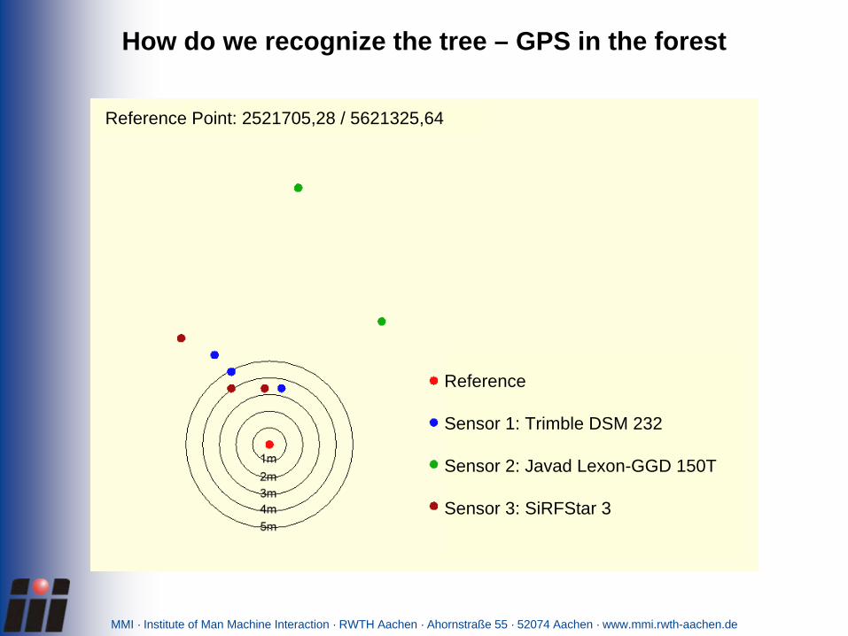
Reference
Sensor 1: Trimble DSM 232
Sensor 2: Javad Lexon-GGD 150T
Sensor 3: SiRFStar 3
Reference Point: 2521705,28 / 5621325,64
How do we recognize the tree – GPS in the forest

MMI · Institute of Man Machine Interaction · RWTH Aachen · Ahornstraße 55 · 52074 Aachen · www.mmi.rwth-aachen.de
„Visual GPS“ enhances the standard GPS localization

MMI · Institute of Man Machine Interaction · RWTH Aachen · Ahornstraße 55 · 52074 Aachen · www.mmi.rwth-aachen.de
The basic idea of „Visual GPS“

MMI · Institute of Man Machine Interaction · RWTH Aachen · Ahornstraße 55 · 52074 Aachen · www.mmi.rwth-aachen.de
Calculate a „more correct“ position by taking a tree group int account!
The basic idea of „Visual GPS“

MMI · Institute of Man Machine Interaction · RWTH Aachen · Ahornstraße 55 · 52074 Aachen · www.mmi.rwth-aachen.de
Virtual Testbed and Simulation
• Simulation of laser scanners in the virtual forest
• Simulation of laser scanners and the particle filter algorithm
• Simulation of the particle filter using logged laser scanner data
• Implementation of the system on the harvester

MMI · Institute of Man Machine Interaction · RWTH Aachen · Ahornstraße 55 · 52074 Aachen · www.mmi.rwth-aachen.de
Laser scanner mounted on a John Deere Harvester

MMI · Institute of Man Machine Interaction · RWTH Aachen · Ahornstraße 55 · 52074 Aachen · www.mmi.rwth-aachen.de
Resulting accuracy: approx. 50cm
Visual GPS allows to localize the harvester

MMI · Institute of Man Machine Interaction · RWTH Aachen · Ahornstraße 55 · 52074 Aachen · www.mmi.rwth-aachen.de
Resulting accuracy: approx. 50cm
Visual GPS allows to localize the harvester

MMI · Institute of Man Machine Interaction · RWTH Aachen · Ahornstraße 55 · 52074 Aachen · www.mmi.rwth-aachen.de
Resulting accuracy: approx. 50cm
Visual GPS allows to localize the harvester
MMI · Institute of Man Machine Interaction · RWTH Aachen · Ahornstraße 55 · 52074 Aachen · www.mmi.rwth-aachen.de
Thank you!The project „Virtual Forest“ is co-financed by the European Union and North-Rhine-Westfalia – European Regional Development Fund (EFRE)
Related Documents