A New Global Data of Cloud Vertical A New Global Data of Cloud Vertical Layers and Implications for Model Layers and Implications for Model Simulations Simulations JCSDA Science Workshop, May 31-June 1, 2006, MD Zhanqing Li Zhanqing Li Department of Atmospheric and Oceanic Science & Department of Atmospheric and Oceanic Science & ESSIC ESSIC University of Maryland University of Maryland Fu-Lung Chang Fu-Lung Chang National Institute of Aerospace (NIA) National Institute of Aerospace (NIA)

A New Global Data of Cloud Vertical Layers and Implications for Model Simulations
Dec 30, 2015
Zhanqing Li Department of Atmospheric and Oceanic Science & ESSIC University of Maryland Fu-Lung Chang National Institute of Aerospace (NIA). A New Global Data of Cloud Vertical Layers and Implications for Model Simulations. JCSDA Science Workshop, May 31-June 1, 2006, MD. - PowerPoint PPT Presentation
Welcome message from author
This document is posted to help you gain knowledge. Please leave a comment to let me know what you think about it! Share it to your friends and learn new things together.
Transcript
A New Global Data of Cloud Vertical Layers and A New Global Data of Cloud Vertical Layers and Implications for Model SimulationsImplications for Model Simulations
JCSDA Science Workshop, May 31-June 1, 2006, MD
Zhanqing LiZhanqing LiDepartment of Atmospheric and Oceanic Science & ESSICDepartment of Atmospheric and Oceanic Science & ESSIC
University of MarylandUniversity of MarylandFu-Lung ChangFu-Lung Chang
National Institute of Aerospace (NIA) National Institute of Aerospace (NIA)

Science Questions
Do we have a sound global cloud data in terms of cloud vertical structure and cloud optical properties?
To what extent do cirrus clouds overlap with lower-level clouds on a global scale?
How much artifact and uncertainty exist in in current satellite and model simulation cloud products?
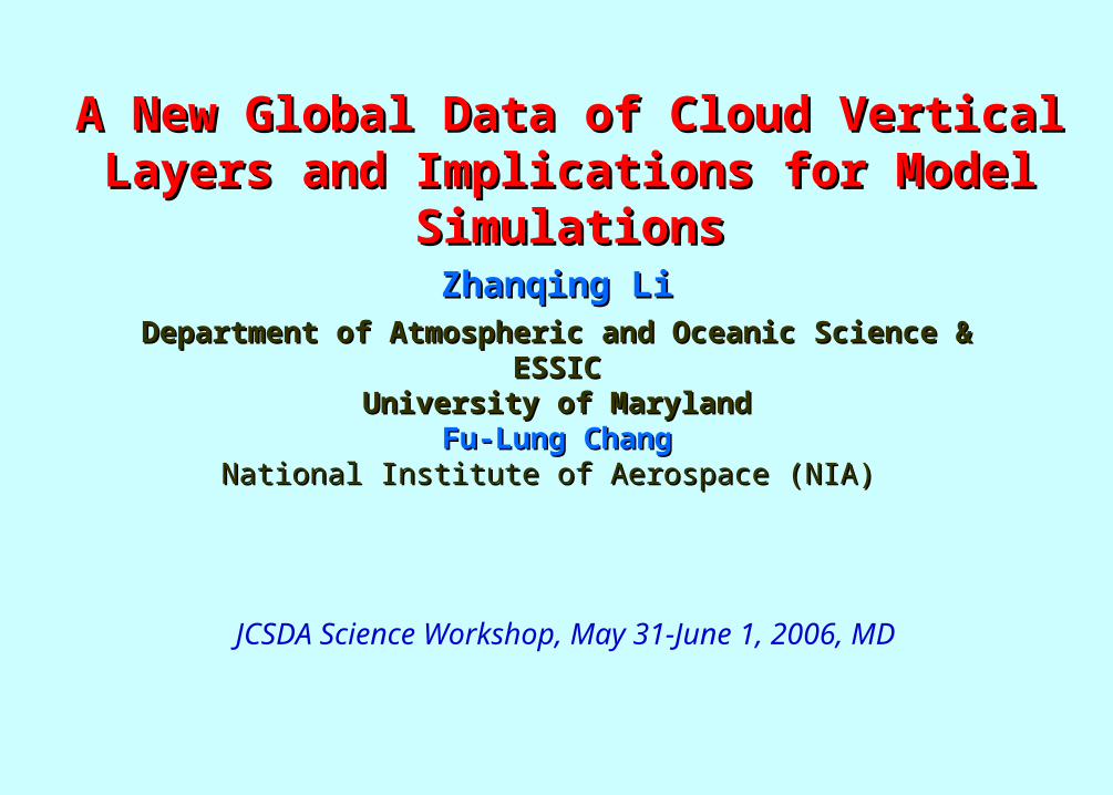
Status of Model Simulation of Cloud-Layering
Satellite cloud properties
Model validation(Zhang et al. 2005,
JGR)
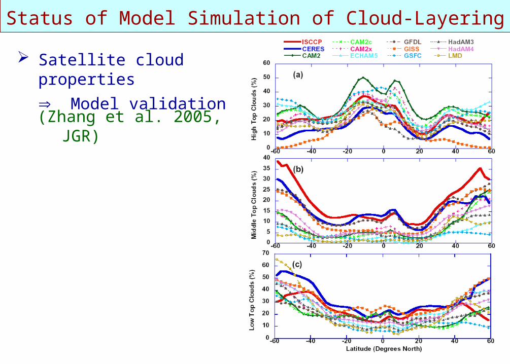
Status of Satellite Remote Sensing of Cloud-layering
Both MODIS and ISCCP cloud retrieval algorithms are applied to April 2001 Terra/MODIS L1B radiance data.
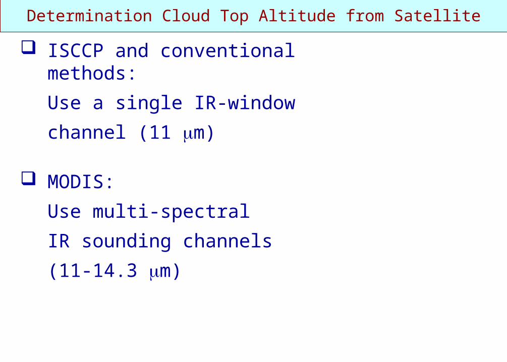
Determination Cloud Top Altitude from Satellite
ISCCP and conventional methods:
Use a single IR-window
channel (11 m)
MODIS:
Use multi-spectral
IR sounding channels
(11-14.3 m)
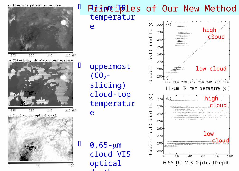
Principles of Our New Method 11-m IR
temperature
uppermost (CO2-slicing) cloud-top temperature
0.65-m cloud VIS optical depth
high cloud
low cloud
high cloud
low cloud
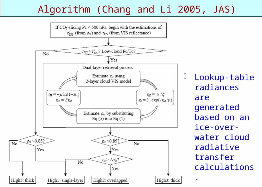
Algorithm (Chang and Li 2005, JAS)
Lookup-table radiances are generated based on an ice-over-water cloud radiative transfer calculations.
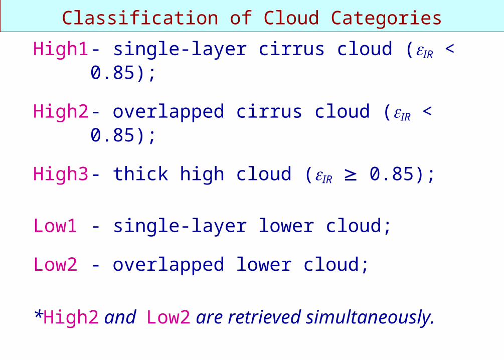
Classification of Cloud Categories
High1 - single-layer cirrus cloud (IR < 0.85);
High2 - overlapped cirrus cloud (IR < 0.85);
High3 - thick high cloud (IR 0.85);
Low1 - single-layer lower cloud;
Low2 - overlapped lower cloud;
*High2 and Low2 are retrieved simultaneously.
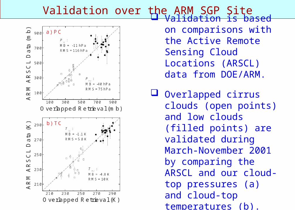
Validation over the ARM SGP Site Validation is based on
comparisons with the Active Remote Sensing Cloud Locations (ARSCL) data from DOE/ARM.
Overlapped cirrus clouds (open points) and low clouds (filled points) are validated during March-November 2001 by comparing the ARSCL and our cloud-top pressures (a) and cloud-top temperatures (b).
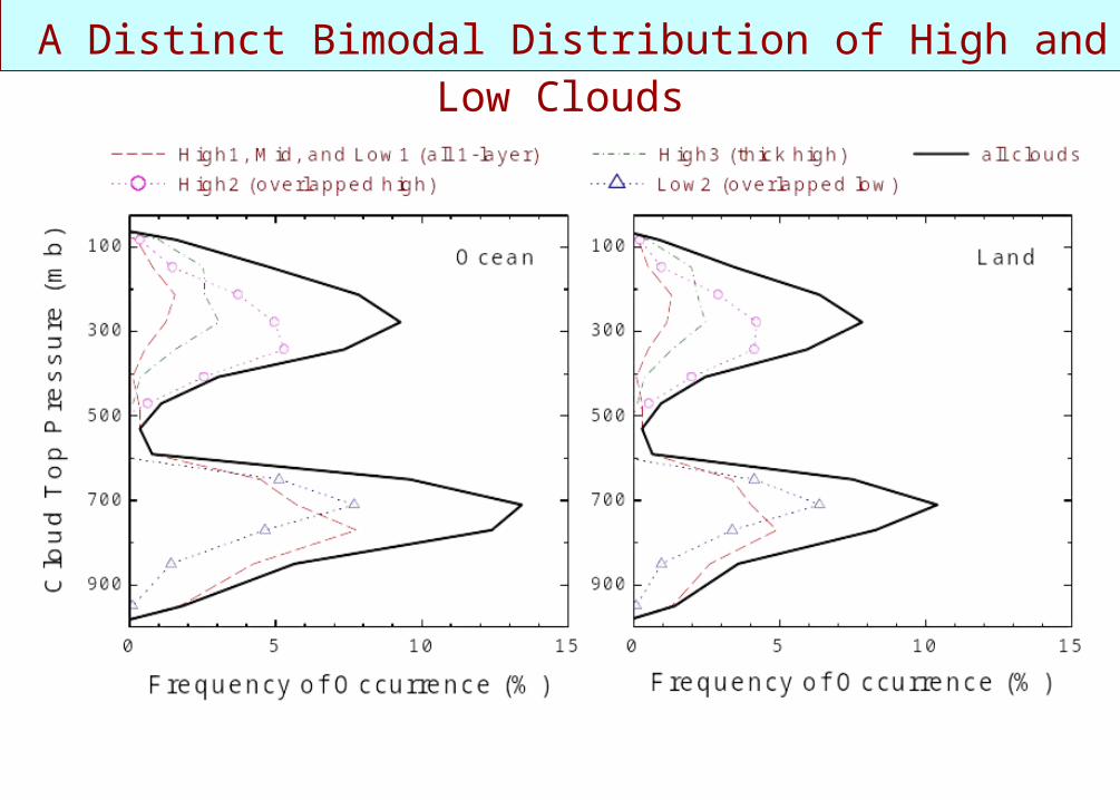
A Distinct Bimodal Distribution of High and Low Clouds
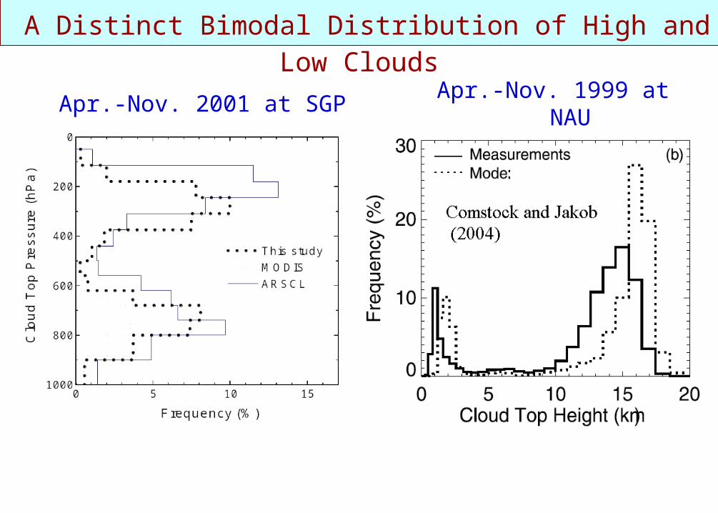
A Distinct Bimodal Distribution of High and Low Clouds
Apr.-Nov. 2001 at SGP Apr.-Nov. 1999 at NAU

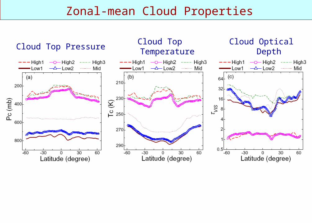
Zonal-mean Cloud Properties
Cloud Top Pressure Cloud Top Temperature Cloud Optical Depth
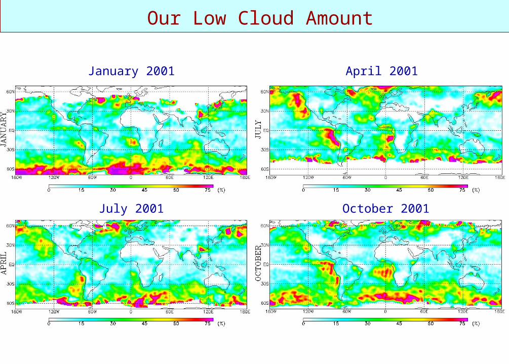
Our Low Cloud Amount
January 2001 April 2001
July 2001 October 2001

Mid Cloud Amount (Including 440-680 mb)
January 2001 April 2001
July 2001 October 2001
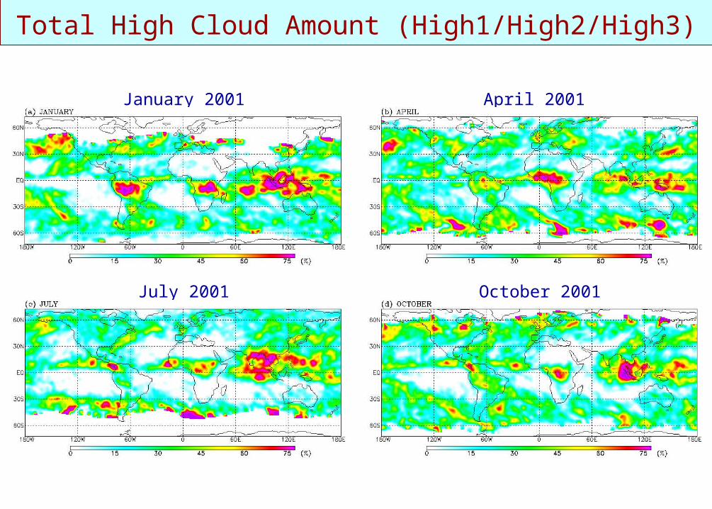
Total High Cloud Amount (High1/High2/High3)
January 2001 April 2001
July 2001 October 2001

Overlapped Cloud Amount
January 2001 April 2001
July 2001 October 2001

Comparing High, Mid, and Low Cloud Amounts
Our MODIS retrievals with overlapping
MODIS data (Collection 4)
Retrievals from the Visible-IR method
H H H
M M M
L L L
H: < 440 mb, M: 440 mb-680 mb, L: > 680 mb
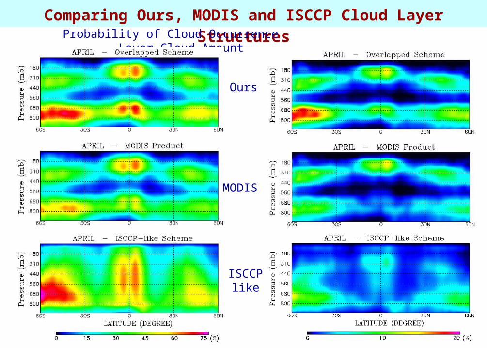
Comparing Ours, MODIS and ISCCP Cloud Layer Structures Probability of Cloud Occurrence Layer Cloud Amount
Ours
MODIS
ISCCP like
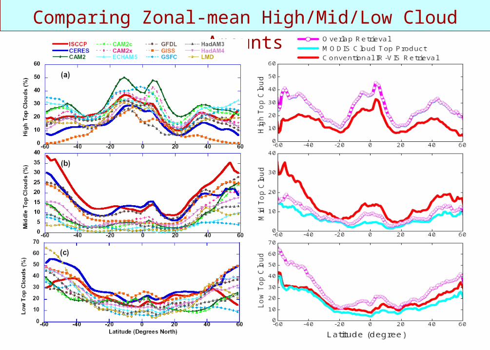
Comparing Zonal-mean High/Mid/Low Cloud Amounts

Comparing Cloud-Top/Cloud-Optical-Depth Joint Distributions
All MODIS, ISCCP, and our cloud retrieval algorithms are applied to April 2001 Terra/MODIS L1B radiance data.

Evaluating Cloud Fields Generated by the NCEP Models
Implement and validate our retrieval algorithm
Get cloud data from the model for selected days & months
Retrieve cloud properties from MODIS satellite
Comparing cloud layers derived from satellite and models
Quantify major discrepancies
Study the causes for the discrepancies

Conclusions To date, most satellite and modeling cloud algorithms
adopt a single-layer cloud assumption, which cannot deal with cloud overlap situation.
For cirrus overlapping low clouds, conventional IR method tends to detect them as single-layer mid-level clouds; while MODIS treats them as single-layer high-thick clouds.
Our results show relatively ~30% more low clouds than the MODIS operational product owing to cloud overlaps.
Our cloud layer structure shows a distinct bimodal high-and-low cloud distribution with minimum cloudiness near 500-600 hPa,
ISCCP does not show the distinct cloud layer structure. Yet, it has a lot less high and low clouds, but more mid-clouds.
Related Documents