MWWD 2008 A_MWWD2008_Santos_Predicting the dynamics of outfall plume_paper.doc - page 1 of 14 Hydrodynamics downscaling for predicting the dynamics of Foz do Arelho submarine outfall plume Santos, M. (1) , P. C. Leitão (2) , R. Neves (1) , S. Carvalho (3) , C. Alves (3) Keywords MOHID, nested models, wastewater discharge, dispersion, submarine outfall, Óbidos Lagoon Introduction Foz do Arelho submarine outfall (-9.24 West and 39.44 North) located on the Western Portuguese coast 150 km north of Lisbon is the last organ of the inter municipal sewer system of Caldas da Rainha and Óbidos [1] (Figure 1). The system includes a network of 5 wastewater treatment plants performing secondary treatment and provides services to about 50000 people in the Óbidos Lagoon catchment. The eutrophication symptoms in the upper lagoon associated to its importance for local tourism and shellfish production were reasons enough for diverting the UWWTP discharges from the lagoon and consequently for the construction of the trunk sewer and the submarine outfall. The submarine outfall is about 2 km long and the diffuser is located about 30 m deep on a sandy bottom. Before the construction of the trunk sewer the WWTP were discharging in the river network (Arnóia and Cal River) having the lagoon as final receiving environment. The sewage discharge at coastal area began after September 2005, through a submerged multi-port diffuser. Figure 1 - Geographical location of Óbidos lagoon and Foz do Arelho submarine outfall. Major freshwater tributaries are marked. The location of the monitoring stations in the coastal area (#1-#5) and Foz do Arelho beach (FA#1-FA#5) are also marked. The submarine outfall discharge is made in the point #1. 1 Madalena Santos (Physical Oceanography, MsC), [email protected] - Instituto Superior Técnico, Av. Rovisco Pais, 1049-001 Lisboa, Portugal. 1 Ramiro Neves (Mechanical Engineer, Ph.D), [email protected] - Instituto Superior Técnico, Av. Rovisco Pais, 1049-001 Lisboa, Portugal. 2 Paulo Chambel Leitão (Civil Engineer, Ph.D), [email protected] -HIDROMOD Lda., Av. Manuel da Maia, nº 36, 3º esq. 1000-201 Lisboa, Portugal 3 Sandra Carvalho (Post Graduated in Sanitary Engineer), [email protected] -Águas do Oeste, S.A., Convento de São Miguel das Gaeiras, 2510-718 Gaeiras, Portugal 3 Cátia Alves (Environmental Engineer), [email protected] -Águas do Oeste, S.A., Convento de São Miguel das Gaeiras, 2510-718 Gaeiras, Portugal

Welcome message from author
This document is posted to help you gain knowledge. Please leave a comment to let me know what you think about it! Share it to your friends and learn new things together.
Transcript
MWWD 2008
A_MWWD2008_Santos_Predicting the dynamics of outfall plume_paper.doc - page 1 of 14
Hydrodynamics downscaling for predicting the dynamics of Foz do Arelho submarine outfall plume
Santos, M.(1), P. C. Leitão (2), R. Neves (1), S. Carvalho(3), C. Alves (3)
Keywords
MOHID, nested models, wastewater discharge, dispersion, submarine outfall, Óbidos Lagoon
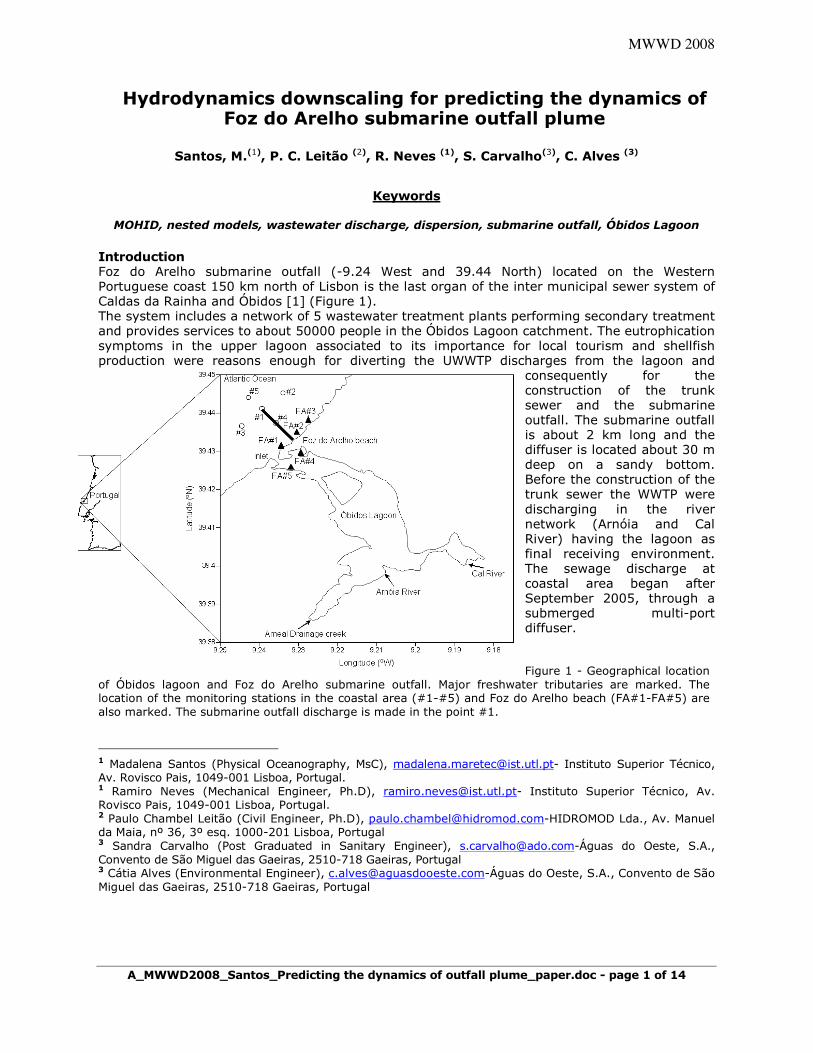
Introduction Foz do Arelho submarine outfall (-9.24 West and 39.44 North) located on the Western Portuguese coast 150 km north of Lisbon is the last organ of the inter municipal sewer system of Caldas da Rainha and Óbidos [1] (Figure 1). The system includes a network of 5 wastewater treatment plants performing secondary treatment and provides services to about 50000 people in the Óbidos Lagoon catchment. The eutrophication symptoms in the upper lagoon associated to its importance for local tourism and shellfish production were reasons enough for diverting the UWWTP discharges from the lagoon and
consequently for the construction of the trunk sewer and the submarine outfall. The submarine outfall is about 2 km long and the diffuser is located about 30 m deep on a sandy bottom. Before the construction of the trunk sewer the WWTP were discharging in the river network (Arnóia and Cal River) having the lagoon as final receiving environment. The sewage discharge at coastal area began after September 2005, through a submerged multi-port diffuser. Figure 1 - Geographical location
of Óbidos lagoon and Foz do Arelho submarine outfall. Major freshwater tributaries are marked. The location of the monitoring stations in the coastal area (#1-#5) and Foz do Arelho beach (FA#1-FA#5) are also marked. The submarine outfall discharge is made in the point #1.
1 Madalena Santos (Physical Oceanography, MsC), [email protected] Instituto Superior Técnico, Av. Rovisco Pais, 1049-001 Lisboa, Portugal. 1 Ramiro Neves (Mechanical Engineer, Ph.D), [email protected] Instituto Superior Técnico, Av. Rovisco Pais, 1049-001 Lisboa, Portugal. 2 Paulo Chambel Leitão (Civil Engineer, Ph.D), [email protected] Lda., Av. Manuel da Maia, nº 36, 3º esq. 1000-201 Lisboa, Portugal 3 Sandra Carvalho (Post Graduated in Sanitary Engineer), [email protected]Águas do Oeste, S.A., Convento de São Miguel das Gaeiras, 2510-718 Gaeiras, Portugal 3 Cátia Alves (Environmental Engineer), [email protected]Águas do Oeste, S.A., Convento de São Miguel das Gaeiras, 2510-718 Gaeiras, Portugal
A_MWWD2008_Santos_Predicting the dynamics of outfall plume_paper.doc - page 2 of 14
a)
Using submerged multi-port diffusers results in much higher initial dilution and reduces the immediate effect of the discharged flow at the coastal area [2].The flow rate of the sewage discharge oscillates between 0.2 and 0.4 m3/s during winter and summer months. The effluent are characterized by a conductivity range of 1150-1162 µs/cm, temperature of 19.5-21 ºC and a faecal coliform counts between 4x10⁵-2x10⁶ CFU/100 mL. Other potential contaminants including metals, total suspended, CBO5 and nutrients also characterized the effluent discharge. The proximity of Foz do Arelho beach, a popular vacation site during summer months, have arisen about potential public health risk. According to these, the water quality at Foz do Arelho beach, have to respect the EC Batching Water Directive (European Union Directive 76/160/EEC) and therefore the company that managed the system, Águas do Oeste S.A. (AdO), set up monitoring programs to assess the fate of the submarine outfall plume in the sea and of its impact in the receiving waters and the environmental benefits in the Óbidos Lagoon [3]. Strategies include monitoring with discreet values, sensor technology, remote sensing images and numerical models. Models are the most effective tool for time and space integration of data values which, in turn, are of prime importance to validate the model results. Hence using all these sources of information in an integrated way results in monitoring cost reduction and helps to better understand the processes, identifying cause-effect relations and test different scenarios. This paper describes the methodologies used in the submarine outfall program and the results obtained. A downscaling approach was developed to study the dispersion processes of Foz do Arelho submarine outfall plume in coastal area through submerse diffusers. The combination of modelling techniques, coupling 3D hydrodynamic nested models with different resolution scales and therefore with a lagrangean model, developed for this particular study, allows the possibility to simulate in integrated way the dispersion of the plume in the near field and far field.The faecal mortality rate was also computed dynamically using the light intensity available at each instant and location computed as a function of the light at the surface, of the depth and of the suspended matter concentration. To understand the dynamics of Foz do Arelho submarine outfall were simulated several scenarios to evaluate the near field and the far field of the sewage discharge. It is important to understand the dynamics of Foz do Arelho submarine outfall plume in order to evaluate the impact of the sewage discharge in costal area and also in Foz do Arelho beach. In the next section of this paper are presented the study area, which include Óbidos Lagoon, and Foz do Arelho coastal area. Then, is described the configuration for the Foz do Arelho submarine outfall and in the following sections the results and conclusions are presented. Study area Circulation in Foz do Arelho coastal area is controlled by ocean currents (large circulation) and local wind force. The Ocean currents flow northward, with typical values of about 20-25 cm s-1
[4].The wind currents are almost parallels to the coast and present large variability in the water column, whit maximums values at the surface layer. At 25 m depth mean current speeds are typically about 5 cm s-1 and 20 cm s-1 at the surface [5]. This variability is induced by local wind forces which have northerly frequency and mean speed of 6 m s-1. For instance, the correlation between winds and currents shows that wind is responsible for 70% of current value, being the others due to another effect. During summer circulation pattern is characterized by strong coastal upwelling together with upwelling filaments. The upwelling occurs major during the spring and summer months, typically between April and
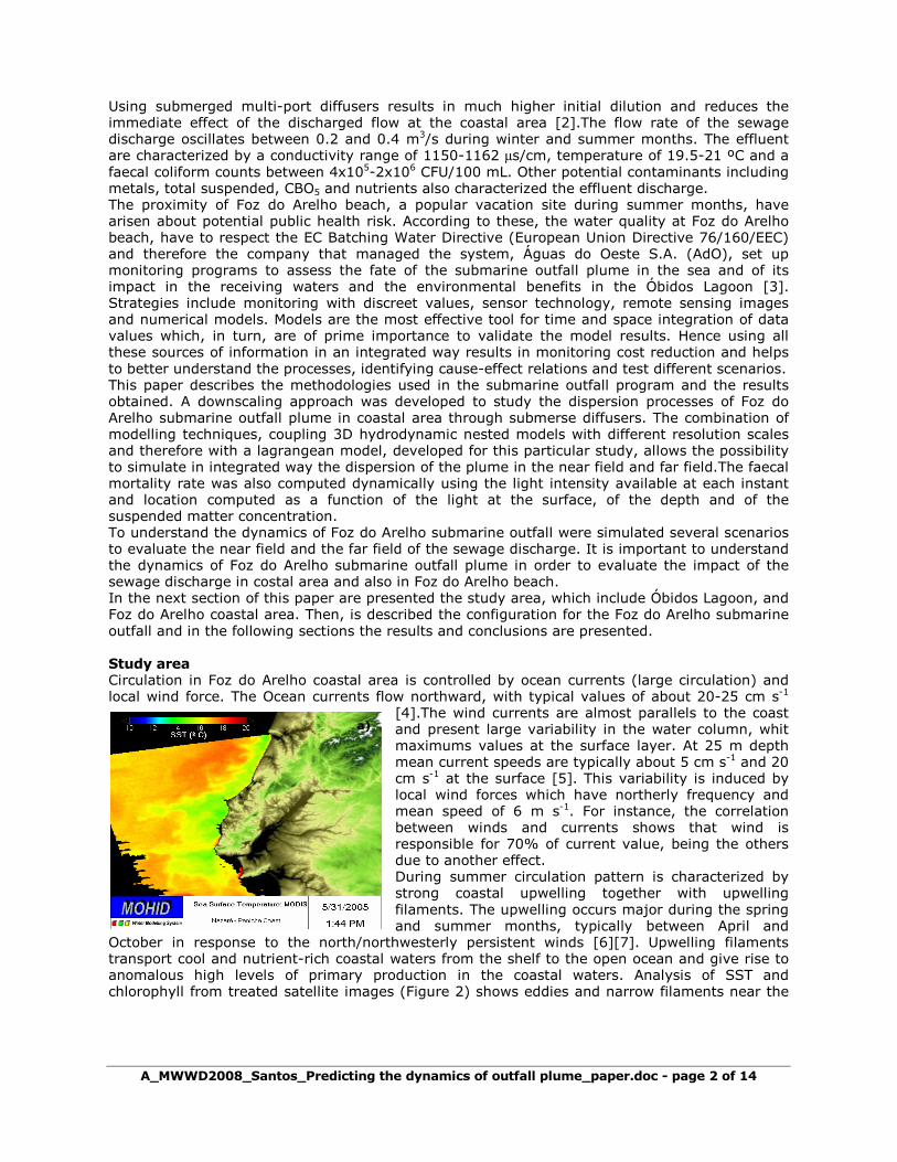
October in response to the north/northwesterly persistent winds [6][7]. Upwelling filaments transport cool and nutrient-rich coastal waters from the shelf to the open ocean and give rise to anomalous high levels of primary production in the coastal waters. Analysis of SST and chlorophyll from treated satellite images (Figure 2) shows eddies and narrow filaments near the
A_MWWD2008_Santos_Predicting the dynamics of outfall plume_paper.doc - page 3 of 14
b)
Carvoeiro cape in the Nazare-Peniche coast. According to several studies the locations of particularly prominent filaments occurs near the regions of Capes and topographic variations [8].
The sea level fluctuation is characterized predominantly by semidiurnal tide. The largest constituent, M2, has amplitude around 1 m, and the second largest constituent, S2, has amplitude of 35 cm. There is a seasonal variation in stratification in Foz do Arelho coastal area, with well-mixed conditions during winter, weaker stratification during spring and autumn and strong stratification during summer. The pycnocline is generally found at 15-20 m depth during summer. A baroclinic circulation were observed during summer while the winter is characterized by a barotropic circulation.
Figure 2 - MODIS remote sensing images in the coast between Nazaré and Peniche: Sea surface temperature (a) and Chlorophyll (b) in 31th may 2005. Low temperatures near shore were observed together with upwelling filaments near the Carvoeiro Cape.
The stratification strongly influences both water properties and dynamics, reducing the vertical exchange between surface and bottom waters and isolating the bottom layer from the direct influence of wind stress [9]. Diurnal and seasonal variations in density stratification and current produce large variations in effluent trapping depth. There is no influence of tidal fresh plumes associated to rivers inflow in the water column salinity values (always about 36 psu), because no major rivers entering directly into Foz do Arelho coastal area. The óbidos plume salinity is minimal because rivers inflows in the lagoon are smaller when compared with tidal prism. The largest local source of fresh water is the sewage outfall. The observations of monitoring program at coastal area [3] shows of about 1 psu diminish in salinity values at the effluent trapping depth. Material and Methods Monitoring program The main goal of the Monitoring Program of Foz do Arelho Submarine Outfall and Óbidos Lagoon (PMES) is the study of the lagoon and coastal area before the shifting of the treated wastewater to the submarine outfall and consequently after the submarine outfall started functioning, in order to evaluate the changes in the system over time [10], [11]. The monitoring plan proposed for AdO encloses five monitoring stations in the coastal area (the water samples are collected considering three water levels: surface, middle and bottom) and six monitoring stations in the Óbidos Lagoon. The program includes analytical determination for the most relevant parameters according to the water quality evaluation. Besides the classical sampling, it was also used a multiparametric probe (YSI 6600 EDS) [12] that acquiring data in a continuous way including temperature, conductivity, specific conductance, salinity, dissolved oxygen (saturation and mg/l), pH, ORP, Depth, Turbidity and Chlorophyll. The monitoring program also includes numerical models. Due to enormous volume of existing data, it was developed a data base WEBGIS [13] with the intention of storing and organizing the field data. This data base simplifies the way the field data is arranged, allowing a more effective search and handling of the data. Numerical model The model used in this study is the MOHID [14] which was developed at IST, Lisbon and is actually a system of coupled modules. MOHID is a baroclinic finite numerical model, designed for coastal and estuarine shallow applications, like Foz do Arelho coastal area and Óbidos Lagoon. The Mohid system is composed by a free surface three dimensional baroclinic hydrodynamic module, a eulerian transport module, a lagrangian transport module, a turbulence module, a
A_MWWD2008_Santos_Predicting the dynamics of outfall plume_paper.doc - page 4 of 14
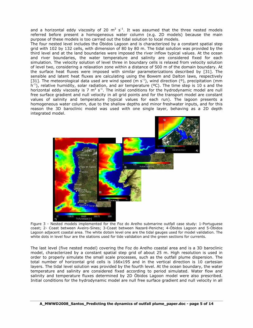
zero-dimensional water quality module and an oil dispersion model. Parameters and processes involving non-conservative properties are object of specific modules (e.g. turbulence module, water quality, ecology and oil transformation). The hydrodynamic model solves the three-dimensional incompressible primitive equations, as in, Martins et al. (2001) [15]. Hydrostatic equilibrium is assumed as well as Boussinesq approximation. The model uses a finite volume approach. This method makes the solution independent of the mesh geometry, allowing the use of a generic vertical mesh. The turbulence module uses the well known General Ocean Turbulence Model (GOTM) [16]. The model also solves a transport equation for salinity and temperature in order to compute the specific mass. The lagrangian transport model tracks the trajectories of selected water masses using the transport fields from the hydrodynamic model in an explicit procedure. Dispersion is computed using the results from the turbulent model. Another integrated module developed was the MOHIDJET module, as in, Leitão [17]. The MOHIDJET module is useful to compute the dispersion of submarine outfall plumes. The MOHIDJET integral model aims to simulate the initial dilution associated to outfalls jets. The model is used as an initial condition of the MOHID system Lagrangian tracers module. The MOHIDJET is a very helpful tool to simulate the impact of outfalls water bodies integrating the near field (MOHIDJET) with the far field (MOHID). A Lagrangian approach was used in the MOHIDJET similar to the one use in the JETLAG model, as in, Lee and Cheung [18]. Basically is simulated the trajectory and volume variation of a tracer with a cylindrical geometry. However, for the entrainment parametrization was used the work of Jirka [19]. This author is one of the main contributors to the development of CORJET (Cornell Buoyant Jet Integral Model) the buoyant jet model of CORMIX (Cornell Mixing Zone Expert System). Implementation For the implementation of Foz do Arelho submarine outfall predictive model, the same downscaling methodology proposed by Leitão et al. (2005) [20] for simulating the Algarve coastal circulation was used. In this case study was implemented a five level of nested models system (Figure 3). Bathymetric data for the first three levels is extracted from General Bathymetric Chart of the Oceans (GEBCO) [21] and from EUROSTRATAFORM project (European Margin Strata Formation) marine cruises [22]. For the coastal area and Óbidos lagoon bathymetry was used the data obtained by the Portuguese Hydrographic Institute (IHPT) [23], [24], [25], [26]. The first level covering the Portuguese and Galician coast (between 36 ºN and 45 ºN) and used a variable spatial step with 324 by 218 cells, with dimension of 4 by 4 km near the open boundary and to 2 by 2 km near the shelf. At the open ocean boundary the model was forced using the FES95.2, global tidal solution [27]. For the levels, at the open boundary a radiation boundary condition was used [28]. Alternatively, relaxation (or nudging) terms towards external data was added to the radiation condition. At the surface were imposed the wind predicted by MM5 model [29]. The meteorological data used are wind speed (m s-1), and wind direction (º). As initial conditions null free surface gradient and null velocity in all grid points was used. The time step is 80 s and the horizontal eddy viscosity is 100 m2 s-1. The second level includes the coast between Aveiro and Sines (between 37.9 ºN and 40.9 ºN) and the third includes the coast between Nazaré and Peniche (between 39.3 ºN and 39.8 ºN). The grid of the level two was characterized by a variable spatial step with 296 by 215 cells, with dimension of 1300 by 1300 m near the open boundary and to 700 by 700 m near the shelf and the third with a variable spatial step with 185 by 376 cells, with dimension of 450 by 450 m near the open boundary and to 250 by 250 km near the shelf. The ocean boundary conditions are given in cascade starting at the first level. In both levels the velocity solution is relaxed from velocity solution of the previously level. For relaxation was used the Flow Relaxation Scheme (FRS) developed by Martinsen and Engedhal (1987) [30], which consist to apply a relaxation scheme at the boundary in a extension of 10 cells, considering a decay time that tends to infinite in the cells far away from the open boundary .The relaxation zone considered for the level two and third were the cells within a distance of ~15 km and ~7 km of the domain boundary, respectively. The same initial conditions and meteorological forcing than level one were used in both levels. In the level two a time step of 40 s and a horizontal eddy viscosity of 60 m2 s-1 were used and in the level three a time step of 20 s
A_MWWD2008_Santos_Predicting the dynamics of outfall plume_paper.doc - page 5 of 14
and a horizontal eddy viscosity of 20 m2 s-1. It was assumed that the three nested models referred before present a homogeneous water column (e.g. 2D models) because the main purpose of these models is too carried out the tidal solution to local models. The four nested level includes the Óbidos Lagoon and is characterized by a constant spatial step grid with 102 by 132 cells, with dimension of 80 by 80 m. The tidal solution was provided by the third level and at the land boundaries were imposed the river inflow typical values. At the ocean and river boundaries, the water temperature and salinity are considered fixed for each simulation. The velocity solution of level three in boundary cells is relaxed from velocity solution of level two, considering a relaxation zone within a distance of 500 m of the domain boundary. At the surface heat fluxes were imposed with similar parameterizations described by [31]. The sensible and latent heat fluxes are calculating using the Bowem and Dalton laws, respectively [31]. The meteorological data used are wind speed (m s-1), wind direction (º), precipitation (mm h-1), relative humidity, solar radiation, and air temperature (ºC). The time step is 10 s and the horizontal eddy viscosity is 7 m2 s-1. The initial conditions for the hydrodynamic model are null free surface gradient and null velocity in all grid points and for the transport model are constant values of salinity and temperature (typical values for each run). The lagoon presents a homogeneous water column, due to the shallow depths and minor freshwater inputs, and for this reason the 3D baroclinic model was used with one single layer, behaving as a 2D depth integrated model.
Figure 3 - Nested models implemented for the Foz do Arelho submarine outfall case study: 1-Portuguese coast; 2- Coast between Aveiro-Sines; 3-Coast between Nazaré-Peniche; 4-Óbidos Lagoon and 5-Óbidos Lagoon adjacent coastal area. The white dotsin level one are the tidal gauges used for model validation. The white dots in level four are the stations used for tide validation and the green sections for currents.
The last level (five nested model) covering the Foz do Arelho coastal area and is a 3D baroclinic model, characterized by a constant spatial step grid of about 25 m. High resolution is used in order to properly simulate the small scale processes, such as the outfall plume dispersion. The total number of horizontal grid cells is 166x195 and in the vertical direction is 10 cartesian layers. The tidal level solution was provided by the fourth level. At the ocean boundary, the water temperature and salinity are considered fixed according to period simulated. Water flow and salinity and temperature fluxes determined by 2D Óbidos Lagoon model were also prescribed. Initial conditions for the hydrodynamic model are null free surface gradient and null velocity in all
A_MWWD2008_Santos_Predicting the dynamics of outfall plume_paper.doc - page 6 of 14
1
10
100
1000
10000
Out_
05
Ja
n_0
6
Mai_
06
Out_
06
Ma
r_07
Ju
l_0
7
Ag
o_0
7
Nov
_07
Ja
n_0
8
[N
º/10
0 m
l]
Surface Middle Bottom
grid points and for the 3D transport model salinity and temperature profiles (typical values for each season). Data from the PMES is used as direct model inputs [10], [11]. The time step is 5 s and the horizontal eddy viscosity is 2 m2 s-1. The vertical eddy viscosity and diffusivity are computed by the model using GOTM coupled to MOHID [32]. The five nested model is used to simulate the impact of the plume in the coastal area and in the Foz do Arelho beach. To simulate the near-field we coupled MOHIDJET to the 3D hydrodynamic model. The results produced by MOHIDJET, are like an initial condition for the lagrangean module which was also coupled to hydrodynamic model and aims to simulate the far-field predictions. A faecal decay similar than described by Canteras et al. (1995) was used. The model was run for the time period corresponding to September 1st, 2000 to November 30th, 2000. The first two months of results were considered a spin-up period, and only the results of the period November 1st to 30th, 2000 were used hydrodynamic validation. Hydrodynamic validation (levels and currents) was made for this period, when intensive field surveys information was obtained. Further, several scenarios were performed with MOHIDJET and CORMIX model considering the outfall characteristics. The data gathered during Foz do Arelho monitoring program was used for far-field validation. Results Near Field Simulations
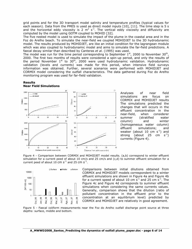
Analyses of near field simulations are focus on CORMIX and MOHIDJET results The simulations predicted the changes that will occurs in the effluent concentration in the near-field, when considerer summer (stratified water column) and winter (homogeneous water column) effluent simulations; and weaker (about 10 cm s-1) and strong (about 25 cm s-1) currents (Figure 4).
Figure 4 - Comparison between CORMIX and MOHIDJET model results. (a,b) correspond to winter effluent simulation for a current peed of about 10 cm/s and 25 cm/s and (c,d) to summer effluent simulation for a current peed of about 10 cm s-1 and 25 cm s-1.
Comparisons between initial dilutions obtained from CORMIX and MOHIDJET models correspondent to a winter effluent simulations are shown in Figure 4a and Figure 4b for a current speed of about 10 cm s-1 and 25 cm s-1. The Figure 4c and Figure 4d corresponds to summer effluent simulations when considering the same currents values. Generally, comparison shows that the dilution (ratio of pollutant concentration in the effluent prior to the concentration at an equilibrium level) predicted by CORMIX and MOHIDJET are relatively in good agreement.
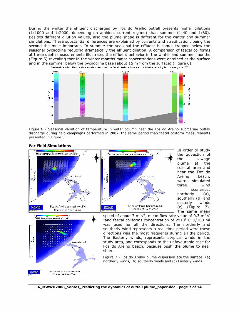
Figure 5 - Faecal coliform measurements near the Foz do Arelho outfall discharge point source at three depths: surface, middle and bottom.
A_MWWD2008_Santos_Predicting the dynamics of outfall plume_paper.doc - page 7 of 14
During the winter the effluent discharged by Foz do Arelho outfall presents higher dilutions (1:1000 and 1:2000, depending on ambient current regime) than summer (1:40 and 1:60). Besides different dilution values, also the plume shape is different for the winter and summer simulations. These substantial differences are explained by currents and stratification, being the second the most important. In summer the seasonal the effluent becomes trapped below the seasonal pycnocline reducing dramatically the effluent dilution. A comparison of faecal coliforms at three depth measurements illustrates the effluent behavior in the winter and summer months (Figure 5) revealing that in the winter months major concentrations were obtained at the surface and in the summer below the pycnocline base (about 15 m from the surface) (Figure 6).
Figure 6 - Seasonal variation of temperature in water column near the Foz do Arelho submarine outfall discharge during field campaigns performed in 2007, the same period than faecal coliform measurements presented in Figure 5.
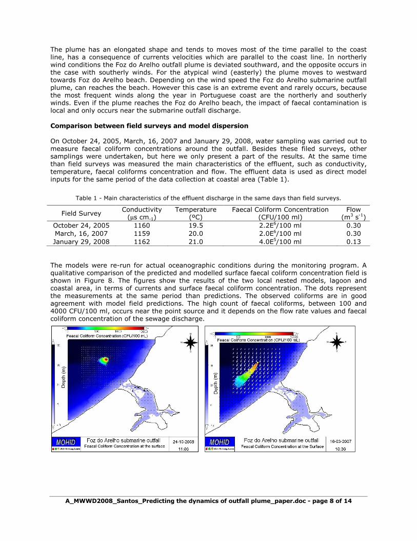
Far Field Simulations In order to study the advection of the sewage plume at the coastal area and near the Foz do Arelho beach, were simulated three wind
scenarios: northerly (a), southerly (b) and easterly winds (c) (Figure 7). The same mean
speed of about 7 m s-1, mean flow rate value of 0.3 m3 s-1and faecal coliforms concentration of 2x10⁶ CFU/100 ml was used for all the directions. The northerly and southerly wind represents a real time period were these directions was the most frequents during all the period. The Easterly winds, represents atypical winds in the study area, and corresponds to the unfavourable case for Foz do Arelho beach, because push the plume to near shore.
Figure 7 - Foz do Arelho plume dispersion ate the surface: (a) northerly winds, (b) southerly winds and (c) Easterly winds.
A_MWWD2008_Santos_Predicting the dynamics of outfall plume_paper.doc - page 8 of 14
The plume has an elongated shape and tends to moves most of the time parallel to the coast line, has a consequence of currents velocities which are parallel to the coast line. In northerly wind conditions the Foz do Arelho outfall plume is deviated southward, and the opposite occurs in the case with southerly winds. For the atypical wind (easterly) the plume moves to westward towards Foz do Arelho beach. Depending on the wind speed the Foz do Arelho submarine outfall plume, can reaches the beach. However this case is an extreme event and rarely occurs, because the most frequent winds along the year in Portuguese coast are the northerly and southerly winds. Even if the plume reaches the Foz do Arelho beach, the impact of faecal contamination is local and only occurs near the submarine outfall discharge.
Comparison between field surveys and model dispersion On October 24, 2005, March, 16, 2007 and January 29, 2008, water sampling was carried out to measure faecal coliform concentrations around the outfall. Besides these filed surveys, other samplings were undertaken, but here we only present a part of the results. At the same time than field surveys was measured the main characteristics of the effluent, such as conductivity, temperature, faecal coliforms concentration and flow. The effluent data is used as direct model inputs for the same period of the data collection at coastal area (Table 1).
Table 1 - Main characteristics of the effluent discharge in the same days than field surveys.
Field Survey Conductivity (µs cm-1)
Temperature (ºC)
Faecal Coliform Concentration (CFU/100 ml)
Flow (m3 s-1)
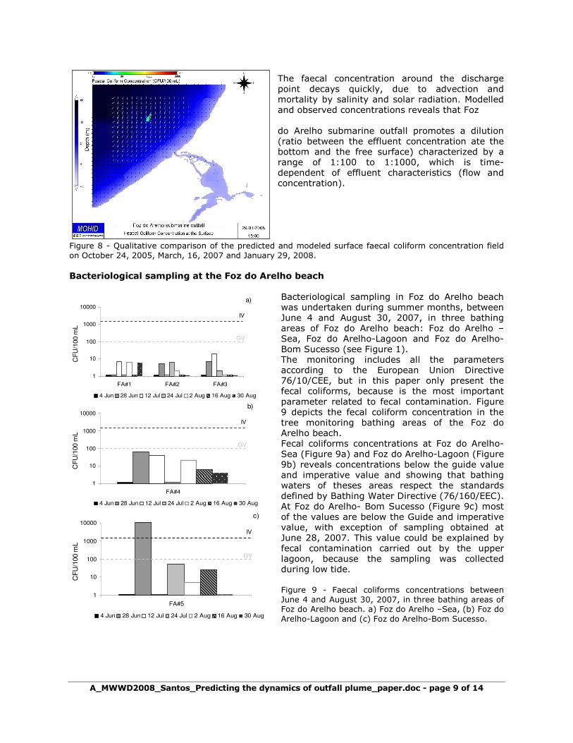
October 24, 2005 1160 19.5 2.2E6/100 ml 0.30 March, 16, 2007 1159 20.0 2.0E6/100 ml 0.30 January 29, 2008 1162 21.0 4.0E5/100 ml 0.13 The models were re-run for actual oceanographic conditions during the monitoring program. A qualitative comparison of the predicted and modelled surface faecal coliform concentration field is shown in Figure 8. The figures show the results of the two local nested models, lagoon and coastal area, in terms of currents and surface faecal coliform concentration. The dots represent the measurements at the same period than predictions. The observed coliforms are in good agreement with model field predictions. The high count of faecal coliforms, between 100 and 4000 CFU/100 ml, occurs near the point source and it depends on the flow rate values and faecal coliform concentration of the sewage discharge.
A_MWWD2008_Santos_Predicting the dynamics of outfall plume_paper.doc - page 9 of 14
The faecal concentration around the discharge point decays quickly, due to advection and mortality by salinity and solar radiation. Modelled and observed concentrations reveals that Foz do Arelho submarine outfall promotes a dilution (ratio between the effluent concentration ate the bottom and the free surface) characterized by a range of 1:100 to 1:1000, which is time-dependent of effluent characteristics (flow and concentration).
Figure 8 - Qualitative comparison of the predicted and modeled surface faecal coliform concentration field on October 24, 2005, March, 16, 2007 and January 29, 2008. Bacteriological sampling at the Foz do Arelho beach
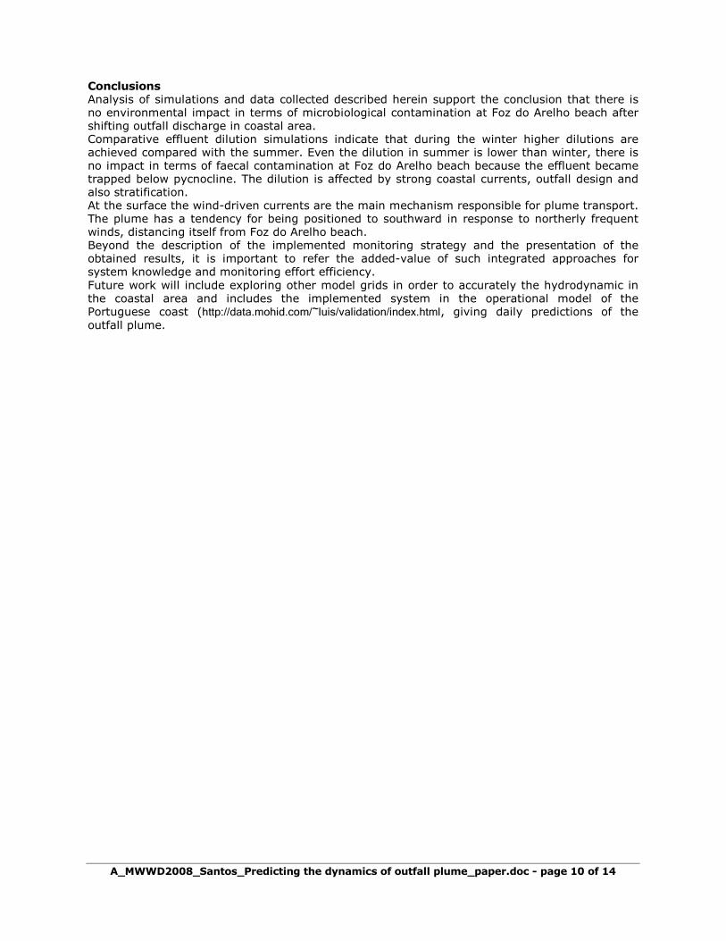
Bacteriological sampling in Foz do Arelho beach was undertaken during summer months, between June 4 and August 30, 2007, in three bathing areas of Foz do Arelho beach: Foz do Arelho –Sea, Foz do Arelho-Lagoon and Foz do Arelho-Bom Sucesso (see Figure 1). The monitoring includes all the parameters according to the European Union Directive 76/10/CEE, but in this paper only present the fecal coliforms, because is the most important parameter related to fecal contamination. Figure 9 depicts the fecal coliform concentration in the tree monitoring bathing areas of the Foz do Arelho beach. Fecal coliforms concentrations at Foz do Arelho- Sea (Figure 9a) and Foz do Arelho-Lagoon (Figure 9b) reveals concentrations below the guide value and imperative value and showing that bathing waters of theses areas respect the standards defined by Bathing Water Directive (76/160/EEC). At Foz do Arelho- Bom Sucesso (Figure 9c) most of the values are below the Guide and imperative value, with exception of sampling obtained at June 28, 2007. This value could be explained by fecal contamination carried out by the upper lagoon, because the sampling was collected during low tide.
Figure 9 - Faecal coliforms concentrations between June 4 and August 30, 2007, in three bathing areas of Foz do Arelho beach. a) Foz do Arelho –Sea, (b) Foz do Arelho-Lagoon and (c) Foz do Arelho-Bom Sucesso.
1
10
100
1000
10000
FA#4
CF
U/1
00 m
L
4 Jun 28 Jun 12 Jul 24 Jul 2 Aug 16 Aug 30 Aug
GV
IV
b)
1
10
100
1000
10000
FA#1 FA#2 FA#3
CF
U/1
00 m
L
4 Jun 28 Jun 12 Jul 24 Jul 2 Aug 16 Aug 30 Aug
GV
IV
a)
1
10
100
1000
10000
FA#5
CF
U/1
00 m
L
4 Jun 28 Jun 12 Jul 24 Jul 2 Aug 16 Aug 30 Aug
GV
IV
c)
A_MWWD2008_Santos_Predicting the dynamics of outfall plume_paper.doc - page 10 of 14
Conclusions Analysis of simulations and data collected described herein support the conclusion that there is no environmental impact in terms of microbiological contamination at Foz do Arelho beach after shifting outfall discharge in coastal area. Comparative effluent dilution simulations indicate that during the winter higher dilutions are achieved compared with the summer. Even the dilution in summer is lower than winter, there is no impact in terms of faecal contamination at Foz do Arelho beach because the effluent became trapped below pycnocline. The dilution is affected by strong coastal currents, outfall design and also stratification. At the surface the wind-driven currents are the main mechanism responsible for plume transport. The plume has a tendency for being positioned to southward in response to northerly frequent winds, distancing itself from Foz do Arelho beach. Beyond the description of the implemented monitoring strategy and the presentation of the obtained results, it is important to refer the added-value of such integrated approaches for system knowledge and monitoring effort efficiency. Future work will include exploring other model grids in order to accurately the hydrodynamic in the coastal area and includes the implemented system in the operational model of the Portuguese coast (http://data.mohid.com/~luis/validation/index.html, giving daily predictions of the outfall plume.

MWWD 2008
A_MWWD2008_Santos_Predicting the dynamics of outfall plume_paper.doc - page 11 of 14
Acknowledgements
Águas do Oeste, S.A (AdO) has started on July of 2004, under its direct supervision, a Monitoring Program in the Óbidos Lagoon and Foz do Arelho Submarine Outfall, with the support of Instituto Superior Técnico (IST) from the Universidade Técnica de Lisboa (IST) and Instituto de Investigação das Pescas e do Mar (IPIMAR). AdO is the company responsible for the Multimunicipal System of Water Supply and Wastewater Treatment of the West region of the Portuguese and is a part of Águas de Portugal.

MWWD 2008
A_MWWD2008_Santos_Predicting the dynamics of outfall plume_paper.doc - page 12 of 14
Madalena Santos is an environmental scientist in Instituto Superior Técnico, Lisbon. She has an MsC in environmental engineering and is graduated in Physical Oceanography. She has specialist knowledge in environmental impact assessment in the marine and coastal areas trough submarine outfalls environment because has been involved in national projects that include the analysis of sewage discharges trough marine outfalls. She has also envolved in european projects to study estuarine euthrophication problems. Madalena Santos (Physical Oceanography, MsC), [email protected] Instituto Superior Técnico, Av. Rovisco Pais, 1049-001 Lisboa, Portugal.
Paulo Chambel Leitão has a degree in Civil Engineering (Technical University of Lisbon) and a Ph.D. in Environmental Engineering (Technical University of Lisbon). Beyond his participation in several consulting projects in which HIDROMOD has been involved along the last 11 years, he has been the main responsible for important projects related with mathematical modelling, oil dispersion and risk assessment and field data programs.
Ramiro Neves is an environmental scientist and associated professor with Instituto Superior Técnico, Lisbon. He has a BSc in mechanical engineering and a PhD in environmental engineering and has over 20 years experience in environmental consulting. He has specialist knowledge of environmental impact assessment in the marine and coastal environment and has been involved in the environmental assessment on a range of major projects, including estuarine euthrophication and other water resources management. Ramiro Neves (Mechanical Engineer, Ph.D), [email protected] Instituto Superior Técnico, Av. Rovisco Pais, 1049-001 Lisboa, Portugal.
Sandra Carvalho is graduated in Aquatic Resources Engineering (Environmental and Hydrogeology). Behind this graduation she is also post-graduated in Sanitary Engineer. Actually she works in AdO, the company responsible for the Multimunicipal System of Water Supply and Wastewater Treatment of the West region of the Portuguese. She is responsible for the monitoring and quality area in the company. Sandra Carvalho (Post Graduated in Sanitary Engineer), [email protected]Águas do Oeste, S.A., Convento de São Miguel das Gaeiras, 2510-718 Gaeiras, Portugal.
Cátia Sacramento Marques Alves is graduated in Environmental Engineer. Actually she works in AdO, the company responsible for the Multimunicipal System of Water Supply and Wastewater Treatment of the West region of the Portuguese. She is technical in the monitoring and quality area in the company. Cátia Alves (Environmental Engineer), [email protected]Águas do Oeste, S.A., Convento de São Miguel das Gaeiras, 2510-718 Gaeiras, Portugal.
A_MWWD2008_Santos_Predicting the dynamics of outfall plume_paper.doc - page 13 of 14
References
[1] Santos, M., Neves, R., Leitão, P.C., Pereira, P., Pablo, H., Fernandes, L. D., Carvalho, S., Alves, C., 2006. Qualidade da água da lagoa de Óbidos: Que futuro? In: 12º Encontro nacional de Saneamento Básico, 24-27 Outubro, Cascais, Portugal.
[2] Etemad-Sahimid, A. and Azimi, A.H., 2003. Testing the CORMIX2 and VISJET models t predict the dilution of san Francisco outfall.Diffuse Pollution and Basin Management. In: Proceedings of the 7th International Specialised IWA Conference, Dublin, Ireland. Bruen, M. (editor). ISBN 1902277767, 4vols. 1140 pps.
[3] Alves, C., Carvalho, S., Santos, M., Zenha, J.H.S., Neves, R. 2006. Monitoring and Modelling Foz do Arelho submarine outfall plume. In: 7th International Conference on Hydroinformatics HIC 2006, 3 a 7 September, Nice, FRANCE.
[4] Coelho, H.S., Neves, R.J.J., White, M., Leitão, P.C., Santos, A.J., 2002. A model for ocean circulation on the Iberian coast. Journal of Marine Systems 32, 153-179.
[5] Santos , M., 2008. Modelação do impacte de emissários submarinos em zonas costeiras-caso da Foz do Arelho. Msc. Thesis for the Msc. degree in environmental engineering. Instituto Superior Técnico, Universidade Técnica de Lisboa, Lisboa, Portugal, pp. 95 (in Portuguese), published.
[6] Wooster, W.S., and J.H. Jones. 1970. The California undercurrent off northern Baja California. Journal of Marine Research 28 (2), 235-250.
[7] Fiúza, A.F.G., J.H. Dias and J. Alonso, 1996: Long-Term Current Measurements on the West Iberian Margin, MORENA, Relatório Técnico e Cientifico No 36,. Instituto de Oceanografia, Universidade de Lisboa, Lisboa, Portugal.
[8] Pacheco, M., García-Weil, L., Rodríguez, G.R., Tejera, A., Luque, A., 2001. Upwelling Filaments in the Northwest African Coastal Transition Zone (NACTZ); Satellite Images and Laboratory Simulations. In: Geoscience and Remote Sensing Symposium, 2001. IGARSS '01. IEEE 2001 International, Sydney- NSW, Australia, Vol. 7, pp. 3015-3017.
[9] Signell, R.P., Jenter, H.L., Blumberg, A.F., 2000. Predicting the physical effects of relocation Boston´s sewage outfall. Estuarine, Coastal and Shelf Science 50, 59-72.
[10] Instituto Superior Técnico, IST, 2006. Caracterização da Lagoa de Óbidos e do emissário submarino da Foz do Arelho desde Outubro de 2004 a Outubro de 2006. Relatório Final, MARETEC, pp.68.
[11] Instituto Superior Técnico, IST, 2008. Variação sazonal e inter-anual da Lagoa de Óbidos, seus afluentes e do emissário submarino da Foz do Arelho. Relatório Final, MARETEC, pp.130.
[12] www.systea.it
[13] www.mohid.com/gis
[14] www.mohid.com
[15] Martins, F., Neves, R., Leitão, P. and Silva, A., 2001. 3D modelling in the Sado estuary using a new generic coordinate approach. Oceanologica Acta 24, 51-62.
[16] www.gotm.net/
[17] Leitão, P., 2004. Simulação integrada da dispersão de poluentes no campo próximo e afastado de um emissário. In 7º Congresso da Água, Lisboa, Portugal.
[18] Lee, J.H.W and Cheung, E.V., 1990 . Generalized Lagrangian model for buoyant jets in current. Journal of Environmental Engineering, ASCE, 116 (6), pp 0851-1105.
[19] Jirka, G.H., 1999. Five Asymptotic Regimes of a Round Buoyant Jet in Stratified Crossflow. In 28th IAHR Biennial Congress, Graz, Austria.
[20] Leitão, P., Coelho; H., Santos, A., Neves, R. 2005. Modelling the main features of the Algarve coastal circulation during July 2004: A downscaling approach. Journal of Atmospheric and Ocean Science 10 (4), 1-42.
A_MWWD2008_Santos_Predicting the dynamics of outfall plume_paper.doc - page 14 of 14
[21] http://www.ngdc.noaa.gov/mgg/gebco/
[22] Instituto Superior Técnico, IST, 2003. EUROSTRATAFORM. Relatório, MARETEC, pp.11.
[23] IHPT, 2001a. Monitorização Ambiental da Lagoa de Óbidos NOV 2000–JUN 2001. Relatório Técnico Final, Report TF. 08/ 2001 (in Portuguese).
[24] IHPT, 2001b. Monitorização Ambiental da Lagoa de Óbidos JUL 2001–DEZ 2001. Relatório Técnico Final, Report PT. OC. 06/2001 (in Portuguese).
[25] IHPT, 2002a. Monitorização Ambiental da Lagoa de Óbidos DEZ 2001–ABR 2002. Relatório Técnico Final, Report PT. OC. 02/2002 (in Portuguese).
[26] IHPT, 2002b. Monitorização Ambiental da Lagoa de Óbidos MAI 2002–AGO 2002. Relatório Técnico Final, Report PT. OC. 05/2002 (in Portuguese).
[27] Le Provost, C., Lyard, F., Molines, J. M., Genco, M. L., Rabilloud, F., 1998. A hydrodynamic ocean tide model improved by assimilating a satellite altimeter derived data set. Journal of Geophysical Research-Oceans 103, 5513-5529.
[28] Blumberg, A. and L. Kantha, 1985. Open boundary condition for circulation models. Journal of Hydraulic Engineering, ASCE, 111, 237-255.
[29] Sousa, T. 2002. Previsão meteorológica em Portugal Continental utilizando um modelo operacional e de investigação MM5. Msc. Thesis for the Msc. degree in environmental engineering. Instituto Superior Técnico, Universidade Técnica de Lisboa, Lisboa, Portugal, in Portuguese , published.
[30] Martinsen, Eivind A. and Harald Engedhal, 1987. Implementation and testing of a lateral boundary scheme as an open boundary condition in a barotropic ocean model, Coastal Engineering 11, 603-627.
[31] Chapra, S.C., 1997. Surface water quality modelling. Civil Engineering Series. McGraw-Hill.
[32] Burchard, H., Bolding, K. and Villarreal, M.R., 1999. GOTM, a general ocean turbulence model: scientific documentation. Tech. Report, European Community, Ispra, Italy.
Related Documents