A model driven approach for the development of metadata editors, applicabil- ity to the annotation of geographic information resources J. Nogueras-Iso, M. ´ A. Latre, R. B´ ejar, P.R. Muro-Medrano, F.J. Zarazaga- Soria PII: S0169-023X(12)00084-5 DOI: doi: 10.1016/j.datak.2012.09.001 Reference: DATAK 1394 To appear in: Data & Knowledge Engineering Received date: 28 July 2010 Revised date: 10 September 2012 Accepted date: 10 September 2012 Please cite this article as: J. Nogueras-Iso, M. ´ A. Latre, R. B´ ejar, P.R. Muro-Medrano, F.J. Zarazaga-Soria, A model driven approach for the development of metadata editors, applicability to the annotation of geographic information resources, Data & Knowledge Engineering (2012), doi: 10.1016/j.datak.2012.09.001 This is a PDF file of an unedited manuscript that has been accepted for publication. As a service to our customers we are providing this early version of the manuscript. The manuscript will undergo copyediting, typesetting, and review of the resulting proof before it is published in its final form. Please note that during the production process errors may be discovered which could affect the content, and all legal disclaimers that apply to the journal pertain.

Welcome message from author
This document is posted to help you gain knowledge. Please leave a comment to let me know what you think about it! Share it to your friends and learn new things together.
Transcript

�������� ����� ��
A model driven approach for the development of metadata editors, applicabil-ity to the annotation of geographic information resources
J. Nogueras-Iso, M.A. Latre, R. Bejar, P.R. Muro-Medrano, F.J. Zarazaga-Soria
PII: S0169-023X(12)00084-5DOI: doi: 10.1016/j.datak.2012.09.001Reference: DATAK 1394
To appear in: Data & Knowledge Engineering
Received date: 28 July 2010Revised date: 10 September 2012Accepted date: 10 September 2012
Please cite this article as: J. Nogueras-Iso, M.A. Latre, R. Bejar, P.R. Muro-Medrano,F.J. Zarazaga-Soria, A model driven approach for the development of metadata editors,applicability to the annotation of geographic information resources, Data & KnowledgeEngineering (2012), doi: 10.1016/j.datak.2012.09.001
This is a PDF file of an unedited manuscript that has been accepted for publication.As a service to our customers we are providing this early version of the manuscript.The manuscript will undergo copyediting, typesetting, and review of the resulting proofbefore it is published in its final form. Please note that during the production processerrors may be discovered which could affect the content, and all legal disclaimers thatapply to the journal pertain.

ACC
EPTE
D M
ANU
SCR
IPT
ACCEPTED MANUSCRIPT
A model driven approach for the development
of metadata editors, applicability to the
annotation of geographic information
resources
J. Nogueras-Iso, M. A. Latre, R. Bejar, P. R. Muro-Medrano,F. J. Zarazaga-Soria
Computer Science and Systems Engineering Department
Universidad de Zaragoza
Marıa de Luna 1, E-50018 Zaragoza, Spain
Abstract
Metadata are a key element for the development of information infrastructuresbecause they facilitate the semantic description of contents and services. However,the diversity and heterogeneity of metadata standards have become a barrier forthe generation of these metadata. Many metadata editors are not useful anymorebecause they do not support the latest version of metadata standards or the newprofiles arisen in the market. Thus, this work proposes a model driven approachfor the development of metadata editors, more focused on the generic treatment ofmetadata models than on the development of specific edition forms for a reducedset of metadata standards. This approach has been tested in the context of spatialdata infrastructures for the development of an Open Source tool called CatMDEdit.Additionally, the approach could be also applied to improve the efficiency of anymetadata editor using a metamodeling development strategy.
Key words: Spatial Data Infrastructures, SDI, Metadata, Annotation, ModelDriven Engineering, MDE, Model Driven Architecture, MDA, Metamodeling,SKOS
Email addresses: [email protected] (J. Nogueras-Iso), [email protected] (M. A.Latre), [email protected] (R. Bejar), [email protected] (P. R. Muro-Medrano),[email protected] (F. J. Zarazaga-Soria).1 This work has been partially supported by the Spanish Government throughthe project TIN2007-65341, the National Geographic Institute of Spain (IGN), andGeoSpatiumLab S.L.
Preprint submitted to Data Knowledge & Engineering September 10, 2012

ACC
EPTE
D M
ANU
SCR
IPT
ACCEPTED MANUSCRIPT
1 Introduction
Spatial Data Infrastructures (SDI) are special types of information infrastruc-tures consisting of the relevant base collection of technologies, policies andinstitutional arrangements that facilitate the availability of and access to spa-tial data. Traditionally, spatial data (also known as geographic information)were the core component of Geographic Information Systems (GIS), which isthe term commonly used to refer to the software packages that allow to cap-ture, store, check, integrate, manipulate, analyze and display them. However,the potential of spatial data as an instrument to facilitate decision-makingand resource management in diverse areas (e.g., natural resources, facilities,cadaster or agriculture) of government or private sectors has led to the evolu-tion of GIS into the broader concept of SDI [1].
One of the main elements for the success in the development of SDI or anyother type of information infrastructure is the appropriate annotation of re-sources to be accessed and distributed by means of metadata. Metadata con-stitute the mechanism to characterize data and services (e.g., descriptions ofthe content, quality, condition, authorship and any other features) in orderto enable other users and applications to make use of such data and services.However, due to the heterogeneity of contents in information infrastructures,it is not possible to consider a unique metadata model or schema.
The diversity of metadata standards has been a critical issue for the devel-opment of SDIs. During the last fifteen years, standardization bodies haveproposed different metadata standards such as the Content Standard for Dig-ital Geospatial Metadata (CSDGM) [2] or ISO 19115 Geographic Information– Metadata [3]. Additionally, apart from the standards, it is also common tofind application profiles and extensions of these standards. The Dublin CoreMetadata Initiative [4] defines a Metadata Application Profile as a declarationof the elements (either selected from the standard, or new elements) that anorganization or user community employs in their metadata, and how theseelements have been customized to a particular application domain. Withinthe SDI context, there are multiple examples of metadata profiles for thedescription of remote sensing data [5,6], environmental data [7,8], or the cus-tomization of general metadata standards such as Dublin Core [9].
In parallel to the definition of this wide range of geographic metadata stan-dards, there has been an increasing need for desktop or web-based metadataeditors able to manage these complex standards (hundreds of elements withdifferent data types organized in hierarchical entities) and providing, amongother functionalities, an internationalized interface, online help, validation ofstandard conformance, and serialization to XML or other semi-structured for-mats. Through different surveys [10,47], it can be verified that the development
2

ACC
EPTE
D M
ANU
SCR
IPT
ACCEPTED MANUSCRIPT
of these metadata editors has been highly promoted during the last years:about 50 tools have been published by different organizations and softwarecompanies. At the beginning, these tools were developed to support a uniquemetadata model. However, these first tools based on fixed structures becamerapidly out-of-date. In contrast, nowadays software developers are sensitiveto this problem of flexibility. Instead of implementing a particular metadatamodel, most of current editors enable as well the configuration of the modelusing some kind of schema language.
From a software engineering perspective, we could say that annotation tools inthe SDI context have moved towards a higher level of abstraction: the focus isnow on the management of metamodels. According to ISO/IEC 11179-3 [11], ametamodel provides a mechanism for understanding the precise structure andcomponents of the specified models, which are needed for the successful shar-ing of the models by users and/or software facilities. Although the availabledocumentation of most editors does not reveal a conscious interest on meta-models, the key component of these tools is the mechanism to describe thedifferent metadata standards that can be used later to customize dynamicallythe software for editing metadata in conformance to these standards.
The need for flexibility and the consequent increase of model abstraction isleading the development of metadata editors to a stage that, although not di-rectly intended, is close to the software engineering paradigm of Model DrivenEngineering (MDE). MDE focuses on models as the primary artifact in the de-velopment process, with transformations as the primary operation on models,used to map information from one model to another [12]. However, in orderto avoid ad-hoc and un-efficient implementations of this MDE paradigm, it isimportant to follow a systematic and acknowledged methodology such as theone defined by the Model Driven Architecture (MDA), the OMG instantiationof MDE [13,19]. Although in the SDI context MDA has been considered forinteroperability issues and data access services [14,15,16], it has received littleattention for the development of metadata editors. The objective of this workis to provide the guidelines and framework to accomplish the development ofmetadata editors according to MDA in order to facilitate their rapid develop-ment, decreasing the development effort and, at the same time, augmentingtheir efficiency and flexibility. This paper presents the different domain specificlanguages and transformations required to define and transform the modelsinvolved in the development of a metadata editor: the Platform IndependentModel (PIM) for the representation of supported metadata schemas; the Plat-form Specific Models (PSM) for the specification of a set of GUI (GraphicalUser Interface) edition forms, and the representation of controlled vocabular-ies; and the transformation of PSM models into code.
The rest of this paper is structured as follows. Section 2 presents our pro-posal to apply an MDA approach in the development of metadata editors.Following this proposal, Section 3 describes how this proposal has been usedin CatMDEDit, an open-source metadata editor, for the support of different
3

ACC
EPTE
D M
ANU
SCR
IPT
ACCEPTED MANUSCRIPT
metadata standards and profiles. Then, Section 4 describes the related workin the development of annotation tools from a metamodeling perspective, anddiscusses the benefits from applying an MDA development approach. Finally,Section 5 draws some conclusions and outlines future work.
2 Development of metadata editors according to an MDA ap-
proach
2.1 Overview
As stated by Djuric et al. [17], if we look back to the history of software devel-opment, we can see a notable increase of models abstraction. The activity ofmodeling is now more separated from the specification of the details of the un-derlying platform. This evolution allows domain experts to focus on definingreusable models of the real world, alleviating them from acquiring the knowl-edge about specific computer systems. Two examples of this evolution are themethodologies known as Model Integrated Computing (MIC) [18] and ModelDriven Engineering (MDE). MIC was a precursor methodology for generat-ing application programs automatically from multi-aspect models. Nowadays,MDE encompasses the software modeling methodologies which focus on creat-ing and exploiting domain models (through successive transformations), ratherthan on the concepts of a specific computing platform.
Model Driven Architecture (MDA) is the OMG instantiation of MDE [19].MDA separates the specification of system functionalities from the specifica-tion of this functionality on a specific technology platform. MDA defines threeviewpoints on a system: a computation independent viewpoint, a platformindependent viewpoint, and a platform specific viewpoint. Each viewpoint isrepresented by means of a viewpoint model (also called view). A ComputationIndependent Model (CIM) is a view of a system that does not show details ofthe structure of systems. A CIM is sometimes called a domain model and fo-cuses on representing the environment and the requirements of the system. APlatform Independent Model (PIM) is a view of a system that focuses on theoperation of a system while hiding the details necessary for a particular plat-form. It shows the part of the system specification that does not change fromone platform to another, i.e. it is the specification of a system for a technology-neutral virtual machine. Finally, a Platform Specific Model (PSM) combinesthe specification in the PIM with the details that specify how that systemuses a particular type of platform.
A crucial issue to allow the transformation between models in MDA is the ap-propriate definition of the domain specific languages, which are used in turnto build models. A domain specific language consists of three elements: anabstract syntax to define the concepts of the language, a concrete syntax toprovide a graphical or textual notation, and a description of the semantics ofthe language [20]. The abstract syntax of a domain specific language is defined
4

ACC
EPTE
D M
ANU
SCR
IPT
ACCEPTED MANUSCRIPT
meta-meta model(meta-classes for concepts in differentconceptual schema languages)
MOF
M3
M2
M1
M0
Platform IndependentModel
Common metamodelfor metadata standards
ISO19115 standardmodel and ISO19115-basedProfiles
Platform Specific Model
GUImetamodel
ISO19115edition forms
TextComputation Independent Model
UMLmetamodel
ISO19115 ComprehensiveModel
Data dictionarymetamodel
XMLmetamodel
ISO19115data dictionary
ISO19139XML Schema
ISO19139XML Document
+ ISO19115translations by national standardization bodies
EcoreEcore
SKOSmetamodel
SKOS-basedISO19115vocabularies
ATL
Renderer library
GUI XML
SKOS browser
SKOS-RDF
MOFScript
MOFScript
Methodology
Meta
modelin
gla
yers
1. Analysis of metadata standards 2. Definition of PIM
models
3. Derivation of PSM
models
4. Text generation
Figure 1. MDA approach for the development of metadata editors
by means of a metamodel, which can be considered as an explicit description(constructs and rules) of the way to build a domain-specific model. Metamod-eling allows strict and agile automatic processing of models and metamod-els. Models in the MDA approach are based on the four-layer metamodelingpattern [21]: a meta-metamodel (M3) layer that provides concepts to definemetaclasses of arbitrary conceptual schema languages (e.g., Class or Associ-ation for UML); a metamodel (M2) layer that defines the concepts used ina conceptual schema language (e.g., the concepts used in UML language); amodel (M1) layer that contains models of the real world, which are representedby concepts defined in the corresponding metamodel at M2; and an instance(M0) layer that contains the things from the real world.
Fig. 1 presents our approach for adopting an MDA methodology in the devel-opment of metadata editors. In this approach, the following steps are consid-ered:
• Analysis of metadata standards in terms of their original conceptual schemalanguages: The definition of a geographic metadata standard can be under-stood as the CIM model that originates the transformation between modelstowards the development of the metadata editor for such standard. Forinstance, Fig. 1 shows ISO 19115 from the perspective of the four-layermeta-modeling architectural pattern.
• Definition of PIM models in terms of a common metamodel: The previousCIM models are transformed into a PIM model, whose metamodel takesinto consideration features that may arise in different metadata standardssuch as ISO 19115, Dublin Core and other ones.
5

ACC
EPTE
D M
ANU
SCR
IPT
ACCEPTED MANUSCRIPT
• Generation of derived PSM models: The previous PIM models are trans-formed into PSM models that describe, in an abstract way, the GUI ofthe metadata edition forms. Additionally, the controlled vocabularies (e.g.,codelists or enumerations) are transformed into the SKOS language [22], adomain specific language proposed by W3C for the standardized represen-tation of knowledge organization systems such as thesauri, taxonomies andother controlled vocabularies.
• Text generation: As a final step, the previous PSM models are transformedinto code, i.e. either software or other artifacts that can be interpreted andexecuted on a specific platform. As a possible alternative for the transforma-tion PSM GUI-based models, we propose the serialization of the GUI-basedmodels into an XML serialization, which can be parsed by a library to gen-erate dynamically the edition forms implemented, for example, as a Javadesktop application. With respect to the SKOS representation of vocabu-laries, their transformation into an SKOS-RDF encoding is proposed.
These steps are detailed in next subsections. With respect to the implemen-tation of this approach, we have used the tools provided by the Eclipse Mod-eling Framework (EMF) [23], which is currently used in many model drivenapproaches [16,24]. EMF is an open source Java implementation of a coresubset of the Meta-Object Facility (MOF) specification [13], a specificationpromoted by OMG to create an MDA framework for constructing and man-aging technology neutral metamodels. The MOF-like core metamodel in EMFis called Ecore. Additionally, EMF provides different tools for the transfor-mation between models. In the case of the transformation from PIM to PSMmodels, the Atlas Transformation Language (ATL) [25] has been selected. ATLis a hybrid language that combines declarative and imperative constructs forthe definition of transformation rules from source to target models. Finally,the transformation of PSM models to code (text serialization) has been de-signed using the MOFScript language, one of the most extended languages formodel-to-text transformation [26]. For the sake of space only selected excerptsof the ATL and MOFScripts transformations will be shown in the followingsubsections. For further details, a web site with the full code of the meta-data models in Ecore format, and the ATL/MOFScript transformations isprovided 2 , together with some examples of the input and output models ofthese transformations.
2.2 Analysis of metadata standards (CIM models)
Nowadays, there are three main families of metadata standards and profilesto describe geographic information resources: Content Standard for Digital
2 http://catmdedit.sourceforge.net/mda
6

ACC
EPTE
D M
ANU
SCR
IPT
ACCEPTED MANUSCRIPT
Geospatial Metadata (CSDGM) [2], ISO 19115 Geographic Information –Metadata [3] and Dublin Core [4]. CSDGM is the oldest proposal. Released in1994 with the sponsorship of the U.S. Federal Geographic Data Committee,it is still used and integrated in many GIS tools. ISO 19115 is the metadatastandard that it is currently world-wide accepted and has been adopted by thegreat majority of national standardization bodies and thematic communitiesin the domain of geographic information. Finally, although Dublin Core is ageneral-purpose metadata standard, it is also widely used in the domain ofgeographic information to establish minimum discovery mechanisms and topromote interoperability [27].
By its inherent nature, the definition of a metadata standard or a metadataprofile can be considered as a CIM model of an annotation tool because it doesnot show details of the structure of the system, it just shows the model of thecontent that must be generated through this system. In order to illustrate thefeatures of these metadata standards and their correspondence with the fourlayer metamodeling perspective, this section describes the case of ISO 19115.
MD_DataIdentification
. ..
language[1. .*] : CharacterString
spatialRepresentat ionType[0..*] : MD_Spat ialRepresentationTypeCode
spatialResolution[0. .*] : MD_Resolut ion
SV_ServiceIdentificat ion
(from Service Metadata)
MD_ScopeCode
...
attribute
attributeType
dataset
series
service
<<CodeList>>
CI_ResponsibleParty
individualName[0..1] : CharacterString
organisationName[0..1] : CharacterString
positionName[0..1] : CharacterString
contactInfo[0..1] : CI_Contact
role : CI_RoleCode
<<DataType>>
MD_CharacterSetCode
...
8859part1
8859part2
utf16utf8
<<CodeList>>MD_Metadata
characterSet[0..1] : MD_CharacterSetCode = "utf8"
contact[1..*] : CI_ResponsibleParty
dataSet[0..1] : CharacterString
dateStamp : Date
fileIdent ifier[0..1] : CharacterString
hierarchyLevelName[0..*] : CharacterString
hierarchyLevel[0..*] : MD_ScopeCode = "dataset"
language[0. .1] : CharacterString
metadataStandardName[0..1] : CharacterString
metadataStandardVersion[0..1] : CharacterString
parent Identifier[0..1] : CharacterString
MD_Identification
citation : CI_Citation
abstract : CharacterString
purpose[0..1] : CharacterString
credit[0. .*] : CharacterString
status[0..*] : MD_ProgressCode
pointOfContact [0..*] : CI_ResponsibleParty
+identificationInfo
1..*1..*
MD_ProgressCode
completed
historicalArchive
obsolete
onGoing
planned
required
underDevelopment
<<CodeList>>
Data dictionary: Name/Role name Short Name Definition Obligation/
ConditionMaximumoccurrence
Data type Domain
1 MD_Metadata Metadata root entity which defines metadata about
a resource or resources
M 1 Class Lines 2-22
2 fileIdentifier mdFileID Unique identifier for this metadata file O 1 CharacterString Free text
… … … … … … … …
Figure 2. Definition of class MD Metadata in ISO 19115
The conceptual schema language used for expressing the comprehensive modelof ISO 19115 metadata and their profiles is UML. Additionally, several stereo-types have been defined for expressing special features of metadata models.Some of these stereotypes are the following: DataType, a descriptor of a set
7

ACC
EPTE
D M
ANU
SCR
IPT
ACCEPTED MANUSCRIPT
of values that lack identity; Enumeration, a data type whose instances forma list of named literal values; CodeList, a more open enumeration where thelist of values can be extended if necessary; or Union, a set of alternativeclasses/types that can be used without the need to create a common super-type/class. For instance, Fig. 2 shows a UML diagram with the definition ofthe class MD Metadata, which is the root class in ISO 19115 for describinga geographic resource. The figure also shows a containment relationship withthe MD Identification class and its derived classes. Additionally, UML staticdiagrams are accompanied with a data dictionary in tabular form, whose rowsdefine UML classes, attributes and relationships by means of seven attributes(Name/Role name, Short name/code, Definition, Obligation/Condition, Max-imum occurrence, Data type, and Domain). Fig. 2 includes two rows of thedata dictionary describing the MD Metadata class and one of its attributes.This example will be used to illustrate the MDA approach along this work.
The XML encoding of this metadata standard is specified through the ISO19139 technical specification [28], which establishes the rules to map the UMLstructure of the standard into an XML serialization through a series of XMLSchemas. Trying to establish the parallelism among all these documents forthe definition of the standard and the four layer meta-modeling perspective(see Fig. 1), the UML metamodel and the XML metamodel would be at M2;ISO 19115 standard document and the associated ISO 19139 XML Schemaswould be at M1; and ISO 19139-compliant XML metadata files would be atM0.
The other two metadata standards, CSDGM and Dublin Core, are describedby means of other conceptual schema languages and artifacts: BNF (Backus-Naur-Form) and a DTD (Document Type Definition) for the syntax and XMLencoding in the case of CSDGM; and the DCMI abstract model document [29]and RDF Schemas for specifying the constructs and RDF encoding of DublinCore. Although the mechanisms to express these standards are different, aparallelism can be established between UML classes and BNF production rulesor RDF Schema descriptions.
2.3 Definition of PIM models in terms of a common metamodel
Currently, the definition of the syntax and semantics of any of the metadatastandards analyzed in Section 2.2 is distributed in a set of heterogeneous doc-uments. Some of these documents are UML models or schemas in conformancewith a schema language (e.g., XML-Schema or DTD), but in other cases thesedocuments are just plain text documents (e.g., documents with descriptionof elements organized in different sections, or data dictionaries not providedin tabular format that must be manually extracted). However, in order to
8

ACC
EPTE
D M
ANU
SCR
IPT
ACCEPTED MANUSCRIPT
apply MDA for the automated development of metadata editors we need amachine-readable definition of metadata standards and in one unique andcompact document. For instance, analyizing the case of ISO 19115, we couldhave considered that the UML profile established in ISO 19103 3 could be aplausible candidate as the domain specific language (DSL) for PIM models.Nevertheless, there are three main reasons not to recommend it. First, someproblems found in the models of ISO 19100 series (which includes ISO 19115)like the disregarding of the UML specification or some conflicting data typesare an obstacle for the direct integration of these models in an MDA devel-opment [14]. Second, the automatic serialization of metadata in XML formatcannot be directly inferred from the ISO 19115 model. Issues such as the URIfor XML namespaces or XML attributes are not explicitly included in theUML model. Third, the ISO 19115 UML model does not include multilingualinformation about labels, definitions, conditionality or examples of metadataelements, something that is an essential for a multilingual metadata editorwith on-line help. Therefore, due to these weaknesses, we decided to proposea new DSL to define PIM models. Additionally, as many metadata standardsand profiles are needed in this context of geographic information, our DSLis flexible enough to support at least the family of metadata profiles derivedfrom ISO 19115, CSDGM and Dublin Core standards.
Fig. 3 shows the proposed common metamodel for the PIM models, i.e. theabstract syntax of the DSL. This metamodel has been built by means of theEcore metamodeling language. The Package class is an auxiliary containmentclass that consists of a series of related standards (represented by the Standardclass) and their derived metadata profiles (represented by the Profile class).The Term class represents any of the components that may be found in ametadata profile, e.g. an entity, an element, or a controlled vocabulary. Inaddition, it is also possible to customize the standard elements within thecontext of a specific profile. These possible modifications are stored in theintermediate class called TermInProfile.
All these classes have some attributes and peculiarities that should be noted:
• The Standard class contains an attribute called namespaceURI that holdsa unique identifier of the standard, which is used for the namespace of thestandard elements in an XML encoding.
• The Term class contains the following attributes: identifier, identifier of theterm within a standard; name, name of the term as used in the encodingof a metadata instance; and a one-to-many property association with theProperty class to store additional information (i.e., label, definition, example,
3 Technical specification that proposes a conceptual schema language to be used inthe models defined by the ISO TC211 technical committee for geographic informa-tion in the ISO 19100 series standards.
9

ACC
EPTE
D M
ANU
SCR
IPT
ACCEPTED MANUSCRIPT
Figure 3. Metamodel of PIM models
Table 1Mapping of concepts between CIM and PIM metamodels
type=class
type=abstractClass
type=dataType
an artificial Entity with
type=abstractClass is
created
type=enumeration
type=codelist
type=thesaurus
data type is well-known
data type is an enumeration or codelist
data type is user-defined
Attribute
ComplexDataTypeElement
VocabularyTerm
Enumeration
CodeList
Union
VocabularyDataTypeElement
SimpleDataTypeElement
Association role
(member of a codelist or enumeration)
ISO 19115 metamodel PIM metamodel
Entity
(thesauri are not explicitly represented in the standard, but
they are recommended in the data dictionary for filling
several elements whose data type is CharacterString)
Vocabulary
DataType
AbstractClass
Class
or condition) in multiple languages.• The Term class can be specialized into different classes:· Entity : it represents a set of metadata elements describing the same aspectof data. The kind of entity is indicated by the attribute type, which maybe: dataType (entity that represents a data type), class (entity that rep-resents a class of the standard), and abstractClass (entity that representsan abstract class).
· Element : it represents an element that belongs to an Entity and has ad-
10

ACC
EPTE
D M
ANU
SCR
IPT
ACCEPTED MANUSCRIPT
Table 2Mapping between CIM data dictionary attributes and the PIM metamodel
row type attribute class attribute/associationRow number identifier
name
property (type=label)
Definition property (type=definition)
Obligation obligation
Condition property (type=condition)
Maximum occurrence occurrence
Data Type dataType
Domain property (type=example)
attribute (Data Type = enumeration or
codelist class)Domain VocabularyDataTypeElement vocabularyDataType
attribute (Data Type = datatype class) Domain
association role Domain
member of codelist or enumeration Code VocabularyTerm code
Elementattribute/
association role
attribute (DataType =string, integer, …
simple data type)SimpleDataElement
ComplexDataElement complexDataType
ISO 19115 Data Dictionary PIM metamodel
any row TermName/Role name
PIM to GUI (PSM)
ATL transformation
GUI (PSM) CORE model
PIM ISO19115
models
Figure 4. ISO 19115 MD Metadata class in terms of the PIM and PSM metamodels
ditional attributes: the obligation attribute identifies whether the elementis mandatory, optional, or conditional (i.e., mandatory under certain con-ditions expressed in a property association); and the occurrence attributeindicates the multiplicity of an element (single or multiple). The Elementclass has also different subclasses according to the data type of the in-formation stored in a metadata record: SimpleDataTypeElement for well-known data types such as strings, numeric types, dates or geometries (seethe dataType attribute); ComplexDataTypeElement for data types definedby means of another Entity ; and VocabularyDataTypeElement for valuesthat belong to a controlled vocabulary (see the Vocabulary class).
11

ACC
EPTE
D M
ANU
SCR
IPT
ACCEPTED MANUSCRIPT
· Attribute: it represents an additional element to characterize an Entity oran Element. This type of term is very common in the XML representationof metadata standards. Although they are not explicitly mentioned in thedocuments defining the metadata standards, they are frequently requiredin their XML encoding.
· Vocabulary : it represents a controlled vocabulary. The type attribute in-dicates the specific type of controlled vocabulary: enumeration (a list ofnamed literal values), codelist (a more open enumeration with a flexiblelist of named literal values), or thesaurus.
· VocabularyTerm: it represents an element of a controlled vocabulary thatmay be identified with a specific code.
• The TermInProfile class allows the redefinition of some of the features of aterm contained in a metadata application profile. On the one hand, the obli-gation attribute can be used to impose a more restrictive obligation value ofan element with respect to the original one in the metadata standard (obli-gation attribute in Element class). On the other hand, the changedPropertyrelation can be used to override additional information such as labels ordefinitions.
Tables 1 and 2 describe the mapping between CIM and PIM metamodels, i.e.the transformation rules between CIM and PIM models. Table 1 shows theassociation between the concepts of ISO 19115 UML and the PIM metamodel.Table 2 shows how the data dictionary attributes of ISO 19115 are directlyincluded in the concepts of the PIM metamodel. Fig. 4 (left side) shows anexcerpt of the ISO 19115 model in terms of the PIM metamodel, which hasbeen edited with the EMF sample reflective Ecore model editor. According tothe aforementioned CIM to PIM mapping, this excerpt corresponds with theUML diagram already shown in Fig. 2. However, since CIM models can beexpressed in very different conceptual schema languages (UML, BNF, XMLSchemas, RDF Schemas) and accompanying documents (with data dictionar-ies, additional information, etc.), it is not possible to propose a unique methodfor the transformation of CIM models into PIM models. Anyway, programsto parse, for instance, the ISO 19115 data dictionaries (in the form of tabularfiles) could be easily designed to define the ISO 19115 metadata standard, andits derived metadata profiles, in terms of a concrete syntax such as the TCStextual notation [30].
2.4 Generation of derived PSM models
The next step in the MDA methodology is the transformation of PIM modelsinto PSM models, which are closer to the final implementation of a metadataeditor for a specific platform. An important decision in this step is to generatetwo distinct PSM models from the source PIM model. The first model en-
12

ACC
EPTE
D M
ANU
SCR
IPT
ACCEPTED MANUSCRIPT
ables the definition of the edition forms for the different entities of metadatarecords. The second model is focused on the representation of controlled vo-cabularies (codelists, enumerations or thesauri) that are imposed by metadatastandards. Since there are well-known domain specific languages to representand manage these vocabularies, our proposal is to reuse them instead of in-tegrating these vocabularies within the language for defining edition forms.Additionally, this decision increases the flexibility of metadata editors for thesemantic annotation of resources with well-known knowledge sources alreadyavailable in SKOS format [31].
2.4.1 A PSM model for edition forms
Before deciding which would be the most appropriate domain specific lan-guage for the definition of the edition forms that should enable the updateof a metadata record in conformance to a specific profile, a set of functionalrequirements were established:
• The edition interface of a metadata profile should consist of a synchronizedset of edition forms, each of them focused on a particular entity of theprofile.
• An edition form should only show those elements that belong to the meta-data profile.
• An edition form should avoid the complexity of inheritance hierarchies be-tween entities. An edition form should facilitate the edition of both the ownelements of the entity and the elements inherited from its super-entities (i.e.the parentEntity association in the PIM metamodel).
• An edition form should avoid the recursive hierarchical relations betweenentities and sub-entities, i.e. the complexDataType association of Complex-DataElements that belong to an entity in the PIM metamodel (see Fig. 3).In the case of editing a ComplexDataElement, a subordinate edition formshould be opened.
• An edition form should provide enough internationalized information tounderstand the meaning and features of elements.
• An edition form should be able to parse and generate the XML encoding ofan entity.
Taking into account these requirements, we considered first the adoption ofexistent GUI description languages like XUL 4 , SwingML (Swing Markup Lan-guage) [32] or SwiXML 5 . All these languages allow the possibility of defininga user interface by means of a wide range of GUI widgets (e.g., panels, but-tons, labels, text-fields, list, trees, tables, etc.). However, there were two main
4 Mozilla XML-based user interface language, https://developer.mozilla.org/En/XUL5 http://www.swixml.org/
13

ACC
EPTE
D M
ANU
SCR
IPT
ACCEPTED MANUSCRIPT
Figure 5. GUI-based PSM metamodel
problems for the adoption of these languages. On the one hand, there is abig semantic difference between the high-level concepts of the PIM model andthe low-level GUI widgets provided by these GUI languages. For instance,one could consider that a single data element of a PIM model could be easilytransformed into a set of widgets provided by these languages consisting of:labels to display the name, the definition and other additional information;and a text area for introducing its value. Nevertheless, richer GUI constructsare needed to take into account the obligation of an element, introduce ap-propriate masks according to the data type (e.g., masks for dates, numbersor geometries), or provide internationalized information 6 . On the other hand,the edition forms should embed enough information to deal with the XMLencoding of an entity. Although the metadata editor does not need to showthe XML tags (and their attributes) to the final user, this information shouldbe stored in some kind of special hidden GUI artifacts, not directly supportedby these languages.
6 The Java internationalization methodology or other alternative solutions couldbe adopted to internationalize edition forms. However, the generation of externalproperty files would increase the complexity of the transformation from PIM models.
14

ACC
EPTE
D M
ANU
SCR
IPT
ACCEPTED MANUSCRIPT
Table 3Mapping of concepts between PIM and GUI-based PSM metamodels
class attribute/association class attribute/association
name
nameURI (computed from the source
model Term and the namespaceURI of
the standard to which it belongs)
identifier number
property (type=label ) label (can be redefined in profile)
property (type=definition) definition (can be redefined in profile)
attribute attributes
element
elements (including elements from the
source Entity and its superclasses)
obligation obligation (can be redefined in profile)
property (type=condition) condition (can be redefined in profile)
property (type=example) example (can be redefined in profile)
(occurrence=single and
datatype=string)
(occurrence=multiple and
datatype=string)
(occurrence=single and
datatype=XX)
(occurrence=multiple and
datatype=XX)
VocabularyDataType
Element
(occurrence=single)
vocabularyDataType SingleControlled
List
schemeURI (derived URI from source
Vocabulary)
VocabularyDataType
Element
(occurrence=multiple)
vocabularyDataType MultipleControlled
List
schemeURI (derived URI from source
Vocabulary)
ComplexDataType
Element
complexDataType ComplexContent
Element
options (derived nameURI of source
entities connected with the
complexDataType association)
(occurrence=single)
(occurrence=multiple)
MultipleText
SingleXX
MultipleXX
PIM metamodel GUI (PSM) metamodel
Attribute Attribute
GUIObjectTerm
Profile Profile
Entity (type=class) EntityContainer
ComplexDataType
Element
SingleComplex
MultipleComplex
Element ContentElement
SimpleDataType
Element
SingleText
Therefore, due to the difficulties to adapt these languages for the requiredfunctional requirements, the final decision was to define a new domain specificlanguage. Fig. 5 shows the metamodel of the proposed language. In this meta-model, a metadata profile (Profile class) can be edited by means of a seriesof EntityContainer objects, which are GUI objects representing the editionform of an entity. In turn, these EntityContainer objects contain ContentEle-ment objects, which represent a GUI widget for the edition of a metadataelement. This proposed language fulfills the required functional requirements,but still provides enough flexibility to transform a user interface based onthis language into a final code implementation that may operate on differentplatforms (desktop or web applications). The objective of this language is toprovide an intermediate step for the final serialization into an XML encod-ing, which can be parsed later by a specialized graphical library in charge ofrendering the edition forms. The ContentElement class is the superclass of ahierarchy of subclasses according to the data type and multiplicity of elements.The aim of this inheritance hierarchy is to facilitate as much as possible themodel-to-text transformations.
Table 3 shows the mapping between the concepts in the PIM and GUI-basedPSM model. This mapping has been implemented using the ATL language.For the sake of space Fig. 6 only presents the rule to transform Entities of thePIM model into EntityContainers of the PSM model. Among other things,this rule makes use of helper functions to identify its internationalized labels(getLabels function), which may be overridden by a specific profile, and linkthis entity with its elements. The getAllElements function obtains all elements
15

ACC
EPTE
D M
ANU
SCR
IPT
ACCEPTED MANUSCRIPT
helper context pim!Term def: getOriginalProperties(type:pim!PropertyTypeCode)
: OrderedSet(pim!Property) =
self.property->select(el |el.type=type);
rule Entity2EntityContainer {
helper context pim!Term def: getChangedProperties(): OrderedSet(pim!Property) =
if (not self.termInProfile.oclIsUndefined()) then
self.termInProfile->any(el | if (not el.profile.oclIsUndefined()) then
el.profile.name=thisModule.getProfile
elserule Entity2EntityContainer {
from
s: pim!Entity(
(not s.isAbstract()) and s.belongsToProfile())
to
t !E tit C t i (
else
false
endif).changedProperty
else
OrderedSet{}
dift: psm!EntityContainer(
nameURI <- s.getNameURI(),
number<-s.identifier,
label<-s.getLabels(),
endif;
helper context pim!Term def:getChangedPropertiesPerType(
type:pim!PropertyTypeCode):OrderedSet(pim!Property)=
self.getChangedProperties()->select(el|el.type=type);
description<-s.getDescriptions(),
elements <-s.getAllElements(),
helper context pim!Term def:getProperties(type:pim!PropertyTypeCode)
:OrderedSet(pim!Property)=
let changed: OrderedSet(pim!Property)=self.getChangedPropertiesPerType(type)
in if (changed.size()>0) thenattributes <-s.attribute
)
}
rule SimpleDataTypeElement2SingleText {
in if (changed.size() 0) then
changed
else
self.getOriginalProperties(type)
endif;
ATL Resolve
algorithm
rule SimpleDataTypeElement2SingleText {
from
s:pim!SimpleDataTypeElement
(s.belongsToProfile() and s.isSingle()
and s.isText())
to
helper context pim!Term def:getLabels()
:OrderedSet(pim!Property)=self.getProperties(#label);
to
t:psm!SingleText (
…
)
}
helper context pim!Entity def: getAllElements():OrderedSet(pim!Element) =
if self.parentEntity.oclIsUndefined() then
self.element --base case
else
self parentEntity getAllElements() union(self element) recursive caseself.parentEntity.getAllElements().union(self.element) --recursive case
endif;
Figure 6. Entity to EntityContainer mapping rule
in the inheritance hierarchy, which are matched later to its appropriate En-tityContainer through the ATL resolve algorithm. Fig. 4 (right side) showsan excerpt of the ISO 19115 MD Metadata entity in terms of the PSM model(using the EMF sample reflective Ecore model editor), which has been de-rived from its corresponding PIM model. This figure exemplifies some effectsof the mapping rules: only the elements of the profile are present in the PSMmodel (e.g., the hierarchyLevel element of MD Metadata is not present in theCore profile); the EntityContainer objects include elements from super-entities(MD DataIdentification includes the elements from MD Identification); everyEntityContainer and ContentElement has its own URI.
2.4.2 Using SKOS for the representation of controlled vocabularies
SKOS (Simple Knowledge Organization System) is a family of formal RDF-based languages for representing controlled structured vocabularies, includingthesauri, classification schemes, taxonomies and subject-heading systems [22].SKOS is currently developed within the W3C framework and has been widelyaccepted by the research community and the industrial sector since the initialproposal of this language in the SWAD-Europe research project. This wideacceptance was mainly due to the lack of standardized exchange formats inthis field [33]. For instance, until 2011 ISO norms for monolingual and mul-
16

ACC
EPTE
D M
ANU
SCR
IPT
ACCEPTED MANUSCRIPT
PIM vocabularies
SKOS (PSM) vocabularies hasTopConcept
PIM to SKOS (PSM) ATL transformationrule Vocabulary2ConceptScheme {
from
s: pim!Vocabulary(s.belongsToProfile())
to
t: skos!ConceptScheme(
URI <- s.getURI(),
hasTopConcept<-s.term)
}
rule VocabularyTerm2Concept {
from
s: pim!VocabularyTerm(s.belongsToProfile())
to
t: skos!Concept(
URI <- s.getURI(),
inScheme <- s.vocabulary,
prefLabel<- s.property->select(el|el.type=#label),
definition<- s.property
->select(el|el.type=#definition),
notation<- generatedNotation)
, generatedNotation: skos!TypedLiteral (
datatype <- s.vocabulary.getURI()+'#notation‘
,value <- s.code)
}
SKOS metamodel
Figure 7. Metamodel of the SKOS language, and transformation of PIM vocabulariesinto SKOS
tilingual thesauri (ISO 2788 and ISO 5964) did not include a standardizedrepresentation format. Currently, these norms already include a XML-basedrepresentation format. However, in contrast to RDF-based languages such asSKOS, this XML representation limits its applicability for the publication ofcontrolled vocabularies using Semantic Web technologies. Therefore, given thewide acceptance of this SKOS language for publishing well-acknowledged vo-cabularies (e.g., GEMET, AGROVOC, and other well-known thesauri usedfor the annotation of SDI resources are available on the Web in SKOS for-mat), and the availability of multiple software libraries 7 for managing SKOSvocabularies, we decided to select the SKOS language as the domain specificlanguage for representing controlled vocabularies in metadata editors.
Fig. 7 shows the main elements of the metamodel of the SKOS language. Acontrolled vocabulary consists of a set of concepts (represented by the Con-cept class) grouped in a concept scheme (ConceptScheme class). Each conceptis linked to its textual representation in different languages (Literal class)by means of prefLabel and altLabel associations, which denote their preferredand alternative textual representations respectively. Additionally, each con-cept may hold definitions, scope notes, or alternative notations (e.g., ISO19115 provides a numeric code for each member of a code list or enumeration
7 http://www.w3.org/2004/02/skos/wiki/Tools
17

ACC
EPTE
D M
ANU
SCR
IPT
ACCEPTED MANUSCRIPT
that could be represented in the SKOS by means of a typed literal linked bya notation association). Finally, it is possible to establish different semanticrelations among concepts: the related association is used to denote any typeof connection between two concepts; the broader and narrower associationsare used to establish hierarchical relations (i.e., one concept is more generalthan another).
Fig. 7 also shows an example of controlled vocabularies defined as PIM mod-els and how they can be converted by means of ATL transformations into theSKOS language. The figure shows the main transformation rules that mapVocabularies to ConceptSchemes (Vocabulary2ConceptScheme rule), and Vo-cabularyTerms to Concepts (VocabularyTerm2Concept rule).
2.5 Text generation
The last step proposed in the MDA methodology is the transformation of PSMmodels into textual representations that can be parsed by software libraries togenerate the metadata edition forms, in the case of GUI models, and browsethe terms from controlled vocabularies, in the case of SKOS models.
psm.Profile::main () {
file ( pkgDir + self.name+'.xml' )
'<?xml version="1.0" encoding="ISO-8859-1" ?>'newline(1)
'<profile name="'self.name'" description="' self.description'"/>'
self.entities->forEach(c:psm.EntityContainer) {
file ( pkgDir + c.nameURI+'.xml' ) // create a file per entity
'<?xml version="1.0" encoding="ISO-8859-1" ?>'newline(1)
'<EntityContainer nameURI="' c.nameURI
'" number="'c.number'"'
c.label->forEach(l:psm.LocalizedString) {
' label_'l.lang'="'l.value'"'}
c.description->forEach(l:psm.LocalizedString) {
' description_'l.lang'="'l.value'"'}
'>' newline(1)
c.attributes->forEach(a:psm.Attribute) {
a.generateAttribute()}
c.elements->forEach(e:psm.ContentElement) {
'<'e.oclGetType()' nameURI="'e.nameURI
'" number="'e.number '" obligation="'e.obligation'"'
e.label->forEach(l:psm.LocalizedString) {
' label_'l.lang'="'l.value'"'
}
…'>' newline(1)
e.attributes->forEach(a:psm.Attribute) {
a.generateAttribute() }
'</'e.oclGetType()'>'newline(1)
} '</EntityContainer>'newline(1)
}
}
<?xml version="1.0" encoding="ISO-8859-1" ?>
<EntityContainer
nameURI="http://isotc211.org/2005/gmd/MD_Metadata"
number="1" label_en="MD_Metadata" label_es="MD_Metadatos"
description_en="root entity which defines metadata"
description_es="Entidad raíz que define los metadatos de uno o
varios recursos">
<SingleText nameURI="http://isotc211.org/2005/gmd/fileIdentifier"
number="2" obligation="optional" label_es="Identificador del
fichero" label_en="File Identifier" description_es="Identificador
único para el fichero de metadatos" description_en="unique
identifier for this metadata file">
</SingleText>
...
<MultipleControlledList
nameURI="http://isotc211.org/2005/gmd/hierarchyLevel"
number="6" obligation="conditional" label_en =“Hierarchy level”
label_es=“Nivel jerárquico” description_en=“Scope to which …”
description_es=“Subconjunto de …” …
schemeURI="http://isotc211.org/2005/gmd/MD_ScopeCode">
…
<MultipleComplex
nameURI="http://isotc211.org/2005/gmd/identificationInfo"
number="15" obligation="mandatory" label_en=“Identification
Information” label_es=“Información de identificación” ….
options="http://isotc211.org/2005/gmd/MD_DataIdentificationInfor
mation, http://isotc211.org/2005/gmd/SV_ServiceIdentification">
</MultipleComplex>
</EntityContainer>
Figure 8. MOFScript transformation from GUI model to XML
An excerpt of the main MOFScript rule for the transformation of a GUImodel into a set of XML files (describing the edition forms) is shown in Fig. 8.The transformation is quite immediate as each element from the GUI modelhas a unique correspondence with a fragment of text. The main contribution
18

ACC
EPTE
D M
ANU
SCR
IPT
ACCEPTED MANUSCRIPT
of this MOFScript code is the addition of the low-level details of the XMLencoding: it creates separate files for the description of the profile, and eachentity contained in the profile. An example of the generated text for the ISO19115 MD Metadata entity is shown on the right-hand side.
skos.ConceptScheme::main () {
file ( pkgDir + self.URI+'.xml')
'<?xml version="1.0" encoding="ISO-8859-1" ?>'newline(1)
'<rdf:RDF xmlns:rdf="http://www.w3.org/1999/02/22-rdf-syntax-ns#"
xmlns:skos="http://www.w3.org/2004/02/skos/core#">'newline(1)
'<rdf:Description rdf:about="'self.URI '">' newline(1)
'<rdf:type rdf:resource=
"http://www.w3.org/2004/02/skos/core#ConceptScheme" />‘
newline(1)
self.hasTopConcept->forEach(topConcept:skos.Concept){
'<skos:hasTopConcept rdf:resource="'topConcept.URI'"/>‘
newline(1) }
'</rdf:Description>' newline(1)
self.hasTopConcept->forEach(concept:skos.Concept){
'<rdf:Description rdf:about="'concept.URI'">'newline(1)
'<rdf:type rdf:resource=
"http://www.w3.org/2004/02/skos/core#Concept" />'newline(1)
'<skos:inScheme rdf:resource="'self.URI'"/>'newline(1)
concept.prefLabel->forEach(l:skos.Literal) {
'<skos:prefLabel xml:lang="'l.lang'">‘
l.value'</skos:prefLabel>' newline(1) }
concept.definition->forEach(l:skos.Literal) {
'<skos:definition xml:lang="'l.lang'">‘
l.value'</skos:definition>' newline(1) }
concept.notation->forEach(tl:skos.TypedLiteral) {
'<skos:notation rdf:datatype="'tl.datatype'">‘
tl.value'</skos:notation>' newline(1)}
'</rdf:Description>'newline(1)
}
'</rdf:RDF>'newline(1)
}
<?xml version="1.0" encoding="ISO-8859-1" ?>
<rdf:RDF xmlns:rdf="http://www.w3.org/1999/02/22-rdf-syntax-
ns#" xmlns:skos="http://www.w3.org/2004/02/skos/core#">
<rdf:Description rdf:about=
"http://isotc211.org/2005/gmd/MD_ScopeCode">
<rdf:type rdf:resource=
"http://www.w3.org/2004/02/skos/core#ConceptScheme" />
<skos:hasTopConcept rdf:resource=
"http://isotc211.org/2005/gmd/MD_ScopeCode/005"/>
<skos:hasTopConcept rdf:resource=
"http://isotc211.org/2005/gmd/MD_ScopeCode/002"/>
…
</rdf:Description>
<rdf:Description rdf:about=
"http://isotc211.org/2005/gmd/MD_ScopeCode/005">
<rdf:type rdf:resource=
"http://www.w3.org/2004/02/skos/core#Concept" />
<skos:inScheme rdf:resource=
"http://isotc211.org/2005/gmd/MD_ScopeCode"/>
<skos:prefLabel xml:lang="en">dataset</skos:prefLabel>
<skos:definition xml:lang="en">
information applies to the dataset</skos:definition>
<skos:notation rdf:datatype=
“http://isotc211.org/2005/gmd/MD_ScopeCode#notation">
005</skos:notation>
</rdf:Description>
….
</rdf:RDF>
Figure 9. MOFScript transformation from SKOS model to SKOS-RDF
An equivalent MOFScript rule is used to transform the SKOS vocabulariesinto SKOS-RDF files (see Fig. 9). It generates a separate file for the SKOS-RDF encoding of each ConceptScheme. An example of the generated RDF forthe MD ScopeCode codelist is shown on the right-hand side of Fig. 9.
Based on this XML and SKOS-RDF encodings, Fig. 10 shows the design ofa prototype implementation for a software library that is able to parse andrender the graphical components of the edition forms to be integrated in aJava desktop application using the graphical components of the Java Swinglibrary. The EditionFormRenderer class is in charge of the dynamic generationof the edition forms according to their XML description. It returns an instanceof the EntityContainer class, which is a panel rendering the EntityContainerclass of the PSM metamodel (i.e., the edition form for the root entity in themetadata standard). Apart from providing methods to parse and generatethe XML encoding of a metadata entity, the EntityContainer class holds acontainment association with the ContentElement class, which is in turn theJava implementation of the corresponding class in the PSM metamodel. Thisclass and its subclasses are in charge of creating the appropriate GUI widgetsfor rendering the values and associated information of metadata elements. For
19

ACC
EPTE
D M
ANU
SCR
IPT
ACCEPTED MANUSCRIPT
setXML()
getXML()
isXMLValid()
EntityContainer
1
1..n
java::JPanel
getDescription()
getLabel()
getName()
getObligation()
getXML()
isXMLValid()
setEditable()
_widgetConfiguration
_encodingSchemes
_attributes
ContentElement
SimpleContentElement
ComplexContentElement
SingleSimpleContentElement
SingleText
MultipleSimpleContentElement
MultipleControlledList
SingleComplex
...
...
java::JTable
java::JTextArea
component
occurrences
getMainEntityContainer()
EditionFormRenderer
MultipleComplex
occurrences
SingleControlledList
component
java::JComboBox
GenericTree GenericTreeNodejava::JTree
1
1
1 *
«interface»
java::TreeNode
subEntityContainer
SKOS-RDF API
Figure 10. Design of an edition form renderer prototype
instance, the SingleText class uses a JTextArea component to facilitate theedition of a metadata element filled with free text. In the case of multiple ele-ments, the classes for its GUI edition (e.g., MultipleComplex, or derived classesfrom MultipleSimpleContentElement) hold a reference to a JTable componentto manage multiple occurrences of widgets. Additionally, the classes in chargeof editing controlled vocabularies (e.g., SingleControlledList) use an SKOS-RDF API to retrieve codelists and enumerations represented in SKOS. ThisSKOS-RDF API may wrap the access to a generic library for RDF manage-ment such as Jena or Sesame, or SKOS-specific libraries such as ThManager[33].
Fig. 11 displays a screenshot of this prototype implementation, enabling theedition of a metadata record that describes a “Natura 2000 sites” dataset. Inparticular, it shows the edition form of the ISO 19115 MD Metadata entity. Atree is used on the left part of the editing window to browse the elements of anentity through the hierarchical structure of the metadata standard. This is thegraphical view of the tree structure, which is modeled with the GenericTreeand GenericTreeNode classes connected with the EntityContainer class inFig. 10. On the right-hand side of the window in Fig. 11, there is a dedicatedpanel to edit the hierarchyLevel element, which must be filled with a valuefrom a controlled vocabulary. Apart from providing a JTable component tomanage multiple occurrences and a JComboBox for editing each occurrence,this panel also provides additional internationalized information such as adefinition, special conditions for obligation or examples. Fig. 11 also shows theXML encoding that would be parsed or generated for this metadata element(getXML and setXML methods of ContentElement class in Fig. 10).
20

ACC
EPTE
D M
ANU
SCR
IPT
ACCEPTED MANUSCRIPT
XML encoding of element
<gmd:MD_Metadata
xmlns:gmd="http://www.isotc211.org/2005/gmd" …>
….
<gmd:hierarchyLevel><gmd:MD_ScopeCode
codeList="./resources/codeList.xml#MD_ScopeCode"
codeListValue="dataset">
dataset
</gmd:MD_ScopeCode>
</gmd:hierarchyLevel>
….
</gmd:MD_Metadata>
Figure 11. Edition of the hierarchyLevel metadata element of ISO 19115
3 Testing the MDA approach in CatMDEdit
CatMDEdit is a Java-based Open Source tool for the semantic annotationof geographical information. Initial versions of this tool were directly imple-mented around the logical model of an extended version of the CSDGM meta-data standard. However, with the increasing requirements for supporting newarising metadata standards and profiles, it was soon acknowledged that thisdevelopment approach was costly and error prone. Since version 3.7, the de-velopment team decided to adopt the MDA approach that has been presentedin this paper. The XML describing the GUI and the SKOS-based vocabularies(i.e., the output of our MDA approach), together with the software compo-nents to manage them, became the essential core of the architecture of thismetadata editor.
Fig. 12 shows an architectural view of CatMDEdit, which follows the mod-ule viewtype of the ‘Views and Beyond’ proposal defined by Clemens et al.[34]. Viewtypes are definitions of the element and relationship types that canbe used in a certain view. A module viewtype partitions the system in codeunits (modules) with certain responsibilities. Additionally, viewtypes can havea set of styles, which are specializations of the element and relationship types,and constraints on their use. In particular, focusing on the main features ofthe application and those modules related to the MDA approach (highlightedin yellow), Fig. 12 provides a hybrid style module view with UML notationthat combines the following styles: decomposition, which shows the structure ofmodules and submodules; use, which indicates functional dependency relations
21

ACC
EPTE
D M
ANU
SCR
IPT
ACCEPTED MANUSCRIPT
among modules; and generalization, which indicates specialization relationsamong modules. There are three main modules in the application: a UserIn-terface module aggregating the submodules providing the main functions ofthe application with GUI interaction; a KernelLibrary module providing coresupport to the UserInterface submodules; and a DataAccess module in chargeof the accessing the data, metadata and vocabularies, which are managed orproduced by the application.
DataAccess
UserInterface
KernelLibrary
ResourceBrowser
BrowserEditionForm
Renderer
ResourceViewer
MetadataAccessManager
«uses»
«uses»
«uses»
«uses»
ApplicationManager
EditionFormSpecificationAccessManager
«uses»
gvSIGJGisView
«uses»«uses»
«uses»
«uses»
ThManager SKOS API
«uses»
ThManagerWidgets
ThesaurusRepository
ThesaurusBrowser
ThesaurusMetadataRenderer
ThesaurusViewer
«uses»
«uses»
ContactDirectoryContactBrowser
ContactFormRenderer
...
MetadataEditor
MetadataFormRenderer
«uses»
Figure 12. Decomposition-uses-generalization view of CatMDEdit architecture
The Resource Browser submodule contains the code of the main browser thatenables the navigation of resources organized in different repositories. It is anspecialization of the generic Browser submodule in the KerneLibrary, whichuses the MetadataAccessManager to have access to metadata repositories. Ad-ditionally, it invokes the rest of functions available in the application: a re-source viewer, and a metadata editor. The resource viewer (ResourceViewersubmodule) facilitates the connection with external applications (e.g., GIStools such as JGISView or gvSIG represented as submodules in DataAccessmodule) through an application manager (ApplicationManager submodule)[35]. The metadata editor (MetadataEditor submodule) facilitates the editionof the metadata describing a resource thanks to the integration of a Meta-dataFormRenderer, which facilitates the dynamic configuration of metadataedition forms according to the metadata standard/profile followed by eachmetadata record.
The MetadataFormRenderer submodule is a specialization of the Edition-
22

ACC
EPTE
D M
ANU
SCR
IPT
ACCEPTED MANUSCRIPT
Table 4Metadata profiles for the annotation of Geographic Information resources
Profile
Standard
Descrip
tion
Encodin
gEnt
Ele
Prop
Languages
ISO
19115
-Comprehen
-sive
ISO
19115
ISO
19115co
mprehen
sivemetadata
model
asdefi
ned
inannex
esA
andB
of
theISO
19115docu
men
t[3].
ISO
19139
126
345
4702
en,es,fr,pl,pt
ISO
19115
-Core
ISO
19115
Core
metadata
forgeo
graphic
datasets
asdefi
ned
inSection6.5
ofISO
19115
docu
men
t[3].
ISO
19139
45
115
1318
en,es,fr,pl,pt
WISE
ISO
19115
Metadata
profile
customized
tomeetth
eguidelines
formetadata
inth
eim
-plemen
tation
ofth
eW
aterFramew
ork
Directiveand
thedev
elopmen
tofth
e“W
aterInform
ation
System
forEurope”
(WISE).
This
profile
[36]wasoneof
thedeliverablesofth
eSDIG
ER
pro
ject
[37],th
efirstpilotpro
ject
totest
the
feasibilityofth
eIN
SPIR
Edirective.
ISO
19139
71
156
1856
en,es,fr,pl,pt
INSPIR
E-
Data
ISO
19115
Metadata
profile
fordescribingdata
customized
tomeetth
erequirem
ents
set
upin
theIN
SPIR
Edirective[38]th
roughth
eim
plemen
tingru
lesformetadata
andth
eirco
rresponden
cewithth
estandard
ISO
19115[39].
ISO
19139
57
70
1185
en,es,fr,pl,pt
EURADIN
-Fea
turetype
ISO
19115
Metadata
profile
crea
ted
within
thescopeofth
eEURADIN
pro
ject
(https:
//www.euradin.eu/),
aEuropea
npro
ject
funded
byth
e7thResea
rchFrame-
work
Programmewhose
main
aim
isto
harm
onizesp
ecifica
tionsaboutad-
dresses
data.This
metadata
profile
fordescribingfeatu
retypes
isbasedonth
eguidelines
formetadata
inth
edraft
INSPIR
Edata
specifica
tionsforaddresses.
ISO
19139
48
85
1070
en,es,fr,pl,pt
EURADIN
-Dataset
ISO
19115
Metadata
profile
crea
tedwithin
thescopeofth
eEURADIN
pro
ject
(see
row
above).This
metadata
profile
fordescribingdatasets
isbasedonth
eguidelines
formetadata
inth
edraft
INSPIR
Edata
specifica
tionsforaddresses.
ISO
19139
54
108
1387
en,es,fr,pl,pt
NEM
ISO
19115
Metadata
profile
reco
mmen
ded
by
theSpanish
NationalGeo
graphicalHigh
Board
asaminim
um
subsetofISO
19115[40].
ISO
19139
73
156
2621
en,es,fr,pl,pt
PNOA
ISO
19115
Metadata
profile
crea
tedtoward
sth
edescriptionofdatasets
producedunder
theSpanishNationalPlanforAerialOrtophotography[41].
ISO
19139
84
142
1952
en,es,fr,pl,pt
SIO
SE
ISO
19115
Metadata
profile
crea
tedtoward
sth
edescriptionofdatasets
producedforth
eSpanishProgrammeforco
llectinginform
ationaboutlanduse
[42].
ISO
19139
63
115
1719
en,es,fr,pl,pt
DC:C
SW
Dublin
Core
Applica
tionprofile
thatincludes
allth
eelem
ents
reco
mmen
ded
asretu
rnable
properties
inth
eCSW
protoco
lbindingofOGC
CatalogSpecifica
tions[27].
RDF
12
37
217
en,es,pl,pt
DC:SDIG
ER
Dublin
Core
Applica
tionprofile
forgeo
graphicaldata
mining[43]proposedwithin
theco
n-
textofth
eSDIG
ER
pro
ject
(see
row
aboveaboutW
ISE).
This
profile
isbased
onth
eDublinCore
SpatialApplica
tionProfile,aCWA
proposedbyCEN
[44].
RDF
154
275
en,es,fr,pl,pt
23

ACC
EPTE
D M
ANU
SCR
IPT
ACCEPTED MANUSCRIPT
FormRenderer submodule of KernelLibrary, which follows the design alreadyexplained in Section 2.5. It renders the GUI of the edition forms defined bymeans of XML configuration files, which are accessed through the Edition-FormSpecificationAccessManager. This submodule also uses submodules ofThManager [33], an implementation of the technology required for access-ing and displaying controlled vocabularies in SKOS-RDF format. Finally, itmust be noted that the MetadataEditor submodule makes use of other twosubmodules: ContactDirectory, which facilitates an agenda of reusable contactinformation (e.g., providers or contributors); and ThesaurusRepository, whichgives access to a browser of available thesauri to select keywords/topics forthe classification of resources. These two submodules apply the same patternused in resource metadata for browsing and rendering the edition forms. Bothsubmodules integrate specializations of the generic Browser and EditionForm-Renderer submodules to navigate and edit contact information and thesaurusmetadata in conformance with Dublin Core metadata profiles.
Once we have introduced the architecture of the tool, Table 4 shows the 11metadata profiles for the annotation of geographic information resources (de-rived from ISO 19115 and Dublin Core), whose edition forms and vocabularieshave been generated using the MDA approach and integrated in CatMDEdit.The table columns present: the name of the profile; the standard from whichit derives; a brief description; the encoding rules applied for serialization; thenumber of entities (Ent), elements (Ele) and multilingual information (Prop)found in the PIM metadata model; and the different languages supported. Ad-ditionally, although CatMDEdit is primarily intended for editing geographicmetadata, it can be also customized to support new standards and metadataprofiles according to different user needs. Table 5 shows a list of 9 metadataprofiles that have been included in CatMDEdit for the annotation of othertypes of resources such as services, feature catalogs, thesauri, contacts or sci-entific related resources.
In order to validate the benefits from adopting this MDA approach, we havecompared it with the development approach of the initial versions of this tool.The inclusion of a new metadata standard in these initial versions implied thedevelopment of a new logical model to support the persistence of metadataaccording to this new standard and a specific GUI to support the edition ofmetadata records according to this profile. For this comparison between ap-proaches, the following dimensions have been considered: development effort,legibility, modularity, ease of maintenance, and extensibility (similar dimen-sions have been considered in other MDA works for comparison [46]).
With respect to the development effort, using the old approach the implemen-tation of the ISO 19115 comprehensive profile, which includes all entities in theISO 19115 standard (126 entities and 345 elements, see Table 4), involved theprogramming of a minimum number of 252 Java classes. Each standard entity
24

ACC
EPTE
D M
ANU
SCR
IPT
ACCEPTED MANUSCRIPT
Table 5Metadata profiles for the annotation of other types of resourcesProfile Stand. Description Encod Ent Ele Prop Lang
INSPIRE-Services
ISO19115/19119
Metadata profile for describing servicesthat has been customized to meet therequirements set up in the INSPIRE di-rective [38] through the implementingrules for metadata and their correspon-dence with the standards ISO 19115and ISO 19119 [39].
ISO19139
58 75 1161 en,es,fr,pl,pt
ISO19110
ISO19110
Metadata profile based on the modelproposed in ISO 19110 for feature cata-logs [45], i.e. catalogs describing spatialapplication schemas.
ISO19139
23 78 598 en,es,fr,pl,pt
DC: The-saurus
DublinCore
Application profile for describing the-sauri and other knowledge organizationsystems (see [33]).
RDF 1 32 132 en,es,fr
DC:Photo DublinCore
Application profile for describing geo-referenced photographs.
RDF 18 53 256 en,es,pl,pt
DC:Group DublinCore
Application profile for describing re-search groups. This profile is used onthe web site of the IAAA research group(http://iaaa.unizar.es).
RDF 9 27 328 en,es,pl,pt
DC:Organi-zation
DublinCore
Application profile used in CatMDEditfor describing contact information oforganizations. It includes some ele-ments from the FOAF (Friend Of AFriend) Dublin Core metadata profile.
RDF 9 32 400 en,es,pl,pt
DC:Person DublinCore
Application profile used in CatMDEditfor describing contact information ofindividuals. It includes some elementsfrom the FOAF (Friend Of A Friend)Dublin Core metadata profile.
RDF 12 33 414 en,es,pl,pt
DC:Project DublinCore
Application profile for describ-ing scientific projects. This pro-file is used on the web site ofthe IAAA research group (http://iaaa.unizar.es/showProjectList.
do?cid=proyectosIAAA.EN).
RDF 9 27 210 en,es,pl,pt
DC: Pub-lication
DublinCore
Application profile for describing scien-tific publications. This profile includeselements from BibTex and other typicalfields used in the library context. Thisprofile is used on the web site of theIAAA research group (http://iaaa.unizar.es/showPublicationList.do?
cid=publicacionesIAAA.EN).
RDF 14 35 242 en,es,pl,pt
required two classes: one class taking part in the logical model of the applica-tion and in charge of handling the XML encoding of an entity and its elements;and, at least, another class (usually extending a Java panel) in charge of thegraphical view of this entity (i.e., creation of graphical components, layoutorganization, coordination with the logical model, internationalization, etc.).For a metadata profile including a big number of entities, this developmentprocess was error-prone as it required a long phase of testing to verify thecorrect XML encoding or the no omission of any element. In contrast, usingthe MDA methodology, the inclusion of a new metadata profile involves no
25

ACC
EPTE
D M
ANU
SCR
IPT
ACCEPTED MANUSCRIPT
programming at all. The developer (metadata profile designer) just focuseson introducing the features of this new standard using the domain specificlanguage proposed for the PIM models. Additionally, if the information of thebase standard has been previously introduced for other profiles, the developeronly needs to indicate which entities and elements belong to this new profile.
About legibility, in the old approach the structure of the metadata standardwas scattered in multiple separate classes, both for the logical model and thegraphical view. Therefore, in the case of a metadata profile with more than 100entities, it was difficult to understand the code if the programmer had not fol-lowed a strict programming policy (e.g., arrange classes in different packages,or use the same name of entities and elements for Java classes and attributes).On the opposite side, the domain specific language for defining the PIM mod-els is a high-level language, easy to understand because it incorporates thesame concepts that are used in the documents describing the standards andmetadata profiles.
Regarding modularity, when using the old approach, similar pieces of codewere repeated in the classes of the logical model (e.g., the XML encodingof special data types like dates or geometries), or in the classes in chargeof the graphical view (e.g., similar patterns to show elements with multipleoccurrence, or similar masks of text fields to introduce the same datatypes).Any decision implying a modification in the look and feel or in the serializationof data types required multiple checks in different parts of the application. Incontrast, with this new approach each element type is rendered and serializedby a unique software component (see hierarchy of ContentElements in Fig. 10).
With respect to the ease of maintenance, any modification introduced by anew version of a metadata standard (and its XML encoding) required newupdates in the old approach software: new classes if new entities had beenproposed; or the update of existing classes if some new elements had beenadded or removed. On the opposite side, using the new approach we just needto introduce the modifications in the PIM models and generate automaticallya new version of XML files describing the edition forms. The software codedoes not require any update or compiling.
Finally, regarding extensibility and as already discussed, the support of newmetadata profiles in the old approach required a hard effort of coding. Incontrast, the incorporation of new metadata profiles based on supported stan-dards is quite immediate: the metadata expert just needs to create a new PIMmodel picking the elements of the profile and modify, if necessary, some oftheir features (e.g., labels, obligation, or condition). But even in the worstcase, integrating a metadata profile of a new standard not considered so far,the effort is focused on a very high-level level. A typical scenario introducedby the support of a new standard can be the definition of a new data type,
26

ACC
EPTE
D M
ANU
SCR
IPT
ACCEPTED MANUSCRIPT
e.g. a time period or a 3-dimension geometry. A possible solution to solve thisproblem is the definition in the PIM model of a complex data type element(see ComplexDataTypeElement in Fig. 3), whose complexDataType is anotherentity aggregating simple data type elements (e.g., the begin date and the enddate of a time period). However, in order to promote the ergonomics and easeof use of the metadata editor, the developers can consider the creation of newGUI widgets specialized on these data types. Although this last alternativerequires a higher development effort, this effort is located in well-identifiedparts of our MDA approach: define a new data type in the DataTypeCodecodelist of the PIM metamodel; define a new type of ContentElement in theGUI PSM metamodel; program a new GUI widget for the edition form ren-derer; and add small modifications in ATL and MOFScript transformationrules. Additionally, this effort is quickly recovered if new metadata profilesand standards have the same requirement.
4 Related work
Given the increasing importance of geographic metadata, numerous softwarepackages (dedicated tools or plug-ins in GIS tools) have appeared during thelast decade for the creation of metadata. The Wisconsin Land InformationClearinghouse (WiscLINC) [10] and the Federal Geographic Data Commit-tee [47] provide detailed reviews of edition tools based on CSDGM (the oldNorth American standard) and ISO 19115 metadata standards. Without be-ing exhaustive, the first review, last updated in 2006, reports 24 metadataedition tools (21 compliant with CSDGM and 6 compliant with ISO 19115),10 metadata utilities, and 4 metadata servers. The second review, made be-tween 2007 and 2009, is focused on a thorough analysis of eleven ISO 19115metadata editors.
The purpose of this section is not to make another review of metadata editors,but to analyze some of them from a metamodeling perspective and how thisaspect may affect their flexibility to satisfy new requirements. Tables 6 and 7review 13 metadata editors with respect to the metamodeling layer they arebased on (see metamodeling layers in Section 2.1). Being an M1-layer basedtool (6 tools in Table 6) means that the logical model of this tool has a directcorrespondence with the standard it supports. On the contrary, being an M2-layer based tool (7 tools in Table 7) means that the tool is able to understanda metamodel and parse different metadata standards expressed in terms ofthis metamodel. Additionally, apart from showing the layer category, thesetables show other features: distributor, platform (and interface), year of firstand last known releases, standards supported, and an explanation for beingincluded within the M1 or M2 category. The tables only report metadataeditors about which we have clear evidence from their source code or from
27

ACC
EPTE
D M
ANU
SCR
IPT
ACCEPTED MANUSCRIPT
Table 6Metadata editors based on M1 layerTool Distributor Platform First-
last
Standards Metamodeling layer explanation
ArcCatalogv9.3
ESRI Desktop -Windows
1999-2009
partial ISO19115, CS-DGM
According to Vermeij [48], building acustom environment in ArcCatalog re-quires four components: a logical modelfor metadata content, an implementa-tion schema, an editor, and one or morestylesheets. Custom editors must be de-ployed as COM (Component ObjectModel) components and registered un-der the “Metadata Editors” componentcategory using the ArcGIS componentmanager. Programmed in Visual Ba-sic or other COM compliant languages,editors must create a specific GUI tosupport the edition of new or existingmetadata elements.
KaRMetadataToolkit
British Ge-ologicalSurvey
Desktop -Windows
2004-2004
partial ISO19115
Microsoft Access application using a re-lational database model where each ta-ble supports the persistence of a differ-ent class in the UML specification ofISO 19115.
MetaGeniev2.0
Associationfor Ge-ographicInformation,UK
Desktop- multi-platform
2004-2006
partial ISO19115, UKGemini
The desktop version of this Java-basedtool enables the creation of metadatarecords in compliance with UK Gem-ini metadata model. Metadata recordscan be saved as XML files or within adatabase [49]. For the database stor-age, the UK Gemini model is imple-mented as a relational schema with afixed structure.
Metalite1.7.5
U.S. Geolog-ical Survey,UnitedNations En-vironmentProgram
Desktop -Windows
1998-2000
partial CS-DGM
Visual basic application using an Ac-cess database as storage device. A coreset of CSDGM elements is implementedas columns of a single table.
MetaMaker NationalBiologicalInformationInfrastruc-ture
Desktop -Windows
1999-1999
CSDGM,CS-DGM NBII
Microsoft Access application using a re-lational database model where each ta-ble represents a section (or subsection)of the CSDGM metadata standard. Ap-pendix E of the user manual [50] de-scribes the names, types, and sizes offields in the MetaMaker database.
Tkme2.9.20
U.S. Geologi-cal Survey
Desktop -Windows
1998-2006
CSDGM The metadata elements of CSDGM arehard-coded within the C source code ofthis application [51].
literature about their design approach. This is the reason to exclude threetools from the study (MetaD, Preludio, terraCatalog) that are included in thereview of ISO metadata editors [47].
As it can be observed in Table 6, only one M1-layer based tool (ArcCata-log) from the CSDGM era has been able to evolve and support partially thecomplexity of ISO 19115. Obviously, one of the reasons for this lack of main-tenance may be the change of company objectives in a ten-year frame. Butprobably, the most important reason can be found in the approval of ISO
28
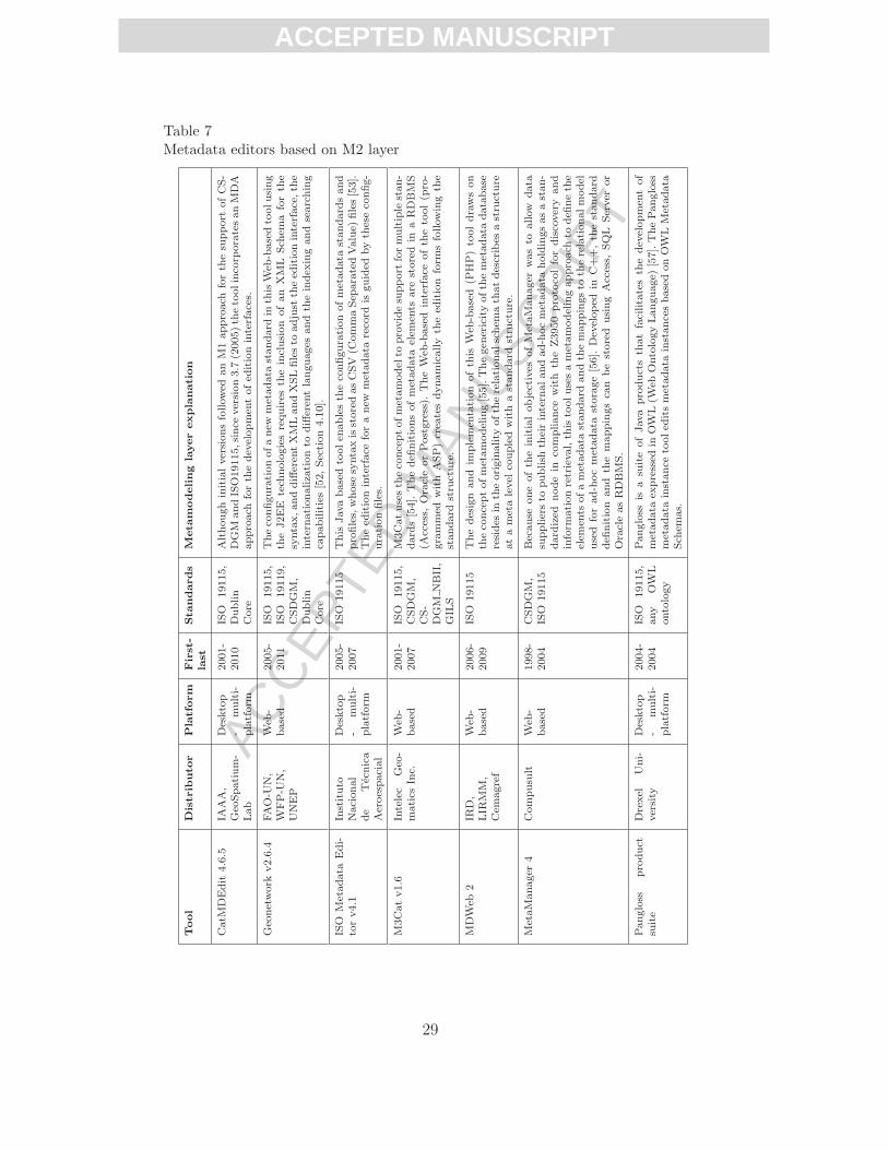
ACC
EPTE
D M
ANU
SCR
IPT
ACCEPTED MANUSCRIPT
Table 7Metadata editors based on M2 layer
Tool
Distrib
utor
Platform
First-
last
Standards
Metam
odeling
layerexplanation
CatM
DEdit
4.6.5
IAAA,
Geo
Spatium-
Lab
Desktop
-multi-
platform
2001-
2010
ISO
19115,
Dublin
Core
Althoughinitialversionsfollowed
anM1approach
forth
esu
pport
ofCS-
DGM
andISO19115,since
version3.7
(2005)th
etoolinco
rporatesanMDA
approach
forth
edev
elopmen
tofed
itioninterfaces.
Geo
network
v2.6.4
FAO-U
N,
WFP-U
N,
UNEP
Web
-based
2005-
2011
ISO
19115,
ISO
19119,
CSDGM,
Dublin
Core
Theco
nfigurationofanew
metadata
standard
inth
isW
eb-basedtoolusing
theJ2EE
tech
nologiesrequires
theinclusion
ofan
XML
Sch
emaforth
esyntax,anddifferen
tXMLandXSLfilesto
adjust
theed
itioninterface,th
eintern
ationaliza
tionto
differen
tlanguages
andth
eindex
ingandsearching
capabilities[52,Section4.10].
ISO
Metadata
Edi-
torv4.1
Instituto
Nacional
de
Tecnica
Aeroespacial
Desktop
-multi-
platform
2005-
2007
ISO
19115
This
Javabasedtoolen
ablesth
eco
nfigurationofmetadata
standard
sand
profiles,whose
syntaxisstoredasCSV
(CommaSep
aratedValue)
files[53].
Theed
itioninterface
foranew
metadata
reco
rdis
guided
byth
eseco
nfig-
urationfiles.
M3Catv1.6
Intelec
Geo
-matics
Inc.
Web
-based
2001-
2007
ISO
19115,
CSDGM,
CS-
DGM
NBII,
GIL
S
M3Catusesth
eco
nceptofmetamodel
toprovidesu
pport
formultiple
stan-
dard
s[54].Thedefi
nitionsofmetadata
elem
ents
are
storedin
aRDBMS
(Access,
OracleorPostgress).
TheW
eb-based
interface
ofth
etool(p
ro-
grammed
with
ASP)crea
tesdynamicallyth
eed
ition
form
sfollowingth
estandard
stru
cture.
MDW
eb2
IRD,
LIR
MM,
Cem
agref
Web
-based
2006-
2009
ISO
19115
Thedesign
and
implemen
tation
ofth
isW
eb-based
(PHP)tooldrawson
theco
nceptofmetamodeling[55].Thegen
ericityofth
emetadata
database
resides
inth
eoriginality
ofth
erelationalschem
ath
atdescribes
astru
cture
atametalevel
coupledwithastandard
stru
cture.
MetaManager
4Compusu
ltW
eb-
based
1998-
2004
CSDGM,
ISO
19115
Because
oneofth
einitialobjectives
ofMetaManager
wasto
allow
data
suppliersto
publish
theirintern
alandad-hocmetadata
holdingsasastan-
dard
ized
nodein
compliance
with
theZ3950
protoco
lfordiscovery
and
inform
ationretrieval,th
istoolusesametamodelingapproach
todefi
neth
eelem
ents
ofametadata
standard
andth
emappingsto
therelationalmodel
used
forad-hocmetadata
storage[56].
Dev
eloped
inC++,th
estandard
defi
nition
and
themappingsca
nbestored
usingAccess,
SQL
Server
or
OracleasRDBMS.
Pangloss
product
suite
Drexel
Uni-
versity
Desktop
-multi-
platform
2004-
2004
ISO
19115,
any
OW
Lontology
Pangloss
isa
suiteofJava
productsth
atfacilitatesth
edev
elopmen
tof
metadata
expressed
inOW
L(W
ebOntologyLanguage)
[57].ThePangloss
metadata
instance
tooled
itsmetadata
instancesbasedonOW
LMetadata
Sch
emas.
29

ACC
EPTE
D M
ANU
SCR
IPT
ACCEPTED MANUSCRIPT
19115 as international standard in 2003 and the convergence of national ini-tiatives such as CSDGM towards this international standard [58]. The highcosts involved in adapting old metadata editors to the complexity of this in-ternational standard (more than 400 elements organized in hierarchical andrecursive structures) can explain the decision of abandoning the maintenance.The WiscLINC review [10] identified 23 historical tools (or utilities) compli-ant with CSDGM whose maintenance had been stopped. Even ArcCatalog, theM1-layer tool providing support for both CSDGM and ISO 19115, only offersa partial coverage of the ISO standard (since 2002, ArcCatalog covers the coreset of ISO 19115 metadata elements for describing geographic datasets [59]).The logical model of this tool supports the CSDGM metadata elements, someESRI-defined elements, and a partial set of ISO 19115. CSDGM, ESRI andpartial ISO 19115 content coexist in parallel in the metadata XML documentsmaintained by ArcCatalog v9.3 [60].
In general, it can be stated that the life-time of the analyzed M1-layer tools ispotentially shorter than the M2-layer ones (average life-time of 4.6 years in Ta-ble 6 versus 5.5 years in Table 7, which will probably increase in the followingyears). The higher costs involved in upgrading M1-layer based tools to satisfynew standard requirements can be observed even for those tools initially devel-oped to support ISO 19115. KaR Metadata Toolkit is no longer available, andMetaGenie only covers a partial set of ISO 19115. The long history of draftversions of ISO 19115 until the final approval in 2003, the corrigendum of thisstandard in 2006, the appearance of different ISO 19115 profiles, and the con-tinuous flow of XML encoding proposals before the publication of ISO 19139have made the upgrading of M1-layer based tools extremely complicated.
As a conclusion, there is a clear tendency towards the implementation of meta-data editors using the metamodeling concept. CatMDEdit, the tool describedin Section 3, is not an exception and works directly at the M2 layer. As well asother M2-layer tools, its user manual explains how to customize the descrip-tion of edition forms for a specific metadata profile. From this perspective, itdoes not differ too much from similar M2-layer tools. However, the real ad-vantages of applying our proposed MDA approach are in the steps previous tothe generation of the GUI description files. Thanks to this approach, a meta-data designer can benefit from the tools and infrastructure provided by MDA.Using textual or graphical notations such as TCS [30] or GMF (GraphicalModeling Framework 8 ), the metadata designer can define PIM models usinga high-level domain specific language which is very close to the concepts ex-pressed in the documents delivered by standardization bodies. Once these PIMmodels have been defined, it is possible to generate automatically the config-uration files that are required by a specific metadata editor software. To ourknowledge after reviewing the literature of tools in Table 7, none has applied
8 http://www.eclipse.org/modeling/gmp
30

ACC
EPTE
D M
ANU
SCR
IPT
ACCEPTED MANUSCRIPT
the MDA methodology to transform a high-level definition of the metadatastandard into a set of low-level configuration files, which are usually hard tounderstand for a non-expert developer.
Additionally, the adaptation of the MDA approach proposed in Section 2 canbe easily applied to any of the tools described in Table 7. Apart from hav-ing demonstrated its applicability for generating the configuration files (andSKOS vocabularies) required by CatMDEdit, the proposed framework (do-main specific languages and transformations proposed in Section 2) can beadapted to generate the input required by other tools. In most cases, only theMOFScript transformation rules should be modified to generate an appropri-ate configuration. All the effort devoted to the definition of PIM models can befully reused if we decided to utilize a new metadata editor software. Besides,using this approach, the internationalization of the metadata standard con-cepts (e.g, labels, definitions, or conditions in multiple languages) is managedat a high and centralized level instead of handling this issue at a low technicallevel (e.g., by means of multiple instances of external property files).
5 Conclusions
This paper has presented the guidelines to apply an MDA approach for the de-velopment of annotation tools, which can be customized to different metadatastandards and profiles with minimum effort. Applying this approach, expertsin metadata standards (without any special programming skills) can focustheir efforts on the definition of new metadata models using a domain spe-cific language (the one used to define PIM models), whose abstraction level isclose to the way of expressing metadata standards in the documents providedby standardization bodies. After this high-level definition, the PIM modelsare automatically transformed into the PSM models and configuration filesrequired by the specific metadata editor that has been chosen as the finalplatform for annotating resources.
The feasibility of these guidelines for applying MDA has been tested withCatMDEdit, an open source metadata editor supporting multiple metadatastandards and profiles. Following this MDA approach, 11 metadata profilesderived from ISO 19115 and Dublin Core have been incorporated in Cat-MDEdit for the annotation of geographic information resources. Anyway, thisapproach is also extensible for the annotation of other types of resources. Asit has been shown in Section 3, many other different metadata profiles havebeen integrated in the tool for the annotation of a wide range of resourcessuch as photographs, services, thesauri or scientific publications. Additionally,using qualitative criteria (development effort, legibility, modularity, ease ofmaintenance and extensibility), it has been proven that the adoption of thisMDA approach outperforms the initial versions of CatMDEdit, which did notfollow this development philosophy. The initial versions of this tool, as well as
31

ACC
EPTE
D M
ANU
SCR
IPT
ACCEPTED MANUSCRIPT
other M1-layer based tools, were implemented around a logical model (directlyhardcoding the structure of the metadata standards) and were very sensitiveto any upgrade of metadata standards and profiles.
Another issue that must be taken into account is that this MDA approachis not only applicable for the development of desktop applications like Cat-MDEdit. For instance, this MDA approach has been successfully applied forthe development of a Web application for editing metadata for geographicweb services [61]. The whole infrastructure for the processing of PIM andGUI-based PSM models was reused. The only thing created specifically wasa renderer for Web edition forms, which was customized to the specific fea-tures of GWT (Google Web Toolkit) technology. A similar adaptation of theapproach could be also applied to improve the efficiency of other metadataeditors using a metamodeling perspective (i.e., M2-layer based tools wheresupported metadata standards can be configured). The domain specific lan-guages and transformations presented in this paper would provide the users ofthese tools with the appropriate MDA infrastructure to focus the developmenteffort on defining reusable models of metadata standards, and alleviating themfrom the technical details of configuration files.
As future work, we will work on the evaluation of different concrete syntaxnotations (visual and textual) for the definition of PIM models. In order totest these different syntaxes, we plan to integrate them in a new release ofCatMDEdit. This would allow final users to define metadata standards andprofiles in a more expressive way, and hide the details of model-to-model andmodel-to-text transformations (which would be executed automatically). Ad-ditionally, instead of using the Ecore metamodeling language for defining thePIM metamodel, we will study the use of other languages with more expressivepower (e.g., PVS or Eiffel [62]), which could help us to check automatically theconformance to some special constraints of metadata profiles (e.g., a profilecan only impose a more stringent obligation on existing metadata elements),not fully expressed with Ecore.
References
[1] D. Nebert (Ed.), Developing Spatial Data Infrastructures: The SDI Cookbookv.2.0, Global Spatial Data Infrastructure (GSDI), http://www.gsdi.org, 2004.
[2] Federal Geographic Data Committee, Content Standard for Digital GeospatialMetadata, version 2.0, Document FGDC-STD-001-1998, Metadata Ad HocWorking Group (1998).
[3] International Organization for Standardization, Geographic information –Metadata, ISO 19115:2003 (2003).
[4] Dublin Core Metadata Initiative (DCMI) Usage Board, DCMI Metadata Terms,http://dublincore.org/documents/2008/01/14/dcmi-terms/ (2008).
32

ACC
EPTE
D M
ANU
SCR
IPT
ACCEPTED MANUSCRIPT
[5] International Organization for Standardization, Geographic information –Metadata – Part 2: Extensions for imagery and gridded data, ISO 19115-2:2009(2009).
[6] Federal Geographic Data Committee, Content Standard for Digital GeospatialMetadata: Extensions for Remote Sensing Metadata, Public review draft,Standards Working Group (2002).
[7] W. Swoboda, F. Kruse, R. Nikolai, W. Kazakos, D. Nyhuis, H. Rousselle,The UDK Approach: the 4th Generation of an Environmental Data CatalogueIntroduced in Austria and Germany, in: Proc. of 3rd IEEE META-DATAConference, Bethesda, Maryland, 1999.
[8] M. Wilde, M. A. Lange, H. Pundt, N. Ostlander, K. Janowicz, An environmentalmetadata profile for the EU project MEDIS, in: 17th International Conferenceon Informatics for Environmental Protection (EnviroInfo), 2003.
[9] R. Tolosana-Calasanz, J. Nogueras-Iso, R. Bejar, P. R. Muro-Medrano, F. J.Zarazaga-Soria, Semantic interoperability based on Dublin Core hierarchicalone-to-one mappings, International Journal of Metadata, Semantics andOntologies (IJMS&O) 1 (3) (2006) 183–188.
[10] Wisconsin Land Information Clearinghouse, Metadata tools for geospatial data,http://www.sco.wisc.edu/wisclinc/metatool/ (2006).
[11] Information technology – Metadata registries (MDR) – Part 3: Registrymetamodel and basic attributes, ISO/IEC 11179-3:2003, InternationalOrganization for Standardization (2003).
[12] R. Grangel, C. Metral, A. Cutting-Decelle, J. Bourey, R. Young., Ontologybased communications through model driven tools: feasibility of the MDAApproach in Urban Engineering, in: Ontologies for Urban Development, Vol. 61of Studies in Computational Intelligence, Springer, 2007, pp. 181–196.
[13] Object Management Group (OMG), Meta Object Facility (MOF) Specificationv1.4, OMG Document formal/02-04-03, http://www.omg.org/cgi-bin/apps/doc?formal/02-04-03.pdf (April 2002).
[14] T. Kutzner, A. Donaubauer, Critical remarks on the use of conceptual schemasin geospatial data modelling - a schema translation perspective, in: Bridgingthe Geographic Information Sciences, Lecture Notes in Geoinformation andCartography, Springer, 2012, pp. 43–60.
[15] P. Staub, H. R. Gnagi, A. Morf, Semantic interoperability through the definitionof conceptual model transformations, Transactions in GIS 12 (2) (2008)193–207.
[16] C. Mayr, U. Zdun, S. Dustdar, View-based model-driven architecturefor enhancing maintainability of data access services, Data & KnowledgeEngineering 70 (9) (2011) 794–819.
[17] D. Djuric, D. Gasevic, V. Devedzic, Ontology Modeling and MDA, Journal onObject Technology 4 (1) (2005) 109–128.
33

ACC
EPTE
D M
ANU
SCR
IPT
ACCEPTED MANUSCRIPT
[18] J. Sztipanovits, G. Karsai, Model-integrated computing, IEEE Computer April(1997) 110–112.
[19] Object Management Group (OMG), MDA Guide version 1.0.1, DocumentNumber: omg/2003-06-01 (2003).
[20] S. Kelly, J.-P. Tolvanen, Domain-Specific Modeling: Enabling Full CodeGeneration, Wiley-IEEE Computer Society Press, 2008.
[21] G. Nordstrom, J. Sztipanovits, G. Karsai, A. Ledeczi, Metamodeling – RapidDesign and Evolution of Domain-Specific Modeling Environments, in: IEEE Int.Conf. and Workshop on the Engineering of Computer Based Systems (ECBS’99), 1999, pp. 68–74.
[22] A. Miles, J. R. Perez-Aguera, SKOS: Simple knowledge organisation for theweb, Cataloging and Classification Quarterly 43 (3-4) (2007) 69–83.
[23] D. Steinberg, F. Budinsky, M. Paternostro, E. Merks, EMF: Eclipse ModelingFramework, 2nd Edition, Addison-Wesley, 2008.
[24] C. Driver, S. Reilly, . Linehan, V. Cahill, S. Clarke, Managing embedded systemscomplexity with aspect-oriented model-driven engineering, ACM Trans. Embed.Comput. Syst. 10 (2) (2011) 21:1–21:26.
[25] F. Jouault, I. Kurtev, Transforming models with ATL, in: Proc. of theModel Transformations in Practice Workshop at MoDELS 2005, Montego Bay,Jamaica, 2005.
[26] J. Oldevik, MOFScript User guide, version 0.9 (MOFScript v 1.4.0), http://www.eclipse.org/gmt/mofscript/doc/MOFScript-User-Guide-0.9.pdf
(2011).
[27] D. Nebert, A. Whiteside, P. Vretanos, OpenGIS – Catalogue ServicesSpecification (version: 2.0.2), OGC 07-006r1, Open Geospatial Consortium Inc.(2007).
[28] International Organization for Standardization, Geographic information –Metadata – XML schema implementation, ISO/TS 19139:2007 (2007).
[29] A. Powell, M. Nilsson, A. Naeve, P. Johnston, T. Baker, DCMI AbstractModel, Dublin Core Metadata Initiative (DCMI), http://dublincore.org/documents/2007/06/04/abstract-model/ (2007).
[30] F. Jouault, J. Bezivin, I. Kurtev, TCS: a DSL for the Specification of TextualConcrete Syntaxes in Model Engineering, in: GPCE’06: Proc. of the 5th int.conf. on Generative programming and Component Engineering, 2006.
[31] J. Lacasta, J. Nogueras-Iso, R. Bejar, P. R. Muro-Medrano, F. J. Zarazaga-Soria, A Web Ontology Service to facilitate interoperability within a SpatialData Infrastructure: applicability to discovery, Data & Knowledge Engineering63 (3) (2007) 945–969.
34

ACC
EPTE
D M
ANU
SCR
IPT
ACCEPTED MANUSCRIPT
[32] E. Cuellar, G. Lozano, R. Morris, SwingML, Swing Markup LanguageSpecification, http://swingml.sourceforge.net/files2/Specification.pdf (2004).
[33] J. Lacasta, J. Nogueras-Iso, J. Lopez-Pellicer, P. M. Medrano, F. J. Zarazaga-Soria, ThManager: An Open Source Tool for creating and visualizing SKOS,Information Technology and Libraries (ITAL) 26 (3) (2007) 39–51.
[34] P. Clements, F. Bachmann, L. Bass, D. Garlan, J. Ivers, R. Little, R. Nord,J. Stafford, Documenting Software Architectures: Views and Beyond, 2ndEdition, SEI Series in Software Engineering, Addison-Wesley, 2011.
[35] J. Nogueras-Iso, J. Barrera, F. Gracia-Crespo, S. Laiglesia, P. R. Muro-Medrano, Integrating catalog and GIS tools: access to resources fromCatMDEdit thanks to gvSIG, in: 4th Int. gvSIG conf.: moving forward together,Valencia, 2008.
[36] J. Nogueras-Iso, P. R. Muro-Medrano, F. J. Zarazaga-Soria, SDIGER – WFDMetadata Profile, v0.3, SDIGER project, http://sdiger.unizar.es/public_docs/wfd_profile_v0.3.pdf (2005).
[37] F. J. Zarazaga-Soria, J. Nogueras-Iso, M. A. Latre, A. Rodrıguez, E. Lopez,P. Vivas, P. Muro-Medrano, Providing SDI Services in a Cross-Border Scenario:the SDIGER Project Use Case, in: Research and Theory in Advancing SpatialData Infrastructure Concepts, ESRI Press, 2007, pp. 113–126.
[38] European Commission, Directive 2007/2/EC of the European Parliament andof the Council of14 March 2007 establishing an Infrastructure for Spatial Information in theEuropean Community (INSPIRE), http://eur-lex.europa.eu/LexUriServ/LexUriServ.do?uri=OJ:L:2007:108:0001:0014:EN:PDF (2007).
[39] European Commission, Joint Research Centre, INSPIREMetadata Implementing Rules: Technical Guidelines based on EN ISO 19115and EN ISO 19119, v. 1.0., http://inspire.jrc.ec.europa.eu/reports/
ImplementingRules/metadata/MD_IR_and_ISO_20081219.pdf (2008).
[40] D. Ballari, A. S. Maganto, J. Nogueras-Iso, A. Rodrıguez, M. A. Bernabe,Experiences in the use of an ISO19115 profile within the framework of theSpanish SDI, in: GSDI-9 Conference Proceedings, no. 10, Santiago, Chile, 2006.
[41] E. Domenech Tofino, S. Molina Blazquez, C. Garcıa Gonzalez, G. Villa Alcazar,A. Arozarena Villar, Produccion de mosaicos por hojas del MTN50 en el PlanNacional de Ortofotografıa Aerea para la visualizacion y distribucion vıa Web,in: V Jornadas Tecnicas de la IDE de Espana JIDEE2008, 2008.
[42] Instituto Geografico Nacional.Equipo Tecnico Nacional SIOSE, Sistema de Informacion de Ocupacion delSuelo en Espana (SIOSE). Manual de fotointerpretacion. Anexo II: Manual demetadatos SIOSE. Version 1.3, http://www.ign.es/siose/Documentacion/Guia_Tecnica_SIOSE/AnexoII_ManualdeMetadatos/080609_ANEXOII_
Manual_Metadatos_SIOSE_v1.3.pdf (2008).
35

ACC
EPTE
D M
ANU
SCR
IPT
ACCEPTED MANUSCRIPT
[43] J. Nogueras-Iso, P. R. Muro-Medrano, F. J. Zarazaga-Soria, R. Rioja, SDIGER– Dublin Core Metadata Application Profile for geographical data mining,v0.5, SDIGER project, http://sdiger.unizar.es/public_docs/spatial_
dc_profile_v0.5.pdf (2005).
[44] European Standardization Committee (CEN), Dublin Core Spatial ApplicationProfile, CWA 14858, CEN/ISSS Workshop – Metadata for MultimediaInformation – Dublin Core, http://www.cen.eu/cenorm/sectors/sectors/isss/cen+workshop+agreements/meta-data+dc.asp (2003).
[45] International Organization for Standardization, Geographic information –Methodology for feature cataloguing, ISO 19110:2005 (2005).
[46] J. L. Canovas Izquierdo, O. Sanchez Ramon, J. Sanchez Cuadrado, J. GarcıaMolina, Utilidad de las transformaciones modelo-modelo en la generacionde codigo, in: XII Jornadas de Ingenierıa del Software y Bases de Datos(JISBD’07), 2007.
[47] Federal Geographic Data Committee, ISO Metadata Editor Review, http://www.fgdc.gov/metadata/iso-metadata-editor-review (April 2010).
[48] B. Vermeij, Implementing European Metadata Using ArcCatalog, ArcUser July-September, http://www.esri.com/news/arcuser/0701/metadata.html.
[49] Association for Geographic Information, Gigateway MetaGenie User Guidev2.0, http://www.gigateway.org.uk/metadata/pdf/MetaGenie_Guide.pdf
(2006).
[50] D. M. Schneider, User’s Manual: National Biological Information InfastructureMetaMaker Version 2.30 – Getting Started and Navigation Tips, U.S. GeologicalSurvey, Midcontinent Ecological Science Center, Fort Collins, Colorado.Published by the Upper Midwest Environmental Sciences Center, La Crosse,Wisconsin, 1999.
[51] P. N. Schweitzer, Tkme: Another editor for formal metadata, http://geology.usgs.gov/tools/metadata/tools/doc/tkme.html (2009).
[52] GeoNetwork opensource Community, GeoNetwork Developer Manual, release2.6.4, http://geonetwork-opensource.org/manuals/2.6.4/developer/
GeoNetworkDeveloperManual.pdf (2011).
[53] A. Amaro Cormenzana, A. Domınguez Barroso, E. Prado Ortega, Definicionde Perfiles y creacion de ficheros XML de metadatos para imagenes deTeledeteccion, in: Actas de Jornadas Tecnicas de la Infraestructura de DatosEspaciales de Espana (JIDEE’05), Madrid, 2005.
[54] S. Kena-Cohen, Y. Bedard, M3Cat, Limiting Aggravation in GeospatialMetadata Cataloguing, in: Conference GIS2001, Vancouver, Canada, 2001.
[55] J.-C. Desconnets, T. Libourel, S. Clerc, B. Granouillac, Cataloguing fordistribution of environmental resources, in: 10th AGILE Int. Conf. onGeographic Information Science, Aalborg, Denmark, 2007.
36

ACC
EPTE
D M
ANU
SCR
IPT
ACCEPTED MANUSCRIPT
[56] B. O’Rourke, Enabling Z39.50 Services for Relational Databases, White paper,Compusult Limited, Mount Pearl,NF, Canada, http://www.metadatamanager.com/metadatamanager/enable_z39.50_services.PDF (1999).
[57] L. Bermudez, M. Piasecki, Metadata Community Profiles for the Semantic Web,Geoinformatica 10 (2006) 159–176.
[58] Federal Geographic Data Committee, Preparing for International Metadata -North American Profile of ISO 19115: Geographic Information – Metadata,http://www.fgdc.gov/metadata/documents/
csdgm-to-nap-transition-guidance.pdf (2010).
[59] ESRI, Metadata and GIS, An ESRI White Paper, http://www.esri.com/
library/whitepapers/pdfs/metadata-and-gis.pdf (October 2002).
[60] ESRI, Metadata standards and the ArcGIS metadata format, ArcGISDesktop Help 9.3., http://webhelp.esri.com/arcgisdesktop/9.3/index.
cfm?TopicName=Metadata_standards_and_the_ArcGIS_metadata_format
(28 March 2008).
[61] J. Nogueras-Iso, J. Barrera, A. F. Rodrıguez, R. Recio, C. Laborda, F. Zarazaga-Soria, Development and deployment of a services catalog in compliancewith the INSPIRE metadata implementing rules, in: SDI Convergence:Research, Emerging Trends, and Critical Assessment, The NetherlandsGeodetic Commission, Delft, the Netherlands, 2009, pp. 21–34.
[62] R. F. Paige, P. J. Brooke, J. S. Ostroff, Metamodel-based model conformanceand multiview consistency checking, ACM Trans. Softw. Eng. Methodol. 16 (3)(2007) 1–49.
37

ACC
EPTE
D M
ANU
SCR
IPT
ACCEPTED MANUSCRIPT
JAVIER NOGUERAS-ISO holds MS and PhD degrees in Computer Science from the University of Zaragoza (Spain). After working for the Economic and Social Committee of the European Communities (Brussels) in 1998, he started his research at the Advanced Information Systems Laboratory of the Computer Science and Systems Engineering Department of the University of Zaragoza. Currently, he is an Associate Professor of Computer Science at that University. Additionally, he completed a postdoctoral stay at the Institute of Environment and Sustainability of the Joint Research Centre (Ispra, Italy) in 2005. His research interests are focused on Spatial Data Infrastructures and Geographic Information Retrieval. Within this context, he has co-authored numerous publications in books, journals or conference proceedings; and has collaborated in several R+D projects.
MIGUEL ÁNGEL LATRE holds a MS degree in Computing from the University of Zaragoza (Spain) since October 1999. He is currently a tenured Assistant Professor at the Department of Computer Science and Systems Engineering at the same university. He is working with the Advanced Information Systems Laboratory where he has been involved in several R&D projects related to the software engineering aspects of Geographic Information Systems and its application to the Environmental field. He is now working to complete his PhD degree in Computer Science.
RUBÉN BÉJAR holds MS and PhD degrees in Computing from the University of Zaragoza (Spain). He is currently a tenured Assistant Professor at the Department of Computer Science and Systems Engineering at the same university. He is working with the Advanced Information Systems Laboratory where he has been involved in several R\&D projects related to the software engineering aspects of Geographic Information Systems and has several publications in that area.
PEDRO R. MURO-MEDRANO holds MS and PhD degrees in Industrial Engineering from the University of Zaragoza (Spain). He has worked in the private industry for 2 years and has hold different visiting research positions at the Carnegie Mellon University's Robotics Institute (Pittsburgh, PA, USA), the University of Maryland (College Park, MD, USA) and the US National Institutes of Health (Bethesda, MD, USA). He has 25 years of experience with R\&D activities in software development and engineering and he is Professor of Computer Science at the University of Zaragoza. He is co-author of numerous national and international publications in books, journals and conference proceedings. Currently, he is the head of the Advanced Information Systems Laboratory at the Computer Science and Systems Engineering Department and the Aragón Institute for Engineering Research from the University of Zaragoza. His research interests include Spatial Data Infrastructures, Geographic Information Systems, Environmental Information systems and Remote Sensing.
F. JAVIER ZARAZAGA-SORIA holds MS degree in computer science from the Technical University of Valencia (Spain) and PhD degree in Computer Science from the University of Zaragoza (Spain). He did his MS Thesis at the Middlesex University's Road Safety Engineering Laboratory, London (UK). In September 1994 he began to work at the Advanced Information Systems Laboratory. He has been Assistant Professor at the Computer Science and Systems Engineering Department of the University of Zaragoza since November 1996 to June 2003. Since June 2003 he is Associate Professor at that University. He is
Short Bios

ACC
EPTE
D M
ANU
SCR
IPT
ACCEPTED MANUSCRIPT
co-author of numerous national and international publications in books, journals and conference proceedings. He has participated in several R\&D projects with companies and/or Public Administrations. His research interests include Information Retrieval and Ontologies in the context of Spatial Data Infrastructures.
Related Documents