LETTERS PUBLISHED ONLINE: 5 SEPTEMBER 2013 | DOI: 10.1038/NGEO1925 A mantle magma reservoir beneath an incipient mid-ocean ridge in Afar, Ethiopia M. Desissa 1 † , N. E. Johnson 1 , K. A. Whaler 1 * , S. Hautot 2 , S. Fisseha 3 and G. J. K. Dawes 1 Shallow magma reservoirs exist in the crust beneath volcanoes and mid-ocean ridges, yet there are no reports of extensive magma bodies within the uppermost mantle. Indeed the buoyancy of magma should cause it to intrude into the crust, preventing it from ponding in the mantle below. The Dabbahu magmatic segment in Afar, Ethiopia, marks the late stages of continental rifting. This segment has been active since 2005 and has experienced repeated magma intrusions 1–6 . Here we use magnetotelluric data to image magma bodies beneath it. We identify a 30-km-wide region of very high electrical conductivity that reaches down to about 35 km depth. We interpret this region as a large volume of magma of at least 500 km 3 that extends well into the mantle and contains about 13% melt fraction. The magma volume is orders of magnitude larger than that intruded during a typical rifting episode, implying that the magma reservoir persists for several tens of thousands of years. This is in marked contrast to the situation beneath mid-ocean ridges, where melt supply is thought to be episodic 7–11 . Large magma reservoirs within the mantle may therefore be responsible for the localization of strain that accompanies the final stages of continental break-up. The late-stage rifting Dabbahu magmatic segment has been active since 2005 when a 60-km-long, 2.5-km 3 -volume mega- dyke was intruded along its axis in two weeks, with up to 8 m of crustal extension 1–4 . Over the following five years, dykes repeatedly intruded the central and southern part of the segment, emanating from shallow sources near the mid-segment that inflated between intrusions 5,6 . Electrical conductivity (or its inverse, resistivity) mapping is an excellent way to probe for magma, fluids and partial melt, because the conductivity of the sub-surface is strongly influenced by the fluid content and its distribution, and only weakly dependent on rock type 12 . Most inorganic liquids raise the conductivity of the bulk medium, and hence electrical currents preferentially flow through regions containing them. Hence, in contrast to seismic methods, where fluids and higher temperatures lower wave speeds, attenuate the signals and thus make melt regions harder to sample, electrical and electromagnetic methods are ideally suited to sense the presence of magma. This study applies the magnetotelluric method, measuring internal magnetic and electric fields induced by naturally occurring external magnetic fields, whose strength and geometry are governed by the sub-surface resistivity distribution. Seventeen magnetotelluric sites were occupied (the eastern-most ten by helicopter owing to the rugged topography) along a profile crossing and approximately perpendicular to the rift axis of the Dabbahu segment (Fig. 1) separated by approximately 5 km over 1 School of GeoSciences, University of Edinburgh, West Mains Road, Edinburgh EH9 3JW, UK, 2 Imagir, IUEM, 29280 Plouzané, France, 3 Institute of Geophysics, Space Sciences and Astronomy, Addis Ababa University, Addis Ababa, Ethiopia. † Present address: Geological Survey of Northern Ireland, Colby House, Stranmillis Court, Belfast BT9 5BF, UK. *e-mail: [email protected] most of the profile, and about 3 km over the rifted region. At most sites, we also collected artificial source transient electromagnetic data to correct the magnetotelluric data for the amplitude of galvanic distortion 13 caused by small-scale, shallow conductors (Supplementary Methods for details). Magnetotelluric data comprise time series of the horizontal electric and magnetic field components, usually measured in (otherwise rotated into) orthogonal pairs. The ratio of horizontal electric to magnetic field, known as the impedance tensor, embodies the information about the sub-surface resistivity structure, often expressed in terms of apparent resistivity (amplitude), and phase (lag between magnetic and electric fields) as a function of period, which acts as a depth proxy (Supplementary Methods). A variety of techniques are available to assess the dimensionality of the causative structures from the impedance tensor, and, in the case of a two-dimensional (2D) Earth, determine the geoelectrical strike direction 14,15 . For a 2D structure, the data separate into two independent modes, transverse electric and transverse magnetic, describing currents flowing parallel and perpendicular to geoelectrical strike, obtained by rotating them into and orthogonal to the geoelectrical strike direction, respectively 14 . A 2D Earth is able to explain most of the data, with deviations most apparent at depth (Supplementary Methods). However, the strike direction determined on a site-to-site and period-to-period basis is variable, pointing to a number of influences on the sub- surface structure. A single compromise strike direction required to undertake 2D modelling was obtained whilst simultaneously correcting for galvanic distortion 16 . This gave a well-defined angle of 340 ◦ , matching the angle obtained from other algorithms (for example, Supplementary Fig. S1) and the orientation of the rift axis. Data pseudo-sections, where increasing log(period) provides the depth proxy, are shown in Fig. 2a. Of significant note are two regions of low apparent resistivities in both modes at most periods, centred on about 18 km along the profile (near site 813) and about 35 km along the profile (the rift axis location), indicating a particularly conductive sub-surface. The phase for both modes rises from a minimum at around 1 s period, reaching a maximum at around 100 s, and then decreases again, indicating a resistivity structure that increases, then decreases, and finally rises again with depth. Viewing the data on an individual site basis as a function of log(period) (Supplementary Fig. S4), the two modes are coincident in both apparent resistivity and phase at shorter periods, but subsequently diverge. The period at which they separate is longer for apparent resistivity than phase; beyond that, transverse magnetic mode apparent resistivities tend to be lower, and phases higher, than their transverse electric counterparts. NATURE GEOSCIENCE | VOL 6 | OCTOBER 2013 | www.nature.com/naturegeoscience 861 © 2013 Macmillan Publishers Limited. All rights reserved

Welcome message from author
This document is posted to help you gain knowledge. Please leave a comment to let me know what you think about it! Share it to your friends and learn new things together.
Transcript
LETTERSPUBLISHED ONLINE: 5 SEPTEMBER 2013 | DOI: 10.1038/NGEO1925
A mantle magma reservoir beneath an incipientmid-ocean ridge in Afar, Ethiopia
M. Desissa1†, N. E. Johnson1, K. A. Whaler1*, S. Hautot2, S. Fisseha3 and G. J. K. Dawes1
Shallow magma reservoirs exist in the crust beneath volcanoesand mid-ocean ridges, yet there are no reports of extensivemagma bodies within the uppermost mantle. Indeed thebuoyancy of magma should cause it to intrude into the crust,preventing it from ponding in the mantle below. The Dabbahumagmatic segment in Afar, Ethiopia, marks the late stages ofcontinental rifting. This segment has been active since 2005and has experienced repeated magma intrusions1–6. Here weuse magnetotelluric data to image magma bodies beneathit. We identify a 30-km-wide region of very high electricalconductivity that reaches down to about 35 km depth. Weinterpret this region as a large volume of magma of at least500 km3 that extends well into the mantle and contains about13% melt fraction. The magma volume is orders of magnitudelarger than that intruded during a typical rifting episode,implying that the magma reservoir persists for several tens ofthousands of years. This is in marked contrast to the situationbeneath mid-ocean ridges, where melt supply is thought to beepisodic7–11. Large magma reservoirs within the mantle maytherefore be responsible for the localization of strain thataccompanies the final stages of continental break-up.
The late-stage rifting Dabbahu magmatic segment has beenactive since 2005 when a 60-km-long, 2.5-km3-volume mega-dyke was intruded along its axis in two weeks, with up to8m of crustal extension1–4. Over the following five years, dykesrepeatedly intruded the central and southern part of the segment,emanating from shallow sources near themid-segment that inflatedbetween intrusions5,6.
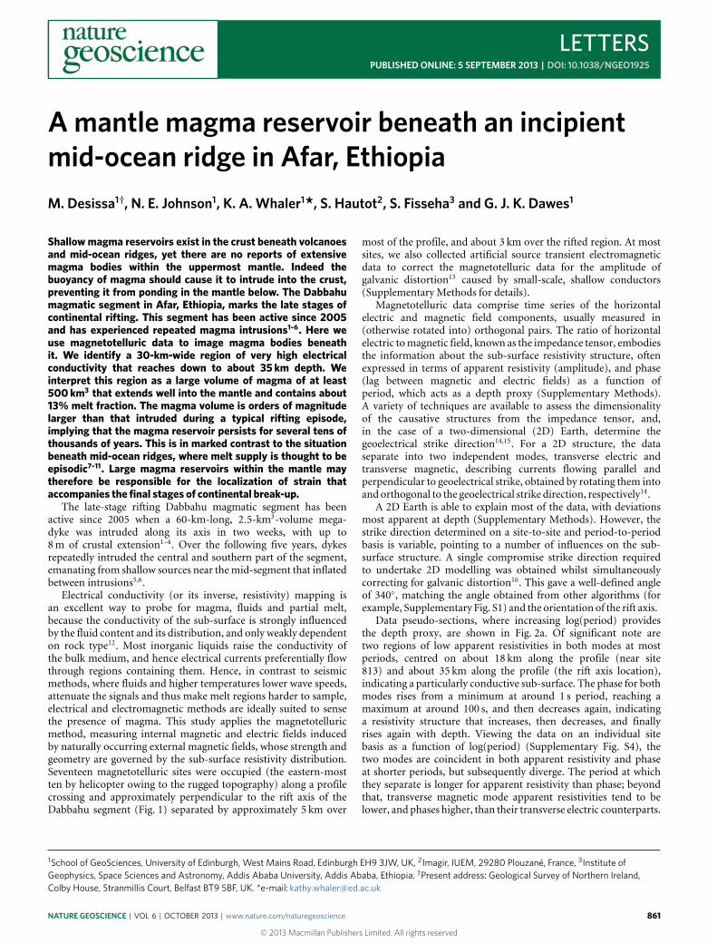
Electrical conductivity (or its inverse, resistivity) mapping isan excellent way to probe for magma, fluids and partial melt,because the conductivity of the sub-surface is strongly influencedby the fluid content and its distribution, and only weakly dependenton rock type12. Most inorganic liquids raise the conductivity ofthe bulk medium, and hence electrical currents preferentially flowthrough regions containing them. Hence, in contrast to seismicmethods, where fluids and higher temperatures lower wave speeds,attenuate the signals and thus make melt regions harder to sample,electrical and electromagnetic methods are ideally suited to sensethe presence of magma. This study applies the magnetotelluricmethod, measuring internal magnetic and electric fields inducedby naturally occurring external magnetic fields, whose strength andgeometry are governed by the sub-surface resistivity distribution.Seventeen magnetotelluric sites were occupied (the eastern-mostten by helicopter owing to the rugged topography) along a profilecrossing and approximately perpendicular to the rift axis of theDabbahu segment (Fig. 1) separated by approximately 5 km over
1School of GeoSciences, University of Edinburgh, West Mains Road, Edinburgh EH9 3JW, UK, 2Imagir, IUEM, 29280 Plouzané, France, 3Institute ofGeophysics, Space Sciences and Astronomy, Addis Ababa University, Addis Ababa, Ethiopia. †Present address: Geological Survey of Northern Ireland,Colby House, Stranmillis Court, Belfast BT9 5BF, UK. *e-mail: [email protected]
most of the profile, and about 3 km over the rifted region. At mostsites, we also collected artificial source transient electromagneticdata to correct the magnetotelluric data for the amplitude ofgalvanic distortion13 caused by small-scale, shallow conductors(Supplementary Methods for details).
Magnetotelluric data comprise time series of the horizontalelectric and magnetic field components, usually measured in(otherwise rotated into) orthogonal pairs. The ratio of horizontalelectric tomagnetic field, known as the impedance tensor, embodiesthe information about the sub-surface resistivity structure, oftenexpressed in terms of apparent resistivity (amplitude), and phase(lag between magnetic and electric fields) as a function ofperiod, which acts as a depth proxy (Supplementary Methods).A variety of techniques are available to assess the dimensionalityof the causative structures from the impedance tensor, and,in the case of a two-dimensional (2D) Earth, determine thegeoelectrical strike direction14,15. For a 2D structure, the dataseparate into two independent modes, transverse electric andtransverse magnetic, describing currents flowing parallel andperpendicular to geoelectrical strike, obtained by rotating them intoand orthogonal to the geoelectrical strike direction, respectively14.
A 2D Earth is able to explain most of the data, with deviationsmost apparent at depth (Supplementary Methods). However, thestrike direction determined on a site-to-site and period-to-periodbasis is variable, pointing to a number of influences on the sub-surface structure. A single compromise strike direction requiredto undertake 2D modelling was obtained whilst simultaneouslycorrecting for galvanic distortion16. This gave a well-defined angleof 340◦, matching the angle obtained from other algorithms (forexample, Supplementary Fig. S1) and the orientation of the rift axis.
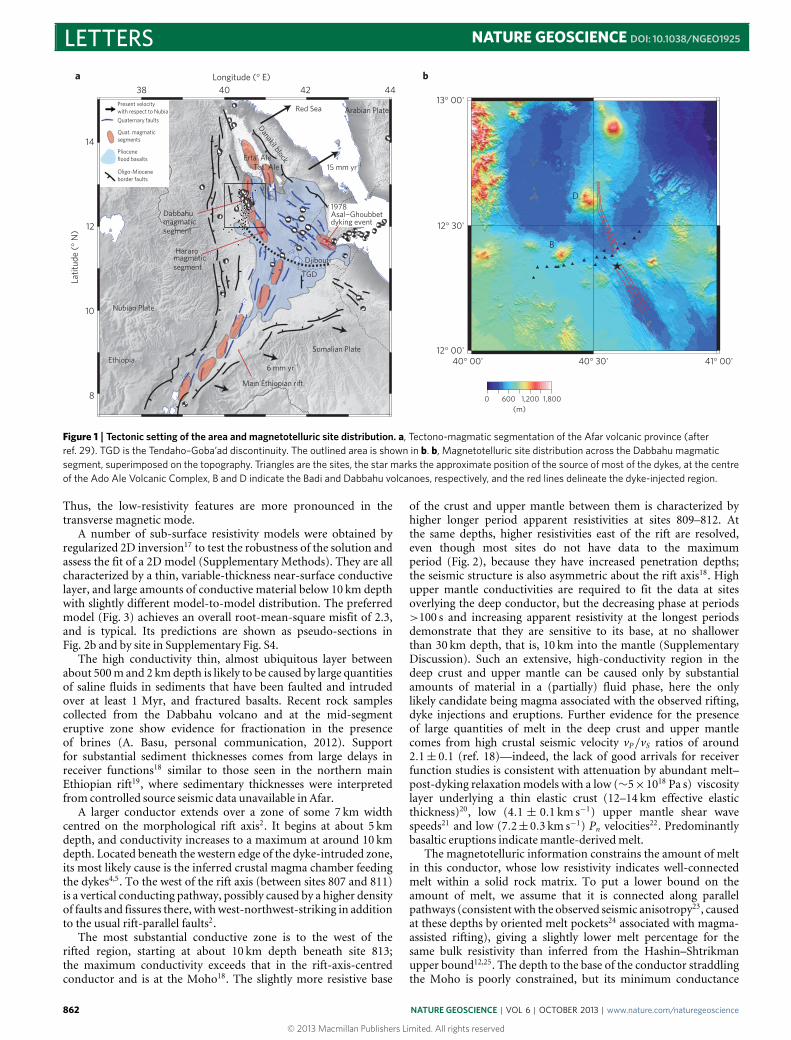
Data pseudo-sections, where increasing log(period) providesthe depth proxy, are shown in Fig. 2a. Of significant note aretwo regions of low apparent resistivities in both modes at mostperiods, centred on about 18 km along the profile (near site813) and about 35 km along the profile (the rift axis location),indicating a particularly conductive sub-surface. The phase for bothmodes rises from a minimum at around 1 s period, reaching amaximum at around 100 s, and then decreases again, indicatinga resistivity structure that increases, then decreases, and finallyrises again with depth. Viewing the data on an individual sitebasis as a function of log(period) (Supplementary Fig. S4), thetwo modes are coincident in both apparent resistivity and phaseat shorter periods, but subsequently diverge. The period at whichthey separate is longer for apparent resistivity than phase; beyondthat, transverse magnetic mode apparent resistivities tend to belower, and phases higher, than their transverse electric counterparts.
NATURE GEOSCIENCE | VOL 6 | OCTOBER 2013 | www.nature.com/naturegeoscience 861
© 2013 Macmillan Publishers Limited. All rights reserved
LETTERS NATURE GEOSCIENCE DOI: 10.1038/NGEO1925
38 40 42 44
40° 00'
13° 00'
12° 30'
B
D
12° 00'40° 30' 41° 00'
14
Present velocity
Quaternary faults
Quat. magmaticsegments
Plioceneflood basalts
Oligo-Mioceneborder faults
Dabbahumagmaticsegment
Red Sea
15 mm yr¬1
Main Ethiopian rift
Erta' AleTat' Ale
Danakil block
Arabian Plate
Nubian Plate
Ethiopia
magmaticsegment
Hararo
12
10
8
Djibouti
TGD
Somalian Plate
6 mm yr¬1
0 600 1,200(m)
1,800
a b
1978Asal¬Ghoubbetdyking event
with respect to Nubia
Latit
ude
(° N
)Longitude (° E)
Figure 1 | Tectonic setting of the area and magnetotelluric site distribution. a, Tectono-magmatic segmentation of the Afar volcanic province (afterref. 29). TGD is the Tendaho–Goba’ad discontinuity. The outlined area is shown in b. b, Magnetotelluric site distribution across the Dabbahu magmaticsegment, superimposed on the topography. Triangles are the sites, the star marks the approximate position of the source of most of the dykes, at the centreof the Ado Ale Volcanic Complex, B and D indicate the Badi and Dabbahu volcanoes, respectively, and the red lines delineate the dyke-injected region.
Thus, the low-resistivity features are more pronounced in thetransverse magnetic mode.
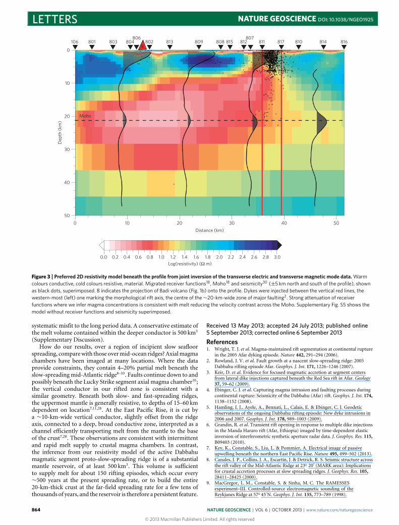
A number of sub-surface resistivity models were obtained byregularized 2D inversion17 to test the robustness of the solution andassess the fit of a 2D model (Supplementary Methods). They are allcharacterized by a thin, variable-thickness near-surface conductivelayer, and large amounts of conductive material below 10 km depthwith slightly different model-to-model distribution. The preferredmodel (Fig. 3) achieves an overall root-mean-square misfit of 2.3,and is typical. Its predictions are shown as pseudo-sections inFig. 2b and by site in Supplementary Fig. S4.
The high conductivity thin, almost ubiquitous layer betweenabout 500m and 2 kmdepth is likely to be caused by large quantitiesof saline fluids in sediments that have been faulted and intrudedover at least 1 Myr, and fractured basalts. Recent rock samplescollected from the Dabbahu volcano and at the mid-segmenteruptive zone show evidence for fractionation in the presenceof brines (A. Basu, personal communication, 2012). Supportfor substantial sediment thicknesses comes from large delays inreceiver functions18 similar to those seen in the northern mainEthiopian rift19, where sedimentary thicknesses were interpretedfrom controlled source seismic data unavailable in Afar.
A larger conductor extends over a zone of some 7 km widthcentred on the morphological rift axis2. It begins at about 5 kmdepth, and conductivity increases to a maximum at around 10 kmdepth. Located beneath the western edge of the dyke-intruded zone,its most likely cause is the inferred crustal magma chamber feedingthe dykes4,5. To the west of the rift axis (between sites 807 and 811)is a vertical conducting pathway, possibly caused by a higher densityof faults and fissures there, withwest-northwest-striking in additionto the usual rift-parallel faults2.
The most substantial conductive zone is to the west of therifted region, starting at about 10 km depth beneath site 813;the maximum conductivity exceeds that in the rift-axis-centredconductor and is at the Moho18. The slightly more resistive base
of the crust and upper mantle between them is characterized byhigher longer period apparent resistivities at sites 809–812. Atthe same depths, higher resistivities east of the rift are resolved,even though most sites do not have data to the maximumperiod (Fig. 2), because they have increased penetration depths;the seismic structure is also asymmetric about the rift axis18. Highupper mantle conductivities are required to fit the data at sitesoverlying the deep conductor, but the decreasing phase at periods>100 s and increasing apparent resistivity at the longest periodsdemonstrate that they are sensitive to its base, at no shallowerthan 30 km depth, that is, 10 km into the mantle (SupplementaryDiscussion). Such an extensive, high-conductivity region in thedeep crust and upper mantle can be caused only by substantialamounts of material in a (partially) fluid phase, here the onlylikely candidate being magma associated with the observed rifting,dyke injections and eruptions. Further evidence for the presenceof large quantities of melt in the deep crust and upper mantlecomes from high crustal seismic velocity vP/vS ratios of around2.1± 0.1 (ref. 18)—indeed, the lack of good arrivals for receiverfunction studies is consistent with attenuation by abundant melt–post-dyking relaxationmodels with a low (∼5×10¹⁸ Pa s) viscositylayer underlying a thin elastic crust (12–14 km effective elasticthickness)20, low (4.1 ± 0.1 km s−1) upper mantle shear wavespeeds21 and low (7.2±0.3 km s−1) Pn velocities22. Predominantlybasaltic eruptions indicate mantle-derivedmelt.
The magnetotelluric information constrains the amount of meltin this conductor, whose low resistivity indicates well-connectedmelt within a solid rock matrix. To put a lower bound on theamount of melt, we assume that it is connected along parallelpathways (consistentwith the observed seismic anisotropy23, causedat these depths by oriented melt pockets24 associated with magma-assisted rifting), giving a slightly lower melt percentage for thesame bulk resistivity than inferred from the Hashin–Shtrikmanupper bound12,25. The depth to the base of the conductor straddlingthe Moho is poorly constrained, but its minimum conductance
862 NATURE GEOSCIENCE | VOL 6 | OCTOBER 2013 | www.nature.com/naturegeoscience
© 2013 Macmillan Publishers Limited. All rights reserved

NATURE GEOSCIENCE DOI: 10.1038/NGEO1925 LETTERS
¬2
¬1
0
1
2
3
90
75
60
45
30
15
0
3
2
1
0
0 5 10 15 20 25 30 35 40 45 50 0 5 10 15 20 25 30 35 40 45 50
106
106 803 804 802 813 809 808 812 811 817 810 814 816801 806 815 807
106 803 804 802 813 809 808 812 811 817 810 814 816801 806 815 807
106 803 804 802 813 809 808 812 811 817 810 814 816801 806 815 807
106 803 804 802 813 809 808 812 811 817 810 814 816801 806 815 807
803 804 802 813 809 808 812 811 817 810 816814806 815 807801
106 803 804 802 813 809 808 812 811 817 810 816814806 815 807801
106 803 804 802 813 809 808 812 811 817 810 816814806 815 807801
106 803 804 802 813 809 808 812 811 817 810 816814806 815 807801
0 5 10 15 20 25 30 35 40 45 50 0 5 10 15 20 25 30 35 40 45 50
Log
peri
od (
s)Log (apparent resistivity) (Ω
m)
Phase (°)Phase (°)
Log (apparent resistivity) (Ω m
)Lo
g pe
riod
(s)
Distance (km) Distance (km)
Log
peri
od (
s)Lo
g pe
riod
(s)
90
75
60
45
30
15
0
3
2
1
0
¬2
¬1
0
1
2
3
a
b
¬2
¬1
0
1
2
3
1
¬2
¬1
0
2
3
Distance (km) Distance (km)
Figure 2 | Data pseudo-sections and their predictions by the preferred model. a,b, Data pseudo-sections (a), and their predictions by the model of Fig. 3(b), plotted as a function of log(period) along the profile from southwest to northeast for the transverse electric (left) and transverse magnetic (right)mode. Top panel, apparent resistivity; bottom panel, phase. Grey masks missing long period data.
(depth integrated conductivity) can be determined26 as 10.1 kS(Supplementary Discussion), an extremely large value equivalentto over 2 km of sea water. A representative melt resistivity usingpetrological constraints on composition, temperature and depth27
(Supplementary Discussion) is 0.28�m, which implies >13%melt, based on the lowest bulk resistivity value of 2.05�m in
the minimum conductance model. It has been demonstrated(J. Hammond, personal communication, 2012) that this high meltfraction is consistent with the seismic observations if it is inbodies with a low aspect ratio (for example, thin disks). Forcinga resistive mantle would increase the melt fraction to values thatseem incompatible with the seismic evidence, besides generating a
NATURE GEOSCIENCE | VOL 6 | OCTOBER 2013 | www.nature.com/naturegeoscience 863
© 2013 Macmillan Publishers Limited. All rights reserved
LETTERS NATURE GEOSCIENCE DOI: 10.1038/NGEO1925
106 803801 804806
B
807802 813 809 808 815 812 811 817 810 814 816
0
10
20 Moho
30
40
Dep
th (
km)
50
0 10 20 30
Distance (km)
40 50
0.0 0.2 0.4 0.6 0.8 1.0 1.2 1.4 1.6 1.8Log(resistivity) (Ω m)
2.0 2.2 2.4 2.6 2.8 3.0
Figure 3 | Preferred 2D resistivity model beneath the profile from joint inversion of the transverse electric and transverse magnetic mode data. Warmcolours conductive, cold colours resistive, material. Migrated receiver functions18, Moho18 and seismicity30 (±5 km north and south of the profile), shownas black dots, superimposed. B indicates the projection of Badi volcano (Fig. 1b) onto the profile. Dykes were injected between the vertical red lines, thewestern-most (left) one marking the morphological rift axis, the centre of the∼20-km-wide zone of major faulting2. Strong attenuation of receiverfunctions where we infer magma concentrations is consistent with melt reducing the velocity contrast across the Moho. Supplementary Fig. S5 shows themodel without receiver functions and seismicity superimposed.
systematic misfit to the long period data. A conservative estimate ofthe melt volume contained within the deeper conductor is 500 km3
(Supplementary Discussion).How do our results, over a region of incipient slow seafloor
spreading, comparewith those overmid-ocean ridges? Axialmagmachambers have been imaged at many locations. Where the dataprovide constraints, they contain 4–20% partial melt beneath theslow-spreadingmid-Atlantic ridge8–10. Faults continue down to andpossibly beneath the Lucky Strike segment axial magma chamber10;the vertical conductor in our rifted zone is consistent with asimilar geometry. Beneath both slow- and fast-spreading ridges,the uppermost mantle is generally resistive, to depths of 15–60 kmdependent on location7,11,28. At the East Pacific Rise, it is cut bya ∼10-km-wide vertical conductor, slightly offset from the ridgeaxis, connected to a deep, broad conductive zone, interpreted as achannel efficiently transporting melt from the mantle to the baseof the crust7,28. These observations are consistent with intermittentand rapid melt supply to crustal magma chambers. In contrast,the inference from our resistivity model of the active Dabbahumagmatic segment proto-slow-spreading ridge is of a substantialmantle reservoir, of at least 500 km3. This volume is sufficientto supply melt for about 150 rifting episodes, which occur every∼500 years at the present spreading rate, or to build the entire20-km-thick crust at the far-field spreading rate for a few tens ofthousands of years, and the reservoir is therefore a persistent feature.
Received 13 May 2013; accepted 24 July 2013; published online5 September 2013; corrected online 6 September 2013
References1. Wright, T. J. et al. Magma-maintained rift segmentation at continental rupture
in the 2005 Afar dyking episode. Nature 442, 291–294 (2006).2. Rowland, J. V. et al. Fault growth at a nascent slow-spreading ridge: 2005
Dabbahu rifting episode Afar. Geophys. J. Int. 171, 1226–1246 (2007).3. Keir, D. et al. Evidence for focused magmatic accretion at segment centers
from lateral dike injections captured beneath the Red Sea rift in Afar. Geology37, 59–62 (2009).
4. Ebinger, C. J. et al. Capturing magma intrusion and faulting processes duringcontinental rupture: Seismicity of the Dabbahu (Afar) rift. Geophys. J. Int. 174,1138–1152 (2008).
5. Hamling, I. J., Ayele, A., Bennati, L., Calais, E. & Ebinger, C. J. Geodeticobservations of the ongoing Dabbahu rifting episode: New dyke intrusions in2006 and 2007. Geophys. J. Int. 178, 989–1003 (2009).
6. Grandin, R. et al. Transient rift opening in response to multiple dike injectionsin the Manda Hararo rift (Afar, Ethiopia) imaged by time-dependent elasticinversion of interferometric synthetic aperture radar data. J. Geophys. Res. 115,B09403 (2010).
7. Key, K., Constable, S., Liu, L. & Pommier, A. Electrical image of passiveupwelling beneath the northern East Pacific Rise. Nature 495, 499–502 (2013).
8. Canales, J. P., Collins, J. A., Escartín, J. & Detrick, R. S. Seismic structure acrossthe rift valley of the Mid-Atlantic Ridge at 23◦ 20’ (MARK area): Implicationsfor crustal accretion processes at slow spreading ridges. J. Geophys. Res. 105,28411–28425 (2000).
9. MacGregor, L. M., Constable, S. & Sinha, M. C. The RAMESSESexperiment–III. Controlled-source electromagnetic sounding of theReykjanes Ridge at 57◦ 45′N. Geophys. J. Int. 135, 773–789 (1998).
864 NATURE GEOSCIENCE | VOL 6 | OCTOBER 2013 | www.nature.com/naturegeoscience
© 2013 Macmillan Publishers Limited. All rights reserved
NATURE GEOSCIENCE DOI: 10.1038/NGEO1925 LETTERS10. Singh, S. C. et al. Discovery of a magma chamber and faults beneath a
Mid-Atlantic Ridge hydrothermal field. Nature 442, 1029–1032 (2006).11. Heinson, G., Constable, S. & White, A. Episodic melt transport at mid-ocean
ridges inferred from magnetotelluric sounding. Geophys. Res. Lett. 27,2317–2320 (2000).
12. Roberts, J. J. & Tyburczy, J. A. Partial-melt electrical conductivity: Influence ofmelt composition. J. Geophys. Res. 104, 7055–7065 (1999).
13. Sternberg, B., Washburne, J. C. & Pellerin, L. Correction for the static shift inmagnetotellurics using transient electromagnetic soundings. Geophysics 53,1459–1468 (1988).
14. Simpson, F. & Bahr, K. Practical Magnetotellurics (Cambridge Univ. Press,2005).
15. Caldwell, T. G., Bibby, H. M. & Brown, C. The magnetotelluric phase tensor.Geophys. J. Int. 158, 457–469 (2004).
16. McNeice, G. W. & Jones, A. G. Multisite, multifrequency tensor decompositionof magnetotelluric data. Geophysics 66, 158–173 (2001).
17. Siripunvaraporn,W. & Egbert, G. An efficient data sub-space inversionmethodfor 2-D magnetotelluric data. Geophysics 65, 791–803 (2000).
18. Hammond, J. O. S. et al. The nature of the crust beneath the Afar triplejunction: Evidence from receiver functions. Geochem. Geophys. Geosys. 12,Q12004 (2011).
19. Cornwell, D. G., Maguire, P. K. H., England, R. W. & Stuart, G. W. Imagingdetailed crustal structure and magmatic intrusion across the EthiopianRift using a dense linear broadband array. Geochem. Geophys. Geosys. 11,Q0AB03 (2010).
20. Nooner, S. L. et al. Post-rifting relaxation in the Afar region, Ethiopia.Geophys. Res. Lett. 36, L21308 (2009).
21. Guidarelli, M. et al. Surface wave tomography across Afar, Ethiopia: Crustalstructure at a rift triple-junction zone. Geophys. Res. Lett. 38, L24313 (2011).
22. Stork, A. et al. Uppermost mantle (Pn) velocity model for the Afar region,Ethiopia: An insight into rifting processes. Geophys. J. Int. 193, 321–328 (2013).
23. Kendall, J. M., Stuart, G. W., Ebinger, C. J., Bastow, I. D. & Keir, D.Magma-assisted rifting in Ethiopia. Nature 433, 146–148 (2005).
24. Keir, D. et al. Mapping the evolving strain field during continental breakupfrom crustal anisotropy in the Afar Depression.Nature Commun. 2, 285 (2011).
25. Hashin, Z. & Shtrikman, S. A. variational approach to the theory of theeffective magnetic permeability of multiphase materials. J. Appl. Phys. 33,3125–3131 (1962).
26. Li, S. et al. Partial melt or aqueous fluid in the mid-crust of Southern Tibet?Constraints from INDEPTH magnetotelluric data. Geophys. J. Int. 153,289–304 (2003).
27. Pommier, A. & Le Trong, E. SIGMELTS: Aweb portal for electrical conductivitycalculations in geosciences. Comput. Geosci. 37, 1450–1459 (2011).
28. Baba, K., Chave, A. D., Evans, R. L., Hirth, G. & Mackie, R. L. Mantledynamics beneath the East Pacific Rise at 17◦S: Insights from the MantleElectromagnetic and Tomography (MELT) experiment. J. Geophys. Res. 111,B02101 (2006).
29. Hayward, N. & Ebinger, C. Variations in along-axis segmentation of the AfarRift System. Tectonics 15, 244–257 (1996).
30. Belachew, M. et al. Comparison of dike intrusions in an incipientseafloor-spreading segment in Afar, Ethiopia: Seismicity perspectives.J. Geophys. Res. 116, B06405 (2011).
AcknowledgementsThis research has been supported financially by NERC (grant NE/E007147/1 and PhDstudentship for N.E.J.), the School of GeoSciences (MSc by Research MTEM PartialScholarship to M.D.), CNRS (financial support for S.H.), and in-kind by equipmentloans from the NERC Geophysical Equipment Facility (GEFSC loans 855 and 907), andthe Geophysical Instrument Pool Potsdam (part of GeoForschungsZentrum) throughthe auspices of O. Ritter and U. Kalberkamp (BGR, Hannover). The Institute forGeophysics, Space Science and Astronomy, Addis Ababa University and the GeologicalSurvey of Ethiopia are thanked for logistical support, as is Y. Lemma for help with thefieldwork. Helicopter access to the rift was provided by C. Stewart, Everett Aviation. Wealso acknowledge discussions with and results in advance of publication from Afar RiftConsortium colleagues and Project Partners, in the UK, Ethiopia, USA and New Zealand.
Author contributionsAll authors participated in the fieldwork. M.D., S.H. and N.E.J. processed the data. M.D.and N.E.J. analysed their dimensionality and corrected for galvanic distortion. M.D.,N.E.J. and S.F. performed 2D inversions. G.J.K.D. designed and constructed the datarecording systems. K.A.W., S.H. and N.E.J. undertook most of the model interpretation,including estimating melt fractions and volumes. K.A.W. obtained the financial support,and wrote the article (with comments from co-authors).
Additional informationSupplementary information is available in the online version of the paper. Reprints andpermissions information is available online at www.nature.com/reprints.Correspondence and requests for materials should be addressed to K.A.W.
Competing financial interestsThe authors declare no competing financial interests.
NATURE GEOSCIENCE | VOL 6 | OCTOBER 2013 | www.nature.com/naturegeoscience 865
© 2013 Macmillan Publishers Limited. All rights reserved

In the version of this Letter originally published online, the published online date should have read ‘5 September 2013’. This has been corrected in the PDF and HTML versions of the Letter.
A mantle magma reservoir beneath an incipient mid-ocean ridge in Afar, EthiopiaM. Desissa, N. E. Johnson, K. A. Whaler, S. Hautot, S. Fisseha and G. J. K. Dawes
Nature Geosci. http://dx.doi.org/10.1038/ngeo1925; published online 5 September 2013; corrected online 6 September 2013
ERRATUM
© 2013 Macmillan Publishers Limited. All rights reserved
Related Documents