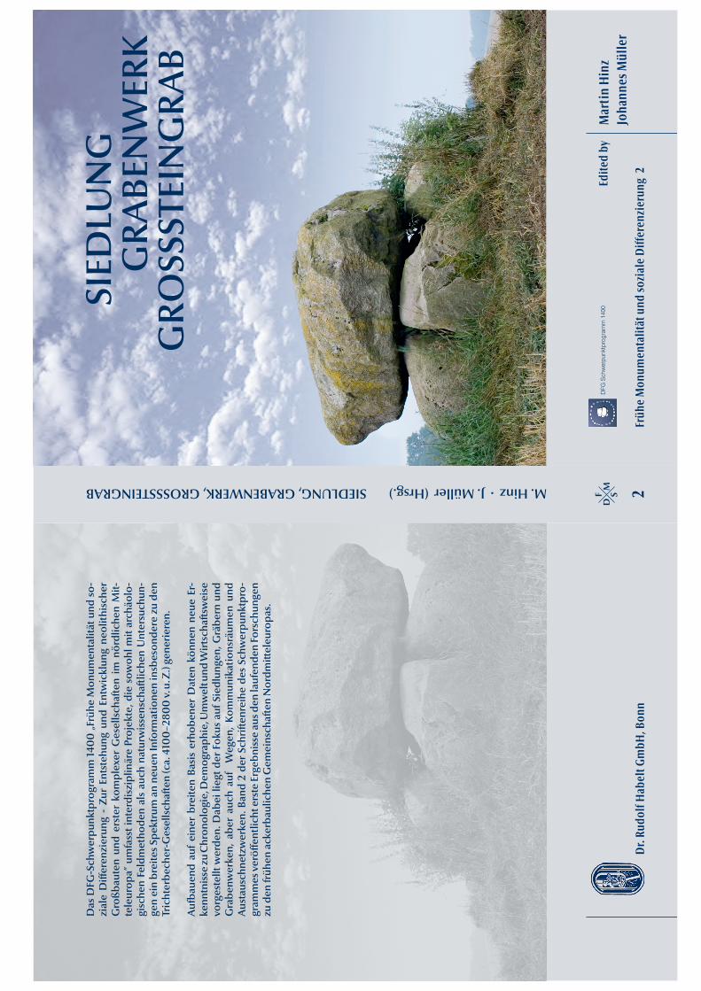
Martin Hinz Johannes Müller Edited by DFG Schwerpunktprogramm 1400 SIEDLUNG GRABENWERK Frühe Monumentalität und soziale Differenzierung 2 SIEDLUNG, GRABENWERK, GROSSSTEINGRAB M. Hinz . J. Müller (Hrsg.) Dr. Rudolf Habelt GmbH, Bonn F M S D 2 GROSSSTEINGRAB Das DFG-Schwerpunktprogramm 1400 „Frühe Monumentalität und so- ziale Differenzierung - Zur Entstehung und Entwicklung neolithischer Großbauten und erster komplexer Gesellschaften im nördlichen Mit- teleuropa” umfasst interdisziplinäre Projekte, die sowohl mit archäolo- gischen Feldmethoden als auch naturwissenschaftlichen Untersuchun- gen ein breites Spektrum an neuen Informationen insbesondere zu den Trichterbecher-Gesellschaften (ca. 4100–2800 v. u. Z.) generieren. Aufbauend auf einer breiten Basis erhobener Daten können neue Er- kenntnisse zu Chronologie, Demographie, Umwelt und Wirtschaftsweise vorgestellt werden. Dabei liegt der Fokus auf Siedlungen, Gräbern und Grabenwerken, aber auch auf Wegen, Kommunikationsräumen und Austauschnetzwerken. Band 2 der Schriftenreihe des Schwerpunktpro- grammes veröffentlicht erste Ergebnisse aus den laufenden Forschungen zu den frühen ackerbaulichen Gemeinschaften Nordmitteleuropas.

Welcome message from author
This document is posted to help you gain knowledge. Please leave a comment to let me know what you think about it! Share it to your friends and learn new things together.
Transcript
Mar
tin
Hin
zJo
hann
es M
ülle
rEd
ited
byD
FG S
chw
erpu
nktp
rogr
amm
140
0SIED
LUN
GG
RABE
NW
ERK
Früh
e M
onum
enta
lität
und
sozi
ale
Diff
eren
zier
ung
2
SIEDLUNG, GRABENWERK, GROSSSTEINGRAB M. Hinz . J. Müller (Hrsg.)
Dr.
Rudo
lf H
abel
t Gm
bH, B
onn
FM
SD
2
GRO
SSST
EIN
GRA
B
Das
DFG
-Sch
wer
punk
tpro
gram
m 1
400
„Fr
ühe
Mon
umen
talit
ät u
nd s
o-zi
ale
Diff
eren
zier
ung
- Zu
r En
tste
hung
und
Ent
wic
klun
g ne
olit
hisc
her
Gro
ßbau
ten
und
erst
er k
ompl
exer
Ges
ells
chaf
ten
im n
ördl
iche
n M
it-te
leur
opa”
um
fass
t int
erdi
szip
linär
e Pr
ojek
te, d
ie s
owoh
l mit
arch
äolo
-gi
sche
n Fe
ldm
etho
den
als
auch
nat
urw
isse
nsch
aftl
iche
n U
nter
such
un-
gen
ein
brei
tes
Spek
trum
an
neue
n In
form
atio
nen
insb
eson
dere
zu
den
Tric
hter
bech
er-G
esel
lsch
afte
n (c
a. 4
100
–280
0 v
. u. Z
.) ge
neri
eren
.
Auf
baue
nd a
uf e
iner
bre
iten
Basi
s er
hobe
ner
Dat
en k
önne
n ne
ue E
r-ke
nntn
isse
zu C
hron
olog
ie, D
emog
raph
ie, U
mw
elt u
nd W
irts
chaf
tsw
eise
vo
rges
tellt
wer
den.
Dab
ei li
egt d
er F
okus
auf
Sie
dlun
gen,
Grä
bern
und
G
rabe
nwer
ken,
abe
r au
ch a
uf
Weg
en,
Kom
mun
ikat
ions
räum
en u
nd
Aus
taus
chne
tzw
erke
n. B
and
2 de
r Sc
hrift
enre
ihe
des
Schw
erpu
nktp
ro-
gram
mes
ver
öffe
ntlic
ht e
rste
Erg
ebni
sse
aus d
en la
ufen
den
Fors
chun
gen
zu d
en fr
ühen
ack
erba
ulic
hen
Gem
eins
chaf
ten
Nor
dmitt
eleu
ropa
s.

Siedlung, Grabenwerk,Großsteingrab
Johannes MüllerHerausgegeben von
Dr. Rudolf Habelt GmbH, Bonn2012
Frühe Monumentalitätund soziale Differenzierung
Band 2
Schwerpunktprogramm 1400
Siedlung, Grabenwerk,Großsteingrab
Studien zu Gesellschaft, Wirtschaft und Umwelt der Trichterbechergruppen im nördlichen Mitteleuropa
Martin HinzJohannes Müller
Herausgegeben von
Dr. Rudolf Habelt GmbH, Bonn2012
Institut für Ur- und Frühgeschichte der CAU Kiel
Deutschen Forschungsgemeinschaft
Dr. Rudolf Habelt GmbH, BonnMartin Hinz, KielInes Reese, KielHolger Dieterich und Ines Reese, KielBirkenmoor 14 (Sprockhoff 131),Sara Jagiolla, Kiel
978-3-7749-3813-7Druckerei Martin Roesberg, Alfter-Impekoven
VerlagRedaktion
Layout, Grafik und technische RedaktionUmschlagentwurf
Umschlagfoto
ISBNDruck
© 2012 by UFG CAU Kiel
Gedruckt mit Unterstützung der
Die Deutsche Nationalbibliothek verzeichnet diese Publikation in der Deutschen Nationalbibliografie.Detailliertere bibliografische Daten sind im Internet über <http://dnb.d-nb.de> abrufbar.
5
Inhalt
Vorworte ________________________________________________________________ 9
Einleitung
Johannes MüllerVom Konzept zum Ergebnis… _________________________________________________ 15
Chronologie
Johannes Müller, Jan-Piet Brozio, Denis Demnick, Hauke Dibbern, Barbara Fritsch, Martin Furholt, Franziska Hage, Martin Hinz, Luise Lorenz, Doris Mischka, Christoph RinnePeriodisierung der Trichterbecher-Gesellschaften. Ein Arbeitsentwurf ______________________ 29
Johannes Müller, Katrin StaudeTypologien, Vertikalstratigraphien und absolutchronologische Daten:Zur Chronologie des nordwestmecklenburgischen Trichterbecherfundplatzes Triwalk ___________ 35
Luise LorenzKeramiklaufzeiten und die Nutzungsdauer nordostdeutscher Megalithgräber __________________ 61
Ricardo Fernandes, Christoph Rinne, Pieter M. Grootes, Marie-Josée NadeauRevisiting the Chronology of Northern German Monumentality Sites: Preliminary Results ________87
Demographie
Knut Rassmann, Georg SchaffererDemography, Social Identities, and the Architectureof Megalithic Graves in the South-Western Baltic Area ________________________________ 107
Sara SchiesbergBevölkerungsdichten und Populationsgrößen in der Trichterbecherzeit.Eine hermeneutische Diskussion _______________________________________________ 121
Umwelt und Wirtschaft
Stefan Dreibrodt, Jürgen Zahrer, Hans-Rudolf Bork, Achim BrauerWitterungs- und Umweltgeschichte während der norddeutschenTrichterbecherkultur – rekonstruiert auf Basis mikrofazieller Untersuchungenan jahresgeschichteten Seesedimenten ___________________________________________ 145
Ingo Feeser, Walter Dörfler, Fritz-Rudolf Averdieck, Julian WietholdNew insight into regional and local land-use and vegetation patternsin eastern Schleswig-Holstein during the Neolithic ___________________________________ 159
6
Siedlungen, Grabenwerke, Großsteingräber
Anja Behrens, Sabrina ReichlerNeue Grabungsergebnisse zur Baugeschichte trichterbecherzeitlicher Großsteingräber auf Rügen ___ 193
Iraj Emadodin, Anja Behrens, Andrey V. Mitusov, Hans-Rudolf BorkSoil formation under and in the surrounding area of a Neolithic burial mound:A case study on Burtevitz, Rügen, NE-Germany _____________________________________ 211
Stefanie Klooß, Wiebke KirleisVerkohlte Pflanzenreste aus Megalithgräbern im Südosten der Insel Rügen __________________ 221
Franziska HageDas trichterbecherzeitliche Gräberfeld von Borgstedt _________________________________ 227
Lennart BrandtstätterGeophysikalische Prospektion zweier Langhügel bei Ringsberg, Kr. Flensburg, Schleswig-Holstein __ 247
Maria WunderlichEin unscheinbares Flachgrab der Trichterbecherkultur in Brekendorf, Kr. Rendsburg-Eckernförde __ 259
Hauke DibbernDas Albersdorfer Grabenwerk – eine mehrphasige Anlage mit ritueller Funktion ______________ 271
Stefanie Klooß, Wiebke KirleisDie verkohlten Pflanzenreste aus dem trichterbecherzeitlichen GrabenwerkAlbersdorf-Dieksknöll, Kr. Dithmarschen, Schleswig-Holstein ___________________________ 297
Jan Piet BrozioMittelneolithischer Brunnen und frühneolithische Bestattungim Oldenburger Graben, Kr. Ostholstein __________________________________________ 303
Annette Kramer, Moritz Mennenga, Daniel Nösler, Hauke Jöns, Felix BittmannNeolithic Settlement and Land Use History in Northwestern Germany –First Results from an Interdisciplinary Research Project _______________________________ 317
Julia MenneMegalithgräber im Emsland. Der Hümmling im Fokus geografischer Informationssysteme (GIS) ___ 337
Christoph Rinne, Johannes MüllerGrabenwerk und Großsteingräber in einer Grenzregion.Erste Ergebnisse des Projektes Haldensleben-Hundisburg ______________________________ 347
Stefanie Klooß, Wiebke KirleisDie verkohlten Pflanzenreste aus dem mehrperiodigen GrabenwerkHundisburg-Olbetal bei Haldensleben, Bördekreis, Sachsen-Anhalt _______________________ 377
Christoph RinneRettungsgrabung in einem Megalithgrab am Rand des Haldensleber Forstes –Alt-Haldensleben Fpl. 34, Landkreis Börde ________________________________________ 383
Oliver RückDie baalbergezeitliche Kreisgrabenanlage Belleben I (Salzlandkreis, Sachsen-Anhalt).Die Ausgrabungen 2009 bis 2011 – Vorbericht und erste Ergebnisse ________________________ 389
Kerstin Schierhold, Ralf Gleser, Michael BaalesZur Genese und Struktur der hessisch-westfälischen Megalithik am Beispiel der Soester Gruppe ____ 411
7
Susan Klingner, Michael SchultzErste Ergebnisse zu den anthropologisch-paläopathologischen Untersuchungender Bestatteten in den Galeriegräbern von Erwitte-Schmerlecke __________________________ 431
Austausch und Identität
Oliver NakoinzAusgewählte Parameter der Lage von Wegen und Monumentenals Proxy für soziale Prozesse prähistorischer Gesellschaften ____________________________ 445
Christoph RinneEine Doppelaxt von Neuwittenbek, Kr. Rendsburg-Eckernförde __________________________ 457
Daniel Nösler, Katrin Struckmeyer, Hauke JönsNeue Forschungen zur Tradition, Technologie und Kommunikationsstrukturen desTöpferhandwerks der Trichterbecherkultur – erste Ergebnisse archäometrischer Untersuchungen ___ 463
Martin FurholtDie räumliche Struktur der entwickelten Trichterbecherkeramik:Eine quantitative Analyse stilistischer Ähnlichkeitsmuster _____________________________ 473
GROSSSTEINGRÄBER
SIEDLUNGEN,GRABENWERKE,
317
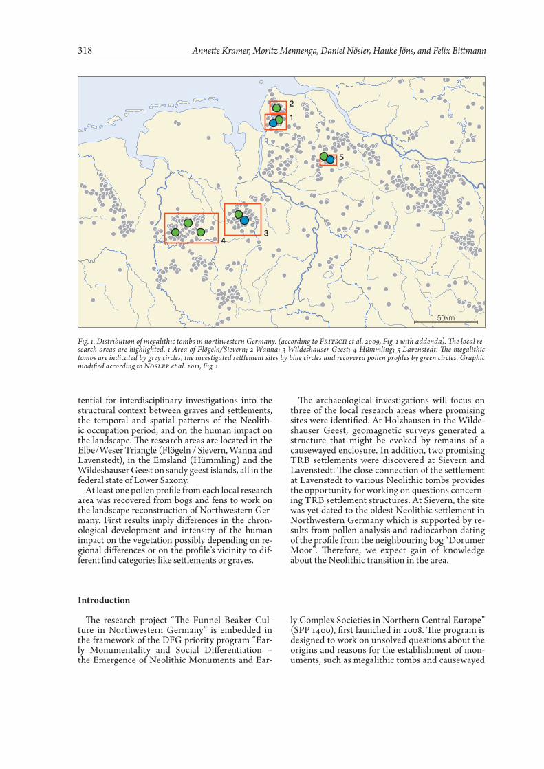
Zur Klärung der neolitischen Siedlungs- und Landnutzungsgeschichte Nordwestdeutschlands werden umfangreiche archäologische und palynolo-gische Untersuchungen im Rahmen des DFG-Schw-erpunktprogramms: „Monumentalität und soziale Differenzierung – Zur Entstehung und Entwick-lung neolithischer Großbauten und erster kom-plexer Gesellschaften im nördlichen Mitteleuropa“ durchgeführt. Zahlreiche Großsteingräber, Grab-hügel und Oberflächenfunde belegen die Siedlung-stätigkeit der Trichterbecherkultur (Westgruppe) und der nachfolgenden Einzelgrabkultur im Un-tersuchungsgebiet. Trotz der Sichtbarkeit dieser Fundgruppen, ist bislang noch relativ wenig über die Siedlungsstruktur sowie die damalige Umwelt und Umweltentwicklung in Nordwestdeutschland während des vierten und dritten Jahrtausend vor Christus bekannt. Daher wurden fünf Kleinre-gionen beispielhaft ausgewählt, in denen eine gute Ausgangslage für die erfolgreiche Untersuchung des strukturalen Zusammenhangs zwischen Gräbern und Siedlungen, der chronologischen und räumli-chen Muster der neolithischen Siedlungstätigkeit sowie des menschlichen Einflusses auf die Umwelt gegeben ist. Die Kleinregionen befinden sich alle in Niedersachsen auf Geestinseln des Elbe/Wes-er Dreiecks (Flögeln / Sievern, Wanna und Laven-stedt), auf dem Geestrücken des Hümmlings im Emsland und auf der Wildeshauser Geest.
Für die palynologischen Untersuchungen liegt nun mindestens ein Profil aus jeder der Regionen
vor, das in den dort anzutreffenden Mooren gebor-gen wurde. Erste Analysen an verschiedenen Pro-filen zeigen Unterschiede im zeitlichen Verlauf und der Intensität des menschlichen Einflusses auf die Vegetation. Möglicherweise ist dies durch die unterschiedliche regionale Lage oder aber durch den Einfluss der verschiedenen Fundkategorien (Gräber oder Siedlungen), die sich in der Nähe der Bohrlokalität befinden, zu erklären.
Nach den Prospektionsmaßnahmen konzen-trieren sich die archäologischen Untersuchungen vorrangig auf drei Kleinregionen. In der Wilde-shauser Geest bei Holzhausen wurde während ge-omagnetischer Prospektionsarbeiten eine Struk-tur entdeckt, die als Hinweis Überreste eines Erdwerks gewertet werden könnte. Außerdem wur-den zwei viel versprechende Siedlungsplätze in Siev-ern und Lavenstedt entdeckt. Die Lage der Sied-lung in Lavenstedt bietet durch die Nachbarschaft zu mehreren neolithischen Gräbern hervorragen-de Bedingungen, um Fragen zu trichterbecher-zeitlichen Siedlungsstrukturen zu klären. In Sievern deuten erste Datierungsergebnisse auf die bislang älteste entdeckte neolithische Siedlung in Nord-westdeutschland. Dies konnte auch durch Polle-nanalysen und Radiokarbondatierungen an einem Torfprofil aus dem benachbarten Dorumer Moor bestätigt werden. Wir erwarten daher einen deutli-chen Erkenntniszugewinn über den Prozess der Ne-olitisierung in Nordwestdeutschland.
Neolithic Settlement and Land Use History in Northwestern Germany – First Results from an Interdisciplinary Research Project
Annette Kramer, Moritz Mennenga, Daniel Nösler, Hauke Jöns, and Felix Bittmann
Abstract
Zusammenfassung
The Neolithic settlement and land use history in northwestern Germany is subject to detailed ar-chaeological and palynological investigations that are carried out within the framework of the DFG priority program “Early Monumentality and Social Differentiation –the Emergence of Neolithic Mon-uments and Early Complex Societies in Northern Central Europe”. Up to now, only little is known
about the settlement structure and the environmen-tal conditions and changes in northwestern Germa-ny during the 4th and 3rd millennium BC, although various megalithic monuments, grave mounds as well as surface finds indicate that the area was set-tled by the West Group of the Funnel Beaker and the subsequent Single Grave Cultures. Therefore, five local research areas were selected that bear high po-
In: M. Hinz/ J. Müller (Hrsg.), Siedlung, Grabenwerk, Großsteingrab.Studien zu Gesellschaft, Wirtschaft und Umwelt
der Trichterbechergruppen im nördlichen Mitteleuropa.Frühe Monumentalität und soziale Differenzierung 2 (Bonn 2012) 317 – 336.
318 Annette Kramer, Moritz Mennenga, Daniel Nösler, Hauke Jöns, and Felix Bittmann
tential for interdisciplinary investigations into the structural context between graves and settlements, the temporal and spatial patterns of the Neolith-ic occupation period, and on the human impact on the landscape. The research areas are located in the Elbe/Weser Triangle (Flögeln / Sievern, Wanna and Lavenstedt), in the Emsland (Hümmling) and the Wildeshauser Geest on sandy geest islands, all in the federal state of Lower Saxony.
At least one pollen profile from each local research area was recovered from bogs and fens to work on the landscape reconstruction of Northwestern Ger-many. First results imply differences in the chron-ological development and intensity of the human impact on the vegetation possibly depending on re-gional differences or on the profile’s vicinity to dif-ferent find categories like settlements or graves.
The archaeological investigations will focus on three of the local research areas where promising sites were identified. At Holzhausen in the Wilde-shauser Geest, geomagnetic surveys generated a structure that might be evoked by remains of a causewayed enclosure. In addition, two promising TRB settlements were discovered at Sievern and Lavenstedt. The close connection of the settlement at Lavenstedt to various Neolithic tombs provides the opportunity for working on questions concern-ing TRB settlement structures. At Sievern, the site was yet dated to the oldest Neolithic settlement in Northwestern Germany which is supported by re-sults from pollen analysis and radiocarbon dating of the profile from the neighbouring bog “Dorumer Moor”. Therefore, we expect gain of knowledge about the Neolithic transition in the area.
Introduction
The research project “The Funnel Beaker Cul-ture in Northwestern Germany” is embedded in the framework of the DFG priority program “Ear-ly Monumentality and Social Differentiation – the Emergence of Neolithic Monuments and Ear-
ly Complex Societies in Northern Central Europe” (SPP 1400), first launched in 2008. The program is designed to work on unsolved questions about the origins and reasons for the establishment of mon-uments, such as megalithic tombs and causewayed
2
5
34
1
50km
Fig. 1. Distribution of megalithic tombs in northwestern Germany. (according to Fritsch et al. 2009, Fig. 1 with addenda). The local re-search areas are highlighted. 1 Area of Flögeln/Sievern; 2 Wanna; 3 Wildeshauser Geest; 4 Hümmling; 5 Lavenstedt. The megalithic tombs are indicated by grey circles, the investigated settlement sites by blue circles and recovered pollen profiles by green circles. Graphic modified according to Nösler et al. 2011, Fig. 1.
319Neolithic Settlement and Land Use History in Northwestern Germany
enclosures, in order to shed light on the cultural context of Neolithic societies in Northern Europe since 4100 BC (compiled by Müller 2009; 2011).
In Northwestern Germany, the distribution area of the west group of the Funnel Beaker Culture (TRB) and the Single Grave Culture (EGK) is to be investigated. Several traces were left by both cul-tures in the areas between the Elbe and Ems riv-ers. The most prominent features are the numerous megalithic tombs that – at least partly – still shape today’s landscape (Fig. 1). They have often been ob-jects of scientific research as their architecture and distribution reveal regional differences in settlement intensities and land use. In addition, a few flat graves, hoards, and settlements with building features are known (complied by Assendorp 1999; Kossian 2005; Laux 1995; Strahl 1990), while no cause-wayed enclosures have yet been identified from the mentioned area (compiled by Richter 2002, 3 pp.).
Therefore, this setting is ideally suited for inves-tigations into the Neolithic colonisation history of the 4 th and the early 3 rd millennia BC. The research project of the Lower Saxony Institute for Histor-ical Coastal Research (NIhK) commences here. Within the project it is necessary to explore wheth-er the rare TRB settlement features can be consid-
ered to be characteristic for this epoch and which settlement pattern might be presumed. Hence, the localisation and the extensive examination of well-preserved TRB and EKG settlements are of great significance (Nösler et al. 2011). The relationships between graves and coexistent settlements and the existence of hierarchical structures among single settlements and graves, respectively, are important topics that will be addressed within the examina-tions.
It is also of great importance to know which nat-ural preconditions the Neolithic settlers had to deal with and which climatic and ecological chang-es they had to face. Palynological investigations will give insights into these developments. A num-ber of further questions are to be investigated. For example, when was the TRB established on the Northwestern German Plain? From which cultures (Ertebølle, Swifterband, Rössen / Bischheim) did the TRB evolve? Which culture(s) influenced the TRB, and what reasons were crucial for this devel-opment? The transition from the TRB to the EGK, including when and why it took place, will also be analysed. The state of the art prior to the project’s commencement and its first results shall be pre-sented in the following.
Current State of Research
The landscape in Northwestern Germany is char-acterised by sandy moraines (geest), marshes, tidal flats and expansive swamps and bogs. While only few pottery and stone artefacts from the TRB and EGK were found in the marsh and on the tidal flats, most finds from this region were recovered on the sandy geest and the area that is nowadays covered with bogs. Bog growth started around 6000 BC. The expansion was triggered by the transgression of the North Sea resulting in more pronounced oceanic climate conditions (Behre 2005; Behre et al. 2001). Bog expansions successively displaced the closed mixed oak-lime forests that dominat-ed the geest before the onset of the Neolithic. The higher geest areas became islands enclosed by bogs (cf. Behre / Kucan 1994). This development did not only causes changes in vegetation but possi-bly reduced the potential settlement area of the Neolithic inhabitants and overgrew graves and al-ready established settlement sites (Behre 2005). In addition to the expansion of bogs, the landscape and vegetation were also shaped by the invention of husbandry. The elm decline, which is observed synchronously in Northwestern Germany, marks the transition to a Neolithic economy in the area. The decline was probably triggered by the elm dis-ease – an Ascomycota infection – that is trans-ferred by the elm bark beetle (Scolytus scolytus). The synchronous character of the decline points
to further factors which may have promoted the spreading of the infection. It is assumed that hu-man activity, such as cutting twigs for leaves, facili-tated the establishment of the infection (cf. compi-lation Heider 1995, 91 f.).
Important insights into Neolithic vegetation his-tory were inferred from the geest island of Flögeln (Behre / Kučan 1994). Within the archaeolog-ically inspired project, ten kettle-hole bogs were examined to reconstruct the vegetation and set-tlement history of the area. The detailed palyno-logical analyses suggest a first moderate influence on the vegetation that was later more pronounced. Behre and Kučan (1994) assume that the subsist-ence strategy of the first Neolithic people focused on animal husbandry. They interpreted the elm de-cline and high total tree pollen as well as low grass pollen as indicators of leaf fodder management, while wood pasture was excluded. This subsist-ence strategy is still found today in some regions in the Alps, the Black Forest and the Mediterrane-an. Alternative interpretations of the consequenc-es of human impact on vegetation are currently un-der debate, considering that forest clearance as an effect of wood pasture is difficult to evaluate from palynological data (cf. Groenman-van Waater-inge 1993; Kreuz 2008).
A marked interference of humans on vegetation is evidenced, on the one hand, by declining tree pollen
320 Annette Kramer, Moritz Mennenga, Daniel Nösler, Hauke Jöns, and Felix Bittmann
and, on the other hand, by increases of primary and secondary agricultural indicators like the pollen of the Cerealia-type and Plantago lanceolata after 3500 cal BC. During that time span, the landscape opened up. Wood pasture and agriculture were probably pre-sent in the area. This development is often referred to as a “landnam phase” according to Iversen’s inter-pretations (1941) of past land use in Denmark. Im-portant crop plants included Triticum monococcum, T. dicoccum, some T. compactum and Hordeum vulgare.
How these results might be transferred to the entire region of the study area is yet to be determined. How-ever, several studies in coastal regions of the North Sea showed similarities to the results from Flögeln (Dörfler 1989; Heider 1995; Bakker 2003). Those studies also noted a different character of subsistence strategies dependent on the respective environment (Bakker 2003). The studies carried out within the framework of the SPP will help to understand Neo-lithic landscape history in Lower Saxony.
1 2
3 4
5 6
7
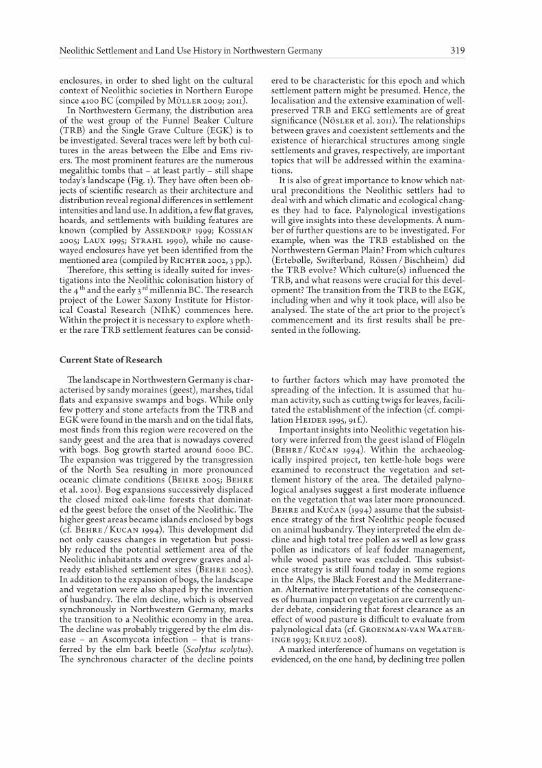
Fig. 2. TRB house floor plans from northwestern Germany. 1. Wittenwater (Voss 1965, Fig. 2), 2. Engter (Rost / Wilbers-Rost 1992, Fig. 3), 3 Flögeln-Eekhöltjen Haus 1 (Zimmermann 1980, Fig. 2), 4. Flögeln-Eekhöltjen, Haus 2 (Zimmermann 2008, Fig. 11.3), 5 Pen-nigbüttel Haus A, 6 Pennigbüttel Haus B (Assendorp 2000, Fig. 3 and 4), 7. Rullstorf (Gebers 2004, Fig. 1). According to Nösler et al. 2011, Fig. 2.
321Neolithic Settlement and Land Use History in Northwestern Germany
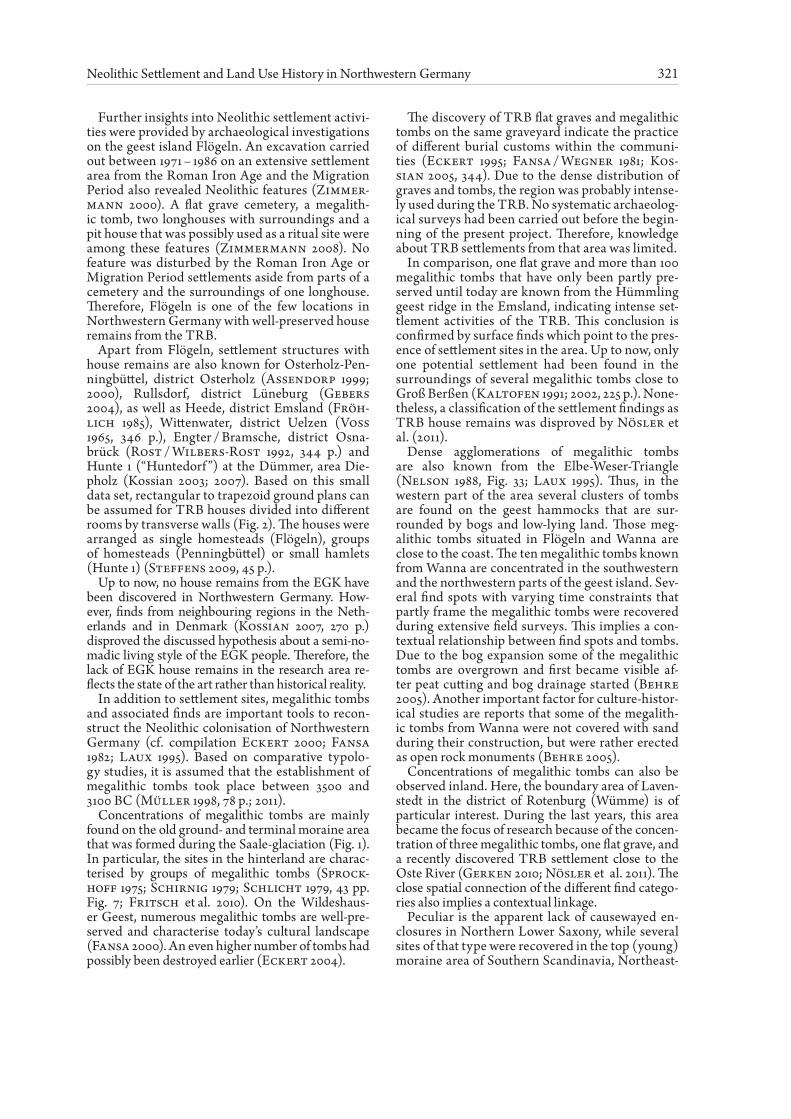
Further insights into Neolithic settlement activi-ties were provided by archaeological investigations on the geest island Flögeln. An excavation carried out between 1971 – 1986 on an extensive settlement area from the Roman Iron Age and the Migration Period also revealed Neolithic features (Zimmer-mann 2000). A flat grave cemetery, a megalith-ic tomb, two longhouses with surroundings and a pit house that was possibly used as a ritual site were among these features (Zimmermann 2008). No feature was disturbed by the Roman Iron Age or Migration Period settlements aside from parts of a cemetery and the surroundings of one longhouse. Therefore, Flögeln is one of the few locations in Northwestern Germany with well-preserved house remains from the TRB.
Apart from Flögeln, settlement structures with house remains are also known for Osterholz-Pen-ningbüttel, district Osterholz (Assendorp 1999; 2000), Rullsdorf, district Lüneburg (Gebers 2004), as well as Heede, district Emsland (Fröh-lich 1985), Wittenwater, district Uelzen (Voss 1965, 346 p.), Engter / Bramsche, district Osna-brück (Rost / Wilbers-Rost 1992, 344 p.) and Hunte 1 (“Huntedorf ”) at the Dümmer, area Die-pholz (Kossian 2003; 2007). Based on this small data set, rectangular to trapezoid ground plans can be assumed for TRB houses divided into different rooms by transverse walls (Fig. 2). The houses were arranged as single homesteads (Flögeln), groups of homesteads (Penningbüttel) or small hamlets (Hunte 1) (Steffens 2009, 45 p.).
Up to now, no house remains from the EGK have been discovered in Northwestern Germany. How-ever, finds from neighbouring regions in the Neth-erlands and in Denmark (Kossian 2007, 270 p.) disproved the discussed hypothesis about a semi-no-madic living style of the EGK people. Therefore, the lack of EGK house remains in the research area re-flects the state of the art rather than historical reality.
In addition to settlement sites, megalithic tombs and associated finds are important tools to recon-struct the Neolithic colonisation of Northwestern Germany (cf. compilation Eckert 2000; Fansa 1982; Laux 1995). Based on comparative typolo-gy studies, it is assumed that the establishment of megalithic tombs took place between 3500 and 3100 BC (Müller 1998, 78 p.; 2011).
Concentrations of megalithic tombs are mainly found on the old ground- and terminal moraine area that was formed during the Saale-glaciation (Fig. 1). In particular, the sites in the hinterland are charac-terised by groups of megalithic tombs (Sprock-hoff 1975; Schirnig 1979; Schlicht 1979, 43 pp. Fig. 7; Fritsch et al. 2010). On the Wildeshaus-er Geest, numerous megalithic tombs are well-pre-served and characterise today’s cultural landscape (Fansa 2000). An even higher number of tombs had possibly been destroyed earlier (Eckert 2004).
The discovery of TRB flat graves and megalithic tombs on the same graveyard indicate the practice of different burial customs within the communi-ties (Eckert 1995; Fansa / Wegner 1981; Kos-sian 2005, 344). Due to the dense distribution of graves and tombs, the region was probably intense-ly used during the TRB. No systematic archaeolog-ical surveys had been carried out before the begin-ning of the present project. Therefore, knowledge about TRB settlements from that area was limited.
In comparison, one flat grave and more than 100 megalithic tombs that have only been partly pre-served until today are known from the Hümmling geest ridge in the Emsland, indicating intense set-tlement activities of the TRB. This conclusion is confirmed by surface finds which point to the pres-ence of settlement sites in the area. Up to now, only one potential settlement had been found in the surroundings of several megalithic tombs close to Groß Berßen (Kaltofen 1991; 2002, 225 p.). None-theless, a classification of the settlement findings as TRB house remains was disproved by Nösler et al. (2011).
Dense agglomerations of megalithic tombs are also known from the Elbe-Weser-Triangle (Nelson 1988, Fig. 33; Laux 1995). Thus, in the western part of the area several clusters of tombs are found on the geest hammocks that are sur-rounded by bogs and low-lying land. Those meg-alithic tombs situated in Flögeln and Wanna are close to the coast. The ten megalithic tombs known from Wanna are concentrated in the southwestern and the northwestern parts of the geest island. Sev-eral find spots with varying time constraints that partly frame the megalithic tombs were recovered during extensive field surveys. This implies a con-textual relationship between find spots and tombs. Due to the bog expansion some of the megalithic tombs are overgrown and first became visible af-ter peat cutting and bog drainage started (Behre 2005). Another important factor for culture-histor-ical studies are reports that some of the megalith-ic tombs from Wanna were not covered with sand during their construction, but were rather erected as open rock monuments (Behre 2005).
Concentrations of megalithic tombs can also be observed inland. Here, the boundary area of Laven-stedt in the district of Rotenburg (Wümme) is of particular interest. During the last years, this area became the focus of research because of the concen-tration of three megalithic tombs, one flat grave, and a recently discovered TRB settlement close to the Oste River (Gerken 2010; Nösler et al. 2011). The close spatial connection of the different find catego-ries also implies a contextual linkage.
Peculiar is the apparent lack of causewayed en-closures in Northern Lower Saxony, while several sites of that type were recovered in the top (young) moraine area of Southern Scandinavia, Northeast-
322 Annette Kramer, Moritz Mennenga, Daniel Nösler, Hauke Jöns, and Felix Bittmann
ern Germany and in areas to the south (Meyer 1995; Richter 2002, 112 pp. Fig. 115; Klatt 2009). Therefore, one further purpose of this project is an attempt to ascertain whether there had been any causewayed enclosures in this area.
In conclusion, it can be stated that for the differ-ent areas of Northwestern Germany the extent of existing research on Neolithic settlement and land-scape history varies. For the area between the Elbe and Ems Rivers it could be shown that very good
conditions exist to obtain new insights into the re-lationships between graves and settlements, partic-ularly within the five exemplarily selected local are-as, i.e. Flögeln and Wanna (rural district Cuxhaven), Lavenstedt (rural district Rotenburg), the Wilde-shauser Geest (rural district Oldenburg), and the Hümmling (rural district Emsland). Thus, the pro-ject presented here will focus on the mentioned re-gions (Fig. 1).
Preliminary Results and Activities
Within the first stage of the project, preliminary reports, archives, documentations, and depots were examined to extract relevant information about the settlements. The information was then compiled and analysed by means of a geographical informa-tion system (GIS) to work on the questions raised in the introductory chapter. Furthermore, palyno-logical and archaeological-geophysical surveys were carried out to recover new pollen archives and well-preserved archaeological features and finds.
At the outset, the archaeological investigations were shaped by the heterogenic situation in the five local areas. Pre-digitalised information was avail-able for the regions of the Wildeshauser Geest, Hümmling, and Lavenstedt in the databases of the Lower Saxony State Service for the Preservation of Monuments and the Archaeological Heritage Agency of the rural district Rotenburg (Wümme). For the local areas Wanna and Flögeln, data need-ed to be digitalised first, but the information was ultimately more detailed than for the former men-tioned areas due to completed archaeological sur-veys. The data was used to establish an equivalent information basis for comparative studies among the regions. In addition to the analyses of archive data, investigators carried out geophysical surveys, sondages, and smaller excavations in all local areas to add information to the existing data sets.
The palynological investigations focused on local vegetation and environmental changes within the vicinity of the archaeological find spots. Thus, Ne-olithic settlement activities are readily comprehen-sible and small spatial environmental conditions that the Neolithic settlers had to deal with could be reconstructed. During the first project stage, ex-tensive prospections were aimed at localising Neo-lithic pollen archives (cf. Nösler et al. 2011). Sev-en profiles have been recovered that are now under investigation (Fig. 1). AMS-dating and high reso-lution pollen analyses are being performed to un-derstand the vegetation and land use history of the region. Further insight into TRB and EGK sub-sistence strategies is anticipated on the basis of the analyses that will be reviewed taking the already published data from the region into account.
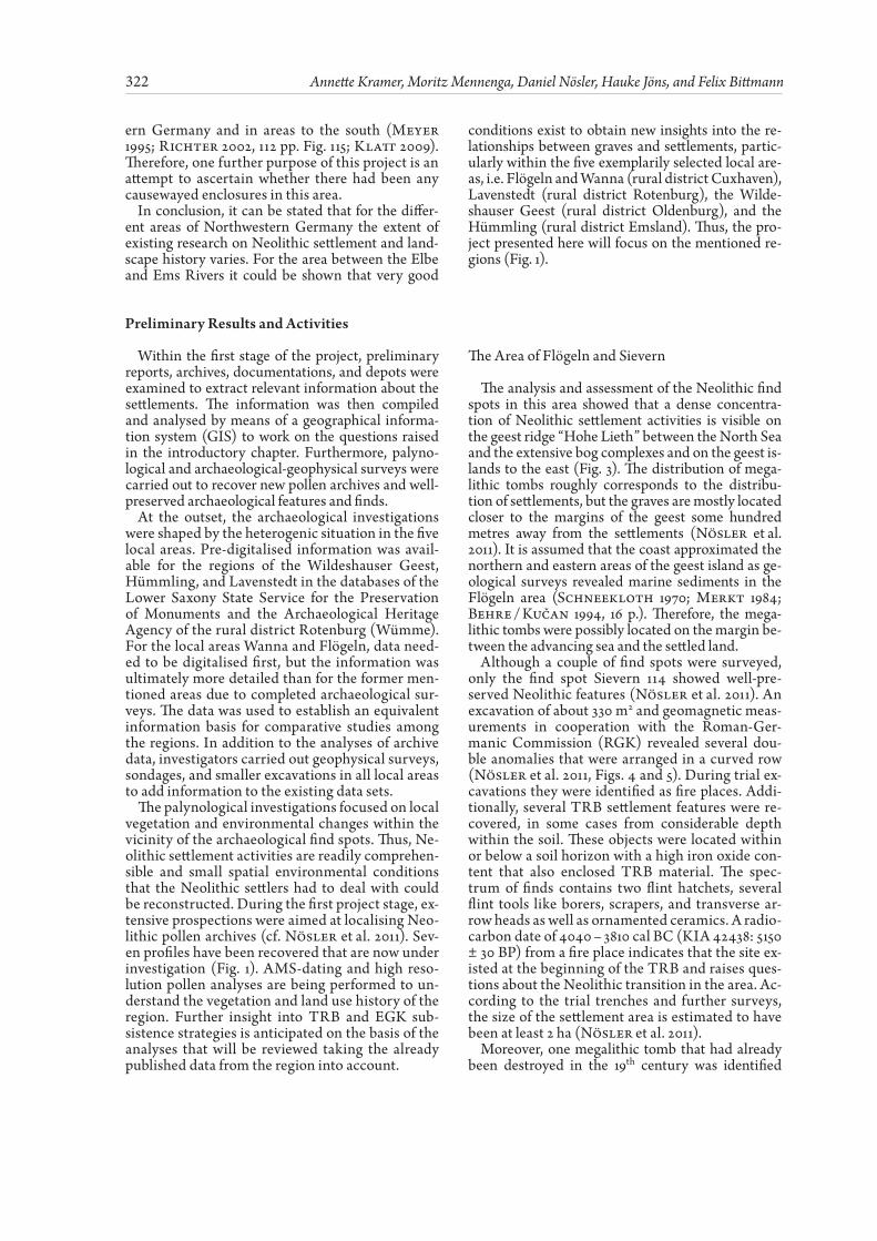
The Area of Flögeln and Sievern
The analysis and assessment of the Neolithic find spots in this area showed that a dense concentra-tion of Neolithic settlement activities is visible on the geest ridge “Hohe Lieth” between the North Sea and the extensive bog complexes and on the geest is-lands to the east (Fig. 3). The distribution of mega-lithic tombs roughly corresponds to the distribu-tion of settlements, but the graves are mostly located closer to the margins of the geest some hundred metres away from the settlements (Nösler et al. 2011). It is assumed that the coast approximated the northern and eastern areas of the geest island as ge-ological surveys revealed marine sediments in the Flögeln area (Schneekloth 1970; Merkt 1984; Behre / Kučan 1994, 16 p.). Therefore, the mega-lithic tombs were possibly located on the margin be-tween the advancing sea and the settled land.
Although a couple of find spots were surveyed, only the find spot Sievern 114 showed well-pre-served Neolithic features (Nösler et al. 2011). An excavation of about 330 m2 and geomagnetic meas-urements in cooperation with the Roman-Ger-manic Commission (RGK) revealed several dou-ble anomalies that were arranged in a curved row (Nösler et al. 2011, Figs. 4 and 5). During trial ex-cavations they were identified as fire places. Addi-tionally, several TRB settlement features were re-covered, in some cases from considerable depth within the soil. These objects were located within or below a soil horizon with a high iron oxide con-tent that also enclosed TRB material. The spec-trum of finds contains two flint hatchets, several flint tools like borers, scrapers, and transverse ar-row heads as well as ornamented ceramics. A radio-carbon date of 4040 – 3810 cal BC (KIA 42438: 5150 ± 30 BP) from a fire place indicates that the site ex-isted at the beginning of the TRB and raises ques-tions about the Neolithic transition in the area. Ac-cording to the trial trenches and further surveys, the size of the settlement area is estimated to have been at least 2 ha (Nösler et al. 2011).
Moreover, one megalithic tomb that had already been destroyed in the 19th century was identified
323Neolithic Settlement and Land Use History in Northwestern Germany
Flögeln
Langen
Sievern
Geest Raised bog Fen bog Inland watersClay district
Pro�leProspection
Megalithic tombSettlement
Palynological investigations
Archaeological sites
N
0 3Kilometers
and possible features of an extensive Neolithic set-tlement were discovered during geomagnetic sur-veys in the south of the geest island of Flögeln. Sum-ming up the results, the investigations carried out so far attest a high potential for further research in the mentioned region. Palynological research on the geest island Flögeln focuses on the establish-ment of a detailed age-depth model for the pol-len profiles obtained by Behre and Kučan (1994). A parallel profile from the kettle-hole bog “Swiens-kuhle” was recovered to avoid problems that might arise when dating material from longer-term stor-age (Wohlfahrt et al. 1998). Up to now, this is the most significant profile from Flögeln as Neolithic vegetation and land use history are best visible here. The pollen events discovered in the original profile, such as the elm and lime declines, a strong increase in anthropogenic indicators, the following spread of heather, and the subsequent generation period (cf. Behre / Kučan 1994) have already been connected to the new profile and AMS dating is under prepara-tion at the Leibniz Laboratory in Kiel.
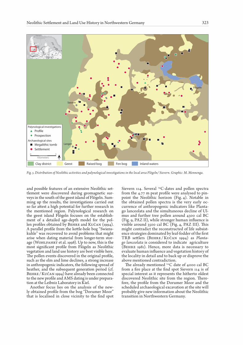
Another focus lies on the analysis of the new-ly obtained profile from the bog “Dorumer Moor” that is localised in close vicinity to the find spot
Sievern 114. Several 14C-dates and pollen spectra from the 4.77 m peat profile were analysed to pin-point the Neolithic horizon (Fig. 4). Notable in the obtained pollen spectra is the very early oc-currence of anthropogenic indicators like Planta-go lanceolata and the simultaneous decline of Ul-mus and further tree pollen around 4300 cal BC (Fig. 9, PAZ II), while stronger human influence is visible around 3500 cal BC (Fig. 4, PAZ III). This might contradict the reconstructed of life subsist-ence strategies dominated by leaf-fodder of the first TRB settlers (Behre / Kučan 1994) as Planta-go lanceolata is considered to indicate agriculture (Behre 1981). Hence, more data is necessary to evaluate human influence and vegetation history of the locality in detail and to back up or disprove the above mentioned contradiction.
The already mentioned 14 C date of 4000 cal BC from a fire place at the find spot Sievern 114 is of special interest as it represents the hitherto oldest discovered Neolithic site from the region. There-fore, the profile from the Dorumer Moor and the scheduled archaeological excavation at the site will probably give new information about the Neolithic transition in Northwestern Germany.
Fig. 3. Distribution of Neolithic activities and palynological investigations in the local area Flögeln/ Sievern. Graphic: M. Mennenga.
324 Annette Kramer, Moritz Mennenga, Daniel Nösler, Hauke Jöns, and Felix Bittmann
(1130-1000) 3710–36403500–3430
3110–2920
4360–4260
4690–4490
6080–5880
2470–2300
340
360
380
400
420
440
460
320
300
280
Plan
tago
lanc
eola
ta
Age
BC
Dep
th (c
m)
Poac
eae
Cer
ealia
p.p
.
Bet
ula
Que
rcus
Ulm
us
Tilia
Frax
inus
Cor
ylus
Mel
ampy
rum
Rum
ex a
ceto
sa
Pter
idiu
m
Cal
una
PAZ IV
PAZ III
PAZ III
PAZ I
40 80 40 20 20 20 20 4080
Fig. 4. Pollen diagram from the Dorumer Moor. Percentages refer to total tree pollen (~500 grains were counted). Calibrated 14C Ages are within the 2-σ-range. PAZ: Pollen assemblage zones (Analysis: A. Kramer).
Fig. 5. Distribution of Neolithic activities and palynological investigations in the local area Wanna. Graphic: M. Mennenga.
Wanhöden
WannaPro�leProspection
Megalithic tombTBK
Palynological investigations
Archaeological sites
Flint �akes1050
100500
N
EGK / late neolithicNeolithic
0 2
Kilometers
Geest Raised bog Fen bogClay district
325Neolithic Settlement and Land Use History in Northwestern Germany
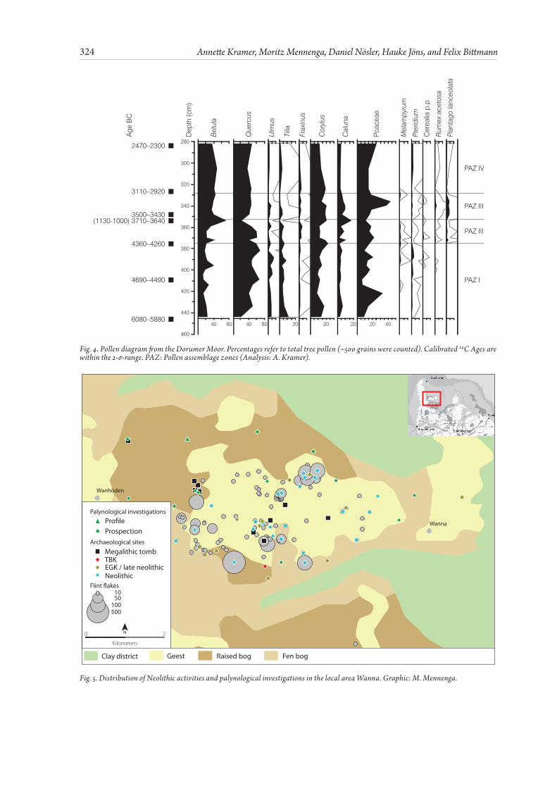
The Geest Island of Wanna
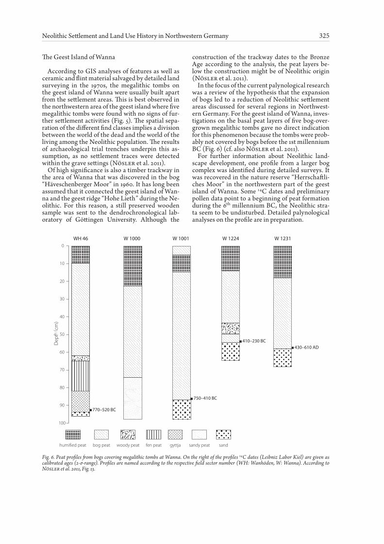
According to GIS analyses of features as well as ceramic and flint material salvaged by detailed land surveying in the 1970s, the megalithic tombs on the geest island of Wanna were usually built apart from the settlement areas. This is best observed in the northwestern area of the geest island where five megalithic tombs were found with no signs of fur-ther settlement activities (Fig. 5). The spatial sepa-ration of the different find classes implies a division between the world of the dead and the world of the living among the Neolithic population. The results of archaeological trial trenches underpin this as-sumption, as no settlement traces were detected within the grave settings (Nösler et al. 2011).
Of high significance is also a timber trackway in the area of Wanna that was discovered in the bog “Häveschenberger Moor” in 1960. It has long been assumed that it connected the geest island of Wan-na and the geest ridge “Hohe Lieth” during the Ne-olithic. For this reason, a still preserved wooden sample was sent to the dendrochronological lab-oratory of Göttingen University. Although the
construction of the trackway dates to the Bronze Age according to the analysis, the peat layers be-low the construction might be of Neolithic origin (Nösler et al. 2011).
In the focus of the current palynological research was a review of the hypothesis that the expansion of bogs led to a reduction of Neolithic settlement areas discussed for several regions in Northwest-ern Germany. For the geest island of Wanna, inves-tigations on the basal peat layers of five bog-over-grown megalithic tombs gave no direct indication for this phenomenon because the tombs were prob-ably not covered by bogs before the 1st millennium BC (Fig. 6) (cf. also Nösler et al. 2011).
For further information about Neolithic land-scape development, one profile from a larger bog complex was identified during detailed surveys. It was recovered in the nature reserve “Herrschaftli-ches Moor” in the northwestern part of the geest island of Wanna. Some 14C dates and preliminary pollen data point to a beginning of peat formation during the 6th millennium BC, the Neolithic stra-ta seem to be undisturbed. Detailed palynological analyses on the profile are in preparation.
Fig. 6. Peat profiles from bogs covering megalithic tombs at Wanna. On the right of the profiles 14C dates (Leibniz Labor Kiel) are given as calibrated ages (2-σ-range). Profiles are named according to the respective field sector number (WH: Wanhöden, W: Wanna). According to Nösler et al. 2011, Fig. 13.
Dep
th( c
m)
100
80
70
60
50
40
30
20
10
0
90
WH 46 W 1000 W 1001 W 1224 W 1231
770–520 BC
750–410 BC
410–230 BC430–610 AD
humified peat bog peat woody peat fen peat gyttja sandy peat sand
326 Annette Kramer, Moritz Mennenga, Daniel Nösler, Hauke Jöns, and Felix Bittmann
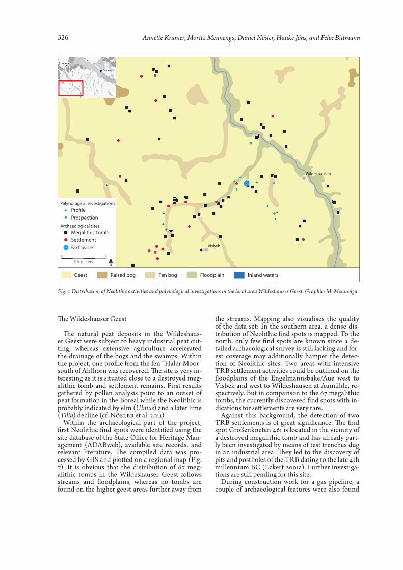
The Wildeshauser Geest
The natural peat deposits in the Wildeshaus-er Geest were subject to heavy industrial peat cut-ting, whereas extensive agriculture accelerated the drainage of the bogs and the swamps. Within the project, one profile from the fen “Haler Moor” south of Ahlhorn was recovered. The site is very in-teresting as it is situated close to a destroyed meg-alithic tomb and settlement remains. First results gathered by pollen analysis point to an outset of peat formation in the Boreal while the Neolithic is probably indicated by elm (Ulmus) and a later lime (Tilia) decline (cf. Nösler et al. 2011).
Within the archaeological part of the project, first Neolithic find spots were identified using the site database of the State Office for Heritage Man-agement (ADABweb), available site records, and relevant literature. The compiled data was pro-cessed by GIS and plotted on a regional map (Fig. 7). It is obvious that the distribution of 67 meg-alithic tombs in the Wildeshauser Geest follows streams and floodplains, whereas no tombs are found on the higher geest areas further away from
the streams. Mapping also visualises the quality of the data set: In the southern area, a dense dis-tribution of Neolithic find spots is mapped. To the north, only few find spots are known since a de-tailed archaeological survey is still lacking and for-est coverage may additionally hamper the detec-tion of Neolithic sites. Two areas with intensive TRB settlement activities could be outlined on the floodplains of the Engelmannsbäke/Aue west to Visbek and west to Wildeshausen at Aumühle, re-spectively. But in comparison to the 67 megalithic tombs, the currently discovered find spots with in-dications for settlements are very rare.
Against this background, the detection of two TRB settlements is of great significance. The find spot Großenkneten 461 is located in the vicinity of a destroyed megalithic tomb and has already part-ly been investigated by means of test trenches dug in an industrial area. They led to the discovery of pits and postholes of the TRB dating to the late 4th millennium BC (Eckert 2001a). Further investiga-tions are still pending for this site.
During construction work for a gas pipeline, a couple of archaeological features were also found
Wildeshausen
Visbek
Pro�leProspection
Megalithic tombSettlement
Palynological investigations
Archaeological sites
Earthwork
0 4Kilometers
N
Geest Raised bog Fen bog Floodplain Inland waters
Fig. 7. Distribution of Neolithic activities and palynological investigations in the local area Wildeshauser Geest. Graphic: M. Mennenga.
327Neolithic Settlement and Land Use History in Northwestern Germany
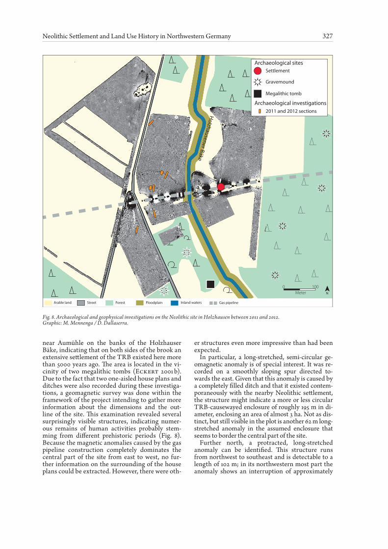
near Aumühle on the banks of the Holzhauser Bäke, indicating that on both sides of the brook an extensive settlement of the TRB existed here more than 5000 years ago. The area is located in the vi-cinity of two megalithic tombs (Eckert 2001 b). Due to the fact that two one-aisled house plans and ditches were also recorded during these investiga-tions, a geomagnetic survey was done within the framework of the project intending to gather more information about the dimensions and the out-line of the site. This examination revealed several surprisingly visible structures, indicating numer-ous remains of human activities probably stem-ming from different prehistoric periods (Fig. 8). Because the magnetic anomalies caused by the gas pipeline construction completely dominates the central part of the site from east to west, no fur-ther information on the surrounding of the house plans could be extracted. However, there were oth-
er structures even more impressive than had been expected.
In particular, a long-stretched, semi-circular ge-omagnetic anomaly is of special interest. It was re-corded on a smoothly sloping spur directed to-wards the east. Given that this anomaly is caused by a completely filled ditch and that it existed contem-poraneously with the nearby Neolithic settlement, the structure might indicate a more or less circular TRB-causewayed enclosure of roughly 195 m in di-ameter, enclosing an area of almost 3 ha. Not as dis-tinct, but still visible in the plot is another 62 m long-stretched anomaly in the assumed enclosure that seems to border the central part of the site.
Further north, a protracted, long-stretched anomaly can be identified. This structure runs from northwest to southeast and is detectable to a length of 102 m; in its northwestern most part the anomaly shows an interruption of approximately
Fig. 8. Archaeological and geophysical investigations on the Neolithic site in Holzhausen between 2011 and 2012.Graphic: M. Mennenga / D. Dallaserra.
Holzhausener Bäke
Arable land Street Forest Floodplain Inland waters Gas pipeline
Holzhausener Bäke
Holzhausener Bäke
Meter0 100
N
SettlementArchaeological sites
Gravemound
Megalithic tomb
Archaeological investigations2011 and 2012 sections
328 Annette Kramer, Moritz Mennenga, Daniel Nösler, Hauke Jöns, and Felix Bittmann
7 m in width. At both ends of the gap deflections could be identified running in southwest direction. Provided that these structures are equally based on ditches and walls, it seems obvious that an in-turned gateway existed here originally.
A first hint for the relative dating of these structures can also be extracted directly from the geomagnetic measurements. Of special interest in this regard are rectangular structures with expansions that meas-ure roughly between 17 x 17 m and 21 x 20 m. These structures may be considered to be the remains of Celtic fields. Such field systems are well known in Northwestern Germany and the Netherlands for the Pre-Roman Iron Age and the Roman Period (Zim-mermann 1995; Kooistra / Maas 2008). Because the Celtic fields undoubtedly superimpose the long stretched structures described above, they may indi-cate a terminus ante quem. Therefore, it can certain-ly be assumed that these structures arose in the peri-od before the turn of the eras.
Last but not least a couple of dipol anomalies and circular structures of up to 20 m in diameter have to be mentioned that are probably caused by the remains of destroyed megalithic tombs and grave mounds of unknown age.
Aiming to gather more information about these structures, first trial trenches were dug in March 2011 focusing on the northern and southern sec-tions of the ditches probably belonging to the cir-cular ditch system as well as on the structure in the centre of the potential enclosure (Fig. 8) In ad-dition, another trial trench was excavated in a sec-tion of the long stretched anomaly north of the pre-sumed inturned gateway. Finally, a small area in the southern part of the area was also excavated, aiming at finding the cause for the geomagnetic di-pole anomaly.
During the campaign it became rapidly clear that most of the geomagnetic anomalies could hard-
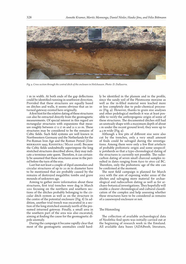
ly be identified in the planum and in the profile, since the sandy soil of the Pleistocene moraine as well as the in-filled material were leached more or less completely due to pedo-chemical process-es (Fig. 9). However, thanks to grain size analyses and other pedological methods it was at least pos-sible to verify the anthropogenic origin of some of these structures. The documented ditches still had an unsteady shape with a maximum depth of about 1 m under the recent ground level; they were up to 4.5 m wide (Fig. 9).
Although a few pits of different size were also cut by the trenches, only a very small amount of finds could be salvaged during the investiga-tions. Among them were only a few flint artefacts of probable prehistoric origin and some unspecif-ic potsherds so that a typo-chronological dating of the structures is currently not possible. The radio-carbon dating of seven small charcoal samples re-sulted in dates ranging from 8300 to 1600 cal BC. Therefore, only the prehistoric age of the site can be confirmed at the moment.
The next field campaign is planned for March 2012 with the aim of exposing wider areas of the ditches and salvaging more material for archae-ological and radiocarbon dating as well as for ar-chaeo-botanical investigations. They hopefully will enable a clearer chronological and cultural classifi-cation of the complex and help assessing whether these structures have to be considered as remains of a causewayed enclosure or not.
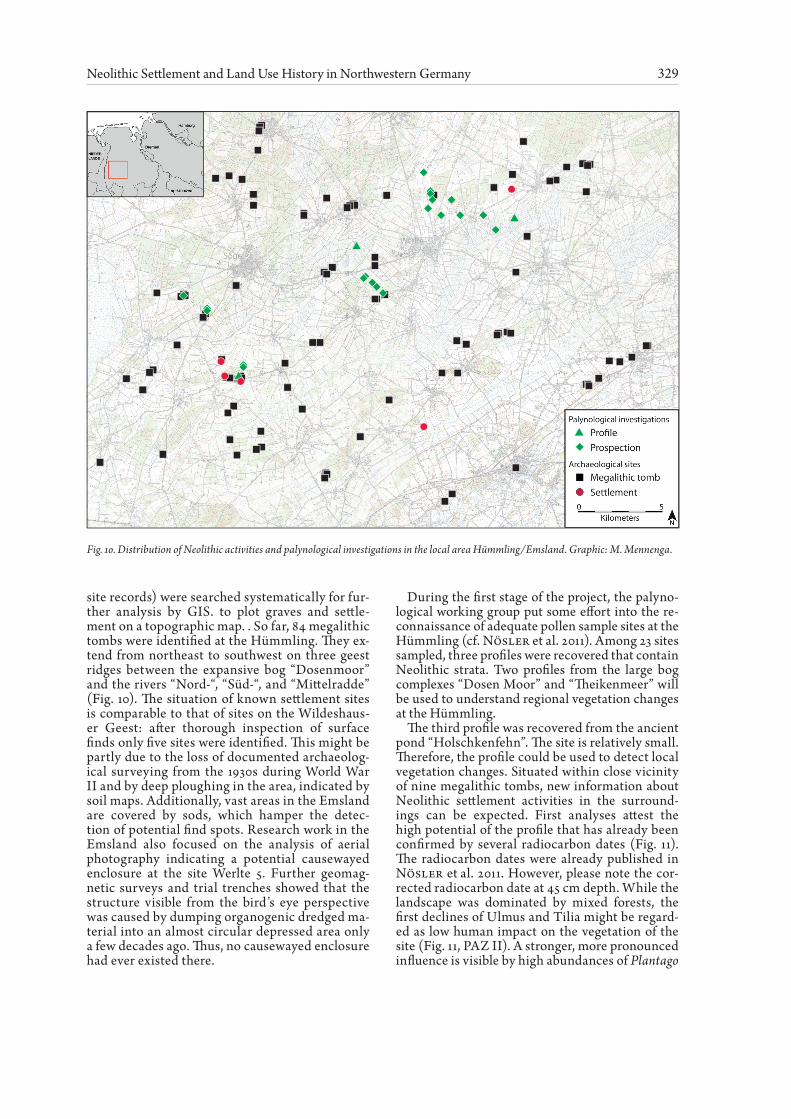
The Hümmling
The collection of available archaeological data of Neolithic find spots was initially carried out at the beginning of research work in the Emsland. All available data bases (ADABweb, literature,
Fig. 9. Cross section through the central ditch of the enclosure in Holzhausen. Photo: D. Dallaserra.
329Neolithic Settlement and Land Use History in Northwestern Germany
site records) were searched systematically for fur-ther analysis by GIS. to plot graves and settle-ment on a topographic map. . So far, 84 megalithic tombs were identified at the Hümmling. They ex-tend from northeast to southwest on three geest ridges between the expansive bog “Dosenmoor” and the rivers “Nord-“, “Süd-“, and “Mittelradde” (Fig. 10). The situation of known settlement sites is comparable to that of sites on the Wildeshaus-er Geest: after thorough inspection of surface finds only five sites were identified. This might be partly due to the loss of documented archaeolog-ical surveying from the 1930s during World War II and by deep ploughing in the area, indicated by soil maps. Additionally, vast areas in the Emsland are covered by sods, which hamper the detec-tion of potential find spots. Research work in the Emsland also focused on the analysis of aerial photography indicating a potential causewayed enclosure at the site Werlte 5. Further geomag-netic surveys and trial trenches showed that the structure visible from the bird’s eye perspective was caused by dumping organogenic dredged ma-terial into an almost circular depressed area only a few decades ago. Thus, no causewayed enclosure had ever existed there.
During the first stage of the project, the palyno-logical working group put some effort into the re-connaissance of adequate pollen sample sites at the Hümmling (cf. Nösler et al. 2011). Among 23 sites sampled, three profiles were recovered that contain Neolithic strata. Two profiles from the large bog complexes “Dosen Moor” and “Theikenmeer” will be used to understand regional vegetation changes at the Hümmling.
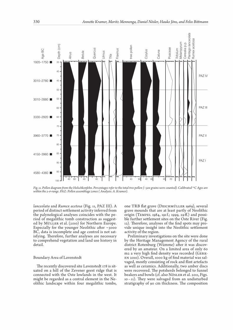
The third profile was recovered from the ancient pond “Holschkenfehn”. The site is relatively small. Therefore, the profile could be used to detect local vegetation changes. Situated within close vicinity of nine megalithic tombs, new information about Neolithic settlement activities in the surround-ings can be expected. First analyses attest the high potential of the profile that has already been confirmed by several radiocarbon dates (Fig. 11). The radiocarbon dates were already published in Nösler et al. 2011. However, please note the cor-rected radiocarbon date at 45 cm depth. While the landscape was dominated by mixed forests, the first declines of Ulmus and Tilia might be regard-ed as low human impact on the vegetation of the site (Fig. 11, PAZ II). A stronger, more pronounced influence is visible by high abundances of Plantago
Fig. 10. Distribution of Neolithic activities and palynological investigations in the local area Hümmling/Emsland. Graphic: M. Mennenga.
330 Annette Kramer, Moritz Mennenga, Daniel Nösler, Hauke Jöns, and Felix Bittmann
lanceolata and Rumex acetosa (Fig. 11, PAZ III). A period of distinct settlement activity inferred from the palynological analyses coincides with the pe-riod of megalithic tomb construction as suggest-ed by Müller et al. (2010) for Northern Europe. Especially for the younger Neolithic after ~3000 BC, data is incomplete and age control is not sat-isfying. Therefore, further analyses are necessary to comprehend vegetation and land use history in detail.
Boundary Area of Lavenstedt
The recently discovered site Lavenstedt 178 is sit-uated on a hill of the Zevener geest ridge that is connected with the Oste lowlands in the west. It might be regarded as a central element in the Ne-olithic landscape within four megalithic tombs,
one TRB flat grave (Deichmüller 1969), several grave mounds that are at least partly of Neolithic origin (Tempel 1984, 191 f.; 1999, 29 ff.) and possi-ble further settlement sites on the Oste River (Fig. 12). Therefore, analyses of the find spots may pro-vide unique insight into the Neolithic settlement activity of the region.
Preliminary investigations on the site were done by the Heritage Management Agency of the rural district Rotenburg (Wümme) after it was discov-ered by an amateur. On a limited area of only 60 m2 a very high find density was recorded (Gerk-en 2010). Overall, 1000 kg of find material was sal-vaged, mostly consisting of rock and flint artefacts as well as ceramics. Additionally, two amber discs were recovered. The potsherds belonged to funnel beakers and bowls (cf. also Nösler et al. 2011, Figs. 10 – 11). They were salvaged from an undisturbed stratigraphy of 90 cm thickness. The composition
3010–2880
3010–2780
3330–2920
3960–3770
4150–3960
4580–4360
1920–1750 35
40
45
50
55
60
65
70
75
80
85
90
95
100
Plan
tago
lanc
eola
ta
Age
BC
Dep
th (c
m)
Poac
eae
Cer
ealia
p.p
.
Alnu
s
Bet
ula
Que
rcus
Ulm
us
Tilia
Frax
inus
Cor
ylus
Mel
ampy
rum
Rum
ex a
ceto
sa
Trifo
lium
Cal
una
PAZ IV
PAZ III
PAZ II
PAZ I
40 40 4080 40 80 40 80 40 20
tree
polle
n
Fig. 11. Pollen diagram from the Holschkenfehn. Percentages refer to the total tree pollen (~500 grains were counted). Calibrated 14C Ages are within the 2-σ-range. PAZ: Pollen assemblage zones ( Analysis: A. Kramer).

331Neolithic Settlement and Land Use History in Northwestern Germany
of that material indicates that the finds represent a closed inventory of the Early Middle Neolithic pe-riod. First 14C AMS dating on charcoal revealed an age of 3370 – 3090 cal BC (4537 ± 44 BP ERL-14449) (Nösler et al. 2011).
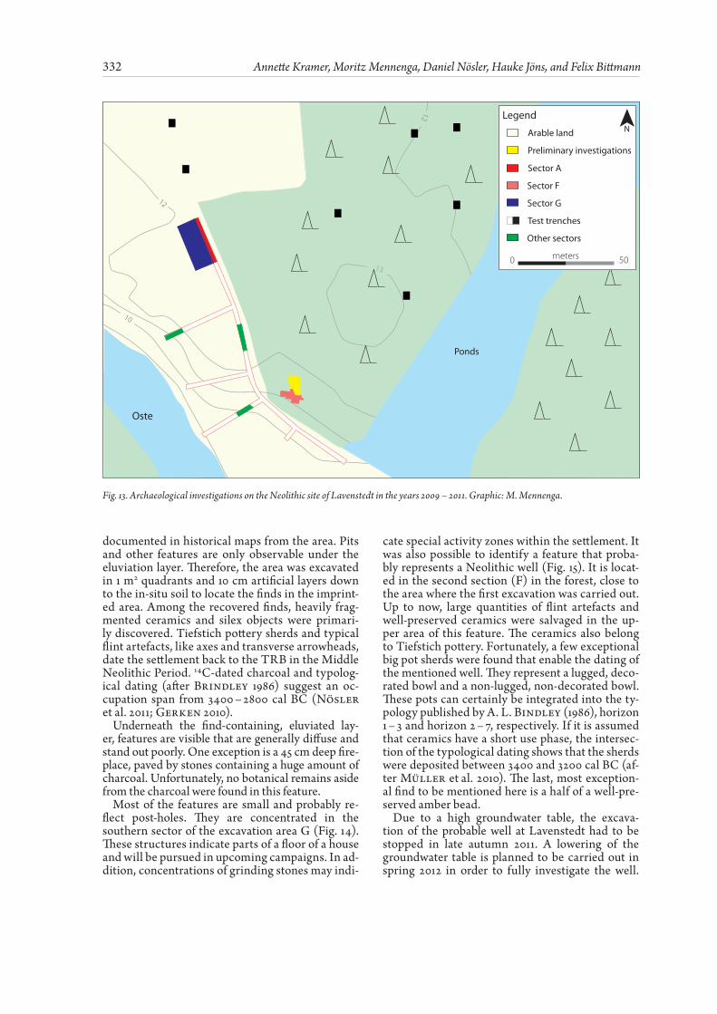
Based on the investigations mentioned above, the NIhK joined the project in 2010 aiming to get new information about the extent, the structure, and the cultural context of the settlement and to explore fea-ture preservation on the agricultural area in use. Therefore, trail trenches were excavated in 2010 that expanded the previously investigated area over a small hill, from north to south. Furthermore, sond-ages were laid in the forest nearby (Fig. 13). The re-sults indicate that the site covers an area of at least 10.000 m2, most of it positioned east and north of the excavated sectors A and G. Very few finds and fea-tures were linked to the Mesolithic or the Iron Age. However, most of them were connected to the TRB. It became apparent that the main part of the site is located in the forest, which rules out broader large-area excavations for technical reasons. Only the western brink beside the Oste River is covered by arable land which showed a slighter deepness of the cultural layer of about 30 cm.
In order to locate further settlement structures, geomagnetic surveys were carried out on the arable land around the find spot in spring 2011. The inves-tigation revealed only a few archaeologically inter-esting anomalies. In the vicinity, structures were found that were interpreted as two abandoned channels of Oste River to the north of the archae-ological site. They were confirmed by pedological and botanical investigations. The basis of the orga-nogenic filling recovered in the channels was dated to the Middle Ages by palynological analysis. Thus, the prehistoric connection of the settlement to the Oste is still a question to deal with in the upcom-ing campaign.
The trenches, which contained the most TRB dated features, could be extended up to 260 m2 on the arable land (Fig. 13). Below the Ap-horizon of the field, a 30 cm eluviation layer imprints the ar-chaeological features. This layer appears too in-tense for the stratigraphic sequence which implies that soil possibly had been removed from the field. On the one hand, this might have been caused by land consolidation in the 20th century – as men-tioned by the local farmer. On the other hand, it could be explained by plaggen cultivation which is
Fig. 12. Distribution of Neolithic activities in the local area Lavenstedt (according to Nösler et al. 2011, Fig. 8) Graphic: M. Mennenga.
332 Annette Kramer, Moritz Mennenga, Daniel Nösler, Hauke Jöns, and Felix Bittmann
documented in historical maps from the area. Pits and other features are only observable under the eluviation layer. Therefore, the area was excavated in 1 m2 quadrants and 10 cm artificial layers down to the in-situ soil to locate the finds in the imprint-ed area. Among the recovered finds, heavily frag-mented ceramics and silex objects were primari-ly discovered. Tiefstich pottery sherds and typical flint artefacts, like axes and transverse arrowheads, date the settlement back to the TRB in the Middle Neolithic Period. 14C-dated charcoal and typolog-ical dating (after Brindley 1986) suggest an oc-cupation span from 3400 – 2800 cal BC (Nösler et al. 2011; Gerken 2010).
Underneath the find-containing, eluviated lay-er, features are visible that are generally diffuse and stand out poorly. One exception is a 45 cm deep fire-place, paved by stones containing a huge amount of charcoal. Unfortunately, no botanical remains aside from the charcoal were found in this feature.
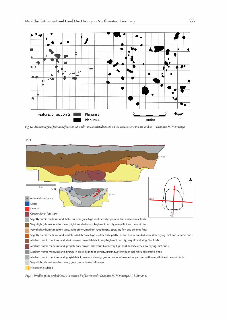
Most of the features are small and probably re-flect post-holes. They are concentrated in the southern sector of the excavation area G (Fig. 14). These structures indicate parts of a floor of a house and will be pursued in upcoming campaigns. In ad-dition, concentrations of grinding stones may indi-
cate special activity zones within the settlement. It was also possible to identify a feature that proba-bly represents a Neolithic well (Fig. 15). It is locat-ed in the second section (F) in the forest, close to the area where the first excavation was carried out. Up to now, large quantities of flint artefacts and well-preserved ceramics were salvaged in the up-per area of this feature. The ceramics also belong to Tiefstich pottery. Fortunately, a few exceptional big pot sherds were found that enable the dating of the mentioned well. They represent a lugged, deco-rated bowl and a non-lugged, non-decorated bowl. These pots can certainly be integrated into the ty-pology published by A. L. Bindley (1986), horizon 1 – 3 and horizon 2 – 7, respectively. If it is assumed that ceramics have a short use phase, the intersec-tion of the typological dating shows that the sherds were deposited between 3400 and 3200 cal BC (af-ter Müller et al. 2010). The last, most exception-al find to be mentioned here is a half of a well-pre-served amber bead.
Due to a high groundwater table, the excava-tion of the probable well at Lavenstedt had to be stopped in late autumn 2011. A lowering of the groundwater table is planned to be carried out in spring 2012 in order to fully investigate the well.
13
12
12
10
Oste
Ponds
Legend
Arable land
Sector A
Preliminary investigations
Sector G
Sector F
Test trenches
Other sectors
0 50meters
N
Fig. 13. Archaeological investigations on the Neolithic site of Lavenstedt in the years 2009 – 2011. Graphic: M. Mennenga.
333Neolithic Settlement and Land Use History in Northwestern Germany
Fig. 14. Archaeological features of sections A and G in Lavenstedt based on the excavations in 2010 and 2011. Graphic: M. Mennenga.
Fig. 15. Profiles of the probable well in section F of Lavenstedt. Graphic: M. Mennenga / J. Lühmann.
Pr. A
Pr. B 11 masl
Pr. A
10 masl
Pr. B
N
Organic layer, forest soil
Slightly humic medium sand, Aeh - horizon, grey, high root density, sporadic �int and ceramic �nds
Very slightly humic medium sand, light middle brown, high root density, many �int and ceramic �nds
Stone
Ceramic
Very slightly humic medium sand, light brown, medium root density, sporadic �int and ceramic �nds
Slightly humic medium sand, middle - dark brown, high root density, partly Fe- and humic banded, very slow drying, �int and ceramic �nds
Animal disturbance*
Medium humic medium sand, dark brown - brownish black, very high root density, very slow drying, �int �nds
Medium humic medium sand, greyish, dark brown - brownish black, very high root density, very slow drying, �int �nds
Medium humic medium sand, brownish black, high root density, groundwater in�uenced, �int and ceramic �nds
Medium humic medium sand, grayish black, low root density, groundwater in�uenced, upper part with many �int and ceramic �nds
Very slightly humic medium sand, grey, groundwater in�uenced
Pleistocene subsoil
10 m asl
11 m asl
1 m
**
334 Annette Kramer, Moritz Mennenga, Daniel Nösler, Hauke Jöns, and Felix Bittmann
Assuming that the ongoing excavations prove that the presumed function of the feature is indeed cor-rect, it would be the first TRB well excavated in Northwestern Germany.
Further insights into the subsistence strategy of Neolithic people are expected by macro-botani-cal analyses that are being carried out within the framework of the SPP 1400 at the University of Kiel. Preliminary results point to a spectrum of finds comparable to that of the Vlaardingen Group in the Netherlands (cf. Kirleis et al. in press; Brinkkemper et al. 2011) with emmer and naked barley as main crop plants (Kirleis, personal com-munication). Detailed investigations are in pro-gress and will be published soon.
The surroundings of the Lavenstedt 178 site have also been surveyed by the palynological working group aiming to identify pollen archives. So far, twelve localities were prospected but peat preser-vation was only given at seven sites. The evalua-tion of the test profiles showed that some profiles indeed started during the Boreal. Unfortunately, the Neolithic period is lacking, while other profiles were too young or pollen preservation was insuffi-cient. Among the seven sites sampled, only the pro-file from the nature reserve “Huvenhoopsmoor” showed undisturbed peat sequences that can be used for regional vegetation reconstruction of the area. Analyses and dating of the profile are current-ly in progress.
Outlook
The investigations carried out so far indicate that plenty of new information about Neolithic set-tlement structures and Neolithic land use will be gained within the framework of the project. Partic-ularly the rural settlements of Sievern/Flögeln and Lavenstedt as well as the still uncertain causewayed enclosure from Holzhausen are of special signifi-cance and contain high scientific potential. Future archaeological activities will focus on these sites.
The presented palynological results from the Emsland and the geest island of Flögeln reveal dif-
ferences in the chronological and qualitative de-velopment of human impact in the region. The differences between the diagrams need to be eval-uated with regard to their location in Northwest-ern Germany (the hinterland and the coast) as well as to influences from the respective find categories (settle ment sites and megalithic tombs) located in the vicinity of the pollen profiles. Therefore, more high resolution pollen data are necessary for the two profiles as well as from all five regions.
We highly acknowledge the support of Prof. Dr. Friedrich Lüth, German Archaeological Institute, Berlin, and Dr. Knut Rassmann, Roman-German-ic Commission, Frankfurt/Main, in providing the geomagnetic equipment for the research project. Furthermore, we have to thank Dr. H. H. Leusch-ner, dendrochronological laboratory of Göttingen University, for the dendrochronological investiga-tion of a wood sample from Wanna.
Our sincere thanks are extended to the land-owners Klaus Schröder, Lavenstedt and Siegfried Gronholz, Sievern, who make their acreage avail-
able for archaeological investigations. We would like to thank Dr. August Capelle und Dr. Ger-fried Caspers, State Authority for Mining, Energy and Geology, Hannover, for the pedological anal-yses in Lavenstedt and for providing map material for the Hümmling, respectively. We also would like to thank Dr. Annette Siegmüller, Dr. Martina Kar-le, and Imke Brandt, M.A. (all NIhK) for their help in evaluating the pedological situation in Lavenst-edt and Holzhausen. Finally we like to thank Eileen Kücükkaraca for proofreading of the English text.
Acknowledgments
335Neolithic Settlement and Land Use History in Northwestern Germany
References
Assendorp 1999: J. J. Assendorp, Die Häuser der Trichter-becherkultur in Nordwestniedersachsen. Berichte zur Denkmalpflege in Niedersachsen 19, 1999, 180 – 185.
Assendorp 2000: J. J. Assendorp, Die Bauart der trichter-becherzeitlichen Gebäude von Penningbüttel, Nied-ersachsen. In: R. Kelm (ed.), Vom Pfostenloch zum Steinzeithaus. Archäologische Forschung und Rekon-struktion jungsteinzeitlicher Haus- und Siedlungsbefunde im nordwestlichen Mitteleuropa. Albersdorfer Forschun-gen zur Archäologie und Umweltgeschichte 1 (Heide 2000) 116 – 125.
Bakker 2003: R. Bakker, The emergence of agriculture on the Drenthe plateau. A palaebotanical study supported by high-resolution 14 C-dating. Archäologische Berichte 16 (Bonn 2003).
Behre 1981: K.-E. Behre, The interpretation of anthropogen-ic indicators in pollen diagrams. Pollen and Spore 23, 1981, 225 – 245.
Behre 2005: K.-E. Behre, Die Einengung des neolithischen Siedlungsraumes in Nordwestdeutschland durch klima-bedingte Faktoren: Meeresspiegelanstieg und großflächige Ausbreitung von Mooren. In: D. Gronenborn (ed.), Kli-maveränderung und Kulturwandel in neolithischen Ge-sellschaften Mitteleuropas, 6700 – 2200 v. Chr. RGZM-Ta-gungen 1 (Mainz 2005) 209 – 220.
Behre/Kučan 1994: K.-E. Behre, D. Kučan, Die Geschichte der Kulturlandschaft und des Ackerbaus in der Siedlung-skammer Flögeln, Niedersachsen, seit der Jungsteinzeit. Probleme der Küstenforschung im südlichen Nordseegebi-et 21 (Oldenburg 1994).
Behre et al. 2001: K.-E. Behre, B. E. M. Petzelberger, M. A. Geyh, Begin and spread of raised-bog formation in NW-Germany as indicator for environmental change. Past Cli-mate Variability through Europe and Africa. Congress PEP III, Abstracts (Aix-en-Provence 2001) 59 – 60.
Brindley 1986: A. L. Brindley, The typochronology of TRB West Group pottery. Palaeohistoria 28, 1986, 93 – 132.
Brinkkemper et al. 2011: O. Brinkkemper, E. Drenth, J.T. Zeil-er, An outline of the subsistence of the Vlaardingen culture from the Netherlands. Revue Archéologique de Picardie numéros spéciaux 28, 2011, 207 – 220.
Deichmüller 1969: J. Deichmüller, Ein neolithisches Flach-grab bei Lavenstedt, Kr. Bremervörde. Nachrichten aus Niedersachsens Urgeschichte 38, 1969, 115 – 119.
Dörfler 1989: W. Dörfler, Pollenanalytische Untersuchun-gen zur Vegetations- und Siedlungsgeschichte im Süden des Landkreises Cuxhaven, Niedersachsen. Probleme der Küstenforschung im südlichen Nordseegebiet 17, 1989, 1 – 75.
Eckert 1995: J. Eckert, Dötlingen, FStNr. 370, Gde Dötlingen, Ldkr. Oldenburg, Reg.-Bez. W-E. Nachrichten aus Nieder-sachsens Urgeschichte 64, 1995, 234.
Eckert 2000: J. Eckert, Die Steinzeit. In: Oldenburger Landesverein für Geschichte, Natur und Heimatkunde e. V. und Staatliches Museum für Naturkunde und Vor-geschichte Oldenburg (eds.), Archäologische Denkmäler zwischen Weser und Ems. Oldenburger Forschungen N.F. 13, 2000, 44 – 60.
Eckert 2001a: J. Eckert, Großenkneten, FStNr. 461, Gde. Großenkneten, Ldkr. Oldenburg. Oldenburger Jahrbuch 2001, 242.
Eckert 2001b: J. Eckert, Wildeshausen FStNr. 1067–1072, Gde. Stadt Wildeshausen, Ldkr. Oldenburg (Oldenburg), Reg.Bez. W-E. Nachrichten aus Niedersachsens Urge-schichte, Beiheft 6, 2001, 84.
Eckert 2004: J. Eckert, „Versenkte“ Großsteingräber im Old-enburger Land. In: H. Haßmann, M. Fansa, F. Both (eds.), ArchäologieLandNiedersachsen: 25 Jahre Denkmals-chutzgesetz: 400 000 Jahre Geschichte. Archäologische
Mitteilungen aus Nordwestdeutschland, Beiheft 42, 2004, 369 – 372.
Fansa 1982: M. Fansa, Die Keramik der Trichterbecherkultur aus den Megalith- und Flachgräbern des oldenburgischen Raumes. Göttinger Schriften zur Vor- und Frühgeschichte 20 (Neumünster 1982).
Fansa 2000: M. Fansa, Großsteingräber zwischen Wes-er und Ems. Archäologische Mitteilungen aus Nordwest-deutschland, Beiheft 33 (Oldenburg 2000).
Fansa/Wegner 1981: M. Fansa, G. Wegner, Ein Flachgrab der Trichterbecherkultur aus Neerstedt, Gemeinde Dötlingen, Ldkr. Oldenburg. Archäologische Mitteilungen aus Nord-westdeutschland 4, 1981, 17 – 22.
Fritsch et al. 2010: B. Fritsch, M. Furholt, M. Hinz, L. Lor-enz, H. Nelson, G. Schafferer, S. Schiesberg, K.-G. Sjögren, Dichtezentren und lokale Gruppierungen – Eine Karte zu den Großsteingräbern Mittel- und Nordeuropas. www.jun-gsteinSITE.de, Artikel vom 20. Oktober 2010.
Fröhlich 1985: S. Fröhlich, Die jungsteinzeitliche Siedlung „Im Hassel“ bei Heede, Ldkr. Friesland. In: K. Wilhelmi (ed.), Ausgrabungen in Niedersachsen. Archäologische Denkmalpflege 1979 – 1984. Berichte zur Denkmalpflege in Niedersachen, Beiheft 1 (Stuttgart 1985) 111 – 114.
Gebers 2004: W. Gebers, Rullstorf. 20 Jahre Archäologie am Rand der Elbmarsch. In: H. Haßmann, M. Fansa, F. Both (eds.), ArchäologieLandNiedersachsen: 25 Jahre Denk-malschutzgesetz: 400 000 Jahre Geschichte. Archäologis-che Mitteilungen aus Nordwestdeutschland; Beiheft 42 (Oldenburg 2004) 412 – 413.
Gerken 2010: K. Gerken, Fundchronik 2008–2009, Lavenst-edt FStNr.178, Gde. Selsingen. Archäologische Berichte des Landkreises Rotenburg (Wümme) 16, 2010, 238 – 246.
Groenman-van Waateringe 1993: W. Groenman-van Waater-inge, The effects of grazing on the pollen production of grasses. Vegetation History and Archaeobotany 2, 1993, 157 – 162.
Heider 1995: S. Heider, Die Siedlungs- und Vegetationsge-schichte im Ostteil des Elbe-Weser-Dreiecks nach polle-nanalytischen Untersuchungen. Probleme der Küsten-forschung im südlichen Nordseegebiet 23, 1995, 51 – 115.
Iversen 1941: J. Iversen, Landnam in Danmarks stenalder. En pollenanalytisk undersøgelse over det første landbrugs in-dvirking paa vegetationsudviklingen. Danmarks Geolo-giske Undersøgelse R. 2, Afhandlinger om speciell vidensk-abelig og praktiske emner 66 (København 1941).
Kaltofen 1991: A. Kaltofen, Trichterbecherzeitliche Haus-grundrisse bei Groß Berßen, Ldkr. Emsland. Archäologie in Deutschland 3, 1991, 50.
Kaltofen 2002: A. Kaltofen, Archäologie. In: F. Franke et al. (eds.), Der Landkreis Emsland. Geographie, Geschichte, Gegenwart. Eine Kreisbeschreibung (Meppen 2002) 222 – 235.
Kirleis et al. in press: W. Kirleis, S. Klooß, H. Kroll, J. Mül-ler, Crop growing and gathering in the northern German Neolithic: a review supplemented by new results. Vegeta-tion History and Archaeobotany. DOI 10.1007/s00334-011-0328-9.
Klatt 2009: S. Klatt, Die neolithischen Einhegungen im west-lichen Ostseeraum. Forschungsstand und Forschungsper-spektiven. In: T. Terberger (ed.), Neue Forschungen zum Neolithikum im Ostseeraum. Archäologie und Geschichte im Ostseeraum 5 (Rahden/Westf. 2009) 7 – 134.
Kooistra/Maas 2008: M. J. Kooistra, G. J. Maas, The wide-spread occurrence of Celtic field systems in the central part of the Netherlands. Jounal Archaeological Science 35, 2008, 2318 – 2328.
Kossian 2003: R. Kossian, The Neolithic settlement site “Hunte 1” near lake Dümmer in Diepholz District (Lower Saxony, Germany) – a survey. In: A. Bauerochse, H. Haß-
336 Annette Kramer, Moritz Mennenga, Daniel Nösler, Hauke Jöns, and Felix Bittmann
mann (eds.), Peatlands. Archaeological sites – archives of nature – nature conservation – wise use. Proceedings of the Peatland Conference 2002 in Hannover, Germany (Rahden/Westf. 2003) 79 – 88.
Kossian 2005: R. Kossian, Nichtmegalithische Grabanlagen der Trichterbecherkultur in Deutschland und den Nied-erlanden. Veröffentlichungen des Landesamtes für Denk-malpflege und Archäologie Sachsen Anhalt – Landesmuse-um für Vorgeschichte 58 (Halle/Saale 2005).
Kossian 2007: R. Kossian, Hunte 1. Ein mittel- bis spätne-olithischer und frühbronzezeitlicher Siedlungsplatz am Dümmer, Ldkr. Diepholz (Niedersachsen). Die Ergebnisse der Ausgrabungen des Reichsamtes für Vorgeschichte in den Jahren 1938 bis 1940. Veröffentlichungen der archäol-ogischen Sammlungen des Landesmuseums Hannover 52 (Kerpen-Loogh 2007).
Kreuz 2008: A. Kreuz, Closed forest or open woodland as natural vegetation in the surroundings of Linearbandker-amik settlements? Vegetation History and Archaeobotany 17, 51 – 64.
Laux 1995: F. Laux, Bauern und Viehzüchter: das Neolithi-kum. In: H.-E. Dannenberg, H.-J. Schulze (eds.), Ge-schichte des Landes zwischen Elbe und Weser 1. Vor und Frühgeschichte (Stade 1995) 71 – 94.
Merkt 1984: J. Merkt, Shoreline Displacement and Lake De-velopment in the Bederkesa Area. In: INQUA Subcommis-sion on Shorelines of Northwestern Europe. Field confer-ence 1984. Excursion guide (Hannover 1984) 32 – 41.
Meyer 1995: M. Meyer, Bemerkungen zu den jungneolithis-chen Grabenwerken zwischen Rhein und Saale. Germania 73, 69 – 94.
Müller 1998: J. Müller, Zur absolutchronologischen Datierung der europäischen Megalithik. In: B. Fritsch, M. Maute, I, Matuschik, J. Müller, C. Wolf (eds.), Tradition und Inno-vation. Prähistorische Archäologie als historische Wissen-schaft. Festschrift für Chr. Strahm. Internationale Archäolo-gie, Studia honoraria 3 (Rahden/Westf. 1998) 63 – 105.
Müller 2009: J. Müller, Monumente und Gesellschaft: Ein neues Schwerpunktprogramm zu neolithischen Großstein-anlagen. Archäologische Nachrichten aus Schleswig-Hol-stein 15, 2009, 30 – 33.
Müller 2011: J. Müller, Megaliths and Funnel Beakers: Socie-ties in Change 4100 – 2700 BC. Kroon-Vordaacht 13 (Am-sterdam 2011).
Müller et al. 2010: J. Müller, J.P. Brozio, D. Demnick, H. Dib-bern, B. Fritsch, M. Furholt, F. Hage, M. Hinz, L. Lorenz, D. Mischka, C. Rinne, Periodisierung der Trichterbech-er-Gesellschaften. Ein Arbeitsentwurf. In: www.jun-gsteinSITE.de, Artikel vom 26. Oktober 2010.
Nelson 1988: H. Nelson, Zur inneren Gliederung und Verbre-itung neolithischer Gruppen im südlichen Niederelbegebi-et. BAR International Series 459 (Oxford 1988).
Nösler et al. 2011: D. Nösler, A. Kramer, H. Jöns, K. Gerken, F. Bittmann, Aktuelle Forschungen zur Besiedlung und Landnutzung zur Zeit der Trichterbecher- und Einzel-grabkultur in Nordwestdeutschland – ein Vorbericht zum DFG-SPP. Nachrichten aus Niedersachsens Urgeschichte 80, 2011, 23 – 45.
Richter 2002: P. B. Richter, Das neolithische Erdwerk von Walmstorf, Ldkr. Uelzen. Studien zur Besiedlungsge-schichte der Trichterbecherkultur im südlichen Ilmenautal. Veröffentlichungen der Urgeschichtlichen Sammlungen des Landesmuseums zu Hannover 49 (Rahden/Westf. 2002).
Rost/Wilbers-Rost 1992: A. Rost, S. Wilberts-Rost, Die vor-geschichtliche Besiedlung am Kalkrieser Berg zwischen Engter und Schwagstorf. Germania 70, 1992, 344 – 349.
Schirnig 1979: H. Schirnig (ed.), Großsteingräber in Nied-ersachsen. Veröffentlichungen der urgeschichtlichen Sammlungen des Landesmuseums zu Hannover 24 (Hildesheim 1979).
Schlicht 1979: E. Schlicht, Die Großsteingräber im nord-westlichen Niedersachsen. In: H. Schirnig (ed.), Großste-ingräber in Niedersachsen. Veröffentlichungen der ur-geschichtlichen Sammlungen des Landesmuseums zu Hannover 24 (Hildesheim 1979) 43 – 58.
Schneekloth 1970: H. Schneekloth, Das Ahlen-Falkenberg-er Moor. Eine moorgeologische Studie zur Altersfrage des Schwarz-/Weißtorfkontaktes und zur Stratigraphie des Küstenholozäns. Geologisches Jahrbuch 89, 1970, 63 – 96.
Sprockhoff 1975: E. Sprockhoff, Atlas der Megalithgräber Deutschlands 3. Niedersachsen – Westfalen. Aus dem Nachlass herausgegeben von Gerhard Körner. Text- und Tafelband (Bonn 1975).
Steffens 2009: J. Steffens, Die neolithischen Fundplätze von Rastorf, Kreis Plön. Eine Fallstudie zur Trichterbecherkul-tur im nördlichen Mitteleuropa am Beispiel eines Sied-lungsraums. Universitätsforschungen zur Prähistorischen Archäologie 170 (Bonn 2009).
Strahl 1990: E. Strahl, Das Endneolithikum im Elb-Wes-er-Dreieck. Veröffentlichungen der urgeschichtlichen Sammlungen zu Hannover 36 (Hildesheim 1990).
Tempel 1984: W.-D. Tempel, Landkreis Rotenburg (Wümme). Führer zu archäologischen Denkmälern in Deutschland 4 (Stuttgart 1984).
Tempel 1999: W.-D. Tempel, Auf ur- und frühgeschichtlichen Spuren durch den Landkreis Rotenburg. Wegweiser zur Vor- und Frühgeschichte Niedersachsens 22 (Oldenburg 1999).
Voss 1965: K. L. Voss, Stratigrafische Notizen zu einem Langhaus der Trichterbecherkultur bei Wittenwater, Kr. Uelzen. Germania 43, 1965, 343 – 351.
Wohlfahrt et al. 1998: B. Wohlfahrt, G. Skog, G. Possnert, B. Holmquist, Pitfalls in the AMS radiocarbon-dating of ter-restrial macrofossils. Journal of Quaternary Science 13, 137 – 45.
Zimmermann 1995: W. H. Zimmermann, Ackerbau in ur- und frühgeschichtlicher Zeit auf der Geest und in der Marsch. In: H.-E. Dannenberg, H.-J. Schulze (ed.), Geschichte des Landes zwischen Elbe und Weser (Stade 1995) 289 – 315.
Zimmermann 2000: W. H. Zimmermann, Die trichter-becherzeitlichen Häuser von Flögeln-Eekhöltjen im nördlichen Elbe-Weser-Gebiet. In: R. Kelm (ed.), Vom Pfostenloch zum Steinzeithaus. Archäologische Forschung und Rekonstruktion jungsteinzeitlicher Haus- und Sied-lungsbefunde im nordwestlichen Mitteleuropa. Albersdor-fer Forschungen zur Archäologie und Umweltgeschichte 1 (Heide 2000) 111 – 115.
Zimmermann 2008: W. H. Zimmermann, Phosphate map-ping of a Funnel Beaker Culture house from Flögeln-Ee-khöltjen, district of Cuxhaven, Lower Saxony. In: H. Fok-kens, B. J. Coles, A. van Gijn, J. P. Kleijne, H. H. Ponjee, C. G. Slappendel (eds.), Between Foraging and Farming. Pa-pers presented to Leendert Louwe Kooijmans. Analecta Praehistorica Leidensia 40 (Leiden 2008) 123 – 129.
Annette Kramer, Moritz Mennenga,Daniel Nösler, Hauke Jöns, Felix Bittmann
Niedersächsisches Institut für historische KüstenforschungViktoriastraße 26/28
D-26382 Wilhelmshaven
Related Documents