A GUIDE TO THE FARMLAND MAPPING AND MONITORING PROGRAM 2004 EDITION STATE OF CALIFORNIA Arnold Schwarzenegger, Governor RESOURCES AGENCY Michael Chrisman, Secretary for Resources DEPARTMENT OF CONSERVATION Darryl Young, Director CALIFORNIA DEPARTMENT OF CONSERVATION DIVISION OF LAND RESOURCE PROTECTION

Welcome message from author
This document is posted to help you gain knowledge. Please leave a comment to let me know what you think about it! Share it to your friends and learn new things together.
Transcript

A G U I D E TO T H E FA R M L A N D M A P P I N G A N D M O N I TO R I N G
P RO G R A M 2004 EDITION
STATE OF CALIFORNIA Arnold Schwarzenegger, Governor RESOURCES AGENCY Michael Chrisman, Secretary for Resources DEPARTMENT OF CONSERVATION Darryl Young, Director
C A L I F O R N I A D E P A R T M E N T O F C O N S E R V A T I O N D I V I S I O N O F L A N D R E S O U R C E P R O T E C T I O N

California Department of Conservation Division of Land Resource Protection (DLRP)
DLRP PROVIDES INFORMATION TO GUIDE LAND USE PLANNING DECISIONS AND PROGRAMS THAT ALLOW AGRICULTURAL AND OPEN SPACE LANDOWNERS TO VOLUNTARILY PROTECT THEIR LAND.
Farmland Mapping and Monitoring Program (FMMP)
FMMP’S GOAL IS TO PROVIDE CONSISTENT, TIMELY, AND ACCURATE LAND USE DATA FOR USE IN ASSESSING PRESENT STATUS, REVIEWING TRENDS, AND PLANNING FOR THE FUTURE OF CALIFORNIA’S AGRICULTURAL LAND RESOURCES.
F O R M O R E I N F O R M A T I O N
California Department of Conservation Farmland Mapping and Monitoring Program
801 K Street, MS 18-01 Sacramento, CA 95814
(916) 324-0859 FAX (916) 327-3430
www.conservation.ca.gov/dlrp/fmmp [email protected]
© California Department of Conservation, 2004

1
A G U I D E T O T H E F A R M L A N D M A P P I N G A N D M O N I T O R I N G P R O G R A M
TABLE OF CONTENTS
Table of Contents 1
Introduction About the Guide 2
Part I Program Goals and Objectives 3
Part II Twenty Years of Farmland Mapping 5
Part III Map Categories 6
Part IV Mapping Procedures and Products 8
Part V Map Review 11
Appendix A Government Code 12
Appendix B Mapping Criteria and Soil Taxonomy Terms 14
Appendix C Farmland of Local Importance Definitions 23
Figure 1 Time Series Images 4
Figure 2 Soil Survey Example 8
Figure 3 Map Enlargement Example 10
Table 1 Map Reviewers 11

2
A G U I D E T O T H E F A R M L A N D M A P P I N G A N D M O N I T O R I N G P R O G R A M
ABOUT THE GUIDE
When the Farmland Mapping and Monitoring Program (FMMP) was established in 1982, a series of public workshops were held to introduce the Program, its mission, and to solicit input on how it could best serve the needs of local governments and other interested groups. As the Program got underway, summary material was gathered in the form of the Guide to the Farmland Mapping and Monitoring Program (Guide). Originally published in 1984, the FMMP Guide underwent minor revisions for 1992 and 1994 editions.
While newer information on FMMP has been published regularly on the internet, and in biennial California Farmland Conversion Reports, portions of the Guide have become obsolete. In particular, technology has significantly changed the mapping process and available products. This edition of the Guide provides a more up-to-date description of these changes in Part IV, along with enhanced background information throughout the document.

3
A G U I D E T O T H E F A R M L A N D M A P P I N G A N D M O N I T O R I N G P R O G R A M
PART I : PROGRAM GOALS AND OBJECTIVES
The goal of the Farmland Mapping and Monitoring Program (FMMP) is to provide consistent, timely, and accurate data to decision makers for use in planning for the present and future of California's agricultural land resources. To meet this goal, FMMP's objective is to provide maps and statistical data to the public, academia, and local, state, and federal governments to assist them in making informed decisions for the best utilization of California's farmland.
The FMMP was established in 1982 in response to what was by then a critical need for data on the nature, location, and extent of farmland, grazing land, and urban built-up areas in the State. Government Code §65570 mandates FMMP to biennially report to the Legislature on the conversion of farmland and grazing land, and to provide maps and data to local government and the public. The FMMP was also directed to prepare and maintain an automated map and database system to record and report changes in the use of agricultural lands.
It was the intent of the Legislature and a broad coalition of building, business, government, and conservation interests that FMMP be non-regulatory, and provide a consistent and impartial analysis of agricultural land use and change in California. With this in mind, FMMP provides basic data from which observations and analyses can be made in the land use planning process. The FMMP's legislative authority and mandate are detailed in Appendix A.
4
D O C U M E N T I N G C H A N G E
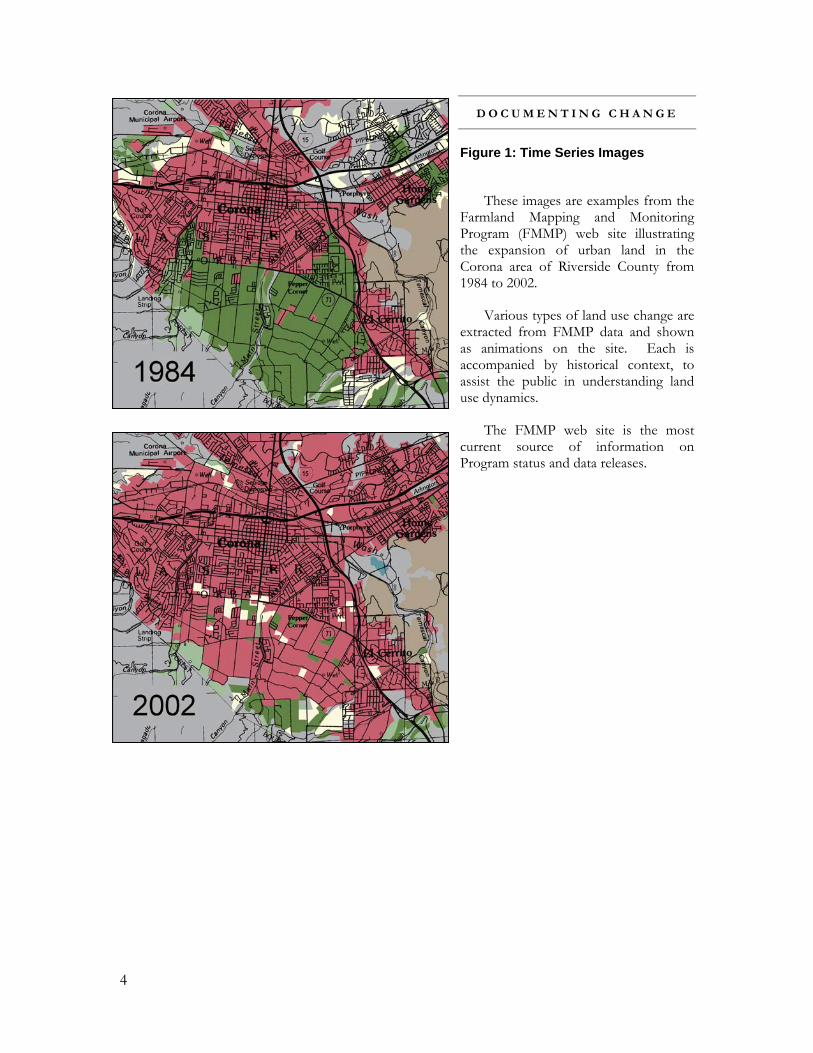
Figure 1: Time Series Images
These images are examples from the Farmland Mapping and Monitoring Program (FMMP) web site illustrating the expansion of urban land in the Corona area of Riverside County from 1984 to 2002.
Various types of land use change are extracted from FMMP data and shown as animations on the site. Each is accompanied by historical context, to assist the public in understanding land use dynamics.
The FMMP web site is the most current source of information on Program status and data releases.

5
A G U I D E T O T H E F A R M L A N D M A P P I N G A N D M O N I T O R I N G P R O G R A M
PART II : TWENTY YEARS OF FARMLAND MAPPING
The FMMP was established in 1982 to continue the Important Farmland mapping efforts begun in 1975 by the U.S. Department of Agriculture, Natural Resources Conservation Service (NRCS). The intent of the NRCS was to produce agricultural resource maps based on soil quality and land use across the nation. As part of this nationwide mapping effort, NRCS developed a series of definitions known as the Land Inventory and Monitoring (LIM) criteria. The LIM criteria classified the land's suitability for agricultural production, which included physical and chemical characteristics of soils, as well as specified land use characteristics. Important Farmland Maps are derived from NRCS soil survey maps using LIM criteria.
The NRCS intended to complete a nationwide set of Important Farmland Maps. However, in 1980, a decreasing federal priority for completing the LIM program influenced the State of California to assist NRCS with completing its mapping in the state. Initial state efforts were directed at providing financial assistance to the federal government to expedite completion of draft Important Farmland Maps for California. The FMMP was then created within the Department of Conservation to carry on the mapping activity on a continuing basis, and with a greater level of detail.
A brief look at the legislative record highlights milestones in the history and direction of FMMP.
• ASSEMBLY BILL 966 (Lehman), Chapter 13, Statutes of 1982, established FMMP to map, monitor, and report on important farmland, grazing land, and urban areas in 40 counties and to prepare and maintain an automated database.
• SENATE BILL 946 (Vuich), Chapter 1342, Statutes of 1985, authorized use of an interim mapping inventory system in counties lacking modern soil surveys, and authorized addition and mapping of new counties as modern soil surveys are completed.
• ASSEMBLY BILL 3719 (Costa), Chapter 1053, Statutes of 1986, shifted FMMP from an annual to a biennial update cycle.
• SENATE BILL 642 (Garamendi), Chapter 1308, Statutes of 1987, incorporated the Farmland Mapping Account with that of the Soil Conservation Program to create the State Soil Conservation Fund.
The first Important Farmland Maps, portraying 1984 data, were released in 1986 and covered 30.3 million acres (38 counties). By 1988, FMMP was able to provide the first California Farmland Conversion Report to detail farmland changes between 1984 and 1986. Project area additions have occurred during most of the subsequent updates as modern soil surveys became available, bringing the coverage area to 45.8 million acres in 48 counties (over 90% of the state’s privately held land) in 2004.
Historically FMMP would release all maps and the California Farmland Conversion Report simultaneously, as authorized in statute. By the mid-1990’s, user interest in receiving the data as soon as possible prompted FMMP to begin releasing counties immediately upon completion of the update/quality control process. Today there may only be a few months lag time between the release of the statewide summary of one cycle and the first map release of the subsequent cycle.

6
A G U I D E T O T H E F A R M L A N D M A P P I N G A N D M O N I T O R I N G P R O G R A M
PART III : MAP CATEGORIES
Important Farmland Map Categories About 90% of FMMP’s study area is covered by NRCS soil surveys. Technical ratings of the
soils and current land use information are combined to determine the appropriate map category. The minimum mapping unit is 10 acres unless otherwise specified. A more complete set of technical definitions of the NRCS-LIM categories can be found in Appendix B.
• PRIME FARMLAND (P): Farmland with the best combination of physical and chemical features able to sustain long term agricultural production. This land has the soil quality, growing season, and moisture supply needed to produce sustained high yields. Land must have been used for irrigated agricultural production at some time during the four years prior to the mapping date.
• FARMLAND OF STATEWIDE IMPORTANCE (S): Farmland similar to Prime Farmland but with minor shortcomings, such as greater slopes or less ability to store soil moisture. Land must have been used for irrigated agricultural production at some time during the four years prior to the mapping date.
• UNIQUE FARMLAND (U): Farmland of lesser quality soils used for the production of the state's leading agricultural crops. This land is usually irrigated, but may include nonirrigated orchards or vineyards as found in some climatic zones in California. Land must have been cropped at some time during the four years prior to the mapping date.
• FARMLAND OF LOCAL IMPORTANCE (L): Land of importance to the local agricultural economy as determined by each county's board of supervisors and a local advisory committee. A set of Farmland of Local Importance definitions current to 2004 is located in Appendix C.
• GRAZING LAND (G): Land on which the existing vegetation is suited to the grazing of livestock. This category was developed in cooperation with the California Cattlemen's Association, University of California Cooperative Extension, and other groups interested in the extent of grazing activities. The minimum mapping unit for Grazing Land is 40 acres.
• URBAN AND BUILT-UP LAND (D): Land occupied by structures with a building density of at least 1 unit to 1.5 acres, or approximately 6 structures to a 10-acre parcel. This land is used for residential, industrial, commercial, institutional, public administrative purposes, railroad and other transportation yards, cemeteries, airports, golf courses, sanitary landfills, sewage treatment, water control structures, and other developed purposes.
• OTHER LAND (X): Land not included in any other mapping category. Common examples include low density rural developments; brush, timber, wetland, and riparian areas not suitable for livestock grazing; confined livestock, poultry or aquaculture facilities; strip mines, borrow pits; and water bodies smaller than 40 acres. Vacant and nonagricultural land surrounded on all sides by urban development and greater than 40 acres is mapped as Other Land.

7
• WATER (W): Perennial water bodies with an extent of at least 40 acres.
Interim Farmland Map Categories For farmed areas lacking modern soil survey information and for which there is expressed local
concern on the status of farmland, the following categories substitute for the categories of P, S, U, and L. This had historically included Butte, Colusa, and portions of Kern and Tulare Counties. With the completion of the Colusa and Western Tulare soil surveys (1998), only Butte and Kern counties continue to have Interim Farmland data.
• IRRIGATED FARMLAND (I): Cropped land with a developed irrigation water supply that is dependable and of adequate quality. Land must have been used for irrigated agricultural production at some time during the four years prior to the mapping date.
• NON-IRRIGATED FARMLAND (N): Land on which agricultural commodities are produced on a continuing or cyclic basis utilizing stored soil moisture.
Optional Designation The Land Committed to Nonagricultural Use category was developed in cooperation with local
government planning departments and county boards of supervisors during the public workshop phase of the FMMP's development in 1982. The designation allows local governments to provide detail on the nature of changes expected to occur in the future.
• LAND COMMITTED TO NONAGRICULTURAL USE: existing farmland, grazing land, and vacant areas which have a permanent commitment for development.
Examples of Land Committed to Nonagricultural Use would include an area undergoing sanitary
sewer installation or for which bonds or assessments have been issued for public utilities. Land Committed to Nonagricultural Use represents a planning area designated for future nonagricultural development that is not reversible by a simple majority vote by a city council or board of supervisors.
Cities and counties furnish information on Land Committed to Nonagricultural Use on a
voluntary basis. It is then available as an overlay to the Important Farmland Map information or as a statistical summary. The voluntary nature of submission for this designation makes generalization or extrapolation of the information to larger geographic areas inappropriate. A complete definition and further explanation of Land Committed to Nonagricultural Use is contained in Appendix B.

8
A G U I D E T O T H E F A R M L A N D M A P P I N G A N D M O N I T O R I N G P R O G R A M
PART IV: MAPPING PROCEDURES AND PRODUCTS
Mapping Procedures The process of making an Important Farmland Map evolved tremendously in recent years, along
with computer technology and the internet. Historically, FMMP compiled land use information on 1:24,000 USGS paper quads, referring to hard copy aerial photos and soil maps, and hand-transferring information. Processing large GIS files was unwieldy and time consuming, and the hand-transfer of information lead to incremental spatial inaccuracies each time maps were updated.
Beginning in 1998, FMMP began transitioning the mapping process to a system in which all data sources (digital photography, soil lines, field notations, reference maps) are co-registered and digitizing is done on screen. This system has improved both the spatial and classification accuracy of the Important Farmland Maps; and allows for cross-referencing to other relevant GIS data. The internet has also become a valuable resource for answering questions on land use status, allowing analysts to focus on the most complicated issues in the field. The transition to the updated workflow was completed during the 2002 update cycle.
At its core, however, the mapping process is much the same as it has been since the Program was established: existing maps are compared to new aerial photos in order to discern land use changes that occurred in the two years between updates. Notes from prior mapping analysts and from outside reviewers are used to document the nature of changes. Areas that are questionable or that lack photographic coverage are field verified. FMMP staff review each other's work before new statistics are generated. The statistics are analyzed to determine anomalies or the need for footnotes. Finally, new maps are generated and released.
Aerial photos are obtained from the private sector or governmental agencies. The cost, availability of existing photo coverage, and photo format dictate which photos are actually used in a given update. When possible, color infrared imagery is used due to its superior ability to depict irrigated agriculture. Satellite data is increasingly being used as prices decrease and data quality increases.
Soil data is one of the critical components of Important Farmland Maps. Soil surveys have historically been in paper format, requiring hand-transfer in the creation of FMMP maps. Hand-transfer systems are inherently prone to spatial and classification error.
Recently, NRCS began creating GIS databases of soil survey information, known as Soil Survey Geographic Data or SSURGO. FMMP is in the process of adopting SSURGO data as individual counties are released and as staff resources allow. This improvement allows FMMP to accurately represent the original NRCS soil maps. The FMMP land use minimum mapping unit of ten acres remains the same, but digital soil units as small as one acre in size will now occur in the GIS data. The acreages of
Figure 2: Soil Survey Example--Davis area.

9
agricultural categories will exhibit shifts in the year SSURGO is adopted to accommodate the increased detail.
Map Products As a result of both technological improvements and user requests, FMMP has improved and
expanded product availability. The most common map products include:
• COLOR COUNTY MAPS AT 1:100,000 OR 1:120,000: Most counties can be published on one sheet, but some require as many as three sheets.
• PAPER ENLARGEMENTS AT USER-DEFINED SCALE: The most common requests for printed maps are either at the USGS 1:24,000 scale or at a scale that fits the entire area of interest on letter-sized paper (8.5” by 11”). Paper maps are limited to the 36” plotter width.
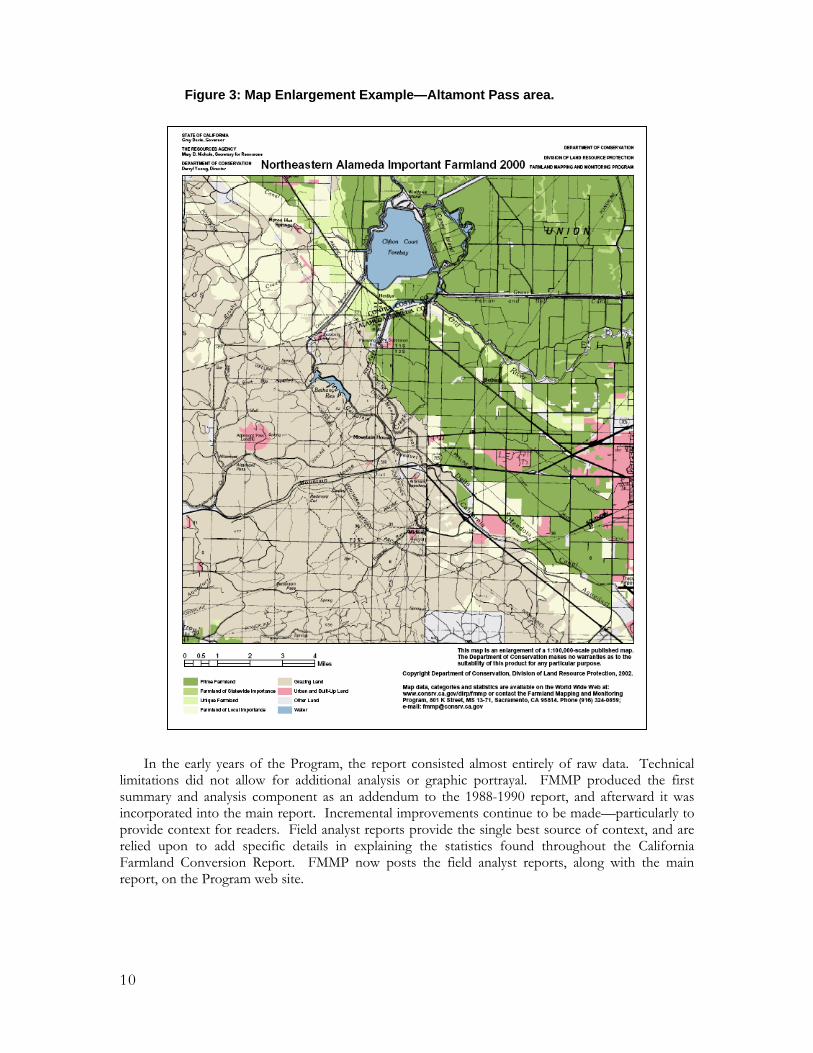
• DIGITAL ENLARGEMENTS AT USER-DEFINED SCALE: The area of interest is produced in an Adobe PDF, JPG, or similar format that can be emailed to the user. An example from Alameda County is shown in Figure 3.
• STATEWIDE OR REGIONAL MAPS: FMMP produces Important Farmland in California wall maps at 1:1,250,000. Various regional products can also be produced.
• ADDITIONAL DATA LAYERS OR OTHER CUSTOM PRODUCTS: Municipal boundaries, Land Committed to Nonagricultural Use, flood zones, or other information can be added to create custom products.
Fees associated with the above products depend on the degree of customization requested. Most products are available for the cost of reproduction, shipping, and handling.
Additional digital information is available for download at the FMMP web site:
• GIS DATA: Important Farmland data for all survey years is available for use in GIS and CAD systems. Background material necessary for the proper import and use of the information, known as metadata, is also posted on the download site.
• TIME SERIES IMAGES: Examples of land use change over time are available on the Program web site in the form of animated GIF files. The images are extracted from FMMP data and are accompanied by background information about the site and land use conversion trends in the area.
Statistics and Reports Government Code §65570 requires FMMP to collect and report land use acreage and conversion
data by June 30 of each even-numbered year. Analysis of the GIS data is conducted on a county-by- county basis, which in turn is summarized into regional and statewide tables. The raw data, summaries, and a descriptive analysis of change occurring during the two-year period are compiled to create the California Farmland Conversion Report.
10
In the early years of the Program, the report consisted almost entirely of raw data. Technical limitations did not allow for additional analysis or graphic portrayal. FMMP produced the first summary and analysis component as an addendum to the 1988-1990 report, and afterward it was incorporated into the main report. Incremental improvements continue to be made—particularly to provide context for readers. Field analyst reports provide the single best source of context, and are relied upon to add specific details in explaining the statistics found throughout the California Farmland Conversion Report. FMMP now posts the field analyst reports, along with the main report, on the Program web site.
Figure 3: Map Enlargement Example—Altamont Pass area.

11
A G U I D E T O T H E F A R M L A N D M A P P I N G A N D M O N I T O R I N G P R O G R A M
PART V: MAP REVIEW
Public review is an important aspect of both initial map compilation and biennial map updating. During these 90-day public review periods, the maps are reviewed at the local level for accuracy of land use classification and delineation. Upon request, enlargements or GIS files are provided to reviewers interested in particular cities or regions.
In addition, city and county planning departments have the option to provide information on Land Committed to Nonagricultural Use as additional map and statistical data. The FMMP staff use the information received from reviewers to identify areas that may be undergoing land use conversion during the next mapping cycle. The FMMP actively seeks and welcomes public review comments since they increase the accuracy of the maps as well as provide information on how the maps are being used at the local level.
Local participation is especially active at the time when new counties are brought in to the FMMP survey area. When new soil surveys are complete, FMMP compiles a draft Important Farmland Map, which is used as a starting point for determining how Farmland of Local Importance might be defined. An advisory committee of
representatives from the list in Table 1 review options based on typical definition components. Multiple variations of the map may be developed to capture the committee’s recommendations. Once the committee is satisfied with the wording of the definition, FMMP takes it to the Board of Supervisors, which has the authority to approve or deny the definition.
The initial delineation of Grazing Land from aerial photography is also improved by meeting with representatives of the livestock ranching community, livestock ranching organizations, and the U. C. Cooperative Extension livestock advisor prior to the public release of the new map.
Table 1: Map Reviewers County Planning Department Incorporated City Planning Departments Agricultural Commissioner Resource Conservation District(s) Farm Bureau Cattlemen's Association Agricultural Producers-Landowners Business-Real Estate Community Development-Building Industry Public Interest Environmental Groups Community Members U. C. Cooperative Extension, Farm Advisor Irrigation Districts

12
A G U I D E T O T H E F A R M L A N D M A P P I N G A N D M O N I T O R I N G P R O G R A M
APPENDIX A: GOVERNMENT CODE
§65570.
(a) The Director of Conservation may establish, after notice and hearing, rules and regulations, and require reports from local officials and may employ, borrow, or contract for such staff or other forms of assistance as are reasonably necessary to carry out this section, Chapter 3 (commencing with Section 16140) of Part 1 of Division 4 of Title 2, and Section 612 of the Public Resources Code. In carrying out his or her duties under those sections, it is the intention of the Legislature that the director shall consult with the Director of Food and Agriculture and the Director of Planning and Research.
(b) Commencing July 1, 1986, and continuing biennially thereafter, the Department of Conservation shall collect or acquire information on the amount of land converted to or from agricultural use using 1984 baseline information as updated pursuant to this section for every county for which Important Farmland Series maps exist. On or before June 30, 1988, and continuing biennially thereafter, the department shall report to the Legislature on the data collected pursuant to this section. In reporting, the department shall specify, by category of agricultural land, the amount of land converted to, or from, agricultural use, by county and on a statewide basis. The department shall also report on the nonagricultural uses to which these agricultural lands were converted or committed.
For the purposes of this section, the following definitions apply unless otherwise specified:
(1) "Important Farmland Series maps" means those maps compiled by the United States Soil Conservation Service and updated and modified by the Department of Conservation.
(2) "Interim Farmland maps" means those maps prepared by the Department of Conservation for areas that do not have the current soil survey information needed to compile Important Farmland Series maps. The Interim Farmland maps shall indicate areas of irrigated agriculture, dry-farmed agriculture, grazing lands, urban and built-up lands, and any areas committed to urban or other nonagricultural uses.
(3) "Category of agricultural land" means prime farmland, farmland of statewide importance, unique farmland, and farmland of local importance, as defined pursuant to United States Department of Agriculture land inventory and monitoring criteria, as modified for California, and grazing land. "Grazing land" means land on which the existing vegetation, whether grown naturally or through management, is suitable for grazing or browsing of livestock.
(4) "Amount of land converted to agricultural use" means those lands which were brought into agricultural use or reestablished in agricultural use and were not shown as agricultural land on Important Farmland Series maps maintained by the Department of Conservation in the most recent biennial report.
(5) "Amount of land converted from agricultural use" means those lands which were permanently converted or committed to urban or other nonagricultural uses and were shown as

13
agricultural land on Important Farmland Series maps maintained by the Department of Conservation and in the most recent biennial report.
(c) Beginning August 1, 1986, and continuing biennially thereafter, the Department of Conservation shall update and send counties copies of current Important Farmland Series maps. Counties may review the maps and notify the department within 90 days of any changes in agricultural land pursuant to subdivision (b) that occurred during the previous fiscal year, and note and request correction of any discrepancies or errors in the classification of agricultural lands on the maps. The department shall make those corrections requested by counties. The department shall provide staff assistance, as available, to collect or acquire information on the amount of land converted to, or from, agricultural use for those counties for which Important Farmland Series maps exist.
(d) The Department of Conservation may also acquire any supplemental information which becomes available from new soil surveys and establish comparable baseline data for counties not included in the 1984 baseline, and shall report on the data pursuant to this section. The Department of Conservation may prepare Interim Farmland maps to supplement the Important Farmland Series maps.
(e) The Legislature finds that the purpose of the Important Farmland Series maps and the Interim Farmland maps is not to consider the economic viability of agricultural lands or their current designation in the general plan. The purpose of the maps is limited to the preparation of an inventory of agricultural lands, as defined in this chapter, as well as land already committed to future urban or other nonagricultural purposes.
(Amended by Stats. 1983, c. 924, § 1; Stats. 1985, c. 1342, § 3; Stats. 1986, c. 1053, § 1.)

14
A G U I D E T O T H E F A R M L A N D M A P P I N G A N D M O N I T O R I N G P R O G R A M
APPENDIX B: MAPPING CRITERIA AND SOIL TAXONOMY TERMS
The following definitions are used in preparing the Important Farmland Maps and the California Farmland Conversion Report. Soil-specific terms, such as xeric, ustic, aridic, etc., are defined at the end of this appendix.
The definitions for Prime Farmland, Farmland of Statewide Importance, Unique Farmland, Farmland of Local Importance, and Urban Built-up Land were developed by the NRCS as part of their nationwide Land Inventory and Monitoring (LIM) system.
These LIM definitions have been modified for use in California. The most significant modification is that Prime Farmland and Farmland of Statewide Importance must be irrigated. Farmland of Local Importance has been identified by local advisory committees and definitions vary from county to county, as intended under the LIM system. Mapping of Grazing Land as part of an Important Farmland Map is unique to California. The minimum mapping unit is 10 acres unless otherwise specified. Units of land smaller than 10 acres are incorporated into the surrounding map classifications.
Digital Soil Survey Data (SSURGO database) The LIM criteria and related minimum mapping units were developed prior to the availability of
soil data in GIS format. The NRCS’ SSURGO data is the digital replacement for paper soil maps and is being incorporated into Important Farmland Maps as resources allow. As of the date of this publication, FMMP has replaced soil lines from paper soil surveys with SSURGO data in 22 counties.
In SSURGO-enhanced versions of Important Farmland Maps, land use is still delineated at the 10 acre minimum mapping unit, but soil units as small as one acre are now depicted. During NRCS’ digitization and quality control process, soil types may have been added and delineation or classification of soils may have occurred. These changes are reflected in the revised Important Farmland Map.
Older Important Farmland Maps will continue to reflect information as it was derived from paper soil survey documents. The published lists of soils qualifying for Prime Farmland and Farmland of Statewide Importance will reflect any differences between the two versions, as well as information on the year of SSURGO incorporation and version of SSURGO used.
Prime Farmland Prime Farmland is land which has the best combination of physical and chemical characteristics
for the production of crops. It has the soil quality, growing season, and moisture supply needed to produce sustained high yields of crops when treated and managed, including water management, according to current farming methods. Prime Farmland must have been used for irrigated agricultural production at some time during the four years prior to the mapping date. It does not include publicly owned lands for which there is an adopted policy preventing agricultural use.
Prime Farmland must meet all the following criteria:
• WATER: The soils have xeric, ustic, or aridic (torric) moisture regimes in which the available water capacity is at least 4.0 inches (10 cm) per 40 to 60 inches (1.02 to 1.52 meters) of soil,

15
and a developed irrigation water supply that is dependable and of adequate quality. A dependable water supply is one which is available for the production of the commonly grown crops in 8 out of 10 years; and
• SOIL TEMPERATURE RANGE: The soils have a temperature regime that is frigid, mesic, thermic, or hyperthermic (pergelic and cryic regimes are excluded). These are soils that, at a depth of 20 inches (50.8 cm), have a mean annual temperature higher than 32° F (0° C). In addition, the mean summer temperature at this depth in soils with an O horizon is higher than 47° F (8° C); in soils that have no O horizon, the mean summer temperature is higher than 59° F (15° C); and
• ACID ALKALI BALANCE: The soils have a pH between 4.5 and 8.4 in all horizons within a depth of 40 inches (1.02 meters); and
• WATER TABLE: The soils have no water table or have a water table that is maintained at a sufficient depth during the cropping season to allow cultivated crops common to the area to be grown; and
• SOIL SODIUM CONTENT: The soils can be managed so that, in all horizons within a depth of 40 inches (1.02 meters), during part of each year the conductivity of the saturation extract is less than 4 mmhos/cm and the exchangeable sodium percentage is less than 15; and
• FLOODING: Flooding of the soil (uncontrolled runoff from natural precipitation) during the growing season occurs infrequently, taking place less often than once every two years; and
• ERODIBILITY: The product of K (erodibility factor) multiplied by the percent of slope is less than 2.0; and
• PERMEABILITY: The soils have a permeability rate of at least 0.06 inch (0.15 cm) per hour in the upper 20 inches (50.8 cm) and the mean annual soil temperature at a depth of 20 inches (50.8 cm) is less than 59° F (15° C); the permeability rate is not a limiting factor if the mean annual soil temperature is 59° F (15° C) or higher; and
• ROCK FRAGMENT CONTENT: Less than 10 percent of the upper 6 inches (15.24 cm) in these soils consists of rock fragments coarser than 3 inches (7.62 cm); and
• ROOTING DEPTH: The soils have a minimum rooting depth of 40 inches (1.02 meters).
Farmland of Statewide Importance Farmland of Statewide Importance is land other than Prime Farmland which has a good
combination of physical and chemical characteristics for the production of crops. It must have been used for irrigated agricultural production at some time during the four years prior to the mapping date. It does not include publicly owned lands for which there is an adopted policy preventing agricultural use.
Farmland of Statewide Importance must meet all the following criteria:
• WATER: The soils have xeric, ustic, or aridic (torric) moisture regimes in which the available water capacity is at least 3.5 inches (8.89 cm) within a depth of 60 inches (1.52 meters) of

16
soil; or within the root zone if it is less than 60 inches (1.52 meters) deep. They have a developed irrigation supply that is dependable and of adequate quality. A dependable water supply is one which is available for the production of the commonly grown crops in 8 out of 10 years; and
• SOIL TEMPERATURE RANGE: The soils have a temperature regime that is frigid, mesic, thermic, or hyperthermic (pergelic and cryic regimes are excluded). These are soils that, at a depth of 20 inches (50.8 cm), have a mean annual temperature higher than 32° F (0° C). In addition, the mean summer temperature at this depth in soils with an O horizon is higher than 47° F (8° C); in soils that have no O horizon, the mean summer temperature is higher than 59° F (15° C); and
• ACID ALKALI BALANCE: The soils have a pH between 4.5 and 9.0 in all horizons within a depth of 40 inches (1.02 meters) or in the root zone if the root zone is less than 40 inches (1.02 meters) deep; and
• WATER TABLE: The soils have no water table or have a water table that is maintained at a sufficient depth during the cropping season to allow cultivated crops common to the area to be grown; and
• SOIL SODIUM CONTENT: The soils can be managed so that, in all horizons within a depth of 40 inches (1.02 meters), or in the root zone if the root zone is less than 40 inches (1.02 meters) deep, during part of each year the conductivity of the saturation extract is less than 16 mmhos/cm and the exchangeable sodium percentage is less than 25; and
• FLOODING: Flooding of the soil (uncontrolled runoff from natural precipitation) during the growing season occurs infrequently, taking place less often than once every two years; and
• ERODIBILITY: The product of K (erodibility factor) multiplied by the percent of slope is less than 3.0; and
• ROCK FRAGMENT CONTENT: Less than 10 percent of the upper 6 inches (15.24 cm) in these soils consists of rock fragments coarser than 3 inches (7.62 cm).
Farmland of Statewide Importance does not have any restrictions regarding permeability or rooting depth.
Unique Farmland Unique Farmland is land which does not meet the criteria for Prime Farmland or Farmland of
Statewide Importance, that has been used for the production of specific high economic value crops at some time during the four years prior to the mapping date. It has the special combination of soil quality, location, growing season, and moisture supply needed to produce sustained high quality and/or high yields of a specific crop when treated and managed according to current farming methods. Examples of such crops may include oranges, olives, avocados, rice, grapes, and cut flowers. It does not include publicly owned lands for which there is an adopted policy preventing agricultural use.
Characteristically Unique Farmland:

17
• Is used for specific high value crops; and
• Has a moisture supply that is adequate for the specific crop; the supply is from stored moisture, precipitation or a developed irrigation system; and
• Combines favorable factors of soil quality, growing season, temperature, humidity, air drainage, elevation, exposure, or other conditions, such as nearness to market, that favor growth of a specific food or fiber crop; and
• Excludes abandoned orchards or vineyards, dryland grains, and extremely low yielding crops, such as irrigated pasture, as determined in consultation with the County Cooperative Extension Director and Agricultural Commissioner.
High value crops are listed in annual summaries produced by the California Agricultural Statistics Service (www.nass.usda.gov/ca). In order for land to be classified Unique Farmland, the crop grown on the land must have qualified for the list at some time during the two update cycles prior to the mapping date.
Farmland of Local Importance Farmland of Local Importance is either currently producing crops, has the capability of
production, or is used for the production of confined livestock. Farmland of Local Importance is land other than Prime Farmland, Farmland of Statewide Importance or Unique Farmland. This land may be important to the local economy due to its productivity or value. It does not include publicly owned lands for which there is an adopted policy preventing agricultural use. In a few counties the local advisory committee has elected to additionally define areas of Local Potential (LP) farmland. This land includes soils which qualify for Prime Farmland or Farmland of Statewide Importance, but generally are not cultivated or irrigated. For reporting purposes, Local Potential and Farmland of Local Importance are combined in the acreage tables, but are shown separately on the Important Farmland Map.
Farmland of Local Importance is initially identified by a local advisory committee (LAC) convened in each county by FMMP in cooperation with the NRCS and the county board of supervisors. LAC membership is very similar to the map reviewer list in Part V of this document. Authority to recommend changes to the category of Farmland of Local Importance rests with the board of supervisors in each county. The FMMP presents each draft map to the board of supervisors for their review. After the presentation of this map, the board of supervisors has a 90-day review period in which to request any needed modifications. An extension may be granted upon request. The board of supervisors may then approve or disapprove the Farmland of Local Importance category. The FMMP will accept the recommendation of the board of supervisors if it is consistent with the general program guidelines.
If no action is initiated by the county to identify or adopt a Farmland of Local Importance definition within a year of contact by FMMP, the county will be deemed to have no adopted definition for Farmland of Local Importance.
Any revision to the initial board of supervisors' action on Farmland of Local Importance will require 30-day written notice to FMMP and members of the LAC. This process may require reconvening of the LAC.
County definitions of Farmland of Local Importance are contained in Appendix C.
18
Grazing Land Grazing Land is defined in Government Code §65570(b)(3) as:
"...land on which the existing vegetation, whether grown naturally or through management, is suitable for grazing or browsing of livestock."
The minimum mapping unit for Grazing Land is 40 acres.
Grazing Land does not include land previously designated as Prime Farmland, Farmland of Statewide Importance, Unique Farmland, or Farmland of Local Importance. It also does not include heavily brushed, timbered, excessively steep, or rocky lands which restrict the access and movement of livestock, rural residential land, or publicly owned lands for which there is an adopted policy preventing agricultural use.
When a new county is added to the project, FMMP conducts initial assessment of the extent of Grazing Land from aerial photography and other data, then tailors the draft information in meetings with representatives of the local livestock ranching community, livestock ranching organizations, and the U. C. Cooperative Extension livestock advisor.
Urban and Built-up Land Urban and Built-up Land is used for residential, industrial, commercial, construction,
institutional, public administrative purposes, railroad yards, cemeteries, airports, golf courses, sanitary landfills, sewage treatment plants, water control structures, and other development purposes. Highways, railroads, and other transportation facilities are mapped as a part of Urban and Built-up Land if they are a part of the surrounding urban areas.
Units of land smaller than 10 acres will be incorporated into the surrounding map classifications. The building density for residential use must be at least 1 structure per 1.5 acres (or approximately 6 structures per 10 acres). Urban and Built-up Land must contain man-made structures or buildings under construction, and the infrastructure required for development (e.g., paved roads, sewers, water, electricity, drainage, or flood control facilities) that are specifically designed to serve that land. Parking lots, storage and distribution facilities, and industrial uses such as large packing operations for agricultural produce will generally be mapped as Urban and Built-up Land even though they may be associated with agriculture.
Urban and Built-up Land does not include strip mines, borrow pits, gravel pits, farmsteads, ranch headquarters, commercial feedlots, greenhouses, poultry facilities, or road systems for freeway interchanges outside of areas classified as Urban and Built-up Land areas.
Within areas classified as Urban and Built-up Land, vacant and nonagricultural land which is surrounded on all sides by urban development and is less than 40 acres in size will be mapped as Urban and Built-up Land. Vacant and nonagricultural land areas larger than 40 acres in size will be mapped as Other Land.
Other Land Other Land is that which is not included in any of the other mapping categories. The following
types of land are generally included:
• Rural development which has a building density of less than 1 structure per 1.5 acres, but with at least 1 structure per 10 acres;

19
• Brush, timber, wetlands, and other lands not suitable for livestock grazing;
• Publicly owned lands not available for agricultural use;
• Road systems for freeway interchanges outside of Urban and Built-up Land areas;
• Vacant and nonagricultural land areas larger than 40 acres in size and surrounded on all sides by urban development;
• Confined livestock, poultry, or aquaculture facilities, unless accounted for by the county's Farmland of Local Importance definition;
• Strip mines, borrow pits, gravel pits, and ranch headquarters, or water bodies smaller than 40 acres; and
• A variety of other rural land uses.
Land Committed to Nonagricultural Use Land Committed to Nonagricultural Use is land that is permanently committed by local elected
officials to nonagricultural development by virtue of decisions which cannot be reversed simply by a majority vote of a city council or county board of supervisors.
Land Committed to Nonagricultural Use must be designated in an adopted, local general plan for future nonagricultural development. The resulting development must meet the requirements of Urban and Built-up Land or the rural development density criteria of Other Land.
Land Committed to Nonagricultural Use must meet the requirements of either (a) or (b) below:
a. It must have received one of the following final discretionary approvals:
1. Tentative subdivision map (approved per the Subdivision Map Act);
2. Tentative or final parcel map (approved per the Subdivision Map Act);
3. Recorded development agreement (per Government Code §65864);
4. Other decisions by a local government which are analogous to items #1-3 above and which exhibit an element of permanence. Zoning by itself does not qualify as a permanent commitment.
Or
b. It must be the subject of one of the final fiscal commitments to finance the capital improvements specifically required for future development of the land in question as shown below:
1. Recorded Resolution of Intent to form a district and levy an assessment;
2. Payment of assessment;
3. Sale of bonds;

20
4. Binding contract, secured by bonds, guaranteeing installation of infrastructure;
5. Other fiscal commitments which are analogous to items #1-4 above and exhibit an element of permanence.
Land Committed to Nonagricultural Use is mapped when city or county planning departments notify FMMP that the land meets these criteria and submits 1:24,000 or similarly detailed maps identifying the area and showing its boundaries. The information provided is subject to verification by FMMP. The local government must also provide documentation of the nature of the permanent commitment, including the approval date.
The FMMP will work with city and county planning staffs to obtain this information by providing additional maps and technical assistance. Digital data (GIS files, scanned maps, etc.) can now be submitted as documentation.
Land Committed to Nonagricultural Use will be shown on an overlay to Important and Interim Farmland Maps. The current land use will be indicated on the map, with the overlay indicating the areas that are Committed to Nonagricultural Use. Statistical summaries are also available.

21
Soil Taxonomy Terms Soils are classified based on their physical and chemical characteristics using systems outlined by
the U.S. Department of Agriculture's Soil Survey Manual and the National Cooperative Soil Survey's Soil Taxonomy.
Soil horizons are layers of soils approximately parallel to the land surface and differing from adjacent, genetically related layers in physical, chemical, and biological properties. Examples of such properties include color, texture, acid-alkali balance, and organic matter content.
Soil moisture regimes are used in defining soil classes at various levels in the soil taxonomy system:
• XERIC: typically found in Mediterranean-type climates where winters are moist and cool, and summers are warm and dry.
• USTIC: involves the concept of limited, but effective, soil moisture. Though implying dryness, moisture is available at a time when other conditions are suitable for plant growth.
• ARIDIC (TORRIC): soils with this moisture regime are generally found in arid climates with hot and dry summers.
Soil temperature regimes are used in defining soil classes at a depth of 19.7 inches (50 cm or to the depth of rock if it is shallower), which is analogous to plant rooting depth.
• FRIGID: mean annual soil temperature is less than 47° F (8° C) and the difference between mean winter and mean summer temperature is more than 9° F (5° C).
• MESIC: mean annual soil temperature is between 47° F (8° C) and 59° F (15° C) and the difference between mean summer and mean winter soil temperature is more than 9° F (5° C).
• THERMIC: mean annual soil temperature is between 59° F (15° C) and 72° F (22° C), and the difference between mean summer and mean winter soil temperature is more than 9° F (5° C).
• HYPERTHERMIC: mean annual soil temperature is greater than 72° F (22° C) and the difference between mean winter and mean summer temperature is more than 9° F (5° C).
• PERGELIC: mean annual soil temperature is lower than 32° F (0° C). Permafrost is present.
• CRYIC: mean annual temperature is higher than 32° F (0° C) but lower than 47° F (8° C) and the difference between mean summer and mean winter soil temperature is more than 9° F (5° C).
Soil salinity may be expressed in terms of the electrical conductivity of the water in contact with the soil.

22
• MMHOS/CM: a unit of electrical conductivity, which is a measure of the salinity of soil.
Soil acid-alkali balance is expressed in terms of pH.
• PH: a numerical measure of acidity or hydrogen ion activity. Neutral is pH 7.0. All pH values below 7.0 are acid, and all above 7.0 are alkaline.

23
A G U I D E T O T H E F A R M L A N D M A P P I N G A N D M O N I T O R I N G P R O G R A M
APPENDIX C: FARMLAND OF LOCAL IMPORTANCE DEFINITIONS
Farmland of Local Importance is land of importance to the local economy, as defined by each county's local advisory committee and adopted by its Board of Supervisors. Farmland of Local Importance is either currently producing, or has the capability of production, but does not meet the criteria of Prime Farmland, Farmland of Statewide Importance, or Unique Farmland. Authority to adopt or to recommend changes to the category of Farmland of Local Importance rests with the Board of Supervisors in each county.
ALAMEDA The Board of Supervisors determined that there will be no Farmland of Local Importance for
Alameda County.
AMADOR Land that is currently in agricultural production and that is providing an economic return equal
to that from the prime soil types.
COLUSA The following lands are to be included in the Farmland of Local Importance category: All
farmable lands within Colusa County that do not meet the definitions of Prime, Statewide, or Unique, but are currently irrigated pasture or nonirrigated crops; or nonirrigated land with soils qualifying for Prime Farmland or Farmland of Statewide Importance; or lands that would have Prime or Statewide designation and have been improved for irrigation but are now idle; or lands with a General Plan Land Use designation for agricultural purposes; and lands that are legislated to be used only for agricultural (farmland) purposes.
CONTRA COSTA The lands within the Tassajara area, extending eastward to the county boundary and bordered on
the north by the Black Hills, the Deer, Lone Tree and Briones Valleys, the Antioch area, and the Delta. These lands are typically used for livestock grazing. They are capable of producing dryland grain on a two year summer fallow or longer rotation with volunteer hay and pasture. The farmlands in this category are included in the U.S. Natural Resources Conservation Service's Land Capability Classes I, II, III, and IV, and lack some irrigation water.
EL DORADO Lands that do not qualify for the Prime, Statewide, or Unique designation but are considered
Existing Agricultural Lands, or Potential Agricultural Lands, in the Agricultural Land Element of the County General Plan. Timberlands are excluded.
FRESNO All farmable lands within Fresno County that do not meet the definitions of Prime, Statewide, or
Unique. This includes land that is or has been used for irrigated pasture, dryland farming, confined livestock and dairy, poultry facilities, aquaculture and grazing land.

24
GLENN Local Importance (L): All lands not qualifying for Prime, Statewide, or Unique that are cropped
on a continuing or cyclic basis (irrigation is not a consideration). All cropable land within Glenn County water district boundaries not qualifying for Prime, Statewide, or Unique.
Local Potential (LP): All lands having Prime and Statewide soil mapping units which are not irrigated, regardless of cropping history or irrigation water availability.
IMPERIAL Unirrigated and uncultivated lands with Prime and Statewide soils.
KERN The Board of Supervisors determined that there will be no Farmland of Local Importance for
Kern County.
KINGS Land that supports the following commercial agricultural activities: dairies, confined livestock,
and poultry operations.
LAKE Lands which do not qualify as Prime Farmland or Farmland of Statewide Importance or Unique
Farmland, but are currently irrigated pasture or nonirrigated crops; and unirrigated land with soils qualifying for Prime Farmland or Farmland of Statewide Importance. Areas of unirrigated Prime and Statewide Importance soils overlying ground water basins may have more potential for agricultural use.
LOS ANGELES Producing lands that would meet the standard criteria for Prime or Statewide but are not
irrigated.
MADERA Lands that are presently under cultivation for small grain crops, but are not irrigated. Also lands
that are currently irrigated pasture, but have the potential to be cultivated for row/field crop use.
MARIN Land which is not irrigated, but is cultivated; or has the potential for cultivation.
MARIPOSA The Board of Supervisors determined that there will be no Farmland of Local Importance for
Mariposa County.
MERCED Farmlands that have physical characteristics that would qualify for Prime or Statewide except for
the lack of irrigation water. Also, farmlands that produce crops that are not listed under Unique but are important to the economy of the county or city.
MODOC Irrigated and dry cropland classified as Class III and Class IV irrigated land if water is or
becomes available.

25
MONTEREY The Board of Supervisors determined that there will be no Farmland of Local Importance for
Monterey County.
NAPA These farmlands include areas of soils that meet all the characteristics of Prime Farmland or of
additional Farmland of Statewide Importance with the exception of irrigation. These farmlands include dryland grains, haylands, and dryland pasture.
NEVADA Farmlands that have physical characteristics that would qualify for Prime or Statewide except for
the lack of irrigation water. Farmlands that produce crops that are not listed under Unique Lands but are important to the economy of the county are: Christmas trees, Sudan grass, Meadow hay, chestnuts, poultry houses and feedlots, improved dryland pasture (not rangeland), and irrigated pasture (it is under Statewide or Prime if soils are listed as such, otherwise as Local). Also, lands that are legislated to be used only for agricultural (farmland) purposes, such as Williamson Act land in western Nevada County.
ORANGE The Board of Supervisors determined that there will be no Farmland of Local Importance for
Orange County.
PLACER Farmlands not covered by the categories of Prime, Statewide, or Unique. They include lands
zoned for agriculture by County Ordinance and the California Land Conservation Act as well as dry farmed lands, irrigated pasture lands, and other agricultural lands of significant economic importance to the County and include lands that have a potential for irrigation from Placer County water supplies.
RIVERSIDE Soils that would be classified as Prime and Statewide but lack available irrigation water. Lands
planted to dryland crops of barley, oats, and wheat. Lands producing major crops for Riverside County but that are not listed as Unique crops. These crops are identified as returning one million or more dollars on the 1980 Riverside County Agriculture Crop Report. Crops identified are permanent pasture (irrigated), summer squash, okra, eggplant, radishes, and watermelons. Dairylands, including corrals, pasture, milking facilities, hay and manure storage areas if accompanied with permanent pasture or hayland of 10 acres or more. Lands identified by city or county ordinance as Agricultural Zones or Contracts, which includes Riverside City "Proposition R" lands. Lands planted to jojoba which are under cultivation and are of producing age.
SACRAMENTO Lands which do not qualify as Prime, Statewide, or Unique designation but are currently irrigated
crops or pasture or nonirrigated crops; lands that would be Prime or Statewide designation and have been improved for irrigation but are now idle; and lands which currently support confined livestock, poultry operations, and aquaculture.
SAN BENITO Land cultivated as dry cropland. Usual crops are wheat, barley, oats, safflower, and grain hay.
Also, orchards affected by boron within the area specified in County Resolution Number 84-3.

26
SAN BERNARDINO Farmlands which include areas of soils that meet all the characteristics of Prime, Statewide, or
Unique and which are not irrigated. Farmlands not covered by above categories but are of high economic importance to the community. These farmlands include dryland grains of wheat, barley, oats, and dryland pasture.
SAN DIEGO Land that meets all the characteristics of Prime and Statewide, with the exception of irrigation.
Farmlands not covered by the above categories but are of significant economic importance to the county. They have a history of good production for locally adapted crops. The soils are grouped in types that are suited for truck crops (such as tomatoes, strawberries, cucumbers, potatoes, celery, squash, romaine lettuce, and cauliflower) and soils suited for orchard crops (avocados and citrus).
SAN JOAQUIN All farmable land within San Joaquin County not meeting the definitions of "Prime Farmland,"
"Farmland of Statewide Importance," and "Unique Farmland." This includes land that is or has been used for irrigated pasture, dryland farming, confined livestock or dairy facilities, aquaculture, poultry facilities, and dry grazing. It also includes soils previously designated by soil characteristics as "Prime Farmland," "Farmland of Statewide Importance," and "Unique Farmland" that has since become idle.
SAN LUIS OBISPO Local Importance (L): areas of soils that meet all the characteristics of Prime or Statewide, with
the exception of irrigation. Additional farmlands include dryland field crops of wheat, barley, oats, and safflower.
Local Potential (LP): lands having the potential for farmland, which have Prime or Statewide characteristics and are not cultivated.
SAN MATEO Lands other than Prime, Statewide, or Unique that produce the following crops: oats, Christmas
trees, pumpkins, dryland pasture, other grains, and haylands. These lands are not irrigated.
SANTA BARBARA All dryland farming areas and permanent pasture (if the soils were not eligible for either Prime or
Statewide). Dryland farming includes various cereal grains (predominantly wheat, barley, and oats), sudan, and many varieties of beans. (Although beans can be high value crops the production areas are usually rotated with grain, hence the decision to include them under Local rather than Unique. Also, bean crop yields are highly influenced by climate, so there can be a wide variance in cash value.)
SANTA CLARA Small orchards and vineyards primarily in the foothill areas. Also land cultivated as dry cropland
for grains and hay.
SANTA CRUZ Soils used for Christmas tree farms and nurseries, and that do not meet the definition for Prime,
Statewide, or Unique.
SHASTA Dryland grain producing lands. Also included are farmlands that are presently irrigated but do
not meet the soil characteristics of Prime or Statewide. The majority of these farmlands are located

27
within the Anderson Cottonwood Irrigation District. These soils include Newton gravelly loam (8 to 15 percent slopes), Moda loam, seeped (0 to 3 percent slopes), Moda loam, shallow (0 to 5 percent slopes), and Hillgate loam.
SIERRA VALLEY Plumas County: Lands designated as "agricultural preserve" in the 1984 Plumas County General
Plan and rangelands with a carrying capacity of 8 acres/animal month, as well as irrigable lands.
Lassen and Sierra counties: Farmlands that include areas of soils that meet all the characteristics of Prime or Statewide and which are not irrigated. Also, all dry land wheat, barley, oats, hayland, and pasture.
SISKIYOU Farmlands that include dryland or sub-irrigated hay and grain and improved pasture forage
species; these dry farmed lands commonly have inclusions of uncultivated shallow, rocky, or steep soils; farmlands presently irrigated but which do not meet the soil characteristics of Prime Farmland or Farmland of Statewide Importance; areas currently shown as Prime Agricultural Land in the Siskiyou County General Plan; areas under contract as Agricultural Preserves in Siskiyou County (currently mapped only for the Scott-Shasta-Butte Valley and Tule Lake soil survey areas); other agricultural land of significant importance to the county (currently mapped only for the Scott-Shasta-Butte Valley and Tule Lake soil survey areas); areas previously designated by soil characteristics as Prime Farmland, Farmland of Statewide Importance, Unique Farmland, and Farmland of Local Importance that have since become idle; lands enrolled in the U.S. Department of Agriculture’s Conservation Reserve Program.
SOLANO The Board of Supervisors determined that there will be no Farmland of Local Importance for
Solano County.
SONOMA The hayland producing areas of the Santa Rosa Plains, Petaluma Valley, and Tubbs Island Naval
Reservation. Additional areas also include those lands which are classified as having the capability for producing locally important crops such as grapes, corn, etc., but may not be planted at the present time. Examples of these areas include the coastal lands from Fort Ross to Stewarts Point, areas surrounding Bloomfield, Two Rock, Chileno Valley, and areas of Sonoma Valley in the vicinity of Big Bend, Vineburg, and Schellville.
STANISLAUS Farmlands growing dryland pasture, dryland small grains, and irrigated pasture.
SUTTER The Board of Supervisors determined that there will be no Farmland of Local Importance for
Sutter County.
TEHAMA All lands which are not included in Prime, Statewide, or Unique and are cropped continuously or
on a cyclic basis (irrigation is not a factor). Also, all lands included in the L category which have soil mapping units listed for Prime or Statewide and which are not irrigated.

28
TULARE Lands that produce dryland grains (barley and wheat); lands that have physical characteristics that
would qualify for "Prime" or "Statewide Important" farmlands except for the lack of irrigation water; and lands that currently support confined livestock, poultry, and/or aquaculture operations.
VENTURA Soils that are listed as Prime or Statewide that are not irrigated, and soils growing dryland crops--
beans, grain, dryland walnuts, or dryland apricots.
YOLO Local Importance (L): cultivated farmland having soils which meet the criteria for Prime or
Statewide, except that the land is not presently irrigated, and other nonirrigated farmland.
Local Potential (LP): Prime or Statewide soils which are presently not irrigated or cultivated.
YUBA The Board of Supervisors determined that there will be no Farmland of Local Importance for
Yuba County.
THE DEPARTMENT OF CONSERVATION MAKES NO WARRANTIES AS TO THE SUITABILITY OF THIS PRODUCT FOR ANY PARTICULAR PURPOSE.
Related Documents