A Compare and Contrast Study of Two Banded Snow Storms Part I – January 6 th , 2002.

A Compare and Contrast Study of Two Banded Snow Storms Part I – January 6 th, 2002.
Dec 19, 2015
Welcome message from author
This document is posted to help you gain knowledge. Please leave a comment to let me know what you think about it! Share it to your friends and learn new things together.
Transcript
A Compare and Contrast Study of Two Banded Snow Storms
Part I – January 6th, 2002.

Part I – My presentation
• A brief review of banded snowstorms
• January 6th, 2002 (A classic case?)

A mechanism for banded snowstorms (Nicosia and Grumm)
Summary
• Banded snowstorms typically associated with major, deepening cyclones.
• Bands typically form in an area of mid-level deformation and frontogenesis.
• Storm-relative flows associated with the storm act to favor slantwise instability in the area of deformation.

January 6th, 2002

Water Vapor imagery at 1815 UTC on 1/6/02

Water Vapor imagery at 0015 UTC on 1/7/02

Composite of base reflectivity 1/6 2050 UTC

Composite of base reflectivity 2350 UTC 1/6/02

Composite of base reflectivity 0100 UTC 1/7/02

Observed snowfall 1/6 – 1/7 2002.
Heavy snow

Data from the 12z 1/6 run of the Eta – a great forecast
But too late????

3 hour QPF from the 00z 1/6 run of the Eta verifying 1/6 21z

3 hr QPF from the 12z 1/6 run of the Eta verifying 1/7 00z

3 hr QPF from the 12z 1/6 run of the Eta verifying 1/7 03z
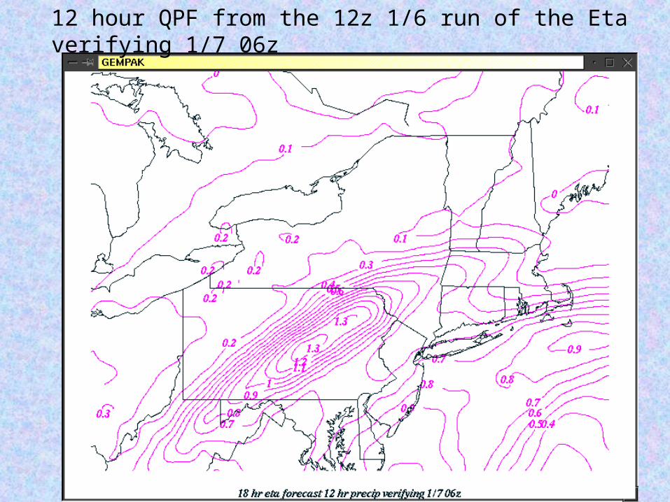
12 hour QPF from the 12z 1/6 run of the Eta verifying 1/7 06z
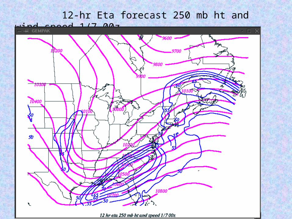
12-hr Eta forecast 250 mb ht and wind speed 1/7 00z.
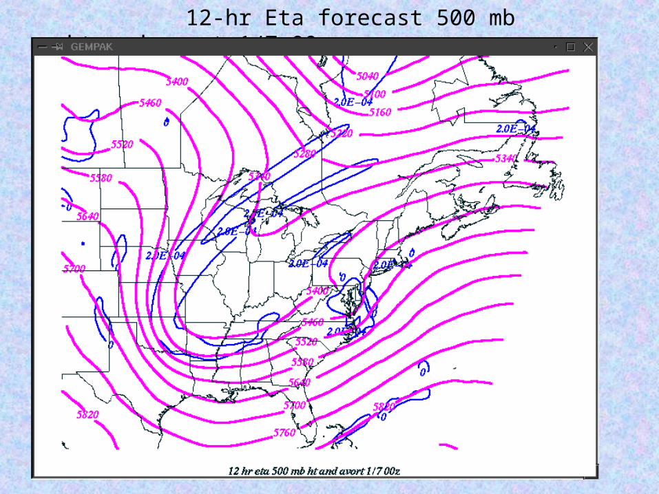
12-hr Eta forecast 500 mb ht and avort 1/7 00z

12 hr Eta forecast 700 mb heights verifying 1/7 00 UTC

12 hour Eta forecast pmsl and 850 mb temperature 1/7 00 UTC.

12 hr Eta forecast 500:400 divergence of Q verifying 1/7 00 UTC.

12 hr Eta forecast 600:500 layer avg RH and omega verifying 1/7 00 UTC

12 hr Eta forecast 800 mb deformation and wind 1/7 00 UTC

12 hr Eta forecast frontogenesis and omega verifying 1/7 00z
Snow bands

12 hr Eta forecast frontogenesis and negative EPV 1/7 00 UTC.
Snow bandsSnow bands

12 hr Eta Theta-e and geostrophic momentum 1/7 00 UTC.
Snow bands

12 hr Eta forecast 700 mb absolute geostrophic vorticity 1/7 00 UTC.
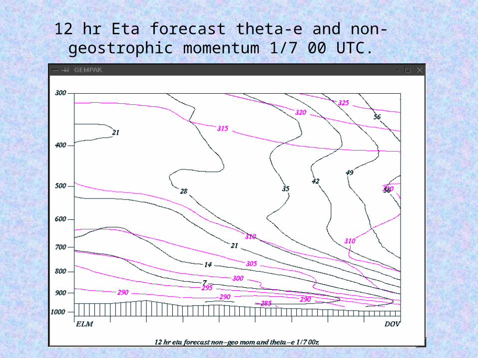
12 hr Eta forecast theta-e and non-geostrophic momentum 1/7 00 UTC.

Data from the 00z 1/6 run of the Eta – not so great!

12 hour QPF from the 00z 1/6 run of the Eta verifying 1/7 06z

QPF from the 4 non-operational members of the Eta portion of the SREF run at 09z 1/6.

Question: Did the earlier model run simulate the structure of the event, with bad placement the
only problem?
Or was the whole run just out to lunch?

24 hr Eta forecast 500:400 divergence of Q verifying 1/7 00z
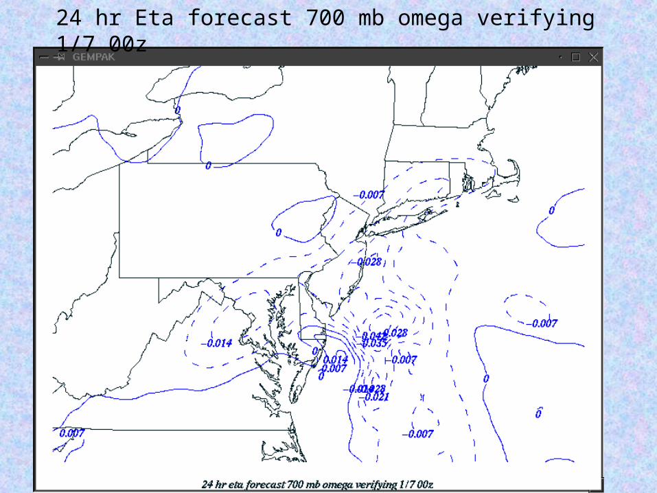
24 hr Eta forecast 700 mb omega verifying 1/7 00z

24 hr Eta forecast 800 mb wind and deformation verifying 1/7 00z

24 hr Eta forecast 700 mb heights and absolute vorticity verifying 1/7 00z
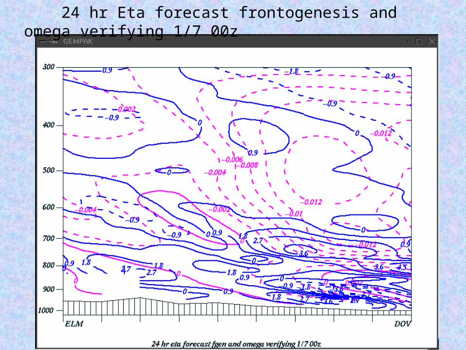
24 hr Eta forecast frontogenesis and omega verifying 1/7 00z

24 hr Eta forecast frontogenesis and negative EPV verifying 1/7 00z

24 hr Eta forecast theta-e and geostrophic momentum verifying 1/7 00z

Conclusion: The earlier runs forecast similar structures.
Errors were mainly in the placement of the key features.

Question: Is inertial instability really the key to producing these
bands?

Explanation 1) Inertial instability in the geostrophic wind field, resulted in horizontal (northward) ageostrophic accelerations, with individual parcels being forced upward along the sloping front zone. These accelerations act to remove the inertial instability in the real wind field.
Parcel becomes sub-geostrophic, PGF > Coriolis, parcel accelerates to the north.
N S
N

Another way of looking at it: The air parcel can’t make the sharp anticyclonic turn, so it accelerates down the height gradient. Key: the existence of the sharp, small-scale downstream ridge.
700 mb heights
L
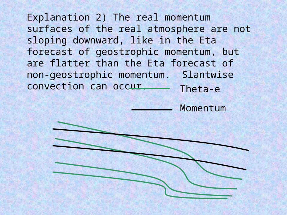
Explanation 2) The real momentum surfaces of the real atmosphere are not sloping downward, like in the Eta forecast of geostrophic momentum, but are flatter than the Eta forecast of non-geostrophic momentum. Slantwise convection can occur.
Theta-e
Momentum

Summary - January 6th – “Classic” Aspects
• A rapidly deepening storm with strong, widespread forcing.
• Closed cyclonic circulation developed at mid-levels.
• Banding developed in an area of mid-level frontogenesis and lower to mid-level negative EPV.

SUMMARY – January 6th “Non-Classic” Aspects
• The system was associated with a compact short-wave located well downstream from the long-wave trough.
• The atmosphere was not close to gravitationally unstable above the frontal zone.
• Model forecasts indicated the presence of inertial instability in the geostrophic wind field.
Model forecast summary
• 12z Eta did an outstanding job forecasting the location of the deformation band and resultant qpf.
• The proceeding 00z Eta was too far southeast with the placement of most key features, resulting in forecast precipitation too far to the southeast.
• Eta short-range ensemble forecasts indicated some uncertainty during their 09z run, however the final solution was outside the range of solutions on the ensembles.
Related Documents