Welcome message from author
This document is posted to help you gain knowledge. Please leave a comment to let me know what you think about it! Share it to your friends and learn new things together.
Transcript

i
GIS-Based Study of Existing Community Infrastructure and Optimum Requirements at Gram Panchayat Level for Assessment of Gaps Using Participatory and Departmental Approach: A Case
of Hantra Gram Panchayat, Bharatpur District, Rajasthan
H. K. Solanki and P. Kesava Rao
National Institute of Rural Development and Panchayati Raj (Ministry of Rural Development, Government of India)
Rajendranagar, Hyderabad-500030, India
nirdpr.org.in
Research Report Series : 128

ii
GIS-Based Study of Existing Community Infrastructure and Optimum Requirements at Gram Panchayat Level for Assessment of Gaps Using Participatory and Departmental Approach: A Case of Hantra Gram Panchayat, Bharatpur District, Rajasthan
Authors: H. K. Solanki and P. Kesava Rao
©National Institute of Rural Development and Panchayati Raj ISBN: 978-93-91412-06-7
First Edition: December 2021
Published by:
Centre for Geoinformatics Applications in Rural Development National Institute of Rural Development and Panchayati Raj Ministry of Rural Development, Govt. of India Rajendranagar, Hyderabad- 500030, India
iii
Authors’ Note
H. K. Solanki and P. Kesava Rao, Centre for Geoinformatics Applications in Rural Development,
National Institute of Rural Development and Panchayati Raj, Rajendranagar, Hyderabad.
This research was funded by the National Institute of Rural Development and Panchayati Raj,
Hyderabad. We express special thanks to Shri Chanchal Kumar Tripathy for field data support as
Research Associate under the study and to Shri Abhilash Prathipati, intern from the Central
University of Karnataka for his support in the study.
Correspondence concerning this report should be addressed to H. K. Solanki, Sr. Assistant Professor,
National Institute of Rural Development and Panchayati Raj, Rajendranagar, Hyderabad-500030,
Email: [email protected]
iv
“If we knew what we were doing, it would not be called research, would it?”
-Albert Einstein
Executive Summary
Introduction:
Planning at the Gram Panchayat (GP) level is a crucial aspect of rural development, which is
done in pieces and scattered manner. Every department is having its own norms and guidelines
whereas villagers are having their own problems. Execution of works has been continuing since the
birth of villages, more formally after independence, and now with more expectations with the
involvement of more funds and convergence approaches. The Gram Panchayat Development Plan
approach started under the Fourteenth Finance Commission is also spreading its wings to cover all
the schemes and functions under one umbrella. Many other ambitious programmes of the
Government of India like Saansad Adarsh Gram Yojana (SAGY), Rurban, etc., are also functioning
parallelly for making some more models of development in the country.
As the works are continued without having a holistic approach in planning, there will not be
any entry or exit point in this development cycle. Hence, having an entry criterion like, ‘what are the
existing assets in the village’, and continuous further inventory of assets and intermediate steps like
working on questions such as, ‘what are the problems/demands of villagers’, ‘what are the norms of
the departments’, and as per those, ‘what is the saturation/optimum level for all the infrastructure
facilities’, ‘what are the working possibilities between existing and saturation levels’, and exit criteria
like ‘what are the gaps between possibilities and demands’. These are the basic research question or
the primary steps in holistic planning to attain the saturation level of infrastructure with further
investment in maintenance aspects and incremental investment requirements.
Further, almost all regions in Indo-Gangetic Plain have less slopes and poor drainage facility,
resulting in villages facing stagnation of water. This is a major concern after the issues related to
drinking water in the areas having flat terrains and poor slopes. The study also involves applications
of drone survey for analysing and proposing solutions to drainage-related problems in villages.
The study dealt with these concerns. For having a focused approach from diverse sectors of
development at the grassroots levels, only community infrastructures have been taken into
consideration for analysis under the study.
Objectives
To survey and map the existing community infrastructure of Gram Panchayat
v
To assess ideal/optimum community infrastructure requirement of Gram Panchayat through
Participatory and Departmental Approach
To analyse and map the gaps in community infrastructure and suggest infrastructure
development plan for GP
Estimation of tentative cost for works and suggestions on inclusion in GP and departmental
development plans
Method:
The area taken into consideration is Hantra Gram Panchayat in Nadbai Block of Bharatpur
district covering three villages, namely Hantra, Arauda and Nagla Banjara.
For the inventory of existing infrastructure open source mobile-based Android app OSMAND
was used and for all GIS related analysis, Open Source QGIS software was used. Public needs/
demands were collected ‘ward-wise’ and validated and refined at the village and GP level through
public meetings, focused discussions. Relevant departments at GP, block, district and State level were
contacted for norms of having new assets and repairs and maintenance, etc. The demands were
analysed with respect to the saturation level of assets as per norms. Gaps were identified between
possibilities and demands. Based on feasibility and demand, and eligibility in guidelines, schemes or
alternative resources were suggested. Drone/UAV survey generated 2D and 3D images which were
analysed for applications in drainage plans, in particular, and other general aspects. The study
involved the following broad workflow.
Study Area:
Hantra Gram Panchayat in Nadbai Block of Bharatpur district comprises three villages, namely
Hantra, Arauda and Nagla Banjara. Hantra Village (Latitude 27° 8' 8.62" N, Longitude 77°14' 10.91"
E), and Arauda (Latitude 27° 7' 57.21" N, Longitude 77°13' 5.85" E) are situated on NH- 11 between
Jaipur and Agra and the third small village named Nagla Banjara (Latitude 27° 7' 26.00" N, Longitude
77°14' 0.43" E) is situated in the southern side of NH-11.
vi
Findings:
While road construction is at first priority at the national and State level in Gram Panchayat
Development Plan (GPDP) and Fourteen Finance Commission (FFC), it is the fifth priority of
villagers. Further, the demands of villagers and priorities are having variations from official
GPDP at the GP level.
In health, education and electricity sectors, concern should be given to service delivery when
compared to the quantity of the assets.
Technical norms are less valued in comparison to public or political pressure and these norms
are at times changed for public demand which may lead to severe stress on natural resources
like groundwater.
When more than one parameter like population, distance, time, etc., is under consideration in
norms, the weightages and priorities within parameters are not clearly defined.
Many strong local demands are not permissible in general schemes (Like Gaushala and solution
for open electric wires), but these are on high priority of villagers in comparison to permissible
demands/works.
The demands like CCTV at selected places/towers, street lights, community toilets, etc., were
felt as secondary demands and much interest was not shown by villagers, while these are more
stressed in missions such as RURBAN, SAGY, etc.
Maintenance of assets is a growing concern now with the increase in infrastructure at the GP
level and requires more systematic and formal approaches.
For the inventory, visualisation and analysis of internal assets, and drainage management,
drone/UAV surveys of Gram Panchayats are essential to work in GIS at household/parcel/
ward/village levels.
Conclusion/Recommendations:
Point-wise details are as follows:
Coding and inventory of existing works with continuous update/addition with time is
necessary.
Scope of wards has to be increased as planning unit
Local demands of high priority like Gaushala and solutions for open and low hanging high
voltage electric wires should be included in GPDP and be addressed with alternative resources
and political will.
vii
To remove local infrastructure disparity, the concept of village-wise asset density may be
considered as a criterion in planning.
During planning, the focus should be on problems and best solutions, not the budget and type
of assets.
More stress is required on service delivery aspects in health, education and electricity sectors
in comparison to infrastructure.
Balance is required to be maintained in public demand and technical feasibility.
In PMGSY, population criteria should be linked to the latest census survey for new connectivity.
Prioritisation and integration of norms/parameters are required if more than one parameter is
to be considered in the execution of any work.
Saturation-centric, independent planning is required at the initial level rather than budget and
scheme/guidelines-centric planning
Proper guidelines for maintenance aspects of assets are required
Environmental sustainability is to be given due priority in all norms
Training and capacity building of selected Block and Panchayat functionaries on the use of GIS
data generated from the study is necessary.
Conclusion on use of drone in village-level planning and generation of drainage plan:
Including MGNREGA, each Panchayat of the country may be spending on an average around
Rs. 1 crore per annum on the development of their Gram Panchayat. Drone/UAV survey is
recommended at GP/village/ward level for fulfilling the requirements of proper depiction,
planning and monitoring at village/ward/asset levels. Drone/UAV survey is looked at as an
essential step towards ‘Smart Village’ concept and in comparison to the quantum of work and
fund flow to the villages/GPs, investment of Rs.2-3 lakh average on each Gram Panchayat will
be a boon for having proper planning. If drone/UAV surveys can be repeated after every 3-5
years, this will be the ultimate resource for monitoring also, as the temporal variations and
development in infrastructure and natural resources can be monitored precisely. Many
prevailing and perpetual problems of villages can be handled well with the availability of
original drone surveys in an open source GIS environment along with free mobile mapping
tools.
viii
Index
S. No. Details Page No.
1 Executive Summary IV-VII
2 List of Tables IX
3 List of Figures X-XI
4 Acronyms XII
Chapters
5 1: Introduction 1-5
6 2: Method 6-11
7 3: Data Presentation and Analysis 12-62
8 4: Discussion 63-72
9 5: Recommendations 73-76
10 6: Applications of Drone Images in Rural Development 77-87
11 7: Photo Gallery 88-93
8: References 94
9: Annexure
1. Key Persons/Officials Supported during the Study 95
ix
List of Tables
Table No. Title Page No.
1 Village-wise Demographic Details of Hantra Gram Panchayat 6
2 Total Existing Community Assets in Hantra Gram Panchayat 17
3 Village-wise General Thematic Break-up of Demands with Frequency/Instances
26
4 Demands Raised by Villagers versus Priorities of Various Guidelines (FFC, SAGY, RURBAN)
28
5 Basic Data for Three Villages to be Used in Further Analysis 30
6 Analysis on Ideal/Optimum Community Infrastructure Requirement of Gram Panchayat
46
7 Cost analysis of the Permissible Assets/Demands 48
8 Weightage of Sectoral Demands 50
9 Focus Area-wise GP Plan Country-wise (2018-2019) 53
10 Focus Area-wise Work Country-wise (2018-2019) 54
11 Focus Area-wise Fund Allocation Country-wise (2018-2019) 55
12 Focus Area-wise GP Plan State - Rajasthan (2018-2019) 56
13 Focus Area-wise Work State - Rajasthan (2018-2019) 57
14 Focus area-wise fund allocation State - Rajasthan (2018-2019) 58
15 Priorities of National, State and GP Level (As per study) 60
16 Resource Envelope of Hantra Gram Panchayat 60
17 Suggestive E-Asset Register 74
x
List of Figures/Images
Figure Number Title/Caption Page Number
1 Top-down Approach of Planning 1
2 Bottom-up Approach of Planning 1
3 Three Broad Components of GP-level Planning 2
4 Study Area 7
5 Process Flow Diagram 9
6 Demographic Trend of GP Hantra over Three Censuses 12
7 Existing Structures, Ward no. 1 18
8 GIS Visualisation of Assets- Hand Pumps 31
9 Proximity Analysis for Hand Pumps 31
10 GIS Visualisation of Assets- Water-related Other Assets 34
11 Water-related Demands 34
12 Sanitation Demands and Existing Assets 36
13 Depiction of Water Stagnation on Road with Vertical Levels 37
14 Drainage Problem along National Highway 11 38
15 Road Density in Gram Panchayat 40
16 Road Densities (Internal Roads) 40
17 Roads Demanded 41
18 Visualisation of Assets- Transformers 42
19 Shortest Path Analysis for the Construction of Anganwadi in Hantra Village
44
20 Weightages Based on Frequency/Instances of Demands 51
21 Weightages Based on Priorities of Demands 51
22 Total Weightage (Instances & priorities) 52
23 Pie Chart for Total Weightage 52
24 Focus Area-wise GP Plan Country-wise (2018-2019), GP Counts GPDP 54
25 Focus Area-wise Work Country-wise (2018-2019) 55
26 Focus Area-wise Fund Allocation Country-wise (2018-2019) 56
27 Focus Area-wise GP Plan State - Rajasthan (2018-2019) 57
28 Focus Area-wise Work State - Rajasthan (2018-2019) 58
29 Focus Area-wise Fund Allocation State:- Rajasthan (2018-2019) 59
30 Yearly Expenditure Trend of GP Hantra (Excluding MGNREGA) 61
31 Yearly Expenditure Trend of GP Hantra (MGNREGA) 61
32 Scheme-wise Expenditure Trend of GP Hantra 62
33 Schematic Representation of Road Layers - Side View 64
34 Relation Between Existing Assets and Demands at the Grassroots Level 69
35 Suggestive Procedure for Recommending Works at GP/Village Level 70
Contd...
xi
Figure Number Title/Caption Page Number
36 Vox Populi- Sarpanch of Nearby GP 'Paraswara', Block Nadbai, District Bharatpur, Rajasthan
71
37 Cartosat 2 Image of Hantra village for a Particular Area (1-metre resolution)
77
38 Drone Image of Hantra Village for the Same Area and on Same Zoom Level (5 cm resolution)
78
39 Visualisation of Water Stagnation Areas in Hantra Village on Drone Images
81
40 Stagnation of Water Even When the Natural Slope is Present- Levels Taken from Drone Image
82
41 Visualising Small Relative Differences in Elevations, Left-Image is Hill Shade View of Right Side Pond
82
42 Hill Shade View of Hantra Village- Heights/Depths of Ponds, Houses, Highway are Visible and Measurable
83
43 Road Elevations at Junction Points 83
44 Hantra Elevation Map 44
45 Elevation Profile of Periphery of the Village, Giving High and Low Points Surrounding the Village
85
46 Road Profile for One Main Road of the Village 85
47 Road Profile for an Internal Street of Hantra Village 86

xii
Acronyms
CSC Common Service Centre :
CSR Corporate Social Responsibility :
DEM Digital Elevation Model :
DTM Digital Terrain Model :
DSM Digital Surface Model :
EPSG European Petroleum Survey Group :
FFC Fourteenth Finance Commission :
FTP File Transfer Protocol :
GPS Global Positioning System :
GPDP Gram Panchayat Development Plan :
GIS Geographic Information Systems :
GLR Ground Level Reservoir :
ICDS Integrated Child Development Scheme :
ISRO Indian Space Research Organisation :
MLALADS Member of Legislative Assembly Local Area Development Scheme :
MPLADS Member of Parliament Local Area Development Scheme :
MJSA Mukhyamantri Jal Swablamban Abhiyan :
MGNREGS Mahatma Gandhi National Rural Employment Guarantee Scheme :
NHM National Health Mission :
NHAI National Highway Authority of India :
NESAC North Eastern Space Application Centre :
NBA Nirmal Bharat Abhiyan :
NRuM National Rurban Mission :
PDS Public Distribution System :
PHED Public Health and Engineering Department :
PHC Primary Health Centre :
PHSC Primary Health Sub Centre :
PMGSY Pradhan Mantri Gram Sadak Yojana :
PURA Provision of Urban Amenities in Rural Areas :
PPP Public-Private Partnership :
RGB Red-Green-Blue :
SECC Socio-Economic Caste Census :
SAGY Saansad Adarsh Gram Yojana :
SGSY Swarnajayanti Gram Swarojgar Yojana :
SFC State Finance Commission :
TDS Total Dissolvable Salts :
TFC Thirteenth Finance Commission :
UAV Unmanned Aerial Vehicle :
UTM Universal Transverse Mercator :
WGS84 World Geodetic System-1984 :
1
H. K. Solanki and P. Kesava Rao
1. Introduction
1.1. Background and Research Questions
What are the existing community infrastructure and optimum requirements of my Gram
Panchayat? Where are the gaps? What cost will be required? Who will do that and where are the
resources? These are the basic questions that the team tried to answer in this study carried out at
Hantra Gram Panchayat comprising three villages.
In most of the cases, planning in Gram Panchayats is related to the availability of funds,
awareness/knowledge of GP functionaries and support of the administration. Even within the Gram
Panchayat and village, infrastructure development is generally found skewed spatially towards
some specific habitation clusters.
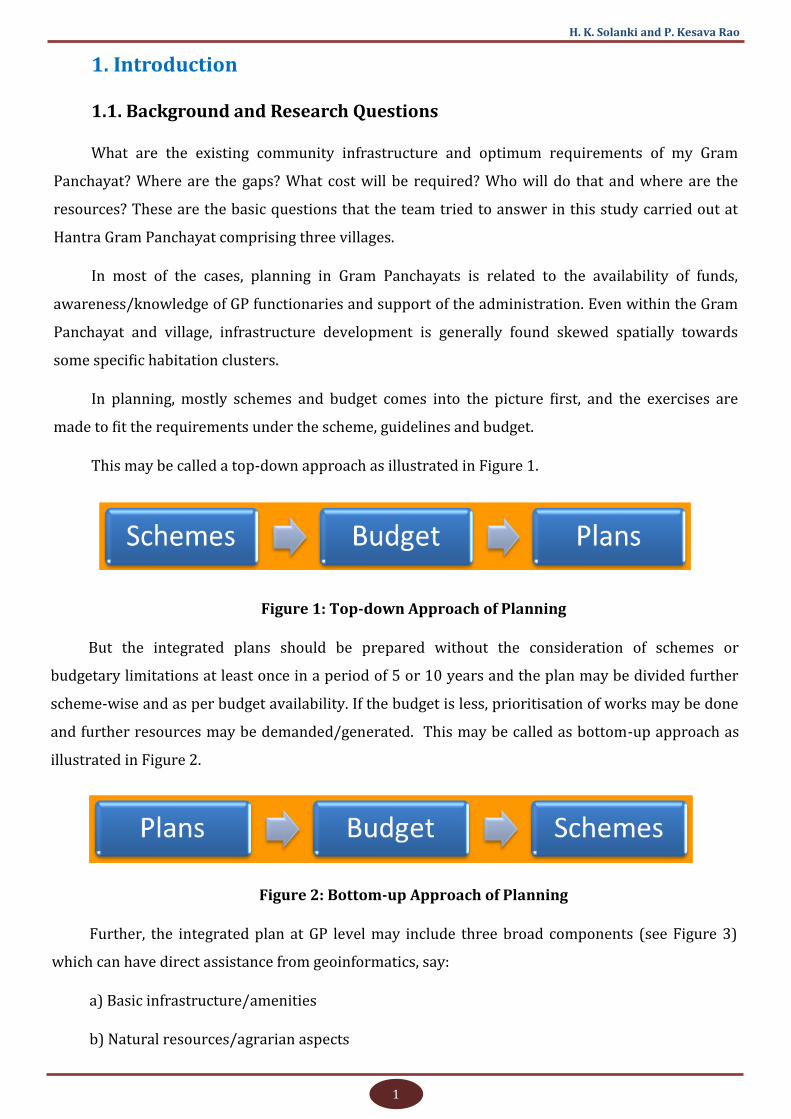
In planning, mostly schemes and budget comes into the picture first, and the exercises are
made to fit the requirements under the scheme, guidelines and budget.
This may be called a top-down approach as illustrated in Figure 1.
Figure 1: Top-down Approach of Planning
But the integrated plans should be prepared without the consideration of schemes or
budgetary limitations at least once in a period of 5 or 10 years and the plan may be divided further
scheme-wise and as per budget availability. If the budget is less, prioritisation of works may be done
and further resources may be demanded/generated. This may be called as bottom-up approach as
illustrated in Figure 2.
Figure 2: Bottom-up Approach of Planning
Further, the integrated plan at GP level may include three broad components (see Figure 3)
which can have direct assistance from geoinformatics, say:
a) Basic infrastructure/amenities
b) Natural resources/agrarian aspects
2
Assessing Infrastructure Gap Using GIS
c) Individual household needs like pension, shelter, PDS, sanitation, drinking water to each
household, etc.
Figure 3: Three Broad Components of GP Level Planning
Other than these, general aspects like livelihoods/skills development, human resources and
behavioural aspect, etc., which cannot be plotted in GIS environment, should also be the part of
planning. Only then, a holistic development of GP/Village will emerge.
Out of the above components, basic community infrastructure is covered under this study in
order to have a focused approach. The agrarian aspects including parcel-wise land use/land
capability, soils, plantations, erosion, drainage pattern, geology, cropping pattern, etc., may be
covered by taking large area/micro watershed into consideration in a separate study.
To decide the optimum level of resources, norms of the departments concerned, and people’s
participation are used as back-up before finally analysing the gaps. In this study, the gap analysis is
considered as the basis for the integrated infrastructure planning under the bottom-up approach, as
described above.
The Gram Panchayat and villages of the area are mainly facing the problems of drainage and it
is the common problem of villages in Bharatpur district as the land area is plain. Subsequently, water
is accumulated at various places due to lack of slope and outlet points, and poor programme
implementation. Hence, the study will have an additional focus on the requirements of drainage and
integrated drainage plan, along with levels of road, which is also one of the priority components of
the National Rurban Mission (NRuM). For this, a drone/UAV survey of the village habitation areas
has been done through NESAC, ISRO, Meghalaya. A separate section is available in the report for
3
H. K. Solanki and P. Kesava Rao
analysing the use of UAV/drone surveys in drainage planning and general rural development
planning and monitoring aspects.
All the analyses are backed up by proper mapping of existing and required assets and
overlaying results on base maps in the GIS environment.
1.2. Literature Review
NRDMS, Department of Science and Technology, Government of India is supporting and funding
initiatives of ‘Village Information System’ for the development of exhaustive village information
system for mapping almost all natural and physical resources of villages. But merely getting a bunch
of information through GIS is a matter of the past and now it should answer something to the
stakeholders. Hence, analysis like gaps in infrastructure and resources is also important (NRDMS,
DST, GoI 2019).
Space-Based Information Support for Decentralised Planning (SIS-DP) project has been
initiated by the National Remote Sensing Centre (NRSC) of ISRO under the aegis of National Natural
Resources Management System (NNRMS) and is being jointly executed by the National Remote
Sensing Centre and State Remote Sensing Centres of the country. The goal of the project is to
empower the Panchayati Raj Institutions (PRIs) and the stakeholders with space-based information
support for decentralised planning and governance in the country (NRSC, ISRO 2020).
The visualisation of the project has been designed with the name of web portal Bhuvan
Panchayat along with one mobile application for asset mapping in the field. The app provides the
facility to register as a citizen or as PRI. The initiative requires extensive training and pilot studies in
the country with making the asset capture formal and binding on PRIs, otherwise, the success of this
excellent project will remain limited. Further, the programme is limited only to create a spatial data
bank of assets.
Bhuvan IWMP-SRISHTI: Monitoring and Evaluation (M&E) is a web-based GIS application
(geoportal) enabling the monitoring and evaluation of IWMP watersheds, using satellite remote
sensing and sample field data using mobile smartphone applications. This geoportal facilitates M&E
of all IWMP watersheds for 10 States and 50 special watersheds in 16 States. The geoportal provides
image and map display, monitoring tools, summary statistics of all the IWMP watersheds. The
application enables national, State, district and watershed level access for information and report
generation. The application is associated with Bhuvan IWMP-DRISHTI, a smartphone app for online
field data collection along with geo-tagged photographs (DoLR, MoRD, GoI 2019).
Further, in an ambitious bid to transform rural areas into economically, socially and physically
sustainable spaces, the Government of India has approved the National Rurban Mission (NRuM) on
4
Assessing Infrastructure Gap Using GIS
21st February, 2016. To ensure an optimum level of development, 14 components have been
suggested as desirable for the clusters that are listed in this framework. States may choose the
components based on the detailed analysis of their cluster through their Integrated Cluster Action
Plans (ICAPs). The mission aims at development of rural growth clusters that have latent potential
for growth, in all States and UTs, which would trigger overall development in the region. The Rurban
Mission will thus develop a cluster of Smart Villages (MoRD, GoI n.d.).
The 14 components suggested as desirable for the cluster include skill development training
linked to economic activities, agro-processing/agri services/storage and warehousing, digital
literacy, sanitation, provision of piped water supply, solid and liquid waste management, village
streets and drains, street lights, fully equipped mobile health unit, upgrading school/higher
education facilities, inter-village road connectivity, Citizen Service Centres- for electronic delivery of
citizen-centric services/e-gram connectivity, public transport, and LPG connections. These clusters
would be strengthened with the required amenities, for which it is proposed that resources be
mobilised through the convergence of various schemes of the Government, over and above which a
Critical Gap Funding (CGF) would be provided under this Mission, for focused development of these
clusters (MoRD, GoI 2015).
The Rurban Mission looks like a modification of ‘Providing Urban Amenities in Rural Areas
(PURA)’ scheme, which has the objective of holistic and accelerated development of compact areas
around a potential growth centre in a Panchayat (or group of Panchayats) through Public-Private
Partnership (PPP) by providing livelihood opportunities and urban amenities to improve the quality
of life in rural areas. The primary objectives of the scheme were the provision of livelihood
opportunities and urban amenities in rural areas to bridge the rural-urban divide. The PURA scheme
was based on the vision of the then President of India Dr. A.P.J. Abdul Kalam. During his address to
the nation on eve of Republic Day in 2003, Dr. Kalam visualised providing four types of connectivity:
physical connectivity, electronic connectivity, knowledge connectivity leading to economic
connectivity of rural areas. Out of these, electronic connectivity looks very important as it helps to
connect the whole world at a very cheaper cost. Hence, in infrastructure development broadband
connectivity, availability of internet/mobile network is very important (MoRD, GoI n.d.).
Bharat Nirman is also one of the ambitious initiatives of the Ministry of Rural Development,
Government of India for the upscaling of rural infrastructure of India by concentrating on six major
sectors. This is a time-bound plan for rural infrastructure by the Government of India in partnership
with State governments and Panchayat Raj Institutions. Under Bharat Nirman, the action was
proposed in the areas of irrigation, road, rural housing, rural water supply, rural electrification and
rural telecommunication connectivity. There are set specific targets to be achieved under each of
these goals so that there is accountability in the progress of this initiative (NIC, GoI 2012).
5
H. K. Solanki and P. Kesava Rao
Under one of the basic objectives of the SAGY scheme, it is mentioned to have improved basic
amenities of the village for substantially improving the standard of living and quality of life of all
sections of the population (MoRD, GoI n.d.).
Now, the XIV Finance Commission has awarded a substantial grant of Rs.200292.20 crore
exclusively for the Gram Panchayats to be devolved over a period of five years. Over this period, as
per the existing trend, GPs are likely to get at least an equivalent amount from MGNREGS. Further,
the State Finance Commission (SFC) transfers, own source revenues and flows from State and
Centrally sponsored schemes would enlarge the financial resources of the GPs (MoPR, GoI 2018a).
People are well-versed with the situations that have been influencing their lives. Situation
analysis is a process through which the issues and the needs of the community and the gaps that
require intervention are identified. Situation analysis refers to the assessment of development status
of the GP. It is primarily required to assess the existing scenario of the GP on various development
issues. It also provides basic information on the gaps in infrastructure, amenities and services that
exist as well as the potential for future development. This analysis can serve as the basis for setting
priorities for the issues to be incorporated in the GPDP (MoPR, GoI 2018b).
The major drawback felt under these schemes is the limitation to sectors, and top-down
approach. The planning should remain holistic for the infrastructure development and it should be in
a bottom-up manner. Further, the GIS/remote sensing based projects are not stressing much on the
planning aspect and gap analysis at local levels, and are mostly limited to the inventory of assets and
visualisation.
1.3. Objectives
To survey and map the existing community infrastructure of Gram Panchayat
To assess ideal/optimum community infrastructure requirement of Gram Panchayat through
Participatory and Departmental Approach
To analyse and map gaps in community infrastructure and suggesting infrastructure
development plan of GP
Estimation of tentative cost for works and suggestions on inclusion in GP and Departmental
Development plans
6
Assessing Infrastructure Gap Using GIS
2. Method
2.1. Location/Demography and Justification of Area
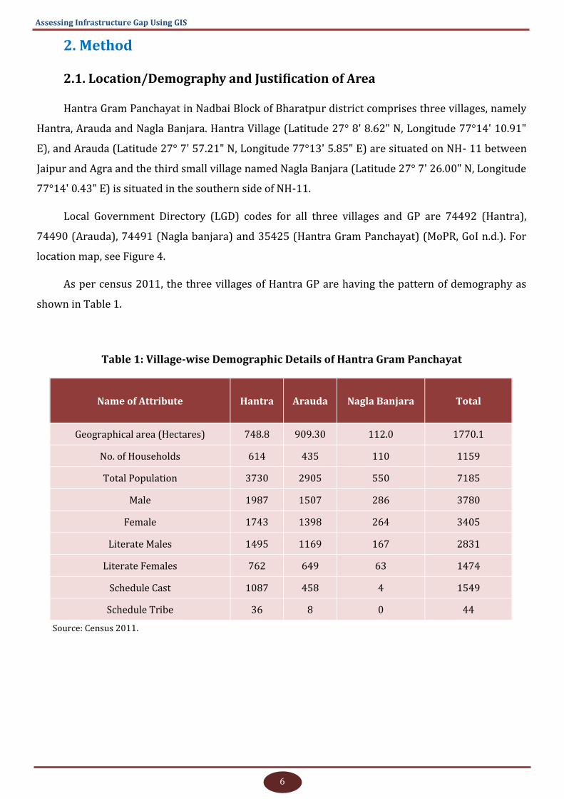
Hantra Gram Panchayat in Nadbai Block of Bharatpur district comprises three villages, namely
Hantra, Arauda and Nagla Banjara. Hantra Village (Latitude 27° 8' 8.62" N, Longitude 77°14' 10.91"
E), and Arauda (Latitude 27° 7' 57.21" N, Longitude 77°13' 5.85" E) are situated on NH- 11 between
Jaipur and Agra and the third small village named Nagla Banjara (Latitude 27° 7' 26.00" N, Longitude
77°14' 0.43" E) is situated in the southern side of NH-11.
Local Government Directory (LGD) codes for all three villages and GP are 74492 (Hantra),
74490 (Arauda), 74491 (Nagla banjara) and 35425 (Hantra Gram Panchayat) (MoPR, GoI n.d.). For
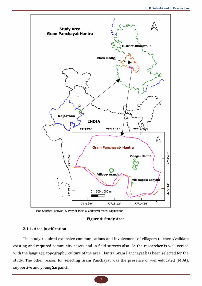
location map, see Figure 4.
As per census 2011, the three villages of Hantra GP are having the pattern of demography as
shown in Table 1.
Table 1: Village-wise Demographic Details of Hantra Gram Panchayat
Name of Attribute Hantra Arauda Nagla Banjara Total
Geographical area (Hectares) 748.8 909.30 112.0 1770.1
No. of Households 614 435 110 1159
Total Population 3730 2905 550 7185
Male 1987 1507 286 3780
Female 1743 1398 264 3405
Literate Males 1495 1169 167 2831
Literate Females 762 649 63 1474
Schedule Cast 1087 458 4 1549
Schedule Tribe 36 8 0 44
Source: Census 2011.
7
H. K. Solanki and P. Kesava Rao
Figure 4: Study Area
2.1.1. Area Justification
The study required extensive communications and involvement of villagers to check/validate
existing and required community assets and in field surveys also. As the researcher is well versed
with the language, topography, culture of the area, Hantra Gram Panchayat has been selected for the
study. The other reason for selecting Gram Panchayat was the presence of well-educated (MBA),
supportive and young Sarpanch.
8
Assessing Infrastructure Gap Using GIS
2.2. Materials
2.2.1. Software and Tools Used for Data Collection
For GIS visualisation and analysis, Open Source QGIS 3.4 Madeira (Long Term Release)
(https://qgis.org/en/site/) software was used. For field GPS data collection of points and lines,
OSMAND 2.6 version free mobile mapping app for Android phones was used. The OSMAND app can
work without internet connectivity in the field by using the GPS connectivity of phone (https://
osmand.net/). To collect ward-wise and village-wise data, meetings and group discussions were held
and the help of individuals like ward members and Panchayat functionaries were taken. To validate
the data and getting the overall problem and solutions, common Gram Panchayat level meetings
were also arranged. Data on existing assets were collected mostly by keeping the requirements of
GPDP guidelines.
Both the community members and departmental officials were contacted frequently during the
study along with collecting field data on assets. Attribute data like general details of assets were
collected from Panchayat functionaries and departmental officials concerned.
2.2.2. Secondary Data Sources
Secondary data was collected for knowing the departmental norms for various assets from all
relevant departments including Panchayat. Census data for the years 1991, 2001, and 2011 were
collected from State Census Department for analysing the primary census abstract and Village
Directory data.
Mostly open-ended questions were asked about the details of assets and status of service
delivery under various sectors in group meetings. NRSC IRS LISS-IV data of 5.8-metre spatial
resolution and Cartosat-2 data with about 1-metre spatial resolution were used at the initial stage for
checking the possibilities of application as base map and as an aid for other analyses.
To get the most refined base map and for other analysis of the village habituated areas,
unmanned aerial vehicle (UAV)/drone survey of settlement areas of all three villages under the study
Gram Panchayat was also carried out with the help of North Eastern Space Applications Centre
(NESAC), Umiam, Shilong, Meghalaya, which is a regional centre of the Indian Space Research
Organisation (ISRO). Data was taken with 5 cm pixel resolution and 10-15 cm of accuracies. A
separate chapter has been dedicated to the details of the drone survey conducted.
9
H. K. Solanki and P. Kesava Rao
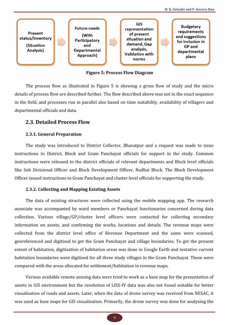
Figure 5: Process Flow Diagram
The process flow as illustrated in Figure 5 is showing a gross flow of study and the micro
details of process flow are described further. The flow described above was not in the exact sequence
in the field, and processes run in parallel also based on time suitability, availability of villagers and
departmental officials and data.
2.3. Detailed Process Flow
2.3.1. General Preparation
The study was introduced to District Collector, Bharatpur and a request was made to issue
instructions to District, Block and Gram Panchayat officials for support in the study. Common
instructions were released to the district officials of relevant departments and Block level officials
like Sub Divisional Officer and Block Development Officer, Nadbai Block. The Block Development
Officer issued instructions to Gram Panchayat and cluster level officials for supporting the study.
2.3.2. Collecting and Mapping Existing Assets
The data of existing structures were collected using the mobile mapping app. The research
associate was accompanied by ward members or Panchayat functionaries concerned during data
collection. Various village/GP/cluster level officers were contacted for collecting secondary
information on assets, and confirming the works, locations and details. The revenue maps were
collected from the district level office of Revenue Department and the same were scanned,
georeferenced and digitised to get the Gram Panchayat and village boundaries. To get the present
extent of habitation, digitisation of habitation areas was done in Google Earth and tentative current
habitation boundaries were digitised for all three study villages in the Gram Panchayat. These were
compared with the areas allocated for settlement/habitation in revenue maps.
Various available remote sensing data were tried to work as a base map for the presentation of
assets in GIS environment but the resolution of LISS-IV data was also not found suitable for better
visualisation of roads and assets. Later, when the data of drone survey was received from NESAC, it
was used as base maps for GIS visualisation. Primarily, the drone survey was done for analysing the
10
Assessing Infrastructure Gap Using GIS
application potential of UAV/drone data in village-level drainage and sanitation plans, which is a
major problem of the area. Further details are available in the chapter concerned.
After collecting data on existing assets, the same was validated by the departmental officials
concerned as well as Panchayat functionaries, and later imported into the GIS environment for
mapping and visualisation.
2.3.3. Collecting Demands from Villagers and Mapping
Data were collected on the problems of the villagers and solutions. The inputs were translated
to get the possibilities of creating any assets as a solution to the problem. To remain focused under
study, no individual problems were discussed. The data were collected ward-wise to stay more
concerned with the last unit of administration of the Indian governance system. However, the wards
are mainly meant to support the election process of India (as observed during discussions). An
attempt was made to get fair boundaries of wards with the help of ward members and Panchayat
functionaries for collecting the problems and accordingly, solutions were demanded. This helped the
study team to obtain more numbers of instances of the same problem to assess its acuteness and to
become more precise on assets required. While gathering their demands, no discussions on schemes,
budgets, and guidelines were made and every available person was having an equal opportunity to
discuss the common infrastructure or basic amenities-related problems and future requirements. If
the solution of any problem could be physically marked on the ground, its location was taken by the
research staff on site, with the help of mobile mapping app with other details.
After collecting the ward-wise data, village-wise meetings were conducted to further validate
the collected data and to get additional problems and solutions at the village level. The next round of
discussions was made at the Gram Panchayat level in which all the Panchayat members and
Panchayat level officials were invited to validate and finalise the demands collected. They were asked
to provide the details of common problems and demands of Gram Panchayat for basic infrastructure
and amenities specifically.
After collecting the problems and solutions sought, the demands which could be marked and
located on the ground were mapped in the GIS environment as GIS layers for various assets
demanded. The general problems and general solutions that require decision on location in the later
stage (like Bank, Gaushala) were not mapped in GIS. The problems which were not convertible to any
structure could not be mapped in the GIS environment (like raising/removal/insulation of electricity
wires).
2.3.4. Collecting Norms from Departmental Officials
In addition to collecting data on existing assets and demands, norms of the departments
11
H. K. Solanki and P. Kesava Rao
relevant to the study were also collected. These were mainly focused on the parameters used for
constructing new assets, repair of assets, etc. The secondary data was searched in departmental
websites also. The departments were contacted at Gram Panchayat, Block and district levels.
2.3.5. Analysing Demands and Norms and Suggesting a Work Plan
After collecting data on existing assets from the field, demands from villagers, norms from
relevant departments, and analysis of demands and norms were made keeping the status of existing
assets in view. Many findings were derived and presented in the results section. Resource-stressed
or resource-relaxed conditions were observed and presented for all demands of the villagers. Based
on the nature of assets demanded, departments and schemes are also suggested.
2.3.6. Cost Analysis of the Plan
After coming to a final possible infrastructure plan, a resource envelop was prepared for
assessing the financial capacity of Panchayat as per income and expenditure trend of five years
including all schemes. The total cost of the demanded assets was also estimated based on the
suggestions of the relevant departmental officials, expenditure norms of assets and villagers’
opinions.
2.3.7. Recommendations
Based on the study findings and discussions, recommendations are made for further
consideration.
12
Assessing Infrastructure Gap Using GIS
3. Data Presentation and Analysis
3.1. Demographic Trends of the Villages in Gram Panchayat
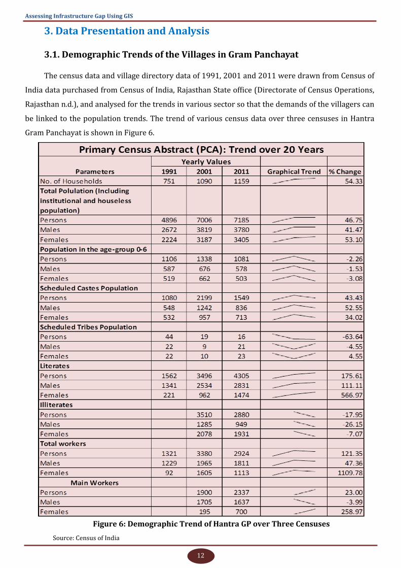
The census data and village directory data of 1991, 2001 and 2011 were drawn from Census of
India data purchased from Census of India, Rajasthan State office (Directorate of Census Operations,
Rajasthan n.d.), and analysed for the trends in various sector so that the demands of the villagers can
be linked to the population trends. The trend of various census data over three censuses in Hantra
Gram Panchayat is shown in Figure 6.
Figure 6: Demographic Trend of Hantra GP over Three Censuses
Source: Census of India
13
H. K. Solanki and P. Kesava Rao
Differences were found between Census-2011 and Socio-Economic and Caste Census (SECC-
2011) data and the reason may be different sources or timings of data collection. However, for the
study purpose, Census 2011 data was taken into account. The period of enumeration of SECC is
different than Census 2011 as quoted on SECC site, https://secc.gov.in/ (DoRD, MoRD, GoI 2011).
In village directory data, it was found that different/additional items, naming conventions, etc.,
were there over the three censuses of 1991, 2001 and 2011. For instance, some of the assets were
given in numbers while others were given in codes like ‘Yes’ and ‘No’ on availability status without
actual numbers. Hence, a proper trend generation like primary census abstract was not possible.
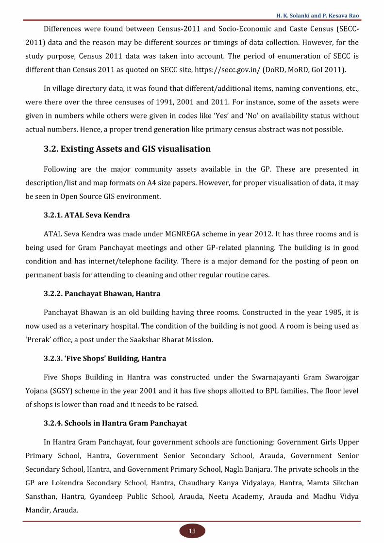
3.2. Existing Assets and GIS visualisation
Following are the major community assets available in the GP. These are presented in
description/list and map formats on A4 size papers. However, for proper visualisation of data, it may
be seen in Open Source GIS environment.
3.2.1. ATAL Seva Kendra
ATAL Seva Kendra was made under MGNREGA scheme in year 2012. It has three rooms and is
being used for Gram Panchayat meetings and other GP-related planning. The building is in good
condition and has internet/telephone facility. There is a major demand for the posting of peon on
permanent basis for attending to cleaning and other regular routine cares.
3.2.2. Panchayat Bhawan, Hantra
Panchayat Bhawan is an old building having three rooms. Constructed in the year 1985, it is
now used as a veterinary hospital. The condition of the building is not good. A room is being used as
‘Prerak’ office, a post under the Saakshar Bharat Mission.
3.2.3. ‘Five Shops’ Building, Hantra
Five Shops Building in Hantra was constructed under the Swarnajayanti Gram Swarojgar
Yojana (SGSY) scheme in the year 2001 and it has five shops allotted to BPL families. The floor level
of shops is lower than road and it needs to be raised.
3.2.4. Schools in Hantra Gram Panchayat
In Hantra Gram Panchayat, four government schools are functioning: Government Girls Upper
Primary School, Hantra, Government Senior Secondary School, Arauda, Government Senior
Secondary School, Hantra, and Government Primary School, Nagla Banjara. The private schools in the
GP are Lokendra Secondary School, Hantra, Chaudhary Kanya Vidyalaya, Hantra, Mamta Sikchan
Sansthan, Hantra, Gyandeep Public School, Arauda, Neetu Academy, Arauda and Madhu Vidya
Mandir, Arauda.
14
Assessing Infrastructure Gap Using GIS
3.2.5. Anganwadi
Four anganwadi centres are functioning in Hantra Gram Panchayat – two each in Hantra and
Arauda village. There is a demand for a centre in Nagla Banjara village. The anganwadis, which are
presently working in private buildings and school buildings, are seeking own buildings. Also,
separate drinking water and other facilities are not available here. All employees are female, who are
engaged by the ICDS department on temporary basis.
3.2.6. Post Office Hantra
The PIN code for Hantra is 321601. Hantra post office belongs to Bharatpur Division of Jaipur
HQ Region, Rajasthan Circle. Hantra is a branch post office and they have delivery facilities.
3.2.7. Hospitals
The Central government established a norm for setting up primary health centres to provide
medical facilities to a large number of people. The health planners in India think primary health
centres and sub-centres as the proper infrastructure to provide health services to the rural and tribal
population.
In Hantra Gram Panchayat, one primary health centre (PHC) is available whereas Arauda
village has a primary health sub centre (PHSC).
3.2.8. Water Tanks
Hantra Gram Panchayat has a total of 18 water tanks constructed by the GP - 11 in Arauda
village and 8 in Hantra village. Hantra village has an overhead water tank and two ground level
reservoirs (GLRs) and Arauda has one GLR. The villagers have sought water tanks at different places
in all three villages.
3.2.9. Hand pumps
A total of 41 hand pumps are available in the Gram Panchayat. Of this, PHE department has
installed 11 pumps and 30 were installed by Gram Panchayat. However, only a few hand pumps are
working whereas others are operated through electric motor and pipe. Out of these, only 7 pumps
are giving potable water while the rest are non-functional or having non-potable water.
3.2.10. Roads
In Hantra Gram Panchayat, a total of 206 different types of roads are digitised as per the
Panchayat records. Roads were categorised as internal roads connecting mostly the internal
locations of villages and external roads connecting the village with external locations or other
villages or habitations far from the main village. A total of 59 roads were marked/recorded in Arauda
15
H. K. Solanki and P. Kesava Rao
and are codified as Arauda Internal Roads (AIR) and Arauda External Roads (AER). In Hantra village,
133 roads were recorded and codified as Hantra Internal Roads (HIR) and Hantra External Roads
(HER). Similarly, in Nagla Banjara village, 17 roads were recorded and codified as Nagla Banjara
External Roads (NER) and Nagla Banjara Internal Road (NIR). Two roads belonged to Public Works
Department (PWD), one was National Highway and the other was the Gaurav Path constructed under
the Gaurav Path Scheme of the PWD. In whole, the road condition in Hantra Gram Panchayat is good
but the drainage water is flowing on roads due to flat or lesser slopes or chocked drainages.
Therefore, frequent damage and construction of roads happen in each plan. Laying of blue metal on
roads is pending at few places and it needs to be completed.
3.2.11. Public Distribution System (PDS) Shops
Hantra Gram Panchayat has three public distribution system (PDS) shops - one in Arauda
village and two in Hantra village. Nagla Banjara village has no PDS shop is available. Shops are
functioning in private buildings and there is a demand to shift the shops to government buildings or
permanent designated places having basic facilities.
3.2.12. Drainage
Drainage is a major problem faced by Hantra Gram Panchayat. Due to poor drainage system
and blockages of drainage channels, wastewater is stored on roads at water stagnation points.
Though drainage channels are constructed along the roads, they are not maintained well. Neither
regular cleaning is done nor are any norms available. Drone images were interpreted for the overall
slope and terrain condition of the village, water stagnation points and as per slope conditions,
suggestions are made to resolve the problem. The drone images are used as base maps also for
proper visualisation of assets. The applications of drone have been dealt with separately in further
sections in detail.
3.2.13. Reverse Osmosis (RO) Plants
Two Reverse Osmosis (RO) plants – one each in Arauda and Hantra are available in Hantra
Gram Panchayat. Both the villages have demanded an additional RO plant. Nagla Banjara village
doesn’t have RO plant facility.
3.2.14. Electric Transformers
A total of 171 electric transformers are available in different capacities like 5 KW, 10 KW, 16
KW, and 25 KW. Hantra village has a total of 113 transformers, Arauda village has 65 and Nagla
Banjara has 5. All transformers are in good working condition. Grid Sub Station (GSS) is situated at
Dehra mod, which is nearly three kilometres away from the GP.
16
Assessing Infrastructure Gap Using GIS
3.2.15. Wells
Hantra Gram Panchayat has a total of 54 wells. Hantra village has 26 wells, Arauda has 23 wells
and Nagla Banjara has 5. All wells have gone dry and are not being used. The water level is very low
and its quality is poor.
3.2.16. Bandh (Earthen Bunds)
One Bandh (बंध) which is also called Bandha (बंधा) is an earthen structure constructed along a
long line to conserve/divert the flow of water or reduce the speed of runoff. Such kind of a structure
is available in Hantra village and stretched to ward numbers 6, 8 and 9 and a structure is available in
Arauda. Bandh area in Hantra village has almost come under encroachment.
3.2.17. Water Ponds
The Gram Panchayat has a total of 10 ponds. Of these, three major ponds are situated in Hantra
and two are in Arauda. Nagla Banjara village does not have any pond.
3.2.18. Shamshan Ghats/Cemeteries
Five cemeteries are available in Hantra Gram Panchayat - two each in Hantra and Arauda and
one in Nagla Banjara.
3.2.19. Deep Borewell
Hantra Gram Panchayat has a total of seven deep bore-wells generally called deep bores. Four
of them are in Hantra village - three constructed by Gram Panchayat and one by PHED. Arauda
village has three deep bores - two constructed by Gram Panchayat and one by PHED.
3.2.20. Brick Kilns
Hantra Gram Panchayat has 20 private brick kilns – 16 in Hantra village and 4 in Arauda village.
Nagla Banjara does not have any brick kiln. Basic facilities are available at kilns but the living
conditions of labourers are not good.
3.2.21. Mobile Communication Towers
Four mobile communication towers of BSNL, Vodafone, Reliance and TATA are installed in
Hantra Gram Panchayat.
3.2.22. Others
The GP has other assets like two beer factories, a petrol pump, three Common Service Centres
(CSCs), two bus shelters on the highway, four restaurants, a veterinary hospital operated in
Panchayat Bhawan building, and 10 temples.
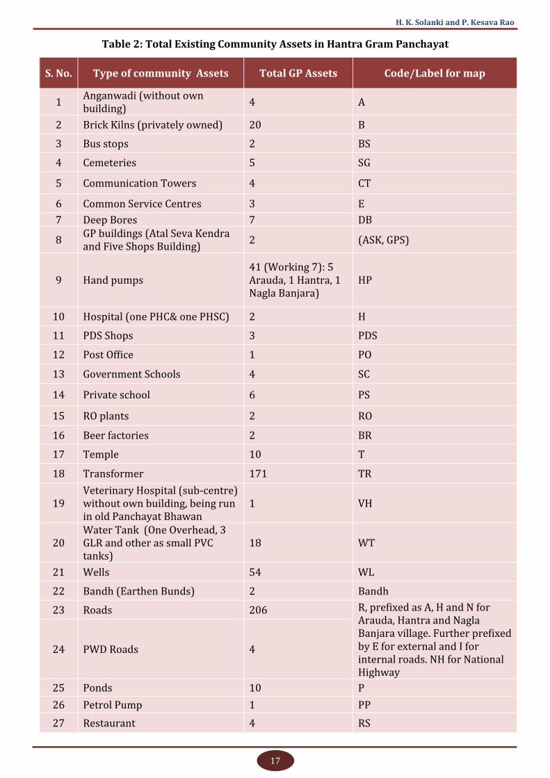
The consolidated asset-wise details are presented in Table 2.
17
H. K. Solanki and P. Kesava Rao
Table 2: Total Existing Community Assets in Hantra Gram Panchayat
S. No. Type of community Assets Total GP Assets Code/Label for map
1 Anganwadi (without own building)
4 A
2 Brick Kilns (privately owned) 20 B
3 Bus stops 2 BS
4 Cemeteries 5 SG
5 Communication Towers 4 CT
6 Common Service Centres 3 E
7 Deep Bores 7 DB
8 GP buildings (Atal Seva Kendra and Five Shops Building)
2 (ASK, GPS)
9 Hand pumps 41 (Working 7): 5 Arauda, 1 Hantra, 1 Nagla Banjara)
HP
10 Hospital (one PHC& one PHSC) 2 H
11 PDS Shops 3 PDS
12 Post Office 1 PO
13 Government Schools 4 SC
14 Private school 6 PS
15 RO plants 2 RO
16 Beer factories 2 BR
17 Temple 10 T
18 Transformer 171 TR
19 Veterinary Hospital (sub-centre) without own building, being run in old Panchayat Bhawan
1 VH
20 Water Tank (One Overhead, 3 GLR and other as small PVC tanks)
18 WT
21 Wells 54 WL
22 Bandh (Earthen Bunds) 2 Bandh
23 Roads 206 R, prefixed as A, H and N for Arauda, Hantra and Nagla Banjara village. Further prefixed by E for external and I for internal roads. NH for National Highway
24 PWD Roads 4
25 Ponds 10 P
26 Petrol Pump 1 PP
27 Restaurant 4 RS
18
Assessing Infrastructure Gap Using GIS
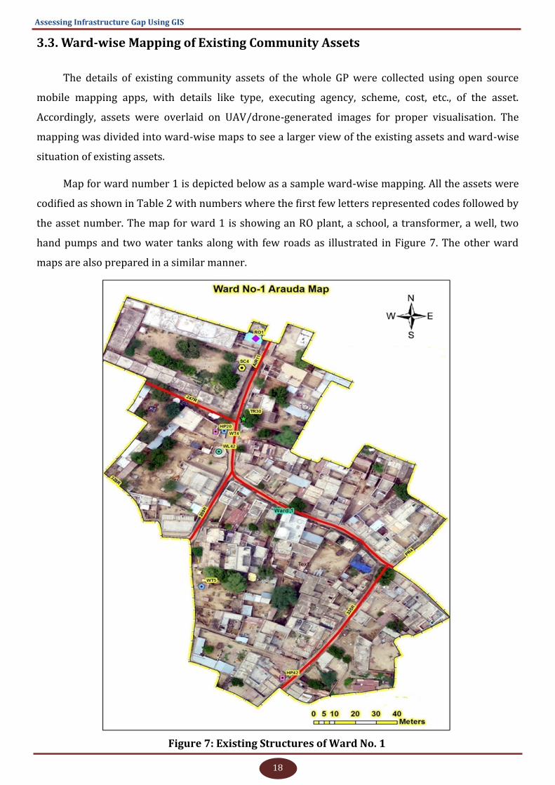
3.3. Ward-wise Mapping of Existing Community Assets
The details of existing community assets of the whole GP were collected using open source
mobile mapping apps, with details like type, executing agency, scheme, cost, etc., of the asset.
Accordingly, assets were overlaid on UAV/drone-generated images for proper visualisation. The
mapping was divided into ward-wise maps to see a larger view of the existing assets and ward-wise
situation of existing assets.
Map for ward number 1 is depicted below as a sample ward-wise mapping. All the assets were
codified as shown in Table 2 with numbers where the first few letters represented codes followed by
the asset number. The map for ward 1 is showing an RO plant, a school, a transformer, a well, two
hand pumps and two water tanks along with few roads as illustrated in Figure 7. The other ward
maps are also prepared in a similar manner.
Figure 7: Existing Structures of Ward No. 1
19
H. K. Solanki and P. Kesava Rao
3.4. Ward-wise Status of General Needs/Demands of Assets
The general problems and needs/demands of assets were noted in ward-wise meetings and
group discussions were held with villagers and Panchayat functionaries. The demands were divided
into two sections as 1) general demands and 2) demands for construction of community assets which
can be shown on the map.
3.4.1. Demands of Ward No.1
Village Name: Arauda
General Problems and Demands
1. Wells in Arauda village are dried up. During rains, the water level in wells goes up
temporarily. But, due to poor water quality and polluted water, the water from the well
is not used for drinking or other purposes.
2. The water level has gone down and only one hand pump is being used. Therefore, some
villagers have made groups and at the personal level, they have fitted electric
submersible pumps in hand pumps for extracting water through PVC pipes to their
homes. The water level is 250-350 feet below ground level.
3. High voltage (11 KV) wires are hanging open in ward no. 1 and these wires should be
insulated with plastic/PVC.
4. Light and fan with other basic facilities are needed at anganwadi centre.
5. Soak pits can be constructed at areas having no natural water drainage slope.
Demands of Community Assets
1. Construction of deep bore well of 8-inch diameter in the vicinity of main pond.
2. Wi-Fi and computer facility in school
3. Common drinking water facility for animals.
4. Soak pit
3.4.2. Demands of Ward No.2
Village Name: Arauda
Demands of Community Assets
1. Water tank
2. Veterinary hospital in Arauda
3. Metal to be laid on road near highway
20
Assessing Infrastructure Gap Using GIS
3.4.3. Demands of Ward No. 3
Village Name: Arauda
General Problems and Demands
1. High voltage open wires
2. Demands of community assets
3. Hand pumps (two)
4. Covering open drainage channel
3.4.4. Demands of Ward No.4
Village Name: Arauda
General Problems and Demands
1. Minimum road width should be 20 feet
2. Demands of community assets
3. Drinking water facility for animals
4. Veterinary hospital in Arauda
5. Deep bore well in the vicinity of the existing deep bore well
6. Brick/RCC street roads
7. Overhead water tank or ground level tank near deep bore well
8. Widening of roads
3.4.5. Demands of Ward No.5
Village Name: Arauda
General Problems and Demands
1. In this ward, water stagnation occurs; hence, a proper drainage system is needed
2. All wells are dry except a few near the ponds with seasonal water availability
3. Streets road should be repaired.
Demands of Community Assets
1. Water exit/drainage facility
21
H. K. Solanki and P. Kesava Rao
2. Repair of street roads
3. Anganwadi building
3.4.6. Demands of Ward No.6
Village Name: Hantra
General Problems and Demands
Metal is yet to be laid on the common road from the National Highway to ward no.7.
Groundwater depth is up to 350 and the water is salty also.
Demands of Community Assets
1. Metaling of the road from National Highway to ward no. 7
2. Deep bore well
3.4.7. Demands Ward No.7
Village Name: Hantra
General Problems and Demands
1. Primary health centre road is not clean and broken at different places.
Demands of Community Assets
1. Piped water supply
2. Water tank near PHC
3. Brick/RCC roads inside the ward
4. Hand pump near ‘Weir wali road’
5. Repair of PHC road
6. Hand pump
3.4.8. Demands of Ward No.8
Village Name: Hantra
Demands of Community Assets
One Hand pump
Repair of a road from the ward member’s home to priest's home
22
Assessing Infrastructure Gap Using GIS
3.4.9. Demands of Ward No.9
Village Name: Nagla Banjara
General Problems and Demands
1. The salinity of water makes it unsafe for consumption and currently no RO plant is
available in Nagla Banjara village.
2. Disposal of wastewater
3. Cleaning of chocked drainages and letting out stagnated drainage water
4. As the compound of the lone school in the village is below road level, water stagnates on
the school premises. This is affecting the movement of students during rainy season.
Demands of Community Assets
1. One Reverse Osmosis (RO) plant
2. RCC road connecting Nagla Banjara to main road
3. A pit outside the village for dumping of sewage/wastewater
4. Drains along the roads lacking proper drainage facility
5. Piped water supply
6. Anganwadi centre with a building.
7. Drainage mechanism to let stagnated water out of the school building
8. Road to Weir side called ‘Weir wali Road’ is damaged at few places and it requires need-
based repairs
9. A hand pump
3.4.10. Demands of Ward No.10
Village Name: Hantra
General Problems and Demands
1. Open high voltage electric wires (11 KV) should be insulated with PVC
2. The height of electric poles supporting high voltage wires needs to be raised
3. Salinity of drinking water
23
H. K. Solanki and P. Kesava Rao
Demands of Community Assets
1. Drainage facility should be provided at all places where it is not available.
3.4.11. Demands Ward No.11
Village Name: Hantra
General Problems and Demands
1. Either one RO plant for 3000 people or one RO for two wards
2. Stagnation of polluted water
3. Groundwater pollution due to mixing of Water Closet (WC) water and bathing water
4. Widening of roads
5. Insulation of 11 KV HT lines with plastic/PVC
6. Pruning of trees that come in contact with the power lines
7. HT lines should be under ground or insulated with plastic
8. Usage of telephone poles as electricity poles
9. Burning of crops due to open low-lying high voltage power lines.
10. Low groundwater level
11. Free-roaming cattle like cow (non-productive) and bulls destroy crops
12. Lack of cleanliness
Demands of Community Assets
1. A new RO Plant (one already exists)
2. River water linkage for irrigation in crop land
3. RCC road from the settlement finishing point to the cemetery
4. RCC metaling on road from beer factory to the main village
5. Tightening of the low hanging wires over the crop field
6. Insulation of high voltage lines with PVC
7. Rescue centre (Gaushala) for animals (cow/bulls).
8. Retaining wall in the pond
24
Assessing Infrastructure Gap Using GIS
9. Timely cleaning of stagnated water and chocked drainages
10. Widening of roads
11. Anganwadi building
3.4.12. Demands of Ward No.12
Village Name: Hantra
General Problems and Demands
1. Changing the location of Grid Sub Station
Demands of Community Assets
1. Deep borewell
2. Straight brick/RCC road from National Highway to Bharkau village
3.4.13. Demands of Ward No.13
Village Name: Hantra
General Problems and Demands
1. Bhumiyan to cemetery roads is broken at different places
2. No provision to let out the stagnated water
Demands of Community Assets
1. Metaling of roads
2. Repair of ‘Bhumiyan to cemetery road’
3. Piped drinking water
4. Proper drainage to address water stagnation
3.5. Validation of Ward-Wise Demands at Village and Gram Panchayat Level
The demands were cross-verified and discussed for their general applicability and intensity at
the village and Gram Panchayat level. The following demands were not found suitable for further
consolidation or out of the scope of the study, based on various reasons described along with the
demand. Accordingly, these demands were removed from further analysis.
1. Cleaning of streets and drainage channels & manpower arrangements for cleaning - The
demands were not directly convertible to the physical assets; however, the same is further
discussed in the analysis of demands of physical assets.

25
H. K. Solanki and P. Kesava Rao
2. Primary health sub-centre - The centre is almost completed and functional, hence may not be
part of demand.
3. Upgradation of Government girls upper primary school to senior secondary school- As the
Gram Panchayat already have two Co-education senior secondary schools, the demand for a
third exclusive Girls Senior Secondary school was not found feasible.
4. Instrument supports at Common Service Centre (CSC) in Atal Seva Kendra- It was informed by
the Panchayat functionaries that the basic required instruments as per norms are available at
the centre.
5. Police Chauki- It was informed that the existing Police Chauki is situated at distance of nearly
2.5 km from Hantra village. Even though it is located a bit away far from other villages, a
separate police Chauki in GP at this point of time is not required.
6. Construction of Bus Stand- National Highway Authority has constructed two stoppages on
either side of the highway and it was informed that the GP cannot construct or modify any
work. Further, the present structure was found sufficient and no additional bus stand is
required inside the village.
7. The shifting of Electric Grid Sub Station (GSS) to a nearer place - The current GSS is located at
Dehra Mod which is 3 km away from Hantra village. It may be little far from other villages but it
was found that there is not much requirement and in case of requirement, the load-bearing
capacity of GSS can be increased. Electric infrastructure for GP is sufficient at this point of time.
3.6. Priority of All Demands as Shown by Villagers (first five)
1. Drinking Water
2. Proper drainage and removal of stagnated water
3. Controlling the freely roaming animals
4. Insulating/raising open electric wires
5. Roads
The above ranking is based on the views of the common public in group discussions, however,
views of Panchayat functionaries were different on this and roads were shown as third priority by
them. For the study purpose, views of the common public have been taken into consideration for
further analyses. The demands collected at ward levels were consolidated in a tabular manner (see
Table 3) and segregated in various sectors, with the frequency of demand and priority of sectors.
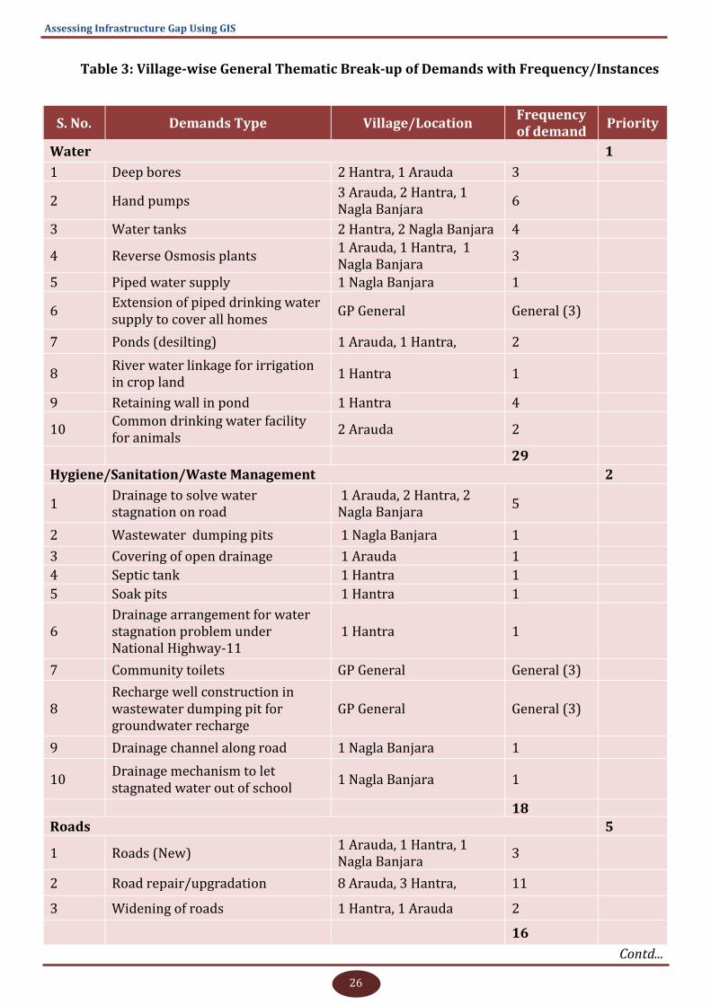
26
Assessing Infrastructure Gap Using GIS
Table 3: Village-wise General Thematic Break-up of Demands with Frequency/Instances
S. No. Demands Type Village/Location Frequency of demand
Priority
Water 1
1 Deep bores 2 Hantra, 1 Arauda 3
2 Hand pumps 3 Arauda, 2 Hantra, 1 Nagla Banjara
6
3 Water tanks 2 Hantra, 2 Nagla Banjara 4
4 Reverse Osmosis plants 1 Arauda, 1 Hantra, 1 Nagla Banjara
3
5 Piped water supply 1 Nagla Banjara 1
6 Extension of piped drinking water supply to cover all homes
GP General General (3)
7 Ponds (desilting) 1 Arauda, 1 Hantra, 2
8 River water linkage for irrigation in crop land
1 Hantra 1
9 Retaining wall in pond 1 Hantra 4
10 Common drinking water facility for animals
2 Arauda 2
29
Hygiene/Sanitation/Waste Management 2
1 Drainage to solve water stagnation on road
1 Arauda, 2 Hantra, 2 Nagla Banjara
5
2 Wastewater dumping pits 1 Nagla Banjara 1
3 Covering of open drainage 1 Arauda 1
4 Septic tank 1 Hantra 1
5 Soak pits 1 Hantra 1
6 Drainage arrangement for water stagnation problem under National Highway-11
1 Hantra 1
7 Community toilets GP General General (3)
8 Recharge well construction in wastewater dumping pit for groundwater recharge
GP General General (3)
9 Drainage channel along road 1 Nagla Banjara 1
10 Drainage mechanism to let stagnated water out of school
1 Nagla Banjara 1
18
Roads 5
1 Roads (New) 1 Arauda, 1 Hantra, 1 Nagla Banjara
3
2 Road repair/upgradation 8 Arauda, 3 Hantra, 11
3 Widening of roads 1 Hantra, 1 Arauda 2
16
Contd...
27
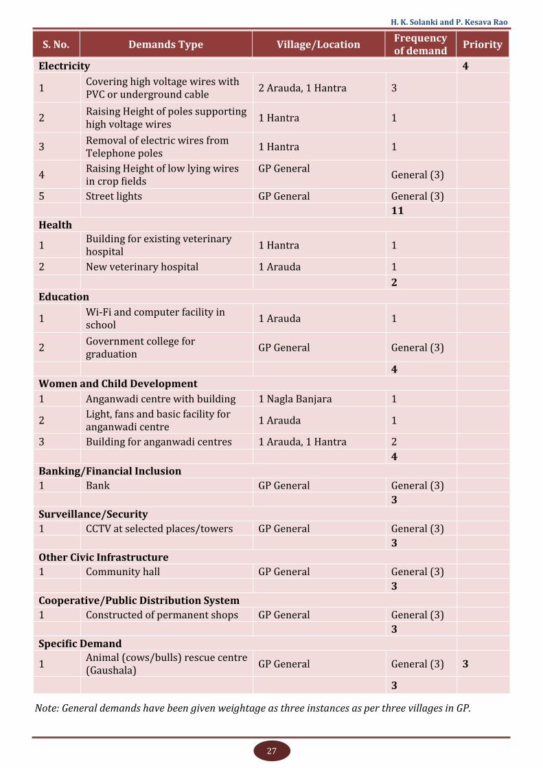
H. K. Solanki and P. Kesava Rao
S. No. Demands Type Village/Location Frequency of demand
Priority
Electricity 4
1 Covering high voltage wires with PVC or underground cable
2 Arauda, 1 Hantra 3
2 Raising Height of poles supporting high voltage wires
1 Hantra 1
3 Removal of electric wires from Telephone poles
1 Hantra 1
4 Raising Height of low lying wires in crop fields
GP General
General (3)
5 Street lights GP General General (3)
11
Health
1 Building for existing veterinary hospital
1 Hantra 1
2 New veterinary hospital 1 Arauda 1
2
Education
1 Wi-Fi and computer facility in school
1 Arauda 1
2 Government college for graduation
GP General General (3)
4
Women and Child Development
1 Anganwadi centre with building 1 Nagla Banjara 1
2 Light, fans and basic facility for anganwadi centre
1 Arauda 1
3 Building for anganwadi centres 1 Arauda, 1 Hantra 2
4
Banking/Financial Inclusion
1 Bank GP General General (3)
3
Surveillance/Security
1 CCTV at selected places/towers GP General General (3)
3
Other Civic Infrastructure
1 Community hall GP General General (3)
3
Cooperative/Public Distribution System
1 Constructed of permanent shops GP General General (3)
3
Specific Demand
1 Animal (cows/bulls) rescue centre (Gaushala)
GP General General (3) 3
3
Note: General demands have been given weightage as three instances as per three villages in GP.

28
Assessing Infrastructure Gap Using GIS
In Table 4, demands of assets raised by villagers are compared with the priorities of FFC, SAGY
and RURBAN schemes to map variations and similarities in local demands of villagers and priorities
of national schemes. Demands matching with the villagers’ demands are shown in bold.
Table 4: Demands Raised by Villagers versus Priorities of Various Guidelines (FFC, SAGY,
RURBAN)
Demands Raised by Villagers FFC Guidelines SAGY Guidelines RURBAN
Guidelines
Deep bores, hand pumps, water tanks
(Overhead/GLR), Reverse Osmosis
plants, piped water supply, extension of
piped drinking water supply, ponds,
desilting of ponds, retaining wall in
pond, common drinking water facility
for animals, drainage for water
stagnation on road, wastewater
dumping pits, covering of open
drainage, septic tank, soak pits,
drainage arrangement for water
stagnation problem under National
Highway-11, community toilets,
cleaning of streets, cleaning of drainage
channels along road side, drainage
channel along roads, drainage
mechanism to let stagnated water out
of school, road repair/upgradation,
widening of roads, covering high
voltage wires with PVC or underground
cable, raising height of poles supporting
high voltage wires, removal of electric
wires from telephone poles, tightening
of the low-lying wires over crop fields,
Pruning of trees to prevent electric
shocks, street lights, building for
existing veterinary hospital, new
veterinary hospital, Wi-Fi and
computer facility in school, upgradation
of government girls upper primary
school to senior secondary school,
government college for graduation,
anganwadi centre with building, light &
fans and basic facilities for anganwadi
centre, manpower and proper
instrument support to Common Service
Centre (CSC) and other services at Atal
Seva Kendra, bank, police chauki, CCTV
at selected places/towers, community
hall, construction of bus stand, animal
(cows/bulls) rescue centre (Gaushala)
Community water
tank,
community well, hand
pumps construction
and maintenance,
drinking water and
sanitation (wells,
ponds, tanka, hand
pumps, bore wells,
glr, Janta Jal, Panghat,
etc.), water supply
pipelines, motor/
pump for water supply,
washroom at common
places for ladies and
gents, toilets in
schools for boys and
girls, drainage
channel for
wastewater , liquid
and solid waste
management
(garbage dumping
points), locating
water stagnation
points and suggesting
the solutions,
community assets
location and their
maintenance,
maintenance of parks,
and play grounds,
maintenance of roads,
crematories, footpath
and burial grounds,
street light
arrangements,
sewage management
Internal all-
weather roads
with covered
drains, all-weather
road connectivity
to the main road
network, street
lights including
those using
alternative sources
of energy, especially
solar, pucca
infrastructure for
public institutions-
anganwadis,
schools, health
institutions, Gram
Panchayat office and
libraries, civic
infrastructure
including
community halls,
buildings for SHG
federations,
playgrounds and
burial grounds/
crematoria, village
markets,
Infrastructure for
PDS outlets, micro
mini banks /post
offices/ATMs,
broadband
connectivity and
Common Service
Centres, telecom
connectivity, CCTVs
in public places
Agro Processing,
agri services,
storage and
warehousing,
upgrading
school/higher
education
facilities
provision of
piped water
supply, solid
and liquid
waste
management,
village streets
and drains,
street lights,
inter-village
road
connectivity,
LPG connections,
digital literacy,
Citizen Service
Centres (CSC) -
for electronic
delivery of
citizen-centric
services/e-
gram
connectivity
29
H. K. Solanki and P. Kesava Rao
3.7. Status of Departmental Norms
Under the study, various relevant departments were contacted for information on norms and
parameters for constructing related new assets so that the same can be used for assessing the
optimum level of asset requirements as per departmental norms. Most schemes/works have the
main criteria/parameters as public demand only. However, whenever parameters like population,
water quality, distance, etc., are properly available, these supersede the public demand.
These norms were collected by personally contacting the departmental officials at Block,
district and State levels or from guidelines if available in guidelines. These norms are always subject
to change with changes in the guidelines and policies of departments/ministries. The following
departments/offices were contacted under the study.
District PDS (Supplies) Department, Bharatpur, Rajasthan
Office of the Block Chief Health Officer, Nadbai Block (Bharatpur)
Department of Information Technology and Communication, Government of Rajasthan
Police Department, Bharatpur, Rajasthan
PNB Bank Lead Bank District Manager (LDM) office, Bharatpur, Rajasthan
JVVNL (Jaipur Vidyut Vitran Nigam Limited) Electricity Department, Bharatpur, Nadbai,
Rajasthan
Rajasthan Cooperative Department
Public Health and Engineering Department Norms
Public Works Department
Integrated Child Welfare Department (ICDS)
Education Department
3.8. Demand Analysis Considering Existing Structures and Departmental
Norms
All demands were analysed in GIS environment (wherever possible) with reference to the
existing assets of similar nature, departmental norms. GIS visualisation was done in reference to
various relevant parameters.
Densities are calculated on unit population or unit area basis as the case may be, and described
in text suitably. For population basis, the population of Hantra, Arauda and Nagla Banjara has been
counted from Census 2011 and for area basis, GIS-derived habitational areas of villages are counted.
The basic data for the three villages is presented in Table 5 for ready reference.
30
Assessing Infrastructure Gap Using GIS
Table 5: Basic Data of Three Villages to be Used in Further Analysis
Name of Attribute Hantra Arauda Nagla
Banjara Total Source
Geographical area (hectares) 748.8 909.30 112.0 1770.1
Census 2011
No. of Households 614 435 110 1159
Literates 2257 1818 230 4305
Illiterates 1473 1087 320 2880
Total Population 3730 2905 550 7185
SC/ST Population 1123 466 4 1593
Population in the age group 0-6 593 370 118 1081
Habitation area as per revenue record (hectares)
14.86 6.5 1.02 22.38
GIS
Habitation area as per Google Image (hectares)
63.98 32.37 2.09 98.44
Length of roads constructed in total village area (kms)
28 16 3 47
Length of roads in habitational area (metres)
9505 4691 677 14873
Using the GIS tool, it is possible to capture the proximity of assets and calculate the ward,
village or GP area-wise asset density. This is helpful to understand the fair distribution of assets over
the area. Population-wise asset density also can be visualised by knowing the number of assets
falling under a particular area divided by the total population of the area.
The analysis has been made for the assets which are having population, area or distance/time
criteria. For the assets where GIS visualisation is not feasible for very few data or not feasible for
mapping, descriptive details are given.
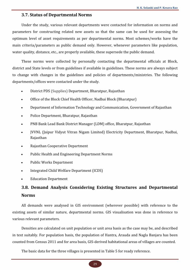
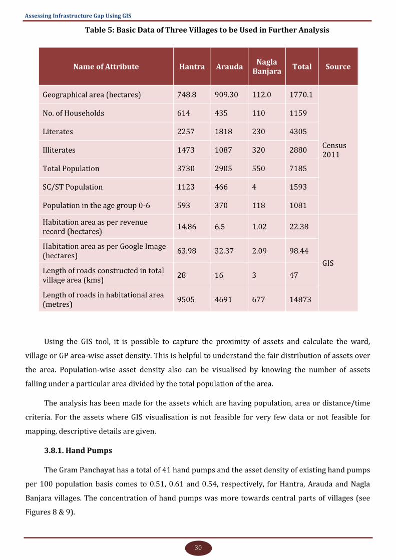
3.8.1. Hand Pumps
The Gram Panchayat has a total of 41 hand pumps and the asset density of existing hand pumps
per 100 population basis comes to 0.51, 0.61 and 0.54, respectively, for Hantra, Arauda and Nagla
Banjara villages. The concentration of hand pumps was more towards central parts of villages (see
Figures 8 & 9).
31
H. K. Solanki and P. Kesava Rao
Figure 8: GIS Visualisation of Assets - Hand Pumps
Figure 9: Proximity Analysis for Hand Pumps
32
Assessing Infrastructure Gap Using GIS
Almost all hand pumps are ineffective due to low water table or poor water quality (the water
from hand pump near the school in Hantra village was tasted and found not fit for consumption).
Generally, people are making groups and putting submersible pumps in hand pumps for drafting
water. Hence, hand pumps are just for namesake and later used as submersible bores. At present, the
hand pump system is a failure in the area. Moreover, villagers and departmental officials do not want
further hand pumps in the areas where water table is 100 feet below the ground level or water is not
potable. Manual operation of hand pumps at a depth of more than 100 feet was not shown feasible by
the PHE department officials.
3.8.2. Other Water-Related Assets
3.8.2.1. Ponds
The village has a total of 10 ponds. Maintenance and construction of retaining walls and
structure to ensure inflow of water is required in different ponds. There are no proper norms for
desilting and maintenance of ponds and as per public demand, works can be performed. As a general
norm, it was informed that the ponds desilted under the Mukhyamantri Jal Swablamban Abhiyan
(MJSA) cannot be taken up again for desilting and all the eligible ponds in the GP have been desilted
under the MJSA scheme of State government. However, it will be better to have specific norms for
desilting of ponds as desilting can break the hard clay base of ponds. If the pond is mostly used for
water harvesting, animal/human drinking purpose, irrigation, etc., the activity may be carried out
with precaution at proper intervals. If the structure is used only as a recharge pond, then the activity
may be performed frequently also. In villages, most of the ponds are used for water harvesting with
slow percolation; hence, the norms may be fixed for the time gap between the desilting activities of
ponds of different areas/terrain conditions. In Hantra village, two ponds are not getting enough
water and the remaining are mostly dry.
Most of the ponds are being used for dumping waste and letting out excess water of the village,
thereby making it non-usable for drinking/bathing purposes. Consequently, the ponds have been
used as waste/excess water collection points. The practice of draining out domestic wastewater into
ponds should be banned and it must be drained into soak pits/separate pits.
Another substantial demand was construction of retaining walls for four ponds.
3.8.2.2. Water Tanks
The village has a total of 19 water tanks and four new ones have been demanded. As per the
norms, the minimum population for a tank is 500 for ‘Single Point Scheme’ and 1500 for ‘Pump and
Tank Scheme’. With respect to both criteria, water tanks are already saturated in Gram Panchayat.
Considering the village as a unit, Nagla Banjara has no water tank and there is no demand for one.
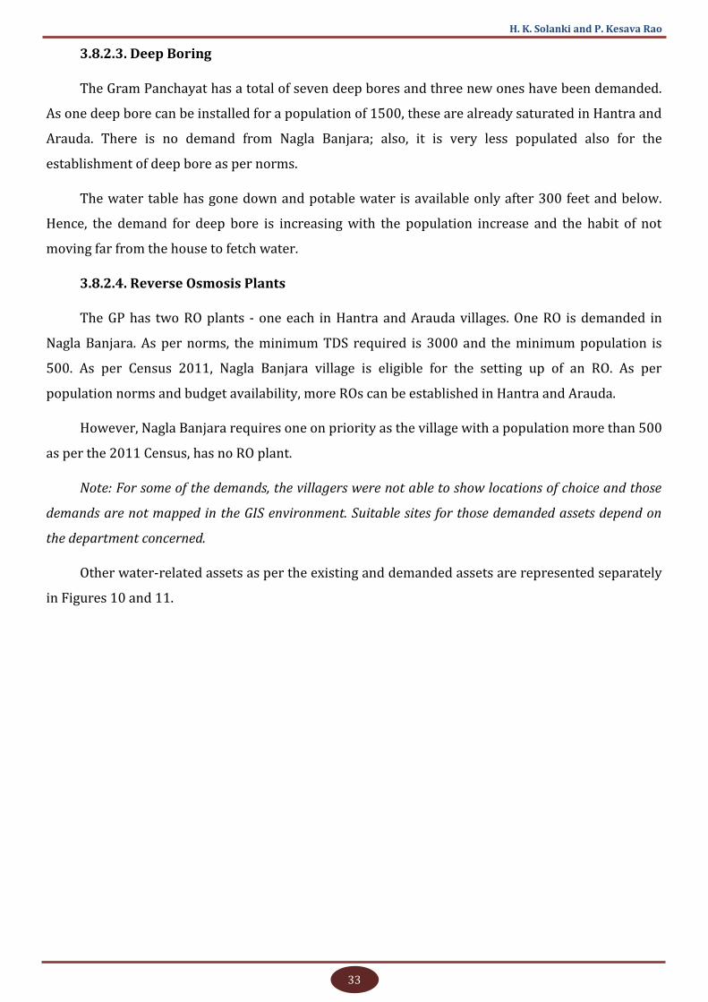
33
H. K. Solanki and P. Kesava Rao
3.8.2.3. Deep Boring
The Gram Panchayat has a total of seven deep bores and three new ones have been demanded.
As one deep bore can be installed for a population of 1500, these are already saturated in Hantra and
Arauda. There is no demand from Nagla Banjara; also, it is very less populated also for the
establishment of deep bore as per norms.
The water table has gone down and potable water is available only after 300 feet and below.
Hence, the demand for deep bore is increasing with the population increase and the habit of not
moving far from the house to fetch water.
3.8.2.4. Reverse Osmosis Plants
The GP has two RO plants - one each in Hantra and Arauda villages. One RO is demanded in
Nagla Banjara. As per norms, the minimum TDS required is 3000 and the minimum population is
500. As per Census 2011, Nagla Banjara village is eligible for the setting up of an RO. As per
population norms and budget availability, more ROs can be established in Hantra and Arauda.
However, Nagla Banjara requires one on priority as the village with a population more than 500
as per the 2011 Census, has no RO plant.
Note: For some of the demands, the villagers were not able to show locations of choice and those
demands are not mapped in the GIS environment. Suitable sites for those demanded assets depend on
the department concerned.
Other water-related assets as per the existing and demanded assets are represented separately
in Figures 10 and 11.
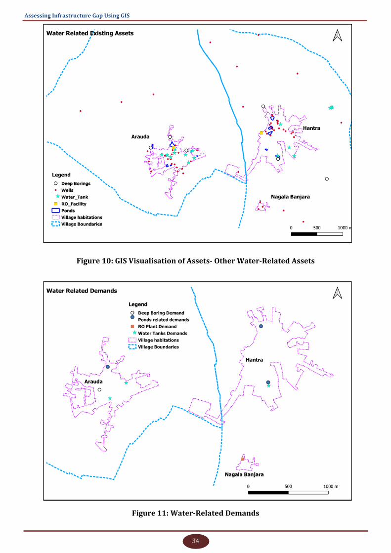
34
Assessing Infrastructure Gap Using GIS
Figure 10: GIS Visualisation of Assets- Other Water-Related Assets
Figure 11: Water-Related Demands

35
H. K. Solanki and P. Kesava Rao
3.8.2.5. Extension of Piped Drinking Water supply to Cover All Homes
This activity is already under process and as informed, the demand will be fulfilled soon by the
efforts of Gram Panchayat and departments concerned. However, as the Nagla Banjara village is not
coming under the Janta Jal Yojana, deep bore or even partial piped water supply system is not
available. Efforts can be done to bring the village under the scheme as it is equally eligible for it.
3.8.3. Sanitation
During the study, it was observed that drinking water and sanitation are the most common and
demanding requirements at the village level followed by roads. Sanitation requirements cover
cleaning, proper surface drainage, solid and liquid waste management, etc. One major demand in
sanitation is to have a proper drainage system to clear stagnated water on roads round the year.
To resolve the problem, the Gram Panchayat is having roadside drainage channels and a few
pits outside the village for wastewater collection. Here, the Gram Panchayat functionaries are not
technically capable or dare to make a consolidated holistic drainage plan for the villages. The
problem can be solved only with the involvement of the departments concerned.
In plain areas, water stagnation on roads resulting from chocked or poorly planned drainages is
a reason for the maintenance of a large number of roads every year. The roads are constructed
without scraping off the previous road material; subsequently, the road levels are going up whereas
the levels of houses along roads are going down. The poorest of the poor are severely affected by this
practice as their houses are vulnerable to water stagnation and they do not have the capacity to raise
the ground level.
No norms are in place in Gram Panchayats with regard to cleaning of chocked drainages and
proper procedure for keeping/engaging manpower for the purpose. It was informed that almost all
villages in the area are saturated with road construction works. Due to water stagnation at different
places, roads were getting damaged or construction of new roads is required. If proper and well-
maintained drainage channels are available in villages, the road constructions activity can be
minimised to a great extent. Doing work in a sporadic and scattered manner will be a never-ending
solution to the problem.
The requirements or demands are clubbed for the existing and demanded assets and is shown
in Figure 12. The problem of stagnated water on roads round the year is shown at one place with an
enlarged view.
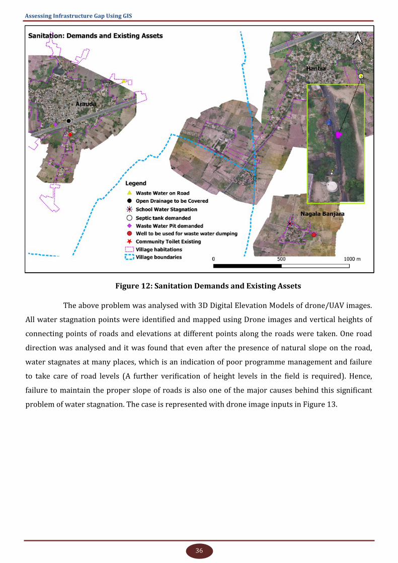
36
Assessing Infrastructure Gap Using GIS
Figure 12: Sanitation Demands and Existing Assets
The above problem was analysed with 3D Digital Elevation Models of drone/UAV images.
All water stagnation points were identified and mapped using Drone images and vertical heights of
connecting points of roads and elevations at different points along the roads were taken. One road
direction was analysed and it was found that even after the presence of natural slope on the road,
water stagnates at many places, which is an indication of poor programme management and failure
to take care of road levels (A further verification of height levels in the field is required). Hence,
failure to maintain the proper slope of roads is also one of the major causes behind this significant
problem of water stagnation. The case is represented with drone image inputs in Figure 13.
37
H. K. Solanki and P. Kesava Rao
Figure 13: Depiction of Water Stagnation on Road with Vertical Levels
The Gram Panchayat needs a solution to massive water stagnation below the National Highway
11. As the construction of the highway disturbed the natural flow of water towards ponds, the water
has been accumulating for months, especially in rainy season, on the road under the highway bridge,
affecting the movement of the villagers.
Water stagnation under National Highway 11, even with the availability of sufficient drainage
channels, can be attributed to the poor or wrong slopes of drainage channels constructed along the
highway. The drainage is either uncovered or broken at various places and it is posing danger to
animals and vehicles.
The demand is visualised in the GIS environment for further clarification in Figure 14.
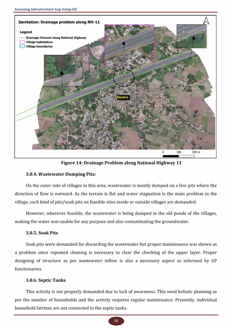
38
Assessing Infrastructure Gap Using GIS
Figure 14: Drainage Problem along National Highway 11
3.8.4. Wastewater Dumping Pits:
On the outer side of villages in this area, wastewater is mostly dumped on a few pits where the
direction of flow is outward. As the terrain is flat and water stagnation is the main problem in the
village, such kind of pits/soak pits on feasible sites inside or outside villages are demanded.
However, wherever feasible, the wastewater is being dumped in the old ponds of the villages,
making the water non-usable for any purpose and also contaminating the groundwater.
3.8.5. Soak Pits
Soak pits were demanded for discarding the wastewater but proper maintenance was shown as
a problem since repeated cleaning is necessary to clear the chocking of the upper layer. Proper
designing of structure as per wastewater inflow is also a necessary aspect as informed by GP
functionaries.
3.8.6. Septic Tanks
This activity is not properly demanded due to lack of awareness. This need holistic planning as
per the number of households and the activity requires regular maintenance. Presently, individual
household latrines are not connected to the septic tanks.
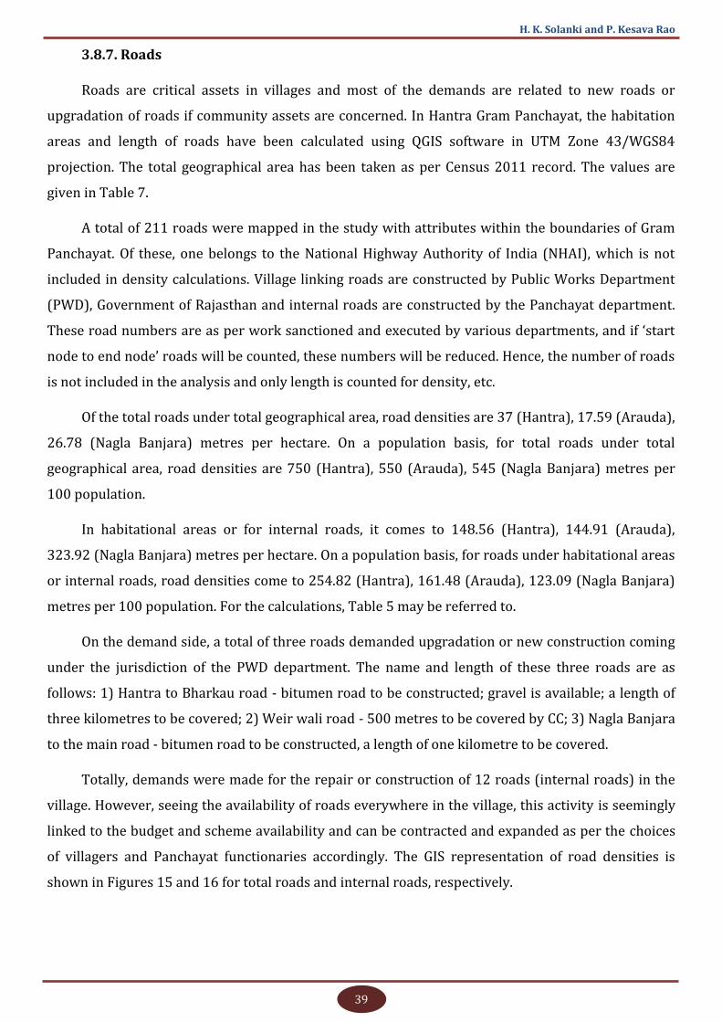
39
H. K. Solanki and P. Kesava Rao
3.8.7. Roads
Roads are critical assets in villages and most of the demands are related to new roads or
upgradation of roads if community assets are concerned. In Hantra Gram Panchayat, the habitation
areas and length of roads have been calculated using QGIS software in UTM Zone 43/WGS84
projection. The total geographical area has been taken as per Census 2011 record. The values are
given in Table 7.
A total of 211 roads were mapped in the study with attributes within the boundaries of Gram
Panchayat. Of these, one belongs to the National Highway Authority of India (NHAI), which is not
included in density calculations. Village linking roads are constructed by Public Works Department
(PWD), Government of Rajasthan and internal roads are constructed by the Panchayat department.
These road numbers are as per work sanctioned and executed by various departments, and if ‘start
node to end node’ roads will be counted, these numbers will be reduced. Hence, the number of roads
is not included in the analysis and only length is counted for density, etc.
Of the total roads under total geographical area, road densities are 37 (Hantra), 17.59 (Arauda),
26.78 (Nagla Banjara) metres per hectare. On a population basis, for total roads under total
geographical area, road densities are 750 (Hantra), 550 (Arauda), 545 (Nagla Banjara) metres per
100 population.
In habitational areas or for internal roads, it comes to 148.56 (Hantra), 144.91 (Arauda),
323.92 (Nagla Banjara) metres per hectare. On a population basis, for roads under habitational areas
or internal roads, road densities come to 254.82 (Hantra), 161.48 (Arauda), 123.09 (Nagla Banjara)
metres per 100 population. For the calculations, Table 5 may be referred to.
On the demand side, a total of three roads demanded upgradation or new construction coming
under the jurisdiction of the PWD department. The name and length of these three roads are as
follows: 1) Hantra to Bharkau road - bitumen road to be constructed; gravel is available; a length of
three kilometres to be covered; 2) Weir wali road - 500 metres to be covered by CC; 3) Nagla Banjara
to the main road - bitumen road to be constructed, a length of one kilometre to be covered.
Totally, demands were made for the repair or construction of 12 roads (internal roads) in the
village. However, seeing the availability of roads everywhere in the village, this activity is seemingly
linked to the budget and scheme availability and can be contracted and expanded as per the choices
of villagers and Panchayat functionaries accordingly. The GIS representation of road densities is
shown in Figures 15 and 16 for total roads and internal roads, respectively.
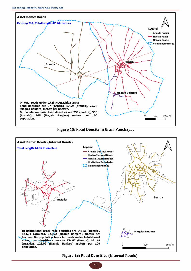
40
Assessing Infrastructure Gap Using GIS
Figure 15: Road Density in Gram Panchayat
Figure 16: Road Densities (Internal Roads)
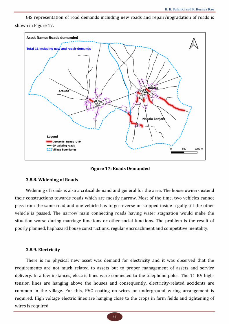
41
H. K. Solanki and P. Kesava Rao
GIS representation of road demands including new roads and repair/upgradation of roads is
shown in Figure 17.
Figure 17: Roads Demanded
3.8.8. Widening of Roads
Widening of roads is also a critical demand and general for the area. The house owners extend
their constructions towards roads which are mostly narrow. Most of the time, two vehicles cannot
pass from the same road and one vehicle has to go reverse or stopped inside a gully till the other
vehicle is passed. The narrow main connecting roads having water stagnation would make the
situation worse during marriage functions or other social functions. The problem is the result of
poorly planned, haphazard house constructions, regular encroachment and competitive mentality.
3.8.9. Electricity
There is no physical new asset was demand for electricity and it was observed that the
requirements are not much related to assets but to proper management of assets and service
delivery. In a few instances, electric lines were connected to the telephone poles. The 11 KV high-
tension lines are hanging above the houses and consequently, electricity-related accidents are
common in the village. For this, PVC coating on wires or underground wiring arrangement is
required. High voltage electric lines are hanging close to the crops in farm fields and tightening of
wires is required.

42
Assessing Infrastructure Gap Using GIS
Covering the high voltage lines with PVC or underground cable is the fourth important priority
of demands. When we met the Chief Electrical Engineer at the State headquarters, it was informed
that at the time of installation of wires all procedures were followed correctly and later the villagers
extend or construct their house near beneath the wires. Sometimes constructions are done directly
below the power lines without taking its position into consideration. Individuals, local corporations,
PWD and other agencies also should consider minimum height as per the Electricity Rules, 2005
while constructing new roads. At times, cable operators also use the electricity poles illegally and as
the height and distance of that cable are less, the possibility of accidents has increased.
Media can play a major role in increasing awareness in this regard.
In order to avoid the danger posed by low hanging wires over crop fields, timely tightening of
wires should be required. In Gram Sabhas, compulsory attendance of persons from the electricity
board is necessary for the proper exchange of dialogues.
In total, 171 transformers are installed in Gram Panchayat. A broad GIS view of locations of
these transformers is illustrated in Figure 18.
Figure 18: Visualisation of Assets - Transformers
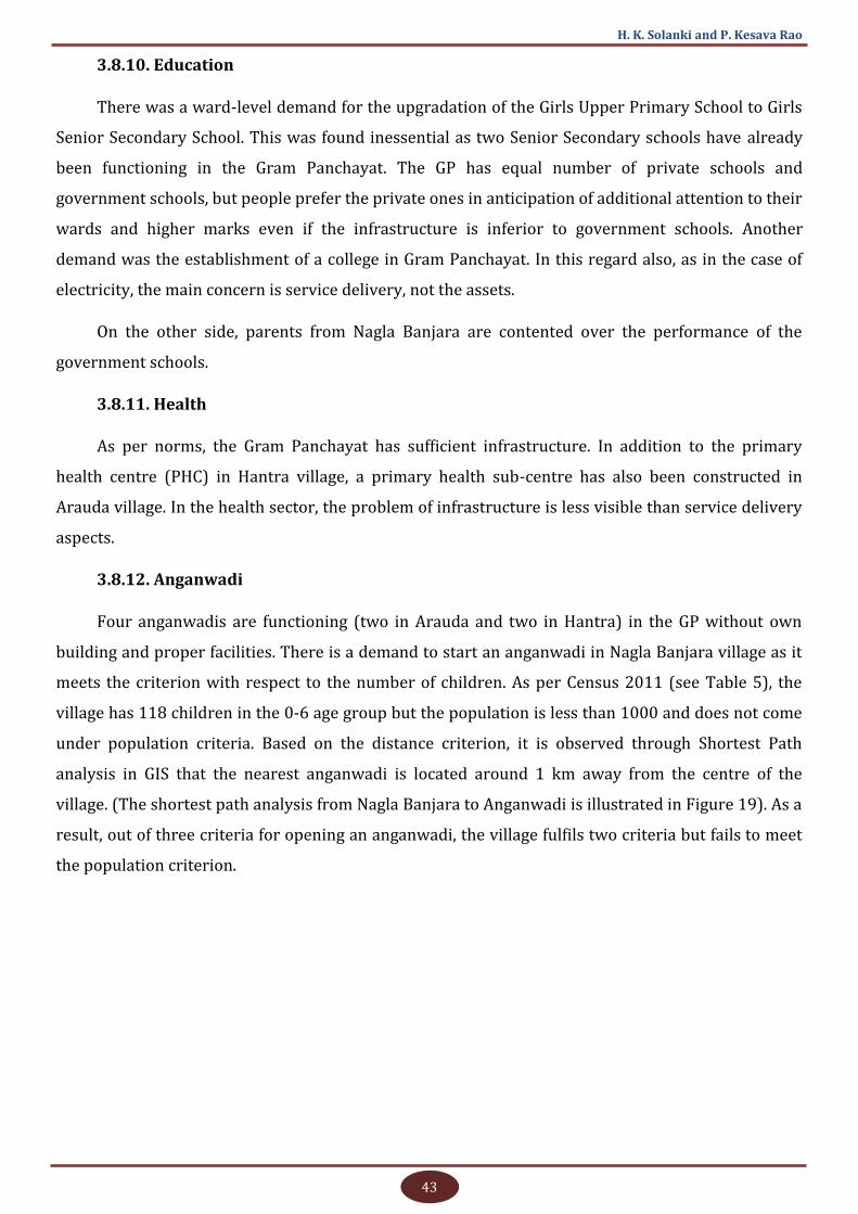
43
H. K. Solanki and P. Kesava Rao
3.8.10. Education
There was a ward-level demand for the upgradation of the Girls Upper Primary School to Girls
Senior Secondary School. This was found inessential as two Senior Secondary schools have already
been functioning in the Gram Panchayat. The GP has equal number of private schools and
government schools, but people prefer the private ones in anticipation of additional attention to their
wards and higher marks even if the infrastructure is inferior to government schools. Another
demand was the establishment of a college in Gram Panchayat. In this regard also, as in the case of
electricity, the main concern is service delivery, not the assets.
On the other side, parents from Nagla Banjara are contented over the performance of the
government schools.
3.8.11. Health
As per norms, the Gram Panchayat has sufficient infrastructure. In addition to the primary
health centre (PHC) in Hantra village, a primary health sub-centre has also been constructed in
Arauda village. In the health sector, the problem of infrastructure is less visible than service delivery
aspects.
3.8.12. Anganwadi
Four anganwadis are functioning (two in Arauda and two in Hantra) in the GP without own
building and proper facilities. There is a demand to start an anganwadi in Nagla Banjara village as it
meets the criterion with respect to the number of children. As per Census 2011 (see Table 5), the
village has 118 children in the 0-6 age group but the population is less than 1000 and does not come
under population criteria. Based on the distance criterion, it is observed through Shortest Path
analysis in GIS that the nearest anganwadi is located around 1 km away from the centre of the
village. (The shortest path analysis from Nagla Banjara to Anganwadi is illustrated in Figure 19). As a
result, out of three criteria for opening an anganwadi, the village fulfils two criteria but fails to meet
the population criterion.
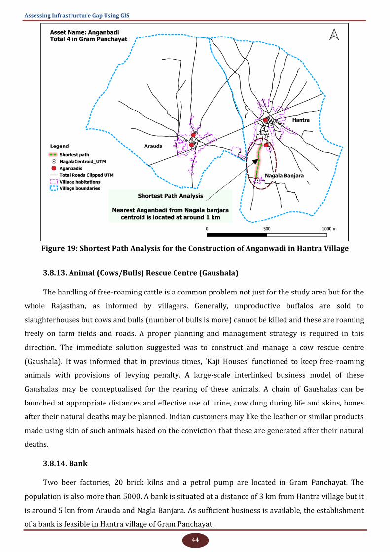
44
Assessing Infrastructure Gap Using GIS
Figure 19: Shortest Path Analysis for the Construction of Anganwadi in Hantra Village
3.8.13. Animal (Cows/Bulls) Rescue Centre (Gaushala)
The handling of free-roaming cattle is a common problem not just for the study area but for the
whole Rajasthan, as informed by villagers. Generally, unproductive buffalos are sold to
slaughterhouses but cows and bulls (number of bulls is more) cannot be killed and these are roaming
freely on farm fields and roads. A proper planning and management strategy is required in this
direction. The immediate solution suggested was to construct and manage a cow rescue centre
(Gaushala). It was informed that in previous times, ‘Kaji Houses’ functioned to keep free-roaming
animals with provisions of levying penalty. A large-scale interlinked business model of these
Gaushalas may be conceptualised for the rearing of these animals. A chain of Gaushalas can be
launched at appropriate distances and effective use of urine, cow dung during life and skins, bones
after their natural deaths may be planned. Indian customers may like the leather or similar products
made using skin of such animals based on the conviction that these are generated after their natural
deaths.
3.8.14. Bank
Two beer factories, 20 brick kilns and a petrol pump are located in Gram Panchayat. The
population is also more than 5000. A bank is situated at a distance of 3 km from Hantra village but it
is around 5 km from Arauda and Nagla Banjara. As sufficient business is available, the establishment
of a bank is feasible in Hantra village of Gram Panchayat.
45
H. K. Solanki and P. Kesava Rao
3.8.15. CCTV at selected places/towers, Street Lights, Community Toilets
The above three demands were not demanded in the initial phase and it was felt that these are
not coming under the immediate actual needs of the villagers. It was observed that the villagers
require gradual development and in that process, these demands are not mentioned. If these are
installed without proper thrust, the maintenance aspects will be difficult for these assets, especially
in the villages of the study area.
3.8.16. Building for Veterinary Hospital
Presently, the hospital is functioning in the old Panchayat building and a new building id
required for the hospital.
3.8.17. Other General Assets:
Community hall
River water linkage for irrigation in cropland
Common drinking water facility for animals
3.9. Ideal/Optimum Community Infrastructure Requirement of Gram
Panchayat
The demands raised by villagers were tested and analysed on the basis of departmental norms
and accordingly, the possibilities on demands have been shown. The detailed discussion on each
demand is available in the discussion section. The possibilities for fulfilling demands at the GP level
have been provided, but may be possible at the village level also. The analysis of the ideal/optimum
community infrastructure requirement of Gram Panchayat is shown in Table 6.
In the table, negative values in Column 5 indicate that asset/solution already exists for more
than the saturation level or the technically feasible number/quantity in the Gram Panchayat as per
norms of nodal department/scheme concerned. Positive values in Column 5 indicate that the existing
asset/solution is less than the maximum possibilities or saturation level as per norms of nodal
department/scheme and can be sanctioned in future.
Column 7 indicates over demand (negative values), or under demand (positive values) status of
assets. It may be called a stressed or relaxed condition of demand. Zero in this column indicates that
the demands are matching with the possibility.
The availability of funds under any scheme for sanctioning the work should always be the
second condition after passing this stage for any asset.
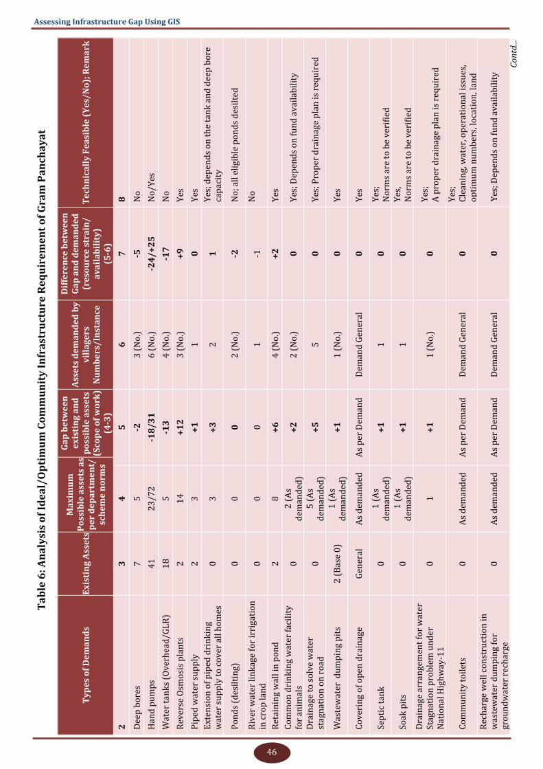
46
Assessing Infrastructure Gap Using GIS
Ta
ble
6: A
na
lysi
s o
f Id
ea
l/O
pti
mu
m C
om
mu
nit
y I
nfr
ast
ruct
ure
Re
qu
ire
me
nt
of
Gra
m P
an
cha
ya
t
Ty
pe
s o
f D
em
an
ds
Ex
isti
ng
Ass
ets
Ma
xim
um
P
oss
ible
ass
ets
as
pe
r d
ep
art
me
nt/
sch
em
e n
orm
s
Ga
p b
etw
ee
n
ex
isti
ng
an
d
po
ssib
le a
sse
ts
(Sco
pe
of
wo
rk)
(4-3
)
Ass
ets
de
ma
nd
ed
by
v
illa
ge
rs
Nu
mb
ers
/In
sta
nce
Dif
fere
nce
be
twe
en
G
ap
an
d d
em
an
de
d
(re
sou
rce
str
ain
/a
va
ila
bil
ity
) (5
-6)
Te
chn
ica
lly
Fe
asi
ble
(Y
es/
No
); R
em
ark
2
3
4
5
6
7
8
Dee
p b
ore
s 7
5
-2
3
(N
o.)
-5
N
o
Han
d p
um
ps
41
2
3/7
2
-18
/3
1
6 (
No
.)
-24
/+
25
N
o/Y
es
Wat
er t
an
ks
(Ov
erh
ead
/GL
R)
18
5
-1
3
4 (
No
.)
-17
N
o
Rev
erse
Osm
osi
s p
lan
ts
2
14
+
12
3
(N
o.)
+
9
Yes
Pip
ed w
ater
su
pp
ly
2
3
+1
1
0
Y
es
Ext
ensi
on
of
pip
ed d
rin
kin
g
wat
er s
up
ply
to
co
ver
all
ho
mes
0
3
+
3
2
1
Yes
; dep
end
s o
n t
he
tan
k a
nd
dee
p b
ore
ca
pac
ity
Po
nd
s (d
esil
tin
g)
0
0
0
2 (
No
.)
-2
No
; all
eli
gib
le p
on
ds
des
ilte
d
Riv
er w
ater
lin
kag
e fo
r ir
rig
atio
n
in c
rop
lan
d
0
0
0
1
-1
No
Ret
ain
ing
wal
l in
po
nd
2
8
+
6
4 (
No
.)
+2
Y
es
Co
mm
on
dri
nk
ing
wat
er f
acil
ity
fo
r an
imal
s 0
2
(A
s d
eman
ded
) +
2
2 (
No
.)
0
Yes
; Dep
end
s o
n f
un
d a
vai
lab
ilit
y
Dra
inag
e to
so
lve
wat
er
stag
nat
ion
on
ro
ad
0
5 (
As
dem
and
ed)
+5
5
0
Y
es; P
rop
er d
rain
age
pla
n is
req
uir
ed
Was
tew
ater
du
mp
ing
pit
s 2
(B
ase
0)
1 (
As
dem
and
ed)
+1
1
(N
o.)
0
Y
es
Co
ver
ing
of
op
en d
rain
age
G
ener
al
As
dem
an
ded
A
s p
er D
eman
d
Dem
and
Gen
eral
0
Y
es
Sep
tic
tan
k
0
1 (
As
dem
and
ed)
+1
1
0
Y
es;
No
rms
are
to b
e v
erif
ied
Soak
pit
s 0
1
(A
s d
eman
ded
) +
1
1
0
Yes
, N
orm
s ar
e to
be
ver
ifie
d
Dra
inag
e ar
ran
gem
ent
for
wat
er
Stag
nat
ion
pro
ble
m u
nd
er
Nat
ion
al H
igh
way
-11
0
1
+
1
1 (
No
.)
0
Yes
; A
pro
per
dra
inag
e p
lan
is r
equ
ired
Co
mm
un
ity
to
ilet
s 0
A
s d
ema
nd
ed
As
per
Dem
and
D
eman
d G
ener
al
0
Yes
; C
lean
ing,
wat
er, o
per
atio
nal
iss
ues
, o
pti
mu
m n
um
ber
s, lo
cati
on
, lan
d
Co
ntd
...
Rec
har
ge w
ell c
on
stru
ctio
n i
n
was
tew
ater
du
mp
ing
for
gro
un
dw
ater
rec
har
ge
0
As
dem
an
ded
A
s p
er D
eman
d
Dem
and
Gen
eral
0
Y
es; D
epen
ds
on
fu
nd
av
aila
bil
ity

47
H. K. Solanki and P. Kesava Rao
Dra
inag
e m
ech
anis
m t
o p
ass
stag
nat
ed w
ater
fro
m s
cho
ol
0
1
+1
1
0
Y
es; A
pro
per
dra
inag
e p
lan
is
req
uir
ed
Ro
ads
(New
) (P
WD
) 2
10
(2
06
+4
) (B
ase
0)
3 (
As
dem
and
ed)
+3
3
(N
o.)
0
Y
es; D
epen
ds
on
fu
nd
av
aila
bil
ity
Ro
ad r
epai
r/u
pg
rad
atio
n
0
(Bas
e 0
) 1
2 (
As
dem
and
ed)
+1
2
12
(N
o.)
0
Y
es; A
s p
er n
orm
s
Wid
enin
g o
f ro
ads
0
2 (
As
dem
and
ed)
+2
2
0
Y
es; C
om
mo
n C
on
sen
sus
is r
equ
ired
Co
ver
ing
hig
h v
olt
age
lin
es w
ith
P
VC
or
un
der
gro
un
d c
able
0
0
0
3
-
3
No
; No
t in
no
rms;
No
rms
nee
d t
o b
e re
vis
ed
Rai
sin
g H
eigh
t o
f p
ole
s su
pp
ort
ing
hig
h v
olt
age
wir
es
0
0
0
1
- 1
N
o, N
ot
in n
orm
s
Rem
ov
al o
f el
ectr
ic w
ires
fro
m
tele
ph
on
e p
ole
s G
ener
al
A
s d
ema
nd
ed
As
per
Dem
and
D
eman
d G
ener
al
0
Yes
; on
co
mp
lain
t
Rai
sin
g th
e h
eigh
t o
f lo
w-l
yin
g H
T li
nes
ov
er c
rop
fie
lds
Gen
eral
As
dem
an
ded
A
s p
er D
eman
d
Dem
and
Gen
eral
0
Y
es; o
n c
om
pla
int
Stre
et li
ghts
G
ener
al
A
s d
ema
nd
ed
As
per
Dem
and
D
eman
d G
ener
al
0
Yes
Bu
ild
ing
for
exis
tin
g v
eter
inar
y
ho
spit
al
0
1
+1
1
(N
o.)
0
Y
es
New
vet
erin
ary
ho
spit
al
0
To
be
chec
ked
1
Wi-
Fi a
nd
co
mp
ute
r fa
cili
ty i
n
sch
oo
l 0
1
+1
1
0
Y
es
Go
ver
nm
ent
coll
ege
for
grad
uat
ion
0
0
0
1
(N
o.)
-1
N
o; C
oll
ege
is a
vai
lab
le i
n 1
5 k
m
An
gan
wad
i ce
ntr
e w
ith
bu
ild
ing
4
4
0
1
(N
o.)
-1
N
o, N
orm
s/p
rio
riti
es m
ay b
e re
vis
ed
Lig
ht,
fan
s an
d b
asic
fac
ilit
y f
or
anga
nw
adi
cen
tre
0
4
+
4
4 (
No
.)
0
Yes
Ban
k
0
1
+1
1
(N
o.)
0
Y
es; B
usi
nes
s is
av
aila
ble
CC
TV
at
sele
cted
pla
ces/
tow
ers
0
As
dem
an
ded
A
s p
er D
eman
d
Dem
and
Gen
eral
0
Y
es
Co
mm
un
ity
hal
l 0
2
+
2
1 (
No
.)
+1
Y
es
An
imal
(co
ws/
bu
lls)
res
cue
cen
tre
(Gau
shal
a)
0
0
0
1 (
No
.)
- 1
N
o; A
lter
nat
ive
sou
rces
may
be
sear
ched
Ty
pe
s o
f D
em
an
ds
Ex
isti
ng
Ass
ets
Ma
xim
um
P
oss
ible
ass
ets
as
pe
r d
ep
art
me
nt/
sch
em
e n
orm
s
Ga
p b
etw
ee
n
ex
isti
ng
an
d
po
ssib
le a
sse
ts
(Sco
pe
of
wo
rk)
(4-3
)
Ass
ets
de
ma
nd
ed
by
v
illa
ge
rs
Nu
mb
ers
/In
sta
nce
Dif
fere
nce
be
twe
en
G
ap
an
d d
em
an
de
d
(re
sou
rce
str
ain
/a
va
ila
bil
ity
) (5
-6)
Te
chn
ica
lly
Fe
asi
ble
(Y
es/
No
); R
em
ark
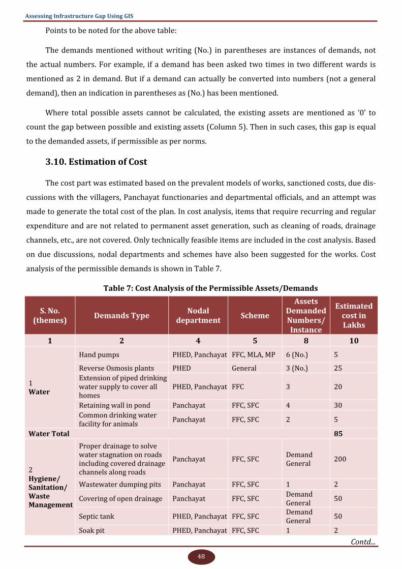
48
Assessing Infrastructure Gap Using GIS
Points to be noted for the above table:
The demands mentioned without writing (No.) in parentheses are instances of demands, not
the actual numbers. For example, if a demand has been asked two times in two different wards is
mentioned as 2 in demand. But if a demand can actually be converted into numbers (not a general
demand), then an indication in parentheses as (No.) has been mentioned.
Where total possible assets cannot be calculated, the existing assets are mentioned as ‘0’ to
count the gap between possible and existing assets (Column 5). Then in such cases, this gap is equal
to the demanded assets, if permissible as per norms.
3.10. Estimation of Cost
The cost part was estimated based on the prevalent models of works, sanctioned costs, due dis-
cussions with the villagers, Panchayat functionaries and departmental officials, and an attempt was
made to generate the total cost of the plan. In cost analysis, items that require recurring and regular
expenditure and are not related to permanent asset generation, such as cleaning of roads, drainage
channels, etc., are not covered. Only technically feasible items are included in the cost analysis. Based
on due discussions, nodal departments and schemes have also been suggested for the works. Cost
analysis of the permissible demands is shown in Table 7.
Table 7: Cost Analysis of the Permissible Assets/Demands
S. No. (themes)
Demands Type Nodal
department Scheme
Assets Demanded Numbers/Instance
Estimated cost in Lakhs
1 2 4 5 8 10
1 Water
Hand pumps PHED, Panchayat FFC, MLA, MP 6 (No.) 5
Reverse Osmosis plants PHED General 3 (No.) 25
Extension of piped drinking water supply to cover all homes
PHED, Panchayat FFC 3 20
Retaining wall in pond Panchayat FFC, SFC 4 30
Common drinking water facility for animals
Panchayat FFC, SFC 2 5
Water Total 85
2
Hygiene/Sanitation/Waste Management
Proper drainage to solve water stagnation on roads including covered drainage channels along roads
Panchayat FFC, SFC Demand General
200
Wastewater dumping pits Panchayat FFC, SFC 1 2
Covering of open drainage Panchayat FFC, SFC Demand General
50
Septic tank PHED, Panchayat FFC, SFC Demand General
50
Soak pit PHED, Panchayat FFC, SFC 1 2
Contd...
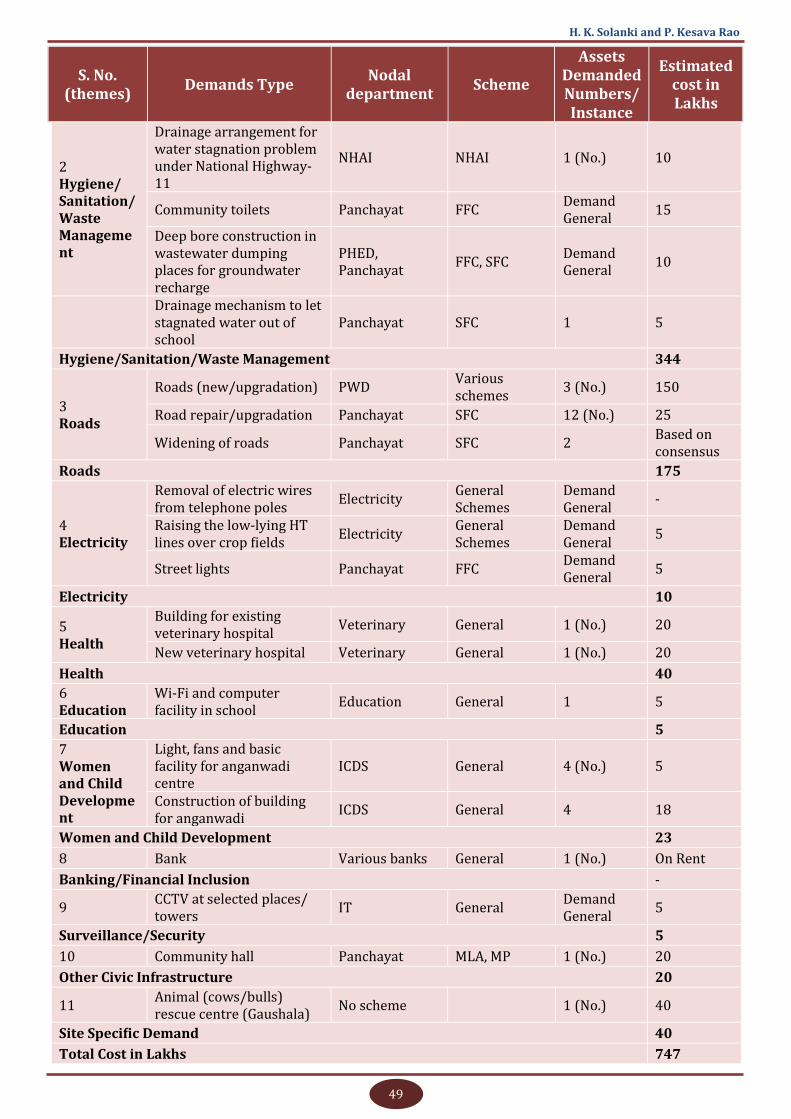
49
H. K. Solanki and P. Kesava Rao
2 Hygiene/Sanitation/Waste Management
Drainage arrangement for water stagnation problem under National Highway-11
NHAI NHAI 1 (No.) 10
Community toilets Panchayat FFC Demand General
15
Deep bore construction in wastewater dumping places for groundwater recharge
PHED, Panchayat
FFC, SFC Demand General
10
Drainage mechanism to let stagnated water out of school
Panchayat SFC 1 5
Hygiene/Sanitation/Waste Management 344
3 Roads
Roads (new/upgradation) PWD Various schemes
3 (No.) 150
Road repair/upgradation Panchayat SFC 12 (No.) 25
Widening of roads Panchayat SFC 2 Based on consensus
Roads 175
4 Electricity
Removal of electric wires from telephone poles
Electricity General Schemes
Demand General
-
Raising the low-lying HT lines over crop fields
Electricity General Schemes
Demand General
5
Street lights Panchayat FFC Demand General
5
Electricity 10
5
Health
Building for existing veterinary hospital
Veterinary General 1 (No.) 20
New veterinary hospital Veterinary General 1 (No.) 20
Health 40
6
Education Wi-Fi and computer facility in school
Education General 1 5
Education 5
7 Women and Child Development
Light, fans and basic facility for anganwadi centre
ICDS General 4 (No.) 5
Construction of building for anganwadi
ICDS General 4 18
Women and Child Development 23
8 Bank Various banks General 1 (No.) On Rent
Banking/Financial Inclusion -
9 CCTV at selected places/towers
IT General Demand General
5
Surveillance/Security 5
10 Community hall Panchayat MLA, MP 1 (No.) 20
Other Civic Infrastructure 20
11 Animal (cows/bulls) rescue centre (Gaushala)
No scheme 1 (No.) 40
Site Specific Demand 40
Total Cost in Lakhs 747
S. No. (themes)
Demands Type Nodal
department Scheme
Assets Demanded Numbers/Instance
Estimated cost in Lakhs
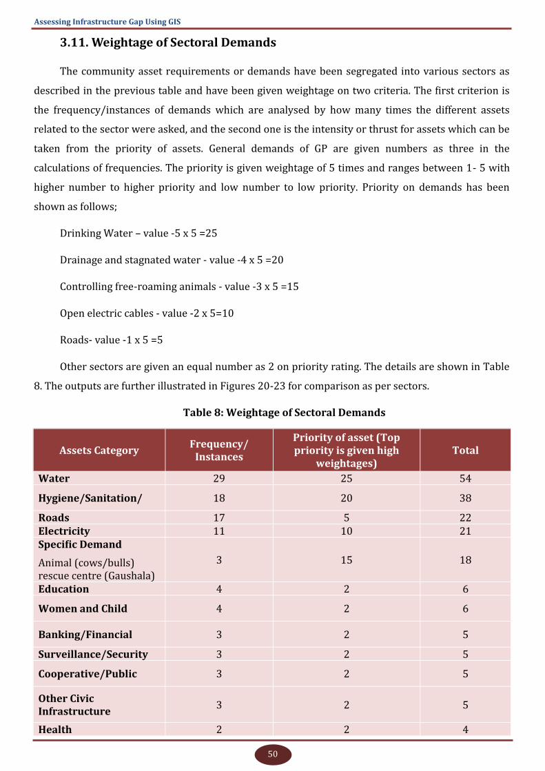
50
Assessing Infrastructure Gap Using GIS
3.11. Weightage of Sectoral Demands
The community asset requirements or demands have been segregated into various sectors as
described in the previous table and have been given weightage on two criteria. The first criterion is
the frequency/instances of demands which are analysed by how many times the different assets
related to the sector were asked, and the second one is the intensity or thrust for assets which can be
taken from the priority of assets. General demands of GP are given numbers as three in the
calculations of frequencies. The priority is given weightage of 5 times and ranges between 1- 5 with
higher number to higher priority and low number to low priority. Priority on demands has been
shown as follows;
Drinking Water – value -5 x 5 =25
Drainage and stagnated water - value -4 x 5 =20
Controlling free-roaming animals - value -3 x 5 =15
Open electric cables - value -2 x 5=10
Roads- value -1 x 5 =5
Other sectors are given an equal number as 2 on priority rating. The details are shown in Table
8. The outputs are further illustrated in Figures 20-23 for comparison as per sectors.
Table 8: Weightage of Sectoral Demands
Assets Category Frequency/
Instances
Priority of asset (Top priority is given high
weightages) Total
Water 29 25 54
Hygiene/Sanitation/ 18 20 38
Roads 17 5 22 Electricity 11 10 21 Specific Demand
Animal (cows/bulls) rescue centre (Gaushala)
3 15 18
Education 4 2 6
Women and Child 4 2 6
Banking/Financial 3 2 5
Surveillance/Security 3 2 5
Cooperative/Public 3 2 5
Other Civic Infrastructure
3 2 5
Health 2 2 4
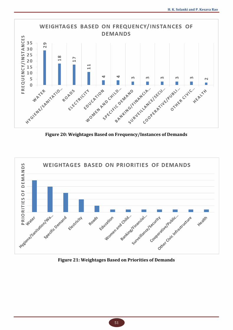
51
H. K. Solanki and P. Kesava Rao
Figure 20: Weightages Based on Frequency/Instances of Demands
Figure 21: Weightages Based on Priorities of Demands
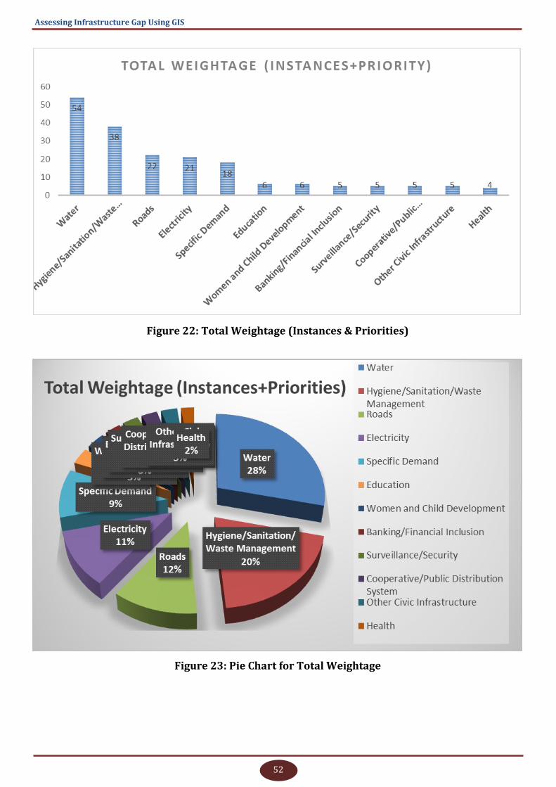
52
Assessing Infrastructure Gap Using GIS
Figure 22: Total Weightage (Instances & Priorities)
Figure 23: Pie Chart for Total Weightage

53
H. K. Solanki and P. Kesava Rao
3.12. Comparison with Focuses of Country and State Plans
Focus area-wise (which can be considered as priorities for study comparison) GP plan, number
of works (which can be considered as instances or frequencies for study comparison) and fund
allocation figures of GPDP and FFC are available with plan plus website
‘http://www.planningonline.gov.in’ at page ‘http://www.planningonline.gov.in/ReportData.do?
ReportMethod=getGPDPDashBoardMapData’. These figures are used for comparison of study
outcomes with national and State trends in GPDP focus areas for the financial year 2018-19. The
trend is almost the same for all previous and 2019-20 GPDP also. The following tables and graphs
used only the first 10 focus areas out of 32 areas prescribed in Plan Plus for the planning process
(MoPR, GoI 2019).
3.12.1. Country level
Tables 9, 10 and 11 and bar graphs in Figures 24, 25 and 26 illustrate the focus area trends in
GP Plan, numbers of works and fund allocation at country level for the first 10 focus areas.
Table 9: Focus Area-wise GP Plan Country Level (2018-2019)
S. No. Focus Area Name GP Count(GPDP)
GP Count(FFC)
1 Roads 152260 133612
2 Health and sanitation 122710 109326
3 Drinking water 102911 86148
4 Rural electrification 77862 64944
5 Education 60152 51804
6 Maintenance of community system 41598 33815
7 Social welfare 39267 30010
8 Women and child development 23654 20053
9 Agriculture 15618 8441
10 Rural housing 14839 11264
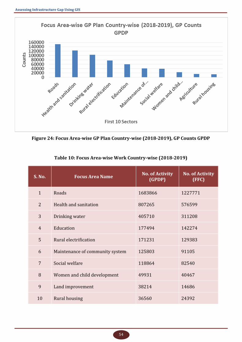
54
Assessing Infrastructure Gap Using GIS
Figure 24: Focus Area-wise GP Plan Country-wise (2018-2019), GP Counts GPDP
Table 10: Focus Area-wise Work Country-wise (2018-2019)
S. No. Focus Area Name No. of Activity
(GPDP) No. of Activity
(FFC)
1 Roads 1683866 1227771
2 Health and sanitation 807265 576599
3 Drinking water 405710 311208
4 Education 177494 142274
5 Rural electrification 171231 129383
6 Maintenance of community system 125803 91105
7 Social welfare 118864 82540
8 Women and child development 49931 40467
9 Land improvement 38214 14686
10 Rural housing 36560 24392
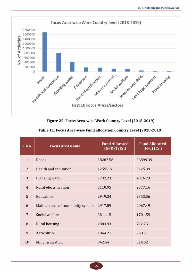
55
H. K. Solanki and P. Kesava Rao
Figure 25: Focus Area-wise Work Country Level (2018-2019)
Table 11: Focus Area-wise Fund allocation Country Level (2018-2019)
S. No. Focus Area Name Fund Allocated
(GPDP) (Cr.) Fund Allocated
(FFC) (Cr.)
1 Roads 38282.56 26899.39
2 Health and sanitation 12555.16 9125.39
3 Drinking water 7732.23 4976.73
4 Rural electrification 3110.95 2377.16
5 Education 2949.34 2353.56
6 Maintenance of community system 2917.59 2067.49
7 Social welfare 2811.15 1701.59
8 Rural housing 1884.93 712.23
9 Agriculture 1044.21 268.3
10 Minor irrigation 942.44 314.02
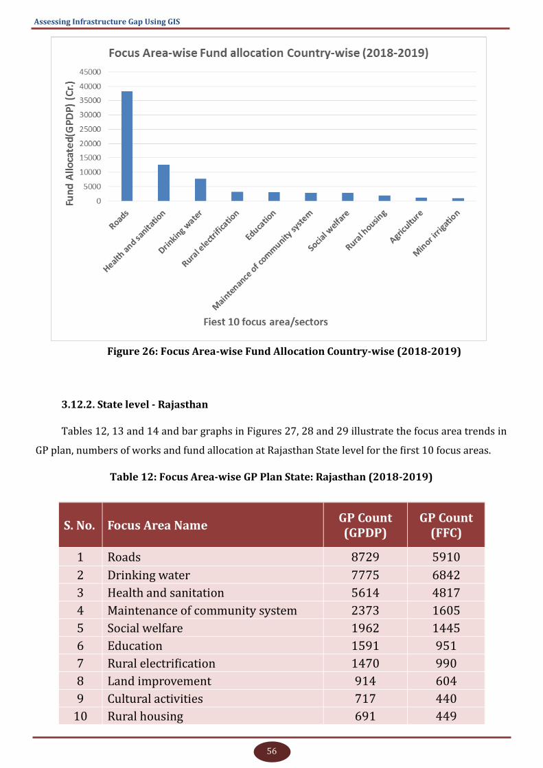
56
Assessing Infrastructure Gap Using GIS
Figure 26: Focus Area-wise Fund Allocation Country-wise (2018-2019)
3.12.2. State level - Rajasthan
Tables 12, 13 and 14 and bar graphs in Figures 27, 28 and 29 illustrate the focus area trends in
GP plan, numbers of works and fund allocation at Rajasthan State level for the first 10 focus areas.
Table 12: Focus Area-wise GP Plan State: Rajasthan (2018-2019)
S. No. Focus Area Name GP Count (GPDP)
GP Count (FFC)
1 Roads 8729 5910
2 Drinking water 7775 6842
3 Health and sanitation 5614 4817
4 Maintenance of community system 2373 1605
5 Social welfare 1962 1445
6 Education 1591 951
7 Rural electrification 1470 990
8 Land improvement 914 604
9 Cultural activities 717 440
10 Rural housing 691 449

57
H. K. Solanki and P. Kesava Rao
Figure 27: Focus Area-wise GP Plan State: Rajasthan (2018-2019)
Table 13: Focus Area-wise Work State: Rajasthan (2018-2019)
S. No. Focus Area Name No. of Activity
(GPDP)
No. of Activity
(FFC)
1 Roads 96128 35134
2 Drinking water 73150 57965
3 Health and sanitation 35152 25220
4 Maintenance of community system 9323 5412
5 Social welfare 9322 5893
6 Education 3806 1863
7 Rural electrification 3095 2005
8 Rural housing 2411 1387
9 Land improvement 2251 1184
10 Cultural activities 2202 1054

58
Assessing Infrastructure Gap Using GIS
Figure 28: Focus Area-wise Work State: Rajasthan (2018-2019)
Table 14: Focus Area-wise Fund Allocation State: Rajasthan (2018-2019)
S. No. Focus Area Name Fund Allocated
(GPDP) (Cr.) Fund Allocated
(FFC) (Cr.)
1 Roads 3259.06 1277.91
2 Drinking water 1342.1 1036.17
3 Health and sanitation 862.35 610.01
4 Maintenance of community system 243.64 134.56
5 Social welfare 225.77 141.02
6 Education 106.95 50.07
7 Rural housing 89.83 54.36
8 Rural electrification 78.76 48.82
9 Cultural activities 74.37 34.13
10 Land improvement 64.98 34.03
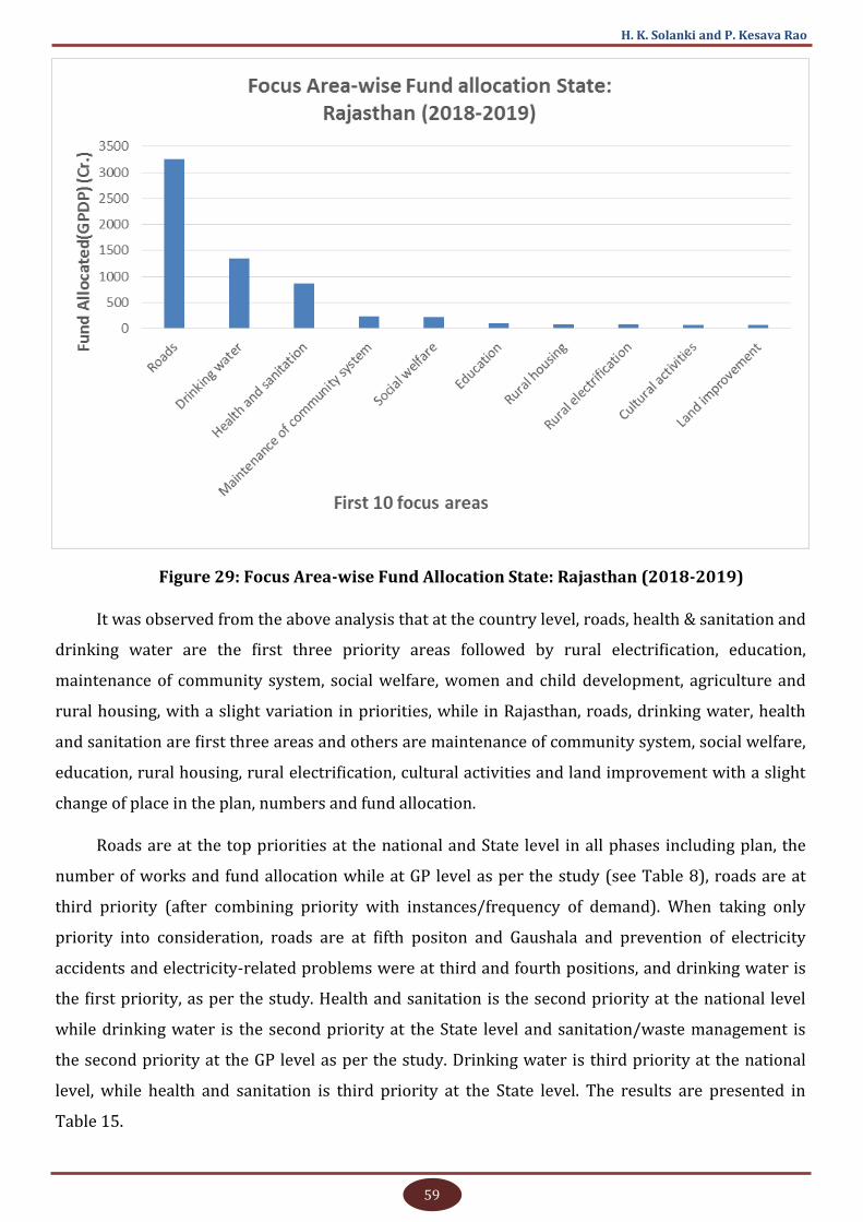
59
H. K. Solanki and P. Kesava Rao
Figure 29: Focus Area-wise Fund Allocation State: Rajasthan (2018-2019)
It was observed from the above analysis that at the country level, roads, health & sanitation and
drinking water are the first three priority areas followed by rural electrification, education,
maintenance of community system, social welfare, women and child development, agriculture and
rural housing, with a slight variation in priorities, while in Rajasthan, roads, drinking water, health
and sanitation are first three areas and others are maintenance of community system, social welfare,
education, rural housing, rural electrification, cultural activities and land improvement with a slight
change of place in the plan, numbers and fund allocation.
Roads are at the top priorities at the national and State level in all phases including plan, the
number of works and fund allocation while at GP level as per the study (see Table 8), roads are at
third priority (after combining priority with instances/frequency of demand). When taking only
priority into consideration, roads are at fifth positon and Gaushala and prevention of electricity
accidents and electricity-related problems were at third and fourth positions, and drinking water is
the first priority, as per the study. Health and sanitation is the second priority at the national level
while drinking water is the second priority at the State level and sanitation/waste management is
the second priority at the GP level as per the study. Drinking water is third priority at the national
level, while health and sanitation is third priority at the State level. The results are presented in
Table 15.

60
Assessing Infrastructure Gap Using GIS
Table 15: Priorities of National, State (As Per Portal) and GP Level (As Per Study)
Priority National (GPDP Plan)
Rajasthan (GPDP Plan)
GP Study (Combined Priority plus Frequency)
1 Roads Roads Water
2 Health and sanitation
Drinking water Hygiene/Sanitation/Waste Management
3 Drinking water Health and sanitation Roads
4 Rural electrification Maintenance of community system Electricity Problems
5 Education Social welfare Specific Demand Animal (Cows/Bulls) Rescue Centre (Gaushala)
6 Maintenance of community system
Education Education
7 Social welfare Rural electrification Women and Child Development
8 Women and child development
Land improvement Banking/Financial Inclusion
9 Agriculture Cultural activities Surveillance/Security
10 Rural housing Rural housing Cooperative/Public Distribution System
3.14. Resource Envelope of Gram Panchayat, Hantra
To understand the general income and expenditure pattern, the resource envelop of the last
five years from 2014-15 to 2018-19 were mapped with the help of information available with
Panchayat (see Table 16). It was collected to estimate the regular income and expenditure pattern of
Gram Panchayat and to elicit the financial capacities of Gram Panchayat. Scheme preferences and
expenditure patterns of Hantra Gram Panchayat over the five years are analysed in Figures 30, 31
and 32.
Table 16: Resource Envelope of Hantra Gram Panchayat
Source: Gram Panchayat Hantra
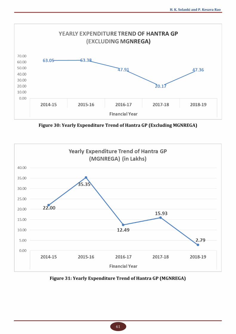
61
H. K. Solanki and P. Kesava Rao
Figure 30: Yearly Expenditure Trend of Hantra GP (Excluding MGNREGA)
Figure 31: Yearly Expenditure Trend of Hantra GP (MGNREGA)
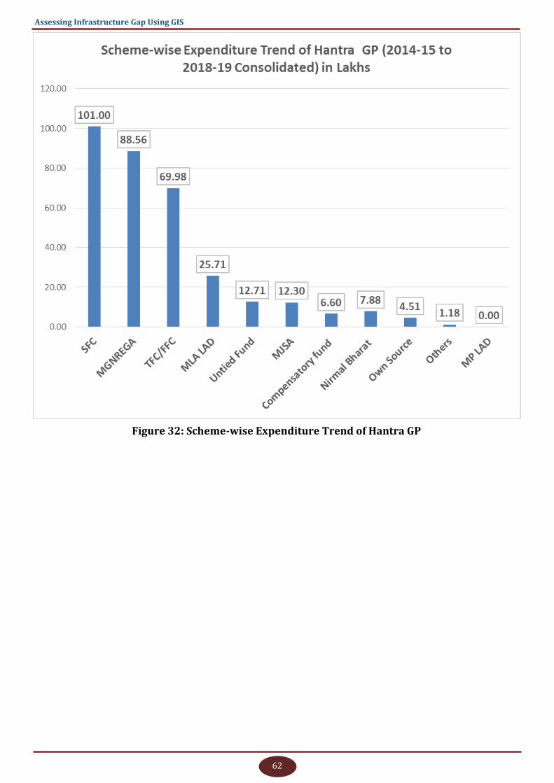
62
Assessing Infrastructure Gap Using GIS
Figure 32: Scheme-wise Expenditure Trend of Hantra GP
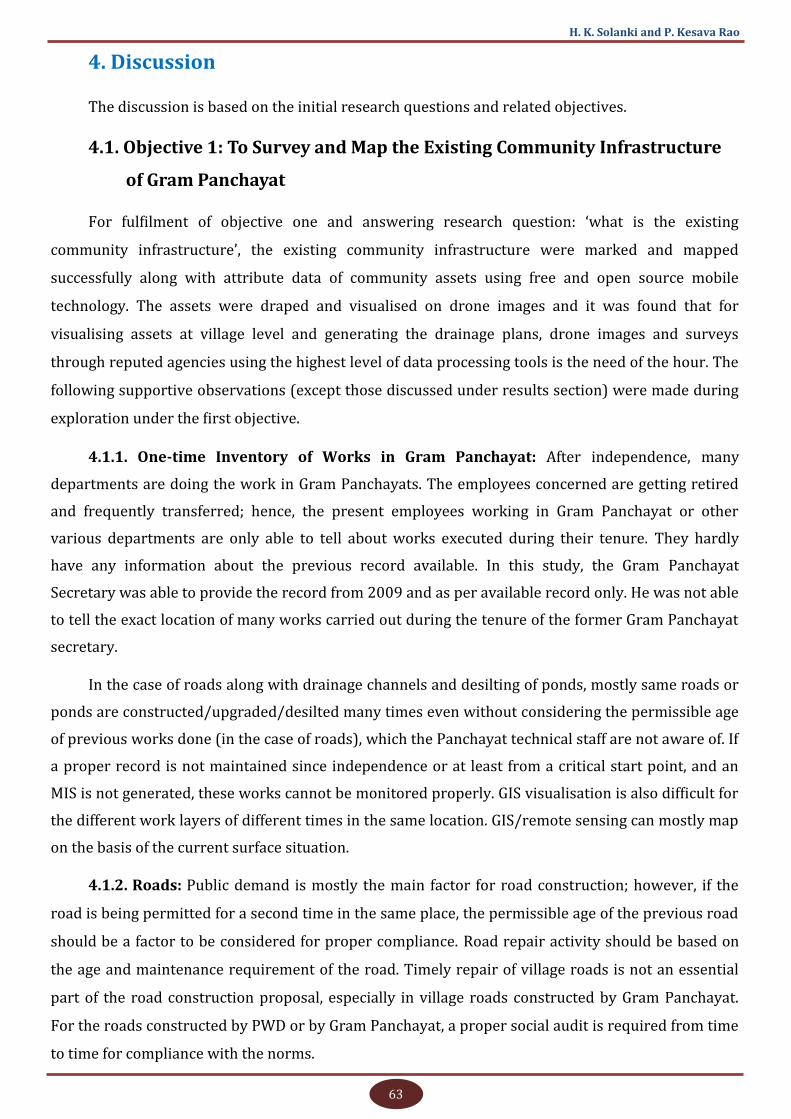
63
H. K. Solanki and P. Kesava Rao
4. Discussion
The discussion is based on the initial research questions and related objectives.
4.1. Objective 1: To Survey and Map the Existing Community Infrastructure
of Gram Panchayat
For fulfilment of objective one and answering research question: ‘what is the existing
community infrastructure’, the existing community infrastructure were marked and mapped
successfully along with attribute data of community assets using free and open source mobile
technology. The assets were draped and visualised on drone images and it was found that for
visualising assets at village level and generating the drainage plans, drone images and surveys
through reputed agencies using the highest level of data processing tools is the need of the hour. The
following supportive observations (except those discussed under results section) were made during
exploration under the first objective.
4.1.1. One-time Inventory of Works in Gram Panchayat: After independence, many
departments are doing the work in Gram Panchayats. The employees concerned are getting retired
and frequently transferred; hence, the present employees working in Gram Panchayat or other
various departments are only able to tell about works executed during their tenure. They hardly
have any information about the previous record available. In this study, the Gram Panchayat
Secretary was able to provide the record from 2009 and as per available record only. He was not able
to tell the exact location of many works carried out during the tenure of the former Gram Panchayat
secretary.
In the case of roads along with drainage channels and desilting of ponds, mostly same roads or
ponds are constructed/upgraded/desilted many times even without considering the permissible age
of previous works done (in the case of roads), which the Panchayat technical staff are not aware of. If
a proper record is not maintained since independence or at least from a critical start point, and an
MIS is not generated, these works cannot be monitored properly. GIS visualisation is also difficult for
the different work layers of different times in the same location. GIS/remote sensing can mostly map
on the basis of the current surface situation.
4.1.2. Roads: Public demand is mostly the main factor for road construction; however, if the
road is being permitted for a second time in the same place, the permissible age of the previous road
should be a factor to be considered for proper compliance. Road repair activity should be based on
the age and maintenance requirement of the road. Timely repair of village roads is not an essential
part of the road construction proposal, especially in village roads constructed by Gram Panchayat.
For the roads constructed by PWD or by Gram Panchayat, a proper social audit is required from time
to time for compliance with the norms.

64
Assessing Infrastructure Gap Using GIS
4.1.3. GIS Visualisation of Roads: Getting the data and presenting it in the GIS environment
was found difficult as the roads may be constructed in different timings under different schemes in
different layers, one over another. For example, a road may be initially constructed of Garvel/
Murrum from point A to B in a particular scheme in time T1. Then other roads of CC category or
bituminous road of different length in time T2 and may be done in future on same roads after its
ageing. So, instead of the number of different roads constructed at different times in different layers,
GIS can represent only the length of the topmost layers with current attributes of roads.
The same condition applies to any asset which is constructed for the same places many times
repeatedly, like the desilting of village ponds. Further, it is difficult to get data pertaining to the
previous works if the time gap is more and officials concerned are transferred. However, if
visualisation can be compromised, the entries can be made in a GIS environment. The representation
view of the construction of roads at a different time in the same place is presented schematically
from the side view in Figure 33.
CC Road, T5
WBM Road, T3 Gravel Road, T2
Earthen/Murrum Road, T1
Interlocking/Brick Road, T4
Figure 33: Schematic Representation of Road Layers - Side View
4.1.4. Ward Boundaries: Ward boundaries are not clearly understood and well defined and
mostly related to the families, not the area. These are basically demarcated for the election purposes.
One Gram Panchayat should have at least nine wards. If a family left the ward and living outside the
ward anywhere in India and sold their property, still the members will be considered as voters of the
same ward. Ownership of ward boundary and maintenance is also not clear. Gram Panchayat
Secretary, revenue officials, etc., were able to give indicative ward boundaries and no proper
documentation/record of the area in this regard was available. Hence, all ward boundaries depicted
in the study are indicative or approximate based on the best knowledge of ward members concerned.
4.1.5. Concept of Asset Density: Road densities or densities of any other assets are not the
criteria for the construction of assets. The norms may be linked to asset densities for repairs and
construction of new assets. The inclusion of asset density as a criterion will be helpful in reducing
local disparities within the Gram Panchayat. For example, if you take the case of Hantra Village in the
Gram Panchayat, which is habituated with ‘Banjara’ community coming under backward class, it is
devoid of RO plant any kind of GLR or piped drinking water supply, whereas the rest of the villages
are having large extent piped drinking water supply, RO and GLR or overhead water tank. The
concept of asset density can put the village under higher priorities in these assets. This concept may
65
H. K. Solanki and P. Kesava Rao
be a good parameter to be in line with the SDG (sustainable development goal) 10: ‘Reduced
Inequalities’.
4.2. Objectives 2, 3: To Assess Ideal/Optimum Community Infrastructure Requirement of Gram Panchayat through Participatory and Departmental Approach; To Analyse and Map Gaps in Community Infrastructure and Suggesting Infrastructure Development Plan of GP
For answering the research questions ‘What are the optimum community infrastructure
requirements of my Gram Panchayat?’, ‘Where are the gaps?’ and fulfilling the relevant second and
third objectives, the villagers were asked for the community infrastructure requirements. Ward-wise
demands were collected and validated at the village and Gram Panchayat level. Norms of
departments concerned were collected and matched for assessing the optimum requirements and
analysing the gaps or resource relaxed or resource strained or neutralised conditions by analysing
the demands with possibilities under the norms of departments. Following supportive observations
(other than the previously discussed under results section) were made during the exploration under
second and third objectives.
4.2.1. Solution versus Assets: Villagers were able to describe the need or problem but finding
a proper solution or converting it into assets is the responsibility of departmental officials concerned
as villagers are not aware of the norms, guidelines, availability of budget, etc. Sometimes, the
problems can be solved with low cost or no cost. Hence, instead of asking the villagers about the
requirement of hand pumps or roads in a particular ward or village, questions about the problems
hindering their daily life or ease of work may be asked. Based on the answer, a decision on whether it
may be solved by a physical asset or something else or by just convergence or proper communication
can be taken.
4.2.2. Asset versus Service Delivery: In some sectors like Health, Education and Electricity,
assets are a secondary concern of the villagers whereas service delivery is the primary concern.
Villagers are ready to accept poor condition of the building, improper equipment, unhygienic
conditions, etc. But if the staff is incompetent or infrequent or non-responsive, the villagers keep the
concern on high priority.
4.2.3. Social Demand V/S Technical Feasibility (Overlapped Works): Most of the works
carried out by departments like hand pumps, roads, water and sanitation-related works can be
executed by the Panchayat also. It was found that departments generally follow the norms strictly
but Panchayats are giving more weightage to the public demand or pressure. This sometimes causes
an imbalance in development within the Panchayat and over expenditure. This can be reduced by
making the relevant departments nodal for checking the technical feasibility of works.

66
Assessing Infrastructure Gap Using GIS
4.2.4. Social Demand versus Technical Feasibility (Change of Norms): Again the social
demands are handled by public representatives and technical feasibility by the technical officers
concerned. It was observed that under social pressure, the technical norms can be revised through a
higher level of political pressure. This was observed in the case of hand pumps. Previously, one hand
pump was provided to a population of 250 and now it has been made 100 people. When the matter
was discussed with officials, it was found that the norms were changed under the socio-political
pressure. If the norms are not matching with the real feasibility, then technical norms will not be
have any significance and there will be pressure on natural resources in future, resulting in untimely
exhaustion of resources.
4.2.5. Environmental Concerns: The absence of rigid technical norms and lack of proper
enforcement will pose serious threats to natural resources (water in general, and drinking water in
particular). Satisfying the short-term immediate demands at the cost of the environment will lead to
the mass destruction of resources.
4.2.6. Future of Hand Pumps and Wells: As discussed previously, hand pumps do not have
any feasibility if the water level is below 100 feet or the water is not potable. Also, wells have been
abandoned or being used for dumping wastewater. In this context, the villagers are against the
continuation of hand pump scheme or any well-related expenditure as wells in the area are almost
abandoned. Villagers suggested promotion of solar pumps in those areas in place of hand pumps.
4.2.7. Relaxation in PMGSY Norms: Nagla Banjara Village has a population of 550 as per the
2011 census and according to PMGSY norms, the population parameter of a minimum 500
population is considered from the 2001 census. Nagla Banjara was not a revenue village at the time
of census 2001 and hence, it is not connected to main roads. Now, there may be several villages
around the country having a population greater than 500/250 (as the case may be as per guidelines)
but cannot be linked under PMGSY as they are not having a satisfying population in the 2001 census.
4.2.8. Life of Asset: Life of asset criteria is not clear for internal assets of villages and public
demand generally supersedes these criteria. Hence with every pucca asset, apart from the norms for
constructing new asset, it should be very well defined that after how many years the asset can be
considered for reconstruction. This may be specially suitable for various kinds of roads where the
reason for deterioration is poor quality and water stagnation, and the cyclic construction of roads is
going on with a chain of newly elected representatives without scratching the previous road
materials. Consequently, the level of houses along the roadside goes down whenever a new layer of
road is constructed.
4.2.9. Maintenance Aspect of Activities/Works: The maintenance of drainage channels is a
very crucial aspect. However, it is crucial for the roads, other buildings and assets also. For
67
H. K. Solanki and P. Kesava Rao
maintenance, norms are not very clear and even if maintenance is a permitted activity in SFC
guidelines, Panchayat functionaries are not able to use this for the lack of proper instructions and
rate criteria. In the absence of clear maintenance norms, roads and chocked drainages are not
cleared regularly resulting in water stagnation and deterioration of roads.
4.2.10. Prioritisation and Integration of Norms/Parameters if More Than One Indicator
is to be Considered: In the departmental norms where more than one criterion is being used for
construction of the new asset, proper integration, weightage and prioritisation are needed. In the
case of hand pumps, population, distance and time to fetch water are the criteria but it is not
mentioned if all the criteria are to be satisfied or one or two criteria are also sufficient and what are
the permissible priorities and combinations in those cases. In the case of anganwadi also, population,
distance and number of children are criteria. But the decision on opening anganwadis in the villages
fulfiling the criteria of distance and number of children but not the overall population is not clear.
Nagla Banjara faces the same problem as it deserves an anganwadi based on the children’s
population and distance norms but fails to meet the overall population criterion.
4.2.11. Compulsory Inclusion of Departmental Officials Concerned in Every Planning: In
Gram Sabhas, attendance of relevant departments are mostly for getting their works to be included
in Gram Sabha proceedings as it is a mandatory condition. A proper three-way relationship between
departments, villagers and Gram Panchayat is yet to be established. The absence of departments
from Gram Sabha or their partial absence is not taken seriously. The representatives of line
departments attend the meeting as if they are bestowing mercy on Gram Sabha and Gram Panchayat.
The demands are not analysed in Gram Sabhas for this reason and departmental works are done like
blessings on the villages without involving them much on the need analysis.
4.2.12. Variation in National, State and Local Priorities: Analysis and comparison of the
national and State GPDP performances/priorities and status of villagers’ demand indicate that some
local demands like cow shelter (Gaushala) and prevention of electrical accidents are higher priority
after drinking water and sanitation. Roads are fifth priority at the local level while it is high priority
at the national and State levels. GPDP is not including these activities, may be not permitted or for
any other reasons. But, to make it a holistic approach, all the local demands are to be part of GPDP
even if they are low cost or no cost, permissible or not permissible and proper priorities are to be
decided. Accordingly, actions that will lead to an increase overall happiness and satisfaction level of
the village may be initiated.
4.2.13. Situation of Roads, Wells and Hand Pumps: As per the study, it was found that hand
pumps are not feasible for GP as water level is below 100 feet and not of good quality. The situation
of existing hand pumps is shown in the photo gallery for reference. Wells are also abandoned
completely and we can say that wells and ponds are discarded for regular uses gradually and these
68
Assessing Infrastructure Gap Using GIS
are made waste disposal pits and ponds. The photo gallery may be referred to for the current
situation of wells and ponds. Internal roads have already been constructed at almost all the places in
the villages, but new roads are required now due to lack of proper drainage facility. The absence of
proper water disposal system will result in water getting stagnated on roads, eventually damaging it
or giving the impression of low level road. Without having an appropriate drainage mechanism in the
villages situated in Indo-Gangetic plains, the construction or maintenance of the roads will be a never
-ending story - the height of roads will be temporarily raised, causing deposition of water in nearby
areas, or it will be executed to satisfy the powers within the village and consume the public money.
Roads, within the current quantum of work, are not actually required and the real need is a proper
drainage system. The functionaries are showing lack of competency in the planning of that GP. A few
success models have to be prepared for making them aware of the need for planning, and deciding
proper technology and norms for it. Hence, regarding the demands related to internal roads, wells
and hand pumps, utmost care is required to cross-validate the demand with technical feasibility.
4.3. Objective 4: Estimation of Tentative Cost for Works and Suggestions on Inclusion in GP and Departmental Development Plans
Under the research questions - ‘What cost will be required? Who will do that?’ and ‘Where are
the resources?’ - the cost estimates for consolidated final demands (after excluding the non-feasible
works) were taken with the help of departmental officials and Gram Panchayat functionaries. As per
eligibilities under various guidelines, the works are proposed to be executed by various departments
under relevant schemes.
For the works that are feasible and required but no scheme is permitting, alternative sources
like MPLADS/MLALADS, Own Source or CSR funding are suggested. Even villagers can contribute
and set an example for such cases like the construction of Gaushala (cow rescue centre).
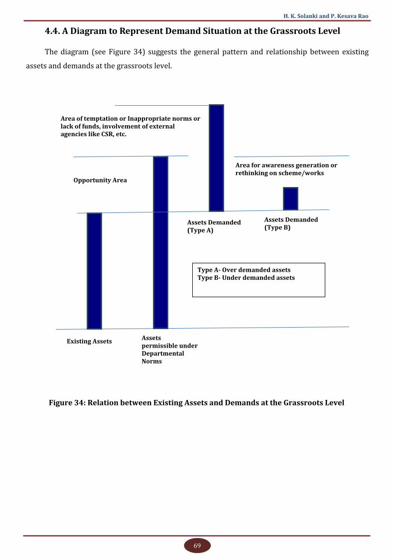
69
H. K. Solanki and P. Kesava Rao
Assets Demanded (Type A)
Opportunity Area
Assets Demanded (Type B)
Existing Assets Assets permissible under Departmental Norms
Area of temptation or Inappropriate norms or lack of funds, involvement of external agencies like CSR, etc.
Type A- Over demanded assets Type B- Under demanded assets
Area for awareness generation or rethinking on scheme/works
Figure 34: Relation between Existing Assets and Demands at the Grassroots Level
4.4. A Diagram to Represent Demand Situation at the Grassroots Level
The diagram (see Figure 34) suggests the general pattern and relationship between existing
assets and demands at the grassroots level.
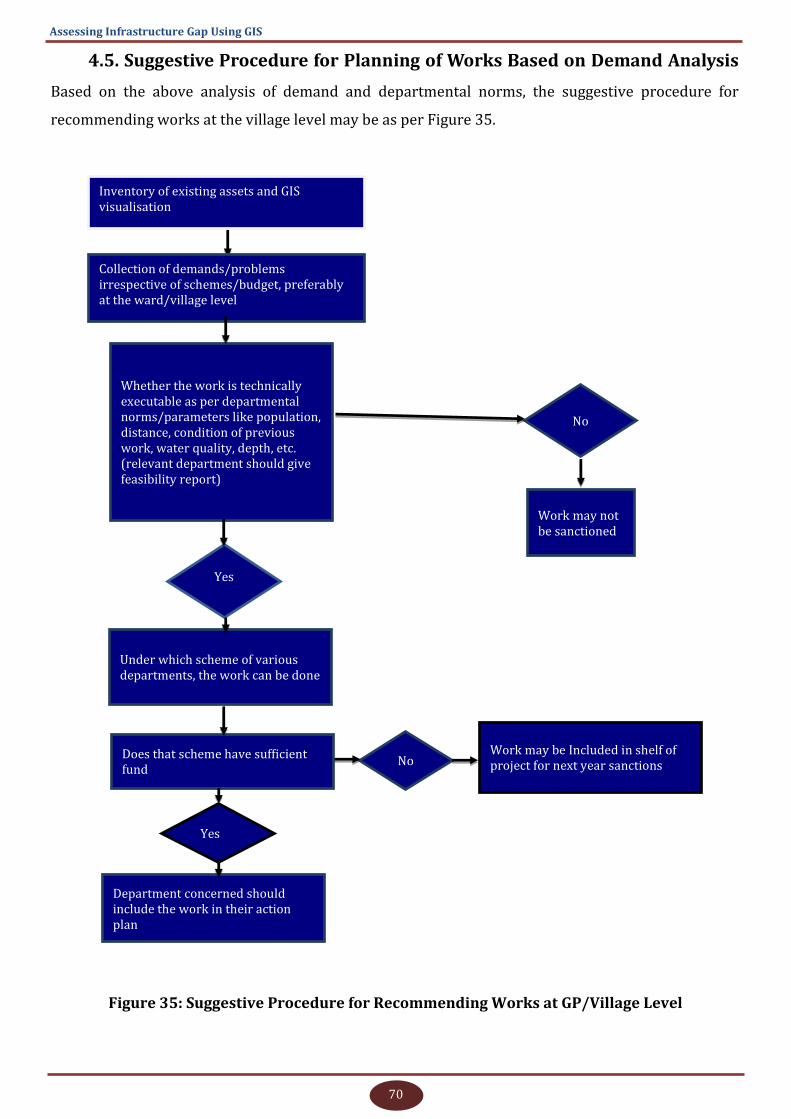
70
Assessing Infrastructure Gap Using GIS
4.5. Suggestive Procedure for Planning of Works Based on Demand Analysis
Based on the above analysis of demand and departmental norms, the suggestive procedure for
recommending works at the village level may be as per Figure 35.
Inventory of existing assets and GIS visualisation
No
Work may not be sanctioned
Yes
Under which scheme of various departments, the work can be done
Yes
Collection of demands/problems irrespective of schemes/budget, preferably at the ward/village level
Whether the work is technically executable as per departmental norms/parameters like population, distance, condition of previous work, water quality, depth, etc. (relevant department should give feasibility report)
Does that scheme have sufficient fund
Department concerned should include the work in their action plan
No Work may be Included in shelf of project for next year sanctions
Figure 35: Suggestive Procedure for Recommending Works at GP/Village Level

71
H. K. Solanki and P. Kesava Rao
4.6. Out-of-the-box Demands
i. Gram Sabhas used to be conducted previously four times a year (26th Jan, 15th August, 2nd Oct,
and 1st May). Now, these are being conducted 15-17 times a year, which is causing incomplete
quorum.
ii. MGNREGA labour-oriented works are less in the area. Desilting of ponds cannot be done in the
area as it has already been carried out under MJSA and not permitted under MGNREGA now.
Anicuts are not constructed due to lack of drainage lines, roads cannot be constructed during
agriculture season as both sides of the roads have crops, and opportunity for new roads are
also less. It was suggested to link farming operations with MGNREGA.
iii. Pay scales of Gram Panchayat secretaries are less and it is difficult for them to instruct and
monitor officers, who are higher to them in pay and post.
iv. The involvement of Panchayat in skill and employment related schemes of the Central and State
governments is minimal. Panchayats are unaware of the activities and persons trained under
various schemes.
One Gram Panchayat Sarpanch described the procedural difficulties at the grassroots level in
simple words as mentioned in Figure 36.
Vox populi
एक साथ प्लान नह ंबनता
एक साथ पैसा नह ंआता
एक साथ काम नह ंहोता
Figure 36: Vox Populi- Sarpanch of Nearby Paraswara GP, Nadbai Block, Bharatpur District, Rajasthan
4.7. Future Research Direction Emerging Out of Study
As the parts of previous roads are generally not removed while carrying out the construction
works and levels are not maintained properly, the floor levels of houses along the roads also go
down from the level of roads. This causes diversion of rainwater and drainage water into the
premises of houses along the roads. This leads to unhygienic living conditions, especially for poor
residents who cannot afford to raise levels of house floors or reconstruction of houses as per road
conditions. A further study is required to quantify the causes, impact and suggest proper solutions in
this direction. Already existing drone images can support immediate sampling of vertical levels of
72
Assessing Infrastructure Gap Using GIS
roads at selected places and vertical levels of houses along the roads corresponding to sampled
points on roads. The same can be validated on the ground with further analysis.
Web visualisation of all data of Gram Panchayat in an editable dynamic manner for their local
planning is required. Hantra Gram Panchayat GIS portal can be developed on a pilot basis where
drone data along with other statistics may be uploaded on the portal and access may be given to the
Gram Panchayat functionaries to update and edit it, prepare the planning maps and contribute local
data collected from time to time through various mobile applications. The same scheme can be
replicated in other Panchayats and all GPs can have their own GIS portal for local-level planning.
Most of the studies are limited to urban sprawls. A detailed study is required to estimate the
spread of settlement areas in villages of various States with terrain conditions, time, distances from
urban settlements and main roads, etc. This may be an additional concern with the problem of
migration and may correlate with migration and population.
Every block in Rajasthan and probably India has a block census handbook prepared by the
Census department. Apart from the data of previous census, the books have a lot of other local data.
Using this data and corresponding field GIS surveys, the book may be converted into a web-based
dynamic GIS portal named “Block Census GIS- Block…………….” where locations can be attached with
the attribute data from the book. The public may be allowed to access the data and download it.
The open wells were once a primary source of water, especially drinking water, in the region.
Now almost all wells are either abandoned or not being used. The reasons are apparent but further
exploration of the problem may be required.
A study is required on the possibilities of linking farming operations with MGNREGA in eligible
areas.
A study is required to estimate the present status of Panchayat-SHG convergence and
involvement of Gram Panchayats in skill and livelihood related State and Centrally sponsored
programmes.
A few models of all-inclusive village-level sanitation, drainage and waste disposals have to be
prepared and executed for testing the benefits, cost structures and deciding the technical norms
towards this as GPs are not able to prepare the plan and execute them financially, technically or
procedurally for the whole village/GP on their own. If the work will continue in a piecewise manner,
then construction of the roads and drainages will be a never-ending practice in villages.
73
H. K. Solanki and P. Kesava Rao
5. Recommendations
Based on results and discussions, the following recommendations are made for consideration
at appropriate levels.
Proper Enforcement of Technical Norms: For spending Panchayat funds (MGNREGS, FFC,
Untied, MP LAD/MLA LAD, etc.), generally the public demand is a hidden criterion that may not be
technically feasible in many circumstances especially when:
Asking for a new work in the same place when previous work done was of inferior quality.
Asking for a work when the actual fault lies with the beneficiaries, like asking for tightening of
HT electric lines or shifting of electric lines when they were laid as per norms and later road
height was increased by PWD or building portions were extended illegally under the lines.
Technical Feasibility Filter: All the works and demands should pass technical feasibility and
saturation criteria in a formal manner; only then, it should be part of the shelf of the project, even if
sufficient budget is available and nature of works are eligible as per guidelines.
Saturation-centric Budget and Scheme/Budget Independent Planning: Freeing of rural
development plans from funds, functions and functionaries in the initial phase of planning and
making it more need-specific and saturation-centric is need of the hour. All the departments with
schemes, budget and functionaries (technical experts) should remain on the periphery and support
only when asked by the Gram Panchayat. Giving an indication of budget and guidelines put a limit on
planning and encourage exaggerated planning also. Once the saturation-centric approach is started,
the plans in later phases may be very less budget consuming and mainly dependent on maintenance
aspects.
Relaxation in PMGSY Norms: As described in the discussion section, the PMGSY Census 2001
is being taken into account for connecting the villages having a population of 500/250 as the case
may be. But Census 2011 is already over and if the revised consideration is done, many new villages
may be benefitted and be connected to the all-weather roads. In the study area, as per Census 2001,
Nagla Banjara is not in the PMGSY criterion. But as per Census 2011, its population is 550 and it is
eligible for connectivity but not eligible under PMGSY. Hence, the eligibility criteria for PMGSY may
be made the population as per the immediate previous Census. Further, in the normal areas also,
norms may be different for villages having more backward population.
Placing Dedicated Technical Staff at Each Gram Panchayat: Panchayats are not capable of
handling bigger technical plans. Panchayats are also having limitations in technical sanctions and the
assistance received from higher offices are less, as the technical staff posted at Block offices serve
many Panchayats at a time. Seeing the fund flow and technical requirements, each Gram Panchayat
should have a dedicated and capable technical staff.
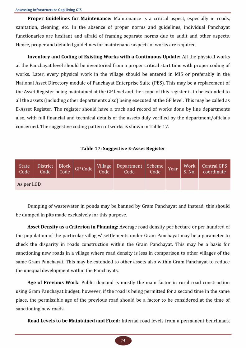
74
Assessing Infrastructure Gap Using GIS
Proper Guidelines for Maintenance: Maintenance is a critical aspect, especially in roads,
sanitation, cleaning, etc. In the absence of proper norms and guidelines, individual Panchayat
functionaries are hesitant and afraid of framing separate norms due to audit and other aspects.
Hence, proper and detailed guidelines for maintenance aspects of works are required.
Inventory and Coding of Existing Works with a Continuous Update: All the physical works
at the Panchayat level should be inventoried from a proper critical start time with proper coding of
works. Later, every physical work in the village should be entered in MIS or preferably in the
National Asset Directory module of Panchayat Enterprise Suite (PES). This may be a replacement of
the Asset Register being maintained at the GP level and the scope of this register is to be extended to
all the assets (including other departments also) being executed at the GP level. This may be called as
E-Asset Register. The register should have a track and record of works done by line departments
also, with full financial and technical details of the assets duly verified by the department/officials
concerned. The suggestive coding pattern of works is shown in Table 17.
Table 17: Suggestive E-Asset Register
State Code
District Code
Block Code
GP Code Village Code
Department Code
Scheme Code
Year Work S. No.
Central GPS coordinate
As per LGD
Dumping of wastewater in ponds may be banned by Gram Panchayat and instead, this should
be dumped in pits made exclusively for this purpose.
Asset Density as a Criterion in Planning: Average road density per hectare or per hundred of
the population of the particular villages’ settlements under Gram Panchayat may be a parameter to
check the disparity in roads construction within the Gram Panchayat. This may be a basis for
sanctioning new roads in a village where road density is less in comparison to other villages of the
same Gram Panchayat. This may be extended to other assets also within Gram Panchayat to reduce
the unequal development within the Panchayats.
Age of Previous Work: Public demand is mostly the main factor in rural road construction
using Gram Panchayat budget; however, if the road is being permitted for a second time in the same
place, the permissible age of the previous road should be a factor to be considered at the time of
sanctioning new roads.
Road Levels to be Maintained and Fixed: Internal road levels from a permanent benchmark
75
H. K. Solanki and P. Kesava Rao
in each village needs to be established preferably on 30 metres of chainage and those points have to
be marked properly in the GIS environment (points may be recorded by DGPS for future reference
and levels may be decided by the PWD using Auto levels from Permanent Benchmark). In future, new
road construction should not cross these road levels. If new material is used for construction, the
previous material on the road should be scrapped off first and dumped/used in other constructions.
Social Audit of Roads/Works: For the roads constructed by PWD and Gram Panchayat, a
proper social audit is required from time to time for checking compliance with norms. Other than
roads, this may be applicable for activities done by other key departments such as PHED, Electricity,
Education and Health.
Systematic Waste Management System: Having a systematic waste disposal system is the
most required activity but it has not been kept on high priority in the area due to social acceptance of
prevailing behaviours. In this regard, thorough awareness generation and capacity building for the
Panchayats are required. This activity is not demanded also properly due to lack of awareness.
Capacity building material prepared by NIRDPR may be translated into Hindi and distributed to
Panchayat functionaries.
Construction of Gaushalas: Roaming of free unproductive animals is a common problem not
only in the area and but also in whole Rajasthan and the country. Generally, unproductive buffalos
are sold to slaughterhouses but cows and bulls cannot be killed and these are roaming freely on
farmlands and roads, eating plastic waste. A proper planning and management strategy is required in
this direction. The immediate solution suggested was to construct and manage a cow rescue centre
(Gaushala) with proper management and a self-sustained model. With the involvement of NGOs,
every GP or cluster of GPs can have a Gaushala where animal wastes like dung, urine and also their
skin and bones can be used in natural ways and a commercial model can be evaluated.
Proper Combinations and Prioritisation of Norms if More Than One Parameter as
Criteria are Involved: In the villages where the population is less than the criteria of the asset but
the distance is more from nearby facility, then distance criterion should be followed if other
conditions are satisfied. For example, if a village has a population of less than 1000 and more than 20
children eligible for anganwadi centre, and its distance is more than 500 metres from nearby
anganwadi centre, then the village may be given an anganwadi centre. A similar pattern may be
followed in the cases pertaining to other infrastructures also. Hence, if more than one parameter is
involved, proper priority and combination of parameters may be rigidly defined, taking all kinds of
possibilities into consideration.
Refinement of MPLAD/MLALAD Guidelines: In MPLAD and MLALAD scheme guidelines, only
‘works not to be recommended’ are mentioned, but ‘doing the works as per guidelines of Nodal
76
Assessing Infrastructure Gap Using GIS
Department only’ is not mentioned . Hence, it should be an essential part of work guidelines of MP/
MLA-LAD works that the ‘Works can be executed only when complying with the norms of nodal
department.’
Concept of Nodal Technical Department: Panchayats are doing almost same type of works
like laying of roads, hand pumps, ponds related works, construction works, etc., which are executed
by relevant expert/line departments also. The technical guidelines of other departments and
Panchayat should be the same at least for the technical norms and should not deviate from norms of
specialised departments like PHED/PWD, etc. Or else, Public Health and Engineering Department
and Public Works Department should be the nodal department in Rajasthan State, respectively, for
all drinking water-related and Road works. Panchayats should get a clearance, technical feasibility
report from PHED or PWD as the case may be before executing any hand pump/RO/road, etc., and
related works. This will help maintain similarities in the quality of works.
Priority for Environmental Concerns: In deciding technical norms, environmental
sustainability should be on top priority and should not be compromised with public demand or
political will; otherwise, the whole population will be at risk in the long run. Moreover, NIRDPR
should try to get environmental concerns included in Section 243G of the Constitution like “………
preparation of plans for economic development and social justice, keeping environmental
sustainability on priority”
Control over Hand Pumps, Open Wells and Internal Road Activity: The same is deliberated
in detail in the discussion section and on this basis, it is recommended to have stringent norms for
sanctioning these activities. Alternative facilities like solar pumps, proper drainage instead of roads,
etc., need to be suggested.
Training and capacity building of selected block and Panchayat functionaries on the use of GIS
data generated from the study: Training and capacity building of selected Panchayat functionaries
and relevant Cluster/Block level officials on the use of GIS data generated from the study will be
useful to make them aware of the project outputs. For this, a post-project training cum workshop for
the selected Gram Panchayat functionaries, progressive and educated youths from project villages,
and a few selected Block level officials is recommended by utilising the remaining fund of study.

77
H. K. Solanki and P. Kesava Rao
6. Applications of Drone Images in Rural Development
6.1. Background
As per the study, it was found that the prime need of the villagers is to have a proper drainage
plan along with a survey of villages for understanding the proper water flow situation on roads and
general slopes. Secondly, it was felt necessary to have base maps for proper depiction of the existing
and demanded assets with fair accuracy. For this, different sources like Cartosat 2 data from NRSC
and Google Earth images were tried. Data resolution of Cartosat 2 data from NRSC and Google Earth
images were not found suitable for depicting internal roads, houses, and other internal community
infrastructure assets of villages. Further, there are certain limitations in using the products and
images of Google Earth (Google, 2019).
Hence, NESAC, ISRO, Meghalaya was contacted for support in getting the drone survey of
Hantra Gram Panchayat done. As the data processing cost was higher and only community
infrastructure assets and Digital Elevation Models (DEM) were the main concerns, drone survey of
settlement areas of all three villages under Gram Panchayat was only planned under the project.
6.1.1. Image Comparison
Cartosat-2 data procured from NRSC and drone survey images from Hantra village were
extracted from QGIS software and depicted for comparison for a small portion of Hantra village,
keeping the same extent and zoom level/scale (see Figures 37 and 38). Cartosat-2 is of 1-metre pixel
resolution (best resolution available with NRSC, ISRO) and drone image is of 5-centimetre pixel
resolution.
Figure 37: Cartosat 2 Image of Hantra Village for a Particular Area (1-Metre Resolution)

78
Assessing Infrastructure Gap Using GIS
Figure 38: Drone Image of Hantra Village for the Same Area and on Same Zoom Level
(5-cm Resolution)
6.2. Objectives
To get high-resolution data as base maps for depicting the existing assets and digitisation
of other features for other relevant use related to rural development for many years
To get 3D Digital Terrain Model (DTM) and Digital Surface Model (DSM) images for use in
drainage plan generation for the villages
6.3. Methodology
For the drone survey, only the settlement areas of all the three villages were surveyed. The
survey covering all three villages was carried out by a team of two scientists from NESAC, ISRO
Meghalaya with DJI Inspire 1 model quadcopter for four days. RGB camera DJI Zenmuse X3 12 MP
was used for the survey. Orthomosaic images, DTM and DSM were generated as output data with
Point Cloud and 3D Mesh. DSM and Orthomosaic data pixel spatial resolution were 5 cm for Hantra
and Nagla Banjara villages and 10 cm for Arauda village. DTM data for all three villages were of 10
cm pixel resolution. Contour vector files of 10 cm vertical intervals were provided for all three
villages. Small video clips of the flight path of survey were also provided. Data processing was done
at NESAC, Meghalaya and final data were shared on FTP. A proper proposal was made before Gram
Panchayat and Gram Sabha and proper acceptance was taken from the Gram Sabha and all the
procedures and possible benefits were described in the open common meeting of villagers and
relevant departmental officials at the GP level. Proper permission was acquired from the district
79
H. K. Solanki and P. Kesava Rao
administration and district police department. During the survey, the district administration
attached a police personnel with the team. NIRDPR research team including the Research Associate
and Coordinator also were present during the survey with the NESAC, ISRO team.
Mr. Abhilash Prathipati, a student intern in partial fulfilment of requirements for his degree of
Master of Science (Applied Geography & Geoinformatics) during the year 2017–18 from the Central
University of Karnataka, Gulbarga also worked on the drone data of Hantra village under the
guidance of research study coordinator Sh. H K. Solanki.
The data was used for the visualisation and superimposing of all the existing and demanded
assets of the villages. Depictions for general use were made ward-wise. Vertical profile for all the
roads was generated, and the road ends, crossings, turns, water stagnation or higher points were
extracted. The overall flow of water was assessed and an attempt was made to determine the
direction of flow. Orthomosaic image was used for demarcating clearly visible water stagnation
patches in Hantra village.
6.4. Results and Key Findings
It was found that the overall flow direction of the village is toward the north side and flow is
accumulated towards the north-east side of the village. Hence, plans can be made for proper water
storage and wastewater dumping and also the draining of excess water in that direction.
It was observed that despite there is a south to north natural flow level difference, the water
gets stagnated on roads. This may be an indication of poor slope management of roads due to many
reasons. Further ground verification on reasons for water stagnation may be verified at the water
stagnation locations. This is a major problem of the area. Even with the availability of proper slope, if
water is stagnated at many places along the road, then the causes which may be social or technical
may be explored. At some places, water is stagnated as there is no natural slope and water is
accumulating to a point. For those areas, piped drains using the slope directions may be proposed.
The overall drainage plan is yet to be prepared.
It was observed from the drone image that the drains constructed by the National Highway
Authority of India are not having proper slope direction towards the two ponds constructed on both
sides and water is flowing in reverse directions. Drain covers are broken at many places and due to
broken drain, at one place, water is flowing towards the farmers’ fields. The roads were digitised for
the full width of the village along with the central line of roads.
The road digitisation with background drone image may be used for planning of roads without
even going on roads. The exact areas and length can be measured and exact and the most accurate
estimates can be prepared. By this, the lump sum estimation can be avoided which is a current
practice in planning including GPDP.
80
Assessing Infrastructure Gap Using GIS
The condition of houses can also be visualised for verifying the eligibility of beneficiaries under
the State or Centrally sponsored housing schemes.
Apart from water stagnation points and current garbage dumping points, a suitable location for
wastewater and garbage dumping can be proposed.
The images may be used for validating the previous works or horizontal and vertical
dimensions in a live GIS environment by providing training to the relevant GP functionaries and
departmental officials. For proposing new works and planning, the images can be easily used for 5-7
years.
The images can be used for checking and validating encroachment status and may be used as a
supporting tool for primary investigation for revenue officials and administration.
Apart from the previous analyses using drone images, a few more drone-related derived data
and analyses are shown in Figures 39-44.
Note: For reducing the clumsiness in images, elevations are shown by reducing 200 metres from
the original reduced levels. For the same reason, the decimal place is also kept as two digits. In the
original GIS environment, the data may be used with original reduced levels and with convenient
decimal places.

81
H. K. Solanki and P. Kesava Rao
Figure 39: Visualisation of Water Stagnation Areas in Hantra Village on Drone Images
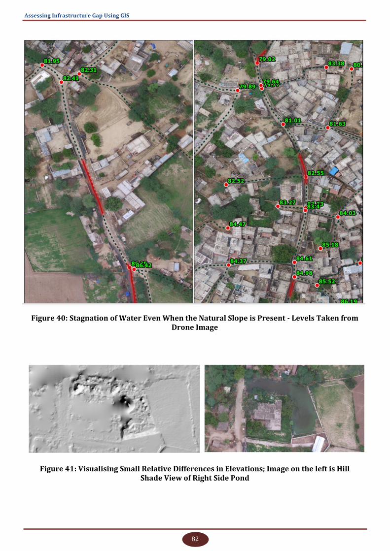
82
Assessing Infrastructure Gap Using GIS
Figure 40: Stagnation of Water Even When the Natural Slope is Present - Levels Taken from Drone Image
Figure 41: Visualising Small Relative Differences in Elevations; Image on the left is Hill Shade View of Right Side Pond
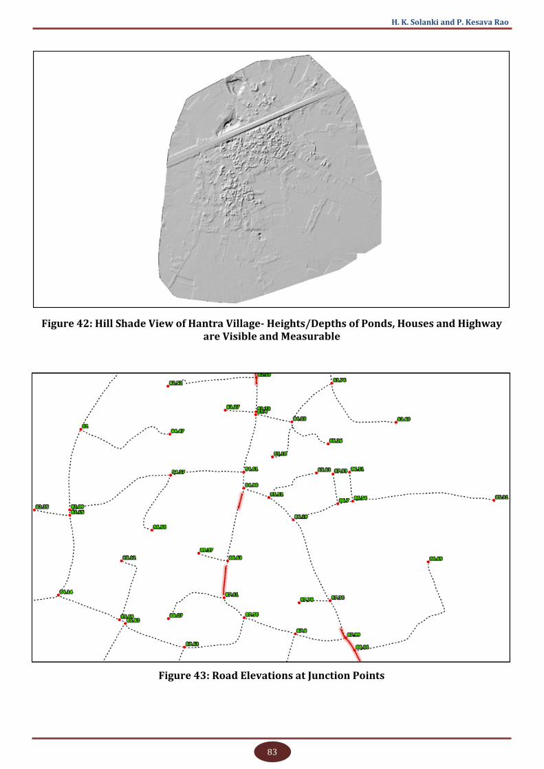
83
H. K. Solanki and P. Kesava Rao
Figure 42: Hill Shade View of Hantra Village- Heights/Depths of Ponds, Houses and Highway are Visible and Measurable
Figure 43: Road Elevations at Junction Points
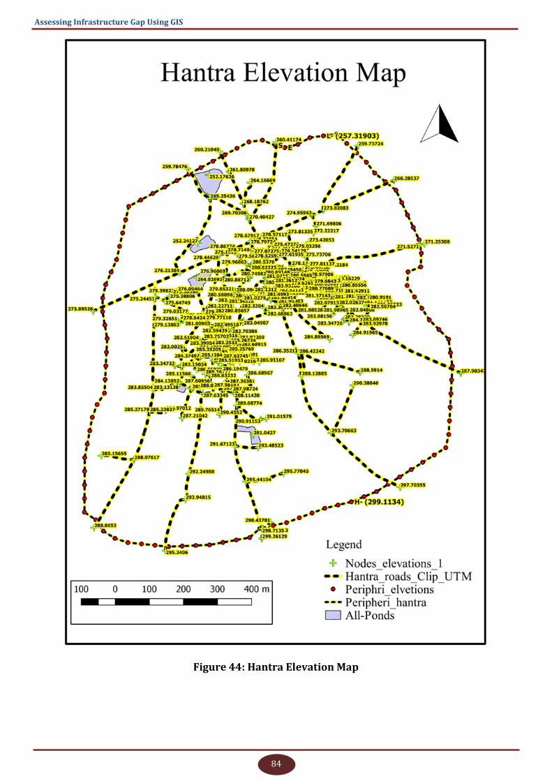
84
Assessing Infrastructure Gap Using GIS
Figure 44: Hantra Elevation Map
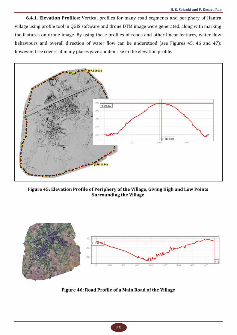
85
H. K. Solanki and P. Kesava Rao
6.4.1. Elevation Profiles: Vertical profiles for many road segments and periphery of Hantra
village using profile tool in QGIS software and drone DTM image were generated, along with marking
the features on drone image. By using these profiles of roads and other linear features, water flow
behaviours and overall direction of water flow can be understood (see Figures 45, 46 and 47);
however, tree covers at many places gave sudden rise in the elevation profile.
Figure 45: Elevation Profile of Periphery of the Village, Giving High and Low Points Surrounding the Village
Figure 46: Road Profile of a Main Road of the Village
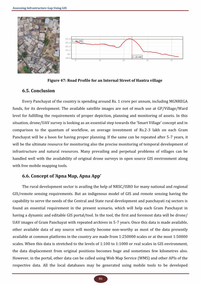
86
Assessing Infrastructure Gap Using GIS
Figure 47: Road Profile for an Internal Street of Hantra village
6.5. Conclusion
Every Panchayat of the country is spending around Rs. 1 crore per annum, including MGNREGA
funds, for its development. The available satellite images are not of much use at GP/Village/Ward
level for fulfilling the requirements of proper depiction, planning and monitoring of assets. In this
situation, drone/UAV survey is looking as an essential step towards the ‘Smart Village’ concept and in
comparison to the quantum of workflow, an average investment of Rs.2-3 lakh on each Gram
Panchayat will be a boon for having proper planning. If the same can be repeated after 5-7 years, it
will be the ultimate resource for monitoring also the precise monitoring of temporal development of
infrastructure and natural resources. Many prevailing and perpetual problems of villages can be
handled well with the availability of original drone surveys in open source GIS environment along
with free mobile mapping tools.
6.6. Concept of ‘Apna Map, Apna App’
The rural development sector is availing the help of NRSC/ISRO for many national and regional
GIS/remote sensing requirements. But an indigenous model of GIS and remote sensing having the
capability to serve the needs of the Central and State rural development and panchayati raj sectors is
found an essential requirement in the present scenario, which will help each Gram Panchayat in
having a dynamic and editable GIS portal/tool. In the tool, the first and foremost data will be drone/
UAV images of Gram Panchayat with repeated archives in 5-7 years. Once this data is made available,
other available data of any source will mostly become non-worthy as most of the data presently
available at common platforms in the country are made from 1:250000 scales or at the most 1:50000
scales. When this data is stretched to the levels of 1:100 to 1:1000 or real scales in GIS environment,
the data displacement from original positions becomes huge and sometimes few kilometres also.
However, in the portal, other data can be called using Web Map Service (WMS) and other APIs of the
respective data. All the local databases may be generated using mobile tools to be developed
87
H. K. Solanki and P. Kesava Rao
dedicatedly for rural development and panchayati raj sector and the same can be uploaded on the
portal. With available databases, the planning and monitoring of assets on the portal can be done by
Panchayat functionaries, revenue departments and other relevant departments by providing them
proper editing tools and authorisation. Having an own system for data generation, visualisation,
planning and monitoring backed by drone/UAV survey images and indigenous mobile app is the
need of the hour.
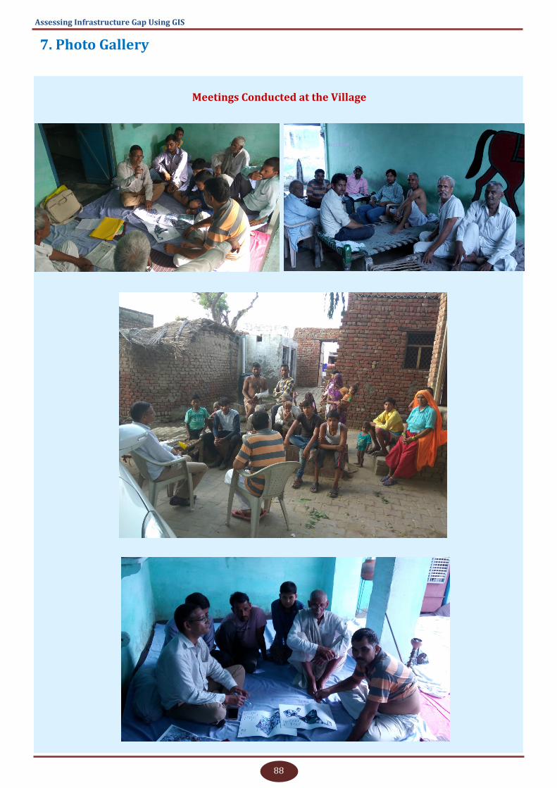
88
Assessing Infrastructure Gap Using GIS
7. Photo Gallery
Meetings Conducted at the Village
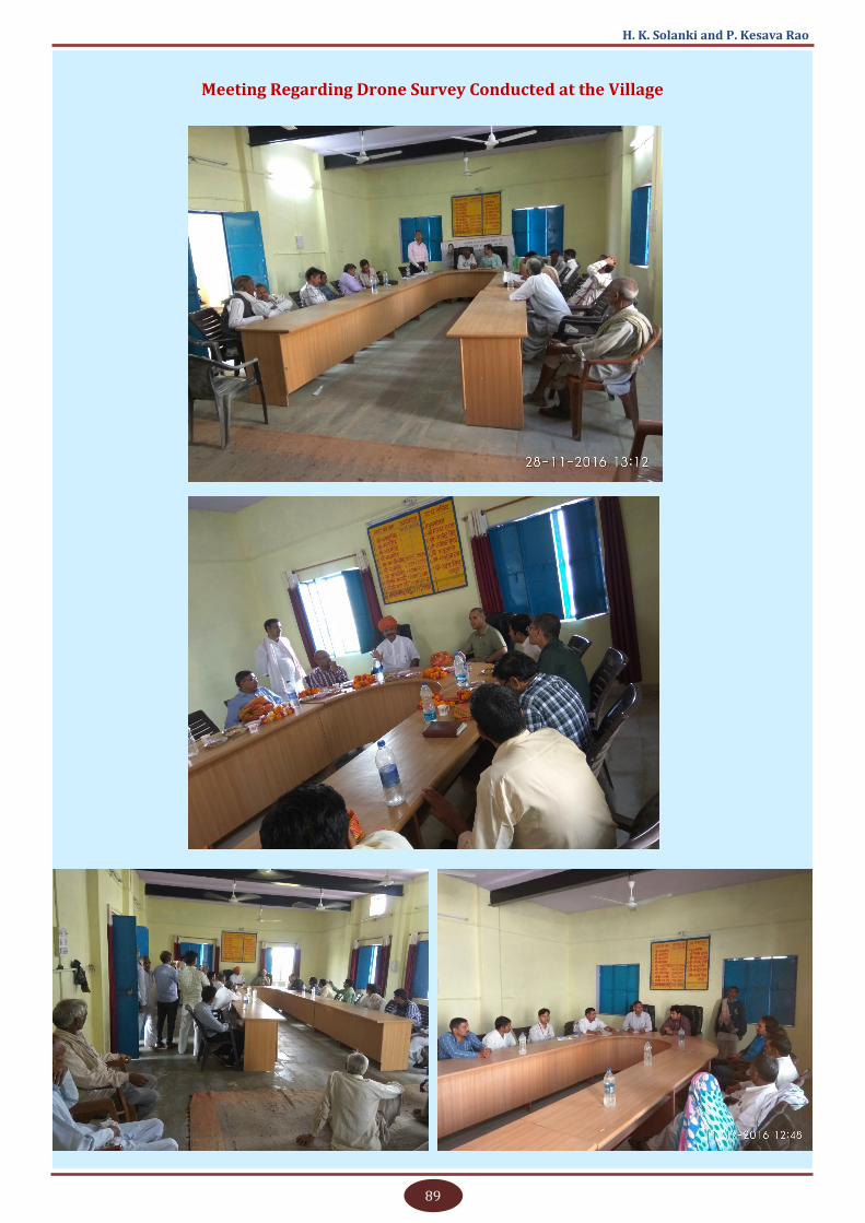
89
H. K. Solanki and P. Kesava Rao
Meeting Regarding Drone Survey Conducted at the Village
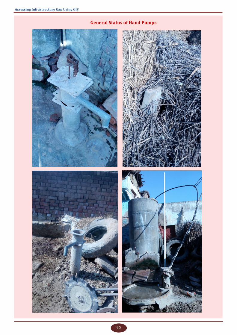
90
Assessing Infrastructure Gap Using GIS
General Status of Hand Pumps
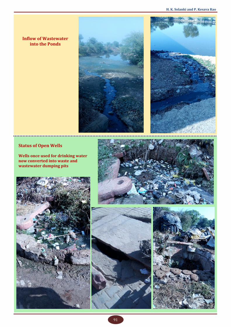
91
H. K. Solanki and P. Kesava Rao
Inflow of Wastewater into the Ponds
Status of Open Wells Wells once used for drinking water now converted into waste and wastewater dumping pits
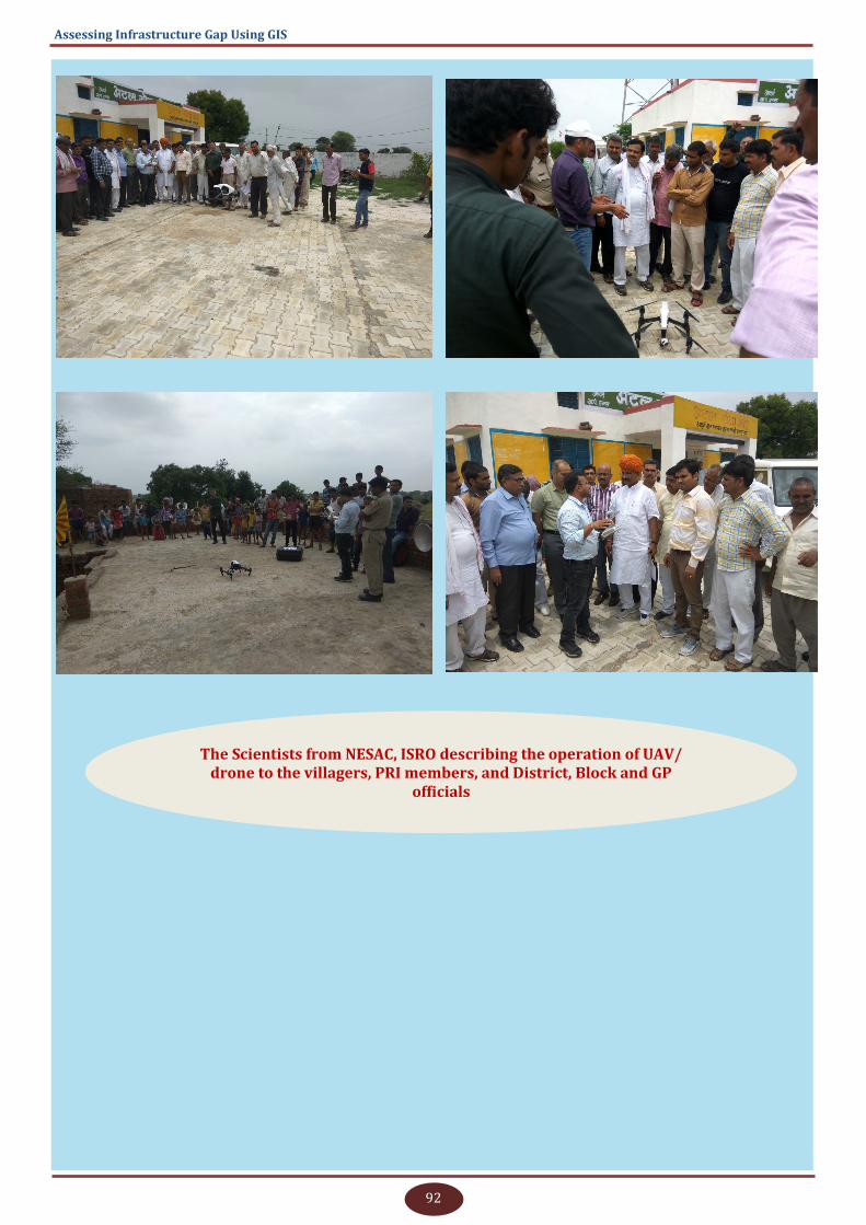
92
Assessing Infrastructure Gap Using GIS
The Scientists from NESAC, ISRO describing the operation of UAV/drone to the villagers, PRI members, and District, Block and GP
officials
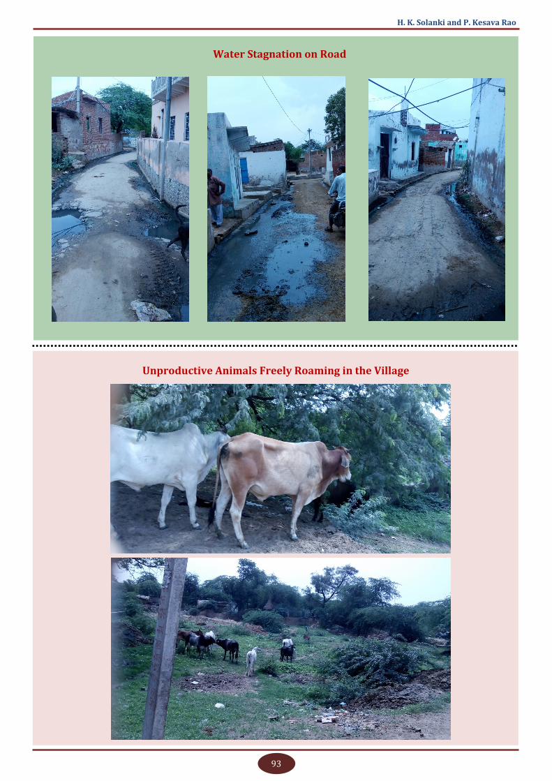
93
H. K. Solanki and P. Kesava Rao
Unproductive Animals Freely Roaming in the Village
Water Stagnation on Road
94
Assessing Infrastructure Gap Using GIS
8. References
Directorate of Census Operations, Rajasthan. n.d. “Primary Census Abstract and Village
Directory: District Bharatpur, Rajasthan for 1991, 2001, 2011 [Excel Sheet].”
DoLR, MoRD, GoI. 2019. “Bhuvan IWMP-SRISHTI.” Monitoring and Evaluation of Watershed
Projects. Retrieved June 10, 2019 (http://bhuvan.nrsc.gov.in/projects/iwmp/).
DoRD, MoRD, GoI. 2011. “Socio-Economic and Caste Census 2011 [PDF Document].”
Google. 2019. “Google Maps & Google Earth.” Permission Guidelines for Google Maps and Google
Earth. Retrieved June 10, 2019 (https://www.google.com/permissions/geoguidelines/).
Gram Panchayat, Hantra. 2019. “Resource Envelop.”
Ministry of Power, Government of India. 2005. “Electricity Rules, 2005.”
MoPR, GoI. 2018a. “FFC Recommendations.” Fourteen Finance Commission (FFC). Retrieved
June 10, 2019 (https://planningonline.gov.in/ffcReport.jsp).
MoPR, GoI. 2018b. “Revised GPDP Guidelines 2018.”
MoPR, GoI. 2019. “PlanPlus V2.0.” Decentralised Planning System. Retrieved October 6, 2019
(http://www.planningonline.gov.in/ReportData.do?ReportMethod=getGPDPDashBoardMapData).
MoPR, GoI. n.d. “LGD - Local Government Directory.” Retrieved March 28, 2020 (https://
lgdirectory.gov.in/).
MoRD, GoI. 2015. “Shyama Prasad Mukherji Rurban Mission: Framework of Implementation.”
MoRD, GoI. n.d. “About SAGY.” Sansad Adarsh Gram Yojana. Retrieved (http://saanjhi.gov.in/
aboutus.aspx).
MoRD, GoI. n.d. “Provision of Urban Amenities in Rural Areas (PURA).” Provision of Urban
Amenities in Rural Areas (PURA). Retrieved June 10, 2019c (https://rural.nic.in/sites/default/
files/07PURA%28F%29.pdf).
MoRD, GoI. n.d. “Shyama Prasad Mukherji Rurban Mission: Integrated Cluster Action Plan
(ICAP).”
NIC, GoI. 2012. “India.Gov.in Archive.” Bharat Nirman. Retrieved (https://archive.india.gov.in/
sectors/rural/index.php?id=7).
NRDMS, DST, GoI. 2019. “Village Information System.” Natural Resources Data Management
System. Retrieved July 19, 2020 (https://dst.gov.in/natural-resources-data-management-system).
NRSC, ISRO. 2020. “Bhuvan Panchayat.” Space-Based Information Support for Decentralized
Planning. Retrieved January 28, 2020 (https://bhuvan-Panchayat3.nrsc.gov.in/).
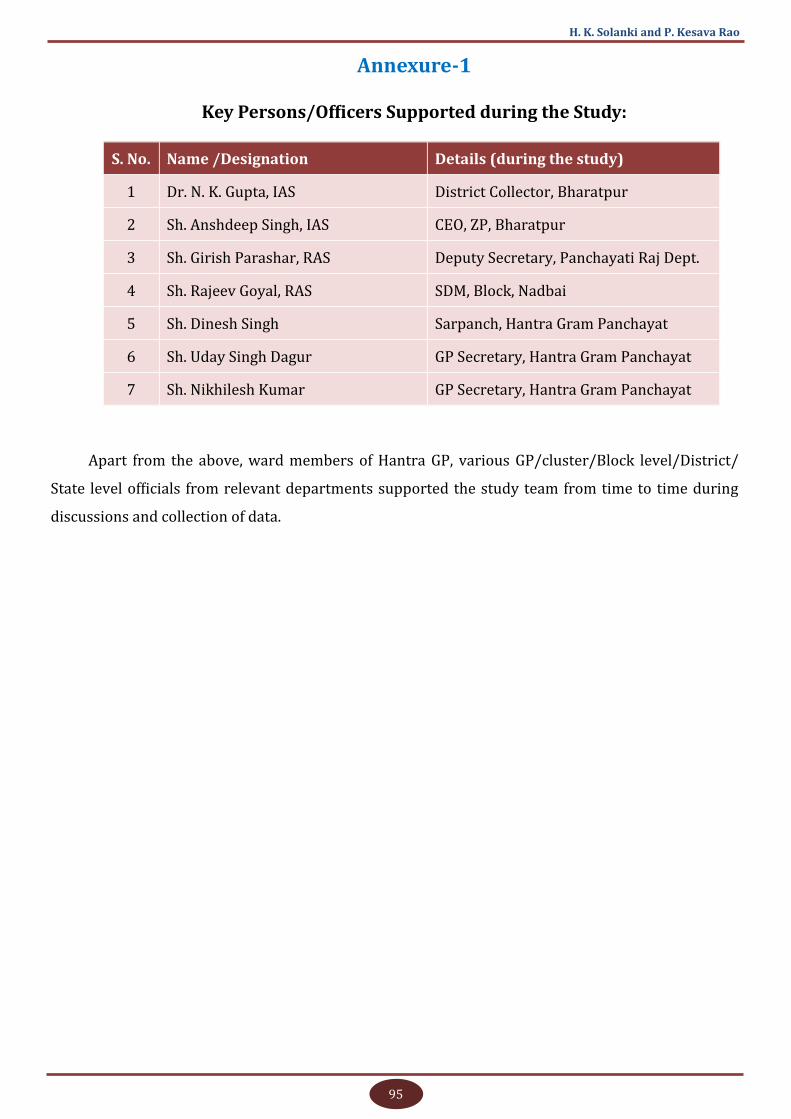
95
H. K. Solanki and P. Kesava Rao
Annexure-1
Key Persons/Officers Supported during the Study:
S. No. Name /Designation Details (during the study)
1 Dr. N. K. Gupta, IAS District Collector, Bharatpur
2 Sh. Anshdeep Singh, IAS CEO, ZP, Bharatpur
3 Sh. Girish Parashar, RAS Deputy Secretary, Panchayati Raj Dept.
4 Sh. Rajeev Goyal, RAS SDM, Block, Nadbai
5 Sh. Dinesh Singh Sarpanch, Hantra Gram Panchayat
6 Sh. Uday Singh Dagur GP Secretary, Hantra Gram Panchayat
7 Sh. Nikhilesh Kumar GP Secretary, Hantra Gram Panchayat
Apart from the above, ward members of Hantra GP, various GP/cluster/Block level/District/
State level officials from relevant departments supported the study team from time to time during
discussions and collection of data.

Related Documents