McArthur River Mine Open Cut Project Public Environmental Report Section 9 Surface Water - Flood Protection Bund 9-1 9 Surface Water - Flood Protection Bund 9.0 Surface Water - Flood Protection Bund 9.1 Summary This section provides the results of an analysis of the stability and integrity of the flood protection bund. The bund has been designed as water storage dam in accordance with the Australian Committee on Large Dams (ANCOLD, 1999) requirements and has been based on extensive geotechnical site investigations and recent site experience with the Test Pit bund. The external and internal faces of the bund will be rock- filled with NAF rock to protect its internal clay core against erosion, and to provide geotechnical stability. The bund will be high enough to protect the mine pit from a 1 in 500-year ARI flood event. The design has considered all relevant aspects that could affect the bund’s stability including erosion, seepage, internal failure, and liquefaction. Stability analysis has shown that the bund will have a factor of safety that complies with best practice engineering design, and demonstrates that it will be stable in the short term and long term during flood events in both the McArthur River and Barney Creek. The risk that the flood protection bund will be overtopped by a flood event larger than the 1 in 500-year ARI design event has been calculated as 0.2% during the first two years of operation and 1.2% during the subsequent 23 years of operation. Although this risk is extremely low and is acceptable to MRM, the likely impact of embankment overtopping has been considered. The bund has been designed to include an emergency overflow section which, if overtopping occurs, would erode in a small area in a controlled manner and at a pre-determined rate. The eroded material would flow into the mine pit. In this way the vast majority of the bund would remain intact, and there would be minimal discharge of eroded material downstream in the McArthur River. 9.2 Flood Bund Integrity 9.2.1 Introduction The flood protection bund will be constructed around the open cut to protect the working areas and associated infrastructure from inundation during flood events. The alignment of the flood protection bund has been selected to provide maximum opportunity for the future development of the McArthur River deposit as well as taking greatest advantage of the natural topography to minimise earthworks. In addition, the alignment has been selected to provide adequate separation between the proposed diversion channels and the bund, and to maintain regulatory separation between the bund crest and the flight path for the McArthur River airstrip as defined by the Civil Aviation Safety Authority. Although the flood protection bund will be required to prevent flooding of the open cut for only a short period of time each year, the standards adopted for its design are those which would normally be adopted

Welcome message from author
This document is posted to help you gain knowledge. Please leave a comment to let me know what you think about it! Share it to your friends and learn new things together.
Transcript

McArthur River Mine
Open Cut Project Public Environmental Report
Section 9
Surface Water - Flood Protection
Bund
9-1
9 Surface Water - Flood Protection Bund
9.0 Surface Water - Flood Protection Bund
9.1 Summary
This section provides the results of an analysis of the stability and integrity of the flood protection bund.
The bund has been designed as water storage dam in accordance with the Australian Committee on Large
Dams (ANCOLD, 1999) requirements and has been based on extensive geotechnical site investigations
and recent site experience with the Test Pit bund. The external and internal faces of the bund will be rock-
filled with NAF rock to protect its internal clay core against erosion, and to provide geotechnical stability.
The bund will be high enough to protect the mine pit from a 1 in 500-year ARI flood event.
The design has considered all relevant aspects that could affect the bund’s stability including erosion,
seepage, internal failure, and liquefaction. Stability analysis has shown that the bund will have a factor of
safety that complies with best practice engineering design, and demonstrates that it will be stable in the
short term and long term during flood events in both the McArthur River and Barney Creek.
The risk that the flood protection bund will be overtopped by a flood event larger than the 1 in 500-year
ARI design event has been calculated as 0.2% during the first two years of operation and 1.2% during the
subsequent 23 years of operation. Although this risk is extremely low and is acceptable to MRM, the
likely impact of embankment overtopping has been considered.
The bund has been designed to include an emergency overflow section which, if overtopping occurs,
would erode in a small area in a controlled manner and at a pre-determined rate. The eroded material
would flow into the mine pit. In this way the vast majority of the bund would remain intact, and there
would be minimal discharge of eroded material downstream in the McArthur River.
9.2 Flood Bund Integrity
9.2.1 Introduction
The flood protection bund will be constructed around the open cut to protect the working areas and
associated infrastructure from inundation during flood events. The alignment of the flood protection bund
has been selected to provide maximum opportunity for the future development of the McArthur River
deposit as well as taking greatest advantage of the natural topography to minimise earthworks.
In addition, the alignment has been selected to provide adequate separation between the proposed
diversion channels and the bund, and to maintain regulatory separation between the bund crest and the
flight path for the McArthur River airstrip as defined by the Civil Aviation Safety Authority.
Although the flood protection bund will be required to prevent flooding of the open cut for only a short
period of time each year, the standards adopted for its design are those which would normally be adopted
McArthur River Mine
Open Cut Project Public Environmental Report
Section 9
Surface Water - Flood Protection
Bund
9-2
for the design of a water retaining structure that would be required to permanently contain water. These
standards are provided in guidelines published by ANCOLD (1999).
Engineering design of the flood protection bund has been undertaken on behalf of MRM by Brisbane
based consultants Kellog Brown & Root Pty Ltd (KBR) and geotechnical consultants Golder Associates.
KBR has undertaken the necessary design and have prepared drawings and technical specifications for
construction. The Design Basis Report and Technical Specification for the McArthur River Mine
Expansion civil works, including the flood protection bund, are included in Appendix B.
9.2.2 Design Basis
The design of the flood protection bund has been based on:
Foundation investigations undertaken for the flood protection bund and diversions
Experience with the construction of the Test Pit bund
ANCOLD guidelines on the design and construction of water storage dams.
A comprehensive geotechnical investigation of the flood protection bund footprint, and the proposed
construction materials to be sourced from the excavations for the McArthur River and Barney Creek
diversions, was undertaken by independent specialist geotechnical consultants Golder Associates.
The investigations were undertaken in accordance with Australian Standard AS1726-1993 (Geotechnical
Site Investigations) and consisted of the following:
31 drill holes at approximately 250 m centres along the bund centreline, supplemented by a number
of groundwater monitoring bores and probe holes;
Seismic refraction traverses (total 2,790 m length) along selected areas of the bund centreline
10 drill holes, 16 test pits and 4,330 m of seismic refraction traverses along the McArthur River
realignment
6 drill holes, 10 test pits and 2,330 m of seismic refraction traverses along the Barney Creek
realignment.
The investigations provided information on the strength and permeability of the foundations for the flood
protection bund and the quantity and quality (strength and permeability) of materials for the bund
construction. The results of this investigation are provided in Golder Associates (2004).
The Test Pit flood protection bund was constructed in August and September 2005 to provide flood
immunity for the 6 ha test pit at McArthur River Mine. The bund was constructed with earth-fill sourced
from overburden from the Test Pit.
The bund was built to a crest level of RL38 (6 m below the top of the proposed flood protection bund for
the Open Cut Project) and with a maximum height of 15 m. The outer face (McArthur River side) of the
bund was protected by a layer of rock sourced from the Test Pit.
McArthur River Mine
Open Cut Project Public Environmental Report
Section 9
Surface Water - Flood Protection
Bund
9-3
The construction of the Test Pit bund confirmed the practicality of providing a key trench beneath the
bund, together with moisture conditioning and compacting the natural clayey materials to the specified
density.
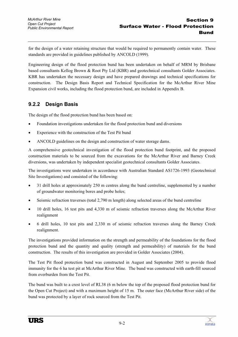
During the 2005/2006 wet season, the McArthur River rose to within approximately 5 m of the crest of
the Test Pit bund (Plate 9.1). No erosion was observed on the outer slopes of the bund, nor was there any
under-seepage beneath the bund into the pit.
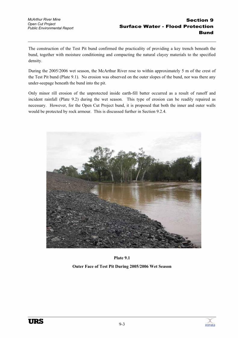
Only minor rill erosion of the unprotected inside earth-fill batter occurred as a result of runoff and
incident rainfall (Plate 9.2) during the wet season. This type of erosion can be readily repaired as
necessary. However, for the Open Cut Project bund, it is proposed that both the inner and outer walls
would be protected by rock armour. This is discussed further in Section 9.2.4.
Plate 9.1
Outer Face of Test Pit During 2005/2006 Wet Season
McArthur River Mine
Open Cut Project Public Environmental Report
Section 9
Surface Water - Flood Protection
Bund
9-4
Plate 9.2
Minor Rilling of Inner Face of Test Pit Bund at End of 2005/2006 Wet Season
9.2.3 Construction Program
Subject to project approval, construction of the flood protection bund is proposed to commence in the
second half of 2006 and continue through to 2009.
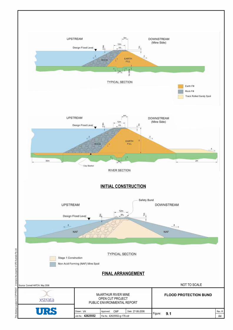
It is proposed to construct a zoned-fill water-retaining bund during the 2006 and 2007 dry seasons. The
bund, designed to ANCOLD standards, would comprise an inner clay earth-fill zone to provide a low
permeability barrier to seepage, and an outer rock-fill zone to provide protection against erosion and
scouring of floodwaters and stability as the floodwater recedes. A typical cross section of the bund is
shown in Figure 9.1 (Initial Construction).
Clay earth-fill and rock-fill used for this part of the bund construction would be sourced from the
McArthur River and Barney Creek diversions. The materials zoning proposed for the bund maximises
the use of the materials that will be extracted from the diversions of Barney Creek and the McArthur
River. Sandy alluvium from the diversions that is not suitable for use in the flood protection bund will be
placed as a weighting zone (for added stability) on the downstream side of the river sections of the bund.
Construction of the flood protection bund has been staged to allow the following goals to be met:
Continued mining of the Test Pit Southern Extension and operation of the processing plant
Efficient use of materials from the diversion channels and the Test Pit Southern Extension
INITIAL CONSTRUCTION
FINAL ARRANGEMENT
9.1
FLOOD PROTECTION BUND
A4
A
42625552
27-06-2006
42625552-g-178.cdr
VH
McARTHUR RIVER MINEOPEN CUT PROJECT
PUBLIC ENVIRONMENTAL REPORT
CMP
Source: Connell HATCH, May 2006 NOT TO SCALE
Rev.Drawn: Approved:
File No.
Date:
Job No.:Figure:
Thi
sdr
awin
gis
subj
ect t
oC
OP
YR
IGH
T.It
rem
ains
the
prop
erty
ofU
RS
Aus
tral
iaP
tyLt
d.
McArthur River Mine
Open Cut Project Public Environmental Report
Section 9
Surface Water - Flood Protection
Bund
9-5
Optimisation of haul distances and construction equipment usage
Passage of normal flood flows without erosion of the partially completed bunds and diversions.
The extent of construction proposed during the 2006 and 2007 dry seasons is shown on Drawing
BEE508-C-DWG-005 in Appendix B. During the 2006 dry season, it is proposed to construct the flood
protection bund to its full height between chainages 0-1800, 3200-6000 and 6800-7450. During the 2007
dry season, the remainder of the bund will be constructed using earth-fill and rock-fill sourced from the
remainder of the McArthur River diversion.
Commencing during the 2007 dry season and continuing through to 2009, NAF materials from the Test
Pit Southern Extension and then from the open cut, will be placed against the inner and outer slopes of the
initial flood protection bund to flatten the overall batter slopes from 50% (1V:2H) to 25% (1V:4H).
The flatter outer slopes of the bund will increase the long-term stability of the embankment, and will
allow immediate and progressive rehabilitation by topsoil and seeding. In addition to flattening the
batters, the NAF will also be used to raise the crest of the flood protection bund by 1 m thereby providing
greater protection against flooding. The final arrangement of the flood protection bund is shown on
Figure 9.1.
During 2006, the flood protection bund between chainage 0-1800 may be constructed to the final
arrangement (1V:4H batters) to maximise material won from the Barney Creek diversion. If this is the
case, the bund will be constructed with compacted earth-fill and a protective layer of rock armour will be
placed over the outer wall of the bund.
9.2.4 Design Considerations
To ensure both the long-term and short-term integrity of the flood protection bund, the following aspects
of the bund design were considered:
Crest level
Stability
Liquefaction of sand layers in the bund foundations (from seismic or blasting activity)
Seepage beneath the bund
Internal erosion
Erosion of the outer batters
Erosion of the inner batters
Inspection and monitoring during operation.
A detailed discussion of each of these issues is provided in Golder Associates (2006) which is included in
Appendix B. A summary of the above design issues is provided in the following sections.
McArthur River Mine
Open Cut Project Public Environmental Report
Section 9
Surface Water - Flood Protection
Bund
9-6
Crest Level
The magnitude and frequency of flooding in the McArthur River was determined using flood frequency
procedures detailed in IE Aust (1987) and based on actual flood data for the McArthur River for the
period 1969 to 2003. Inflow from tributary catchments was scaled from the McArthur River data based
on catchment area.
Hydraulic modelling using ‘state of the art’ two-dimensional (2D) hydraulic modelling software,
developed by WL/Delft Hydraulics of the Netherlands, was undertaken by KBR to determine the water
levels for floods in the McArthur River with various return intervals. MRM adopted a flood with a return
interval of 1 in 500-year as the design event for the flood protection bund, as this was considered to
provide an acceptable level of risk for the project.
The crest level of the bund has been set at 0.9 m above the 1 in 500-year ARI flood event for the initial
construction, and 2 m above the design flood event for the final arrangement. Assuming flood level and
wind speed are independent of each other, the probability that the flood protection bund will be
overtopped is 0.2% in the first 2 years of the project and 1.2% over the 25 year life of the project.
Hydraulic modelling using the one-dimensional (1D) hydraulic modelling software HEC-RAS, as
described in Section 5 of this PER, was also undertaken to estimate water levels for flood flows in the
Barney Creek diversion channel, assuming no concurrent flooding in the McArthur River. The HEC-
RAS results, as presented in Appendix F.2, show that a flood in Barney Creek with a return interval of 1
in 500 years would not overtop the flood protection bund.
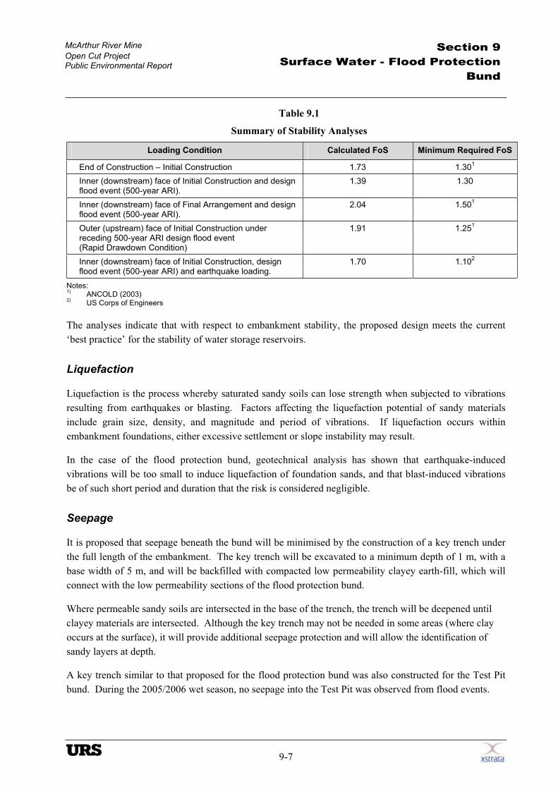
Stability
The stability of the flood protection bund was determined for critical loading conditions using the slope
stability software program Slope/W. Unlike water storage dams, where water is permanently stored
against the face of the dam, the face of the flood protection bund will be intermittently subject to
inundation during each year as flood waters rise and fall. Seepage forces resulting from this periodic
inundation were determined using the seepage analysis program Seep/W.
The factors of safety (FoS) determined from the analyses, together with the minimum FoS recommended
in ANCOLD guidelines and current best practice, are presented in Table 9.1.
McArthur River Mine
Open Cut Project Public Environmental Report
Section 9
Surface Water - Flood Protection
Bund
9-7
Table 9.1
Summary of Stability Analyses
Loading Condition Calculated FoS Minimum Required FoS
End of Construction – Initial Construction 1.73 1.301
Inner (downstream) face of Initial Construction and design flood event (500-year ARI).
1.39 1.30
Inner (downstream) face of Final Arrangement and design flood event (500-year ARI).
2.04 1.501
Outer (upstream) face of Initial Construction under receding 500-year ARI design flood event (Rapid Drawdown Condition)
1.91 1.251
Inner (downstream) face of Initial Construction, design flood event (500-year ARI) and earthquake loading.
1.70 1.102
Notes:1)
ANCOLD (2003) 2)
US Corps of Engineers
The analyses indicate that with respect to embankment stability, the proposed design meets the current
‘best practice’ for the stability of water storage reservoirs.
Liquefaction
Liquefaction is the process whereby saturated sandy soils can lose strength when subjected to vibrations
resulting from earthquakes or blasting. Factors affecting the liquefaction potential of sandy materials
include grain size, density, and magnitude and period of vibrations. If liquefaction occurs within
embankment foundations, either excessive settlement or slope instability may result.
In the case of the flood protection bund, geotechnical analysis has shown that earthquake-induced
vibrations will be too small to induce liquefaction of foundation sands, and that blast-induced vibrations
be of such short period and duration that the risk is considered negligible.
Seepage
It is proposed that seepage beneath the bund will be minimised by the construction of a key trench under
the full length of the embankment. The key trench will be excavated to a minimum depth of 1 m, with a
base width of 5 m, and will be backfilled with compacted low permeability clayey earth-fill, which will
connect with the low permeability sections of the flood protection bund.
Where permeable sandy soils are intersected in the base of the trench, the trench will be deepened until
clayey materials are intersected. Although the key trench may not be needed in some areas (where clay
occurs at the surface), it will provide additional seepage protection and will allow the identification of
sandy layers at depth.
A key trench similar to that proposed for the flood protection bund was also constructed for the Test Pit
bund. During the 2005/2006 wet season, no seepage into the Test Pit was observed from flood events.
McArthur River Mine
Open Cut Project Public Environmental Report
Section 9
Surface Water - Flood Protection
Bund
9-8
Internal Erosion
Internal erosion (referred to as piping) of earth-fill in the flood protection bund could occur if soils used
for the construction of the bund are dispersive, or if there is a defect in the construction that would allow a
concentrated leak to form.
Although the potential for piping of the earth-fill will be minimised by the use of clay materials with a
low potential for dispersion (Emerson Class > 2), and because compaction of the earth-fill at a high
moisture content and high density will mitigate against dispersion, the development of a concentrated leak
through either a naturally occurring shrinkage crack or a defect in the embankment construction cannot be
ignored. As a consequence an event tree analysis was used to assess the risk of piping.
Event tree analysis undertaken by Golder Associates (2006) estimated that the annual risk of piping
through the bund is 1 in 2,200 for the initial construction arrangement, and 1 in 3,400 for the final
arrangement as shown in Figure 9.1.
The use of a filter fabric on the downstream face of the initial construction arrangement (between the
earth-fill and NAF) was evaluated, and was shown to significantly reduce the risk of piping (to the order
of 1 in 100,000). However, this additional measure was considered unwarranted, as the risk of piping
(without geotextile) is of the same order of magnitude as the risk of the embankment being overtopped.
Erosion of Outer Batters
Two-dimensional hydraulic modelling of the design flood event undertaken by KBR (Figure 9.2), shows
that the maximum flood velocity at the outer face of the flood protection bund during a 1 in 500–year ARI
event will be of the order of 1.5 m/sec.
The risk of scouring of the outer face of the flood protection bund by floodwater would minimised by the
use of rock-fill. The rock-fill used on the outer face (maximum particle size 400 mm) will be capable of
withstanding a scour velocity of up to 2.6 m/sec (Austroads – Waterway Design Manual). In addition,
the rock-fill will provide long-term protection against scouring resulting from incident rainfall during the
wet season.
Erosion of Inner Batters
Earth-fill batters will be exposed on the inner slopes of the flood protection bund for a maximum of 2
years. The batters will then be covered with NAF rock generated as part of the mining operations
(maximum particle size 400 mm). Topsoil will be spread over the rock-fill materials to promote
rehabilitation.
Experience gained with the existing Test Pit bund indicates that minor rilling of the exposed earth-fill
face may be expected during the first two years of operation, until the face is flattened and covered with
NAF rock. Any rilling would be repaired as necessary. Subsequently, the rocky NAF material and
established vegetation would provide long-term protection against any scouring resulting from incident
rainfall during the wet season.

9.2
500 YEAR ARI FLOOD VELOCITIES
A4
A
42625552 42625552-g-200.cdr
VH
McARTHUR RIVER MINEOPEN CUT PROJECT
PUBLIC ENVIRONMENTAL REPORT
CMP
Source: Connell HATCH, May 2006
27-06-2006 Rev.Drawn: Approved:
File No.
Date:
Job No.:Figure:
Thi
sdr
awin
gis
subj
ect t
oC
OP
YR
IGH
T.It
rem
ains
the
prop
erty
ofU
RS
Aus
tral
iaP
tyLt
d.
McArthur River Mine
Open Cut Project Public Environmental Report
Section 9
Surface Water - Flood Protection
Bund
9-9
Monitoring and Surveillance
In the context of embankment dam engineering, monitoring refers to measurements taken by survey or
instrumentation, while surveillance refers to observations made as part of a documented inspection
program. Monitoring and surveillance guidelines for embankment dams are described in ANCOLD
guidelines (2003). On the basis of these guidelines, the following monitoring and surveillance program is
proposed for the flood protection bund.
The foundation and embankment pore water pressure will be monitored to check actual values against
design expectations. Three embankment sections comprising a total of 25 piezometers tips will be data-
logged at six-hourly intervals. Telemetric transmission of upper-catchment rainfall and flood water levels
(for advanced warning) and flood levels adjacent to the flood protection bund will also be implemented to
allow immediate action to be undertaken when predetermined trigger levels are exceeded.
The proposed surveillance plan will include the following:
An annual professional dam engineering inspection and review of monitoring data prior to the onset
of each wet season
Documented weekly inspection of the full length of the crest and downstream (mine side) toe by
experienced mine engineering personnel through the wet season
Documented daily inspection of the full length of the crest and downstream (mine side) toe by
experienced mine engineering personnel during actual flood events that exceed a pre-determined
trigger level.
9.3 Overtopping Risk
The risk that the flood protection bund will be overtopped by a flood event larger than the 1 in 500–year
ARI design event has been calculated as 0.2% during the first two years of operation, and 1.2% during the
subsequent 23 years of operation. Although this risk is extremely low, the likely impact of embankment
overtopping is catered for in the design.
A key feature of any embankment overtopping is to ensure that the overtopping occurs at a pre-
determined location, where the impacts can be managed and not randomly along the whole length of the
embankment. To facilitate any overtopping of the flood protection bund, it is proposed that an emergency
overflow section 0.5 m lower than the adjacent bund crest is constructed. The proposed emergency
overflow section would be constructed on the southern side of the flood protection bund between
chainage 6750 and 7000 (Drawing BEE508-C-DWG-302 in Appendix B).
To minimise the potential for damage to the other areas of the flood protection bund, it is important that
the water level on either side of the bund is balanced in as short a time as possible. In order to achieve
this, a ‘fuse plug spillway’ approach will be adopted, whereby the embankment will be designed to
breach and erode in a controlled manner to allow maximum discharge through the breach. This approach
is commonly used in major water storage dams and has, for example, recently been constructed at
Wivenhoe Dam, Queensland.
McArthur River Mine
Open Cut Project Public Environmental Report
Section 9
Surface Water - Flood Protection
Bund
9-10
Analysis indicates that, at final pit depth, the water level on either side of the bund would balance in 6.5
hours if a 250 m wide, 6 m deep, breach was allowed to form. As the peak flow capacity of such a breach
is in the order of 6,000 m3/sec, and the 500-year ARI catchment discharge is in the order of 19,000
m3/sec, the breach would have a significant effect on reducing the flood level prior to the water levels
balancing.
To ensure that the emergency overflow section erodes in a controlled manner and at the pre-determined
rate, special design features will be incorporated into the upper 6 m of the embankment in this section.
Such features may include a narrower crest, a thin upstream sloping clay core, sand fill shoulders, and
minimal use of rock-fill and rock protection, while a conventional section incorporating a thick clay core
and standard rock-fill will be used below 6 m depth to minimise erosion to ground level.
The likely sequence of events in the case of the bund being overtopped by floodwaters is shown in Figure
9.3.
In the highly unlikely event that the flood protection bund is overtopped, the design strategy anticipates
that materials from the breached embankment will be swept into the open cut, as this will be the lowest
point in the interior of the bund. The open cut will then become filled with floodwater. As the
floodwaters recede, the outflow through the breach will be at a much slower rate than the inflow, and the
resistant base and sides to the breach will minimise further erosion. Water levels in the open cut will drop
until the top of the eroded breach is reached.
Should erosion of breach materials occur during the outflow, it is anticipated that they will be deposited
near the outside of the breach, as the breach is located in a relatively quiet backwater of the bund, away
from the main flow paths. It is not anticipated that this relatively small volume of material would cause
any more contamination of the aquatic environment of the McArthur River than would normally be
expected in a flood event with a recurrence interval in excess of 500 years.
It is proposed that an early warning system would be implemented to ensure that the open cut can be
evacuated, and all personnel and equipment moved to high ground, before the flood protection bund is
breached. The early warning system will incorporate telemetric transmission of upper catchment rainfall
and flood water levels (for advanced warning), together with a flood level trigger and a rate of rise trigger
levels. These trigger levels would be incorporated into the operation and monitoring plan of the flood
protection bund.
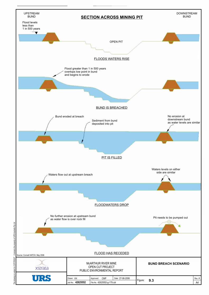
OPEN PIT
FLOODS WATERS RISE
UPSTREAMBUND
Flood levelsless than1 in 500 years
DOWNSTREAMBUNDSECTION ACROSS MINING PIT
BUND IS BREACHED
PIT IS FILLED
FLOODWATERS DROP
FLOOD HAS RECEDED
Flood greater than 1 in 500 yearsovertops low point in bundand begins to erode
Bund eroded at breach
Sediment from bunddeposited into pit
No erosion atdownstream bundas water levels are similar
Waters flow out at upstream breach
Waters levels on eitherside are similar
No further erosion at upstream bundas water flow is over rock fill
Pit needs to be pumped out
9.3
BUND BREACH SCENARIO
A4
A
42625552 42625552-g-179.cdr
VH
Source: Connell HATCH, May 2006
McARTHUR RIVER MINEOPEN CUT PROJECT
PUBLIC ENVIRONMENTAL REPORT
CMP 27-06-2006 Rev.Drawn: Approved:
File No.
Date:
Job No.:Figure:
Thi
sdr
awin
gis
subj
ect t
oC
OP
YR
IGH
T.It
rem
ains
the
prop
erty
ofU
RS
Aus
tral
iaP
tyLt
d.
Related Documents