1 Summary MONTGOMERY COUNTY PLANNING DEPARTMENT THE MARYLAND-NATIONAL CAPITAL PARK AND PLANNING COMMISSION MCPB Item No.: Date: 6-18-15 8008 Wisconsin Avenue, Project Plan 920150020, Pre-Preliminary Plan 720150160 Neil Braunstein, AICP, Planner Coordinator, Area 1, [email protected], (301) 495-4532 Elza Hisel-McCoy, Supervisor, Area 1, [email protected], (301) 495-2115 Robert Kronenberg, Chief, Area 1, [email protected], (301) 495-2187 Location: Southwest quadrant of the intersection of Wisconsin Avenue and Cordell Avenue Zone: CBD-1 Master Plans: Woodmont Triangle Amendment to the Bethesda CBD Sector Plan; Bethesda CBD Sector Plan; Countywide Transit Corridors Functional Master Plan Property size: 13,962 net square feet Project Plan Application: 140 dwelling units and 4,500 SF retail in a mixed use building. Pre-Preliminary Plan Application: Binding advice on the configuration of right-of-way along the subject property frontage. Applicant: Jemal’s Surplus, LLC Filing Date: October 1, 2014 Staff recommendation: o Project Plan - Approval with conditions o Pre-preliminary Plan - binding advice that the proposed right-of-way configuration along the property frontage is appropriate. The subject property is located within the Woodmont Triangle, and the Project Plan includes a transfer of density of 47,821 square feet of floor area from five sending properties to the development site. Because this application was submitted before October 30, 2014, it is eligible to be processed under the CBD zone in the previous version of the Zoning Ordinance. The Applicant is not providing all of the required public use space on-site, and will pay a required fee in lieu of outstanding on-site public use space. Description Staff Report Date: 6/5/15

Welcome message from author
This document is posted to help you gain knowledge. Please leave a comment to let me know what you think about it! Share it to your friends and learn new things together.
Transcript

1
Summary
MONTGOMERY COUNTY PLANNING DEPARTMENT
THE MARYLAND-NATIONAL CAPITAL PARK AND PLANNING COMMISSION
MCPB Item No.:
Date: 6-18-15
8008 Wisconsin Avenue, Project Plan 920150020, Pre-Preliminary Plan 720150160
Neil Braunstein, AICP, Planner Coordinator, Area 1, [email protected], (301) 495-4532
Elza Hisel-McCoy, Supervisor, Area 1, [email protected], (301) 495-2115
Robert Kronenberg, Chief, Area 1, [email protected], (301) 495-2187
Location: Southwest quadrant of the intersection of
Wisconsin Avenue and Cordell Avenue
Zone: CBD-1
Master Plans: Woodmont Triangle Amendment to
the Bethesda CBD Sector Plan; Bethesda CBD Sector
Plan; Countywide Transit Corridors Functional
Master Plan
Property size: 13,962 net square feet
Project Plan Application: 140 dwelling units and
4,500 SF retail in a mixed use building.
Pre-Preliminary Plan Application: Binding advice on
the configuration of right-of-way along the subject
property frontage.
Applicant: Jemal’s Surplus, LLC
Filing Date: October 1, 2014
� Staff recommendation:
o Project Plan - Approval with conditions
o Pre-preliminary Plan - binding advice that the proposed right-of-way configuration along the
property frontage is appropriate.
� The subject property is located within the Woodmont Triangle, and the Project Plan includes a transfer of
density of 47,821 square feet of floor area from five sending properties to the development site.
� Because this application was submitted before October 30, 2014, it is eligible to be processed under the CBD
zone in the previous version of the Zoning Ordinance.
� The Applicant is not providing all of the required public use space on-site, and will pay a required fee in lieu of
outstanding on-site public use space.
Description
Staff Report Date: 6/5/15
Elza.Hisel-McCoy
Initials
Robert.Kronenberg
New Stamp

2
PROJECT PLAN RECOMMENDATION AND CONDITIONS
Staff recommends approval of Project Plan 920150020 for a maximum of 151,953 square feet of
multi-family residential use consisting of 140 multi-family dwelling units, including 15% Moderately
Priced Dwelling Units (MPDUs), and 4,500 square feet of non-residential uses subject to the following
conditions:
1. The development is limited to a maximum of 151,953 square feet of multi-family residential
uses, consisting of no more than 140 multi-family dwelling units (including a minimum of 15%
MPDUs), and a maximum of 4,500 square feet of non-residential use. The total floor area of the
project is limited to 156,453 square feet.
2. The development is limited to the building footprint delineated in the Project Plan drawings
submitted to Staff dated April 20, 2015, unless modified at site plan review. Building height is
limited to a maximum height of 143 feet as determined by the Department of Permitting
Services approved building height measurement point(s).
3. The development will provide a minimum of 15% MPDUs based upon the total number of units,
in accordance with Chapter 25A.
4. The Planning Board accepts the recommendations of the Maryland State Highway
Administration (“MDSHA”) in its letter dated April 21, 2015, and does hereby incorporate them
as conditions of the Project Plan approval. The Applicant must comply with each of the
recommendations as set forth in the letter, which may be amended by MDSHA, provided that
the amendments do not conflict with other conditions of the Project Plan approval.
5. With submission of a preliminary plan application, the Applicant must provide a noise analysis
(prepared by an engineer specializing in acoustics) which includes exhibits of existing noise
contours and 20 year projection. If applicable, the analysis must also describe the mitigation
techniques needed to attenuate current noise levels to no more than 65 dBA Ldn for areas of
common outdoor activity and for interior levels not to exceed 45 dBA Ldn.
6. The Applicant must provide a minimum of 20% of the net lot area of the receiving property for
on-site public use space.
7. The public use space must be easily and readily accessible to the general public and available for
public enjoyment.
8. Prior to issuance of a building permit, the Applicant must pay a fee in lieu of public use space
equal to $717,120, unless the amount is adjusted by the Planning Board prior to approval of a
site plan, for design and/or construction of renovations at Battery Lane Urban Park.
a. The fee will be calculated as follows: the percentage of public use space not being provided
on-site multiplied by the assessed land value of the sending properties, plus the area in
square feet of the public use space not being provided on-site multiplied by $35 per square
foot.
b. Prior to approval of a site plan, the Planning Board may adjust the amount of the fee to
reflect any change in the amount of public use space to be provided on-site.
9. The Applicant must provide a minimum of 4,784 square feet for off-site public amenity space,
consisting of street scape improvements in the public right-of-way of Wisconsin Avenue,
Woodmont Avenue, and Cordell Avenue.
10. The streetscape improvements must be installed and consistent with the Bethesda CBD
Streetscape Standards, as amended, including placing the utilities underground.
11. The following issue is to be addressed at site plan approval:

3
a. The Applicant must ensure that any landscaping, hardscape, or street furniture proposed
within the MDSHA easement area will not interfere with the future BRT station or
pedestrian circulation around the station.
12. Density Transfer
a. Prior to certification of the site plan, the Applicant must record an easement in the County
Land Records for the density transfer for this Application in conformance with Section 59-C-
6.2355 of the Zoning Ordinance that was in effect on October 29, 2014.
b. The Applicant must provide verification of the density transfer from the Sending Properties
through recordation of a covenant that provides for all available standard method density,
at a minimum, to remain on the Sending Properties.
PRE-PRELIMINARY PLAN RECOMMENDATION AND CONDITIONS
Staff recommends that the Planning Board provide binding advice to the applicant that the
proposed right-of-way configuration along the subject property frontage is appropriate, subject to the
following conditions:
1. Any preliminary plan submitted based on this binding advice must show the following right-of-
way configuration:
a. Dedication of 13.5 feet of right-of-way along the Subject Property’s Wisconsin Avenue
frontage to provide 61 feet of right-of-way to the centerline to support a future right-of-way
width of 122 feet from the opposite right-of-way line as required in the Countywide Transit
Corridors Functional Master Plan.
b. Dedication of 5 feet of right-of-way along the Subject Property’s Woodmont Avenue
frontage to provide 40 feet of right-of-way to the centerline totaling 80 feet from the
opposite right-of-way line as required in the Bethesda CBD Sector Plan.
c. Provision of a 10-foot-wide public improvement easement (“PIE”) along the Wisconsin
Avenue frontage to accommodate a proposed bus rapid transit (“BRT”) station and/or
sidewalk areas around the station. At the intersection of Wisconsin Avenue and Cordell
Avenue, the PIE must be expanded to cover the area equivalent to a 20-foot right-of-way
truncation. The project’s underground parking garage will be permitted to extend under the
PIE, and, starting at 15 feet above grade, the building structure will be permitted to extend
over the PIE.
d. Provision of reduced right-of-way truncations – 20 feet at the intersection of Woodmont
Avenue and Cordell Avenue and no truncation at the intersection of Wisconsin Avenue –
instead of the required 25-foot standard truncation.
2. Any subsequent plat must note the liber and folio of the recorded PIE.
3. The subsequent site plan must include a note that states that the Applicant must not place any
structures or other items, including temporary items, that would interfere with pedestrian
movement on the sidewalk or obstruct sight distance within the area that would have been the
20-foot truncation area at the intersection or Wisconsin Avenue and Cordell Avenue.
SITE DESCRIPTION
The subject property, shown below and in Attachment A, is located in the southwest quadrant
of the intersection of Wisconsin Avenue and Cordell Avenue, in the Woodmont Triangle area of
downtown Bethesda. The subject property consists of five platted lots that comprise 13,962 net square
4
feet developed with existing retail uses and surface parking. The gross tract area, including previous
dedications for Woodmont Avenue, Cordell Avenue, and Wisconsin Avenue, measures 27,077 square
feet (0.62 acres) in area. The subject property is located within the CR-3.0 zone, but the project is being
developed under the previous CBD-1 zone under Section 7.7.1.B of the Zoning Ordinance. Surrounding
properties are developed with a mix of residential, office, and retail uses in the CBD-1 and CBD-R2
zones.
The property is located in the Lower Rock Creek watershed. The site is entirely developed, and
there are no streams, floodplains, forests, or other sensitive environmental features on the site.
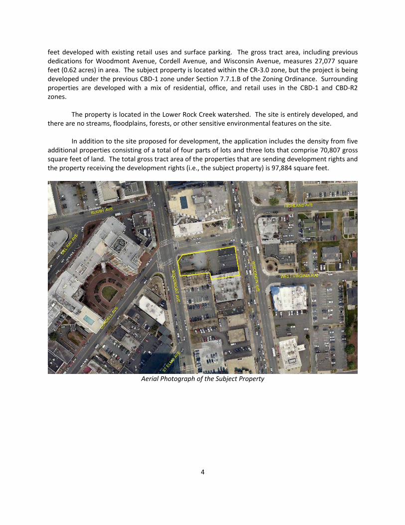
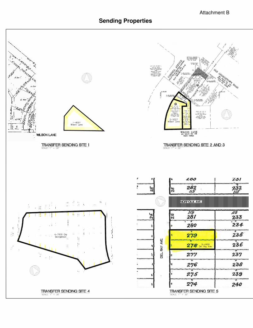
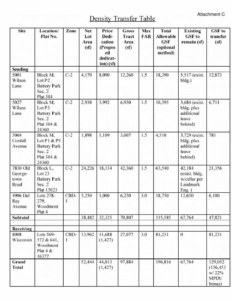
In addition to the site proposed for development, the application includes the density from five
additional properties consisting of a total of four parts of lots and three lots that comprise 70,807 gross
square feet of land. The total gross tract area of the properties that are sending development rights and
the property receiving the development rights (i.e., the subject property) is 97,884 square feet.
Aerial Photograph of the Subject Property
5
Sending and Receiving Properties

6
PROJECT DESCRIPTION
The applicant is proposing an optional method of development project consisting of a mixed-use
building to contain up to 151,953 square feet of multi-family residential use in no more than 140 multi-
family residential units, including 15% moderately priced dwelling units (MPDUs), and up to 4,500
square feet of non-residential uses (retail, restaurant, or service uses). The total floor area of the
building will be up to 156,453 square feet. The project is receiving a 22% residential density bonus for
providing 15% MPDUs.
The proposed building will consist of a total of 14 floors, with a maximum height of 143 feet.
The ground floor will contain up to 4,500 square feet of non-residential uses, which could be retail,
restaurant, or service uses. In addition, the residential lobby and leasing office will be located on the
ground floor. Above the ground floor will be 13 residential stories containing up to 140 multi-family
units. Parking will be provided in an underground garage beneath the building. Vehicular access for
parking and loading will be provided via a driveway from Cordell Avenue. Pedestrian access to the
subject property is provided by Wisconsin Avenue, Cordell Avenue, and Woodmont Avenue. The site is
served by public water and public sewer.
The project is being developed with the use of a density transfer from four parts of lots and
three lots (see Attachment B and Attachment C). The density transfer will send 47,821 square feet of
floor area from the sending sites to the subject property. The sending sites will retain sufficient density
to be developed under the standard method of development, including any existing buildings on those
properties. A recorded easement for each sending property will limit the properties to this amount of
development. Any attempt to develop the sending properties at a density higher than standard method
would trigger a project plan amendment, and this would alert staff to the fact that the densities are
limited to standard method. The combination of the recorded easements and the project plan
amendment process will ensure that an application is not processed for an inappropriate increase in
density.
The design of the building presents a strong building edge, with an upgraded streetscape that
includes a contrasting paving apron, ornamental planters, and bioretention basins within the subject
property boundaries, as well as the standard Bethesda streetscape paving and other landscaping and
street furniture in the public rights-of-way outside the subject property boundaries. The proposed
building overhang above the portion of the sidewalk to be placed in a public improvement easement will
create architectural interest along Wisconsin Avenue.

7
Illustrative Project Plan

8
Illustrative Rendering Of The Proposed Building As Seen From Wisconsin Avenue
Illustrative Rendering Of The Proposed Building As Seen From Woodmont Avenue
Public use space is proposed along all three frontages of the subject property, along Woodmont
Avenue, Cordell Avenue, and Wisconsin Avenue. The public use space will include landscaping,

9
decorative paving, benches, and lighting. In total, the project will provide 2,792 square feet of on-site
public use space, and 4,784 square feet of off-site public amenity space. In addition, the project is
required to provide 3,848 square feet of public use space on the sending properties. Of that, 20 square
feet will be provided on one of the sending properties and the remaining 3,828 square feet will be
provided by payment of a fee-in-lieu of public use space. In total, the project will provide 6,640 square
feet of public use space, consisting of 2,812 square feet of on-site public use space and 3,828 square
feet provided by a fee-in-lieu.
Pre-Preliminary Plan
A pre-preliminary plan is being processed concurrently with the project plan application so that
the applicant may receive binding advice from the Planning Board on the configuration of the rights-of-
way along the subject property frontages. The Countywide Transit Corridors Functional Master Plan,
adopted in 2013, envisions a network of bus rapid transit (BRT) routes throughout Montgomery County.
One such route is proposed on Wisconsin Avenue, along the subject property frontage. Further, a BRT
station is proposed at the subject property frontage on Wisconsin Avenue, south of the intersection of
Cordell Avenue. The Functional Master Plan recommends a right-of-way width of 122 feet (61 feet from
centerline) for Wisconsin Avenue to accommodate the BRT route, with an additional 10 feet of right-of-
way to be dedicated from the subject property to accommodate the proposed BRT station, for a total of
71 feet. While the station itself is expected to be located either in the median or along the curb of
Wisconsin Avenue, the ten feet of right-of-way is intended to accommodate pedestrian area lost with
addition of the station.
The project is constrained by the small net lot area of the subject property. Dedication of 71
feet of right-of-way from the centerline of Wisconsin Avenue would significantly reduce the usable area
of the property. Therefore, the applicant proposes to dedicate 61 feet from the centerline as required
for the BRT route, but, rather than dedication, proposes to place the ten feet for the station area in a
public improvement easement. With an easement, as opposed to dedication, the building could project
over the sidewalk adjacent to the station area and the underground garage could be placed under the
sidewalk and potential station area. These projections will allow placement of the BRT station without
reducing the area of the underground garage or the floorplate of the building above the ground floor,
while still accommodating pedestrian circulation.

10
Pre-Preliminary Plan
11
ANALYSIS AND FINDINGS
Project Plan
According to Section 59-D-2.43 of the Montgomery County Zoning Ordinance, in reaching its
determination on a project plan the Planning Board must consider the following:
(a) The nature of the proposed site and development, including its size and shape, and the
proposed size, shape, height, arrangement and design of structures, and its consistency with an
urban renewal plan approved under chapter 56.
(b) Whether the open spaces, including developed open space, would serve as convenient areas for
recreation, relaxation and social activities for the residents and patrons of the development and are
planned, designed and situated to function as necessary physical and aesthetic open areas among
and between individuals structures and groups of structures, and whether the setbacks, yards and
related walkways are located and of sufficient dimensions to provide for adequate light, air,
pedestrian circulation and necessary vehicular access.
(c) Whether the vehicular circulation system, including access and off-street parking and loading, is
designed to provide an efficient, safe and convenient transportation system.
(d) Whether the pedestrian circulation system is located, designed and of sufficient size to
conveniently handle pedestrian traffic efficiently and without congestion; the extent to which the
pedestrian circulation system is separated from vehicular roadways so as to be safe, pleasing and
efficient for movement of pedestrians; and whether the pedestrian circulation system provides
efficient, convenient and adequate linkages among residential areas, open spaces, recreational
areas, commercial and employment areas and public facilities.
(e) The adequacy of landscaping, screening, parking and loading areas, service areas, lighting and
signs, in relation to the type of use and neighborhood.
(f) The adequacy of provisions for construction of moderately priced dwelling units in accordance
with chapter 25a if that chapter applies.
(g) The staging program and schedule of development.
(h) The adequacy of forest conservation measures proposed to meet any requirements under
chapter 22a.
(i) The adequacy of water resource protection measures proposed to meet any requirements
under chapter 19.
(j) Payment of a fee acceptable to the Planning Board may satisfy all or some of the requirements
for any public use space, or public facilities and amenities under the requirements established
elsewhere in this Section.
12
As the following Findings demonstrate, the subject project plan adequately addresses each of
these considerations, as conditioned by the Staff Recommendation.
Section 59-D-2.42 of the Zoning Ordinance establishes the findings that must be made by the
Planning Board and in concert with the considerations enumerated above form the basis for the Board’s
consideration of approval. In accordance herewith, the Staff makes the following findings:
(a) As conditioned, the proposal complies with all of the intents and requirements of the zone.
The Montgomery County Zoning Ordinance states the purposes which the CBD zones are
designed to accomplish. The following statements analyze how the proposed Project Plan conforms to
these purposes:
(1) “To encourage development in accordance with an adopted and approved master or
sector plan, or an urban renewal plan approved under Chapter 56 by permitting an
increase in density, height, and intensity where the increase conforms to the master or
sector plan or urban renewal plan and the site plan or combined urban renewal project
plan is approved on review by the Planning Board.”
The project is in conformance with the recommendation of the Woodmont Triangle Amendment
to the Bethesda CBD Sector Plan to permit up to 3.0 floor area ratio and up to 143 feet in building height
as recommended for the Troiano property in Block 10 (page 21). As directed by the Sector Plan
Amendment, the project provides the opportunity to enhance the Woodmont Triangle area with
increased housing opportunities for persons of varying income levels through MPDUs, and also fulfills an
important need to preserve small-scale retail on other properties in the Woodmont Triangle area
through density transfers. Finally, consistent with the Sector Plan Amendment, the project will add
meaningful public use and amenity space by upgrading the surrounding properties through the
installation of special pavers and the Bethesda streetscape along the three street frontages of the
subject property. An outdoor plaza will also be created along Woodmont Avenue, including decorative
paving, benches, planters, and seating areas. In addition, the application is in substantial conformance
with the Countywide Transit Corridors Functional Master Plan by providing dedication at preliminary
plan of additional right-of-way for the 122-foot right-of-way for Wisconsin Avenue and a ten-foot-wide
easement to accommodate the proposed BRT station at this site.
(2) “To permit a flexible response of development to the market as well as to provide
incentives for the development of a variety of land uses and activities in central business
districts to meet the needs and requirements of workers, shoppers and residents.”
The project responds to the current market by providing high-rise residential development
where infrastructure, public facilities, and area amenities already exist. The project will address the
need for a greater variety of housing options in the Woodmont Triangle area, and will enhance the
pedestrian experience along Wisconsin, Cordell, and Woodmont Avenues. The additional housing
opportunities created by the project, as well as the proposed public use space and off-site public
amenities, will help to ensure that the Woodmont Triangle area remains activated and vibrant
throughout the day and into the evenings and weekends.

13
(3) “To encourage designs which produce a desirable relationship between the individual
buildings in the central business district, between the buildings and the circulation
system and between the central business district and adjacent areas.”
The proposed design, scale, and façade of the project will provide a consistent and
complementary relationship to adjacent buildings in the Woodmont Triangle area and the Bethesda CBD
as a whole. At the same time, the project is designed to take advantage of its location on the highly
visible intersections of Wisconsin and Cordell Avenues on the east and Woodmont and Cordell Avenues
on the west and by providing an inviting and active pedestrian transition from Wisconsin Avenue to the
core retail area of the Woodmont Triangle. The pedestrian improvements along the surrounding
streetscapes and plaza area along Woodmont Avenue will strengthen the identity of the Woodmont
Triangle as a pedestrian-friendly destination.
(4) “To promote the effective use of transit facilities in the central business district and
pedestrian access thereto.”
The project is designed to be a transit-oriented development with convenient, walkable access
to the existing Metrorail at the Bethesda and Medical Center stations, bus facilities (Metrobus, Ride On,
and the Bethesda Circulator all pass by or within a block of the subject property), the Bethesda CBD
pedestrian network, and bikeways, such as the Capital Crescent Trail. Furthermore, in proposing a
revised footprint that was designed to accommodate the proposed BRT station on Wisconsin Avenue,
the application provides a building footprint that will promote and allow the effective use of transit
facilities along Wisconsin Avenue when the BRT system is implemented.
(5) “To improve pedestrian and vehicular circulation.”
The project promotes pedestrian circulation around the subject property via the retail-activated
corner of Woodmont and Cordell Avenues, the Bethesda streetscape paving, outdoor furniture,
ornamental planters. The proposed right-of-way dedication and public improvement easement along
the Wisconsin Avenue frontage will ensure ample space for pedestrian circulation around the future BRT
station. Vehicular access to the underground parking and separate, covered loading dock are from
Cordell Avenue, which continues the existing practice, and will provide safe and convenient on-site
circulation.
(6) “To assist in the development of adequate residential areas for people with a range of
different incomes.”
The project includes both market-rate units and MPDUs, which comprise 15% of the total
number of units. The proposed units include a variety of unit sizes, from one-bedroom to three-
bedroom units, appealing to residents with a range of incomes, needs, and desires. The project is
receiving a 22% residential density bonus for providing 15% MPDUs.
(7) “To encourage land assembly and most desirable use of land in accordance with a sector
plan.”
The project will be completed through assembly of five platted lots to create a single lot that will
front on Wisconsin Avenue to the east, Woodmont Avenue to the west, and Cordell Avenue to the

14
north. As assembled, the subject property will be located at the prominent intersections of Woodmont
and Cordell Avenues and Wisconsin and Cordell Avenues. Furthermore, the use of density transfers to
the subject property allows for the maximum utilization of an important planning tool to revitalize the
Woodmont Triangle. The subject property is in an ideal location for both residential units and street-
level retail, and it satisfies a need for more housing in the Woodmont Triangle area.
Further Intents of the CBD-1 Zone
Section 59-C-6.213 of the Zoning Ordinance states:
(a) In the CBD-0.5, CBD-R1, and CBD-1 zones it is further the intent:
(1) To foster and promote the orderly development of the fringes of the Central
Business Districts of the county so that these areas will provide land uses at a
density and intensity which will encourage small business enterprises and
diverse living accommodations, while complementing the uses in the interior
portions of these districts; and
(2) To provide a density and intensity of development which will be compatible with
adjacent land uses outside of the Central Business Districts.
The project will transfer density from four commercially-zoned (C-2) sites that are on the fringes
of the Woodmont Triangle area1. By sending density to another site within the Woodmont Triangle
area, the sending properties will retain a lower density, which will encourage small business enterprises
but also allow for orderly development consistent with adjacent neighborhoods. Additionally, the
project will offer affordable housing with 15% MPDUs, which strengthens housing opportunities for
diverse populations. The project is also compatible with adjacent land uses outside the central business
district, of which the closest is the National Institutes of Health, the multi-acre, medical and research
center with high-rise office and hospital buildings.
The project will offer a variety of housing options through provision of both market-rate units
and MPDUs. The market-rate units will be in an array of unit sizes and it is the Montgomery County
Department of Housing and Community Affair’s (MCDHCA) practice to require MPDU unit counts to
match those of the market-rate units. This will provide residential opportunities in an area otherwise
dominated by employment uses. In addition, the project provides non-residential uses (retail,
restaurant, and/or service uses), which will enhance the living environment for residents of the project
and provide retail opportunities for nearby residents, workers, and visitors. All of these uses are located
within easy walking distance of the Bethesda Metro station, bus facilities, and bikeway and pedestrian
routes, including the Capital Crescent Trail.
CBD-1 Zone Development Standards
Section 59-C-6.23 of the Zoning Ordinance contains the development standards for optional
method projects in the CBD-1 Zone. As shown in Table 1 below, the project meets all of the standards
and requirements.
1 Section 59-C-6.2355 of the Zoning Ordinance that was in effect on October 29, 2014, permits transfer of density
from the C-2 zone to the CBD zones.

15
Table 1: Project Data Table for the CBD-1 Zone
Development Standard Permitted/
Required
Proposed for
Approval
Gross Tract Area - total (sf.) 18,000 97,884
Receiving Site 27,077
Sending Sites 70,807
Previous Dedications - total (sf.) 44,013
Receiving Site 11,688
Sending Sites 32,325
Proposed Dedications - total (sf.) 1,427
Receiving Site 1,427
Sending Sites 0
Net Lot Area - total (sf.) 52,444
Receiving Site 13,962
Sending sites 38,482
Maximum Density (FAR) (base)
CBD-1 3 3
C-2 1.5 1.5
Maximum Floor Area, Total (sf.) (base) 196,816 196,816
Receiving Site 129,052
Sending Sites 67,764
Maximum Density, Non-residential (FAR) 1 0.05
Maximum Floor Area, Non-residential (sf.) 128,004 4,500
Maximum Floor Area, Residential (sf.) (base) n/a 124,552
Maximum Floor Area, Residential (sf.) (22% density
bonus
n/a 27,401
Maximum Floor Area, Residential (sf.) (including 22%
density bonus)
n/a 151,953
Maximum Floor Area, Total (sf.) (including 22%
density bonus)
n/a 156,453
Maximum Density, Total (FAR) (including 22% density
bonus)
n/a 8.3
Maximum Dwelling Units, total n/a 140
Minimum MPDU (%) 12.5 15
Building Height, Maximum (ft.) 143 143
Parking Spaces, Maximum
Residential 170
Non-residential 68
Less 10% CBD Residential Credit -17
Total Required 221 401
16
Development Standard Permitted/
Required
Proposed for
Approval
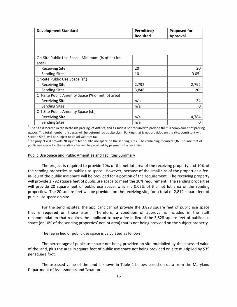
On-Site Public Use Space, Minimum (% of net lot
area)
Receiving Site 20 20
Sending Sites 10 0.052
On-Site Public Use Space (sf.)
Receiving Site 2,792 2,792
Sending Sites 3,848 202
Off-Site Public Amenity Space (% of net lot area)
Receiving Site n/a 34
Sending Sites n/a 0
Off-Site Public Amenity Space (sf.)
Receiving Site n/a 4,784
Sending Sites n/a 0 1 The site is located in the Bethesda parking lot district, and as such is not required to provide the full complement of parking
spaces. The total number of spaces will be determined at site plan. Parking that is not provided on the site, consistent with
Section 59-E, will be subject to an ad valorem tax. 2The project will provide 20 square feet public use space on the sending sites. The remaining required 3,828 square feet of
public use space for the sending sites will be provided by payment of a fee in lieu.
Public Use Space and Public Amenities and Facilities Summary
The project is required to provide 20% of the net lot area of the receiving property and 10% of
the sending properties as public use space. However, because of the small size of the properties a fee-
in-lieu of the public use space will be provided for a portion of the requirement. The receiving property
will provide 2,792 square feet of public use space to meet the 20% requirement. The sending properties
will provide 20 square feet of public use space, which is 0.05% of the net lot area of the sending
properties. The 20 square feet will be provided on the receiving site, for a total of 2,812 square feet of
public use space on-site.
For the sending sites, the applicant cannot provide the 3,828 square feet of public use space
that is required on those sites. Therefore, a condition of approval is included in the staff
recommendation that requires the applicant to pay a fee in lieu of the 3,828 square feet of public use
space (or 10% of the sending properties’ net lot area) that is not being provided on the subject property.
The fee in lieu of public use space is calculated as follows:
The percentage of public use space not being provided on-site multiplied by the assessed value
of the land, plus the area in square feet of public use space not being provided on-site multiplied by $35
per square foot.
The assessed value of the land is shown in Table 2 below, based on data from the Maryland
Department of Assessments and Taxation.
17
Table 2: Assessed Land Value of Sending Properties
Site No. Address Tax ID Description Plat Zone Assessed Value
1
5001 Wilson
Lane 07-00441433
Block M, Lot P2,
Battery Park Sec
2 304 C-2 $500,400
2
5027 Wilson
Lane 07-00440941
Block M, Lot P3,
Battery Park Sec
2
304 &
24360 C-2 $423,000
3
5004 Cordell
Avenue 07-00440952
Block M, Lot P1
& P3, Part Lot 3
Battery Park
304 &
24360 C-2 $273,300
4
7830 Old
Georgetown
Road 07-02446538
Block L, Lot 23,
Battery Park Sec
2 15023 C-2 $3,488,500
5
4906 Del Ray
Avenue 07-00552161
Part Lot 278,
Woodmont 4 CBD-1 $573,100
5
4906 Del Ray
Avenue 07-00552172
Part Lot 279,
Woodmont 4 CBD-1 $573,100
Total
$5,831,400
Based on the formula for calculation of the fee in lieu of public use space, Table 3 shows the amount of
the fee that will be required by the recommended condition of approval. The condition allocates the fee
to CIP project P118701 for design and/or construction of renovations at Battery Lane Urban Park.
Payment to the amenity fund for the public use space contribution is required at the time of building
permit. The Planning Board may adjust the amount of the fee prior to approval of a site plan.
Table 3: Calculation of fee in lieu of public use space
Percentage of public use space
not provided on site 10% $583,140
Assessed land value times percentage of
public use space not provided on site
Square feet of public use space
not provided on site 3,828 $133,980
Square feet of public use space not provided
on site times $35/square foot
Total fee in lieu of public use
space
$717,120
The on-site public use space will be in the form of a plaza on the Woodmont Avenue frontage,
containing decorative paving, landscaping, and benches; decorative paving on the Cordell Avenue
frontage; and landscaping, decorative paving, and benches on the Wisconsin Avenue frontage. The
public use space adjacent to Wisconsin Avenue will be overlain with a 10-foot-wide easement for the
Maryland State Highway Administration (MDSHA), which will be used for pedestrian circulation around
the future BRT station, in the event that the system is implemented on Wisconsin Avenue. The final
design of the Wisconsin Avenue frontage will be determined at site plan approval.
(b) The proposal conforms to the approved and adopted Master or Sector Plan or an Urban Renewal
Plan approved under Chapter 56.

18
The subject property is located within the Woodmont Triangle Amendment to the Bethesda CBD
Sector Plan area. The project substantially conforms to the recommendations in the Sector Plan
Amendment in the following ways:
The primary objectives of the Woodmont Triangle Amendment are to encourage redevelopment
in order to provide housing opportunities and to retain small-scale retail through the allowance of
transfers of density between properties in Woodmont Triangle, thereby achieving a vibrant, urban,
mixed-use neighborhood that emphasizes residential uses, small-scale retail, the arts, and public
amenities.
The subject property is identified as the “Troiano property” in the Woodmont Triangle
Amendment (page 21). Accordingly, the subject property is recommended for the CBD-1 Zone and up to
143 feet of height with the 22% bonus density. As designed, the project maximizes the potential for
development on the subject property, including the MPDU density bonus and density transfer from the
sending properties, by building out to a maximum of 156,453 square feet and up to 143 feet in height.
This utilization of the density potential of the subject property (which also allows the preservation of
small-scale retail elsewhere in the Woodmont Triangle) is in accordance with the goals and objectives of
the Woodmont Triangle Amendment. Furthermore, the project is predominantly residential in nature,
devoting only approximately 3% of the total building to non-residential uses and concentrating those
uses on the Woodmont Avenue frontage to create synergies with the existing Woodmont Triangle
retailers.
The Project conforms to the goals, recommendations, and design guidelines provided by the
Woodmont Triangle Amendment for the subject property as follows:
• Transit-Oriented Development.
Being within walking distance of both the Bethesda and Medical Center Metrorail Stations, as
well as several bus lines, the subject property is ripe for transit-oriented development, and the project,
through its mix of uses, amenities, limited on-site parking, and enhancement of pedestrian connectivity,
provides a model for transit-oriented development. Further, a bus stop is directly in front of the subject
property on Wisconsin Avenue. Moreover, as discussed above, the project is designed to accommodate
the proposed MD 355 South corridor of the BRT introduced in the Functional Master Plan. To that end,
the applicant is dedicating 13.5 feet to accommodate the 122-foot right-of-way referenced for BRT in
the Functional Master Plan, and the building’s ground floor is set back approximately 35 feet from the
existing curb to accommodate future construction of the BRT line and station. Accordingly, should the
BRT line be funded and constructed, the project will provide ample space to accommodate the
additional right of way required to support that transit system. Until that time, the project will provide
an expansive, approximately 35-foot setback from the curb on Wisconsin Avenue that will support
pedestrian circulation throughout the Woodmont Triangle.
• Housing – Provide opportunities to increase the supply of housing to serve a variety of income
levels.
The project proposes up to 140 multi-family residential units, with 15% on-site MPDUs, resulting
in the maximization of the subject property for increasing the supply of housing for a variety of income

19
levels, in the Woodmont Triangle area. The project is receiving a 22% residential density bonus for
providing 15% MPDUs.
• Small-Scale Retail – Provide opportunities to retain existing businesses and expand
opportunities for new businesses.
The project provides a street-activating, non-residential component along Woodmont Avenue.
The proposed commercial area of the project is flexible enough that it may provide opportunities for
small and large retail or restaurant establishments. In addition, through the utilization of the density
transfer provisions critical to the success of the Woodmont Triangle Amendment, small-scale retail sites
will be preserved by transferring un-utilized density to the subject property for inclusion in the project,
protecting and preserving the small-scale retail on the sending sites through recordation of appropriate
documents in the land records.
• Arts and Entertainment District – Enhance the existing public arts programs in the Bethesda CBD
and provide opportunities for both the visual and performing arts.
The CBD’s public arts character is intended to be enhanced by the proposed entrance feature
along Wisconsin Avenue as well as the proposed streetscape along Wisconsin, Cordell, and Woodmont
Avenues. The project features a contrasting paver apron along these streets, creating an artistic edge
along the standard Bethesda Streetscape and vegetated amenity zone, as well as durable outdoor
furniture along Cordell Avenue. Furthermore, the project proposes artistic paving banding, linear
benches and planters within the Woodmont Avenue plaza area. Also, by providing in-grade lighting
elements along the Woodmont and Cordell Avenue street frontages, the project will enhance the area’s
aesthetics. The variety of seating options, rich material palette and playful lighting will create an active,
multi-season outdoor space that will enhance the Woodmont Triangle’s existing public arts character.
• Safe and Attractive Streets – Focus on improving the safety and character of the existing streets.
The project will improve the safety and character of the adjacent streets by (1) providing new,
contrasting paver aprons and the Bethesda Streetscape Standard paving, lighting and street trees for the
subject property frontages; (2) activating the streets both during the day as well as the evening hours
with an influx of new residents and retail opportunities; (3) creating an attractive and well-lit pedestrian
experience along Wisconsin, Cordell, and Woodmont Avenues; and (4) ensuring that the proposed
loading and vehicular access areas on Cordell Avenue are safe and efficient.
Further, the subject property will dedicate approximately 13.5 feet of frontage along Wisconsin
Avenue to bring the Wisconsin Avenue right-of-way to the 122 feet recommended in the Functional
Master Plan, and it will provide an additional 10-foot easement to MDSHA, further pulling the ground
floor of the building back another 10 feet from the existing curb. Also, in accordance with the Bethesda
CBD Sector Plan, the applicant will dedicate an additional 5 feet along Woodmont Avenue to bring the
right of way to the 80 feet recommended in the Sector Plan. With these dedications, until the BRT is
constructed, the width of the sidewalk along Wisconsin Avenue will be approximately 35 feet, of which
approximately 10 feet will be within the subject property and approximately 25 feet will be from the
property line to the curb. Furthermore, the project proposes substantial improvements to the existing
streetscape and pedestrian network along Cordell Avenue and the east side of Woodmont Avenue,
including an activated plaza area within the subject property along Woodmont Avenue. The proposed

20
streetscape improvements along Wisconsin, Cordell, and Woodmont Avenues will create sizeable
setback and sidewalk areas that will promote pedestrian activation as well as safe and attractive streets.
Finally, the applicant has submitted a sight distance evaluation that concludes that the proposed
driveway locations and intersection truncation reductions provide sufficient sight distance.
• Public Amenities – Increase the flexibility in providing the public use space through the optional
method of development by allowing off-site and on-site fulfillment of this requirement, and by
identifying a list of priority public amenities.
The project provides 2,812 square feet of on-site public use space and 4,784 square feet of off-
site public amenity space. The project’s public use space is provided both in the 10-foot MDSHA
easement area between the ground floor of the building and property line on Wisconsin Avenue and the
plaza along Woodmont Avenue. The application addresses several of the identified priority projects for
public amenities in the Woodmont Triangle Amendment area. In particular, it will enhance the
pedestrian experience and connectivity along Cordell and Woodmont Avenues, and it will provide
distinctive street lights as well as other festive, in-ground lighting features along Cordell Avenue and in
the Woodmont Avenue plaza area. The project includes benches, bike racks, trash receptacles, and
streetscape design that will improve the pedestrian experience in the area. Furthermore, the plaza
along Woodmont Avenue can accommodate outdoor seating if a restaurant use is located on the ground
floor of the building. However, due to the property’s small size and accommodation of the proposed
BRT station, the applicant may pay a fee-in-lieu or provide off-site public use space for the amount of
required public use space that cannot be provided on the subject property.
In terms of off-site public amenities, the applicant is providing the Bethesda Streetscape
Standard sidewalk, planting zones, tree amenity zone and furniture within the rights-of-way along
Wisconsin, Cordell, and Woodmont Avenues.
• Provide a range of housing opportunities, including new low-rise and high-rise housing, to serve
a variety of income levels.
As envisioned in the Woodmont Triangle Sector Plan Amendment, the project will provide a
143-foot, 14-story, high-rise building, containing up to 140 multi-family residential units, of which 15%
will be MPDUs. Different unit sizes will ensure that the project serves a variety of residents at varying
levels of income.
• Mixed-Use Development – Density; FAR; Public Use Space.
The Sector Plan Amendment strives to produce mixed-use projects that are primarily residential,
capping non-residential uses to 1.0 FAR, and that provide meaningful on-site public amenities or,
alternatively, contribute to public use space elsewhere in the Woodmont Triangle if more suitable to
creating dynamic spaces. The project achieves maximum FAR through density transfers and the 22
percent MPDU bonus on the residential density, limiting non-residential uses to the ground floor along
Woodmont Avenue (which serves to activate the area). The on-site public use space and off-site public
amenity space will provide additional public benefits to people who live, work, and/or visit in the
Woodmont Triangle. Furthermore, the project will provide sufficient right-of-way so that if the BRT is
constructed in the future, it will be accommodated. Such transit oriented development further
enhances the mixed-use, density, and public space vision of the Sector Plan Amendment.
21
The Woodmont Triangle Amendment establishes the following urban design guidelines, to which
the project appropriately responds as described:
• Design new buildings so that public streets and spaces retain adequate sunlight.
Since the spaces and streets lie to the north, east and west of the building, as designed, the
project will cast limited shadows on public streets and/or active public spaces.
• Provide sufficient building setbacks to adequately accommodate pedestrians and streetscape
improvements.
The project provides sufficient building setbacks and incorporates contrasting paving and the
Bethesda Streetscape Standard improvements along all three subject property frontages. In particular,
the ground floor of the building is set back from the existing curb on Wisconsin Avenue by
approximately 35 feet, creating an expansive setback and sidewalk area that will adequately
accommodate pedestrian and streetscape improvements. On Cordell Avenue, the applicant proposes
almost 15 feet of sidewalk between the building face and the curb. On Woodmont Avenue, the
truncated corner of the building is set back approximately 30 feet from the Woodmont Avenue curb. In
total, the project proposes 1,427 square feet of new right-of-way dedications to adequately
accommodate proposed improvements on Wisconsin Avenue (future BRT) and Woodmont Avenue
(proposed bike lane).
• Review new projects for compatibility with existing uses and to ensure animation of the first
floor space through use of retail, restaurant, or other activating uses.
The project will be compatible in design, massing, and uses to the surrounding land uses. The
exterior building materials will reflect similar materials that exist around the neighborhood, and the use
of glass, metal, colors, and textures layered with masonry is contextual with the surrounding
architectural language. The project’s emphasis on transparency in the public spaces on the ground floor
is also harmonious with the other adjacent buildings.
Furthermore, the project will ensure animation of the first floor space by providing first-floor
commercial space along Woodmont Avenue and a residential entrance, proposed entrance feature,
architecturally interesting building overhang, and new lighting along Wisconsin Avenue that will
promote a dynamic pedestrian realm.
• Provide the Bethesda streetscape on other streets in the study area.
The Bethesda Streetscape will be constructed along all three street frontages – Wisconsin,
Cordell, and Woodmont Avenues.
• Establish a network of diverse urban spaces including public use space on-site.
The project proposes 2,812 square feet of on-site public use space designed in a network of
diverse urban spaces, including the revitalized and enlivened streetscape along Wisconsin and Cordell

22
Avenues to the new public plaza area along Woodmont Avenue. With the proposed paving, planters
and linear benches, the network of public spaces flanking the proposed building is designed to be
inviting and to feel like an extension of the sidewalk. The applicant also proposes 4,784 square feet of
off-site public amenity space including Bethesda Streetscape paving and seating to make the open space
serve as both a gathering spot and a pedestrian access way.
• Provide public art, art facilities, and public gathering spaces. The arts-related space needs could
include the following:
o Arts incubator space – A stand-alone building or portion of a building open to the public
to provide studio space for emerging visual and performing artists.
o Exhibit, teaching and lecture space – Flexible space within existing or new buildings for a
variety of functions.
o Space for the arts, such as dance studios, a black box theater, and live/work space for
artists that could be leased at moderate rates to non-profit arts organizations.
While the project will not provide any public art piece due to the constrained size of the subject
property, it does provide engaging architecture and an outdoor plaza along Woodmont Avenue that will
include a variety of seating options, the rich material pallet and playful lighting design. The plaza along
Woodmont Avenue could become a public gathering place that could be utilized for arts-related
gatherings.
(c) Because of its location, size, intensity, design, operational characteristics and staging, it would
be compatible with and not detrimental to existing or potential development in the general
neighborhood.
The project proposes a 14-story residential building with a retail use on the ground floor.
Several properties in the general neighborhood are developed with buildings that are similar in size and
intensity to the project. Other properties in the neighborhood are developed with low intensity, single
story buildings. However, those properties are expected to develop in a similar fashion to the project,
based on the CR-3 and CR-5 zoning.
(d) As conditioned, the proposal would not overburden existing public services nor those
programmed for availability concurrently with each stage of construction and, if located within a
transportation management district designated under Chapter 42A, article II, is subject to a
traffic mitigation agreement that meets the requirements of that article.
The project will not overburden existing public services nor those programmed for availability.
The proposed development is expected to generate 41 morning peak-hour trips and 37 evening peak-
hour trips (Table 4). As a result of the proposed transportation impact, a full traffic study will be
submitted with the subsequent preliminary plan application.

23
Table 4: Proposed 8008 Wisconsin Avenue
Trip Generation Morning Peak Hour Evening Peak Hour
In Out Total In Out Total
Proposed
140 High Rise Dwelling Units
4,500 SF General Retail
Existing
6,354 SF General
Retail
Total
8
2
(2)
8
34
1
(2)
33
42
3
(4)
41
28
6
(9)
25
14
6
(8)
12
42
12
(17)
37
Source: The Traffic Group. Traffic Impact Study, dated August 27, 2014.
Since the proposed development is within the Bethesda CBD Policy Area, the application is
exempt from both the roadway and transit tests set forth in the 2012-2016 Subdivision Staging Policy.
As a result, the proposed development is not required to pay the transportation impact tax to satisfy the
Transportation Policy Area Review (TPAR) requirement. Local Area Transportation Review will be
conducted at the time of preliminary plan.
As a mixed-use project within the Bethesda Transportation Management District (TMD), the
applicant is required to enter into a Traffic Mitigation Agreement (TMAg) with the Planning Board and
MCDOT to participate in the Bethesda TMD. The specific criterion requiring a TMAg is the creation of
more than 100 dwelling units. The TMAg will be required by a condition of approval of the subsequent
preliminary plan.
(e) The proposal will be more efficient and desirable than could be accomplished by the use of the
standard method of development.
Under the standard method of development, the building height would be capped at 90 feet,
the maximum building coverage would be 75%, and the total maximum density would be 2.0 FAR.
Accordingly, if developed under the standard method of development, the subject property’s maximum
potential would not be fully realized, and the building would be shorter and smaller than with the
optional method, thereby providing fewer residential units, contrary to the intent and goals of the
Sector Plan Amendment. Furthermore, by utilizing the optional method of development, the project
will provide off-site amenities, that, with the proposed on-site public use space, will enhance the
surrounding street network and activate the pedestrian realm to the benefit of the entire Woodmont
Triangle area. The project will result in a significantly improved pedestrian linkage between Woodmont
and Wisconsin Avenues that has the immediate benefit of improving the pedestrian circulation
throughout the area for both residents and visitors. In addition, the optional method allows for the
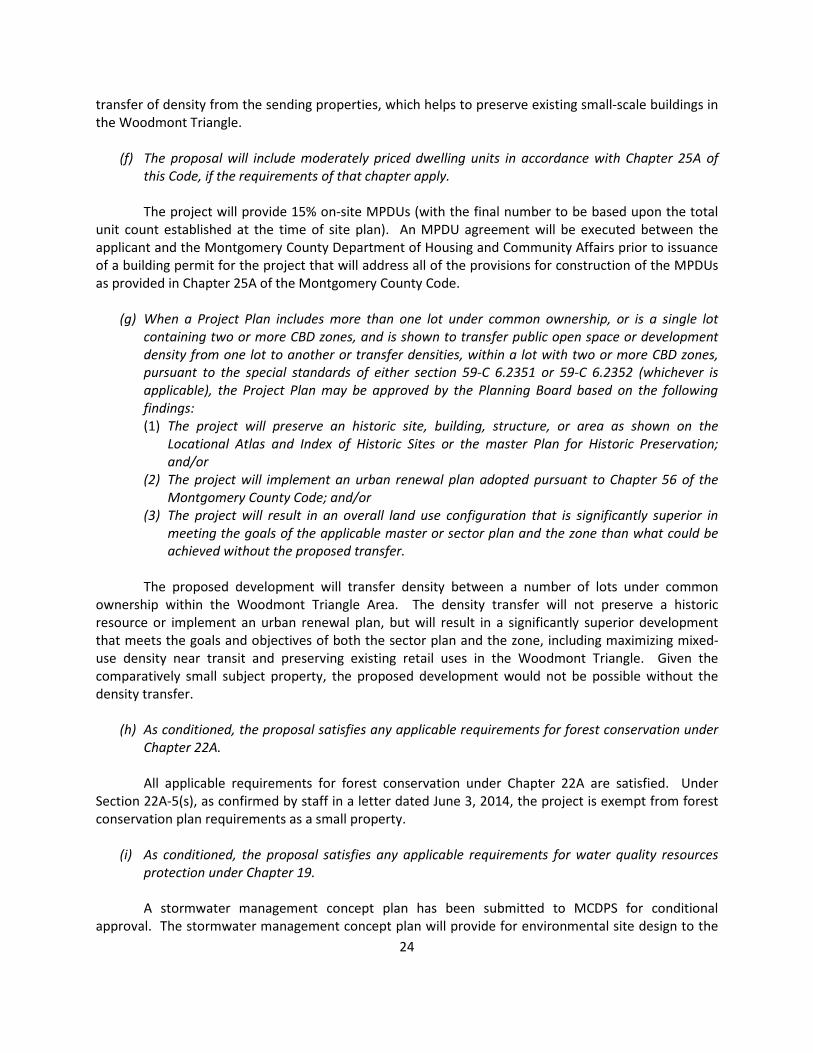
24
transfer of density from the sending properties, which helps to preserve existing small-scale buildings in
the Woodmont Triangle.
(f) The proposal will include moderately priced dwelling units in accordance with Chapter 25A of
this Code, if the requirements of that chapter apply.
The project will provide 15% on-site MPDUs (with the final number to be based upon the total
unit count established at the time of site plan). An MPDU agreement will be executed between the
applicant and the Montgomery County Department of Housing and Community Affairs prior to issuance
of a building permit for the project that will address all of the provisions for construction of the MPDUs
as provided in Chapter 25A of the Montgomery County Code.
(g) When a Project Plan includes more than one lot under common ownership, or is a single lot
containing two or more CBD zones, and is shown to transfer public open space or development
density from one lot to another or transfer densities, within a lot with two or more CBD zones,
pursuant to the special standards of either section 59-C 6.2351 or 59-C 6.2352 (whichever is
applicable), the Project Plan may be approved by the Planning Board based on the following
findings:
(1) The project will preserve an historic site, building, structure, or area as shown on the
Locational Atlas and Index of Historic Sites or the master Plan for Historic Preservation;
and/or
(2) The project will implement an urban renewal plan adopted pursuant to Chapter 56 of the
Montgomery County Code; and/or
(3) The project will result in an overall land use configuration that is significantly superior in
meeting the goals of the applicable master or sector plan and the zone than what could be
achieved without the proposed transfer.
The proposed development will transfer density between a number of lots under common
ownership within the Woodmont Triangle Area. The density transfer will not preserve a historic
resource or implement an urban renewal plan, but will result in a significantly superior development
that meets the goals and objectives of both the sector plan and the zone, including maximizing mixed-
use density near transit and preserving existing retail uses in the Woodmont Triangle. Given the
comparatively small subject property, the proposed development would not be possible without the
density transfer.
(h) As conditioned, the proposal satisfies any applicable requirements for forest conservation under
Chapter 22A.
All applicable requirements for forest conservation under Chapter 22A are satisfied. Under
Section 22A-5(s), as confirmed by staff in a letter dated June 3, 2014, the project is exempt from forest
conservation plan requirements as a small property.
(i) As conditioned, the proposal satisfies any applicable requirements for water quality resources
protection under Chapter 19.
A stormwater management concept plan has been submitted to MCDPS for conditional
approval. The stormwater management concept plan will provide for environmental site design to the

25
maximum extent practicable. Approval of the Stormwater Management concept is required prior to
submittal of the site plan application.
(j) When the Planning Board allows any public use space, or public facilities and amenities to be
provided off-site, the Planning Board must find that the space or improvement:
(1) is consistent with the goals of the applicable master or sector plan; and
(2) serves the public interest better than providing the public use space or public facilities and
amenities on-site.
The project is required to provide 20% of the net lot area of the receiving property and 10% of
the sending properties as public use space. However, because of the small size of the properties a fee-
in-lieu of the public use space will be provided for a portion of the requirement. The receiving property
will provide 2,792 square feet of public use space to meet the 20% requirement. The sending properties
will provide 20 square feet of public use space, which is 0.05% of the net lot area of the sending
properties. The 20 square feet will be provided on the receiving site, for a total of 2,812 square feet of
public use space on-site.
For the sending sites, the applicant cannot provide the 3,828 square feet of public use space
that is required on those sites. Therefore, a condition of approval is included in the staff
recommendation that requires the applicant to pay a fee in lieu of the 3,828 square feet of public use
space (or 10% of the sending properties’ net lot area) that is not being provided on the subject property.
The fee in lieu of public use space will be allocated to CIP project P118701 for design and/or
construction of renovations at Battery Lane Urban Park. The Sector Plan Amendment recommends
improvements to this park, including improvements made by developers through a CIP project in
exchange for increased density (page 16). The public interest is served by providing high-quality park
improvements, while allowing the redevelopment of land that is suitable for dense urban uses in a
transit-proximate location.
Pre-Preliminary Plan
The pre-preliminary plan application seeks binding advice from the Planning Board regarding the
configuration of the right-of-way along the subject property frontage on Wisconsin Avenue and also
truncation at the intersections of Woodmont Avenue and Cordell Avenue and Wisconsin Avenue and
Cordell Avenue.
Wisconsin Avenue Right-Of-Way
The existing Wisconsin Avenue right-of-way along the subject property frontage is 90 feet wide,
measured from the opposite right-of-way line. The Bethesda CBD Sector Plan recommends a right-of-
way width of 104 feet, and the Countywide Transit Corridors Functional Master Plan recommends a 122-
foot width to accommodate the future BRT system on Wisconsin Avenue. In addition, the Functional
Master Plan recommends a width of 142 feet to accommodate BRT stations at the intersection of
Cordell Avenue and Wisconsin Avenue. The station will be located in the street right-of-way adjacent to
the subject property, either along the curb or in a median. In order to provide the recommended right-
of-way width, the applicant would need to dedicate 13.5 feet for Wisconsin Avenue, including the BRT
route, and an additional 10 feet for the BRT station. However, due to the constrained size of the subject

26
property, full dedication as recommended by the Sector Plan and the Functional Master Plan would
reduce the building footprint to the point that the project would not be feasible.
In order to maintain the viability of the project, the applicant proposes to dedicate right-of-way
to create the 122 feet necessary for Wisconsin Avenue, including the BRT route, but to provide an
easement for the final 10 feet needed for the BRT station. Unlike right-of-way, the underground garage
can project under the easement area, and the building can project over the easement area. The
applicant is proposing that the garage project under the easement and the building project over the
easement, starting at the second story. The 10-foot easement area will serve as a pedestrian walkway
around the future BRT station. Provision of an easement instead of right-of-way dedication will
accommodate the future BRT station and the needs of the project. In its letter of April 21, 2015, MDSHA
agrees with provision of the easement and projection of the building into the easement area above the
second floor and underground for the garage. Staff recommends that the Planning Board give binding
advice to the applicant that provision of the easement is an acceptable alternative to right-of-way
dedication.
Truncation
Section 50-26(c)(3) of the Subdivision Regulations requires that the property lines of corner lots
be truncated 25 feet from the intersection. This provides additional right-of-way area at intersections
that ensures that adequate sight distance is available and creates space for traffic channelization. But
the regulation also allows the Planning Board to specify a greater or lesser truncation depending on the
specific sight distance and channelization needs at the intersections adjacent to the subject property.
In this case, the existing property has a 20-foot truncation at the intersection of Woodmont
Avenue and Cordell Avenue, and the applicant is proposing to continue to provide this 20-foot
truncation. Full 25-foot truncation at this intersection is not necessary because adequate sight distance
exists. The intersection is signalized, which further enhances its safety and removes the concern that
there is not sufficient space within the right-of-way to place traffic signal equipment. Providing full
truncation would negatively impact the design of the proposed project and the provision of the required
public use space.
The applicant is also proposing to provide no truncation of the right-of-way at the intersection
of Wisconsin Avenue and Cordell Avenue, but to provide an area in the MDSHA easement that would be
equivalent to a 20-foot truncation. Full truncation at this intersection is not necessary because
adequate sight distance exists. The intersection is signalized, which further enhances its safety and
addresses the concern for sufficient space within the right-of-way to place traffic signal equipment.
Providing full truncation would negatively impact the design of the proposed project and the provision
of the required public use space by further reducing the size of the already constrained subject property.
Providing the equivalent of truncation by way of the easement instead of right-of-way dedication will
allow the building to project above and the garage to project below a portion of the truncation area. In
order to ensure that the easement area remains functionally equivalent to truncation, the staff
recommendation includes a condition of approval that requires that the applicant not place anything in
the area that otherwise would have been the 20-foot truncation that would obstruct site distance or
pedestrian movement.

27
For these reasons, Staff recommends that the Planning Board find that the proposed modified
truncation in this location is appropriate at these intersections.
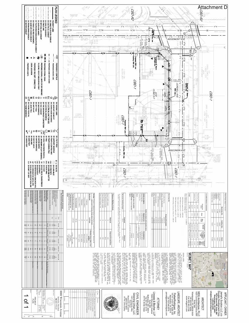
Proposed right-of-way configuration at the intersection of Wisconsin Avenue and Cordell Avenue. The
proposed easement area is shaded (yellow). The triangular area of the easement adjacent to the
intersection is the area provided in lieu of 20-foot truncation.
CITIZEN CORRESPONDENCE AND ISSUES
The applicant has complied with all submittal and noticing requirements. As of the date of this
staff report, staff has not received any correspondence regarding the application.
CONCLUSION
The project plan meets all of the requirements established in the Zoning Ordinance and
substantially conforms to the recommendations of the Woodmont Triangle Amendment to the Bethesda
CBD Sector Plan and the Countywide Transit Corridors Functional Master Plan. Therefore, approval of
the project plan application with the conditions specified above is recommended.
28
The proposed right-of-way configuration for Wisconsin Avenue and the proposed truncation
configurations at the intersections of Woodmont Avenue and Cordell Avenue and Wisconsin Avenue and
Cordell Avenue are appropriate. Therefore, staff recommends that the Planning Board provide binding
advice to the applicant stating that those configurations are appropriate, subject to the conditions
specified above.
Attachments
Attachment A – Vicinity Map
Attachment B – Gross Tract Area
Attachment C – Density Transfer Table
Attachment D – Proposed Project Plan and Pre-Preliminary Plan
Attachment E – Agency Correspondence Referenced in Conditions
Attachment F – Property Data for Calculation of Fee in Lieu of Public Use Space

TIL
BU
RY
ST
DEL
RAY
AVE
WIS
CO
NS
INA
VE
CO
RD
ELL
AVE
MAPLE AVE
WO
OD
MO
NT
AV
E
RUGBY AVE
NO
RFO
LKAV
E
CHASE AVE
HIGHLAND AVE
WEST VIRGINIA AVE
ST
ELM
OAVE
AU
BU
RN
AVE
HARLING LA
FAIRMONT AVE
¯0 200 400 600 800100Feet
Attachment A
Sending Properties
Attachment B
Attachment C
80
08
Wis
co
ns
in A
ve
nu
eR
ec
re
atio
na
l Re
qu
ire
me
nts
Facto
rT
ots
D1
Ch
ildre
n D
2T
ee
ns
D3
Ad
ult
s D
4S
en
iors
D5
Num
ber o
f units
140
1.4
44
477
46
5.6
05.6
05.6
0107.8
064.4
0
Recre
atio
nal D
em
and
5.6
05
.60
5.6
01
07
.80
64
.40
Require
d to
Pro
vide 9
0%
of D
em
and
0.9
5.0
45
.04
5.0
49
7.0
25
7.9
6
To
ta
l Re
cre
atio
n D
em
an
d R
eq
uir
ed
5.0
45
.04
5.0
49
7.0
25
7.9
6
Re
cre
atio
n T
yp
eT
ots
D1
Ch
ildre
n D
2T
ee
ns
D3
Ad
ult
s D
4S
en
iors
D5
Fa
cilit
y R
eq
uir
em
en
tS
eatin
g A
rea S
upply V
alu
es
11
1.5
52
2 B
enches a
nd a
Tra
sh R
ecepta
cle
- Accom
modate
6 P
eople
Tota
l Sittin
g A
reas P
rovid
ed
88
88
8S
itting
Are
a S
up
ply
To
tal
88
12
40
16
Pedestria
n S
yste
m S
upply V
alu
es(S
upply V
alu
e x D
)0.4
0.8
0.8
34.6
520.7
Pedestria
n S
yste
m P
rovid
ed
11
11
1P
ed
estria
n S
yste
m T
ota
l0.4
0.8
0.8
34.6
520.7
Indoor C
om
munity S
pace S
upply V
alu
es(S
upply V
alu
e x D
)0.4
0.6
1.2
23.1
18.4
Min
imum
1,2
00 s
f
Indoor C
om
munity
Space P
rovid
ed
11
11
1
Ind
oo
r Co
mm
un
ity S
pa
ce
To
tal
0.4
0.6
1.2
23.1
18.4
Indoor F
itness F
acility S
upply V
alu
es (S
upply V
alu
e x D
)0
0.4
0.4
15.4
6.9
Min
imum
350 s
f
Indoor F
itness F
acility
Pro
vided
11
11
1
Ind
oo
r Fitn
ess F
acility
To
tal
00.4
0.4
15.4
6.9
To
tal P
rovid
ed
8.8
9.8
14.4
113.1
562
To
tal R
ecre
atio
n V
alu
e D
em
an
d5.0
45.0
45.0
497.0
257.9
6
To
tal R
ecre
atio
n V
alu
e S
up
plie
d8.8
9.8
14.4
113.1
562
Hig
hris
e- M
ulti-F
am
ily (5 S
torie
s o
r More
)
Hig
hris
e D
em
and C
alc
ula
tion
Min
ium
um
5 ft W
idth
Attachment D


Attachment E


Real Property Data Search ( w2) Guide to searching the database
Search Result for MONTGOMERY COUNTY
View Map View GroundRent Redemption View GroundRent Registration
Account Identifier: District - 07 Account Number - 00441433
Owner Information
Owner Name: SLEEPING GYPSY LLC Use: Principal Residence:
COMMERCIALNO
Mailing Address: 5001 WILSON LN BETHESDA MD 20814-0000
Deed Reference: /34779/ 00483
Location & Structure Information
Premises Address: 5001 WILSON LNBETHESDA 20814-0000
Legal Description: BATTERY PARK SEC 2
Map: Grid: Parcel: Sub District:
Subdivision: Section: Block: Lot: Assessment Year:
Plat No:
HN22 0000 0000 0003 M P2 2014 Plat Ref:
Special Tax Areas: Town: BATTERY PARKAd Valorem:Tax Class: 80
Primary Structure Built
Above Grade Enclosed Area
Finished Basement Area
Property Land Area
County Use
1933 5426 4,170 SF 599
Stories Basement Type Exterior Full/Half Bath Garage Last Major RenovationRETAIL STORE
Value Information
Base Value Value Phase-in AssessmentsAs of 01/01/2014
As of 07/01/2014
As of 07/01/2015
Land: 417,000 500,400Improvements 868,600 997,500Total: 1,285,600 1,497,900 1,356,367 1,427,133Preferential Land: 0 0
Transfer Information
Seller: RIELEY, WALTON D & D A Date: 08/29/2007 Price: $760,000Type: ARMS LENGTH IMPROVED Deed1: /34779/ 00483 Deed2:
Seller: Date: 10/06/1969 Price: $67,000Type: ARMS LENGTH IMPROVED Deed1: /03906/ 00538 Deed2:
Seller: Date: Price: Type: Deed1: Deed2:
Exemption Information
Partial Exempt Assessments: Class 07/01/2014 07/01/2015County: 000 0.00State: 000 0.00Municipal: 000 0.00|0.00 0.00|0.00
Tax Exempt: Special Tax Recapture: Exempt Class: NONE
Homestead Application Information
Homestead Application Status: No Application
Page 1 of 1SDAT: Real Property Search
5/13/2015http://sdat.resiusa.org/RealProperty/Pages/default.aspx
Attachment F

Real Property Data Search ( w2) Guide to searching the database
Search Result for MONTGOMERY COUNTY
View Map View GroundRent Redemption View GroundRent Registration
Account Identifier: District - 07 Account Number - 00440941
Owner Information
Owner Name: KOLIUS WILLAIM S TRUSTEEKOLIUS JOHN M
Use: Principal Residence:
COMMERCIALNO
Mailing Address: PO BOX 1667BERLIN MD 21811-5667
Deed Reference: /41193/ 00213
Location & Structure Information
Premises Address: 5027 WILSON LNBETHESDA 20814-0000
Legal Description: BATTERY PARK SEC 2
Map: Grid: Parcel: Sub District:
Subdivision: Section: Block: Lot: Assessment Year:
Plat No:
HN22 0000 0000 0003 M P3 2014 Plat Ref:
Special Tax Areas: Town: BATTERY PARKAd Valorem:Tax Class: 80
Primary Structure Built
Above Grade Enclosed Area
Finished Basement Area
Property Land Area
County Use
1923 2770 2,938 SF 581
Stories Basement Type Exterior Full/Half Bath Garage Last Major RenovationRETAIL STORE
Value Information
Base Value Value Phase-in AssessmentsAs of 01/01/2014
As of 07/01/2014
As of 07/01/2015
Land: 352,500 423,000Improvements 381,800 344,400Total: 734,300 767,400 745,333 756,367Preferential Land: 0 0
Transfer Information
Seller: KOLIUS WILLAIM S TRUSTEE Date: 02/24/2011 Price: $0Type: ARMS LENGTH MULTIPLE Deed1: /41193/ 00213 Deed2:
Seller: KOLIUS WILLAIM S TR ET AL Date: 02/24/2011 Price: $0Type: ARMS LENGTH MULTIPLE Deed1: /41193/ 00207 Deed2:
Seller: KOLIUS, VASHA P TR Date: 03/13/2008 Price: $0Type: NON-ARMS LENGTH OTHER Deed1: /35440/ 00464 Deed2:
Exemption Information
Partial Exempt Assessments:
Class 07/01/2014 07/01/2015
County: 000 0.00State: 000 0.00Municipal: 000 0.00|0.00 0.00|0.00
Tax Exempt: Special Tax Recapture: Exempt Class: NONE
Homestead Application Information
Homestead Application Status: No Application
Page 1 of 1SDAT: Real Property Search
5/13/2015http://sdat.resiusa.org/RealProperty/Pages/default.aspx
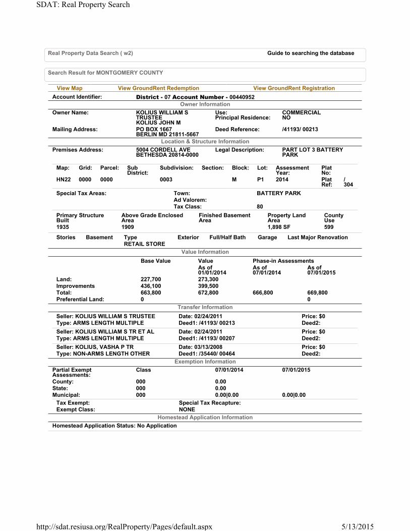
Real Property Data Search ( w2) Guide to searching the database
Search Result for MONTGOMERY COUNTY
View Map View GroundRent Redemption View GroundRent Registration
Account Identifier: District - 07 Account Number - 00440952
Owner Information
Owner Name: KOLIUS WILLIAM S TRUSTEEKOLIUS JOHN M
Use: Principal Residence:
COMMERCIALNO
Mailing Address: PO BOX 1667BERLIN MD 21811-5667
Deed Reference: /41193/ 00213
Location & Structure Information
Premises Address: 5004 CORDELL AVEBETHESDA 20814-0000
Legal Description: PART LOT 3 BATTERY PARK
Map: Grid: Parcel: Sub District:
Subdivision: Section: Block: Lot: Assessment Year:
Plat No:
HN22 0000 0000 0003 M P1 2014 Plat Ref:
/ 304
Special Tax Areas: Town: BATTERY PARKAd Valorem:Tax Class: 80
Primary Structure Built
Above Grade Enclosed Area
Finished Basement Area
Property Land Area
County Use
1935 1909 1,898 SF 599
Stories Basement Type Exterior Full/Half Bath Garage Last Major RenovationRETAIL STORE
Value Information
Base Value Value Phase-in AssessmentsAs of 01/01/2014
As of 07/01/2014
As of 07/01/2015
Land: 227,700 273,300Improvements 436,100 399,500Total: 663,800 672,800 666,800 669,800Preferential Land: 0 0
Transfer Information
Seller: KOLIUS WILLIAM S TRUSTEE Date: 02/24/2011 Price: $0Type: ARMS LENGTH MULTIPLE Deed1: /41193/ 00213 Deed2:
Seller: KOLIUS WILLIAM S TR ET AL Date: 02/24/2011 Price: $0Type: ARMS LENGTH MULTIPLE Deed1: /41193/ 00207 Deed2:
Seller: KOLIUS, VASHA P TR Date: 03/13/2008 Price: $0Type: NON-ARMS LENGTH OTHER Deed1: /35440/ 00464 Deed2:
Exemption Information
Partial Exempt Assessments:
Class 07/01/2014 07/01/2015
County: 000 0.00State: 000 0.00Municipal: 000 0.00|0.00 0.00|0.00
Tax Exempt: Special Tax Recapture: Exempt Class: NONE
Homestead Application Information
Homestead Application Status: No Application
Page 1 of 1SDAT: Real Property Search
5/13/2015http://sdat.resiusa.org/RealProperty/Pages/default.aspx

Real Property Data Search ( w2) Guide to searching the database
Search Result for MONTGOMERY COUNTY
View Map View GroundRent Redemption View GroundRent Registration
Account Identifier: District - 07 Account Number - 02446538
Owner Information
Owner Name: 7830 BETHESDA LLC Use: Principal Residence:
COMMERCIALNO
Mailing Address: 4416 E WEST HWY # 306BETHESDA MD 20814-4565
Deed Reference: /20647/ 00324
Location & Structure Information
Premises Address: 7830 OLD GEORGETOWN RDBETHESDA 20814-0000
Legal Description: BATTERY PARK SEC 2
Map: Grid: Parcel: Sub District:
Subdivision: Section: Block: Lot: Assessment Year:
Plat No:
15023
HN22 0000 0000 0003 L 23 2014 Plat Ref:
Special Tax Areas: Town: BATTERY PARKAd Valorem:Tax Class: 80
Primary Structure Built
Above Grade Enclosed Area
Finished Basement Area
Property Land Area
County Use
1985 48333 24,226 SF 600
Stories Basement Type Exterior Full/Half Bath Garage Last Major RenovationOFFICE BUILDING
Value Information
Base Value Value Phase-in AssessmentsAs of 01/01/2014
As of 07/01/2014
As of 07/01/2015
Land: 2,907,100 3,488,500Improvements 7,592,900 10,011,500Total: 10,500,000 13,500,000 11,500,000 12,500,000Preferential Land: 0 0
Transfer Information
Seller: GREAT OAK LLC Date: 03/01/2002 Price: $8,537,500Type: ARMS LENGTH IMPROVED Deed1: /20647/ 00324 Deed2:
Seller: 7830 HOLDINGS LIMITED PTNS Date: 01/28/1997 Price: $6,610,000Type: ARMS LENGTH IMPROVED Deed1: /14654/ 00307 Deed2:
Seller: 7830 OLD GEORGETOWN RD LTD Date: 10/28/1996 Price: $4,000,000Type: NON-ARMS LENGTH OTHER Deed1: /14460/ 00273 Deed2:
Exemption Information
Partial Exempt Assessments:
Class 07/01/2014 07/01/2015
County: 000 0.00State: 000 0.00Municipal: 000 0.00|0.00 0.00|0.00
Tax Exempt: Special Tax Recapture: Exempt Class: NONE
Homestead Application Information
Homestead Application Status: No Application
Page 1 of 1SDAT: Real Property Search
5/13/2015http://sdat.resiusa.org/RealProperty/Pages/default.aspx
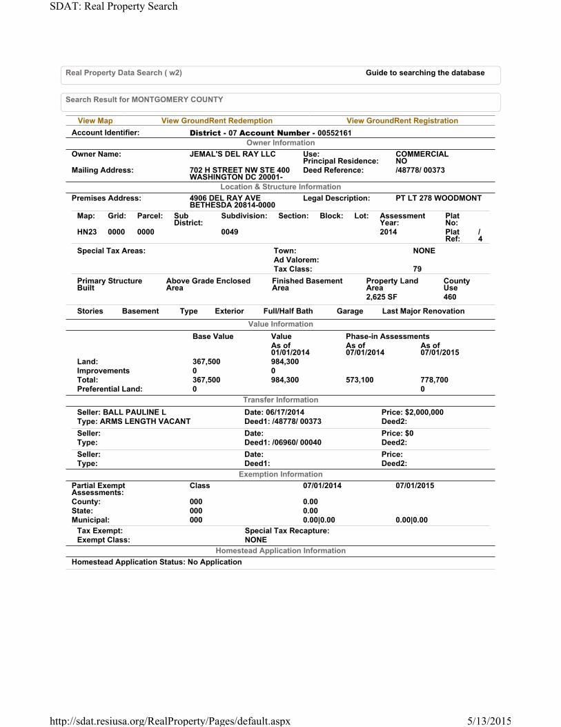
Real Property Data Search ( w2) Guide to searching the database
Search Result for MONTGOMERY COUNTY
View Map View GroundRent Redemption View GroundRent Registration
Account Identifier: District - 07 Account Number - 00552161
Owner Information
Owner Name: JEMAL'S DEL RAY LLC Use: Principal Residence:
COMMERCIALNO
Mailing Address: 702 H STREET NW STE 400WASHINGTON DC 20001-
Deed Reference: /48778/ 00373
Location & Structure Information
Premises Address: 4906 DEL RAY AVEBETHESDA 20814-0000
Legal Description: PT LT 278 WOODMONT
Map: Grid: Parcel: Sub District:
Subdivision: Section: Block: Lot: Assessment Year:
Plat No:
HN23 0000 0000 0049 2014 Plat Ref:
/ 4
Special Tax Areas: Town: NONEAd Valorem:Tax Class: 79
Primary Structure Built
Above Grade Enclosed Area
Finished Basement Area
Property Land Area
County Use
2,625 SF 460
Stories Basement Type Exterior Full/Half Bath Garage Last Major Renovation
Value Information
Base Value Value Phase-in AssessmentsAs of 01/01/2014
As of 07/01/2014
As of 07/01/2015
Land: 367,500 984,300Improvements 0 0Total: 367,500 984,300 573,100 778,700Preferential Land: 0 0
Transfer Information
Seller: BALL PAULINE L Date: 06/17/2014 Price: $2,000,000Type: ARMS LENGTH VACANT Deed1: /48778/ 00373 Deed2:
Seller: Date: Price: $0Type: Deed1: /06960/ 00040 Deed2:
Seller: Date: Price: Type: Deed1: Deed2:
Exemption Information
Partial Exempt Assessments:
Class 07/01/2014 07/01/2015
County: 000 0.00State: 000 0.00Municipal: 000 0.00|0.00 0.00|0.00
Tax Exempt: Special Tax Recapture: Exempt Class: NONE
Homestead Application Information
Homestead Application Status: No Application
Page 1 of 1SDAT: Real Property Search
5/13/2015http://sdat.resiusa.org/RealProperty/Pages/default.aspx

Real Property Data Search ( w2) Guide to searching the database
Search Result for MONTGOMERY COUNTY
View Map View GroundRent Redemption View GroundRent Registration
Account Identifier: District - 07 Account Number - 00552172
Owner Information
Owner Name: JEMAL'S DEL RAY LLC Use: Principal Residence:
COMMERCIALNO
Mailing Address: 702 H ST NW STE 400WASHINGTON DC 20001-
Deed Reference: /48778/ 00373
Location & Structure Information
Premises Address: DEL RAY AVE0-0000
Legal Description: PT LT 279 WOODMONT
Map: Grid: Parcel: Sub District:
Subdivision: Section: Block: Lot: Assessment Year:
Plat No:
HN23 0000 0000 0049 2014 Plat Ref:
Special Tax Areas: Town: NONEAd Valorem:Tax Class: 79
Primary Structure Built
Above Grade Enclosed Area
Finished Basement Area
Property Land Area
County Use
2,625 SF 460
Stories Basement Type Exterior Full/Half Bath Garage Last Major Renovation
Value Information
Base Value Value Phase-in AssessmentsAs of 01/01/2014
As of 07/01/2014
As of 07/01/2015
Land: 367,500 984,300Improvements 0 0Total: 367,500 984,300 573,100 778,700Preferential Land: 0 0
Transfer Information
Seller: BALL PAULINE L Date: 06/17/2014 Price: $2,000,000Type: ARMS LENGTH MULTIPLE Deed1: /48778/ 00373 Deed2:
Seller: Date: Price: $0Type: Deed1: /06960/ 00040 Deed2:
Seller: Date: Price: Type: Deed1: Deed2:
Exemption Information
Partial Exempt Assessments: Class 07/01/2014 07/01/2015County: 000 0.00State: 000 0.00Municipal: 000 0.00|0.00 0.00|0.00
Tax Exempt: Special Tax Recapture: Exempt Class: NONE
Homestead Application Information
Homestead Application Status: No Application
Page 1 of 1SDAT: Real Property Search
5/13/2015http://sdat.resiusa.org/RealProperty/Pages/default.aspx
Related Documents