ATOLL KESEARCE BULLETIN 8. The Eyiydrology of Amo Atoll-, ifiarshal.1 Islands Issued by THE PACIFIC SCIFNCE BOAXI National Academy of Sciences - National Research Council iiashingfon, D. C. December 15, 1951

Welcome message from author
This document is posted to help you gain knowledge. Please leave a comment to let me know what you think about it! Share it to your friends and learn new things together.
Transcript
ATOLL KESEARCE BULLETIN
8. The Eyiydrology of Amo Atoll-, ifiarshal.1 Islands
Issued by
THE PACIFIC SCIFNCE BOAXI
National Academy of Sciences - National Research Council
iiashingfon, D. C.
December 15, 1951
THE HYDROLOGY OF ASO ATOLL
MRRSHALL ISLANDS
SCILNTIFIC IitVESTIGATIONS I N PiICRONESIA
P a c i f i c Science Eoard
National Research Council
Do& C. Cox Experiment S t a t i o n , A.S.P.A. Honolulu, H a w i i Idarch 1951 (Date of o r i g i n )
bcki-'o~rledgen~ents
'Climate : . '
Tides
Rain .'cat,cknunt . 6
Grou2.d-7:ater 7
Notes on geology pertinent t o grui.~ad-%a+,er occurrence . 8
Principles of ground-water occurrence on a t o l l islands 10
Ground-water o5se;-va-kions on Arne 18
Seasonal chafiges i n ground-riater
Uti l izat ion of ground-water
Appendi:;
Rainfall masurements on Arro Ato3.1
E e ~ c h marks a t Ine VIYlage
Tidal daba f o r Ine I s l a&.
ILLUSTRATIONS . .
Proffles aac! ground-%a-Ler graphs of tno section across h e Island.
Tne au.Yi~or of t h i s report part.icipbt,ed i n the 1950 SIR$ (Sc ien t i f ic . .
Inves-Lj.,oat,ion of i4j.cronesia) Project of the Pacif ic Science Board of the
National Research Couccil, and the report i s based on .h i s f i e l d work on
Arno from July S t o f i ug~s t 5, 1950. This project was supported by. funds
granted t o the NatS.one.1 AcaZemy of Sciences by the Office of Naval Re- . . . . .
search, and the f i e l d work =as carr ied out mith the act ive assistance of . . .
the Navy Department, the Mi3.itarjr A i r Transport Service and. the o f f i c i a l s
of t he Civ i l Administretlve Staff of Yne T r u s t Terr i tory (Navy). Par- . . . . . ..
t i c u l a r l g t o the l a t t e r o f f i c i a l s , too numerous t o . l i s t . indivi6ually, the '.. .
author i s indebted f o r assistance i n o 5 t a i n i n g a n ~ transporting equipment . . ...
used ir. the rork and f o r providing climatic data f o r Majuro. Miss '. .
Eknestine Akers, I Ionduh Secretary of the Pacif ic Science Eoarci ass i s ted
gra8.ti.y and has shown more than officia:L in t e r e s t i n the study. . .
The author 's par t ic ipat ion was possible because of z. leave granted
from h i s regular dut ies a t the Ekperiment Ytatj.on of Havaiian Sugar
P lan te r ' s Association. For the opportunity thus provided t o Soin the
project he i s very grateful . 'Dennis Lee, of the Experiment Station, has
ass i s ted with the preperation of the accompanying ground-crater diagrm.
Several government agencies furnished special equipment t ha t was
invaluable i n tile study. Tide gaging equiplent was loane3 ky the U. S.
Coast and Geodetjc Survey, and the Survey has worked up tine besic t i d a l
data. The 0. S. Weather Bureau loaned the meteorological equipment, and
tine U. S. Geological Survey loaned a water-stage recorder.
The author i s indebted t,o the other members of the Arno group who
ass i s ted i n the co!.lection of data, ?a r t icu la r ig t o Gerald F'ade i":ho mas
-2-
i n principal chzrge of t1,e meteorologic~l v:oYk, and. to t,he interpreters ,
especiall-y IZon%o and Kil.ii,m who helped ndce swveys titid. di.g ells as
well a s provide informstion aad in t e rp re t t,he tinformation of others ,
Flnal::~, thanks a r e due to Jokon, the sc r ibe at, h e , vho has been con-
t i m i n g cer ta in ~eteoro1ogicz.l md hydrol.ogic xeasurements since the
parb~lef - t , and t o John, Tobin v:ho has been formrrling these 'data u:i.+,n com-
parative data from Majuro.
?he f i e l d inves5igztion of the climate of Amo coneisted of da i ly
measurements of rain:sli, maximum and minimuin temperature, and humidity,
snd continuous recording of temperatwe and humidity. The principal
weather s taf ion mas a t Ine Vilizge on Ine Island on the south s ide of
the a-coll. Irregu3.a-r r a b f a l l mensurewnts were a lso made on Bikarij
Island mii Arno IslanZ. h e -to s!lipping d i f f i c u l t i e s rece ip t of the
me-teorological equipinent =as delayed, and measurements vere not s ta r ted
u n t i l Ju ly 2. A l l measurements were continued u n t i l the f i r s t meek i n
Sentember when Vie l a s t of the ?ar ty 1.eZt Arno. Most. of the records,
therefore, cover a period of not qu i te tno months. The Ine raingage wes . : . . . .
?.eft i n pl.ace, however, and Jokon, the scr ibe a t h e Village agreed t o , . . , ,.:. . > . .
'continue the da i ly measurements, sending the r e su i t s monthly t o Honolulu. , . . . . . . .
A s required, he xi11 be a.ssisted by Killiam, the Ine school teacher. ~. .
<7 lhe oarlous measurenents made so f a r cons4Litute, by themselves, a . . ,
hope1essl.q incomplete record of the krno climate. 'Re shorter periods . .
of measurement w i l l not indicate the changes even t'nroul;h s, shg3.e sea- . .
zonal cycle, and even a year 's measurement of r a in fa l l ' w i l l give no . . . . . .
indication of the l i m i t s of annual variation. Hor!ever, they may be : ,: , . : . .
correla.ted wi. t ; i fragmentary but lor,ger 'term recopds on the neighboring . . . . . .
i s land of Majuro and mith other records f o r &farshall I s , , so t h a t rough . . . .
but useable defini-t.ion of a t l e c s t the hydrologic factors i n the climate
of Arno may be obtained.
-4-
The r a i n f a l l measurements recorded from July through November a t
Tne are tabulated i n the appendix,
17 inches, equivalent to an annual
record includes more summer months
reported to be the a ry season, the
be somewhat l e s s .
During the same period a mean
The mean monthly r a i n f a l l has been
r a i n f a l l of over 200 inches. As the
than minter months and a s winter i s
actual annual r a i n f a l l v i l l
monthly r a i n f a l l of 20 inches was
recorded a t Wajuro. Most of the rainstorms a re of m a l l diameter, per-
haps 10 miles across a t the most. I t i s t o be expected, therefore, t h a t
short period n~easurements a t s ta t ions 10 miles or more avay from each
should show very poor correlation. Longer pericd to t a l s , however, i n
which the e f fec t s of individual rainstorms a re l e s s important, should
shoa greater correlation re f lec t ing the movements of l a rge a i r masses.
The difference betneen the Ine r a i n f a l l and tha t of Arno, therefore, may , , . . . . . . . .:. ....;: ,
well be a s ign i f ican t one. A long term estimate of the mean r a i n f a l l of
Arno can probably be
Marshall 1s. records
During a 2.4- day
. , . . . . . .. . . . . . , . . . . . .
made ;rhen more complete recor6.s f o r litajuro and other . .
become available and have been analyzed. . . , . . , . , . ., , < . .
period t,he r a i n f a l l on Arno Island to ta l led 14 ' ; .. :, :..:
inches. The t o t a l f o r Ine for the sEme perio4 was 16 inches and t h a t a t . . . . . . . . , , . .
ih juro was 18 inches. Tfiis is interest,ing because the P.mo s ta t ion lies .! , , .. . , . . . . . , ..,
roughly between the Ina and Kajuro s ta t ions yet its r a i n f a l l i s not inter- . . . . . . . . . .
mediate betvieen t h a t a t Ine and Majuro but lower than e i ther . The dif- . . . .
ference f o r the short period may? however, not be s ignif icant . Only
four days r a i n f a l l in Ju ly were recorded a t Eikarij . Aftervrards the
gage cmld not be v i s i t ed until. j u s t before the par ty l e f t Arno, v;hen
-5-
it was found to be o v e r f l ~ ~ i n q . 1s the t o t a l r a i n f a l l i n the interim
had been nearly 30 inches a t Ine the overflow was t o be eqec t ed , and
the record contributes very l i f t l e .
Daily r a i n f a l l during the period ranged from n i l t o over.4.14 inches.
Most of t h i s ra in canie in sudden intense rainstorms. No rela t ion of
rainstorm frequency t c time of day was noted.
The temperahre during the period of operation of the we?"ther sta-
t ion ranged. from 73O t o 90" F. viith a maximum da i ly rsnge of 1 9 O an& a
common da i ly range of 10" to 12O. The morning humiditjr readings ranged
from 78% t o 100%. The 5ydrothermomph records have not been analyzed, . . .. , .
. .
but casual inspection shor:s t ha t the humidity usually dropped during the
daytime, and tha t the humidity was generally bet~leen 80% and 95%.
The t i des of Arno were studied i n some d e t a i l because of the i m -
portance of the elevation o f the water t ab l e of the fresh ground-water
bodies of the islands above mean sea leve l , and because . of . the importance
of the t i d a l f luc tua t ions i n Vne fresh ground-water bodies of t h e islands. . .
The shipping de lay resulted. in the. ,loss of valuaXe. recording time i n
t h i s study also. One t i d e gage xas established on the ocean s ide of Ine
i n the seconZ week in July and a second was established on the lagoon s ide
i n the l a s t week i n July. The gages were kept i n operation u n t i l j u s t
before t he party l e f t .
An analysis of the tid.e records by the Coast and Geodetic Survey
indicates t h a t the mean t i d e range in theocean i s 3.8 f e e t and the
spring range i s about 4.1 f ee t . The mean water l eve l i n the lagoon i s
ahout t h e same as t h a t in the ocean, but the mean ticle range i s 0.1 fw't
gre i t e r than: t ha t i n the ocean. The explanation f o r t h i s increase iril:
t i d e range i n the lagoon is not known. . .
'
A hbmber of bench ma.rks %ere established to fac i . l i t a te leveling be-
tween t i d e gages and ce l l s . Their description and elevations a r e l i s t e d
in the ar~pendix.
There i s no runoff of the r a l n f a l l from tine Island of Arno. A t , the
most the water may r.Jn e few tens of f e e t on the packed surface of the .... ~.
main t r a i l s . Most of the rainfa.11 seeps very quickly in to the highly per- . .
. . ' ,. !
meable so i l . Ar t i f i c i a l surface catchment of r a in fd l l is, however, very
important. It furnishes t'fie en t i r e supply of water for cooking and urink-
ing i n Ine and Arno vi l lages and Sy far the major. supply f o r those gur-
poses generally. The best 'ca+k?hm&t.structuI'es a r e corregatea iron roofs.
In Ine 'Village perhaps half b@.'tlze house6 havve.suCh'~~roofs, to ta l l ing, . . :
about 12,000 horizontal s @ a r e x f e e t 6 f catchmen%~:surface. Of t h i s Sur-
face not qui te~b,000 ' squ&e ' fee t is' a c t u d l y used, the ma-ter being 1.ea
by troughs to concrete L'tsterns o r 'discarded o i l *rums. I n Ine Village
there e r e 22 c i s te rns t o t a l l i ng about 69,000 gallons storage volume. Of
these, homever, only 17, t o t a l i i ng 53,000 gallon capacity a r e ac tua l ly in
use. With the barrels the t o t a l water storage Capacity i n the v i l l age
is about :4,000 gallons. T h i s i s the equivalent of n e a r l y ~ 5 0 i n c h e s of
r a ~ i on the t r ibu ta ry catchment areas. Iiovrever, the ratio"of t he : . cntch-
men+, areas to the capacit ies of the c i s te rns and barrels they feed i s .
extremely variable. On the one hand'some c i s te rns are fed only by 'the
-7-
roofs thr.t cover tke:!;, ,md on tt.c otkcr :,erne i .~ . r ro roofs foed oae o r t;o
Ckums. Doneztic water shortages, reported recurrent, 6vring dry seasons,
cou1.d proba3ly be completely avoide? i f exis t ing ca_-lxhment areas were a l l
cormec-ted 7xit.h nearby ex i s t i ng cis terns i n such a manner tha t the r a t i o s
of c i s te rn volumes and rapectj-ve t r ibu ta ry caknmen-t areas should be a s
nearly a uniform a s possib'e.
i n the ou%l.ying dis t , r ic ts the cro:ms of pandanus a n d coconut t r e e s
m e used as ra in catchments, tl-1s vcater Seirig l e d by way of a prop root
o r a s t i ck from the trunks of the t rees , dam v:hich it r u n s a f t e r being
concentrated by tile funnels of the upper whorls of leaves, to an o i l
I . Nearly- every- house o r small s o u p of houses t h a t does not have a
cis-tern on Irie and il;-r~o 1slar.d~ has one t r e e rigged f o r a ra in catchment.
.--. The rain water con t~ ined 8 to 9 pa r t s per m u ~ l o n chlorides at. Ine
during July and August. This small qmnt,ii;v i s und.oub$edlg due t c the
solution by the ra in of s a l t cryi ta lsresul*, inl ; from evcporation of sea
sprsy. A t times of low r a i n f a l l the s a l i n i t y of the r a i n w t e r ?ay in-
crease somewhat. It i s probably higher on th s ~ i a d r m d islands than on
Ine.
GR@UiW-I?ATx2
The groundwater obse rva t io~s made on R ~ n o can be in te l l igen t ly dis-
cussed only i f they a re considered in r e l a t i on to the shallor; geological
structure, and. can be understood sn ly zhen sene of the pr inciplss of
ground-water occurrence a s they r e l a t e t o a t o l l i s lands a r e knom. There
follows, therefore, f i r s t a aiscussion of shallow geological s t ructure ,
second a theoret ical discussion of pr inciples of ground-%ate-r occurrence
-8-
in a t o l l s , :and t h i ~ d the disci1:ision of ?he Arno observations as a confir- , , .
ma-tion, evaluat ioi~ and expmsio.n of t h e principles.
Notes on ~e01oz:~r per t inent t o ground-vater occurrence
. T h e islands on an a t o l l a r e niere heaps of sand md '...,;:i, ;.--. ,; ".- . .
"reef platform", the top of the reef t h z t characterizes the a t o l l . Their
position and. the character of the materials within them a re determined
by shiipe., s ize , and exposure of the. sections of the reefs on rhich they
a re developed. J. W. Eel ls ' report on the Coral Reefs of Arno Atoll de-
scr ibes (p. ) the boulder ramparts charac te r i s t ica l ly surmounting the
beaches on ',he ocean sides of the islands. The ocean beaches themselves,
though not composed en t i r e ly of boukkrs l i k e the raqpart , contain a l a ~ g e
proportion of boulders and cobbles and very l i t t l e f ine sand. The lagoon
beaches, on t h e south s ide of the lagoon a t l e ~ s t , a r e composed princi-
p.ally of sand, much of i - L very f ' i ~ e . Because the i s lagas ctro the result,
of accretion ,of isesch .rn~cer$?Js, genera.;ly on bo:h shores., t k materials
appearing on the ben-hes c? the two shores of the is lands should be rep-
resentat ive of the maieriaiz cornpgsilg the i s b n d s as a v~ho1.e. The
permeability of :he coarse ocsm-bead? ~edi17ei~t.s sE,snld expectably be nuch
higher than tha t of the f i z e lagsol;-beach sc;din:eni:s.
Vtells a lso describes the beach rock commonly exposed along the
shores. In t h i s material., 'whe.ther derived from s m d o r teach gravel,
the or ig ina l pores and very la rge ly f i l l e d with cement so t h a t t h e p e r -
meabi1.it.y i s very low.
The small dashed l i n e s i n diagrains A a ~ d E of the accompanying figure
indicate the depths a t which gravel and karti rock were encountered under
the sand a s indicated by i ~ e l l s along two across' Ine Island. The
-9-
lower small dashed.-line represents 'he top of well consolidated rock,
e i t he r a s seen i n the bottom of l a rge vrelb, a s exposed on the surface,
o r as.estimated from the limit t o v~hich drivepoints could be simply
churned down, or. the top. of gravel exposed i n wells o r on t,he surface. . .
The long dashed l i n e represents a projection of the reef surface beneath . .
the . . islands. .. .
It 1 v i l l be noted. tha t under the narror: ? a r t of the island shom in
diagram A, there i s no consolidated rock above the leve l of reef plat-
form except on the lagoon beach where there is beach rock. This section
was d ram across a canoe portage vthere a channel had been nashed out
across the is land in a hurricane. The beach rock ex%ended on surface
only t o the west edge of the portage and mas found by probing t o extend . .
only p a r t way across the,portage, so t ha t a few f e e t ea s t of the section . . ~ . . . . ,
shom there was no beach.rock. The.vihole section of the island except . . . . . . .
for the face of the lagoon-.beach , , , and , , ; . . a s m a i l lagoon beach ridge o r dune . . . .
were composed o f . coarse sand and .,gravel.. . . . .. . .
. . In the wider pa r t of the is land there i s apparently hard rock t o t ~ ~ o
o r three f e e t above the leve l of the r ee f s but not above mean sea level
except where beach rock uas formed on the ocean beach. This hard rock
mQh% . . repr.esent merely boulders too la rge t o c rack ,y i th the drivepipe . .
under most of the v~e l l s , but it %as evidently a continuous layer under . . well
B. No:beach rock was exposed on the la.goon beach 2t t h i s section, and
there i s room f o r only a very narrow beach rock zone a t the most between
the beach surface and well P.
The s t ruc ture and texture a r e not so obvious i n the underlying reef . .
i :!~ :ire i n the overlying sediments.. It w i l l be noted in Kells' discussion , . .
-10-
of reef zonation (pp. 11-16) t h a t along the south s ide of Arno Atoll the
lag003 r e e f s are covered a i t h extensive patches of sand t h a t are absent ,
o r a t l e a s t not prominent on the deem reef. %ether 'the 3wrface condi-
t ions s r e typical of the underlying materials depend.^ on whether the. :
present environments a r e typical, of those prevail ing while the reefs mere
being hui1.t. Unfortunately our knodedge of the h i s tory of coral r ee f s
i s so s l i g h t th8.t %here i s no general agreement a s t o the conditions of
t h e i r development. A l l t h a t can be said, therefore, i s t h a t t he re ap-
pears t o be a poss5.biJ.ity ?or the d e w l o p e n t o f asymmetry i n the per-
meability of the reef i t s e l f . A s v:il.l be shom in the analysis of the
ground-water measurements such asymmetry apparently obtai-ns under Ine
Island. , . . .
P r i n c i d e s of mount!-water occurrence on a t o l l i s l a n d s
Most of the r a i n f a l l on a t o l l islanc3, a l l . t h a t i s not caught on and
evaporated. from the plants 'and. the surface 'of i the ground, seeps quickly
in to the ground. A wart of t h i s seepage is heM .in cap i l la ry openings in
the s o i l and rsma.ins avai lable t o shall;?:-rooted plants. I n most regions
of t h e world t h i s s o i l water i s the most important source of water f o r
plants , r~hich withdraw it and transpire. it t o the atmosphere. It is un-
doubteclly a very important source :on . a to l l islands and probably the mail
. source f o r many plants, but the low ground elevations probably p e m i t
other plants t o obtain water a lso from a deeper accumulation t o be dis-
- , cussed.
The excess beyond the capi l lary capacity of t he s o i l generally
f i l t e r s dovm through the sand t o a foot o r so above sea leve l , where it
joins and maintains a body of more o r l e s s f resh va te r sa tura t ing , the
-11-
rock and sand. From t h i s body of what may be called basal. gmuncl-rater
it maybe l o s t by vrithdranal and t ranspirat ion by deep-rooted plants, by
wi.thdrawa1 from mells, and bx.underground flow 1aterall;y t o the shore-
. l ines, both ocean and lagoon.
S a l t xater i s denser than fresh mater. Providing a volume of f resh
water i s somehow confined so t h a t it cannot mix s i t h the s a l t nater , it
i r i l l f l o a t on s a l t water, <isplacing the salt, water j u s t a s a lump of i c e
o r a s t i c k would. The densi t ies of fresh water and ocean water of usual
s a l i n i t y a r e such tha t approximately one u n i t of f resh water ahove the
ocean water l eve l w 5 . U be supported by every 40 un i t s below. A porous
rock, pa r t l y submerged Zn ocean vater , though it does not absoltitely con-
f i n e t ke water t h a t sa txrates it, provide,^ a r e s t r i c t i on of flop7 t h a t may
reduce mixing sufficientj-y so t h a t i f f resh vater i s introduced in to it,
an in t eg ra l body of , f resh .water . w i l l be maintained, f loa t ing on the s a l t
va te r i n the rock m i t h i t s . . . ,surfa.ce .. . l f o o t above the l eve l of the salt . . .
plater f o r approximately every A0 Feet of depth.of f resh water below the
s3J.t water level. This principle, know .as t h e Ghyben-Herzberg l a ~ i a f t e r
its f i r s t discoverers, applies in coastal areas, including i s l m d s , under-
. l a in by porous rocks i n many pa r t s of t he world. Fresh mater i ~ t r o d u c e d
by r a i n f a l l forms a basal fresh-ground-water layer vkose depth below
sea l eve l i s approximately 40 times the head o r elevation o f i t s r:ater
t ab l e above sea level. . .
It i s a w e l l established principle, cal led Darcyls lau, f i r s t t h a t
. t he amount of ground mater floming through a.,,sand of given cross section
w i l l be proportional t o the hydraulic.gradient, which, i n a ground-water
,. . .
. . -12-
body v i th a ra ter- table Chat i s n c t t o o steep, may be measured by the
' loss i n elevation of the water table p e r u n i t distance masured i n the
direct ion of and second tha t 75th the same hydraulic gradient i n
tihe same system but with sands of different s izes and degrees of compac-
t ion the amount of viater floo:ing through a given cross sect,ion w i l l be
proportional t o a fac tor called the permeability of the sand, which may
b e thought of a s merely its .capacity to transmit the zater . Ooublikg
the cross-sectional area, doubling the hydraulic gradient, o r doubiing
the permecbi1i"ly o r a system w i l l double the r a t e of flov: of water
through it.
Disregarding the water withdram from v~e l l s , negligible on most
a t o l l islands, the excess..of rainwater introduced i z t o a basal pound-
water b0d.y of the Ghyben-Herzberg type over the amount of aate-r r i t hd ram
by plants from the body car; b e l o s t f r o m the body only by f lon to i t s
margins a t the shores.. This..'flow can be icduced only by ii hydraulic
gradtent tonard the shores., and by the Ghyben-Herzberg la?? the 'nigher
heads inland must be baianced by greater depths of f resh water iEland.
Assume for a mo~ent t h a t the permeability i s . c o n s t a n t a n d the r a in fa l l ,
o r ra ther its excess over t rmspi ra t ion and evaporatim, i s uniform both
i n space time. 'Through the shore edges of t b e f r e s h water body a l l
of the rai5'fall excess over the vhole island nust be flov~ing. Y e t t h a
head i s low near the shore, and the thickness of f resh v!ater small. ,By
Darcy's law, the co~nbination of high r a t e of f lon and sir.al.1 cross sec-
t i o n a l area must be balancerj by &.high shoreward hydraulic gradient, and
rapid increase of both head and depth of f resh mater inland. In sections
of the island nearer t o the center the head and depth of fresh water a r e
-13-
greater, and the %mount of rainfai?. excess, being the pa r t derived from
the ce r t r a l par t of the S.slmd only, i s l e s s . The hydraulic gradient iaust
be smdleT, znd the r a t e of increase of head md fresh--':ater thickness
' inland i s enaller. Tile fresh-water borly, therefore, has a len t icu la r
shage v%th a bow-shapedwater table t h a t is convex upward and ~*:ith a
. lower, sa1.t-water contact t h a t is s imilar ly but exa.g~erat.ed1.y canvex d-ovn-
ward.
In any islnnd of uniform permeability the maximum head and thick-
ness of f resh water v S l be greater i f the r a i n f a l l i s greater, smaller
i f the r a i n f a l l is less . I f tine r?.infall i s not uniform but varies sea-
son:iLly there w i l i be a. seesonai change i n the head and thic-hess o f
f resh water. Elien 'he e l f e c t s of da i ly var ia t ion in r a i n f a l l may cause
variation i n the h e ~ d , although the e f fec t s of short term variations i i i i l
l a g behind the or ig ina l -ariations and are not as great a s the e f f ec t s of
long term varia.'cions of the same amount. The l a g and dwnping are even
greater i n var ia t ions i n t he depth of f resh water than. i n variations i n
head.
I n tv:o islands of the ssne s i ze pad r a i n f a l l , the one viti, the lover
permeabili.ty v:i . l l have the higher head and the thicker fresh-water lens.
In tvo is!.ands of r3lssimil.ar s ize . but having the same permeability and re-
ceiving the same rai .nf%il, the la rger , i s land w i l l have the head and
tE~e thicker fresh-water Lens. Eecause of t he change i n shapes of the
f resh .dater lens with chonge in s ize , the re la t ionships o f rainfa71 yste,
i s land s i z e , and permeability t o the thickness of the f resn nater l ens
.we complicated and not those of d i rec t proportionali ty.
The sea leve l , khich controls t.he posit ion of the fresh-water lens,
is, o f course, not constant but has t ides . The l o s s of water from tine
-14-
fresh ground-mter lens is, therefore, controlled not by a. constsr t bese
, . l e v e l but by 2 vvsriable one; the hydraulic gradients th~oughout the l e n s
m d the r a t e of l o s s are, therefcre, variable. A s a consequence, tine al-
t i t ude of the ground-water t zb le i t s e l f i s variable, shovring a t,idal
f luctuat ion much l i k e the oceans but smaller and v i t h a time lag. The
' l a g and t?le degree of damping of the t i de in the f resh riater body a re de-
pendent on the distance from the coast, the permeability and depth o f the
aquifer , and tine porosity of the section a l te rna te ly saturated and drained.
'The greater the distance, the smaiier the permeability and depth of
' aquifer, and the greater the porosity, the grea te r . a r e the t i d a l damping
and lag.
Fresh mater res t ing upon salt water i n the open v : i l l , of course,
'quickly mingle v i th the sa l t by diffusion and by mixing through turbu-
'
1.ence nccomp~nying any nave motion. h. the medium of a permeable rock
the r a t e of mingling i s greatlyredueed;: Diffusion becomes an uni~nportmt
pr6cess, and there i s no ordinary V~ave~tnction except a t % h e extreme nar-
gins of the lens.. However, the t i d a l movement of the lens and the .alter-
' . 'nkte s7;elling and shrinking of the l e n s by increases and decresses i n the
r a t e of recharge,' a s compared t o l o s s . by withdrawah by plants and flow
%.o'th.e sea, result, i n ra i s ing ai&lcweri.ng of the salt-fresh contact. A s
t h e contact i s ra ised, some fresh: mater i s i e f t in the rocks belov the
contact t o mingle with the invading salt mater, and a s t!~e contact is
&owered some sa;t water is l e f t above t o mingle x i t h the fresh. Conse-
quently, the contact i s not a sharp one but a gradual t ransi t ion. . : .
Vhere the spread of s a l t na te r in to t,he fresh-water zone i s la rger
t h m the donnward component of the movement of the f resh vater in response
. . t o r&harge;the zone of mixture sill extend., c lear t o t he top of t he lens,
-1.5-
and if the r a t e of mixj.ng i s : large ellough o r the recharge small e;-.ough,
the water even a t the top of the lens may be too brackish for drinking,
o r even f o r utilj.ze.tion by most plants. Sea water contains rough1.y 2
per cent chloride i.ons (eauivaLent to about 0.2% NaCl). Drinking water
s'ould preferably contain no more t h a 0.03 per cent chlorides and cer-
t a in ly no more than 0.1. 2er cent, o r one twentieth the amount i n sea
mater. The ra.te of movement of s a l t in to and up through the fresh-
water zone i s depen2ent on tP.e amount of cl imatic and t , i d a l Pluctmtion
of the t heomt i ca l salt. water-fresh matsr boundary, on the ve r t i ca l s a l t -
content gradient, on the cature of the porosity ( the m i x i n e f fec t
probably being heishteced i n ma5erlal of variable pore s i ze ) , and on the
ve r t i ca l component of the snlt-content gmdient ( t he t r m s f e r of s a l t
being most rapid %here Kne chznge i n s a l t ' content n i th dept'fi i s highest) .
A t tP,e center of an island the t i d a l 2uc tua t ion is at, a minimum,. 8nd
the de;sth of f resh water, i s a t amaximum, so t h a t the . r a t e of sal% trans-
f e r i s st a. minimum, and thsre may be a lorn salt cont,ent, and comparatively
3.itf;ie charige of salt content with depth near the t,op of the Ghyben-
IIerzberg lens. Near the coast the tide!. range 2,s greater in the ground--
water body, and the t o t a l 6epth of fresh water i s l e s s , so t h a t the s a l t
gradient, i s steeper and the frssshest water more brackish. A t the shore the
t i d e range i s a t a maximum and the 6epth cf f resh r a t e r i s a t a mininuin.
R r t h r m o r e , a t high t-'.de there i s a reverse hydraulic ~ ~ a d i e n t carrying
s a l t mater in to the island. Consequent,lj: ail. of +,he water emerging a t . the
shore i s brackish, and the change -k. s a l t content with depth anu time i s
complex.
The average s a l i n 5 . t ~ a t any point i n a. Ghyhen-Herzberg l ens i n a
small. i s land is, therefore, complexed controlled by the s i z e of tl?e island,
-16-
t h e horizontaJ. loca t ion of t h e po in t on it. with reference t o t h e coas t
l i n e s and t h e v e r t i c a l 1ocati.on of t h e poj.nt, i n t h e l e n s , by t h e aver-
age recharge ( t h a t i s t h e average excess of r a i n f a l l over t ranspirat i .on
and evaporation 1.osses) and by t h e v a r i a b i l i t y of t h e recharge, by t h e
permeabil i ty and poros i ty of t h e rocks, and by t h e tide; range i n t h e sur-
~ o u n d i n g ?!ater. The s a l i n i t y a t t h e po in t may be a t a p a r t i c u l a r time
g r e a t l y d i f f e r e n t from t h e average s a l i n i t y a t t h e point . Near t h e sur-
f a c e of t h e l e n s , except a t t h e shore, t h e s a l i n i t y r : i l l depend p r inc i -
p a l l y on hhe time elapsed s ince t h e last rainfal1.s and the magnitudes of
those r a i n f a l l s i n r e l a t i o n i,o t h e porosit,y w d permeability. Soon a f t e r
a r a i n t h e sa l in- i ty n i l l drop f a i r l y quickly and then re turn gradusl ly t o
a normal v a h e which n i l l be ?.etermined, l i k e t h e s a l i n i t y deeper in t h e
l e n s , principa1l.i by seasonal changes-of recharge, . again r i t h re1at:ion t o
t h e permeabilit:~. A s has been a l ready iadica:ted, t h e s a l i n i t y a t t h e
shore v i l l be g r e a t l y infl.uenced+y. t h e t i d e s . . .. : . .
I n t h e so f a r , t h e rocks of t h e . i s l a n d have been assumed
t o have uniform permeability. That t h i s assumptLon i s u n r e a l i s t i c has
been shosn f o r Ine I s l and i n t h e preceeding sec t ion , and t h s conseauences
:': of Sbme of t h e expectable v a r i a b i l i t y of permeabi l i ty x i11 be discussed
' ' here.
. . . . , The d i f fe rence i n o r i g i n an< t ex tu re betveen t h e r ee f problem and the
': ' i s l ands on top of it cmsti.truttes perhaps t h e major source of a possib!.e
d i f ference i n permeabil i ty, but t h e permeabi l i ty of each i s !?i,qhly var iable ,
and no offhand guess can he made a s t o which has t h e l a r g e r o v e r a l l per-
meability. I f , on t h e o the r hand, t h e r e e f platform has a considerably
loner 3ermeabi l i ty than t h a t of t h e sediments of t h e overigirig is land, Yne
. . . . .. .
-17-
Ghyben-Herzberg ~:i_.ncip:.e might apply so f a r as the depth of the :f;resi-
wa-her l%s, but -the pa r t of the fresh-water h d y i n the island sedhen t s
would function very n e a ~ l y a s i f it v:e-e zn independent body cn i m -
per.me&ie layer; The tXa; response wuuld be cor1si;lerablg l.ess 'clan i f
the reef @Zatfor:n had equal. permeability, but the f luctuat ions s f head with
variat.ions 3.n rainfal.1 would be nuc5 greater. There vould be much Less
o&ortunlty f o r mixing, and the ground-water v!oul.d be nuch fresher. I f ,
on the ot.hcr hand, the reef i~:.&l.form were inuch mme permezib1.e than the
island sedinents the system \voulc! function v.?ry much a s i f it, were uni-
f o r d y as ?ol.r?eable as +he reef platform. . .
The p'edominmce of Sou;ders, cobbles, ar,d coarse sand in %he ocean
beach an? the prec'orn!.nmce of f i ne sand i n the l a g ~ o n beach suggest . .
s t rongly a ereitor. pernea.hili.i;y i r : <he ocei~nward par t s of tile Ine Island . . . .
than i n t'hs lagoonward p r - t s . This difference may cipply i n other is- . . . . . . . .
lal?ds. The <difference 5.n w ~ o e inter!si;;y on -?ne t v : ~ s ides of "&,e reef . . , . . . , .
mzy r e s u l t i n making one side of the reef p1a.tfor.m more permoaiLe %han . .
t:te other. The e f fec t s 0.i aspmetry in the ?ermeabiliiy of the reef
platform shou3.d be much more inroortant than those of asynine-try i n the
perrneabili%y of the overlying sedinents. Any asymmetry i n the distribu- . .
t ion of perneak.iii.ties v:ould r e s u l t i n a lower water table , a thinner . : . . . , . .
fresh-water layer, a greater t i d a l e f fec t , aid a greater s a l i n i t y on the . , .
h:.gh perrr!e&bilib s ide than on Yne iov~ permeability si&.
T"le been;-3 rock found on bobh ocean and lagoon shores i s much l e s s
perineable than the uncemented sedinents. Were there i s beach rock a t the . .
shore, e i ther on the surface o r buried under new sand, i t should serve as . . ,.
a bar r ie r to outflow of' the f resh n a t e ~ . If tne reef plntform i s permeable
-18-
the e f f e c t of t h i s bar r ie r s h o u l ~ be s m a l l , but i f the reef platform is
impermeable the beach-rock bar r ie rs might serve almost l i k e the s ides
of a tank, e f f ec t i~ re ly sealing off t he f resh water from the ocean and
causing a high head, very l i t t l e t i c a l e f fec t , and low sa l in i ty .
Beach rock re la ted t o old shore l i n e s and buried now i n i n t e r i o r
pa r t s of the is lands might make s imilar ber r ie rs within the is lands re-
su l t ing i n the separat'on of tmo o r more independent fresh-water bodies
i f t he reef platform were imper,neable. Such layers 3f beach rock might
d s o r e s u l t in the perching of thin b d i e s of f resh witter a h v e sea level .
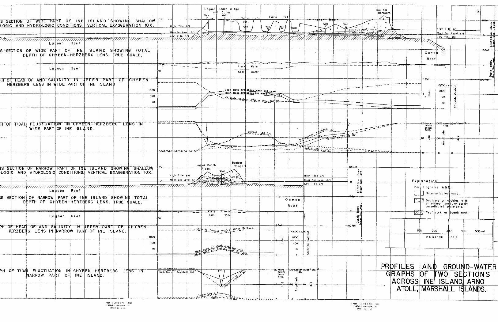
Gr~und-water observ&izs on Arno -- The accompanying diagrams summarize the most important pa r t of the
observations on ground-n:ater con6itions on Ine Island. The ground-rater
conditions a r e shovw across -the islanci a t ' a point ea s t of Ine Village ... ,
??here it i s near ly U+OO f e e t wide and a t a point vest of Ine Village where , . . ,
it i s only a l i t t l e nore than 300 f e e t wide. The conditions can best be
discussed a s they confirm, evaluate &d expand the previously discussed
p i n c i p i e s of ground water occurrence.
The re la t ionsh ip betreen the head and the distance from theshore-
i i n e s i s shown by diagram A, a cross-section of the wide par t of the
is land with a great ve r t i ca l exaggeration. Three water-table posit ions
a r e shorn, the upper and lower being the t i d a l limits of the water table
and the middle one being the mean position. Each slopes continuously
toward the shorelines from a high paint about a t h i rd of the way from the
lagoon t o the ocean shore, except where high-tide vater t ab le slopes in-
land for's short distance a t each shore and also 's lopee toward the lagoon
f d r a short distance near the center of the ioland. The probable
-19-
e&ank,t.ion for these deviations ci.l.1 be discussed shortly. The m r i a t i o n
in mean Lead n i th distijnce from shcrelines i s shorm v i th s t i l l greater
ve r t i ca l exaggeration by the two 601id Lines i n diagram C. The heavier
of these 1.ines shows eleva%ions of the mean water t ab le f o r one riay above
long-term mean sea level . The l i gh t e r l i n e in6icetes elevations of the
meam water t ab le f o r the same day above thz mean sea l eve l f o r t ne t day.
The l a t t e r l i n e i s yrob~b1;p more d i r ec t ly meani.ngfu1, because the heads
msy be expected t o be very largely adjusted to t i d e s of periods longer
% h a - a day.
Disgrams E end G indicate t.hat, the head a t the center of t'ne narrower
p a r t of t5.e is land i s lesa than the head i n the wl&e pa r t of the is land
shocn in diagrams k an2 0. Diagrmis E and G do not show v e l l the s h q e
of the mater t ab l e because tb.ere was nnlv one measuring point i n the nar-
row section of the island. . .
Diaqrams B and F indicate the undistorted theoret ical shapes of t'ne
G1:;pben-Eerzberg lenses i n tho cross sections of the 7;id.e and narrow parks
of' the isband respectively. The depths of 'khe lenses have merely been
computed from the heads a.bove mean saa l e w l Tor the day on which 'they r e r e
meascred, zssumbg t h a t the F.eads ?>ere frilly adjusted t o long period t ides .
The 1o:~er l i t n i t s shorn may be regarded a s tile approximate leve ls of water
half as 'saline as ocean m t e r . Much of t he r a t e r above these leve ls i s
too s a l t y Tor humans o r even p l a n t t o use.
That "inere i s a greater effect ive permeability on the ocea s ide of
at, l e a s t the vide pa r t of the isian?. i s indicated de f in i t e ly by the r e l +
t i v e l y low head inland from the ocean shore and r e l a t i v e l y high head in-
land from the lagoon shore ass30vn in diagrams A and C. The same asyme-Lry
-20-
i n permeability probably ex is t s iii tke narrow section too, but cannot be , ,
proved viith only the one central meas~r ing s ta t ion.
The difference in perme.abili+,y is also ind.icat,ed by the grea te r
::damping lag of the t i des a s they move in from the lagom shore than
as the move' i n from the ocean shore. In the t l d a l graphs, diagram D
.6nd H, tine dmping and l e g of the t ~ o pr incipal t i d a l component.s, serni-
diurnal and diurnal, are show separately. Con~icleration of the t i de as
a r h o l e ~rould r e s i l t i n confusicn, because the periods of the components
a r e effect ive as vreI.1 as the charac te r i s t ics of the aquifer i n determin-
..:. - 2 . i n g the damping avd lag, an6. the tv!o components do not, therefore, behave
as a u n i t a s they move into the q u i f e r . The quanti ty z/x i s a parameter
describing the t i d a l progression a s 1- hole and the values plot ted were
':veraged from ml.ues obtained from both. phase l ag and dmping e f fec t s
i n both semi-diurnal and diurnal components. .
Attentioh has aireacy been called t o +,he imdvial-d slopes of the nezr-
'shore pa r t s of the v:a-ter t,able a t high tj.de. Such a reverscl of slope i s
expectable i n nost Ghyben-Herzberg lenses discharging ~ i i t h o u t r e s t r a i n t
. ' . t o t he sea. Because of the l a rge rango of the t i a e a t Ine a s compared t o . .
, : ' the m a x i m u m head the ocean and lagoon leve ls are actual ly nearly three
f e e t higher thsn -the highest pa r t of the ground-water t ab le e t high t ide.
Because of the l ag in the inland pogressioi-I o f the tide,, the two l i n e s
representing the high- and low-tide l i m i t s o f . the wa+,er t ab l e . do not re-
present two respectively contempors.neous positions of the nater table. A t
times of high t i de i n the ocean the t i d e i n the ground-water body i s s t i l l
: r i s i n g toward the high-ti& l i m i t shown, and the landvard slope i s even
more extreme than i s shovn. The lagoonv~ard slope of the high-tide srater
-21-
tab12 n e w the cen tw of tile is land probably res!?lts f~oin the ground-vater
in the hf.gi~ permeabil.it:,r, oceiinward p a t ~f the is land acting i t s e l f i l k e
the sea -h con%roll.ing the discharge of tile ~ r m L - w c t e r from the l o w
perm~ab:S.ity, lagoonward pa r t of the is!.and. l'h:';s behmior suggesl-s a
ra ther sharp d.";sconthuq.ty in the permeabi.iity near the center of tke is-
land.
A s a r e s d t of tk2 lawer ::ea?. and grer.ter tlda:. flucC,ua-Lioa in the
oceanmrd. p a r t of the is land than i n t.he Lagoonward p r t , the water a t the
top of tlie l ens is freshes"i.n b e lagocnward par t of the is!.md, a s
shown by the 3ashed l i n e in d i ~ g r a a C ~ k i c l - represexits the s a l i n i t y of
sanpic-s d ram nea-ly sinultaneously from the several wells across the v;ide
par t of the isian2. and plo'tted on a logarithmic scale. The water in me11
S co;itainec! 8 ppn. chlorXes, the saxe concentra'~ion as in tke or ig ina l
raj.nwzter, sad an amount astonishingly lor: t o anyone accustomed t o the
range i n sci i ini t ies to be found at f a r gree.t,er d?.stmcos from the sea i n
Cne Ghyben-Herzberg ?.eases of volcanic i s lan3s l i k e Havzaii. Wber of 250
ppn. chlorides o r l e e s could he found :?:itkin 70 f e e t of the lagoon shore
but nut c loser thsn $59 f e e t rrom tine ocean s b r e , a d water of 1030 ppm.
la^"?' shore Fbt not closer than 1.00 f e e t chlorides -::ithin 60 f e e t of the
of the ocean shore. The s a l i n i t y a t -the center of th.e narrorz pa r t of the
is2and st the saxe tLme was 5500 p y . as sko:%n i n dkgram G, indicat ing
tile very great ixportzmce of the v~idth of the islanind or, the minimum . . salin-
ity ir, the Ghyte'n-Herzberg lens.
?he permnab'iity of %he near-surfac? sediments may be eztiixated from
the hydraulics of tine shallov: ::o;e!.ls md from the character is t ics of the
material, t h a t of the zone occupied by the Ghy'oen-llerzberg lens may be
estimated from the gradients of the cmter table , and t h a t of the much deeper
-22-
'zone affected. bv t i & . fiov; Ero:3 - t ie ti.da1 l a g an,? damp3ng. The theories
l inking permeability 7:;ith t.hese various ineasurakle ef'fects are, unfortun-
a te ly , poorly worked out, but, the rouhh approximations possible provide
some very bsefl~S resu l t s . The water-table gradierlts on the two s iees of
ine Island iadicate an ef fez t ive permeability 'ten times o r noro greater
i n the z.one occu;.ied. b.7 the GhyFen-.Iier~berg lens on YrLe ocean si.de than
on the lagoon side. The penneabi1it.y coeff ic ients camputed f o r t h i s zone
a r e mch greater t.han those &$ecteZ i n the kinds of ' sediments found near
the c-ater-t,ab!.e, indic:;.ti?g t h a t the reef platform must be a pertrieability
discontinuity below vhlch the permesbili-ty i s pester Ynan above. The
t idal , effects indicate t ha t t he h i& permeability continues t o a .lep?,h
greater t h m tha t of the Ghy?>en--Hexberg leas.
Tiiese observa.tions, nii.th .a ruinher o r scet,tored observations of t i a a l
fl.uctuation, s a l i n i ty , and h s ~ d n e s s of water no$ f a l l ? worked up yet, in-
d ica te t h a t on the vide par t s cE the islanc3 cf limo Atoll., end ljrobably
on .;ride a t o l l i s i rnds with a s i m i . l a l - climate' generalkr, t!,ere i s a v e l l
developed Ghyben-..Kerzberg l ens a i t h a. maximum head of about a foot a b v e
mean ssa leve l containing f resh water in i ts upper art,. The highest
head and freshest water i s -to be found toward the s ide of t.he is land
urjdez ~8hich the a e r a g e perme&Fility is lowest, vLich on Ine and Arno a t
l e e st,, and probai?ly very comzor,ly, i s the lagoon side. Tonard the ocean
si6.e the l o se r head rmd a greater t i d a l fluctuation r % s u l t in greater
mixing of +,he f resh water v i th tl;e underlying salt vrater.
Seasonel chames in ground-wter -----..-
The f i e l d o'bsermtions on Ine -!ere a l l made during 'the rainy season
i n the ~~Iarsha l l s . The heads neasured should, therefore, be expected to be
-23-
near the maximum to be found during the year, m d the s a l i n i t i e s measured,
therefore, near the minimum. It seems certain that. the patterns of head
and sai i -ni ty differences over the r i d t h of an island v i i l i not. d i f f e r sig-
n i f i can t lv a t any season from t h a t noted, but the amount of decrease i n
head a d of' increase in s a l i n i t y cannot a t present be predicted. monthly
measurements of head in a key v ~ e l l a r e being maintained through a year by
the scr ibe of Ine, so t h a t consiaerabiy more information v i l l be available
on t h i s point. The data received so f z r v i l l not tJe l i s t e d here, because
they have n o t y e t been correcter! f w t i d n l e f fec t s and are useless u n t i l so
corrected. . .
Nati-ire reports indicate t h a t the s a l t content a t the f reshes t w e l l s
on Ine and Bikarij r i s e s enough t o be noticeable but not enough t o make
domestic ?Jse of the water impossible.
Ut i l izat ion of <round-vjater
The k4arshalLese dram d i r ec t ly only a m a l l quanti ty of ground-wa.ter.
There a r e no vlells it? the densely populated pa r t o f Ine Village, and the
uih.ole wz.ter supply there comes from ra in catchment. In -the more nlral
area& of both Ine and Arno there a r e a number of dug wells used a h o s t en-
tiri.1~ to su2ply xater for xashing clothes. EVE^ .:!here there a r e wells,
the vatw used f o r other p r?oses is rain water. In viea of the probable
eas+ of biological contaminaxion cf the grounZ wster under such a lo^:,
previoils t e r ra in , the f a i l u r e t o use much ground m t e r f o r t r inking i s
probably fortunate. Tro of these wells sunk in comparatively high ground
were l i ned n'ittn blocks of beach rock. Most ':ere sunk i n low places and
l ined with o i l drums with the e n d s cut out, tvo o i l drums, one on top of
another, being used in some. O i l drum v:ells vere seen also on Bikarij by
Squires. None of the wells extend more than a couple of f e e t i n to t he water.
-&'+-
Besides t h e a e l l s used f o r vrasn water ti iere a r e a number of p i t s
excaua.ted t o a f o o t o r t v . 0 below t h e x ~ ~ a t e r t a b i e f o r use i n r e t t i n g coco-
n u t h s k s . The husks of copra nu t s a r e merely p i l e d i n these p i t s ,
covered viith l eaves arid t r a s h , and al loyed t o decompose f o r a f en ~tonths , . .
a f t e r which the f i b e r s e r e e a s i l y separated f o r u s & . i k k e ; t i n g cordage.
There 5.s apparently no important s a l i n i t y con t ro l on t h e ?-&tirig process,
some of the r e t t i n g being done i n p i t s exoevated i n t'ne beaches o r merely
i n pi.7.e~ covered v:ith rocks on t h e beaches. The re",ting p i t s i n t h e in-
t e r i o r o? t h e i s l a n d s a r e appsrent ly loca ted t h e r e merely t o be conven-
ient . t o th.e source o r nuts .
The small a i r e c t d r e f t of ground-mter i s no ind ics t ion of the over-
a l l importance of t h e rrzter t h a t seeps i n t o t h e ground. As has a l ready
been discussed, t h e w t e r iil t h e unsa tu ra te i $ a r t of t h e s o i l i s probably
priniaril:? responsible f o r sup7ortin.g t h e heavy vege-tation of vet a t o l l s . .
l i k e Arno; but some of the p.lants e r e wl~olly o r p a r t l y lependent on ground-
water from t?.e sa tu ra ted zone.
Conscious use i s made of grouild-water i n t a r o c u l t u r e by t h e Mar-
shal lese . The vet-land forms of t a r o w i l l groi: o n l y i n s o i l s sa tu ra ted
with water, and a l s o , it i s believed i n Harraii, on ly where t h e ' ~ a t e r i s
in mo~remmt. With no surface st:rearns, the Mershallese have been z b l e t o
meet t h e requirements by excavating p i t s from t h e surface of the ground
5 or 6 f e e t o r more deep, penet ra t ing t.he water-table. Taro is erovm in
organic muck, accumulated by r q t t i n g vegetat ion i n these pits. The sur-.
f a c e of the muck i s genera l ly a t about mean vfaber-table, so t h a t water . . .
s tands i n t h e p i t s about h a l f . t h e t i r e . - T b t i d a l f iuc tua t ion of t h e
- ' %a&er-table apparent ly induces s u f f i c i e n t movement o f t h e viater. The a r e e , .
-25-
occupied by taro p i t s on Ine Island corresponds t o the d i s t r ibu t ion of
tne f reshes t ground.-water in t he lens, t h a t containing 20 ppm. o r l e s s
of chlorides a t the time of sampling. The t a ro p i t s on Arno Island oc-
cupy a corres2onding position, undoubtedly becawe of the same control.
Taro is knom in Hawaii t o be ra ther in to le ran t of s a l t .
Ground-water apparently plays an addi t ional important pa r t i n sus-
ta ining breadfruit trees. Brezdfruit i s no t generally regarded a s a
pkreatophyte (plant u t i l i z i n g ground-water from beloc the vater-table)
and or, high islands it i s c lear ly not a phreatophyte. Eo~sever, the dis-
t r ibut ion of productive breadfrui t t r e e s corresponds so c losely mith
the pat tern of s a l i n i ty of the ground water that, some ground-water con-
t r o l seems cer ta in ly effect ive. It is possible t h a t the control i s
exercised only d x i n g the dry sea.son when vadose water ( t h a t held in the
unsaturated s o i l above the 6ater-table) i s inadequate t o maintain growth,
o r i t s e l f r e f l e c t s t;ke s a l i n i t y of the underlya!: groiind water due t o
cap i l la ry r i s e . In general, t he breadfrui t t r ee s are l imited t o a zone
including the ta ro p i t zone and extendhg beyond t o a posit ion corres-
ponding t o perhaps 200 to 400 ppm. chloride content in the undeiilying
weter a t the time of sampling. There a r e a few breadfruit t r e e s growing
on Ine Island seaward of t h i s lhit, and a fevi on Arno t h a t probably a r e
a lso. None of these seaward t r e e s are a s l a rge es many of the t r ee s in
the center and lagoonward pa r t s of the is lands, and it i s noted by the
Marshallese t ha t they f a i l t,o bear o r a r e at best poor bearers. There
a r e no breadfrui t t r e e s on narrow par t s of the i s h n d s . It should be
remembered t h a t the l i m i t s of a fez< tens of par t s per mill ion chlorides
f o r t a ro and a fep! hundreds for breadfrui t are net-season l i m i t s . Un-
doubtedly the dry-season l i m i t s representing the r e a l control a r e con- siderable- higher.
. . . , . -26- , . .
. . ~ . . ?Ine dl .s tr ibution of se t t lements mil: rodds, c lose t o the lagoon shore
. , . ~., dn n e a r l y a l l of 'he i s l a n d s of Urno Ato l l , i s probably very c lose ly t h e
' r e s v l t of t h e brezclfr'ait and t a r o d i B t r i b u t i o n . . . . .
Banan?. and papaya t r e e s snou: d i s t r i b u t i o n s s i m i l a r t o t h a t of t a r o ,
, , . . . .. but more l imi ted , probably a s a r e s u l t of l i m i t i n g p lant ings c lose t o
set$lements. No o the r economically impwtant p l a n t s seem t o bs l i m i t e d
by t h e ava j . l ah i l i ty o.f f r e s h ground-water..:: ; . . . (.. . .
-27-
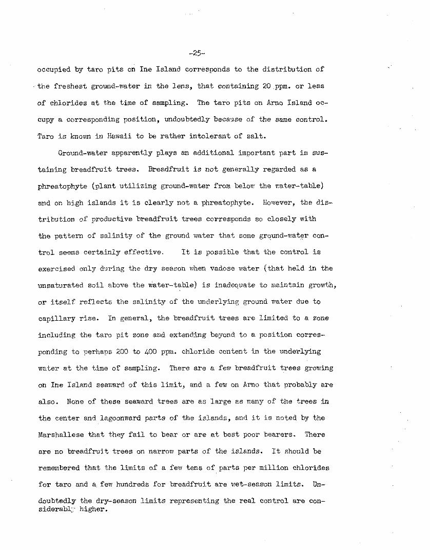
APPENilIX -- Rainfall measuremen.ts on Brno Atoll --.-.-- .----..----
1950 Ju ly J u l A u g u s t mScpt. OcC,. k v .
day Ine A r n z ~ikari: Ine A m o Bikarij h e Ine Ine - -
Total
Mean
tr - ? a b
Trace Not read. R ~ l n f a l l included i n succeeding readjng, 130 r e c ~ r d . May be incorporated i n succeeding dp.yst catch. Incomplete. Estimate bosed on pa,rtib?. record.
-28-
Bench Marks a t Ine Vj.llage
Eench nark 1: - The top of head of galvanized spike driven in to north s ide of
coconutpalm t r e e about one. foo t above ground. Tree i s nearest t o ocean on southeask. s ide of t r a i l leading to beach from point on main t r a i l about 75 feet.northvrest of northwesternmost houses of Ine Village, and about 450 f e e t northwest of main t r a i l in tersect ion a t church.
Elevation: 8 . n f e e t above mean sea l eve l a t Ocean.
Bench mark 2: -- :.A.small cowrie she l l f i l l e d with cement and s e t in to top of
unusedconcrete foundation post on south corner of concrete pla t - form around house on north corner a t t r a i l intersection a t church.
Elevation;. 8.27 f e e t above mean s e a l e v e l a t Ocem.
Bench mark 3:
A c i r c l e chiseled i n beaah sandstone on lagoon beach a t foo t of t r a i l leading lagoonward from church.
Elevation: 1+.39 f e e t above mean sea. l eve l a t Ocean.
Bench mark L:
A c i r c l e chiseled on edge of ea s t corner of concrete c i s te rn , 30 f e e t northivest of t r a i l from church to lagoon a point 125 f e e t from intersect ion a t church.
Elevation: 6.74 f e e t above mean sea l eve l a t Ocean.
Bench mark 5: - A c i r c l e chiseled i n south corner of concrete foundation of
n o r t h w s t concrete post a t entrance t o Ine Council House.
Elevation: 8.80 f e e t above mean sea l eve l a t Oce,m.
Bench mark 6:
B c i r c l e chiseled i n northwest s ide of concrete s i l l around I r o i j Well, about 1 0 f e e t south of main t r a i l a t point 75 f e e t southeast of Council House.
Elevation: 8.14. f e e t above mean sea ' l eve l a t Ocean.
Bench marks established July 1950. Mean low water elevations and reduction t o mean sea leve l a t ocean computed by U. S. Cocst and Geodetic Survey.
-29-
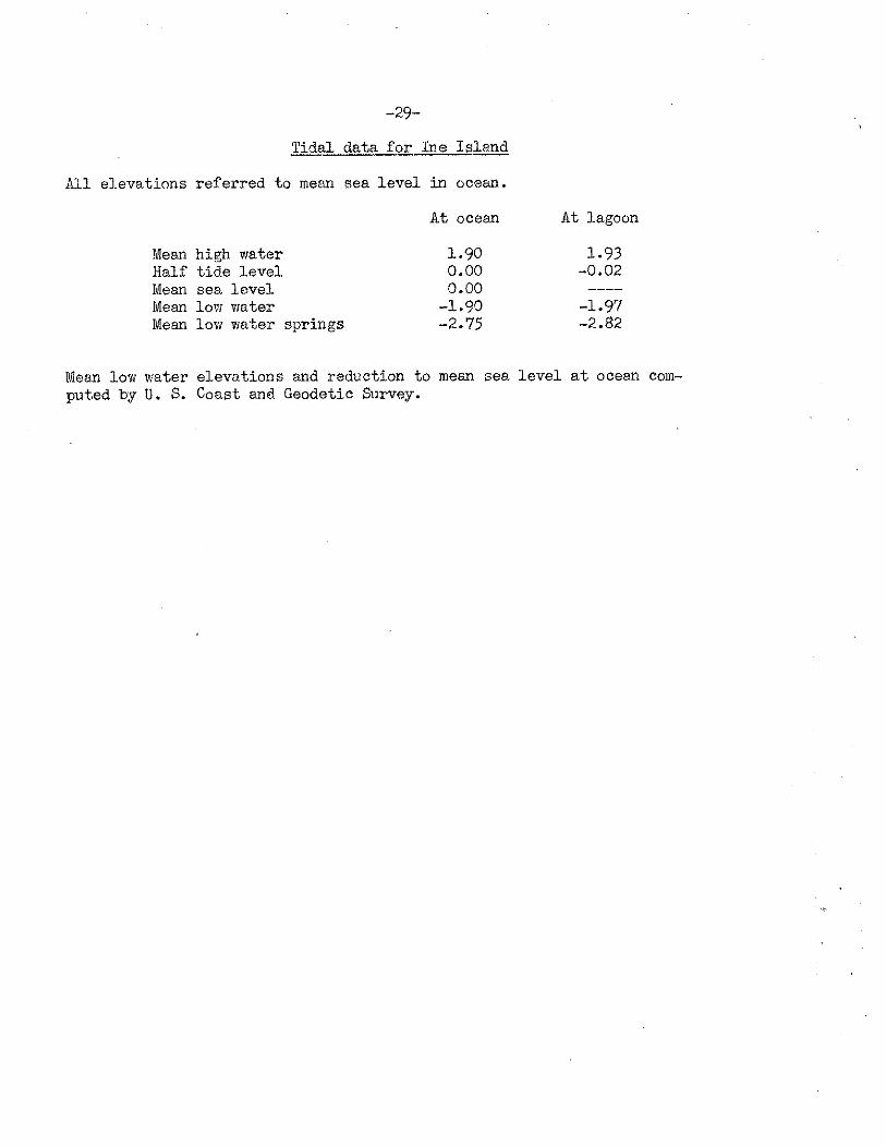
Tidal data f o r h e Is= 7
Ail el.evations referred t o mean sea l eve l in ocean.
A t ocean
Sean high water 1.90 Half t i de l eve l 0.00 Mean sea l eve l 0.00 Mean low water -1.90 Mean low water springs -2.75
A t lagoon
1.93 -0.02
Mean low water elevations and reduction t o mean sea l eve l a t ocean com- putred by U. S. Coast and Geodetic Survey.
~ ~ m ~ - p x ~ D PTH F GH BEN-HERZ o ~ I Y E ~ / - ~ ERG S L - ~ D - ~ ' ~ ENS. RUE l$Top-, CALE. t r T ~ ~ ~ * T X i E ' E T Y ~ 2 ~ o ~ ~ ~ K l ~ - U F F ~ G I I Y B - f . ~ ~ H RZBE G LE S IN
Related Documents