PORT DEVELOPMENT PROJECT FINAL REPORT IN THE REPUBLIC OF LITHUANIA (JICA) VOLUME III MAIN REPORT III-6-36 CHAPTER 6 6.3 The Short-Term Development Plan As indicated above, the Short-Term Development Plan includes two main elements: Construction of the first phase of the Outer Port Development proposed in the Master Plan; Development of the existing port by improving railway access to terminals in the south. These plans, and the way in which they are likely to be constructed, are described below. 6.3.1 Existing Port (1) The proposed development There are two rail lines in the south of the port, which branch to the west of Draugyste Station. One line runs to the International Ferry Terminal and the other passes through the edge of the Western Ship Repair Yard and SC Progresas, and through the Smelte, Transfosa and Bega Terminals to the Klaipeda Ship Repair Yard (Figure III.6.3-1). The Plan proposes to construct an additional line near the second of these routes (shown in red on Figure III.6.3-1), to provide separate access to the Smelte and Bega terminals. The new line will be approximately 5.5 km in length, and over the southern two-thirds it will be located immediately alongside the existing track. It will then take a different route through the east of the SC Progresas yard, providing a separate line to the Bega Terminal, allowing the present track to be used mainly by Smelte. (2) Construction of the new rail line The new line will be built mainly in the wayleave of an existing line, so it will not require significant ground breaking and removal of obstacles. Construction should therefore be less complex than building a new line in areas of urban development or diverse topography (see Section 6.4.1 below). It will involve the following main activities: Initial ground preparation by hand and backhoe diggers, to remove vegetation, debris and any structures from approximately 20 m of land to one side of the existing track; Infilling of the cleared area with stone tipped from lorries, and compaction by roller vehicles and hand-operated vibrating compactors, to provide a stable foundation for the rails; Where land is lower along 2.4 km of the southern part of the route, a more substantial embankment (1-2.5 m in height) will be constructed (from tipped and compacted stone as above) to raise the level of the track to the elevation of land in the port; The surface and sides of the new embankment will be finished with crushed stone to enhance stability and prevent growth of vegetation;

Welcome message from author
This document is posted to help you gain knowledge. Please leave a comment to let me know what you think about it! Share it to your friends and learn new things together.
Transcript

PORT DEVELOPMENT PROJECT FINAL REPORT IN THE REPUBLIC OF LITHUANIA (JICA) VOLUME III
MAIN REPORT III-6-36 CHAPTER 6
6.3 The Short-Term Development Plan
As indicated above, the Short-Term Development Plan includes two main elements:
Construction of the first phase of the Outer Port Development proposed in the Master Plan;
Development of the existing port by improving railway access to terminals in the south.
These plans, and the way in which they are likely to be constructed, are described below.
6.3.1 Existing Port
(1) The proposed development
There are two rail lines in the south of the port, which branch to the west of Draugyste Station. One line runs to the International Ferry Terminal and the other passes through the edge of the Western Ship Repair Yard and SC Progresas, and through the Smelte, Transfosa and Bega Terminals to the Klaipeda Ship Repair Yard (Figure III.6.3-1). The Plan proposes to construct an additional line near the second of these routes (shown in red on Figure III.6.3-1), to provide separate access to the Smelte and Bega terminals.
The new line will be approximately 5.5 km in length, and over the southern two-thirds it will be located immediately alongside the existing track. It will then take a different route through the east of the SC Progresas yard, providing a separate line to the Bega Terminal, allowing the present track to be used mainly by Smelte.
(2) Construction of the new rail line
The new line will be built mainly in the wayleave of an existing line, so it will not require significant ground breaking and removal of obstacles. Construction should therefore be less complex than building a new line in areas of urban development or diverse topography (see Section 6.4.1 below). It will involve the following main activities:
Initial ground preparation by hand and backhoe diggers, to remove vegetation, debris and any structures from approximately 20 m of land to one side of the existing track;
Infilling of the cleared area with stone tipped from lorries, and compaction by roller vehicles and hand-operated vibrating compactors, to provide a stable foundation for the rails;
Where land is lower along 2.4 km of the southern part of the route, a more substantial embankment (1-2.5 m in height) will be constructed (from tipped and compacted stone as above) to raise the level of the track to the elevation of land in the port;
The surface and sides of the new embankment will be finished with crushed stone to enhance stability and prevent growth of vegetation;

PORT DEVELOPMENT PROJECT FINAL REPORT IN THE REPUBLIC OF LITHUANIA (JICA) VOLUME III
MAIN REPORT III-6-37 CHAPTER 6
Figure III.6.3-1 Present railway network of Klaipeda, and additional line proposed for the southern Port area (shown in red)
Pre-cast concrete sleepers and metal rails will then be delivered on wagons along the existing and/or new track, and these will be unloaded and positioned by crane, and attached by hand;
For the approximately 2 km of track in the existing port there may be a need to demolish some disused buildings, particularly in the Progresas area, and this will be done mainly by bulldozers, with material being transported off-site in trucks;
Some areas of concrete surfacing in the port may also need to be removed if they are not suitable for rail lines, and these will be broken by hand-held or machine-operated pneumatic drills, and again the debris will be taken off-site in trucks.
The route will cross the Smeltale River to the north of Klaipedos Terminalas, and here the existing bridge will be widened to carry the new line. New supporting pillars and

PORT DEVELOPMENT PROJECT FINAL REPORT IN THE REPUBLIC OF LITHUANIA (JICA) VOLUME III
MAIN REPORT III-6-38 CHAPTER 6
surface platform will be created by pouring concrete into sections encased in wooden shuttering, into which metal reinforcing bars are fitted.
Specific working methods will be decided by the contractor, but it is likely that construction of the new line will begin at the branching point in Draugyste Station, and work will then advance gradually along the route to the end in the Bega Terminal. A temporary haul road will be established at the edge of the track to allow trucks to deliver infill and other materials and remove debris.
6.3.2 New Outer Port
(1) The proposed new port area
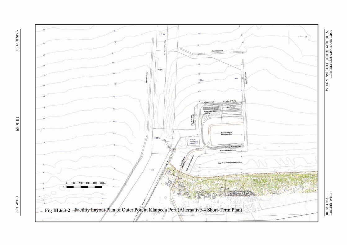
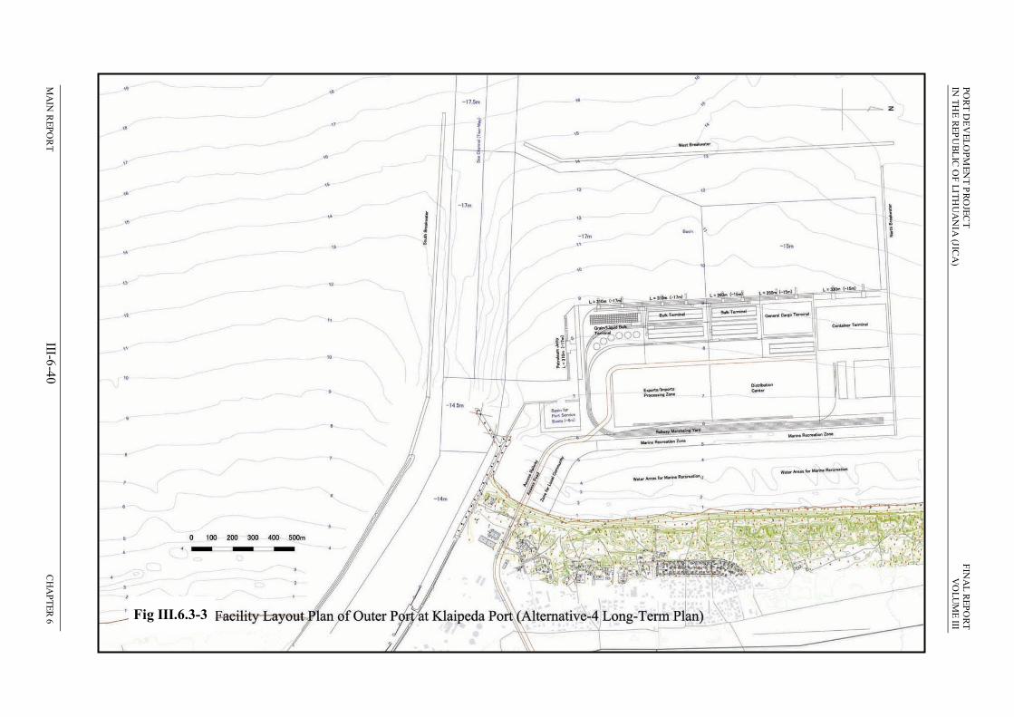
The main element of the Short Term Plan is to construct the first phase of the Outer Port Development proposed by the Master Plan. Figures III.6.3-2 and III.6.3-3 show that this is approximately 40% of the total structure, in terms of both land area and dredged basin. The Outer Port Development as built during the Short Term Plan period (2005-2015) will therefore consist of the following main features:
A square area of reclaimed land, 0.5 km2 in total, located 300 m from the beach west of Melnrage I;
A smaller reclamation (0.15 km2) at the south-east corner, connecting the main area to the coast north-west of the existing port;
An L-shaped 1.3 km2 basin west of the reclaimed areas, adjacent to the present access channel, dredged to –17 m;
A breakwater extending 600m offshore from the north-western corner of the main reclaimed area, enclosing the northern side of the dredged basin;
A 1 km breakwater parallel to the coast, 1.8 km from the beach, enclosing the outer part of the dredged basin;
A 1.4 km extension of the present southern breakwater along the south of the access channel, protecting the channel and the southern side of the new port basin;
The angular extension to the northern breakwater at the port entrance will be removed, widening the access channel to 300m;
The access channel will be dredged to –14.5 m at the present entrance, –17 m adjacent to the new basin and –17.5 m at the new port entrance;
New road and rail lines will branch from existing routes east of Melnrage, and run south of the village and across the smaller reclamation onto the main port area.
(2) On-land facilities
Figure III.6.3-2 shows that the following facilities will be provided on the new port area to handle the types and quantities of cargo predicted in the period to 2015:
Three berths, each of 310 m length and 17 m depth, two on the western side and one in the south;
Two terminals adjacent to the western berths, one a multi-purpose facility for break bulk, general cargo and containers, and the other a grain terminal for bulk grain and liquid UAN (fertilizer);
PO
RT
DE
VE
LO
PM
EN
T P
RO
JEC
T
FIN
AL
RE
PO
RT
IN
TH
E R
EP
UB
LIC
OF
LIT
HU
AN
IA (JIC
A)
VO
LU
ME
III
MA
IN R
EP
OR
T
III-6-39
C
HA
PT
ER
6
Figu
re III.6.3-2 Facility L
ayout P
lan of O
uter P
ort at Klaip
eda P
ort (Altern
ative-4 S
hort-T
erm P
lan)
Fig III.6.3-2
PO
RT
DE
VE
LO
PM
EN
T P
RO
JEC
T
FIN
AL
RE
PO
RT
IN
TH
E R
EP
UB
LIC
OF
LIT
HU
AN
IA (JIC
A)
VO
LU
ME
III
MA
IN R
EP
OR
T
III-6-40
C
HA
PT
ER
6
Figu
re III.6.3-3 Facility L
ayout P
lan of O
uter P
ort at Klaip
eda P
ort (Altern
ative-4 L
ong-T
erm P
lan)
Fig III.6.3-3

PORT DEVELOPMENT PROJECT FINAL REPORT IN THE REPUBLIC OF LITHUANIA (JICA) VOLUME III
MAIN REPORT III-6-41 CHAPTER 6
The grain terminal will include silos for storage of 110,000 tons of grain, and a 120,000 ton tank-farm for UAN on the inland side, connected to the quayside by belt conveyor and piped connections respectively;
At the multi-purpose terminal 3ha adjacent to the quay will be left vacant in the short-term for open storage and handling of cargo, and inland of this a 12,000 m2 warehouse will be provided to store dry bulks. Cargo will be handled via rail-mounted and rubber-tyred cranes, ship- and derrick-cranes and forklift trucks;
The southern berth will be used for loading and unloading of oil products and willbe connected by pipes to tanks in the Nafta facility in the existing port;
40% of the new port area, inshore of the terminals, will be left open, for use by KSSA as a free-trade zone, where local businesses can develop high value manufacturing enterprises, importing raw materials and exporting finished products;
Buildings will be constructed in this area as required, and will mainly consist of small workshops, warehouses and offices;
A single track rail line will run from the expanded Pauoscio marshalling yard east of Melnrage, through Giruliai Forest and onto the new port across the small reclaimed area south-west of the village;
On the new port area rail lines will run in a horseshoe arrangement along the western, southern and eastern edges, serving the berths and storage facilities, and providing a small shunting area along the inland side (Figure III.6.3-2);
Road access will be via a new four-lane highway, 2km long and 20 m wide, extending from the junction of P.Lideikio Street and Giruliu plentas Street, around the south of Melnrage and onto the new port adjacent to the railway;
In the port the road will cross the rail lines by means of a small flyover, and willthen run around the western edge of the exports/imports processing zone;
In addition to the berths the port will also include a small basin, 6 m deep on the southern side, where service boats will be moored;
The small embayment between the eastern edge of the reclaimed area and the Melnrage beach will be provided to Klapieda Municipality for use in marine recreation, which in time might include construction of a marina for small craft;
Some of the reclaimed land adjacent to this bay (at the east of the main area and on the north of the smaller reclamation) will also be provided to the Municipality.
(3) Construction of the new port
The construction process will be planned much later, when the designs for the development are prepared. These will define the details of facilities and structures, but construction methods will largely be left to the contractor, to allow firms bidding for the construction contracts the flexibility to vary their approach to provide cost savings where appropriate. Notwithstanding this it is still possible to describe the general approach to the construction process even at this early stage, from experience of the way in which marine structures are normally built. The main features are likely to be as follows:
Initially an area of land will be cleared for storage and processing of materials, and for site offices, vehicles, etc, and this is likely to be the unused land north-

PORT DEVELOPMENT PROJECT FINAL REPORT IN THE REPUBLIC OF LITHUANIA (JICA) VOLUME III
MAIN REPORT III-6-42 CHAPTER 6
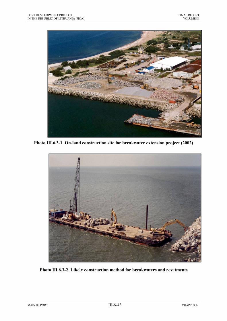
west of the port adjacent to the Nafta Terminal, which was used for this purpose in 2002 when the breakwater extension was built (Photo III.6.3-1);
Marine construction will begin by laying rock mounds on the seabed to form revetments around the area to be reclaimed, to delimit the site and retain the infill material. These will be of medium grade rock, probably brought from abroad on barges, and deposited on the seabed using cranes or bulldozers (Photo III.6.3-2);
Geotextile membrane will then be placed over the inner surface of each revetment by divers, to aid retention of the finer particles when reclamation material is added;
Larger rocks will be placed individually on the upper and outer surfaces, by cranes operating on the barges, to bring the top of each structure above the level of the sea;
Short lengths that are lower in height will also be included, to form weirs across which retained water will flow back into the sea as the reclamation proceeds;
Initial investigations suggest that sand from the seabed at the site could be suitable for use as infill, and if this is confirmed, dredged material will be pumped straight into the reclaimed area through pipes;
Any shortfall would be made up from soil, sand and rock brought from local quarries on trucks, and dumped near the edge of the reclamation, from where it will be pushed into the area by bulldozer;
Construction of the breakwaters will commence at around the same time, to protect the site from wave action.
The composition of the breakwater will be determined later, and it could comprise large rocks, concrete blocks, caisson-type structures (large sand-filled concrete boxes), or a combination of materials;
Components will be carried to the site on barges and deposited on the seabed using cranes. Photo III.6.3-3 shows the smaller operation to replenish rock protection along the southern breakwater;
As the reclamation proceeds, quay structures will be built along the western and southern edges, outside the rock mounds, and these will be formed from steel sheet piles, open piles or caissons;
Caissons would be constructed off-site and brought in on large trucks or barges, transported to the edge of the reclaimed area by barge, and placed into position by cranes. Sand will be brought in on barges and bulldozed in to fill each caisson;
Piles will also be manufactured locally, taken onto site on barges, and driven into the sea bed by large hydraulic hammer. Open piles will be used to form the dolphin structure of the petroleum jetty, which will project from the quayside on a T-shaped extension (Figure III.6.3-2);
During the reclamation, large roller vehicles will be used to compact the area. This will increase as the level rises towards the design height, and once this has been reached, the surface will be finished with concrete or asphalt pavement, or left uncovered;
PORT DEVELOPMENT PROJECT FINAL REPORT IN THE REPUBLIC OF LITHUANIA (JICA) VOLUME III
MAIN REPORT III-6-43 CHAPTER 6
Photo III.6.3-1 On-land construction site for breakwater extension project (2002)
Photo III.6.3-2 Likely construction method for breakwaters and revetments

PORT DEVELOPMENT PROJECT FINAL REPORT IN THE REPUBLIC OF LITHUANIA (JICA) VOLUME III
MAIN REPORT III-6-44 CHAPTER 6
Photo III.6.3-3 Operation to replenish rock protection on the southern breakwater
Photo III.6.3-4 Cutter suction dredger

PORT DEVELOPMENT PROJECT FINAL REPORT IN THE REPUBLIC OF LITHUANIA (JICA) VOLUME III
MAIN REPORT III-6-45 CHAPTER 6
Deepening the approach channel to –17 m will probably be done by cutter suction dredger (Photo III.6.3-4), moving along the channel and discharging the dredged material into the reclamation area. Excess water will overflow across the weirs and back into the sea;
The confined area of the basin will probably be deepened by suction dredger, as this allows greater precision in the positioning of the dredging head. A clam-type dredger could be used for small corner areas, and where the substrate is hard.
(4) Construction of on-land facilities
Once the reclamation has been completed, the on-land facilities will be built. This is likely to involve the following main activities:
The warehouse will be of mainly concrete construction, formed by pouring ready-mixed concrete (prepared off-site and brought in by mixer-truck), into sections encased by wooden shuttering, into which metal reinforcing rods are fitted. Photo III.6.3-5 shows a similar warehouse under construction at the Klasco Terminal in 2003;
The silos, tanks, loaders and conveyor (Photos III.6.3-6 – III.6.3-9) will be constructed on site from concrete and metal components manufactured locally and brought in on trucks;
Buildings on the export/import processing zone will be of mainly block and brick construction, built by local builders;
The new road and rail lines will require removal of any obstacles and levelling of the land within a 30 m corridor along the approximately 1.5 km between the existing routes east of Melnrage and the new port site. This will be carried out mainly by bulldozers and backhoe diggers;
Aggregate will then be tipped onto the levelled subsoil and compacted by heavy rollers to form stable foundations;
Sleepers and rails, brought to site on wagons on the present railway, will then be placed into position by cranes and attached by hand, after which crushed stone ballast will be applied onto and around the track;
Locally manufactured asphalt will be applied in layers to the area for the road, and kerbstones and paved walkways will be added at the edges, mainly by hand.

PORT DEVELOPMENT PROJECT FINAL REPORT IN THE REPUBLIC OF LITHUANIA (JICA) VOLUME III
MAIN REPORT III-6-46 CHAPTER 6
Photo III.6.3-5 Warehouse under construction at Klasco Terminal in December 2003
Photo III.6.3-6 Klasco grain silo

PORT DEVELOPMENT PROJECT FINAL REPORT IN THE REPUBLIC OF LITHUANIA (JICA) VOLUME III
MAIN REPORT III-6-47 CHAPTER 6
Photo III.6.3-7 Storage tanks at Klasco Terminal
Photo III.6.3-8 Grain loader

PORT DEVELOPMENT PROJECT FINAL REPORT IN THE REPUBLIC OF LITHUANIA (JICA) VOLUME III
MAIN REPORT III-6-48 CHAPTER 6
Photo III.6.3-9 Covered conveyors at the Bega Terminal

PORT DEVELOPMENT PROJECT FINAL REPORT IN THE REPUBLIC OF LITHUANIA (JICA) VOLUME III
MAIN REPORT III-6-49 CHAPTER 6
6.4 Potential Environmental Impacts of Rail and Port Developments
Before the environmental impacts of the new rail line and outer port can be assessed, the types of impact that these developments can have needs to be established. The following account therefore describes the most common impacts associated with such schemes, in both construction and operating phases.
This does not mean that these impacts will be produced if these developments are constructed in Klaipeda. The actual impacts depend on a variety of factors, in particular the specific nature, size and location of the development, and the nature of the environment in the vicinity. Impacts likely to be produced by each of the proposed schemes are discussed in Section 6.5 below.
6.4.1 Construction of New Rail Lines
(1) Physical Environment
New railway developments can have major impacts on the physical environment, where they are routed across terrain of varying topography. This is because the gradient of rail lines needs to be kept as level as possible to maintain fuel efficiency, reduce journey times and minimise wear and tear on the rolling stock. Routes are normally chosen to avoid hills, valleys, rivers and other obstacles as far as possible, but where this cannot be done, large scale engineering work can be required, which produces major physical changes. These can include removing large amounts of soil and rock to produce cuttings or tunnels through hillsides, building embankments to carry the railway across low ground, and constructing bridges across rivers and valleys. The physical changes begin in the construction phase, increase as the work progresses, and then remain during and even after the railway is in operation, as disused lines are often left in situ long after the service has been discontinued.
Although large, these changes in themselves are not necessarily negative in physical terms as long as the overall structure and integrity of the land is maintained. However, there can be significant impacts if other physical features are affected (such as the stability of soil and hillslopes and drainage patterns of surface and ground water), resulting in any of the following:
Landslips onto rail lines or areas nearby, particularly if they are inhabited;
Soil erosion, which reduces the agricultural or ecological value of affected areas;
Reductions in the quality or quantity of water in aquifers used to provide a potable supply to communities;
Changes in the flow of water in rivers, affecting water quality, ecology or riparian communities.
An aspect of the physical changes that is often viewed as negative is their effect on the landscape, and this is discussed with other elements of the human environment below, as impacts on the landscape are mainly judged by the way the changes are perceived by people.
(2) Chemical Environment
Where railway construction involves major earthworks, then there could be impacts on air and water quality. These can be produced by:

PORT DEVELOPMENT PROJECT FINAL REPORT IN THE REPUBLIC OF LITHUANIA (JICA) VOLUME III
MAIN REPORT III-6-50 CHAPTER 6
Dust blown from the surface of worksites during dry weather, and from stockpiles of soil kept on site;
Rainfall washing soil into rivers, groundwater and the sea, increasing the level of suspended sediment in the water.
The significance of both of these impacts would be increased if soil at the site was contaminated (from previous industrial use for example), as chemical pollutants would then enter the air or water.
There are few other risks of chemical pollution because few toxic materials are used in railway construction, and those that are (such as diesel fuel for locomotives) are normally stored securely away from the site, in the rail yard.
(3) Ecology and Nature Conservation
Construction of a railway can damage the ecology and thus the nature conservation value of an area by causing:
Loss of habitat along the rail route, where vegetation, or even land is removed to provide the area on which the track is laid;
Loss of animals inhabiting the route, which are either killed as the vegetation is removed, or disturbed by the land clearance and forced to leave;
Disturbance of species living near the route, from the noise and visibility of the construction activities, which can cause animals to leave an area, at least temporarily while the work is in progress;
Severance, where a rail line cuts through a habitat (such as a wood or a forest for example), leaving different parts of the same population or community separated by a physical barrier, which can make populations unviable;
Severance can also impede or even prevent migration of animals, which can be necessary for breeding, feeding or temporary relocation to more favourable areas (over winter for example).
The significance of these impacts depends on the nature of the areas affected, and their ecological importance, and would be more significant if they occurred in or near protected areas.
(4) Human Environment
The process of constructing a new rail line can have many impacts on the human environment, but generally one of the most significant is the effect on the landscape. Initially views are disrupted by the presence of construction vehicles, machinery and site activities, and then gradually the developing railway begins to change the appearance of an area permanently. These changes are most noticeable if the new line is in a location where it is very visible, such as crossing a river valley, or where the landscape is natural, with no man-made features. Conversely impacts on the landscape are normally much less significant if they occur in an industrial or even an urban location, particularly if the line is located near an existing railway.
Acquisition of land for a railway route can cause significant impacts on the local community if the land is inhabited or contains business premises, or if it is farmed or put to some other important use. Although compulsory purchase and forced relocation of residents have occurred in the past this is no longer an acceptable practice, as it has

PORT DEVELOPMENT PROJECT FINAL REPORT IN THE REPUBLIC OF LITHUANIA (JICA) VOLUME III
MAIN REPORT III-6-51 CHAPTER 6
destroyed communities, caused dissatisfaction and unrest, and resulted in social, economic and other problems for those affected. In more recent times developers have gone to considerable lengths to avoid inhabited areas, and where this cannot be done, resettlement plans are developed in partnership with communities, which normally involve provision of improved accommodation and land elsewhere.
Other human impacts associated with construction of a railway are relatively minor in comparison. Noise can be an issue for people living close to a construction site, as many of the activities can produce sound. Particular sources include:
Drilling and even the use of explosives where major earth and rock removal is required;
Loading of materials, and the noise of vehicles and machinery including trucks, bulldozers, roller vehicles and vibrating compactors;
Shunting of locomotives and wagons used to bring rails, sleepers and other materials to site;
Handling and fixing of rails, which can involve hammering onto metal surfaces;
Tipping of stone to form foundations or ballast, or to protect embankments;
However given that construction noise is temporary and gradually diminishes as the site moves on down the completed line, this impact in itself is not normally of major significance.
Similarly, disruption caused by temporary closure of roads and footpaths whilst the rail lines are built is generally a short-term inconvenience rather than a major source of impact, providing the routes are reopened promptly and crossings are provided where necessary.
Construction projects normally provide some local benefits, depending on the scale of the operation, because local people are employed in the workforce. However, this is not always the case for rail projects as construction is a fairly specialised activity, and there can be few opportunities that do not require at least some previous training and experience.
6.4.2 Operation of New Rail Lines
(1) Physical Environment
When a railway is operating, the physical changes created during the construction period, by building structures or altering the physiography of an area, remain in placeover the long term. These are normally considered as impacts of the construction phase which have long-term consequences. Over the timescale of an operating railway there is more potential that these changes could cause other physical impacts such as the landslips, soil erosion or changes in surface and groundwater mentioned above. However in practice these impacts rarely happen because like most large-scale civil engineering developments, rail construction is preceded by detailed investigations, planning and design, which amongst other things avoids major negative impacts such as these.
The only additional physical impact caused by an operating railway is the vibration produced by trains and waggons operating on the line, and this is discussed below

PORT DEVELOPMENT PROJECT FINAL REPORT IN THE REPUBLIC OF LITHUANIA (JICA) VOLUME III
MAIN REPORT III-6-52 CHAPTER 6
with other impacts on the human environment as it is an issue mainly if it affects people or buildings.
(2) Chemical Environment
Locomotives are the main source through which railways affect the chemical environment, as if they operate by burning diesel fuel, this liberates the same types of atmospheric pollutants as road vehicles. These include Carbon Dioxide (CO2), Carbon Monoxide (CO), oxides of nitrogen (NOx), Volatile Organic Compounds (VOC) and Sulphur Dioxide (SO2). These include both greenhouse gases (CO2 and NO2) which contribute to global warming and climate change, and pollutants that can damage human health (eg CO and SO2). Health issues can be of concern where heavy rail traffic occurs in populated areas, where higher levels of respiratory disease and related conditions have been reported. Notwithstanding this, rail transport is generally preferred over road transport, because it is more energy efficient (carrying more passengers and freight per unit of fuel) and less polluting (producing smaller amounts of atmospheric emissions).
Although rail systems with older rolling stock can produce localised solid and liquid pollution from toilets discharging onto the track below, this practice has long ceased in the developed world, where modern carriages have self-contained chemical toilets, which are emptied into the sewer or treatment plant at the rail depot.
The other way in which rail transport can affect the chemical environment is through accidents releasing toxic liquids, solids or gases, carried in cargo wagons. Although accidents are relatively infrequent, and rail is a safer mode of transport than most other methods, accidents still happen, even where there are highly trained personnel and modern safety systems. When a chemical cargo is released it can pollute the atmosphere, land and water at the site, and can then be carried farther afield, affecting rivers, groundwater, land and air, and animals, plants and people in the vicinity.
(3) Ecology and Nature Conservation
Like the physical changes noted above, the impacts of an operating railway on ecology are mainly those that begin during the construction phase. The loss of habitat and species from the track area, and severance of communities or populations, all continue for as long as the rail line remains in place. These are again normally considered as impacts of the construction phase with a much longer duration than the short-term impacts that usually occur during this stage.
Disturbance of animals near rail lines also continues in the operational period, but here the impact can be reduced as animals are often able to adapt to the regular noise and visual presence of trains and wagons along a line, in contrast to the irregular and unpredictable disturbance from a construction site.
Like motorways, rail routes can have minor ecological benefits if plants and animals are able to colonise small areas of land at the fenced margins of the track, or small pockets of land isolated between lines, as these areas are relatively free from direct interference by humans.
(4) Human Environment
Landscape is another issue where the impacts are created during the construction stage and continue during and after the period when the railway is operating.

PORT DEVELOPMENT PROJECT FINAL REPORT IN THE REPUBLIC OF LITHUANIA (JICA) VOLUME III
MAIN REPORT III-6-53 CHAPTER 6
Although the physical presence of railway structures or altered geographical features may not necessarily be considered as negative, their impact on the landscape often is. This is particularly the case if the changes are very visible, such as where a bridge crosses a large river valley or a track cuts through a prominent hillside, or if the area previously contained little or no man-made development. However this is a further aspect where rail development is often argued as preferable over road transport, as railways tend to be smaller and less visually intrusive than large roads and motorways, and proponents suggest that they blend more into the landscape with time. Nevertheless, impacts would still be considered highly negative if a new line were constructed in an area valued for its natural beauty.
Noise and vibration are further key issues, and although only a relatively narrow belt of land on either side of the line is affected (up to approximately 1 km, depending on conditions), noise and vibration from a railway can be a major source of disturbance and thus a highly significant negative impact for people living in the vicinity. Where there is no alternative to building a rail line near an inhabited area, noise barriers adjacent to the track and provision of double-glazed windows and sound-proofing in homes can reduce the impact. However developers frequently have to compensate or even relocate people if the noise remains above tolerable limits.
The purpose of building a new rail line is to improve transport facilities for people, cargo or both, and if it is heavily patronised and reduces the usage of road vehicles, then there would be improvements from a variety of sources. These include:
Availability of a generally cheaper mode of transport;
Reduced atmospheric pollution both locally and globally;
Less congestion, noise and pollution on roads;
Improved and increased cargo handling, leading to economic benefits.
A new railway would also generate some new employment opportunities, and these would increase if there were significant increases in cargo handling.
6.4.3 Construction of Port Developments
(1) Physical Environment
Like railways, port developments often involve major physical changes, which then can have impacts on other areas and environmental features. Creation of a large area of new land by reclamation at a coastal site or near the mouth of a river can change the natural processes of erosion, accretion and sediment transport, which create and maintain the natural morphology of the bed and the interface between land and water. Structures built perpendicular to strong currents often interrupt sediment transport processes, causing silt to collect on the upstream side, where the bed or intertidal area becomes shallow and muddy from the accumulation of fine particles. In contrast on the downstream side the lack of sediment can cause severe erosion.
These impacts can be increased if reclamation is coupled with construction of large breakwaters, and particularly where there is extensive dredging, as this affects bed topography and alters currents. Changes in sedimentation patterns generally begin in the construction phase, when bunds are built around the reclamation area. They increase as breakwaters are built and dredging progresses, and may continue long after construction has finished.
PORT DEVELOPMENT PROJECT FINAL REPORT IN THE REPUBLIC OF LITHUANIA (JICA) VOLUME III
MAIN REPORT III-6-54 CHAPTER 6
Removal of materials used for construction (rock, sand, aggregate, etc) can have major negative impacts on the physical environment at the extraction sites, particularly if licensed quarries are not used. These are non-renewable materials, so amounts removed should be kept to a minimum by using dredged material for reclamation where possible. This has the further benefit of reducing sea dumping and providing a positive use for a waste material.
Port construction can also cause major changes in the physical appearance of the landscape, initially from the presence of site vehicles, vessels and machinery, which disturb views, and subsequently from the new permanent structures as they begin to develop. As with rail developments the main effect of these changes is on people and the enjoyment they gain from views of the landscape, so this is discussed with other aspects of the human environment below.
(2) Chemical Environment
Dredging can have major negative impacts on water quality, because the normal practice is to pump the extracted material into the hold of the dredger or a hopper barge, which is allowed to overflow to reduce the water content and increase the retained sediment, before the vessel travels to the dumpsite. Overflow water is normally very high in suspended solids, which reduces light penetration, irritates fish and other marine organisms which avoid the area, and makes water unattractive for swimming and watersports. It can also increase pollution levels if the dredged sediment is contaminated, as the chemicals re-enter the water column.
Reclamation can have similar effects because water is normally allowed to overflow from the bunded area back into the water body as infill is added. This creates plumes of turbid water, which can contain chemicals if fill material is polluted. Reclamation can also increase pollution levels if the new structures cause areas of contaminated sediment to erode.
Another potential source of chemical pollution at construction sites is from spillage of site materials, such as fuel, oil and detergents, if these are not properly used and stored. This can be avoided relatively easily by storage in closed drums in bunded areas, and by implementing routine controls on their usage.
(3) Ecology and Nature Conservation
Reclamation and the creation of breakwaters and other structures can have significant ecological effects if large numbers of benthic organisms (living in or on the bottom sediment), are covered and destroyed. Such impacts are more significant if any of the affected species are rare, or if they are important for other reasons, such as being used as food by commercially exploited fish. Dredging can have similar impacts, as few organisms are able to survive being pumped into the dredger with the extracted sand. Dredged areas therefore become devoid of organisms, although this is temporary as the benthos normally re-colonises by settlement of larvae from the plankton in a few years.
Fish can be affected by dredging and aquatic construction if they, or organisms they feed on, avoid turbid water because of the irritation caused by suspended sediment. They can also avoid areas because of the disturbance caused by noise, vibration or movement in the water, although conversely some fish can be attracted to marine structures by the cover they provide. Dredging and construction in rivers or marine

PORT DEVELOPMENT PROJECT FINAL REPORT IN THE REPUBLIC OF LITHUANIA (JICA) VOLUME III
MAIN REPORT III-6-55 CHAPTER 6
channels can impede migration in those fish that have to travel between rivers and the sea at different stages in their life cycle. This can be critical if the migration is related to breeding, as it can affect the overall stock of rare or commercially important species. Stocks can also decline if dredging or reclamation destroys areas used as spawning, feeding or nursery grounds and the fish have to move to less suitable areas.
Aquatic and terrestrial birds living near a construction site can be disturbed by the noise and visibility of vehicles, workers and other activities, and this can be very significant if it occurs during breeding periods, at critical feeding times in winter, or if it causes birds to leave an area. Birds can also be affected if the construction covers important feeding or nesting habitat, which for aquatic species is often in intertidal areas or at the edges of lakes and rivers.
Areas that are important for nature conservation are normally designated by law, which confers protection, the scale of which depends on the importance of the area and the species and habitats it contains. The protection defines activities that are permitted and/or prohibited within the boundary, and the latter often includes construction projects. Designations associated with areas of national and international importance can also prohibit development close to protected sites, if it could damage species and habitats in the designated area. Impacts can include destruction of habitats and species, or indirect loss, such as could arise from changes in erosion and accretion patterns. Animals can also be disturbed by site activities and noise, which can affect breeding success or alter distribution patterns.
(4) Human Environment
Many of the potential impacts of port construction on people who live and work nearby, are similar to those of rail development as described above. These include:
Disturbance by noise from the construction site, by dust produced during dry weather, and by the visual impacts of vehicles, machinery and the structures that change the landscape as they are built;
Disruption of normal activities by the presence of increased traffic on local roads, and by loss of access to areas in and around the site;
Loss of land if this has to be purchased at the site, or where access roads are constructed.
Land acquisition is generally not a key issue for port projects as the bed of aquatic areas and existing port land are normally owned by the State. If privately owned land does have to be obtained, this should be achieved amicably through negotiation and payment of fair prices, and inhabited areas should be avoided if possible, so that residents do not need to be relocated. If this has to be done then it must be in consultation with the community, by developing an acceptable resettlement plan.
Most impacts that occur during port construction are temporary and therefore less significant than the permanent impacts of the completed, operating facility. However port projects are often large, and if construction takes several years then even temporary impacts can become very significant. One of these is the transportation of material used in reclamation and to construct extensive breakwaters, if it is carried by road. Communities living alongside the route can be repeatedly exposed to increased noise, dust and air pollution from heavy lorries, delicate buildings can be damaged by

PORT DEVELOPMENT PROJECT FINAL REPORT IN THE REPUBLIC OF LITHUANIA (JICA) VOLUME III
MAIN REPORT III-6-56 CHAPTER 6
vibration, and traffic and normal activities are disrupted by large increases in heavy traffic over long periods.
The presence of a construction site can also mean that people are unable to visit areas to conduct their normal activities, and at the coast this often relates to leisure pursuits such as swimming, sunbathing, boating and fishing. This is a temporary impact and is generally not greatly significant if these activities can be carried on nearby, or in aquatic areas elsewhere. If construction is in or near an existing port, then careful planning is required to ensure that vessel movements and other port operations are not impeded by activities at and around the site, and that safety is maintained at all times.
Many site activities can produce noise and dust, but the main sources are pile driving and reclamation respectively. Although both are temporary and normally occur for a period of months only, impacts could be significant if the site is located close to inhabited areas, or locations that are important for nature conservation. In such situations noise barriers can be erected around the site, dusty areas can be sprayed with water in dry weather, and other precautions can be taken, such as prohibiting pile driving during the night and at weekends.
Like rail developments, the visual impacts of port construction are both temporary and permanent. Views of the landscape are disturbed by construction lorries, vessels, cranes and heavy machinery, but these impacts cease when building work finishes. However the landscape begins to change permanently as structures are built, and the changes increase as the scheme progresses.
Where a new development is built at an existing port site, impacts of construction activities on the landscape are not normally significant because they occur against a backdrop of busy industrial activity, where any additional visual disturbance would not be noticed. However if construction is at a greenfield site, visual impacts can be highly negative, particularly if they occur in an area of scenic beauty, which coasts and estuaries frequently are. If the development is prominent at such a location it may be difficult or impossible to make the site appear less obtrusive, as visual screens can impede natural views, and artificial barriers or even natural screening by earth banks or trees are out of place in an aquatic landscape.
Port construction can also have positive impacts on the human environment by providing opportunities for local people to be employed in the construction workforce, and for local businesses to supply goods and services. This provides at least temporary improvements in socio-economic conditions and may stimulate the economy, and these benefits can increase if greater opportunities develop when the port begins to operate.
6.4.4 Operation of Port Developments
(1) Physical Environment
The operational phase of a new port development extends over a much longer period than construction, so there is a greater likelihood that the morphological changes described in Section 6.4.3 may occur. Over time silt can gradually build up on one side of port structures, and adjacent beaches or mudbanks can become shallow and wide. The nature of the bed can change as well, as the settling particles tend to be fine and high in organic content, so at coastal sites beaches can become muddier. Areas elsewhere can erode if the retention of material by the new structures significantly

PORT DEVELOPMENT PROJECT FINAL REPORT IN THE REPUBLIC OF LITHUANIA (JICA) VOLUME III
MAIN REPORT III-6-57 CHAPTER 6
decreases sediment supply downstream, and this can cause loss of coastal land and increase the risk of flooding
The presence of the port structures can also cause major changes in the landscape, and again this is discussed with other impacts on the human environment below.
(2) Chemical Environment
Many of the activities carried out in an operating port can affect chemical conditions in the environment. These include:
Cargo handling: hazardous materials can be spilled onto land and water and released into the air;
Fuel loading: oil can be spilled on land and into the water;
Cargo storage: dry bulk materials can create dust, and liquids can leak onto land and water;
Ship manoeuvring: collisions and other accidents can release fuel and cargo.
These can have significant impacts on water, air and aesthetic quality within the port and in areas nearby, which would be highly negative if they affected nature conservation sites, inhabited areas, or locations used for recreation, fish farming or other purposes. However modern ports normally minimise such incidents by using state-of-the-art cargo handling and storage facilities (suction unloaders, enclosed conveyors, silos with dust extraction), applying strict operational procedures designed to reduce environmental impacts, and developing oilspill contingency plans and other pollution treatment measures.
(3) Ecology and Nature Conservation
Operating ports can have negative ecological impacts if they release pollutants into the air or water as noted above, but this is normally avoided by the various preventative measures, so these impacts are relatively rare.
As ports are mainly located on coasts or estuaries, they are often near nature conservation sites, particularly those that are important for waterbirds. Disturbance by noise and movement of vessels, vehicles and machinery is therefore an issue, as if birds are disturbed during winter feeding times they can have difficulty surviving cold periods, and excessive disturbance can also cause birds to leave an area permanently. This needs to be avoided by careful siting of operations within the port, and inclusion of screening measures in the design if necessary.
Operating ports frequently have to be dredged to maintain the depth of access channels and basins, and this can then produce the temporary impacts described in Section 6.4.1 above. These include the following:
Benthic organisms inhabiting dredged areas are removed and destroyed;
Fish, or species they feed on may avoid areas affected by plumes of turbid water, so distribution patterns can be changed;
Fish may be prevented from migrating between rivers and the sea by the presence of the dredger and turbidity plumes;

PORT DEVELOPMENT PROJECT FINAL REPORT IN THE REPUBLIC OF LITHUANIA (JICA) VOLUME III
MAIN REPORT III-6-58 CHAPTER 6
Areas affected by turbidity plumes can become low in productivity because reduced light penetration inhibits plant photosynthesis;
Aquatic organisms can be exposed to pollution if dredged areas are contaminated;
Birds in areas nearby can be disturbed during key times, such as winter feeding, breeding or nesting.
Given that dredging is rarely an urgent activity, many of these impacts can be avoided by careful planning to ensure that the operation is not carried out at critical times of fish migration, bird breeding, etc. Other impacts like the loss of benthic organisms and changes in the distribution of fish are normally temporary, and the ecosystem recovers within a relatively short time after the dredging ceases. Impacts can be significant however if they cause changes in the stocks of rare or commercially exploited fish, species that are eaten by fish or birds, or organisms that are important for other reasons.
Ports can also confer certain ecological benefits, by providing:
Increased habitat diversity in the form of concrete quaysides and rock breakwaters, which will be colonised by different species than the soft sediments that normally dominate aquatic areas;
Protected water in the harbours and enclosed basins, which can be used as nursery areas where young fish grow into adults, if the water is unpolluted.
These benefits can be significant if they result in increases in stocks of fish or other important species.
(4) The Human Environment
The purpose of expanding a port is normally to bring economic benefits at national level by attracting increased trade, which provides improved income for the Government. This might then confer benefits on people throughout the country, if new revenues are spent on social projects, providing improved healthcare, public education, transport, etc, or used to encourage business expansion and other investment that generates employment.
There can also be improvements in the human environment in the vicinity of a new port, as it provides increased employment, which improves socio-economic conditions and can stimulate the local economy. Where the new port is large and successful, or if it is located in a socially disadvantaged area, the long-term economic benefits can be very significant at a local level.
There can also be negative impacts, of which changes in land use and landscape can be the most important. As with impacts of the construction process, long-term changes in these features are not normally significant when the development is sited within an existing port, as the new activities are absorbed into the overall industrial character of the area. However if the development is located at a greenfield site, particularly an area regarded for its scenery, these changes can be very negative indeed.
A new port development can be very visible and obtrusive in an otherwise natural and unspoilt coastal or estuarine landscape, as the eye is inevitably drawn to the unnatural feature. It can be difficult or impossible to make the structure less obvious, as
PORT DEVELOPMENT PROJECT FINAL REPORT IN THE REPUBLIC OF LITHUANIA (JICA) VOLUME III
MAIN REPORT III-6-59 CHAPTER 6
screening by even natural materials such as trees, can be out of keeping in a seascape. Changes in land use can also be very negative if an area that was heavily used for recreational pursuits is no longer suitable or attractive for such purposes because of the presence of the new industrial site.
In determining the significance of such impacts, important considerations should be:
Whether the area is recognised for the beauty or importance of its landscape by being subject to national or international designation or protection;
The number of visitors the area receives, whose enjoyment of the landscape would be decreased by the presence of a new port;
The distance over which the changes can be seen, which can be considerable at coastal sites because of the lack of natural barriers;
Impacts on the local economy if visitor numbers were to decline.
Such considerations need to be evaluated against the benefits to the human environment that a new port development can bring, by generating trade, employment, and social and economic improvements.

PORT DEVELOPMENT PROJECT FINAL REPORT IN THE REPUBLIC OF LITHUANIA (JICA) VOLUME III
MAIN REPORT III-6-60 CHAPTER 6
6.5 Environmental Impacts of the Proposed Port Developments
This section assesses the environmental impacts of each of the developments proposed by the Short-Term Plan, and proposes mitigation measures to reduce negative impacts to acceptable levels as far as possible. Table III.6.5-1 lists the main impacts that rail and port developments at coastal and urban sites can have, as discussed above. It then considers whether the impacts would occur during construction and operation of each of the two proposed schemes, and whether the impact would be significant. This is explained in words in the table, and indicated via a coloured key. This assessment is explained further in the following sections.
6.5.1 Construction of the New Rail Line
Construction of the proposed new rail line between Draugyste Station and the Bega Terminal 5.5 km to the north-west will be a large project. It will directly affect an area of around 11 ha (5.5 km long, 20 m wide), in which the line will be built and the haul road created, and the work will be audible and visible over an area of around 1,100 ha (extending roughly one kilometre on either side). Figure III.6.1-1 indicates that this is equivalent to around 10% of the inhabited area of the city. However it is not expected to result in major environmental impacts. This is mainly because over most of its length the line will be built adjacent to an existing operating line, so it will not require large-scale construction work, and because there are few sensitive receptors nearby, such as houses, business premises or areas that are important for other reasons.
(1) Physical Environment
Section III.6.5-1 indicated that construction of a new rail line can cause major physical disturbance and physiographic changes, but that will not be the case at this site. This is because for most of the route the land is relatively flat, and there are no large hillsides, river valleys or other features requiring earth works or large structures.
The most significant construction will be in the south, where 2.4 km of embankments will be built to raise the track to the level of land in the port. However this will not greatly change or disturb the physical environment because these are relatively small structures (1-2.5 m high, 9-12 m across the base, composed of mainly small diameter stone), which will be constructed as lateral extensions of the existing embankment, so some of the land will already have been cleared and compacted when the previous line was built.
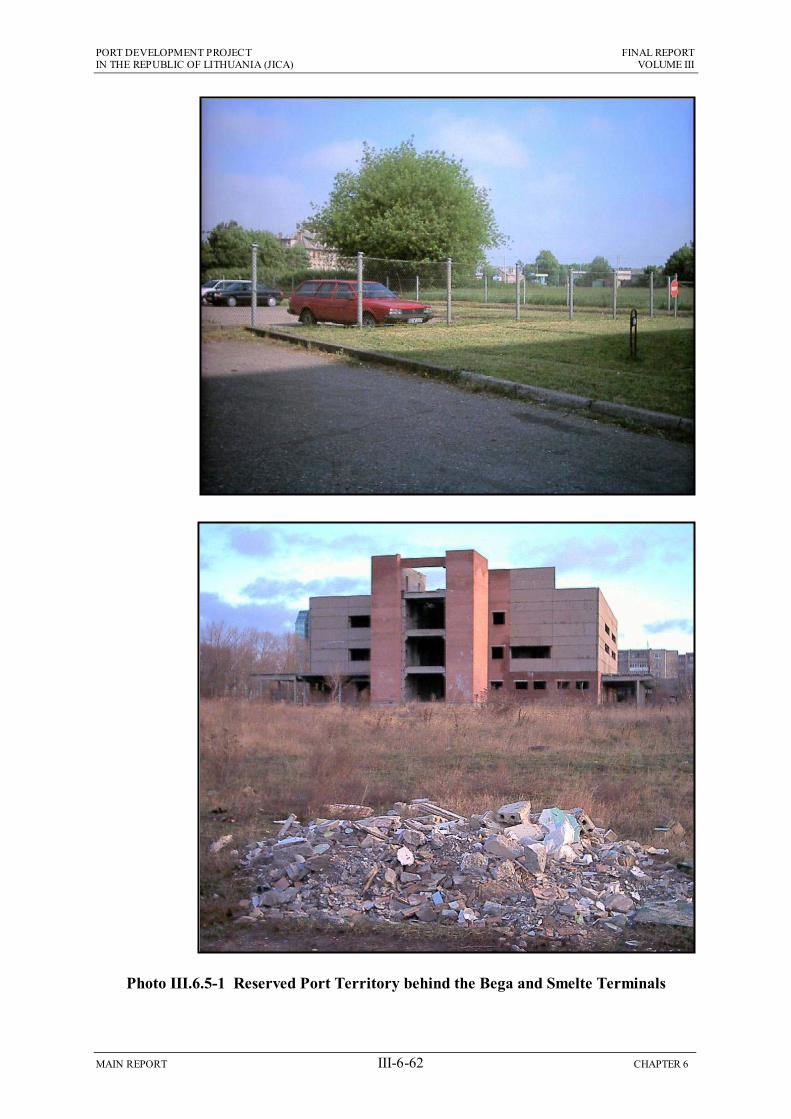
To the north the new route passes through port land in the Progresas yard, and then through reserved territory behind the Smelte and Bega terminals, and Photo III.6.5-1 shows that this area is also relatively flat and the ground is mainly solid. There will be some additional clearance of vegetation and other obstacles, but this should be a small-scale operation, carried out by manual labour and small backhoe diggers. Foundations will then be constructed from tipped and compacted stone, to form a small stable mound for the track, similar to that of the existing line (Photo III.6.5-2).
Some buildings may have to be demolished in the Progresas yard and in the reserved territory, but the route will be planned to avoid this as much as possible. Any demolition will mainly involve small older buildings, which can be removed by bulldozers, with the material being loaded into trucks and carried to an approved disposal site.

PO
RT
DE
VE
LO
PM
EN
T P
RO
JEC
T
FIN
AL
RE
PO
RT
IN
TH
E R
EP
UB
LIC
OF
LIT
HU
AN
IA (JIC
A)
VO
LU
ME
III
MA
IN R
EP
OR
T
III-6-6
1
CH
AP
TE
R 6
Table III.6.5-1 Main Environmental Impacts of the Developments Proposed by the Short Term Plan
RAILWAY IMPROVEMENT NEW OUTER PORT IMPACT CONSTRUCTION OPERATION
IMPACT CONSTRUCTION OPERATION
Physiographic changes caused by bridges, tunnels, cuttings
Topography is mostly flat; new line is adjacent to existing track
No major structures or physiographic changes
Changes in patterns of erosion and sedimentation
Weak sediment transport currents so changes not likely
Silt may collect on north side & coast elsewhere could erode
PH
YS
Secondary impacts: landslips, soil erosion, reduced aquifers
No major structures required, so no risk of secondary impacts
No major structures so no risk of related impacts
Physical changes at sites from where materials are extracted
Dredgings used for reclamation Rock imported from overseas
Not Relevant
Dust blown from worksites and soil washed into rivers/aquifers
No major earthworks, so little risk of dust or soil runoff
Not Relevant Dredging: turbidity plumes, polluted sediment disturbed
No impact if dredged material is pumped into reclaimed area
Avoid dredging in summer to prevent plume affecting beach
Atmospheric pollution from locomotives burning diesel fuel
Only small increases in rail traffic delivering materials
Route is open and windswept so pollutants will be dispersed
Reclamation: turbidity plumes, polluted sediment disturbed
Problematic if plume affects nearby beaches in summer
Not Relevant
CH
EM
ICA
L
Pollution from spills of fuel or chemicals kept on site, or cargo
No fuel or other toxic materials stored on site
Low speed line and new controls should avoid accidents
Pollution from spills of fuel or cargo, or dust blown from site
Fuels stored responsibly. Site dust should not reach Melnrage
Spills prevented by modern facilities and strict procedures
Loss of habitat, animals, plants along rail route
No important species or habitats along proposed route
Losses not significant because habitats/species not important
Benthos: animals killed by dredging and reclamation
Will destroy many animals, but none are known to be rare
Maintenance dredging will kill animals, but none are rare May obstruct coastal migration Disturbance causing animals to
leave areas near rail route No important species or habitats along proposed route
Losses not significant because habitats/species not important
Fish: impeded migration, loss of breeding or feeding grounds
May obstruct coastal migration & disturb breeding/nursery site May provide new breeding areas
Reductions in plant and animal populations severed by rail line
No important species or habitats along proposed route
Losses not significant because habitats/species not important
Birds: decreases because of disturbed breeding or feeding
No known important bird sites nearby
No known important bird sites nearby
Damage of habitats or species in or near protected areas
Route does not pass through or near protected areas
Route does not pass through or near protected areas
Damage of habitats or species in or near protected areas
Unlikely to affect protected area on Curonian Spit
Unlikely to affect protected area on Curonian Spit
EC
OL
OG
Y
Species colonise undisturbed areas near and between tracks
Construction disturbance will prevent colonisation
No large areas near or between tracks suitable for colonisation
Increased habitat/biodiversity; port water used as fish nursery
Disturbance will prevent significant colonisation
New benthos, herring eggs on rocks; water may be fish nursery
Need to acquire land, property and/or relocate residents
Government own land in port and adjacent to existing line
Not Relevant Need to acquire land, property and/or relocate residents
Sea bed owned by State. Some land needed for road & railway
Not Relevant
Decrease in value of real estate because of presence of rail line
Value of reserved territory may rise if it needs to be purchased
Land outside port is mainly low value so no major impact
Decrease in value of real estate because of presence of port site
Value of property in Melnrage may begin to fall
Values could fall (port) or rise (recreational developments)
Disruption and disturbance by transport of materials & cargo
Could affect port road and rail transport and local road traffic
Level crossings will minimise disruption of road traffic
Disruption and disturbance by transport of materials & cargo
Most materials brought by sea. Reclamation by dredged sand
South of Melnrage disturbed by increased lorry and rail traffic
Disruption of normal activity through loss of access to site
Land not used in south. Could disrupt activities in port
Land in south not used. Port activity will be reorganised
Disruption of normal activity through loss of access to site
Loss of access to Melnrage beach (south) and breakwater
New recreational area created between port and beach
Disturbance by noise, vibration and dust
Only two residential areas: disturbance will be temporary
Long-term disturbance of people living near new line
Disturbance by noise and dust Unlikely to affect Melnrage as new port is 300m offshore
Port noise may be heard on shore occasionally
Visual disturbance, permanent changes to landscape
Site is flat, mainly uninhabited and industrial in character
New line is not highly visible: mainly industrial background
Visual disturbance, permanent changes to landscape
Site highly visible along coast to N and S and in Melnrage
Natural landscape lost. Quiet area changed to recreation site
HU
MA
N
Increased employment and improved socio-economics
May create some jobs, but many need experience/training
Better cargo handling, trade, improved national economy
Increased employment and improved socio-economics
Local people employed; local firms supply goods & services
Improved trade, new jobs, improved national economy
CONCLUSION Minor negative impacts can be mitigated by careful planning, liaison with port and householders, and by compensating residents
CONCLUSION Significant economic and social benefits but changes in landscape, coastline and Melnrage property values could be very detrimental
RECOMMENDATION Fewer economic benefits than outer port, but scheme can go ahead without negative environmental impacts, so is recommended
RECOMMENDATION Not recommended, but economic needs and benefits may outweigh negative impacts and possible opposition from Melnrage residents
KEY: Highly Negative Negative Not Significant Positive Highly Positive
PORT DEVELOPMENT PROJECT FINAL REPORT IN THE REPUBLIC OF LITHUANIA (JICA) VOLUME III
MAIN REPORT III-6-62 CHAPTER 6
Photo III.6.5-1 Reserved Port Territory behind the Bega and Smelte Terminals

PORT DEVELOPMENT PROJECT FINAL REPORT IN THE REPUBLIC OF LITHUANIA (JICA) VOLUME III
MAIN REPORT III-6-63 CHAPTER 6
Photo III.6.5-2 Bega train on existing line behind Smelte Terminal
Photo III.6.5-3 Present activity on Progresas site

PORT DEVELOPMENT PROJECT FINAL REPORT IN THE REPUBLIC OF LITHUANIA (JICA) VOLUME III
MAIN REPORT III-6-64 CHAPTER 6
One structure that will have to be modified is the bridge that carries the existing line across the Smeltale River east of the Klaipedos Terminalas yard. Again this will be a relatively straightforward operation involving limited piling, and creation of pillars and a widened platform by pouring ready-mixed concrete into sections encased in wooden shuttering. This will not alter drainage or flow in the river.
These physical changes are all very minor, confined to small localised areas, and therefore should not be significant.
(2) Chemical Environment
Given that construction of the new line will involve no large-scale earthworks or creation of structures, then there will be no stockpiles of soil or other materials that could pollute the air or water around the site. There will be some localised decreases in air quality from emissions from the trucks and locomotives used to transport materials to the new line, but given the open and widswept nature of much of the terrain these will be dispersed quickly. There should therefore be no significant changes in chemical conditions around the site.
(3) Ecology and Nature Conservation
Land around the southern part of the route is mainly uninhabited, and covered with a scrub-type vegetation of grasses, shrubs and small trees, with some small ponds and reedbeds in places. The Smeltale River is small and is not known to contain any important species, and north of this the route passes through the Progresas site, which is mainly covered with gravel, asphalt and dilapidated buildings (Photo III.6.5-3). The line then runs through the reserved territory, which includes paved areas and land overgrown with scrub (Photo III.6.5-1). There is little ecological interest in any of these locations, and there are no protected areas along the route or nearby.
Construction will clear vegetation and inhabiting animals from a strip of 10-20 m, and will create noise which could disturb animals in the vicinity. However the fact that none of the areas or inhabiting species are of any particular ecological importance, means that any impacts will not be significant.
(4) Human Environment
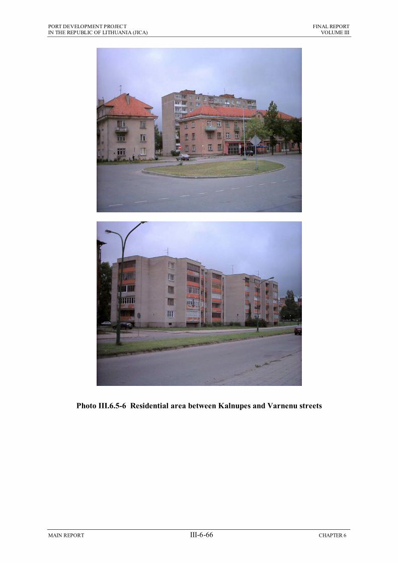
The human environment is more complex as the area that could be affected by construction includes locations that are quite different in character (see Section 6.2.5 and Figures III.6.2-13 and III.6.2-14). There is a largely uninhabited area in the south, a well-established village and large collection of private garages (used for storage) south of the Smeltale River in the centre (Photo III.6.5-4 and III.6.5-5), port areas in the north-west, reserved port territory nearby which includes both used and unused land (Photo III.6.5-1), and an inhabited area between Kalnupes and Varnenu streets with an estimated 5,000 residents (Photo III.6.5-6).
In terms of landscape, the route is across naturally flat terrain, and large parts of the surrounding area are uninhabited, so the construction activities should not be highly visible, even when the embankments are built in the south. Where the site can be seen from the residential areas, or by people travelling along Minijos gatve, it will be viewed against the industrial backdrop of the port to the west, and the neglected nature of the reserved area and the unused land in the south. In this context construction should not be considered as significantly damaging to the landscape.

PORT DEVELOPMENT PROJECT FINAL REPORT IN THE REPUBLIC OF LITHUANIA (JICA) VOLUME III
MAIN REPORT III-6-65 CHAPTER 6
Photo III.6.5-4 Village south of Smeltale River
Photo III.6.5-5 Privately owned garages east of Klaipedos Terminalas
PORT DEVELOPMENT PROJECT FINAL REPORT IN THE REPUBLIC OF LITHUANIA (JICA) VOLUME III
MAIN REPORT III-6-66 CHAPTER 6
Photo III.6.5-6 Residential area between Kalnupes and Varnenu streets

PORT DEVELOPMENT PROJECT FINAL REPORT IN THE REPUBLIC OF LITHUANIA (JICA) VOLUME III
MAIN REPORT III-6-67 CHAPTER 6
As the route lies mainly adjacent to the existing line or runs through port or reserved port areas, then there should be no need to purchase residential land for the construction sites or to relocate residents. Land ownership will be determined at a later stage, but acquisition is not expected to be a problem as land in the port and in the wayleave of the existing line is presumably owned by the Lithuianian Government and should therefore be made available for the project. If land in the reserved territory is owned by private companies and individuals this should be purchased amicably via fair negotiation. Construction should not cause a fall in real estate values, as the residential area in the north-west is 150 m from the route and is buffered by the reserved port territory, and in the village near the Smeltale River there is already a rail line in the vicinity. Prices of privately owned land might even increase if owners become aware that KSSA need to purchase land for the route.
Noise should not be an issue at most locations, which are either uninhabited, or within or near the port where people are accustomed to hearing noise from industrial activities, so an additional, temporary source should not be significant. This could be more of a problem in the two inhabited areas, as construction noise can travel a kilometre or more, depending on conditions and the nature of the sound. Between Kalnupes and Varnenu streets, roughly half of the estimated 5,000 residents live within 300 m of the route, and in the village south of the Smeltale River 300 m of track will run within 100 m of several houses, so people could be disturbed. However certain factors will reduce the significance of this impact, including the fact that:
Construction noise will be present for only a few months at any one location, while the line is installed;
Houses likely to be affected are all located between the port and Minijos Street (a major road route into the port and the city), so residents should be relatively tolerant of a degree of background noise.
It should therefore be possible to reduce this to an impact of little or no significance by implementing a few straightforward measures, such as:
Informing residents about the construction programme in advance, indicating that some noise will be produced;
Avoiding construction in these areas at critical times, particularly at weekends and during the hours of darkness.
Although the route is outside the main parts of both the city and the port, there is a risk that the construction process could disrupt normal activities in the vicinity. Much of the route is within a few metres of the only line providing rail access into the south of the port, and this line and adjacent roads will be used to deliver materials to the site. In the north the new line will pass through the existing port and reserved territory that is open to the public, and there may be a need to relocate parts of a minor public road (Nemuno Street) to accommodate the track. Construction activities could therefore disrupt road and rail traffic and thus cargo transport of several port operators (particularly Smelte, Bega and Transfosa) and could also impede public and private vehicles. These impacts will occur if construction causes:
Delays in rail traffic because the rail line is being used to deliver materials;
Road congestion from increased amounts of heavy traffic in the vicinity;
Temporary closure of roads while the line is being built nearby;

PORT DEVELOPMENT PROJECT FINAL REPORT IN THE REPUBLIC OF LITHUANIA (JICA) VOLUME III
MAIN REPORT III-6-68 CHAPTER 6
Permanent closure of Nemuno Street and loss of access to areas it serves;
Re-routing of vehicles in the port increasing delivery times.
These impacts could be significant if they caused dissatisfaction amongst the public, and moreso if they affected the economic performance of the port. However the impacts can all be reduced by careful planning of the construction activities, for example to ensure that key port access areas are only closed during less busy periods, that roads are kept open at peak times, etc. If the construction programme is planned thoroughly in conjunction with the key authorities (KSSA, Klaipeda Muncipality and the affected port operators) then this is another impact that should be reduced to an insignificant level.
Although construction projects often bring benefits to the community by employing local people in the workforce, this is less so for railway schemes where many of the activities require a degree of previous experience and training. Nevertheless all opportunities to employ local people should be taken, and wherever possible services and materials should be purchased locally, to reduce costs and maximise the benefits within the community that is most directly affected by the scheme.
6.5.2 Operation of the New Rail Line
Given that the process of constructing the new rail line is unlikely to have major impacts because the surrounding environment is not highly sensitive, then it would be expected that operation of the line should also not cause major problems. This is generally the case, although the human environment is again slightly more complex, because of the differing nature of certain areas.
(1) Physical Environment
The physical impacts of an operating railway are mainly the changes created by the construction process, which may be viewed as more significant as they are present over a much longer timescale. In this case the line will be constructed without major earthworks or large new structures, and with relatively small physical changes. These include the demolition of some buildings in and near the port, clearance and compaction of a narrow strip of land, creation of stone foundations for the new line in the north and construction of a new embankment in the south, 1-2.5 m high, and 9-12 m wide (max). These are minor physical changes, occurring in a relatively small area, so they should not be of any greater significance over the longer term.
(2) Chemical Environment
Although the likely increase in rail traffic along the new line has not yet been predicted, it is unlikely that it will produce any discernable change in air quality in the vicinity of the line or in Klaipeda as a whole. This is because as explained above, trains are considerably less polluting than road vehicles, the city is subject to strong sea breezes for much of the year, and there are no geographic or meteorological conditions likely to trap atmospheric pollutants and prevent dispersion.
At present rail is the main form of land transport serving the port, and in the south the main cargoes are imported raw sugar and apatite (Calcium Phosphate, a raw material for fertilzer production), and exported wheat, fertilizer (dry and liquid) and molasses (a liquid by-product from processing of beet sugar). The Short-Term Plan assumes that similar cargoes will be handled in the future, in increased quantities. Although
PORT DEVELOPMENT PROJECT FINAL REPORT IN THE REPUBLIC OF LITHUANIA (JICA) VOLUME III
MAIN REPORT III-6-69 CHAPTER 6
not especially hazardous these are mainly organic materials and plant nutrients, which would promote plant growth and deplete water of oxygen if spilled. These cargoes should increase in the period of the Short-Term Plan, so there is a risk that these materials could be spilled in an accident. However several factors suggest that this should not be a major risk, including the fact that:
This is not a high-speed line on which safety signals can easily be overlooked;
It is also a relatively simple network, without conflicting flows and major directional changes, with a relatively low traffic volume, even in the future;
Plans to upgrade the control tower at the Draugyste yard so that it can control rail traffic throughout the southern port will include provision of state-of-the-art technology and safety systems.
This is therefore not considered a major potential source of impact, and no special pollution control methods, and no prevention other than normal rail safety procedures should be necessary.
(3) Ecology and Nature Conservation
The area around the line contains no areas of nature conservation value, and no known species or habitats of particular ecological interest. Construction of the new line will cause the loss of only small areas of mainly scrub vegetation, and will disturb any animals living in the vicinity. These impacts will continue when the line is operating, but given the fact that none of the affected areas or species are protected or of any special value or interest, these impacts will not be significant, even over the long-term.
(4) Human Environment
Although landscape impacts are normally one of the key issues associated with both construction and operation of rail projects, this will not be the case at this location. As explained above this is because the site and the surrounding area is flat and low-lying so the line will not be highly visible, and the natural landscape is dominated by the port and includes scrubland and unused and neglected areas, so views will not be adversely affected by the addition of a rail line. This will also be the case in the operational period, so landscape impacts should be no more significant over the longer term.
However in the case of noise, the length of time over which the impacts will be felt, could increase their significance, at least in the two inhabited areas. It was suggested above that noise should not be an issue during construction as it is temporary and the houses that could be affected are in a location where residents will be accustomed to background noise from the nearby road and port. However depending on the amount by which rail traffic increases, the fact that an estimated 2,500 people live within 300 m of the track between Kalnupes and Varnenu streets, plus possibly 100 more near Smeltale River means that these and other residents could be disturbed significantly over the longer term. This will need to be investigated in more detail during a future stage of the project, and residents should be consulted regarding the issue. At the very least sound barriers should be constructed adjacent to the rail line to absorb and attenuate the noise. Other measures such as the provision of double glazed windows and further sound proofing in affected houses may also be necessary. Although the houses near Smeltale River have been built on land that is in theory reserved for
PORT DEVELOPMENT PROJECT FINAL REPORT IN THE REPUBLIC OF LITHUANIA (JICA) VOLUME III
MAIN REPORT III-6-70 CHAPTER 6
future use by the port, residents should be treated the same as other city dwellers, to prevent negative public perceptions about the project.
The aim of building the new rail line is so that, in combination with the proposed outer port development it will help to generate increased trade for the port, which will maintain and improve Lithuania’s position as a major trading and transportation hub in the region, and produce increased earnings for the government. If this occurs then there could be widespread highly significant benefits throughout the country if the government chooses to use the revenue for social projects, improving schooling and higher education, healthcare, housing, public transport, social security provision, etc. There would also be considerable benefits locally from the significantly improved employment opportunities that an expanded port would bring, which would improve the local economy, socio-economic conditions and many other aspects.
The contribution of the rail line will be relatively small in comparison to the major impact that the outer port development could have (described below) but nevertheless, like other measures planned by KSSA and the operating companies, it should still be a significant contribution, as one of the key improvements in the existing port
6.5.3 Construction of the New Outer Port
Although with the implementation of a few straightforward mitigation measures the proposed rail line can be constructed and operated without major negative impacts, that will not be the case for the outer port development. This will be built in a prominent location, which is used for recreation by local people, and is adjacent to one of the country’s main nature and tourism sites. It is also located within 600 m of the village of Melnrage, where the beauty and proximity of the coast are valued commodities, and where residents may therefore not be in favour of the scheme and the changes it will bring.
The proposals have been amended to address certain issues identified by the IEE and others raised by Klaipeda Municipality, and as a result many factors that could have created negative impacts, should now not be significant. However concerns remain regarding the long-term impacts of the development on the stability of the adjacent coastline, and despite proposed screening measures, the new port will still have very negative impacts on the landscape, which will become dominated by an artificial feature. The change in character of the area could also reduce the value of land and property in the area, which is likely to be an important issue for local residents. These and the other main factors are explained below.
(1) Physical Environment
The Outer-Port development proposed for 2025 by the Master Plan includes the creation of a 1 km2 area of reclaimed land, 3 km of breakwaters and a dredged basin of 1.5 km2, and the Short-Term Plan that is the subject of this EIA proposes to construct approximately 40% of the total development in the first phase, to the year 2015. As shown in Figure III.6.3-2 the main elements will include:
Two reclaimed areas, of 0.5 and 0.15 km2;
A 1.3 km2 basin, in which the present depth of 9-14 m will be increased to –17 m;
Approximately 2.2 km of rock and/or concrete breakwaters around the basin, including a 1.4 km extension of the present southern breakwater;
PORT DEVELOPMENT PROJECT FINAL REPORT IN THE REPUBLIC OF LITHUANIA (JICA) VOLUME III
MAIN REPORT III-6-71 CHAPTER 6
Three berths and two terminals on the main reclaimed area, initially one multi-purpose and the other for bulk cargo, with vacant areas for open storage at the quayside, and a warehouse, tanks and silos for solid and liquid bulks;
Oil products will be handled at the southern berth, which will be connected by pipes to tanks in the Nafta terminal in the existing port;
A 300 m wide bay between the Melnrage beach and the new port will be provided to Klaipeda Municipality for use as a marine recreation area.
Irrespective of whether they will be constructed from rock, concrete or a combination of materials, the breakwaters will be very large structures, projecting 5 m or more above the sea surface, and with foundations in 9-15 m of water. Dredging will also create a large, deep basin, in which 1.3 km2 of seabed will be dug to 3-8 m below the natural depth. The breakwaters will be constructed over approximately the first three years of the four-year construction period, and the dredging and reclamation will be completed during years 3 and 4.
The physical effects of these changes have been investigated in detail by mathematical modelling described in Chapter 2 above. This indicates that, despite the scale of the operation there will in fact be few effects on erosion and sedimentation patterns in the construction period. This is because as explained in Section 5.2.3 the direction of coastal drift is mainly from south to north on the Curonian Spit, and north to south between Palanga and Melnrage, suggesting that the Port entrance is at the boundary between two coastal sediment cells. Alongshore transporting currents are generally weak in such areas, which has been observed to be the case here. There is therefore little transfer of sediment along the coast and between the cells, and no large-scale mass transport of material that would cause noticeable changes in morphology if interrupted by the new structures and changed topography in the construction period.
The other way in which large coastal developments can affect the physical environment is by removing large amounts of rock, sand and soil from local quarries, riverbeds and other areas for use in construction, which can dramatically alter the physical condition of the extraction site. This should also not produce significant impacts in this case because:
Bed material from the area of the basin has been shown to be suitable for use in reclamation, so it is likely that most of this will be pumped straight into the reclamation area, leaving probably only small quantities to be made up from local quarries;
There are no sources of rock in Lithuania large enough to provide the sizes and quantities required for the revetments and breakwaters, so rock is likely to be imported on barges from several locations in Scandinavia or other countries in the eastern Baltic, keeping physical impacts at each individual site to a minimum.
(2) Chemical Environment
The decision to use dredged material as infill for the reclamation should greatly reduce the impact of this operation on water quality, as there should be none of the large plumes of turbid water normally associated with dredging, because material will be pumped straight into the reclaimed area.

PORT DEVELOPMENT PROJECT FINAL REPORT IN THE REPUBLIC OF LITHUANIA (JICA) VOLUME III
MAIN REPORT III-6-72 CHAPTER 6
Plumes will still be produced by water overflowing from the reclamation site, but these would only be a problem if beaches to the north and south of this area were affected during the summer recreation period. This can be reduced by some relatively straightforward measures including:
Locating overflow weirs at the north-western corner of the reclaimed area, thus increasing the dispersion of suspended solids by wave action in deeper water, and directing the plumes away from the more important beaches on the Curonian Spit in the south;
Planning the operation so that no reclamation work is carried out in July and August, which are the two most popular months for beach recreation.
Section 5.2.4 above shows that sediment near the mouth of the channel and along the coast is relatively free of pollution, so there should be no risk of chemicals being released into the water when the material is dredged or deposited into the reclaimed area.
There could be negative impacts if chemicals used or stored on site (such as oil, fuels, etc) were spilled and washed into the water, polluting the adjacent sea and beaches. Such incidents are routinely prevented on construction sites by ensuring that polluting materials are used responsibly and stored securely in areas protected by concrete bunds. If this is done this should also not be a significant source of impact.
When the reclamation is completed the surface will be left uncovered, and concrete and asphalt pavement will gradually be laid onto specific areas as the road, rail lines and other facilities are built. Given that the main reclamation will be a minimum of 300 m offshore, then even if the majority of the surface is left uncovered, windblown dust from the site should not reach Melnrage, which is already naturally exposed to a degree of blown sand, from the beach.
(3) Ecology and Nature Conservation
The northern boundary of the Curonian Spit National Park runs due west from the beach adjacent to the southern breakwater (see Fig III.5.2-10), but despite the proximity it is unlikely that construction of the outer port will affect any habitats or species in the protected area. The mathematical modelling has shown that there should be no physical changes in the beach or sub-tidal habitats during this time, and this part of the park is also not particularly important ecologically because colonisation is limited by the presence of tourism facilities on the eastern side and popular beaches on the west. The only risk would be if noise or activity at the construction site disturbed any birds overwintering in the northern beach area, or nesting here in the spring. Surveys should therefore be carried out to determine whether this area is important for birds in winter and spring, so that construction can be restricted during key periods if necessary.
Large numbers of marine organisms living in or on the sea bed at the construction site will be killed by being covered by the breakwater structures and revetments, pumped through the dredger with the sediment they inhabit, or smothered by material deposited into the reclamation area. However the site area is a very small proportion of the coastal belt as a whole, so even though many millions of organisms will be lost, this should not affect the health or functioning of the overall ecosystem. In addition the regular monitoring conducted by both KSSA and the MoE Centre of Marine

PORT DEVELOPMENT PROJECT FINAL REPORT IN THE REPUBLIC OF LITHUANIA (JICA) VOLUME III
MAIN REPORT III-6-73 CHAPTER 6
Research has shown no particularly rare or important species inhabiting the seabed in this area, so this should not be viewed as a significant impact.
Fish tend to avoid areas being dredged and sites of marine construction because they are disturbed by noise, vibration or activity in the water, and their gills and other sensitive surfaces are irritated by suspended sediment in plumes of turbid water. The Ministry of Environment therefore normally impose restrictions on work in the channel during key periods of fish migration, in an attempt to avoid impacts on migration and spawning. The current practice, implemented for the recent deepening of the channel entrance, is to restrict dredging to half of the channel between 1 April-31 May, and prohibit all dredging in the intensive migration period of 15 April-15 May. However this may not be suficient to prevent all impacts on fish in the case of this project.
Figure III.6.2-9 above suggests that the location proposed for the outer port development is very important for the marine fishery of the area, because:
Fish that migrate into the lagoon travel along the nearshore area above approximately the 10 m depth contour, and enter the channel around the tip of the breakwaters;
Both breakwaters are important spawning sites for herring, which lay eggs on the rocks in large quantities during the spring;
The breakwaters are also important nursery areas for herring and other species as the juvenile fish stay in and around the protective rocky areas until they grow into young adults.
It is possible therefore that the presence of significant aquatic based construction at this location over a four-year period, that includes removal of a large area of seabed and creation of a substantial reclaimed area and solid breakwaters stretching out to the 14 m contour, could impede fish migration and subsequent spawning. This might be counterbalanced to an extent if the new breakwaters provided new spawning grounds and nursery areas, but this is unlikely to occur until construction and disturbance have ceased, and these areas are not suitable for all species. If migration and spawning of rare or commercially important species were reduced, then effects on fish stocks, commercial catches and biodiversity, could be very negative.
At present only one source of data has been located that suggests that this area is important to fish for the above reasons (Institute of Geography, 2000), so before any firm conclusions are drawn, this should be investigated further. At this stage all that can be said is that construction of the outer port could have negative impacts on the fishery and biodiversity if it impeded fish migration, and that this needs to be investigated further to establish whether this is likely, and if so, to determine what preventative action needs to be taken.
(4) Human Environment
As explained in Section 6.5.3 above, construction of a new port can have a variety of impacts on nearby communities. These can include:
Disruption of traffic by increased numbers of heavy vehicles on local roads;
Disturbance from noise and dust produced by vehicles and the construction site;
PORT DEVELOPMENT PROJECT FINAL REPORT IN THE REPUBLIC OF LITHUANIA (JICA) VOLUME III
MAIN REPORT III-6-74 CHAPTER 6
Loss of access to areas that are important for local activities;
Loss of land if the development is to be located on privately owned areas;
Reduction in the value of surrounding property because of the proximity of a construction site;
Visual disturbance by the construction activities and their more permanent impacts on the landscape.
The outer port will involve construction of some very large structures, which willrequire large quantities of rock, sand and concrete for the marine works, plus bricks and blocks, concrete and metal components, and many other items for the on-land facilities. This was identified during the IEE as a potential source of major disruption and disturbance for the people of Melnrage if these materials were transported by road, as it would involve very large numbers of lorry movements over most of the four-year construction period. Because of this, and in the light of further investigations during the Study, alternative measures have been devised which should reduce this to an impact that is not significant. This is because:
The most likely source of rock for the breakwaters and revetments is Scandinavia or other countries on the eastern Baltic, and rock will be brought to site on barges;
Seabed material at the site has been found to be suitable for use in reclamation so it will be pumped straight into the area from the dredger, removing completely the need to transport these very large quantities by road from local quarries;
Certain companies operating in the port have the capacity to manufacture concrete caissons and other pre-cast components, which can thus be transported to site by barge;
The development as now proposed includes a corridor for new road and rail access to the port south of Melnrage, which can be used to carry any material to site that cannot come by sea, thus avoiding the centre of the village.
Loss of access is another issue where potential impacts have been reduced by action taken during development of the project. In the IEE it was suggested that local people might be unable to use the Melnrage beach if the reclaimed area was built close to the shore. However it has now been decided to locate the main reclamation 300 m offshore so that usage of the beach can continue, and the small embayment between the port and the beach will be provided to Klaipeda Municipality for development as a marine recreation site. The smaller reclaimed area, connecting the outer port to the land, will still result in the loss of a 250 m length of beach at the southern end. However this should not be significant as it is adjacent to the port and is thus not greatly used, and the creation of a new recreation area should compensate for this loss.
Acquisition of land will also not be an issue in this case as most of the development will be on land owned by the Lithuanian government, including the subtidal zone, nearby land at the north of the port, and the road and rail route through Girulai Forest. If any other small areas of privately owned land are needed, purchase should be negotiated amicably with the owners.
There are two remaining issues where it has not been possible to devise measures that would reduce impacts to the level of little or no significance.

PORT DEVELOPMENT PROJECT FINAL REPORT IN THE REPUBLIC OF LITHUANIA (JICA) VOLUME III
MAIN REPORT III-6-75 CHAPTER 6
The first is the value of land and property in Melnrage, which is likely to have risen in recent years as there has been an increase in high quality housing in the area (Photo III.6.5-6), and an increase in residents in higher income brackets. Melnrage could be considered a less desirable area once construction of the port begins, as the site will be both visible and audible from the village and the beach, and potential purchasers may be deterred by the knowledge that a port will soon be operating nearby. If property values declined this would be highly negative for both long-established and newer residents, particularly those who have invested in large houses, or businesses serving the many visitors who use the area for beach-based recreation.
Property values are determined by many factors, such as the economic health of an area, public perceptions and aspirations, etc. These cannot be directly influenced by a construction project, so it is not possible to mitigate this impact within the context of this development.
Landscape impacts are the other issue where no suitable mitigation has yet been found. As with most large projects, effects on the landscape begin with views being disrupted by the presence of site vehicles and machinery during the construction stage, and then the appearance of the area begins to change gradually as excavations commence and structures are built. Once construction is complete the temporary structures are removed, vehicles and personnel leave and the site is reinstated for the operational phase. However the built structures and other changes remain, in a landscape that is permanently altered.
The landscape of the Lithuanian coast is rugged and beautiful, dominated by wind and waves, white sandy beaches, and spectacular sand dunes. At present the landscape is largely unaffected by coastal development, and for more than 50% of the country’s coastline, development is prohibited, in the Curonian Spit National Park. Klaipeda Port is a large industrial area that extends into the coastal zone, but even on nearby beaches it is largely hidden from view because of the low elevation of the beaches, and the screening provided by dunes and forest at the top of the shore. The beaches, sea and landscape attract large numbers of visitors, who contribute significantly to the local economy. Their main destinations are Palanga and the beaches at the north of the Curonian Spit, and these areas and others between, including Melnrage, are used also by many Klaipeda residents.
The surface of the reclaimed area and breakwaters will be 5 m above the level of the sea, and many of the construction vessels and vehicles are several metres in height. This means that soon after commencement the site will be visible along the coast, and visibility will increase towards the end of the construction phase when the quayside warehouse, tanks, silos, conveyors and other structures are built. Although these blend into the disordered landscape of an existing port (see Photos III.6.3-6 – III.6.3.9) they will be very visible on an island 1 km offshore. The site will be visible 6 km north at the “Dutch Cap” (Olandu Kepures) landmark, and possibly 20 km or more from the south because the coast is concave in shape (Figure III.6.2-9). In Melnrage village (Photo III.6.5-7) the site will be hidden from view at ground level by buildings and the dunes and woodland at the top of the shore, but it will be visible from the upper floors of many of the newer buildings (Photo III.6.5-6).
The construction site and the changes it will impose on the landscape, will be visible over 25 km or more of coast that is heavily used in summer by visitors and residents.

PORT DEVELOPMENT PROJECT FINAL REPORT IN THE REPUBLIC OF LITHUANIA (JICA) VOLUME III
MAIN REPORT III-6-76 CHAPTER 6
Photo III.6.5-7 New housing at Melnrage

PORT DEVELOPMENT PROJECT FINAL REPORT IN THE REPUBLIC OF LITHUANIA (JICA) VOLUME III
MAIN REPORT III-6-77 CHAPTER 6
The unspoilt natural beauty is one of the main features that attract people to these areas, and this will be seriously damaged by the presence of a large construction site, and by the port structures which will dominate views as they develop. Given the importance of the coast in attracting tourists and providing an area for local recreation, and the international importance of the landscape of the Curonian Spit as shown by its status as a World Heritage Site, then these must be considered as highly negative impacts.
To reduce the visual impacts of construction sites in urban areas, wooden barriers are often erected around the perimeter to screen the site from view, and these are removed once the development has been built. This would not be appropriate at this site, as high fences would impede views of the sea from the adjacent beaches and land, and a coastal landscape with prominent wooden fences would be almost as negative as viewing the site itself. Screening by earth banks would also not be appropriate, as such structures would be out of place in a coastal situation. In the absence of any suitable method to make the site less visible, it must be concluded that this is a highly negative impact that cannot be mitigated.
It would still be appropriate to improve natural screening at Melnrage, which is where most impacts of this scheme are likely to be of greater significance. Here the site is already hidden to an extent by sand dunes and wooded areas at the top of the beach, and by the buildings of the village. The dunes are lower than those on the Spit and less actively protected (Photo III.6.5-8), so they are subject to a degree of trampling and erosion. Measures to replenish sand and increase the height of the dunes by 1-2 m would improve the environment of the area and help to mask the site from view. Marram grass would need to be planted to stabilise the dunes, and protective brushwood fencing would also be beneficial. Fast-growing evergreen trees should also be planted on the landward side to extend and increase the screening provided by the existing woodland.
As with most other large projects there are also positive impacts on the human environment during the construction stage, as local people will be employed in the workforce. This should improve the income and thus the socio-economic conditions of the workers, and provide at least a temporary boost to the local economy. For the same reasons, local companies should be employed to provide materials and services where appropriate. It might help to improve local perceptions of the scheme if as many staff and services as possible were obtained from the Melnrage area.
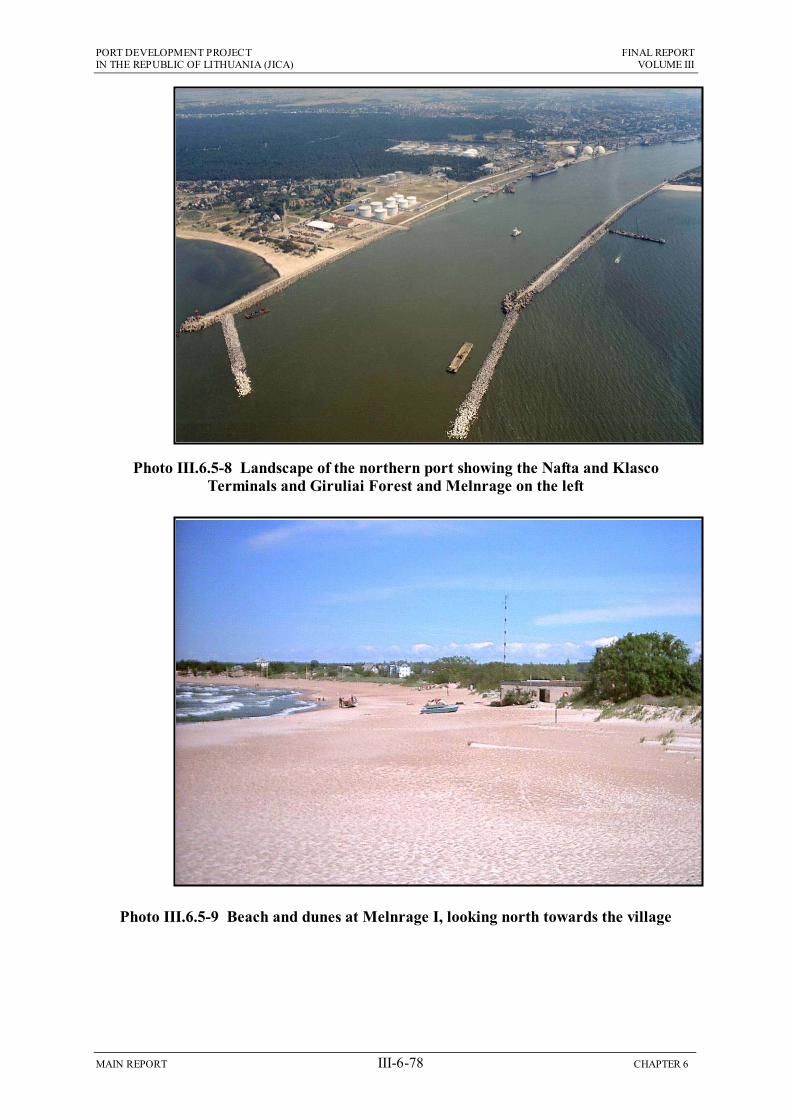
PORT DEVELOPMENT PROJECT FINAL REPORT IN THE REPUBLIC OF LITHUANIA (JICA) VOLUME III
MAIN REPORT III-6-78 CHAPTER 6
Photo III.6.5-8 Landscape of the northern port showing the Nafta and Klasco Terminals and Giruliai Forest and Melnrage on the left
Photo III.6.5-9 Beach and dunes at Melnrage I, looking north towards the village

PORT DEVELOPMENT PROJECT FINAL REPORT IN THE REPUBLIC OF LITHUANIA (JICA) VOLUME III
MAIN REPORT III-6-79 CHAPTER 6
6.5.4 Operation of the New Outer Port
(1) Physical Environment
As explained in Section 6.5.3 above, the exit from the port channel is at the border between two sediment cells across which there is little transport of material, so the new structures and topography created by the outer port will not cause significant changes in coastal morphology in the construction period. However the mathematical modelling presented in Chapter 2 suggests that over the longer term sediment could gradually build up on the northern side of the development. If this were to occur, and as a result there was a deficit in the supply of sediment to other parts of the coast, then beaches and dunes elsewhere might be subject to erosion. This is of concern given current reports of erosion around Olandu Kepures in the north, where there are already fears of flooding, loss of land, and adverse impacts on the important tourist beaches near Palanga.
The mathematical modelling also indicates that the majority of the suspended sediment that presently flows from the Curonian Lagoon through the port channel and out to sea towards the north, will collect in the dredged basin once the outer port has been built. This could exacerbate the present coastal management problems if this material contributes to the sediment budget of the northern area. Clearly this needs to be studied further to determine the role of beach material from Melnrage and suspended sediment from the lagoon, and the impact on the wider coastline of this material becoming trapped by the new structures. These impacts would be highly detrimental if they did increase coastal erosion elsewhere, so this needs to be investigated prior to final decisions being made about the port development.
This situation will need to be monitored carefully if the development is constructed, because remedial action could require regular dredging of sediment from the basin and the northern side of the port, and re-deposition along the coast to restore the natural balance. Beaches may also need to be recharged with additional sand dredged from elsewhere if they become depleted. As windblown beach sand is also the source of material for the dunes, monitoring will need to include these areas as well to ensure that dunes do not also suffer degradation from a reduction in the sand supply.
Sediment will also need to be removed from the northern side of the development if it accumulates close to the shore and reduces flushing of the embayment and creates muddy areas on or near the beach. Effective flushing will be necessary to maintain water quality in the bay, and this will be essential if it is to be used for marine recreation (see below). If water quality did decline and the beach became muddy, this could discourage people from visiting the area.
(2) Chemical Environment
When the new port area is operating, it will handle mainly bulk materials in the period of the Short-Term Plan (oil, grain, and solid and liquid fertilizer), so there is considerable potential for pollution to occur, from spillages when materials are handled or stored, and from shipping accidents. Given the proximity and international importance of the beaches and coastal habitats of the Curonian Spit, then pollution incidents could have serious consequences on ecology, recreation and the local economy if they were to affect this area.

PORT DEVELOPMENT PROJECT FINAL REPORT IN THE REPUBLIC OF LITHUANIA (JICA) VOLUME III
MAIN REPORT III-6-80 CHAPTER 6
Pollution is minimised at many ports by the application of modern technology and facilities, and this should be the case at this site. State-of-the-art cargo handling and storage facilities will be provided, including suction unloaders, covered conveyors and enclosed storage (tanks, silos and a warehouse), with modern and effective dust extraction and other pollution control measures. It is recommended that KSSA also ensure that companies operating in the new port do so to the highest environmental standards. To facilitate this KSSA should:
Require that the environmental performance of operators is certified and routinely confirmed by mandatory ISO 14001 accreditation;
Conduct an overall pollution risk assessment for the new port area and establish a contingency plan to contain and clean up any major spillage (of oil or other chemicals);
Expand the role of their own environmental experts to include regular inspections of the new port and the operators to ensure that all work is conducted according to the established policies and procedures.
One aspect of the design of the new port that could be detrimental to water quality in the surrounding area is the fact that the northern breakwater does not meet the outer breakwater, but instead a gap of 100 m is to be left (see Figure III.6.3-2). This means that any material or chemicals spilled in the port for whatever reason could easily exit through this area, and then be carried towards the Melnrage beaches (including the embayment to be used for marine recreation). This would be the case for visible materials that mainly float on the surface (such as oil) and invisible materials like chemicals that are dispersed throughout the water column. If this space in the breakwaters is being left for reasons of economy only, then it should be closed, so that any pollutants spilled in the new port can be contained and dealt with within that area.
As mentioned above, if the embayment between the new port and the beach is to be used for marine recreation then water quality in this area will need to be maintained to a high standard, both in terms of its appearance, and the substances it contains (including chemicals and sewage bacteria). The port structures will protect the bay from current- and wave-action, so the only exchange of water with the open sea to the north will result from tidal movement, which in this area is very low (the daily tidal range is normally a few centimetres only). There are no known sources of pollution along the Melnrage coast, and the data presented in Section 6.2.3 indicate that the water is presently of good quality. However even unpolluted seawater can become stagnant if it is confined, and if oxygen is not replenished by phytoplankton photosynthesis or wave action. This is another aspect that will need to be monitored closely during port operations, so that action can be taken to flush the bay and clean and aerate the water if necessary.
It should be noted that water quality is likely to be a much more significant issue with respect to the embayment created by the Master Plan development (Figure III.6.3-3), as the full structure will confine the water in the bay even further, and water in the south of the area will receive very little exchange. This is another factor that will need to be studied in detail by mathematical modelling prior to decisions being made about the development, particularly as the provision of a marine recreation area for the local community is suggested as a major positive aspect of the scheme.

PORT DEVELOPMENT PROJECT FINAL REPORT IN THE REPUBLIC OF LITHUANIA (JICA) VOLUME III
MAIN REPORT III-6-81 CHAPTER 6
(3) Ecology and nature conservation
If pollution incidents are prevented in the new port as suggested above, then there should be no impacts on ecology and nature conservation from materials spilled on land or into the water during routine operations.
The operating port should also not affect species or habitats in the National Park, because even though the boundary is only a kilometre away to the south, as explained above this area is not particularly important for ecology, and even if birds overwinter or nest here, they should not be unduly disturbed.
However there could be negative impacts on fish if as suggested in Section 6.5.3 the new port and breakwaters were to impede the migration of fish along the coast, and/or reduce the numbers able to enter the channel and thus reach their spawning grounds in the lagoon. Presently available data suggests that the migrations occur mainly in the inshore area, below approximately 10 m depth, and that fish enter the channel around the ends of the breakwaters (Figure III.6.2-9). The breakwater ends will be 1.4 km farther offshore once the new port is constructed, in deeper water (14-16 m), which might thus prevent certain species or individuals from entering the channel. If this occurred during the construction phase when the structures are being built, it would be much more significant if it continued over the longer-term when the port is operating.
Presently only one source of data has been located that suggests that the migrations follow this route (Institute of Geography 2000), so it was suggested above that further study is necessary to confirm the validity of the data before definite conclusions can be drawn. As well as determining the patterns of coastal migration, routes of entry into the channel and the importance of the breakwaters and the Melnrage coast as a spawning and nursery area (see Figure III.6.2-9), this should also assess the degree to which the new structures might impede migration and spawning, and any long-term impact on fish populations, the fishery and biodiversity. This will enable the significance of this as a long-term impact to be assessed, so that mitigation can be devised if necessary. Mitigation could be difficult as measures to provide an opening into the channel through the port in the inshore area (for example by building a canal between the proposed recreational area and the basin for service boats), could allow pollutants spilled in the port to reach the coast outside, which could have other detrimental impacts as explained above.
Any long term impacts on fish could be counterbalanced to an extent because the new rock surfaces of the breakwaters should provide an increase in the spawning area available for herring, which could increase population numbers. The protected water in the new harbour might also be used by certain species as a nursery area (where newly hatched fish remain until they grow into adults), as sometimes happens if the quality of the water is kept high enough. However these benefits would not apply to all species, and would not remove the need to mitigate any impacts of impeded migration and spawning.
The new port would produce one other minor ecological benefit by providing a greater amount and variety of hard surfaces than are available in the offshore area at present, which is dominated by soft sediment (Figure III.6.2-3). The hard surfaces would be colonised by barnacles, mussels, seaweeds, molluscs, crabs and other organisms typical of rocky substrates, so the fauna of the area would be more diverse.

PORT DEVELOPMENT PROJECT FINAL REPORT IN THE REPUBLIC OF LITHUANIA (JICA) VOLUME III
MAIN REPORT III-6-82 CHAPTER 6
(4) The Human Environment
As explained in Section 6.5.2 above, the main purpose of expanding Klaipeda Port is to enable it to compete in the future with ports in the surrounding countries, and thus to bring increased trade and revenue into Lithuania. The amount of new income cannot be predicted with certainty, and its usage will depend on Government policy. However it is reasonable to expect that a successful port expansion could bring some widespread and significant improvements in various aspects of Lithuanian society, which might include increases in public spending, investment in healthcare and social service provision, improved public education, transport, etc.
Benefits in Klaipeda are easier to pinpoint, and these would include increased employment, more money being spent locally, stimulating local businesses and improving socio-economic conditions, all producing a more buoyant economy. Together with the improvements in the country as a whole there is no doubt that a successfully expanded port would bring significant improvements in the human environment.
There would however be negative impacts, including disturbance in the south of Melnrage from port-related road and rail traffic, and more importantly permanent changes in the landscape and character of the area, and possibly also effects on real estate values.
Figure III.6.3-2 shows that the proposed new road and rail access routes will run immediately past the southern edge of Melnrage. Even though this is the less inhabited part of the village, many houses will be subject to increased noise from the heavy lorries and rail waggons carrying cargo to and from the port, and this could be considerable if the new facilities reach the volumes predicted elsewhere in this report. Clearly this will need to be the subject of further study once the traffic volumes are estimated more accurately, and this should predict the noise contours and the number of houses likely to be affected by increased levels. Residents will then need to be consulted and informed about the noise increases before construction begins, and mitigation could include offering double-glazing and other sound proofing measures, plus financial compensation if necessary. If possible a buffer of evergreen trees should be planted on the northern side of the road to absorb and attenuate some of the noise and provide a visual screen.
The impact of the outer port development on the landscape of the area was discussed in some length in the IEE, and it was concluded that:
The development would be visible along at least 26 km of coast from the Olandu Kepures landmark in the north to the beaches in the centre of the Curonian Spit in the south, and from Melnrage village 600 m to the east;
The Spit includes the most important recreation and tourist beaches in Lithuania, in an area which is nationally and internationally recognised because of the beauty of its landscape;
The beaches to the north are less popular, but nevertheless are important to local people, many of whom prefer this area to the more crowded southern coast;
Some of the newer Melnrage residents have moved there because of the peace and tranquility of the area and the proximity of the beach, and several have invested in businesses which depend on trade from visitors;

PORT DEVELOPMENT PROJECT FINAL REPORT IN THE REPUBLIC OF LITHUANIA (JICA) VOLUME III
MAIN REPORT III-6-83 CHAPTER 6
The new outer port will dominate views of the coastline and reduce the beauty and value of the landscape, making the area less attractive for visitors and residents, which could reduce visitor numbers and damage the local economy.
Because of this a number of changes were introduced into the scheme, aimed at reducing its impact on the landscape, and changing the overall character of the development to one that presents a more positive appeal to the public. These are as follows:
The location of the main reclamation area has been moved farther offshore (300 m) to retain the beach at Melnrage;
Trees will be planted along the northern and eastern edges of the new port to screen it from view;
The northern and eastern breakwaters will include a promenade along the crest, allowing people to walk from Melnrage to the end of the northern breakwater 1.6 km offshore;
A lighthouse will be built at the end of the promenade, to provide an attractive feature;
The bay between the new port and the beach at Melnrage will be provided to Klaipeda Municipality for development as a marine recreation area, which could include a marina for pleasure craft;
Some land on the adjacent reclaimed areas will also be provided to the Municipality for use in developing other leisure activities.
The last two measures are linked to the new Municipal Plan (to 2020) soon to be published by Klaipeda Municipality, which designates the Melnrage coast as an area for marine recreation, and proposes construction of a small island and promenade a few kilometres to the north of this site.
These measures will reduce the significance of some of the above impacts, and provide a more positive appearance. The promenade and recreational facilities should attract far more visitors to the area than at present, and this will provide expanded business opportunities for those Melnrage residents who are sufficiently entrepreneurial to take advantage. The trees around the site will also mean that the buildings, ships and operations of the port are less visible, at least once the trees have matured.
However these developments may not be viewed as wholly positive by all of those who may be affected. The changes will alter the character of the Melnrage area, which at present is a quiet coastal location with natural beauty and uncrowded beaches and bathing in the summer, and instead it could become a busy modern recreational site, with many associated facilities and attractions both in the water and on the land. Some residents will almost certainly be in favour of these changes if they are able to take advantage of the facilities or the business opportunities, but others, possibly those who are more interested in the peace and tranquility of the area, may be less enthusiastic. The views of the residents should be taken into account in any decisions regarding the future of the area, so it is important to determine public opinion by consulting all Melnrage residents as soon as possible. If a significant proportion of the population are opposed to the proposals then alternatives to the recreational developments or even the outer port scheme may need to be considered.
PORT DEVELOPMENT PROJECT FINAL REPORT IN THE REPUBLIC OF LITHUANIA (JICA) VOLUME III
MAIN REPORT III-6-84 CHAPTER 6
If communities become opposed to a development it can be difficult for the proponent to devise mitigation that is viewed as acceptable, so this issue will need to be approached with sensitivity. Measures that have been effective for large projects elsewhere include the development of a Resettlement Plan with the community, which allows affected persons to relocate voluntarily to suitable alternative accommodation elsewhere. Financial compensation might also be considered as a means of mitigating disturbance or loss.
The impact of the proposed changes on real estate values will need to be predicted accurately, as this may be a key factor in determining the response of the residents. This is a complex issue as property values might be expected to fall in an area adjacent to a new industrial development, but they could rise at a location where there is investment in new recreational facilities and visitor attractions. Specialist assistance should be sought to ensure that any such predictions are reliable, given the importance of the issue in forming public opinion.
The final issue remains the long-term impact of the scheme on the landscape. The marine recreation area, promenade and adjacent woodland will undoubtedly make the area more visually attractive than the open views of the port, and when the trees have matured they should screen the port from the north and east, leaving only the upper parts of taller structures visible. However, this will not alter the fact that this is a large artificial structure that will dominate views over a long stretch of coastline, the appearance of which is almost entirely natural at present. The trees may make the port less visible, but they will still appear unnatural, located on a concrete island and breakwater stretching almost 2 km from the beach. The port also cannot be screened from the south, because planting trees along the long southern breakwater would be inappropriate, given the overriding natural appearance of the Spit and the importance of its landscape. The breakwater extension would remain very visible from this important location, together with the upper parts of ships and on-land structures (such as the tanks, silos, loaders and conveyor), which will be seen over the top of the breakwater.
Given these various factors and the national and international importance of the landscape to the south of the site, then the residual impacts of the scheme on the landscape must be assessed as significantly negative, despite the measures that have been introduced.
This does not mean that the development should not be built. Many other schemes have been built around the world with much greater environmental impacts than this. It does mean however that the decision on whether or not to build the new port at this location needs to be made in the understanding that it will have permanent negative impacts on an internationally important environmental feature. If the economic needs of the country are more important, and if those needs cannot be fulfilled by expansion and refurbishment within the existing port, then it may be necessary to build the new development at Melnrage despite its negative landscape impacts, and even if the majority of local residents are opposed to the scheme. Identifying these as impacts that cannot be mitigated and will thus remain, enables an informed decision to be made.

PORT DEVELOPMENT PROJECT FINAL REPORT IN THE REPUBLIC OF LITHUANIA (JICA) VOLUME III
MAIN REPORT III-6-85 CHAPTER 6
6.6 Conclusions and Recommendations: Existing Port
6.6.1 South Access Railway Inprovement
(1) Construction
The EIA presented in Section 6.5.1 above indicates that the new rail line between Draugyste Station and the Bega Terminal 5.5 km to the north-west can be built without major negative impacts. This is mainly because over the southern half of the route the line will be located adjacent to an existing line, the area is naturally flat so there will not be a requirement for major earthworks or structures, and there are few sensitive receptors along the route such as houses, businesses, or areas that are important for other reasons.
There could be some minor negative impacts on the human environment, which are:
Land in the reserved port territory behind the Smelte and Bega Terminals could be privately owned, so this land may need to be purchased by KSSA;
Inhabited areas between Kalnupes and Varnenu Streets (estimated 5,000 residents) and the village south of the Smeltale River (200 residents) could be affected by noise, during the few months that construction is carried out near these areas;
Road, rail and cargo traffic could be disrupted by several activities, including closure or re-routing of roads to allow construction nearby, usage of the rail line to deliver site materials, increases in heavy traffic on local roads, or the permanent closure of Nemuno Street.
These are all very small-scale impacts which can be reduced to the level of not significant by some very straightforward measures. These are:
If any privately-owned land needs to be purchased to allow construction of the line, this should be negotiated amicably with the owners, and current market values should be paid;
Residents of the two inhabitated areas should be informed about the construction programme in advance, indicating that some noise will be produced;
Construction near these locations should not be carried out at critical times, particularly at weekends and during the hours of darkness;
The detailed construction programme should be planned in conjunction with KSSA, Klaipeda Municipality and the affected port operators to minimise disruption of ongoing activities in the port and outside.
Although construction projects normally bring some temporary economic benefits by employing local people in the workforce, this may not be the case here as rail construction is a fairly specialised activity, and most jobs require some previous experience and training.
(2) Operation
Section 6.5.2 indicates that the rail line can also be operated with few negative impacts, because of the nature of the area and its overall lack of sensitivity. Again the human environment is the one area in which there could be negative impacts, and once more these relate to the effects of noise in the two inhabited areas:

PORT DEVELOPMENT PROJECT FINAL REPORT IN THE REPUBLIC OF LITHUANIA (JICA) VOLUME III
MAIN REPORT III-6-86 CHAPTER 6
Depending of the amount by which rail traffic increases, noise could disturb people in the two inhabited areas, where approximately 50% of the residents live within 300 m of the track.
The following action should be taken to reduce this to a non-significant impact:
Noise measurements should be taken in each area, and residents should be consulted to determine whether noise is causing significant disturbance;
If it is, then noise barriers should be erected adjacent to the line, and sound proofing measures offered to residents, such as provision of double-glazed windows.
There should be highly positive impacts once the new line is operating, because in combination with other measures in the existing port planned by KSSA and the operating companies it will improve facilities and help to generate increased trade and government income. This could bring widespread positive impacts if it were spent on improvements in education, healthcare, social security provision, transport, etc. The contribution of the rail line is small in comparison with that of the outer port development (see below), but it should still be viewed as significantly positive. There will also be local economic benefits from increased employment opportunities.
(3) Overall Conclusions
If the measures recommended above are implemented, then the new rail line should produce no environmental impacts when it is built, and significant positive impacts when it is operating, by contributing to the improved facilities in the existing port, and thus helping to generate major local and national economic benefits. Table III.6.5-2 summarises the mitigation required.
Table III.6.6-1 Summary of mitigation measures for the proposed new rail line Potential Impact Required Mitigation
1. CONSTRUCTION PHASE
Land in the reserved port territory may be owned by private individuals or companies
The purchase of any privately owned land should be negotiated amicably and current market values should be paid.
Residents of the area between Kalnupes and Varnenu Streets and the village south of the Smeltale River could be affected by noise when construction is in this area.
Residents should be informed about the construction programme in advance, indicating that some noise will be produced.
Construction at these locations should not be carried out at night or at weekends.
Road, rail and cargo traffic could be disrupted by closure and re-routing of roads, usage of the rail line to deliver materials, increased heavy traffic on local roads, or the permanent closure of Nemuno Street.
The construction programme should be planned in conjunction with KSSA, Klaipeda Municipality and affected port operators to minimise disruption of activities inside and outside the port.
2. OPERATION PHASE
Noise could disturb residents of the area between Kalnupes and Varnenu Streets and the village south of the Smeltale River.
Noise should be measured in these areas and residents should be consulted to determine whether noise is a significant disturbance.
If it is, then noise barriers should be built adjacent to the line and sound proofing of houses offered to affected residents.
PORT DEVELOPMENT PROJECT FINAL REPORT IN THE REPUBLIC OF LITHUANIA (JICA) VOLUME III
MAIN REPORT III-6-87 CHAPTER 6
6.6.2 Outer Port Development
(1) Construction
Section 6.5.3 indicated that the site of the proposed outer port development is much more sensitive, being located in an area that is used for local recreation, less than a kilometre from one of Lithuiania’s most important nature, tourism and landscape sites, and 600m from the village of Melnrage where press reports have suggested that some residents may not be in favour of the scheme.
Several measures have been included to address issues identified by the IEE as having the potential to cause negative impacts. As a result of this, most construction phase issues have been rendered non-significant, and require no further mitigation. The few remaining aspects where further action is required are as follows:
Plumes of turbid water overflowing from the reclamation site could discourage people from using nearby beaches if these areas were affected in the summer;
Oil, fuel and other chemicals used on site could pollute adjacent beaches and sea areas if they were spilled;
If fish migrate along the coast and around the breakwaters en route to the Lagoon to spawn, this could be impeded by the construction site, which could then cause declines in fish populations, commercial catches and biodiversity;
The following action should be taken to reduce the impacts of turbidity plumes and chemical pollution, and to collect additional data so that measures can be devised to reduce impacts on fish and birds if necessary:
The overflow weir should be located at the north-west corner of the reclamation site to disperse the suspended sediment in deeper water and deflect plumes away from the coast and the important beaches on the Spit;
The reclamation operation should be planned to avoid the main holiday months of July and August, so that beaches are not affected during this key period;
Any chemicals used on site should be stored in areas protected by concrete floors and bunds, and procedures should be enforced to prevent any spillage;
Surveys should be carried out to validate data which suggests that during their spawning migrations fish travel along the coast in the inshore area and enter the channel around the tip of the breakwaters. This should also determine the importance of the breakwaters and the Melnrage coast as a fish spawning and nursery area;
Surveys should also be conducted to determine whether any birds overwinter on the north of the Spit or breed there in spring, and if so to plan action to avoid disturbance in critical periods, for example by restricting noise-producing activities.
There are two remaining issues for which it has not been possible to devise suitable mitigation. These are:
Melnrage could be considered a less desirable living area because of the presence of a large construction site, so the value of land and property may decrease;
PORT DEVELOPMENT PROJECT FINAL REPORT IN THE REPUBLIC OF LITHUANIA (JICA) VOLUME III
MAIN REPORT III-6-88 CHAPTER 6
The construction site will be visible over a long length of coastline which is heavily used for recreation by local people and visitors, and includes the Curonian Spit, which is internationally recognised for its landscape beauty.
A decline in property values at Melnrage would be highly negative for both long-established and new residents, particularly those who have invested in large houses, or business enterprises aimed at visitors to the area. Property values are determined by many factors, such as the economic health of an area, public perceptions, etc. These cannot be directly influenced by a construction project, so it is not possible to mitigate this impact within the context of this development.
The landscape impacts will also be highly negative because the construction site and the permanent changes it causes will detract from the beauty of the area, and may reduce visitor numbers and affect the local economy. The site cannot be screened by erecting large wooden boards or earth embankments as these are not appropriate at a prominent coastal location. This is therefore a highly negative impact that cannot be mitigated.
Construction of the outer port should provide significant improvements in local socio-economic conditions as there should be substantial opportunities for local people to be employed in the workforce, and for local businesses to provide goods and services. This should increase spending and stimulate the economy.
(2) Operation
Section 6.5.4 indicates that actions included in the project have also reduced the significance of many impacts of the operating port to levels that require no further mitigation. These include locating the road and rail access routes to the south of Melnrage village, and providing a small bay between the port and Melnrage beach that can be used for local recreation.
There are however a few issues that need further action, as follows:
Mathematical modelling suggests that in the long term sediment could collect on the northern side of the development, which could increase present erosion reported around Olandu Kepures if it limited sediment supply to this area;
Modelling also suggests that sediment from the lagoon that currently flows through the channel and out to sea will collect in the new outer port basin, which could exacerbate the erosion if it contributes to the coastal sediment budget;
Build up of sediment on the northern side of the development could make the area less attractive for recreation if it created muddy areas, and if it limited flushing of the bay between the port and the beach, reducing water quality;
Water quality in this bay will need to be maintained at a high standard suitable for recreational use, and this could be difficult because water will only be exchanged slowly with seawater from outside, by the very limited tidal action;
Many of the cargoes to be handled in the short-term would pollute the water if spilled, so KSSA will need to ensure that operators in the new port work to the highest environmental standards;
The inclusion in the design of a 100 m gap between the northern and western breakwaters would allow any pollutants spilled in the port to exit the basin and flow towards the adjacent beaches and proposed recreational area;
PORT DEVELOPMENT PROJECT FINAL REPORT IN THE REPUBLIC OF LITHUANIA (JICA) VOLUME III
MAIN REPORT III-6-89 CHAPTER 6
Available data suggests that fish migrate along the coast and enter the channel around the breakwaters prior to spawning in the lagoon, and this could be impeded by the new structures and breakwaters that extend into deeper water; over the long term this could reduce fish populations, commercial catches and biodiversity;
Residents in the south of Melnrage will be disturbed by noise from the port-related road and rail traffic on the new routes around the south of the village.
The issue of sedimentation within and around the new port needs to be studied further as this could be highly negative if it caused erosion and instability farther along the coastline. This will require:
Mathematical modelling to determine the amount, pattern and timescale of sediment accumulation inside the new basin and on its northern side, to predict the impact on coastal morphology, and to devise and estimate the cost of remedial actions if necessary;
Long-term monitoring of sediment levels inside and outside the new port if it is built, and on adjacent beaches and dunes, and design of a strategy to artificially maintain sediment levels in all such locations if necessary.
The importance of the area for fish also needs to be investigated further, as the potential negative impacts noted above have been identified on the basis of data from a single source only. This will require:
Surveys to determine whether significant numbers and/or species of fish migrate along the coast prior to spawning, the depth ranges and timing of any such migrations, routes of entry into the channel, and the importance of the Melnrage coast as a spawning and nursery area;
Predictions as to the degree to which the new structures might impede migration and spawning, and any long-term impacts on fish populations, commercial catches and biodiversity, from which mitigation measures can be devised if necessary.
The other issues will not cause major negative impacts, and can be addressed by straightforward actions. These are:
Mathematical modelling to predict water quality in the embayment and to design remedial measures (such as artificial flushing and/or aeration) if necessary;
KSSA should require operators in the new port to operate procedures accredited to ISO 14001, and should expand the role of KSSA environmental experts to include inspections to verify usage of the procedures. They should also conduct risk assessments and establish a contingency plan to treat pollution incidents;
Preliminary designs of the new port should be revised to close the gap between the breakwaters in the north-western corner if its only purpose is to reduce costs;
Levels of traffic noise in the south of Melnrage should be predicted and discussed with residents, who should be offered sound-proofing and financial compensation if necessary. A buffer of evergreen trees should be planted to the north of the road.
Operation of the outer port should bring major economic benefits at a national level by increasing Lithuania’s trade and providing new government revenue, which would produce highly significant positive impacts if it were used to improve social conditions including education, healthcare, social security, transport, etc. In Klaipeda
PORT DEVELOPMENT PROJECT FINAL REPORT IN THE REPUBLIC OF LITHUANIA (JICA) VOLUME III
MAIN REPORT III-6-90 CHAPTER 6
a successfully expanded port would provide major new employment opportunities, improving socio-economic conditions and stimulating the economy.
There could also be ecological benefits because the new hard surfaces of the port will be colonised by a higher diversity of species than present in the soft sediments naturally present in the area, and will provide additional egg-laying areas for herring, which could increase population numbers. The quiet, protected waters of the new port might also provide a nursery for certain fish if water quality remains good.
There are two unresolved issues. The first relates to the measures that have been included in the development since the IEE stage, to present a more positive appearance to the public. These are:
Providing an embayment between the port and Melnrage beach, and adjacent land areas that can be developed by Klaipeda Municipality for marine recreation;
Planting trees around the northern and eastern edges of the new port to screen it from view;
Including a promenade along the eastern and northern breakwaters, allowing people to walk to a lighthouse at the end of the north breakwater, 1.6 km offshore.
This will improve the appearance and attract more people to the area, providing increased business opportunities for entrepreneurs from Melnrage, which will be welcomed by some residents. Others may be less enthusiastic as these developments could change the area from a quiet, natural coastal location, to a busy recreational site. The views of residents should influence decisions regarding the future of an area, so the people of Melnrage should be consulted regarding these proposals, and mitigation may be necessary to deal with issues raised. Measures that have been effective elsewhere in addressing public concerns about large projects include development of a Resettlement Plan with the community, which allows affected persons to relocate to suitable alternative accommodation elsewhere. Financial compensation might also be considered to mitigate disturbance or loss.
Accurate predictions should also be obtained on the likely impact of the developments on the value of land and property in Melnrage, as this is likely to be a key factor. At present this issue is uncertain as property is generally less expensive in the vicinity of a port, but is often more expensive near recreation sites.
There is one issue where the measures included in the plans will not mitigate a highly negative impact. This is the effect of the outer port development on the landscape. The recreational developments will make the area more attractive than open views of a port, and the trees will screen the port from the north and east. However:
The port will still be a large artificial structure that will dominate views over a long stretch of coastline, the appearance of which is almost entirely natural at present;
The trees will screen the port from view, but they will still appear unnatural, located on a concrete island and breakwater, stretching 2 km from the coast;
The port cannot be screened from the south as planting trees along the southern breakwater would be inappropriate given the importance of the natural landscape on the Spit. The long breakwater extension and the upper parts of ships, tanks,

PORT DEVELOPMENT PROJECT FINAL REPORT IN THE REPUBLIC OF LITHUANIA (JICA) VOLUME III
MAIN REPORT III-6-91 CHAPTER 6
silos, etc in the port would thus be very visible from the area that is internationally recognised for the beauty of its landscape;
This must therefore be considered as a highly negative impact, despite the measures that have been introduced.
(3) Overall Conclusions
Unlike the proposed new rail line the outer port development is a large project in a very prominent and sensitive location, so impacts are more significant and less easy to mitigate.
During construction three straightforward measures recommended above (and summarised in Table III.6.5-3 below) are required to reduce the impacts of plumes of turbid water released from the reclamation site and to prevent spillage of materials stored or used on site.
Further investigation is required to study two issues in more detail and devise mitigation to reduce impacts if necessary. These are:
Surveys to determine the importance of the area for fish and to assess whether migration, spawning and populations will be affected by the construction site;
Surveys to determine whether any birds overwinter on the north of the Spit or breed there in the spring, when they could be disturbed by site activities.
There are two construction-phase impacts that could be highly negative, which cannot be adequately mitigated. These are:
Melnrage could be a less desirable living area because of the presence of the construction site, so the value of land and property may decrease during this time;
The site will be visible over a long length of coast that is important for recreation, and this will detract from the beauty of the area and may affect visitor numbers and the local economy.
The construction process will also produce positive impacts as local people will be employed in the workforce, and local businesses will provide goods and services.
When the new port is operating four further measures will be necessary to mitigate negative impacts, as described above and summarised in Table III.6.5-3 below.
Four other issues need to be studied in more detail, to evaluate impacts more fully and devise mitigation if required. These are:
Sedimentation in and around the port and its impact on the coastline should be predicted by mathematical modelling, and remediation by periodic dredging and artificial replenishment of sand on beaches and dunes can be planned if necessary;
Results of surveys to determine the importance of the area for fish should be used to predict long-term impacts of the operating port on spawning, populations, catches and biodiversity, and mitigation should be investigated if necessary;
The long-term impact of the port and recreational developments on property values in Melnrage should also be predicted, as this could be a key issue influencing public opinion;
PORT DEVELOPMENT PROJECT FINAL REPORT IN THE REPUBLIC OF LITHUANIA (JICA) VOLUME III
MAIN REPORT III-6-92 CHAPTER 6
Melnrage residents should then be consulted to obtain their views on the proposals, and mitigation should be developed to address issues raised.
There is one final issue that cannot be adequately mitigated. This is the impact of the operating outer port on the landscape:
Despite measures taken to improve its appearance the port will still be a large artificial structure that will dominate views over a long stretch of coastline that is important as a recreational site for local people and visitors;
Trees planted around the perimeter will mask the port from view, but will stillappear unnatural located on a large concrete island stretching 2 km from the coast;
It is not appropriate to plant trees on the southern breakwater, so this structure and the tops of ships, silos, cranes, etc will be highly visible from the Curonian Spit, which is a World Heritage Site because of the beauty of its landscape;
This must therefore be considered as a highly negative, permanent impact.
The operating port would produce significant economic benefits, by providing new employment locally, and generating increased trade and Government income at a national level, which could bring major improvements throughout the country if the revenue were used to improve education, healthcare, social security, transport, etc.
Table III.6.6-2 Summary of mitigation measures for the proposed new outer port Potential Impact Required Mitigation
1. CONSTRUCTION PHASE
Plumes of turbid water overflowing from the reclamation area could discourage people from using nearby beaches in the summer.
Locate the overflow weir at the north-west corner of the reclamation area to disperse sediment in deep water and deflect plumes away from the beaches.
Avoid reclamation in the main holiday months of July and August.
Oil, fuel and other chemicals used on site could pollute the adjacent sea and beaches if spilled.
Store any chemicals in areas protected by concrete floors and bunds, and enforce procedures to prevent spillage.
If fish migrate along the coast and around the breakwaters into the channel prior to spawning in the lagoon, this could be impeded by the construction site. Spawning could then be less successful and fish populations, catches and biodiversity could decrease.
Conduct surveys to validate present data that suggests that fish migrate along the coast and enter the channel via this route. This should also determine the importance of the breakwaters and the Melnrage coast as a fish spawning and nursery area.
Birds overwintering at the north of the Spit or nesting there in the spring could be disturbed by the noise or visibility of construction.
Conduct surveys to determine whether any birds overwinter on the north of the Spit or nest there in spring, and if so, plan action to avoid disturbance, eg by restricting noise-producing activities during critical periods.
Melnrage could be a less desirable living area because of the presence of a large construction site, so the value of land and property may decrease during this time.
Property values are determined by many factors outside the influence of a construction project. This cannot be mitigated in the context of this project.
This will remain as a highly negative impact.

PORT DEVELOPMENT PROJECT FINAL REPORT IN THE REPUBLIC OF LITHUANIA (JICA) VOLUME III
MAIN REPORT III-6-93 CHAPTER 6
The site will be visible over a long length of coastline, which is heavily used for recreation by locals and visitors and includes the Curonian Spit which is internationally recognised for its landscape beauty. Construction activity will detract from the beauty and popularity of these areas and may affect visitor numbers and the local economy.
The site cannot be screened by erecting large wooden boards and earth embankments, as these are not appropriate at a prominent coastal location.
There is therefore no suitable mitigation.
This will remain as a highly negative impact.
2. OPERATION PHASE
Mathematical modelling suggests that in time sediment could collect on the northern side of the development, which could increase erosion of the northern coastline if it starves sediment supply to this area
Modelling also suggests that sediment from the lagoon will settle in the new port basin, which could exacerbate erosion if it contributes to the coastal sediment budget
Conduct modelling to determine the extent to which sediment will collect in and around the new port and whether this will cause erosion of the coast.
Plan remedial action if necessary, such as regular dredging of the accumulated sediment and deposition farther along the coast.
If the port is constructed, monitor sediment levels inside and outside, and on adjacent beaches and dunes, and design a strategy to artificially redistribute sand if necessary.
Build up of sediment to the north of the outer port could make the recreation area less attractive by reducing flushing of the bay, causing water quality to decline.
It could be difficult to maintain the quality of water in the bay anyway because water will only be replenished slowly by seawater from outside, by the very limited tidal action.
Conduct mathematical modelling to predict water quality in the bay and design remedial measures (such as artificial flushing and/or aeration) if necessary.
Many of the cargoes handled in the new port would pollute the water if spilled.
KSSA should require port operators to implement procedures accredited to ISO 14001, and should expand the role of KSSA environmental experts to include regular inspections to verify usage of the procedures. They should also conduct risk assessments and establish a pollution contingency plan.
The proposed 100 m gap between the northern and western breakwaters would allow any spilled pollutants to exit the port and flow towards the recreation area and beaches.
Revise the preliminary designs to close the gap between the breakwaters if this has only been included to reduce costs.
If fish migrate along the nearshore zone and into the channel around the breakwaters prior to spawning, this could be impeded by the new port structures, which extend into deeper water. Over the long-term this could reduce fish populations, catches and biodiversity.
Predict the long-term impacts of the operating port on fish spawning, populations, catches and biodiversity, using the results of surveys (above) to determine the importance of the area for fish. Investigate and design mitigation if necessary.
Residents in the south of Melnrage will be disturbed by noise from road and rail traffic on the new routes to the south of the village.
Predict levels of traffic noise in Melnrage, discuss with residents and offer sound-proofing and financial compensation if necessary.
Plant a buffer of evergreen trees to the north of the road.
Property values in Melnrage might be expected to decrease because of the presence of a new port, but could increase if the area becomes a popular recreation destination.
Predict the likely impact of the port and recreational developments on property values.
Inform the Melnrage public about the proposals and
PORT DEVELOPMENT PROJECT FINAL REPORT IN THE REPUBLIC OF LITHUANIA (JICA) VOLUME III
MAIN REPORT III-6-94 CHAPTER 6
Some Melnrage residents will be in favour of the recreational developments if they provide increased business opportunities, but others may be opposed because they will change the character of the area
their likely impacts, and seek their views as to their acceptability or otherwise.
Devise remedial action if there are significant objections.
Despite the recreational developments and screening measures the port will still be a large artificial structure that will dominate views.
The trees will make the port less visible, but they will still appear unnatural, located on a concrete island stretching 2 km out to sea.
The port cannot be screened from the south because trees would be inappropriate on the long breakwater, so this structure and the upper parts of the ships, tanks, silos, etc will be highly visible from the area where the landscape is internationally important.
No suitable mitigation.
This will remain as a highly negative impact.

PORT DEVELOPMENT PROJECT FINAL REPORT IN THE REPUBLIC OF LITHUANIA (JICA) VOLUME III
MAIN REPORT III-6-95 CHAPTER 6
6.7 Future EIA Requirements
6.7.1 Rationale
The EIA described above was carried out according to JICA Environmental Guidelines, and the approach adopted follows generally accepted best practice in environmental assessment.
The EIA was carried out in the period when the Master Plan for development of Klaipeda Port was prepared. This is an early stage in the evolution of a development, when many details (of the scheme and the approach to construction) have not yet been decided. The EIA therefore considers issues at a broad level, which is appropriate for a study carried out at this stage. The work has enabled the inclusion of many mitigation measures in the plans for the development, which will reduce its environmental impacts, which was the main aim of the study.
It will be necessary to conduct a further EIA when the development is designed in detail, as features may change as the proposals evolve, and further information on construction methods, sources of material, etc, will become available. The future EIA will need to conform with the formal requirements of Lithuanian and EU law, and will need to follow the legally established procedures. This section explains the main aspects of the Lithuanian EIA law, the approach that should be followed in conducting the EIA, and outlines the likely programme of the various activities.
6.7.2 EU and Lithuanian Law on EIA
Lithuania became a member of the European Union on 1 May 2004. As in other Member States, formal membership was preceded by a pre-accession period of several years, during which the legal, administrative and economic systems of the country were aligned more closely with those operating in the EU. In the case of the legal system, the laws and procedures were gradually amended to become as similar as possible to those of the EU, a process known as “Approximation”. From the accession date onwards the laws of each Member State are considered to be the same as those of the EU, even though the wording of individual laws and some of the details may differ.
Lithuania established seven legal acts on EIA during the pre-accession period (all in the year 2000), which define how EIA is conducted in the country. The system complies fully with EU requirements, and is the same as operates in other Member States. The laws and procedures are described in a guidance manual (available in Lithuanian and English) produced by the Ministry of Environment, entitled “Manual for Environmental Impact Assessment in Lithuania” (MoE 2001). This is the system that should be followed in the future EIA for the proposed development of Klaipeda Port.
As a legally established process, the Lithuanian EIA system includes certain procedures (such as formal public consultation for example) which are not required by JICA Guidelines. An EIA conducted during the design stage of a project would also by its nature be more detailed than the study conducted to date, because more information on the project will be available. There are six main differences between the EIA carried out during this study and that which will be required during the detailed design stage. These are as follows:

PORT DEVELOPMENT PROJECT FINAL REPORT IN THE REPUBLIC OF LITHUANIA (JICA) VOLUME III
MAIN REPORT III-6-96 CHAPTER 6
The Lithuanian EIA system involves participation by the public (inhabitants of the area, NGOs and other interest groups) in all stages of the process, and public opinion is sought formally during the initial screening stage (see below), and in public hearings held when the EIA report is prepared;
The Lithuanian system includes formal screening to determine the type of environmental analysis required for a proposed development, and scoping to identify its likely impacts, which are then investigated in detail in the EIA. Both aspects are decided by the Competent Authority (Ministry of Environment), who seek the views of “the relevant parties of the EIA” (government institutions responsible for health protection, fire-prevention, protection of cultural assets, development of economy and agriculture, and municipal administrations), and the public;
Lithuanian EIA law requires the consideration of alternatives (locations, scales of project, technological processes or equipment, operating conditions and timings, waste discharges, traffic management, etc). This must include at least the proposed option (most favourable to the developer), the most environmentally sound alternative, and the no action option (environmental conditions and natural changes if the project did not go ahead);
The philosophy of the Lithanian EIA system is aimed integrating environmental matters fully into the process of planning and preparing a development, and the emphasis of the procedures is on early action to prevent and avoid environmental damage, rather than devising technical measures to reduce negative impacts later;
Special techniques should be used for impact analysis, which in this case would include mathematical modelling of shoreline changes that could occur at the site and along the coast once the outer port is built, and modelling to predict the quality of water in the proposed recreation area, and the likely success of mitigation measures;
The work of the EIA should be carried out by specialists, which in this case would involve a team that included experts in fields where the main impacts are likely. This includes coastal processes and geomorphology, water quality, fish ecology, landscape and visual impacts, noise, real estate, tourism and recreation, and socio-economics, as well as experts in EIA and public consultation and participation.
6.7.3 Approach
There are eleven main activities in the approach to EIA as defined by Lithuanian law. In summary these involve the following (in the order in which they occur):
Screening: The developer (or their consultants) submit to the Competent Authority (CA) information on the characteristics of the site and the proposed development (size; technology; use of raw materials and natural resources; production of waste, pollution or nuisance; accident prevention). The CA then follow a legally-defined procedure to determine the level of study required, with the aid of lists of projects for which EIA is mandatory, or which need to be screened on a case-by-case basis to determine whether EIA is necessary. The CA then notifies the developer of their conclusions.
Public Consultation: The developer informs the public about the screening conclusion or the forthcoming EIA, by placing announcements at public places and in the press, plus TV and radio if possible. Within ten days the public and the developer
PORT DEVELOPMENT PROJECT FINAL REPORT IN THE REPUBLIC OF LITHUANIA (JICA) VOLUME III
MAIN REPORT III-6-97 CHAPTER 6
both have the right to present justified proposals to the CA for them to reconsider the screening conclusion. In this event the CA invites the EIA parties (see above) to participate in preparing the final conclusion.
Scoping: The developer (or their consultants) define the scope of the EIA by preparing an EIA programme and contents of the EIA report, following guidance provided in the legislation. These are submitted to the EIA parties, who either provide their conclusions or require amendments to the programme before providing conclusions on the revised version. The developer then submits the programme and conclusions to the CA for ratification, after which the EIA study may begin.
Baseline Data Collection: The developer (or their consultants) collect both qualitative (eg aesthetic and historical values) and quantitative (eg pollution and noise levels) information to characterise environmental conditions at and around the area likely to be affected by the development (directly or indirectly). This is found in documents, maps and databases, but may require additional field studies and interviews with local communities. Fields to be covered are defined by the approved scope of the EIA programme, and include socio-economic, biological, physico-chemical and cultural factors.
Impact Identification and Significance: The issues identified through scoping are then analysed in more detail to determine the expected impacts of the project (positive, negative, direct, indirect, cumulative; both when it is built and when it is in operation). This uses appropriate methodologies, which may include impact prediction checklists, matrices, networks or overlay maps, aided by mathematical modelling and other techniques where appropriate. According to the Lithuanian EIA Manual the significance of each impact should be assessed on the basis of: environmental and other standards; scientific and professional judgement; level of public concern; magnitude, extent, duration and reversibility of ecological change; impacts on social values and quality of life; and the availability of mitigation.
Mitigation: Measures are then devised and included in the project to avoid altogether or reduce to acceptable levels all adverse environmental effects. In the extreme case of highly significant and adverse impacts, abandoning the project may be the only effective mitigation, although it is more normal to modify design, construction or scheduling practices to avoid environmental damage. Mitigation can be included at any stage, and if it is considered early enough many impacts can be avoided by selecting alternative locations, timings, etc. The developer is responsible for devising and implementing mitigation, and the authorities approving or regulating the project must ensure that the approved measures are carried out and prove effective.
EIA Report Preparation: The EIA is then presented in a report prepared by the developer (or consultants), following the ratified EIA programme. This contains detailed information on all topics included in the EIA, and includes an analysis of the alternative developments considered, a plan for environmental protection monitoring, an indication of any difficulties encountered, and a summary of all information provided in the report.
Public Consultation: The developer then organises public hearings at which the contents of the EIA report are presented, the questions of the public are answered, and the comments or proposals of the public (made before or during the meeting) are evaluated. The hearings are advertised as before, and are held in the territory of the

PORT DEVELOPMENT PROJECT FINAL REPORT IN THE REPUBLIC OF LITHUANIA (JICA) VOLUME III
MAIN REPORT III-6-98 CHAPTER 6
administrative unit(s) in which the development would be located, during non-working hours. The developer (or consultants) then analyses the proposals of the public in a separate document, and revises the EIA report to take the proposals into account. Both documents are submitted to the EIA parties, who provide their conclusions on the report and the possibility of the development going ahead.
Decision-Making: The developer submits to the CA the EIA report, the evaluation of the proposals from the public and the conclusions of the EIA parties, and the CA makes a justified decision on whether the development, taking into account its nature, size, location and environmental impacts, may be carried out at the chosen site. To avoid any bias, particular emphasis is placed on the conclusions of the EIA parties, who are experts in their particular fields. The CA decision is binding, and a positive decision remains in force for five years.
Public Consultation: The CA informs the public of its decision by placing on its Internet homepage and in the official newspaper Valstybes Zinios, information on the decision, any attached conditions, and if necessary the main mitigation and compensation measures. The public can request more comprehensive information on the decision if they wish. The developer also informs the public of the decision, via the media as before.
Monitoring: The Lithuanian law on EIA requires that the EIA report includes a plan for environmental protection monitoring, and a decision by the CA in favour of a development would normally include a condition requiring that the monitoring plan is implemented. Monitoring should include confirmation and evaluation of impacts, verification of predictions and the effective functioning of mitigation measures. It can be conducted by the project operator, a contractor, an independent monitoring institute, or a government agency. If monitoring detects impacts that are different or greater than predicted in the approved EIA then the developer would be required to take action to avoid or reduce those impacts to the predicted level.
6.7.4 EIA Programme
The Lithuanian law on EIA stipulates the maximum time that the Competent Authority, the EIA parties and the public are given in which to repond to the developer in the various stages outlined above. These are shown in Table III.6.7-1 below. This indicates that the EIA process will last a maximum of 95 working days (19 weeks) if the proposed development undergoes screening (plus 15 additional days if EIA documents are not properly prepared and have to be resubmitted), and 75 days (15 weeks) if screening is not required (again plus 15 days if documents have to be resubmitted).
However this timescale relates to the response times of the official review and approvals process, and does not take into account the time taken for the developer or their consultants to conduct the EIA and prepare the various documents, to devise and design mitigation measures, and particularly the time required to collect sufficient survey data to prepare a reliable baseline of existing conditions.
Figure III.6.7.1 shows a suggested programme for the overall EIA, which includes the procedural aspects and also allows time for the practical elements of the study. This indicates that:
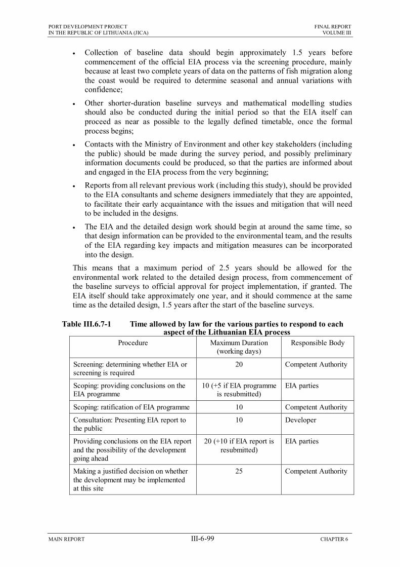
PORT DEVELOPMENT PROJECT FINAL REPORT IN THE REPUBLIC OF LITHUANIA (JICA) VOLUME III
MAIN REPORT III-6-99 CHAPTER 6
Collection of baseline data should begin approximately 1.5 years before commencement of the official EIA process via the screening procedure, mainly because at least two complete years of data on the patterns of fish migration along the coast would be required to determine seasonal and annual variations with confidence;
Other shorter-duration baseline surveys and mathematical modelling studies should also be conducted during the initial period so that the EIA itself can proceed as near as possible to the legally defined timetable, once the formal process begins;
Contacts with the Ministry of Environment and other key stakeholders (including the public) should be made during the survey period, and possibly preliminary information documents could be produced, so that the parties are informed about and engaged in the EIA process from the very beginning;
Reports from all relevant previous work (including this study), should be provided to the EIA consultants and scheme designers immediately that they are appointed, to facilitate their early acquaintance with the issues and mitigation that will need to be included in the designs.
The EIA and the detailed design work should begin at around the same time, so that design information can be provided to the environmental team, and the results of the EIA regarding key impacts and mitigation measures can be incorporated into the design.
This means that a maximum period of 2.5 years should be allowed for the environmental work related to the detailed design process, from commencement of the baseline surveys to official approval for project implementation, if granted. The EIA itself should take approximately one year, and it should commence at the same time as the detailed design, 1.5 years after the start of the baseline surveys.
Table III.6.7-1 Time allowed by law for the various parties to respond to each aspect of the Lithuanian EIA process
Procedure Maximum Duration (working days)
Responsible Body
Screening: determining whether EIA or screening is required
20 Competent Authority
Scoping: providing conclusions on the EIA programme
10 (+5 if EIA programme is resubmitted)
EIA parties
Scoping: ratification of EIA programme 10 Competent Authority
Consultation: Presenting EIA report to the public
10 Developer
Providing conclusions on the EIA report and the possibility of the development going ahead
20 (+10 if EIA report is resubmitted)
EIA parties
Making a justified decision on whether the development may be implemented at this site
25 Competent Authority

MA
IN R
EP
OR
T
III-6-100
C
HA
PT
ER
14
PO
RT
DE
VE
LO
PM
EN
T P
RO
JEC
T
FIN
AL
RE
PO
RT
IN
TH
E R
EP
UB
LIC
OF
LIT
HU
AN
IA (JIC
A)
VO
LU
ME
III
Year 1 Year 2 Year 3 1 2 3 4 5 6 7 8 9 10 11 12 13 14 15 16 17 18 19 20 21 22 23 24 25 26 27 28 29 30
SURVEYS Physical Conditions (Coast) Water Quality (Coast, Channel) Fish Migration (Coast) Fish Spawning/Nursery (Coast) Bird Breeding (N Spit) Bird Overwintering (N Spit) Property values (Melnrage) Noise (S Melnrage) Socio-economics (Melnrage) Recreation and Tourism (Coast)
MODELLING Sedimentation/Erosion (Coast) Water Quality (Recreation Area)
EIA Screening Public Consultation Scoping Collect Existing Baseline Data Impacts Mitigation EIA Report Decision on Development
ENGINEERING PROGRAM
Detailed Design
Figure III.6.7-1 Suggested programme for EIA study to be conducted during detailed design of the Short Term Development Plan

PORT DEVELOPMENT PROJECT FINAL REPORT IN THE REPUBLIC OF LITHUANIA (JICA) VOLUME III
MAIN REPORT III-6-101 CHAPTER 6
EIA Reference List
Briedis Leidyhla Publishers Provided Maps
DEP (1994) Instructions for Klaipeda Port area and Sea channel dredging (cleaning and deepening) and sediment dumping in the Sea works. Approved by order No 54 of November 16, 1994, issued by the Department of Environment Protection.
EPD (1992) Red Data Book of Lithuania: Rare and Endangered Species of Animals, Plants and Fungi. Environmental Protection Department of the Republic of Lithuania, 364 pp.
EU Directives: 76/160/EEC, 79/923/EEC, 96/62/EC, 1999/30/EC, 2000/69/EC.
Harris F R (2000) Klaipeda Port Entrance Rehabilitation Project. Final Environmental Impact Assessment. Frederic R Harris B V, The Hague, Netherlands.
Inst. of Geog. (2000) Selection of the experimental site for recultivation of the underwater slope of the coastal zone with clean sand and monitoring of sand particles dispersion during the reconstruction of the entrance channel of Klaipeda port. (Vilnius, 2000)
Joksas, K et al. (2003) The Only Lithuanian Seaport and Its Environment. Published by the Institute of Geology and Geography, Vilnius.
Lithuanian Health Information Centre (2003)
Data provided by Klaipeda Public Health Centre.
MoE CMR (2002) Results of oceanographic, hydrochemical, ecotoxicological and hydrobiological research in the Baltic Sea in 2002. Ministry of Environment, Centre of Marine Research, Klaipeda.
State enterprise: Registru Centras (provided various maps)
UNESCO (2000) Report of the 24th session of the World Heritage Committee, 27 November – 2 December 2000,http://whc.unesco.org/sites/994.htm
http://www,infoplius.lt/search_.asp(Lithuanian Telecom Co.) Klaipeda Public Health Centre http://www.klaipedatransport.it/ http://www.kpc.lt/index.html (Register of immobile cultural values)

PORT DEVELOPMENT PROJECT FINAL REPORT IN THE REPUBLIC OF LITHUANIA (JICA) VOLUME III
MAIN REPORT III-6-102 CHAPTER 6
List of Environmental Laws
Environmental Impact Assessment:
Council Directive 85/337/EEC of 27 June 1985 on the assessment of the effects of certain public and private projects on the environment (the EIA Directive).
Council Directive 97/11/EC of 3 March 1997 amending Directive 85/337/EEC on the assessment of the effects of certain public and private projects on the environment
Directive 2001/42/EC of the European Parliament and of the Council of 27th June 2001 on the assessment of the effects of certain plans and programmes on the environment (the SEA Directive).
Water:
Council Directive 76/160/EEC of 8th December 1975 concerning the quality of bathing water (the Bathing Water Directive).
Council Directive 79/923/EEC of 30th October 1979 concerning the quality required of shellfish waters (the Shellfish Waters Directive).
Air:
Directive 96/62/EC of 27th September 1996 on ambient air quality assessment and management.
The first daughter directive, Council Directive 1999/30/EC of 22nd April 1999 relating to limit values for sulphur dioxide, nitrogen dioxide and oxides of nitrogen, particulate matter and lead.
The second daughter directive, Council Directive 2000/69/EC of 16th November 2000 relating to limit values for benzene and carbon monoxide.
Nature Conservation:
Council Directive 79/409/EEC of 2 April 1979 on the conservation of wild birds (the Wild Birds Directive).
Council Directive 92/43/EEC of 21 May 1992 on the conservation of natural habitats and of wild fauna and flora (the Habitats Directive).

CHAPTER 7 CONCLUSION AND RECOMMENDATION

PORT DEVELOPMENT PROJECT FINAL REPORT IN THE REPUBLIC OF LITHUANIA (JICA) VOLUME III
MAIN REPORT III-7-1 CHAPTER 7
CHAPTER 7 CONCLUSIONS AND RECOMMENDATIONS
7.1 Conclusions On the basis of the JICA Study on the Lithuanian Port, the following conclusions have been reached.
(1) Geographically, Lithuania occupies a strategic location on the eastern edge of the Baltic Sea, north of Poland and Kaliningrad (Russia). To expand the East-West seaborne trade and sustain the country’s economic growth, Klaipeda, as a gateway port of Lithuania, should build up its port capacity and upgrade service level. Otherwise, it will not survive the competition with rival ports in the Eastern Baltic Sea.
(2) The annual increase at Klaipeda represents an additional 3.6 million tons from 1997-2002 despite losing 3.3 million tons of general cargo, mainly steel traffic because of Russia’s preferential railway tariff. Klaipeda Port handled 20 million tons of cargo in 2003, and is operating at 66% of capacity, causing no serious operational issue at present. However, it is obvious that the Port will not be able to handle the traffic demands of 37.9 million tons in 2015 and 48.6 million tons in 2025.
(3) As the port expansion inside the existing port area has been found to be environmentally negative in terms of fresh water conservation, and rather limited in space of the port basin. Instead, the outer port development has been proposed in the north of the existing port entrance. The new port area (outer port) will built by reclamation offshore of the Melnrage beach, and accommodate a total of six port terminals capable of receiving Baltmax-type or Panamax-type vessels, including 1-petroleum jetty, 1-grain berth, 2-fertilizer berths, 1-general cargo berth, 1-container berth in the stage of Master Plan and the first three terminals in Short-Term Development.
(4) Among the Short-Term Development Plans, two project components have been selected as the Key Projects, including the first-phase development of outer port and the railway improvement in the southern part of the existing port. The total construction costs of the Key Projects have been estimated at 355 million Euros, and the time requirements for their implementation will be 5.5 years, including pre-construction services.
(5) The financial viability of the Key Projects has been evaluated as a whole through parameters of Financial Internal Rate of Return (FIRR) and the Ratio Analysis. The FIRR has been estimated at 7.5% for the base case, and 5.6% in the worst case (cost increase 10% and revenue decrease 10%). The estimated figure of 7.5% exceeds the Government’s target rate of profitability (7%), and the worst figure of 5.6% is above international loan rates (2.84%), so that the financial soundness of the projects has been justified. The economic evaluation has also been conducted by use of EIRR. As a result, EIRR has been estimated at 12.6%, which is in an agreeable range, so the economic feasibility of the projects has also been confirmed.
(6) In the environmental aspect, it has been evaluated that the Southern Access Railway Improvement Project would cause no fatal impact, while the Outer Port Development at Melnrage would less desirable due to damage to surrounding

PORT DEVELOPMENT PROJECT FINAL REPORT IN THE REPUBLIC OF LITHUANIA (JICA) VOLUME III
MAIN REPORT III-7-2 CHAPTER 7
natural landscape, fall of property values nearby and likely beach changes to the north. Therefore, it has been concluded that adequate measures should be taken to prevent these negative impacts.
7.2 Recommendations Taking into account of the above conclusions, the JICA Study Team has made the following recommendations.
(1) Lithuania should follow the transport policy of EU, and KSSA should maintain details of its relations with the state and keep proper accounts. Outwardly, KSSA should encourage cross-border transport services like Viking Project, and strive for normalization of Russian preferential railway tariff together with EU and international trading organizations in order to regain the past share of transit traffic through Klaipeda Port.
(2) Klaipeda Port should maintain the position of a landlord port with independent and autonomous terminals. To this end, the Law on Klaipeda Port should remain fundamentally intact except for some revisions, including Land Lease Contract. Land lease rates progressively should be increased as and when possible under the existing leases to reflect market values. The involvement of MOTC should be only to ensure the correctness of procedures, including those to ensure the competence and suitability of the negotiators.
(3) It would be necessary to develop an outer port development to meet the growing traffic demands and to satisfy the shipping needs. Nevertheless, prior to proceeding to this stage, the existing potential capacity of Klaipeda Port should be fully utilized by renovating seaside and landside facilities, including expansion of storage areas and access railway lines. To this end, KSSA should take earlier actions to convert the land use from “reserved” to “port”.
(4) For the smooth implementation of the outer port development, KSSA should undertake various kinds of preparatory works. Firstly, the concept of the proposed master plan should be authorized in the state plan in full coordination with the City Plan of Klaipeda and the Lithuanian Railway, where basic development policy near Melnrage region should be harmoniously crystallized. The land use plan around and further north of the region should be concreted so as not incur cause land issues in the future.
(5) KSSA should monitor the movements of cargo traffic at Klaipeda Port and also the commercial activities of rival ports. Once the symptom of traffic congestions as estimated in the Study has been noticed or urgent needs for receiving Baltmax-type vessels has been fully confirmed by terminal operators, KSSA should take a quick action to initiate the first phase of the outer port development. All terminal development in the outer port should be undertaken in close cooperation with the prospective terminal operators. Selection of terminal operators should therefore take place openly in advance of development.
(6) The KSSA should upgrade the port traffic management system (PTMS). To compete with rival ports in the east Baltic Sea, the KSSA should upgrade marketing activities jointly with terminal operators. The information on the future port development, including a new outer port, should be widely publicized

PORT DEVELOPMENT PROJECT FINAL REPORT IN THE REPUBLIC OF LITHUANIA (JICA) VOLUME III
MAIN REPORT III-7-3 CHAPTER 7
initially to ensure that all prospective operators are aware of the intended development.
(7) The responsibility and obligation in the field of investment, operation and maintenance of railways in and around the Port area are not clear. To ensure an efficient railway handling, the laws relevant to railway clauses should be upgraded more clearly. Furthermore, it is advisable for KSSA to collect “Railway Infrastructure Fee” to maintain the access railway efficiently and sustain a reliable and sound financial position.
(8) For successful implementation of the outer port development in front of the Melnrage area, KSSA should undertake environmental procedures as proposed in the EIA, where KSSA should maintain the same level of environmental conservation as those adopted for the City Plan of Klaipeda.
Related Documents


