59 Walton Street, Whangarei Phone: 64 9 430 2177 Fax 64 9 430 2178 EMAIL: [email protected] WEBSITE: www.copyworld.co.nz Marine Chart Trading Post Chart List 2013

Welcome message from author
This document is posted to help you gain knowledge. Please leave a comment to let me know what you think about it! Share it to your friends and learn new things together.
Transcript

59 Walton Street, Whangarei Phone: 64 9 430 2177 Fax 64 9 430 2178
EMAIL: [email protected] WEBSITE: www.copyworld.co.nz
Marine Chart Trading Post Chart List 2013
Copyworld hold a growing list of US DMA (Defence Mapping Assoc.) marine charts for many different world regions. DMA Charts carry no Copyright restrictions. Our copies are taken from charts traded with visiting yachts, and we have attempted to hold only the highest quality and latest versions that have been offered to us. We can supply charts for most of the Pacific and Australian Coast, and all the way through to the Mediterranean. Copies are printed the same size as the original charts we obtained, and are charged at a very economical price per metre. We print using the very latest 600dpi wide format digital scanner / copier / laser printer which produces the highest quality copies we have seen. Many customers tell us that our copies are better than they have received anywhere in the world. The printed copies will be the same quality as the original scanned chart we hold. Place your order at Copyworld for the charts you require from our list, and pick up your order when they are completed – (usually the next day). If you have new or very high quality US DMA Charts of charts we do not have, then we would be happy to trade a copy of one of our charts for the opportunity to take a digital scan of your original. This catalogue clearly shows which charts we have available with “YES” beside the charts we have. At Copyworld we have printed chart catalogues available for you to look through, showing a reduced example of each chart we hold - This will allow you to see the charts, check their quality, and ensure that they cover the area you require. We hope that you can take advantage of our services during your stay in New Zealand. PRICING OF CHARTS Because each chart is a different length, we charge by the lineal metre. Printed charts are on average 1 metre long. 1 – 5 metres $10.00 per metre 6 – 20 metres $7.00 21+ metres $6.00
Visit Copyworld to view catalogues of reduced chart images, showing additional charts for …
Fiji
Vanuatu
New Caledonia
Australian Coast
Japan / Korea
Philippines
Singapore
South Africa
The Mediterranean We also carry complete portfolios of charts for … Portfolio 730 - New Guinea area (30 charts) Portfolio 705 - Australia (64 charts) Portfolio 115 - Nth Pacific (29 charts)
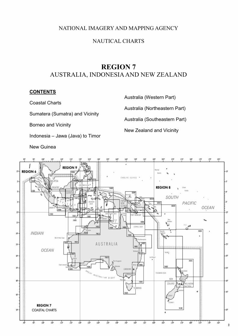
NATIONAL IMAGERY AND MAPPING AGENCY
NAUTICAL CHARTS
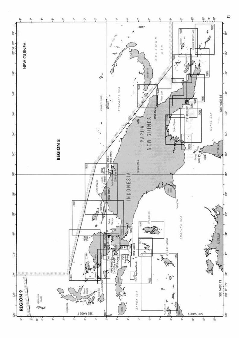
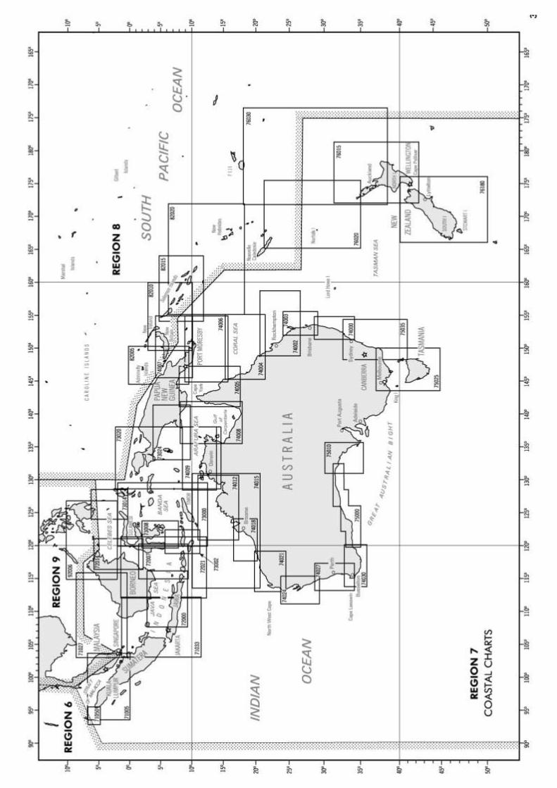
REGION 7 AUSTRALIA, INDONESIA AND NEW ZEALAND
CONTENTS Coastal Charts Sumatera (Sumatra) and Vicinity Borneo and Vicinity Indonesia – Jawa (Java) to Timor New Guinea
Australia (Western Part) Australia (Northeastern Part) Australia (Southeastern Part) New Zealand and Vicinity
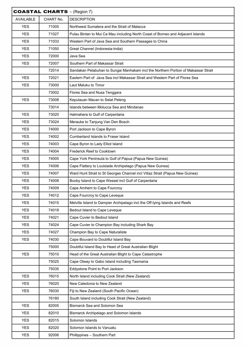
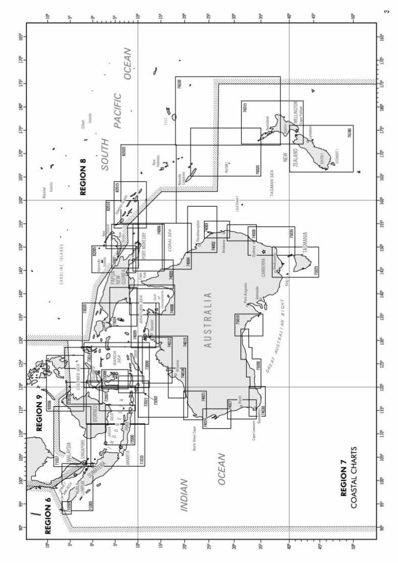
COASTAL CHARTS – (Region 7)
AVAILABLE CHART No. DESCRIPTION
YES 71005 Northwest Sumatera and the Strait of Malacca
YES 71027 Pulau Bintan to Mui Ca Mau including North Coast of Borneo and Adjacent Islands
YES 71033 Western Part of Java Sea and Southern Passages to China
YES 71050 Great Channel (Indonesia-India)
YES 72000 Java Sea
YES 72007 Southern Part of Makassar Strait
72014 Sandakan Pelabuhan to Sungai Manhakam incl the Northern Portion of Makassar Strait
YES 72021 Eastern Part of Java Sea incl Makassar Strait and Western Part of Flores Sea
YES 73000 Laut Maluku to Timor
73002 Flores Sea and Nusa Tenggara
YES 73008 Kepulauan Macan to Selat Peleng
73014 Islands between Molucca Sea and Mindanao
YES 73020 Halmahera to Gulf of Carpentaria
YES 73024 Merauke to Tanjung Van Den Bosch
YES 74000 Port Jackson to Cape Byron
YES 74002 Cumberland Islands to Fraser Island
YES 74003 Cape Byron to Lady Elliot Island
YES 74004 Frederick Reef to Cooktown
YES 74005 Cape York Peninsula to Gulf of Papua (Papua New Guinea)
YES 74006 Cape Flattery to Louisiade Archipelago (Papua New Guinea)
YES 74007 Ward Hunt Strait to St Georges Channel incl Vitiaz Strait (Papua New Guinea)
YES 74008 Booby Island to Cape Wessel incl Gulf of Carpentaria
YES 74009 Cape Arnhem to Cape Fourcroy
YES 74012 Cape Fourcroy to Cape Leveque
YES 74015 Melville Island to Dampier Archipelago incl the Off-lying Islands and Reefs
YES 74018 Bedout Island to Cape Leveque
YES 74021 Cape Cuvier to Bedout Island
YES 74024 Cape Cuvier to Champion Bay including Shark Bay
YES 74027 Champion Bay to Cape Naturaliste
YES 74030 Cape Bouvard to Doubtful Island Bay
75000 Doubtful Island Bay to Head of Great Australian Blight
YES 75010 Head of the Great Australian Blight to Cape Catastrophe
75025 Cape Otway to Gabo Island including Tasmania
75035 Eddystone Point to Port Jackson
YES 76015 North Island including Cook Strait (New Zealand)
YES 76020 New Caledonia to New Zealand
YES 76030 Fiji to New Zealand (South Pacific Ocean)
76180 South Island including Cook Strait (New Zealand)
YES 82005 Bismarck Sea and Solomon Sea
YES 82010 Bismarck Archipelago and Solomon Islands
YES 82015 Solomon Islands
YES 82020 Solomon Islands to Vanuatu
YES 92006 Phillippines – Southern Part
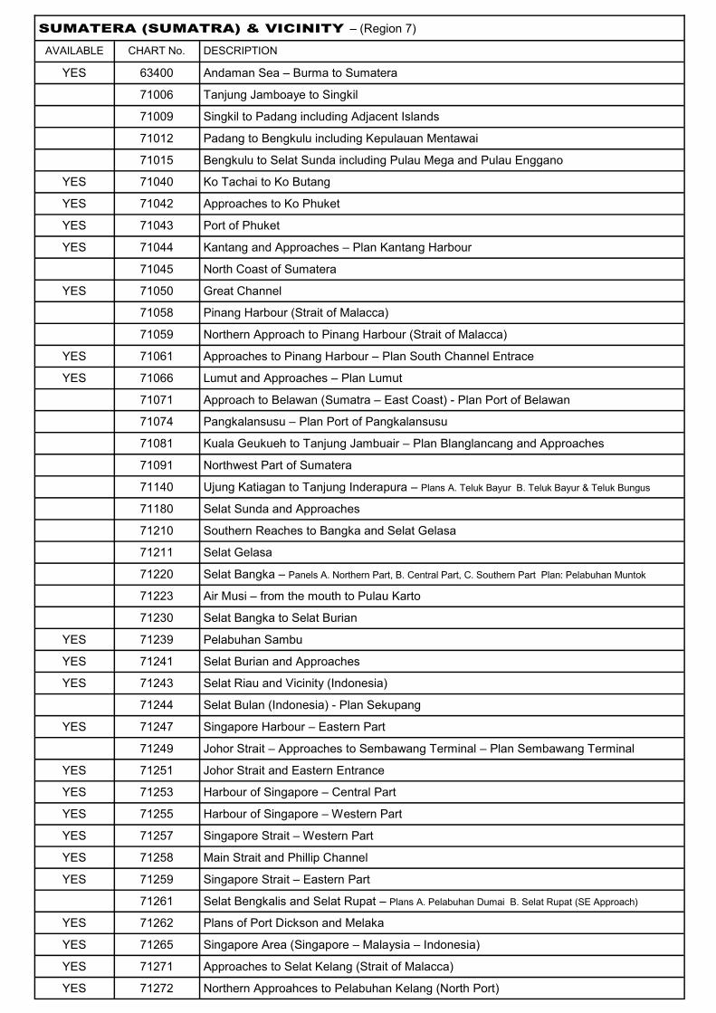
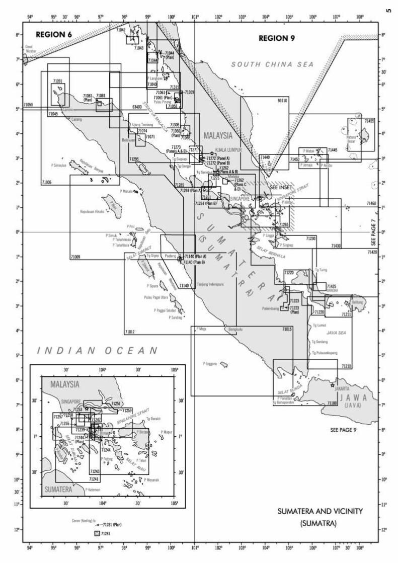
SUMATERA (SUMATRA) & VICINITY – (Region 7)
AVAILABLE CHART No. DESCRIPTION
YES 63400 Andaman Sea – Burma to Sumatera
71006 Tanjung Jamboaye to Singkil
71009 Singkil to Padang including Adjacent Islands
71012 Padang to Bengkulu including Kepulauan Mentawai
71015 Bengkulu to Selat Sunda including Pulau Mega and Pulau Enggano
YES 71040 Ko Tachai to Ko Butang
YES 71042 Approaches to Ko Phuket
YES 71043 Port of Phuket
YES 71044 Kantang and Approaches – Plan Kantang Harbour
71045 North Coast of Sumatera
YES 71050 Great Channel
71058 Pinang Harbour (Strait of Malacca)
71059 Northern Approach to Pinang Harbour (Strait of Malacca)
YES 71061 Approaches to Pinang Harbour – Plan South Channel Entrace
YES 71066 Lumut and Approaches – Plan Lumut
71071 Approach to Belawan (Sumatra – East Coast) - Plan Port of Belawan
71074 Pangkalansusu – Plan Port of Pangkalansusu
71081 Kuala Geukueh to Tanjung Jambuair – Plan Blanglancang and Approaches
71091 Northwest Part of Sumatera
71140 Ujung Katiagan to Tanjung Inderapura – Plans A. Teluk Bayur B. Teluk Bayur & Teluk Bungus
71180 Selat Sunda and Approaches
71210 Southern Reaches to Bangka and Selat Gelasa
71211 Selat Gelasa
71220 Selat Bangka – Panels A. Northern Part, B. Central Part, C. Southern Part Plan: Pelabuhan Muntok
71223 Air Musi – from the mouth to Pulau Karto
71230 Selat Bangka to Selat Burian
YES 71239 Pelabuhan Sambu
YES 71241 Selat Burian and Approaches
YES 71243 Selat Riau and Vicinity (Indonesia)
71244 Selat Bulan (Indonesia) - Plan Sekupang
YES 71247 Singapore Harbour – Eastern Part
71249 Johor Strait – Approaches to Sembawang Terminal – Plan Sembawang Terminal
YES 71251 Johor Strait and Eastern Entrance
YES 71253 Harbour of Singapore – Central Part
YES 71255 Harbour of Singapore – Western Part
YES 71257 Singapore Strait – Western Part
YES 71258 Main Strait and Phillip Channel
YES 71259 Singapore Strait – Eastern Part
71261 Selat Bengkalis and Selat Rupat – Plans A. Pelabuhan Dumai B. Selat Rupat (SE Approach)
YES 71262 Plans of Port Dickson and Melaka
YES 71265 Singapore Area (Singapore – Malaysia – Indonesia)
YES 71271 Approaches to Selat Kelang (Strait of Malacca)
YES 71272 Northern Approahces to Pelabuhan Kelang (North Port)

SUMATERA (SUMATRA) & VICINITY – (Region 7) continued
AVAILABLE CHART No. DESCRIPTION
YES 71273 Southern Approaches to Pelabuhan Kelang (South Port)
71275 Strait of Malacca – Southeast Part
71281 Cocos (Keeling) Islands – Plan Keeling Island
71285 Strait of Malacca – Central Part
71295 Strait of Malacca – Northwest Part
71305 Strait of Malacca – Northern Part
YES 71315 Ko Klang to Pulau Langkawi
YES 71420 Selat Karimata and Northwest Reaches
71425 Pangkalpinang Roadstead
YES 71430 Southeast Reaches to Singapore Strait
71440 Singapore Strait to Pulau Tioman including Kepulauan Anambas
71445 Kepulauan Anambas
71450 Kepulauan Anambas to Kepulauan Natuna
71455 Kepulauan Natuna Besar
71460 Kayu Ara to Tanjung Api
93110 Pulau Tioman to Terengganu
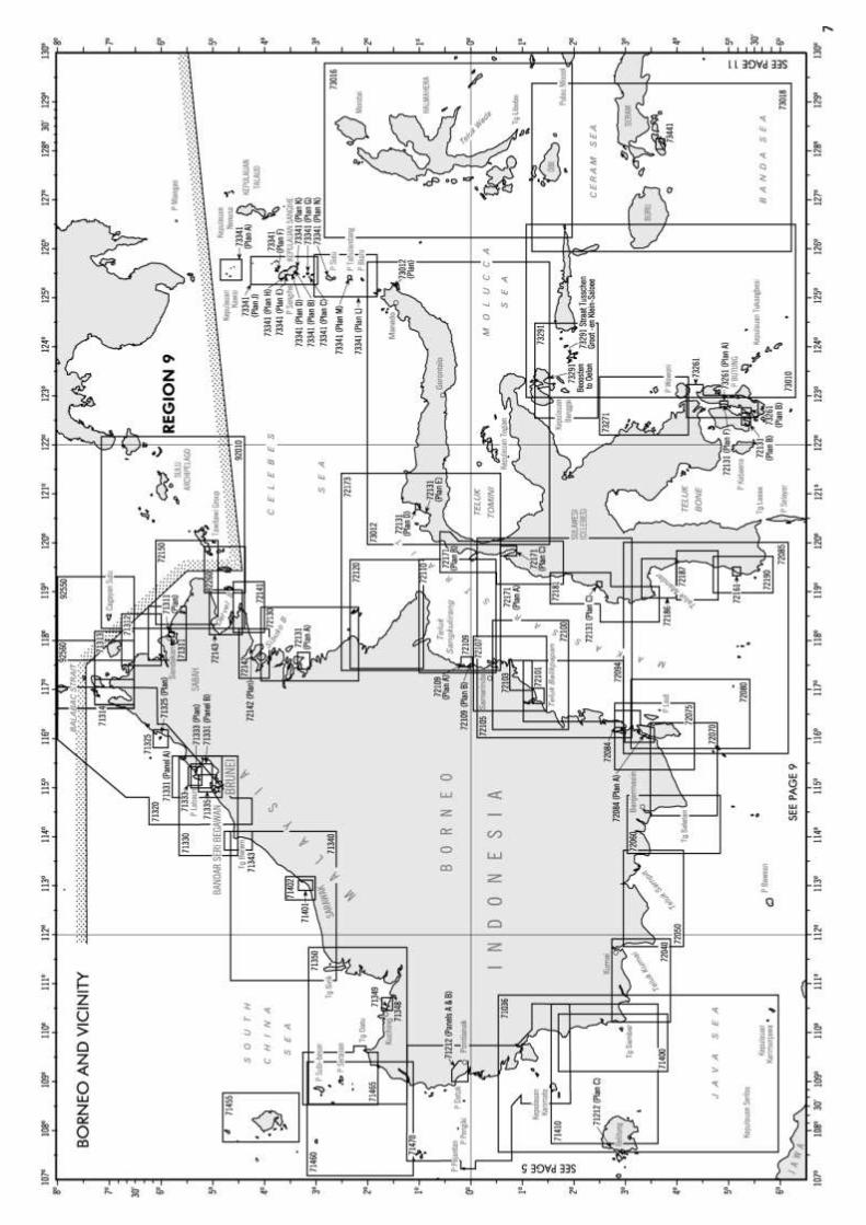
BORNEO & VICINITY – (Region 7)
YES 71036 Selat Karimata
YES 71330 Tanjung Baram to Tanjung Nosong (Northwest Coast of Borneo)
YES 71335 Muara Harbour & Approaches – Pan Muara Harbour
YES 71340 Tanjung Sirik to Tanjung Baram
YES 71350 Tanjung Bayung to Tanjong Sirik inclu Kepulauan Natuna Selatan
YES 71410 Karimata Strait and South East Reaches
INDONESIA – JAWA (JAVA) TO TIMOR (Region 7)
YES 71018 Western Portion of Jawa including Selat Sunda
YES 72000 Java Sea
YES 72035 Eastern Portion of Jawa including Mandura, Bali & Lombok (OMEGA)
YES 73004 Timor and Adjacent Islands
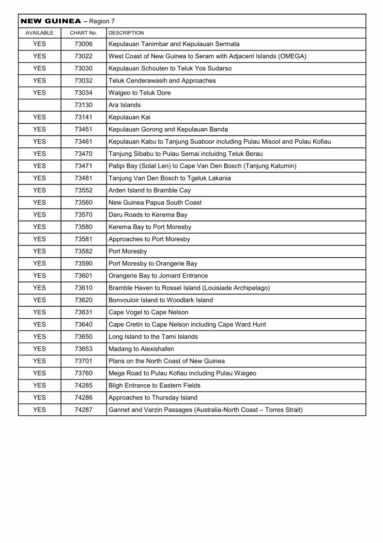
NEW GUINEA – Region 7
AVAILABLE CHART No. DESCRIPTION
YES 73006 Kepulauan Tanimbar and Kepulauan Sermata
YES 73022 West Coast of New Guinea to Seram with Adjacent Islands (OMEGA)
YES 73030 Kepulauan Schouten to Teluk Yos Sudarso
YES 73032 Teluk Cenderawasih and Approaches
YES 73034 Waigeo to Teluk Dore
73130 Ara Islands
YES 73141 Kepulauan Kai
YES 73451 Kepulauan Gorong and Kepulauan Banda
YES 73461 Kepulauan Kabu to Tanjung Suaboor including Pulau Misool and Pulau Kofiau
YES 73470 Tanjung Sibabu to Pulau Semai incluidng Teluk Berau
YES 73471 Patipi Bay (Solat Len) to Cape Van Den Bosch (Tanjung Katumin)
YES 73481 Tanjung Van Den Bosch to Tgeluk Lakania
YES 73552 Arden Island to Bramble Cay
YES 73560 New Guinea Papua South Coast
YES 73570 Daru Roads to Kerema Bay
YES 73580 Kerema Bay to Port Moresby
YES 73581 Approaches to Port Moresby
YES 73582 Port Moresby
YES 73590 Port Moresby to Orangerie Bay
YES 73601 Orangerie Bay to Jomard Entrance
YES 73610 Bramble Haven to Rossel Island (Louisiade Archipelago)
YES 73620 Bonvouloir Island to Woodlark Island
YES 73631 Cape Vogel to Cape Nelson
YES 73640 Cape Cretin to Cape Nelson including Cape Ward Hunt
YES 73650 Long Island to the Tami Islands
YES 73653 Madang to Alexishafen
YES 73701 Plans on the North Coast of New Guinea
YES 73760 Mega Road to Pulau Kofiau including Pulau Waigeo
YES 74285 Bligh Entrance to Eastern Fields
YES 74286 Approaches to Thursday Island
YES 74287 Gannet and Varzin Passages (Australia-North Coast – Torres Strait)

AUSTRALIA – WESTERN PART (Region 7)
AVAILABLE CHART No. DESCRIPTION
YES 74016 Approaches to Broome & Plan of Broome Harbour
YES 74017 Port of Dampier
YES 74018 Bedout Island to Cape Leveque
YES 74020 Approaches to Dampier Archipelago
YES 74021 Cape Cuvier to Bedout Island & Plans Port Robinson & Port Walcott
YES 74024 Cape Cuvier to Champion Bay including Shark Bay
YES 74027 Champion Bay to Cape Naturaliste
YES 74030 Cape Bouvard to Doubtful Island Bay
74051 Point D’Entrecasteaux to Point Hillier
74052 Point Hillier to Bald Island
74053 Cape Naturaliste to Cape Leeuwin
74054 Cape Leeuwin to Point D’Entrecasteaux
YES 74391 Port Essington to Cape Hotham
YES 74392 Clarence Strait
YES 74393 Approaches to Port Darwin
YES 74394 Port Darwin & Plans Approaches to Naval Base & Darwin Wharves
YES 74410 Darwin to Penguin Shoal (Eastern Sheet)
YES 74415 Pelican Island to Cape Rulhiers
YES 74420 Charles Point to Pelican Islet
YES 74430 The Boxers to Penguin Shoal
YES 74440 Pelican Islet to Penguin Shoal
YES 74450 Penguin Shoal to Browse Island
YES 74455 Browse Island to Adele Island including Bonaparte Archipelago
YES 74460 Sahul Banks
YES 74465 Cape Leveque to Degerando Island
YES 74470 Adele Island to Lacepede Islands
YES 74475 Lacepede Island to Eighty Mile Beach
YES 74480 Red Hill to North Turtle Islet
YES 74485 Bedout Island to Port Walcott
74491 Bedout Islet to Port Hedland
74492 Approaches to Port Hedland
74493 Port Hedland to Port Walcott & Plan Deputch Island Anchorage
74494 Port Hedland
74510 Port Walcott to Montebello Islands
74515 Montebello Islands to North West Cape
74517 Barrow Island to Onslow & Plan Fortescue Road
74520 North West Cape to Point Cloates
74521 Exmouth Gulf and Approaches
74527 North West Cape to Point Maud
74530 Point Cloates to Point Quobba & Plan Cape Cuvier
74535 Point Quobba to Zuytdorp Point

AUSTRALIA – WESTERN PART continued (Region 7)
AVAILABLE CHART No. DESCRIPTION
74545 Zuytdorp Point to Geraldton
74550 Geraldton to Wedge Island
74555 Ledge Point to Cape Naturaliste
74560 Houtman Abrolhos and Adjacent Coach – Plans Champion Bay & Port Gregory
74561 Pelsaert Island to Beagle Islands – Plan Port Denison
YES 74581 Approaches to Fremantle
YES 74582 Port of Fremantle
74583 Approaches to Rottnest Island
74584 Gage Roads and Cockburn Sound – Plan Kwinana
74590 Cape Naturaliste to Point D’Entrecasteaux
74591 Approaches to Bunbury – Plan Port of Bunbury
74595 Cape Leeuwin to King George Sound
YES 75001 Approaches to Esperance – Plans Bandy Creek Boat Harbour, Duke of Orleans Bay, Approaches to Goose Island, Esperance
YES 75051 Approaches to King George Sound – Plan Albany Wharves
75052 King George Sound (Australia – South Coast)
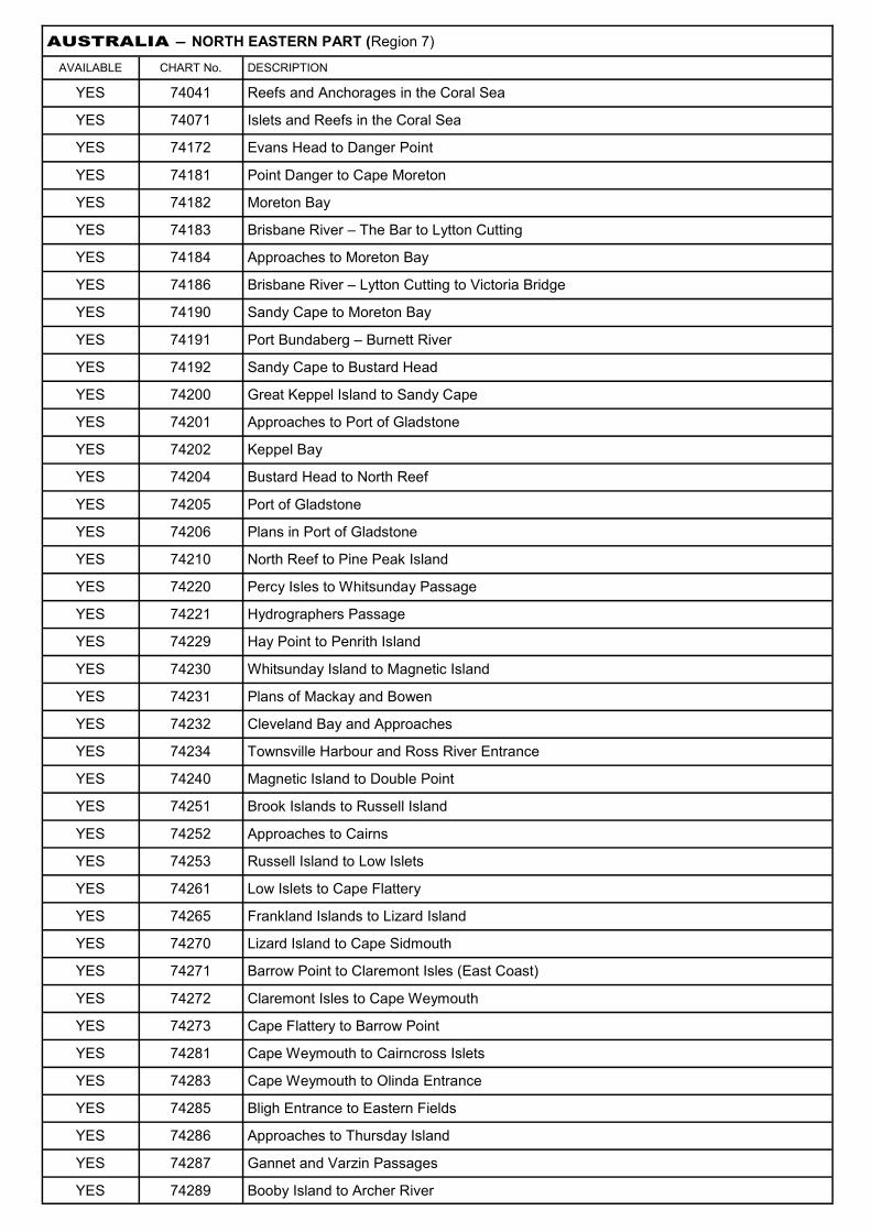
AUSTRALIA – NORTH EASTERN PART (Region 7)
AVAILABLE CHART No. DESCRIPTION
YES 74041 Reefs and Anchorages in the Coral Sea
YES 74071 Islets and Reefs in the Coral Sea
YES 74172 Evans Head to Danger Point
YES 74181 Point Danger to Cape Moreton
YES 74182 Moreton Bay
YES 74183 Brisbane River – The Bar to Lytton Cutting
YES 74184 Approaches to Moreton Bay
YES 74186 Brisbane River – Lytton Cutting to Victoria Bridge
YES 74190 Sandy Cape to Moreton Bay
YES 74191 Port Bundaberg – Burnett River
YES 74192 Sandy Cape to Bustard Head
YES 74200 Great Keppel Island to Sandy Cape
YES 74201 Approaches to Port of Gladstone
YES 74202 Keppel Bay
YES 74204 Bustard Head to North Reef
YES 74205 Port of Gladstone
YES 74206 Plans in Port of Gladstone
YES 74210 North Reef to Pine Peak Island
YES 74220 Percy Isles to Whitsunday Passage
YES 74221 Hydrographers Passage
YES 74229 Hay Point to Penrith Island
YES 74230 Whitsunday Island to Magnetic Island
YES 74231 Plans of Mackay and Bowen
YES 74232 Cleveland Bay and Approaches
YES 74234 Townsville Harbour and Ross River Entrance
YES 74240 Magnetic Island to Double Point
YES 74251 Brook Islands to Russell Island
YES 74252 Approaches to Cairns
YES 74253 Russell Island to Low Islets
YES 74261 Low Islets to Cape Flattery
YES 74265 Frankland Islands to Lizard Island
YES 74270 Lizard Island to Cape Sidmouth
YES 74271 Barrow Point to Claremont Isles (East Coast)
YES 74272 Claremont Isles to Cape Weymouth
YES 74273 Cape Flattery to Barrow Point
YES 74281 Cape Weymouth to Cairncross Islets
YES 74283 Cape Weymouth to Olinda Entrance
YES 74285 Bligh Entrance to Eastern Fields
YES 74286 Approaches to Thursday Island
YES 74287 Gannet and Varzin Passages
YES 74289 Booby Island to Archer River

AUSTRALIA – NORTH EASTERN PART continued (Region 7)
YES 74290 Torres Strait
YES 74292 Prince of Wales Channel & Approaches
YES 74293 Cairncross Islets to Arden Islet
YES 74294 Adolphus Channel to Havey Rocks
YES 74295 Prince of Wales Channel – Torres Strait
YES 74296 Goode Island to Proudfoot Shoal (Torres Strait)
YES 74310 Archer River to Nassau River
YES 74320 Nassau River to Wellesley Islands
YES 74330 Wellesley Island to Vanderlin Island
YES 74340 Cape Vanderlin to Cape Grey
YES 74350 Cape Grey to Cape Wessel and Elcho Island
YES 74376 Cape Arnhem to Cape Wessel
YES 74380 Port Essington to Cape Stewart
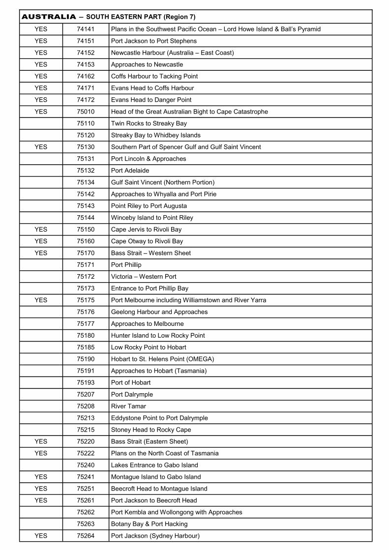
AUSTRALIA – SOUTH EASTERN PART (Region 7)
YES 74141 Plans in the Southwest Pacific Ocean – Lord Howe Island & Ball’s Pyramid
YES 74151 Port Jackson to Port Stephens
YES 74152 Newcastle Harbour (Australia – East Coast)
YES 74153 Approaches to Newcastle
YES 74162 Coffs Harbour to Tacking Point
YES 74171 Evans Head to Coffs Harbour
YES 74172 Evans Head to Danger Point
YES 75010 Head of the Great Australian Bight to Cape Catastrophe
75110 Twin Rocks to Streaky Bay
75120 Streaky Bay to Whidbey Islands
YES 75130 Southern Part of Spencer Gulf and Gulf Saint Vincent
75131 Port Lincoln & Approaches
75132 Port Adelaide
75134 Gulf Saint Vincent (Northern Portion)
75142 Approaches to Whyalla and Port Pirie
75143 Point Riley to Port Augusta
75144 Winceby Island to Point Riley
YES 75150 Cape Jervis to Rivoli Bay
YES 75160 Cape Otway to Rivoli Bay
YES 75170 Bass Strait – Western Sheet
75171 Port Phillip
75172 Victoria – Western Port
75173 Entrance to Port Phillip Bay
YES 75175 Port Melbourne including Williamstown and River Yarra
75176 Geelong Harbour and Approaches
75177 Approaches to Melbourne
75180 Hunter Island to Low Rocky Point
75185 Low Rocky Point to Hobart
75190 Hobart to St. Helens Point (OMEGA)
75191 Approaches to Hobart (Tasmania)
75193 Port of Hobart
75207 Port Dalrymple
75208 River Tamar
75213 Eddystone Point to Port Dalrymple
75215 Stoney Head to Rocky Cape
YES 75220 Bass Strait (Eastern Sheet)
YES 75222 Plans on the North Coast of Tasmania
75240 Lakes Entrance to Gabo Island
YES 75241 Montague Island to Gabo Island
YES 75251 Beecroft Head to Montague Island
YES 75261 Port Jackson to Beecroft Head
75262 Port Kembla and Wollongong with Approaches
75263 Botany Bay & Port Hacking
YES 75264 Port Jackson (Sydney Harbour)

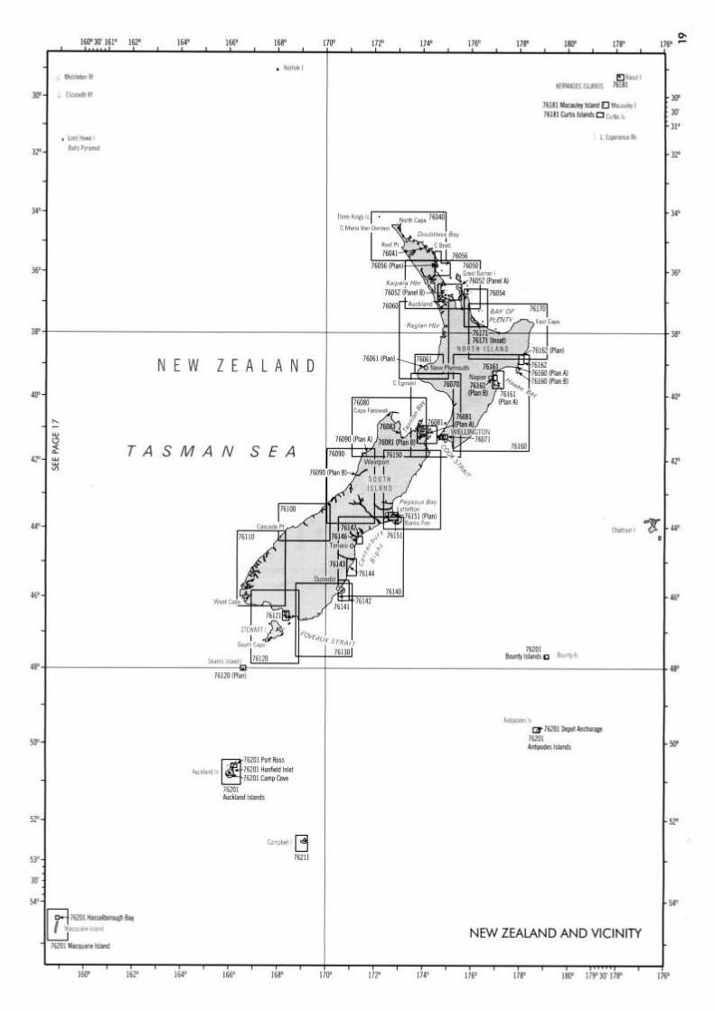
NEW ZEALAND & VICINITY (Region 7)
YES 76040 Cape Maria Van Diemen to Tutukaka Harbour
YES 76041 Bay of Islands
YES 76050 Manukau Harbour to Maunganui Bluff & Tutukaka Harbour to Mayor Island
YES 76052 New Zealand – North Island East Coast
YES 76054 Mercury Bay to Town Point
YES 76056 Approaches to Whangarei
76060 Cape Egmont to Manukau Harbour
76061 Approaches to Taranaki Roads (New Plymouth)
YES 76070 Cook Strait
YES 76071 Wellington Harbour
YES 76080 Cape Foulwind to D’Urville Island incl Tasman and Golden Bays
76081 Approaches to Picton
76090 Waiho River to Cape Foulwind
76100 Big Bay to Waiho River
76110 Tewaewae Bay to Awarua Bay
76120 Foveaux Strait and Stewart Island
76121 Bluff Harbour and Entrance
76130 Otago Harbour to Waipapa Point
76140 Banks Peninsula to Otago Harbour
76141 Otago Harbour (South Island – East Coast)
76142 Otago Harbour Approaches (South Island – East Coast)
76143 Approaches to Oamaru Harbour (South Island – East Coast)
76144 Oamaru Harbour
76146 Timaru Harbour
76147 Approaches to Timaru
76150 Cape Campbell to Banks Peninsula
76151 Lyttelton Harbour and Approaches
YES 76160 Poverty Bay to Castle Point and Continuation to Cape Palliser
YES 76161 Approaches to Napier
76162 Poverty Bay (North Island)
YES 76170 Mayor Island to Poverty Bay (Bay of Plenty)
YES 76171 Tauranga Harbour – North Island (East Coast)
YES 76181 Raoul Island – Kermadecs, Macauley & Curtis Islands
76201 Islands and Anchorages to the Southward of New Zealand
76211 Campbell Island
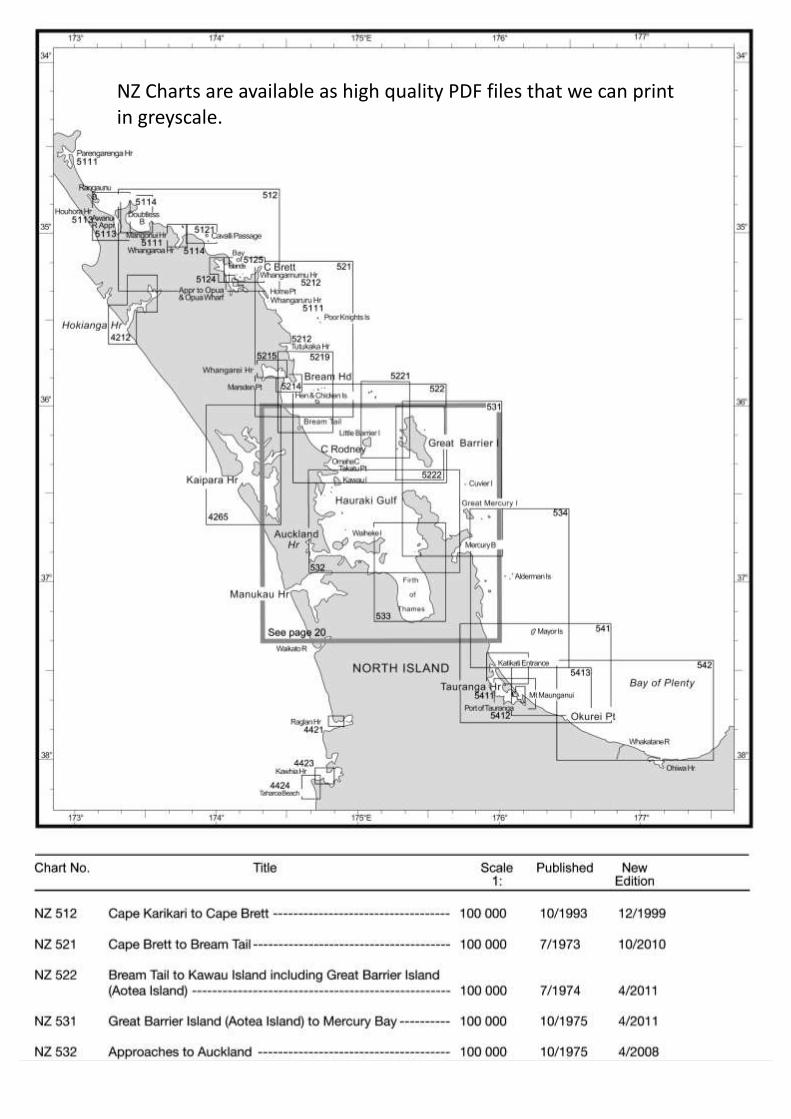
NZ Charts are available as high quality PDF files that we can print in greyscale.

NATIONAL IMAGERY AND MAPPING AGENCY
NAUTICAL CHARTS
REGION 8
CONTENTS Coastal Charts Mariana Islands Area Caroline Islands to Bismarck Archipelago Area Caroline Islands, Marshall Islands and Wake Island Solomon Islands to Gilbert Islands New Hebrides and Fiji including Iles Loyaute Johnston Atoll to Christmas Island
Samoa and Phoenix Islands Area Tonga to Cook Islands Iles Marquises to Iles de la Societe and Iles Gambrier to Ducie Island Miscellaneous

COASTAL CHARTS
AVAILABLE CHART No. DESCRIPTION
YES 76020 New Caledonia to New Zealand (Omega)
YES 76030 Fiji to New Zealand (South Pacific Ocean) (Omega)
81001 Mindanoa to Palau Islands
81002 Caroline Islands – Western Part
YES 81007 Bikini Atoll to Mili Atoll
YES 81012 Namorik Atoll to Nonouti
YES 81016 Kusaie to Ngatik Atoll (Caroline Islands – North Pacific Ocean)
81019 Kosrae Island to Ngatik Atoll
YES 81023 Nomoi Islands to Faraulep Atoll (Caroline Islands)
YES 82005 Bismarck Sea and Solomon Sea
YES 82010 Bismarck Archipelago and Solomon Islands
YES 82015 Solomon Islands
YES 82020 Solomon Islands to Vanuatu
YES 82030 New Caledonia to Fiji and Vanuatu (New Hebrides)
YES 83005 Gilbert Islands to Tuvalu Islands
YES 83010 Howland Island to Samoa Islands
YES 83015 Enderbury Island (Phoenix Islands) to Christmas Island
YES 83020 Iles Marquises Islands
YES 83032 Tuvalu Islands, Rotuma and Iles de Horne
YES 83034 Fiji – Iles de Horne
YES 83039 Fiji Islands to Samoa Islands
YES 83255 Mururoa to Fangataufa
YES 83500 Fiji and Tonga Islands
97000 Namp-Shoto
MARIANA ISLANDS AREA
81060 Saipan to Santa Rosa Reef
YES 81086 Plans In the Marianas
YES 81133 Caroline Islands (North Pacific Ocean)
YES 81187 Yap Islands (Caroline Islands)
YES 81209 Ulithi Atoll – West Carolines
CAROLINE ISLANDS TO BISMARCK ARCHIPELAGO AREA
YES 73650 Long Island to the Tami Islands
YES 81133 Caroline Islands (North Pacific Ocean)
YES 81141 Palau Islands
YES 81145 Palau Islands (Northern Part)
YES 81148 Toachel Mlengui (West Passage) (Palau Islands)
YES 81151 Arangel Channel & Koror Road (Palau Islands)
YES 81155 Malakal Harbour (Palau Islands)
YES 81249 Plans in the Caroline Islands
YES 81288 Plans of Namonuito Island (East Caroline Islands)
YES 81303 Hall (Horu) Islands (East Caroline Islands)
YES 82050 Wuvulu Island to Kaniet Islands
YES 82060 Manus Island & Approaches
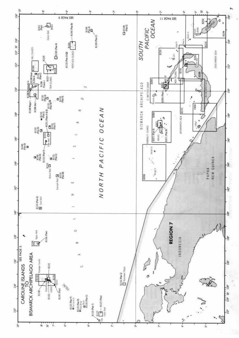
CAROLINE ISLANDS TO BISMARCK ARCHIPELAGO AREA cpntd
YES 82093 Passages between New Ireland and New Hanover
YES 82095 Ysabel Channel
YES 82105 Elizabeth Bay to North Cape
YES 82107 Kavieng Harbour
YES 82192 Blanche Bay and Approaches (New Britain)
YES 82200 Gazelle Peninsula
YES 82201 Saint George’s Channel (South Pacific Ocean)
YES 82210 Bougainville Island – Northern Part
YES 82215 Kimbe Bay to Dampier Strait
YES 82242 Approaches to Kieta Bay and Anewa Bay (South Pacific Ocean – Papua New Guinea)
YES 82244 Bougainville Island
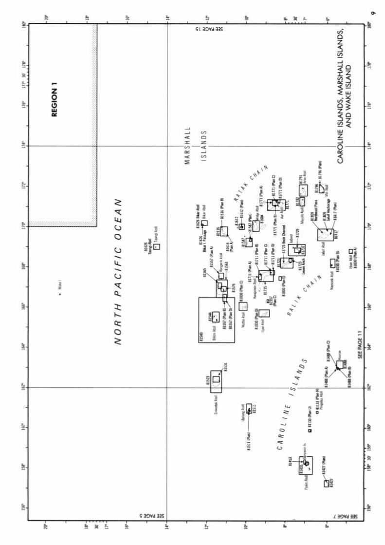
CAROLINE ISLANDS, MARSHALL ISLANDS & WAKE ISLAND
YES 81133 Caroline Islands (North Pacific Ocean)
YES 81540 Approaches to Bikini Atoll
YES 81782 Majuro Atoll (Marshall Islands)
SOLOMON ISLANDS TO GILBERT ISLANDS
YES 81012 Namorik Atoll to Nonouti
YES 82210 Bougainville Island – Northern Part
YES 82244 Bougainville Island
YES 82253 Bougainville Island to Ghizo Island
YES 82304 New Georgia Group – Vella Lavella to Vonavona
YES 82349 Isabel (Santa Isabel) Island, Western Part
YES 82356 Malaita Island to Santa Isabel Island
YES 82367 Indispensable Strait
YES 82374 Guadalcanal & Florida Islands
YES 82377 Honiara and Approaches
YES 82384 Russel Islands
YES 82412 San Cristobal to Malaita
YES 82449 Santa Cruz Islands
YES 83005 Gilbert Islands to Tuvalu Islands
YES 83032 Tuvalu Islands, Rotuma and Iles de Horne
YES 83044 Plans in the Gilbert Islands – Nonouti
YES 83052 Butaritari Atoll
YES 83059 Tarawa Atoll
YES 83094 Funafuti Atoll
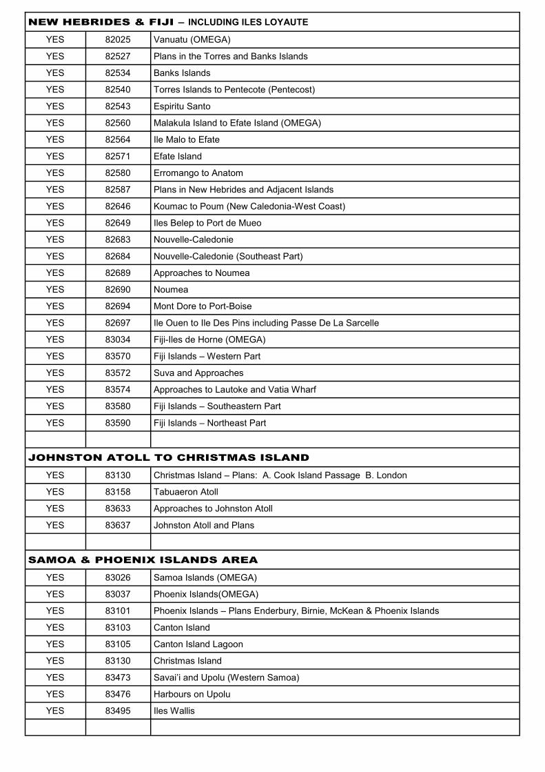
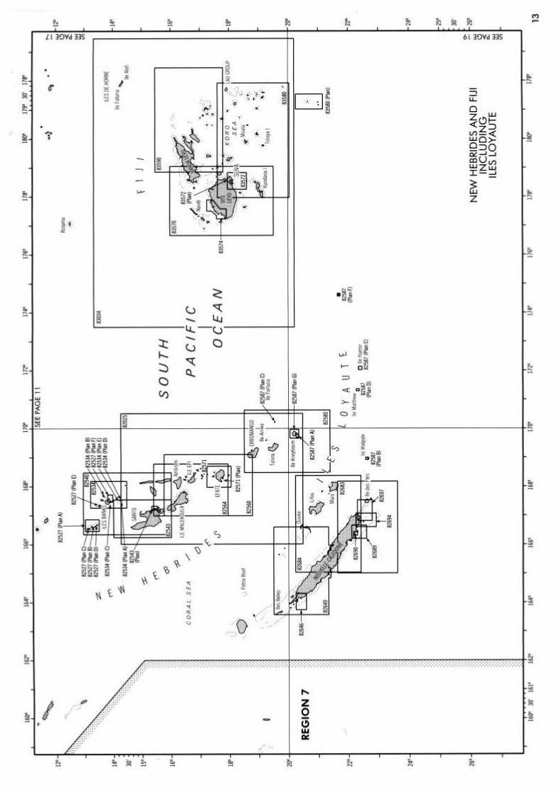
NEW HEBRIDES & FIJI – INCLUDING ILES LOYAUTE
YES 82025 Vanuatu (OMEGA)
YES 82527 Plans in the Torres and Banks Islands
YES 82534 Banks Islands
YES 82540 Torres Islands to Pentecote (Pentecost)
YES 82543 Espiritu Santo
YES 82560 Malakula Island to Efate Island (OMEGA)
YES 82564 Ile Malo to Efate
YES 82571 Efate Island
YES 82580 Erromango to Anatom
YES 82587 Plans in New Hebrides and Adjacent Islands
YES 82646 Koumac to Poum (New Caledonia-West Coast)
YES 82649 Iles Belep to Port de Mueo
YES 82683 Nouvelle-Caledonie
YES 82684 Nouvelle-Caledonie (Southeast Part)
YES 82689 Approaches to Noumea
YES 82690 Noumea
YES 82694 Mont Dore to Port-Boise
YES 82697 Ile Ouen to Ile Des Pins including Passe De La Sarcelle
YES 83034 Fiji-Iles de Horne (OMEGA)
YES 83570 Fiji Islands – Western Part
YES 83572 Suva and Approaches
YES 83574 Approaches to Lautoke and Vatia Wharf
YES 83580 Fiji Islands – Southeastern Part
YES 83590 Fiji Islands – Northeast Part
JOHNSTON ATOLL TO CHRISTMAS ISLAND
YES 83130 Christmas Island – Plans: A. Cook Island Passage B. London
YES 83158 Tabuaeron Atoll
YES 83633 Approaches to Johnston Atoll
YES 83637 Johnston Atoll and Plans
SAMOA & PHOENIX ISLANDS AREA
YES 83026 Samoa Islands (OMEGA)
YES 83037 Phoenix Islands(OMEGA)
YES 83101 Phoenix Islands – Plans Enderbury, Birnie, McKean & Phoenix Islands
YES 83103 Canton Island
YES 83105 Canton Island Lagoon
YES 83130 Christmas Island
YES 83473 Savai’i and Upolu (Western Samoa)
YES 83476 Harbours on Upolu
YES 83495 Iles Wallis


TONGA TO COOK ISLANDS
YES 83026 Samoa Islands
YES 83392 Ile de la Societe – Iles Sous Le Vent
YES 83425 Islands & Anchorages in Cook Islands
YES 83555 Vava’u Group
YES 83560 Tonga Islands
YES 83563 Plans of the Tonga Islands
YES 83567 Nukualofa and Approaches
ILES MARQUISES TO ILES DE LA SOCIETE & ILES GAMBIER TO DUCIE IS
AVAILABLE CHART No. DESCRIPTION
YES 83021 Manuae to Tahiti
YES 83022 Makemo to Tatakoto
YES 83023 Tahiti to Rangiroa and Makemo
YES 83024 Hae to Fangataufa
YES 83025 Iles Tuamoto to Iles Gambier
YES 83207 Nuku Hiva
YES 83218 Hiva Oa, Tahuata & Motane
YES 83225 Islands in the South Pacific Ocean
YES 83251 Archipel Des Tuamotu Iles Gambier
YES 83252 Ile Mangareva
YES 83253 Iles Gambier – Southern Part
YES 83254 Rade de Rikitea
YES 83382 Approaches to Tahiti & Moorea including Maiao and Tetiaroa
YES 83383 Moorea
YES 83385 Port of Papeete
YES 83392 Ile de la Societe – Iles Sous Le Vent
YES 83397 Bora Bora


MISCELLANEOUS
YES 83035 Raiatea to Tutuila, Marquesas
YES 83030 Tonga, South Pacific Ocean
YES 83033 Fiji, South Pacific Ocean
YES 83484 Samoa Islands, Pacific Ocean
YES Moorings of Tonga
YES 83597 Vanua Levu & Vicinity
YES 83608 Fiji Islands – Kandavu Island and Passage
YES 83611 Fiji - Northwest Approach to Vata-I-Ra Channel
YES 83582 Fiji Islands Eastern Archipelago (Southern Portion)
YES 83584 East Coat of Viti Levu to Nairai Island
YES 83594 Fiji Islands (North Eastern Part)
YES 83116 Islands in Pacific
YES 83153 Kingman Reef
YES 83157 Palmyra Atoll
YES 83225 Islands in the South Pacific
YES 83251 Archipel Des Tuamotu Iles Gambier
YES 83254 Rade de Rikitea
YES 83382 Approaches to Tahiti & Moorea incl Maiao & Tetiaroa
YES 83383 Moorea
YES 83392 Iles Sous Le Vent – Society Islands
YES 6054 Caroline Islands – Woleai Atol
YES 6058 Caroline Islands – Ngulu Island
YES 81048 Guam
YES 81193 Yap Islands Tomil Harbour

NATIONAL IMAGERY AND MAPPING AGENCY
NAUTICAL CHARTS
REGION 6
CONTENTS Coastal Charts South Africa Mozambique Channel Area Kenya and Somalia Red Sea Area Gulf of Aden to Persian Gulf
Eastern Part of Arabian Sea Bay of Bengal Area Islands Eastward of Madagascar Gulf of Oman to Persian Gulf Miscellaneous
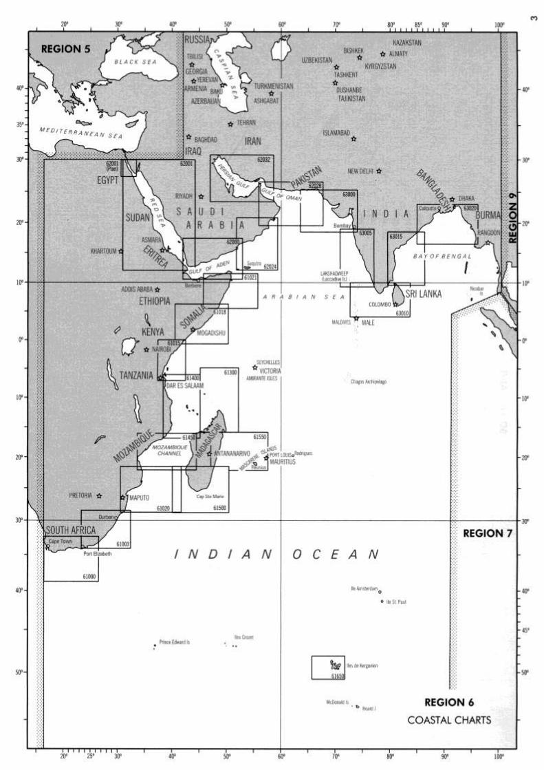

COASTAL CHARTS
61000 Algoa Bay to Cape Town
61003 Durban to Algoa Bay
YES 61015 Webi Jubba to Zanzibar
YES 61018 Hobyo to Kismaayo
61020 Mozambique Channel – Southern Reaches
YES 61021 Raas Xaafuun to Hobyo
61300 Madagascar – North Coast and Seychelles
61400 Mozambique Channel – Northern Reaches
61450 Mozambique Channel
61500 Madagascar – South Coast
61550 Madagascar – East Coast
61650 Iles Kerguelen
YES 62000 Gulf of Aden
YES 62001 Red Sea – Plan Khalig El Suweis (Gulf of Suez)
62024 Al Masirah to Ra’s Raysut including Suqutra Island
62028 Gulf of Oman and Adjacent Coasts – Karachi to Jazirat Masirah
62032 Persian Gulf
63000 Karachi to Bombay, India & Pakistan
63005 Bombay to Cochin including the Lakshadweep
63010 Cochin to Calimere Pt with Sri Lanka and the Northern Portion of Maldives
63015 Coast of India – Calimere Point to Kalingapatam
63020 Kalingapatam to Goyagyi Kyun
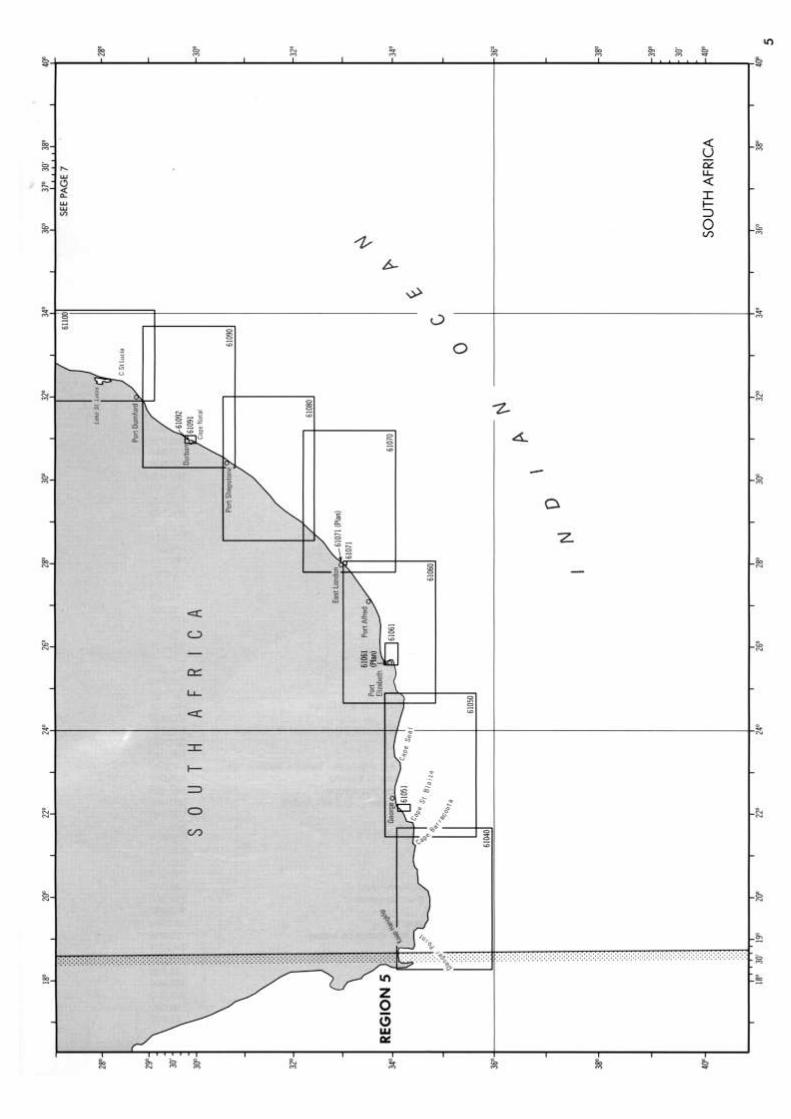
SOUTH AFRICA
61040 Yzervarkpunt to Cape of Good Hope
61050 Cape St Francis to Ystervarkpunt
61051 Approaches to Mossel Bay – Plan: Mossel Bay
61060 East London to Cape St Francis
61061 Approaches to Port Elizabeth – Plan: Port Elizabeth
61070 Mbashe Point to East London
61071 Approaches to East London Harbour – Plan: East London Harbour
61080 Port Shepstone to Mbashe Point
61090 Durnford Point to Port Shepstone
61091 Approaches to Durban
61092 Durban
61100 Ponta do Ouro to Port Durnford
MOZAMBIQUE CHANNEL AREA
61100 Ponta do Ouro to Port Durnford
61110 Limpopo to Ponta do Ouro (Mozambique)
61111 Daia de Maputo
61112 Maputo (Lourenco Marques)(Mozambique)

MOZAMBIQUE CHANNEL AREA continued
61120 Ponta da Barra to Rio Limpopo (Mozambique)
61130 Ilha Chiloane to Ponta da Barra (Mozambique)
61140 Rio Zambeze to Ilha Chiloane
61141 Approaches to Beira
61142 Port of Beira
61150 Ilha Epidendron to Zambezi River
61160 Porto de Mocambique to Ilha Epidendron
61170 Porto do Ibo to Porto de Mocambique
61171 Porto de Mocambique including Baia da Conducia and Porto de Mocambo
61172 Porto de Mocambique
61180 Mchinga Bay to Porto do Ibo
61181 Mikindani Bay incl Mikindani Harbour and Mtwara Bay
61182 Plans in Mozambique
YES 61190 Dar Es Salaam to Mchinga Bay
61191 Dar es Salaam and Adjoining Anchorages
YES 61200 Dar es Salaam to Mombasa Harbour
61203 Approaches to Zanzibar
61204 Zanzibar Harbour
YES 61210 Mombasa Harbour to Manda Island
61211 Approaches to Mombasa
61212 Mombasa Harbour including Kilindini Harbour and Port Reitz
YES 61220 Manda Island to Kismaayo
61301 Islands North of Madagascar
61310 Comoros Islands
61311 Plans in the Comoros and Mayotte
61312 Mayotte – North side
61331 Baie Andranoaomby to Helodranon Antsiranana
61410 Tanjona Bobaomby to Nosy Be
61420 Nosy Be to Helodrano Bombetoka
61430 Helodrano Bombetoka to Tanjona Vilanandro
61433 Approaches to Baie de Bombetoka
61434 Helodrano Bombetoka
61440 Tanona Vilanandro to Tanjona Kimby
61460 Tanjona Kimby to Nosy Lava
61470 Nosy Lava to Tanjon Andriamanoa
61472 Toliara and Approaches
61510 Tanjon Andriamanao to Tolanaro
61520 Tolanaro to Faraony
61522 Faradofay and Approaches
61530 Faraony to Toamasina
61538 Toamasina and Approaches
61540 Toamasina to Tanjon Antsirakosy
61560 Cap Est to Cap d’Ambre
61562 Helodranon Antsiranana
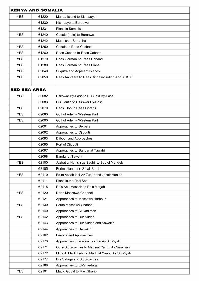
KENYA AND SOMALIA
YES 61220 Manda Island to Kismaayo
61230 Kismaayo to Baraawe
61231 Plans in Somalia
YES 61240 Cadale (Itala) to Baraawe
61242 Muqdisho (Somalia)
YES 61250 Cadale to Raas Cusbad
YES 61260 Raas Cusbad to Raas Cabaad
YES 61270 Raas Garmaal to Raas Cabaad
YES 61280 Raas Garmaal to Raas Binna
YES 62040 Suqutra and Adjacent Islands
YES 62050 Raas Aantaara to Raas Binna including Abd Al Kuri
RED SEA AREA
YES 56082 Difirswar By-Pass to Bur Said By-Pass
56083 Bur Taufiq to Difirswar By-Pass
YES 62070 Raas Jilbo to Raas Goragii
YES 62080 Gulf of Aden – Western Part
YES 62090 Gulf of Aden – Western Part
62091 Approaches to Berbera
62092 Approaches to Djibouti
62093 Djibouti and Approaches
62095 Port of Djibouti
62097 Approaches to Bandar at Tawahi
62098 Bandar at Tawahi
YES 62100 Jazirat al Hanish as Saghir to Bab el Mandeb
62105 Perim Island and Small Strait
YES 62110 Ed to Assab incl Az Zuqur and Jazair Hanish
62111 Plans in the Red Sea
62115 Ra’s Abu Masarib to Ra’s Marjah
YES 62120 North Massawa Channel
62121 Approaches to Massawa Harbour
YES 62130 South Massawa Channel
62140 Approaches to Al Qadimah
YES 62142 Approaches to Bur Sudan
62143 Approaches to Bur Sudan and Sawakin
62144 Approaches to Sawakin
62162 Bernice and Approaches
62170 Approaches to Madinat Yanbu As’Sina’iyah
62171 Outer Approaches to Madinat Yanbu As Sina’iyah
62172 Mina Al Malik Fahd at Madinat Yanbu As Sina’iyah
62177 Bur Safaga and Approaches
62188 Approaches to El-Ghardaqa
YES 62191 Madiq Gubal to Ras Gharib

RED SEA AREA continued
YES 62193 Bahr el-Qulzum
62194 Approaches to Bahr el-Qulzum
62195 Ras Shukheir to Ras el-Sudr
62220 Gulf of Aqaba
62222 Strait of Tiran
62225 Elat and Al Aqabah
62230 Madiq Gubal to Geziret Zabartad
62241 Mina Jiddah
62242 Approaches to Jiddah
62250 Jaziret Zabarjad to Port Sudan
62270 Port Sudan to Sajid
62271 Jaza’ir Farasan and Approaches to Jizan
62276 Port of Jizan
62285 Approaches to Madiq Kamaran
62288 Plans of Al Luhayyah and Al Mukha
62290 Sajid to Siyyan
62292 Al Ahmadi and Approaches
62295 Ra’s Isa to Ra’s Mutaynah incluidng Jasair As Subayr and Jazair Hanish
62302 Yemen – South Coast
GULF OF ADEN TO PERSIAN GULF
YES 62040 Suqutra and Adjacent Islands
62046 Approaches to Suqutra
YES 62050 Raas Aantaara to Raas Binna including Abd Al Kuri
YES 62070 Raas Jilbo to Ras Goragii
62302 Yemen – South Coast
62306 Ra’s Fartak to Ash Shihr
62310 Ra’s Fartak to Ra’s Janjali
62312 Approaches to Ra’s al Madrakah
62313 Port Salalah and Approaches
62320 Ra’s Qarwaw to Ra’s Janjali
62330 Ra’s ad Duqm to Ra’s Qarwaw
62340 Ra’s Duqm to Ra’s al Hadd
62342 Northern Approaches to Masirah
62344 Ra’s Hilk Ancharage
62350 Ra’a al Hadd to Masat
62353 Ra’s al Hadd to Sur
62360 Masqat to As Salamah wa Banatuha
62391 Plans on the Coast of Pakistan and Iran
62392 Strait of Hormuz
62393 Approaches to Bandar Abbas
62400 Al Mubarraz to Ash Shariqah including Mubarak Oil Termimal
62406 Ra’s al Khaymah to Dubayy
62420 Bahrain to Abu Ali including Dawhat As Salwa
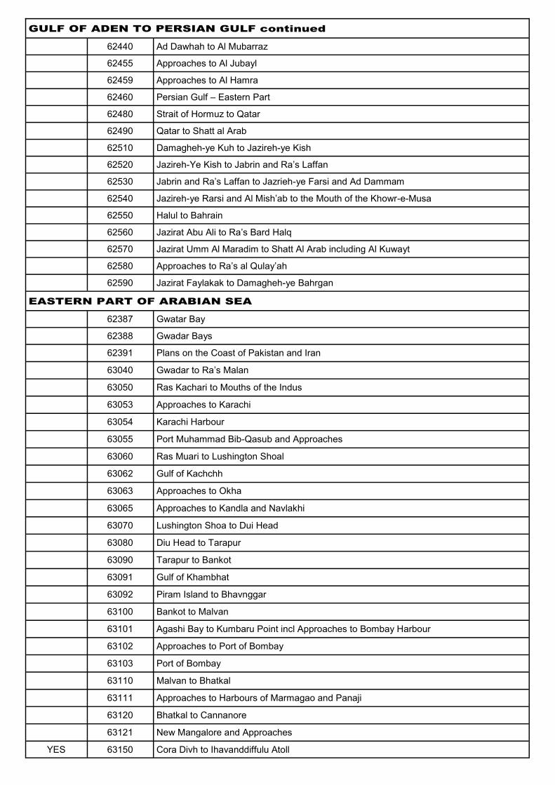
GULF OF ADEN TO PERSIAN GULF continued
62440 Ad Dawhah to Al Mubarraz
62455 Approaches to Al Jubayl
62459 Approaches to Al Hamra
62460 Persian Gulf – Eastern Part
62480 Strait of Hormuz to Qatar
62490 Qatar to Shatt al Arab
62510 Damagheh-ye Kuh to Jazireh-ye Kish
62520 Jazireh-Ye Kish to Jabrin and Ra’s Laffan
62530 Jabrin and Ra’s Laffan to Jazrieh-ye Farsi and Ad Dammam
62540 Jazireh-ye Rarsi and Al Mish’ab to the Mouth of the Khowr-e-Musa
62550 Halul to Bahrain
62560 Jazirat Abu Ali to Ra’s Bard Halq
62570 Jazirat Umm Al Maradim to Shatt Al Arab including Al Kuwayt
62580 Approaches to Ra’s al Qulay’ah
62590 Jazirat Faylakak to Damagheh-ye Bahrgan
EASTERN PART OF ARABIAN SEA
62387 Gwatar Bay
62388 Gwadar Bays
62391 Plans on the Coast of Pakistan and Iran
63040 Gwadar to Ra’s Malan
63050 Ras Kachari to Mouths of the Indus
63053 Approaches to Karachi
63054 Karachi Harbour
63055 Port Muhammad Bib-Qasub and Approaches
63060 Ras Muari to Lushington Shoal
63062 Gulf of Kachchh
63063 Approaches to Okha
63065 Approaches to Kandla and Navlakhi
63070 Lushington Shoa to Dui Head
63080 Diu Head to Tarapur
63090 Tarapur to Bankot
63091 Gulf of Khambhat
63092 Piram Island to Bhavnggar
63100 Bankot to Malvan
63101 Agashi Bay to Kumbaru Point incl Approaches to Bombay Harbour
63102 Approaches to Port of Bombay
63103 Port of Bombay
63110 Malvan to Bhatkal
63111 Approaches to Harbours of Marmagao and Panaji
63120 Bhatkal to Cannanore
63121 New Mangalore and Approaches
YES 63150 Cora Divh to Ihavanddiffulu Atoll
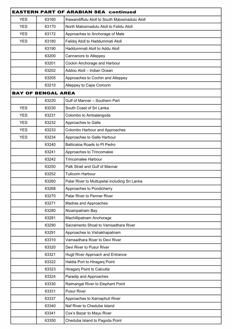
EASTERN PART OF ARABIAN SEA continued
YES 63160 Ihawandiffulu Atoll to South Malosmadulu Atoll
YES 63170 North Malosmadulu Atoll to Felidu Atoll
YES 63172 Approaches to Anchorage of Male
YES 63180 Falidoj Atoll to Haddummati Atoll
63190 Haddummati Atoll to Addu Atoll
63200 Cannanore to Alleppey
63201 Cockin Anchorage and Harbour
63202 Addoo Atoll – Indian Ocean
63205 Approaches to Cochin and Alleppey
63210 Alleppey to Cape Comorin
BAY OF BENGAL AREA
63220 Gulf of Mannar – Southern Part
YES 63230 South Coast of Sri Lanka
YES 63231 Colombo to Ambalangoda
YES 63232 Approaches to Galle
YES 63233 Colombo Harbour and Approaches
YES 63234 Approaches to Galle Harbour
63240 Batticaloa Roads to Pt Pedro
63241 Approaches to Trincomalee
63242 Trincomalee Harbour
63250 Palk Strait and Gulf of Mannar
63252 Tuticorin Harbour
63260 Palar River to Muttupetai including Sri Lanka
63268 Approaches to Pondicherry
63270 Palar River to Penner River
63271 Madras and Approaches
63280 Nizampatnam Bay
63281 Machillipatnam Anchorage
63290 Sacramento Shoal to Vamsadhara River
63291 Approaches to Vishakhapatnam
63310 Vamsadhara River to Devi River
63320 Devi River to Pusur River
63321 Hugli River Approach and Entrance
63322 Haldia Port to Hiraganj Point
63323 Hiraganj Point to Calcutta
63324 Paradip and Approaches
63330 Raimangal River to Elephant Point
63331 Pusur River
63337 Approaches to Karnaphuli River
63340 Naf River to Cheduba Island
63341 Cox’s Bazar to Mayu River
63350 Cheduba Island to Pagoda Point

BAY OF BENGAL AREA continued
63351 Mayu River to Kyaukpyu Harbour
63352 Kaladan River
63353 Kyaukpyu Harbour to Cheduba Strait
63354 Cheduba Strait to Andrew Bay including Ramree Harbour
63361 Andrew Bay to the Calventuras
YES 63370 Andaman Islands – Northern Part
YES 63380 Andaman Islands – Central Part
YES 63383 Port Blair and Approaches
YES 63390 Nicobar Islands
YES 63400 Andaman Sea – Burma to Sumatera
63410 Goyangyi Kyun to Rangoon River including Preparis Island
63411 Calventuras to Bassein River
63412 Basseuin River and Approaches
63413 Rangoon Riber
63417 Approaches to Yangon River
63420 Rangoon River to Launglon Bok Islands
63422 Mali Kyun and Vicinity
63424 Approaches to Moulmein
63430 Launglon Bok Islands to Nearchus Passage
63433 Approaches to Mergui Harbour
YES 63440 Nearchus Passage to Ko Tachai
YES 71040 Ko Tachai to Ko Butang
ISLANDS EASTWARD OF MADAGASCAR
YES 61036 Seychelles
61541 Mahe and Praslin and Approaches
YES 61542 Victoria and Approaches
61551 Plans in the Indian Ocean
61581 Ile de la Reunion
61582 Saint Denis to Saint Gilles-Les-Bain
61591 Mauritius
61592 Plans on the West Coast of Mauritius
61594 Grand Port
61601 Rodrigues Island
YES 61610 Chagos Archipelago
YES 61611 Diego Garcia, Indian Ocean
YES 61612 Approaches to Diego Garcia
GULF OF OMAN TO PERSIAN GULF
62314 Mina Qabus
62343 Mina Qabus to Mina al Fahl
62355 Approaches to Mina Qabus and Mina al Fahl
62362 Gulf of Oman
62366 Khawr Fakkan, Al Fujayrah and Approaches

GULF OF OMAN TO PERSIAN GULF continued
62377 Khalij-e Chabahar
62394 Bandar Abbas
62395 Bandar-E Shahid
62396 Musandam Peninsula
62401 Approaches to Jabal Az Zannah
62402 Approaches to Ad Dawah and Umm Sa’id
62403 Approaches to Abu Zaby
62404 Jabal az Zannah Anchorage
62405 Approaches to Dubayy and Ash Shariqah
62407 Al Mubarraz and Approaches
62408 Approaches to Das, Zirkuh and Abu al Bukhush
62409 Plans in Qatar
62411 Approaches to Ra’s Laffan
62412 Approaches to Mina Salman and Mina al Manamah
62413 Mina Salman and Sitrah
62414 Mubarraz Oil Terminal
62415 Al Ju’aymah
62416 Ra’s Tannurah and Ad Dammam
62417 Ra’s Laffan
62418 Ra’s al Ghar
62419 Approaches to Al Ju’aymah, Ra’s Tannurah and Ad Damman
62428 Bushehr and Approaches
62429 Al Jubayl-Saudi Arabia
62431 Jazireh-ye Khark
62432 Mina’ al Ahmadi and Approaches
62433 Harbour of Al Kuwayt
62434 Approaches to Khawr Abd Allah and Shatt Al Arab
62435 Shatt Al Arab-Al Faw to Abadan
62437 Khawr Shatanah and Approaches to Umm Qasr
62438 Abadan and Khorramshahr
62439 Approaches to Al’Ashshar and Al Ma’qil
62441 Khowr-e Musa (Iran)
62442 Khowr-e Musa
62444 Approaches to Abu Zaby
62446 Dubayy
62447 Ash Shariqah
62448 Al Khafji
62449 Plans of Das, Sir Bu Nu’yar and Arzanah
62451 Approaches to Al Khafji
62452 Approaches to Mina’ Ra’s Mish’ab
62453 Mina Salman
62456 Al Jubayl Ports

GULF OF OMAN TO PERSIAN GULF continued
62457 Umm Sa’id
62458 Mina Saqr
62462 Abu Zaby
62463 Mina Zayid
62464 Mina Jabal Ali
62481 Jazireh-Ye Lavan Terminal and Jazrieh-Ye Sirri
62498 Approaches to Mina Jabal Ali, Dubayy and Ash Shariqah
62499 Mina Jabal Ali
62515 Mina Az Zawr
62584 Ra’s al Qulay’ah
MISCELLANEOUS CHARTS
YES 61012 Zanzibar to Portode Mocambique, Africa E. Coast
YES 62004 Jaza’ir az Zubayr to ‘Adan, Red Sea and Gulf of Aden
YES 62008 Masamirit to Jaza’ir az Zubayr, Red Sea Sheet IV
YES 62012 Jaza’ir Siyal to Masamirit, Red Sea
YES 62016 Al Ikhwan to Jaza’ir Siyal, Red Sea
YES 62020 As Suways to the Brothers incl Gulf of Aqaba, Red Sea
YES 62060 Ras al Hamar to Capo Guardafui, Somalia, Gulf of Aden
YES 62081 Bab al Mandeb to ‘Adan, Yemen, Asia
YES 62190 Khalij as Suways, Egypt
INT 22 638
204 70
302 700
506 701
507 702
508 703
509 704
601 705
602 706
603 707
604 708
605
606 Minerva Reef is also another popular chart
622
631
International Charts that we hold ...

OTHER MISCELLANEOUS
CHARTS WE HOLD
(VARIOUS COUNTRIES)
Visit Copyworld to view catalogues of reduced chart images, showing charts for …
Fiji
Vanuatu
New Caledonia
Australian Coast
Japan / Korea
Philippines
Singapore
South Africa
The Mediterranean
We also carry some complete portfolios of charts … Portfolio 730 - New Guinea area (30 charts) Portfolio 705 - Australia (64 charts) Portfolio 115 - Nth Pacific (29 charts)
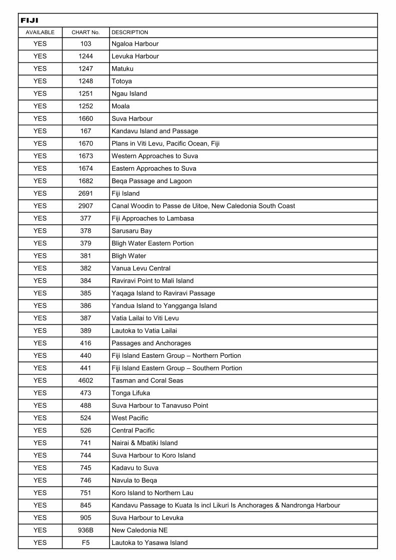
FIJI
AVAILABLE CHART No. DESCRIPTION
YES 103 Ngaloa Harbour
YES 1244 Levuka Harbour
YES 1247 Matuku
YES 1248 Totoya
YES 1251 Ngau Island
YES 1252 Moala
YES 1660 Suva Harbour
YES 167 Kandavu Island and Passage
YES 1670 Plans in Viti Levu, Pacific Ocean, Fiji
YES 1673 Western Approaches to Suva
YES 1674 Eastern Approaches to Suva
YES 1682 Beqa Passage and Lagoon
YES 2691 Fiji Island
YES 2907 Canal Woodin to Passe de Uitoe, New Caledonia South Coast
YES 377 Fiji Approaches to Lambasa
YES 378 Sarusaru Bay
YES 379 Bligh Water Eastern Portion
YES 381 Bligh Water
YES 382 Vanua Levu Central
YES 384 Raviravi Point to Mali Island
YES 385 Yaqaga Island to Raviravi Passage
YES 386 Yandua Island to Yangganga Island
YES 387 Vatia Lailai to Viti Levu
YES 389 Lautoka to Vatia Lailai
YES 416 Passages and Anchorages
YES 440 Fiji Island Eastern Group – Northern Portion
YES 441 Fiji Island Eastern Group – Southern Portion
YES 4602 Tasman and Coral Seas
YES 473 Tonga Lifuka
YES 488 Suva Harbour to Tanavuso Point
YES 524 West Pacific
YES 526 Central Pacific
YES 741 Nairai & Mbatiki Island
YES 744 Suva Harbour to Koro Island
YES 745 Kadavu to Suva
YES 746 Navula to Beqa
YES 751 Koro Island to Northern Lau
YES 845 Kandavu Passage to Kuata Is incl Likuri Is Anchorages & Nandronga Harbour
YES 905 Suva Harbour to Levuka
YES 936B New Caledonia NE
YES F5 Lautoka to Yasawa Island
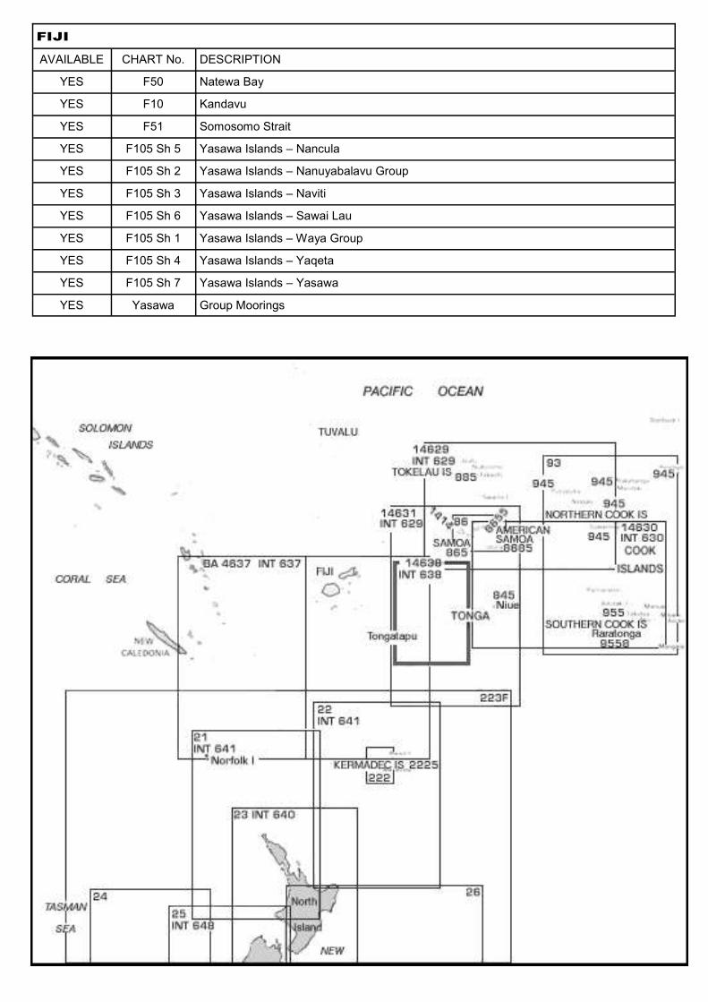
FIJI
AVAILABLE CHART No. DESCRIPTION
YES F50 Natewa Bay
YES F10 Kandavu
YES F51 Somosomo Strait
YES F105 Sh 5 Yasawa Islands – Nancula
YES F105 Sh 2 Yasawa Islands – Nanuyabalavu Group
YES F105 Sh 3 Yasawa Islands – Naviti
YES F105 Sh 6 Yasawa Islands – Sawai Lau
YES F105 Sh 1 Yasawa Islands – Waya Group
YES F105 Sh 4 Yasawa Islands – Yaqeta
YES F105 Sh 7 Yasawa Islands – Yasawa
YES Yasawa Group Moorings
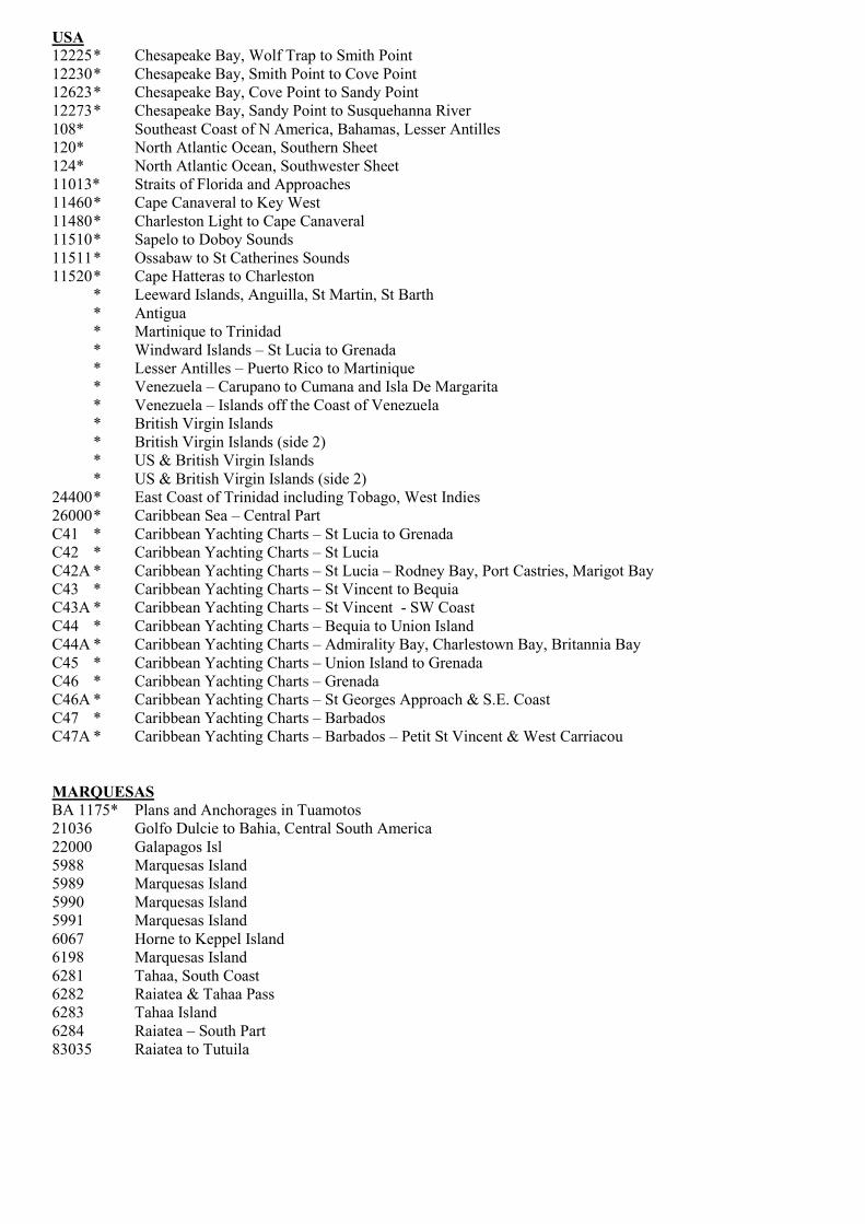
USA
12225 * Chesapeake Bay, Wolf Trap to Smith Point
12230 * Chesapeake Bay, Smith Point to Cove Point
12623 * Chesapeake Bay, Cove Point to Sandy Point
12273 * Chesapeake Bay, Sandy Point to Susquehanna River
108* Southeast Coast of N America, Bahamas, Lesser Antilles
120* North Atlantic Ocean, Southern Sheet
124* North Atlantic Ocean, Southwester Sheet
11013* Straits of Florida and Approaches
11460 * Cape Canaveral to Key West
11480 * Charleston Light to Cape Canaveral
11510 * Sapelo to Doboy Sounds
11511 * Ossabaw to St Catherines Sounds
11520 * Cape Hatteras to Charleston
* Leeward Islands, Anguilla, St Martin, St Barth
* Antigua
* Martinique to Trinidad
* Windward Islands – St Lucia to Grenada
* Lesser Antilles – Puerto Rico to Martinique
* Venezuela – Carupano to Cumana and Isla De Margarita
* Venezuela – Islands off the Coast of Venezuela
* British Virgin Islands
* British Virgin Islands (side 2)
* US & British Virgin Islands
* US & British Virgin Islands (side 2)
24400 * East Coast of Trinidad including Tobago, West Indies
26000 * Caribbean Sea – Central Part
C41 * Caribbean Yachting Charts – St Lucia to Grenada
C42 * Caribbean Yachting Charts – St Lucia
C42A * Caribbean Yachting Charts – St Lucia – Rodney Bay, Port Castries, Marigot Bay
C43 * Caribbean Yachting Charts – St Vincent to Bequia
C43A * Caribbean Yachting Charts – St Vincent - SW Coast
C44 * Caribbean Yachting Charts – Bequia to Union Island
C44A * Caribbean Yachting Charts – Admirality Bay, Charlestown Bay, Britannia Bay
C45 * Caribbean Yachting Charts – Union Island to Grenada
C46 * Caribbean Yachting Charts – Grenada
C46A * Caribbean Yachting Charts – St Georges Approach & S.E. Coast
C47 * Caribbean Yachting Charts – Barbados
C47A * Caribbean Yachting Charts – Barbados – Petit St Vincent & West Carriacou
MARQUESAS
BA 1175* Plans and Anchorages in Tuamotos
21036 Golfo Dulcie to Bahia, Central South America
22000 Galapagos Isl
5988 Marquesas Island
5989 Marquesas Island
5990 Marquesas Island
5991 Marquesas Island
6067 Horne to Keppel Island
6198 Marquesas Island
6281 Tahaa, South Coast
6282 Raiatea & Tahaa Pass
6283 Tahaa Island
6284 Raiatea – South Part
83035 Raiatea to Tutuila
SOUTH AMERICA
21306 * Golfo Dulce to Bahia de Paita, Galapagos
22000 * Archipelago de Colon, Galapagos
23000 * Bahia San Julian to Estrecho de Magallanes with Part of Falkland Islands, Argentina
23010 * Golfo Nuevo to Bahia San Julian, Argentina
23020 * Bahia Blanca to Golfo Nuevo, Argentina
23030 * Rio de la Plata to Bahia Blanca, Argentina E Coast
23051 * Puerto Santa Cruz, Argentina
23071 * Rada Puerto Deseado, Argentina
23101 * Golfo Nuevo, Provincia del Chubut, Argentina
23102 * Puerto Madryn, Argentina-Golfo Nuevo
24000 * Ilha de Santa Catarina to Maldonado, Brazil and Uruguay
24004 * Rio de Janeiro to Ilha de Santa Cataina, Brazil S. Coast
24008 * Belmonte to Rio de Janeiro, Brazil E. Coast
24012 * Recife to Belmonte, Brazil E. Coast
24016 * Rio Parnaiba to Recife, Brazil N. Coast
24020 * Baia do Oiapoque to Rio Parnaiba, Brazil N. Coast
24024 * Ponta Goiabal to Maroni River, French Guiana and Brazil
24028 * Gulf of Paria to Maroni River, South Amercia NE Coast
24050 * Rio de la Plata, South Amercia E. Coast
24051 * Anchorage and Port of La Plata, Argentina
24052 * Approaches to Port of Buenos Aires, Rio de la Plata, Argentina-Uruguay
24053 * Port of Buenos Aires, Argentina
24054 * Bahia de Montevideo and Approaches, Isla de Flores to Cerro de Montevideo, Uruguay
24150 * Rio de Janeiro to Santos, Brazil S.Coast
24160 * Cabo de Sao Tome to Rio de Janeiro, Brazil E. Coast
24161 * Baia de Guanabara, Brazil S. Coast
24162 * Port of Rio de Janeiro, Brazil S. Coast
24164 * Pta de Guaratiba to Ilha Grande incl Eastern Passage to Baia de Ilha Grande & Baia de Sepetiba, Brazil
24220 * Cabo Branco to Maceio, Brazil E. Coast
24223 * Port of Recife, Brazil E. Coast
24230 * Ponta Dos Tres Irmaos to Cabo Branco, Brazil N. Coast
24311 * das Ilhas Pedreira a Ilha de Santana, Brazil-Amazon River
24312 * Ponta do Capinal to Ilhas Pedreira, Brazil-Amazon River
24321 * Ilha Bailique to Ponta do Capinal, Brazil-Amazon River
24322 * Rio Amazonas, Northern Entrance to Brazil N. Coast
NEW CALEDONIA – (NewCaledonia) - not wonderful quality but readable
2906 Kunie to Baie du Prony
2907 Baie du Prony to Passe du Cap Ka
3033 New Hebrides Islands to New Caledonia
526 Pacific Ocean – Central Part
936B New Caledonia (SE Part) Port Mueo to Kunie Island
NOUMEA – (Noumea folder)
480 Port Noumea
7052 De Noumea A L’ile Des Pins (Le Grand Lagon Sud)

EUROPE
36000* English Channel
37010* North Sea Southern Sheet
37025* Bay of Biscay, France and Spain
37030* Cabo Penas to Pointe d’Arcachon, N. Coast Spain/W. Coast France
37035* Cabo Silleiro to Cabo Penas, North & West Coasts of Spain
37090* Isle of Portland of Worthing and Cap Frehel to Courseulles, English Channel, England-France
37110* Worthing to Dover and Courseulles to Cap Gris-Nez, English Channel, UK-France
37241* Approaches to Europoort and Hoek van Holland, Netherlands, N. Sea
37130* Dover to Orford Ness and Cap Gris-Nez to Hoek van Holland, English Channel North Sea
37320* Goulven to Pte de Penmarc’h including Ile d’Ouessant and Brest, France, NW Coast
37360* Pte de Penmarch to Ile d’Yen, France W. Coast
37400* Ile d’Yen to Gironde River, Bay of Biscay, France W. Coast
37505* Cabo Torinana to La Estaca de Bares, Spain NW Coast, N. Atlantic
51007* Cabo Finisterreto Cadiz, Spain and Portugal, W & S Coasts
51013* Cabo de Sao Vicente to Beddouza incl Strait of Gibraltar, Portugal-Spain-Morocco
51017 * Ra’s Beddouza to Cap Juby incl Arch, Da Madeira & Islas Canarias
51100* Cabo Villano to Porto, Spain and Portugal W. Coast
51109* Plans of the West Coast of Portugal
51120* Porto to Ponta de Maparoeira, Portugal W. Coast
51140 * Ponta da Lamparoeira to Cabo de Sao Vicente, Portugal W. Coast
51141* Approahces to Rio Tejo and Lisboa, Portugal W. Coast
51160* Cabo de Sao Vicente to Strait of Gibralter, Spain & Portugal
51341* Ports in the Islas Canarias, N. Atlantic Ocean
51342* Iiheus Selvagem (Salvage Isl) N. Atlantic
51343* Approaches to Puerto del Rosario, Fuerteventura, Islas Canarias, N. Atlantic Ocean
51380* Islas Canarias, Eastern Group, Africa W. Coast
51500* Cape Verde, Northwestern Part, N. Atlantic Ocean
51520* Cape Verde, Eastern Part, N. Atlantic Ocean
51540* Cape Verde, N. Atlantic Ocean
MEDITERRANEAN
310* Mediterranean Sea (Europe, Africa, Asia)
52000* Gibraltar to Cabo de San Antonio and Cape Tenes, Spain-Morocco-Algeria
52010* Cabo de Palos and Cap Tenes to Sardegna incl Islas Baleares, Spain-Algeria-Sardegna
52100* Cabo de San Antonio to Vabo Tortosa, Spain E. Coast
52120* Cabo Tortosa to Cabo de San Sebastian, Spain E. Coast
52122* Rio Llobregat to Rio Besos incl Port of Barcelona, Spain E. Coast
52140* Islas Baleares, Spain
52144* Isla Dragonera to Cabo Blanco incl Bahia de Palma, Balearic Islands-Mallorca
52162* East Coast of Tunisia
52160* Al Mahdiyah to Ra’s Al Makhbaz (Tunisia)
53000* Barcelona to Roma incl Island of Corse
53020* Tyrrhenian Sea incl Sardegna and Sicilia
53040* Cabo de San Sebastian to Sete, Spain and France
53060* Sete to Maseille, France S. Coast, Mediterranean Sea
53061* Approaches to Marseille, France S. Coast
53062* Port of Marseille, France S. Coast
53063* Golfe de Fos incl Port-de-Bouc and Port-St-Louis-du-Rhone, France S. Coast
53080* Marseille to San Remo, France and Italy
53100* San Remo to Capo Cavallo, Italy W. Coast
53160* Isole Ponziane to Capo Bonifati, Italy W. Coast
53180* Capo Bonifati to Stretto di Messina, Italy W. Coast
53183* Stretto di Messina, Italy-Sicilia
53185* Messina Harbor, Sicilia E. Coast
53200* Malta to Stretto di Messina, Sicilia E. Coast
53280* Sargegna (Sardinia) Northern Part
53287* Strait of Bonifacio, Sardegna-Corse

MEDITERRANEAN continued
53300* Corse
54010* Malta to Kriti (Crete) incl Ionian Sea
54020* Aegean Sea, Greece-Turkey
54030* Antalya Korfezi to Al Iskandariyah (Alexandria) incl Cyprus
54040* Capo Spartivento to Punta Alice, Italy S. Coast
54280* Corfu Channel to Nisis Proti, Albania-Greece
54287* Patraikos Kolpos and Approaches, Greece W. Coast
54288* Plans in Korinthiakos Kolpos and Patraikos Kolpos, Greece
54289* Korinthiakos Kolpos (Gulf of Corinth), Greece
54300* Nisi Proti to Nisos Spetzai incl NW Coast of Crete, Greece S. Coast
54320* Kikladhes Nisoi to Kriti (Crete), Greece S. Coast, Aegean Sea
54322* Kriti (Crete), Greece
54340* Nisos Spetsai to Nisoi Vorioi Sporadhes, Greece E. Coast, Aegean Sea
54346* Piraievs and Ormos Falirou, Greeced
54360* Thessaloniki to Dardanelles (Canakkale Bogazi) Greece-Turkey, Aegean Sea Northern Part
54400* Nisos Samos to Misos Rodhos incl Dodecanese & SW Coast of Turkey, Greece-Turkey, Aegean Sea
55040* Sea of Marmara, Turkey
56000* Tubruq to Al Iskandariyah (Alexandria) incl Crete & Dodecanese
56081* Bur Sa’id, Egypt
56082* Qanat as Suways (Suez Canal), Egypt
56100* Al Iskandariiyah to Bur Sa’id, Egypt
KOREA
104 Korean Archipelago
1065 Approaches to Chinhae & Pusan
1259 Pusan Hang
1263 Sth China Sea
1280 Korea Sth Coast
2385 Tsu Shima
2483 Atlantic Ocean – Indian Ocean & Pacific
3365 Korea SW Coast
3366 Korea Sth Coast
3480 China East Coast
3666 Korea East Coast
898 Sinp’o Hang & Ulsan Hang Approaches
INDONESIA
524 Western Part of Pacific Ocean including Phillipines & Indonesia
603 Indian Ocean – Australia, North Coast (Adjacent Waters)
632 Strait of Malacca to Banda Sea including South China Sea, Java Sea & Celebes Sea
945 Plans in Madura Strait
1653A Jawa – Western Portion
1653B Jawa – Central Portion
1653C Jawa – Eastern Portion
1696 Lombok to Flores
1697 Flores to Timor
3244 Eastern Timor & Pulau Sermata – Western Portion
3937 Plans for Kepulauan
3948 Straat Durian (China Sea)
INDIAN OCEAN – IndianOcean folder
721 Indian Ocean – Northern Part (Indian Ocean Folder)
4070 Indian Ocean – Southern Portion
4071 Indian Ocean – Northern Portion
748A Indian Ocean – Southern Portion
748B Indian Ocean – Northern Portion
BA 66A Maldives Sheet 1
BA 66B Maldives Sheet 2
BA 66C Maldives Sheet 3
703 Gulf of Aden to Maldives & Seychelles
SOUTH PACIFIC – SthPacific folder
1174 Nuie and Suwarow Island
1175 Plans in the Archipel Des Tuamotu
1385 Anchorages in Tonga / Nukualofa / Nomuka Harbour
1830 Ellice Islands to Phoenix Islands
215 New Caledonia (Kunie Island) to New Zealand (North Cape)
379 Fiji – Bligh Water Eastern Portion
440 Fiji Islands – Eastern Group (Northern Portion)
4602 Tasman and Coral Seas (Australia to Northern NZ and Fiji)
4607 South East Polynesia
568 Raoul Island
8259 Tonga or Friendly Islands – Nomuka Group
ChtInd Bellingham Chart Printers
Norfolk Norfolk and Philip Island
526 Pacific Ocean Central Part
Vava’u Kingdom of Tonga – Vava’u Island Group
HAWAII
19320 Island of Hawaii
19327 West Coast of Hawaii – Cook Pt to Upolu Pt
19357 Island of Oahu
PAPUA NEW GUINEA – INDONESIA
1066 Java Sea
1293 Approaches to Makassar
1416 Anchorages NW Coast of New Guinea
1653 Java East inc Madura, Bali & Lombok
1653A Java West
1653B Java Central
1696 Lombok to Flores
1697 Flores to Timor
2575 Celebes Sea East
2637 Strait of Makassar
3026 Kai Islands
3242 East Ceram Sea
3244 East Timor & Sermatal Eilanden
3330 West Portion of Java inc Sunda
3726 Straat of Bali
3744 New Guinea NW Coast
6115 Lakahia Bay and Approaches
921 Approaches to Java
933 Approaches to Djakarta
941A East Archipelago inc Java Sea
941B East Archipelago inc Java – Borneo
942A East Archipelago inc Timor
942B East Archipelago inc Flores, Banda, + Arafura to China
MALAYSIA
1353 Diamond Point to One Fathom Bank
3946 Port Dickson
3947 Melaka to Iyu Kecil
71062 Pinang Harbour and Approach
2403 Singapore Strait

SOLOMONS
1469 Guadalcanal Island to Georgia Group
17 Plans in the Santa Cruz and Adjacent Islands
2003 Vitu Islands to Watom Island
2018 Vitiaz and Dampier Straits
2054 Plans in New Guinea
2136 Plans in New Ireland
2240 Vitiaz Strait to Isumrud Strait
2766 Northeast Coast of New Guinea
2901 Solomon Islands to Tuvalu (Ellice Islands)
3268 Plans in the Solomon Islands
3402 Isabel Island to Georgia Group
3412 San Cristobal Island to Malaita Island
3419 Bougainville Strait
3420 Bougainville Island
3553 Gazelle Peninsula and St Georges Channel
378 PNG South Coast – Daru Roads to Kerema Bay
379 Kerema Bay to Port Moresby
380 Port Moresby to Orangerie Bay
381 Orangerie Bay to Jomard Entrace
383 Bonvouloir Islands to Woodlark Island
384 Cape Vogel to Cape Nelson with the D’entrecasteaux Islands
385 Cape Ward Hunt to Cape Cretin and Cape Nelson to Cape Ward Hunt
3994 Bougainville Island to Ghizo Island
3995 Choiseul Island to New Georgia Island
4604 Coral and Solomon Seas
567 Mugula Island to China Strait
621 Approaches to Port Moresby
625 China Strait and Approaches
629 Milne Bay including Approaches from China and Goschen Straits
683 Plans in the Solomon Passage
1713 Shalark Channel and Approaches to Honiara
1750 Anchorages in Guadalcanal Island
1756 Harbours in the Solomon Islands
JAPAN
127 Hirado Seto to Shimonoseki Kaikyo
128 Channels between Bingo Nada and Ozuchi Shima
135 Wakamatsu
358 Western Coasts of Kyushu and Honshu including the Korea Strait
532 Approaches to Kanmon Kaikyo
626 Plans in the South East Kyushu
651 Tozaki Hana to Okino Shima including Bungo Suido
652 Ashizuri Saki to Muroto Saki
835 Osumi Kaikyo and Approaches
836 Koshiki Retto to Hirado Shima
873 Amami Gunto
951 Muroto Saki to Miki Saki including Kii Suido
952 Miki Saki to Omae Saki
953 Omae Saki to Nojima Saki
990 Naha Ko
1527 Io Shima to Hirado Shima
1578 Kanmon Kaikyo
1648 Osumi Kaikyo to O Shima showing Approaches to Bungo Suido and Kii Suido
1969 Ozuchi Shima to Funoko Shima
2026 Matsu Shima to Kuro Shima including Approaches to Sasebo
2412 Amoy to Nagasaki including Yangtze Kiang and Islands between Tai-wan and Japan
2415 Approaches to Nagasaki and Shimabara Kaiwan
2459 North West Pacific Ocean including Yellow, Yapan and Okhotsk Seas, The Kuril Islands and Kamchatka
2815 Nagasaki Ko
2874 Naikai or Seto Uchi – Western Sheet
2875 Seto Naikai – Eastern Sheet
3105 Chiba Ko and Approaches
3109 Keihin Ko Yokohama Ku and Kawasaki Ku
3110 Keihin Ko Tokyo Ku
3112 Plans on the West Coast of Kyushu
3225 Kanmon Kaikyo to Kusayama Saki
3237 Okinawa Gunto to Kyushu
3357 Osumi Gunto and Approaches
3469 Ports in Hiroshima Wan
3511 Ogawa Shima to Ashiya
3514 Hirado Shima to Hotoke Sake including Iki Suido
3551 Ogasawaro Gunto and Approaches
3602 Ya Shima to Naka Shima and Hiroshima
3603 Ao Shima to Osaki Kami Shima
3604 Osaki Kami Shima to Ta Shima and Nihama
3650 Irako Suido and Approaches
3702 Southern Part of Okinawa Shima
3881 Sasebo Ko
NORTHERN PACIFIC
1101 Mariana Islands, Bahia Laulau, Saipan Harbour, Saipan & Tinian Islands
1142 Midway Island to Kauai including Johnston Island
1510 Hawaiian or Sandwich Islands
2867 Christmas Island
763 Caroline Islands – Western Portion
764 Caroline Islands – Eastern Portion
781 Pacific Ocean – Northwest Sheet
782 Pacific Ocean – Northeast Sheet
910 Plans in the Marianas or Ladrones Islands
970 Islands & Anchorage in the Caroline Islands
983 Marshall Islands


Related Documents