TIERRA ROBLES PLANNED DEVELOPMENT ZONE AMENDMENT 10-002 TRACT MAP 1996 SCH NO. 2012102051 DRAFT ▪ OCTOBER 2017 5.6-1 GEOLOGY AND SOILS 5.6 GEOLOGY AND SOILS The purpose of this section is to describe the geologic and seismic setting of the project area, identify potential impacts associated with implementation of the proposed project, and, as necessary, recommend mitigation to reduce the significance of impacts. The issues addressed in this section are risks associated with faults, strong seismic ground shaking, seismic-related ground failure such as liquefaction, landslides, and unstable geological units and/or soils. Information in this section is drawn from the Preliminary Geotechnical Report (Brown and Mills, 2006) and other published references, as cited. The report is included in Appendix 15.5, PRELIMINARY GEOTECHNICAL REPORT. The following analysis of the potential environmental impacts related to geology and soils is also derived from the following sources and agencies: • Shasta County. Shasta County General Plan. 2004. • Shasta County. Shasta County and City of Anderson Multi-Jurisdictional Hazard Mitigation Plan. September 2011. • Shasta County. Code of Ordinances, Grading, Excavating, and Filling, Chapter 12.12. July 2016. This section describes the affected environment and regulatory setting for geology and soils. It also describes the impacts on geology and soils that would result from implementation of the proposed project and mitigation measures that would reduce these impacts. 5.6.1 ENVIRONMENTAL SETTING GEOLOGIC SETTING Regional Geology The proposed development area is located in the northern part of the Sacramento Valley, the northern extension of the Central (or “Great”) Valley, which extends along much of the length of California. The Central Valley occupies an elongate, northwest-trending structural trough bound on the east by the Sierra Nevada mountain range and on the west by the Coast Ranges. The northern Sacramento Valley is bound on the west by the northern Coast Ranges, on the north by the Klamath Mountains, and on the east by the Cascade Range and Modoc Plateau. The Sacramento/Central Valley has been filled with an immense accumulation of valley fill sediment derived from the surrounding uplands that dates from the Jurassic period to the present. Regional tectonic uplift through the Pleistocene within the northern Sacramento Valley has resulted in incision of a pre-existing alluvial plain by the Sacramento River and other major tributaries east of Redding (Cow Creek, Stillwater Creek, and so on). This uplift has resulted in a landscape defined by broad, uplifted alluvial surfaces (terraces) punctuated by incised stream canyons. The project site occupies a similar surface between Clough Creek and the Cow Creek watershed. The uplifted alluvial surfaces in the northern Sacramento Valley, including the project site, are underlain by a thin veneer of Pleistocene age alluvial deposits mapped as the Red Bluff Formation (Helley and Harwood, 1985). The Red Bluff Formation consists of highly-weathered (characteristically very red in color) conglomerate with well-rounded cobbles. Test pits excavated at the site during the preliminary geotechnical investigation encountered these materials to depths of 1 to 5 feet. The Red Bluff Formation

Welcome message from author
This document is posted to help you gain knowledge. Please leave a comment to let me know what you think about it! Share it to your friends and learn new things together.
Transcript
TIERRA ROBLES PLANNED DEVELOPMENT ZONE AMENDMENT 10-002
TRACT MAP 1996 SCH NO. 2012102051
DRAFT ▪ OCTOBER 2017 5.6-1 GEOLOGY AND SOILS
5.6 GEOLOGY AND SOILS The purpose of this section is to describe the geologic and seismic setting of the project area, identify potential impacts associated with implementation of the proposed project, and, as necessary, recommend mitigation to reduce the significance of impacts. The issues addressed in this section are risks associated with faults, strong seismic ground shaking, seismic-related ground failure such as liquefaction, landslides, and unstable geological units and/or soils. Information in this section is drawn from the Preliminary Geotechnical Report (Brown and Mills, 2006) and other published references, as cited. The report is included in Appendix 15.5, PRELIMINARY GEOTECHNICAL REPORT. The following analysis of the potential environmental impacts related to geology and soils is also derived from the following sources and agencies:
• Shasta County. Shasta County General Plan. 2004.
• Shasta County. Shasta County and City of Anderson Multi-Jurisdictional Hazard Mitigation Plan. September 2011.
• Shasta County. Code of Ordinances, Grading, Excavating, and Filling, Chapter 12.12. July 2016. This section describes the affected environment and regulatory setting for geology and soils. It also describes the impacts on geology and soils that would result from implementation of the proposed project and mitigation measures that would reduce these impacts.
5.6.1 ENVIRONMENTAL SETTING
GEOLOGIC SETTING
Regional Geology
The proposed development area is located in the northern part of the Sacramento Valley, the northern extension of the Central (or “Great”) Valley, which extends along much of the length of California. The Central Valley occupies an elongate, northwest-trending structural trough bound on the east by the Sierra Nevada mountain range and on the west by the Coast Ranges. The northern Sacramento Valley is bound on the west by the northern Coast Ranges, on the north by the Klamath Mountains, and on the east by the Cascade Range and Modoc Plateau. The Sacramento/Central Valley has been filled with an immense accumulation of valley fill sediment derived from the surrounding uplands that dates from the Jurassic period to the present.
Regional tectonic uplift through the Pleistocene within the northern Sacramento Valley has resulted in incision of a pre-existing alluvial plain by the Sacramento River and other major tributaries east of Redding (Cow Creek, Stillwater Creek, and so on). This uplift has resulted in a landscape defined by broad, uplifted alluvial surfaces (terraces) punctuated by incised stream canyons. The project site occupies a similar surface between Clough Creek and the Cow Creek watershed.
The uplifted alluvial surfaces in the northern Sacramento Valley, including the project site, are underlain by a thin veneer of Pleistocene age alluvial deposits mapped as the Red Bluff Formation (Helley and Harwood, 1985). The Red Bluff Formation consists of highly-weathered (characteristically very red in color) conglomerate with well-rounded cobbles. Test pits excavated at the site during the preliminary geotechnical investigation encountered these materials to depths of 1 to 5 feet. The Red Bluff Formation

TIERRA ROBLES PLANNED DEVELOPMENT ZONE AMENDMENT 10-002
TRACT MAP 1996 SCH NO. 2012102051
DRAFT ▪ OCTOBER 2017 5.6-2 GEOLOGY AND SOILS
overlies weathered sedimentary rock of the Pliocene age Tehama Formation (Helley and Harwood, 1985). The Tehama Formation consists of sandstone and siltstone with lenses of cross-bedded pebble and cobble conglomerate derived from the Coast Ranges and Klamath Mountains. Tehama Formation sedimentary rocks are relatively dense; backhoe test pits in these materials met practical refusal at relatively shallow depths (<10 feet).
Tectonic Setting
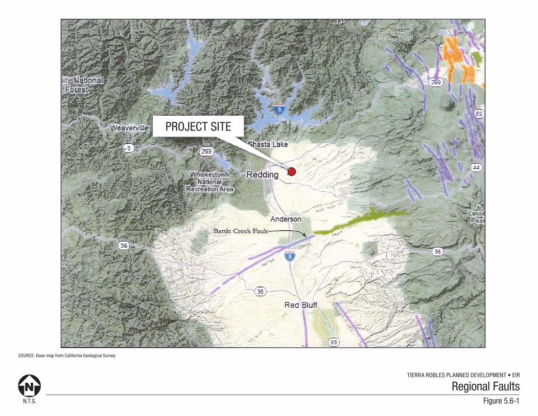
Despite its location surrounded by active volcanoes and a variety of active seismic sources, the northern Sacramento Valley is an area of relatively low seismicity. The area is east of the region affected by the subduction of the Cascadia Subduction Zone (the eastward-travelling, down-going crustal slab being subducted has largely melted by the time it is beneath the Redding area). Areas of extensional faulting related to the Basin and Range geomorphic province occur some 50 miles to the east within the active Hat Creek fault system. The area is within a transitional zone, as right-lateral shearing related to the northern extension of the Walker Lane zone of faulting (the Walker Lane fault zone accommodates the easternmost plate margin-related faulting through western Nevada and into northeastern California) progresses into the region. This recent faulting is poorly understood, but appears to occur east of the project site as well. The active volcanoes at Mt Shasta and Mt. Lassen are potential seismic sources as well. There are no mapped, active faults in the project site vicinity. The most recent seismic activity in the site region was a magnitude (M) 3.3 earthquake on May 6, 2015 that occurred about 4 miles north-northwest of Redding.
GEOLOGIC HAZARDS
Fault Rupture
There are no known active faults in the project site vicinity, nor are there state mandated “Earthquake Fault Zones” per the Alquist-Priolo Fault Zoning Act. The nearest potentially active fault is the Battle Creek fault, which is approximately 17 miles southeast of the site. As most of the project site is a low-gradient terrace surface, recent faulting would likely be associated with observable geomorphic evidence, which is not apparent in aerial photography nor in the field (none is shown on the very-detailed Helley and Harwood (1985) mapping nor discussed in the preliminary geotechnical reporting developed in 2006). Historic seismicity in the region has typically been too minor to result in surface rupture. There appears to be a negligible potential for surface fault rupture at the project site. Refer to Figure 5.6-1, REGIONAL FAULTS.
Strong Ground Shaking
Northern California is a seismically active region, and the project site may be subject to seismic shaking generated from a variety of regional sources. Potential sources, however, are relatively far afield, and regional historic seismicity has been of low magnitude. The northern Sacramento Valley is well east of the seismogenic portion of the Cascadia Subduction Zone. The project area is relatively close to both Mts. Lassen and Shasta, both of which are active volcanic sources that may generate seismicity if a renewed period of activity occurs. The most recent eruption occurred at Mt. Lassen in 1915. The nearest known active fault is 17 miles away. The most recent seismic activity in the site vicinity was a M 5.2 earthquake that occurred in 1998 about 4 miles north-northwest of Redding. There appears to be a moderate potential for moderate strength ground shaking within the economic lifespan of the proposed development, and a low potential for strong, long duration ground shaking.
N.T.S.
TIERRA ROBLES PLANNED DEVELOPMENT • EIR
SOURCE: Base map from California Geological Survey
Figure 5.6-1
Regional Faults
PROJECT SITE
TIERRA ROBLES PLANNED DEVELOPMENT ZONE AMENDMENT 10-002
TRACT MAP 1996 SCH NO. 2012102051
DRAFT ▪ OCTOBER 2017 5.6-4 GEOLOGY AND SOILS
Liquefaction
Seismic ground shaking of relatively loose, granular soils that are saturated or submerged can cause the soils to liquefy and temporarily behave as a dense fluid. Liquefaction is caused by a sudden temporary increase in pore water pressure due to cyclic loading during earthquakes. Liquefaction most often occurs in areas underlain by young alluvium subject to shallow groundwater conditions and strong, long duration earthquakes. The effects of liquefaction can include the temporary loss of soil shear strength (and therefore, its bearing capacity), regional or localized settlement, lateral gliding of large blocks on liquefied layers at depth, and the extrusion of large volumes of liquefied sand (as sand volcanoes).
Preliminary geotechnical investigations at the project site indicate that the majority of the area is underlain by a relatively thin veneer of dense, late Pleistocene age alluvium (with significant soil development) overlying sedimentary bedrock (Tehama Formation). Groundwater was not encountered during the field investigation, which was conducted at the end of the dry season (October). Drainages in the Project area are associated with minimal alluvial deposition; reconnaissance along the Clough Creek channel in the western part of the project area indicated a bedrock-lined scour channel with only minor associated deposition. In the absence of significant accumulations of alluvium in the project area, the liquefaction potential appears to be low.
Landslides
Most of the project area is associated with a low-relief, low gradient alluvial terrace surface that is associated with negligible landslide potential. Sloping ground is present in the eastern part of the project area along three drainage heads where slopes in excess of 30% exist. These slopes are not an area of known landslide activity, nor were any observed during the preliminary geotechnical investigation. Slopes in the northwestern part of the project area leading to Clough Creek are generally gently to moderately sloping. Landslide potential on ground within the project area that slopes <30% is low; for ground sloping >30%, landslide potential is considered moderate.
Flooding
The project area primarily occupies uplands that are not subject to flooding potential. The site is crossed by Clough Creek and several small ephemeral tributaries in the western part of the site, as well as the headwaters of several Cow Creek tributaries along the eastern edge of the site. All of these streams are ephemeral (dry in the summer), and are associated with only minor flooding potential during infrequent, major peak storm events. A low (near-stream level) alluvial floodplain terrace is present locally along the Clough Creek channel. A Preliminary Hydrology Analysis was completed for the project (S2-J2 Engineering, 2016) and determined inundation potential under a variety of high flow conditions along Clough Creek (refer to Appendix 15.5, PRELIMINARY HYDROLOGY ANALYSIS). For the most part, high flows associated with an inferred 100-year flood event are contained within the existing riparian area and floodplain, and do not encroach into proposed residential lots; only the floodplain on Lot #140 is subject to inundation during the 100 year flood (refer to Impact 5.6-2, below).
Two small ponds are located upstream of the site on Clough Creek. These shallow impoundments (approximately 6 feet deep) are retained by engineered earthen embankments. These embankments are reportedly in good condition and are not known to have previously breached. The potential for flooding at the site in the event of dam failure at one of these ponds was considered in the project hydrology report (S2-J2 Engineering, 2016). That analysis concludes that the inundation level associated with potential dam
TIERRA ROBLES PLANNED DEVELOPMENT ZONE AMENDMENT 10-002
TRACT MAP 1996 SCH NO. 2012102051
DRAFT ▪ OCTOBER 2017 5.6-5 GEOLOGY AND SOILS
failure largely coincides with the 100-year flood level. As discussed above, the primary potential for flood inundation associated with a potential dam failure occurs on the floodplain on Lot #140.
There is no potential for flooding at the site associated with potential large scale dam failures at Whiskeytown or Shasta Lakes. Floodwaters associated with these inferred events would largely be confined within the Sacramento River valley and other low-lying areas well below the elevation of the subject site
SOILS
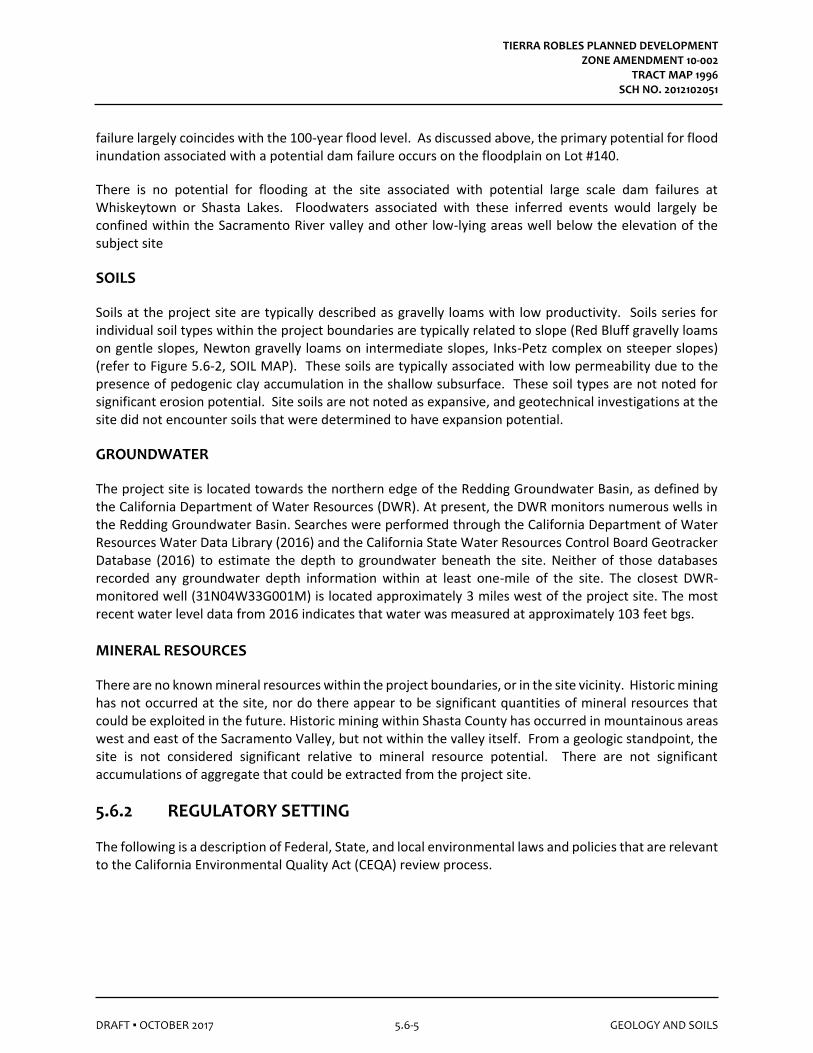
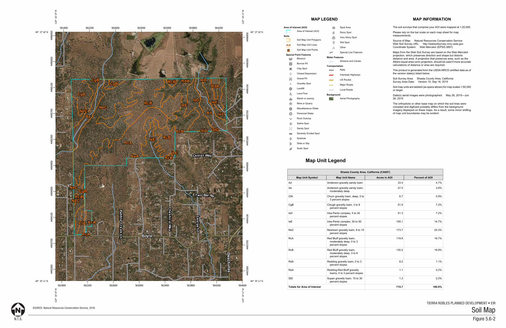
Soils at the project site are typically described as gravelly loams with low productivity. Soils series for individual soil types within the project boundaries are typically related to slope (Red Bluff gravelly loams on gentle slopes, Newton gravelly loams on intermediate slopes, Inks-Petz complex on steeper slopes) (refer to Figure 5.6-2, SOIL MAP). These soils are typically associated with low permeability due to the presence of pedogenic clay accumulation in the shallow subsurface. These soil types are not noted for significant erosion potential. Site soils are not noted as expansive, and geotechnical investigations at the site did not encounter soils that were determined to have expansion potential.
GROUNDWATER
The project site is located towards the northern edge of the Redding Groundwater Basin, as defined by the California Department of Water Resources (DWR). At present, the DWR monitors numerous wells in the Redding Groundwater Basin. Searches were performed through the California Department of Water Resources Water Data Library (2016) and the California State Water Resources Control Board Geotracker Database (2016) to estimate the depth to groundwater beneath the site. Neither of those databases recorded any groundwater depth information within at least one-mile of the site. The closest DWR-monitored well (31N04W33G001M) is located approximately 3 miles west of the project site. The most recent water level data from 2016 indicates that water was measured at approximately 103 feet bgs.
MINERAL RESOURCES
There are no known mineral resources within the project boundaries, or in the site vicinity. Historic mining has not occurred at the site, nor do there appear to be significant quantities of mineral resources that could be exploited in the future. Historic mining within Shasta County has occurred in mountainous areas west and east of the Sacramento Valley, but not within the valley itself. From a geologic standpoint, the site is not considered significant relative to mineral resource potential. There are not significant accumulations of aggregate that could be extracted from the project site.
5.6.2 REGULATORY SETTING
The following is a description of Federal, State, and local environmental laws and policies that are relevant to the California Environmental Quality Act (CEQA) review process.
N.T.S.
TIERRA ROBLES PLANNED DEVELOPMENT • EIRSOURCE: Natural Resources Conservation Service, 2016
Figure 5.6-2
Soil Map
Soil Map—Shasta County Area, California(ChathamPropBoundary)
Natural ResourcesConservation Service
Web Soil SurveyNational Cooperative Soil Survey
2/9/2016Page 1 of 3
4493
300
4493
700
4494
100
4494
500
4494
900
4495
300
4495
700
4496
100
4496
500
4496
900
4493
300
4493
700
4494
100
4494
500
4494
900
4495
300
4495
700
4496
100
4496
500
4496
900
561800 562200 562600 563000 563400 563800 564200
561800 562200 562600 563000 563400 563800 564200 564600
40° 37' 16'' N
122°
16'
15'
' W
40° 37' 16'' N
122°
14'
11'
' W
40° 35' 11'' N
122°
16'
15'
' W
40° 35' 11'' N
122°
14'
11'
' W
N
Map projection: Web Mercator Corner coordinates: WGS84 Edge tics: UTM Zone 10N WGS840 500 1000 2000 3000
Feet0 250 500 1000 1500
MetersMap Scale: 1:18,700 if printed on A portrait (8.5" x 11") sheet.
MAP LEGEND MAP INFORMATION
Area of Interest (AOI)Area of Interest (AOI)
SoilsSoil Map Unit Polygons
Soil Map Unit Lines
Soil Map Unit Points
Special Point FeaturesBlowout
Borrow Pit
Clay Spot
Closed Depression
Gravel Pit
Gravelly Spot
Landfill
Lava Flow
Marsh or swamp
Mine or Quarry
Miscellaneous Water
Perennial Water
Rock Outcrop
Saline Spot
Sandy Spot
Severely Eroded Spot
Sinkhole
Slide or Slip
Sodic Spot
Spoil Area
Stony Spot
Very Stony Spot
Wet Spot
Other
Special Line Features
Water FeaturesStreams and Canals
TransportationRails
Interstate Highways
US Routes
Major Roads
Local Roads
BackgroundAerial Photography
The soil surveys that comprise your AOI were mapped at 1:20,000.
Please rely on the bar scale on each map sheet for mapmeasurements.
Source of Map: Natural Resources Conservation ServiceWeb Soil Survey URL: http://websoilsurvey.nrcs.usda.govCoordinate System: Web Mercator (EPSG:3857)
Maps from the Web Soil Survey are based on the Web Mercatorprojection, which preserves direction and shape but distortsdistance and area. A projection that preserves area, such as theAlbers equal-area conic projection, should be used if more accuratecalculations of distance or area are required.
This product is generated from the USDA-NRCS certified data as ofthe version date(s) listed below.
Soil Survey Area: Shasta County Area, CaliforniaSurvey Area Data: Version 10, Sep 16, 2015
Soil map units are labeled (as space allows) for map scales 1:50,000or larger.
Date(s) aerial images were photographed: May 26, 2015—Jun26, 2015
The orthophoto or other base map on which the soil lines werecompiled and digitized probably differs from the backgroundimagery displayed on these maps. As a result, some minor shiftingof map unit boundaries may be evident.
Soil Map—Shasta County Area, California(ChathamPropBoundary)
Natural ResourcesConservation Service
Web Soil SurveyNational Cooperative Soil Survey
2/9/2016Page 2 of 3
Map Unit Legend
Shasta County Area, California (CA607)
Map Unit Symbol Map Unit Name Acres in AOI Percent of AOI
Ad Anderson gravelly sandy loam 33.4 4.7%
Ae Anderson gravelly sandy loam,moderately deep
27.5 3.8%
CfA Churn gravelly loam, deep, 0 to3 percent slopes
6.7 0.9%
CgB Clough gravelly loam, 3 to 8percent slopes
51.9 7.3%
IeD Inks-Pentz complex, 5 to 30percent slopes
51.3 7.2%
IeE Inks-Pentz complex, 30 to 50percent slopes
105.1 14.7%
NeC Newtown gravelly loam, 8 to 15percent slopes
173.7 24.3%
RcA Red Bluff gravelly loam,moderately deep, 0 to 3percent slopes
119.9 16.7%
RcB Red Bluff gravelly loam,moderately deep, 3 to 8percent slopes
135.5 18.9%
RdA Redding gravelly loam, 0 to 3percent slopes
8.2 1.1%
ReA Redding-Red Bluff gravellyloams, 0 to 3 percent slopes
1.1 0.2%
StD Supan gravelly loam, 15 to 30percent slopes
1.3 0.2%
Totals for Area of Interest 715.7 100.0%
Soil Map—Shasta County Area, California ChathamPropBoundary
Natural ResourcesConservation Service
Web Soil SurveyNational Cooperative Soil Survey
2/9/2016Page 3 of 3
TIERRA ROBLES PLANNED DEVELOPMENT ZONE AMENDMENT 10-002
TRACT MAP 1996 SCH NO. 2012102051
DRAFT ▪ OCTOBER 2017 5.6-7 GEOLOGY AND SOILS
FEDERAL
Federal Earthquake Hazards Reduction Act
Passed by Congress in 1977, the Federal Earthquake Hazards Reduction Act is intended to reduce the risks to life and property from future earthquakes. The Act established the National Earthquake Hazards Reduction Program (NEHRP). The goals of NEHRP are to educate and improve the knowledge base for predicting seismic hazards, improve land use practices and building codes, and to reduce earthquake hazards through improved design and construction techniques.
STATE Alquist-Priolo Earthquake Fault Zoning Act The Alquist-Priolo Earthquake Fault Zoning Act was passed in 1972 (originally enacted as the Alquist-Priolo Special Studies Zones Act and renamed in 1994) and is intended to reduce the risk to life and property from surface fault rupture during earthquakes. The main purpose of the law is to prevent the construction of buildings used for human occupancy on the surface trace of active faults. The law only addresses the hazard of surface fault rupture and is not directed toward other earthquake hazards. The Alquist-Priolo Act requires the State Geologist to establish regulatory zones known as “Earthquake Fault Zones” around the surface traces of active faults and to issue appropriate maps. The maps are distributed to all affected cities, counties, and state agencies for their use in planning efforts. Local agencies must regulate most development projects within the zones. Projects include all land divisions and most structures for human occupancy. There are no Earthquake Fault Zones subject to the Alquist-Priolo Earthquake Fault Zoning Act within the proposed project. Seismic Hazards Mapping Act Passed in 1990, the Seismic Hazards Mapping Act addresses non-surface rupture earthquake hazards, which may include liquefaction and earthquake-induced land sliding. A mapping program is also established by this Act, which identifies areas within California that have the potential to be affected by such non-surface rupture hazards. California Building Code The California Building Code (CBC), which is codified in CCR Title 24, Part 2, was promulgated to safeguard the public health, safety, and general welfare by establishing minimum standards related to structural strength, egress facilities, and general building stability. The purpose of the CBC is to regulate and control the design, construction, quality of materials, use/occupancy, location, and maintenance of all building and structures within its jurisdiction. Title 24 is administered by the California Building Standards Commission, which, by law, is responsible for coordinating all building standards. Under State law, all building standards must be centralized in Title 24 or they are not enforceable. The CBC is based on the International Building Code. The 2016 CBC is based on the 2015 International Building Code published by the International Code Conference. In addition, the CBC contains necessary California amendments that are based on the American Society of Civil Engineers (ASCE) Minimum Design Standards 7‐10. ASCE 7‐10 provides requirements for general structural design and includes means for determining earthquake loads as well as other loads (flood, snow, wind, etc.) for inclusion in building
TIERRA ROBLES PLANNED DEVELOPMENT ZONE AMENDMENT 10-002
TRACT MAP 1996 SCH NO. 2012102051
DRAFT ▪ OCTOBER 2017 5.6-8 GEOLOGY AND SOILS
codes. In accordance with these standards, the CBC design provisions prescribe minimum lateral forces to withstand ground shaking. Seismic design provisions of building code generally prescribe minimum lateral forces applied statically to the structure, combined with the gravity forces of dead and live loads. The prescribed lateral forces are generally considered to be substantially smaller than the actual peak forces that would be associated with a major earthquake. Consequently, structures should be able to: (1) resist minor earthquakes without damage, (2) resist moderate earthquakes without structural damage but with some nonstructural damage, and (3) resist major earthquakes without collapse, but with some structural as well as nonstructural damage. Conformance to the current building code recommendations does not constitute any kind of guarantee that significant structural damage would not occur in the event of a maximum magnitude earthquake. However, it is reasonable to expect that a well-designed and well-constructed structure would not collapse or cause loss of life in a major earthquake. The provisions of the CBC apply to the construction, alteration, movement, replacement, and demolition of every building or structure or any appurtenances connected or attached to such buildings or structures throughout California including the proposed project. The Subdivision Map Act The State of California provides minimum standards for soils reports through the Subdivision Map Act requiring a final map for every subdivision. The Subdivision Map Act requires a registered civil engineer to prepare a preliminary soils report based upon adequate subsurface investigation that shall be reviewed by the city engineer or county engineer for adequacy. If the preliminary soils report indicates the presence of critically expansive soils, high liquefaction potential, or other geotechnical issues, additional investigation may be required (up to and including lot-specific investigations). The scope of soils reporting is typically at the discretion of the city or county engineer. Surface Mining and Reclamation Act of 1975 The principal legislation addressing mineral resources in California is the State Surface Mining and Reclamation Act of 1975 (SMARA) (Public Resources Code §2710 – §2719), which was enacted in response to land use conflicts between urban growth and essential mineral production. The stated purpose of SMARA is to provide a comprehensive surface mining and reclamation policy that will encourage the production and conservation of mineral resources while ensuring that adverse environmental effects of mining are prevented or minimized; that mined lands are reclaimed and residual hazards to public health and safety are eliminated; and that consideration is given to recreation, watershed, wildlife, aesthetic, and other related values.
LOCAL Shasta County General Plan The Shasta County General Plan Public Safety Element, as amended through September 2004, provides the following geologic and seismic hazards policies relative to the proposed project.
• SG-1. Protection of all development from seismic hazards, etc.
• SG-2. Protection of development on unstable slopes by developing standards for the location of development relative to these hazards.
TIERRA ROBLES PLANNED DEVELOPMENT ZONE AMENDMENT 10-002
TRACT MAP 1996 SCH NO. 2012102051
DRAFT ▪ OCTOBER 2017 5.6-9 GEOLOGY AND SOILS
• SG-3. Protection of development from other geologic hazards, such as volcanoes, erosion, and expansive soils.
• SG-4. Protection of waterways from adverse water quality impacts caused by development on highly erodible soils.
• FL-1. Protection of public health and safety, both onsite and downstream, from flooding through floodplain management, which regulates the types of land uses which may locate in the floodplain, prescribes construction designs for floodplain development, and requires mitigation measures for development which would impact the floodplain by increasing runoff quantities.
Shasta County Code of Ordinances, Chapter 12.12 The purpose of the Clearing, Excavating, and filling Code (Title 12) is to safeguard life, health, property, the environment, and the public welfare by establishing minimum requirements for grading, clearing, and erosion control. The code sets forth rules and regulations that control clearing and grading, the prevention of erosion and other environmental damage; establishes administrative procedures for issuance and enforcement of permits; and provides for the approval of plans and inspection of grading and erosion-control operations.
5.6.3 STANDARDS OF SIGNIFICANCE
In accordance with State CEQA Guidelines, the effects of a project are evaluated to determine whether they would result in a significant adverse impact on the environment. An EIR is required to focus on these effects and offer mitigation measures to reduce or avoid any significant impacts that are identified. The criteria used to determine the significance of impacts may vary depending on the nature of the project. According to Appendix G of the State CEQA Guidelines, geologic and seismic impacts resulting from the implementation of the proposed project could be considered significant if they cause any of the following results.
• Expose people or structures to potential substantial adverse effects, including the risk of loss, injury, or death involving (refer to Impact 5.6-1, below):
o Rupture of a known earthquake fault, as delineated on the most recent Alquist-Priolo Earthquake Fault Zoning Map issued by the State Geologist for the area or based on substantial evidence of a known fault;
o Strong seismic ground shaking;
o Seismic-related ground failure, including liquefaction; and
o Landslides.
• Exposure of people or structures to significant risk of loss, injury or death including flooding, as a result of the failure of a levee or a dam. Refer to Impact 5.6-2, below.
TIERRA ROBLES PLANNED DEVELOPMENT ZONE AMENDMENT 10-002
TRACT MAP 1996 SCH NO. 2012102051
DRAFT ▪ OCTOBER 2017 5.6-10 GEOLOGY AND SOILS
• Be located on a geologic unit or soil that is unstable, or that would become unstable and potentially result in on or offsite landslides, lateral spreading, subsidence, liquefaction or collapse. Refer to Impact 5.6-1, below.
• Be located on expansive soil, as defined in Table 18-1-B of the Uniform Building Code (1994), creating substantial risks to life or property. Refer to Impact 5.6-3, below.
• Have soils incapable of adequately supporting the use of septic tanks or alternative wastewater disposal systems where sewers are not available for the disposal of wastewater. Refer to Impact 5.6-4, below.
Based on these standards, the effects of the proposed project have been categorized as either a “less than significant” impact or a “potentially significant” impact. Mitigation measures are recommended for potentially significant impacts. If a potentially significant impact cannot be reduced to a less than significant level through the application of mitigation, it is categorized as a “significant and unavoidable” impact.
5.6.4 POTENTIAL IMPACTS AND MITIGATION MEASURES
METHODOLOGY
Project-related information provided by the applicant, as well as geologic maps and information available from Shasta County and the Preliminary Geotechnical Report (Brown and Mills, 2006) for the project site were reviewed. Evaluation of the potential impacts are based on information obtained from the Shasta County USDA Soil Survey, applicable Shasta County policies and codes, the California Building Code, as well as field visits. In accordance with CEQA, the effects of a project are evaluated to determine if they would result in a significant adverse impact on the environment. Geology and soil impacts are analyzed below according to topic. Mitigation measures directly correspond with an identified impact.
IMPACT 5.6-1
Implementation of the proposed project would not expose people or structures to potential substantial adverse effects, including the risk of loss, injury, or death involving rupture of a known earthquake fault; strong seismic ground shaking; seismic-related ground failure, including liquefaction; and landslides.
Significance: Less Than Significant Impact.
Impact Analysis: Damage in Shasta County resulting from earthquakes would most likely be from ground shaking, and less likely from related ground failure. The effects of ground shaking are best mitigated by adequate design for the maximum probable earthquake for the County. The effects of ground failure are best mitigated by adequate geotechnical investigations of specific sites. The County enforces the California Building Code, which establishes building requirements for all new structures based on
TIERRA ROBLES PLANNED DEVELOPMENT ZONE AMENDMENT 10-002
TRACT MAP 1996 SCH NO. 2012102051
DRAFT ▪ OCTOBER 2017 5.6-11 GEOLOGY AND SOILS
predicted earthquake intensities. The risk of loss of life and property damage due to seismic activity is assumed to be minimized if the California Building Code is enforced.1 Earthquake Fault Rupture / Seismic Ground Shaking The project site is not located within an Alquist-Priolo Earthquake Fault Zone, nor are there any in the site vicinity. There are no known active or potentially active faults at the project site, or nearby. The nearest known active fault is 17 miles southeast of the site, and is a low slip rate fault capable of generating infrequent, small to moderate size earthquakes (<M6). The seismogenic portion of the Cascadia Subduction Zone lies to the west of the site; a great (M9) earthquake on the subduction zone would likely generate moderate intensity, long duration shaking at the project site. There is a low potential for moderate seismicity at the site related to potential renewed volcanic activity at either Mount Shasta or Mount Lassen. Structures will be built per the most recent version of the California Building Code, which is intended to mitigate the risk of loss of life and property due to seismic activity. In the absence of significant seismic sources or nearby active faults, and with implementation of California Building Code requirements, the potential impacts related to surface fault rupture and/or strong seismic shaking are less than significant at this site. Liquefaction Due to the age and consistency of sedimentary materials of the project site, and the general absence of shallow groundwater, there is a low potential for secondary seismic effects such as liquefaction. Seismically-induced land sliding, although a low probability event, would be isolated to sloping areas not subject to development. As such, secondary seismic impacts at the site are less than significant. Landslides The vast majority of the project site is located on low gradient ground that is not subject to landslide hazards. Steeper slopes (>30%) are present locally in the eastern part of the site. Although no recent land sliding was noted during preliminary geotechnical investigations, the potential for mass wasting on steeper slopes cannot be precluded. There appears to be a negligible potential for slope instability on gentle slopes in the project area, and a Moderate potential on steeper (>30%) slopes. The development plans restrict development to slopes <30%, therefore, the potential for land sliding at the site will have no impact on the proposed development. The potential for landslide impacts at the project site is considered to be less than significant. Mitigation Measures: No mitigation measures are required. Level of Significance After Mitigation: No mitigation measures are required. Impacts would be less than significant.
IMPACT 5.6-2
Implementation of the proposed project could potentially expose people or structures to flooding as a result of the failure of a dam of levee.
1 Shasta County. Shasta County and City of Anderson Multi-Jurisdictional Hazard Mitigation Plan, page 4-61. September 2011.
TIERRA ROBLES PLANNED DEVELOPMENT ZONE AMENDMENT 10-002
TRACT MAP 1996 SCH NO. 2012102051
DRAFT ▪ OCTOBER 2017 5.6-12 GEOLOGY AND SOILS
Significance: Potentially Significant Impact. Impact Analysis: Potential flooding sources related to dam failure include the two small impoundments north of the site (on Clough Creek), Whiskeytown Lake, and Shasta Lake. The project hydrology report evaluated the flooding potential associated with embankment failure of the shallow impoundments upstream on Clough Creek. That report concluded that flood potential was isolated to the low floodplain on Lot #140. There is no potential for flooding at the site due to dam failure at either Whiskeytown or Shasta Lake; floodwaters derived from these sources would flow into the Sacramento River valley west of the site. Implementation of MM 5.9-4 in Section 5.9, HYDROLOGY AND WATER QUALITY, would reduce potential impacts to less than significant levels. Mitigation Measures: Implement MM 5.9-4. Level of Significance After Mitigation: Impacts would be less than significant with mitigation incorporated.
IMPACT 5.6-3
The proposed project is not located on soil that has potential to be substantially expansive.
Significance: Less Than Significant Impact. Impact Analysis: Expansive soils are defined as those subject to significant volumetric changes with variations in moisture content. In general, expansive soils swell when they become wet and shrink when they become dry. These volumetric changes may cause damaging heave of foundations, concrete slabs-on-grade, and pavements. Preliminary geotechnical investigation at the project site did not identify expansive soils, and none are anticipated. Expansive soils are not common in the site vicinity. In the absence of expansive soils, potential impacts would be less than significant. Mitigation Measures: No mitigation measures are required. Level of Significance After Mitigation: No mitigation measures are required. Impacts would be less than significant.
IMPACT 5.6-4
Have soils incapable of adequately supporting the use of septic tanks or alternative wastewater disposal systems where sewers are not available for the disposal of wastewater.
Significance: Less Than Significant Impact. Impact Analysis: The proposed project does not incorporate individual onsite wastewater disposal systems; however, the project intends to utilize a hybrid wastewater disposal system (“partial dual-plumbing wastewater drain system”) that includes routing of grey water (from clothes washing machines, showers, and tubs) for irrigation on individual lots. Wastewater will be routed to an over-sized watertight

TIERRA ROBLES PLANNED DEVELOPMENT ZONE AMENDMENT 10-002
TRACT MAP 1996 SCH NO. 2012102051
DRAFT ▪ OCTOBER 2017 5.6-13 GEOLOGY AND SOILS
septic tank on each lot. Effluent from the septic tank will be pumped into a small diameter community pressure sewer main in the street right-of-way. The wastewater will be pumped to a central treatment facility where the effluent will be treated to secondary disinfection standards. The treated wastewater leaving the central treatment facility will be dispersed to landscaped areas via a drip dispersal system. Soils at the site are often difficult to excavate due to the high degree of cementation; hardpan layers are common. As such, wastewater infiltration potential is limited in these soils. Under these circumstances, the proposed wastewater disposal strategy is appropriate as it involves dispersal of grey water and treated wastewater into shallow landscape soils in small quantities. In the absence of onsite sewage disposal systems, there is no potential for “inadequate” soils to impact the project. Therefore, soils conditions relative to onsite sewage disposal is associated with a less than significant impact. Mitigation Measures: No mitigation measures are required. Level of Significance After Mitigation: No mitigation measures are required. Impacts would be less than significant.
5.6.5 CUMULATIVE SETTING, IMPACTS, AND MITIGATION MEASURES
IMPACT 5.6-5
Implementation of the proposed project, combined with future development, would not result in increased short-term impacts such as erosion and sedimentation, and long-term seismic-related impacts within the project area.
Significance: Less Than Significant Impact. Cumulative Setting: Geology and soil-related impacts are generally determined by a particular site’s location (relative to faults, volcanoes, steep slopes), soil characteristics, topography, and how these factors interact with proposed land uses. Development projects are analyzed on an individual basis and must comply with established requirements of the Shasta County and the California Building Standards Code as they pertain to protection against known geologic hazards and potential geologic and soil-related impacts. Shasta County recognizes the consequences of disasters and the need to reduce the impacts of natural hazards. The elected and appointed officials of the County also know that with careful selection, mitigation actions in the form of projects and programs can become long-term, cost effective means for reducing the impact of natural hazards. The purpose of hazard mitigation is to implement and sustain actions that reduce vulnerability and risk from hazards, or reduce the severity of the effects of hazards on people and property. Mitigation actions are both short-term and long-term activities, which reduce the cause or occurrence of hazards; reduce exposure to hazards, or reduce effects of hazards through various means to include preparedness, response and recovery measures. Effective mitigation actions will also reduce the adverse impact and costs of future disasters.
TIERRA ROBLES PLANNED DEVELOPMENT ZONE AMENDMENT 10-002
TRACT MAP 1996 SCH NO. 2012102051
DRAFT ▪ OCTOBER 2017 5.6-14 GEOLOGY AND SOILS
The Shasta County Multi-Jurisdictional Hazard Mitigation Plan includes resources and information to assist in planning for hazards. The plan provides a list of actions that may assist Shasta County, together the other jurisdictions, in reducing risk and preventing loss from future hazard events.
Impact Analysis: There are no short-term cumulative effects related to the project, as it is a low density residential development on low gradient, stable ground utilizing low impact development methods. Erosion and sedimentation are unlikely outcomes based on the site topography, soils at the site, and the development approach. Long-term impacts related to geology include the exposure of people to the potential for seismically induced ground shaking and volcanism, although the level of impact is similar throughout the region. Regional seismic impacts are mitigated through standard engineering procedures outlined in pertinent sections of the California Building Code. As indicated above, the risk of loss of life and property damage due to seismic activity is assumed to be minimized if the California Building Code is enforced.
The proposed project would not contribute to a cumulative effect related to the geologic condition of the site; in that way, the site is independent of the surrounding areas relative to geologic impacts. Therefore, cumulative effects of increased seismic risk, erosion, or sedimentation would be less than significant.
Mitigation Measures: No mitigation measures are required. Level of Significance After Mitigation: No mitigation measures are required. Cumulative impacts related to geology and soils would be less than significant.
Related Documents