Initial Environmental Examination Project Number: 50301-003 Loan Number: 3851 November 2020 SRI: Second Integrated Road Investment Program – Tranche 2 Improvement, Rehabilitation and Maintenance of - Pitakotte - Thalawathugoda Road (B368) - Pagoda Pitakotta Road (B345) - Borella Rajagiriya Road (Kota Road) - B062 - Malabe - Kaduwela Road (B263) - Kelaniya Mudungoda Road (B214) from Nagahamula Junction to Belummahara Prepared by the Road Development Authority, Ministry of Highways for the Asian Development Bank. This Initial Environmental Examination Report is a document of the borrower. The views expressed herein do not necessarily represent those of ADB's Board of Directors, Management, or staff, and may be preliminary in nature. In preparing any country program or strategy, financing any project, or by making any designation of or reference to a particular territory or geographic area in this document, the Asian Development Bank does not intend to make any judgments as to the legal or other status of any territory or area.

Welcome message from author
This document is posted to help you gain knowledge. Please leave a comment to let me know what you think about it! Share it to your friends and learn new things together.
Transcript
Initial Environmental Examination Project Number: 50301-003 Loan Number: 3851 November 2020
SRI: Second Integrated Road Investment Program – Tranche 2
Improvement, Rehabilitation and Maintenance of
- Pitakotte - Thalawathugoda Road (B368) - Pagoda Pitakotta Road (B345) - Borella Rajagiriya Road (Kota Road) - B062 - Malabe - Kaduwela Road (B263) - Kelaniya Mudungoda Road (B214) from Nagahamula Junction to Belummahara
Prepared by the Road Development Authority, Ministry of Highways for the Asian Development Bank. This Initial Environmental Examination Report is a document of the borrower. The views expressed herein do not necessarily represent those of ADB's Board of Directors, Management, or staff, and may be preliminary in nature. In preparing any country program or strategy, financing any project, or by making any designation of or reference to a particular territory or geographic area in this document, the Asian Development Bank does not intend to make any judgments as to the legal or other status of any territory or area.
Ministry of Highways
SECOND INTEGRATED ROAD INVESTMENT
PROGRAM
Providing Services for Preparation of Environmental, Social Safeguard Documents for Rehabilitation and Maintenance of
1. B062: Borella–Rajagiriya Road (Cotta Road) (from 0+000 km to 1+380 km)
2. B263: Malabe–Kaduwela Road (from 0+000 km to 5+630 km)
3. B368: Pitakotte–Thalawathugoda Road (from 0+000 km to 4+100 km)
4. B345: Pagoda–Pitakotte Road (from 0+000 km to 1+530 km)
5. B214: Kelaniya–Mudungoda Road from Nagahamulla Junction to Belummahara Junction (from 6+000 km to 29+000 km)
Initial Environmental Examination Report
Final Report
November 2020
Prepared by
SMEC in Association with RDC & MHEC
On behalf of
Road Development Authority Ministry of Highways
Submitted to
Asian Development Bank
Initial Environmental Examination
Document Status: Final Report
Date: November 2020
Survey and Preliminary Engineering (SAPE) works for
Second Integrated Road Investment Program
Rehabilitation and improvement of:
1. B062: Borella–Rajagiriya Road (Cotta Road) (from 0+000 km to 1+380 km)
2. B263: Malabe–Kaduwela Road (from 0+000 km to 5+630 km)
3. B368: Pitakotte–Thalawathugoda Road (from 0+000 km to 4+100 km)
4. B345: Pagoda–Pitakotte Road (from 0+000 km to 1+530 km)
5. B214: Kelaniya–Mudungoda Road from Nagahamulla Junction to Belummahara Junction (from 6+000 km to 29+000 km)
Prepared by SMEC in Association with RDC & MHEC for the Road Development
Authority, Sri Lanka.
I SMEC in Association with RDC & MHEC
ABBREVIATIONS
ADB - Asian Development Bank
AMSL - Above Mean Sea Level
BIQ - Basic Information Questionnaire
BOD - Biochemical Oxygen Demand
CEA - Central Environmental Authority
DS - Divisional Secretary
EA - Executing Agency
EHS - Environment, Health & Safety
EIA - Environmental Impact Assessment
EMP - Environmental Management Plan
EMoP - Environmental Monitoring Plan
EPL - Environmental Protection License
FFPO - Fauna and Flora Protection Ordinance
FS - Feasibility Study
GHG - Greenhouse Gas
GN - Grama Niladhari
GoSL - Government of Sri Lanka
GRC - Grievance Redress Committee
GRM - Grievance Redress Mechanism
GSMB - Geological Survey and Mines Bureau
H&S - Health and Safety
H&SP - Health and Safety Plan
IA - Implementing Agency
IEE - Initial Environmental Examination
IFC - International Finance Corporation
iRoad 2 - Second Integrated Road Investment Program
IUCN - International Union for Conservation of Nature
MEN - Ministry of Environment
MOH - Ministry of Highways
MSL - Mean Sea Level
NEA - National Environmental Act
II SMEC in Association with RDC & MHEC
NGO - Non-Governmental Organization
NWSDB - National Water Supply and Drainage Board
O&M - Operation and Maintenance
PAA - Project Approving Agency
PD - Project Director
PIC - Project Implementation Consultants
PIU - Project Implementation Unit
PPE - Personal Protective Equipment
RDA - Road Development Authority
REA - Rapid Environmental Assessment
ROW - Right of Way
SAPE - Survey and Preliminary Engineering
SPS - ADB Safeguard Policy Statement 2009
IV SMEC in Association with RDC & MHEC
TABLE OF CONTENT
TABLE OF CONTENT ........................................................................................................... IV
ANNEXES .............................................................................................................................. VI
APPENDICES ....................................................................................................................... VII
LIST OF FIGURES ................................................................................................................ IX
LIST OF TABLES .................................................................................................................. IX
EXECUTIVE SUMMARY ...................................................................................................... XII
1. INTRODUCTION ............................................................................................................. 1
A. Background................................................................................................................... 1
B. Objectives of the proposed project ............................................................................... 1
C. Objectives of the Initial Environmental Examination ..................................................... 2
D. Outline of the Assessment ............................................................................................ 3
E. Approach, Methodology, and Personnel Involved ........................................................ 3
2 POLICY, LEGAL, AND ADMINISTRATIVE FRAMEWORK ........................................... 6
A. Applicable Laws, Regulations, Standards, and Requirements ..................................... 6
A1 National Environmental Act and other applicable regulation ................................ 6
A2 Project-relevant International Agreements and Conventions .............................. 14
B. ADB Policy on Environmental & Social safeguards .................................................... 16
3 DESCRIPTION OF THE PROJECT .............................................................................. 18
Location of the project ....................................................................................................... 18
Category of the project ...................................................................................................... 20
Need for the Project .......................................................................................................... 20
Analysis of Alternatives ..................................................................................................... 27
D1 No Project Alternative ......................................................................................... 27
D2 With Project Alternative ....................................................................................... 27
Magnitude of Operations ................................................................................................... 27
E1 Proposed improvement ....................................................................................... 27
E2 Project activities .................................................................................................. 28
E3 Extraction of Construction Material ..................................................................... 31
4 DESCRIPTION OF EXISTING ENVIRONMENT ........................................................... 32
A. Existing land use along the road ................................................................................. 32
A1 Land Use ............................................................................................................. 32
A2 Existing condition of culverts and bridges ........................................................... 36

V SMEC in Association with RDC & MHEC
B. Physical Environment ................................................................................................. 36
B1 Climate, land use, terrain and soil ....................................................................... 36
B2 Hydrology ............................................................................................................ 38
B3 Water Quality ...................................................................................................... 44
B1 Air Quality ........................................................................................................... 48
B2 Noise Levels ....................................................................................................... 49
C. Ecological Environment .............................................................................................. 52
C1 General description of the project area ............................................................... 52
C2 Major Habitat Types ............................................................................................ 52
C3 Environmental condition of individual roads/sections ......................................... 54
C4 Flora and Fauna of the project area .................................................................... 55
D. Socio-Economic Environment ..................................................................................... 57
D1 Infrastructure Facilities ............................................................................................. 60
5 ANTICIPATED ENVIRONMENTAL IMPACTS AND PROPOSED MITIGATION
MEASURES .................................................................................................................. 65
A. Identification of Potential Environmental Impacts and Mitigation of such Impacts ..... 65
B. Impacts during Pre-construction phase and Mitigation ............................................... 65
B1 Route selection and alternatives ......................................................................... 65
B2 Acquisition of Encroached Land/Temporary Structures ...................................... 65
B3 Relocating Utility Supply Lines ............................................................................ 66
B4 Mobilization of resources and selection of sites for temporary usage................. 67
B5 Natural hazards aggravated by the project and impacts to the road due to natural
hazards .......................................................................................................................... 68
B6 Ecological Impacts during the pre-construction phase ....................................... 69
C. Impacts during Construction phase and Mitigation ..................................................... 69
C1 Physical Impacts and Mitigation .......................................................................... 69
C2 Ecological Impacts and Mitigation ....................................................................... 75
C3 Socio-economic Impacts and Mitigation ............................................................. 78
C4 Other Impacts and Mitigation .............................................................................. 79
D. Impacts during Operational Phase and Mitigation ...................................................... 80
D1 Physical Impacts and Mitigation .......................................................................... 80
D2 Ecological Impacts and Mitigation ....................................................................... 82
E. Positive Impacts of the Project ................................................................................... 82

VI SMEC in Association with RDC & MHEC
E1 Socio-economic benefits ..................................................................................... 82
6 CLIMATE CHANGE ADAPTATION (IMPACT AND MITIGATION) ............................. 83
A. Model predicted CO2 emission levels ........................................................................ 84
B. Mitigation measures for floods .................................................................................... 84
7 INSTITUTIONAL REQUIREMENTS AND ENVIRONMENTAL MANAGEMENT PLAN
AND GRIEVANCE REDRESS MECHANISM ............................................................... 85
A. Institutional Arrangements .......................................................................................... 85
B. Environmental Management Plan and Monitoring ...................................................... 85
B1 Environment Management Plan (EMP) .............................................................. 85
B2 Environmental Monitoring Plan (EMoP) .............................................................. 86
C. Grievance Redress Mechanism .................................................................................. 86
8 PUBLIC CONSULTATION AND INFORMATION DISCLOSURE ................................ 89
A. Public Consultation ..................................................................................................... 89
B. Focus Group Discussions (FGDs) .............................................................................. 89
B1 Summary of the issue discussed ........................................................................ 89
C. Disclosure of information ............................................................................................ 92
9 CONCLUSION AND RECOMMENDATIONS ............................................................... 93
A. Findings and Recommendations ................................................................................ 93
B. Conclusions ................................................................................................................ 93
10 ANNEXES ..................................................................................................................... 95
ANNEXES
1. Map of the five roads and connectivity to other major roads
2. Proposed Cross Sections of the rehabilitated roads
3. Locations where water samples were collected for quality analysis
4. Locations where noise levels were measured

VII SMEC in Association with RDC & MHEC
APPENDICES
Appendix 1.1: Rapid Environmental Assessment (B062)
Appendix 1.2: Rapid Environmental Assessment (B263)
Appendix 1.3: Rapid Environmental Assessment (B368)
Appendix 1.4: Rapid Environmental Assessment (B345)
Appendix 1.5: Rapid Environmental Assessment (B214)
Appendix 2.1: Environmental Checklist (B062)
Appendix 2.2: Environmental Checklist (B263)
Appendix 2.3: Environmental Checklist (B368)
Appendix 2.4: Environmental Checklist (B345)
Appendix 2.5: Environmental Checklist (B214)
Appendix 3.1: Photographs of the Existing Condition of the Road and land use (B062)
Appendix 3.2: Photographs of the Existing Condition of the Road and land use (B263)
Appendix 3.3: Photographs of the Existing Condition of the Road and land use (B368)
Appendix 3.4: Photographs of the Existing Condition of the Road and land use (B345)
Appendix 3.5: Photographs of the Existing Condition of the Road and land use (B214)
Appendix 4.1: List of Road-side Trees (B062)
Appendix 4.2: List of Road-side Trees (B263)
Appendix 4.3: List of Road-side Trees (B368)
Appendix 4.4: List of Road-side Trees (B345)
Appendix 4.5: List of Road-side Trees (B214)
Appendix 5.1: List of Road-side Utility Poles (B062)
Appendix 5.2: List of Road-side Utility Poles (B263)
Appendix 5.3: List of Road-side Utility Poles (B368)
Appendix 5.4: List of Road-side Utility Poles (B345)
Appendix 5.5: List of Road-side Utility Poles (B214)
Appendix 6: List of Bridges and Culverts along the Road
Appendix 7.1: List of Flora Species observed in the study area
Appendix 7.2: List of Fauna Species observed in the study area
Appendix 8.1: Environmental Management Plan – Pre-Construction Phase
Appendix 8.2: Environmental Management Plan – Construction Phase
Appendix 8.3: Environmental Management Plan – Operational Phase
Appendix 9.1: Environmental Monitoring Plan
Appendix 9.2: Environmental Monitoring Checklist – Pre-Construction Phase

VIII SMEC in Association with RDC & MHEC
Appendix 9.3: Environmental Monitoring Checklist – Construction Phase
Appendix 9.4: Environmental Monitoring Checklist – Operational Phase
Appendix 10.1: List of Temporary Structures that need shifting
Appendix 10.2: List of Social Institutions located along the road
Appendix 11: Flood Locations for Package 2
Appendix 12: Recording and monitoring the procedures adopted by the contractors to ensure
health and safety to prevent spreading of COVID-19

IX SMEC in Association with RDC & MHEC
LIST OF FIGURES
Figure 3-1:Location Map of the Borella-Rajagiriya Road (Cotta Road) (B062) (0km to 1.38 km)
.............................................................................................................................................. 22
Figure 3-2: Location Map of the Malabe-Kaduwela Road (B263) ......................................... 23
Figure 3-3: Location Map of the Pitakotte-Thalawathugoda Road (B368) ............................ 24
Figure 3-4:Location Map of the Pagoda-Pitakotte Road (B345) ........................................... 25
Figure 3-5:Location Map of the Kelaniya-Mudungoda Road (B214) from Nagahamulla
Junction to Belummahara ..................................................................................................... 26
Figure 4-1:Existing land use along the B062 road from Borella to Rajagiriya ....................... 32
Figure 4-2: Existing land use along the Malabe-Kaduwela Road (B263) ............................. 33
Figure 4-3: Existing land use along the Pitakotte-Thalawathugoda Road (B368)................. 34
Figure 4-4: Existing land use along the Pagoda-Pitakotte Road ( B345) .............................. 34
Figure 4-5: Existing land use along the Kelaniya-Mudungoda Road (B214) from Nagahamulla
Junction to Belummahara Junction ....................................................................................... 35
Figure 4-6: Monthly histograms of 75% rainfall probability for AEZ of WL3 .......................... 37
Figure 4-7: Monthly average rainfall and temperature variation over the year in Colombo and
suburbs (Source: Climate Data Org.) .................................................................................... 38
Figure 4-8: Location Map of candidate road sections with their hydrological setting (with 500
m Buffer(Base Map: 1:50,000 Topographical Maps, Survey Department, Sri Lanka) .......... 40
Figure 4-9: Location Map of candidate road B214 sections with Locations of Drainage
Crossings .............................................................................................................................. 41
Figure 4-10: Location Map of Candidate Roads B062, B345 and B368 with Flood Sections
and Locations of Drainage Crossings ................................................................................... 42
Figure 4-11:Location Map of Candidate Road B263 with Flood Sections and Locations of
Drainage Crossings .............................................................................................................. 43
Figure 4-12: Air Quality Index for PM2.5 for Colombo on 24th (Friday) and 25th (Saturday) July
2020 ...................................................................................................................................... 48
Figure 8-1: Photographs taken during the Focus Group Discussions .................................. 92
LIST OF TABLES
Table 2-1. Laws and regulations applicable for the project activities ...................................... 9
Table 2-2: Project-related international agreements to which Sri Lanka is a party ............... 14
Table 3-1: The administrative location of the proposed section of B062 Road proposed for
improvement ......................................................................................................................... 18
Table 3-2:The administrative location of the proposed section of B263 Road proposed for
improvement ......................................................................................................................... 18
X SMEC in Association with RDC & MHEC
Table 3-3:The administrative location of the proposed section of B368 Road ...................... 19
Table 3-4:The administrative location of the proposed section of B345 Road proposed for
improvement ......................................................................................................................... 19
Table 3-5:The administrative location of the proposed section of B214 Road proposed for
improvement ......................................................................................................................... 19
Table 3-6: Typical interventions proposed in iRoad 2 Project ............................................... 29
Table 3-7: Estimated quantities of material required for Package 2 roads .......................... 31
Table 4-1:The conditions of the roads .................................................................................. 35
Table 4-2: Climatic characteristics of candidate roads ......................................................... 37
Table 4-3:Past records of surface water quality data for some locations closer to the Pagoda-
Pitakotte road (B345) ............................................................................................................ 44
Table 4-4:(a) GPS coordinates and related other information of some surface water sampling
locations closer to Pitakotte-Thalawathugoda road (B368) .................................................. 45
Table 4-5:(b) Surface water quality measurements at selected sampling locations closer to
Pitakotte-Thalawathugoda road (B368) ................................................................................ 45
Table 4-6:GPS coordinates and related other information of the selected surface water
sampling locations closer to Kelaniya-Mudungoda road (B214) ........................................... 46
Table 4-7:Surface water quality measurements at selected sampling locations closer to the
proposed candidate road section of Kelaniya-Mudungoda road (B214) ............................... 46
Table 4-8:(a) GPS coordinates and related other information of some selected ground water
sampling locations closer to Kelaniya-Mudungoda road (B214) ........................................... 47
Table 4-9:(b) Groundwater quality measurements at selected sampling locations closer to the
proposed candidate road section of Kelaniya-Mudungoda road (B214) ............................... 47
Table 4-10: National ambient air quality standards Parameter ............................................. 49
Table 4-11:Measured ambient noise levels (day-time) (date of sampling: 19/08/2020 and
22/08/2020) ........................................................................................................................... 49
Table 4-12: Noise sensitive Receptors along the five roads ................................................. 51
Table 4-13:Summary of the plant species recorded during the survey ................................. 55
Table 4-14:Summary of the faunal species recorded during the survey ............................... 56
Table 4-15: The population in DSDs with Gender segregation ............................................. 58
Table 4-16: Population with Ethnic Diversity ......................................................................... 58
Table 4-17: Education levels of the population in project influential area ............................. 59
Table 4-18: Employment categories of the people in 6 DSDs .............................................. 59
Table 4-19: Employment categories ..................................................................................... 60
Table 4-20: Source of Electricity ........................................................................................... 60
Table 4-21: Source of Water ................................................................................................. 61
XI SMEC in Association with RDC & MHEC
Table 4-22: Type of Sanitary system available ..................................................................... 62
Table 4-23: Religious Place/ Archeological Places in the vicinity of the roads (within 100m)62
Table 4-24: Percentage ranges show the situation of households interviewed .................... 63
Table 4-25: Households income in the GNDs relevant to the roads ..................................... 64
Table 5-1:Temporary structures within 2 m on either side of the existing ROW for each of the
five roads .............................................................................................................................. 65
Table 5-2:Utility Poles within 2 m of the ROW for each of the five roads ............................. 67
Table 6-1: Input parameters for TEEMP model for roads in NP ........................................... 83
Table 6-2: CO2 emission for Project & induced traffic and Project without induced traffic with
compared to BAU .................................................................................................................. 84
Table 8-1: Summary of the FGDs Venue, dates and participants ........................................ 89
XII SMEC in Association with RDC & MHEC
EXECUTIVE SUMMARY
1. Background
I. The absence of proper all-weather road connectivity is a severe problem in Sri Lanka’s rural and developed areas, preventing communities from accessing socioeconomic centers and limiting the mobility in the cities. Poor road infrastructure and poor maintenance of roads hamper the mobility among all stakeholders of socioeconomic centers in the cities, which will utimately nagatively affect the economic growth. Western Province of Sri Lanka faces these problems and it limits the mobility between such cities. The country partnership strategy, 2018–2022 of the Asian Development Bank (ADB) for Sri Lanka aims to address the significant constraints to improving quality of growth and is closely aligned with the government’s priorities. The country partnership strategy reconfirms continued ADB assistance for developing the transport sector, including rural roads, which are critical for rural development in providing access to markets, health, education, and administrative services.
II. The Second Integrated Road Investment Program(iRoad 2) supports the government’s sector objective to improve the mobility by providing more efficient connectivity between Sri Lanka’s communities and socioeconomic centers. The immediate outcome will be increased transport efficiency on project roads.
III. Five national road sections in Western Province have been selected to be rehabilitated and maintained as package 2 of additional roads in WP under iRoad 2. The roads under Western Province (Package 2) are as follows;
i. B062: Borella–Rajagiriya Road (Cotta Road) from Borella junction to Rajagiriya
Junction (from 0+000 km to 1+380 km) – 1.38 km
ii. B263: Malabe–Kaduwela Road from Malabe Junction to Kaduwela Junction
(from 0+000 km to 5+630 km) – 5.63 km
iii. B368: Pitakotte–Thalawathugoda Road from Pitakotte Junction to
Thalawathugoda Junction (from 0+000 km to 4+100 km) – 4.1 km
iv. B345: Pagoda–Pitakotte Road from (Pagoda,Niromi Junction) to Pitakotte
Junction (from 0+000 km to 1+530 km) – 1.53 km
v. B214: Kelaniya–Mudungoda Road from Nagahamulla Junction to
Belummahara Junction (from 6+000 km to 29+000 km) – 23 km
IV. None of the project roads that are reported in this study pass through reserved forest or national parks, sanctuaries, or habitats of protected species, and none disturb any cultural heritage or monuments of cultural or historical importance. However, it is a condition of the Contract Agreement that all bidding documents contain the location-specific environmental management plans, environmental monitoring plans, and road-specific environmental code of practice checklists, from which respective contractors would prepare road-specific environmental management plans. The following five roads have been proposed for rehabilitation and maintainance under package 2 of iRoad 2.
(i) Rehabilitation and Improvement of Borella – Rajagiriya Road (Cotta Road) (B062)
V. This road section, which is 1.38 km in length, connects Borella Junction (6°54'52.9"N 79°52'39.6"E) and Rajagiriya (6°54'34.5"N 79°53'44.7"E) at Rajagiriya Bo Tree Junction.
(ii) Rehabilitation and Improvement of Malabe – Kaduwela Road (B263)

XIII SMEC in Association with RDC & MHEC
VI. This road section (B263), which is 5.63 km in length, connects Malabe Junction ( 6°54'14.2"N 79°57'18.3"E) on B240 trunk road and Kaduwela Junction ( 6°56'08.5"N 79°59'03.2"E) on AB10 trunk road.
(iii) Rehabilitation and Improvement of Pitakotte –Thalawathugoda Road (B368)
VII. This road section (B368), which is 4.1 km in length, connects Pitakotte Junction (6°53'03.1"N 79°54'07.0"E) on B120 trunk road and Thalawathugoda Junction ( 6°52'34.8"N 79°56'06.9"E) on B47 trunk road.
(iv) Rehabilitation and Improvement of Pagoda-Pitakotte Road (B345)
VIII. This road section (B345), which is 1.53 km in length, connects Pagoda (Pagoda, Niromi Junction) (6°52'31.7"N 79°53'32.0"E) on B120 trunk road and Pitakotte junction ( 6°53'02.3"N 79°54'06.8"E) on B120 trunk road.
(v) Rehabilitation and Improvement of Kelaniya-Mudungoda Road (B214) from Nagahamulla Junction to Belummahara Junction
IX. This road section (B214), which is 23km in length, connects Nagahamulla Junction (6°57'05.4"N 79°56'00.6"E) on B214 trunk road and Belummahara Junction (7°03'59.6"N 80°00'44.3"E) on A001 trunk road.
2. Policy, legal, and administrative framework
X. The National Environmental Act (NEA) No. 47 of 1980 is the key legislation of the country for matters pertaining to environmental safeguards. The environmental clearance process is implemented through the designated Project Approving Agency (PAA) as prescribed by the Minister under section 23 Y of the NEA. The procedure that should be followed for obtaining environmental clearance is described under section 23CC and 32 of the NEA. While the NEA is the key environmental legislation under GOSL there are a number of 8 other environmental laws and regulations that are also applicable to the investment program.
3. Category of the project
XI. Each of the five project roads will be initially screened to understand the nature and significance of anticipated environmental impacts by completing an Environmental Checklist (EC) provided in Appendix 2. Based on the findings of these individual checklists per project road, one Rapid Environmental Assessment (REA) checklist (Appendix 1) required by the ADB SPS (2009) will be prepared. Most sensitive issues identified in each EC will be recorded in the REA checklist. As this program will have no category A projects, all the five project roads under this investment program will fall under category B, as highlighted by the Environmental Assessment and Review Framework (EARF), SRI: Second Integrated Road Investment Program (June 2017).
4. Need for the Project
XII. The Government of Sri Lanka is implementing the Integrated Road Investment Program (iRoad 2) to improve the connectivity between rural communities and socioeconomic centers by improving the transport efficiency on selected national, provincial, and local roads. In order to achieve this objective, it is important to develop the rural road network coupled with improvement of the National Road Network. Therefore, operating a sustainable trunk road network at least in fair condition is very important. In line with that view, rehabilitation and improvement of the selected candidate road sections which directly connects Sri Lanka’s commercial hub is vital.
XIII. The main purpose of the proposed project is to facilitate increased mobility of traffic by improving the connectivity and access through B062 road (between Borella Junction and Rajagiriya Junction), through B263 road (between Malabe Junction and Kaduwela Junction), through B368 road (which connects B120 and B047) and through B345 road (from Pagoda Road Niromi Junction to Pitakotte Junction) and through B214 road
XIV SMEC in Association with RDC & MHEC
(from Nagahamulla Junction to Belummahara Junction on A001) in the National Road network in Sri Lanka. By providing such improved connectivity between these road sections, the access for establishing most essential social and economic centres in identified locations and giving access to primary community centres and villages within the Sri Ja’pura Kotte, Maharagama, kaduwela, Divisional Secretariat Divisions (DSDs) in the Colombo District, and Mahara, Gampaha and Biyagama Divisional Secretariat Divisions (DSDs) in the Gampaha District will be vastly improved.
5. Magnitude of Operations
XIV. The project comprises of rehabilitation and improvement works of five B class National roads (B062, B263, B368, B345 & B214) ,where the work will be carried out for two (2) years and maintained for another five (5) years. These roads have been proposed to rehabilitate and upgrade to standard two-lane or four-lane configurations, as the case may be. The project will not involve the acquisition of additional lands, and all improvement activities will be restricted to the existing ROW. Both 4-Lane and 2-Lane road sections in selected road segments will be rehabilitated under this project.
5.1 Project activities
XV. The scope of work proposed include clearing and grubbing; roadway excavation; channel excavation; excavation and backfill of structures; embankment construction; sub bases, capping layers, and bases; shoulder construction, asphalt overlay; roadside and leadaway drains; cleaning, desilting, and repairing of culverts.
6. Existing Environment
6.1 Land Use
XVI. The road B062, From Rajagiriya Junction to Borella Junction runs through a very busy area of Colombo. This Section is mainly occupied by Commercial and public Buildings. Commercial Buildings varied from Small scale Commercial Buildings to Larger Scale companies are situated among mentioned road section. Road Section has a Length of 1.38 km.
XVII. The selected section of B263 road is from Malabe (0 km) to Kaduwela (5.63 km) covering a length of 5.63 km. Many small-scale companies and industries Small shops and houses are along the road for the most part of the selected section of the road. Apart from that about 0.4 km section of the Malabe-Kaduwela road runs through paddy/marshy land area.
XVIII. The selected section of B368 road is from Pitakotte (0 km) to Thalawathugoda (4.1 km) covering a length of 4.1 km. Many small-scale companies and Small shops and houses are along the road for the most part of the selected section of the road. About 0.9 km section of the Pitakotte-Thalawathugoda road runs through Diyawanna Lake and marshy land area.
XIX. The selected section of B345 road is from Pagoda (0 km) to Pitakotte (1.53 km) covering a length of 1.53 km. The road passes areas of urban, semi-urban in nature. Many small-scale companies and industries Small shops and houses are along the road for the most part of the selected section of the road.
XX. The selected section of B214 road is from Nagahamulla Junction (6 km) to Belummahara (29 km) covering a length of 23 km. The whole section of the road falls within Gampaha district and about 7km of the road traverses through within 200m from the kelani river basin. The road passes areas of semi-urban,rural and agricultural in nature. Paddy lands can be seen on some parts on either side of the road.
6.2 Existing condition of the carriageways, pavements, culverts and bridges
XXI. The existing carriageway of the five roads varies from 6.70–7.00 m for two-lane roads, and 13.70–14.00 m for four-lane roads, respectively, in width within the corridors that
XV SMEC in Association with RDC & MHEC
generally have adequate width to support some widening where required. For the five roads, existing bridges were found to be in satisfactory condition from a structural point of view by the field evidence collected (note that this assessment has since been checked visually only, and detailed structural assessments are needed). A visual inspection showed that most of the existing culverts were deemed to be hydraulically and structurally satisfactory, but many of them were found to be silted and partially blocked.
6.3 Physical Environment
6.3.1 Climate, land use, terrain and soil:
XXII. Based on major climatic zones of the country, the candidate road sections of B062, B263, B368, B345 & B214 Roads fall within the area classified as Wet Zone where the annual average rainfall is between 2,000 mm and 2,500 mm. The Agro-ecological Zone is WL3. The proposed candidate road sections are located in Colombo and Gampaha Districts in the Western Province, and lie within the lowermost peneplain.
6.3.2 Water Resources
XXIII. All candidate road sections are situated within the Wet Zone (in Western Province) of the country in Agro-ecological Zone WL3. The selected road segments fall within the floodplains of Attanagalu Oya (Stream) and Kelani River basins while some of the sections are located in the proximity of existing water bodies. Groundwater extraction using deep wells are not common and only limited to Industrial Zones and several other locations for specific uses. Dug wells are commonly observed within home gardens along either side of the candidate roads (except in urban areas, like in the case of B062), and shallow groundwater is used to fulfill domestic requirements by the households even in some sub-urban areas despite the availability of pipe borne water (supplied by NWS&DB)
6.3.3 Water Quality
XXIV. The water quality of the canals and rainwater drainage essentially follows that of the activities that take place within the watershed and the catchment, which are direct implications of solid waste and wastewater discharges from households, commercial and industrial entities.
6.3.4 Air Quality and Noise
XXV. The Air Quality Index (AQI) for PM2.5 is continuously measured in the Colombo area by the US Embassy in Sri Lanka, which has consistently recorded AQI values of 0–50 (which corresponds to breakpoint value of 0.0–15.4 µm3) or AQI values of 51–100 (which corresponds to breakpoint value of 15.5–40.4 µm3), which indicates either good or moderate level of health concern. Similar values can be expected in the project area, as the vehicular movement, extent, and nature of paved areas and air-borne dust levels are more or less similar to Colombo. However, AQI values of 101–150 (which corresponds to breakpoint value of 65.5–150.4µm3) also has been observed occasionally, which indicates air quality levels unhealthy for sensitive groups. Such scenarios also can be expected in the project areas, especially during days on which winds are low, humid and cloudy.A considerable number of vehicles pass these roads mainly during the daytime. Therefore, the noise levels, which were 65–71 dB(A) may be higher than the permissible levels during busy hours. Night-time levels were also measured, and the levels were somewhat suppressed (ranged from 40 – 49 dB(A) compared to those of daytime due to the lesser number of vehicles in the road.
6.3.5 Floods
XXVI. Colombo and Gampaha Districts in the Wet Zone of the country where the candidate road sections are located were affected recently due to extreme weather events in

XVI SMEC in Association with RDC & MHEC
2010, 2014, 2016 and 2017 and recurrent floods in low-lying valleys are observed a result of seasonal monsoonal storms.
6.4 Ecological Environment
XXVII. The roads/sections of B345 (1.53km), B062 (1.38Km), B368 (4.1Km) and B263(5.63Km) runs through urban environment while B214 (23km) runs mainly through urban and sub-urban environment. Biogeographically, the proposed roads/sections located within the low country wet zone region and floristically this area falls within Northern Wet Lowlands Floristic Zone. A tropical wet evergreen forest is the main type of forest distribute within the low country wet zone, but natural vegetation does not distribute within the selected area of roads. The existing habitats beside the roads can be identified as two main habitats terrestrial and aquatic based on floral and faunal distribution. Both aquatic and terrestrial habitats can be observed in some roads while others include only terrestrial habitats.
XXVIII. Terrestrial habitats within the project areas include Home gardens and residences, Business & government premises, Roadside vegetation and Cultivated lands. Aquatic habitats include Waterbodies (Inland water bodies, streams, irrigation canals, marshy areas etc.) and associated vegetation.
XXIX. The species diversity and the richness are considerably low in-home gardens which located within identified rods in urban areas compare to same habitats. Guava (Psidium guava), Mango (Mangifera indica), Banana (Musa x paradisiaca), Amberella (Spondis dulcis), Papaw (Carica papaya), Pihimbiya (Filicium decipiens), Kottan (Terminalia catappa), Araliya (Plumeria obtuse), Jam (Muntingia calabura) etc., are frequently found in home garden habitats.
XXX. Some trees located close to the edges of the road and othrs distributed within reservation area up to fences of road side properties. Trees belongs to different species Mangifera indica (Amba), Terminalia catappa (Kottamba), Macaranga peltata (Kanda), Filicium decipiens (Pihibiya), Polyalthia longifolia (Vilo), Cassia fistula (Ehela), Samanea saman (Para-mara), Swietenia mahagoni (Mahogani), Ficus racemosa (Attikka), Ficus religiosa (Bo), Magul Karanda (Pongamia pinnata), Tabebuia rosea (Tabebuia), Ficus benjamina (Elu nuga) etc, are located commonly beside the roads.
6.5 Flora and Fauna of the project area
XXXI. A total number of 34 and 31 species of plants were recorded mainly from home gardens of highly urban environment of B345: Pagoda - Pitakotte Road and B062: Borella - Rajagiriya Road respectively without any endemic and threatened species. Since variety of habitats located beside other three roads: high species diversity of plants compare to other two roads, 100 species from B368: Pitakotte - Thalawathugoda Road, 181 species from B214: Kelaniya - Mudungoda Road and 137 species from B263: Malabe-Kaduwela Road were recorded with several endemic and threatened species. A single species and 6 species of endemic plants were recorded from B263: Malabe-Kaduwela Road and B214: Kelaniya - Mudungoda Road respectively. All recorded endemic and threatened species are restricted to the surrounding home gardens and out of 7 endemic plants recorded from above two roads 6 were planted species within home gardens. Since land acquisition will not be included from the road side properties impact to the above species is negligible.
XXXII. A total number of 37 and 28 species of fauna were recorded mainly from home gardens of highly urban environment of B345: Pagoda - Pitakotte Road and B062: Borella - Rajagiriya Road respectively without any endemic and threatened species. Since variety of habitats located beside the other three roads: as similar to faunal distribution high species diversity of fauna 133 species from B368: Pitakotte - Thalawathugoda Road, 117 species from B214: Kelaniya - Mudungoda Road and 114 species from
XVII SMEC in Association with RDC & MHEC
B263: Malabe-Kaduwela Road were recorded with few endemic and threatened species. All recorded endemic and threatened species are restricted to the surrounding home gardens and water bodies. Since recorded endemic and threatened species of fauna are highly mobile, impact from the construction activities will be insignificant but the mitigation measures are suggested through this report.
6.6 Socio-Economic Environment
XXXIII. Population in Road Relevant DSDs: Population in selected 6 DSDs are recoded as 1,148,423, The selected road sections for improvements of five roads connects Sri Ja’pura Kotte, Maharagama, kaduwela, Mahara, Gampaha and Biyagama DS Divisions influencing 43 number of GND Division.
XXXIV. The ethnic diversity of population in DSDs: Nearly 94% of the population in 6 DSDs is Sinhalese. The Muslim population is next to Sinhalese, and it is 3% of total population. The population under Tamil and others is 2% and 1% respectively.
XXXV. Education levels of DSDs population: Information on education in 6 DSDs shows a considerable level among the population. The percentage with no formal education ranges from 1% to 2% among 6 DSDs. The percentage of the population with G.C.E (A/L) qualification ranges from 16% to 25%. The percentage obtained degrees’ ranges from 4% to 12%.
XXXVI. Employment of the population in DSDs: Private sector employment is the main livelihood activities of the people in the project related 6 DSDs. Apart from those, the persons within employable ages are involved in other income generation activities.
XXXVII. Infrastructure Facilities: All the households have electricity facilities in considering entire sample households. All these DSD, almost all the households have obtained electricity from the national grid. Between 74% to 99% of sample households in road relevant DSD areas have access to pipe born water provided by the National Water Supply & Drainage Board (NWS&DB). Tube wells and Shallow wells are the main sources of drinking water in household’s percentage between 1% to 26% among 6 DSD. All the households interviewed have access to sanitary latrine facilities. Almost all the households in all the project relevant DS divisions have water sealed latrines in their households.
XXXVIII. The project relevant Grama Niladhari Divisions (GNDs): These roads runs across 43 GNDs. The total number of families in road relevant GNDs is 335,643 comprising of 1,148,423populations. The people in the GNDs can be defined as the population in the road corridor.
XXXIX. Employment: Majority of the families in the project area (GNDs) are employed in the private sector.
XL. Income levels of the households in project related GNDs: The data on income levels are available only in some GND offices. According to the observations of the field data collection team of the Social Assessment survey, the data available on income levels in GND offices is not so accurate. The data on income levels are recorded based on the figures provided by the householders of the families.
7 Anticipated Environmental Impacts and Proposed Mitigation Measures
7.1 Impacts during Pre-construction phase and Mitigation
XLI. The mitigation measures adopted during design or pre-construction phases are of preventive in nature with two basic objectives:
• Avoiding costly mitigation measures, and
• Increasing awareness among the stakeholders for environmental management of road construction, rehabilitation and operation.

XVIII SMEC in Association with RDC & MHEC
7.1.1 Route selection and alternatives
XLII. The project involves rehabilitation of five existing roads, and therefore no alternative routes are considered.
7.1.2 Impacts on Encroached Land/Temporary Structures
XLIII. The proposed rehabilitation work along the five roads will not involve widening the existing ROW. All the interventions will be carried out within the existing ROW. Therefore, there will be no land acquisition. However, the proposed construction activities may affect parts of 17 structures that are projecting towards the existing ROW. These structures shall be shifted away from the new road reservation.
7.1.3 Shifting of Utility Supply Lines
XLIV. There are utility supply lines, such as electricity and telecommunication lines, that are located within the existing ROW. Some of these utility supply lines which are located close to the existing road pavement edge need to be shifted during pre-construction phase.
XLV. Advance notice to the public shall be given, with the details of the time and the duration of the utility disruption to minimize public inconvenience and employing well-trained/experienced operators to reduce accidental risk/damage to public utilities, proper coordination with respective line agencies shall be carried out by RDA for the shifting of these lines.
7.1.4 Flood Impacts to be mitigated during design stages
XLVI. Climate change in a global perspective has brought about a change in rainfall pattern and especially the intensities of rainfall. Therefore, special attention shall be paid to road side drainage and cross drainage in designing of the improvements for these roads. Structures such as culverts and bridges with small spans will be constructed along with roadside drains (either earth or concrete based on the requirement) to facilitate the existing flow regime as well as future discharge volumes as predicted by drainage analysis during level one designs. All hydraulic structures constructed on these roads will be of reinforced concrete. All undersized culverts (especially 0.6 m and 0.9 m diameter Hume Pipe Culverts) should be replaced with cross drainage structures of adequate sizes.
Road Chainages Number of flood-prone
locations
B062 - 0
B214
8+500 - 13+000
13+600- 13+800
14+400- 14+650
3
B263 0+800 – 1+000 1
B240
1+600 - 1+750
2+500 - 2+750
3+000 - 3+500
4+000 - 4+150
4
XIX SMEC in Association with RDC & MHEC
B345 - 0
7.1.5 Ecological Impacts during the pre-construction phase
XLVII. During pre-construction stage some trees close to road edges must be removed or pruned within existing ROW and the fences beside the roads belonging to different categories, fruits, ornamental, shading and valued timber species etc. In addition, removal of trees and land clearing will be undertaken for temporary facilities from identified locations mainly for stockpiles of aggregates, yards for machinery & equipment, vehicle parking and construction of labour camps etc. Trees beside the roads and above lands including roadside vegetation provide roosting, resting and forgoing habitats for the different species of fauna. To compensate the damage, tree planting program with native species is essential parallel to the project activities.
7.2 Construction phase
7.2.1 Anticipated impacts due to land preparation activities
XLVIII. During the construction period, especially during, excavation and dredging a large amount of debris or wreckage will be generated. If this debris is not properly disposed of significant negative impacts are anticipated on public health and safety and scenic beauty of the project area. If spoil material and vegetation collected during land preparation, construction and demolition waste and other types of waste are accumulated alongside the road, it will cause public inconvenience by dust dispersion, reduced visual quality, and safety and health hazard. Other waste related issues may arise from, (i) municipal solid waste generated from labour camps and offices, and (ii) wastewater that is generated at labour camps and storage yards.
XLIX. The contractor shall make every effort to handle and manage waste generated from the construction/labour camps without causing a nuisance to the neighborhood. MSW shall be properly collected in bins provided with lids and handed over to the garbage collection trucks of the LA. Garbage bins be provided to all worker camps, and construction sites, site inspections by Public Health Inspector (PHI) in the area shall be facilitated. Proper collection and disposal of waste will ensure avoidance of negative environmental and social impacts, apart from ecological impacts, public health and negative impacts on scenic beauty. Proper sanitation and sewerage facilities (drinking water, urinals, toilets and washrooms) shall be provided to all site offices and construction/labour camps. Selection of the location for labour camps shall be approved by the Engineer and comply with guidelines/recommendations issued by CEA and LAs. To avoid waste generation and sanitation problems from labour camps, the majority of skilled and unskilled workers shall be selected from the project influence area.
7.2.2 Road-side landscape
L. All debris, piles of unwanted earth, spoil materials, temporary structures shall be cleared away from the roadsides and from other workplaces and disposed at locations designated or acceptable to the PIC. Road landscape activities have to be done as per either detailed design, or typical design guidelines are given as part of the bid documents. Road furniture items are provided as per the design given in the bid documents.
7.2.3 Impacts on natural flow and existing drainage pattern and hydrology
LI. The rehabilitation or reconstruction of culverts (as indicated in Appendix 6) may require temporary diversion of streams, disturbing the natural drainage pattern and it may lead to creating flooding conditions in adjacent areas. Improperly stored construction
XX SMEC in Association with RDC & MHEC
materials can also block natural drainage pattern. Leveling, filling, excavations and formation of temporarily or permanently raised embankments in the ROW may block natural flow patterns and cause localized flooding effects in the immediate downstream.The contractor shall take all measures necessary and as directed by the PIC to keep all drainage paths and drains clear at all times. Temporary storage of material will be made only in approved sites by the PIC where natural drainage is not disturbed. All wastes will be disposed at locations approved by the Local Authority. If flooding or stagnation of water is caused by contractor’s activities, the contractor shall provide suitable means to prevent loss of access to any land or property and prevent damage to land and property.
7.2.4 Impacts on Water Quality
LII. Soil erosion, sedimentation, and siltation can occur any time during the rainy season due to construction activities such as material extraction and storage, land clearing, cut and fill operation, construction or reconstruction of new culverts, causeways, and construction of earth and line drains
LIII. Only the shrubs and bushes will be cut, and the wetland habitat will not be disturbed. The cut material during the excavation of drainage canals will be used as fill material at the site. Fills shall be compacted as soon as they are laid to an appropriate degree of compaction. Erosion control practices shall be implemented during construction to limit turbidity and silt transport off the site premises. Temporary barriers such as soil mounds, temporary drains, silt traps will be considered to control soil washing away to the streams. Suitable local drainage facilities shall be established properly to drain water in the construction areas.
7.2.5 Effect on the local road network and disruption to traffic
LIV. Transportation through local roads, which are mainly national and provincial council roads and busy both during day and night will cause inconveniences to other road users and households living in these areas.
LV. The contractor shall be provided with any restrictions related to sizes and lengths of vehicles, allowable axial loads, speed limits, no entry zones and time limits (near schools). The contractor’s written consent abiding him to follow these restrictions shall be mandatory. If construction vehicles are likely to cause damage to public roads, provision shall be made for their repair and restoration as part of the contract. Proper signage and advance notice to road users and roadside communities should be provided about the schedule of construction activities, provision of safe and convenient passage to the vehicles and passengers especially during construction of culverts, bridges and causeways. Implement traffic management plans in construction areas according to the traffic rules and regulations, if necessary, in close coordination with local communities/authorities and local police by the contractor.
7.2.6 Impacts due to Noise and Vibration, Dust and Air Quality due to construction
LVI. Dust, noise, and vibrations generated from the project activities will impact the roadside communities and people who inhabit around material extraction sites and other haulage roads. If the work is carried out in dry season dust emission is likely to be significant. The release of air pollutants from vehicular movements, blasting and dust generated from clearing, grubbing, excavating, backfilling, dumping, mixing concrete, transportation of materials, storage of soil and metal piles, etc. can be taken place in the surroundings due to the wind.Vibration during compaction works could easily damage structures close to the roads.
LVII. All the neighbors will be informed of noise generating activities, times of operation, duration, etc. The maximum permissible noise levels at boundaries of the land in which the sources of noise is located for construction activities are 75dB (A) Leq and 50 dB
XXI SMEC in Association with RDC & MHEC
(A) Leq during daytime and nighttime respectively (Daytime: 6.00 am – 7.00 pm, night time: from 7.00 pm – 6.00 am). However, the contractor shall limit working time for activities that create noise from 6.00 am to 6.00 pm. Enforcing speed limits to the vehicles is necessary to control dust emissions during transportation of construction materials. Dust can also be controlled by providing of dust barriers to sensitive public locations (such as schools and houses located very close to the road), spraying of water to quarry sites, construction sites, roads which will be used for the transportation of construction materials at regular intervals. Tarpaulin covering is mandatory on trucks/lorries which are used for transporting materials, and all construction materials (sand, gravel, metal, cement) shall be stored with proper covering.
LVIII. The contractor shall conduct a pre-crack survey on all structures along the road on a corridor agreed with PIC. Any complaint from public on development of cracks due to construction works shall be investigated keeping the crack survey records as reference source. If it is concluded that crack damages were caused due to the construction works then the contractor shall rectify the damages through a third-party insurance or by repairing the damage on their own cost.
7.2.7 Extraction, Transportation, and Storage of Construction Materials
LIX. Large-scale extraction of materials especially sand, gravel, and aggregates for project activities can have negative impacts on the environment, notably noise, air, water, soil pollution and reduction of scenic beauty along with causing damage to ecosystems. Sand mining causes bank erosion, lowering of river bed levels, destruction of riverine ecosystems.Selection of material suppliers who have proper EPLs will ensure proper environmental safeguards in material extraction. Extraction of construction materials shall only be from the approved mines and quarries by GSMB. Environmental requirements and guidelines issued by the CEA, GSMB, and LAs shall be followed with respect to locating material extraction sites and other operations including rehabilitation of the extraction sites at the end of their use.
7.2.8 Ecological Impacts due to loss / destruction / fragmentation of habitats
LX. During construction stage, soil erosion, water and air pollution, noise and vibration could be expected at the levels of low, medium and high; therefore, negative impact on both flora and fauna in aquatic and terrestrial habitats is anticipated. However, the exact impact could be varying and depending on the construction plan. Since this is rehabilitation and improvement project of the existing road, most of the anticipated biological impacts are minor and can be mitigated with the appropriate mitigation action. However, with the mitigation measure in place, the ecological impact should be minimal, as road mainly runs through urban and sub urban environment.
LXI. Construction activities of roads have widespread effect on aquatic habitats. Generation of excess soil from construction related activities, clearing, grubbing, excavation etc. and soil erosion will lead to sedimentation and siltation of water bodies around project roads during construction stage due to heavy rains. This will create impact to aquatic vegetation and faunal species in the way that reduction of photosynthesis, food availability for aquatic fauna and impact to the respiratory organs of animal and quality of water.
LXII. All construction vehicles, machineries and equipment shall be used in good condition, service and regularly maintenance in compliance with National Emission Standards. Project activities which are potential to have high noise, vibration and dust specially during the construction phase should essentially be limited to acceptable levels. Preform all construction activities with appropriate construction methods or equipment’s that will cause lowest level of ground vibration impacts, especially near residences and ecological sensitive areas.Monitoring is essential during construction phase especially during vibration intensive activities are in place and if the ambient
XXII SMEC in Association with RDC & MHEC
levels are far higher than the stipulated limits measures should be undertaken to avoid or minimize the impacts. Since environment sensitive areas and protected habitats are not located beside the proposed road sections, ecological disturbance from the workforce and due to operation of labour camps will not be expected from the construction stage. However, open dumping of garbage at labour camps could be increase threats of mosquitoes, flies and the spread of rats and crows.
7.2.9 Social impacts and mitigation
LXIII. Establishment of labour camps: The nature of the proposed project may not require large-scale labour camps to be established in the road area. Majority of the labours work in the construction sites may come from the local area itself, and therefore, there will be no need to provide them with accommodation facilities. However, if the needemerges to establish labour camps, they shall be established in suitable locations away from the houses, business establishments and other sensitive institutions such as schools, religious centers, etc.
LXIV. Distruption to traffic/transportation: This is the most possible and obvious negative impact during construction. All five roads are heavily used by public buses, other public vehicles and mostly Private Vehicle and they will have serious disturbances. The traffic-related disturbances will create specific impacts to the business establishments in the townships located along the roads. Management of construction sites would be the most effective and pragmatic solution to the traffic problem. One side of the road may be used for construction at a time while the other side is kept for the road users. Regular/continuous arrangements to manage the traffic near construction sites shall be implemented methodically. Most of the road construction contractors are well experience in these aspects due to their long-term exposure to similar projects on road improvements.
LXV. Impacts to roadside structures: These structures are being used by members of the local community to sell vegetables, fruits, and some other items to the road users. The socio-economic study team interviewed all the owners of these structures, and they are in agreement to shift the structures if the need arises.
LXVI. Impact due to obstruction to access: Access to the houses, business establishments, institutions and by-roads will be disturbed during the construction period. The contractors shall be instructed by the PIC to explore all the possibilities to minimize such disturbances based on the specific situation of the road. The contractor shall be instructed by the PIC to support to the affected persons to establish temporary access to reach their houses, business locations, institution or by-road. Steel plates can be used to create temporary access.
7.2.10 Health and Safety of labour force and Public
LXVII. During construction, workers will be exposed to various risks and hazards. Potential impacts to health are respiration and eye diseases due to exposure to dust, the risk of accident during work. Extraction of construction materials, loading, transportation & unloading, construction of culverts, bridges, causeways, surfacing, roadway excavation, removal of roadside structures, public utilities, use of hazardous substances (such as bituminous products) are the main causes associated with accidental risk.
LXVIII. Workers will be provided with first aid and health facilities. First aid training will be provided to field staff and social mobilizers and the foreman. The contractor shall organize awareness programs about the personal safety of the workers and the general public in the area with proper briefing and training on safety precautions, their responsibilities for the safety of themselves and others. Awareness programmes shall be conducted for the workforce on spread and containment of COVID 19, and on good
XXIII SMEC in Association with RDC & MHEC
health and hygienic practices and for workers who return home, and the precautionary measures they should be taking.
LXIX. The Contractor or site supervisor may consult the PHI of the sub-project area before mobilization, and obtain his/her opinion/advice. Contact the PHI and record his/her opinion on site organization and health & safety plans to prevent spread of pandemic such as COVID-19, and safeguard general health of the workers.
LXX. The safety of the public will be ensured by using relevant measures as mentioned below,
i. The places with deep excavations and hazardous activities will be noticed and such places shall be barricaded to guide public away from such sites.
ii. Spraying of water will be done during the construction period in order to minimize the dust generation.
7.3 Operational Phase
7.3.1 Impacts on Water Resources and Hydrology
LXXI. Improvements to the road drainage will result in improved stormwater flows and reduce the tendency of blockages to occur in roadside drains. Risks to the public health caused by such stagnant water bodies by acting as disease vector breeding places will be reduced. By designing the drains to withstand appropriate storm events will reduce the risk of an operational failure of the drainage system and regular maintenance will further reduce the chances of failure.
LXXII. Regular maintenance of all drainage related structures and monitoring especially prior to/in the aftermath of major storm events/monsoonal seasons by the RDA/Local authority will be required to ensure proper functioning of the drainage structures and to avoid blockage to the channels, culverts, roadside drains, tail/ lead away canals due to siltation, debris accumulation, nuisance vegetation growth, etc.
7.3.2 Pedestrian and Commuter safety
LXXIII. Inadequate provisions of road safety measures like no provisions of signals and lack of enforcement of traffic rules during operation period may invite accidents. Rehabilitation of the roads will provide easy access to the area, however, will increase the number of vehicles and their speed due to the improved condition of roads.
LXXIV. Enforcement of speed limits, traffic rules and regulations and Installation of the warning signs, regulatory signs and information signs. Applying appropriate road safety measures with the help of 3-Es; i.e., Engineering, Enforcement, and Education is needed.
7.3.3 Noise, Air and Water Pollution
LXXV. During the operation period, the noise level will increase due to the increased movement of vehicles. It is a general habit that the motorists tend to drive faster when the road condition is good. However, this will cause higher noise levels. Movement of three-wheelers and motorcycles are relatively higher than other vehicles, and these two types of vehicles emit more noise than bigger vehicles. Higher levels of noise will be a disturbance to the household, especially for vulnerable persons such as babies, children and elderly. Schools, religious places, and offices will also be disturbed by such high levels of noise and vibration. The disposal of MSW waste and wastewater to roadside drains, oil and grease from vehicles into water bodies may cause water pollution. Similarly, with the careless disposal of spoil and other construction material into water bodies during maintenance of road may also degrade the water quality.
LXXVI. Community and road user awareness program will be organized to enhance public understanding on proper maintenance of roadside drains and importance of proper
XXIV SMEC in Association with RDC & MHEC
MSW and wastewater disposal. Maintenance of green corridors and their beneficial impact on air and noise pollution control. Speed limits shall be strictly enforced together with restriction in the use of horns shall be restricted near mosques, hospital, schools and densely populated settlements.
7.3.4 Ecological Impacts and Mitigation
LXXVII. There are some domestic animals frequently approaching the roads during the nights. This will result in the increasing number of animal accidents and disturb their natural movement.Since animal crossing were not recorded beside these road sections anticipated impact will not be significant.Also these roads are not located near any ecological sensitive sites, the movement of such fauna is recorded to be minimum. Thus, this impact is not significant.
7.3.5 Socio-economic Impacts and Mitigation
LXXVIII. The proposed as mitigation measures are improvements to these roads would bring a contribution to the local economy, especially for the agriculture community. Availability of roads without dust and mud during dry and rainy seasons. Possible enhancement of time efficiency of transportation and the potential increase in property value.
LXXIX. The potential for an increased accident in the post-project improvement period can be expected. Intensive monitoring of traffic with the active involvement of the traffic police in relevant police stations will have to be carried out at least for about 1-year period in critical locations of each road.
8 Climate Change Adoption and Net Carbon Emissions
LXXX. As indicated in the model output the proposed improvement to existing road pavements will bring a reduction in CO2 emission even with a growth of traffic. However, this analysis is based on the assumption that the roughness of improved road surface will be maintained during the project life. Therefore, it is important that the road maintenance program is maintained throughout the project span (i.e. during operational stage). The total length of roads to be improved in this project is around 36 km and based on the minimum (1.8 T/km/year) and maximum (5.1 T/km/year) net change in CO2 emissions or CO2 savings of the proposed investment program in WP will be between 70 and 230 Tons/year
9 Institutional Arrangements
LXXXI. The Ministry of Highways is the Executing Agency (EA) and RDA is the Implementing Agency and within RDA there is a Project Implementation Unit (PIU) for coordinating the iRoad 2 programme. This PIU will be responsible for implementing the project and managing detailed design and supervision of the construction works and ensuring that all environmental safeguard requirements in accordance with this EARF are met. The PIU is headed by a full time Project Director (PD) and supported by a team of engineers from RDA. Safeguard team of PIU, PIC and the contractor is primarily responsible for safeguards compliance of all activities carried out for rehabilitation and maintenance of the five candidate roads.
10 Environmental Management Plan and Monitoring
10.1 Environment Management Plan (EMP)
LXXXII. The EARF as well as the Environmental Safeguards Manual of RDA, outlines the requirements for an Environmental Management Plan (EMP) which is presented as a matrix developed based on best practices for environmental management. This EMP covers all impacts and mitigation measures identified within the project. However, contractor will be responsible for preparation of Site-Specific Environmental Management Action Plan (SSEMAP) based on the EMP given in this IEER. SSEMAP shall include site specific impacts related to site specific construction activities and

XXV SMEC in Association with RDC & MHEC
relevant mitigation measures proposed to the particular locations to minimize relevant impacts. SSEMAP will be supported by site plans in which proposed mitigation measures are presented. Separate SSEMAPs will be prepared for each of the five roads. All costs for implementing the mitigation measures must be included in the Bill of Quantities (BOQ) by the contractor as implementation of the SSEMAP will be the responsibility of the contractor and the PIC will oversee the effectiveness of the implementation with the assistance of the PIU. In addition, in compliance with the EARF, ESDD is also responsible for monitoring of implementation of the SSEMAP bi annually. ESDD also assists PIU in meeting safeguards compliance and will conduct training sessions to the safeguards staff of the contractor on safeguards considerations of iRoad 2. Contractors who implement the package will be responsible to keep the road in operational condition for a period of 5 years after rehabilitation. Therefore, the EMP has been modified accordingly paying more attention on the environmental impacts and mitigation measures during the operational stage together with rehabilitation stage.
10.2 Environmental Monitoring Plan (EMoP)
LXXXIII. Environmental monitoring is required to make sure that the anticipated adverse impacts are kept minimal with the implementation of mitigation measures as and when required. The monitoring objectives are therefore focused on the mitigation of likely impacts. The EMoP will be a useful tool to monitor the implementation of mitigation measures included to the EMP. Monitoring of the quality of water, air, and noise during the construction stage is a responsibility of the contractor by the approved Government Agency. All the monitoring activities such as site supervision, removal of trees, material extraction, verification of permits, etc. by the contractor will be supervised by the PICs. The environmental monitoring report prepared annually by PIC will be submitted to the PIU. This report shall include the results of environmental monitoring based on the construction activities carried out and this report shall be uploaded in to ADB as well as iRoad 2 web page.
11 Grievance Redress Mechanism
LXXXIV. In compliance with the EARF, grievances will be addressed at three levels depending on the nature and significance of the grievances or complaints. The first will be at the grass roots level where complaints will be directly received and addressed by the contractor, PIC or PIU representative on site. Grievances which are simple but still cannot be addressed at the grass roots level will be addressed at the Grama Niladhari (GN) level. More complex grievances which cannot be addressed at the GN level will be addressed at the Divisional Secretariat (DS) level. Different avenues shall be opened to receive suggestions, requests and complaints from public.
12 Public Consultation
LXXXV. Public consultations were carried out covering all 6 DSDs falling under the road influenced areas for Package 02. The methods used for public consultations includes one on one interviews with above 50 road users and 6 Focus Group Discussions (FGDs). The main aim of these consultations was to obtain the perception of the community about the project (5 candidate roads), any environmental and social problems prevailing in the project area. It shall be noted that during these interviews equal focus was paid to male and female members.
13 Disclosure of information
LXXXVI. According to the requirements of the ADB SPS, for Environment Category B project roads the respective draft IEE will be disclosed before the Management Review Meeting (MRM) or equivalent meeting or approval of the respective project if there is no MRM. Signboards with project information including details on nature of construction works, road length, construction period, the name of the contractor,
XXVI SMEC in Association with RDC & MHEC
contract sum and contact information for reporting complaints or grievances will be posted in three languages (Sinhala, Tamil, and English). In addition, an information flyer could be distributed among residents who live along the route providing information on how they could assist the project. For the iRoad 2 package roads, there will be sign boards on the period of works and contact information for reporting complaints or grievances in three languages.
LXXXVII. During project implementation, annual environmental monitoring reports will be prepared for the entire iRoad 2 package and submitted to ADB for disclosure on the ADB website.
14 Conclusion and Recommendations
LXXXVIII. The proposed road rehabilitation and construction activities (on B062, B263, B368, B345 and B214 roads) are restricted to the existing ROW and road reservation boundary lines. There is no need for land acquisition or resettlement of households. Anticipated positive socio-economic impacts of the project include reduction of transport costs and vehicle operation cost due to better road conditions and reduced travel time, an increase in income-generating activities, enhancement of road safety, less noise and air emissions due to improved road condition, reduced soil erosion and improved water quality due to better drainage facilities, etc.
LXXXIX. Negative environmental impacts, which are mostly restricted to the construction stage, include extraction of construction materials, transportation, and storage of material, disposal of debris, deterioration of water quality, elevated levels of dust and particulate matter in the air, fumes and smoke and noise and vibration. Temporary blockage or alteration of surface runoff is the other anticipated impacts during the construction of bridges, culverts, and causeways. Realignment of services such as electricity, telecommunication, and water lines would cause inconveniences to the residents. These impacts can mostly be mitigated by following good construction practices and careful planning. The fauna and flora observed are common species that are found in rural and suburban areas. Only a few endemic and threatened species were recorded at the project site. None of the recorded endemic species are restricted to the project area. Therefore, the project will not have major adverse impacts on the habitats or fauna and flora in the proposed project areas.
XC. A long-term maintenance program is essential for sustaining road in good condition. Thus periodic inspection, assessments, and proper maintenance strategies shall be implemented during operation stage. It is recommended that the design team shall be properly coordinated with future schedules regarding infrastructure development of line agencies to minimize structural damages to the road.
XCI. A proper Grievance Redress Mechanism shall be established to receive and resolve any public complaints regarding the project interventions and impacts. An Environmental Monitoring Plan shall be established to assess and evaluate the effectiveness of the mitigation strategies as outlined in the Environmental Management Plan. According to the analysis of existing baseline data and prediction of impacts, the proposed road rehabilitation, and construction activities fall under Environmental Category B based on the ADB Guidelines. Thus, a full Environmental Impact Assessment (EIA) for the project is not required. Concerning the National Environmental Act, No.47 of 1980, Amendment, No. 56 of 1988, and subsequent amendments, the project does not fall under the Prescribed Project Category.

1 SMEC in Association with RDC & MHEC
1. INTRODUCTION
A. Background
1. The absence of proper all-weather road connectivity is a severe problem in Sri Lanka’s rural & developed areas, preventing communities from accessing socioeconomic centers and limiting the mobility in the cities. Poor road infrastructure and poor maintenance negatively affects the mobility of people and goods in the cities and limiting the economic growth. Western Province of Sri Lanka face these problems and it limits the mobility between those cities. The country partnership strategy, 2018–2022 of the Asian Development Bank (ADB) for Sri Lanka aims to address the significant constraints to improving quality of growth and is closely aligned with the government’s priorities. The country partnership strategy reconfirms continued ADB assistance for developing the transport sector, including rural roads, which are critical for rural development in providing access to markets, health, education, and administrative services.
2. The Second Integrated Road Investment Program (iRoad 2) supports the government’s sector objective to improve the mobility by providing more efficient connectivity between Sri Lanka’s communities and socioeconomic centers. The immediate outcome will be increased transport efficiency on project roads.
3. The iRoad 2 Program is identified as one of the critical components in the development of the road network to support and facilitate the activities in the enhancement of the economic and social status of the people living in many provinces in Sri Lanka. Accordingly, it has received top priority in the development programs of the Government of Sri Lanka (GOSL), and funds are being provided by the Asian Development Bank (ADB). The iRoad 2 program is a novel concept introduced recently into the country by the ADB.
4. Five national road sections in Western Province have been selected to be rehabilitated and maintained as package 2 of additional roads in WP under iRoad 2. The roads under Western Province (Package 2) are as follows:
(i) B062: Borella--Rajagiriya Road (Cotta Road) – 1.38 km
(ii) B263: Malabe–Kaduwela Road – 5.63 km
(iii) B368: Pitakotte–Thalawathugoda Road - 4.1 km
(iv) B345: Pagoda–Pitakotte Road-1.53 km
(v) B214: Kelaniya–Mudungoda Road from Nagahamulla Junction to Belummahara Junction
- 23 km
5. In line with the Environment Assessment Review Framework (EARF) developed for iRoad 2 program a Rapid Environmental Assessments (REA) were carried out for each of the candidate road sections (See Appendix 1.1, 1.2, 1.3, 1.4 and 1.5), and the project is classified as category B on environmental aspects. Therefore, an Initial Environmental Examination (IEE) is needed to be carried out for the rehabilitation of these five candidate roads.
6. This document presents the findings of the Initial Environmental Examination (IEE) conducted for the five roads mentioned above. This IEE report discusses possible impacts (beneficial and adverse) that would arise due to the proposed development and maintenance work of the selected road sections.
B. Objectives of the proposed project
7. Objectives of this project are:
• Facilitate to increase mobility by improving the connectivity and access through B062 road (between Borella Junction and Rajagiriya Junction), through B263 road (between Malabe Junction and Kaduwela Junction), through B368 road (which connects B120 and B047) and through B345 road (from Pagoda Road Niromi Junction to Pitakotte

2 SMEC in Association with RDC & MHEC
Junction) and through B214 road (from Nagahamulla Junction to Belummahara Junction on A001) which link up trunk roads in the National Road network in Sri Lanka.
• Alleviation of traffic congestion by smoothening the traffic movements in Colombo Metropolitan Region.
• To improve the pedestrian facilities, walkability, and pedestrian safety
• To enhance the mobility in all weather conditions by improving the drainage conditions along the road
• Ensure the safety of vehicles and other road users by improving pavement condition and proper geometric standards
8. To achieve these objectives, the roads identified under the iRoad 2 programme will be improved with the following:
• Improve the existing roads with proper geometric features
• Resurfacing the existing pavement with Asphalt Concrete (AC) if the present surface is weak
• Improve the horizontal alignment at selected locations to reduce acute curves to provide safe driving conditions
• Widen, repair or reconstruct damaged culverts and bridges and construct new culverts at locations where required
• Remove any irregularities that are on the existing vertical profile, thereby improve the vehicle operating speeds while ensuring the safety of road users
9. The following secondary objectives are also expected:
• Savings in Vehicle Operating Costs (VOC’s) taking into account the speed and travel time in the with- and without-project situations including the potential distance differential, surface quality, road congestion, etc.
• Benefits and costs for diverted traffic would be calculated differently as a percentage compared to the regular traffic.
• Savings of road maintenance costs
• Savings of travel time for passengers and goods in transit
• Reduction in the number as well as the severity of accidents and the related costs, although traffic safety assessment was not part of this evaluation.
C. Objectives of the Initial Environmental Examination
10. The project comprises of carrying out of rehabilitation and improvement works along five B-class national roads, where the work will be carried out for two (2) years and maintained for another five (5) years. The Environmental Assessments for these five roads are carried out as a requirement of the ADB Safeguard requirements outlined in the EARF1 prepared for the iRoad 2. The scope of the study was determined by the specifications given by the ADB for conducting an Initial Environment Examination (IEE), which are outlined below:
• Field data collection regarding physical, social, economic and environmental background of the project area.
1Environmental Assessment and Review Framework, SRI: Integrated Road Investment Program, May 2014
3 SMEC in Association with RDC & MHEC
• Public consultation with affected people and other relevant authorities.
• Preparation of Basic Information Questionnaire (BIQ).
• Preparation of Rapid Environment Assessment (REA) Checklists for ADB categorization
• Assessment of potential environmental impacts and development of preventive and/or mitigation measures for significant impacts.
• Preparation of Environmental Management Plan (EMP) and Environmental Monitoring Plans (EMoP).
• Preparation of institutional requirements and Grievance Redress Mechanism (GRM).
• Preparation of consolidated Initial Environment Examination (IEE) report.
D. Outline of the Assessment
11. This Environmental Assessment report provides general policies, guidelines, and procedures to be integrated into the implementation of all components under the Road Project Preparatory Facility. In preparing this document, following procedure has been adopted, in addition to requirements as specified in the EARF prepared for iRoad 2:
• Safeguard Policy Framework of ADB2 has been reviewed to identify environmental safeguard requirements and Policy of the ADB
• The Environmental assessment processes as outlined in the OM Section F1/OP (2013)3 and Environmental Assessment Guidelines4 have been reviewed to determine the environmental category of the proposed project, and the procedure to be adopted for conducting Environmental Assessments.
• Relevant environmental regulations, guidelines, and Policies of Sri Lanka have been reviewed.
• The review also included consultations with the associated technical personnel to identify the components of the proposed project activities.
• The assessment made an effort in identifying potential environmental impacts and proposed strategies to mitigate the potential adverse environmental impacts due to project activities.
12. The assessment outlines environmental screening procedures, assessment methodologies, environmental management (mitigation, monitoring, and documentation), and reporting for actions proposed under the Project, and to specify institutional structure and mechanism to carryout compliance to the environmental management plan.
E. Approach, Methodology, and Personnel Involved
13. The approach and methodology in conducting the present study are listed below:
i. Liaise with the team of engineers working on the project to develop the understanding of the scope of expected engineering activities that will take place at the site as well as any sites outside by discussing the physical interventions finally proposed to be carried out at the site, construction methodologies, and equipment to be used, pre-construction activities, etc.
2 Safeguard Policy Statement, Asian Development Bank, June 2009. 3 Operations Manual Bank Policies (BP), Asian Development Bank, 2013 4 Environmental Assessment Guidelines, Asian Development Bank, 2003

4 SMEC in Association with RDC & MHEC
ii. Carry out the Screening using the REA Checklists (See Appendix 1.1, 1.2, 1.3,1.4 and 1.5), included in the EARF5. The study corridor used for the study is a 50m width section along the existing road.
iii. Carry out a Rapid Assessment to decide on the significant impacts and then to carry out the Environmental Assessment based on the TOR specified in the EARF.
iv. Establish the general baseline conditions of the physical environment, which include a survey of invasive species to identify the potential flora species that can be introduced using borrow material.
v. Carry out a scoping of environmental issues that may arise as a result of project activities: physical, biological/ecological, and social impacts. This scoping will also focus on key stakeholders, mainly the CEA, RDA, PRDA, NBRO, Department of Wildlife Conservation and Forest Department, etc.
vi. Prepare a comprehensive Environmental Management Plans (EMP) for each Road, describing the proposed mitigation measures for each impact identified and the phase in which it shall be carried out, appropriate institutional arrangement to implement the proposed measures, reporting procedures and estimated costs for implementing mitigation measures to manage the onsite as well as off-site environmental impacts.
vii. Prepare a comprehensive Environmental Monitoring Plan (EMoP) for each Road, with specifying monitoring indicators to measure the performance of each mitigation measure, monitoring mechanisms and frequency to support EMP. Environmental Monitoring Plan will be therefore separately prepared.
viii. Identify the clearances/approvals needed by the project before its implementation.
ix. Make conclusions and recommendations to the client on the environmental viability of the project based on the findings.
14. To meet the requirements of ADB, the IEE report follows the TOR given in the EARF prepared for the Integrated Road Investment Program. The structure of the IEE report is organized as follows:
• Introduction: Provides identification of the project and the project proponent, and an explanation of the Objectives of the proposed project. It also presents the Approach and the Methodology adopted by the IEE
• Policy, Legal, and Administrative Framework: This section summarizes the national and local legal and institutional framework within which the environmental assessment is carried out. It also identifies project-relevant international environmental agreements to which the country is a party. This chapter shall include: Applicable Laws, Regulations, Standards and Requirements, ADB Policy on Environmental & Social safeguards
• Description of the Project: In accordance with the ADB SPS (2009) and EA Guidelines (2003), this section provides the detailed description of the project, need of the project, project location, and magnitude of the operation, the environmental category of the project and implementation schedule.
• Description of the Environment: Provides a description of the current environment of the project area. The summary is based on available documentation, statistical data, and meetings with government authorities, APs, field surveys, and investigations.
5Environmental Assessment and Review Framework, SRI: Integrated Road Investment Program, May
2014

5 SMEC in Association with RDC & MHEC
• Screening of the Potential Environmental Impacts and Mitigation Measures: Provides an assessment of potential impacts of the proposed road development in light of the existing conditions together with recommended actions to prevent and/or otherwise to mitigate unavoidable impacts.
• Information Disclosure, Consultation, and Participation: Information on public participatory workshops and consultations with experts and local administrative officers is presented in this section.
• Grievance Redress Mechanism (GRM): This section describes the grievance redress framework (both informal and formal channels), setting out the time frame and mechanisms for resolving complaints about environmental performance.
• Institutional Requirements and Environmental Management Plan: This section deals with the set of mitigation and management measures to be taken during project implementation to avoid, reduce, mitigate, or compensate for adverse environmental impacts. It also includes management plans and actions. Provides a description of responsible parties to implement, administration and supervision of the project and the procedure to address concerns, complaints, and grievances of the affected population.
• Conclusion and Recommendations: Findings of the study and recommendations which are finalized by the consultant are stated here with the analysis of currently available data. Conclusions section Outlines of the result of the IEE and justification.
15. This IEE report has been prepared by a team of consultants representing Master Hellie's Engineering Consultants (Pvt) Ltd., led by Prof. Jagath Manatunge (Chartered Civil Engineer, Environmental Engineer) as the team leader together with Mr. K. Jinapala (Sociologist), Dr. Bandara Digana (Ecologist) and Dr. Lalith Rajapakshe (Hydrologist) .Some information related to Socio-economic environment for this IEER has been extracted from the Social Impact Assessment Report, which had been prepared by Mr. K. Jinapala and his team. The consultants of the report acknowledge the support of the staff at Master Hellie's Engineering Consultants (Pvt) Ltd. for their help and making available some information to compile this report. Also, the Consultants also wish to acknowledge the kind assistance of the Director and the Engineers attached to the iRoad 2 Project, Road Development Authority for their support during the field visits and for providing information of the project interventions.
6 SMEC in Association with RDC & MHEC
2 POLICY, LEGAL, AND ADMINISTRATIVE FRAMEWORK
A. Applicable Laws, Regulations, Standards, and Requirements
A1 National Environmental Act and other applicable regulation
1. Environmental Protection and Management
16. The commitment and responsibility of the Sri Lankan government and its citizens to environmental protection is enshrined in the country’s constitution (GoSL 19786). Chapter VI (Directive Principles of State Policy and Fundamental Duties), Sections 27 (14) and 28 (f) declares that: “The State shall protect, preserve and improve the environment for the benefit of the community” and “it is the duty of every person in Sri Lanka to protect nature and conserve its riches.” 17. The Central Environmental Authority (CEA) was created in 1982 as the government regulatory and enforcement agency for environmental matters. This was followed by the establishment of a cabinet-level Ministry of Environment in 1990, which became the Ministry of Environment and Natural Resources (MENR) in 2001 and developed the National Environment Policy (NEP) in 2003. The environmental protection mandate passed to a new Ministry of Mahaweli Development and Environment in January 2015, with the mission to “manage the environment and natural resources to ensure national commitment for sustainable development for the benefit of the present and future generation.” 18. The basic legislation governing protection and management of the environment is the National Environmental Act (NEA) No 47 of 1980, and its subsequent amendments, No 56 of 1988 and No 53 of 2000. The NEA includes two main regulatory provisions through which the environmental impacts of development are assessed, mitigated and managed:
i. The Environmental Impact Assessment (EIA) procedure for major development projects - regulations published in Government Gazette Extraordinary No 772/72 of 24 June 1993 and in subsequent amendments;
ii. The Environmental Protection License (EPL) procedure for the control of pollution - regulations published in Government Gazette Extraordinary No 1533/16 of 25 January 2008.
2. Environmental Impact Assessment
19. The provision for EIA is contained in Part IV C of the NEA, which requires the submission of an IEE or EIA report in respect of certain “prescribed projects.” These are specified in Gazette Extraordinary No 772/22 of 24 June 1993 and include the following:
i. Construction of national and provincial highways involving a length exceeding 10 kilometers (Note: the proposed project does not belong to this category)
ii. Projects that fall within sensitive areas as defined in the National Environmental (Procedure for approval of projects) Regulations, No.1 of 1993.
20. The EIA process is implemented through designated Project Approving Agencies (PAA), which are line ministries and agencies with responsibility and jurisdiction over the project. The appropriate PAA is determined by CEA by the following (unranked) criteria (with the proviso that the project proponent cannot also act as the PAA):
• The agency with jurisdiction over the largest area;
6 Government of Sri Lanka (1978, as amended): The Constitution of the Democratic Socialist Republic of Sri Lanka
(Revised Edition 2015), 221 pp. (http://www.parliament.lk/files/pdf/constitution.pdf)
7 SMEC in Association with RDC & MHEC
• The agency with jurisdiction over diverse or unique ecosystems;
• The agency within whose jurisdiction the environmental impacts (resource depletion) are likely to be the greatest; or
• The agency having statutory authority to license or otherwise approve the prescribed project.
21. The EIA process involves the following steps:
i. The proponent submits to the PAA preliminary information on the project in the form of a Basic Information Questionnaire (BIQ) provided by CEA;
ii. The PAA screens the project by the information provided, and informs the proponent within six days whether an EIA or IEE is required7;
iii. The PAA then determines the scope of the study, taking into account the views of CEA, and relevant state agencies and the public if appropriate. The PAA devises ToR specifying the nature and content of the IEE or EIA report, and provides these to the proponent in writing within 14 (IEE) or 30 (EIA) days of receipt of the preliminary information;
iv. If the PAA considers that the preliminary information provided by the proponent is sufficient for the purpose of an IEE report, the PAA proceeds as in (vi) below;
v. The proponent conducts the studies necessary to fulfill the ToR (or engages consultants to do so) and submits the number of copies of the final IEE or EIA report as may be required by the PAA.
vi. The PAA conducts a technical review of the report, within 21 days for an IEE and 30 days for an EIA.
vii. An EIA report is also subject to public review. In this case, the PAA submits a copy of the EIA report to CEA, and by the publication of a notice in the Gazette and one daily national newspaper in Sinhala, Tamil and English languages, invites the public to inspect the report and make written comments.
viii. The public forward any comments to the PAA within 30 working days and these are forwarded by the PAA to the project proponent. The proponent responds to the PAA in writing regarding all comments, within six days of completion of the public inspection.
ix. After the technical review (IEE/EIA), and within six days of receipt of the proponent’s response to public comments on an EIA, the PAA either: a) grants approval for implementation of the project, subject to certain conditions; or b) refuses approval for project implementation, giving reasons for the decision.
x. Within 30 days of granting approval, the PAA submits to CEA a report containing a plan to monitor project implementation, which is then implemented after approval.
3. Environmental Protection License (EPL)
22. The Environmental Protection License (EPL) scheme was introduced under the NEA in order to: prevent or minimize the release of discharges and emissions from industrial activities in compliance with national discharge and emission standards; provide guidance to industry on methods of pollution control; and encourage the use of new pollution abatement technologies, such as cleaner production, waste minimization, etc.
7An EIA is required for prescribed projects that involve complex environmental issues; and an IEE is required for
projects that do not have complex environmental issues.
8 SMEC in Association with RDC & MHEC
23. In Gazette Extraordinary 1533/16 of 25 January 2008, industries are classified into three categories (A, B or C) depending on their pollution potential. Part A comprises 80 high polluting industries, such as: Asphalt processing plants, Concrete batching plants having a production capacity of 50 or more cubic meters per day, Mechanized mining activities with multi bore hole blasting or single bore hole blasting activities with production capacity having 600 or more cubic meters per month, Hostels and similar dwelling places where occupancy level is exceeding 200 or more, Any industry where 200 or more workers per shift are employed, etc. Part B includes 33 medium level polluting activities, such as Hostels and similar dwelling places where occupancy level or 25 or more boarders and less than 200 borders, Concrete batching plants having a capacity less than 50 cubic meters per day, Single borehole blasting with industrial mining activities using explosives, having a production capacity of less than 600 cubic meters per month, Granite crushing (Metal crushing) industries having a total production capacity of less than 25 cubic meters per day excluding manual crushing operations using hand tools.; garages for vehicle repair and maintenance; etc. Part C includes 25 low polluting activities, such as vehicle filling stations; Mechanized cement blocks manufacturing industries; hotels and guest houses with 5-20 rooms; etc.
24. Licenses may also be required for some activities conducted on site during the construction period, including concrete batching, stone crushing, vehicle repair/maintenance and the accommodation camp for workers. These activities are classified as Part A or Part B, depending on their capacity or output. Part A and B licenses are obtained from the relevant Provincial or District Offices of the CEA.
4. A permit from the Geological Survey and Mines Bureau
25. The Mines and Mineral Act No 33 of 1992 requires that mining and exploitation of minerals in Sri Lanka are licensed by the Geological Survey and Mines Bureau (GSMB). This applies to earth and quarry materials excavated for use in construction, for which a permit must be obtained from the GSMB8, by the project proponent or contractor.
5. Archaeological Impact Assessment
26. The Antiquities (Amendment) Act No 24 of 1998, and the implementing regulations published in Gazette Extraordinary No 1152/14 of 4 October 2000 require that an Archaeological Impact Assessment is conducted about every proposed development project with a land area of over 0.25 ha. The purpose of the assessment is to examine whether there are antiquities in the land, to determine the impact of the proposed development and to provide alternative measures if necessary.
27. The Government’s Department of Archaeology (DOA) specifies the projects for which their written permission shall be obtained before implementation, and these include:
(1.a) To develop transport systems: (a) to construct national or provincial roads
(4) Excavations exceeding 500 m in length for laying pipes and conduits for drainage, water, gas, electricity and telephone facilities;
(6.a) To quarrying and blasting stones to leach stone, gravel, minerals, or soil: (a) To identify reserves the exceed 0.25 ha on the crust of the land in the inner part of the country and do mining
8 For GSMB Licensing procedure, see:
http://www.gsmb.gov.lk/web/index.php?option=com_content&view=article&id= 100&Itemid=68&lang=en

9 SMEC in Association with RDC & MHEC
6. Labour Laws and Occupational Health and Safety
28. Sri Lankan legislation includes some laws, acts, and regulations designed to prevent the exploitation of workers and to protect their health and safety in the workplace (construction sites and operating facilities). These instruments are identified in the tender documents, and the contractor will be required to comply with all those listed and any others that may be applicable. It is not possible to review this legislation here, so the following sources are recommended for further information: Department of Labour9; Salary.lk10; National Institute of Occupational Safety and Health11; and for an international perspective, the World Bank’s guidelines on Occupational and Community Health and Safety12.
7. Other Relevant Environmental Regulations, Guidelines and Policies of Sri Lanka
29. The present Constitution of Sri Lanka came into operation in 1978 and also provides the basic principles of environmental protection and preservation through Chapter 4, Section 27, and Item 14; “The State shall protect, preserve and improve the environment for the benefit of the community.” Based on above principles, Government of Sri Lanka has laid down various Acts including National Environmental Act No. 47 of 1980, to ensure environmental perseverance and protection.
Table 2-1. Laws and regulations applicable for the project activities
Laws and Regulations Provisions and Main Content Applicability to proposed project
National Environmental Act, No. 47 of 1980
National Environmental (Amendment) Act, No. 56 of 1988
National Environmental (Amendment) Act, No. 53 of 2000 and other
Amendments
The NEA is a framework environmental statue that makes provision for the protection, management and enhancement of the environment, for the regulation, maintenance and control of the quality of the environment, and for the prevention and control of pollution by implementing the subproject.
Following Regulations related to NEA is applicable to all project components.
National Environment (Noise Control) Regulations 1996. Gazette Notification Number 924/12 dated 23rd May 1996.
National Environmental (Vehicle Horns) Regulations, No. 1 of 2011
Regulates maximum allowable noise levels for construction activities during subproject activities
Noise levels shall be strictly monitored for conformity, especially during excavations and backfilling.
National Environmental (Protection & Quality) Regulations, Gazette
This regulates the discharge and deposit of any kind of waste or emission into the environment.
Any effluent discharges and waste discharges (scheduled waste) shall
9http://www.labourdept.gov.lk/index.php?option=com_content&id=65&Itemid=59&lang=en&limitstart=1
10http://www.salary.lk/home/labour-law
11http://www.niosh.gov.lk/
12http://www.ifc.org/wps/wcm/connect/9aef2880488559a983acd36a6515bb18/2%2BOccupational%2BHealth
%2Band%2BSafety.pdf?MOD=AJPERES

10 SMEC in Association with RDC & MHEC
Laws and Regulations Provisions and Main Content Applicability to proposed project
Notification No. 1534/18 dated 01.02.2008.
conform to the Standards.
The activities for which Environmental Protection License (EPL) is required: Gazette Notification No. 1533/16 dated 25.01.2008
The prescribed activities for which a license is required are set forth.
Certain project-related activities may need an EPL such as asphalt processing plant, concrete batching plants, treatment plants, sewerage networks, mechanized mining activities etc.
National Environment (Air Emissions, Fuel & Vehicle Importation Standards) Amended Regulations, No. 1 of 2003. Gazette Notification Number 1295/11 dated 30th June 2003.
This sets out the Vehicular Exhaust Emission limits for every motor vehicle in use in
Sri Lanka.
All the project vehicles, machinery and equipment shall conform to the emission standards.
National Environment (Ambient Air Quality) Regulation 1994 and Amendment of Gazette Notification Number 1562/22 dated 15th August 2008.
Establishes permissible ambient air quality standards during proposed project activities
Ambient air quality shall be established prior to construction and be monitored during construction especially activities involving earthwork.
National Thoroughfares Act, No. 40 of 2008
Motor Traffic (Speed Limits) Regulations, No. 1 of 2012
The Act provides a framework for planning, design, construction, maintenance and public roads. Section 26 prohibits any government department or local authority carry out any services on a road, public road or a national highway without proper permissions
Permission of shall be obtained from RDA, PRDA, and LAs for rehabilitation and closure of roads.
Speed limits of all vehicles shall conform to speed limit regulations.
Motor Traffic Act, No. 14 of 1995, Amended by Act, No. 05 of 1998
The Motor Traffic (Construction of Vehicles) Regulations 1983 as amended in the Gazette Extraordinary No. 1842/32 of 29.01.2014
Establishes a regulatory framework for ownership, transfer and use of vehicles within Sri Lanka and defines the dimensions of any motor vehicle
All the project vehicles shall conform the provisions of the Act and shall not exceed the dimensions specified, especially heavy vehicles which transport equipment, machinery and materials.
Fauna and Flora Protection Ordinance, 1937 (Chapter 469); Fauna and Flora Protection (Amendment) Act, No. 49 of 1993 and Fauna
Provide for the protection and conservation of the fauna and flora and their habitats; for the conservation of the biodiversity and to provide for matters
Rehabilitation and construction work of the roads, quarrying and borrowing activities he roads, machinery and
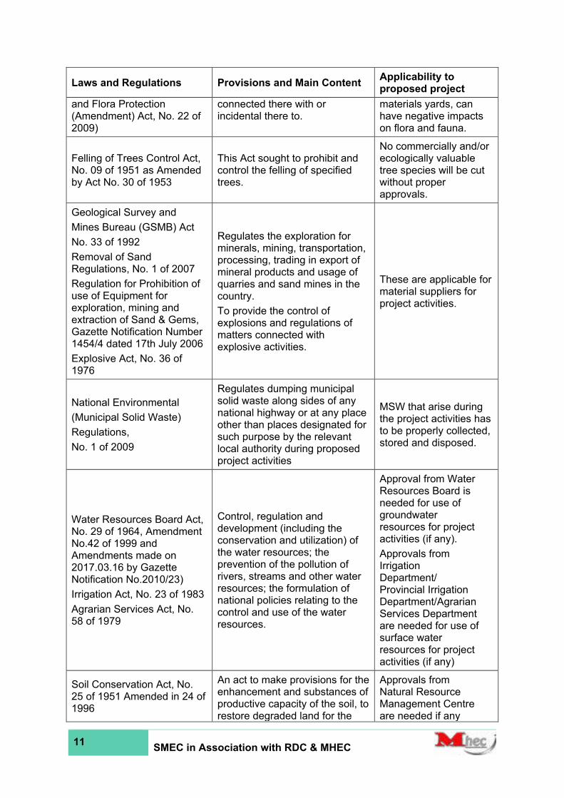
11 SMEC in Association with RDC & MHEC
Laws and Regulations Provisions and Main Content Applicability to proposed project
and Flora Protection (Amendment) Act, No. 22 of 2009)
connected there with or incidental there to.
materials yards, can have negative impacts on flora and fauna.
Felling of Trees Control Act, No. 09 of 1951 as Amended by Act No. 30 of 1953
This Act sought to prohibit and control the felling of specified trees.
No commercially and/or ecologically valuable tree species will be cut without proper approvals.
Geological Survey and
Mines Bureau (GSMB) Act
No. 33 of 1992
Removal of Sand Regulations, No. 1 of 2007
Regulation for Prohibition of use of Equipment for exploration, mining and extraction of Sand & Gems, Gazette Notification Number 1454/4 dated 17th July 2006
Explosive Act, No. 36 of 1976
Regulates the exploration for minerals, mining, transportation, processing, trading in export of mineral products and usage of quarries and sand mines in the country.
To provide the control of explosions and regulations of matters connected with explosive activities.
These are applicable for material suppliers for project activities.
National Environmental
(Municipal Solid Waste)
Regulations,
No. 1 of 2009
Regulates dumping municipal solid waste along sides of any national highway or at any place other than places designated for such purpose by the relevant local authority during proposed project activities
MSW that arise during the project activities has to be properly collected, stored and disposed.
Water Resources Board Act, No. 29 of 1964, Amendment No.42 of 1999 and Amendments made on 2017.03.16 by Gazette Notification No.2010/23)
Irrigation Act, No. 23 of 1983
Agrarian Services Act, No. 58 of 1979
Control, regulation and development (including the conservation and utilization) of the water resources; the prevention of the pollution of rivers, streams and other water resources; the formulation of national policies relating to the control and use of the water resources.
Approval from Water Resources Board is needed for use of groundwater resources for project activities (if any).
Approvals from Irrigation Department/ Provincial Irrigation Department/Agrarian Services Department are needed for use of surface water resources for project activities (if any)
Soil Conservation Act, No. 25 of 1951 Amended in 24 of 1996
An act to make provisions for the enhancement and substances of productive capacity of the soil, to restore degraded land for the
Approvals from Natural Resource Management Centre are needed if any

12 SMEC in Association with RDC & MHEC
Laws and Regulations Provisions and Main Content Applicability to proposed project
prevention and mitigation of soil erosion, for the conservation of soil resources and protection of land against damage by floods, salinity, alkalinity and drought and to provide for matters connected there with or incidental there to.
borrow areas or any other project activities lead to soil erosion.
Flood Protection Ordinance, No. 4 of 1924 and No 22 of 1955
An ordinance for the protection of areas subjected to damage from floods. This includes declaration of flood areas, preparation of schemes for flood protection and other rules and regulations regarding flood in the country.
Approvals and consents from the Irrigation Department, Agrarian Services Department are needed if project activities lead to flooding.
Crown Land Ordinance Act No. 1947
Land Settlement Ordinance, No. 20 of 1931; Land Development Ordinance, No. 19 of 1935 as amended by land development (amendment) Act, No. 16 of 1969, No.27 of 1981, No, 22 of 1998, No, 22 of 1995; State Land Ordinance, No. 08 of 1947; Land Acquisition Act, No. 09 of 1950; State Land (Recovery of possession and divesting of State Land) Act, No. 07 of 1979; Land Grants (Special Provisions) Act, No. 43 of 1979; Title Registration Act, No. 21 of 1998
The act dealing with allocation and control of Crown lands In Sri Lanka for private and government activities.
Approvals and consents are needed from Commissioner General of Lands, District Secretary, Divisional Secretary or any other government institutions for acquisition/lease of lands
The Antiquities (Amendment) Act No 24 of 1998, and regulations published in Gazette Extraordinary No 1152/14 of 4 October 2000
This require that an Archaeological Impact Assessment (AIA) to be conducted about every proposed development project with a land area of over 0.25 ha. The purpose of the assessment is to examine whether there are antiquities in the land, to determine the impact of the proposed development and to provide alternative measures if necessary.
Approval of the Department of Archaeology is needed (after conducting an Archaeological Impact Assessment (AIA).
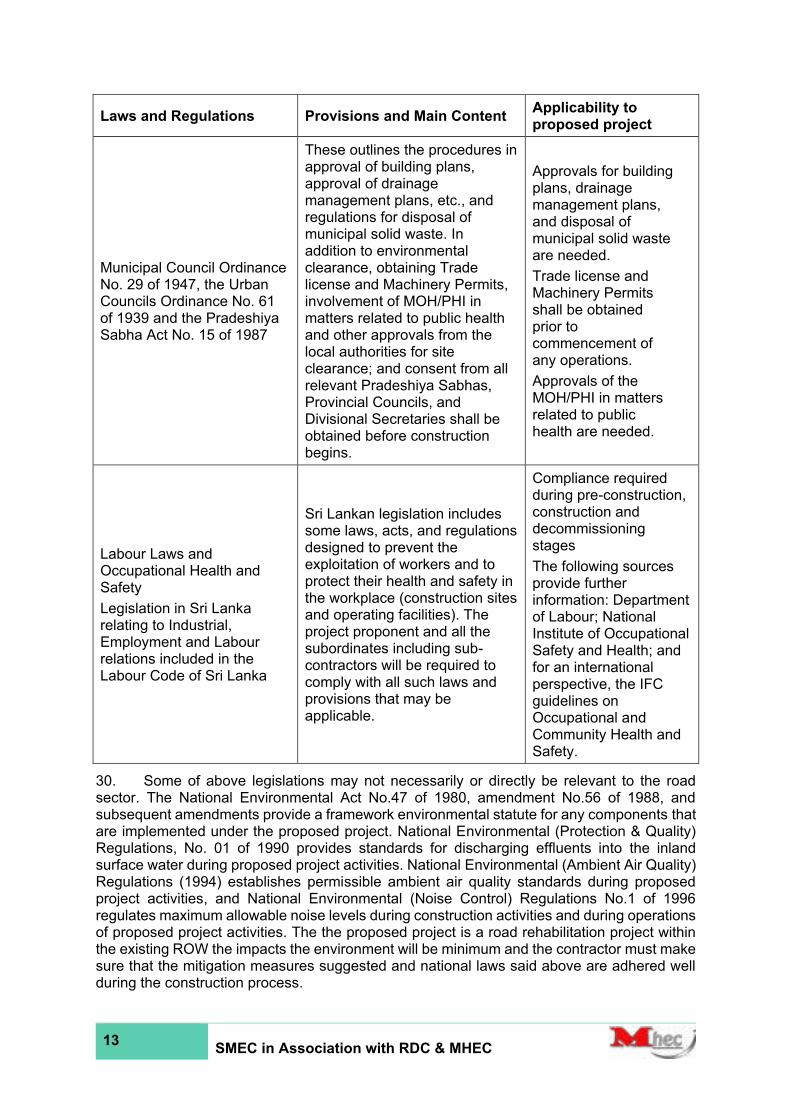
13 SMEC in Association with RDC & MHEC
Laws and Regulations Provisions and Main Content Applicability to proposed project
Municipal Council Ordinance No. 29 of 1947, the Urban Councils Ordinance No. 61 of 1939 and the Pradeshiya Sabha Act No. 15 of 1987
These outlines the procedures in approval of building plans, approval of drainage management plans, etc., and regulations for disposal of municipal solid waste. In addition to environmental clearance, obtaining Trade license and Machinery Permits, involvement of MOH/PHI in matters related to public health and other approvals from the local authorities for site clearance; and consent from all relevant Pradeshiya Sabhas, Provincial Councils, and Divisional Secretaries shall be obtained before construction begins.
Approvals for building plans, drainage management plans, and disposal of municipal solid waste are needed.
Trade license and Machinery Permits shall be obtained prior to commencement of any operations.
Approvals of the MOH/PHI in matters related to public health are needed.
Labour Laws and Occupational Health and Safety
Legislation in Sri Lanka relating to Industrial, Employment and Labour relations included in the Labour Code of Sri Lanka
Sri Lankan legislation includes some laws, acts, and regulations designed to prevent the exploitation of workers and to protect their health and safety in the workplace (construction sites and operating facilities). The project proponent and all the subordinates including sub-contractors will be required to comply with all such laws and provisions that may be applicable.
Compliance required during pre-construction, construction and decommissioning stages
The following sources provide further information: Department of Labour; National Institute of Occupational Safety and Health; and for an international perspective, the IFC guidelines on Occupational and Community Health and Safety.
30. Some of above legislations may not necessarily or directly be relevant to the road sector. The National Environmental Act No.47 of 1980, amendment No.56 of 1988, and subsequent amendments provide a framework environmental statute for any components that are implemented under the proposed project. National Environmental (Protection & Quality) Regulations, No. 01 of 1990 provides standards for discharging effluents into the inland surface water during proposed project activities. National Environmental (Ambient Air Quality) Regulations (1994) establishes permissible ambient air quality standards during proposed project activities, and National Environmental (Noise Control) Regulations No.1 of 1996 regulates maximum allowable noise levels during construction activities and during operations of proposed project activities. The the proposed project is a road rehabilitation project within the existing ROW the impacts the environment will be minimum and the contractor must make sure that the mitigation measures suggested and national laws said above are adhered well during the construction process.
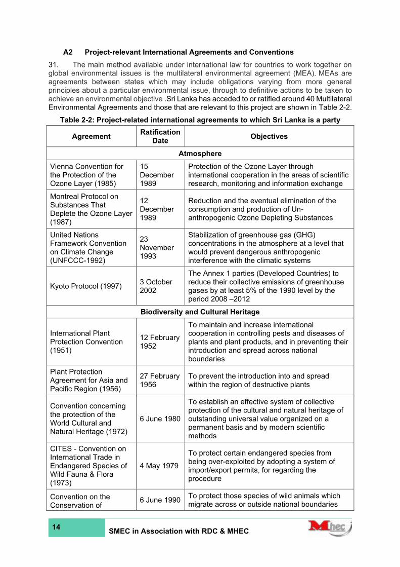
14 SMEC in Association with RDC & MHEC
A2 Project-relevant International Agreements and Conventions
31. The main method available under international law for countries to work together on global environmental issues is the multilateral environmental agreement (MEA). MEAs are agreements between states which may include obligations varying from more general principles about a particular environmental issue, through to definitive actions to be taken to achieve an environmental objective .Sri Lanka has acceded to or ratified around 40 Multilateral Environmental Agreements and those that are relevant to this project are shown in Table 2-2.
Table 2-2: Project-related international agreements to which Sri Lanka is a party
Agreement Ratification
Date Objectives
Atmosphere
Vienna Convention for the Protection of the Ozone Layer (1985)
15 December 1989
Protection of the Ozone Layer through international cooperation in the areas of scientific research, monitoring and information exchange
Montreal Protocol on Substances That Deplete the Ozone Layer (1987)
12 December 1989
Reduction and the eventual elimination of the consumption and production of Un-anthropogenic Ozone Depleting Substances
United Nations Framework Convention on Climate Change (UNFCCC-1992)
23 November 1993
Stabilization of greenhouse gas (GHG) concentrations in the atmosphere at a level that would prevent dangerous anthropogenic interference with the climatic systems
Kyoto Protocol (1997) 3 October 2002
The Annex 1 parties (Developed Countries) to reduce their collective emissions of greenhouse gases by at least 5% of the 1990 level by the period 2008 –2012
Biodiversity and Cultural Heritage
International Plant Protection Convention (1951)
12 February 1952
To maintain and increase international cooperation in controlling pests and diseases of plants and plant products, and in preventing their introduction and spread across national boundaries
Plant Protection Agreement for Asia and Pacific Region (1956)
27 February 1956
To prevent the introduction into and spread within the region of destructive plants
Convention concerning the protection of the World Cultural and Natural Heritage (1972)
6 June 1980
To establish an effective system of collective protection of the cultural and natural heritage of outstanding universal value organized on a permanent basis and by modern scientific methods
CITES - Convention on International Trade in Endangered Species of Wild Fauna & Flora (1973)
4 May 1979
To protect certain endangered species from being over-exploited by adopting a system of import/export permits, for regarding the procedure
Convention on the Conservation of
6 June 1990 To protect those species of wild animals which migrate across or outside national boundaries

15 SMEC in Association with RDC & MHEC
Agreement Ratification
Date Objectives
Migratory Species (1979)
The Convention on Wetlands (Ramsar Convention) (1971)
15 October 1990
This is the intergovernmental treaty that provides the framework for the conservation and wise use of wetlands and their resources.
Convention on Biological Diversity (CBD-1992)
23 March 1994
Conservation of biological diversity, the sustainable use of its components and the fair and equitable sharing of the benefits arising out of the utilization of genetic resources, including appropriate access to genetic resources and by appropriate transfer of relevant technologies and appropriate funding
The UNESCO World Heritage Convention (1972)
06 June 1980
Convention concerning the protection of the World Cultural and Natural Heritage
Land
United Nations Convention to Combat Desertification (UNCCD- 1994)
09 December 1998
To combat desertification and to mitigate the effects of drought in countries experiencing severe droughts and/ or desertification with the final aim being to prevent land degradation in the hyper-arid, arid, and semi-arid, dry subhumid areas in the countries that are parties of the Convention
Chemicals
Basel Convention on the Control of Trans-boundary Movements of Hazardous Wastes and Their Disposal (1989)
28 August 1992
To reduce transboundary movements of hazardous waste; to dispose of hazardous and other waste as close as possible to the source; to minimize the generation of hazardous waste; to prohibit shipments of hazardous waste to countries lacking the legal, administrative and technical capacity to manage & dispose of them in an environmentally sound manner; to assist developing countries in environmentally sound management of the hazardous waste they generate
Rotterdam Convention (1998)
19 January 2006
To promote shared responsibility and cooperative efforts in the international trade of certain hazardous chemicals, to protect human health and the environment; to contribute to the environmentally sound use of those hazardous chemicals by facilitating information exchange, providing for a national decision-making process on their import/export
Stockholm Convention on Persistent Organic Pollutants (POPs) (2001)
22 December 2005
To protect human health and the environment from persistent organic pollutants (POPs)

16 SMEC in Association with RDC & MHEC
B. ADB Policy on Environmental & Social safeguards
32. ADB’s Environment Policy requires that environmental issues are considered in all aspects of the Bank’s operations. The detailed requirements are defined in the Safeguard Policy Statement (2009), which builds upon the three previous policies on the environment, involuntary resettlement, and indigenous peoples, and brings them into a consolidated policy framework that enhances their effectiveness and relevance. The SPS affirms that ADB considers environmental and social sustainability as a cornerstone of economic growth and poverty reduction in Asia and the Pacific and is committed to ensuring the social and environmental sustainability of the projects it supports.
33. In this context, safeguards are operational policies that seek to avoid or reduce to acceptable levels adverse environmental and social impacts, including protecting the rights of those likely to be affected or marginalized by the development process. The objectives of ADB’s safeguards are to:
i. avoid adverse impacts of projects on the environment and affected people, where possible;
ii. minimize, mitigate and/or compensate for adverse project impacts on the environment and affected people where avoidance is not possible; and
iii. help borrowers/clients strengthen their safeguard systems and develop the capacity to manage environmental and social risks.
34. The Safeguard Policy Statement applies to all projects or components financed, administered or otherwise supported by ADB, regardless of whether ADB is the funder; and ADB will not finance projects that do not comply with the SPS and the host country’s social and environmental laws and regulations.
35. Environmental safeguards are triggered if a project is likely to have potential environmental risks and impacts, and the objectives are to ensure the environmental soundness and sustainability of projects and support the integration of environmental considerations into the project decision-making process. The principal tool for achieving these aims is an environmental assessment, which is a process of environmental analysis and planning to avoid or reduce the environmental impacts associated with a project. The nature of the assessment required depends on the significance of the environmental impacts, which are related to the type and location of the project; the sensitivity, scale, nature, and magnitude of its potential impacts; and the availability of cost-effective mitigation measures.
36. Screening and Categorization: ADB screens a project in the preparation stage to (i) reflect the significance of potential impacts or risks that the project might present; (ii) identify the level of assessment and institutional resources required for the safeguard process; and (iii) determine the requirements for public disclosure. Screening reviews basic information on project design and operation, the proposed project site/s, and the general environmental/social features, and is aided by ADB’s Rapid Environmental Assessment (REA) checklists. By the significance of the potential environmental impacts and risks, projects are assigned into one of the following four categories:
i. Category A: projects likely to have significant adverse environmental impacts that are irreversible, diverse or unprecedented, and which may affect an area larger than the location subject to physical works. An Environmental Impact Assessment (EIA) is required.
ii. Category B: projects with potential adverse impacts that are less significant than those of Category A. Impacts are site-specific, few are irreversible, and in most cases, impacts can be mitigated more readily than those for Category A projects. An Initial Environmental Examination (IEE) is required.
17 SMEC in Association with RDC & MHEC
iii. Category C: projects likely to have minimal or no adverse environmental impacts. No environmental assessment is required, although environmental implications are reviewed.
iv. Category FI: projects where ADB funds are invested in or through a Financial Intermediary (FI). ADB conducts safeguard due diligence of the FI’s portfolio and requires an appropriate environmental and social management system (ESMS) in place, to address environmental or social risks.
37. Environmental Assessment conducted under the SPS is governed by a series of policy principles, which define the scale, content, and approach to the study. The specific requirements of the Environment Safeguard Policy are given in Appendix 1 of the SPS; and the Annex to Appendix 1 provides an outline of an EIA report, which includes guidance on the overall layout and the content of each section. Guidance on the practical approach to conducting the environmental assessment is provided in the Environment Safeguards Good Practice Sourcebook (ADB, 2012). EIA and IEE studies follow the same general approach as prescribed in these documents; and the SPS states that the level of detail and comprehensiveness of the study shall be commensurate with the significance of environmental impacts and risks, so an IEE may have a narrower scope. These documents were all consulted extensively in conducting this study and preparing this report.
38. Public Consultation: The SPS requires the borrower/client to carry out meaningful consultation with affected people and other stakeholders to facilitate their informed participation. This should: (i) begin early during project preparation and continue throughout the project cycle; (ii) provide timely disclosure of adequate, relevant and understandable information; (iii) be free of intimidation and coercion; (iv) be gender inclusive and responsive, and tailored to the needs of disadvantaged and vulnerable groups; and (v) enable incorporation of all relevant views into decision-making, including project design, impact mitigation, and sharing of project benefits and opportunities. The SPS specifies that for a Category A project, at least two consultation exercises are needed: the first at the early stage of EIA fieldwork; and the second when the draft EIA is available. The results of the consultation process are documented in the environmental assessment report.
39. Information Disclosure: The SPS requires the borrower to make relevant environmental information available to affected people and other stakeholders promptly, in an accessible place and in an understandable form and language(s). This normally involves providing the draft, and final IEE/EIA reports in public buildings in the study area, but for complex studies, brochures, leaflets, etc. can also be used, along with non-written communication methods if any stakeholders are illiterate. ADB also requires the borrower to provide the following for dissemination to a wider audience via the ADB website:
i. The final EIA or IEE;
ii. New or updated EIA/IEE, supplementary reports and/or corrective action plans, if prepared during project implementation;
iii. Environmental monitoring reports, also during project implementation.
iv. In the case of a Category A project, the draft EIA (including the draft EMP) must be provided at least 120 days before ADB Board consideration.

18 SMEC in Association with RDC & MHEC
3 DESCRIPTION OF THE PROJECT
Location of the project
40. The following five road sections have been proposed to be rehabilitated and maintained under the Second Integrated Road Investment Program (iRoad 2), package 2 of additional roads in WP.
1. Rehabilitation and Improvement of Borella – Rajagiriya Road (Cotta Road) (B062)
41. This road section, which is 1.38 km in length, connects Borella Junction (6°54'52.9"N 79°52'39.6"E) and Rajagiriya (6°54'34.5"N 79°53'44.7"E) at Rajagiriya Bo Tree Junction.
Table 3-1: The administrative location of the proposed section of B062 Road proposed for improvement
Province District
DS Division
GN Division
Western Province
Colombo Sri Jayawardenepura
Kotte
Welikada West
Welikada East
Welikada North
Rajagiriya
42. The location map of the road is shown in Figure 3-1 and Annex 1.
2. Rehabilitation and Improvement of Malabe – Kaduwela Road (B263)
This road section (B263), which is 5.63 km in length, connects Malabe Junction ( 6°54'14.2"N 79°57'18.3"E) on B240 and Kaduwela Junction ( 6°56'08.5"N 79°59'03.2"E) on AB10 trunk road.
Table 3-2:The administrative location of the proposed section of B263 Road proposed for improvement
Province District
DS Division
GN Division
Western Province
Colombo Kaduwela
Malabe West
Malabe East
Malabe North
Kotalawala
Kaduwela
43. The location map of the road is shown in Figure 3-2 and Annex 1.
3. Rehabilitation and Improvement of Pitakotte –Thalawathugoda Road (B368)
This road section (B368), which is 4.1 km in length, connects Pitakotte Junction (6°53'03.1"N 79°54'07.0"E) on B120 trunk road and Thalawathugoda Junction ( 6°52'34.8"N 79°56'06.9"E) on B47 trunk road.

19 SMEC in Association with RDC & MHEC
Table 3-3:The administrative location of the proposed section of B368 Road
Province District
DS Division
GN Division
Western Province
Colombo
Sri Jayawardenepura Kotte Pitakotte
Pitakotte West
Maharagama
Madiwela
Thalawathugoda West
Thalawathugoda East
44. The location map of the road is shown in Figure 3-3 and Annex 1.
4. Rehabilitation and Improvement of Pagoda-Pitakotte Road (B345)
This road section (B345), which is 1.53 km in length, connects Pagoda (Pagoda, Niromi Junction) (6°52'31.7"N 79°53'32.0"E) on B120 road and Pitakotte junction ( 6°53'02.3"N 79°54'06.8"E) on B120 road.
Table 3-4:The administrative location of the proposed section of B345 Road proposed for improvement
Province District
DS Division
GN Division
Western Province
Colombo Sri Jayawardenepura Kotte
Nugegoda
Pagoda
Pitakotte West
Pitakotte
45. The location map of the road is shown in Figure 3-4 and Annex 1.
5. Rehabilitation and Improvement of Kelaniya-Mudungoda Road (B214) from Nagahamulla Junction to Belummahara Junction
This road section (B214), which is 23km in length, connects Nagahamulla Junction (6°57'05.4"N 79°56'00.6"E) on B214 road and Belummahara Junction (7°03'59.6"N 80°00'44.3"E) on A001 trunk road.
Table 3-5:The administrative location of the proposed section of B214 Road proposed for improvement
Province District
DS Division
GN Division
Western Province
Gampaha Biyagama
Kammalwatta
Delgoda
Yatihena
Thalwatta
Bollegala
Pattivila South
Biyagama South
Biyagama North
Biyagama East
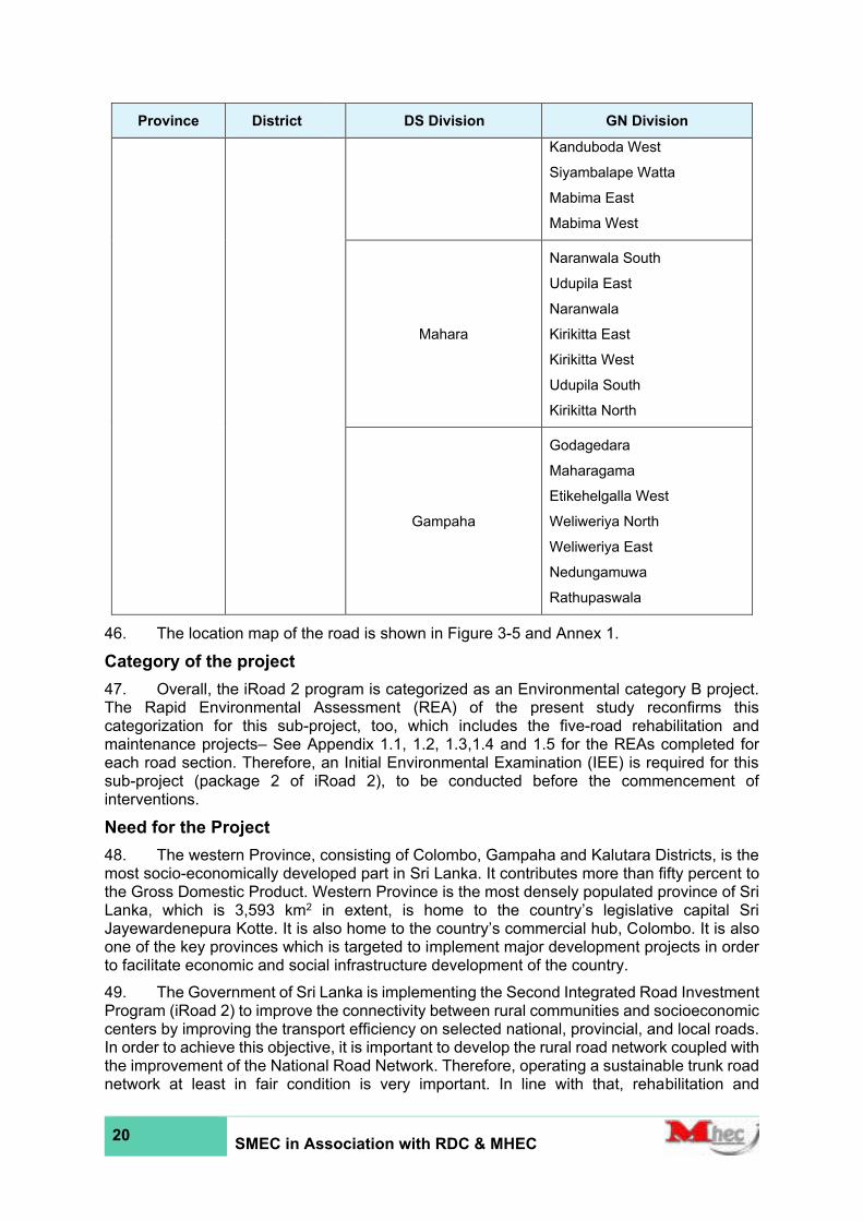
20 SMEC in Association with RDC & MHEC
Province District
DS Division
GN Division
Kanduboda West
Siyambalape Watta
Mabima East
Mabima West
Mahara
Naranwala South
Udupila East
Naranwala
Kirikitta East
Kirikitta West
Udupila South
Kirikitta North
Gampaha
Godagedara
Maharagama
Etikehelgalla West
Weliweriya North
Weliweriya East
Nedungamuwa
Rathupaswala
46. The location map of the road is shown in Figure 3-5 and Annex 1.
Category of the project
47. Overall, the iRoad 2 program is categorized as an Environmental category B project. The Rapid Environmental Assessment (REA) of the present study reconfirms this categorization for this sub-project, too, which includes the five-road rehabilitation and maintenance projects– See Appendix 1.1, 1.2, 1.3,1.4 and 1.5 for the REAs completed for each road section. Therefore, an Initial Environmental Examination (IEE) is required for this sub-project (package 2 of iRoad 2), to be conducted before the commencement of interventions.
Need for the Project
48. The western Province, consisting of Colombo, Gampaha and Kalutara Districts, is the most socio-economically developed part in Sri Lanka. It contributes more than fifty percent to the Gross Domestic Product. Western Province is the most densely populated province of Sri Lanka, which is 3,593 km2 in extent, is home to the country’s legislative capital Sri Jayewardenepura Kotte. It is also home to the country’s commercial hub, Colombo. It is also one of the key provinces which is targeted to implement major development projects in order to facilitate economic and social infrastructure development of the country.
49. The Government of Sri Lanka is implementing the Second Integrated Road Investment Program (iRoad 2) to improve the connectivity between rural communities and socioeconomic centers by improving the transport efficiency on selected national, provincial, and local roads. In order to achieve this objective, it is important to develop the rural road network coupled with the improvement of the National Road Network. Therefore, operating a sustainable trunk road network at least in fair condition is very important. In line with that, rehabilitation and

21 SMEC in Association with RDC & MHEC
improvement of the selected candidate road sections which directly connects Sri Lanka’s commercial hub is vital.
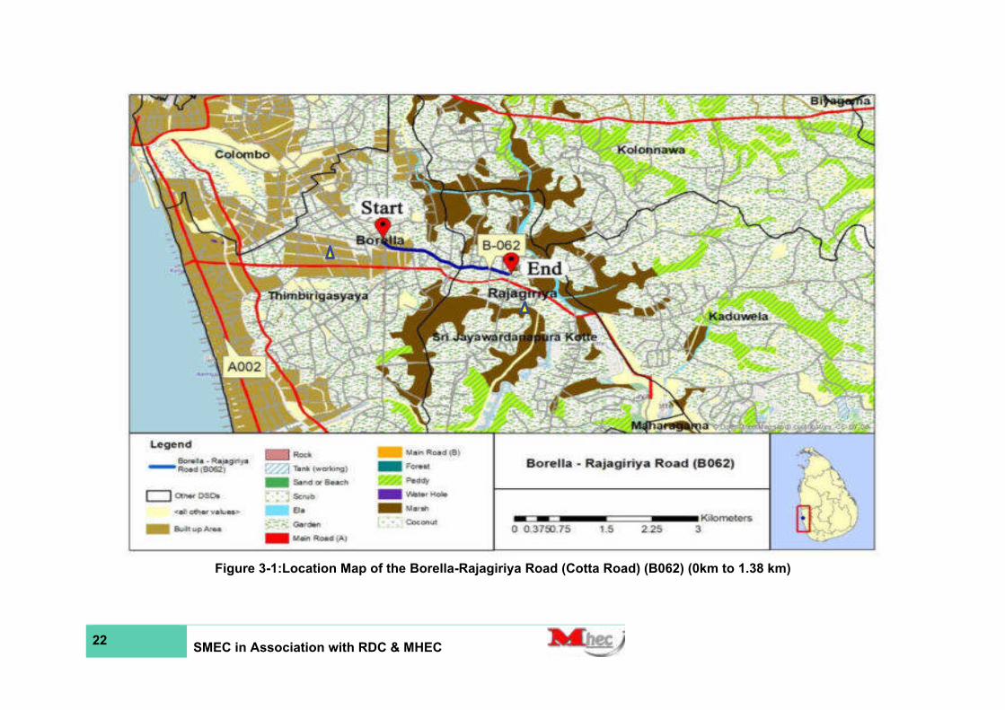
22 SMEC in Association with RDC & MHEC
Figure 3-1:Location Map of the Borella-Rajagiriya Road (Cotta Road) (B062) (0km to 1.38 km)
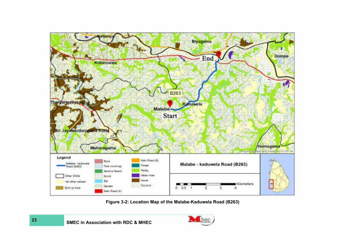
23 SMEC in Association with RDC & MHEC
Figure 3-2: Location Map of the Malabe-Kaduwela Road (B263)

24 SMEC in Association with RDC & MHEC
Figure 3-3: Location Map of the Pitakotte-Thalawathugoda Road (B368)

25 SMEC in Association with RDC & MHEC
Figure 3-4:Location Map of the Pagoda-Pitakotte Road (B345)
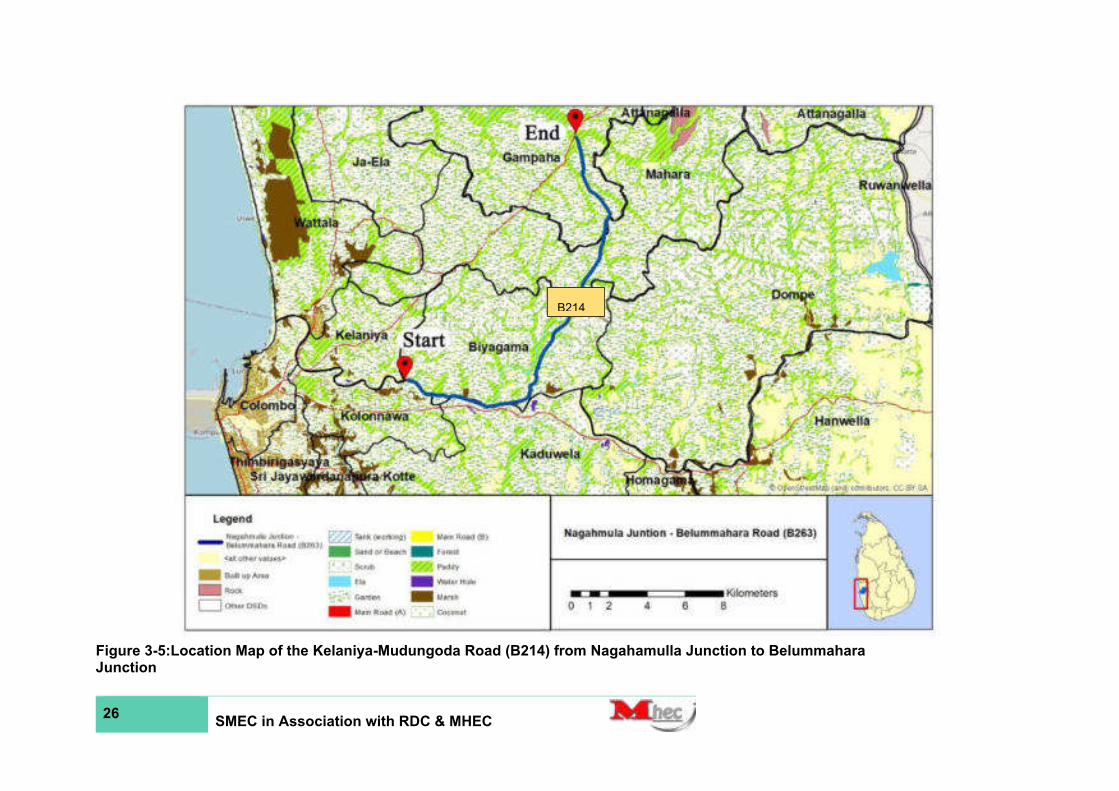
26 SMEC in Association with RDC & MHEC
Figure 3-5:Location Map of the Kelaniya-Mudungoda Road (B214) from Nagahamulla Junction to Belummahara Junction
B214

27 Master Hellie’s Engineering Consultants (Pvt) Ltd
Analysis of Alternatives
D1 No Project Alternative
50. The present sub-standard conditions of the five roads will worsen with the increased traffic flow with time if the selected five roads are not be rehabilitated without further delay and maintained. The efficiency of transportation between the five B-class Roads proposed for rehabilitation, will be severely hampered without the project. Moreover, the safety of road users will continue to be at risky levels with structural damages which are very common along the five road stretches. These five roads, which traverse through urban and semi-urban communities, will not support socio-economic development of the area as it disturbs livelihood activities of the project area, especially minimizing the mobility of the roads. ‘No project alternative’, therefore, is not a feasible solution with respect to mobility of the road and socio-economic development of these six divisional secretary areas of the Western Province.
D2 With Project Alternative
51. The project proposes to rehabilitate B062 (Cotta Road) from Borella Junction to Rajagiriya bo tree Junction – 1.38 km, B263 (Malabe – Kaduwela Road) from Malabe Junction to Kaduwela Junction – 5.63 km, B368 (Pitakotte – Thalawathugoda Road) from Pitakotte Junction to Thalawathugoda Junction– 4.1 km, B345 (Pagoda – Pitakotte Road) from Pagoda to Pitakotte Junction -1.53 km and B214 (Kelaniya-Mudungoda Road) From Nagahamulla Junction to Belummahara Junction on A001 – 23km). Under the proposed development, hard shoulders, roadside drains and parking facilities will be provided, where necessary. There are sections of these five roads which are subjected to seasonal flooding, and special consideration will be paid for such sections which are prone to inundation. Improvements of roadside drainage facilities will enhance the quality of road by reducing the existing inundations in the area. Also, necessary mitigation measures will be incorporated into the design to prevent such natural occurrences which will disturb the flow of traffic from time to time during inclement weather. Also, the improvements and rehabilitation works will provide safe driving conditions and road safety for other road users such as cyclists, motorcyclists, and pedestrians. School children and other people using public transport can benefit from the provision of bus bays and bus shelters improving the safety and comfort. The unemployed people living in the subproject area will have the construction-related job opportunities during project implementation, and subsequently, they will have employment opportunities in the expanded commercial/industrial sectors. Development of these roads will provide better transport facilities for the people to access markets. The land value will also be increased due to the proposed road project.
52. The main purpose of iRoad 2 program is to improve the mobility between communities having potential of economic growth with socio-economic centres. Therefore, the proposed rehabilitation and maintenance, will positively contribute to the enhancement of transport efficiency in the five B-Class roads and better transport efficiency will be a catalyst for regional development and the socio-economic well-being of the people living along the five road project areas in the Western Province and ultimately for the economic development of the country.
Magnitude of Operations
E1 Proposed improvement
53. The project comprises of carrying out of rehabilitation and improvement works along five B-class national roads (B062, B263, B368, B345, B214). The rehabilitation of B062 (from Borella Junction to Rajagiriya ) involves 1.38 km, B263 (From Malabe to Kaduwela) involves 5.63 km, B368 (Pitakotte Junction to Thalawathugoda Junction) involves 4.1 km, B345 (From Pagoda to Pitakotte) involves 1.53 km and B214 Kelaniya-Mudungoda Road (from Nagahamulla Junction to Belummahara Junction) involves 23 km. The project will not involve the acquisition of additional lands, and all improvement activities will be restricted to the

28 Master Hellie’s Engineering Consultants (Pvt) Ltd
existing ROW. The proposed typical cross section consists of the carriageway, hard shoulder, soft shoulder, and side drain where necessary as given below:
Borella - Rajagiriya Road (Cotta Road) (B062) from Borella Junction to Rajagiriya
• Carriage Width: 3.3m x 4
• Centre meridian: 1.6
• Total ROW: 20.4 m
Malabe-Kaduwela Road (B263) From Malabe to Kaduwela
• Carriage Width: 3.5m x 2
• Hard Shoulder: 1m x 2
• Total ROW: 10 m
Pitakotte-Thalawathugoda Road (B368) from Pitakotte Junction to Thalawathugoda Junction
• Carriage Width: 3.5m x 2
• Hard Shoulder: 1m x 2
• Total ROW: 9.4 m
Pagoda-Pitakotte Road (B345) from Pagoda to Pitakotte
• Carriage Width: 3.5m x 2
• Hard Shoulder: 1m x 2
• Total ROW: 9.4 m
Kelaniya-Mudungoda Road (B214) from Nagahamulla Junction to Belummahara Junction
• Carriage Width: 3.5m x 2
• Hard Shoulder: 0.3m x 2
• Soft shoulder: 1 m x 2
• Total ROW: 9.6 m
54. The proposed typical cross-section is shown in Annex 2. However, the typical cross section will be modified based on the location specific contexts keeping the major components unchanged.
E2 Project activities
55. The scope of work proposed under the iRoad 2 package include the following: clearing and grubbing; roadway excavation; channel excavation; excavation and backfill of structures; embankment construction; sub bases, capping layers, and bases; shoulder construction, asphalt overlay; roadside and leadaway drains; cleaning, desalting, and repairing of culverts.
56. The improvement works for selected roads under iRoad 2 Project will be as follows:
• The widening of roads will be carried out only if there is sufficient ROW.
• If the existing surface is asphalt; it will be overlaid with the AC.
• The base correction will be carried out if base failures are found along the road.
• If the existing surface is macadam based it will be overlaid by Aggregate Base Course (ABC) and asphalt as per the pavement design given by the Engineer.

29 Master Hellie’s Engineering Consultants (Pvt) Ltd
• The buildup drain provided for town areas or other requested areas. Otherwise, the earth drain will be provided.
• The earthwork will be carried out in required areas.
• Finally, road marking will be carried out.
(Source: PIU, iRoad 2 Program, RDA)
57. Further, an improvement on the cross- and side-drainage of the particular roads will be considered in locations where structures have been badly damaged, or rectification of the drainage is significantly required. The civil works will entail the repair and extension of existing cross drainage structures to accommodate the new road cross section/the construction of replacement and additional culverts and bridges as detailed in the construction drawings. (Refer: Annex 2 for Typical Cross-Sections)
Table 3-6: Typical interventions proposed in iRoad 2 Project
Type of Intervention
Description Items*
Rehabilitation
Maintenance aimed at restoring the deteriorated road surface to its original condition
Patching, maintenance of hard shoulders, double bituminous surface treatment, asphalt concrete treatment, re-surfacing, continuous maintenance of hard shoulders, painting traffic signs and guard railings, maintenance of side ditches, etc.
Periodic Maintenance
Maintenance aimed at restoring the condition of partially deteriorated pavement to a certain level
Routine Maintenance
Maintenance work performed on a daily basis to maintain the condition of road surfaces and delay their deterioration
Cutting back foliage along hard shoulders, patching cracks, laying earth on hard shoulders, repairing potholes, using the sand sealing method to repair pavement, etc.
* There is no clear distinction among the three types of maintenance, and details of the work involved vary only marginally between projects.
58. In addition, road furniture and markings will also be appropriately provided where necessary. At present, such furniture and markings are lacking in most parts of the five roads.
59. The general scope of work for the roads includes:
• Initial repairs to the existing road surface: These are carried out to prepare the road surface for resurfacing or overlay: these repairs may include bituminous patching, crack sealing, carriageway edges and shoulder repairs where traffic damage or erosion has occurred, cleaning of side drains and road culverts.
• Overlay: In all cases, the recommended improvements entail overlaying the existing pavement with a base or leveling course, designed for the projected number of Equivalent Standard Axles (ESA’s) over the design life of the road, and resurfacing. Where a pavement is found to be severely deteriorated, broken, or uneven, the existing surface would first be scarified and reshaped before applying the pavement surface.
• Construction/widening of pavements: This will involve earthworks, pavement construction, overlaying of the existing pavement and bitumen surfacing. Work will also include cleaning of roadside drains; culverts; cleaning of outlet drains and repairs to road furniture. Road pavements are constructed by Technical Specifications, Part 1 Standard Specification for Construction and Maintenance of Roads and Bridges 1989 (Sri Lanka).
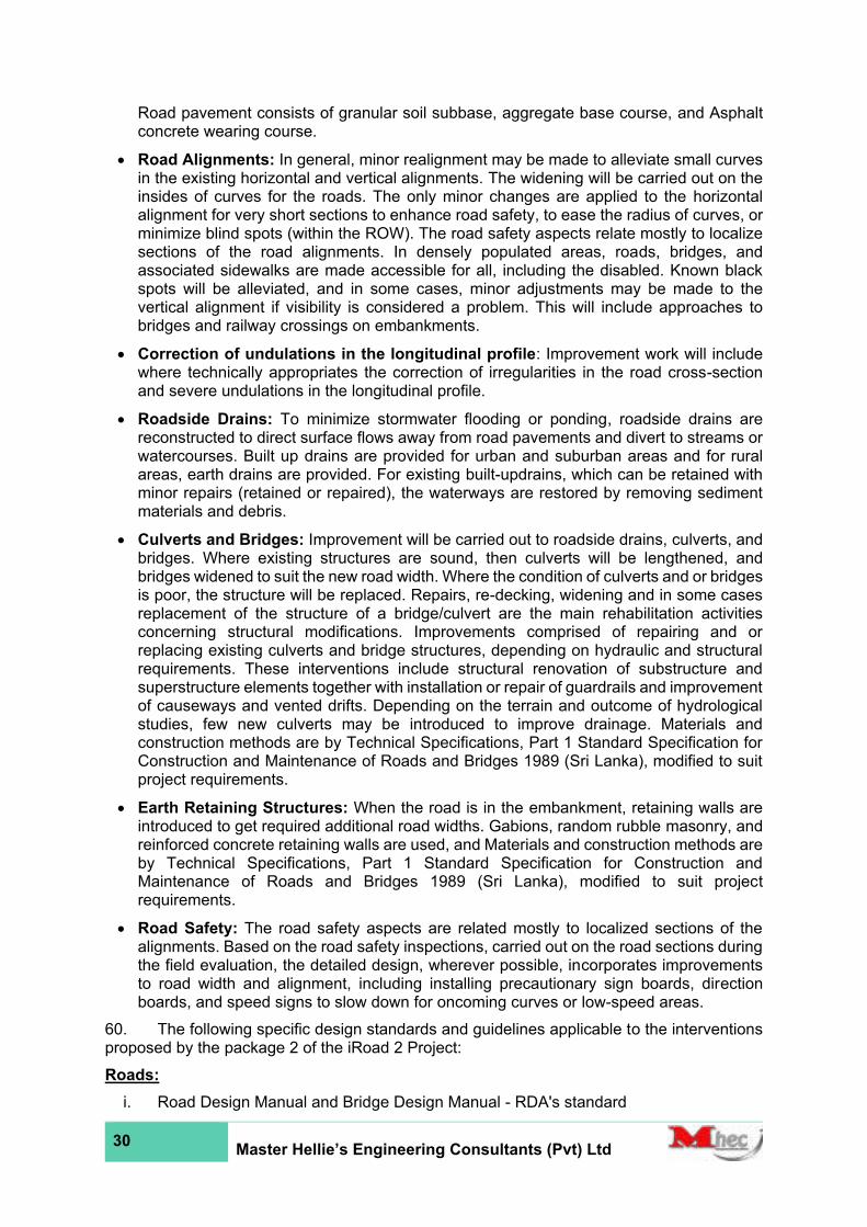
30 Master Hellie’s Engineering Consultants (Pvt) Ltd
Road pavement consists of granular soil subbase, aggregate base course, and Asphalt concrete wearing course.
• Road Alignments: In general, minor realignment may be made to alleviate small curves in the existing horizontal and vertical alignments. The widening will be carried out on the insides of curves for the roads. The only minor changes are applied to the horizontal alignment for very short sections to enhance road safety, to ease the radius of curves, or minimize blind spots (within the ROW). The road safety aspects relate mostly to localize sections of the road alignments. In densely populated areas, roads, bridges, and associated sidewalks are made accessible for all, including the disabled. Known black spots will be alleviated, and in some cases, minor adjustments may be made to the vertical alignment if visibility is considered a problem. This will include approaches to bridges and railway crossings on embankments.
• Correction of undulations in the longitudinal profile: Improvement work will include where technically appropriates the correction of irregularities in the road cross-section and severe undulations in the longitudinal profile.
• Roadside Drains: To minimize stormwater flooding or ponding, roadside drains are reconstructed to direct surface flows away from road pavements and divert to streams or watercourses. Built up drains are provided for urban and suburban areas and for rural areas, earth drains are provided. For existing built-updrains, which can be retained with minor repairs (retained or repaired), the waterways are restored by removing sediment materials and debris.
• Culverts and Bridges: Improvement will be carried out to roadside drains, culverts, and bridges. Where existing structures are sound, then culverts will be lengthened, and bridges widened to suit the new road width. Where the condition of culverts and or bridges is poor, the structure will be replaced. Repairs, re-decking, widening and in some cases replacement of the structure of a bridge/culvert are the main rehabilitation activities concerning structural modifications. Improvements comprised of repairing and or replacing existing culverts and bridge structures, depending on hydraulic and structural requirements. These interventions include structural renovation of substructure and superstructure elements together with installation or repair of guardrails and improvement of causeways and vented drifts. Depending on the terrain and outcome of hydrological studies, few new culverts may be introduced to improve drainage. Materials and construction methods are by Technical Specifications, Part 1 Standard Specification for Construction and Maintenance of Roads and Bridges 1989 (Sri Lanka), modified to suit project requirements.
• Earth Retaining Structures: When the road is in the embankment, retaining walls are introduced to get required additional road widths. Gabions, random rubble masonry, and reinforced concrete retaining walls are used, and Materials and construction methods are by Technical Specifications, Part 1 Standard Specification for Construction and Maintenance of Roads and Bridges 1989 (Sri Lanka), modified to suit project requirements.
• Road Safety: The road safety aspects are related mostly to localized sections of the alignments. Based on the road safety inspections, carried out on the road sections during the field evaluation, the detailed design, wherever possible, incorporates improvements to road width and alignment, including installing precautionary sign boards, direction boards, and speed signs to slow down for oncoming curves or low-speed areas.
60. The following specific design standards and guidelines applicable to the interventions proposed by the package 2 of the iRoad 2 Project:
Roads:
i. Road Design Manual and Bridge Design Manual - RDA's standard

31 Master Hellie’s Engineering Consultants (Pvt) Ltd
ii. AASHTO – Geometric Design of Highways and Streets 5th edition (2004)
iii. TRL – Overseas Road Note 6, A Guide to Geometric Design (1988), and
iv. Austroads –Rural Road Design (2003)
Bridges:
i. RDA's Sri Lanka Bridge Design Manual of 1997, based on the British Standards Code of Practice for Bridge Design (BS5400:1990)
Road Pavements:
i. Transport Research Labouratory’s Road Note 31, 4th Edition (TRL-RN31), basis of RDA's pavement design process
ii. AASHTO Pavement Design Guide, and
iii. Design life for new pavements: 10-year life with a provision for overlays during or at the end of that period to extend the life to 15-20 years
Drainage:
i. RDA's standards incorporating relevant standards from AASHTO and the British Standard Design Manual for Roads and Bridges
E3 Extraction of Construction Material
61. Depending on contractor’s preference, construction material will be sourced from various locations to reduce haulage costs. The main materials required for construction of the roadworks are soil and gravel, aggregates and asphalt. The soil is used for embankment construction. Gravel is used for sub-base construction. Aggregates, which are crushed stone, requiring blasting, crushing, screening, and at times blending, is used for base-course construction and for bituminous surfacing. Sand, aggregates, cement, and steel are needed for structural work, such as culverts and repair work of bridges, and for drainage canals and concrete embankments if any. Asphalt is used for the overlay of road surfaces. Approximate material quantities required for the civil works of all five roads are presented in Table 3-7.
Table 3-7: Estimated quantities of material required for Package 2 roads
Type of material
Unit Estimated quantity
B062 B263 B368 B345 B214
Sand Cu. m 76.00 240.00 210.00 60.00 298.00
Earth Cu. m 970.00 195.00 2,300.00 605.00 3950.00
Cement MT 125.00 240.00 390.00 105.00 490.00
ABC Cu. m 320.00 135.00 1100.00 260.00 1220.00
Rubble Cu. m 140.00 75.00 - - 560.00
Metal Cu. m 170.00 455.00 420.00 98.00 680.00
Asphalt Cu. m 2,155.00 2580.00 6205.00 1405.00 8560.00
Bitumen Cu. m 55.00 48.00 85.00 19.00 230.00
Steel MT 21.50 15.00 60.00 16.00 82.00
(Source: Project Implementing Unit, RDA)
62. Sources of material are yet to be selected and approved by the RDA once the Contractor is selected. Sourcing of material shall only be through sites complying with national laws/ policies and ADB policy.
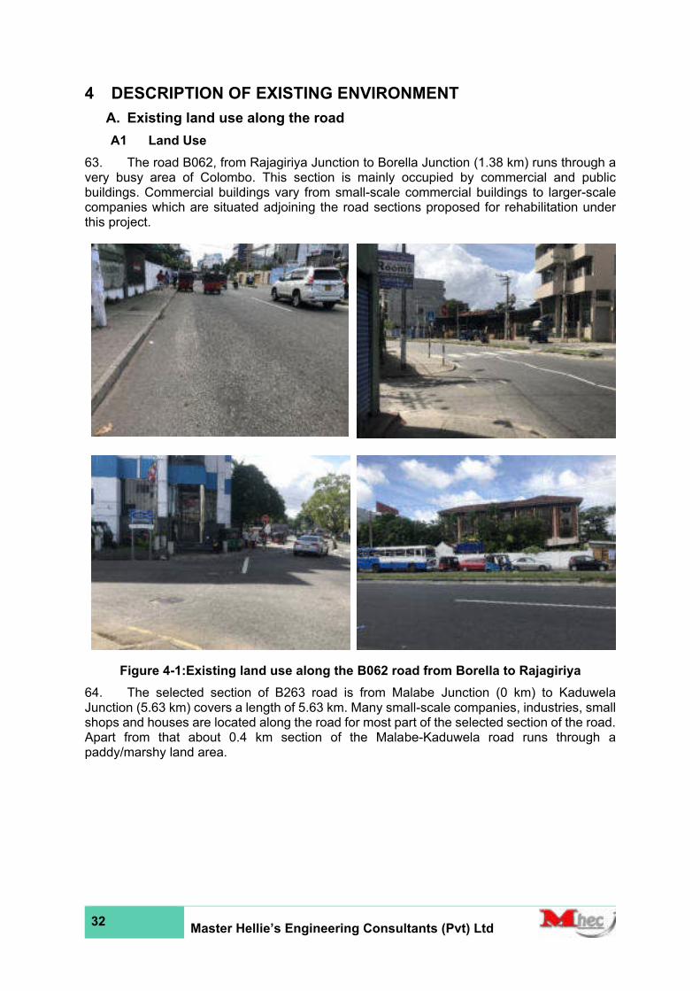
32 Master Hellie’s Engineering Consultants (Pvt) Ltd
4 DESCRIPTION OF EXISTING ENVIRONMENT
A. Existing land use along the road
A1 Land Use
63. The road B062, from Rajagiriya Junction to Borella Junction (1.38 km) runs through a very busy area of Colombo. This section is mainly occupied by commercial and public buildings. Commercial buildings vary from small-scale commercial buildings to larger-scale companies which are situated adjoining the road sections proposed for rehabilitation under this project.
Figure 4-1:Existing land use along the B062 road from Borella to Rajagiriya
64. The selected section of B263 road is from Malabe Junction (0 km) to Kaduwela Junction (5.63 km) covers a length of 5.63 km. Many small-scale companies, industries, small shops and houses are located along the road for most part of the selected section of the road. Apart from that about 0.4 km section of the Malabe-Kaduwela road runs through a paddy/marshy land area.
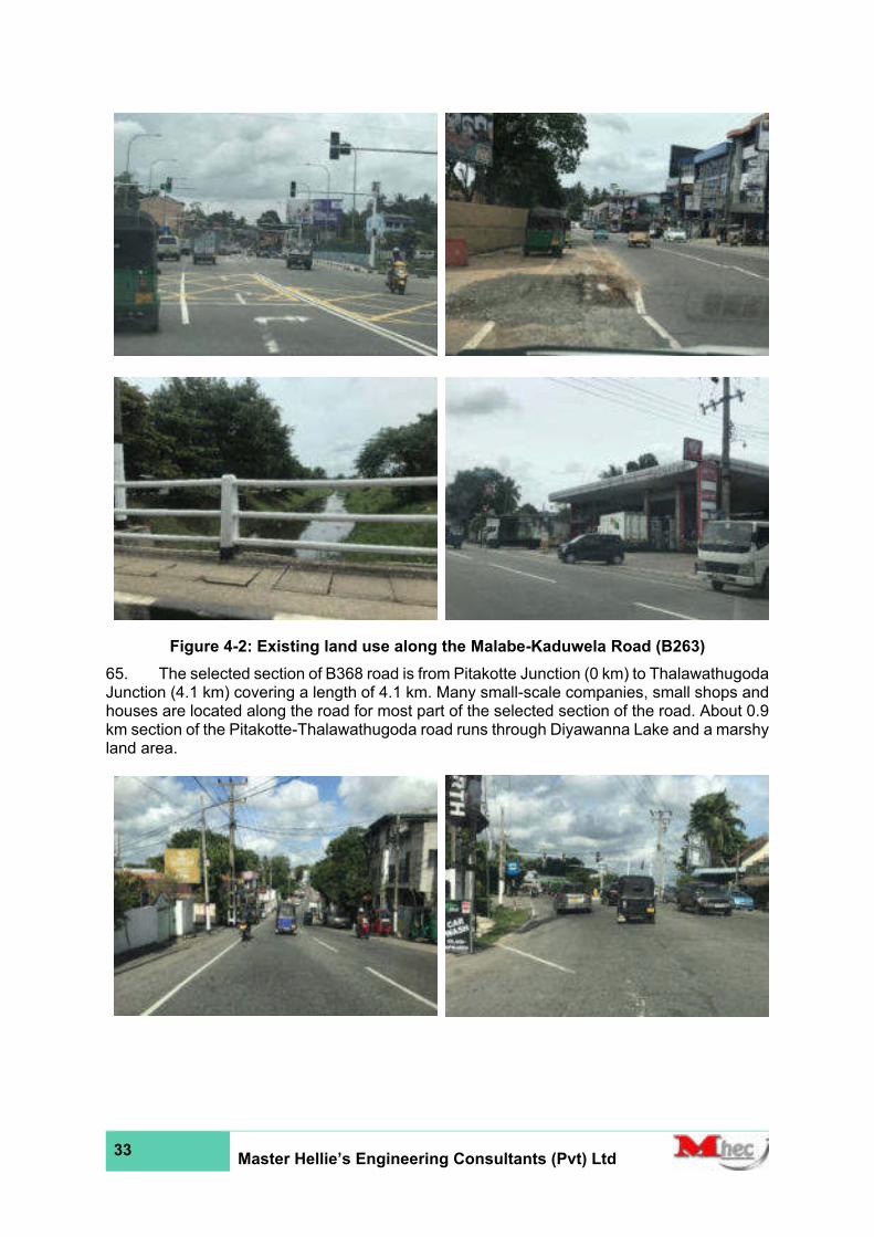
33 Master Hellie’s Engineering Consultants (Pvt) Ltd
Figure 4-2: Existing land use along the Malabe-Kaduwela Road (B263)
65. The selected section of B368 road is from Pitakotte Junction (0 km) to Thalawathugoda Junction (4.1 km) covering a length of 4.1 km. Many small-scale companies, small shops and houses are located along the road for most part of the selected section of the road. About 0.9 km section of the Pitakotte-Thalawathugoda road runs through Diyawanna Lake and a marshy land area.
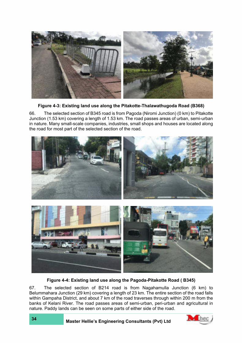
34 Master Hellie’s Engineering Consultants (Pvt) Ltd
Figure 4-3: Existing land use along the Pitakotte-Thalawathugoda Road (B368)
66. The selected section of B345 road is from Pagoda (Niromi Junction) (0 km) to Pitakotte Junction (1.53 km) covering a length of 1.53 km. The road passes areas of urban, semi-urban in nature. Many small-scale companies, industries, small shops and houses are located along the road for most part of the selected section of the road.
Figure 4-4: Existing land use along the Pagoda-Pitakotte Road ( B345)
67. The selected section of B214 road is from Nagahamulla Junction (6 km) to Belummahara Junction (29 km) covering a length of 23 km. The entire section of the road falls within Gampaha District, and about 7 km of the road traverses through within 200 m from the banks of Kelani River. The road passes areas of semi-urban, peri-urban and agricultural in nature. Paddy lands can be seen on some parts of either side of the road.
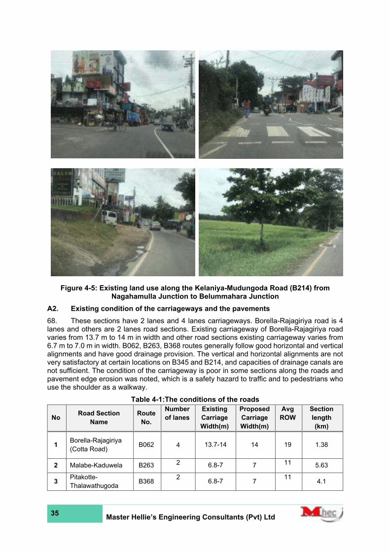
35 Master Hellie’s Engineering Consultants (Pvt) Ltd
Figure 4-5: Existing land use along the Kelaniya-Mudungoda Road (B214) from Nagahamulla Junction to Belummahara Junction
A2. Existing condition of the carriageways and the pavements
68. These sections have 2 lanes and 4 lanes carriageways. Borella-Rajagiriya road is 4 lanes and others are 2 lanes road sections. Existing carriageway of Borella-Rajagiriya road varies from 13.7 m to 14 m in width and other road sections existing carriageway varies from 6.7 m to 7.0 m in width. B062, B263, B368 routes generally follow good horizontal and vertical alignments and have good drainage provision. The vertical and horizontal alignments are not very satisfactory at certain locations on B345 and B214, and capacities of drainage canals are not sufficient. The condition of the carriageway is poor in some sections along the roads and pavement edge erosion was noted, which is a safety hazard to traffic and to pedestrians who use the shoulder as a walkway.
Table 4-1:The conditions of the roads
No Road Section
Name
Route
No.
Number
of lanes
Existing
Carriage
Width(m)
Proposed
Carriage
Width(m)
Avg
ROW
Section
length
(km)
1 Borella-Rajagiriya
(Cotta Road) B062
4 13.7-14 14
19 1.38
2 Malabe-Kaduwela B263 2 6.8-7 7 11 5.63
3 Pitakotte-
Thalawathugoda B368
2 6.8-7 7
11 4.1

36 Master Hellie’s Engineering Consultants (Pvt) Ltd
No Road Section
Name
Route
No.
Number
of lanes
Existing
Carriage
Width(m)
Proposed
Carriage
Width(m)
Avg
ROW
Section
length
(km)
4 Pagoda-Pitakotte
Road B345
2 6.7-7 7
10.5 1.53
5
Kelaniya-
Mudungoda Rd
from Nagahamulla
Junction to
Belummahara
Junction
B214
2 6.7-7 7
10 23
Sub Total 36.36
A2 Existing condition of culverts and bridges
69. For the five roads, the inventory of existing bridge structures (bridges being defined as any structure with a span >3 m) are given in Appendix 6. Almost all of them were found to be in satisfactory condition from structural point of view by the field evidence collected – this assessment has since been checked visually only, and detailed structural assessments are needed.
70. The existing cross culverts were identified within the subject corridor and assessments made of present conditions and improvements needed at each site are provided in Appendix 6.
71. Details of the hydraulic condition and of the recommended treatments at each location to address both reported and perceived problems shall be contained in Engineering Assessment Reports. A visual inspection showed that the majority of the existing culverts were deemed to be hydraulically and structurally satisfactory, many of them were found to be silted and partially blocked. Most inlet/outlet openings need to be cleared. It was also observed that most of the lead away drains of the culverts were similarly affected by silt deposits, vegetation or otherwise restricted by encroachments – most of them being in need of at least, clearing and cleaning.
B. Physical Environment
B1 Climate, land use, terrain and soil
72. Based on major climatic zones of the country, the candidate road sections of B062/ B263/B368/B345/B214 Roads fall within the area classified as Wet Zone where the annual average rainfall is between 2,000 mm and 2,500 mm.
73. The climate of the project area is further categorized into Agro-ecological Zones (AEZ) which are categorized based on climate, soil, natural vegetation, and land use pattern of an area. The AEZ nomenclature is alphanumeric where the first upper case letter denotes the climatic condition (W - Wet, I - Intermediate, D - Dry), the second upper case letter indicates elevation (L - Low, M - Medium, U - Upper), the first number describes the moisture regime, and the last lower-case letter indicates the rainfall distribution and other environmental factors where the degree of wetness degrades from letters a to f.
74. The general climate that prevails in Colombo and Gampaha Districts in the Western Province where the proposed candidate road sections of B062/ B263/B368/B345/B214 Roads are situated is characterized by humid, warm, and tropical weather for most parts of the year. The rain climate follows a typical pattern that is found in the Wet Zone of Sri Lanka. This region remains dry from December to February followed by convective torrential rains in March and April and then Southwest monsoons. Heavy rains occur during the inter-monsoon months of October and November. Rainfall distribution is influenced by monsoon winds from passing over the Indian Ocean and the Bay of Bengal.
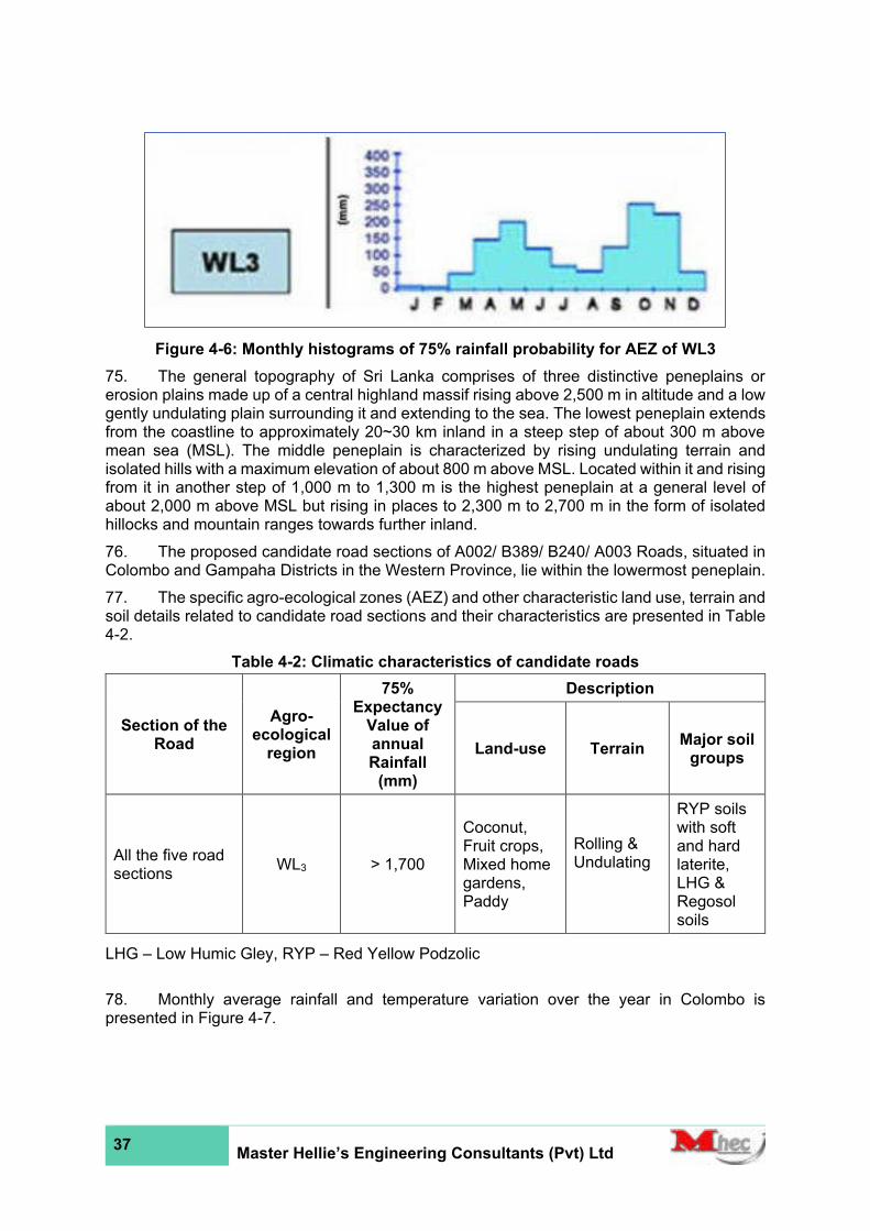
37 Master Hellie’s Engineering Consultants (Pvt) Ltd
Figure 4-6: Monthly histograms of 75% rainfall probability for AEZ of WL3
75. The general topography of Sri Lanka comprises of three distinctive peneplains or erosion plains made up of a central highland massif rising above 2,500 m in altitude and a low gently undulating plain surrounding it and extending to the sea. The lowest peneplain extends from the coastline to approximately 20~30 km inland in a steep step of about 300 m above mean sea (MSL). The middle peneplain is characterized by rising undulating terrain and isolated hills with a maximum elevation of about 800 m above MSL. Located within it and rising from it in another step of 1,000 m to 1,300 m is the highest peneplain at a general level of about 2,000 m above MSL but rising in places to 2,300 m to 2,700 m in the form of isolated hillocks and mountain ranges towards further inland.
76. The proposed candidate road sections of A002/ B389/ B240/ A003 Roads, situated in Colombo and Gampaha Districts in the Western Province, lie within the lowermost peneplain.
77. The specific agro-ecological zones (AEZ) and other characteristic land use, terrain and soil details related to candidate road sections and their characteristics are presented in Table 4-2.
Table 4-2: Climatic characteristics of candidate roads
Section of the Road
Agro-ecological
region
75% Expectancy
Value of annual Rainfall
(mm)
Description
Land-use Terrain Major soil
groups
All the five road sections
WL3 > 1,700
Coconut, Fruit crops, Mixed home gardens, Paddy
Rolling & Undulating
RYP soils with soft and hard laterite, LHG & Regosol soils
LHG – Low Humic Gley, RYP – Red Yellow Podzolic
78. Monthly average rainfall and temperature variation over the year in Colombo is presented in Figure 4-7.
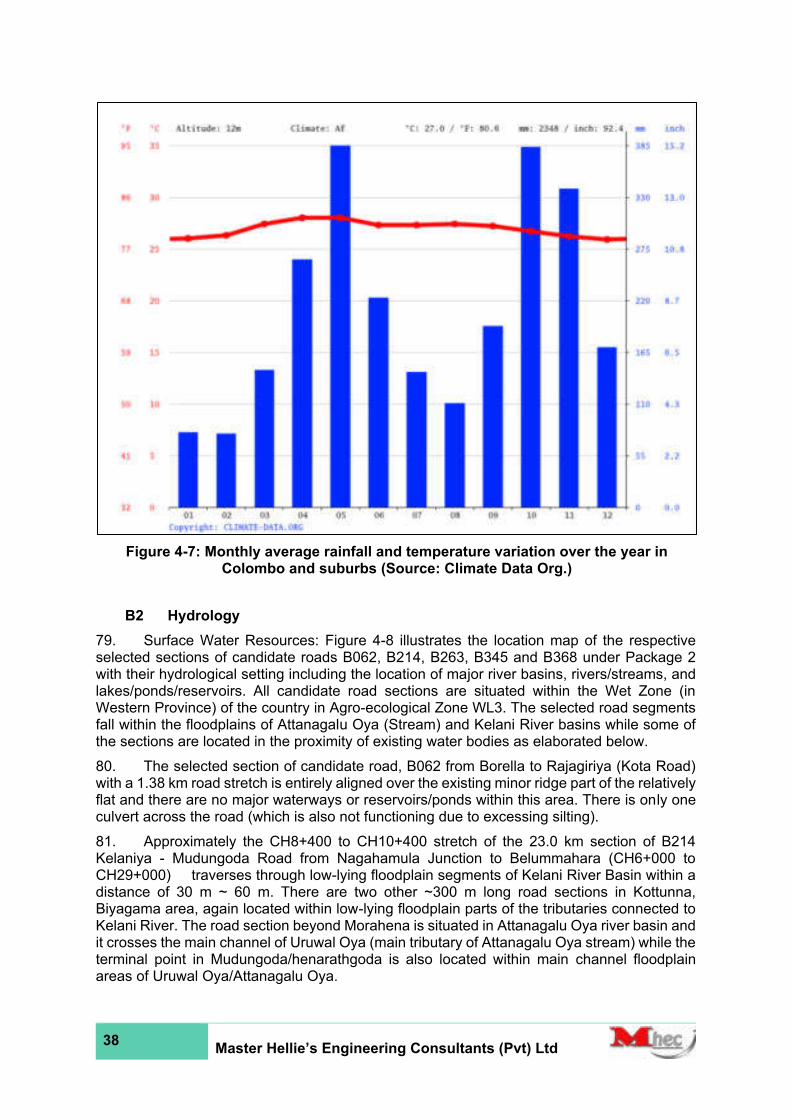
38 Master Hellie’s Engineering Consultants (Pvt) Ltd
B2 Hydrology
79. Surface Water Resources: Figure 4-8 illustrates the location map of the respective selected sections of candidate roads B062, B214, B263, B345 and B368 under Package 2 with their hydrological setting including the location of major river basins, rivers/streams, and lakes/ponds/reservoirs. All candidate road sections are situated within the Wet Zone (in Western Province) of the country in Agro-ecological Zone WL3. The selected road segments fall within the floodplains of Attanagalu Oya (Stream) and Kelani River basins while some of the sections are located in the proximity of existing water bodies as elaborated below.
80. The selected section of candidate road, B062 from Borella to Rajagiriya (Kota Road) with a 1.38 km road stretch is entirely aligned over the existing minor ridge part of the relatively flat and there are no major waterways or reservoirs/ponds within this area. There is only one culvert across the road (which is also not functioning due to excessing silting).
81. Approximately the CH8+400 to CH10+400 stretch of the 23.0 km section of B214 Kelaniya - Mudungoda Road from Nagahamula Junction to Belummahara (CH6+000 to CH29+000) traverses through low-lying floodplain segments of Kelani River Basin within a distance of 30 m ~ 60 m. There are two other ~300 m long road sections in Kottunna, Biyagama area, again located within low-lying floodplain parts of the tributaries connected to Kelani River. The road section beyond Morahena is situated in Attanagalu Oya river basin and it crosses the main channel of Uruwal Oya (main tributary of Attanagalu Oya stream) while the terminal point in Mudungoda/henarathgoda is also located within main channel floodplain areas of Uruwal Oya/Attanagalu Oya.
Figure 4-7: Monthly average rainfall and temperature variation over the year in Colombo and suburbs (Source: Climate Data Org.)
39 Master Hellie’s Engineering Consultants (Pvt) Ltd
82. The 5.63 km Malabe Kaduwela Road (B263) is located within lower reach of Kelani Basin and the road stretch in Malmbe intercepts the low-lying floodplain segment of a tributary of Kelani River (in Pagoda section).
83. The short 1.53 km stretch of Pagoda Pitakotta Road (B345) is located within the downstream part of Kelani basin and in the proximity (200 m ~ 500 m distance) of Diyawanna Oya (Stream) and Diyawanna Lake connected to Kelani River.
84. The continued section of this road, the 4.1 km long candidate road, Pitakotte Thalawathugoda Road (B368) crosses several low-lying valley sections of Diyawanna Lake at Pita Kotte, Madiwela, Thalapathpitiya and Thalawathugoda.
85. The project areas under Package 2 are predominantly urban and sub-urban areas where agriculture is not comprehensively practiced (except for extensive paddy lands (both cultivated and abandoned) which are basically rainfed located in minor, low-lying valley sections, especially at intermittent sections along B214, B263, and B368, and coconut plantations in homesteads, and small extents of rubber/pineapple and other crops). Some road sections are located in the close proximity of these low-lying valley sections and their associated floodplain and tributary distributary networks (all, except B062 which is located on ridge). These low-lying sections which serve the important retention-detention purposes are typically covered with marshes/bushes and lie on either side of the road. The particular locations at which stream tributaries are crossed by the candidate roads with their associated drainage crossings (Culverts and Bridges) are shown in Figure 4-8, Figure 4-9, Figure 4-10 and the details of their opening sizes, whether fully functional/silted/dilapidated, etc., are given in Appendix 6.
86. Groundwater Resources: Groundwater extraction using deep wells are not common and only limited to Industrial Zones and several other locations for specific uses. Dug wells are commonly observed within home gardens along either side of the candidate roads (except in urban areas, like in the case of B062), and shallow groundwater is used to fulfill domestic requirements by the households even in some sub-urban areas despite the availability of pipe borne water (supplied by NWS&DB).
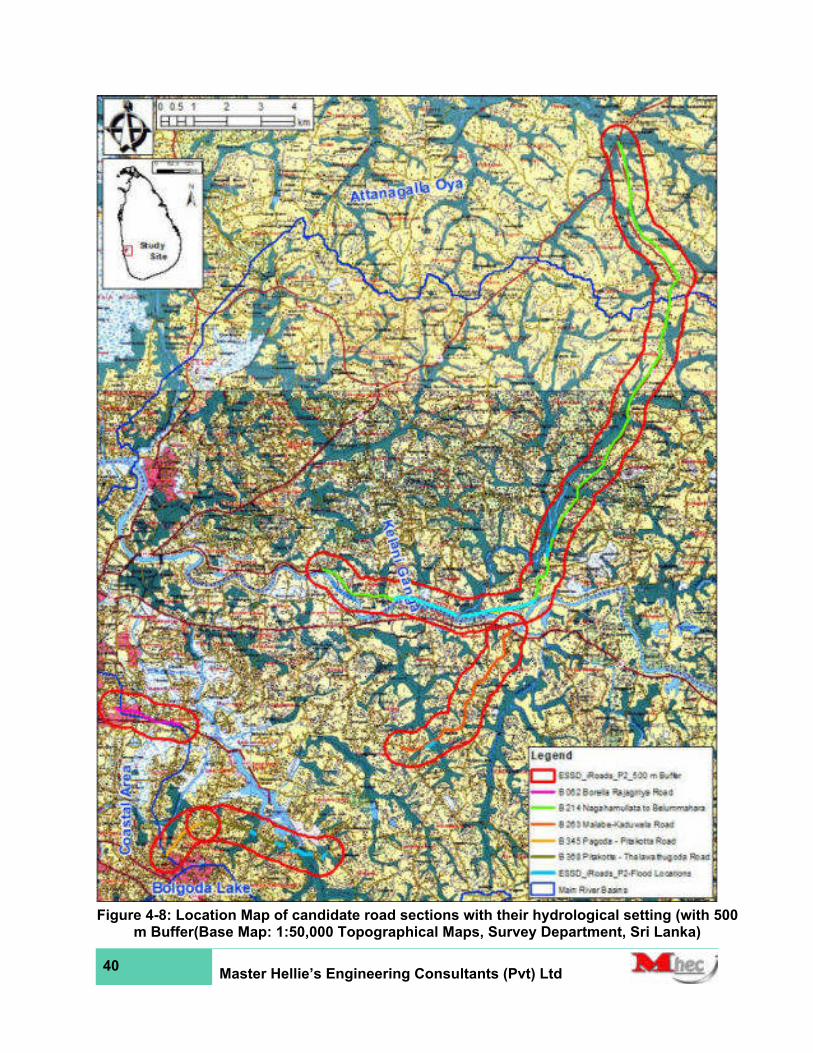
40 Master Hellie’s Engineering Consultants (Pvt) Ltd
Figure 4-8: Location Map of candidate road sections with their hydrological setting (with 500
m Buffer(Base Map: 1:50,000 Topographical Maps, Survey Department, Sri Lanka)

41 Master Hellie’s Engineering Consultants (Pvt) Ltd
Figure 4-9: Location Map of candidate road B214 sections with Locations of Drainage Crossings

42 Master Hellie’s Engineering Consultants (Pvt) Ltd
Figure 4-10: Location Map of Candidate Roads B062, B345 and B368 with Flood Sections
and Locations of Drainage Crossings (Base Map: General Topographic Terrain, USDA)

43 Master Hellie’s Engineering Consultants (Pvt) Ltd
Figure 4-11:Location Map of Candidate Road B263 with Flood Sections and Locations of Drainage Crossings
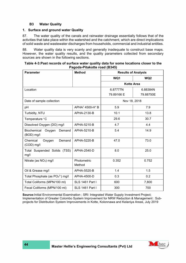
44 Master Hellie’s Engineering Consultants (Pvt) Ltd
B3 Water Quality
1. Surface and ground water Quality
87. The water quality of the canals and rainwater drainage essentially follows that of the activities that take place within the watershed and the catchment, which are direct implications of solid waste and wastewater discharges from households, commercial and industrial entities.
88. Water quality data is very scanty and generally inadequate to construct base maps. However, the water quality results, and the quality parameters collected from secondary sources are shown in the following sections.
Table 4-3:Past records of surface water quality data for some locations closer to the Pagoda-Pitakotte road (B345)
Parameter Method Results of Analysis
WQ1 WQ2
Kotte Area
Location 6.87777N
79.89166 E
6.88384N
79.88750E
Date of sample collection Nov 18, 2018
pH APHA1 4500-H+ B 5.9 7.9
Turbidity, NTU APHA-2130-B 10.1 13.8
Temperature C 29.6 30.7
Dissolved Oxygen (DO) mg/l APHA-5210-B 4.7 4.4
Biochemical Oxygen Demand
(BOD) mg/l
APHA-5210-B 5.4 14.9
Chemical Oxygen Demand
(COD) mg/l
APHA-5220-B 47.0 73.0
Total Suspended Solids (TSS)
mg/l
APHA-2540-D 8.0 25.0
Nitrate (as NO3) mg/l Photometric
Method
0.352 0.752
Oil & Grease mg/l APHA-5520-B 1.4 1.5
Total Phosphate (as PO43-) mg/l APHA-4500-D 0.3 0.2
Total Coliforms (MPN/100 ml) SLS 1461 Part I 600 7,800
Fecal Coliforms (MPN/100 ml) SLS 1461 Part I 300 700
Source:Initial Environmental Examination ; SRI: Integrated Water Supply Investment Project; Implementation of Greater Colombo System Improvement for NRW Reduction & Management : Sub-projects for Distribution System Improvements in Kotte, Kolonnawa and Kelaniya Areas, July 2019
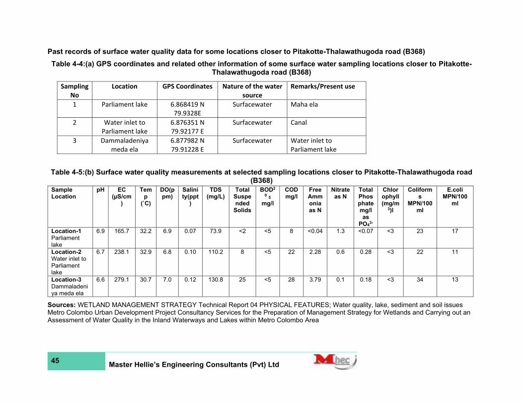
45 Master Hellie’s Engineering Consultants (Pvt) Ltd
Past records of surface water quality data for some locations closer to Pitakotte-Thalawathugoda road (B368)
Table 4-4:(a) GPS coordinates and related other information of some surface water sampling locations closer to Pitakotte-Thalawathugoda road (B368)
Table 4-5:(b) Surface water quality measurements at selected sampling locations closer to Pitakotte-Thalawathugoda road (B368)
Sample Location
pH EC (µS/cm
)
Temp
(˚C)
DO(ppm)
Salinity(ppt
)
TDS (mg/L)
Total Suspended
Solids
BOD2
0 5
mg/l
COD mg/l
Free Ammonia as N
Nitrate as N
Total Phosphate mg/l as
PO43-
Chlorophyll (mg/m
3)l
Coliforms
MPN/100ml
E.coli MPN/100
ml
Location-1 Parliament lake
6.9 165.7 32.2 6.9 0.07 73.9 <2 <5 8 <0.04 1.3 <0.07 <3 23 17
Location-2 Water inlet to Parliament lake
6.7 238.1 32.9 6.8 0.10 110.2 8 <5 22 2.28 0.6 0.28 <3 22 11
Location-3 Dammaladeniya meda ela
6.6 279.1 30.7 7.0 0.12 130.8 25 <5 28 3.79 0.1 0.18 <3 34 13
Sources: WETLAND MANAGEMENT STRATEGY Technical Report 04 PHYSICAL FEATURES; Water quality, lake, sediment and soil issues Metro Colombo Urban Development Project Consultancy Services for the Preparation of Management Strategy for Wetlands and Carrying out an Assessment of Water Quality in the Inland Waterways and Lakes within Metro Colombo Area
Sampling
No
Location GPS Coordinates Nature of the water
source
Remarks/Present use
1 Parliament lake 6.868419 N
79.9328E
Surfacewater Maha ela
2 Water inlet to
Parliament lake
6.876351 N
79.92177 E
Surfacewater Canal
3 Dammaladeniya
meda ela
6.877982 N
79.91228 E
Surfacewater Water inlet to
Parliament lake
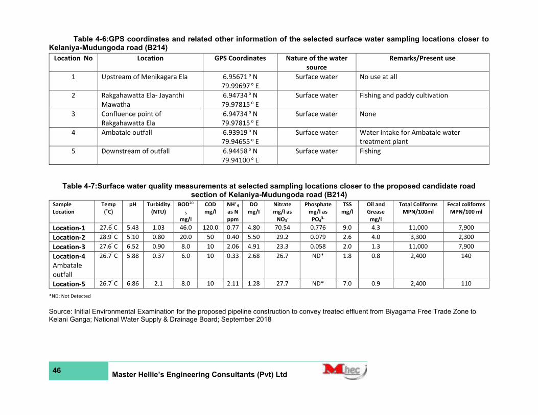
46 Master Hellie’s Engineering Consultants (Pvt) Ltd
Table 4-6:GPS coordinates and related other information of the selected surface water sampling locations closer to Kelaniya-Mudungoda road (B214)
Location No Location GPS Coordinates Nature of the water
source
Remarks/Present use
1 Upstream of Menikagara Ela 6.95671 o N
79.99697 o E
Surface water No use at all
2 Rakgahawatta Ela- Jayanthi
Mawatha
6.94734 o N
79.97815 o E
Surface water Fishing and paddy cultivation
3 Confluence point of
Rakgahawatta Ela
6.94734 o N
79.97815 o E
Surface water None
4 Ambatale outfall 6.93919 o N
79.94655 o E
Surface water Water intake for Ambatale water
treatment plant
5 Downstream of outfall 6.94458 o N
79.94100 o E
Surface water Fishing
Table 4-7:Surface water quality measurements at selected sampling locations closer to the proposed candidate road section of Kelaniya-Mudungoda road (B214)
Sample
Location
Temp
(˚C)
pH Turbidity
(NTU)
BOD20
5
mg/l
COD
mg/l
NH+4
as N
ppm
DO
mg/I
Nitrate
mg/l as
NO3-
Phosphate
mg/l as
PO43-
TSS
mg/l
Oil and
Grease
mg/l
Total Coliforms
MPN/100ml
Fecal coliforms
MPN/100 ml
Location-1 27.6 ͦ C 5.43 1.03 46.0 120.0 0.77 4.80 70.54 0.776 9.0 4.3 11,000 7,900
Location-2 28.9 ͦ C 5.10 0.80 20.0 50 0.40 5.50 29.2 0.079 2.6 4.0 3,300 2,300
Location-3 27.6 ͦ C 6.52 0.90 8.0 10 2.06 4.91 23.3 0.058 2.0 1.3 11,000 7,900
Location-4
Ambatale
outfall
26.7 ͦ C 5.88 0.37 6.0 10 0.33 2.68 26.7 ND* 1.8 0.8 2,400 140
Location-5 26.7 ͦ C 6.86 2.1 8.0 10 2.11 1.28 27.7 ND* 7.0 0.9 2,400 110
*ND: Not Detected
Source: Initial Environmental Examination for the proposed pipeline construction to convey treated effluent from Biyagama Free Trade Zone to Kelani Ganga; National Water Supply & Drainage Board; September 2018
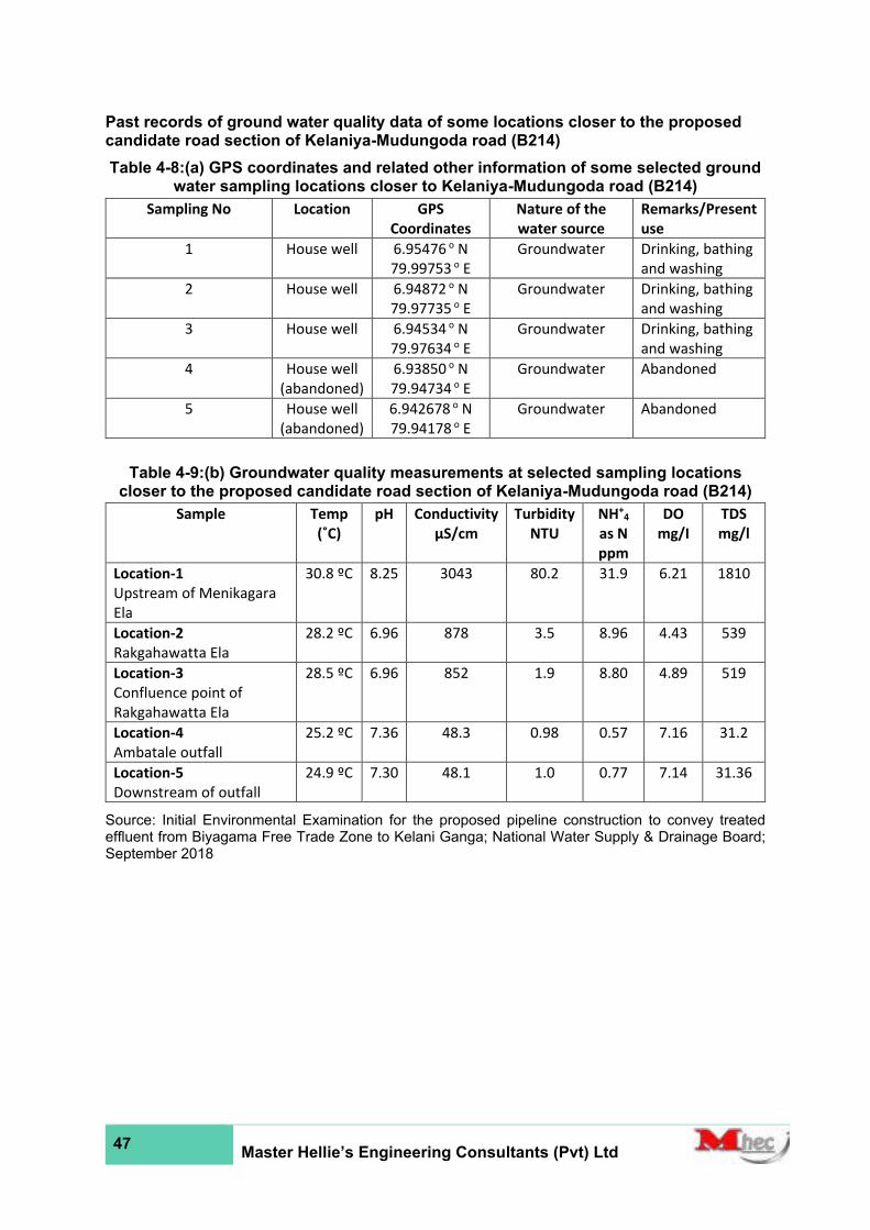
47 Master Hellie’s Engineering Consultants (Pvt) Ltd
Past records of ground water quality data of some locations closer to the proposed candidate road section of Kelaniya-Mudungoda road (B214)
Table 4-8:(a) GPS coordinates and related other information of some selected ground water sampling locations closer to Kelaniya-Mudungoda road (B214)
Sampling No Location GPS
Coordinates
Nature of the
water source
Remarks/Present
use
1 House well 6.95476 o N
79.99753 o E
Groundwater Drinking, bathing
and washing
2 House well 6.94872 o N
79.97735 o E
Groundwater Drinking, bathing
and washing
3 House well 6.94534 o N
79.97634 o E
Groundwater Drinking, bathing
and washing
4 House well
(abandoned)
6.93850 o N
79.94734 o E
Groundwater Abandoned
5 House well
(abandoned)
6.942678 o N
79.94178 o E
Groundwater Abandoned
Table 4-9:(b) Groundwater quality measurements at selected sampling locations closer to the proposed candidate road section of Kelaniya-Mudungoda road (B214)
Sample Temp
(˚C) pH Conductivity
µS/cm
Turbidity
NTU
NH+4
as N
ppm
DO
mg/I
TDS
mg/l
Location-1
Upstream of Menikagara
Ela
30.8 ºC 8.25 3043 80.2 31.9 6.21 1810
Location-2
Rakgahawatta Ela
28.2 ºC 6.96 878 3.5 8.96 4.43 539
Location-3
Confluence point of
Rakgahawatta Ela
28.5 ºC 6.96 852 1.9 8.80 4.89 519
Location-4
Ambatale outfall
25.2 ºC 7.36 48.3 0.98 0.57 7.16 31.2
Location-5
Downstream of outfall
24.9 ºC 7.30 48.1 1.0 0.77 7.14 31.36
Source: Initial Environmental Examination for the proposed pipeline construction to convey treated effluent from Biyagama Free Trade Zone to Kelani Ganga; National Water Supply & Drainage Board; September 2018
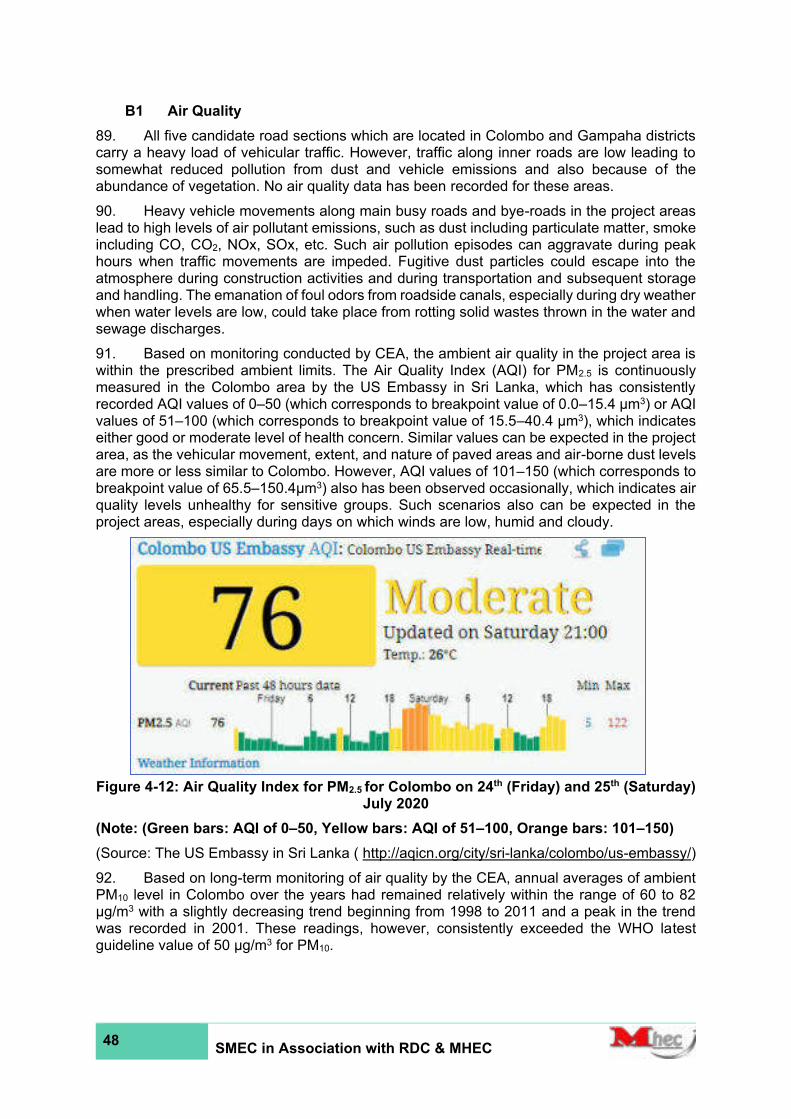
48 SMEC in Association with RDC & MHEC
B1 Air Quality
89. All five candidate road sections which are located in Colombo and Gampaha districts carry a heavy load of vehicular traffic. However, traffic along inner roads are low leading to somewhat reduced pollution from dust and vehicle emissions and also because of the abundance of vegetation. No air quality data has been recorded for these areas.
90. Heavy vehicle movements along main busy roads and bye-roads in the project areas lead to high levels of air pollutant emissions, such as dust including particulate matter, smoke including CO, CO2, NOx, SOx, etc. Such air pollution episodes can aggravate during peak hours when traffic movements are impeded. Fugitive dust particles could escape into the atmosphere during construction activities and during transportation and subsequent storage and handling. The emanation of foul odors from roadside canals, especially during dry weather when water levels are low, could take place from rotting solid wastes thrown in the water and sewage discharges.
91. Based on monitoring conducted by CEA, the ambient air quality in the project area is within the prescribed ambient limits. The Air Quality Index (AQI) for PM2.5 is continuously measured in the Colombo area by the US Embassy in Sri Lanka, which has consistently recorded AQI values of 0–50 (which corresponds to breakpoint value of 0.0–15.4 µm3) or AQI values of 51–100 (which corresponds to breakpoint value of 15.5–40.4 µm3), which indicates either good or moderate level of health concern. Similar values can be expected in the project area, as the vehicular movement, extent, and nature of paved areas and air-borne dust levels are more or less similar to Colombo. However, AQI values of 101–150 (which corresponds to breakpoint value of 65.5–150.4µm3) also has been observed occasionally, which indicates air quality levels unhealthy for sensitive groups. Such scenarios also can be expected in the project areas, especially during days on which winds are low, humid and cloudy.
Figure 4-12: Air Quality Index for PM2.5 for Colombo on 24th (Friday) and 25th (Saturday) July 2020
(Note: (Green bars: AQI of 0–50, Yellow bars: AQI of 51–100, Orange bars: 101–150)
(Source: The US Embassy in Sri Lanka ( http://aqicn.org/city/sri-lanka/colombo/us-embassy/)
92. Based on long-term monitoring of air quality by the CEA, annual averages of ambient PM10 level in Colombo over the years had remained relatively within the range of 60 to 82 µg/m3 with a slightly decreasing trend beginning from 1998 to 2011 and a peak in the trend was recorded in 2001. These readings, however, consistently exceeded the WHO latest guideline value of 50 µg/m3 for PM10.
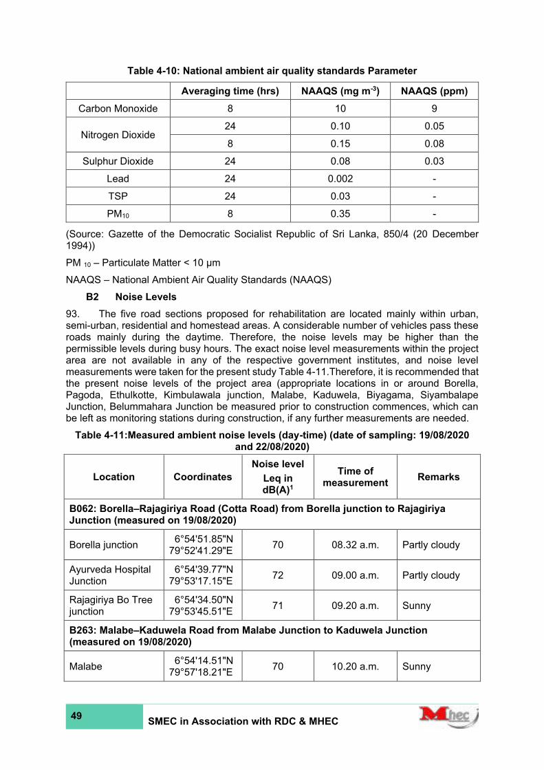
49 SMEC in Association with RDC & MHEC
Table 4-10: National ambient air quality standards Parameter
Averaging time (hrs) NAAQS (mg m-3) NAAQS (ppm)
Carbon Monoxide 8 10 9
Nitrogen Dioxide 24 0.10 0.05
8 0.15 0.08
Sulphur Dioxide 24 0.08 0.03
Lead 24 0.002 -
TSP 24 0.03 -
PM10 8 0.35 -
(Source: Gazette of the Democratic Socialist Republic of Sri Lanka, 850/4 (20 December 1994))
PM 10 – Particulate Matter < 10 μm NAAQS – National Ambient Air Quality Standards (NAAQS)
B2 Noise Levels
93. The five road sections proposed for rehabilitation are located mainly within urban, semi-urban, residential and homestead areas. A considerable number of vehicles pass these roads mainly during the daytime. Therefore, the noise levels may be higher than the permissible levels during busy hours. The exact noise level measurements within the project area are not available in any of the respective government institutes, and noise level measurements were taken for the present study Table 4-11.Therefore, it is recommended that the present noise levels of the project area (appropriate locations in or around Borella, Pagoda, Ethulkotte, Kimbulawala junction, Malabe, Kaduwela, Biyagama, Siyambalape Junction, Belummahara Junction be measured prior to construction commences, which can be left as monitoring stations during construction, if any further measurements are needed.
Table 4-11:Measured ambient noise levels (day-time) (date of sampling: 19/08/2020 and 22/08/2020)
Location Coordinates
Noise level
Leq in dB(A)1
Time of measurement
Remarks
B062: Borella–Rajagiriya Road (Cotta Road) from Borella junction to Rajagiriya Junction (measured on 19/08/2020)
Borella junction 6°54'51.85"N 79°52'41.29"E
70 08.32 a.m. Partly cloudy
Ayurveda Hospital Junction
6°54'39.77"N 79°53'17.15"E
72 09.00 a.m. Partly cloudy
Rajagiriya Bo Tree junction
6°54'34.50"N 79°53'45.51"E
71 09.20 a.m. Sunny
B263: Malabe–Kaduwela Road from Malabe Junction to Kaduwela Junction (measured on 19/08/2020)
Malabe 6°54'14.51"N 79°57'18.21"E
70 10.20 a.m. Sunny
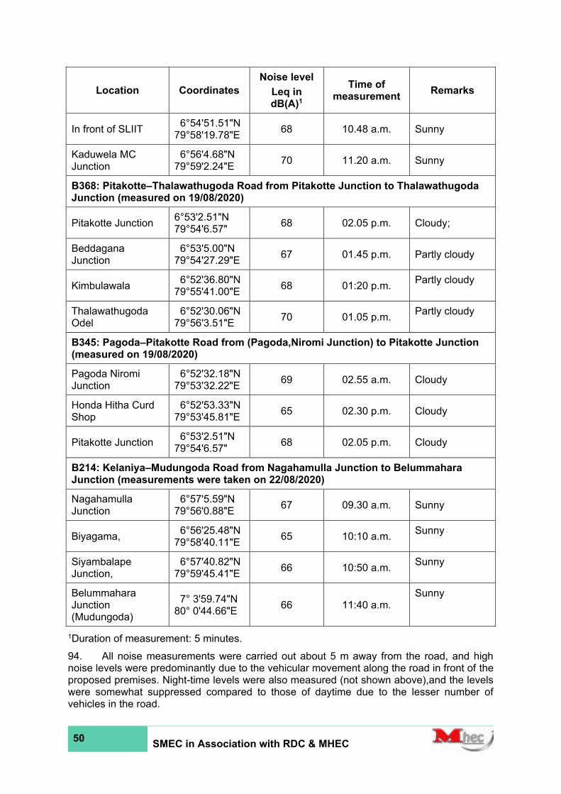
50 SMEC in Association with RDC & MHEC
Location Coordinates
Noise level
Leq in dB(A)1
Time of measurement
Remarks
In front of SLIIT 6°54'51.51"N 79°58'19.78"E
68 10.48 a.m. Sunny
Kaduwela MC Junction
6°56'4.68"N 79°59'2.24"E
70 11.20 a.m. Sunny
B368: Pitakotte–Thalawathugoda Road from Pitakotte Junction to Thalawathugoda Junction (measured on 19/08/2020)
Pitakotte Junction 6°53'2.51"N 79°54'6.57"
68 02.05 p.m. Cloudy;
Beddagana Junction
6°53'5.00"N 79°54'27.29"E
67 01.45 p.m. Partly cloudy
Kimbulawala 6°52'36.80"N 79°55'41.00"E
68 01:20 p.m. Partly cloudy
Thalawathugoda Odel
6°52'30.06"N 79°56'3.51"E
70 01.05 p.m. Partly cloudy
B345: Pagoda–Pitakotte Road from (Pagoda,Niromi Junction) to Pitakotte Junction (measured on 19/08/2020)
Pagoda Niromi Junction
6°52'32.18"N 79°53'32.22"E
69 02.55 a.m. Cloudy
Honda Hitha Curd Shop
6°52'53.33"N 79°53'45.81"E
65 02.30 p.m. Cloudy
Pitakotte Junction 6°53'2.51"N 79°54'6.57"
68 02.05 p.m. Cloudy
B214: Kelaniya–Mudungoda Road from Nagahamulla Junction to Belummahara Junction (measurements were taken on 22/08/2020)
Nagahamulla Junction
6°57'5.59"N 79°56'0.88"E
67 09.30 a.m. Sunny
Biyagama, 6°56'25.48"N 79°58'40.11"E
65 10:10 a.m. Sunny
Siyambalape Junction,
6°57'40.82"N 79°59'45.41"E
66 10:50 a.m. Sunny
Belummahara Junction (Mudungoda)
7° 3'59.74"N 80° 0'44.66"E
66 11:40 a.m. Sunny
1Duration of measurement: 5 minutes.
94. All noise measurements were carried out about 5 m away from the road, and high noise levels were predominantly due to the vehicular movement along the road in front of the proposed premises. Night-time levels were also measured (not shown above),and the levels were somewhat suppressed compared to those of daytime due to the lesser number of vehicles in the road.

51 SMEC in Association with RDC & MHEC
95. According to Schedules I and II of National Environmental (Noise Control) Regulations, No.1 of 1996 (924/12), the study area belongs to Medium noise area and Low noise area, as all the five roads are located within Colombo Municipal Council, Sri Jayawardenepura Kotte Municipal Council, Maharagama Urban Council, Kaduwela Municipal Council, Biyagama Pradeshiya Sabha, Mahara Pradeshiya Sabha, and Gampaha Pradeshiya Sabha areas. Therefore, the maximum permissible noise levels at the boundary of the land in which any source of noise is located, shall not exceed (in LAeq, T) of the area can be considered as 55 dB(A) during daytime (06.00 hrs-18.00 hrs) and 45 dB (A) night time (18.00 hrs - 06.00 hrs) for low noise areas (pradeshiya sabha areas), and 63 dB(A) during daytime (06.00 hrs-18.00 hrs) and 50 dB (A) night time (18.00 hrs - 06.00 hrs) for medium noise areas (municipal and urban council areas). For construction activities, the maximum permissible noise levels at boundaries of the land in which the source of noise is located (in LAeq,T), are 75 (daytime: 06:00 hrs – 21:00 hrs) and 50 (nighttime: 21:00 hrs – 06:00 hrs). However, measured noise levels sometimes exceed the maximum noise levels, which is mainly due to the continuous traffic movement along these five roads during the period of measurement.
96. With reference to the National Environmental (Noise Control) Regulations, No.1 of 1996, noise sensitive areas include: an area in which a courthouse, hospital, public library, school, zoo, a sacred area, and areas set apart for recreation or environmental purposes. An area covered by a distance of 100 m from the boundary of these sensitive areas are referred to as Silent Zone, where the maximum permissible noise levels at the boundary of the land in which any source of noise is located, shall not exceed (in LAeq, T) of the area can be considered as 50 dB (A) during daytime (06.00 hrs-18.00 hrs) and 45 dB (A) night time (18.00 hrs-06.00 hrs). Noise sensitive receptors along the five roads are given in Table 4-12.
Table 4-12: Noise sensitive Receptors along the five roads
Chainage (m) Noise Sensitive Receptor Side of the road
B062
1,000 Western Infirmary Private Hospital RHS
1,200 Christ Church LHS
1,400 Jayawardanaramaya Temple LHS
1,990 Sacred Heart Church LHS
B263
240 Boys' School - Malabe LHS
1,935 Sri Sudharshanarama Purana Viharaya LHS
2,640 Slit Campus Malabe RHS
5,140 Sankapitti Purana Viharaya RHS
B368
100 Ananda Sastralaya, Kotte RHS
2,600 Iyamporuwa Gangathilaka Viharaya RHS
3,000 Temple LHS
B345
850 Vidya Vijaya Aramaya LHS
B214
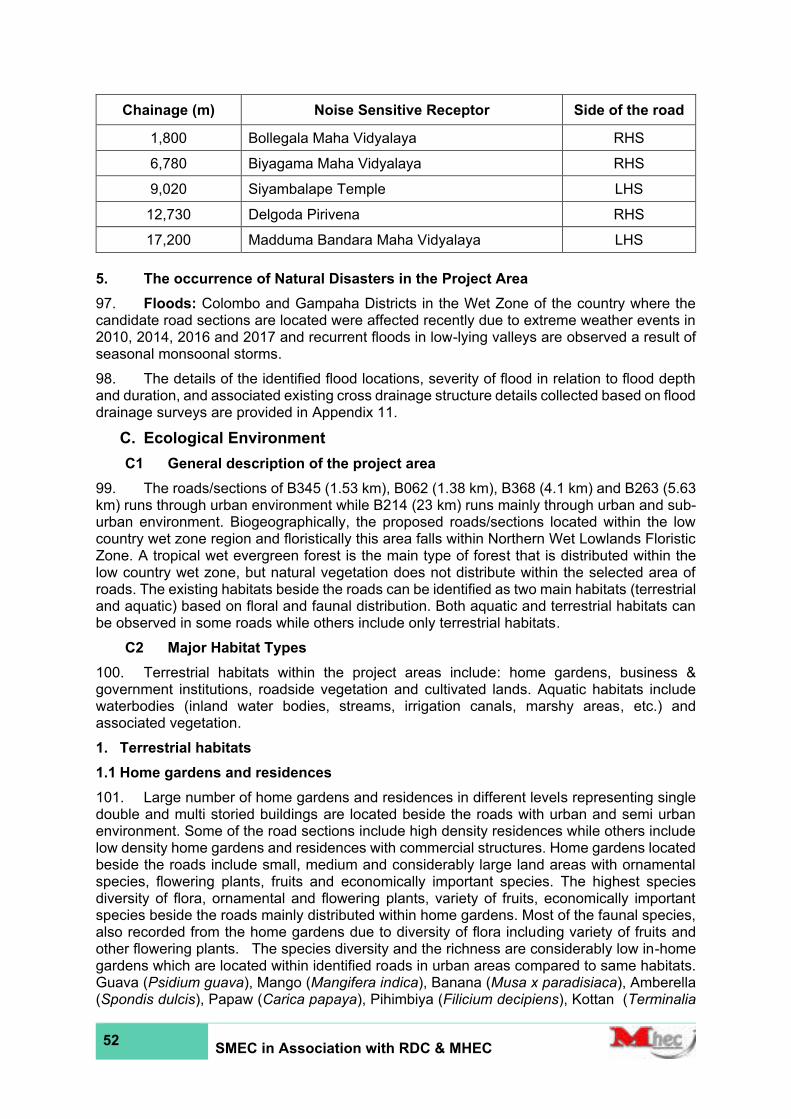
52 SMEC in Association with RDC & MHEC
Chainage (m) Noise Sensitive Receptor Side of the road
1,800 Bollegala Maha Vidyalaya RHS
6,780 Biyagama Maha Vidyalaya RHS
9,020 Siyambalape Temple LHS
12,730 Delgoda Pirivena RHS
17,200 Madduma Bandara Maha Vidyalaya LHS
5. The occurrence of Natural Disasters in the Project Area
97. Floods: Colombo and Gampaha Districts in the Wet Zone of the country where the candidate road sections are located were affected recently due to extreme weather events in 2010, 2014, 2016 and 2017 and recurrent floods in low-lying valleys are observed a result of seasonal monsoonal storms.
98. The details of the identified flood locations, severity of flood in relation to flood depth and duration, and associated existing cross drainage structure details collected based on flood drainage surveys are provided in Appendix 11.
C. Ecological Environment
C1 General description of the project area
99. The roads/sections of B345 (1.53 km), B062 (1.38 km), B368 (4.1 km) and B263 (5.63 km) runs through urban environment while B214 (23 km) runs mainly through urban and sub- urban environment. Biogeographically, the proposed roads/sections located within the low country wet zone region and floristically this area falls within Northern Wet Lowlands Floristic Zone. A tropical wet evergreen forest is the main type of forest that is distributed within the low country wet zone, but natural vegetation does not distribute within the selected area of roads. The existing habitats beside the roads can be identified as two main habitats (terrestrial and aquatic) based on floral and faunal distribution. Both aquatic and terrestrial habitats can be observed in some roads while others include only terrestrial habitats.
C2 Major Habitat Types
100. Terrestrial habitats within the project areas include: home gardens, business & government institutions, roadside vegetation and cultivated lands. Aquatic habitats include waterbodies (inland water bodies, streams, irrigation canals, marshy areas, etc.) and associated vegetation.
1. Terrestrial habitats
1.1 Home gardens and residences
101. Large number of home gardens and residences in different levels representing single double and multi storied buildings are located beside the roads with urban and semi urban environment. Some of the road sections include high density residences while others include low density home gardens and residences with commercial structures. Home gardens located beside the roads include small, medium and considerably large land areas with ornamental species, flowering plants, fruits and economically important species. The highest species diversity of flora, ornamental and flowering plants, variety of fruits, economically important species beside the roads mainly distributed within home gardens. Most of the faunal species, also recorded from the home gardens due to diversity of flora including variety of fruits and other flowering plants. The species diversity and the richness are considerably low in-home gardens which are located within identified roads in urban areas compared to same habitats. Guava (Psidium guava), Mango (Mangifera indica), Banana (Musa x paradisiaca), Amberella (Spondis dulcis), Papaw (Carica papaya), Pihimbiya (Filicium decipiens), Kottan (Terminalia
53 SMEC in Association with RDC & MHEC
catappa), Araliya (Plumeria obtuse), Jam (Muntingia calabura) etc., are frequently found in home garden habitats.
1.2 Business & government premises
102. The project affected areas of the roads which mainly contain with ribbon type developed business premises, small, medium and large-scale industries, warehouses, container yards and other service providers. In addition, religiously important sites and government buildings including their premises belonging to various government department and authorities that are located beside the roads. These buildings occupied significant amount of lands beside the roads. A considerable land area beside the main road network covered with government buildings and religious places while business and commercial structures including wholesale and retail business premises distribute in different level. Cultivated flora including economically important species, fruits and number of species belonging to ornamental category are found in government and business premises with considerable land area. The prominent trees { Kottanba (Terminalia catappa), Maha Nuga (Ficus benghalensis), Bo (Ficus religiosa), Kos (Artocarpus heterophyllus), Amba (Mangifera indica), Pihimbiya (Filicium decipiens), Tabebuia (Tabebuia rosea) etc} belong to different species were observed within above premises. 1.3 Road Reservations
103. Roadside trees and vegitation located beside the roads within ROW have considered under this sub topic. Majority of trees located within the ROW include planted species with flowering plants, ornamental species and shading species. Trees that are located beside the roads are mainly concentrated on outside of the urban areas. Some trees are located close to the edges of the road and others are distributed within reservation area up to the fences of road side properties. Trees belonging to different species Mangifera indica (Amba), Terminalia catappa (Kottamba), Macaranga peltata (Kanda), Filicium decipiens (Pihibiya), Polyalthia longifolia (Willow), Cassia fistula (Ehela), Samanea saman (Para-mara), Swietenia mahagoni (Mahogani), Ficus racemosa (Attikka), Ficus religiosa (Bo), Magul Karanda (Pongamia pinnata), Tabebuia rosea (Tabebuia), Ficus benjamina (Elu nuga) etc, are located commonly beside the roads. 1.4 Cultivated lands
104. Paddy fields, mixed coconut cultivations, rubber and pineapple cultivations are located in the vicinity of some roads/sections. Paddy fields located adjacent to some roads in the vicinity are cultivated while abandoned and uncultivated paddy field also observed during the field survey. Several scattered trees, canal bund vegetation, different species of grasses, herbs and shrub communities are found within this environment. Abandoned paddy fields which are mainly concentrated in urban and sub-urban sections have been converted to variety of constructions. Paddy (Oryza sativa) is the only cultivated species in paddy lands. At the end of rainy season aquatic and semi aquatic weeds colonize within some of the paddylands while during the drying of those lands take over with different species of terrestrial weeds.
1.5 Waterbodies and associated vegetation
105. Several freshwater canals that are located around the project roads (B368, B214 and B263) and some canals cross the project roads in different locations. Most of the canals activate only during the rainy season. The existing conditions of the water in the canals within urban areas are highly polluted. The color of the water is black with bad odor in most of the occasions. In addition, least number of aquatic plant and animal species observed within the canal eco system. Water bodies such as Diyawanna lake and associated habitats of B368: Pitakotte - Thalawathugoda road provides feeding, breeding and nesting habitats for different species of water birds, freshwater fishes, reptiles etc. In addition, large number of invertebrates can be seen within these habitats. Madiwela left bank canal of B263: Malabe-Kaduwela road and Kelani River that runs parallel to the initial section of B214: Kelaniya-

54 SMEC in Association with RDC & MHEC
Mudungoda road important water bodies that are located within project affected areas of the roads.
C3 Environmental condition of individual roads/sections
B345: Pagoda-Pitakotte Road - 1.53 km
106. A entire road is located within urban area of Nugegoda, Pagoda and Pitakotte. The terrain of the road is flat and slightly undulating. The land use beside the road include ribbon type develop business places, residences with small to medium size home gardens up to Pitakotte Junction. A large number of commercial structures are concentrated at the start and end section of the road while mid-section includes mix commercial and residential environment. High density residential area of the road is located in the inner part beside the road.
107. Water bodies and other environment sensitive sites are not located close to the road while all most all the floral and faunal species were recorded from home gardens. No trees were recorded from the right of way. Existing biodiversity of the area is mainly representing from common home garden species including several species of fruits and ornamental plants.
B062: Borella - Rajagiriya Road (Cotta Road) – 1.38 km
108. A section of 1.38 km road located through a highly urban area from Borella Junction up to Rajagiriya Bo Tree Junction. The terrain of the road is flat and slightly undulating. The total area beside the road include ribbon type developed business structures and other government and private sector buildings. Several residences are located in between commercial structures while highly residential environment is located inner areas around the road.
109. No environmental sensitive areas close to the road. Few roadside trees are located within the ROW of the road close to the road edges. Existing biodiversity of the area is mainly representing from common home garden species including several species of fruits and ornamental plants.
B368: Pitakotte - Thalawathugoda Road - 4.1 km
110. The road of Pitakotte to Thalawatugoda starts from Pitakotte Junction and runs urban environment up to 4.10 km of Thalawathugoda Junction through mixed residential and commercial area. The terrain of the road is flat and slightly undulating. The roadside environment from the starting and ending sections includes highly commercial, mix residential and commercial area with government and private sector buildings, playgrounds, paddy field, water bodies etc. Water canals which is connected to the marshy area and Diyawanna Lake crosses the road around 1.5 and 2.5 km respectively around Pitakotte and Madiwela area. A considerable extent of paddy fields are located RHS around 3.1 km. Diyawanna Lake is located on the LHS around 3 km., and another small water body connected with Diyawanna Lake is located on the LHS around 4 km, close to the Thalawathugoda Junction.
111. Existing biodiversity of proposed road is mainly representing from the faunal species recorded from the Diyawanna lake, marshy areas and other species mainly reported from common home garden species including several species of fruits and ornamental plants. Small number of trees were recorded from the right of way.
B263: Malabe-Kaduwela Road - 5.63 km.
112. A total of 5.63 km road starts at Malabe Junction and runs up to Kaduwela Junction with flat and slightly undulating terrain. The starting and end points of the road are highly commercial with ribbon type development while mix commercial and residential areas with government and private sector buildings are located beside the road. The inner area beside the road from Malabe up to Kaduwela is highly residential. Paddy fields both cultivable and abandoned, marshy habitats and water ways are located at several locations beside the road while Madiwela left bank canal cross the road just after the CBK Road at the mid-section.
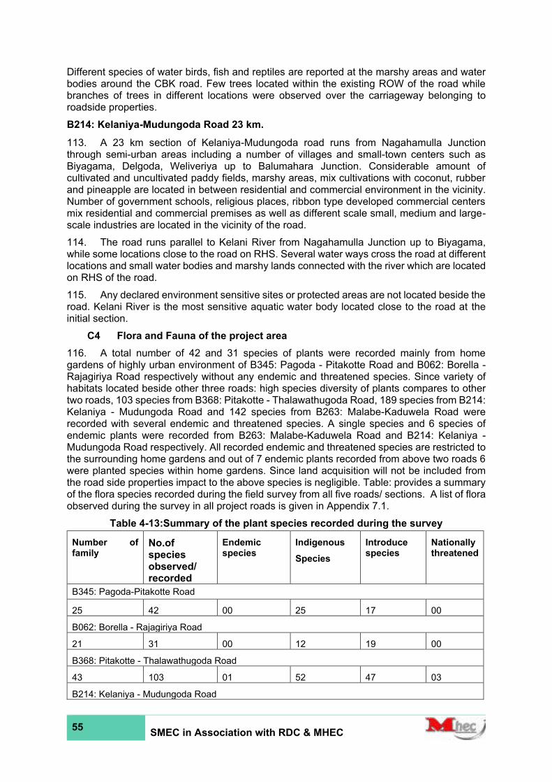
55 SMEC in Association with RDC & MHEC
Different species of water birds, fish and reptiles are reported at the marshy areas and water bodies around the CBK road. Few trees located within the existing ROW of the road while branches of trees in different locations were observed over the carriageway belonging to roadside properties.
B214: Kelaniya-Mudungoda Road 23 km.
113. A 23 km section of Kelaniya-Mudungoda road runs from Nagahamulla Junction through semi-urban areas including a number of villages and small-town centers such as Biyagama, Delgoda, Weliveriya up to Balumahara Junction. Considerable amount of cultivated and uncultivated paddy fields, marshy areas, mix cultivations with coconut, rubber and pineapple are located in between residential and commercial environment in the vicinity. Number of government schools, religious places, ribbon type developed commercial centers mix residential and commercial premises as well as different scale small, medium and large-scale industries are located in the vicinity of the road.
114. The road runs parallel to Kelani River from Nagahamulla Junction up to Biyagama, while some locations close to the road on RHS. Several water ways cross the road at different locations and small water bodies and marshy lands connected with the river which are located on RHS of the road.
115. Any declared environment sensitive sites or protected areas are not located beside the road. Kelani River is the most sensitive aquatic water body located close to the road at the initial section.
C4 Flora and Fauna of the project area
116. A total number of 42 and 31 species of plants were recorded mainly from home gardens of highly urban environment of B345: Pagoda - Pitakotte Road and B062: Borella - Rajagiriya Road respectively without any endemic and threatened species. Since variety of habitats located beside other three roads: high species diversity of plants compares to other two roads, 103 species from B368: Pitakotte - Thalawathugoda Road, 189 species from B214: Kelaniya - Mudungoda Road and 142 species from B263: Malabe-Kaduwela Road were recorded with several endemic and threatened species. A single species and 6 species of endemic plants were recorded from B263: Malabe-Kaduwela Road and B214: Kelaniya - Mudungoda Road respectively. All recorded endemic and threatened species are restricted to the surrounding home gardens and out of 7 endemic plants recorded from above two roads 6 were planted species within home gardens. Since land acquisition will not be included from the road side properties impact to the above species is negligible. Table: provides a summary of the flora species recorded during the field survey from all five roads/ sections. A list of flora observed during the survey in all project roads is given in Appendix 7.1.
Table 4-13:Summary of the plant species recorded during the survey
Number of family
No.of species observed/ recorded
Endemic species
Indigenous
Species
Introduce species
Nationally threatened
B345: Pagoda-Pitakotte Road
25 42 00 25 17 00
B062: Borella - Rajagiriya Road
21 31 00 12 19 00
B368: Pitakotte - Thalawathugoda Road
43 103 01 52 47 03
B214: Kelaniya - Mudungoda Road
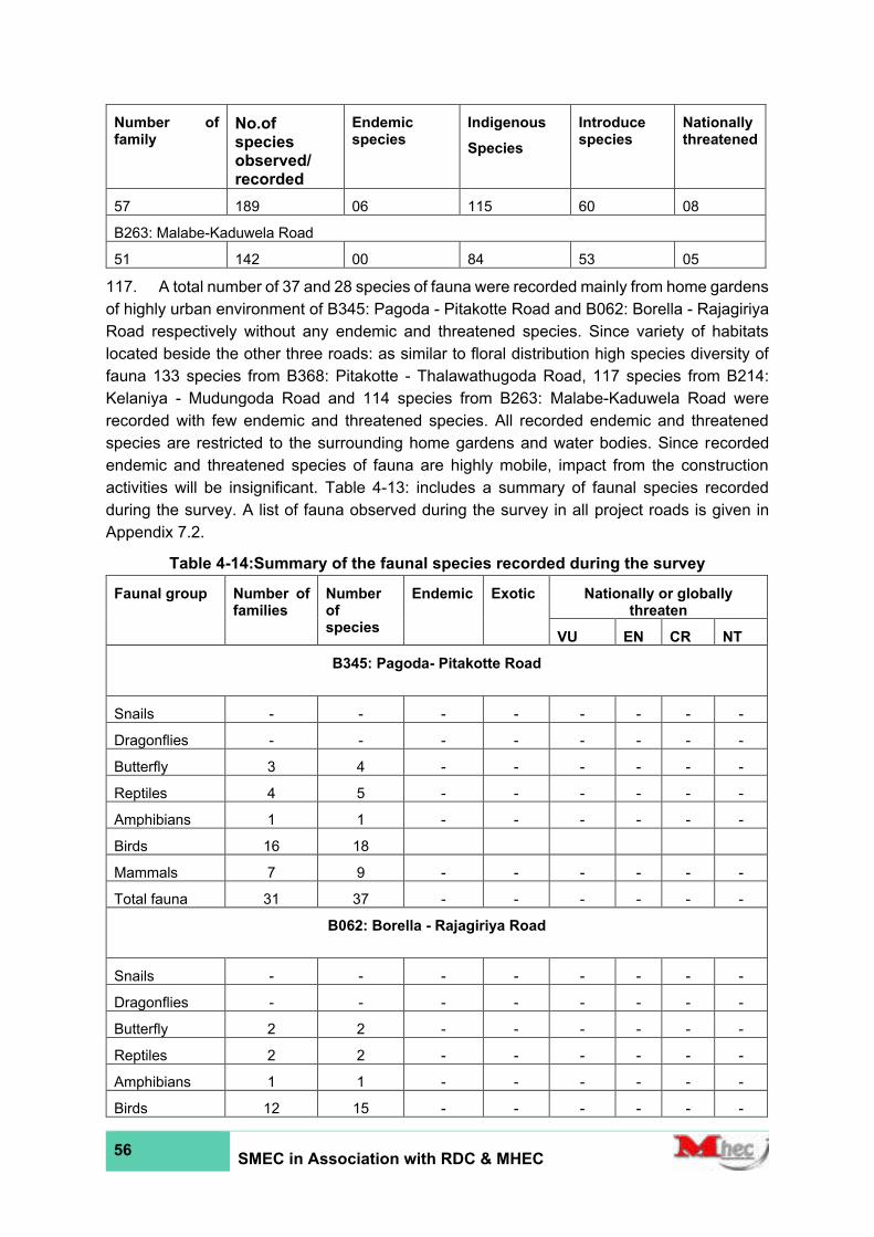
56 SMEC in Association with RDC & MHEC
Number of family
No.of species observed/ recorded
Endemic species
Indigenous
Species
Introduce species
Nationally threatened
57 189 06 115 60 08
B263: Malabe-Kaduwela Road
51 142 00 84 53 05
117. A total number of 37 and 28 species of fauna were recorded mainly from home gardens
of highly urban environment of B345: Pagoda - Pitakotte Road and B062: Borella - Rajagiriya
Road respectively without any endemic and threatened species. Since variety of habitats
located beside the other three roads: as similar to floral distribution high species diversity of
fauna 133 species from B368: Pitakotte - Thalawathugoda Road, 117 species from B214:
Kelaniya - Mudungoda Road and 114 species from B263: Malabe-Kaduwela Road were
recorded with few endemic and threatened species. All recorded endemic and threatened
species are restricted to the surrounding home gardens and water bodies. Since recorded
endemic and threatened species of fauna are highly mobile, impact from the construction
activities will be insignificant. Table 4-13: includes a summary of faunal species recorded
during the survey. A list of fauna observed during the survey in all project roads is given in
Appendix 7.2.
Table 4-14:Summary of the faunal species recorded during the survey
Faunal group Number of families
Number of species
Endemic Exotic Nationally or globally threaten
VU EN CR NT
B345: Pagoda- Pitakotte Road
Snails - - - - - - - -
Dragonflies - - - - - - - -
Butterfly 3 4 - - - - - -
Reptiles 4 5 - - - - - -
Amphibians 1 1 - - - - - -
Birds 16 18
Mammals 7 9 - - - - - -
Total fauna 31 37 - - - - - -
B062: Borella - Rajagiriya Road
Snails - - - - - - - -
Dragonflies - - - - - - - -
Butterfly 2 2 - - - - - -
Reptiles 2 2 - - - - - -
Amphibians 1 1 - - - - - -
Birds 12 15 - - - - - -
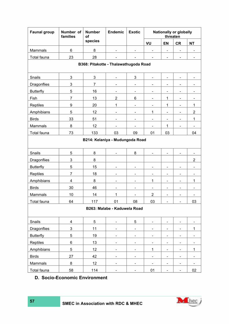
57 SMEC in Association with RDC & MHEC
Faunal group Number of families
Number of species
Endemic Exotic Nationally or globally threaten
VU EN CR NT
Mammals 6 8 - - - - - -
Total fauna 23 28 - - - - - -
B368: Pitakotte - Thalawathugoda Road
Snails 3 3 - 3 - - - -
Dragonflies 3 7 - - - - - -
Butterfly 5 16 - - - - - -
Fish 7 13 2 6 - 1 - -
Reptiles 9 20 1 - - 1 - 1
Amphibians 5 12 - - 1 - - 2
Birds 33 51 - - - - - 1
Mammals 8 12 - - - 1 - -
Total fauna 73 133 03 09 01 03 04
B214: Kelaniya - Mudungoda Road
Snails 5 8 - 8 - - - -
Dragonflies 3 8 2
Butterfly 5 15 - - - - - -
Reptiles 7 18 - - - - - -
Amphibians 4 8 - - 1 - - 1
Birds 30 46 - - - - - -
Mammals 10 14 1 - 2 - - -
Total fauna 64 117 01 08 03 - - 03
B263: Malabe - Kaduwela Road
Snails 4 5 - 5 - - - -
Dragonflies 3 11 - - - - - 1
Butterfly 5 19 - - - - - -
Reptiles 6 13 - - - - - -
Amphibians 5 12 - - 1 - - 1
Birds 27 42 - - - - - -
Mammals 8 12 - - - - - -
Total fauna 58 114 - - 01 - - 02
D. Socio-Economic Environment

58 SMEC in Association with RDC & MHEC
118. Population in selected 6 DSDs are recoded as 1,148,423, The selected road sections for improvements of five roads connects Sri Ja’pura Kotte, Maharagama, kaduwela, Mahara, Gampaha and Biyagama DS Divisions influencing 43 number of GND Division.
119. Population in Road relevant DSDs: The said road sections fallen within Sri Ja’pura Kotte, Maharagama, kaduwela, Mahara, Gampaha and Biyagama Divisional Secretariat Divisions (DSDs). The population in the six DSDs is defined as the population in the road influential area. Therefore, the road influential area population is 1,148,423. This is about 38% of the total population in the Colombo and Gampaha district. Kaduwela DSD has the highest population out of the six DSDs. The details on the road influential area population are shown in Table 4-15.
Table 4-15: The population in DSDs with Gender segregation
DS Division
Female population
Male population Total
Population
No % No %
Sri Ja’pura Kotte (B345, B368, B062) 55,933 52% 51,992 48% 107,925
Maharagama (B368) 102,30
6 52% 94,117 48% 196,423
Kaduwela B263) 128,469 51% 123,572 49% 252,041
Mahara (B214) 106,393 51% 101,389 49% 207,782
Gampaha (B214) 95,570 48% 102,097 52% 197,667
Biyagama (B214) 94,470 51% 92,115 49% 186,585
Total 583,141 51% 565,282 49% 1,148,423
Source: Resource profiles of relevant DSDs - 2019
120. The ethnic diversity of population in DSDs: Nearly 94% of the population in 6 DSDs is Sinhalese. The Muslim population is next to Sinhalese, and it is 3% of total population. The population under Tamil and others is 2% and 1% respectively.
Table 4-16: Population with Ethnic Diversity
DS Division
Ethnicity
Total Population
Sinhala Tamil Muslim Other
No % No % No % No %
Sri Ja’pura Kotte 91,518 85% 8,243 8% 5,529 5% 2,635 2% 107,925
Maharagama 188,054 96% 3,886 2% 1,379 1% 3,104 2% 196,423
Kaduwela 241,070 96% 5,338 2% 2,180 1% 3,453 1% 252,041
Mahara 195,127 94% 2,582 1% 5,471 3% 4,602 2% 207,782
Gampaha 195,379 99% 1,271 1% 230 0% 787 0% 197,667
Biyagama 171,103 92% 2,029 1% 12,172 7% 1,281 1% 186,585
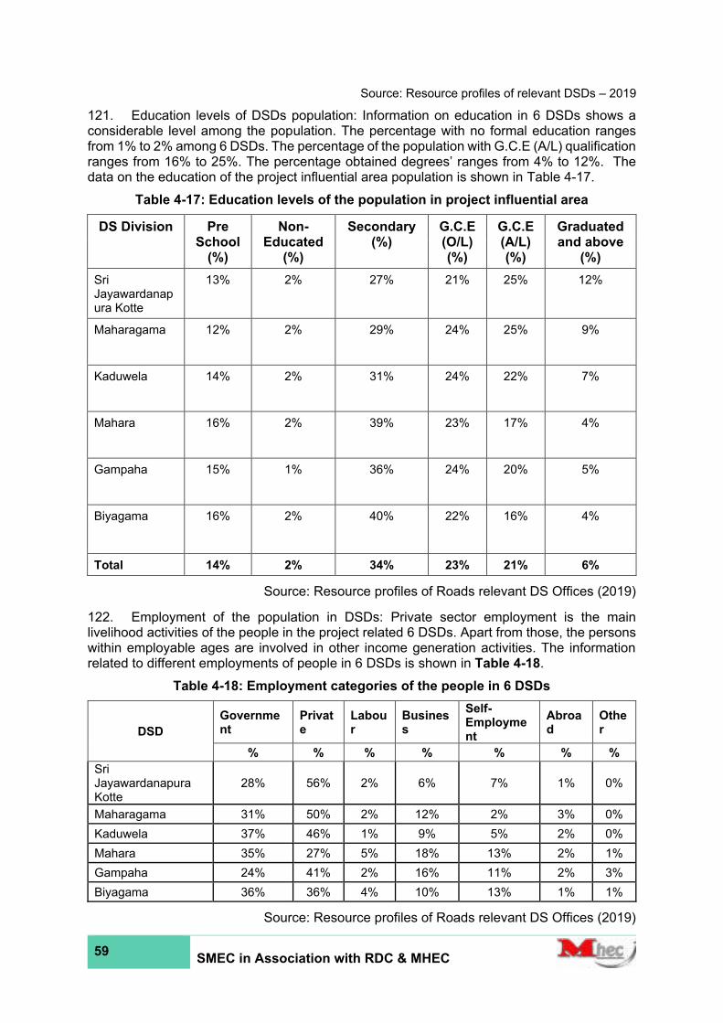
59 SMEC in Association with RDC & MHEC
Source: Resource profiles of relevant DSDs – 2019
121. Education levels of DSDs population: Information on education in 6 DSDs shows a considerable level among the population. The percentage with no formal education ranges from 1% to 2% among 6 DSDs. The percentage of the population with G.C.E (A/L) qualification ranges from 16% to 25%. The percentage obtained degrees’ ranges from 4% to 12%. The data on the education of the project influential area population is shown in Table 4-17.
Table 4-17: Education levels of the population in project influential area
DS Division Pre School
(%)
Non-Educated
(%)
Secondary (%)
G.C.E (O/L) (%)
G.C.E (A/L) (%)
Graduated and above
(%)
Sri Jayawardanapura Kotte
13% 2% 27% 21% 25% 12%
Maharagama 12% 2% 29% 24% 25% 9%
Kaduwela 14% 2% 31% 24% 22% 7%
Mahara 16% 2% 39% 23% 17% 4%
Gampaha 15% 1% 36% 24% 20% 5%
Biyagama 16% 2% 40% 22% 16% 4%
Total 14% 2% 34% 23% 21% 6%
Source: Resource profiles of Roads relevant DS Offices (2019)
122. Employment of the population in DSDs: Private sector employment is the main livelihood activities of the people in the project related 6 DSDs. Apart from those, the persons within employable ages are involved in other income generation activities. The information related to different employments of people in 6 DSDs is shown in Table 4-18.
Table 4-18: Employment categories of the people in 6 DSDs
DSD
Government
Private
Labour
Business
Self-Employment
Abroad
Other
% % % % % % %
Sri Jayawardanapura Kotte
28% 56% 2% 6% 7% 1% 0%
Maharagama 31% 50% 2% 12% 2% 3% 0%
Kaduwela 37% 46% 1% 9% 5% 2% 0%
Mahara 35% 27% 5% 18% 13% 2% 1%
Gampaha 24% 41% 2% 16% 11% 2% 3%
Biyagama 36% 36% 4% 10% 13% 1% 1%
Source: Resource profiles of Roads relevant DS Offices (2019)
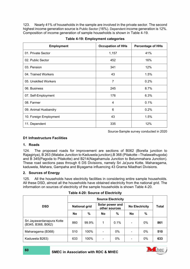
60 SMEC in Association with RDC & MHEC
123. Nearly 41% of households in the sample are involved in the private sector. The second highest income generation source is Public Sector (16%). Dependent income generation is 12%. Composition of income generation of sample households is shown in Table 4-19.
Table 4-19: Employment categories
Employment Occupation of HHs Percentage of HHs
01. Private Sector 1,157 41%
02. Public Sector 452 16%
03. Pension 341 12%
04. Trained Workers 43 1.5%
05. Unskilled Workers 7 0.2%
06. Business 245 8.7%
07. Self-Employment 176 6.3%
08. Farmer 4 0.1%
09. Animal Husbandry 6 0.2%
10. Foreign Employment 43 1.5%
11. Dependent 335 12%
Source-Sample survey conducted in 2020
D1 Infrastructure Facilities
1. Roads
124. The proposed roads for improvement are sections of B062 (Borella junction to Rajagiriya), B 263 (Malabe Junction to Kaduwela junction),B 368 (Pitakotte –Thalawathugoda) and B 345(Pagoda to Pitakotte) and B214(Nagahamula Junction to Belummahara Junction). These road sections pass through 6 DS Divisions, namely Sri Ja’pura Kotte, Maharagama, kaduwela, Mahara, Gampaha and Biyagama influencing 43 Grama Niladhari Divisions.
2. Sources of Energy
125. All the households have electricity facilities in considering entire sample households. All these DSD, almost all the households have obtained electricity from the national grid. The information on sources of electricity of the sample households is shown Table 4-20.
Table 4-20: Source of Electricity
DSD
Source Electricity
Total National grid Solar power and
other sources No Electricity
No % No % No %
Sri Jayawardanapura Kotte (B345, B368, B062)
860 99.9% 1 0.1% - 0% 861
Maharagama (B368) 510 100% - 0% - 0% 510
Kaduwela B263) 633 100% - 0% - 0% 633

61 SMEC in Association with RDC & MHEC
DSD
Source Electricity
Total National grid Solar power and
other sources No Electricity
No % No % No %
Mahara (B214) 185 100% - 0% - 0% 185
Gampaha (B214) 145 100% - 0% - 0% 145
Biyagama (B214) 475 100% - 0% - 0% 475
Total 2,808 1 - 2,809
Source-Sample survey conducted in 2020
3. Water
126. Between 74% to 99% of sample households in road relevant DSD areas have access to pipe born water provided by the National Water Supply & Drainage Board (NWS&DB). Tube wells and Shallow wells are the main sources of drinking water in household’s percentage between 1% to 26% among 6 DSD. Located in interior areas of Surveyed GNDs. The data on sources of drinking water is shown in Table 4-21. However, according to the community members interviewed quality of water in shallow wells and community water supply schemes is good for drinking and they had no complaints about the quality of water.
Table 4-21: Source of Water
DSD
Water source
Total NWS&DB Well/Tube well Community
Well
No % No % No %
Sri Jayawardanapura Kotte (B345, B368, B062)
849 99% 12 1.4% - 0% 861
Maharagama (B368) 478 94% 32 6.3% - 0% 510
Kaduwela B263) 606 96% 25 3.9% 2 0.3% 633
Mahara (B214) 113 61% 70 38% 2 1.1% 185
Gampaha (B214) 109 75% 36 25% - 0% 145
Biyagama (B214) 350 74% 122 26% 3 0.6% 475
Total 2,505 89% 297 11% 7 0% 2,809
Source-Sample survey conducted in 2020
4. Sanitation
127. All the households interviewed have access to sanitary latrine facilities. Almost all the households in all the project relevant DS divisions have water sealed latrines in their households (water sealed latrines include flush type latrines as well). According to the interviews with community members during the socio-economic survey it was found that establishment of water sealed latrine is considered as an essential need of the households. Therefore, in near future most of the households in the area will have water sealed latrines. The data on sanitary latrine facilities available in sample households is shown in the Table 4-22 below.

62 SMEC in Association with RDC & MHEC
Table 4-22: Type of Sanitary system available
DSD
Sanitary Condition
Total Flush Water Sealed Pit Latrine None
No % No % No % No %
Sri Jayawardanapura Kotte (B345, B368, B062)
667 77% 193 22% 1 0.1% - 0% 861
Maharagama (B368) 467 92% 41 8.0% 2 0.4% - 0% 510
Kaduwela B263) 550 87% 82 13% 1 0.2% - 0% 633
Mahara (B214) 160 86% 24 13% 1 0.5% - 0% 185
Gampaha (B214) 118 81% 27 19% - 0% - 0% 145
Biyagama (B214) 383 81% 91 19% 1 0.2% - 0% 475
Total 2,345 458 6 - 2,809
Source-Sample survey conducted in 2020
5. Health
128. The communities in the road’s catchment area have access to private and government Hospitals for their needs.
Eg: National Hospital of Sri Lanka (B062), Golden Key Hospital(B062)
Hemas Hospital, Thalawathugoda (B368) Kaduwela Private Hospital & Elderly Nursing Home (B263)
6. Historical Significance (Physical cultural resources)
129. It is identified these selected roads provide access to many places which contributes a religious and archeological importance. Major religious and archeological places are listed in Table 4-23.
Table 4-23: Religious Place/ Archeological Places in the vicinity of the roads (within 100m)
Number Road Religious Place/ Archeological Places (within 100m)
1 B062 -
2 B 263 Sri Sudharshanarama Purana Viharaya(1+740), Mahamevnawa Amawatura Monastery(3+290), Sankapitti Purana Viharaya(4+370)
3 B 214
Sri Sudharmarama Maha Viharaya (14+600)
Siyambalape Temple (14+820)
Mosque - Madrasathul Furkaniyah (17+200)

63 SMEC in Association with RDC & MHEC
Number Road Religious Place/ Archeological Places (within 100m)
Delgoda Pirivena (18+850)
Sri Poorwarama Buddhist Temple (25+240)
4 B 345 Vidya Vijaya Aramaya (0+750)
5 B 368 Iyanporuwa Raja Maha Viharaya (2+660)
Buddhist temple (2+640)
130. The project relevant Grama Niladhari Divisions (GNDs): These roads runs across 43 GNDs. The total number of families in road relevant GNDs is 335,643 comprising of 1,148,423populations. The people in the GNDs can be defined as the population in the road corridor.
131. Education levels: The following data on education levels of people in 43 GNDs indicates a low level of education in the project affected area. Percentage ranges show the situation of households interviewed.
Table 4-24: Percentage ranges show the situation of households interviewed
Level of Education attainment Total %
Male Female
No % No %
01. Less than 5 years of age 548 5.3% 299 2.9% 249 2.4%
02. Never went to school 103 1.0% 48 0.5% 55 0.5%
03. Up to Grade 1 - 5 499 4.8% 234 2.3% 265 2.6%
04. Up to Grade 5 - 10 1,040 10% 553 5.4% 487 4.7%
05. Up to GCE O/L 1,179 11% 575 5.6% 604 5.9%
06. Pass GCE O/L 1,588 15% 803 7.8% 785 7.6%
07. Up to GCE A/L 1,567 15% 811 7.9% 756 7.3%
08. Pass GCE A/L 2,761 27% 1,433 14% 1,328 13%
09. Graduate 996 10% 559 5.4% 437 4.2%
10. Postgraduate 39 0.4% 28 0.3% 11 0.1%
Total 10,320 100% 5,343 52% 4,977 48%
Source-Sample survey conducted in 2020
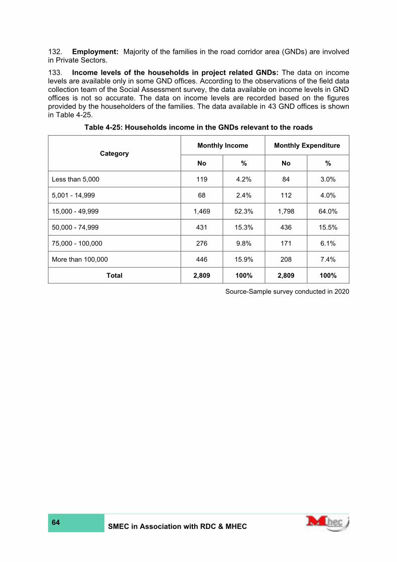
64 SMEC in Association with RDC & MHEC
132. Employment: Majority of the families in the road corridor area (GNDs) are involved in Private Sectors.
133. Income levels of the households in project related GNDs: The data on income levels are available only in some GND offices. According to the observations of the field data collection team of the Social Assessment survey, the data available on income levels in GND offices is not so accurate. The data on income levels are recorded based on the figures provided by the householders of the families. The data available in 43 GND offices is shown in Table 4-25.
Table 4-25: Households income in the GNDs relevant to the roads
Category
Monthly Income Monthly Expenditure
No % No %
Less than 5,000 119 4.2% 84 3.0%
5,001 - 14,999 68 2.4% 112 4.0%
15,000 - 49,999 1,469 52.3% 1,798 64.0%
50,000 - 74,999 431 15.3% 436 15.5%
75,000 - 100,000 276 9.8% 171 6.1%
More than 100,000 446 15.9% 208 7.4%
Total 2,809 100% 2,809 100%
Source-Sample survey conducted in 2020
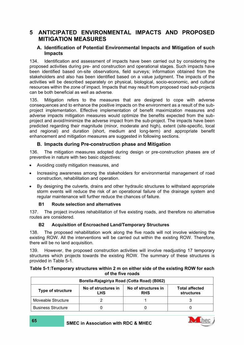
65 SMEC in Association with RDC & MHEC
5 ANTICIPATED ENVIRONMENTAL IMPACTS AND PROPOSED MITIGATION MEASURES
A. Identification of Potential Environmental Impacts and Mitigation of such Impacts
134. Identification and assessment of impacts have been carried out by considering the proposed activities during pre- and construction and operational stages. Such impacts have been identified based on-site observations, field surveys; information obtained from the stakeholders and also has been identified based on a value judgment. The impacts of the activities will be described separately on physical, biological, socio-economic, and cultural resources within the zone of impact. Impacts that may result from proposed road sub-projects can be both beneficial as well as adverse.
135. Mitigation refers to the measures that are designed to cope with adverse consequences and to enhance the positive impacts on the environment as a result of the sub-project implementation. Effective implementation of benefit maximization measures and adverse impacts mitigation measures would optimize the benefits expected from the sub-project and avoid/minimize the adverse impact from the sub-project. The impacts have been predicted regarding their magnitude (minor, moderate and high), extent (site-specific, local and regional) and duration (short, medium and long-term) and appropriate benefit enhancement and mitigation measures are suggested in following sections.
B. Impacts during Pre-construction phase and Mitigation
136. The mitigation measures adopted during design or pre-construction phases are of preventive in nature with two basic objectives:
• Avoiding costly mitigation measures, and
• Increasing awareness among the stakeholders for environmental management of road construction, rehabilitation and operation.
• By designing the culverts, drains and other hydraulic structures to withstand appropriate storm events will reduce the risk of an operational failure of the drainage system and regular maintenance will further reduce the chances of failure.
B1 Route selection and alternatives
137. The project involves rehabilitation of five existing roads, and therefore no alternative routes are considered.
B2 Acquisition of Encroached Land/Temporary Structures
138. The proposed rehabilitation work along the five roads will not involve widening the existing ROW. All the interventions will be carried out within the existing ROW. Therefore, there will be no land acquisition.
139. However, the proposed construction activities will involve readjusting 17 temporary structures which projects towards the existing ROW. The summary of these structures is provided in Table 5-1.
Table 5-1:Temporary structures within 2 m on either side of the existing ROW for each of the five roads
Borella-Rajagiriya Road (Cotta Road) (B062)
Type of structure No of structures in
LHS No of structures in
RHS Total affected
structures
Moveable Structure 2 1 3
Business Structure 0 0 0
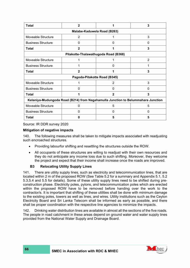
66 SMEC in Association with RDC & MHEC
Total 2 1 3
Malabe-Kaduwela Road (B263)
Moveable Structure 2 1 3
Business Structure 0 0 0
Total 2 1 3
Pitakotte-Thalawathugoda Road (B368)
Moveable Structure 1 1 2
Business Structure 1 0 1
Total 2 1 3
Pagoda-Pitakotte Road (B345)
Moveable Structure 1 2 3
Business Structure 0 0 0
Total 1 2 3
Kelaniya-Mudungoda Road (B214) from Nagahamulla Junction to Belummahara Junction
Moveable Structure 0 5 5
Business Structure 0 0 0
Total 0 5 5
Source: IR DDR survey 2020
Mitigation of negative impacts
140. The following measures shall be taken to mitigate impacts associated with readjusting such encroached structures.
• Providing labourfor shifting and resettling the structures outside the ROW.
• All occupants of these structures are willing to readjust with their own resources and they do not anticipate any income loss due to such shifting. Moreover, they welcome the project and expect that their income shall increase once the roads are improved.
B3 Relocating Utility Supply Lines
141. There are utility supply lines, such as electricity and telecommunication lines, that are located within 2 m of the proposed ROW (See Table 5.2 for a summary and Appendix 5.1, 5.2 5.3,5.4 and 5.5 for details). Some of these utility supply lines need to be shifted during pre-construction phase. Electricity poles, pylons, and telecommunication poles which are erected within the proposed ROW have to be removed before handing over the work to the contractor/s. It is important that shifting of these utilities shall be done with minimum damage to the existing poles, towers as well as lines, and wires. Utility institutions such as the Ceylon Electricity Board and Sri Lanka Telecom shall be informed as early as possible, and there shall be proper coordination with the respective line agencies to minimize the impacts.
142. Drinking water distribution lines are available in almost all the sections of the five roads. The people in road catchment in these areas depend on ground water and water supply lines provided from the National Water Supply and Drainage Board.

67 SMEC in Association with RDC & MHEC
Table 5-2:Utility Poles within 2 m of the ROW for each of the five roads
Road
Number of Utility Poles
Electricity Telecommunication
LHS RHS LHS RHS
Borella-Rajagiriya Road (Cotta Road) - B062 56 46 24 0
Malabe-Kaduwela Road (B263) 218 230 125 120
Pitakotte-Thalawathugoda Road (B368) 150 101 99 67
Pagoda-Pitakotte Road (B345) 69 51 32 26
Kelaniya-Mudungoda Road (B214) from Nagahamulla Junction to Belummahara Junction
951 819 346 429
Mitigation of negative impacts
143. The following are the measures to mitigate possible impacts:
• Advance notice to the public shall be given, with the details of the time and the duration of the utility disruption to minimize public inconvenience
• Proper coordination with respective line agencies is essential, and the schedules shall be prepared with their consent and approvals, especially during the removal of and reestablishment of the services to avoid accidental damage, unnecessary delays and thereby lessen the inconveniences to the general public. Locations and access to these utilities shall be clearly marked (possibly on ground) within the ROW during detailed design to avoid structural damage to the carriageway, shoulders, and drains in future.
• Provision of alternate sources and other utilities during the disruption period and re-establish the utilities as soon as practicable to overcome public inconvenience.
B4 Mobilization of resources and selection of sites for temporary usage
144. Resources such as material, machinery and labour have to be mobilized before construction commences, which storage need space/yards, land/building for site office, labour camps, and for parking of construction vehicles and storing and sheltering of machinery. Proper planning can mitigate much of the impacts described in subsequent sections. Special attention needs when preparing sites for labour camps considering any pandemic situation such as COVID-19.
Mitigation of negative impacts
145. The site selection for temporary usage has to be done in close consultation with village leaders and the authorities of the LA. Such sites shall be located away (at least 500 m) from waterlogged areas, and flood-prone areas. Also, such sites shall be ideally located by the roadside, but clearly away from the proposed carriageway and the shoulders.
146. Such sites shall be located sufficiently away from socially sensitive areas such as schools, temples kovils, churches and mosques and, governmental offices and establishments.
147. Recruitment of labourers, both unskilled and skilled, from the locality, will reduce the need for having large labour camps and will lead to lesser impacts due to such labour camps

68 SMEC in Association with RDC & MHEC
during the construction stage. When selecting and preparing the sites for labour camps follows the WHO the guidelines Considering any pandemic situation such as COVID-19. Also, approvals from relevant authorities must be obtained to use temporary lands to comply with National laws and regulations. Preparation of the temporary lands and access road must be carried out in a way to minimize disturbances to natural vegetation cover.
B5 Natural hazards aggravated by the project and impacts to the road due to natural hazards
1. Flood Impacts
148. The details of the existing drainage patterns and flood conditions were collected during the project reconnaissance period and subsequent field visits based on flood and drainage surveys conducted by the consultants. The low-lying, marshy sections of Kelani River and Attanagalu Oya basins coinciding with the proposed road rehabilitation project area serve as flood retention-detention zones. The possible impacts based on proposed road rehabilitation works were envisaged and required mitigation measures were considered in detail. The overall impact of the proposed road rehabilitation and related other project activities when carried out incorporating cross drainage enhancement are expected to improve the existing (present or baseline) drainage conditions rather than causing to aggravate the impacts due to these natural hazards. Except for flooding, landslides or no other natural hazards are envisaged to occur in the project areas due to their relatively flat terrain.
• Borella - Rajagiriya Road (Kota Road) - B062 (1.38 km from CH0+000 - 1+380)
149. This is a 1.38 km, short road section and this stretch of the road is entirely located along the slightly elevated ridge of land. There are no waterbodies or main flow paths located in this area while there are no identified low-lying or flood prone locations in this road section.
• Kelaniya - Mudungoda Road (B214) from Nagahamula Junction to Belummahara (23.0 km from CH6+000 to CH29+000)
150. This is a 23.0 km road section of B214 Kelaniya - Mudungoda Road from Nagahamula Junction to Belummahara (CH6+000 to CH29+000). The initial CH8+400 to CH10+400 stretch of the selected road traverses through the low-lying floodplain segments of Kelani River Basin within a distance of 30 m ~ 60 m.
151. The floodplain areas surrounding Kelani River main channel in the downstream are prone to yearly/bi-yearly floods during heavy monsoonal rainy periods. The CH8+500 - CH13+000 section of B214 was reportedly flooded 4 years ago in 2016 with flood depths varying up to 2.5 m maximum in the surroundings, due to flooding of Kelani River.
152. Further, the B214 road sections CH13+600 - CH13+800 and CH14+400 - 14+650 have also been reportedly undergoing minor flooding (0.3 m ~ 0.45 m) during heavy monsoonal storm periods. Any blockage to the existing drainage patterns in these low-lying road sections during construction stage will lead to aggravated and elongated flood conditions. This requires ensuring strict measures to curtail any possible worsening of flood impacts to the associated floodplains, marshes and households/homesteads.
• Malabe - Kaduwela Road (B263) (5.63 km from CH0+000 to CH5+630)
153. The road section CH0+800 - CH1+000 of B263 was reportedly flooded up to 0.6 m in 2016 (4 years ago). The road section is located within Kelani River basin and the low-lying sections in Malambe, Kotalawala, Hewagama and Kaduwela areas along this road are intermittently flooded during monsoonal heavy rain periods.
• Pagoda Pitakotta Road (B345) (1.53 km from CH0+000 to CH1+530)
154. The only relatively low-lying part along this road section located within Diyawanna Oy\a Basin draining into lower Kelan Basin is the section close to Nugegoda. However, this part is

69 SMEC in Association with RDC & MHEC
also located 300 m ~ 450 m away from the stream channel and there are no flood prone areas within this section.
• Pitakotte - Thalawathugoda Road (B368) (4.1 km from CH0+000 to CH4+100)
155. Several low-lying sections of this B368 road section including CH1+600 - CH1+750, CH2+500 - CH2+750, CH3+000 - CH3+500, and CH4+000 - CH4+150 in the proximity of mirihana, Madiwela, Thalapathpitiya, and Thalawathugoda areas along this road are prone to intermittent flooding during monsoonal heavy rain periods. These low-lying floodplain sections are connected to marshes and cultivated/uncultivated/abandoned paddies which serve the function of flood retention and detention while they also help mitigating flood peaks.
2. Project and Impacts
156. There can be minor impacts leading to temporary aggravation of existing flood issues during the construction stage, if the work is not properly planned and carried out following proper standards and construction practices. Therefore, surface water hydrology along the candidate road sections shall be studied in depth during the detailed design stage with special attention to these flood-prone locations. Possible mitigation for above issues shall be provided, and the type and sizes of cross drainage structures, road finish level (RFL)), adequacy of lead-away / tail canals, flow connectivity issues and the surface treatment shall be decided accordingly in rehabilitating the road and associate cross drainage structures.
157. The Bridge and Culvert schedules suggest malfunctioning structures due to aging and siltation, lack of maintenance, etc., and rectification of these minor issues should also be addressed to mitigate possible impacts leading to aggravation of the existing issues.
158. Close coordination with Sri Lanka Land Development Corporation (SLLDC), Department of Irrigation, Department of Agrarian Services and Disaster Management Center (DMC) shall be maintained in this regard to obtain associated peak flow discharges, high flood levels, their return periods, respective retention periods and other recommendations to support the final designs. The public consultation will also be helpful to verify the findings.
B6 Ecological Impacts during the pre-construction phase
159. During pre-construction stage some trees close to road edges must be removed or pruned within existing ROW and the fences beside the roads belongs to different categories, fruits, ornamental, shading and valued timber species etc. In addition, removal of trees and land clearing will be undertaken for temporary facilities from identified locations mainly for stockpiles of aggregates, yards for machinery & equipment, vehicle parking and construction of labour camps etc. Trees beside the roads and above lands including roadside vegetation provide roosting, resting and forgoing habitats for the different species of fauna. On the other hand, removal of trees and green cover vegetation will directly and indirectly impact to the ecosystem services and lead to destruction and disturbance to the roosting and foraging habitats of several avifaunal & mammalian species. Trees beside the road also increase aesthetic value of the area and removal will be reduced aesthetic beauty, shading and quality of environment. Dust emissions during pre-construction stage also affect the ability of nearby vegetation to survive and maintain effective physiological activities. Tree planting outside the ROW and water sprinkling (to dusted areas) to cleared areas and road surfaces can be taken as mitigation measures during the pre-construction phase.
C. Impacts during Construction phase and Mitigation
C1 Physical Impacts and Mitigation
1. Anticipated impacts due to land preparation activities (removal of vegetation, land clearing, residue disposal, dredging, filling, etc.)
160. During the construction period, especially during, excavation and dredging a large amount of debris or wreckage will be generated. If this debris is not properly disposed of significant negative impacts are anticipated on public health and safety and scenic beauty

70 SMEC in Association with RDC & MHEC
of the project area. If spoil material and vegetation collected during land preparation, construction and demolition waste and other types of waste are accumulated alongside the road, it will cause public inconvenience by dust dispersion, reduced visual quality, and safety and health hazard.
161. Other waste related issues may arise from, (i) municipal solid waste generated from labour camps and offices, and (ii) wastewater that is generated at labour camps and storage yards. It is recommended to consult the relavent municipal authority to arrange and prepare a plan to collect the solid waste collected during the construction stage.
Mitigation of negative impacts
162. To avoid these impacts, such waste shall be removed from the project site immediately after the land clearing and construction work and dumped in an approved site according to the current rules and regulations. The contractor must identify and select suitable and safest locations for the dumping or landfill sites with sufficient capacity and approvals shall be obtained from relevant Local Authorities (also from CEA if applicable according to the Gazette notification No 772/22 of 24th June 1993). Proper engineering design (including drainage and erosion control facilities) shall be prepared by the contractor, and written approval shall be obtained from the PIC before dumping at the each identified site. Dumping shall be done only after receiving approvals from the necessary authorities and obtaining the PIC approval on the proposed engineering design of the site.
163. Construction debris and spoil disposal: Spoils shall be safely disposed and managed with minimum environmental damage re-using excavated materials and minimum quantity of earthworks. The following mitigation measures will be adopted:
• Re-use of debris is a good option to reduce the quantity of debris. Wherever possible, surplus spoil will be used to fill eroded gullies, quarries, and depressed areas, etc. Metal, soil, and sand are reusable raw materials, which can be used for backfilling, leveling and amenity planting at intersections. Wood debris can be used as a fuel for worker camps or distributed to local people free of charge.
• Excess spoils will be disposed ofat specified tipping sites in a controlled manner, and the tipping sites shall be covered by vegetation through bio-engineering techniques after the surplus material is tipped.
• Spoils shall not be disposed on sloping areas, farmland, marshy land, forest areas – especially natural drainage path, canals and other infrastructures. The temporary debris storage sites shall not be located closer to residential or ecologically sensitive areas.
• Necessary toe and retaining walls will be provided to protect the disposal of soil.
• Topsoil will be protected as far as possible. Excess soil will be stockpiled and will be used to fill in farmland for maintaining land productivity and also used during bioengineering for plantation and in fresh-cut slope.
• The remaining non-reusable construction debris shall be dumped properly in approved dumping sites. Prior approval for the disposal site shall be obtained from the LAs via Grama Niladhari of the area. After the disposal, the site will be provided with proper drainage, vegetation and adequate protection against erosion.
164. Municipal solid waste: The contractor shall make every effort to handle and manage waste generated from the construction/labour camps without causing a nuisance to the neighborhood. MSW shall be properly collected in bins provided with lids and handed over to the garbage collection trucks of the LA. Garbage bins be provided to all worker camps, and construction sites, site inspections by Public Health Inspector (PHI) in the area shall be facilitated. Proper collection and disposal of waste will ensure avoidance of negative environmental and social impacts, apart from ecological impacts, public health and negative impacts on scenic beauty. Degradable wastes also attract pests such as rats and flies which
71 SMEC in Association with RDC & MHEC
become unhealthy, dirty, and unsightly places to reside in. Labour camps, garbage disposal sites and material storage yards provide favorable habitats for vectors of diseases like mosquitoes and rats. Contamination of water bodies with wastewater, construction debris, and spoil will create a significant impact on the aquatic lives and people inhabited in the area.
165. Wastewater disposal and proper sanitation: Proper sanitation and sewerage facilities (drinking water, urinals, toilets and washrooms) shall be provided to all site offices and construction/labour camps. Selection of the location for labour camps shall be approved by the Engineer and comply with guidelines/recommendations issued by CEA and LAs. To avoid waste generation and sanitation problems from labour camps, the majority of skilled and unskilled workers shall be selected from the project influence area. If migrant labour is brought for construction activities from different areas, there may also be conflict situations among the workers and settlers near worker camps. Spreading of communal diseases is also possible due to migrant labours.
2. Road-side landscape
166. Landscape degradation relates particularly to poorly designed or monitored activities resulting from indiscriminate dumping of spoil material, improper cut and fill, borrow and quarrying operations. Road induced activities may lead to the generation and mismanagement of wastes in the roadsides and create scars on the landscape.
Mitigation of negative impacts
167. All debris, piles of unwanted earth, spoil materials, temporally structures shall be cleared away from the roadsides and from other workplaces and disposed at locations designated or acceptable to the PIC. Road landscape activities have to be done as per either detailed design, or typical design guidelines are given as part of the bid documents. Road furniture items are provided as per the design given in the bid documents. The following mitigation measures will be adopted:
• Indiscriminate dumping of spoil material will be discouraged
• After the extraction is completed, the quarry sites and borrow pits will be rehabilitated to suit the local landscape.
3. Impacts on natural flow and existing drainage pattern and hydrology
168. The rehabilitation or reconstruction of culverts (as indicated in Appendix 6) may require temporarily diversion of streams, disturbing the natural drainage pattern and it may lead to creating flooding conditions in adjacent areas. Improperly stored construction materials can also block natural drainage paths. Leveling, filling, excavations and formation of temporarily or permanently raised embankments in the ROW may block natural flow patterns and cause localized flooding effects in the immediate downstream.
169. The contractor shall take all measures necessary and as directed by the PIC to keep all drainage paths and drains clear at all times. Temporary storage of material will be made only in approved sites by the PIC where natural drainage is not disturbed. All wastes will be disposed at locations approved by the Local Authority. If flooding or stagnation of water is caused by contractor’s activities, the contractor shall provide suitable means to prevent loss of access to any land or property and prevent damage to land and property.
170. The Contractor shall take precautionary measures to avoid any negative impacts on existing irrigation and drainage paths due to temporary coffer damming at constructional sites. Direct pumping out of the water into nearby marshy lands including paddy lands, blockage of irrigation canals crossed by the roads, stream bank erosion (increased) and collapsing of stream embankments shall be avoided.
171. Severe rain intensities are observed during inter-monsoon and monsoon seasons and thus timing of construction during dry flow period as a mitigation measure is highly recommended.
72 SMEC in Association with RDC & MHEC
172. No material including excavated soil will be allowed to be disposed near water bodies or in paddy lands, even on a temporary basis, to curtail any undue wash off of soil and debris to nearby water bodies and agricultural lands (paddy lands).
173. Strict control and mitigatory measures will be implemented in B214 Road section where an extended section of the road is located within 30 m ~ 100 m proximity of Kelani Riven main channel and associated floodplains, in B263, B345 and B368 where drainage paths are connected to hydrologically and environmentally sensitive marshes/law-lying parts (including paddies).
174. The contractor will ensure that no damage or blockage to any natural or manmade drainage canal even on a temporary basis. If blocked, the contractor will remove such debris without any delay. Also, the contractor will schedule his construction activities in compliance with the rainfall pattern of the project area and activities which will induce soil erosion will strictly be planned avoiding heavy rainy periods.
175. Therefore, contractor’s activities shall not lead to flooding conditions as a result of blocked drainage paths and drain. The contractor shall take all measures necessary and as directed by the PIC to keep all drainage paths and drains clear of blockage at all times. If flooding or stagnation of water is caused by contractor’s activities, contractors shall provide suitable means to (a) prevent loss of access to any land or property and (b) prevent damage to land and property. Contractor’s activities shall not lead to aggravating floods when working in flood-prone areas. Further, any recommendations laid down by the hydrological studies shall be adopted at flood-prone areas. Contractor shall not select land within flood-prone areas to dispose of excavated and unsuitable material, locations for material stockpiles, yards and other locations where chemicals and other construction material are stored.
4. Impacts on Water Quality due to Silt Runoff, Emissions and Spoil from Construction Related Activities
176. The Western Province, in general, receives a considerable amount of rainfall during the southwest monsoon. Therefore, soil erosion, sedimentation, and siltation can occur any time during the rainy season due to construction activities such as material extraction and storage, land clearing, cut and fill operation, construction or reconstruction of new culverts, causeways, and construction of earth and line drains. The decrease of infiltration of rainwater, acceleration of surface runoff, lowering of the canal beds and destruction of the canal banks are the main impacts associated with soil erosion.
Mitigation of negative impacts
• Construction activities including base and shoulder construction, earthwork and construction of cross drainages shall be conducted during the dry season (November/December to February).
• Wherever there are low-lying areas, wetlands, marshes, and paddy fields bordering the roads, only the shrubs and bushes will be cut, and the wetland/marshy habitats will not be disturbed.
• The cut material during the excavation of drainage canals will be used as fill material at the site. Fills (if any) shall be compacted as soon as they are laid to an appropriate degree of compaction
• Erosion of the soil brought for filling shall be controlled during rainfall and surface runoff. The soil heaps can be appropriately covered using tarpaulin sheets. They shall never be stored close to the watercourses and marshy/low-lying areas. Topsoil generated from the construction sites (not exceeding 150 mm) shall be stored properly (height not exceeding 2 m) and reused for turfing activities.
• Erosion control practices shall be implemented during construction to limit turbidity and silt transport off the site premises. Temporary barriers such as soil mounds, temporary
73 SMEC in Association with RDC & MHEC
drains, silt traps will be considered to control soil washing away to the canals and marshy areas. Suitable local drainage facilities shall be established properly to drain water in the construction areas.
5. Effect on the local road network
177. Transportation of construction material through local roads will cause inconvenience to other road users and households living in these areas. Moreover, increased vehicular traffic and increased axial loads due to material transportation may badly affect the road network around the project area.
Mitigation of negative impacts
178. The contractor shall be provided with any restrictions related to sizes and lengths of vehicles, allowable axial loads, speed limits, no entry zones and time limits (near schools). The contractor’s written consent abiding him to follow these restrictions shall be mandatory. If construction vehicles are likely to cause damage to public roads, provision shall be made for their repair and restoration as part of the contract.
179. The contractor shall obtain a permit from LAs to use local roads before the transportation of construction materials, machinery,and equipment. Construction materials shall not exceed the carrying capacity of the local road network. The contractor shall maintain all roads, which are used for transportation of construction materials and other activities in proper order.
180. Proper signage and advance notice to road users and roadside communities about the schedule of construction activities, provision of safe and convenient passage to the vehicles and passengers especially during construction of culverts, bridges and causeways, implement traffic management plans in construction areas according to the traffic rules and regulations if necessary in close coordination with local communities/authorities and local police by the contractor.
181. The signage used for traffic management shall follow accepted Standards and approved by the engineer/ police. Construction sites and excavated areas shall be barricaded with warning tapes, painted barriers or traffic cones. Use of flagmen and/or temporary traffic signs for construction sites or temporally diversions, allocation of properly trained personnel provided with proper gear including communication equipment and luminous jackets for night use are other measures that have to be undertaken during the construction period.
6. Impacts due to Noise and Vibration, Dust and Air Quality due to construction
182. During the construction stage of road, dust, noise, and vibrations generated from the project activities will impact the roadside communities and people who inhabit around material extraction sites and other haulage roads. Vibration during compaction works could easily damage structures close to the roads.
183. Furthermore, if construction work is carried out in dry season dust emission is likely to be significant. Release of Volatile Organic Compounds, emission of small amounts of Carbon monoxide, Nitrogen dioxide and particulates from vehicular movements, blasting and dust generated from clearing, grubbing, excavating, backfilling, dumping, mixing concrete, transportation of materials, storage of soil and metal piles, etc. can be taken place in the surroundings due to wind.
Mitigation of negative impacts
184. Construction-related activities closer to sensitive public locations have to be scheduled in coordination with the relevant authorities (community leaders, school principals, high–priests or other respective officers) to avoid disturbance to day to day activities of the people. Such work has to be completed as soon as possible.
185. No high noise generating machinery is encouraged. All machinery, equipment, and vehicles shall be maintained in good condition by engaging skilled mechanics and regularly
74 SMEC in Association with RDC & MHEC
maintained in compliance with National Emission Standards (1994). Noise control regulations stipulated by the CEA in 1996 (Gazette Extra Ordinance, No. 924/12) shall strictly be implemented for crushers, hot mixed plants, construction vehicles, and equipment.
186. If the contractor decides to operate crushers and hot mixed plants, they shall be placed with the approval of Engineer, CEA, and LAs and shall be located at least 500 m away from residential and environmentally sensitive areas or other public sensitive locations. Dust extraction units, exhaust silencers and noise reduction devices can be fitted to the roadside crushers, construction vehicles and hot mixed plants to reduce dust emissions.
187. All the neighbors will be informed of noise generating activities, times of operation, duration, etc. The maximum permissible noise levels at boundaries of the land in which the sources of noise is located for construction activities are 75dB (A) Leq and 50 dB (A) Leq during daytime and nighttime respectively (Daytime: 6.00 am – 7.00 pm, night time: from 7.00 pm – 6.00 am). However, the contractor shall limit working time for activities that create noise from 6.00 am to 6.00 pm. Enforcing speed limits to the vehicles is necessary to control dust emissions during transportation of construction materials. Dust can also be controlled by providing of dust barriers to sensitive public locations (such as schools and houses located very close to the road), spraying of water to quarry sites, construction sites, roads which will be used for the transportation of construction materials at regular intervals. Tarpaulin covering is mandatory on trucks/lorries which are used for transporting materials, and all construction materials (sand, gravel, metal, cement) shall be stored with proper covering.
188. The contractor shall conduct a pre-crack survey on all structures along the road on a corridor agreed with PIC. Any complaint from public on development of cracks due to construction works shall be investigated keeping the crack survey records as reference source. If it is concluded that crack damages were caused due to the construction works then the contractor shall rectify the damages through a third-party insurance or by repairing the damage on their own cost.
189. Water sprinkling will be necessary for any activity that causes generation of dust particles within the proposed site. Suitable actions shall be taken to minimize or avoid dirt and mud being carried to the road surface. The contractor shall also take actions to prevent bad odor and offensive smells emanating from chemicals, construction material processing or other construction activities.
7. Extraction, Transportation, and Storage of Construction Materials
190. Construction materials especially sand, gravel, and aggregates for the project activities are needed in large quantities. Large-scale extraction of such materials can have negative impacts on the environment, notably noise, air, water, soil pollution and reduction of scenic beauty along with causing damage to ecosystems. Sand mining causes bank erosion, lowering of riverbed levels, destruction of riverine ecosystems, during the dry season. Metal quarrying causes nuisance from fugitive dust emissions, noise, and vibrations which will lead to health-related impacts apart from severe social disturbance to the households living close to quarry sites. Quarrying can also lead to cracking of structures (houses and other buildings). Stagnation of water in borrows pits (and metal quarries) that provide breeding grounds for mosquitoes. Such pits also pose a danger to people and wild animals who roam in such areas.
191. Transportation of construction materials may cause disturbances to other road users. Thus, loading and unloading together with transportation of construction materials can significantly cause disturbance to the general public, increase dust and noise nuisance and damages to the minor roads. Storage of material, especially gravel can erode away with surface runoff causing siltation of drainage paths. Also, storage of material will block drainage paths, hindrances to traffic and pedestrian movements, and damage road-side structures. Storage of material for longer periods will create aesthetically unpleasing surroundings.
Mitigation of negative impacts

75 SMEC in Association with RDC & MHEC
192. Selection of material suppliers who have proper EPLs will ensure proper environmental safeguards in material extraction. Extraction of construction materials shall only be from the approved mines and quarries by GSMB. Environmental requirements and guidelines issued by the CEA, GSMB, and LAs shall be followed with respect to locating material extraction sites and other operations including rehabilitation of the extraction sites at the end of their use. If new material extraction sites need to be located, those shall exclude places which are close to the sensitive public locations (schools, religious places, hospitals) and environmentally sensitive areas.
193. Machinery operators and drivers shall have obtained proper licenses for the category of machinery/vehicles they operate/drive. Drivers shall abide by the speed limits on roads based on the traffic rules and regulations. The quantities of material to be transported shall not exceed allowable axial loads along the roads, and especially when they are transported along bridges. Loading and unloading of construction materials and transport shall not cause a minimum nuisance to the people by way of noise, vibration, and dust. Trailers and trucks shall be covered properly with tarpaulin sheets, which will prevent dust emissions and slip away from the material, which will otherwise cause damage to pedestrians and other vehicles. Materials shall be piled sufficiently away from environmental (away from water sources, wetlands, etc.) and sensitive public locations (schools, mosques, offices, etc.). Sand, rubble, metal, bitumen, and cement shall be properly covered to ensure no dust is emitted and to avoid erosion and contamination. Construction materials shall not store around canals, cross drainage, and natural flow paths. All cement, bitumen (barrels), oil and other chemicals shall be stored and handled on an impervious surface above ground level (e.g., concrete slabs) and shall be enclosed ensuring that no stormwater flows into the structure. Adequate ventilation shall be kept to avoid accumulation of fumes and offensive odor that could be harmful.
194. A site restoration plan must be submitted by the Contractor to the PIC. Any retention of payments shall be released once the sites and yards are properly restored.
C2 Ecological Impacts and Mitigation
195. During construction stage, soil erosion, water and air pollution, noise and vibration could be expected at the levels of low, medium and high; therefore, negative impact on both flora and fauna in aquatic and terrestrial habitats is anticipated. However, the exact impact could be varying and depending on the construction plan. Since this is rehabilitation and improvement project of the existing road, most of the anticipated biological impacts are minor and can be mitigated with the appropriate mitigation action. However, with the mitigation measure in place, the ecological impact should be minimal, as road mainly runs through urban and sub-urban environment. During the construction domestic and some other common faunal species that were recorded during the survey may be disturb, but overall construction phase is restricted to short term, the disturbance will be minimal.
1. Ecological Impacts due to loss of trees and green cover vegetation
196. The existing roads traverses mainly through urban and sub-urban areas and most of the existing habitats beside the road include, road reservations, commercial structures, home gardens and residences, paddy fields and several water bodies. Proposed urban roads include minimum number of roadside trees to moderate level compare to rural road sections. Removal of trees and other vegetation may have some ecological impacts as it will destroy faunal habitat and displace environment of birds, herpetofauna and insects. From the total recorded trees within ROW, few of these trees need to be removed for the proposed construction. Since the roads do not lie within any protected areas, it is not expected to hinder any migratory routes of such species, and majority of recorded species are very likely to move away in response to the disturbance caused by the felling activity. Therefore, most of the recorded species can avoid accidental damage or death easily. Removal of tree will directly impact the surrounding environment and the existing biodiversity in the area. This may, in turn, result in loss of soil moisture and soil, reduction of aesthetic value and loss of shade.
76 SMEC in Association with RDC & MHEC
Mitigation measure due to loss of vegetation
197. The following are the mitigation measures:
• Trimming of trees adjoining to the trace prior to commencing other construction
activities be minimized structural damage to the road side trees. Moving of construction
vehicles and machinery will be restricted only to designated areas to avoid the loss of
vegetation due to squash.
• Maintaining adequate vegetation clearance only within the ROW. The unnecessary
removal of vegetation and felling of trees will be prevented by finalizing the tree list
with the Environmental Specialist of PIC. Joint inspections by the contractor, design
team together with the PIC are needed to take decisions as to what trees are cut, felled
or trimmed.
• To compensate the damage, tree planting program at least 1‐3 ratios with native species is essential parallel to the project activities. This program should be planed during the detail design stage and allocation should be made to implement tree planting programs in suitable locations where ever possible around project affected area.
• Unless it is essential, removal of trees from temporarily use lands for the project activities should be avoided as much as possible.
• When conducting tree felling, it is important to confirm that eggs/ nestlings or roosting are not available on trees. Any guidelines and recommendations made by the CEA, FD or other line agencies with regard to felling of trees should be strictly followed.
All trees to be felled will be marked and handed over to State Timber Corporation for cutting and removal
2. Impact on aquatic fauna and flora
198. Construction activities of roads have widespread effect on aquatic habitats. Generation of excess soil from construction related activities, clearing, grubbing, excavation etc. and soil erosion will lead to sedimentation and siltation of water bodies around project roads during construction stage due to heavy rains. This will create impact to aquatic vegetation and faunal species in the way that reduction of photosynthesis, food availability for aquatic fauna and impact to the respiratory organs of animal and quality of water. Soil erosion will also increase turbidity of water bodies and directly impact the survival of aquatic biodiversity due to reduction of light penetration.
Measures to avoid/minimize the impact on aquatic fauna and flora
199. The following are proposed as mitigation measures:
• Construction activities around water bodies should be restricted to the dry season to the extent possible.
• Cut and fill areas would be controlled by carrying out both temporary and permanent erosion control measures (silt trap basins, drains and sedimentation tanks) to reduce heavy sediment loads to the water bodies.
• Locate all hot mix plants, crushing plants, workshops, depots and temporary worker
camps and storing of toxic and hazardous materials at least 500 m away from water
bodies, preferably, approved locations by relevant government agencies.
• Pollutants such as petroleum‐based waste, wash water containing oil, grease or
lubricants will be collected on‐ site and properly treated before being discharged.

77 SMEC in Association with RDC & MHEC
• Recycling and dumping of solid waste matter at locations approved by the LAs.
• Maintenance of vehicles and equipment in good operable condition, ensuring no
leakage of oil or fuel and the fitting of proper exhaust baffles.
• Awareness programmes shall be carried out for workers on solid waste management
so that MSW shall not be dumped into water bodies.
• Water quality monitoring will be conducted at main water bodies along the alignment
in some roads
3. Impact on flora and fauna due to local air pollution, noise, and vibration
200. Noise, vibration and dust from heavy machineries and equipment, excavation and compaction have potential impacts on disturbing behavior of common species of birds, reptiles, amphibians and mammals inhabit in different habitats within project affected areas. Plant communities are affected by dust and deposition of dust can interfere with physiological functions of trees including photosynthesis and respiration.
Measure to mitigate the impact on flora and fauna due to noise, vibration, and dust
201. The following are proposed as mitigation measures:
• All construction vehicles, machineries and equipment shall be used in good condition,
service and regularly maintenance in compliance with National Emission Standards.
• Project activities which are potential to have high noise, vibration and dust specially
during the construction phase should essentially be limited to acceptable levels.
• Perform all construction activities with appropriate construction methods or
equipment’s that will cause lowest level of ground vibration impacts, especially near
residences and ecological sensitive areas.
• Construction vehicles and machinery shall be well maintained to reduce the noise and
vibration disturbances.
• Dust emission will be controlled by frequent wetting or wet spraying of quarries,
construction sites, dusty surfaces, any exposed earthwork surfaces, roads which use
for transportation using sprinklers, tankers or bowsers in regular intervals.
• Monitoring is essential during construction phase especially during vibration intensive
activities are in place and if the ambient levels are far higher than the stipulated limits
and measures should be undertaken to avoid or minimize the impacts.
• The Client should ensure that the main contractor is experienced enough to conduct
this type of construction work and undertake well developed practices to minimize
disturbance from noise, dust and vibration to the neighboring habitats.
• Moving of construction vehicles and machinery will be restricted only to designated
areas to save vegetation beyond the proposed project area due to trampling.
• Specific mitigation plans shall be prepared for borrow sites and quarry operation.
4. Ecological disturbances by workers and their camp operations
202. Since environmental sensitive areas and protected habitats are not located beside the proposed road sections, ecological disturbance from the workforce and due to operation of labour camps will not be expected from the construction stage. However, open dumping of
78 SMEC in Association with RDC & MHEC
garbage at labour camps could increase threats of mosquitoes, flies and the spread of rats and crows.
Measures to mitigate disturbances to the surrounding environment by workers and their camp operations
203. The following are proposed as mitigation measures:
• Local labour both skilled and unskilled will be recruited as much as possible to minimize construction of labour camps.
• The environmental quality in the surrounding area shall not be affected or polluted due to camp operations.
• Strict labour supervision, provision of labour camps with electricity or LP gas for cooking, to eliminate them using the firewood from surrounding vegetation.
• Adequate supply of water shall be provided to the urinals, toilets and washrooms of the worker-based camps.
• Proper drainage facilities shall be provided around labour camps to minimize stagnation.
• Fishing and poaching will not be allowed within the project area.
• Solid waste and sanitary waste arising from labour camps and other sites shall be properly collected and disposed of.
• Accepted sanitation methods (e.g., mobile toilets) with proper sewage disposal facilities shall be provided. Under no circumstances shall such waste be released untreated into the water bodies, near scrub areas.
C3 Socio-economic Impacts and Mitigation
1. Positive impacts of iRoad 2 project
204. All five roads proposed for rehabilitation are presently in need of Rehabilitations. Improvements these dilapidated roads would bring obvious positive impacts for the road user community. All these five roads are connected to the road network in Western Province. There for connectivity impacts of the roads are significant. These proposed road segments have significant number of passengers travelling in public and private busses to reach their desired destination in Western Province.
2. Social impacts due to Establishment of labour camps
205. The nature of the proposed project may not require large-scale labour camps to be established in the road area. Majority of the labours work in the construction sites may come from the local area itself, there will be no need to provide them with accommodation facilities. However, if the need emerges to establish labour camps, they shall be established in suitable locations away from the houses, business establishments and other sensitive institutions such as schools, religious centers, etc.
3. Disruption to traffic/ transportation
206. This is the most possible and obvious negative impact during construction. All roads are heavily used by public buses, other public vehicles and mostly Private Vehicle and they will have serious disturbances. The traffic-related disturbances will create specific impacts to the business establishments in the townships located along the roads. Management of construction sites would be the most effective and pragmatic solution to the traffic problem. One side of the road may be used for construction at a time while the other side is kept for the road users. Regular/continuous arrangements to manage the traffic near construction sites shall be implemented methodically. Most of the road construction contractors are well experience in these aspects due to their long-term exposure to similar projects on road improvements.

79 SMEC in Association with RDC & MHEC
4. Impacts due to extraction and transportation of construction materials
207. Transportation of construction material will create impacts beyond the area of candidate roads. The transportation of material in other roads in the area will contribute to the existing traffic congestion. The nature of construction activities in the 5 roads will not require huge quantity of material to be transported, but the Transportation of those material will go through highly congested areas. This situation is well known to the contractors and to the material transporters. The most essential needs are the commitments to minimize the traffic through their decent behavior in driving their vehicles and the time of transportation. They shall be advised to avoid peak hours of the roads during transportation. They also shall follow all the rules that are required in transporting construction material to the sites.
5. Impacts to roadside structures
208. These structures are being used by local community members to sell vegetables, fruits, and some other items to the road users. The socio-economic study team interviewed all the owners of these structures, and they are in agreement to shift the structures if the need arises. The RDA will inform them in advance (about 30 days in advance) about the project and its construction schedule and also the needs of the shifting of the structures if required.
209. Heavy vehicle movements, material sourcing (borrow material and quarrying operations) can lead to cracking of structures, especially old houses and buildings. If such a situation is anticipated, the contractor has to carry out a crack survey and subsequent monitoring. Contractor shall obtain 3rd party insurance to compensate/ repair any damages (cracks) dur to construction works.
6. Impact to due to obstruction to access
210. Access to the houses, business establishments, institutions and by-roads will be disturbed during the construction period. The contractors shall be instructed by the PIC to explore all the possibilities to minimize such disturbances based on the specific situation of the road. The contractor shall be instructed by the PIC to support to the affected persons to establish temporary access to reach their houses, business locations, institution or by-road. Steel plates can be used to create temporary access. However, the construction contractors of the roads are well experience in handling these types of situations in road construction projects. The most essential need is to monitor whether contractors fulfill these needs with commitments.
7. Impacts on the development activities in the vicinity
211. The development activities such as construction of new houses presently carried in the area adjacent to the roads’ edges will have disturbances. Possible disturbances to the access to such development sites would be the most critical impact. The road contractor can provide assistance to establish temporary access to the sites. However, the two parties, road contractor and the implementers of other projects shall get together and work out practical plan depending on the specific condition to create a win-win situation.
C4 Other Impacts and Mitigation
1. Health and Safety of labour force and Public
212. During construction, workers will be exposed to various risks and hazards. Potential impacts to health are respiration and eye diseases due to exposure to dust, the risk of accident during work. Extraction of construction materials, loading, transportation & unloading, construction of, culverts, bridges, causeways, surfacing, roadway excavation, removal of roadside structures, public utilities, use of hazardous substances (such as bituminous products) are the main causes associated with accidental risk. All the personals must make sure that they are following the guidelines published by the local health authorities and the WHO regarding any special sittuations such as COVID 19 Pandemic.
Mitigation of negative impacts
80 SMEC in Association with RDC & MHEC
213. Workers will be provided with first aid and health facilities. First aid training will be provided to field staff and social mobilizers and the foreman. The contractor shall organize awareness programs about the personal safety of the workers and the general public in the area with proper briefing and training on safety precautions, their responsibilities for the safety of themselves and others. Awareness programmes shall be conducted for the workforce on spread and containment of COVID 19, and on good health and hygienic practices and for workers who return home, and the precautionary measures they should be taking.
214. It is mandatory that the Contractor shall comply with requirements for the safety of the workmen as per the International Labour Organization (ILO) convention No. 62, Safety and Health Regulations of the Factory Ordinance of Sri Lanka and IFC EHS Guidelines on Occupational Health and Safety to the extent that applies to the contract. Other than that, the contractor has to comply with regulations regarding safe scaffolding, ladder, working platforms, gangway, stairwells, excavations, trenches and safe means or entry and egress.
215. Use of licensed and trained plant and vehicle operators, provision of protective footwear, helmets, goggles, eye-shields, face masks, ear plugged and clothes to workers depending on their duty (mixing asphalt, blasting, handling equipment) are the major steps that can be taken to reduce accidental risk. Provision of high visibility jackets to the workers when construction activities are taking place at night with necessary lighting arrangement, allocation of flagmen during the daytime and provision of two red lamps at night are also necessary. Provision of first aid facilities and emergency transport facilities to the construction sites and labour camps is also an important responsibility of the contractor.
216. Excavated areas for construction shall be barricaded using barricading tapes and signboards. Quarry operations, roadway excavations and blasting shall be carried out and supervised by trained personnel.
217. Arranging regular safety checks for vehicles and equipment’s, allocation of responsibility to the relevant personnel, prohibition of alcoholic drinks and other substances which may impair the judgment of workers engaged in construction activities, installation of warning signs, speed limits and signals to particular locations of the road.
218. Group accidental insurance shall be considered for the workers. In addition, conducting regular safety awareness toolbox meetings at least once in two weeks is needed.
D. Impacts during Operational Phase and Mitigation
D1 Physical Impacts and Mitigation
1. Impacts on Water Resources and Hydrology
219. Improvements to the overall road drainage conditions will result in enhanced storm water cross drainage flows and reduce the tendency of blockages to occur in roadside drains. Risks to the public health caused by such stagnant water bodies by acting as disease vector breeding places will be reduced.
220. Drainage flow enhancement will reduce risk of erosion and siltation/sedimentation, thus positively impacting water quality.
221. Main river channel drainage crossings and outlets (Attanagalu Oya/Stream and associated floodplains in Kelani Basin) should be studied in detail and special attention is required to flow paths connected to hydrologically and environmentally sensitive marshy areas.
222. Also, improper handling of chemicals used for maintenance works such as paints, asphalt, etc., will also degrade water quality in flow channel sand water bodies located nearby to the road. Proper handling of such chemicals under strict supervision will help to minimize the water pollution during the maintenance period.
Mitigation of negative impacts
81 SMEC in Association with RDC & MHEC
223. By designing the drains to withstand appropriate storm events of pre-determined return design period rainfall intensity and associated peak flow discharges will reduce the risk of an accidental operational failure of the drainage system, and regular maintenance will further reduce the chances of failure.
224. Replacing undersized cross drainage structures in candidate road sections (especially 0.6 m & 0.9 m diameter hume pipe culverts) with minimum recommended or allowable culvert sizes of 1.0 m x 1.2 m (Depth x Width) box sections and 1.2 diameter hume pipes (not recommended) will ensure better cross drainage flows and reduced siltation effect due to ease of regular maintenance.
225. Regular maintenance of all drainage related structures (particularly the desilting) and monitoring especially prior to/in the aftermath of major storm events/monsoonal seasons by the RDA/Local authority will be required to ensure proper functioning of the drainage structures and to avoid blockage to the channels, culverts, roadside drains, tail/leadaway canals due to siltation, debris accumulation, nuisance vegetation growth, etc.
2. Pedestrian and Commuter safety
226. Rehabilitation of the roads will provide easy access to the area, however, will increase the number of vehicles and their speed due to the improved condition of roads. These conditions will raise the issues of road safety for both pedestrians as well as for vehicular traffic. It is essential that enforcement of the speed limits, traffic rules, and shall be incorporated to minimize road accidents and enhance the safety of the vehicles and road users. Also, Improper maintenance of the signage and road markings will lead to safety hazards.
Mitigation of negative impacts
227. The following are proposed as mitigation measures:
• Enforcement of speed limits, traffic rules and regulations and Installation of the warning signs, regulatory signs and information signs
• Applying appropriate road safety measures with the help of 3-Es; i.e., Engineering, Enforcement, and Education.
• Appropriately designated locations for bus stops, zebra crossings, vehicle parking and curbedfootpaths within urban areas, etc. to ensure the safety of both pedestrians and other road users including drivers. Maintenance of road furniture and markings is important during the operational period.
• Designated locations for garbage collection, so as not to disturb pedestrians and vehicle movements.
3. Noise, Air and Water Pollution
228. During the operation period, the noise level will increase due to the increased movement of vehicles. It is a general habit that the motorists tend to drive faster when the road condition is good. However, this will cause higher noise levels. Movement of three-wheelers and motorcycles are relatively higher than other vehicles, and these two types of vehicles emit more noise than bigger vehicles. Higher levels of noise will be a disturbance to the household, especially for vulnerable persons such as babies, children, and elderly. Schools, religious places, and offices will also be disturbed by such high levels of noise and vibration.
229. Therefore, air pollution due to vehicle emissions cannot increase after the project. On the other hand, rehabilitation work such as alignment of roads, widening and re-surfacing will allow considerably higher speeds for vehicles with minimum accelerations and decelerations which in turn reduce the vehicular emissions and sound pollution compare to the current situation. Therefore, quality of air in the area will improve due to less dust and fugitive particles, which will cause positive impacts on human health in the area. Introducing green areas and

82 SMEC in Association with RDC & MHEC
corridors and tree plantation will also help to curtail both dust and noise as experienced by households living along the roadside.
230. The disposal of household waste and wastewater to roadside drains, oil, and grease from vehicles into water bodies may cause water pollution. Similarly, with the careless disposal of spoil and other construction material into water bodies during maintenance of road may also degrade the water quality. However, enforcement of strict control on wastewater disposal and proper collection of MSW will alleviate the problems associated with water pollution.
Mitigation of negative impacts
231. The following are proposed as mitigation measures:
• Community and road user awareness program will be organized to enhance public understanding on proper maintenance of roadside drains and importance of proper MSW and wastewater disposal.
• Maintenance of green corridors and their beneficial impact on air and noise pollution control
• Speed limits shall be strictly enforced together with restriction in the use of horns shall be restricted near mosques, hospital, schools and densely populated settlements.
D2 Ecological Impacts and Mitigation
232. Due to improvement of road condition vehicular movement of these roads could be increased and therefore increase of traffic flow at higher speeds is expected. Consequently, there is a potential of collision of common animals such as small mammals, reptiles, amphibians, and birds in road sections. Moreover, there are some domestic animals frequently approaching the roads during the nights. This will result in the increasing number of animal accidents and disturb their natural movement.
E. Positive Impacts of the Project
E1 Socio-economic benefits
233. The following are proposed as mitigation measures:
• The improvements to these roads would positively contribute to the local economy
• Possible enhancement of time efficiency of transportation
• The potential increase in property value
• Significant reduction of vehicle maintenance cost

83 SMEC in Association with RDC & MHEC
6 CLIMATE CHANGE ADAPTATION (IMPACT AND MITIGATION)
234. Growth in vehicular traffic and energy use are considered as main contributors of increased Green House Gas (GHG) emissions which directly affect global warming. According to “International Energy Outlook 2016” (IEO2016) prepared by U.S. Energy Information Administration, the energy use in the transportation sector includes energy consumed in moving people and goods by road, rail, air, water, and pipeline. Transportation sector has accounted for 25% of total world delivered energy consumption in 2012. And it is forecasted that transportation energy use to increase by 1.4% per year from 2012 to 2040 in the IEO2016 Reference case.
235. The evaluation study by ADB’s Independent Evaluation Department (IED) in year 2010 (Evaluation Knowledge Brief, July 2010 – EKB) on reducing Carbon emission for transport projects has indicated the need of a shift in ADB’s investments on transport sector in to low Carbon growth across Asia and the Pacific regions.
236. Improving the surfaces (pavements) of existing B class roads in western Province may increase the traffic volume in these roads. However, changes in vehicle operation speeds with respect to present conditions will have an impact on emission levels of the gases emitted by such vehicles. Most common types of vehicles that would move on these roads are bicycles, motor cycles, three wheelers, cars, vans, buses and light commercial vehicles. Thus, emission of Carbon Dioxide (CO2) from motorized vehicles which is a GHG needs to be analyzed to evaluate the overall contribution of this investment program in terms of the change in CO2 emissions.
237. The EKB has developed a set of spreadsheet-based models to evaluate the CO2 impacts of rural roads, urban roads, bikeway projects, expressways, light rail and Metro Rail Transit (MRT) projects, Bus Rapid Transit (BRT) projects, and railways. These Transport Emissions Evaluation Models for projects (TEEMPs) consider passenger and freight travel activity, the shares of trips by different modes and vehicle types (structure), fuel CO2 efficiency (intensity), and fuel type, validated by more detailed emission factor models. The models directly estimate CO2 emissions for a business-as-usual case (a no-action alternative) vs. one or more alternative modal investment interventions (including improvement to road pavement) and calculate scenario differences. The models consider induced traffic demand generated by changes in the generalized time and money cost of travel by different modes, building on best practice analysis techniques.
238. The TEEMP model for Urban roads was used for the analysis with using default parameters for base fuel consumption, emission factor and upstream emission percentage. Occupancy-loading, average trip lengths of each type of vehicle, vehicle type growth and roughness factors (before and after improvements) were fed to the model based on the details of traffic and economic analysis for roads in western Province. A summary of these input parameters is presented in Table 6-1.
Table 6-1: Input parameters for TEEMP model for roads in NP
Parameter Input value
Occupancy/loading
Two-wheeler 1.7
Three-wheeler 2.0
Passenger car 3.0
Light Commercial Vehicle 2.5 Ton
Bus 30.0
Heavy Commercial Vehicle 7.5 Ton

84 SMEC in Association with RDC & MHEC
Bullock cart 0
Bicycle 1.0
Roughness
Before improvement 8.0 m/km
After improvement 3.0 m/km
Lane configuration
Before Single lane @ 3.5 m pavement
After Single lane @ 3.5 m pavement
A. Model predicted CO2 emission levels
239. Three case scenarios were analyzed using the model based on the traffic analysis in Western Province which categorized the traffic levels as rural, urban and provincial. Model output includes CO2 emissions at Business as Usual (BAU) or without project; with project (i.e. with improvements) and with induced traffic; and with project and without induced traffic.
Table 6-2: CO2 emission for Project & induced traffic and Project without induced traffic with compared to BAU
Net Change in Emission of CO2 in Ton/km/year
Urban
Project with induced traffic –1.8
Project without induced traffic – 5.1
240. As indicated in the model output and summarized in above table the proposed improvement to existing road pavements will bring a reduction in CO2 emission even with a growth of traffic. However, this analysis is based on the assumption that the roughness of improved road surface will be maintained during the project life. Therefore, it is important that the road maintenance program is maintained throughout the project span (i.e. during operational stage). The total length of roads to be improved in this project is around 35.64 km and based on the minimum (1.8 T/km/year) and maximum (5.1 T/km/year) net change in CO2 emissions or CO2 savings of the proposed investment program in WP will be between 70 and 230 Tons/year.
B. Mitigation measures for floods
241. Climate change in a global perspective has brought about a change in rainfall patterns and especially the intensities of short-duration rainfall. Therefore, special attention shall be paid to roadside drainage and cross drainage in designing of the improvements for these roads. Structures such as culverts and bridges with small spans will be constructed along with roadside drains (either earth or concrete based on the requirement) to facilitate the existing flow regime as well as considering future discharge volumes as predicted by drainage analysis during level one designs. It is essential provide an adequate freeboard to address design, climate and construction quality related uncertainties. All hydraulic structures constructed on these roads will be of reinforced concrete. All existing undersized culverts (especially 0.6 m and 0.9 m diameter Hume Pipe Culverts) should be replaced with cross drainage structures of adequate sizes.

85 SMEC in Association with RDC & MHEC
7 INSTITUTIONAL REQUIREMENTS AND ENVIRONMENTAL MANAGEMENT PLAN AND GRIEVANCE REDRESS MECHANISM
A. Institutional Arrangements
242. The Ministry of Highways is the Executing Agency (EA) for the project and the RDA is the Implementation Authority (IA) who has the responsibility of implementing the overall EMP. The Project Implementation Unit (PIU) has been already established by the RDA. The PIU is responsible for overall contract administration and the supervision of the contractor regarding the implementation of environmental specifications and special environmental safeguard provisions included in the Contract Document. In practice, the detailed implementation of EMP will involve EA, IA, PIU, PIC and Contractors.
243. The PIU is headed by a full time Project Director (PD) and supported by a team of engineers from the RDA. The PIU have a safeguards team with sufficient social and environment safeguards officers to cover the quantum and geographic distribution of works in all provinces under the investment program. The Project Implementation Consultants (PIC) will support the PIU for supervision of the design and construction works by the civil works contractor. The PIC team will include an environment specialist for conduction of regular monitoring of safeguards implementation on site.
244. Safeguard team of PIU, PIC and the contractor is primarily responsible for safeguards compliance of all activities carried out for rehabilitation and maintenance of the five candidate roads. Their specific roles and responsibilities of each party are given in chapter VI of the EARF.
B. Environmental Management Plan and Monitoring
B1 Environment Management Plan (EMP)
245. The Environmental Management Plan (EMP) was developed to avoid/ minimize the adverse impacts to the physical, biological and social environments during pre-construction, construction and operational stages of the project. EMP, prepared as a matrix, is attached as Appendix 8.1, 8.2 and 8.3. This was developed based on best practices for environmental management. The EMP includes the potential impact as a result of project activities, proposed mitigation measures, the responsible party to implement and supervise those impacts and the feasible cost measures to be taken to reduce the potentially significant adverse impacts in an acceptable level.
246. This EMP covers all impacts and mitigation measures identified within the project. However, contractor will be responsible for preparation of Site-Specific Environmental Management Action Plan (SSEMAP) based on the EMP given in this IEE. SSEMAP is supposed to include site specific impacts related to site specific construction activities and relevant mitigation measures proposed to the particular locations in order to minimize relevant impacts. SSEMAP will be supported by site plans in which proposed mitigation measures are presented. Separate SSEMAPs will be prepared for each contract. All costs for implementing the mitigation measures must be included in the Bill of Quantities (BOQ) by the contractor as implementation of the SSEMAP will be the responsibility of the contractor and the PIU will oversee the effectiveness of the implementation with the assistance of the PIC. In addition, in compliance with the EARF, ESDD is also responsible for monitoring of implementation of the SSEMAP bi annually. ESDD also assists PIU in meeting safeguards compliance and will conduct training sessions to the safeguards staff of the contractor on safeguards considerations of iRoad 2.
247. Contractors who implement package will be responsible to keep the road in operational condition for a period of 5 years after rehabilitation. Therefore, the EMP has been modified accordingly paying more attention on the environmental impacts and mitigation measures during the operational stage together with rehabilitation stage. The EMPs prepared for the five roads are attached in Appendix 8.1, 8.2 and 8.3.
86 SMEC in Association with RDC & MHEC
248. Monitoring of EMP implementation will be carried out during the preconstruction, operation and maintenance stages of the project. As specified in the EARF (chapter VII), Environmental Monitoring Checklist (EMC) shall be prepared by the PIC based on the EMP for each of these stages. The EMC monitors the degree of compliance of the mitigation measures proposed in the EMP in all three stages. At least one EMC shall be completed during pre-construction, bi-annually during operation and maintenance period. Records of these completed monitoring checklists must be systematically maintained within the PIC and/or PIU office. Based on these records and site visits, monitoring reports will be prepared during the construction and operation stage on an annual basis and submitted to ADB for disclosure on the ADB website.
B2 Environmental Monitoring Plan (EMoP)
249. There will be an Environmental Monitoring Plan (EMOP) based on the project cycle to monitor EMP implementation by measuring environmental parameters. Environmental monitoring is required to make sure that the anticipated adverse impacts are kept minimal with the implementation of mitigation measures as and when required. The monitoring objectives are therefore focused on the mitigation of likely impacts. Also, compliance with the existing regulations and legislation is also guaranteed.
250. During the pre-construction phase baseline data on air, water quality and noise levels will need to be collected. This data will provide baseline information on the existing conditions which could be used to compare the changes in quality levels during construction and operational phases. Such a comparison will reflect how effective the EMP is and help to revise it to rectify any shortcomings that will cause any adverse impacts. Appendix 9 presents the EMOP prepared for the five Roads. Based on the EMOP, the contractor will be required to prepare contract package specific EMOPs.
251. Furthermore, the contractor will also be responsible for updating/modifying the EMP, EMC and EMOP if there are any significant changes in the project site, activities, conditions, engineering design or if any unpredicted impact will arise with the approval of PIC.
252. The EMoP (Appendix 9.1) includes information on:
• Parameters to be monitored
• Proposed locations of sampling points
• Frequency of monitoring
• Responsible agency / agencies
• Facilities available with such agencies
• Availability of funds, expertise, and facilities
253. The EMoP will be a useful tool to monitor the implementation of mitigation measures included to the EMP. Monitoring of the quality of water, air, and noise during the construction stage is a responsibility of the contractor by the approved Government Agency. All the monitoring activities such as site supervision, removal of trees, material extraction, verification of permits, etc. by the contractor will be supervised by the PICs. The environmental monitoring report will be submitted to the PIU, which will include the results of environmental monitoring into its environmental report that will be reported to the PD of the iRoad 2 Project.
C. Grievance Redress Mechanism
254. A project-specific grievance redress mechanism will be established to receive, evaluate and facilitate the resolution of affected persons (AP) concerns, complaints and grievances about the social and environmental impacts at all levels of the project. The GRM will aim to provide a time-bound and transparent mechanism to voice and resolve social and environmental concerns linked to the project. Expected issues from these sub-projects (4 Roads) are mostly from the construction activities which can be amicably settled by both
87 SMEC in Association with RDC & MHEC
parties. In the case of grievances that are immediate and urgent in the perception of the complainant, the contractor and supervision personnel from the PIC on site will provide the most easily accessible contact for quick resolution of such grievances. Contact phone numbers and names of the PIU Social Development/Safeguards and contractor’s site engineer will be posted at all construction sites in visible locations.
255. Grievances from the affected people on social and environmental issues during project implementation will be addressed mainly through the existing local administrative system. Depending on the nature and significance of the grievances or complaints, grievances will be addressed at three levels. The first will be at the grassroots level where complaints will be directly received and addressed by the contractor, PIC or PIU representative on site. Grievances which are simple but still cannot be addressed at the grassroots level will be addressed at the Grama Niladhari (GN) level. More complex grievances which cannot be addressed at the GN level will be addressed at the Divisional Secretariat (DS) level. There will be a Grievance Redress Committee (GRC) at the GN and DS levels.
256. At the GN level the GRC members will be:
i. The Grama Niladari of the area Chairman
ii. A representative of PIU Secretary
iii. A representative of Supervision Consultant Member
iv. A representative of Contractor Member
v. A community member/religious leader Member
vi. A woman representative from the local community Member
257. At the DS Level GRC members will be:
i. The Divisional Secretary of the area Chairman
ii. A representative of PMU Secretary Member
iii. The Grama Niladari Member
iv. A representative of Supervision Consultant Member
v. A representative of Contractor Member
vi. A representative of a social organization
a. (NGO/CBO) of the area Member
vii. A community member/religious leader Member
viii. A woman representative from the local community Member
258. To make the GRM process gender responsive the GRC will include one-woman member to represent the local community women. Further, when grievances or complaints are submitted to the GRC, both women and men complainants will be treated equally, and necessary measures will be taken to address the grievance in the best way possible.
259. Recommended steps with a timeline on the operation of the GRM are provided in Figure 7.1. Adjustments may be made to the GRM during processing of succeeding tranches if necessary and accordingly described in the respective IEE. In addition, a complaint contact person will be designated within the PIU to help address all concerns and grievances of the local communities and affected parties. Contact details of this person will be provided in the project information display board that will be placed at the project site.

88 SMEC in Association with RDC & MHEC
Figure 7.1: Summary of GRM procedures (Source: EARF: SRI: Integrated Road Investment Program submitted by the RDA to the ADB, May 2014)

89 SMEC in Association with RDC & MHEC
8 PUBLIC CONSULTATION AND INFORMATION DISCLOSURE
A. Public Consultation
260. Public consultations were carried out covering all 6 DSDs falling under the road influenced areas for Package 02. The methods used for public consultations includes one on one interviews with above 50 road users and 6 Focus Group Discussions (FGDs). The main aim of these consultations was to obtain the perception of the community about the project (5 candidate roads), any environmental and social problems prevailing in the project area. It shall be noted that during these interviews equal focus was paid to male and female members.
B. Focus Group Discussions (FGDs)
261. The following descriptions are the summary reports for the Focus Group Discussions conducted during the field visits.
Table 8-1: Summary of the FGDs Venue, dates and participants
DS Division Date Participants
Total Male Female
Sri Jayawardanapura Kotte 15.07.2020 4 5 9
Maharagama 22.07.2020 4 6 10
Kaduwela 28.07.2020 6 5 11
Biyagama 12.08.2020 4 11 15
Mahara 10.08.2020 4 12 16
Gampaha 12.08.2020 4 4 8
262. The issues emerged from FGDs held in each road studied under the Package 2 are mentioned below as summaries. Most of the issues emerged from the FGDs held in each road were relevant to the entire packages as whole and therefore, summary relevant to the road packages is presented in this section.
B1 Summary of the issue discussed
Present physical condition
• Drainage system is not properly functioning and is lead to spreading of Dengue.
• Culverts are old and narrow, blocked and drainage system related issues can
be seen speacially near the Naranwala Filling Station and Udupila Town.
• Width of the carriage way is not enough and not smooth Specially the section
from the 1st cross street to Nugegoda junction and Weliweriya Town.
• Continuous drains are not available, and they are not connected. Some ad hoc
drains are available in scatted locations and not connected to main streams.
• In some sections of the road are with uneven corrugated road surface
(observed by participants). These are observed especially at the area near
Biyagama beer Factory.
• Road width is not adequate to cater the high volume of vehicles at the city
( Udupila Town)
• Road surface is damaged frequently due to high volume of container trucks.
90 SMEC in Association with RDC & MHEC
• Road Signs are not visible at night and to be placed in proper locations when
rehabilitation activities are carried out
• Most of the pedestrian crossings are not properly placed (observed by
participants specially Rthupaswala and Weliweriya Town)
• The carpet is cracked, and the surface is uneven, therefore, high possibility for
accidents.
• Road was damaged by the Water Board and SLT for laying of pipes and cable.
The road surface was not properly compacted and repaired. Level difference
can be observed along that trench.
• Many shops use the walkway space to display their goods and the space for
pedestrians is reduced.
Issues for road users both vehicle operators and pedestrians
• Raised walkways are not available and very unsafe environment for
pedestrians.
• 3-Wheelers use the roadside parking spaces and walkways and no space for
pedestrians Drains overflow and difficult to stay at the bus halts during the rainy
season
• No space for parking of busses and traffic congestion is observed due to
parking of busses (specially near the DS Office Kotte)
• Very difficult to walk on the pedestrian walkway due to vendor activities
• Raised walkways are not available and very unsafe environment for
pedestrians.
• Many accidents occur due to pedestrians walking on the carriage way as the
shoulder is filled with water.
• Road Signs are not visible at night and to be placed in proper locations when
rehabilitation activities are performed.
• Streetlights are not available and the participant proposed to have a street
lighting
• Roadside vendors have acquired pedestrian walkway and e.g. parking space
available.
Present maintenance condition of the road
• RDA does not have regular and proper methodology to repair and maintenance
system the road.
• Specially drainage system maintenance is not satisfactory.
• Participants were not happy regarding the maintenance by the authorities and
even after informing them about the potholes it takes months to repair them.

91 SMEC in Association with RDC & MHEC
• Most of the vendors and unauthorized buildings there, but not removed
• There is no proper coordination among Water Board, SLT and CEB therefore,
frequent damages to the road surface are observed, and these damages are
not timely attended.
• Maintenance work is not up to satisfactory level
Suggestions for the improvement project
• The participants highlighted the need a cover slabs for the whole drainage
system and keep it as a pedestrian walkway
• Provide proper pedestrian walkways even for the busy sections..
• Damages to the road due to SLT and Water Board Activities and better to
inform them in advance to do their work prior to the commencement of
construction.
• Requested for the raised pedestrian walkway with a security fence.
• Need a cover slabs for the drainage system and fix it with the same road level
• Traffic management plan should be introduced to town area specially
Weliweriya, Udupila, Delgoda, Pitakotte, and Kimbulawala Junction.
• Request to level the man holes at the center of road to the same road level
• Requested to remove all the unauthorized buildings on RDA reservation.
• Whole drainage system needs to be properly covered and improve it as a
pedestrian walkway
• Create a link with all the stakeholders such as Agrarian Service, CEB, Water
Board, local government, DS office and Grama Niladari.
Possible impact during construction and post construction phases:
• Need to put water to the road from time to time during the construction period
• After completing the construction, check the road condition frequently and
attend for maintenance work
• Proper traffic management plan should be followed with advanced information
to drivers to avoid heavy congestion.
• Complete the constructions within the time period assigned to the contractors
and follow the safety guidelines during construction to prevent possible
accidents
• Consider special attention to prevent water stagnation and open excavations
for long period.
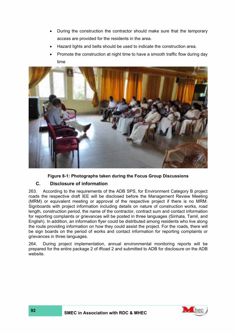
92 SMEC in Association with RDC & MHEC
• During the construction the contractor should make sure that the temporary
access are provided for the residents in the area.
• Hazard lights and belts should be used to indicate the construction area.
• Promote the construction at night time to have a smooth traffic flow during day
time
Figure 8-1: Photographs taken during the Focus Group Discussions
C. Disclosure of information
263. According to the requirements of the ADB SPS, for Environment Category B project roads the respective draft IEE will be disclosed before the Management Review Meeting (MRM) or equivalent meeting or approval of the respective project if there is no MRM. Signboards with project information including details on nature of construction works, road length, construction period, the name of the contractor, contract sum and contact information for reporting complaints or grievances will be posted in three languages (Sinhala, Tamil, and English). In addition, an information flyer could be distributed among residents who live along the route providing information on how they could assist the project. For the roads, there will be sign boards on the period of works and contact information for reporting complaints or grievances in three languages.
264. During project implementation, annual environmental monitoring reports will be prepared for the entire package 2 of iRoad 2 and submitted to ADB for disclosure on the ADB website.

93 SMEC in Association with RDC & MHEC
9 CONCLUSION AND RECOMMENDATIONS
A. Findings and Recommendations
265. The proposed road rehabilitation and construction activities of the five roads under package 2 of iRoad 2 in western province shall be carried out within the existing ROW and road reservation boundary lines to avoid any land acquisition and/or resettlement of households. Anticipated positive socio-economic impacts of the project include reduction of transport costs and vehicle operation cost due to better road conditions and reduced travel time, an increase in income-generating activities and enhancement of road safety. With proper implementation of the EMP and the EMoP, environmental benefits include less noise and air emissions due to improved road condition, reduced soil erosion and improved water quality due to better drainage facilities, etc. Facilitating better drainage (cross drainage and along the road) and raising the road surface to levels above frequent flood levels would ensure continuous, uninterrupted road use. Proper drainage will alleviate problems of flood inundation of road surfaces thereby avoiding damage to the roads, thus ensuring the continued structural strength of the road and other structures.
266. Negative environmental impacts are mostly restricted to the construction stage. Extraction of construction materials, transportation, and storage of material and disposal of debris needs careful planning and to follow good practices to avoid environmental impacts. Deterioration of water quality in nearby drains is possible due to washing away of material, especially soil and gravel, with surface runoff and wastewater discharges. Nuisance caused by way of high levels of dust and particulate matter in the air due to material extraction, transportation and storage, and construction activities is another negative environmental impact. Also, fumes and smoke from vehicles and machinery are identified as negative impacts. Noise and vibration can be expected from vehicular movements and construction activities which needs mitigation. Temporary blockage or alteration of surface runoff is the other anticipated impacts during the construction of bridges, culverts, and causeways. Realignment of services such as electricity, telecommunication, and water lines would cause inconveniences to the residents.
267. The fauna and flora observed are common species that are found in urban and suburban areas. Only a few endemic and threatened species were recorded at the project site. None of the recorded endemic species are restricted to the project area. Therefore, the project will not have major adverse impacts on the habitats or fauna and flora in the proposed project areas.
268. Establishing baseline environmental parameters is necessary to implement the Environmental Monitoring Plan. Monitoring of baseline water quality, air and noise/vibration levels is recommended to carry out at sampling locations as outlined in the Environmental Monitoring Plan during the pre-construction stage. Establishment of baseline parameters is essential to monitor changes in the quality of water, air, and noise during the construction and operation periods. Repeated sampling during the construction and operational periods shall be done at the same locations which were used to establish baseline parameters. Thus, changes can be easily compared to assess and evaluate the effectiveness of the mitigation strategies as outlined in the Environmental Management Plan.
269. A long-term maintenance program is essential for sustaining road in good condition. Thus, periodic inspection, assessments, and proper maintenances strategies shall be implemented during operation stage. It is recommended that detailed design team shall be properly coordinated with future schedules regarding infrastructure development of line agencies to minimize structural damages to the road.
B. Conclusions
270. The proposed activities involve rehabilitation of five existing roads and other road-side-structures. The proposed project will not cause significant negative impacts on the existing

94 SMEC in Association with RDC & MHEC
socio-economic environment in the area (project-affected area and its immediate vicinity). The potential environmental impacts that have been identified during the study are temporary, manageable and will occur only during pre-construction and construction stage of the project. The proposed road rehabilitation and construction activities shall be carried out within the existing ROW and road reservation boundary lines. There is no need for land acquisition or resettlement of persons. Therefore, the proposed rehabilitation work activities of the five roads are environmentally acceptable.
271. According to the analysis of existing baseline data and prediction of impacts, the proposed road rehabilitation, and construction activities fall under Environmental Category B based on the ADB Guidelines. Thus, a full Environmental Impact Assessment (EIA) for the project is not required. Concerning the National Environmental Act, No.47 of 1980, Amendment, No.56 of 1988, and subsequent amendments, the project does not fall under the Prescribed Project Category, and therefore may not need an EIA or an IEE to be carried out. However, it is advisable to seek the advice of the Central Environmental Authority and confirm this and obtain any guidelines that must be adhered

95 SMEC in Association with RDC & MHEC
10 ANNEXES
Annex 1.1- Borella-Rajagiriya Road (Cotta Road) (from 0+000 km to 1+380 km) (B062)
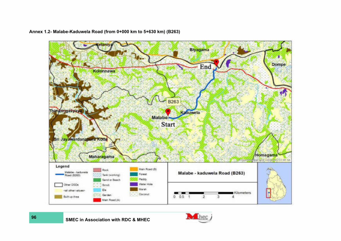
96 SMEC in Association with RDC & MHEC
Annex 1.2- Malabe-Kaduwela Road (from 0+000 km to 5+630 km) (B263)
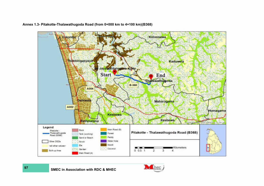
97 SMEC in Association with RDC & MHEC
Annex 1.3- Pitakotte-Thalawathugoda Road (from 0+000 km to 4+100 km)(B368)

98 SMEC in Association with RDC & MHEC
Annex 1.4- Pagoda-Pitakotte Road (from 0+000 km to 1+530 km)(B 345)
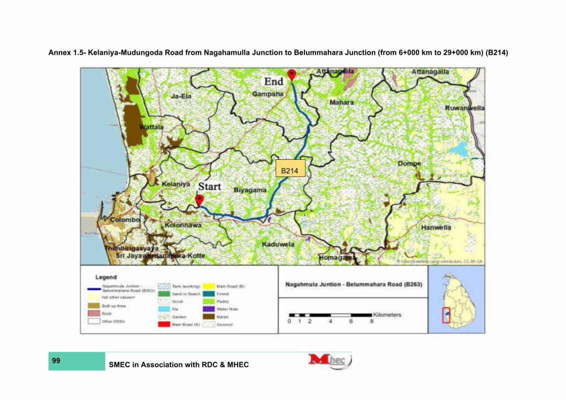
99 SMEC in Association with RDC & MHEC
Annex 1.5- Kelaniya-Mudungoda Road from Nagahamulla Junction to Belummahara Junction (from 6+000 km to 29+000 km) (B214)
B214
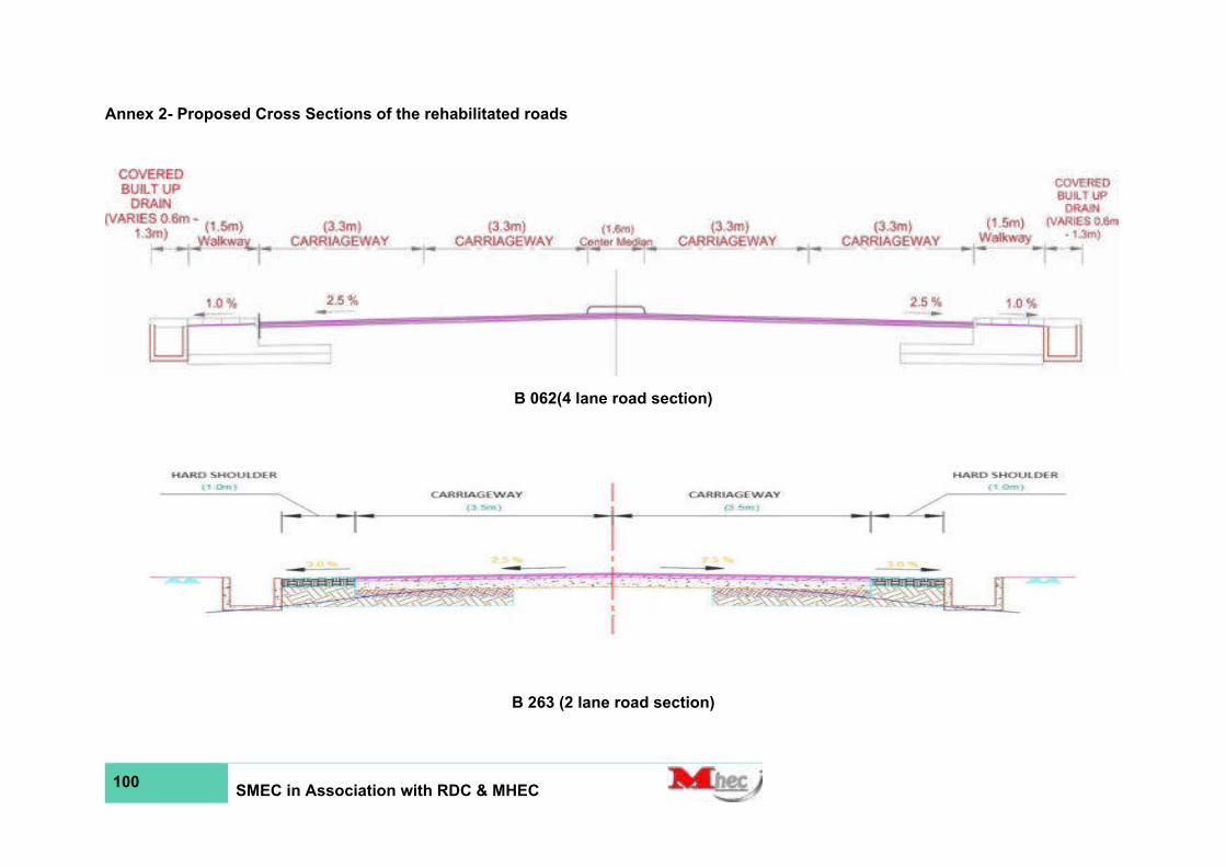
100 SMEC in Association with RDC & MHEC
Annex 2- Proposed Cross Sections of the rehabilitated roads
B 062(4 lane road section)
B 263 (2 lane road section)

101 SMEC in Association with RDC & MHEC
B 345 (2 lane road section)
B 368 (2 lane road section)

102 SMEC in Association with RDC & MHEC
B 214 (2 lane road section)
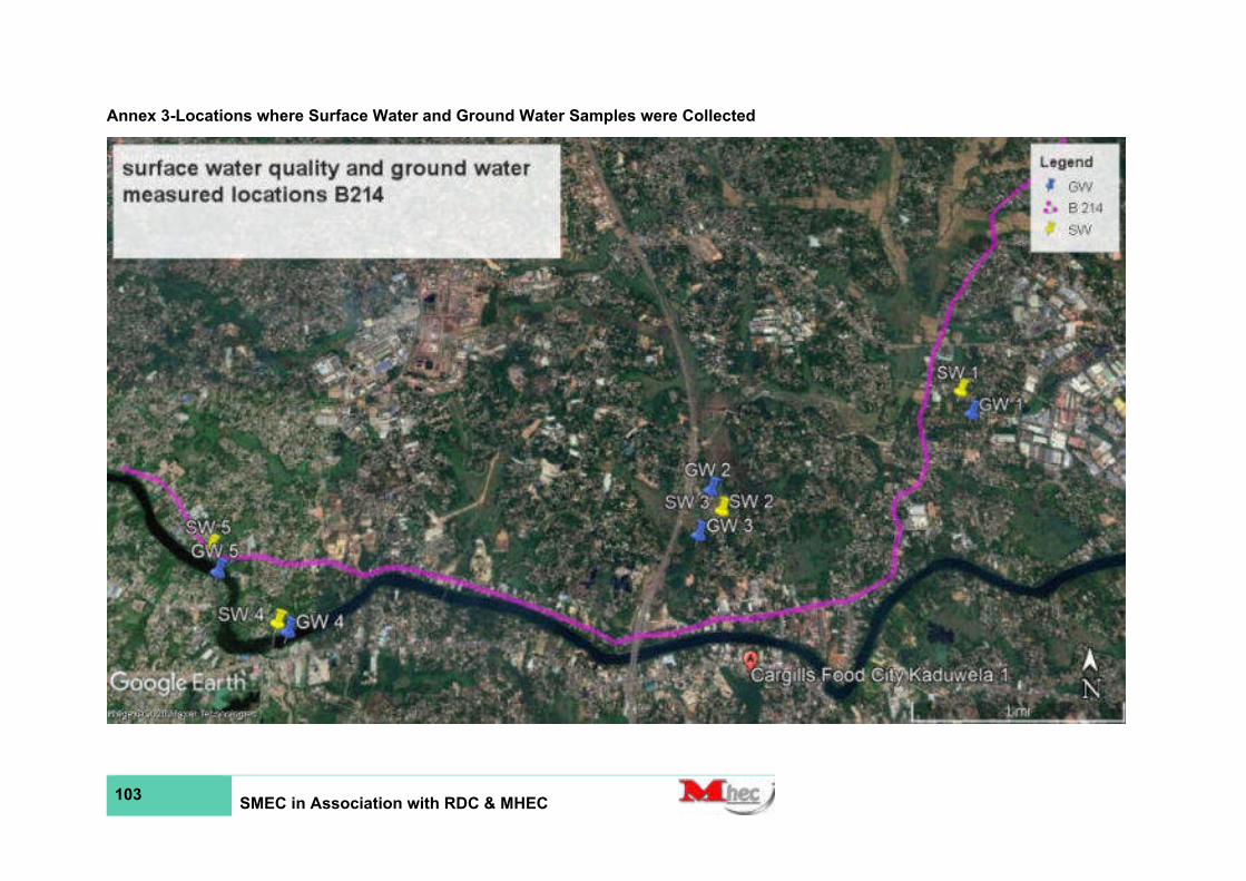
103 SMEC in Association with RDC & MHEC
Annex 3-Locations where Surface Water and Ground Water Samples were Collected

104 SMEC in Association with RDC & MHEC

105 SMEC in Association with RDC & MHEC

106 SMEC in Association with RDC & MHEC
Annex 4-Locations where noise levels were measured

107 SMEC in Association with RDC & MHEC

Appendix 1.1-RAPID ENVIRONMENTAL ASSESSMENT (B062 Rd)
HIGHWAYS
Page 1 of 8
RAPID ENVIRONMENTAL ASSESSMENT (REA)
CHECKLIST
Country/Project Title:
Sub Project:
Sector Division:
Project Location:
Biogeographically, the proposed road section located within the low country wet zone region and
agroecological zone of low country WL3. Floristically this area falls within Northern Wet Lowlands
Floristic Zone.
This road section, which is 1.38 km in length, connects Borella junction at 0th km (6°54'52.9"N 79°
52'39.6"E) and Rajagiriya at 1.38thkm (6°54'34.5"N 79°53'44.7"E) near Rajagiriya flyover. The road
runs through Welikada West, Welikada East,Welikada North, Rajagiriya Grama Niladhari Divisions
(GNDs) in Sri Jayawardanapura Kotte Divisional Secretariat (DS) Division located in the Colombo
District in Western Province of Sri Lanka.
Province District DSD
Western Province Colombo Sri Jayawardanapura Kotte
Screening Questions Yes No Remarks
A. Project Siting
Is the project area adjacent to or within any of the following environmentally sensitive areas?
Instructions:
(i) The project team completes this checklist to support the environmental classification of a project. It is to be attached to the environmental categorization form and submitted to the Environment and Safeguards Division (RSES), for endorsement by Director, RSES and for approval by the Chief Compliance Officer.
(ii) This checklist focuses on environmental issues and concerns. To ensure that social dimensions are adequately considered, refer also to ADB's (a) checklists on involuntary resettlement and Indigenous Peoples; (b) poverty reduction handbook; (c) staff guide to consultation and participation; and (d) gender checklists.
(iii) Answer the questions assuming the “without mitigation” case. The purpose is to identify potential impacts. Use the “remarks” section to discuss any anticipated mitigation measures.
Second Integrated Road Investment Program – package 2 in Western province
Rehabilitation and Improvement of Borella Rajagiriya Road (Kota Road) (B062)- 1.38 km
Highways
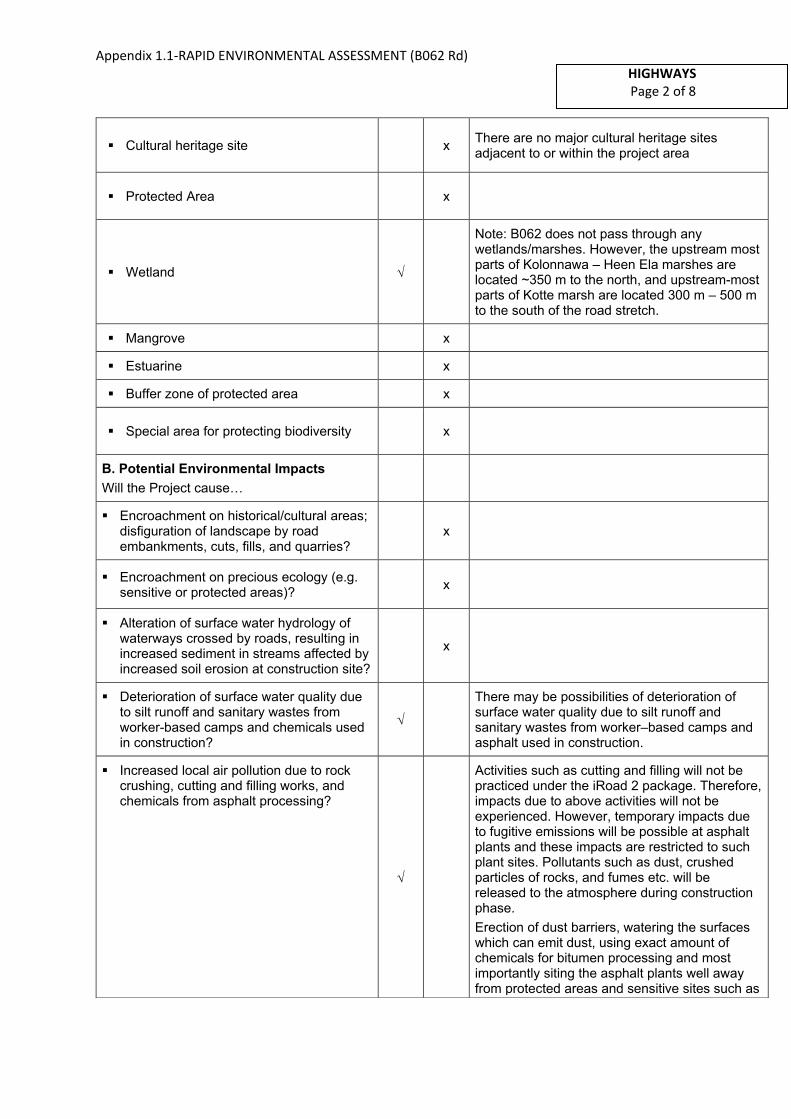
Appendix 1.1-RAPID ENVIRONMENTAL ASSESSMENT (B062 Rd)
HIGHWAYS
Page 2 of 8
▪ Cultural heritage site x There are no major cultural heritage sites adjacent to or within the project area
▪ Protected Area x
▪ Wetland
Note: B062 does not pass through any wetlands/marshes. However, the upstream most parts of Kolonnawa – Heen Ela marshes are located ~350 m to the north, and upstream-most parts of Kotte marsh are located 300 m – 500 m to the south of the road stretch.
▪ Mangrove x
▪ Estuarine x
▪ Buffer zone of protected area x
▪ Special area for protecting biodiversity x
B. Potential Environmental Impacts
Will the Project cause…
▪ Encroachment on historical/cultural areas;disfiguration of landscape by roadembankments, cuts, fills, and quarries?
x
▪ Encroachment on precious ecology (e.g.sensitive or protected areas)?
x
▪ Alteration of surface water hydrology ofwaterways crossed by roads, resulting inincreased sediment in streams affected byincreased soil erosion at construction site?
x
▪ Deterioration of surface water quality dueto silt runoff and sanitary wastes fromworker-based camps and chemicals usedin construction?
There may be possibilities of deterioration of surface water quality due to silt runoff and sanitary wastes from worker–based camps and asphalt used in construction.
▪ Increased local air pollution due to rockcrushing, cutting and filling works, andchemicals from asphalt processing?
Activities such as cutting and filling will not be practiced under the iRoad 2 package. Therefore,impacts due to above activities will not be experienced. However, temporary impacts due to fugitive emissions will be possible at asphalt plants and these impacts are restricted to such plant sites. Pollutants such as dust, crushed particles of rocks, and fumes etc. will be released to the atmosphere during construction phase.
Erection of dust barriers, watering the surfaces which can emit dust, using exact amount of chemicals for bitumen processing and most importantly siting the asphalt plants well away from protected areas and sensitive sites such as
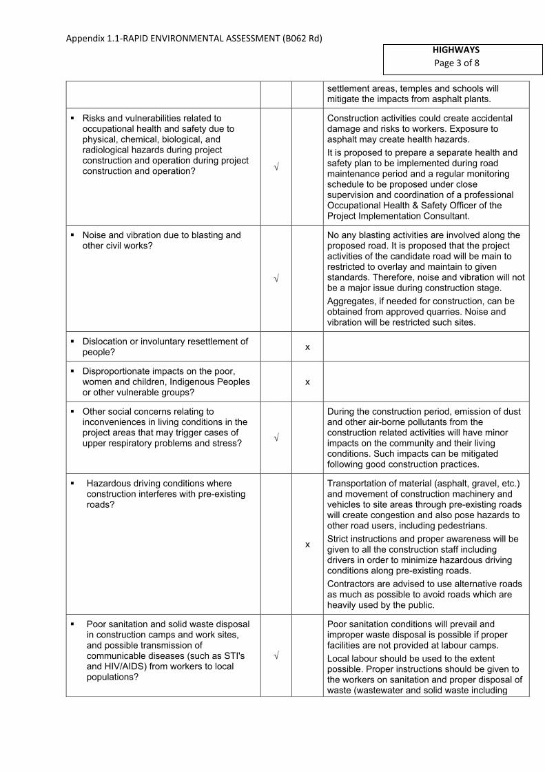
Appendix 1.1-RAPID ENVIRONMENTAL ASSESSMENT (B062 Rd)
Page 3 of 8
settlement areas, temples and schools will mitigate the impacts from asphalt plants.
▪ Risks and vulnerabilities related tooccupational health and safety due tophysical, chemical, biological, andradiological hazards during projectconstruction and operation during projectconstruction and operation?
Construction activities could create accidental damage and risks to workers. Exposure to asphalt may create health hazards.
It is proposed to prepare a separate health and safety plan to be implemented during road maintenance period and a regular monitoring schedule to be proposed under close supervision and coordination of a professional Occupational Health & Safety Officer of the Project Implementation Consultant.
▪ Noise and vibration due to blasting andother civil works?
No any blasting activities are involved along the proposed road. It is proposed that the project activities of the candidate road will be main to restricted to overlay and maintain to given standards. Therefore, noise and vibration will not be a major issue during construction stage.
Aggregates, if needed for construction, can be obtained from approved quarries. Noise and vibration will be restricted such sites.
▪ Dislocation or involuntary resettlement ofpeople?
x
▪ Disproportionate impacts on the poor,women and children, Indigenous Peoplesor other vulnerable groups?
x
▪ Other social concerns relating toinconveniences in living conditions in theproject areas that may trigger cases ofupper respiratory problems and stress?
During the construction period, emission of dust and other air-borne pollutants from the construction related activities will have minor impacts on the community and their living conditions. Such impacts can be mitigated following good construction practices.
▪ Hazardous driving conditions whereconstruction interferes with pre-existingroads?
x
Transportation of material (asphalt, gravel, etc.) and movement of construction machinery and vehicles to site areas through pre-existing roads will create congestion and also pose hazards to other road users, including pedestrians.
Strict instructions and proper awareness will be given to all the construction staff including drivers in order to minimize hazardous driving conditions along pre-existing roads.
Contractors are advised to use alternative roads as much as possible to avoid roads which are heavily used by the public.
▪ Poor sanitation and solid waste disposalin construction camps and work sites,and possible transmission ofcommunicable diseases (such as STI'sand HIV/AIDS) from workers to localpopulations?
Poor sanitation conditions will prevail and improper waste disposal is possible if proper facilities are not provided at labour camps.
Local labour should be used to the extent possible. Proper instructions should be given to the workers on sanitation and proper disposal of waste (wastewater and solid waste including
HIGHWAYS

Appendix 1.1-RAPID ENVIRONMENTAL ASSESSMENT (B062 Rd)
HIGHWAYS
Page 4 of 8
construction waste) and communicable diseases.
Site specific environmental management action plans will be prepared and labour camps will be regularly supervised by a Public Health Inspector in order to mitigate such impacts in labor camps. Further, it will be ensured that labor camp, yards or any other site which emit solid waste or wastewater will not be located within or adjacent to the sensitive areas.
▪ Creation of temporary breeding habitatsfor diseases such as those transmitted bymosquitoes and rodents?
Labour camps, garbage disposal sites, borrow pits and material storage yards provide favorable breeding habitats for vectors such as mosquitoes, flies, rats and other parasites. Proper maintenance of such areas will prevent such breeding habitats.
▪ Accident risks associated with increasedvehicular traffic, leading to accidentalspills of toxic materials?
Overlaying of the pre-existing roadway and culvert construction sites, especially close to public sensitive locations, and removal of utilities will increase the accidental risk due to barricading of roads, closure of one lane of the road, and restricting the pavement/shoulder space for pedestrian pathways.
Appropriate sign boards will be used together with proper barricading and other safety arrangements at appropriate locations of the road during overlaying. Properly trained traffic stewards will be employed for traffic control. The public will be made aware of the possible hazards in advance. The workers, who are engaged in maintenance activities, will be provided with personal protective equipment
There is a possibility of toxic material spills at asphalt plants, and during bituminous material transport. Such toxic material will be properly stored with proper safety instructions provided for workers who are connected with asphalt material handling. Spills/leakages should be prevented and/or cleaned up appropriately for which strict instructions will be provided. First aid facilities and firefighting equipment will be provided at these sites.
▪ Increased noise and air pollution resultingfrom traffic volume?
Increased noise and air pollution is possible during construction, due to increased traffic volumes. Construction vehicles will be serviced and maintained appropriately to conform to Standards. Strict speed limits will be adopted for all construction vehicles. Wetting of exposed areas and gravel roads will prevent air-borne dust. Regular monitoring of noise levels and air quality is needed to review the effectiveness of mitigation measures.
During operations there will be positive impacts due to more smooth and steady flow of traffic along the rehabilitated road, which will also keep
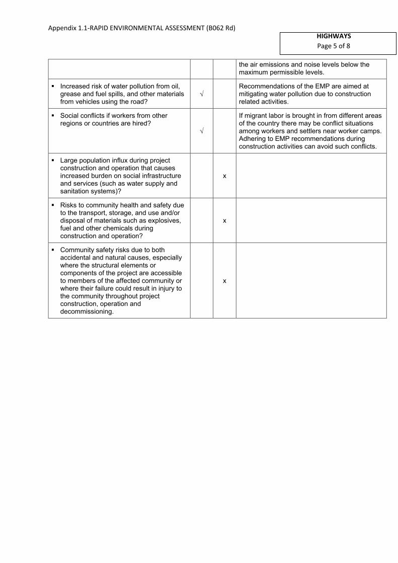
Appendix 1.1-RAPID ENVIRONMENTAL ASSESSMENT (B062 Rd) HIGHWAYS
Page 5 of 8
the air emissions and noise levels below the maximum permissible levels.
▪ Increased risk of water pollution from oil,grease and fuel spills, and other materialsfrom vehicles using the road?
Recommendations of the EMP are aimed at mitigating water pollution due to construction related activities.
▪ Social conflicts if workers from otherregions or countries are hired?
If migrant labor is brought in from different areas of the country there may be conflict situations among workers and settlers near worker camps. Adhering to EMP recommendations during construction activities can avoid such conflicts.
▪ Large population influx during projectconstruction and operation that causesincreased burden on social infrastructureand services (such as water supply andsanitation systems)?
x
▪ Risks to community health and safety dueto the transport, storage, and use and/ordisposal of materials such as explosives,fuel and other chemicals duringconstruction and operation?
x
▪ Community safety risks due to bothaccidental and natural causes, especiallywhere the structural elements orcomponents of the project are accessibleto members of the affected community orwhere their failure could result in injury tothe community throughout projectconstruction, operation anddecommissioning.
x

Appendix 1.1-RAPID ENVIRONMENTAL ASSESSMENT (B062 Rd)
HIGHWAYS
Page 6 of 8
A Checklist for Preliminary Climate Risk Screening1
Screening Questions Score Remarks1
Location and Design of project
Is siting and/or routing of the project (or its components) likely to be affected by climate conditions including extreme weather related events such as floods, droughts, storms, landslides?
0
Would the project design (e.g. the clearance for bridges) need to consider any hydro-meteorological parameters (e.g., sea-level, peak river flow, reliable water level, peak wind speed etc)?
0
Materials and Maintenance
Would weather, current and likely future climate conditions (e.g. prevailing humidity level, temperature contrast between hot summer days and cold winter days, exposure to wind and humidity hydro-meteorological parameters likely affect the selection of project inputs over the life of project outputs (e.g. construction material)?
0
Would weather, current and likely future climate conditions, and related extreme events likely affect the maintenance (scheduling and cost) of project output(s)?
0
Performance of project outputs
Would weather/climate conditions and related extreme events likely affect the performance (e.g. annual power production) of project output(s) (e.g. hydro-power generation facilities) throughout their design life time?
0
Options for answers and corresponding score are provided below:
Response Score
Not Likely 0
Likely 1
Very Likely 2
1 1 If possible, provide details on the sensitivity of project components to climate conditions, such as how climate parameters are
considered in design standards for infrastructure components, how changes in key climate parameters and sea level might affect the
siting/routing of project, the selection of construction material and/or scheduling, performances and/or the maintenance cost/scheduling
of project outputs.
Country/Project Title: Second Integrated Road Investment Program – package 2 in Western
province
Rehabilitation and Improvement of Borella Rajagiriya Road (Kota Road) (B062)- 1.38 km
Sector: Highways
Subsector: Highways
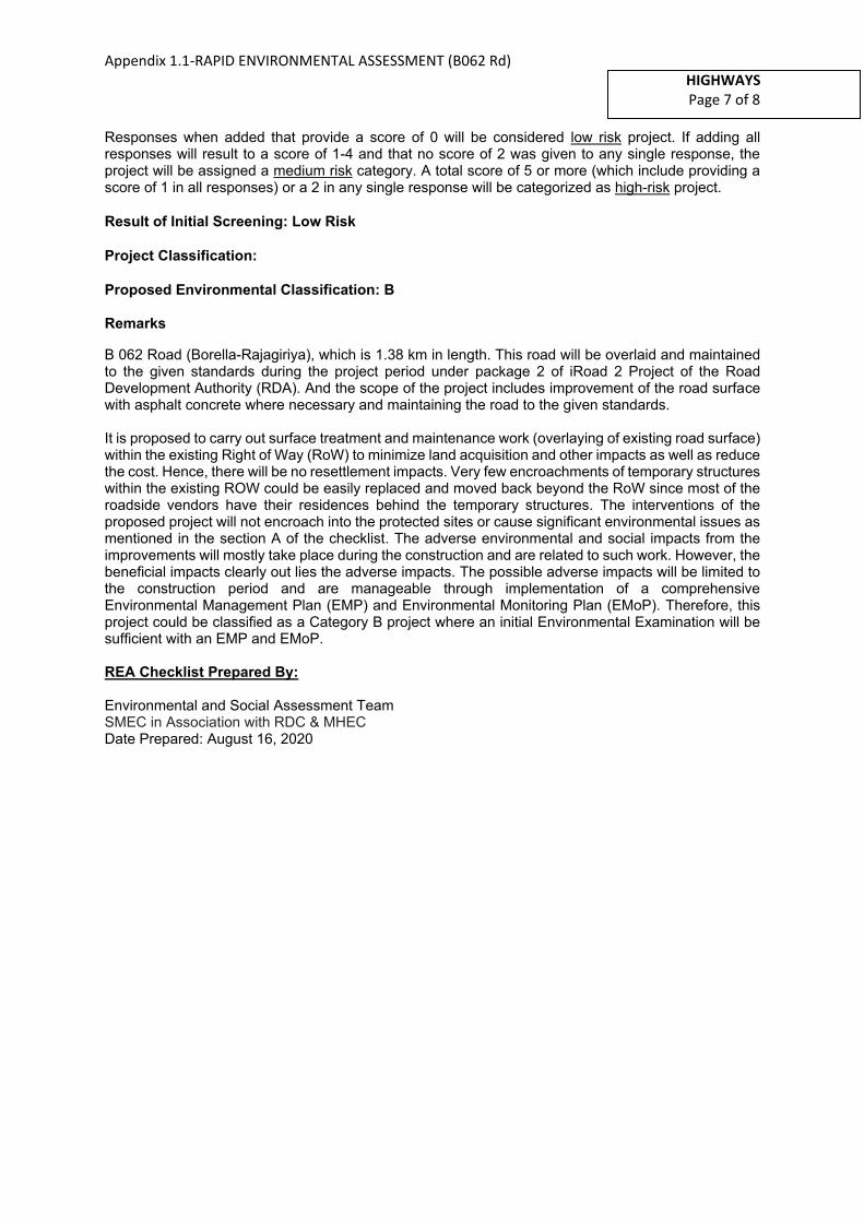
Appendix 1.1-RAPID ENVIRONMENTAL ASSESSMENT (B062 Rd)
HIGHWAYS
Page 7 of 8
Responses when added that provide a score of 0 will be considered low risk project. If adding all responses will result to a score of 1-4 and that no score of 2 was given to any single response, the project will be assigned a medium risk category. A total score of 5 or more (which include providing a score of 1 in all responses) or a 2 in any single response will be categorized as high-risk project.
Result of Initial Screening: Low Risk
Project Classification:
Proposed Environmental Classification: B
Remarks
B 062 Road (Borella-Rajagiriya), which is 1.38 km in length. This road will be overlaid and maintained to the given standards during the project period under package 2 of iRoad 2 Project of the Road Development Authority (RDA). And the scope of the project includes improvement of the road surface with asphalt concrete where necessary and maintaining the road to the given standards.
It is proposed to carry out surface treatment and maintenance work (overlaying of existing road surface) within the existing Right of Way (RoW) to minimize land acquisition and other impacts as well as reduce the cost. Hence, there will be no resettlement impacts. Very few encroachments of temporary structures within the existing ROW could be easily replaced and moved back beyond the RoW since most of the roadside vendors have their residences behind the temporary structures. The interventions of the proposed project will not encroach into the protected sites or cause significant environmental issues as mentioned in the section A of the checklist. The adverse environmental and social impacts from the improvements will mostly take place during the construction and are related to such work. However, the beneficial impacts clearly out lies the adverse impacts. The possible adverse impacts will be limited to the construction period and are manageable through implementation of a comprehensive Environmental Management Plan (EMP) and Environmental Monitoring Plan (EMoP). Therefore, this project could be classified as a Category B project where an initial Environmental Examination will be sufficient with an EMP and EMoP.
REA Checklist Prepared By:
Environmental and Social Assessment Team SMEC in Association with RDC & MHEC Date Prepared: August 16, 2020
Appendix 1.2 RAPID ENVIRONMENTAL ASSESSMENT (B263 Rd)
HIGHWAYS
Page 1 of 8
RAPID ENVIRONMENTAL ASSESSMENT (REA)
CHECKLIST
Country/Project Title:
Sub Project:
Sector Division:
Project Location:
Biogeographically, the proposed road section located within the low country wet zone region
and agroecological zone of low country WL3. Floristically this area falls within Northern Wet
Lowlands Floristic Zone.
This road section (B263), which is 5.63 km in length, connect Malabe Junction ( 6°54'14.2"N
79°57'18.3"E) and Kaduwela junction ( 6°56'08.5"N 79°59'03.2"E) on AB10 trunk road.The road runs
through Malabe West ,Malabe East, Malabe North, Kothalawala and Kaduwela Grama Niladhari
Divisions (GNDs) in Kaduwela Divisional Secretariat (DS) Division located in the Colombo District in
Western Province of Sri Lanka.
Province District DSD
Western Province Colombo Kaduwela DS
Screening Questions Yes No Remarks
A. Project Siting
Instructions:
(i) The project team completes this checklist to support the environmental classification of a project. It is to be attached to the environmental categorization form and submitted to the Environment and Safeguards Division (RSES), for endorsement by Director, RSES and for approval by the Chief Compliance Officer.
(ii) This checklist focuses on environmental issues and concerns. To ensure that social dimensions are adequately considered, refer also to ADB's (a) checklists on involuntary resettlement and Indigenous Peoples; (b) poverty reduction handbook; (c) staff guide to consultation and participation; and (d) gender checklists.
(iii) Answer the questions assuming the “without mitigation” case. The purpose is to identify potential impacts. Use the “remarks” section to discuss any anticipated mitigation measures.
Second Integrated Road Investment Program – package 2 in Western province
Rehabilitation and Improvement of Malabe – Kaduwela Road (B263)– 5.63 km
Highways

Appendix 1.2 RAPID ENVIRONMENTAL ASSESSMENT (B263 Rd)
HIGHWAYS
Page 2 of 8
Is the project area adjacent to or within any of the following environmentally sensitive areas?
▪ Cultural heritage site x
There are no major cultural heritage sites adjacent to or within the project area, except some temples etc.(Sri Sudharshanarama Purana Viharaya, Mahamevnawa Amawatura Monastery, Sankapitti Purana Viharaya)
▪ Protected Area x
▪ Wetland
There are locations where the road stretch passes adjacent to seasonal/ intermittent freshwater bodies, which includes floodplains of natural flow paths and paddy fields draining into Kelani River main channel and its tributary Maha Ela.
The road trace intersects such low-lying locations at Malabe, Kotalawala and Kaduwela (basically paddies).
Impacts can be mitigated by following good construction practices:
− Avoiding rainy periods for construction.
− Avoiding erecting temporary structures, stockpiling or tipping of materials, dumping of construction debris and waste in wetland areas and along surface runoff paths.
− Preventing washout of soil, all debris and residual materials into low-lying areas.
− Avoiding prolonged exposure of loose soil surfaces to wind and surface runoff.
▪ Mangrove x
▪ Estuarine x
▪ Buffer zone of protected area x
▪ Special area for protecting biodiversity x
B. Potential Environmental Impacts
Will the Project cause…
▪ Encroachment on historical/cultural areas;disfiguration of landscape by roadembankments, cuts, fills, and quarries?
x
▪ Encroachment on precious ecology (e.g.sensitive or protected areas)?
x
▪ Alteration of surface water hydrology ofwaterways crossed by roads, resulting inincreased sediment in streams affected byincreased soil erosion at construction site?
x

Appendix 1.2 RAPID ENVIRONMENTAL ASSESSMENT (B263 Rd)
HIGHWAYS
Page 3 of 8
▪ Deterioration of surface water quality dueto silt runoff and sanitary wastes fromworker-based camps and chemicals usedin construction?
There may be possibilities of deterioration of surface water quality due to silt runoff and sanitary wastes from worker–based camps and asphalt used in construction.
▪ Increased local air pollution due to rockcrushing, cutting and filling works, andchemicals from asphalt processing?
Activities such as cutting and filling will not be practiced under the iRoad-(II) package. Therefore, impacts due to above activities will not be experienced. However, temporary impacts due to fugitive emissions will be possible at asphalt plants and these impacts are restricted to such plant sites. Pollutants such as dust, crushed particles of rocks, and fumes etc. will be released to the atmosphere during construction phase.
Erection of dust barriers, watering the surfaces which can emit dust, using exact amount of chemicals for bitumen processing and most importantly siting the asphalt plants well away from protected areas and sensitive sites such as settlement areas, temples and schools will mitigate the impacts from asphalt plants.
▪ Risks and vulnerabilities related tooccupational health and safety due tophysical, chemical, biological, andradiological hazards during projectconstruction and operation during projectconstruction and operation?
Construction activities could create accidental damage and risks to workers. Exposure to asphalt may create health hazards.
It is proposed to prepare a separate health and safety plan to be implemented during road maintenance period and a regular monitoring schedule to be proposed under close supervision and coordination of a professional Occupational Health & Safety Officer of the Project Implementation Consultant.
▪ Noise and vibration due to blasting andother civil works?
No any blasting activities are involved along the proposed road. It is proposed that the project activities of the candidate road will be main to restricted to overlay and maintain to given standards. Therefore, noise and vibration will not be a major issue during construction stage.
Aggregates, if needed for construction, can be obtained from approved quarries. Noise and vibration will be restricted such sites.
▪ Dislocation or involuntary resettlement ofpeople?
x
▪ Disproportionate impacts on the poor,women and children, Indigenous Peoplesor other vulnerable groups?
x
▪ Other social concerns relating toinconveniences in living conditions in theproject areas that may trigger cases ofupper respiratory problems and stress?
During the construction period, emission of dust and other air-borne pollutants from the construction related activities will have minor impacts on the community and their living conditions. Such impacts can be mitigated following good construction practices.

Appendix 1.2 RAPID ENVIRONMENTAL ASSESSMENT (B263 Rd)
HIGHWAYS
Page 4 of 8
▪ Hazardous driving conditions whereconstruction interferes with pre-existingroads?
x
Transportation of material (asphalt, gravel, etc.) and movement of construction machinery and vehicles to site areas through pre-existing roads will create congestion and also pose hazards to other road users, including pedestrians.
Strict instructions and proper awareness will be given to all the construction staff including drivers in order to minimize hazardous driving conditions along pre-existing roads.
Contractors are advised to use alternative roads as much as possible to avoid roads which are heavily used by the public.
▪ Poor sanitation and solid waste disposalin construction camps and work sites,and possible transmission ofcommunicable diseases (such as STI'sand HIV/AIDS) from workers to localpopulations?
Poor sanitation conditions will prevail and improper waste disposal is possible if proper facilities are not provided at labour camps.
Local labour should be used to the extent possible. Proper instructions should be given to the workers on sanitation and proper disposal of waste (wastewater and solid waste including construction waste) and communicable diseases.
Site specific environmental management action plans will be prepared and labour camps will be regularly supervised by a Public Health Inspector in order to mitigate such impacts in labor camps. Further, it will be ensured that labor camp, yards or any other site which emit solid waste or wastewater will not be located within or adjacent to the sensitive areas.
▪ Creation of temporary breeding habitatsfor diseases such as those transmitted bymosquitoes and rodents?
Labour camps, garbage disposal sites, borrow pits and material storage yards provide favorable breeding habitats for vectors such as mosquitoes, flies, rats and other parasites. Proper maintenance of such areas will prevent such breeding habitats.
▪ Accident risks associated with increasedvehicular traffic, leading to accidentalspills of toxic materials?
Overlaying of the pre-existing roadway and culvert construction sites, especially close to public sensitive locations, and removal of utilities will increase the accidental risk due to barricading of roads, closure of one lane of the road, and restricting the pavement/shoulder space for pedestrian pathways.
Appropriate sign boards will be used together with proper barricading and other safety arrangements at appropriate locations of the road during overlaying. Properly trained traffic stewards will be employed for traffic control. The public will be made aware of the possible hazards in advance. The workers, who are engaged in maintenance activities, will be provided with personal protective equipment
There is a possibility of toxic material spills at asphalt plants, and during bituminous material transport. Such toxic material will be properly stored with proper safety instructions provided for workers who are connected with asphalt material

Appendix 1.2 RAPID ENVIRONMENTAL ASSESSMENT (B263 Rd)
HIGHWAYS
Page 5 of 8
handling. Spills/leakages should be prevented and/or cleaned up appropriately for which strict instructions will be provided. First aid facilities and firefighting equipment will be provided at these sites.
▪ Increased noise and air pollution resultingfrom traffic volume?
Increased noise and air pollution is possible during construction, due to increased traffic volumes. Construction vehicles will be serviced and maintained appropriately to conform to Standards. Strict speed limits will be adopted for all construction vehicles. Wetting of exposed areas and gravel roads will prevent air-borne dust. Regular monitoring of noise levels and air quality is needed to review the effectiveness of mitigation measures.
During operations there will be positive impacts due to more smooth and steady flow of traffic along the rehabilitated road, which will also keep the air emissions and noise levels below the maximum permissible levels.
▪ Increased risk of water pollution from oil,grease and fuel spills, and other materialsfrom vehicles using the road?
Recommendations of the EMP are aimed at mitigating water pollution due to construction related activities.
▪ Social conflicts if workers from otherregions or countries are hired?
If migrant labor is brought in from different areas of the country there may be conflict situations among workers and settlers near worker camps. Adhering to EMP recommendations during construction activities can avoid such conflicts.
▪ Large population influx during projectconstruction and operation that causesincreased burden on social infrastructureand services (such as water supply andsanitation systems)?
x
▪ Risks to community health and safety dueto the transport, storage, and use and/ordisposal of materials such as explosives,fuel and other chemicals duringconstruction and operation?
x
▪ Community safety risks due to bothaccidental and natural causes, especiallywhere the structural elements orcomponents of the project are accessibleto members of the affected community orwhere their failure could result in injury tothe community throughout projectconstruction, operation anddecommissioning.
x

Appendix 1.2 RAPID ENVIRONMENTAL ASSESSMENT (B263 Rd)
HIGHWAYS
Page 6 of 8
A Checklist for Preliminary Climate Risk Screening1
Screening Questions Score Remarks1
Location and Design of project
Is siting and/or routing of the project (or its components) likely to be affected by climate conditions including extreme weather related events such as floods, droughts, storms, landslides?
1 The following locations are prone to floods during heavy rainy periods:
In the areas of CH0+800 - CH1+000 close to Malabe in low-lying floodplains of a tributary connected to Kelani River main channel.
Would the project design (e.g. the clearance for bridges) need to consider any hydro-meteorological parameters (e.g., sea-level, peak river flow, reliable water level, peak wind speed etc)?
1 Project design may need to consider locations which are prone to localized flooding and necessary mitigation measures need to be incorporated to the surface treatment. It is noted that the B263 road drainage crossings are located further upstream in the sub-catchment and not affected by the peak flows or flood levels in Kelani river main channel.
Materials and Maintenance
Would weather, current and likely future climate conditions (e.g. prevailing humidity level, temperature contrast between hot summer days and cold winter days, exposure to wind and humidity hydro-meteorological parameters likely affect the selection of project inputs over the life of project outputs (e.g. construction material)?
0
Would weather, current and likely future climate conditions, and related extreme events likely affect the maintenance (scheduling and cost) of project output(s)?
0
Performance of project
Would weather/climate conditions and related extreme events likely affect the performance
0
1 1 If possible, provide details on the sensitivity of project components to climate conditions, such as how climate parameters are
considered in design standards for infrastructure components, how changes in key climate parameters and sea level might affect the
siting/routing of project, the selection of construction material and/or scheduling, performances and/or the maintenance cost/scheduling
of project outputs.
Country/Project Title: Second Integrated Road Investment Program – package 2 in Western
province
Rehabilitation and Improvement of Malabe – Kaduwela Road (B263)– 5.63 km
Sector: Highways
Subsector: Highways
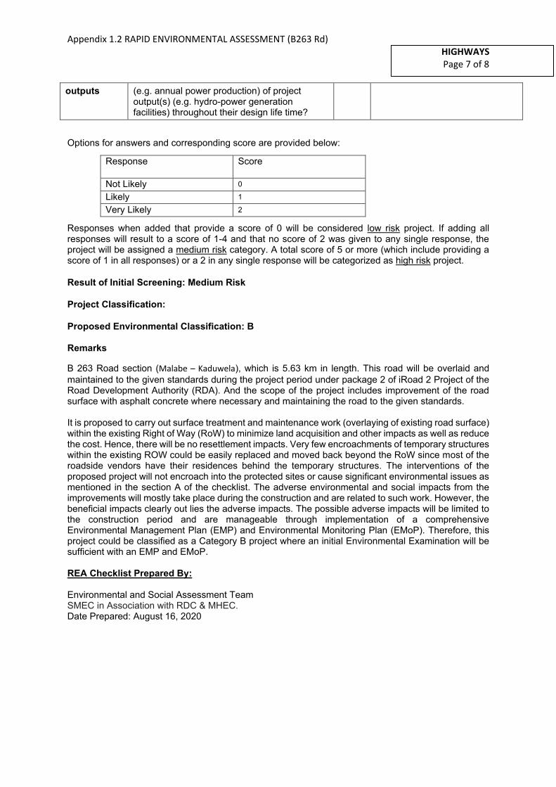
Appendix 1.2 RAPID ENVIRONMENTAL ASSESSMENT (B263 Rd)
HIGHWAYS
Page 7 of 8
outputs (e.g. annual power production) of project output(s) (e.g. hydro-power generation facilities) throughout their design life time?
Options for answers and corresponding score are provided below:
Response Score
Not Likely 0
Likely 1
Very Likely 2
Responses when added that provide a score of 0 will be considered low risk project. If adding all responses will result to a score of 1-4 and that no score of 2 was given to any single response, the project will be assigned a medium risk category. A total score of 5 or more (which include providing a score of 1 in all responses) or a 2 in any single response will be categorized as high risk project.
Result of Initial Screening: Medium Risk
Project Classification:
Proposed Environmental Classification: B
Remarks
B 263 Road section (Malabe – Kaduwela), which is 5.63 km in length. This road will be overlaid and
maintained to the given standards during the project period under package 2 of iRoad 2 Project of the Road Development Authority (RDA). And the scope of the project includes improvement of the road surface with asphalt concrete where necessary and maintaining the road to the given standards.
It is proposed to carry out surface treatment and maintenance work (overlaying of existing road surface) within the existing Right of Way (RoW) to minimize land acquisition and other impacts as well as reduce the cost. Hence, there will be no resettlement impacts. Very few encroachments of temporary structures within the existing ROW could be easily replaced and moved back beyond the RoW since most of the roadside vendors have their residences behind the temporary structures. The interventions of the proposed project will not encroach into the protected sites or cause significant environmental issues as mentioned in the section A of the checklist. The adverse environmental and social impacts from the improvements will mostly take place during the construction and are related to such work. However, the beneficial impacts clearly out lies the adverse impacts. The possible adverse impacts will be limited to the construction period and are manageable through implementation of a comprehensive Environmental Management Plan (EMP) and Environmental Monitoring Plan (EMoP). Therefore, this project could be classified as a Category B project where an initial Environmental Examination will be sufficient with an EMP and EMoP.
REA Checklist Prepared By:
Environmental and Social Assessment Team SMEC in Association with RDC & MHEC.
Date Prepared: August 16, 2020

Appendix 1.3 RAPID ENVIRONMENTAL ASSESSMENT (B368 Rd)
HIGHWAYS
Page 1 of 8
RAPID ENVIRONMENTAL ASSESSMENT (REA)
CHECKLIST
Country/Project Title:
Sub Project:
Sector Division:
Project Location:
Biogeographically, the proposed road section located within the low country wet zone region and
agroecological zone of low country WL3. Floristically this area falls within Northern Wet Lowlands
Floristic Zone.
This road section (B368), which is 4.1 km in length, connects Pitakotte (6°53'03.1"N 79°54'07.0"E) on
B120 trunk road and Thalawathugoda junction ( 6°52'34.8"N 79°56'06.9"E) on B47 trunk road. The road
runs through Pitakotte and Pitakotte West Grama Niladhari Divisions (GNDs) in Sri Jayawardanapura
Kotte Divisional Secretariat (DS) Division, Madiwela, Thalawathugoda West and Thalawathugoda East
GNDs in Maharagama DS Division located in the Colombo District in WesternProvince of Sri Lanka.
Province District DSD
Western Province Colombo
Sri Jayawardanapura Kotte DS
Maharagama DS
Instructions:
(i) The project team completes this checklist to support the environmental classification of a project. It is to be attached to the environmental categorization form and submitted to the Environment and Safeguards Division (RSES), for endorsement by Director, RSES and for approval by the Chief Compliance Officer.
(ii) This checklist focuses on environmental issues and concerns. To ensure that social dimensions are adequately considered, refer also to ADB's (a) checklists on involuntary resettlement and Indigenous Peoples; (b) poverty reduction handbook; (c) staff guide to consultation and participation; and (d) gender checklists.
(iii) Answer the questions assuming the “without mitigation” case. The purpose is to identify potential impacts. Use the “remarks” section to discuss any anticipated mitigation measures.
Second Integrated Road Investment Program – package 2 in Western province
Rehabilitation and Improvement of Pitakotte Thalawathugoda Road (B368)- 4.1 km
Highways

Appendix 1.3 RAPID ENVIRONMENTAL ASSESSMENT (B368 Rd)
HIGHWAYS
Page 2 of 8
Screening Questions Yes No Remarks
A. Project Siting
Is the project area adjacent to or within any of the following environmentally sensitive areas?
▪ Cultural heritage site x There are no major cultural heritage sites adjacent to or within the project area, except some temples etc.
▪ Protected Area x
▪ Wetland
There are locations where the road stretch passes adjacent to seasonal/ intermittent freshwater bodies, which includes floodplains of natural flow paths and paddy fields draining into Diyawanna Oya and Lake (basically cultivated/uncultivated/abandoned paddies in upstream parts and Diyawanna Lake and associated floodplain marshes in the downstream), which subsequently drain into Kelani Basin.
The road trace intersects such low-lying locations at Pita Kotte/Mirihana, Madiwela, Thalapathpitiya and Thalawathugoda.
Impacts can be mitigated by following good construction practices:
− Avoiding rainy periods for construction.
− Avoiding erecting temporary structures, stockpiling or tipping of materials, dumping of construction debris and waste in wetland areas and along surface runoff paths.
− Preventing washout of soil, all debris and residual materials into low-lying areas.
− Avoiding prolonged exposure of loose soil surfaces to wind and surface runoff.
▪ Mangrove x
▪ Estuarine x
▪ Buffer zone of protected area x
▪ Special area for protecting biodiversity
Marshy area which is located around 2.4km, LHS of
the road act as an important habitat for different
species of fauna and flora. In addition, this area serves
as roosting and breeding sites for number of aquatic

Appendix 1.3 RAPID ENVIRONMENTAL ASSESSMENT (B368 Rd)
HIGHWAYS
Page 3 of 8
birds. Diyawanna Lake located around 3km also
provide rich habitat especially for inland fish, water
birds and reptiles.
B. Potential Environmental Impacts
Will the Project cause…
▪ Encroachment on historical/cultural areas;disfiguration of landscape by roadembankments, cuts, fills, and quarries?
x
▪ Encroachment on precious ecology (e.g.sensitive or protected areas)?
x
▪ Alteration of surface water hydrology ofwaterways crossed by roads, resulting inincreased sediment in streams affected byincreased soil erosion at construction site?
x
▪ Deterioration of surface water quality dueto silt runoff and sanitary wastes fromworker-based camps and chemicals usedin construction?
There may be possibilities of deterioration of surface water quality due to silt runoff and sanitary wastes from worker–based camps and asphalt used in construction.
▪ Increased local air pollution due to rockcrushing, cutting and filling works, andchemicals from asphalt processing?
Activities such as cutting and filling will not be practiced under the iRoad-(II) package. Therefore, impacts due to above activities will not be experienced. However, temporary impacts due to fugitive emissions will be possible at asphalt plants and these impacts are restricted to such plant sites. Pollutants such as dust, crushed particles of rocks, and fumes etc. will be released to the atmosphere during construction phase.
Erection of dust barriers, watering the surfaces which can emit dust, using exact amount of chemicals for bitumen processing and most importantly siting the asphalt plants well away from protected areas and sensitive sites such as settlement areas, temples and schools will mitigate the impacts from asphalt plants.
▪ Risks and vulnerabilities related tooccupational health and safety due tophysical, chemical, biological, andradiological hazards during projectconstruction and operation during projectconstruction and operation?
Construction activities could create accidental damage and risks to workers. Exposure to asphalt may create health hazards.
It is proposed to prepare a separate health and safety plan to be implemented during road maintenance period and a regular monitoring schedule to be proposed under close supervision and coordination of a professional Occupational Health & Safety Officer of the Project Implementation Consultant.
▪ Noise and vibration due to blasting andother civil works?
No any blasting activities are involved along the proposed road. It is proposed that the project activities of the candidate road will be main to restricted to overlay and maintain to given

Appendix 1.3 RAPID ENVIRONMENTAL ASSESSMENT (B368 Rd)
HIGHWAYS
Page 4 of 8
standards. Therefore, noise and vibration will not be a major issue during construction stage.
Aggregates, if needed for construction, can be obtained from approved quarries. Noise and vibration will be restricted such sites.
▪ Dislocation or involuntary resettlement ofpeople?
x
▪ Disproportionate impacts on the poor,women and children, Indigenous Peoplesor other vulnerable groups?
x
▪ Other social concerns relating toinconveniences in living conditions in theproject areas that may trigger cases ofupper respiratory problems and stress?
During the construction period, emission of dust and other air-borne pollutants from the construction related activities will have minor impacts on the community and their living conditions. Such impacts can be mitigated following good construction practices.
▪ Hazardous driving conditions whereconstruction interferes with pre-existingroads?
x
Transportation of material (asphalt, gravel, etc.) and movement of construction machinery and vehicles to site areas through pre-existing roads will create congestion and also pose hazards to other road users, including pedestrians.
Strict instructions and proper awareness will be given to all the construction staff including drivers in order to minimize hazardous driving conditions along pre-existing roads.
Contractors are advised to use alternative roads as much as possible to avoid roads which are heavily used by the public.
▪ Poor sanitation and solid waste disposalin construction camps and work sites,and possible transmission ofcommunicable diseases (such as STI'sand HIV/AIDS) from workers to localpopulations?
Poor sanitation conditions will prevail and improper waste disposal is possible if proper facilities are not provided at labour camps.
Local labour should be used to the extent possible. Proper instructions should be given to the workers on sanitation and proper disposal of waste (wastewater and solid waste including construction waste) and communicable diseases.
Site specific environmental management action plans will be prepared and labour camps will be regularly supervised by a Public Health Inspector in order to mitigate such impacts in labor camps. Further, it will be ensured that labor camp, yards or any other site which emit solid waste or wastewater will not be located within or adjacent to the sensitive areas.
▪ Creation of temporary breeding habitatsfor diseases such as those transmitted bymosquitoes and rodents?
Labour camps, garbage disposal sites, borrow pits and material storage yards provide favorable breeding habitats for vectors such as mosquitoes, flies, rats and other parasites. Proper maintenance of such areas will prevent such breeding habitats.

Appendix 1.3 RAPID ENVIRONMENTAL ASSESSMENT (B368 Rd)
HIGHWAYS
Page 5 of 8
▪ Accident risks associated with increasedvehicular traffic, leading to accidentalspills of toxic materials?
Overlaying of the pre-existing roadway and culvert construction sites, especially close to public sensitive locations, and removal of utilities will increase the accidental risk due to barricading of roads, closure of one lane of the road, and restricting the pavement/shoulder space for pedestrian pathways.
Appropriate sign boards will be used together with proper barricading and other safety arrangements at appropriate locations of the road during overlaying. Properly trained traffic stewards will be employed for traffic control. The public will be made aware of the possible hazards in advance. The workers, who are engaged in maintenance activities, will be provided with personal protective equipment
There is a possibility of toxic material spills at asphalt plants, and during bituminous material transport. Such toxic material will be properly stored with proper safety instructions provided for workers who are connected with asphalt material handling. Spills/leakages should be prevented and/or cleaned up appropriately for which strict instructions will be provided. First aid facilities and firefighting equipment will be provided at these sites.
▪ Increased noise and air pollution resultingfrom traffic volume?
Increased noise and air pollution is possible during construction, due to increased traffic volumes. Construction vehicles will be serviced and maintained appropriately to conform to Standards. Strict speed limits will be adopted for all construction vehicles. Wetting of exposed areas and gravel roads will prevent air-borne dust. Regular monitoring of noise levels and air quality is needed to review the effectiveness of mitigation measures.
During operations there will be positive impacts due to more smooth and steady flow of traffic along the rehabilitated road, which will also keep the air emissions and noise levels below the maximum permissible levels.
▪ Increased risk of water pollution from oil,grease and fuel spills, and other materialsfrom vehicles using the road?
Recommendations of the EMP are aimed at mitigating water pollution due to construction related activities.
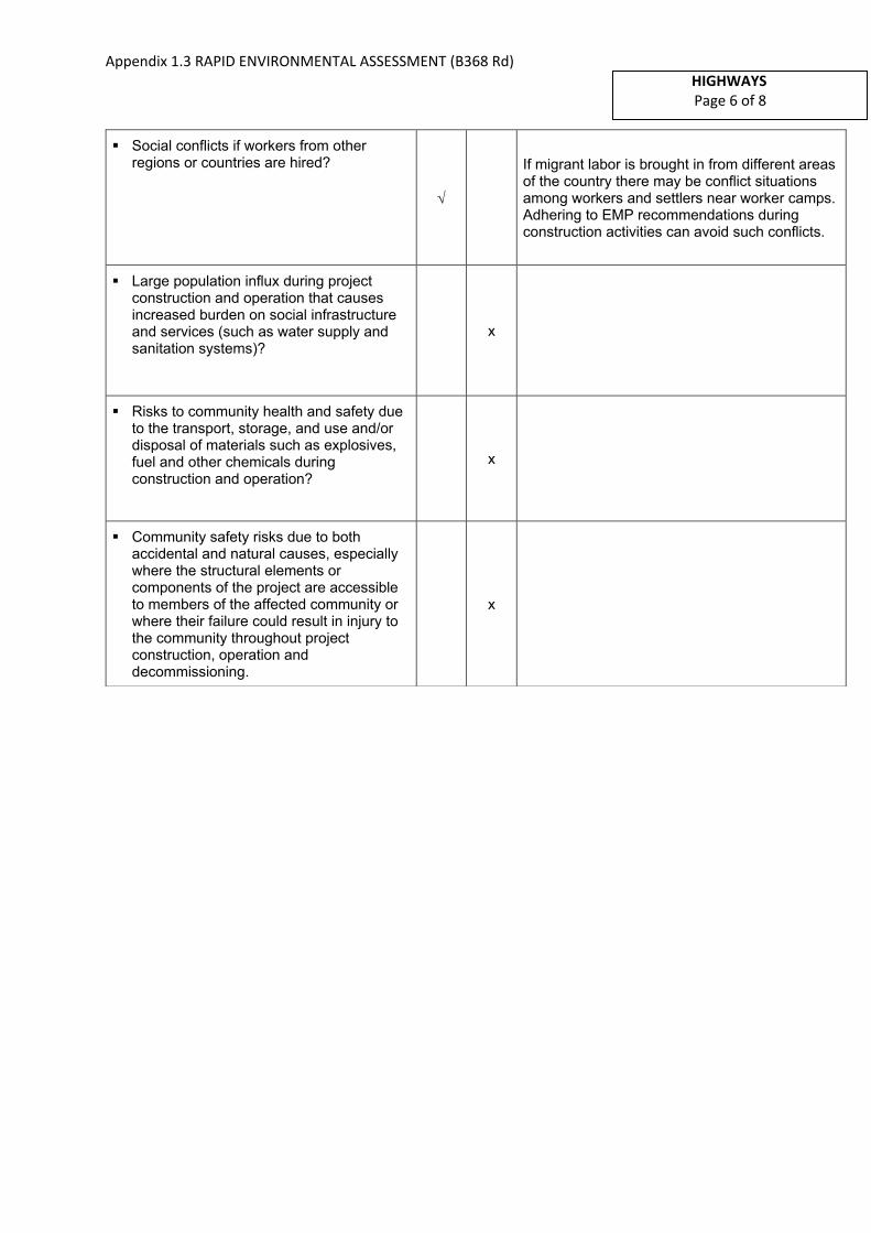
Appendix 1.3 RAPID ENVIRONMENTAL ASSESSMENT (B368 Rd)
HIGHWAYS
Page 6 of 8
▪ Social conflicts if workers from otherregions or countries are hired?
If migrant labor is brought in from different areas of the country there may be conflict situations among workers and settlers near worker camps. Adhering to EMP recommendations during construction activities can avoid such conflicts.
▪ Large population influx during projectconstruction and operation that causesincreased burden on social infrastructureand services (such as water supply andsanitation systems)?
x
▪ Risks to community health and safety dueto the transport, storage, and use and/ordisposal of materials such as explosives,fuel and other chemicals duringconstruction and operation?
x
▪ Community safety risks due to bothaccidental and natural causes, especiallywhere the structural elements orcomponents of the project are accessibleto members of the affected community orwhere their failure could result in injury tothe community throughout projectconstruction, operation anddecommissioning.
x

Appendix 1.3 RAPID ENVIRONMENTAL ASSESSMENT (B368 Rd)
HIGHWAYS
Page 7 of 8
A Checklist for Preliminary Climate Risk Screening1
Screening Questions Score Remarks1
Location and Design of project
Is siting and/or routing of the project (or its components) likely to be affected by climate conditions including extreme weather related events such as floods, droughts, storms, landslides?
2 The following locations are prone to flooding during heavy rainy periods due to Diyawanna Oya Lake flooding (increased water levels):
In the areas of CH1+600 - CH1+750, CH+500 - CH2+750, CH3+000 - CH3+500, and CH4+000 - CH4+150 in the low-lying floodplains of tributaries connected to Diyawanna Oya and Lake draining into Kelani River main channel.
Would the project design (e.g. the clearance for bridges) need to consider any hydro-meteorological parameters (e.g., sea-level, peak river flow, reliable water level, peak wind speed etc)?
2 Project design may need to consider locations which are prone to flooding and necessary mitigation measures need to be incorporated to the surface treatment. It is noted that the respective road drainage crossings are located in the immediate upstream of Diyawanna Lake and affected by high flood levels in Diyawanna Lake.
Materials and Maintenance
Would weather, current and likely future climate conditions (e.g. prevailing humidity level, temperature contrast between hot summer days and cold winter days, exposure to wind and humidity hydro-meteorological parameters likely affect the selection of project inputs over the life of project outputs (e.g. construction material)?
0
Would weather, current and likely future climate conditions, and related extreme events likely affect the maintenance (scheduling and cost) of project output(s)?
0
1 1 If possible, provide details on the sensitivity of project components to climate conditions, such as how climate parameters are
considered in design standards for infrastructure components, how changes in key climate parameters and sea level might affect the
siting/routing of project, the selection of construction material and/or scheduling, performances and/or the maintenance cost/scheduling
of project outputs.
Country/Project Title: Second Integrated Road Investment Program – package 2 in Western
province
Rehabilitation and Improvement of Pitakotte Thalawathugoda Road (B368)-4.1 km
Sector: Highways
Subsector: Highways
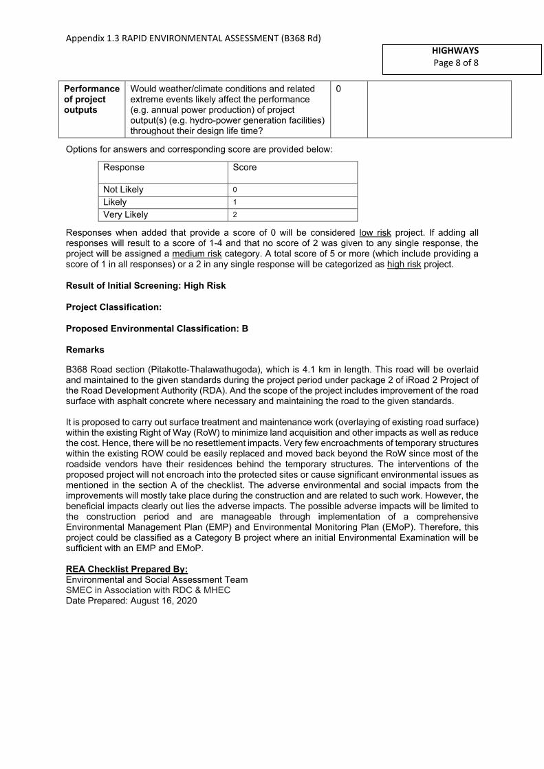
Appendix 1.3 RAPID ENVIRONMENTAL ASSESSMENT (B368 Rd)
HIGHWAYS
Page 8 of 8
Performance of project outputs
Would weather/climate conditions and related extreme events likely affect the performance (e.g. annual power production) of project output(s) (e.g. hydro-power generation facilities) throughout their design life time?
0
Options for answers and corresponding score are provided below:
Response Score
Not Likely 0
Likely 1
Very Likely 2
Responses when added that provide a score of 0 will be considered low risk project. If adding all responses will result to a score of 1-4 and that no score of 2 was given to any single response, the project will be assigned a medium risk category. A total score of 5 or more (which include providing a score of 1 in all responses) or a 2 in any single response will be categorized as high risk project.
Result of Initial Screening: High Risk
Project Classification:
Proposed Environmental Classification: B
Remarks
B368 Road section (Pitakotte-Thalawathugoda), which is 4.1 km in length. This road will be overlaid and maintained to the given standards during the project period under package 2 of iRoad 2 Project of the Road Development Authority (RDA). And the scope of the project includes improvement of the road surface with asphalt concrete where necessary and maintaining the road to the given standards.
It is proposed to carry out surface treatment and maintenance work (overlaying of existing road surface) within the existing Right of Way (RoW) to minimize land acquisition and other impacts as well as reduce the cost. Hence, there will be no resettlement impacts. Very few encroachments of temporary structures within the existing ROW could be easily replaced and moved back beyond the RoW since most of the roadside vendors have their residences behind the temporary structures. The interventions of the proposed project will not encroach into the protected sites or cause significant environmental issues as mentioned in the section A of the checklist. The adverse environmental and social impacts from the improvements will mostly take place during the construction and are related to such work. However, the beneficial impacts clearly out lies the adverse impacts. The possible adverse impacts will be limited to the construction period and are manageable through implementation of a comprehensive Environmental Management Plan (EMP) and Environmental Monitoring Plan (EMoP). Therefore, this project could be classified as a Category B project where an initial Environmental Examination will be sufficient with an EMP and EMoP.
REA Checklist Prepared By: Environmental and Social Assessment Team SMEC in Association with RDC & MHEC Date Prepared: August 16, 2020
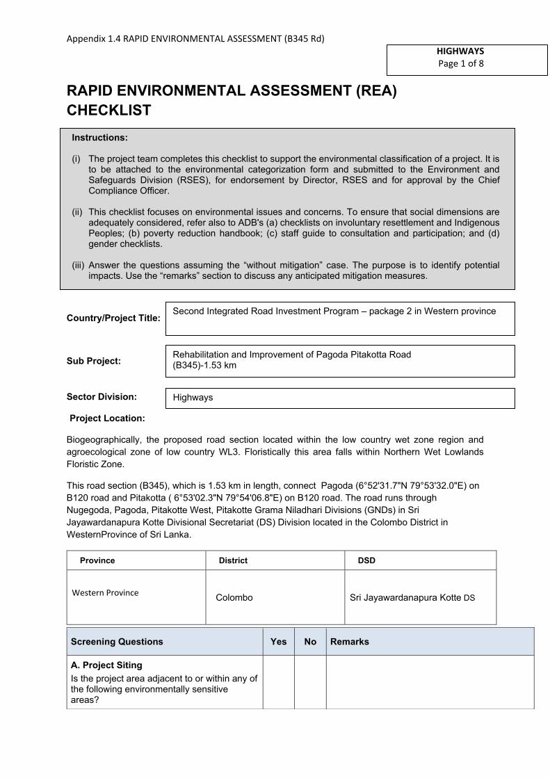
Appendix 1.4 RAPID ENVIRONMENTAL ASSESSMENT (B345 Rd)
HIGHWAYS
Page 1 of 8
RAPID ENVIRONMENTAL ASSESSMENT (REA)
CHECKLIST
Country/Project Title:
Sub Project:
Sector Division:
Project Location:
Biogeographically, the proposed road section located within the low country wet zone region and
agroecological zone of low country WL3. Floristically this area falls within Northern Wet Lowlands
Floristic Zone.
This road section (B345), which is 1.53 km in length, connect Pagoda (6°52'31.7"N 79°53'32.0"E) on
B120 road and Pitakotta ( 6°53'02.3"N 79°54'06.8"E) on B120 road. The road runs through
Nugegoda, Pagoda, Pitakotte West, Pitakotte Grama Niladhari Divisions (GNDs) in Sri
Jayawardanapura Kotte Divisional Secretariat (DS) Division located in the Colombo District in
WesternProvince of Sri Lanka.
Province District DSD
Western Province Colombo Sri Jayawardanapura Kotte DS
Screening Questions Yes No Remarks
A. Project Siting
Is the project area adjacent to or within any of the following environmentally sensitive areas?
Instructions:
(i) The project team completes this checklist to support the environmental classification of a project. It is to be attached to the environmental categorization form and submitted to the Environment and Safeguards Division (RSES), for endorsement by Director, RSES and for approval by the Chief Compliance Officer.
(ii) This checklist focuses on environmental issues and concerns. To ensure that social dimensions are adequately considered, refer also to ADB's (a) checklists on involuntary resettlement and Indigenous Peoples; (b) poverty reduction handbook; (c) staff guide to consultation and participation; and (d) gender checklists.
(iii) Answer the questions assuming the “without mitigation” case. The purpose is to identify potential impacts. Use the “remarks” section to discuss any anticipated mitigation measures.
Second Integrated Road Investment Program – package 2 in Western province
Rehabilitation and Improvement of Pagoda Pitakotta Road (B345)-1.53 km
Highways

Appendix 1.4 RAPID ENVIRONMENTAL ASSESSMENT (B345 Rd)
HIGHWAYS
Page 2 of 8
▪ Cultural heritage site x There are no major cultural heritage sites adjacent to or within the project area, except some temples etc.
▪ Protected Area x
▪ Wetland
The initial ~ 300 m part of the road stretch (CH0+200 – CH0+500) where the road stretch passes adjacent to seasonal/ intermittent freshwater bodies, which includes floodplains of natural flow paths and paddy fields draining into Diyawanna Oya and Lake and finally into Kelani River main channel.
The road trace intersects a such low-lying location at Nugegoda/Pagoda end.
Impacts can be mitigated by following good construction practices:
− Avoiding rainy periods for construction.
− Avoiding erecting temporary structures, stockpiling or tipping of materials, dumping of construction debris and waste in wetland areas and along surface runoff paths.
− Preventing washout of soil, all debris and residual materials into low-lying areas.
− Avoiding prolonged exposure of loose soil surfaces to wind and surface runoff.
▪ Mangrove x
▪ Estuarine
▪ Buffer zone of protected area x
▪ Special area for protecting biodiversity x
B. Potential Environmental Impacts
Will the Project cause…
▪ Encroachment on historical/cultural areas;disfiguration of landscape by roadembankments, cuts, fills, and quarries?
x
▪ Encroachment on precious ecology (e.g.sensitive or protected areas)?
x
▪ Alteration of surface water hydrology ofwaterways crossed by roads, resulting in
x

Appendix 1.4 RAPID ENVIRONMENTAL ASSESSMENT (B345 Rd)
HIGHWAYS
Page 3 of 8
increased sediment in streams affected by increased soil erosion at construction site?
▪ Deterioration of surface water quality dueto silt runoff and sanitary wastes fromworker-based camps and chemicals usedin construction?
There may be possibilities of deterioration of surface water quality due to silt runoff and sanitary wastes from worker–based camps and asphalt used in construction.
▪ Increased local air pollution due to rockcrushing, cutting and filling works, andchemicals from asphalt processing?
Activities such as cutting and filling will not be practiced under the iRoad-(II) package. Therefore, impacts due to above activities will not be experienced. However, temporary impacts due to fugitive emissions will be possible at asphalt plants and these impacts are restricted to such plant sites. Pollutants such as dust, crushed particles of rocks, and fumes etc. will be released to the atmosphere during construction phase.
Erection of dust barriers, watering the surfaces which can emit dust, using exact amount of chemicals for bitumen processing and most importantly siting the asphalt plants well away from protected areas and sensitive sites such as settlement areas, temples and schools will mitigate the impacts from asphalt plants.
▪ Risks and vulnerabilities related tooccupational health and safety due tophysical, chemical, biological, andradiological hazards during projectconstruction and operation during projectconstruction and operation?
Construction activities could create accidental damage and risks to workers. Exposure to asphalt may create health hazards.
It is proposed to prepare a separate health and safety plan to be implemented during road maintenance period and a regular monitoring schedule to be proposed under close supervision and coordination of a professional Occupational Health & Safety Officer of the Project Implementation Consultant.
▪ Noise and vibration due to blasting andother civil works?
No any blasting activities are involved along the proposed road. It is proposed that the project activities of the candidate road will be main to restricted to overlay and maintain to given standards. Therefore, noise and vibration will not be a major issue during construction stage.
Aggregates, if needed for construction, can be obtained from approved quarries. Noise and vibration will be restricted such sites.
▪ Dislocation or involuntary resettlement ofpeople?
x
▪ Disproportionate impacts on the poor,women and children, Indigenous Peoplesor other vulnerable groups?
x
▪ Other social concerns relating toinconveniences in living conditions in theproject areas that may trigger cases ofupper respiratory problems and stress?
During the construction period, emission of dust and other air-borne pollutants from the construction related activities will have minor impacts on the community and their living
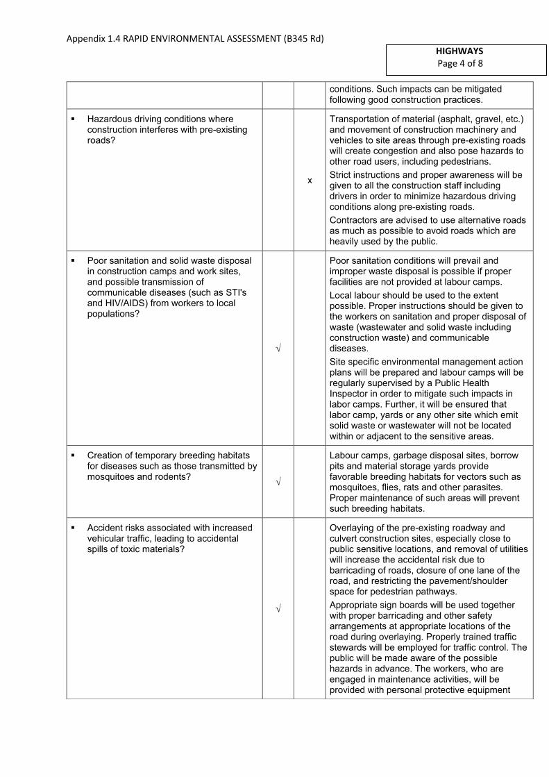
Appendix 1.4 RAPID ENVIRONMENTAL ASSESSMENT (B345 Rd)
HIGHWAYS
Page 4 of 8
conditions. Such impacts can be mitigated following good construction practices.
▪ Hazardous driving conditions whereconstruction interferes with pre-existingroads?
x
Transportation of material (asphalt, gravel, etc.) and movement of construction machinery and vehicles to site areas through pre-existing roads will create congestion and also pose hazards to other road users, including pedestrians.
Strict instructions and proper awareness will be given to all the construction staff including drivers in order to minimize hazardous driving conditions along pre-existing roads.
Contractors are advised to use alternative roads as much as possible to avoid roads which are heavily used by the public.
▪ Poor sanitation and solid waste disposalin construction camps and work sites,and possible transmission ofcommunicable diseases (such as STI'sand HIV/AIDS) from workers to localpopulations?
Poor sanitation conditions will prevail and improper waste disposal is possible if proper facilities are not provided at labour camps.
Local labour should be used to the extent possible. Proper instructions should be given to the workers on sanitation and proper disposal of waste (wastewater and solid waste including construction waste) and communicable diseases.
Site specific environmental management action plans will be prepared and labour camps will be regularly supervised by a Public Health Inspector in order to mitigate such impacts in labor camps. Further, it will be ensured that labor camp, yards or any other site which emit solid waste or wastewater will not be located within or adjacent to the sensitive areas.
▪ Creation of temporary breeding habitatsfor diseases such as those transmitted bymosquitoes and rodents?
Labour camps, garbage disposal sites, borrow pits and material storage yards provide favorable breeding habitats for vectors such as mosquitoes, flies, rats and other parasites. Proper maintenance of such areas will prevent such breeding habitats.
▪ Accident risks associated with increasedvehicular traffic, leading to accidentalspills of toxic materials?
Overlaying of the pre-existing roadway and culvert construction sites, especially close to public sensitive locations, and removal of utilities will increase the accidental risk due to barricading of roads, closure of one lane of the road, and restricting the pavement/shoulder space for pedestrian pathways.
Appropriate sign boards will be used together with proper barricading and other safety arrangements at appropriate locations of the road during overlaying. Properly trained traffic stewards will be employed for traffic control. The public will be made aware of the possible hazards in advance. The workers, who are engaged in maintenance activities, will be provided with personal protective equipment
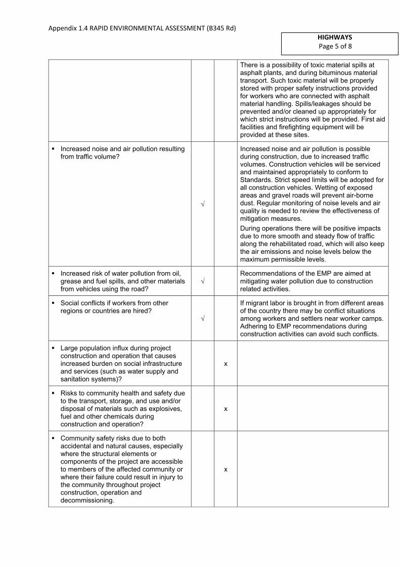
Appendix 1.4 RAPID ENVIRONMENTAL ASSESSMENT (B345 Rd)
HIGHWAYS
Page 5 of 8
There is a possibility of toxic material spills at asphalt plants, and during bituminous material transport. Such toxic material will be properly stored with proper safety instructions provided for workers who are connected with asphalt material handling. Spills/leakages should be prevented and/or cleaned up appropriately for which strict instructions will be provided. First aid facilities and firefighting equipment will be provided at these sites.
▪ Increased noise and air pollution resultingfrom traffic volume?
Increased noise and air pollution is possible during construction, due to increased traffic volumes. Construction vehicles will be serviced and maintained appropriately to conform to Standards. Strict speed limits will be adopted for all construction vehicles. Wetting of exposed areas and gravel roads will prevent air-borne dust. Regular monitoring of noise levels and air quality is needed to review the effectiveness of mitigation measures.
During operations there will be positive impacts due to more smooth and steady flow of traffic along the rehabilitated road, which will also keep the air emissions and noise levels below the maximum permissible levels.
▪ Increased risk of water pollution from oil,grease and fuel spills, and other materialsfrom vehicles using the road?
Recommendations of the EMP are aimed at mitigating water pollution due to construction related activities.
▪ Social conflicts if workers from otherregions or countries are hired?
If migrant labor is brought in from different areas of the country there may be conflict situations among workers and settlers near worker camps. Adhering to EMP recommendations during construction activities can avoid such conflicts.
▪ Large population influx during projectconstruction and operation that causesincreased burden on social infrastructureand services (such as water supply andsanitation systems)?
x
▪ Risks to community health and safety dueto the transport, storage, and use and/ordisposal of materials such as explosives,fuel and other chemicals duringconstruction and operation?
x
▪ Community safety risks due to bothaccidental and natural causes, especiallywhere the structural elements orcomponents of the project are accessibleto members of the affected community orwhere their failure could result in injury tothe community throughout projectconstruction, operation anddecommissioning.
x

Appendix 1.4 RAPID ENVIRONMENTAL ASSESSMENT (B345 Rd)
HIGHWAYS
Page 6 of 8
A Checklist for Preliminary Climate Risk Screening1
Screening Questions Score Remarks1
Location and Design of project
Is siting and/or routing of the project (or its components) likely to be affected by climate conditions including extreme weather related events such as floods, droughts, storms, landslides?
1 The following locations are low lying and prone to floods during heavy rainy periods:
In the surrounding areas of CH0+200 – CH0+500 in low-lying floodplains of a tributary connected to Diyawanna Oya stream channel and associated marshes. However, the road section has not been affected.
Would the project design (e.g. the clearance for bridges) need to consider any hydro-meteorological parameters (e.g., sea-level, peak river flow, reliable water level, peak wind speed etc)?
1 Project design may need to consider locations which are prone to localized flooding and necessary mitigation measures need to be incorporated to the surface treatment. It is noted that the respective road drainage crossings are located further upstream in sub-catchment and not affected by the peak flows or flood levels in Diyawanna Oya or Lake.
Materials and Maintenance
Would weather, current and likely future climate conditions (e.g. prevailing humidity level, temperature contrast between hot summer days and cold winter days, exposure to wind and humidity hydro-meteorological parameters likely affect the selection of project inputs over the life of project outputs (e.g. construction material)?
0
Would weather, current and likely future climate conditions, and related extreme events likely affect the maintenance (scheduling and cost) of project output(s)?
0
1 1 If possible, provide details on the sensitivity of project components to climate conditions, such as how climate parameters are
considered in design standards for infrastructure components, how changes in key climate parameters and sea level might affect the
siting/routing of project, the selection of construction material and/or scheduling, performances and/or the maintenance cost/scheduling
of project outputs.
Country/Project Title: Second Integrated Road Investment Program – package 2 in Western
province
Rehabilitation and Improvement of Pagoda Pitakotta Road (B345)-1.53 km
Sector: Highways
Subsector: Highways

Appendix 1.4 RAPID ENVIRONMENTAL ASSESSMENT (B345 Rd)
HIGHWAYS
Page 7 of 8
Performance of project outputs
Would weather/climate conditions and related extreme events likely affect the performance (e.g. annual power production) of project output(s) (e.g. hydro-power generation facilities) throughout their design life time?
0
Options for answers and corresponding score are provided below:
Response Score
Not Likely 0
Likely 1
Very Likely 2
Responses when added that provide a score of 0 will be considered low risk project. If adding all responses will result to a score of 1-4 and that no score of 2 was given to any single response, the project will be assigned a medium risk category. A total score of 5 or more (which include providing a score of 1 in all responses) or a 2 in any single response will be categorized as high risk project.
Result of Initial Screening: Medium Risk
Project Classification:
Proposed Environmental Classification: B
Remarks
B345 Road (Pagoda-Pitakotta), which is 1.53 km in length. This road will be overlaid and maintained to the given standards during the project period under package 2 of iRoad 2 Project of the Road Development Authority (RDA). And the scope of the project includes improvement of the road surface with asphalt concrete where necessary and maintaining the road to the given standards.
It is proposed to carry out surface treatment and maintenance work (overlaying of existing road surface) within the existing Right of Way (RoW) to minimize land acquisition and other impacts as well as reduce the cost. Hence, there will be no resettlement impacts. Very few encroachments of temporary structures within the existing ROW could be easily replaced and moved back beyond the RoW since most of the roadside vendors have their residences behind the temporary structures. The interventions of the proposed project will not encroach into the protected sites or cause significant environmental issues as mentioned in the section A of the checklist. The adverse environmental and social impacts from the improvements will mostly take place during the construction and are related to such work. However, the beneficial impacts clearly out lies the adverse impacts. The possible adverse impacts will be limited to the construction period and are manageable through implementation of a comprehensive Environmental Management Plan (EMP) and Environmental Monitoring Plan (EMoP). Therefore, this project could be classified as a Category B project where an initial Environmental Examination will be sufficient with an EMP and EMoP.
REA Checklist Prepared By:
Environmental and Social Assessment Team SMEC in Association with RDC & MHEC
Date Prepared: August 16, 2020
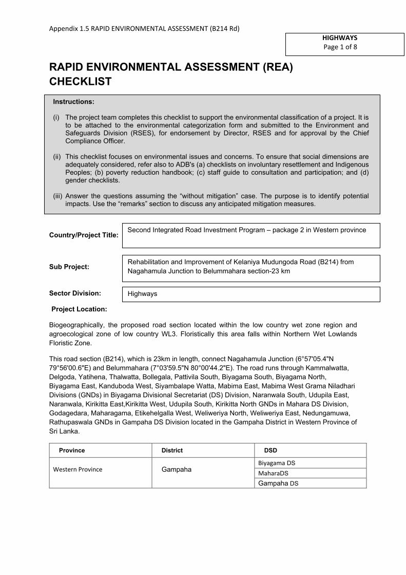
Appendix 1.5 RAPID ENVIRONMENTAL ASSESSMENT (B214 Rd)
HIGHWAYS
Page 1 of 8
RAPID ENVIRONMENTAL ASSESSMENT (REA)
CHECKLIST
Country/Project Title:
Sub Project:
Sector Division:
Project Location:
Biogeographically, the proposed road section located within the low country wet zone region and
agroecological zone of low country WL3. Floristically this area falls within Northern Wet Lowlands
Floristic Zone.
This road section (B214), which is 23km in length, connect Nagahamula Junction (6°57'05.4"N
79°56'00.6"E) and Belummahara (7°03'59.5"N 80°00'44.2"E). The road runs through Kammalwatta,
Delgoda, Yatihena, Thalwatta, Bollegala, Pattivila South, Biyagama South, Biyagama North,
Biyagama East, Kanduboda West, Siyambalape Watta, Mabima East, Mabima West Grama Niladhari
Divisions (GNDs) in Biyagama Divisional Secretariat (DS) Division, Naranwala South, Udupila East,
Naranwala, Kirikitta East,Kirikitta West, Udupila South, Kirikitta North GNDs in Mahara DS Division,
Godagedara, Maharagama, Etikehelgalla West, Weliweriya North, Weliweriya East, Nedungamuwa,
Rathupaswala GNDs in Gampaha DS Division located in the Gampaha District in Western Province of
Sri Lanka.
Province District DSD
Western Province Gampaha Biyagama DS
MaharaDS
Gampaha DS
Instructions:
(i) The project team completes this checklist to support the environmental classification of a project. It is to be attached to the environmental categorization form and submitted to the Environment and Safeguards Division (RSES), for endorsement by Director, RSES and for approval by the Chief Compliance Officer.
(ii) This checklist focuses on environmental issues and concerns. To ensure that social dimensions are adequately considered, refer also to ADB's (a) checklists on involuntary resettlement and Indigenous Peoples; (b) poverty reduction handbook; (c) staff guide to consultation and participation; and (d) gender checklists.
(iii) Answer the questions assuming the “without mitigation” case. The purpose is to identify potential impacts. Use the “remarks” section to discuss any anticipated mitigation measures.
Second Integrated Road Investment Program – package 2 in Western province
Rehabilitation and Improvement of Kelaniya Mudungoda Road (B214) from
Nagahamula Junction to Belummahara section-23 km
Highways

Appendix 1.5 RAPID ENVIRONMENTAL ASSESSMENT (B214 Rd)
HIGHWAYS
Page 2 of 8
Screening Questions Yes No Remarks
A. Project Siting
Is the project area adjacent to or within any of the following environmentally sensitive areas?
▪ Cultural heritage site x
There are no major cultural heritage sites adjacent to or within the project area, except some temples etc. (Sri Sama Viharaya, Palayadi pillayar kovil mundel, Mundel Temple, Kobbekaduwa Viharaya Palaviya, Aiyanar ancient temple)
▪ Protected Area x
▪ Wetland
Approximately the CH8+400 to CH13+400
stretch of the 23.0 km section of B214 Kelaniya -
Mudungoda Road from Nagahamula Junction to
Belummahara (CH6+000 to CH29+000) traverses
through low-lying floodplain segments of Kelani
River Basin within a distance of 30 m ~ 60 m.
There are two other ~300 m long road sections
in Kottunna, Biyagama area, again located within
low-lying floodplain parts of the tributaries
connected to Kelani River. The road section
beyond Morahena is situated in Attanagalu Oya
river basin and it crosses the main channel of
Uruwal Oya (main tributary of Attanagalu Oya
stream) while the terminal point in
Mudungoda/Henarathgoda is also located
within main channel floodplain areas of Uruwal
Oya/Attanagalu Oya. These low-lying parts
basically consist of cultivated/uncultivated/
abandoned paddies which also serve the
important function of flood retention/detention
and flood peak mitigation.
Impacts can be mitigated by following good construction practices:
− Avoiding rainy periods for construction.
− Avoiding erecting temporary structures, stockpiling or tipping of materials, dumping of construction debris and waste in wetland areas and along surface runoff paths.
− Preventing washout of soil, all debris and residual materials into low-lying areas
− Avoiding prolonged exposure of loose soil surfaces to wind and surface runoff

Appendix 1.5 RAPID ENVIRONMENTAL ASSESSMENT (B214 Rd)
HIGHWAYS
Page 3 of 8
▪ Mangrove x
▪ Estuarine x
▪ Buffer zone of protected area x
▪ Special area for protecting biodiversity x
B. Potential Environmental Impacts
Will the Project cause…
▪ Encroachment on historical/cultural areas;disfiguration of landscape by roadembankments, cuts, fills, and quarries?
x
▪ Encroachment on precious ecology (e.g.sensitive or protected areas)?
x
▪ Alteration of surface water hydrology ofwaterways crossed by roads, resulting inincreased sediment in streams affected byincreased soil erosion at construction site?
x
▪ Deterioration of surface water quality dueto silt runoff and sanitary wastes fromworker-based camps and chemicals usedin construction?
There may be possibilities of deterioration of surface water quality due to silt runoff and sanitary wastes from worker–based camps and asphalt used in construction.
▪ Increased local air pollution due to rockcrushing, cutting and filling works, andchemicals from asphalt processing?
Activities such as cutting and filling will not be practiced under the iRoad-(II) package. Therefore, impacts due to above activities will not be experienced. However, temporary impacts due to fugitive emissions will be possible at asphalt plants and these impacts are restricted to such plant sites. Pollutants such as dust, crushed particles of rocks, and fumes etc. will be released to the atmosphere during construction phase.
Erection of dust barriers, watering the surfaces which can emit dust, using exact amount of chemicals for bitumen processing and most importantly siting the asphalt plants well away from protected areas and sensitive sites such as settlement areas, temples and schools will mitigate the impacts from asphalt plants.
▪ Risks and vulnerabilities related tooccupational health and safety due tophysical, chemical, biological, andradiological hazards during projectconstruction and operation during projectconstruction and operation?
Construction activities could create accidental damage and risks to workers. Exposure to asphalt may create health hazards.
It is proposed to prepare a separate health and safety plan to be implemented during road maintenance period and a regular monitoring schedule to be proposed under close supervision and coordination of a professional Occupational Health & Safety Officer of the Project Implementation Consultant.
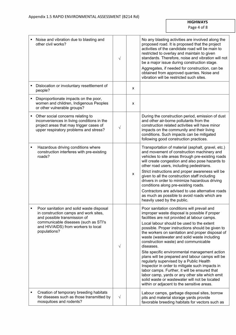
Appendix 1.5 RAPID ENVIRONMENTAL ASSESSMENT (B214 Rd)
HIGHWAYS
Page 4 of 8
▪ Noise and vibration due to blasting andother civil works?
No any blasting activities are involved along the proposed road. It is proposed that the project activities of the candidate road will be main to restricted to overlay and maintain to given standards. Therefore, noise and vibration will not be a major issue during construction stage.
Aggregates, if needed for construction, can be obtained from approved quarries. Noise and vibration will be restricted such sites.
▪ Dislocation or involuntary resettlement ofpeople?
x
▪ Disproportionate impacts on the poor,women and children, Indigenous Peoplesor other vulnerable groups?
x
▪ Other social concerns relating toinconveniences in living conditions in theproject areas that may trigger cases ofupper respiratory problems and stress?
During the construction period, emission of dust and other air-borne pollutants from the construction related activities will have minor impacts on the community and their living conditions. Such impacts can be mitigated following good construction practices.
▪ Hazardous driving conditions whereconstruction interferes with pre-existingroads?
x
Transportation of material (asphalt, gravel, etc.) and movement of construction machinery and vehicles to site areas through pre-existing roads will create congestion and also pose hazards to other road users, including pedestrians.
Strict instructions and proper awareness will be given to all the construction staff including drivers in order to minimize hazardous driving conditions along pre-existing roads.
Contractors are advised to use alternative roads as much as possible to avoid roads which are heavily used by the public.
▪ Poor sanitation and solid waste disposalin construction camps and work sites,and possible transmission ofcommunicable diseases (such as STI'sand HIV/AIDS) from workers to localpopulations?
Poor sanitation conditions will prevail and improper waste disposal is possible if proper facilities are not provided at labour camps.
Local labour should be used to the extent possible. Proper instructions should be given to the workers on sanitation and proper disposal of waste (wastewater and solid waste including construction waste) and communicable diseases.
Site specific environmental management action plans will be prepared and labour camps will be regularly supervised by a Public Health Inspector in order to mitigate such impacts in labor camps. Further, it will be ensured that labor camp, yards or any other site which emit solid waste or wastewater will not be located within or adjacent to the sensitive areas.
▪ Creation of temporary breeding habitatsfor diseases such as those transmitted bymosquitoes and rodents?
Labour camps, garbage disposal sites, borrow pits and material storage yards provide favorable breeding habitats for vectors such as
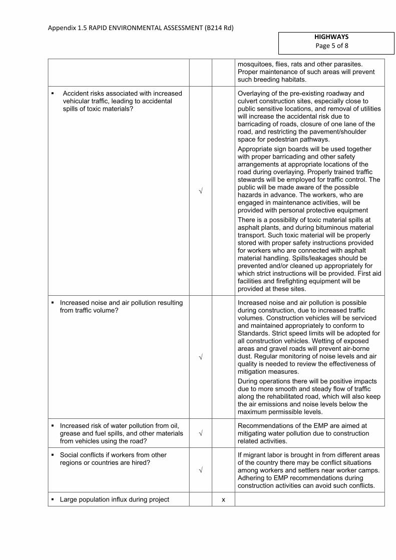
Appendix 1.5 RAPID ENVIRONMENTAL ASSESSMENT (B214 Rd)
HIGHWAYS
Page 5 of 8
mosquitoes, flies, rats and other parasites. Proper maintenance of such areas will prevent such breeding habitats.
▪ Accident risks associated with increasedvehicular traffic, leading to accidentalspills of toxic materials?
Overlaying of the pre-existing roadway and culvert construction sites, especially close to public sensitive locations, and removal of utilities will increase the accidental risk due to barricading of roads, closure of one lane of the road, and restricting the pavement/shoulder space for pedestrian pathways.
Appropriate sign boards will be used together with proper barricading and other safety arrangements at appropriate locations of the road during overlaying. Properly trained traffic stewards will be employed for traffic control. The public will be made aware of the possible hazards in advance. The workers, who are engaged in maintenance activities, will be provided with personal protective equipment
There is a possibility of toxic material spills at asphalt plants, and during bituminous material transport. Such toxic material will be properly stored with proper safety instructions provided for workers who are connected with asphalt material handling. Spills/leakages should be prevented and/or cleaned up appropriately for which strict instructions will be provided. First aid facilities and firefighting equipment will be provided at these sites.
▪ Increased noise and air pollution resultingfrom traffic volume?
Increased noise and air pollution is possible during construction, due to increased traffic volumes. Construction vehicles will be serviced and maintained appropriately to conform to Standards. Strict speed limits will be adopted for all construction vehicles. Wetting of exposed areas and gravel roads will prevent air-borne dust. Regular monitoring of noise levels and air quality is needed to review the effectiveness of mitigation measures.
During operations there will be positive impacts due to more smooth and steady flow of traffic along the rehabilitated road, which will also keep the air emissions and noise levels below the maximum permissible levels.
▪ Increased risk of water pollution from oil,grease and fuel spills, and other materialsfrom vehicles using the road?
Recommendations of the EMP are aimed at mitigating water pollution due to construction related activities.
▪ Social conflicts if workers from otherregions or countries are hired?
If migrant labor is brought in from different areas of the country there may be conflict situations among workers and settlers near worker camps. Adhering to EMP recommendations during construction activities can avoid such conflicts.
▪ Large population influx during project x

Appendix 1.5 RAPID ENVIRONMENTAL ASSESSMENT (B214 Rd)
HIGHWAYS
Page 6 of 8
construction and operation that causes increased burden on social infrastructure and services (such as water supply and sanitation systems)?
▪ Risks to community health and safety dueto the transport, storage, and use and/ordisposal of materials such as explosives,fuel and other chemicals duringconstruction and operation?
x
▪ Community safety risks due to bothaccidental and natural causes, especiallywhere the structural elements orcomponents of the project are accessibleto members of the affected community orwhere their failure could result in injury tothe community throughout projectconstruction, operation anddecommissioning.
x
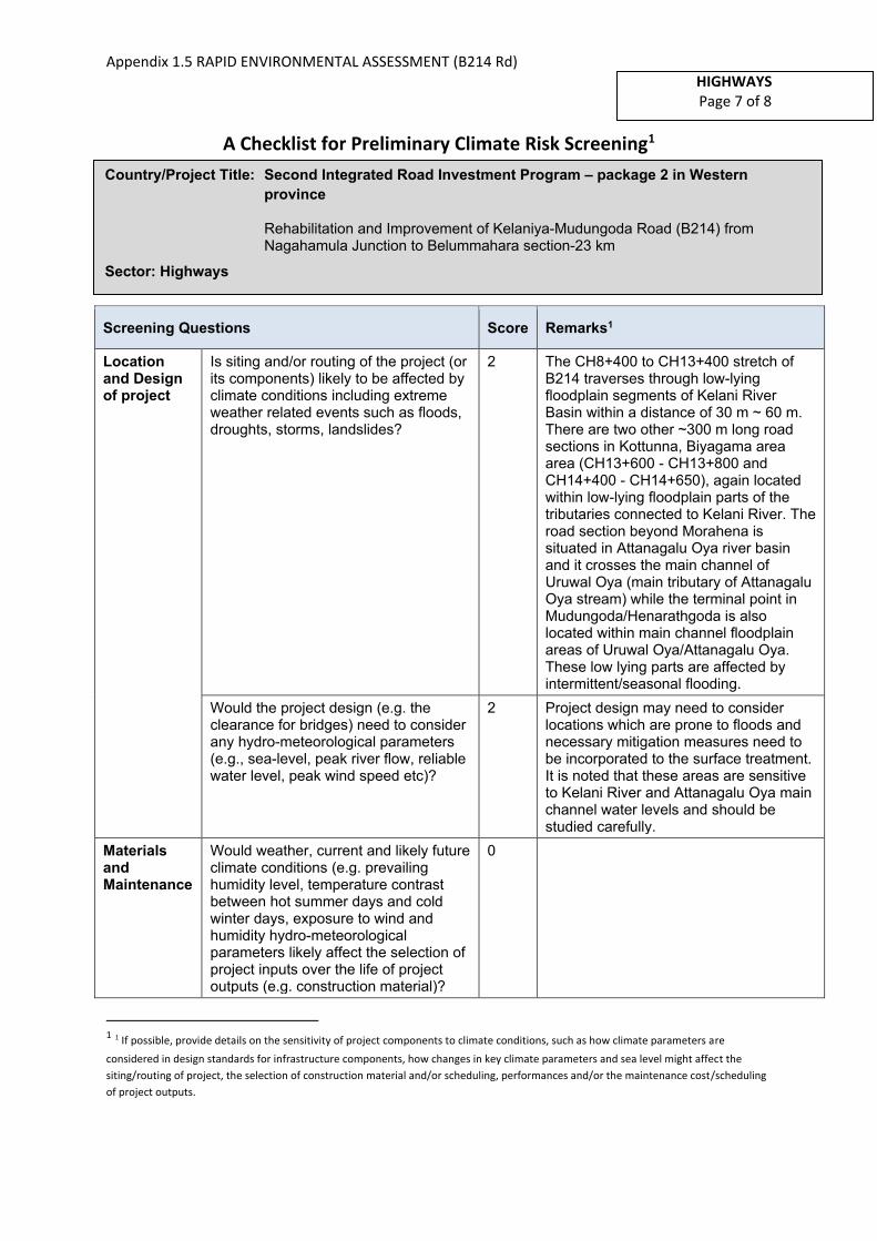
Appendix 1.5 RAPID ENVIRONMENTAL ASSESSMENT (B214 Rd)
HIGHWAYS
Page 7 of 8
A Checklist for Preliminary Climate Risk Screening1
Screening Questions Score Remarks1
Location and Design of project
Is siting and/or routing of the project (or its components) likely to be affected by climate conditions including extreme weather related events such as floods, droughts, storms, landslides?
2 The CH8+400 to CH13+400 stretch of B214 traverses through low-lying floodplain segments of Kelani River Basin within a distance of 30 m ~ 60 m. There are two other ~300 m long road sections in Kottunna, Biyagama area area (CH13+600 - CH13+800 and CH14+400 - CH14+650), again located within low-lying floodplain parts of the tributaries connected to Kelani River. The road section beyond Morahena is situated in Attanagalu Oya river basin and it crosses the main channel of Uruwal Oya (main tributary of Attanagalu Oya stream) while the terminal point in Mudungoda/Henarathgoda is also located within main channel floodplain areas of Uruwal Oya/Attanagalu Oya. These low lying parts are affected by intermittent/seasonal flooding.
Would the project design (e.g. the clearance for bridges) need to consider any hydro-meteorological parameters (e.g., sea-level, peak river flow, reliable water level, peak wind speed etc)?
2 Project design may need to consider locations which are prone to floods and necessary mitigation measures need to be incorporated to the surface treatment. It is noted that these areas are sensitive to Kelani River and Attanagalu Oya main channel water levels and should be studied carefully.
Materials and Maintenance
Would weather, current and likely future climate conditions (e.g. prevailing humidity level, temperature contrast between hot summer days and cold winter days, exposure to wind and humidity hydro-meteorological parameters likely affect the selection of project inputs over the life of project outputs (e.g. construction material)?
0
1 1 If possible, provide details on the sensitivity of project components to climate conditions, such as how climate parameters are
considered in design standards for infrastructure components, how changes in key climate parameters and sea level might affect the
siting/routing of project, the selection of construction material and/or scheduling, performances and/or the maintenance cost/scheduling
of project outputs.
Country/Project Title: Second Integrated Road Investment Program – package 2 in Western
province
Rehabilitation and Improvement of Kelaniya-Mudungoda Road (B214) from Nagahamula Junction to Belummahara section-23 km
Sector: Highways
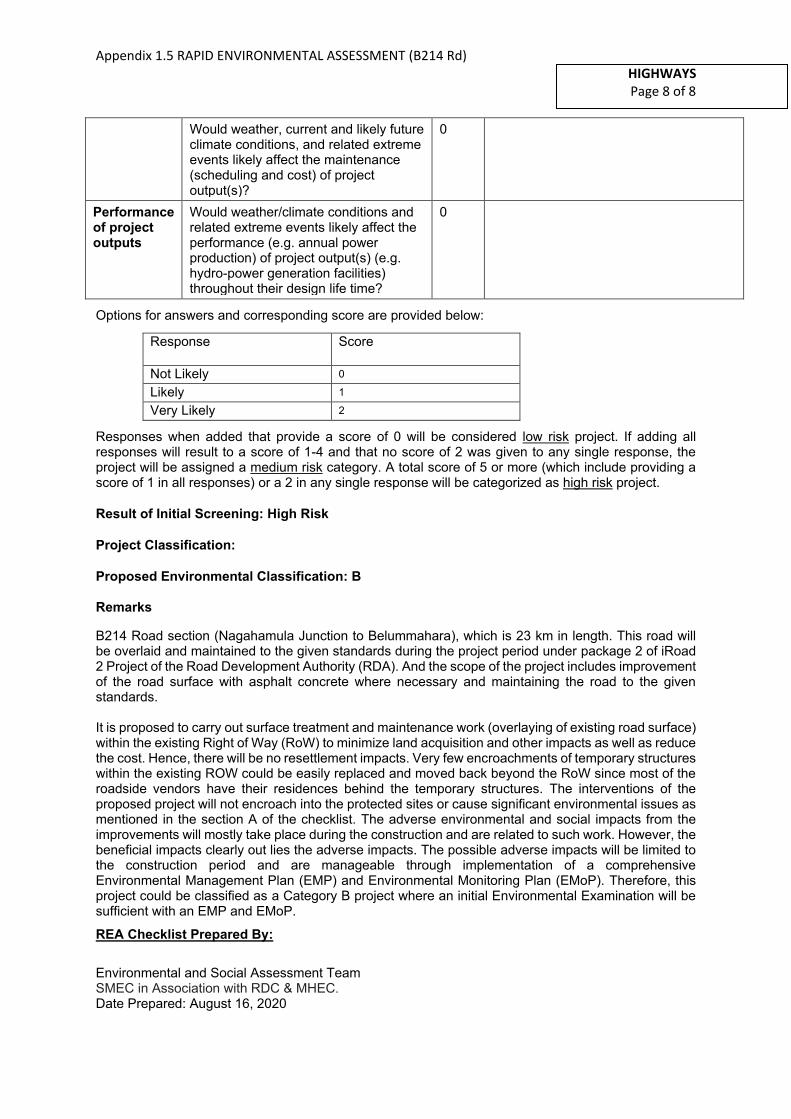
Appendix 1.5 RAPID ENVIRONMENTAL ASSESSMENT (B214 Rd)
HIGHWAYS
Page 8 of 8
Would weather, current and likely future climate conditions, and related extreme events likely affect the maintenance (scheduling and cost) of project output(s)?
0
Performance of project outputs
Would weather/climate conditions and related extreme events likely affect the performance (e.g. annual power production) of project output(s) (e.g. hydro-power generation facilities) throughout their design life time?
0
Options for answers and corresponding score are provided below:
Response Score
Not Likely 0
Likely 1
Very Likely 2
Responses when added that provide a score of 0 will be considered low risk project. If adding all responses will result to a score of 1-4 and that no score of 2 was given to any single response, the project will be assigned a medium risk category. A total score of 5 or more (which include providing a score of 1 in all responses) or a 2 in any single response will be categorized as high risk project.
Result of Initial Screening: High Risk
Project Classification:
Proposed Environmental Classification: B
Remarks
B214 Road section (Nagahamula Junction to Belummahara), which is 23 km in length. This road will be overlaid and maintained to the given standards during the project period under package 2 of iRoad 2 Project of the Road Development Authority (RDA). And the scope of the project includes improvement of the road surface with asphalt concrete where necessary and maintaining the road to the given standards.
It is proposed to carry out surface treatment and maintenance work (overlaying of existing road surface) within the existing Right of Way (RoW) to minimize land acquisition and other impacts as well as reduce the cost. Hence, there will be no resettlement impacts. Very few encroachments of temporary structures within the existing ROW could be easily replaced and moved back beyond the RoW since most of the roadside vendors have their residences behind the temporary structures. The interventions of the proposed project will not encroach into the protected sites or cause significant environmental issues as mentioned in the section A of the checklist. The adverse environmental and social impacts from the improvements will mostly take place during the construction and are related to such work. However, the beneficial impacts clearly out lies the adverse impacts. The possible adverse impacts will be limited to the construction period and are manageable through implementation of a comprehensive Environmental Management Plan (EMP) and Environmental Monitoring Plan (EMoP). Therefore, this project could be classified as a Category B project where an initial Environmental Examination will be sufficient with an EMP and EMoP.
REA Checklist Prepared By:
Environmental and Social Assessment Team SMEC in Association with RDC & MHEC.
Date Prepared: August 16, 2020
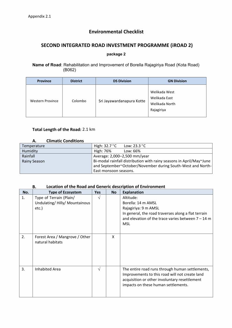
Appendix 2.1
Environmental Checklist
SECOND INTEGRATED ROAD INVESTMENT PROGRAMME (iROAD 2)
package 2
Name of Road: Rehabilitation and Improvement of Borella Rajagiriya Road (Kota Road) (B062)
Province District DS Division GN Division
Western Province Colombo Sri Jayawardanapura Kotte
Welikada West
Welikada East
Welikada North
Rajagiriya
Total Length of the Road: 2.1 km
A. Climatic Conditions Temperature High: 32.7 C Low: 23.3 C
Humidity High: 76% Low: 66%
Rainfall
Rainy Season
Average: 2,000–2,500 mm/year
Bi-modal rainfall distribution with rainy seasons in April/May~June
and September~October/November during South-West and North-
East monsoon seasons.
B. Location of the Road and Generic description of Environment
No. Type of Ecosystem Yes No Explanation
1. Type of Terrain (Plain/
Undulating/ Hilly/ Mountainous
etc.)
Altitude:
Borella: 14 m AMSL
Rajagiriya: 9 m AMSL
In general, the road traverses along a flat terrain
and elevation of the trace varies between 7 – 14 m
MSL
2. Forest Area / Mangrove / Other
natural habitats
X
3. Inhabited Area The entire road runs through human settlements,
Improvements to this road will not create land
acquisition or other involuntary resettlement
impacts on these human settlements.

Appendix 2.1
No. Type of Ecosystem Yes No Explanation
4. Agricultural Land X
5. Barren Land X All the land plots are used for business and
residential purposes. Therefore, Barren land is
insignificant feature of land in the road’s vicinity.
C. Specific description of the Road Environment
(Note: Questions number 1, 4, 5, 7 and 8 must be answered after discussions with the local
community people)
No. Parameter/ Component Yes No Explanation
1 Are there any areas with landslide
or erosion problems along the
road?
(If yes, indicate the location
whether Right or Left side and the
chainage)
X
2 Are there any Tanks/streams /rivers
etc. along/crossing the road or any
lakes/swamps beside the road?
(If yes, list them indicating the
location Right/ Left or crossing and
the chainage)
The candidate road section of B062
does not pass through any
wetlands/marshes. However, the
upstream most parts of Kolonnawa –
Heen Ela marshes are located ~350 m to
the north, and upstream-most parts of
Kotte marsh are located 300 m – 500 m
to the south of the road stretch.
3 Is the area along the project road
prone to flooding or any problems
of water stagnation and other
drainage issues?
(If yes, mention chainage, flood
level and frequency)
X No flood sections along this B062 Road
stretch.
However, silted culverts were observed.

Appendix 2.1
No. Parameter/ Component Yes No Explanation
4 Are there any trees with a girth of
600 mm or more at breast height
within the existing ROW (within
two fences on either sides) or
within 2 m corridor from the edge
of the carriageway on either side
Refer Appendix 4.1
5 Along the road and within 100 m of
the road shoulder, are there any
Faunal habitat areas, Faunal
breeding ground, bird migration
area, or other similar areas?
X
6 Along the road and within 100 m of
the road shoulder is there any
evidence of Flora and Fauna
species that are classified as
endangered species?
X
7 Are there any utility structures1
within 2 m on either side from the
centre line of the road alignment or
within the existing ROW of the
road?
(If yes, attach list with chainage)
Refer Appendix 5.1
8 Are there any religious, cultural or
community structures/buildings
within 50 m on either side from the
centre line of the road alignment?
(If yes attach list with chainage)
About 3 temporary structures possible
to move if required, used for business
ventures are available in scattered
locations on both sides of the road.
See Appendix 10.1
D. Public Consultation No. Consultation Activities Yes No Remarks
1. Consultation with local community
was conducted before finalizing the
alignment.
(Attach list of people met and
dates)
X 1 Focus Group Discussions were held with
the participation of 9 persons (male 4 and
female 5).
1 Water tap, hand pump, electric pole, telephone pole, pipe lines and other similar structures
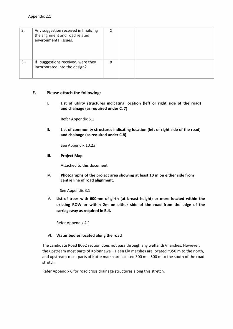
Appendix 2.1
2. Any suggestion received in finalizing
the alignment and road related
environmental issues.
X
3. If suggestions received, were they
incorporated into the design? X
E. Please attach the following:
I. List of utility structures indicating location (left or right side of the road)
and chainage (as required under C. 7)
Refer Appendix 5.1
II. List of community structures indicating location (left or right side of the road)
and chainage (as required under C.8)
See Appendix 10.2a
III. Project Map
Attached to this document
IV. Photographs of the project area showing at least 10 m on either side from
centre line of road alignment. See Appendix 3.1
V. List of trees with 600mm of girth (at breast height) or more located within the
existing ROW or within 2m on either side of the road from the edge of the
carriageway as required in B.4.
Refer Appendix 4.1
VI. Water bodies located along the road
The candidate Road B062 section does not pass through any wetlands/marshes. However,
the upstream most parts of Kolonnawa – Heen Ela marshes are located ~350 m to the north,
and upstream-most parts of Kotte marsh are located 300 m – 500 m to the south of the road
stretch.
Refer Appendix 6 for road cross drainage structures along this stretch.
Appendix 2.1
Figure 1: Location Map of Borella – Rajagiriya Rd (B 062)
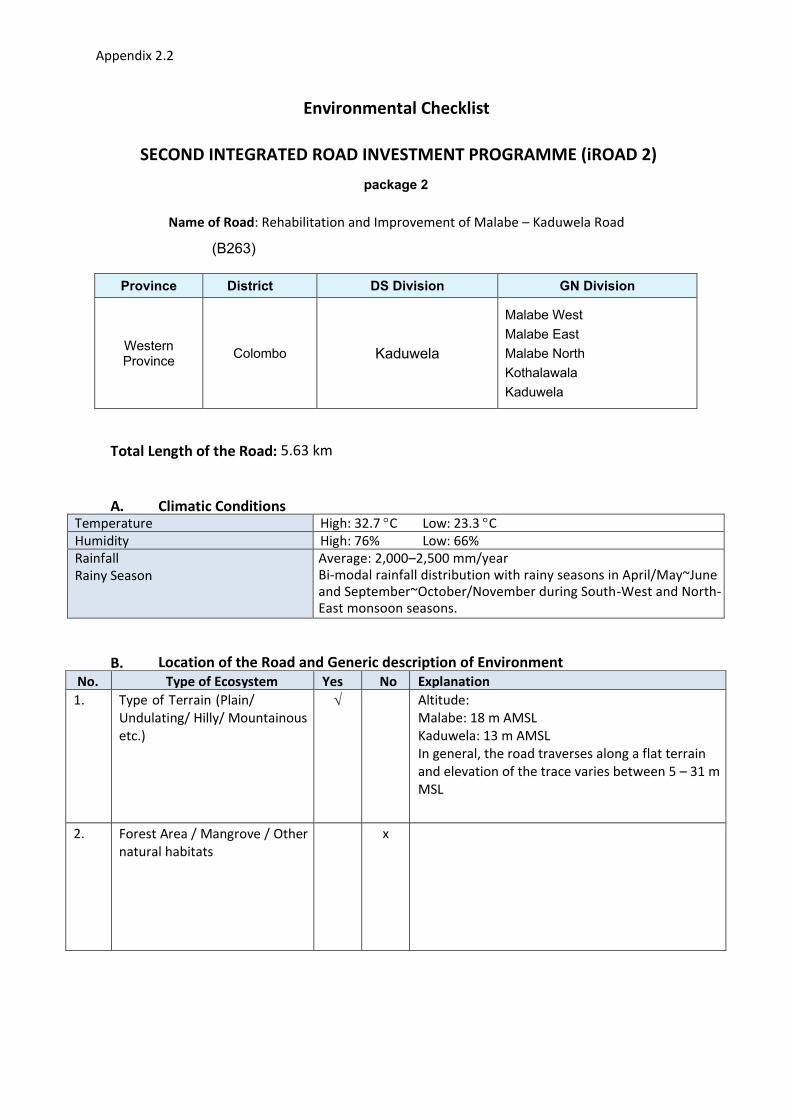
Appendix 2.2
Environmental Checklist
SECOND INTEGRATED ROAD INVESTMENT PROGRAMME (iROAD 2)
package 2
Name of Road: Rehabilitation and Improvement of Malabe – Kaduwela Road
(B263)
Province District
DS Division
GN Division
Western Province
Colombo Kaduwela
Malabe West
Malabe East
Malabe North
Kothalawala
Kaduwela
Total Length of the Road: 5.63 km
A. Climatic Conditions Temperature High: 32.7 C Low: 23.3 C
Humidity High: 76% Low: 66%
Rainfall
Rainy Season
Average: 2,000–2,500 mm/year
Bi-modal rainfall distribution with rainy seasons in April/May~June
and September~October/November during South-West and North-
East monsoon seasons.
B. Location of the Road and Generic description of Environment
No. Type of Ecosystem Yes No Explanation
1. Type of Terrain (Plain/
Undulating/ Hilly/ Mountainous
etc.)
Altitude:
Malabe: 18 m AMSL
Kaduwela: 13 m AMSL
In general, the road traverses along a flat terrain
and elevation of the trace varies between 5 – 31 m
MSL
2. Forest Area / Mangrove / Other
natural habitats
x

Appendix 2.2
3. Inhabited Area The entire road runs through human settlements,
Improvements to this road will not create land
acquisition or other involuntary resettlement
impacts on these human settlements.
4. Agricultural Land X
5. Barren Land X All the land plots are used for residential or
business purposes. Therefore, Barren land is
insignificant feature of land in the road’s vicinity.
C. Specific description of the Road Environment
(Note: Questions number 1, 4, 5, 7 and 8 must be answered after discussions with the local
community people)
No. Parameter/ Component Yes No Explanation
1 Are there any areas with landslide
or erosion problems along the
road?
(If yes, indicate the location
whether Right or Left side and the
chainage)
X
2 Are there any Tanks/streams /rivers
etc. along/crossing the road or any
lakes/swamps beside the road?
(If yes, list them indicating the
location Right/ Left or crossing and
the chainage)
No major rivers/streams/lakes. The road
trace intersects low-lying minor valley
locations at Malabe, Kotalawala and
Kaduwela (basically
cultivated/uncultivated/ abandoned
paddies).

Appendix 2.2
No. Parameter/ Component Yes No Explanation
3 Is the area along the project road
prone to flooding or any problems
of water stagnation and other
drainage issues?
(If yes, mention chainage, flood
level and frequency)
CH0+800 - CH1+000 stretch close to
Malabe is situated within the low-lying
floodplain of a tributary connected to
Kelani River main channel. This part was
flooded in 2016 for ~0.45 m ~0.60 m
depth.
Intermittent/seasonal flooding is
envisaged during monsoonal storm
periods.
4 Are there any trees with a girth of
600 mm or more at breast height
within the existing ROW (within
two fences on either sides) or
within 2 m corridor from the edge
of the carriageway on either side
Refer Appendix 4.2
5 Along the road and within 100 m of
the road shoulder, are there any
Faunal habitat areas, Faunal
breeding ground, bird migration
area, or other similar areas?
X
6 Along the road and within 100 m of
the road shoulder is there any
evidence of Flora and Fauna
species that are classified as
endangered species?
X Refer Appendix 7.1(c) and 7.2(c)
7 Are there any utility structures1
within 2 m on either side from the
centre line of the road alignment or
within the existing ROW of the
road?
(If yes, attach list with chainage)
Refer Appendix 5.2
8 Are there any religious, cultural or
community structures/buildings
within 50 m on either side from the
centre line of the road alignment?
(If yes attach list with chainage)
About 3 temporary structures possible
to move if required, used for business
ventures are available in scattered
locations on both sides of the road.
See Appendix 10.1
1 Water tap, hand pump, electric pole, telephone pole, pipe lines and other similar structures
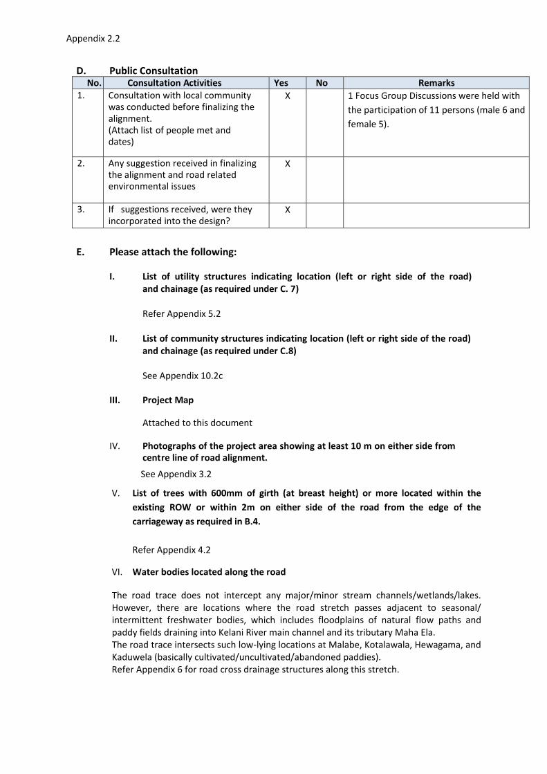
Appendix 2.2
D. Public Consultation No. Consultation Activities Yes No Remarks
1. Consultation with local community
was conducted before finalizing the
alignment.
(Attach list of people met and
dates)
X 1 Focus Group Discussions were held with
the participation of 11 persons (male 6 and
female 5).
2. Any suggestion received in finalizing
the alignment and road related
environmental issues
X
3. If suggestions received, were they
incorporated into the design? X
E. Please attach the following:
I. List of utility structures indicating location (left or right side of the road)
and chainage (as required under C. 7)
Refer Appendix 5.2
II. List of community structures indicating location (left or right side of the road)
and chainage (as required under C.8)
See Appendix 10.2c
III. Project Map
Attached to this document
IV. Photographs of the project area showing at least 10 m on either side from
centre line of road alignment. See Appendix 3.2
V. List of trees with 600mm of girth (at breast height) or more located within the
existing ROW or within 2m on either side of the road from the edge of the
carriageway as required in B.4.
Refer Appendix 4.2
VI. Water bodies located along the road
The road trace does not intercept any major/minor stream channels/wetlands/lakes.
However, there are locations where the road stretch passes adjacent to seasonal/
intermittent freshwater bodies, which includes floodplains of natural flow paths and
paddy fields draining into Kelani River main channel and its tributary Maha Ela.
The road trace intersects such low-lying locations at Malabe, Kotalawala, Hewagama, and
Kaduwela (basically cultivated/uncultivated/abandoned paddies).
Refer Appendix 6 for road cross drainage structures along this stretch.

Appendix 2.2
Location Map of Malabe – Kaduwela Road (B263)
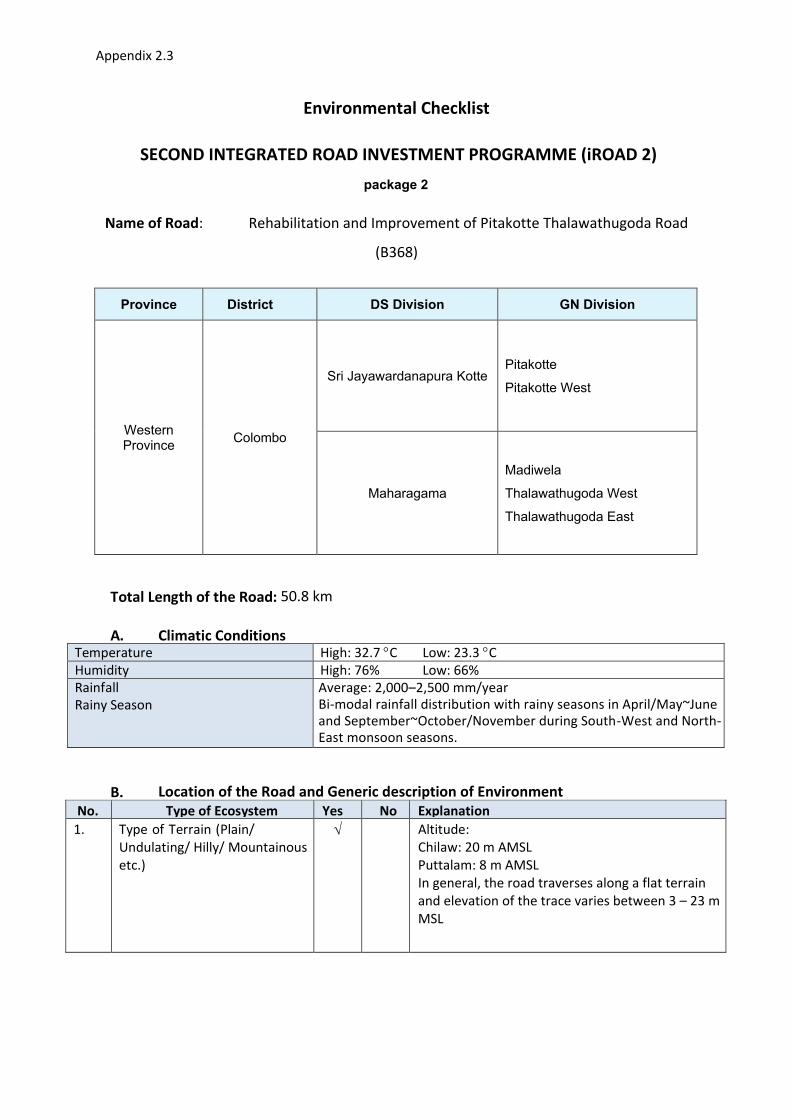
Appendix 2.3
Environmental Checklist
SECOND INTEGRATED ROAD INVESTMENT PROGRAMME (iROAD 2)
package 2
Name of Road: Rehabilitation and Improvement of Pitakotte Thalawathugoda Road
(B368)
Province District
DS Division
GN Division
Western Province
Colombo
Sri Jayawardanapura Kotte Pitakotte
Pitakotte West
Maharagama
Madiwela
Thalawathugoda West
Thalawathugoda East
Total Length of the Road: 50.8 km
A. Climatic Conditions Temperature High: 32.7 C Low: 23.3 C
Humidity High: 76% Low: 66%
Rainfall
Rainy Season
Average: 2,000–2,500 mm/year
Bi-modal rainfall distribution with rainy seasons in April/May~June
and September~October/November during South-West and North-
East monsoon seasons.
B. Location of the Road and Generic description of Environment
No. Type of Ecosystem Yes No Explanation
1. Type of Terrain (Plain/
Undulating/ Hilly/ Mountainous
etc.)
Altitude:
Chilaw: 20 m AMSL
Puttalam: 8 m AMSL
In general, the road traverses along a flat terrain
and elevation of the trace varies between 3 – 23 m
MSL

Appendix 2.3
2. Forest Area / Mangrove / Other
natural habitats
Marshy area is located around 2.4km, LHS and the
Diyawanna lake around 3km, of the road act as
natural habitats for number of floral and faunal
species.
3. Inhabited Area The entire road runs through human settlements,
Improvements to this road will not create land
acquisition or other involuntary resettlement
impacts on these human settlements.
4. Agricultural Land The road runs adjacent to the paddy fields, RHS
around 3.2km to 3.4 km.
5. Barren Land Except negligible number of land plots located in
the vicinity of the road all other land plots are used
for residential or business purposes. Therefore,
Barren land is insignificant feature of land in the
road’s vicinity.
C. Specific description of the Road Environment
(Note: Questions number 1, 4, 5, 7 and 8 must be answered after discussions with the local
community people)
No. Parameter/ Component Yes No Explanation
1 Are there any areas with landslide
or erosion problems along the
road?
(If yes, indicate the location
whether Right or Left side and the
chainage)
X
2 Are there any Tanks/streams /rivers
etc. along/crossing the road or any
lakes/swamps beside the road?
(If yes, list them indicating the
location Right/ Left or crossing and
the chainage)
No rivers/streams/lakes. There are
locations where the road stretch passes
adjacent to seasonal/ intermittent
freshwater bodies, which includes
floodplains of natural flow paths and
paddy fields draining into Diyawanna Oya
and Lake, which subsequently drain into
Kelani Basin.
The road trace intersects such low-lying
locations at Pita Kotte/Mirihana,
Madiwela, Thalapathpitiya and
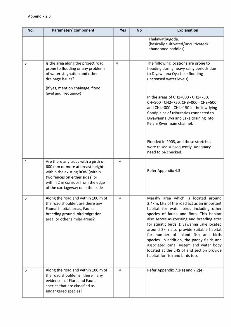
Appendix 2.3
No. Parameter/ Component Yes No Explanation
Thalawathugoda.
(basically cultivated/uncultivated/
abandoned paddies).
3 Is the area along the project road
prone to flooding or any problems
of water stagnation and other
drainage issues?
(If yes, mention chainage, flood
level and frequency)
The following locations are prone to
flooding during heavy rainy periods due
to Diyawanna Oya Lake flooding
(increased water levels):
In the areas of CH1+600 - CH1+750,
CH+500 - CH2+750, CH3+000 - CH3+500,
and CH4+000 - CH4+150 in the low-lying
floodplains of tributaries connected to
Diyawanna Oya and Lake draining into
Kelani River main channel.
Flooded in 2003, and these stretches
were raised subsequently. Adequacy
need to be checked.
4 Are there any trees with a girth of
600 mm or more at breast height
within the existing ROW (within
two fences on either sides) or
within 2 m corridor from the edge
of the carriageway on either side
Refer Appendix 4.3
5 Along the road and within 100 m of
the road shoulder, are there any
Faunal habitat areas, Faunal
breeding ground, bird migration
area, or other similar areas?
Marshy area which is located around
2.4km, LHS of the road act as an important
habitat for water birds including other
species of fauna and flora. This habitat
also serves as roosting and breeding sites
for aquatic birds. Diyawanna Lake located
around 3km also provide suitable habitat
for number of inland fish and birds
species. In addition, the paddy fields and
associated canal system and water body
located at the LHS of end section provide
habitat for fish and birds too.
6 Along the road and within 100 m of
the road shoulder is there any
evidence of Flora and Fauna
species that are classified as
endangered species?
Refer Appendix 7.1(e) and 7.2(e)

Appendix 2.3
No. Parameter/ Component Yes No Explanation
7 Are there any utility structures1
within 2 m on either side from the
centre line of the road alignment or
within the existing ROW of the
road?
(If yes, attach list with chainage)
Refer Appendix 5.3
8 Are there any religious, cultural or
community structures/buildings
within 50 m on either side from the
centre line of the road alignment?
(If yes attach list with chainage)
About 4 temporary structures possible
to move if required, used for business
ventures are available in scattered
locations on both sides of the road.
See Appendix 10.1
D. Public Consultation No. Consultation Activities Yes No Remarks
1. Consultation with local community
was conducted before finalizing the
alignment.
(Attach list of people met and
dates)
X 2 Focus Group Discussions were held with
the participation of 19 persons (male 8 and
female 11).
2. Any suggestion received in finalizing
the alignment and road related
environmental issues
X
3. If suggestions received, were they
incorporated into the design? X
E. Please attach the following:
I. List of utility structures indicating location (left or right side of the road)
and chainage (as required under C. 7)
Refer Appendix 5.3
II. List of community structures indicating location (left or right side of the road)
and chainage (as required under C.8)
1 Water tap, hand pump, electric pole, telephone pole, pipe lines and other similar structures

Appendix 2.3
See Appendix 10.2e
III. Project Map
Attached to this document
IV. Photographs of the project area showing at least 10 m on either side from
centre line of road alignment. See Appendix 3.3
V. List of trees with 600mm of girth (at breast height) or more located within the
existing ROW or within 2m on either side of the road from the edge of the
carriageway as required in B.4.
Refer Appendix 4.3
VI. Water bodies located along the road
The road trace does not intercept any major/minor stream channels/wetlands/lakes.
However, there are locations where the road stretch passes adjacent to seasonal/
intermittent freshwater bodies, which includes floodplains of natural flow paths and
paddy fields draining into Diyawanna Lake.
The following locations are prone to flooding during heavy rainy periods due to
Diyawanna Oya Lake flooding (increased water levels):
In the areas of CH1+600 - CH1+750, CH+500 - CH2+750, CH3+000 - CH3+500, and
CH4+000 - CH4+150 in the low-lying floodplains of tributaries connected to Diyawanna
Oya and Lake draining into Kelani River main channel (basically
cultivated/uncultivated/abandoned paddies in upstream parts and Diyawanna Lake and
associated floodplain marshes in the downstream).
Refer Appendix 6 for road cross drainage structures along this stretch.
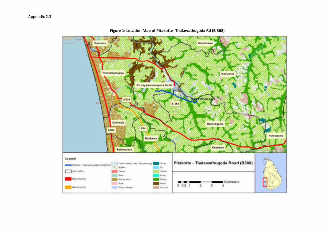
Appendix 2.3
Figure 1: Location Map of Pitakotte -Thalawathugoda Rd (B 368)
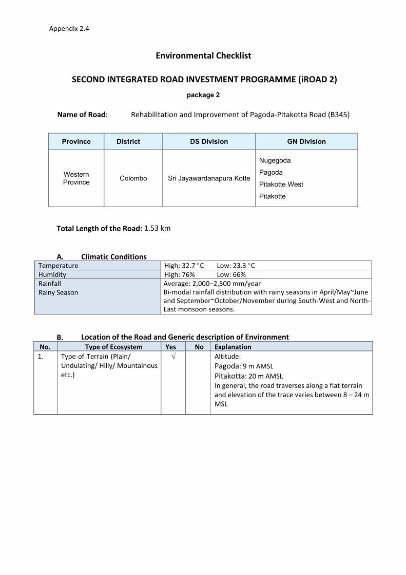
Appendix 2.4
Environmental Checklist
SECOND INTEGRATED ROAD INVESTMENT PROGRAMME (iROAD 2)
package 2
Name of Road: Rehabilitation and Improvement of Pagoda-Pitakotta Road (B345)
Province District
DS Division
GN Division
Western Province
Colombo Sri Jayawardanapura Kotte
Nugegoda
Pagoda
Pitakotte West
Pitakotte
Total Length of the Road: 1.53 km
A. Climatic Conditions Temperature High: 32.7 C Low: 23.3 C
Humidity High: 76% Low: 66%
Rainfall
Rainy Season
Average: 2,000–2,500 mm/year
Bi-modal rainfall distribution with rainy seasons in April/May~June
and September~October/November during South-West and North-
East monsoon seasons.
B. Location of the Road and Generic description of Environment
No. Type of Ecosystem Yes No Explanation
1. Type of Terrain (Plain/
Undulating/ Hilly/ Mountainous
etc.)
Altitude:
Pagoda: 9 m AMSL
Pitakotta: 20 m AMSL
In general, the road traverses along a flat terrain
and elevation of the trace varies between 8 – 24 m
MSL

Appendix 2.4
2. Forest Area / Mangrove / Other
natural habitats
X
3. Inhabited Area The entire road runs through human settlements,
Improvements to this road will not create land
acquisition or other involuntary resettlement
impacts on these human settlements.
4. Agricultural Land x
5. Barren Land X All the land plots are used for residential or
business purposes. Therefore, Barren land is
insignificant feature of land in the road’s vicinity.
C. Specific description of the Road Environment
(Note: Questions number 1, 4, 5, 7 and 8 must be answered after discussions with the local
community people)
No. Parameter/ Component Yes No Explanation
1 Are there any areas with landslide
or erosion problems along the
road?
(If yes, indicate the location
whether Right or Left side and the
X

Appendix 2.4
No. Parameter/ Component Yes No Explanation
chainage)
2 Are there any Tanks/streams /rivers
etc. along/crossing the road or any
lakes/swamps beside the road?
(If yes, list them indicating the
location Right/ Left or crossing and
the chainage)
No rivers/streams/lakes. The initial part
of the road stretch (CH0+000 – CH0+300)
where the road stretch passes adjacent
to seasonal/ intermittent freshwater
bodies, which includes floodplains of
natural flow paths and paddy fields
draining into Diyawanna Lake and finally
into Kelani River main channel.
The road trace intersects a such low-lying
location at Nugegoda/Pagoda end.
3 Is the area along the project road
prone to flooding or any problems
of water stagnation and other
drainage issues?
(If yes, mention chainage, flood
level and frequency)
X
4 Are there any trees with a girth of
600 mm or more at breast height
within the existing ROW (within
two fences on either sides) or
within 2 m corridor from the edge
of the carriageway on either side
Refer Appendix 4.4
5 Along the road and within 100 m of
the road shoulder, are there any
Faunal habitat areas, Faunal
breeding ground, bird migration
area, or other similar areas?
x
6 Along the road and within 100 m of
the road shoulder is there any
evidence of Flora and Fauna
species that are classified as
endangered species?
x
7 Are there any utility structures1
within 2 m on either side from the
centre line of the road alignment or
within the existing ROW of the
Refer Appendix 5.4
1 Water tap, hand pump, electric pole, telephone pole, pipe lines and other similar structures

Appendix 2.4
No. Parameter/ Component Yes No Explanation
road?
(If yes, attach list with chainage)
8 Are there any religious, cultural or
community structures/buildings
within 50 m on either side from the
centre line of the road alignment?
(If yes attach list with chainage)
About 3 temporary structures possible
to move if required, used for business
ventures are available in scattered
locations on both sides of the road.
See Appendix 10.1
D. Public Consultation No. Consultation Activities Yes No Remarks
1. Consultation with local community
was conducted before finalizing the
alignment.
(Attach list of people met and
dates)
X 1 Focus Group Discussions were held with
the participation of 9 persons (male 4 and
female 5).
2. Any suggestion received in finalizing
the alignment and road related
environmental issues
X
3. If suggestions received, were they
incorporated into the design? X
E. Please attach the following:
I. List of utility structures indicating location (left or right side of the road)
and chainage (as required under C. 7)
Refer Appendix 5.4
II. List of community structures indicating location (left or right side of the road)
and chainage (as required under C.8)
See Appendix 10.2d
III. Project Map
Attached to this document
IV. Photographs of the project area showing at least 10 m on either side from
centre line of road alignment. See Appendix 3.4

Appendix 2.4
V. List of trees with 600mm of girth (at breast height) or more located within the
existing ROW or within 2m on either side of the road from the edge of the
carriageway as required in B.4.
Refer Appendix 4.4
VI. Water bodies located along the road
The following locations are low lying and prone to floods during heavy rainy periods:
The surrounding areas of CH0+800 – CH0+300 is situated within the low-lying floodplain
and associated marshes of a tributary connected to Diyawanna Oya stream channel.
Diyawanna Oya and Lake are located at a distance of 200 m ~ 300 m at some stretches
(on left side). However, the road section does not pass through the stream/lake.

Appendix 2.4
Figure 1: Location Map of Pagoda-Pitakotta Road (B345)
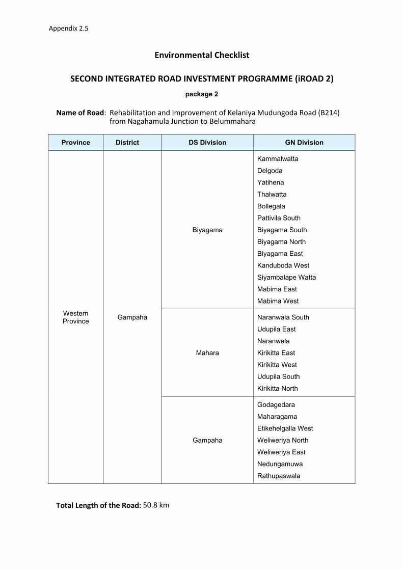
Appendix 2.5
Environmental Checklist
SECOND INTEGRATED ROAD INVESTMENT PROGRAMME (iROAD 2)
package 2
Name of Road: Rehabilitation and Improvement of Kelaniya Mudungoda Road (B214) from Nagahamula Junction to Belummahara
Province District
DS Division
GN Division
Western Province
Gampaha
Biyagama
Kammalwatta
Delgoda
Yatihena
Thalwatta
Bollegala
Pattivila South
Biyagama South
Biyagama North
Biyagama East
Kanduboda West
Siyambalape Watta
Mabima East
Mabima West
Mahara
Naranwala South
Udupila East
Naranwala
Kirikitta East
Kirikitta West
Udupila South
Kirikitta North
Gampaha
Godagedara
Maharagama
Etikehelgalla West
Weliweriya North
Weliweriya East
Nedungamuwa
Rathupaswala
Total Length of the Road: 50.8 km

Appendix 2.5
A. Climatic Conditions Temperature High: 32.7 C Low: 23.3 C
Humidity High: 76% Low: 66%
Rainfall
Rainy Season
Average: 2,000–2,500 mm/year
Bi-modal rainfall distribution with rainy seasons in April/May~June
and September~October/November during South-West and North-
East monsoon seasons.
B. Location of the Road and Generic description of Environment
No. Type of Ecosystem Yes No Explanation
1. Type of Terrain (Plain/
Undulating/ Hilly/ Mountainous
etc.)
Altitude:
Chilaw: 12 m AMSL
Puttalam: 14 m AMSL
In general, the road traverses along a flat terrain
and elevation of the trace varies between 9 – 39 m
MSL
2. Forest Area / Mangrove / Other
natural habitats
x
3. Inhabited Area Except some scattered sections, the entire road
runs through human settlements, Improvements to
this road will not create land acquisition or other
involuntary resettlement impacts on these human
settlements.
4. Agricultural Land Some section of the road runs adjoining to the
paddy fields but proposed road section mainly runs
thgrough suburban environment.
Appendix 2.5
5. Barren Land Except negligible number of land plots located in
the vicinity of the road all other land plots are used
for residential, agricultural or business purposes.
Therefore, Barren land is insignificant feature of
land in the road’s vicinity.
C. Specific description of the Road Environment
(Note: Questions number 1, 4, 5, 7 and 8 must be answered after discussions with the local
community people)
No. Parameter/ Component Yes No Explanation
1 Are there any areas with landslide
or erosion problems along the
road?
(If yes, indicate the location
whether Right or Left side and the
chainage)
X Minor erosion on the road edges in
some sections can be observed mainly
due to non-availability of storm water
drainage canal system. The road does
not run through high terrain.
2 Are there any Tanks/streams /rivers
etc. along/crossing the road or any
lakes/swamps beside the road?
(If yes, list them indicating the
location Right/ Left or crossing and
the chainage)
The CH8+400 to CH13+400 stretch of
B214 Kelaniya - Mudungoda Road from
Nagahamula Junction to Belummahara
traverses through low-lying floodplain
segments of Kelani River Basin within a
distance of 30 m ~ 60 m. There are two
other ~300 m long road sections in
Kottunna, Biyagama area, again located
within low-lying floodplain parts of the
tributaries connected to Kelani River.
The road section beyond Morahena is
situated in Attanagalu Oya river basin
and it crosses the main channel of
Uruwal Oya (main tributary of
Attanagalu Oya stream) while the
terminal point in
Mudungoda/Henarathgoda is also
located within main channel floodplain
areas of Uruwal Oya/Attanagalu Oya.

Appendix 2.5
No. Parameter/ Component Yes No Explanation
3 Is the area along the project road
prone to flooding or any problems
of water stagnation and other
drainage issues?
(If yes, mention chainage, flood
level and frequency)
The CH8+400 to CH13+400 stretch, two
other ~300 m long road sections in
Kottunna, Biyagama area (CH13+600 -
CH13+800 and CH14+400 - CH14+650),
located within low-lying floodplain parts
of the tributaries connected to Kelani
are affected by intermittent/seasonal
flooding.
4 Are there any trees with a girth of
600 mm or more at breast height
within the existing ROW (within
two fences on either sides) or
within 2 m corridor from the edge
of the carriageway on either side
Refer Appendix 4
5 Along the road and within 100 m of
the road shoulder, are there any
Faunal habitat areas, Faunal
breeding ground, bird migration
area, or other similar areas?
X
6 Along the road and within 100 m of
the road shoulder is there any
evidence of Flora and Fauna
species that are classified as
endangered species?
Refer Appendix 7.1(b) and 7.2(b)
7 Are there any utility structures1
within 2 m on either side from the
centre line of the road alignment or
within the existing ROW of the
road?
(If yes, attach list with chainage)
Refer Appendix 5.5
8 Are there any religious, cultural or
community structures/buildings
within 50 m on either side from the
centre line of the road alignment?
(If yes attach list with chainage)
About 5 temporary structures possible
to move if required, used for business
ventures are available in scattered
locations on both sides of the road.
See Appendix 10.1
1 Water tap, hand pump, electric pole, telephone pole, pipe lines and other similar structures
Appendix 2.5
D. Public Consultation No. Consultation Activities Yes No Remarks
1. Consultation with local community
was conducted before finalizing the
alignment.
(Attach list of people met and
dates)
X 3 Focus Group Discussions were held with
the participation of 39 persons (male 12
and female 27).
2. Any suggestion received in finalizing
the alignment and road related
environmental issues
X
3. If suggestions received, were they
incorporated into the design? X
E. Please attach the following:
I. List of utility structures indicating location (left or right side of the road)
and chainage (as required under C. 7)
Refer Appendix 5.5
II. List of community structures indicating location (left or right side of the road)
and chainage (as required under C.8)
See Appendix 10.2b
III. Project Map
Attached to this document
IV. Photographs of the project area showing at least 10 m on either side from
centre line of road alignment. See Appendix 3.5
V. List of trees with 600mm of girth (at breast height) or more located within the
existing ROW or within 2m on either side of the road from the edge of the
carriageway as required in B.4.
Refer Appendix 4.5
VI. Water bodies located along the road
The road trace does not intercept any major/minor stream channels/wetlands/lakes.
However, it passes alongside with Kelani River and intercepts several minor
Appendix 2.5
streams/tributaries connected to Kelani and Attanagalu Oya basins. There are other
locations where the road stretch passes through such seasonal/ intermittent freshwater
bodies, which includes floodplains of natural flow paths and paddy fields draining into Kelani
River main channel and Attanagalu Oya.
The CH8+400 to CH13+400 stretch of B214 traverses through low-lying floodplain segments
of Kelani River Basin within a distance of 30 m ~ 60 m. There are two other ~300 m long road
sections in Kottunna, Biyagama area area (CH13+600 - CH13+800 and CH14+400 -
CH14+650), again located within low-lying floodplain parts of the tributaries connected to
Kelani River. The road section beyond Morahena is situated in Attanagalu Oya river basin
and it crosses the main channel of Uruwal Oya (main tributary of Attanagalu Oya stream)
while the terminal point in Mudungoda/Henarathgoda is also located within main channel
floodplain areas of Uruwal Oya/Attanagalu Oya.
Refer Appendix 6 for road cross drainage structures along this stretch.

Appendix 2.5
Figure 1: Location Map of Kelaniya-Mudungoda Road Section (B214)
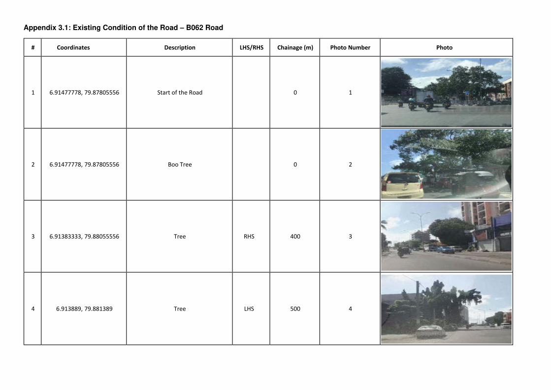
Appendix 3.1: Existing Condition of the Road – B062 Road
# Coordinates Description LHS/RHS Chainage (m) Photo Number Photo
1 6.91477778, 79.87805556 Start of the Road 0 1
2 6.91477778, 79.87805556 Boo Tree 0 2
3 6.91383333, 79.88055556 Tree RHS 400 3
4 6.913889, 79.881389 Tree LHS 500 4
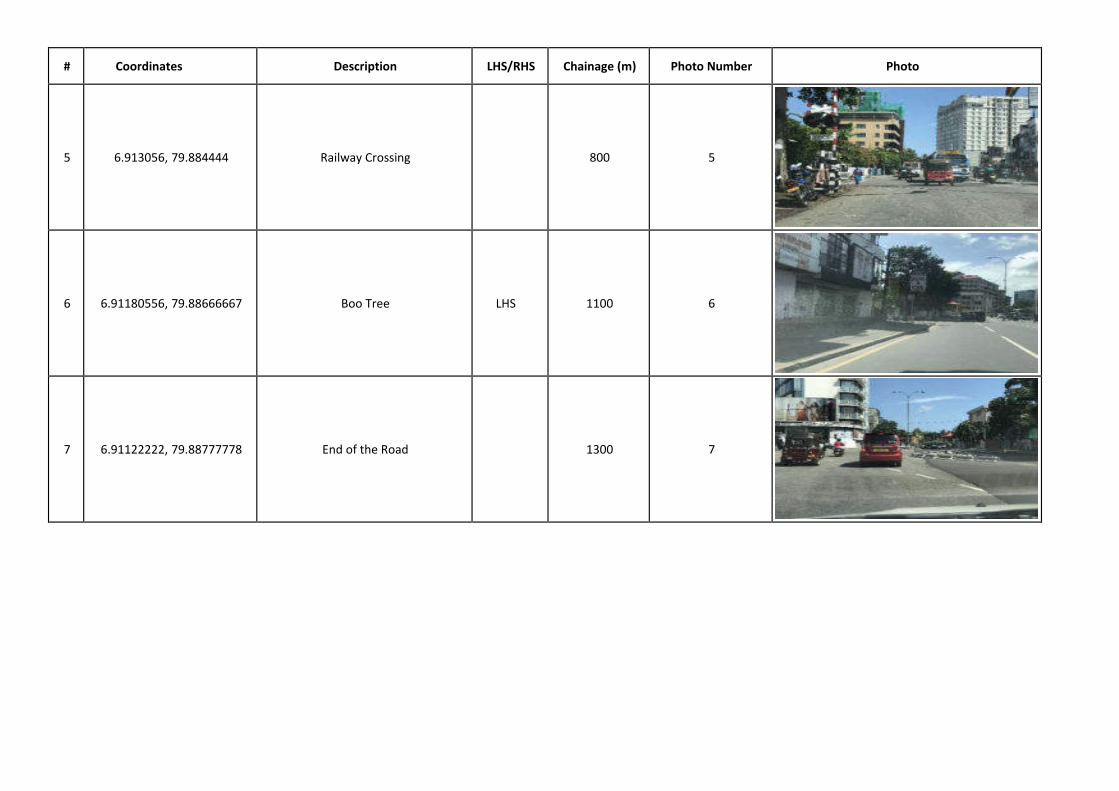
# Coordinates Description LHS/RHS Chainage (m) Photo Number Photo
5 6.913056, 79.884444 Railway Crossing 800 5
6 6.91180556, 79.88666667 Boo Tree LHS 1100 6
7 6.91122222, 79.88777778 End of the Road 1300 7
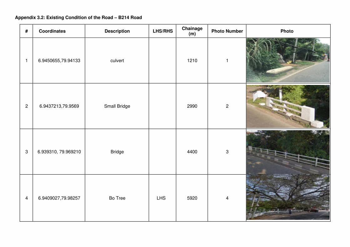
Appendix 3.2: Existing Condition of the Road – B214 Road
# Coordinates Description LHS/RHS Chainage
(m) Photo Number Photo
1 6.9450655,79.94133 culvert 1210 1
2 6.9437213,79.9569 Small Bridge 2990 2
3 6.939310, 79.969210 Bridge 4400 3
4 6.9409027,79.98257 Bo Tree LHS 5920 4
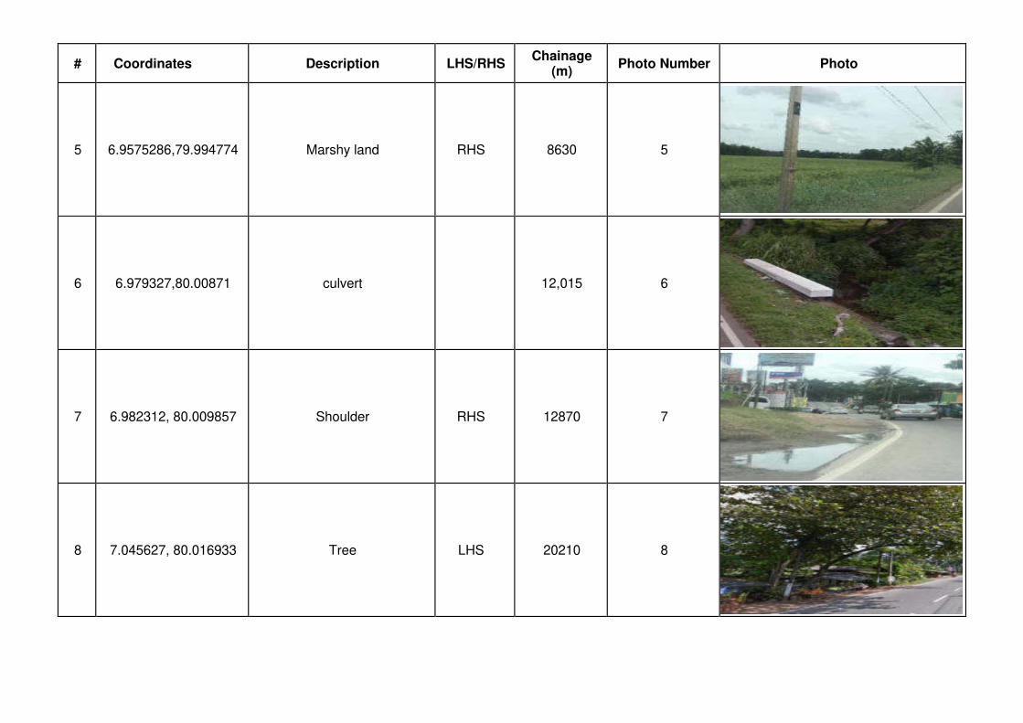
# Coordinates Description LHS/RHS Chainage
(m) Photo Number Photo
5 6.9575286,79.994774 Marshy land RHS 8630 5
6 6.979327,80.00871 culvert 12,015 6
7 6.982312, 80.009857 Shoulder RHS 12870 7
8 7.045627, 80.016933 Tree LHS 20210 8

# Coordinates Description LHS/RHS Chainage
(m) Photo Number Photo
9 7.055841, 80.016036 Culvert 20940 9
10 7.062618, 80.014114 Culvert 21460 10
11 7.0664473,80.01272 Bridge 22990 11
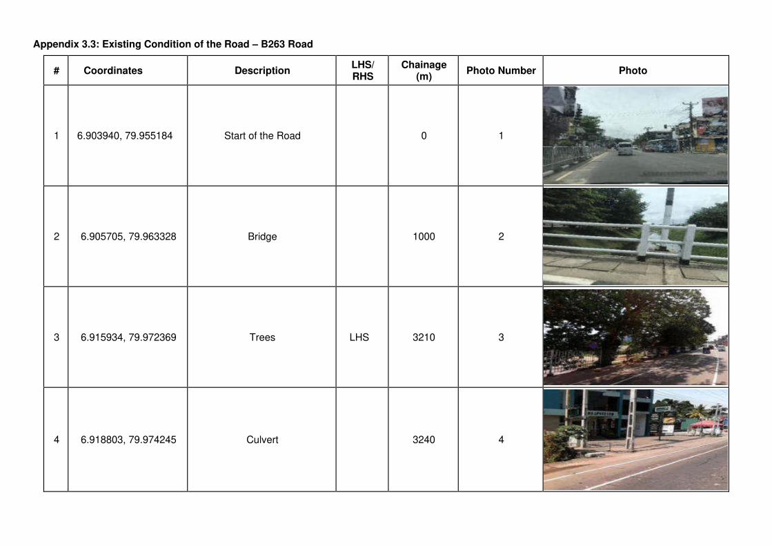
Appendix 3.3: Existing Condition of the Road – B263 Road
# Coordinates Description LHS/ RHS
Chainage (m)
Photo Number Photo
1
6.903940, 79.955184
Start of the Road 0 1
2 6.905705, 79.963328 Bridge 1000 2
3 6.915934, 79.972369 Trees LHS 3210 3
4 6.918803, 79.974245 Culvert 3240 4

# Coordinates Description LHS/ RHS
Chainage (m)
Photo Number Photo
5 6.932750, 79.982444 Drain Culvert 5100 5
6 6.930473, 79.982494 Drain LHS 5230 6
7 6.935661, 79.984197 End of the Road 5630 7

Appendix 3.4: Existing Condition of the Road – B345 Road
# Coordinates Description LHS/ RHS
Chainage (m)
Photo Number Photo
1 6.875852,79.89219 Start of the Road 0 1
2 6.8769464,79.892746 Junction LHS 0.2km 2
3 6.381889, 79.896944 Culvert 0.9km 3
4 6.884056, 79.901056 Culvert 1.5km 4
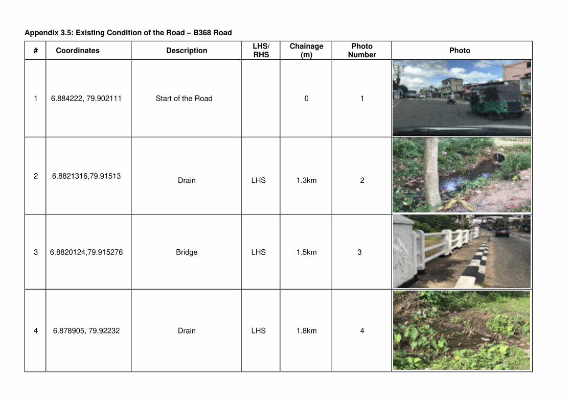
Appendix 3.5: Existing Condition of the Road – B368 Road
# Coordinates Description LHS/ RHS
Chainage (m)
Photo Number
Photo
1 6.884222, 79.902111 Start of the Road 0 1
2 6.8821316,79.91513
Drain
LHS
1.3km 2
3 6.8820124,79.915276 Bridge LHS 1.5km 3
4 6.878905, 79.92232 Drain LHS 1.8km 4
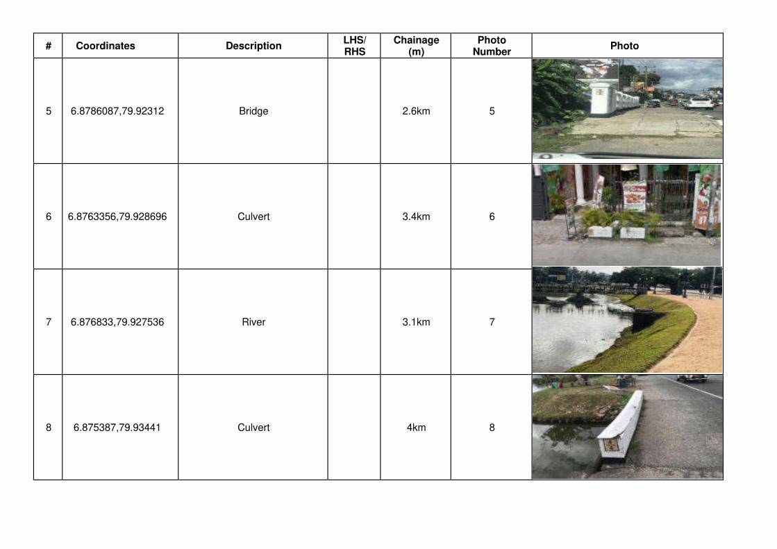
# Coordinates Description LHS/ RHS
Chainage (m)
Photo Number
Photo
5 6.8786087,79.92312 Bridge 2.6km 5
6 6.8763356,79.928696 Culvert 3.4km 6
7 6.876833,79.927536 River 3.1km 7
8 6.875387,79.93441 Culvert 4km 8
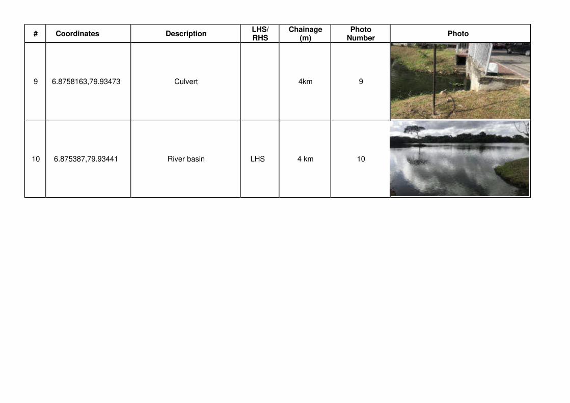
# Coordinates Description LHS/ RHS
Chainage (m)
Photo Number
Photo
9 6.8758163,79.93473 Culvert 4km 9
10 6.875387,79.93441 River basin LHS 4 km 10
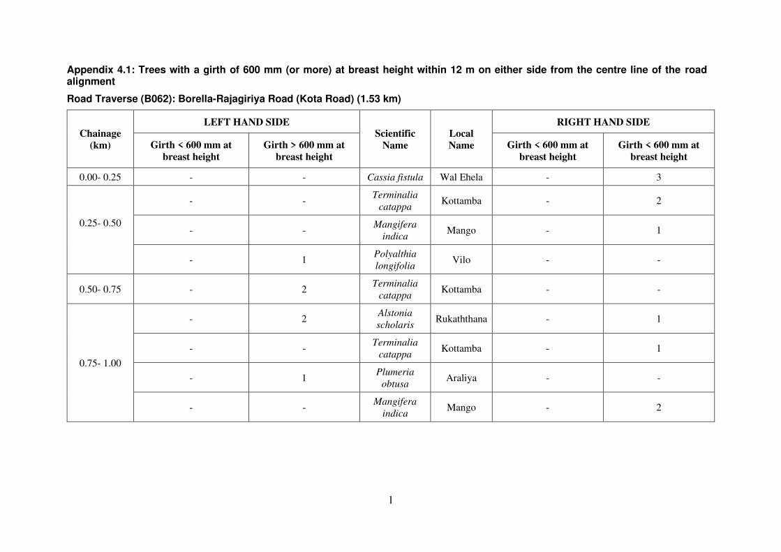
1
Appendix 4.1: Trees with a girth of 600 mm (or more) at breast height within 12 m on either side from the centre line of the road alignment
Road Traverse (B062): Borella-Rajagiriya Road (Kota Road) (1.53 km)
Chainage
(km)
LEFT HAND SIDE Scientific
Name
Local
Name
RIGHT HAND SIDE
Girth < 600 mm at
breast height
Girth > 600 mm at
breast height
Girth < 600 mm at
breast height
Girth < 600 mm at
breast height
0.00- 0.25 - - Cassia fistula Wal Ehela - 3
0.25- 0.50
- - Terminalia
catappa Kottamba - 2
- - Mangifera
indica Mango - 1
- 1 Polyalthia
longifolia Vilo - -
0.50- 0.75 - 2 Terminalia
catappa Kottamba - -
0.75- 1.00
- 2 Alstonia
scholaris Rukaththana - 1
- - Terminalia
catappa Kottamba - 1
- 1 Plumeria
obtusa Araliya - -
- - Mangifera
indica Mango - 2
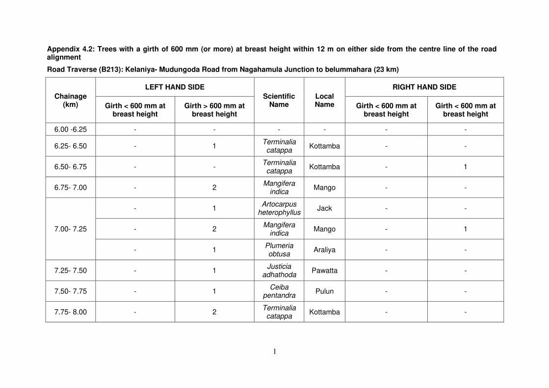
1
Appendix 4.2: Trees with a girth of 600 mm (or more) at breast height within 12 m on either side from the centre line of the road alignment
Road Traverse (B213): Kelaniya- Mudungoda Road from Nagahamula Junction to belummahara (23 km)
Chainage (km)
LEFT HAND SIDE
Scientific Name
Local Name
RIGHT HAND SIDE
Girth < 600 mm at breast height
Girth > 600 mm at breast height
Girth < 600 mm at breast height
Girth < 600 mm at breast height
6.00 -6.25 - - - - - -
6.25- 6.50 - 1 Terminalia catappa
Kottamba - -
6.50- 6.75 - - Terminalia catappa
Kottamba - 1
6.75- 7.00 - 2 Mangifera
indica Mango - -
7.00- 7.25
- 1 Artocarpus
heterophyllus Jack - -
- 2 Mangifera
indica Mango - 1
- 1 Plumeria obtusa
Araliya - -
7.25- 7.50 - 1 Justicia
adhathoda Pawatta - -
7.50- 7.75 - 1 Ceiba
pentandra Pulun - -
7.75- 8.00 - 2 Terminalia catappa
Kottamba - -

2
- 1 Alstonia scholaris
Ruk attana
- -
- 1 Peltophorum pterocarpum
Kaha maara
- -
8.00- 8.25 - - - - - -
8.25- 8.50
- 1 Nephelium lappaceum
Rambutan - -
- 1 Filicium
decipiens Pihimbiya - -
8.50- 8.75 - - - - - -
8.75- 9.00 - - - - - -
9.00- 9.25
- 1 Mangifera
indica Mango - -
- 1 Vitex
negundo Nika - -
- 1 Terminalia catappa
Kottamba - -
9.25- 9.50
- 3 Terminalia
arjuna Kumbuk - -
- - Muntingia calabura
Jam - 1
- 4 Mangifera
indica Mango - -
9.50- 9.75 - - - - - -
9.75- 10.00
- 1 Terminalia catappa
Kottamba - -
- - Mangifera
indica Mango - 1
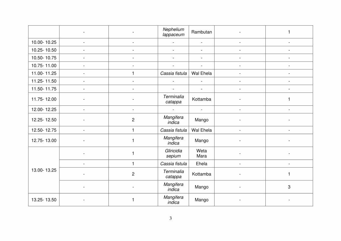
3
- - Nephelium lappaceum
Rambutan - 1
10.00- 10.25 - - - - - -
10.25- 10.50 - - - - - -
10.50- 10.75 - - - - - -
10.75- 11.00 - - - - - -
11.00- 11.25 - 1 Cassia fistula Wal Ehela - -
11.25- 11.50 - - - - - -
11.50- 11.75 - - - - - -
11.75- 12.00 - - Terminalia catappa
Kottamba - 1
12.00- 12.25 - - - - - -
12.25- 12.50 - 2 Mangifera
indica Mango - -
12.50- 12.75 - 1 Cassia fistula Wal Ehela - -
12.75- 13.00 - 1 Mangifera
indica Mango - -
13.00- 13.25
- 1 Gliricidia sepium
Weta Mara
- -
- 1 Cassia fistula Ehela - -
- 2 Terminalia catappa
Kottamba - 1
- - Mangifera
indica Mango - 3
13.25- 13.50 - 1 Mangifera
indica Mango - -

4
- 1 Sterculia foetida
Thelambu - -
- 1 Terminalia catappa
Kottamba - -
- 1 - Unknown
tree - -
13.50- 13.75 - - - - - -
13.75- 14.00 - - - - - -
14.00- 14.25 - - - - - -
14.25- 14.50
- 2 Cocos
nucifera Coconut - -
- 5 Cassia fistula Wal Ehela - -
- 3 Melia
azedarach Lunu
Midella - -
- 1 Mangifera
indica Mango - -
- 2 Ceiba
pentandra Kotta - -
- 1 Persea
americana Avacado - -
14.50- 14.75
- 2 Peltophorum pterocarpum
Kaha Maara
- -
- 2 Terminalia catappa
Kottamba - -
- 2 Cassia fistula Ehela - -
14.75- 15.00 - 1 Artocarpus
heterophyllus Jack - -

5
15.00- 15.25
- 8 Cassia fistula Ehela - -
- - Terminalia catappa
Kottamba - 1
- 2 Alstonia scholaris
Ruk Attana
- -
15.25- 15.50
- - Plumeria obtusa
Araliya - 1
- - Terminalia catappa
Kottamba - 1
- - Terminalia
arjuna Kumbuk - 4
- - Cassia fistula Ehela - 1
15.50- 15.75
- 1 Ceiba
pentandra Kotta Pulun
- -
- 1 Mangifera
indica Mango - -
15.75- 16.00
1 1 Mangifera
indica Mango - -
- 2 Cassia fistula Wal Ehela - -
- 1 Terminalia catappa
Kottamba - -
16.00- 16.25 - 1 Mangifera
indica Mango - -
16.25- 16.50 - - - - - -
16.50- 16.75
- 3 Mangifera
indica Mango - -
- 1 - Unknown
tree - -
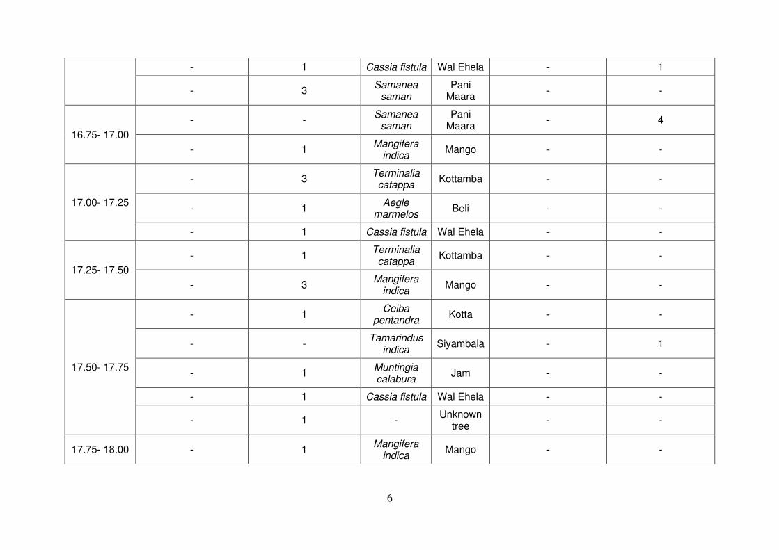
6
- 1 Cassia fistula Wal Ehela - 1
- 3 Samanea
saman Pani
Maara - -
16.75- 17.00
- - Samanea
saman Pani
Maara - 4
- 1 Mangifera
indica Mango - -
17.00- 17.25
- 3 Terminalia catappa
Kottamba - -
- 1 Aegle
marmelos Beli - -
- 1 Cassia fistula Wal Ehela - -
17.25- 17.50
- 1 Terminalia catappa
Kottamba - -
- 3 Mangifera
indica Mango - -
17.50- 17.75
- 1 Ceiba
pentandra Kotta - -
- - Tamarindus
indica Siyambala - 1
- 1 Muntingia calabura
Jam - -
- 1 Cassia fistula Wal Ehela - -
- 1 - Unknown
tree - -
17.75- 18.00 - 1 Mangifera
indica Mango - -
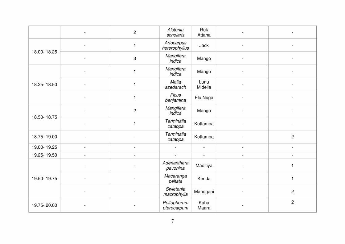
7
- 2 Alstonia scholaris
Ruk Attana
- -
18.00- 18.25
- 1 Artocarpus
heterophyllus Jack - -
- 3 Mangifera
indica Mango - -
18.25- 18.50
- 1 Mangifera
indica Mango - -
- 1 Melia
azedarach Lunu
Midella - -
- 1 Ficus
benjamina Elu Nuga - -
18.50- 18.75
- 2 Mangifera
indica Mango - -
- 1 Terminalia catappa
Kottamba - -
18.75- 19.00 - - Terminalia catappa
Kottamba - 2
19.00- 19.25 - - - - - -
19.25- 19.50 - - - - - -
19.50- 19.75
- - Adenanthera
pavonina Maditiya - 1
- - Macaranga
peltata Kenda - 1
- - Swietenia
macrophylla Mahogani - 2
19.75- 20.00 - - Peltophorum pterocarpum
Kaha Maara
- 2

8
20.00- 20.25
- - Terminalia catappa
Kottamba - 2
- - Mangifera
indica Mango - 2
20.25- 20.50
- - Polyalthia longifolia
Vilo - 1
- 1 - Unknown
tree - -
- - Mangifera
indica Mango - 1
20.50- 20.75 - 1 Mangifera
indica Mango - -
20.75- 21.00 - - - - - -
21.00- 21.25 - - - -
21.25- 21.50 - - - - - -
21.50- 21.75 - - Filicium
decipiens pihimbiya - 1
21.75- 22.00 - - - - - -
22.00- 22.25 - - Bridelia retusa
Keta Kala - 1
22.25- 22.50
- - Bambusa vulgaris
Una/bamboo
- 1
- - Mangifera
indica Mango - 1
22.50- 22.75 - - Alstonia scholaris
Ruk Attana
- 1
22.75- 23.00 - - Muntingia calabura
Jaam - 1
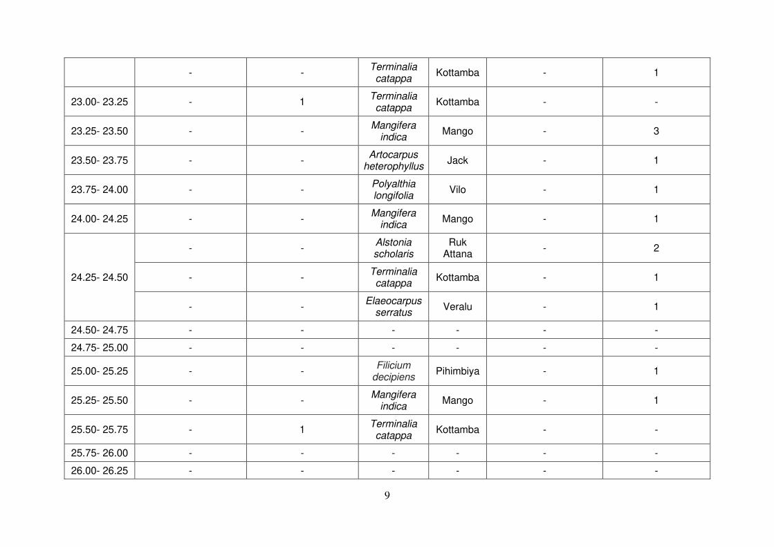
9
- - Terminalia catappa
Kottamba - 1
23.00- 23.25 - 1 Terminalia catappa
Kottamba - -
23.25- 23.50 - - Mangifera
indica Mango - 3
23.50- 23.75 - - Artocarpus
heterophyllus Jack - 1
23.75- 24.00 - - Polyalthia longifolia
Vilo - 1
24.00- 24.25 - - Mangifera
indica Mango - 1
24.25- 24.50
- - Alstonia scholaris
Ruk Attana
- 2
- - Terminalia catappa
Kottamba - 1
- - Elaeocarpus
serratus Veralu - 1
24.50- 24.75 - - - - - -
24.75- 25.00 - - - - - -
25.00- 25.25 - - Filicium
decipiens Pihimbiya - 1
25.25- 25.50 - - Mangifera
indica Mango - 1
25.50- 25.75 - 1 Terminalia catappa
Kottamba - -
25.75- 26.00 - - - - - -
26.00- 26.25 - - - - - -
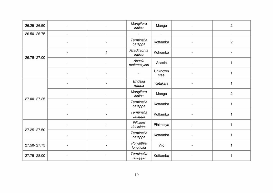
10
26.25- 26.50 - - Mangifera
indica Mango - 2
26.50- 26.75 - - - - - -
26.75- 27.00
- - Terminalia catappa
Kottamba - 2
- 1 Azadirachta
indica Kohomba - -
- - Acacia
melanoxylon Acasia - 1
- - - Unknown
tree - 1
27.00- 27.25
- - Bridelia retusa
Ketakala - 1
- - Mangifera
indica Mango - 2
- - Terminalia catappa
Kottamba - 1
- - Terminalia catappa
Kottamba - 1
27.25- 27.50
- - Filicium
decipiens Pihimbiya - 1
- - Terminalia catappa
Kottamba - 1
27.50- 27.75 - - Polyalthia longifolia
Vilo - 1
27.75- 28.00 - - Terminalia catappa
Kottamba - 1
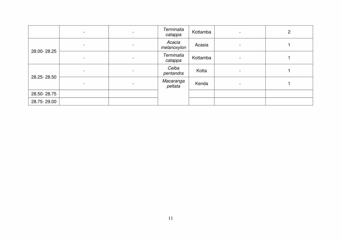
11
- - Terminalia catappa
Kottamba - 2
28.00- 28.25
- - Acacia
melanoxylon Acasia - 1
- - Terminalia catappa
Kottamba - 1
28.25- 28.50
- - Ceiba
pentandra Kotta - 1
- - Macaranga
peltata Kenda - 1
28.50- 28.75
28.75- 29.00

1
Appendix 4.3: Trees with a girth of 600 mm (or more) at breast height within 12 m on either side from the centre line of the road alignment
Road Traverse (B263): Malabe Kaduwela Road (5.63 km)
Chainage (km)
LEFT HAND SIDE Scientific
Name Local Name
RIGHT HAND SIDE
Girth < 600 mm at breast height
Girth > 600 mm at breast height
Girth < 600 mm at breast height
Girth < 600 mm at breast height
0.00- 0.25 - 1 Mangifera
indica Mango - -
0.25- 0.50 - - - - - -
0.50- 0.75 - - - - - -
0.75- 1.00 - - - - - -
1.00- 1.25 - - Terminalia catappa
Kottamba - 1
1.25- 1.50 - - - - - -
1.50- 1.75 - - - - - -
1.75- 2.00 - - - - - -
2.00- 2.25 - 1 Terminalia catappa
Kottamba - -
2.25- 2.50 - - - - - -
2.50- 2.75 - - - - - -
2.75- 3.00 - - - - - -
3.00- 3.25 - - - - - -
3.25- 3.50 - - - - - -
3.50- 3.75 - - - - - -
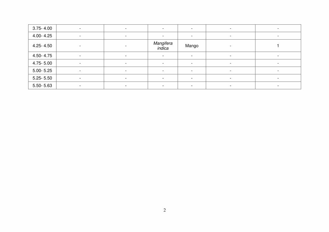
2
3.75- 4.00 - - - - - -
4.00- 4.25 - - - - - -
4.25- 4.50 - - Mangifera
indica Mango - 1
4.50- 4.75 - - - - - -
4.75- 5.00 - - - - - -
5.00- 5.25 - - - - - -
5.25- 5.50 - - - - - -
5.50- 5.63 - - - - - -
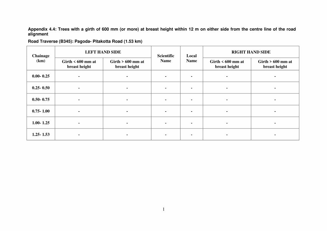
1
Appendix 4.4: Trees with a girth of 600 mm (or more) at breast height within 12 m on either side from the centre line of the road alignment
Road Traverse (B345): Pagoda- Pitakotta Road (1.53 km)
Chainage
(km)
LEFT HAND SIDE Scientific
Name
Local
Name
RIGHT HAND SIDE
Girth < 600 mm at
breast height
Girth > 600 mm at
breast height
Girth < 600 mm at
breast height
Girth > 600 mm at
breast height
0.00- 0.25 - - - - - -
0.25- 0.50 - - - - - -
0.50- 0.75 - - - - - -
0.75- 1.00 - - - - - -
1.00- 1.25 - - - - - -
1.25- 1.53 - - - - - -

1
Appendix 4.5: Trees with a girth of 600 mm (or more) at breast height within 12 m on either side from the centre line of the road alignment
Road Traverse (B368): Pitakotte-Thalawathugoda Road (4.10 km)
Chainage (km)
LEFT HAND SIDE
Scientific Name
Local Name
RIGHT HAND SIDE
Girth < 600 mm at breast height
Girth > 600 mm at breast height
Girth < 600 mm at breast height
Girth < 600 mm at breast height
0.00- 0.25 - - - - - -
0.25- 0.50 2 - Psidium guajava
Pera - -
0.50- 0.75 - 1 Terminalia catappa
Kottamba - -
0.75- 1.00 - 1 Terminalia catappa
Kottamba - -
1.00- 1.25 1 - Psidium guajava
Pera - -
1.25- 1.50
- 2 Terminalia catappa
Kottamba - -
- 1 Macaranga
peltata Kenda - -
1.50- 1.75
- 2 Terminalia catappa
Kottamba - -
- 1 Leucaena
leucocephala Ipil - -
1.75- 2.00
- - Filicium
decipiens Pihimbiya - 2
- 3 Terminalia catappa
Kottmba - -
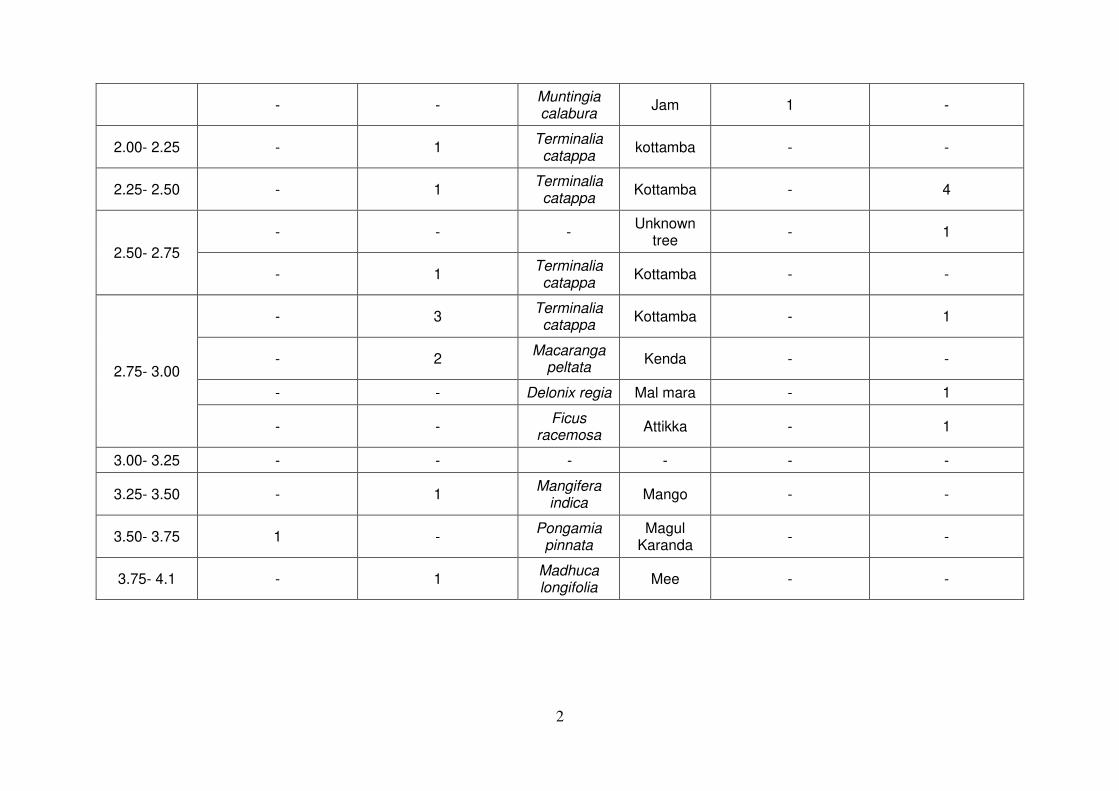
2
- - Muntingia calabura
Jam 1 -
2.00- 2.25 - 1 Terminalia catappa
kottamba - -
2.25- 2.50 - 1 Terminalia catappa
Kottamba - 4
2.50- 2.75
- - - Unknown
tree - 1
- 1 Terminalia catappa
Kottamba - -
2.75- 3.00
- 3 Terminalia catappa
Kottamba - 1
- 2 Macaranga
peltata Kenda - -
- - Delonix regia Mal mara - 1
- - Ficus
racemosa Attikka - 1
3.00- 3.25 - - - - - -
3.25- 3.50 - 1 Mangifera
indica Mango - -
3.50- 3.75 1 - Pongamia
pinnata Magul
Karanda - -
3.75- 4.1 - 1 Madhuca longifolia
Mee - -

Appendix 5.1: Utility structures within 2 m on either side from the existing ROW
Road Traverse: B062 - Borella Rajagiriya Road (Kota Road)
Left
Chainage (km)
Right
No of Telephone poles
No of Electric poles
No of Telephone poles
No of Electric poles
3 2 0+000 - 0+200 3
1 5 0+200 - 0+400 4
4 6 0+400 - 0+600 6
2 6 0+600 - 0+800 7
2 8 0+800 - 1+000 6
2 5 1+000 - 1+200 9
1 4 1+200 - 1+400 4
1 5 1+400 - 1+600 2
4 6 1+600 - 1+800 1
2 6 1+800 - 2+000 3
2 3 2+000 - 2+200 1
24 56 Total 46
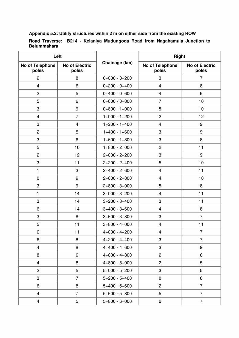
Appendix 5.2: Utility structures within 2 m on either side from the existing ROW
Road Traverse: B214 - Kelaniya Mudungoda Road from Nagahamula Junction to Belummahara
Left
Chainage (km)
Right
No of Telephone poles
No of Electric poles
No of Telephone poles
No of Electric poles
2 8 0+000 - 0+200 3 7
4 6 0+200 - 0+400 4 8
2 5 0+400 - 0+600 4 6
5 6 0+600 - 0+800 7 10
3 9 0+800 - 1+000 5 10
4 7 1+000 - 1+200 2 12
3 4 1+200 - 1+400 4 9
2 5 1+400 - 1+600 3 9
3 6 1+600 - 1+800 3 8
5 10 1+800 - 2+000 2 11
2 12 2+000 - 2+200 3 9
3 11 2+200 - 2+400 5 10
1 3 2+400 - 2+600 4 11
0 9 2+600 - 2+800 4 10
3 9 2+800 - 3+000 5 8
1 14 3+000 - 3+200 4 11
3 14 3+200 - 3+400 3 11
6 14 3+400 - 3+600 4 8
3 8 3+600 - 3+800 3 7
5 11 3+800 - 4+000 4 11
6 11 4+000 - 4+200 4 7
6 8 4+200 - 4+400 3 7
4 8 4+400 - 4+600 3 9
8 6 4+600 - 4+800 2 6
4 8 4+800 - 5+000 2 5
2 5 5+000 - 5+200 3 5
3 7 5+200 - 5+400 0 6
6 8 5+400 - 5+600 2 7
4 7 5+600 - 5+800 5 7
4 5 5+800 - 6+000 2 7

Left
Chainage (km)
Right
No of Telephone poles
No of Electric poles
No of Telephone poles
No of Electric poles
4 9 6+000 - 6+200 2 9
6 11 6+200 - 6+400 3 14
6 12 6+400 - 6+600 0 5
5 14 6+600 - 6+800 6 6
7 14 6+800 - 7+000 6 7
5 9 7+000 - 7+200 6 5
6 7 7+200 - 7+400 2 8
5 8 7+400 - 7+600 3 10
5 9 7+600 - 7+800 1 8
4 12 7+800 - 8+000 3 11
3 6 8+000 - 8+200 2 6
4 11 8+200 - 8+400 3 10
2 11 8+400 - 8+600 3 7
2 7 8+600 - 8+800 2 10
0 9 8+800 - 9+000 0 6
3 11 9+000 - 9+200 3 8
2 4 9+200 - 9+400 6 5
0 6 9+400 - 9+600 3 7
2 6 9+600 - 9+800 4 7
3 9 9+800 - 10+000 3 8
4 11 10+000 - 10+200 6 11
3 11 10+200 - 10+400 3 8
5 10 10+400 - 10+600 3 7
2 7 10+600 - 10+800 2 2
0 5 10+800 - 11+000 0 5
3 7 11+000 - 11+200 2 6
4 9 11+200 - 11+400 4 6
6 9 11+400 - 11+600 4 11
5 10 11+600 - 11+800 1 6
2 6 11+800 - 12+000 2 5
3 11 12+000 - 12+200 2 8
4 9 12+200 - 12+400 5 8
3 5 12+400 - 12+600 3 7
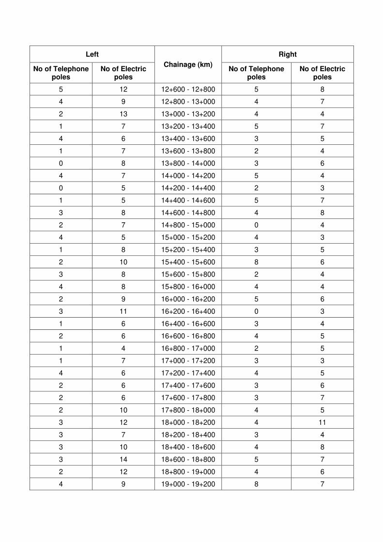
Left
Chainage (km)
Right
No of Telephone poles
No of Electric poles
No of Telephone poles
No of Electric poles
5 12 12+600 - 12+800 5 8
4 9 12+800 - 13+000 4 7
2 13 13+000 - 13+200 4 4
1 7 13+200 - 13+400 5 7
4 6 13+400 - 13+600 3 5
1 7 13+600 - 13+800 2 4
0 8 13+800 - 14+000 3 6
4 7 14+000 - 14+200 5 4
0 5 14+200 - 14+400 2 3
1 5 14+400 - 14+600 5 7
3 8 14+600 - 14+800 4 8
2 7 14+800 - 15+000 0 4
4 5 15+000 - 15+200 4 3
1 8 15+200 - 15+400 3 5
2 10 15+400 - 15+600 8 6
3 8 15+600 - 15+800 2 4
4 8 15+800 - 16+000 4 4
2 9 16+000 - 16+200 5 6
3 11 16+200 - 16+400 0 3
1 6 16+400 - 16+600 3 4
2 6 16+600 - 16+800 4 5
1 4 16+800 - 17+000 2 5
1 7 17+000 - 17+200 3 3
4 6 17+200 - 17+400 4 5
2 6 17+400 - 17+600 3 6
2 6 17+600 - 17+800 3 7
2 10 17+800 - 18+000 4 5
3 12 18+000 - 18+200 4 11
3 7 18+200 - 18+400 3 4
3 10 18+400 - 18+600 4 8
3 14 18+600 - 18+800 5 7
2 12 18+800 - 19+000 4 6
4 9 19+000 - 19+200 8 7

Left
Chainage (km)
Right
No of Telephone poles
No of Electric poles
No of Telephone poles
No of Electric poles
0 7 19+200 - 19+400 8 4
2 10 19+400 - 19+600 6 8
4 12 19+600 - 19+800 7 12
3 6 19+800 - 20+000 6 6
1 10 20+000 - 20+200 7 10
2 9 20+200 - 20+400 7 7
2 5 20+400 - 20+600 5 6
2 7 20+600 - 20+800 7 5
3 5 20+800 - 21+000 5 7
3 7 21+000 - 21+200 6 7
3 6 21+200 - 21+400 8 8
1 6 21+400 - 21+600 5 6
2 8 21+600 - 21+800 5 8
3 8 21+800 - 22+000 4 5
2 7 22+000 - 22+200 2 7
3 7 22+200 - 22+400 6 7
2 5 22+400 - 22+600 3 8
1 11 22+600 - 22+800 5 9
3 8 22+800 - 23+000 5 9
346 951 Total 429 819

Appendix 5.3: Utility structures within 2 m on either side from the existing ROW
Road Traverse: B263 - Malabe Kaduwela Road
Left
Chainage (km)
Right
No of Telephone poles
No of Electric poles
No of Telephone poles
No of Electric poles
1 3 0+000 - 0+200 1 5
5 9 0+200 - 0+400 4 11
2 9 0+400 - 0+600 5 9
3 5 0+600 - 0+800 6 10
4 11 0+800 - 1+000 5 9
4 11 1+000 - 1+200 5 9
2 6 1+200 - 1+400 4 8
5 12 1+400 - 1+600 4 8
3 2 1+600 - 1+800 4 7
8 13 1+800 - 2+000 5 8
7 9 2+000 - 2+200 4 10
4 10 2+200 - 2+400 6 7
3 8 2+400 - 2+600 3 9
6 7 2+600 - 2+800 4 8
2 3 2+800 - 3+000 5 9
4 4 3+000 - 3+200 6 6
6 9 3+200 - 3+400 4 7
5 13 3+400 - 3+600 3 8
4 7 3+600 - 3+800 3 9
6 9 3+800 - 4+000 4 6
3 6 4+000 - 4+200 4 8
7 7 4+200 - 4+400 5 10
5 6 4+400 - 4+600 6 10
5 6 4+600 - 4+800 1 7
6 9 4+800 - 5+000 5 10
6 9 5+000 - 5+200 4 8
5 6 5+200 - 5+400 5 4
3 5 5+400 - 5+600 4 7
1 4 5+600 - 5+800 1 3
125 218 Total 120 230

Appendix 5.4: Utility structures within 2 m on either side from the existing ROW
Road Traverse: B345 - Pagoda Pitakotta Road
Left
Chainage (km)
Right
No of Telephone
poles
No of Electric poles
No of Telephone poles
No of Electric poles
4 12 0+000 - 0+200 1 8
6 9 0+200 - 0+400 4 8
4 8 0+400 - 0+600 2 5
6 9 0+600 - 0+800 3 7
3 10 0+800 - 1+000 4 7
4 6 1+000 - 1+200 3 6
2 5 1+200 - 1+400 6 4
3 10 1+400 - 1+600 3 6
32 69 Total 26 51
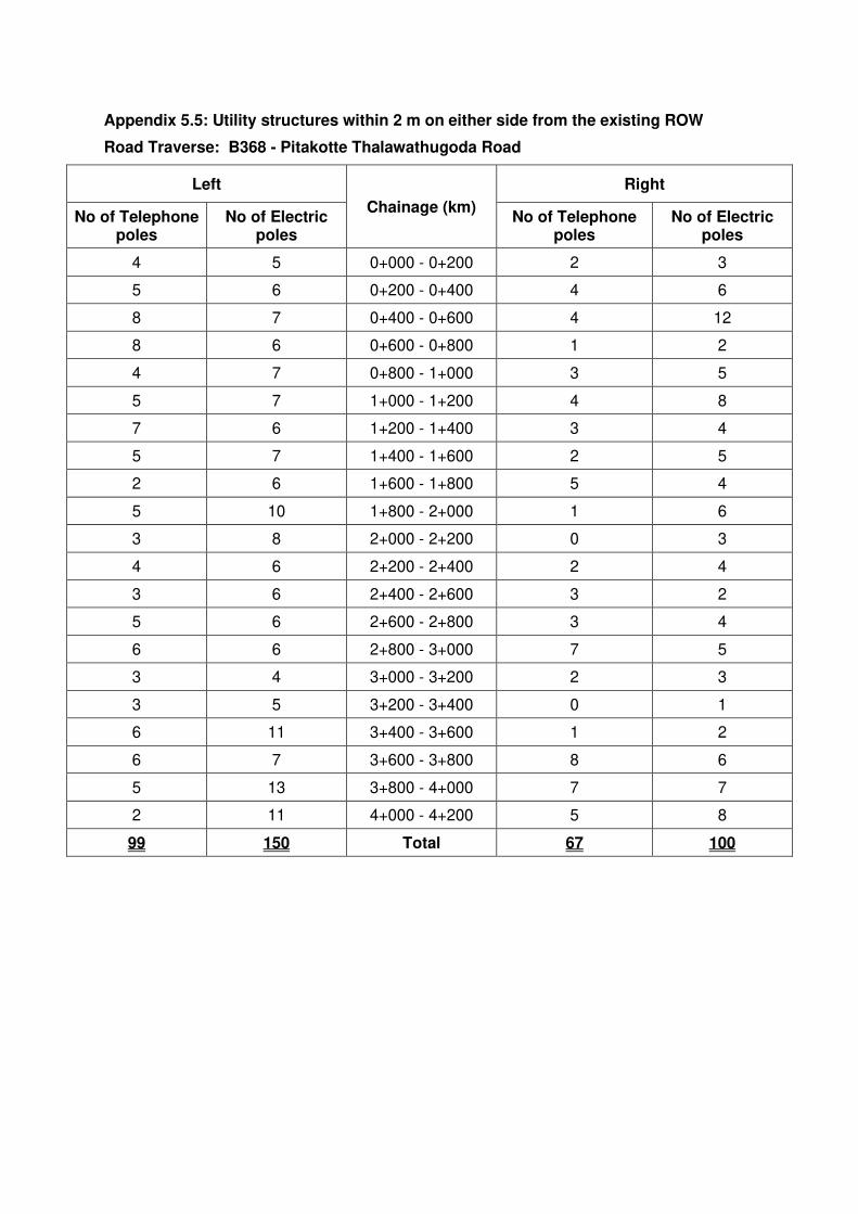
Appendix 5.5: Utility structures within 2 m on either side from the existing ROW
Road Traverse: B368 - Pitakotte Thalawathugoda Road
Left
Chainage (km)
Right
No of Telephone poles
No of Electric poles
No of Telephone poles
No of Electric poles
4 5 0+000 - 0+200 2 3
5 6 0+200 - 0+400 4 6
8 7 0+400 - 0+600 4 12
8 6 0+600 - 0+800 1 2
4 7 0+800 - 1+000 3 5
5 7 1+000 - 1+200 4 8
7 6 1+200 - 1+400 3 4
5 7 1+400 - 1+600 2 5
2 6 1+600 - 1+800 5 4
5 10 1+800 - 2+000 1 6
3 8 2+000 - 2+200 0 3
4 6 2+200 - 2+400 2 4
3 6 2+400 - 2+600 3 2
5 6 2+600 - 2+800 3 4
6 6 2+800 - 3+000 7 5
3 4 3+000 - 3+200 2 3
3 5 3+200 - 3+400 0 1
6 11 3+400 - 3+600 1 2
6 7 3+600 - 3+800 8 6
5 13 3+800 - 4+000 7 7
2 11 4+000 - 4+200 5 8
99 150 Total 67 100
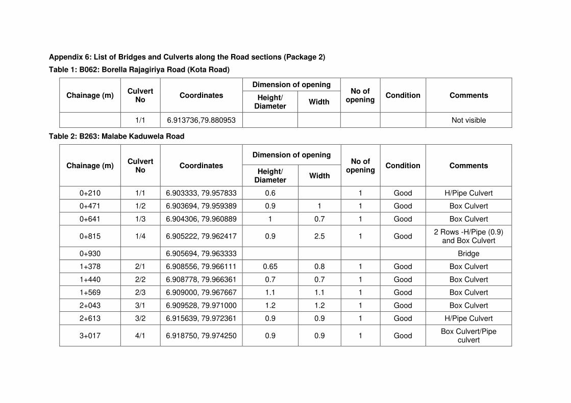
Appendix 6: List of Bridges and Culverts along the Road sections (Package 2)
Table 1: B062: Borella Rajagiriya Road (Kota Road)
Chainage (m) Culvert
No Coordinates
Dimension of opening No of
opening Condition Comments Height/
Diameter Width
1/1 6.913736,79.880953 Not visible
Table 2: B263: Malabe Kaduwela Road
Chainage (m) Culvert
No Coordinates
Dimension of opening No of
opening Condition Comments
Height/ Diameter
Width
0+210 1/1 6.903333, 79.957833 0.6 1 Good H/Pipe Culvert
0+471 1/2 6.903694, 79.959389 0.9 1 1 Good Box Culvert
0+641 1/3 6.904306, 79.960889 1 0.7 1 Good Box Culvert
0+815 1/4 6.905222, 79.962417 0.9 2.5 1 Good 2 Rows -H/Pipe (0.9)
and Box Culvert
0+930 6.905694, 79.963333 Bridge
1+378 2/1 6.908556, 79.966111 0.65 0.8 1 Good Box Culvert
1+440 2/2 6.908778, 79.966361 0.7 0.7 1 Good Box Culvert
1+569 2/3 6.909000, 79.967667 1.1 1.1 1 Good Box Culvert
2+043 3/1 6.909528, 79.971000 1.2 1.2 1 Good Box Culvert
2+613 3/2 6.915639, 79.972361 0.9 0.9 1 Good H/Pipe Culvert
3+017 4/1 6.918750, 79.974250 0.9 0.9 1 Good Box Culvert/Pipe
culvert
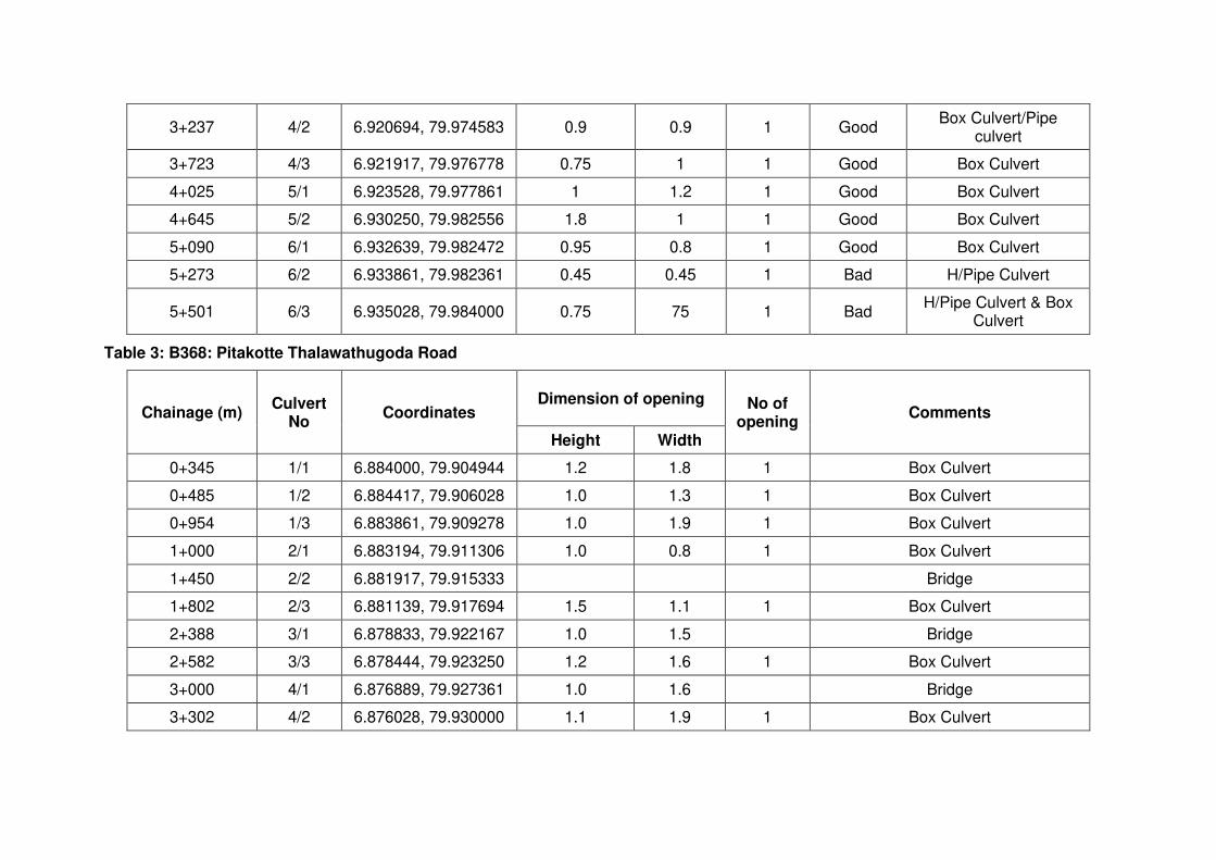
3+237 4/2 6.920694, 79.974583 0.9 0.9 1 Good Box Culvert/Pipe
culvert
3+723 4/3 6.921917, 79.976778 0.75 1 1 Good Box Culvert
4+025 5/1 6.923528, 79.977861 1 1.2 1 Good Box Culvert
4+645 5/2 6.930250, 79.982556 1.8 1 1 Good Box Culvert
5+090 6/1 6.932639, 79.982472 0.95 0.8 1 Good Box Culvert
5+273 6/2 6.933861, 79.982361 0.45 0.45 1 Bad H/Pipe Culvert
5+501 6/3 6.935028, 79.984000 0.75 75 1 Bad H/Pipe Culvert & Box
Culvert
Table 3: B368: Pitakotte Thalawathugoda Road
Chainage (m) Culvert
No Coordinates
Dimension of opening No of opening
Comments
Height Width
0+345 1/1 6.884000, 79.904944 1.2 1.8 1 Box Culvert
0+485 1/2 6.884417, 79.906028 1.0 1.3 1 Box Culvert
0+954 1/3 6.883861, 79.909278 1.0 1.9 1 Box Culvert
1+000 2/1 6.883194, 79.911306 1.0 0.8 1 Box Culvert
1+450 2/2 6.881917, 79.915333 Bridge
1+802 2/3 6.881139, 79.917694 1.5 1.1 1 Box Culvert
2+388 3/1 6.878833, 79.922167 1.0 1.5 Bridge
2+582 3/3 6.878444, 79.923250 1.2 1.6 1 Box Culvert
3+000 4/1 6.876889, 79.927361 1.0 1.6 Bridge
3+302 4/2 6.876028, 79.930000 1.1 1.9 1 Box Culvert
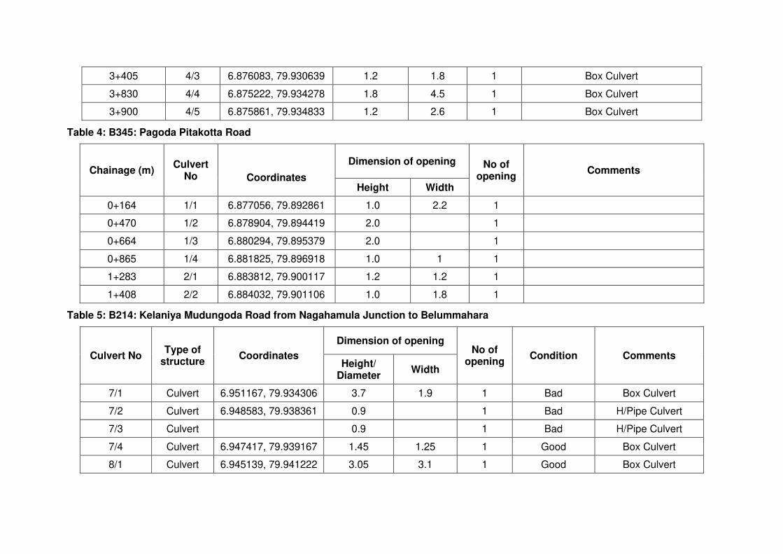
3+405 4/3 6.876083, 79.930639 1.2 1.8 1 Box Culvert
3+830 4/4 6.875222, 79.934278 1.8 4.5 1 Box Culvert
3+900 4/5 6.875861, 79.934833 1.2 2.6 1 Box Culvert
Table 4: B345: Pagoda Pitakotta Road
Chainage (m) Culvert
No
Coordinates
Dimension of opening No of opening
Comments
Height Width
0+164 1/1 6.877056, 79.892861 1.0 2.2 1
0+470 1/2 6.878904, 79.894419 2.0 1
0+664 1/3 6.880294, 79.895379 2.0 1
0+865 1/4 6.881825, 79.896918 1.0 1 1
1+283 2/1 6.883812, 79.900117 1.2 1.2 1
1+408 2/2 6.884032, 79.901106 1.0 1.8 1
Table 5: B214: Kelaniya Mudungoda Road from Nagahamula Junction to Belummahara
Culvert No Type of
structure Coordinates
Dimension of opening No of
opening Condition Comments
Height/ Diameter
Width
7/1 Culvert 6.951167, 79.934306 3.7 1.9 1 Bad Box Culvert
7/2 Culvert 6.948583, 79.938361 0.9 1 Bad H/Pipe Culvert
7/3 Culvert 0.9 1 Bad H/Pipe Culvert
7/4 Culvert 6.947417, 79.939167 1.45 1.25 1 Good Box Culvert
8/1 Culvert 6.945139, 79.941222 3.05 3.1 1 Good Box Culvert
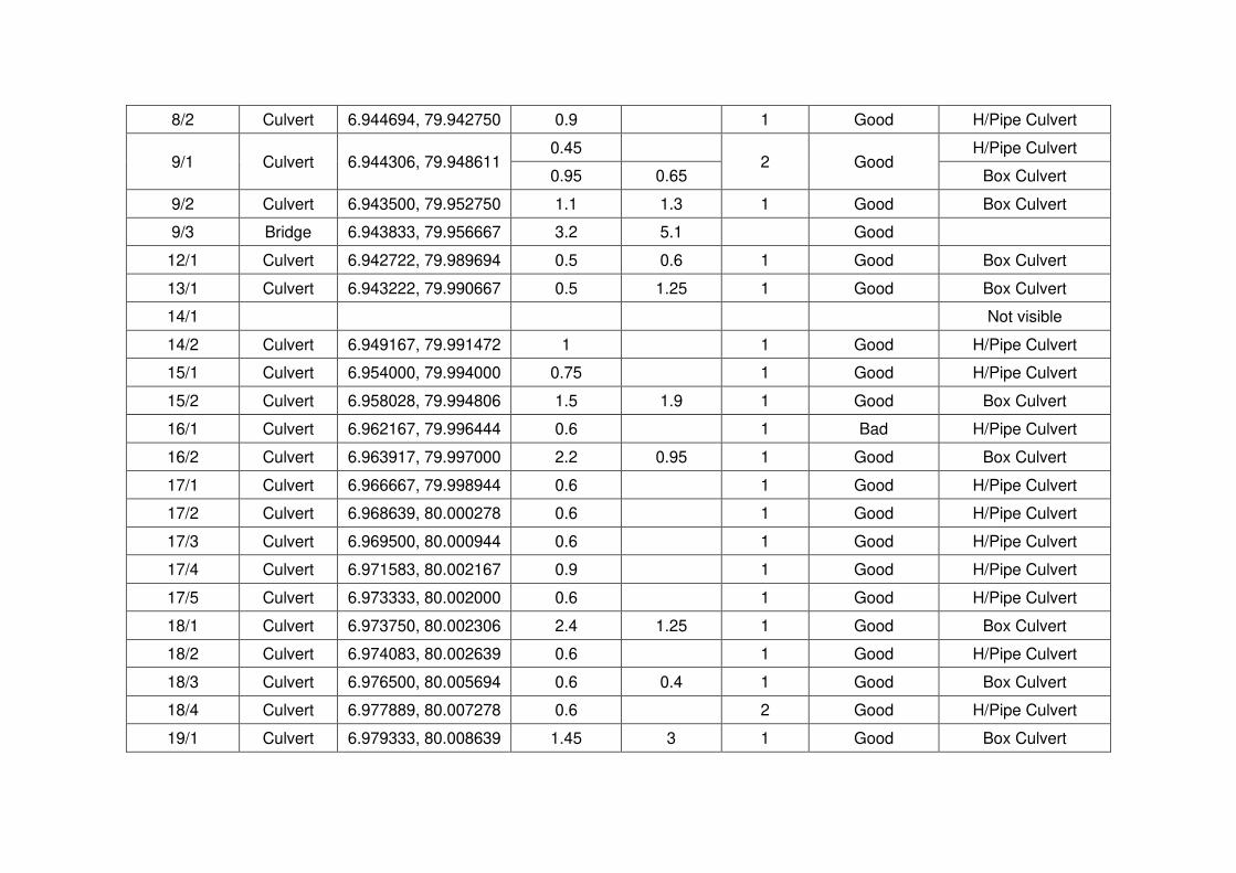
8/2 Culvert 6.944694, 79.942750 0.9 1 Good H/Pipe Culvert
9/1 Culvert 6.944306, 79.948611 0.45
2 Good H/Pipe Culvert
0.95 0.65 Box Culvert
9/2 Culvert 6.943500, 79.952750 1.1 1.3 1 Good Box Culvert
9/3 Bridge 6.943833, 79.956667 3.2 5.1 Good
12/1 Culvert 6.942722, 79.989694 0.5 0.6 1 Good Box Culvert
13/1 Culvert 6.943222, 79.990667 0.5 1.25 1 Good Box Culvert
14/1 Not visible
14/2 Culvert 6.949167, 79.991472 1 1 Good H/Pipe Culvert
15/1 Culvert 6.954000, 79.994000 0.75 1 Good H/Pipe Culvert
15/2 Culvert 6.958028, 79.994806 1.5 1.9 1 Good Box Culvert
16/1 Culvert 6.962167, 79.996444 0.6 1 Bad H/Pipe Culvert
16/2 Culvert 6.963917, 79.997000 2.2 0.95 1 Good Box Culvert
17/1 Culvert 6.966667, 79.998944 0.6 1 Good H/Pipe Culvert
17/2 Culvert 6.968639, 80.000278 0.6 1 Good H/Pipe Culvert
17/3 Culvert 6.969500, 80.000944 0.6 1 Good H/Pipe Culvert
17/4 Culvert 6.971583, 80.002167 0.9 1 Good H/Pipe Culvert
17/5 Culvert 6.973333, 80.002000 0.6 1 Good H/Pipe Culvert
18/1 Culvert 6.973750, 80.002306 2.4 1.25 1 Good Box Culvert
18/2 Culvert 6.974083, 80.002639 0.6 1 Good H/Pipe Culvert
18/3 Culvert 6.976500, 80.005694 0.6 0.4 1 Good Box Culvert
18/4 Culvert 6.977889, 80.007278 0.6 2 Good H/Pipe Culvert
19/1 Culvert 6.979333, 80.008639 1.45 3 1 Good Box Culvert

19/2 Culvert 6.982778, 80.010056 0.6 1 Good H/Pipe Culvert
19/3 Culvert 6.986250, 80.011917 0.6 1 Good H/Pipe Culvert
20/1 Culvert 6.987139, 80.013056 0.6 1 Good H/Pipe Culvert
20/2 Culvert 6.987694, 80.013722 0.6 1.2 1 Bad Box Culvert
20/3 Culvert 6.988417, 80.014000 1 1 1 Good Box Culvert
20/4 Culvert 6.989917, 80.014806 0.6 1 Good H/Pipe Culvert
20/5 Culvert 6.990694, 80.015222 1 0.8 1 Good Box Culvert
20/6 Culvert 6.991528, 80.015528 1.2 0.6 1 Good Box Culvert
20/7 Culvert 6.991972, 80.015583 0.6 0.6 1 Good Box Culvert
20/8 Culvert 6.992417, 80.015556 1.2 0.9 1 Good Box Culvert
20/9 Culvert 6.995028, 80.015444 0.6 0.4 1 Good Box Culvert
21/1 Culvert 6.995694, 80.015667 1.2 0.9 1 Good Box Culvert
21/2 Culvert 6.996556, 80.015889 2 1 Good Pipe Culvert
21/3 Culvert 6.996556, 80.015889 0.7 0.7 1 Good Box Culvert
21/4 Culvert 6.997278, 80.016139 1.6 1.9 1 Good Box Culvert
21/5 Culvert 6.996778, 80.015972 1.7 3.1 1 Good Box Culvert
21/6 Bridge 6.997472, 80.016194 4.65 8.9
21/7 Culvert 7.000167, 80.017889 0.6 0.6 1 Good Box Culvert
21/8 Culvert 7.003500, 80.020194 2 1 Good Pipe Culvert
22/1 Culvert 7.003333, 80.020000 1 Pipe Culvert/silted
22/2 Culvert 7.005667, 80.021889 2 1 Pipe Culvert/silted
22/3 Culvert 7.014972, 80.025000 0.4 1.3 1 Box Culvert/silted
22/4 Culvert 7.008417, 80.023667 2 1 Good Pipe Culvert/silted

23/1 Culvert 7.010972, 80.024417 0.4 0.9 1 Box Culvert/silted
23/2 Culvert 7.012722, 80.024528 2 1 Bad Pipe Culvert/silted
23/3 Culvert 7.015222, 80.025222 1.3 1.2 1 Good Box Culvert
23/4 Culvert 7.015472, 80.025250 0.8 1.2 1 Good Box Culvert
24/1 Culvert 7.019111, 80.025833 0.1 0.12 1 Good Box Culvert
24/2 Culvert 7.019389, 80.025917 0.3 0.12 1 Good Box Culvert
24/3 Culvert 7.022917, 80.026778 0.6 1 Good H/Pipe Culvert
24/4 Culvert 7.026083, 80.026611 0.6 1 Good H/Pipe Culvert
25/1 Culvert 7.029722, 80.028806 0.7 1.2 1 Good Box Culvert
25/2 Culvert 7.030167, 80.028917 0.1 1.7 1 Good Box Culvert/silted
25/3 Culvert 7.030639, 80.028861 1 Good Box Culvert/silted
26/1 Culvert 7.035100, 80.026172 1.2 2.2 1 Good Box Culvert
26/2 Culvert 7.036258, 80.025469 0.45 1 Good Pipe Culvert/silted
26/3 Culvert 7.040072, 80.020850 0.6 0.7 1 Good Box Culvert
26/4 Culvert 7.040947, 80.019808 0.6 0.6 1 Good Box Culvert
27/1 Culvert 7.042783, 80.018433 0.5 0.7 1 Good Box Culvert
27/2 Culvert 7.044253, 80.017625 0.6 1 Good H/Pipe Culvert
27/3 Culvert 7.046764, 80.016281 0.6 1 Good Pipe Culvert
27/4 Culvert 7.048167, 80.015878 1.3 1.8 1 Good Box Culvert
28/1 Culvert 7.049200, 80.015889 0.9 1 Good Pipe Culvert
28/2 Culvert 7.049317, 80.015892 0.7 1.4 1 Good Box Culvert
28/3 Culvert 7.049764, 80.015869 0.4 1.5 1 Good Box Culvert
28/4 Culvert 7.051878, 80.016825 0.4 0.6 1 Good Box Culvert/silted
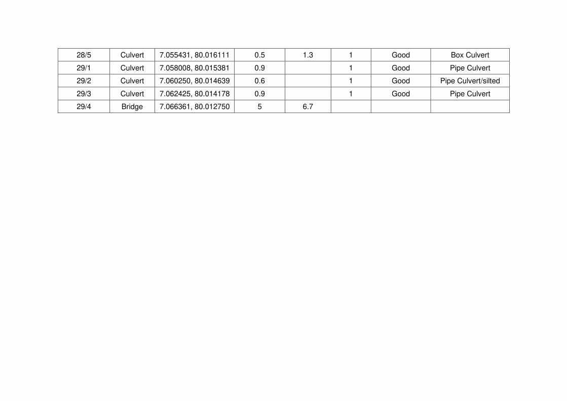
28/5 Culvert 7.055431, 80.016111 0.5 1.3 1 Good Box Culvert
29/1 Culvert 7.058008, 80.015381 0.9 1 Good Pipe Culvert
29/2 Culvert 7.060250, 80.014639 0.6 1 Good Pipe Culvert/silted
29/3 Culvert 7.062425, 80.014178 0.9 1 Good Pipe Culvert
29/4 Bridge 7.066361, 80.012750 5 6.7

Appendix 7.1 (a): Flora species found within the study area -B062
Conservation Status: NCS = National Conservation Status
LC - Least Concern NT - Near Threatened NE - Not evaluated CR - Critically Endangered
EN - Endangered VU - Vulnerable
Habit: H- Herb C – Creeper T- Tree S – Shrub G – Grass
Taxonomic Status: E: Endemic, N: Native I: Introduce
In - Within the RoW of the road
Out- Habitat located beside the RoW of the road + Present- Absent
No Family Species name Common
name TS NCS Habit In Out
1 Anacardiaceae Spondias dulcis Amberella I LC T - +
2 Anacardiaceae Mangifera indica Amba I LC T + +
3 Annonaceae Polyalthia longifolia
O-wila / villo N LC T + +
4 Apocynaceae Plumeria obtusa Araliya I LC T + +
5 Apocynaceae Thevetia peruviana
Kaha- kaneru
I LC S - +
6 Apocynaceae Tabernaemontana
divaricata Watu-sudda I LC S - +
7 Apocynaceae Alstonia scholaris Ruk Attana N LC T + +
8 Arecaceae Cocos nucifera Pol N LC T - +
9 Arecaceae Dypsis sp. Cane palm I LC S - +
10 Arecaceae Roystonea regia Royal palm I LC T - +
11 Arecaceae Areca catechu Puwak N LC T - +
12 Calophyllaceae Mesua Ferrea Na N LC T - +
13 Caricaceae Carica papaya Gas-labu I LC S - +
14 Combretaceae Terminalia
catappa Kottan I LC T + +
15 Elaeocarpaceae Elaeocarpus
serratus Weralu N LC T - +
16 Euphorbiaceae Croton sp. Croton I LC S - +
17 Fabaceae Pterocarpus
indicus Wal-ehala I LC T + +
18 Fabaceae Pongamia pinnata Magul
Karanda N LC T - +
19 Lauraceae Persea americana Aligeta-pera I LC T - +
20 Malvaceae Muntingia calabura
Jam I LC T - +
21 Moraceae Ficus religiosa Bo N LC T - +
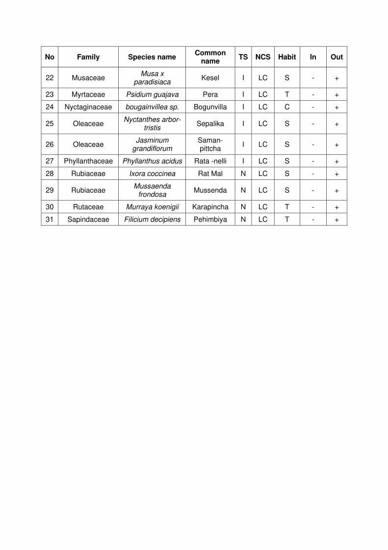
No Family Species name Common
name TS NCS Habit In Out
22 Musaceae Musa x
paradisiaca Kesel I LC S - +
23 Myrtaceae Psidium guajava Pera I LC T - +
24 Nyctaginaceae bougainvillea sp. Bogunvilla I LC C - +
25 Oleaceae Nyctanthes arbor-
tristis Sepalika I LC S - +
26 Oleaceae Jasminum
grandiflorum Saman-pittcha
I LC S - +
27 Phyllanthaceae Phyllanthus acidus Rata -nelli I LC S - +
28 Rubiaceae Ixora coccinea Rat Mal N LC S - +
29 Rubiaceae Mussaenda
frondosa Mussenda N LC S - +
30 Rutaceae Murraya koenigii Karapincha N LC T - +
31 Sapindaceae Filicium decipiens Pehimbiya N LC T - +
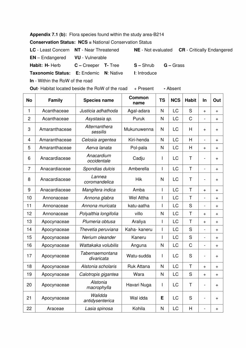
Appendix 7.1 (b): Flora species found within the study area-B214
Conservation Status: NCS = National Conservation Status
LC - Least Concern NT - Near Threatened NE - Not evaluated CR - Critically Endangered
EN – Endangered VU - Vulnerable
Habit: H- Herb C – Creeper T- Tree S – Shrub G – Grass
Taxonomic Status: E: Endemic N: Native I: Introduce
In - Within the RoW of the road
Out- Habitat located beside the RoW of the road + Present - Absent
No Family Species name Common
name TS NCS Habit In Out
1 Acanthaceae Justicia adhathoda Agal-adara N LC S + +
2 Acanthaceae Asystasia sp. Puruk N LC C - +
3 Amaranthaceae Alternanthera
sessilis Mukunuwenna N LC H + +
4 Amaranthaceae Celosia argentea Kiri-henda N LC H - +
5 Amaranthaceae Aerva lanata Pol-pala N LC H + +
6 Anacardiaceae Anacardium occidentale
Cadju I LC T - +
7 Anacardiaceae Spondias dulcis Amberella I LC T - +
8 Anacardiaceae Lannea
coromandelica Hik N LC T - +
9 Anacardiaceae Mangifera indica Amba I LC T + +
10 Annonaceae Annona glabra Wel Attha I LC T - +
11 Annonaceae Annona muricata katu-aatha I LC S - +
12 Annonaceae Polyalthia longifolia villo N LC T + +
13 Apocynaceae Plumeria obtusa Araliya I LC T + +
14 Apocynaceae Thevetia peruviana Kaha- kaneru I LC S - +
15 Apocynaceae Nerium oleander Kaneru I LC S - +
16 Apocynaceae Wattakaka volubilis Anguna N LC C - +
17 Apocynaceae Tabernaemontana
divaricata Watu-sudda I LC S - +
18 Apocynaceae Alstonia scholaris Ruk Attana N LC T + +
19 Apocynaceae Calotropis gigantea Wara N LC S + +
20 Apocynaceae Alstonia
macrophylla Havari Nuga I LC T - +
21 Apocynaceae Walidda
antidysenterica Wal idda E LC S - +
22 Araceae Lasia spinosa Kohila N LC H - +

No Family Species name Common
name TS NCS Habit In Out
23 Araceae Colocasia esculenta Gahala I LC H + +
24 Araceae Syngonium angustatum
Wel Kohila I LC C - +
25 Araucariaceae Araucaria
columnaris Araucaria I LC T - +
26 Arecaceae Caryota urens Kitul N LC T - +
27 Arecaceae Cocos nucifera Pol N LC T + +
28 Arecaceae Dypsis sp. Cane palm I LC S - +
29 Arecaceae Roystonea regia Royal palm I LC T - +
30 Arecaceae Areca catechu Puwak N LC T - +
31 Arecaceae Areca concinna Lenteri Puwak E EN T - +
32 Asparagaceae Asparagus racemosus
Hatawariya N LC C - +
33 Asteraceae Eclipta prostrate Kikirindi N LC H + +
34 Asteraceae Vernonia cinerea Monara
Kudumbiya N LC H + +
35 Asteraceae Sphagneticola
trilobata Wedelia I LC H + +
36 Asteraceae Mikania cordata Wathu Palu I LC C + +
37 Calophyllaceae Mesua Ferrea Na N LC T + +
38 Calophyllaceae Calophyllum inophyllum
Domba N LC T - +
39 Cannabaceae Trema orientalis Gadumba N LC T + +
40 Caricaceae Carica papaya Gas-labu I LC S - +
41 Combretaceae Terminalia bellirica Bulu N LC T - +
42 Combretaceae Terminalia arjuna Kumbuk N LC T + +
43 Combretaceae Terminalia catappa Kottan I LC T + +
44 Commelinaceae Commelina diffusa Gira Pala N LC H + +
45 Convolvulaceae Merremia tridentata Heen Madu N LC C - +
46 Convolvulaceae Argyreia populifolia Giri Tilla E LC C - +
47 Convolvulaceae Cuscuta campestris Aga Mula Neti
Wel N LC C + +
48 Convolvulaceae Ipomoea aquatica Kan Kun N LC C - +
49 Convolvulaceae Merremia umbellata Mahamadu N LC C - +
50 Cyperaceae Cyperus aromaticus Pothukola
Pan N LC H - +
51 Dilleniaceae Dillenia triquetra Diyapara N LC T - +

No Family Species name Common
name TS NCS Habit In Out
52 Dilleniaceae Dillenia retusa Godapara N LC T - +
53 Dilleniaceae Dillenia suffruticosa Diya Para I LC T - +
54 Elaeocarpaceae Elaeocarpus
serratus Weralu N LC T + +
55 Euphorbiaceae Croton sp. Croton I LC S - +
56 Euphorbiaceae Hevea brasiliensis Rubber I LC T + +
57 Euphorbiaceae Macaranga peltata Kenda N LC T - +
58 Euphorbiaceae Mallotus tetracoccus Bu Kenda N LC T - +
59 Euphorbiaceae Ricinus communis Beheth Endaru
I LC S - +
60 Euphorbiaceae Euphorbia hirta Bu Dada
Kiriya N LC H - +
61 Fabaceae Mimosa pudica Nidikumba N LC H + +
62 Fabaceae Samanea saman Para Mara I LC T + +
63 Fabaceae Clitoria ternatea Nil-katarodu N LC C - +
64 Fabaceae Cassia fistula Ehela N LC T + +
65 Fabaceae Bauhinia racemosa Maila N LC T - +
66 Fabaceae Pericopsis mooniana
Nadun N VU T - +
67 Fabaceae Pterocarpus indicus Wal-ehala I LC T + +
68 Fabaceae Bauhinia variegata Koboleela I LC T - +
69 Fabaceae Cassia alata Rata Tora I LC S + +
70 Fabaceae Peltophorum pterocarpum
Kaha-mara I LC T + +
71 Fabaceae Sesbania
grandiflora Katuru-
murunga N LC S - +
72 Fabaceae Cynometra cauliflora
Naminam N LC S - +
73 Fabaceae Abrus precatorius Olinda N LC C - +
74 Fabaceae Acacia melanoxylon Acacia I LC T + +
75 Fabaceae Adenanthera
pavonina Madatiya N LC T + +
76 Fabaceae Clitoria laurifolia Andana Hiriya I LC H + +
77 Fabaceae Delonix regia Mai Mara I LC T + +
78 Fabaceae Desmodium
heterocarpon Et Undupiyali N LC H + +
79 Fabaceae Desmodium
triflorum Heen
Undupiyali N LC H + +
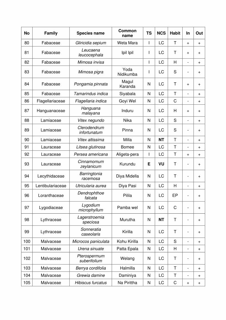
No Family Species name Common
name TS NCS Habit In Out
80 Fabaceae Gliricidia sepium Weta Mara I LC T + +
81 Fabaceae Leucaena
leucocephala Ipil Ipil I LC T + +
82 Fabaceae Mimosa invisa I LC H - +
83 Fabaceae Mimosa pigra Yoda
Nidikumba I LC S - +
84 Fabaceae Pongamia pinnata Magul
Karanda N LC T + +
85 Fabaceae Tamarindus indica Siyabala N LC T - +
86 Flagellariaceae Flagellaria indica Goyi Wel N LC C - +
87 Hanguanaceae Hanguana malayana
Induru N LC H + +
88 Lamiaceae Vitex negundo Nika N LC S - +
89 Lamiaceae Clerodendrum infortunatum
Pinna N LC S - +
90 Lamiaceae Vitex altissima Milla N NT T - +
91 Lauraceae Litsea glutinosa Bomee N LC T - +
92 Lauraceae Persea americana Aligeta-pera I LC T + +
93 Lauraceae Cinnamomum
zeylanicum Kurundu E VU T - +
94 Lecythidaceae Barringtonia racemosa
Diya Midella N LC T - +
95 Lentibulariaceae Utricularia aurea Diya Pasi N LC H - +
96 Loranthaceae Dendrophthoe
falcata Pilila N LC EP - +
97 Lygodiaceae Lygodium
microphyllum Pamba wel N LC C - +
98 Lythraceae Lagerstroemia
speciosa Murutha N NT T - +
99 Lythraceae Sonneratia caseolaris
Kirilla N LC T - +
100 Malvaceae Microcos paniculata Kohu Kirilla N LC S - +
101 Malvaceae Urena sinuate Patta Epala N LC H - +
102 Malvaceae Pterospermum
suberifolium Welang N LC T - +
103 Malvaceae Berrya cordifolia Halmilla N LC T - +
104 Malvaceae Grewia damine Daminiya N LC T - +
105 Malvaceae Hibiscus furcatus Na Pirittha N LC C + +

No Family Species name Common
name TS NCS Habit In Out
106 Malvaceae Hibiscus tiliaceus Beli Patta N LC T - +
107 Malvaceae Melochia
corchorifolia Gal Kura N LC H - +
108 Malvaceae Sida acuta Gas Bebila N LC H + +
109 Malvaceae Sida rhombifolia Kotikan Bevila N LC H + +
110 Malvaceae Thespesia populnea Gan Suriya N LC T - +
111 Malvaceae Urena lobata Patta Epala N LC H + +
112 Malvaceae Muntingia calabura Jam I LC T + +
113 Marsileaceae Marsilea minuta Hathara pethiya
N LC H + +
114 Melastomataceae Melastoma
malabathricum Maha Bovitiya N LC S - +
115 Meliaceae Swietenia
macrophylla Mahogani I LC T + +
116 Meliaceae Azadirachta indica Kohomba N LC T - +
117 Meliaceae Melia azedarach Lunu Midella N LC T + +
118 Moraceae Ficus racemosa Attikka N LC T + +
119 Moraceae Ficus religiosa Bo N LC T - +
120 Moraceae Artocarpus incisus Del I LC T - +
121 Moraceae Ficus benjamina Walu-nuga I LC T + +
122 Moraceae Artocarpus
heterophyllus Kos I LC T + +
123 Moraceae Artocarpus nobilis Wal Del E LC T - +
124 Moraceae Ficus benghalensis Maha Nuga N LC T - +
125 Moraceae Ficus hispida Kota Dimbula N LC T - +
126 Moraceae Ficus exasperate Bu Thediya N LC T - +
127 Musaceae Musa x paradisiaca Kesel I LC S - +
128 Myrtaceae Eucalyptus Sp. Eucalytus I LC T - +
129 Myrtaceae Psidium guajava Pera I LC T + +
130 Myrtaceae Syzygium
caryophyllatum Heen Dan N LC S - +
131 Myrtaceae Syzygium cumini Madan N LC T - +
132 Nyctaginaceae bougainvillea sp. Bogunvilla I LC C - +
133 Nymphaeaceae Nymphaea pubescens
Olu N LC H - +
134 Nymphaeaceae Nymphaea nouchali Manel N VU H - +
135 Nymphaeaceae Nymphaea sp. Ratu Olu I LC H - +
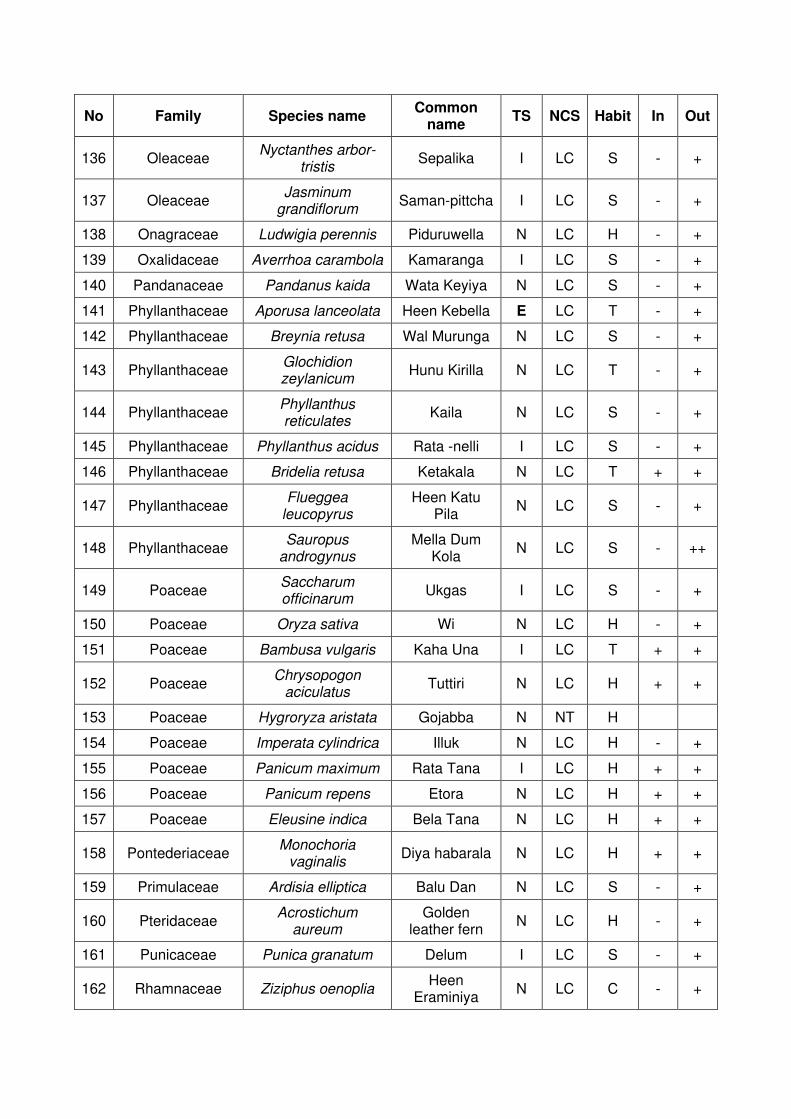
No Family Species name Common
name TS NCS Habit In Out
136 Oleaceae Nyctanthes arbor-
tristis Sepalika I LC S - +
137 Oleaceae Jasminum
grandiflorum Saman-pittcha I LC S - +
138 Onagraceae Ludwigia perennis Piduruwella N LC H - +
139 Oxalidaceae Averrhoa carambola Kamaranga I LC S - +
140 Pandanaceae Pandanus kaida Wata Keyiya N LC S - +
141 Phyllanthaceae Aporusa lanceolata Heen Kebella E LC T - +
142 Phyllanthaceae Breynia retusa Wal Murunga N LC S - +
143 Phyllanthaceae Glochidion zeylanicum
Hunu Kirilla N LC T - +
144 Phyllanthaceae Phyllanthus reticulates
Kaila N LC S - +
145 Phyllanthaceae Phyllanthus acidus Rata -nelli I LC S - +
146 Phyllanthaceae Bridelia retusa Ketakala N LC T + +
147 Phyllanthaceae Flueggea
leucopyrus Heen Katu
Pila N LC S - +
148 Phyllanthaceae Sauropus
androgynus Mella Dum
Kola N LC S - ++
149 Poaceae Saccharum officinarum
Ukgas I LC S - +
150 Poaceae Oryza sativa Wi N LC H - +
151 Poaceae Bambusa vulgaris Kaha Una I LC T + +
152 Poaceae Chrysopogon
aciculatus Tuttiri N LC H + +
153 Poaceae Hygroryza aristata Gojabba N NT H
154 Poaceae Imperata cylindrica Illuk N LC H - +
155 Poaceae Panicum maximum Rata Tana I LC H + +
156 Poaceae Panicum repens Etora N LC H + +
157 Poaceae Eleusine indica Bela Tana N LC H + +
158 Pontederiaceae Monochoria
vaginalis Diya habarala N LC H + +
159 Primulaceae Ardisia elliptica Balu Dan N LC S - +
160 Pteridaceae Acrostichum
aureum Golden
leather fern N LC H - +
161 Punicaceae Punica granatum Delum I LC S - +
162 Rhamnaceae Ziziphus oenoplia Heen
Eraminiya N LC C - +

No Family Species name Common
name TS NCS Habit In Out
163 Rhizophoraceae Carallia brachiata Dawata N NT T - +
164 Rubiaceae Coffea arabica Kopi I LC T - +
165 Rubiaceae Morinda citrifolia Ahu N LC T - +
166 Rubiaceae Nauclea orientalis Bakmi N LC T - +
167 Rubiaceae Ixora coccinea Rat Mal N LC S - +
168 Rutaceae Murraya koenigii Karapincha N LC T - +
169 Rutaceae Murraya paniculata Etteriya N LC T - +
170 Rutaceae Limonia acidissima Diul N LC T -
171 Rutaceae Aegle marmelos. Bali N LC T + +
172 Salicaceae Flacourtia inermis Lovi I LC S - +
173 Sapindaceae Schleichera oleosa Kon N LC T - +
174 Sapindaceae Nephelium lappaceum
Rambutan N NE T - +
175 Sapindaceae Filicium decipiens Pehimbiya N LC T + +
176 Sapotaceae Madhuca longifolia Mi N NT T + +
177 Symplocaceae Symplocos
cochinchinensis Bombu N LC T - +
178 Typhaceae Typha angustifolia Hambu Pan I LC H + +
179 Verbanaceae Tectona grandis Thekka I LC T - +
180 Verbenaceae Lantana camara Gandapana I LC S + +
181 Verbenaceae Stachytarpheta
jamaicensis Balu Nakuta N LC H + +
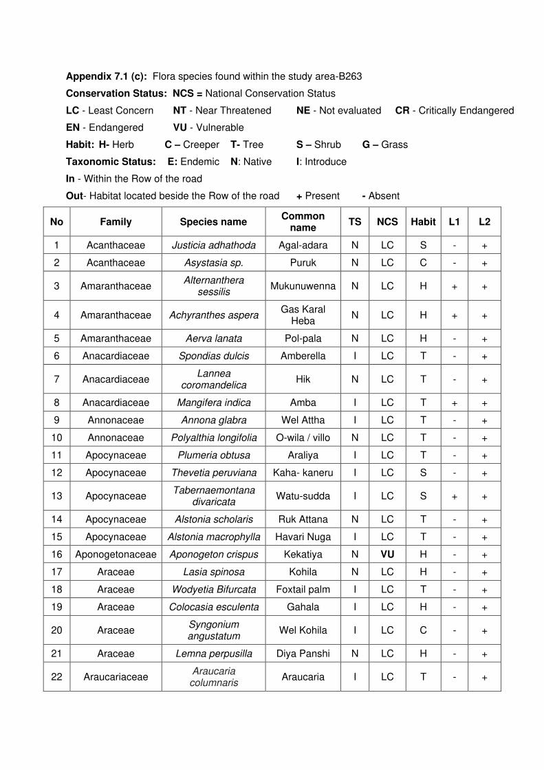
Appendix 7.1 (c): Flora species found within the study area-B263
Conservation Status: NCS = National Conservation Status
LC - Least Concern NT - Near Threatened NE - Not evaluated CR - Critically Endangered
EN - Endangered VU - Vulnerable
Habit: H- Herb C – Creeper T- Tree S – Shrub G – Grass
Taxonomic Status: E: Endemic N: Native I: Introduce
In - Within the Row of the road
Out- Habitat located beside the Row of the road + Present - Absent
No Family Species name Common
name TS NCS Habit L1 L2
1 Acanthaceae Justicia adhathoda Agal-adara N LC S - +
2 Acanthaceae Asystasia sp. Puruk N LC C - +
3 Amaranthaceae Alternanthera
sessilis Mukunuwenna N LC H + +
4 Amaranthaceae Achyranthes aspera Gas Karal
Heba N LC H + +
5 Amaranthaceae Aerva lanata Pol-pala N LC H - +
6 Anacardiaceae Spondias dulcis Amberella I LC T - +
7 Anacardiaceae Lannea
coromandelica Hik N LC T - +
8 Anacardiaceae Mangifera indica Amba I LC T + +
9 Annonaceae Annona glabra Wel Attha I LC T - +
10 Annonaceae Polyalthia longifolia O-wila / villo N LC T - +
11 Apocynaceae Plumeria obtusa Araliya I LC T - +
12 Apocynaceae Thevetia peruviana Kaha- kaneru I LC S - +
13 Apocynaceae Tabernaemontana
divaricata Watu-sudda I LC S + +
14 Apocynaceae Alstonia scholaris Ruk Attana N LC T - +
15 Apocynaceae Alstonia macrophylla Havari Nuga I LC T - +
16 Aponogetonaceae Aponogeton crispus Kekatiya N VU H - +
17 Araceae Lasia spinosa Kohila N LC H - +
18 Araceae Wodyetia Bifurcata Foxtail palm I LC T - +
19 Araceae Colocasia esculenta Gahala I LC H - +
20 Araceae Syngonium angustatum
Wel Kohila I LC C - +
21 Araceae Lemna perpusilla Diya Panshi N LC H - +
22 Araucariaceae Araucaria columnaris
Araucaria I LC T - +
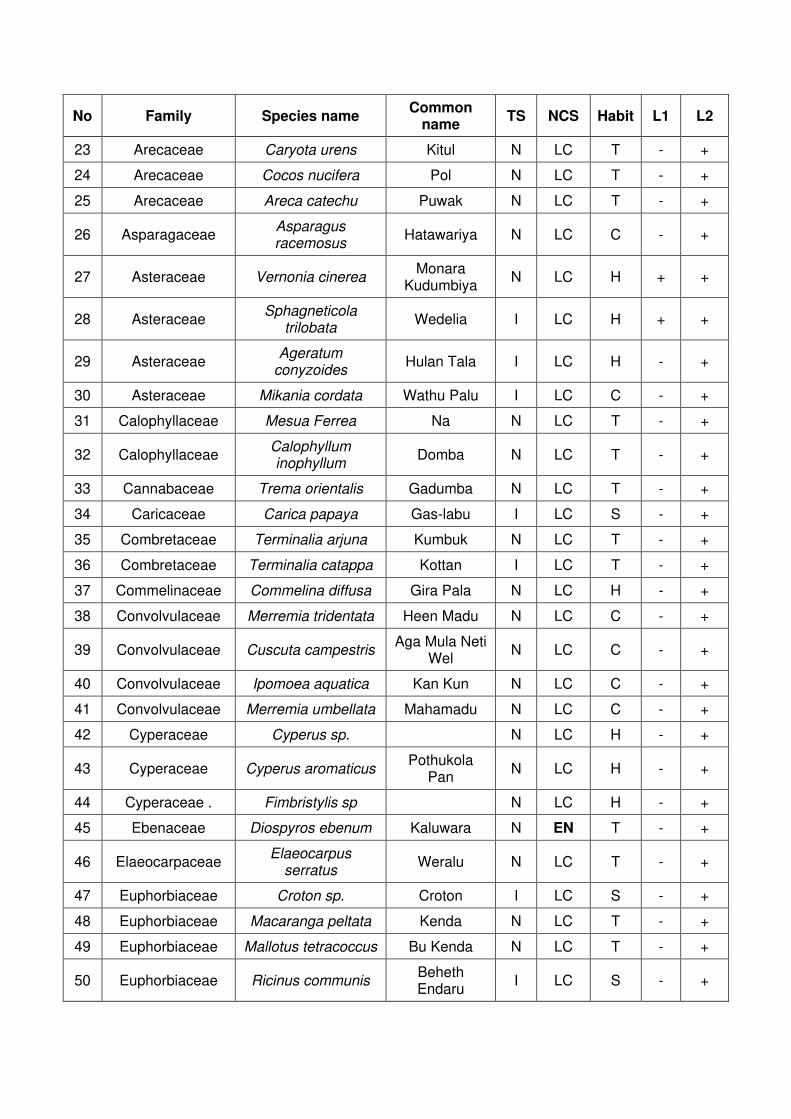
No Family Species name Common
name TS NCS Habit L1 L2
23 Arecaceae Caryota urens Kitul N LC T - +
24 Arecaceae Cocos nucifera Pol N LC T - +
25 Arecaceae Areca catechu Puwak N LC T - +
26 Asparagaceae Asparagus racemosus
Hatawariya N LC C - +
27 Asteraceae Vernonia cinerea Monara
Kudumbiya N LC H + +
28 Asteraceae Sphagneticola
trilobata Wedelia I LC H + +
29 Asteraceae Ageratum
conyzoides Hulan Tala I LC H - +
30 Asteraceae Mikania cordata Wathu Palu I LC C - +
31 Calophyllaceae Mesua Ferrea Na N LC T - +
32 Calophyllaceae Calophyllum inophyllum
Domba N LC T - +
33 Cannabaceae Trema orientalis Gadumba N LC T - +
34 Caricaceae Carica papaya Gas-labu I LC S - +
35 Combretaceae Terminalia arjuna Kumbuk N LC T - +
36 Combretaceae Terminalia catappa Kottan I LC T - +
37 Commelinaceae Commelina diffusa Gira Pala N LC H - +
38 Convolvulaceae Merremia tridentata Heen Madu N LC C - +
39 Convolvulaceae Cuscuta campestris Aga Mula Neti
Wel N LC C - +
40 Convolvulaceae Ipomoea aquatica Kan Kun N LC C - +
41 Convolvulaceae Merremia umbellata Mahamadu N LC C - +
42 Cyperaceae Cyperus sp. N LC H - +
43 Cyperaceae Cyperus aromaticus Pothukola
Pan N LC H - +
44 Cyperaceae . Fimbristylis sp N LC H - +
45 Ebenaceae Diospyros ebenum Kaluwara N EN T - +
46 Elaeocarpaceae Elaeocarpus
serratus Weralu N LC T - +
47 Euphorbiaceae Croton sp. Croton I LC S - +
48 Euphorbiaceae Macaranga peltata Kenda N LC T - +
49 Euphorbiaceae Mallotus tetracoccus Bu Kenda N LC T - +
50 Euphorbiaceae Ricinus communis Beheth Endaru
I LC S - +

No Family Species name Common
name TS NCS Habit L1 L2
51 Fabaceae Mimosa pudica Nidikumba N LC H + +
52 Fabaceae Clitoria ternatea Nil-katarodu N LC C - +
53 Fabaceae Cassia fistula Ehela N LC T - +
54 Fabaceae Bauhinia variegata Koboleela I LC T - +
55 Fabaceae Cassia alata Rata Tora I LC S - +
56 Fabaceae Sesbania grandiflora Katuru-
murunga N LC S - +
57 Fabaceae Cynometra cauliflora Naminam N LC S - +
58 Fabaceae Acacia melanoxylon Acacia I LC T - +
59 Fabaceae Adenanthera
pavonina Madatiya N LC T - +
60 Fabaceae Clitoria laurifolia Andana Hiriya I LC H - +
61 Fabaceae Delonix regia May Mara I LC T - +
62 Fabaceae Desmodium
heterocarpon Et Undupiyali N LC H - +
63 Fabaceae Desmodium triflorum Heen
Undupiyali N LC H - +
64 Fabaceae Gliricidia sepium Weta Mara I LC T - +
65 Fabaceae Leucaena
leucocephala Ipil Ipil I LC T - +
66 Fabaceae Mimosa pigra Yoda
Nidikumba I LC S - +
67 Fabaceae Pongamia pinnata Magul
Karanda N LC T - +
68 Fabaceae Tamarindus indica Siyabala N LC T - +
69 Hydrocharitaceae Hydrilla verticillata Hydrilla I LC H - +
70 Lauraceae Persea americana Aligeta-pera I LC T - +
71 Lecythidaceae Barringtonia racemosa
Diya Midella N LC T - +
72 Lythraceae Sonneratia caseolaris
Kirilla N LC T - +
73 Malvaceae Microcos paniculata Kohu Kirilla N LC S - +
74 Malvaceae Urena sinuate Patta Epala N LC H - +
75 Malvaceae Berrya cordifolia Halmilla N LC T - +
76 Malvaceae Grewia damine Daminiya N LC T - +
77 Malvaceae Hibiscus furcatus Na Pirittha N LC C - +
78 Malvaceae Hibiscus tiliaceus Beli Patta N LC T - +
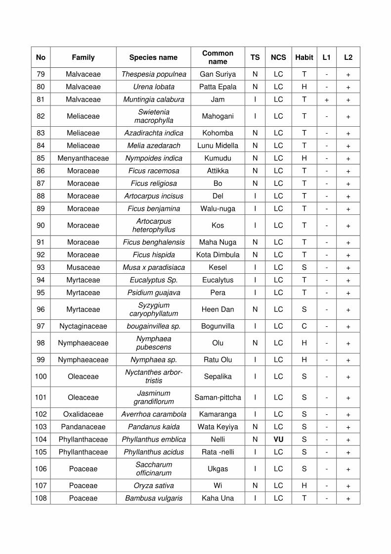
No Family Species name Common
name TS NCS Habit L1 L2
79 Malvaceae Thespesia populnea Gan Suriya N LC T - +
80 Malvaceae Urena lobata Patta Epala N LC H - +
81 Malvaceae Muntingia calabura Jam I LC T + +
82 Meliaceae Swietenia
macrophylla Mahogani I LC T - +
83 Meliaceae Azadirachta indica Kohomba N LC T - +
84 Meliaceae Melia azedarach Lunu Midella N LC T - +
85 Menyanthaceae Nympoides indica Kumudu N LC H - +
86 Moraceae Ficus racemosa Attikka N LC T - +
87 Moraceae Ficus religiosa Bo N LC T - +
88 Moraceae Artocarpus incisus Del I LC T - +
89 Moraceae Ficus benjamina Walu-nuga I LC T - +
90 Moraceae Artocarpus
heterophyllus Kos I LC T - +
91 Moraceae Ficus benghalensis Maha Nuga N LC T - +
92 Moraceae Ficus hispida Kota Dimbula N LC T - +
93 Musaceae Musa x paradisiaca Kesel I LC S - +
94 Myrtaceae Eucalyptus Sp. Eucalytus I LC T - +
95 Myrtaceae Psidium guajava Pera I LC T - +
96 Myrtaceae Syzygium
caryophyllatum Heen Dan N LC S - +
97 Nyctaginaceae bougainvillea sp. Bogunvilla I LC C - +
98 Nymphaeaceae Nymphaea pubescens
Olu N LC H - +
99 Nymphaeaceae Nymphaea sp. Ratu Olu I LC H - +
100 Oleaceae Nyctanthes arbor-
tristis Sepalika I LC S - +
101 Oleaceae Jasminum
grandiflorum Saman-pittcha I LC S - +
102 Oxalidaceae Averrhoa carambola Kamaranga I LC S - +
103 Pandanaceae Pandanus kaida Wata Keyiya N LC S - +
104 Phyllanthaceae Phyllanthus emblica Nelli N VU S - +
105 Phyllanthaceae Phyllanthus acidus Rata -nelli I LC S - +
106 Poaceae Saccharum officinarum
Ukgas I LC S - +
107 Poaceae Oryza sativa Wi N LC H - +
108 Poaceae Bambusa vulgaris Kaha Una I LC T - +
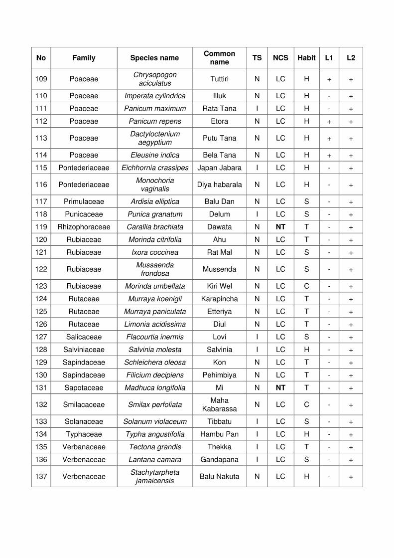
No Family Species name Common
name TS NCS Habit L1 L2
109 Poaceae Chrysopogon
aciculatus Tuttiri N LC H + +
110 Poaceae Imperata cylindrica Illuk N LC H - +
111 Poaceae Panicum maximum Rata Tana I LC H - +
112 Poaceae Panicum repens Etora N LC H + +
113 Poaceae Dactyloctenium
aegyptium Putu Tana N LC H + +
114 Poaceae Eleusine indica Bela Tana N LC H + +
115 Pontederiaceae Eichhornia crassipes Japan Jabara I LC H - +
116 Pontederiaceae Monochoria
vaginalis Diya habarala N LC H - +
117 Primulaceae Ardisia elliptica Balu Dan N LC S - +
118 Punicaceae Punica granatum Delum I LC S - +
119 Rhizophoraceae Carallia brachiata Dawata N NT T - +
120 Rubiaceae Morinda citrifolia Ahu N LC T - +
121 Rubiaceae Ixora coccinea Rat Mal N LC S - +
122 Rubiaceae Mussaenda
frondosa Mussenda N LC S - +
123 Rubiaceae Morinda umbellata Kiri Wel N LC C - +
124 Rutaceae Murraya koenigii Karapincha N LC T - +
125 Rutaceae Murraya paniculata Etteriya N LC T - +
126 Rutaceae Limonia acidissima Diul N LC T - +
127 Salicaceae Flacourtia inermis Lovi I LC S - +
128 Salviniaceae Salvinia molesta Salvinia I LC H - +
129 Sapindaceae Schleichera oleosa Kon N LC T - +
130 Sapindaceae Filicium decipiens Pehimbiya N LC T - +
131 Sapotaceae Madhuca longifolia Mi N NT T - +
132 Smilacaceae Smilax perfoliata Maha
Kabarassa N LC C - +
133 Solanaceae Solanum violaceum Tibbatu I LC S - +
134 Typhaceae Typha angustifolia Hambu Pan I LC H - +
135 Verbanaceae Tectona grandis Thekka I LC T - +
136 Verbenaceae Lantana camara Gandapana I LC S - +
137 Verbenaceae Stachytarpheta
jamaicensis Balu Nakuta N LC H - +
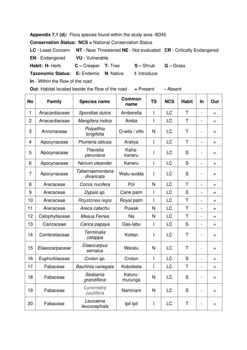
Appendix 7.1 (d): Flora species found within the study area -B345
Conservation Status: NCS = National Conservation Status
LC - Least Concern NT - Near Threatened NE - Not evaluated CR - Critically Endangered
EN - Endangered VU - Vulnerable
Habit: H- Herb C – Creeper T- Tree S – Shrub G – Grass
Taxonomic Status: E: Endemic N: Native I: Introduce
In - Within the Row of the road
Out- Habitat located beside the Row of the road + Present - Absent
No Family Species name Common
name TS NCS Habit In Out
1 Anacardiaceae Spondias dulcis Amberella I LC T - +
2 Anacardiaceae Mangifera indica Amba I LC T - +
3 Annonaceae Polyalthia longifolia
O-wila / villo N LC T - +
4 Apocynaceae Plumeria obtusa Araliya I LC T - +
5 Apocynaceae Thevetia
peruviana Kaha- kaneru
I LC S - +
6 Apocynaceae Nerium oleander Kaneru I LC S - +
7 Apocynaceae Tabernaemontana
divaricata Watu-sudda I LC S - +
8 Arecaceae Cocos nucifera Pol N LC T - +
9 Arecaceae Dypsis sp. Cane palm I LC S - +
10 Arecaceae Roystonea regia Royal palm I LC T - +
11 Arecaceae Areca catechu Puwak N LC T - +
12 Calophyllaceae Mesua Ferrea Na N LC T - +
13 Caricaceae Carica papaya Gas-labu I LC S - +
14 Combretaceae Terminalia
catappa Kottan I LC T - +
15 Elaeocarpaceae Elaeocarpus
serratus Weralu N LC T - +
16 Euphorbiaceae Croton sp. Croton I LC S - +
17 Fabaceae Bauhinia variegata Koboleela I LC T - +
18 Fabaceae Sesbania grandiflora
Katuru-murunga
N LC S - +
19 Fabaceae Cynometra cauliflora
Naminam N LC S - +
20 Fabaceae Leucaena
leucocephala Ipil Ipil I LC T - +
No Family Species name Common
name TS NCS Habit In Out
21 Fabaceae Pongamia pinnata Magul
Karanda N LC T - +
22 Lamiaceae Clerodendrum infortunatum
Pinna N LC S - +
23 Lauraceae Persea americana Aligeta-pera I LC T - +
24 Malvaceae Berrya cordifolia Halmilla N LC T - +
25 Malvaceae Muntingia calabura Jam I LC T - +
26 Meliaceae Azadirachta indica Kohomba N LC T - +
27 Moraceae Ficus religiosa Bo N LC T - +
28 Moraceae Artocarpus incisus Del I LC T - +
29 Moraceae Artocarpus
heterophyllus Kos I LC T - +
30 Musaceae Musa x
paradisiaca Kesel I LC S - +
31 Myrtaceae Psidium guajava Pera I LC T - +
32 Nyctaginaceae bougainvillea sp. Bogunvilla I LC C - +
33 Oleaceae Nyctanthes arbor-
tristis Sepalika I LC S - +
34 Oleaceae Jasminum
grandiflorum Saman-pittcha
I LC S - +
35 Oxalidaceae Averrhoa
carambola Kamaranga I LC S - +
36 Pandanaceae Pandanus kaida Wata
Keyiya N LC S - +
37 Phyllanthaceae Phyllanthus acidus Rata -nelli I LC S - +
38 Poaceae Bambusa vulgaris Kaha Una I LC T - +
39 Rubiaceae Ixora coccinea Rat Mal N LC S - +
40 Rubiaceae Mussaenda
frondosa Mussenda N LC S - +
41 Rutaceae Murraya koenigii Karapincha N LC T - +
42 Sapindaceae Filicium decipiens Pehimbiya N LC T - +

Appendix 7.1 (e): Flora species found within the study area -B 368
Conservation Status: NCS = National Conservation Status
LC - Least Concern NT - Near Threatened NE - Not evaluated CR - Critically Endangered
EN – Endangered VU - Vulnerable
Habit: H- Herb C – Creeper T- Tree S – Shrub G – Grass
Taxonomic Status: E: Endemic N: Native I: Introduce
In - Within the Row of the road
Out- Habitat located beside the Row of the road + Present - Absent
No Family Species name Common
name TS NCS Habit In Out
1 Acanthaceae Justicia adhathoda Agal-adara N LC S - +
2 Amaranthaceae Alternanthera sessilis Mukunuwenna N LC H + +
3 Amaranthaceae Aerva lanata Pol-pala N LC H + +
4 Anacardiaceae Spondias dulcis Amberella I LC T - +
5 Anacardiaceae Mangifera indica Amba I LC T + +
6 Annonaceae Annona glabra Wel Attha I LC T - +
7 Annonaceae Annona reticulata Weli-attha I LC S - +
8 Annonaceae Annona muricata katu-aatha I LC S - +
9 Annonaceae Polyalthia longifolia O-wila / villo N LC T - +
10 Apocynaceae Plumeria obtusa Araliya I LC T - +
11 Apocynaceae Thevetia peruviana Kaha- kaneru I LC S - +
12 Apocynaceae Nerium oleander Kaneru I LC S - +
13 Apocynaceae Calotropis gigantea Wara N LC S - +
14 Apocynaceae Alstonia macrophylla Havari Nuga I LC T - +
15 Apocynaceae Walidda
antidysenterica Wal idda E LC S - +
16 Aponogetonaceae Aponogeton crispus Kekatiya N VU H - +
17 Araceae Lasia spinosa Kohila N LC H - +
18 Araceae Colocasia esculenta Gahala I LC H + +
19 Araceae Lemna perpusilla Diya Panshi N LC H - +
20 Araucariaceae Araucaria columnaris Araucaria I LC T - +
21 Arecaceae Cocos nucifera Pol N LC T - +
22 Arecaceae Dypsis sp. Cane palm I LC S - +
23 Arecaceae Roystonea regia Royal palm I LC T - +
24 Arecaceae Areca catechu Puwak N LC T - +
25 Asparagaceae Asparagus racemosus Hatawariya N LC C - +
No Family Species name Common
name TS NCS Habit In Out
26 Asteraceae Mikania cordata Wathu Palu I LC C - +
27 Calophyllaceae Mesua Ferrea Na N LC T - +
28 Caricaceae Carica papaya Gas-labu I LC S - +
29 Combretaceae Terminalia arjuna Kumbuk N LC T - +
30 Combretaceae Terminalia catappa Kottan I LC T + +
31 Commelinaceae Commelina diffusa Gira Pala N LC H + +
32 Convolvulaceae Ipomoea aquatica Kan Kun N LC C + +
33 Elaeocarpaceae Elaeocarpus serratus Weralu N LC T - +
34 Euphorbiaceae Croton sp. Croton I LC S - +
35 Euphorbiaceae Croton aromaticus Wel Keppetiya N LC S - +
36 Euphorbiaceae Hevea brasiliensis Rubber I LC T + +
37 Euphorbiaceae Macaranga peltata Kenda N LC T + +
38 Euphorbiaceae Ricinus communis Beheth Endaru I LC S + +
39 Euphorbiaceae Croton hirtus Val Tippili I LC H + +
40 Fabaceae Mimosa pudica Nidikumba N LC H + +
41 Fabaceae Clitoria ternatea Nil-katarodu N LC C - +
41 Fabaceae Cassia fistula Ehela N LC T - +
43 Fabaceae Pterocarpus indicus Wal-ehala I LC T - +
44 Fabaceae Bauhinia variegata Koboleela I LC T - +
45 Fabaceae Cassia alata Rata Tora I LC S + +
46 Fabaceae Sesbania grandiflora Katuru-
murunga N LC S - +
47 Fabaceae Acacia melanoxylon Acacia I LC T - +
48 Fabaceae Delonix regia Mai Mara I LC T + +
49 Fabaceae Desmodium
heterocarpon Et Undupiyali N LC H + +
50 Fabaceae Desmodium triflorum Heen
Undupiyali N LC H + +
51 Fabaceae Gliricidia sepium Weta Mara I LC T - +
52 Fabaceae Leucaena
leucocephala Ipil Ipil I LC T + +
53 Fabaceae Pongamia pinnata Magul Karanda N LC T + +
54 Hydrocharitaceae Hydrilla verticillata Hydrilla I LC H - +
55 Lauraceae Persea americana Aligeta-pera I LC T - +
56 Lentibulariaceae Utricularia aurea Diya Pasi N LC H - +
57 Loranthaceae Dendrophthoe falcata Pilila N LC EP - +
No Family Species name Common
name TS NCS Habit In Out
58 Malvaceae Urena sinuate Patta Epala N LC H + +
59 Malvaceae Berrya cordifolia Halmilla N LC T - +
60 Malvaceae Hibiscus tiliaceus Beli Patta N LC T - +
61 Malvaceae Sida acuta Gas Bebila N LC H + +
62 Malvaceae Thespesia populnea Gan Suriya N LC T - +
63 Malvaceae Urena lobata Patta Epala N LC H + +
64 Malvaceae Muntingia calabura Jam I LC T + +
65 Meliaceae Swietenia
macrophylla Mahogani I LC T - +
66 Meliaceae Azadirachta indica Kohomba N LC T - +
67 Meliaceae Melia azedarach Lunu Midella N LC T - +
68 Menyanthaceae Nympoides indica Kumudu N LC H - +
69 Moraceae Ficus racemosa Attikka N LC T + +
70 Moraceae Ficus religiosa Bo N LC T - +
71 Moraceae Ficus benjamina Walu-nuga I LC T - +
72 Moraceae Artocarpus
heterophyllus Kos I LC T - +
73 Moraceae Ficus benghalensis Maha Nuga N LC T - +
74 Musaceae Musa x paradisiaca Kesel I LC S - +
75 Myrtaceae Psidium guajava Pera I LC T + +
76 Nyctaginaceae bougainvillea sp. Bogunvilla I LC C - +
77 Nymphaeaceae Nymphaea pubescens Olu N LC H - +
78 Nymphaeaceae Nymphaea nouchali Manel N VU H - +
79 Nymphaeaceae Nymphaea sp. Ratu Olu I LC H - +
80 Oleaceae Nyctanthes arbor-
tristis Sepalika I LC S - +
81 Oleaceae Jasminum
grandiflorum Saman-pittcha I LC S - +
82 Phyllanthaceae Phyllanthus acidus Rata -nelli I LC S - +
83 Phyllanthaceae Bridelia retusa Ketakala N LC T - +
84 Poaceae Oryza sativa Wi N LC H - +
85 Poaceae Bambusa vulgaris Kaha Una I LC T - +
86 Poaceae Chrysopogon
aciculatus Tuttiri N LC H + +
87 Poaceae Panicum maximum Rata Tana I LC H + +
88 Poaceae Panicum repens Etora N LC H + +
No Family Species name Common
name TS NCS Habit In Out
89 Poaceae Eleusine indica Bela Tana N LC H + +
90 Punicaceae Punica granatum Delum I LC S - +
91 Rubiaceae Ixora coccinea Rat Mal N LC S - +
92 Rubiaceae Mussaenda frondosa Mussenda N LC S - +
93 Rutaceae Murraya koenigii Karapincha N LC T - +
94 Rutaceae Aegle marmelos. Bali N LC T - +
95 Salicaceae Flacourtia inermis Lovi I LC S - +
96 Salviniaceae Salvinia molesta Salvinia I LC H - +
97 Sapindaceae Filicium decipiens Pehimbiya N LC T + +
98 Sapotaceae Madhuca longifolia Mi N NT T + +
99 Typhaceae Typha angustifolia Hambu Pan I LC H - +
100 Verbanaceae Tectona grandis Thekka I LC T - +

Appendix 7.2 (a): List of fauna species observed in the study area-B062
Abbreviations:
NCS: National Conservation Status.
LC - Least Concern NT - Near Threatened NE - Not evaluated CR - Critically Endangered
EN - Endangered VU – Vulnerable+: Present
Table 1.1 Butterfly species
No Family Scientific Name Common Name Taxonomic
Status NCS B062
1 Nymphalid
ae Euploea core Common crow Indigenous LC +
2 Papilionida
e Papilio demoleus Lime butterfly Indigenous LC +
Table 1.2 Reptile species
No Family Scientific Name Common Name Taxonomic
Status NCS B062
1 Colubridae Ptyas mucosa Rat snake Native LC +
2 Gekkonidae Hemidactylus
frenatus Common house-
gecko Native LC +
Table 1.3 Amphibian species
No Family Scientific Name Common Name Taxonomic
Status NCS B062
01 Bufonidae Duttaphrynus melanostictus
Common house toad
Native LC +
Table 1.4 Birds species
BrR = Breading resident, WV=Winter Visitor, Pro: endemic = Proposed Endemic
No Family Scientific Name English Name Taxonomic
Status NCS B062
1 Alcedinidae Alcedo atthis Common Kingfisher
BrR LC +
2 Columbidae Streptopelia
chinensis Spotted Dove BrR LC +
3 Columbidae Columba livia Rock Pigeon BrR LC +
4 Dicruidae Dicrurus
caerulescens White-bellied
Drongo BrR LC +
5 Corvidae Corvus splendens House Crow BrR LC +
6 Estrididae Lonchura punctulata
Scaly-breasted Munia
BrR LC +

No Family Scientific Name English Name Taxonomic
Status NCS B062
7 Estrididae Lonchura striata White-rumped
Munia BrR LC +
8 Muscicapida
e Copsychus saularis
Oriental Magpie Robin
BrR LC +
9 Nectariniida
e Nectarina zeylonica
Purple-rumped Sunbird
BrR LC +
10 Passeridae Passer domesticus House Sparrow BrR LC +
11 Psittacidae Psittacula krameri Rose-ringed
Parakeet BrR LC +
12 Pycnonotida
e Pycnonotus cafer
Red-vented Bulbul
BrR LC +
13 Ramphastid
ae Megalaima zeylanica
Brown-headed Barbet
BrR LC +
14 Sturnidae Acridotheres tristis Common Myna BrR LC +
15 Timalidae Turdoides affinis Yellow-billed
Babbler BrR LC +
Table 1.5 Mammal species
No Family Scientific Name Common Name Taxonomic
Status NCS B062
1 Sciuridae Funambulus palmarum
Palm squirrel Indigenous LC +
2 Pteropodida
e Rousettus
leschenaultii Dog faced fruit
bat Indigenous LC +
3 Pteropodida
e Cynoptrrus sphinx
Short nosed fruit bat
Indigenous LC +
4 Muridae Bandicota Spp. Bandicoot Spp. Indigenous LC +
5 Muridae Rattus ratus Common house
rat Indigenous LC +
6 Canidae Canis familiaris Domestic dog Indigenous LC + 7 Felidae Felis catus Domestic cat Indigenous LC +
8 Viverridae Paradoxurus
hermaphoditus Palm civet Indigenous LC +

Appendix 7.2 (b): List of fauna species observed in the study area-B214
Appendix: Fauna species found within the study area
Abbreviations:
NCS: National Conservation Status.
LC - Least Concern NT - Near Threatened NE - Not evaluated CR - Critically Endangered
EN - Endangered VU – Vulnerable+: Present
Table 1.1 Land Snails species
No Family Scientific Name Common
Name Taxonomic
Status NCS B214
01 Achatinidae Lissachatina
fulica African Snail Exotic NE +
02 Ariophantidae Cryptozona
bistrialis Indigenous LC +
03 Ariophantidae Macrochlamys
indica Indigenous DD +
04 Ariophantidae Mariaella
dussumieri Exotic NE +
05 Subulinidae Allopeas gracile Exotic NE +
06 Veronicellidae Laevicaulis altae Exotic LC +
07 Ampullariidae Pila Spp. +
08 Ampullariidae Pomacea diffusa Apple Snail Exotic NE +
Table 1.2 Dragonfly species
No Family Scientific Name Common
Name Taxonomic
Status NCS B214
1 Cholorocyphida
e Libellago adami Adam's Gem Endemic VU +
2 Coenagrionidae Agriocnemis
pygmaea Wandering
Wisp Indigenous LC +
3 Coenagrionidae Pseudagrion
microcephalum Blue Sprite Indigenous LC +
4 Coenagrionidae Ischnura
senegalensis Common Bluetail
Indigenous LC +
5 Libellulidae Lathrecista
asiatica Pruinosed Blood tail
Indigenous NT +
6 Libellulidae Orthetrum pruinosum
Pink Skimmer
Indigenous NT +
7 Libellulidae Brachythmis contaminata
Asian Groundling
Indigenous LC +
8 Libellulidae Trithemis aurora Crimson
Drop wing Indigenous LC +
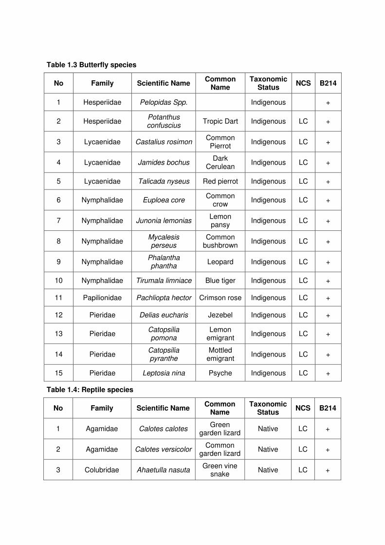
Table 1.3 Butterfly species
No Family Scientific Name Common
Name Taxonomic
Status NCS B214
1 Hesperiidae Pelopidas Spp. Indigenous +
2 Hesperiidae Potanthus confuscius
Tropic Dart Indigenous LC +
3 Lycaenidae Castalius rosimon Common Pierrot
Indigenous LC +
4 Lycaenidae Jamides bochus Dark
Cerulean Indigenous LC +
5 Lycaenidae Talicada nyseus Red pierrot Indigenous LC +
6 Nymphalidae Euploea core Common
crow Indigenous LC +
7 Nymphalidae Junonia lemonias Lemon pansy
Indigenous LC +
8 Nymphalidae Mycalesis perseus
Common bushbrown
Indigenous LC +
9 Nymphalidae Phalantha phantha
Leopard Indigenous LC +
10 Nymphalidae Tirumala limniace Blue tiger Indigenous LC +
11 Papilionidae Pachliopta hector Crimson rose Indigenous LC +
12 Pieridae Delias eucharis Jezebel Indigenous LC +
13 Pieridae Catopsilia pomona
Lemon emigrant
Indigenous LC +
14 Pieridae Catopsilia pyranthe
Mottled emigrant
Indigenous LC +
15 Pieridae Leptosia nina Psyche Indigenous LC +
Table 1.4: Reptile species
No Family Scientific Name Common
Name Taxonomic
Status NCS B214
1 Agamidae Calotes calotes Green
garden lizard Native LC +
2 Agamidae Calotes versicolor Common
garden lizard Native LC +
3 Colubridae Ahaetulla nasuta Green vine
snake Native LC +

4 Colubridae Amphiesma
stolatum Buff striped keelback
Native LC +
5 Colubridae Coeloganthus
helena Trinket snake
Native NT +
6 Colubridae Dendrelaphis
tristis Common
bronze-back Native LC +
7 Colubridae Lycodon aulicus House snake Native LC +
8 Colubridae Oligodon arnensis
Common kukri snake
Native LC +
9 Colubridae Ptyas mucosa Rat snake Native LC +
10 Elapidae Naja naja Indian cobra Native LC +
11 Gekkonidae Gehyra mutilata Four-claw
gecko Native LC +
12 Gekkonidae Hemidactylus
frenatus Common
house-gecko Native LC +
13 Gekkonidae Hemidactylus
parvimaculatus Spotted
house gecko Native LC +
14 Pythonidae Python molurus Indian python
Native LC +
15 Scincidae Eutropis carinata Common
skink Native LC +
16 Varanidae Varanus
bengalensis Land monitor Native LC +
17 Varanidae Varanus salvator Water
monitor Native LC +
18 Viperidae Daboia russelii Russell’s
viper Native LC +
Table 1.5 Amphibian species
No Family Scientific Name Common
Name Taxonomic
Status NCS B214
1 Bufonidae Duttaphrynus melanostictus
Common house toad
Native LC +
2 Bufonidae Duttaphrynus
scaber Ferguson’s
Toad Native VU +
3 Dicroglossidae Hoplobatrachus
crassus Jerdon's bull
frog Native LC +
4 Dicroglossidae Zakerana
shyadrensis
Common paddy field
frog Native LC +
5 Ranidae Hylarana gracilis Sri Lanka wood frog
Endemic LC +
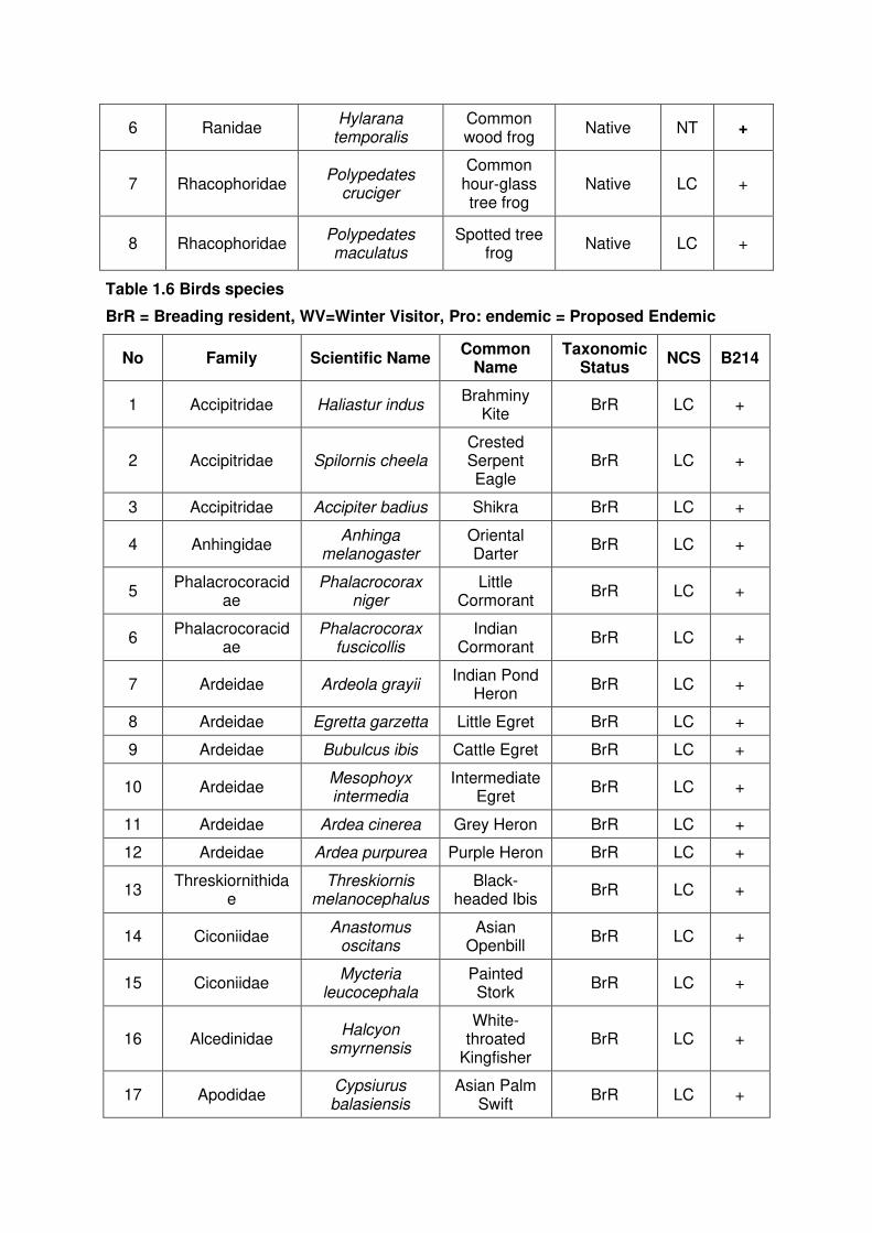
6 Ranidae Hylarana
temporalis Common wood frog
Native NT +
7 Rhacophoridae Polypedates
cruciger
Common hour‐glass tree frog
Native LC +
8 Rhacophoridae Polypedates maculatus
Spotted tree frog
Native LC +
Table 1.6 Birds species
BrR = Breading resident, WV=Winter Visitor, Pro: endemic = Proposed Endemic
No Family Scientific Name Common
Name Taxonomic
Status NCS B214
1 Accipitridae Haliastur indus Brahminy
Kite BrR LC +
2 Accipitridae Spilornis cheela Crested Serpent Eagle
BrR LC +
3 Accipitridae Accipiter badius Shikra BrR LC +
4 Anhingidae Anhinga
melanogaster Oriental Darter
BrR LC +
5 Phalacrocoracid
ae Phalacrocorax
niger Little
Cormorant BrR LC +
6 Phalacrocoracid
ae Phalacrocorax
fuscicollis Indian
Cormorant BrR LC +
7 Ardeidae Ardeola grayii Indian Pond
Heron BrR LC +
8 Ardeidae Egretta garzetta Little Egret BrR LC +
9 Ardeidae Bubulcus ibis Cattle Egret BrR LC +
10 Ardeidae Mesophoyx intermedia
Intermediate Egret
BrR LC +
11 Ardeidae Ardea cinerea Grey Heron BrR LC +
12 Ardeidae Ardea purpurea Purple Heron BrR LC +
13 Threskiornithida
e Threskiornis
melanocephalus Black-
headed Ibis BrR LC +
14 Ciconiidae Anastomus
oscitans Asian
Openbill BrR LC +
15 Ciconiidae Mycteria
leucocephala Painted Stork
BrR LC +
16 Alcedinidae Halcyon
smyrnensis
White-throated
Kingfisher BrR LC +
17 Apodidae Cypsiurus balasiensis
Asian Palm Swift
BrR LC +
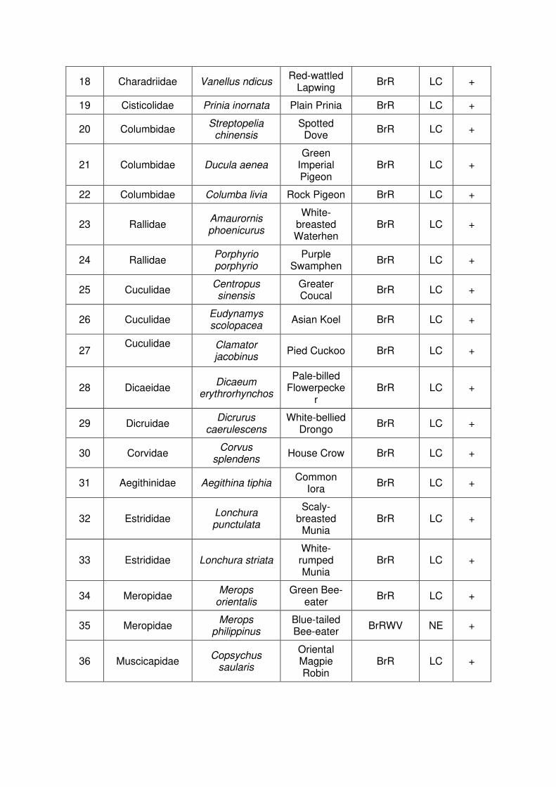
18 Charadriidae Vanellus ndicus Red-wattled
Lapwing BrR LC +
19 Cisticolidae Prinia inornata Plain Prinia BrR LC +
20 Columbidae Streptopelia
chinensis Spotted Dove
BrR LC +
21 Columbidae Ducula aenea Green
Imperial Pigeon
BrR LC +
22 Columbidae Columba livia Rock Pigeon BrR LC +
23 Rallidae Amaurornis phoenicurus
White-breasted Waterhen
BrR LC +
24 Rallidae Porphyrio porphyrio
Purple Swamphen
BrR LC +
25 Cuculidae Centropus sinensis
Greater Coucal
BrR LC +
26 Cuculidae Eudynamys scolopacea
Asian Koel BrR LC +
27 Cuculidae
Clamator jacobinus
Pied Cuckoo BrR LC +
28 Dicaeidae Dicaeum
erythrorhynchos
Pale-billed Flowerpecke
r BrR LC +
29 Dicruidae Dicrurus
caerulescens White-bellied
Drongo BrR LC +
30 Corvidae Corvus
splendens House Crow BrR LC +
31 Aegithinidae Aegithina tiphia Common
Iora BrR LC +
32 Estrididae Lonchura punctulata
Scaly-breasted
Munia BrR LC +
33 Estrididae Lonchura striata White-rumped Munia
BrR LC +
34 Meropidae Merops
orientalis Green Bee-
eater BrR LC +
35 Meropidae Merops
philippinus Blue-tailed Bee-eater
BrRWV NE +
36 Muscicapidae Copsychus
saularis
Oriental Magpie Robin
BrR LC +
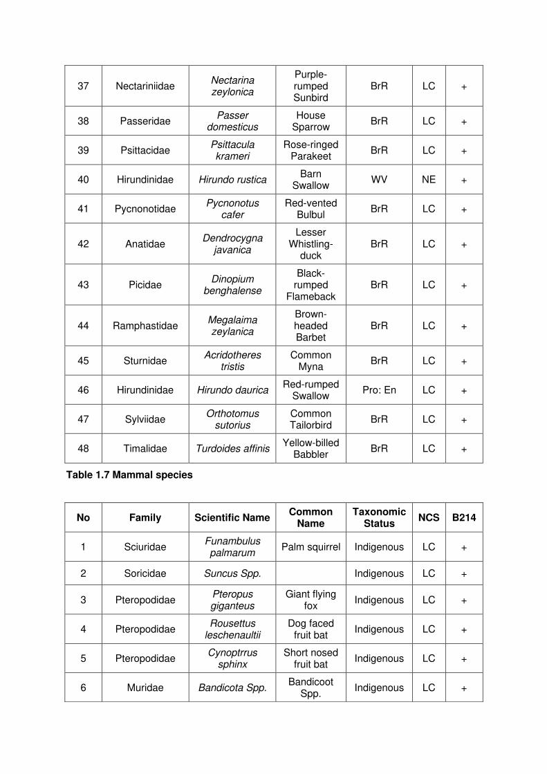
37 Nectariniidae Nectarina zeylonica
Purple-rumped Sunbird
BrR LC +
38 Passeridae Passer
domesticus House
Sparrow BrR LC +
39 Psittacidae Psittacula krameri
Rose-ringed Parakeet
BrR LC +
40 Hirundinidae Hirundo rustica Barn
Swallow WV NE +
41 Pycnonotidae Pycnonotus
cafer Red-vented
Bulbul BrR LC +
42 Anatidae Dendrocygna
javanica
Lesser Whistling-
duck BrR LC +
43 Picidae Dinopium
benghalense
Black-rumped
Flameback BrR LC +
44 Ramphastidae Megalaima zeylanica
Brown-headed Barbet
BrR LC +
45 Sturnidae Acridotheres
tristis Common
Myna BrR LC +
46 Hirundinidae Hirundo daurica Red-rumped
Swallow Pro: En LC +
47 Sylviidae Orthotomus
sutorius Common Tailorbird
BrR LC +
48 Timalidae Turdoides affinis Yellow-billed
Babbler BrR LC +
Table 1.7 Mammal species
No Family Scientific Name Common
Name Taxonomic
Status NCS B214
1 Sciuridae Funambulus palmarum
Palm squirrel Indigenous LC +
2 Soricidae Suncus Spp. Indigenous LC +
3 Pteropodidae Pteropus giganteus
Giant flying fox
Indigenous LC +
4 Pteropodidae Rousettus
leschenaultii Dog faced
fruit bat Indigenous LC +
5 Pteropodidae Cynoptrrus
sphinx Short nosed
fruit bat Indigenous LC +
6 Muridae Bandicota Spp. Bandicoot
Spp. Indigenous LC +

7 Muridae Rattus ratus Common house rat
Indigenous LC +
8 Cercopithecidae Semnopithecus
vetulus Purple-faced leaf monkey
Endemic EN +
9 Canidae Canis familiaris Domestic
dog Indigenous LC +
10 Felidae Felis catus Domestic cat Indigenous LC +
11 Herpestidae Herpestes brachyurus
Brown mongoose
Indigenous LC +
12 Viverridae Paradoxurus
hermaphoditus Palm civet Indigenous LC +
13 Viverridae Viverricula indica Ring-tailed
civet Indigenous LC +
14 Hystricidae Hystrix indica Porcupine Indigenous LC +
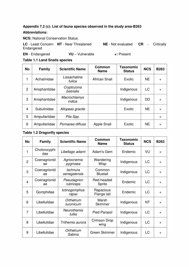
Appendix 7.2 (c): List of fauna species observed in the study area-B263
Abbreviations:
NCS: National Conservation Status.
LC - Least Concern NT - Near Threatened NE - Not evaluated CR - Critically Endangered
EN - Endangered VU – Vulnerable +: Present
Table 1.1 Land Snails species
No Family Scientific Name Common
Name Taxonomic
Status NCS B263
1 Achatinidae Lissachatina
fulica African Snail Exotic NE +
2 Ariophantidae Cryptozona
bistrialis Indigenous LC +
3 Ariophantidae Macrochlamys
indica Indigenous DD +
4 Subulinidae Allopeas gracile Exotic NE +
5 Ampullariidae Pila Spp. +
6 Ampullariidae Pomacea diffusa Apple Snail Exotic NE +
Table 1.2 Dragonfly species
No Family Scientific Name Common
Name Taxonomic
Status NCS B263
1 Cholorocyphi
dae Libellago adami Adam's Gem Endemic VU +
2 Coenagrionid
ae Agriocnemis
pygmaea Wandering
Wisp Indigenous LC +
3 Coenagrionid
ae Ischnura
senegalensis Common Bluetail
Indigenous LC +
4 Coenagrionid
ae Pseudagrion
rubriceps Red-headed
Sprite Endemic LC +
5 Gomphidae Ictinogomphus
rapax Rapacious Flange tail
Endemic LC +
6 Libellulidae Orthetrum luzonicum
Marsh Skimmer
Indigenous NT +
7 Libellulidae Neurothemis
tullia Pied Parasol Indigenous LC +
8 Libellulidae Trithemis aurora Crimson Drop
wing Indigenous LC +
9 Libellulidae Orthetrum
Sabina Green Skimmer Indigenous LC +
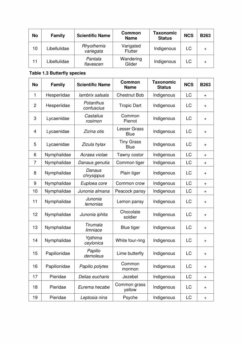
No Family Scientific Name Common
Name Taxonomic
Status NCS B263
10 Libellulidae Rhyothemis
variegata Varigated
Flutter Indigenous LC +
11 Libellulidae Pantala
flavescen Wandering
Glider Indigenous LC +
Table 1.3 Butterfly species
No Family Scientific Name Common
Name Taxonomic
Status NCS B263
1 Hesperiidae Iambrix salsala Chestnut Bob Indigenous LC +
2 Hesperiidae Potanthus confuscius
Tropic Dart Indigenous LC +
3 Lycaenidae Castalius rosimon
Common Pierrot
Indigenous LC +
4 Lycaenidae Zizina otis Lesser Grass
Blue Indigenous LC +
5 Lycaenidae Zizula hylax Tiny Grass
Blue Indigenous LC +
6 Nymphalidae Acraea violae Tawny costor Indigenous LC +
7 Nymphalidae Danaus genutia Common tiger Indigenous LC +
8 Nymphalidae Danaus
chrysippus Plain tiger Indigenous LC +
9 Nymphalidae Euploea core Common crow Indigenous LC +
10 Nymphalidae Junonia almana Peacock pansy Indigenous LC +
11 Nymphalidae Junonia lemonias
Lemon pansy Indigenous LC +
12 Nymphalidae Junonia iphita Chocolate
soldier Indigenous LC +
13 Nymphalidae Tirumala limniace
Blue tiger Indigenous LC +
14 Nymphalidae Ypthima ceylonica
White four-ring Indigenous LC +
15 Papilionidae Papilio
demoleus Lime butterfly Indigenous LC +
16 Papilionidae Papilio polytes Common mormon
Indigenous LC +
17 Pieridae Delias eucharis Jezebel Indigenous LC +
18 Pieridae Eurema hecabe Common grass
yellow Indigenous LC +
19 Pieridae Leptosia nina Psyche Indigenous LC +

Table 1.4 Reptile species
No Family Scientific Name Common
Name Taxonomic
Status NCS B263
1 Agamidae Calotes calotes Green garden
lizard Native LC +
2 Agamidae Calotes
versicolor Common
garden lizard Native LC +
3 Colubridae Ahaetulla nasuta Green vine
snake Native LC +
4 Colubridae Amphiesma
stolatum Buff striped keelback
Native LC +
5 Colubridae Lycodon aulicus House snake Native LC +
6 Gekkonidae Gehyra mutilata Four-claw
gecko Native LC +
7 Gekkonidae Hemidactylus
frenatus Common
house-gecko Native LC +
8 Gekkonidae Hemidactylus
parvimaculatus Spotted house
gecko Native LC +
9 Pythonidae Python molurus Indian python Native LC +
10 Scincidae Eutropis carinata Common skink Native LC +
11 Varanidae Varanus
bengalensis Land monitor Native LC +
12 Varanidae Varanus salvator Water monitor Native LC +
13 Viperidae Daboia russelii Russell’s viper Native LC +
Table 1.5 Amphibian species
No Family Scientific Name Common
Name Taxonomic
Status NCS B263
1 Bufonidae Duttaphrynus melanostictus
Common house toad
Native LC +
2 Bufonidae Duttaphrynus
scaber Ferguson’s
Toad Native VU +
3 Dicroglossidae Euphlyctis
cyanophlyctis Skipper frog Native LC +
4 Dicroglossidae Euphlyctis
hexadactylus Six toe green
frog Native LC +
5 Dicroglossidae Hoplobatrachus
crassus Jerdon's bull
frog Native LC +
6 Dicroglossidae Zakerana
shyadrensis
Common paddy field
frog Native LC +
7 Microhylidae Kaloula
taprobanica Common bull
frog Native LC +
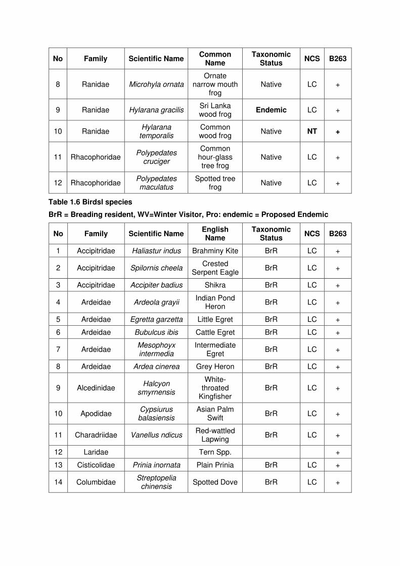
No Family Scientific Name Common
Name Taxonomic
Status NCS B263
8 Ranidae Microhyla ornata Ornate
narrow mouth frog
Native LC +
9 Ranidae Hylarana gracilis Sri Lanka wood frog
Endemic LC +
10 Ranidae Hylarana
temporalis Common wood frog
Native NT +
11 Rhacophoridae Polypedates
cruciger
Common hour‐glass tree frog
Native LC +
12 Rhacophoridae Polypedates maculatus
Spotted tree frog
Native LC +
Table 1.6 Birdsl species
BrR = Breading resident, WV=Winter Visitor, Pro: endemic = Proposed Endemic
No Family Scientific Name English Name
Taxonomic Status
NCS B263
1 Accipitridae Haliastur indus Brahminy Kite BrR LC +
2 Accipitridae Spilornis cheela Crested
Serpent Eagle BrR LC +
3 Accipitridae Accipiter badius Shikra BrR LC +
4 Ardeidae Ardeola grayii Indian Pond
Heron BrR LC +
5 Ardeidae Egretta garzetta Little Egret BrR LC +
6 Ardeidae Bubulcus ibis Cattle Egret BrR LC +
7 Ardeidae Mesophoyx intermedia
Intermediate Egret
BrR LC +
8 Ardeidae Ardea cinerea Grey Heron BrR LC +
9 Alcedinidae Halcyon
smyrnensis
White-throated
Kingfisher BrR LC +
10 Apodidae Cypsiurus balasiensis
Asian Palm Swift
BrR LC +
11 Charadriidae Vanellus ndicus Red-wattled
Lapwing BrR LC +
12 Laridae Tern Spp. +
13 Cisticolidae Prinia inornata Plain Prinia BrR LC +
14 Columbidae Streptopelia
chinensis Spotted Dove BrR LC +
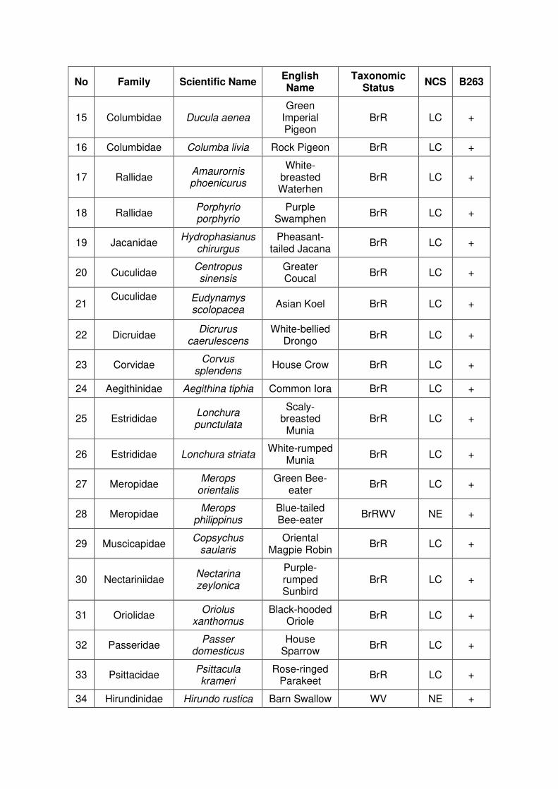
No Family Scientific Name English Name
Taxonomic Status
NCS B263
15 Columbidae Ducula aenea Green
Imperial Pigeon
BrR LC +
16 Columbidae Columba livia Rock Pigeon BrR LC +
17 Rallidae Amaurornis phoenicurus
White-breasted Waterhen
BrR LC +
18 Rallidae Porphyrio porphyrio
Purple Swamphen
BrR LC +
19 Jacanidae Hydrophasianus
chirurgus Pheasant-
tailed Jacana BrR LC +
20 Cuculidae Centropus sinensis
Greater Coucal
BrR LC +
21 Cuculidae
Eudynamys scolopacea
Asian Koel BrR LC +
22 Dicruidae Dicrurus
caerulescens White-bellied
Drongo BrR LC +
23 Corvidae Corvus
splendens House Crow BrR LC +
24 Aegithinidae Aegithina tiphia Common Iora BrR LC +
25 Estrididae Lonchura punctulata
Scaly-breasted
Munia BrR LC +
26 Estrididae Lonchura striata White-rumped
Munia BrR LC +
27 Meropidae Merops
orientalis Green Bee-
eater BrR LC +
28 Meropidae Merops
philippinus Blue-tailed Bee-eater
BrRWV NE +
29 Muscicapidae Copsychus
saularis Oriental
Magpie Robin BrR LC +
30 Nectariniidae Nectarina zeylonica
Purple-rumped Sunbird
BrR LC +
31 Oriolidae Oriolus
xanthornus Black-hooded
Oriole BrR LC +
32 Passeridae Passer
domesticus House
Sparrow BrR LC +
33 Psittacidae Psittacula krameri
Rose-ringed Parakeet
BrR LC +
34 Hirundinidae Hirundo rustica Barn Swallow WV NE +

No Family Scientific Name English Name
Taxonomic Status
NCS B263
35 Pycnonotidae Pycnonotus
cafer Red-vented
Bulbul BrR LC +
36 Anatidae Dendrocygna
javanica
Lesser Whistling-
duck BrR LC +
37 Picidae Dinopium
benghalense Black-rumped
Flameback BrR LC +
38 Ramphastidae Megalaima zeylanica
Brown-headed Barbet
BrR LC +
39 Sturnidae Acridotheres
tristis Common
Myna BrR LC +
40 Hirundinidae Hirundo daurica Red-rumped
Swallow Pro LC +
41 Sylviidae Orthotomus
sutorius Common Tailorbird
BrR LC +
42 Timalidae Turdoides affinis Yellow-billed
Babbler BrR LC +
Table 1.7 Mammal species
No Family Scientific Name Common
Name Taxonomic
Status NCS B263
1 Sciuridae Funambulus palmarum
Palm squirrel Indigenous LC +
2 Soricidae Suncus Spp. Indigenous LC +
3 Pteropodidae Pteropus giganteus
Giant flying fox
Indigenous LC +
4 Pteropodidae Rousettus
leschenaultii Dog faced
fruit bat Indigenous LC +
5 Pteropodidae Cynoptrrus
sphinx Short nosed
fruit bat Indigenous LC +
6 Muridae Bandicota Spp. Bandicoot
Spp. Indigenous LC +
7 Muridae Rattus ratus Common house rat
Indigenous LC +
8 Canidae Canis familiaris Domestic dog Indigenous LC +
9 Felidae Felis catus Domestic cat Indigenous LC +
10 Viverridae Paradoxurus
hermaphoditus Palm civet Indigenous LC +

11 Viverridae Viverricula indica Ring-tailed
civet Indigenous LC +
12 Hystricidae Hystrix indica Porcupine Indigenous LC +

Appendix 7.2 (d): List of fauna species observed in the study area-B345
Abbreviations:
NCS: National Conservation Status.
LC - Least Concern NT - Near Threatened NE - Not evaluated CR–Critically Endangered
EN - Endangered VU – Vulnerable + Present
Table 1.1 Butterfly species
No Family Scientific Name Common
Name Taxonomic
Status NCS B345
1 Lycaenidae Castalius rosimon Common Pierrot
Indigenous LC +
2 Nymphalidae Danaus
chrysippus Plain tiger Indigenous LC +
3 Nymphalidae Euploea core Common crow Indigenous LC +
4 Nymphalidae Ypthima ceylonica White four-ring Indigenous LC +
Table 1.2 Reptile species
No Family Scientific Name Common
Name Taxonomic
Status NCS B345
1 Agamidae Calotes calotes Green garden
lizard Native LC +
2 Agamidae Calotes versicolor Common
garden lizard Native LC +
3 Colubridae Ptyas mucosa Rat snake Native LC +
4 Gekkonidae Hemidactylus
frenatus Common
house-gecko Native LC +
5 Varanidae Varanus
bengalensis Land monitor Native LC +
Table 1.3 Amphibian species
No Family Scientific Name Common
Name Taxonomic
Status NCS B345
1 Bufonidae Duttaphrynus melanostictus
Common house toad
Native LC +
Table 1.4 Birds species
BrR = Breading resident, WV=Winter Visitor, Pro: endemic = Proposed Endemic
No Family Scientific Name Common
Name Taxonomic
Status NCS B345
1 Ardeidae Bubulcus ibis Cattle Egret BrR LC +
2 Alcedinidae Halcyon
smyrnensis White-throated
Kingfisher BrR LC +
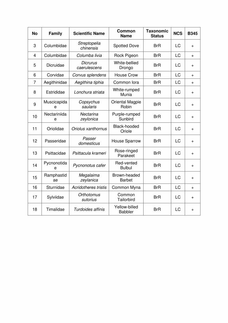
No Family Scientific Name Common
Name Taxonomic
Status NCS B345
3 Columbidae Streptopelia
chinensis Spotted Dove BrR LC +
4 Columbidae Columba livia Rock Pigeon BrR LC +
5 Dicruidae Dicrurus
caerulescens White-bellied
Drongo BrR LC +
6 Corvidae Corvus splendens House Crow BrR LC +
7 Aegithinidae Aegithina tiphia Common Iora BrR LC +
8 Estrididae Lonchura striata White-rumped
Munia BrR LC +
9 Muscicapida
e Copsychus
saularis Oriental Magpie
Robin BrR LC +
10 Nectariniida
e Nectarina zeylonica
Purple-rumped Sunbird
BrR LC +
11 Oriolidae Oriolus xanthornus Black-hooded
Oriole BrR LC +
12 Passeridae Passer
domesticus House Sparrow BrR LC +
13 Psittacidae Psittacula krameri Rose-ringed
Parakeet BrR LC +
14 Pycnonotida
e Pycnonotus cafer
Red-vented Bulbul
BrR LC +
15 Ramphastid
ae Megalaima zeylanica
Brown-headed Barbet
BrR LC +
16 Sturnidae Acridotheres tristis Common Myna BrR LC +
17 Sylviidae Orthotomus
sutorius Common Tailorbird
BrR LC +
18 Timalidae Turdoides affinis Yellow-billed
Babbler BrR LC +
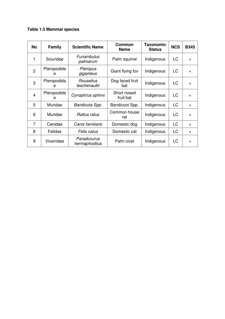
Table 1.5 Mammal species
No Family Scientific Name Common
Name Taxonomic
Status NCS B345
1 Sciuridae Funambulus palmarum
Palm squirrel Indigenous LC +
2 Pteropodida
e Pteropus giganteus
Giant flying fox Indigenous LC +
3 Pteropodida
e Rousettus
leschenaultii Dog faced fruit
bat Indigenous LC +
4 Pteropodida
e Cynoptrrus sphinx
Short nosed fruit bat
Indigenous LC +
5 Muridae Bandicota Spp. Bandicoot Spp. Indigenous LC +
6 Muridae Rattus ratus Common house
rat Indigenous LC +
7 Canidae Canis familiaris Domestic dog Indigenous LC +
8 Felidae Felis catus Domestic cat Indigenous LC +
9 Viverridae Paradoxurus
hermaphoditus Palm civet Indigenous LC +

Appendix 7.2 (e): List of fauna species observed in the study area-B368
Abbreviations:
NCS: National Conservation Status.
LC - Least Concern NT - Near Threatened NE - Not evaluated CR-Critically Endangered
EN - Endangered VU – Vulnerable +: Present
Table 1.1 Land Snails species
No Family Scientific Name Common
Name Taxonomic
Status NCS B368
1 Achatinidae Lissachatina fulica African Snail Exotic NE +
2 Ampullariidae Pila Spp. +
3 Ampullariidae Pomacea diffusa Apple Snail Exotic NE +
Table 1.2 Dragonfly species
No Family Scientific Name Common
Name Taxonomic
Status NCS B368
1 Coenagrionidae Agriocnemis
pygmaea Wandering
Wisp Indigenous LC +
2 Platycnemidida
e Copera marginipes
Yellow Feather leg
Indigenous LC +
3 Libellulidae Neurothemis tullia Pied Parasol Indigenous LC +
4 Libellulidae Orthetrum Sabina Green
Skimmer Indigenous LC +
5 Libellulidae Crocothemis servilia Oriental Scarlet
Indigenous LC +
6 Libellulidae Diplacodes trivialis Blue Percher Indigenous LC +
7 Libellulidae Pantala flavescen Wandering
Glider Indigenous LC +
Table 1.3 Butterfly species
No Family Scientific Name Common
Name Taxonomic
Status NCS B368
1 Hesperiidae Pelopidas Spp. Indigenous +
2 Hesperiidae Potanthus confuscius Tropic Dart Indigenous LC +
3 Lycaenidae Jamides celeno Common Cerulean
Indigenous LC +
4 Lycaenidae Zizina otis Lesser Grass
Blue Indigenous LC +
5 Nymphalidae Acraea violae Tawny costor Indigenous LC +
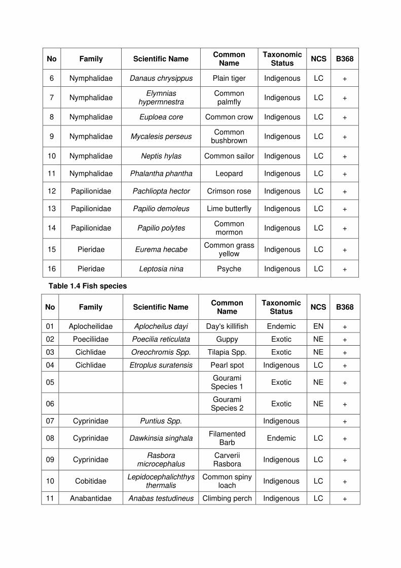
No Family Scientific Name Common
Name Taxonomic
Status NCS B368
6 Nymphalidae Danaus chrysippus Plain tiger Indigenous LC +
7 Nymphalidae Elymnias
hypermnestra Common palmfly
Indigenous LC +
8 Nymphalidae Euploea core Common crow Indigenous LC +
9 Nymphalidae Mycalesis perseus Common
bushbrown Indigenous LC +
10 Nymphalidae Neptis hylas Common sailor Indigenous LC +
11 Nymphalidae Phalantha phantha Leopard Indigenous LC +
12 Papilionidae Pachliopta hector Crimson rose Indigenous LC +
13 Papilionidae Papilio demoleus Lime butterfly Indigenous LC +
14 Papilionidae Papilio polytes Common mormon
Indigenous LC +
15 Pieridae Eurema hecabe Common grass
yellow Indigenous LC +
16 Pieridae Leptosia nina Psyche Indigenous LC +
Table 1.4 Fish species
No Family Scientific Name Common
Name Taxonomic
Status NCS B368
01 Aplocheilidae Aplocheilus dayi Day's killifish Endemic EN +
02 Poeciliidae Poecilia reticulata Guppy Exotic NE +
03 Cichlidae Oreochromis Spp. Tilapia Spp. Exotic NE +
04 Cichlidae Etroplus suratensis Pearl spot Indigenous LC +
05 Gourami Species 1
Exotic NE +
06 Gourami Species 2
Exotic NE +
07 Cyprinidae Puntius Spp. Indigenous +
08 Cyprinidae Dawkinsia singhala Filamented
Barb Endemic LC +
09 Cyprinidae Rasbora
microcephalus Carverii Rasbora
Indigenous LC +
10 Cobitidae Lepidocephalichthys
thermalis Common spiny
loach Indigenous LC +
11 Anabantidae Anabas testudineus Climbing perch Indigenous LC +

No Family Scientific Name Common
Name Taxonomic
Status NCS B368
12 Loricaridaedae Pterygoplichthys
multiradiatus Scavenger / tank cleaner
Exotic NE +
13 Notopteridae Chitala ornata Knife fish Exotic NE +
Table 1.5 Reptile species
No Family Scientific Name Common
Name Taxonomic
Status NCS B368
1 Agamidae Calotes calotes Green garden
lizard Native LC +
2 Agamidae Calotes versicolor Common
garden lizard Native LC +
3 Bataguridae Melanochelys trijuga Flat-backed
turtle Native LC +
4 Colubridae Ahaetulla nasuta Green vine
snake Native LC +
5 Colubridae Coeloganthus
helena Trinket snake Native NT +
6 Colubridae Dendrelaphis tristis Common
bronze-back Native LC +
7 Colubridae Lycodon aulicus House snake Native LC +
8 Colubridae Lycodon striatus Shaw’s wolf
snake Native LC +
9 Colubridae Ptyas mucosa Rat snake Native LC +
10 Colubridae Sibynophis
subpunctatus Jerdon’s polyodont
Native NT +
11 Crocodylidae Crocodylus porosus Estuarine crocodile
Native EN +
12 Elapidae Naja naja Indian cobra Native LC +
13 Emydidae Trachemys scripta Red-eared Terrapin
Invasive - +
14 Gekkonidae Gehyra mutilata Four-claw
gecko Native LC +
15 Gekkonidae Hemidactylus
frenatus Common
house-gecko Native LC +
16 Gekkonidae Hemidactylus
parvimaculatus Spotted house
gecko Native LC +
17 Varanidae Varanus
bengalensis Land monitor Native LC +
18 Varanidae Varanus salvator Water monitor Native LC +
19 Viperidae Daboia russelii Russell’s viper Native LC +
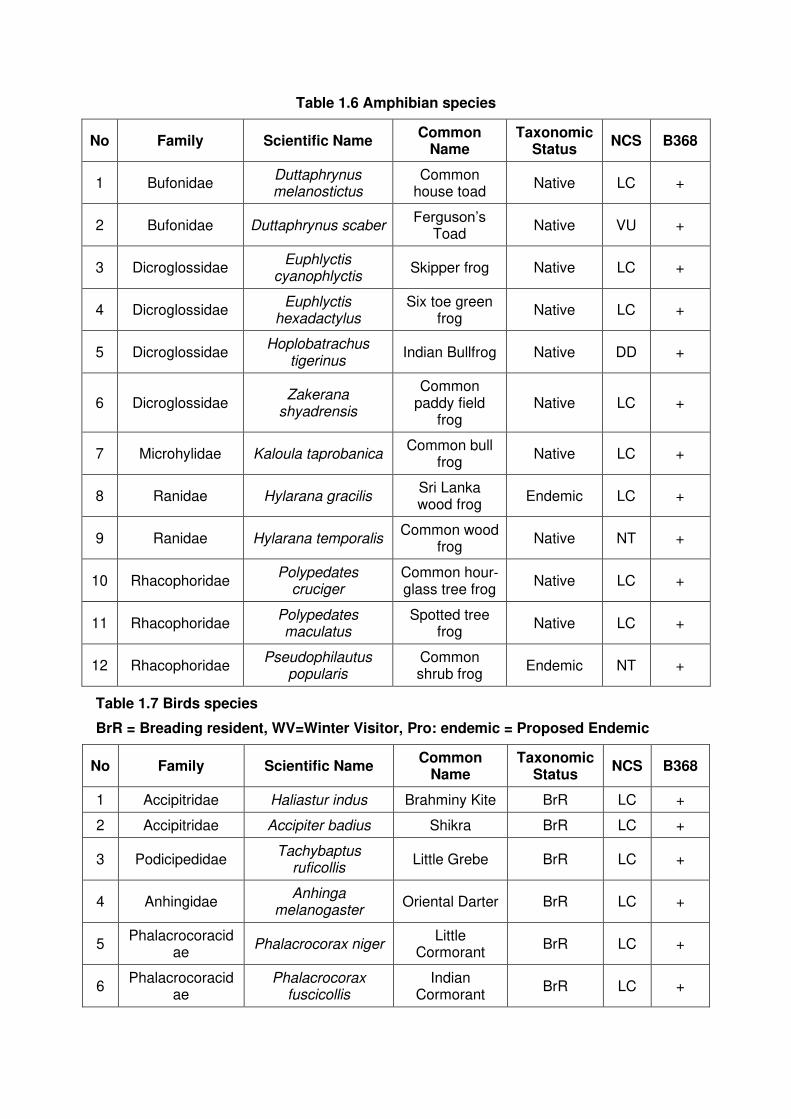
Table 1.6 Amphibian species
No Family Scientific Name Common
Name Taxonomic
Status NCS B368
1 Bufonidae Duttaphrynus melanostictus
Common house toad
Native LC +
2 Bufonidae Duttaphrynus scaber Ferguson’s
Toad Native VU +
3 Dicroglossidae Euphlyctis
cyanophlyctis Skipper frog Native LC +
4 Dicroglossidae Euphlyctis
hexadactylus Six toe green
frog Native LC +
5 Dicroglossidae Hoplobatrachus
tigerinus Indian Bullfrog Native DD +
6 Dicroglossidae Zakerana
shyadrensis
Common paddy field
frog Native LC +
7 Microhylidae Kaloula taprobanica Common bull
frog Native LC +
8 Ranidae Hylarana gracilis Sri Lanka wood frog
Endemic LC +
9 Ranidae Hylarana temporalis Common wood
frog Native NT +
10 Rhacophoridae Polypedates
cruciger Common hour‐glass tree frog
Native LC +
11 Rhacophoridae Polypedates maculatus
Spotted tree frog
Native LC +
12 Rhacophoridae Pseudophilautus
popularis Common shrub frog
Endemic NT +
Table 1.7 Birds species
BrR = Breading resident, WV=Winter Visitor, Pro: endemic = Proposed Endemic
No Family Scientific Name Common
Name Taxonomic
Status NCS B368
1 Accipitridae Haliastur indus Brahminy Kite BrR LC +
2 Accipitridae Accipiter badius Shikra BrR LC +
3 Podicipedidae Tachybaptus
ruficollis Little Grebe BrR LC +
4 Anhingidae Anhinga
melanogaster Oriental Darter BrR LC +
5 Phalacrocoracid
ae Phalacrocorax niger
Little Cormorant
BrR LC +
6 Phalacrocoracid
ae Phalacrocorax
fuscicollis Indian
Cormorant BrR LC +
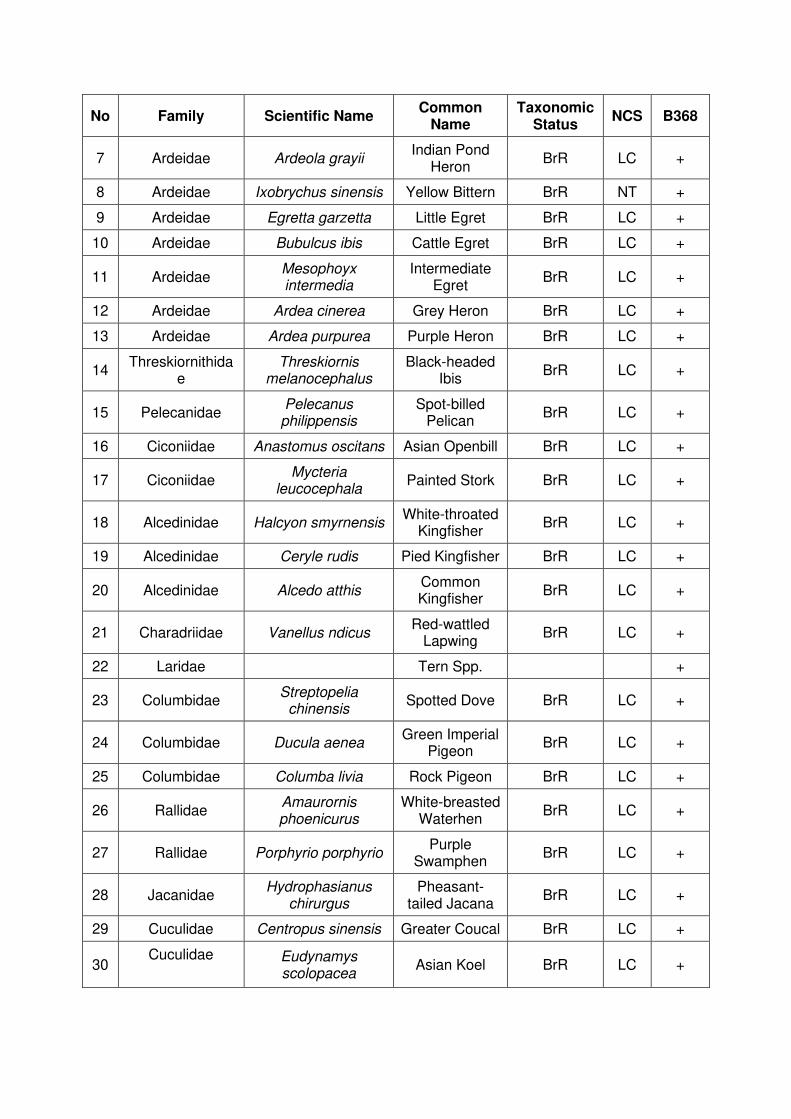
No Family Scientific Name Common
Name Taxonomic
Status NCS B368
7 Ardeidae Ardeola grayii Indian Pond
Heron BrR LC +
8 Ardeidae Ixobrychus sinensis Yellow Bittern BrR NT +
9 Ardeidae Egretta garzetta Little Egret BrR LC +
10 Ardeidae Bubulcus ibis Cattle Egret BrR LC +
11 Ardeidae Mesophoyx intermedia
Intermediate Egret
BrR LC +
12 Ardeidae Ardea cinerea Grey Heron BrR LC +
13 Ardeidae Ardea purpurea Purple Heron BrR LC +
14 Threskiornithida
e Threskiornis
melanocephalus Black-headed
Ibis BrR LC +
15 Pelecanidae Pelecanus philippensis
Spot-billed Pelican
BrR LC +
16 Ciconiidae Anastomus oscitans Asian Openbill BrR LC +
17 Ciconiidae Mycteria
leucocephala Painted Stork BrR LC +
18 Alcedinidae Halcyon smyrnensis White-throated
Kingfisher BrR LC +
19 Alcedinidae Ceryle rudis Pied Kingfisher BrR LC +
20 Alcedinidae Alcedo atthis Common Kingfisher
BrR LC +
21 Charadriidae Vanellus ndicus Red-wattled
Lapwing BrR LC +
22 Laridae Tern Spp. +
23 Columbidae Streptopelia
chinensis Spotted Dove BrR LC +
24 Columbidae Ducula aenea Green Imperial
Pigeon BrR LC +
25 Columbidae Columba livia Rock Pigeon BrR LC +
26 Rallidae Amaurornis phoenicurus
White-breasted Waterhen
BrR LC +
27 Rallidae Porphyrio porphyrio Purple
Swamphen BrR LC +
28 Jacanidae Hydrophasianus
chirurgus Pheasant-
tailed Jacana BrR LC +
29 Cuculidae Centropus sinensis Greater Coucal BrR LC +
30 Cuculidae
Eudynamys scolopacea
Asian Koel BrR LC +

No Family Scientific Name Common
Name Taxonomic
Status NCS B368
31 Dicaeidae
Dicaeum erythrorhynchos
Pale-billed Flowerpecker
BrR LC +
32 Dicruidae Dicrurus
caerulescens White-bellied
Drongo BrR LC +
33 Corvidae Corvus splendens House Crow BrR LC +
34 Aegithinidae Aegithina tiphia Common Iora BrR LC +
35 Estrididae Lonchura punctulata Scaly-breasted
Munia BrR LC +
36 Estrididae Lonchura striata White-rumped
Munia BrR LC +
37 Meropidae Merops orientalis Green Bee-
eater BrR LC +
38 Meropidae Merops philippinus Blue-tailed Bee-eater
BrRWV NE +
39 Muscicapidae Copsychus saularis Oriental
Magpie Robin BrR LC +
40 Nectariniidae Nectarina zeylonica Purple-rumped
Sunbird BrR LC +
41 Oriolidae Oriolus xanthornus Black-hooded
Oriole BrR LC +
42 Passeridae Passer domesticus House
Sparrow BrR LC +
43 Psittacidae Psittacula krameri Rose-ringed
Parakeet BrR LC +
44 Hirundinidae Hirundo rustica Barn Swallow WV NE +
45 Pycnonotidae Pycnonotus cafer Red-vented
Bulbul BrR LC +
46 Anatidae Dendrocygna
javanica Lesser
Whistling-duck BrR LC +
47 Picidae Dinopium
benghalense Black-rumped
Flameback BrR LC +
48 Ramphastidae Megalaima zeylanica
Brown-headed Barbet
BrR LC +
49 Sturnidae Acridotheres tristis Common Myna BrR LC +
50 Hirundinidae Hirundo daurica Red-rumped
Swallow Pro:endemi
c LC +
51 Sylviidae Orthotomus sutorius Common Tailorbird
BrR LC +
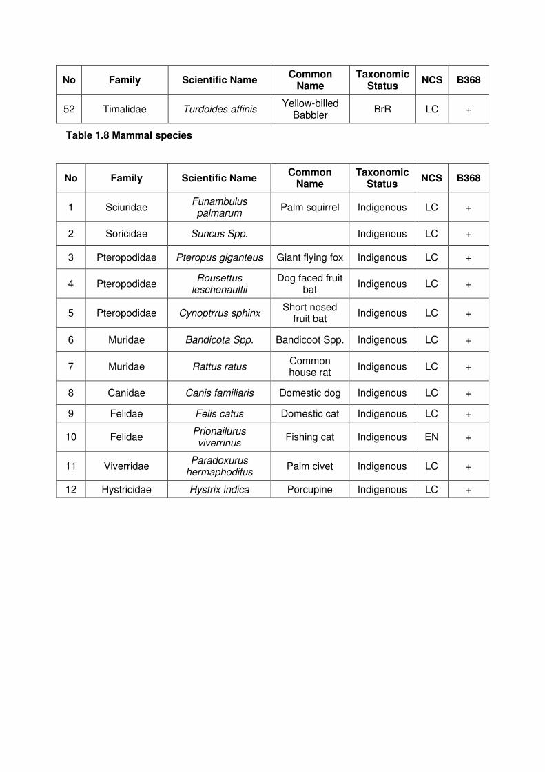
No Family Scientific Name Common
Name Taxonomic
Status NCS B368
52 Timalidae Turdoides affinis Yellow-billed
Babbler BrR LC +
Table 1.8 Mammal species
No Family Scientific Name Common
Name Taxonomic
Status NCS B368
1 Sciuridae Funambulus palmarum
Palm squirrel Indigenous LC +
2 Soricidae Suncus Spp. Indigenous LC +
3 Pteropodidae Pteropus giganteus Giant flying fox Indigenous LC +
4 Pteropodidae Rousettus
leschenaultii Dog faced fruit
bat Indigenous LC +
5 Pteropodidae Cynoptrrus sphinx Short nosed
fruit bat Indigenous LC +
6 Muridae Bandicota Spp. Bandicoot Spp. Indigenous LC +
7 Muridae Rattus ratus Common house rat
Indigenous LC +
8 Canidae Canis familiaris Domestic dog Indigenous LC +
9 Felidae Felis catus Domestic cat Indigenous LC +
10 Felidae Prionailurus viverrinus
Fishing cat Indigenous EN +
11 Viverridae Paradoxurus
hermaphoditus Palm civet Indigenous LC +
12 Hystricidae Hystrix indica Porcupine Indigenous LC +
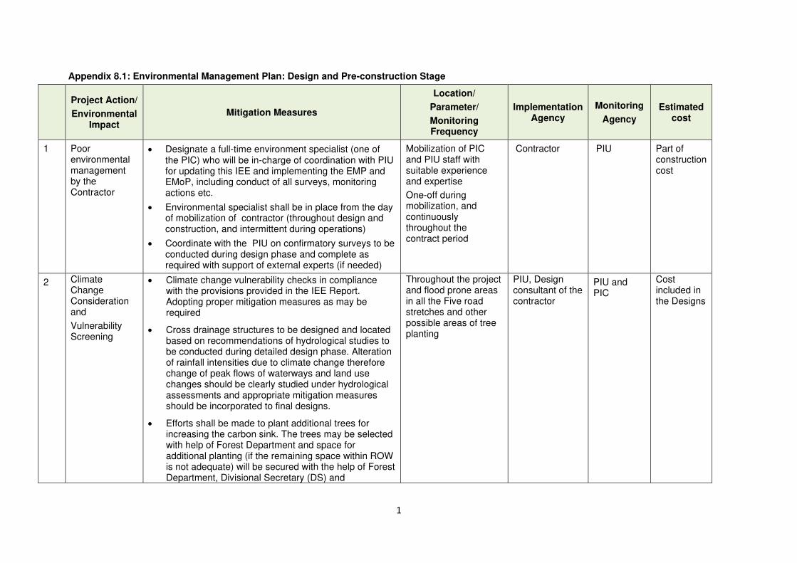
1
Appendix 8.1: Environmental Management Plan: Design and Pre-construction Stage
Project Action/
Environmental Impact
Mitigation Measures
Location/
Parameter/
Monitoring Frequency
Implementation Agency
Monitoring
Agency
Estimated cost
1 Poor environmental management by the Contractor
• Designate a full-time environment specialist (one of the PIC) who will be in-charge of coordination with PIU for updating this IEE and implementing the EMP and EMoP, including conduct of all surveys, monitoring actions etc.
• Environmental specialist shall be in place from the day of mobilization of contractor (throughout design and construction, and intermittent during operations)
• Coordinate with the PIU on confirmatory surveys to be conducted during design phase and complete as required with support of external experts (if needed)
Mobilization of PIC and PIU staff with suitable experience and expertise
One-off during mobilization, and continuously throughout the contract period
Contractor PIU Part of construction cost
2 Climate Change Consideration and
Vulnerability Screening
• Climate change vulnerability checks in compliance with the provisions provided in the IEE Report. Adopting proper mitigation measures as may be required
• Cross drainage structures to be designed and located based on recommendations of hydrological studies to be conducted during detailed design phase. Alteration of rainfall intensities due to climate change therefore change of peak flows of waterways and land use changes should be clearly studied under hydrological assessments and appropriate mitigation measures should be incorporated to final designs.
• Efforts shall be made to plant additional trees for increasing the carbon sink. The trees may be selected with help of Forest Department and space for additional planting (if the remaining space within ROW is not adequate) will be secured with the help of Forest Department, Divisional Secretary (DS) and
Throughout the project and flood prone areas in all the Five road stretches and other possible areas of tree planting
PIU, Design consultant of the contractor
PIU and PIC
Cost included in the Designs

2
Project Action/
Environmental Impact
Mitigation Measures
Location/
Parameter/
Monitoring Frequency
Implementation Agency
Monitoring
Agency
Estimated cost
Community-based Organizations (CBOs).
3(a) Site selection and preparation for
quarrying, borrow operations, clearing land for stockpiling, labour huts, machinery yards, asphalt plants, batching plants, etc.
a) Loss of scrub land, trees and other flora, and protected flora species
• Conduct a confirmatory survey by an Ecologist to identify and mark, if any, protected plant species on site and also on the site survey maps.
• Integrate identified protected plants (if any) in the location maps to avoid the need to remove/cut these plants.
Protected plants survey map & markings on site maps of quarries, borrow areas, and other areas cleared for yards, etc.
One-off after survey
Contractor (if needed, through a pre-approved party)
PIU supported by an independent consultant (Ecologist)
Lump sum costs
• If removal of trees is unavoidable, translocate protected species in the nearby areas; prepare Tree Translocation, Cutting & Re-plantation Plan. If translocation is not possible, and if it is necessary to remove/cut protected plants, prepare a justification to establish that it is not feasible to avoid or translocate trees.
• Obtain approval of relevant authority for cutting/removal and plant 3-5 trees of same species for each tree that is removed
• Adopt minimal tree cutting as a general principle in planning & design; minimize tree cutting – either of protected species or otherwise
• In general, follow avoidance and compensatory approach for cutting of tree species; plant 3-5 trees for each tree removed.
Tree Translocation, Cutting & Re-plantation Plan (shall include justification, minimization & approvals)
One-off during site location finalization
Contractor (if needed, through a pre-approved party)
PIU supported by an independent consultant (Ecologist)
Lump sum costs
• Site Operation manual shall include clear provisions on protection and conservation of environment & wildlife, including prohibition on cutting of trees, removal of shrubs and bushes, hunting / harming wild animals etc.; do’s and don’ts to be followed by all concerned with the Contractors
Operation plan for site operations, including quarries, borrow sites, plans and yards.
Contractor PIU No additional costs

3
Project Action/
Environmental Impact
Mitigation Measures
Location/
Parameter/
Monitoring Frequency
Implementation Agency
Monitoring
Agency
Estimated cost
3(b) Site selection and preparation for quarrying, borrow operations, clearing land for stockpiling, labour huts, machinery yards, asphalt plants, batching plants, etc.
(b) Impacts on protected species of avifauna
• Conduct field surveys by an ecologist (at least one season prior to start of work) to confirm if there are any birds of protected species, and identify if any trees with nests / breeding places:
• If there are birds any of these species on trees within the site, but no nests, ensure that the birds are not harmed, and allowed to move away freely
• If there are any trees with nests / breeding birds, work shall not commence until nesting cycle is complete and the birds leave the nest
• If there are no protected birds or any other protected species, immediately initiate work on boundary fencing; the work related disturbance will ensure the birds move away from the site, and do not prefer the site for further roosting/nesting
Confirmation survey output & mitigation measures
One-off prior to survey
One-off after survey
Contractor (if needed, through a pre-approved party)
PIU supported by an independent consultant (Ecologist)
Lump sum costs
3(c) Site selection and preparation for quarrying, borrow operations, clearing land for stockpiling, labour huts, machinery yards, asphalt plants, batching plants, etc.
(c) Impacts on protected species of
• Conduct confirmatory surveys by experts to rule out fauna breeding areas in the proposed sites and reconfirm that their extent & nature of inhabitation is limited to occasional visits
• Review the following suggested measures & develop further based on confirmatory survey:
o Providing workers or posting in public places for the workers, illustrations or pictures of protected, endangered, threatened, and/or near-threatened species, which can be found in the work area or its immediate surroundings.
o Instructing workers to stop work immediately and report if any such species are spotted on the site
o Creating awareness and conducting training;
Confirmatory survey results & suggested mitigation measures
One-off after survey
Contractor (if needed, through a pre-approved party)
PIU supported by an independent consultant (Ecologist)
Lump sum costs
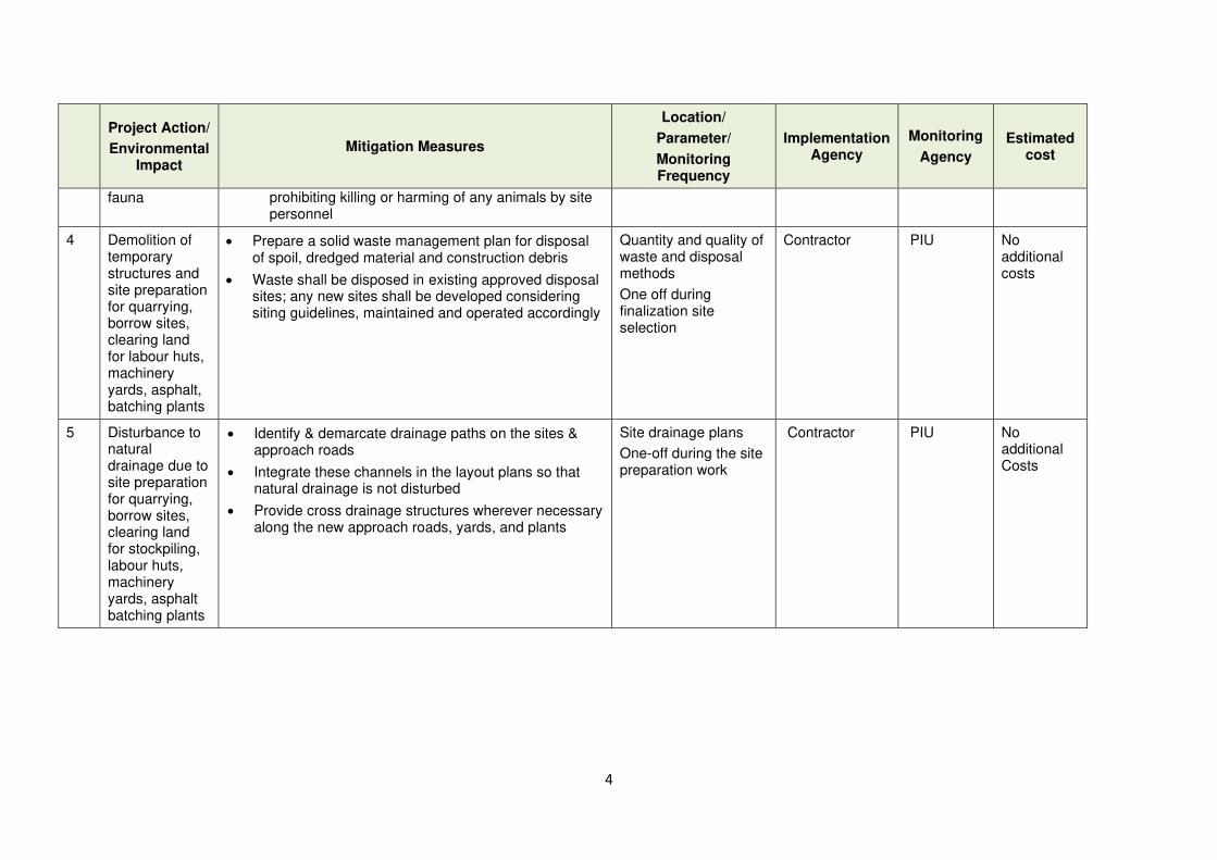
4
Project Action/
Environmental Impact
Mitigation Measures
Location/
Parameter/
Monitoring Frequency
Implementation Agency
Monitoring
Agency
Estimated cost
fauna prohibiting killing or harming of any animals by site personnel
4 Demolition of temporary structures and site preparation for quarrying, borrow sites, clearing land for labour huts, machinery yards, asphalt, batching plants
• Prepare a solid waste management plan for disposal of spoil, dredged material and construction debris
• Waste shall be disposed in existing approved disposal sites; any new sites shall be developed considering siting guidelines, maintained and operated accordingly
Quantity and quality of waste and disposal methods
One off during finalization site selection
Contractor PIU No additional costs
5 Disturbance to natural drainage due to site preparation for quarrying, borrow sites, clearing land for stockpiling, labour huts, machinery yards, asphalt batching plants
• Identify & demarcate drainage paths on the sites & approach roads
• Integrate these channels in the layout plans so that natural drainage is not disturbed
• Provide cross drainage structures wherever necessary along the new approach roads, yards, and plants
Site drainage plans
One-off during the site preparation work
Contractor PIU No additional Costs

5
Project Action/
Environmental Impact
Mitigation Measures
Location/
Parameter/
Monitoring Frequency
Implementation Agency
Monitoring
Agency
Estimated cost
6 Sites for construction work camps, areas for stockpile, storage and disposal
• Except disposal sites, all the work sites (camps, storage, stockpiles etc.) will be located within the selected section of the road.
• No construction camp shall be located close to water bodies (at least 500 m away)
• Construction material shall be brought to site as and when required, and temporary storage of material shall be made near the work site along the road itself outside the RoW.
• No temporary storage shall be located near water ways or areas prone for flooding or locations where there are natural drainage paths
Plan for site selection
One-off prior to start of construction
Contractor PIU No additional costs
7 Delays in mobilisation and timely implementation of work program & plans
• Finalize construction programs duly considering provisions for work schedule
• Following plans be developed for implementation:
o Construction Waste Management Plan
o Transportation Plan for construction material, equipment and waste conveyance
o Health & Safety Plan; Construction Camp Development & Management Plan
o Material Procurement Plans and EMPs
o Area Construction Work Plan
o Erosion control plan near the water bodies for earth works (if any)
Work schedule
Respective plans
One-off prior to start of construction
Contractor PIU No additional costs
8 Consents, permits, clearances, no objection certificate
• Obtain all necessary consents, permits, clearance, NOCs, prior to start of civil works (PAA/CEA; EPL; permits from LAs, etc.)
• Include in project implementation all conditions and provisions where necessary
Clearances and approvals
One-off prior to start of construction
PIU facilitated by the EA and/or IA
Contractor facilitated by the
PIU No additional costs
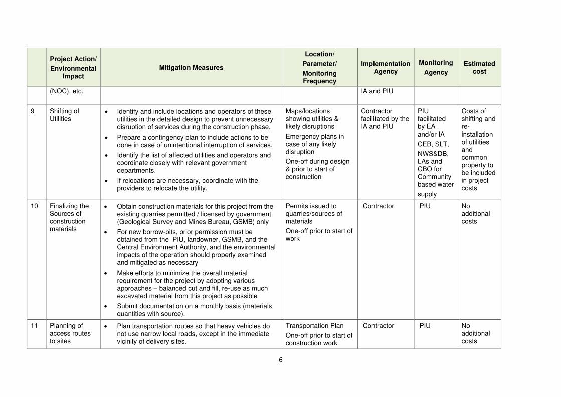
6
Project Action/
Environmental Impact
Mitigation Measures
Location/
Parameter/
Monitoring Frequency
Implementation Agency
Monitoring
Agency
Estimated cost
(NOC), etc. IA and PIU
9 Shifting of Utilities
• Identify and include locations and operators of these utilities in the detailed design to prevent unnecessary disruption of services during the construction phase.
• Prepare a contingency plan to include actions to be done in case of unintentional interruption of services.
• Identify the list of affected utilities and operators and coordinate closely with relevant government departments.
• If relocations are necessary, coordinate with the providers to relocate the utility.
Maps/locations showing utilities & likely disruptions
Emergency plans in case of any likely disruption
One-off during design & prior to start of construction
Contractor facilitated by the IA and PIU
PIU facilitated by EA and/or IA
CEB, SLT,
NWS&DB, LAs and CBO for Community based water
supply
Costs of shifting and re-installation of utilities and common property to be included in project costs
10 Finalizing the Sources of construction materials
• Obtain construction materials for this project from the existing quarries permitted / licensed by government (Geological Survey and Mines Bureau, GSMB) only
• For new borrow-pits, prior permission must be obtained from the PIU, landowner, GSMB, and the Central Environment Authority, and the environmental impacts of the operation should properly examined and mitigated as necessary
• Make efforts to minimize the overall material requirement for the project by adopting various approaches – balanced cut and fill, re-use as much excavated material from this project as possible
• Submit documentation on a monthly basis (materials quantities with source).
Permits issued to quarries/sources of materials
One-off prior to start of work
Contractor PIU No additional costs
11 Planning of access routes to sites
• Plan transportation routes so that heavy vehicles do not use narrow local roads, except in the immediate vicinity of delivery sites.
Transportation Plan
One-off prior to start of construction work
Contractor PIU No additional costs
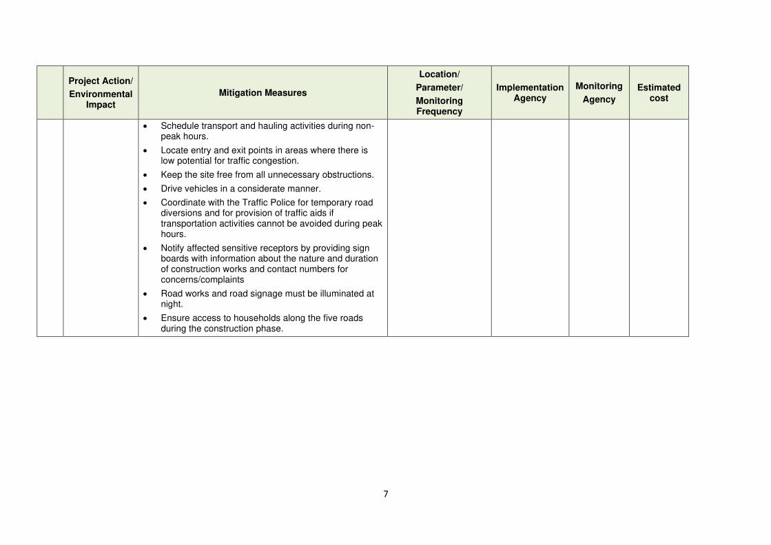
7
Project Action/
Environmental Impact
Mitigation Measures
Location/
Parameter/
Monitoring Frequency
Implementation Agency
Monitoring
Agency
Estimated cost
• Schedule transport and hauling activities during non-peak hours.
• Locate entry and exit points in areas where there is low potential for traffic congestion.
• Keep the site free from all unnecessary obstructions.
• Drive vehicles in a considerate manner.
• Coordinate with the Traffic Police for temporary road diversions and for provision of traffic aids if transportation activities cannot be avoided during peak hours.
• Notify affected sensitive receptors by providing sign boards with information about the nature and duration of construction works and contact numbers for concerns/complaints
• Road works and road signage must be illuminated at night.
• Ensure access to households along the five roads during the construction phase.
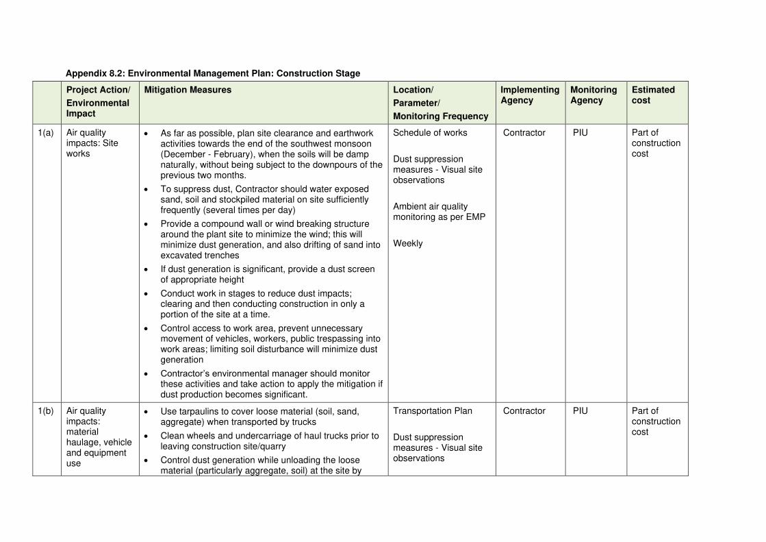
Appendix 8.2: Environmental Management Plan: Construction Stage
Project Action/
Environmental Impact
Mitigation Measures Location/
Parameter/
Monitoring Frequency
Implementing Agency
Monitoring Agency
Estimated cost
1(a) Air quality impacts: Site works
• As far as possible, plan site clearance and earthwork activities towards the end of the southwest monsoon (December - February), when the soils will be damp naturally, without being subject to the downpours of the previous two months.
• To suppress dust, Contractor should water exposed sand, soil and stockpiled material on site sufficiently frequently (several times per day)
• Provide a compound wall or wind breaking structure around the plant site to minimize the wind; this will minimize dust generation, and also drifting of sand into excavated trenches
• If dust generation is significant, provide a dust screen of appropriate height
• Conduct work in stages to reduce dust impacts; clearing and then conducting construction in only a portion of the site at a time.
• Control access to work area, prevent unnecessary movement of vehicles, workers, public trespassing into work areas; limiting soil disturbance will minimize dust generation
• Contractor’s environmental manager should monitor these activities and take action to apply the mitigation if dust production becomes significant.
Schedule of works
Dust suppression measures - Visual site observations
Ambient air quality monitoring as per EMP
Weekly
Contractor PIU Part of construction cost
1(b) Air quality impacts: material haulage, vehicle and equipment use
• Use tarpaulins to cover loose material (soil, sand, aggregate) when transported by trucks
• Clean wheels and undercarriage of haul trucks prior to leaving construction site/quarry
• Control dust generation while unloading the loose material (particularly aggregate, soil) at the site by
Transportation Plan
Dust suppression measures - Visual site observations
Contractor PIU Part of construction cost
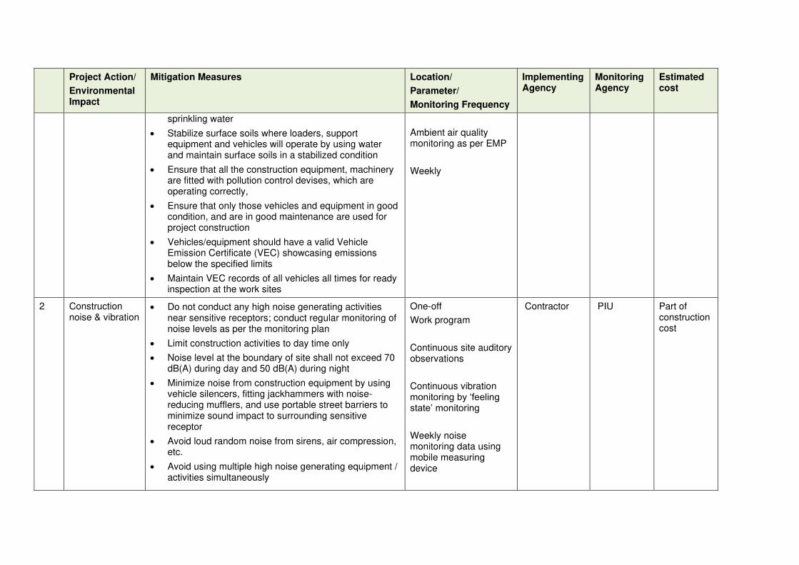
Project Action/
Environmental Impact
Mitigation Measures Location/
Parameter/
Monitoring Frequency
Implementing Agency
Monitoring Agency
Estimated cost
sprinkling water
• Stabilize surface soils where loaders, support equipment and vehicles will operate by using water and maintain surface soils in a stabilized condition
• Ensure that all the construction equipment, machinery are fitted with pollution control devises, which are operating correctly,
• Ensure that only those vehicles and equipment in good condition, and are in good maintenance are used for project construction
• Vehicles/equipment should have a valid Vehicle Emission Certificate (VEC) showcasing emissions below the specified limits
• Maintain VEC records of all vehicles all times for ready inspection at the work sites
Ambient air quality monitoring as per EMP
Weekly
2 Construction noise & vibration
• Do not conduct any high noise generating activities near sensitive receptors; conduct regular monitoring of noise levels as per the monitoring plan
• Limit construction activities to day time only
• Noise level at the boundary of site shall not exceed 70 dB(A) during day and 50 dB(A) during night
• Minimize noise from construction equipment by using vehicle silencers, fitting jackhammers with noise-reducing mufflers, and use portable street barriers to minimize sound impact to surrounding sensitive receptor
• Avoid loud random noise from sirens, air compression, etc.
• Avoid using multiple high noise generating equipment / activities simultaneously
One-off
Work program
Continuous site auditory observations
Continuous vibration monitoring by ‘feeling state’ monitoring
Weekly noise monitoring data using mobile measuring device
Contractor PIU Part of construction cost
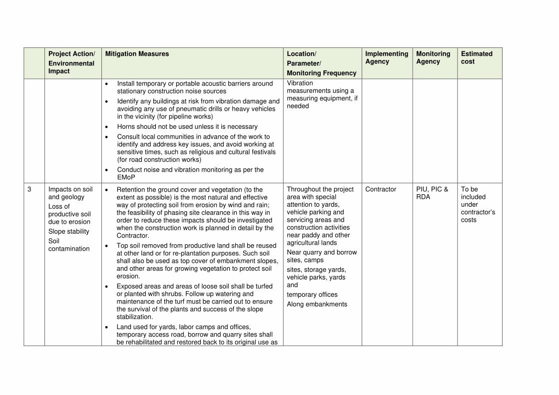
Project Action/
Environmental Impact
Mitigation Measures Location/
Parameter/
Monitoring Frequency
Implementing Agency
Monitoring Agency
Estimated cost
• Install temporary or portable acoustic barriers around stationary construction noise sources
• Identify any buildings at risk from vibration damage and avoiding any use of pneumatic drills or heavy vehicles in the vicinity (for pipeline works)
• Horns should not be used unless it is necessary
• Consult local communities in advance of the work to identify and address key issues, and avoid working at sensitive times, such as religious and cultural festivals (for road construction works)
• Conduct noise and vibration monitoring as per the EMoP
Vibration measurements using a measuring equipment, if needed
3 Impacts on soil and geology
Loss of productive soil due to erosion
Slope stability
Soil contamination
• Retention the ground cover and vegetation (to the extent as possible) is the most natural and effective way of protecting soil from erosion by wind and rain; the feasibility of phasing site clearance in this way in order to reduce these impacts should be investigated when the construction work is planned in detail by the Contractor.
• Top soil removed from productive land shall be reused at other land or for re-plantation purposes. Such soil shall also be used as top cover of embankment slopes, and other areas for growing vegetation to protect soil erosion.
• Exposed areas and areas of loose soil shall be turfed or planted with shrubs. Follow up watering and maintenance of the turf must be carried out to ensure the survival of the plants and success of the slope stabilization.
• Land used for yards, labor camps and offices, temporary access road, borrow and quarry sites shall be rehabilitated and restored back to its original use as
Throughout the project area with special attention to yards, vehicle parking and servicing areas and construction activities near paddy and other agricultural lands
Near quarry and borrow sites, camps
sites, storage yards, vehicle parks, yards and
temporary offices
Along embankments
Contractor
PIU, PIC & RDA
To be included under contractor’s costs
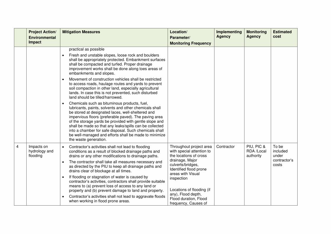
Project Action/
Environmental Impact
Mitigation Measures Location/
Parameter/
Monitoring Frequency
Implementing Agency
Monitoring Agency
Estimated cost
practical as possible
• Fresh and unstable slopes, loose rock and boulders shall be appropriately protected. Embankment surfaces shall be compacted and turfed. Proper drainage improvement works shall be done along toes areas of embankments and slopes.
• Movement of construction vehicles shall be restricted to access roads, haulage routes and yards to prevent soil compaction in other land, especially agricultural lands. In case this is not prevented, such disturbed land should be tilled/harrowed.
• Chemicals such as bituminous products, fuel, lubricants, paints, solvents and other chemicals shall be stored at designated laces, well-sheltered and impervious floors (preferable paved). The paving area of the storage yards be provided with gentle slope and shall be made so that any leaks/spills can be collected into a chamber for safe disposal. Such chemicals shall be well-managed and efforts shall be made to minimize the waste generation.
4 Impacts on hydrology and flooding
• Contractor’s activities shall not lead to flooding conditions as a result of blocked drainage paths and drains or any other modifications to drainage paths.
• The contractor shall take all measures necessary and as directed by the PIU to keep all drainage paths and drains clear of blockage at all times.
• If flooding or stagnation of water is caused by contractor’s activities, contractors shall provide suitable means to (a) prevent loss of access to any land or property and (b) prevent damage to land and property.
• Contractor’s activities shall not lead to aggravate floods when working in flood prone areas.
Throughout project area with special attention to the locations of cross drainage, Major culverts/bridges, Identified flood prone areas with Visual inspection
Locations of flooding (if any), Flood depth, Flood duration, Flood frequency, Causes of
Contractor
PIU, PIC & RDA /Local authority
To be included under contractor’s costs
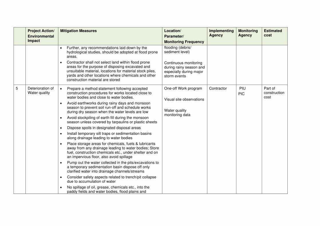
Project Action/
Environmental Impact
Mitigation Measures Location/
Parameter/
Monitoring Frequency
Implementing Agency
Monitoring Agency
Estimated cost
• Further, any recommendations laid down by the hydrological studies, should be adopted at flood prone areas.
• Contractor shall not select land within flood prone areas for the purpose of disposing excavated and unsuitable material, locations for material stock piles, yards and other locations where chemicals and other construction material are stored
flooding (debris/ sediment level)
Continuous monitoring during rainy season and especially during major storm events
5 Deterioration of Water quality
• Prepare a method statement following accepted construction procedures for works located close to water bodies and close to water bodies.
• Avoid earthworks during rainy days and monsoon season to prevent soil run-off and schedule works during dry season when the water levels are low
• Avoid stockpiling of earth fill during the monsoon season unless covered by tarpaulins or plastic sheets
• Dispose spoils in designated disposal areas
• Install temporary silt traps or sedimentation basins along drainage leading to water bodies
• Place storage areas for chemicals, fuels & lubricants away from any drainage leading to water bodies; Store fuel, construction chemicals etc., under shelter and on an impervious floor, also avoid spillage
• Pump out the water collected in the pits/excavations to a temporary sedimentation basin dispose off only clarified water into drainage channels/streams
• Consider safety aspects related to trench/pit collapse due to accumulation of water
• No spillage of oil, grease, chemicals etc., into the paddy fields and water bodies, flood plains and
One-off Work program
Visual site observations
Water quality monitoring data
Contractor PIU
PIC
Part of construction cost

Project Action/
Environmental Impact
Mitigation Measures Location/
Parameter/
Monitoring Frequency
Implementing Agency
Monitoring Agency
Estimated cost
reservations
• Dispose any residuals at identified disposal site, and stock pile construction material away from paddy fields and water bodies, flood plains and reservations
• Do not conduct any cleaning, washing, rinsing of machinery and equipment near the water bodies; prevent any waste/water from discharging into water bodies.
• Inspect all vehicles daily for fluid leaks before leaving the vehicle staging area, and repair any leaks before the vehicle resumes operation
• Ensure that no silt laden runoff from nearby construction area enter the water bodies;
• Excess water sprinkling on soil, material to control dust may also generate runoff which may enter the water bodies; this should be avoided by controlled water sprinkling
• Conduct surface quality inspection according to the EMoP
6 Pollution from asphalt and batching plant operation
• Ensure that batching plant is installed with in-built air pollution and dust control system; for fugitive emissions/dust from loading area, provide dust screen around the components
• Ensure that plant is well operated & maintained at all times according to O&M manuals provided by the equipment manufacturer;
• The asphalt loading area is equipped with a leak-proof concrete floor, from which all drainage is collected and treated as necessary prior to discharge
• Asphalt trucks and especially drums are washed out only in a designated area, which should also be
Establishment of batching plant
One-off for preparation and establishment of the Operations Manual
Operations manual should include waste management plan
Visual site observation by weekly inspection of
Contractor PIU
PIC
CEA
LAs
Part of construction cost
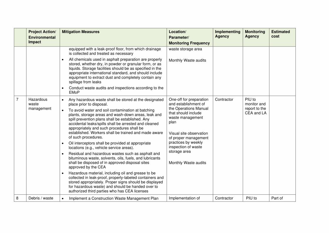
Project Action/
Environmental Impact
Mitigation Measures Location/
Parameter/
Monitoring Frequency
Implementing Agency
Monitoring Agency
Estimated cost
equipped with a leak-proof floor, from which drainage is collected and treated as necessary
• All chemicals used in asphalt preparation are properly stored, whether dry, in powder or granular form, or as liquids. Storage facilities should be as specified in the appropriate international standard, and should include equipment to extract dust and completely contain any spillage from leaks
• Conduct waste audits and inspections according to the EMoP
waste storage area
Monthly Waste audits
7 Hazardous waste management
• Any hazardous waste shall be stored at the designated place prior to disposal.
• To avoid water and soil contamination at batching plants, storage areas and wash-down areas, leak and spill prevention plans shall be established. Any accidental leaks/spills shall be arrested and cleaned appropriately and such procedures shall be established. Workers shall be trained and made aware of such procedures.
• Oil interceptors shall be provided at appropriate locations (e.g., vehicle service areas).
• Residual and hazardous wastes such as asphalt and bituminous waste, solvents, oils, fuels, and lubricants shall be disposed of in approved disposal sites approved by the CEA
• Hazardous material, including oil and grease to be collected in leak-proof, properly-labeled containers and stored appropriately. Proper signs should be displayed for hazardous waste) and should be handed over to authorized third parties who has CEA licenses
One-off for preparation and establishment of the Operations Manual that should include waste management plan
Visual site observation of proper management practices by weekly inspection of waste storage area
Monthly Waste audits
Contractor PIU to monitor and report to the CEA and LA
8 Debris / waste • Implement a Construction Waste Management Plan Implementation of Contractor PIU to Part of
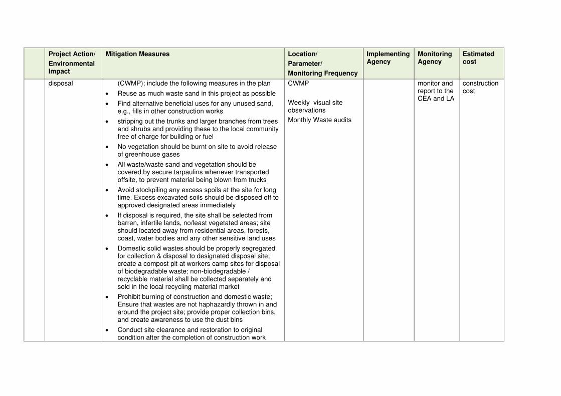
Project Action/
Environmental Impact
Mitigation Measures Location/
Parameter/
Monitoring Frequency
Implementing Agency
Monitoring Agency
Estimated cost
disposal (CWMP); include the following measures in the plan
• Reuse as much waste sand in this project as possible
• Find alternative beneficial uses for any unused sand, e.g., fills in other construction works
• stripping out the trunks and larger branches from trees and shrubs and providing these to the local community free of charge for building or fuel
• No vegetation should be burnt on site to avoid release of greenhouse gases
• All waste/waste sand and vegetation should be covered by secure tarpaulins whenever transported offsite, to prevent material being blown from trucks
• Avoid stockpiling any excess spoils at the site for long time. Excess excavated soils should be disposed off to approved designated areas immediately
• If disposal is required, the site shall be selected from barren, infertile lands, no/least vegetated areas; site should located away from residential areas, forests, coast, water bodies and any other sensitive land uses
• Domestic solid wastes should be properly segregated for collection & disposal to designated disposal site; create a compost pit at workers camp sites for disposal of biodegradable waste; non-biodegradable / recyclable material shall be collected separately and sold in the local recycling material market
• Prohibit burning of construction and domestic waste; Ensure that wastes are not haphazardly thrown in and around the project site; provide proper collection bins, and create awareness to use the dust bins
• Conduct site clearance and restoration to original condition after the completion of construction work
CWMP
Weekly visual site observations
Monthly Waste audits
monitor and report to the CEA and LA
construction cost

Project Action/
Environmental Impact
Mitigation Measures Location/
Parameter/
Monitoring Frequency
Implementing Agency
Monitoring Agency
Estimated cost
especially along the conveyance pipeline route, beach area, and around the RODP; ensure that site is properly restored prior to issuing of completion certificate
9 Traffic and access related impacts
• Temporary access will be provided to properties that are located adjacent to the roads under construction
• Temporary parking areas for urban areas will be identified. Proper management of work zone will be carried out in urban areas.
• Construction scheduling will be done to allow accessibility from alternative routes
• Temporary traffic management schemes will be used at the commencement of the project
• Traffic diversion planning and implementation will be done. Adequate signboards shall be placed much ahead of diversion site to caution the road users. The road signs should comply with the Road Safety Manual of RDA
• Reinstatement of road sections be carried out as per specifications and method statement will be given at the commencement of the project.
• Road furniture including footpaths, railings, storm water drains, crash barrier, traffic signs, speed zone signs, pavement markers and any other such items will be provided to enhance the road safety where necessary at the completion of the project
• Night time illumination should be in place at every location where the road is narrow, diverted and structures are repaired and any other places where PIC recommends to do so.
• Monitor and record road crashes during construction
Properties along the five roads, especially access to residents, business premises and by-roads
Urban areas where disturbances to vehicle parking would occur.
Locations where access to businesses premises are disturbed in urban areas
Continuous throughout the construction period
Contractor PIU to monitor and report to LAs
Part of construction cost

Project Action/
Environmental Impact
Mitigation Measures Location/
Parameter/
Monitoring Frequency
Implementing Agency
Monitoring Agency
Estimated cost
and maintenance stages and take appropriate remedial actions
Ecological Impacts
10 Loss / damage to flora and fauna
• Ensure that all construction activities are conducted strictly within the site footprints (including offices, vehicle parking and other activities that might normally be located in an exterior contractor’s area); no clearance of vegetation/trees outside footprint is permitted
• Prohibit any deliberate killing or harming of animals on or off-site; any hunting or fishing or in nearby areas by site personnel; preventive actions shall be put in place by contractor for hunting/killing of wild animals
• Ensure that all construction work or other activities near the site perimeter are conducted with particular care and include measures to reduce noise and dust to minimum possible
• Conduct the site clearance and earthworks in a phased manner, gradually advancing noise & visual disturbance, which will encourage animals to leave before their habitat is affected
• Create awareness in all site staff & workers on the importance of the animals and plants on site and in the surrounding area, and their vulnerability
• To protect site personnel, training should also be provided to enable them to recognize & deal safely & humanely wilt all venomous animals that may be encountered (e.g., snakes and scorpions)
• Conduct site preparation activities, including vegetation removals, outside of the breeding season for wildlife,
One-off prior to start of work: Construction camp/yard establishment & management plan
Weekly
Visual observations
Monthly Interviews with workers and local people
Accident and medical records
Contractor
Labour sub-contractors
PIU with the assistance of specialist monitoring agency
Part of construction cost
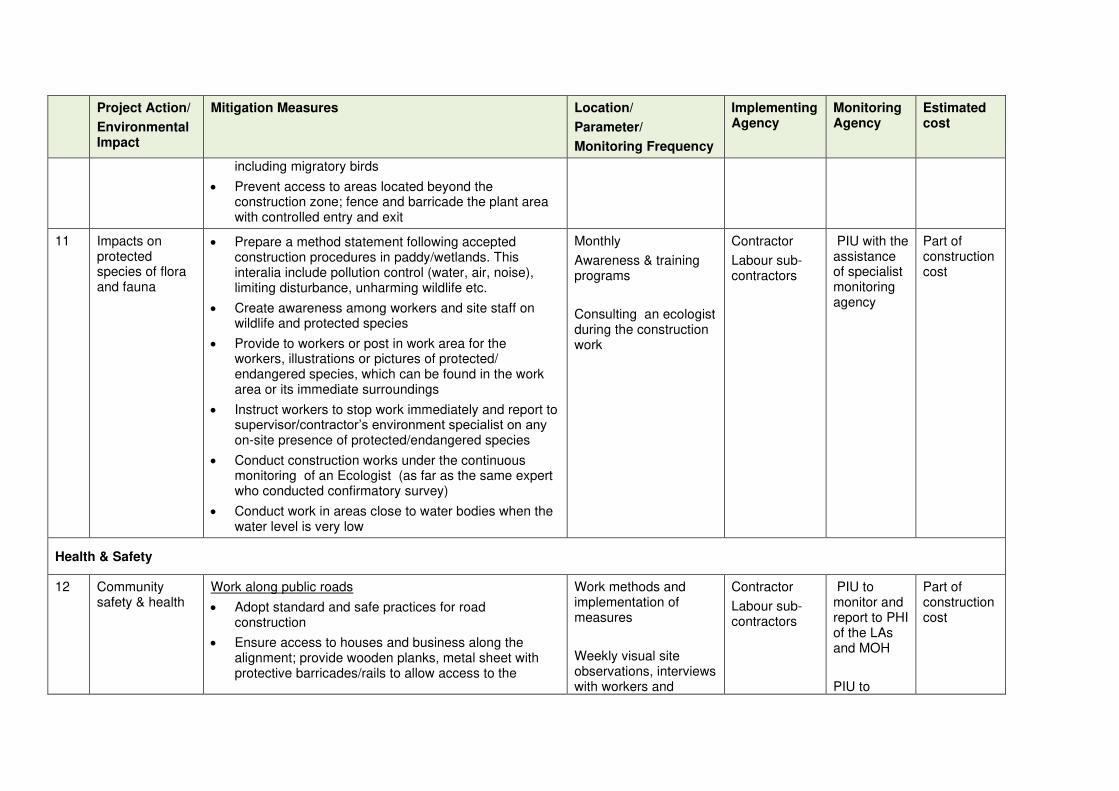
Project Action/
Environmental Impact
Mitigation Measures Location/
Parameter/
Monitoring Frequency
Implementing Agency
Monitoring Agency
Estimated cost
including migratory birds
• Prevent access to areas located beyond the construction zone; fence and barricade the plant area with controlled entry and exit
11 Impacts on protected species of flora and fauna
• Prepare a method statement following accepted construction procedures in paddy/wetlands. This interalia include pollution control (water, air, noise), limiting disturbance, unharming wildlife etc.
• Create awareness among workers and site staff on wildlife and protected species
• Provide to workers or post in work area for the workers, illustrations or pictures of protected/ endangered species, which can be found in the work area or its immediate surroundings
• Instruct workers to stop work immediately and report to supervisor/contractor’s environment specialist on any on-site presence of protected/endangered species
• Conduct construction works under the continuous monitoring of an Ecologist (as far as the same expert who conducted confirmatory survey)
• Conduct work in areas close to water bodies when the water level is very low
Monthly
Awareness & training programs
Consulting an ecologist during the construction work
Contractor
Labour sub-contractors
PIU with the assistance of specialist monitoring agency
Part of construction cost
Health & Safety
12 Community safety & health
Work along public roads
• Adopt standard and safe practices for road construction
• Ensure access to houses and business along the alignment; provide wooden planks, metal sheet with protective barricades/rails to allow access to the
Work methods and implementation of measures
Weekly visual site observations, interviews with workers and
Contractor
Labour sub-contractors
PIU to monitor and report to PHI of the LAs and MOH
PIU to
Part of construction cost

Project Action/
Environmental Impact
Mitigation Measures Location/
Parameter/
Monitoring Frequency
Implementing Agency
Monitoring Agency
Estimated cost
properties
• Provide temporary traffic control (e.g. flagmen) & signs where necessary to improve safety and provide directions
• Restrict public access to all areas where construction works are on-going through the use of barricading and security personnel
• Ensure that all material, equipment, workers and all activities are conducted within the demarcated / barricaded strip of land along the road; there should be no spillage of any activity outside this zone
• Clearly separate work area with traffic/pedestrian flow; provide public information boards to easily identify the work area
• Warning signs, blinkers will be attached to the barricading to caution the public about the hazards associated with the works such as presence of trenches / deep excavation
• Plan carefully using section-by-section approach, so that open trenches are quickly closed and road restored
• Control dust pollution – implement dust control measures as suggested under air quality
• Organize public awareness campaigns.
community
coordinate with the Police Department
Safety risk due to construction vehicle/equipment movement on public roads
• Prepare a Transportation Plan for material, waste and equipment; consult highways agencies, police and other relevant authorities during both planning & implementation
• Plan transportation routes to avoid heavily populated
Implementation of Transportation Plan and Monthly monitoring
Weekly Visual site observations, interviews with workers and
Contractor and labour sub-contractors
PIU to monitor and report to PHI of the LAs and MOH
PIU to
Part of construction cost
Part of construction cost
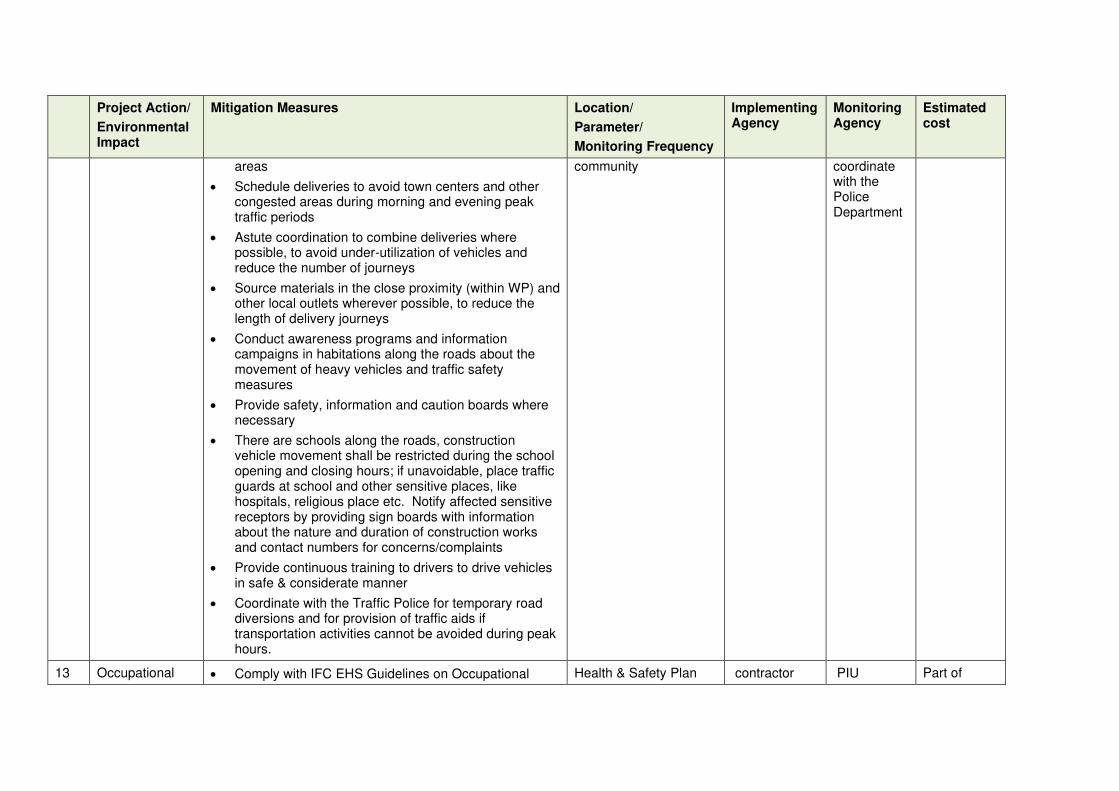
Project Action/
Environmental Impact
Mitigation Measures Location/
Parameter/
Monitoring Frequency
Implementing Agency
Monitoring Agency
Estimated cost
areas
• Schedule deliveries to avoid town centers and other congested areas during morning and evening peak traffic periods
• Astute coordination to combine deliveries where possible, to avoid under-utilization of vehicles and reduce the number of journeys
• Source materials in the close proximity (within WP) and other local outlets wherever possible, to reduce the length of delivery journeys
• Conduct awareness programs and information campaigns in habitations along the roads about the movement of heavy vehicles and traffic safety measures
• Provide safety, information and caution boards where necessary
• There are schools along the roads, construction vehicle movement shall be restricted during the school opening and closing hours; if unavoidable, place traffic guards at school and other sensitive places, like hospitals, religious place etc. Notify affected sensitive receptors by providing sign boards with information about the nature and duration of construction works and contact numbers for concerns/complaints
• Provide continuous training to drivers to drive vehicles in safe & considerate manner
• Coordinate with the Traffic Police for temporary road diversions and for provision of traffic aids if transportation activities cannot be avoided during peak hours.
community
coordinate with the Police Department
13 Occupational • Comply with IFC EHS Guidelines on Occupational Health & Safety Plan contractor PIU Part of

Project Action/
Environmental Impact
Mitigation Measures Location/
Parameter/
Monitoring Frequency
Implementing Agency
Monitoring Agency
Estimated cost
health & safety Health and Safety
• Prepare a comprehensive & site-specific Health and Safety Plan (H&SP) describing in detail how the health and safety of all site personnel (workers, staff and visitors) will be maintained at all times. It is to provide guidance on establishing a management strategy and applying practices that are intended to eliminate, or reduce, fatalities, injuries and illnesses for workers performing activities and tasks associated with the project.
• Provide compulsory H&S orientation training to all new workers to ensure that they are apprised of H&S Plan including rules of work, PPE, preventing injury to fellow workers, etc.
• Conduct regular toolbox safety briefings; leanings, causes, risks & safe procedures
• Conduct periodic safety audit, identify and remove potential hazard
• Ensure that qualified first-aid is provided at all times; equipped first-aid stations shall be easily accessible throughout the work sites and camps.
• Provide medical insurance coverage to workers.
• Secure all installations from unauthorized intrusion and accident risks.
• Provide supplies of potable drinking water
• Provide clean eating areas where workers are not exposed to hazardous or noxious substances.
• Provide visitor orientation if visitors to the site can gain access to areas where hazardous conditions or substances may be present; visitors not to enter hazard areas unescorted
Implementation of measures
Weekly visual observations
Weekly interviews with workers
construction cost

Project Action/
Environmental Impact
Mitigation Measures Location/
Parameter/
Monitoring Frequency
Implementing Agency
Monitoring Agency
Estimated cost
• Ensure the visibility of workers through their use of high visibility vests when working in or walking through heavy equipment operating areas
• Ensure moving equipment is outfitted with audible back-up alarms
• Mark and provide sign boards for hazardous areas such as energized electrical devices and lines, service rooms housing high voltage equipment, and areas for storage and disposal. Signage shall be in accordance with international standards and be well known to, and easily understood by workers, visitors, and the general public as appropriate.
• Disallow worker exposure to high noise level for a duration of more than 8 hours per day without hearing protection. The use of hearing protection shall be enforced actively.
14 Labour camps • Avoid / minimize the requirement to establish camps by hiring gangs by employing local workers as far as possible; presence of workers throughout the day and night during the construction work will disturb the environment
• If necessary, contractor to identify a barren, vacant land (preferably private unused land) to establish the camp nearby; ensure that such camp is at least 500 m away from habitation, water bodies, scrub lands etc., and 1 km from forest reserves
• Prepare & implement Construction Camp Management plan (CCMP). Plan should include:
o Layout plan showing all the proposed facilities, offices, material storage area (separately for hazardous waste, fuel, chemicals etc.), amenities, repair and washing areas, and circulation
Construction Camp Management Plan
Monthly visual observations, interviews with workers and local people
contractor
PIU Part of construction cost
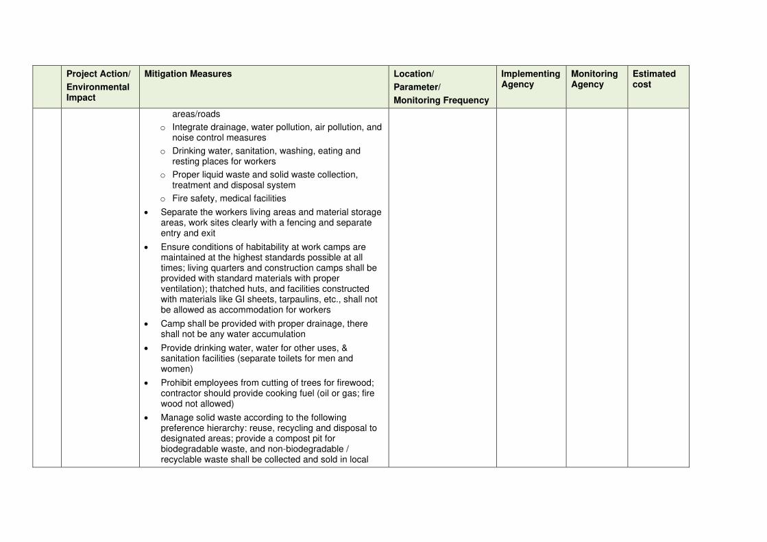
Project Action/
Environmental Impact
Mitigation Measures Location/
Parameter/
Monitoring Frequency
Implementing Agency
Monitoring Agency
Estimated cost
areas/roads
o Integrate drainage, water pollution, air pollution, and noise control measures
o Drinking water, sanitation, washing, eating and resting places for workers
o Proper liquid waste and solid waste collection, treatment and disposal system
o Fire safety, medical facilities
• Separate the workers living areas and material storage areas, work sites clearly with a fencing and separate entry and exit
• Ensure conditions of habitability at work camps are maintained at the highest standards possible at all times; living quarters and construction camps shall be provided with standard materials with proper ventilation); thatched huts, and facilities constructed with materials like GI sheets, tarpaulins, etc., shall not be allowed as accommodation for workers
• Camp shall be provided with proper drainage, there shall not be any water accumulation
• Provide drinking water, water for other uses, & sanitation facilities (separate toilets for men and women)
• Prohibit employees from cutting of trees for firewood; contractor should provide cooking fuel (oil or gas; fire wood not allowed)
• Manage solid waste according to the following preference hierarchy: reuse, recycling and disposal to designated areas; provide a compost pit for biodegradable waste, and non-biodegradable / recyclable waste shall be collected and sold in local
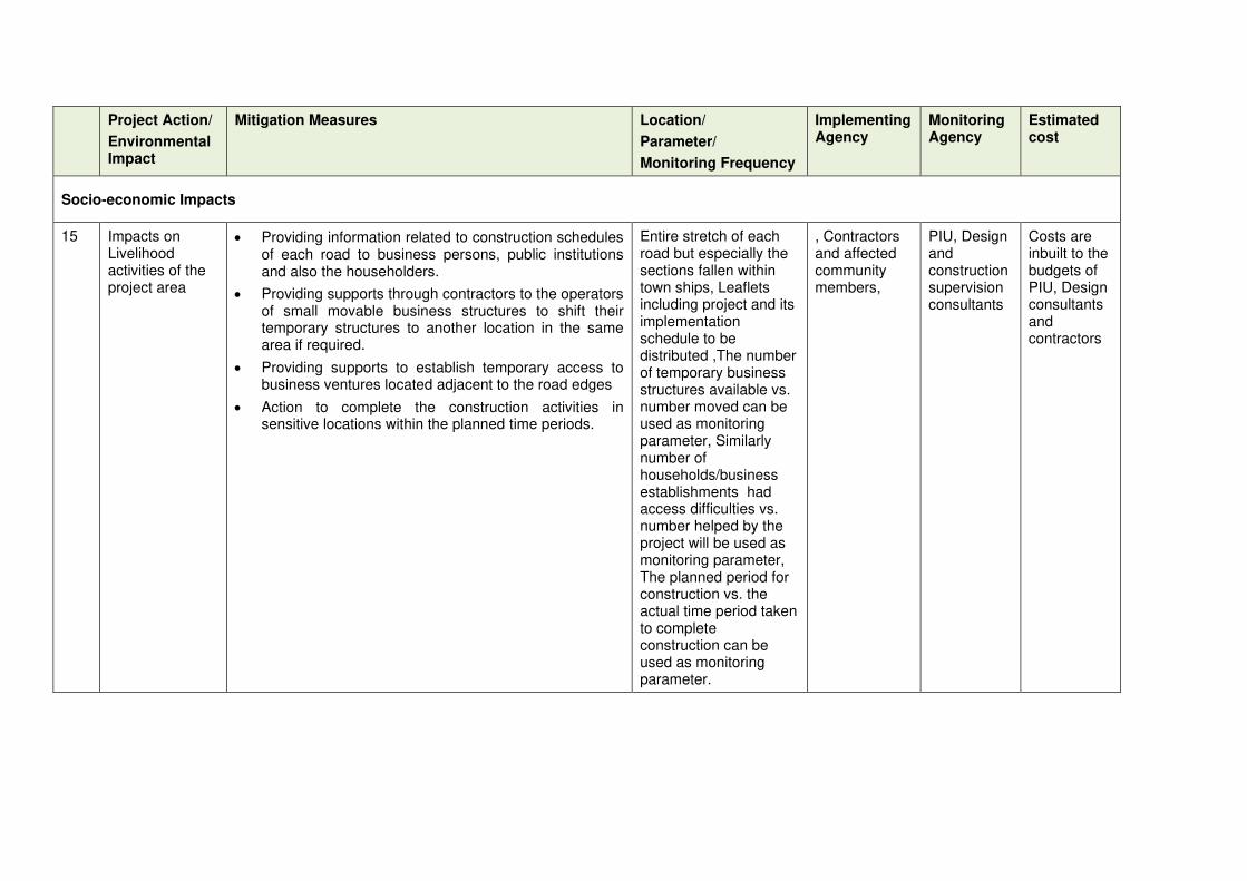
Project Action/
Environmental Impact
Mitigation Measures Location/
Parameter/
Monitoring Frequency
Implementing Agency
Monitoring Agency
Estimated cost
Socio-economic Impacts
15 Impacts on Livelihood activities of the project area
• Providing information related to construction schedules of each road to business persons, public institutions and also the householders.
• Providing supports through contractors to the operators of small movable business structures to shift their temporary structures to another location in the same area if required.
• Providing supports to establish temporary access to business ventures located adjacent to the road edges
• Action to complete the construction activities in sensitive locations within the planned time periods.
Entire stretch of each road but especially the sections fallen within town ships, Leaflets including project and its implementation schedule to be distributed ,The number of temporary business structures available vs. number moved can be used as monitoring parameter, Similarly number of households/business establishments had access difficulties vs. number helped by the project will be used as monitoring parameter, The planned period for construction vs. the actual time period taken to complete construction can be used as monitoring parameter.
, Contractors and affected community members,
PIU, Design and construction supervision consultants
Costs are inbuilt to the budgets of PIU, Design consultants and contractors
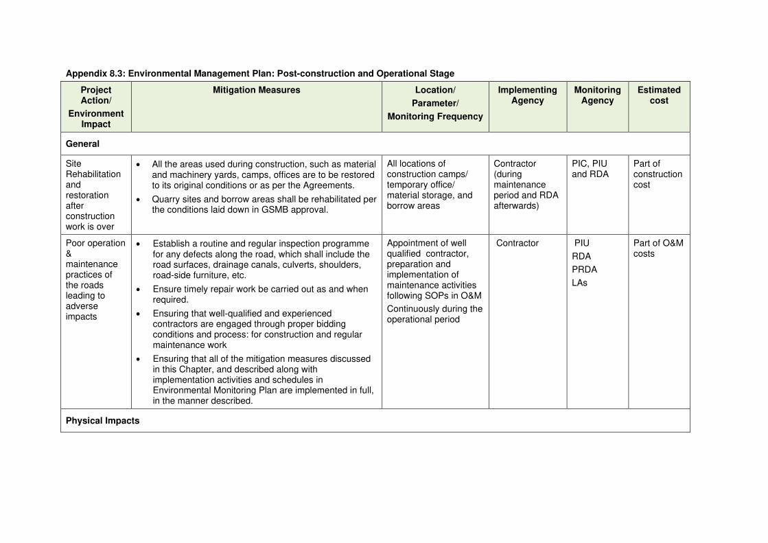
Appendix 8.3: Environmental Management Plan: Post-construction and Operational Stage
Project Action/
Environment Impact
Mitigation Measures Location/
Parameter/
Monitoring Frequency
Implementing Agency
Monitoring Agency
Estimated cost
General
Site Rehabilitation and restoration after construction work is over
• All the areas used during construction, such as material and machinery yards, camps, offices are to be restored to its original conditions or as per the Agreements.
• Quarry sites and borrow areas shall be rehabilitated per the conditions laid down in GSMB approval.
All locations of construction camps/ temporary office/ material storage, and borrow areas
Contractor (during maintenance period and RDA afterwards)
PIC, PIU and RDA
Part of construction cost
Poor operation & maintenance practices of the roads leading to adverse impacts
• Establish a routine and regular inspection programme for any defects along the road, which shall include the road surfaces, drainage canals, culverts, shoulders, road-side furniture, etc.
• Ensure timely repair work be carried out as and when required.
• Ensuring that well-qualified and experienced contractors are engaged through proper bidding conditions and process: for construction and regular maintenance work
• Ensuring that all of the mitigation measures discussed in this Chapter, and described along with implementation activities and schedules in Environmental Monitoring Plan are implemented in full, in the manner described.
Appointment of well qualified contractor, preparation and implementation of maintenance activities following SOPs in O&M
Continuously during the operational period
Contractor PIU
RDA
PRDA
LAs
Part of O&M costs
Physical Impacts

Project Action/
Environment Impact
Mitigation Measures Location/
Parameter/
Monitoring Frequency
Implementing Agency
Monitoring Agency
Estimated cost
Spoil disposal
Disposal of tree branches, shrubs and bushes
Solid waste disposal
• Prepare a waste management plan to be used during operations
• Identify areas for spoil disposal
• Tree branches shall be used as firewood
• Hazardous waste such as asphalt, bituminous products, paints, solvents, etc. used for road maintenance work shall be collected and disposed off as per CEA accepted practices
Waste Management Plan preparation and implementation
Throughout the operation phase
Contractor PIU Part of O&M costs
Air and Noise Quality
• Proper signage, and road-side furniture shall be affixed, and maintained, especially placing sign boards for speed limits.
• Noise restrictions to be enforced near sensitive locations.
• Removal of soil, debris, dust and mud collected on road surfaces and drainage canals to avoid dust generation. Such material shall be taken away for proper disposal.
• Noise and dust barriers shall be installed wherever those are needed, especially when the noise and particulate levels exceed levels stipulated in the Standards. Noise barriers such as lines of trees along sensitive noise receptors are effective in providing attenuation of both noise and particulate matter reaching sensitive receptors.
• Noise monitoring shall be carried out to confirm the compliance with set values
Quarterly Monitoring report
Corrective Action Plan
Throughout the operation phase
Contractor PIU
Police Department
Part of O&M costs
Ecological Impacts
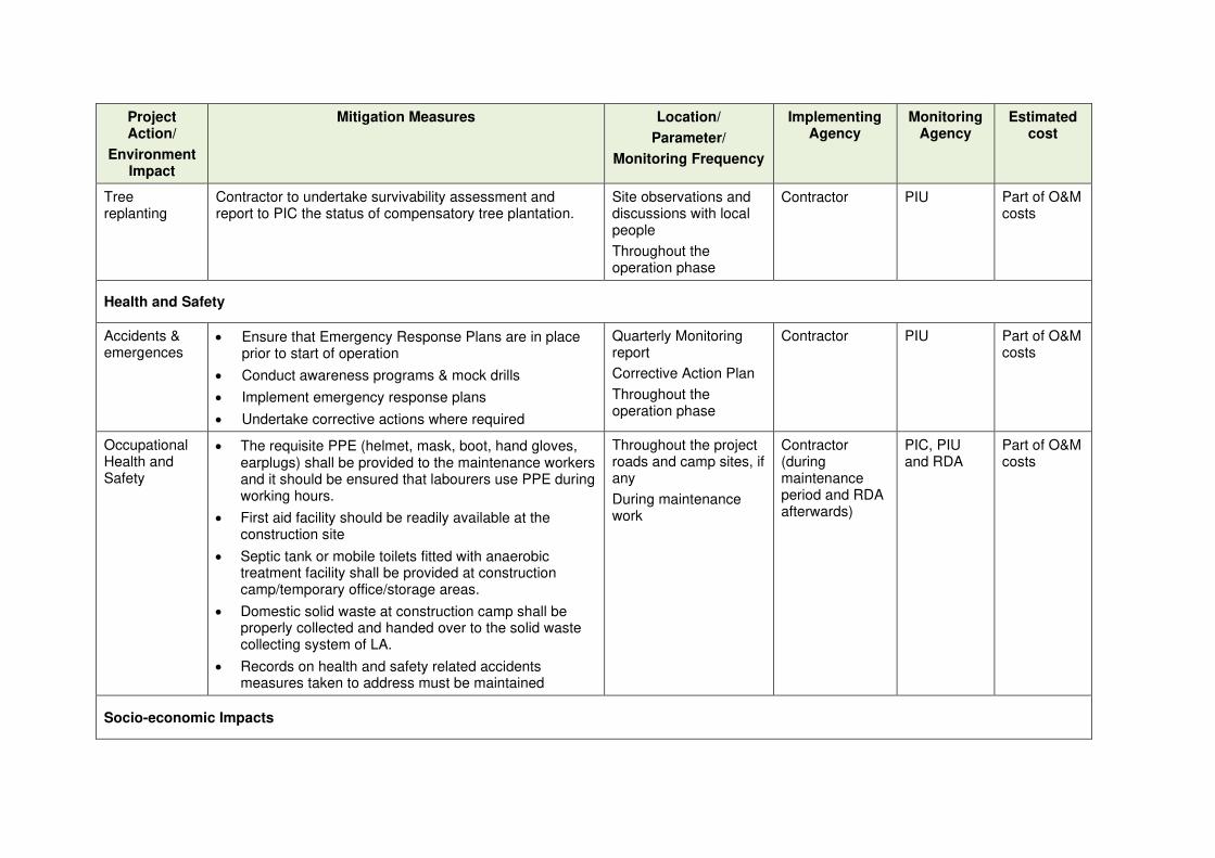
Project Action/
Environment Impact
Mitigation Measures Location/
Parameter/
Monitoring Frequency
Implementing Agency
Monitoring Agency
Estimated cost
Tree replanting
Contractor to undertake survivability assessment and report to PIC the status of compensatory tree plantation.
Site observations and discussions with local people
Throughout the operation phase
Contractor PIU Part of O&M costs
Health and Safety
Accidents & emergences
• Ensure that Emergency Response Plans are in place prior to start of operation
• Conduct awareness programs & mock drills
• Implement emergency response plans
• Undertake corrective actions where required
Quarterly Monitoring report
Corrective Action Plan
Throughout the operation phase
Contractor PIU Part of O&M costs
Occupational Health and Safety
• The requisite PPE (helmet, mask, boot, hand gloves, earplugs) shall be provided to the maintenance workers and it should be ensured that labourers use PPE during working hours.
• First aid facility should be readily available at the construction site
• Septic tank or mobile toilets fitted with anaerobic treatment facility shall be provided at construction camp/temporary office/storage areas.
• Domestic solid waste at construction camp shall be properly collected and handed over to the solid waste collecting system of LA.
• Records on health and safety related accidents measures taken to address must be maintained
Throughout the project roads and camp sites, if any
During maintenance work
Contractor (during maintenance period and RDA afterwards)
PIC, PIU and RDA
Part of O&M costs
Socio-economic Impacts

Project Action/
Environment Impact
Mitigation Measures Location/
Parameter/
Monitoring Frequency
Implementing Agency
Monitoring Agency
Estimated cost
Possible accidents
• Monitoring of the vehicles running on the improved roads
Entire stretch of each road but especial attention to the sensitive locations in terms of accidents
Traffic Police, RDA
RDA, Traffic police
No additional cost, routine roles of traffic police in the area
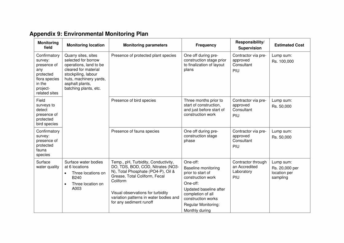
Appendix 9: Environmental Monitoring Plan
Monitoring field
Monitoring location Monitoring parameters Frequency Responsibility/
Supervision Estimated Cost
Confirmatory survey: presence of any protected flora species in the project-related sites
Quarry sites, sites selected for borrow operations, land to be cleared for material stockpiling, labour huts, machinery yards, asphalt plants, batching plants, etc.
Presence of protected plant species One off during pre-construction stage prior to finalization of layout plans
Contractor via pre-approved Consultant
PIU
Lump sum:
Rs. 100,000
Field surveys to detect presence of protected bird species
Presence of bird species Three months prior to start of construction, and just before start of construction work
Contractor via pre-approved Consultant
PIU
Lump sum:
Rs. 50,000
Confirmatory survey: presence of protected fauna species
Presence of fauna species One off during pre-construction stage phase
Contractor via pre-approved Consultant
PIU
Lump sum:
Rs. 50,000
Surface water quality
Surface water bodies at 6 locations
• Three locations on B240
• Three location on A003
Temp., pH, Turbidity, Conductivity, DO, TDS, BOD, COD, Nitrates (NO3-N), Total Phosphate (PO4-P), Oil & Grease, Total Coliform, Fecal Coliform
Visual observations for turbidity variation patterns in water bodies and for any sediment runoff
One-off:
Baseline monitoring prior to start of construction work
One-off:
Updated baseline after completion of all construction works
Regular Monitoring:
Monthly during
Contractor through an Accredited Laboratory
PIU
Lump sum:
Rs. 20,000 per location per sampling
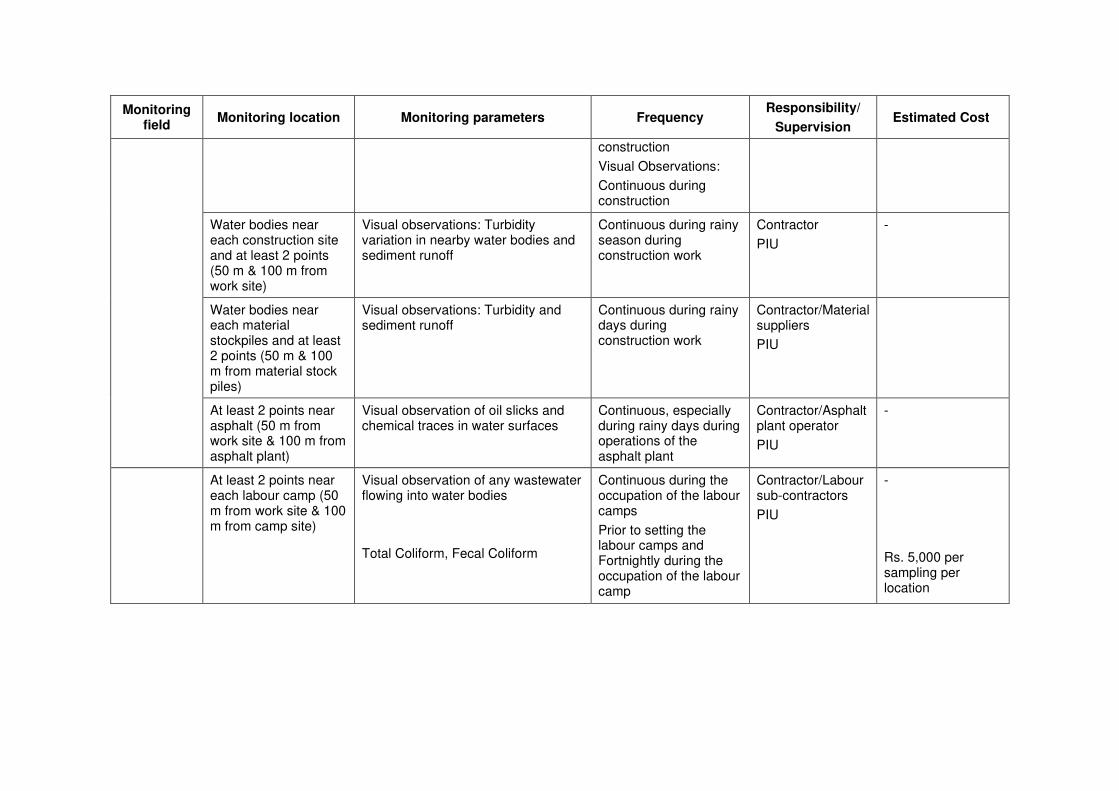
Monitoring field
Monitoring location Monitoring parameters Frequency Responsibility/
Supervision Estimated Cost
construction
Visual Observations:
Continuous during construction
Water bodies near each construction site and at least 2 points (50 m & 100 m from work site)
Visual observations: Turbidity variation in nearby water bodies and sediment runoff
Continuous during rainy season during construction work
Contractor
PIU
-
Water bodies near each material stockpiles and at least 2 points (50 m & 100 m from material stock piles)
Visual observations: Turbidity and sediment runoff
Continuous during rainy days during construction work
Contractor/Material suppliers
PIU
At least 2 points near asphalt (50 m from work site & 100 m from asphalt plant)
Visual observation of oil slicks and chemical traces in water surfaces
Continuous, especially during rainy days during operations of the asphalt plant
Contractor/Asphalt plant operator
PIU
-
At least 2 points near each labour camp (50 m from work site & 100 m from camp site)
Visual observation of any wastewater flowing into water bodies
Total Coliform, Fecal Coliform
Continuous during the occupation of the labour camps
Prior to setting the labour camps and Fortnightly during the occupation of the labour camp
Contractor/Labour sub-contractors
PIU
-
Rs. 5,000 per sampling per location

Monitoring field
Monitoring location Monitoring parameters Frequency Responsibility/
Supervision Estimated Cost
Ambient air quality & noise and vibration
The same locations at which baseline measurements were taken
(See Table 4-11 of the IEE Report for Noise Levels)
• PM10, PM2.5, NO2, SO2, CO, HC
• Equivalent sound levels (Leq A) and vibration level in terms of ppv
(Mitigation measures should conform to CEA Regulations on National Air Quality Standards, ambient noise levels and permissible ground vibration levels)
One-off:
Baseline monitoring prior to start of construction work
One-off:
Updated baseline after completion of all construction works
Contractor through an Accredited Laboratory
PIU
Lump sum:
Air Quality: Rs. 40,000 per location
Noise measurements: Rs. 10,000 per location
Vibration levels: Rs. 10,000 per location
At any location along the five roads, access roads to yards, borrow sites and along haulage routes
All the sensitive receptors (as outlined in Table 4-12) of the IEE
• PM10, PM2.5, NO2, SO2, CO, HC
• Equivalent sound levels (Leq A) and vibration level in terms of ppv
(Mitigation measures should conform to CEA Regulations on National Air Quality Standards, ambient noise levels and permissible ground vibration levels)
Once complaints are received:
Measurements compare with baseline monitoring values
Contractor through an Accredited Laboratory
PIU
Auditory levels of noise, Visual observations of dust levels and dust collected on window sills and vegetation cover
Continuous visual observations
Contractor
PIU
-
At the boundary of the Quarry and Borrow sites
• PM10, PM2.5, NO2, SO2, CO, HC
Equivalent sound levels (Leq A) and vibration level in terms of ppv V
(Mitigation measures should conform to CEA Regulations on National Air Quality Standards, ambient noise levels and permissible ground vibration levels)
During rock blasting, grinding and transporting
During borrow material excavation and transportation
Quarry operator and Transport contractor
PIU
Borrow site operator and Transport contractor
PIU
Lump sum:
Air Quality: Rs. 40,000 per location
Noise measurements: Rs. 10,000 per location
Vibration levels: Rs. 10,000 per location

Monitoring field
Monitoring location Monitoring parameters Frequency Responsibility/
Supervision Estimated Cost
Erosion of soil during excavation, storage of material and transport operations
At locations that are like to cause soil erosion, including borrow sites, material stock piles, exposed surfaces, cuts and fill areas - Flow paths, streams, toe areas of slopes and embankments.
Sedimentation and siltation of drainage canals and water bodies
Visual observations
Suspended sediments and elevated turbidity in surface runoff
Continuous monitoring during rainy season
Contractor
Borrow site operator and Transport contractor
PIU
-
Slope stability and settlement control measures
Cracking of structures
Toe of slopes, Important buildings/ structures/other predetermined critical locations
Measurement of Displacements (Vertical/ horizontal)
Visual observation for settlements and cracks of buildings and structures
Daily or Continuous monitoring
Contractor Additional costs are needed for pre-construction crack survey. The cost depends on the number of buildings/structures included for the survey
Work zone management and safety
All roads where rehabilitation is proposed
Access and haulage routes
Check compliance with the work zone management plan submitted by the contractor:
Safety hazards for pedestrians
Safety hazards for motorists
Availability of all the devices such as signs, barricades, cones etc. as specified in the work zone management plan
Availability of traffic control officers
Daily (for the five and other roads, to be decided in consultation with Traffic Police) during construction period
2-3 times during the construction period for local roads
During construction
Authority responsible for the relevant road (RDA/ PRDA /Local Authorities)
Police Department
A detailed cost calculation has to be done for work zone management schemes as part of the contractor’s main task obligation. However, regular monitoring is needed to make
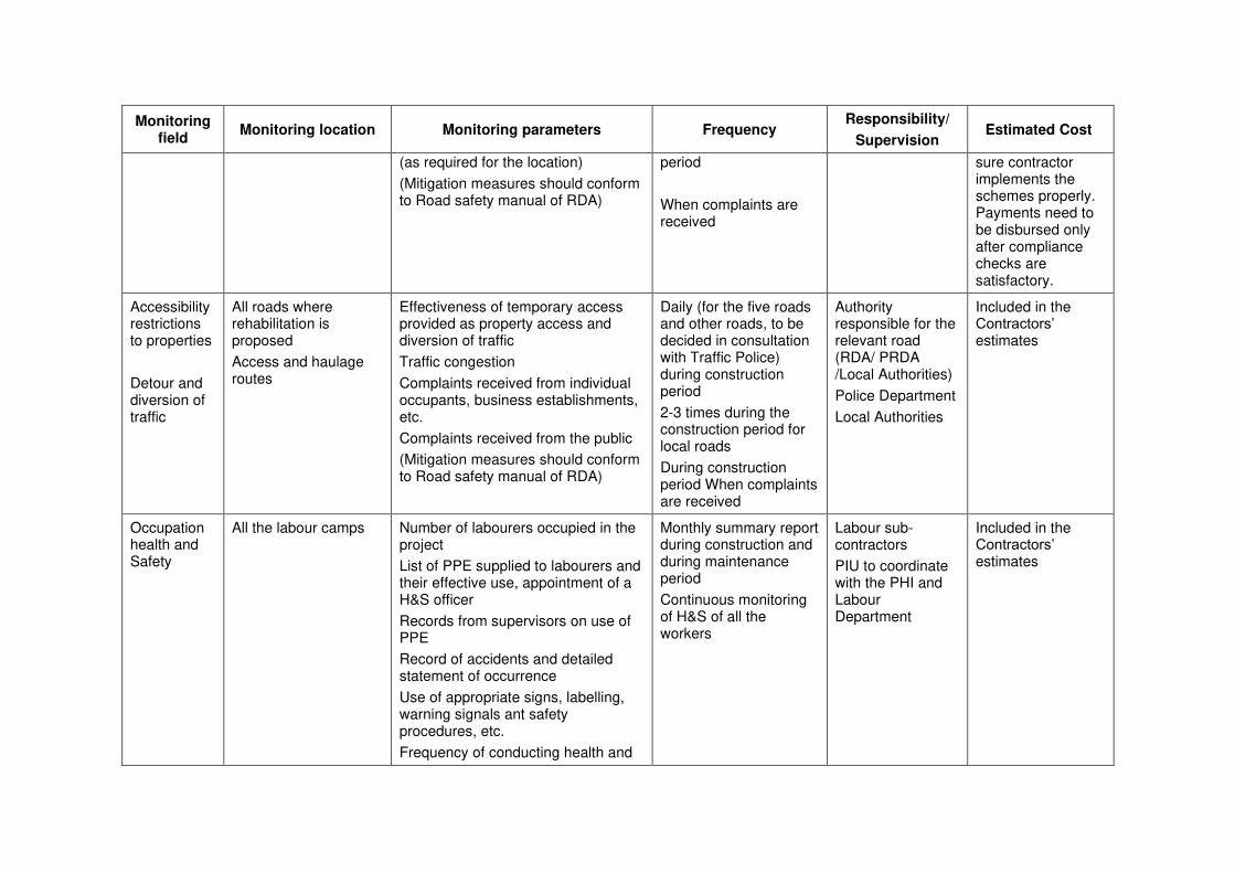
Monitoring field
Monitoring location Monitoring parameters Frequency Responsibility/
Supervision Estimated Cost
(as required for the location)
(Mitigation measures should conform to Road safety manual of RDA)
period
When complaints are received
sure contractor implements the schemes properly. Payments need to be disbursed only after compliance checks are satisfactory.
Accessibility restrictions to properties
Detour and diversion of traffic
All roads where rehabilitation is proposed
Access and haulage routes
Effectiveness of temporary access provided as property access and diversion of traffic
Traffic congestion
Complaints received from individual occupants, business establishments, etc.
Complaints received from the public
(Mitigation measures should conform to Road safety manual of RDA)
Daily (for the five roads and other roads, to be decided in consultation with Traffic Police) during construction period
2-3 times during the construction period for local roads
During construction period When complaints are received
Authority responsible for the relevant road (RDA/ PRDA /Local Authorities)
Police Department
Local Authorities
Included in the Contractors’ estimates
Occupation health and Safety
All the labour camps Number of labourers occupied in the project
List of PPE supplied to labourers and their effective use, appointment of a H&S officer
Records from supervisors on use of PPE
Record of accidents and detailed statement of occurrence
Use of appropriate signs, labelling, warning signals ant safety procedures, etc.
Frequency of conducting health and
Monthly summary report during construction and during maintenance period
Continuous monitoring of H&S of all the workers
Labour sub-contractors
PIU to coordinate with the PHI and Labour Department
Included in the Contractors’ estimates

Monitoring field
Monitoring location Monitoring parameters Frequency Responsibility/
Supervision Estimated Cost
safety awareness programmes, drills and compliance
Method of supplying sanitary facilities, drinking water and waste disposal system
(Mitigation measures should conform to EHS Standards of the IFC)
Flooding and hydrology during construction
All culvert and bridge locations and other identified flood prone areas located close to low-lying areas and canals
Locations of flooding (upstream/ downstream/floodplain, etc.)
Flood depth/water level
Flood extent and duration
Flood frequency
Causes of flooding (debris/sediment level)
Continuous monitoring during rainy season and especially during major storm events during construction period
Contractor/Sub-contractors
Included in the Contractors’ estimates
Flooding and hydrology during operations
All major culvert and bridge locations and other identified flood prone areas located close to low-lying areas and canals
Locations of flooding (if any)
Flood depth
Flood duration
Flood frequency
Causes of flooding (debris/sediment level)
Continuous monitoring during rainy season and especially during major storm events
RDA/Local authority
Additional costs should be allocated under regular monitoring and maintenance programs
Social Impacts during construction
Townships and sections falling in front of sensitive locations in 4 roads
Complaints of road users, business community, officers of institutions on dust, noise, mud, traffic related issues and access related issues to houses, business ventures and institutions
Monthly Design and construction supervision consultants, PIU and interested parties of stakeholders
Included in the budget of PIU and the design preparation and construction supervision consultants
Social Impacts during
Sensitive locations identified as accidents prone sections of the
Observations of the traffic police and also the complaints by the neighbourhood community members on the likelihood danger of driving
Monthly for about one-year special program after improvements to
Traffic police of the area, RDA
No separate cost is required (as part of routine duties of

Monitoring field
Monitoring location Monitoring parameters Frequency Responsibility/
Supervision Estimated Cost
operations rehabilitated 4 roads behaviour of some drivers. five roads the traffic police)

1
Appendix 9.2: Sample Environmental Monitoring Checklists: Design and Pre-construction Stage
District:
Road Name:
Road ID:
Total length:
Date of site visit:
Project Action/
Environmental Impact
Mitigation Measures
Location/
Parameter/
Monitoring Frequency
Compliance status
(Complied, partly complied, not complied)
Corrective action
proposed if any
1 Poor environmental management by the Contractor
• Designate a full-time environment specialist (one of the PIC) who will be in-charge of coordination with PIU for updating this IEE and implementing the EMP and EMoP, including conduct of all surveys, monitoring actions etc.
• Environmental specialist shall be in place from the day of mobilization of contractor (throughout design and construction, and intermittent during operations)
• Coordinate with the PIU on confirmatory surveys to be conducted during design phase and complete as required with support of external experts (if needed)
Mobilization of PIC and PIU staff with suitable experience and expertise
One-off during mobilization, and continuously throughout the contract period
2 Climate Change Consideration and
Vulnerability Screening
• Climate change vulnerability checks in compliance with the provisions provided in the IEE Report. Adopting proper mitigation measures as may be required
• Cross drainage structures to be designed and located based on recommendations of hydrological studies to be conducted during detailed design phase. Alteration of rainfall intensities due to climate change therefore change of peak flows of waterways and land use
Throughout the project and flood prone areas in all the five road stretches and other possible areas of tree planting

2
Project Action/
Environmental Impact
Mitigation Measures
Location/
Parameter/
Monitoring Frequency
Compliance status
(Complied, partly complied, not complied)
Corrective action
proposed if any
changes should be clearly studied under hydrological assessments and appropriate mitigation measures should be incorporated to final designs.
• Efforts shall be made to plant additional trees for increasing the carbon sink. The trees may be selected with help of Forest Department and space for additional planting (if the remaining space within ROW is not adequate) will be secured with the help of Forest Department, Divisional Secretary (DS) and Community-based Organizations (CBOs).
3(a) Site selection and preparation for
quarrying, borrow operations, clearing land for stockpiling, labour huts, machinery yards, asphalt plants, batching plants, etc.
a) Loss of scrub land, trees and other flora, and protected flora species
• Conduct a confirmatory survey by an Ecologist to identify and mark, if any, protected plant species on site and also on the site survey maps.
• Integrate identified protected plants (if any) in the location maps to avoid the need to remove/cut these plants.
Protected plants survey map & markings on site maps of quarries, borrow areas, and other areas cleared for yards, etc.
One-off after survey
• If removal of trees is unavoidable, translocate protected species in the nearby areas; prepare Tree Translocation, Cutting & Re-plantation Plan. If translocation is not possible, and if it is necessary to remove/cut protected plants, prepare a justification to establish that it is not feasible to avoid or translocate trees.
• Obtain approval of relevant authority for cutting/removal and plant 3-5 trees of same species for each tree that is removed
• Adopt minimal tree cutting as a general principle in planning & design; minimize tree cutting – either of protected species or otherwise
Tree Translocation, Cutting & Re-plantation Plan (shall include justification, minimization & approvals)
One-off during site location finalization
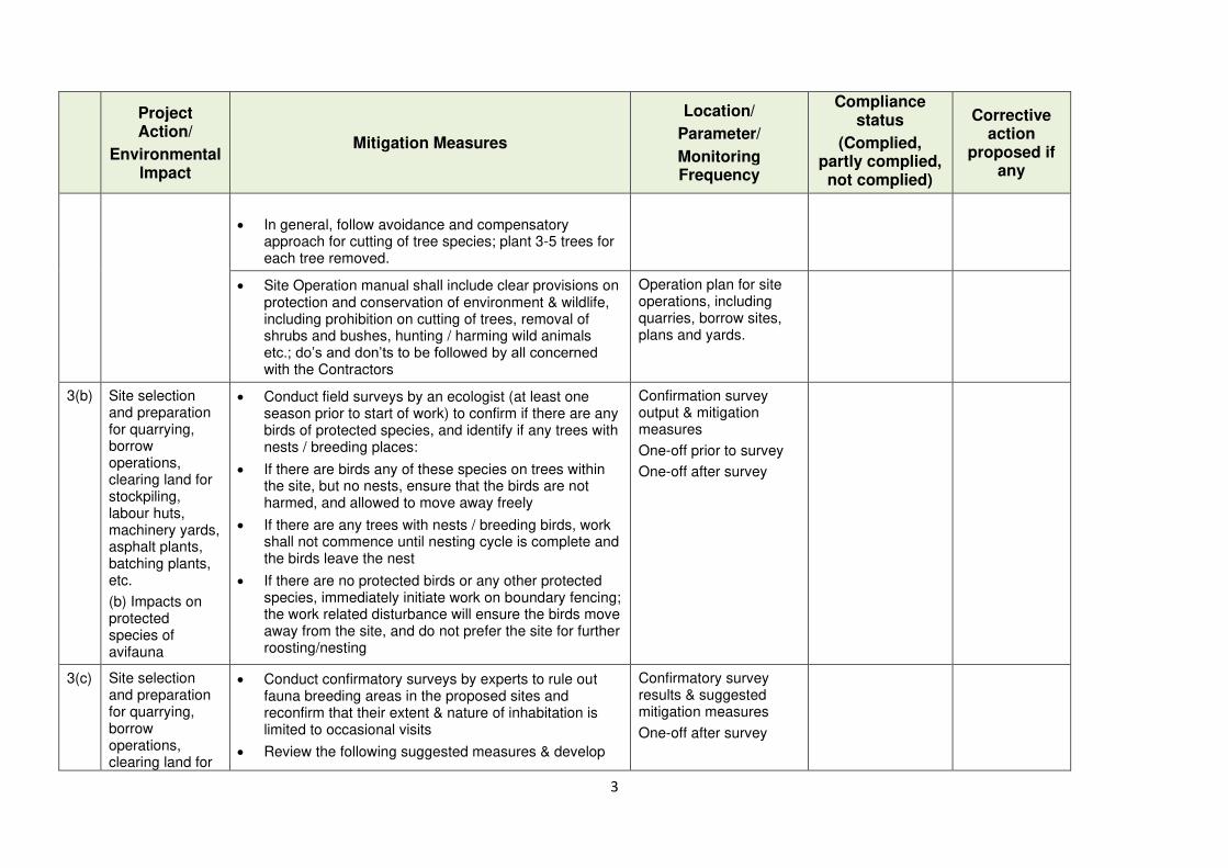
3
Project Action/
Environmental Impact
Mitigation Measures
Location/
Parameter/
Monitoring Frequency
Compliance status
(Complied, partly complied, not complied)
Corrective action
proposed if any
• In general, follow avoidance and compensatory approach for cutting of tree species; plant 3-5 trees for each tree removed.
• Site Operation manual shall include clear provisions on protection and conservation of environment & wildlife, including prohibition on cutting of trees, removal of shrubs and bushes, hunting / harming wild animals etc.; do’s and don’ts to be followed by all concerned with the Contractors
Operation plan for site operations, including quarries, borrow sites, plans and yards.
3(b) Site selection and preparation for quarrying, borrow operations, clearing land for stockpiling, labour huts, machinery yards, asphalt plants, batching plants, etc.
(b) Impacts on protected species of avifauna
• Conduct field surveys by an ecologist (at least one season prior to start of work) to confirm if there are any birds of protected species, and identify if any trees with nests / breeding places:
• If there are birds any of these species on trees within the site, but no nests, ensure that the birds are not harmed, and allowed to move away freely
• If there are any trees with nests / breeding birds, work shall not commence until nesting cycle is complete and the birds leave the nest
• If there are no protected birds or any other protected species, immediately initiate work on boundary fencing; the work related disturbance will ensure the birds move away from the site, and do not prefer the site for further roosting/nesting
Confirmation survey output & mitigation measures
One-off prior to survey
One-off after survey
3(c) Site selection and preparation for quarrying, borrow operations, clearing land for
• Conduct confirmatory surveys by experts to rule out fauna breeding areas in the proposed sites and reconfirm that their extent & nature of inhabitation is limited to occasional visits
• Review the following suggested measures & develop
Confirmatory survey results & suggested mitigation measures
One-off after survey
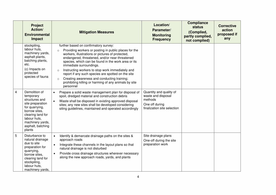
4
Project Action/
Environmental Impact
Mitigation Measures
Location/
Parameter/
Monitoring Frequency
Compliance status
(Complied, partly complied, not complied)
Corrective action
proposed if any
stockpiling, labour huts, machinery yards, asphalt plants, batching plants, etc.
(c) Impacts on protected species of fauna
further based on confirmatory survey:
o Providing workers or posting in public places for the workers, illustrations or pictures of protected, endangered, threatened, and/or near-threatened species, which can be found in the work area or its immediate surroundings.
o Instructing workers to stop work immediately and report if any such species are spotted on the site
o Creating awareness and conducting training; prohibiting killing or harming of any animals by site personnel
4 Demolition of temporary structures and site preparation for quarrying, borrow sites, clearing land for labour huts, machinery yards, asphalt, batching plants
• Prepare a solid waste management plan for disposal of spoil, dredged material and construction debris
• Waste shall be disposed in existing approved disposal sites; any new sites shall be developed considering siting guidelines, maintained and operated accordingly
Quantity and quality of waste and disposal methods
One off during finalization site selection
5 Disturbance to natural drainage due to site preparation for quarrying, borrow sites, clearing land for stockpiling, labour huts, machinery yards,
• Identify & demarcate drainage paths on the sites & approach roads
• Integrate these channels in the layout plans so that natural drainage is not disturbed
• Provide cross drainage structures wherever necessary along the new approach roads, yards, and plants
Site drainage plans
One-off during the site preparation work
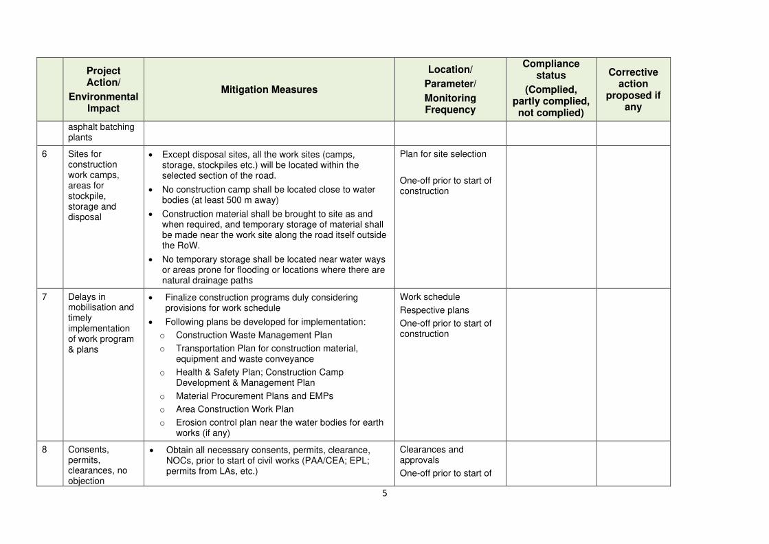
5
Project Action/
Environmental Impact
Mitigation Measures
Location/
Parameter/
Monitoring Frequency
Compliance status
(Complied, partly complied, not complied)
Corrective action
proposed if any
asphalt batching plants
6 Sites for construction work camps, areas for stockpile, storage and disposal
• Except disposal sites, all the work sites (camps, storage, stockpiles etc.) will be located within the selected section of the road.
• No construction camp shall be located close to water bodies (at least 500 m away)
• Construction material shall be brought to site as and when required, and temporary storage of material shall be made near the work site along the road itself outside the RoW.
• No temporary storage shall be located near water ways or areas prone for flooding or locations where there are natural drainage paths
Plan for site selection
One-off prior to start of construction
7 Delays in mobilisation and timely implementation of work program & plans
• Finalize construction programs duly considering provisions for work schedule
• Following plans be developed for implementation:
o Construction Waste Management Plan
o Transportation Plan for construction material, equipment and waste conveyance
o Health & Safety Plan; Construction Camp Development & Management Plan
o Material Procurement Plans and EMPs
o Area Construction Work Plan
o Erosion control plan near the water bodies for earth works (if any)
Work schedule
Respective plans
One-off prior to start of construction
8 Consents, permits, clearances, no objection
• Obtain all necessary consents, permits, clearance, NOCs, prior to start of civil works (PAA/CEA; EPL; permits from LAs, etc.)
Clearances and approvals
One-off prior to start of
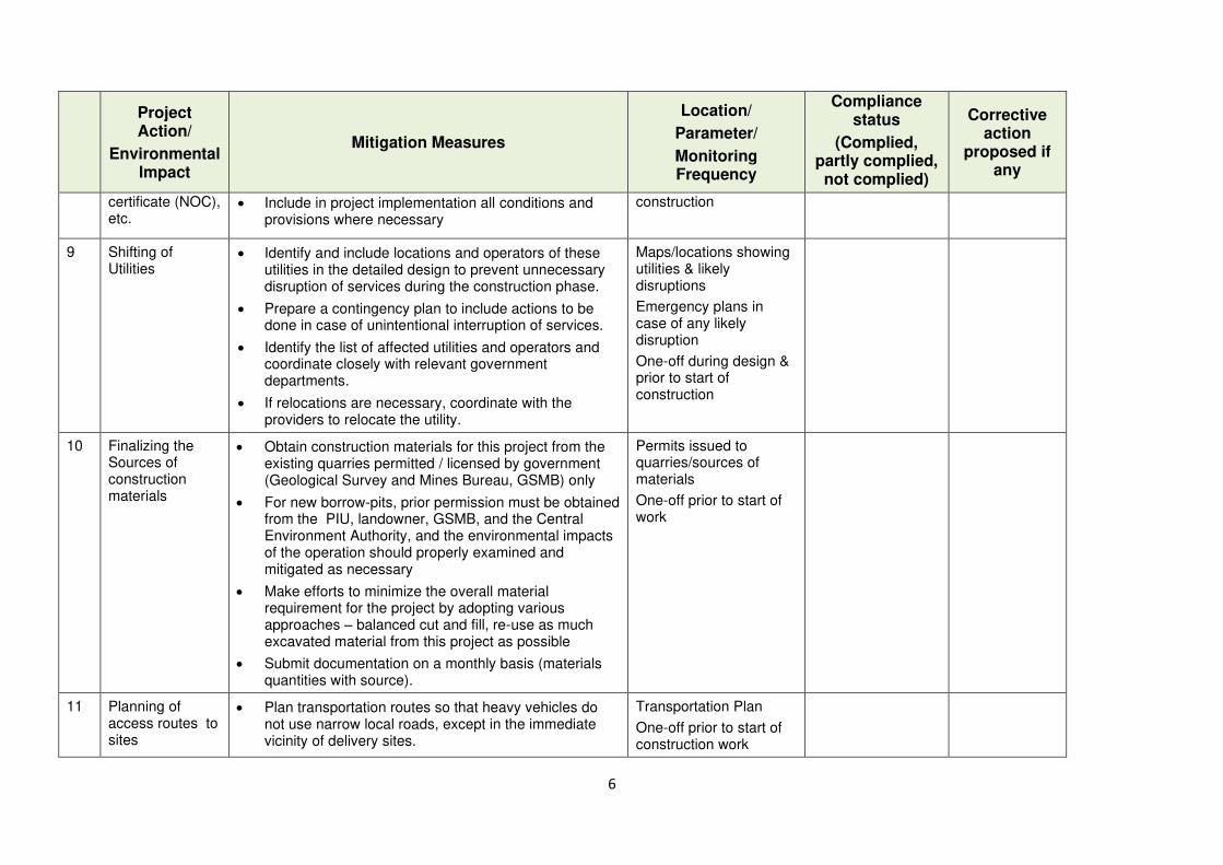
6
Project Action/
Environmental Impact
Mitigation Measures
Location/
Parameter/
Monitoring Frequency
Compliance status
(Complied, partly complied, not complied)
Corrective action
proposed if any
certificate (NOC), etc.
• Include in project implementation all conditions and provisions where necessary
construction
9 Shifting of Utilities
• Identify and include locations and operators of these utilities in the detailed design to prevent unnecessary disruption of services during the construction phase.
• Prepare a contingency plan to include actions to be done in case of unintentional interruption of services.
• Identify the list of affected utilities and operators and coordinate closely with relevant government departments.
• If relocations are necessary, coordinate with the providers to relocate the utility.
Maps/locations showing utilities & likely disruptions
Emergency plans in case of any likely disruption
One-off during design & prior to start of construction
10 Finalizing the Sources of construction materials
• Obtain construction materials for this project from the existing quarries permitted / licensed by government (Geological Survey and Mines Bureau, GSMB) only
• For new borrow-pits, prior permission must be obtained from the PIU, landowner, GSMB, and the Central Environment Authority, and the environmental impacts of the operation should properly examined and mitigated as necessary
• Make efforts to minimize the overall material requirement for the project by adopting various approaches – balanced cut and fill, re-use as much excavated material from this project as possible
• Submit documentation on a monthly basis (materials quantities with source).
Permits issued to quarries/sources of materials
One-off prior to start of work
11 Planning of access routes to sites
• Plan transportation routes so that heavy vehicles do not use narrow local roads, except in the immediate vicinity of delivery sites.
Transportation Plan
One-off prior to start of construction work
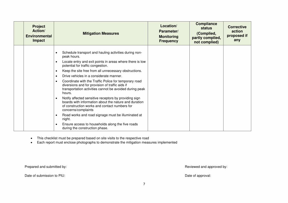
7
Project Action/
Environmental Impact
Mitigation Measures
Location/
Parameter/
Monitoring Frequency
Compliance status
(Complied, partly complied, not complied)
Corrective action
proposed if any
• Schedule transport and hauling activities during non-peak hours.
• Locate entry and exit points in areas where there is low potential for traffic congestion.
• Keep the site free from all unnecessary obstructions.
• Drive vehicles in a considerate manner.
• Coordinate with the Traffic Police for temporary road diversions and for provision of traffic aids if transportation activities cannot be avoided during peak hours.
• Notify affected sensitive receptors by providing sign boards with information about the nature and duration of construction works and contact numbers for concerns/complaints
• Road works and road signage must be illuminated at night.
• Ensure access to households along the five roads during the construction phase.
• This checklist must be prepared based on site visits to the respective road
• Each report must enclose photographs to demonstrate the mitigation measures implemented
Prepared and submitted by: Reviewed and approved by:
Date of submission to PIU: Date of approval:
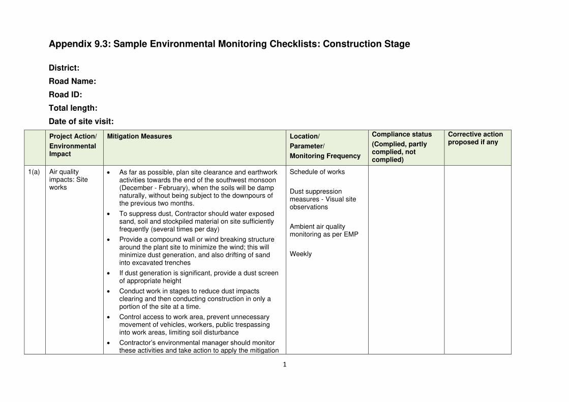
1
Appendix 9.3: Sample Environmental Monitoring Checklists: Construction Stage
District:
Road Name:
Road ID:
Total length:
Date of site visit:
Project Action/
Environmental Impact
Mitigation Measures Location/
Parameter/
Monitoring Frequency
Compliance status
(Complied, partly complied, not complied)
Corrective action proposed if any
1(a) Air quality impacts: Site works
• As far as possible, plan site clearance and earthwork activities towards the end of the southwest monsoon (December - February), when the soils will be damp naturally, without being subject to the downpours of the previous two months.
• To suppress dust, Contractor should water exposed sand, soil and stockpiled material on site sufficiently frequently (several times per day)
• Provide a compound wall or wind breaking structure around the plant site to minimize the wind; this will minimize dust generation, and also drifting of sand into excavated trenches
• If dust generation is significant, provide a dust screen of appropriate height
• Conduct work in stages to reduce dust impacts clearing and then conducting construction in only a portion of the site at a time.
• Control access to work area, prevent unnecessary movement of vehicles, workers, public trespassing into work areas, limiting soil disturbance
• Contractor’s environmental manager should monitor these activities and take action to apply the mitigation
Schedule of works
Dust suppression measures - Visual site observations
Ambient air quality monitoring as per EMP
Weekly
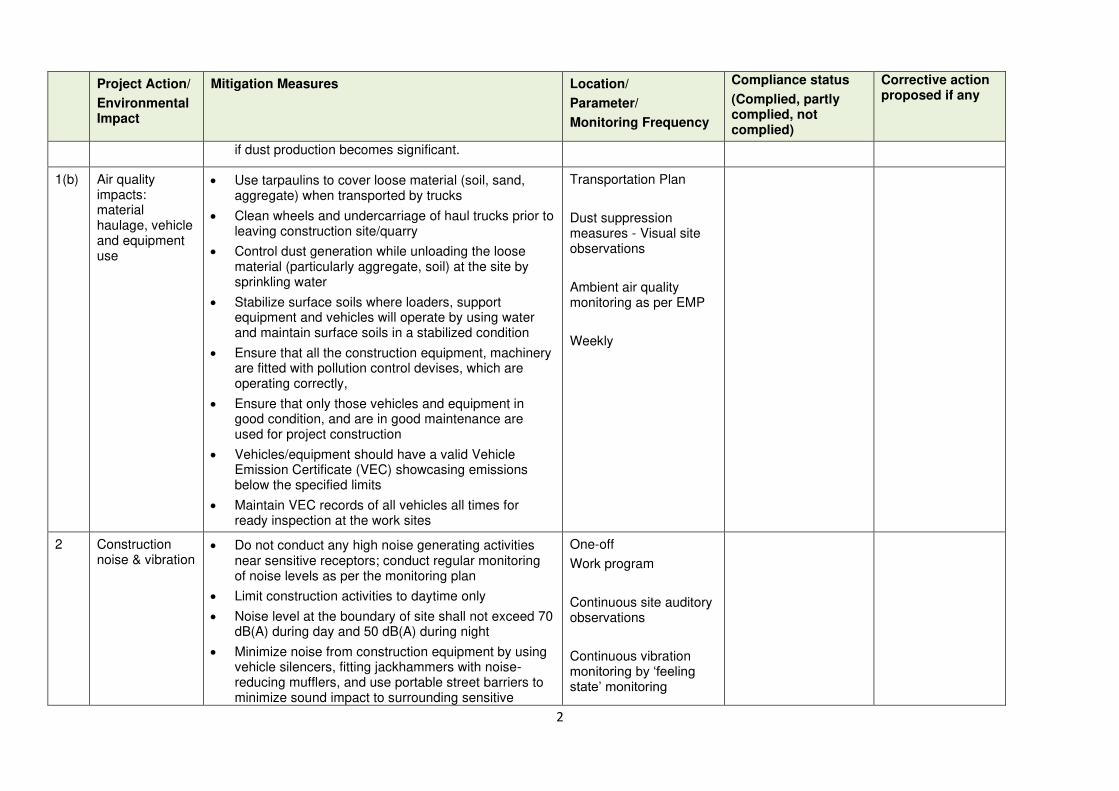
2
Project Action/
Environmental Impact
Mitigation Measures Location/
Parameter/
Monitoring Frequency
Compliance status
(Complied, partly complied, not complied)
Corrective action proposed if any
if dust production becomes significant.
1(b) Air quality impacts: material haulage, vehicle and equipment use
• Use tarpaulins to cover loose material (soil, sand, aggregate) when transported by trucks
• Clean wheels and undercarriage of haul trucks prior to leaving construction site/quarry
• Control dust generation while unloading the loose material (particularly aggregate, soil) at the site by sprinkling water
• Stabilize surface soils where loaders, support equipment and vehicles will operate by using water and maintain surface soils in a stabilized condition
• Ensure that all the construction equipment, machinery are fitted with pollution control devises, which are operating correctly,
• Ensure that only those vehicles and equipment in good condition, and are in good maintenance are used for project construction
• Vehicles/equipment should have a valid Vehicle Emission Certificate (VEC) showcasing emissions below the specified limits
• Maintain VEC records of all vehicles all times for ready inspection at the work sites
Transportation Plan
Dust suppression measures - Visual site observations
Ambient air quality monitoring as per EMP
Weekly
2 Construction noise & vibration
• Do not conduct any high noise generating activities near sensitive receptors; conduct regular monitoring of noise levels as per the monitoring plan
• Limit construction activities to daytime only
• Noise level at the boundary of site shall not exceed 70 dB(A) during day and 50 dB(A) during night
• Minimize noise from construction equipment by using vehicle silencers, fitting jackhammers with noise-reducing mufflers, and use portable street barriers to minimize sound impact to surrounding sensitive
One-off
Work program
Continuous site auditory observations
Continuous vibration monitoring by ‘feeling state’ monitoring
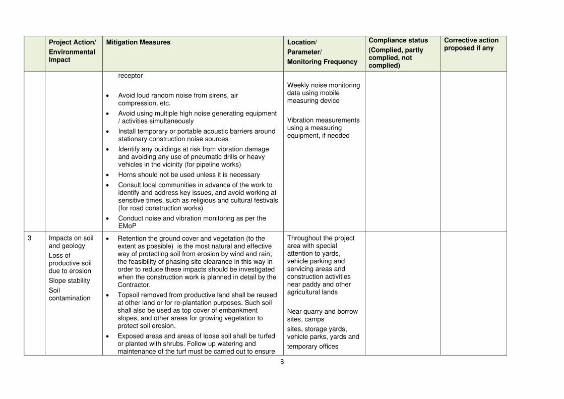
3
Project Action/
Environmental Impact
Mitigation Measures Location/
Parameter/
Monitoring Frequency
Compliance status
(Complied, partly complied, not complied)
Corrective action proposed if any
receptor
• Avoid loud random noise from sirens, air compression, etc.
• Avoid using multiple high noise generating equipment / activities simultaneously
• Install temporary or portable acoustic barriers around stationary construction noise sources
• Identify any buildings at risk from vibration damage and avoiding any use of pneumatic drills or heavy vehicles in the vicinity (for pipeline works)
• Horns should not be used unless it is necessary
• Consult local communities in advance of the work to identify and address key issues, and avoid working at sensitive times, such as religious and cultural festivals (for road construction works)
• Conduct noise and vibration monitoring as per the EMoP
Weekly noise monitoring data using mobile measuring device
Vibration measurements using a measuring equipment, if needed
3 Impacts on soil and geology
Loss of productive soil due to erosion
Slope stability
Soil contamination
• Retention the ground cover and vegetation (to the extent as possible) is the most natural and effective way of protecting soil from erosion by wind and rain; the feasibility of phasing site clearance in this way in order to reduce these impacts should be investigated when the construction work is planned in detail by the Contractor.
• Topsoil removed from productive land shall be reused at other land or for re-plantation purposes. Such soil shall also be used as top cover of embankment slopes, and other areas for growing vegetation to protect soil erosion.
• Exposed areas and areas of loose soil shall be turfed or planted with shrubs. Follow up watering and maintenance of the turf must be carried out to ensure
Throughout the project area with special attention to yards, vehicle parking and servicing areas and construction activities near paddy and other agricultural lands
Near quarry and borrow sites, camps
sites, storage yards, vehicle parks, yards and
temporary offices

4
Project Action/
Environmental Impact
Mitigation Measures Location/
Parameter/
Monitoring Frequency
Compliance status
(Complied, partly complied, not complied)
Corrective action proposed if any
the survival of the plants and success of the slope stabilization.
• Land used for yards, labor camps and offices, temporary access road, borrow and quarry sites shall be rehabilitated and restored back to its original use as practical as possible
• Fresh and unstable slopes, loose rock and boulders shall be appropriately protected. Embankment surfaces shall be compacted and turfed. Proper drainage improvement works shall be done along toes areas of embankments and slopes.
• Movement of construction vehicles shall be restricted to access roads, haulage routes and yards to prevent soil compaction in other land, especially agricultural lands. In case this is not prevented, such disturbed land should be tilled/harrowed.
• Chemicals such as bituminous products, fuel, lubricants, paints, solvents and other chemicals shall be stored at designated laces, well-sheltered and impervious floors (preferable paved). The paving area of the storage yards be provided with gentle slope and shall be made so that any leaks/spills can be collected into a chamber for safe disposal. Such chemicals shall be well-managed, and efforts shall be made to minimize the waste generation.
Along embankments
4 Impacts on hydrology and flooding
• Contractor’s activities shall not lead to flooding conditions as a result of blocked drainage paths and drains or any other modifications to drainage paths.
• The contractor shall take all measures necessary and as directed by the PIU to keep all drainage paths and drains clear of blockage at all times.
• If flooding or stagnation of water is caused by contractor’s activities, contractors shall provide
Throughout project area with special attention to the locations of cross drainage, Major culverts/bridges, Identified flood prone areas with Visual inspection
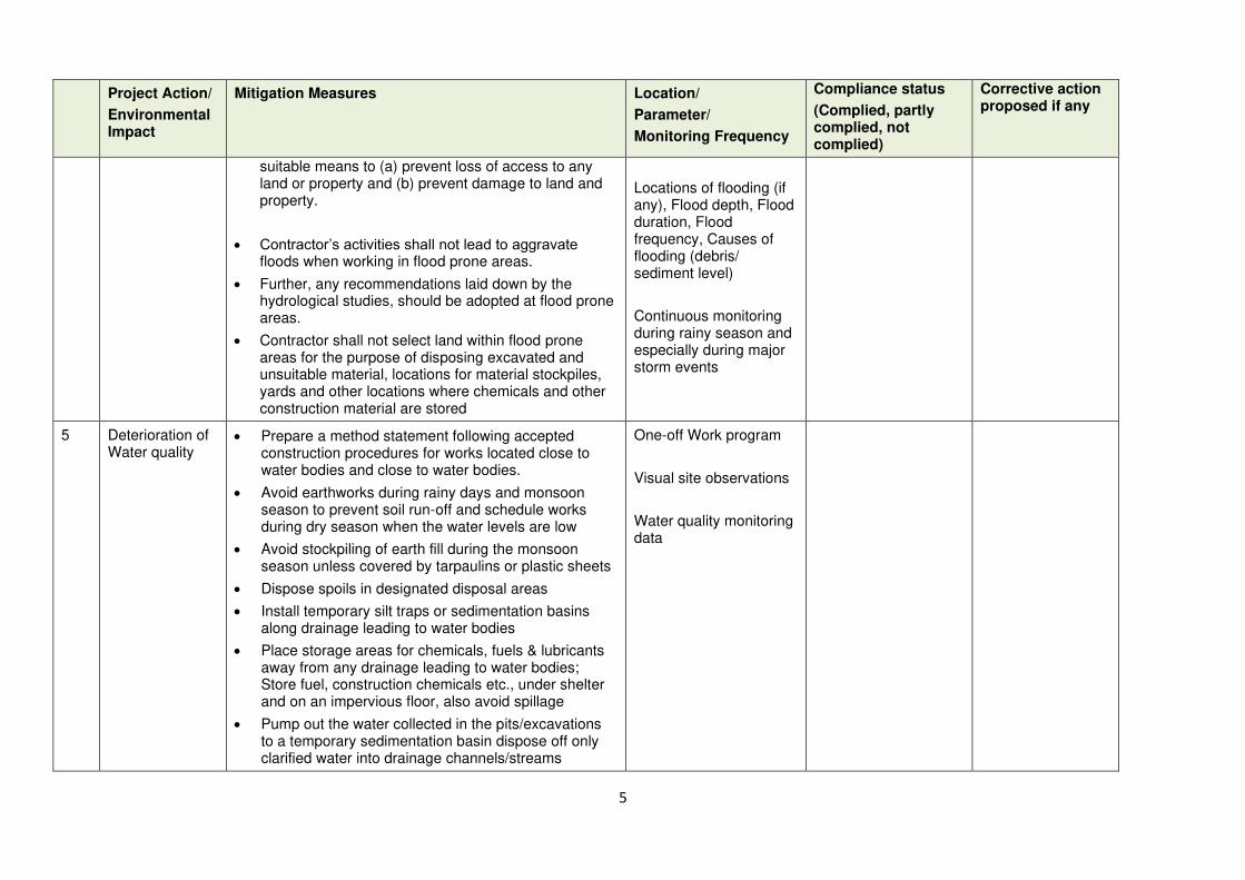
5
Project Action/
Environmental Impact
Mitigation Measures Location/
Parameter/
Monitoring Frequency
Compliance status
(Complied, partly complied, not complied)
Corrective action proposed if any
suitable means to (a) prevent loss of access to any land or property and (b) prevent damage to land and property.
• Contractor’s activities shall not lead to aggravate floods when working in flood prone areas.
• Further, any recommendations laid down by the hydrological studies, should be adopted at flood prone areas.
• Contractor shall not select land within flood prone areas for the purpose of disposing excavated and unsuitable material, locations for material stockpiles, yards and other locations where chemicals and other construction material are stored
Locations of flooding (if any), Flood depth, Flood duration, Flood frequency, Causes of flooding (debris/ sediment level)
Continuous monitoring during rainy season and especially during major storm events
5 Deterioration of Water quality
• Prepare a method statement following accepted construction procedures for works located close to water bodies and close to water bodies.
• Avoid earthworks during rainy days and monsoon season to prevent soil run-off and schedule works during dry season when the water levels are low
• Avoid stockpiling of earth fill during the monsoon season unless covered by tarpaulins or plastic sheets
• Dispose spoils in designated disposal areas
• Install temporary silt traps or sedimentation basins along drainage leading to water bodies
• Place storage areas for chemicals, fuels & lubricants away from any drainage leading to water bodies; Store fuel, construction chemicals etc., under shelter and on an impervious floor, also avoid spillage
• Pump out the water collected in the pits/excavations to a temporary sedimentation basin dispose off only clarified water into drainage channels/streams
One-off Work program
Visual site observations
Water quality monitoring data
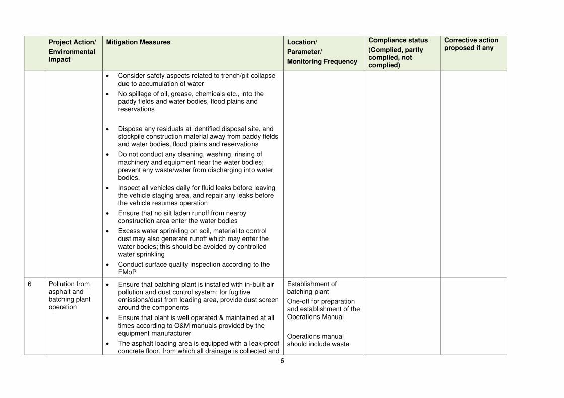
6
Project Action/
Environmental Impact
Mitigation Measures Location/
Parameter/
Monitoring Frequency
Compliance status
(Complied, partly complied, not complied)
Corrective action proposed if any
• Consider safety aspects related to trench/pit collapse due to accumulation of water
• No spillage of oil, grease, chemicals etc., into the paddy fields and water bodies, flood plains and reservations
• Dispose any residuals at identified disposal site, and stockpile construction material away from paddy fields and water bodies, flood plains and reservations
• Do not conduct any cleaning, washing, rinsing of machinery and equipment near the water bodies; prevent any waste/water from discharging into water bodies.
• Inspect all vehicles daily for fluid leaks before leaving the vehicle staging area, and repair any leaks before the vehicle resumes operation
• Ensure that no silt laden runoff from nearby construction area enter the water bodies
• Excess water sprinkling on soil, material to control dust may also generate runoff which may enter the water bodies; this should be avoided by controlled water sprinkling
• Conduct surface quality inspection according to the EMoP
6 Pollution from asphalt and batching plant operation
• Ensure that batching plant is installed with in-built air pollution and dust control system; for fugitive emissions/dust from loading area, provide dust screen around the components
• Ensure that plant is well operated & maintained at all times according to O&M manuals provided by the equipment manufacturer
• The asphalt loading area is equipped with a leak-proof concrete floor, from which all drainage is collected and
Establishment of batching plant
One-off for preparation and establishment of the Operations Manual
Operations manual should include waste
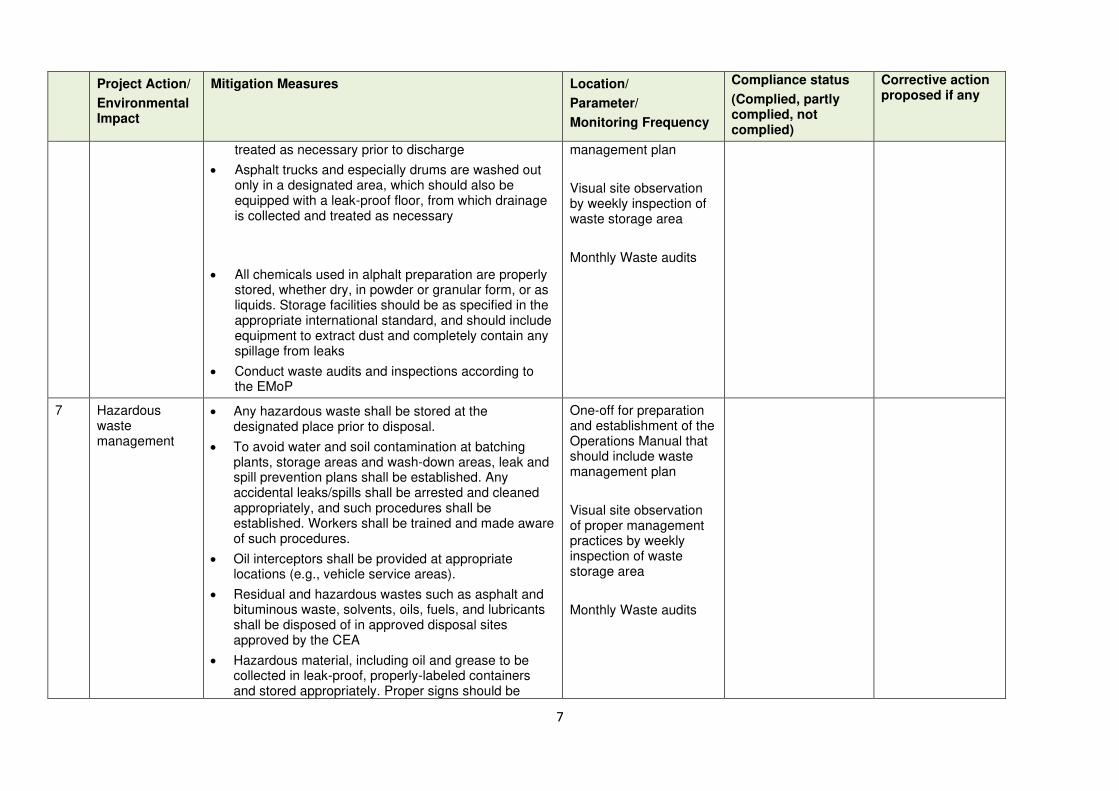
7
Project Action/
Environmental Impact
Mitigation Measures Location/
Parameter/
Monitoring Frequency
Compliance status
(Complied, partly complied, not complied)
Corrective action proposed if any
treated as necessary prior to discharge
• Asphalt trucks and especially drums are washed out only in a designated area, which should also be equipped with a leak-proof floor, from which drainage is collected and treated as necessary
• All chemicals used in alphalt preparation are properly stored, whether dry, in powder or granular form, or as liquids. Storage facilities should be as specified in the appropriate international standard, and should include equipment to extract dust and completely contain any spillage from leaks
• Conduct waste audits and inspections according to the EMoP
management plan
Visual site observation by weekly inspection of waste storage area
Monthly Waste audits
7 Hazardous waste management
• Any hazardous waste shall be stored at the designated place prior to disposal.
• To avoid water and soil contamination at batching plants, storage areas and wash-down areas, leak and spill prevention plans shall be established. Any accidental leaks/spills shall be arrested and cleaned appropriately, and such procedures shall be established. Workers shall be trained and made aware of such procedures.
• Oil interceptors shall be provided at appropriate locations (e.g., vehicle service areas).
• Residual and hazardous wastes such as asphalt and bituminous waste, solvents, oils, fuels, and lubricants shall be disposed of in approved disposal sites approved by the CEA
• Hazardous material, including oil and grease to be collected in leak-proof, properly-labeled containers and stored appropriately. Proper signs should be
One-off for preparation and establishment of the Operations Manual that should include waste management plan
Visual site observation of proper management practices by weekly inspection of waste storage area
Monthly Waste audits
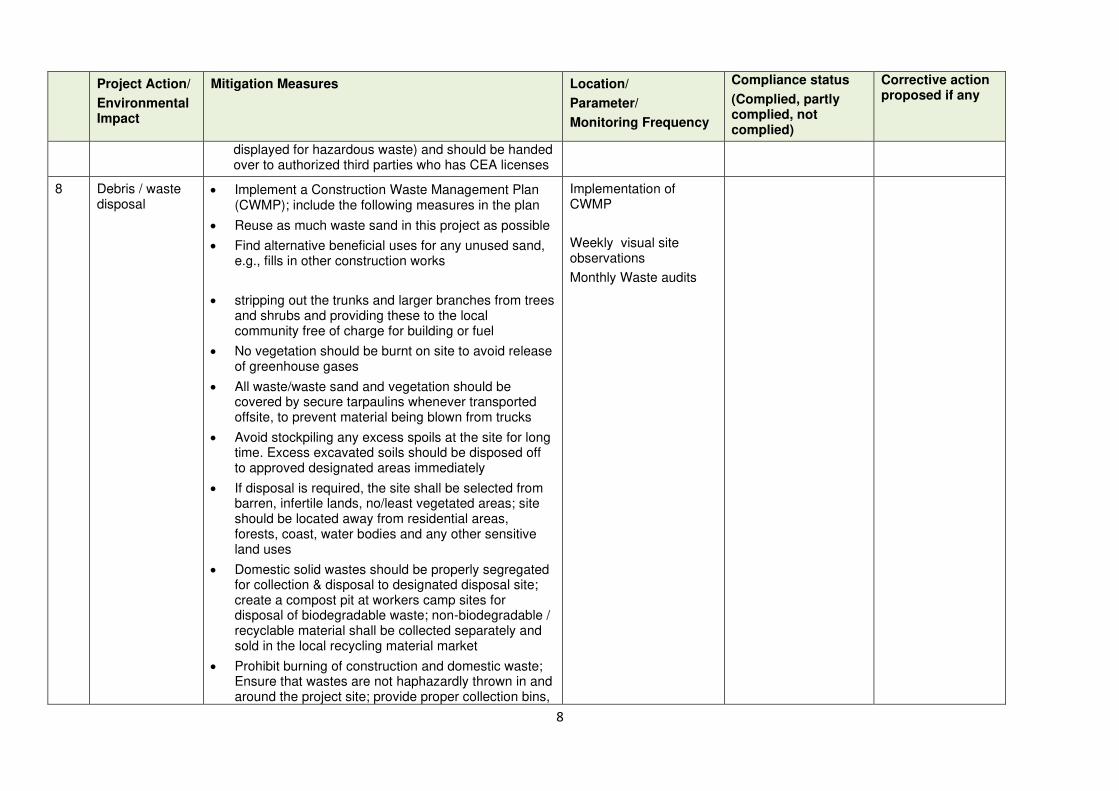
8
Project Action/
Environmental Impact
Mitigation Measures Location/
Parameter/
Monitoring Frequency
Compliance status
(Complied, partly complied, not complied)
Corrective action proposed if any
displayed for hazardous waste) and should be handed over to authorized third parties who has CEA licenses
8 Debris / waste disposal
• Implement a Construction Waste Management Plan (CWMP); include the following measures in the plan
• Reuse as much waste sand in this project as possible
• Find alternative beneficial uses for any unused sand, e.g., fills in other construction works
• stripping out the trunks and larger branches from trees and shrubs and providing these to the local community free of charge for building or fuel
• No vegetation should be burnt on site to avoid release of greenhouse gases
• All waste/waste sand and vegetation should be covered by secure tarpaulins whenever transported offsite, to prevent material being blown from trucks
• Avoid stockpiling any excess spoils at the site for long time. Excess excavated soils should be disposed off to approved designated areas immediately
• If disposal is required, the site shall be selected from barren, infertile lands, no/least vegetated areas; site should be located away from residential areas, forests, coast, water bodies and any other sensitive land uses
• Domestic solid wastes should be properly segregated for collection & disposal to designated disposal site; create a compost pit at workers camp sites for disposal of biodegradable waste; non-biodegradable / recyclable material shall be collected separately and sold in the local recycling material market
• Prohibit burning of construction and domestic waste; Ensure that wastes are not haphazardly thrown in and around the project site; provide proper collection bins,
Implementation of CWMP
Weekly visual site observations
Monthly Waste audits
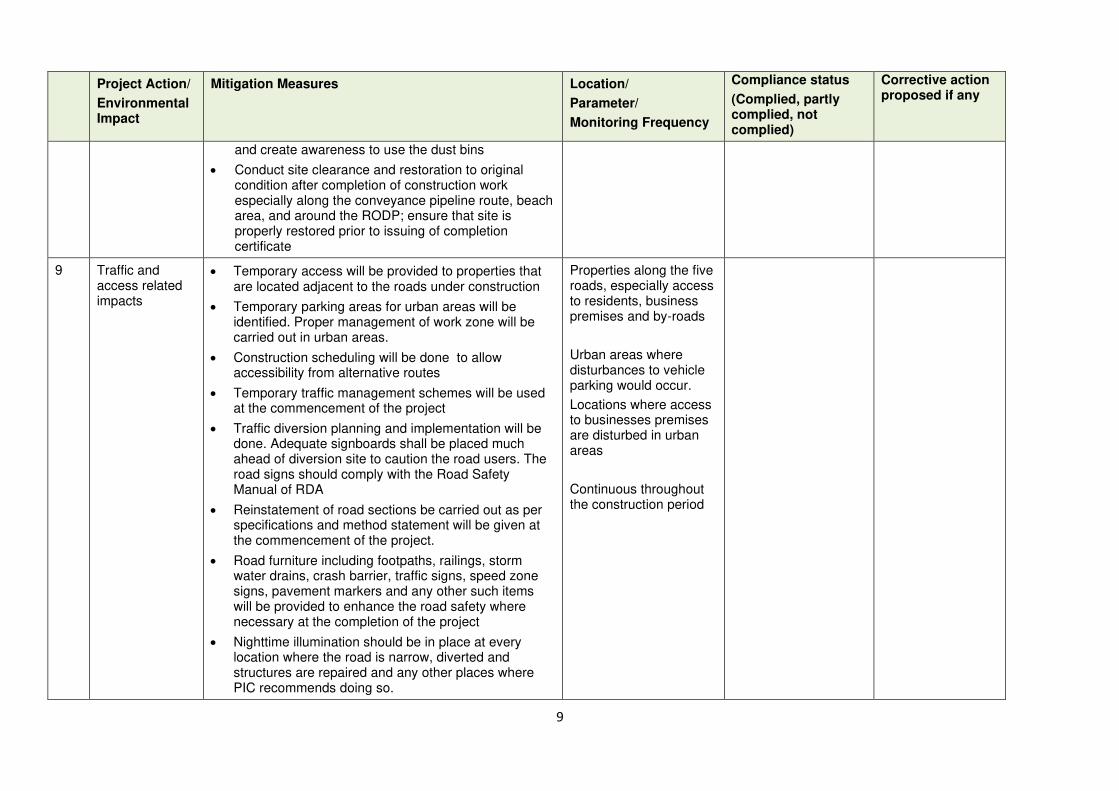
9
Project Action/
Environmental Impact
Mitigation Measures Location/
Parameter/
Monitoring Frequency
Compliance status
(Complied, partly complied, not complied)
Corrective action proposed if any
and create awareness to use the dust bins
• Conduct site clearance and restoration to original condition after completion of construction work especially along the conveyance pipeline route, beach area, and around the RODP; ensure that site is properly restored prior to issuing of completion certificate
9 Traffic and access related impacts
• Temporary access will be provided to properties that are located adjacent to the roads under construction
• Temporary parking areas for urban areas will be identified. Proper management of work zone will be carried out in urban areas.
• Construction scheduling will be done to allow accessibility from alternative routes
• Temporary traffic management schemes will be used at the commencement of the project
• Traffic diversion planning and implementation will be done. Adequate signboards shall be placed much ahead of diversion site to caution the road users. The road signs should comply with the Road Safety Manual of RDA
• Reinstatement of road sections be carried out as per specifications and method statement will be given at the commencement of the project.
• Road furniture including footpaths, railings, storm water drains, crash barrier, traffic signs, speed zone signs, pavement markers and any other such items will be provided to enhance the road safety where necessary at the completion of the project
• Nighttime illumination should be in place at every location where the road is narrow, diverted and structures are repaired and any other places where PIC recommends doing so.
Properties along the five roads, especially access to residents, business premises and by-roads
Urban areas where disturbances to vehicle parking would occur.
Locations where access to businesses premises are disturbed in urban areas
Continuous throughout the construction period
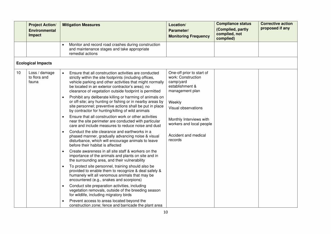
10
Project Action/
Environmental Impact
Mitigation Measures Location/
Parameter/
Monitoring Frequency
Compliance status
(Complied, partly complied, not complied)
Corrective action proposed if any
• Monitor and record road crashes during construction and maintenance stages and take appropriate remedial actions
Ecological Impacts
10 Loss / damage to flora and fauna
• Ensure that all construction activities are conducted strictly within the site footprints (including offices, vehicle parking and other activities that might normally be located in an exterior contractor’s area); no clearance of vegetation outside footprint is permitted
• Prohibit any deliberate killing or harming of animals on or off-site; any hunting or fishing or in nearby areas by site personnel; preventive actions shall be put in place by contractor for hunting/killing of wild animals
• Ensure that all construction work or other activities near the site perimeter are conducted with particular care and include measures to reduce noise and dust
• Conduct the site clearance and earthworks in a phased manner, gradually advancing noise & visual disturbance, which will encourage animals to leave before their habitat is affected
• Create awareness in all site staff & workers on the importance of the animals and plants on site and in the surrounding area, and their vulnerability
• To protect site personnel, training should also be provided to enable them to recognize & deal safely & humanely wilt all venomous animals that may be encountered (e.g., snakes and scorpions)
• Conduct site preparation activities, including vegetation removals, outside of the breeding season for wildlife, including migratory birds
• Prevent access to areas located beyond the construction zone; fence and barricade the plant area
One-off prior to start of work: Construction camp/yard establishment & management plan
Weekly
Visual observations
Monthly Interviews with workers and local people
Accident and medical records

11
Project Action/
Environmental Impact
Mitigation Measures Location/
Parameter/
Monitoring Frequency
Compliance status
(Complied, partly complied, not complied)
Corrective action proposed if any
with controlled entry and exit
11 Impacts on protected species of flora and fauna
• Prepare a method statement following accepted construction procedures in paddy/wetlands. This interalia include pollution control (water, air, noise), limiting disturbance, unharming wildlife etc.
• Create awareness among workers and site staff on wildlife and protected species
• Provide to workers or post in work area for the workers, illustrations or pictures of protected/ endangered species, which can be found in the work area or its immediate surroundings
• Instruct workers to stop work immediately and report to supervisor/contractor’s environment specialist on any on-site presence of protected/endangered species
• Conduct construction works under the continuous monitoring of an Ecologist (as far as the same expert who conducted confirmatory survey)
• Conduct work in areas close to water bodies when the water level is very low
Monthly
Awareness & training programs
Consulting an ecologist during the construction work
Health & Safety
12 Community safety & health
Work along public roads
• Adopt standard and safe practices for road construction
• Ensure access to houses and business along the alignment; provide wooden planks, metal sheet with protective barricades/rails to allow access to the properties
• Provide temporary traffic control (e.g. flagmen) & signs where necessary to improve safety and provide directions
Work methods and implementation of measures
Weekly visual site observations, interviews with workers and community
12
Project Action/
Environmental Impact
Mitigation Measures Location/
Parameter/
Monitoring Frequency
Compliance status
(Complied, partly complied, not complied)
Corrective action proposed if any
• Restrict public access to all areas where construction works are on-going through the use of barricading and security personnel
• Ensure that all material, equipment, workers and all activities are conducted within the demarcated / barricaded strip of land along the road; there should be no spillage of any activity outside this zone
• Clearly separate work area with traffic/pedestrian flow; provide public information boards to easily identify the work area
• Warning signs, blinkers will be attached to the barricading to caution the public about the hazards associated with the works such as presence of trenches / deep excavation
• Plan carefully using section-by-section approach, so that open trenches are quickly be closed and road restored
• Control dust pollution – implement dust control measures as suggested under air quality
• Organize public awareness campaigns.

13
Project Action/
Environmental Impact
Mitigation Measures Location/
Parameter/
Monitoring Frequency
Compliance status
(Complied, partly complied, not complied)
Corrective action proposed if any
Safety risk due to construction vehicle/equipment movement on public roads
• Prepare a Transportation Plan for material, waste and equipment; consult highways agencies, police and other relevant authorities during both planning & implementation
• Plan transportation routes to avoid heavily populated areas
• Schedule deliveries to avoid town centers and other congested areas during morning and evening peak traffic periods
• Astute coordination to combine deliveries where possible, to avoid under-utilization of vehicles and reduce the number of journeys
• Source materials in the close proximity (within WP) and other local outlets wherever possible, to reduce the length of delivery journeys
• Conduct awareness programs and information campaigns in habitations along the roads about the movement of heavy vehicles and traffic safety measures
• Provide safety, information and caution boards where necessary
• There are schools along the roads, construction vehicle movement shall be restricted during the school opening and closing hours; if unavoidable, place traffic guards at school and other sensitive places, like hospitals, religious place etc. Notify affected sensitive receptors by providing sign boards with information about the nature and duration of construction works and contact numbers for concerns/complaints
• Provide continuous training to drivers to drive vehicles in safe & considerate manner
• Coordinate with the Traffic Police for temporary road diversions and for provision of traffic aids if transportation activities cannot be avoided during peak hours.
Implementation of Transportation Plan and Monthly monitoring
Weekly Visual site observations, interviews with workers and community
14
Project Action/
Environmental Impact
Mitigation Measures Location/
Parameter/
Monitoring Frequency
Compliance status
(Complied, partly complied, not complied)
Corrective action proposed if any
13 Occupational health & safety
• Comply with IFC EHS Guidelines on Occupational Health and Safety
• Prepare a comprehensive & site-specific Health and Safety Plan (H&SP) describing in detail how the health and safety of all site personnel (workers, staff and visitors) will be maintained at all times. It is to provide guidance on establishing a management strategy and applying practices that are intended to eliminate, or reduce, fatalities, injuries and illnesses for workers performing activities and tasks associated with the project.
• Provide compulsory H&S orientation training to all new workers to ensure that they are apprised of H&S Plan including rules of work, PPE, preventing injury to fellow workers, etc.
• Conduct regular toolbox safety briefings; leanings, causes, risks & safe procedures
• Conduct periodic safety audit, identify and remove potential hazard
• Ensure that qualified first-aid is provided at all times; equipped first-aid stations shall be easily accessible throughout the work sites and camps.
• Provide medical insurance coverage to workers.
• Secure all installations from unauthorized intrusion and accident risks.
• Provide supplies of potable drinking water
• Provide clean eating areas where workers are not exposed to hazardous or noxious substances.
• Provide visitor orientation if visitors to the site can gain access to areas where hazardous conditions or substances may be present; visitors not to enter hazard areas unescorted
• Ensure the visibility of workers through their use of
Health & Safety Plan
Implementation of measures
Weekly visual observations
Weekly interviews with workers

15
Project Action/
Environmental Impact
Mitigation Measures Location/
Parameter/
Monitoring Frequency
Compliance status
(Complied, partly complied, not complied)
Corrective action proposed if any
high visibility vests when working in or walking through heavy equipment operating areas
• Ensure moving equipment is outfitted with audible back-up alarms
• Mark and provide sign boards for hazardous areas such as energized electrical devices and lines, service rooms housing high voltage equipment, and areas for storage and disposal. Signage shall be in accordance with international standards and be well known to, and easily understood by workers, visitors, and the general public as appropriate.
• Disallow worker exposure to high noise level for a duration of more than 8 hours per day without hearing protection. The use of hearing protection shall be enforced actively.
14 Labor camps • Avoid / minimize the requirement to establish camps by hiring gangs by employing local workers as far as possible; presence of workers throughout the day and night during the construction work will disturb the environment
• If necessary, contractor to identify a barren, vacant land (preferably private unused land) to establish the camp nearby; ensure that such camp is at least 500 m away from habitation, water bodies, scrub lands etc., and 1 km from forest reserves
• Prepare & implement Construction Camp Management plan (CCMP). Plan should include:
o Layout plan showing all the proposed facilities, offices, material storage area (separately for hazardous waste, fuel, chemicals etc.), amenities, repair and washing areas, and circulation areas/roads
o Integrate drainage, water pollution, air pollution,
Construction Camp Management Plan
Monthly visual observations, interviews with workers and local people
16
Project Action/
Environmental Impact
Mitigation Measures Location/
Parameter/
Monitoring Frequency
Compliance status
(Complied, partly complied, not complied)
Corrective action proposed if any
and noise control measures
o Drinking water, sanitation, washing, eating and resting places for workers
o Proper liquid waste and solid waste collection, treatment and disposal system
o Fire safety, medical facilities
• Separate the workers living areas and material storage areas, work sites clearly with a fencing and separate entry and exit
• Ensure conditions of habitability at work camps are maintained at the highest standards possible at all times; living quarters and construction camps shall be provided with standard materials with proper ventilation); thatched huts, and facilities constructed with materials like GI sheets, tarpaulins, etc., shall not be allowed as accommodation for workers
• Camp shall be provided with proper drainage, there shall not be any water accumulation
• Provide drinking water, water for other uses, & sanitation facilities (separate toilets for men and women)
• Prohibit employees from cutting of trees for firewood; contractor should provide cooking fuel (oil or gas; firewood not allowed)
• Manage solid waste according to the following preference hierarchy: reuse, recycling and disposal to designated areas; provide a compost pit for biodegradable waste, and non-biodegradable / recyclable waste shall be collected and sold in local market

17
Project Action/
Environmental Impact
Mitigation Measures Location/
Parameter/
Monitoring Frequency
Compliance status
(Complied, partly complied, not complied)
Corrective action proposed if any
Socio-economic Impacts
15 Impacts on Livelihood activities of the project area
• Providing information related to construction schedules of each road to business personnel, public institutions and also the householders.
• Providing supports through contractors to the operators of small movable business structures to shift their temporary structures to another location in the same area if required.
• Providing supports to establish temporary access to business ventures located adjacent to the road edges
• Action to complete the construction activities in sensitive locations within the planned time periods.
Entire stretch of each road but especially the sections fallen within town ships, Leaflets including project and its implementation schedule to be distributed ,The number of temporary business structures available vs. number moved can be used as monitoring parameter, Similarly number of households/business establishments had access difficulties vs. number helped by the project will be used as monitoring parameter, The planned period for construction vs. the actual time period taken to complete construction can be used as monitoring parameter.
• This checklist must be prepared based on site visits to the respective road
• Each report must enclose photographs to demonstrate the mitigation measures implemented

18
Prepared and submitted by: Reviewed and approved by:
Date of submission to PIU: Date of approval:

1
Appendix 9.4: Sample Environmental Monitoring Checklists: Operational Stage
District:
Road Name:
Road ID:
Total length:
Date of site visit:
Project Action/
Environment Impact
Mitigation Measures
Location/
Parameter/
Monitoring Frequency
Compliance status
(Complied, partly complied, not
complied)
Corrective action proposed if any
General
Site Rehabilitation and restoration after construction work is over
• All the areas used during construction, such as material and machinery yards, camps, offices are to be restored to its original conditions or as per the Agreements.
• Quarry sites and borrow areas shall be rehabilitated per the conditions laid down in GSMB approval.
All locations of construction camps/ temporary office/ material storage, and borrow areas
Poor operation & maintenance practices of the roads leading to adverse impacts
• Establish a routine and regular inspection programme for any defects along the road, which shall include the road surfaces, drainage canals, culverts, shoulders, road-side furniture, etc.
• Ensure timely repair work be carried out as and when required.
• Ensuring that well-qualified and experienced contractors are engaged through proper bidding conditions and process: for construction and regular maintenance work
• Ensuring that all of the mitigation measures discussed in this Chapter, and described along with implementation activities and schedules in Environmental Monitoring Plan are implemented in
Appointment of well qualified contractor, preparation and implementation of maintenance activities following SOPs in O&M
Continuously during the operational period

2
Project Action/
Environment Impact
Mitigation Measures
Location/
Parameter/
Monitoring Frequency
Compliance status
(Complied, partly complied, not
complied)
Corrective action proposed if any
full, in the manner described.
Physical Impacts
Spoil disposal
Disposal of tree branches, shrubs and bushes
Solid waste disposal
• Prepare a waste management plan to be used during operations
• Identify areas for spoil disposal
• Tree branches shall be used as firewood
• Hazardous waste such as asphalt, bituminous products, paints, solvents, etc. used for road maintenance work shall be collected and disposed off as per CEA accepted practices
Waste Management Plan preparation and implementation
Throughout the operation phase
Air and Noise Quality
• Proper signage, and road-side furniture shall be affixed, and maintained, especially placing sign boards for speed limits.
• Noise restrictions to be enforced near sensitive locations.
• Removal of soil, debris, dust and mud collected on road surfaces and drainage canals to avoid dust generation. Such material shall be taken away for proper disposal.
• Noise and dust barriers shall be installed wherever those are needed, especially when the noise and particulate levels exceed levels stipulated in the Standards. Noise barriers such as lines of trees along sensitive noise receptors are effective in providing attenuation of both noise and particulate matter reaching sensitive receptors.
• Noise monitoring shall be carried out to confirm the compliance with set values
Quarterly Monitoring report
Corrective Action Plan
Throughout the operation phase
3
Project Action/
Environment Impact
Mitigation Measures
Location/
Parameter/
Monitoring Frequency
Compliance status
(Complied, partly complied, not
complied)
Corrective action proposed if any
Ecological Impacts
Tree replanting Contractor to undertake survivability assessment and report to PIC the status of compensatory tree plantation.
Site observations and discussions with local people
Throughout the operation phase
Health and Safety
Accidents & emergences
• Ensure that Emergency Response Plans are in place prior to start of operation
• Conduct awareness programs & mock drills
• Implement emergency response plans
• Undertake corrective actions where required
Quarterly Monitoring report
Corrective Action Plan
Throughout the operation phase
Occupational Health and Safety
• The requisite PPE (helmet, mask, boot, hand gloves, earplugs) shall be provided to the maintenance workers and it should be ensured that laborer use PPE during working hours.
• First aid facility should be readily available at the construction site
• Septic tank or mobile toilets fitted with anaerobic treatment facility shall be provided at construction camp/temporary office/storage areas.
• Domestic solid waste at construction camp shall be properly collected and handed over to the solid waste collecting system of LA.
• Records on health and safety related accidents measures taken to address must be maintained
Throughout the project roads and camp sites, if any
During maintenance work

4
Project Action/
Environment Impact
Mitigation Measures
Location/
Parameter/
Monitoring Frequency
Compliance status
(Complied, partly complied, not
complied)
Corrective action proposed if any
Socio-economic Impacts
Possible accidents
• Monitoring of the vehicles running on the improved roads
Entire stretch of each road but especial attention to the sensitive locations in terms of accidents
• This checklist must be prepared based on site visits to the respective road
• Each report must enclose photographs to demonstrate the mitigation measures implemented Prepared and submitted by: Reviewed and approved by:
Date of submission to PIU: Date of approval:

No #
GPS Coordinates Owner/ Renter Name and address
Address LHS / RHS
Nature of Property
Type of Impact
Dis. from the Road
Edge Photo
N E
B 345 Road
1 6.886197’N
79.897754’ E
Nimal Soyza 347, Magala Road, Nugegoda RHS Moveable Structure
Parially Affected
1m
2 6.8745
9’N 79.8917
81’E
S.S.Siriwardhana
175, Pagoda Road,Nugegoda LHS Business Structure
Parially Affected
0.9m
3 6.886197’ N
79.897754sE
N.F.Siyam 477 Old Maharagama Road,Nawinna RHS Moveable Structure
Parially Affected
0.2m
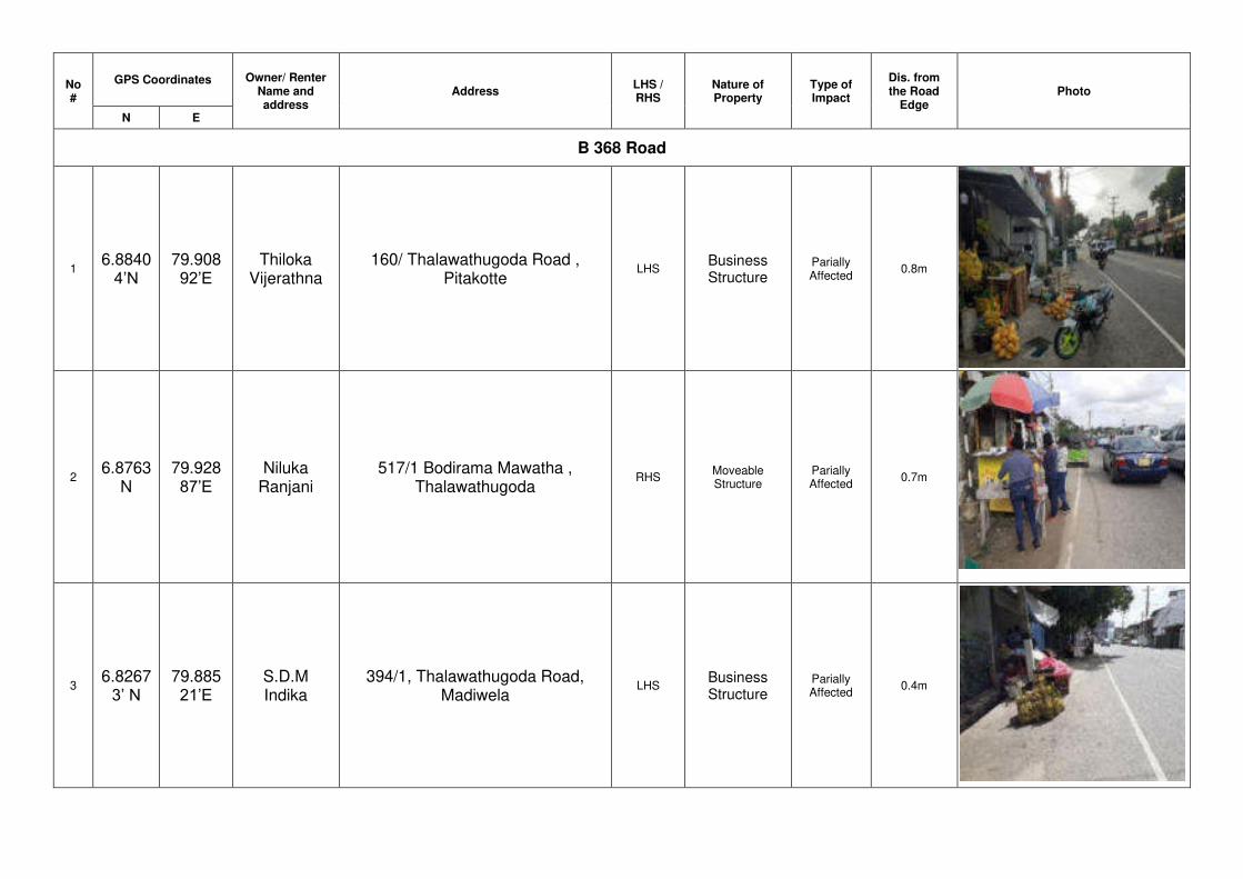
No #
GPS Coordinates Owner/ Renter Name and address
Address LHS / RHS
Nature of Property
Type of Impact
Dis. from the Road
Edge Photo
N E
B 368 Road
1 6.8840
4’N 79.90892’E
Thiloka Vijerathna
160/ Thalawathugoda Road , Pitakotte
LHS Business Structure
Parially Affected
0.8m
2 6.8763
N 79.92887’E
Niluka Ranjani
517/1 Bodirama Mawatha , Thalawathugoda
RHS Moveable Structure
Parially Affected
0.7m
3 6.8267
3’ N 79.88521’E
S.D.M Indika
394/1, Thalawathugoda Road, Madiwela
LHS Business Structure
Parially Affected
0.4m
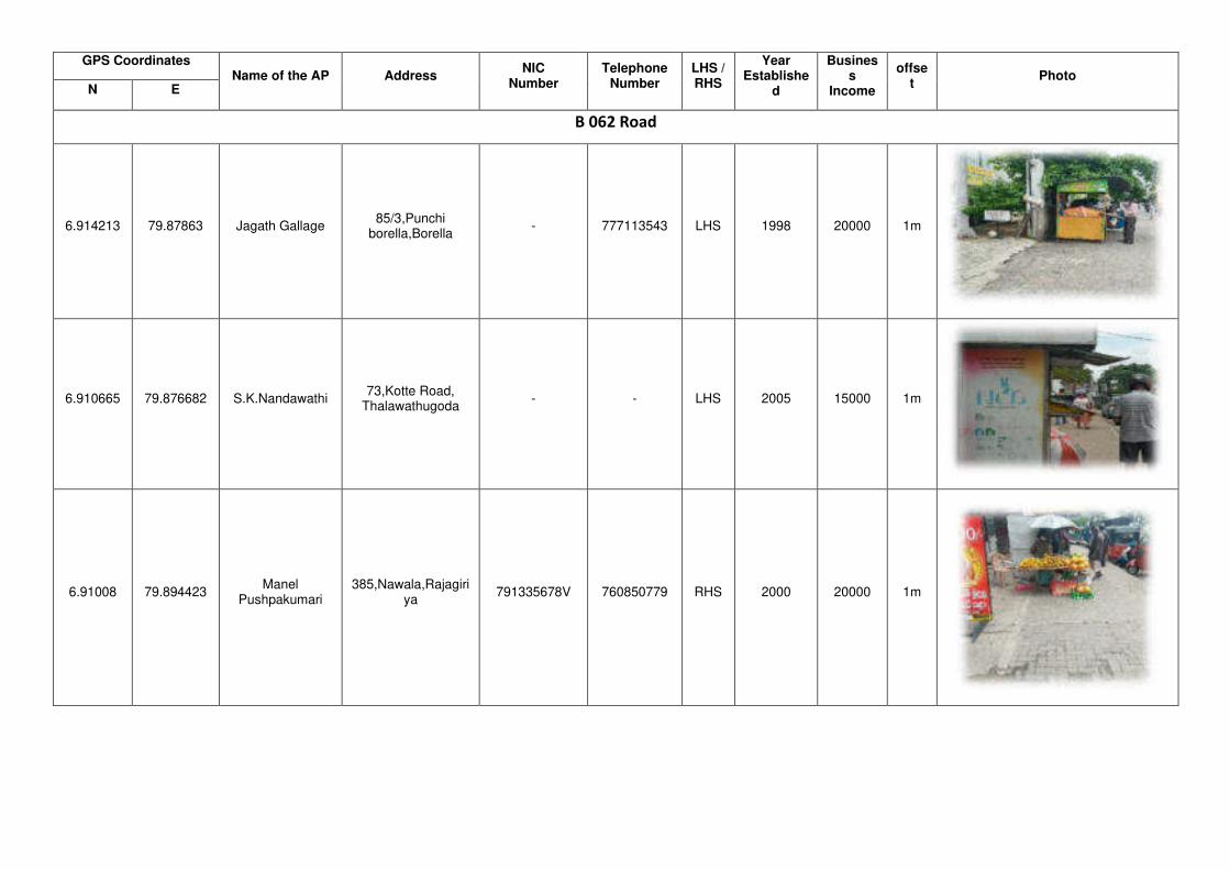
GPS Coordinates Name of the AP Address
NIC Number
Telephone Number
LHS / RHS
Year Establishe
d
Business
Income
offset
Photo N E
B 062 Road
6.914213 79.87863 Jagath Gallage 85/3,Punchi
borella,Borella - 777113543 LHS 1998 20000 1m
6.910665 79.876682 S.K.Nandawathi 73,Kotte Road,
Thalawathugoda - - LHS 2005 15000 1m
6.91008 79.894423 Manel
Pushpakumari 385,Nawala,Rajagiri
ya 791335678V 760850779 RHS 2000 20000 1m
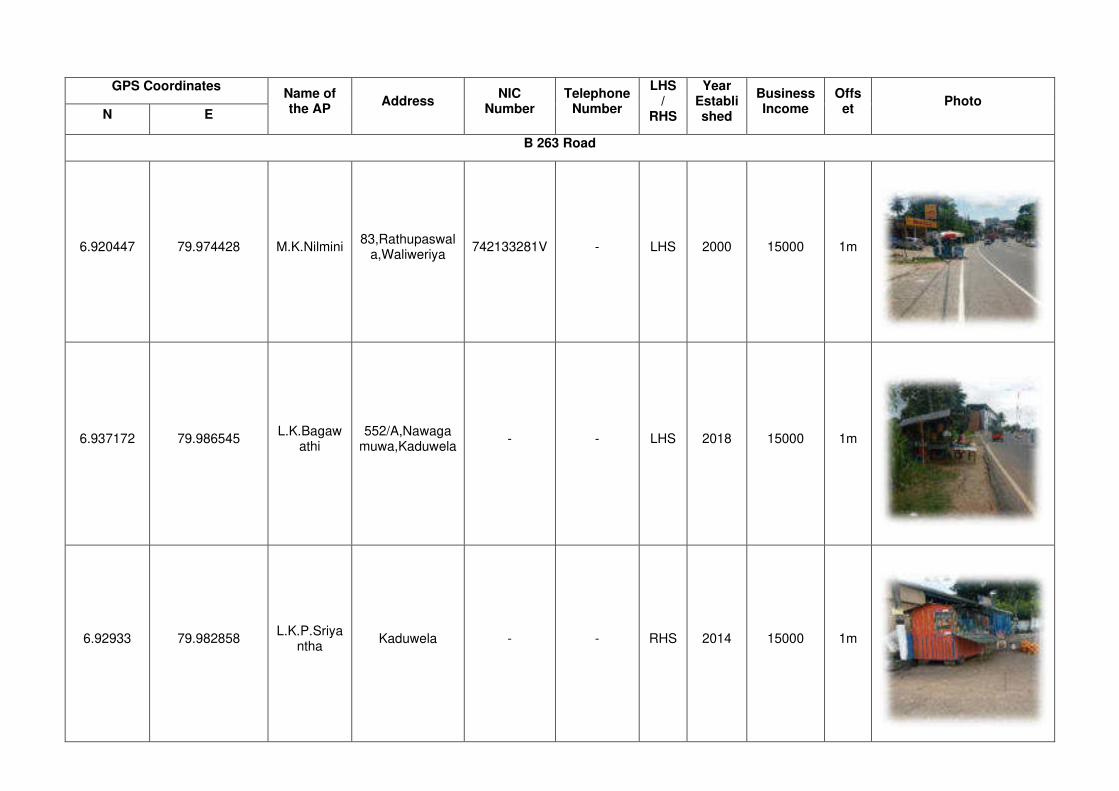
GPS Coordinates Name of the AP
Address NIC
Number Telephone
Number
LHS /
RHS
Year Established
Business Income
Offset
Photo N E
B 263 Road
6.920447 79.974428 M.K.Nilmini 83,Rathupaswal
a,Waliweriya 742133281V - LHS 2000 15000 1m
6.937172 79.986545 L.K.Bagaw
athi 552/A,Nawaga
muwa,Kaduwela - - LHS 2018 15000 1m
6.92933 79.982858 L.K.P.Sriya
ntha Kaduwela - - RHS 2014 15000 1m
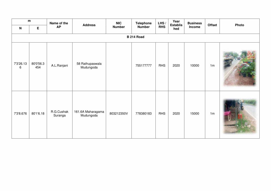
m Name of the
AP Address
NIC Number
Telephone Number
LHS / RHS
Year Establis
hed
Business Income
Offset Photo N E
B 214 Road
7'3'26.136
80'0'56.3454
A.L.Ranjani 58 Rathupaswala
Mudungoda 755177777 RHS 2020 10000 1m
7'3'8.676 80'1'6.18 R.G.Cushak
Suranga 161.6A Maharagama
Mudungoda 803212350V 778380183 RHS 2020 15000 1m

m Name of the
AP Address
NIC Number
Telephone Number
LHS / RHS
Year Establis
hed
Business Income
Offset Photo N E
B 214 Road
6'58'19.698
80'0'7.398
H.K.Lakmal Udayagama
30/2 Siyabalape Watta Delgoda
198823401917 724359089 RHS 1995 20000 1m
7'1'35.592
80'1'38.526
N.P.Chanpa Chandan
37/4 Biyagama Road Waliwariya
728093536V 784478444 RHS 2012 15000 1m
7'2'40.02 80'1'3.71
4 H.Priyangika
916 Heenpathuwa Waliwariya
798431390V 757148963 RHS 2003 20000 1m
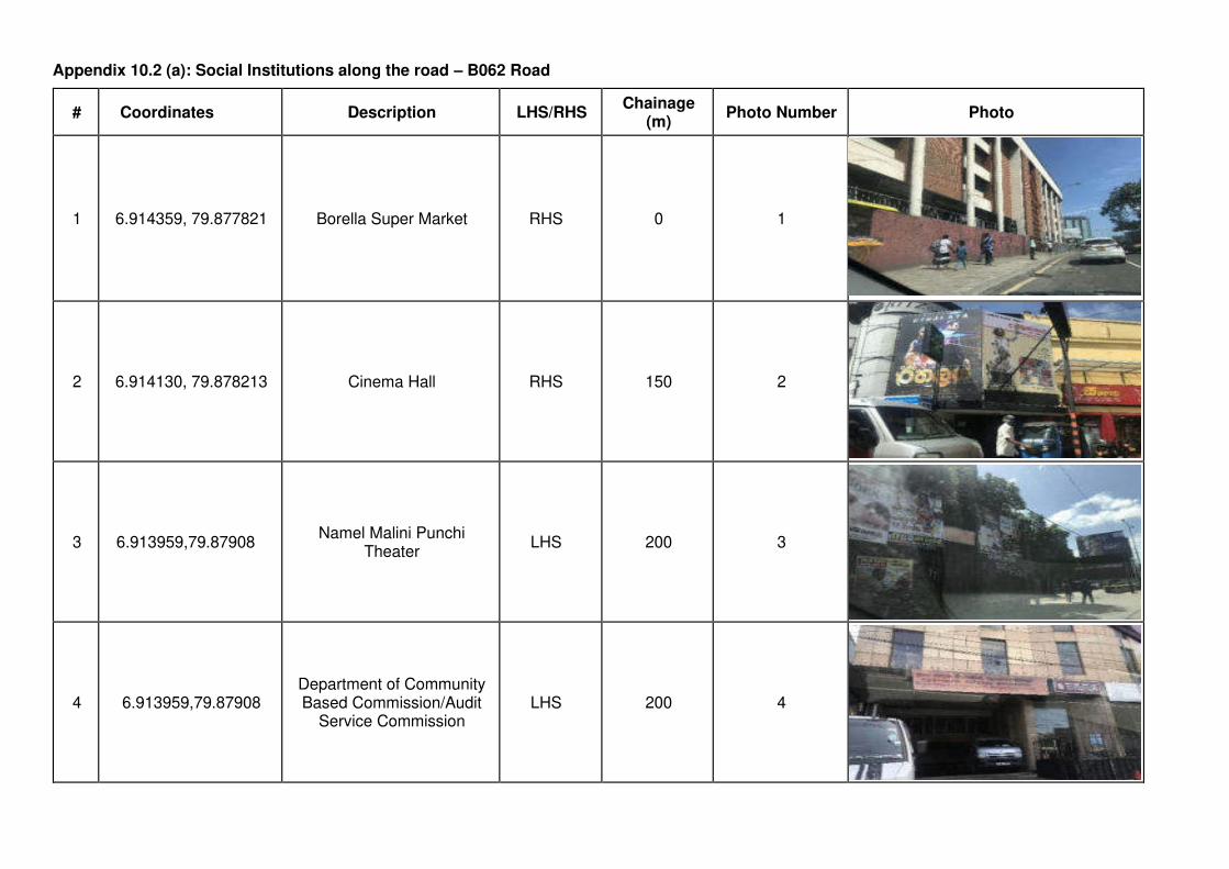
Appendix 10.2 (a): Social Institutions along the road – B062 Road
# Coordinates Description LHS/RHS Chainage
(m) Photo Number Photo
1 6.914359, 79.877821 Borella Super Market RHS 0 1
2 6.914130, 79.878213 Cinema Hall RHS 150 2
0
3 6.913959,79.87908 Namel Malini Punchi
Theater LHS 200 3
4 6.913959,79.87908 Department of Community Based Commission/Audit
Service Commission LHS 200 4

# Coordinates Description LHS/RHS Chainage
(m) Photo Number Photo
5 6.9139547,79.879456 Sri Lanka Investors
Commission RHS 250 5
6 6.913788,79.88181 Communist Party Building LHS 500 6
7 6.9137673,79.882256 Dr. N.M. Perera Centre RHS 600 7
8 6.913734, 79.883226 Treasure Trove Residence LHS 700 8

# Coordinates Description LHS/RHS Chainage
(m) Photo Number Photo
9 6.912341,79.88513 Buddha Statue LHS 900 9
10 6.9117985,79.88597 Western Infirmary Private
Hospital RHS 1000 10
11 6.911458,79.886955 S.W.R.D. Bandaranayake
College LHS 1200 11
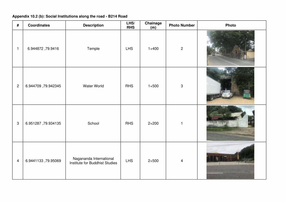
Appendix 10.2 (b): Social Institutions along the road - B214 Road
# Coordinates Description LHS/ RHS
Chainage (m)
Photo Number Photo
1 6.944872 ,79.9416 Temple LHS 1+400 2
2 6.944709 ,79.942345 Water World RHS 1+500 3
3 6.951287 ,79.934135 School RHS 2+200 1
4 6.9441133 ,79.95069 Nagananda International
Institute for Buddhist Studies LHS 2+500 4
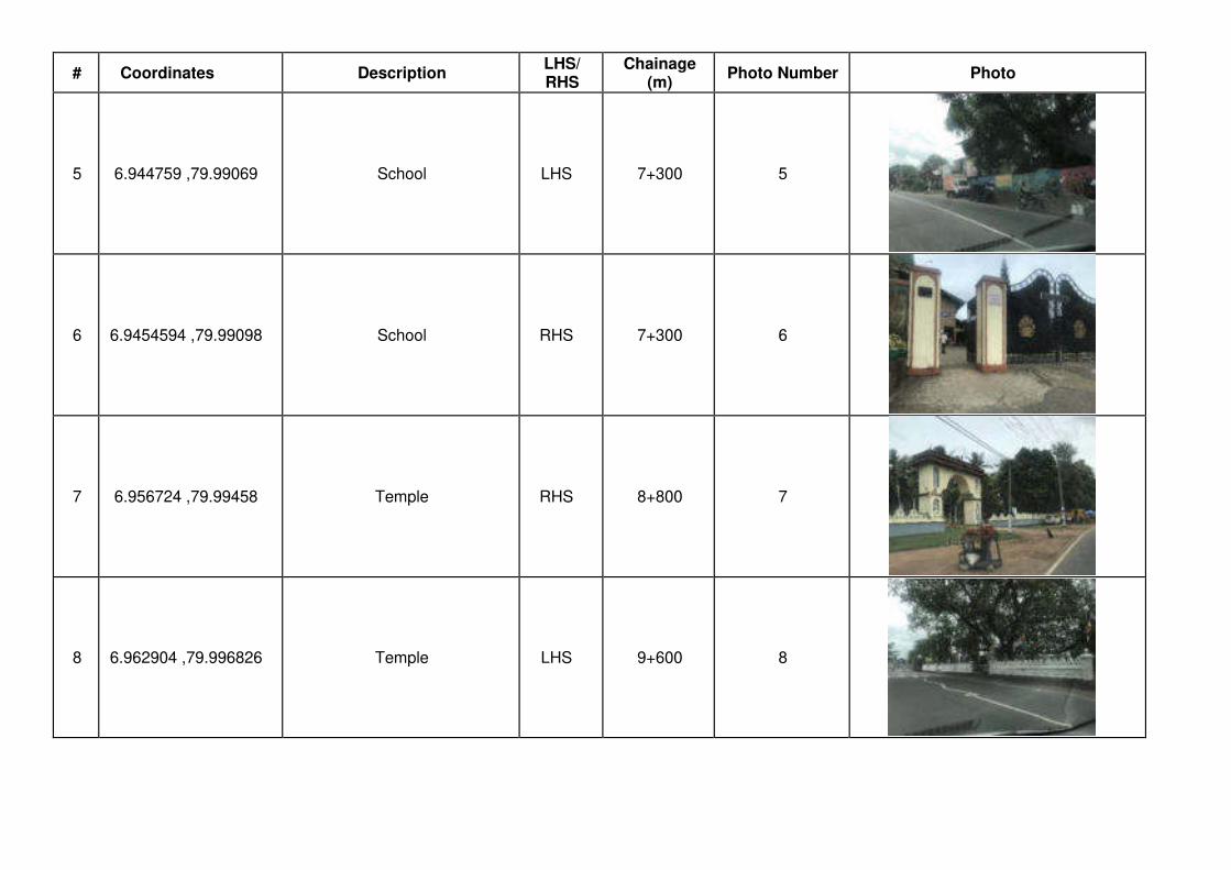
# Coordinates Description LHS/ RHS
Chainage (m)
Photo Number Photo
5 6.944759 ,79.99069 School LHS 7+300 5
6 6.9454594 ,79.99098 School RHS 7+300 6
7 6.956724 ,79.99458 Temple RHS 8+800 7
8 6.962904 ,79.996826 Temple LHS 9+600 8

# Coordinates Description LHS/ RHS
Chainage (m)
Photo Number Photo
9 6.970224, 80.001945 School RHS 10+600 9
10 6.977071 ,80.00651 Temple RHS 11+600 10
11 6.980763 ,80.00935 School RHS 12+100 11
12 6.995226 ,80.015564 School RHS 13+900 12
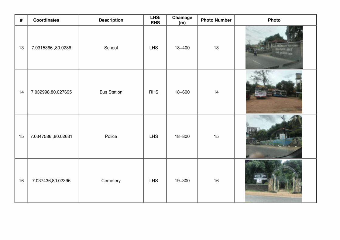
# Coordinates Description LHS/ RHS
Chainage (m)
Photo Number Photo
13 7.0315366 ,80.0286 School LHS 18+400 13
14 7.032998,80.027695 Bus Station RHS 18+600 14
15 7.0347586 ,80.02631 Police LHS 18+800 15
16 7.037436,80.02396 Cemetery LHS 19+300 16
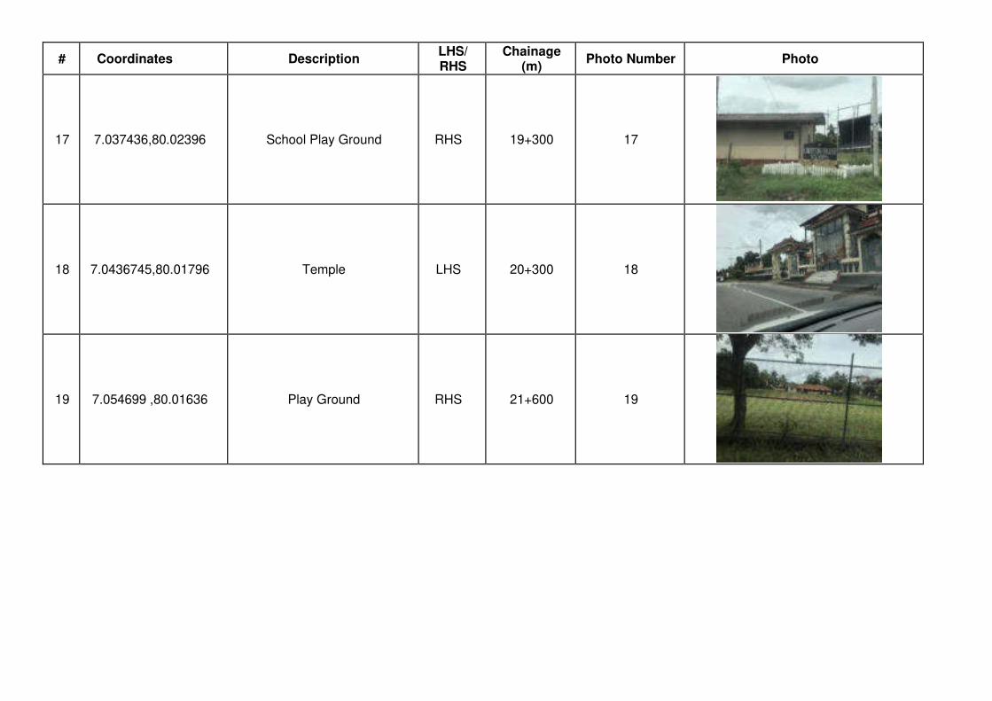
# Coordinates Description LHS/ RHS
Chainage (m)
Photo Number Photo
17 7.037436,80.02396 School Play Ground RHS 19+300 17
18 7.0436745,80.01796 Temple LHS 20+300 18
19 7.054699 ,80.01636 Play Ground RHS 21+600 19

Appendix 10.2 (c): Social Institutions along the road -B263 Road
# Coordinates Description LHS/ RHS
Chainage (m)
Photo Number Photo
1 6.903489, 79.957138 Boys' School - Malabe LHS 240 1
2 6.908795, 79.969568 Sri Sudharshanarama
Purana Viharaya LHS 1935 2
3 6.909097, 79.970276 Mahamevnawa Amawatura
Monastery RHS 2390 3
4 6.914444, 79.972197 Slit Campus Malabe RHS 2640 4

# Coordinates Description LHS/ RHS
Chainage (m)
Photo Number Photo
5 6.912341,79.88513 Lanka Fuel Station RHS 4330 5
6 6.932145, 79.982615 Sankapitti Purana Viharaya RHS 5140 6
7 6.934395, 79.983316 Kaduwela Municipal Council RHS 5400 7
8 6.934422, 79.983604 Vijayanthi Theater RHS 5510 8
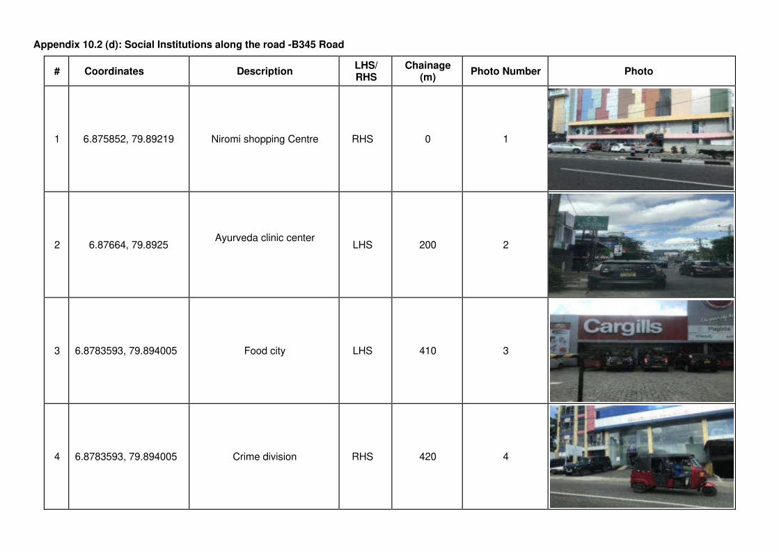
Appendix 10.2 (d): Social Institutions along the road -B345 Road
# Coordinates Description LHS/ RHS
Chainage (m)
Photo Number Photo
1 6.875852, 79.89219 Niromi shopping Centre RHS 0 1
2 6.87664, 79.8925 Ayurveda clinic center
LHS 200 2
3 6.8783593, 79.894005 Food city LHS 410 3
4 6.8783593, 79.894005 Crime division RHS 420 4
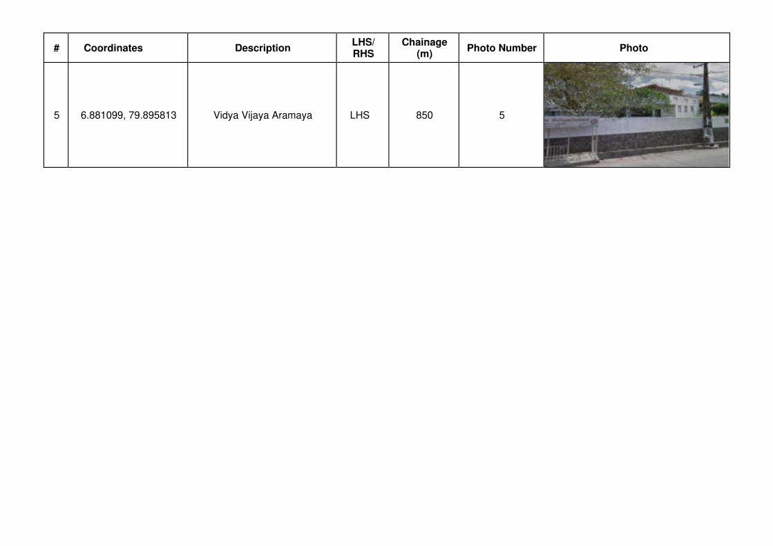
# Coordinates Description LHS/ RHS
Chainage (m)
Photo Number Photo
5 6.881099, 79.895813 Vidya Vijaya Aramaya LHS 850 5
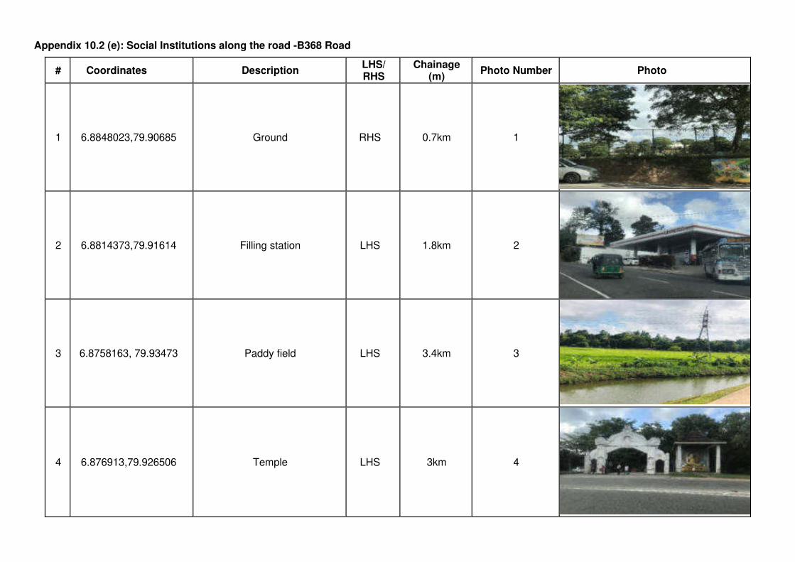
Appendix 10.2 (e): Social Institutions along the road -B368 Road
# Coordinates Description LHS/ RHS
Chainage (m)
Photo Number Photo
1 6.8848023,79.90685 Ground RHS 0.7km 1
2 6.8814373,79.91614 Filling station LHS 1.8km 2
3 6.8758163, 79.93473 Paddy field LHS 3.4km 3
4 6.876913,79.926506 Temple LHS 3km 4
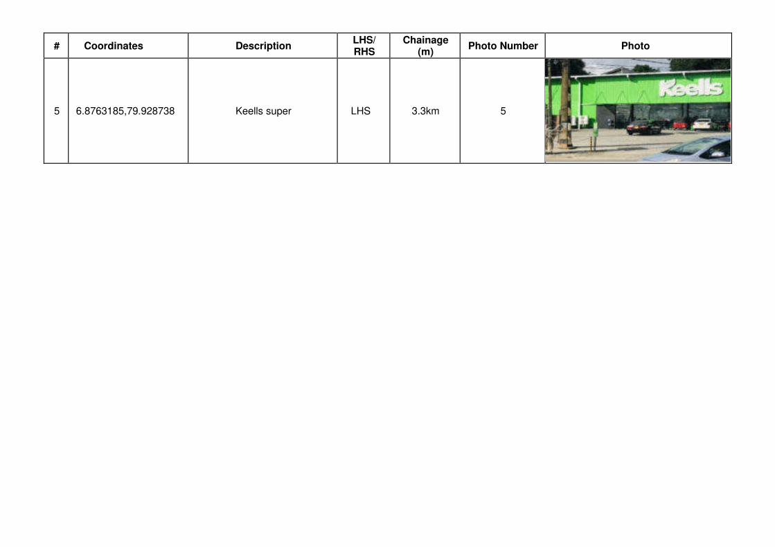
# Coordinates Description LHS/ RHS
Chainage (m)
Photo Number Photo
5 6.8763185,79.928738 Keells super LHS 3.3km 5

Appendix 11: Flood Locations for Roads in Package 2
Road Number
Road Name Length
(km) Chainage Height (m) Years Description Photos
B062 Borella Rajagiriya Road
(Kota Road) 1.38 No Flood Locations were recorded in recent times
B214
Kelaniya Mudungoda Road from Nagahamula
Junction to Belummahara
23.00
8+500 - 13+000 varied upto 2.5m
maximum 4 Years ago,
Due to flooding of Kelani River
13+600 - 13+800 0.2 Rainy Seasons
14+400 - 14+650 Rainy Seasons
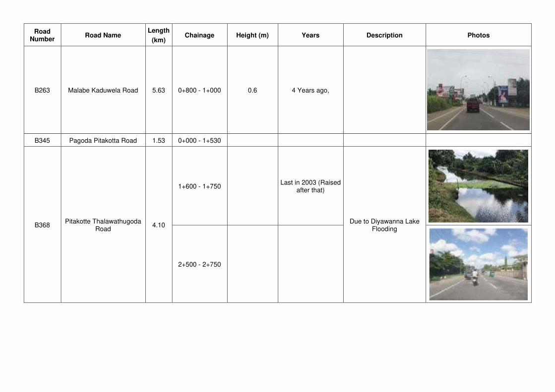
Road Number
Road Name Length
(km) Chainage Height (m) Years Description Photos
B263 Malabe Kaduwela Road 5.63 0+800 - 1+000 0.6 4 Years ago,
B345 Pagoda Pitakotta Road 1.53 0+000 - 1+530
B368 Pitakotte Thalawathugoda
Road 4.10
1+600 - 1+750 Last in 2003 (Raised
after that)
Due to Diyawanna Lake Flooding
2+500 - 2+750
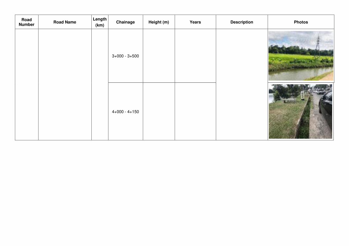
Road Number
Road Name Length
(km) Chainage Height (m) Years Description Photos
3+000 - 3+500
4+000 - 4+150
Appendix12: Recording and monitoring the procedures adopted by the contractors
to ensure health and safety to prevent spreading of COVID-19
1. What activities were considered when the site work commences?
Commencement of site works and mobilizing the workers
Awareness creation, routine, and regular health/ hygienic practices
Emergency preparedness
2. What precautions have been taken so that workers are not at a risk to expose/infect the virus
Note: workers at a site near a hospital are more vulnerable to be infected
3. List out the activities that will be carried out at sites and (practical) measures that shall be adopted
to contain any infection or spread of disease.
4. List out the measures that will be adopted at site to record the health condition of workers upon
reporting to work and their whereabouts and specific activities they had got involved during the
previous 2–3 week period.
5. List out the measures that would be adopted to monitor the health condition of the worker force.
Note that workers/ staff with following conditions should not be allowed to the site.
Those having fever, with or without acute onset respiratory symptoms such as cough,
runny nose, sore throat and/or shortness of breath.
Those who have had contact with suspected or confirmed case of COVID-19 for the last
14 days.
Those who are quarantined for COVID-19
If sick person reports for work, he/she is sent back home immediately.
6. Include the procedure/s that will be followed with respect to managing visitors and other deliveries
to site.
7. Include measures that will be taken to provide required PPE to workers, measures taken to enforce
them to wear them at site and measures used to dispose the used items such as face masks.
8. List out the routine and regular measures that would be adopted at sites to maintain the health,
hygiene and safety of the workforce including office staff (including social distancing where
possible).
9. How awareness programmes shall be conducted for the workforce on spread and containment of
COVID 19, and on good health and hygienic practices and for workers who return home, and the
precautionary measures they should be taking.
10. Provide information on how accommodations, kitchens, meal rooms, labour billets shall be
improved to restrain any possibility of contamination.
11. Include procedures that would be adopted in case an infected persons/ suspected case is found at
site.
The Contractor or site supervisor may consult the PHI of the sub-project area before mobilization, and
obtain his/her opinion/advice. Contact the PHI and record his/her opinion on site organization and health
& safety plans to prevent COVID-19, and safeguard general health of the workers.
Related Documents