August 2020 page i Environmental Impact Assessment (draft) Project No.: 44167-015 August 2020 (2 of 2) Bangladesh: Flood and Riverbank Erosion Risk Management Investment Program – Project 2 Prepared by the Bangladesh Water Development Board for the Asian Development Bank. This environmental impact assessment is a document of the borrower. The views expressed herein do not necessarily represent those of ADB's Board of Directors, Management, or staff, and may be preliminary in nature. Your attention is directed to the “terms of use” section on ADB’s website. In preparing any country program or strategy, financing any project, or by making any designation of or reference to a particular territory or geographic area in this document, the Asian Development Bank does not intend to make any judgments as to the legal or other status of any territory or area.

Welcome message from author
This document is posted to help you gain knowledge. Please leave a comment to let me know what you think about it! Share it to your friends and learn new things together.
Transcript
August 2020 page i
Environmental Impact Assessment (draft)
Project No.: 44167-015 August 2020
(2 of 2)
Bangladesh: Flood and Riverbank Erosion Risk
Management Investment Program – Project 2
Prepared by the Bangladesh Water Development Board for the Asian Development Bank. This environmental impact assessment is a document of the borrower. The views expressed herein do not necessarily represent those of ADB's Board of Directors, Management, or staff, and may be preliminary in nature. Your attention is directed to the “terms of use” section on ADB’s website.
In preparing any country program or strategy, financing any project, or by making any designation of or reference to a particular territory or geographic area in this document, the Asian Development Bank does not intend to make any judgments as to the legal or other status of any territory or area.
July 2020 page 1
10 ANALYSIS OF ALTERNATIVES
368. The three sub-reaches selected for Project-2 of the FRERMIP physical works: JRB-1, JLB-2 and PBL-1, were chosen from 13 sub-reaches into which the FRERMIP program area was divided based on discussions among BWDB, ADB and the PPTA consultant. These 13 sub-reaches were evaluated using a multi-criteria assessment approach taking into consideration three primary criteria (riverbank erosion, flooding, and poverty) and several secondary criteria (related to planning, design, cost-benefit and safeguards issues). Of the six sub-reaches scoring highest1, these three sub-reaches were screened out due to a lack of active erosion and/or conflicts with other immediately planned interventions.
369. While riverbank protection was placed according to immediate needs especially for growth centers (“something to defend”), embankment construction considered alternatives especially for the area JLB-2. BWDB contemplates the establishment of polders (ring-embankments) covering large parts of JLB-2 with very long ring embankment lines. These were compared to the solution of an embankment only along the riverbanks of the main rivers, reducing the length of the embankments and as such minimizing the footprint and related land acquisition and resettlement. In addition, open distributaries would allow all-year-round water flow to the area, which specifically enhances the dry season water management 2.
370. As such various alternative interventions have been considered. One of these has been large-scale Capital Dredging for which a national feasibility study was conducted (2010-2015). However, large-scale capital dredging on the one hand, and riverbank protection on the other, are different solutions to the same problem, and it is neither logical nor cost-efficient to implement both on a large scale simultaneously. Large-scale dredging is believed not be sustainable due to (continued) high costs and the high sediment load of river waters (resulting in rapid refill), and is therefore not further considered as a viable scenario under the present river stabilization planning process. However, limited dredging of river sections may be considered to stimulate the development of a desired future river planform with more stable river channels and a narrower active river corridor by the river itself, whereby dredged material is placed at selected locations in the floodplain and on chars.
10.1 Without-Project scenarios
371. Without JRB-1. It is expected that without additional riverbank protection along JRB-1, the embankment and important infrastructure in the Enayetpur area will remain vulnerable and the goal of the project will not be achieved.
372. Without JLB-2. The future geometry of the two downstream Jamuna branches fully depends on the discharge distribution at the bifurcation. Without countermeasures (stabilization works) there is a risk that the bifurcation changes over time with increased discharge in the right channel and reduced in the left one or vice versa. Other changes could happen within the channel pattern, for example the cut-off channel at Chauhali could develop and change the downstream channel pattern. As a consequence of these changes, the downstream channel pattern would change in two ways: riverbank erosion would take place in yet unprotected
1 The highest ranking sites scored between 300 and 370 points, while the lower ranking sites ranged between 200
and 260 points. 2 Annex D of the feasibility study, “River and Charland Morphology and River Engineering” provides more
background.

July 2020 page 2
reaches, and existing work to stabilize the downstream channel might turn out to be ineffective as placed in the wrong location.
July 2020 page 3
11 ENVIRONMENTAL MANAGEMENT PLAN
373. In previous chapters, the possible positive and negative impacts have been identified and evaluated. In addition to that, mitigation measures have been mentioned to address adverse impacts. This chapter presents the Environmental Management Plan (EMP) prepared by the study team. The EMP entails mitigation measures for the negative impacts, enhancement measures for the positive impacts, compensation for the non-mitigated impacts and contingency measures for the accidental events that might occur.
374. The EMP has been organized per construction and post-construction phase (operation and maintenance), to facilitate the monitoring process. Impacts and mitigation measures broadly cover the three topics: (i) construction, (ii) biodiversity and (iii) fisheries and aquaculture. Most construction related impacts are mitigated by contractors during construction. Issues pertaining to biodiversity and fisheries/aquaculture, especially related to the construction of the embankment at JRB-1 will be implemented through a specialist firm/NGO, following the principles established by the biodiversity program of GIZ at Pabna, now extended to Sirajganj, and as part of the livelihood program of the resettlement plan. In addition, fisheries/aquaculture will be supported to compensate for the loss of open water fisheries on the floodplain after the construction of the embankments. Fisheries and aquaculture have a strong relevance for the poor and is part of the livelihood component of the resettlement plan, which is a separate compensation mechanism.
375. The layout of the EMP is as follows:
Construction phase Site offices Riverbank protection Embankment construction Drainage structures/regulators-cum-fish passes
Post construction phase per site Decommissioning Water resources Land resources Agricultural resources Fisheries resources Ecological resources Socio-economic resources
376. In addition to mitigating direct impacts of the ongoing Tranche-1 and planned Project-2 works, a specialist firm/NGO may be retained to elaborate on the biodiversity baseline and study the establishment of fisheries sanctuaries, in accordance with future stabilization plans, looking beyond the localized Tranche-1 and Project-2 measures and aiming at identifying and mitigating any impacts from larger scale river-reach stabilization.
377. Note that mitigation of impacts on local community members and their livelihoods are addressed via the Resettlement Action Plan.
July 2020 page 4
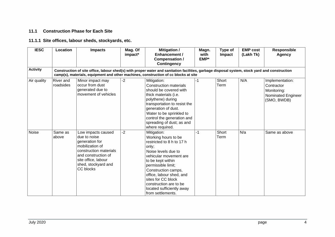
11.1 Construction Phase for Each Site
11.1.1 Site offices, labour sheds, stockyards, etc.
IESC Location Impacts Mag. Of impact*
Mitigation / Enhancement / Compensation /
Contingency
Magn. with EMP*
Type of Impact
EMP cost (Lakh Tk)
Responsible Agency
Activity Construction of site office, labour shed(s) with proper water and sanitation facilities, garbage disposal system, stock yard and construction camp(s), materials, equipment and other machines, construction of cc blocks at site
Air quality River and roadsides
Minor impact may occur from dust generated due to movement of vehicles
-2 Mitigation:
Construction materials should be covered with thick materials (i.e. polythene) during transportation to resist the generation of dust.
Water to be sprinkled to control the generation and spreading of dust; as and where required.
-1 Short Term
N/A
Implementation:
Contractor
Monitoring:
Nominated Engineer (SMO, BWDB)
Noise Same as above
Low impacts caused due to noise generation for mobilization of construction materials and construction of site office, labour shed, stockyard and CC blocks
-2 Mitigation:
Working hours to be restricted to 8 h to 17 h only;
Noise levels due to vehicular movement are to be kept within permissible limit;
Construction camps, office, labour shed, and sites for CC block construction are to be located sufficiently away from settlements.
-1 Short Term
N/a Same as above
July 2020 page 5
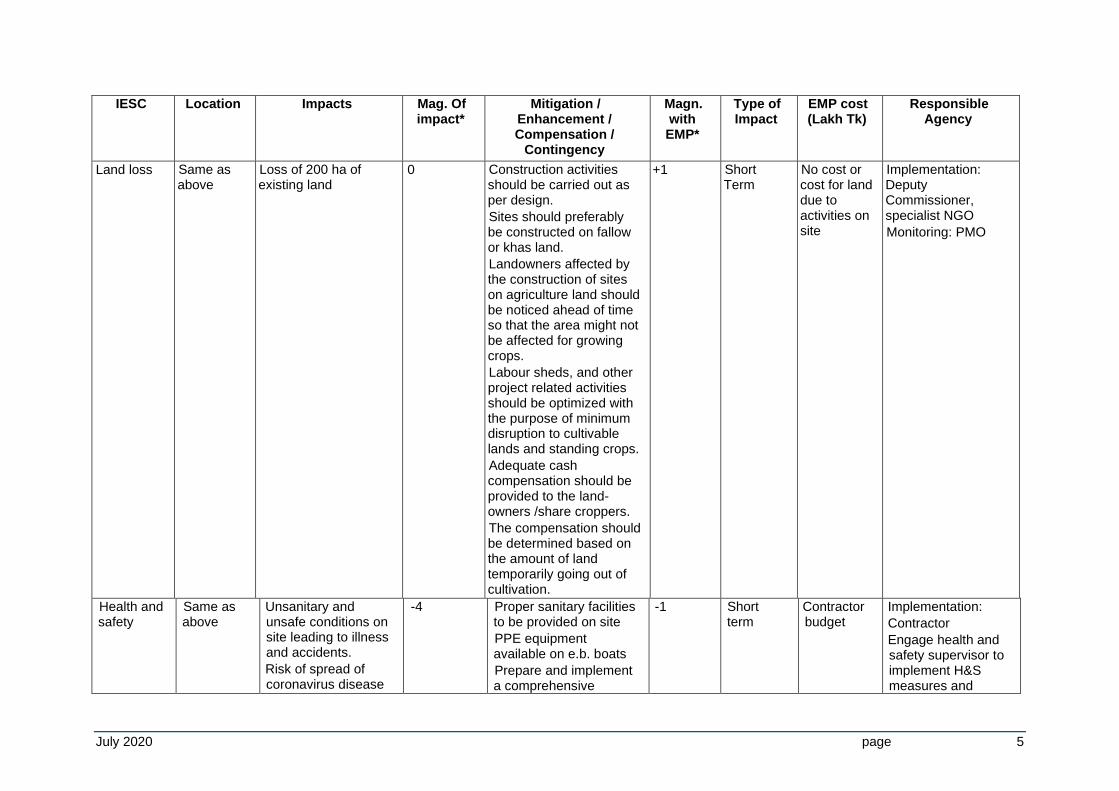
IESC Location Impacts Mag. Of impact*
Mitigation / Enhancement / Compensation /
Contingency
Magn. with EMP*
Type of Impact
EMP cost (Lakh Tk)
Responsible Agency
Land loss Same as above
Loss of 200 ha of existing land
0 Construction activities should be carried out as per design.
Sites should preferably be constructed on fallow or khas land.
Landowners affected by the construction of sites on agriculture land should be noticed ahead of time so that the area might not be affected for growing crops.
Labour sheds, and other project related activities should be optimized with the purpose of minimum disruption to cultivable lands and standing crops.
Adequate cash compensation should be provided to the land-owners /share croppers.
The compensation should be determined based on the amount of land temporarily going out of cultivation.
+1 Short Term
No cost or cost for land due to activities on site
Implementation: Deputy Commissioner, specialist NGO
Monitoring: PMO
Health and safety
Same as above
Unsanitary and unsafe conditions on site leading to illness and accidents.
Risk of spread of coronavirus disease
-4 Proper sanitary facilities to be provided on site
PPE equipment available on e.b. boats
Prepare and implement a comprehensive
-1 Short term
Contractor budget
Implementation:
Contractor
Engage health and safety supervisor to implement H&S measures and
July 2020 page 6
IESC Location Impacts Mag. Of impact*
Mitigation / Enhancement / Compensation /
Contingency
Magn. with EMP*
Type of Impact
EMP cost (Lakh Tk)
Responsible Agency
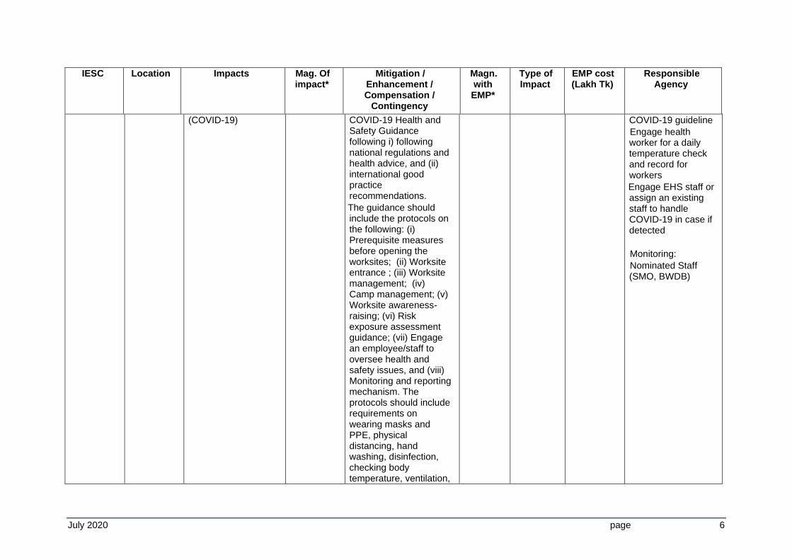
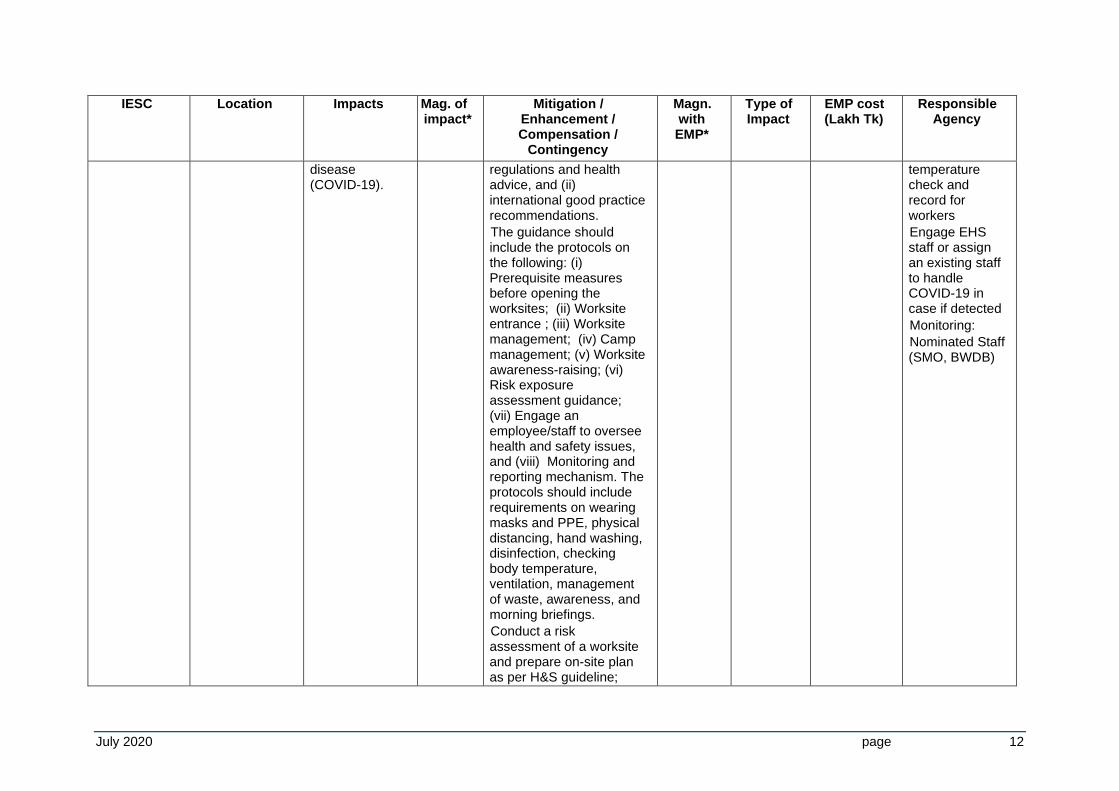
(COVID-19) COVID-19 Health and Safety Guidance following i) following national regulations and health advice, and (ii) international good practice recommendations.
The guidance should include the protocols on the following: (i) Prerequisite measures before opening the worksites; (ii) Worksite entrance ; (iii) Worksite management; (iv) Camp management; (v) Worksite awareness-raising; (vi) Risk exposure assessment guidance; (vii) Engage an employee/staff to oversee health and safety issues, and (viii) Monitoring and reporting mechanism. The protocols should include requirements on wearing masks and PPE, physical distancing, hand washing, disinfection, checking body temperature, ventilation,
COVID-19 guideline
Engage health worker for a daily temperature check and record for workers
Engage EHS staff or assign an existing staff to handle COVID-19 in case if detected
Monitoring:
Nominated Staff (SMO, BWDB)
July 2020 page 7
IESC Location Impacts Mag. Of impact*
Mitigation / Enhancement / Compensation /
Contingency
Magn. with EMP*
Type of Impact
EMP cost (Lakh Tk)
Responsible Agency
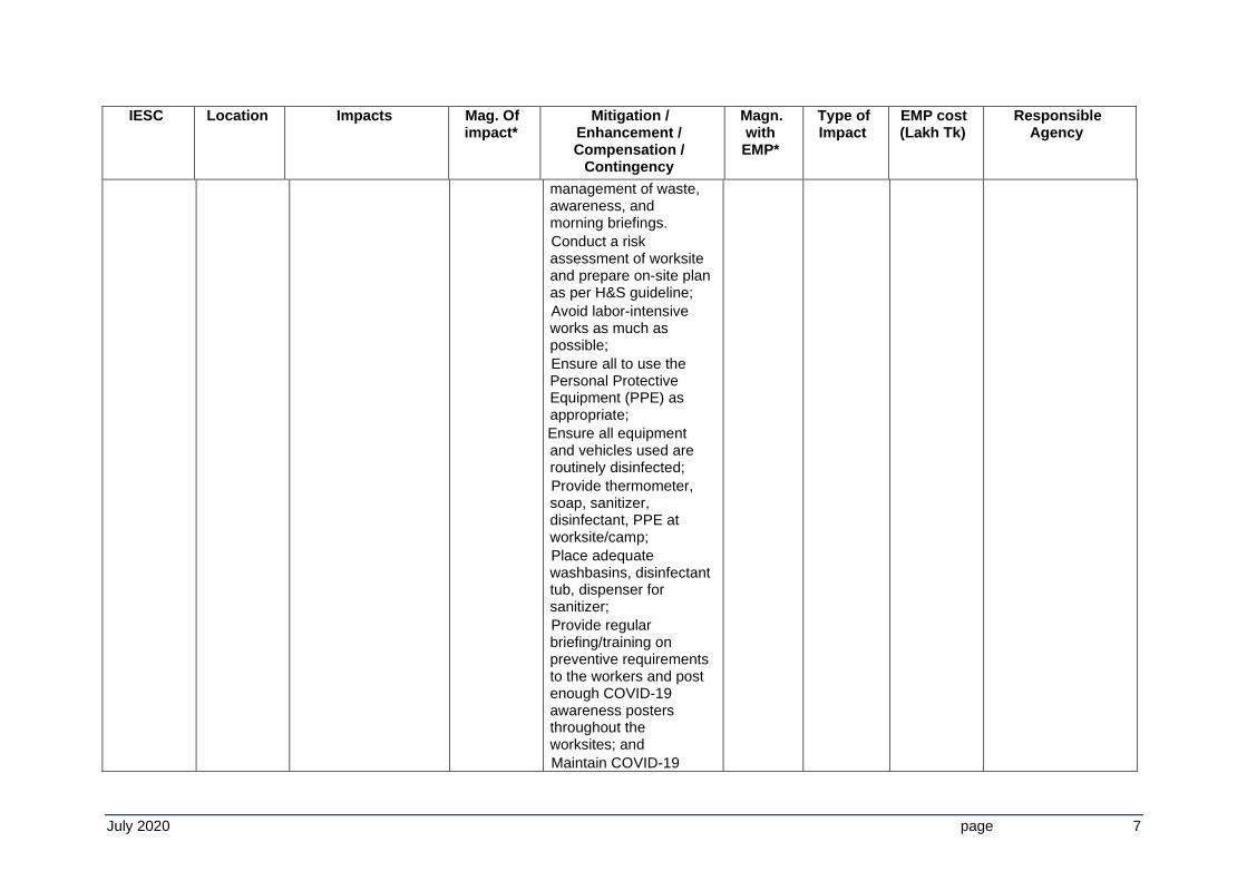
management of waste, awareness, and morning briefings.
Conduct a risk assessment of worksite and prepare on-site plan as per H&S guideline;
Avoid labor-intensive works as much as possible;
Ensure all to use the Personal Protective Equipment (PPE) as appropriate;
Ensure all equipment and vehicles used are routinely disinfected;
Provide thermometer, soap, sanitizer, disinfectant, PPE at worksite/camp;
Place adequate washbasins, disinfectant tub, dispenser for sanitizer;
Provide regular briefing/training on preventive requirements to the workers and post enough COVID-19 awareness posters throughout the worksites; and
Maintain COVID-19
July 2020 page 8
IESC Location Impacts Mag. Of impact*
Mitigation / Enhancement / Compensation /
Contingency
Magn. with EMP*
Type of Impact
EMP cost (Lakh Tk)
Responsible Agency
weekly monitoring and reporting mechanism at the worksite; including any necessary actions to be taken
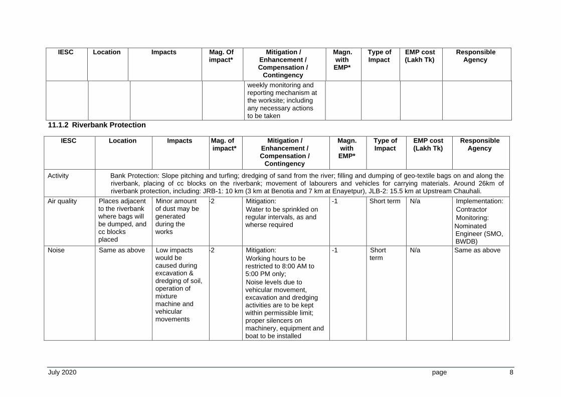
11.1.2 Riverbank Protection
IESC Location Impacts Mag. of impact*
Mitigation / Enhancement / Compensation /
Contingency
Magn. with EMP*
Type of Impact
EMP cost (Lakh Tk)
Responsible Agency
Activity Bank Protection: Slope pitching and turfing; dredging of sand from the river; filling and dumping of geo-textile bags on and along the riverbank, placing of cc blocks on the riverbank; movement of labourers and vehicles for carrying materials. Around 26km of riverbank protection, including: JRB-1: 10 km (3 km at Benotia and 7 km at Enayetpur), JLB-2: 15.5 km at Upstream Chauhali.
Air quality Places adjacent to the riverbank where bags will be dumped, and cc blocks placed
Minor amount of dust may be generated during the works
-2 Mitigation:
Water to be sprinkled on regular intervals, as and wherse required
-1 Short term N/a Implementation:
Contractor
Monitoring:
Nominated Engineer (SMO, BWDB)
Noise Same as above Low impacts would be caused during excavation & dredging of soil, operation of mixture machine and vehicular movements
-2 Mitigation:
Working hours to be restricted to 8:00 AM to 5:00 PM only;
Noise levels due to vehicular movement, excavation and dredging activities are to be kept within permissible limit; proper silencers on machinery, equipment and boat to be installed
-1 Short term
N/a Same as above
July 2020 page 9
IESC Location Impacts Mag. of impact*
Mitigation / Enhancement / Compensation /
Contingency
Magn. with EMP*
Type of Impact
EMP cost (Lakh Tk)
Responsible Agency
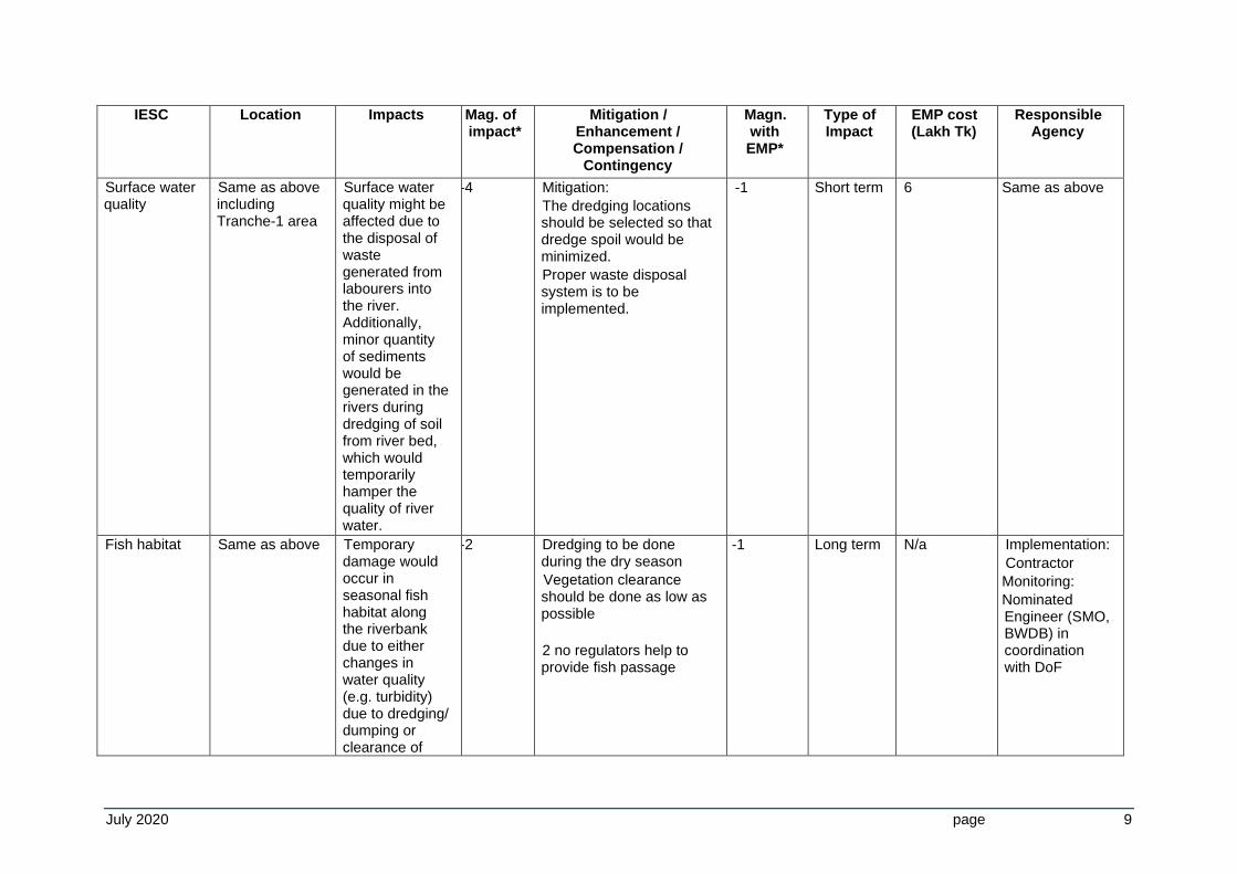
Surface water quality
Same as above including Tranche-1 area
Surface water quality might be affected due to the disposal of waste generated from labourers into the river. Additionally, minor quantity of sediments would be generated in the rivers during dredging of soil from river bed, which would temporarily hamper the quality of river water.
-4 Mitigation:
The dredging locations should be selected so that dredge spoil would be minimized.
Proper waste disposal system is to be implemented.
-1 Short term 6 Same as above
Fish habitat Same as above Temporary damage would occur in seasonal fish habitat along the riverbank due to either changes in water quality (e.g. turbidity) due to dredging/ dumping or clearance of
-2 Dredging to be done during the dry season
Vegetation clearance should be done as low as possible
2 no regulators help to provide fish passage
-1 Long term N/a Implementation:
Contractor
Monitoring:
Nominated Engineer (SMO, BWDB) in coordination with DoF
July 2020 page 10
IESC Location Impacts Mag. of impact*
Mitigation / Enhancement / Compensation /
Contingency
Magn. with EMP*
Type of Impact
EMP cost (Lakh Tk)
Responsible Agency
vegetation cover or draped by the filling earth during earth work
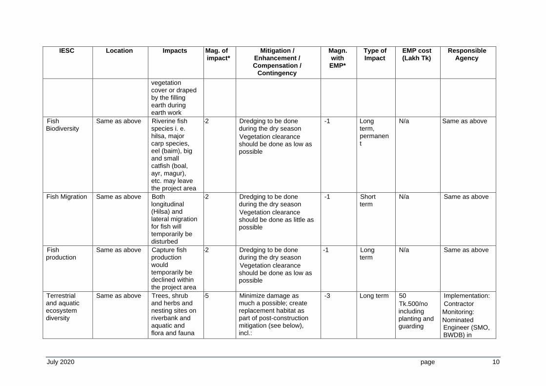
Fish Biodiversity
Same as above Riverine fish species i. e. hilsa, major carp species, eel (baim), big and small catfish (boal, ayr, magur), etc. may leave the project area
-2 Dredging to be done during the dry season
Vegetation clearance should be done as low as possible
-1 Long term, permanent
N/a Same as above
Fish Migration Same as above Both longitudinal (Hilsa) and lateral migration for fish will temporarily be disturbed
-2 Dredging to be done during the dry season
Vegetation clearance should be done as little as possible
-1 Short term
N/a Same as above
Fish production
Same as above Capture fish production would temporarily be declined within the project area
-2 Dredging to be done during the dry season
Vegetation clearance should be done as low as possible
-1 Long term
N/a Same as above
Terrestrial and aquatic ecosystem diversity
Same as above Trees, shrub and herbs and nesting sites on riverbank and aquatic and flora and fauna
-5 Minimize damage as much a possible; create replacement habitat as part of post-construction mitigation (see below), incl.:
-3 Long term 50
Tk.500/no including planting and guarding
Implementation:
Contractor
Monitoring:
Nominated Engineer (SMO, BWDB) in
July 2020 page 11
IESC Location Impacts Mag. of impact*
Mitigation / Enhancement / Compensation /
Contingency
Magn. with EMP*
Type of Impact
EMP cost (Lakh Tk)
Responsible Agency
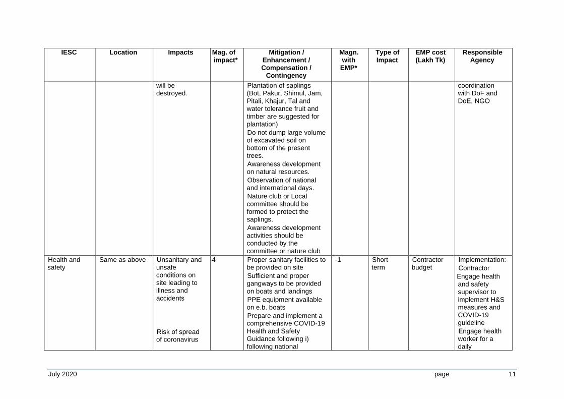
will be destroyed.
Plantation of saplings (Bot, Pakur, Shimul, Jam, Pitali, Khajur, Tal and water tolerance fruit and timber are suggested for plantation)
Do not dump large volume of excavated soil on bottom of the present trees.
Awareness development on natural resources.
Observation of national and international days.
Nature club or Local committee should be formed to protect the saplings.
Awareness development activities should be conducted by the committee or nature club
coordination with DoF and DoE, NGO
Health and safety
Same as above Unsanitary and unsafe conditions on site leading to illness and accidents
Risk of spread of coronavirus
-4 Proper sanitary facilities to be provided on site
Sufficient and proper gangways to be provided on boats and landings
PPE equipment available on e.b. boats
Prepare and implement a comprehensive COVID-19 Health and Safety Guidance following i) following national
-1 Short term
Contractor budget
Implementation:
Contractor
Engage health and safety supervisor to implement H&S measures and COVID-19 guideline
Engage health worker for a daily
July 2020 page 12
IESC Location Impacts Mag. of impact*
Mitigation / Enhancement / Compensation /
Contingency
Magn. with EMP*
Type of Impact
EMP cost (Lakh Tk)
Responsible Agency
disease (COVID-19).
regulations and health advice, and (ii) international good practice recommendations.
The guidance should include the protocols on the following: (i) Prerequisite measures before opening the worksites; (ii) Worksite entrance ; (iii) Worksite management; (iv) Camp management; (v) Worksite awareness-raising; (vi) Risk exposure assessment guidance; (vii) Engage an employee/staff to oversee health and safety issues, and (viii) Monitoring and reporting mechanism. The protocols should include requirements on wearing masks and PPE, physical distancing, hand washing, disinfection, checking body temperature, ventilation, management of waste, awareness, and morning briefings.
Conduct a risk assessment of a worksite and prepare on-site plan as per H&S guideline;
temperature check and record for workers
Engage EHS staff or assign an existing staff to handle COVID-19 in case if detected
Monitoring:
Nominated Staff (SMO, BWDB)
July 2020 page 13
IESC Location Impacts Mag. of impact*
Mitigation / Enhancement / Compensation /
Contingency
Magn. with EMP*
Type of Impact
EMP cost (Lakh Tk)
Responsible Agency
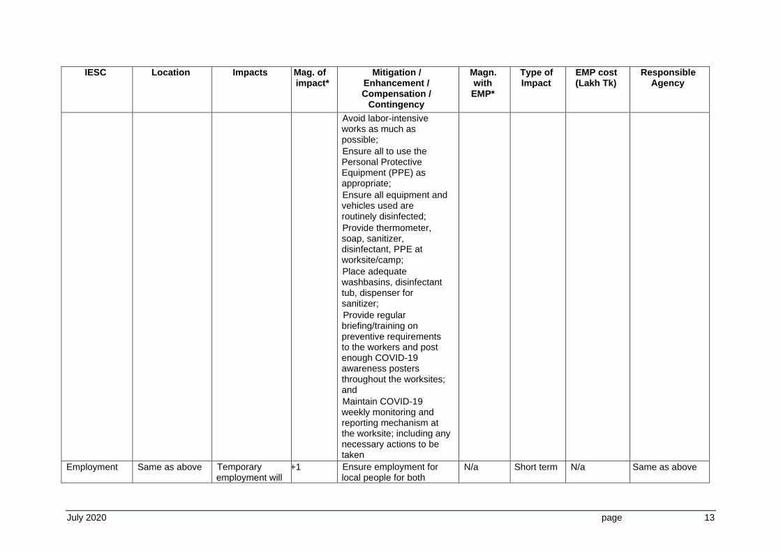
Avoid labor-intensive works as much as possible;
Ensure all to use the Personal Protective Equipment (PPE) as appropriate;
Ensure all equipment and vehicles used are routinely disinfected;
Provide thermometer, soap, sanitizer, disinfectant, PPE at worksite/camp;
Place adequate washbasins, disinfectant tub, dispenser for sanitizer;
Provide regular briefing/training on preventive requirements to the workers and post enough COVID-19 awareness posters throughout the worksites; and
Maintain COVID-19 weekly monitoring and reporting mechanism at the worksite; including any necessary actions to be taken
Employment Same as above Temporary employment will
+1 Ensure employment for local people for both
N/a Short term N/a Same as above
July 2020 page 14
IESC Location Impacts Mag. of impact*
Mitigation / Enhancement / Compensation /
Contingency
Magn. with EMP*
Type of Impact
EMP cost (Lakh Tk)
Responsible Agency
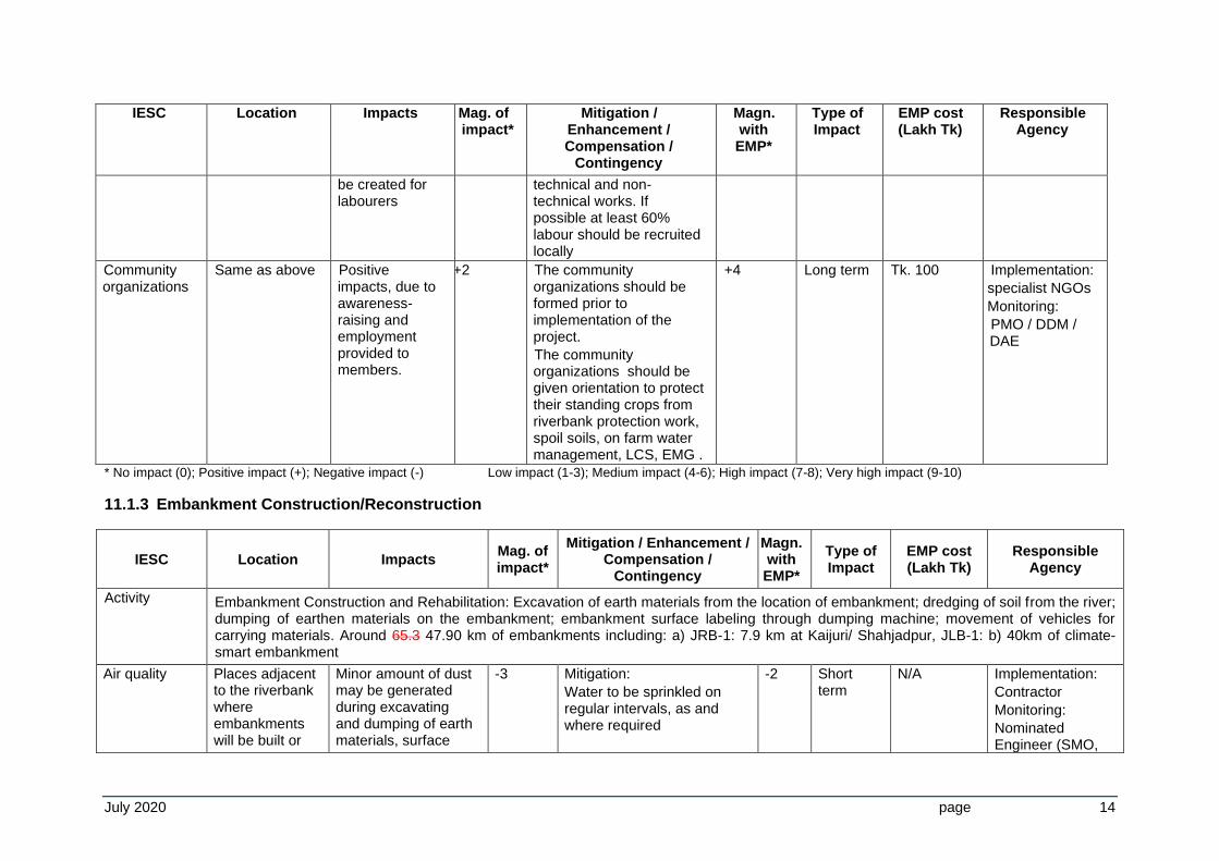
be created for labourers
technical and non-technical works. If possible at least 60% labour should be recruited locally
Community organizations
Same as above Positive impacts, due to awareness-raising and employment provided to members.
+2 The community organizations should be formed prior to implementation of the project.
The community organizations should be given orientation to protect their standing crops from riverbank protection work, spoil soils, on farm water management, LCS, EMG .
+4 Long term Tk. 100 Implementation:
specialist NGOs
Monitoring:
PMO / DDM / DAE
* No impact (0); Positive impact (+); Negative impact (-) Low impact (1-3); Medium impact (4-6); High impact (7-8); Very high impact (9-10)
11.1.3 Embankment Construction/Reconstruction
IESC Location Impacts Mag. of impact*
Mitigation / Enhancement / Compensation /
Contingency
Magn. with EMP*
Type of Impact
EMP cost (Lakh Tk)
Responsible Agency
Activity Embankment Construction and Rehabilitation: Excavation of earth materials from the location of embankment; dredging of soil from the river; dumping of earthen materials on the embankment; embankment surface labeling through dumping machine; movement of vehicles for carrying materials. Around 65.3 47.90 km of embankments including: a) JRB-1: 7.9 km at Kaijuri/ Shahjadpur, JLB-1: b) 40km of climate-smart embankment
Air quality Places adjacent to the riverbank where embankments will be built or
Minor amount of dust may be generated during excavating and dumping of earth materials, surface
-3 Mitigation:
Water to be sprinkled on regular intervals, as and where required
-2 Short term
N/A Implementation:
Contractor
Monitoring:
Nominated Engineer (SMO,
July 2020 page 15
IESC Location Impacts Mag. of impact*
Mitigation / Enhancement / Compensation /
Contingency
Magn. with EMP*
Type of Impact
EMP cost (Lakh Tk)
Responsible Agency
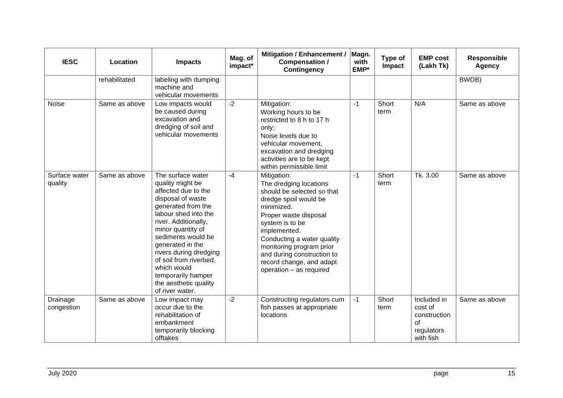
rehabilitated labeling with dumping machine and vehicular movements
BWDB)
Noise Same as above Low impacts would be caused during excavation and dredging of soil and vehicular movements
-2 Mitigation:
Working hours to be restricted to 8 h to 17 h only;
Noise levels due to vehicular movement, excavation and dredging activities are to be kept within permissible limit
-1 Short term
N/A Same as above
Surface water quality
Same as above The surface water quality might be affected due to the disposal of waste generated from the labour shed into the river. Additionally, minor quantity of sediments would be generated in the rivers during dredging of soil from riverbed, which would temporarily hamper the aesthetic quality of river water.
-4 Mitigation:
The dredging locations should be selected so that dredge spoil would be minimized.
Proper waste disposal system is to be implemented.
Conducting a water quality monitoring program prior and during construction to record change, and adapt operation – as required
-1 Short term
Tk. 3.00 Same as above
Drainage congestion
Same as above Low impact may occur due to the rehabilitation of embankment temporarily blocking offtakes
-2 Constructing regulators cum fish passes at appropriate locations
-1 Short term
Included in cost of construction of regulators with fish
Same as above
July 2020 page 16
IESC Location Impacts Mag. of impact*
Mitigation / Enhancement / Compensation /
Contingency
Magn. with EMP*
Type of Impact
EMP cost (Lakh Tk)
Responsible Agency
pass
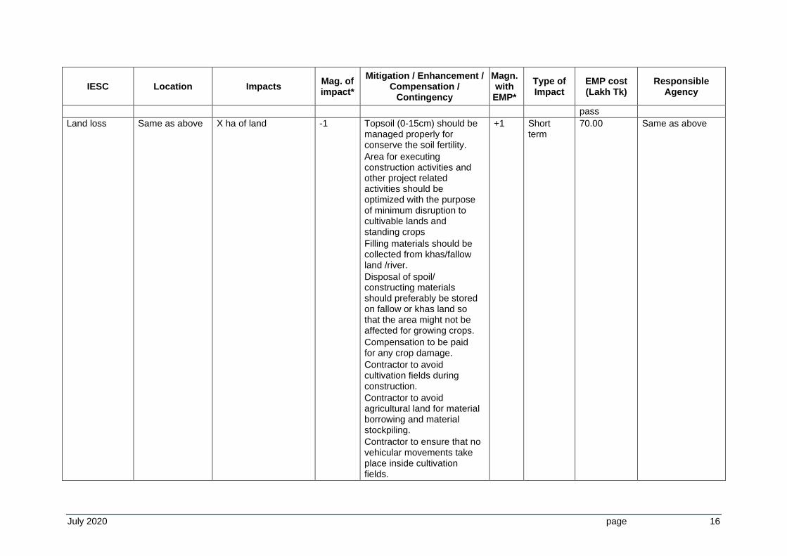
Land loss Same as above X ha of land -1 Topsoil (0-15cm) should be managed properly for conserve the soil fertility.
Area for executing construction activities and other project related activities should be optimized with the purpose of minimum disruption to cultivable lands and standing crops
Filling materials should be collected from khas/fallow land /river.
Disposal of spoil/ constructing materials should preferably be stored on fallow or khas land so that the area might not be affected for growing crops.
Compensation to be paid for any crop damage.
Contractor to avoid cultivation fields during construction.
Contractor to avoid agricultural land for material borrowing and material stockpiling.
Contractor to ensure that no vehicular movements take place inside cultivation fields.
+1 Short term
70.00 Same as above
July 2020 page 17
IESC Location Impacts Mag. of impact*
Mitigation / Enhancement / Compensation /
Contingency
Magn. with EMP*
Type of Impact
EMP cost (Lakh Tk)
Responsible Agency
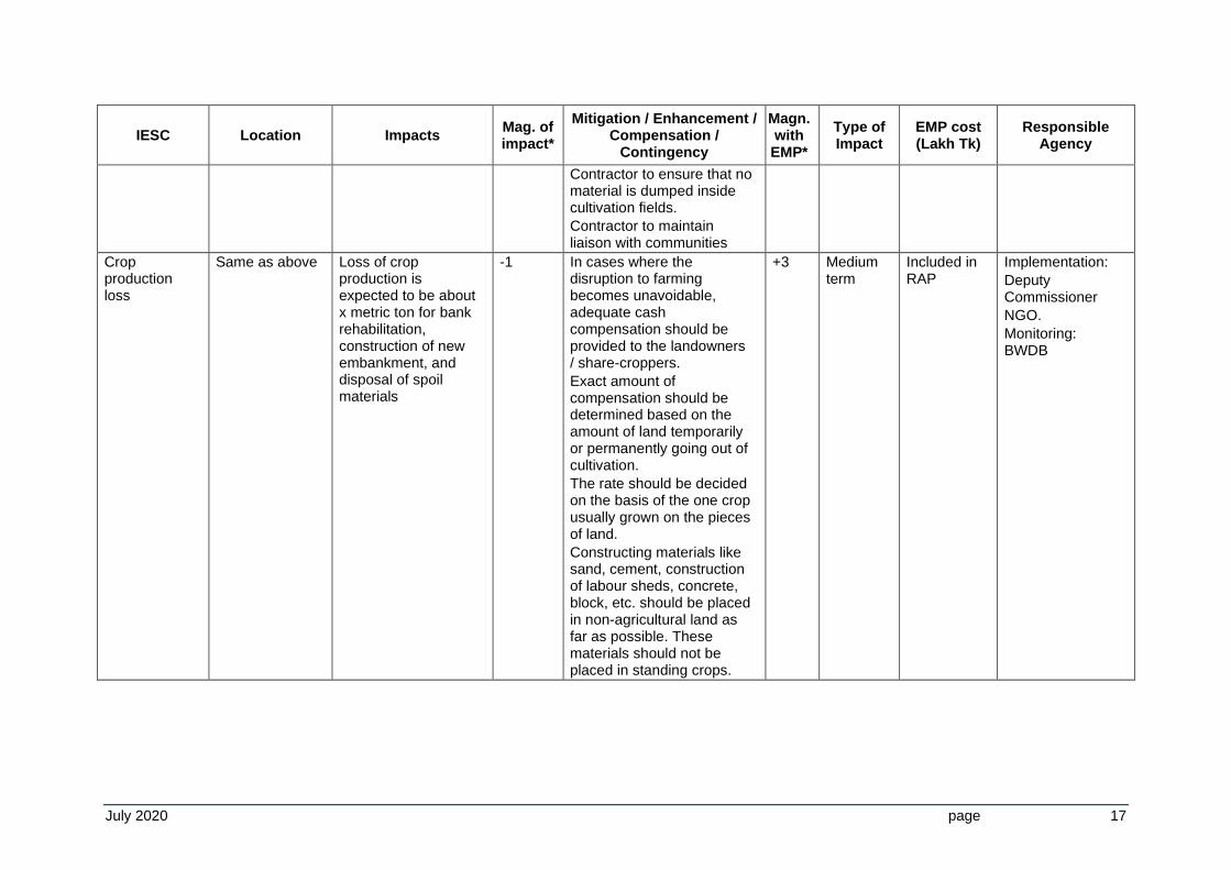
Contractor to ensure that no material is dumped inside cultivation fields.
Contractor to maintain liaison with communities
Crop production loss
Same as above Loss of crop production is expected to be about x metric ton for bank rehabilitation, construction of new embankment, and disposal of spoil materials
-1 In cases where the disruption to farming becomes unavoidable, adequate cash compensation should be provided to the landowners / share-croppers.
Exact amount of compensation should be determined based on the amount of land temporarily or permanently going out of cultivation.
The rate should be decided on the basis of the one crop usually grown on the pieces of land.
Constructing materials like sand, cement, construction of labour sheds, concrete, block, etc. should be placed in non-agricultural land as far as possible. These materials should not be placed in standing crops.
+3 Medium term
Included in RAP
Implementation:
Deputy Commissioner
NGO.
Monitoring: BWDB
July 2020 page 18
IESC Location Impacts Mag. of impact*
Mitigation / Enhancement / Compensation /
Contingency
Magn. with EMP*
Type of Impact
EMP cost (Lakh Tk)
Responsible Agency
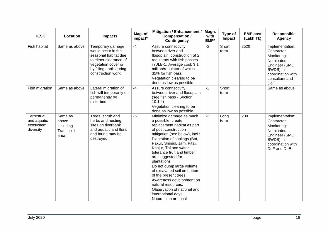
Fish habitat Same as above Temporary damage would occur in the seasonal habitat due to either clearance of vegetation cover or by filling earth during construction work
-4 Assure connectivity between river and floodplain: construction of 2 regulators with fish passes in JLB-1. Average cost: $ 1 million/regulator of which 35% for fish pass
Vegetation clearing to be done as low as possible
-2 Short term
2520 Implementation: Contractor
Monitoring:
Nominated Engineer (SMO, BWDB) in coordination with consultant and DoF
Fish migration Same as above Lateral migration of fish will temporarily or permanently be disturbed
-4 Assure connectivity between river and floodplain (see fish pass - Section 10.1.4)
Vegetation clearing to be done as low as possible
-2 Short term
Same as above
Terrestrial and aquatic ecosystem diversity
Same as
above
including
Tranche-1
area
Trees, shrub and herbs and nesting sites on riverbank and aquatic and flora and fauna may be destroyed.
-5 Minimize damage as much a possible; create replacement habitat as part of post-construction mitigation (see below), incl.:
Plantation of saplings (Bot, Pakur, Shimul, Jam, Pitali, Khajur, Tal and water tolerance fruit and timber are suggested for plantation)
Do not dump large volume of excavated soil on bottom of the present trees.
Awareness development on natural resources.
Observation of national and international days.
Nature club or Local
-3 Long term
200 Implementation:
Contractor
Monitoring:
Nominated Engineer (SMO, BWDB) in coordination with DoF and DoE
July 2020 page 19
IESC Location Impacts Mag. of impact*
Mitigation / Enhancement / Compensation /
Contingency
Magn. with EMP*
Type of Impact
EMP cost (Lakh Tk)
Responsible Agency
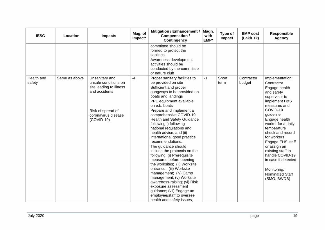
committee should be formed to protect the saplings.
Awareness development activities should be conducted by the committee or nature club
Health and safety
Same as above Unsanitary and unsafe conditions on site leading to illness and accidents
Risk of spread of coronavirus disease (COVID-19)
-4 Proper sanitary facilities to be provided on site
Sufficient and proper gangways to be provided on boats and landings
PPE equipment available on e.b. boats
Prepare and implement a comprehensive COVID-19 Health and Safety Guidance following i) following national regulations and health advice, and (ii) international good practice recommendations.
The guidance should include the protocols on the following: (i) Prerequisite measures before opening the worksites; (ii) Worksite entrance ; (iii) Worksite management; (iv) Camp management; (v) Worksite awareness-raising; (vi) Risk exposure assessment guidance; (vii) Engage an employee/staff to oversee health and safety issues,
-1 Short term
Contractor budget
Implementation:
Contractor
Engage health and safety supervisor to implement H&S measures and COVID-19 guideline
Engage health worker for a daily temperature check and record for workers
Engage EHS staff or assign an existing staff to handle COVID-19 in case if detected
Monitoring:
Nominated Staff (SMO, BWDB)
July 2020 page 20
IESC Location Impacts Mag. of impact*
Mitigation / Enhancement / Compensation /
Contingency
Magn. with EMP*
Type of Impact
EMP cost (Lakh Tk)
Responsible Agency
and (viii) Monitoring and reporting mechanism. The protocols should include requirements on wearing masks and PPE, physical distancing, hand washing, disinfection, checking body temperature, ventilation, management of waste, awareness, and morning briefings.
Conduct a risk assessment of a worksite and prepare on-site plan as per H&S guideline;
Avoid labor-intensive works as much as possible;
Ensure all to use the Personal Protective Equipment (PPE) as appropriate;
Ensure all equipment and vehicles used are routinely disinfected;
Provide thermometer, soap, sanitizer, disinfectant, PPE at worksite/camp;
Place adequate washbasins, disinfectant tub, dispenser for sanitizer;
Provide regular briefing/training on preventive requirements to the workers and post
July 2020 page 21
IESC Location Impacts Mag. of impact*
Mitigation / Enhancement / Compensation /
Contingency
Magn. with EMP*
Type of Impact
EMP cost (Lakh Tk)
Responsible Agency
enough COVID-19 awareness posters throughout the worksites; and
Maintain COVID-19 weekly monitoring and reporting mechanism at the worksite; including any necessary actions to be taken
Employment Same as above Temporary employment will be created for labourers
+1 Ensure employment for local people for both technical and non-technical works. If possible, at least 60% labour should be recruited locally
N/a Short term
N/a Same as above
Community organisations
Same as above Positive impact +2 The community organizations should be formed prior to implementation of the project.
The community organizations should be given orientation to protect their standing crops from riverbank protection work, spoil soils, on farm water management, LCS, EMG.
+4 Long term
Tk. 100 Implementation:
specialist NGOs
Monitoring:
PMO / DDM / DAE
* No impact (0); Positive impact (+); Negative impact (-) Low impact (1-3); Medium impact (4-6); High impact (7-8); Very high impact (9-10)
July 2020 page 22
11.1.4 Drainage Structure / Regulators cum fish passes/off-take Old Dhaleswari
IESC Location Impacts Mag. of impact*
Mitigation / Enhancement / Compensation /
Contingency
Magn. with EMP*
Type of Impact
EMP cost (Lakh Tk)
Responsible Agency
Activity Construction of a drainage structure / sluice / fish pass within the embankment/ Re-establish flow of the Dhaleswari offtake by diverting 245 m3/s from the Jamuna River into the Dhaleswari/Pungli/Bangshi/Turag/Buriganga river system, to improve water quality (e.g. DO levels up to 4 mg/l, from present 1 mg/l) and support fisheries and aquatic life, improve groundwater recharging, navigation, and so on.
Air quality Strategic location within rehabilitated/ new embankment
Minor amount of dust may be generated during construction works and vehicular movements
-2 Mitigation:
Water to be sprinkled on regular intervals, as and where required
-1 Short term
N/a Implementation:
Contractor
Monitoring:
Nominated Engineer (SMO, BWDB)
Noise Same as above Low impacts would be caused during construction and works and vehicle movements
-2 Mitigation:
Working hours to be restricted to 8:00 Am to 5:00 PM only;
Noise levels due to vehicular movement to be kept within permissible limit
-1 Short term
N/a Same as above
Surface water quality and surroundings
Same as above The surface water quality might be affected due to the disposal of waste generated from the construction site into the river or surroundings.
-4 Mitigation:
Proper waste disposal system is to be implemented.
-1 Short term
N/a
Same as above
Drainage congestion
Same as above Low impact may occur due to the
-2 Constructing regulators cum fish
-1 Short term
Same as above
July 2020 page 23
IESC Location Impacts Mag. of impact*
Mitigation / Enhancement / Compensation /
Contingency
Magn. with EMP*
Type of Impact
EMP cost (Lakh Tk)
Responsible Agency
rehabilitation of embankment temporarily blocking offtakes
passes at appropriate locations
Health and safety
Same as above Unsanitary and unsafe conditions on site leading to illness and accidents
Risk of spread of coronavirus disease (COVID-19)
-4 Proper sanitary facilities to be provided on site
Sufficient and proper gangways to be provided on boats and landings
PPE equipment available on e.b. boats
Prepare and implement a comprehensive COVID-19 Health and Safety Guidance following i) following national regulations and health advice, and (ii) international good practice recommendations.
The guidance should include the protocols on the following: (i) Prerequisite measures before opening the worksites; (ii) Worksite entrance ; (iii) Worksite
-1 Short term
Contractor budget
Implementation:
Contractor
Engage health and safety supervisor to implement H&S measures and COVID-19 guideline
Engage health worker for a daily temperature check and record for workers
Engage EHS staff or assign an existing staff to handle COVID-19 in case if detected
Monitoring:
Nominated Engineer (SMO, BWDB)
July 2020 page 24
IESC Location Impacts Mag. of impact*
Mitigation / Enhancement / Compensation /
Contingency
Magn. with EMP*
Type of Impact
EMP cost (Lakh Tk)
Responsible Agency
management; (iv) Camp management; (v) Worksite awareness-raising; (vi) Risk exposure assessment guidance; (vii) Engage an employee/staff to oversee health and safety issues, and (viii) Monitoring and reporting mechanism. The protocols should include requirements on wearing masks and PPE, physical distancing, hand washing, disinfection, checking body temperature, ventilation, management of waste, awareness, and morning briefings.
Conduct a risk assessment of a worksite and prepare on-site plan as per H&S guideline;
Avoid labor-intensive works as much as possible;
July 2020 page 25
IESC Location Impacts Mag. of impact*
Mitigation / Enhancement / Compensation /
Contingency
Magn. with EMP*
Type of Impact
EMP cost (Lakh Tk)
Responsible Agency
Ensure all to use the Personal Protective Equipment (PPE) as appropriate;
Ensure all equipment and vehicles used are routinely disinfected;
Provide thermometer, soap, sanitizer, disinfectant, PPE at worksite/camp;
Place adequate washbasins, disinfectant tub, dispenser for sanitizer;
Provide regular briefing/training on preventive requirements to the workers and post enough COVID-19 awareness posters throughout the worksites; and
Maintain COVID-19 weekly monitoring and reporting mechanism at the worksite; including any necessary actions to be taken.
July 2020 page 26
IESC Location Impacts Mag. of impact*
Mitigation / Enhancement / Compensation /
Contingency
Magn. with EMP*
Type of Impact
EMP cost (Lakh Tk)
Responsible Agency
Employment Same as above Temporary employment will be created for labourers
+1 Ensure employment for local people for both technical and non-technical works. If possible at least 60% labour should be recruited locally
N/a Short term
N/a Same as above
Community organisations
Same as above Positive impact +2 The community organizations should be formed prior to implementation of the project.
The community organizations should be given orientation to protect their standing crops from riverbank protection work, spoil soils, on farm water management, LCS, EMG etc.
+4 Long term Tk. 100 Implementation:
specialist NGOs
Monitoring:
PMO / DDM / DAE
* No impact (0); Positive impact (+); Negative impact (-) Low impact (1-3); Medium impact (4-6); High impact (7-8); Very high impact (9-10)
July 2020 page 27
11.2 Post-Construction Phase at Each Site
11.2.1 Decommissioning of Site Offices, Labour Sheds, Stock Yards
IESC Location Impacts Mag. of impact*
Mitigation / Enhancement / Compensation /
Contingency
Magn. with EMP*
Type of
Impact
EMP cost (Lakh Tk)
Responsible Agency
Activity Decommissioning of site office, labour shed(s) with water and sanitation facilities, garbage disposal system, stock yard and construction camp(s), materials, equipment and other machines, construction of cc blocks at site
Air quality River and roadsides
Minor impact may occur from dust generated due to movement of vehicles
-2 Mitigation:
Construction materials should be covered with thick materials (i.e. polythene) during transportation to resist the generation of dust.
Water to be sprinkled to control the generation and spreading of dust; as and where required.
-1 Short term
N/a Implementation:
Contractor
Monitoring:
Nominated Engineer (SMO, BWDB)
Noise Same as above
Low impacts caused due to noise generation for demobilization of construction materials and decommissioning of site office, labour shed, stockyard and CC blocks – as may be applicable
-2 Mitigation:
Working hours to be restricted to 8 h to 17 h only;
Noise levels due to vehicular movement are to be kept within permissible limit.
Buildings and yards may remain and be given another purpose/ landowner / sold
-1 Short term
N/a Same as above
Waste and disposal
Same as above
Littering of rest and waste materials from decommissioning of
-3 Reuse, recycle or sell left over materials
Remove worker’s camps
-1 Short term
Implementation:
Contractor
July 2020 page 28
IESC Location Impacts Mag. of impact*
Mitigation / Enhancement / Compensation /
Contingency
Magn. with EMP*
Type of
Impact
EMP cost (Lakh Tk)
Responsible Agency
buildings, worker’s camps and construction yards may affect the local environment
including sanitation facilities (toilets) in an environmentally sound way
Monitoring:
PMO
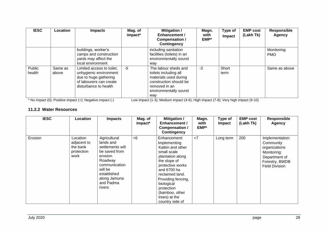
Public health
Same as above
Limited access to toilet, unhygienic environment due to huge gathering of labourers can create disturbance to health
-5 The labour sheds and toilets including all materials used during construction should be removed in an environmentally sound way
-3 Short term
Same as above
* No impact (0); Positive impact (+); Negative impact (-) Low impact (1-3); Medium impact (4-6); High impact (7-8); Very high impact (9-10) 11.2.2 Water Resources
IESC Location Impacts Mag. of impact*
Mitigation / Enhancement / Compensation /
Contingency
Magn. with EMP*
Type of Impact
EMP cost (Lakh Tk)
Responsible Agency
Erosion Location adjacent to the bank protection work
Agricultural lands and settlements will be saved from erosion. Roadway communication will be established along Jamuna and Padma rivers
+6 Enhancement:
Implementing Katkin and other small scale plantation along the slope of protective works and 6700 ha reclaimed land.
Providing fencing, biological protection (bamboo, other trees) at the country side of
+7 Long term 200 Implementation:
Community organizations
Monitoring:
Department of Forestry, BWDB Field Division
July 2020 page 29
IESC Location Impacts Mag. of impact*
Mitigation / Enhancement / Compensation /
Contingency
Magn. with EMP*
Type of Impact
EMP cost (Lakh Tk)
Responsible Agency
protective works to ensure soil stability
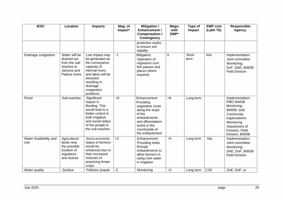
Drainage congestion Water will be drained out from the sub reaches to Jamuna and Padma rivers
Low impact may be generated as the conveyance capacity of internal rivers and lakes will be stressed, resulting in drainage congestion problems
-1 Mitigation:
Operation of regulators cum fish passes and places where required
0 Short term
N/A Implementation:
Joint committee
Monitoring:
DoF, DAE, BWDB Field Division
Flood Sub-reaches Significant impact in flooding. This would lead to a better control in both irrigation and social status of the people in the sub-reaches
+5 Enhancement:
Providing vegetative cover along the slope of the embankments and afforestation works in the countryside of the embankment
+8 Long term Implementation: PMO BWDB Monitoring:
BWDB, DoE
Community organizations
Monitoring
Department of Forestry, Field Division, BWDB
Water Availability and Use
Agricultural lands near the possible location of regulators and sluices
Socio-economic status of farmers would be enhanced due to their increased chances of practicing Aman crops
+3 Enhancement:
Providing inlets through embankments to allow farmers in using river water in irrigation
+5 Long term N/a Implementation:
Joint committee
Monitoring:
DAE, DoF, BWDB Field Division
Water quality Surface Pollution (waste -3 Monitoring +2 Long term 2.00 DoE, DoF, or
July 2020 page 30
IESC Location Impacts Mag. of impact*
Mitigation / Enhancement / Compensation /
Contingency
Magn. with EMP*
Type of Impact
EMP cost (Lakh Tk)
Responsible Agency
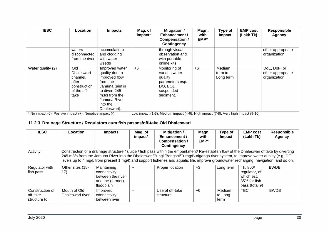
waters disconnected from the river
accumulation) and clogging with water weeds
through visual observation and with portable online kits
other appropriate organization
Water quality (2) Old Dhaleswari channel, after construction of the off-take
Improved water quality due to improved flow from the Jamuna (aim is to divert 245 m3/s from the Jamuna River into the Dhaleswari).
+6 Monitoring of various water quality parameters esp. DO, BOD, suspended sediment.
+6 Medium term to Long term
DoE, DoF, or other appropriate organization
* No impact (0); Positive impact (+); Negative impact (-) Low impact (1-3); Medium impact (4-6); High impact (7-8); Very high impact (9-10) 11.2.3 Drainage Structure / Regulators cum fish passes/off-take Old Dhaleswari
IESC Location Impacts Mag. of impact*
Mitigation / Enhancement / Compensation /
Contingency
Magn. with EMP*
Type of Impact
EMP cost (Lakh Tk)
Responsible Agency
Activity Construction of a drainage structure / sluice / fish pass within the embankment/ Re-establish flow of the Dhaleswari offtake by diverting 245 m3/s from the Jamuna River into the Dhaleswari/Pungli/Bangshi/Turag/Buriganga river system, to improve water quality (e.g. DO levels up to 4 mg/l, from present 1 mg/l) and support fisheries and aquatic life, improve groundwater recharging, navigation, and so on.
Regulator with fish pass
Other sites (15-17)
Maintaining connectivity between the river and the (former) floodplain
-- Proper location +3 Long term Tk. 800/ regulator, of which est. 35% for fish pass (total 9)
BWDB
Construction of off-take structure to
Mouth of Old Dhaleswari river
Improved connectivity between river
-- Use of off-take structure
+6 Medium to Long term
TBC BWDB
July 2020 page 31
IESC Location Impacts Mag. of impact*
Mitigation / Enhancement / Compensation /
Contingency
Magn. with EMP*
Type of Impact
EMP cost (Lakh Tk)
Responsible Agency
divert 245 m3/s from Jamuna to Dhaleswari
and floodplain, improved water quality, fisheries, navigation & groundwater recharging
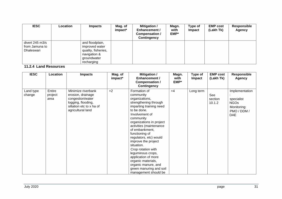
11.2.4 Land Resources
IESC Location Impacts Mag. of impact*
Mitigation / Enhancement / Compensation /
Contingency
Magn. with EMP*
Type of Impact
EMP cost (Lakh Tk)
Responsible Agency
Land type change
Entire project area
Minimize riverbank erosion, drainage congestion/water logging, flooding, siltation etc to x ha of agricultural land
+2 Formation of community organizations, strengthening through imparting training need to be done.
Involvement of community organizations in project activities (maintenance of embankment, functioning of regulators, etc) would improve the project situation.
Crop rotation with leguminous crops, application of more organic materials, organic manure, and green manuring and soil management should be
+4 Long term
See section 10.1.2
Implementation:
specialist NGOs
Monitoring:
PMO / DDM / DAE
July 2020 page 32
IESC Location Impacts Mag. of impact*
Mitigation / Enhancement / Compensation /
Contingency
Magn. with EMP*
Type of Impact
EMP cost (Lakh Tk)
Responsible Agency
practiced to improve soil fertility in the project area.
Crop diversification with multi-crops might improve environmental condition of the soil.
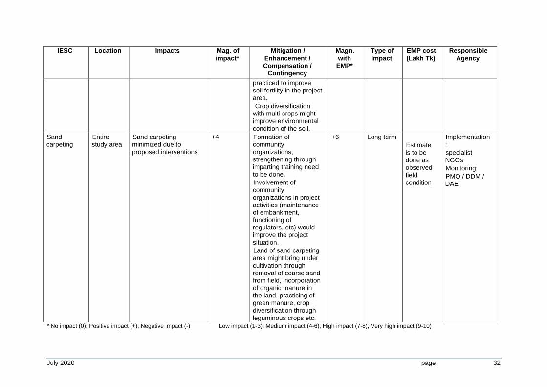
Sand carpeting
Entire study area
Sand carpeting minimized due to proposed interventions
+4 Formation of community organizations, strengthening through imparting training need to be done.
Involvement of community organizations in project activities (maintenance of embankment, functioning of regulators, etc) would improve the project situation.
Land of sand carpeting area might bring under cultivation through removal of coarse sand from field, incorporation of organic manure in the land, practicing of green manure, crop diversification through leguminous crops etc.
+6 Long term
Estimate is to be done as observed field condition
Implementation:
specialist NGOs
Monitoring:
PMO / DDM / DAE
* No impact (0); Positive impact (+); Negative impact (-) Low impact (1-3); Medium impact (4-6); High impact (7-8); Very high impact (9-10)
July 2020 page 33
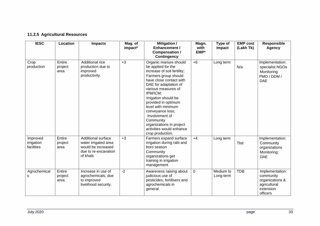
11.2.5 Agricultural Resources
IESC Location Impacts Mag. of impact*
Mitigation / Enhancement / Compensation /
Contingency
Magn. with EMP*
Type of Impact
EMP cost (Lakh Tk)
Responsible Agency
Crop production
Entire project area
Additional rice production due to improved productivity.
+3 Organic manure should be applied for the increase of soil fertility;
Farmers group should have close contact with DAE for adaptation of various measures of IPM/ICM;
Irrigation should be provided in optimum level with minimum conveyance loss;
Involvement of Community organizations in project activities would enhance crop production.
+6 Long term
N/a
Implementation:
specialist NGOs
Monitoring:
PMO / DDM / DAE
Improved irrigation facilities
Entire project area
Additional surface water irrigated area would be increased due to re-excavation of khals
+3 Farmers expand surface irrigation during rabi and boro season
Community organizations get training in irrigation management
+4 Long term
Tbd
Implementation:
Community organizations
Monitoring:
DAE
Agrochemicals
Entire project area
Increase in use of agrochemicals, due to improved livelihood security.
-2 Awareness raising about judicious use of pesticides, fertilisers and agrochemicals in general.
0 Medium to Long-term
TDB Implementation: community organizations & agricultural extension officers
July 2020 page 34
* No impact (0); Positive impact (+); Negative impact (-) Low impact (1-3); Medium impact (4-6); High impact (7-8); Very high impact (9-10)
July 2020 page 35
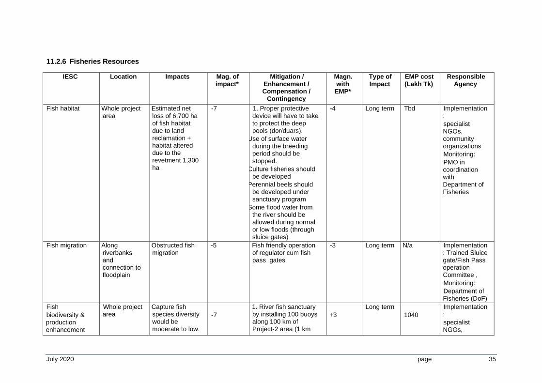
11.2.6 Fisheries Resources
IESC Location Impacts Mag. of impact*
Mitigation / Enhancement / Compensation /
Contingency
Magn. with EMP*
Type of Impact
EMP cost (Lakh Tk)
Responsible Agency
Fish habitat Whole project area
Estimated net loss of 6,700 ha of fish habitat due to land reclamation + habitat altered due to the revetment 1,300 ha
-7 1. Proper protective device will have to take to protect the deep pools (dor/duars).
2. Use of surface water during the breeding period should be stopped.
3. Culture fisheries should be developed
4. Perennial beels should be developed under sanctuary program
5. Some flood water from the river should be allowed during normal or low floods (through sluice gates)
-4 Long term Tbd Implementation:
specialist NGOs, community organizations
Monitoring:
PMO in coordination with Department of Fisheries
Fish migration Along riverbanks and connection to floodplain
Obstructed fish migration
-5 Fish friendly operation of regulator cum fish pass gates
-3 Long term N/a Implementation: Trained Sluice gate/Fish Pass operation Committee ,
Monitoring:
Department of Fisheries (DoF)
Fish
biodiversity & production enhancement
Whole project area
Capture fish species diversity would be moderate to low.
-7
1. River fish sanctuary by installing 100 buoys along 100 km of Project-2 area (1 km
+3
Long term
1040
Implementation:
specialist NGOs,
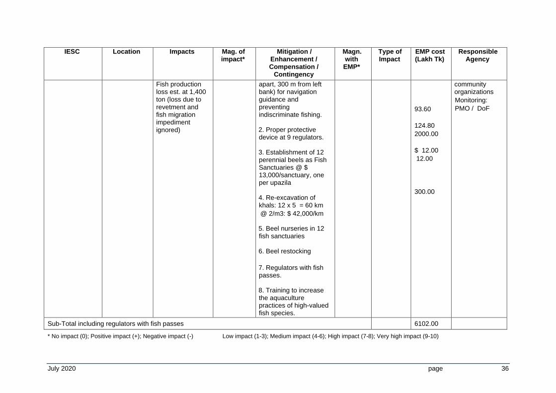
July 2020 page 36
IESC Location Impacts Mag. of impact*
Mitigation / Enhancement / Compensation /
Contingency
Magn. with EMP*
Type of Impact
EMP cost (Lakh Tk)
Responsible Agency
Fish production loss est. at 1,400 ton (loss due to revetment and fish migration impediment ignored)
apart, 300 m from left bank) for navigation guidance and preventing indiscriminate fishing.
2. Proper protective device at 9 regulators.
3. Establishment of 12 perennial beels as Fish Sanctuaries @ $ 13,000/sanctuary, one per upazila
4. Re-excavation of khals: 12 x 5 = 60 km
@ 2/m3: $ 42,000/km
5. Beel nurseries in 12 fish sanctuaries
6. Beel restocking
7. Regulators with fish passes.
8. Training to increase the aquaculture practices of high-valued fish species.
93.60
124.80
2000.00
$ 12.00
12.00
300.00
community organizations
Monitoring:
PMO / DoF
Sub-Total including regulators with fish passes 6102.00
* No impact (0); Positive impact (+); Negative impact (-) Low impact (1-3); Medium impact (4-6); High impact (7-8); Very high impact (9-10)
July 2020 page 37
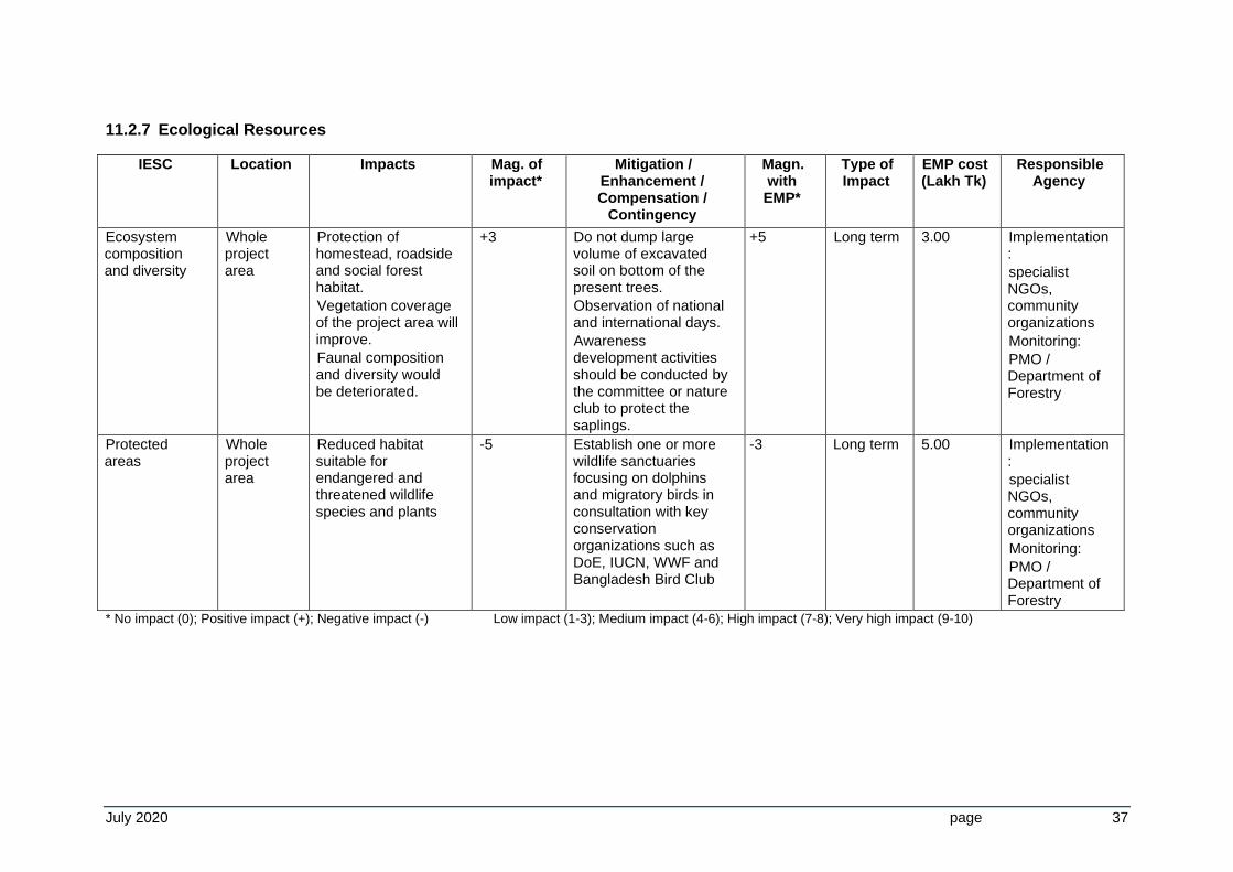
11.2.7 Ecological Resources
IESC Location Impacts Mag. of impact*
Mitigation / Enhancement / Compensation /
Contingency
Magn. with EMP*
Type of Impact
EMP cost (Lakh Tk)
Responsible Agency
Ecosystem composition and diversity
Whole project area
Protection of homestead, roadside and social forest habitat.
Vegetation coverage of the project area will improve.
Faunal composition and diversity would be deteriorated.
+3
Do not dump large volume of excavated soil on bottom of the present trees.
Observation of national and international days.
Awareness development activities should be conducted by the committee or nature club to protect the saplings.
+5 Long term 3.00
Implementation:
specialist NGOs, community organizations
Monitoring:
PMO / Department of Forestry
Protected areas
Whole project area
Reduced habitat suitable for endangered and threatened wildlife species and plants
-5 Establish one or more wildlife sanctuaries focusing on dolphins and migratory birds in consultation with key conservation organizations such as DoE, IUCN, WWF and Bangladesh Bird Club
-3 Long term 5.00 Implementation:
specialist NGOs, community organizations
Monitoring:
PMO / Department of Forestry
* No impact (0); Positive impact (+); Negative impact (-) Low impact (1-3); Medium impact (4-6); High impact (7-8); Very high impact (9-10)
July 2020 page 38
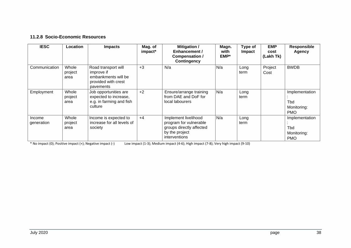
11.2.8 Socio-Economic Resources
IESC Location Impacts Mag. of impact*
Mitigation / Enhancement / Compensation /
Contingency
Magn. with EMP*
Type of Impact
EMP cost
(Lakh Tk)
Responsible Agency
Communication Whole project area
Road transport will improve if embankments will be provided with crest pavements
+3 N/a N/a Long term
Project
Cost
BWDB
Employment Whole project area
Job opportunities are expected to increase, e.g. in farming and fish culture
+2 Ensure/arrange training from DAE and DoF for local labourers
N/a Long term
Implementation:
Tbd
Monitoring:
PMO
Income generation
Whole project area
Income is expected to increase for all levels of society
+4 Implement livelihood program for vulnerable groups directly affected by the project interventions
N/a Long term
Implementation:
Tbd
Monitoring:
PMO
* No impact (0); Positive impact (+); Negative impact (-) Low impact (1-3); Medium impact (4-6); High impact (7-8); Very high impact (9-10)
July 2020 page 39
11.3 Monitoring Plan
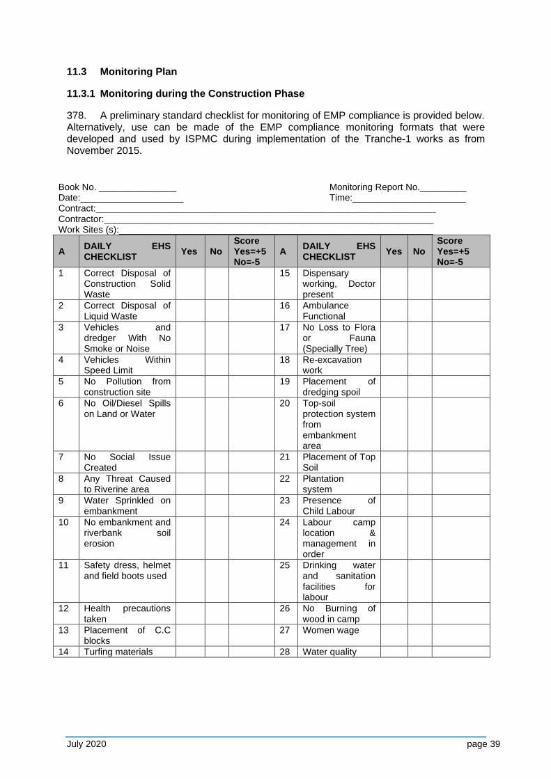
11.3.1 Monitoring during the Construction Phase
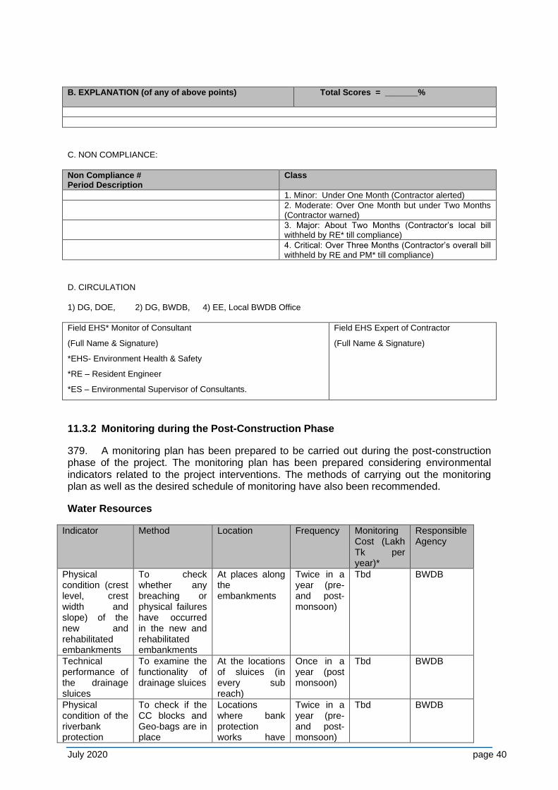
378. A preliminary standard checklist for monitoring of EMP compliance is provided below. Alternatively, use can be made of the EMP compliance monitoring formats that were developed and used by ISPMC during implementation of the Tranche-1 works as from November 2015.
Book No. _______________ Monitoring Report No._________ Date:____________________ Time:______________________ Contract:__________________________________________________________________ Contractor:________________________________________________________________ Work Sites (s):_____________________________________________________________
A DAILY EHS CHECKLIST
Yes No Score Yes=+5 No=-5
A DAILY EHS CHECKLIST
Yes No Score Yes=+5 No=-5
1 Correct Disposal of Construction Solid Waste
15 Dispensary working, Doctor present
2 Correct Disposal of Liquid Waste
16 Ambulance Functional
3 Vehicles and dredger With No Smoke or Noise
17 No Loss to Flora or Fauna (Specially Tree)
4 Vehicles Within Speed Limit
18 Re-excavation work
5 No Pollution from construction site
19 Placement of dredging spoil
6 No Oil/Diesel Spills on Land or Water
20 Top-soil protection system from embankment area
7 No Social Issue Created
21 Placement of Top Soil
8 Any Threat Caused to Riverine area
22 Plantation system
9 Water Sprinkled on embankment
23 Presence of Child Labour
10 No embankment and riverbank soil erosion
24 Labour camp location & management in order
11 Safety dress, helmet and field boots used
25 Drinking water and sanitation facilities for labour
12 Health precautions taken
26 No Burning of wood in camp
13 Placement of C.C blocks
27 Women wage
14 Turfing materials 28 Water quality
July 2020 page 40
B. EXPLANATION (of any of above points) Total Scores = _______%
C. NON COMPLIANCE:
Non Compliance # Period Description
Class
1. Minor: Under One Month (Contractor alerted)
2. Moderate: Over One Month but under Two Months (Contractor warned)
3. Major: About Two Months (Contractor’s local bill withheld by RE* till compliance)
4. Critical: Over Three Months (Contractor’s overall bill withheld by RE and PM* till compliance)
D. CIRCULATION
1) DG, DOE, 2) DG, BWDB, 4) EE, Local BWDB Office
Field EHS* Monitor of Consultant
(Full Name & Signature)
*EHS- Environment Health & Safety
*RE – Resident Engineer
*ES – Environmental Supervisor of Consultants.
Field EHS Expert of Contractor
(Full Name & Signature)
11.3.2 Monitoring during the Post-Construction Phase
379. A monitoring plan has been prepared to be carried out during the post-construction phase of the project. The monitoring plan has been prepared considering environmental indicators related to the project interventions. The methods of carrying out the monitoring plan as well as the desired schedule of monitoring have also been recommended.
Water Resources
Indicator Method Location Frequency Monitoring Cost (Lakh Tk per year)*
Responsible Agency
Physical condition (crest level, crest width and slope) of the new and rehabilitated embankments
To check whether any breaching or physical failures have occurred in the new and rehabilitated embankments
At places along the embankments
Twice in a year (pre- and post-monsoon)
Tbd BWDB
Technical performance of the drainage sluices
To examine the functionality of drainage sluices
At the locations of sluices (in every sub reach)
Once in a year (post monsoon)
Tbd BWDB
Physical condition of the riverbank protection
To check if the CC blocks and Geo-bags are in place
Locations where bank protection works have
Twice in a year (pre- and post-monsoon)
Tbd BWDB
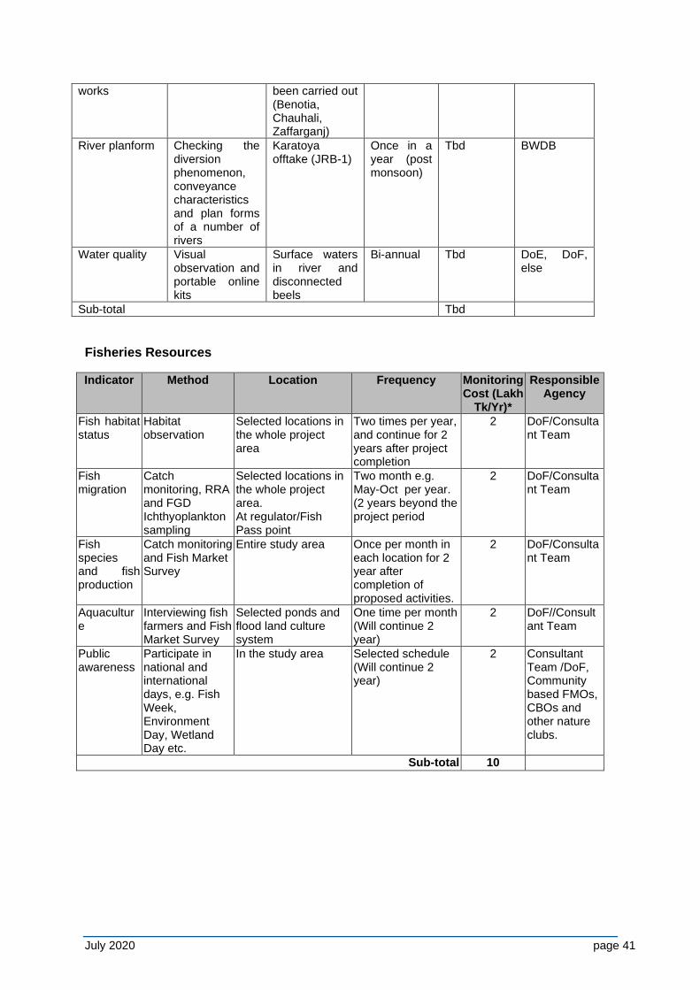
July 2020 page 41
works been carried out (Benotia, Chauhali, Zaffarganj)
River planform Checking the diversion phenomenon, conveyance characteristics and plan forms of a number of rivers
Karatoya offtake (JRB-1)
Once in a year (post monsoon)
Tbd BWDB
Water quality Visual observation and portable online kits
Surface waters in river and disconnected beels
Bi-annual Tbd DoE, DoF, else
Sub-total Tbd
Fisheries Resources
Indicator Method Location Frequency Monitoring Cost (Lakh
Tk/Yr)*
Responsible Agency
Fish habitat status
Habitat observation
Selected locations in the whole project area
Two times per year, and continue for 2 years after project completion
2 DoF/Consultant Team
Fish migration
Catch monitoring, RRA and FGD Ichthyoplankton sampling
Selected locations in the whole project area. At regulator/Fish Pass point
Two month e.g. May-Oct per year. (2 years beyond the project period
2 DoF/Consultant Team
Fish species and fish production
Catch monitoring and Fish Market Survey
Entire study area Once per month in each location for 2 year after completion of proposed activities.
2 DoF/Consultant Team
Aquaculture
Interviewing fish farmers and Fish Market Survey
Selected ponds and flood land culture system
One time per month (Will continue 2 year)
2 DoF//Consultant Team
Public awareness
Participate in national and international days, e.g. Fish Week, Environment Day, Wetland Day etc.
In the study area Selected schedule (Will continue 2 year)
2 Consultant Team /DoF, Community based FMOs, CBOs and other nature clubs.
Sub-total 10
July 2020 page 42
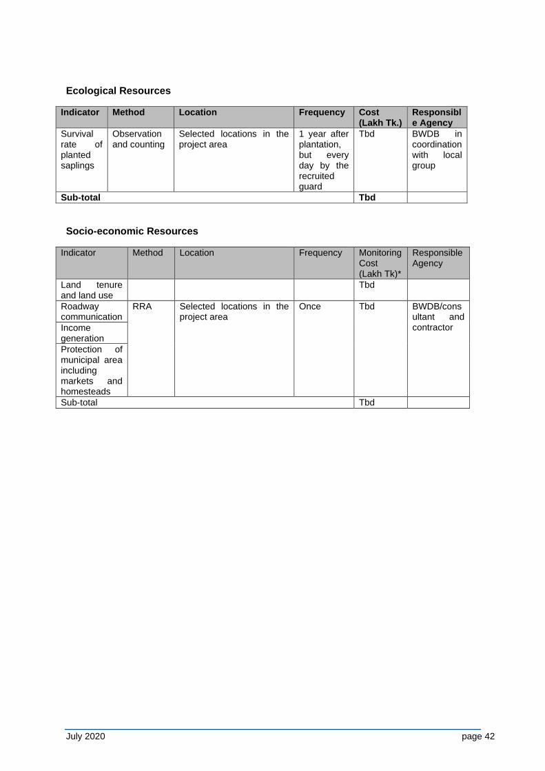
Ecological Resources
Indicator Method Location Frequency Cost (Lakh Tk.)
Responsible Agency
Survival rate of planted saplings
Observation and counting
Selected locations in the project area
1 year after plantation, but every day by the recruited guard
Tbd BWDB in coordination with local group
Sub-total Tbd
Socio-economic Resources
Indicator Method Location Frequency Monitoring Cost (Lakh Tk)*
Responsible Agency
Land tenure and land use
Tbd
Roadway communication
RRA
Selected locations in the project area
Once
Tbd
BWDB/consultant and contractor Income
generation
Protection of municipal area including markets and homesteads
Sub-total Tbd
July 2020 page 43
12 CONCLUSIONS AND RECOMMENDATIONS
12.1 Conclusions
380. The program has inbuilt mechanisms to reduce environmental impacts, and many mitigation measures have been mainstreamed into program planning and engineering designs. The flexibility of a phased MFF approach supports minimization and mitigation of potential negative impacts in a gradual manner. Works implemented in Tranche-1 with protection of critically eroding riverbanks along the Lower Jamuna and Padma rivers and were completed by the 2019 flood season while embankment construction is ongoing.
381. Extensive feasibility studies are currently being finalized for the Project-2 works, of which the present EIA is a part. These cover future impacts of river stabilization and associated embankment works. During Project-2, first measures for larger scale river stabilization are planned, with the design based on the Tranche-1 study outcomes and supported by environmental monitoring and mitigation measures.
382. With respect to flood mitigation and river stabilization, the program considers the following detailed approach: the program aims to reduce flood risks at two priority sub-projects (JRB-1, JLB-2) along the Lower Jamuna and Padma Rivers by providing new/rehabilitated embankments in all tranches.
383. The program intends to mitigate negative impacts at the planning and design level, and through additional compensation measures. Planning and design account for:
(i) leaving key distributaries open to limited flood flows to support the continued deposition of fertile sediments as well as flood season navigation;
(ii) designing the offtakes of the distributaries as part of the river stabilization work, in order to improve dry season flows;
(iii) providing embankments with sluice gates specifically for local drainage3, and (iv) designing embankments in accordance to international practice to reduce the
risk of failure, while mitigation measures address: (v) loss in floodplain biodiversity, and (vi) open water fisheries.
384. At community-level, flood risk management training will be provided to the flood affected population to raise the awareness to the residual risk after strengthening the existing flood embankment lines.
385. To protect the flood embankments, riverbanks will be progressively stabilized through riverbank protection, starting in Tranche-1 at critically eroding reaches on an emergency basis. Over time, this approach may lead to general river stabilization. To avoid transforming the geomorphology of the Padma/Jamuna in an unprecedented manner, for example if a single-channel solution is implemented, as studied in the Capital Dredging and Sustainable River Management Project, the following approach has been adopted:
(i) a multi-disciplinary river stabilization study4 covering the whole Brahmaputra system from the Indian border is being conducted, supported by
(ii) piloting stabilization measures, focusing on bio-engineering techniques or “building with nature”;
3 As it is not possible to locate sluice gates, cost have been reflected in the embankment kilometer cost. 4 encompassing potential future river morphologies including the system response to man-made impacts on
global (e.g. climate change), basin (e.g. sediment wave) and local (e.g stabilization) scale, plus socio-economic and environmental impacts of potential stabilization scenarios on floodplain and char habitants and biodiversity.
July 2020 page 44
(iii) siting of physical works will be planned using an innovative dynamic methodology that responds to evolving river behaviour. Mitigation of potentially negative impacts of the planned river stabilization will be based on
(iv) a river sanctuary study covering river- and floodplain land and planned start during 2017 potentially followed by implementation of one or more sanctuaries in a suitable river reach.
12.2 Recommendations
386. Mitigation of embankment and revetment operation-phase impacts described in Chapter 8 – on aquatic habitats and their biodiversity including fisheries, and on people who depend on them, will be implemented in three work packages:
(i) Aquaculture expansion (from Project-2). Compensation measures rely on aquaculture or culture-based methods to increase fish production and thereby compensate for lost tonnage of fish due to flood control. In contrast, mitigation measures are designed to reduce or avoid losses during capturing fisheries (see 8.3.7).
(ii) Wetland biodiversity mitigation and rehabilitation (from Project-2). This will occur via the improved off-takes and flow of the distributaries, desilting of beels, and the installation of regulators and fish passes (2 at Shahjadpur, 6 at Harirampur-Dohar; in addition, 1 regulator without fish pass at H-D). The proposed fish and bird sanctuaries (see below) all contribute to mitigation of wetland biodiversity loss.
(iii) Sanctuaries (studied under Project-2, implemented during the subsequent River Stabilization Plan). Details on the nine (9) proposed bird sanctuaries and the 52 proposed fish sanctuaries are included in Appendices C (bird) and D (fish). Note that these sanctuaries also contribute to maintaining wetland biodiversity.
387. The anticipated environmental impacts of Tranche-1 have proved to be acceptable under the circumstances, and those of Project-2 are expected to be of a similar nature and extent, provided the mitigation measures set forth in the EMP under Chapter 11 are implemented.
388. Finalization of the Tranche-1 major construction works (in 2020) can proceed without further environmental study, other than completion of the SESA and continued environmental management and monitoring.
July 2020 page 45
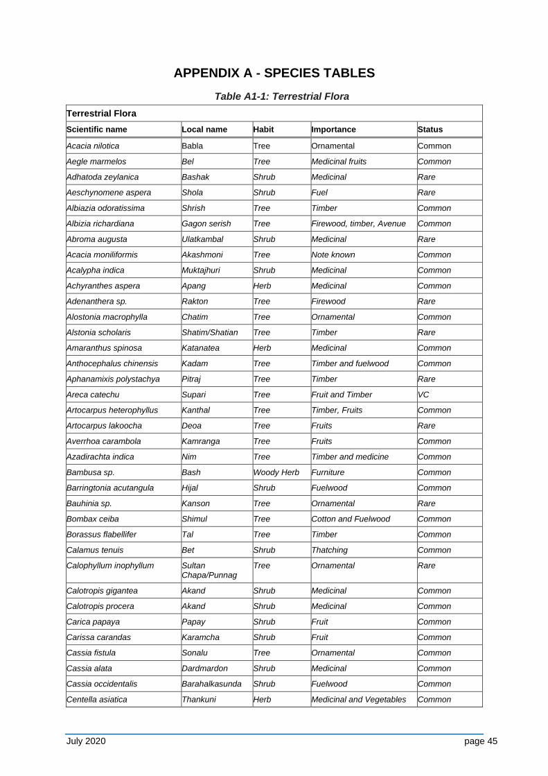
APPENDIX A - SPECIES TABLES
Table A1-1: Terrestrial Flora
Terrestrial Flora
Scientific name Local name Habit Importance Status
Acacia nilotica Babla Tree Ornamental Common
Aegle marmelos Bel Tree Medicinal fruits Common
Adhatoda zeylanica Bashak Shrub Medicinal Rare
Aeschynomene aspera Shola Shrub Fuel Rare
Albiazia odoratissima Shrish Tree Timber Common
Albizia richardiana Gagon serish Tree Firewood, timber, Avenue Common
Abroma augusta Ulatkambal Shrub Medicinal Rare
Acacia moniliformis Akashmoni Tree Note known Common
Acalypha indica Muktajhuri Shrub Medicinal Common
Achyranthes aspera Apang Herb Medicinal Common
Adenanthera sp. Rakton Tree Firewood Rare
Alostonia macrophylla Chatim Tree Ornamental Common
Alstonia scholaris Shatim/Shatian Tree Timber Rare
Amaranthus spinosa Katanatea Herb Medicinal Common
Anthocephalus chinensis Kadam Tree Timber and fuelwood Common
Aphanamixis polystachya Pitraj Tree Timber Rare
Areca catechu Supari Tree Fruit and Timber VC
Artocarpus heterophyllus Kanthal Tree Timber, Fruits Common
Artocarpus lakoocha Deoa Tree Fruits Rare
Averrhoa carambola Kamranga Tree Fruits Common
Azadirachta indica Nim Tree Timber and medicine Common
Bambusa sp. Bash Woody Herb Furniture Common
Barringtonia acutangula Hijal Shrub Fuelwood Common
Bauhinia sp. Kanson Tree Ornamental Rare
Bombax ceiba Shimul Tree Cotton and Fuelwood Common
Borassus flabellifer Tal Tree Timber Common
Calamus tenuis Bet Shrub Thatching Common
Calophyllum inophyllum Sultan Chapa/Punnag
Tree Ornamental Rare
Calotropis gigantea Akand Shrub Medicinal Common
Calotropis procera Akand Shrub Medicinal Common
Carica papaya Papay Shrub Fruit Common
Carissa carandas Karamcha Shrub Fruit Common
Cassia fistula Sonalu Tree Ornamental Common
Cassia alata Dardmardon Shrub Medicinal Common
Cassia occidentalis Barahalkasunda Shrub Fuelwood Common
Centella asiatica Thankuni Herb Medicinal and Vegetables Common
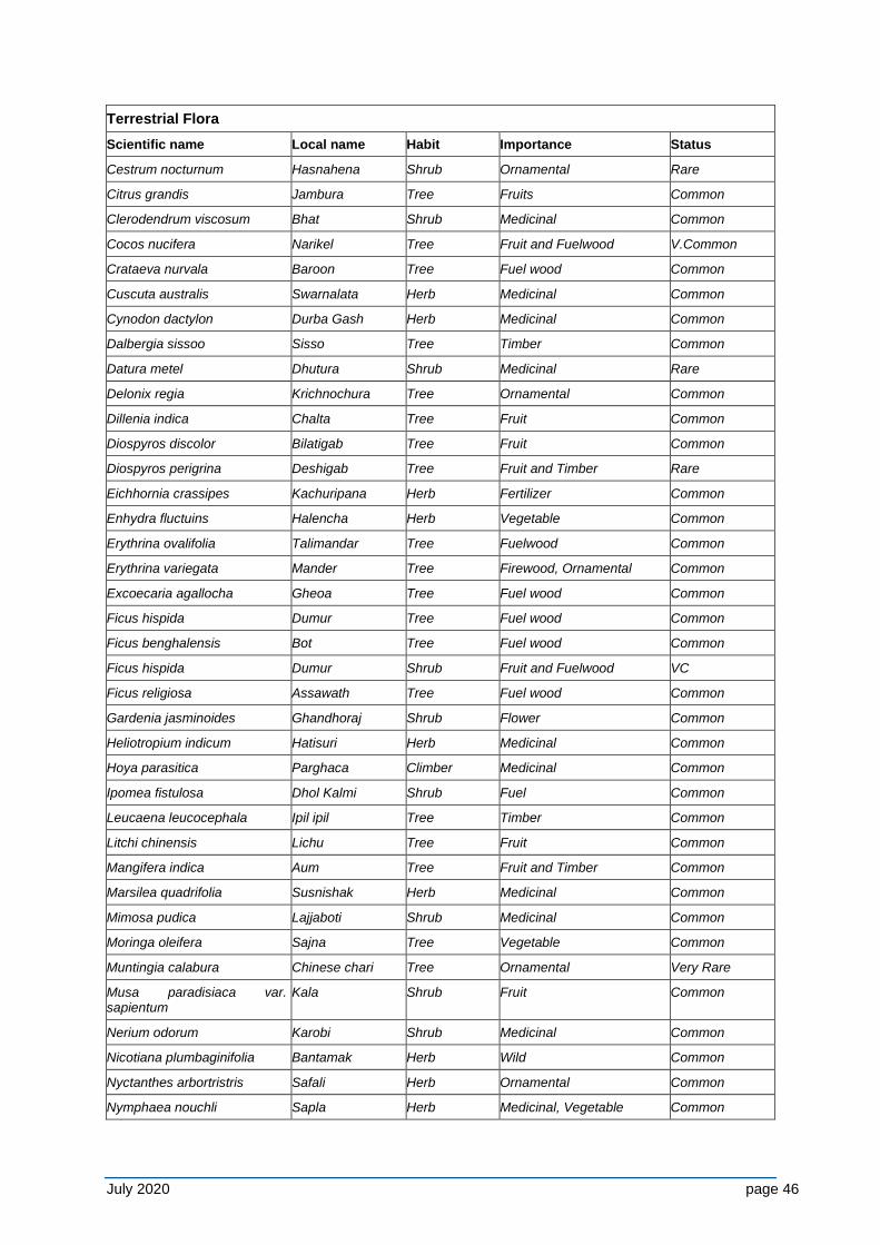
July 2020 page 46
Terrestrial Flora
Scientific name Local name Habit Importance Status
Cestrum nocturnum Hasnahena Shrub Ornamental Rare
Citrus grandis Jambura Tree Fruits Common
Clerodendrum viscosum Bhat Shrub Medicinal Common
Cocos nucifera Narikel Tree Fruit and Fuelwood V.Common
Crataeva nurvala Baroon Tree Fuel wood Common
Cuscuta australis Swarnalata Herb Medicinal Common
Cynodon dactylon Durba Gash Herb Medicinal Common
Dalbergia sissoo Sisso Tree Timber Common
Datura metel Dhutura Shrub Medicinal Rare
Delonix regia Krichnochura Tree Ornamental Common
Dillenia indica Chalta Tree Fruit Common
Diospyros discolor Bilatigab Tree Fruit Common
Diospyros perigrina Deshigab Tree Fruit and Timber Rare
Eichhornia crassipes Kachuripana Herb Fertilizer Common
Enhydra fluctuins Halencha Herb Vegetable Common
Erythrina ovalifolia Talimandar Tree Fuelwood Common
Erythrina variegata Mander Tree Firewood, Ornamental Common
Excoecaria agallocha Gheoa Tree Fuel wood Common
Ficus hispida Dumur Tree Fuel wood Common
Ficus benghalensis Bot Tree Fuel wood Common
Ficus hispida Dumur Shrub Fruit and Fuelwood VC
Ficus religiosa Assawath Tree Fuel wood Common
Gardenia jasminoides Ghandhoraj Shrub Flower Common
Heliotropium indicum Hatisuri Herb Medicinal Common
Hoya parasitica Parghaca Climber Medicinal Common
Ipomea fistulosa Dhol Kalmi Shrub Fuel Common
Leucaena leucocephala Ipil ipil Tree Timber Common
Litchi chinensis Lichu Tree Fruit Common
Mangifera indica Aum Tree Fruit and Timber Common
Marsilea quadrifolia Susnishak Herb Medicinal Common
Mimosa pudica Lajjaboti Shrub Medicinal Common
Moringa oleifera Sajna Tree Vegetable Common
Muntingia calabura Chinese chari Tree Ornamental Very Rare
Musa paradisiaca var. sapientum
Kala Shrub Fruit Common
Nerium odorum Karobi Shrub Medicinal Common
Nicotiana plumbaginifolia Bantamak Herb Wild Common
Nyctanthes arbortristris Safali Herb Ornamental Common
Nymphaea nouchli Sapla Herb Medicinal, Vegetable Common
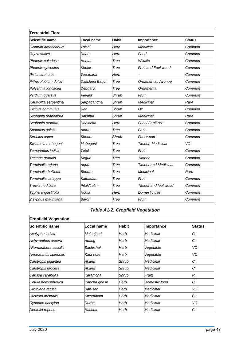
July 2020 page 47
Terrestrial Flora
Scientific name Local name Habit Importance Status
Ocimum americanum Tulshi Herb Medicine Common
Oryza sativa Dhan Herb Food Common
Phoenix paludosa Hental Tree Wildlife Common
Phoenix sylvestris Khejur Tree Fruit and Fuel wood Common
Pistia stratiotes Topapana Herb - Common
Pithecolobium dulce Dakshnia Babul Tree Ornamental, Avunue Common
Polyalthia longifolia Debdaru Tree Ornamental Common
Psidium guajava Peyara Shrub Fruit Common
Rauwolfia serpentina Sarpagandha Shrub Medicinal Rare
Ricinus communis Reri Shrub Oil Common
Sesbania grandiflora Bakphul Shrub Medicinal Rare
Sesbania rostrata Dhaincha Herb Fuel / Fertilizer Common
Spondias dulcis Amra Tree Fruit Common
Streblus asper Sheora Shrub Fuel wood Common
Swietenia mahagoni Mahogoni Tree Timber, Medicinal VC
Tamarindus indica Tetul Tree Fruit Common
Tectona grandis Segun Tree Timber Common
Terminalia arjuna Arjun Tree Timber and Medicinal Common
Terminalia bellirica Bhorae Tree Medicinal Rare
Terminalia catappa Katbadam Tree Fruit Common
Trewia nudiflora Pitali/Latim Tree Timber and fuel wood Common
Typha angustifolia Hogla Herb Domestic use Common
Zizyphus mauritiana Baroi Tree Fruit Common
Table A1-2: Cropfield Vegetation
Cropfield Vegetation
Scientific name Local name Habit Importance Status
Acalypha indica Muktajhuri Herb Medicinal C
Achyranthes aspera Apang Herb Medicinal C
Alternanthera sessilis Sachishak Herb Vegetable VC
Amaranthus spinosus Kata note Herb Vegetable VC
Calotropis gigantea Akand Shrub Medicinal C
Calotropis procera Akand Shrub Medicinal C
Carissa carandas Karamcha Shrub Fruits R
Cotula hemispherica Kancha ghash Herb Domestic food C
Crotolaria retusa Ban-san Herb Medicinal VC
Cuscuta australis Swarnalata Herb Medicinal C
Cynodon dactylon Durba Herb Medicinal VC
Dentella repens Hachuti Herb Medicinal C
July 2020 page 48
Marsilea quadrifolia Susnishak Herb Vegetable C
Nicotiana plumbaginifolia Bantamak Herb Wild C
Nyctanthes arbortristris Sefali Herb Ornamental C
Rhynchospora rufescens Shimbhatraji Herb Medicinal VC
Rorippa indica Bansarisha Herb Medicinal C
Sesbania rostrata Dhaincha Herb Fuel/Fertilizer VC
C – Common, VC – Very Common, R – Rare
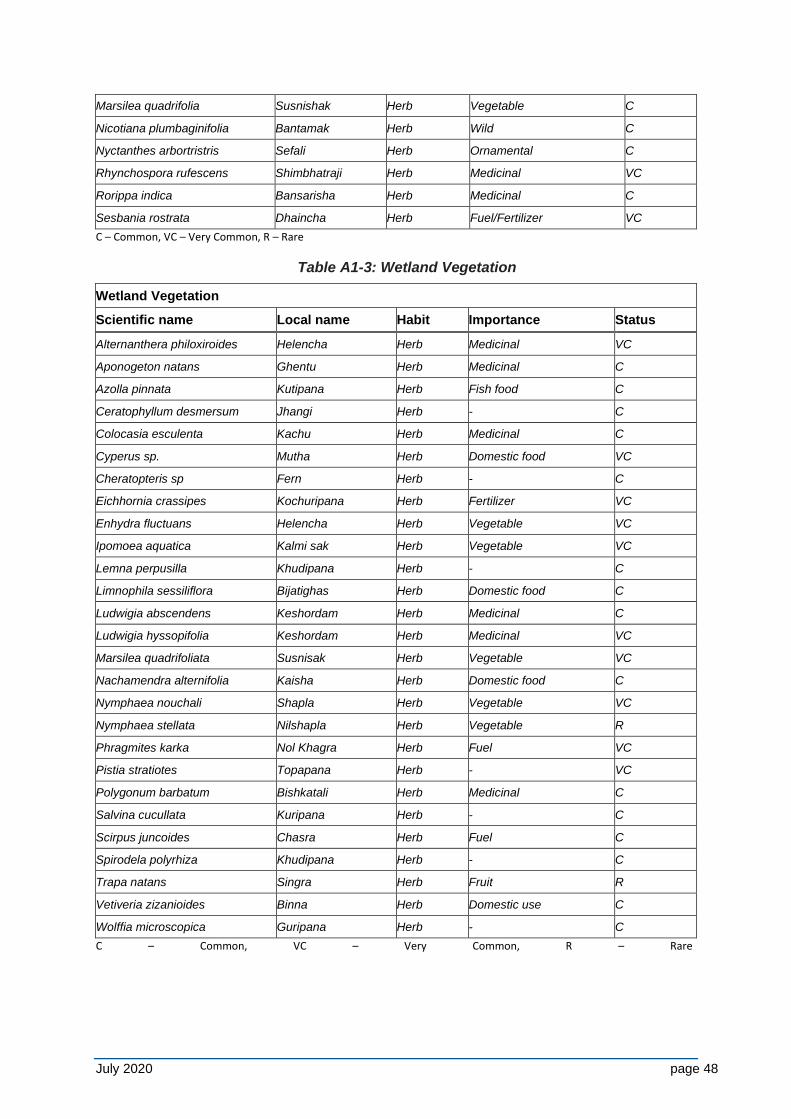
Table A1-3: Wetland Vegetation
Wetland Vegetation
Scientific name Local name Habit Importance Status
Alternanthera philoxiroides Helencha Herb Medicinal VC
Aponogeton natans Ghentu Herb Medicinal C
Azolla pinnata Kutipana Herb Fish food C
Ceratophyllum desmersum Jhangi Herb - C
Colocasia esculenta Kachu Herb Medicinal C
Cyperus sp. Mutha Herb Domestic food VC
Cheratopteris sp Fern Herb - C
Eichhornia crassipes Kochuripana Herb Fertilizer VC
Enhydra fluctuans Helencha Herb Vegetable VC
Ipomoea aquatica Kalmi sak Herb Vegetable VC
Lemna perpusilla Khudipana Herb - C
Limnophila sessiliflora Bijatighas Herb Domestic food C
Ludwigia abscendens Keshordam Herb Medicinal C
Ludwigia hyssopifolia Keshordam Herb Medicinal VC
Marsilea quadrifoliata Susnisak Herb Vegetable VC
Nachamendra alternifolia Kaisha Herb Domestic food C
Nymphaea nouchali Shapla Herb Vegetable VC
Nymphaea stellata Nilshapla Herb Vegetable R
Phragmites karka Nol Khagra Herb Fuel VC
Pistia stratiotes Topapana Herb - VC
Polygonum barbatum Bishkatali Herb Medicinal C
Salvina cucullata Kuripana Herb - C
Scirpus juncoides Chasra Herb Fuel C
Spirodela polyrhiza Khudipana Herb - C
Trapa natans Singra Herb Fruit R
Vetiveria zizanioides Binna Herb Domestic use C
Wolffia microscopica Guripana Herb - C
C – Common, VC – Very Common, R – Rare
July 2020 page 49
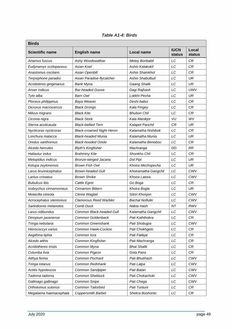
Table A1-4: Birds
Birds
Scientific name English name Local name IUCN status
Local status
Artamus fuscus Ashy Woodswallow Metey Bonbabil LC CR
Eudynamys scolopaceus Asian Koel Ashio Kalakokil LC CR
Anastomus oscitans Asian Openbill Ashio Shamkhol LC CR
Terpsiphone paradisi Asian Paradise-flycatcher Ashio Shabulbuli LC UR
Acridoteres ginginianus Bank Myna Gaang Shalik LC UR
Anser indicus Bar-headed Goose Dagi Rajhash LC UWV
Tyto alba Barn Owl Lokkhi Pecha LC UR
Ploceus philippinus Baya Weaver Deshi babui LC CR
Dicrurus macrocercus Black Drongo Kala Fingey LC CR
Milvus migrans Black Kite Bhubon Chil LC CR
Ciconia nigra Black Stork Kala Manikjor VU WV
Sterna acuticauda Black-bellied Tern Kalapet Panchil CR UR
Nycticorax nycticorax Black-crowned Night Heron Kalamatha Nishibok LC CR
Lonchura malacca Black-headed Munia Kalamatha Munia LC UR
Oriolus xanthornus Black-hooded Oriole Kalamatha Benebou LC CR
Alcedo hercules Blyth's Kingfisher Machranga DD RR
Haliastur indus Brahminy Kite Shonkho Chil LC CR
Metopidius indicus Bronze-winged Jacana Dol Pipi LC UR
Ketupa zeylonensis Brown Fish Owl Khoira Mechopecha LC UR
Larus brunnicephalus Brown-headed Gull Khoiramatha Gangchil LC CWV
Lanius cristatus Brown Shrike Khoira Latora LC CWV
Bubulcus ibis Cattle Egret Go Boga LC CR
Ixobrychus cinnamomeus Cinnamon Bittern Khoira Bogla LC UR
Motacilla citreola Citrine Wagtail Sitrin Khonjon LC CWV
Acrocephalus stentoreus Clamorous Reed Warbler Bachal Nolfutki LC CWV
Sarkidiornis melanotos Comb Duck Nakta Hash NT RWV
Larus ridibundus Common Black-headed Gull Kalamatha Gangchil LC CWV
Dinopium javanense Common Goldenback Pati Kaththokra LC CR
Tringa nebularia Common Greenshank Pati Shobujpa LC CWV
Hierococcyx varius Common Hawk-Cuckoo Pati Chokhgelo LC CR
Aegithina tiphia Common Iora Pati Fatikjal LC CR
Alcedo atthis Common Kingfisher Pati Machranga LC CR
Acridotheres tristis Common Myna Bhat Shalik LC CR
Columba livia Common Pigeon Gola Paira LC CR
Atthya ferina Common Pochard Pati Bhutihash LC CWV
Tringa totanus Common Redshank Pati Lalpa LC CWV
Actitis hypoleucos Common Sandpiper Pati Batan LC CWV
Tadorna tadorna Common Shelduck Pati Chokachoki LC CWV
Gallinago gallinago Common Snipe Pati Chega LC CWV
Orthotomus sutorius Common Tailorbird Pati Tuntuni LC CR
Megalaima haemacephala Coppersmith Barbet Shekra Boshonto LC CR
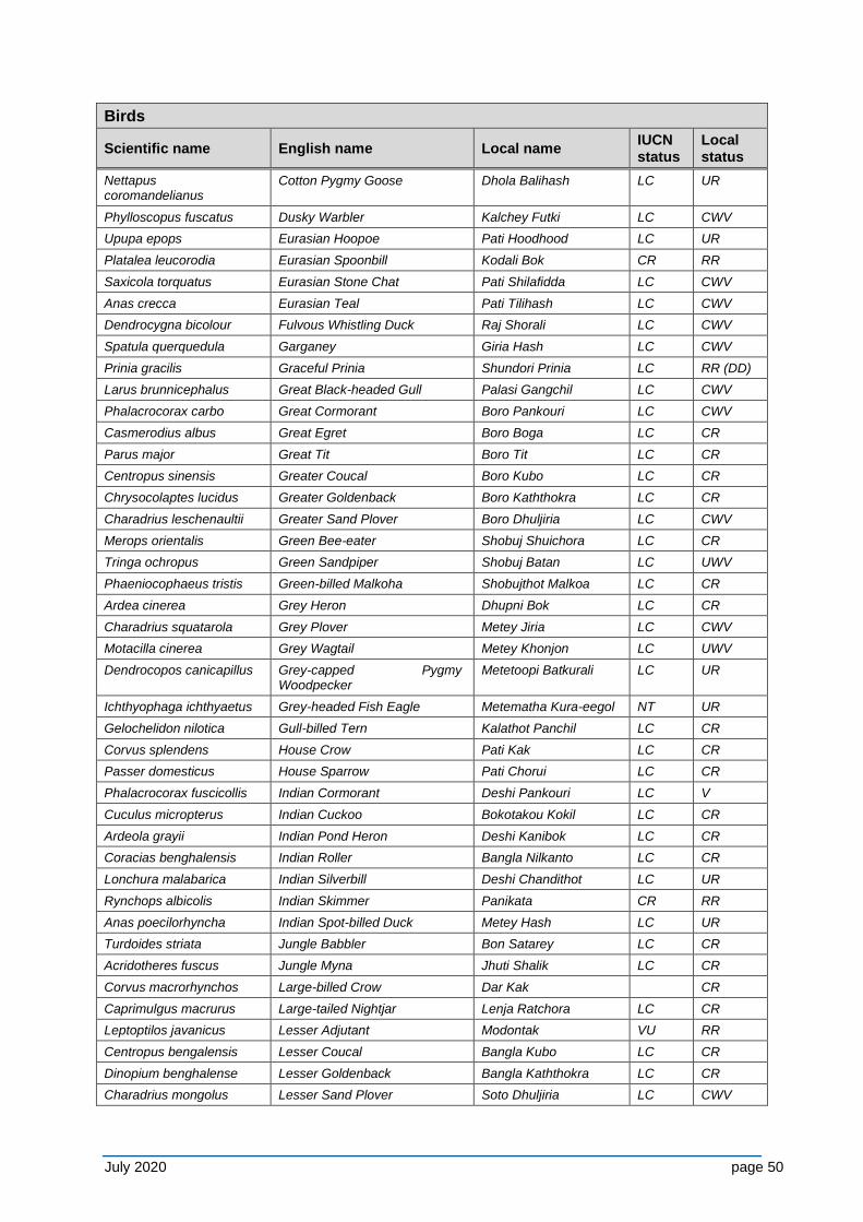
July 2020 page 50
Birds
Scientific name English name Local name IUCN status
Local status
Nettapus coromandelianus
Cotton Pygmy Goose Dhola Balihash LC UR
Phylloscopus fuscatus Dusky Warbler Kalchey Futki LC CWV
Upupa epops Eurasian Hoopoe Pati Hoodhood LC UR
Platalea leucorodia Eurasian Spoonbill Kodali Bok CR RR
Saxicola torquatus Eurasian Stone Chat Pati Shilafidda LC CWV
Anas crecca Eurasian Teal Pati Tilihash LC CWV
Dendrocygna bicolour Fulvous Whistling Duck Raj Shorali LC CWV
Spatula querquedula Garganey Giria Hash LC CWV
Prinia gracilis Graceful Prinia Shundori Prinia LC RR (DD)
Larus brunnicephalus Great Black-headed Gull Palasi Gangchil LC CWV
Phalacrocorax carbo Great Cormorant Boro Pankouri LC CWV
Casmerodius albus Great Egret Boro Boga LC CR
Parus major Great Tit Boro Tit LC CR
Centropus sinensis Greater Coucal Boro Kubo LC CR
Chrysocolaptes lucidus Greater Goldenback Boro Kaththokra LC CR
Charadrius leschenaultii Greater Sand Plover Boro Dhuljiria LC CWV
Merops orientalis Green Bee-eater Shobuj Shuichora LC CR
Tringa ochropus Green Sandpiper Shobuj Batan LC UWV
Phaeniocophaeus tristis Green-billed Malkoha Shobujthot Malkoa LC CR
Ardea cinerea Grey Heron Dhupni Bok LC CR
Charadrius squatarola Grey Plover Metey Jiria LC CWV
Motacilla cinerea Grey Wagtail Metey Khonjon LC UWV
Dendrocopos canicapillus Grey-capped Pygmy Woodpecker
Metetoopi Batkurali LC UR
Ichthyophaga ichthyaetus Grey-headed Fish Eagle Metematha Kura-eegol NT UR
Gelochelidon nilotica Gull-billed Tern Kalathot Panchil LC CR
Corvus splendens House Crow Pati Kak LC CR
Passer domesticus House Sparrow Pati Chorui LC CR
Phalacrocorax fuscicollis Indian Cormorant Deshi Pankouri LC V
Cuculus micropterus Indian Cuckoo Bokotakou Kokil LC CR
Ardeola grayii Indian Pond Heron Deshi Kanibok LC CR
Coracias benghalensis Indian Roller Bangla Nilkanto LC CR
Lonchura malabarica Indian Silverbill Deshi Chandithot LC UR
Rynchops albicolis Indian Skimmer Panikata CR RR
Anas poecilorhyncha Indian Spot-billed Duck Metey Hash LC UR
Turdoides striata Jungle Babbler Bon Satarey LC CR
Acridotheres fuscus Jungle Myna Jhuti Shalik LC CR
Corvus macrorhynchos Large-billed Crow Dar Kak CR
Caprimulgus macrurus Large-tailed Nightjar Lenja Ratchora LC CR
Leptoptilos javanicus Lesser Adjutant Modontak VU RR
Centropus bengalensis Lesser Coucal Bangla Kubo LC CR
Dinopium benghalense Lesser Goldenback Bangla Kaththokra LC CR
Charadrius mongolus Lesser Sand Plover Soto Dhuljiria LC CWV
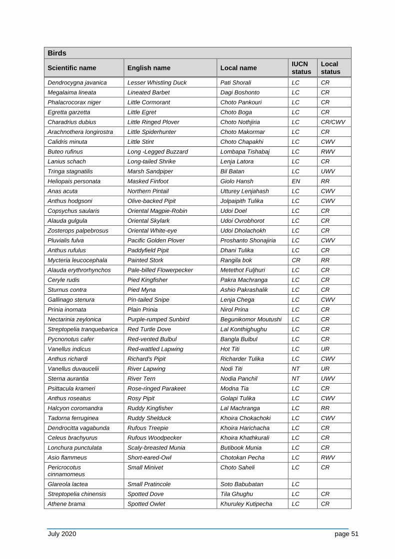
July 2020 page 51
Birds
Scientific name English name Local name IUCN status
Local status
Dendrocygna javanica Lesser Whistling Duck Pati Shorali LC CR
Megalaima lineata Lineated Barbet Dagi Boshonto LC CR
Phalacrocorax niger Little Cormorant Choto Pankouri LC CR
Egretta garzetta Little Egret Choto Boga LC CR
Charadrius dubius Little Ringed Plover Choto Nothjiria LC CR/CWV
Arachnothera longirostra Little Spiderhunter Choto Makormar LC CR
Calidris minuta Little Stint Choto Chapakhi LC CWV
Buteo rufinus Long -Legged Buzzard Lombapa Tishabaj LC RWV
Lanius schach Long-tailed Shrike Lenja Latora LC CR
Tringa stagnatilis Marsh Sandpiper Bil Batan LC UWV
Heliopais personata Masked Finfoot Giolo Hansh EN RR
Anas acuta Northern Pintail Utturey Lenjahash LC CWV
Anthus hodgsoni Olive-backed Pipit Jolpaipith Tulika LC CWV
Copsychus saularis Oriental Magpie-Robin Udoi Doel LC CR
Alauda gulgula Oriental Skylark Udoi Ovrobhorot LC CR
Zosterops palpebrosus Oriental White-eye Udoi Dholachokh LC CR
Pluvialis fulva Pacific Golden Plover Proshanto Shonajiria LC CWV
Anthus rufulus Paddyfield Pipit Dhani Tulika LC CR
Mycteria leucocephala Painted Stork Rangila bok CR RR
Alauda erythrorhynchos Pale-billed Flowerpecker Metethot Fuljhuri LC CR
Ceryle rudis Pied Kingfisher Pakra Machranga LC CR
Sturnus contra Pied Myna Ashio Pakrashalik LC CR
Gallinago stenura Pin-tailed Snipe Lenja Chega LC CWV
Prinia inornata Plain Prinia Nirol Prina LC CR
Nectarinia zeylonica Purple-rumped Sunbird Begunikomor Moutushi LC CR
Streptopelia tranquebarica Red Turtle Dove Lal Konthighughu LC CR
Pycnonotus cafer Red-vented Bulbul Bangla Bulbul LC CR
Vanellus indicus Red-wattled Lapwing Hot Titi LC UR
Anthus richardi Richard's Pipit Richarder Tulika LC CWV
Vanellus duvaucelii River Lapwing Nodi Titi NT UR
Sterna aurantia River Tern Nodia Panchil NT UWV
Psittacula krameri Rose-ringed Parakeet Modna Tia LC CR
Anthus roseatus Rosy Pipit Golapi Tulika LC CWV
Halcyon coromandra Ruddy Kingfisher Lal Machranga LC RR
Tadorna ferruginea Ruddy Shelduck Khoira Chokachoki LC CWV
Dendrocitta vagabunda Rufous Treepie Khoira Harichacha LC CR
Celeus brachyurus Rufous Woodpecker Khoira Khathkurali LC CR
Lonchura punctulata Scaly-breasted Munia Butibook Munia LC CR
Asio flammeus Short-eared-Owl Chotokan Pecha LC RWV
Pericrocotus cinnamomeus
Small Minivet Choto Saheli LC CR
Glareola lactea Small Pratincole Soto Babubatan LC
Streptopelia chinensis Spotted Dove Tila Ghughu LC CR
Athene brama Spotted Owlet Khuruley Kutipecha LC CR
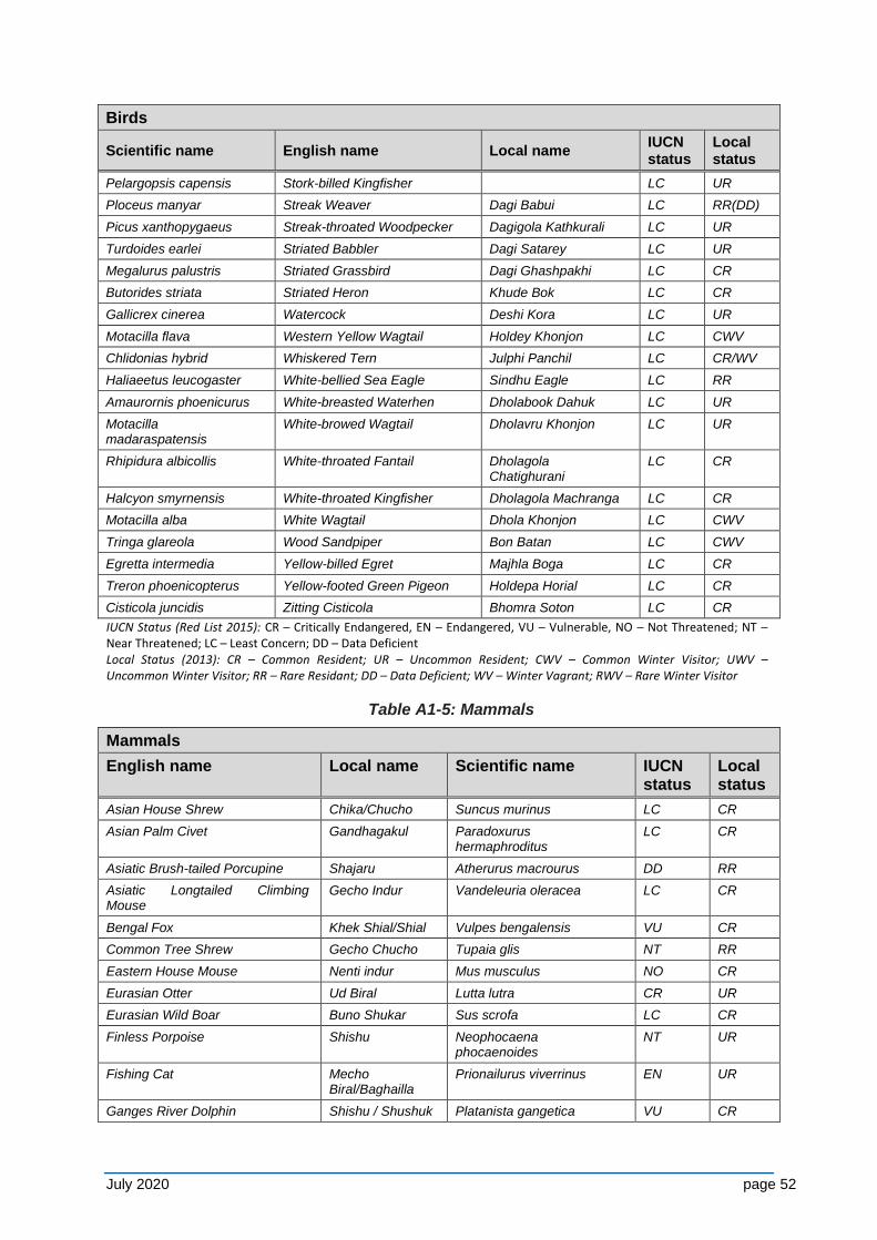
July 2020 page 52
Birds
Scientific name English name Local name IUCN status
Local status
Pelargopsis capensis Stork-billed Kingfisher LC UR
Ploceus manyar Streak Weaver Dagi Babui LC RR(DD)
Picus xanthopygaeus Streak-throated Woodpecker Dagigola Kathkurali LC UR
Turdoides earlei Striated Babbler Dagi Satarey LC UR
Megalurus palustris Striated Grassbird Dagi Ghashpakhi LC CR
Butorides striata Striated Heron Khude Bok LC CR
Gallicrex cinerea Watercock Deshi Kora LC UR
Motacilla flava Western Yellow Wagtail Holdey Khonjon LC CWV
Chlidonias hybrid Whiskered Tern Julphi Panchil LC CR/WV
Haliaeetus leucogaster White-bellied Sea Eagle Sindhu Eagle LC RR
Amaurornis phoenicurus White-breasted Waterhen Dholabook Dahuk LC UR
Motacilla madaraspatensis
White-browed Wagtail Dholavru Khonjon LC UR
Rhipidura albicollis White-throated Fantail Dholagola Chatighurani
LC CR
Halcyon smyrnensis White-throated Kingfisher Dholagola Machranga LC CR
Motacilla alba White Wagtail Dhola Khonjon LC CWV
Tringa glareola Wood Sandpiper Bon Batan LC CWV
Egretta intermedia Yellow-billed Egret Majhla Boga LC CR
Treron phoenicopterus Yellow-footed Green Pigeon Holdepa Horial LC CR
Cisticola juncidis Zitting Cisticola Bhomra Soton LC CR
IUCN Status (Red List 2015): CR – Critically Endangered, EN – Endangered, VU – Vulnerable, NO – Not Threatened; NT – Near Threatened; LC – Least Concern; DD – Data Deficient Local Status (2013): CR – Common Resident; UR – Uncommon Resident; CWV – Common Winter Visitor; UWV – Uncommon Winter Visitor; RR – Rare Residant; DD – Data Deficient; WV – Winter Vagrant; RWV – Rare Winter Visitor
Table A1-5: Mammals
Mammals
English name Local name Scientific name IUCN status
Local status
Asian House Shrew Chika/Chucho Suncus murinus LC CR
Asian Palm Civet Gandhagakul Paradoxurus hermaphroditus
LC CR
Asiatic Brush-tailed Porcupine Shajaru Atherurus macrourus DD RR
Asiatic Longtailed Climbing Mouse
Gecho Indur Vandeleuria oleracea LC CR
Bengal Fox Khek Shial/Shial Vulpes bengalensis VU CR
Common Tree Shrew Gecho Chucho Tupaia glis NT RR
Eastern House Mouse Nenti indur Mus musculus NO CR
Eurasian Otter Ud Biral Lutta lutra CR UR
Eurasian Wild Boar Buno Shukar Sus scrofa LC CR
Finless Porpoise Shishu Neophocaena phocaenoides
NT UR
Fishing Cat Mecho Biral/Baghailla
Prionailurus viverrinus EN UR
Ganges River Dolphin Shishu / Shushuk Platanista gangetica VU CR
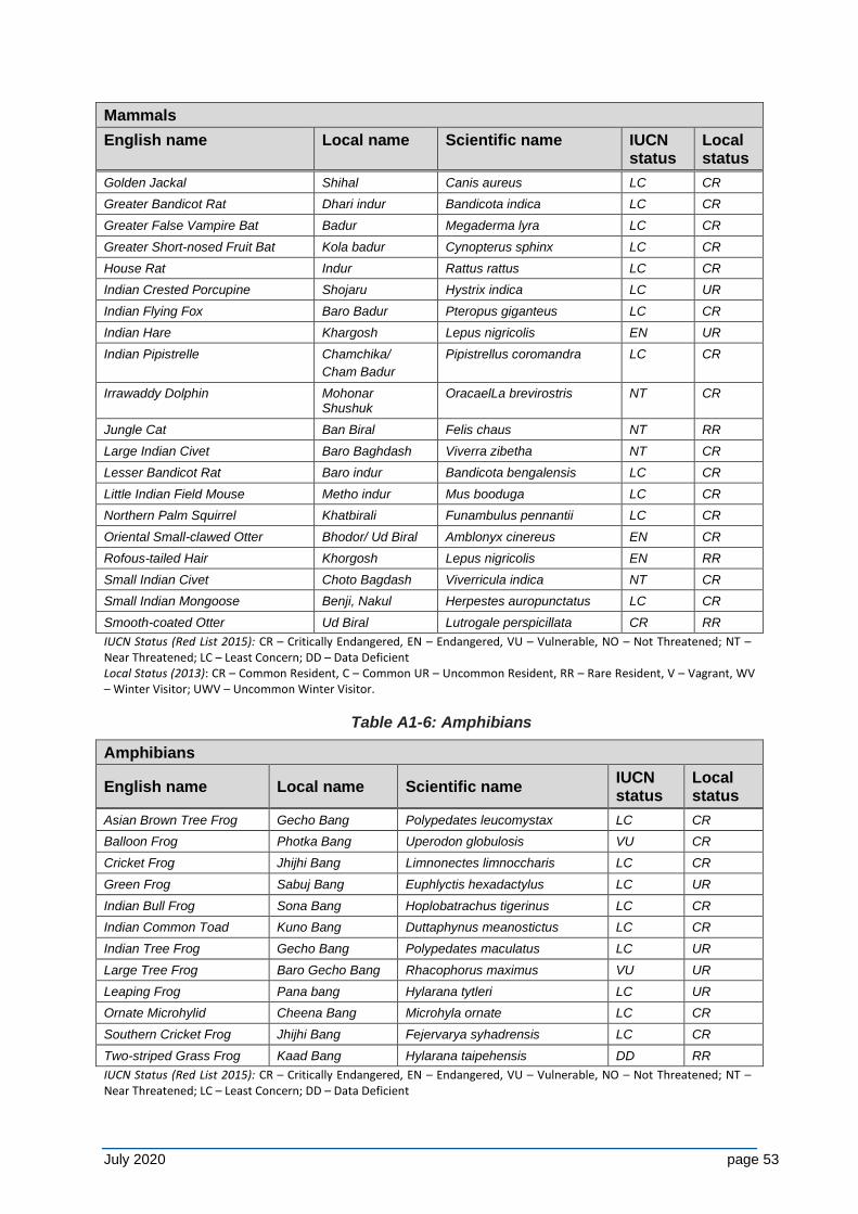
July 2020 page 53
Mammals
English name Local name Scientific name IUCN status
Local status
Golden Jackal Shihal Canis aureus LC CR
Greater Bandicot Rat Dhari indur Bandicota indica LC CR
Greater False Vampire Bat Badur Megaderma lyra LC CR
Greater Short-nosed Fruit Bat Kola badur Cynopterus sphinx LC CR
House Rat Indur Rattus rattus LC CR
Indian Crested Porcupine Shojaru Hystrix indica LC UR
Indian Flying Fox Baro Badur Pteropus giganteus LC CR
Indian Hare Khargosh Lepus nigricolis EN UR
Indian Pipistrelle Chamchika/
Cham Badur
Pipistrellus coromandra LC CR
Irrawaddy Dolphin Mohonar Shushuk
OracaelLa brevirostris NT CR
Jungle Cat Ban Biral Felis chaus NT RR
Large Indian Civet Baro Baghdash Viverra zibetha NT CR
Lesser Bandicot Rat Baro indur Bandicota bengalensis LC CR
Little Indian Field Mouse Metho indur Mus booduga LC CR
Northern Palm Squirrel Khatbirali Funambulus pennantii LC CR
Oriental Small-clawed Otter Bhodor/ Ud Biral Amblonyx cinereus EN CR
Rofous-tailed Hair Khorgosh Lepus nigricolis EN RR
Small Indian Civet Choto Bagdash Viverricula indica NT CR
Small Indian Mongoose Benji, Nakul Herpestes auropunctatus LC CR
Smooth-coated Otter Ud Biral Lutrogale perspicillata CR RR
IUCN Status (Red List 2015): CR – Critically Endangered, EN – Endangered, VU – Vulnerable, NO – Not Threatened; NT – Near Threatened; LC – Least Concern; DD – Data Deficient Local Status (2013): CR – Common Resident, C – Common UR – Uncommon Resident, RR – Rare Resident, V – Vagrant, WV – Winter Visitor; UWV – Uncommon Winter Visitor.
Table A1-6: Amphibians
Amphibians
English name Local name Scientific name IUCN status
Local status
Asian Brown Tree Frog Gecho Bang Polypedates leucomystax LC CR
Balloon Frog Photka Bang Uperodon globulosis VU CR
Cricket Frog Jhijhi Bang Limnonectes limnoccharis LC CR
Green Frog Sabuj Bang Euphlyctis hexadactylus LC UR
Indian Bull Frog Sona Bang Hoplobatrachus tigerinus LC CR
Indian Common Toad Kuno Bang Duttaphynus meanostictus LC CR
Indian Tree Frog Gecho Bang Polypedates maculatus LC UR
Large Tree Frog Baro Gecho Bang Rhacophorus maximus VU UR
Leaping Frog Pana bang Hylarana tytleri LC UR
Ornate Microhylid Cheena Bang Microhyla ornate LC CR
Southern Cricket Frog Jhijhi Bang Fejervarya syhadrensis LC CR
Two-striped Grass Frog Kaad Bang Hylarana taipehensis DD RR
IUCN Status (Red List 2015): CR – Critically Endangered, EN – Endangered, VU – Vulnerable, NO – Not Threatened; NT – Near Threatened; LC – Least Concern; DD – Data Deficient
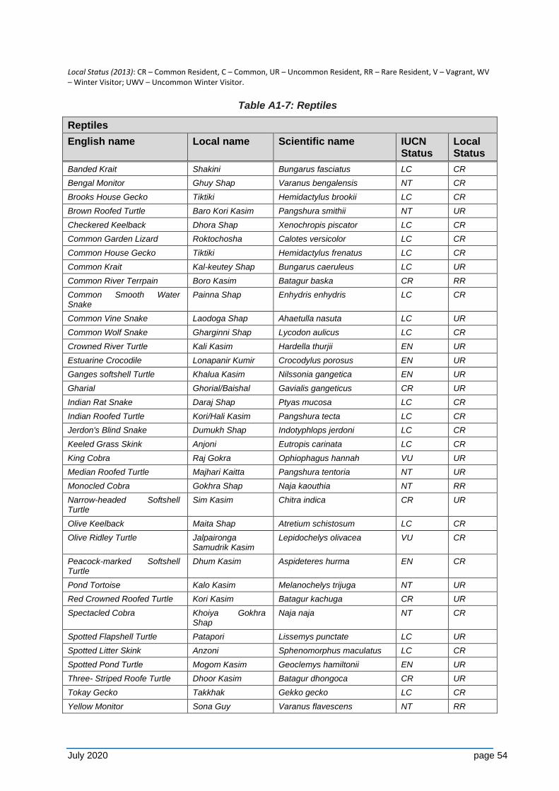
July 2020 page 54
Local Status (2013): CR – Common Resident, C – Common, UR – Uncommon Resident, RR – Rare Resident, V – Vagrant, WV – Winter Visitor; UWV – Uncommon Winter Visitor.
Table A1-7: Reptiles
Reptiles
English name Local name Scientific name IUCN Status
Local Status
Banded Krait Shakini Bungarus fasciatus LC CR
Bengal Monitor Ghuy Shap Varanus bengalensis NT CR
Brooks House Gecko Tiktiki Hemidactylus brookii LC CR
Brown Roofed Turtle Baro Kori Kasim Pangshura smithii NT UR
Checkered Keelback Dhora Shap Xenochropis piscator LC CR
Common Garden Lizard Roktochosha Calotes versicolor LC CR
Common House Gecko Tiktiki Hemidactylus frenatus LC CR
Common Krait Kal-keutey Shap Bungarus caeruleus LC UR
Common River Terrpain Boro Kasim Batagur baska CR RR
Common Smooth Water Snake
Painna Shap Enhydris enhydris LC CR
Common Vine Snake Laodoga Shap Ahaetulla nasuta LC UR
Common Wolf Snake Gharginni Shap Lycodon aulicus LC CR
Crowned River Turtle Kali Kasim Hardella thurjii EN UR
Estuarine Crocodile Lonapanir Kumir Crocodylus porosus EN UR
Ganges softshell Turtle Khalua Kasim Nilssonia gangetica EN UR
Gharial Ghorial/Baishal Gavialis gangeticus CR UR
Indian Rat Snake Daraj Shap Ptyas mucosa LC CR
Indian Roofed Turtle Kori/Hali Kasim Pangshura tecta LC CR
Jerdon's Blind Snake Dumukh Shap Indotyphlops jerdoni LC CR
Keeled Grass Skink Anjoni Eutropis carinata LC CR
King Cobra Raj Gokra Ophiophagus hannah VU UR
Median Roofed Turtle Majhari Kaitta Pangshura tentoria NT UR
Monocled Cobra Gokhra Shap Naja kaouthia NT RR
Narrow-headed Softshell Turtle
Sim Kasim Chitra indica CR UR
Olive Keelback Maita Shap Atretium schistosum LC CR
Olive Ridley Turtle Jalpaironga Samudrik Kasim
Lepidochelys olivacea VU CR
Peacock-marked Softshell Turtle
Dhum Kasim Aspideteres hurma EN CR
Pond Tortoise Kalo Kasim Melanochelys trijuga NT UR
Red Crowned Roofed Turtle Kori Kasim Batagur kachuga CR UR
Spectacled Cobra Khoiya Gokhra Shap
Naja naja NT CR
Spotted Flapshell Turtle Patapori Lissemys punctate LC UR
Spotted Litter Skink Anzoni Sphenomorphus maculatus LC CR
Spotted Pond Turtle Mogom Kasim Geoclemys hamiltonii EN UR
Three- Striped Roofe Turtle Dhoor Kasim Batagur dhongoca CR UR
Tokay Gecko Takkhak Gekko gecko LC CR
Yellow Monitor Sona Guy Varanus flavescens NT RR
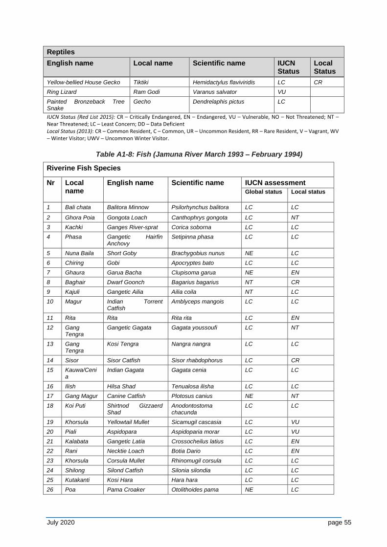
July 2020 page 55
Reptiles
English name Local name Scientific name IUCN Status
Local Status
Yellow-bellied House Gecko Tiktiki Hemidactylus flaviviridis LC CR
Ring Lizard Ram Godi Varanus salvator VU
Painted Bronzeback Tree Snake
Gecho Dendrelaphis pictus LC
IUCN Status (Red List 2015): CR – Critically Endangered, EN – Endangered, VU – Vulnerable, NO – Not Threatened; NT – Near Threatened; LC – Least Concern; DD – Data Deficient Local Status (2013): CR – Common Resident, C – Common, UR – Uncommon Resident, RR – Rare Resident, V – Vagrant, WV – Winter Visitor; UWV – Uncommon Winter Visitor.
Table A1-8: Fish (Jamuna River March 1993 – February 1994)
Riverine Fish Species
Nr Local name
English name Scientific name IUCN assessment
Global status Local status
1 Bali chata Balitora Minnow Psilorhynchus balitora LC LC
2 Ghora Poia Gongota Loach Canthophrys gongota LC NT
3 Kachki Ganges River-sprat Corica soborna LC LC
4 Phasa Gangetic Hairfin Anchovy
Setipinna phasa LC LC
5 Nuna Baila Short Goby Brachygobius nunus NE LC
6 Chiring Gobi Apocryptes bato LC LC
7 Ghaura Garua Bacha Clupisoma garua NE EN
8 Baghair Dwarf Goonch Bagarius bagarius NT CR
9 Kajuli Gangetic Ailia Ailia coila NT LC
10 Magur Indian Torrent Catfish
Amblyceps mangois LC LC
11 Rita Rita Rita rita LC EN
12 Gang Tengra
Gangetic Gagata Gagata youssoufi LC NT
13 Gang Tengra
Kosi Tengra Nangra nangra LC LC
14 Sisor Sisor Catfish Sisor rhabdophorus LC CR
15 Kauwa/Cenia
Indian Gagata Gagata cenia LC LC
16 Ilish Hilsa Shad Tenualosa ilisha LC LC
17 Gang Magur Canine Catfish Plotosus canius NE NT
18 Koi Puti Shirtnod Gizzaerd Shad
Anodontostoma chacunda
LC LC
19 Khorsula Yellowtail Mullet Sicamugil cascasia LC VU
20 Piali Aspidopara Aspidoparia morar LC VU
21 Kalabata Gangetic Latia Crossocheilus latius LC EN
22 Rani Necktie Loach Botia Dario LC EN
23 Khorsula Corsula Mullet Rhinomugil corsula LC LC
24 Shilong Silond Catfish Silonia silondia LC LC
25 Kutakanti Kosi Hara Hara hara LC LC
26 Poa Pama Croaker Otolithoides pama NE LC
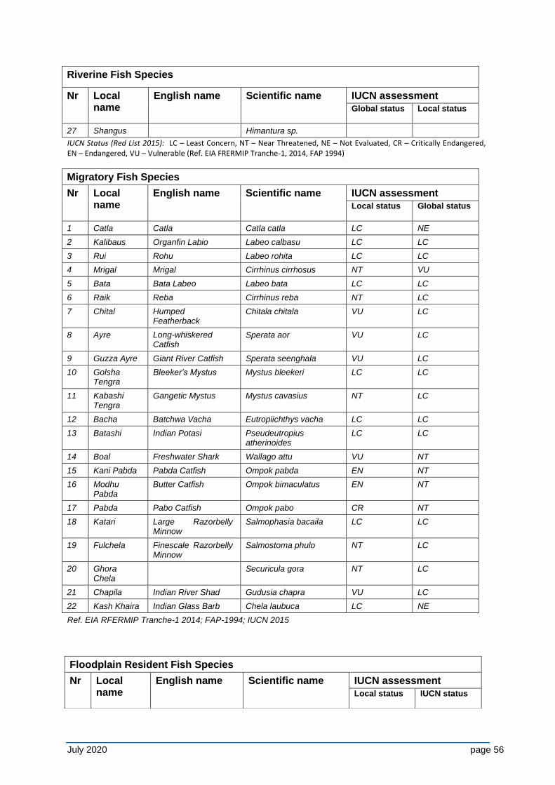
July 2020 page 56
Riverine Fish Species
Nr Local name
English name Scientific name IUCN assessment
Global status Local status
27 Shangus Himantura sp.
IUCN Status (Red List 2015): LC – Least Concern, NT – Near Threatened, NE – Not Evaluated, CR – Critically Endangered, EN – Endangered, VU – Vulnerable (Ref. EIA FRERMIP Tranche-1, 2014, FAP 1994)
Migratory Fish Species
Nr Local name
English name Scientific name IUCN assessment
Local status Global status
1 Catla Catla Catla catla LC NE
2 Kalibaus Organfin Labio Labeo calbasu LC LC
3 Rui Rohu Labeo rohita LC LC
4 Mrigal Mrigal Cirrhinus cirrhosus NT VU
5 Bata Bata Labeo Labeo bata LC LC
6 Raik Reba Cirrhinus reba NT LC
7 Chital Humped Featherback
Chitala chitala VU LC
8 Ayre Long-whiskered Catfish
Sperata aor VU LC
9 Guzza Ayre Giant River Catfish Sperata seenghala VU LC
10 Golsha Tengra
Bleeker’s Mystus Mystus bleekeri LC LC
11 Kabashi Tengra
Gangetic Mystus Mystus cavasius NT LC
12 Bacha Batchwa Vacha Eutropiichthys vacha LC LC
13 Batashi Indian Potasi Pseudeutropius atherinoides
LC LC
14 Boal Freshwater Shark Wallago attu VU NT
15 Kani Pabda Pabda Catfish Ompok pabda EN NT
16 Modhu Pabda
Butter Catfish Ompok bimaculatus EN NT
17 Pabda Pabo Catfish Ompok pabo CR NT
18 Katari Large Razorbelly Minnow
Salmophasia bacaila LC LC
19 Fulchela Finescale Razorbelly Minnow
Salmostoma phulo NT LC
20 Ghora Chela
Securicula gora NT LC
21 Chapila Indian River Shad Gudusia chapra VU LC
22 Kash Khaira Indian Glass Barb Chela laubuca LC NE
Ref. EIA RFERMIP Tranche-1 2014; FAP-1994; IUCN 2015
Floodplain Resident Fish Species
Nr Local name
English name Scientific name IUCN assessment
Local status IUCN status
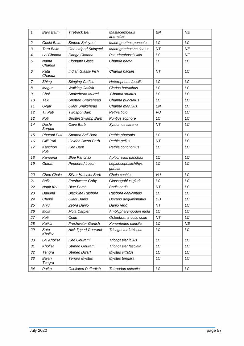
July 2020 page 57
1 Baro Baim Tiretrack Eel Mastacembelus aramatus
EN NE
2 Guchi Baim Striped Spinyeel Macrognathus pancalus LC LC
3 Tara Baim One striped Spinyeel Macrognathus aculeatus NT NE
4 Lal Chanda Ranga Chanda Pseudambassis lala LC NE
5 Nama Chanda
Elongate Glass Chanda nama LC LC
6 Kata Chanda
Indian Glassy Fish Chanda baculis NT LC
7 Shing Stinging Catfish Heteropneus fossilis LC LC
8 Magur Walking Catfish Clarias batrachus LC LC
9 Shol Snakehead Murrel Channa striatus LC LC
10 Taki Spotted Snakehead Channa punctatus LC LC
11 Gojar Giant Snakehead Channa marulius EN LC
12 Tit Puti Twospot Barb Pethia ticto VU LC
12 Puti Spotfin Swamp Barb Puntius sophore LC LC
14 Deshi Sarputi
Olive Barb Systomus sarana NT LC
15 Phutani Puti Spotted Sail Barb Pethia phutunio LC LC
16 Gilli Puti Golden Dwarf Barb Pethia gelius NT LC
17 Kanchon Puti
Red Barb Pethia conchonius LC LC
18 Kanpona Blue Panchax Aplocheilus panchax LC LC
19 Gutum Peppered Loach Lepidocephalichthys
guntea
LC LC
20 Chep Chala Silver Hatchlet Barb Chela cachius VU LC
21 Baila Freshwater Goby Glossogobius giuris LC LC
22 Napit Koi Blue Perch Badis badis NT LC
23 Darkina Blackline Rasbora Rasbora daniconius LC LC
24 Chebli Giant Danio Devario aequipinnatus DD LC
25 Anju Zebra Danio Danio rerio NT LC
26 Mola Mola Carplet Amblypharyngodon mola LC LC
27 Keti Cotio Osteobrama cotio cotio NT LC
28 Kaikla Freshwater Garfish Xenentodon cancila LC NE
29 Soto Kholisa
Hick-lipped Gourami Trichgaster labiosus LC LC
30 Lal Kholisa Red Gourami Trichgaster lalius LC LC
31 Kholisa Striped Gourami Trichgaster fasciata LC LC
32 Tengra Striped Dwarf Mystus vittatus LC LC
33 Bajari Tengra
Tengra Mystus Mystus tengara LC LC
34 Potka Ocellated Pufferfish Tetraodon cutcutia LC LC
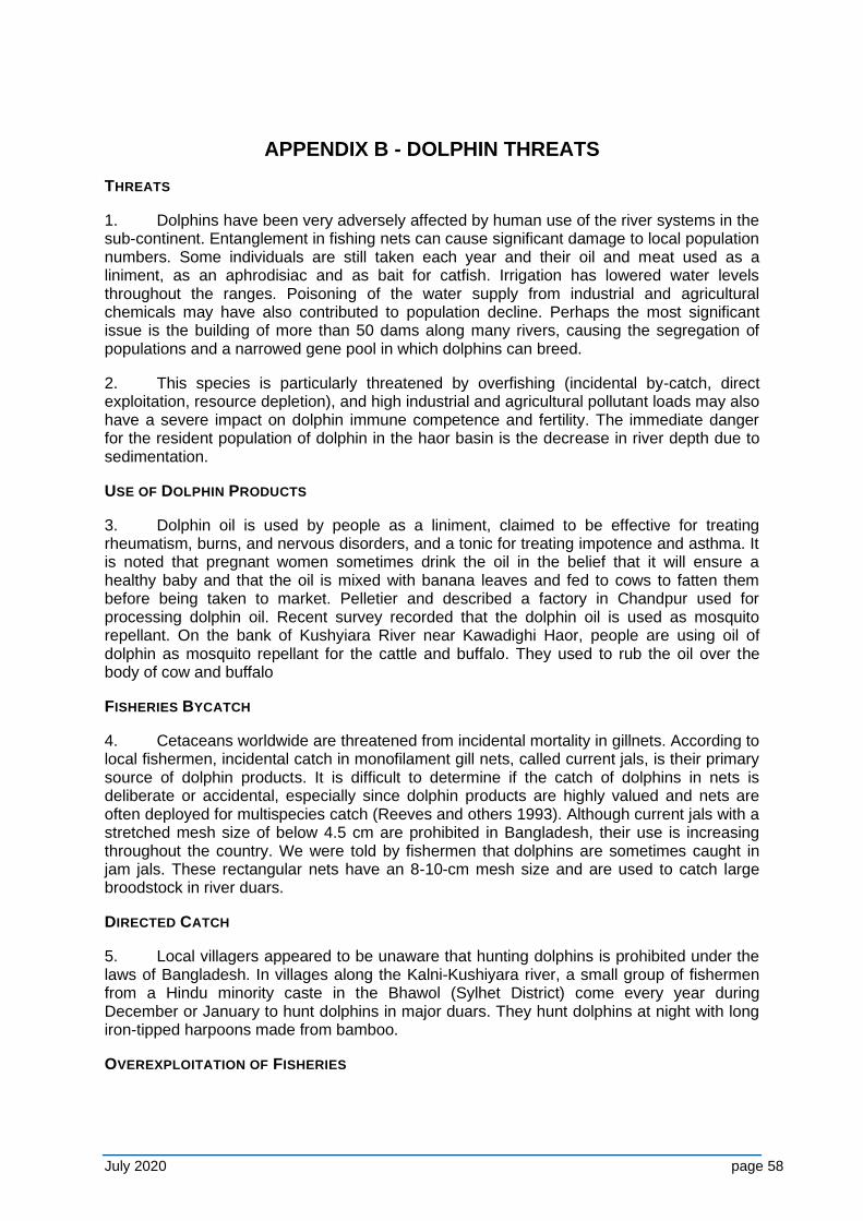
July 2020 page 58
APPENDIX B - DOLPHIN THREATS
THREATS
1. Dolphins have been very adversely affected by human use of the river systems in the sub-continent. Entanglement in fishing nets can cause significant damage to local population numbers. Some individuals are still taken each year and their oil and meat used as a liniment, as an aphrodisiac and as bait for catfish. Irrigation has lowered water levels throughout the ranges. Poisoning of the water supply from industrial and agricultural chemicals may have also contributed to population decline. Perhaps the most significant issue is the building of more than 50 dams along many rivers, causing the segregation of populations and a narrowed gene pool in which dolphins can breed.
2. This species is particularly threatened by overfishing (incidental by-catch, direct exploitation, resource depletion), and high industrial and agricultural pollutant loads may also have a severe impact on dolphin immune competence and fertility. The immediate danger for the resident population of dolphin in the haor basin is the decrease in river depth due to sedimentation.
USE OF DOLPHIN PRODUCTS
3. Dolphin oil is used by people as a liniment, claimed to be effective for treating rheumatism, burns, and nervous disorders, and a tonic for treating impotence and asthma. It is noted that pregnant women sometimes drink the oil in the belief that it will ensure a healthy baby and that the oil is mixed with banana leaves and fed to cows to fatten them before being taken to market. Pelletier and described a factory in Chandpur used for processing dolphin oil. Recent survey recorded that the dolphin oil is used as mosquito repellant. On the bank of Kushyiara River near Kawadighi Haor, people are using oil of dolphin as mosquito repellant for the cattle and buffalo. They used to rub the oil over the body of cow and buffalo
FISHERIES BYCATCH
4. Cetaceans worldwide are threatened from incidental mortality in gillnets. According to local fishermen, incidental catch in monofilament gill nets, called current jals, is their primary source of dolphin products. It is difficult to determine if the catch of dolphins in nets is deliberate or accidental, especially since dolphin products are highly valued and nets are often deployed for multispecies catch (Reeves and others 1993). Although current jals with a stretched mesh size of below 4.5 cm are prohibited in Bangladesh, their use is increasing throughout the country. We were told by fishermen that dolphins are sometimes caught in jam jals. These rectangular nets have an 8-10-cm mesh size and are used to catch large broodstock in river duars.
DIRECTED CATCH
5. Local villagers appeared to be unaware that hunting dolphins is prohibited under the laws of Bangladesh. In villages along the Kalni-Kushiyara river, a small group of fishermen from a Hindu minority caste in the Bhawol (Sylhet District) come every year during December or January to hunt dolphins in major duars. They hunt dolphins at night with long iron-tipped harpoons made from bamboo.
OVEREXPLOITATION OF FISHERIES
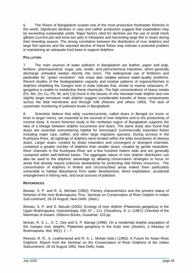
July 2020 page 59
6. The Rivers of Bangladesh sustain one of the most productive freshwater fisheries in the world. Significant declines in carp and catfish production suggest that exploitation may be exceeding sustainable yields. Major factors cited for declines are the use of small mesh gillnets (current jals and kona ber jals) in tributaries and harvesting large fish in duars during their breeding season. The strong correlation between the distribution of river dolphins and large fish species and the reported decline of these fishes may indicate a potential problem in maintaining an adequate food base to support dolphins.
POLLUTION
7. The main sources of water pollution in Bangladesh are leather, paper and pulp, fertilizer, pharmaceutical, sugar, jute, textile, and petrochemical industries, which generally discharge untreated wastes directly into rivers. The widespread use of fertilizers and pesticides for ‘‘green revolution’’ rice crops also creates serious water-quality problems. Recent studies of the biodegradation capacity and residue patterns of organochlorines in dolphins inhabiting the Ganges river in India indicate that, similar to marine cetaceans, P. gangetica is unable to metabolize these chemicals. The high concentrations of heavy metals (Fe, Mn, Zn, Cu, Pb, Mi, and Cd) found in the tissues of one neonatal male dolphin and one slightly larger immature male dolphin suggest considerable transfer of these contaminants across the fetal membrane and through milk (Reeves and others 1993). The lack of systematic monitoring of pollutant levels in Bangladesh.
8. Scientists believe that eddy countercurrents, called duars in Bengali (or koom or khari in larger rivers), are essential to the survival of river dolphins and to the productivity of riverine biota. A recent fisheries study in the northeast region of Bangladesh supports the idea of a linkage between dolphin occurrence and duars. The same study also found that duars are essential overwintering habitat for boromaach (commercially important fishes including major carp, catfish, and other large migratory species). During surveys in the Kushiyara River, all sightings of dolphins were located within the eddy boundaries of obvious duars. Larger duars, created by sharp meanders and convergent or divergent channels, contained a greater number of dolphins than smaller duars, created by gentle meanders. River channels in the Kushiyara River are a few hundred meters wide and are generally contained within well-defined banks. The aggregate nature of river dolphin distribution can also be used to the dolphins’ advantage by allowing conservation strategies to focus on areas that already require judicious stewardship for protecting vital fishery resources. The concentration of dolphins in limited and circumscribed areas makes them particularly vulnerable to habitat disturbance from water development, direct exploitation, accidental entanglement in fishing nets, and local sources of pollution.
REFERENCES
Biswas, S. P. and R. G. Michael (1992): Fishery characteristics and the present status of fisheries of the river Brahmaputra. Proc. Seminar on Conservation of River Dolphin in Indian Sub-continent, 18-19 August, New Delhi. (Abst.)
Biswas, S. P. and S. Baruah (2000): Ecology of river dolphin (Platanista gangetica) in the Upper Brahmaputra. Hydrobiologia, 430: 97 – 111. Choudhury, A. U. (1997): Checklist of the Mammals of Assam. Gibbons Books, Guwahati. 103 pp.
Mohan, R. S. L., S. C. Dey and S. P. Bairagi (1998): On a residential dolphin population of the Ganges river dolphin, Platanista gangetica in the Kulsi river (Assam), a tributary of Brahmaputra. Ibid, 95(1): 1 – 7.
Reeves, R. R., S. Leatherwood and R. S. L. Mohan (eds.) (1993): A Future for Asian River Dolphins: Report from the Seminar on the Conservation of River Dolphins of the Indian Subcontinent, 18-19 August 1992, New Delhi, India.
July 2020 page 60
Whale and Dolphin Conservation Society, Bath, U.K. Reeves, R. R. and S. Leatherwood (1994): Dams and river dolphins: can they co-exist? Ambio 23: 172-175.
B. D. Smith and T. Kasuya), pp. 54-61. IUCN, Gland, Switzerland. Sinha, R. K. and G. Sharma (2003): Current status of the Ganges river dolphin, Platanista gangetica in the rivers Kosi and Son, Bihar, India. J. Bombay nat. Hist. Soc., 100(1): 27-37.
Sinha, R. K., N. K. Das, N. K. Singh, G. Sharma and S. N. Ahsan (1993): Gut content of the Gangetic dolphin, Platanista gangetica. Invest. Cetacea, 24: 317-321. Smith, B. D. (1993): 1990 status and conservation of the Ganges River Dolphin (Platanista gangetica) in the Karnali River, Nepal. Biological Conservation, 66: 159-169.
Smith, B. D., A. K. M., Haque, M. S. Hussain and A. Khan (1998): River dolphins in Bangladesh: conservation and the effects of water development. Environmental Management, 22: 323 335.
Smith, B. D. and R. R. Reeves (2000): Survey methods for population assessment of Asian river dolphins. In Biology and Conservation of Freshwater Cetaceans in Asia, Occasional Papers of the IUCN Species Survival Commission no. 23 (eds. R. R. Reeves, B. D. Smith and T. Kasuya), pp. 97-115. IUCN, Gland, Switzerland.
Smith, B. D., R. K. Sinha, Z. Kaiya, A. A. Choudhury, L. Renjun, W. Ding, B. Ahmed, A. K. M. A. Haque, R. S. L. Mohan, K. Sapkota (2000): Register of water development projects affecting river cetaceans in Asia. In Biology and Conservation of Freshwater Cetaceans in Asia, Occasional Papers of the
Ahmed, A.T.A., Kabir, S.M.H.,M.,Ahmed,Z. U., Begum, Z.N.T., Hassan, M. A., and Khondker, m. (eds.).2009. Encyclopedia of Flora and Fauna of Bangladesh, Vol.27 Mammals. Asiatic Society of Bangladesh, Dhaka.264 p.
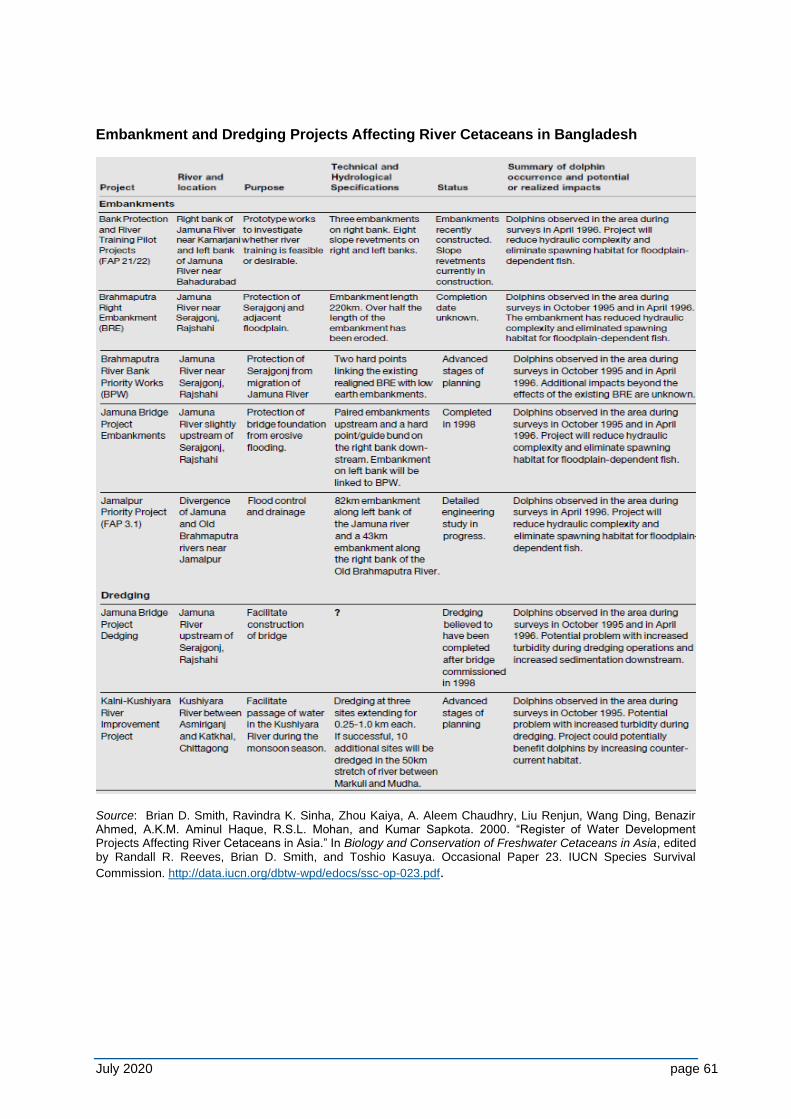
July 2020 page 61
Embankment and Dredging Projects Affecting River Cetaceans in Bangladesh
Source: Brian D. Smith, Ravindra K. Sinha, Zhou Kaiya, A. Aleem Chaudhry, Liu Renjun, Wang Ding, Benazir Ahmed, A.K.M. Aminul Haque, R.S.L. Mohan, and Kumar Sapkota. 2000. “Register of Water Development Projects Affecting River Cetaceans in Asia.” In Biology and Conservation of Freshwater Cetaceans in Asia, edited by Randall R. Reeves, Brian D. Smith, and Toshio Kasuya. Occasional Paper 23. IUCN Species Survival
Commission. http://data.iucn.org/dbtw-wpd/edocs/ssc-op-023.pdf.
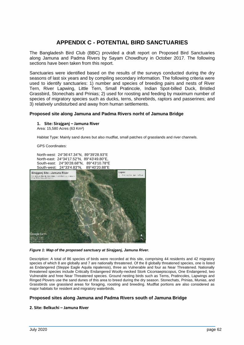
July 2020 page 62
APPENDIX C - POTENTIAL BIRD SANCTUARIES
The Bangladesh Bird Club (BBC) provided a draft report on Proposed Bird Sanctuaries along Jamuna and Padma Rivers by Sayam Chowdhury in October 2017. The following sections have been taken from this report.
Sanctuaries were identified based on the results of the surveys conducted during the dry seasons of last six years and by compiling secondary information. The following criteria were used to identify sanctuaries: 1) number and species of breeding pairs and nests of River Tern, River Lapwing, Little Tern, Small Pratincole, Indian Spot-billed Duck, Bristled Grassbird, Stonechats and Prinias; 2) used for roosting and feeding by maximum number of species of migratory species such as ducks, terns, shorebirds, raptors and passerines; and 3) relatively undisturbed and away from human settlements.
Proposed site along Jamuna and Padma Rivers norht of Jamuna Bridge
1. Site: Sirajganj – Jamuna River Area: 15,580 Acres (63 Km²)
Habitat Type: Mainly sand dunes but also mudflat, small patches of grasslands and river channels.
GPS Coordinates:
North-west: 24°36'47.34"N, 89°39'28.93"E North-east: 24°34'17.52"N, 89°43'49.80"E, South-east: 24°30'28.68"N, 89°43'10.78"E South-west: 24°33'4.83"N, 89°40'20.88"E
Figure 1: Map of the proposed sanctuary at Sirajganj, Jamuna River.
Description: A total of 86 species of birds were recorded at this site, comprising 44 residents and 42 migratory species of which 8 are globally and 7 are nationally threatened. Of the 8 globally threatened species, one is listed as Endangered (Steppe Eagle Aquila nipalensis), three as Vulnerable and four as Near Threatened. Nationally threatened species include Critically Endangered Woolly-necked Stork Ciconiaepiscopus, One Endangered, two Vulnerable and hree Near Threatened species. Ground nesting birds such as Terns, Pratincoles, Lapwings and Ringed Plovers use the sand dunes of this area to breed during the dry season. Stonechats, Prinias, Munias, and Grassbirds use grassland areas for foraging, roosting and breeding. Mudflat portions are also considered as major habitats for resident and migratory waterbirds.
Proposed sites along Jamuna and Padma Rivers south of Jamuna Bridge
2. Site: Belkuchi – Jamuna River
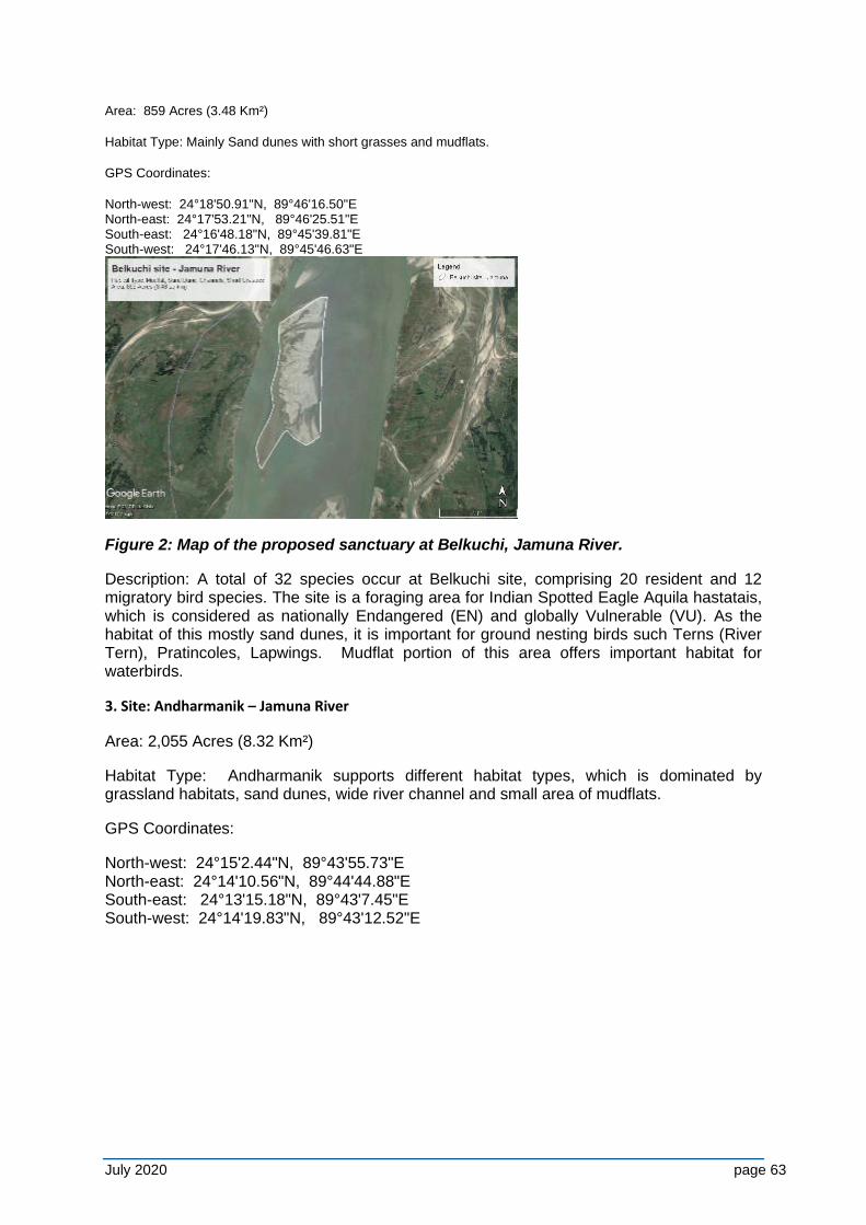
July 2020 page 63
Area: 859 Acres (3.48 Km²)
Habitat Type: Mainly Sand dunes with short grasses and mudflats.
GPS Coordinates:
North-west: 24°18'50.91"N, 89°46'16.50"E North-east: 24°17'53.21"N, 89°46'25.51"E South-east: 24°16'48.18"N, 89°45'39.81"E South-west: 24°17'46.13"N, 89°45'46.63"E
Figure 2: Map of the proposed sanctuary at Belkuchi, Jamuna River.
Description: A total of 32 species occur at Belkuchi site, comprising 20 resident and 12 migratory bird species. The site is a foraging area for Indian Spotted Eagle Aquila hastatais, which is considered as nationally Endangered (EN) and globally Vulnerable (VU). As the habitat of this mostly sand dunes, it is important for ground nesting birds such Terns (River Tern), Pratincoles, Lapwings. Mudflat portion of this area offers important habitat for waterbirds.
3. Site: Andharmanik – Jamuna River
Area: 2,055 Acres (8.32 Km²)
Habitat Type: Andharmanik supports different habitat types, which is dominated by grassland habitats, sand dunes, wide river channel and small area of mudflats.
GPS Coordinates:
North-west: 24°15'2.44"N, 89°43'55.73"E North-east: 24°14'10.56"N, 89°44'44.88"E South-east: 24°13'15.18"N, 89°43'7.45"E South-west: 24°14'19.83"N, 89°43'12.52"E
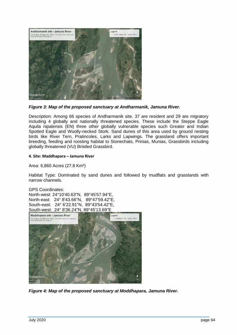
July 2020 page 64
Figure 3: Map of the proposed sanctuary at Andharmanik, Jamuna River.
Description: Among 66 species of Andharmanik site, 37 are resident and 29 are migratory including 4 globally and nationally threatened species. These include the Steppe Eagle Aquila nipalensis (EN) three other globally vulnerable species such Greater and Indian Spotted Eagle and Woolly-necked Stork. Sand dunes of this area used by ground nesting birds like River Tern, Pratincoles, Larks and Lapwings. The grassland offers important breeding, feeding and roosting habitat to Stonechats, Prinias, Munias, Grassbirds including globally threatened (VU) Bristled Grassbird.
4. Site: Maddhapara – Jamuna River
Area: 6,860 Acres (27.8 Km²)
Habitat Type: Dominated by sand dunes and followed by mudflats and grasslands with narrow channels.
GPS Coordinates: North-west: 24°10'40.63"N, 89°45'57.94"E, North-east: 24° 8'43.66"N, 89°47'59.42"E, South-east: 24° 6'22.91"N, 89°43'54.42"E, South-west: 24° 8'36.24"N, 89°45'13.69"E
Figure 4: Map of the proposed sanctuary at Moddhapara, Jamuna River.
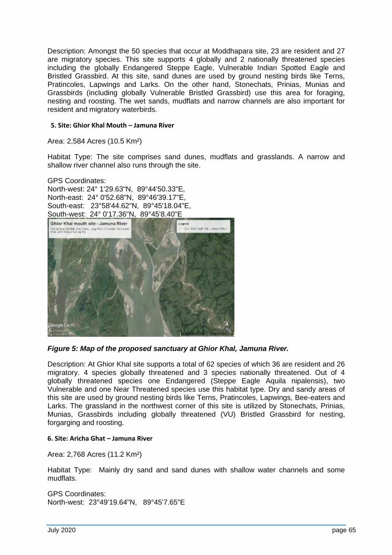
July 2020 page 65
Description: Amongst the 50 species that occur at Moddhapara site, 23 are resident and 27 are migratory species. This site supports 4 globally and 2 nationally threatened species including the globally Endangered Steppe Eagle, Vulnerable Indian Spotted Eagle and Bristled Grassbird. At this site, sand dunes are used by ground nesting birds like Terns, Pratincoles, Lapwings and Larks. On the other hand, Stonechats, Prinias, Munias and Grassbirds (including globally Vulnerable Bristled Grassbird) use this area for foraging, nesting and roosting. The wet sands, mudflats and narrow channels are also important for resident and migratory waterbirds.
5. Site: Ghior Khal Mouth – Jamuna River
Area: 2,584 Acres (10.5 Km²)
Habitat Type: The site comprises sand dunes, mudflats and grasslands. A narrow and shallow river channel also runs through the site.
GPS Coordinates: North-west: 24° 1'29.63"N, 89°44'50.33"E, North-east: 24° 0'52.68"N, 89°46'39.17"E, South-east: 23°58'44.62"N, 89°45'18.04"E, South-west: 24° 0'17.36"N, 89°45'8.40"E
Figure 5: Map of the proposed sanctuary at Ghior Khal, Jamuna River.
Description: At Ghior Khal site supports a total of 62 species of which 36 are resident and 26 migratory. 4 species globally threatened and 3 species nationally threatened. Out of 4 globally threatened species one Endangered (Steppe Eagle Aquila nipalensis), two Vulnerable and one Near Threatened species use this habitat type. Dry and sandy areas of this site are used by ground nesting birds like Terns, Pratincoles, Lapwings, Bee-eaters and Larks. The grassland in the northwest corner of this site is utilized by Stonechats, Prinias, Munias, Grassbirds including globally threatened (VU) Bristled Grassbird for nesting, forgarging and roosting.
6. Site: Aricha Ghat – Jamuna River
Area: 2,768 Acres (11.2 Km²)
Habitat Type: Mainly dry sand and sand dunes with shallow water channels and some mudflats.
GPS Coordinates: North-west: 23°49'19.64"N, 89°45'7.65"E
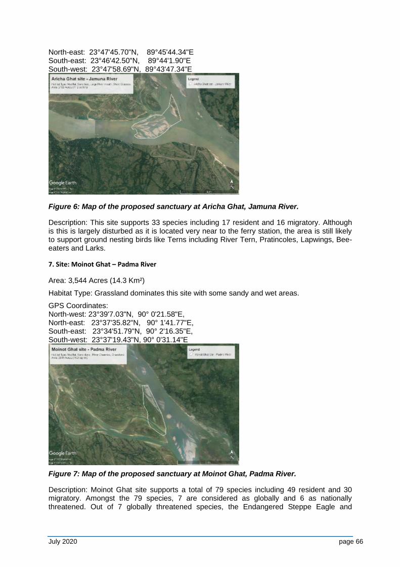
July 2020 page 66
North-east: 23°47'45.70"N, 89°45'44.34"E South-east: 23°46'42.50"N, 89°44'1.90"E South-west: 23°47'58.69"N, 89°43'47.34"E
Figure 6: Map of the proposed sanctuary at Aricha Ghat, Jamuna River.
Description: This site supports 33 species including 17 resident and 16 migratory. Although is this is largely disturbed as it is located very near to the ferry station, the area is still likely to support ground nesting birds like Terns including River Tern, Pratincoles, Lapwings, Bee-eaters and Larks.
7. Site: Moinot Ghat – Padma River
Area: 3,544 Acres (14.3 Km²)
Habitat Type: Grassland dominates this site with some sandy and wet areas.
GPS Coordinates: North-west: 23°39'7.03"N, 90° 0'21.58"E, North-east: 23°37'35.82"N, 90° 1'41.77"E, South-east: 23°34'51.79"N, 90° 2'16.35"E, South-west: 23°37'19.43"N, 90° 0'31.14"E
Figure 7: Map of the proposed sanctuary at Moinot Ghat, Padma River.
Description: Moinot Ghat site supports a total of 79 species including 49 resident and 30 migratory. Amongst the 79 species, 7 are considered as globally and 6 as nationally threatened. Out of 7 globally threatened species, the Endangered Steppe Eagle and
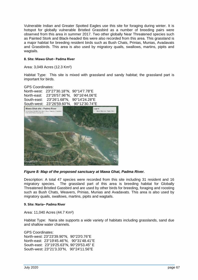
July 2020 page 67
Vulnerable Indian and Greater Spotted Eagles use this site for foraging during winter. It is hotspot for globally vulnerable Bristled Grassbird as a number of breeding pairs were observed from this area in summer 2017. Two other globally Near Threatened species such as Painted Stork and Black-headed Ibis were also recorded from this area. This grassland is a major habitat for breeding resident birds such as Bush Chats, Prinias, Munias, Avadavats and Grassbirds. This area is also used by migratory quails, swallows, martins, pipits and wagtails.
8. Site: Mawa Ghat– Padma River
Area: 3,049 Acres (12.3 Km²)
Habitat Type: This site is mixed with grassland and sandy habitat; the grassland part is important for birds.
GPS Coordinates: North-west: 23°27'30.18"N, 90°14'7.78"E North-east: 23°26'57.96"N, 90°16'44.06"E South-east: 23°26'1.68"N, 90°14'24.28"E South-west: 23°26'59.60"N, 90°12'30.74"E
Figure 8: Map of the proposed sanctuary at Mawa Ghat, Padma River.
Description: A total 47 species were recorded from this site including 31 resident and 16 migratory species. The grassland part of this area is breeding habitat for Globally Threatened Bristled Gassbird and are used by other birds for breeding, foraging and roosting such as Bush Chats, Weavers, Prinias, Munias and Avadavats. This area is also used by migratory quails, swallows, martins, pipits and wagtails.
9. Site: Naria– Padma River
Area: 11,040 Acres (44.7 Km²)
Habitat Type: Naria site supports a wide variety of habitats including grasslands, sand due and shallow water channels.
GPS Coordinates: North-west: 23°23'39.90"N, 90°23'0.76"E North-east: 23°19'45.46"N, 90°31'48.41"E South-east: 23°19'25.63"N, 90°29'53.45" E South-west: 23°21'3.33"N, 90°24'11.56"E
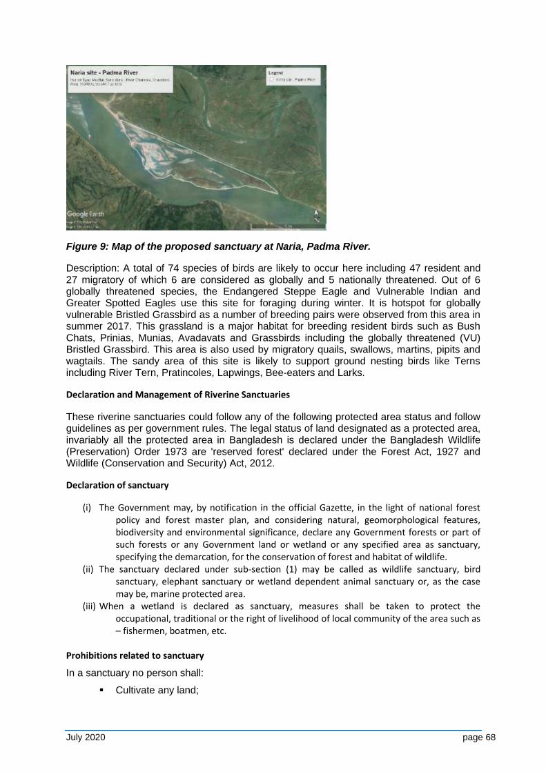
July 2020 page 68
Figure 9: Map of the proposed sanctuary at Naria, Padma River.
Description: A total of 74 species of birds are likely to occur here including 47 resident and 27 migratory of which 6 are considered as globally and 5 nationally threatened. Out of 6 globally threatened species, the Endangered Steppe Eagle and Vulnerable Indian and Greater Spotted Eagles use this site for foraging during winter. It is hotspot for globally vulnerable Bristled Grassbird as a number of breeding pairs were observed from this area in summer 2017. This grassland is a major habitat for breeding resident birds such as Bush Chats, Prinias, Munias, Avadavats and Grassbirds including the globally threatened (VU) Bristled Grassbird. This area is also used by migratory quails, swallows, martins, pipits and wagtails. The sandy area of this site is likely to support ground nesting birds like Terns including River Tern, Pratincoles, Lapwings, Bee-eaters and Larks.
Declaration and Management of Riverine Sanctuaries
These riverine sanctuaries could follow any of the following protected area status and follow guidelines as per government rules. The legal status of land designated as a protected area, invariably all the protected area in Bangladesh is declared under the Bangladesh Wildlife (Preservation) Order 1973 are 'reserved forest' declared under the Forest Act, 1927 and Wildlife (Conservation and Security) Act, 2012.
Declaration of sanctuary
(i) The Government may, by notification in the official Gazette, in the light of national forest policy and forest master plan, and considering natural, geomorphological features, biodiversity and environmental significance, declare any Government forests or part of such forests or any Government land or wetland or any specified area as sanctuary, specifying the demarcation, for the conservation of forest and habitat of wildlife.
(ii) The sanctuary declared under sub-section (1) may be called as wildlife sanctuary, bird sanctuary, elephant sanctuary or wetland dependent animal sanctuary or, as the case may be, marine protected area.
(iii) When a wetland is declared as sanctuary, measures shall be taken to protect the occupational, traditional or the right of livelihood of local community of the area such as – fishermen, boatmen, etc.
Prohibitions related to sanctuary
In a sanctuary no person shall:
▪ Cultivate any land;
July 2020 page 69
▪ Establish or undertake any industrial operation; ▪ Harvest, destroy or collect any plant; ▪ Set any kind of fire; ▪ Enter into a sanctuary with any weapon without the permission of the Chief
Warden or the officer authorised by him in this behalf; ▪ Disturb or threat any wildlife, or use chemicals, explosives or any other weapon
or substances which may Destroy wildlife habitat; ▪ Introduce any exotic animal or plant; ▪ Introduce any domestic animal or allow any domestic animal to stray; ▪ Dump any materials detrimental to wildlife; ▪ Explore or dig for extraction of minerals; ▪ Fell any plant or part thereof except silvicultural operations required for natural
regeneration of plants; ▪ Divert, stop or pollute watercourse; or ▪ Introduce any alien and invasive plant species.
Notwithstanding anything contained in sub-section (1), after the commencement of this Act, no person, institution or company shall establish or operate any industrial factory or brickfield within 2 (two) kilometers from the boundary of a sanctuary.
Management of sanctuary
The Government may, for each sanctuary, prepare a management plan in accordance with the manner prescribed by rules. The Chief Warden shall bear all responsibilities of implementation and management of management plan. Proposed regulations could be:
(i) MoFE and DoE shall bear all responsibilities of implementations and management
(ii) The Government (MoFE & DoE) may for each sanctuary, prepare a management plan in accordance with manner prescribed by rules
(iii) Allow the operation of tourism shop for any commercial purpose which is essential for management of sanctuary
(iv) Take necessary steps for ensuring the safety of wildlife and its habitats (v) Imporve habitat, protect breeding ground, prevent disturbance during
breeding and raise plantation suitable for wildlife in limited scale for ensuring food security
(vi) Prohibition of fishing activities on movement on movement of watercrafts (vii) Prohibit after identifying the activities detrimental to environment within 2
(two) kilometers from the border of sanctuary area (viii) Undertake necessary step in minor resettlement is needed under resettlement
framework (ix) The authority may conduct public awareness campaign program about wildlife
conservation (x) Government may constitute a committee for co-management specifying the
terms of reference of the committee. (xi) Government may ensure imposition of penalties mentioned in Art 38(1) &
38(2) of wildlife (Conservation and Security) Act, 2012.
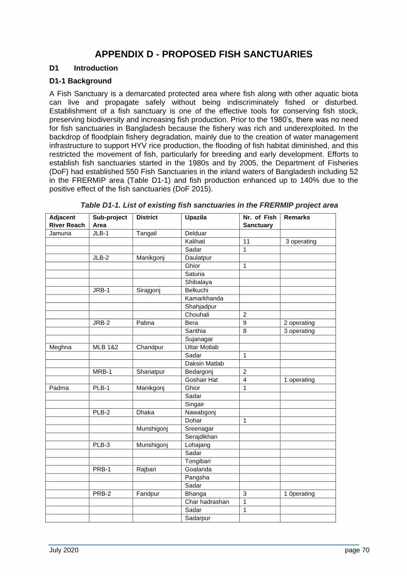
July 2020 page 70
APPENDIX D - PROPOSED FISH SANCTUARIES
D1 Introduction
D1-1 Background
A Fish Sanctuary is a demarcated protected area where fish along with other aquatic biota can live and propagate safely without being indiscriminately fished or disturbed. Establishment of a fish sanctuary is one of the effective tools for conserving fish stock, preserving biodiversity and increasing fish production. Prior to the 1980’s, there was no need for fish sanctuaries in Bangladesh because the fishery was rich and underexploited. In the backdrop of floodplain fishery degradation, mainly due to the creation of water management infrastructure to support HYV rice production, the flooding of fish habitat diminished, and this restricted the movement of fish, particularly for breeding and early development. Efforts to establish fish sanctuaries started in the 1980s and by 2005, the Department of Fisheries (DoF) had established 550 Fish Sanctuaries in the inland waters of Bangladesh including 52 in the FRERMIP area (Table D1-1) and fish production enhanced up to 140% due to the positive effect of the fish sanctuaries (DoF 2015).
Table D1-1. List of existing fish sanctuaries in the FRERMIP project area
Adjacent
River Reach
Sub-project
Area
District Upazila Nr. of Fish
Sanctuary
Remarks
Jamuna JLB-1 Tangail Delduar
Kalihati 11 3 operating
Sadar 1
JLB-2 Manikgonj Daulatpur
Ghior 1
Saturia
Shibalaya
JRB-1 Sirajgonj Belkuchi
Kamarkhanda
Shahjadpur
Chouhali 2
JRB-2 Pabna Bera 9 2 operating
Santhia 8 3 operating
Sujanagar
Meghna MLB 1&2 Chandpur Uttar Motlab
Sadar 1
Daksin Matlab
MRB-1 Shariatpur Bedargonj 2
Goshair Hat 4 1 operating
Padma PLB-1 Manikgonj Ghior 1
Sadar
Singair
PLB-2 Dhaka Nawabgonj
Dohar 1
Munshigonj Sreenagar
Serajdikhan
PLB-3 Munshigonj Lohajang
Sadar
Tongibari
PRB-1 Rajbari Goalanda
Pangsha
Sadar
PRB-2 Faridpur Bhanga 3 1 0perating
Char hadrashan 1
Sadar 1
Sadarpur
July 2020 page 71
PRB-3 Madaripur Shib char 6 1 operating
Total 52
Source: Fish Sanctuaries of Bangladesh, DoF 2015
Present status of fish sanctuaries in Bangladesh
A recent DoF report (2015, DoF) shows that there are 550 Fish Sanctuaries established in the floodplain and small rivers of the country besides the river areas declared as Fishing Ban Zones for conservation of breeding and early development of Hilsha (Tenulosa ilisha). Thus there are two basic types of aquatic sanctuaries in Bangladesh, i.e. (i) Floodplain Sanctuary mostly of 0.5-0.1 ha size with structural delimitations situated in the floodplain and small rivers, and (ii) River Sanctuary in the form of declared river area with a ban on fishing. Effort for establishment of such reserved areas in the rivers for Hilsha fishery started mostly in the 1990s when the Hilsha fishery declined significantly.
Also, there are such declared areas in the Sunderbans and adjacent rivers, i.e. about 30 km2 mainly for conservation of the Ganges River Dolphin including a ban on all sorts of fishing efforts in the area. Recent evaluation shows that fish production increased up to 140%, and fish diversity by about 10% due to establishment of these sanctuaries. Hilsha fishery has increased from 219,532 Ton in 2000 to 387,211 Ton in 2015, apparently due to the conservation measures taken. On the downside however, it appears that most floodplain fish sanctuaries are either non-existent, or non-operating, due to (i) poor establishment and (ii) ineffective management, while in the declared river fish ban area there is considerable indiscriminate fishing of Jatka.
D1-2 Importance of Fish Sanctuaries for FRERMIP
It is foreseen that FRERMIP interventions for river stabilization will have a substantial impact on fish habitats and production, and to mitigate this, various structural and non-structural mitigation measures are proposed, such as the establishment of Fish Sanctuaries in the river and in the floodplain of the project influence area. In the backdrop of foreseeable significant reduction and changes in the river fish habitat, loss of scope for fish migration to the floodplain due to limitation of river-floodplain connectivity and reduction of flooding of the floodplain, are all expected to result in the decrease of fish biodiversity and production. Establishment of fish sanctuaries will be a major management measure for mitigation of the fisheries impacts.
D1-3 Strategic plan for FRERMIP Fish Sanctuaries
River Fish Sanctuary
BOX-1 Present Status of River Fishing Prohibited Areas
The strip between Shatnol and Char Alexander in Meghna River; Shahbazpur channel of Meghna River; Tentulia River adjacent to Bhola district; and Andharmanik River near the Bay of Bengal were declared fish sanctuaries in 2003-2004. The other major sanctuary is located in Shariatpur district, in the estuary of Padma and Meghna Rivers; this place was given the status in 2010-2011.
These are called sanctuaries because catching fish in these places is prohibited during the two breeding seasons. For the Andharmanik sanctuary, the breeding season is November-January. For the remaining four, the season spans March-April. At present, the five sanctuaries cover a total riverine area of 350 km2; the upcoming one is about 60 km2 in size (Abu Naser, 2010)
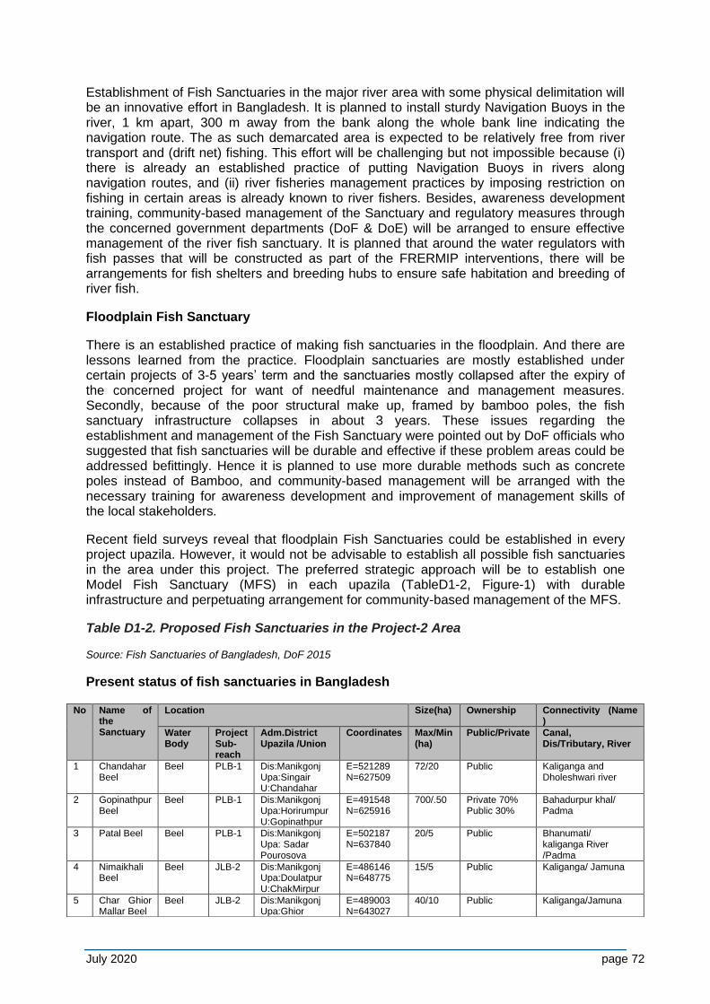
July 2020 page 72
Establishment of Fish Sanctuaries in the major river area with some physical delimitation will be an innovative effort in Bangladesh. It is planned to install sturdy Navigation Buoys in the river, 1 km apart, 300 m away from the bank along the whole bank line indicating the navigation route. The as such demarcated area is expected to be relatively free from river transport and (drift net) fishing. This effort will be challenging but not impossible because (i) there is already an established practice of putting Navigation Buoys in rivers along navigation routes, and (ii) river fisheries management practices by imposing restriction on fishing in certain areas is already known to river fishers. Besides, awareness development training, community-based management of the Sanctuary and regulatory measures through the concerned government departments (DoF & DoE) will be arranged to ensure effective management of the river fish sanctuary. It is planned that around the water regulators with fish passes that will be constructed as part of the FRERMIP interventions, there will be arrangements for fish shelters and breeding hubs to ensure safe habitation and breeding of river fish.
Floodplain Fish Sanctuary
There is an established practice of making fish sanctuaries in the floodplain. And there are lessons learned from the practice. Floodplain sanctuaries are mostly established under certain projects of 3-5 years’ term and the sanctuaries mostly collapsed after the expiry of the concerned project for want of needful maintenance and management measures. Secondly, because of the poor structural make up, framed by bamboo poles, the fish sanctuary infrastructure collapses in about 3 years. These issues regarding the establishment and management of the Fish Sanctuary were pointed out by DoF officials who suggested that fish sanctuaries will be durable and effective if these problem areas could be addressed befittingly. Hence it is planned to use more durable methods such as concrete poles instead of Bamboo, and community-based management will be arranged with the necessary training for awareness development and improvement of management skills of the local stakeholders.
Recent field surveys reveal that floodplain Fish Sanctuaries could be established in every project upazila. However, it would not be advisable to establish all possible fish sanctuaries in the area under this project. The preferred strategic approach will be to establish one Model Fish Sanctuary (MFS) in each upazila (TableD1-2, Figure-1) with durable infrastructure and perpetuating arrangement for community-based management of the MFS.
Table D1-2. Proposed Fish Sanctuaries in the Project-2 Area
Source: Fish Sanctuaries of Bangladesh, DoF 2015
Present status of fish sanctuaries in Bangladesh
No Name of the Sanctuary
Location Size(ha) Ownership Connectivity (Name )
Water Body
Project Sub-reach
Adm.District Upazila /Union
Coordinates Max/Min (ha)
Public/Private Canal, Dis/Tributary, River
1 Chandahar Beel
Beel PLB-1 Dis:Manikgonj Upa:Singair U:Chandahar
E=521289 N=627509
72/20
Public Kaliganga and Dholeshwari river
2 Gopinathpur Beel
Beel PLB-1 Dis:Manikgonj Upa:Horirumpur U:Gopinathpur
E=491548 N=625916
700/.50
Private 70% Public 30%
Bahadurpur khal/ Padma
3 Patal Beel Beel PLB-1 Dis:Manikgonj Upa: Sadar Pourosova
E=502187 N=637840
20/5 Public Bhanumati/ kaliganga River /Padma
4 Nimaikhali Beel
Beel JLB-2 Dis:Manikgonj Upa:Doulatpur U:ChakMirpur
E=486146 N=648775
15/5 Public Kaliganga/ Jamuna
5 Char Ghior Mallar Beel
Beel JLB-2 Dis:Manikgonj Upa:Ghior
E=489003 N=643027
40/10 Public Kaliganga/Jamuna
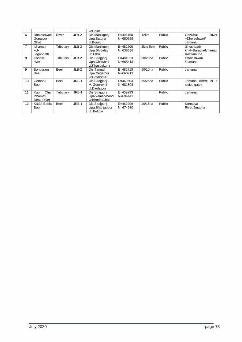
July 2020 page 73
U:Ghior
6 Dholeshwari Gopalpur Ghat
River JLB-2 Dis:Manikgonj Upa:Saturia U:Boraid
E=496158 N=650665
12km Public Gazikhali River +Dholeshwari/ Jamuna
7 Ichamati kol-Jagannath
Tributary JLB-2 Dis:Manikgonj Upa:Shibalay U: Uthuli
E=482200 N=638636
8km/3km Public Ghoshbarir khal+Baradia/Ichamati Kol/Jamuna
8 Kodalia river
Tributary JLB-2 Dis:Sirajgonj Upa:Chowhali U:Khaspukuria
E=481023 N=665413
60/20ha Public Dholeshwari /Jamuna
9 Bonogram Beel
Beel JLB-2 Dis:Tangail Upa:Nagarpur U:Goyahata
E=482718 N=663713
50/10ha Public Jamuna
10 Gomorki Beel
Beel JRB-1 Dis:Sirajgonj V: Gomrekhi U:Daulatpur
E=469603 N=681808
65/25ha Public Jamuna (there is a sluice gate)
11 Kutir Char Ichamati Dead River
Tributary JRB-1 Dis:Sirajgonj Upa:kamarkhand U:BhodraGhat
E=459293 N=694441
Public Jamuna
12 Kadai Badla Beel
Beel JRB-1 Dis:Sirajgonj Upa;Shahjadpur U: Beltola
E=462999 N=674980
40/15ha Public Korotoya River/Jmauna
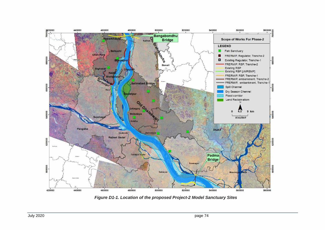
July 2020 page 74
Figure D1-1. Location of the proposed Project-2 Model Sanctuary Sites
July 2020 page 75
D1-4 Management of Fish Sanctuaries
Good management of the fish sanctuary is key to derive expected results. It is ascertained that the sanctuary established in the initial phases by the DoF ended in failure mainly due to lack of good management. Subsequently, community-based management measures were adopted with good results. So it is planned that community-based management will be ensured for the sanctuary with effective monitoring under joint supervision of BWDB and DoF. FRERMIP has a positive situation in this respect because the FRERMIP MFF is expected to be continued till 2023 with possibility of extension. So the project team will continue to monitor the management of the fish sanctuaries. It is believed that the community will be meanwhile adapted to good fish sanctuary management practices.
D1-5 Conclusion and Recommendations
It is foreseen that there will be potential impacts of the FRERMIP interventions on the fisheries sector and establishment of fish sanctuaries will be an effective mitigation measure for the impact. In the river area, potential fish habitats in the braided system and along the bankline will be lost and will be partially replenished by the proposed river sanctuaries which will also reduce possibilities for indiscriminate fishing. In the floodplain, anticipated fisheries loss due to the loss of connectivity by riverbank embankments impacting floodplain flooding and fish migration to and from the floodplain, will be partially covered by the added production expected due to the establishment of fish sanctuaries. Establishment of fish sanctuaries will be implemented by DoF as a works, with the financial assistance of BWDB/ADB.
D1-6 Selected Project-2 sites for Fish Sanctuaries
River Sanctuary: 100 km along the 100 km of left riverbank of Project-2 river area
▪ Navigation Buoys (NB): 100 for 100 km Tranche area @ 1 per km; @ USD 13,000 per NB = USD 1,300,000
▪ River fish Breeding Hub along the Regulator/Fish Pass: 9 locations near the regulators: 9 x $ 13,000 = $ 117,000
Floodplain Sanctuaries: 12 in 12 Upazilas
▪ Establishment of Floodplain Fish Sanctuaries: 12 sites in 12 upazilas @ USD 13,000/site= USD 156,000
▪ Re-excavation of canals: 12 x 5 km = 60 km @ $ 2/m3: $ 42,000/km, total $ 2,500,000
▪ Beel nurseries in 12 fish sanctuaries: $ 15,000
▪ Beel restocking in 12 fish sanctuaries: $ 15,000
Regulators with Fish Passes: 2 in JLB-1; 1 in other location tbd. Cost: $ 1 million/regulator, 35% of costs is for fish pass: $ 2 million x 0.35 = $ 700,000
Training in fish sanctuary management and sustainable production
Topics include awareness development; orientation; operation & maintenance; fisheries management; fish culture technology: 300 trainings in 3 years @ BDT 100,000/training = BDT 3 million = $ 375,000
Total cost = $ 7,628,000
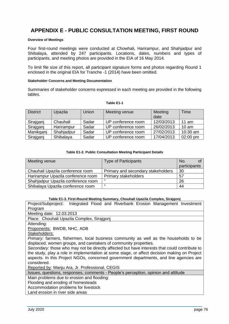
July 2020 page 76
APPENDIX E - PUBLIC CONSULTATION MEETING, FIRST ROUND
Overview of Meetings
Four first-round meetings were conducted at Chowhali, Harirampur, and Shahjadpur and Shibalaya, attended by 247 participants. Locations, dates, numbers and types of participants, and meeting photos are provided in the EIA of 16 May 2014.
To limit file size of this report, all participant signature forms and photos regarding Round 1 enclosed in the original EIA for Tranche -1 (2014) have been omitted.
Stakeholder Concerns and Meeting Documentation
Summaries of stakeholder concerns expressed in each meeting are provided in the following tables.
Table E1-1
District Upazila Union Meeting venue Meeting date
Time
Sirajganj Chauhali Sadar UP conference room 12/03/2013 11 am
Sirajganj Harirampur Sadar UP conference room 26/02/2013 10 am
Manikganj Shahjadpur Sadar UP conference room 27/02/2013 10:30 am
Sirajganj Shibalaya Sadar UP conference room 17/04/2013 02:00 pm
Table E1-2. Public Consultation Meeting Participant Details
Meeting venue Type of Participants No. of participants
Chauhali Upazila conference room Primary and secondary stakeholders 30
Harirampur Upazila conference room Primary stakeholders 57
Shahjadpur Upazila conference room " 26
Shibalaya Upazila conference room " 44
Table E1-3. First-Round Meeting Summary, Chouhali Upazila Complex, Sirajgonj Project/Subproject: Integrated Flood and Riverbank Erosion Management Investment Program
Meeting date: 12.03.2013
Place: Chouhali Upazila Complex, Sirajgonj
Attending: Proponents: BWDB, NHC, ADB Stakeholders: Primary: farmers, fishermen, local business community as well as the households to be displaced, women groups, and caretakers of community properties. Secondary: those who may not be directly affected but have interests that could contribute to the study, play a role in implementation at some stage, or affect decision making on Project aspects. In this Project NGOs, concerned government departments, and line agencies are considered. Reported by: Manju Ara, Jr. Professional, CEGIS
Issues, questions, responses, comments - People’s perception, opinion and attitude
Main problems due to erosion and flooding: Flooding and eroding of homesteads Accommodation problems for livestock Land erosion in river side areas
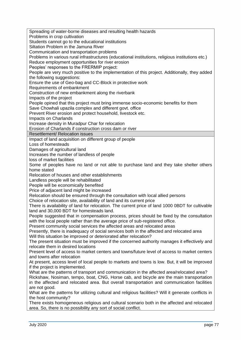
July 2020 page 77
Spreading of water-borne diseases and resulting health hazards Problems in crop cultivation Students cannot go to the educational institutions Siltation Problem in the Jamuna River Communication and transportation problems Problems in various rural infrastructures (educational institutions, religious institutions etc.) Reduce employment opportunities for river erosion Peoples’ responses to the FRERMIP project: People are very much positive to the implementation of this project. Additionally, they added the following suggestions: Ensure the use of Geo-bag and CC-Block in protective work Requirements of embankment Construction of new embankment along the riverbank Impacts of the project People opined that this project must bring immense socio-economic benefits for them Save Chowhali upazila complex and different govt. office Prevent River erosion and protect household, livestock etc. Impacts on Charlands Increase density in Muradpur Char for relocation Erosion of Charlands if construction cross dam or river
Resettlement/ Relocation issues
Impact of land acquisition on different group of people Loss of homesteads Damages of agricultural land Increases the number of landless of people loss of market facilities Some of peoples have no land or not able to purchase land and they take shelter others home stated Relocation of houses and other establishments Landless people will be rehabilitated People will be economically benefited Price of adjacent land might be increased Relocation should be ensured through the consultation with local allied persons Choice of relocation site, availability of land and its current price There is availability of land for relocation. The current price of land 1000 0BDT for cultivable land and 30,000 BDT for homesteads land. People suggested that in compensation process, prices should be fixed by the consultation with the local people rather than the average price of sub-registered office. Present community social services the affected areas and relocated areas Presently, there is inadequacy of social services both in the affected and relocated area Will this situation be improved or deteriorated after relocation? The present situation must be improved if the concerned authority manages it effectively and relocate them in desired locations Present level of access to market centers and towns/future level of access to market centers and towns after relocation At present, access level of local people to markets and towns is low. But, it will be improved if the project is implemented. What are the patterns of transport and communication in the affected area/relocated area? Rickshaw, Nosiman, tempo, boat, CNG, Horse cab, and bicycle are the main transportation in the affected and relocated area. But overall transportation and communication facilities are not good. What are the patterns for utilizing cultural and religious facilities? Will it generate conflicts in the host community? There exists homogeneous religious and cultural scenario both in the affected and relocated area. So, there is no possibility any sort of social conflict.
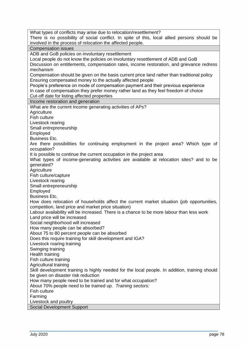
July 2020 page 78
What types of conflicts may arise due to relocation/resettlement? There is no possibility of social conflict. In spite of this, local allied persons should be involved in the process of relocation the affected people.
Compensation issues
ADB and GoB policies on involuntary resettlement Local people do not know the policies on involuntary resettlement of ADB and GoB Discussion on entitlements, compensation rates, income restoration, and grievance redress mechanism Compensation should be given on the basis current price land rather than traditional policy Ensuring compensated money to the actually affected people People’s preference on mode of compensation payment and their previous experience In case of compensation they prefer money rather land as they feel freedom of choice Cut-off date for listing affected properties
Income restoration and generation
What are the current income generating activities of APs? Agriculture Fish culture Livestock rearing Small entrepreneurship Employed Business Etc. Are there possibilities for continuing employment in the project area? Which type of occupation? It is possible to continue the current occupation in the project area What types of income-generating activities are available at relocation sites? and to be generated? Agriculture Fish culture/capture Livestock rearing Small entrepreneurship Employed Business Etc. How does relocation of households affect the current market situation (job opportunities, competition, land price and market price situation) Labour availability will be increased. There is a chance to be more labour than less work Land price will be increased Social neighborhood will increased How many people can be absorbed? About 75 to 80 percent people can be absorbed Does this require training for skill development and IGA? Livestock roaring training Swinging training Health training Fish culture training Agricultural training Skill development training is highly needed for the local people. In addition, training should be given on disaster risk reduction How many people need to be trained and for what occupation? About 70% people need to be trained up. Training sectors: Fish culture Farming Livestock and poultry
Social Development Support
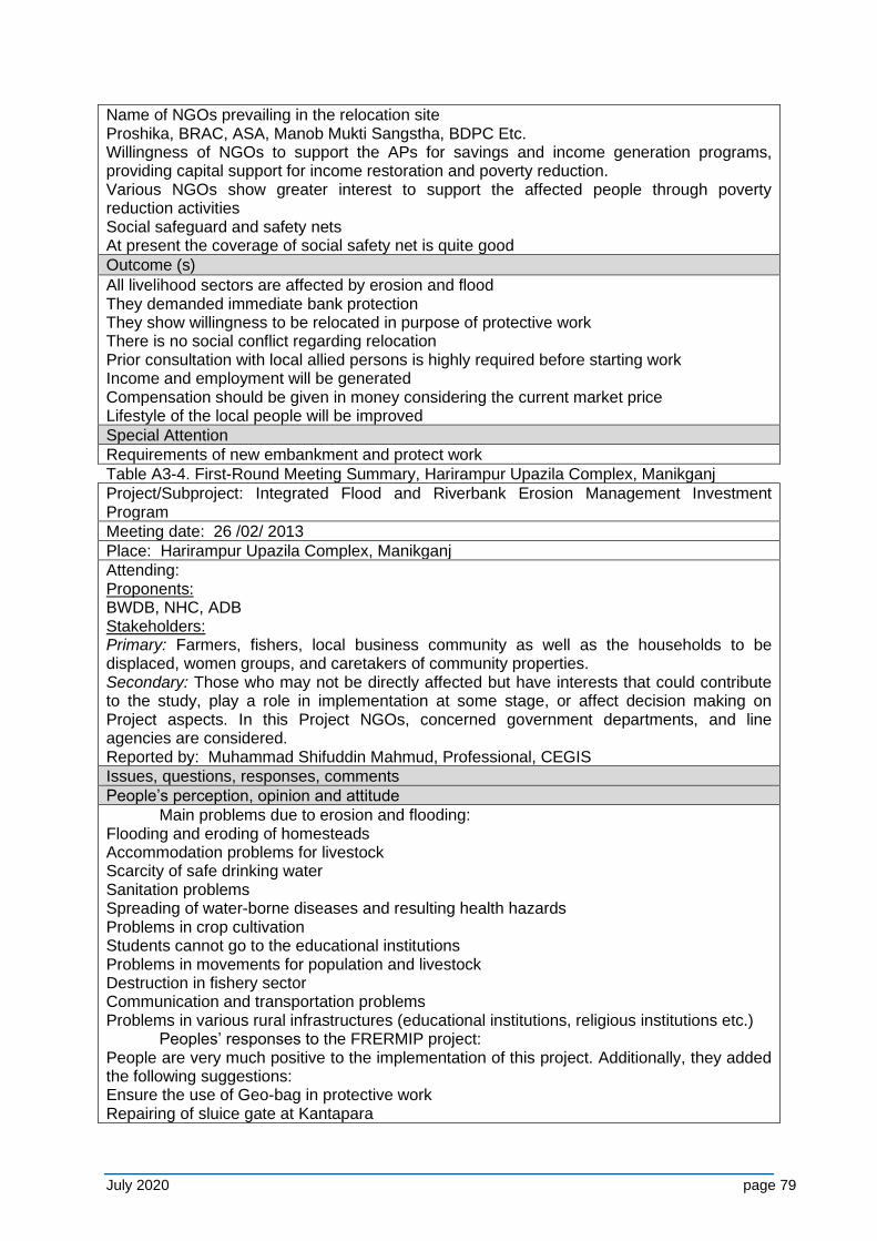
July 2020 page 79
Name of NGOs prevailing in the relocation site Proshika, BRAC, ASA, Manob Mukti Sangstha, BDPC Etc. Willingness of NGOs to support the APs for savings and income generation programs, providing capital support for income restoration and poverty reduction. Various NGOs show greater interest to support the affected people through poverty reduction activities Social safeguard and safety nets At present the coverage of social safety net is quite good
Outcome (s)
All livelihood sectors are affected by erosion and flood They demanded immediate bank protection They show willingness to be relocated in purpose of protective work There is no social conflict regarding relocation Prior consultation with local allied persons is highly required before starting work Income and employment will be generated Compensation should be given in money considering the current market price Lifestyle of the local people will be improved
Special Attention
Requirements of new embankment and protect work
Table A3-4. First-Round Meeting Summary, Harirampur Upazila Complex, Manikganj
Project/Subproject: Integrated Flood and Riverbank Erosion Management Investment Program
Meeting date: 26 /02/ 2013
Place: Harirampur Upazila Complex, Manikganj
Attending: Proponents: BWDB, NHC, ADB Stakeholders: Primary: Farmers, fishers, local business community as well as the households to be displaced, women groups, and caretakers of community properties. Secondary: Those who may not be directly affected but have interests that could contribute to the study, play a role in implementation at some stage, or affect decision making on Project aspects. In this Project NGOs, concerned government departments, and line agencies are considered. Reported by: Muhammad Shifuddin Mahmud, Professional, CEGIS
Issues, questions, responses, comments
People’s perception, opinion and attitude
Main problems due to erosion and flooding: Flooding and eroding of homesteads Accommodation problems for livestock Scarcity of safe drinking water Sanitation problems Spreading of water-borne diseases and resulting health hazards Problems in crop cultivation Students cannot go to the educational institutions Problems in movements for population and livestock Destruction in fishery sector Communication and transportation problems Problems in various rural infrastructures (educational institutions, religious institutions etc.) Peoples’ responses to the FRERMIP project: People are very much positive to the implementation of this project. Additionally, they added the following suggestions: Ensure the use of Geo-bag in protective work Repairing of sluice gate at Kantapara
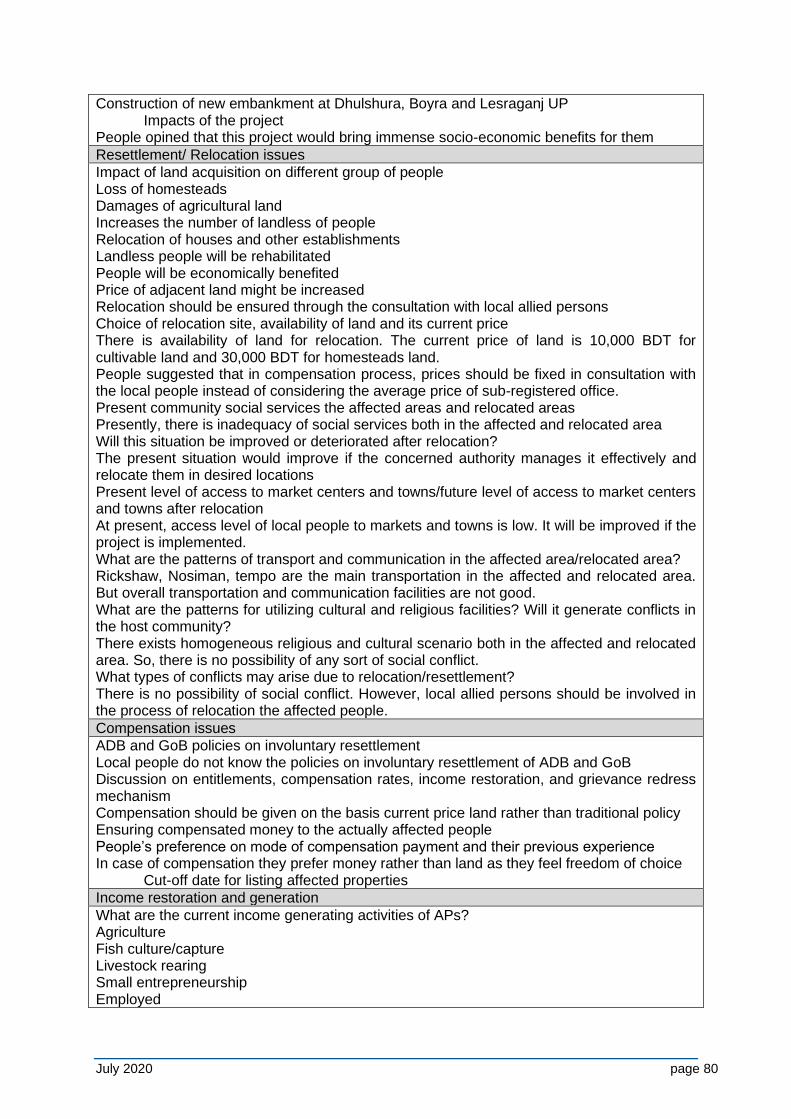
July 2020 page 80
Construction of new embankment at Dhulshura, Boyra and Lesraganj UP Impacts of the project People opined that this project would bring immense socio-economic benefits for them
Resettlement/ Relocation issues
Impact of land acquisition on different group of people Loss of homesteads Damages of agricultural land Increases the number of landless of people Relocation of houses and other establishments Landless people will be rehabilitated People will be economically benefited Price of adjacent land might be increased Relocation should be ensured through the consultation with local allied persons Choice of relocation site, availability of land and its current price There is availability of land for relocation. The current price of land is 10,000 BDT for cultivable land and 30,000 BDT for homesteads land. People suggested that in compensation process, prices should be fixed in consultation with the local people instead of considering the average price of sub-registered office. Present community social services the affected areas and relocated areas Presently, there is inadequacy of social services both in the affected and relocated area Will this situation be improved or deteriorated after relocation? The present situation would improve if the concerned authority manages it effectively and relocate them in desired locations Present level of access to market centers and towns/future level of access to market centers and towns after relocation At present, access level of local people to markets and towns is low. It will be improved if the project is implemented. What are the patterns of transport and communication in the affected area/relocated area? Rickshaw, Nosiman, tempo are the main transportation in the affected and relocated area. But overall transportation and communication facilities are not good. What are the patterns for utilizing cultural and religious facilities? Will it generate conflicts in the host community? There exists homogeneous religious and cultural scenario both in the affected and relocated area. So, there is no possibility of any sort of social conflict. What types of conflicts may arise due to relocation/resettlement? There is no possibility of social conflict. However, local allied persons should be involved in the process of relocation the affected people.
Compensation issues
ADB and GoB policies on involuntary resettlement Local people do not know the policies on involuntary resettlement of ADB and GoB Discussion on entitlements, compensation rates, income restoration, and grievance redress mechanism Compensation should be given on the basis current price land rather than traditional policy Ensuring compensated money to the actually affected people People’s preference on mode of compensation payment and their previous experience In case of compensation they prefer money rather than land as they feel freedom of choice Cut-off date for listing affected properties
Income restoration and generation
What are the current income generating activities of APs? Agriculture Fish culture/capture Livestock rearing Small entrepreneurship Employed
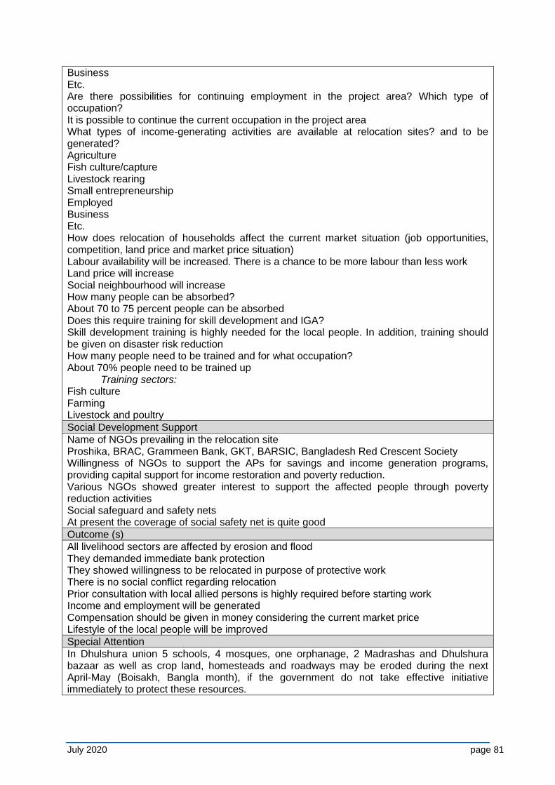
July 2020 page 81
Business Etc. Are there possibilities for continuing employment in the project area? Which type of occupation? It is possible to continue the current occupation in the project area What types of income-generating activities are available at relocation sites? and to be generated? Agriculture Fish culture/capture Livestock rearing Small entrepreneurship Employed Business Etc. How does relocation of households affect the current market situation (job opportunities, competition, land price and market price situation) Labour availability will be increased. There is a chance to be more labour than less work Land price will increase Social neighbourhood will increase How many people can be absorbed? About 70 to 75 percent people can be absorbed Does this require training for skill development and IGA? Skill development training is highly needed for the local people. In addition, training should be given on disaster risk reduction How many people need to be trained and for what occupation? About 70% people need to be trained up Training sectors: Fish culture Farming Livestock and poultry
Social Development Support
Name of NGOs prevailing in the relocation site Proshika, BRAC, Grammeen Bank, GKT, BARSIC, Bangladesh Red Crescent Society Willingness of NGOs to support the APs for savings and income generation programs, providing capital support for income restoration and poverty reduction. Various NGOs showed greater interest to support the affected people through poverty reduction activities Social safeguard and safety nets At present the coverage of social safety net is quite good
Outcome (s)
All livelihood sectors are affected by erosion and flood They demanded immediate bank protection They showed willingness to be relocated in purpose of protective work There is no social conflict regarding relocation Prior consultation with local allied persons is highly required before starting work Income and employment will be generated Compensation should be given in money considering the current market price Lifestyle of the local people will be improved
Special Attention
In Dhulshura union 5 schools, 4 mosques, one orphanage, 2 Madrashas and Dhulshura bazaar as well as crop land, homesteads and roadways may be eroded during the next April-May (Boisakh, Bangla month), if the government do not take effective initiative immediately to protect these resources.
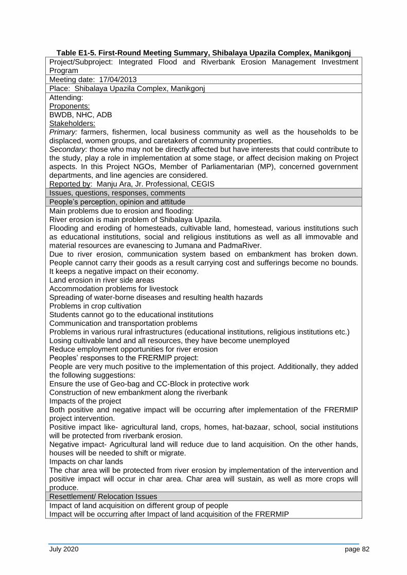
July 2020 page 82
Table E1-5. First-Round Meeting Summary, Shibalaya Upazila Complex, Manikgonj
Project/Subproject: Integrated Flood and Riverbank Erosion Management Investment Program
Meeting date: 17/04/2013
Place: Shibalaya Upazila Complex, Manikgonj
Attending: Proponents: BWDB, NHC, ADB Stakeholders: Primary: farmers, fishermen, local business community as well as the households to be displaced, women groups, and caretakers of community properties. Secondary: those who may not be directly affected but have interests that could contribute to the study, play a role in implementation at some stage, or affect decision making on Project aspects. In this Project NGOs, Member of Parliamentarian (MP), concerned government departments, and line agencies are considered. Reported by: Manju Ara, Jr. Professional, CEGIS
Issues, questions, responses, comments
People’s perception, opinion and attitude
Main problems due to erosion and flooding: River erosion is main problem of Shibalaya Upazila. Flooding and eroding of homesteads, cultivable land, homestead, various institutions such as educational institutions, social and religious institutions as well as all immovable and material resources are evanescing to Jumana and PadmaRiver. Due to river erosion, communication system based on embankment has broken down. People cannot carry their goods as a result carrying cost and sufferings become no bounds. It keeps a negative impact on their economy. Land erosion in river side areas Accommodation problems for livestock Spreading of water-borne diseases and resulting health hazards Problems in crop cultivation Students cannot go to the educational institutions Communication and transportation problems Problems in various rural infrastructures (educational institutions, religious institutions etc.) Losing cultivable land and all resources, they have become unemployed Reduce employment opportunities for river erosion Peoples’ responses to the FRERMIP project: People are very much positive to the implementation of this project. Additionally, they added the following suggestions: Ensure the use of Geo-bag and CC-Block in protective work Construction of new embankment along the riverbank Impacts of the project Both positive and negative impact will be occurring after implementation of the FRERMIP project intervention. Positive impact like- agricultural land, crops, homes, hat-bazaar, school, social institutions will be protected from riverbank erosion. Negative impact- Agricultural land will reduce due to land acquisition. On the other hands, houses will be needed to shift or migrate. Impacts on char lands The char area will be protected from river erosion by implementation of the intervention and positive impact will occur in char area. Char area will sustain, as well as more crops will produce. Resettlement/ Relocation Issues
Impact of land acquisition on different group of people Impact will be occurring after Impact of land acquisition of the FRERMIP
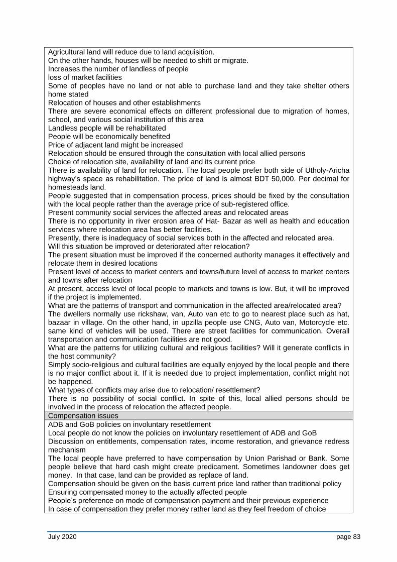
July 2020 page 83
Agricultural land will reduce due to land acquisition. On the other hands, houses will be needed to shift or migrate. Increases the number of landless of people loss of market facilities Some of peoples have no land or not able to purchase land and they take shelter others home stated Relocation of houses and other establishments There are severe economical effects on different professional due to migration of homes, school, and various social institution of this area Landless people will be rehabilitated People will be economically benefited Price of adjacent land might be increased Relocation should be ensured through the consultation with local allied persons Choice of relocation site, availability of land and its current price There is availability of land for relocation. The local people prefer both side of Utholy-Aricha highway’s space as rehabilitation. The price of land is almost BDT 50,000. Per decimal for homesteads land. People suggested that in compensation process, prices should be fixed by the consultation with the local people rather than the average price of sub-registered office. Present community social services the affected areas and relocated areas There is no opportunity in river erosion area of Hat- Bazar as well as health and education services where relocation area has better facilities. Presently, there is inadequacy of social services both in the affected and relocated area. Will this situation be improved or deteriorated after relocation? The present situation must be improved if the concerned authority manages it effectively and relocate them in desired locations Present level of access to market centers and towns/future level of access to market centers and towns after relocation At present, access level of local people to markets and towns is low. But, it will be improved if the project is implemented. What are the patterns of transport and communication in the affected area/relocated area? The dwellers normally use rickshaw, van, Auto van etc to go to nearest place such as hat, bazaar in village. On the other hand, in upzilla people use CNG, Auto van, Motorcycle etc. same kind of vehicles will be used. There are street facilities for communication. Overall transportation and communication facilities are not good. What are the patterns for utilizing cultural and religious facilities? Will it generate conflicts in the host community? Simply socio-religious and cultural facilities are equally enjoyed by the local people and there is no major conflict about it. If it is needed due to project implementation, conflict might not be happened. What types of conflicts may arise due to relocation/ resettlement? There is no possibility of social conflict. In spite of this, local allied persons should be involved in the process of relocation the affected people. Compensation issues
ADB and GoB policies on involuntary resettlement Local people do not know the policies on involuntary resettlement of ADB and GoB Discussion on entitlements, compensation rates, income restoration, and grievance redress mechanism The local people have preferred to have compensation by Union Parishad or Bank. Some people believe that hard cash might create predicament. Sometimes landowner does get money. In that case, land can be provided as replace of land. Compensation should be given on the basis current price land rather than traditional policy Ensuring compensated money to the actually affected people People’s preference on mode of compensation payment and their previous experience In case of compensation they prefer money rather land as they feel freedom of choice
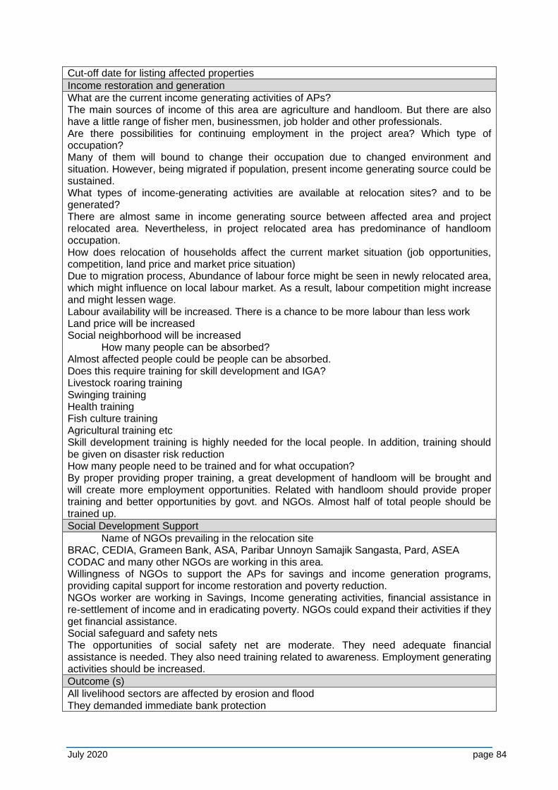
July 2020 page 84
Cut-off date for listing affected properties
Income restoration and generation
What are the current income generating activities of APs? The main sources of income of this area are agriculture and handloom. But there are also have a little range of fisher men, businessmen, job holder and other professionals. Are there possibilities for continuing employment in the project area? Which type of occupation? Many of them will bound to change their occupation due to changed environment and situation. However, being migrated if population, present income generating source could be sustained. What types of income-generating activities are available at relocation sites? and to be generated? There are almost same in income generating source between affected area and project relocated area. Nevertheless, in project relocated area has predominance of handloom occupation. How does relocation of households affect the current market situation (job opportunities, competition, land price and market price situation) Due to migration process, Abundance of labour force might be seen in newly relocated area, which might influence on local labour market. As a result, labour competition might increase and might lessen wage. Labour availability will be increased. There is a chance to be more labour than less work Land price will be increased Social neighborhood will be increased How many people can be absorbed? Almost affected people could be people can be absorbed. Does this require training for skill development and IGA? Livestock roaring training Swinging training Health training Fish culture training Agricultural training etc Skill development training is highly needed for the local people. In addition, training should be given on disaster risk reduction How many people need to be trained and for what occupation? By proper providing proper training, a great development of handloom will be brought and will create more employment opportunities. Related with handloom should provide proper training and better opportunities by govt. and NGOs. Almost half of total people should be trained up.
Social Development Support
Name of NGOs prevailing in the relocation site BRAC, CEDIA, Grameen Bank, ASA, Paribar Unnoyn Samajik Sangasta, Pard, ASEA CODAC and many other NGOs are working in this area. Willingness of NGOs to support the APs for savings and income generation programs, providing capital support for income restoration and poverty reduction. NGOs worker are working in Savings, Income generating activities, financial assistance in re-settlement of income and in eradicating poverty. NGOs could expand their activities if they get financial assistance. Social safeguard and safety nets The opportunities of social safety net are moderate. They need adequate financial assistance is needed. They also need training related to awareness. Employment generating activities should be increased.
Outcome (s)
All livelihood sectors are affected by erosion and flood They demanded immediate bank protection
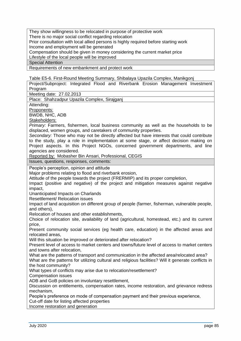
July 2020 page 85
They show willingness to be relocated in purpose of protective work There is no major social conflict regarding relocation Prior consultation with local allied persons is highly required before starting work Income and employment will be generated Compensation should be given in money considering the current market price Lifestyle of the local people will be improved
Special Attention
Requirements of new embankment and protect work
Table E5-6. First-Round Meeting Summary, Shibalaya Upazila Complex, Manikgonj
Project/Subproject: Integrated Flood and Riverbank Erosion Management Investment Program
Meeting date: 27.02.2013
Place: Shahzadpur Upazila Complex, Sirajganj
Attending: Proponents: BWDB, NHC, ADB Stakeholders: Primary: Farmers, fishermen, local business community as well as the households to be displaced, women groups, and caretakers of community properties. Secondary: Those who may not be directly affected but have interests that could contribute to the study, play a role in implementation at some stage, or affect decision making on Project aspects. In this Project NGOs, concerned government departments, and line agencies are considered. Reported by: Mobasher Bin Ansari, Professional, CEGIS
Issues, questions, responses, comments:
People’s perception, opinion and attitude Major problems relating to flood and riverbank erosion, Attitude of the people towards the project (FRERMIP) and its proper completion, Impact (positive and negative) of the project and mitigation measures against negative impact, Unanticipated Impacts on Charlands Resettlement/ Relocation issues Impact of land acquisition on different group of people (farmer, fisherman, vulnerable people, and others), Relocation of houses and other establishments, Choice of relocation site, availability of land (agricultural, homestead, etc.) and its current price, Present community social services (eg health care, education) in the affected areas and relocated areas, Will this situation be improved or deteriorated after relocation? Present level of access to market centers and towns/future level of access to market centers and towns after relocation, What are the patterns of transport and communication in the affected area/relocated area? What are the patterns for utilizing cultural and religious facilities? Will it generate conflicts in the host community? What types of conflicts may arise due to relocation/resettlement? Compensation issues ADB and GoB policies on involuntary resettlement, Discussion on entitlements, compensation rates, income restoration, and grievance redress mechanism, People’s preference on mode of compensation payment and their previous experience, Cut-off date for listing affected properties Income restoration and generation
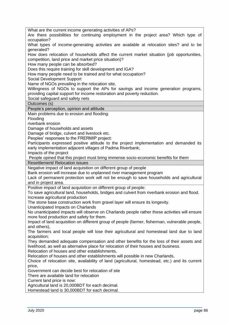
July 2020 page 86
What are the current income generating activities of APs? Are there possibilities for continuing employment in the project area? Which type of occupation? What types of income-generating activities are available at relocation sites? and to be generated? How does relocation of households affect the current market situation (job opportunities, competition, land price and market price situation)? How many people can be absorbed? Does this require training for skill development and IGA? How many people need to be trained and for what occupation? Social Development Support Name of NGOs prevailing in the relocation site, Willingness of NGOs to support the APs for savings and income generation programs, providing capital support for income restoration and poverty reduction. Social safeguard and safety nets
Outcomes (s)
People’s perception, opinion and attitude
Main problems due to erosion and flooding: Flooding riverbank erosion Damage of households and assets Damage of bridge, culvert and livestock etc. Peoples’ responses to the FRERMIP project: Participants expressed positive attitude to the project implementation and demanded its early implementation adjacent villages of Padma Riverbank; Impacts of the project People opined that this project must bring immense socio-economic benefits for them
Resettlement/ Relocation issues
Negative impact of land acquisition on different group of people Bank erosion will increase due to unplanned river management program Lack of permanent protection work will not be enough to save households and agricultural and in project area.
Positive impact of land acquisition on different group of people: To save agricultural land, households, bridges and culvert from riverbank erosion and flood. Increase agricultural production The stone base construction work from gravel layer will ensure its longevity. Unanticipated Impacts on Charlands No unanticipated impacts will observe on Charlands people rather these activities will ensure more food production and safety for them. Impact of land acquisition on different group of people (farmer, fisherman, vulnerable people, and others), The farmers and local people will lose their agricultural and homestead land due to land acquisition; They demanded adequate compensation and other benefits for the loss of their assets and livelihood, as well as alternative place for relocation of their houses and business. Relocation of houses and other establishments, Relocation of houses and other establishments will possible in new Charlands, Choice of relocation site, availability of land (agricultural, homestead, etc.) and its current price, Government can decide best for relocation of site There are available land for relocation Current land price is now: Agricultural land is 20,000BDT for each decimal. Homestead land is 30,000BDT for each decimal.
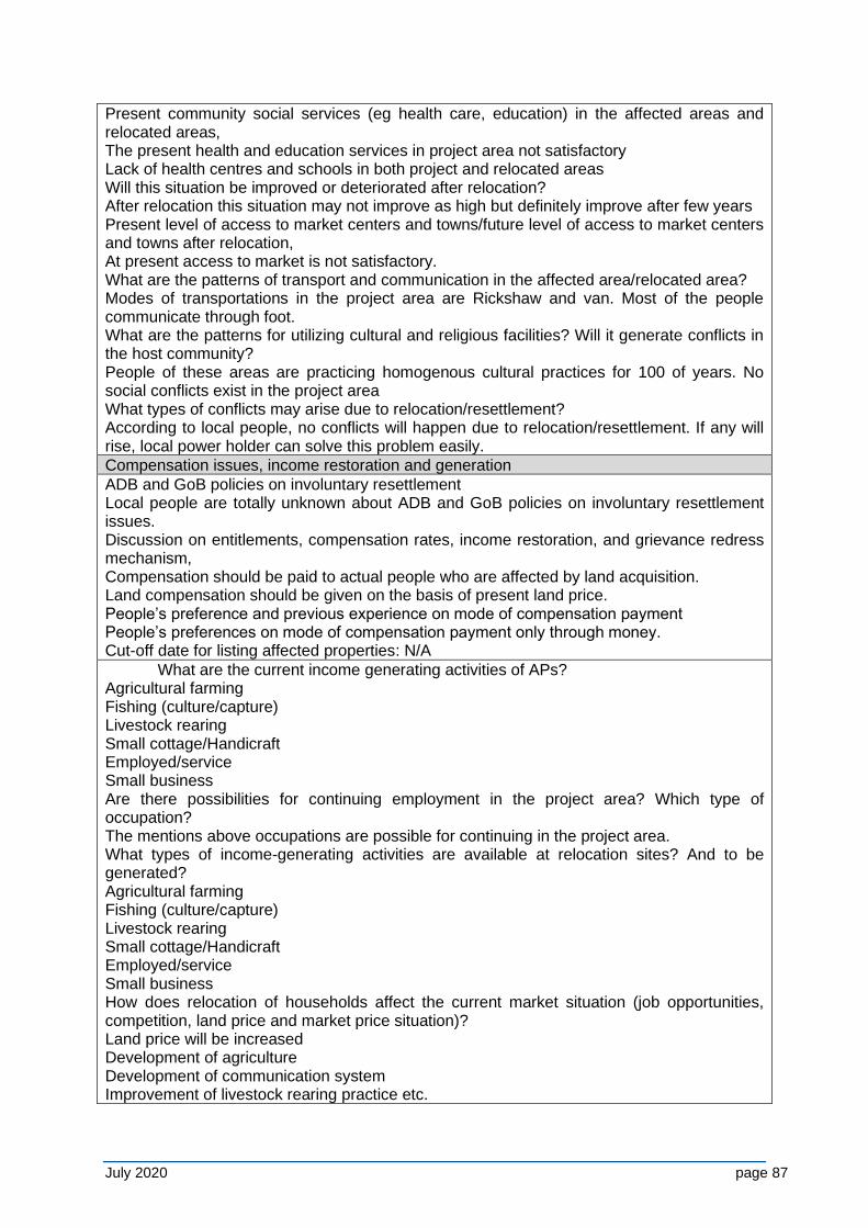
July 2020 page 87
Present community social services (eg health care, education) in the affected areas and relocated areas, The present health and education services in project area not satisfactory Lack of health centres and schools in both project and relocated areas Will this situation be improved or deteriorated after relocation? After relocation this situation may not improve as high but definitely improve after few years Present level of access to market centers and towns/future level of access to market centers and towns after relocation, At present access to market is not satisfactory. What are the patterns of transport and communication in the affected area/relocated area? Modes of transportations in the project area are Rickshaw and van. Most of the people communicate through foot. What are the patterns for utilizing cultural and religious facilities? Will it generate conflicts in the host community? People of these areas are practicing homogenous cultural practices for 100 of years. No social conflicts exist in the project area What types of conflicts may arise due to relocation/resettlement? According to local people, no conflicts will happen due to relocation/resettlement. If any will rise, local power holder can solve this problem easily.
Compensation issues, income restoration and generation
ADB and GoB policies on involuntary resettlement Local people are totally unknown about ADB and GoB policies on involuntary resettlement issues. Discussion on entitlements, compensation rates, income restoration, and grievance redress mechanism, Compensation should be paid to actual people who are affected by land acquisition. Land compensation should be given on the basis of present land price. People’s preference and previous experience on mode of compensation payment People’s preferences on mode of compensation payment only through money. Cut-off date for listing affected properties: N/A
What are the current income generating activities of APs? Agricultural farming Fishing (culture/capture) Livestock rearing Small cottage/Handicraft Employed/service Small business Are there possibilities for continuing employment in the project area? Which type of occupation? The mentions above occupations are possible for continuing in the project area. What types of income-generating activities are available at relocation sites? And to be generated? Agricultural farming Fishing (culture/capture) Livestock rearing Small cottage/Handicraft Employed/service Small business How does relocation of households affect the current market situation (job opportunities, competition, land price and market price situation)? Land price will be increased Development of agriculture Development of communication system Improvement of livestock rearing practice etc.
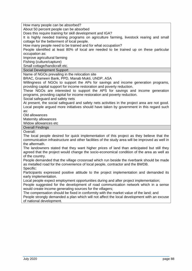
July 2020 page 88
How many people can be absorbed? About 50 percent people can be absorbed Does this require training for skill development and IGA? It is highly needed training programs on agriculture farming, livestock rearing and small cottage for the betterment of local people. How many people need to be trained and for what occupation? People identified at least 80% of local are needed to be trained up on these particular occupation as: Improve agricultural farming Fishing (culture/capture) Small cottage/handicraft etc.
Social Development Support
Name of NGOs prevailing in the relocation site BRAC, Grameen Bank, PPD, Manab Mukti, UNDP, ASA Willingness of NGOs to support the APs for savings and income generation programs, providing capital support for income restoration and poverty reduction. These NGOs are interested to support the APS for savings and income generation programs, providing capital for income restoration and poverty reduction. Social safeguard and safety nets At present, the social safeguard and safety nets activities in the project area are not good. Local people argued more initiatives should have taken by government in this regard such as: Old allowances Maternity allowances Widow allowances etc
Overall Findings
Overall: The local people desired for quick implementation of this project as they believe that the communication infrastructure and other facilities of the study area will be improved as well in the aftermath. The landowners stated that they want higher prices of land than anticipated but still they agreed that the project would change the socio-economical condition of the area as well as of the country. People demanded that the village crossroad which run beside the riverbank should be made as metalled road for the convenience of local people, contractor and the BWDB. Specific: Participants expressed positive attitude to the project implementation and demanded its early implementation. Local people expect employment opportunities during and after project implementation; People suggested for the development of road communication network which in a sense would create income generating sources for the villagers; The compensation should be fixed in conformity with the market value of the land; and People strongly demanded a plan which will not affect the local development with an excuse of national development.
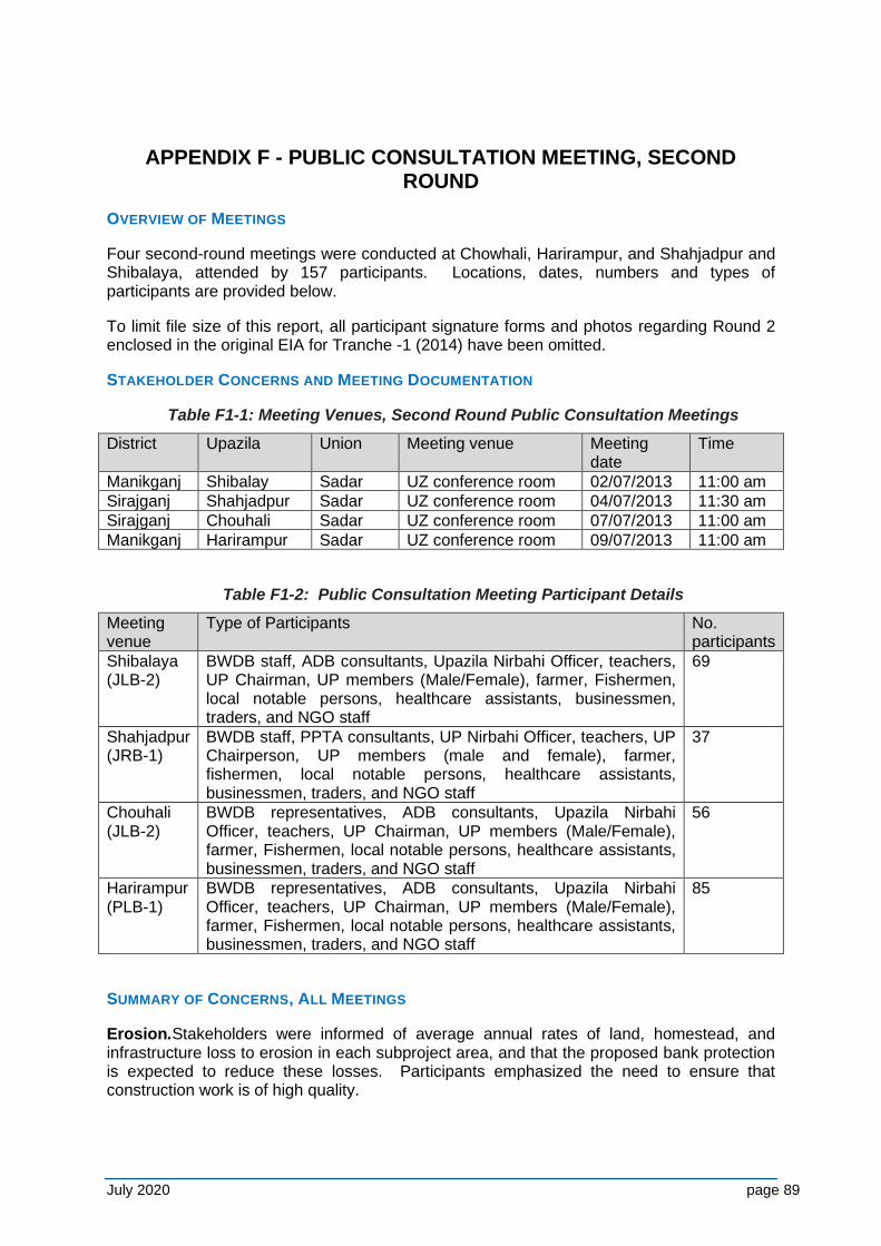
July 2020 page 89
APPENDIX F - PUBLIC CONSULTATION MEETING, SECOND ROUND
OVERVIEW OF MEETINGS
Four second-round meetings were conducted at Chowhali, Harirampur, and Shahjadpur and Shibalaya, attended by 157 participants. Locations, dates, numbers and types of participants are provided below.
To limit file size of this report, all participant signature forms and photos regarding Round 2 enclosed in the original EIA for Tranche -1 (2014) have been omitted.
STAKEHOLDER CONCERNS AND MEETING DOCUMENTATION
Table F1-1: Meeting Venues, Second Round Public Consultation Meetings
District Upazila Union Meeting venue Meeting date
Time
Manikganj Shibalay Sadar UZ conference room 02/07/2013 11:00 am
Sirajganj Shahjadpur Sadar UZ conference room 04/07/2013 11:30 am
Sirajganj Chouhali Sadar UZ conference room 07/07/2013 11:00 am
Manikganj Harirampur Sadar UZ conference room 09/07/2013 11:00 am
Table F1-2: Public Consultation Meeting Participant Details
Meeting venue
Type of Participants No. participants
Shibalaya (JLB-2)
BWDB staff, ADB consultants, Upazila Nirbahi Officer, teachers, UP Chairman, UP members (Male/Female), farmer, Fishermen, local notable persons, healthcare assistants, businessmen, traders, and NGO staff
69
Shahjadpur (JRB-1)
BWDB staff, PPTA consultants, UP Nirbahi Officer, teachers, UP Chairperson, UP members (male and female), farmer, fishermen, local notable persons, healthcare assistants, businessmen, traders, and NGO staff
37
Chouhali (JLB-2)
BWDB representatives, ADB consultants, Upazila Nirbahi Officer, teachers, UP Chairman, UP members (Male/Female), farmer, Fishermen, local notable persons, healthcare assistants, businessmen, traders, and NGO staff
56
Harirampur (PLB-1)
BWDB representatives, ADB consultants, Upazila Nirbahi Officer, teachers, UP Chairman, UP members (Male/Female), farmer, Fishermen, local notable persons, healthcare assistants, businessmen, traders, and NGO staff
85
SUMMARY OF CONCERNS, ALL MEETINGS
Erosion.Stakeholders were informed of average annual rates of land, homestead, and infrastructure loss to erosion in each subproject area, and that the proposed bank protection is expected to reduce these losses. Participants emphasized the need to ensure that construction work is of high quality.
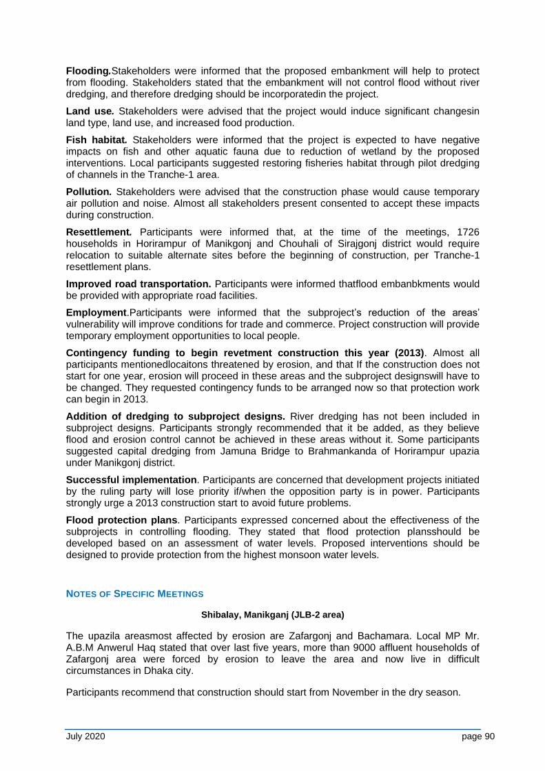
July 2020 page 90
Flooding.Stakeholders were informed that the proposed embankment will help to protect from flooding. Stakeholders stated that the embankment will not control flood without river dredging, and therefore dredging should be incorporatedin the project.
Land use. Stakeholders were advised that the project would induce significant changesin land type, land use, and increased food production.
Fish habitat. Stakeholders were informed that the project is expected to have negative impacts on fish and other aquatic fauna due to reduction of wetland by the proposed interventions. Local participants suggested restoring fisheries habitat through pilot dredging of channels in the Tranche-1 area.
Pollution. Stakeholders were advised that the construction phase would cause temporary air pollution and noise. Almost all stakeholders present consented to accept these impacts during construction.
Resettlement. Participants were informed that, at the time of the meetings, 1726 households in Horirampur of Manikgonj and Chouhali of Sirajgonj district would require relocation to suitable alternate sites before the beginning of construction, per Tranche-1 resettlement plans.
Improved road transportation. Participants were informed thatflood embanbkments would be provided with appropriate road facilities.
Employment.Participants were informed that the subproject’s reduction of the areas’ vulnerability will improve conditions for trade and commerce. Project construction will provide temporary employment opportunities to local people.
Contingency funding to begin revetment construction this year (2013). Almost all participants mentionedlocaitons threatened by erosion, and that If the construction does not start for one year, erosion will proceed in these areas and the subproject designswill have to be changed. They requested contingency funds to be arranged now so that protection work can begin in 2013.
Addition of dredging to subproject designs. River dredging has not been included in subproject designs. Participants strongly recommended that it be added, as they believe flood and erosion control cannot be achieved in these areas without it. Some participants suggested capital dredging from Jamuna Bridge to Brahmankanda of Horirampur upazia under Manikgonj district.
Successful implementation. Participants are concerned that development projects initiated by the ruling party will lose priority if/when the opposition party is in power. Participants strongly urge a 2013 construction start to avoid future problems.
Flood protection plans. Participants expressed concerned about the effectiveness of the subprojects in controlling flooding. They stated that flood protection plansshould be developed based on an assessment of water levels. Proposed interventions should be designed to provide protection from the highest monsoon water levels.
NOTES OF SPECIFIC MEETINGS
Shibalay, Manikganj (JLB-2 area)
The upazila areasmost affected by erosion are Zafargonj and Bachamara. Local MP Mr. A.B.M Anwerul Haq stated that over last five years, more than 9000 affluent households of Zafargonj area were forced by erosion to leave the area and now live in difficult circumstances in Dhaka city.
Participants recommend that construction should start from November in the dry season.
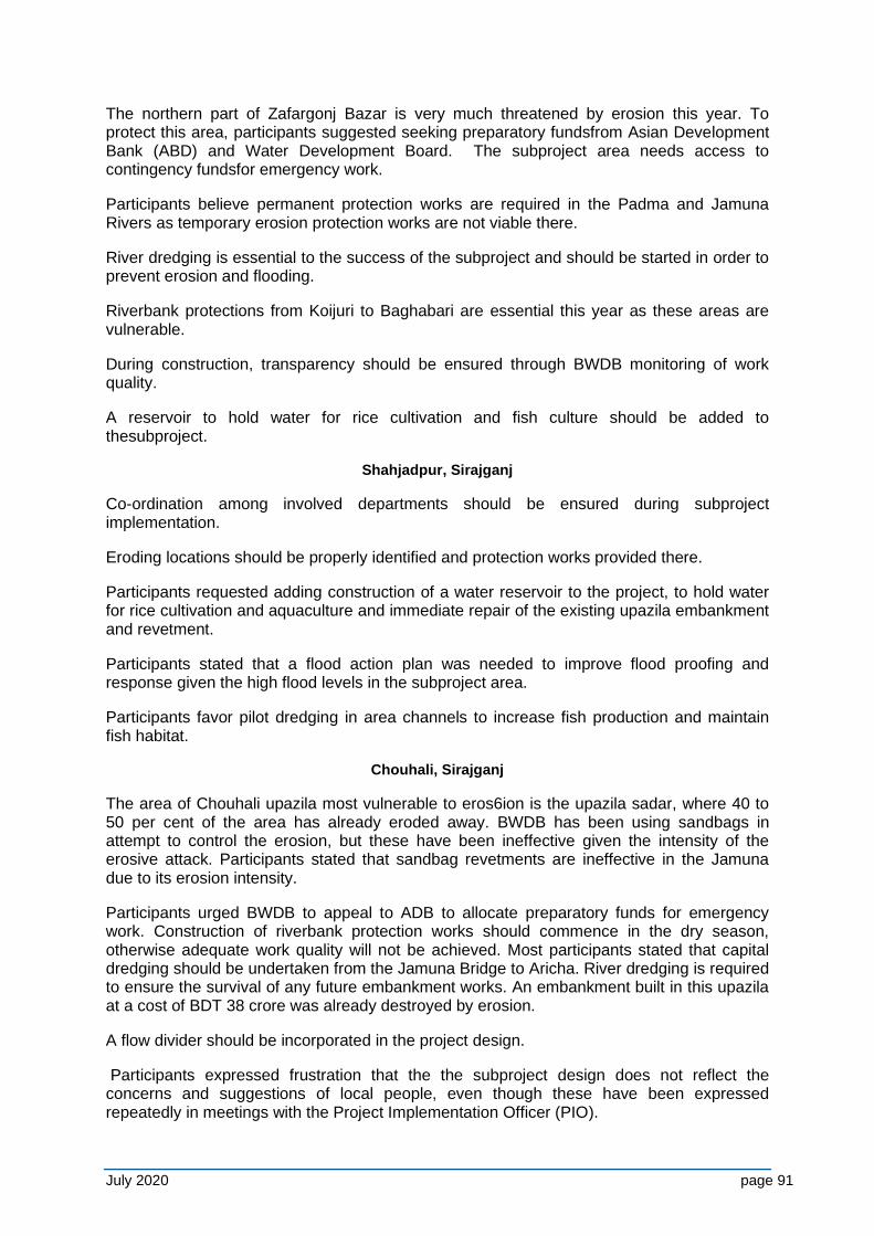
July 2020 page 91
The northern part of Zafargonj Bazar is very much threatened by erosion this year. To protect this area, participants suggested seeking preparatory fundsfrom Asian Development Bank (ABD) and Water Development Board. The subproject area needs access to contingency fundsfor emergency work.
Participants believe permanent protection works are required in the Padma and Jamuna Rivers as temporary erosion protection works are not viable there.
River dredging is essential to the success of the subproject and should be started in order to prevent erosion and flooding.
Riverbank protections from Koijuri to Baghabari are essential this year as these areas are vulnerable.
During construction, transparency should be ensured through BWDB monitoring of work quality.
A reservoir to hold water for rice cultivation and fish culture should be added to thesubproject.
Shahjadpur, Sirajganj
Co-ordination among involved departments should be ensured during subproject implementation.
Eroding locations should be properly identified and protection works provided there.
Participants requested adding construction of a water reservoir to the project, to hold water for rice cultivation and aquaculture and immediate repair of the existing upazila embankment and revetment.
Participants stated that a flood action plan was needed to improve flood proofing and response given the high flood levels in the subproject area.
Participants favor pilot dredging in area channels to increase fish production and maintain fish habitat.
Chouhali, Sirajganj
The area of Chouhali upazila most vulnerable to eros6ion is the upazila sadar, where 40 to 50 per cent of the area has already eroded away. BWDB has been using sandbags in attempt to control the erosion, but these have been ineffective given the intensity of the erosive attack. Participants stated that sandbag revetments are ineffective in the Jamuna due to its erosion intensity.
Participants urged BWDB to appeal to ADB to allocate preparatory funds for emergency work. Construction of riverbank protection works should commence in the dry season, otherwise adequate work quality will not be achieved. Most participants stated that capital dredging should be undertaken from the Jamuna Bridge to Aricha. River dredging is required to ensure the survival of any future embankment works. An embankment built in this upazila at a cost of BDT 38 crore was already destroyed by erosion.
A flow divider should be incorporated in the project design.
Participants expressed frustration that the the subproject design does not reflect the concerns and suggestions of local people, even though these have been expressed repeatedly in meetings with the Project Implementation Officer (PIO).
July 2020 page 92
Harirampur, Manikganj
The 5-km riverbank protection proposed in this upazila should be extended an additional 2 km up to Dhulsura. Bahadurpur union should be included with the project.
Participants were concerned about the successful implementation of the project. They think that projects initiated by the ruling party will have lower priority if and when the opposition is in power. Participants hope the subproject will be implemented in 2013 and agreed to make whatever sacrifices would be required to expedite this.
Participants stated that the priority should be to protect Harirampur before providing protection to Manikgonj town. Priority work should start as soon as possible.
A quality control committee should be struck to ensure quality construction work.
Local stakeholders should be involved in regular embankment maintenance.
July 2020 page 93
APPENDIX G - PUBLIC CONSULTATION MEETING, THIRD ROUND
OVERVIEW OF MEETINGS
Six third-round public meetings were conducted at Harirampur, Shahjadpur & Chauhali and four FDG attended by 336 participants. Locations, dates, numbers and types of participants, and meeting photos are provided below.
STAKEHOLDER CONCERNS AND MEETING DOCUMENTATION
Summaries of stakeholder concerns expressed in the meetings are provided in Sections A5-0 and A5-0. Copies of the meeting sign-in sheets are shown in Photos E1-8 to E1-16.
Table G1-1: Meeting Venues, third Round Public Consultation & FDG Meetings
District Upazila Union Meeting venue Meeting date
Time
Manikganj Harirampur Bahadurpur Office room of Gopinathpurbeel water Management committee
17/10/2016 11:00 am
Sirajgonj Shahjadpur Ratankandi Rantankandi Ideal High School
22/02/2017 2:00 pm
Sirajgonj Chauhali Chauhali Chauhali Degree College
15/03/2017 3:00 pm
Manikgonj Harirampur Boyra Boyra Union Parishad 27/09/2017 11:00 am
Sirajgonj Chauhali Solimabad Union parishad building 09/10/2017 11:00 am
Sirajgonj Chauhali Khaspukuria Khaspukuria union Parishad
09/10/2017 2:00 pm
Pabna Bera Bera Sadar Bera Fisheries Office 27/12/2016 11:00 am
Pabna Bera
Koitala Courtyard of Mr. Akash kalidas house
27/12/2016 3:00 pm
Pabna Pabna Sadar
Pabna Sadar
District Fisheries Office 27/12/2016 7:30 pm
Sirajganj Shahjadpur Verakhola Verakhola old regulator site
28/12/2016 9:30 am
Table G1-2: Public Consultation and FGD Meeting Participants Details
Meeting venue Type of Participants No. participants
Harirampur (PLB-1) Public Meeting
BWDB staff, ADB consultants, Former UP Chairman, farmer, Fishermen, local notable persons, local social worker, healthcare assistants, businessmen, traders, and NGO staff
28
Shahjadpur (JRB-1) Public meeting Ratankandi
BWDB staff, UP Chairman, Public representatives, farmer, fishermen, local notable persons, local social worker, healthcare assistants, businessmen, traders, student and NGO staff
121
Chauhali (JLB-2) Public Meeting
BWDB staff, Public representatives, farmer, fishermen, local notable persons, freedom fighter, village doctor, local social worker, healthcare assistants, businessmen, traders and NGO staff
87
Harirampur (PLB-1) Public meeting Boyra
BWDB staff, UP Chairman, Public representatives, farmer, fishermen, local notable persons, local social worker, businessmen, traders and NGO staff
26
Chauhali (JLB-2) BWDB staff, Upazila Chairman, Public representatives, farmer, fishermen, 21
July 2020 page 94
Meeting venue Type of Participants No. participants
Public Meeting Char Solimabad
local notable persons, local social worker, businessmen, teacher, Imam, traders
Chauhali (JLB-2) Public Meeting Khaspukuria
BWDB staff, Upazila Chairman, UP Chairman, Public representatives, farmer, fishermen, local notable persons, local social worker, student, businessmen, teacher, Imam, traders
25
Bera (JRB-1) FGD
BWDB staff, consultants, Former UP Chairperson, farmar, fisheries office, NGO staff
7
Bera (JRB-1) FDG
BWDB representatives, consultants, ex. UP members, farmer, owner of bird satctuary, local resident
6
Pubna (JRB-1) FDG
ISPMC consultant, Dirstrict Fisheries officer 3
Shahjadpur (JRB-1) FDG
BWDB staff, ISPMC consultants, Former UP Chairperson, farmer, fishermen, boatman, businessmen,
12
SUMMARY OF CONCERNS, ALL MEETINGS
Erosion - Stakeholders and local people were informed about the project intervention of bank protection in order to establish river stabilisation. They were fully agreed in favour of bank protection but emphasized the need to ensure that construction work is of high quality. They also demanded to get compensation of their land used for the Project in a short period.
Flooding- Stakeholders were informed that the proposed embankment will help to protect from flooding. Stakeholders stated that the embankment will not control flood without river dredging and therefore dredging should be incorporated in the project.
Land use - Stakeholders were advised that the project would induce significant changes in land type, land use, and increased food production. They agreed the out come of the project implementation though they have limited idea about the project benefits other than erosion and flood control.
Fish habitat - Stakeholders were informed that the project is expected to have negative impacts on fish and other aquatic fauna due to reduction of river width by the proposed interventions. Local participants suggested restoring fisheries habitat through pilot dredging of channels and provide adequate number of fish pass regulators for connectivity with the flood plain and river.
Pollution - Stakeholders were advised that the construction phase would cause temporary air pollution and noise. Almost all stakeholders present consented to accept these impacts during construction.
Resettlement - Participants were informed that, at the time of the meetings, households in Horirampur of Manikgonj and Chouhali of Sirajgonj district would require relocation to suitable alternate sites before the beginning of construction, per Project-2 resettlement plans.
Improved road transportation - Participants were informed that flood embanbkments would be provided with appropriate road facilities.
Employment - Participants were informed that the subproject’s reduction of the areas’ vulnerability will improve conditions for trade and commerce. Project construction will provide temporary employment opportunities to local people.
Addition of dredging to subproject designs - River dredging has not been included in subproject designs. Participants strongly recommended that it be added, as they believe flood and erosion control cannot be achieved in these areas without it. Some participants suggested capital dredging from Jamuna Bridge to Brahmankanda of Horirampur upazia under Manikgonj district.
July 2020 page 95
Successful implementation - Participants are concerned that development projects initiated by the ruling party will lose priority if/when the opposition party is in power. Participants strongly urge eraly construction start.
Flood protection plans - Participants expressed concerned about the effectiveness of the subprojects in controlling flooding. They stated that flood protection plans should be developed based on an assessment of water levels. Proposed interventions should be designed to provide protection from the highest monsoon water levels.
NOTES OF SPECIFIC MEETINGS
Harirampur, Manikganj (PLB-1 area)
The participants in the public meeting at Gopinathpur are strongly in favour of constructing the flood embakment from Paturia to Dohar (32 Km.) but they arged to add more ventage of the regulator and provide fish pass which is being constructed by LGED. They also requested to provide adequate number of regulaters with fishpass provision in different proper locations of the embankments.
They demanded to take program for bank protection work at the upstream of bank protection work done in 2015-16 dry season as there is still erosion there. The also requested to construct atleast one boat pass fasilities in this area to make it convenient for transporting their commodity to the local bazer.
They informed that the Embankment constructed by LGED is dwarf and weak in section as such they had to face a lot of trauble during rainy season as some portion of the embankment breached or tend to breach. They urged to strengthen the Embankment around the Gopinathpur beel area
In connection of the land acquisition issues, they are willing to give land which is required for Project implementations but the emphasized for getting compensation in time.
Shahjadpur, Sirajganj (JRB-1 area), FGD
The participants in the FGD meeting opined to extent the Embankment up to Baghabari from where the Project-1 embankment ends. They stromgly recommended that the riverside slope of the embankment should be protected for wave action as there occur high wave during monsoon.
They demanded to provide regulator with adequate noumber of ventage and also rehabilate the existing regulator which was constructed in the previous project. They also requested to lower down the sill level of the regulators for fish migration.
Bera, Sirajganj (JRB-1 area), FGD
A FDG meeting was conducted at the courtyard of Mr. Akash Kalidas who established a bird sactuary in his residence containg 165 decimal of land. He informed a considerable no of migratory birds come every year during winter season. But this number is decreasing as some people of the locality hunt birds unlawfully when the birds used to collect food from beels and fields at night. The owner of the sanctuary and local people demanded to take admistrative legal action against the bird hunters.
Shahjatpur, Sirajganj (JRB-1)
A public meeting was held at Ratankandi Ideal High School where the participants demanded to construct flood embankment from Verakhola to Shahjadpur- koijuri road. They informed that there was embankment along this alignment but it was eroded by the river
July 2020 page 96
erosion. So there was land acquisition by BWDB which may be followed to save the cost of land acquisition. They erged to provide regulators with fish pass where necessary.
Chauhali, Serajgonj (JLB-2)
The participants in a public meeting at Chauhali Degree Collage informed the protective work done in 2015-16 dry season have been eroded in some places. They demanded to repear these damaged portions on emergent basis. They also informed during the flood season crops damaged due to innandation of field. While disclosing that proect has a plan to stabilize the Jamuna River and construct flood embankment along both banks of the Jumuna, they strongly supported the project plan and expressed their full cooperation in implementing the project plan.
Another two public meetings were conduced in this sub-reach, one at Char Solimabad another at Kaskaulia of Chauhali Upazila to receive the local public opinion for the proposed closure dam on the newly developed channel from Jamuna. The local people informed the newly developed channel eroded their homestead and other assets and it is aggravated day by day. They demanded to control this erosion. While informing the participants of the meeting that project has freamed a plan to construct a closure dam over this newly developed channel for depositing silt and therby the erosion will be checked, they strongly supported the plan and demanded to implement the work with emergent basis. They expressed their full cooperation in implementing the work.
Public Consultation Matrix- Comments/Opinion of the Participants and address by the Project
Sl.
No.
Comments/Opinion of the participants during
consultation
Addressed in the Project
General Comment
1. While informing stakeholders and local
people about the project interventions they
are fully agreed in favour of bank protection
and demanded to extend the protection
work. They emphasized the need to ensure
that construction work is of high quality
The bank protection work will be done
as per technical need of the specific
location.
Quality of bank protection work will be
ensured by Consultants, field staff of
PMO and regular task force team of
BWDB
2.
The participants raised their voice to get
compensation of the land used for Project
interventions in short time
The PMO staff and engaged NGO will
pursue on regular basis to the
concerned Deputy commissioner’s
office so that the compensations could
be paid with in shortest possible time
3. Stakeholder were informed that the
proposed embankment to protect flooding.
They expressed that only the embankment
construction will not control flood. They are
in favour of river dredging and demanded for
incorporation of dredging in the project.
The issue was discussed with river
stabilization technical team. They will
provide dredging if it is feasible in
context of river stabilization.
4. Participants suggested restoring fisheries
habitat through pilot dredging of channels
and provide adequate number of fish pass
regulators for connectivity with the flood plain
and river
The EIA team shared these
stakeholder opinions with BWDB
officials and ISPMC’s team members
for technical solution. The suggestion
is well taken. The design team is
providing fish-pass regulators to
July 2020 page 97
Sl.
No.
Comments/Opinion of the participants during
consultation
Addressed in the Project
restore connectivity with the flood plain
and river at feasible locations
5.
While informing the stakeholders that during
construction temporary air pollution and
noise may cause, which they consented to
accept these impacts during construction
Noted and included in the EIA
6. Probable project affected people expressed
their views to relocate to suit able alternative
sites before the start of construction
These issues will be addressed in the
Resettlement program of the Project.
7. Participants demanded for providing
appropriate road facilities.
Project have a plan to provide road
facilities over the flood embankment
8. Participants enquired about the employment
opportunities of the local people in the
project work
Project construction will provide
temporary employment opportunities to
local people
9. Participants recommended to include
dredging as they believe flood and erosion
control could not be achieved without
dredging.
The scope River dredging to control
erosion will be thoroughly investigate
by the project design team. Necessary
arrangement will be provided after
feasibility study of the Project.
10. Participants were concerned about
development projects initiated by the ruling
party will lose priority if/when the opposition
party is in power. So, they strongly urged
early implementation of the Project.
Noted and included in the EIA
11. Participants expressed concerned about the
effectiveness of the subproject in controlling
flooding. Proposed interventions should be
designed to provide protection from the
highest monsoon water level.
Renowned international and national
experts are taking care of it
Public Consultation of the Specific Meetings
12. At Gopinathpur public meeting the
participants were in favour of constructing
flood embankment from Paturia to Dohar.
They urged to add more ventage of the
regulator and provide fish pass which is
being constructed by LGED. They also
requested to provide adequate number of
regulators with fish pass provision in suitable
location of the embankments
Renowned international and national
experts are taking care of it
13. The participants in the FGD meeting at
Shahjadpur, Sirajgonj (JRB-1) opined to
extent the Embankment up to Baghabari
from where the Project -1 embankment
ends. They recommended that the riverside
slope of the embankment should be
protected from wave action as there occur
high wave during monsoon. They demanded
The proposal for constructing
embankment has been included in the
Project-2 work. The experts of the
team is working for fish pass regulators
along with the sill level as requested.
July 2020 page 98
Sl.
No.
Comments/Opinion of the participants during
consultation
Addressed in the Project
to provide regulator with adequate numbers
of ventage and also rehabilate the existing
regulator. They also requested to lower
down the sill level of the regulators for fish
migration
14. The participants of the FGD meeting at Bera
Sirajgonj (JRB-1) informed that a
considerable number of migratory birds
come every year during winter season, but
this number is decreasing as some people of
the locality hunt the birds unlawfully when
birds used to collect food from beels and
fields at night. The local people asked to
take administrative legal action against
poacher
Noted and included in EIA. The opinion
has been sheared with BWDB official
for taking necessary action.
15. The participants in a public meeting at
Ratankandi Ideal High School demanded to
construct flood embankment from Verakhola
to Shahjadpur-Koijuri road. They informed
there was land acquisition by BWDB in the
previous embankment which may be
followed to save the cost of land acquisition
for new embankment.
The requested embankment reach has
been included in the Project-2
interventions. The Pervious land
acquisition by BWDB has been
followed as per as feasible.
16. The Public meeting at Chauhali Degree
Collage, the participants demanded to repair
the damaged portion of the protective work
done in 2015-16 on emergent basis. They
also urged to save their crops from monsoon
flood.
The Project has taken up to repair the
damage portion of the protective
worked done in 2015-16. The
participants were informed that Project
has a plan to construct flood
embankment along the bank of the
Jamuna as a part of River stabilization
plan.
17. The participants in public meeting at Char
Solimabad and Kaskaulia (JLB-2) demanded
to control the erosion of the newly developed
channel which eroding their homestead and
other assets.
The Project has a program to construct
a closure dam at the mouth of the
newly developed channel in 2017-18
dry season. This will ensure the
erosion control and about 5000 ha of
land will be reclaimed by silt
deposition.
Some example photos of public consultation meetings (PCM) at various locations
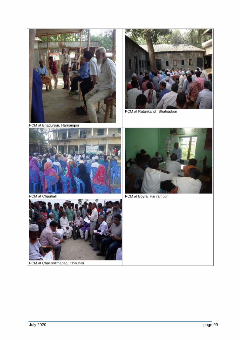
July 2020 page 99
PCM at Bhadurpur, Harirampur
PCM at Ratankandi, Shahjadpur
PCM at Chauhali
PCM at Boyra, Harirampur
PCM at Char solimabad, Chauhali
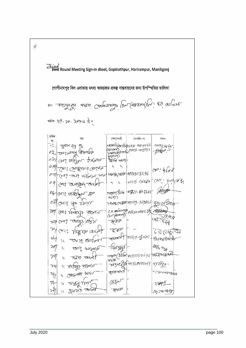
July 2020 page 100
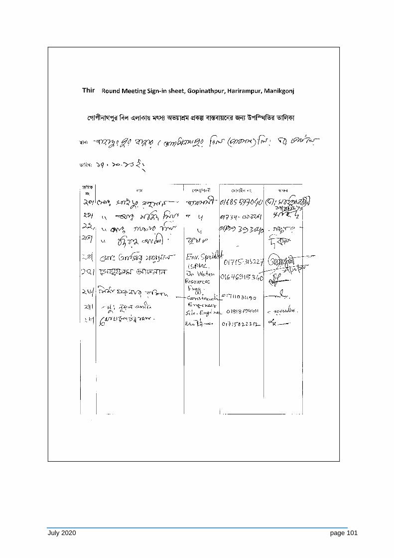
July 2020 page 101
Third
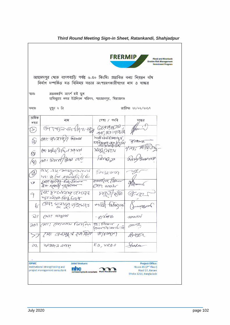
July 2020 page 102
Third Round Meeting Sign-in Sheet, Ratankandi, Shahjadpur
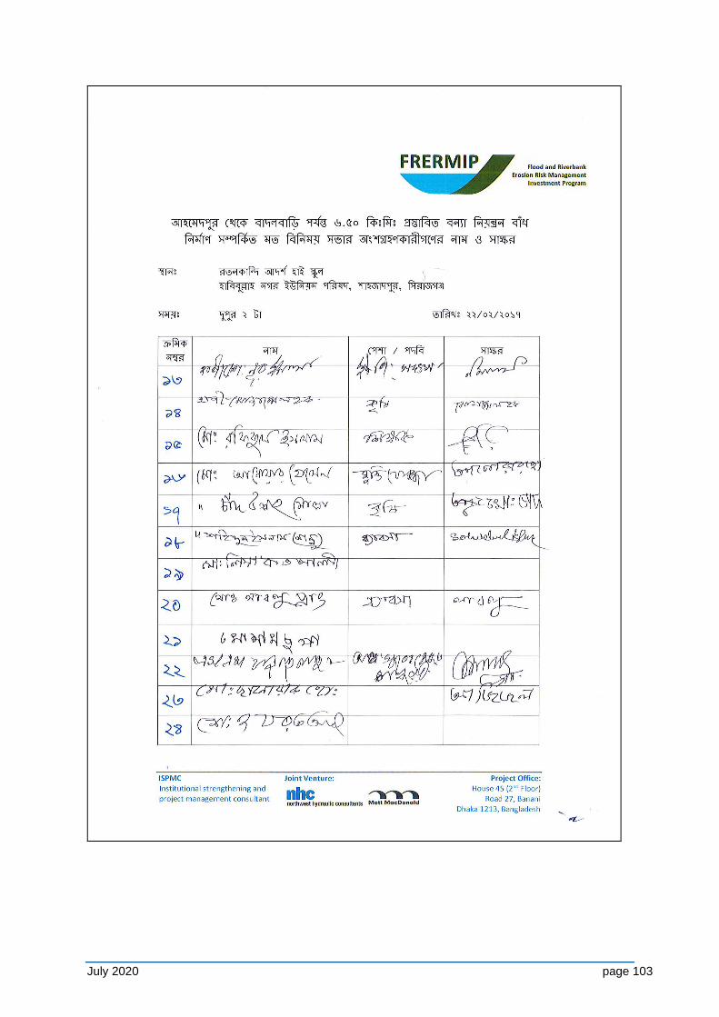
July 2020 page 103
July 2020 page 104
July 2020 page 105
July 2020 page 106
July 2020 page 107
July 2020 page 108
July 2020 page 109
July 2020 page 110
July 2020 page 111
July 2020 page 112
July 2020 page 113
July 2020 page 114
July 2020 page 115
July 2020 page 116
July 2020 page 117
July 2020 page 118
July 2020 page 119
July 2020 page 120
July 2020 page 121
Third Round Meeting Sign-in Sheet, Char Solimabad, Chauhali
July 2020 page 122
July 2020 page 123
July 2020 page 124
July 2020 page 125
Third Round FGD meeting Sign-in Sheet, Verakhola, Shahjadpur
July 2020 page 126
Third Round FGD meeting Sign-in Sheet, Fisheries Office, Bera
July 2020 page 127
Third Round FGD meeting Sign-in Sheet, Koitola, Bera

July 2020 page 128
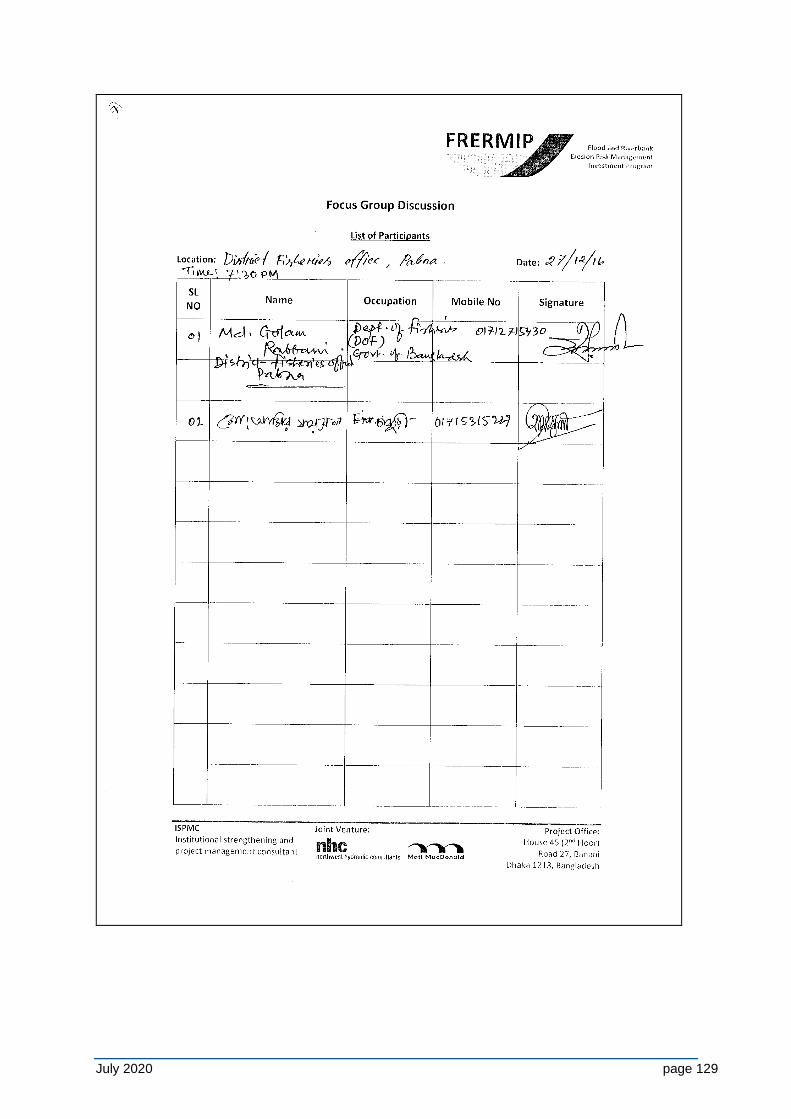
July 2020 page 129
July 2020 page 130
APPENDIX H - STANDARD CONSTRUCTION CONTACT ENVIRONMENTAL SAFEGUARD CLAUSES
H1 Environmental Protection and Control of Pollution
H1-1 General
The Contractor shall observe and comply with all National Laws and Government Regulationspertaining to environmental protection, pollution control, waste management, and biodiversity protection.
In conducting his construction activities, the Contractor shall take all necessary precautions to minimise environmental disturbance to the project area and surroundings and to prevent the escape of polluting substances into streams, water courses, and ground water. The Contractor shall also utilise all necessary practicable methods and devices as are available to prevent and otherwise minimize atmospheric emissions or discharges of air contaminants.
Except where otherwise agreed or provided for by the Employer or expressly stipulated in Particular Specifications or Technical Specifications forming part of the Contract Documents, no separate payment will be made for complying with the provisions of this Clause and attendant sub-clauses; and all costs shall be deemed to be included in the prices for the Contractor’s mobilisation for construction, and the various rates and lump sum items for the works included in the priced Bill of Quantities.
H1-2 Pollution of Water Courses and Streams
The emission of polluting liquids or other waste into drains, water courses or ground water shall not be permitted.
No concrete or cement washings from the works or drainage from the Contractor's concrete batching and mixing areas, plants or other manufacturing or production facilities shall be allowed to discharge into streams or drains without passing through an adequate system of settling ponds.
Storage of fuels, fuelling and maintenance of plant and vehicles, etc. shall take place only on sites and under conditions that do not allow spilt fuels to be discharged to water bodies. Fuel storage and fuelling areas shall be equipped with adequate protective measures to confine and retain accidental spillages. No drainage from fuel store and plant maintenance depots shall be allowed to be discharged without passing through an adequate arrangement of oil traps and separators.
Washing of vehicles shall not be permitted in streams but only in specially designated and equipped areas.
Operations in quarries and borrow areas shall be carried out in such a way as to minimize any possible pollution from particulate matter entering the streams.
Adequate sanitary waste control facilities shall be provided in site offices and workers camps, and sewage waste shall be collected regularly and disposed in accordance with relevant environmental legislation.
The Contractor shall accordingly be responsible for the installation, operation and maintenance of a comprehensive drainage system to all areas of the Works. The system shall be constructed such that no discharges of oil, cement, silt or other liquid or solid waste
July 2020 page 131
matter can enter the streams and water courses at the site; and it shall have all necessary solid waste and sediment traps, settling ponds, oil separators, etc. required to ensure that pollution of streams watercourses and natural bodies of water does not occur. The Contractor shall be responsible for maintaining the system to the satisfaction of the Employer’s Construction Supervisor and all costs of providing the system shall be deemed to be included in the various rates and lump sum items for the works included in the priced Bill of Quantities.
H1-3 Air Pollution
The Contractor shall take all necessary steps to minimize air pollution resulting from his operations.
Except where stipulated in these Specifications for the disposal of natural vegetation and organic materials from clearing operations, the burning of waste materials for disposal, particularly oil and petroleum wastes, rubber, plastics and similar materials will not be permitted.
During the performance of the work required under the Contract or of any operations appurtenant thereto, whether on the Project Site or elsewhere, the Contractor shall take all steps necessary, and shall furnish all labour, equipment, materials and means, required to reduce dust nuisance from the Works, and to prevent dust originating from his operations from damaging crops, orchards, cultivated fields, and dwellings; or causing a nuisance to persons. The Contractor shall be held liable for any damage resulting from dust originating from his operations including on Government roads, rights-of-way or elsewhere.
The emission of dust into the atmosphere shall not be permitted during the manufacture, handling and storage and handling of cement and of concrete aggregates and the Contractor shall use such methods and equipment as are necessary for the prevention, or the collection and disposal, of dust during such operations. All truckloads of loose materials shall be covered during transportation
Concrete batching and mixing areas, asphalt (hot mix) plants, or other manufacturing or production facilities shall be sited at least 500m from the nearest habitation. Emission outlets shall be fitted with pollution control devices in compliance with relevant current Government of Bangladesh emission control legislation.
The cost of spraying water on haul roads, access roads, government roads, aggregate stockpiles, etc.; or of any other methods of reducing the formation of dust; and the cost of furnishing and applying materials to maintain the works areas, adjacent areas, and roads, in a dustless condition, shall be deemed to be included in the various rates and lump sum items for the works included in the priced Bill of Quantities.
H1-4 Noise Pollution
The Contractor shall take all necessary precautions to minimize the amount of noise and vibrations coming from construction activities.
The Contractor shall ensure that all plant and equipment is properly maintained in good operating condition, and that noisy construction activities shall be effectively sound reduced by means of silencers, mufflers, acoustic linings or shields, acoustic sheds or screens or other means, to avoid disturbance to any nearby noise sensitive receivers. All plant and equipment shall comply with relevant Government of Bangladesh legislation covering sound emissions.
July 2020 page 132
Quarry operations and blasting shall be undertaken so as to minimize blasting and disturbance during the night and, insofar as possible, noise, vibration and dust. Operation of trucks and heavy vehicles and machinery shall be restricted to the hours of 06:30 to 19:00.
All necessary measures shall be undertaken to protect schools, hospitals and other adjacent noise sensitive receptors, including the use of noise barriers. The budget for this purpose in the contract package should be arranged.
H1-5 Damage to Property, Crops, and Vegetation
The Contractor shall limit the movement of his employees and equipment within the project area and on adjacent land, including access routes approved by the Employer’s Construction Supervisor, so as to minimize damage to natural vegetation, crops and property, and shall endeavor to avoid any damage to land.
The Contractor shall strictly ensure employees and equipment do not enter any sensitive environmental areas that are demarcated as “no-entry” zones.
The Contractor shall preserve existing trees, plants and other vegetation that are to remain within or adjacent to the Works and shall use every precaution necessary to prevent damage or injury thereto. Trees or shrubs shall only be felled or removed where such impinge directly on the permanent works or necessary temporary works areas; and where such is approved by the Employer’s Construction Supervisor.
On completion of the Works all areas disturbed by the Contractor’s construction activities shall be restored by the Contractor to their original condition, or as may be acceptable to the Employer.
For any damage to the standing crops due to intervention of the project activities, the compensation will be paid to the affected person (AP) on receiving his/her claim to GRC.
H2 Sanitation Facilities and Arsenic Safe Water Supplies
At each construction area, (i) an appropriate number of tubewells will be installed to supply water for construction and safe drinking water to labourers and the construction camps, and (ii) latrines with septic tanks will be provided. Tubewells will be tested for arsenic and marked accordingly (green/red for safe/unsafe).
H3 Reporting
The Contractor shall maintain a record of all emissions and spills of liquid, solid and gaseous matter which occur at the site, whether into water courses, streams, on land, or into the air. This record shall be compiled daily and shall include details of date, time and nature of the event, along with details of the remedial and clean-up measures carried out. Copies of these records shall be given to the Employer monthly.
The Contractor shall also maintain a record of any complaints made by any Governmental or Community Organization or by the public, regarding his operations. This record shall contain the date and time of receipt of the complaint, the name and address of the complainant and the action taken to remedy the situation. Copies of these records shall be given to the Employer monthly.
H4 Environmental Management Plan
July 2020 page 133
The requirements of this clause and attendant sub-clauses on Environmental Protection and Pollution Control notwithstanding; the Contractor shall observe and comply with all relevant environmental protection and mitigation, monitoring and reporting requirements in the Environmental Management Plan (EMP) as stipulated in the Particular Specification. In the event of any conflict between the foregoing sub-clauses and the environmental protection and mitigation measures and pollution control requirements of the EMP, the EMP shall take precedence.
The Contractor shall prepare and submit to the Employer’s Construction Supervisor a Construction Environmental Management and Monitoring Plan (CEMP) demonstrating the manner in which the Contractor will comply with the requirements of the foregoing sub-clauses on Environmental Protection and Pollution Control, the EMP, and any particular environmental mitigation measures as stipulated in the Particular Specifications or Technical Specifications forming part of the Contract Documents.
The CEMP shall be submitted within 15 working days of the Contractor receiving the Notice to Proceedwith the Works, and shall include a waste management plan detailing procedures for waste management for the site covering all solid, liquid and gaseous waste materials and emissions. The waste management plan shall include procedures for the collection and disposal of all waste materials in such a way as to ensure that no damage is caused to the environment. Training shall be provided to workers about the appropriate implementation of the CEMP and waste management plan measures.
Where stipulated in the Particular Specifications or Technical Specifications forming part of the Contract Documents, and provision has been made in the Bill of Quantities; payment for the implementation of the CEMP will be made in accordance with the Unit Rates, Lump Sum or Provisional Sum Items included in the Priced Bill of Quantities.
July 2020 page 134
APPENDIX I - PROJECT IMPLEMENTATION ARRANGEMENTS
I-1 Steering and Guidance of Executing and Implementing Agencies
The program is suggested to be implemented under the lead of BWDB (executing agency) with close relationships to DDM (implementing agency). Other associated organizations are WARPO, LGED, DoF, DAE, DoFo and BIWTA. The participating organizations require clearly defined procedures of when, where, and how to coordinate their activities. To this end BWDB has a number of Memoranda of Understanding (MoU) in place, which will be suitably updated for the purpose of the program during the first year of the program.
In line with government principles program activities are regularly reviewed and discussed through annual inter-ministerial steering committee meetings. Given the complexities of the program, a Panel of Experts is expected to provide guidance related to key questions:
(i) River morphology, engineering, and stabilization (ii) Flood Risk Management at regional and community level (iii) Institutional and capacity development at regional and community level
I-2 Integrated Program Management Office (PMO)
The PMO will be integrated into the administrative setup of BWDB and placed at a high level given the importance and relevance of the program. The key features are:
(i) Headed by a Chief Engineer/Additional Chief Engineer/Superintending Engineer and supported by two Superintending Engineers and four Executive Engineers.
(ii) Initially identical and later closely associated with the CE River Management, once the post gets approved. This is a vital element to activate the new river management wing and to institutionalize the broad river stabilization approach.
(iii) Supported by an individual design office, exclusively dealing with river stabilization measures.
(iv) Conducting river management activities of larger national importance, such as procuring materials for works and strategic stockpiling for emergencies, and guiding char reclamation activities
(v) Implementing work through existing zonal division. These divisions already build embankments and riverbank protection, and will be strengthened in terms of staff during the implementation of the works.
(vi) A environmental monitoring section headed by an Executive Engineer in PMO to moniror the EMP compliance and other environmental issues of the Project supported by SMOs, an International Environmental Specialist and a national Environmental Specialist from the ISPMC team.
Figure A1-1 depicts the program project management organogram for BWDB/FRERMIP management, as provided by the PMO in February 2018 June 2020.
I-3 Advisory Support
The program will be supported by consultants and NGOs at different level. This addresses the program management requirements of ADB and supports BWDB during the current period of staff shortage, specifically of junior staff. An Institutional Strengthening and Project Management Consultant (ISPMC) will provide the main support in a number of different areas. The advisory support scope of work includes the services of a specialist organization to conduct environmental assessment and planning. Additional details regarding the
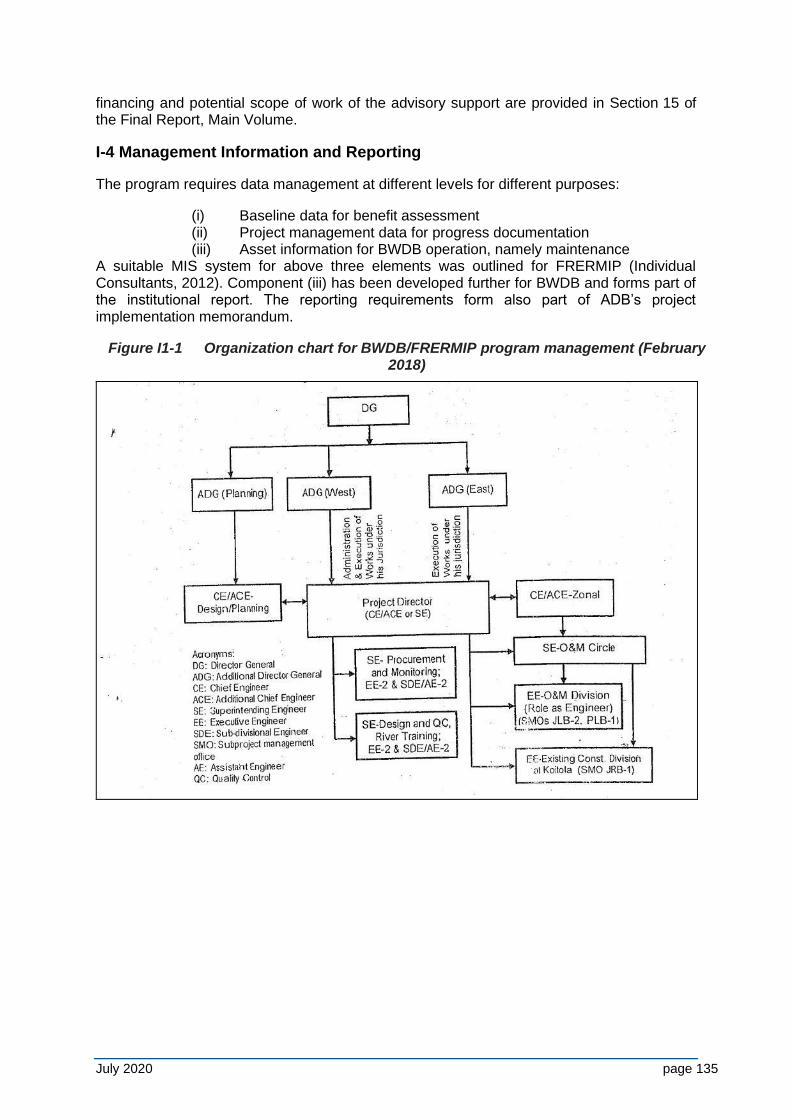
July 2020 page 135
financing and potential scope of work of the advisory support are provided in Section 15 of the Final Report, Main Volume.
I-4 Management Information and Reporting
The program requires data management at different levels for different purposes:
(i) Baseline data for benefit assessment (ii) Project management data for progress documentation (iii) Asset information for BWDB operation, namely maintenance
A suitable MIS system for above three elements was outlined for FRERMIP (Individual Consultants, 2012). Component (iii) has been developed further for BWDB and forms part of the institutional report. The reporting requirements form also part of ADB’s project implementation memorandum.
Figure I1-1 Organization chart for BWDB/FRERMIP program management (February 2018)
July 2020 page 136
APPENDIX J - BIODIVERSITY BASELINE AND FISHERIES DEVELOPMENT STUDY
Terms of Reference for Consultancy Services for Updating the Biodiversity Baseline and Monitoring Plan; Preparation of a Fisheries Development Plan
J-1 Background
1. The ADB-funded Flood and Riverbank Erosion Risk Management Investment Program (FRERMIP), aims to sustain incomes and livelihoods of people living along selected reaches of the Jamuna and Padma Rivers by enhancing resilience to flooding and to riverbank erosion through a mix of structural and non-structural measures. FRERMIP will be implemented under a Multi-tranche Financing Facility (MFF) in three phases or tranches of three- to four-year duration each with one year overlap from 2015 until 2023. Tranche-1 of the MFF consisting of three sub-projects: Jamuna Right Bank 1 (JRB-1), Jamuna Left Bank 2 (JLB-2), and Padma Left Bank 1 (PLB-1) – marked as ‘FRERMIP recovery of lost floodplain’ in Figure 1.
2. The Program includes structural measures, extensive non-structural activities, institutional strengthening, as well as preparing a long-term strategic river stabilization plan for the Jamuna, Padma and Lower Meghna rivers, i.e. between the Indian border and the estuary mouth (Figure 1).
3. A total of 50 km of riverbank protection, 53 km of embankment rehabilitation, and 36 km of embankment reconstruction or new construction are planned to be implemented through the Bangladesh Water Development Board (BWDB). In addition, more than one million people living in flood risk areas along the main rivers are expected to be supported by a community-based flood risk management program organized through the Department of Disaster Management (DDM). Institutional strengthening will largely focus on improving the knowledge base and planning tools for managing critical river reaches, particularly within the planned River Management Wing in BWDB.
4. After initially protecting critically eroding riverbanks at priority areas under Tranche-1 (November 2015 to end-2018), and conducting the wider long-term strategic river stabilization study (November 2015 to mid-2016), the program plans to move to more systematic riverbank stabilization, potentially contributing towards future river-reach stabilization during later tranches. The stabilization approach will make use of the currently ongoing consolidation of the river morphology developing towards a more accentuated channel pattern similar to the one observed in the 1970s, before the dramatic widening (from the 1970s to 2000s) took place. In parallel existing, degraded or eroded embankment lines, such as the Brahmaputra Right Embankment (BRE) will be restored and extended to arrive at reliable flood protection for the large population living on the floodplain along the main rivers. The community-based flood risk management component aims to increase resilience and preparedness of the population for the residual risk, for example if existing embankments unexpectedly breach.
5. The riverbank protection approach builds on and extends technical principles established under the Jamuna-Meghna River Erosion Mitigation Project (JMREMP; 2004-2010). Embankment designs follow best international practice providing access along a land-side planform with the opportunity to raise embankments later in response to climate change requirements with limited means. Tranche-1 JLB-2 and PLB-1 physical works consist of riverbank-erosion protection works along critically eroding areas only. JRB-1 consists of limited riverbank-erosion protection works in support of existing works and the restoration of degraded and eroded flood embankments, specifically a section of the most downstream
July 2020 page 137
part of the historic Brahmaputra Right Embankment. Flood embankments will also be rehabilitated behind the JLB-2 and PLB-1 erosion protection works, but not until Project-2.
6. The FRERMIP was prepared through Project Preparatory Technical Assistance (PPTA) 8054, called Main River Flood and Bank Erosion Risk Management Program (MRP) that delivered its (draft) final report in December 2013 – the final ADB version became available in May 2014. Among others this PPTA resulted in an Environmental Assessment and Review Framework (EARF, first version May 2014), its purpose being to guide the preparation of future tranches of the FRERMIP. It also produced a full EIA for the planned FRERMIP interventions for Tranche-1 (May 2014).
7. Specific guidance is required as the FRERMIP intends to move from localized riverbank protection towards stabilization of first river reaches of the main rivers in central Bangladesh. This approach includes the reclamation of lost floodplain land and expansion of existing flood risk mitigation infrastructure (flood embankments), leading to more reliable flood risk mitigation. To this end existing literature knowledge on issues pertaining to environmental safeguards, such as the river ecosystem, river floodplain interaction, and specifically fish, need to be expanded, in parallel to the study of the overall stabilization approach over the following tranches, alternative solutions, and their impacts. Future environmental assessment accounts for the dynamic river morphology that experienced dramatic changes over the last 40 years, which are still ongoing.
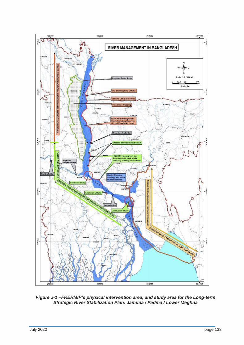
July 2020 page 138
Figure J-1 –FRERMIP’s physical intervention area, and study area for the Long-term Strategic River Stabilization Plan: Jamuna / Padma / Lower Meghna
July 2020 page 139
8. The historic river course, some 40-years ago, has exhibited planforms that are relevant for future planning. To this end the study of historic habitat characteristics will help to determine a suitable baseline for the rapidly changing river environment but also allow to draw analogies to future planned river courses, narrower than today’s river.
9. The anticipated benefits of the planned works are considerable and include: (i) reduced loss of agricultural and other land with established infrastructure to prevent river erosion, (ii) reduced destruction of livelihood and impoverishment of families, (iii) gains in floodplain land from river stabilization, (iv) improved river navigation and trade, (v) reduced flood damage to agriculture, particularly Aus and Aman cropping, and (vi) increased agricultural and pond-fish production on less-flooded agricultural land.
10. While its anticipated benefits are considerable, the Program potentially negatively impacts both the floodplain and the river environment. Negative impacts may include the transformation of deeply flooded floodplain into less flooded areas leading to the degradation of floodplain aquatic (wetland) habitats, reduced hydrological connectivity, and physiochemical / water quality changes, which may adversely affect floodplain-dependent openwater fish species and wetland biodiversity. Increased agriculture may increase utilization of water resources for irrigation and increased fertilizer and pesticide use may impact water quality. Erosion protection of the Program may alter river morphology along reaches beyond the works, change river appearance (e.g. the number of channels and islands, water depths, and velocity), and as a consequence change the river habitat. This may in turn have an impact on the biodiversity locally, as well as for migrating or trans-boundary animal populations (e.g. fish, birds, dolphins).
11. The FRERMIP has a number of inbuilt mechanisms to reduce environmental impacts, and mitigation measures have been aggressively mainstreamed into program planning and engineering designs. The flexibility of a phased MFF approach supports minimization and mitigation of potential negative impacts in a gradual manner. Works started in Tranche-1 with protection of critically eroding riverbanks and the reconstruction of the destroyed BRE, while conducting extensive studies on future impacts of river stabilization and associated embankment works, including piloting new measures. Specialist studies have been conducted for Tranche-1 interventions on morphology, floodplain hydrology, and environmental aspects. They support that the Tranche-1 impacts are more limited in nature and can be mitigated. During Project-2 first measures for river stabilization along the priority work reaches are planned and will be designed based on the Tranche-1 study outcomes and supported by environmental monitoring and mitigation measures.
12. The FRERMIP includes several additional studies to develop a broader background understanding and develop an approach that optimizes different key drivers, ranging from morphological trends, future river use for navigation, safeguarding and enhancing the river ecosystem, and reducing social impacts.
13. Mitigation measures suggested for larger-scale river stabilization include:
(i) Development of stabilization alternatives and assessing environmental impacts in the Jamuna-Padma-Meghna river system through a Long-term Strategic River Stabilization Study, i.e. from November 2015 to June 2016.
(ii) Biodiversity baseline elaboration, both in river and floodplain, identification of locations for fish sanctuaries, and their establishment.
(iii) Development of EIA studies for each subsequent tranche. (iv) Formulation of fisheries and aquatic biodiversity development plans to
enhance fisheries production to compensate for adverse biodiversity and fisheries impacts.
July 2020 page 140
14. Figure 2 depicts the system of studies and their interaction with environmental and social safeguards. In addition, “building-with-nature” measures will be piloted to assess ways closely mimicking or making use of natural processes to build attached charland faster into floodplain land.
J-2 Objectives
15. Simultaneously with conducting the Long-term Strategic River Stabilization Study (Figure 2) environmental measures for potential larger-scale river stabilization (Figure 3 provides preliminary options) need to be investigated and suitable mitigation measures, such as aquatic sanctuary identified and detailed. This involves:
(i) Identify historic developments and changes pertaining to the number of species and areas available to them within the river belt and adjacent floodplains from the 1960s to 2015.
(ii) Identification of monitoring indicators for major flora and fauna components in the study area, i.e. the Jamuna-Padma-Lower Meghna(river and floodplain) between the Indian border and the estuary mouth, and during pre-construction, construction and operational stages. Once these indicators are carefully selected, they would be the monitoring indicators/parameters that will be followed throughout the project life. Hence, considerable research and thought must be given to this.
(iii) Elaborating on the already existing biodiversity baseline for the study area's influence areas, i.e. building further (rather than duplicating) on baselines already established under FRERMIP and RMIP. The focus here is on identifying and mapping important habitats for fish, (migratory) birds, dolphins and other wildlife in river and floodplain of the study area, and assessing how these may be impacted (e.g. form/increase or reduce/disappear) by the river stabilization options proposed as part of the long-term strategic river stabilization plan.
(iv) Considering the environmental and fisheries impacts, various strategic development options for river stabilization in the study area as proposed under the long-term strategic river stabilization plan.
(v) Analysing the effectiveness of existing (fish) sanctuaries and other protected areas in the study area, and proposing improvement, including capture and pond culture fisheries to document past trends and needed improvements.
(vi) Identifying, as necessary and if deemed feasible, suitable locations for sanctuaries or other protected areas, and developing detailed plans for establishment of such sanctuaries or protected areas, to compensate for project impacts and that contribute to a long term conservation of aquatic and terrestrial habitat.
(vii) Assessing historic development of fisheries/aquaculture, their present status and prospect of contributions to the aquatic biodiversity and fisheries impacts.
J-3 Consulting Services
16. Consulting services are solicited from one or more firm/NGO/research institute experienced in setting ecological baselines, biodiversity monitoring, defining conservation status of species and their conservation strategy and restoration, establishment and management of (fish) sanctuaries, and aquaculture practices with proven international and national experience to provide necessary technical services. The consulting team will include a mix of experts with experiences in biology of the various species and habitats. The interested party/ies should have experience in similar works and preferably have working experience in Bangladesh.
July 2020 page 141
17. Sanctuary Establishment Plans should include a detailed Management & Monitoring Plan. The latter should identify the responsible persons/organizations and present a site-specific or/and species-specific management /monitoring plan for the required inputs.
J-4 Scope of Services
18. The consultants of the firm/NGO/research institute shall familiarize with the FRERMIP, RMIP and other relevant project documentation, as well as liaise with the team conducting the Long-term Strategic River Stabilization Study, and maintain close coordination with the Environment Unit of PMO. The scope of works is defined as follows.
Task 1 – Existing environmental/biodiversity baselines
(i) Identify, collect and study relevant existing environmental/biodiversity baselines for the long-term river stabilization study area5 and identify information gaps.
(ii) Describe based on available information historic developments, changes and trends pertaining to the number of species and areas available to them within the river belt and adjacent floodplains from the 1960s to 2015.
(iii) Oversight and summary of relevant existing biodiversity baselines for the study area.
Task 2 – Biodiversity baseline for Project-2 area
(i) Biodiversity baseline for the Project-2 area (river and floodplain) through existing information and additional field data collection (including seeking local knowledge) as needed with a focus on (i) critically endangered and economically important species, including Hilsa and dolphin, resident and migratory birds, and other wildlife; (ii) frequency , abundance, distribution and migration patterns, dislocation of indicator species of wildlife in the study area; (iii) distribution and extent of key habitats (e.g. river, beel, channel, chars, mudflats, sandflats, reeds, agricultural fields, homesteads, etc.);
(ii) Mapping important habitats for key biodiversity and economic species in the study area for the period 1960s to 2015 as per available data;
(iii) Analysis of key environmental issues impacting on biodiversity; (iv) Identification of key monitoring indicators; (v) Biodiversity Monitoring Plan, including methodology, key monitoring
indicators, responsible organisations, frequency, reporting, costs. Task 3 – River stabilization impacts for Project-2 area
(i) Identify FRERMIP impacts (positive and negative) on biodiversity and recommend remedial measures and visualization of results (tables, graphs, maps);
(ii) Identify impacts (positive and negative) of planned river stabilization interventions options on the biodiversity and key habitats (distribution, extent), propose alternatives and mitigation measures and visualization of results (tables, graphs, maps);
(iii) Stakeholder consultations will be conducted as needed and may include public representatives, Department of Environment, Department of Fisheries, Department for Wildlife Conservation, NGOs, representative of major professional groups (fishermen, agriculture farmers, etc. – men and women) and charland dwellers at the sites.
5 Currently the Jamuna/Padma/Lower Megna between the Indian border and the Bay of Bengal. The Study Area
will be delineated in January 2016.
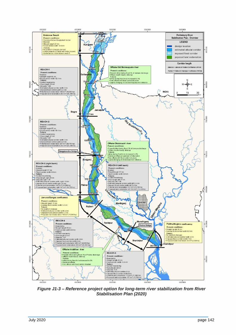
July 2020 page 142
Figure J1-3 – Reference project option for long-term river stabilization from River Stabilisation Plan (2020)
July 2020 page 143
Task 4 – Aquatic sanctuary and fisheries development in Tranche-1 and Project-2 areas
(i) Identify the location of existing (fish) sanctuaries and assess for these their functioning (success / failures), analyse constraints, including capture and pond fisheries to document past trends, and determine requirements for effective sanctuary operation and management; if such areas do not exist within Tranche-1 and -2 areas, a number of representative sanctuaries will be studied elsewhere (e.g. north of Jamuna bridge – see RMIP report, July 2015)
(ii) Identification of and recommend suitable locations, with justification, where one or more sanctuaries may be established in the Tranche-1 and -2 areas, including guaranteeing sustained connectivity to the river ecosystem;
(iii) Public consultations with charland dwellers, local leaders, representatives of local fisheries, forestry, environment, wildlife conservation departments or units, relevant NGOs, representative of major professional groups (fishermen, agriculture farmers, etc. – men and women) at the sites and consider outcomes in identifying suitable locations.
19. The following criteria should be considered for the sanctuaries:
(i) Located in the lower Jamuna downstream of Jamuna Bridge; (ii) Location be relatively insensitive to river erosion; (iii) Chars with reedlands with submerged areas are generally suitable due as
these provide aquatic and bird habitat as well terrestrial habitats; (iv) Consider existing erosion and accretion processes on site and the impact of
short- and medium-term (FRERMIP) and impacts from long-term river stabilization interventions;
(v) Proposed locations may need to be located or raised to a height of 1-3 m above the monsoon water level and should contain a number of water bodies or channels and have least seasonal connection to the main river system;
(vi) Consultations with local community and government organizations is needed to agree on the project location;
(vii) Potential location sites will be mapped and zoned on the existing revenue maps to enable BBA to identify land for acquisition purposes.
Task 5 – Biodiversity Sanctuary/ Protected area planning
Two basic types of sanctuaries/ protected area should be planned
(i) River Charlands Sanctuary/Wildlife protected area specially for aquatic birds/mammals
(ii) Floodplain Sanctuary specially for biodiversity/Fisheries development
20. Sanctuary Establishment Plans should be prepared for at least two sites for River Sanctuary and for a number of locations to be identified for Floodplain Sanctuary, including:
(i) Detailed design including demarcation of core and buffer zones, as well as connections with open (river) water;
(ii) Site location reflected on the mouza maps for land acquisition purposes; (iii) Existing and required infrastructure such sluice, bridge, road, fish pass, etc.,
as well as needed repair and maintenance works; (iv) Core zone to include charland and river: a critical part of the design process
will focus on the establishment of nursing and feeding areas for fish, crustaceans, turtles, dolphins, etc.;
(v) Access paths and hides for observation for eco-tourism;
July 2020 page 144
(vi) Experience from fish sanctuaries developed in Hakaluki in 2008 by the DoE under the 'Coastal and Wetland Biodiversity Management Project' in Brahmaputra River by Bangladesh Agriculture University and Wetland (Floodplain) Sanctuary established under the Wetland Biodiversity Rehabilitation Project of giz-DoF and Fish Sanctuary established under the Community based Fisheries Development Project of DoF and LGED will be considered in the design;
(vii) Stakeholder consultations will be conducted, and outcomes considered in planning the establishment of Sanctuary.
Note: morphological statistical information on river, char and floodplain dynamics (including water depth, cross-sections, charland extent and movement, erosion/accretion rates) in the study area will be made available by FRERMIPs morphologists.
Task 6 – Fisheries development
(i) Assessment of adverse impacts of the project interventions on the river and floodplain capture and culture fisheries including aquatic biodiversity;
(ii) Identification of the impacted fisheries community in the river and Floodplain capture and culture fisheries sector;
(iii) Assessment of status of the technology and methods of exploitation of the river and floodplain capture and culture fisheries of the subproject area;
(iv) Assessment of potential of and outline methods for development of the fisheries sector to compensate for adverse impacts of the project intervention;
(v) Detailed description of the plan for and functional details of the fisheries development program including aquatic biodiversity, fish, fisheries and fisheries community.
J-5 Time Frame
21. The expected to start in 2020 and will be conducted in a period of 14 months (12 months of field study and 2 months of assessment and reporting), including revisions based on comments by BWDB, other agencies and ADB.
J-6 Reporting Requirements/Deliverables
22. The firm/NGO/research institute will prepare and submit the following reports and deliverables during the Services:
▪ Inception Report (Month 1) – including outlining the methodology for data collection and analysis, data sources to be used, detailed work and outcome planning.
▪ Report on existing baselines and information gaps (Month 2)
▪ Draft Biodiversity Baseline and Monitoring Plan & Impacts of Planned Developments (Month 6) – including an updated biodiversity baseline, and impacts of river stabilization options visualized in tables / graphs / maps.
▪ Final Biodiversity Baseline and Monitoring Plan & Impacts of planned Developments (Month 8)–addressing comments received from various parties.
▪ Draft Sanctuary Analysis & Establishment Plan and Fisheries Development Plan (Month 12).
▪ Final Sanctuary Analysis & Establishment Plan and Fisheries development Plan (Month 14) – addressing comments received from various parties.
▪ Monthly progress notes as per agreed template.
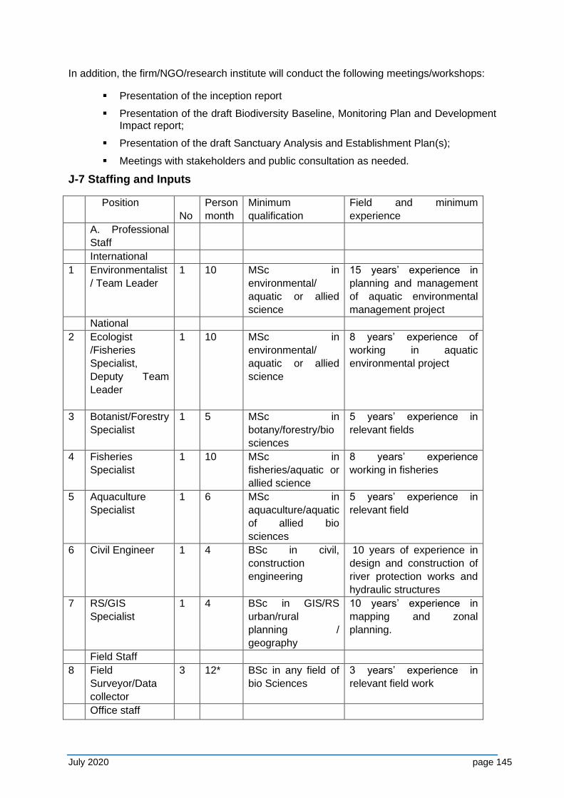
July 2020 page 145
In addition, the firm/NGO/research institute will conduct the following meetings/workshops:
▪ Presentation of the inception report
▪ Presentation of the draft Biodiversity Baseline, Monitoring Plan and Development Impact report;
▪ Presentation of the draft Sanctuary Analysis and Establishment Plan(s);
▪ Meetings with stakeholders and public consultation as needed.
J-7 Staffing and Inputs
Position
No
Person
month
Minimum
qualification
Field and minimum
experience
A. Professional
Staff
International
1 Environmentalist
/ Team Leader
1 10 MSc in
environmental/
aquatic or allied
science
15 years’ experience in
planning and management
of aquatic environmental
management project
National
2 Ecologist
/Fisheries
Specialist,
Deputy Team
Leader
1 10 MSc in
environmental/
aquatic or allied
science
8 years’ experience of
working in aquatic
environmental project
3 Botanist/Forestry
Specialist
1 5 MSc in
botany/forestry/bio
sciences
5 years’ experience in
relevant fields
4 Fisheries
Specialist
1 10 MSc in
fisheries/aquatic or
allied science
8 years’ experience
working in fisheries
5 Aquaculture
Specialist
1 6 MSc in
aquaculture/aquatic
of allied bio
sciences
5 years’ experience in
relevant field
6 Civil Engineer 1 4 BSc in civil,
construction
engineering
10 years of experience in
design and construction of
river protection works and
hydraulic structures
7 RS/GIS
Specialist
1 4 BSc in GIS/RS
urban/rural
planning /
geography
10 years’ experience in
mapping and zonal
planning.
Field Staff
8 Field
Surveyor/Data
collector
3 12* BSc in any field of
bio Sciences
3 years’ experience in
relevant field work
Office staff
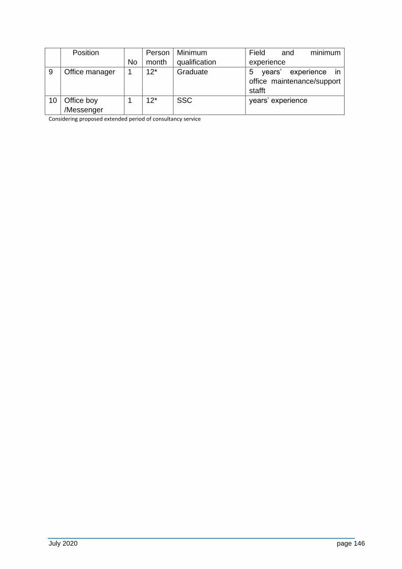
July 2020 page 146
Position
No
Person
month
Minimum
qualification
Field and minimum
experience
9 Office manager 1 12* Graduate 5 years’ experience in
office maintenance/support
stafft
10 Office boy
/Messenger
1 12* SSC years’ experience
Considering proposed extended period of consultancy service

July 2020 page 147
APPENDIX K - NCEA COMMENTS ON 2014-EIA & ISPMC RESPONSE
The consultant that conducted the PPTA for FRERMIP issued its draft EIA report, version R7, for the project on 28 February 2014. The Netherlands Embassy in Dhaka then contracted the Netherlands Commission for Environmental Management (NCEA) to review the report. Subsequently the NCEA conducted the review in two phases: Phase 1 focused, among others, on the February version on the EIA report in which the NCEA noted some shortcomings, after which the ADB decided to adjust the EIA report, which resulted in a next version of the report, i.e. of 16 May 2014 (https://www.adb.org/sites/default/files/project-
document/80829/44167-013-eia-02-0.pdf).
Then, during Phase 2 the NCEA reviewed this revised version of the report and came up with recommendations. NCEA’s findings were presented in its advisory review report, dated 26 June 2014, downloadable from: http://api.commissiemer.nl/docs/os/i00/i0098/27-06-
2014_final_advice_bangladesh.pdf.
The following matrix indicates how the (summarized) comments of the NCEA have been or are being addressed.
Nr Summary of NCEA’s comments on the
EIA of 16 May 2014
Response of ISPMC
1. Justification and comparison of
alternatives – This has not been studied
in the EIA nor in the feasibility study, for
example the Capital Dredging Study and
FRERMIP’s comprehensive stabilization
plan to identify potential river
stabilization solutions to be implemented
in an adaptive manner with minimal
impact on river and char development.
Include the findings of the feasibility
studies in the development of the
planned SEA study.
Alternatives are being considered in
FRERMIP’s long-term River Stabilization
Plan for the active Jamuna/Padma and
Lower Meghna River channel, as well as in
its long-term River Management Master
Plan. As part of these plans a Strategic
Environmental and Social Assessment
(SESA) has been prepared, addressing
among others downstream and cumulative
impacts of proposed interventions in the
JPM river system. Capital dredging is
considered by the FRERMIP consultant as
an unfeasible solution to sustained long-
term river management.
2. Downstream impacts of the
Brahmaputra Right Embankment project
under JRB-1 are not presented in the
report. These should be studied in the
long-term morphological / stabilization
study that will be carried out during
Tranche-1 and the findings could be
presented in the SEA.
There could be two levels of impacts:
associated with the riverbank protection
stabilization works to secure the
embankment and associated with the
impact of the embankment works on flood
levels.
Potential downstream river instability is
mitigated through a 7 km long riverbank
protection work from the Hurasagar to
Kaitola, which was completed under
JMREMP in 2008. This protection work is
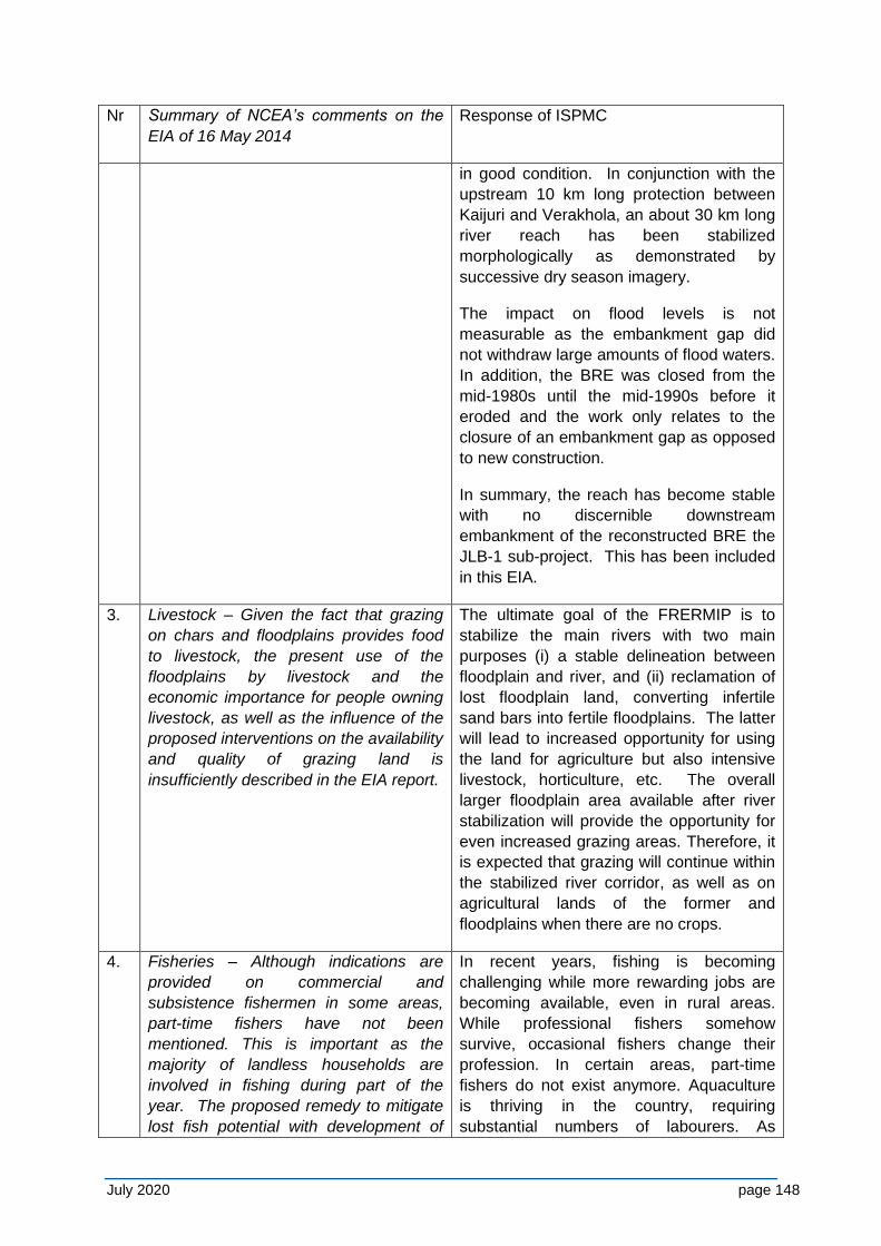
July 2020 page 148
Nr Summary of NCEA’s comments on the
EIA of 16 May 2014
Response of ISPMC
in good condition. In conjunction with the
upstream 10 km long protection between
Kaijuri and Verakhola, an about 30 km long
river reach has been stabilized
morphologically as demonstrated by
successive dry season imagery.
The impact on flood levels is not
measurable as the embankment gap did
not withdraw large amounts of flood waters.
In addition, the BRE was closed from the
mid-1980s until the mid-1990s before it
eroded and the work only relates to the
closure of an embankment gap as opposed
to new construction.
In summary, the reach has become stable
with no discernible downstream
embankment of the reconstructed BRE the
JLB-1 sub-project. This has been included
in this EIA.
3. Livestock – Given the fact that grazing
on chars and floodplains provides food
to livestock, the present use of the
floodplains by livestock and the
economic importance for people owning
livestock, as well as the influence of the
proposed interventions on the availability
and quality of grazing land is
insufficiently described in the EIA report.
The ultimate goal of the FRERMIP is to
stabilize the main rivers with two main
purposes (i) a stable delineation between
floodplain and river, and (ii) reclamation of
lost floodplain land, converting infertile
sand bars into fertile floodplains. The latter
will lead to increased opportunity for using
the land for agriculture but also intensive
livestock, horticulture, etc. The overall
larger floodplain area available after river
stabilization will provide the opportunity for
even increased grazing areas. Therefore, it
is expected that grazing will continue within
the stabilized river corridor, as well as on
agricultural lands of the former and
floodplains when there are no crops.
4. Fisheries – Although indications are
provided on commercial and
subsistence fishermen in some areas,
part-time fishers have not been
mentioned. This is important as the
majority of landless households are
involved in fishing during part of the
year. The proposed remedy to mitigate
lost fish potential with development of
In recent years, fishing is becoming
challenging while more rewarding jobs are
becoming available, even in rural areas.
While professional fishers somehow
survive, occasional fishers change their
profession. In certain areas, part-time
fishers do not exist anymore. Aquaculture
is thriving in the country, requiring
substantial numbers of labourers. As
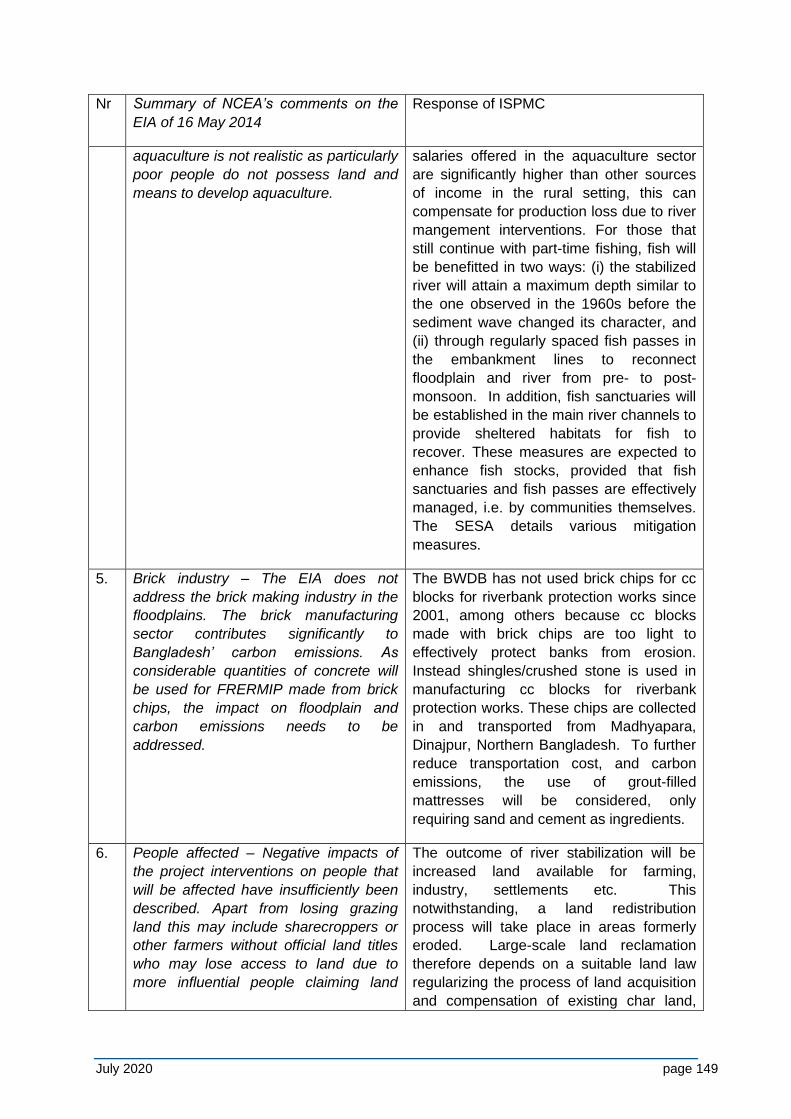
July 2020 page 149
Nr Summary of NCEA’s comments on the
EIA of 16 May 2014
Response of ISPMC
aquaculture is not realistic as particularly
poor people do not possess land and
means to develop aquaculture.
salaries offered in the aquaculture sector
are significantly higher than other sources
of income in the rural setting, this can
compensate for production loss due to river
mangement interventions. For those that
still continue with part-time fishing, fish will
be benefitted in two ways: (i) the stabilized
river will attain a maximum depth similar to
the one observed in the 1960s before the
sediment wave changed its character, and
(ii) through regularly spaced fish passes in
the embankment lines to reconnect
floodplain and river from pre- to post-
monsoon. In addition, fish sanctuaries will
be established in the main river channels to
provide sheltered habitats for fish to
recover. These measures are expected to
enhance fish stocks, provided that fish
sanctuaries and fish passes are effectively
managed, i.e. by communities themselves.
The SESA details various mitigation
measures.
5. Brick industry – The EIA does not
address the brick making industry in the
floodplains. The brick manufacturing
sector contributes significantly to
Bangladesh’ carbon emissions. As
considerable quantities of concrete will
be used for FRERMIP made from brick
chips, the impact on floodplain and
carbon emissions needs to be
addressed.
The BWDB has not used brick chips for cc
blocks for riverbank protection works since
2001, among others because cc blocks
made with brick chips are too light to
effectively protect banks from erosion.
Instead shingles/crushed stone is used in
manufacturing cc blocks for riverbank
protection works. These chips are collected
in and transported from Madhyapara,
Dinajpur, Northern Bangladesh. To further
reduce transportation cost, and carbon
emissions, the use of grout-filled
mattresses will be considered, only
requiring sand and cement as ingredients.
6. People affected – Negative impacts of
the project interventions on people that
will be affected have insufficiently been
described. Apart from losing grazing
land this may include sharecroppers or
other farmers without official land titles
who may lose access to land due to
more influential people claiming land
The outcome of river stabilization will be
increased land available for farming,
industry, settlements etc. This
notwithstanding, a land redistribution
process will take place in areas formerly
eroded. Large-scale land reclamation
therefore depends on a suitable land law
regularizing the process of land acquisition
and compensation of existing char land,
July 2020 page 150
Nr Summary of NCEA’s comments on the
EIA of 16 May 2014
Response of ISPMC
due to its higher production potential. stabilizing the river in that area, and land-
use zoning and land development. The
existing owners can be identified from
mouza maps superimposed with banklines
from the last 30 years.
7. Gender aspects – The Gender Action
Plan is incomplete, lacks clear
implementation arrangements and in its
present form does not guarantee that
the objective of the program of effective
gender mainstreaming will be achieved.
Noted, however the GAP is not applicable
to the EIA.
8. Biodiversity aspects – The report does
not provide insight in the impact of the
program on protected areas; for some
species the baseline does not provide
sufficient insight in crucial habitats for
the survival of all protected species of
global and national significance, and the
extent to which these species and
habitats might be influenced by the
program.
A Terms of Reference for updating the
biodiversity baseline and preparation of a
fisheries development plan, included as
Annex 13 in the May 2014-EIA has been
revised based on the currently available
information and needs, and this will be
tendered in 2017. The updated ToR is
enclosed in an Annex of the present EIA.
9. Anti-erosive measure – The proposed
planting of trees on (slope)
embankments is not appropriate to
reduce erosion. Protection with shrubs
and low vegetation is generally more
effective for rain and wind erosion on
such places.
This is correct and the trees do not fulfill the
function of erosion protection. They are
rather placed as compensation for trees cut
during embankment construction and to
improve driveability. This was already
incorporated in the May 2014 version of the
EIA report.
July 2020 page 151
APPENDIX L - ADB COMMENTS ON DRAFT EIA & ISPMC RESPONSE
ADB submitted its comments on the draft EIA for Project-2 of 12 December 2017 on 8 February 2018, with further comments on particularly the annexes of the report on 13 February 2018. In the table below these ADB comments are listed and the ISPMC’s response indicates how the comments have been addressed in the current final version of the report.
Page Item/section ADB comments ISPMC Response
2 Figure 1-1. Replace with clearer map Figure replaced.
26 Figure 4-3. Replace with clearer map Figure deleted – see Figure 1-1.
28 Figure 4-4. Replace with clearer map Figure replaced.
36 Figure 5-1 & Figure 5-2
Update with more recent data of monthly rainfall and temperatures
Data was requsted from BWDB, but not provided.
36 Table 12 1. Reaches along Padma left bank.
Please check the coordinates (start x/y and end x/y) for the Reaches 1a, 1b, 2a, 2b and 3 if they fall along the Padma left bank.
Checked but OK; all are along the Padma left bank. Coordinates were determined with the BTM (Bangladesh Transverse Mercator) projection which is commonly used by BWDB and SoB.
38 Table 12 2. Location and purpose of regulators for the whole embankment length from Paturia to Dohar
Please check the coordinates (easting and northing) for the Regulators 1-6 if they fall along whole embankment length. They seem not in the location of the project area.
Checked but OK. Initially there were 34 km of embankment and 6 regulators, but reduced to 17 and 4 respectively, due to economic feasibility. All structures are in the project area. Table 4-9 and Figure 4-10 revised.
41 Paragraph 148 Presence of “()”. Please revise accordingly Revised.
July 2020 page 152
Page Item/section ADB comments ISPMC Response
41-45 Table 5-1, Table 5-3, Table 5-10
Update with more recent data on discharges of Jamuna – Padma, water levels, and ground water levels.
Data was requsted from BWDB, but not provided.
52 Table 12 3. Surface water quality of Jamuna and Padma
Where are the surface water quality of Jamuna and Padma River for the months of July to December? Please include surface water quality of Jamuna and Padma for the months of July to December. This will serve as part baseline information of the river system.
Table expanded.
62 Paragraph 209 and Table 12 4. Land use
The paragraph and Table 12 5 do not match. Please revise accordingly
Paragraph and Table corrected.
67- 68 Items 5.5.1 Health and Disease and 5.5.2 Rearing Constraints
These are not related to the project scope. Please remove these items
Sections deleted.
68 Paragraph 234 Please provide a map for the locations of the seasonal and perennial khals (canals), beels (floodplain depressions) and the associated flood lands
Map added.
68 Paragraph 235 Please include in the sentence the source of the information. “Fish biodiversity is also rich in the area but is declining due to indiscriminate fishing, obstruction of migration routes (especially in the dry season), discharge of industrial wastes, poor fisheries management, siltation, oil spills, insecticide contamination, and loss of critical habitats to siltation and bank erosion.”
Done.
69 Figure 5-15. Open water (l) and bankline fish habitat
Include the location of the photograph where they are taken
These pictures were taken from the FRERMIP Tranche-1 EIA (2014) that did not mention the location. Two new pictures included with known location.
72 Paragraph 250 Please include in the sentence the source of the information. “Three types of fishers are found in the study area, i.e. (i) commercial or fulltime fishers; (ii) occasional or part time fishers; and (iii) subsistence fishers. Commercial or fulltime fishers are professional
Done.
July 2020 page 153
Page Item/section ADB comments ISPMC Response
fishers.”
73 Figure 5-17. Seasonality of fishing and types
Please include in the sentence the source of the information for the table
Source added.
77 Table 12 6. Locations of Beels and their connectivity (Project-2 area)
Provide map for the table This requires major further inputs that will be conducted as part of the various baseline studies planned.
80 For the items under 5.7.1 Bioecological Zones - Introductions
Provide a map showing the Teesta Floodplain, Major Rivers, Brahmaputra–Jamuna Floodplain, Chalan Beel, and Ganges Floodplain.
Map provided.
83 Terrestrial Fauna
Revisit the IUCN category of each species mentioned in the EIA. Indicate the appropriate IUCN category for each species in the area. As an example, Varanus flavescens has a status of Lower Risk/least concern to the IUCN website, however, Varanus flavescens in the EIA (paragraph 305) is endangered. This creates confusion on the status of the species. Also, spell the scientific names correctly.
Species list in annexes checked with IUCN Red List (2015) and main text adjusted.
86 Paragraph 322 Please indicate the source of information stated in the Climate Change in Bangladesh.
Indicated.
99 5.8.10 (b) Waterways
Provide map for the waterways that will show the navigation routes of the area mentioned in paragraph 348. Please delete paragraph 349
Waterways map added, paragraph 348 rewritten.
Paragraph 349 deleted.
102 5.8.16 Historical, Cultural and Archaeological Sites
Provide map for the Historical, Cultural and Archaeological Sites
Map added.
112 7.2.1 Erosion and Accretion
Please provide a baseline information for the paragraph 412. There are no baseline information of the sediment loading or amount of total suspended solids (TSS) in the Chapter 5. Environmental and Social Baseline of the EIA Report.
Baseline on erosion/accretion added as Section 5.2.2.
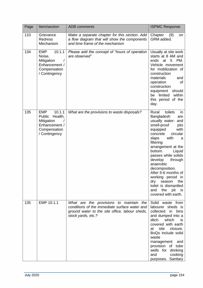
July 2020 page 154
Page Item/section ADB comments ISPMC Response
110 Grievance Redress Mechanism
Make a separate chapter for this section. Add a flow diagram that will show the components and time frame of the mechanism
Chapter (9) on GRM added.
134 EMP 10.1.1 Noise, Mitigation / Enhancement / Compensation / Contingency
Please add the concept of “hours of operation are observed”
Usually at site work starts at 8 AM and ends at 5 PM. Vehicle movement for mobilization of construction materials and operation of construction equipment should be limited within this period of the day.
135 EMP 10.1.1 Public Health, Mitigation / Enhancement / Compensation / Contingency
What are the provisions to waste disposals? Rural toilets in Bangladesh are usually water- and smell-proof pits equipped with concrete circular slaps with a filtering arrangement at the bottom. Liquid passes while solids develop through anaerobic decomposition. After 5-6 months of working period in dry season the toilet is dismantled and the pit is covered with earth.
135 EMP 10.1.1 What are the provisions to maintain the conditions of the immediate surface water and ground water to the site office, labour sheds, stock yards, etc.?
Solid waste from labourer sheds is collected in bins and dumped into a ditch which is covered with earth at site closure. BoQs include solid waste management and provision of tube wells for drinking and cooking purposes. Sanitary
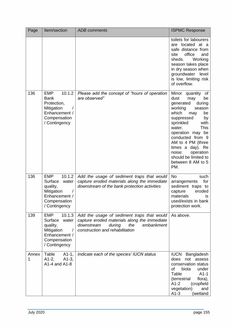
July 2020 page 155
Page Item/section ADB comments ISPMC Response
toilets for labourers are located at a safe distance from site office and sheds. Working season takes place in dry season when groundwater level is low, limiting risk of overflow.
136 EMP 10.1.2 Bank Protection, Mitigation / Enhancement / Compensation / Contingency
Please add the concept of “hours of operation are observed”
Minor quantity of dust may be generated during working season which may be suppressed by sprinkled with water. This operation may be conducted from 9 AM to 4 PM (three times a day). Re noise: operation should be limited to between 8 AM to 5 PM.
136 EMP 10.1.2 Surface water quality, Mitigation / Enhancement / Compensation / Contingency
Add the usage of sediment traps that would capture eroded materials along the immediate downstream of the bank protection activities
No such arrangements for sediment traps to capture eroded materials is used/exists in bank protection work.
139 EMP 10.1.3 Surface water quality, Mitigation / Enhancement / Compensation / Contingency
Add the usage of sediment traps that would capture eroded materials along the immediate downstream during the embankment construction and rehabilitation
As above.
Annex 1
Table A1-1, A1-2, A1-3, A1-4 and A1-8
Indicate each of the species’ IUCN status IUCN Bangladesh does not assess conservation status of biota under Table A1-1 (terrestrial flora), A1-2 (cropfield vegetation) and A1-3 (wetland
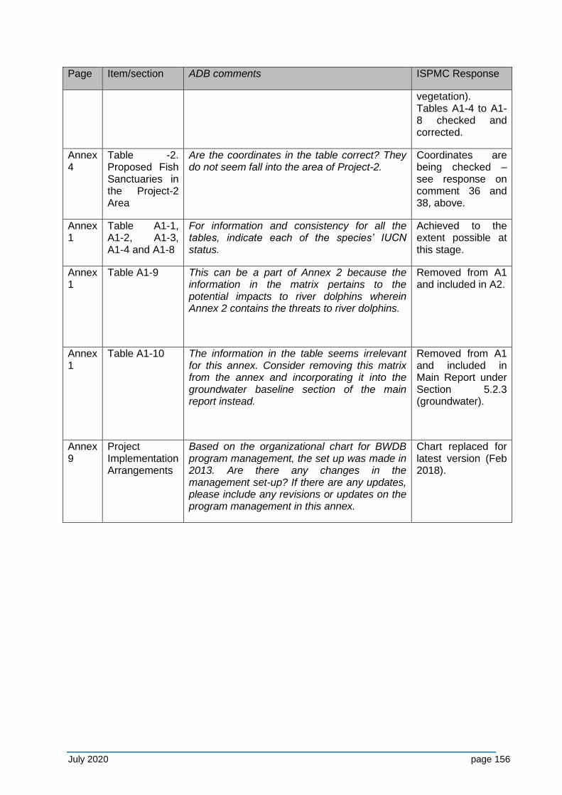
July 2020 page 156
Page Item/section ADB comments ISPMC Response
vegetation). Tables A1-4 to A1-8 checked and corrected.
Annex 4
Table -2. Proposed Fish Sanctuaries in the Project-2 Area
Are the coordinates in the table correct? They do not seem fall into the area of Project-2.
Coordinates are being checked – see response on comment 36 and 38, above.
Annex 1
Table A1-1, A1-2, A1-3, A1-4 and A1-8
For information and consistency for all the tables, indicate each of the species’ IUCN status.
Achieved to the extent possible at this stage.
Annex 1
Table A1-9 This can be a part of Annex 2 because the information in the matrix pertains to the potential impacts to river dolphins wherein Annex 2 contains the threats to river dolphins.
Removed from A1 and included in A2.
Annex 1
Table A1-10 The information in the table seems irrelevant for this annex. Consider removing this matrix from the annex and incorporating it into the groundwater baseline section of the main report instead.
Removed from A1 and included in Main Report under Section 5.2.3 (groundwater).
Annex 9
Project Implementation Arrangements
Based on the organizational chart for BWDB program management, the set up was made in 2013. Are there any changes in the management set-up? If there are any updates, please include any revisions or updates on the program management in this annex.
Chart replaced for latest version (Feb 2018).
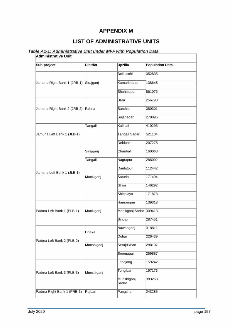
July 2020 page 157
APPENDIX M
LIST OF ADMINISTRATIVE UNITS
Table A1-1: Administrative Unit under MFF with Population Data Administrative Unit
Sub-project District Upzilla Population Data
Jamuna Right Bank 1 (JRB-1) Sirajganj
Belkucchi 352835
Kamarkhandi 138645
Shahjadpur 561076
Jamuna Right Bank 2 (JRB-2) Pabna
Bera 256793
Santhia 380301
Sujanagar 278096
Jamuna Left Bank 1 (JLB-1)
Tangail Kalihati 410293
Tangail Sadar 521104
Delduar 207278
Jamuna Left Bank 1 (JLB-1)
Sirajganj Chauhali 160063
Tangail Nagrapur 288092
Manikganj
Daulatpur 112442
Saturia 171494
Ghior 146292
Shibalaya 171873
Padma Left Bank 1 (PLB-1) Manikganj
Harirampur 139318
Manikganj Sadar 309413
Singair 287451
Padma Left Bank 2 (PLB-2)
Dhaka
Nawabganj 318811
Dohar 226439
Munshiganj Serajdikhan 288107
Sreenagar 259887
Padma Left Bank 3 (PLB-3) Munshiganj
Lohajang 159242
Tongibari 197173
Munshiganj Sadar
383263
Padma Right Bank 1 (PRB-1) Rajbari Pangsha 243285
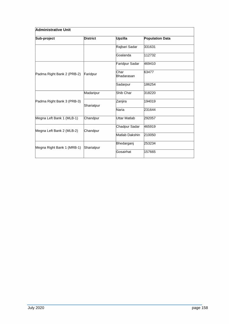
July 2020 page 158
Administrative Unit
Sub-project District Upzilla Population Data
Rajbari Sadar 331631
Goalanda 112732
Padma Right Bank 2 (PRB-2) Faridpur
Faridpur Sadar 469410
Char Bhadarasan
63477
Sadarpur 186254
Padma Right Bank 3 (PRB-3)
Madaripur Shib Char 318220
Shariatpur
Zanjira 194019
Naria 231644
Megna Left Bank 1 (MLB-1) Chandpur Uttar Matlab 292057
Megna Left Bank 2 (MLB-2) Chandpur
Chadpur Sadar 465919
Matlab Dakshin 210050
Megna Right Bank 1 (MRB-1) Shariatpur
Bhedarganj 253234
Gosairhat 157665
159
APPENDIX N - PMO COMMENTS ON DRAFT EIA & ISPMC RESPONSE
PMO submitted its comments on the draft EIA (November 05, 2019). In the table below these PMO comments are listed and the ISPMC’s response indicates how the comments have been addressed in the current final version of the report.
Sl.
No.
PMO Comment ISPMC Notes / Response to Project
Management Office (PMO)
Location (Section/sub
section/para/page no.)
A. General Observations
A1. PMO has sent to you the ToR/Report Structure of the EIA via the Memo
No. : PMOFRERMlP/E-4/871; Date: 17 October 2016 which was approved
by the Department of Environment (DOE). Our development partner
Asian Development Bank (ADB) has given their consent for following the
GOB style through the email (attached as enclosure-I) and requested to
ensure including all necessary items in the report to meet ADB's
requirement. You are hereby requested to recast the EIA report by
strictly following the approved ToR.
Although the report does not follow the
exact order of the structure mentioned in
the ToR of DoE and ADB in the memo, the
contents cover all aspects as required by
ADB and DoE. Note that it also follows the
same structure as the already approved
EIA for Tranche-1.
A2. The Report should be recast following the approved FSR (T-2). It is
mentionable that in the FSR (T-2) report, no physical intervention is
proposed under MLB-2 area. The FRERMIP financing plan needs to be
updated as per actual
While the work locations and design of
interventions have changed, the
fundamental nature of works remains the
same so that it can be expected that the
environmental impacts are similar. The
report has been updated to the T-2 design
on 31 March 2020
A3. In the Executive Summary, there should be a table showing the sub-
project area name, district name, upazila and union name (for proposed
interventions) of T-2 project and in the main body of the report, there
should be another table including the previous showing all the FRERMIP
This table has been included in an
appendix that lists Administrative units.
Appendix M
160
Sl.
No.
PMO Comment ISPMC Notes / Response to Project
Management Office (PMO)
Location (Section/sub
section/para/page no.)
(T1 , 2 & 3) sub-project areas' districts and upazilas name.
A4. In the Executive Summary of the report, there should be an A3 size clear
colour satellite real image showing only T-2 proposed interventions and
locations. In the main body, there should be two A3 size clear colour
satellite real image (one showing only T-2 proposed interventions and
another showing implemented T-1 interventions, proposed T-2
interventions and planned T-3 interventions as per approved FSR).
Maps are provided as appropriate. An A3
Map with satellite imagery has been
provided in Appendix I
Various locations
throughout (e.g. 4-1)
A5. All the information and data provided in the submitted EIA report should
be updated till the date (October 2019). So there need more data
collection and updating. Hence, the report will be more acceptable.
Where data could be collected this was
updated. Note that the purpose of the EIA
is to provide an assessment of the long-
term impacts of a project on the
environment, which depend on long-term
data series and trends. As the nature of the
planned interventions was not altered
fundamentally, significant changes to the
EIA are not anticipated and therefore a
repetition of the study is not required.
Paragraphs and data in
5.1.1 are updated.
A6. To make the report more presentable, the whole report (including all
appendices) should be in same Font, Font size, Letter spacing and more
colourful with clear A3 maps (if suggested).
The report has been thoroughly edited to
make it presentable
Throughout the whole
report
A7. The version name of the report should be updated at the bottom of each
page of the report. The present header of the main body of the report
These have been done In the whole report
161
Sl.
No.
PMO Comment ISPMC Notes / Response to Project
Management Office (PMO)
Location (Section/sub
section/para/page no.)
should be deleted.
A8. It will be convenient to go through the whole report easily if all the para
written here along with serial numbers
Although done in the first EIA, this has not
been re-applied in the latest versions of
the ESIA, as not all parties found it useful.
N.a.
B
B1. Cover Page: Please mention that the report prepared by Bangladesh
Water Development Board (BWDB) with the financial assistance from
ADB and technical assistance from ISPMC (NHC-EMM JV). Please also
mention that the report is prepared for the proposed project of "Flood
and Riverbank Erosion Risk Management Investment Program
(FRERMIP)- Project-2" which may be implemented under the proposed
ADB Loan 44167-015-BAN: Flood and Riverbank Erosion Risk
Management Investment Program - Project-2.
These have been done however the ADB
loan number has not yet been confirmed
for Project-2 and this has been indicated
Cover page and page iii
B2
Page ii: proposed project name and loan number should be corrected for
T-2. The revision date and the contributing team members' names should
be updated.
Corrected and updated Page-ii
B3
Page iii: proposed project name and loan number should be corrected for
T-2. "ENVIRONMENT AND CLIMATE CHANGE and Main Report" may be
deleted as the page is showing only the key data. Project start/end time
may be updated as per approved FSR (T-2).
Corrected and updated Page-iii
B4 Page iv: In 1st para Tranche-I, 2 & 3 duration should be updated as per Durations have been updated. The Page-v, 1st para
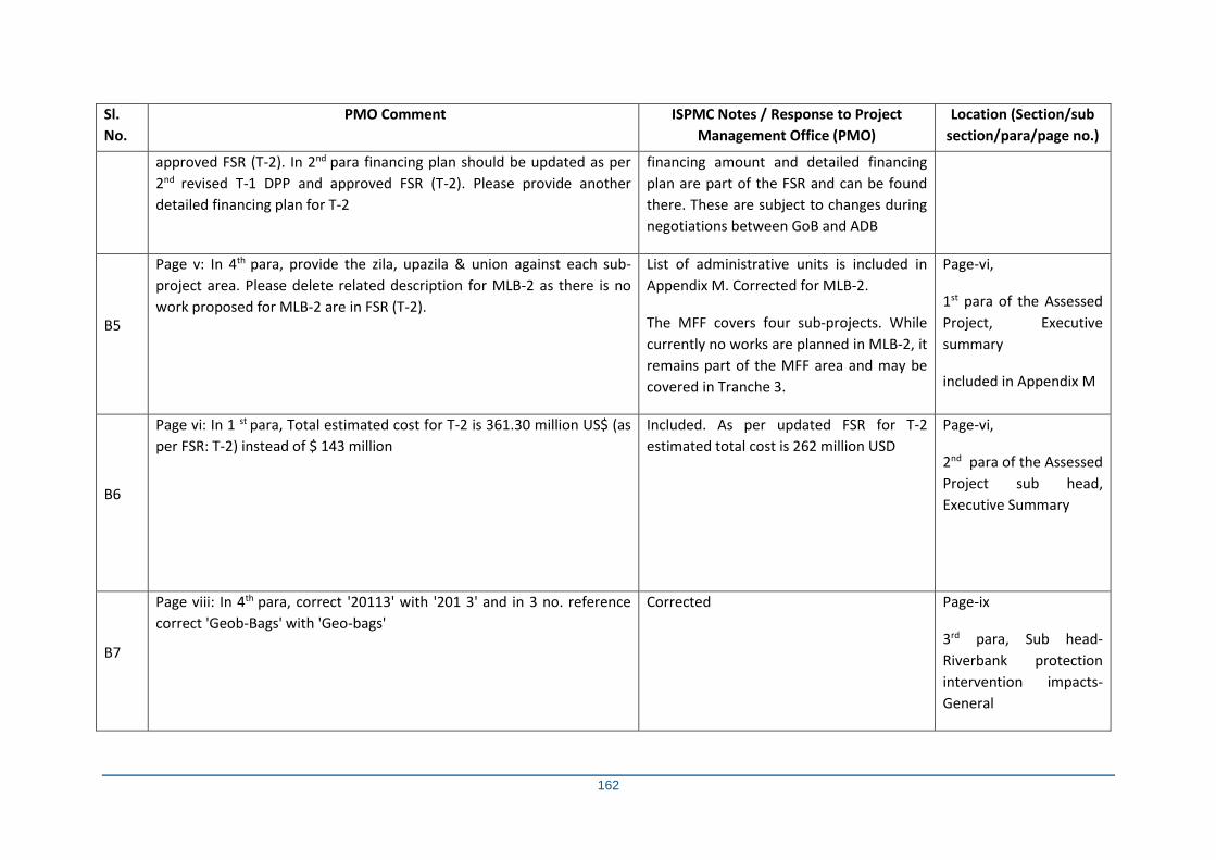
162
Sl.
No.
PMO Comment ISPMC Notes / Response to Project
Management Office (PMO)
Location (Section/sub
section/para/page no.)
approved FSR (T-2). In 2nd para financing plan should be updated as per
2nd revised T-1 DPP and approved FSR (T-2). Please provide another
detailed financing plan for T-2
financing amount and detailed financing
plan are part of the FSR and can be found
there. These are subject to changes during
negotiations between GoB and ADB
B5
Page v: In 4th para, provide the zila, upazila & union against each sub-
project area. Please delete related description for MLB-2 as there is no
work proposed for MLB-2 are in FSR (T-2).
List of administrative units is included in
Appendix M. Corrected for MLB-2.
The MFF covers four sub-projects. While
currently no works are planned in MLB-2, it
remains part of the MFF area and may be
covered in Tranche 3.
Page-vi,
1st para of the Assessed
Project, Executive
summary
included in Appendix M
B6
Page vi: In 1 st para, Total estimated cost for T-2 is 361.30 million US$ (as
per FSR: T-2) instead of $ 143 million
Included. As per updated FSR for T-2
estimated total cost is 262 million USD
Page-vi,
2nd para of the Assessed
Project sub head,
Executive Summary
B7
Page viii: In 4th para, correct '20113' with '201 3' and in 3 no. reference
correct 'Geob-Bags' with 'Geo-bags'
Corrected Page-ix
3rd para, Sub head-
Riverbank protection
intervention impacts-
General
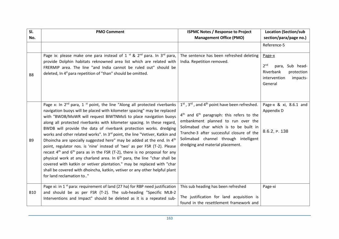
163
Sl.
No.
PMO Comment ISPMC Notes / Response to Project
Management Office (PMO)
Location (Section/sub
section/para/page no.)
Reference-5
B8
Page ix: please make one para instead of 1 st & 2nd para. In 3rd para,
provide Dolphin habitats reknowned area list which are related with
FRERMIP area. The line "and India cannot be ruled out" should be
deleted, In 4tl para repetition of "than" should be omitted.
The sentence has been refreshed deleting
India. Repetition removed.
Page-x
2nd para, Sub head-
Riverbank protection
intervention impacts-
General
B9
Page x: In 2nd para, 1 st point, the line "Along all protected riverbanks
navigation buoys will be placed with kilometer spacing" may be replaced
with "BWDB/MoWR will request BIWTNMoS to place navigation buoys
along all protected riverbanks with kilometer spacing. In these regard,
BWDB will provide the data of riverbank protection works. dredging
works and other related works". In 3rd point, the line "Vetiver, Katkin and
Dhoincha are specially suggested here" may be added at the end. In 4th
point, regulator nos. is 'nine' instead of 'two' as per FSR (T-2). Please
recast 4th and 6th para as in the FSR (T-2), there is no proposal for any
physical work at any charland area. In 6th para, the line "char shall be
covered with katkin or vetiver plantation." may be replaced with "char
shall be covered with dhoincha, katkin, vetiver or any other helpful plant
for land reclamation to.."
1st , 3rd , and 4th point have been refreshed.
4th and 6th paragraph: this refers to the
embankment planned to run over the
Solimabad char which is to be built in
Tranche-3 after successful closure of the
Solimabad channel through intelligent
dredging and material placement.
Page-x & xi, 8.6.1 and
Appendix D
8.6.2, P. 138
B10
Page xi: in 1 st para: requirement of land (27 ha) for RBP need justification
and should be as per FSR (T-2). The sub-heading "Specific MLB-2
Interventions and Impact" should be deleted as it is a repeated sub-
This sub heading has been refreshed
The justification for land acquisition is
found in the resettlement framework and
Page-xi
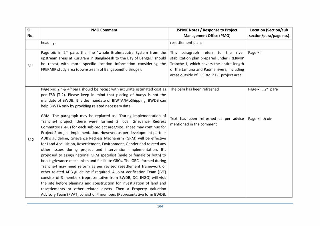
164
Sl.
No.
PMO Comment ISPMC Notes / Response to Project
Management Office (PMO)
Location (Section/sub
section/para/page no.)
heading. resettlement plans
B11
Page xii: in 2nd para, the line "whole Brahmaputra System from the
upstream areas at Kurigram in Bangladesh to the Bay of Bengal." should
be recast with more specific location information considering the
FRERMIP study area (downstream of Bangabandhu Bridge).
This paragraph refers to the river
stabilization plan prepared under FRERMIP
Tranche-1, which covers the entire length
of the Jamuna and Padma rivers, including
areas outside of FRERMIP T-1 project area
Page-xii
B12
Page xiii: 2nd & 4th para should be recast with accurate estimated cost as
per FSR (T-2). Please keep in mind that placing of buoys is not the
mandate of BWDB. It is the mandate of BIWTA/MoShipping. BWDB can
help BIWTA only by providing related necessary data.
GRM: The paragraph may be replaced as: "During implementation of
Tranche-I project, there were formed 3 local Grievance Redress
Committee (GRC) for each sub-project area/site. These may continue for
Project-2 project implementation. However, as per development partner
ADB's guideline, Grievance Redress Mechanism (GRM) will be effective
for Land Acquisition, Resettlement, Environment, Gender and related any
other issues during project and intervention implementation. It’s
proposed to assign national GRM specialist (male or female or both) to
boost grievance mechanism and facilitate GRCs. The GRCs formed during
Tranche-I may need reform as per revised resettlement framework or
other related ADB guideline if required, A Joint Verification Team (JVT)
consists of 3 members (representative from BWDB, DC, INGO) will visit
the site before planning and construction for investigation of land and
resettlements or other related assets. Then a Property Valuation
Advisory Team (PVAT) consist of 4 members (Representative form BWDB,
The para has been refreshed
Text has been refreshed as per advice
mentioned in the comment
Page-xiii, 2nd para
Page-xiii & xiv
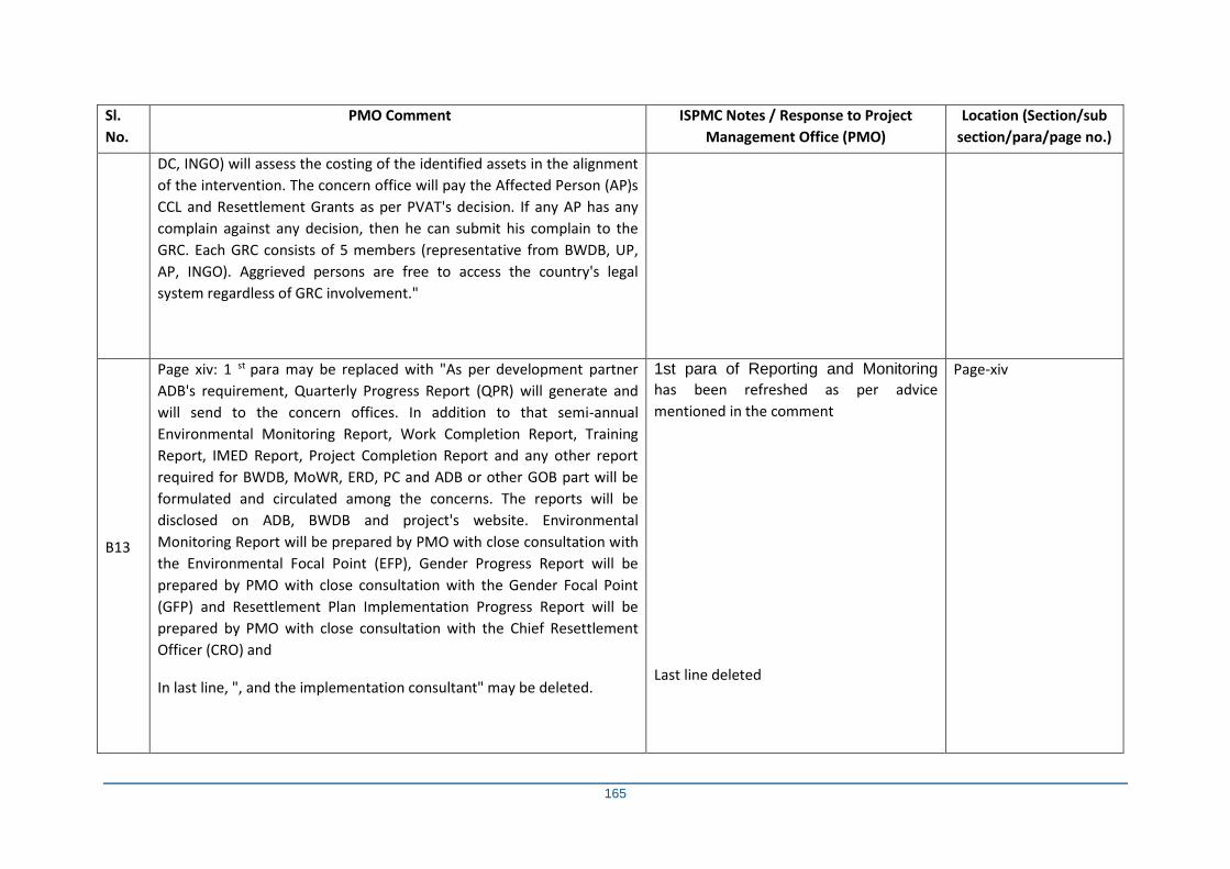
165
Sl.
No.
PMO Comment ISPMC Notes / Response to Project
Management Office (PMO)
Location (Section/sub
section/para/page no.)
DC, INGO) will assess the costing of the identified assets in the alignment
of the intervention. The concern office will pay the Affected Person (AP)s
CCL and Resettlement Grants as per PVAT's decision. If any AP has any
complain against any decision, then he can submit his complain to the
GRC. Each GRC consists of 5 members (representative from BWDB, UP,
AP, INGO). Aggrieved persons are free to access the country's legal
system regardless of GRC involvement."
B13
Page xiv: 1 st para may be replaced with "As per development partner
ADB's requirement, Quarterly Progress Report (QPR) will generate and
will send to the concern offices. In addition to that semi-annual
Environmental Monitoring Report, Work Completion Report, Training
Report, IMED Report, Project Completion Report and any other report
required for BWDB, MoWR, ERD, PC and ADB or other GOB part will be
formulated and circulated among the concerns. The reports will be
disclosed on ADB, BWDB and project's website. Environmental
Monitoring Report will be prepared by PMO with close consultation with
the Environmental Focal Point (EFP), Gender Progress Report will be
prepared by PMO with close consultation with the Gender Focal Point
(GFP) and Resettlement Plan Implementation Progress Report will be
prepared by PMO with close consultation with the Chief Resettlement
Officer (CRO) and
In last line, ", and the implementation consultant" may be deleted.
1st para of Reporting and Monitoring
has been refreshed as per advice
mentioned in the comment
Last line deleted
Page-xiv
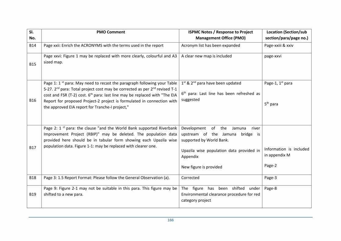
166
Sl.
No.
PMO Comment ISPMC Notes / Response to Project
Management Office (PMO)
Location (Section/sub
section/para/page no.)
B14 Page xxii: Enrich the ACRONYMS with the terms used in the report Acronym list has been expanded Page-xxiii & xxiv
B15
Page xxvi: Figure 1 may be replaced with more clearly, colourful and A3
sized map.
A clear new map is included page-xxvi
B16
Page 1: 1 st para: May need to recast the paragraph following your Table
5-27. 2nd para: Total project cost may be corrected as per 2nd revised T-1
cost and FSR (T-2) cost. 6th para: last line may be replaced with "The EIA
Report for proposed Project-2 project is formulated in connection with
the approved EIA report for Tranche-I project,"
1st & 2nd para have been updated
6th para: Last line has been refreshed as
suggested
Page-1, 1st para
5th para
B17
Page 2: 1 st para: the clause "and the World Bank supported Riverbank
Improvement Project (RBIP)" may be deleted. The population data
provided here should be in tabular form showing each Upazila wise
population data. Figure 1-1: may be replaced with clearer one.
Development of the Jamuna river
upstream of the Jamuna bridge is
supported by World Bank.
Upazila wise population data provided in
Appendix
New figure is provided
Information is included
in appendix M
Page-2
B18 Page 3: 1.5 Report Format: Please follow the General Observation (a). Corrected Page-3
B19
Page 9: Figure 2-1 may not be suitable in this para. This figure may be
shifted to a new para.
The figure has been shifted under
Environmental clearance procedure for red
category project
Page-8
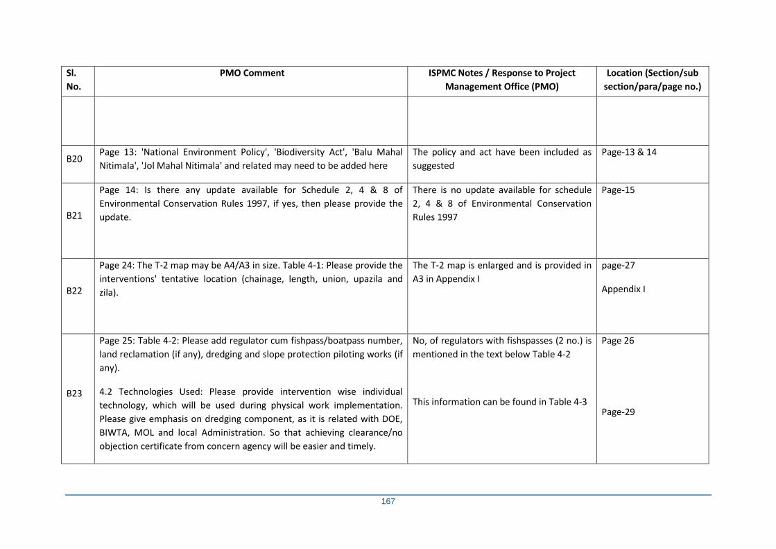
167
Sl.
No.
PMO Comment ISPMC Notes / Response to Project
Management Office (PMO)
Location (Section/sub
section/para/page no.)
B20 Page 13: 'National Environment Policy', 'Biodiversity Act', 'Balu Mahal
Nitimala', 'Jol Mahal Nitimala' and related may need to be added here
The policy and act have been included as
suggested
Page-13 & 14
B21
Page 14: Is there any update available for Schedule 2, 4 & 8 of
Environmental Conservation Rules 1997, if yes, then please provide the
update.
There is no update available for schedule
2, 4 & 8 of Environmental Conservation
Rules 1997
Page-15
B22
Page 24: The T-2 map may be A4/A3 in size. Table 4-1: Please provide the
interventions' tentative location (chainage, length, union, upazila and
zila).
The T-2 map is enlarged and is provided in
A3 in Appendix I
page-27
Appendix I
B23
Page 25: Table 4-2: Please add regulator cum fishpass/boatpass number,
land reclamation (if any), dredging and slope protection piloting works (if
any).
4.2 Technologies Used: Please provide intervention wise individual
technology, which will be used during physical work implementation.
Please give emphasis on dredging component, as it is related with DOE,
BIWTA, MOL and local Administration. So that achieving clearance/no
objection certificate from concern agency will be easier and timely.
No, of regulators with fishspasses (2 no.) is
mentioned in the text below Table 4-2
This information can be found in Table 4-3
Page 26
Page-29
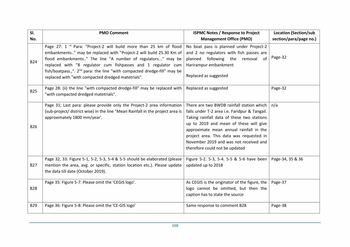
168
Sl.
No.
PMO Comment ISPMC Notes / Response to Project
Management Office (PMO)
Location (Section/sub
section/para/page no.)
B24
Page 27: 1 st Para: "Project-2 will build more than 25 km of flood
embankments.." may be replaced with "Project-2 will build 25.30 Km of
flood embankments.." The line "A number of regulators..." may be
replaced with "8 regulator cum fishpasses and 1 regulator cum
fish/boatpass.,". 2nd para: the line "with compacted dredge-fill" may be
replaced with "with compacted dredged matetrials".
No boat pass is planned under Project-2
and 2 no regulators with fish passes are
planned following the removal of
Harirampur embankment
Replaced as suggested
Page-32
B25 Page 28: (ii) the line "with compacted dredge-fill" may be replaced with
"with compacted dredged matetrials".
Replaced as suggested Page-32
B26
Page 31; Last para: please provide only the Project-2 area information
(sub-project/ district wise) in the line "Mean Rainfall in the project area is
approximately 1800 mm/year'.
There are two BWDB rainfall station which
falls under T-2 area i.e. Faridpur & Tangail.
Taking rainfall data of these two stations
up to 2019 and mean of these will give
approximate mean annual rainfall in the
project area. This data was requested in
November 2019 and was not received and
therefore could not be updated
n/a
B27
Page 32, 33: Figure 5-1, 5-2, 5-3, 5-4 & 5-5 should be elaborated (please
mention the area, avg. or specific, station location etc.). Please update
the data till date (October 2019).
Figure 5-2. 5-3, 5-4. 5-5 & 5-6 have been
updated up to 2018
Page-34, 35 & 36
B28
Page 35: Figure 5-7: Please omit the 'CEGIS logo'. As CEGIS is the originator of the figure, the
logo cannot be omitted, but then the
caption has to state the source
Page-37
B29 Page 36: Figure 5-8: Please omit the ICE-GIS logo' Same response to comment B28 Page-38
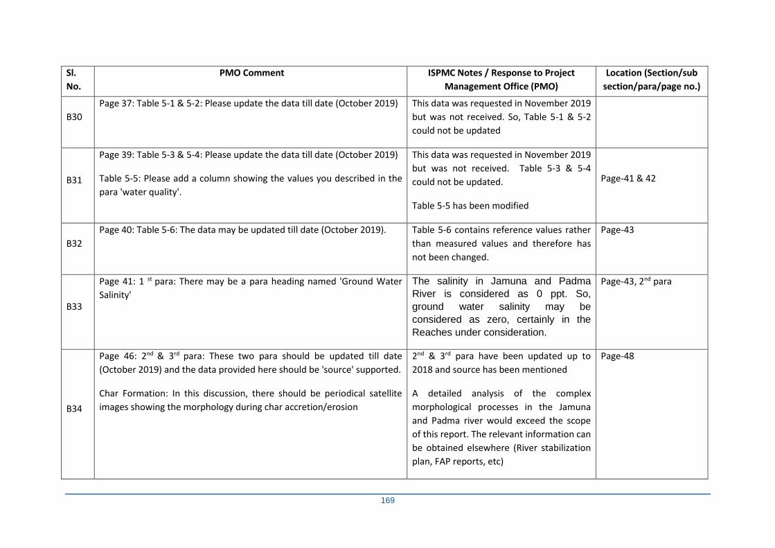
169
Sl.
No.
PMO Comment ISPMC Notes / Response to Project
Management Office (PMO)
Location (Section/sub
section/para/page no.)
B30
Page 37: Table 5-1 & 5-2: Please update the data till date (October 2019) This data was requested in November 2019
but was not received. So, Table 5-1 & 5-2
could not be updated
B31
Page 39: Table 5-3 & 5-4: Please update the data till date (October 2019)
Table 5-5: Please add a column showing the values you described in the
para 'water quality'.
This data was requested in November 2019
but was not received. Table 5-3 & 5-4
could not be updated.
Table 5-5 has been modified
Page-41 & 42
B32
Page 40: Table 5-6: The data may be updated till date (October 2019). Table 5-6 contains reference values rather
than measured values and therefore has
not been changed.
Page-43
B33
Page 41: 1 st para: There may be a para heading named 'Ground Water
Salinity'
The salinity in Jamuna and Padma
River is considered as 0 ppt. So,
ground water salinity may be
considered as zero, certainly in the
Reaches under consideration.
Page-43, 2nd para
B34
Page 46: 2nd & 3rd para: These two para should be updated till date
(October 2019) and the data provided here should be 'source' supported.
Char Formation: In this discussion, there should be periodical satellite
images showing the morphology during char accretion/erosion
2nd & 3rd para have been updated up to
2018 and source has been mentioned
A detailed analysis of the complex
morphological processes in the Jamuna
and Padma river would exceed the scope
of this report. The relevant information can
be obtained elsewhere (River stabilization
plan, FAP reports, etc)
Page-48
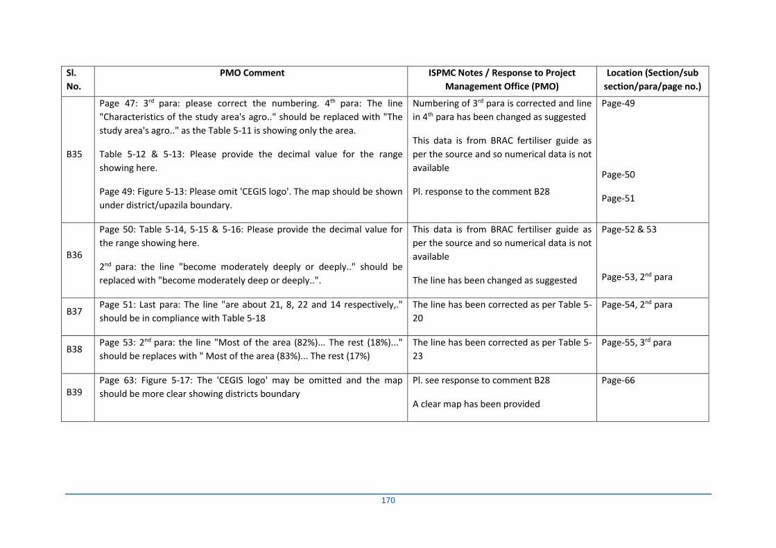
170
Sl.
No.
PMO Comment ISPMC Notes / Response to Project
Management Office (PMO)
Location (Section/sub
section/para/page no.)
B35
Page 47: 3rd para: please correct the numbering. 4th para: The line
"Characteristics of the study area's agro.." should be replaced with "The
study area's agro.." as the Table 5-11 is showing only the area.
Table 5-12 & 5-13: Please provide the decimal value for the range
showing here.
Page 49: Figure 5-13: Please omit 'CEGIS logo'. The map should be shown
under district/upazila boundary.
Numbering of 3rd para is corrected and line
in 4th para has been changed as suggested
This data is from BRAC fertiliser guide as
per the source and so numerical data is not
available
Pl. response to the comment B28
Page-49
Page-50
Page-51
B36
Page 50: Table 5-14, 5-15 & 5-16: Please provide the decimal value for
the range showing here.
2nd para: the line "become moderately deeply or deeply.." should be
replaced with "become moderately deep or deeply..".
This data is from BRAC fertiliser guide as
per the source and so numerical data is not
available
The line has been changed as suggested
Page-52 & 53
Page-53, 2nd para
B37 Page 51: Last para: The line "are about 21, 8, 22 and 14 respectively,."
should be in compliance with Table 5-18
The line has been corrected as per Table 5-
20
Page-54, 2nd para
B38 Page 53: 2nd para: the line "Most of the area (82%)... The rest (18%)..."
should be replaces with " Most of the area (83%)... The rest (17%)
The line has been corrected as per Table 5-
23
Page-55, 3rd para
B39 Page 63: Figure 5-17: The 'CEGIS logo' may be omitted and the map
should be more clear showing districts boundary
Pl. see response to comment B28
A clear map has been provided
Page-66
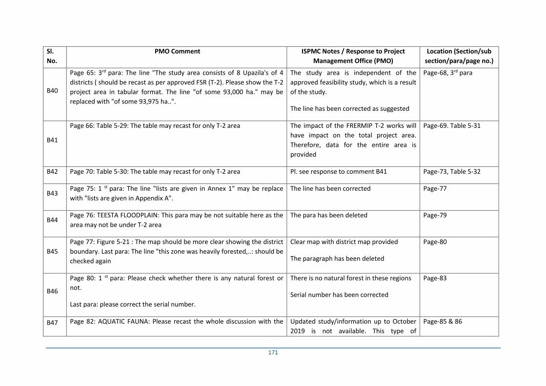
171
Sl.
No.
PMO Comment ISPMC Notes / Response to Project
Management Office (PMO)
Location (Section/sub
section/para/page no.)
B40
Page 65: 3rd para: The line "The study area consists of 8 Upazila's of 4
districts ( should be recast as per approved FSR (T-2). Please show the T-2
project area in tabular format. The line "of some 93,000 ha." may be
replaced with "of some 93,975 ha..".
The study area is independent of the
approved feasibility study, which is a result
of the study.
The line has been corrected as suggested
Page-68, 3rd para
B41
Page 66: Table 5-29: The table may recast for only T-2 area The impact of the FRERMIP T-2 works will
have impact on the total project area.
Therefore, data for the entire area is
provided
Page-69. Table 5-31
B42 Page 70: Table 5-30: The table may recast for only T-2 area Pl. see response to comment B41 Page-73, Table 5-32
B43 Page 75: 1 st para: The line "lists are given in Annex 1" may be replace
with "lists are given in Appendix A".
The line has been corrected Page-77
B44 Page 76: TEESTA FLOODPLAIN: This para may be not suitable here as the
area may not be under T-2 area
The para has been deleted Page-79
B45
Page 77: Figure 5-21 : The map should be more clear showing the district
boundary. Last para: The line "this zone was heavily forested,..: should be
checked again
Clear map with district map provided
The paragraph has been deleted
Page-80
B46
Page 80: 1 st para: Please check whether there is any natural forest or
not.
Last para: please correct the serial number.
There is no natural forest in these regions
Serial number has been corrected
Page-83
B47 Page 82: AQUATIC FAUNA: Please recast the whole discussion with the Updated study/information up to October
2019 is not available. This type of
Page-85 & 86
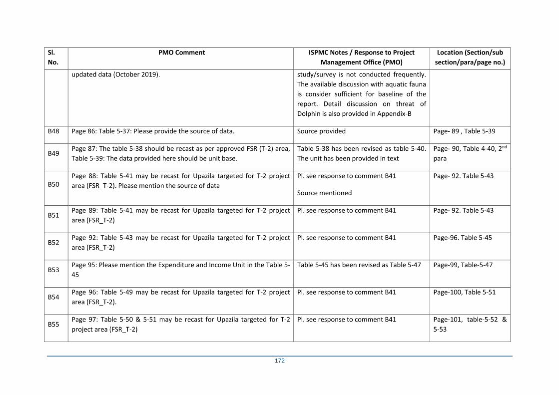
172
Sl.
No.
PMO Comment ISPMC Notes / Response to Project
Management Office (PMO)
Location (Section/sub
section/para/page no.)
updated data (October 2019). study/survey is not conducted frequently.
The available discussion with aquatic fauna
is consider sufficient for baseline of the
report. Detail discussion on threat of
Dolphin is also provided in Appendix-B
B48 Page 86: Table 5-37: Please provide the source of data. Source provided Page- 89 , Table 5-39
B49 Page 87: The table 5-38 should be recast as per approved FSR (T-2) area,
Table 5-39: The data provided here should be unit base.
Table 5-38 has been revised as table 5-40.
The unit has been provided in text
Page- 90, Table 4-40, 2nd
para
B50 Page 88: Table 5-41 may be recast for Upazila targeted for T-2 project
area (FSR_T-2). Please mention the source of data
Pl. see response to comment B41
Source mentioned
Page- 92. Table 5-43
B51 Page 89: Table 5-41 may be recast for Upazila targeted for T-2 project
area (FSR_T-2)
Pl. see response to comment B41 Page- 92. Table 5-43
B52 Page 92: Table 5-43 may be recast for Upazila targeted for T-2 project
area (FSR_T-2)
Pl. see response to comment B41 Page-96. Table 5-45
B53 Page 95: Please mention the Expenditure and Income Unit in the Table 5-
45
Table 5-45 has been revised as Table 5-47 Page-99, Table-5-47
B54 Page 96: Table 5-49 may be recast for Upazila targeted for T-2 project
area (FSR_T-2).
Pl. see response to comment B41 Page-100, Table 5-51
B55 Page 97: Table 5-50 & 5-51 may be recast for Upazila targeted for T-2
project area (FSR_T-2)
Pl. see response to comment B41 Page-101, table-5-52 &
5-53
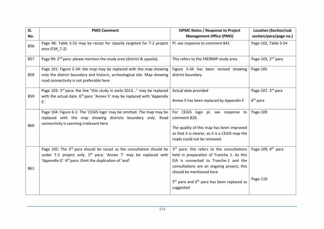
173
Sl.
No.
PMO Comment ISPMC Notes / Response to Project
Management Office (PMO)
Location (Section/sub
section/para/page no.)
B56 Page 98: Table 5-52 may be recast for Upazila targeted for T-2 project
area (FSR_T-2)
Pl. see response to comment B41 Page-102, Table 5-54
B57 Page 99: 2nd para: please mention the study area (district & upazila). This refers to the FRERMIP study area Page-103, 2nd para
B58
Page 101: Figure 5-34: the map may be replaced with the map showing
only the district boundary and historic, archeological site. Map showing
road connectivity is not preferable here
Figure 5-34 has been revised showing
district boundary
Page-105
B59
Page 103: 3rd para: the line "this study in early-2013..." may be replaced
with the actual date. 6th para: 'Annex 5' may be replaced with 'Appendix
E'.
Actual date provided
Annex 5 has been replaced by Appendix E
Page-107. 3rd para
6th para
B60
Page 104: Figure 6-1: The 'CEGIS logo' may be omitted. The map may be
replaced with the map showing districts boundary only. Road
connectivity is seeming irrelevant here
For CEGIS logo pl. see response to
comment B28.
The quality of this map has been improved
so that it is clearer, as it is a CEGIS map the
roads could not be removed.
Page-109
B61
Page 105: The 3rd para should be recast as the consultation should be
under T-2 project only. 5th para: 'Annex 7' may be replaced with
'Appendix G'. 6th para: Omit the duplication of 'and'.
3rd para: this refers to the consultations
held in preparation of Tranche 1. As this
EIA is connected to Tranche-1 and the
consultations are an ongoing project, this
should be mentioned here
5th para and 6th para has been replaced as
suggested
Page-109, 4th para
Page-110
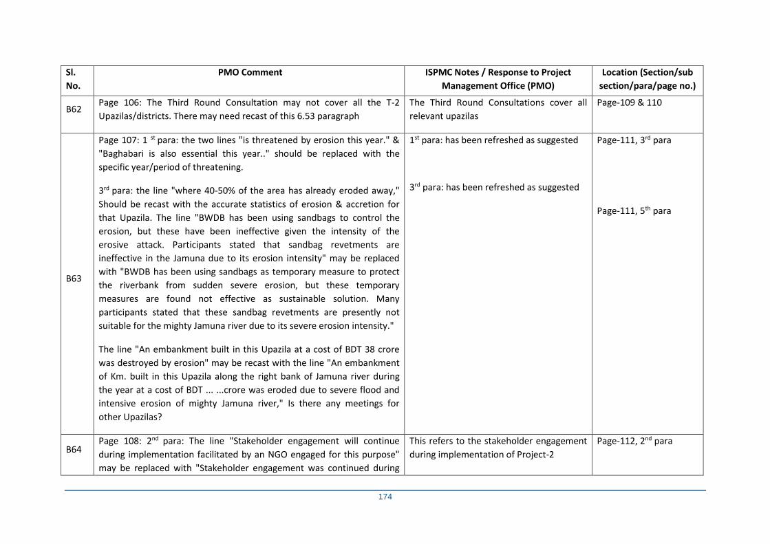
174
Sl.
No.
PMO Comment ISPMC Notes / Response to Project
Management Office (PMO)
Location (Section/sub
section/para/page no.)
B62 Page 106: The Third Round Consultation may not cover all the T-2
Upazilas/districts. There may need recast of this 6.53 paragraph
The Third Round Consultations cover all
relevant upazilas
Page-109 & 110
B63
Page 107: 1 st para: the two lines "is threatened by erosion this year." &
"Baghabari is also essential this year.." should be replaced with the
specific year/period of threatening.
3rd para: the line "where 40-50% of the area has already eroded away,"
Should be recast with the accurate statistics of erosion & accretion for
that Upazila. The line "BWDB has been using sandbags to control the
erosion, but these have been ineffective given the intensity of the
erosive attack. Participants stated that sandbag revetments are
ineffective in the Jamuna due to its erosion intensity" may be replaced
with "BWDB has been using sandbags as temporary measure to protect
the riverbank from sudden severe erosion, but these temporary
measures are found not effective as sustainable solution. Many
participants stated that these sandbag revetments are presently not
suitable for the mighty Jamuna river due to its severe erosion intensity."
The line "An embankment built in this Upazila at a cost of BDT 38 crore
was destroyed by erosion" may be recast with the line "An embankment
of Km. built in this Upazila along the right bank of Jamuna river during
the year at a cost of BDT ... ...crore was eroded due to severe flood and
intensive erosion of mighty Jamuna river," Is there any meetings for
other Upazilas?
1st para: has been refreshed as suggested
3rd para: has been refreshed as suggested
Page-111, 3rd para
Page-111, 5th para
B64 Page 108: 2nd para: The line "Stakeholder engagement will continue
during implementation facilitated by an NGO engaged for this purpose"
may be replaced with "Stakeholder engagement was continued during
This refers to the stakeholder engagement
during implementation of Project-2
Page-112, 2nd para
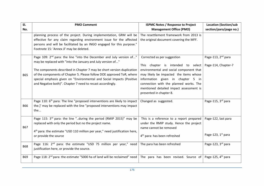
175
Sl.
No.
PMO Comment ISPMC Notes / Response to Project
Management Office (PMO)
Location (Section/sub
section/para/page no.)
planning process of the project. During implementation, GRM will be
effective for any claim regarding environment issue for the affected
persons and will be facilitated by an INGO engaged for this purpose."
Footnote 15: 'Annex Jl' may be deleted.
The resettlement framework from 2013 is
the original document covering the MFF.
B65
Page 109: 2nd para: the line "into the December and July version of..."
may be replaced with "into the January and July version of..."
The components described in Chapter 7 may be short version duplication
of the components of Chapter 5. Please follow DOE approved ToR, where
special emphasis given on "Environmental and Social Impacts (Positive
and Negative both)". Chapter 7 need to recast accordingly.
Corrected as per suggestion
This chapter is intended to select
environmental and social component that
may likely be impacted the items whose
information given in chapter 5 in
connection with the planned works. The
mentioned detailed impact assessment is
presented in chapter 8.
Page-113, 2nd para
Page-114, Chapter-7
B66
Page 110: 6th para: The line "proposed interventions are likely to impact
the.]' may be replaced with the line "proposed interventions may impact
the...
Changed as suggested. Page-115, 3rd para
B67
Page 115: 3rd para: the line "..during the period (RMIP 2015)" may be
replaced with only the period but no the project name.
4th para: the estimate "USD 110 million per year," need justification here,
or provide the source
This is a reference to a report prepared
under the RMIP study. Hence the project
name cannot be removed
4th para: has been refreshed
Page-122, last para
Page-123, 1st para
B68 Page 116: 2nd para: the estimate "USD 75 million per year," need
justification here, or provide the source.
The para has been refreshed Page-123, 3rd para
B69 Page 118: 2nd para: the estimate "5000 ha of land will be reclaimed" need The para has been revised. Source of Page-125, 4th para
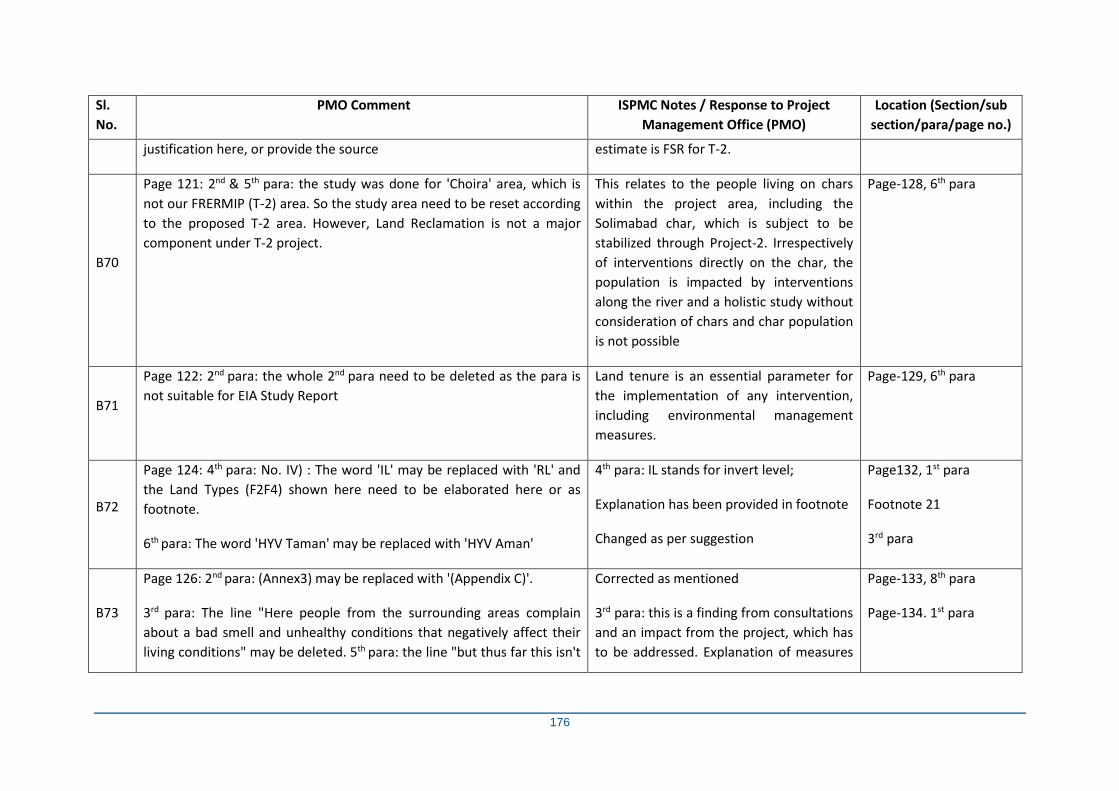
176
Sl.
No.
PMO Comment ISPMC Notes / Response to Project
Management Office (PMO)
Location (Section/sub
section/para/page no.)
justification here, or provide the source estimate is FSR for T-2.
B70
Page 121: 2nd & 5th para: the study was done for 'Choira' area, which is
not our FRERMIP (T-2) area. So the study area need to be reset according
to the proposed T-2 area. However, Land Reclamation is not a major
component under T-2 project.
This relates to the people living on chars
within the project area, including the
Solimabad char, which is subject to be
stabilized through Project-2. Irrespectively
of interventions directly on the char, the
population is impacted by interventions
along the river and a holistic study without
consideration of chars and char population
is not possible
Page-128, 6th para
B71
Page 122: 2nd para: the whole 2nd para need to be deleted as the para is
not suitable for EIA Study Report
Land tenure is an essential parameter for
the implementation of any intervention,
including environmental management
measures.
Page-129, 6th para
B72
Page 124: 4th para: No. IV) : The word 'IL' may be replaced with 'RL' and
the Land Types (F2F4) shown here need to be elaborated here or as
footnote.
6th para: The word 'HYV Taman' may be replaced with 'HYV Aman'
4th para: IL stands for invert level;
Explanation has been provided in footnote
Changed as per suggestion
Page132, 1st para
Footnote 21
3rd para
B73
Page 126: 2nd para: (Annex3) may be replaced with '(Appendix C)'.
3rd para: The line "Here people from the surrounding areas complain
about a bad smell and unhealthy conditions that negatively affect their
living conditions" may be deleted. 5th para: the line "but thus far this isn't
Corrected as mentioned
3rd para: this is a finding from consultations
and an impact from the project, which has
to be addressed. Explanation of measures
Page-133, 8th para
Page-134. 1st para
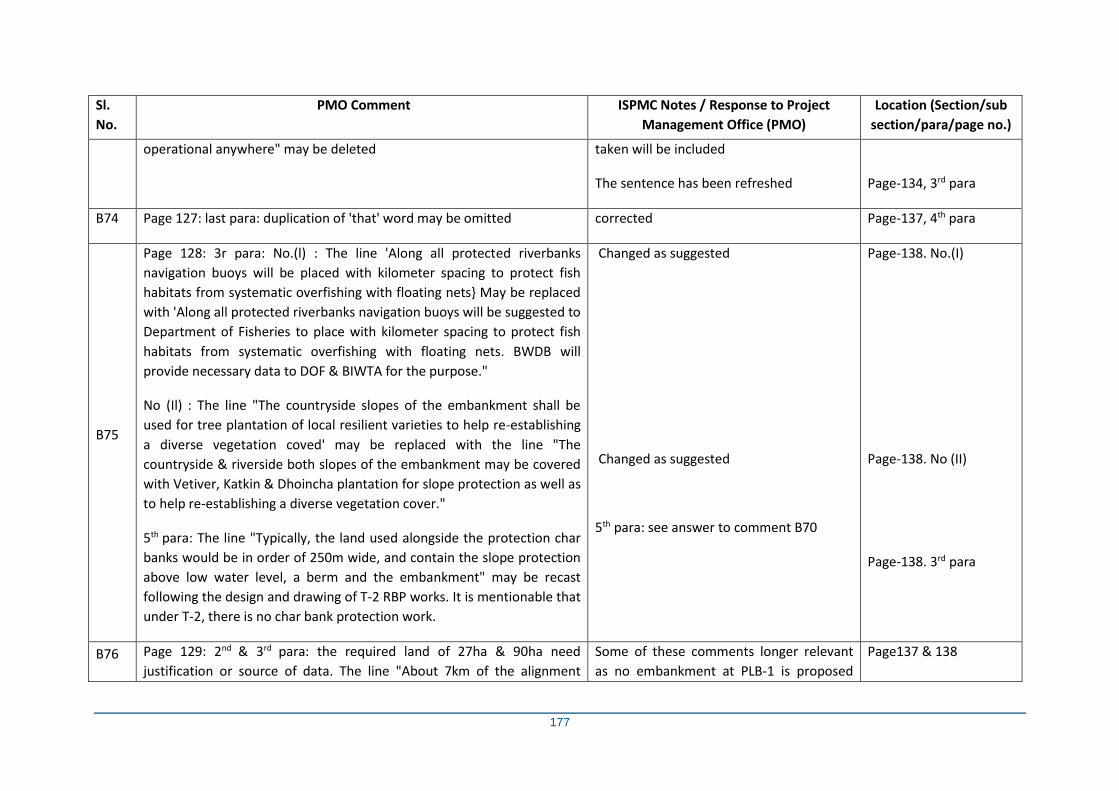
177
Sl.
No.
PMO Comment ISPMC Notes / Response to Project
Management Office (PMO)
Location (Section/sub
section/para/page no.)
operational anywhere" may be deleted taken will be included
The sentence has been refreshed
Page-134, 3rd para
B74 Page 127: last para: duplication of 'that' word may be omitted corrected Page-137, 4th para
B75
Page 128: 3r para: No.(l) : The line 'Along all protected riverbanks
navigation buoys will be placed with kilometer spacing to protect fish
habitats from systematic overfishing with floating nets} May be replaced
with 'Along all protected riverbanks navigation buoys will be suggested to
Department of Fisheries to place with kilometer spacing to protect fish
habitats from systematic overfishing with floating nets. BWDB will
provide necessary data to DOF & BIWTA for the purpose."
No (Il) : The line "The countryside slopes of the embankment shall be
used for tree plantation of local resilient varieties to help re-establishing
a diverse vegetation coved' may be replaced with the line "The
countryside & riverside both slopes of the embankment may be covered
with Vetiver, Katkin & Dhoincha plantation for slope protection as well as
to help re-establishing a diverse vegetation cover."
5th para: The line "Typically, the land used alongside the protection char
banks would be in order of 250m wide, and contain the slope protection
above low water level, a berm and the embankment" may be recast
following the design and drawing of T-2 RBP works. It is mentionable that
under T-2, there is no char bank protection work.
Changed as suggested
Changed as suggested
5th para: see answer to comment B70
Page-138. No.(I)
Page-138. No (II)
Page-138. 3rd para
B76 Page 129: 2nd & 3rd para: the required land of 27ha & 90ha need
justification or source of data. The line "About 7km of the alignment
Some of these comments longer relevant
as no embankment at PLB-1 is proposed
Page137 & 138
178
Sl.
No.
PMO Comment ISPMC Notes / Response to Project
Management Office (PMO)
Location (Section/sub
section/para/page no.)
(40%) will be placed on newly reclaimed charland" need to be recast as
per approved FSR (T-2).
4th para: the line "In total 5 regulators... need to be checked.
6th para: The line "The embankment planned for Tranche-I is yet to start
due to unavoidable delay in tendering process" need to be recast as per
actual field condition.
9.1 Tranche-I Experience: 1 st & 2nd para: need to recast as per last update
(please follow QPR16 or latest draft 17)
under the updated design as per client
preference
6th para: has been refreshed
9.1: The para has been refreshed
Page-138 & 139
Page-140
B77
Page 131: 4th para: The line "For implementation of GRM it is proposed to
assign two..." may be replaced with the line 'For implementation of GRM,
there may be two..."
This change would not make it clear that
these are additional positions
Page-142, 3rd para
B78
Page 132: 1 st para: No (IV): the line " in a format agreed with the ISPMC
Team Leaded' may be replaced with ...in a format agreed with the BWDB
and the development partner ADB". 3rd para: The line "the FRERMIP
project area was.." may be replaced with "the FRERMIP program area
was....
1st para: changed as suggested
3rd para: Changed as suggested
Page-142, 3rd para (IV)
Page-143, 1st para
B79
Page 133: last para: the line "specialist firm/NGO will be retained.." may
be replaced with "specialist firm/NGO may be retained.."
Provide the Impact Magnitude Scale here in a tabular format
Changed as suggested
Impact Magnitude scale have been
provided against each intervention in EMP
table
Page-144, 4th para
EMP table
B80 Page 136: 11.1.2 'Bank Protection' may be replaced with 'Riverbank Changed as suggested Page-147, 11.1.2
179
Sl.
No.
PMO Comment ISPMC Notes / Response to Project
Management Office (PMO)
Location (Section/sub
section/para/page no.)
Protection'.
Noise: Mitigation: may be 'Working hours to be restricted to 8:00 AM to
5:00 PM. only'
Changed as suggested
B81
Page 137: Surface Water Quality: Mag. of Impact may be -3 & EMP Cost
may be 2.00
The impact magnitudes are determined by
national and international environmental
experts. This test will be conducted at
different locations
Page-148
B82
Page 139: Terrestrial and Aquatic Ecosystem Diversity: Mag. of Impact
may be -1 & Mag with EMP may be -l
The impact magnitudes are determined by
national and international environmental
experts.
Page-150
B83 Page 140: Health and Safety: Mag. of Impact may be -3 Same response to comment B 82 Page-151
B84 Page 141: Employment: Mag. of Impact may be +3. Community
Organizations: EMP Cost: Check FSR (T-2) for accurate costing
Same response to comment B 82 Page-152
B85
Page 142: 11.113: 'Embankment Construction and Rehabilitation' may be
replaced as 'Embankment Construction/Reconstruction'.
Air Quality: Mag with EMP may be -1.
Page 143: Noise: Mitigation: may be 'Working hours to be restricted to
8:00 AM to 5:00 PM
Changed as suggested
Same response to comment B 82
Changed as suggested
Page- 152 & 153
B86 Page 144: Drainage Congestion: Mitigation: may be 'Constructing
Regulators cum Fish/Boat pass at appropriate locations'.
Changed as suggested
Cost may be incurred from anywhere from
Page-154
180
Sl.
No.
PMO Comment ISPMC Notes / Response to Project
Management Office (PMO)
Location (Section/sub
section/para/page no.)
Land Loss: Mag with EMP may be 0 and for EMP Cost, please check
present ongoing works' BOQ of the Contract Agreement
project, but it will be reckoned as EMP cost
and magnitude is consider with EMP
B87 Page 146: Crop Production Loss: Mag with EMP may be +1 & the list of
Responsible Agency may need recast
Same response to comment B 82 Page-156
B88
Page 148: Fish Habitat: Mag of Impact may be -3 & Mag with EMP may
be -1. Mitigation: please mention all 9 regulators which are proposed in
FSR (T-2)
Same response to comment B 82. 7 no of
these regulators are no longer proposed as
PLB1 embankment has been removed from
the design as per Client preference. 2 no
fish regulators have been mentioned as
mitigation
Page-157
B89
Page 149: Terrestrial and Aquatic Ecosystem Diversity: Mag. of Impact
may be -3 & Mag with EMP may be -1. In Impacts: the line '..and fauna
will be destroyed' may be replaced with '..and fauna may be destroyed'
Same response to comment B 82
Impact column changed as suggested
Page-158
B90 Page 151: Health and Safety: Mag of Impact may be -3 Same response to comment B 82 Page-159
B91 Page 152: Employment: Mag of Impact may be +2.
Community Organizations: EMP Cost: Please mention the decimal figure
Same response to comment B 82
Sub section corrected
Page-160
B92
Page 153: 11.14 'Drainage Structure/Sluice/Fishpass' may be replaced
with 'Drainage Structure/Rgulators cum Boat/Fishpass'
Page 154: Noise: Mitigation: may be 'Working hours to be restricted to
8:00 AM to 5:00 PM.
Drainage Congestion: the word 'sluices' may be replaced with 'regulators
Changed to “regulators cum fish passes”
Working hours restriction mention as
suggested
Page-161
181
Sl.
No.
PMO Comment ISPMC Notes / Response to Project
Management Office (PMO)
Location (Section/sub
section/para/page no.)
cum boat/fish pass'. EMP cost: mention the decimal figure Changed to “regulators cum fish passes”
B93
Page 155: Health and Safety: Mag of Impact: may be -2.
Employment: Mag of Impact: may be +2.
Community Organizations: EMP Cost: mention the decimal figure
Same response to comment B 82
Same response to comment B 82
Figure included
Page-160
B94 Page 158: Waste and Disposal: Mag of Impact may be -2.
Public Health: Mag of Impact may be -3 & Mag with EMP may be -1
Same response to comment B 82
Same response to comment B 82
Page166
B95
Page 159: Erosion: Mitigation: check the figure of .6,700ha'.
Drainage Congestion: Mitigation: the word 'sluices' may be replaced with
'regulators cum boat/fishpass'
Pl. check the figure 6700 ha
Changed to “regulators cum fish passes”
Page-176
B96
Page 162: Sand Carpeting: EMP Cost: Mention the decimal figure At this stage figure cannot be provided. It
will be quantified after assessing field
condition
Page-170
B97 Page 164: Improved Irrigation Facilities: EMP Cost: Mention the decimal
figure
Cost will be finalised after observing field
condition
Page-172
B98
Page 165: Fish Habitat: Impacts: The line 'Estimated net loss of 6,700 ha
of fish habitat due to land reclamation + habitat altered due to the
revetment 1,300 ha' need to be check following the FSR (T-2).
Fish Migration: Mitigation: the word 'sluices' may be replaced with
'regulators cum boat/fishpass'. Mag with EMP may be -2
This has not been mentioned in FSR T2
Changed as per suggestion
Page-174
182
Sl.
No.
PMO Comment ISPMC Notes / Response to Project
Management Office (PMO)
Location (Section/sub
section/para/page no.)
B99
Page 166: Fish Biodiversity & production enhancement: Mitigation (1, 3
& 7): placing buoys is not the mandate of BWDB but the mandate of
Department of Fisheries or BIWTA. BWDB can provide the RbP Works'
data to the concern organizations. Hence 1, 3 & 7 no. mitigation need to
be recast as per.
It is a mitigation measure provided by the
expert which should be included in EMP.
During implementation the responsibility/
mandate will be sort out
Page-175
B100
Page 169: Communication: Impacts: the line '...be provided with crest
pavements..' may be replaced with ...be provided with 10m wide crest of
the flood protection embankments..}
EMP Cost: Mention the decimal figure following the FSR (T-2).
Responsible Agency: should be BWDB
A crest alone will not improve road
transport unless it is paved, as otherwise
this is subject to encroachment
Project cost (Tbd)
Changed as suggested
Page-179
B101 Page 171: Monitoring Plan 10: 'No embankment and bank soil erosion'
may be replaced with 'No embankment and riverbank soil erosion'
Changed as suggested Page-180
B102
Page 176: 3rd para: The line 'aquatic habitats including charlands and
their...' may be recast as there are no works in charlands under FSR (T-2).
The recommended action l, Il & Ill should be more elaborate that which
agency will implement those actions as BWDB is not mandated to do
those. Different agencies can do those actions and BWDB can assist
concern agencies providing related data for this purpose.
The line 'Finalization of the Tranche-l works (in 2018) can proceed
without further environmental study' need to recast as per present
situation.
The sentence has been refreshed without
including charlands
The action I, II & III has been refreshed
The para has been refreshed
Page-186
183
Sl.
No.
PMO Comment ISPMC Notes / Response to Project
Management Office (PMO)
Location (Section/sub
section/para/page no.)
B103 Page 186,187, 188, 189, 190: IUCN Status & Local Status: Please update
the list as per latest 2019 status
The list was last updated in 2015 and it will
be updated in 2025 again
Page- 196 to 200
B104
Page 193: 1 st para: The line 'Perhaps the most significant issue is the
building more than 50 dams along many rivers,..' may need recast with
more specific data (number of dams and relevant river names), like the
relevant upstream river of Jamuna and Padma.
3rd para: The line 'Dolphin oil is used by people in Bangladesh as a
liniment,' should be replaced with the line 'Dolphin oil & organs are used
by the people around the world
This comment is related to the destruction
habitat of dolphins across the sub-
continent and so the names of the rivers or
dams are not relevant and will not affect
the statement’s validity. A sentence in the
main report can be added referring to the
overall effect of dolphins.
This document relates to Bangladesh,
however refreshed according to Client
preferences
Page-205
B105
Page 197-203: The proposed Bird Sanctuary Site 1, 2, 3, 4, 5, 6, 7, 8 & 9
should be more specific by mentioning Union, Upazila and District name
The bird sanctuary sites are provided with
maps and GPS coordinates instead, which
is more specific than union & upazila
name.
Page-209 to 215
B106
Page 206: 1 st para: Please provide the Fish Sanctuary DoFo data up to the
date (October 2019) and provide the data only for T-2 area as per
approved FSR Page 207: 1 st para: may recast the report as per latest
DoFo report
No updated data/report regarding the no.
of Fish Sanctuaries in the Tranche -2 in
October 2019 is available with the DoF.
However, field report of the ISPMC Team
of August 2019 indicated that there are 5
Fish Sanctuaries, most of them non-
functional, in the Tranche -2 area including
the DoF and NGO supported ones.
Page-218 & 219
184
Sl.
No.
PMO Comment ISPMC Notes / Response to Project
Management Office (PMO)
Location (Section/sub
section/para/page no.)
B107
Page 210: Figure DI-I: the map should be more clear and the figure title
may be 'Proposed location of model sanctuary which is located under T-2
project site.
1 st para: the line because the project will continue till 2023 with...'
may be replaced with the line .because the FRERMIP MFF program is
expected to be continued till 2023 with
Clear map provided
The sentence has been changed as
suggested
Page-222
Page-223, 1st para
B108
2nd para: The para may be recast as per the sense that BWDB is not
mandated to implement fish sanctuaries in the project area. DoF is
mandated to do that. BWDB may assist DoF by providing necessary data
in purpose of Sanctuary establishment. ADB may finance DoFi in respect
of establishment of fish sanctuary to mitigate the adverse effect of fish
production & habitat due to T-2 project implementation
2nd para has been refreshed. DOF
initiated establishing Inland Fish
Sanctuaries as extension measures in the
1980s, and now several NGOs and private
efforts are there to establish and maintain
Fish Sanctuaries. Project evaluation of
sanctuaries found many to be deficient,
and an improved approach is needed.
Page-223
B109 Page 213: Table El-3: Please correct the project name and proponents
may be BWDB, ISPMC & ADB
At that time, no ISPMC was engaged,
hence the proponent was NHC
Page-225
B110
Page 231: Table Gl-l: is there any consultation meeting for Tangail? If so,
then please mention the details.
Table Gl-2: name may be 'Public Consultation and FGD Meeting
Participants Details'
There were no consultation meetings in
Tangail.
Type mistake has been corrected
Page-244
B111 Page 239 & 240: Please check the meeting date for both and make
confirm whether the meeting is for first round or third
The consultation meeting is for third round
The meeting date is ok
Page-252
185
Sl.
No.
PMO Comment ISPMC Notes / Response to Project
Management Office (PMO)
Location (Section/sub
section/para/page no.)
B112 Page 269: 5th para: asphalt (hot mix) plants is not suitable here as there is
no asphalt work under proposed T-2 project
Asphalt removed Page-282
B113
Page 271: 4th para: to implement the line 'including the use of noise
barriers', there should kept budget provision in the Contract Agreement
of work packages.
9th para: deduction of contractor's bill for crop damage (if any) during the
intervention construction may not feasible under the present GOB rules.
The AP can submit his/her claim to the GRC for appropriate
compensation for this case. Last para: tubewell testing: there should kept
budget provision in the contract agreement/BoQ for water quality tests
and the liability should be upon the contractors side
4th para: Refreshed as suggested
9th para: The para has been refreshed as
suggested
Last para: testing of tube well should be
kept under contractor’s contract budget
Page-284, 4th para
Page-284, 9th para
Page-284, last para
B114 Page 272: 4th para is a good initiative and should be included in the
tender documents under T-2 project
noted Page-285
B115
Page 273: 1 st para: other associated organizations may be DoF (Forests),
DOE, DoF (Fisheries) 3rd para: (i): The line may be 'Headed by an
CE/ACE/SE and supported by two SE and 4 EEs
1st para changed as suggested
3rd para (i) refreshed as suggested
Page-286 1st para
3rd para (i)
B116
Page 274: 2nd para: The serial number need to be refresh.
3rd para: need to recast as per present T-1 & it's components' progress
2nd para: serial number corrected
This section refers to the implementation
arrangements rather than the status of the
project and so have not changed
Page-287, 2nd para
Page-287, 3rd para
B117 Page 275: The heading name should be 'Model terms of Reference.. This terms of reference is for engagement
of a NGO to conduct a study under the
Page-288, heading name
186
Sl.
No.
PMO Comment ISPMC Notes / Response to Project
Management Office (PMO)
Location (Section/sub
section/para/page no.)
3rd para: The line 'A total of 50km .36 km of embankment..' need to be
recast as per the data shown in the approved FSR (T-2)
4th para: the line ....the dramatic widening (from 1970s to 2000s) took
place.' Please provide the satellite image at 10 years interval for 1970 to
2019 in favour of this line.
The line 'for example if the existing embankments unexpectedly breach'
may be deleted.
Last para: the line 'established under the successful Jamuna-Meghna.
May be replaced with the line 'established under the Jamuna-Meghna..
project. Some expertise opinion will be
provided in the study report which may be
implemented to mitigate/enhance the
biodiversity lose due to project
interventions. So the heading should not
be changed
3rd para: This has now been changed in line
with the latest design
4th para: these information are available in
other reports as the FAP reports and would
exceed the scope of this report. A
references has been provided.
The CbFRM is aimed to mitigate losses of
property and life in case of embankment
breaches and therefore this has to remain
here as example
Replaced as suggested
3rd para
4th para
4th para
Last para
B118 Page 276: Please reduce the gap between the 1 st & 2nd para Done as mentioned Page- 289, 1st & 2nd para
B119 Page 277: Please provide more clear map A more clear map provided Page- 290
B120 Page 282: Please provide the map showing only FRERMIP area. RMIP
map is not suitable here
This has been updated with a map from
the river stabilization plan
Page- 296
187
Sl.
No.
PMO Comment ISPMC Notes / Response to Project
Management Office (PMO)
Location (Section/sub
section/para/page no.)
B121 Page 284: 4th para: The line 'the expected to start in 2018... ‘may be
replaced with the expected to start in 2020..
Changed as mentioned Page-297, 4th para
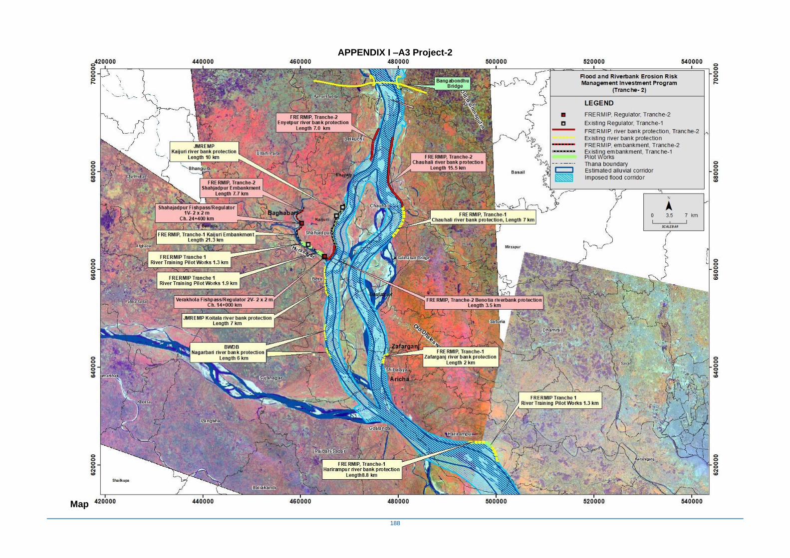
188
APPENDIX I –A3 Project-2
Map
189
APPENDIX O - Environmental and Social Baseline
The environmental and social baseline condition in the study area has been characterized by using both primary and secondary data. Primary data were collected by the EIA field team during visits to the study area, through rapid rural appraisal (RRA), focus group discussions (FGD), key informant interviews (KII) and public consultations. Secondary data sources included:
i. Bangladesh Bureau of Statistics (BBS) ii. Bangladesh Water Development Board (BWDB)
iii. National Water Resources Database (NWRD) iv. Water Resources Planning Organization (WARPO) v. Soils Resources Development Institute (SRDI)
vi. Bangladesh Meteorology Department (BMD) vii. Department of Agricultural Extension (DAE)
viii. Department of Fisheries (DoF) ix. International Union for Conservation of Nature (IUCN).
O1 Physical Environment
O1-1 Climate
Seasonality
The project influence area lies in the northwest part of Bangladesh where the climate is sub-tropical in nature with three seasons namely summer/pre-monsoon from March to May, monsoon from June to October, and winter season from November to February. Lower rainfall makes this area both atmospherically and pedologically drier than the rest of the country. The rainy season is hot and humid with about 88% of the annual rainfall in the area. The winter is predominately cool and dry. The summer is hot and dry interrupted by occasional heavy rainfall, whereas monsoon comes in the month of June and recedes in late October. Meteorological data such as rainfall, temperature, humidity and wind speed were collected from Bangladesh Meteorological Division (BMD) and analyzed for assessing local climate that are directly related to water resources of the study area.
During the pre-monsoon, violent thunderstorms (referred to as “northwesters”) are common. During the rainy season, tropical depressions move inland from the Bay of Bengal. During the pre- and post-monsoon periods (March-May and October-December), cyclones can occur, sometimes generating very large storm surges that cause significant flood damage to the coastal area.
Meteorology Stations
Data used here is from two stations near the study area (Faridpur and Tangail) of Bangladesh Meteorological Division (BMD).
Rainfall
Mean annual rainfall in the project area is approximately 1800 mm/year (FAP-3, 1992). Error! Reference source not found. shows the 1959-2008 rainfall record from Faridpur station. Significant rainfall occurs from June to October, and little or no rainfall from November to February. The maximum recorded monthly rainfall was 831 mm in September 1986. No up to date rainfall data was available however as this is long time series data small fluctuations were deemed unlikely to significantly affect the analysis.
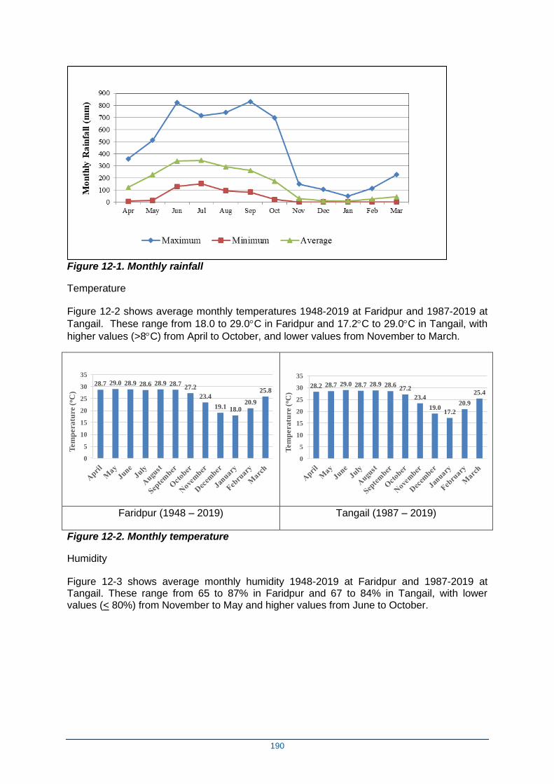
190
Figure 12-1. Monthly rainfall
Temperature
Figure 12-2 shows average monthly temperatures 1948-2019 at Faridpur and 1987-2019 at
Tangail. These range from 18.0 to 29.0C in Faridpur and 17.2C to 29.0C in Tangail, with
higher values (>8C) from April to October, and lower values from November to March.
28.7 29.0 28.9 28.6 28.9 28.727.2
23.4
19.1 18.020.9
25.8
0
5
10
15
20
25
30
35
Tem
pera
ture
(oC
)
28.2 28.7 29.0 28.7 28.9 28.627.2
23.4
19.017.2
20.9
25.4
0
5
10
15
20
25
30
35
Tem
pera
ture
(oC
)
Faridpur (1948 – 2019) Tangail (1987 – 2019)
Figure 12-2. Monthly temperature
Humidity
Figure 12-3 shows average monthly humidity 1948-2019 at Faridpur and 1987-2019 at Tangail. These range from 65 to 87% in Faridpur and 67 to 84% in Tangail, with lower values (< 80%) from November to May and higher values from June to October.
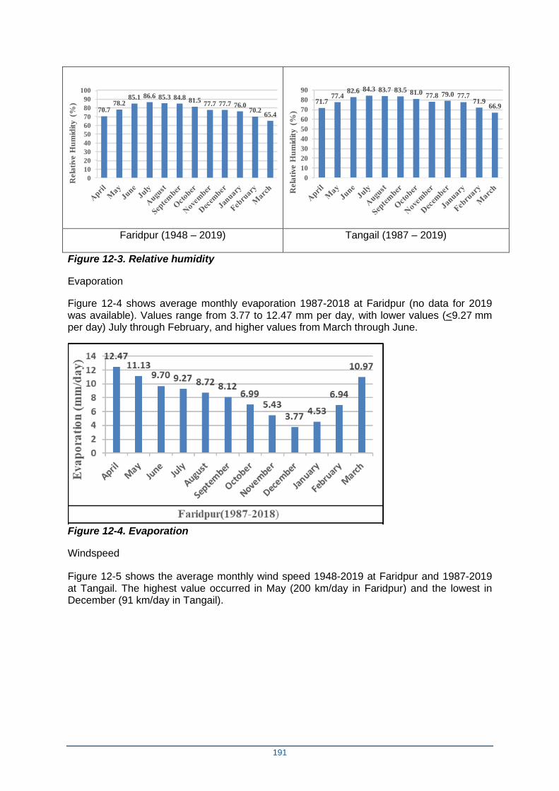
191
70.778.2
85.1 86.6 85.3 84.8 81.577.7 77.7 76.0
70.265.4
0
10
20
30
40
50
60
70
80
90
100
Rela
tive H
um
idit
y (
%)
71.777.4
82.6 84.3 83.7 83.5 81.0 77.8 79.0 77.771.9
66.9
0
10
20
30
40
50
60
70
80
90
Rela
tive H
um
idit
y (
%)
Faridpur (1948 – 2019) Tangail (1987 – 2019)
Figure 12-3. Relative humidity
Evaporation
Figure 12-4 shows average monthly evaporation 1987-2018 at Faridpur (no data for 2019 was available). Values range from 3.77 to 12.47 mm per day, with lower values (<9.27 mm per day) July through February, and higher values from March through June.
Figure 12-4. Evaporation
Windspeed
Figure 12-5 shows the average monthly wind speed 1948-2019 at Faridpur and 1987-2019 at Tangail. The highest value occurred in May (200 km/day in Faridpur) and the lowest in December (91 km/day in Tangail).
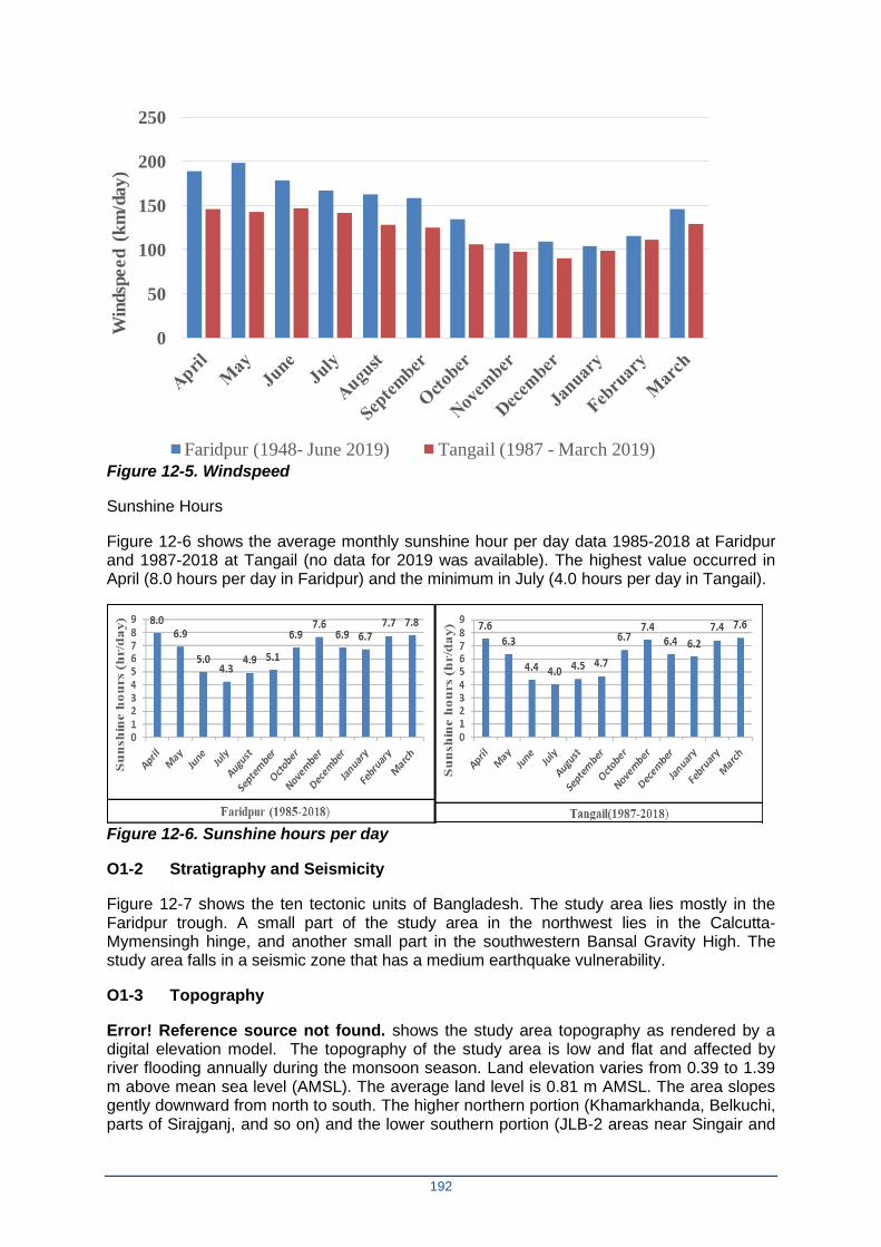
192
0
50
100
150
200
250W
ind
spe
ed
(k
m/d
ay
)
Faridpur (1948- June 2019) Tangail (1987 - March 2019) Figure 12-5. Windspeed
Sunshine Hours
Figure 12-6 shows the average monthly sunshine hour per day data 1985-2018 at Faridpur and 1987-2018 at Tangail (no data for 2019 was available). The highest value occurred in April (8.0 hours per day in Faridpur) and the minimum in July (4.0 hours per day in Tangail).
Figure 12-6. Sunshine hours per day
O1-2 Stratigraphy and Seismicity
Figure 12-7 shows the ten tectonic units of Bangladesh. The study area lies mostly in the Faridpur trough. A small part of the study area in the northwest lies in the Calcutta-Mymensingh hinge, and another small part in the southwestern Bansal Gravity High. The study area falls in a seismic zone that has a medium earthquake vulnerability.
O1-3 Topography
Error! Reference source not found. shows the study area topography as rendered by a digital elevation model. The topography of the study area is low and flat and affected by river flooding annually during the monsoon season. Land elevation varies from 0.39 to 1.39 m above mean sea level (AMSL). The average land level is 0.81 m AMSL. The area slopes gently downward from north to south. The higher northern portion (Khamarkhanda, Belkuchi, parts of Sirajganj, and so on) and the lower southern portion (JLB-2 areas near Singair and
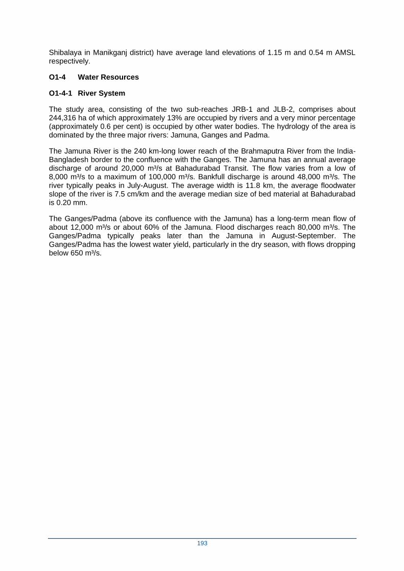
193
Shibalaya in Manikganj district) have average land elevations of 1.15 m and 0.54 m AMSL respectively.
O1-4 Water Resources
O1-4-1 River System
The study area, consisting of the two sub-reaches JRB-1 and JLB-2, comprises about 244,316 ha of which approximately 13% are occupied by rivers and a very minor percentage (approximately 0.6 per cent) is occupied by other water bodies. The hydrology of the area is dominated by the three major rivers: Jamuna, Ganges and Padma.
The Jamuna River is the 240 km-long lower reach of the Brahmaputra River from the India-Bangladesh border to the confluence with the Ganges. The Jamuna has an annual average discharge of around 20,000 m³/s at Bahadurabad Transit. The flow varies from a low of 8,000 m³/s to a maximum of 100,000 m³/s. Bankfull discharge is around 48,000 m³/s. The river typically peaks in July-August. The average width is 11.8 km, the average floodwater slope of the river is 7.5 cm/km and the average median size of bed material at Bahadurabad is 0.20 mm.
The Ganges/Padma (above its confluence with the Jamuna) has a long-term mean flow of about 12,000 m³/s or about 60% of the Jamuna. Flood discharges reach 80,000 m³/s. The Ganges/Padma typically peaks later than the Jamuna in August-September. The Ganges/Padma has the lowest water yield, particularly in the dry season, with flows dropping below 650 m³/s.
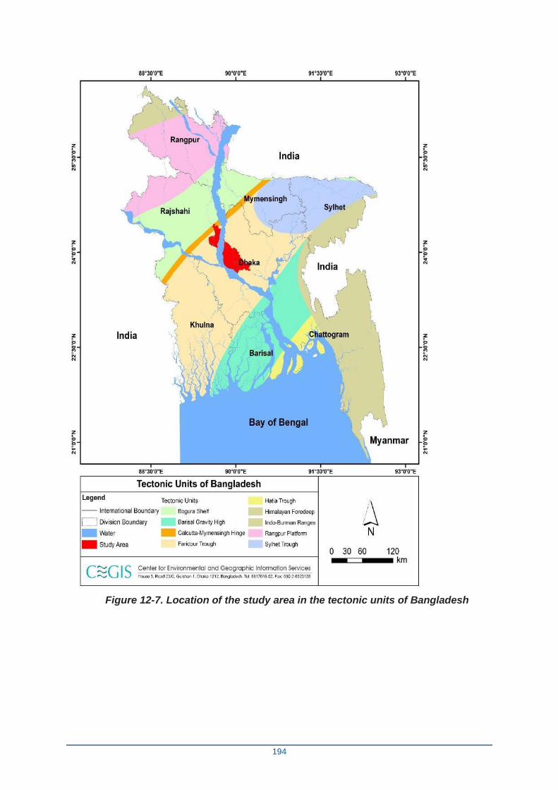
194
Figure 12-7. Location of the study area in the tectonic units of Bangladesh
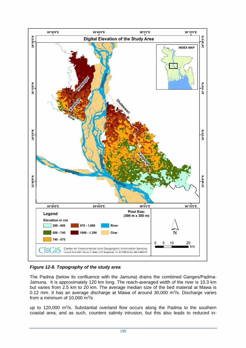
195
Figure 12-8. Topography of the study area
The Padma (below its confluence with the Jamuna) drains the combined Ganges/Padma-Jamuna. It is approximately 120 km long. The reach-averaged width of the river is 10.3 km but varies from 2.5 km to 20 km. The average median size of the bed material at Mawa is 0.12 mm. It has an average discharge at Mawa of around 30,000 m3/s. Discharge varies from a minimum of 10,000 m3/s
up to 120,000 m3/s. Substantial overland flow occurs along the Padma to the southern coastal area, and as such, counters salinity intrusion, but this also leads to reduced in-
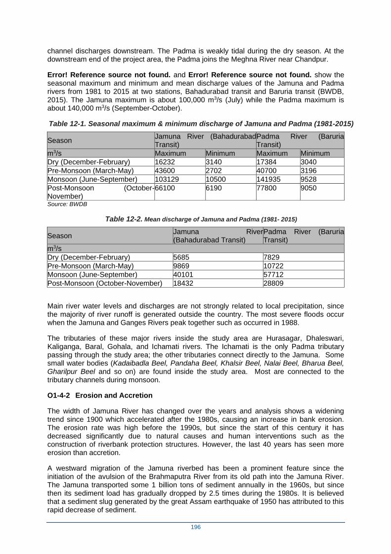
196
channel discharges downstream. The Padma is weakly tidal during the dry season. At the downstream end of the project area, the Padma joins the Meghna River near Chandpur.
Error! Reference source not found. and Error! Reference source not found. show the seasonal maximum and minimum and mean discharge values of the Jamuna and Padma rivers from 1981 to 2015 at two stations, Bahadurabad transit and Baruria transit (BWDB, 2015). The Jamuna maximum is about 100,000 m3/s (July) while the Padma maximum is about 140,000 m3/s (September-October).
Table 12-1. Seasonal maximum & minimum discharge of Jamuna and Padma (1981-2015)
Season Jamuna River (Bahadurabad Transit)
Padma River (Baruria Transit)
m3/s Maximum Minimum Maximum Minimum
Dry (December-February) 16232 3140 17384 3040
Pre-Monsoon (March-May) 43600 2702 40700 3196
Monsoon (June-September) 103129 10500 141935 9528
Post-Monsoon (October-November)
66100 6190 77800 9050
Source: BWDB
Table 12-2. Mean discharge of Jamuna and Padma (1981- 2015)
Season Jamuna River (Bahadurabad Transit)
Padma River (Baruria Transit)
m3/s
Dry (December-February) 5685 7829
Pre-Monsoon (March-May) 9869 10722
Monsoon (June-September) 40101 57712
Post-Monsoon (October-November) 18432 28809
Main river water levels and discharges are not strongly related to local precipitation, since the majority of river runoff is generated outside the country. The most severe floods occur when the Jamuna and Ganges Rivers peak together such as occurred in 1988.
The tributaries of these major rivers inside the study area are Hurasagar, Dhaleswari, Kaliganga, Baral, Gohala, and Ichamati rivers. The Ichamati is the only Padma tributary passing through the study area; the other tributaries connect directly to the Jamuna. Some small water bodies (Kadaibadla Beel, Pandaha Beel, Khalsir Beel, Nalai Beel, Bharua Beel, Gharilpur Beel and so on) are found inside the study area. Most are connected to the tributary channels during monsoon.
O1-4-2 Erosion and Accretion
The width of Jamuna River has changed over the years and analysis shows a widening trend since 1900 which accelerated after the 1980s, causing an increase in bank erosion. The erosion rate was high before the 1990s, but since the start of this century it has decreased significantly due to natural causes and human interventions such as the construction of riverbank protection structures. However, the last 40 years has seen more erosion than accretion.
A westward migration of the Jamuna riverbed has been a prominent feature since the initiation of the avulsion of the Brahmaputra River from its old path into the Jamuna River. The Jamuna transported some 1 billion tons of sediment annually in the 1960s, but since then its sediment load has gradually dropped by 2.5 times during the 1980s. It is believed that a sediment slug generated by the great Assam earthquake of 1950 has attributed to this rapid decrease of sediment.
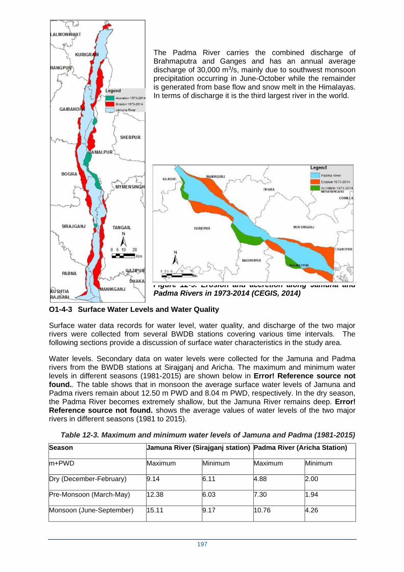
197
The Padma River carries the combined discharge of Brahmaputra and Ganges and has an annual average discharge of 30,000 m3/s, mainly due to southwest monsoon precipitation occurring in June-October while the remainder is generated from base flow and snow melt in the Himalayas. In terms of discharge it is the third largest river in the world.
Figure 12-9. Erosion and accretion along Jamuna and Padma Rivers in 1973-2014 (CEGIS, 2014)
O1-4-3 Surface Water Levels and Water Quality
Surface water data records for water level, water quality, and discharge of the two major rivers were collected from several BWDB stations covering various time intervals. The following sections provide a discussion of surface water characteristics in the study area.
Water levels. Secondary data on water levels were collected for the Jamuna and Padma rivers from the BWDB stations at Sirajganj and Aricha. The maximum and minimum water levels in different seasons (1981-2015) are shown below in Error! Reference source not found.. The table shows that in monsoon the average surface water levels of Jamuna and Padma rivers remain about 12.50 m PWD and 8.04 m PWD, respectively. In the dry season, the Padma River becomes extremely shallow, but the Jamuna River remains deep. Error! Reference source not found. shows the average values of water levels of the two major rivers in different seasons (1981 to 2015).
Table 12-3. Maximum and minimum water levels of Jamuna and Padma (1981-2015)
Season Jamuna River (Sirajganj station) Padma River (Aricha Station)
m+PWD Maximum Minimum Maximum Minimum
Dry (December-February) 9.14 6.11 4.88 2.00
Pre-Monsoon (March-May) 12.38 6.03 7.30 1.94
Monsoon (June-September) 15.11 9.17 10.76 4.26
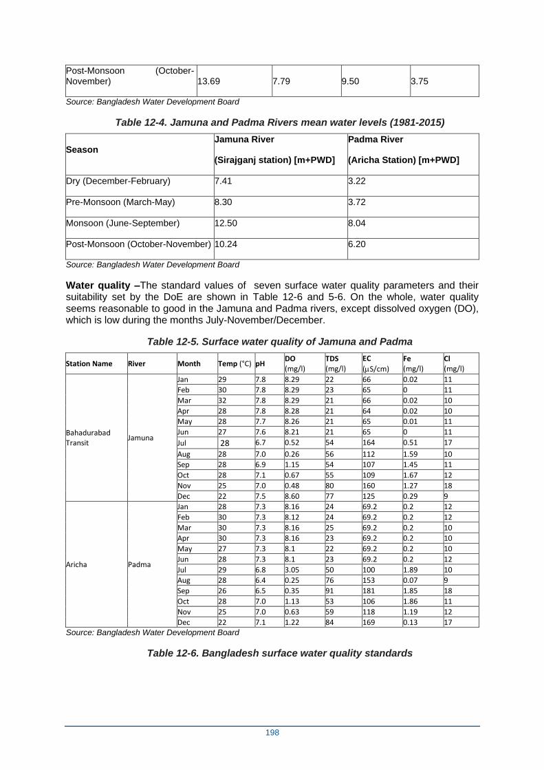
198
Post-Monsoon (October-November) 13.69 7.79 9.50 3.75
Source: Bangladesh Water Development Board
Table 12-4. Jamuna and Padma Rivers mean water levels (1981-2015)
Season Jamuna River
(Sirajganj station) [m+PWD]
Padma River
(Aricha Station) [m+PWD]
Dry (December-February) 7.41 3.22
Pre-Monsoon (March-May) 8.30 3.72
Monsoon (June-September) 12.50 8.04
Post-Monsoon (October-November) 10.24 6.20
Source: Bangladesh Water Development Board
Water quality –The standard values of seven surface water quality parameters and their suitability set by the DoE are shown in Table 12-6 and 5-6. On the whole, water quality seems reasonable to good in the Jamuna and Padma rivers, except dissolved oxygen (DO), which is low during the months July-November/December.
Table 12-5. Surface water quality of Jamuna and Padma
Station Name River Month Temp (°C) pH DO (mg/l)
TDS (mg/l)
EC
(S/cm)
Fe (mg/l)
Cl (mg/l)
Bahadurabad Transit
Jamuna
Jan 29 7.8 8.29 22 66 0.02 11
Feb 30 7.8 8.29 23 65 0 11
Mar 32 7.8 8.29 21 66 0.02 10
Apr 28 7.8 8.28 21 64 0.02 10
May 28 7.7 8.26 21 65 0.01 11
Jun 27 7.6 8.21 21 65 0 11
Jul 28 6.7 0.52 54 164 0.51 17
Aug 28 7.0 0.26 56 112 1.59 10
Sep 28 6.9 1.15 54 107 1.45 11
Oct 28 7.1 0.67 55 109 1.67 12
Nov 25 7.0 0.48 80 160 1.27 18
Dec 22 7.5 8.60 77 125 0.29 9
Aricha Padma
Jan 28 7.3 8.16 24 69.2 0.2 12
Feb 30 7.3 8.12 24 69.2 0.2 12
Mar 30 7.3 8.16 25 69.2 0.2 10
Apr 30 7.3 8.16 23 69.2 0.2 10
May 27 7.3 8.1 22 69.2 0.2 10
Jun 28 7.3 8.1 23 69.2 0.2 12
Jul 29 6.8 3.05 50 100 1.89 10
Aug 28 6.4 0.25 76 153 0.07 9
Sep 26 6.5 0.35 91 181 1.85 18
Oct 28 7.0 1.13 53 106 1.86 11
Nov 25 7.0 0.63 59 118 1.19 12
Dec 22 7.1 1.22 84 169 0.13 17
Source: Bangladesh Water Development Board
Table 12-6. Bangladesh surface water quality standards
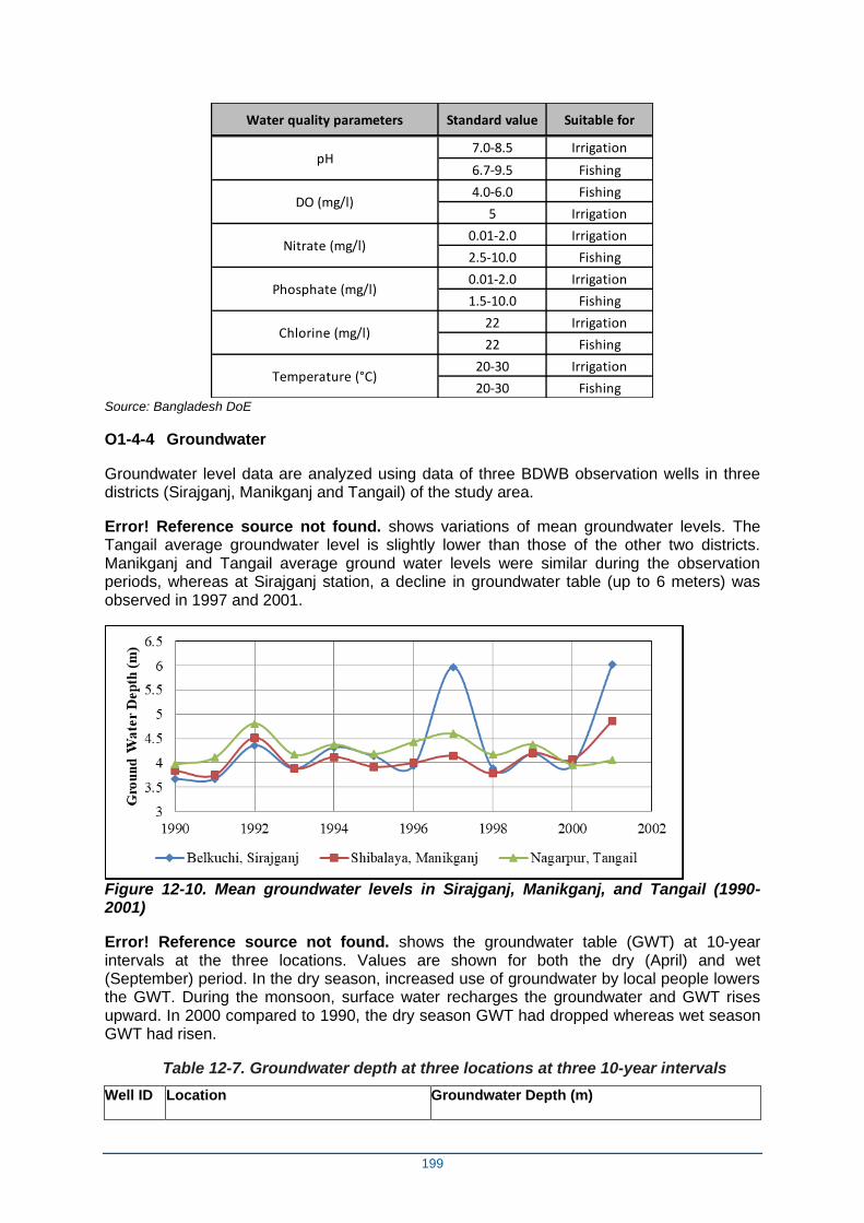
199
Water quality parameters Standard value Suitable for
7.0-8.5 Irrigation
6.7-9.5 Fishing
4.0-6.0 Fishing
5 Irrigation
0.01-2.0 Irrigation
2.5-10.0 Fishing
0.01-2.0 Irrigation
1.5-10.0 Fishing
22 Irrigation
22 Fishing
20-30 Irrigation
20-30 Fishing
pH
DO (mg/l)
Nitrate (mg/l)
Phosphate (mg/l)
Chlorine (mg/l)
Temperature (°C)
Source: Bangladesh DoE
O1-4-4 Groundwater
Groundwater level data are analyzed using data of three BDWB observation wells in three districts (Sirajganj, Manikganj and Tangail) of the study area.
Error! Reference source not found. shows variations of mean groundwater levels. The Tangail average groundwater level is slightly lower than those of the other two districts. Manikganj and Tangail average ground water levels were similar during the observation periods, whereas at Sirajganj station, a decline in groundwater table (up to 6 meters) was observed in 1997 and 2001.
Figure 12-10. Mean groundwater levels in Sirajganj, Manikganj, and Tangail (1990-2001)
Error! Reference source not found. shows the groundwater table (GWT) at 10-year intervals at the three locations. Values are shown for both the dry (April) and wet (September) period. In the dry season, increased use of groundwater by local people lowers the GWT. During the monsoon, surface water recharges the groundwater and GWT rises upward. In 2000 compared to 1990, the dry season GWT had dropped whereas wet season GWT had risen.
Table 12-7. Groundwater depth at three locations at three 10-year intervals
Well ID Location Groundwater Depth (m)
200
1980 1990 2000
April September April September April September
8811001 Shrenagar village, Belkuchithana, Sirajganj
6.78 2.83 4.51 1.70 5.84 1.42
5678012 Uthali village, Shibalayathana, Manikganj
6.31 1.39 5.91 1.89 7.07 0.90
9376032 Bhalkutia village, Nagarpurthana, Tangail
6.46 1.64 5.51 1.94 6.31 1.52
Ocean water has a salinity of 35 ppt whereas in the Bay of Bengal close to Bangladesh coast it is 30–32 ppt. This is due to discharge of fresh water by the three large rivers. The salinity in Jamuna and Padma River is considered as 0 ppt. The extreme lower part of Padma river near Chandpur has very low salinity which varies between 0-1 ppt.
O1-4-5 Navigation
The Jamuna River is categorized as Class II by the Bangladesh Inland Water Authority (BIWTA, 1991), which means the river remains navigable throughout the whole year and links major inland ports or places of economic importance to class-I route (Figure 12-11).
The available average draft in the Jamuna is 1.75 m across the river and recent surveys show the minimum available water depth in the river from Sirajganj to Bahadurabad is 1-1.3 m and from Bahadurabad to Chilmari is a 1.2-2.2 m (Mishra and Hussain, 2012). The river is also a part of the India-Bangladesh protocol route and the route is used by cargo vessels to carry goods to Pandu in India. At the local level, people from charlands use the river to access the mainland mainly for earning livelihood, education and health care purposes. Smaller mechanized boats are used mainly for carrying people and goods and for fishing activities.
O1-4-6 Water Resources Functions
The people of the study area not only depend on the existence of the surrounding water resources system, but also its adequate functioning. The assessment of the water resources functions is helpful to investigate the scenarios of different types of water use, as well as the consequences of natural flow phenomenon.
Irrigation
The net cultivable area (NCA) for Project-2 is approximately 184,200 ha, comprised of 51% clay and 49% loam soil. The water required to irrigate the entire NCA is approximately 2.8 billion m3 for a single season of Boro rice planted in the Rabi winter season (generally November-February) and harvested in the Kharif monsoon season (generally March-October). Water to irrigate the NCA for Aus (rice planted and harvested in Kharif) and for Aman (rice planted in Kharif and harvested in Rabi) would be 0.55 billion m3 each. Therefore around 3.9 billion m3 water would be required for irrigating the entire 184,200 ha NCA. However, of this area, only 55% area is irrigable. Table 12-8 shows the proportion of irrigable areas and water consumed by these areas annually (Minor Irrigation Project, 2010). Approximately 2.15 billion m3 of water is annually available for irrigation from different surface and groundwater sources and around 1.75 billion m3 of water would be further required to provide irrigation in the entire NCA.
Table 12-8. Irrigable areas and water consumption
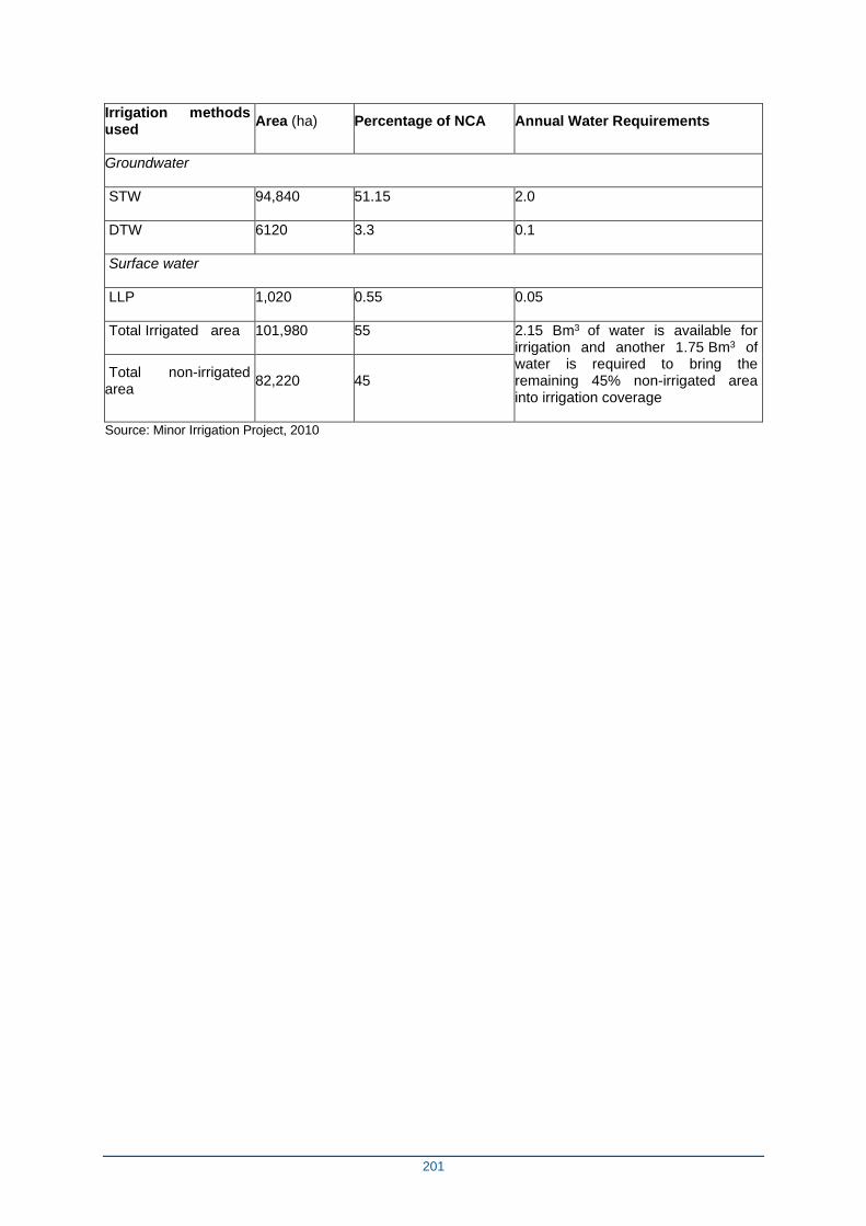
201
Irrigation methods used
Area (ha) Percentage of NCA Annual Water Requirements
Groundwater
STW 94,840 51.15 2.0
DTW 6120 3.3 0.1
Surface water
LLP 1,020 0.55 0.05
Total Irrigated area 101,980 55 2.15 Bm3 of water is available for irrigation and another 1.75 Bm3 of water is required to bring the remaining 45% non-irrigated area into irrigation coverage
Total non-irrigated area
82,220 45
Source: Minor Irrigation Project, 2010
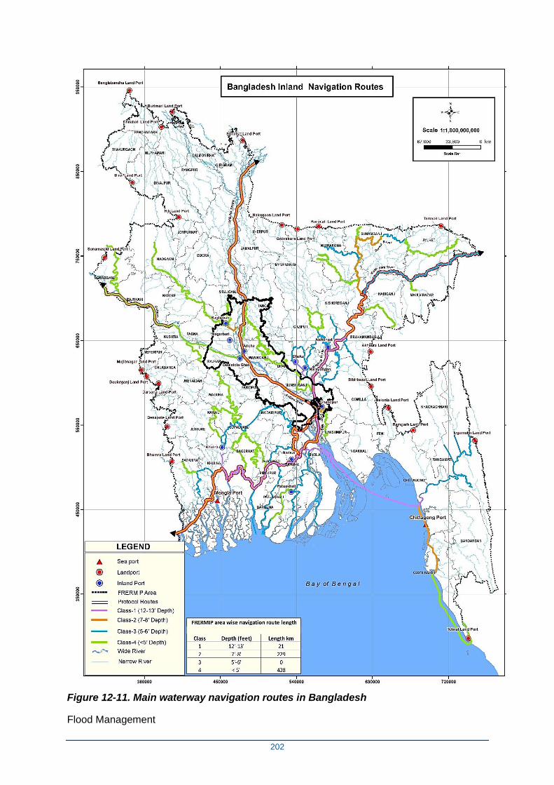
202
Figure 12-11. Main waterway navigation routes in Bangladesh
Flood Management
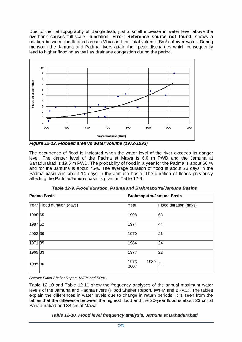
203
Due to the flat topography of Bangladesh, just a small increase in water level above the riverbank causes full-scale inundation. Error! Reference source not found. shows a relation between the flooded areas (Mha) and the total volume (Bm3) of river water. During monsoon the Jamuna and Padma rivers attain their peak discharges which consequently lead to higher flooding as well as drainage congestion during the period.
Figure 12-12. Flooded area vs water volume (1972-1993)
The occurrence of flood is indicated when the water level of the river exceeds its danger level. The danger level of the Padma at Mawa is 6.0 m PWD and the Jamuna at Bahadurabad is 19.5 m PWD. The probability of flood in a year for the Padma is about 60 % and for the Jamuna is about 75%. The average duration of flood is about 23 days in the Padma basin and about 14 days in the Jamuna basin. The duration of floods previously affecting the Padma/Jamuna basin is given in Table 12-9.
Table 12-9. Flood duration, Padma and Brahmaputra/Jamuna Basins
Padma Basin Brahmaputra/Jamuna Basin
Year Flood duration (days) Year Flood duration (days)
1998 65 1998 63
1987 52 1974 44
2003 39 1970 26
1971 35 1984 24
1969 33 1977 22
1995 30 1973, 1980, 2007
21
Source: Flood Shelter Report, IWFM and BRAC
Table 12-10 and Table 12-11 show the frequency analyses of the annual maximum water levels of the Jamuna and Padma rivers (Flood Shelter Report, IWFM and BRAC). The tables explain the differences in water levels due to change in return periods. It is seen from the tables that the difference between the highest flood and the 20-year flood is about 23 cm at Bahadurabad and 38 cm at Mawa.
Table 12-10. Flood level frequency analysis, Jamuna at Bahadurabad
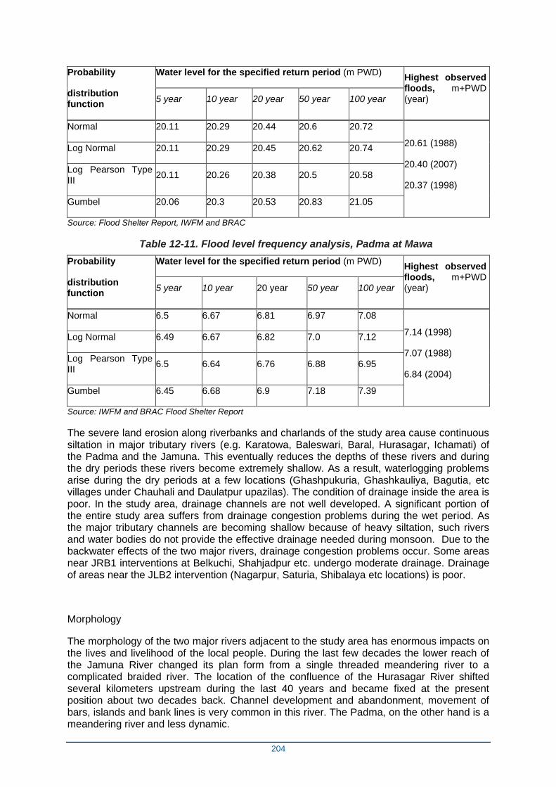
204
Probability
distribution function
Water level for the specified return period (m PWD) Highest observed floods, m+PWD (year) 5 year 10 year 20 year 50 year 100 year
Normal 20.11 20.29 20.44 20.6 20.72
20.61 (1988)
20.40 (2007)
20.37 (1998)
Log Normal 20.11 20.29 20.45 20.62 20.74
Log Pearson Type III
20.11 20.26 20.38 20.5 20.58
Gumbel 20.06 20.3 20.53 20.83 21.05
Source: Flood Shelter Report, IWFM and BRAC
Table 12-11. Flood level frequency analysis, Padma at Mawa
Probability
distribution function
Water level for the specified return period (m PWD) Highest observed floods, m+PWD (year) 5 year 10 year 20 year 50 year 100 year
Normal 6.5 6.67 6.81 6.97 7.08
7.14 (1998)
7.07 (1988)
6.84 (2004)
Log Normal 6.49 6.67 6.82 7.0 7.12
Log Pearson Type III
6.5 6.64 6.76 6.88 6.95
Gumbel 6.45 6.68 6.9 7.18 7.39
Source: IWFM and BRAC Flood Shelter Report
The severe land erosion along riverbanks and charlands of the study area cause continuous siltation in major tributary rivers (e.g. Karatowa, Baleswari, Baral, Hurasagar, Ichamati) of the Padma and the Jamuna. This eventually reduces the depths of these rivers and during the dry periods these rivers become extremely shallow. As a result, waterlogging problems arise during the dry periods at a few locations (Ghashpukuria, Ghashkauliya, Bagutia, etc villages under Chauhali and Daulatpur upazilas). The condition of drainage inside the area is poor. In the study area, drainage channels are not well developed. A significant portion of the entire study area suffers from drainage congestion problems during the wet period. As the major tributary channels are becoming shallow because of heavy siltation, such rivers and water bodies do not provide the effective drainage needed during monsoon. Due to the backwater effects of the two major rivers, drainage congestion problems occur. Some areas near JRB1 interventions at Belkuchi, Shahjadpur etc. undergo moderate drainage. Drainage of areas near the JLB2 intervention (Nagarpur, Saturia, Shibalaya etc locations) is poor.
Morphology
The morphology of the two major rivers adjacent to the study area has enormous impacts on the lives and livelihood of the local people. During the last few decades the lower reach of the Jamuna River changed its plan form from a single threaded meandering river to a complicated braided river. The location of the confluence of the Hurasagar River shifted several kilometers upstream during the last 40 years and became fixed at the present position about two decades back. Channel development and abandonment, movement of bars, islands and bank lines is very common in this river. The Padma, on the other hand is a meandering river and less dynamic.
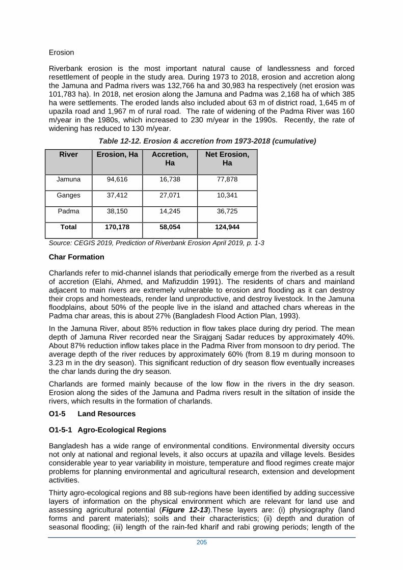
205
Erosion
Riverbank erosion is the most important natural cause of landlessness and forced resettlement of people in the study area. During 1973 to 2018, erosion and accretion along the Jamuna and Padma rivers was 132,766 ha and 30,983 ha respectively (net erosion was 101,783 ha). In 2018, net erosion along the Jamuna and Padma was 2,168 ha of which 385 ha were settlements. The eroded lands also included about 63 m of district road, 1,645 m of upazila road and 1,967 m of rural road. The rate of widening of the Padma River was 160 m/year in the 1980s, which increased to 230 m/year in the 1990s. Recently, the rate of widening has reduced to 130 m/year.
Table 12-12. Erosion & accretion from 1973-2018 (cumulative)
River Erosion, Ha Accretion, Ha
Net Erosion, Ha
Jamuna 94,616 16,738 77,878
Ganges 37,412 27,071 10,341
Padma 38,150 14,245 36,725
Total 170,178 58,054 124,944
Source: CEGIS 2019, Prediction of Riverbank Erosion April 2019, p. 1-3
Char Formation
Charlands refer to mid-channel islands that periodically emerge from the riverbed as a result of accretion (Elahi, Ahmed, and Mafizuddin 1991). The residents of chars and mainland adjacent to main rivers are extremely vulnerable to erosion and flooding as it can destroy their crops and homesteads, render land unproductive, and destroy livestock. In the Jamuna floodplains, about 50% of the people live in the island and attached chars whereas in the Padma char areas, this is about 27% (Bangladesh Flood Action Plan, 1993).
In the Jamuna River, about 85% reduction in flow takes place during dry period. The mean depth of Jamuna River recorded near the Sirajganj Sadar reduces by approximately 40%. About 87% reduction inflow takes place in the Padma River from monsoon to dry period. The average depth of the river reduces by approximately 60% (from 8.19 m during monsoon to 3.23 m in the dry season). This significant reduction of dry season flow eventually increases the char lands during the dry season.
Charlands are formed mainly because of the low flow in the rivers in the dry season. Erosion along the sides of the Jamuna and Padma rivers result in the siltation of inside the rivers, which results in the formation of charlands.
O1-5 Land Resources
O1-5-1 Agro-Ecological Regions
Bangladesh has a wide range of environmental conditions. Environmental diversity occurs not only at national and regional levels, it also occurs at upazila and village levels. Besides considerable year to year variability in moisture, temperature and flood regimes create major problems for planning environmental and agricultural research, extension and development activities.
Thirty agro-ecological regions and 88 sub-regions have been identified by adding successive layers of information on the physical environment which are relevant for land use and assessing agricultural potential (Figure 12-13).These layers are: (i) physiography (land forms and parent materials); soils and their characteristics; (ii) depth and duration of seasonal flooding; (iii) length of the rain-fed kharif and rabi growing periods; length of the
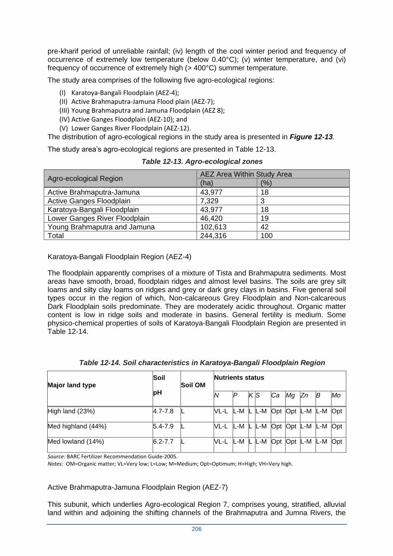
206
pre-kharif period of unreliable rainfall; (iv) length of the cool winter period and frequency of occurrence of extremely low temperature (below 0.40°C); (v) winter temperature, and (vi) frequency of occurrence of extremely high (> 400°C) summer temperature.
The study area comprises of the following five agro-ecological regions:
(I) Karatoya-Bangali Floodplain (AEZ-4); (II) Active Brahmaputra-Jamuna Flood plain (AEZ-7); (III) Young Brahmaputra and Jamuna Floodplain (AEZ 8); (IV) Active Ganges Floodplain (AEZ-10); and (V) Lower Ganges River Floodplain (AEZ-12).
The distribution of agro-ecological regions in the study area is presented in Figure 12-13.
The study area’s agro-ecological regions are presented in Table 12-13.
Table 12-13. Agro-ecological zones
Agro-ecological Region AEZ Area Within Study Area
(ha) (%)
Active Brahmaputra-Jamuna 43,977 18
Active Ganges Floodplain 7,329 3
Karatoya-Bangali Floodplain 43,977 18
Lower Ganges River Floodplain 46,420 19
Young Brahmaputra and Jamuna 102,613 42
Total 244,316 100
Karatoya-Bangali Floodplain Region (AEZ-4)
The floodplain apparently comprises of a mixture of Tista and Brahmaputra sediments. Most areas have smooth, broad, floodplain ridges and almost level basins. The soils are grey silt loams and silty clay loams on ridges and grey or dark grey clays in basins. Five general soil types occur in the region of which, Non-calcareous Grey Floodplain and Non-calcareous Dark Floodplain soils predominate. They are moderately acidic throughout. Organic matter content is low in ridge soils and moderate in basins. General fertility is medium. Some physico-chemical properties of soils of Karatoya-Bangali Floodplain Region are presented in Table 12-14.
Table 12-14. Soil characteristics in Karatoya-Bangali Floodplain Region
Major land type Soil
pH Soil OM
Nutrients status
N P K S Ca Mg Zn B Mo
High land (23%) 4.7-7.8 L VL-L L-M L L-M Opt Opt L-M L-M Opt
Med highland (44%) 5.4-7.9 L VL-L L-M L L-M Opt Opt L-M L-M Opt
Med lowland (14%) 6.2-7.7 L VL-L L-M L L-M Opt Opt L-M L-M Opt
Source: BARC Fertilizer Recommendation Guide-2005. Notes: OM=Organic matter; VL=Very low; L=Low; M=Medium; Opt=Optimum; H=High; VH=Very high.
Active Brahmaputra-Jamuna Floodplain Region (AEZ-7)
This subunit, which underlies Agro-ecological Region 7, comprises young, stratified, alluvial land within and adjoining the shifting channels of the Brahmaputra and Jumna Rivers, the
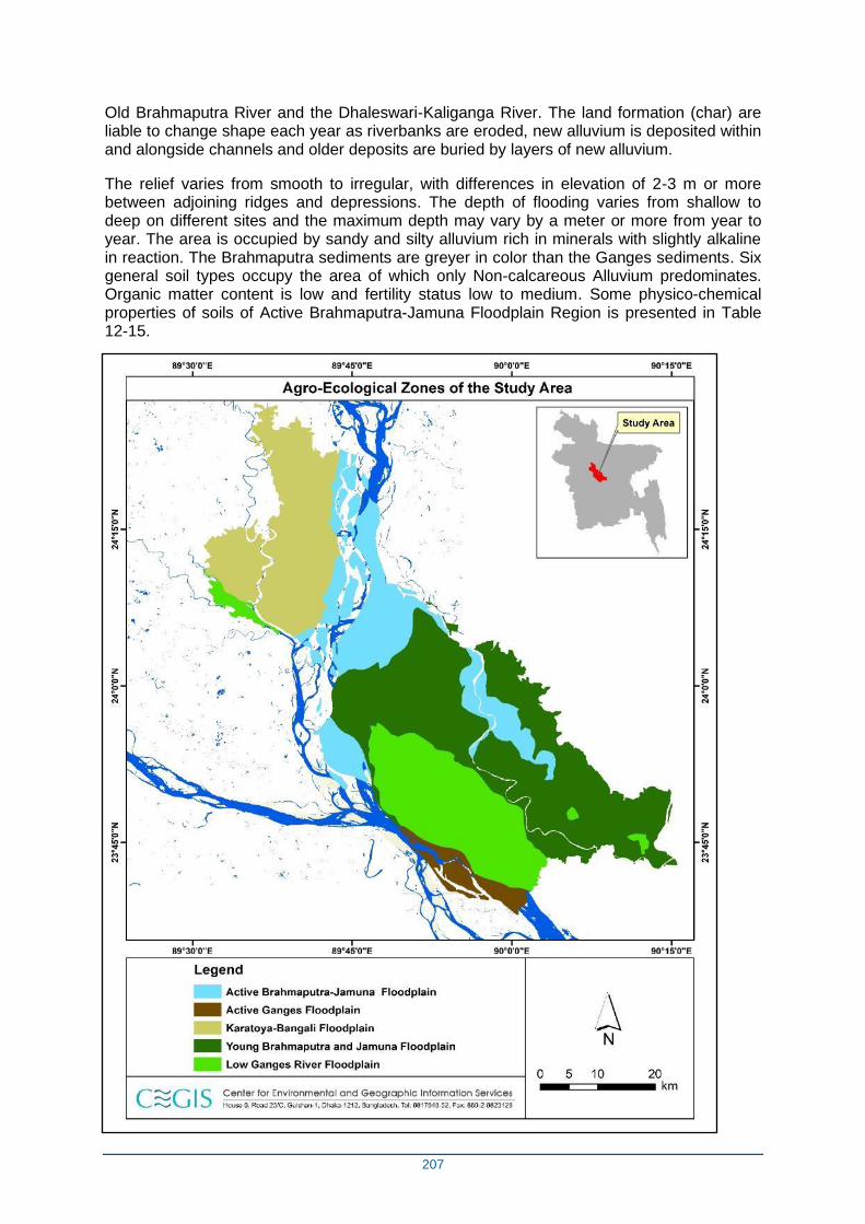
207
Old Brahmaputra River and the Dhaleswari-Kaliganga River. The land formation (char) are liable to change shape each year as riverbanks are eroded, new alluvium is deposited within and alongside channels and older deposits are buried by layers of new alluvium.
The relief varies from smooth to irregular, with differences in elevation of 2-3 m or more between adjoining ridges and depressions. The depth of flooding varies from shallow to deep on different sites and the maximum depth may vary by a meter or more from year to year. The area is occupied by sandy and silty alluvium rich in minerals with slightly alkaline in reaction. The Brahmaputra sediments are greyer in color than the Ganges sediments. Six general soil types occupy the area of which only Non-calcareous Alluvium predominates. Organic matter content is low and fertility status low to medium. Some physico-chemical properties of soils of Active Brahmaputra-Jamuna Floodplain Region is presented in Table 12-15.

208
Figure 12-13. Agro-ecological regions in the Study Area
209
Table 12-15. Soil characteristics, Active Brahmaputra-Jamuna Floodplain
Major land type Soil
pH
Soil OM
Nutrients status
N P K S Ca Mg Zn B Mo
Medium highland (37%)
5.7-8.2 L L L-M L-M L-M L-M L-M L-M L-M M
Medium lowland (20%)
6.0-8.2 L L L-M L-M L-M L-M L-M L-M L-M M
Source: BRAC Fertilizer Recommendation Guide-2005.
Notes: OM=Organic matter; VL=Very low; L=Low; M=Medium; Opt=Optimum; H=High; VH=Very high
Young Brahmaputra and Jamuna Floodplain Region (AEZ 8)
This region comprises the area of Brahmaputra sediments. It has a complex relief of broad and narrow ridges, inter-ridge depressions, partially in filled cut-off channels and basins. This area is occupied by permeable silt loam to silty clay loam soils on the ridges and impermeable clays in the basins; neutral to slightly acid in reaction. General soil types include predominantly Grey Floodplain soils. Organic matter content is low in ridges and moderate in basins. Soils are deficient in N, P and S but the status of K and Zn is medium. Some physiochemical properties of the soils of Young Brahmaputra and Jamuna Floodplain are presented in Table 12-16.
Table 12-16. Soil characteristics, Young Brahmaputra and Jamuna Floodplain
Major land type Soil
pH Soil OM
Nutrients status
N P K S Ca Mg Zn B Mo
High land (18%) 5.6-7.5 VL-L VL-L L M L M M L-M L-M M
Med highland (42%) 5.4-7.5 VL-L VL-L L M L M M L-M L-M M
Med lowland (19%) 5.4-7.5 L L L M L M M L-M L-M M
Source: BARC Fertilizer Recommendation Guide-2005. Notes: OM=Organic matter; VL=Very low; L=Low; M=Medium; Opt=Optimum; H=High; VH=Very high
Active Ganges Floodplain Region (AEZ-10)
The agro-ecological region of Active Ganges Floodplain comprises of young, stratified, alluvium land within and adjoining the shifting channels of the Ganges River and its two main distributaries, the Gorai- Madhumati and Arial khan. The alluvial formations (chars) are liable to change shape each year as riverbank are eroded, new alluvium is deposited within and along channels and older deposits are buried by layers of new alluvium. The relief varies from smooth to irregular, with 2-3 m or more difference in elevation between the adjacent ridges and depressions. Seasonal flooding varies from shallow to deep on different sites and may vary in depth by more than a meter between years. The area has complex mixtures of calcareous sandy, silty and clayey alluvium. The general soil types predominately include Calcareous Alluvium and Calcareous Brown Floodplain soils, which are low in organic matter and mildly alkaline in reaction. The fertility status generally is medium. Physiochemical properties of soils of the Active Ganges Floodplain Region are presented in Table 12-17.
210
Table 12-17. Soil characteristics, Active Ganges Floodplain Region
Major land type Soil
pH
Soil OM
Nutrients status
N P K S Ca Mg Zn B Mo
High land (12%) 7.1-8.1 L L L-M M L-M H H L M M
Med highland (33%) 7.1-8.1 L L L-M M L-M H H L M M
Med lowland (18%) 7.1-8.1 L L L-M M L-M H H L M M
Source: BARC Fertilizer Recommendation Guide-2005. Notes: OM=Organic matter; VL=Very low; L=Low; M=Medium; Opt=Optimum; H=High; VH=Very high.
Lower Ganges River Floodplain (AEZ-12)
This region comprises of the north-eastern, eastern and south-eastern parts of the Ganges Meander Floodplain which are lower lying than the western part. The ridges are mainly shallowly flooded, but basins become moderately deep or deeply flooded in the rainy season.
The soils of the Lower Ganges River Floodplains are silt loams and silty clay loams on the ridges and silty clay loams to heavy clays on lower sites. In general soil types predominately include Calcareous Dark Grey, Grey and Calcareous Brown Floodplain soils. Organic matter content is low in ridges and moderate in the basins. Soils are calcareous in nature having neutral to slightly alkaline in reaction. General fertility level is medium. Some physiochemical properties of soils of Lower Ganges River Floodplain are presented in Table 12-18.
Table 12-18. Soil characteristics, Lower Ganges River Floodplain
Major land type Soil
pH
Soil OM
Nutrients status
N P K S Ca Mg Zn B Mo
High land (13%) 6.8-8.2
L VL-L VL-L M-Opt
L-M
Opt-H
Opt-H
L-M
M-Opt
Opt
Medium highland (29%) 6.2-8.3
L-M VL-M
VL-M
M-Opt
L-M
Opt-H
Opt-H
L-M
M-Opt
Opt
Medium lowland (31%) 6.0-8.3
L-M L L M-Opt
L-M
Opt-H
Opt-H
L-M
M-Opt
Opt
Lowland (14%) 6.0-7.7
M L L M-Opt
L-M
Opt-H
Opt-H
L-M
M-Opt
Opt
Source: Fertilizer Recommendation Guide-2005, BARC Notes: OM=Organic matter; VL=Very low; L=Low; M=Medium; Opt=Optimum=High; VH=Very high
O1-5-2 Land Use
The total study area is about 244,316 ha of which about 184,200 ha is net cultivable area (NCA). Settlements and water bodies constitute about 11% and 13% respectively. Land use in the study area is presented in Error! Reference source not found..
Table 12-19. Land use
Land use Area (ha) % of total area
211
Sources: CEGIS estimation from SOLARIS
O1-5-3 Land Type
Land type classifications are based on depth of inundation on agriculture land during monsoon season due to normal flooding. This land type classification is based on depth of inundation during the monsoon season due to normal flooding on agriculture land. There are five land types: High Land (HL, flooding: depth 0-30 cm); Medium Highland (MHL, flooding depth: 30-90 cm); Medium Lowland (MLL, flooding depth: 90-180 cm); Low Land (LL, flooding depth: 180-360 cm); and Very Lowland (VLL, flooding depth: above 360 cm) (MPO, 1986). The percentages of land type of high land, medium highland, medium lowland, lowland and very lowland are about 4, 37, 37, 21 and 1 respectively of the total area. The detailed land type is presented in Table 12-20.
Table 12-20. Land types
Land type Area (ha) % of NCA
Highland 8,153 4
Medium Highland 68,045 37
Medium Lowland 68,023 37
Lowland 39,376 21
Very Lowland 1795 1
Total 184,200 100
Sources: CEGIS estimation from SOLARIS
O1-5-4 Soil Texture
Soil texture is the relative proportions of sand, silt and clay; important for agriculture crop production. The percentages of texture of surface soil of the study areas are about 7, 44, 39, 6 and 4% for clay, clay loam, loam, sand, sandy loam respectively of the NCA. Data on soil texture is presented in Table 12-21.
Table 12-21. Soil texture, 0-15 cm depth
Texture Area(ha) % of NCA
Clay 13,157 7
Clay Loam 80,193 44
Loam 72,511 39
Sand 11,389 6
Sandy Loam 6,950 4
Total 184,200 100 Sources: CEGIS estimation from SOLARIS
O1-5-5 Available Soil Moisture
NCA 184,200 75
Settlements 27,764 11
Rivers & Water Bodies 32,352 13
Total 244,316 100
212
The available soil moisture is important for the cultivation of Rabi crops. The high (72.9%) and medium level (26.9%) of available soil moisture has been observed in the study area. The distribution of available soil moisture is presented in Table 12-22.
Table 12-22. Soil moisture
Soil Moisture Area % of NCA
High 134,373 72.9
Medium 49,485 26.9
Low 342 0.2
Total 184,200 100 Source: CEGIS estimation from SOLARIS
O1-5-6 Drainage Characteristics
Drainage plays a vital role in the management of soil in the study area. As per the SRDI, the drainage characteristics have been divided into six classes from the agriculture point of view. Detailed drainage characteristics along with area of the project are presented in Error! Reference source not found..
Most of the area (83%) of the NCA is under imperfectly drained condition. The rest (17%) is under poorly drained condition. The dominance of imperfectly drained soil of the study area indicates that the removal of water in rainy/monsoon season is the main constraint for growing dry land crops in the study area.
Table 12-23. Drainage characteristics
Drainage classes
Drainage characteristics Area (ha)
% of NCA
Imperfectly Drained
Water drained from soil badly or slowly. This soil often remains wet in rainy season due to rainfall. In normal situation, water does not stand on land more than 15 days at a stretch. In rainy season, groundwater stands within 1 m at least for some time.
31,314 17
Poorly Drained
The soil remains under water from 15 days to 7/8 months. Water is drained from the soil slowly. In most cases, the land remains wet/water-logged for a considerable period of time after the rainy season.
152,886 83
Total 184,200 100
Source: CEGIS estimation from SOLARIS (NWRD).
O1-5-7 Land reclamation
About 150,000 ha of land is to be stabilized and reclaimed under the RSP programme, which is to consist of currently (unstable) char land and low-lying floodplain land. Figure 5-14 provides a map of the areas and locations to be reclaimed. It is anticipated that land stabilization will lead to reduced human suffering, greater investment and higher productivity, but also greater use of agrochemicals (and hence pollution), loos of floodplain habitats and competing land claims.
213
Figure 12-14. Reclaimed Land Resulting from FERMIP Interventions
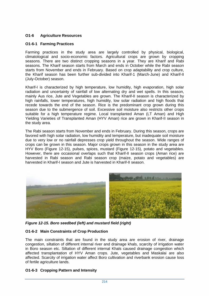
214
O1-6 Agriculture Resources
O1-6-1 Farming Practices
Farming practices in the study area are largely controlled by physical, biological, climatological and socio-economic factors. Agricultural crops are grown by cropping seasons. There are two distinct cropping seasons in a year. They are Kharif and Rabi seasons. The Kharif season starts from March and ends in October while the Rabi season starts from November and ends in February. Based on crop adaptability and crop culture, the Kharif season has been further sub-divided into Kharif-1 (March-June) and Kharif-II (July-October) season.
Kharif-I is characterized by high temperature, low humidity, high evaporation, high solar radiation and uncertainty of rainfall of low alternating dry and wet spells. In this season, mainly Aus rice, Jute and Vegetables are grown. The Kharif-II season is characterized by high rainfalls, lower temperatures, high humidity, low solar radiation and high floods that recede towards the end of the season. Rice is the predominant crop grown during this season due to the submergence of soil. Excessive soil moisture also restricts other crops suitable for a high temperature regime. Local transplanted Aman (LT Aman) and High Yielding Varieties of Transplanted Aman (HYV Aman) rice are grown in Kharif-II season in the study area.
The Rabi season starts from November and ends in February. During this season, crops are favored with high solar radiation, low humidity and temperature, but inadequate soil moisture due to very low or no rainfall depresses crop yield throughout the season. Wide ranges of crops can be grown in this season. Major crops grown in this season in the study area are HYV Boro (Figure 12-15), pulses, spices, mustard (Figure 12-15), potato and vegetables. However, there are occasional overlaps such that Kharif-II season crops (Aman rice) are harvested in Rabi season and Rabi season crop (maize, potato and vegetables) are harvested in Kharif-I season and Jute is harvested in Kharif-II season.
Figure 12-15. Boro seedbed (left) and mustard field (right)
O1-6-2 Main Constraints of Crop Production
The main constraints that are found in the study area are erosion of river, drainage congestion, siltation of different internal river and drainage khals, scarcity of irrigation water in Boro season etc. Siltation of different internal Khals caused drainage congestion which affected transplantation of HYV Aman crops. Jute, vegetables and Maskalai are also affected. Scarcity of irrigation water affect Boro cultivation and riverbank erosion cause loss of fertile agriculture lands.
O1-6-3 Cropping Pattern and Intensity
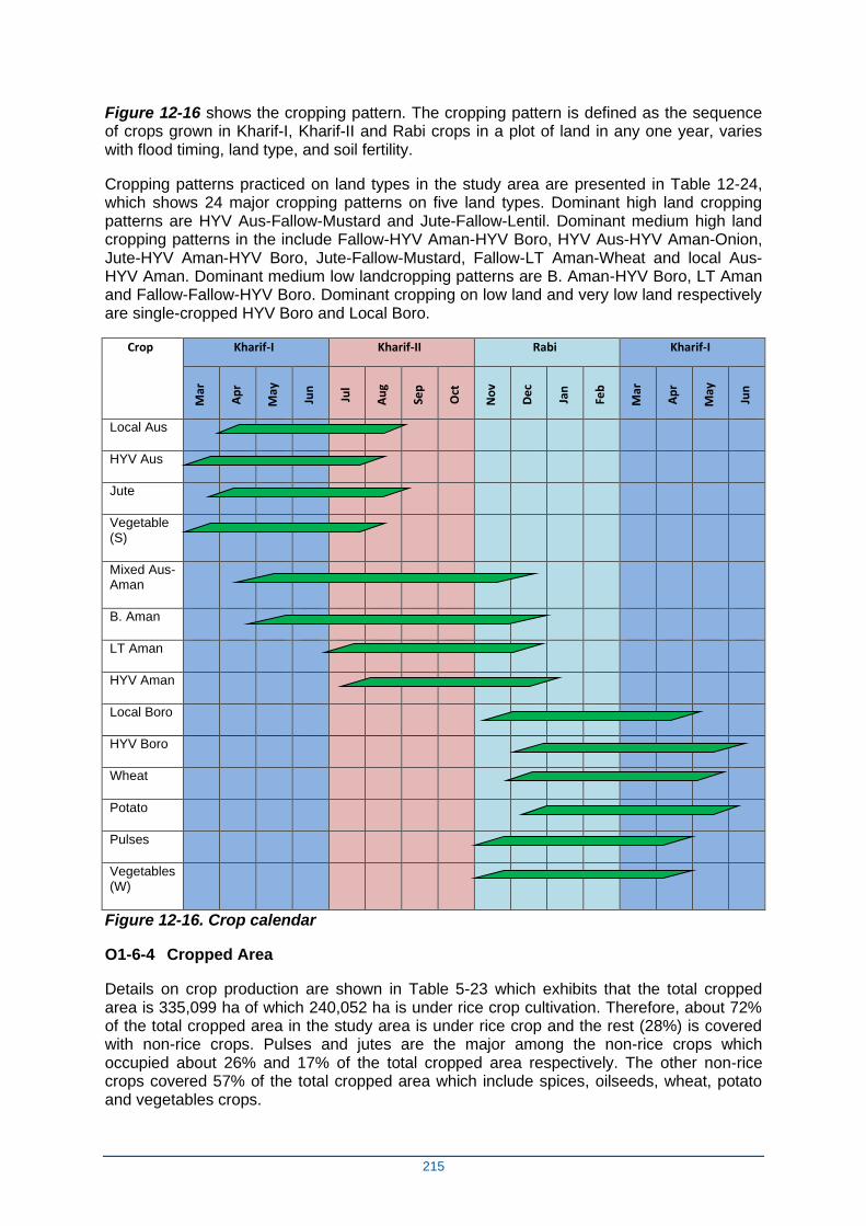
215
Figure 12-16 shows the cropping pattern. The cropping pattern is defined as the sequence of crops grown in Kharif-I, Kharif-II and Rabi crops in a plot of land in any one year, varies with flood timing, land type, and soil fertility.
Cropping patterns practiced on land types in the study area are presented in Table 12-24, which shows 24 major cropping patterns on five land types. Dominant high land cropping patterns are HYV Aus-Fallow-Mustard and Jute-Fallow-Lentil. Dominant medium high land cropping patterns in the include Fallow-HYV Aman-HYV Boro, HYV Aus-HYV Aman-Onion, Jute-HYV Aman-HYV Boro, Jute-Fallow-Mustard, Fallow-LT Aman-Wheat and local Aus-HYV Aman. Dominant medium low landcropping patterns are B. Aman-HYV Boro, LT Aman and Fallow-Fallow-HYV Boro. Dominant cropping on low land and very low land respectively are single-cropped HYV Boro and Local Boro.
Crop Kharif-I Kharif-II Rabi Kharif-I
Mar
Ap
r
May
Jun
Jul
Au
g
Sep
Oct
No
v
De
c
Jan
Feb
Mar
Ap
r
May
Jun
Local Aus
HYV Aus
Jute
Vegetable (S)
Mixed Aus-Aman
B. Aman
LT Aman
HYV Aman
Local Boro
HYV Boro
Wheat
Potato
Pulses
Vegetables (W)
Figure 12-16. Crop calendar
O1-6-4 Cropped Area
Details on crop production are shown in Table 5-23 which exhibits that the total cropped area is 335,099 ha of which 240,052 ha is under rice crop cultivation. Therefore, about 72% of the total cropped area in the study area is under rice crop and the rest (28%) is covered with non-rice crops. Pulses and jutes are the major among the non-rice crops which occupied about 26% and 17% of the total cropped area respectively. The other non-rice crops covered 57% of the total cropped area which include spices, oilseeds, wheat, potato and vegetables crops.
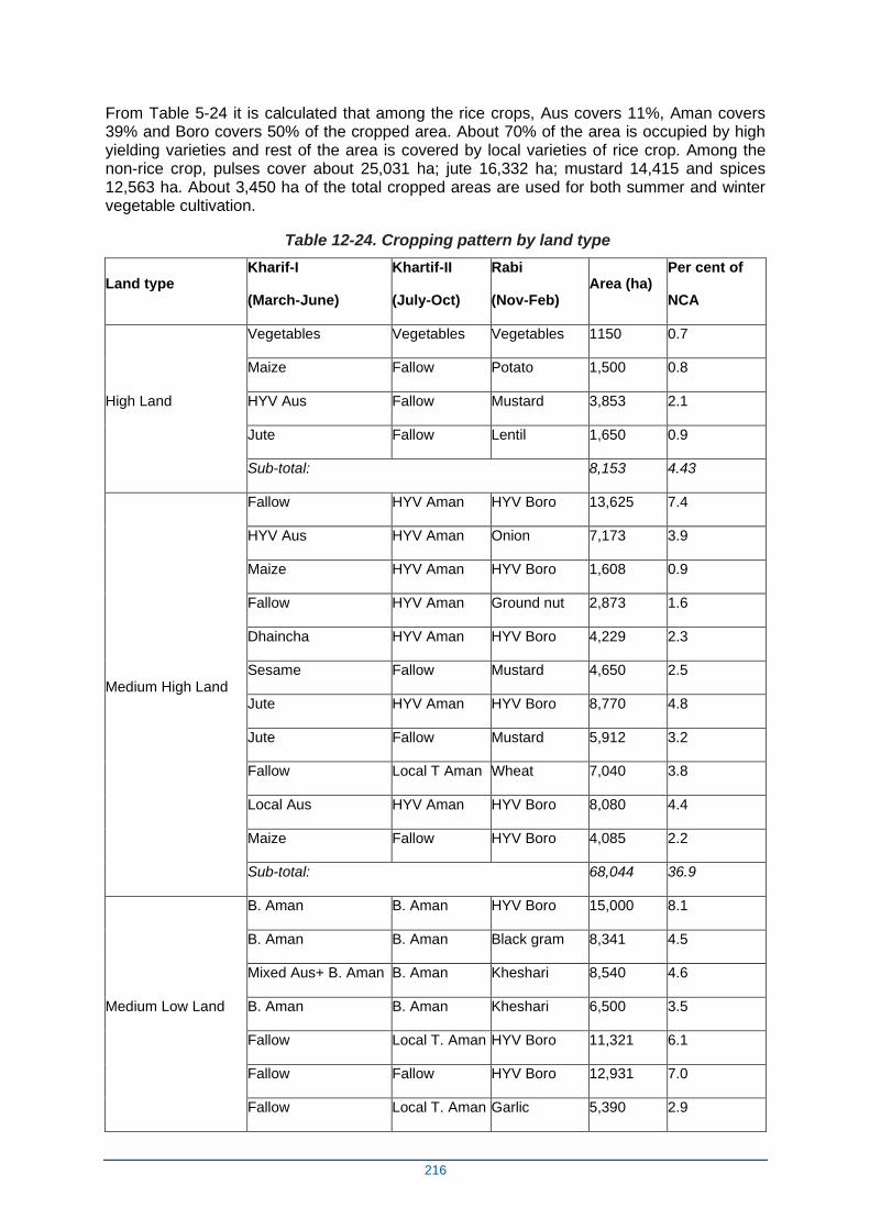
216
From Table 5-24 it is calculated that among the rice crops, Aus covers 11%, Aman covers 39% and Boro covers 50% of the cropped area. About 70% of the area is occupied by high yielding varieties and rest of the area is covered by local varieties of rice crop. Among the non-rice crop, pulses cover about 25,031 ha; jute 16,332 ha; mustard 14,415 and spices 12,563 ha. About 3,450 ha of the total cropped areas are used for both summer and winter vegetable cultivation.
Table 12-24. Cropping pattern by land type
Land type Kharif-I
(March-June)
Khartif-II
(July-Oct)
Rabi
(Nov-Feb) Area (ha)
Per cent of
NCA
High Land
Vegetables Vegetables Vegetables 1150 0.7
Maize Fallow Potato 1,500 0.8
HYV Aus Fallow Mustard 3,853 2.1
Jute Fallow Lentil 1,650 0.9
Sub-total: 8,153 4.43
Medium High Land
Fallow HYV Aman HYV Boro 13,625 7.4
HYV Aus HYV Aman Onion 7,173 3.9
Maize HYV Aman HYV Boro 1,608 0.9
Fallow HYV Aman Ground nut 2,873 1.6
Dhaincha HYV Aman HYV Boro 4,229 2.3
Sesame Fallow Mustard 4,650 2.5
Jute HYV Aman HYV Boro 8,770 4.8
Jute Fallow Mustard 5,912 3.2
Fallow Local T Aman Wheat 7,040 3.8
Local Aus HYV Aman HYV Boro 8,080 4.4
Maize Fallow HYV Boro 4,085 2.2
Sub-total: 68,044 36.9
Medium Low Land
B. Aman B. Aman HYV Boro 15,000 8.1
B. Aman B. Aman Black gram 8,341 4.5
Mixed Aus+ B. Aman B. Aman Kheshari 8,540 4.6
B. Aman B. Aman Kheshari 6,500 3.5
Fallow Local T. Aman HYV Boro 11,321 6.1
Fallow Fallow HYV Boro 12,931 7.0
Fallow Local T. Aman Garlic 5,390 2.9
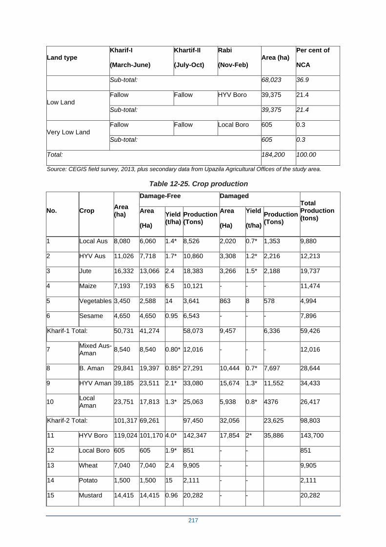
217
Land type Kharif-I
(March-June)
Khartif-II
(July-Oct)
Rabi
(Nov-Feb) Area (ha)
Per cent of
NCA
Sub-total: 68,023 36.9
Low Land Fallow Fallow HYV Boro 39,375 21.4
Sub-total: 39,375 21.4
Very Low Land Fallow Fallow Local Boro 605 0.3
Sub-total: 605 0.3
Total: 184,200 100.00
Source: CEGIS field survey, 2013, plus secondary data from Upazila Agricultural Offices of the study area.
Table 12-25. Crop production
No.
Crop Area (ha)
Damage-Free Damaged Total Production (tons)
Area
(Ha)
Yield (t/ha)
Production (Tons)
Area
(Ha)
Yield
(t/ha)
Production (Tons)
1 Local Aus 8,080 6,060 1.4* 8,526 2,020 0.7* 1,353 9,880
2 HYV Aus 11,026 7,718 1.7* 10,860 3,308 1.2* 2,216 12,213
3 Jute 16,332 13,066 2.4 18,383 3,266 1.5* 2,188 19,737
4 Maize 7,193 7,193 6.5 10,121 - - - 11,474
5 Vegetables 3,450 2,588 14 3,641 863 8 578 4,994
6 Sesame 4,650 4,650 0.95 6,543 - - - 7,896
Kharif-1 Total: 50,731 41,274 58,073 9,457 6,336 59,426
7 Mixed Aus-Aman
8,540 8,540 0.80* 12,016 - - - 12,016
8 B. Aman 29,841 19,397 0.85* 27,291 10,444 0.7* 7,697 28,644
9 HYV Aman 39,185 23,511 2.1* 33,080 15,674 1.3* 11,552 34,433
10 Local Aman
23,751 17,813 1.3* 25,063 5,938 0.8* 4376 26,417
Kharif-2 Total: 101,317 69,261 97,450 32,056 23,625 98,803
11 HYV Boro 119,024 101,170 4.0* 142,347 17,854 2* 35,886 143,700
12 Local Boro 605 605 1.9* 851 - - 851
13 Wheat 7,040 7,040 2.4 9,905 - - 9,905
14 Potato 1,500 1,500 15 2,111 - - 2,111
15 Mustard 14,415 14,415 0.96 20,282 - - 20,282

218
No.
Crop Area (ha)
Damage-Free Damaged Total Production (tons)
Area
(Ha)
Yield (t/ha)
Production (Tons)
Area
(Ha)
Yield
(t/ha)
Production (Tons)
16 Pulses 25,031 25,031 1 35,219 - - 35,219
17 Spices 12,563 12,563 4.6 17,676 - - 17,676
18 Ground nut 2,873 2,873 1.5 4,042 - - 4,042
Rabi Total: 183,051 165,197 232,433 17,845 35,886 233,786
Cropped Area 335,099 275,733 59,358
NCA 184,200
Cropping Intensity 182%
Source: CEGIS field survey, 2013, plus secondary data from Upazila Agricultural Offices of the study area.
O1-6-5 Crop Production
Crop production data, presented in Table 12-25, indicates that the major agricultural production of the study area comes from rice crops. The annual total rice production stands at about 268,154 metric tons. There is a production loss in rice production which is calculated as 63,080 MT. Among the rice crops, Boro is contributing about 54% (144,551 MT) followed by T. Aman 33% (89,494 MT), T Aus 8% (22,093 MT) and Mixed Aus-Aman 4% (12,016 MT) of the total rice production. Different types of non-rice crops are grown in about 95,047 ha land and production is about 133,336 MT. The non-rice crops are pulses (about 35,219 MT), spices (about 17,676 MT), jute (about 19,737 MT), mustard (about 20,282 MT), vegetables (about 4,994 MT) and potato (about 2,111 MT).
O1-6-6 Crop Damage
Table 12-25 also articulates the crop damage area and damaged yield in the study area. During the field survey, it was found that major crop damaging factors are heavy rainfall, floods, river erosion, drainage congestion and hailstorm during monsoon period; irrigation water scarcity and drought during dry season and pest infestation throughout the year. Boro crop of the study area suffered due to non-availability of surface water and lowering of ground water table during the flowering stage. For this reason, about 15% of Boro crop area suffered damage annually and yield of this crop was reduced by about 24 to 26%. Aus crop was damaged due to heavy rainfall during the month of June and July at harvesting period of this crop. Jute also suffers during their sowing period when the distribution of rainfall is uneven. Farmers try to meet up the demand of water with the help of irrigation water. But their attempts fail due to non-availability of surface water due to siltation of the khals/rivers. About 35% area of Aman crop was affected by flood, river erosion and drainage congestion during the months of August and September. Early drought also delays transplanting and harvesting of crop which affect the growing of Rabi crops after Aman rice. This crop also faces maximum drought stress during panicle initiation to the maturity stage. Crop production loss has been calculated using the formula: Crop production loss = Total cropped area × normal yield - (damaged area × damaged yield + damage-free area × normal yield).
O1-6-7 Agricultural Inputs
Fertilizers and pesticides are used for all crop cultivated in the study area (Table 12-26). However, the rate of use of fertilizer per hectare varies considerably from farmer to farmer depending on soil fertility, cropping pattern and financial ability. The major fertilizers used in
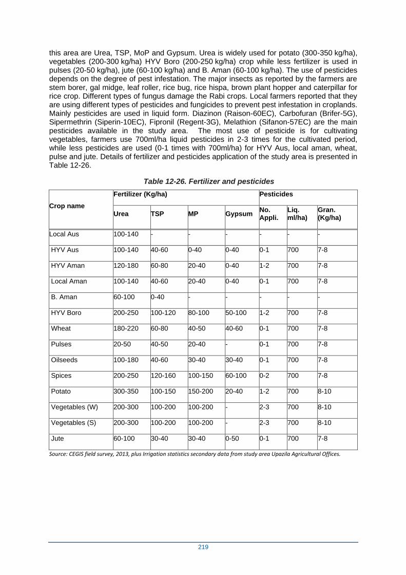
219
this area are Urea, TSP, MoP and Gypsum. Urea is widely used for potato (300-350 kg/ha), vegetables (200-300 kg/ha) HYV Boro (200-250 kg/ha) crop while less fertilizer is used in pulses (20-50 kg/ha), jute (60-100 kg/ha) and B. Aman (60-100 kg/ha). The use of pesticides depends on the degree of pest infestation. The major insects as reported by the farmers are stem borer, gal midge, leaf roller, rice bug, rice hispa, brown plant hopper and caterpillar for rice crop. Different types of fungus damage the Rabi crops. Local farmers reported that they are using different types of pesticides and fungicides to prevent pest infestation in croplands. Mainly pesticides are used in liquid form. Diazinon (Raison-60EC), Carbofuran (Brifer-5G), Sipermethrin (Siperin-10EC), Fipronil (Regent-3G), Melathion (Sifanon-57EC) are the main pesticides available in the study area. The most use of pesticide is for cultivating vegetables, farmers use 700ml/ha liquid pesticides in 2-3 times for the cultivated period, while less pesticides are used (0-1 times with 700ml/ha) for HYV Aus, local aman, wheat, pulse and jute. Details of fertilizer and pesticides application of the study area is presented in Table 12-26.
Table 12-26. Fertilizer and pesticides
Crop name
Fertilizer (Kg/ha) Pesticides
Urea TSP MP Gypsum No. Appli.
Liq. ml/ha)
Gran. (Kg/ha)
Local Aus 100-140 - - - - - -
HYV Aus 100-140 40-60 0-40 0-40 0-1 700 7-8
HYV Aman 120-180 60-80 20-40 0-40 1-2 700 7-8
Local Aman 100-140 40-60 20-40 0-40 0-1 700 7-8
B. Aman 60-100 0-40 - - - - -
HYV Boro 200-250 100-120 80-100 50-100 1-2 700 7-8
Wheat 180-220 60-80 40-50 40-60 0-1 700 7-8
Pulses 20-50 40-50 20-40 - 0-1 700 7-8
Oilseeds 100-180 40-60 30-40 30-40 0-1 700 7-8
Spices 200-250 120-160 100-150 60-100 0-2 700 7-8
Potato 300-350 100-150 150-200 20-40 1-2 700 8-10
Vegetables (W) 200-300 100-200 100-200 - 2-3 700 8-10
Vegetables (S) 200-300 100-200 100-200 - 2-3 700 8-10
Jute 60-100 30-40 30-40 0-50 0-1 700 7-8
Source: CEGIS field survey, 2013, plus Irrigation statistics secondary data from study area Upazila Agricultural Offices.
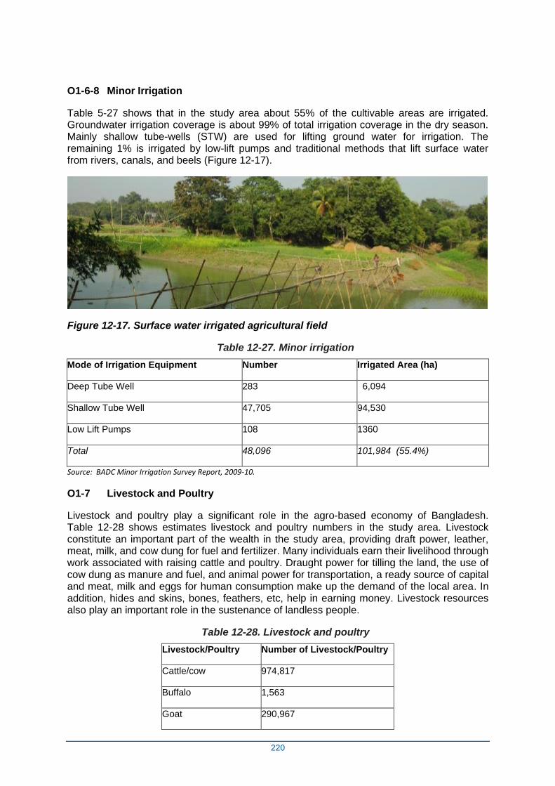
220
O1-6-8 Minor Irrigation
Table 5-27 shows that in the study area about 55% of the cultivable areas are irrigated. Groundwater irrigation coverage is about 99% of total irrigation coverage in the dry season. Mainly shallow tube-wells (STW) are used for lifting ground water for irrigation. The remaining 1% is irrigated by low-lift pumps and traditional methods that lift surface water from rivers, canals, and beels (Figure 12-17).
Figure 12-17. Surface water irrigated agricultural field
Table 12-27. Minor irrigation
Mode of Irrigation Equipment Number Irrigated Area (ha)
Deep Tube Well 283 6,094
Shallow Tube Well 47,705 94,530
Low Lift Pumps 108 1360
Total 48,096 101,984 (55.4%)
Source: BADC Minor Irrigation Survey Report, 2009-10.
O1-7 Livestock and Poultry
Livestock and poultry play a significant role in the agro-based economy of Bangladesh. Table 12-28 shows estimates livestock and poultry numbers in the study area. Livestock constitute an important part of the wealth in the study area, providing draft power, leather, meat, milk, and cow dung for fuel and fertilizer. Many individuals earn their livelihood through work associated with raising cattle and poultry. Draught power for tilling the land, the use of cow dung as manure and fuel, and animal power for transportation, a ready source of capital and meat, milk and eggs for human consumption make up the demand of the local area. In addition, hides and skins, bones, feathers, etc, help in earning money. Livestock resources also play an important role in the sustenance of landless people.
Table 12-28. Livestock and poultry
Livestock/Poultry Number of Livestock/Poultry
Cattle/cow 974,817
Buffalo 1,563
Goat 290,967
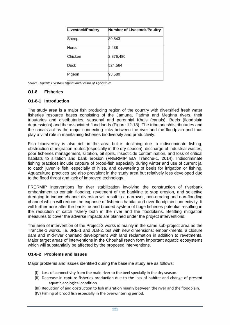
221
Livestock/Poultry Number of Livestock/Poultry
Sheep 89,843
Horse 2,438
Chicken 2,876,480
Duck 524,564
Pigeon 93,580
Source: Upazila Livestock Offices and Census of Agriculture.
O1-8 Fisheries
O1-8-1 Introduction
The study area is a major fish producing region of the country with diversified fresh water fisheries resource bases consisting of the Jamuna, Padma and Meghna rivers, their tributaries and distributaries, seasonal and perennial Khals (canals), Beels (floodplain depressions) and the associated flood lands (Figure 12-18). The tributaries/distributaries and the canals act as the major connecting links between the river and the floodplain and thus play a vital role in maintaining fisheries biodiversity and productivity.
Fish biodiversity is also rich in the area but is declining due to indiscriminate fishing, obstruction of migration routes (especially in the dry season), discharge of industrial wastes, poor fisheries management, siltation, oil spills, insecticide contamination, and loss of critical habitats to siltation and bank erosion (FRERMIP EIA Tranche-1, 2014). Indiscriminate fishing practices include capture of brood-fish especially during winter and use of current jal to catch juvenile fish, especially of hilsa, and dewatering of beels for irrigation or fishing. Aquaculture practices are also prevalent in the study area but relatively less developed due to the flood threat and lack of improved technology.
FRERMIP interventions for river stabilization involving the construction of riverbank embankment to contain flooding, revetment of the bankline to stop erosion, and selective dredging to induce channel diversion will result in a narrower, non-eroding and non-flooding channel which will reduce the expanse of fisheries habitat and river-floodplain connectivity. It will furthermore alter the bankline and braided system of huge fisheries potential resulting in the reduction of catch fishery both in the river and the floodplains. Befitting mitigation measures to cover the adverse impacts are planned under the project interventions.
The area of intervention of the Project-2 works is mainly in the same sub-project area as the Tranche-1 works, i.e. JRB-1 and JLB-2, but with new dimensions: embankments, a closure dam and mid-river charland development with land reclamation in addition to revetments. Major target areas of interventions in the Chouhali reach form important aquatic ecosystems which will substantially be affected by the proposed interventions.
O1-8-2 Problems and Issues
Major problems and issues identified during the baseline study are as follows:
(I) Loss of connectivity from the main river to the beel specially in the dry season. (II) Decrease in capture fisheries production due to the loss of habitat and change of present
aquatic ecological condition. (III) Reduction of and obstruction to fish migration mainly between the river and the floodplain. (IV) Fishing of brood fish especially in the overwintering period.
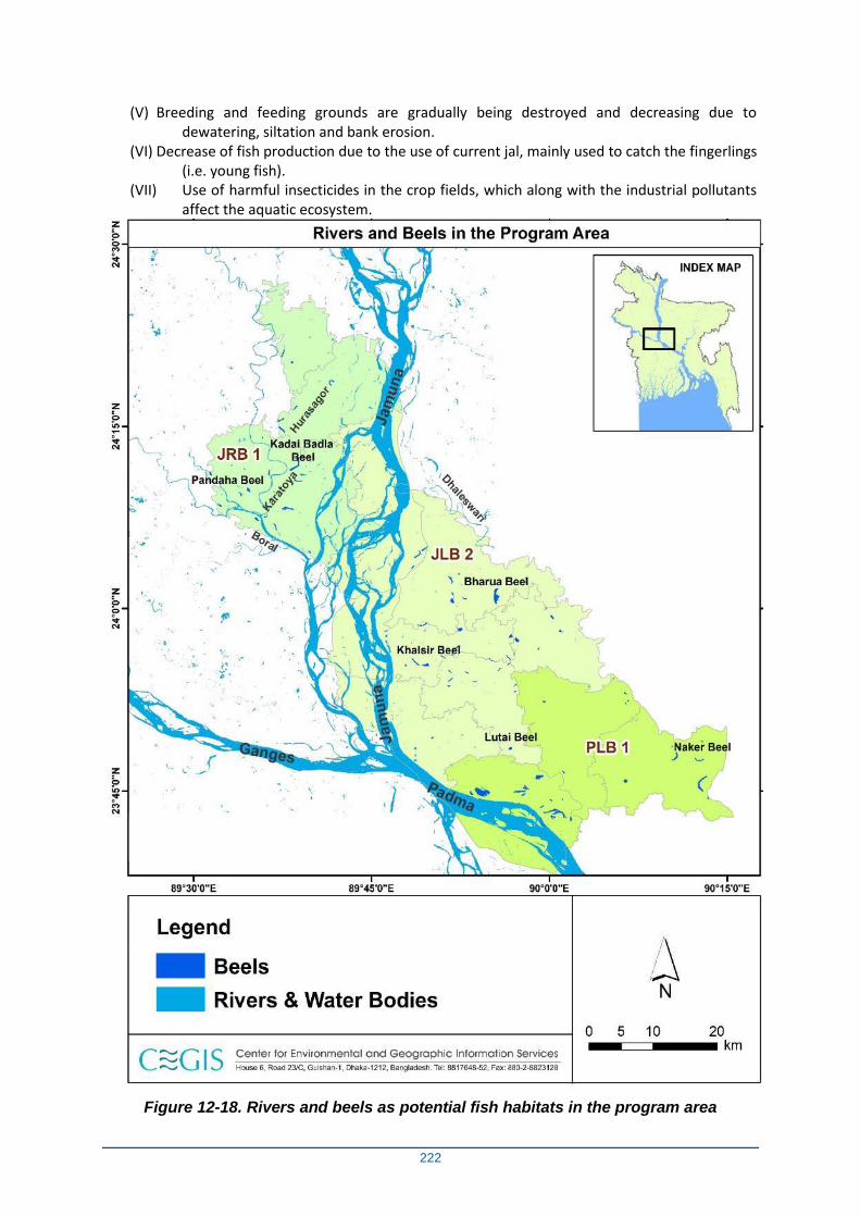
222
(V) Breeding and feeding grounds are gradually being destroyed and decreasing due to dewatering, siltation and bank erosion.
(VI) Decrease of fish production due to the use of current jal, mainly used to catch the fingerlings (i.e. young fish).
(VII) Use of harmful insecticides in the crop fields, which along with the industrial pollutants affect the aquatic ecosystem.
Figure 12-18. Rivers and beels as potential fish habitats in the program area
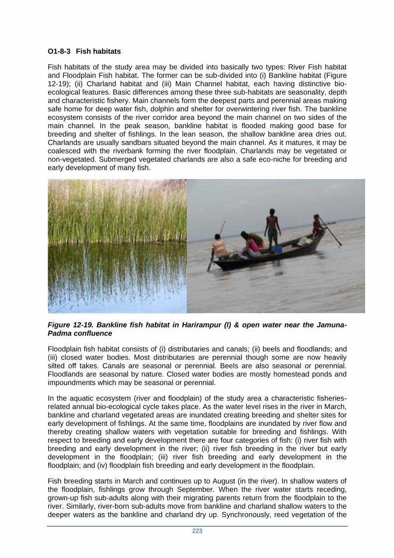
223
O1-8-3 Fish habitats
Fish habitats of the study area may be divided into basically two types: River Fish habitat and Floodplain Fish habitat. The former can be sub-divided into (i) Bankline habitat (Figure 12-19); (ii) Charland habitat and (iii) Main Channel habitat, each having distinctive bio-ecological features. Basic differences among these three sub-habitats are seasonality, depth and characteristic fishery. Main channels form the deepest parts and perennial areas making safe home for deep water fish, dolphin and shelter for overwintering river fish. The bankline ecosystem consists of the river corridor area beyond the main channel on two sides of the main channel. In the peak season, bankline habitat is flooded making good base for breeding and shelter of fishlings. In the lean season, the shallow bankline area dries out. Charlands are usually sandbars situated beyond the main channel. As it matures, it may be coalesced with the riverbank forming the river floodplain. Charlands may be vegetated or non-vegetated. Submerged vegetated charlands are also a safe eco-niche for breeding and early development of many fish.
Figure 12-19. Bankline fish habitat in Harirampur (l) & open water near the Jamuna-Padma confluence
Floodplain fish habitat consists of (i) distributaries and canals; (ii) beels and floodlands; and (iii) closed water bodies. Most distributaries are perennial though some are now heavily silted off takes. Canals are seasonal or perennial. Beels are also seasonal or perennial. Floodlands are seasonal by nature. Closed water bodies are mostly homestead ponds and impoundments which may be seasonal or perennial.
In the aquatic ecosystem (river and floodplain) of the study area a characteristic fisheries-related annual bio-ecological cycle takes place. As the water level rises in the river in March, bankline and charland vegetated areas are inundated creating breeding and shelter sites for early development of fishlings. At the same time, floodplains are inundated by river flow and thereby creating shallow waters with vegetation suitable for breeding and fishlings. With respect to breeding and early development there are four categories of fish: (i) river fish with breeding and early development in the river; (ii) river fish breeding in the river but early development in the floodplain; (iii) river fish breeding and early development in the floodplain; and (iv) floodplain fish breeding and early development in the floodplain.
Fish breeding starts in March and continues up to August (in the river). In shallow waters of the floodplain, fishlings grow through September. When the river water starts receding, grown-up fish sub-adults along with their migrating parents return from the floodplain to the river. Similarly, river-born sub-adults move from bankline and charland shallow waters to the deeper waters as the bankline and charland dry up. Synchronously, reed vegetation of the
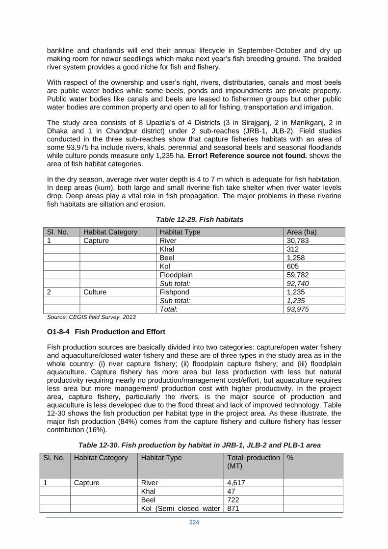
224
bankline and charlands will end their annual lifecycle in September-October and dry up making room for newer seedlings which make next year’s fish breeding ground. The braided river system provides a good niche for fish and fishery.
With respect of the ownership and user’s right, rivers, distributaries, canals and most beels are public water bodies while some beels, ponds and impoundments are private property. Public water bodies like canals and beels are leased to fishermen groups but other public water bodies are common property and open to all for fishing, transportation and irrigation.
The study area consists of 8 Upazila’s of 4 Districts (3 in Sirajganj, 2 in Manikganj, 2 in Dhaka and 1 in Chandpur district) under 2 sub-reaches (JRB-1, JLB-2). Field studies conducted in the three sub-reaches show that capture fisheries habitats with an area of some 93,975 ha include rivers, khals, perennial and seasonal beels and seasonal floodlands while culture ponds measure only 1,235 ha. Error! Reference source not found. shows the area of fish habitat categories.
In the dry season, average river water depth is 4 to 7 m which is adequate for fish habitation. In deep areas (kum), both large and small riverine fish take shelter when river water levels drop. Deep areas play a vital role in fish propagation. The major problems in these riverine fish habitats are siltation and erosion.
Table 12-29. Fish habitats
Sl. No. Habitat Category Habitat Type Area (ha)
1 Capture River 30,783 Khal 312 Beel 1,258 Kol 605 Floodplain 59,782 Sub total: 92,740
2 Culture Fishpond 1,235 Sub total: 1,235 Total: 93,975
Source: CEGIS field Survey, 2013
O1-8-4 Fish Production and Effort
Fish production sources are basically divided into two categories: capture/open water fishery and aquaculture/closed water fishery and these are of three types in the study area as in the whole country: (i) river capture fishery; (ii) floodplain capture fishery; and (iii) floodplain aquaculture. Capture fishery has more area but less production with less but natural productivity requiring nearly no production/management cost/effort, but aquaculture requires less area but more management/ production cost with higher productivity. In the project area, capture fishery, particularly the rivers, is the major source of production and aquaculture is less developed due to the flood threat and lack of improved technology. Table 12-30 shows the fish production per habitat type in the project area. As these illustrate, the major fish production (84%) comes from the capture fishery and culture fishery has lesser contribution (16%).
Table 12-30. Fish production by habitat in JRB-1, JLB-2 and PLB-1 area
Sl. No. Habitat Category Habitat Type Total production (MT)
%
1 Capture River 4,617 Khal 47 Beel 722 Kol (Semi closed water 871
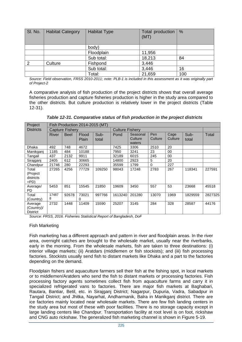
225
Sl. No. Habitat Category Habitat Type Total production (MT)
%
body) Floodplain 11,956 Sub total: 18,213 84
2 Culture Fishpond 3,446 Sub total: 3,446 16 Total: 21,659 100
Source: Field observation, FRSS 2010-2011; note: PLB-1 is included in this assessment as it was originally part of Project-2
A comparative analysis of fish production of the project districts shows that overall average fisheries production and capture fisheries production is higher in the study area compared to the other districts. But culture production is relatively lower in the project districts (Table 12-31).
Table 12-31. Comparative status of fish production in the project districts
Project Districts
Fish Production 2014-2015 (MT)
Capture Fishery Culture Fishery
River Beel Flood Plain
Sub- total
Pond Seasonal Culture waters
Pen Culture
Cage Culture
Sub- total
Total
Dhaka 492 748 4672 7425 3306 2510 20
Manikganj 1185 484 10188 7950 3241 23 00
Tangail 437 2132 9911 32189 6015 245 00
Sirajganj 2405 612 30665 14800 2923 5 20
Chandpur 21746 280 22293 35599 1799 0 227
Total (Project districts =PD)
27265 4256 77729 109250 98043 17248 2783 267 118341 227591
Average/ PD
5453 851 15545 21850 19609 3450 557 53 23668 45518
Total (Country)
174878
92678 730210
997766 1613240 201280 13070 1969 1829559 2827325
Average (Country)/ District
2732 1448 11409 15590 25207 3145 284 328 28587 44176
Source: FRSS, 2016. Fisheries Statistical Report of Bangladesh, DoF
Fish Marketing
Fish marketing has a different approach and pattern in river and floodplain areas. In the river area, overnight catches are brought to the wholesale market, usually near the riverbanks, early in the morning. From the wholesale markets, fish are taken to three destinations: (i) interior village markets; (ii) Aratdars (middlemen or fish stockists); and (iii) fish processing factories. Stockists usually send fish to distant markets like Dhaka and a part to the factories depending on the demand.
Floodplain fishers and aquaculture farmers sell their fish at the fishing spot, in local markets or to middlemen/Aratders who send the fish to distant markets or processing factories. Fish processing factory agents sometimes collect fish from aquaculture farms and carry it in specialized refrigerated vans to factories. There are major fish markets at Baghabari, Rautara, Bantiar, Betil, etc. in Sirajganj District; Nagarpur, Dupuria, Vadra, Sabadpur in Tangail District; and Jhitka, Nayarhat, Andharmanik, Balra in Manikganj district. There are ice factories mainly located near wholesale markets. There are few fish landing centers in the study area but most of these with poor facilities. There is no storage capacity except in large landing centers like Chandpur. Transportation facility at root level is on foot, rickshaw and CNG auto rickshaw. The generalized fish marketing channel is shown in Figure 5-19.
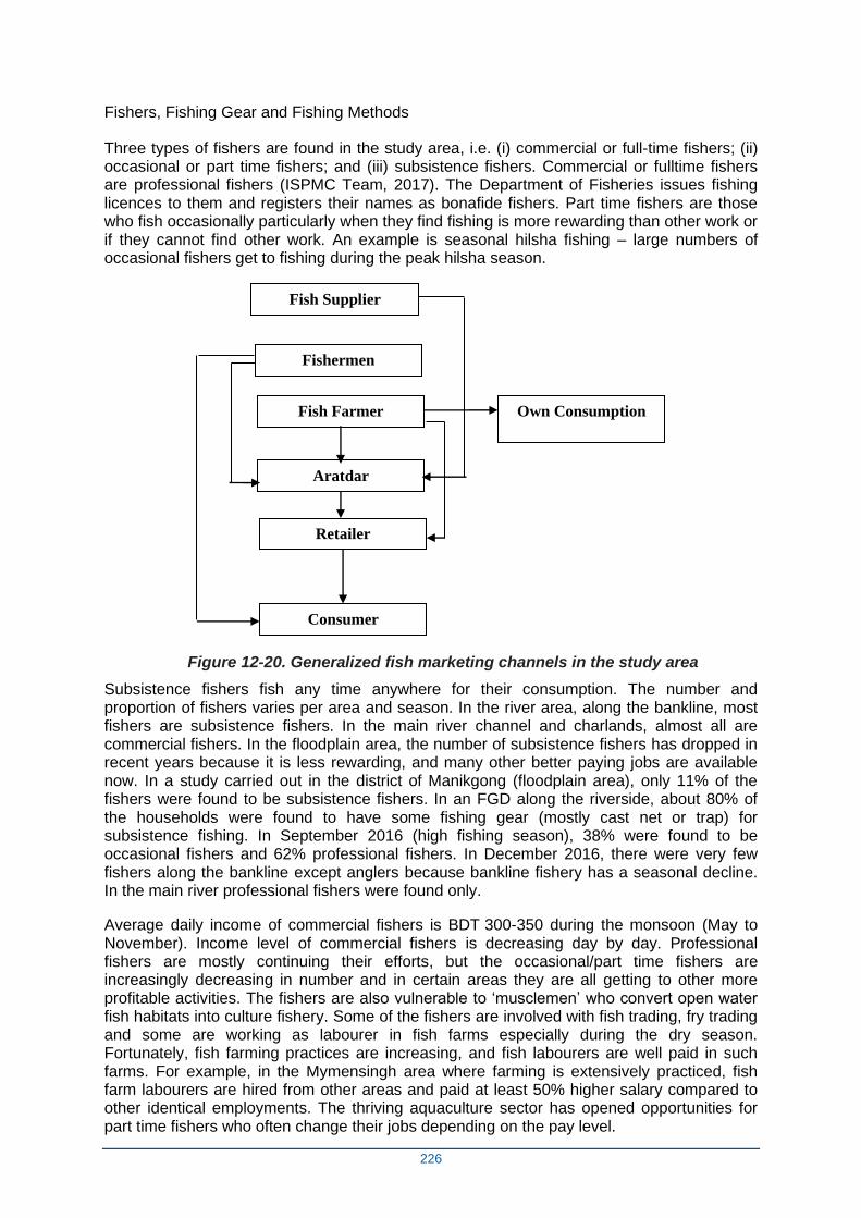
226
Fishers, Fishing Gear and Fishing Methods
Three types of fishers are found in the study area, i.e. (i) commercial or full-time fishers; (ii) occasional or part time fishers; and (iii) subsistence fishers. Commercial or fulltime fishers are professional fishers (ISPMC Team, 2017). The Department of Fisheries issues fishing licences to them and registers their names as bonafide fishers. Part time fishers are those who fish occasionally particularly when they find fishing is more rewarding than other work or if they cannot find other work. An example is seasonal hilsha fishing – large numbers of occasional fishers get to fishing during the peak hilsha season.
Figure 12-20. Generalized fish marketing channels in the study area
Subsistence fishers fish any time anywhere for their consumption. The number and proportion of fishers varies per area and season. In the river area, along the bankline, most fishers are subsistence fishers. In the main river channel and charlands, almost all are commercial fishers. In the floodplain area, the number of subsistence fishers has dropped in recent years because it is less rewarding, and many other better paying jobs are available now. In a study carried out in the district of Manikgong (floodplain area), only 11% of the fishers were found to be subsistence fishers. In an FGD along the riverside, about 80% of the households were found to have some fishing gear (mostly cast net or trap) for subsistence fishing. In September 2016 (high fishing season), 38% were found to be occasional fishers and 62% professional fishers. In December 2016, there were very few fishers along the bankline except anglers because bankline fishery has a seasonal decline. In the main river professional fishers were found only.
Average daily income of commercial fishers is BDT 300-350 during the monsoon (May to November). Income level of commercial fishers is decreasing day by day. Professional fishers are mostly continuing their efforts, but the occasional/part time fishers are increasingly decreasing in number and in certain areas they are all getting to other more profitable activities. The fishers are also vulnerable to ‘musclemen’ who convert open water fish habitats into culture fishery. Some of the fishers are involved with fish trading, fry trading and some are working as labourer in fish farms especially during the dry season. Fortunately, fish farming practices are increasing, and fish labourers are well paid in such farms. For example, in the Mymensingh area where farming is extensively practiced, fish farm labourers are hired from other areas and paid at least 50% higher salary compared to other identical employments. The thriving aquaculture sector has opened opportunities for part time fishers who often change their jobs depending on the pay level.
Fish Supplier
Own Consumption
Fishermen
Aratdar
Retailer
Consumer
Fish Farmer
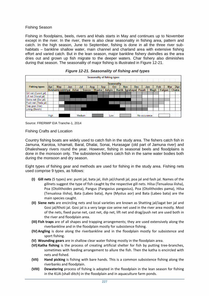
227
Fishing Season
Fishing in floodplains, beels, rivers and khals starts in May and continues up to November except in the river. In the river, there is also clear seasonality in fishing area, pattern and catch. In the high season, June to September, fishing is done in all the three river sub-habitats – bankline shallow water, main channel and charland area with extensive fishing effort and varied catch. But in the lean season, major bankline fishery dwindles as the area dries out and grown up fish migrate to the deeper waters. Char fishery also diminishes during that season. The seasonality of major fishing is illustrated in Figure 12-21.
Figure 12-21. Seasonality of fishing and types
Source: FRERMIP EIA Tranche-1, 2014
Fishing Crafts and Location
Country fishing boats are widely used to catch fish in the study area. The fishers catch fish in Jamuna, Karotoa, Ichamati, Baral, Dhalai, Sonai, Hurasagar (old part of Jamuna river) and Dhaleshwary rivers round the year. However, fishing in seasonal beels and floodplains is done in the monsoon only. The subsistence fishers catch fish in the same water bodies both during the monsoon and dry season.
Eight types of fishing gear and methods are used for fishing in the study area. Fishing nets used comprise 9 types, as follows:
(I) Gill nets (5 types) are: punti jal, bata jal, ilish jal/chandi jal, poa jal and fash jal. Names of the gillnets suggest the type of fish caught by the respective gill nets. Hilsa (Tenualosa ilisha), Poa (Otolithoides pama), Pangus (Pangasius pangasius), Poa (Otolithoides pama), Hilsa (Tenualosa ilisha), Bata (Labeo bata), Ayre (Mystus aor) and Bata (Labeo bata) are the main species caught.
(II) Siene nets are encircling nets and local varieties are known as Shatting jal/Jagat ber jal and Gosi jal/Khoti jal. Gosi jal is a very large size seine net used in the river area mostly. Most of the nets, fixed purse net, cast net, dip net, lift net and drag/push net are used both in the river and floodplain area.
(III) Fish traps are of all shapes and trapping arrangements; they are used extensively along the riverbankline and in the floodplain mostly for subsistence fishing.
(IV) Angling is done along the riverbankline and in the floodplain mostly for subsistence and sport fishing.
(V) Wounding gears are in shallow clear water fishing mostly in the floodplain area. (VI) Katha fishing is the process of creating artificial shelter for fish by putting tree-branches,
sometimes with feeding arrangement to allure the fish. Then the katha is encircled with nets and fished.
(VII) Hand picking is fishing with bare hands. This is a common subsistence fishing along the riverbanks and floodplain.
(VIII) Dewatering process of fishing is adopted in the floodplain in the lean season for fishing in the KUA (shall ditch) in the floodplain and in aquaculture farm ponds.
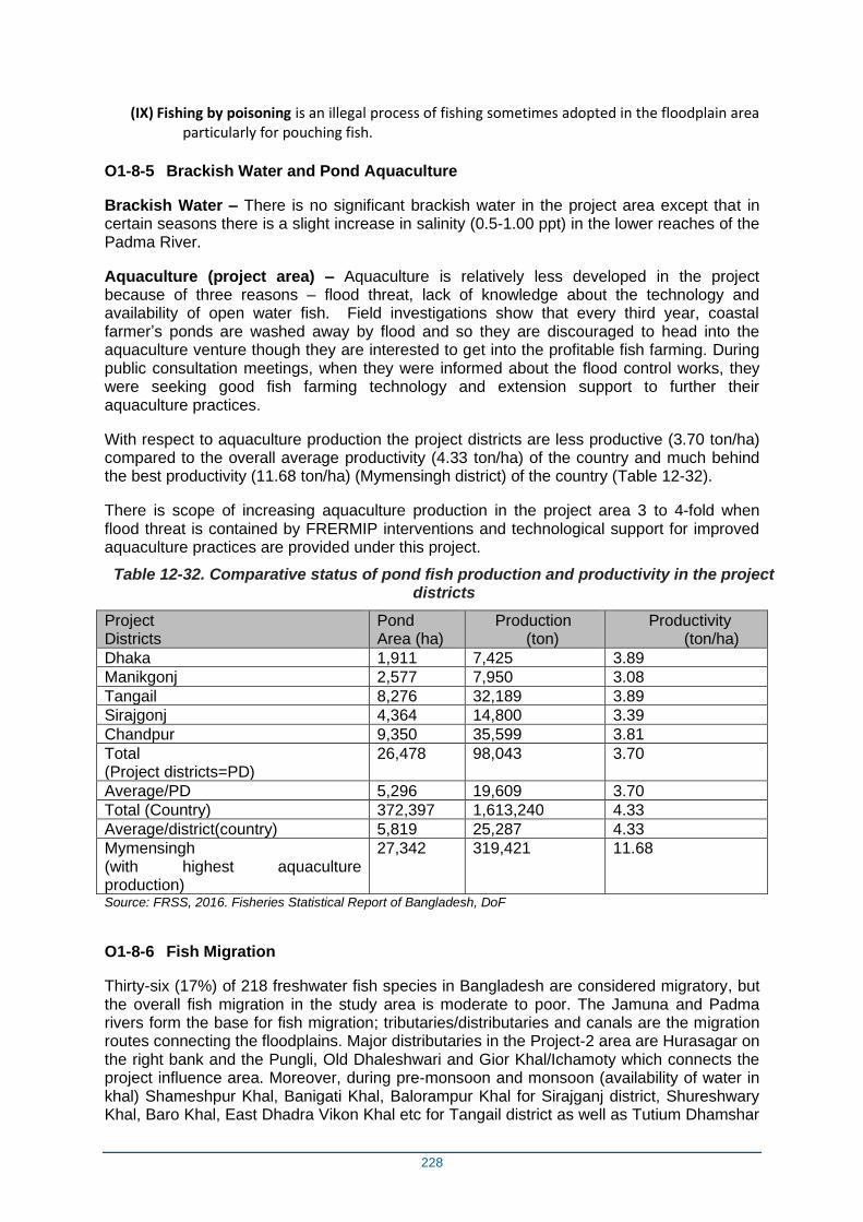
228
(IX) Fishing by poisoning is an illegal process of fishing sometimes adopted in the floodplain area particularly for pouching fish.
O1-8-5 Brackish Water and Pond Aquaculture
Brackish Water – There is no significant brackish water in the project area except that in certain seasons there is a slight increase in salinity (0.5-1.00 ppt) in the lower reaches of the Padma River.
Aquaculture (project area) – Aquaculture is relatively less developed in the project because of three reasons – flood threat, lack of knowledge about the technology and availability of open water fish. Field investigations show that every third year, coastal farmer’s ponds are washed away by flood and so they are discouraged to head into the aquaculture venture though they are interested to get into the profitable fish farming. During public consultation meetings, when they were informed about the flood control works, they were seeking good fish farming technology and extension support to further their aquaculture practices.
With respect to aquaculture production the project districts are less productive (3.70 ton/ha) compared to the overall average productivity (4.33 ton/ha) of the country and much behind the best productivity (11.68 ton/ha) (Mymensingh district) of the country (Table 12-32).
There is scope of increasing aquaculture production in the project area 3 to 4-fold when flood threat is contained by FRERMIP interventions and technological support for improved aquaculture practices are provided under this project.
Table 12-32. Comparative status of pond fish production and productivity in the project districts
Project Districts
Pond Area (ha)
Production (ton)
Productivity (ton/ha)
Dhaka 1,911 7,425 3.89
Manikgonj 2,577 7,950 3.08
Tangail 8,276 32,189 3.89
Sirajgonj 4,364 14,800 3.39
Chandpur 9,350 35,599 3.81
Total (Project districts=PD)
26,478 98,043 3.70
Average/PD 5,296 19,609 3.70
Total (Country) 372,397 1,613,240 4.33
Average/district(country) 5,819 25,287 4.33
Mymensingh (with highest aquaculture production)
27,342 319,421 11.68
Source: FRSS, 2016. Fisheries Statistical Report of Bangladesh, DoF
O1-8-6 Fish Migration
Thirty-six (17%) of 218 freshwater fish species in Bangladesh are considered migratory, but the overall fish migration in the study area is moderate to poor. The Jamuna and Padma rivers form the base for fish migration; tributaries/distributaries and canals are the migration routes connecting the floodplains. Major distributaries in the Project-2 area are Hurasagar on the right bank and the Pungli, Old Dhaleshwari and Gior Khal/Ichamoty which connects the project influence area. Moreover, during pre-monsoon and monsoon (availability of water in khal) Shameshpur Khal, Banigati Khal, Balorampur Khal for Sirajganj district, Shureshwary Khal, Baro Khal, East Dhadra Vikon Khal etc for Tangail district as well as Tutium Dhamshar
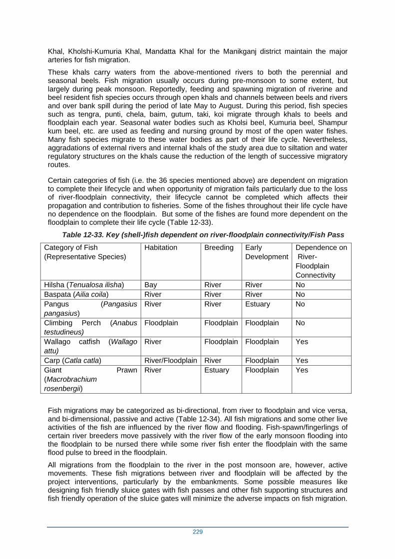
229
Khal, Kholshi-Kumuria Khal, Mandatta Khal for the Manikganj district maintain the major arteries for fish migration.
These khals carry waters from the above-mentioned rivers to both the perennial and seasonal beels. Fish migration usually occurs during pre-monsoon to some extent, but largely during peak monsoon. Reportedly, feeding and spawning migration of riverine and beel resident fish species occurs through open khals and channels between beels and rivers and over bank spill during the period of late May to August. During this period, fish species such as tengra, punti, chela, baim, gutum, taki, koi migrate through khals to beels and floodplain each year. Seasonal water bodies such as Kholsi beel, Kumuria beel, Shampur kum beel, etc. are used as feeding and nursing ground by most of the open water fishes. Many fish species migrate to these water bodies as part of their life cycle. Nevertheless, aggradations of external rivers and internal khals of the study area due to siltation and water regulatory structures on the khals cause the reduction of the length of successive migratory routes.
Certain categories of fish (i.e. the 36 species mentioned above) are dependent on migration to complete their lifecycle and when opportunity of migration fails particularly due to the loss of river-floodplain connectivity, their lifecycle cannot be completed which affects their propagation and contribution to fisheries. Some of the fishes throughout their life cycle have no dependence on the floodplain. But some of the fishes are found more dependent on the floodplain to complete their life cycle (Table 12-33).
Table 12-33. Key (shell-)fish dependent on river-floodplain connectivity/Fish Pass
Category of Fish
(Representative Species)
Habitation Breeding Early
Development
Dependence on
River-
Floodplain
Connectivity
Hilsha (Tenualosa ilisha) Bay River River No
Baspata (Ailia coila) River River River No
Pangus (Pangasius
pangasius)
River River Estuary No
Climbing Perch (Anabus
testudineus)
Floodplain Floodplain Floodplain No
Wallago catfish (Wallago
attu)
River Floodplain Floodplain Yes
Carp (Catla catla) River/Floodplain River Floodplain Yes
Giant Prawn
(Macrobrachium
rosenbergii)
River Estuary Floodplain Yes
Fish migrations may be categorized as bi-directional, from river to floodplain and vice versa, and bi-dimensional, passive and active (Table 12-34). All fish migrations and some other live activities of the fish are influenced by the river flow and flooding. Fish-spawn/fingerlings of certain river breeders move passively with the river flow of the early monsoon flooding into the floodplain to be nursed there while some river fish enter the floodplain with the same flood pulse to breed in the floodplain.
All migrations from the floodplain to the river in the post monsoon are, however, active movements. These fish migrations between river and floodplain will be affected by the project interventions, particularly by the embankments. Some possible measures like designing fish friendly sluice gates with fish passes and other fish supporting structures and fish friendly operation of the sluice gates will minimize the adverse impacts on fish migration.
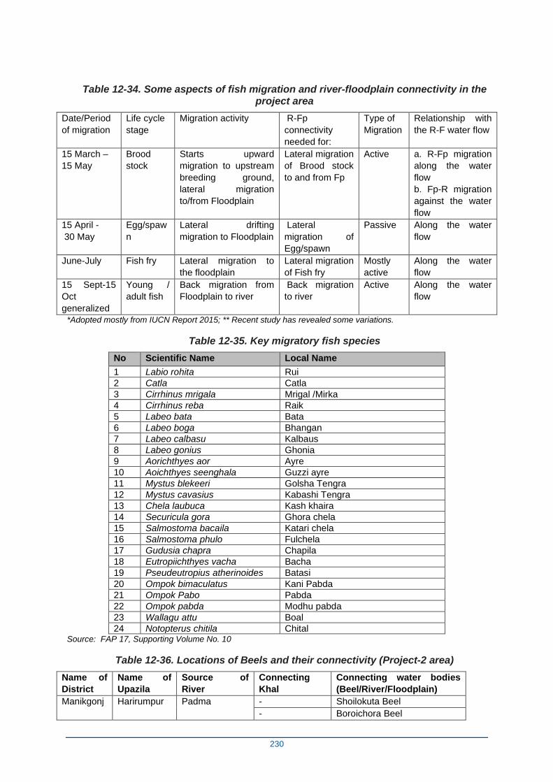
230
Table 12-34. Some aspects of fish migration and river-floodplain connectivity in the project area
Date/Period
of migration
Life cycle
stage
Migration activity R-Fp
connectivity
needed for:
Type of
Migration
Relationship with
the R-F water flow
15 March –
15 May
Brood
stock
Starts upward
migration to upstream
breeding ground,
lateral migration
to/from Floodplain
Lateral migration
of Brood stock
to and from Fp
Active a. R-Fp migration
along the water
flow
b. Fp-R migration
against the water
flow
15 April -
30 May
Egg/spaw
n
Lateral drifting
migration to Floodplain
Lateral
migration of
Egg/spawn
Passive Along the water
flow
June-July Fish fry Lateral migration to
the floodplain
Lateral migration
of Fish fry
Mostly
active
Along the water
flow
15 Sept-15
Oct
generalized
Young /
adult fish
Back migration from
Floodplain to river
Back migration
to river
Active Along the water
flow
*Adopted mostly from IUCN Report 2015; ** Recent study has revealed some variations.
Table 12-35. Key migratory fish species
No Scientific Name Local Name
1 Labio rohita Rui
2 Catla Catla
3 Cirrhinus mrigala Mrigal /Mirka
4 Cirrhinus reba Raik
5 Labeo bata Bata
6 Labeo boga Bhangan
7 Labeo calbasu Kalbaus
8 Labeo gonius Ghonia
9 Aorichthyes aor Ayre
10 Aoichthyes seenghala Guzzi ayre
11 Mystus blekeeri Golsha Tengra
12 Mystus cavasius Kabashi Tengra
13 Chela laubuca Kash khaira
14 Securicula gora Ghora chela
15 Salmostoma bacaila Katari chela
16 Salmostoma phulo Fulchela
17 Gudusia chapra Chapila
18 Eutropiichthyes vacha Bacha
19 Pseudeutropius atherinoides Batasi
20 Ompok bimaculatus Kani Pabda
21 Ompok Pabo Pabda
22 Ompok pabda Modhu pabda
23 Wallagu attu Boal
24 Notopterus chitila Chital Source: FAP 17, Supporting Volume No. 10
Table 12-36. Locations of Beels and their connectivity (Project-2 area)
Name of
District
Name of
Upazila
Source of
River
Connecting
Khal
Connecting water bodies
(Beel/River/Floodplain)
Manikgonj Harirumpur Padma - Shoilokuta Beel
- Boroichora Beel
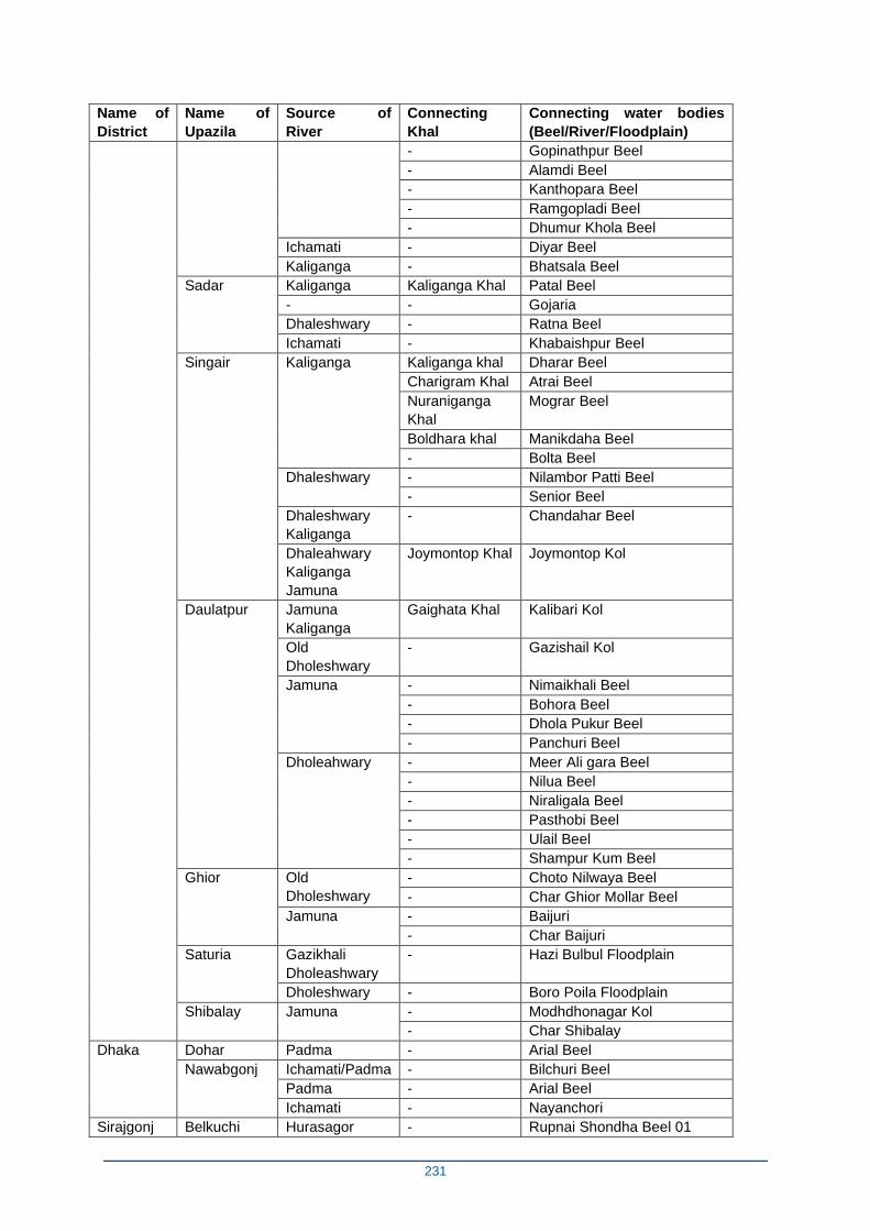
231
Name of
District
Name of
Upazila
Source of
River
Connecting
Khal
Connecting water bodies
(Beel/River/Floodplain)
- Gopinathpur Beel
- Alamdi Beel
- Kanthopara Beel
- Ramgopladi Beel
- Dhumur Khola Beel
Ichamati - Diyar Beel
Kaliganga - Bhatsala Beel
Sadar Kaliganga Kaliganga Khal Patal Beel
- - Gojaria
Dhaleshwary - Ratna Beel
Ichamati - Khabaishpur Beel
Singair Kaliganga
Kaliganga khal Dharar Beel
Charigram Khal Atrai Beel
Nuraniganga
Khal
Mograr Beel
Boldhara khal Manikdaha Beel
- Bolta Beel
Dhaleshwary
- Nilambor Patti Beel
- Senior Beel
Dhaleshwary
Kaliganga
- Chandahar Beel
Dhaleahwary
Kaliganga
Jamuna
Joymontop Khal Joymontop Kol
Daulatpur Jamuna
Kaliganga
Gaighata Khal Kalibari Kol
Old
Dholeshwary
- Gazishail Kol
Jamuna
- Nimaikhali Beel
- Bohora Beel
- Dhola Pukur Beel
- Panchuri Beel
Dholeahwary
- Meer Ali gara Beel
- Nilua Beel
- Niraligala Beel
- Pasthobi Beel
- Ulail Beel
- Shampur Kum Beel
Ghior Old
Dholeshwary
- Choto Nilwaya Beel
- Char Ghior Mollar Beel
Jamuna - Baijuri
- Char Baijuri
Saturia Gazikhali
Dholeashwary
- Hazi Bulbul Floodplain
Dholeshwary - Boro Poila Floodplain
Shibalay Jamuna - Modhdhonagar Kol
- Char Shibalay
Dhaka Dohar Padma - Arial Beel
Nawabgonj Ichamati/Padma - Bilchuri Beel
Padma - Arial Beel
Ichamati - Nayanchori
Sirajgonj Belkuchi Hurasagor - Rupnai Shondha Beel 01
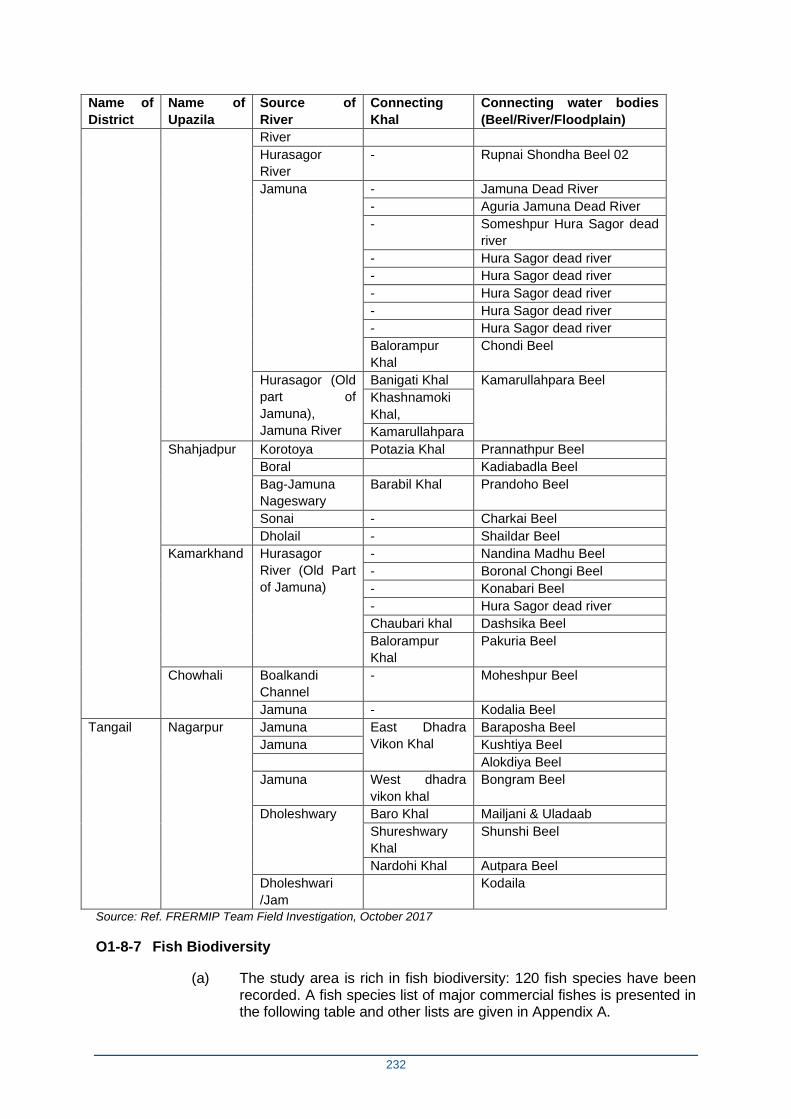
232
Name of
District
Name of
Upazila
Source of
River
Connecting
Khal
Connecting water bodies
(Beel/River/Floodplain)
River
Hurasagor
River
- Rupnai Shondha Beel 02
Jamuna
- Jamuna Dead River
- Aguria Jamuna Dead River
- Someshpur Hura Sagor dead
river
- Hura Sagor dead river
- Hura Sagor dead river
- Hura Sagor dead river
- Hura Sagor dead river
- Hura Sagor dead river
Balorampur
Khal
Chondi Beel
Hurasagor (Old
part of
Jamuna),
Jamuna River
Banigati Khal Kamarullahpara Beel
Khashnamoki
Khal,
Kamarullahpara
Shahjadpur Korotoya Potazia Khal Prannathpur Beel
Boral Kadiabadla Beel
Bag-Jamuna
Nageswary
Barabil Khal Prandoho Beel
Sonai - Charkai Beel
Dholail - Shaildar Beel
Kamarkhand Hurasagor
River (Old Part
of Jamuna)
- Nandina Madhu Beel
- Boronal Chongi Beel
- Konabari Beel
- Hura Sagor dead river
Chaubari khal Dashsika Beel
Balorampur
Khal
Pakuria Beel
Chowhali Boalkandi
Channel
- Moheshpur Beel
Jamuna - Kodalia Beel
Tangail Nagarpur Jamuna East Dhadra
Vikon Khal
Baraposha Beel
Jamuna Kushtiya Beel
Alokdiya Beel
Jamuna West dhadra
vikon khal
Bongram Beel
Dholeshwary Baro Khal Mailjani & Uladaab
Shureshwary
Khal
Shunshi Beel
Nardohi Khal Autpara Beel
Dholeshwari
/Jam
Kodaila
Source: Ref. FRERMIP Team Field Investigation, October 2017
O1-8-7 Fish Biodiversity
(a) The study area is rich in fish biodiversity: 120 fish species have been recorded. A fish species list of major commercial fishes is presented in the following table and other lists are given in Appendix A.
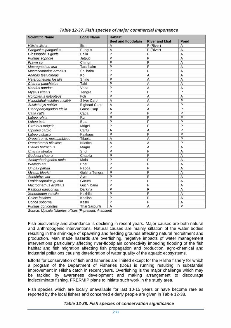
233
Table 12-37. Fish species of major commercial importance
Scientific Name Local Name Habitat
Beel and floodplain River and khal Pond
Hilisha ilisha Ilish A P (River) A
Pangasius pangasius Pungus A P (River) A
Glossogobius giuris Baila P P A
Puntius sophore Jatputi P P A
Prawn sp. Chingri P P A
Macrognathus aral Tara baim P P A
Mastacembelus armatus Sal baim P P A
Anabas testudineus Koi P A A
Heteropneutes fossilis Shing P A A
Channa panchtatus Taki P A A
Nandus nandus Veda P A A
Mystus vitatus Tengra P P P
Notopterus notopteus Foli P A A
Hypophthalmichthys molitrix Silver Carp A A P
Aristichthys nobilis Bighead Carp A A P
Ctenopharyngodon Idella Grass Carp A A P
Catla catla Catla P P P
Labeo rohita Rui P P P
Labeo bata Bata P P P
Cirrhinus mrigela Mrigel P P P
Ciprinus carpio Carfu A A P
Labeo calbasu Kalibaus P P P
Oreochromis mossambicus Tilapia A A P
Oreochromis niloticus Nilotica A A P
Clarias batrachus Magur P A A
Channa striatus Shol P P A
Gudusia chapra Chapila P P A
Amblypharingodon mola Mola P P A
Wallago attu Boal P P A
Ompak pabda Pabda P P A
Mystus bleekri Gulsha Tengra P P A
Aorichthys aor Ayre P P A
Lepidosephalus guntia Gutum P P A
Macrognathus aculatus Guchi baim P P A
Rasbora daniconius Darkina P P A
Xenentodon cancila Kakhila P P A
Colisa fasciata Khalisa P P A
Corica soborna Kaski P P A
Puntius gonionotus Thai Sarpunti A A P
Source: Upazila fisheries offices (P-present, A-absent)
Fish biodiversity and abundance is declining in recent years. Major causes are both natural and anthropogenic interventions. Natural causes are mainly siltation of the water bodies resulting in the shrinkage of spawning and feeding grounds affecting natural recruitment and production. Man made hazards are overfishing, negative impacts of water management interventions particularly affecting river-floodplain connectivity impeding flooding of the fish habitat and fish migration affecting fish propagation and production, agro-chemical and industrial pollutions causing deterioration of water quality of the aquatic ecosystems.
Efforts for conservation of fish and fisheries are limited except for the Hilsha fishery for which a program of the Department of Fisheries (DoE) is running resulting in substantial improvement in Hilsha catch in recent years. Overfishing is the major challenge which may be tackled by awareness development and making arrangement to discourage indiscriminate fishing. FRERMIP plans to initiate such work in the study area.
Fish species which are locally unavailable for last 10-15 years or have become rare as reported by the local fishers and concerned elderly people are given in Table 12-38.
Table 12-38. Fish species of conservation significance
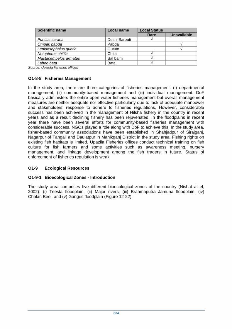
234
Scientific name Local name Local Status
Rare Unavailable
Puntius sarana Deshi Sarputi √
Ompak pabda Pabda √
Lepidosephalus guntia Gutum √
Notopterus chitila Chital √
Mastacembelus armatus Sal baim √
Labeo bata Bata √ Source: Upazila fisheries offices
O1-8-8 Fisheries Management
In the study area, there are three categories of fisheries management: (i) departmental management, (ii) community-based management and (iii) individual management. DoF basically administers the entire open water fisheries management but overall management measures are neither adequate nor effective particularly due to lack of adequate manpower and stakeholders’ response to adhere to fisheries regulations. However, considerable success has been achieved in the management of Hilsha fishery in the country in recent years and as a result declining fishery has been rejuvenated. In the floodplains in recent year there have been several efforts for community-based fisheries management with considerable success. NGOs played a role along with DoF to achieve this. In the study area, fisher-based community associations have been established in Shahjadpur of Sirajganj, Nagarpur of Tangail and Daulatpur in Manikganj District in the study area. Fishing rights on existing fish habitats is limited. Upazila Fisheries offices conduct technical training on fish culture for fish farmers and some activities such as awareness meeting, nursery management, and linkage development among the fish traders in future. Status of enforcement of fisheries regulation is weak.
O1-9 Ecological Resources
O1-9-1 Bioecological Zones - Introduction
The study area comprises five different bioecological zones of the country (Nishat at el, 2002): (i) Teesta floodplain, (ii) Major rivers, (iii) Brahmaputra–Jamuna floodplain, (iv) Chalan Beel, and (v) Ganges floodplain (Figure 12-22).

235
Figure 12-22. Major floodplains in Central Bangladesh
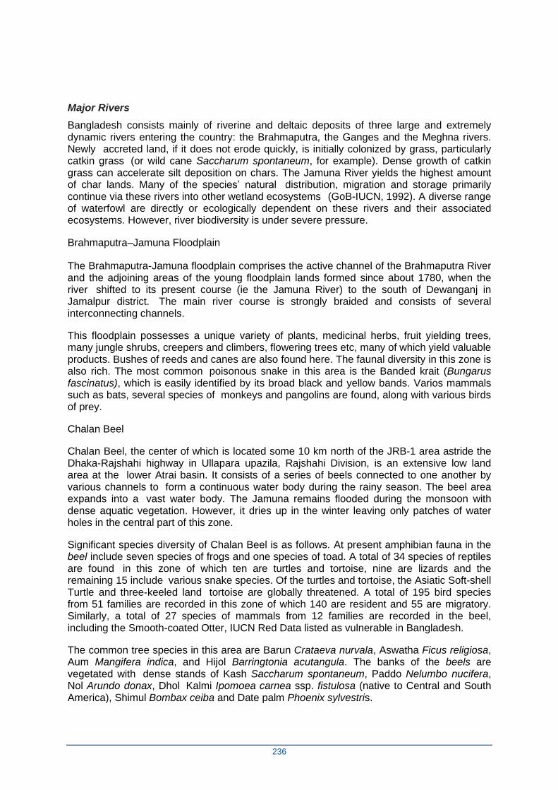
236
Major Rivers
Bangladesh consists mainly of riverine and deltaic deposits of three large and extremely dynamic rivers entering the country: the Brahmaputra, the Ganges and the Meghna rivers. Newly accreted land, if it does not erode quickly, is initially colonized by grass, particularly catkin grass (or wild cane Saccharum spontaneum, for example). Dense growth of catkin grass can accelerate silt deposition on chars. The Jamuna River yields the highest amount of char lands. Many of the species’ natural distribution, migration and storage primarily continue via these rivers into other wetland ecosystems (GoB-IUCN, 1992). A diverse range of waterfowl are directly or ecologically dependent on these rivers and their associated ecosystems. However, river biodiversity is under severe pressure.
Brahmaputra–Jamuna Floodplain
The Brahmaputra-Jamuna floodplain comprises the active channel of the Brahmaputra River and the adjoining areas of the young floodplain lands formed since about 1780, when the river shifted to its present course (ie the Jamuna River) to the south of Dewanganj in Jamalpur district. The main river course is strongly braided and consists of several interconnecting channels.
This floodplain possesses a unique variety of plants, medicinal herbs, fruit yielding trees, many jungle shrubs, creepers and climbers, flowering trees etc, many of which yield valuable products. Bushes of reeds and canes are also found here. The faunal diversity in this zone is also rich. The most common poisonous snake in this area is the Banded krait (Bungarus fascinatus), which is easily identified by its broad black and yellow bands. Varios mammals such as bats, several species of monkeys and pangolins are found, along with various birds of prey.
Chalan Beel
Chalan Beel, the center of which is located some 10 km north of the JRB-1 area astride the Dhaka-Rajshahi highway in Ullapara upazila, Rajshahi Division, is an extensive low land area at the lower Atrai basin. It consists of a series of beels connected to one another by various channels to form a continuous water body during the rainy season. The beel area expands into a vast water body. The Jamuna remains flooded during the monsoon with dense aquatic vegetation. However, it dries up in the winter leaving only patches of water holes in the central part of this zone.
Significant species diversity of Chalan Beel is as follows. At present amphibian fauna in the beel include seven species of frogs and one species of toad. A total of 34 species of reptiles are found in this zone of which ten are turtles and tortoise, nine are lizards and the remaining 15 include various snake species. Of the turtles and tortoise, the Asiatic Soft-shell Turtle and three-keeled land tortoise are globally threatened. A total of 195 bird species from 51 families are recorded in this zone of which 140 are resident and 55 are migratory. Similarly, a total of 27 species of mammals from 12 families are recorded in the beel, including the Smooth-coated Otter, IUCN Red Data listed as vulnerable in Bangladesh.
The common tree species in this area are Barun Crataeva nurvala, Aswatha Ficus religiosa, Aum Mangifera indica, and Hijol Barringtonia acutangula. The banks of the beels are vegetated with dense stands of Kash Saccharum spontaneum, Paddo Nelumbo nucifera, Nol Arundo donax, Dhol Kalmi Ipomoea carnea ssp. fistulosa (native to Central and South America), Shimul Bombax ceiba and Date palm Phoenix sylvestris.
237
The northern palm squirrel, smooth-coated otter, fishing cat, cotton-pigmy-goose, small buttonquail, purple swamp hen, three-stripe roof turtle, painted roofed turtle, common krait are common wildlife species in this zone.
Ganges Floodplain
The Ganges floodplain basically consists of the active floodplains of the Ganges River and the adjoining meandering floodplains. It is mostly situated in the districts of Rajshahi, Pabna, Jessore, Kushtia, Faridpur, Shariatpur and Barisal. The adjoining meander floodplains mainly comprise a smooth landscape of ridges, basins and old channels. A noteworthy aspect here is that the Gangetic alluvium is readily distinguishable from the old Brahmaputra, Jamuna and Meghna sediments by its high lime content. Beside this the relief is locally irregular alongside the present and former river courses, especially in the west, comprising a rapidly alternating series of linear low ridges and depressions. The Ganges-Jamuna channel is constantly shifting within its active floodplain, eroding and depositing large areas of new charlands in each flooding season. But it is less braided than those of the Brahmaputra-Jamuna. Both plants and animals move and adapt with the pattern of flooding (Brammer, 1996).
Significant species diversity of the Ganges Floodplainis as follows. This floodplain is characterised by mixed vegetation. The presence of lot of stagnant water bodies and channels, rivers and tributaries in this zone support a habitat of rich biodiversity to some extent. In the beels and other water bodies, free-floating aquatic vegetation is prominent. The dominant floral types are Panimorich Polygonum orientale, Jhanji Hydrilla verticillata, Helencha Alternanthera philoxeroides, Topapana Pistia stratiotes, Chechra Schoenoplectus articulatus, Shada shapla Nymphaea nouchali, Keshordam Ludwigia adscendens, Kolmi Ipomoea aquatica, Dhol kolmi I. carnea ssp. fistulosa, Hijal Barringtonia acutangula, Tentul Tamarindus indica and Biash Salix tetrasperma. Moreover, grasses are abundant in the Ganges Floodplain and begin to grow as soon as the floodwater begins to recede. Hunuman Langur, Five-Striped Palm Squirrel, Smooth-Coated Otter, Refuse-Tailed Hare, Water Cock, Bank Myna, Asian Paradise Flycatcher, River Tern, Yellow Monitor, Common Vine Snake, Painted-Roofed Turtle, Balloon Frog, etc, occur in this zone.
Nearly all the major groups of oriental birds are represented in this zone by one or more species. In addition, migratory birds are found here during the winter. Besides, different species of freshwater tortoises and turtles are also found in the rivers and ponds, most of which are a popular delicacy among non-Muslims. The amphibian species found in this zone include a few species of toads, frogs and tree frog.
O1-9-2 Terrestrial Habitats and Flora
Terrestrial habitats of the study area can be categorized under the following divisions: (i) settlement/ homestead vegetation (ii) cropland vegetation, (iii) river-bank vegetation, (iv) social forest, and (v) roadside vegetation. Species lists of terrestrial flora and cropland vegetation are provided in Appendix A (Table A1-1 and Table A1-2).
Settlement / homestead vegetation is a man-made plantation cultivated in the yard adjacent to the house. This type of vegetation has been practiced by community traditionally for financial and mundane needs. The Narikel Cocos nucifera, Aam Mangifera sp., Supari Areca catechu, Bansh Bambusa spp.), Akashmoni Acacia auriculiformes, and Bot Ficus bengalensis were observed frequently during the field survey. Chatim and Swarna Lata are present but less common.
Cropland vegetation is found on the periphery of cultivated lands as weeds that grow and expand through self-propagation. Dominant weed species are Shyama Ghash, Durba Ghash, Badali ghash, and Chawla ghas.
238
Riverbank vegetation consists primarily of small to large trees. The large species are Pitali Trewia nudiflora, Pakur Ficus religiosa, Neem Azadirachta indica, Shimul Tula Bombax ceiba, Kul etc. The small to medium-sized species are Bhat Cleodendrum viscosum, Chon, Dhol Kolmi, Dumur Ficus hispida, Bhadi Lannea coromandelica and Khejur Phoenix sylvestris. Among grasses, Durba and Chawla are common.
Social forest in the study area is found on small areas of fallow lands, cropland periphery, and near settlements and graveyards. Social forestry species are Akashmoni (Acacia auriculiformes, Bansh Bambusa spp., Mehogany Swietenia mahogani.
Roadside vegetation consists of a variety of floral species, some wild and some planted. Roadside vegetation is planted in some locations with the concept of public-private partnership to protect roads from erosion. The Ghora Neem Melia azadirachta, Pakor Ficus religiosa, Akashmoni Acacia auriculiformes, Sisu Dalbergia sissoo, Pitali Trewia nudiflora, Bamboo Bambusa spp., Khejur Phoenix sylvestris, Bon Begun Solanu nigrum are common. Less common floral species are Dumur Ficus hispida, Debdaru Polyalthia longifolia and Pakor Ficus religiosa.
Urban Area and built up areas have a low density of vegetations. Because of serious disturbance due to urbanization and dense road network with heavy traffic load, the wildlife population and floral condition and distribution are poor. But still some small mammals, reptiles, and birds were sighted during the field survey.
O1-9-3 Seasonal and Perennial Wetland Habitats and Flora
(a) Overview – Wetland habitats of the study area include charland, swamp, and grassland. Appendix A: Table A1-3 provides a species list of wetland vegetation.
(b) Charland occupies significant part of the study area. The Jamuna and Padma Riversare constantly shifting within their active floodplains, eroding and depositing large areas of new charlands each flood season. New charlands exhibit considerable plant succession such that the char vegetation depends on the time since char formation. At species level, Shon Crotalaria retusa, Nol Phragmites karka and Kaisa are the first colonizers, whereas Mutha Cyperus sp, Kolmi Ipomoea sp, Binna Vetiveria zizanioides, Durba Cynodon sp etc, are the second level successor. At the terminal succession, some bushy plant species such as Dholkolmi Ipomoea carnea ssp. fistulosa appear.
(c) Swamps – Chalan Beel area is favorable for a good growth of wetland trees like Hizal Barringtonia acutangula and Barun.
(d) Grassland species include Binna Vetiveria zizanioides and Durba Gash Cynodon dactylon.
O1-9-4 Terrestrial Fauna
Overview – Among the terrestrial fauna, groups of animals present in the area include birds (Appendix A: Table A1-4), mammals (Appendix A: Table A1-5), amphibians (Appendix A: Table A1-6), and reptiles (Appendix A: Table A1-7).
Terrestrial birds – residents and short-range migrants. Common terrestrial birds in the study area include the Common Myna Acridotheres tristis, Red-Vented Bulbul Pycnonotus cafer, Spotted Dove Streptopelia chinensis, Black Drongo Dicrurus macrocercus, Pompadour Green Pigeon Treron pompadora, Blue Rock Pigeon Columba livia, Oriental Magpie Robin Copsychus saularis, Brahminy Kite Haliastur indus. Uncommon residents include the Barn Owl Tyto alba, Bank Myna Acridotheris ginginiarus and Bronze-winged Jacana Metopidius indicus. Uncommon winter visitors include the Bar-headed Goose Anser indicus, several sand piper and tern species. The area supports also small numbers of species that appear on the Bangladesh-IUCN’s Red List (2015) such as the Lesser Adjutant
239
Leptoptilos javanicus is Vulnerable; River Lapwing Vanellus ducaucelli and River Tern Sterna aurantia are Near Treathened; Masked Finfoot Heliopais personatus is Endangered; and Indian Skimmer Rynchops albocollis, Eurasian Spoonbill Platalea leucorodia and Painted Stork Mycteria leucocephala are Critically Endangered.
Terrestrial birds – long-range migratory species. Bangladesh is on the Central Asian Flyway between the Palaearctic and the Indian subcontinent. Migratory birds that move along the Central Asian Flyway utilize the Brahmaputra-Jamuna-Padma-Ganges char and other habitats potentially affected by Project-2 works. 6
Mammals – The situation of mammals in Bangladesh is not good due to habitat shortage, food scarcity and hunting pressure. Several species have gone extinct since the 1970s. Mammmal species still present include Little Indian Field Mouse Mus booduga, Golden Jackal Canis aureus, Small Indian Mongoose Herpestes auropunctatus, Indian Flying Fox Pteropus giganteus and Greater Short-Nosed Fruit Bat Cynopterus sphinx. Several species still occurring are on the Bangladesh IUCN Red List (2015) for example: Ganges River Dolphin Platanista gangetica, Bengal Fox Vulpes bengalensis as Vulnerable; Finless Porpoise Neophocaena phocaenoides, Irrawady Dolphin Oracaela brevirostris, Jungle Cat Felis chaus, Large Indian Cevet Viverra zibetha, Small Indian Civet Viverricula indica and Common Tree Shrew Tupaia glis as Near Threatened; Eurasian Otter Lutra lutra and Smooth-coated Otter Lutrogale perspicillata as Critically Endangered.
Amphibians are found in terrestrial and aquatic environments. Common terrestrial species observed during the survey were Indian Common Toad Duttaphrynus melanostictus and Indian Bullfrog Hoplobatrachus trigerinus. The Common Tree Frog Polypedates maculates occurs in association with human settlement and forest periphery and the Balloon Frog Uperodon globulosus (IUCN: Vulnerable) lives both in burrows and forest patches and agricultural land. The latter species is considered as rare in the study area.
Reptiles – The Yellow-bellied House Gecko Hemidactylus flaviviridis, Common Garden Lizard Calotes versicolor, Yellow Monitor Varanus flavescens (IUCN: Near Theatened) and Banded Krait Bungarus fasciatus, were observed during the field survey. King Cobra Ophiophagus hannah (IUCN: Vulnerable) and Indian Cobra Naja naja were reported by local people as present in the area.
For several of the species recorded to be present in the area (Tables A1-4 to A1-8 in Appendix A) it is doubtful whether they still occur in this densely populated and intensively used part of Bangladesh, such as the Gharial Gavialis gangeticus (which may be nationally extinct) or the shy Masked Finfoot Heliopais personatus (which is probably now confined in its distribution to the Sundarbans only). The Biodiversity Baseline study (Annex 10) is going to investigate and verify the occurence of plant and animal species in the program area.
O1-9-5 Aquatic Ecosystems
The hydrological cycle regulates ecosystem function by providing varying water levels and flows that create diverse aquatic habitats to be utilized by aquatic biota. In this area, aquatic ecosystems include a range of riverine, floodplain, and pond habitats that become maximally interconnected in the monsoon season. Freshwater wetlands (rivers, khals, ponds, and beels) are classified as seasonal and perennial. Seasonal wetlands usually remain inundated for four to five months. Seasonal wetland occupies the lower croplands and provides refuge and shelter for many aquatic flora and fauna. In addition, wetlands serve as the grazing ground for fish and other aquatic fauna.
6 Ministry of Environment and Forest. 2002. “Country Paper of Bangladesh.” Seventh Meeting of the
Conference of Parties of Convention on the Conservation of Migratory Species of Wild Animals. Bonn, Germany: Government of Bangladesh. http://www.cms.int/bodies/COP/cop7/proceedings/pdf/national_reports/national_report_bangladesh.pdf
240
Perennial wetlands hold water throughout the year. Aquatic Flora
Aquatic flora is present in both seasonal and perennial water bodies. The submerged species are Fodder Hydrilla verticillata, Vallisneria spiralis, Aponogeton Sp. and Gechu. The free-floating species mentionable here are Kachuripana Eichhornia crassipes (waterhyacinth), Kutipana Azolla Sp., and Khudipana Lemna perpusilla. Of the rooted floating species, Keshordam Ludwigia adscendens (syn. Jussiaea repens) and Shapla Nymphae nouchali (waterlily) are common especially in perennial and seasonal beel.
Aquatic Fauna: South Asian River (Gangetic) Dolphin
The South Asian River (Gangetic) Dolphin Platanista gangetica is native to the Ganges and Brahmaputra rivers in Bangladesh and India (Figure 12-23).
During January-September 2011, a Dolphin survey was carried out in the Padma, Jamuna,
and Hurashagar-Baral Rivers of Pabna district.7 Seventy-four transects (including upstream
and downstream) were made over 79 km of river reach by mechanized boats to estimate abundance and habitat use. The dolphin population of the studied area was found to vary from 58 during early monsoon and to 103 during late monsoon. The mean dolphin population was about one dolphin per 1.72 km in the Padma and one per 0.69 km in the Jamuna. Adults accounted for 65% and juveniles for 35% of observed individuals. Dolphin concentrations were found in 22 river locations and found in every count in three scours (Bangla kum): Mohanganj kum of Jamuna- Hurashagar River, Nazirganj ferry ghat kum of Padma River, and Nagarbari kum of Jamuna River. Recent surveys in 2015-2016 recorded 206 River Dophins in the Jamuna-Brahmaputra system (Aziz, 20198).
Dolphins were slightly more abundant during the low water Jan-Apr period (one per 1 km) than in the monsoon high water Jun-Jul period (one per 1.06 km). The local community fishers were involved in river dolphin conservation.
Dolphins utilizing riverine habitats potentially affected by the project are part of a transboundary (Bangladesh-India) population that may include individuals who migrate internationally between Bangladesh and India. Most international movement of dolphins occurs within peri-border areas as short-range tributary-to-mainstream trips, but longer-range migrations of individuals between the project’s influence area and India cannot be ruled out.
The Ganges River Dolphin is on the IUCN Red List as Vulnerable. It is listed in Appendices I and IIof the Convention on the Conservation of Migratory Species of Wild Animals (CMS). CMS Appendix I listed species are deemed in danger of extinction throughout all or a significant proportion of their range and meriting from CMS Parties (Bangladesh is a signatory) strict protection, conservation or restorationof habitats, mitigation of migration obstacles, and control of other threats to survival. Appendix II listed species have an unfavourable conservation status or would benefit significantly from international co-operation organised by tailored agreements. It is also listed in Appendix I of the Convention
7 Rashid, S.M.A., Abdul Wahab Akonda, and Bashir Ahmed. 2012. “Occurrences of South Asian River Dolphin
(Platanista Gangetica) in the Padma and Jamuna Rivers, Pabna.” In Book of Abstracts, 130. Dhaka: Bangladesh
Fisheries Research Forum.
http://bfrf.org/bookofabstracts/BFRF%205th%20Fisheries%20Conference%20and%20Research%20Fair%20201
2%20-%20Book%20of%20Abstracts.pdf. 8 Aziz, M.A (2019) Final Report atlas on Ganges River Dolphin and Irrawaddy Dolphin of Bangladesh. Expanding
the Protected Area System to Incorporate Important Aquatic Ecosystems Project. Bangladesh Forest Department, Ministry of Environment, Forests and Climate Change. 47 pp.
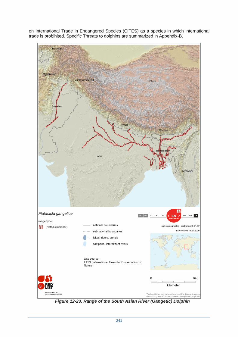
241
on International Trade in Endangered Species (CITES) as a species in which international trade is probihited. Specific Threats to dolphins are summarized in Appendix-B.
Figure 12-23. Range of the South Asian River (Gangetic) Dolphin
242
O1-9-6 Aquatic Ecosystem Services
The floodplain and wetland ecosystem of the study area play an important role in the purification of water quality of the area, fertilization of the agricultural land, recreation and fodder for livestock and food sources for community. The flood cycle and its associated ecosystem purify the water quality deteriorated by the discharge of effluents and waste, and use of agrochemicals.
O1-9-7 Threats to Aquatic Ecosystems
In the study area, river erosion and siltation occur every year. Consequently, threats on surrounding aquatic ecosystem and its biodiversity are increasing. Some of the aquatic plant species being rare have become extinct due to erosion and siltation. Due to this process habitat quality is deteriorating day by day. The population of both flora and fauna is disrupted.
O1-10 Climate Change: Current and Predicted Conditions
In 2007, the International Panel on Climate Change (IPCC) considered data from climate observations across the world and concluded that the evidence for warming of the global climate is ‘unequivocal’. Current projections estimate that the increase in global temperature by the end of this century will range from 1.8 - 4.0 °C predominantly depending on the level of future greenhouse gas emissions. However, these figures demonstrate that dangerous climate change – conventionally understood as a global temperature rise of 2 °C or greater – is becoming increasingly likely. And even this picture is evolving rapidly: recent studies suggest that the impacts of climate change may be even more severe and more rapid than those reported by the IPCC at the start of 2007. In a country like Bangladesh, the vulnerabilities will be emphasised and increased due to the dependence of livelihoods on climate sensitive natural resources and their weak social protection structures. They will be impacted with physical resources, human resources, social resources, natural resources and financial resources. A publication named “Promoting adaptation to climate change in Bangladesh” from Journal of Practical Action, UK (www.preventionweb.net/publications/views/20408 ) states that the projected impacts of climate change on Bangladesh are:
(I) Climate change is likely to bring particularly rapid temperature increases in Bangladesh – faster than the average global rate of warming.
(II) Winter temperatures will increase more than summer temperatures. The level of winter rainfall is expected to decrease, whilst summer rainfall will increase.
(III) Extreme weather events such as heatwaves and very high rainfall are likely to become more frequent. Tropical cyclone intensity is expected to rise by 10 - 20%.
(IV) It is certain that sea level will rise. The lowest anticipated rise in sea level is 40cm by the end of the century.
Some level of uncertainty is inevitable in measuring and anticipating climate change. Attributing individual current events to climate change is impossible due to inherent climate variability. A lack of observations over a sufficiently long time frame or narrow geographical area can hamper the analysis of climate trends. However, the degree of certainty of overall aspects of climate change has increased in recent years, between the publication of the IPCC’s reports in 2001 and 2007.
Climate Change Projections: The majority of climate change projections relevant to Bangladesh have been made using regional climate models. These indicate that warming across Asia will accelerate. The rate of warming in the South Asia is projected to be
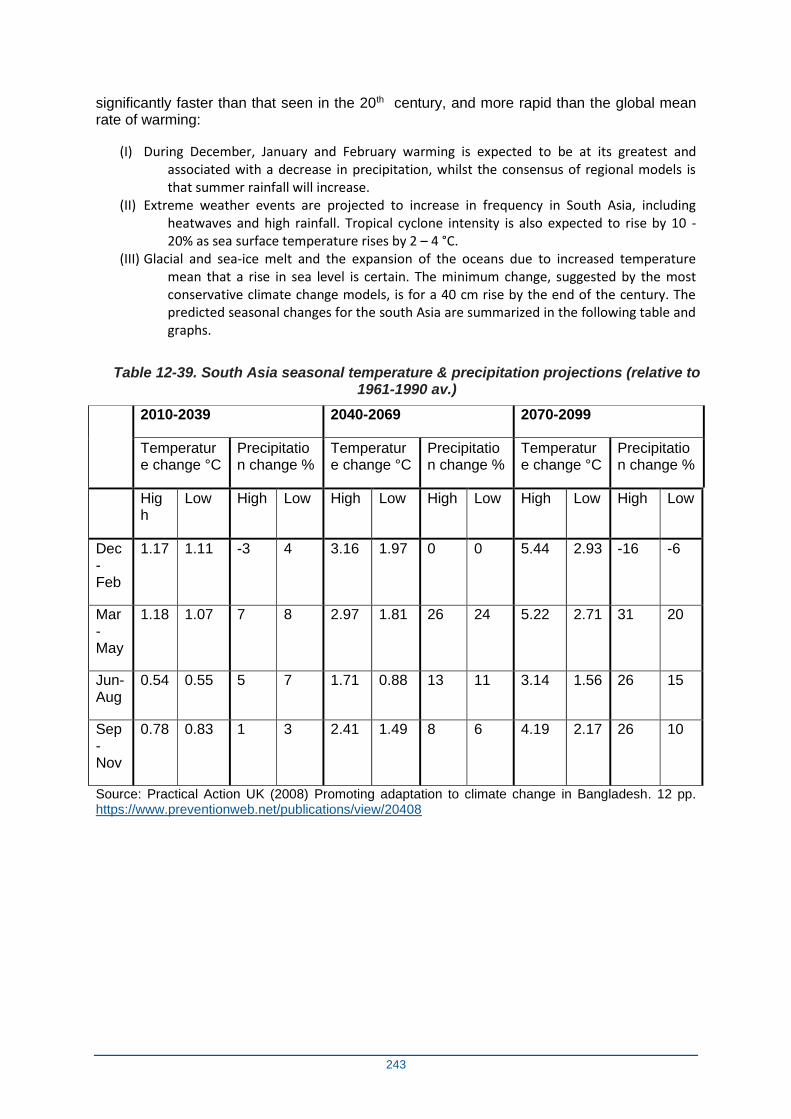
243
significantly faster than that seen in the 20th century, and more rapid than the global mean rate of warming:
(I) During December, January and February warming is expected to be at its greatest and associated with a decrease in precipitation, whilst the consensus of regional models is that summer rainfall will increase.
(II) Extreme weather events are projected to increase in frequency in South Asia, including heatwaves and high rainfall. Tropical cyclone intensity is also expected to rise by 10 - 20% as sea surface temperature rises by 2 – 4 °C.
(III) Glacial and sea-ice melt and the expansion of the oceans due to increased temperature mean that a rise in sea level is certain. The minimum change, suggested by the most conservative climate change models, is for a 40 cm rise by the end of the century. The predicted seasonal changes for the south Asia are summarized in the following table and graphs.
Table 12-39. South Asia seasonal temperature & precipitation projections (relative to 1961-1990 av.)
2010-2039 2040-2069 2070-2099
Temperature change °C
Precipitation change %
Temperature change °C
Precipitation change %
Temperature change °C
Precipitation change %
High
Low High Low High Low High Low High Low High Low
Dec-Feb
1.17 1.11 -3 4 3.16 1.97 0 0 5.44 2.93 -16 -6
Mar-May
1.18 1.07 7 8 2.97 1.81 26 24 5.22 2.71 31 20
Jun-Aug
0.54 0.55 5 7 1.71 0.88 13 11 3.14 1.56 26 15
Sep-Nov
0.78 0.83 1 3 2.41 1.49 8 6 4.19 2.17 26 10
Source: Practical Action UK (2008) Promoting adaptation to climate change in Bangladesh. 12 pp. https://www.preventionweb.net/publications/view/20408
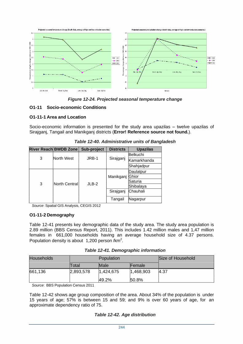
244
Figure 12-24. Projected seasonal temperature change
O1-11 Socio-economic Conditions
O1-11-1 Area and Location
Socio-economic information is presented for the study area upazilas – twelve upazilas of Sirajganj, Tangail and Manikganj districts (Error! Reference source not found.).
Table 12-40. Administrative units of Bangladesh
River Reach BWDB Zone Sub-project Districts Upazilas
3 North West JRB-1 Sirajganj Belkuchi
Kamarkhanda
Shahjadpur
3
North Central JLB-2
Manikganj
Daulatpur
Ghior
Saturia
Shibalaya
Sirajganj Chauhali
Tangail Nagarpur
Source: Spatial GIS Analysis, CEGIS 2012
O1-11-2 Demography
Table 12-41 presents key demographic data of the study area. The study area population is 2.89 million (BBS Census Report, 2011). This includes 1.42 million males and 1,47 million females in 661,000 households having an average household size of 4.37 persons.
Population density is about 1,200 person /km2.
Table 12-41. Demographic information
Households Population Size of Household
Total Male Female
661,136 2,893,578 1,424,675 1,468,903 4.37
49.2% 50.8% Source: BBS Population Census 2011
Table 12-42 shows age group composition of the area. About 34% of the population is under 15 years of age; 57% is between 15 and 59; and 9% is over 60 years of age, for an approximate dependency ratio of 75.
Table 12-42. Age distribution
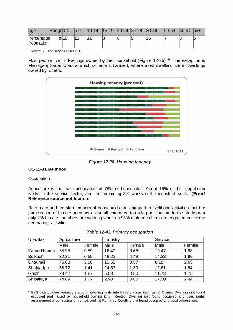
245
Age Range (Years)
0-4 5-9 10-14 15-19 20-24 25-29 30-49 50-59 60-64 65+
Percentage of Population
10 13 11 8 8 9 25 7 3 6
Source: BBS Population Census 2011
Most people live in dwellings owned by their household (Figure 12-25). 9 The exception is Manikganj Sadar Upazila which is more urbanized, where most dwellers live in dwellings owned by others.
Figure 12-25. Housing tenancy
O1-11-3 Livelihood
Occupation
Agriculture is the main occupation of 76% of households. About 16% of the population works in the service sector; and the remaining 8% works in the industrial sector (Error! Reference source not found.).
Both male and female members of households are engaged in livelihood activities, but the participation of female members is small compared to male participation. In the study area only 2% female members are working whereas 98% male members are engaged in income generating activities.
Table 12-43. Primary occupation
Upazilas Agriculture Industry Service
Male Female Male Female Male Female
Kamarkhanda 55.98 0.59 18.40 3.68 19.47 1.88
Belkuchi 32.31 0.69 46.23 4.48 14.33 1.96
Chauhali 75.08 2.00 11.59 0.57 8.10 2.65
Shahjadpur 58.72 1.41 24.33 1.39 12.61 1.54
Ghior 78.42 1.67 5.58 0.80 11.78 1.75
Shibalaya 74.89 1.67 2.90 0.60 17.50 2.44
9 BBS distinguishes tenancy status of dwelling units into three classes such as- i) Owner: Dwelling unit found
occupied and used by household owning it; ii) Rented: Dwelling unit found occupied and used under arrangement of contractually rented; and iii) Rent free: Dwelling unit found occupied and used without rent.
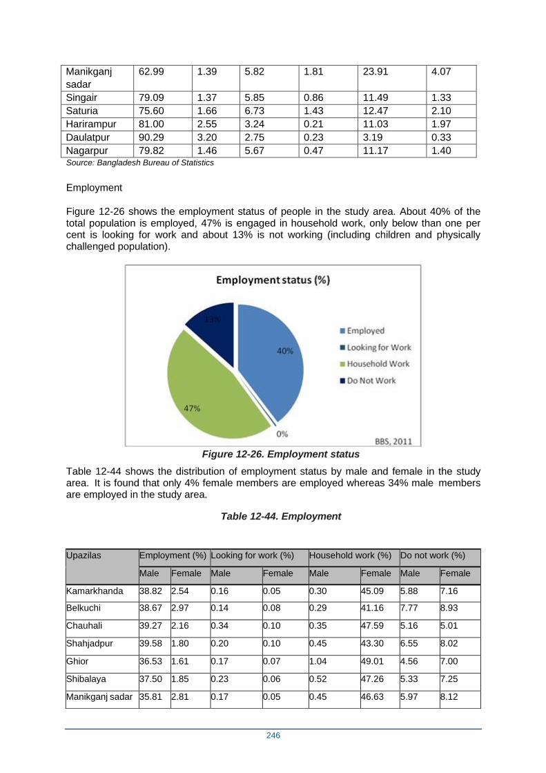
246
Manikganj
sadar
62.99 1.39 5.82 1.81 23.91 4.07
Singair 79.09 1.37 5.85 0.86 11.49 1.33
Saturia 75.60 1.66 6.73 1.43 12.47 2.10
Harirampur 81.00 2.55 3.24 0.21 11.03 1.97
Daulatpur 90.29 3.20 2.75 0.23 3.19 0.33
Nagarpur 79.82 1.46 5.67 0.47 11.17 1.40 Source: Bangladesh Bureau of Statistics
Employment
Figure 12-26 shows the employment status of people in the study area. About 40% of the total population is employed, 47% is engaged in household work, only below than one per cent is looking for work and about 13% is not working (including children and physically challenged population).
Figure 12-26. Employment status
Table 12-44 shows the distribution of employment status by male and female in the study area. It is found that only 4% female members are employed whereas 34% male members are employed in the study area.
Table 12-44. Employment
Upazilas Employment (%) Looking for work (%) Household work (%) Do not work (%)
Male Female Male Female Male Female Male Female
Kamarkhanda 38.82 2.54 0.16 0.05 0.30 45.09 5.88 7.16
Belkuchi 38.67 2.97 0.14 0.08 0.29 41.16 7.77 8.93
Chauhali 39.27 2.16 0.34 0.10 0.35 47.59 5.16 5.01
Shahjadpur 39.58 1.80 0.20 0.10 0.45 43.30 6.55 8.02
Ghior 36.53 1.61 0.17 0.07 1.04 49.01 4.56 7.00
Shibalaya 37.50 1.85 0.23 0.06 0.52 47.26 5.33 7.25
Manikganj sadar 35.81 2.81 0.17 0.05 0.45 46.63 5.97 8.12
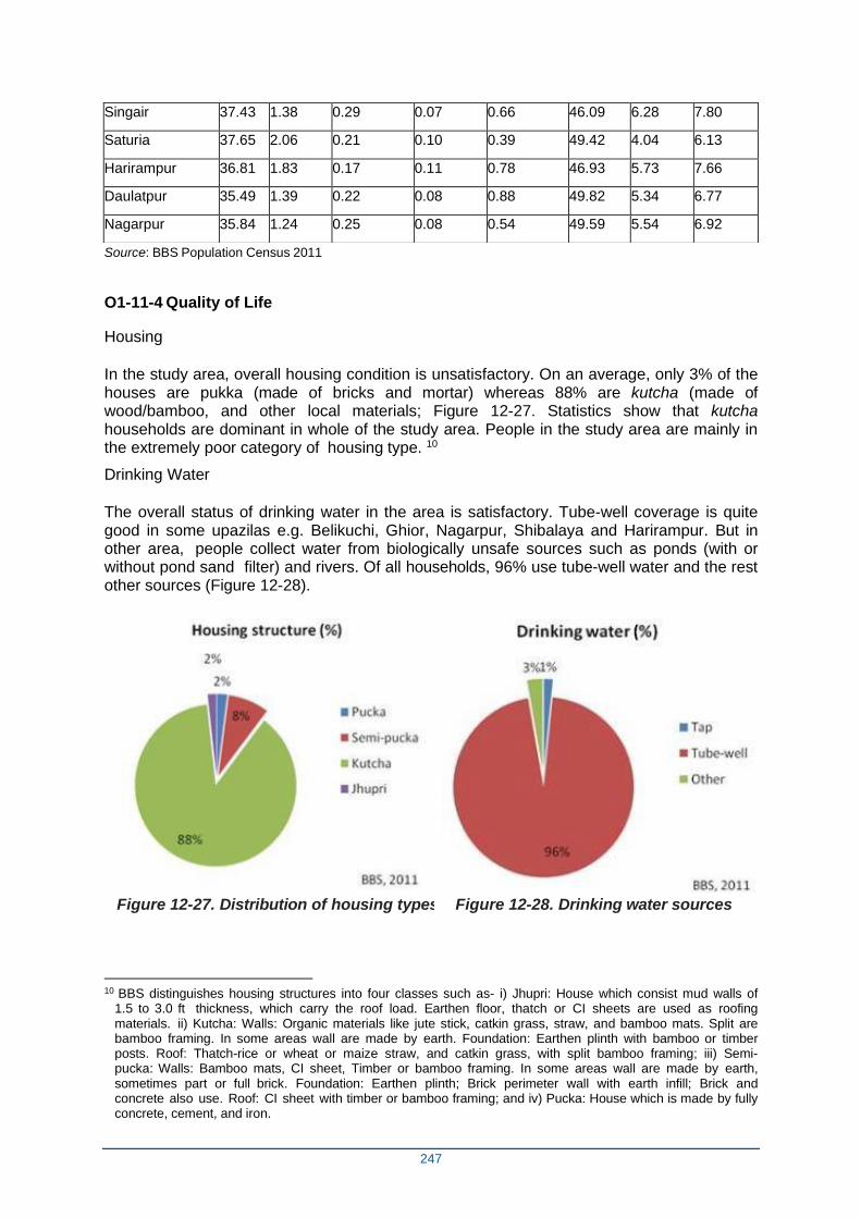
247
Source: BBS Population Census 2011
O1-11-4 Quality of Life
Housing
In the study area, overall housing condition is unsatisfactory. On an average, only 3% of the houses are pukka (made of bricks and mortar) whereas 88% are kutcha (made of wood/bamboo, and other local materials; Figure 12-27. Statistics show that kutcha households are dominant in whole of the study area. People in the study area are mainly in the extremely poor category of housing type. 10
Drinking Water
The overall status of drinking water in the area is satisfactory. Tube-well coverage is quite good in some upazilas e.g. Belikuchi, Ghior, Nagarpur, Shibalaya and Harirampur. But in other area, people collect water from biologically unsafe sources such as ponds (with or without pond sand filter) and rivers. Of all households, 96% use tube-well water and the rest other sources (Figure 12-28).
Figure 12-27. Distribution of housing types Figure 12-28. Drinking water sources
10 BBS distinguishes housing structures into four classes such as- i) Jhupri: House which consist mud walls of
1.5 to 3.0 ft thickness, which carry the roof load. Earthen floor, thatch or CI sheets are used as roofing materials. ii) Kutcha: Walls: Organic materials like jute stick, catkin grass, straw, and bamboo mats. Split are bamboo framing. In some areas wall are made by earth. Foundation: Earthen plinth with bamboo or timber posts. Roof: Thatch-rice or wheat or maize straw, and catkin grass, with split bamboo framing; iii) Semi-pucka: Walls: Bamboo mats, CI sheet, Timber or bamboo framing. In some areas wall are made by earth, sometimes part or full brick. Foundation: Earthen plinth; Brick perimeter wall with earth infill; Brick and concrete also use. Roof: CI sheet with timber or bamboo framing; and iv) Pucka: House which is made by fully concrete, cement, and iron.
Singair 37.43 1.38 0.29 0.07 0.66 46.09 6.28 7.80
Saturia 37.65 2.06 0.21 0.10 0.39 49.42 4.04 6.13
Harirampur 36.81 1.83 0.17 0.11 0.78 46.93 5.73 7.66
Daulatpur 35.49 1.39 0.22 0.08 0.88 49.82 5.34 6.77
Nagarpur 35.84 1.24 0.25 0.08 0.54 49.59 5.54 6.92
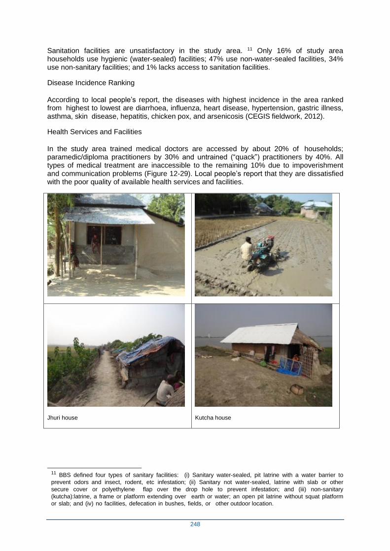
248
Sanitation facilities are unsatisfactory in the study area. 11 Only 16% of study area households use hygienic (water-sealed) facilities; 47% use non-water-sealed facilities, 34% use non-sanitary facilities; and 1% lacks access to sanitation facilities.
Disease Incidence Ranking
According to local people’s report, the diseases with highest incidence in the area ranked from highest to lowest are diarrhoea, influenza, heart disease, hypertension, gastric illness, asthma, skin disease, hepatitis, chicken pox, and arsenicosis (CEGIS fieldwork, 2012).
Health Services and Facilities
In the study area trained medical doctors are accessed by about 20% of households; paramedic/diploma practitioners by 30% and untrained (“quack”) practitioners by 40%. All types of medical treatment are inaccessible to the remaining 10% due to impoverishment and communication problems (Figure 12-29). Local people’s report that they are dissatisfied with the poor quality of available health services and facilities.
Jhuri house
Kutcha house
11 BBS defined four types of sanitary facilities: (i) Sanitary water-sealed, pit latrine with a water barrier to
prevent odors and insect, rodent, etc infestation; (ii) Sanitary not water-sealed, latrine with slab or other
secure cover or polyethylene flap over the drop hole to prevent infestation; and (iii) non-sanitary
(kutcha):latrine, a frame or platform extending over earth or water; an open pit latrine without squat platform
or slab; and (iv) no facilities, defecation in bushes, fields, or other outdoor location.
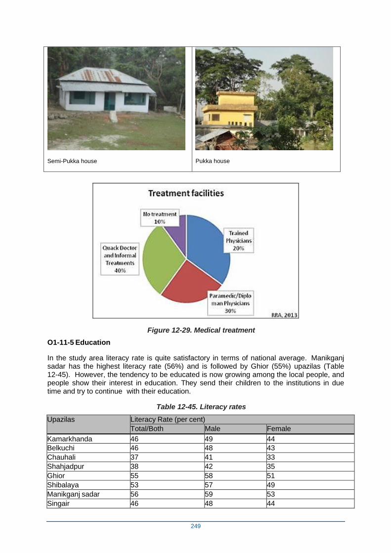
249
Semi-Pukka house
Pukka house
Figure 12-29. Medical treatment
O1-11-5 Education
In the study area literacy rate is quite satisfactory in terms of national average. Manikganj sadar has the highest literacy rate (56%) and is followed by Ghior (55%) upazilas (Table 12-45). However, the tendency to be educated is now growing among the local people, and people show their interest in education. They send their children to the institutions in due time and try to continue with their education.
Table 12-45. Literacy rates
Upazilas Literacy Rate (per cent)
Total/Both Male Female
Kamarkhanda 46 49 44
Belkuchi 46 48 43
Chauhali 37 41 33
Shahjadpur 38 42 35
Ghior 55 58 51
Shibalaya 53 57 49
Manikganj sadar 56 59 53
Singair 46 48 44
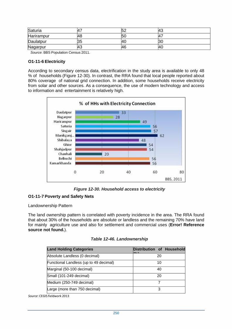
250
Saturia 47 52 43
Harirampur 48 50 47
Daulatpur 35 40 30
Nagarpur 43 46 40
Source: BBS Population Census 2011.
O1-11-6 Electricity
According to secondary census data, electrification in the study area is available to only 48 % of households (Figure 12-30). In contrast, the RRA found that local people reported about 80% coverage of national grid connection. In addition, some households receive electricity from solar and other sources. As a consequence, the use of modern technology and access to information and entertainment is relatively high.
Figure 12-30. Household access to electricity
O1-11-7 Poverty and Safety Nets
Landownership Pattern
The land ownership pattern is correlated with poverty incidence in the area. The RRA found that about 30% of the households are absolute or landless and the remaining 70% have land for mainly agriculture use and also for settlement and commercial uses (Error! Reference source not found.).
Table 12-46. Landownership
Land Holding Categories Distribution of Household (%)
Absolute Landless (0 decimal) 20
Functional Landless (up to 49 decimal) 10
Marginal (50-100 decimal) 40
Small (101-249 decimal) 20
Medium (250-749 decimal) 7
Large (more than 750 decimal) 3
Source: CEGIS fieldwork 2013
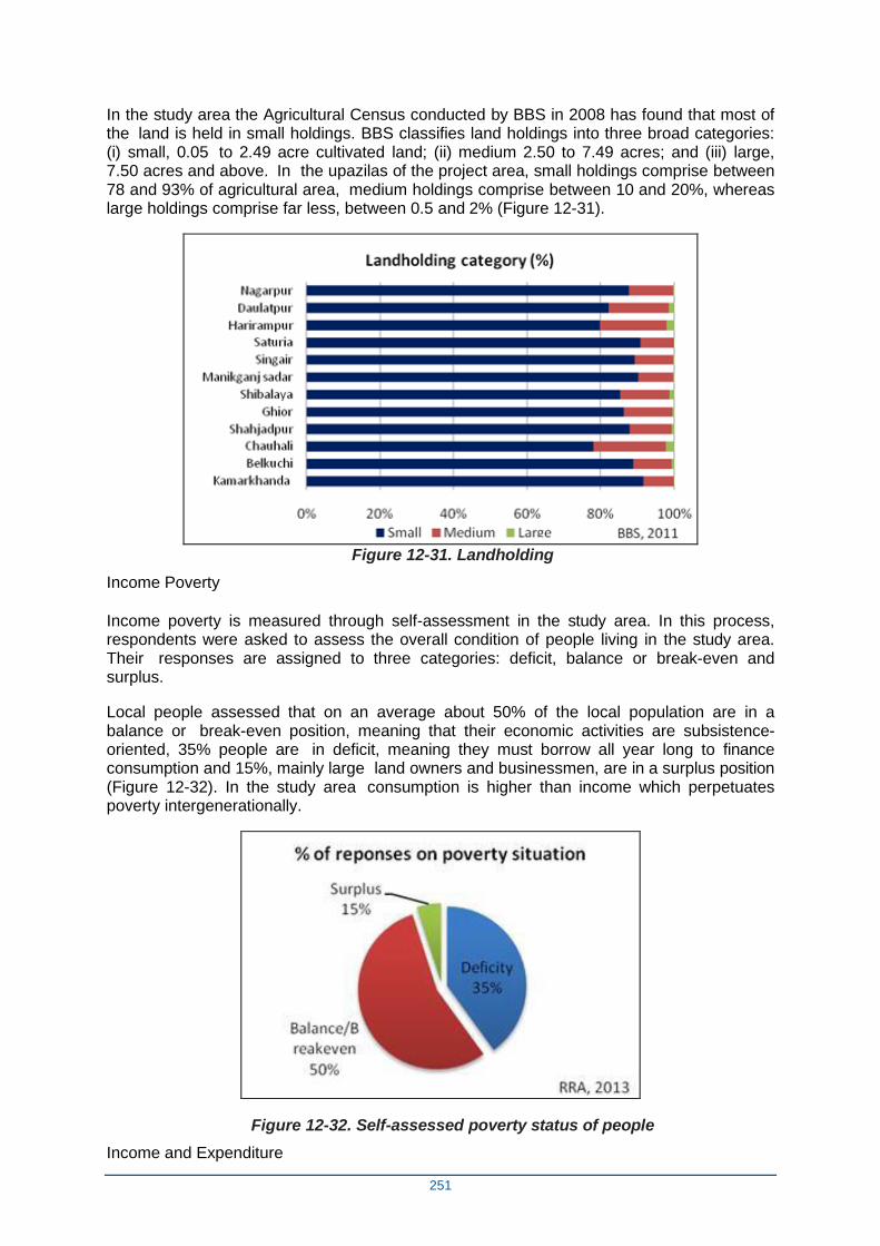
251
In the study area the Agricultural Census conducted by BBS in 2008 has found that most of the land is held in small holdings. BBS classifies land holdings into three broad categories: (i) small, 0.05 to 2.49 acre cultivated land; (ii) medium 2.50 to 7.49 acres; and (iii) large, 7.50 acres and above. In the upazilas of the project area, small holdings comprise between 78 and 93% of agricultural area, medium holdings comprise between 10 and 20%, whereas large holdings comprise far less, between 0.5 and 2% (Figure 12-31).
Figure 12-31. Landholding
Income Poverty
Income poverty is measured through self-assessment in the study area. In this process, respondents were asked to assess the overall condition of people living in the study area. Their responses are assigned to three categories: deficit, balance or break-even and surplus.
Local people assessed that on an average about 50% of the local population are in a balance or break-even position, meaning that their economic activities are subsistence-oriented, 35% people are in deficit, meaning they must borrow all year long to finance consumption and 15%, mainly large land owners and businessmen, are in a surplus position (Figure 12-32). In the study area consumption is higher than income which perpetuates poverty intergenerationally.
Figure 12-32. Self-assessed poverty status of people
Income and Expenditure
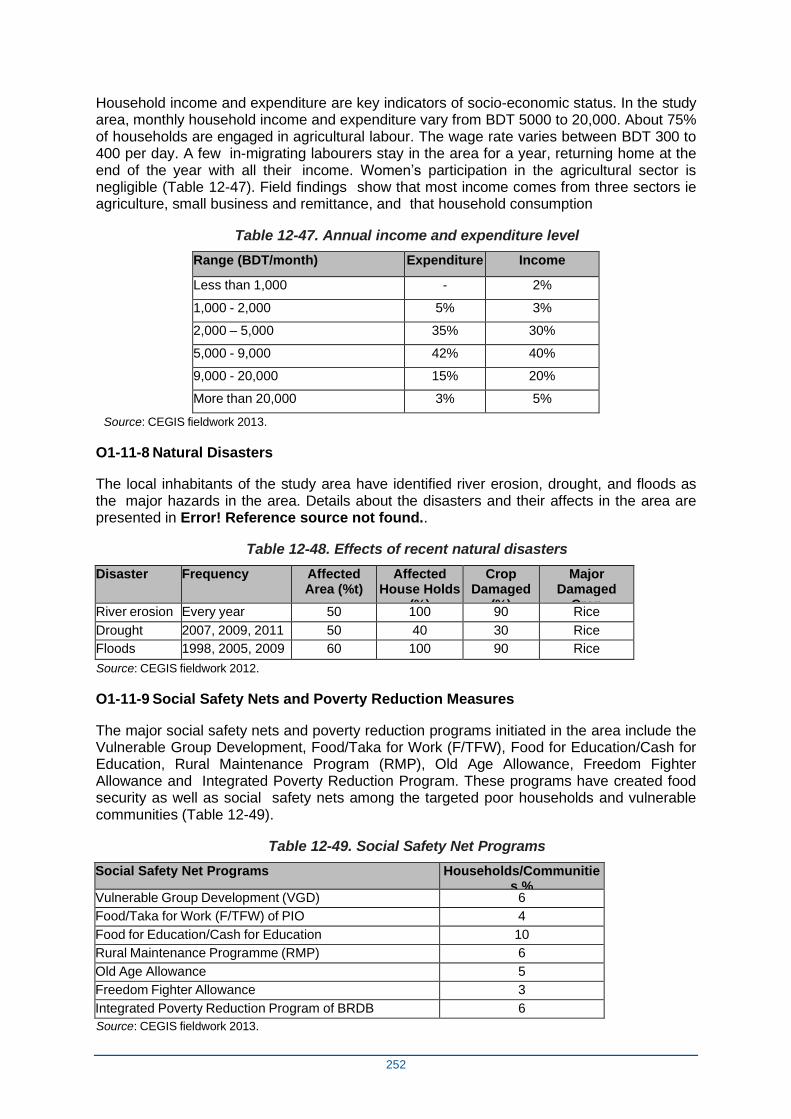
252
Household income and expenditure are key indicators of socio-economic status. In the study area, monthly household income and expenditure vary from BDT 5000 to 20,000. About 75% of households are engaged in agricultural labour. The wage rate varies between BDT 300 to 400 per day. A few in-migrating labourers stay in the area for a year, returning home at the end of the year with all their income. Women’s participation in the agricultural sector is negligible (Table 12-47). Field findings show that most income comes from three sectors ie agriculture, small business and remittance, and that household consumption
Table 12-47. Annual income and expenditure level
Range (BDT/month) Expenditure Income
Less than 1,000 - 2%
1,000 - 2,000 5% 3%
2,000 – 5,000 35% 30%
5,000 - 9,000 42% 40%
9,000 - 20,000 15% 20%
More than 20,000 3% 5%
Source: CEGIS fieldwork 2013.
O1-11-8 Natural Disasters
The local inhabitants of the study area have identified river erosion, drought, and floods as the major hazards in the area. Details about the disasters and their affects in the area are presented in Error! Reference source not found..
Table 12-48. Effects of recent natural disasters
Disaster Frequency Affected Area (%t)
Affected House Holds
(%)
Crop Damaged
(%)
Major Damaged
Crop River erosion Every year 50 100 90 Rice
Drought 2007, 2009, 2011 50 40 30 Rice
Floods 1998, 2005, 2009 60 100 90 Rice
Source: CEGIS fieldwork 2012.
O1-11-9 Social Safety Nets and Poverty Reduction Measures
The major social safety nets and poverty reduction programs initiated in the area include the Vulnerable Group Development, Food/Taka for Work (F/TFW), Food for Education/Cash for Education, Rural Maintenance Program (RMP), Old Age Allowance, Freedom Fighter Allowance and Integrated Poverty Reduction Program. These programs have created food security as well as social safety nets among the targeted poor households and vulnerable communities (Table 12-49).
Table 12-49. Social Safety Net Programs
Social Safety Net Programs Households/Communities %
Vulnerable Group Development (VGD) 6
Food/Taka for Work (F/TFW) of PIO 4
Food for Education/Cash for Education 10
Rural Maintenance Programme (RMP) 6
Old Age Allowance 5
Freedom Fighter Allowance 3
Integrated Poverty Reduction Program of BRDB 6
Source: CEGIS fieldwork 2013.
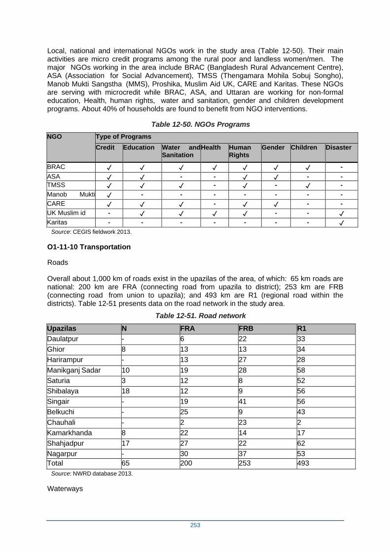
253
Local, national and international NGOs work in the study area (Table 12-50). Their main activities are micro credit programs among the rural poor and landless women/men. The major NGOs working in the area include BRAC (Bangladesh Rural Advancement Centre), ASA (Association for Social Advancement), TMSS (Thengamara Mohila Sobuj Songho), Manob Mukti Sangstha (MMS), Proshika, Muslim Aid UK, CARE and Karitas. These NGOs are serving with microcredit while BRAC, ASA, and Uttaran are working for non-formal education, Health, human rights, water and sanitation, gender and children development programs. About 40% of households are found to benefit from NGO interventions.
Table 12-50. NGOs Programs
NGO Type of Programs
Credit Education Water and Sanitation
Health Human Rights
Gender Children Disaster
BRAC ✓ ✓ ✓ ✓ ✓ ✓ ✓ -
ASA ✓ ✓ - - ✓ ✓ - -
TMSS ✓ ✓ ✓ - ✓ - ✓ -
Manob Mukti Sangstha
✓ - - - - - - -
CARE ✓ ✓ ✓ - ✓ ✓ - -
UK Muslim id - ✓ ✓ ✓ ✓ - - ✓
Karitas - - - - - - - ✓
Source: CEGIS fieldwork 2013.
O1-11-10 Transportation
Roads
Overall about 1,000 km of roads exist in the upazilas of the area, of which: 65 km roads are national: 200 km are FRA (connecting road from upazila to district); 253 km are FRB (connecting road from union to upazila); and 493 km are R1 (regional road within the districts). Table 12-51 presents data on the road network in the study area.
Table 12-51. Road network
Upazilas N FRA FRB R1
Daulatpur - 6 22 33
Ghior 8 13 13 34
Harirampur - 13 27 28
Manikganj Sadar 10 19 28 58
Saturia 3 12 8 52
Shibalaya 18 12 9 56
Singair - 19 41 56
Belkuchi - 25 9 43
Chauhali - 2 23 2
Kamarkhanda 8 22 14 17
Shahjadpur 17 27 22 62
Nagarpur - 30 37 53
Total 65 200 253 493
Source: NWRD database 2013.
Waterways
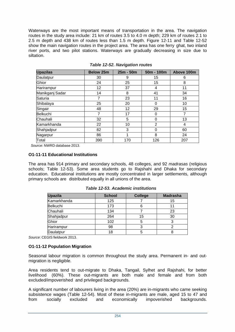
254
Waterways are the most important means of transportation in the area. The navigation routes in the study area include: 21 km of routes 3.5 to 4.0 m depth; 229 km of routes 2.1 to 2.5 m depth and 438 km of routes less than 1.5 m depth. Figure 12-11 and Table 12-52 show the main navigation routes in the project area. The area has one ferry ghat, two inland river ports, and two pilot stations. Waterways are gradually decreasing in size due to siltation.
Table 12-52. Navigation routes
Upazilas Below 25m 25m - 50m 50m - 100m Above 100m
Daulatpur 30 9 15 6
Ghior 24 25 15 8
Harirampur 12 37 4 11
Manikganj Sadar 14 8 41 34
Saturia 7 23 11 16
Shibalaya 25 20 0 10
Singair 48 12 29 15
Belkuchi 7 17 0 7
Chauhali 32 5 0 13
Kamarkhanda 22 10 2 4
Shahjadpur 82 3 0 60
Nagarpur 86 1 8 24
Total 390 170 126 207
Source: NWRD database 2013.
O1-11-11 Educational Institutions
The area has 914 primary and secondary schools, 48 colleges, and 92 madrasas (religious schools; Table 12-53). Some area students go to Rajshahi and Dhaka for secondary education. Educational institutions are mostly concentrated in larger settlements, although primary schools are distributed equally in all unions of the area.
Table 12-53. Academic institutions
Upazila School College Madrasha
Kamarkhanda 125 7 15
Belkuchi 173 6 11
Chauhali 134 7 23
Shahjadpur 264 15 30
Ghior 102 5 3
Harirampur 98 3 2
Daulatpur 18 5 8
Source: CEGIS fieldwork 2013.
O1-11-12 Population Migration
Seasonal labour migration is common throughout the study area. Permanent in- and out- migration is negligible.
Area residents tend to out-migrate to Dhaka, Tangail, Sylhet and Rajshahi, for better livelihood (60%). These out-migrants are both male and female and from both excluded/impoverished and privileged backgrounds.
A significant number of labourers living in the area (20%) are in-migrants who came seeking subsistence wages (Table 12-54). Most of these in-migrants are male, aged 15 to 47 and from socially excluded and economically impoverished backgrounds.
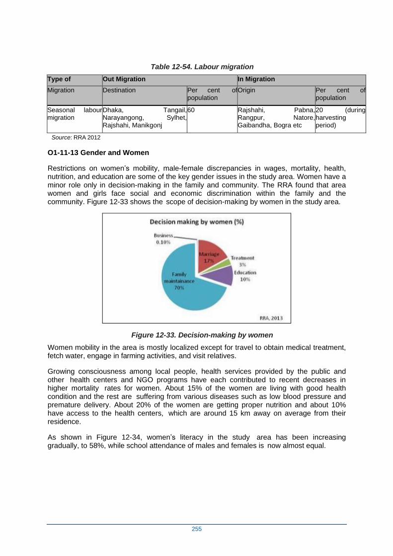
255
Table 12-54. Labour migration
Type of Out Migration In Migration
Migration Destination Per cent of population
Origin Per cent of population
Seasonal labour migration
Dhaka, Tangail, Narayangong, Sylhet, Rajshahi, Manikgonj
60 Rajshahi, Pabna, Rangpur, Natore, Gaibandha, Bogra etc
20 (during harvesting period)
Source: RRA 2012
O1-11-13 Gender and Women
Restrictions on women’s mobility, male-female discrepancies in wages, mortality, health, nutrition, and education are some of the key gender issues in the study area. Women have a minor role only in decision-making in the family and community. The RRA found that area women and girls face social and economic discrimination within the family and the community. Figure 12-33 shows the scope of decision-making by women in the study area.
Figure 12-33. Decision-making by women
Women mobility in the area is mostly localized except for travel to obtain medical treatment, fetch water, engage in farming activities, and visit relatives.
Growing consciousness among local people, health services provided by the public and other health centers and NGO programs have each contributed to recent decreases in higher mortality rates for women. About 15% of the women are living with good health condition and the rest are suffering from various diseases such as low blood pressure and premature delivery. About 20% of the women are getting proper nutrition and about 10% have access to the health centers, which are around 15 km away on average from their residence.
As shown in Figure 12-34, women’s literacy in the study area has been increasing gradually, to 58%, while school attendance of males and females is now almost equal.
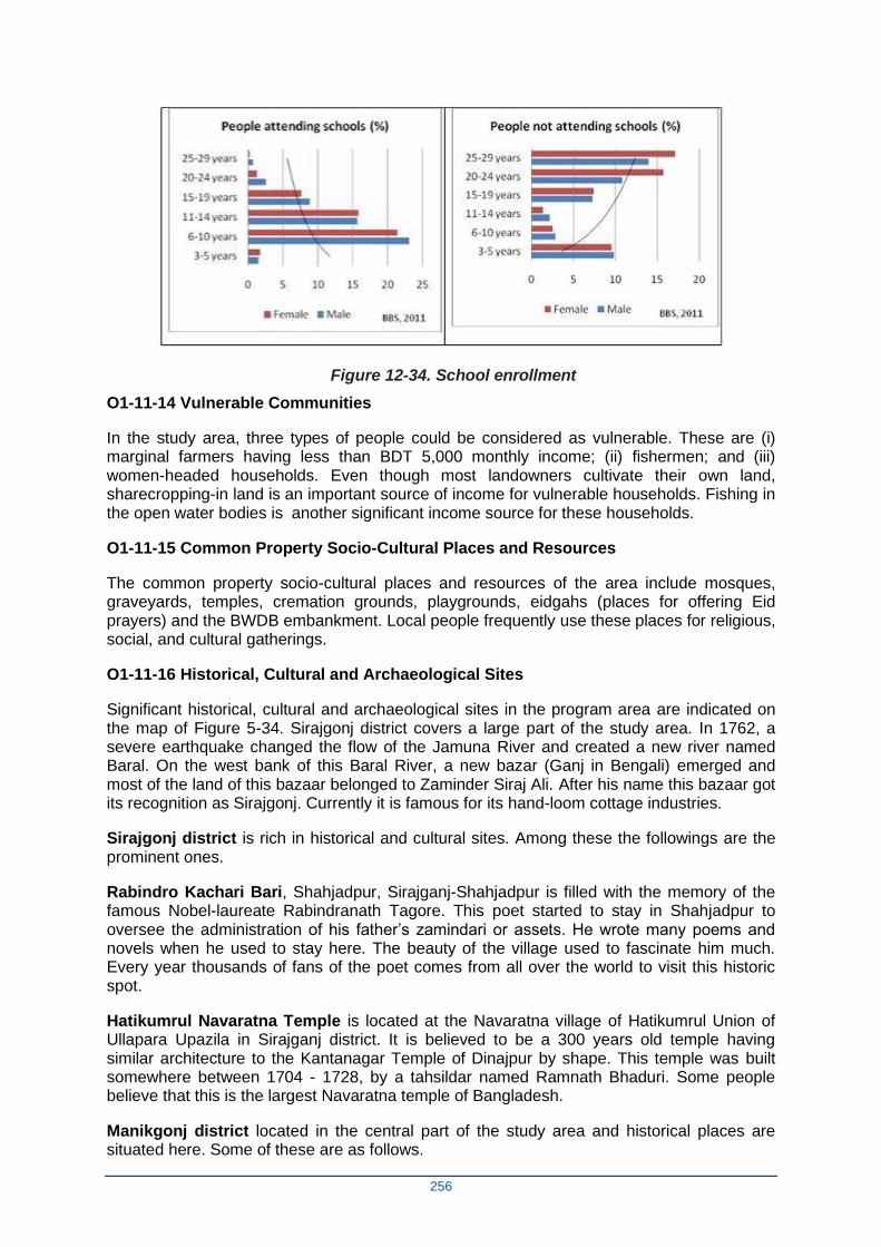
256
Figure 12-34. School enrollment
O1-11-14 Vulnerable Communities
In the study area, three types of people could be considered as vulnerable. These are (i) marginal farmers having less than BDT 5,000 monthly income; (ii) fishermen; and (iii) women-headed households. Even though most landowners cultivate their own land, sharecropping-in land is an important source of income for vulnerable households. Fishing in the open water bodies is another significant income source for these households.
O1-11-15 Common Property Socio-Cultural Places and Resources
The common property socio-cultural places and resources of the area include mosques, graveyards, temples, cremation grounds, playgrounds, eidgahs (places for offering Eid prayers) and the BWDB embankment. Local people frequently use these places for religious, social, and cultural gatherings.
O1-11-16 Historical, Cultural and Archaeological Sites
Significant historical, cultural and archaeological sites in the program area are indicated on the map of Figure 5-34. Sirajgonj district covers a large part of the study area. In 1762, a severe earthquake changed the flow of the Jamuna River and created a new river named Baral. On the west bank of this Baral River, a new bazar (Ganj in Bengali) emerged and most of the land of this bazaar belonged to Zaminder Siraj Ali. After his name this bazaar got its recognition as Sirajgonj. Currently it is famous for its hand-loom cottage industries.
Sirajgonj district is rich in historical and cultural sites. Among these the followings are the prominent ones.
Rabindro Kachari Bari, Shahjadpur, Sirajganj-Shahjadpur is filled with the memory of the famous Nobel-laureate Rabindranath Tagore. This poet started to stay in Shahjadpur to oversee the administration of his father’s zamindari or assets. He wrote many poems and novels when he used to stay here. The beauty of the village used to fascinate him much. Every year thousands of fans of the poet comes from all over the world to visit this historic spot.
Hatikumrul Navaratna Temple is located at the Navaratna village of Hatikumrul Union of Ullapara Upazila in Sirajganj district. It is believed to be a 300 years old temple having similar architecture to the Kantanagar Temple of Dinajpur by shape. This temple was built somewhere between 1704 - 1728, by a tahsildar named Ramnath Bhaduri. Some people believe that this is the largest Navaratna temple of Bangladesh.
Manikgonj district located in the central part of the study area and historical places are situated here. Some of these are as follows.

257
Baliati Palace is a massive palace complex comprising four major sections. The palace is under the Ministry of Archeology.
Nava Ratna Mandir temple was built around 1920s, owners of this palace tried to make the temple in European style rather using traditional Hindu mythological decor. The remarkable Navaratna adjoining the rajbari, built in honour of the family god and used during the ‘Dol' festival, is among the tallest and most elegant ones of its kind.
Teota Zaminder Palace is located 3 km away from Aricha ghat. The 300-year old Teota Zamindar Palace at the village Teota under Shibalaya Upazila in Manikganj District still stands with pride and dignity becoming a living testimony to historical times.
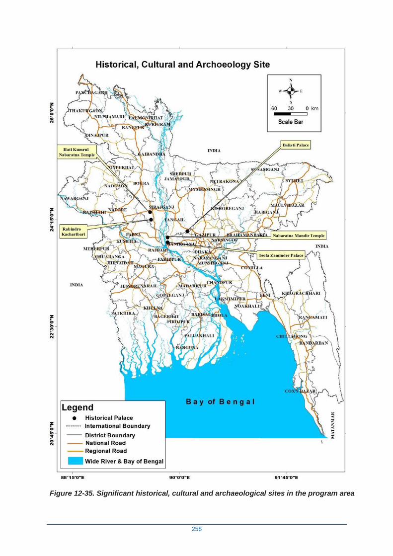
258
Figure 12-35. Significant historical, cultural and archaeological sites in the program area
259
APPENDIX P - Preliminary Comment Matrix
Flood and Riverbank Erosion Risk Management Investment Program – Project 2
Environmental Impact Assessment Report (Comments from May 2020)
No. Issue Suggested action Response
1 General issue:
While the report is well
prepared and comprehensive,
however, it also tends to be
exceedingly long.
While the information
(Baseline) is there, it is difficult
to decipher which information
is generic to the area and
which is specific to the project
site.
Please review the baseline section and use
the most relevant information to impact
analysis and discard other information that
is affecting the flow of the report. Some of
this information can probably be kept as an
annex if necessary.
Impacts depend on the type of intervention.
The overall project area is relatively larger
than some of the specific interventions such
as the construction of embankment, which
might have potently more significant impact,
some level of disaggregation will be helpful
to get a clearer picture.
Please disaggregate the information
(baseline and impact) at the site level and
by intervention type (flood protection, dam
etc), as much as possible. For example,
which are the Khals and Beels that are
within the zone of influence of the project?
Which are of the conservation importance?
What are the potential impacts? The
information provided on 3rd of May on
Impact of FRERMIP Project-2 works on
Beels and wetlands presents somelevel of
The 77 page social and environmental
baseline has been moved to a new Annex
O, so as to retain available information.
To improve the flow of the report, a new
22-page summary Social and environ-
mental baseline has been inserted.
The summary baseline is more site
specific than the original baseline and
includes three location maps (of beels
and land reclamation areas).
260
disaggregation.
It is understandable that the site specific
information on biodiversity might not be
available. Please provide linkages to site
and justification when national level data is
being used.
2 Some description of the project
activities is outdated
It is not clear construction of
the road on the embankment is
included in the current project
design or not?
Please revise the description of project
activities to reflect the most recent design
Please clarify if the construction of the road
is still withing the scope or not.
Latest description of Project-2 is now
included.
Road construction is no longer included,
and an observation to this effect is
included in 4.1.
3 Old maps and not necessarily
relevant to Project-2
Please replace with the newly updated
map, please include Project-2 specific
details as much as possible.
Maps have been replaced.
4 Cumulative and induced
impact.
This section could be further
elaborated in the context of the
first tranche of the project,
what will be the potential risk
(e.g. downstream flood risk,
inundation of adjacent
floodplains, dike failure risk
due to change in river
morphology, raised riverbed,
increase in water depth, and
Please further elaborate on this section.
Please use report on Strategic
Environmental and Social Assessment as a
reference, wherever applicable.
The section has been added to re the
points indicated, with some reference to
the SESA.
261
increased velocity of water etc.
)
5 Impact assessment.
Impact assessment currently
focuses only on habitat and
species. It could be
strengthened by taking a bit
broader approach considering
overall foregone ecosystem
services, e.g. flushing of
agriculture land (pollution),
nutrient loading, drainage
obstruction associated with
hydrological regimes, if
possible.
More details on reclaimed land
could be provided. This could
include site-specific current
characteristics, land-use, land-
tenure. Future land-use plan.
And, Impact, such as increase
Agri-chemical use, pollution.
Water quality impact of
dredging should also be
elaborated. While the impact of
dredging is mentioned, it is not
clear what is the current
baseline, and what will be the
additional change because of
Please elaborate this section to include
ecosystem service, this might require
including additional baseline information.
Please provide a more detailed baseline
and impact analysis on reclaimed land.
Please elaborate baseline on water quality
and impact of dredging.
The summary focuses on habitat and
species as these are likely to be
significantly affected. However, chapter 8
focuses on a broad range of social and
environmental impacts, both positive (8.2)
and negative (8.3), including aspects
associated with pollution, nutrient loading
and so on. As suggested, a section on
(negative) impacts on ecosystem services
(8.3.10) has been added.
A map and paragraph on (to be)
reclaimed land has been added to the
baseline on land resources (5.3.7).
Impacts of land reclamation are felt at
various levels and concern dredging and
excavation (8.3.4), reduced flooding
(8.3.5), fisheries (8.3.7), natural habitats
and wildlife (8.3.8) and of course on local
(char dwelling) communities, which is
dealt with in 8.3.6. Pollution & agro-
chemical used has been added to 8.3.6.
The impact of dredging is not just
mentioned, but 1.5 pages is devoted to to
this impact. In terms of impacts on
aquatic environment, the EIA states:
“Dredging will or may affect the aquatic
environment in four possible ways: (i)
262
the project activities.
destabilizing the bottom ecology, (ii)
channel deepening creates an altered
ecosystem that may not be good for
aquatic life, (iii) destroying potential
fisheries habitat as the spoil deposition
sites are targeted to be partly water
bodies, and (iv) changing water quality
(e.g. pollution, turbidity, suspended
solids).” The latter has been elaborated
further. These are the anticipated
changes, and the EIA specifies (via the
EMP) that water quality is monitored,
which will also provide a pre-dredging
baseline. Section 5.2.3 provides a
baseline on water quality for the Jamuna
and Padma, but for monitoring this needs
to be time and location specific.
6 Consultation.
It seems that the last
consultation was held in 2017.
It might be useful to undertake a
consultation based on the finalized project
design and include it in the report.
Public consultations were conducted in
three rounds, two in 2013 and the third
from 2016-2017, so a renewed
consultation would have been
appropriate. However, given present
restrictions due to COVID-19, the
completion of the ISPMC contract in June
2020 and the limited ability to use
alternative strategies for face-to-face
meetings (e.g. teams or zoom) in these
rural settings, renewed consultations are
not feasibile for the foreseeable future.
Also, in principle, the types of
interventions and impacts and hence the
263
likely concerns of the stakeholders
remain unchanged in the final design, so
it is unlikely that new insights will emerge.
264
APPENDIX Q - Detailed Comment Matrix:
Flood and Riverbank Erosion Risk Management Investment Program – Project 2
Environmental Impact Assessment Report (Comments from June 2020)
No. Issue ADB comments – 26 June 2020 Response on 30 June 2020
1 General issue:
While the report is generally well written, there are
several paragraphs, which are very long and
convoluted and might benefit from editing. Some
sentences in EMP tables are incomplete (marked x)
The report refers to old EARF and EIA of the program.
Please edit the document / complete the
information as required.
Please update based on updated EARF of
Project-2 thorough out the report.
The ‘x’s’ in the EMP tables are intentional, as
they refer to unknown amounts (e.g. ha
impacted, or extra rice production in tons).
This has been updated in the latest revision
(30 June 2020).
2 Executive Summary:
Introduction:
First sentence refers to the EIA of the program. This
report is for the EIA of Project 2.
Please update
The ‘program’ referred to is the title of
FRERMIP and that remains unchanged.
Where appropriate the document refers to
Project 2.
265
The Assessed Project:
Does not mention PLB 1
Environmental categorization: needs to be updated
based on new EARF for Project 2.
Impacts: understandably, the emphasis is on long
term significant impacts such as habitat and species;
however, it will be useful to add a summary of other
impacts as well.
Fourth Paragraph:”… Riverbank protection works at
the two sub-project sites have the purpose of
protecting the existing floodplain habitat from
continuous and systematic erosion...” It should be
three sub-projects.
Fifth Paragraph. Difficult to understand.
Sixth Paragraph. References to morphology studies
are missing.
Please add PLB 1 or provide justification, and
adjust throughout the report
Please update
Please update
Please update
This has been added.
Environmental categorization is correct and
updated; the EARF does not specify the
environmental category.
Other impacts such as on livelihoods,
protection against floods and erosion are
already mentioned in the 2.5 pages summary
on impacts.
Reference to number of sub-project sites has
been removed.
This 5th paragraph has been rewritten/
266
The last two sentences are not clear.
Specific JRB-1 Interventions and Impacts: Does not
say anything about the impacts
Specific JLB-2 Interventions and Impacts: Does not
say anything about the impacts
Specific PLB-1 Interventions and Impacts: Does not
say anything about the impacts
Recommended Actions
“…. It will not result in all residual impacts being
reduced to insignificance, but it will reduce them to
levels considered acceptable under the
circumstances…” is vague, acceptable by whom?
“…emergency type riverbank protection…” not clear
what does this mean
Environmental Management Plan
Please rewrite the paragraph
Please provide a reference to morphology
studies.
Please rewrite the last two sentences
Please summarize the impacts of JRB-1
Please summarize the impacts of JLB-2
Please summarize the impacts of PLB-1
Please be specific, a reference to standards
Reference provided.
Unclear which two sentences are referred to.
These have been added.
Reference is made to JRB-1, above.
Reference is made to JRB-1 and JLB-2
impacts.
Redrafted this, as indeed vague.
267
“…(i) include open water fisheries-related
measures…” Not clear what are the measures
and best practices will help
Please clarify
Please specify measures or give examples
These target initial perceived risks. Has been
reworded.
These include fish-passes and buoys to curb
use of nets (now added to text).
Introduction:
Overview: First sentence. Long and convoluted. Also,
what is the remaining 85% of land use?
Second Paragraph. Outdated
Third paragraph. Reference to MFF
Please rewrite
Please update based on the new EARF for
Project-2
Please update based on the updated EARF
for Project-2
Reworded. 15% consists of water bodies, the
rest consists of dryland area.
This history of EARF and EIA has been
updated.
Reworded.
Objective:
Reference to Jamuna-Meghna River Erosion
Mitigation Project (JMREMP). It suddenly appears
here without providing any context or linkage to
Project 2.
“…It aims to sustain incomes and livelihoods of
people…” The objective does not appear in line with
Project 2 outcome and outputs
Please provide better context to JMREMP if
necessary, otherwise, delete any reference to
the JMREMP.
Please clarify/ adjust, more along the line of
flood and bank erosion risk management
Reference to JMREMP has been removed.
The main aim is providing security, and
sustaining incomes and livelihoods is a
knock-on effect.
268
Project Area versus Study Area. This section needs to
be updated for Project-2
The first paragraph refers to the World Bank Project,
however linkage to this project is not clear. If there is a
link, this needs a discussion under the section on
Cumulative Impact Assessment.
“… The EIA study area has focused on two sub-
reaches, i.e., JRB-1 and JLB-2…” PLB-2 is missing.
Please update
Please clarify/ elaborate.
Please add PLB-1 or justify not including it in
the EIA
Reworded, and PLB-1 has been reinserted.
Deleted, as PMO also questioned this
previously.
PLB-1 has been reinserted.
POLICY, LEGAL AND ADMINISTRATIVE
FRAMEWORK.
National Conservation Strategy (NCS, 1992). One
sentence does not say much about this strategy. What
is the objective of the strategy and its
relevance/linkage to Project-2?
National Environnemental Management Action Plan
(NEMAP, 1995). The period covering period 1995 to
2005 appears outdated, what is its relevance to
Project-2?
Bangladesh Climate Change Strategy and Action Plan
(BCCSAP, 2009). What is the objective of the strategy
and its relevance/ linkage to Project-2?
Environmental Conservation Rules (ECR, 1997).
Does Project-2 fall inside any 'ecologically critical
area' (ECA)
Please elaborate
Please update/ clarify
Please add an introductory paragraph
Please provide information
Please add a sentence or two to clarify
This has been elaborated.
As NEMAP was not updated after 2005, it still
provides the framework for implementing the
NCS.
This has been added. The BCCSAP
demonstrates the government’s commitment
to low carbon development and ensuring that
infrastructure is climate proof, both of which
are of direct relevance to Project 2 design
and implementation.
By 2015, 13 Ecologically Critical Areas had
been declared in Bangladesh, none of which
are in the project area.
Any resettlement on Project 2 should bear in
mind the issues related to arsenic in drinking
269
The National Policy for Arsenic Mitigation (2004). Not
clear what is the relevance to the Project-2.
Bangladesh Wildlife (Protection and Safety) Act 2012.
The introduction to this act is missing.
Bangladesh Wildlife (Protection and Safety) Act 2012
Last sentence. “… GOB commitment to biodiversity
conservation…” also climate change and disaster risk
management
relevance to Project-2
Please introduce this act with a few
sentences
Please add climate change and disaster risk
management
water.
An introductory sentence has been added.
Updated the last sentence of Section 2.2 to
include this
APPROACH AND METHODOLOGY
Baseline Data Collection and Analysis: The collection
of baseline on the existing infrastructure is missing.
This is important because one of the major impacts is
reduction of connectivity between river and
floodplains, which is also affected by already built
infrastructure such as embankments, roads, and
settlements.
Please add a collection of baseline on
existing infrastructure in approach and
methodology. Also, add collection of baseline
on other human activities such as navigation,
existing use/land use (char) of braided river
system.
This information was collected. Road network
and waterways, including maps, are now
included in Annex O, and have been moved
here because a previous review by ADB
found that the baseline (chapter 5) was way
too long. Land use is included in 5.3 on Land
Resources. A comment has been added to
approach & methodology.
Project Description
Assessment of dredging. This title is confusing.
Probably it should be Description of dredging instead
of assessment
The last paragraph is the description of embankment
construction. It should be under separate title.
Please consider/ change
Please adjust
Reworded as description of proposed
dredging.
Please note that it is included under
‘technologies used’, and not under the
heading ‘dredging’.
Environmental and Social Baseline
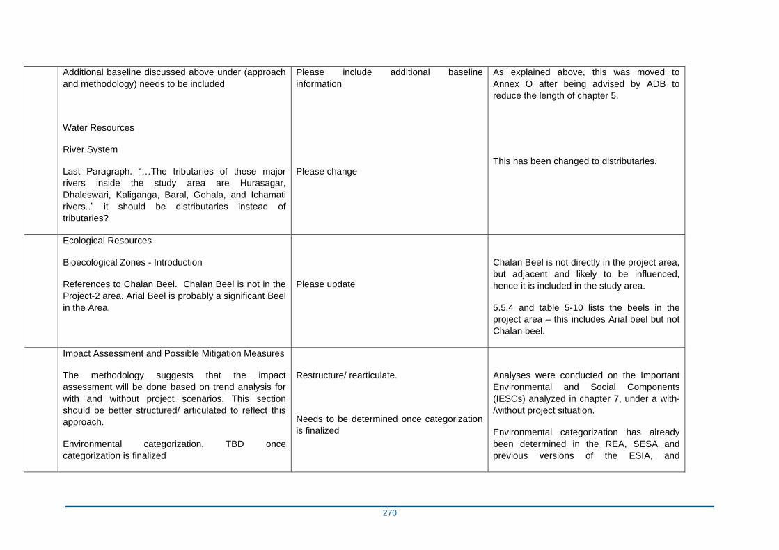
270
Additional baseline discussed above under (approach
and methodology) needs to be included
Water Resources
River System
Last Paragraph. “…The tributaries of these major
rivers inside the study area are Hurasagar,
Dhaleswari, Kaliganga, Baral, Gohala, and Ichamati
rivers..” it should be distributaries instead of
tributaries?
Please include additional baseline
information
Please change
As explained above, this was moved to
Annex O after being advised by ADB to
reduce the length of chapter 5.
This has been changed to distributaries.
Ecological Resources
Bioecological Zones - Introduction
References to Chalan Beel. Chalan Beel is not in the
Project-2 area. Arial Beel is probably a significant Beel
in the Area.
Please update
Chalan Beel is not directly in the project area,
but adjacent and likely to be influenced,
hence it is included in the study area.
5.5.4 and table 5-10 lists the beels in the
project area – this includes Arial beel but not
Chalan beel.
Impact Assessment and Possible Mitigation Measures
The methodology suggests that the impact
assessment will be done based on trend analysis for
with and without project scenarios. This section
should be better structured/ articulated to reflect this
approach.
Environmental categorization. TBD once
categorization is finalized
Restructure/ rearticulate.
Needs to be determined once categorization
is finalized
Analyses were conducted on the Important
Environmental and Social Components
(IESCs) analyzed in chapter 7, under a with-
/without project situation.
Environmental categorization has already
been determined in the REA, SESA and
previous versions of the ESIA, and
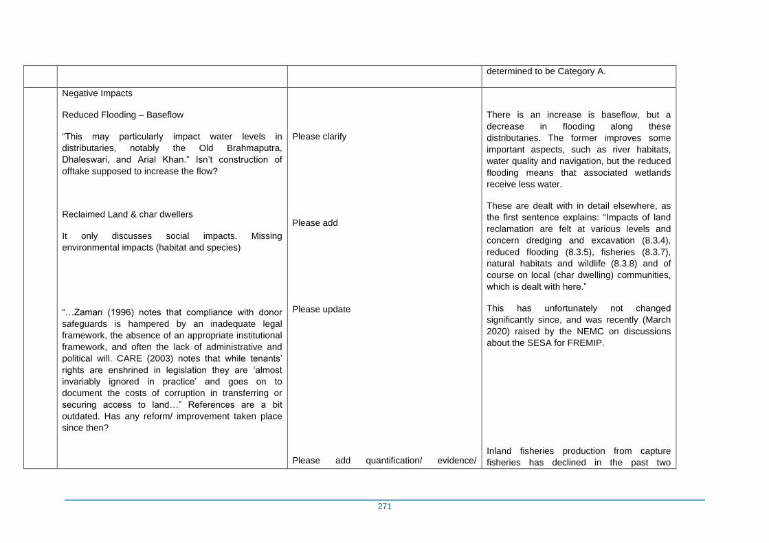
271
determined to be Category A.
Negative Impacts
Reduced Flooding – Baseflow
“This may particularly impact water levels in
distributaries, notably the Old Brahmaputra,
Dhaleswari, and Arial Khan.” Isn’t construction of
offtake supposed to increase the flow?
Reclaimed Land & char dwellers
It only discusses social impacts. Missing
environmental impacts (habitat and species)
“…Zaman (1996) notes that compliance with donor
safeguards is hampered by an inadequate legal
framework, the absence of an appropriate institutional
framework, and often the lack of administrative and
political will. CARE (2003) notes that while tenants’
rights are enshrined in legislation they are ‘almost
invariably ignored in practice’ and goes on to
document the costs of corruption in transferring or
securing access to land…” References are a bit
outdated. Has any reform/ improvement taken place
since then?
Please clarify
Please add
Please update
Please add quantification/ evidence/
There is an increase is baseflow, but a
decrease in flooding along these
distributaries. The former improves some
important aspects, such as river habitats,
water quality and navigation, but the reduced
flooding means that associated wetlands
receive less water.
These are dealt with in detail elsewhere, as
the first sentence explains: “Impacts of land
reclamation are felt at various levels and
concern dredging and excavation (8.3.4),
reduced flooding (8.3.5), fisheries (8.3.7),
natural habitats and wildlife (8.3.8) and of
course on local (char dwelling) communities,
which is dealt with here.”
This has unfortunately not changed
significantly since, and was recently (March
2020) raised by the NEMC on discussions
about the SESA for FREMIP.
Inland fisheries production from capture
fisheries has declined in the past two
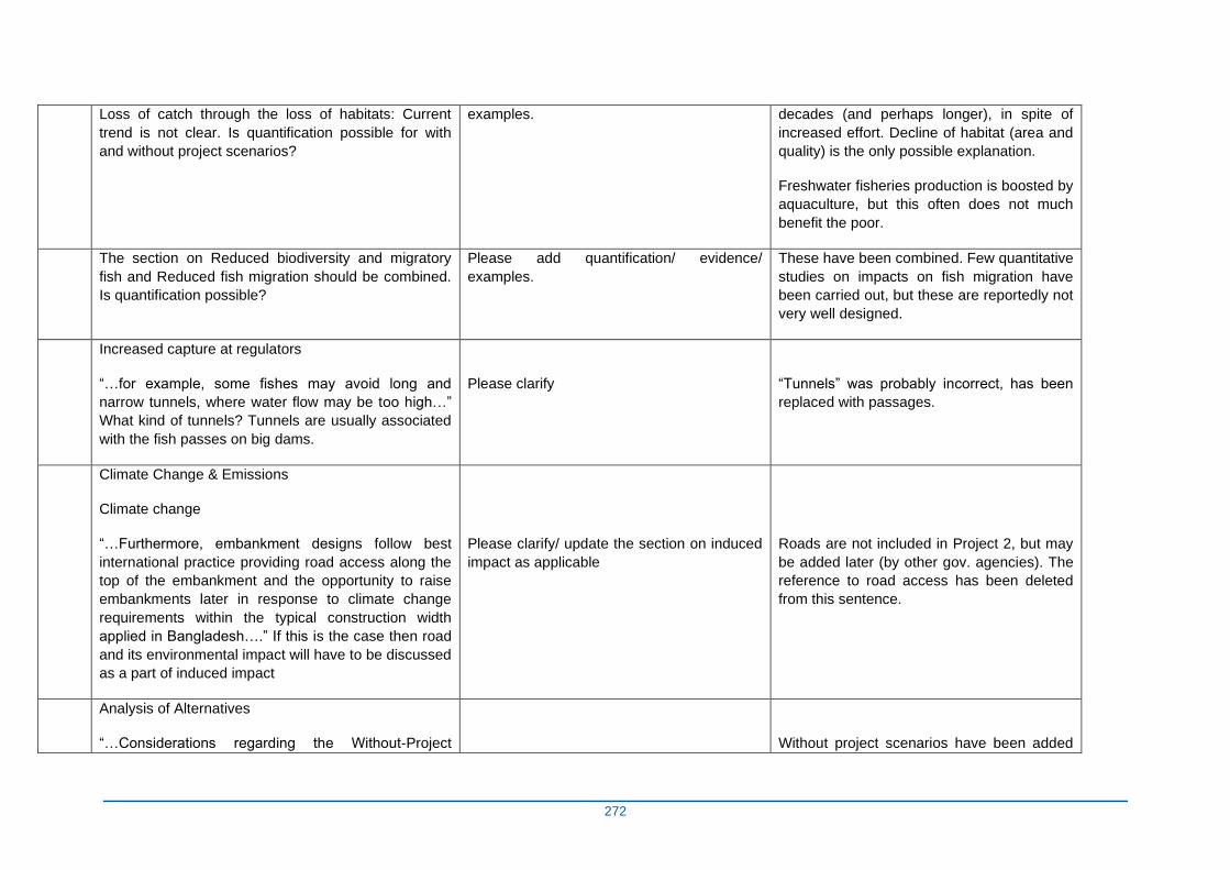
272
Loss of catch through the loss of habitats: Current
trend is not clear. Is quantification possible for with
and without project scenarios?
examples. decades (and perhaps longer), in spite of
increased effort. Decline of habitat (area and
quality) is the only possible explanation.
Freshwater fisheries production is boosted by
aquaculture, but this often does not much
benefit the poor.
The section on Reduced biodiversity and migratory
fish and Reduced fish migration should be combined.
Is quantification possible?
Please add quantification/ evidence/
examples.
These have been combined. Few quantitative
studies on impacts on fish migration have
been carried out, but these are reportedly not
very well designed.
Increased capture at regulators
“…for example, some fishes may avoid long and
narrow tunnels, where water flow may be too high…”
What kind of tunnels? Tunnels are usually associated
with the fish passes on big dams.
Please clarify
“Tunnels” was probably incorrect, has been
replaced with passages.
Climate Change & Emissions
Climate change
“…Furthermore, embankment designs follow best
international practice providing road access along the
top of the embankment and the opportunity to raise
embankments later in response to climate change
requirements within the typical construction width
applied in Bangladesh….” If this is the case then road
and its environmental impact will have to be discussed
as a part of induced impact
Please clarify/ update the section on induced
impact as applicable
Roads are not included in Project 2, but may
be added later (by other gov. agencies). The
reference to road access has been deleted
from this sentence.
Analysis of Alternatives
“…Considerations regarding the Without-Project
Without project scenarios have been added
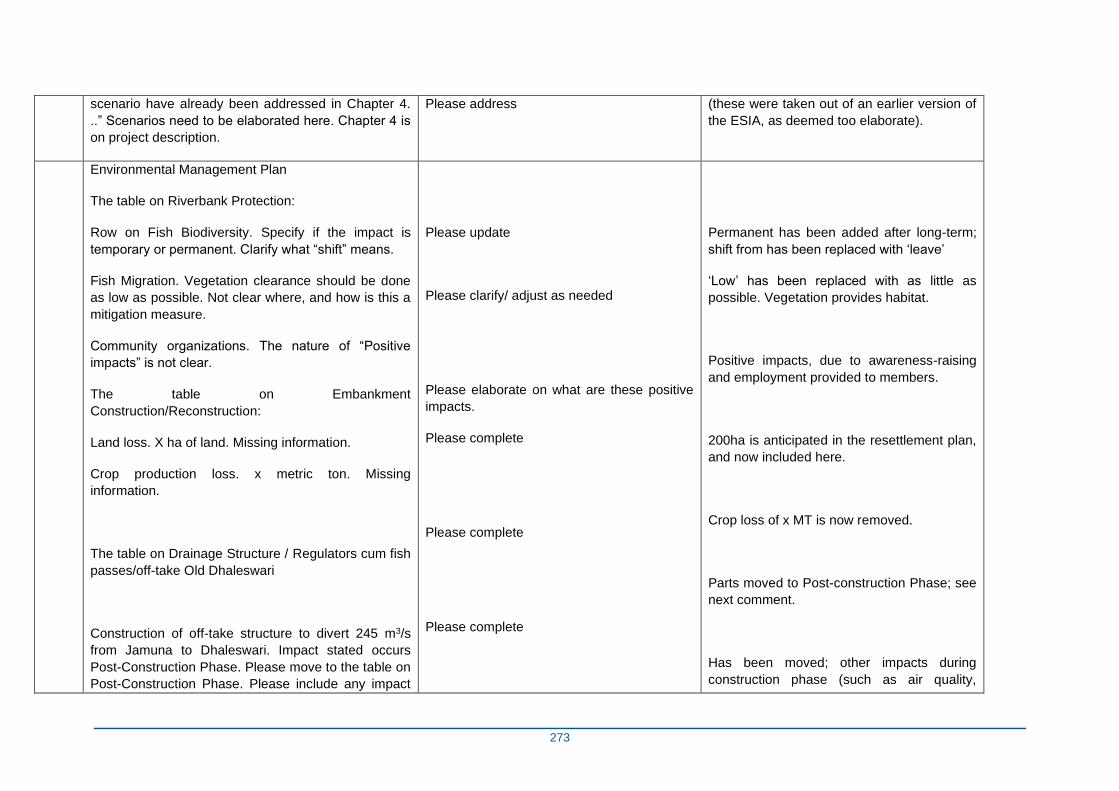
273
scenario have already been addressed in Chapter 4.
..” Scenarios need to be elaborated here. Chapter 4 is
on project description.
Please address (these were taken out of an earlier version of
the ESIA, as deemed too elaborate).
Environmental Management Plan
The table on Riverbank Protection:
Row on Fish Biodiversity. Specify if the impact is
temporary or permanent. Clarify what “shift” means.
Fish Migration. Vegetation clearance should be done
as low as possible. Not clear where, and how is this a
mitigation measure.
Community organizations. The nature of “Positive
impacts” is not clear.
The table on Embankment
Construction/Reconstruction:
Land loss. X ha of land. Missing information.
Crop production loss. x metric ton. Missing
information.
The table on Drainage Structure / Regulators cum fish
passes/off-take Old Dhaleswari
Construction of off-take structure to divert 245 m3/s
from Jamuna to Dhaleswari. Impact stated occurs
Post-Construction Phase. Please move to the table on
Post-Construction Phase. Please include any impact
Please update
Please clarify/ adjust as needed
Please elaborate on what are these positive
impacts.
Please complete
Please complete
Please complete
Permanent has been added after long-term;
shift from has been replaced with ‘leave’
‘Low’ has been replaced with as little as
possible. Vegetation provides habitat.
Positive impacts, due to awareness-raising
and employment provided to members.
200ha is anticipated in the resettlement plan,
and now included here.
Crop loss of x MT is now removed.
Parts moved to Post-construction Phase; see
next comment.
Has been moved; other impacts during
construction phase (such as air quality,
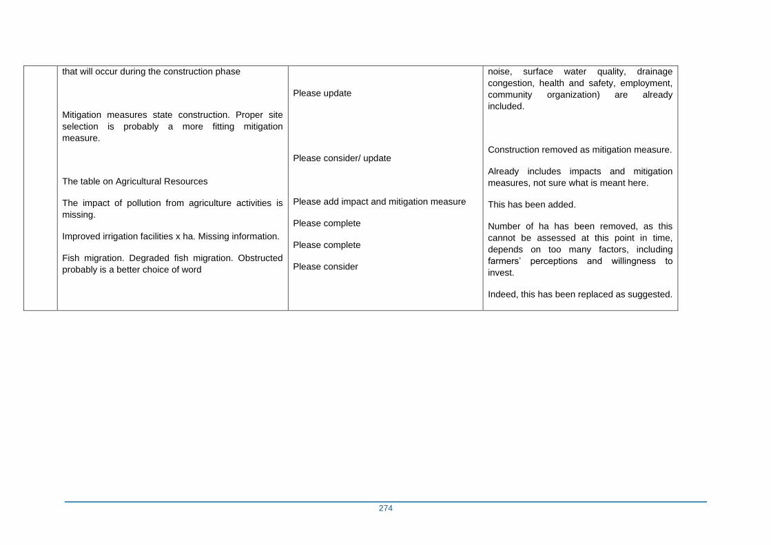
274
that will occur during the construction phase
Mitigation measures state construction. Proper site
selection is probably a more fitting mitigation
measure.
The table on Agricultural Resources
The impact of pollution from agriculture activities is
missing.
Improved irrigation facilities x ha. Missing information.
Fish migration. Degraded fish migration. Obstructed
probably is a better choice of word
Please update
Please consider/ update
Please add impact and mitigation measure
Please complete
Please complete
Please consider
noise, surface water quality, drainage
congestion, health and safety, employment,
community organization) are already
included.
Construction removed as mitigation measure.
Already includes impacts and mitigation
measures, not sure what is meant here.
This has been added.
Number of ha has been removed, as this
cannot be assessed at this point in time,
depends on too many factors, including
farmers’ perceptions and willingness to
invest.
Indeed, this has been replaced as suggested.
Related Documents