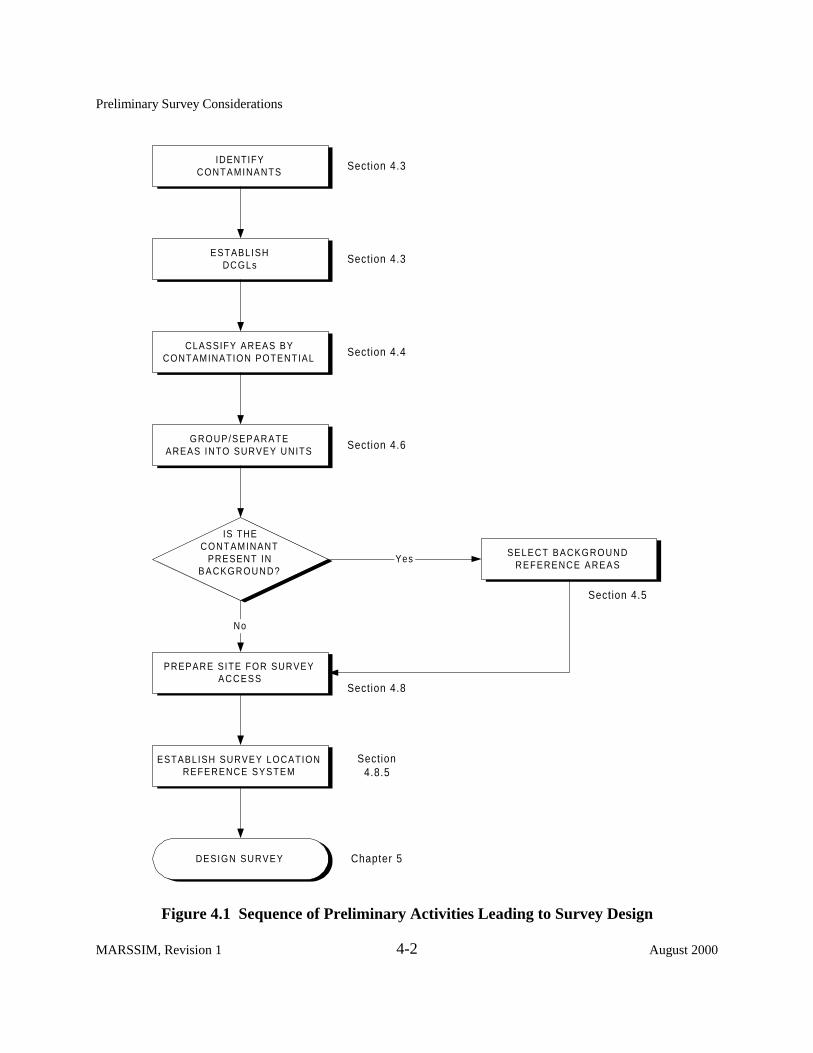
4 PRELIMINARY SURVEY CONSIDERATIONS 4.1 Introduction This chapter assists the MARSSIM user in designing a survey plan by presenting areas of consideration common to radiation surveys and site investigations in support of decommissioning. The topics discussed here should be addressed during the planning stages of each survey. Figure 4.1 illustrates the sequence of preliminary activities described in this chapter and their relationship to the survey design process. Conducting radiological surveys in support of decommissioning serves to answer several basic questions, including: ! Is there residual radioactive contamination present from previous uses? ! What is the character (qualitative and quantitative) of the residual activity? ! Is the average residual activity level below the established derived concentration guideline level? ! Are there small localized areas of residual activity in excess of the investigation level? The survey methods used to evaluate radiological conditions and develop answers to these questions depend on a number of factors including: contaminants, contaminant distribution, acceptable contaminant levels established by the regulatory agency, future site use, and physical characteristics of the site. 4.2 Decommissioning Criteria The decommissioning process assures that residual radioactivity will not result in individuals being exposed to unacceptable levels of radiation or radioactive materials. Regulatory agencies establish radiation dose standards based on risk considerations and scientific data relating dose to risk. Residual levels of radioactive material that correspond to allowable radiation dose standards are calculated (derived) by analysis of various pathways and scenarios (direct radiation, inhalation, ingestion, etc.) through which exposures could occur. These derived levels, known as derived concentration guideline levels (DCGLs), are presented in terms of surface or mass activity concentrations. DCGLs usually refer to average levels of radiation or radioactivity above appropriate background levels. DCGLs applicable to building or other structural and miscellaneous surfaces are expressed in units of activity per surface area (typically Bq/m 2 or dpm/100 cm 2 ). When applied to soil and induced activity from neutron irradiation, DCGLs are expressed in units of activity per unit of mass (typically Bq/kg or pCi/g). August 2000 4-1 MARSSIM, Revision 1

Welcome message from author
This document is posted to help you gain knowledge. Please leave a comment to let me know what you think about it! Share it to your friends and learn new things together.
Transcript

4 PRELI MI NARY SURVEY CONSIDERATI ONS
4.1 Introduction
This chapter assists the MARSSIM user in designing a survey plan by presenting areas of consideration common to radiation surveys and site investigations in support of decommissioning. The topics discussed here should be addressed during the planning stages of each survey. Figure 4.1 illustrates the sequence of preliminary activities described in this chapter and their relationship to the survey design process.
Conducting radiological surveys in support of decommissioning serves to answer several basic questions, including:
! Is there residual radioactive contamination present from previous uses? ! What is the character (qualitative and quantitative) of the residual activity? ! Is the average residual activity level below the established derived concentration
guideline level? ! Are there small localized areas of residual activity in excess of the investigation level?
The survey methods used to evaluate radiological conditions and develop answers to these questions depend on a number of factors including: contaminants, contaminant distribution, acceptable contaminant levels established by the regulatory agency, future site use, and physical characteristics of the site.
4.2 Decommissioning Criteria
The decommissioning process assures that residual radioactivity will not result in individuals being exposed to unacceptable levels of radiation or radioactive materials. Regulatory agencies establish radiation dose standards based on risk considerations and scientific data relating dose to risk. Residual levels of radioactive material that correspond to allowable radiation dose standards are calculated (derived) by analysis of various pathways and scenarios (direct radiation, inhalation, ingestion, etc.) through which exposures could occur. These derived levels, known as derived concentration guideline levels (DCGLs), are presented in terms of surface or mass activity concentrations. DCGLs usually refer to average levels of radiation or radioactivity above appropriate background levels. DCGLs applicable to building or other structural and miscellaneous surfaces are expressed in units of activity per surface area (typically Bq/m2 or dpm/100 cm2). When applied to soil and induced activity from neutron irradiation, DCGLs are expressed in units of activity per unit of mass (typically Bq/kg or pCi/g).
August 2000 4-1 MARSSIM, Revision 1
Preliminary Survey Considerations
IDENTIFY CONTAMINANTS
ESTABLISH DCGLs
CLASSIFY AREAS BY CONTAMINATION POTENTIAL
GROUP/SEPARATE AREAS INTO SURVEY UNITS
PREPARE SITE FOR SURVEY ACCESS
ESTABLISH SURVEY LOCATION REFERENCE SYSTEM
SELECT BACKGROUND REFERENCE AREAS
IS THE CONTAMINANT
PRESENT IN BACKGROUND?
DESIGN SURVEY
Yes
No
Section 4.3
Section 4.3
Section 4.4
Section 4.6
Section 4.8
Section 4.8.5
Chapter 5
Section 4.5
Figure 4.1 Sequence of Preliminary Activities Leading to Survey Design
MARSSIM, Revision 1 4-2 August 2000
Preliminary Survey Considerations
The DCGLW, based on pathway modeling, is the uniform residual radioactivity concentration level within a survey unit that corresponds to the release criterion (e.g., regulatory limit in terms of dose or risk). Note that for the majority of MARSSIM users, the DCGL will simply be obtained using regulatory agency guidance based on default parameters—other users may elect to perform site-specific pathway modeling to determine DCGLs. In both cases, the DCGL is based on the spatial distribution of the contaminant, and each derivation can produce different values depending on the specific radionuclide distribution and pathway modeling.
In addition to the numerical DCGLs, criteria include conditions for implementing those guideline levels. Conditions applicable to satisfying decommissioning objectives described in Chapter 5 are as follows:
! The uniform residual contamination above background is below the DCGLW.
! Individual measurements or samples, representing small areas of residual radioactivity, do not exceed the DCGLEMC for areas of elevated residual radioactivity. These small areas of residual radioactivity may exceed the DCGLW established for average residual radioactivity levels in a survey unit, provided these areas of residual radioactivity satisfy the criteria of the responsible regulatory agency.
The manner in which a DCGL is applied should be clearly documented in the survey plans and reports.
4.3 Identify Contaminants and Establish DCGLs
Some objectives of the scoping and characterization surveys, as discussed in Chapter 5, include identifying site contaminants, determining relative ratios of contaminants, and establishing DCGLs and conditions for the contaminants which satisfy the requirements of the responsible agency. Identification of potential radionuclide contaminants at the site is generally performed through laboratory analyses, such as alpha and gamma spectrometry. These analyses are used to determine the relative ratios of the identified contaminants, as well as isotopic ratios for common contaminants like uranium and thorium. This information is essential in establishing and applying the DCGLs for the site. DCGLs provide the goal for essentially all aspects of designing, implementing, and evaluating the final status survey. The DCGLs discussed in this manual are limited to structure surfaces and soil contamination; the user should consult the responsible regulatory agency if it is necessary to establish DCGLs for other environmental media (e.g., ground water, and other water pathways). This section contains information regarding the selection and application of DCGLs.
August 2000 4-3 MARSSIM, Revision 1

Preliminary Survey Considerations
The development of DCGLs is often an iterative process, where the DCGLs selected or developed early in the Radiation Survey and Site Investigation (RSSI) Process are modified as additional site-specific information is obtained from subsequent surveys. One example of the iterative nature of DCGLs is the development of final cleanup levels in EPA’s Superfund program. Soil Screening Levels1 (SSLs; EPA 1996b, EPA 1996c) are selected or developed at a point early in the process, usually corresponding to the scoping survey in MARSSIM. An SSL can be further developed, based on site-specific information, to become a preliminary remediation goal (PRG; EPA 1991h), usually at a point corresponding to the characterization survey. If the PRG is found to be acceptable during the characterization survey, it is documented as the final cleanup level in the Record of Decision (ROD) for the site. The ROD is typically in place prior to any remedial action, because the remedy is also documented in the ROD. Additional information on the Superfund program can be found in Appendix F.
4.3.1 Direct Application of DCGLs
In the simplest case, the DCGLs may be applied directly to survey data to demonstrate compliance. This involves assessing the surface activity levels and volumetric concentrations of radionuclides and comparing measured values to the appropriate DCGL. For example, consider a site that used only one radionuclide, such as 90Sr throughout its operational lifetime. The default DCGL for 90Sr on building surfaces and in soil may be obtained from the responsible agency. Survey measurements and samples are then compared to the surface and volume activity concentration DCGLs for 90Sr directly to demonstrate compliance. While seemingly straightforward, this approach is not always possible (e.g., when more than one radionuclide is present).
4.3.2 DCGLs and the Use of Surrogate Measurements
For sites with multiple contaminants, it may be possible to measure just one of the contaminants and still demonstrate compliance for all of the contaminants present through the use of surrogate measurements. Both time and resources can be saved if the analysis of one radionuclide is simpler than the analysis of the other. For example, using the measured 137Cs concentration as a surrogate for 90Sr reduces the analytical costs because wet chemistry separations do not have to be performed for 90Sr on every sample. In using one radionuclide to measure the presence of others, a sufficient number of measurements, spatially separated throughout the survey unit, should be made to establish a “consistent” ratio. The number of measurements needed to determine the ratio is selected using the Data Quality Objectives (DQO) Process and based on the chemical, physical, and radiological characteristics of the nuclides and the site. If consistent
1 Soil Screening Levels are currently available for chemical contaminants and are not designed for use at sites with radioactive contamination.
MARSSIM, Revision 1 4-4 August 2000

Preliminary Survey Considerations
radionuclide ratios cannot be determined during the Historical Site Assessment (HSA) based on existing information, MARSSIM recommends that one of the objectives of scoping or characterization be a determination of the ratios rather than attempting to determine ratios based on the final status survey. If the ratios are determined using final status survey data, MARSSIM recommends that at least 10% of the measurements (both direct measurements and samples) include analyses for all radionuclides of concern.
In the use of surrogates, it is often difficult to establish a “consistent” ratio between two or more radionuclides. Rather than follow prescriptive guidance on acceptable levels of variability for the surrogate ratio, a more reasonable approach may be to review the data collected to establish the ratio and to use the DQO process to select an appropriate ratio from that data. An example is provided to illustrate the application of surrogate measurements.
Ten soil samples within the survey unit were collected and analyzed for 137Cs and 90Sr to establish a surrogate ratio. The ratios of 90Sr to 137Cs were as follows: 6.6, 5.7, 4.2, 7.9, 3.0, 3.8, 4.1, 4.6, 2.4, and 3.3. An assessment of this example data set results in an average 90Sr to 137Cs surrogate ratio of 4.6, with a standard deviation of 1.7. There are various approaches that may be used to develop a surrogate ratio from this data—but each must consider the variability and level of uncertainty in the data. One may consider the variability in the surrogate ratio by selecting the 95% upper bound of the surrogate ratio (to yield a conservative value of 90Sr from the measured 137Cs), which is 8.0 in this case. Similarly, one may select the most conservative value from the data set (7.9). The DQO process should be used to assess the use of surrogates. The benefit of using the surrogate approach is the reduced cost of not having to perform costly wet chemistry analyses on each sample. This benefit should be considered relative to the difficulty in establishing the surrogate ratio, as well as the potential consequence of unnecessary investigations that result from the error in using a “conservative” surrogate ratio. Selecting a conservative surrogate ratio ensures that potential exposures from individual radionuclides are not underestimated. The surrogate method can only be used with confidence when dealing with the same media in the same surroundings—for example, soil samples with similar physical and geological characteristics. The MARSSIM user will need to consult with the responsible regulatory agency for concurrence on the approach used to determine the surrogate ratio.
Once an appropriate surrogate ratio is determined, one needs to consider how compliance will be demonstrated using surrogate measurements. That is, the user must modify the DCGL of the measured radionuclide to account for the inferred radionuclide. Continuing with the above example, the modified DCGL for 137Cs must be reduced according to the following equation:
DCGLSrDCGLCs,mod ' DCGLCs × [(CSr/CCs) × DCGLCs] % DCGLSr
4-1
where CSr/CCs is the surrogate ratio of 90Sr to 137Cs.
August 2000 4-5 MARSSIM, Revision 1

Preliminary Survey Considerations
Assuming that the DCGLSr is 15 Bq/kg, the DCGLCs is 10 Bq/kg, and the surrogate ratio is 8 (as derived previously), the modified DCGL for 137Cs (DCGLCs, mod
Equation 4-1: ) can be calculated using
15DCGLCs,mod ' 10 ×
[8 × 10] % 15 ' 1.6 Bq/kg
This modified DCGL is then used for survey design purposes described in Chapter 5.
The potential for shifts or variations in the radionuclide ratios means that the surrogate methodshould be used with caution. Physical or chemical differences between the radionuclides mayproduce different migration rates, causing the radionuclides to separate and changing theradionuclide ratios. Remediation activities have a reasonable potential to alter the surrogate ratioestablished prior to remediation. MARSSIM recommends that when the ratio is established priorto remediation, additional post-remediation samples should be collected to ensure that the dataused to establish the ratio are still appropriate and representative of the existing site condition. Ifthese additional post-remediation samples are not consistent with the pre-remediation data,surrogate ratios should be re-established.
Compliance with surface activity DCGLs for radionuclides of a decay series (e.g., thorium anduranium) that emit both alpha and beta radiation may be demonstrated by assessing alpha, beta,or both radiations. However, relying on the use of alpha surface contamination measurementsoften proves problematic due to the highly variable level of alpha attenuation by rough, porous,and dusty surfaces. Beta measurements typically provide a more accurate assessment of thoriumand uranium contamination on most building surfaces because surface conditions causesignificantly less attenuation of beta particles than alpha particles. Beta measurements, therefore,may provide a more accurate determination of surface activity than alpha measurements.
The relationship of beta and alpha emissions from decay chains or various enrichments ofuranium should be considered when determining the surface activity for comparison with theDCGLW values. When the initial member of a decay chain has a long half-life, the radioactivityassociated with the subsequent members of the series will increase at a rate determined by theindividual half-lives until all members of the decay chain are present at activity levels equal tothe activity of the parent. This condition is known as secular equilibrium.
Consider an example where the average surface activity DCGLW
Bq/m2 (600 dpm/100 cm2), and all of the progeny are in secular equilibrium—that is, for eachdisintegration of 232Th there are six alpha and four beta particles emitted in the thorium decay
for natural thorium is 1,000
MARSSIM, Revision 1 4-6 August 2000

Preliminary Survey Considerations
series. Note that in this example, the surface activity DCGLW of 1,000 Bq/m2 is assumed to apply to the total activity from all members of the decay chain. In this situation, the corresponding alpha activity DCGLW should be adjusted to 600 Bq/m2 (360 dpm/100 cm2), and the corresponding beta activity DCGLW to 400 Bq/m2 (240 dpm/100 cm2), in order to be equivalent to 1,000 Bq/m2 of natural thorium surface activity. For a surface activity DCGLW of 1,000 Bq/m2, the beta activity DCGLW is calculated as follows:
(1,000 Bq of chain
) × ( dis of
4 T � h&232
) 400 � Bq
4-2m 2
' 10 Bq of chain m 2
1 Bq of Th&232
To demonstrate compliance with the beta activity DCGLW for this example, beta measurements (in cpm) must be converted to activity using a weighted beta efficiency that accounts for the energy and yield of each beta particle. For decay chains that have not achieved secular equilibrium, the relative activities between the different members of the decay chain can be determined as previously discussed for surrogate ratios.
Another example for the use of surrogates involves the measurement of exposure rates, rather than surface or volume activity concentrations, for radionuclides that deliver the majority of their dose through the direct radiation pathway. That is, instead of demonstrating compliance with soil or surface contamination DCGLs derived from the direct radiation pathway, compliance is demonstrated by direct measurement of exposure rates. To implement this surrogate method, Historical Site Assessment (HSA) documentation should provide reasonable assurance that no radioactive materials are buried at the site and that radioactive materials have not seeped into the soil or groundwater. This surrogate approach may still be possible for sites that contain radionuclides that do not deliver the majority of their dose through the direct radiation pathway. This requires that a consistent relative ratio for the radionuclides that do deliver the majority of their dose through the direct radiation pathway can be established. The appropriate exposure rate limit in this case accounts for the radionuclide(s) that do not deliver the majority of their dose to the direct radiation pathway. This is accomplished by determining the fraction of the total activity represented by radionuclide(s) that do deliver the majority of their dose through the direct radiation pathway, and weighting the exposure rate limit by this fraction. Note that the considerations for establishing consistent relative ratios discussed above apply to this surrogate approach as well. The responsible regulatory agency should be consulted prior to implementing this surrogate approach.
August 2000 4-7 MARSSIM, Revision 1
Preliminary Survey Considerations
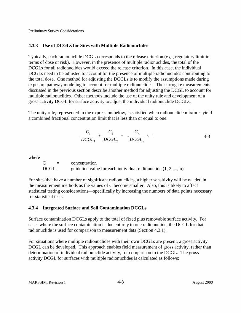
4.3.3 Use of DCGLs for Sites with Multiple Radionuclides
Typically, each radionuclide DCGL corresponds to the release criterion (e.g., regulatory limit in terms of dose or risk). However, in the presence of multiple radionuclides, the total of the DCGLs for all radionuclides would exceed the release criterion. In this case, the individual DCGLs need to be adjusted to account for the presence of multiple radionuclides contributing to the total dose. One method for adjusting the DCGLs is to modify the assumptions made during exposure pathway modeling to account for multiple radionuclides. The surrogate measurements discussed in the previous section describe another method for adjusting the DCGL to account for multiple radionuclides. Other methods include the use of the unity rule and development of a gross activity DCGL for surface activity to adjust the individual radionuclide DCGLs.
The unity rule, represented in the expression below, is satisfied when radionuclide mixtures yield a combined fractional concentration limit that is less than or equal to one:
C1 C2 Cn% % ... # 1 4-3
DCGL1 DCGL2 DCGLn
where C = concentration DCGL = guideline value for each individual radionuclide (1, 2, ..., n)
For sites that have a number of significant radionuclides, a higher sensitivity will be needed in the measurement methods as the values of C become smaller. Also, this is likely to affect statistical testing considerations—specifically by increasing the numbers of data points necessary for statistical tests.
4.3.4 Integrated Surface and Soil Contamination DCGLs
Surface contamination DCGLs apply to the total of fixed plus removable surface activity. For cases where the surface contamination is due entirely to one radionuclide, the DCGL for that radionuclide is used for comparison to measurement data (Section 4.3.1).
For situations where multiple radionuclides with their own DCGLs are present, a gross activity DCGL can be developed. This approach enables field measurement of gross activity, rather than determination of individual radionuclide activity, for comparison to the DCGL. The gross activity DCGL for surfaces with multiple radionuclides is calculated as follows:
MARSSIM, Revision 1 4-8 August 2000

Preliminary Survey Considerations
1. Determine the relative fraction (f) of the total activity contributed by the radionuclide. 2. Obtain the DCGL for each radionuclide present. 3. Substitute the values of f and DCGL in the following equation.
1Gross Activity DCGL '
f1 f2 fn 4-4 % %...
DCGL1 DCGL2 DCGLn
Example
Assume that 40% of the total surface activity was contributed by a radionuclide with a DCGL of 8,300 Bq/m2 (5000 dpm/100 cm2); 40% by a radionuclide with a DCGL of 1,700 Bq/m2 (1000 dpm/100 cm2); and 20% by a radionuclide with a DCGL of 830 Bq/m2
(500 dpm/100 cm2). Using Equation 4-4,
1Gross Activity DCGL '
0.40 0.40 0.20% %
8,300 1,700 830
= 1,900 Bq/m2
Note that Equation 4-4 may not work for sites exhibiting surface contamination from multiple radionuclides having unknown or highly variable concentrations of radionuclides throughout the site. In these situations, the best approach may be to select the most conservative surface contamination DCGL from the mixture of radionuclides present. If the mixture contains radionuclides that cannot be measured using field survey equipment, laboratory analyses of surface materials may be necessary.
Because gross surface activity measurements are not nuclide-specific, they should be evaluated by the two-sample nonparametric tests described in Chapter 8 to determine if residual contamination meets the release criterion. Therefore, gross surface activity measurements should be performed for both the survey units being evaluated and for background reference areas. The background reference areas for surface activity typically involve building surfaces and construction materials that are considered free of residual radioactivity (see Section 4.5). The total surface activity due to residual contamination should not exceed the gross activity DCGL calculated above.
August 2000 4-9 MARSSIM, Revision 1
Preliminary Survey Considerations
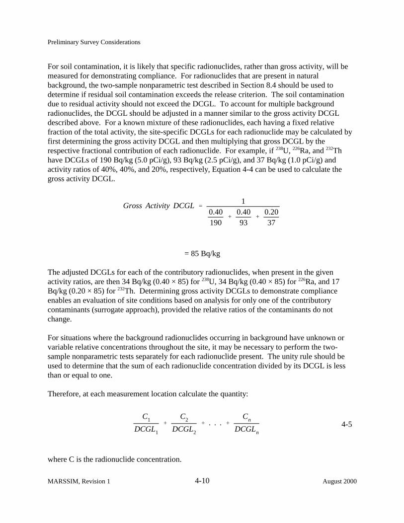
For soil contamination, it is likely that specific radionuclides, rather than gross activity, will be measured for demonstrating compliance. For radionuclides that are present in natural background, the two-sample nonparametric test described in Section 8.4 should be used to determine if residual soil contamination exceeds the release criterion. The soil contamination due to residual activity should not exceed the DCGL. To account for multiple background radionuclides, the DCGL should be adjusted in a manner similar to the gross activity DCGL described above. For a known mixture of these radionuclides, each having a fixed relative fraction of the total activity, the site-specific DCGLs for each radionuclide may be calculated by first determining the gross activity DCGL and then multiplying that gross DCGL by the respective fractional contribution of each radionuclide. For example, if 238U, 226Ra, and 232Th have DCGLs of 190 Bq/kg (5.0 pCi/g), 93 Bq/kg (2.5 pCi/g), and 37 Bq/kg (1.0 pCi/g) and activity ratios of 40%, 40%, and 20%, respectively, Equation 4-4 can be used to calculate the gross activity DCGL.
1Gross Activity DCGL '
0.40 0.40 0.20% %
190 93 37
= 85 Bq/kg
The adjusted DCGLs for each of the contributory radionuclides, when present in the given activity ratios, are then 34 Bq/kg (0.40 × 85) for 238U, 34 Bq/kg (0.40 × 85) for 226Ra, and 17 Bq/kg (0.20 × 85) for 232Th. Determining gross activity DCGLs to demonstrate compliance enables an evaluation of site conditions based on analysis for only one of the contributory contaminants (surrogate approach), provided the relative ratios of the contaminants do not change.
For situations where the background radionuclides occurring in background have unknown or variable relative concentrations throughout the site, it may be necessary to perform the two-sample nonparametric tests separately for each radionuclide present. The unity rule should be used to determine that the sum of each radionuclide concentration divided by its DCGL is less than or equal to one.
Therefore, at each measurement location calculate the quantity:
C1 C2 Cn% % . . . % 4-5
DCGL1 DCGL2 DCGLn
where C is the radionuclide concentration.
MARSSIM, Revision 1 4-10 August 2000

Preliminary Survey Considerations
The values of C are the data to be used in the statistical tests to determine if the average over the survey unit exceeds one.
The same approach applies for radionuclides that are not present in background, with the exception that the one-sample nonparametric statistical test described in Section 8.3 is used in place of the two-sample nonparametric test (see Section 5.5.2.3). Again, for multiple radionuclides either the surrogate approach or the unity rule should be used to demonstrate compliance, if relative ratios are expected to change.
4.4 Classify Areas by Contamination Potential
All areas of the site will not have the same potential for residual contamination and, accordingly,will not need the same level of survey coverage to achieve the established release criteria. Theprocess will be more efficient if the survey is designed so areas with higher potential forcontamination (based in part on results of the HSA in Chapter 3) will receive a higher degree ofsurvey effort.
Classification is a critical step in the survey design process. The working hypothesis ofMARSSIM is that all impacted areas being evaluated for release have a reasonable potential for radioactive contamination above the DCGL. This initial assumption means that all areas are initiallyconsidered Class 1 areas unless some basis for reclassification as non-impacted, Class 3, orClass 2 is provided.
Areas that have no reasonable potential for residual contamination do not need any level ofsurvey coverage and are designated as non-impacted areas. These areas have no radiologicalimpact from site operations and are typically identified during the HSA (Chapter 3). Backgroundreference areas are normally selected from non-impacted areas (Section 4.5).
Impacted areas are areas that have reasonable potential for containing contaminated material. Theycan be subdivided into three classes:
! Class 1 areas: Areas that have, or had prior to remediation, a potential for radioactive contamination (based on site operating history) or known contamination (based on previous radiological surveys). Examples of Class 1 areas include: 1) site areas previously subjected to remedial actions, 2) locations where leaks or spills are known to have occurred, 3) former burial or disposal sites, 4) waste storage sites, and 5) areas with contaminants in discrete solid pieces of material high specific activity. Note that areas containing contamination in excess of the DCGLW prior to remediation should be classified as Class 1 areas.
August 2002 4-11 MARSSIM, Revision 1
Preliminary Survey Considerations
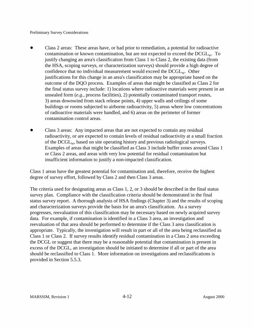
! Class 2 areas: These areas have, or had prior to remediation, a potential for radioactive contamination or known contamination, but are not expected to exceed the DCGLW. To justify changing an area's classification from Class 1 to Class 2, the existing data (from the HSA, scoping surveys, or characterization surveys) should provide a high degree of confidence that no individual measurement would exceed the DCGLW. Other justifications for this change in an area's classification may be appropriate based on the outcome of the DQO process. Examples of areas that might be classified as Class 2 for the final status survey include: 1) locations where radioactive materials were present in an unsealed form (e.g., process facilities), 2) potentially contaminated transport routes, 3) areas downwind from stack release points, 4) upper walls and ceilings of some buildings or rooms subjected to airborne radioactivity, 5) areas where low concentrations of radioactive materials were handled, and 6) areas on the perimeter of former contamination control areas.
! Class 3 areas: Any impacted areas that are not expected to contain any residual radioactivity, or are expected to contain levels of residual radioactivity at a small fraction of the DCGLW, based on site operating history and previous radiological surveys. Examples of areas that might be classified as Class 3 include buffer zones around Class 1 or Class 2 areas, and areas with very low potential for residual contamination but insufficient information to justify a non-impacted classification.
Class 1 areas have the greatest potential for contamination and, therefore, receive the highest degree of survey effort, followed by Class 2 and then Class 3 areas.
The criteria used for designating areas as Class 1, 2, or 3 should be described in the final status survey plan. Compliance with the classification criteria should be demonstrated in the final status survey report. A thorough analysis of HSA findings (Chapter 3) and the results of scoping and characterization surveys provide the basis for an area's classification. As a survey progresses, reevaluation of this classification may be necessary based on newly acquired survey data. For example, if contamination is identified in a Class 3 area, an investigation and reevaluation of that area should be performed to determine if the Class 3 area classification is appropriate. Typically, the investigation will result in part or all of the area being reclassified as Class 1 or Class 2. If survey results identify residual contamination in a Class 2 area exceeding the DCGL or suggest that there may be a reasonable potential that contamination is present in excess of the DCGL, an investigation should be initiated to determine if all or part of the area should be reclassified to Class 1. More information on investigations and reclassifications is provided in Section 5.5.3.
MARSSIM, Revision 1 4-12 August 2000
Preliminary Survey Considerations
4.5 Select Background Reference Areas
Certain radionuclides may also occur at significant levels as part of background in the media of interest (soil, building material, etc.). Examples include members of the naturally-occurring uranium, thorium, and actinium series; 40K; 14C; and tritium. 137Cs and other radionuclides are also present in background as a result of nuclear weapons fallout (Wallo, et al., 1994). Establishing background concentrations that describe a distribution of measurement data is necessary to identify and evaluate contributions attributable to site operations. Determining background levels for comparison with the conditions determined in specific survey units entails conducting surveys in one or more reference areas to define the radiological conditions of the site. NUREG-1505 (NRC 1997a) provides additional information on background reference areas.
A site background reference area should have similar physical, chemical, geological, radiological, and biological characteristics as the survey unit being evaluated. Background reference areas are normally selected from non-impacted areas, but are not limited to natural areas undisturbed by human activities. In some situations, a reference area may be associated with the survey unit being evaluated, but cannot be potentially contaminated by site activities. For example, background measurements may be taken from core samples of a building or structure surface, pavement, or asphalt. This option should be discussed with the responsible regulatory agency during survey planning. Generally, reference areas should not be part of the survey unit being evaluated.
Reference areas provide a location for background measurements which are used for comparisons with survey unit data. The radioactivity present in a reference area would be ideally the same as the survey unit had it never been contaminated. If a site includes physical, chemical, geological, radiological, or biological variability that is not represented by a single reference background area, selecting more than one reference area may be necessary.
It may be difficult to find a reference area within an industrial complex for comparison to a survey unit if the radionuclides of potential concern are naturally occurring. Background may vary greatly due to different construction activities that have occurred at the site. Examples of construction activities that change background include: leveling; excavating; adding fill dirt; importing rocks or gravel to stabilize soil or underlay asphalt; manufacturing asphalt with different matrix rock; using different pours of asphalt or concrete in a single survey unit; layering asphalt over concrete; layering different thicknesses of asphalt, concrete, rock, or gravel; and covering or burying old features such as railroad beds or building footings. Background variability may also increase due to the concentration of fallout in low areas of parking lots where runoff water collects and evaporates. Variations in background of a factor of five or more can occur in the space of a few hectares.
August 2000 4-13 MARSSIM, Revision 1
Preliminary Survey Considerations
There are a number of possible actions to address these concerns. Reviewing and reassessing the selection of reference areas may be necessary. Selecting different reference areas to represent individual survey units is another possibility. More attention may also be needed in selecting survey units and their boundaries with respect to different areas of potential or actual background variability. More detailed scoping or characterization surveys may be needed to better understand background variability. Using radionuclide-specific measurement techniques instead of gross radioactivity measurement techniques may also be necessary. If a background reference area that satisfies the above recommendations is not available, consultation and negotiation with the responsible regulatory agency is recommended. Alternate approaches may include using published studies of radionuclide distributions.
Verifying that a particular background reference area is appropriate for a survey can be accomplished using the techniques described or referenced in Chapter 8. Verification provides assurance that assumptions used to design the survey are appropriate and defensible. This approach can also prevent decision errors that may result from selecting an inappropriate background reference area.
If the radionuclide contaminants of interest do not occur in background, or the background levels are known to be a small fraction of the DCGLW (e.g., <10%), the survey unit radiological conditions may be compared directly to the specified DCGL and reference area background surveys are not necessary. If the background is not well defined at a site, and the decision maker is willing to accept the increased probability of incorrectly failing to release a survey unit (Type II error), the reference area measurements can be eliminated and a one-sample statistical test performed as described in Section 8.3.
4.6 Identify Survey Units
A survey unit is a physical area consisting of structures or land areas of specified size and shape for which a separate decision will be made as to whether or not that area exceeds the release criterion. This decision is made as a result of the final status survey. As a result, the survey unit is the primary entity for demonstrating compliance with the release criterion.
To facilitate survey design and ensure that the number of survey data points for a specific site are relatively uniformly distributed among areas of similar contamination potential, the site is divided into survey units that share a common history or other characteristics, or are naturally distinguishable from other portions of the site. A site may be divided into survey units at any time before the final status survey. For example, HSA or scoping survey results may provide sufficient justification for partitioning the site into Class 1, 2, or 3 areas. Note, however, that dividing the site into survey units is critical only for the final status survey—scoping, characterization, and remedial action support surveys may be performed without dividing the site into survey units.
MARSSIM, Revision 1 4-14 August 2000

Preliminary Survey Considerations
A survey unit should not include areas that have different classifications. The survey unit’s characteristics should be generally consistent with exposure pathway modeling that is used to convert dose or risk into radionuclide concentrations. For indoor areas classified as Class 1, each room may be designated as a survey unit. Indoor areas may also be subdivided into several survey units of different classification, such as separating floors and lower walls from upper walls and ceilings (and other upper horizontal surfaces) or subdividing a large warehouse based on floor area.
Survey units should be limited in size based on classification, exposure pathway modeling assumptions, and site-specific conditions. The suggested areas for survey units are as follows:
Classification Class 1
Structures Land areas
Class 2 Structures Land areas
Class 3 Structures Land areas
Suggested Area
up to 100 m2 floor area up to 2,000 m2
100 to 1,000 m2
2,000 to 10,000 m2
no limit no limit
The limitation on survey unit size for Class 1 and Class 2 areas ensures that each area is assigned an adequate number of data points. The rationale for selecting a larger survey unit area should be developed using the DQO Process (Section 2.3) and fully documented. Because the number of data points (determined in Sections 5.5.2.2 or 5.5.2.3) is independent of the survey unit size, disregarding locating small areas of elevated activity, the survey coverage in an area is determined by dividing the fixed number of data points obtained from the statistical tests by the survey unit area. That is, if the statistical test estimates that 20 data points are necessary to demonstrate compliance, then the survey coverage is determined by dividing 20 by the area over which the data points are distributed.
Special considerations may be necessary for survey units with structure surface areas less than 10 m2 or land areas less than 100 m2. In this case, the number of data points obtained from the statistical tests is unnecessarily large and not appropriate for smaller survey unit areas. Instead, some specified level of survey effort should be determined based on the DQO process and with the concurrence of the responsible regulatory agency. The data generated from these smaller survey units should be obtained based on judgment, rather than on systematic or random design, and compared individually to the DCGLs.
August 2000 4-15 MARSSIM, Revision 1
Preliminary Survey Considerations
4.7 Select Instruments and Survey Techniques
Based on the potential radionuclide contaminants, their associated radiations, and the types of residual contamination categories (e.g., soil, structure surfaces) to be evaluated, the detection sensitivities of various instruments and techniques are determined and documented. Instruments should be identified for each of the three types of measurements: 1) scans, 2) direct measurements, and 3) laboratory analysis of samples. In some cases, the same instrument (e.g., sodium iodide detector) or same type of instrument (e.g., gas-flow proportional counter) may be used for performing several types of measurements. Once the instruments are selected, appropriate survey techniques and standard operating procedures (SOPs) should be developed and documented. The survey techniques describe how the instrument will be used to perform the required measurements.
Chapter 6 of this manual, NRC report NUREG-1507 (NRC 1997b), and draft NRC report NUREG-1506 (NRC 1995) discuss the concept of detection sensitivities and provide guidance on determining sensitivities and selecting appropriate measurement methods. Chapter 6 also discusses instruments and survey techniques for scans and direct measurements, while Chapter 7 provides guidance on sampling and laboratory analysis. Appendix H describes typical field and laboratory equipment plus associated cost and instrument sensitivities.
4.7.1 Selection of Instruments
Choose reliable instruments that are suited to the physical and environmental conditions at the site and capable of detecting the radiations of concern to the appropriate minimum detectable concentration (MDC). During survey design, it is generally considered good practice to select a measurement system with an MDC between 10-50% of the DCGL. Sometimes this goal may not be achievable based on site-specific conditions (e.g., best available technology, cost restrictions).
The MDC is calculated based on an hypothesis test for individual measurements (see Section 6.7), and results below the MDC are variable and lead to a high value for � of the measured values in the survey unit or reference area. This high value for � can be accounted for using the statistical tests described in Chapter 8 for the final status survey, but a large number of measurements are needed to account for the variability. � is defined as the standard deviation of the measurements in the survey unit.
Early in decommissioning, during scoping and characterization, low MDCs help in the identification of areas that can be classified as non-impacted or Class 3 areas. These decisions are usually based on fewer numbers of samples, and each measurement is evaluated individually. Using an optimistic estimation of the MDC (see Section 2.3.5) for these surveys may result in the misclassification of a survey unit and cleaning up an uncontaminated area or performing a final status survey in a contaminated area. Selecting a measurement technique with a well defined
MARSSIM, Revision 1 4-16 August 2000

Preliminary Survey Considerations
MDC or a conservative estimate of the MDC ensures the usefulness of the data for making decisions for planning the final status survey. For these reasons, MARSSIM recommends that a realistic or conservative estimate of the MDC be used instead of an optimistic estimate. A conservative estimate of the MDC uses reasonably conservative values for parameters with a high level of uncertainty, and results in a MDC value that is higher than a non-conservative or optimistic estimate.
The instrument should be calibrated for the radiations and energies of interest at the site. This calibration should be traceable to an accepted standards organization such as the National Institute of Science and Technology (NIST). Routine operational checks of instrument performance should be conducted to assure that the check source response is maintained within acceptable ranges and that any changes in instrument background are not attributable to contamination of the detector. If the radionuclide contaminants cannot be detected at desired levels by direct measurement (Section 6.7), the portion of the survey dealing with measurements at discrete locations should be designed to rely primarily on sampling and laboratory analysis (Chapter 7).
Assuming the contaminants can be detected, either directly or by measuring a surrogate radionuclide in the mixture, the next decision point depends on whether the radionuclide being measured is present in background. Gross measurement methods will likely be more appropriate for measuring surface contamination in structures, scanning for locations of elevated activity, and determining exposure rates. Nuclide-specific measurement techniques, such as gamma spectrometry, provide a marked increase in detection sensitivity over gross measurements because of their ability to screen out contributions from other sources. Figure 4.2 illustrates the sequence of steps in determining if direct measurement techniques can be applied at a particular site, or if laboratory analysis is more appropriate. Scanning surveys are typically performed at all sites. The selection of appropriate instruments for scanning, direct measurement, and sampling and analysis should be survey specific.
4.7.2 Selection of Survey Techniques
In practice, the DQO process is used to obtain a proper balance among the use of various measurement techniques. In general, there is an inverse correlation between the cost of a specific measurement technique and the detection levels being sought. Depending on the survey objectives, important considerations include survey costs and choosing the optimum instrumentation and measurement mix.
A certain minimum number of direct measurements or samples will be needed to demonstrate compliance with the release criterion based on the nonparametric statistical tests (see Section 5.5.2). In addition, the potential for areas of elevated contamination will have to be considered for designing scanning surveys. Areas of elevated activity may also affect the number of measurements; however, scanning with survey instruments should generally be sufficient to
August 2000 4-17 MARSSIM, Revision 1

Preliminary Survey Considerations
IDENTIFY RADIONUCLIDES O F C O N C E R N
IDENTIFY ASSOCIATED RADIONUCLIDES
IDENTIFY CONDIT ION TO BE EVALUATED OR
M E A S U R E D
D E T E R M I N E DCGL VALUES
D E T E R M I N E W H E T H E R CONTAMINANT IS IN
B A C K G R O U N D
CALCULATE REQUIRED D E T E C T I O N
SENSITIVITIES
EVALUATE INSTRUMENTS AND TECHNIQUES
RELATIVE TO REQUIRED D E T E C T I O N
SENSITIVITIES
C A N REQUIRED SENSITIV IT IES
BE ACHIEVED USING DIRECT
M E A S U R E M E N T S ?
DESIGN SURVEY PLAN FOR D IRECT
M E A S U R E M E N T S A N D SAMPL ING
SELECT AND OBTAIN I N S T R U M E N T S
CAL IBRATE I N S T R U M E N T S
PROCEED WITH F IELD S U R V E Y
Yes
No
DESIGN SURVEY PLAN FOR SAMPLING
Figure 4.2 Flow Diagram for Selection of Field Survey Instrumentation for Direct Measurements and Analysis of Samples (Refer to Section 4.7)
MARSSIM, Revision 1 4-18 August 2000
Preliminary Survey Considerations
ensure that no areas with unusually high levels of radioactivity are left in place. Some measurements may also provide information of a qualitative nature to supplement other measurements. An example of such an application is in situ gamma spectrometry to demonstrate the absence (or presence) of specific contaminants.
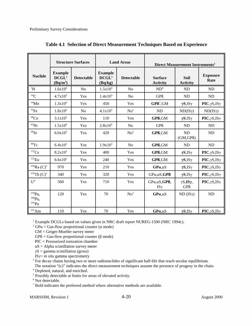
Table 4.1 presents a list of common contaminants along with recommended survey methods that have proven to be effective based on past survey experience in the decommissioning industry. This table provides a general indication of the detection capability of commercially-available instruments. As such, Table 4.1 may be used to provide an initial evaluation of instrument capabilities for some common radionuclides at the example DCGLs listed in the table. For example, consider the contamination of a surface with 241Am. Table 4.1 indicates that 241Am is detectable at the example DCGLs, and that viable direct measurement instruments include gas-flow proportional (� mode) and alpha scintillation detectors. Table 4.1 should not be interpreted as providing specific values for an instrument’s detection sensitivity, which is discussed in Section 6.7. In addition, NRC draft report NUREG-1506 (NRC 1995) provides further information on factors that may affect survey instrumentation selection.
4.7.3 Criteria f or Selection of Sample Collection and Direct Measurement Methods
Sample characteristics such as sample depth, volume, area, moisture level, and composition, as well as sample preparation techniques which may alter the sample, are important planning considerations for Data Quality Objectives. Sample preparation may include, but is not limited to, removing extraneous material, homogenizing, splitting, drying, compositing, and final preparation of samples. As is the case for determining survey unit characteristics, the physical sample characteristics and sampling method should be consistent with the dose or risk pathway modeling that is used to determine radionuclide DCGL’s. If a direct measurement method is used, it should also be consistent with the pathway modeling.
For example, a sample depth of 15 cm (6 in.) for soil samples might be specified during the DQO process for a final status survey because this corresponds to the soil mixing or plow depth in several environmental pathway models (Yu et al., 1993, NRC 1992b). If contamination exists at a depth less than this, a number of models uniformly mix it throughout this depth to simulate the soil mixing associated with plowing. Similarly, models may be based on dry weight, which may necessitate either drying samples or data transformation to account for dry weight.
The DQOs and subsequent direction to the laboratory for analysis might include removal of material not relevant for characterizing the sample, such as pieces of glass, twigs, or leaves. Table 4.2 provides examples of how a particular field soil composition of fine-, medium-, and coarse-grained materials might determine laboratory analysis DQOs for particular radionuclides. Fine materials consist of clay (less than 0.002 mm) and silt (0.002 to 0.062 mm). Medium materials consist of sand, which can be further divided into very fine, fine, medium, coarse, and very coarse sand. Coarse materials consist of gravel, which is composed of pebbles (2 to 64 mm), cobbles (64 to 256 mm), and boulders (greater than 256 mm) (Friedman 1978).
August 2000 4-19 MARSSIM, Revision 1
Preliminary Survey Considerations
Table 4.1 Selection of Direct Measurement Techniques Based on Experience
Nuclide
Stru cture Surfaces Land Areas Direct M easurement Instruments2
Example DCGL1
(Bq/m2) Detectable
Example DCGL1
(Bq/kg) Detectable Sur face
Activ ity Soil
Activ ity
Exposure Rate
3H 1.6x10⁶ No 1.5x10⁴ No ND6 ND ND 14C 4.7x10⁵ Yes 1.4x10³ No GPß ND ND 54Mn 1.3x10⁴ Yes 450 Yes GPß7,GM �S,IS� PIC,�S,IS� 55Fe 1.8x10⁶ No 4.1x10⁵ No5 ND ND(IS�) ND(IS�) 60Co 3.1x10³ Yes 110 Yes GPß,GM �S,IS� PIC,�S,IS� 63Ni 1.5x10⁶ Yes 2.8x10⁵ No GPß ND ND 90Sr 6.0x10³ Yes 420 No5 GPß,GM ND
(GM,GPß) ND
99Tc 6.4x10⁵ Yes 1.9x10³ No GPß,GM ND ND 137Cs 8.2x10³ Yes 400 Yes GPß,GM �S,IS� PIC,�S,IS� 152Eu 6.6x10³ Yes 240 Yes GPß,GM �S,IS� PIC,�S,IS� 226Ra (C)3 970 Yes 210 Yes GP�,�S �S,IS� PIC,�S,IS� 232Th (C)3 340 Yes 320 Yes GP�,�S,GPß �S,IS� PIC,�S,IS�
U4 560 Yes 710 Yes GP�,�S,GPß, IS�
�S,IS�, GPß
PIC,�S,IS�
239Pu, 240Pu, 241Pu
120 Yes 70 No5 GP�,�S ND (IS�) ND
241Am 110 Yes 70 Yes GP�,�S �S,IS� PIC,�S,IS�
1 Example DCGLs based on values given in NRC draft report NUREG-1500 (NRC 1994c). 2 GP� = Gas-flow proportional counter (� mode)
GM = Geiger-Mueller survey meter GPß = Gas-flow proportional counter (� mode) PIC = Pressurized ionization chamber �S = Alpha scintillation survey meter �S = gamma scintillation (gross) IS�= in situ gamma spectrometry
3 For decay chains having two or more radionuclides of significant half-life that reach secular equilibrium. The notation “(c)” indicates the direct measurement techniques assume the presence of progeny in the chain.
4 Depleted, natural, and enriched. 5 Possibly detectable at limits for areas of elevated activity. 6 Not detectable. 7 Bold indicates the preferred method where alternative methods are available.
MARSSIM, Revision 1 4-20 August 2000

Preliminary Survey Considerations
Table 4.2 Example of DQO Planning Considerations
Separate out and evaluate fine-grain material because resuspension is associated with the fine grain fraction for the air pathway.
If contamination resides on sand, pebbles, and cobbles, analyze these materials for direct exposure pathway and analyze the fine-grain fraction for the air pathway.
Separation and homogenization are not necessary for analyses because direct exposure pathway depends upon the average concentration and presence of cobbles will usually not impact laboratory analysis.
Determine if pathway modeling considered the presence of cobbles.
Separate, homogenize, and evaluate fine-grain material because plant root uptake is associated with the fine-grain fraction for the plant ingestion pathway.
Separate, homogenize, and evaluate fine-grain materials because of their relevance for the contaminant source term for contaminant migration to the sub-surface for the water pathway.
Both sample depth and area are considerations in determining appropriate sample volume, and sample volume is a key consideration for determining the laboratory MDC. The depth should also correlate with the conceptual model developed in Chapter 3 and upgraded throughout the Radiation Survey and Site Investigation (RSSI) Process. For example, if data collected during the Historical Site Assessment indicate contamination may exist to a depth of greater than 15 cm (6 in.), then samples should be deep enough to support the survey objectives, such as for the scoping or characterization survey. Taking samples as a function of depth might also be a survey design objective, such as for scoping, characterization, or remediation support.
The depth and area of the sample should be recorded as well as any observations, such as the presence of materials noted during sampling. Chapter 6 and Chapter 7 present more detail regarding the application of these survey planning considerations.
August 2000 4-21 MARSSIM, Revision 1
Preliminary Survey Considerations
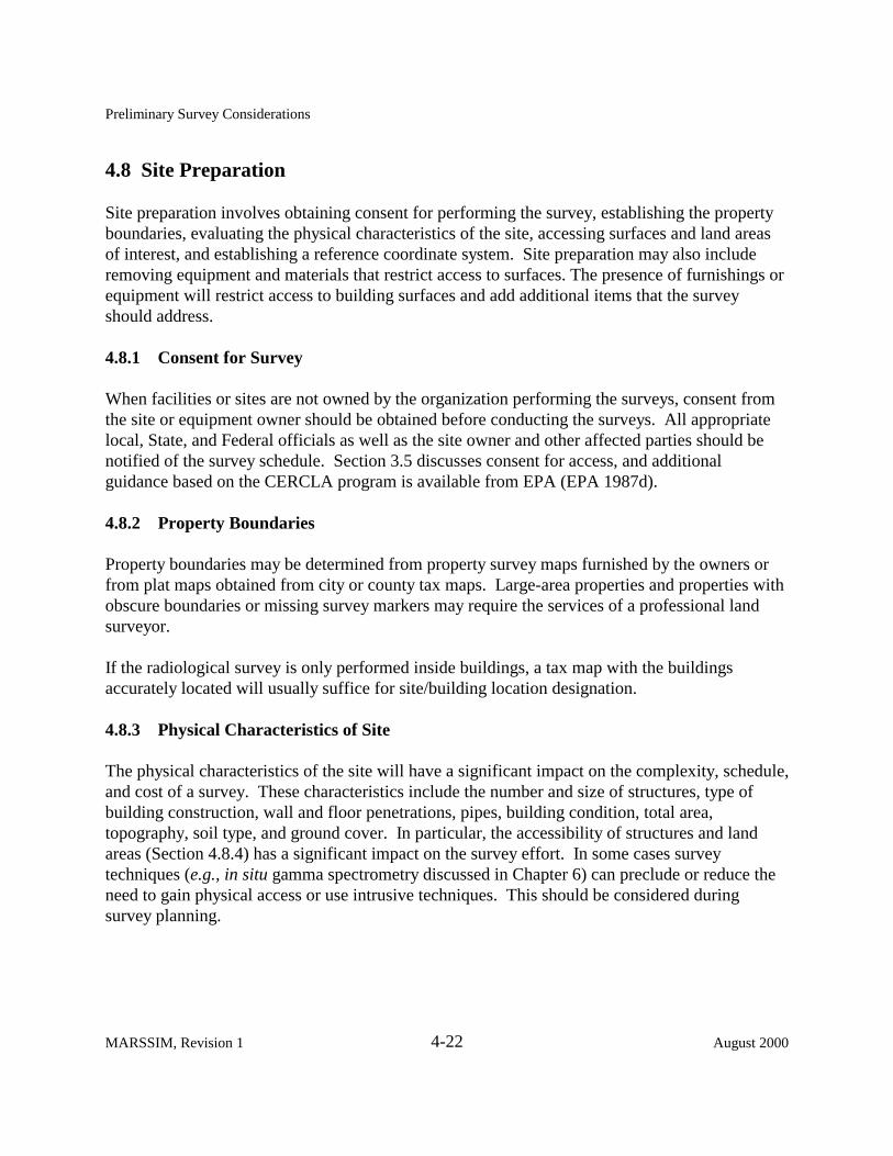
4.8 Site Preparation
Site preparation involves obtaining consent for performing the survey, establishing the property boundaries, evaluating the physical characteristics of the site, accessing surfaces and land areas of interest, and establishing a reference coordinate system. Site preparation may also include removing equipment and materials that restrict access to surfaces. The presence of furnishings or equipment will restrict access to building surfaces and add additional items that the survey should address.
4.8.1 Consent for Survey
When facilities or sites are not owned by the organization performing the surveys, consent from the site or equipment owner should be obtained before conducting the surveys. All appropriate local, State, and Federal officials as well as the site owner and other affected parties should be notified of the survey schedule. Section 3.5 discusses consent for access, and additional guidance based on the CERCLA program is available from EPA (EPA 1987d).
4.8.2 Property Boundaries
Property boundaries may be determined from property survey maps furnished by the owners or from plat maps obtained from city or county tax maps. Large-area properties and properties with obscure boundaries or missing survey markers may require the services of a professional land surveyor.
If the radiological survey is only performed inside buildings, a tax map with the buildings accurately located will usually suffice for site/building location designation.
4.8.3 Physical Characteristics of Site
The physical characteristics of the site will have a significant impact on the complexity, schedule, and cost of a survey. These characteristics include the number and size of structures, type of building construction, wall and floor penetrations, pipes, building condition, total area, topography, soil type, and ground cover. In particular, the accessibility of structures and land areas (Section 4.8.4) has a significant impact on the survey effort. In some cases survey techniques (e.g., in situ gamma spectrometry discussed in Chapter 6) can preclude or reduce the need to gain physical access or use intrusive techniques. This should be considered during survey planning.
MARSSIM, Revision 1 4-22 August 2000
Preliminary Survey Considerations
4.8.3.1 Structures
Building design and condition will have a marked influence on the survey efforts. The time involved in conducting a survey of building interior surfaces is essentially directly proportional to the total surface area. For this reason the degree of survey coverage decreases as the potential for residual activity decreases. Judgment measurements and sampling, which are performed in addition to the measurements performed for the nonparametric tests, are recommended in areas likely to have accumulated deposits of residual activity. As discussed in Section 5.5.3.3 and Section 8.5, judgment measurements and samples are compared directly to the appropriate DCGL.
The condition of surfaces after decontamination may affect the survey process. Removing contamination that has penetrated a surface usually involves removing the surface material. As a result, the floors and walls of decontaminated facilities are frequently badly scarred or broken up and are often very uneven. Such surfaces are more difficult to survey because it is not possible to maintain a fixed distance between the detector and the surface. In addition, scabbled or porous surfaces may significantly attenuate radiations—particularly alpha and low-energy beta particles. Use of monitoring equipment on wheels is precluded by rough surfaces, and such surfaces also pose an increased risk of damage to fragile detector probe faces. These factors should be considered during the calibration of survey instruments; NRC report NUREG-1507 (NRC 1997b) provides additional information on how to address these surface conditions. The condition of the building should also be considered from a safety and health standpoint before a survey is conducted. A structural assessment may be needed to determine whether the structure is safe to enter.
Expansion joints, stress cracks, and penetrations into floors and walls for piping, conduit, and anchor bolts, etc., are potential sites for accumulation of contamination and pathways for migration into subfloor soil and hollow wall spaces. Drains, sewers, and septic systems can also become contaminated. Wall/floor interfaces are also likely locations for residual contamination. Coring, drilling, or other such methods may be necessary to gain access for survey. Intrusive surveying may require permitting by local regulatory authorities. Suspended ceilings may cover areas of potential contamination such as ventilation ducts and fixtures.
Exterior building surfaces will typically have a low potential for residual contamination, however, there are several locations that should be considered during survey planning. If there are roof exhausts, roof accesses that allow for radioactive material movement, or the facility is proximal to the air effluent discharge points, the possibility of roof contamination should be considered. Because roofs are periodically resurfaced, contaminants may be trapped in roofing material, and sampling this material may be necessary. Roof drainage points such as driplines along overhangs, downspouts, and gutters are also important survey locations. Wall penetrations for process equipment, piping, and exhaust ventilation are potential locations for exterior
August 2000 4-23 MARSSIM, Revision 1

Preliminary Survey Considerations
contamination. Window ledges and outside exits (doors, doorways, landings, stairways, etc.) are also building exterior surfaces that should be addressed.
4.8.3.2 Land Areas
Depending upon site processes and operating history, the radiological survey may include varying portions of the land areas. Potentially contaminated open land or paved areas to be considered include storage areas (e.g., equipment, product, waste, and raw material), liquid waste collection lagoons and sumps, areas downwind (based on predominant wind directions on an average annual basis, if possible) of stack release points, and surface drainage pathways. Additionally, roadways and railways that may have been used for transport of radioactive or contaminated materials that may not have been adequately contained could also be potentially contaminated.
Buried piping, underground tanks, sewers, spill areas, and septic leach fields that may have received contaminated liquids are locations of possible contamination that may necessitate sampling of subsurface soil (Section 7.5.3). Information regarding soil type (e.g., clay, sand) may provide insight into the retention or migration characteristics of specific radionuclides. The need for special sampling by coring or split-spoon equipment should be anticipated for characterization surveys.
If radioactive waste has been removed, surveys of excavated areas will be necessary before backfilling. If the waste is to be left in place, subsurface sampling around the burial site perimeter to assess the potential for future migration may be necessary.
Additionally, potentially contaminated rivers, harbors, shorelines, and other outdoor areas may require survey activities including environmental media (e.g., sediment, marine biota) associated with these areas.
4.8.4 Clearing to Provide Access
In addition to the physical characteristics of the site, a major consideration is how to address inaccessible areas that have a potential for residual radioactivity. Inaccessible areas may need significant effort and resources to adequately survey. This section provides a description of common inaccessible areas that may have to be considered. The level of effort expended to access these difficult-to-reach areas should be commensurate with the potential for residual activity. For example, the potential for the presence of residual activity behind walls should be established before significant effort is expended to remove drywall.
MARSSIM, Revision 1 4-24 June 2001

Preliminary Survey Considerations
4.8.4.1 Structures
Structures and indoor areas should be sufficiently cleared to permit completion of the survey. Clearing includes providing access to potentially contaminated interior surfaces (e.g., drains, ducting, tanks, pits, ceiling areas, and equipment) by removing covers, disassembly, or other means of producing adequate openings.
Building features such as ceiling height, construction materials, ducts, pipes, etc., will determine the ease of accessibility of various surfaces. Scaffolding, cranes, lifts, or ladders may be necessary to reach some surfaces, and dismantling portions of the building may be required.
The presence of furnishings and equipment will restrict access to building surfaces and add additional items that the survey should address. Remaining equipment indirectly involved in the process may need to be dismantled in order to evaluate the radiological status, particularly of inaccessible parts of the equipment. Removing or relocating certain furnishings, such as lab benches and hoods, to obtain access to potentially contaminated floors and walls may also be necessary. The amount of effort and resources dedicated to such removal or relocation activities should be commensurate with the potential for contamination. Where the potential is low, a few spot-checks may be sufficient to provide confidence that covered areas are free of contamination. In other cases, complete removal may be warranted.
Piping, drains, sewers, sumps, tanks, and other components of liquid handling systems present special difficulties because of the inaccessibility of interior surfaces. Process information, operating history, and preliminary monitoring at available access points will assist in evaluating the extent of sampling and measurements included in the survey.
If the building is constructed of porous materials (e.g., wood, concrete) and the surfaces were not sealed, contamination may be found in the walls, floors, and other surfaces. It may be necessary to obtain cores of these surfaces for laboratory analysis.
Another accessibility problem is the presence of contamination beneath tile or other floor coverings. This often occurs because the covering was placed over contaminated surfaces, or the joints in tile were not sealed to prevent penetration. The practice in some facilities has been to “fix” contamination (particularly alpha emitters) by painting over the surface of the contaminated area. Thus, actions to obtain access to potentially contaminated surfaces, such as removing wall and floor coverings (including paint, wax, or other sealer) and opening drains and ducts, may be necessary to enable representative measurements of the contaminant. If alpha radiation or very low energy beta radiation is to be measured, the surface should be free of overlying material, such as dust and water, which may significantly attenuate the radiations.
August 2000 4-25 MARSSIM, Revision 1

Preliminary Survey Considerations
4.8.4.2 Land Areas
If ground cover needs to be removed or if there are other obstacles that limit access by survey personnel or necessary equipment, the time and expense of making land areas accessible should be considered. In addition, precautionary procedures need to be developed to prevent spreading surface contamination during ground cover removal or the use of heavy equipment.
Removal or relocation of equipment and materials that may entail special precautions to prevent damage or maintain inventory accountability should be performed by the property owner whenever possible. Clearing open land of brush and weeds will usually be performed by a professional land-clearing organization under subcontract arrangements. However, survey personnel may perform minor land-clearing activities as needed.
An important consideration prior to clearing is the possibility of bio-uptake and consequent radiological contamination of the material to be cleared. Special precautions to avoid exposure of personnel involved in clearing activities may be necessary. Initial radiological screening surveys should be performed to ensure that cleared material or equipment is not contaminated.
The extent of site clearing in specific areas depends primarily on the potential for radioactive contamination existing in those areas where: 1) the radiological history or results of previous surveys do not indicate potential contamination of an area (it may be sufficient to perform only minimum clearing to establish a reference coordinate system); 2) contamination is known to exist or a high potential for contamination necessitates completely clearing an area to provide access to all surfaces; and 3) new findings as the survey progresses may indicate that additional clearing be performed.
Open land areas may be cleared by heavy machinery (e.g., bulldozers, bushhogs, and hydroaxes). However, care should be exercised to prevent relocation of surface contamination or damage to site features such as drainage ditches, utilities, fences, and buildings. Minor land clearing may be performed using manually operated equipment such as brushhooks, power saws, knives, and string trimmers. Brush and weeds should be cut to the minimum practical height necessary to facilitate measurement and sampling activities (approximately 15 cm). Care should be exercised to prevent unnecessary damage to or removal of mature trees or shrubs.
Potential ecological damage that might result from an extensive survey should be considered. If a survey is likely to result in significant or permanent damage to the environment, appropriate environmental analyses should be conducted prior to initiating the survey. In addition, environmental hazards such as poison ivy, ticks carrying Lyme disease, and poisonous snakes, spiders, or insects should be noted. These hazards can affect the safety and health of the workers as well as the schedule for performing the survey.
MARSSIM, Revision 1 4-26 August 2000
Preliminary Survey Considerations
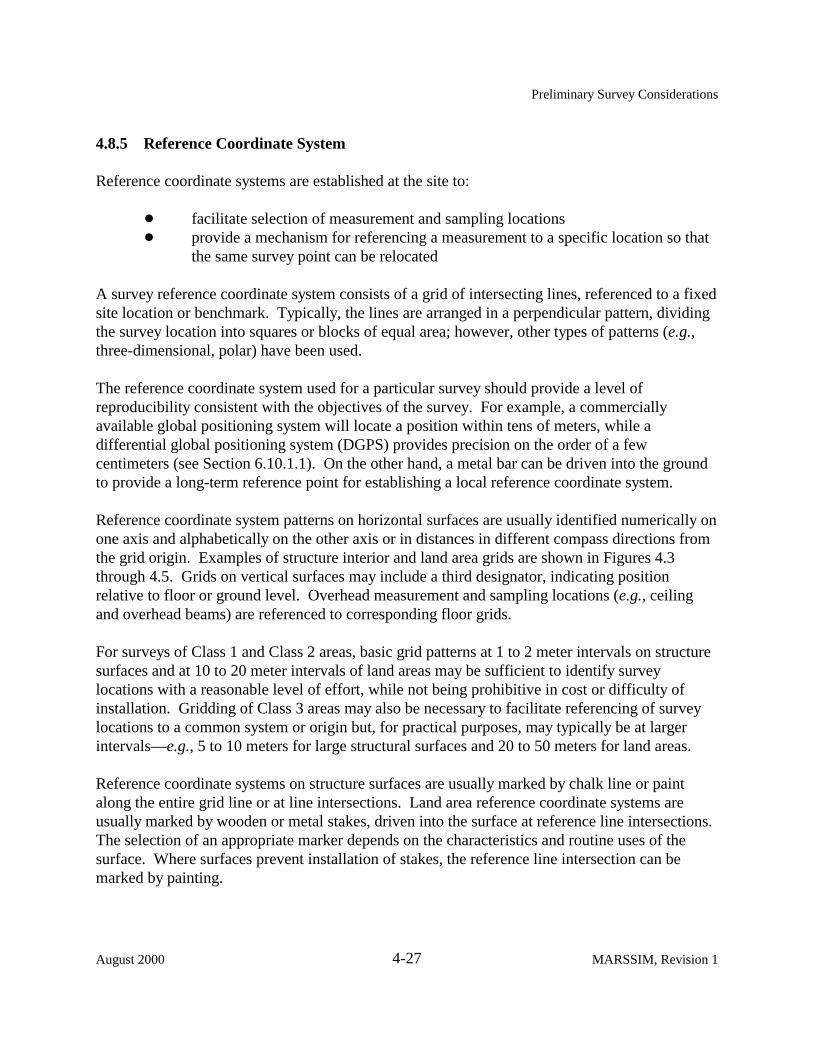
4.8.5 Reference Coordinate System
Reference coordinate systems are established at the site to:
! facilitate selection of measurement and sampling locations ! provide a mechanism for referencing a measurement to a specific location so that
the same survey point can be relocated
A survey reference coordinate system consists of a grid of intersecting lines, referenced to a fixed site location or benchmark. Typically, the lines are arranged in a perpendicular pattern, dividing the survey location into squares or blocks of equal area; however, other types of patterns (e.g., three-dimensional, polar) have been used.
The reference coordinate system used for a particular survey should provide a level of reproducibility consistent with the objectives of the survey. For example, a commercially available global positioning system will locate a position within tens of meters, while a differential global positioning system (DGPS) provides precision on the order of a few centimeters (see Section 6.10.1.1). On the other hand, a metal bar can be driven into the ground to provide a long-term reference point for establishing a local reference coordinate system.
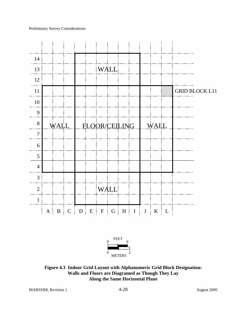
Reference coordinate system patterns on horizontal surfaces are usually identified numerically on one axis and alphabetically on the other axis or in distances in different compass directions from the grid origin. Examples of structure interior and land area grids are shown in Figures 4.3 through 4.5. Grids on vertical surfaces may include a third designator, indicating position relative to floor or ground level. Overhead measurement and sampling locations (e.g., ceiling and overhead beams) are referenced to corresponding floor grids.
For surveys of Class 1 and Class 2 areas, basic grid patterns at 1 to 2 meter intervals on structure surfaces and at 10 to 20 meter intervals of land areas may be sufficient to identify survey locations with a reasonable level of effort, while not being prohibitive in cost or difficulty of installation. Gridding of Class 3 areas may also be necessary to facilitate referencing of survey locations to a common system or origin but, for practical purposes, may typically be at larger intervals—e.g., 5 to 10 meters for large structural surfaces and 20 to 50 meters for land areas.
Reference coordinate systems on structure surfaces are usually marked by chalk line or paint along the entire grid line or at line intersections. Land area reference coordinate systems are usually marked by wooden or metal stakes, driven into the surface at reference line intersections. The selection of an appropriate marker depends on the characteristics and routine uses of the surface. Where surfaces prevent installation of stakes, the reference line intersection can be marked by painting.
August 2000 4-27 MARSSIM, Revision 1
Preliminary Survey Considerations
4-28MARSSIM, Revision 1 August 2000
A C D E F G H I J K L
1
2
3
4
5
6
7
8
9
10
11
12
13
14
WALL
WALL WALLFLOOR/CEILING
WALL
GRID BLOCK L11
0
0
6
2
FEET
METERS
Figure 4.3 r id Layout with Alphanumeric Gr id Block Designation:Walls and Floors are Diagramed as Though They Lay
Along the Same Horizontal Plane
B
Indoor G

Preliminary Survey Considerations
4-29August 2000 MARSSIM, Revision 1
0
0
30
10
FEET
M ETERS0 10E 20E 30E 40E 50E 60E
0
10N
20N
30N
40N
50N
60N
70N
80N
85N
BUILDING
3 m
4 mB
A
N
POINT A GRID COORDINATES 30E, 30NPOINT B GRID COORDINATES 23E, 24NSHADED BLOCK GRID COORDINATES 10E, 30N
SURVEY UNIT BOUNDARY
ONSITE FENCE
Figure 4.4 ple of a Gr id System for Survey of Site GroundsUsing Compass Directions
Exam

Preliminary Survey Considerations
4-30MARSSIM, Revision 1 August 2000
200L 100L BASELINE 100R 200R 300R
0+00
1+00
2+00
3+00
4+00
PROPERTYBOUNDARY
A
B25 m
30 m
POINT A GRID COORDINATES 100R, 2+00POINT B GRID COORDINATES 25R, 1+30SHADED BLOCK GRID COORDINATES 200L, 2+00
0
0
300
100
FEET
METERS
N
Figure 4.5 ple of a Gr id System for Survey of Site GroundsUsing Distances Left or Right of the BaselineExam

Preliminary Survey Considerations
Three basic coordinate systems are used for identifying points on a reference coordinate system. The reference system shown in Figure 4.3 references grid locations using numbers on the vertical axis and letters on the horizontal axis. The reference system shown on Figure 4.4 references distances from the 0,0 point using the compass directions N (north), S (south), E (east), and W (west). The reference system shown in Figure 4.5 references distances along and to the R (right) or L (left) of the baseline. In addition, a less frequently used reference system is the polar coordinate system, which measures distances along transects from a central point. Polar coordinate systems are particularly useful for survey designs to evaluate effects of stack emissions, where it may be desirable to have a higher density of samples collected near the stack and fewer samples with increasing distance from the stack.
Figure 4.5 shows an example grid system for an outdoor land area. The first digit or set of digits includes an L or R (separated from the first set by a comma) to indicate the distance from the baseline in units (meters) and the direction (left or right) from the baseline. The second digit or set of digits refers to the perpendicular distance from the 0,0 point on the baseline and is measured in hundreds of units. Point A in the example of a reference coordinate system for survey of site grounds, Figure 4.5, is identified 100R, 2+00 (i.e., 200 m from the baseline and 100 m to the right of the baseline). Fractional distances between reference points are identified by adding the distance beyond the reference point and are expressed in the same units used for the reference coordinate system dimensions. Point B on Figure 4.5 is identified 25R, 1+30.
Open land reference coordinate systems should be referenced to a location on an existing State or local reference system or to a U.S. Geological Survey (USGS) bench mark. (This may require the services of a professional land surveyor.) Global positioning systems (GPS) are capable of locating reference points in terms of latitude and longitude (Section 6.10.1 provides descriptions of positioning systems).
Following establishment of the reference coordinate system, a drawing is prepared by the survey team or the land surveyor. This drawing indicates the reference lines, site boundaries, and other pertinent site features and provides a legend showing the scale and a reference compass direction. The process used to develop the reference coordinate system should be recorded in the survey planning documentation (e.g., the Quality Assurance Project Plan or QAPP). An deviations from the requirements developed during planning should be documented when the reference coordinate system is established.
It should be noted that the reference coordinate systems described in this section are intended primarily for reference purposes and do not necessarily dictate the spacing or location of survey measurements or samples. Establishment of a measurement grid to demonstrate compliance with the DCGL is discussed in Section 5.5.2.5 and Chapter 8.
August 2000 4-31 MARSSIM, Revision 1

Preliminary Survey Considerations
4.9 Quality Control
Site surveys should be performed in a manner that ensures results are accurate and sources of uncertainty are identified and controlled. This is especially the case for final status surveys that are vital to demonstrating a facility satisfies pre-established release criteria. Quality control (QC) and quality assurance (QA) are initiated at the start of a project and integrated into all surveys as DQOs are developed. This carries over to the writing of a Quality Assurance Project Plan (QAPP), which applies to each aspect of a survey. Section 9.2 provides guidance on developing a QAPP. Data quality is routinely a concern throughout the RSSI Process, and one should recognize that QA/QC procedures will change as data are collected and analyzed, and as DQOs become more rigorous for the different types of surveys that lead up to a final status survey.
In general, surveys performed by trained individuals are conducted with approved written procedures and properly calibrated instruments that are sensitive to the suspected contaminant. However, even the best approaches for properly performing measurements and acquiring accurate data need to consider QC activities. QC activities are necessary to obtain additional quantitative information to demonstrate that measurement results have the required precision and are sufficiently free of errors to accurately represent the site being investigated. The following two questions are the main focus of the rationale for the assessment of errors in environmental data collection activities (EPA 1990).
! How many and what type of measurements are required to assess the quality of data from an environmental survey?
! How can the information from the quality assessment measurements be used to identify and control sources of error and uncertainties in the measurement process?
These questions are introduced as part of guidance that also includes an example to illustrate the planning process for determining a reasonable number of quality control (QC) measurements. This guidance also demonstrates how the information from the process may be used to document the quality of the measurement data. This process was developed in terms of soil samples collected in the field and then sent to a laboratory for analysis (EPA 1990). For MARSSIM, these questions may be asked in relation to measurements of surface soils and building surfaces both of which include sampling, scanning, and direct measurements.
Quality control may be thought of in three parts: 1) determining the type of QC samples needed to detect precision or bias; 2) determining the number of samples as part of the survey design; and 3) scheduling sample collections throughout the survey process to identify and control sources of error and uncertainties. Section 4.9.1 introduces the concepts of precision and bias related to survey measurements and briefly discusses the types of QC measurements needed to detect and quantify precision and bias. Section 6.2 and Section 7.2 provide more detailed
MARSSIM, Revision 1 4-32 August 2000

Preliminary Survey Considerations
guidance on the types of QC measurements. The number of QC measurements is addressed in Section 4.9.2, while Section 4.9.3 and Section 9.3 contain information on identifying and controlling sources of uncertainty. Overall, survey activities associated with MARSSIM include obtaining the additional information related to QA of both field and laboratory activities.
4.9.1 Precision and Systematic Errors (Bias)
Precision is a measure of agreement among repeated measurements. Precision is discussedfurther in Appendix N in statistical terms. Table N.2 presents the minimum considerations,impacts of not meeting these considerations, and corrective actions associated with assessingprecision. Systematic errors, also called bias, accumulate during the measurement process andresult from faults in sampling designs and procedures, analytical procedures, samplecontamination, losses, interactions with containers, deterioration, inaccurate instrumentcalibration, and other sources. Bias causes the mean value of the sample data to be consistentlyhigher or lower than the true mean value. Appendix N also discusses bias, and Table N.3presents the minimum considerations associated with assessing bias, the impacts if theconsiderations are not met, and related corrective actions. Laboratories typically introduce QCsamples into their sample load to assess possible bias. In simplest terms, spikes, repeatedmeasurements, and blanks are used to assess bias, precision, and contamination, respectively.See Section 6.2 for further discussion of specific measurements for determining precision andbias for scans and direct measurements and Section 7.2 for further discussion of specificmeasurements for determining precision and bias for samples.
Field work using scanning or direct measurements eliminates some sources of error becausesamples are not removed, containerized, nor transported to another location for analysis. Theoperator’s technique or field instrument becomes the source of bias. In this case, detecting biasmight incorporate field replicates (see Section 7.2.2.1) by having a second operator to revisitmeasurement locations and following the same procedure with the same instrument as was usedby the first operator. This is an approach used to assess precision of measurements. A fieldinstrument’s calibration can also be checked by one or more operators during the course of asurvey and recorded on a control chart. Differences in set up or handling of instruments bydifferent operators may reveal a significant source of bias that is quite different from sources ofbias associated with laboratory work.
The following factors should be considered when evaluating sources of bias, error, anduncertainty. Contamination is an added factor to consider for each of the following items.
! sample collection methods! handling and preparation of samples! homogenization and aliquots of laboratory samples! field methods for sampling, scanning, or direct measurements
August 2000 4-33 MARSSIM, Revision 1

Preliminary Survey Considerations
! laboratory analytical process ! total bias contributed by all sources
The magnitude of the measurement system variability should be evaluated to determine if the variability approaches or exceeds the true but unknown variability in the population of interest. Errors, bias, or data variability may accumulate to the point of rendering data unusable to achieve survey objectives. Systematic investigations of field or laboratory processes can be initiated to assess and identify the extent of errors, bias, and data variability and to determine if the DQOs are achieved. An important aspect of each QC determination is the representative nature of a sample or measurement (see Appendix N for a description of representativeness). If additional samples or measurements are not taken according to the appropriate method, the resulting QC information will be invalid or unusable. For example, if an inadequate amount of sample is collected, the laboratory analytical procedure may not yield a proper result. The QC sample must represent the sample population being studied. Misrepresentation itself creates a bias that if undetected leads to inaccurate conclusions concerning an analysis. At the very least, misrepresentation leads to a need for additional QA investigation.
4.9.2 Number of Quality Control Measurements
The number of QC measurements is determined by the available resources and the degree to which one needs assurance that a measurement process is adequately controlled. The process is simplified, for example, when the scope of a survey is narrowed to a single method, one sampling crew, and a single laboratory to analyze field samples. Increasing the number of samples and scheduling sample collections and analyses over time or at different laboratories increases the level of difficulty and necessitates increasing the number of QC measurements. The number of QC measurements may also be driven upward as the action level approaches a given instrument’s detection limit. This number is determined on a case-by-case basis, where the specific contaminant and instruments are assessed for detecting a particular radionuclide.
A widely used standard practice is to collect a set percentage, such as 5% (EPA 1987b), of samples for QA purposes. However, this practice has disadvantages. For example, it provides no real assessment of the uncertainties for a relatively small sample size. For surveys where the required number of measurements increases, there may be a point beyond which there is little added value in performing additional QC measurements. Aside from cost, determining the appropriate number of QC measurements essentially depends on site-specific factors. For example, soil may present a complex and variable matrix requiring many more QC measurements for surface soils than for building surfaces.
A performance based alternative (EPA 1990) to a set percentage or rule of thumb can be implemented. First, potential sources of error or uncertainty, the likelihood of occurrence, and the consequences in the context of the DQOs should be determined. Then, the appropriate type
MARSSIM, Revision 1 4-34 August 2000

Preliminary Survey Considerations
and number of QC measurements based on the potential error or uncertainty are determined. Forexample, field replicate samples (i.e., a single sample that is collected, homogenized, and splitinto equivalent fractions in the field) are used to estimate the combined contribution of severalsources of variation. Hence, the number of field replicate samples to be obtained in the studyshould be dictated by how precise the estimate of the total measurement should be.
Factors influencing this estimate include the
! number of measurements! number and experience of personnel involved! current and historical performance of sampling and analytical procedures used! the variability of survey unit and background reference area radioactivity measurement
systems used ! number of laboratories used ! the level of radioactivity in the survey unit (which for a final status survey should be low) ! how close an action level (e.g., DCGL) is to a detection limit (which may represent a
greater concern after reducing or removing radionuclide concentrations by remediation)
The precision of an estimate of the “true” variance for precision or bias within a survey design depends on the number of degrees of freedom used to provide the estimate. Table 4.3 provides the one-sided upper confidence limits for selected degrees of freedom assuming the results of the measurements are normally distributed. Confidence limits are provided for 90, 95, 97.5, and 99 percent confidence levels. At the stated level of confidence, the “true” variance of the estimate of precision or bias for a specified number of QC measurements will be between zero and the multiple of the estimated variance listed in Table 4.3. For example, for five degrees of freedom one would be 90% confident that the true variance for precision falls between zero and 3.10 times the estimated variance. The number of QC measurements is equal to one greater than the degrees of freedom.
When planning surveys, the number of each type of QC measurement can be obtained from Table 4.3. For example, if the survey objective is to estimate the variance in the bias for a specific measurement system between zero and two times the estimated variance at a 95% confidence level, 15 degrees of freedom or 16 measurements of a material with known concentration (e.g., performance evaluation samples) would be indicated. MARSSIM recommends that the survey objective be set such that the true variance falls between zero and two times the estimated variance. The level of confidence is then determined on a site-specific basis to adjust the number of each type of QC measurement to the appropriate level (i.e., 11, 16, 21 or 31 measurements). The results of the QC measurements are evaluated during the assessment phase of the data life cycle (see Section 9.3 and Appendix N).
August 2000 4-35 MARSSIM, Revision 1

Preliminary Survey Considerations
Table 4.3 Upper Confidence Limits for the True Variance as a Function of the Number of QC Measurements Used to Determine the Estimated Variance (EPA 1990)
Degrees of Freedom* Level of Confidence (%)
90 95 97.5 99
2 9.49 19.49 39.21 99.50
5 3.10 4.34 6.02 9.02
10 2.05 2.54 3.08 3.91
15 1.76 2.07 2.40 2.87
20 1.61 1.84 2.08 2.42
25 1.52 1.71 1.91 2.17
30 1.46 1.62 1.78 2.01
40 1.38 1.51 1.64 1.80
50 1.33 1.44 1.61 1.68
100 1.21 1.28 1.35 1.43
* To obtain the necessary number of quality control measurements, add one to the degrees of freedom.
Example:
A site is contaminated with 60Co and consists of four Class 1 interior survey units, nine Class 2 interior survey units, two Class 3 interior survey units, and one Class 3 exterior survey unit. Three different measurement systems are specified in the survey design for performing scanning surveys, one measurement system is specified for performing direct measurements for interior survey units, and one measurement system is specified for measuring samples collected from the exterior survey unit.
Repeated measurements are used to estimate precision. For scan surveys there is not a specified number of measurements. 10% of the scans in each Class 1 survey unit were repeated as replicates to measure operator precision (see Section 6.2.2.1) within 24 hours of the original scan survey. 5% of each Class 2 and Class 3 survey unit were similarly repeated as replicates to measure operator precision. The results of the repeated scans were evaluated based on professional judgment. For direct measurements and sample collection activities, a 95% confidence level was selected as consistent with the objectives of the survey. Using Table 4.3, it was determined that 16 repeated measurements were required for both the direct measurement technique and the sample collection and laboratory measurement technique. Because 72 direct measurements would be performed in Class 1 survey units, 99 in Class 2 survey units, and 20 in Class 3 survey units, it was anticipated that at least 16 direct measurements would have sufficient
MARSSIM, Revision 1 4-36 August 2000

Preliminary Survey Considerations
activity above background to perform repeated measurements and obtain usable results (see Section 5.5.2 for guidance on determining the number of measurements and Appendix A for a more detailed discussion of the example site). The 16 direct measurement locations to be repeated would be selected based on the results of the direct measurements and would represent the entire usable range of activity found in the survey units rather than measuring the 16 locations with the highest activities. (The usable range of activity includes the highest measurement result in the survey unit and the lowest measurement result with an acceptable measurement uncertainty compared to the desired level of precision.) The repeated measurements would be performed by different operators using the same equipment, but they would not know the results of the original survey. To ensure that the measurements would be valid, the QC measurements to check for contamination would be performed at the same time. Because the laboratory’s QA program called for periodic checks on the precision of the laboratory instruments, the total survey design precision for laboratory measurements was measured. Because the only samples collected would come from a Class 3 area, the sample activities were expected to be close to or below the measurement system MDC. This meant that field replicate samples would not provide any usable information. Also, QC samples for bias were repeated to obtain a usable estimate of precision for the survey design.
Measurements of materials with known concentrations above background (e.g., performance evaluation samples) and known concentrations at or below background (e.g., field blanks) are used to estimate bias. For scan surveys, the repeated scanning performed to estimate precision would also serves as a check for contamination using blanks. Because there was no appropriate material of known concentration on which to perform bias measurements, the calibration checks were used to demonstrate that the instruments were reading properly during the surveys. A control chart was developed using the instrument response for an uncalibrated check source. Measurements were obtained using a specified source-detector alignment that could be easily repeated. Measurements were obtained at several times during the day over a period of several weeks prior to taking the instruments into the field. Calibration checks were performed before and after each survey period in the field and the results immediately plotted on the control chart to determine if the instrument was performing properly. This method was also adopted for the direct measurement system. 20 samples were required by the survey design for the Class 3 exterior survey unit. To ensure that the samples were truly blind for the laboratory, samples three times the requested volume were collected. These samples were sent to a second laboratory for preparation. Each sample was weighed, dried, and reweighed to determine the moisture content. Then each sample was ground to a uniform particle size of 1 mm (approximately 16 mesh) and divided into three separate aliquots (each aliquot was the same size). For each sample one aliquot was packaged for transport to the laboratory performing the analysis. After these samples were packaged, 16 of the samples had both of the remaining aliquots spiked with the same level of activity using a
August 2000 4-37 MARSSIM, Revision 1

Preliminary Survey Considerations
source solution traceable to the National Institute of Science and Technology (NIST). The 16 samples each had a different level of activity within a range that was accepted by the laboratory performing the analysis. These 32 samples were also packaged for transport to the laboratory. In addition, 16 samples of a soil similar to the soil at the site were prepared as blanks to check against contamination. The 20 samples, 32 spikes, and 16 blanks were transported to the laboratory performing the analyses in a single shipment so that all samples were indistinguishable from each other except by the sample identification.
4.9.3 Controlling Sources of Error
During the performance of a survey, it is important to identify sources of error and uncertainty early in the process so that problems can be resolved. The timing of the QC measurements within the survey design can be very important. In order to identify problems as early as possible, it may be necessary to perform a significant number of QC measurements early in the survey. This can be especially important for surveys utilizing an innovative or untested survey design. Survey designs that have been used previously and produced reliable results may be able to space the QC measurement evenly throughout the survey, or even wait to have samples analyzed at the end of the survey, as long as the objectives of the survey are achieved.
For example, a survey design requires a new scanning method to be used for several survey units when there are little performance data available for this technique. To ensure that the technique is working properly, the first few survey units are re-scanned to provide an initial estimate of the precision and bias. After the initial performance of the techniques has been verified, a small percentage of the remaining survey units is re-scanned to demonstrate that the technique is operating properly for the duration of the survey.
Identifying sources of error and uncertainty is only the first step. Once the sources of uncertainty have been identified, they should be minimized and controlled for the rest of the survey. Section 9.3 discusses the assessment of survey data and provides guidance on corrective actions that may be appropriate for controlling sources of error or uncertainty after they have been identified.
4.10 Health and Safety
Consistent with the approach for any operation, activities associated with the radiological surveys should be planned and monitored to assure the health and safety of the worker and other personnel, both onsite and offsite, are adequately protected. At the stage of determining the final status of the site, residual radioactivity is expected to be below the DCGL values; therefore, the final status survey should not include radiation protection controls. However, radiation protection controls may be necessary when performing scoping or characterization surveys where the potential for significant levels of residual radioactivity is unknown.
MARSSIM, Revision 1 4-38 August 2000
Preliminary Survey Considerations
Significant health and safety concerns during any radiological survey include the potential industrial hazards commonly found at a construction site, such as exposed electrical circuitry, excavations, enclosed work spaces, hazardous atmospheres, insects, poisonous snakes, plants, and animals, unstable surfaces (e.g., wet or swamp soil), heat and cold, sharp objects or surfaces, falling objects, tripping hazards, and working at heights. The survey plan should incorporate objectives and procedures for identifying and eliminating, avoiding, or minimizing these potential safety hazards.
August 2000 4-39 MARSSIM, Revision 1
Related Documents