Why a 4°C Warmer World Must be Avoided Turn Down Heat the

4 Degree_Chapter 3, 4, 5
Dec 10, 2015
4 Degree
Welcome message from author
This document is posted to help you gain knowledge. Please leave a comment to let me know what you think about it! Share it to your friends and learn new things together.
Transcript

Why a 4°C Warmer World Must be Avoided
Turn Down Heatth
e

Why a 4°C Warmer World Must be Avoided
Turn Down Heatth
e
November 2012A Report for the World Bank by the Potsdam Institute for Climate Impact Research and Climate Analytics

Chapter3

21
21st Century ProjectionsThis section provides an overview of 21st century climate projections, comparing the effects of strong mitigation actions that limit warming to 1.5 and 2°C above preindustrial levels with a distinctly different world in which low mitigation efforts result in warming approaching 4°C by 2100. The section looks at how likely a 4°C world is and compares the global mean consequence of a range of mitigation scenarios, which show that 4°C warming is not inevitable and that warming can still be limited to 2°C or lower with sustained policy action. It then explores some of the consequences of a 4°C world.
The nonmitigation IPCC Special Report on Emissions Scenarios (SRES) (Nakicenovic and Swart 2000), assessed in the IPCC AR4, gave a warming range for 2100 of 1.6–6.9°C above preindustrial temperatures. In these projections, about half the uncertainty range is due to the uncertainties in the climate system response to green-house gas emissions. Assuming a “best guess” climate response, the warming response was projected at 2.3–4.5°C by 2100, the remaining uncertainty being due to different assumptions about how the world population, economy, and technology will develop during the 21st century. No central, or most likely, estimate was provided of future emissions for the SRES scenarios, as it was not possible to choose one emissions pathway over another as more likely (Nakicenovic and Swart 2000). The range from the SRES scenarios, nevertheless, indicates that there are many nonmitiga-tion scenarios that could lead to warming in excess of 4°C. The evolution of policies and emissions since the SRES was completed points to a warming of above 3°C being much more likely than those levels below, even after including mitigation pledges and targets adopted since 2009.
While the SRES generation of scenarios did not include mitiga-tion of greenhouse gas emissions to limit global warming, a range of new scenarios was developed for the IPCC AR5, three of which are derived from mitigation scenarios. These so-called Representative Concentration Pathways (RCPs) (Moss et al. 2010) are compared with the SRES scenarios in Figure 20. Three of the RCPs are derived from mitigation scenarios produced by Integrated Assessment Models (IAMs) that are constructed to simulate the international energy-economic system and allow for a wide variety of energy
Figure 20: Probabilistic temperature estimates for old (SRES) and new (RCP) IPCC scenarios. Depending on which global emissions path is followed, the 4°C temperature threshold could be exceeded before the end of the century.
Source: rogelj, meinshausen, et al. 2012.
Turn Down The heaT: why a 4°C warmer worlD musT Be avoiDeD
22
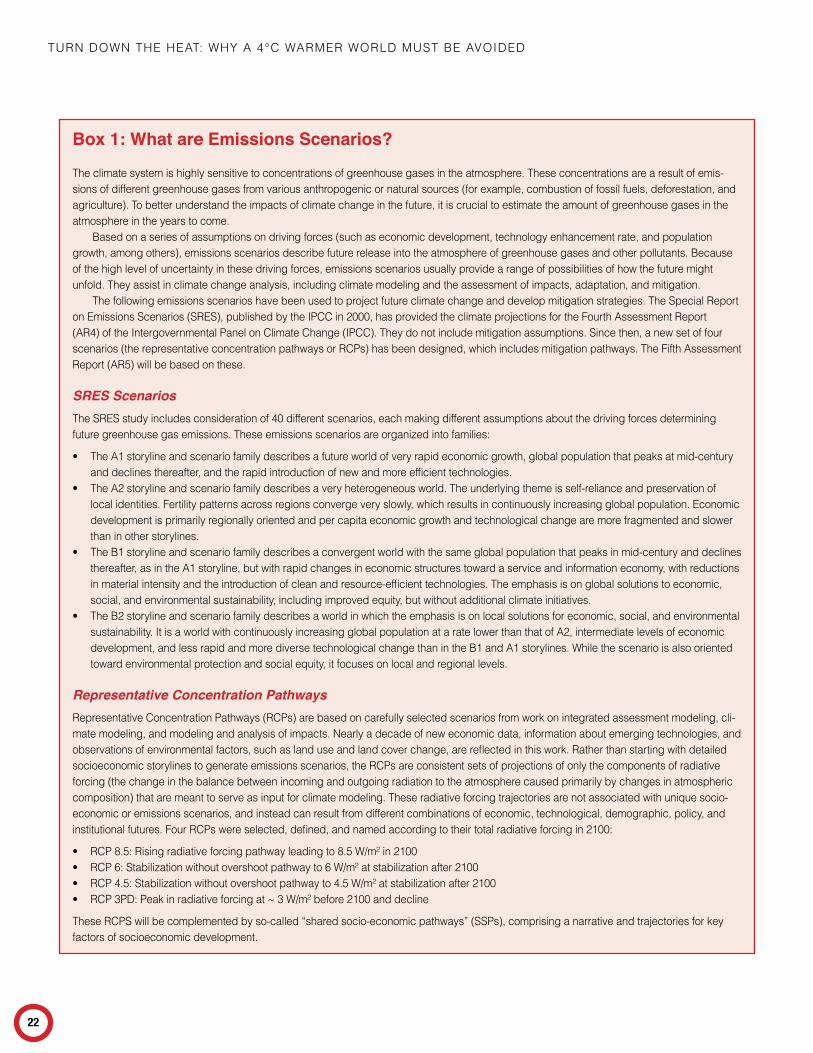
Box 1: What are Emissions Scenarios?
The climate system is highly sensitive to concentrations of greenhouse gases in the atmosphere. These concentrations are a result of emis-sions of different greenhouse gases from various anthropogenic or natural sources (for example, combustion of fossil fuels, deforestation, and agriculture). To better understand the impacts of climate change in the future, it is crucial to estimate the amount of greenhouse gases in the atmosphere in the years to come.
Based on a series of assumptions on driving forces (such as economic development, technology enhancement rate, and population growth, among others), emissions scenarios describe future release into the atmosphere of greenhouse gases and other pollutants. Because of the high level of uncertainty in these driving forces, emissions scenarios usually provide a range of possibilities of how the future might unfold. They assist in climate change analysis, including climate modeling and the assessment of impacts, adaptation, and mitigation.
The following emissions scenarios have been used to project future climate change and develop mitigation strategies. The Special report on Emissions Scenarios (SrES), published by the IpCC in 2000, has provided the climate projections for the Fourth Assessment report (Ar4) of the Intergovernmental panel on Climate Change (IpCC). They do not include mitigation assumptions. Since then, a new set of four scenarios (the representative concentration pathways or rCps) has been designed, which includes mitigation pathways. The Fifth Assessment report (Ar5) will be based on these.
SRES ScenariosThe SrES study includes consideration of 40 different scenarios, each making different assumptions about the driving forces determining future greenhouse gas emissions. These emissions scenarios are organized into families:
• The A1 storyline and scenario family describes a future world of very rapid economic growth, global population that peaks at mid-century and declines thereafter, and the rapid introduction of new and more efficient technologies.
• The A2 storyline and scenario family describes a very heterogeneous world. The underlying theme is self-reliance and preservation of local identities. Fertility patterns across regions converge very slowly, which results in continuously increasing global population. Economic development is primarily regionally oriented and per capita economic growth and technological change are more fragmented and slower than in other storylines.
• The B1 storyline and scenario family describes a convergent world with the same global population that peaks in mid-century and declines thereafter, as in the A1 storyline, but with rapid changes in economic structures toward a service and information economy, with reductions in material intensity and the introduction of clean and resource-efficient technologies. The emphasis is on global solutions to economic, social, and environmental sustainability, including improved equity, but without additional climate initiatives.
• The B2 storyline and scenario family describes a world in which the emphasis is on local solutions for economic, social, and environmental sustainability. It is a world with continuously increasing global population at a rate lower than that of A2, intermediate levels of economic development, and less rapid and more diverse technological change than in the B1 and A1 storylines. While the scenario is also oriented toward environmental protection and social equity, it focuses on local and regional levels.
Representative Concentration Pathwaysrepresentative Concentration pathways (rCps) are based on carefully selected scenarios from work on integrated assessment modeling, cli-mate modeling, and modeling and analysis of impacts. Nearly a decade of new economic data, information about emerging technologies, and observations of environmental factors, such as land use and land cover change, are reflected in this work. rather than starting with detailed socioeconomic storylines to generate emissions scenarios, the rCps are consistent sets of projections of only the components of radiative forcing (the change in the balance between incoming and outgoing radiation to the atmosphere caused primarily by changes in atmospheric composition) that are meant to serve as input for climate modeling. These radiative forcing trajectories are not associated with unique socio-economic or emissions scenarios, and instead can result from different combinations of economic, technological, demographic, policy, and institutional futures. Four rCps were selected, defined, and named according to their total radiative forcing in 2100:
• rCp 8.5: rising radiative forcing pathway leading to 8.5 W/m² in 2100• rCp 6: Stabilization without overshoot pathway to 6 W/m² at stabilization after 2100• rCp 4.5: Stabilization without overshoot pathway to 4.5 W/m² at stabilization after 2100• rCp 3pD: peak in radiative forcing at ~ 3 W/m² before 2100 and decline
These rCpS will be complemented by so-called “shared socio-economic pathways” (SSps), comprising a narrative and trajectories for key factors of socioeconomic development.

21ST CENTury prOJECTIONS
23
technologies to satisfy demand (Masui et al. 2011; Thomson et al. 2011; Vuuren et al. 2011; Rao and Riahi 2006).
The purpose of the RCP exercise was to derive a wide range of plausible pathways through 2100 (and beyond) to be used to drive the climate and climate impact models, the results of which would be summarized in the IPCC.
The highest RCP scenario, RCP8.5 (Riahi, Rao, et al. 2011), is the only nonmitigation pathway within this AR5 scenario group and is comparable to the highest AR4 SRES scenario (SRES A1FI). It projects warming by 2100 of close to 5°C. However, RCP6, one of the RCP mitigation scenarios that assumes only a limited degree of climate policy intervention, already projects warming exceeding 4°C by 2100 with a probability of more than 15 percent. As illustrated in Figure 20, the range of changes in temperature for the RCP scenarios is wider than for the AR4 SRES scenarios. The main reason for this is that the RCPs span a greater range of plausible emissions scenarios, including both scenarios assuming no mitigation efforts (RCP8.5) and scenarios that assume relatively ambitious mitigation efforts (RCP3PD). This wide variety of the RCP pathway range is further illustrated in Figure 21. The median estimate of warming in 2100 under the nonmitigation RCP8.5 pathway is close to 5°C and still steeply rising, while under the much lower RCP3PD pathway temperatures have already peak and slowly transition to a downward trajectory before the end of this century.
How Likely is a 4°C World?
The emission pledges made at the climate conventions in Copen-hagen and Cancun, if fully met, place the world on a trajectory for a global mean warming of well over 3°C. Even if these pledges are fully implemented there is still about a 20 percent chance of exceeding 4°C in 2100.10 If these pledges are not met then there is a much higher likelihood—more than 40 percent—of warm-ing exceeding 4°C by 2100, and a 10 percent possibility of this occurring already by the 2070s, assuming emissions follow the medium business-as-usual reference pathway. On a higher fos-sil fuel intensive business-as-usual pathway, such as the IPCC SRESA1FI, warming exceeds 4°C earlier in the 21st century. It is important to note, however, that such a level of warming can still be avoided. There are technically and economically feasible emission pathways that could still limit warming to 2°C or below in the 21st century.
To illustrate a possible pathway to warming of 4°C or more, Figure 22 uses the highest SRES scenario, SRESA1FI, and compares it to other, lower scenarios. SRESA1FI is a fossil-fuel intensive, high economic growth scenario that would very likely cause mean the global temperature to exceed a 4°C increase above preindustrial temperatures.
Most striking in Figure 22 is the large gap between the pro-jections by 2100 of current emissions reduction pledges and the (lower) emissions scenarios needed to limit warming to 1.5–2°C above pre-industrial levels. This large range in the climate change implications of the emission scenarios by 2100 is important in its
Figure 21: Probabilistic temperature estimates for new (RCP) IPCC scenarios, based on the synthesized carbon-cycle and climate system understanding of the IPCC AR4. Grey ranges show 66 percent ranges, yellow lines are the medians. Under a scenario without climate policy intervention (RCP8.5), median warming could exceed 4°C before the last decade of this century. In addition, RCP6 (limited climate policy) shows a more than 15 percent chance to exceed 4°C by 2100.
Source: rogelj, meinshausen et al. 2012
10 Probabilities of warming projections are based on the approach of (Meinshausen et al. 2011), which involves running a climate model ensemble of 600 realizations for each emissions scenario. In the simulations each ensemble member is driven by a different set of climate-model parameters that define the climate-system response, including parameters determining climate sensitivity, carbon cycle characteristics, and many others. Randomly drawn parameter sets that do not allow the climate model to reproduce a set of observed climate variables over the past centuries (within certain tolerable “accuracy” levels) are filtered out and not used for the projections, leaving the 600 realizations that are assumed to have adequate predictive skill.

Turn Down The heaT: why a 4°C warmer worlD musT Be avoiDeD
24
own right, but it also sets the stage for an even wider divergence in the changes that would follow over the subsequent centuries, given the long response times of the climate system, including the carbon cycle and climate system components that contribute to sea-level rise.
The scenarios presented in Figure 22 indicate the likely onset time for warming of 4°C or more. It can be seen that most of the scenarios remain fairly close together for the next few decades of the 21st century. By the 2050s, however, there are substantial differences among the changes in temperature projected for the different scenarios. In the highest scenario shown here (SRES A1FI), the median estimate (50 percent chance) of warming reaches 4°C by the 2080s, with a smaller probability of 10 percent of exceeding this level by the 2060s. Others have reached similar conclusions (Betts et al. 2011). Thus, even if the policy pledges from climate convention in Copenhagen and Cancun are fully implemented, there is still a chance of exceeding 4°C in 2100. If the pledges are not met and present carbon intensity trends continue, then the higher emissions scenarios shown in Figure 22 become more likely, raising the probability of reaching 4°C global mean warming by the last quarter of this century.
Figure 23 shows a probabilistic picture of the regional patterns of change in temperature and precipitation for the lowest and
highest RCP scenarios for the AR4 generation of AOGCMS. Patterns are broadly consistent between high and low scenarios. The high latitudes tend to warm substantially more than the global mean.
RCP8.5, the highest of the new IPCC AR5 RCP scenarios, can be used to explore the regional implications of a 4°C or warmer world. For this report, results for RCP8.5 (Moss et al. 2010) from the new IPCC AR5 CMIP5 (Coupled Model Intercomparison Proj-ect; Taylor, Stouffer, & Meehl 2012) climate projections have been analyzed. Figure 24 shows the full range of increase of global mean temperature over the 21st century, relative to the 1980–2000 period from 24 models driven by the RCP8.5 scenario, with those eight models highlighted that produce a mean warming of 4–5°C above preindustrial temperatures averaged over the period 2080–2100.
In terms of regional changes, the models agree that the most pronounced warming (between 4°C and 10°C) is likely to occur over land. During the boreal winter, a strong “arctic amplifica-tion” effect is projected, resulting in temperature anomalies of over 10°C in the Arctic region. The subtropical region consisting of the Mediterranean, northern Africa and the Middle East and the contiguous United States is likely to see a monthly summer temperature rise of more than 6°C.
CO2 Concentration and Ocean AcidificationThe high emission scenarios would also result in very high carbon dioxide concentrations and ocean acidification, as can be seen in Figure 25 and Figure 26. The increase of carbon dioxide concen-tration to the present-day value of 390 ppm has caused the pH to drop by 0.1 since preindustrial conditions. This has increased ocean acidity, which because of the logarithmic scale of pH is equivalent to a 30 percent increase in ocean acidity (concentration of hydrogen ions). The scenarios of 4°C warming or more by 2100 correspond to a carbon dioxide concentration of above 800 ppm and lead to a further decrease of pH by another 0.3, equivalent to a 150 percent acidity increase since preindustrial levels.
Ongoing ocean acidification is likely to have very severe consequences for coral reefs, various species of marine calcifying organisms, and ocean ecosystems generally (for example, Vézina & Hoegh-Guldberg 2008; Hofmann and Schellnhuber 2009). A recent review shows that the degree and timescale of ocean acidification resulting from anthropogenic CO
2 emissions appears to be greater than during any of the ocean acidification events identified so far over the geological past, dating back millions of years and including several mass extinction events (Zeebe 2012). If atmospheric CO2 reaches 450 ppm, coral reef growth around the world is expected to slow down considerably and at 550 ppm reefs are expected to start to dissolve (Cao and Caldeira 2008; Silverman et al. 2009). Reduced growth, coral skeleton weakening,
Figure 22: Median estimates (lines) from probabilistic temperature projections for two nonmitigation emission scenarios (SRES A1FI and a reference scenario close to SRESA1B), both of which come close to, or exceed by a substantial margin, 4°C warming by 2100. The results for these emissions are compared to scenarios in which current pledges are met and to mitigation scenarios holding warming below 2°C with a 50 percent chance or more (Hare, Cramer, Schaeffer, Battaglini, and Jaeger 2011; Rogelj et al. 2010; Schaeffer, Hare, Rahmstorf, and Vermeer 2012). The 2 standard deviation uncertainty range is provided for one scenario only to enhance readability. A hypothetical scenario is also plotted for which global emissions stop are ended in 2016, as an illustrative comparison against pathways that are technically and economically feasible. The spike in warming after emissions are cut to zero is due to the removal of the shading effect of sulfate aerosols.
Illustrative low-emission scenario with negative CO2 emissionsfrom upper half of literature range
in 2nd half of 21st CenturyHistorical observations
21001900 1950 2000 2050
0
1
2°C1.5°C
3
4
5
Glo
bal a
vera
ge s
urfa
ce te
mpe
ratu
re in
crea
se
abov
e pr
e-in
dust
rial l
evel
s (°
C)
Current Pledgesvirtually certain to exceed 2°C; 50% chance above 3°C
Reference (close to SRES A1B)likely to exceed 3°C
Effect of current pledges
RCP3PDlikely below 2°C; medium chance to exceed 1.5°C
Global sudden stop to emissions in 2016likely below 1.5°C
Geophysicalintertia
IPCC SRES A1FIvery likely to exceed 4°C
Stabilization at 50% chance to exceed 2°C

21ST CENTury prOJECTIONS
25
and increased temperature dependence would start to affect coral reefs already below 450 ppm. Thus, a CO2 level of below 350 ppm appears to be required for the long-term survival of coral reefs, if multiple stressors, such as high ocean surface-water tempera-ture events, sea-level rise, and deterioration in water quality, are included (Veron et al. 2009).
Based on an estimate of the relationship between atmo-spheric carbon dioxide concentration and surface ocean acidity (Bernie, Lowe, Tyrrell, and Legge 2010), only very low emission scenarios are able to halt and ultimately reverse ocean acidifica-tion (Figure 26). An important caveat on these results is that the approach used here is likely to be valid only for relatively short timescales. If mitigation measures are not implemented soon to reduce carbon dioxide emissions, then ocean acidification can be expected to extend into the deep ocean. The calculations shown refer only to the response of the ocean surface layers, and once ocean acidification has spread more thoroughly, slowing and reversing this will be much more difficult. This would further add significant stress to marine ecosystems already under pres-sure from human influences, such as overfishing and pollution.
Figure 24: Simulated historic and 21st century global mean temperature anomalies, relative to the preindustrial period (1880–1900), for 24 CMIP5 models based on the RCP8.5 scenario. The colored (and labeled) curves show those simulations reaching a global mean warming of 4°C–5°C warmer than preindustrial for 2080–2100, which are used for further analysis.
Figure 23: The correlation between regional warming and precipitation changes in the form of joint distributions of mean regional temperature and precipitation changes in 2100 is shown for the RCP3-PD (blue) and RCP8.5 (orange) scenarios. The latter exceeds 4°C warming globally by 2100. The distributions show the uncertainty in the relationship between warming and precipitation for 20 of the AOGCMs used in the IPCC AR4, and take into account the significant effects of aerosols on regional patterns. The boxes indicate the inner 80 percent of the marginal distributions and the labeling of the axes is the same in all subpanels and given in the legend. The region definitions are based on Giorgi and Bi (2005) and are often used to describe large-scale climate changes over land areas. Here, they are amended by those for the West and East Antarctic Ice Sheets separated by the Transantarctic Mountains.
Source: Frieler, meinshausen et al. 2012.

Turn Down The heaT: why a 4°C warmer worlD musT Be avoiDeD
26
Droughts and Precipitation
As explained earlier, modeling, observations and theoretical considerations suggest that greenhouse-gas forcing leads to an intensification of the water cycle (Trenberth 2010). This implies
that on the planetary scale, in a warmer world generally dry areas will become drier and wet areas wetter, in the absence of additional forcing by aerosols (Chen et al. 2011), which are projected to play a much smaller role relative to greenhouse gases compared to the 20th century. The most robust large-scale feature of climate model projections seems to be an increase in precipitation in the tropics and a decrease in the subtropics, as well as an increase in mid to high latitudes (Trenberth 2010; Allen 2012). On the regional scale, observational evidence suggests soil-moisture feedbacks might lead to increased vertical air transport (convection) trig-gering afternoon rains over drier soils, hence providing a negative feedback that dampens an increased dryness trend, although it is as yet unclear if and how the small-scale feedbacks involved translate to longer time scales and larger subcontinental spatial scales (Taylor de Jenet 2012).
Using the results from the latest generations of 13 climate models (CMIP5) that will form major input for IPCC AR5, Sill-mann et al. (2012) showed that total precipitation on wet days is generally projected to increase by roughly 10 percent. They also found that extreme precipitation events, expressed as total annual precipitation during the five wettest days in the year, is projected to increase by 20 percent in RCP8.5 (4+°C), indicating an additional risk of flooding. Large increases in mean total precipitation are projected for large parts of the Northern Hemisphere, East Africa, and South and Southeast Asia, as well as Antarctica, while changes are amplified in high northern and southern latitudes for scenarios in which global mean warming exceeds 4°C.
Significant increases in extreme precipitation are projected to be more widespread. The strongest increases of 20–30 percent precipitation during the annually wettest days were found for South Asia, Southeast Asia, western Africa, eastern Africa, Alaska, Greenland, northern Europe, Tibet, and North Asia. The projected increases in extreme precipitation seem to be concentrated in the Northern Hemisphere winter season (December, January, and February) over the Amazon Basin, southern South America, western North America, central North America, northern Europe, and Central Asia.
Overall drier conditions and droughts are caused by net decreases in precipitation and evaporation, the latter enhanced by higher surface temperatures (Trenberth 2010), as explained in Chapter 2 on observations. Since the net change determines soil moisture content, and since increased precipitation might occur in more intense events, an increase in overall precipitation might be consistent with overall drier conditions for some regions. Trenberth (2010) and more recently Dai (2012), who used the CMIP5 model results mentioned above, showed that particularly significant soil moisture decreases are projected to occur over much of the Americas, as well as the Mediterranean, southern Africa, and Australia. He also found that soil moisture content is projected to decrease in parts of the high northern latitudes.
Figure 25: Projected impacts on coral reefs as a consequence of a rising atmospheric CO2 concentration. Coral reef limits from Silverman et al. (2009) indicate the approximate levels of atmospheric CO2 concentration at which the reaction of CO2 with seawater reduces the availability of calcium carbonate to the point that coral reefs stop growing (450 ppm), or even start to resolve (550 ppm). Based on further considerations of coral bleaching resulting from associated warming at high CO2 while also considering other human influences, Veron et al. (2009) estimated that the CO2 concentration might have to be reduced to below 350 ppm to ensure the long-term survival of coral reefs. See caption of Figure 22 for legend.
1900 2000 2100300
400
500
600
700
800
900
1000
Year
CO
2 con
cent
ratio
n (p
pm)
1950 2050
Coral reefs start dissolving
Coral reefs stop growing
Long-term limit for reefsIllustrative low-emission scenario withstrong negative CO2 emissions
Current Pledges
Reference (close to SRES A1B)
RCP3PDGlobal sudden stop to emissions in 2016
IPCC SRES A1FI
50% chance to exceed 2°C
Sources: hare et al. 2011; rogelj et al. 2010; Schaeffer et al. 2012.
Figure 26: Ocean surface pH. Lower pH indicates more severe ocean acidification, which inhibits the growth of calcifying organisms, including shellfish, calcareous phytoplankton, and coral reefs. The SRES A1FI scenarios show increasing ocean acidification likely to be associated with 4°C warming. Method for estimating pH from Bernie et al. (2010). Median estimates from probabilistic projections. See Hare et al. 2011; Rogelj et al. 2010; Schaeffer et al. 2012. See caption of Figure 22 for more details.
1900 1950 2000 2050 21007.7
7.8
7.9
8
8.1
Year
Oce
an A
cidi
ty (p
H)
Illustrative low-emission scenario withstrong negative CO2 emissions
Current Pledges
Reference (close to SRES A1B)
RCP3PD
Global sudden stop to emissions in 2016
IPCC SRES A1FI
50% chance to exceed 2°C

21ST CENTury prOJECTIONS
27
A different indicator of drought is the Palmer Drought Index, which measures the cumulative balance of precipitation and evaporation relative to local conditions, therefore indicating what is normal for a geographical location. The most extreme droughts compared to local conditions are projected over the Amazon, western United States, the Mediterranean, southern Africa, and southern Australia (Dai 2012). Further discussion of droughts and their implications for agriculture appears in section 6.
ImpLICATIONS FOr ECONOmIC grOWTh AND humAN DEvELOpmENT
Increasing intensity of extreme dry events appears likely to have adverse implications for poverty, particularly in developing coun-tries in the future. According to models that bring together the biophysical impacts of climate change and economic indicators, food prices can be expected to rise sharply, regardless of the exact amount of warming (Nelson et al. 2010). A recent projec-tion of the change in poverty and changes in extreme dry event intensity in the 2071 to 2100 period under the SRES A2 scenario (with warming of about 4.1°C above preindustrial temperatures) indicates a significant risk of increased climate-induced poverty (Ahmed, Diffenbaugh, and Hertel 2009). The largest increase in poverty because of climate change is likely to occur in Africa, with Bangladesh and Mexico also projected to see substantial climate-induced poverty increases.
Tropical Cyclones
For some regions, the projected increased intensity of tropical cyclones poses substantial risks. The IPCC´s Special Report on
Managing the Risks of Extreme Events and Disasters to Advance
Climate Change Adaptation (SREX) reports that the average maxi-mum cyclone intensity (defined by maximum speed) is likely to increase in the future (Field et al. 2012). This is to be expected from both theory and high-resolution modeling (Bender et al. 2010; Knutson et al. 2010), although uncertainty remains as to whether the global frequency of tropical cyclones will decrease or remain essentially the same. Increasing exposure through economic growth and development is likely to lead to higher economic losses in the future, with floodwaters in many locations increasing in the absence of additional protection measures. In the East Asia and Pacific and South Asian regions as a whole, gross domestic product (GDP) has outpaced increased losses because of tropical cyclone damage, but in all other regions the risk of economic losses from tropical cyclones appears to be growing faster than GDP per capita; in other words, the risk of loss of wealth because of tropical cyclone disasters appears to be increasing faster than wealth (UNISDR 2011). Recent work has demonstrated that the mortality risk from tropical cyclones depends on such factors as tropical cyclone intensity, exposure, levels of poverty, and governance structures (Peduzzi et al. 2012). In the short term, over the next 20 years or so, increases in population and development pressure combined with projected increases in tropical cyclone intensity appear likely to greatly increase the number of people exposed to risk and exacerbate disasters (Peduzzi et al. 2012). Mendelsohn, Emanuel, Chonabayashi, and Bakkensen (2012) project that warming reaching roughly 4°C by 2100 is likely to double the present economic damage resulting from the increased projected frequency of high-intensity tropical cyclones accompanying global warming, with most damages concentrated in North America, East Asia, and the Caribbean and Central American region.

Chapter4
29
Focus: Sea-level Rise Projectionsprojecting sea-level rise as a consequence of climate change is one of the most difficult, complex, and controversial scientific problems. process-based approaches dominate—i.e the use of numeric models that represent the physical processes at play—and are usually used to project future climate changes such as air, temperature, and precipitation. In the case of green-land and Antarctic ice sheets however, uncertainties in the scientific understanding about the response to global warming lead to less confidence in the application of ice sheet models to sea-level rise projections for the current century. On the other hand, semi-empirical approaches, which have begun to be used in recent years and take into account the observed relation between past sea level rise and global mean temperature to project future sea level rise, have their own limitations and challenges.
It is now understood that, in addition to global rise in sea levels, a number of factors, such as the respective contribution of the ice sheets or ocean dynamics, will affect what could happen in any particular location. Making estimates of regional sea-level rise, therefore, requires having to make estimates of the loss of ice on Greenland and Antarctica and from mountain glaciers and ice caps.
Furthermore, there is at present an unquantifiable risk of nonlinear responses from the West Antarctic Ice Sheet and pos-sibly from other components of Greenland and Antarctica. In the 1970s, Mercer hypothesized that global warming could trigger the collapse of the West Antarctic Ice Sheet, which is separated from the East Antarctic Ice Sheet by a mountain range. The West Antarctic Ice Sheet is grounded mainly below sea level, with the deepest points far inland, and has the potential to raise eustatic global sea level by about 3.3 m (Bamber, Riva, Vermeersen, and LeBrocq 2009). This estimate takes into account that the reverse bedslope could trigger instability of the ice sheet, leading to an unhalted retreat. Since the first discussion of a possible collapse of the West Antarctic Ice Sheet because of this so-called Marine Ice Sheet Instability (Weertman 1974) induced by global anthropogenic greenhouse gas concentrations (Hughes 1973; Mercer 1968, 1978), the question of if and how this might happen has been debated. In their review of the issue in 2011, Joughin and Alley conclude that the possibility of a collapse of the West Antarctic Ice Sheet cannot be discarded, although it remains unclear how likely such a collapse is and at what rate it would contribute to sea-level rise.
A range of approaches have been used to estimate the regional consequences of projected sea-level rise with both a small and a substantial ice sheet contribution over the 21st century (see Appendix 1 and Table 2 for a summary).
Using a semi-empirical model indicates that scenarios that approach 4°C warming by 2100 (2090–2099) lead to median esti-mates of sea-level rise of nearly 1 m above 1980–1999 levels on this time frame (Table 2). Several meters of further future sea-level rise would very likely be committed to under these scenarios (Schaef-fer et al. 2012). In this scenario, as described in Appendix 1, the Antarctic and Greenland Ice Sheets (AIS and GIS) contributions to the total rise are assumed to be around 26 cm each over this time period. Applying the lower ice-sheet scenario assumption, the total rise is approximately 50 cm, the AIS and GIS contribu-tions to the total rise 0 and around 3 cm, respectively (Table 2). Process-based modeling considerations at the very high end of physically plausible ice-sheet melt, not used in this report, suggest that sea-level rise of as much as 2 m by 2100 might be possible at maximum (Pfeffer et al. 2008).
For a 2°C warming by 2100 (2090–99), the median estimate of sea-level rise from the semi-empirical model is about 79 cm above 1980–99 levels. In this case, the AIS and GIS contributions to the total rise are assumed to be around 23 cm each. Applying the lower ice-sheet scenario assumption, the median estimate of the total rise is about 34 cm, with the AIS and GIS contributing 0 and around 2 cm respectively (Table 2).

Turn Down The heaT: why a 4°C warmer worlD musT Be avoiDeD
30
Box 2: Predictability of Future Sea-level Changes
Future sea-level rise can be described as the sum of global mean change (as if the ocean surface as a whole were to undergo a uniform vertical displacement, because of heating or addition of mass) and local deviations from this mean value (readjustment of the ocean surface resulting from gravity forces, winds, and currents). The components of both global and regional sea-level rise are known with varying levels of confidence. global mean thermal expansion is relatively well simulated by climate models, as it depends on the total amount of atmo-spheric warming and the rate of downward mixing of heat in the oceans. The spread in existing climate model projections is, therefore, well understood and probably gives an adequate estimate of the uncertainty. projected melt in mountain glaciers and ice caps is also considered reliable, or at least its potential contribution to sea-level rise is limited by their moderate total volume, equal to 0.60 ±0.07 m sea-level equiva-lent, of which a third is located at the margin of the large greenland and Antarctic ice sheets (radić and hock 2010).
The greenland and Antarctic ice sheets themselves constitute a markedly different problem. Their potential contributions to future global mean sea-level rise is very large, namely 7 m and 57 m, respectively, for complete melting. While a recent study (robinson et al. 2012) sug-gests that a critical threshold for complete disintegration of the greenland ice sheet might be 1.6°C, it should not be forgotten that this applies to an ice sheet that can reach its equilibrium state in a world where temperature stays at levels above that threshold for a long time. The time frame for such a complete disintegration, is of the order of at least several centuries or even millennia, even though it is not precisely known. This means, that a world that crosses that threshold but returns to lower levels thereafter, is not necessarily doomed to lose the greenland ice sheet. Although the question of committed sea-level rise is important, currently projections of the nearer future are needed. however, the phys-ics of the large ice sheets is poorly understood. There are indications that current physical models do not capture these fast timescales: model
simulations are so far not able to reproduce their presently observed contribution to current sea-level rise (rahmstorf et al. 2007). This casts doubt on their ability to project changes into the future (see discussion below and throughout the main text).
regional variations of future sea-level also have uncertainties, but—concerning ocean dynamics—they remain within reach of the current generation of coupled ocean-atmosphere models, in the sense that an ensemble of model projections may be a good approach to estimate future changes and their associated uncertainties. Concerning changes in gravitational patterns, however, they are inherently linked to ice-sheet projections. Nevertheless, several attempts have been made to project regional sea-level changes (Katsman et al. 2008, 2011; perrette, Landerer, riva, Frieler, and meinshausen 2012; Slangen, Katsman, Wal, vermeersen, and riva 2011).
past sea-level records indicate that it has varied by about 120 m between glacial periods and warmer interglacials (Figure 27), most of which is due to ice-sheet melt and regrowth. The most recent deglaciation has been accompanied by very rapid rates of rise (~40 mm/year) (Deschamps et al. 2012). however, that is not directly applicable to anthropogenic climate change because present-day ice sheets are much smaller than they were during the last ice age, and less numerous (the Laurentide and Fenno-scandinavian ice sheets do not exist anymore). A more relevant period to look at is the last warm, or interglacial, period (120,000 years ago). The global mean temperature was then likely 1–2°C above current values, and sea level was 6.6–9.4 m above the present level (Kopp, Simons, mitrovica, maloof, and Oppenheimer 2009),
Figure 27. Sea level (blue, green: scale on the left) and Antarctic air temperature (orange, gray: scale on the right) over the last 550,000 years, from paleo-records (from right to left: present-day on the left). Sea level varied between about 110 m below and 10 m above present, while air temperature in Antarctica varied between about 10°C below and 4°C above present, with a very good correlation between both quantities. Variations in Antarctic air temperature are about two-fold those of global mean air temperature. Low sea-level stands correspond to glacial periods and high stands to interglacials (see main text).
-120
-80
-40
0
40
RS
L (
m)
-50
0
50
Re
sid
ua
ls a
rou
nd
RS
L*
(m)
0 50000 100000 150000 200000 250000 300000 350000 400000 450000 500000 550000
-120
-80
-40
0
40
RS
L (
m)
-50 0 50residuals (m)
0
100
200
300
N
-120
-80
-40
0
40
RS
L (
m)
-12
-8
-4
0
4
!T
AA (
°C)
0 50000 100000 150000 200000 250000 300000 350000 400000 450000 500000 550000
Age (y BP, EDC3)
a.
b.
c. d.
e.
Source: rohling et al. 2009.
(continued on next page)

FOCuS: SEA-LEvEL rISE prOJECTIONS
31
The benefit of choosing a 2°C pathway rather than a 4°C pathway can be to limit up to about 20 cm of total global sea-level rise by the end of the century.
Schaeffer et al. (2012) report, with a semi-empirical model, significant potential to reduce the rate of sea-level rise by 2100 with deep mitigation scenarios, such as RCP3PD, and even more so with a scenario consistent with limiting warming to 1.5°C by 2100 (Figure 28). For example, under deep mitigation scenarios the rate of sea-level rise could be either stabilized (albeit at three times the present level under RCP3PD) or reduced from peak levels reached at mid-century (under a 1.5°C consistent scenario). Under emissions scenarios that reach or exceed 4°C warming by 2100 the rate of sea-level rise would continue to increase throughout the 21st century (Figure 29).
Regional Sea-level Rise Risks
Sea level is not “flat” nor uniformly distributed over the Earth. The presence of mountains, deep-ocean ridges, and even ice sheets perturb the gravity field of the Earth and give the ocean surface
mountains and valleys. Wind and ocean currents further shape the sea surface (Yin, Griffies, and Stouffer 2010), with strong cur-rents featuring a cross-current surface slope (because of Earth rotation). This effect results in a so-called “dynamic” sea-level pattern (Figure 30), which describes local deviations from the gravity-shaped surface (also called geoid), which the ocean would have if it were at rest. This dynamic topography also adjusts to the temperature and salinity structure, and thereby the local density distribution of the underlying water. Apart from those changes in the sea level itself (or in the absolute sea level, as measured from the center of the Earth), the vertical motion of the Earth’s crust also influences the perceived sea level at the coast (also called relative sea level, as measured from the coast). The elevation of the land surface responds to current and past changes in ice loading, in particular the glacial isostatic adjustment since the last deglacia-tion (Peltier and Andrews 1976). Local land subsidence can also occur in response to mining (Poland and Davis 1969), leading to a perceived sea-level rise. In what follows, this publication refers to sea-level changes regardless of whether they are absolute or relative changes.
as revealed by a compilation of various proxy data around the world. Important caveats in the study of paleo-climate as analog for future climate change are the nature of the forcing, which leads to sea-level rise (ganopolski and robinson 2011), and the rate of sea-level rise. The latter is often very poorly known due to a lack of temporal resolution in the data. Despite the various caveats associated with the use of paleo-climatic data, a lesson from the past is that ice sheets may have been very sensitive to changes in climate conditions and did collapse in the past. That is a strong motivation to better understand what leads to these changes and to pursue the efforts to assess the risk of large ice-sheet contributions to sea-level rise in the future.
(continued)
Table 2: Global Mean Sea-Level Projections between Present-Day (1980–99) and the 2090–99 Period
The numbers in bracket for the 2°C and 4°C scenarios indicate the 16th and the 84th percentiles, as an indication of the assessed uncertainty. Components are thermal expansion, mountain glaciers, and ice caps (mgIC), greenland Ice Sheet (gIS), and Antarctic Ice Sheet (AIS). All scenarios apply the same method of calculating the contributions from thermal expansion and mountain glaciers and ice caps, but differ in assumptions regarding the greenland and Antarctica ice sheets. The “gIS Ar4 and zero AIS” method assumes no contribution from the Antarctic ice sheet and a limited contribution from greenland, using methods dating back to IpCC’s Ar4 (see text box). The semi-empirical method derives relations between warming and total sea-level rise from observations over the past 2,000 years and uses this relation for projections into the future. In addition, the table presents in the last row extrapolations in the future of present-day rates of sea-level rise (SLr Current Trend) for comparison with the projections (indicative purpose only). The two numbers indicated there represent a linear and an accelerated trend. The ice-sheet trends are derived from 1992–2009 observations (rignot et al. 2011). For total SLr (last column), the lower estimate assumes a fixed 3.3 mm/yr annual rate of SLr, equal to the mean trend in satellite observations over the period 1993–2007 (Cazenave and Llovel 2010). The accelerated trend estimate only accounts for acceleration resulting from ice sheet melting (rignot et al. 2011), added on top of the fixed-rate estimate of total sea-level rise.
Scenario Thermal expansion (cm) MGIC (cm)Thermal
+MGIC (cm) GIS (cm) AIS (cm) Total (cm)2°C Lower ice sheet 19 (12, 26) 13 (9, 16)
32 (25, 40)
2 (1, 3) 0 (0, 0) 34 (27, 42)
Semi-empirical 23 (14, 33) 23 (14, 33) 79 (65, 96)
4°C Lower ice sheet 27 (17, 38) 16 (12, 20) 43 (33, 53) 3 (2, 5) 0 (0, 0) 47 (37, 58)
Semi-empirical 26 (15, 39) 26 (16, 39) 96 (82, 123)
SLr Current Trend linear-accelerated
6–33 7–23 35–77

Turn Down The heaT: why a 4°C warmer worlD musT Be avoiDeD
32
Climate change perturbs both the geoid and the dynamic topog-raphy. The redistribution of mass because of melting of continental ice (mountain glaciers, ice caps, and ice sheets) changes the gravity field (and therefore the geoid). This leads to above-average rates of rise in the far field of the melting areas and to below-average rise—sea-level drop in extreme cases—in the regions surround-ing shrinking ice sheets and large mountain glaciers (Farrell and Clark 1976) (Figure 31). That effect is accentuated by local land uplift around the melting areas. These adjustments are mostly instantaneous.
Changes in the wind field and in the ocean currents can also—because of the dynamic effect mentioned above—lead to strong local sea-level changes (Landerer, Jungclaus, and Marotzke 2007; Levermann, Griesel, Hofmann, Montoya, and Rahmstorf
2005). In certain cases, however, these large deviations from the global mean rate of rise are caused by natural variability (such as the El Niño phenomenon) and will not be sustained in the future. The very high rates of rise observed in the western tropical Pacific since the 1960s (Becker et al. 2012) likely belong to this category (B. Meyssignac, Salas y Melia, Becker, Llovel, and Cazenave 2012).
In the following, the authors apply two scenarios (lower ice-sheet and higher ice-sheet) in a 4°C world to make regional sea-level rise projections. For methods, please see Appendix 1 and Table 2 for global-mean projections.
A clear feature of the regional projections for both the lower and higher ice-sheet scenarios is the relatively high sea-level rise at low latitudes (in the tropics) and below-average sea-level rise at higher latitudes (Figure 32). This is primarily because of the polar location of ice masses whose reduced gravitational pull accentuates the rise in their far-field, the tropics, similarly to present-day ice-induced pattern of rise (Figure 31). Close to the main ice-melt sources (Greenland, Arctic Canada, Alaska, Pata-gonia, and Antarctica), crustal uplift and reduced self-attraction cause a below-average rise, and even a sea-level fall in the very
Figure 30: Present-day sea-level dynamic topography. This figure shows the sea-level deviations from the geoid (that is, the ocean surface determined by the gravity field, if the oceans were at rest). Above-average sea-level is shown in orange/red while below-average sea level is indicated in blue/purple. The contour lines indicate 10 cm intervals. This “dynamic topography” reflects the equilibrium between the surface slope and the ocean current systems. Noteworthy is the below-average sea level along the northeastern coast of the United States, associated with the Gulf Stream. Climate change is projected to provoke a slow-down of the Gulf Stream during the 21st century and a corresponding flattening of the ocean surface. This effect alone would, in turn, cause sea level to rise in that area. Note however that there is no systematic link between present-day dynamic topography (shown in this figure) and the future sea-level rise under climate warming.
Source: yin et al. 2010.
Figure 28: As for Figure 22 but for global mean sea-level rise using a semi-empirical approach. The indicative/fixed present-day rate of 3.3 mm.yr-1 is the satellite-based mean rate 1993–2007 (Cazenave and Llovel 2010). Median estimates from probabilistic projections. See Schaeffer et al. (2012) and caption of Figure 22 for more details.
1900 1950 2000 2050 2100-25
0
25
50
75
100
125
Year
Sea
leve
l (cm
abo
ve 2
000)
Fixed present-day rate
Illustrative low-emission scenario withstrong negative CO2 emissions
Current PledgesReference (close to SRES A1B)
RCP3PD
Global sudden stop to emissions in 2016
IPCC SRES A1FI
50% chance to exceed 2°C
Figure 29: As for Figure 22 but for annual rate of global mean sea-level rise. The indicative/fixed present-day rate of 3.3 mm.yr-1 is the satellite based mean rate 1993–2007 (Cazenave and Llovel 2010). Median estimates from probabilistic projections. See Schaeffer et al. (2012 and caption of Figure 22 for more details.
1900 1950 2000 2050 21000
5
10
15
20
Year
Rat
e of
Sea
Lev
el R
ise
(mm
/yea
r)
Illustrative low-emission scenario withstrong negative CO2 emissions
Current Pledges
Reference (close to SRES A1B)
RCP3PD
Global sudden stop to emissions in 2016
IPCC SRES A1FI
50% chance to exceed 2°C
Fixed present-day rate

FOCuS: SEA-LEvEL rISE prOJECTIONS
33
near-field of a mass source. Further away, the eastern Asian coast and the Indian Ocean experience above-average contribution from land-ice melt.
While this is clearly the dominant effect in the higher ice-sheet case, where the median land-ice contribution makes up around 70 percent of the total, it explains only part of the pattern in the lower ice-sheet case, where land ice accounts for only 40 percent of the total median. Ocean dynamics also shape the pattern of projected sea-level. In particular, above-average contribution from ocean dynamics is projected along the northeastern North American and eastern Asian coasts, as well as in the Indian Ocean (Figure A1.3). In the northeastern North American coast, gravi-tational forces counteract dynamic effects because of the nearby location of Greenland. Along the eastern Asian coast and in the Indian Ocean, however, which are far from melting glaciers, both gravitational forces and ocean dynamics act to enhance sea-level rise, which can be up to 20 percent higher than the global mean.
In summary, projected sea-level rise by 2100 presents regional variations, which are generally contained within ±20 percent of the global mean rise, although higher values are also possible (Figure 32). Sea-level rise tends to be larger than the global mean at
low latitudes, such as in vulnerable locations in the Indian Ocean or in the western Pacific, and less than the global mean at high latitudes, for example along the Dutch coast, because of the polar location of the ice sheets and their reduced gravitational pull after melting. On top of ice-induced patterns, changes in ocean currents can also lead to significant deviations from the global mean rise. The northeastern North American coast has indeed been identified as a “hotspot” where the sea level is rising faster than the global mean (Sallenger et al. 2012), and might continue to do so (Yin et al. 2009), if the gravitational depression from the nearby melting Greenland and Canadian glaciers is moderate.
The biggest uncertainties in regional projections of sea-level rise are caused by insufficient knowledge of the contributions from the large ice sheets, especially from dynamic changes in the Antarctic ice sheet. So far, semi-empirical models or approaches using kinematic constraints11 have been used to bridge the gap
11 A kinematic constraint is, for example, estimating the maximum ice flux that can in total pass through the narrow fjords around the Greenland ice sheet assuming an upper limit of a physically reasonable speed of the glaciers.
Figure 32: Sea-level rise in a 4°C warmer world by 2100 along the world’s coastlines, from South to North. Each color line indicates an average over a particular coast as shown in the inlet map in the upper panel. The scale on the right-hand side represents the ratio of regional sea-level compared to global-mean sea level (units of percent), and the vertical bars represent uncertainty thereof, showing 50 percent, 68 percent, and 80 percent ranges.
−100−90−80−70−60−50−40−30−20−100102030405060
%
−100−90−80−70−60−50−40−30−20−100102030405060
%
−70 −60 −50 −40 −30 −20 −10 0 10 20 30 40 50 60 700
50
100
150
MelbourneCape Town
MauritiusTuvalu
MombasaMaldivesBay of Bengal
Hong Kong
LisbonNew York
VancouverDutch Coast
Latitude
Sea−
leve
l cha
nge
(cm
)b. High ice−sheet scenario
0
10
20
30
40
50
60
70
Sea−
leve
l cha
nge
(cm
)
a. Low ice−sheet scenario
Figure 31: Present-day rates of regional sea-level rise due to land-ice melt only (modeled from a compilation of land-ice loss observations). This features areas of sea-level drop in the regions close to ice sheets and mountain glaciers (in blue) and areas of sea-level rise further away (red), as a consequence of a modified gravity field (reduced self-attraction from the ice masses) or land uplift. The thick green contour indicates the global sea-level rise (1.4 mm/yr): locations inside the contour experience above-average rise, while locations outside the contour experience below-average sea-level rise or even drop. Compare Figure A1.3 for projected sea-level contribution from land ice in a 4°C world
Source: Bamber and riva 2010.

Turn Down The heaT: why a 4°C warmer worlD musT Be avoiDeD
34
between the few available projections of ice-sheet contribution and the need to provide estimates of future sea-level rise. It should be noted that warming of 4°C above preindustrial temperatures by 2100 implies a commitment to further sea-level rise beyond this point, even if temperatures were stabilized.
rISKS OF SEA-LEvEL rISE
While a review of the regional impacts of sea level rise has not been undertaken here, it is useful to indicate some particular risks.
Because of high population densities and often inadequate urban planning, coastal cities in developing regions are particu-larly vulnerable to sea-level rise in concert with other impacts of climate change. Coastal and urban migration, with often associated unplanned urban sprawl, still exacerbates risks in the future. Sea-level rise impacts are projected to be asymmetrical even within regions and countries. Of the impacts projected for 31 developing countries, only ten cities account for two-thirds of the total expo-sure to extreme floods. Highly vulnerable cities are to be found in Mozambique, Madagascar, Mexico, Venezuela, India, Bangladesh, Indonesia, the Philippines, and Vietnam (Brecht et al. 2012)
Because of the small population of small islands and poten-tial problems with adaptation implementation, Nicholls et al. (2011) conclude that forced abandonment seems a possible outcome even for small changes in sea level. Similarly, Barnett and Adger (2003) point out that physical impacts might breach a threshold that pushes social systems into complete abandonment, as institutions that could facilitate adaptation collapse. Projecting such collapses, however, can potentially lead to self-fulfilling prophecies, if foreign aid decreases. Barnett and Adger cite Tuvalu as a case in which negotiations over migration rights to New Zealand might have
undermined foreign aid investor confidence and thereby indirectly undermined the potential for adaptive capacity.
A recent detailed review (Simpson et al. 2010) of the conse-quences for 1 m sea-level rise in the Caribbean illustrates the scale of the damage that could be caused to small island developing states by the 2080s. Total cumulative capital GDP loss was estimated at US$68.2 billion equivalent to about 8.3 percent of projected GDP in 2080, including present value of permanently lost land, as well as relocation and reconstruction costs. Annual GDP costs were estimated by the 2080s at $13.5 billion (1.6 percent of GDP), mainly in the tourism and agricultural sectors. These estimates do not include other potential factors, such as water supply costs, increased health care costs, nonmarket damages, and increased tropical cyclone damages. The tourism industry, a major source of economic growth in these regions, was found to be very sensitive to sea-level rise. Large areas of important wetlands would be lost, affecting fisheries and water supply for many communities: losses of 22 percent in Jamaica, 17 percent in Belize, and 15 percent in the Bahamas are predicted.
Nicholls and Cazenave (2010) stress that geological processes also drive sea-level rise and, therefore, its impacts. In additional, human activities, such as drainage and groundwater fluid with-drawal, exacerbate subsidence in regions of high population density and economic activity. River deltas are particularly susceptible to such additional stresses. These observations highlight the potential for coastal management to alleviate some of the projected impacts. At the same time, they hint at the double challenge of adapting to climate change induced sea-level rise and impacts of increasing coastal urbanization, particularly in developing regions. It thus appears paramount to include sea-level rise projections in coastal planning and decisions on long-term infrastructure developments.


Chapter5
37
Focus: Changes in Extreme TemperaturesA thorough assessment of extreme events by Field et al. (2012) concludes that it is very likely that the length, frequency, and intensity of heat waves will increase over most land areas, with more warming resulting in more extremes. Zwiers and Kharin (1998) report, when examining simulations with doubled CO2, (which typically results in about 3°C global mean warming), that the intensity of extremely hot days, with a return time of 20 years, increases between 5°C and 10°C over continents, with the larger values over North and South America and Eurasia, related to substantial decreases in regional soil moisture.
Meehl and Tebaldi (2004) found significant increases in intensity, duration, and frequency of three-day heat events under a business-as-usual scenario. The intensity of such events increases by up to 3°C in the Mediterranean and the western and southern United States. Based on the SRES A2 transient greenhouse-gas scenario, Schär et al. (2004) predict that toward the end of the century about every second European summer could be as warm as or warmer than the summer of 2003. Likewise, Stott et al. (2004) show that under unmitigated emission scenarios, the European summer of 2003 would be classed as an anomalously cold summer relative to the new climate by the end of the century. Barnett et al. (2006) show that days exceeding the present-day 99th percentile occur more than 20 times as frequently in a doubled CO2 climate. In addition, extremely warm seasons are robustly predicted to become much more common in response to doubled CO2 (Barnett et al. 2006). Based on the same ensemble of simulations, Clark, Brown, and Murphy (2006) conclude that the intensity, duration, and frequency of summer heat waves are expected to be substantially greater over all continents, with the largest increases over Europe, North and South America, and East Asia.
These studies, which analyze extreme weather events in simulations with a doubling of CO2 and those following a business-as-usual emissions path, can provide useful insights. Without exception, such studies show that heat extremes, whether on daily or seasonal time scales, greatly increase in climates more than 3°C warmer than today.
To the authors’ knowledge, no single study has specifically analyzed the number of extremes in a world beyond 4°C warmer
than preindustrial conditions. The authors address this gap in the science and provide statistical analysis of heat extremes in CMIP5 (Coupled Model Intercomparison Project) climate projections that reach a 4°C world by the end of the 21st century (Taylor et al. 2012). Methods are described in Appendix 2.
A Substantial Increase in Heat Extremes
The authors’ statistical analysis indicates that monthly heat extremes will increase dramatically in a world with global mean temperature more than 4°C warmer than preindustrial temperatures. Temperature anomalies that are associated with highly unusual heat extremes today (namely, 3-sigma events occurring only once in several hun-dreds of years in a stationary climate)12 will have become the norm over most (greater than 50 percent) continental areas by the end of the 21st century. Five-sigma events, which are now essentially
12 In general, the standard deviation (sigma) shows how far a variable tends to devi-ate from its mean value. In the authors’ study it represents the possible year-to-year changes in local monthly temperature because of natural variability. For a normal distribution, events warmer than 3 sigma away from the mean have a return time of 740 years and events warmer than 5 sigma have a return time of several million years. Monthly temperature data do not necessarily follow a normal distribution (for example, the distribution can have “long” tails making warm events more likely) and the return times can be different. Nevertheless, 3-sigma events are extremely unlikely and 4-sigma events almost certainly have not occurred over the lifetime of key infrastructure. A warming of 5 sigma means that the average change in the climate is 5 times larger than the normal year-to-year variation experienced today.

Turn Down The heaT: why a 4°C warmer worlD musT Be avoiDeD
38
absent, will become common, especially in the tropics and in the Northern Hemisphere (NH) mid-latitudes during summertime.
According to the authors’ analysis, the most pronounced warming will occur over land (see Figure 33, top row). Monthly mean temperatures over oceans will increase between 0°C and 4°C and over continents between 4°C and 10°C. Warming over continental regions in the tropics and in the Southern Hemisphere (SH) is distributed rather evenly without strong spatial and seasonal variations. The only exception is Argentina, which is expected to see less wintertime (JJA) warming. In the NH, much stronger spatial and seasonal variations in continental warming patterns are observed. During the boreal winter, strong warming in the near Arctic region is observed due to the so-called “arctic amplification” effect, resulting in temperature anomalies of over 10°C. Two NH regions can be identified that are expected to see more warming in summertime than in wintertime: The subtropical region consisting of the Mediterranean, northern Africa, and the Middle East, as well as the contiguous United States, are likely to see monthly summer temperatures rise by more than 6°C.
All land areas show a mean warming of at least 1-sigma above the present-day mean and most land areas (greater than 80 per-cent) show warming of at least 2-sigma. Roughly half of the land
area will likely experience a mean warming of more than 3-sigma during the boreal winter and more than 4-sigma during the boreal summer. This seasonal difference is due to enhanced warming over NH mid-latitudinal land areas during the boreal summer.
Shifts in Temperature by Region
In the authors’ analysis, a 4°C warmer world will consistently cause temperatures in the tropics to shift by more than 6 standard deviations for all months of the year (Figure 33 bottom panels). Particularly, countries in tropical South America, Central Africa, and all tropical islands in the Pacific will see unprecedented extreme temperatures become the new norm in all months of the year. In fact, a temperature shift of 6 standard deviations or more implies a new climatic regime with the coolest months in 2080–2100 being substantially warmer than the warmest months in the end of the 20th century. In the SH mid-latitudes, monthly temperatures over the continents by the end of the 21st century lie in the range of 2- to 4-sigma above the present-day mean in both seasons. Over large regions of the NH mid-latitudes, the con-tinental warming (in units of sigma) is much stronger in summer,
Figure 33: Multimodel mean of monthly warming over the 21st century (2080–2100 relative to present day) for the months of JJA (left) and DJF (right) in units of degrees Celsius (top) and in units of local standard deviation of temperature (bottom). The intensity of the color scale has been reduced over the oceans for distinction.

FOCuS: ChANgES IN ExTrEmE TEmpErATurES
39
reaching 4- to 5-sigma, than in winter. This includes large regions of North America, southern Europe, and central Asia, including the Tibetan plateau.
From this analysis, the tropics can be identified as high impact regions, as highlighted in previous studies (Diffenbaugh and Scherer 2011). Here, continental warming of more than 4°C shifts the local climate to a fundamentally new regime. This implies that anomalously cold months at the end of the 21st century will be substantially warmer than record warm months experienced today.
Outside the tropics, the NH subtropics and mid-latitudes are expected to experience much more intense heat extremes during the boreal summer. In the Mediterranean, North Africa, the Middle East, the Tibetan plateau, and the contiguous United States, almost all (80 percent to 100 percent) summer months will be warmer than 3-sigma and approximately half (about 50 percent) will be warmer than 5-sigma. This implies that temperatures of the warm-est July within the period 2080–2100 in the Mediterranean region,
for example, are expected to approach 35°C, which is about 9°C warmer than the warmest July estimated for the present day. This strong increase in the intensity of summertime extremes over NH continental regions is likely because of soil moisture feedbacks (Schär and et al. 2004; Zwiers and Kharin 1998). Once the soil has completely dried out due to strong evaporation during heat waves, no more heat can be converted into latent heat, thus further increasing temperatures. This effect is much more important dur-ing summers (Schär and et al. 2004) and has been a characteristic of major heat and drought events in Europe and North America.
Frequency of Significantly Warmer Months
Figure 34 shows the frequency of months warmer than 3-, 4-, and 5-sigma occurring during 2080–2100 for JJA and DJF. This figure clearly shows that the tropics would move to a new
Figure 34: Multimodel mean of the percentage of months during 2080–2100 that are warmer than 3- (top), 4- (middle) and 5-sigma (bottom) relative to the present-day climatology, for the months of JJA (left) and DJF (right). The intensity of the color scale has been reduced over the oceans for distinction.

Turn Down The heaT: why a 4°C warmer worlD musT Be avoiDeD
40
climatic regime. In the authors’ analysis, even months warmer than 5-sigma are very common over tropical regions, reaching 100 percent frequencies in central Africa and parts of tropical South America. In addition, the tropical ocean maintains anomalies above 3-sigma 100 percent of the time for all months. Over SH extra-tropical land areas, the patterns are again broadly similar between the warm and cold season. Australia and Argentina are expected to see summer months (DJF) warmer than 3-sigma about 50 percent of the time, but 5-sigma events will still be rare. In the NH mid-latitudes, especially summertime extremes (3-, 4- and 5-sigma events) will increase dramatically. In the Mediterranean, North Africa, and Middle East almost all (80 percent to 100 per-cent) summer months will be warmer than 3-sigma and about half (about 50 percent) will be warmer than 5-sigma. The same approximate values hold for summer extremes over the contiguous United States and the Tibetan plateau. For the Mediterranean, North Africa, and Middle East, the strong increase in summer-time extremes is directly related to the enhanced summertime warming trends in these areas (Figure 33). In contrast, the high number of summertime extremes over the Tibetan plateau is due to much smaller standard deviations here in JJA in combination with a moderate warming. Over the continental both effects play a role. Warm extremes during the boreal winter hardly increase
over some areas of NH continents, including the eastern United States and central Europe.
Figure 35 plots the multi-model mean of the warmest July and January temperatures encountered during the period 2080–2100. The warmest July month in the Sahara and the Middle East will see temperatures as high as 45°C, or 6–7°C above the warmest July simulated for the present day. In the Mediterranean and central United States, the warmest July in the period 2080–2100 will see temperatures close to 35°C, or up to 9°C above the warmest July for the present day. Finally, in the Southern Hemisphere, record monthly summer extremes (namely, January) will be as warm as 40°C in Australia, or about 5°C warmer than the most extreme present-day January. Note that temperatures presented here are monthly averages, which include night-time temperatures. Day-time temperatures can be expected to significantly exceed the monthly average.
Monthly heat extremes exceeding 3 standard deviations or more that occur during summer months are associated with the most prolonged, and therefore high-impact, heat waves. The authors’ results show that the number of such prolonged heat waves will increase dramatically in a 4°C warmer world over essentially all continental regions, with the tropics and the NH subtropics and mid-latitudes most severely impacted. This is consistent with
Figure 35: Multimodel mean compilation of the most extreme warm monthly temperature experienced at each location in the period 2080–2100 for the months of July (left) and January (right) in absolute temperatures (top) and anomalies compared to the most extreme monthly temperature simulated during present day (bottom). The intensity of the color scale has been reduced over the oceans for distinction.

FOCuS: ChANgES IN ExTrEmE TEmpErATurES
41
modeling studies on the increase of heat wave intensity over the 21st century based on business-as-usual emission scenarios (Meehl and Tebaldi 2004; Schär and et al. 2004; Stott et al. 2004) or doubled CO2 simulations (Barnett et al. 2005; Clark et al. 2006; Zwiers and Kharin 1998). These results also corroborate recent modeling studies indicating that the tropics are especially vulnerable to unprecedented heat extremes in the next century (Beaumont et al. 2011; Diffenbaugh and Scherer 2011).
The Impacts of More Frequent Heat Waves
Given the humanitarian impacts of recent extreme heat waves, the strong increase in the number of extreme heat waves in a 4°C world as reported here would pose enormous adaptation challenges for societies. Prolonged heat waves are generally the
most destructive as mortality and morbidity rates are strongly linked to heat wave duration, with excess deaths increasing each additional hot day (Kalkstein and Smoyer 1993; Smoyer 1998; Tan et al. 2006; Fouillet et al. 2006). Temperature conditions experi-enced during these recent events would become the new norm in a 4°C warmer world and a completely new class of heat waves, with magnitudes never experienced before in the 20th century, would occur regularly. Societies and ecosystems can be expected to be especially vulnerable to the latter as they are not adapted to extremes never experienced before. In particular, the agricultural sector would be strongly impacted as extreme heat can cause severe yield losses (Lobell et al. 2012) (see Section 6). Ecosystems in tropical and sub-tropical regions would be particularly vulnerable to climate change. The authors’ analysis show that the increase in absolute temperatures relative to the past variability is largest in these regions and thus the impacts on ecosystems would become extreme here (see Section 6).
Related Documents