Environmental Impact Report/Environmental Impact Statement Mitsubishi Cement Corporation South Quarry Project DRAFT December 2016 3.8-1 3.8 Hydrology and Water Quality ______________________________ 3.8.1 Introduction A hydrology and water quality evaluation was completed for the proposed South Quarry Project (Ninyo & Moore 2013a, Appendix F). In addition to the hydrology and water quality evaluation conducted by Ninyo & Moore, a Jurisdictional Delineation Report was conducted for the Project (GLA 2012; Appendix D). This report summarized preliminary findings of U.S. Army Corps of Engineers, Regional Water Quality Control Board, and California Department of Fish and Wildlife jurisdiction. Finally, a Water Supply Assessment was also prepared for this Project (Lilburn Corporation 2012; Appendix H). 3.8.2 Applicable Laws, Regulations, and Standards 3.8.2.1 Federal Clean Water Act The Clean Water Act (CWA) was enacted with the intent of restoring and maintaining the chemical, physical, and biological integrity of the waters of the United States. The CWA requires states to set standards to protect, maintain, and restore water quality through the regulation of point source and certain non-point source discharges to surface water. CWA Section 404 regulates the discharge of dredged and/or fill material into waters of the United States through the U.S. Army Corps of Engineers. In 1972, the Clean Water Act was amended to prohibit the discharge of pollutants to Waters of the United States unless the discharge is in compliance with a National Pollutant Discharge Elimination System (NPDES) permit. Section 401 of the CWA requires that an applicant provide certification that any discharges from their proposed project would comply with the CWA, including water quality standard requirements. In California Regional Water Quality Control Boards (RWQCB) regulate Section 401 of the CWA. The Project area falls under the RWQCB, Colorado River Basin Region’s jurisdiction. Forest Service Manual 2520 Forest Service Manual 2520 provides guidance for watershed protection and management. Specific areas of responsibility include planning, implementing, and monitoring watershed improvements; managing riparian areas for long-term conservation, productivity, biodiversity, and ecosystem integrity; and managing wetlands and floodplains. Federal Emergency Management Agency (FEMA) Flood Hazard Mapping FEMA is an agency of the United States Department of Homeland Security that coordinates disaster response for large disasters that overwhelm the resources of local and state authorities. FEMA also has the responsibility of protecting lives from major flooding events. FEMA has developed and defined geographic flood zone areas by varying levels of flood risk. These zones are depicted on a community's Flood Insurance Rate Map (FIRM) or Flood Hazard Boundary Map. Each zone reflects the severity or type of flooding in the area.

Welcome message from author
This document is posted to help you gain knowledge. Please leave a comment to let me know what you think about it! Share it to your friends and learn new things together.
Transcript

Environmental Impact Report/Environmental Impact Statement Mitsubishi Cement Corporation South Quarry Project DRAFT
December 2016 3.8-1
3.8 Hydrology and Water Quality ______________________________
3.8.1 Introduction
A hydrology and water quality evaluation was completed for the proposed South Quarry Project (Ninyo & Moore 2013a, Appendix F). In addition to the hydrology and water quality evaluation conducted by Ninyo & Moore, a Jurisdictional Delineation Report was conducted for the Project (GLA 2012; Appendix D). This report summarized preliminary findings of U.S. Army Corps of Engineers, Regional Water Quality Control Board, and California Department of Fish and Wildlife jurisdiction. Finally, a Water Supply Assessment was also prepared for this Project (Lilburn Corporation 2012; Appendix H).
3.8.2 Applicable Laws, Regulations, and Standards
3.8.2.1 Federal
Clean Water Act The Clean Water Act (CWA) was enacted with the intent of restoring and maintaining the chemical, physical, and biological integrity of the waters of the United States. The CWA requires states to set standards to protect, maintain, and restore water quality through the regulation of point source and certain non-point source discharges to surface water. CWA Section 404 regulates the discharge of dredged and/or fill material into waters of the United States through the U.S. Army Corps of Engineers. In 1972, the Clean Water Act was amended to prohibit the discharge of pollutants to Waters of the United States unless the discharge is in compliance with a National Pollutant Discharge Elimination System (NPDES) permit. Section 401 of the CWA requires that an applicant provide certification that any discharges from their proposed project would comply with the CWA, including water quality standard requirements. In California Regional Water Quality Control Boards (RWQCB) regulate Section 401 of the CWA. The Project area falls under the RWQCB, Colorado River Basin Region’s jurisdiction.
Forest Service Manual 2520 Forest Service Manual 2520 provides guidance for watershed protection and management. Specific areas of responsibility include planning, implementing, and monitoring watershed improvements; managing riparian areas for long-term conservation, productivity, biodiversity, and ecosystem integrity; and managing wetlands and floodplains.
Federal Emergency Management Agency (FEMA) Flood Hazard Mapping FEMA is an agency of the United States Department of Homeland Security that coordinates disaster response for large disasters that overwhelm the resources of local and state authorities. FEMA also has the responsibility of protecting lives from major flooding events. FEMA has developed and defined geographic flood zone areas by varying levels of flood risk. These zones are depicted on a community's Flood Insurance Rate Map (FIRM) or Flood Hazard Boundary Map. Each zone reflects the severity or type of flooding in the area.
Environmental Impact Report/Environmental Impact Statement Mitsubishi Cement Corporation South Quarry Project DRAFT
3.8-2 December 2016
3.8.2.2 State
Porter Cologne Water Quality Control Act Division 7 of the California Water Code, also known as the Porter-Cologne Water Quality Control Act, regulates water quality protection and management in California. The Porter-Cologne Act establishes the State Water Resources Control Board (SWRCB) and the nine RWQCBs as the principal state agencies responsible for implementing state and federal laws and regulations. In California, the SWRCB, through the RWQCBs, administers the CWA Section 401, including the NPDES permit program. The Porter-Cologne Water Quality Control Act Section 13000 directs each of the RWQCBs to develop a Water Quality Control Plan (Basin Plan) for all areas within its region and jurisdiction.
California Department of Fish and Game Code Pursuant to Division 2, Chapter 6, Sections 1602 of the California Fish and Game code, the California Department of Fish and Wildlife (CDFW) regulates all diversions, obstructions, or changes to the natural flow or bed, channel, or bank of any river, stream, or lake, which supports fish or wildlife. Streams include, but are not limited to, intermittent and ephemeral streams, rivers, creeks, dry washes, sloughs, blue-line streams, and watercourses with subsurface flow. An entity may not substantially divert, obstruct, or change the flow of a river, lake, stream, bed channel or bank unless it first notifies the CDFW of the activity and the CDFW either authorizes the activity through a Streambed Alteration Agreement, informs the entity in writing that a Streambed Alteration Agreement is not required, or fails to respond within the statutory period.
Senate Bill 610 Senate Bill 610 (Chapter 643, Statutes of 2001) amended state law, effective January 1, 2002, to improve the link between information on water supply availability and certain land use decisions made by cities and counties. SB 610 seeks to promote more collaborative planning between local water suppliers and cities and counties. SB 610 requires detailed information regarding water availability to be provided to the city and county decision-makers prior to approval of specified large development projects. Under SB 610, water supply assessments must be furnished to local governments for inclusion in any environmental documentation for certain projects (as defined in Water Code 10912 [a]) subject to CEQA. A Water Supply Assessment has been prepared for the Project as part of the Plan of Operations (Lilburn Corporation 2012).
3.8.2.3 Local
San Bernardino County General Plan The General Plan’s Safety Element contains goals and policies related to hydrology.
GOAL S 4 – The County will minimize damage due to wind and water erosion where possible.
• POLICY S 4.3: Tailor grading, land clearance, and grazing to prevent unnatural erosion in erosion susceptible areas.
GOAL S 5 – The County will provide adequate flood protection to minimize hazards and structural damage.
• POLICY S 5.6: Prevent flood hazard resulting from drainage from adjacent development.
Environmental Impact Report/Environmental Impact Statement Mitsubishi Cement Corporation South Quarry Project DRAFT
December 2016 3.8-3
Mojave Basin Adjustment (Adjudication) The Mojave Basin, including the Este Subarea where the Project area is located, has been the subject of adjudication to determine the water rights of the various producers. The adjudication process of the groundwater in Mojave Basin began in 1990 with cross complaints filed in 1991. In 1992 numerous parties agreed to conduct good faith negotiations and by 1993 over 75 percent of the parties involved were agreed to the Stipulated Judgment, thus binding the involved parties. In 1995 a trial of the non-stipulated parties was completed. The final judgment was entered in 1996 adopting the physical solution set forth in the Stipulated Judgment. The purpose of the Stipulated Judgment was to create incentives to conserve local water, guarantee that downstream producers will not be adversely affected by upstream producers, and assess producers to obtain funding for the purchase of imported water. In addition, the Stipulated Judgment required that the Mojave Basin Area Watermaster generate an annual report summarizing the yearly Watermaster activities and water supply conditions for the Mojave Water Basin. The Mojave Water Agency (MWA) is the Watermaster for the Mojave Water Basin.
3.8.3 Affected Environment
The Project site is located almost entirely on public lands within the SBNF, south of the unincorporated community of Lucerne Valley and north of Big Bear Lake. The Project site is located near the base of the north-northeast facing side of the San Bernardino Mountains. These mountains were created by faulting activity. The bedrock material forming the mountains consists of layers of limestone deposited during Mississippian to Devonian period. Drainage in the vicinity of the Project site is toward the north-northeast. Runoff occurs as sheet flow until concentrated in topographic lows. Concentrated runoff has created slightly- to deeply-incised drainage features or canyons that cut into the limestone bedrock. Natural slopes in the vicinity of the site have inclinations that range from approximately 50 to 100 percent. Existing elevations across the South Quarry location vary from approximately 6,600 feet msl near the southern end of the pit to approximately 5,400 feet msl near the northern end of the proposed quarry (Figure 3.8-1). Elevations across the alignment of the haul road vary from approximately 6,080 feet msl near the entrance to the South Quarry to a low elevation of approximately 5,020 feet msl (Ninyo & Moore 2013a).
Surficial soils covering the Project site and adjacent areas are sparse, and much of the surface is bedrock with minimal topsoil coverage. This soil, lithic xerorthents, is developed on a calcareous-rock outcrop complex with 50 to 100 percent slopes (see Section 3.5 Geology, Soils, and Mineral Resources, Figure 3.5-4). The soil layer overlies unweathered bedrock. Rocky outcrops are also present on the slopes. The substrates within the drainage features generally consist of boulder to gravel materials. Soils at the site are not considered to be hydric. The site does not include wetland areas. The hillsides are covered with sparse vegetation including brush, trees, cactus and low lying plants (Ninyo & Moore 2013a).
Climate Setting The climate of the area is generally characterized by mild, dry summers and moist, cold winters. The rainfall and snowfall season generally occurs in the winter and spring; summer monsoonal storms can occur, typically in August and September. Western Regional Climate Center (WRCC) data from three stations in the in the vicinity of the Project area have been included in this evaluation: the Big Bear Lake Station (No. 040741) located approximately 7.5 miles southwest of the site at an elevation of approximately 6,760 feet msl; the Lucerne Valley Station

Environmental Impact Report/Environmental Impact Statement Mitsubishi Cement Corporation South Quarry Project DRAFT
3.8-4 December 2016
(No. 045182) located approximately 8.5 miles northwest of the site at an elevation of approximately 2,963 feet msl; and the Big Bear Lake Dam Station (No. 040742) located approximately 10 miles southwest of the site at an elevation of approximately 6,815 feet msl (Ninyo & Moore 2013a). Climate data for these stations are provided on Table 3.8-1.
Table 3.8-1 Summary of Climate Data
Big Bear
Lake Station
Lucerne Valley Station
Big Bear Dam
Station Annual Monthly Average
Temperature (°F)
47.1 60.2 44.5
Low Monthly Average Temperature
(°F) (month of occurrence)
20.3 (January)
26.0 (January)
15.9 (January)
High Monthly Average Temperature
(°F) (month of occurrence)
80.8 (July)
99.8 (July)
77.8 (July)
Average Annual Precipitation (inches) 21.8 4.1 35.6
Low Annual Precipitation (inches) (month of occurrence)
0.14 (June)
0.01 (June and
September)
0.06 (June)
High Annual Precipitation (inches) (month of occurrence)
4.49 (January)
0.91 (August)
6.13 (February)
Average Annual Snowfall (inches) 62.6 2.3 128.3
High Annual Snowfall (inches)
(month of occurrence)
14.5 (January)
1.1 (December)
30.9 (March)
Source: Ninyo & Moore 2013a
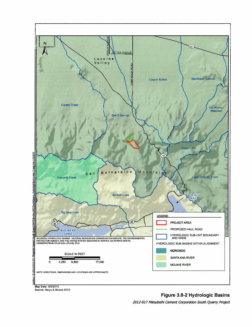
Watershed Hydrology The Project is located within the Morongo sub-basin of the Colorado River Hydrologic Region (Figure 3.8-2). There are six drainage features in the vicinity of the site (Figure 3.8-1). Each drainage feature consists of ephemeral or non-relatively permanent waters. Drainage flow is toward the north-northeast. The drainages are isolated and do not flow into navigable water.

Environmental Impact Report/Environmental Impact Statement Mitsubishi Cement Corporation South Quarry Project DRAFT
3.8-6 December 2016
THIS PAGE INTENTIONALLY LEFT BLANK

Environmental Impact Report/Environmental Impact Statement Mitsubishi Cement Corporation South Quarry Project DRAFT
3.8-8 December 2016
THIS PAGE INTENTIONALLY LEFT BLANK

Environmental Impact Report/Environmental Impact Statement Mitsubishi Cement Corporation South Quarry Project DRAFT
December 2016 3.8-9
The largest drainage feature within the site vicinity is Marble Canyon Creek. Marble Canyon Creek is located topographically lower and to the west and southwest of the South Quarry excavation and haul road. The ordinary high water mark varies from approximately 1 to 20 feet wide. The ordinary high water marks for Drainage A vary from approximately 1 to 5 feet wide. Drainage B has an ordinary high water mark varies from approximately 1 to 3 feet wide. The headwaters for Drainage C starts near the east side of the South Quarry. The ordinary high water mark is approximately 1 foot wide. Drainage D begins near the east side of the Proposed South Quarry. The ordinary high water mark varies from approximately 1 to 3 feet wide. The headwater for Drainage F starts near the east side of the South Pit. The ordinary high water mark varies from approximately 1 to 5 feet wide (Ninyo & Moore 2013a).
Jurisdictional Waters The Clean Water Act regulates traditional navigable waters as well as relatively permanent, non-navigable tributaries to traditional navigable waters and certain associated wetlands. Relatively permanent tributaries are considered tributaries that typically flow year round or have continuous flow at least seasonally (typically three months). The jurisdictional delineation (GLA 2012) covered a 572-acre survey area that included the Project Area and a portion of the Analysis Area. The study identified five unnamed drainages (identified in the report as drainages A-E) and Marble Canyon Creek. Within the 572-acre survey area, the jurisdictional delineation did not identify any traditional navigable waters or relatively permanent tributaries to navigable waters. The jurisdictional delineation identified 2.39 acres of non-relatively permanent waters, none of which consisted of wetlands or riparian vegetation, and are not subject to Corps jurisdiction. Within the Project Area, less than 0.1 acre of CDFW and potential RWQCB jurisdiction is present. While lower portions of the unnamed drainages are not in the Project Area (see GLA 2012), the upper portions of the drainages are in the footprint of the quarry haul road or development.
Flooding and Inundation The Project site and adjacent areas are not located within a FEMA Potential 100-year floodplains area. Based on the Safety Element of the County of San Bernardino General Plan, the Project site and adjacent areas are also not subject to dam inundation or inundation from a lake or river (Ninyo & Moore 2013a).
Groundwater and Wells The Mojave Basin, including the Este Subarea where the Project site is located, has been the subject of adjudication to determine the water rights of the various producers. Final Judgment was entered in 1996 adopting the physical solution set forth in the Judgment. The purpose of the Judgment was to create incentives to conserve local water, guarantee that downstream producers will not be adversely affected by upstream producers, and assess producers to obtain funding for the purchase of imported water. To carry out the Mojave Basin Judgment, the MWA assigned Base Annual Production (BAP) amounts to each producer using 10-acre feet per year or more. MCC has a Free Production Allowance (FPA) of 1,116 acre-feet (Lilburn Corporation 2012).
There are four groundwater wells (Well-1 through Well-4) within the plant area of the Cushenbury Mine. The wells include two active wells (Well-1 and Well-4) and two non-active wells (Well-2 and Well-3). All of the wells are located to the north of the Project site with Well-1 located approximately 3,468 feet north, Well- 2 located approximately 5,156 feet north, Well-3 located approximately 4,218 feet north, and Well-4 located approximately 5,718 feet north.

Environmental Impact Report/Environmental Impact Statement Mitsubishi Cement Corporation South Quarry Project DRAFT
3.8-10 December 2016
There are also four monitoring wells (MW-1 through MW-4) within the plant area. MW-1 is located approximately 4,781 feet north, MW-2 is located approximately 5,437 feet north, MW-3 is located approximately 6,093 feet north, and MW-4 is located approximately 4,593 feet north. The approximate locations of all of the wells are presented on Figure 3.8-1. The water wells are used to supply the existing mine with operational water. Water quality monitoring at the four monitoring wells within the mine has been performed on an irregular basis since 1999. In 2004, regular semi-annual monitoring of the wells began. Groundwater elevation data from monitoring wells MW-1 through MW-4 indicates that the groundwater elevation varies from approximately 4,107 feet msl to 4,141 feet msl. Groundwater level data indicate that over the past several years there has been a relative balance between replenishment and discharge. (Ninyo & Moore 2013a).
Groundwater Quality Based upon Drinking Water Standards (DWS) set by the EPA, some of constituent concentrations exceed the secondary standards for the DWS. Secondary drinking water standards pertain to constituents that can affect the water color, odor, taste and can cause discoloration of teeth and skin. Except in Well-3, water samples obtained from the wells have total dissolved solids (TDS) that vary from approximately 290 to 550 milligrams per liter (mg/l). The secondary standard for TDS is approximately 500 mg/l. In Well-3, TDS concentrations varied from approximately 930 to 970 mg/l. Excessive concentrations of iron, concentrations that exceed approximately 0.3 mg/l, have been obtained in water samples taken from MW-1, MW-2, MW-3, MW-4, Well-1 and Well-2. Manganese concentrations that exceed the secondary drinking water standard of approximately 0.05 mg/l have been recorded in water samples taken from MW-2 and MW-3. Aluminum concentrations in excess of the secondary drinking water standard of 0.2 mg/l have been recorded in water samples taken from MW-2, MW-3 and MW-4.
3.8.4 Environmental Consequences
3.8.4.1 Impact Analysis Approach
CEQA Significance Criteria Appendix G of the State CEQA Guidelines suggest that lead agencies evaluate the potential significance of hydrology and/or water quality impacts of a project by considering ten criteria. Of the ten criteria, only six are applicable to the project. Would the project:
• Violate any water quality standards or waste discharge requirements;
• Substantially deplete groundwater supplies or interfere substantially with groundwater recharge such that there would be a net deficit in aquifer volume or a lowering of the local groundwater table level (e.g., the production rate of pre-existing nearby wells would drop to a level which would not support existing land uses or planned uses for which permits have been granted);
• Substantially alter the existing drainage pattern of the site or area, including through the alteration of the course of a stream or river, in a manner that would result in substantial erosion or siltation on- or off-site;
• Substantially alter the existing drainage pattern of the site or area, including through the alteration of the course of a stream or river, or substantially increase the rate or amount of surface runoff in a manner that would result in flooding on- or off-site;

Environmental Impact Report/Environmental Impact Statement Mitsubishi Cement Corporation South Quarry Project DRAFT
December 2016 3.8-11
• Create or contribute runoff water, which would exceed the capacity of existing or planned stormwater drainage systems or provide substantial additional sources of polluted runoff;
• Otherwise substantially degrade water quality.
The following criteria are not discussed further in this EIR/EIS because they are not applicable to the Project for the reasons summarized after each criterion, and further explained in the Initial Study prepared during Project scoping (Appendix A-2):
• Would the project place housing within a 100-year flood hazard area as mapped on a federal Flood Hazard Boundary or Flood Insurance Rate Map or other flood hazard delineation map? This criterion is not applicable because the site does not occur within a 100-year flood hazard area, does not include the construction of housing, and would not place housing within a flood plain.
• Would the project place structures within a 100-year flood hazard area that would impede or redirect flood flows? This criterion is not applicable because the site is not within a 100-year flood hazard area, does not include the construction of housing, and would not place housing within a flood plain.
• Would the project expose people or structures to a significant risk of loss, injury or death involving flooding, including flooding as a result of the failure of a levee or dam? This criterion is not applicable because the site and surrounding area is located outside of any designated dam inundation area.
• Would the project be subject to inundation by seiche, tsunami, or mudflow? This criterion is not applicable because the site is not located in an area that has the potential for inundation from seiche or tsunami.
NEPA Analysis Approach The NEPA analysis determines whether direct or indirect hydrology or water quality impacts would result from the Proposed Action and provides a comparison of effects by alternative. As defined by the Council on Environmental Quality, significance of an effect is determined by the context and intensity of the resulting change relative to the existing environment (40 CFR 1508.27). As applicable, impacts are discussed in terms of spatial extent, duration and intensity. Water resources effects could include violation of water quality standards, depletion of groundwater supplies, erosion, or flooding.
3.8.4.2 Alternative 1 – Proposed Action
Direct and Indirect Impacts
Water Quality and Waste Discharge The site is at a topographic high and construction of the quarry creates a low area for surface drainage. Water runoff due to rainfall events and snow melt would occur at the site. Offsite runoff from the quarry excavation would not be significant because the Project has been designed to retain runoff within the excavation. Runoff water collected using best management practices (BMPs) would leave by evaporation or infiltration. As required to Design Feature/Mitigation Measure GEN-1, standard erosion control measures commensurate with those

Environmental Impact Report/Environmental Impact Statement Mitsubishi Cement Corporation South Quarry Project DRAFT
3.8-12 December 2016
typically required in an Industrial SWPPP for a limestone surface mining operation would be implemented for all phases of construction and operation. The Project would meet waste discharge requirements as required by Department of Water Resources, California Environmental Protection Agency, NPDES and San Bernardino County. This includes meeting requirements for surface runoff that can enter into the groundwater by infiltration. In addition, the on-going water quality monitoring program that includes testing of groundwater wells and monitoring wells located within and outside of the operations area of the mine would continue. One of the purposes of the on-going monitoring is to ensure proper treatment of runoff. The Project would meet all waste discharge requirements from the MWA and State Water Resources Control Board and would not violate any water quality standards; a less than significant impact would occur (Ninyo & Moore 2013a).
Alternative 1 – Proposed Action would not affect any waters that are subject to the jurisdiction of the U.S. Army Corps of Engineers, and therefore, would not require a Section 404 permit from that agency. However, Alternative 1 – Proposed Action would affect 0.08 acre and 1,231 linear feet of streambed under the jurisdiction of the CDFW, requiring notification to CDFW of proposed modification to the streambed and would likely require a Streambed Alteration Agreement from the CDFW under Fish and Game Code Section 1602. This impact would be less than significant with the implementation of Design Feature GEN-1k.
Groundwater Groundwater level data indicate that, within the Project vicinity, the groundwater levels generally follow the pumping trends. Over the past several years there has been a relative equilibrium with withdrawal and replenishment. In order to carry out the Mojave Basin Judgment, MCC has been assigned a variable FPA of 1,116 acre-feet, which is 85.9 percent of BAP. Any groundwater that MCC pumps over and above the FPA is subject to replacement either by paying the Watermaster to purchase supplemental water from the MWA or by acquiring/ transferring unused production rights within the same area from another party. Historically, MCC has had prior year carryover from unused FPA and has sold FPA to others for replacement water. In 2009/2010, MCC produced 319.1 acre-feet of its 1,116 acre-foot FPA, with a prior year carryover of 1,116 acre-feet, 52 acre-feet sold as replacement water, and a total adjusted FPA of 2,159 acre-feet (Lilburn Corporation 2012). It is anticipated that Alternative 1 – Proposed Action would increase the total demand for groundwater by approximately 105.3 acre-feet/year. This increase in demand for groundwater is not expected to exceed the allotted FPA. Therefore, impacts to groundwater would be less than significant (Ninyo & Moore 2013a).
Drainage Patterns and Water and Wind Erosion The Project’s BMPs include a vegetated earthen berm along the south side of the South Quarry. The vegetated berm would allow up-slope runoff occurring southeast of the Project site to continue the natural flow. Runoff occurring on the southwest side of the Project site would flow naturally into Marble Canyon Creek. Rainfall or snow occurring within the largest area of disturbance, the South Quarry excavation, would be contained within the excavation by design and would leave either by evaporation or infiltrated as groundwater. A vegetated earthen berm would be constructed along the northern edge of the haul road to direct concentrated runoff from the road onto the adjacent descending natural slope. Storm water catch basins would be constructed on the south side of the road. The catch basins would collect the concentrated flow on the roadway and intercept naturally occurring drainage flow. The water would pond in the catch basins and would leave the basins either by evaporation or infiltration. In addition,
Environmental Impact Report/Environmental Impact Statement Mitsubishi Cement Corporation South Quarry Project DRAFT
December 2016 3.8-13
collection ditches, berms, check dams (placement of erosion control materials, sediment fences, or straw bales) and other appropriate measures would be used to reduce the flow and velocity of runoff. Although the soil thickness in the vicinity of the site is relatively thin, gradual siltation would occur in the catch basins over time. Periodic maintenance would be performed to ensure that the size of the basins and the absorption rates are not affected by siltation. During mining operations water trucks would apply water to the haul road and within the quarry excavation to mitigate dust and wind related erosion. With implementation of Design Features/Mitigation Measures GEN-1i through GEN-1k, substantial erosion or siltation on- or off-site is not expected, even though the natural drainage pattern of the site would be changed. Impacts would be less than significant.
Cumulative Impacts With incorporation of Design Feature/Mitigation Measure GEN-1k, Alternative 1 – Proposed Action is not anticipated to create significant effects on hydrology and/or water quality. Alternative 1 – Proposed Action incorporates the use of BMPs that would ensure that erosion, siltation, and flooding impacts remain local to the Project site and less than significant (Ninyo & Moore 2013a). MCC has been assigned a variable FPA of 1,116 acre-feet. Water use is expected to increase 105.3 acre-feet/year with Alternative 1 – Proposed Action. This increase in demand for groundwater is not expected to exceed the allotted FPA. The FPA for each user in the basin is calculated by the Watermaster to avoid cumulative significant impacts to the availability of groundwater in the basin. Alternative 1 – Proposed Action’s contribution to cumulative hydrology and water quality impacts is anticipated to be minor and not considerable.
Mitigation Measures The NEPA design features from Section 2.3.2.14 for hydrology and water quality are listed below for convenience. Design features indicated with an asterisk (*) are also CEQA Mitigation Measures that would avoid, minimize, rectify, reduce, and/or compensate for effects to biological resources anticipated with Alternative 1- Proposed Action.
GEN-1*: MCC shall minimize disturbance or hazards to surrounding vegetation, habitat, and wildlife, such as toxic substances, dust, noise, and lighting, as follows: (Note: GEN-1a through GEN-1h are not applicable to hydrology and water
quality). i*: Standard erosion control measures commensurate with those typically
required in an Industrial Stormwater Pollution Prevention Plan for a limestone surface mining operation shall be implemented for all phases of construction and operation where sediment run-off from exposed slopes may enter native soils or habitat or jurisdictional streambeds;
j*: Disturbed soils and roads within the project site shall be stabilized to reduce erosion potential; and
k*: For drainages that cannot be avoided, MCC shall obtain a Streambed Alteration Agreement in compliance with Section 1602 of the California Fish and Game Code and an application for waste discharge requirements (WDRs) or a waiver of WDRs in compliance with Section 13260 of the California Water Code, as applicable.
Environmental Impact Report/Environmental Impact Statement Mitsubishi Cement Corporation South Quarry Project DRAFT
3.8-14 December 2016
Residual Impacts after Mitigation Residual impacts would be less than significant.
3.8.4.3 Alternative 2 – Partial Implementation
This alternative was developed in response to public comments requesting an alternative with a shorter duration and/or smaller footprint. The footprint of the quarry would be approximately 20 acres smaller and would not be as deep as with Alternative 1 – Proposed Action. Mining in the quarry would last 40 years rather than 120 years. As a result, reclamation and revegetation at the South Quarry site would be completed nearly 80 years sooner and localized impacts related to mining, such as fugitive dust and noise, would also end earlier at this site. With Alternative 2 – Partial Implementation, a higher grade limestone would still be required for blending at the existing Cushenbury cement plant and would be trucked to the plant after Phase 2 is completed, from approximately year 40 through year 120. The effects of trucking in limestone after Phase 2 (years 40 to 120) would occur outside the area of analysis and are expected to have a neutral or less significant effect on the hydrology setting.
Direct and Indirect Impacts Direct and indirect hydrology or water quality impacts of Alternative 2 – Partial Implementation would be similar to the hydrology and water quality impacts that would result from the implementation of Alternative 1 – Proposed Action, but they would occur in a smaller area and in a shorter time-frame. Direct and indirect impacts of Alternative 1 – Proposed Action, discussed in Section 3.8.4.2, would be less than significant. Therefore, the hydrology and water quality impacts of Alternative 2 – Partial Implementation would be less than significant.
Cumulative Impacts The cumulative impacts analysis for this alternative would be similar as those described for Alternative 1, the Proposed Action. However, because Alternative 2, Partial Implementation, has a smaller footprint and shorter duration, the impacts would be even less. Impact would remain less than significant with incorporation of Design Feature GEN-1k (see Section 2.3.2.13).
Mitigation Measures Design Features/Mitigation Measures GEN-1i through GEN-1k from Section 2.3.2.14 listed for Alternative 1 – Proposed Action in Section 3.8.4.2 would avoid, minimize, rectify, reduce, and/or compensate for potential effects to hydrology and water quality anticipated with Alternative 2 – Partial Implementation.
Residual Impacts after Mitigation Impacts would be less than significant.
3.8.4.4 Alternative 3 – No Action/No Project
If the No Action Alternative is implemented and the Cushenbury Cement Plant is not expanded into the South Quarry under this Plan of Operations, there would be no direct or indirect adverse effect to hydrology and water quality.
Direct and Indirect Impacts No impacts would occur.

Environmental Impact Report/Environmental Impact Statement Mitsubishi Cement Corporation South Quarry Project DRAFT
December 2016 3.8-15
Cumulative Impacts No impacts would occur.
Mitigation Measures No impacts would occur therefore mitigation measure would not be required.
Residual Impacts after Mitigation No impacts would occur.

Environmental Impact Report/Environmental Impact Statement Mitsubishi Cement Corporation South Quarry Project DRAFT
3.8-16 December 2016
THIS PAGE INTENTIONALLY LEFT BLANK
Related Documents


