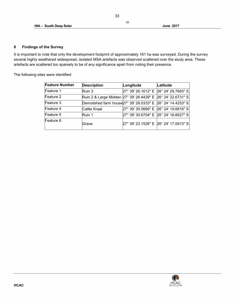
33 33 HIA – South Deep Solar June 2017 HCAC 8 Findings of the Survey It is important to note that only the development footprint of approximately 161 ha was surveyed. During the survey several highly weathered widespread, isolated MSA artefacts was observed scattered over the study area. These artefacts are scattered too sparsely to be of any significance apart from noting their presence. The following sites were identified: Feature Number Description Longitude Latitude Feature 1 Ruin 3 27° 39' 26.1612" E 26° 24' 29.7683" S Feature 2 Ruin 2 & Large Midden 27° 39' 26.4439" E 26° 24' 22.6731" S Feature 3 Demolished farm house 27° 39' 28.0333" E 26° 24' 14.4253" S Feature 4 Cattle Kraal 27° 39' 30.0666" E 26° 24' 19.6816" S Feature 5 Ruin 1 27° 39' 30.6704" E 26° 24' 16.6627" S Feature 6 Grave 27° 39' 23.1526" E 26° 24' 17.0913" S

Welcome message from author
This document is posted to help you gain knowledge. Please leave a comment to let me know what you think about it! Share it to your friends and learn new things together.
Transcript
33
33
HIA – South Deep Solar June 2017
HCAC
8 Findings of the Survey
It is important to note that only the development footprint of approximately 161 ha was surveyed. During the survey
several highly weathered widespread, isolated MSA artefacts was observed scattered over the study area. These
artefacts are scattered too sparsely to be of any significance apart from noting their presence.
The following sites were identified:
Feature Number Description Longitude Latitude
Feature 1 Ruin 3 27° 39' 26.1612" E 26° 24' 29.7683" S
Feature 2 Ruin 2 & Large Midden 27° 39' 26.4439" E 26° 24' 22.6731" S
Feature 3 Demolished farm house 27° 39' 28.0333" E 26° 24' 14.4253" S
Feature 4 Cattle Kraal 27° 39' 30.0666" E 26° 24' 19.6816" S
Feature 5 Ruin 1 27° 39' 30.6704" E 26° 24' 16.6627" S
Feature 6 Grave 27° 39' 23.1526" E 26° 24' 17.0913" S

34
34
HIA – South Deep Solar June 2017
HCAC
8.1 Built Environment (Section 34 of the NHRA)
Feature 1
This feature consists of ephemeral stone wall foundations (Figure 15) that is entirely overgrown (Figure
16). Most of the walling has been removed but it seems as if the feature was rectangular in shape
measuring approximately 8 x 6 meters. No other features or artefacts were noted and the site has been
demolished to the extent that it is of low heritage significance. The site is given a Generally Protected C
(GP.C) field rating. It must however be kept in mind that sites like these might contain unmarked graves.
Figure 15: Ephemeral stone foundations
Figure 16: Feature 1 viewed from the south
35
35
HIA – South Deep Solar June 2017
HCAC
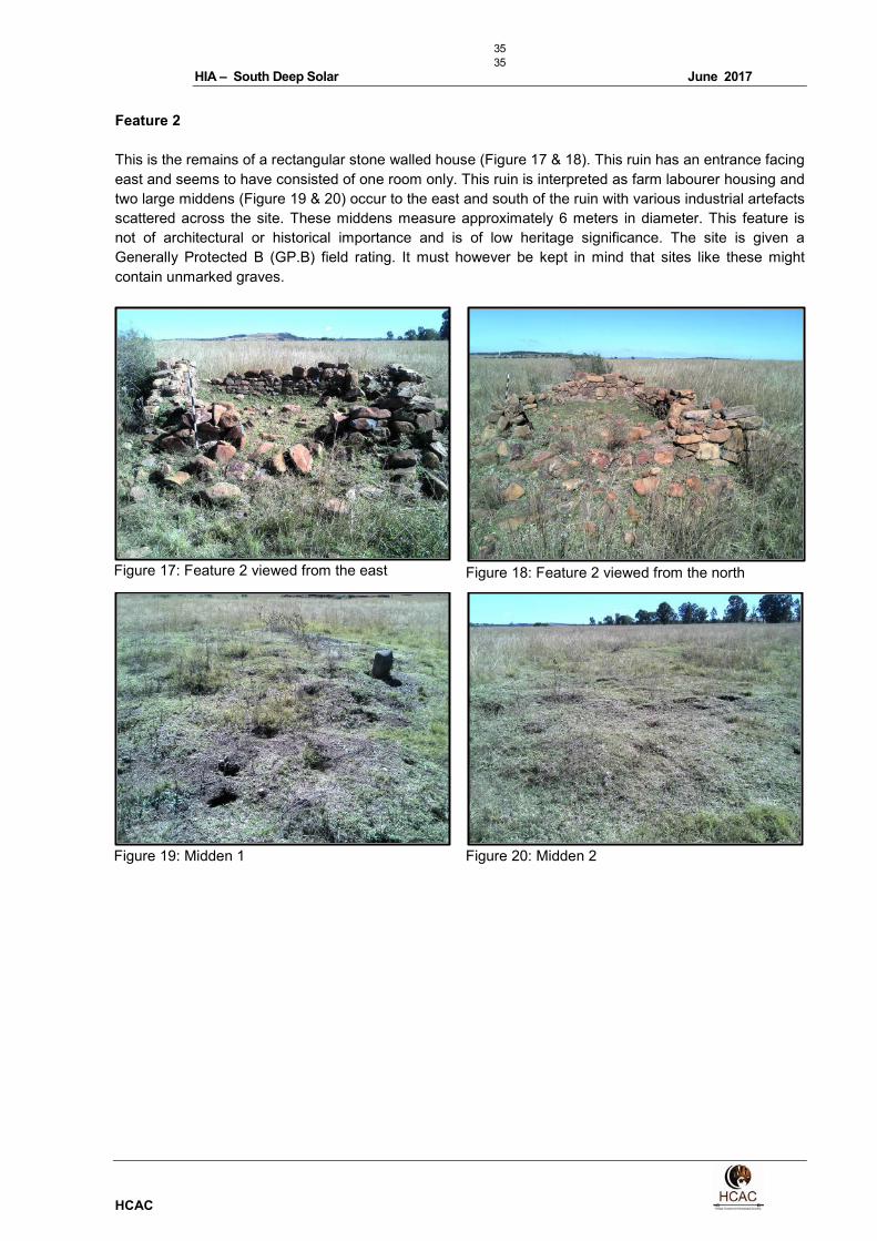
Feature 2
This is the remains of a rectangular stone walled house (Figure 17 & 18). This ruin has an entrance facing
east and seems to have consisted of one room only. This ruin is interpreted as farm labourer housing and
two large middens (Figure 19 & 20) occur to the east and south of the ruin with various industrial artefacts
scattered across the site. These middens measure approximately 6 meters in diameter. This feature is
not of architectural or historical importance and is of low heritage significance. The site is given a
Generally Protected B (GP.B) field rating. It must however be kept in mind that sites like these might
contain unmarked graves.
Figure 17: Feature 2 viewed from the east
Figure 18: Feature 2 viewed from the north
Figure 19: Midden 1
Figure 20: Midden 2

36
36
HIA – South Deep Solar June 2017
HCAC
Feature 3.
This is the location where the old farm house used to be. The structure has been entirely demolished and
is only marked by building rubble. The site is of no heritage significance. The site is given a Generally
Protected C (GP.C) field rating.
Figure 21. General site conditions Feature 3 Figure 22. Building rubble
Feature 4
This is the location of a large cattle kraal constructed from stone (Figure 21). The rectangular kraal
measures approximately 27 X 27 meters and the height of the wall is approximately 1.10 meter. The kraal
has an entrance on the northern side and the western wall has partly collapsed. A water or feeding trough
from cement is located on the inside adjacent to the wall (Figure 22). The site is of low heritage
significance. The site is given a Generally Protected B (GP.B) field rating.
Figure 23: Feature 4 viewed from the west
Figure 24: Water trough within Feature 4
37
37
HIA – South Deep Solar June 2017
HCAC
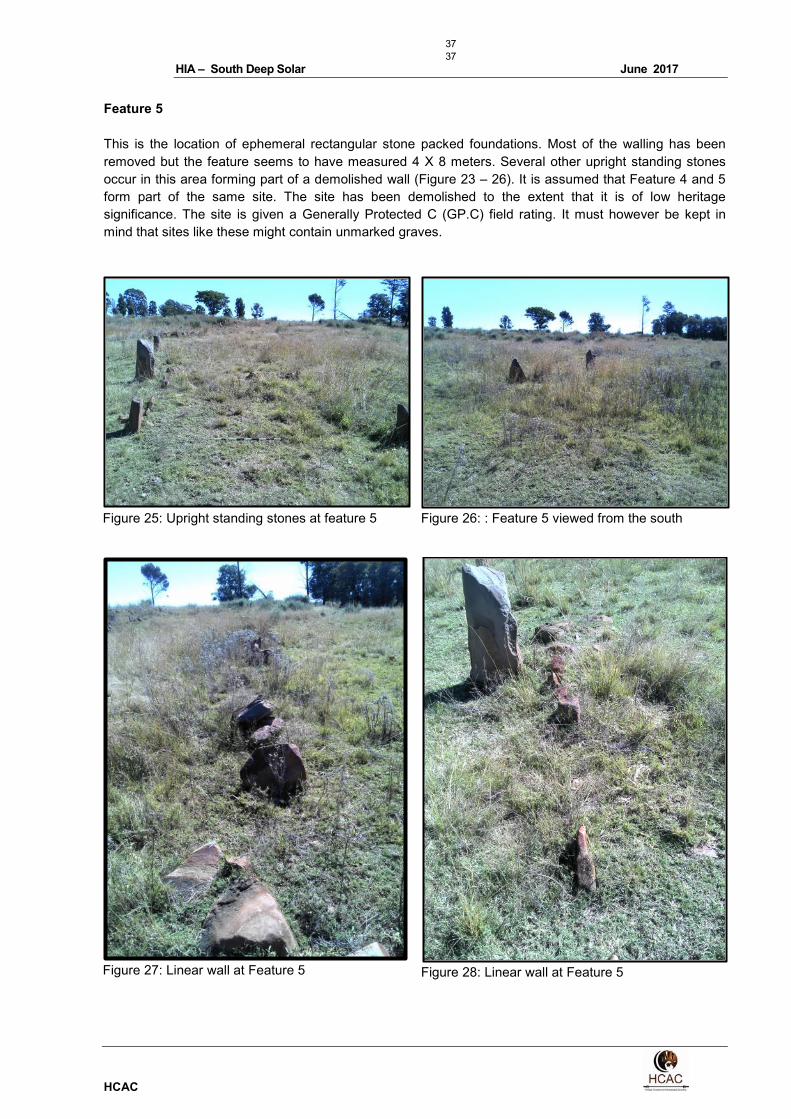
Feature 5
This is the location of ephemeral rectangular stone packed foundations. Most of the walling has been
removed but the feature seems to have measured 4 X 8 meters. Several other upright standing stones
occur in this area forming part of a demolished wall (Figure 23 – 26). It is assumed that Feature 4 and 5
form part of the same site. The site has been demolished to the extent that it is of low heritage
significance. The site is given a Generally Protected C (GP.C) field rating. It must however be kept in
mind that sites like these might contain unmarked graves.
Figure 25: Upright standing stones at feature 5
Figure 26: : Feature 5 viewed from the south
Figure 27: Linear wall at Feature 5
Figure 28: Linear wall at Feature 5
38
38
HIA – South Deep Solar June 2017
HCAC
8.2 Archaeological and palaeontological resources (Section 35 of the NHRA)
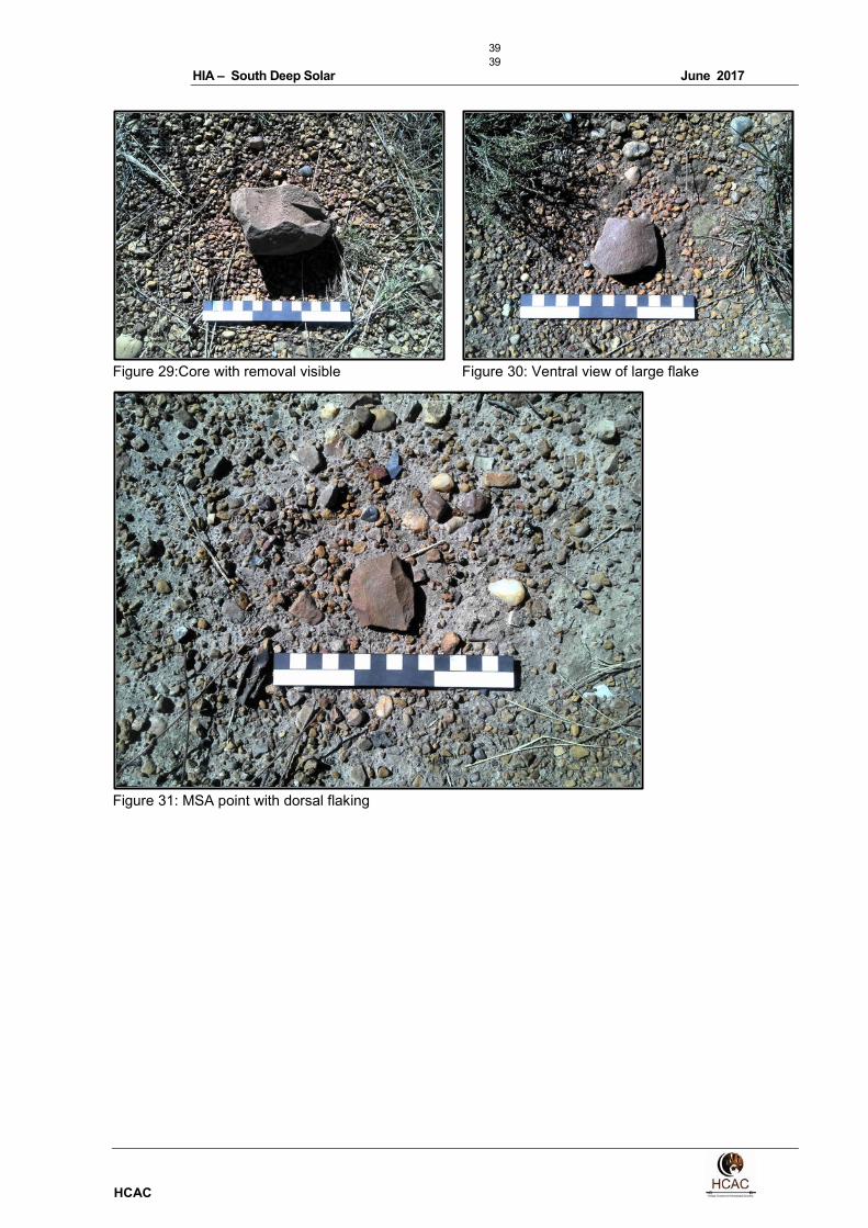
No archaeological sites of significance were recorded during the survey. However widely dispersed
isolated lithics was recorded. These are made entirely from quartzite and consist of cores and flakes with
faceted platforms characteristic of the Middle Stone Age. These artefacts are not in-situ and are scattered
too sparsely to be of any significance apart from noting their presence which have been done in this
report.
The proposed study area is underlain by potentially fossil-bearing, Transvaal Supergroup sedimentary
strata (stromatolites) of the early Proterozoic Timeball Hill Formation (Pretoria Group), that are capped by
superficial (Quaternary) deposits of low to very low palaeontological sensitivity, the latter being that the
impact area is not situated within or near pan, well-developed alluvial or spring deposits. Impact by
development on igneous rock mapped near the north-eastern boundary of the site will not affect
palaeontological potential remains (Rossouw 2017).
39
39
HIA – South Deep Solar June 2017
HCAC
Figure 29:Core with removal visible
Figure 30: Ventral view of large flake
Figure 31: MSA point with dorsal flaking

40
40
HIA – South Deep Solar June 2017
HCAC
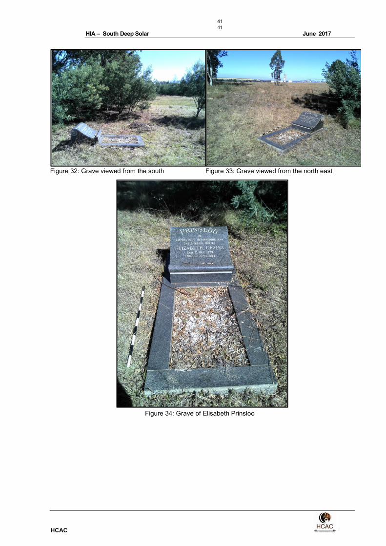
8.3 Burial Grounds and Graves (Section 36 of the NHRA)
Feature 3
In terms of Section 36 of the Act a single grave was recorded. The grave is that of Elisabeth Gezina
Prinsloo, born on the 12th of October 1879 and who passed away on the 30
th June 1985. The site is of
high social significance and given a field rating of Generally Protected A (GP.A). If any graves are located
in future they should ideally be preserved in-situ or alternatively relocated according to existing legislation.
41
41
HIA – South Deep Solar June 2017
HCAC
Figure 32: Grave viewed from the south
Figure 33: Grave viewed from the north east
Figure 34: Grave of Elisabeth Prinsloo
42
42
HIA – South Deep Solar June 2017
HCAC
8.4 Cultural Landscapes, Intangible and Living Heritage.
Long term impact on the cultural landscape is considered to be negligible as the surrounding area
consists of an intensely mined area that has already impacted on the cultural landscape of the area that
used to consist of a rural/farming landscape. These mining activities also reduces the visual impacts to
scenic routes and sense of place.
8.5 Battlefields and Concentration Camps
An Anglo Boer War battle known as the Battle of Doornkop took place in the greater area on 29 May
1900. The British were advancing toward Johannesburg led by General John French. De La Rey and his
men held the Klipriviersberg Ridge for the first two days but on the third day the Boers were outflanked by
French’s cavalry to the West, where General Sarel Oosthuizen’s commando was forced to withdraw. This
opened the road to Johannesburg and the British took the city peacefully on 30 May 1900.
8.6 Potential Impact
All of the recorded sites will be directly impacted on by the proposed project (Figure 35). In the case of
this development, with the recommended mitigation measures and management actions impacts on
heritage resources can be mitigated to an acceptable level. However, this and other projects in the area
could have an indirect impact on the heritage landscape. The lack of significant heritage resources and
the extensive mining activities in the immediate area minimises additional impact on the landscape.
8.6.1 Potential Damage to identified heritage features
8.6.1.1 Project attribute / activity
The pre-construction phase will involve the removal of topsoil and vegetation as well as the establishment
of infrastructure needed for the construction phase. These activities can have a negative and irreversible
impact on heritage sites. Impacts include destruction or partial destruction of non-renewable heritage
resources.
During the construction phase activities resulting in disturbance of surfaces and/or sub-surfaces may
destroy, damage, alter, or remove from its original position archaeological and paleontological material or
objects.
8.6.1.2 Embedded controls
A chance find procedure will be implemented for the project.
8.6.1.3 Pre-mitigation impact significance
The loss of cultural heritage structures due to the construction of the solar PV facility will result in a
Negligible impact (Table 7).

43
43
HIA – South Deep Solar June 2017
HCAC
Table 6 Pre-mitigation impact significance rating for loss of cultural heritage structures due to the construction of the solar PV facility
Type of Impact
Direct Negative Impact
Rating of Impacts
Characteristic Designation Summary of Reasoning
Extent Local This impact is considered local in extent.
Duration Permanent Any impact on non-renewable heritage resources is always permanent
and non-reversible.
Scale 130 ha The impact on heritage resources is restricted to the development
footprint of the project where heritage resources occur. This measures
less than 10 ha.
Frequency Permanent Any impact on non-renewable heritage resources is always permanent
and non-reversible.
Likelihood Definite Based on the current lay out all of the sites recorded will be destroyed.
Magnitude
Small
Sensitivity/Vulnerability/Importance of the Resource/Receptor
Low
The heritage resources are all of a low sensitivity with either a GP.B or GP.C field rating.
Significance Rating Before Mitigation
Negligible
Mitigation measures
• Implementation of a chance find procedure
• Mapping of Features 1 -6 as part of the cultural landscape.
• A destruction permit should be applied for prior to destruction of the structures according to the
relevant legislation.
• It is advised that, as part of a follow-up Phase 1 Palaeontological Impact Assessment, a
professional palaeontologist should monitor fresh exposures should large scale excavations into
unweathered sedimentary bedrock be conducted during the construction phase of the
development.
Table 7: Site specific mitigation measures
Feature Number Description Mitigation
Feature 1 Ruin 3: Rectangular stone
foundations
• Mapping of site
• Monitoring during construction for unmarked
graves
Feature 2
Ruin 2 & Large Midden
• Mapping of site
• Monitoring during construction for unmarked
graves
Feature 3 Demolished farm house No further action needed
Feature 4 Cattle Kraal Mapping of site
Feature 5 Ruin 1: Rectangular stone
foundations
• Mapping of site
• Monitoring during construction for unmarked
graves
Residual impact significance
The residual impact will remain Negligible; therefore, no further assessments are required.
44
44
HIA – South Deep Solar June 2017
HCAC
8.6.2 Damage or destruction of a grave site due to the construction of the solar PV facility
Sensitive receptors
The sensitive receptor is that of the grave of Elisabeth Gezina Prinsloo (12 October 1879 - 30 June
1985). The site is of high social significance and given a field rating of Generally Protected A (GP.A). If
any graves are located in future they should ideally be preserved in-situ or alternatively relocated
according to existing legislation.
8.6.2.1 Project attribute / activity
The pre-construction phase will involve the removal of topsoil and vegetation as well as the establishment
of infrastructure needed for the construction phase. These activities will damage or destroy the grave of
Elisabeth Gezina Prinsloo.
8.6.2.2 Embedded controls
The project will undertake a grave relocating in accordance with legislated procedures.
8.6.2.3 Pre-mitigation impact significance
The loss of cultural heritage structures due to the construction of the solar PV facility will result in a
Moderate impact (Table 8).
Table 8 Pre-mitigation impact significance rating for the damage or destruction of a gravesite due to the construction of the solar PV facility
Type of Impact
Direct Negative Impact
Rating of Impacts
Characteristic Designation Summary of Reasoning
Extent Local This impact is considered local in extent.
Duration Permanent Any impact on non-renewable heritage resources is always permanent
and non-reversible.
Scale 100m2 The impact on heritage resources is restricted to the site where the grave
occurs.
Frequency Permanent Any impact on non-renewable heritage resources is always permanent
and non-reversible.
Likelihood Likely Based on the current layout it is likely that the grave will be impacted
upon
Magnitude
Small
Sensitivity/Vulnerability/Importance of the Resource/Receptor
High
The site is of high social significance and given a field rating of Generally Protected A (GP.A).
Significance Rating Before Mitigation
Moderate
Mitigation measures
• Preservation of grave in situ with 20-meter buffer zone and access gate
• If this is not possible relocation adhering to all legal requirements
45
45
HIA – South Deep Solar June 2017
HCAC
Residual impact significance
The residual impact significance will remain Moderate; therefore, no further assessments are required.

46
46
HIA – South Deep Solar June 2017
HCAC
8.6.3 ESMP
8.6.3.1 Cultural Heritage Management Plan
Management plan for loss of cultural heritage resources due to construction of the solar PV
facility
Potential Impact Loss of cultural heritage resources due to construction
of the solar PV facility
Project Commitment Implementation of a chance find procedure
Respectful and lawful handling of cultural heritage
resources.
Key Responsibilities Implementation of chance find procedure
• Site Manager
• ECO
• All construction staff
Implementation of Mitigation Measures
• ECO
• Heritage Resources Professional
Performance Criteria Respectful and lawful handling of cultural heritage resources
performance assessed through the achievement of the
following goals:
• Zero grievances logged in the grievance mechanism
related to the disturbance or destruction of cultural
resources;
• Zero incidence of non-compliance in terms of the
National Heritage Resources Act, 1999 (Act No.25 of
1999)
Mitigation Measures A Chance find procedure will be implemented for the
project.
Sites should be mapped prior to permit application.
It is advised that, as part of a follow-up Phase 1
Palaeontological Impact Assessment, a professional
palaeontologist should monitor fresh exposures should large
scale excavations into unweathered sedimentary bedrock
be conducted during the construction phase of the
development.
In order to proceed with the construction of the solar PV
facility the relevant permits should be obtained through
SAHRA for the destruction of the heritage resources.
Monitoring Monitoring
• On-going visual assessment of compliance by ECO
• Monitoring and management of destruction by suitably
qualified and registered heritage resources professional.
• Paleontological monitoring of fresh exposures should
large scale excavations into unweathered sedimentary
bedrock be conducted during the construction phase of
the development
.
Reporting & Corrective • Records of all monitoring activities will be kept by the
47
47
HIA – South Deep Solar June 2017
HCAC
Potential Impact Loss of cultural heritage resources due to construction
of the solar PV facility
Action ECO and a summary of the results reported to the
project management bi-annually.
• Corrective actions must be implemented to address
audit findings.
• On site monitoring and management of the process by a
heritage resources professional;
• Relevant reports will be submitted by the heritage
resources professional to the South African Heritage
Resources Agency (SAHRA)
Budget Considerations Monitoring
• Monitoring will be undertaken by the ECO
• Monitoring by heritage resources professional:
R50 000.00

48
48
HIA – South Deep Solar June 2017
HCAC
Management plan for damage or destruction of a grave site due to the construction of the solar
PV facility
Potential Impact Damage or destruction of a grave site due to the
construction of the solar PV facility
Project Commitment Respectful and lawful relocation of the grave.
Key Responsibilities Implementation of chance find procedure
• Site Manager
• ECO
• All construction staff
Implementation of Mitigation Measures
• ECO
• Heritage Resources Professional
Performance Criteria Respectful and lawful relocation of the grave performance
assessed through the achievement of the following goals:
• Zero grievances logged in the grievance mechanism
related to the disturbance or destruction of cultural
resources;
• Zero incidence of non-compliance in terms of the
National Heritage Resources Act, 1999 (Act No.25 of
1999)
Mitigation Measures In order to proceed with the construction of the solar PV
facility the relevant permits should be obtained through
SAHRA for the relocation of the grave.
Monitoring Monitoring
• On-going visual assessment of compliance by ECO
• Monitoring and management of grave relocation by
suitably qualified and registered heritage resources
professional.
Reporting & Corrective
Action
• Records of all monitoring activities will be kept by the
ECO and a summary of the results reported to the
project management bi-annually.
• Corrective actions must be implemented to address
audit findings.
• On site monitoring and management of the process by a
heritage resources professional;
• Relevant reports will be submitted by the heritage
resources professional to the South African Heritage
Resources Agency (SAHRA)
Budget Considerations Monitoring
• Monitoring will be undertaken by the ECO
• Monitoring by heritage resources professional:
R50 000.00

49
49
HIA – South Deep Solar June 2017
HCAC

50
50
HIA – South Deep Solar June 2017
HCAC
Figure 35. Location of recorded sites within the development footprint

51
51
HIA – South Deep Solar June 2017
HCAC
9 Recommendations and conclusion
No archaeological sites were recorded during the survey although isolated individual Middle Stone Age
lithics were noted. These artefacts are not in-situ and are scattered too sparsely to be of any significance
apart from noting their presence which has been done in this report. No further mitigation prior to
construction is recommended in terms of the archaeological component of Section 35 for the proposed
development to proceed.
An independent paleontological study was conducted by Rossouw (2017). Rossouw concluded: “The
proposed study area is underlain by potentially fossil-bearing, Transvaal Supergroup sedimentary strata
(stromatolites) of the early Proterozoic Timeball Hill Formation (Pretoria Group), that are capped by
superficial (Quaternary) deposits of low to very low palaeontological sensitivity, the latter being that the
impact area is not situated within or near pan, well-developed alluvial or spring deposits. Impact by
development on igneous rock mapped near the north-eastern boundary of the site will not affect
palaeontological potential remains. As far as palaeontological heritage is concerned, removal of
superficial overburden and excavation within the development footprint > 1 m² and exceeding depths of
>1 m into unweathered/fresh bedrock will need monitoring by a professional palaeontologist. It is
therefore advised that, as part of a follow-up Phase 1 Palaeontological Impact Assessment, a
professional palaeontologist should monitor fresh exposures should large scale excavations into
unweathered sedimentary bedrock be conducted during the construction phase of the development.”
(Rossouw 2017).
In terms of the built environment of the area (Section 34), 4 ruins and a kraal was recorded. Based on
historical maps from 1943 & 1957 it can be deducted that all of these features are older than 60 years
and would then be protected under the Act. The features are in very poor condition and some are totally
demolished and are of low heritage significance. Direct impacts to these features would be of low
significance. It must however be noted that sites like these might contain unmarked graves and will
require the implementation of a change find procedure during the construction phase. These features
should also be mapped as part the cultural landscape and to cross reference any finds that might be
exposed during construction activities. A destruction permit should be applied for prior to destruction of
the structures.
In terms of Section 36 of the Act a single grave site was recorded and should ideally be demarcated with
a 20-meter buffer zone and an access gate for family members. Based on the current layout this is not
possible and if the grave has to be relocated this should be done adhering to all legal requirements. If any
graves are located in future they should ideally be preserved in-situ or alternatively relocated according to
existing legislation. No public monuments are located within or close to the study area. The study area is
surrounded by mining developments and the proposed development will not impact negatively on
significant cultural landscapes or viewscapes. During the public participation process conducted for the
project no heritage concerns were raised.
With the correct mitigation measures and management actions in place the impact of the proposed
project on heritage resources can be managed to an acceptable level and it is recommended that the
proposed project can commence on the condition that the following recommendations and the site-
specific recommendation (Table 2 and 9) are implemented as part of the EMPr and based on approval
from SAHRA:
• Implementation of a chance find procedure
• It is advised that, as part of a follow-up Phase 1 Palaeontological Impact Assessment, a
professional palaeontologist should monitor fresh exposures should large scale excavations into
52
52
HIA – South Deep Solar June 2017
HCAC
unweathered sedimentary bedrock be conducted during the construction phase of the
development.
• Mapping of Features 1 -6 as part of the cultural landscape.
• A destruction permit should be applied for prior to destruction of the historical structures adhering
to all legal requirements.
• The grave should be relocated adhering to all legal requirements including permits from the
relevant departments for the relocation.
53
53
HIA – South Deep Solar June 2017
HCAC
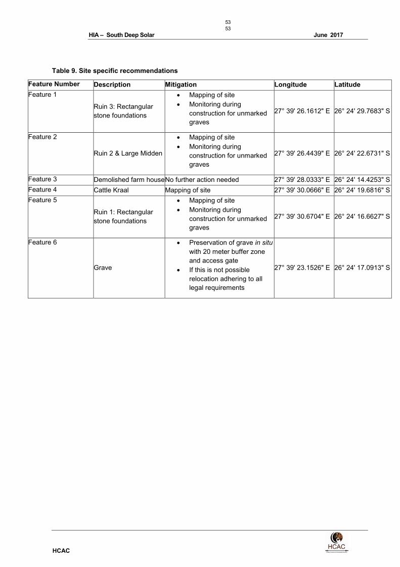
Table 9. Site specific recommendations
Feature Number Description Mitigation Longitude Latitude
Feature 1
Ruin 3: Rectangular
stone foundations
• Mapping of site
• Monitoring during
construction for unmarked
graves
27° 39' 26.1612" E 26° 24' 29.7683" S
Feature 2
Ruin 2 & Large Midden
• Mapping of site
• Monitoring during
construction for unmarked
graves
27° 39' 26.4439" E 26° 24' 22.6731" S
Feature 3 Demolished farm house No further action needed 27° 39' 28.0333" E 26° 24' 14.4253" S
Feature 4 Cattle Kraal Mapping of site 27° 39' 30.0666" E 26° 24' 19.6816" S
Feature 5
Ruin 1: Rectangular
stone foundations
• Mapping of site
• Monitoring during
construction for unmarked
graves
27° 39' 30.6704" E 26° 24' 16.6627" S
Feature 6
Grave
• Preservation of grave in situ
with 20 meter buffer zone
and access gate
• If this is not possible
relocation adhering to all
legal requirements
27° 39' 23.1526" E 26° 24' 17.0913" S

54
54
HIA – South Deep Solar June 2017
HCAC
9.1 Chance Find Procedures
The possibility of the occurrence of subsurface finds cannot be excluded. Therefore, if during construction
any possible finds such as stone tool scatters, artefacts or bone and fossil remains are made, the
operations must be stopped and a qualified archaeologist must be contacted for an assessment of the
find and therefor chance find procedures should be put in place as part of the EMP. A short summary of
chance find procedures is discussed below.
This procedure applies to the developer’s permanent employees, its subsidiaries, contractors and
subcontractors, and service providers. The aim of this procedure is to establish monitoring and reporting
procedures to ensure compliance with this policy and its associated procedures. Construction crews must
be properly inducted to ensure they are fully aware of the procedures regarding chance finds as
discussed below.
• If during the pre-construction phase, construction, operations or closure phases of this project,
any person employed by the developer, one of its subsidiaries, contractors and subcontractors, or
service provider, finds any artefact of cultural significance or heritage site, this person must cease
work at the site of the find and report this find to their immediate supervisor, and through their
supervisor to the senior on-site manager.
• It is the responsibility of the senior on-site Manager to make an initial assessment of the extent of
the find, and confirm the extent of the work stoppage in that area.
• The senior on-site Manager will inform the ECO of the chance find and its immediate impact on
operations. The ECO will then contact a professional archaeologist for an assessment of the finds
who will notify the SAHRA.

55
55
HIA – South Deep Solar June 2017
HCAC
10 References
Primary Sources:
Du Piesanie, J et al. 2016. Environmental Impact Assessment for Sibanye Gold Limited's West Rand
Tailings Retreatment Project Heritage Impact Assessment. Unpublished report
Geskiedenisatlas van Suid-Afrika. Die vier noordelike provinsies. Edited by J. S. Bergh. 1999. Pretoria: J.
L. van Schaik Uitgewers.
Huffman, T.N. 2007. Handbook to the Iron Age: The Archaeology of Pre-Colonial Farming Societies in
Southern Africa. University of KwaZulu-Natal Press, Scotsville.
NHRA Act 25 of 1999
Rasmussen, R.K. 1978 Migrant kingdom: Mzilikaqzi’s Ndebele in South Africa. London: Rex Collings
Ross, R. 2002. A concise history of South Africa. Cambridge: Cambridge University Press.
Rossouw, L. 2017. Palaeontological Desktop Assessment of a 197 ha Solar Photovoltaic Facility located
on a Portion of the farm Doornpoort 347, at the South Deep Gold Mine, Westonaria, Gauteng Province.
Unpublished report for HCAC.
SAHRA Report Mapping Project Version 1.0, 2009
South African Heritage Information System (SAHRIS)
Huffman, T. et al . 1994. Archaeological survey of the East and West Driefontein Mines. Unpublished
report.
Schoeman, M.H. and Barry, L.2004. Archaeological Reconnaissance for The Proposed New South
Deep Tailings Dam. Unpublished report.
Electronic Sources:
Google Earth. 2016. [Online]. [Cited 2017].
http://www.westonaria.gov.za
www.goldfields.co.za
56
56
HIA – South Deep Solar June 2017
HCAC
11 Appendices:
Curriculum Vitae of Specialist
Jaco van der Walt
Archaeologist
+27 82 373 8491
+27 86 691 6461
Education:
Particulars of degrees/diplomas and/or other qualifications:
Name of University or Institution: University of Pretoria
Degree obtained : BA Heritage Tourism & Archaeology
Year of graduation : 2001
Name of University or Institution: University of the Witwatersrand
Degree obtained : BA Hons Archaeology
Year of graduation : 2002
Name of University or Institution : University of the Witwatersrand
Degree Obtained : MA (Archaeology)
Year of Graduation : 2012
Name of University or Institution : University of Johannesburg
Degree : PhD
Year : Currently Enrolled
EMPLOYMENT HISTORY:
2011 – Present: Owner – HCAC (Heritage Contracts and Archaeological Consulting CC).
2007 – 2010 : CRM Archaeologist, Managed the Heritage Contracts Unit at the
University of the Witwatersrand.
2005 - 2007: CRM Archaeologist, Director of Matakoma Heritage Consultants
2004: Technical Assistant, Department of Anatomy University of Pretoria
2003: Archaeologist, Mapungubwe World Heritage Site
2001 - 2002: CRM Archaeologists, For R & R Cultural Resource Consultants,
Polokwane
2000: Museum Assistant, Fort Klapperkop.

57
57
HIA – South Deep Solar June 2017
HCAC
Countries of work experience include:
Republic of South Africa, Botswana, Zimbabwe, Mozambique, Tanzania, The Democratic Republic of the
Congo, Lesotho and Zambia.
SELECTED PROJECTS INCLUDE:
Archaeological Impact Assessments (Phase 1)
Heritage Impact Assessment Proposed Discharge Of Treated Mine Water Via The Wonderfontein Spruit
Receiving Water Body Specialist as part of team conducting an Archaeological Assessment for the
Mmamabula mining project and power supply, Botswana
Archaeological Impact Assessment Mmamethlake Landfill
Archaeological Impact Assessment Libangeni Landfill
Linear Developments
Archaeological Impact Assessment Link Northern Waterline Project At The Suikerbosrand Nature Reserve
Archaeological Impact Assessment Medupi – Spitskop Power Line,
Archaeological Impact Assessment Nelspruit Road Development
Renewable Energy developments
Archaeological Impact Assessment Karoshoek Solar Project
Grave Relocation Projects
Relocation of graves and site monitoring at Chloorkop as well as permit application and liaison with local
authorities and social processes with local stakeholders, Gauteng Province.
Relocation of the grave of Rifle Man Maritz as well as permit application and liaison with local authorities and
social processes with local stakeholders, Ndumo, Kwa Zulu Natal.
Relocation of the Magolwane graves for the office of the premier, Kwa Zulu Natal
Relocation of the OSuthu Royal Graves office of the premier, Kwa Zulu Natal
Phase 2 Mitigation Projects
Field Director for the Archaeological Mitigation For Booysendal Platinum Mine, Steelpoort, Limpopo Province.
Principle investigator Prof. T. Huffman
Monitoring of heritage sites affected by the ARUP Transnet Multipurpose Pipeline under directorship of Gavin
Anderson.
Field Director for the Phase 2 mapping of a late Iron Age site located on the farm Kameelbult, Zeerust, North
West Province. Under directorship of Prof T. Huffman.
Field Director for the Phase 2 surface sampling of Stone Age sites effected by the Medupi – Spitskop Power
Line, Limpopo Province
Heritage management projects
Platreef Mitigation project – mitigation of heritage sites and compilation of conservation management plan.
58
58
HIA – South Deep Solar June 2017
HCAC
MEMBERSHIP OF PROFESSIONAL ASSOCIATIONS:
o Association of Southern African Professional Archaeologists. Member number 159
Accreditation:
o Field Director Iron Age Archaeology
o Field Supervisor Colonial Period Archaeology, Stone Age
Archaeology and Grave Relocation
o Accredited CRM Archaeologist with SAHRA
o Accredited CRM Archaeologist with AMAFA
o Co-opted council member for the CRM Section of the Association of Southern African Association
Professional Archaeologists (2011 – 2012)
PUBLICATIONS AND PRESENTATIONS
• A Culture Historical Interpretation, Aimed at Site Visitors, of the Exposed Eastern Profile of K8 on
the Southern terrace at Mapungubwe.
J van der Walt, A Meyer, WC Nienaber
Poster presented at Faculty day, Faculty of Medicine University of Pretoria 2003
• ‘n Reddingsondersoek na Anglo-Boereoorlog-ammunisie, gevind by Ifafi, Noordwes-Provinsie.
South-African Journal for Cultural History 16(1) June 2002, with A. van Vollenhoven as co-writer.
• Fieldwork Report: Mapungubwe Stabilization Project.
WC Nienaber, M Hutten, S Gaigher, J van der Walt
Paper read at the Southern African Association of Archaeologists Biennial
Conference 2004
• A War Uncovered: Human Remains from Thabantšho Hill (South Africa), 10 May 1864.
M. Steyn, WS Boshoff, WC Nienaber, J van der Walt
Paper read at the 12th Congress of the Pan-African Archaeological Association
for Prehistory and Related Studies 2005
• Field Report on the mitigation measures conducted on the farm Bokfontein, Brits, North West
Province .
J van der Walt, P Birkholtz, W. Fourie
Paper read at the Southern African Association of Archaeologists Biennial
Conference 2007
• Field report on the mitigation measures employed at Early Farmer sites threatened by
development in the Greater Sekhukhune area, Limpopo Province. J van der Walt
Paper read at the Southern African Association of Archaeologists Biennial
Conference 2008
• Ceramic analysis of an Early Iron Age Site with vitrified dung, Limpopo Province South Africa.
J van der Walt. Poster presented at SAFA, Frankfurt Germany 2008
59
59
HIA – South Deep Solar June 2017
HCAC
• Bantu Speaker Rock Engravings in the Schoemanskloof Valley, Lydenburg District, Mpumalanga
(In Prep)
J van der Walt and J.P Celliers
• Sterkspruit: Micro-layout of late Iron Age stone walling, Lydenburg, Mpumalanga. W. Fourie and J
van der Walt. A Poster presented at the Southern African Association of Archaeologists Biennial
Conference 2011
• Detailed mapping of LIA stone-walled settlements’ in Lydenburg, Mpumalanga. J van der Walt
and J.P Celliers
Paper read at the Southern African Association of Archaeologists Biennial
Conference 2011
• Bantu-Speaker Rock engravings in the Schoemanskloof Valley, Lydenburg District, Mpumalanga.
J.P Celliers and J van der Walt
Paper read at the Southern African Association of Archaeologists Biennial
Conference 2011
• Pleistocene hominin land use on the western trans-Vaal Highveld ecoregion, South Africa, Jaco
van der Walt.
J van der Walt. Poster presented at SAFA, Toulouse, France.
Biennial Conference 2016
REFERENCES:
1. Prof Marlize Lombard Senior Lecturer, University of Johannesburg, South Africa
E-mail: [email protected]
2. Prof TN Huffman Department of Archaeology Tel: (011) 717 6040
University of the Witwatersrand
3. Alex Schoeman University of the Witwatersrand
E-mail:[email protected]
Related Documents