Lund, Sweden, January 8–10 2014 Hosted by the Geological Society of Sweden 31st Nordic Geological Winter Meeting. Lund, Sweden. January 8-10, 2014 Main sponsors

Welcome message from author
This document is posted to help you gain knowledge. Please leave a comment to let me know what you think about it! Share it to your friends and learn new things together.
Transcript
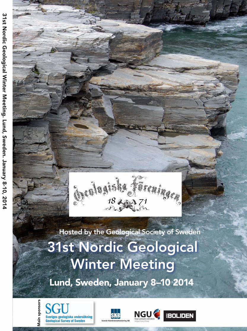
Lund, Sweden, January 8–10 2014
Hosted by the Geological Society of Sweden
Abiskojokk canyon, Abisko SwedenPhoto: Mark Johnson, 2012
31st No
rdic G
eolo
gical W
inter Meeting
. Lund, Sw
eden. January 8-10, 2014
Mai
n sp
ons
ors
Sponsors
Table of Contents
Welcome ______________________________________________________ 2
Organizing committee __________________________________________ 3
Scientific program committee ___________________________________ 3
Program Overview _____________________________________________ 4
Social Program ________________________________________________ 5
Scientific Program______________________________________________ 6
- Oral presentations __________________________________________ 7
- Posters ___________________________________________________ 22
Abstracts1 ________________________________________________ 34
- Plenary talks ________________________________________________ 35
- HYD-ENV Hydrogeology/Environmental Geology _______________ 37
- ENG-GEO Engineering Geology ______________________________ 46
- ECON-OIL Economic and Petroleum Geology __________________ 50
- LUNDPAL Lundadagarna i Historisk Geologi och Paleontologi ____________________________________________ 64
- PET Petrology ______________________________________________ 77
- STR-TEC Structural Geology/Tectonics ________________________ 104
- MOR-GLA Geomorphology and Glacial Geology ______________ 126
- QUAT Quaternary Geology _________________________________ 148
- GEOBIO Geobiology and Astrobiology _______________________ 156
- GEOP Geophysics and Volcanoes ____________________________ 159
- OUT-ED Outreach and Education: Reaching out with WOW to the Many! ________________________________________ 167
Author Index ________________________________________________ 171
1 The abstract texts that follow are arranged first by theme, and then alphabetically by first author. For example, all abstracts in the various PET Petrology sessions are found within the PET section of the abstract volume, and alphabetically by author therein. This is to ease searching for abstracts while sitting within a given theme session.
Welcome to Sweden! Welcome to Lund!
It is with great excitement and pleasure that we welcome you to Skåne in southern Sweden for the 31st Nordic Geological Winter Meeting! The Geologiska Föreningen is very proud to be able to organize this meeting, which has become a strong tradition in our Nordic countries and, judging by the content of this year’s presentations, continues to provide an important and highly valued venue for presenting research, making connections, and meeting old and new friends.
We hope that we all have a fulfilling three days of high-level scientific discussions, The oral talks, held in 6 rooms in parallel sessions, run the entire gamut of the field of geology, although with a very special Scandinavian stamp. We also are glad to welcome into the ‘midst’ of this conference, Lundadagarna, an annual conference held at Lund University specializing in paleontology, historical geology, sedimentology and stratigraphy: this year Lundadagarna is given as part of the NGWM.
Sweden’s Geologiska Föreningen and its scientific journal GFF has traditionally focused the many fields of geology into three main areas, and these three are represented in our plenary talks this year. Ólafur Ingólfsson will represent Quaternary and glacial geology with a presentation on Icelan-dic surging glaciers on Wednesday. Uwe Ring, reflecting the area of crystalline bedrock, will present on Thursday on mantle and crustal links. And on Friday, Mary Higby Schweitzer will represent pa-leontology and historical geology with a presentation on her research in preserved dinosaur tissue.
We are also excited to be able to give out for the second time, the Nordic Geoscientist Award. Håkon Fossen, structural geologist from Bergen, Norway won the very first award that was given out in Reykjavik at the 30th NGWM in 2012. This year’s winner will be announced at the banquet on Thursday evening. The winner will give a plenary talk at 13:00 on Friday.
The organization of a meeting like this requires more than a year of preparation, a task that many people are involved in. We would like to thank the Scientific Programme Committee (SPC) for put-ting together an ambitious program, the conveners for promoting exciting sessions, the plenary lecturers for their contribution, and not least the many sponsors who have made this event possible. We also want to thank Qi Media, Jönköping, and Gert Pettersson, Lund, for building and maintai-ning the 31st NGWM web site, and Creative Support, Göteborg, for producing this abstract volume. We hope that the 31st Nordic Geological Winter Meeting will be fruitful and lead to better and deeper insight into the different fields of geosciences, and stimulate further Nordic collaboration.
Sincerely,
The Organizing Committee
1
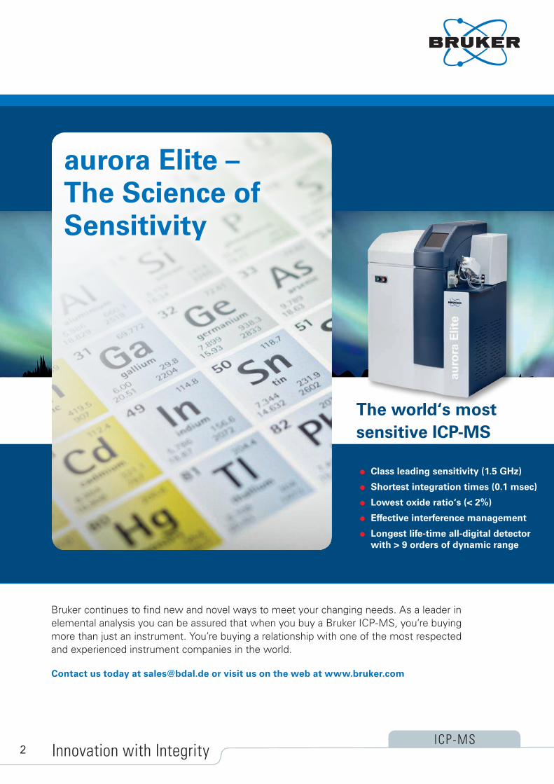
Bruker continues to find new and novel ways to meet your changing needs. As a leader inelemental analysis you can be assured that when you buy a Bruker ICP-MS, you’re buyingmore than just an instrument. You’re buying a relationship with one of the most respectedand experienced instrument companies in the world.
ICP-MS
Contact us today at [email protected] or visit us on the web at www.bruker.com
Class leading sensitivity (1.5 GHz)
Shortest integration times (0.1 msec)
Lowest oxide ratio‘s (< 2%)
Effective interference management
Longest life-time all-digital detector with > 9 orders of dynamic range
Innovation with Integrity
The world‘s most sensitive ICP-MS
aurora Elite – The Science of Sensitivity
2

Organizing committee:
Mark D. Johnson*: Gothenburg University, chair
Jan Ove Ebbestad*: Uppsala University, Co-Chair: registration and budget
Vivi Vajda: Lund University, Co-Chair: abstracts
Paul Evins*: WSP, Stockholm, Co-Chair: sponsorhips
Mikael Calner*: Lund University
Anna Kim-Anderson*: Qi-Media, Jönköping
Kaarina Ringstad*: Geological Survey of Sweden, Uppsala
Erik Sturkell*: Gothenburg University
Johan Gren, Lund University
*Geologiska Föreningen board member
Scientific program committee:
Helena Alexandersson: Lund University Quaternary Geology
Mikael Calner: Lund University Sedimentology/ Stratigraphy
Roland Barthel: Gothenburg University Hydrogeology/environmental geology
Paul Evins: WSP Engineering Geology
Nils Holm: Stockholm University Geobiology
Mark D. Johnson: Gothenburg University Glacial Geology and geomorphology
Iain Pitcairn: Stockholm University Economic Geology
Kaarina Ringstad: SGU Uppsala Outreach and education
Anders Scherstén: Lund University Igneous Petrology
Alisdair Skelton: Stockholm University Metamorphic petrology
Erik Sturkell: Gothenburg University Geophysics and volcanology
Björn Sundqvist: Uppsala University History of Geology and Geoscience
Ulf Söderlund: Lund University Geochronology
Vivi Vajda: Lund University Paleontology
Thomas Zack: Geochemistry/Mineralogy
Bruker continues to find new and novel ways to meet your changing needs. As a leader inelemental analysis you can be assured that when you buy a Bruker ICP-MS, you’re buyingmore than just an instrument. You’re buying a relationship with one of the most respectedand experienced instrument companies in the world.
ICP-MS
Contact us today at [email protected] or visit us on the web at www.bruker.com
Class leading sensitivity (1.5 GHz)
Shortest integration times (0.1 msec)
Lowest oxide ratio‘s (< 2%)
Effective interference management
Longest life-time all-digital detector with > 9 orders of dynamic range
Innovation with Integrity
The world‘s most sensitive ICP-MS
aurora Elite – The Science of Sensitivity
3

7 January
18:00-21:00 # Registration (AF Borgen foajén) NB: Zetterwallska rum available as speaker-ready room throughout conference
8 January
07:30 Registration (AF Borgen foajén)
STORA SALEN LILLA SALEN NYA FEST ÖVRE PALESTRA NEDRE PALESTRA SÅNGSALEN
08:20-08:45 Opening ceremony
08:45-10:00 5 MOR-GLA1Geomorphology and
Glacial Geology I
GEOP1 Impact structures I
HYD-ENV1 Hydrogeology I
PET1 Modeling of P-T-fluid
conditions in metamorphic studies
STR-TEC1Open Session: Structural Geology and Tectonics
10:00-10:30 Coffee
10:00
Post
er s
essi
on
(Caf
é A
ten,
AF
Bo
rgen
)
Posters up
10:30-12:00 6 MOR-GLA1Geomorphology and
Glacial Geology II (3 talks)MOR-GLA3
Using LiDAR in Geo-morphology I (3 talks)
GEOP1 Impact structures II
HYD-ENV1 Hydrogeology II
PET2 Open session:
Geochemistry, mineralogy, geochronology I
STR-TEC2 Trans-Baltic Precambrian
Correlations: Regional and Global Tectonic Recon-
structions I
12:00-13:00 Lunch
13:00-13:45 Plenary session OLAFUR
13:45-14:30 3 MOR-GLA4 Dynamics of Modern
Glaciers I
LUND I Lundadagarna I: Paleontology,
sedimentology and stratigraphy
ENG-GEO Engineering Geology I
PET2 Open session:
Geochemistry, mineralogy, geochronology II
STR-TEC2 Trans-Baltic Precambrian
Correlations: Regional and Global Tectonic
Reconstructions II
14:30-15:00 Coffee
15:00-16:00 4-6 MOR-GLA4 Dynamics of Modern
Glaciers II
LUND II Lundadagarna I: Paleontology,
sedimentology and stratigraphy
ENG-GEO Engineering Geology II
PET3 100 years of modern
metamorphic petrology: Celebrating the centennial of Eskolas Orijärvi Bulletin
GEOP2 Volcanology
16:00-18:00 Poster session (Café Aten, AF Borgen) Boreas board meeting 16–18
18:00-20:00 Ice breaker, Universitetshuset
Post
er s
essi
on
(Caf
é A
ten,
AF
Bo
rgen
)
9 January
08:30-10:00 6 MOR-GLA 5 Glacial History of
Scandinavia I
LUND III Lundadagarna I: Paleontology,
sedimentology and stratigraphy
ECON-OIL2 Metallogeny of Greenland
and Fennoscandia I
PET4 The zircon messenger: nature and experiment
HYD-ENV2 Geohazards in the Nordic
and Arctic regions
10:00-10:30 Coffee
10:30-12:00 6 MOR-GLA 5 Glacial History of
Scandinavia II
UND IV Lundadagarna I: Paleontology,
sedimentology and stratigraphy
ECON-OIL2 Metallogeny of Greenland and Fennoscandia II
PET5 Petrology (Igneous, meta-
morphic, sedimentary)
MOR-GLA2 Scandinavian bedrock
landscapes: tectonic and glacial implications
12:00-13:00 Lunch
13:00-13:45 Plenary session RING
13:45-14:30 3 QUAT2 Land-Sea Interactions in a
long time perspective I
LUND V Lundadagarna II:
Weathering horizons
MOR-GLA 5 Glacial History of
Scandinavia III
PET6 The geology of north
Atlantic and high-arctic large igneous provinces
STR-TEC4 Evolution of the Conti-nental Crust: growth vs.
reworking I
14:30-15:00 Coffee
15:00-16:30 6-8 QUAT2 Land-Sea Interactions in a long time perspective II
LUND VI Lundadagarna II:
Weathering horizons
MOR-GLA 5 Glacial History of
Scandinavia IV
PET7 Chronology and Rates of Metamorphism and
Deformation
STR-TEC4 Evolution of the
Continental Crust: growth vs. reworking II
Nordic Society for Clay Research 16:30
NORDQUA meeting 16:45 Nordic Volcanologial Center 40th Anniversary celebration, 17:00-19:00
19:00-22:00 Conference dinner
Post
er s
essi
on
(Caf
é A
ten,
AF
Bo
rgen
)
10 January
08:30-10:00 6 QUAT1Quaternary Geology I
LUND VII Lundadagarna II:
Weathering horizons
ECON-OIL3 Petroleum Geology an
Industrial Minerals
PET8 Progress of laser ablation ICP-MS in Earth Sciences I
STR-TEC3 Orogens and orogen
dynamics I
OUT-ED Outreach and educa-
tion: Reaching out with WOW to the Many! I
10:00-10:30 Coffee
10:30-11:15 3 QUAT1Quaternary Geology II
GEOBIO Geobiology I
ECON-OIL3 Petroleum Geology an
Industrial Minerals
PET8 Progress of laser ablation
ICP-MS in Earth Sciences II
STR-TEC3 Orogens and orogen
dynamics II
OUT-ED Outreach and educa-
tion: Reaching out with WOW to the Many! II
11:15-12:00 Plenary session SCHWEITZER
2:00-13:00 Lunch
13:00-13:45 Plenary session NORDIC GEOSCIENTIST
13:45-14:30 3 QUAT1Quaternary Geology III
GEOBIO Geobiology II
ECON-OIL1 Ore Formation and
Exploration I
PET8 Progress of laser ablation
ICP-MS in Earth Sciences III AND ROUND TABLE
STR-TEC3 Orogens and orogen
dynamics III
From 14:00 on, PETROLOGY ROUND
TABLE
14:30-15:00 Coffee
15:00-16:30 6 MOR-GLA3 Using LiDAR in
Geomorphology II
GEOBIO Geobiology III
ECON-OIL1 Ore Formation and
Exploration II
HYD-ENV3 Environmental Geology
STR-TEC3 Orogens and orogen
dynamics IV
PETROLOGY ROUND TABLE
16:30 Closing ceremony
Program Overview
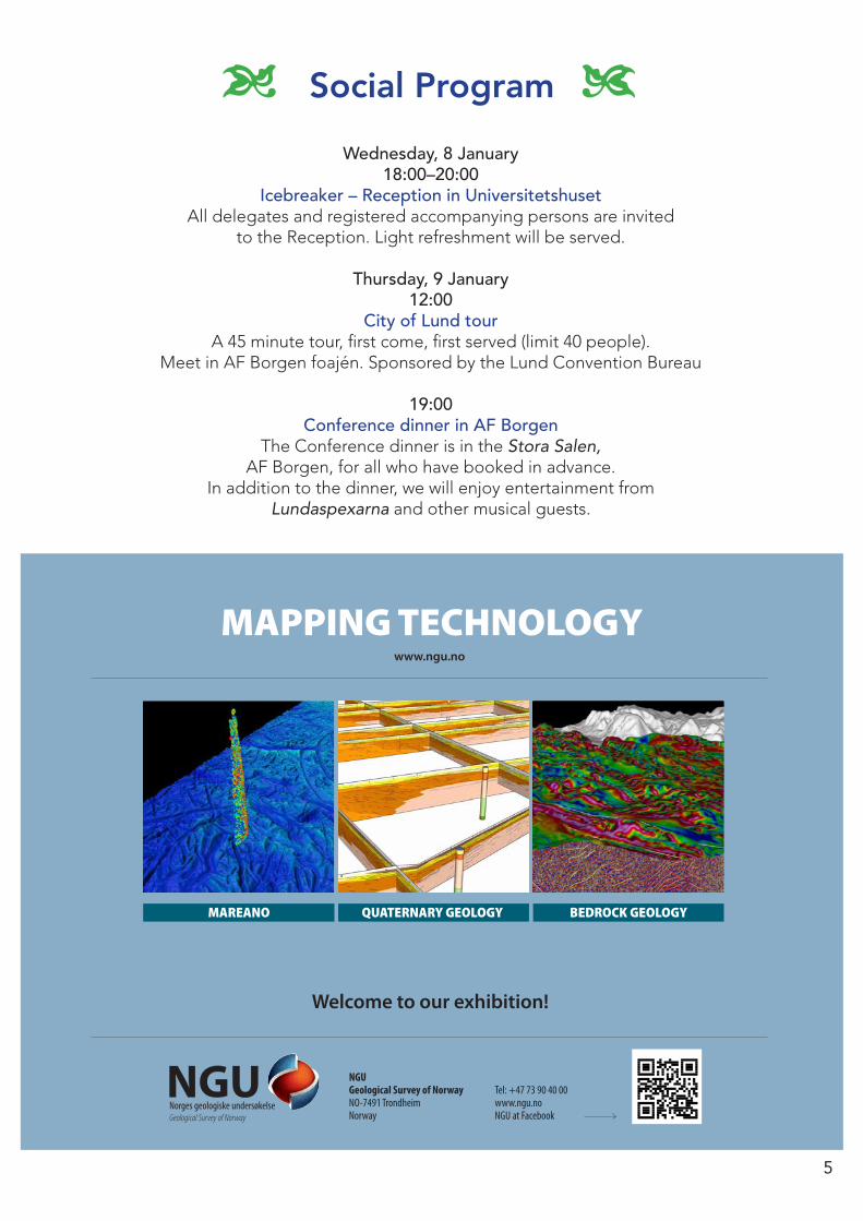
Wednesday, 8 January18:00–20:00
Icebreaker – Reception in Universitetshuset All delegates and registered accompanying persons are invited
to the Reception. Light refreshment will be served.
Thursday, 9 January12:00
City of Lund tour A 45 minute tour, first come, first served (limit 40 people).
Meet in AF Borgen foajén. Sponsored by the Lund Convention Bureau
19:00 Conference dinner in AF Borgen
The Conference dinner is in the Stora Salen, AF Borgen, for all who have booked in advance.
In addition to the dinner, we will enjoy entertainment from Lundaspexarna and other musical guests.
Social Program3 4
MAPPING TECHNOLOGY
QUATERNARY GEOLOGY
www.ngu.no
MAREANO BEDROCK GEOLOGY
NGU Geological Survey of NorwayNO-7491 Trondheim Norway
Tel: +47 73 90 40 00 www.ngu.no NGU at Facebook
Welcome to our exhibition!
5
Scientific Program
6

Scientific Program
7
Wednesday January 8th, AM
8:20 Opening Cermony
MOR-GLA1Geomorphology and Glacial Geology I
Conveners: Kariane Lilleøren and Emrys Phillips Rum: Stora Salen
8:45 Detailed slope geomorphology in central Sval-bard - a comparative study relating slope land-forms and processes to meteorology, geology and topography
Rubensdotter, Lena; Christiansen, Hanne, H
9:00 Alluvial fans on Svalbard and implications for past Mars climate
de Haas, Tjalling; Carbonneau, Patrice; Hauber, Ernst; Kleinhans, Maarten G.
9:15 Cold region geomorphology, permafrost evolution and landscape development in the north – the concept of cryo-conditioning
Etzelmüller, Bernd; Lilleøren, Karianne S.; Berthling, Ivar
9:30 Morphologic evidence for a sackung event in Tröllaskagi mountain (Northern Iceland)
Coquin, Julien; Mercier, Denis; Bourgeois, Olivier; Cossart, Etienne
9:45 “The Poly Morphological Landform Approach” a new tool for hydrogeological applications in heterogeneous glacial deposits.
Klint, Knud Erik S.;Nilsson, Bertel; Troldberg, Lars; Jakobsen, Peter Roll
MOR-GLA1 Geomorphology and Glacial Geology II
Conveners: Kariane Lilleøren and Emrys PhillipsRum: Stora Salen
10:30 A soft-bed system under the Scandinavian Ice Sheet: Mosaic of stable and deforming spots
Piotrowski, Jan A.; Tylmann, Karol; Narloch, Wlodzimierz; Wysota, Wojciech; Damsgaard, Anders; Egholm, David L.; Larsen, Nicolaj K.; Lesemann, Jerome
10:45 Micromorphological evidence of liquefaction, injection and sediment deposition during
basal sliding Phillips, Emrys; Likpa, Ewelina; van der Meer,
Jaap
11:00 Geomorphological indications of palaeo-sub-glacial lakes in Fennoscandia
Lilleøren Karianne S; Sørbel, Leif; Etzelmüller, Bernd; Hagen, Jon Ove
MOR-GLA3 Using LiDAR in Geomorphology I
Conveners: Clas Hättestrand and Mark JohnsonRum: Stora Salen
11:15 Implementing airborne LiDAR data in mapping of Quaternary geology and surficial deposits in Norway
Høgaas, Fredrik; Fredin, Ola; Romundset, Anders
11:30 LiDAR DEM use in Quaternary deposits mapping Palmu, Jukka-Pekka;1 Ojala, Antti E.K.
11:45 Applications of airborne LiDAR at the Geological survey of Sweden
Peterson, Gustaf; Mikko, Henrik; Ising, Jonas; Smith, Colby A.
Wednesday January 8th, AM
8:30 Opening Cermony
GEOP1 Impact structures I
Conveners: Carl Alwmark, Sanna Holm and Jens OrmöRum: Lilla Salen
8:45 Definitive criteria for meteorite impact — Keynote What to look for? Ferrière, Ludovic
9:15 The Lockne-Målingen doublet impact struc-ture: A marine impact by a binary asteroid
Ormö, J; Sturkell, E; Alwmark, C; Nõlvak, J., Melero-Asensio, I, Lepinette, A., Frisk, Å, Holm, S., and Wikström, T.
9:30 Planar deformation features in quartz grains from the Målingen structure – Evidence of an impact
Alwmark, Carl; Holm, Sanna; Ormö, Jens; Sturkell, Erik
9:45 Shock-induced deformations in feldspar grains from Siljan impactites (Sweden)
Holm, Sanna; Ferrière, Ludovic
GEOP1 Impact structures II
Conveners: Carl Alwmark, Sanna Holm and Jens OrmöRum: Lilla Salen
10:30 The Vakkejokk Breccia, an Early Cambrian proximal impact ejecta layer in the north-
Swedish Caledonides. But where is the crater? Nielsen, Arne Thorshøj; Ormö, Jens; Alwmark, Carl
10:45 Mesoscale hypervelocity cratering experimens in sandstone, quartzite, and tuff – the MEMIN project
8
Deutsch, Alex; Kenkmann, Thomas; Poelchau, Michael; Thoma, Klaus
11:00 Chicxulub ejecta deposits – an analogue to
Fluidized Ejecta Blankets on Mars Ocampo, Adriana; Vajda, Vivi
11:15 Mechanical mixing of impact-generated feld-spar liquids in the Maniitsoq structure, West Greenland
Garde, Adam A.; Keulen, Nynke 11:30 Whole rock geochemistry and zircon geochro-
nology of the central Finnefjeld tonalite gneiss from the Maniitsoq impact structure, Western Greenland
Esbensen, Kim H.; McDonald, Iain; Johansson, Leif 11:45 Continental boninitic norite intrusions as meteorite impact modified mantle indicators Klausen, Martin B.; Garde, Adam A.; Riisager, Peter; Söderlund, Ulf
Wednesday January 8th, AM
8:20 Opening Cermony
HYD-ENV1 Hydrogeology I
Convener: Roland BarthelRum: Nya Fest
8:45 Patterns of pesticide pollution in Scanian groundwater reservoirs
Åkesson, Maria; Sparrenbom, Charlotte 9:00 Arsenic concentrations in water in aggregate
production areas in Tampere–Häme region, Finland
Backman, Birgitta, Hatakka, Tarja; Pullinen, Arto; Tarvainen, Timo; Härmä Paavo
9:15 The Effect of Morphologically Undetectable
Kettle Holes (MUKHs) on the Groundwater Flow and Water Geochemistry at Virttaankan-gas, SW Finland
Ahokangas, Elina, Korkka-Niemi, Kirsti, Mäkin-en, Joni& Artimo, Aki
9:30 3H/3He dating of groundwater for calibration
of flow models Sundal, Anja; Aagaard, Per; Wejden,
Bente;Brennwald, Matthias S. 9:45 Quantifying groundwater recharge contribution
through natural and artificial recharge areas by groundwater modeling
Hashemi, Hossein
HYD-ENV1 Hydrogeology II
Convener: Roland BarthelRum: Nya Fest
10:30 Groundwater index – a Norwegian approach to cope with limited data
Haugen, L.E.; Dagestad, A.; Kværner, J.; Gunnarsdottir, H.; Pedersen, T.; Frengstad, B.
10:45 The role of springs during history in Sweden Gert Knutsson 11:00 Sources of CO2 in Mineral Water of Bad Driburg and other Locations Ali, Syed Anas 11:15 Waters around and underground - a challenge
to Hannukainen mining development site, Finland Korkka-Niemi, Kirsti; Salonen, Veli-Pekka; Nurminen, Tiina; Rautio Anne
11:30 Rautuvaara: A conceptual model approach to environmental management within the Hannukainen mining project, Finland. Howett, Peter; Korkka-Niemi, Kirsti; & Salonen,
Veli-Pekka
11:45 An integrated simulations system to study the impact of global change on human-environment systems in the field of groundwater and water supply
Barthel, Roland; Reichenau, Tim G.; Muerth, Markus; Heinzeller, Christoph; Schneider, Karl; Hennicker, Rolf; Mauser, Wolfram; Krimly,
Tatjana;Elbers, Michael; Soboll, Anja;Wackerbauer, Johann;Janisch, Stephan; Dabbert, Stephan;Schmude, Jurgen; Ernst, Andreas
Wednesday January 8th, AM
8:20 Opening Cermony
PET1 Modeling of P-T-fluid conditions in metamorphic studies
Conveners: Alasdair Skelton and Charlotte MöllerRum: Övre Palestra
8:45 A comparison of the P/T conditions between two metamorphic complexes in Tasmania, Australia
Chmielowski, Riia M.
9:00 Preservation of blueschist facies minerals along a shear zone by fast flowing high XCO2 fluids
Kleine, Barbara ; Skelton, Alasdair ; Huet, Benjamin ; Pitcairn, Iain 9:15 Vein controlled stabilisation of Barrovian index
minerals: observations from Glen Esk Lewerentz, Alexander; Skelton, Alasdair; Möller, Charlotte; Crill, Patrick 9:30 Characterization of Na-metasomatism in the Sveconorwegian Bamble Sector of South Norway Engvik, Ane K.; Ihlen, Peter; Austrheim, Håkon

9
Keynote
9:45 Fluid controlled infiltration driven retrogression of dry granulite protoliths in the Bamble sector, South Norway - fluid inclusion studies and phase diagram modelling
Sørensen, Bjørn Eske; Larsen, Rune
PET2 Open session: Geochemistry, mineralogy, geochronology I
Conveners: Nynke Keulen & Tod WaightRum: Övre Palestra
10:30 Formation of parting in quartz Kjøll, Hans Jørgen; Sørensen, Bjørn Eske 10:45 Arctic Ocean Mn-stratigraphy: genesis, synthesis and inter-basin correlation Gyllencreutz, Richard; Löwemark, Ludvig; März, Christian; O’Regan, Matt 11:00 Source and character of hydrothermal calcite veins adjacent to extension-related dolerite dykes on the Baltic Shield Maskenskaya, Olga; Drake, Henrik; Åström, Mats 11:15 Geochemistry of Palaeoproterozoic greenstone
dykes, Dannemora, eastern Bergslagen region, east-central Sweden
Johansson, Åke; Dahlin, Peter; Andersson, Ulf Bertil 11:30 Determination of the origin of corundum (ruby
and sapphire) from Tanzania by geochemical fingerprinting
Keulen, Nynke; Kalvig, Per; Thomsen, Tonny B.; Kokfelt, Thomas F.; Vennemann, Torsten
11:45 Evaluating handheld XRF (hXRF) – Is there a
wider application horizon? Esbensen, Kim H.; Holding, Martin C.; McDonald, Iain; Johansson, Leif
Wednesday January 8th, AM
8:20 Opening Cermony
STR-TEC1Open Session: Structural Geology and Tectonics Convers
Convener: Hemin KoyiRum: Nedre Palestre 8:45 The ductile deformation history of Olkiluoto,
the site for the high-level nuclear waste repository, SW Finland Engström, Jon; Paulamäki, Seppo; Kärki, Aulis;
Aaltonen Ismo 9:00 Basin inversion in the Sorgenfrei-Tornquist
Zone was governed by local compression during regional extension Graversen, Ole
9:15 Shear zones between rock units with no relative movement Koyi, Hemin; Schmeling, Harro; Burchardt, Steffi; Talbot, Christopher; Mukherkjee, Soumajit; Sjöström, Håkan; Chemia, Zurab
9:30 ICDP drilling in the Scandnavian Caledonieds: The SSDP-COSC project
Juhlin, Christopher; Lorenz, Henning; Gee, David; Pascal, Christophe; Tsang, Chin-Fu; Pedersen, Karsten; Parrish, Randy; Rosberg, Jan-Erik
9:45 Late Cretaceous structural inversion in the Sorgenfrei-Tornquist Zone was not linked with Alpine foreland compression
Graversen, Ole
STR-TEC2 Trans-Baltic Precambrian Correlations: Regional and Global Tectonic Reconstructions I
Conveners: Svetlana Bogdanova & Grazina SkridlaiteRum: Nedre Palestre
10:30 Trans-Baltic Precambrian correlations: highlights Bogdanova, Svetlana V. 11:00 Late Paleoproterozoic paleogeography of the
East European Craton by paleomagnetic data Lubnina, Natalia; Bogdanova, Svetlana; Gintov, Oleg 11:15 Evolution of the East European craton inferred from ages and Hf isotope composition of detrital zircons Shumlyanskyy, Leonid 11:30 The Ingul Block of the Ukrainian Shield as a
key to the Paleoproterozoic reconstruction of Sarmatia, East European Craton
Gintov, Oleg; Mychak, Sergii 11:45 TransBaltic Proterozoic correlation: recurrent
metamorphism and magmatism in Lithuania and adjacent areas
Skridlaite, Grazina; Bogdanova, Svetlana; Taran, Ludmila; Baginski, Boguslaw; Wiszniewska, Janina
Wednesday January 8th
13:00 Plenary Session INGÓLFSSON & BENEDIKTSSON
MOR-GLA4 Dynamics of Modern Glaciers I
Conveners: Anders Schomacker, Ívar Benediktsson, and Jez EverestRum: Stora Salen
10
13:45 Morphological and sedimentological imprints of a temporary, glacier-surge ice-dammed lake, Van Mijenfjorden, Svalbard
Lyså, Astrid; Larsen, Eiliv; Høgaas, Fedrik; Jensen, Maria; Klug, Martin;
Rubensdotter, Lena; Szczucinski, Witold 14:00 The 2008 mini-surge of Múlajökull, Iceland:
end-moraine formation and post-surge ice-marginal dynamics Benediktsson, Ívar Örn; Schomacker, Anders;
Johnson, Mark D.; Jónsson, S.A.; Ingólfsson, Ó. 14:15 Late Holocene glacial history of the Drangajökull
ice cap, NW Iceland, based on proglacial lake sediment records – preliminary results
Schomacker, Anders; Larsen, Nicolaj K.; Brynjólfsson, Skafti; Guðmundsdóttir, Esther Ruth; Julie Andreassen; Lena Håkansson; Ólafur Ingólfsson
MOR-GLA4 Dynamics of Modern Glaciers II
Conveners: Anders Schomacker, Ívar Benediktsson, and Jez EverestRum: Stora Salen
15:00 Detailed monitoring of rapid deglaciation: Virkisjökull-Falljökull catchment, SE Iceland
Everest, Jez; Bradwell, Tom; Finlayson, Andrew; Jones, Lee; O’Dochartaigh, Brighid; Hughes, Leanne; Black, Andrew; Flett, Verity;
Phillips, Emrys; Maurice, Louise; Raines, Michael; MacDonald, Alan; Bergsson, Bergur; Ofeigsson, Benni 15:15 Groundwater – meltwater coupling in an active proglacial sandur in SE Iceland Ó Dochartaigh, Brighid; MacDonald, Alan; Andrew Black; Everest, Jez; Wilson, Paul 15:30 Fracturing, block-faulting and moulin develop-
ment associated with the retreat a maritime glacier: Falljökull, SE Iceland
Finlayson, Andrew; Phillips, Emrys; Jones, Lee 15:45 Glacier Downsizing” – the structural response
of a maritime glacier to a prolonged period of retreat: evidence from Falljökull, SE Iceland
Phillips, Emrys; Finlayson, Andrew; Tom, Bradwell; Jones, Lee; Everest, Jez
16:00 Geomorphology of the Drangajökull ice cap, NW Iceland, with focus on its three surgetype outlets Brynjolfsson, Skafti; Schomacker Anders; Ingolfsson, Olafur
Wednesday January 8th
13:00 Plenary Session INGÓLFSSON & BENEDIKTSSON
LUND I Lundadagarna i Historisk ge-ologi och paleontology I: Paleontology, sedimentology and stratigraphy
Conveners: Vivi Vajda & Johan GrenRum: Lilla salen 13:45 The sediment fill of the ‘Siljan Ring’ - a mirror
of the Early Palaeozoic evolution of western Baltoscandia
Lehnert, Oliver; Meinhold, Guido; Arslan Arzu; Berner, Ulrich; Calner, Mikael; Huff, Warren D.; Ebbestad, Jan Ove; Joachimski, Michael M.
14:00 First evidence of Devonian strata in Sweden
– Palynological study of the Övedskloster drill-cores 1 and 2 from Skåne
Mehlqvist, Kristina; Vajda, Vivi; Steemans, Philippe
14:15 The Silurian in Denmark: new stratigraphical results from the Sommerodde-1 well,
Bornholm Schovsbo, Niels; Nielsen, Arne Thorshøj
LUND II Lundadagarna i Historisk ge-ologi och paleontology I: Paleontology, sedimentology and stratigraphy
Conveners: Mikael Calner & Anders LindskogRum:Lilla Salen 15:00 Trilobites of the Lower Cambrian Duolbasgaissa
Formation, the Digermul Peninsula, northern Norway
Ebbestad, Jan Ove R.; Högström, Anette E.S.; Høyberget, Magne; Jensen, Sören;
Palacios, Teodoro; Taylor, Wendy L.T. 15:15 A mid-Cambrian trilobite fauna from the Lower
Allochthon of the Blaik Nappe Complex, northern Sweden
Weidner, Thomas; Rushton, Adrian W.A.; Ebbestad, Jan Ove R.
15:30 Early–Middle Ordovician conodont biofacies
in the marginal Yangtze Platform, South China, and their paleoenvironmental implications
Wu, Rongchang; Stouge, Svend; Percival, Ian G; Zhan, Renbin
15:45 The Hawke Bay Event: A complex regression
at the Early/Mid Cambrian transition Nielsen, Arne Thorshøj; Schovsbo, Niels Hem-
mingsen 16:00 Transport pathways and source partitioning:
complementary interpretations involving sedi-ment grain size and mineralogy
Stevens, Rodney L.
Wednesday January 8th
13:00 Plenary Session INGÓLFSSON & BENEDIKTSSON

11
ENG-GEO Engineering Geology I
Conveners: Rodney StevensRum: Nya Fest 13:45 “DS 3077 Horizontal” - new standard for representative sampling in science, technology and industry Esbensen, Kim H.; Petersen Julius, Lars 14:00 The curse and blessing of orientation uncer-
tainty of objects measured in boreholes Stigsson, Martin
14:15 On the possible correlation between the hydraulic transmissivity of deformation zones and in situ stress Follin, Sven; Stigsson, Martin
ENG-GEO Engineering Geology II
Convener: Rodney StevensRum: Nya Fest
15:00 How to build a Metro in a large city from a geological and geotechnical point of view
Korshøj, Joakim Stiel; Tranholm, Louise; Galsgaard, Jens
15:15 Geoelectrical Imaging for Pre-investigation of
Urban Underground Infrastructure Dahlin,Torleif; Rosqvist, Håkan; Sparrenbom,
Charlotte; Svensson, Mats; Auken, Esben; Bastani, Mehrdad; Moberg, Jonas
15:30 Characterization of fracture zones in bedrock
using 2D resistivity profiling Rønning, Jan S.; Dalsegg, Einar; Ganerød, Guri V 15:45 Underwater ERT Survey for Site Investigation
of a New Line for the Stockholm Metro Dahlin, Torleif; Loke, Meng Heng; Siikanen, Jonas; Höök, Marcus 16:00 Marine ERT modelling for the detection of
fracture zones Tassis, Georgios; Tsourlos, Panagiotis; Rønning, Jan Steinar; Dahlin, Torleif 16:15 Improving communication between geolo-
gists and engineers Evins, Paul
Wednesday January 8th
13:00 Plenary Session INGÓLFSSON
PET 2 Open session: Geochemistry, mineralogy, geochronology II
Conveners: Nynke Keulen & Tod WaightRum: Övre Palestra
13:45 Mantle source characteristics of mid-Proterozoic dyke swarms within the Gardar Igneous
Province, South Greenland Bartels, A
14:00 Mantle sources during continental breakup, a geochemical-chronological study of Creta-ceous dikes from New Zealand
van der Meer, Quinten H.A ; Waight, Tod E.; Scott, James M.; Münker, Carsten; Storey,
14:15 For richer and poorer: depletion and enrich-
ment in sub-continental lithospheric mantle xenoliths from southern Zealandia
Waight, Tod E.; Scott, James M.; van der Meer, Quinten H.A.; Münker, Carsten
PET3 100 years of modern metamorphic petrology: Celebrating the centennial of Eskolas Orijärvi Bulletin
Conveners: Lorraine Tual & Victoria BeckmanRum: Övre Palestra
15:00 Pentti Eskola – A Personal Outlook Robinson, Peter 15:30 Eskola’s Mineral Facies: Yesterday and Today Schumacher, John C. 15:45 Fluid-induced mineral composition adjustments
of Alpine stilbite Weisenberger, Tobias Björn; Bucher, Kurt
Wednesday January 8th
13:00 Plenary Session INGÓLFSSON & BENEDIKTSSON
STR-TEC2 Trans-Baltic Precambrian Correlations: Regional and Global Tectonic Reconstructions II
Conveners: Svetlana Bogdanova and Alvar SoesooRum: Nedre Palestra
13:45 A novel image of hidden crystalline basement in NE Poland at the junction of Fennoscandia and Sarmatia
Krzeminska, Ewa; Krzeminski, Leszek; Wiszniewska, Janina; Williams, Ian S.; Petecki, Zdzisław 14:00 The Karlskrona Deformation Zone and Erings-
boda granitic pluton: magmatism and defor-mation during the Danopolonian Orogeny Čečys, Audrius
14:15 Carbon isotope composition of sedimentary
carbonates in the Paleoproterozoic Kolosjoki Sedimentary Formation, Pechenga Greenstone Belt, NW Russia
Salminen, Paula E.; Karhu, Juha A.; Melezhik, Victor A.
GEOP2 Volcanology
Conveners: Hannes Mattsson an Erik SturkellRum: Nedre Palestra
Keynote
12
Keynote
15:00 The Role of Thermal Stresses in Magma Frag-mentation
Cashman, Katherine; Nicholson, Emma; Rust, Alison; Dobson, Katherine
15:15 Holocene explosive volcanic activity in Iceland as recorded from Lake Lögurinn, east Iceland
Gudmundsdóttir; Esther, Ruth; Ingólfsson, Ólafur; Björck, Svante; Larsen, Gudrún 15:30 Prehistoric Katla eruptions, Iceland: volume
estimates of selected basaltic tephra layers Óladóttir, Bergrún Arna; Larsen, Guðrún; Sigmarsson, Olgeir 15:45 Brown snow: Remobilisation of volcanic ash
from recent Icelandic eruptions Nicholson, Emma; Cashman, Katharine; Beckett, Frances; Witham, Claire; Leadbetter, Susan; Hort, Matthew
Thursday January 9th, AM
MOR-GLA 5 Glacial History of Scandinavia I
Conveners: Martin Jakobsson and Atle NesjeRum: Stora salen
8:30 Ice-free conditions in Sweden during Marine Oxygen Isotope Stage 3?
Wohlfarth, Barbara 8:45 Drumlinised MIS 3 glaciofluvial and glacio-
lacustrine sediments on the Småland pene-plain, South Sweden
Möller, Per 9:00 The last Eurasian Ice Sheet: a chronological
database and time-slice reconstruction Hughes, Anna L.C.; Gyllencreutz, Richard; Man-
gerud, Jan; Svendsen, John Inge; Lohne, Øystein S. 9:15 The Weichselian Stage in Western Finnish Lapland – glacial sedimentology and revised stratigraphy Lunkka, Juha Pekka; Salonen, Veli-Pekka 9:30 Modeling the Scandinavian Ice Sheet: past,
present and future efforts Kirchner, Nina; Ahlkrona, Josefin; Lötstedt, Per;
Schuett, Jorina; Noormets, Riko; Jakobsson, Martin, Classon, Caroline
9:45 Asynchronous northern ice sheets – their behavior in time and space Larsen, Eiliv; Fjeldskaar, Willy; Fredin, Ola; Lyså, Astrid
MOR-GLA 5 Glacial History of Scandinavia II
Conveners: Martin Jakobsson and Atle NesjeRum: Stora Salen
10:30 The drainage of the Baltic Ice Lake: a long debated topic in Swedish Quaternary Geology Björck, Svante
11:00 Weichselian glaciation history and palaeo- environmental development of the SW Baltic Sea
Anjar, Johanna; Adrielsson, Lena; Björck, Svante; Filipsson, Helena L.; Larsen, Nicolaj Krog; Möller, Per
11:15 The Baltic Sea IODP Expedition 347 “Baltic
Sea Paleoenvironment” - preliminary results from the cruise
Andrén, Thomas
11:45 Major late glacial-early postglacial tectonic events in Lake Vättern following the Scandina-vian ice sheet retreat
Jakobsson, Martin; Björck, Svante; O’Regan, Matt; Flodén, Tom; Greenwood, Sarah; Swärd, Henrik; Lif, Arne; Ampel, Linda; Koyi, Hemin; Skelton, Alasdair
Thursday January 9th, AM
LUND III Lundadagarna i Historisk geologi och paleontology I: Paleontology, sedimentology and stratigraphy
Conveners: Johan Gren & Kristina MehlqvistRum: Lilla salen
8:30 Evolution of early biota and complex eco- systems: the Digermul succession of northern Norway Högström, Anette E.S.; Ebbestad, Jan Ove R.; Jensen, Sören; Palacios, Teodoro; Høyberget, Magne & Taylor, Wendy L 9:00 Fungal–prokaryotic symbiosis in the deep biosphere Bengtson, Stefan; Ivarsson, Magnus
9:15 Micropaleontologic and sedimentologic changes across the Volkhov–Kunda boundary at Kinnekulle, Västergötland, Sweden Lindskog, Anders; Eriksson, Mats E.
9:30 Aquatic palynology and its applications in studies of past nutrient and salinity changes
Willumsen, Pi Suhr 09:45 Middle Jurassic to basal Cretaceous foraminifral
stratigraphy and water mass features on the Mid-Norwegian shelf
Nagy, Jenoe; Hendrichson, Randi M.
LUND IV Lundadagarna i Historisk geologi och paleontology I: Paleontology, sedimentology and stratigraphy
Keynote
Keynote
13
Conveners: Vivi Vajda & Anders Lindskog Rum: Lilla Salen 10:30 The Central European Iharkút vertebrate locality:
a window to the continental fauna of the Late Cretaceous western Tethyan archipelago
Ösi, Attila 11:00 Stratigraphy and ages of the classic Neogene
mammal fossil localities from Baode County, China
Kaakinen, Anu; Passey, Benjamin H.; Zhang, Zhaoqun; Liu, Liping; Pesonen, Lauri J.; Fortelius, Mikael 11:15 Colouring the past: detailed imaging and molecular analyses of an exceptionally preserved feather from the Eocene Fur Formation of Denmark Gren, Johan; Lindgren, Johan 11:30 Exceptional cellular preservation in Mesozoic
and Cenozoic plants, fungi and invertebrates McLoughlin, Stephen; Bomfleur, Benjamin;
Mörs, Thomas 11:45 Documentation of the immediate K–Pg mass
extinction recovery using vertebrate micro-stratigraphy Bercovici, Antoine; Hunter, John; Pearson, Dean; Vajda, Vivi
Thursday January 9th, AM
ECON-OIL2 Metallogeny of Greenland and Fennoscandia I
Conveners: Iain Pitcairn and Jochen KolbRum: Nya Fest
8:30 Relationships of polymetallic sulphide deposits to volcanoes, basins and faults in the Swedish Palaeoproterozoic
Allen, Rodney 9:00 Trace element characteristics of magnetite
from mineralizations in the Bergslagen ore district, central Sweden Hogmalm, Johan; Tillberg, Mikael; Inerfeldt,
Andreas; Nordgren, Nina; Zack, Thomas 9:15 Geochemistry of the Mertainen iron ore Holme, Kirsten; Debras, Céline 9:30 Structural geology and spatial patterns of
hydrothermal alteration at the Falun pyritic Zn-Pb-Cu-(Au-Ag) sulphide deposit, Bergslagen region, south-central Sweden
Kampmann, Tobias C.; Stephens, Michael B. 9:45 Petrology and in situ Strontium isotope inves-
tigation of the Ni-Cu-(PGE) ore bearing Kevitsa intrusion, northern Finland
Luolavirta, Kirsi; Hanski, Eero; Maier, Wolfgang; O´Brien, Hugh; Lahaye, Yann;
Santaguida, Frank; Voipio, Teemu
ECON-OIL2 Metallogeny of Greenland and Fennoscandia II
Conveners: Iain Pitcairn and Jochen KolbRum: Nya Fest
10:30 Au- and Ag-rich phases detected by LA-ICP-MS trace element analysis of sulphide and sul-pharsenide minerals in Håkansboda
copper-cobalt deposit, Bergslagen, Sweden Tillberg, Mikael; Inerfeldt, Andreas; Zack, Thomas; Hogmalm, Johan 10:45 The Laver 1.9 Ga large volume, low grade,
Porphyry-style Cu-Au-Mo-Ag mineralization, northern Sweden
Wasström, Annika; Knipfer, Sebastian; Åberg, Lina 11:00 Metallogeny of Greenland Kolb, Jochen 11:30 Zinc potential in the high Arctic- exploring the
Franklinian Basin Rehnström, Emma F
11:45 Alteration types within the Nalunaq Gold Deposit, South Greenland Bell, Robin-Marie; Kolb, Jochen
Thursday January 9th, AM PET4 The zircon messenger: nature and experiment
Conveners: Alexander Lewerentz & Anders Scherstén Rum: Övre Palestra
8:30 Zircon messenger; cryptic tales from arc magmas Roberts, Nick M.W.; Tapster, Simon 8:45 Alteration of zircon to baddeleyite: examples
from nature and experiment Lewerentz, Alexander; Harlov, Daniel E.; Whitehouse, Martin J.; Scherstén 9:00 How clear is the message from detrital zircon? Andersen, Tom 9:15 0.3 b. y. of drainage stability along the Palaeozoic western Gondwana margin – detrital zircon evidence Augustsson, Carita; Rüsing, Tobias; Niemeyer,
Hans; Kooijman, Ellen 9:30 U–Pb age and Lu–Hf signatures of detrital zircon from Palaeozoic sandstones in the Oslo Rift, Norway Kristoffersen, Magnus; Andersen, Tom; Andresen, Arild 9.45 Evidence for mid-Proterozoic crustal rework-
ing in southern Scandanavia from Hf isotopes in zircon from Bornholm.
Waight, Tod
Keynote
Keynote
Keynote
14
PET5 Petrology (Igneous, metamorphic, sedimentary)
Convener: Tom Andersen and Karolina BjärnborgRum: Övre Palestra
10:30 Updating the knowledge about the SE part of the Paleoproterozoic Central Finland gran-itoid complex: preliminary insights from field work and geochemistry
Heilimo, Esa; Mikkola, Perttu; Hartikainen, Aimo; Luukas, Jouni; Niemi, Sami
10:45 Metamorphic conditions of the Vetlanda for-
mation, southeastern Sweden – support for a pre-TIB origin of the Oskarshamn-Jönköping Belt
Makowsky, Felix; Mansfeld, Joakim 11:00 Garnet-orthopyroxene thermometry revisited:
a new calibration and application to granulites and peridotites
Olivotos, Spyros–Christos; Kostopoulos, Dimitrios 11:15 A new insight to A-type granites and ultra- K rocks from hard-soft acid-base (HSAB) and density functional theory (DFT) concepts Vigneresse, Jean-Louis
11:30 Petrology of delhayelite- and andremeyerite- bearing, peralkaline nephelinite from
Nyiragongo, East African Rift Andersen, Tom; Elburg, Marlina; Erambert, Muriel
11:45 Chemometric verification of the geochemical evolution of dual igneouslava rock suites in the Richtersfeld Hiab province, Namibia
Esbensen, Kim H.; Minnitt, Richard
Thursday January 9th, AM HYD-ENV2 Geohazards in the Nordic and Arctic regions
Conveners: Þorsteinn Sæmundsson and Reginald HermannsRum: Nedre Palestra
8:30 Approach for systematic rockslide mapping of unstable rock slopes in Norway
Hermanns, Reginald L.; Oppikofer, Thierry; Yugsi Molina, Freddy X.; Dehls, John F.;
Böhme; Martina
8:45 Debris flow modeling for susceptibility mapping at regional to national scale in Norway Rubensdotter, Lena; Fischer, L; Stalsberg, K;
Sletten, K 9:00 The melting of mountain permafrost and the
Mófellshyrna debris slide in Northern Iceland Saemundsson Thorsteinn; Helgason, Jon; Kristinn & Petursson, Halldor G.
9:15 Are submarine landslides of industrial waste contributing to an ecological catastrophe along the rising northeastern coast of Sweden?
Snowball, Ian; Apler, Anna; Nyberg, Johan; Zillén, Lovisa
9:30 Extreme snow avalanche winters recorded in
tree-rings in the Bødalen valley, inner Nord-fjord, western Norway
Decaulne, Armelle, Eggertsson Ólafur, Laute Katja, Beylich Achim A.
MOR-GLA2 Scandinavian bedrock land-scapes: tectonic and glacial implications
Conveners: Karna Lidmar Bergström and Mats OlvmoRum: Nedre Palestra
10:15 Burial and exhumation history of southern Sweden estimated from apatite fission-track analysis data
Japsen, Peter; Green, Paul F.; Bonow, Johan M.; Erlström, Mikael
10:30 The development of granite domes and their
role in understanding the geomorphological evolution in SW Sweden.
Olvmo, Mats; Johansson, Magnus 10:45 Deep weathering, neotectonics and strandflat
formation in Nordland, northern Norway Olesen, O.; Kierulf, H.P.; Brönner, M.; Dalsegg, E.; Fredin, O. ; Solbakk, T. 11:00 Saprolites on- and offshore Norway: New constraints on formation processes and age Fredin, Ola; Zwingmann, Horst; Knies, Jochen;
Sorlie, Ronald; Grandal, Else 11:15 Glacier/permafrost interaction, alpine landscape development and paleic surfaces Berthling, Ivar; Etzelmüller, Bernd 11:30 Inherited basement relief and glacial erosion
in northern and central Sweden – a review Lidmar-Bergström, Karna; Olvmo, Mats
Thursday January 9th 13.00 Plenary session RING
QUAT2 Land-Sea Interactions in a long time perspective I
Conveners: Helena L. Filipsson, Anne Birgitte Nielsen & Anneli PoskaRum: Stora salen
13:45 Landscape, climate, sea-level variations and human living conditions in a coastal area of western Blekinge on the Baltic sea between 11600 cal BP and AD 1000
Broström, Anna; Persson, Carl; Svensson, Nils-Olof, Rudebeck, Elisabeth; E22- Sölves-borg-Stensnäs-project members
15
14:15 Quantitative reconstruction of Holocene land-cover in NW Europe for the evaluation of past land cover-climate interactions: first results from the Swedish LANDCLIM project
Trondman, Anna-Kari; Gaillard, Marie-José; Sugita, Shinya; Fyfe, Ralph; Kaplan, Jed; Marquer, Laurent; Mazier, Florence; Nielsen, Anne Birgitte; Poska, Anneli; Strandberg, Gustav
QUAT2 Land-Sea Interactions in a long time perspective II
Conveners: Helena L. Filipsson, Anne Birgitte Nielsen & Anneli PoskaRum: Stora salen
15:00 Modelling past land use changes and their effects on carbon pools -Using REVEALS and LPJ-Guess
Nielsen, Anne Birgitte; Poska, Anneli; Åkesson, Christine, Broström, Anna
15:15 Reconstruction of the Swedish Baltic coastal
environment over the last 6 000 years Ghosh, Anupam; Ning, Wenxin; Khan, Man-
soor; Filipsson, Helena L. 15:30 Experiments with benthic foraminifera: Im-
proving our understanding of the conditions of the past
Duffield, Christopher James; Alve, Elisabeth 15:45 Effects on sea level of anthropogenic global
warming has not yet occurred in the eastern North Sea to central Baltic Region
Hansen, Jens Morten
16:00 Absolute sea levels of the Kattegat Sea during the last 5 000 years
Hansen, Jens Morten 16:15 The present sea level rise – a natural process Påsse, Tore; Daniels, Johan
Thursday January 9th
13.00 Plenary session RING
LUND V Lundadagarna i Historisk geologi och paleontology II: Weath-ering horizons - their formation, later reworking and final deposition
Conveners: Henning Dypvik and Lars RibeRum: Lilla salen
13:45 Deep weathering and landforms in Scandinavia – a review
Lidmar-Bergström, K 14:15 Preglacial weathering crust in Finland Peuraniemi, V.
Lund VI Lundadagarna i Historisk ge-ologi och paleontology II: Weathering horizons - their formation, later re-working and final deposition
Conveners: Henning Dypvik and Lars RibeRum: Lilla salen
15:00 Deep weathering, neotectonics and strandflat formation in Nordland, northern Norway
Olesen, O.; Kierulf, H.P.; Brönner, M.; Dalsegg, E.; Fredin, O. ; Solbakk, T.
15:15 Granite weathering features and impact on
the knowledge of arenization process Begonha, A.; Sequeira Braga, M.A.; Paque,
H. 15:45 The evolution of the passive continental mar-
gin of Norway and its adjacent mainland – us-ing the sub-Cambrian peneplain as a reference surface
Gabrielsen, R. H.; Jarsve, E. M.; Lundmark, A.M.; Nystuen, J.P.; Faleide, J.I.
16:00 Basement rocks as sand factory and reservoir
for the Johan Sverdrup and Edvard Grieg fields – the southern Utsira High, Norwegian North Sea
Sørlie, R., Charnock, M., Hammer, E., Maast, T. E., Amundsen, H.
16:15 Weathering profiles on the Utsira High, Nor-wegian North Sea – a comparison with on-shore analogues
Riber, L., Dypvik, H., Oberhardt, N., Naqvi, S.; Sørlie, R.
Thursday January 9th 13.00 Plenary session RING
MOR-GLA 5 Glacial History of Scandinavia III
Conveners: Martin Jakobsson and Atle NesjeRum: Nya Fest
13:45 Late-glacial retreat and readvance signatures in the Vättern basin, south-central Sweden
Greenwood, Sarah; Jakobsson, Martin; O’Regan, Matt; Swärd, Henrik; Flodén, Tom
14:00 Veiki moraine – morphology, stratigraphy
and paleoglaciological implications of an ice-walled lake plain topography in northern Swe-den
Hättestrand, Clas, Alexanderson, Helena, Hättestrand, Martina, Sigfúsdóttir, Thorbjörg, Vidar Jakobsen, Leif
14:15 Pre-Late Weichselian interstadial sediments in
Northern Sweden Hättestrand, Martina; Alexanderson, Hele-
na; Hättestrand, Clas; Sigfúsdóttir, Thorbjörg; Bjursäter, Stefan
Keynote
Keynote
16
MOR-GLA 5 Glacial History of Scandinavia IV
Conveners: Martin Jakobsson and Atle NesjeRum: Nya Fest
15:00 The Kattegat Readvance Påsse, Tore 15:15 Rapid break-up of the Norwegian Channel Ice
Stream of the Scandinavian Ice Sheet during the Last Glacial Maximum
Svendsen, John Inge; Mangerud, Jan; Briner, Jason; Young Nicolás
15:30 Deglaciation of the Fennoscandian Ice Sheet
at its northern margin Andreassen, Karin; Corner, Geoffrey D.; Stokes,
Chris R.; Winsborrow, Monica, C.M. 15:45 Depositional environments and glacial event
at Nordli following the Younger Dryas maxi-mum advance in Leirfjord, North Norway
Hansen, Louise; Funder, Svend; Sveian, Harald; Dretvik, Håvard; Husum, Katrine
16:00 The Late Weichselian deglaciation of central
Scandes; new stratigraphical evidences from laminated lake sediments at Dovre, central Norway.
Paus, Aage; Boessenkool, Sanne; Brochmann, Christian, Haflidason, Haflidi
16:15 Cosmogenic surface exposure dating of the
last de-glaciation in Denmark: 6 000-year age scatter suggest shielding effect controlled by periglacial landform transformation
Houmark-Nielsen, Michael; Linge, Henriette 16:30 Ice dynamics and deglaciation in SW Norway
constrained by LIDAR mapping and cosmo-genic exposure ages of glacial landforms
Fredin, Ola; Akçar, Naki; Romundset, Anders; Reber, Regina; Kubik, Peter;
Schlüchter, Christian
Thursday January 9th 13.00 Plenary session RING
PET6 The geology of north Atlantic and high-arctic large igneous provinces
Conveners: Christian Tegner, Romain Meyer & Sverre PlankeRum: Övre Palestra
13:45 Contrasting volcanic architecture and ge-ochemistry of interdigitating flood basalt groups: structural and tectono-magmatic im-plications for Iceland in the Neogene
Óskarsson, Birgir V; Riishuus, Morten S
14:00 The Vestbrona Formation Re-Interpreted as Sill Complexes of Paleocene Age
Planke, Sverre; Polteau, Stephane; Hafeez, Amer; Jerram, Dougal A.; Angard, Kristian; Prestvik,
14:15 Late Cretaceous alkaline volcanism in the High Arctic: Geological and geochemical con-straints from the Kap Washington ignimbrites, North Greenland
Thorarinsson, Sigurjon B; Holm, Paul M; Duprat, Helene; Tegner, C
PET7 Chronology and Rates of Metamorphism and Deformation
Conveners: Bernard Bingen & Matthijs Smit Rum: Övre Palestra
15:00 Linking age to stage? Progress and pitfalls in dating metamorphic cycles
Warren, Clare; McDonald, Christopher; Mot-tram, Catherine; Regis, Daniele
15:30 Micro- to macroscale correlation of metamor-
phic and deformation events with in situ U-Pb dating and thermometry
Möller, Andreas; Oalmann, Jeffrey; Savage, Jessica; Bousquet, Romain
15:45 Lu-Hf and Sm-Nd garnet geochronology: Clo-
sure revisited and new applications in litho-sphere studies
Smit, Matthijs A.; Scherer, Erik E.; Mezger, Klaus; Ratschbacher, Lothar; Kooijman,
16:00 Exhumation of an eclogite terrane as a hot,
migmatitic nappe, Sveconorwegian orogen Möller, Charlotte; Andersson, Jenny; Dyck,
Brendan; Antal Lundin, Ildiko 16:15 Significance of an early Sveconorwegian (1100
Ma) granulite facies event at Flatraket and Kråkeneset, Western Gneiss Region
Corfu, Fernando; Austrheim, Håkon; Ganzhorn, Anne-Céline
16:30 High T/P metamorphism at 1.45 Ga: P-T evo-
lution and SIMS U-Pb zircon ages of parag-neisses from southernmost Sweden
Ulmius, Jan; Moller, Charlotte; Andersson, Jenn
Thursday January 9th 13.00 Plenary session RING
STR-TEC4 Evolution of the Continental Crust: growth vs. reworking I
Convener: Anders SchersténRum: Nedre Palestra
13:45 Zircon Hf based growth models of the conti-nental crust – a few considerations
Scherstén Anders; Kristinsdóttir, Bára; Peters-son, Andreas; Næraa, Tomas; Bjärnborg, Karo-lina; Hollis, Julie
14:00 Early Archean crust in the East European
Craton Claesson, Stefan; Bogdanova, Svetlana
Keynote
17
14:15 On the petrogenesis of the late Neoarchaean Qôrqut Granite Complex in the Nuuk region of southern West Greenland
Næraa, Tomas1,; Kemp, Anthony I.S; Scherstén, Anders; Rehnström, Emma F.; Rosing, Minik T.; Whitehouse, Martin
STR-TEC4 Evolution of the Continental Crust: growth vs. reworking II
Convener: Ulf Söderlund and Andreas PeterssonRum: Nedre Palestra
15:00 Neoarchean alkaline rich igneous magmatism at cratonization stage of western part of
Karelian (Baltic) Province Heilimo, Esa; Mikkola, Perttu
15:15 The Usushwana Complex: a tale of two igneous events, and a magmatic feeder to one of Earth’s earliest large igneous provinces Gumsley, Ashley; Olsson, Johan; Söderlund, Ulf;
de Kock, Michiel; Hofmann, Axel 15:30 Svecofennian orogeny – an evolving orogenic
system Korja, Annakaisa 15:45 Zircon U-Pb-Hf constraints on growth versus
reworking of southern Fennoscandia Petersson, Andreas; Scherstén, Anders; Andersson, Jenny; Möller, Charlotte 16:00 Preservation bias in the geological record; a
Fennoscandian case study Roberts, Nick M.W. 16:15 The >2 000 km-long 1.63 Ga Melville Bugt
Dyke Swarm and its petrogenetic relationship to the ~1.8 Ga Ketilidian Orogen: Evidence from SE Greenland
Klausen, Martin B; Nilsson, Mimmi K.M; Snyman, Dian; Bothma, Riaan; Kolb, Jochen; Tappe, Sebastian; Kokfelt, Thomas F; Nielsen, Troels F.D.; Denyszyn, Steven 16:30 Tectonic deformations in the Ediacaran- Paleozoic bedrocks of Estonia Systra ,Ylo
Friday January 10th, AM
QUAT1 Quaternary Geology I
Conveners: Helena Alexanderson and Svante BjörckRum: Stora salen
9:00 Wet shifts in Holocene peat records and the role of internal feedbacks: Plant macrofossil evidence from southern Sweden
Rundgren, Mats; Kokfelt, Ulla 9:15 Excavation of and analysis of Coleoptera from
of a late Holocene natural spring from south central Sweden
Hellqvist, Magnus
9:30 A 37 kyr long record from the central South Atlantic
Björck, Svante; Ljung, Karl; Holmgren, Sofia
9:45 First remains of submarine, non-marine, arctic plants from the Danish North Sea
Bennike, Ole; Jensen, Jørn Bo; Leth, Jørgen O.; Nørgaard-Pedersen, Niels & Lomholt, Steen
QUAT1Quaternary Geology II
Conveners: Helena Alexanderson and Svante BjörckRum: Stora salen
10:30 The effect of pre-glacial uplift on late Pliocene cooling along the Scandinavian continental margin
Knies, Jochen, 10:45 Early Quaternary sediments in Denmark dated
by paleomagnetism Kronborg, Christian; Nielsen, Ole Bjørslev;
Beyer, Claus 11:00 The Greenland ice sheet is more than 1 million
years old Schmidt, Astrid M.Z.; Funder, Svend; Dahl-Jensen, Dorthe; Steffensen, Jørgen Peder; Willerslev, Eske
Plenary session SCHWEITZER
Friday January 10th, AM
LUND VII Lundadagarna i Historisk geologi och paleontology II: Weathering horizons - their formation, later reworking and final deposition
Conveners: Henning Dypvik and Lars RibeRum: Lilla salen
9:00 Regional significance and zonation of granitic saprolites secondary minerals from North-to-South of Atlantic Europe
Sequeira Braga, M.A.; Begonha, A.; Paquet, H. 9:15 Kaolinite group minerals from weathered
anorthosite, SW Norway Roaldset, E.; Bering, D.; Aerts, M.; Nguyen,
P.D. 9:30 Hirnantian (terminal Ordovician) dripstones
and deep palaeo-karst in the Boda Limestone Formation, Dalarna, Sweden
Kröger, B., Ebbestad, J.O.; Rasmussen, C. M. Ø.
GEOBIO Geobiology I
Convener: Nils HolmRum: Lilla salen
10:30 Fungal bio-weathering in subseafloor mineral-isations
Ivarsson, Magnus; Bengtson, Stefan Keynote
18
11:00 Microbial surface attachment and its impor-tance in mineral weathering
Ahmed, Engy; Holmström, Sara J.M.
Plenary session SCHWEITZER
Friday January 10th, AM
ECON-OIL3 Petroleum Geology an Industrial Minerals
Convener: Mai Britt MørkRum: Nya Fest 8:45 The Norwegian CO2 storage atlas Halland, Eva K; Bjørheim, Maren
9:00 Current and future utilization of the Cambro- Ordovician sedimentary rocks in the Baltic syneclise
Palmlöf, Erik; Liljedahl, Thomas 9:15 Mechanisms of chemical compaction and
quartz cementation – examples from Triassic and Jurassic sandstones from the western Barents Shelf
Mørk, Mai Britt E. 9:30 Sedimentary basins of Somalia and their
petroleum potential: out of sight out of mind Salad Hersi, Osman 9:45 Mineral and chemical characteristics of high-whiteness calcite marbles, northern Norway Korneliussen, Are; Raaness, Agnes
ECON-OIL3 Petroleum Geology an Industrial Minerals
Conveners: Mai Britt MørkRum: Nya Fest
10:30 Masi Quartzite, quality and occurrence Aasly, Kari Aslaksen; Meyer, Gurli
10:45 Killing the myths: a geological view on ancient stone quarrying technology
Heldal, Tom
11:00 The inner life of millstones: 1 200 years of quarrying dissected by provenance studies Meyer, Gurli B.; Grenne, Tor; Heldal, Tom
Plenary session SCHWEITZER
Friday January 10th, AM
PET8 Progress of laser ablation ICP-MS in Earth Sciences I
Conveners: Ellen Kooijman & Thomas ZackRum: Övre Palestra
8:30 Recent advances in 193nm laser ablation- ICP-MS: characteristics of sensitivity, stability, and efficiency
McFarlane, Christopher R.M. 9:00 Laser ablation U-(Th)-Pb geochronology;
progress and pitfalls Roberts, Nick M.W.; Horstwood, Matthew S.A. 9:15 U-Pb LA-ICPMS dating using variable common
Pb-bearing accessory mineral standards with VizualAge/Iolite
Chew, David; Petrus, Joe; Kamber, Balz
9:30 Current Challenges in Laser Ablation ICP-MS Zack, Thomas, Hogmalm, Johan; Tillberg, Mikael 9:45 Obsidian Glass: a potential external accuracy
reference material for LA ICPMS analysis Ulrich, Thomas; Kamber, Balz S.
PET8 Progress of laser ablation ICP-MS in Earth Sciences II
Conveners: Ellen Kooijman & Thomas Zack Rum: Övre Palestra
10:30 Evaluating the discordance of baddelyite U-Pb dates: clues from combined TIMS and LA-ICPMS isotopic analyses
Söderlund, Ulf; Ibanez-Mejia, Mauricio; Fuchs, Robert; Nilsson 10:45 Applications of in situ Pb, S and Sr isotopic
analysis on thin sections using LA-MCICPMS: Additional methods to decipher ore deposits.
Lahaye, Y. ; O’Brien, H.; Molnar, F.; Shenhong, Y.; Maier, W.
11:00 Laser ablation split-stream analysis: advantages
and prospects for the new Vegacenter Kooijman, Ellen
Plenary session SCHWEITZER
Friday January 10th, AM
STR-TEC3 Orogens and orogen dynamics I
Convener: Arild AndersenRum: Nedre Palestra
8:30 The Vaasa Dome: an in-situ magmatic dome? Chopin, Francis; Korja, Annakaisa; Hölttä, Pentti 8:45 The Albacken intrusion in the western part
of the Granite and Diatexite Belt, central Sweden: Is it a Revsund granite?
Högdahl, Karin; Sjöström, Håkan; Väisänen, Markku; O’Brien, Hugh 9:00 Coupled oroclines in the central part of the
composite Svecofennian orogen: From linear magmatic arc to equidimensional continental crust
Keynote
19
Lahtinen, Raim; Johnston, Stephen T.; Nironen, Mikko 9:15 The role of granulite-facies shear zones in the
spreading of the orogenic crust in southern Finland
Torvela, Taija, Kurhila, Matti 9:30 The case for a mid-crustal channel flow during
the Sveconorwegian orogeny? Bingen, Bernard; Viola, Giulio; Yi, Keewook;
Engvik, Ane 9:45 Terranes within the Arctic Caledonides and
their constraints on Early Paleozoic orogenic evolution
Andresen, Arild; Agyei-Dwarko, Nana Yaw Nana; Steltenpohl, Mark G.; Augland, Lars E.
STR-TEC3 Orogens and orogen dynamics II
Convener: Arild AndersenRum: Nedre Palestra
10:30 Revealing hidden parts of the Caledonian orogen by provenance analysis of Mesozoic sandstones
Lundmark, Mattias; Kristoffersen, Magnus; Thomsen, Tonny Bernt; Gillhespy, Lewis; Gabrielsen, Roy 10:45 Mixed carbonate-siliciclastic facies develop-
ments within a foreland basin fill: The Upper Ordovician and Silurian in the Oslo Region
Olaussen, Snorre ; Hanken, Nils-Martin ; Larsen, Bjørn T. ; Gabrielsen, Roy H. ; Pedersen, Jon Halvard
11:00 Lithotectonic framework and a palaeotectonic model for the 2.0–1.8 Ga orogenic system in northern Europe
Stephens, Michael
Plenary session SCHWEITZER
Friday January 10th, AM OUT-ED Outreach and education: Reaching out with WOW to the Many! I
Conveners: Linda Wikström och Elisabeth EinarssonRum: Sångsalen
8:30 Geology in school – interdisciplinary teaching based on Lgr11 with geology as the theme
Einarsson, Elisabeth 8:45 Developing Earth science education research Hellqvist, Magnus; Lundqvist, Jennie; Hedmark, Mia 9:00 ABCG heritage-project and Barents tour for
geotourists Johansson, Peter
9:15 Anglesey – a landscape carved by ice: a web-based, interactive landform map for Anglesey North Wales (UK) from the British Geological Survey
Phillips, Emrys; Ritchie, Calum; Oliver, Lelsey; Everest, Jez
9:30 Geoconservation – why should we care? Lundqvist, Sven; Ransed, Gunnel 9:45 Swedish Network of Geoparks Wickström Linda M.
OUT-ED Outreach and education: Reaching out with WOW to the Many! II
Conveners: Linda Wikström och Elisabeth EinarssonRum: Sångsalen 10:30 The new edition of ”Landet blir til – Norges
geologi” Rangnes, Kristin; 10:45 Urban stones as storytellers Jansen, Øystein J
11:00 HELP – I’m on TV Jansen, Øystein J
Plenary session SCHWEITZER
Friday January 10th,
13:00 Plenary session NORDIC GEOSCIENTIST
QUAT1Quaternary Geology III
Conveners: Helena Alexanderson and Svante BjörckRum: Stora salen
13:45 Inland dunes and cover sand in southern Swe-den and Norway – evidence of late glacial and historical aeolian activity
Alexanderson, Helena; Bernhardson, Martin; Henriksen, Mona; Jakobsen, Leif V.;
Shrestha, Rajendra 14:00 Coastal lagoon sediments as a recorder of
Holocene landscape evolution and sea-level development: Samsø, southern Kattegat Sea, Denmark
Sander, Lasse; Fruergaard, Mikkel; Johannessen, Peter N.; Morigi, Caterina; Nielsen, Lars Henrik; Pejrup, Morten
14:15 Glacio-isostatic equilibrium during the Bølling
Interstadial in Western Iceland Norðdahl, Hreggviður; Ingólfsson, Ólafur
MOR-GLA3 Using LiDAR in Geomorphology II
Conveners: Clas Hättestrand and Mark JohnsonRum: Stora salen
20
15:00 Drumlin morphology and distribution in Sweden Dowling, Thomas P.F.; Spagnolo, Matteo;
Hättestrand, Clas 15:15 Using LiDAR DEM in validating and inter- preting ancient shorelines in Finland Ojala, Antti E.K.; Palmu, Jukka-Pekka 15:30 Rootless shields at Dimmuborgir, northern Iceland revealed by airborne laser mapping Skelton, Alasdair; Sturkell, Erik; Jakobsson, Martin; Einarsson, Draupnir 15:45 Postglacial faults and Pulju moraine detected
through airborne LiDAR in Palojärvi, Finnish Lapland
Sutinen, Raimo, Hyvönen, Eija, Middleton, Maarit; Ruskeeniemi, Timo 16:00 Low amplitude Rogen moraines mapped with
LIDAR based DEM Jakobsen, Peter Roll; Klint, Knud Erik
Friday January 10th, 13:00 Plenary session NORDIC GEOSCIENTIST
GEOBIO Geobiology II
Convener: Nils HolmRum: Lilla salen
13:45 Rapid quantification of functional genes in-volved in carbon and nitrogen metabolism in deep subsurface microbial communities in Fennoscandian bedrock fluids
Purkamo, Lotta; Bomberg, Malin; Nyyssönen, Mari; Kietäväinen, Riikka; Ahonen, Lasse;
Kukkonen, Ilmo; Itävaara, Merja 14:00 Arsenic crisis in the aftermath of the Pre- cambrian ice ages Chi Fru, Ernest 14:15 Magnetic quantification of Fe and S bound as
bacterial greigite in laminated sapropels in the deeper basins of the Baltic Sea
Reinholdsson, Maja; Snowball, Ian
GEOBIO Geobiology III
Convener: Nils HolmRum: Lilla salen
15:00 Early life and its implications for astrobiology – a case study from Bitter Springs Chert,
Australia Vajda, Vivi; Sigeman, Hanna 15:15 Analysis of single microbial cells links functions to taxonomy of the uncultured microbial communities in Fennoscandian bedrock fluids Bomberg, Malin; Rajala, Pauliina; Itävaara, Merja
Friday January 10th, 13:00 Plenary session NORDIC GEOSCIENTIST
ECON-OIL1 Ore Formation and Exploration I
Conveners: Iain Pitcairn and Jochen Kolb Rum: Nya Fest 13:45 Geological and mineralogical aspects of mineral
carbonation of rocks and mine tailings: Economical perspective Sjöblom, Sonja; Eklund, Olav
14:00 Alteration patterns of the Kristineberg area as revealed by 3D geochemical modelling
Chmielowski, Riia; Jansson, Nils
14:15 South Greenland – a mineral treasury reflected in geochemical exploration data
Steenfelt, Agnete
ECON-OIL1 Ore Formation and Exploration II
Conveners: Iain Pitcairn and Jochen KolbRum: Nya Fest
15:00 A new type of Cu-Ni-PGE deposit in the Rein fjord ultramafic (UM) complex, Seiland Igneous Province (SIP), Norway Larsen B., Rune; Oen, Endre; Whitehouse, Martin
15:15 Mineral chemistry and boron-isotope charac teristics of tourmaline in the orogenic gold deposits of the Archean Hattu schist belt, eastern Finland Molnár, Ferenc; Mänttäri, Irmeli; Whitehouse, Martin; Sorjonen-Ward, Peter; Sakellaris, Grigorios; Käpyaho, Asko
15:30 Behaviour of Au, As, Sb, Se and Te during the hydrothermal alteration of the oceanic crust: a study case from IODP site 1256D.
Patten, Clifford; Pitcairn, Iain 15:45 Mobility of gold during metamorphism and
the formation of orogenic gold deposits Pitcairn, Iain
Friday January 10th, 13:00 Plenary session NORDIC GEOSCIENTIST
PET8 Progress of laser ablation ICP-MS in Earth Sciences III AND ROUND TABLE
Conveners: Ellen Kooijman & Thomas ZackRum: Övre Palestra
13:45 Validating LA-ICP-MS data for rocks and minerals: A new strategy for manufacturing homogeneous standards
Garbe-Schönberg, Dieter

21
HYD-ENV3 Environmental Geology
Conveners: Rum: Övre Palestra
15:00 CO2 Storage Atlas, the Barents Sea Bjørnestad, Andreas; Rød, Rita Sande; Riis, Fridtjof 15:15 Skånestrand – a seamless land/marine geo- database along the coast of Skåne Malmberg Persson, Kärstin; Nyberg, Johan 15:30 The comparison of different sampling methods
on arsenic and some metal concentrations in rock aggregate product samples in the
ASROCKS demonstration sites in Tampere region, southern Finland Hatakka, Tarja; Tarvainen, Timo; Härmä, Paavo;
Ketola, Terhi; Vuokko, Jouko; Nurmi Heikki; Nyholm, Tuure; Pullinen, Arto; Porkka, Tero; Hannukainen, Lari and Backman, Birgitta
15:45 Functional Facies for environmental risk and water-resource management (Gothenburg City and Niger Delta near Port Harcourt)
Stevens, Rodney L.1 16:00 Modified vermiculite for water purification Rama, Miradije; Laiho, Taina; Eklund, Olav
Friday January 10th, 13:00 Plenary session NORDIC GEOSCIENTIST
STR-TEC3 Orogens and orogen dynamics III
Convener: Arild AndersenRum: Nedre Palestra
13:45 Early Carboniferous thrusting in the Green-land Caledonides
Pierpaolo, Guarnieri
14:00 The origin of allochtonous terranes of the North American Cordillera: the Aptian-Eocene movements
Bjaerke, Tor
STR-TEC3 Orogens and orogen dynamics IV
Convener: Arild AndersenRum: Nedre Palestra
15:00 Insight into the dynamics of gneiss and migmatite domes from nature and numerical modeling Teyssier, Christian; Rey, Patrice F.; Whitney,
Donna L. 15:30 Asymmetric lateral flow of over-thickened
crust: Analogue experiments from the S vecofennian orogen K. Nikkilä;H. Koyi;A. Korja; O. Eklund
15:45 Sub-lithospheric small scale convection – a process for continental collision magmatism Kaislaniemi, Lars; van Hunen, Jeroen; Allen, Mark B. ; Neill, Iain
Keynote

22
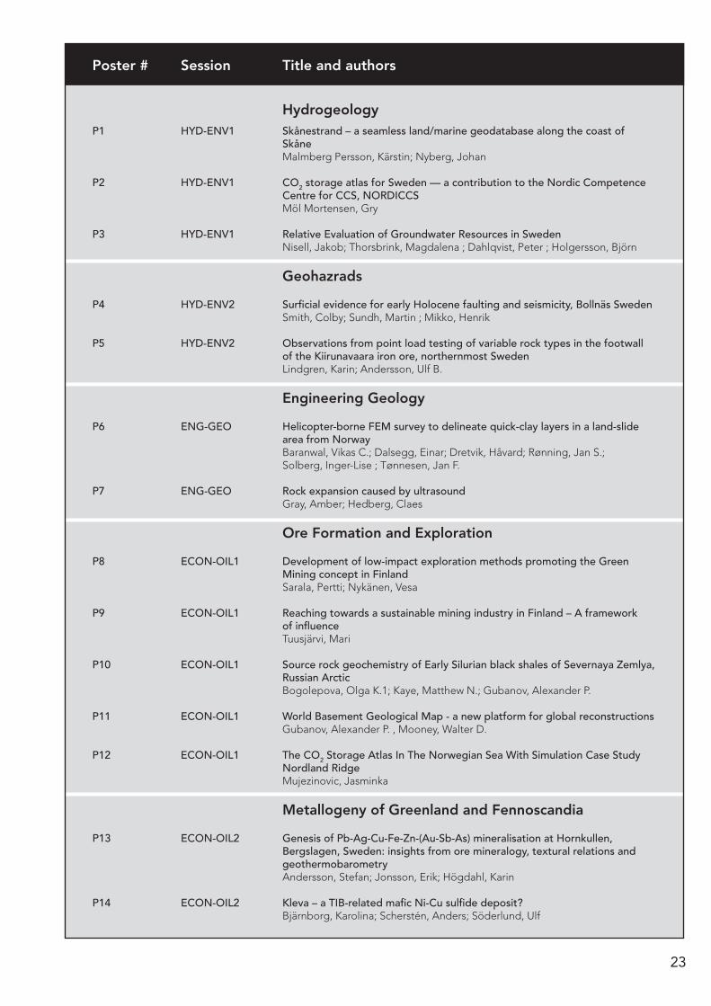
Posters
23
HydrogeologyP1 HYD-ENV1 Skånestrand – a seamless land/marine geodatabase along the coast of
Skåne Malmberg Persson, Kärstin; Nyberg, Johan
P2 HYD-ENV1 CO2 storage atlas for Sweden — a contribution to the Nordic Competence Centre for CCS, NORDICCS
Möl Mortensen, Gry
P3 HYD-ENV1 Relative Evaluation of Groundwater Resources in Sweden Nisell, Jakob; Thorsbrink, Magdalena ; Dahlqvist, Peter ; Holgersson, Björn
Geohazrads
P4 HYD-ENV2 Surficial evidence for early Holocene faulting and seismicity, Bollnäs Sweden Smith, Colby; Sundh, Martin ; Mikko, Henrik
P5 HYD-ENV2 Observations from point load testing of variable rock types in the footwall of the Kiirunavaara iron ore, northernmost Sweden
Lindgren, Karin; Andersson, Ulf B.
Engineering Geology
P6 ENG-GEO Helicopter-borne FEM survey to delineate quick-clay layers in a land-slide area from Norway
Baranwal, Vikas C.; Dalsegg, Einar; Dretvik, Håvard; Rønning, Jan S.; Solberg, Inger-Lise ; Tønnesen, Jan F.
P7 ENG-GEO Rock expansion caused by ultrasound Gray, Amber; Hedberg, Claes
Ore Formation and Exploration
P8 ECON-OIL1 Development of low-impact exploration methods promoting the Green Mining concept in Finland
Sarala, Pertti; Nykänen, Vesa
P9 ECON-OIL1 Reaching towards a sustainable mining industry in Finland – A framework of influence Tuusjärvi, Mari
P10 ECON-OIL1 Source rock geochemistry of Early Silurian black shales of Severnaya Zemlya, Russian Arctic
Bogolepova, Olga K.1; Kaye, Matthew N.; Gubanov, Alexander P.
P11 ECON-OIL1 World Basement Geological Map - a new platform for global reconstructions Gubanov, Alexander P. , Mooney, Walter D.
P12 ECON-OIL1 The CO2 Storage Atlas In The Norwegian Sea With Simulation Case Study Nordland Ridge
Mujezinovic, Jasminka
Metallogeny of Greenland and Fennoscandia
P13 ECON-OIL2 Genesis of Pb-Ag-Cu-Fe-Zn-(Au-Sb-As) mineralisation at Hornkullen, Bergslagen, Sweden: insights from ore mineralogy, textural relations and geothermobarometry
Andersson, Stefan; Jonsson, Erik; Högdahl, Karin
P14 ECON-OIL2 Kleva – a TIB-related mafic Ni-Cu sulfide deposit? Bjärnborg, Karolina; Scherstén, Anders; Söderlund, Ulf
Poster # Session Title and authors
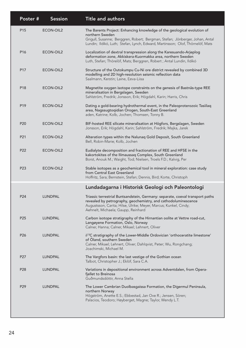
24
P15 ECON-OIL2 The Barents Project: Enhancing knowledge of the geological evolution of northern Sweden
Grigull, Susanne; Berggren, Robert; Bergman, Stefan; Jönberger, Johan, Antal Lundin; Ildikó, Luth; Stefan, Lynch, Edward, Martinsson; Olof, Thörnelöf, Mats
P16 ECON-OIL2 Localization of dextral transpression along the Karesuando-Arjeplog deformation zone, Akkiskera-Kuormakka area, northern Sweden Luth, Stefan; Thörelöf, Mats; Berggren, Robert ; Antal Lundin, Ildikó
P17 ECON-OIL2 Structure of the Outokumpu Cu-Ni ore district revealed by combined 3D modelling and 2D high-resolution seismic reflection data
Saalmann, Kerstin; Laine, Eeva-Liisa
P18 ECON-OIL2 Magnetite oxygen isotope constraints on the genesis of Bastnäs-type REE mineralisation in Bergslagen, Sweden
Sahlström, Fredrik; Jonsson, Erik; Högdahl, Karin; Harris, Chris
P19 ECON-OIL2 Dating a gold-bearing hydrothermal event, in the Paleoproterozoic Tasiilaq area, Nagssugtoqidian Orogen, South-East Greenland
aden, Katrine; Kolb, Jochen; Thomsen, Tonny B.
P20 ECON-OIL2 BIF-hosted REE silicate mineralisation at Högfors, Bergslagen, Sweden Jonsson, Erik; Högdahl, Karin; Sahlström, Fredrik; Majka, Jarek
P21 ECON-OIL2 Alteration types within the Nalunaq Gold Deposit, South Greenland Bell, Robin-Marie; Kolb, Jochen
P22 ECON-OIL2 Eudialyte decomposition and fractionation of REE and HFSE in the kakortokites of the Ilímaussaq Complex, South Greenland
Borst, Anouk M.; Waight, Tod; Nielsen, Troels F.D.; Kalvig, Per
P23 ECON-OIL2 Stable isotopes as a geochemical tool in mineral exploration: case study from Central East Greenland
Hoffritz, Sara; Bernstein, Stefan; Dennis, Bird; Korte, Christoph
Lundadagarna i Historisk Geologi och Paleontologi
P24 LUNDPAL Triassic terrestrial Buntsandstein, Germany: separate, coeval transport paths revealed by petrography, geochemistry, and cathodoluminescence
Augustsson, Carita; Hilse, Ulrike; Meyer, Marcus; Kunkel, Cindy; Aehnelt, Michaela; Gaupp, Reinhard
P25 LUNDPAL Carbon isotope stratigraphy of the Hirnantian oolite at Vettre road-cut, Langøyene Formation, Oslo, Norway
Calner, Hanna; Calner, Mikael; Lehnert, Oliver
P26 LUNDPAL δ13C stratigraphy of the Lower-Middle Ordovician ‘orthoceratite limestone’ of Öland, southern Sweden
Calner, Mikael; Lehnert, Oliver; Dahlqvist, Peter; Wu, Rongchang; Joachimski, Michael M.
P27 LUNDPAL The Vargfors basin: the last vestige of the Gothian ocean Talbot, Christopher J.; Eklöf, Sara C.A.
P28 LUNDPAL Variations in depositional environment across Adventdalen, from Opera- fjellet to Breinosa
Guðmundsdóttir, Anna Stella
P29 LUNDPAL The Lower Cambrian Duolbasgaissa Formation, the Digermul Peninsula, northern Norway
Högström, Anette E.S.; Ebbestad, Jan Ove R.; Jensen, Sören; Palacios, Teodoro; Høyberget, Magne; Taylor, Wendy L.T.
Poster # Session Title and authors
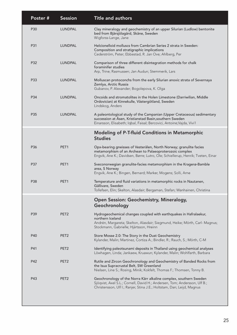
25
P30 LUNDPAL Clay mineralogy and geochemistry of an upper Silurian (Ludlow) bentonite bed from Bjärsjölagård, Skåne, Sweden
Wigforss-Lange, Jane
P31 LUNDPAL Helcionelloid molluscs from Cambrian Series 2 strata in Sweden: Composition and stratigraphic implications
Cederström, Peter; Ebbestad, R. Jan Ove; Ahlberg, Per
P32 LUNDPAL Comparison of three different disintegration methods for chalk foraminifer studies
Arp, Trine; Rasmussen; Jan Audun; Stemmerik, Lars
P33 LUNDPAL Molluscan protoconchs from the early Silurian anoxic strata of Severnaya Zemlya, Arctic Russia
Gubanov, P. Alexander; Bogolepova, K. Olga
P34 LUNDPAL Oncoids and stromatolites in the Holen Limestone (Darriwilian, Middle Ordovician) at Kinnekulle, Västergötland, Sweden
Lindskog, Anders
P35 LUNDPAL A paleontological study of the Campanian (Upper Cretaceous) sedimentary succession at Åsen, Kristianstad Basin,southern Sweden Einarsson, Elisabeth; Iqbal, Faisal; Bercovici, Antoine;Vajda, Vivi1
Modeling of P-T-fluid Conditions in Metamorphic Studies
P36 PET1 Opx-bearing gneisses of Vesterålen, North Norway; granulite facies metamorphism of an Archean to Palaeoproterozoic complex
Engvik, Ane K.; Davidsen, Børre; Lutro, Ole; Schiellerup, Henrik; Tveten, Einar
P37 PET1 Sveconorwegian granulite-facies metamorphism in the Kragerø-Bamble area, S Norway
Engvik, Ane K.; Bingen, Bernard; Marker, Mogens; Solli, Arne
P38 PET1 Temperature and fluid variations in metamorphic rocks in Nautanen, Gällivare, Sweden
Tollefsen, Elin; Skelton, Alasdair; Bergaman, Stefan; Wanhainen, Christina
Open Session: Geochemistry, Mineralogy, Geochronology
P39 PET2 Hydrogeochemical changes coupled with earthquakes in Hafralaekur, northern Iceland
Andrén, Margareta; Skelton, Alasdair; Siegmund, Heike; Mörth, Carl- Magnus; Stockmann, Gabrielle; Hjärtsson, Hreinn
P40 PET2 Store Mosse 2.0: The Story in the Dust Geochemistry Kylander, Malin; Martinez, Cortiza A.; Bindler, R.; Rauch, S.; Mörth, C-M
P41 PET2 Identifying paleotsunami deposits in Thailand using geochemical analyses Löwhagen, Linda; Jankaew, Kruawun; Kylander, Malin; Wohlfarth, Barbara
P42 PET2 Rutile and Zircon Geochronology and Geochemistry of Banded Rocks from the Isua Supracrustal Belt, SW Greenland
Nielsen, Line S.; Rosing, Minik; Kokfelt, Thomas F.; Thomsen, Tonny B.
P43 PET2 Geochronology of the Norra Kärr alkaline complex, southern Sweden Sjöqvist, Axel S.L.; Cornell, David H.; Andersen, Tom; Andersson, Ulf B.; Christensson, Ulf I.; Ranjer, Stina J.E.; Holtstam, Dan; Leijd, Magnus
Poster # Session Title and authors
26
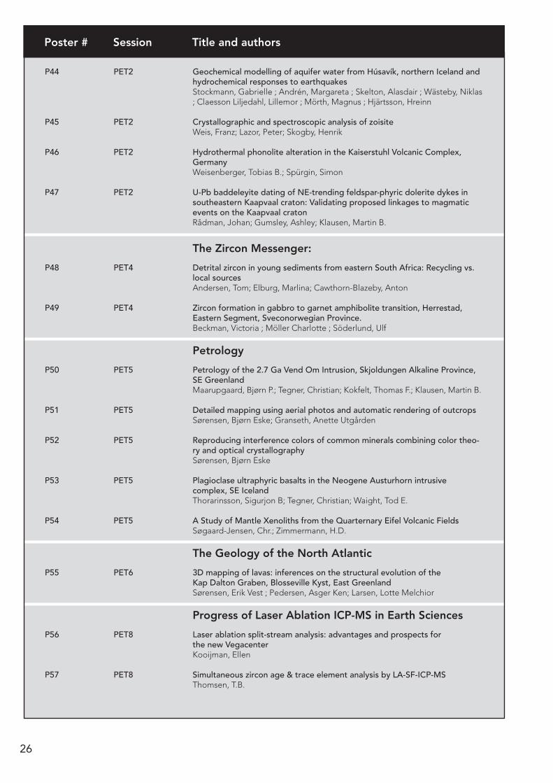
P44 PET2 Geochemical modelling of aquifer water from Húsavík, northern Iceland and hydrochemical responses to earthquakes
Stockmann, Gabrielle ; Andrén, Margareta ; Skelton, Alasdair ; Wästeby, Niklas ; Claesson Liljedahl, Lillemor ; Mörth, Magnus ; Hjärtsson, Hreinn
P45 PET2 Crystallographic and spectroscopic analysis of zoisite Weis, Franz; Lazor, Peter; Skogby, Henrik
P46 PET2 Hydrothermal phonolite alteration in the Kaiserstuhl Volcanic Complex, Germany
Weisenberger, Tobias B.; Spürgin, Simon
P47 PET2 U-Pb baddeleyite dating of NE-trending feldspar-phyric dolerite dykes in southeastern Kaapvaal craton: Validating proposed linkages to magmatic events on the Kaapvaal craton Rådman, Johan; Gumsley, Ashley; Klausen, Martin B.
The Zircon Messenger:
P48 PET4 Detrital zircon in young sediments from eastern South Africa: Recycling vs. local sources
Andersen, Tom; Elburg, Marlina; Cawthorn-Blazeby, Anton
P49 PET4 Zircon formation in gabbro to garnet amphibolite transition, Herrestad, Eastern Segment, Sveconorwegian Province.
Beckman, Victoria ; Möller Charlotte ; Söderlund, Ulf
Petrology
P50 PET5 Petrology of the 2.7 Ga Vend Om Intrusion, Skjoldungen Alkaline Province, SE Greenland
Maarupgaard, Bjørn P.; Tegner, Christian; Kokfelt, Thomas F.; Klausen, Martin B.
P51 PET5 Detailed mapping using aerial photos and automatic rendering of outcrops Sørensen, Bjørn Eske; Granseth, Anette Utgården
P52 PET5 Reproducing interference colors of common minerals combining color theo-ry and optical crystallography
Sørensen, Bjørn Eske
P53 PET5 Plagioclase ultraphyric basalts in the Neogene Austurhorn intrusive complex, SE Iceland
Thorarinsson, Sigurjon B; Tegner, Christian; Waight, Tod E.
P54 PET5 A Study of Mantle Xenoliths from the Quarternary Eifel Volcanic Fields Søgaard-Jensen, Chr.; Zimmermann, H.D.
The Geology of the North Atlantic
P55 PET6 3D mapping of lavas: inferences on the structural evolution of the Kap Dalton Graben, Blosseville Kyst, East Greenland
Sørensen, Erik Vest ; Pedersen, Asger Ken; Larsen, Lotte Melchior
Progress of Laser Ablation ICP-MS in Earth Sciences
P56 PET8 Laser ablation split-stream analysis: advantages and prospects for the new Vegacenter
Kooijman, Ellen
P57 PET8 Simultaneous zircon age & trace element analysis by LA-SF-ICP-MS Thomsen, T.B.
Poster # Session Title and authors

27
Structural Geology an Tectonics
P58 STR-TEC1 Elements of the structural evolution at Kiirunavaara, northernmost Sweden Berglund, Johan; Andersson, Ulf B.
P59 STR-TEC1 Analogue modelling of ductile deformation at ore lenses in Grängesberg, Bergslagen, Sweden
Eklöf, Sara C.A.; Högdahl, Karin; Koyi, Hemin A.
P60 STR-TEC1 Reconstruction of the coastal impact of the Indian Ocean tsunami on December 26, 2004
Ericsson, Linda; Skelton, Alasdair
P61 STR-TEC1 Numerical models of finite deformation within down-built diapirs: effects of composite rocksalt rheology on deformation patterns
Fuchs, Lukas; Koyi, Hemin; Schmeling, Harro
P62 STR-TEC1 Fracture patterns and fault kinematics in the Bohus granite at Smögen, SW Sweden
Hallinder, Stina; Berglund, Johan
P63 STR-TEC1 The Nesflaten supracrustal unit – a polydeformed Mesoproterozoic unit in SW Norway
Dalslåen, Bjørgunn Heggem; Jacobs, Joachim; Slagstad, Trond; Marker, Mogens
P64 STR-TEC1 Post-depositional thermal history: inherited fission tracks Jensen, Peter Klint; Hansen, Kirsten
P65 STR-TEC1 Ordovician sediments sandwiched between Proterozoic basement slivers in the southern part of the Siljan Ring, central Sweden
Arslan, Arzu; Lehnert, Oliver; Guido Meinhold
P66 STR-TEC1 Structural and metamorphic evolution of the basal shear zone of a c. 1 Ga eclogite domain in the Sveconorwegian Orogen, Sweden
Tual, Lorraine; Möller, Charlotte; Pinan-Llamas, Aranzazu
P67 STR-TEC1 New insights to the Geological history of the Southern part of the Nags sugtoqidian orogeny in Western Greenland from lineament mapping along the Kangerlussuaq-Russell Thrust Zone Engstrom, Jon; Klint, Knud Erik S.
P68 STR-TEC1 Structural and kinematic analyses of the Håkaneset subaerial/subaquatic rockslide along Tinnsjø, Telemark, Norway Sollie, Inger Lise; Hermanns, Reginald L.; Eilertsen, Raymond; Eiken, Trond
Trans-Baltic Precambrian Correlations: Regional and Global Tectonic Reconstructions
P69 STR-TEC2 Postglacial and recent paleoseismic dislocations in the SE part of Fennos candian Shield and on the marginal zone of the Russian Platform Systra, Ylo; Spungin, Vadim; Shvarev, Sergei P70 STR-TEC2 3D magnetic modeling of the Korsun'-Novomirgorod pluton and the Novoukrainka massif (Ukrainian Shield), and its geological interpretation Pashkevich, I.K. ; Bakarjieva, M.I.; Mychak, S.
P71 STR-TEC2 The pre- to early-Sveconorwegian history of southwest Norway Roberts, Nick M W, Slagstad, Trond, Marker, Mogens, Røhr, Torkil
P72 STR-TEC2 Evolution of the Precambrian crust in Lithuania Skridlaite, Grazina; Čečys, Audrius
Poster # Session Title and authors

28
P73 STR-TEC2 Tectonothermal evolution of the crust of the north-western Belarus during Palaeo- and Mezoproterozoic
Taran, L.
P74 STR-TEC2 Multistage Danopolonian deformation in the E-W trending Polotsk-Kurzeme Fault Belt, Lithuania
Vejelyte, Irma; Bogdanova, Svetlana
Orogens and Orogen Dynamics
P75 STR-TEC3 Mid Ordovician Leucogranites in the Lower Seve Nappe of central Jämtland, Swedish Caledonides
Li, Yuan; Gee, David. G.; Iwona Klonowska; Henning Lorenz; Anna Ladenberger
P76 STR-TEC3 The structure of the Kakari area with implications to the structural evolution of the Palaeoproterozoic Peräpohja Belt, Northern Finland
Nieminen, Ville; Skyttä, Pietari; Piippo, Simo; Huovinen, Irmeli; Kilpeläinen, Timo
P77 STR-TEC3 The Gillberga synform – an upper-crustal orogenic lid? Persson Nilsson, Katarina; Lundqvist, Lena
P78 STR-TEC3 Evolution of the Hardangervidda-Ryfylke Nappe Complex, SW Norwegian Caledonides
Roberts, N.M.W.; Parrish, R.R.; Horstwood, M.S.A
P79 STR-TEC3 Structural analysis and 3D-modelling of the structures controlling the spatial distribution and structure of Cu- and Au-deposits in the Peräpohja Belt, Northern Finland
Skyttä, Pietari; Käpyaho, Asko; Lauri, Laura; Piippo, Simo; Nieminen, Ville; Kilpeläinen, Timo; Huovinen, Irmeli; Kinnunen, Janne
P80 STR-TEC3 Lateral spreading in the Svecofennian mid-crust revealed by seismic attribute analysis
Torvela, Taija; Moreau, Julien; Butler, Robert; Korja, Annakaisa; Heikkinen, Pekka
P81 STR-TEC3 Extension versus contraction in the East Greenland Caledonides Andresen, Arild; Hauge, Kristina; Gasser, Deta
Evolution of the Continental Crust: Growth vs. Reworking
P82 STR-TEC4 Field Relationships, Petrography and Geochemistry of Proterozoic Dyke Swarms in the Umivik Area, SE Greenland
Bothma, Riaan; Klausen, Martin, B.
P83 STR-TEC4 Tectonophysical interpretation of the junction zone between the Fennoscandian, Sarmatian and Volga-Uralian segments of the East European Craton
Garetsky, Radim. G., Karatayev, German I.
P84 STR-TEC4 Kinematic constraints on the formation of gneiss domes in the Archaean Yilgarn Craton, Western Australia.
Hansman, Reuben; Gessner, Klaus; Thébaud, Nicolas; Zibra, Ivan; Uwe, Ring; Duclaux, Guillaume
P85 STR-TEC4 Zircon geochronology of the Skjoldungen region, SE Greenland Næraa, Tomas ; Kokfelt F. Thomas; Thrane Kristine
P86 STR-TEC4 Relationships between basin architecture, basin closure, and occurrence of sulphide-bearing schists: an example from Tampere Schist Belt, Finland
Kalliomäki, Henrik ; Torvela, Taija; Moreau, Julien; Kähkönen, Yrjö
Poster # Session Title and authors
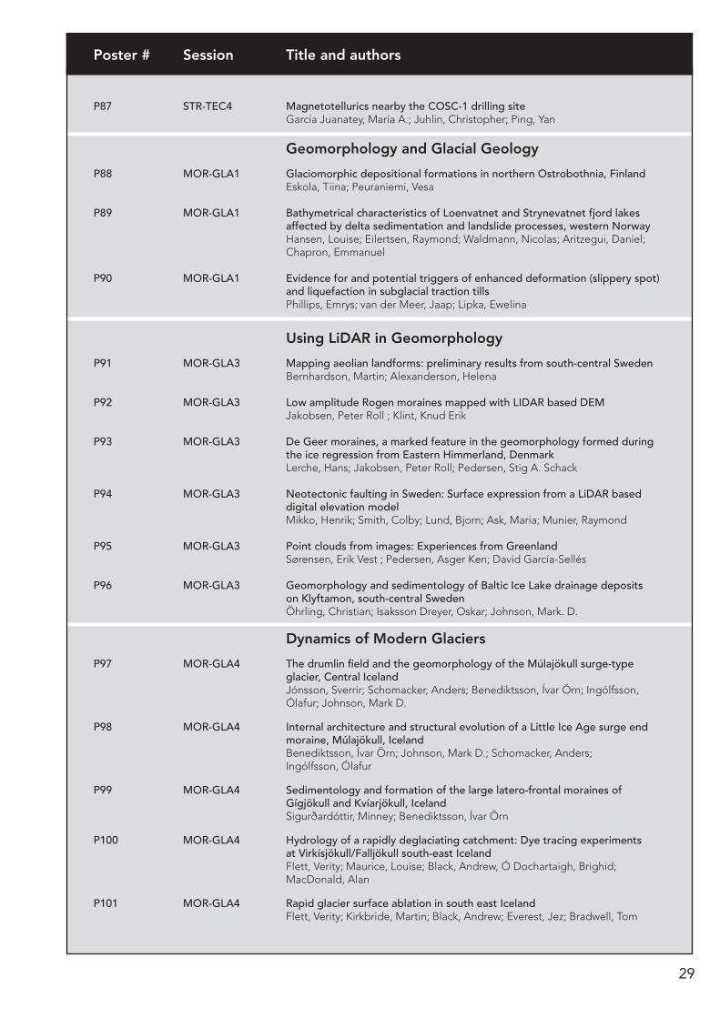
29
P87 STR-TEC4 Magnetotellurics nearby the COSC-1 drilling site García Juanatey, María A.; Juhlin, Christopher; Ping, Yan
Geomorphology and Glacial Geology
P88 MOR-GLA1 Glaciomorphic depositional formations in northern Ostrobothnia, Finland Eskola, Tiina; Peuraniemi, Vesa
P89 MOR-GLA1 Bathymetrical characteristics of Loenvatnet and Strynevatnet fjord lakes affected by delta sedimentation and landslide processes, western Norway
Hansen, Louise; Eilertsen, Raymond; Waldmann, Nicolas; Aritzegui, Daniel; Chapron, Emmanuel
P90 MOR-GLA1 Evidence for and potential triggers of enhanced deformation (slippery spot) and liquefaction in subglacial traction tills
Phillips, Emrys; van der Meer, Jaap; Lipka, Ewelina
Using LiDAR in Geomorphology
P91 MOR-GLA3 Mapping aeolian landforms: preliminary results from south-central Sweden Bernhardson, Martin; Alexanderson, Helena
P92 MOR-GLA3 Low amplitude Rogen moraines mapped with LIDAR based DEM Jakobsen, Peter Roll ; Klint, Knud Erik
P93 MOR-GLA3 De Geer moraines, a marked feature in the geomorphology formed during the ice regression from Eastern Himmerland, Denmark
Lerche, Hans; Jakobsen, Peter Roll; Pedersen, Stig A. Schack
P94 MOR-GLA3 Neotectonic faulting in Sweden: Surface expression from a LiDAR based digital elevation model
Mikko, Henrik; Smith, Colby; Lund, Bjorn; Ask, Maria; Munier, Raymond
P95 MOR-GLA3 Point clouds from images: Experiences from Greenland Sørensen, Erik Vest ; Pedersen, Asger Ken; David García-Sellés
P96 MOR-GLA3 Geomorphology and sedimentology of Baltic Ice Lake drainage deposits on Klyftamon, south-central Sweden
Öhrling, Christian; Isaksson Dreyer, Oskar; Johnson, Mark. D.
Dynamics of Modern Glaciers
P97 MOR-GLA4 The drumlin field and the geomorphology of the Múlajökull surge-type glacier, Central Iceland
Jónsson, Sverrir; Schomacker, Anders; Benediktsson, Ívar Örn; Ingólfsson, Ólafur; Johnson, Mark D.
P98 MOR-GLA4 Internal architecture and structural evolution of a Little Ice Age surge end moraine, Múlajökull, Iceland
Benediktsson, Ívar Örn; Johnson, Mark D.; Schomacker, Anders; Ingólfsson, Ólafur
P99 MOR-GLA4 Sedimentology and formation of the large latero-frontal moraines of Gígjökull and Kvíarjökull, Iceland
Sigurðardóttir, Minney; Benediktsson, Ívar Örn
P100 MOR-GLA4 Hydrology of a rapidly deglaciating catchment: Dye tracing experiments at Virkísjökull/Falljökull south-east Iceland
Flett, Verity; Maurice, Louise; Black, Andrew, Ó Dochartaigh, Brighid; MacDonald, Alan
P101 MOR-GLA4 Rapid glacier surface ablation in south east Iceland Flett, Verity; Kirkbride, Martin; Black, Andrew; Everest, Jez; Bradwell, Tom
Poster # Session Title and authors

30
Glacial History of Scandinavia
P102 MOR-GLA5 Contrast in glaciomarine varves deposited before and after the Baltic Ice Lake drainage: micromorphologic and geochemical evidence
Johnson, Mark D.; Phillips, Emrys; Kylander, Malin ; Casserstedt, Lovise; Wiborgh, Hanna; Björck, Svante
P103 MOR-GLA5 Deglaciation of the outer Hardangerfjord system (Bømlafjorden), western Norway
Egeland, Irene; Haflidason, Haflidi; Hjelstuen, Berit Oline;Sejrup, Hans Petter
P104 MOR-GLA5 The deglaciation of the outer mid-Norwegian continental shelf Haflidason, Haflidi; Bøyum, Eivind S.; Hjelstuen, Berit O.
P105 MOR-GLA5 Deglaciation history and landscape development of the Nesna-Leirfjord area, north Norway
Hansen, Lousie; Sveian, Harald; Olsen, Lars; Rubensdotter, Lena; Romundset, Anders; Fredin, Ola; Dretvik, Håvard; Bøe, Reidulv
P106 MOR-GLA5 The Scandinavian ice sheet through the Weichselian: high mobility and climate sensitivity.
Houmark-Nielsen, Michael
P107 MOR-GLA5 Early Quaternary sediments in Denmark dated by paleomagnetism Kronborg, Christian; Nielsen, Ole Bjørslev; Beyer, Claus
P108 MOR-GLA5 The Younger Dryas ice margin positions in the Oppdal-Trondheim area, Mid-Norway
Olsen, Lars; Høgaas, Fredrik; Sveian, Harald; Follestad, Bjørn; Klug, Martin
P109 MOR-GLA5 Geotechnical and sedimentary evidence for late glacial ice dynamics in Southern Lake Vättern
O’Regan, Matt; Ampel, Linda;, Greenwood, Sarah; Kylander, Malin; Preto, Preto, Swärd, Henrik, Jakobsson, Martin
P110 MOR-GLA5 OSL dating of the inter-till stratified sediments of the Naakenavaara key section in Kittilä, northern Finland
Sarala, Pertti
P111 MOR-GLA5 Late Pleistocene to Holocene Sediments from Southern Lake Vättern Swärd, Henrik; O´Regan, Matt; Greenwood, Sarah; Mörth, Magnus; Preto,
Pedro; Varga, Tina; Ampel, Linda; Jakobsson, Martin
P112 MOR-GLA5 Early Pleistocene glacial sediments in Denmark. Beyer, Claus; Kronborg, Christian; Nielsen, Ole Bjorslev
P113 QUAT1 Early Holocene landscape and Baltic Sea development based on submarine lake sediments and forest remains
Hansson, Anton; Björck, Svante; Linderson, Hans; Nilsson, Björn; Rundgren, Mats; Sjöström, Arne; Hammarlund, Dan
P114 QUAT1 Bølling-Allerød glacier dynamics in lower Borgarfjörður, W-Iceland: multi-scale analysis of a glaciotectonised sequence of marine sediments
Sigfúsdóttir, Þorbjörg; Benediktsson, Ívar Örn; Phillips, Emrys
P115 QUAT1 Ocean Drilling Program (ODP) Site 1233, SE Pacific Ocean: paleoclimatic reconstructions over Antarctic warming event 1
Soltvedt, Natalie; Kleiven, Helga; Irvali, Nil
P116 QUAT1 Holocene climate and environmental change in north-eastern Kamchatka (Russia)
Andrén, Elinor; Hammarlund, Dan ; Klimaschewski, Andrea ; Self, Angela E. ; Andreev, Andrei A. ; Barnekow, Lena ; Conley, Daniel ; Solovieva, Nadia ; Bennett, Keith
Poster # Session Title and authors

31
Land-Sea Interactions in a Long Time Perspective
P117 QUAT2 Mineralogical perspectives of central Arctic Ocean sediments for understanding ice sheet transitions, transport mechanism and provenance changes during the Late Pleistocene
Kaparulina, Ekaterina; Strand, Kari; Lunkka, Juha Pekka
P118 QUAT2 Reconstruction of land-use change and erosion within the catchment of Lake Vomb in southern Sweden
Ljung, Karl; Alexanderson, Helena; Ning, Wenxin; Broström, Anna
P119 QUAT2 Pelagic-benthic coupling within an upwelling system of the subtropical northeast Atlantic over the last 35 ka
McKay, C.L.; Filipsson, H.L.; Romero, O.E.; Stuut, J.-B.W.; Donner, B
P120 QUAT2 Environmental changes in the Baltic Sea coastal area over the last 6 000 years – a dinoflagellate cysts perspective
Ning, Wenxin; Ghosh, Anupam; Filipsson, Helena L.
Astrobiology
P121 GEOBIO Peroxy Defects in Rocks and H2O2 Formation on the Early Earth Gray, Amber; Balk, Melike; Mason, Paul; Freund, Friedemann; Rothschild, Lynn
P122 GEOBIO Structural and catalytic characterization of iron bearing analcime and phillipsite, and its plausible role on the nitrogen reduction in hydrothermal systems.
Iñiguez, Enrique; Holm, Nils G.
Geophysics & Impact Structures
P123 GEOP1 The 3D modeling of the Vihanti area using geological interpretation of seismic and magnetic data
Laine, Eevaliisa; Ruotsalainen, Aimo; Suppala, Ilkka
P124 GEOP1 Continuous subsidence in the Thingvellir rift graben, Iceland: Geodetic observations since 1966 compared to rheological models of plate spreading
Sturkell, Erik; Islam, Tariqul M; Sigmundsson, Freysteinn; Geirsson, Halldor; La Femina, Peter C
P125 GEOP1 Ni-Cu mineralisation in the impact-induced Norite belt, Maniitsoq structure, West Greenland
Garde, Adam A.; Pattison, John; Kokfelt, Thomas; McDonald, Iain
P126 GEOP1 Direct mineral melting in the Maniitsoq structure, West Greenland Keulen, Nynke ; Garde, Adam A.; Johansson, Leif
P127 GEOP1 Ni-mineralised norites and post-kinematic diorites from the Maniitsoq area, southern West Greenland: Evidence for impact-related source modification
Kokfelt, Thomas F.; Garde, Adam; Pattison, John; MacDonald, Ian
P128 GEOP1 Tsunami generation and subsequent resurge at the Wetumpka impact structure (Alabama, USA)
Ormö, J.; King, D. T. Jr.; Lepinette, A.; Petruny, L. W.; Markin, J.K.
P129 GEOP1 Hydrothermal zircon with complete isotopic re-equilibration in the Maniitsoq structure, West Greenland: A 3001 Ma minimum age of impact?
Scherstén Anders; Garde, Adam
P130 GEOP1 Concentric Impact Structures in the Palaeozoic (CISP) Sturkell, Erik; Juhlin, Christopher; Ormö, Jens; Ebbestad Jan Ove R.;
Greiling, Reinhard O.; Högström, Anette; Kontny, Agnes M.; Lehnert, Oliver; Meinhold, Guido
Poster # Session Title and authors

32
Volcanology
P131 GEOP2 Impact of tephra deposition on benthic foraminifera: Evidence from the North Icelandic shelf
Gudmundsdóttir, Esther Ruth; Eiríksson, Jón ; Knudsen, Karen Luise; Larsen, Gudrún
P132 GEOP2 Regional tephra horizons in the E-Norwegian Sea during the last 40 ka Nilsen, Tonje Elvik; Haflidason, Haflidi; Sejrup, Hans Petter
Outreach
P133 OUT-ED Helping PhD-students succeed: PhD on Track Gullbekk, Eystein; Lundmark, Anders Mattias; Austrheim, Gunhild; Attinger,
Gisela ; Bech, Mia ; Cutler, Ingrid ; Folkestad, Hege ; Gasparini, Andrea Ales-sandro; Haraldsen, Kirsten Borse ; Kavli, Fredrik ; Konestabo, Heidi Sjursen; Mikki, Susanne ; Ringnes, Hege Kristin; Roos, Monica ; Rullestad, Tove ; Skagen, Therese; Torras, Maria-Carme ; Westbye, Hilde ; Ødegaard, Marte
P134 OUT-ED The Virtual Seismic Atlas – an interactive web-based tool for Earth science teaching and research
Torvela, Taija; Butler, Rob; McCaffrey, Bill
P135 OUT-ED 155 years of rock samples Wickström, Linda M.; Lundqvist, Sven
Poster # Session Title and authors
33
34
AbstractsThe abstract texts that follow are arranged first by theme, and then alphabetically by first author. For example, all abstracts in the various PET Petrology sessions are found within the PET section of the abstract volume, and alphabetically by author therein. This is to ease searching for abstracts while sitting within a given theme session.

35
Ple
nary
Surging glaciers in Iceland – research status and future challenges
Ólafur Ingólfsson1 & Ívar Örn Benediktsson2
1 University Centre in Svalbard (UNIS) and Faculty of Earth Sciences, University of Iceland
2 Department of Geology, Lund University
Although intensely studied, dynamics and geological finger-prints of surging glaciers are still not well understood, and the question if mass balance or climate control surge initiation is still enigmatic. Iceland is a key area for studying surging glaciers, and one motivation for the research is that large surging glaciers are the best modern analog we have to ice streams in the geo-logical record. At least 26 Icelandic outlet glaciers, ranging from 0.5–1 500 km2, are known to surge, with terminal advances rang-ing from a few tens of meters to about 10 km. The geomorphic signatures of surges vary, from large-scale fold and thrust end moraines, crevasse-fill ridges and concertina eskers, extensive dead-ice fields and fluted/-drumlinized forefields to drift sheets where fast ice-flow indicators are largely missing.
The talk will outline some outstanding research questions, and present case studies from the forefields of Brúarjökull, Eyjabakka¬jökull and Múlajökull surging glaciers:
• How is rapid ice flow sustained through the surge? • What is the geological fingerprinting of surges in
sediments and landforms, and which processes control the development of surging glacier landsystems?
• Can we explain the surging glacier landsystem assem-blage using one model, or do we need different models for different types of glaciers (warm based vs polythermal glaciers, large outlet glaciers vs cirque glaciers)?
• Can we reconstruct past surge flow rates from glacial landforms and sediments?
• Can we scale-up present-day surging glaciers processes/landforms/landsystems for applying to past ice streams?
• Is there a climatic control on surge initiation, duration or frequencies?
At Brúarjökull, extremely rapid ice flow during surges was sus-tained by overpressurized water causing decoupling beneath a thick sediment sequence that was coupled to the glacier. The ice-marginal position of the 1890 surge is marked by a sedimen-tary wedge formed within five days and a large moraine ridge that formed in about one day (“instantaneous end-moraine“). Three different qualitative and conceptual models are required to explain the genesis of the Eyjabakkajökull moraines: a narrow, single-crested moraine ridge at the distal end of a marginal sediment wedge formed in response to decoupling of the sub-glacial sediment from the bedrock and associated down-glacier sediment transport; large lobate end moraine ridges with mul-tiple, closely spaced, asymmetric crests formed by proglacial piggy-back thrusting; and large ridges of multiple, widely spaced and broad symmetric crests formed by shortening of the foreland strata through large-scale folding. A study high-lighting the surge history of Eyjabakkajökull over the last 4 400 years, as reflected in sediment cores from Lögurinn glacial lake, suggests there is a mass balance-climate control on surge frequencies. Studies of the Múlajökull surging glacier concern
drumlin genesis in an active drumlin field (>100 drumlins) being exposed as the glacier retreats, and the question if there is one unifying theory to explain the formation of drumlins? The drum-lins form through repeated surges, where each surge causes deposition of till bed onto the drumlin while simultaneously eroding the sides.
Jules Verne revisited: An attempt to link mantle tomography with crustal deformation
Ring, Uwe
Department of Geological Sciences, Stockholm University, Sweden
Linking processes in the mantle with crustal deformation is one of the major challenges in tectonics/geodynamics research. We use the well-constrained mantle tomography data from the eastern Mediterranean to resolve the Cenozoic history of the retreating Hellenic subduction system. Ages for high-pressure metamorphism in the central Aegean Sea region range from 53 Ma in the north to ∼25-20 Ma in Crete in the south. Younging of high-pressure metamorphism in a southerly direction re-flects the southward retreat of the Hellenic subduction zone. The shape of pressure-temperature-time paths of high-pressure rocks is remarkably similar across all tectonic units, suggesting a steady-state thermal profile of the subduction system and persistence of deformation and exhumation styles. Most of the exhumation of high-pressure units occurred in extrusion wedges during ongoing subduction and overall lithospheric conver-gence. At 23-19 Ma this extrusion wedge stage was followed by large-scale lithospheric extension with the development of metamorphic core complexes and the opening of the Aegean Sea basin. The age pattern of extensional faults, as well as con-toured maps of apatite and zircon fission-track cooling ages, do not show a simple southward progression but reflect fluctu-ations in regional partitioning of extensional deformation and related exhumation from 23-19 Ma to the Recent. Assuming that current subduction rates were not greatly different throughout the Cenozoic shows that the draping of the subducted slab over the 660 km discontinuity occurred at about the Oligocene/Miocene boundary and drove large-scale extension causing the opening of the Aegean Sea basin.
Microstructural and molecular preser-vation in two Cretaceous dinosaurs
Schweitzer, Mary Higby
Marine, Earth and Atmospheric Sciences, Department of Biology, North Carolina Museum of Natural Sciences, Raleigh, NC 27695
Although “soft tissue preservation” has been noted for dino-saurs for centuries, it is understood to mean preservation of materials that were originally soft (i.e., not biomineralized), but had become preserved as mineralized replacements—most commonly seen in preservation of vertebrate ‘skin’ tissues. It
Plenary talks

36
was not questioned whether original molecular components remained; indeed it was assumed replacement was complete. In 2005, we first published microstructures recovered from dino-saur material that retained the transparency, flexibility and other features of the original material; blood vessels, fibrous collagen matrix, intravascular material, and bone forming cells (osteo-cytes) unique to vertebrate organisms. This was not predicted by any modes of fossilization put forth to date, and was there-fore controversial. Here I review evidence for the endogeneity of these components, and put forth a mode of preservation consistent with the data that may explain such preservation. Understanding the chemistry of preservation allows some com-pensation for the alteration that has occurred, making more fossils amenable to molecular investigations.
37
HY
D-E
NV
The Effect of Morphologically Undetectable Kettle Holes (MUKHs) on the Groundwater Flow and Water Geochemistry at Virttaankangas, SW Finland
Ahokangas, Elina1, Korkka-Niemi, Kirsti2, Mäkinen, Joni1; Artimo, Aki3
1 Department of Geography and Geology, University of Turku, 20014 Turun ylio-pisto, Finland; [email protected], [email protected];
2 Department of Geosciences and Geology, University of Helsinki, P.O.Box 64, 00014 University of Helsinki, Finland; [email protected];
3 Turku Region Water Ltd, Maariankatu 1, 20100 Turku, Finland; [email protected]
The Säkylänharju-Virttaankangas esker is one of the world’s largest glaciofluvial aquifers. It is important for the society due to its large groundwater reserve and the associated artificial groundwater project supplying water for Turku region. The various sedimentary structures (e.g. fan foresets, morphologically un-detectable kettle holes) have direct impact on the groundwater flow directions as well as on the residual times of the ground-water within the aquifer. The kettle holes were formed due to the melting of ice blocks buried within esker sediment which lead to the collapse and/or deformation of the overlying fine-grained sediments. These fine-grained sediments form a com-plete or partial walls of the kettle hole. The fine-grained walls have partial or complete insulating characteristics which further impact the groundwater flow patterns within the aquifer. The lowest and highest temperatures measured from groundwater pipes located in kettle holes were related to fine-grained layers. They have low hydraulic conductivities which decreases the groundwater flow within them. This water is no longer mixed with the aquifer groundwater which inhibits change in its tem-perature. The impact of sedimentary structures was also seen in the measured temperature, pH, electric conductivity, DOC and ORP values. These values seem to correspond to certain sedimentary units in within the aquifer. The understanding of the sedimentological characteristics combined with the de-tailed 3D hydrogeological model are used to interpret the groundwater flow and geochemistry within the Virttaankangas aquifer. This is further implemented with the large set of drill hole logs, ground penetrating radar profiles, results of pumping and recharge tests as well as the geochemical data.
Sources of CO2 in Mineral Water of Bad Driburg and other Locations
Ali, Syed Anas1
1 University of Goettingen, Geoscience, Goettingen, Germany
Significant amount of CO2 gas has been trapped in the reser-voirs of North German Basin (NGB) that is thought to be of Cretaceous age (M. Fischer et al, 2008) but there are a lot of discussions regarding the source of this CO2 which is not well understood yet. Water samples were collected from Bad Driburg mineral water bottles and nearby locations for δ13C analysis to find out about origin of the gas. δ13C values were analyzed on a Delta V coupled to a LC-Isolink where the sam-ples were acidified with phosphoric acid to produced CO2 for isotope analysis. Considering the complex dispositional and
digenetic history of the basin, the δ13C isotope results of respective samples are quite variable indicating three possible sources of CO2. Results are compared to δ13C values of magmatic CO2 from other locations worldwide.
Arsenic concentrations in water in aggregate production areas in Tampere–Häme region, Finland
Backman, Birgitta1; Hatakka, Tarja1; Pullinen, Arto1; Tarvainen, Timo1; Härmä Paavo1
1 Geological Survey of Finland, P.O. Box 96, Fi-02151 Espoo, Finland; [email protected]
The main objective of the in 2011 started EU Life+ project AS-ROCKS is to provide guidelines and risk management tools for the exploitation of natural aggregate resources (crushed bed-rock, sand and gravel) in areas with elevated natural arsenic concentrations in bedrock and soil in the Tampere–Häme region, southern Finland (http://projects.gtk.fi/ASROCKS). High arsenic content in bedrock, soil and groundwater was earlier found in the Tampere region. In these studies bedrock groundwater was noticed to be the main pathway for arsenic. The arsenic concentration in domestic wells drilled into fractured bedrock aquifers varied from <0.05 to 2230 µg/l (n=1272) (Backman et al. 2006). The health-based guideline arsenic value for drinking water by WHO (WHO, 1993) and EU, 10 µg/l, was exceeded in 22.5 % of these samples. Such high As concentrations in groundwater were not found in the ASROCKS study areas, but the As values were, however, elevated in comparison with the values elsewhere in Finland. The dissolved As concentration in groundwater in the sites ranged from <0.05 to 37.1 µg/l (n=18) and in surface water from 0.1 to 10 µg/l (n=43). The total As con-centrations in groundwater ranged from 0.1 to 99.2 µg/l (n=17) and in surface water from 0.1 to 9 µg/l (n=43). According to the results of stream water and stream sediment samples the environ-mental impacts in aggregate production sites extend only a short distance (<200 m) from the quarry. Arsenic in groundwater was mainly in dissolved form. In one site, where the bedrock consists of leuco gabbro only a part (2–66%) of the total As was in dissolved form. The arsenic content in the leuco gabbro varied from 74.1 to 1090 mg/kg.
ReferencesBackman, B., Luoma, S., Ruskeeniemi, T., Karttunen, V., Talikka, M. & Kaija, J., 2006: Natural Occurrence of Arsenic in the Pirkanmaa region in Finland. Geological Survey of Finland, Miscellaneous Publications, 82 p.
WHO, 1993: Guidelines for drinking-water quality. Volume 1: Recom-mendations, 2nd ed. World Health Organisation, Geneva.
An integrated simulations system to study the impact of global change on human-environment systems in the field of groundwater and water supply
Barthel, Roland1; Reichenau, Tim G.2; Muerth, Markus3; Heinzeller, Christoph3; Schneider, Karl2; Hennicker, Rolf4; Mauser, Wolfram3; Krimly, Tatjana5; Elbers, Michael6;
HYD-ENV Hydrogeology/Environmental Geology
38
HY
D-E
NV
Soboll, Anja7; Wackerbauer, Johann8; Janisch, Stephan4; Dabbert, Stephan5; Schmude, Jürgen7; Ernst, Andreas6
1 Department of Earth Sciences, University of Gothenburg, Sweden, roland.barthelu.se;
2 Hydrogeography and Climatology, University of Cologne, Germany; 3 Physical Geography and Remote Sensing, Ludwig-Maximilians-University
Munich, Germany; 4 Institute of Informatics, Ludwig-Maximilians-University Munich, Germany; 5 Institute for Farm Management, Universität Hohenheim, Germany; 6 Center for Environmental Systems Research, University of Kassel, Germany;7 Economic Geography and Tourism Research, Ludwig-Maximilians-of Munich,
Germany; 8 CESifo Group, Center for Economic Studies, Munich, Germany
Groundwater, human activities and climate are related in many different and often complex ways due to manifold interac-tions within and between the natural-environmental and the socio-economic domain. The GLOWA-Danube project, carried out between 2001 and 2010 by an interdisciplinary consortium of 17 research groups had the aim of providing an integrated approach to predicting changes in the hydrological cycle resulting from global change in the Upper Danube Catchment (UDC) in southern Germany. The central objective of GLOWA-Danube was the development of the integrated simulation system DANUBIA to simulate water-related influences of global change in different spatial and temporal contexts. DANUBIA is a modular system comprised of 17 dynamically-coupled, process-based model components and a framework that controls the interaction of these components with respect to space and time. This contri-bution describes approaches and capabilities of DANUBIA with regard to the simulation of global change in water-related fields. The DANUBIA simulation framework is presented together with the model components which are most relevant to the inter-actions between groundwater and humans. The approach for developing combination climate and socio-economic scenari-os is explained. The principles of socioeconomic actor-model-ling and interactions between socioeconomic and natural sci-ence model components will be briefly described. We present selected simulations that show impacts on groundwater from changes in agriculture, tourism, economy, domestic water users and water supply.
CO2 Storage Atlas, the Barents Sea
Bjørnestad, Andreas1; Rød, Rita Sande1; Riis, Fridtjof1
1 Norwegian Petroleum Directorate, Postboks 600, 4003 Stavanger, Norway; [email protected]
A number of studies have shown good potential for large amounts of CO2 storage on the Norwegian Continental Shelf. The CO2 team at the Norwegian Petroleum Directorate (NPD) has during the last two years, interpreted relevant data on the Norwegian Continental Shelf in order to classify potential stor-age sites. The CO2 should be injected and stored in a dense phase and in a reservoir with relative good permeability. Con-sequently, aquifers to be evaluated for CO2 storage should be located at a depth between 600 and 3500 m and have a suffi-ciently high permeability, porosity and connectivity to ensure injection and storage of CO2.
The CO2 storage atlas for the Norwegian North Sea was pub-lished in 2011 and the atlas for the Norwegian Sea was pub-lished in 2012. Both studies indicate possible storage sites, and estimated storage capacity.
The third atlas covers the southwestern Barents Sea including the Hammerfest Basin and will be published by the end of 2013.
An active petroleum industry has collected a lot of data off-shore Norway over the past 40 years; 2D and 3D seismic, drilled wells and reservoir data. The NPD has access to all data collected on the Norwegian continental shelf (NCS) and all relevant infor-mation has been utilized in the study.
Evaluated storage possibilities are saline aquifers, defined structures and use of CO2 in producing fields to enhance recovery.
Extreme snow avalanche winters recorded in tree-rings in the Bødalen valley, inner Nordfjord, western Norway
Decaulne, Armelle1,2; Eggertsson, Ólafur3; Laute, Katja4; Beylich, Achim A.5
1 Laboratory Géolittomer, UMR-6554 CNRS –LETG, Nantes University, Campus du Tertre, BP 81227, 44312 Nantes cedex 3, France, [email protected];
2 CNRS - GDR 6032 « mutations polaires », Besançon, France; 3 Iceland Forest Service, Research Branch, Mógilsá, IS-116 Reykjavík, Iceland,
[email protected]; 4 Geological Survey of Norway (NGU), Geo-Environment Division, P.O. Box 6315 Sluppen, NO-7491 Trondheim, Norway, [email protected], [email protected]
The recurrence of extreme snow avalanches in a western Norwe-gian path situated in the upper Bødalen valley and originating from an outlet glacier of the Jostedalsbreen ice cap is highlighted with the help of tree-ring studies.
The lower part of the valley is covered with downy birch (Betula pubescens Ehrh.) and grey alder (Alnus incana (L.) Moench) shrubs; trees growing in the runout zone, on the sub-horizontal valley floor, are heavily damaged up to the opposite slope.
The method used here is classic in dendrochronology applied to snow-avalanche research, and includes field survey, tree sam-pling, sample analyses and construction of a snow-avalanche chronology. Field survey locates the obvious impacts of snow avalanches in the distal runout zone, such as mineral debris deposits and damage on trees. Tree sampling, up to 91 trees, alive and dead, includes cores and disks selected randomly and along transects within the runout zone. The construction of the snow-avalanche chronology is based on the eccentricity signal of the impacted trees, death of trees and scar dating; the calculation of the avalanche activity index is derived for each year, according to the number of signals registered by trees related to the number of trees alive at this time.
Four extreme snow-avalanche events, passing over the entire valley floor and reaching a distance up to 800 m from the foot of the slope, are clearly underlined since the 20th century. Return periods of 15 to 20 years for the most extreme events are ex-tracted and recurrence intervals of 10 to 15 years for avalanches presenting distinct deposition lobes uphill the distal torrent.
Results obtained by dendrochronology are successfully compared to available documents at different spatial and tem-poral scales. While heavy wintry precipitation combined with strong winds are clearly associated to rock face snow-avalanche occurrence in the area, this is not valid for the avalanche path investigated in the paper, which is a result of the existence of the outlet glacier in the starting-zone, commanding a spatial and inter-annual variation of snow accumulation in the depar-ture zone.
Quantifying groundwater recharge contribution through natural and artificial recharge areas by ground- water modeling
Hashemi, Hossein1
1Lund University, Water Resources Engineering and The Center for Middle East-ern Studies, Lund, Sweden
Per capita water resources availability has dwindled rapidly during the last five decades in the Middle East. Especially, Groundwater has undergone dramatic changes in arid areas because of higher demand. Therefore techniques are needed to enhance groundwater reservoir. Besides natural recharge to the groundwater, water can be artificially infiltrated into an under-ground aquifer. Artificial recharge is a method to balance and
39
HY
D-E
NV
recover groundwater resources through floodwater spreading (FWS) system and injection well. Recharge is a fundamental component of groundwater system. However, often adequate estimation of recharged water is difficult due to complex geo-physical features and the large temporal and spatial variability of runoff. This research presents an inverse modeling approach to quantify the recharge contribution from both an ephemeral river channel and an introduced artificial recharge system based on FWS in arid Iran. The study used the MODFLOW2000 to es-timate recharge for both steady and unsteady-state conditions. The model was calibrated and verified based on the observed hydraulic head in observation wells and model precision, un-certainty, and model sensitivity were analyzed in all modeling steps. Our aim was to provide an approach capable of estimating the recharge parameters in such complex systems even with the scarcity of available data. The modeling results show that, assuming the observation wells are representative of the be-havior of the studied area’s aquifer, in a normal year without an extreme event the contribution of natural recharge to the groundwater storage from the river channel is about 20% and the contribution of artificial recharge from the FWS systems is about 80%. Therefore the FWS system is the main source of recharge in the study area. There are very few studies and in-adequate information about the recharge estimates through the ephemeral channels where there is an extra effect on the groundwater system by an artificial recharge system. But the methodology employed in this study can be used as represent-ative for such complex system in estimating recharge and quan-tifying the contribution of different recharge sources in an area.
The comparison of different sampling methods on arsenic and some metal concentrations in rock aggregate product samples in the ASROCKS demonstration sites in Tampere region, southern Finland
Hatakka, Tarja1; Tarvainen, Timo1; Härmä, Paavo1; Ketola, Terhi2; Vuokko, Jouko1; Nurmi Heikki1; Nyholm, Tuure1; Pullinen, Arto1; Porkka, Tero2; Hannukainen, Lari2 and Backman, Birgitta1
1 Geological Survey of Finland, P.O.Box 96, FI-02151 Espoo, Finland; [email protected];
2 Tampere University of Technology, P.O.Box 600, FI-33101 Tampere, Finland; [email protected]
The main objective of the ASROCKS project (http://projects.gtk.fi/ASROCKS), co-funded by the EU Life + Environment Policy and Governance programme, is to provide guidelines and risk management tools for the exploitation of natural aggregate re-sources in areas with naturally elevated arsenic concentrations in bedrock and soil. The arsenic and metal concentrations were determined from product samples which were taken as single or composite samples with three different sampling methods in two ASROCKS demonstration sites in Tampere region, Finland, in order to find out the best practice for the risk assessment pur-poses. In addition, the arsenic and metal concentrations were measured in the field with a portable XRF analyzer.
In the rock aggregate production sites the particle-size fractions of the studied products were 0–3 or 0–4 mm, 0–16 or 0–56 mm and 3–6 or 4–8 mm. The samples were taken using a six sub-samples composite sampling method, a sampling method de-veloped for leaching test and a multi increment sampling method. Also field duplicate samples were taken. In the laboratory, the samples were crushed to the < 2 mm grain-size fraction, and the arsenic and metal concentrations were analysed from aqua regia- and ammonium acetate-EDTA-extractions.
The agua regia-leachable arsenic concentrations in the products varied from 10.5 mg/kg to 67.4 mg/kg, and the ammonium ac-etate-EDTA-leachable concentrations from <0.5 mg/kg to 5.0
mg/kg. In comparison of arsenic concentrations in the sample and in its duplicate samples, the lowest deviation was shown in the product samples taken with the multi increment sampling method, where 30–50 subsamples from the product pile were taken. Arsenic concentrations varied most in the composite samples and in their duplicates made up from six subsamples. Despite the sampling method, the variation was lower in the coarse material. The samples taken with multi increment sam-pling method present the average arsenic concentrations in the product piles best. However, the extreme arsenic concentra-tions in the products were found in single samples. The results of some metal concentrations will also be presented.
Groundwater index – a Norwegian approach to cope with limited data
Haugen, L.E.1; Dagestad, A.2; Kværner, J.3; Gunnarsdottir, H.4; Pedersen, T.5; Frengstad, B.2
1 Norwegian Water Resources and Energy Directorate, P.O. Box 5091 Majorstua, N-0301 Oslo, Norway, [email protected];
2 Geological Survey of Norway, P.O.Box 6315, Sluppen,N-7491 Trondheim, Norway; [email protected]; [email protected];
3 Bioforsk, Fr. A. Dahlsvei 20, NO-1430 Ås, Norway; [email protected]; 4 Norwegian Environment Agency, P.O. Box 5672 Sluppen, N-7485 Trondheim,
Norway; [email protected]; 5 County Governor of Oppland, P.O.Box 987, N-2626 Lillehammer, Norway;
Norway is, due to the EEA agreement with EU, obliged to im-plement the EU groundwater directive; although with a 6 years’ extended time limit. The legal and administrative issues re-garding the implementation of the Groundwater Directive is put into force under Vannforskriften (the Water Regulation) and the responsible national authority is Miljødirektoratet (the Norwegian Environment Agency). The Geological Survey of Norway has the national responsibility for groundwater resource mapping in Norway, which traditionally has been focused on resource evaluation for drinking water supply. Hence, contaminated or aquifers under pressures from human activities, have been given less attention and hydrogeological data from these are scarce or non-existing. As drinking water supply on a rather local scale has been the main objective in previous national groundwater surveys, hydrogeological infor-mation to delineate larger aquifers or groundwater bodies is very limited.
Groundwater bodies have thus been derived from Quater-nary geology maps, and fractured hard rock aquifers are not considered to be important in this context. As in Sweden and Finland, the important aquifers in Norway are found in glacio-fluvial or fluvial deposits. They are generally small and open and situated along the river courses in valleys.
The national approach in implementing the Groundwater directive is based on the hypothesis that there are no major problems regarding groundwater quantity and chemistry in Norway. In order to document this statement, and to identify groundwater bodies which may be at risk, a national ground-water index method has been developed. The vulnerability of groundwater bodies has been assessed by using the DRASTIC method which gives weighted scores based on hydrogeological properties and climate. The pressures are treated as a function of land use where potential contamination activities such as agriculture, infrastructure, and urbanisation are calculated as weighted areas of the groundwater body. By combining the weighted vulnerability and the pressure score, a sum index gives an estimate of the probability of a groundwater body to be at risk of not meeting the environmental standards given in the Directive. The groundwater index is a transparent and unified system which can be modified when more information is available, and it promotes dedicated collection of information. It is an analytical tool and in combination with GIS techniques it provides a simple spatial overview which enables us to identify the groundwater bodies which might be at risk. However, the index cannot replace on-site surveys of the aquifer properties and
40
HY
D-E
NV
real groundwater chemistry analyses. To test and document the relevance of this groundwater index method, a limited number of groundwater bodies are selected for more detailed hydro-geological investigations. These selected groundwater bodies represent common aquifer types, hydrogeological conditions and pressures, thus representing the status of a large number of similar groundwater bodies over the country.
Approach for systematic rockslide map-ping of unstable rock slopes in Norway Hermanns, Reginald L.1; Oppikofer, Thierry1; Yugsi Molina, Freddy X.1; Dehls, John F.1; Böhme, Martina1
1 Norges geologiske undersøkelse, Leiv Eirikssons vei 39, NO-7491 Trondheim, Norway; e-mail, [email protected]
Systematic mapping of unstable rock slopes is carried out in Norway since 2005. More than 300 unstable or potential unstable rock slopes have been detected and characterized so far. This requires a standardized hazard and risk classification system that was established in 2012. The determination of the hazard and risk level follows a new standard approach for the systematic mapping of the analyzed sites, which is iterative starting with simple assessments. However the higher the hazard/risk level of a site is, the larger the amount of geological information col-lected, and the more detailed the run-out models and conse-quence analyses that will be carried out. This approach allows that mapping resources get focused on sites with higher risk level, delivering products with different levels of detail. Rock slope failures that would not result in any loss of life, as there is no life line or building in the run-out area, are mapped with-out a probability assessment. Hence these analyses have no scale for the hazard class. Rock slope failures that can result in loss of life are analyzed using qualitative hazard analyses, thus mapping products are hazard maps with qualitative probability classes. The work on this mapping approach is still ongoing; methods for assessment of the occurrence and consequences of secondary processes (e.g. triggering of displacement waves in water bodies, river damming and outburst floods) need still to be defined. An iterative approach will also be developed to analyze those processes.
Rautuvaara: A conceptual model approach to environmental management within the Hannukainen mining project, Finland
Howett, Peter¹; Korkka-Niemi, Kirsti²; Salonen, Veli-Pekka³
¹ University of Helsinki, Finland; [email protected]; ² University of Helsinki, Finland; [email protected]; ³ University of Helsinki, Finland; [email protected]
The project is the product of a joint cooperation between the company, Northland Mines Oy, and the University of Helsinki. It brings together the inevitability of an increased demand for resources with the importance to identify and maintain impacts to the surrounding geo-environment; one that is culturally, rec-reationally and biologically valuable and sensitive.
The overall aim of this project is to assess the suitability of the Rautuvaara site as a tailings facility, from an environmental perspective, which is a challenge because of the complex geo-logical history and the unknown groundwater conditions. This means to ensure that the surface/subsurface architecture is recognised, in terms of groundwater, surface water, stratigraphy and morphology, and potential impacts from the operations identified and managed.
To achieve this aim a conceptual digitized model of the sub-
surface was produced, using the MOVE™ model, to project and analyse the different data sets collected. These data sets include: ground penetrating radar data (bedrock, groundwa-ter and stratigraphy); borehole logs (bedrock); test pits (strati- graphy); groundwater piezometers (geochemistry, elevations); surface water analysis (elevations, geochemistry, discharge rates); infra-red mapping (discharge); digital elevation model data (DEM), and; peat thickness measurements.
This 3D model provides a platform, in which to identify any potential contaminant pathways within the surface water and ground water domains, for which then a flow model can be applied to simulate potential contaminants from the tailings source; which is underway, using MODFLOW.
The model, in its current form, suggests that both groundwater and surface water systems are contained within the Niesajoki valley, and that waters can effectively be managed in the south of the area. There is a narrow passage where the flow paths concentrate, therefore supporting the current planned site and on-going water management facilities, laid out by the company.
The role of springs during history in Sweden
Knutsson, Gert1
1 Brännkyrkagatan 96, 11726 Stockholm, [email protected]
A spring is a site, where groundwater is flowing out on the land surface in a natural way. There are different types of springs due to the geology and the topography. The most common type is springs in moraine areas with normally low capacity, which also is typical for springs in hard rocks as granite and gneiss. Springs with high capacity are found in glaciofluvial sediments but also in karstified limestone and coarse sandstone.
Springs have been used for water supply in all time. The first settlements from the stone-age on the plain of Västergötland were located close to springs. The growing towns, e.g. Uppsala (1649), Gothenburg (1789), Nyköping (1839) and Kalmar (1910) were supplied by water from springs.
Spring cults were related to the healing effect on the body of the water from some springs. The oldest findings of such a spring cult is from Alvastra, where a 5000 years old pile-work is located in a spring-fed fen. Many of these springs were called offering springs during Heathen Time and holy springs during Christian Time.
Mineral springs were found in Sweden and the first Spa started in Medevi 1678. The development of Spas was very fast and around 300 Spas were established all around Sweden. Some of the most famous are still running and some also sell bottled water.
The runoff and the water chemistry of a spring indicate the changes in the environment of its catchment. Acidification of groundwater due to acid precipitation as wejj as pollution from agriculture or traffic have been detected in many springs.
Waters around and underground – a challenge to Hannukainen mining development site, Finland
Korkka-Niemi, Kirsti1; Salonen, Veli-Pekka1; Nurminen, Tiina1; Rautio, Anne1
1 Department of Geosciences and Geography, University of Helsinki, Finland; [email protected]
Environmental issues play an increasingly important role in planning large-scale mining activities. Potential impacts are often related to groundwater systems, which may be inadequately understood and assessed. This is true especially in Lapland,
41
HY
D-E
NV
where subsurface and surface water reserves and their hydraulic connections have rarely been studied. The Hannukainen iron-copper-gold mining development site is surrounded by three rivers identified as critical spawning grounds for the Sea Trout, an endangered species. Therefore it is essential to assess the potential environmental impacts of the planned mining to asso-ciated groundwater and surface water bodies.
We described the aquifers and aquitards, measured or cal-culated hydraulic conductivity of hydrostratigraphic units and observed hydraulic heads and groundwater flow directions as well as characterized chemical and isotopic signatures of waters. The specific target was to evaluate the groundwater – river water interactions.Based on the sedimentological and hydrogeological studies as well as ground penetrating radar survey, the Hannukainen site hosts a complicated aquifer system with notable connections to natural river systems. The Quaternary sediments are exceptionally thick and genetically complex. There are aquifers related to fluvial and glaciofluvial sands and gravels and aquitards related to tills or fines hosting intricate perched water bodies. According to water and river bed sediment temperature observations, water chemistry, stable isotopic composition (δD, δ18O) of waters, the hydraulic head measurements and low altitude aerial infra-red (AIR) survey, rivers Kuerjoki and Valkeajoki are dominantly fed by groundwater. Groundwater is discharging into the River Äkäsjoki from the old open pit area, as well.
The hydrogeological background information is crucial in planning and siting essential mining facilities such as tailings. At Hannukainen site, the mining company decided to operate in more narrow area and to move the tailings dump site away from the most sensitive area in order to diminish undesirable environmental impacts. This is collaboration between North-land Mines Oy and University of Helsinki.
Skånestrand – a seamless land/marine geodatabase along the coast of Skåne
Malmberg Persson, Kärstin1; Nyberg, Johan2
1 Geological Survey of Sweden, Kiliansgatan 10, SE-223 50, Sweden; [email protected];
2 Geological Survey of Sweden, Box 670, SE-751 28 Uppsala; [email protected]
Due to an increase in global temperatures, a rising sea level is predicted. Combined with changes in wind, wave and precipita-tion patterns, coastal erosion is expected to increase. In southern Sweden coastal erosion is already a problem in some areas.
The Geological Survey of Sweden (SGU) is currently (2012-2014) conducting detailed combined land- and seabed mapping along the coastline of Skåne in the Skånestrand project. The project is aimed at producing geological information which can be used to identify areas that are sensitive to coastal erosion. This also includes assessing sediment transport-,erosion- and accumulation patterns on the sea bed.
A large amount of data are collected which can be used for e.g. erosion risk mapping, coastal physical and marine spatial planning as well as study of sediments and sedimentary pro-cesses in coastal environments. The geographical limits for the mapping are approximately 500 m within and 1000 m outside the present shoreline.
The beaches are mapped in a detailed scale following the standard mapping techniques of SGU. Sediments and morpho- logy on land are mapped based on field work and LiDAR data. Signs of active erosion and constructions for coastal protection are indicated.
The methods for investigating the seabed include analysis of Multibeam-, Swathsonar-, Side-scan sonar and LiDAR data, as well as sediment profiles, seismic data and groundtruthing.
More than 1000 photos along the beaches and the near-shore seabed are shown in a map viewer on SGU´s web site (www.sgu.se). The main report from the project is planned to be published in the spring of 2014.
Skånestrand – geological mapping along the coast of Skåne
Malmberg Persson, Kärstin1; Nyberg, Johan2
1 Geological Survey of Sweden, Kiliansgatan 10, SE-223 50, Sweden; [email protected];
2 Geological Survey of Sweden, Box 670, SE-751 28 Uppsala; [email protected]
Climate change is expected to cause a rising sea level as well as an increase in precipitation and storm frequency. This will likely cause increased coastal erosion, particularly in southernmost Sweden where there is no isostatic uplift to counteract a rising sea level. To predict where coastal erosion will be most intense and which areas are most sensible to erosion, detailed geologi-cal data are necessary.
The Geological Survey of Sweden is now conducting com-bined land- and sea-based geological mapping along the coastline of Skåne. The aim is to produce a seamless land/sea database with the geological information that is needed for erosion risk assessments, including e.g. beach sediment composition, beach morphology, sediment stratigraphy, sea-floor surface sediment composition, detailed bathymetry, and patterns of erosion and deposition caused by waves and under- water currents. The data can also be used for e.g. coastal physical and marine spatial planning and study of sediments and sedi-mentary processes in coastal environments.
The poster shows examples of the investigation methods and photos of coastal environments, above and below the sea surface. The work is in progress and a first report will be pub-lished in the spring of 2014. In the meantime, see more than 1000 photos from beaches and the near-shore seafloor on SGUs webpage: www.sgu.se!
CO2 storage atlas for Sweden – a contribution to the Nordic Compe-tence Centre for CCS, NORDICCS
Möl Mortensen, Gry1
1 Geological Survey of Sweden (SGU), Physical planning, Lund, Sverige
During the last 10–20 years Nordic countries have been involved in several international CO2 storage mapping projects. Swedish contributions have traditionally been limited. However, in 2011 all five Nordic countries joined forces in a CCS competence centre – NORDICCS, and one of the major tasks of the centre is the creation of an united Nordic CO2 storage atlas which will be public available in 2015 as a web based Geographical Infor-mation System (GIS).
Material and Methods: The Swedish part of the CO2 stor-age atlas is based on a screening process by analysing existing deep wells and seismic data regarding deep saline aquifers and cap rocks in SW Scania and SE Baltic Sea. Parameters included are lithology, volume, net/gross, porosity, permeability, injectiv-ity, reservoir type, salinity, CO2 density at reservoir conditions, efficiency factor, cap rocks. The parameter values are used to estimate and model the CO2 storage capacity. Furthermore, injection simulations of CO2 in selected Nordic storage sites will narrow the uncertainty in storage capacity assessment. The compiled information is transferred into a GIS environment and integrated into the Nordic CO2 storage geodatabase which is the basis for the webGIS.
Result and conclusion: First part of the Nordic CO2 storage atlas was completed in autumn 2013. Sweden presents eight potential deep saline aquifer storage units and one single storage trap. Very preliminary estimations indicate a potential Swedish CO2 storage capacity up to 27 Gt. However, future modelling and Swedish legislation prohibiting onshore storage will clearly decrease this number.
42
HY
D-E
NV
Relative Evaluation of Groundwater Resources in Sweden
Nisell, Jakob12; Thorsbrink, Magdalena1; Dahlqvist, Peter3; Holgersson, Björn1
1 Geological Survey of Sweden, Box 670, 751 28 Uppsala, 2 e-mail: [email protected]; 3 Geological Survey of Sweden, 223 61 Lund
The Swedish Geological Survey (SGU) has compiled information on groundwater resources in Sweden for use in a model for evaluating relative values of groundwater drinking water re-sources. The value is based on six criteria: • withdrawal capacity, • artificial recharge possibility, • quality, • human impact, • vulnerability and • needs.
Each of these parameters are produced on a national scale with a cell size of 100 x 100 m. for each cell a value is set between 0 and 100.
A step by step aggregate appraisal of the parameters using weighted addition calculates values on: • quantity, • property, • risk, • potential and • overall value of each cell,
The calculated scores gives a relative value within the area of interest for each parameter that can compare different resources.
The six parameter plus the five aggregated values is a unique source of information on groundwater resources and can be used in many different applications We will present some examples of the most valuable resources on a national and regional scale.
Underlying parameter values can be a source to further discussions research and inventor. Some examples are listed below.• This area shows to give large quantities but have a large
risk trough human impact • This area has a great potential, is not so important today,
no nearby need, but it might in the future.• This area shows low withdrawal capacity, it is vulnera-
ble but the need is very high nearby, the possibility for artificial recharge is good. We need to protect it, it is an important resource.
Modified vermiculite for water purification
Rama, Miradije1; Laiho, Taina2; Eklund, Olav1
1 Department of Natural Sciences, Geology and mineralogy, Åbo Akademi University;
2 Materials Research Laboratory, Department of Physics and Astronomy, Univer-sity of Turku
Vermiculite (Mg,Fe,Al)3(Al,Si)4O10(OH)2·4H2O) is a member of the phyllosilicate group of clay minerals. It is widely available, easily handled and a low-cost mineral. Vermiculite has an excess of negative charge per formula unit in the tightly bond layer structure. This charge is compensated by cations in the space between layers. The compensating cations are hydrated Mg2+ in many cases. These interlayer counter ions are exchangeable and can be replaced by various monovalent or divalent cati-
ons (e.g. Li+, Na+, K+, Cs+, NH4+, Ni2+). The cation exchange capacity of vermiculite is very high. A feature that is useful for water treatment, which is a process based on a sensitive balance of forces: molecule–molecule interactions, molecule–surface in-teractions, molecule–solvent and solvent–surface interactions.
Vermiculite can be used to remove ammonium ions (and also other impurities) from waste waters. It works well in form of crushed natural vermiculite mineral, but its capability to selectively intake ammonium ions can be improved with a special heat treatment of natural vermiculite. This method for improv-ing vermiculites intake of ammonium ions by heating is a brand new invention made at the University of Turku. The vermiculite- material which effectively binds ammonium nitrogen to its structure has been developed to remove ammonium ions from different types of waste waters. The ammonium enriched material is further developed to a fertilizer for nitrogen depleted soils.
Debris flow modeling for susceptibility mapping at regional to national scale in Norway
Rubensdotter, Lena1; Fischer, L1; Stalsberg, K1; Sletten, K1
1 Geohazard team, Geological survey of Norway (NGU),Leiv Eiriksons vei 39,Trondheim, Norway; [email protected]
Debris flows and related landslide processes are prevalent in many regions all over Norway and pose a significant hazard to inhabited areas and transport infrastructure. Within the frame-work of the construction of a national debris flows susceptibility map of Norway, we adapted and developed a landslide and debris flow modeling approach. For the development of a debris flow model, we took into account both the complexity of the phenomenon and varying specific climate and geological setting of different regions in Norway.
The GIS-based approach incorporates a detection of possible source areas and an calculation of the debris flow run out path and distance. We adapted the Flow-R model approach (IGAR, University of Lausanne) to Norwegian conditions. The topo-graphic parameters slope, curvature and upslope contributing area were extracted from a digital terrain model (DTM) and are used to determine possible debris flow starting points. Addi-tionally, we used the quarternary database of Norway together with a specially produced nation-wide regional classification of debris-flow landscape in three different geomorphological activity classes. This zonation approach reveals regions with different potential sensitivity to debris flows and shallow land-slides. The parameters for the source areas model have thus been tuned to, in total, 9 sensitivity settings developed for three activity, and three sediment classes. A probabilistic and energetic approach is used for the calculation of the maximum run out distances.
The model was calibrated at different test sites in Norway through field surveys, orthophoto comparisons and, if available, detailed quaternary maps. Channeled landslides and small to medium debris flows processes are very well represented by the model. But as debris flow processes may have very vary-ing water content, and thus also run out length, we additionally adapted the model to cover larger debris flow events on steep slopes and in steep fluvial tracks. A combination of these two approaches will be presented in this contribution, resulting in a nation-wide debris flow susceptibility map for Norway.

43
HY
D-E
NV
The melting of mountain permafrost and the Mófellshyrna debris slide in Northern Iceland
Saemundsson Thorsteinn1, Helgason, Jon Kristinn2; Petursson, Halldor G.3
1 Natural Research Centre of NW Iceland, Saudarkrokur, Iceland ([email protected]); 2 Met Office - Avalanche Center, Sudurgata 12, Isafjordur ([email protected]); 3 Icelandic Institute of Natural History, Borgum við Nordurslod, Akureyri, Iceland
A large debris slide fell from the Móafellshyrna Mountain in the Fljót area in Central North Iceland on the 20th of September 2012. The slide occurred after an unusually warm and dry sum-mer with record amount of sunshine hours, followed by month of intense precipitation and earthquake activity in N-Iceland. From the 20th of August to the 20th of September about 440 mm of precipitation fell in the area, where the annual precipita-tion is around 670 mm.
The slide originated in a 200 m wide cirque at 750 m height in the NW slope of the mountain where a frozen solid debris cone slid / crept off a 100 m high rock face into a steep talus slope. Frozen blocks of sediments fell on the water saturated talus slope and triggered another debris slide. It is estimated that around 300.000 to 350.000 m3 of debris were removed from the talus slope.
The frozen sediments at 750 m height give clear indication of mountain permafrost in loose sediments at this altitude in the northern part of the Tröllaskagi peninsula. These observations are in good agreement with former calculations.
The cause of this debris flow activity is primary believed to be the intense precipitation followed by the earthquake activity. Melting of the permafrost can also have played a significant role as a triggering factor.
Surficial evidence for early Holocene faulting and seismicity, Bollnäs Sweden
Smith, Colby A.1; Sundh, Martin2; Mikko, Henrik3
1 Geological Survey of Sweden, Villavägen 18 Box 670, 751 28 Uppsala, Sweden; [email protected];
2 Geological Survey of Sweden, Villavägen 18 Box 670, 751 28 Uppsala, Sweden; [email protected];
2 Geological Survey of Sweden, Villavägen 18 Box 670, 751 28 Uppsala, Sweden; [email protected]
The recent availability of a high-resolution digital elevation model over much of Sweden has led to refined mapping of post-glacial faults in northern Sweden and to the discovery of previously undocumented scarps that appear to cross-cut Quaternary sediments in central Sweden some 400 km south of the previously recognized faults.
The southernmost scarp yet mapped is located in the town of Bollnäs. It strikes approximately north-south and extends for some 8 km. The scarp faces east with a vertical relief of about 5 m, and it appears to cross-cut a variety of glacial sediments including till, glaciofluvium, and glacial clay.
Here, we present a multi-proxy data set indicating that the Bollnäs scarp is a post-glacial fault that ruptured to the surface shortly after deglaciation. In addition to the LiDAR imagery of the scarp, we present multiple lines of evidence to support a post-glacial fault origin of the structure. First, multiple expo-sures, including two machine excavated trenches, across the scarp show evidence of off-set glacial sediments and landslides down the scarp. Second, glacial lacustrine sediments in the vicinity of the scarp exhibit an abundance of water-escape structures, which are interpreted to be seismically induced. Third, numerous landslides, in till, on low-angle slopes are in-terpreted to be co-seismic. Radiocarbon dates from bogs with-
in these landslides suggest that the mass movements occurred shortly after local deglaciation. Taken together, these data indi-cate post-glacial fault movement and seismicity.
Are submarine landslides of industrial waste contributing to an ecological catastrophe along the rising north- eastern coast of Sweden?
Snowball, Ian1; Apler, Anna2; Nyberg, Johan2; Zillén, Lovisa2
1 Uppsala University, Earth Sciences - Geophysics, Uppsala, Sweden; 2 Geological Survey of Sweden, Marine geology, Uppsala, Sweden
In the 1970s the Swedish population of the white-tailed sea eagle (Haliaeetus albicilla) was close to extinction due to toxic and persistent organic pollutants that were released into the environment by a lucrative paper and pulp industry. The pop-ulation recovered well after many hazardous substances were banned. Recently, however, high concentrations of the same toxins have been found in lifeless eggs of sea eagles along the coast of Västernorrland: Why have these substances returned to the apex predator four decades after their use was forbidden?
Between 2006 and 2011 The Geological Survey of Sweden used a variety of hydro-acoustic methods and groundtruthing to map the distribution and volume of contaminated sediments along this rising coast. The concentrations of organic pollutants and heavy metals were established. During a separate research cruise by RV Poseidon in 2012, gravity cores were recovered along a 100 km long transect, extending from the western part of Ångermanälven to the Gulf of Bothnia.
Seafloor mapping reveals that many banks, built up by heavily polluted fiber, exist in shallow waters. In addition, affected sediments exist around these banks, which can be several meters thick and have volumes up to 400 000 m3. Scars typical of submarine landslides exist in some of the banks and adjacent sediments. The study of cores reveals a regionally widespread layer of physically weak silt that is sandwiched between under-lying varved clays and overlying laminated gyttja clay. This layer forms a potential slip plane in the dipping coastal zones.
It is too soon to attribute the reappearance of old toxins in the highest trophic level to submarine landslides of contaminated sediments. However, isostatic uplift continues in this region at a rate of ca. 1 cm/yr and earthquakes are relatively common. The chemical properties and physical strength of the Quaternary deposits (incl. fiber) change over time due to decomposition and uplift. Slope failures will continue to occur when geomor-phological thresholds are exceeded, although there is unlikely to be one trigger. The fiber banks persist as a geohazard that urgently needs risk assessment.
Structural and kinematic analyses of the Håkaneset subaerial/subaquatic rockslide along Tinnsjø, Telemark, Norway
Sollie, Inger Lise1; Hermanns, Reginald L.2; Eilertsen, Raymond1; Eiken, Trond3
1 Norges Tekniske og Naturvitenskaplige Universitet, Institutt for Geologi og Bergteknikk, Høgskolringen 6, 7491 Trondheim, Norway; e-mail, [email protected];
2 Norges geologiske undersøkelse, Leiv Eirikssons vei 39, NO-7491 Trondheim, Norway; 3Universitet i Oslo, Institutt for Geofag
The Håkaneset rockslide is the first rockslide mapped in Nor-way that has both a subaerial and subaquatic component. It is
44
HY
D-E
NV
located on the west shore of Tinnsjø, a lake stretching 32 km with a SSE-NNW orientation in southern Norway. The rockslide comprises metavolcanic and gneisic bedrock and has a surface area of 0.55 km2 under water and 0.45 km2 on land. Prelimi-nary results of systematic mapping revealed that the rock slide is strongly dissected by 5 structure sets braking the rockmass in blocks of various size. At the northern end the instability is limited by steep NWN dipping joint (J3) that is one direction of a conjugate strike slip fault set (J3, J2). Towards the south the limit to the stable bedrock is transitional. Planar sliding is possible along the 40-70 degrees E dipping exfoliation joint along the steeper parts of the slope, while bi-planar sliding is possible along the shore along J1 and the shallow E-dipping foliation. A prominent NNW trending step of 650 m length at the subaquatic toe suggest the same kinematic characteristics under water. Minor parallel steps up to ~100 m long on the sub-aquatic slope suggest multiple basal sliding planes. In addition, toppling is possible along a NE dipping joint (J4) however due to the rigidity of the bedrock this is only feasible for minor col-umns. The intersection between J3 and J2 (steeply N dipping) makes wedge sliding possible in steep slope areas (>45°) and has been observed along the road cut.
Functional Facies for environmental risk and water-resource management (Gothenburg City and Niger Delta near Port Harcourt)
Stevens, Rodney L.1
1 Dept. Earth Sciences, Univ. Gothenburg, Box 460, 40530 Gothenburg, Sweden; [email protected]
The use of a classification structure (Functional Facies) that allows sequential incorporation of both empirical and conceptual in-formation is illustrated using two application examples: the city of Gothenburg, Sweden, and an area of the Niger Delta. These settings have contrasting ground conditions, pollution histo-ries and different scales of information detail. The classification focusses on the 3D ground conditions as an integrated system, especially important for pollution and water-resource manage-ment if it is to be robust and environmentally sustainable.
The main methodological steps are: 1. Classification of “Functional Facies” to integrate geo
logical, geochemical and biological conditions and pro-cesses at the surface with the 3D structure of sub-surface architecture.
2. Mapping FF units. Different ground and sub-surface conditions and pollution histories are documented using several scales of detail (identifying land features of 1000, 100 and 10 m size). The focus of characterization shifts from regional mapping of environmental subdivisions to local processes and parameter trends that govern resource vulnerability. Resource identification is initially a regional question, but local detail is necessary for practical management, especially protection and remediation actions.
3. Calculation of water, sediment and selected contaminant budgets within each FF type area, using parameter relationships from both quantitative data and qualitative information.
4. Risk and resource ranking, where identified sources for stressors (pollutants or environmental change) and the receptors and habitats are ranked and evaluated with the multi-criteria approach of Analytical Hierarchy Process to give relative measures of the vulnerability or value of the end-point sensors.
3H/3He dating of groundwater for calibration of flow models
Sundal, Anja 1; Aagaard, Per 1; Wejden, Bente 2; Brennwald, Matthias S.3
1 Department of Geosciences, University of Oslo, Norway; [email protected]; [email protected];
2 Soil and Water Department, Oslo Airport, Norway; [email protected]; 3 EAWAG Aquatic Research, Switzerland; [email protected]
The quaternary deposits of the Gardermoen Delta Complex hold the bulk part of the largest unconfined aquifer in Norway. It is solely precipitation fed, with water fluxes well constrained by the local topography and bounding, effluent rivers. The geo-logically heterogeneous aquifer system has been thoroughly studied in numerous research projects. Since 1998 Oslo Airport is located within the recharge area, with all areas of technical conduct strictly supervised according to regulatory, environ-mental policies. The natural water balance is continuously mon-itored, with artificial drainage- and infiltration systems adapted accordingly.
The current data set comprises 24 water samples that have been analyzed for major ions, noble gases (He, Ne, Ar, Kr, Xe) and 3H (measured indirectly from He ingrowth). Water ages may be estimated from the 3H/3He ratio, and are of great impor-tance in estimating turnover times and flow dynamics, especially in deeper parts of the aquifer. Residence times (ranging from 1.5 to >50 yrs) are in agreement with the regional flow pattern, increasing with depth and distance from the local groundwater divide. Accumulation of terrigenic He (indicative of old fluids) in combination with high chloride concentration suggests mixing with fossil, saline pore waters (>9000 yrs) in some distal parts. Further, water ages from multilevel wells are used for calibrating local sector models in areas where large downward compo-nents in the hydraulic gradient cause decreases in pressure head with depth (>10 m sub-hydrostatic). This is of great impor-tance with respect to fitting long term monitoring schemes to include the deeper flow regime.
Patterns of pesticide pollution in Scanian groundwater reservoirs
Åkesson, Maria1; Sparrenbom, Charlotte2
1 Department of Geology, Lund University, Sölvegatan 12, 223 Lund, Sweden; [email protected]
2 Department of Geology, Lund University, Sölvegatan 12, 223 Lund, Sweden; [email protected]
In Skåne as in overall Sweden, c. 50% of drinking water is provided for by groundwater. Available data demonstrate pesticide oc-currence in many of the region’s drinking water supplies (RPD 2012; Virgin 2012). The character and cause of this occurrence, however, remains difficult to assess due to a nationwide lack of consistent monitoring (SEPA 2013; EC 2012). This deficiency ham-pers cause-effect assessment and impedes the development of sound groundwater management plans required through the Water Framework Directive. This study aimed to assess the character and causal conditions of pesticide contamination of selected Scanian groundwater reservoirs, and from that address related management and policy issues.
Twenty-three municipal groundwater abstraction wells were sampled for pesticides and helium/tritium-3 for radiometric groundwater age assessment. Past pesticide analysis records and well metadata were gathered from relevant authorities. Hydrogeological conditions and land-use characteristics were determined via relevant maps and literature. Potential causal conditions for pesticide-groundwater pollution were analyzed using Kohonen’s Self-Organizing Map (SOM).
We demonstrate (typically repeated) pesticide occurrence in 18 of the 23 wells. Atrazine, BAM, bentazone and terbutylazin
45
Berget erbjuder den mest stabila miljö vi känner på jorden. Därför vill
SKB bygga Kärnbränsleförvaret i Forsmark, i norra Uppland, bland rötterna av en nästan
två miljarder år gammal bergskedja.
Läs mer om ett av Sveriges största miljöskyddsprojekt på www.skb.se.
are the overall most common substances. Concentrations above the EU-threshold (0.1 µg/L) have been registered for nine wells. Bentazone is that substance most commonly detected in above-threshold concentrations.
A significant proportion of the documented pollution appears related to non-agricultural use. The most vulnerable wells are situated in fractured rocks with limited Quaternary cover. The least vulnerable wells pump relatively old water from reduced environments in confined pore/pore-fracture aquifers.
We further conclude that currently lacking standardized moni- toring of pesticides in groundwater need be implemented to enable (i) local, regional and national assessments of spatial and temporal trends and their reasons, and (ii) efficient counteractive measures.
ReferencesEC., 2012: Water Framework Directive Implementation Reports: 3rd imple-mentation report on the River Basin Management Plans – Country-specific assessments. European Commission, Sweden(SE) – SWD(2012)379 Volume 26, Brussels, 63 pp.
RPD., 2012: The Regional Pesticide Database – a national database with information on pesticide occurrence in Swedish surface water, ground water and drinking water. Swedish University of Agricultural Sciences, Uppsala: http://www.slu.se/vaxtskyddsmedel.
SEPA., 2013: The national environmental objectives – yearly follow-up of Sweden’s environmental quality objectives and milestone targets 2013. Swedish Environmental Protection Agency Report 6557, Stockholm, 262 pp (in Swedish).
Virgin, H., 2012: Groundwater quality in Skåne Län - assessment of re-gional monitoring 2007-10. County Administrative Board of Skåne Report 2012:12, Malmö, 86 pp (in Swedish).
46
EN
G-G
EO
ENG-GEO Engineering Geology
Helicopter-borne FEM survey to delineate quick-clay layers in a land-slide area from Norway
Baranwal, Vikas C.1; Dalsegg, Einar1; Dretvik, Håvard1; Rønning, Jan S.1,2; Solberg, Inger-Lise1; Tønnesen, Jan F.1
1 Geological Survey of Norway (NGU), Postboks 6315, Sluppen, Trondheim 7491, Norway; [email protected], [email protected], havard,[email protected], [email protected], [email protected], [email protected];
2Norwegian University of Science and Technology (NTNU), Trondheim, Norway
There was a quick-clay landslide in Byneset, Trondheim on 1st January 2012. The present landslide area is surrounded mostly by agricultural lands. The bedrock in the area is old ocean floor and outcrops at several places. Prehistorically, the sea-level has been c. 175 m higher than the present sea-level. The sediment in the area consists of eroded rocks and marine clay which was later compacted due to overall pressure.
Two electrical resistivity profiles perpendicular to each other were performed in 2012 by NGU close to the origin of the land-slide to delineate the resistivity structure below it. A frequency domain helicopter-borne electromagnetic (FHEM) survey was performed in July, 2013 to investigate a larger area. It was fur-ther followed by three new resistivity profiles in October, 2013 along part of the helicopter flight lines to match the findings from both the surveys. Refraction seismic is also performed along parts of these three lines. In a firsthand interpretation of the acquired data, we see a good correlation between findings of various types of geophysical surveys. We are able to define the top of the marine clay and could differentiate between pos-sible quick-clay and unleached marine clay layers using HEM data. However, the bottom of the marine clay layer is uncertain due to low skin depth in conductive regions. In conclusion, the HEM survey could be a very effective tool to delineate possible quick clay regions rapidly and to act as a reconnaissance survey.
Underwater ERT Survey for Site Investigation of a New Line for the Stockholm Metro
Dahlin, Torleif1; Loke, Meng Heng2; Siikanen, Jonas3; Höök, Marcus4
1 Engineering Geology, Lund University, Box 118, SE-221 00 Lund, Sweden; [email protected];
2 Geotomo Software, 115 Cangkat Minden Jalan 5, 11700 Gelugor, Penang, Malaysia; [email protected];
3 ÅF Infrastruktur AB, SE-169 99 Stockholm, Sweden; [email protected];
4 Clinton Mätkonsult AB, Skolvägen 4, SE-121 32 Enskededalen, Sweden; [email protected]
An underwater Electrical Resistivity Tomography (ERT) survey was carried out in a part of the sea called Saltsjön in central Stockholm as part of pre-investigations for a new line for the Stockholm metro. The aim was to identify variations of the depth of the bottom sediments, as well as variations in rock quality and the possible presence of weak zones in the rock. The ERT survey was performed with pole-dipole configuration using ABEM Terrameter LS and an electrode cable with 64 electrodes at 7 meter intervals placed on the sea bottom. The water depth was mapped using multi-beam sonar in combination with side scan sonar, complemented by recording pressure transducers. The water resistivity as a function of depth was measured with a borehole logging tool, and integrated in the inversion model.
The resistivity sections show a superficial layer with resistivity lower than 12 Ωm and thicknesses of up to about 20 m, which is interpreted as unconsolidated sediments of varying thickness and composition. Below are generally higher but varying resis-tivities that are interpreted as bedrock with zones of weakness and possibly varying composition. The geotechnical soundings support the sediment depth interpretation, and show that the model sections combined with data from drilling can be used for creating coherent models of the variation in depth to rock and possibly variation in rock quality.
Geoelectrical Imaging for Pre- investigation of Urban Underground Infrastructure
Dahlin,Torleif1; Rosqvist, Håkan2; Sparrenbom, Charlotte3; Svensson, Mats4; Auken, Esben5; Bastani, Mehrdad6; Moberg, Jonas7
1 Engineering Geology, Lund University, Box 118, SE-221 00 Lund, Sweden; [email protected];
2 Geology Dept., Lund University, Box 118, SE-221 00 Lund, Sweden; [email protected];
3 Geology Dept., Lund University, Box 118, SE-221 00 Lund, Sweden; [email protected];
4 Tyréns AB, Isbergs gata 15, 205 19 Malmö, Sweden; [email protected]; 5 Swedish Geological Survey, Box 670, 751 28 Uppsala, Sweden;
[email protected]; 6 ABEM Instrument AB, Löfströms allé 1, 172 66 Sundbyberg, Sweden;
The project is part of the Geoinfra TRUST framework that is working towards developing techniques for more cost efficient and sustainable underground construction in urban areas (see http://trust-geoinfra.se/ for more information). This project aims at development and adaptation of DCIP (DC resistivity and induced polarisation) imaging for use in urban environments, and includes demonstration and evaluation of geoelectric map-ping in this context. Establishment of how well engineering and environmental key parameters can be estimated from models based on time-domain spectral IP is another aim.
One part of the work is 3D data acquisition methodology and strategies, including different electrode arrays and combina-tions of surface and borehole electrode arrays. Adaptation and evaluation of data acquisition equipment is included, where evaluation comprises synthetic examples from numerical mod-elling as well as field experiments. Development of software for 3D inversion of spectral time-domain IP data is a key part of the project. Ways of integrating other types of data in the inversion process are also part of the task.
The possibility to establish more accurate characterisation of engineering and environmental key properties based on models derived from inversion of spectral time-domain IP data will also be investigated. This includes soil and rock properties, tectonic structures, existence and character of buried waste and derelict industrial areas, as well as water and contaminant occurrence and transport.
Preliminary evaluation suggests that free phase chlorinated hydrocarbons are visible as high resistive zones.
47
EN
G-G
EO
“DS 3077 Horizontal” – new standard for representative sampling in science, technology and industry
Esbensen, Kim H.1,2; Petersen Julius, Lars2,3
1 Geological Survey of Denmark and Greenland, Copenhagen. [email protected]; 2 Applied Chemometrics Research Group (ACABS), Aalborg University, Esbjerg
(AAUE) [email protected]; 3 MAERSK Oil, Esbjerg. Production chemist [email protected]
August 2013 saw the conclusion and publication of a five-year project encompassing design, development and quality assur-ance of a new generic sampling standard: “DS 3077 Horizontal”. Design and development was organized as a task force (DS F-205) with representation from industry, academia, regulato-ry bodies, professionals and students. DS 3077 describes the minimum Theory of Sampling (TOS) competence basis upon which any sampler must rely so that sampling can be docu-mentable as representative, both with respect to accuracy and reproducibility (aka precision). The primary objective behind DS 3077 was to develop a fully comprehensive, short and easy-to- understand introduction to the minimum principles necessary for sampling all types of materials and lots, at all scales. The overarching goal was to reach all individuals new to the Theory of Sampling (TOS), or individuals who perhaps earlier have been overwhelmed by the oft-quoted (but wrongly so) impression that the Theory of Sampling is “difficult”. This undertaking was ambitious – it took 12 core participants in the task force five years to reach a consensus and to develop a product accept-able to all parties. This work necessitated development of par-tially new didactic approaches, which are illustrated here. The standard has benefitted significantly from valuable input from a large group of external reviewers, assessors, standard writers, sampling consultants and ‘users’ from science, technology and industry. While standards are indispensable for technology and industry, standardization often results in distinct disdain in the academic realm (standardization would appear to go against many inherent values in academia: creativity, individual research …). This contribution aims to bridge this perceived gap: even geologists, representing a profession sine qua non regarding the need and the ability of taking representative samples (one must certainly assume) have reason to acquaint themselves with the principles in TOS although not regarding all types of sampling. The specific needs for geology to involve TOS are described. It is argued that geology has not been deprived of any of its reasons for full professional pride; however the com-petence base for geology has been significantly extended and augmented.
DS 3077 Representative Sampling – HORIZONTAL can be obtained at Danish Standards (DS) at www.ds.dk.
Improving communication between geologists and engineers
Evins, Paul1
1 WSP Group, Arenavägen 7, 12188, Stockholm, Sweden; [email protected]
I will be leading an open discussion which may include the follow-ing topics:• What do engineers need from geologists?
– Requests range from full scale geotechnical baseline reports of 100s of pages to a single design parameter such as compressive strength of the rock mass.
• What level of detail is needed? What information is rele-vant in each type of project? – In many cases, general character or discontinuity den-
sity suffices whereas in others, full-scale modeling may be necessary or useful.
• How to enforce the proper sequence of ground investiga-tion before design? – Engineers often have a design ready before ground
investigation has begun. Furthermore, the cost of the ground investigation may outstrip the cost of the most conservative design. On the other hand, unforeseen ground/rock conditions can be very costly.
• What information should be archived and how will that information be used in the future? – Currently in Sweden, there is no comprehensive data-
base for rock core drilling and inspections. Here and elsewhere, drilling and mapping logs only exist on pa-per or as unreferenced pdfs. Future archived mapping and logging pdfs should include coordinates in their metadata. Most tunnel maps show too many disconti-nuities to obtain a useful picture of the large-scale rock mass quality.
• How do geologists and geophysicists communicate geo-logical uncertainty to engineers? – Visualization of errors and ranges in charts and graphs – More diagrams and clearer diagrams – Field involvement with the engineer
• How can we improve measurement standards? Where do we need the most improvement? – Discontinuity characterization is still a time-consuming
method and the standards are quite subjective.• Do engineers have adequate tools to convert geological
data into design parameters? – Apart from the RMR and Q methods, there is a lack
of standard conversion and classification tables for engineers.
• How can engineers better educate geologists on the function of rock in their constructions?
• How do we enforce good practice (required inspections, etc.) for the constructor?
On the possible correlation between the hydraulic transmissivity of defor-mation zones and in situ stress
Follin, Sven1; Stigsson, Martin2,3
1 SF GeoLogic AB, Box 1139, 183 11 Täby, Sweden; [email protected]; 2 Svensk Kärnbränslehantering AB, Box 250, 101 24 Stockholm, Sweden;
[email protected]; 3 KTH; [email protected]
The Forsmark site was recently proposed by the Swedish Nu-clear Fuel and Waste Management Co. to serve as the potential site for construction of a future geological repository for spent nuclear fuel at about 470 m depth in fractured crystalline rock. The considerations included: distance from regionally signifi-cant deformation zones with highly strained rock, lithological homogeneity, low hydraulic conductivity, groundwater salinity with an acceptable range, and lack of potential mineral resources. This study describes the calculation of transmissivity of de-duced deformation zones at Forsmark and the transmissivity model used in the regional groundwater flow modeling carried out in support of the integrated site description. Besides signifi- cant decrease with increasing depth (more than four orders of magnitude over a depth of about one kilometer), the calculated transmissivity values also reveal considerable spatial variability along the strikes of the zones, i.e. lateral heterogeneity (more than two orders of magnitude). A hydro-mechanical coupling is discussed, based on presented models for the tectonic evolu-tion and the principal stress tensor. Tentatively, laboratory-scale relationships developed from normal stress experiments on a single fracture in crystalline rock can be used to estimate the maximum values of transmissivity of deduced deformation zones at Forsmark.
48
EN
G-G
EO
Rock expansion caused by ultrasound
Gray, Amber1; Hedberg, Claes1
1 Blekinge Institute of Technology, Mechanical Engineering, Karlskrona, Sweden; [email protected], [email protected]
It has been reported that materials’ elastic moduli decrease when exposed to influences such as mechanical impacts, ultra-sound, magnetic fields, electricity and even humidity. Non-per-fect atomic structures like rocks, concrete, or damaged metals exhibit a larger effect. This softening has most often been re-corded by wave resonance measurements. The motion towards equilibrium is slow, often taking hours or days, which is why the effect is called Slow Dynamics (Guyer & Johnson 1999; Guyer & Johnson 2009). The question has been raised, if a material expansion also occurs. “The most fundamental parameter to consider is the volume expansion predicted to occur when pos-itive hole charge carriers become activated, causing a decrease of the electron density in the O2− sublattice of the rock-forming minerals. This decrease of electron density should affect essen-tially all physical parameters, including the volume.” (Freund & Freund 2012).
A new type of configuration has measured expansion of a rock subjected to ultrasound. A piezoelectric transducer (PZT) was used as a pressure sensor while the combined thickness of the rock sample and the PZT sensor was held fixed. The expansion increased the stress in both the rock and the PZT, which gave an output voltage from the PZT. Knowing its material properties then made it possible to calculate the rock expansion.
The equivalent strain caused by the ultrasound was approxi-mately 3·10−5. The temperature was monitored and accounted for during the tests and for the maximum expansion the in-crease was 0.7 C, which means the expansion is at least to some degree caused by heating of the material by the ultrasound. The fraction of bonds activated by ultrasound was estimated to be around 10−5.
References Guyer, R.A. & Johnson, P.A., 1999: Nonlinear mesocopic elasticity: evi-dence for a new class of materials. Physics Today April 1999, 30-36.
Guyer, R.A. & Johnson, P.A., 2009: Nonlinear Mesoscopic Elasticity: The Complex Behaviour of Rocks, Soils, Concrete. Wiley-VCH.
Freund, M.M. & Freund, F.F., 2012: Manipulating the Toughness of Rocks through Electric Potentials. Final Report CIF 2011 Award NNX11AJ84A, NASA Ames.
How to build a Metro in a large cityfrom a geological and geotechnical point of view
Korshøj, Joakim Stiel1; Tranholm, Louise2; Galsgaard, Jens1
1 GEO, Geoteknik, Maglebjergvej 1, 2800 Kgs. Lyngby, Danmark; 2 GEO, Geoteknik, Maglebjergvej 1, Kgs. Lyngby, Danmark; [email protected]
GEO has been involved in all soil investigation phases (plan-ning, pre-investigations, modelling and excavations) of the Copenhagen City ring project so far. This has provided a better insight into the underground conditions. In the pre-investiga-tion phases, 570 boreholes were drilled, many of these yielded drill core from the limestone. All of the boreholes were logged geophysically and many of them had pumping tests. 383 addi-tional borings have been made during the construction work. All relevant drilling information (c. 7800 borings) was added to GeoScene 3D for construction of the hydrostratigraphical model. The stations are currently under excavation and GEO is conducting supervision of the work. This gives us a profound insight into the geological conditions of the Copenhagen area, and helps us in making our models even better. Comparison of
drilling results to stability after excavation has shown that even though sometimes core recovery is poor, the formation is often very stable. Televiewer logs are a good supplement to the core descriptions.
Observations from point load testing of variable rock types in the footwall of the Kiirunavaara iron ore, norther most Sweden
Lindgren, Karin1; Andersson, Ulf B.2
1 LKAB, PNG, Kiruna, Sweden ([email protected]); 2 LKAB, TFG, Kiruna, Sweden ([email protected])
The footwall of the Kiirunavaara iron ore is dominated by fine-grained, often feldspar-phyric, trachyte-trachyandesites that are traditionally referred to as syenite porphyries. The rocks are variably veined and carbonate, chlorite and clay altered. Associ-ated with these, porphyries with nodules filled with amphibole, titanite, magnetite, mica, apatite etc. are common. These rocks were intruded by several rock types, including densely feldspar- phyric dyke porphyries and granite. To test the intact rock strength of the different rock types, 138 specimens were collected in the mine and subjected to point load testing (PLT), following the recommendations for ‘irregular lumps’ of the ISRM. The samples were subdivided into 8 groups, based on ocular and microscopic examination: 1. unaltered syenite porphyry, 2. red nodular porphyry, 3. dark nodular porphyry, 4. dyke porphyry, 5. granite, 6. veined syenite porphyry, 7. syenite porphyry with healed fractures, and 8. strongly altered syenite porphyry. Groups 1-5 represent samples with little alteration.
The results show a considerable range of strength values within each rock group as well as substantial overlaps between the groups. Coefficients of variation are in the range 10-35 %. The size-corrected point load index (Is(50), following ISRM) ranges from c. 1 to 18 MPa, where the unaltered syenite porphyry had the highest average: 12.5 MPa, and the strongly altered syenite porphyries the lowest: 3.2 MPa. All other groups over-lap in the range 8-10 MPa. Weak correlation between sample size and strength was observed. Average values of uniaxial compressive strength (UCS) from previous studies for unaltered syenite porphyry, nodular porphyry and granite (365, 270, and 265 MPa, respectively) yielded PLT to UCS conversion factors of 28-31 that are higher than previously considered general factors (23-25). In concert with UCS data, PLT shows that most of the rock types in the Kiirunavaara footwall have strongly variable and overlapping strengths; the unaltered syenite porphyries are the strongest and altered rock types have significantly lower strength. Size and UCS correlation factors do not corroborate those of ISRM.
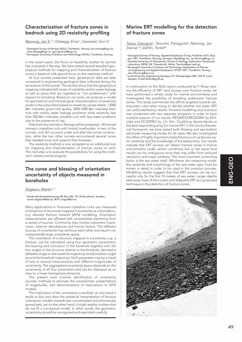
49
EN
G-G
EO
Characterization of fracture zones in bedrock using 2D resistivity profiling
Rønning, Jan S.1,2; Dalsegg, Einar1; Ganerød, Guri V.1
1 Geological Survey of Norway (NGU), Trondheim, Norway; [email protected], [email protected], [email protected];
2 Norwegian University of Science and Technology (NTNU), Trondheim, Norway
In the recent years, the focus on feasibility studies for tunnels has increased in Norway. We have tested several standard geo-physical methods for mapping and characterization of fracture zones in bedrock with special focus on the resistivity method.
At four tunnels presented here, geophysical data are later compared to engineering geological data collected during the excavation of the tunnel. The studies show that the geophysical mapping indicated (all) zones of instability and/or water leakage as well as zones that are regarded as ”non problematic” with respect to tunneling. Based on our work, we propose a model for geometrical and mineralogical characterization of weakness zones in the subsurface based on resistivity values where; >3000 Ωm indicates good rock quality, 3000-1000 Ωm indicates bed-rock with mainly water leakage problems while resistivity less than 500 Ωm indicates unstable rock with less water problems due to the presence of clay.
Data from four tunnels in Norway will be presented. All tunnels intersect crystalline rock with limited overburden. In two of the tunnels, rock fall occurred under and after the tunnel construc-tion, while the two other tunnels encountered several zones that needed more rock support than foreseen.
The resistivity method is now accepted as an additional tool for mapping and characterization of fracture zones on land. The next step is to evaluate the possibilities for using the meth-od in subsea tunnel projects.
The curse and blessing of orientation uncertainty of objects measured in boreholes
Stigsson, Martin1, 2
1 Svensk Kärnbränslehantering AB, Box 250, 101 24 Stockholm, Sweden; [email protected]; 2KTH; [email protected]
Many applications in fractured crystalline rocks use measured orientations of structures mapped in boreholes as a foundation, e.g. discrete fracture network (DFN) modelling. Orientation measurements are afflicted with uncertainties stemming from a variety of sources. Commonly, they involve instrument impre-cision, external disturbances and human factors. The different sources of uncertainty may reinforce each other and result in an unexpectedly large uncertainty space.
The orientation of a structure mapped in a borehole, e.g. a fracture, can be calculated using four geometric parameters: the bearing and inclination of the borehole together with the two angles of the structure relative to the borehole, denoted α (dihedral angle to the borehole trajectory) and β (rotation angle around the borehole trajectory). Each parameter may be a result of one or several measurements with different magnitudes of uncertainty. The aggregated uncertainty space depends on the uncertainty of all four parameters and can be displayed as an area on a lower hemisphere stereonet.
The present work involves identification of uncertainty sources; methods to estimate the uncertainties; presentations of magnitudes; and demonstrations of implications to DFN models.
The implication of the uncertainty is twofold: on one hand it tends to blur and skew the statistical interpretation of fracture orientation models towards less concentrated and erroneously spread sets, yet on the other hand, it might explain outliers that do not fit a conceptual model. In other words, the geometric uncertainty should be recognized and exploited carefully.
Marine ERT modelling for the detection of fracture zones
Tassis, Georgios1; Tsourlos, Panagiotis2; Rønning, Jan Steinar1,3; Dahlin, Torleif4
1 Geological Survey of Norway, Applied Geophysics Group, Postboks 6315, Slup-pen 7491, Trondheim, Norway; [email protected], [email protected];
2 Aristotle University of Thessaloniki, School of Geology, Exploration Geophysics Laboratory, GR541-24, Thessaloniki, Hellas; [email protected];
3 Norwegian University of Science and Technology, Department of Petrole-um Engineering and Applied Geophysics, NTNU 7491, Trondheim, Norway, [email protected];
4 Lund University, Engineering Geology LTH, Getingevägen 60D, 222 41 Lund, Sweden; [email protected]
In continuation to the NGU report conducted by F. Reiser test-ing the efficiency of ERT land surveys over fracture zones, we have performed a similar study for marine environments and investigated the possibility of revealing underwater fracture zones. This study summarizes the efforts targeted towards set-ting basic rules when trying to decide whether sea water ERT can yield satisfactory results. Forward modelling and inversion was conducted with two separate programs in order to have multiple support of our results: RES2MOD/RES2DINV by M.H. Loke and DC2DPRO by J.H. Kim. Qualifying dipole-dipole as the best responding array for marine ERT in this strictly theoret-ical framework, we have tested both floating and sea-bottom electrode measuring modes for all cases. We also investigated the effect of highly important related factors such as the sea wa-ter resistivity and the knowledge of the bathymetry. Our results indicate that ERT surveys can detect fracture zones in marine environments under certain conditions but at the same time results can be ambiguous since they may suffer from reduced resolution and major artefacts. The most important controlling factor is the sea water itself. Whichever the measuring mode, the resistivity and morphology of the sea water layer must be known in detail in order to be used in the inversion process. Modelling results suggest that that ERT surveys can be suc-cessful only for the first 10 meters of sea water. Larger depths take away most of the current and disqualify ERT as a proposed technique in the detection of fracture zones.

50
EC
ON
-OIL
ECON-OIL Economic and Petroleum Geology
Masi Quartzite, quality and occurrence
Aasly, Kari Aslaksen1; Meyer, Gurli1
1 Norges geologiske undersøkelse, Leiv Eirikssons vei 39, 7040 Trondheim, Norway; [email protected]; [email protected]
The early Proterozioic Kautokeino greenstone belt (KGB) in Northern Norway, consist mainly of volcanic and sedimentary rocks. The rock of the KGB is divided into several different for-mations (Siedledka 1985, Olsen & Nilsen 1985, Hagen 1987). In one of the formations, the Masi formation, which consists of terrigenious or shallow marine quartzites and meta arkoses (Sandstad 1992) a fuchsite bearing quartzite is found. This unique green and white quartzite is quarried for natural stone purposes, the Masi Quartzite. The rock has a characteristic green color from fuchsite combined with white feldspar and quartz and the special (mixture of colors) look are due to super ductile folding. The Masi Quartzite have been quarried for nat-ural stone purposes for the last 15 years from quarries situated about 20 km north of the town Kautokeino. Several initiatives have made effort to start commercial production in different deposits, with varying success. Today there are two active quar-ries extracting the Masi Quartzite. In addition to regular blocks exported to southern Europe and Asia, crushed rock for differ-ent purposes and obelisks are produced from the Masi Quartz-ite. Geological mapping in the area near the active quarries have been performed. The objectives have been to map the occurrence of the Masi Quartzite and to see what parameters influence the quality of the natural stone deposit. The deposits have varying feldspar content and the occurrence of the fuch-site varies, as do the occurrence and density of cracks. These parameters influence the quality of the natural stone products. Mineralogical analyses have been performed in order to inves-tigate the significance of the feldspar content on the quality of the natural stone products.
Relationships of polymetallic sulphide deposits to volcanoes, basins and faults in the Swedish Palaeoproterozoic
Allen, Rodney1
1 Boliden Group, 77698 Garpenberg, Sweden, email: [email protected]
The two most important base and precious metal mining prov-inces in Sweden, the Skellefte district and Bergslagen, contain many Zn-Pb-Cu-Ag-Au sulphide deposits that are related to the evolution of extensional basins, rhyolitic to dacitic volca-noes, and syn-depositional normal faults. These ore deposits include Volcanic-hosted Massive Sulphide (VMS) deposits that formed at the sea floor, VMS deposits that formed largely by replacement of volcaniclastic strata below the sea floor, and limestone-hosted replacement deposits that formed deeper in the volcanic pile. Ore deposits of these types generally occur at the volcanic vent and formed following tectonic subsidence along normal faults, either small or large pyroclastic eruptions, and emplacement of domes and/or subvolcanic intrusions. Ore deposits that formed at the sea floor (e.g. Petiknäs South) overlie the major pyroclastic unit and associated lava domes, whereas deposits formed by replacement below the sea floor, post-date eruption of the major pyroclastic unit, but can occur stratigraphically above (Stollberg), within (Maurliden, Renström) or below (Garpenberg) this unit depending on how
far below the sea floor the ore deposit formed. Subsequent deformation resulted in tectonic inversion: reactivation of normal faults as reverse faults and development of fault-related folds. Sheet-like, bedded, stratiform sulphide deposits in Bergslagen (Zinkgruvan, Viker-Älvlängen) occur outside and/or far above volcanic vents and are probably related primarily to regional basin tectonics and depositional environment rather than specific volcanoes. Documentation of the physical and temporal relationships between mineralization and the host-rock, and the relationship between mineralization and volcano evolution, aid mineral exploration and are essential for under-standing the genesis of these ore deposits.
Genesis of Pb-Ag-Cu-Fe-Zn-(Au-Sb-As) mineralisation at Hornkullen, Bergslagen, Sweden: insights from ore mineralogy, textural relations and geothermo-barometry
Andersson, Stefan1; Jonsson, Erik1,2; Högdahl, Karin1
1 Department of Earth Sciences, CEMPEG, Uppsala University, SE-75236 Uppsala, Sweden; [email protected]; [email protected];
2 Geological Survey of Sweden, Department of Mineral Resources, Box 670, SE-75128 Uppsala, Sweden; [email protected]
The polymetallic deposit at Hornkullen is situated in the western part of the Bergslagen ore province, Sweden. It is hosted by an inlier of Svecofennian volcanic and sedimentary metasupracrustal rocks enclosed in a significantly younger, c. 1.8 Ga granitoid (Filipstad granite). Although the deposit has been known for a long time (cf. Tegengren 1924) and its lead isotope signature is consistent with syn-volcanic deposits in Bergslagen (Ridder-sand & Sundblad 1988), the origin and evolution of the deposit is not fully understood. This includes as to what degree, if any, the younger intrusives may have contributed to mineralisation. The major ore minerals are galena, pyrrhotite, arsenopyrite and magnetite with subordinate chalcopyrite, pyrite and sphalerite. Löllingite and ilmenite occur locally. Pb-Fe-Ag-Sb sulphosalts include boulangerite, tetrahedrite, pyrargyrite, jamesonite and stephanite, which mainly occur in trace amounts, except for boulangerite. Gudmundite and molybdenite are rare ac-cessories. Evidence of mineralisation significantly pre-dating Svecokarelian regional deformation and metamorphism is ob-vious, not least from abundant, relict inclusions of ore minerals in porphyroblastic garnet. Overall, ore textures indicate extensive deformation and remobilisation; specifically galena, chalcopy-rite and pyrrhotite commonly exhibit evidence of ductile defor-mation. Recrystallisation is also common, particularly in mag-netite and pyrrhotite. Geothermobarometry of arsenopyrite and sphalerite suggests temperatures and pressures of 525±70°C and 6±4kbar, consistent with regional Svecokarelian amphibo-lite facies metamorphism. A later stage of brittle deformation is also apparent. The ore mineral assemblages and their distinct metamorphosed and deformed nature thus clearly suggest a pre-regional metamorphic, most likely syn-volcanic origin for the polymetallic mineralisation at Hornkullen.
ReferencesRiddersand, H. & Sundblad, K., 1988: Nord. Geol. Vinterm., 350-351.Tegengren, F., 1924: SGU Ca 17.

51
EC
ON
-OIL
Dating a gold-bearing hydrothermal event, in the Paleoproterozoic Tasiilaq area, Nagssugtoqidian Orogen, South-East Greenland
Baden, Katrine1,2; Kolb, Jochen2; Thomsen, Tonny B.2
1 University of Copenhagen, Øster Voldgade 10, DK-1350 Copenhagen K, Denmark;
2 Geological Survey of Denmark and Greenland (GEUS), Øster Voldgade 10, DK-1350 Copenhagen K, Denmark
Graphite-sulphide mineralisation with local gold enrichment is widespread in the northern part of the Tasiilaq area. The area is characterized by TTG gneisses interleaved with Paleoprotero-zoic supracrustal rocks, during a 1870 Ma to 1840 Ma orogenic event. Possible triggers for hydrothermal activity in the Nags-sugtoqidian Orogen are manifold, starting with tonalitic and noritic intrusions at ca. 1900-1880 Ma, followed by subsequent high-pressure metamorphism and retrograde evolution until ca. 1820 Ma, as well as post-tectonic granite emplacement at ca. 1680 Ma. The ability to establish the age of the hydrothermal mineralization is paramount in founding an ore deposit model, aiding mineral exploration. Hydrothermal monazites were iden-tified in three paragneiss samples from the Helheim synform (ca. 50 km north of Tasiilaq). The samples provided abundant monazite grains, several of more than 25µm in size. The zircon standard GJ-1 was bracketing the monazite LA-ICP-MS analyses, common Pb content was low and Pb-loss could not be deter-mined, thus all monazite ages are less than 10% discordant compared to Concordia. Xenotime and zircon were also dated. The textural and structural relations of the xenotime are similar to that of monazite, whereas zircon appeared rounded and more complexly zoned. Twenty monazites , yield 207Pb/206Pb ages from 1961±47 Ma to 1752±22 Ma, with the majority between 1850 Ma and 1750 Ma (viz. 17 of 22 monazite ages), providing evidence that the mineralization was coeval with, or closely succeeding the time of orogeny in the Tasiilaq area.
Alteration types within the Nalunaq Gold Deposit, South Greenland
Bell, Robin-Marie1; Kolb, Jochen1
1 Geological Survey of Denmark and Greenland, Petrology and Ore Geology, 10 Øster Volgade, København, Danmark
Nalunaq is a gold deposit located on the southern tip of Green-land, in the Ketilidian Orogen. It is characterized by narrow gold-quartz veins and exceptionally high gold grades (up to 5000 g/t). Previous studies have been impaired by the assump-tion that all alteration was of one stage and confusion regard-ing an alteration halo associated with the gold-quartz vein. This study has revealed the formation of an early regional skarn al-teration, unrelated to gold mineralization consisting of garnet, plagioclase, clinopyroxene ± chalcopyrite ± pyrrhotite. Gold-quartz veins cross-cut the skarn, trending 35°-50° SE. Non-miner-alized quartz-calcite veins contemporaneous with gold mineraliza-tion are orientated at angles 70°-90° to the gold-quartz veins. A narrow alteration halo of biotite, arsenopyrite, rutile ± tour-maline surrounds the gold-quartz vein. A retrogressive overprint defined by zoisite ± chlorite ± muscovite ± pyrite ± hematite replaces earlier alteration stages. A regional scale epidote- calcite ± feldspar alteration cross-cuts all alteration stages with-in the Nalunaq Deposit. This study revealed a minimum of 4 separate alteration assemblages, both pre- and post-dating gold mineralization. Both orogenic-type and intrusion-related alteration is present and both contain sulphides, though only the orogenic-type is mineralized. The mineralogy of the alter-ation halo surrounding the gold-quartz vein may be used as a vector in the discovery of further high-grade gold deposits. The previously used vector, calc-silicate alteration, is ineffective as
this includes the regional skarn, which is not associated with gold mineralization.
Kleva – a TIB-related mafic Ni-Cu sulfide deposit?
Bjärnborg, Karolina1; Scherstén, Anders1; Söderlund, Ulf1
1 Department of Geology, Lund University, Sölvegatan 12 223 62 Lund, Sweden; [email protected]
The Kleva Ni-Cu sulfide deposit, situated within a metagabbro intrusion in southeastern Sweden, was mined periodically from the 17th to the 20th century. The mineralization is dominated by pyrrhotite, chalcopyrite, pentlandite and pyrite, occurring as massive mineralization, disseminations and thin, predominantly chalcopyrite-bearing veins. The sulfide association is typical of magmatic sulphides in mafic and ultramafic igneous rocks (Naldrett 1989) and is thus considered to be of primary mag-matic origin. The bedrock south of the Kleva intrusion is dom-inated by late Svecofennian supracrustal and intrusive rocks considered to belong to the Oskarshamn Jönköping belt. There are numerous base metal mineralizations in this area. North of the gabbro intrusion occur slightly younger granitic rocks belonging to the Transscandinavian Igneous belt (TIB). SIMS- and TIMS dating of zircon and baddeleyite, respectively, yielded an age of 1.79 Ga for the intrusion, which is considered as the crystallization age of the gabbro and the primary miner-alization. The age corresponds well with TIB-related magma-tism in the area. Primitive-mantle normalized REE-contents of the metagabbro are generally fractionated, and similar to most mafic TIB-related rocks in the region (Andersson et al., 2007) showing enrichments in LREE relative to the HREE. This, together with low Nb/La, suggests a subduction related environment of the Kleva metagabbro. Assimilation of crustal rocks could have triggered sulfur saturation in the Kleva magma and thereby controlled the mineralization at Kleva. The late Svecofennian rocks south of Kleva might have played an important role as source of sulfur. Xenoliths and inherited zircon in the Kleva in-trusion point to the involvement of an older crustal component.
ReferencesAndersson et al., 2007: International Geology Review 49, 587–625.Naldrett, 1989: Magmatic Sulfide Deposits. Oxford University Press Inc., Oxford.
Source rock geochemistry of Early Silurian black shales of Severnaya Zemlya, Russian Arctic
Bogolepova, Olga K.1; Kaye, Matthew N.2; Gubanov, Alexander P.3
1 CASP, Cambridge, United Kingdom; 2 OceanGrove Ltd, Aberdeen, United Kingdom; 3 Museum of Evolution, Uppsala
The Severnaya Zemlya Archipelago is located on the edge of the Arctic Ocean north of the Taimyr Peninsula, separating the Kara and Laptev seas, two potentially vast and apparently different hydrocarbon provinces. The geology of this area is represented by sedimentary, metamorphic and volcanic rocks ranging from the Neoproterozoic to Cenozoic age. Combined Rock-Eval and other geochemistry analyses on the Silurian samples reveal the presence of early Silurian source rocks on Severnaya Zemlya. The Llandovery Sredny Formation yields organically rich black shale with good source potential and a Type II oil and gas prone bulk source rock quality. The Rock Eval Tmax value suggests that the organic matter is early mature for oil generation. The biomarker characteristics of the Llandovery Sredny shale source rock extract are consistent with a marine
52
EC
ON
-OIL
The Palaeoproterozoic Skellefte mining district in northern Sweden is one of the most important mining regions in Europe and, as a result of decades of exploration in this area, there is an extensive collection of geochemical analyses from drill holes in this area. This research compiles data from over 3,000 samples from the Kristineberg area of this district to create an overview of the alteration patterns in 3D, and, for the first time ever, this data is being compared with the regional struc-tural 3D model, which has also been developed for this area, to determine to what extent the current structure dominates the alteration pattern. Structurally-constrained 3D interpolations of calculated alteration indexes of drill core and outcrop samples from the hydrothermally altered zones in this area reveals an excellent correlation (from surface to c. 1,000 m depth) be-tween the zones of most intense alteration and the localization of massive sulphide deposits. The results furthermore suggest that most of the alteration zones at surface are continuous with alteration zones at depth (possibly even deeper than 1,000 m). Comparison of the geometries and spatial distribution of these 3D interpolation volumes with 3D-modelled regional faults and lithological contacts in the Kristineberg area suggest that the regional distribution of alteration zones is controlled to a significant extent by the regional structure of the area, in particular by major S-dipping faults. Consequently, the struc-turally-constrained 3D geochemical model presents a new and exciting tool for the identification of prospective 3D volumes in the Kristineberg area for deep exploration. In addition, the 3D approach will allow quantifications of the total budget of mass gain and loss during hydrothermal alteration in the Kristineberg area, which will allow fundamental questions regarding the nature of the hydrothermal systems and the source of elements to be answered.
The Barents Project: Enhancing know-ledge of the geological evolution of northern Sweden
Grigull, Susanne1, Berggren, Robert1, Bergman, Stefan1, Jönberger, Johan1, Antal Lundin, Ildikó1, Luth, Stefan1, Lynch, Edward1, Martinsson, Olof2, Thörnelöf, Mats1
1 Geological Survey of Sweden (SGU), Box 670,75128 Uppsala, Sweden; [email protected], [email protected], [email protected], [email protected], [email protected], [email protected], [email protected], [email protected];
2 Luleå University of Technology (LTU), Division of Geosciences and Environmental Engineering, 97187 Luleå, Sweden; [email protected]
Despite the high ore potential of northern Sweden, the regional geologic development of this part of the Fennoscandian lithos- phere is poorly constrained and largely based on reconnais-sance-level mapping and sparse datasets. The ongoing Barents Project, run by the Geological Survey of Sweden (SGU), aims to increase knowledge about the region’s geological setting in terms of stratigraphy and mineralisation as well as its tectonic evolution. We present a synoptic introduction to fifteen key areas targeted for selective geological and geophysical studies, and we discuss the goals, methods and preliminary outcomes of the bedrock mapping and sampling campaign in 2013. The key areas were primarily chosen for the following reasons: (a) accessibility of key lithostratigraphic units, (b) presence of major interacting shear zones and folding patterns, (c) known altera-tion and mineralisation occurrences. In 2012, a seismic reflec-tion survey was undertaken along a 74 km long profile between Kiruna and Vittangi passing through two of the key areas. Air-borne electromagnetic (TEM) measurements were carried out in 2013 and gravity (AGG) measurements are currently taking place. Compilations of available geological and geophysical data on seven of the key areas were published online in October 2013.
Preliminary results indicate that the geophysical anomalies in the area usually reflect (a) changes in lithology, (b) minerali-sations, or (c) geological structures such as folds and deforma-
algal/bacterial organic matter source and a clay-rich oxic-su-boxic palaeoenvironment. The distinctive methyltriaromatic sterane signature obtained, strongly matches Late Ordovician source rock extracts and related oils from the Tarim Basin of China. There is a close similarity in sterane fingerprint and carbon isotope composition between the Sredny shale extract and oils derived from the Silurian Safiq source rock of central Oman. The occurrence of hydrocarbon in the Silurian of Sever-naya Zemlya is clear evidence of an active petroleum system in the region. This information provides an important insight into the likely nature of successions and petroleum systems of the North Kara Sea Shelf.
Eudialyte decomposition and fraction-ation of REE and HFSE in the kakor-tokites of the Ilímaussaq Complex, South Greenland
Borst, Anouk M.1; Waight, Tod2; Nielsen, Troels F.D.1; Kalvig, Per1
1 Geological Survey of Denmark and Greenland, Department of Petrology and Economic Geology, Øster Voldgade 10, 1350, Copenhagen, Danmark;
2 University of Copenhagen, Department of Geosciences and Natural Resource Management, Øster Voldgade 10, 1350, Copenhagen, Danmark
The Mesoproterozoic Ilímaussaq Complex is well-known for its pronounced mineralogical diversity and multi-element resource potential. The intrusion is largely composed of agpaitic peral-kaline nepheline syenites, containing complex Zr-Ti silicates like eudialyte and rinkite instead of zircon and ilmenite. At Kring-lerne, in the southern part of the intrusion, the majority of REE, Nb, Ta and Zr mineralisation is accommodated in the eudia-lyte-rich units of the rhythmically-layered kakortokite series. The mineralisation, however, is significantly complicated by decom-position of eudialyte into complex pseudomorphic aggregates of various minerals. Previous studies on decomposed eudia-lyte from Kringlerne suggest at least two types of alteration; catapleiite- and zircon-type. As part of a larger petrological, mineralogical and geochemical project investigating the REE mineralisation and magmatic evolution at Ilímaussaq, we have carried out detailed EPMA analyses of black, red and white kakortokites from layer 0 to +5. Our preliminary investigations show that catapleiite (Na-Zr silicate) is the most common and volumetrically abundant replacement product. Additionally, the aggregates contain aegirine, K-feldspar, analcime, fluorite, pectolite, nacareniobsite (REE-Nb silicate), apatite, britholite (REE-phosphosilicate), monazite (REE-phosphate) and several unidentified REE and HFSE phases. Preliminary interpretations suggest that the original REE and HFSE budget of the eudia-lyte has been retained in the pseudomorphs, yet, the observed assemblages indicate strong fractionation of Zr, Nb and REE between the secondary phases. This will likely have significant implications on the processing techniques to extract the ore metals. Mass balance calculations and element mapping are required to further constrain (re-) mobilisation of elements. The absence of Cl-rich phases suggests a loss in Cl, while F and P have been added to form fluorite, apatite, britholite and monazite. Therefore, we propose a late-stage magmatic paragenesis for the eudialyte alteration, by reaction with interstitial residual - or immiscible - liquids enriched in the latter two elements.
Alteration patterns of the Kristineberg area as revealed by 3D geochemical modelling
Chmielowski, Riia1; Jansson, Nils2
1 Luleå University of Technology, SBN, Division of Geosciences, Luleå, Sweden; 2 Boliden Mines, Exploration, Boliden, Sweden

53
EC
ON
-OIL
depleted fields. CO2 storage in abandoned and depleted fields will usually require a careful study of the integrity of the wells which have been drilled into the field. If oil has been present, it is relevant to study the potential for enhanced recovery by CO2 injection. The CO2 storage potential achieved by potential EOR projects is discussed.
Killing the myths: a geological view on ancient stone quarrying technology
Heldal, Tom1
1 Geological Survey of Norway, No-7491 Trondheim, Norway
Is not my word like as a fire and like a hammer that breaketh the rock in pieces? Such are the words from Jeremiah 23:29, a mani- festation of God’s power illustrated on a background of ancient stone quarrying technology. Lost technologies leave traces that can and will be interpreted in different context through differ-ent periods, and truly the spectacular monuments of the past have triggered mystical and highly creative ideas on how our ancestors performed their skills.
Geology and engineering geology have another type of power, the potential of shedding a more rational light over some of the major mysteries of ancient civilizations: de-mysti-fying the past. The traces one find in ancient stone quarries tell stories about the people and technology involved, the interac-tion between man and geological resource. By carefully study-ing the quarries, monuments and rocks, one may conclude that the ‘mysteries’ are nothing more than impressive evolution of skills and material knowledge, a fruitful marriage between man and rock.
Such perspectives have lead to more innovative interpreta-tion of ancient quarrying: The role of the right tools, the role of fire as an agent in extraction, and, most important, the role of skills evolving through hundreds and even thousands of years. The presentation will, aided by empirical data and a review of different approach to the behaviour of rocks, travel to some of the most impressing ancient monuments and how those may have been produced.
Stable isotopes as a geochemical tool in mineral exploration: case study from Central East Greenland
Hoffritz, Sara1; Bernstein, Stefan2; Dennis, Bird3; Korte, Christoph1
1 University of Copenhagen, Department of Geosciences and Natural Resource Management, Copenhagen, Denmark;
2 Avannaa Resources Ltd., -, Copenhagen, Denmark; 3 Stanford University, Department of Geological & Environmental Sciences,
California, United States
Widespread copper mineralization occurs in Late Permian car-bonates and Triassic clastic sediments in Central East Green-land. On Wegener Halvø peninsula copper mineralizations are particularly abundant in the Permian Karstryggen and Wegener Halvø Formations that are underlain by Permian conglomer-ates and Devonian strata and overlain by Ravnefjeldet Forma-tion shale, a time equivalent to the Kupferschiefer in Northern Europe. The Wegener Halvø area is dominated by a series of major N-S striking normal fault zones and carries evidence of igneous activity during the Early Tertiary. A dense network of zoned calcite veins and cavities in a highly differing and cemented host rock characterizes the carbonates. The rocks are spatially related to red beds, intrusions and evaporates on a regionally scale. The aim of this study is to constrain the fluid history and controlling factors for fracturing and veining of the rocks host to the copper mineralizations. This in turn will help understanding the timing and ultimately the nature of the mineralization processes. We will be using petrography and
tion zones. Furthermore, it appears that regional deformation in a transpressional regime was predominantly accommodated along highly localised deformation zones that range in width from metre- to kilometre-scale and separate low strain zones. Locally, shear zone kinematics can be determined. The defor-mation zones are often associated with a high degree of bed-rock alteration as well as mineralisation. In 2015, an updated and improved interpretation of geological and geophysical data in the key areas will be published.
World Basement Geological Map – a new platform for global reconstructions
Gubanov, Alexander P.1,3, Mooney, Walter D.2
1 Evolutionsmuseet, Uppsala, Sweden ([email protected]); 2 USGS, Menlo Park, USA; 3SCANDIZ, Skokloster, Sweden
Geological maps display the surface geology of the Earth, and since a large portion of the surface is covered by sedimentary rocks, the deeper features of the continental crust are over-shadowed. Due to the large number of small details and lack of large-scale geological features in places, these maps are diffi-cult to use for reconstruction of large-scale lithospheric events or interpretation and interpolation of global geophysical data. Here we present simplified crustal basement geological map of the world where the sedimentary cover was removed to expose a collage of rocks of different ages. It shows four Precambrian age units, Achaean (3.8-2.5 Ga), Paleoproterozoic (2.5-1.6 Ga), Mesoproterozoic (1.6-1.0 Ga), and Neoproterozoic (1.0-0. 54 Ga) and three Phanerozoic units: Early Paleozoic (543-400 Ma), Late Paleozoic (400-250 Ma), and Mesozoic-Cenozoic (250-0 Ma). The map reveals the history of continental growth where large blocks of continental crust were accreted around Achaean cratons and a large area of older crust was heavily reworked during continent-continent collisions. The map provides con-text for an evaluation of global and continental scale models of crustal evolution as well as background for specialists in earth sciences who are addressing issues on a global scale. Of particular interest is to use our Global Map as a platform for investigation of the basement control on the formation and development of sedimentary/hydrocarbon basins by combining geophysical, geodynamic and paleogeographic data.
The Norwegian CO2 storage atlas
Halland, Eva K1; Bjørheim, Maren1
1 Norwegian Petroleum Directorate, Geology, Stavanger, Norge
The CO2 storage atlas of the Norwegian part of the North Sea, Norwegian Sea and the Barents Sea has been prepared by the Norwegian Petroleum Directorate at the request of the Minis-try of Petroleum and Energy. The main objectives have been to identify the safe and effective areas for long-term storage of CO2 and to avoid possible negative interference with ongoing and future petroleum activity. This study is based on the knowl-edge we have from 40 years of petroleum activity and from the two CO2 storage projects, Sleipner and Snøhvit, on the Nor-wegian Continental Shelf. Several geological formations have been individually assessed, and grouped into saline aquifers. The aquifers were evaluated with regard to reservoir quality and presence of relevant sealing formations. Those aquifers that may have a relevant storage potential in terms of depth, capacity and injectivity have been considered. The methodology applied for estimating storage capacity is based on previous as-sessments, but the storage efficiency factor has been assessed individually for each aquifer based on simplified reservoir simu-lation cases. In the petroleum provinces, the storage potential was calculated from the extracted volume of the hydrocarbon in
54
EC
ON
-OIL
microscope techniques, measure δ13C and δ18O values of bulk carbonates and calcite veins and δ13S of the sulfides from a collection of 30 samples that span a wide variety of veins. Results indicate different fluids migrating through the host rock and several hydrothermal alteration- and metal mineralization events.
Trace element characteristics of mag-netite from mineralizations in the Bergslagen ore district, central Sweden
Hogmalm, Johan1; Tillberg, Mikael1; Inerfeldt, Andreas1; Nordgren, Nina1; Zack, T1
1 Earth Sciences Centre, University of Gothenburg, Box 460, SE-405 30 Göteborg, Sweden; [email protected]
Magnetite chemistry can be used as a petrogenetic indicator for a wide range of rock types and mineral deposits, and is very easy to extract from sediments due to its magnetic properties. It has been difficult to use magnetite for provenance studies since magnetite is a highly abundant heavy mineral. With com-puter-controlled SEM-EDS systems it is now possible to handle the chemistry of a large numbers of crystals. There is a need to extend the data on magnetite major and trace element data to test the applicability of recently proposed discrimination dia-grams and to explore new uses for this mineral. We have analyzed magnetite chemistry in a range of different mineralizations in the Bergslagen ore district using LA-ICP-MS. Precision and ac-curacy evaluated by analysis of the BC28 magnetite mineral standard confirms the reliability of this method. Our results indi-cate that existing, globally used discrimination diagrams are generally not applicable to magnetites from Bergslagen. How-ever, on a regional scale, element ratios including Ti, V, Mn, Mg, Co and Ni are useful to discriminate between the different ge-netic types of deposits. For example, iron oxide apatite ores are characterized by low Ti/V and high Mn/Mg ratios. For explora-tion purposes, it may be interesting that elevated Zn and Co concentrations in magnetite in the Håkansboda area reflect association with either Pb-Zn or Cu-Co sulphide mineraliza-tions, respectively.
Geochemistry of the Mertainen iron ore
Holme, Kirsten1; Debras, Céline1
1 LKAB, Kiirunavägen 1, 981 86 Kiruna, Sweden; [email protected], [email protected]
The Mertainen iron ore body belongs to the apatite iron ores in northern Sweden. This group also includes the well-known Kiirunavaara and Malmberget ores and the smaller ore bodies at Gruvberget and Leveäniemi. In contrast to other iron ores in the region that are typically compact ores, the Mertainen ore also occurs as veins, schlieren, breccia matrix, or nodules in the host rock. The Mertainen ore was discovered in the end of the 19th century. Several investigations were carried out until 1963 when it was concluded that the ore was a giant iron for-mation, but with grades too low to be economically viable. In 2010, LKAB re-started exploration of the area with the intention to investigate the possibilities of opening up a new mine. In this first step, 23 drill holes between 71 and 540 meters (totally 7900 meters) were drilled as a supplement to old core drillings. The drill cores have been mapped and 2292 samples have been analysed for major- and trace elements. All data have been compiled and evaluated, and followed up by modelling using the 3D mining software Vulcan. An ore calculation for the in-vestigated area resulted in 105 Mton of iron ore with 36.4 % Fe (cut-off 20 % Fe). In the early investigations, the Mertain-en rocks were divided into four classes (I) rich ore, (II) rich breccia ore, (III) poor breccia ore and (IV) leptite (host rock).
The same classification is still applied, but based on the whole rock geochemistry, the host rock is today recognized as basic to intermediate low-grade meta-volcanic rocks of mainly tholeiitic, metaluminous, trachyandesitic composition. Approaching the ore, metasomatic alterations increase. This includes redistribu-tions of K and Na indicated by brick-red colouring of feldspar, as well as the presence of skarn minerals and sometimes sca-polite. Differentiation trends for both major and trace elements indicate that the host rock consists of one rock type mainly, but with different amounts of Fe-oxide. An anomalous distribution pattern of V is also recognized. There is a distinct positive corre-lation with Fe in the host rock, but a strong negative correlation with Fe in the rich ore and rich breccia ore.
BIF-hosted REE silicate mineralisation at Högfors, Bergslagen, Sweden
Jonsson, Erik1 2; Högdahl, Karin2; Sahlström, Fredrik2; Majka, Jarek2
1 Geological Survey of Sweden, Department of Mineral Resources, Box 670, SE-75128 Uppsala, Sweden; [email protected]
2 Department of Earth Sciences, CEMPEG, Uppsala University, SE-75236 Uppsala, Sweden; [email protected], [email protected], [email protected]
Along the REE-line in the west-central part of the Bergslagen ore province, a suite of iron oxide mineralisations exhibit anom-alously high REE contents (e.g. Geijer 1961). Characteristically, these REE-rich iron oxide skarn deposits of Bastnäs-type occur as replacements in carbonate rocks. In the Högfors field (Swedish grid RT90 663842/148904), however, REE silicate assemblages of this type occur within a hematite-dominated banded iron for-mation (BIF; cf. Geijer 1961; Jonsson & Högdahl 2013), a most unusual association. SEM-EDS and WDS-FE-EPMA mineral chemical analysis and bulk geochemical analyses on samples of BIF ore were conducted. The main REE hosts at Högfors are LREE-enriched and comprise cerite-(Ce), ferriallanite-(Ce) and an unnamed iron-analogue of västmanlandite-(Ce). Addition-ally, we have observed REE-fluorocarbonates; bastnäsite-(Ce)-synchysite-(Ce), sparse monazite-(Ce), as well as allanite-(Ce) (the latter in cross-cutting quartz veins). The relatively common appearance of a gadolinite-group beryllium silicate is notable. At Högfors, cerite-(Ce) is relatively enriched in fluorine, but ex-cept fluorocarbonates, major minerals with essential fluorine are lacking. This is in accordance with the overall low Y+HREE encountered at Högfors, considering the higher degree of com-plexing, and therefore transport, of these elements in fluoride-rich fluids. The occurrence of recrystallised, folded, partly conform skarn bands ± banded REE mineralisation in the Högfors BIF together with textural and geochemical data combine to sug-gest formation of the REE assemblages through hydrothermal overprinting and selective replacement of a pre-existing, locally carbonate-bearing iron formation.
References:Geijer, P., 1961: The geological significance of the cerium mineral occurrences of the Bastnäs type in central Sweden. Arkiv för Mineralogi och Geologi 3, 99–105.Jonsson, E. & Högdahl, K. 2013: New evidence for the timing of for-mation of Bastnäs-type REE mineralisation in Bergslagen, Sweden . In Jonsson, E. et al. (eds.) Mineral deposit research for a high-tech world. Proceedings of the 12th Biennial SGA Meeting, Uppsala, Sweden, 1724–1727.
55
EC
ON
-OIL
Structural geology and spatial patterns of hydrothermal alteration at the Falun pyritic Zn-Pb-Cu-(Au-Ag) sulphide deposit, Bergslagen region, south-central Sweden
Kampmann, Tobias C.1; Stephens, Michael B.1,2
1 Department of Civil, Environmental and Natural Resources Engineering, Division of Geosciences, Luleå University of Technology, SE-971 87 Luleå, Sweden; [email protected];
2 Geological Survey of Sweden (SGU), Box 670, SE-751 28 Uppsala, Sweden; [email protected]
The pyritic Zn-Pb-Cu-(Au-Ag) sulphide deposit at Falun in the northern part of the Bergslagen region, south-central Sweden, has been historically the most prominent base metal producer in Sweden. This study aims firstly to identify the alteration rock types and mineral assemblages around the deposit. Secondly, knowledge about their spatial distribution, coupled with a structural geological investigation, will yield implications for the geometry of and the structural control on the Falun ores. The results of this study are based on data obtained during field work during the summers of 2012 and 2013. Furthermore, a 3D model of the Falun ores has been created using existing mine level maps and information from the examination of available drill cores. The alteration rocks enveloping the ores show mainly quartz-mica-cordierite-(anthophyllite) and quartz-anthophyllite mineral assemblages, probably replacing felsic volcanic rocks, and dolomite or calc-silicate (tremolite, actinolite, diopside)- skarn assemblages, replacing carbonate rocks. A complex Si-Mg-Fe alteration system is inferred. A major ductile, steeply dipping, ENE–WSW striking deformation zone, c. 10 m thick, has been identified that bounds the pyritic massive sulphide ore on its northern side, and most likely decouples the hydro-thermal alteration system to the north and south of the zone. Tectonic contacts between lithologies are common, forming 0.5–1 m thick shear zones and contributing to the transposition of rock units in a NE–SW (D2) direction. The 3D modelling work indicates the presence of several steeply plunging, rod-like lobes of pyritic massive sulphide ore, thickening and merging towards the ground surface into a single body that is up to 270 m in diameter at this surface. The massive sulphides are enve-loped on nearly all sides by disseminated to semi-massive Cu-Au mineralization, possibly representing a feeder system. A polyphase deformation mechanism, including the develop-ment of steeply plunging sheath folds, will be presented.
Metallogeny of Greenland
Kolb, Jochen1
1 Geological Survey of Denmark and Greenland, Petrology and Economic Geology, Copenhagen, Denmark
The Archaean of central and western Greenland is formed by granite-gneiss terranes, which host small orogenic gold occur-rences and Ni-PGE targets. Iron deposits occur in BIF in rare granite-greenstone belts (e.g. the ca. 3.8 Ga Isua deposit). The Palaeoproterozoic rifting stage is not well preserved, but is rep-resented by the Black Angel SEDEX deposit, which was subse-quently metamorphosed and deformed. Internal and external high-metamorphic Palaeoproterozoic orogens are known for Ni-Cu-PGE, VMS and IOCG occurrences, and host the only active mine (Nalunaq gold mine). The Palaeoproterozoic assembly of Nuna is followed by rifting and basin development until the Caledonian and Ellesmerian orogens formed in North and East Greenland. Sedimentary basins host stratiform Cu and SEDEX occurrences. Rifting predating the Grenvillian formed peral- kaline intrusions of the 1350-1140 Ma Gardar Province in South Greenland. These are endowed with some large REE-Zr-Nb-Ta-
U-Th-Zn and cryolite occurrences in the Kvanefjeld, Kringlerne, Kryolit and Motzfeldt deposits. Mafic dykes host the large Isor-toq Fe-Ti-V deposit. The Palaeozoic Franklinian Basin in North Greenland hosts the Citronen SEDEX deposit. Inversion of the basin during the Palaeozoic led to the formation of MVT-like occurrences in carbonates. The Caledonian in East Greenland is represented by the foreland fold-and-thrust belt, where ex-ploration is directed towards intrusion-related vein-type, skarn and porphyry deposits. In particular at the northern margin of the North Atlantic Craton, carbonatites and kimberlites intrud-ed subsequent to the Iapetus opening and after opening of the Atlantic. The Sarfartoq rare metal-U deposit is hosted in one of the older carbonatites. Tertiary flood basalts related to opening of the Atlantic are explored for Ni, whereas the mafic layered in-trusions comprise the world-famous Skaergaard intrusion host-ing a PGE-Au deposit. Tertiary felsic intrusions host porphyry Mo deposits in Flammefjeld and Malmbjerg.
Mineral and chemical characteristics of high-whiteness calcite marbles, northern Norway
Korneliussen, Are1; Raaness, Agnes1
1 Geological Survey of Norway; P. O. Box 6315 Sluppen, NO-7491 Trondheim, Norway; [email protected]
Carbonates on the Norwegian mainland range in age from Paleoproterozoic to Silurian. Due to differences in chemical composition and extent of recrystallization during deformation and metamorphism of the precursor rock, their character var-ies widely. The fourteen Norwegian carbonate mines currently in operation thus differ significantly and provide raw materials for industrial production of cement, lime, mineral fillers and soil conditioner. Of particular interest for new developments are calcite and dolomite marble deposits with low contents of crystal-bound iron and manganese, of potential interest for pro-duction of high-whiteness carbonate products. Iron and man-ganese in the crystal structure reduces the carbonate mineral’s whiteness and should be lowest possible. A considerable num-ber of deposits contain calcite and/or dolomite with less than 250 ppm crystal-bound ΣFe+Mn, thus potentially containing raw material suitable for industrial production of high-whiteness carbonate products. However, extensive finely dispersed inclu-sions of graphite, quartz and other minerals in the carbonate as well as calcite/dolomite intergrowths, present a major obstacle for industrial development. Such rocks may not be processable, i.e. sufficiently pure carbonate mineral concentrates cannot be produced at sufficiently low cost. Consequently, from a mineral processing point of view, two options can be considered for the development of new carbonate deposits. One is identification and characterization of high-whiteness carbonates with minor inclusions of other minerals, that are compatible with current re-finement/processing techniques as used in today´s downstream industries. Alternatively, a new processing mechanism to han-dle mineralogically complex deposits could be developed.
A new type of Cu-Ni-PGE deposit in the Reinfjord ultramafic (UM) complex, Seiland Igneous Province (SIP), Norway
Larsen B., Rune1; Oen, Endre1; Whitehouse, Martin2
1 NTNU, Geology and Geo-Engineering, Trondheim, Norway; 2 Natural History Museum, Lab for Isotope Geology, Stockholm, Sweden
The Reinfjord UM complex is situated in the westernmost parts of the SIP (560-570 Ma). Reinfjord formed from three pulses of UM-melts successively forming three series of UM-cumulates
56
EC
ON
-OIL
with increasing olivine contents and finally forming a dunitic cumulate. A 2 km long and 10-20 metres thick deposit at the gneiss contact with 0.3% Ni and 0.3% Cu in c. 2 % total sul-phides was known from before. Several new mineralization’s with 1-2 % Cu-Ni sulphides were identified in the late dunitic cumulates. Helicopter-borne TEM-surveys picked up a substan-tial conductor c. 100 metres below the surface and two explor-atory drill holes confirmed two reef deposits of 5 and 7 metres thickness, respectively, and separated by 20 metres of dunite. The reefs only contain 1.2-1.6 wt% total sulphides and both de-posits occur in the central dunitic series of the Reinfjord com-plex. The lower occurrence (5 m) is a PGE-reef with 0.64 ppm of total Pt+Pd+Au, 0.3 ppm Os, and 0.27 wt. % Ni. The upper Cu-Ni reef carry 0.38 wt% Ni and 0.12 wt% Cu and traces of PGE. Analysis of the chondrite normalised PGE spectrum yield-ed a trough pattern with positive Os, Pt and Pd, Au anomalies. In-situ, ion-probe, sulfur-isotope analysis returned juvenile val-ues for all sulphide deposits in the UM complex and the coun-try rock gabbros, however, with conspicuous variations amongst the individual deposits. The PGE-reef yielded a δ34S value of -0.40, the Cu-Ni reef, -4.56, the contact deposits, 0.02, and gabbro sulphides gave an average of 2.19. Finally, sulphides in country rock gneisses yielded a value of 9.09. Accordingly, the reef deposits did not achieve their sulphur by local country rock assimilation. It is also concluded that the source of sulphur for the PGE-reef is distinctively different from that of the Cu-Ni reef only 20 m’s higher up. What arguably makes the Reinfjord reefs a new type of Cu-Ni-PGE deposit is i) the great thickness of the reefs with low total sulphides; ii) clear separation of a PGE Cu-poor and a Cu-Ni PGE-poor reefs; iii) strongly contrast-ing S-isotope signatures; iv) the uncommon trough shaped PGE-pattern and v) setting in a dunite.
Petrology and in situ Strontium isotope investigation of the Ni-Cu-(PGE) ore bearing Kevitsa intrusion, northern Finland
Luolavirta, Kirsi1; Hanski, Eero1; Maier, Wolfgang2; O´Brien, Hugh3; Lahaye, Yann3; Santaguida, Frank4; Voipio, Teemu4
1 Department of Geology, University of Oulu, Finland, email: [email protected]; 2 The School of Earth and Ocean Sciences, Gardiff University, United Kingdom; 3 Geological Survey of Finland, Espoo, Finland; 4 First Quantum Minerals Ltd, FinnEx, Sodankylä, Finland
The 2.05 Ga mafic-ultramafic Kevitsa intrusion is located in Central Lapland, ̴ 40 km north of Sodankylä. The ̴ 1 km thick ultramafic lower part of the intrusion is composed of olivine clinopyroxenites, olivine websterites and plagioclase bearing (olivine)websterites and hosts a large disseminated Ni-Cu-(P-GE) ore deposit. The mineralization can be divided into two economic end-member ore types: 1) the regular ore with Ni/Cu <1 and 2) the Ni-PGE ore with Ni/Cu commonly >5. There are also metal-poor false ore and contact mineralization that are uneconomic. In this study we report whole rock, mineral chemistry and Sr-isotope analyses from three drill cores across the ultramafic lower part of the intrusion in order to constrain the magmatic evolution of the intrusion and the ore forming processes. Sr isotopes were measured on fresh interstitial pla-gioclase using in situ LA-ICP-MS analysis. One of the studied boreholes is located in the middle of the current resource area and intersects both the regular and Ni-PGE ore types. The two other boreholes are drilled ̴ 500 m east of the deposit and do not intersect any economic mineralization. The data reveal differ-ences in whole rock and mineral chemistry and Sr isotopic pro-files between drill cores from different locations. The samples from the ore-bearing part of the intrusion yielded 87Sr/86Sr(i) values above 0.705 and up to 0.711, whereas samples from the two ´unmineralized´ drill cores show more homogeneous 87Sr/86Sr(i) values of ̴ 0.705-0.706. Also a marked difference in
87Sr/86Sr(i) between different ore types is observed, consistent with previous studies indicating isotopic differences between different ore types (Hanski et al. 1997). The isotope data, miner-al and whole rock chemistry aside suggest that the mineralized part of the intrusion represents a dynamic site with multiple in-trusions of variably contaminated magma.
Reference: Hanski, E.J., Huhma, H., Suominen, I.M. & Walker, R.J., 1997: Geo-chemical and isotopic (Os, Nd) study of the early Proterozoic Keivitsa Intrusion and its Cu-Ni deposit, northern Finland. Proceedings of the Biennial SGA Society for Geology Applied to Mineral Deposits Meeting 4, 435–438.
Localization of dextral transpression along the Karesuando-Arjeplog defor-mation zone, Akkiskera-Kuormakka area, northern Sweden
Luth, Stefan1 ; Thörelöf, Mats1; Berggren, Robert1 ; Antal Lundin, Ildikó1
1 Sveriges Geologiska Undersökning, Villagvägen 18 Uppsala, Sweden; [email protected]
The Karesuando-Arjeplog deformation zone (KADZ) in Swedish Lapland is seen on gravity and magnetic anomaly maps as a c. 450 km long, NNE trending lineament. Its regional geological significance in terms of deformation patterns and kinematics is only poorly constrained. Previous mapping of several duc-tile shear zones and brittle fault steps between Gällivare and Karesuando have indicated western-side-up movement and local dextral movements inferred from mainly s-c fabrics. How-ever, these kinematic indicators were derived from only a few observations along the northern part of the shear zone. This study aims to further constrain how deformation was accom-modated along the KADZ through time and space. The main tools used were structural mapping along profiles orthogonal to the inferred KADZ as well as geochemical and geochron-ological analysis of the rocks affected by deformation within the Akkiskera-Kuormakka key area. Detailed profile mapping revealed a sub-vertical, NNE-trending, penetrative foliation af-fecting the metamorphosed sediments and (sub)volcanic rocks directly east of the KADZ. It appeared that most deformation along the KADZ was localized along several steeply dipping, NNE-trending mylonite zones (ca. 1 to 4 wide that cross-cut and border the Archean basement). Intensive deformation was also accommodated by the overlying quartzite unit (Tjärro group) as indicated by the development of a very strong continuous foliation. South to southwest moderately plunging stretching lineations along with rotated clasts and large-scale drag folds all imply dextral transpression. These findings will be used in the ongoing Barents project to further investigate how the KADZ connects with regional structures, such as with the long-lived Mierujávri-Svaerholt shearzone in Norway or the Pajala shear zone in Finland and Sweden.
The inner life of millstones: 1200 years of quarrying dissected by provenance studies
Meyer, Gurli B.1; Grenne, Tor1; Heldal, Tom1
1 Geological Survey of Norway, No-7491 Trondheim, Norway; [email protected]
A question that arises when ancient techniques and inventions are discovered is whether they were driven by man, material or geographic conditions? Since the first humans began using stones for grinding various organic and inorganic materials
57
EC
ON
-OIL
there has been a stepwise development of grinding technology and driving mechanisms for querns and mills. This is reflected in parallel changes of materials and extraction- and working tech-niques of stones. The largest technological step in the grinding of cereals in Norway was the change from saddle querns to ro-tary hand querns during the late Roman Period. The second step was the change from using erratic blocks and scree mate-rial of various lithologies as raw material for making non-stand-ardized querns, to bedrock quarrying of a particular, well suit-ed geological resource : porphyroblastic mica schist. This step happened at some point during the early Viking Age. A third step was the change from hand and animal driven querns to water and wind driven mills in the Early Middle Age. From that point the millstones became gradually larger. The entire story of querns and millstones made from natural rock comes to an end in Scandinavia at the entry of artificial millstones and modern grinding techniques in the early 20th century.
A cross disciplinary team of archaeologists and geologists joined forces for the last four years in Norway. The team studied historical records and performed registration of the majority of quern- and millstone quarries in Norway. Paralleling this activ-ity the team sampled and described a large number of hand querns and millstones in Scandinavia. By characterising unique textures, mineralogy and geochemistry of each extraction area, the archaeological finds was traced back to their unique sources.
The production of millstones was the beginning of perhaps the most long-lasting and most important stone industry in Norway through the Viking Age until recent. Here we describe the main distribution patterns from the quarries, import of foreign stones and the rise and fall of each production area. We may conclude that both techniques and inventions were controlled by both man, material and terrain.
Mineral chemistry and boron-isotope characteristics of tourmaline in the orogenic gold deposits of the Archean Hattu schist belt, eastern Finland
Molnár, Ferenc1; Mänttäri, Irmeli1; Whitehouse, Martin2; Sorjonen-Ward, Peter3;Sakellaris, Grigorios4; Käpyaho, Asko1
1 Geological Survey of Finland, P.O. Box 96, 02151 Espoo, Finland, [email protected];
2 Swedish Museum of Natural History, Box 50 007, 104 05 Stockholm, Sweden, [email protected];
3 Geological Survey of Finland, P.O. Box 1237, 70211 Kuopio, Finland, [email protected];
4 Sakellaris, Grigorios, Endomines Oy., 82967 Hattu, Finland, [email protected]
Tourmaline (TUR) occurs in several forms in the Hattu schist belt. It is a rock forming mineral in the Naarva leucogranite (2.70 Ga) and it is a common mineral in magmatic-hydrothermal quartz veins of felsic intrusions (Kuittila pluton – 2.75 Ga; dikes at Pampalo – 2.72 Ga). In the metasedimentary and volcaniclastic host rocks of orogenic gold deposits of the belt, TUR occurs in deformed quartz veins and disseminations, and in masses replacing folded bands of turbiditic metasediments. Sericitic alteration is associated with TUR in these latter occurrences. All types of TUR belong to the alkali and hydroxy group with var-iable, but usually low Ca-contents and low X-site vacancies. In terms of Al-Fe-Mg contents, TUR compositions are transitional between schorl/dravite and uvite. Magmatic and magmatic- hydrothermal TUR have a more restricted range of composi-tions in comparison to TUR from the altered host rocks of oro-genic gold deposits. During boron-isotope analyses by SIMS, we observed significant matrix dependent mass-fractionation on TUR standards and therefore δ11B values for samples were calculated on the basis of the best compositional matching between samples and standards. Average δ11B data for mag-matic and magmatic-hydrothermal TUR samples are between -13 and -17 ‰ suggesting -12 - -15 ‰ δ11B for magmatic fluids
(500ºC). δ11B TUR from the host rocks of gold deposits range from -11 to -23 ‰ corresponding to δ11Bfluid between -8 and -20 ‰ (400-500ºC). These results suggest that parent fluids of TUR locally contained magmatic components in the orogenic gold deposits of the Hattu schist belt.
The CO2 Storage Atlas In The Norwe-gian Sea With Simulation Case Study Nordland Ridge
Mujezinovic, Jasminka1
1 Norwegian Petroleum Directorate, Geology, Professor Olav Hanssens vei 10, Stavanger, Norge
The ongoing CO2 storage in the Sleipner and Snøhvit fields represent CO2 storage pioneers on the Norwegian Continental Shelf. The CO2 team at the Norwegian Petroleum Directorate (NPD) has during the last two years, interpreted relevant data on the Norwegian Continental shelf in order to classify poten-tial storage sites. The CO2 should be injected and stored in a dense phase and in a reservoir with relative good permeability. A Simulation model of the The Nordland Ridge within Åre For-mation (Lower Jurassic) was built for the purpose of assessing its CO2 storage potential. The modeled Nordland Ridge is a closed structure with CO2 storage potential in two structural dome highs. Segment 3 is the deepest dome, segment 1 and 2 combined is the shallowest dome, with possible down flank a quifer communication to areas outside the modeled region. The top reservoir (Åre Formation) depth in the two main stor-age domes is about 1000 - 1150m. The Åre Formation consists of fluvial deposited sand channels and is heterogeneous with uncertain communication. The average sand permeability is about 500mD. Different injection rates and volumes have been simulated, and the main scenario injects 2 mill SM3 CO2 /day. CO2 will continue to migrate upwards as long as it is in free, mov-able state. Migration stops when CO2 is permanently bounded or trapped, by going into solution with the formation water or by being residually trapped, or becoming structurally trapped (mineralogical trapping not considered). A maximum pressure build-up of about 35 bar is considered acceptable at depths of about 1000. The injection well is located at about 1150 m depth, adding another 7 bar to the fracturing pressure. The simulation results show that all cases can inject for 2 mill Sm3 CO2 /day for 28 years with respect to acceptable pressure increase and CO2
plume spreading. Applying a safety factor of two to the accept-able pressure increase, it can be concluded that 10 GSm3 (or 18.7 mill tons) CO2 safely by stored in the Nordland Ridge.
Mechanisms of chemical compaction and quartz cementation – examples from Triassic and Jurassic sandstones from the western Barents Shelf
Mørk, Mai Britt E.1
1 Institutt for geologi og bergteknikk, NTNU, N-7491 Trondheim, Norway. [email protected]
Triassic and Jurassic sandstones in the Barents Sea and Sval-bard display a considerable variation in composition and sedi-mentary facies, and depending on burial history quartz cemen-tation is a major porosity reducing processes. Quartz cement associated with stylolites is in particular common in mineralog-ically mature sandstones, and both cementation and stylolite development appear to have been facilitated in the fine-grained, bioturbated facies. The role of grain boundary stress in chem-ical compaction (pressure dissolution) and generation of stylo-lites in sandstones has been discussed, and also disputed in

58
EC
ON
-OIL
the literature. A problem in sandstone petrography is that the common deformation structures identified, such as sub-grain boundaries and dauphine twins in quartz, are most likely inher-ited from the provenance, and also that post-depositional grain boundary deformation structures could have been removed by later dissolution. However, detection of deformation twins in the diagenetic quartz overgrowths, as displayed by SEM EBSD analyses, do suggest that quartz cementation has been accompanied by compaction-induced deformation. In the stud-ied sandstones from the Barents Sea micro-structural relations furthermore suggest that stylolites continued to grow after the deformation, suggesting a multistage diagenetic history. The late diagenetic event was associated with crystallization of pyrite in different locations. Further research is suggested to examine if the occurrences of extensive quartz cementation can be related to the large scale geological processes at the western Barents Shelf, which involved multi-stage rifting and faulting, extensive igneous activity in some areas, hydrocarbon maturation and migration, and regional variations in burial and uplift of the Mesozoic strata.
Current and future utilization of the Cambro-Ordovician sedimentary rocks in the Baltic syneclise
Palmlöf, Erik1; Liljedahl, Thomas1
1 Svenska petroleum Exploration AB, OPAB; [email protected], [email protected]
The Baltic syneclise has been actively explored for hydrocar-bons for more than 60 years. In excess of 965 exploration wells have been drilled, both on- and offshore, and the current pro-duction from the Russian and Polish offshore are estimated to 27.000 barrels per day. Active operators are Lukoil, Lotos-Petrobaltic, Balin Energy, Minijos Nafta, OPAB and Tethys Oil. Gripen Oil and Gas are exploring for gas in Swedish Onshore Östergötland basin and for oil on Gotland. Renewed extraction of shale oil started in Estonia and exploration for Alum shale oil and gas are ongoing in Lithuania. The Geological Survey of Sweden and a Swedish-Finish industry consortium investigate the suitability for CO2 storage. The primary known reservoirs are the middle Cambrian Faludden Formation in Sweden, (Deimena Fm. in Latvia). Based on the available data their predominant facies are currently understood as sheet sands and barriers bar coast conditions with a range in thickness of approximately 30-120 meters. Secondary reservoirs are Late Ordovician carbonate mounds and late Silurian Reefs. The Baltic Basins hosts excellent source rocks, such as the Estonian Ordovician Kukersite Oil shale and the Late Cambrian/Early Ordovician Alum Shales. A key challenge in the exploration is to define the maturation history and migration path ways. For this purpose the tectonic history with fault re-generation, uplift and massive erosion needs to be further investigated. Some alternative future utilisations involving the Cambro-Silurian reservoirs, are CO2 storage and technologies for energy preser-vation, such as heat and cold storage.
ReferencesErlström, M., Fredriksson, D., Juhojunti, N., Sivhed, U. & Wickström, L., 2011: Lagring av koldioxid i berggrunden–Krav, förutsättningar och möjligheter. SGU, Sveriges Geologiska Undersökning, report, 100 pp.Kanev, S. & Lauritzen, O., 1997: Latvia - Petroleum Potential and Explo-ration Opportunities. The State Geological Survey of Latvia (GSL), 35 pp.Kanev, S., Margulis, L., Bojesen-Koefoed, J., Weil, W., Merta, H. & Zdanaviciute, O., 1994: Oils and hydrocarbon source rocks of the Baltic syneclise. OGJ 1994 11/7, 69–73.OPAB, Oljeprospektering AB. Internal confidential reports, 1969 to present.
Behaviour of Au, As, Sb, Se and Te during the hydrothermal alteration of the oceanic crust: a study case from IODP site 1256D.
Patten, Clifford1; Pitcairn, Iain1
1 Department of Geological Sciences, Stockholm University, SE-10691 Stockholm, Sweden; [email protected]
Metals enriched in volcanic massive sulfide (VMS) deposits such as Cu and Zn are known to have been mobilized from areas of highly altered oceanic crust. An important sub-set of VMS deposits are enriched in Au and associated elements As, Sb, Se and Te but despite this, the mobility of these elements dur-ing seafloor alteration is not well known. The concentrations of Au, As, Sb, Se and Te have been determined in a suite of 65 oceanic crust samples from IODP site 1256D in the Cocos Plate, Pacific Ocean. Gold concentration has been determined by ultralow-level Au technique and As, Sb, Se and Te have been determined by hydride generation-atomic fluorescence spec-trometry (HG-AFS) at Stockholm University, Sweden. Gold, As and Sb show decreasing concentrations with increasing depth in the oceanic crust from the volcanic section to the gabbroic zone whereas the concentrations of Se and Te show no system-atic changes. This distribution implies that Au, As and Sb are mobilised during hydrothermal alteration of the oceanic crust whereas Se and Te are unaffected. All elements also show lo-cal high concentrations in the transitional zone most likely due to incorporation into hydrothermal sulfides that are abundant in this zone. The primitive composition is estimated to be 0.18±0.05ppb Au, 106±51ppb As, 27.5ppb Sb, 220±76ppb Se and 23±5ppb Te. Comparison with primitive composition shows that the volcanic section is locally enriched in As and Sb which can be attributed to off axis late stage seawater circulation.
Mobility of gold during metamorphism and the formation of orogenic gold deposits
Pitcairn, Iain1
1 Department of Geological Sciences, Stockholm University, Sweden; [email protected]
The sources of metals for orogenic gold deposits have long been debated but much recent research has supported the metamorphic dehydration model where metal-rich fluids are produced during prograde metamorphic dehydration reac-tions. Investigations of a number of orogenic belts including the Otago and Alpine Schists, New Zealand, and the Dalradian Metasedimantary Belt (DMB) in Scotland show that consider-ably more gold is mobilized than is trapped in orogenic gold deposits in these regions. The metamorphic mobilization of gold and other elements associated with orogenic gold depos-its such as As and Sb is shown through systematic depletions of these elements with increasing metamorphic grade (Pitcairn et al. 2006). Recrystalisation of sulfide minerals during prograde metamorphism, in particular the recrystalisation of pyrite to pyrrhotite, is considered to be the driving force for the release of metals into the metamorphic fluids. Metamorphic process-ing of Torlesse Terrane source rock beneath the Southern Alps of New Zealand is thought to have mobilised 1000s of t of Au in the last 5 Myrs, with only a fraction of that gold being trapped in the gold deposits observed in the Southern Alps. In the DMB of Scotland, systematic depletions of the same suite of elements has been observed, yet the belt is poorly endowed with orogenic gold deposits. These investigations indicate that the production of gold-rich fluids is not the major control on

59
EC
ON
-OIL
generation of large orogenic gold deposits and provinces, but that other processes such as efficient fluid focusing and potent precipitation mechanisms may be the key.
ReferencePitcairn et al., 2006: Economic Geology 101, 1525-1546
Regional carbonate alteration in the Eastern Desert of Egypt: Isotopic evidence, FME mobility, and fluid composition
Pitcairn, Iain1; Boskabadi, Ahmad1; Broman, Curt1; Boyce, Adrian2; Teagle, Damon3; Cooper, Matthew3; Azer, Mokhles4; Mohamed, Fathy5; Stern, Robert6
1 Department of Geological Sciences, Stockholm University, Stockholm, Sweden; 2 Scottish Universities Environmental Research Centre, East Kilbride, UK; 3 National Oceanography Centre Southampton, University of Southampton, SO14
3ZH, UK; 4 Geology Department, National Research Centre, Cairo, Egypt; 5 Geology Department, Faculty of Science, Alexandria University, Alexandria,
Egypt; 6 Geosciences Department, University of Texas at Dallas, Texas, USA
The migration of carbonate-rich solutions was common during deformation and metamorphism of the Arabian-Nubian Shield (ANS), forming veins and dykes, and causing diffuse and perva-sive carbonation of a wide range of basement rocks (1). Perva-sive carbonate alteration focused along faults and shear zones is extremely abundant in ultramafic and mafic components of the ophiolitic sequences of the Central Eastern Desert (CED), Egypt. Carbon, O and Sr isotopic compositions of carbonated serpentinites and metavolcanics and of pure carbonate veins are used to constrain the origin of the fluid involved. We also report fluid-mobile elements (FME) concentrations of two types of serpentinites, and fluid inclusion compositions from car-bonate veins in a sequence of carbonated mafic and ultramafic rocks in the CED, Egypt. The isotopic composition of the altered rocks and veins are similar to those from intrusive carbonates in the CED (Stern & Gwinn 1990). The isotopic data suggests that large fluxes of mantle-derived CO2-rich fluid through the CED basement rocks during the Neoproterozoic. A comparison be-tween FME concentrations in two serpentine phases revealed that the intensive carbonate-altered antigorite-serpentinites have been depleted in FME relative to the lesser carbonate-al-tered lizardite-serpentinites suggesting these elements have been remobilized during transition of lizardite to antigorite. Carbonate veins contain abundant carbonic (CO2±CH4±N2) and aqueous-carbonic (H2O-NaCl-CO2±CH4±N2) fluid inclusions with low salinity, similar to those reported from gold-rich vein deposits in the CED. It is possible that the auriferous veins were formed from the same mantle-derived fluids.
Reference1. Stern, R.J. & Gwinn, C.J., 1990: Precambrian Research 46, 259–272.
Zinc potential in the high Arctic- exploring the Franklinian Basin
Rehnström, Emma F1
1 Dronningens Tværgade 48 st. tv., 1302 København K, Denmark; [email protected]
At the frontier of mineral exploration, Avannaa Resources, to-gether with Boliden, has engaged in prospecting of the Franklinian Basin in northern Greenland. The Franklinian Basin covers most of northern Greenland and Arctic Islands of Canada. It is a basin of Palaeozoic age consisting of a carbonate plat-form to the south, sloping down towards a deep-marine basin to the north. The sediments were deposited at sub-equatorial
latitudes and have subsequently suffered deformation and met-amorphism related to southward docking of exotic terranes during the Ellesmerian Orogeny in the Devonian. The environ-ment is a classic setting for the coupled MVT-Sedex type zinc-lead mineralisations. All the hallmarks of carbonate-hosted de-posits are displayed within the Avannaa-owed, Petermann Prospect, including; Palaeozoic platform carbonates, subse-quent tectonic activity in a sufficiently wet climate to enable fluid flow and creating large-scale normal-sense structures to channel metalliferous fluids, hydrocarbon-bearing rocks, high secondary porosity, secondary sparry dolomitisation, dolomite- sulphide replacement textures, abundant massive pyrite and high-grade zinc and lead bearing samples. The prospect is structurally complex and shares some characteristics with disso-lution collapse structures. The site seems to have suffered a later phase of secondary oxidation and supergene enrichment. This has led to the transformation of primary sphalerite to smithsonite, a carbonate, and hydrozincite, an oxide. An ambi-tious, but short, exploration campaign was launched in 2013 with ground gravimetry, regional stream sediment sampling, local and regional prospecting and remote sensing target ground checking. Extensive areas were covered despite the challenges posed by the coldest summer in the region in the 21st century.
Structure of the Outokumpu Cu-Ni ore district revealed by combined 3D modelling and 2D high-resolution seismic reflection data
Saalmann, Kerstin1; Laine, Eeva-Liisa2
1 University of the Witwatersrand, School of Geosciences, Johannesburg, South Africa;
2 Geological Survey of Finland (GTK), Department of Bedrock and Metallogeny, Espoo, Finland
Ophiolite-hosted Cu-Ni sulphide deposits of the Outokumpu district within the North Karelia Schist Belt in eastern Finland are associated with meta-serpentinites derived from depleted man-tle peridotites that were subsequently tectonically interleaved with allochthonous meta-turbidites. Extensive metasomatism of the peridotites produced a rim of quartz-carbonate-calc-sil-icate rocks, grouped as the Outokumpu assemblage (OKA). A tectonic history comprising various phases of folding and shearing followed by several faulting events dismembered the meta-peridotites so that ore bodies cannot be easily followed along strike. Future exploration has to expand the search into deeper areas and requires profound knowledge of the subsur-face 3D geology. Our approach is to build 3D geologic models of different scale using a variety of data sets like drill core logs, observations from underground mine galleries and mine cross sections, geological and geophysical maps, digital elevation models, and, for crustal structures, data from seismic surveys lines which have been reprocessed for our purpose. The models reveal that the ore body has formed during remobilisation of a proto-ore and is closely related to thrust zones that truncate the OKA. On a larger scale, at least four km-scale thrust sheets separated by major listric shear zones can be recognized, each internally further imbricated by subordinate shear zones con-taining a number of lens-shape bodies of probably OKA rocks. Thrust stacking was followed by at least 3 stages of faulting that divided the ore belt into fault-bounded blocks with hetero- geneous displacements: (i) NW-dipping faults with unresolved kinematics, (ii) reverse faulting along c.50°-60° SE-dipping faults , (iii) SW-NE to SSW-NNE striking faults which may have formed at an earlier stage and have been reactivated. Our approach shows that 3D modelling combining surface geology and geophysical data and a good knowledge about the structural evolution substantially improves the interpretation of reflectors and their assignments to rock units of interest. It enhances the chances for locating potentially economic bodies at depth and allows delineating target areas.
60
EC
ON
-OIL
Magnetite oxygen isotope constraints on the genesis of Bastnäs-type REE mineralisation in Bergslagen, Sweden
Sahlström, Fredrik1; Jonsson, Erik1 2; Högdahl, Karin1; Harris, Chris3
1 Uppsala University, SE-75236 Uppsala, Sweden; [email protected], [email protected];
2 Geological Survey of Sweden, Box 670, SE-75128 Uppsala, Sweden; [email protected];
3 University of Cape Town, Rondebosch 7701, Republic of South Africa; [email protected]
The metasupracrustal-hosted Fe-REE-Cu-(Co-Au-Bi-Mo) depos-its of Bastnäs-type mainly occur as skarn-associated replace-ments in carbonate rocks in the Palaeoproterozoic Bergslagen ore province, Sweden. Despite a long history of mining and scientific study, the origin of these deposits remains unclear. They are essentially REE silicate-bearing magnetite skarn de-posits; hence there is a direct link between magnetite formation and that of REE mineralisation. Magnetites and, when present, co-existing quartz or carbonates from 10 different deposits within the “REE-line” (Jonsson & Högdahl 2013) were analysed for their oxygen isotope compositions, in order to address the possible sources of metals and fluids in these deposits. Thermo-metric calculations based on (Mt-Qz, Mt-Cc/Dol) mineral pairs suggest crystallisation temperatures between 650 and 520 °C for these assemblages. Earlier studies of fluid inclusions hosted by bastnäsite and fluorite indicate minimum (not pressure-cor-rected) trapping temperatures of 400-300 and 150-100 °C, respectively, for these minerals (Andersson et al. 2013). However, bastnäsite and fluorite are, in part, interpreted to be secondary. Therefore, combining stable isotope- and fluid inclusion data, we propose formation of primary assemblages in an interval of c. 650-400 °C. If it is assumed that the mineralising fluid is mag-matic in origin, it would have had a δ18O-value between 6 and 8 ‰. Magnetites from some deposits (δ18O = 0.15 to 1.12 ‰) would have been in equilibrium with such a fluid. Magnetites from other deposits (δ18O = -1.79 to -0.35 ‰) would have been in equilibrium with fluids of lower δ18O (4-6 ‰). This suggests crystallisation of primary magnetite assemblages at relatively high temperatures from an originally magmatic-dominated fluid. At individual deposit scale variable mixing occurred with low-δ18O fluids, possibly seawater-dominated, leading to the observed shifts in magnetite oxygen isotope signatures.
References Andersson, U.B., Holtstam, D. & Broman, C., 2013: Min-eral deposit research for a high-tech world, 1639–1642.Jonsson, E. & Högdahl, K., 2013: Mineral deposit re-search for a high-tech world, 1724–1727.
Sedimentary basins of Somalia and their petroleum potential: out of sight out of mind
Salad Hersi, Osman1
1 Department of Geology, University of Regina, Regina, Canada. [email protected]
Somalia is the least explored country in East Africa, a region geologically akin to the hydrocarbon-laden Arabian Peninsula. The sedimentary basins of Somalia preserve thick succession of Permian to Recent sedimentary rocks with favorable petroleum elements. The basins include, from north to south, Berbera and Al-Mado basins which converge southeastward into a vast, on-shore to offshore “Puntland Basin” (amalgamation of Dharoor Basin, Nugal Basin, and Hafun Margin), Mudugh Basin (central Somalia), Mogadishu (Qoriolei) Basin along the south-central
Indian Ocean coastal region, Luq-Mandera Basin in the south-west, and Jubba-Lamu Basin in the far south of the country. The northern basins share southern Arabia with their post-Paleo-zoic geological evolution, Mudugh Basin continues westward into the hydrocarbon-proven Ogaden Basin, and Luq-Mandera and Jubba-Lamu basins straddle Somalia-Kenya border. About one-hundred exploration wells were drilled in Somalia and many of them have encouraging oil and gas shows in differ-ent stratigraphic intervals. Oil seeps are additional evidences of a mature hydrocarbon system. Potential reservoirs include prominent intervals within the ?Permian-Early Jurassic (Karroo and Adigrat) and Cretaceous (Yesomma) sandstones, Juras-sic (Hamanlei & equivalents), Cretaceous (Mustahil, Gumburo and Tisje) and early Cenozoic (Auradu Formation) carbonates. Potential source rocks include deep shelf Jurassic and Creta-ceous shales and carbonates (Meregh, Urandab, Gahodleh, Daghani, Gira, Sagaleh, etc). Shale, evaporite and fine-grained, argillaceous carbonates, along with structural, stratigraphic and diapiric features suggest existence of promising traps. Recent hydrocarbon discoveries in the neighboring East African coun-tries and geologic kinship with the Arabian Peninsula further underscore Somalia’s outstanding, but overlooked, candidacy for hydrocarbon exploration.
Development of low-impact explora-tion methods promoting the Green Mining concept in Finland
Sarala, Pertti1; Nykänen, Vesa1
1Geological Survey of Finland, Northern Finland Office, Rovaniemi, Finland
Finland is located in the central part of last glaciated area where mineral exploration is challenging due to thick glaciogenic overburden, but also due to large peat land areas and nature reserves. Demand is increasing to develop new applications for regional and target-scale exploration. The Green Mining Pro-gramme of the Finnish Funding Agency for Technology and In-novation (Tekes) was launched in 2011 to make Finland a global leader of sustainable mineral industry by 2020 and to increase the number of small and medium size enterprises in the min-eral cluster in Finland. The Geological Survey of Finland (GTK) has several ongoing projects within this programme and two of these concern new methodologies for sampling, analysis and in-terpretation of multiple geological, geochemical and geophysi-cal datasets in environmentally sensitive Arctic and Sub-Arctic areas. The projects are Novel technologies for greenfield explo-ration (NovTecEx; 2012-2014) and Ultra low-impact exploration methods in the subarctic (UltraLIM; 2013-2015). These projects aim to minimize the environmental impact of mineral explora-tion, decrease analytical costs, and increase sampling and data interpretation efficiency. In the NovTecEx project new sampling techniques and analytical methods for till geochemistry and in-dicator minerals are investigated together with advanced data mining methods and interpretation tools for geophysical data. The UltraLIM project focuses on the study and comparison of several geochemical techniques to find the best practices for exploration of various ore types. The three tasks included in the UltraLIM project are: 1) Selective/weak leach techniques, 2) Bio-geochemistry and 3) Snow geochemistry.
61
EC
ON
-OIL
Geological and mineralogical aspects of mineral carbonation of rocks and mine tailings: Economical perspective
Sjöblom, Sonja1; Eklund, Olav1
1Åbo Akademi, Geology and Mineralogy, Turku, Finland
The aim with the research is to study waste rocks and mine tail-ings from active mines in Finland and their capability to be used for binding anthropogenic carbon dioxide (CO2) (Carbon Cap-ture and Mineralization, CCM) in an economically sound way. The question is how suitable the Finnish mine waste products are for CCM. Further, is it possible to develop an economically useful system that allows cutback of expenses for CCM? Hy-drous Mg-rich silicates in mafic and ultramafic rocks have been stated to be the most promising raw material for CCM. There-fore, material from mines, particularly mines in ultramafic rocks in Finland, has been collected for further studies. The carbona-tion process in focus is done according to J. Fagerlund’s study (2010) on carbonation of Mg(OH)2 in a pressurized fluidized bed for CO2 sequestration. In the process, Mg is extracted from the ground ultramafic material, converted into Mg(OH)2 and subse-quently fused with CO2 in an exothermic reaction forming sta-ble magnesite, MgCO3. Using material from active mines would be a benefitting factor if the mine tailings show potential for carbonation processes. Barren ore (even that suitable for car-bonation) is quarried and brought up from mines anyway, why it might as well be exploited for CCM. There are mines with the necessary mineralogical qualities for CCM. This profitable material can be utilized when selecting the most economically worthwhile raw materials for mineral carbonation. To produce magnesite from ultramafic rocks for CCM is expensive because of grinding and transporting costs of the raw material. There-fore it will be an advantage if the carbonating process will take place where suitable material is available on site in ground form.
ReferenceFagerlund, J., Nduagu, E., Stasiulaitiene, I. & Zeven-hoven, R., 2010: Progress with the carbonation of serpentinite-derived magnesium hydroxide using a pressurised fluidised bed. I-SUP2010 Innovation for Sustainable Production – Belgium. 6 p.
South Greenland – a mineral treasury reflected in geochemical exploration data
Steenfelt, Agnete1
1 Geological Survey of Denmark and Greenland, Petrology and Economic Geology, Copenhagen, Denmark
In the light of current interest in critical minerals deposits, GEUS’ stream sediment geochemical data are reviewed and related to the mineral potential and crustal structure of South Greenland. Stream sediment geochemical data for entire Greenland demonstrate that South Greenland stands out as a province with elevated to anomalously high values for a range of elements, thereby illustrating that South Greenland has a more promising economic mineral potential than remaining Greenland for commodities including As-Sb, Au, Be, F, Li, Nb-Ta, REE-Y, U, Th, W, Zn, Zr-Hf, several of which are considered critical by the European Community. South Greenland compris-es Archaean basement, Palaeoproterozoic arc-related granite batholith, supracrustal rocks and A-type granite, and Mesopro-terozoic alkaline igneous intrusions. Each of these litho-strati-graphic units has distinct geochemical signature outlined by multielement statistical analysis. The distribution of individual elements within South Greenland shows that several settings
contain mineralisation including 1) alkaline and carbonatitic magma intrusions, 2) Upper crustal fracture systems, and 3) partially melted metasediments with pegmatite and possible placer-type deposits. The stream sediment geochemical data outline mineralised districts with proven and potential mineral deposits. The abundance and distribution of elements like U, Th, Au, As are difficult to reconcile with the present geolog-ical understanding that the supracrustal province represents erosion products of the batholith. The geochemical data are in better agreement with a model based on seismic data in which the batholith is seen as underlain by Archaean basement.
Au- and Ag-rich phases detected by LA-ICP-MS trace element analysis of sulphide and sulpharsenide minerals in Håkansboda copper-cobalt deposit, Bergslagen, Sweden
Tillberg, Mikael1; Inerfeldt, Andreas1; Zack, Thomas1; Hogmalm, Johan1
1 Earth Sciences Centre, University of Gothenburg, Box 460, SE-405 30 Göteborg, Sweden; [email protected]
LA-ICP-MS analysis of sulphide and sulpharsenide minerals in Håkansboda Cu-Co deposit was conducted to examine trace element distributions between crystallization phases and thus improve the understanding of ore-forming processes. Analysis was performed at University of Gothenburg using 30 µm spot size and MASS-1 as external standard. The cobalt-bearing sul-pharsenides cobaltite and glaucodote incorporate significant trace amounts of Ni, Sb and Te, while higher concentrations of Ag, Sn, Pb, Bi, Zn, In and Hg are found in chalcopyrite. Au is readily detected in Co-rich sulpharsenides and chalcopyrite but is absent in pyrrhotite. Concentric and patchy cobaltite rims show a 15 and 100 times enrichment of Au and Ag respectively, along with elevated Cu, Ni and Bi compared to glaucodote and more Fe-rich cores of cobaltite. CoAsS-FeAsS solid solution ex-change relates glaucodote to a high temperature fluid phase, while cobaltite crystallized in equilibrium with chalcopyrite that partially replaced glaucodote at decreasing temperatures. The results indicate that cooling of hydrothermal fluids had an im-portant control on the varying rates of metal and semi-metal in-corporation into sulphides and sulpharsenides throughout pro-tracted crystallization. This is in line with textural, geochemical and geochronological data ascribing the forming of Håkansbo-da mineralization to metamorphism and magmatism during the late stages of the Svecofennian orogeny. Contrary to previous interpretations, this event probably had an essential role in the development of base and precious metal ores in Bergslagen. Furthermore, this study emphasizes the utility of LA-ICP-MS analysis to detect low amounts of critical trace elements in nar-row mineral grain zonations.
Reaching towards a sustainable mining industry in Finland – A framework of influence
Tuusjärvi, Mari1
1 Geological Survey of Finland, P.O. Box 96, FI-02151 Espoo, Finland; [email protected]
Increased metal prices resulted a mineral exploration and min-ing boom in Finland at the beginning of the 21st century. This raised expectations towards the mining industry´s ability to provide new stimulus in the economically regressive areas in Eastern and Northern Finland, and possibly also to the nation-
62
EC
ON
-OIL
al economy. At the same time, concerns towards regional so-cio-economic benefits and environmental impacts were raised. If not well-managed, mining creates potential for substantial environmental and social degradation. The mining and pro-cessing technology and environmental protection in the mining industry in Finland has generally been at a high level, and the industry has traditionally been well accepted by citizens. How-ever, the increasing project size, recent environmental and com-municational problems, conflicts in land and water use issues, contradicting values, and feelings of insufficient compensation have recently created challenges for maintaining the industry´s good performance and the social license to operate. In solving these challenges, the industry, decision makers and scientists should co-operate, as all these actors have different roles in keeping the industry on a good track. To describe these roles, a “framework of influence” was developed. The framework is built on dimensions of local vs. global and theory vs. practise, and emphasizes the importance of the co-operation between the actors. The framework clarifies the role´s of the actors in developing the mining industry´s practises and strengthening the societal and environmental contexts in which mining is per-formed in Finland.
The Laver 1.9 Ga large volume, low grade, Porphyry-style Cu-Au-Mo-Ag mineralization, northern Sweden
Wasström, Annika1; Knipfer, Sebastian1; Åberg, Lina2
1 Exploration, Boliden Mines, SE 936 81 Boliden, Sweden; [email protected], [email protected];
2 Ore Reserves and Project Evaluation, Boliden Mines, SE 936 81 Boliden, Sweden; [email protected]
The new Laver mineralization is a large volume, low grade, por-phyry-style Cu-Au-Mo-Ag mineralization, located less than 50 km north of the Skellefte District in the Fennoscandian Shield, northern Sweden. The new mineralization is situated 1 km south of the old Laver mine, which operated between 1938 and 1946. In total 1.3 Mt @ 1.5% Cu, 0.2 g/t Au and 36 g/t Ag was mined in the old mine. The host rocks to the new Laver mineralization are various ca 1.9 Ga old porphyries of felsic to mafic composition. Most of them are feldspar porphyritic with fine-grained ground-mass and a dacitic-andesitic composition, but rhyolites and basalts occur as well. The volcanic rocks consist of lava flows, pyroclastic rocks, sub-volcanic intrusions and dykes. Porphyritic texture and flow-banding are common. Associated with these porphyries there are breccias, volcaniclastic rocks and debris flows derived from the above mentioned porphyries, some of these also contain pumice clasts. There are also some minor reworked sedimentary rocks in which grading and slumping can be observed. Younger dykes and fault cross-cut the porphyries, volcaniclastic rocks and sedimentary rocks. The metamorphic grade is of upper greenschist to lower amphibolite facies. The mineralized rocks are strongly altered, mainly by pervasive silici-fication but also by quartz-veining. Almost all mineralized rocks are silicified and the silicification overprints all rock types except later dykes. Epidote alteration is also characteristic for the min-eralization. Minor biotite, chlorite, sericite, garnet, carbonate, skarn and K-feldspar alterations have also been observed. The mineralization comprises mainly of sulphides in dissemination and veins and the edge of the mineralization cross cuts the rock type contacts. The main ore minerals are pyrite, chalcopyrite, pyrrhotite, molybdenite, magnetite and sphalerite. Arsenopy-rite, galena, hematite, bornite and some native copper were also observed. A Mineral Resource estimate was completed in late 2012, which gave an Inferred Mineral Resource of 690 Mt @ 0.20% Cu, 0.12 g/t Au, 2.8 g/t Ag and 35 g/t Mo.
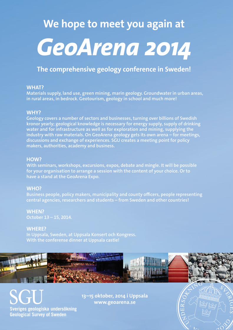
63
We hope to meet you again at
GeoArena 2014
The comprehensive geology conference in Sweden!
13–15 oktober, 2014 i Uppsala www.geoarena.se
WHAT? Materials supply, land use, green mining, marin geology. Groundwater in urban areas, in rural areas, in bedrock. Geotourism, geology in school and much more!
WHY? Geology covers a number of sectors and businesses, turning over billions of Swedish kronor yearly; geological knowledge is necessary for energy supply, supply of drinking water and for infrastructure as well as for exploration and mining, supplying the industry with raw materials. On GeoArena geology gets its own arena – for meetings, discussions and exchange of experiences. SGU creates a meeting point for policy makers, authorities, academy and business.
HOW? With seminars, workshops, excursions, expos, debate and mingle. It will be possible for your organisation to arrange a session with the content of your choice. Or to have a stand at the GeoArena Expo.
WHO? Business people, policy makers, municipality and county officers, people representing central agencies, researchers and students – from Sweden and other countries!
WHEN? October 13 – 15, 2014.
WHERE? In Uppsala, Sweden, at Uppsala Konsert och Kongress. With the conferense dinner at Uppsala castle!
vintermotet.indd 1 2013-12-05 12:50:04
64
LUN
DPA
L
LUNDPAL Lundadagarna i Historisk Geologi och Paleontologi
Comparison of three different disinte-gration methods for chalk foraminifer studies
Arp, Trine1; Rasmussen; Jan Audun2; Stemmerik, Lars3
1 Natural History Museum of Denmark, University of Copenhagen, Øster Vold-gade 5-7, DK-1350 Copenhagen K; [email protected] ;
2 Natural History Museum of Denmark, University of Copenhagen, Øster Vold-gade 5-7, DK-1350 Copenhagen K; [email protected];
3 Natural History Museum of Denmark, University of Copenhagen, Øster Vold-gade 5-7, DK-1350 Copenhagen K; [email protected]
Three mid-Danian chalk samples from the same bed in Dalbyo-ver Quarry, Denmark were collected, 50.00 g of each were dried overnight and three different laboratory methods were applied. Acetic acid method: In short, the dry sample was soaked in 80 % acetic acid and subsequently covered with boiling water, sieved and dried. Glaubersalt method: The sample was covered by a supersaturated solution of glaubersalt (Na2SO4 · 10H2O) and deep-frozen. The sample was reheated and the process repeated nine times. The sample was sieved and dried. Dish-washing detergent method: The dry sample was soaked in tap water, dishwashing detergent was added, and the solution was carefully stirred twice a day. Finally, the sample was sieved and dried. Most important results: The acetic acid method has the advantage of being very fast and effective in disintegrating the chalk. A disadvantage is that the foraminifers typically remain covered with a very fine-grained residue and break more eas-ily than we observed by using the two other methods. 37 % of the sieved chalk was in the 0.063–1mm range. The glaubersalt method is more time consuming, but it disintegrates the chalk effectively. The foraminiferal state of preservation is good. 49 % of the sieved chalk was in the 0.063–1mm range. The dish-washing detergent method is cheap and slow, although active working time is limited. The foraminifers are preserved nicely. 28 % of the sieved chalk was in the 0.063–1mm range. Evidently, the preparation methods have huge influence on both sample disintegration and foraminifer preservation, and our preliminary results suggest that a combined use of the glaubersalt and the dishwashing detergent methods is an advance.
Triassic terrestrial Buntsandstein, Ger-many: separate, coeval transport paths revealed by petrography, geochemis-try, and cathodoluminescence
Augustsson, Carita1,2; Hilse, Ulrike2; Meyer, Marcus²; Kunkel, Cindy2; Aehnelt, Michaela2; Gaupp, Reinhard2
1 Institutt for Petroleumsteknologi, Universitetet i Stavanger, 4036 Stavanger, Nor-way; [email protected];
2 Institut für Geowissenschaften, Friedrich-Schiller-Universität Jena, Burgweg 11, 07749 Jena, Germany; [email protected], [email protected], [email protected], [email protected], [email protected]
We present the provenance of the middle Buntsandstein from central Germany – an extensive fluvial-aeolian-lacustrine suc-cession of Early Triassic age. The study area is marked by differ-ences in palaeoflow directions and it is surrounded by structural and topographic highs. We investigate the relation between highs and source areas in the basin. Arkose of the Solling For-mation was sampled from a core in W Thuringia (in the east) and from outcrops in E Hesse and S Lower Saxony (in the west).
The area is situated between the Rhenish Massif to the SW and the Bohemian Massif in the SE and with the structural Eichs-feld high between the eastern and western parts of the study area. Flow directions are towards the north but vary from NW to E. The chemical weathering index (CWI) is 80-95 % for the west and provenance-indicative chemical indices, such as Th/Sc (2-3), point to felsic source rocks. Feldspar, mainly potassi-um feldspar, occurs with 10-20 % and lithic fragments (8-15 %) mainly are of metasedimentary origin. Monocrystalline quartz constitutes 80-90 % of the quartz population and it dominantly produces cathodoluminescence spectra typical for low-grade metamorphic rocks. Tourmaline (30-50 %), zircon (15-40 %) and titanium oxides (anatase, rutile; 10-30 %) are common heavy minerals. Apatite is frequent in the north and on the Eichsfeld high (15-35 %). In the east, the arkose mostly has lower CWI (50-95 %) and Th/Sc (1-3). The difference is due to provenance rather than weathering, as indicated by the petrographic composition. Accordingly they are poorer in lithic fragments (absent or < 5 %) that are dominated by felsic magmatic clasts and monocrys-talline quartz grains (> 90 %) are mainly of plutonic origin. The compositional differences indicate that the Eichsfeld high in-fluenced the location of the axial trunk systems, although the Solling Formation was deposited on top of it. Metasedimenta-ry material from the Rhenish Massif and the Ardennian-Gallian Massif, and igneous detritus from the Bohemian Massif were transported in different systems with little mixing around the high. Hence, this study illustrates the strength that petrographic provenance methods have.
Granite weathering features and im-pact on the knowledge of arenization process
Begonha, A.1*; Sequeira Braga, M.A.2; Paque, H.3
1 Departamento de Engenharia Civil, Faculdade de Engenharia da Universidade do Porto, Rua Dr. Roberto Frias s/n, 4200-465 Porto, Portugal;
2 Centro de Investigação Geológica, Ordenamento e Valorização de Recursos (CIG-R), Departamento de Ciências da Terra, Universidade do Minho, Campus de Gualtar, 4710-057 Braga, Portugal.;
* Corresponding author (e-mail: [email protected]); 3-Académie des Sciences, 23 Quai de Conti, 75 006 Paris, France
The features of the weathering process of the granites were studied in a temperate climate region (NW Portugal) either on landscape or crystal-grain scale. The purpose of this paper is to present a review of mineralogical and chemical studies carried out in Portugal.
Samples of 30 granite weathering profiles of the Cávado Riv-er basin and 13 profiles of the Oporto granite were studied. Optical microscopy, XRD, TEM, SEM-EDS, electron micropro-be, ICP-MS, AAS, grain-size distribution, dry bulk density and pH were used.
The main features of the weathering horizons may be ex-plained by the granitic saprolites as follows: (1) thickness of more than 10 to 20 m, with or without spheroidally weathered boulders inside; (2) predominant sand fraction over a very low percentage of clay fraction with a mean value of 7%; (3) mean material loss of 40 % during granite saprolites formation i.e. arenization; (4) conservation of 60% of the parent material in the sand fraction, consisting of skeleton fabric; (5) intense degree of mineralogical evolution resulting in formation of secondary minerals, since kaolinite + gibbsite and/or gibbsite alone.
The variability of the kaolinite + gibbsite distribution of the granite saprolites profiles in zones under unique climate, may only be due to local factors: (i) inclination of the slopes, fractur-ation and external drainage; (ii) grain size distribution, microf-

65
LUN
DPA
L
racturation, porosity and internal drainage. The abundance of kaolinite and gibbsite in the <2 µm fraction testifies the efficacy of the leaching and the intense degree of the mineralogical evolution.
Finally, an intense arenization, its later reworking and final deposition to the arenaceous terraces of the main rivers from NW Portugal, is the source of many sedimentary deposits rich in kaolin minerals. During the Quaternary, especially in the periglacial times up to present-day, the granitic saprolites con-dense an entire geological history.
Fungal–prokaryotic symbiosis in the deep biosphere
Bengtson, Stefan1; Ivarsson, Magnus1
1 Department of Palaeobiology and Nordic Center for Earth Evolution, Swedish Museum of Natural History, Box 50007, SE-104 05 Stockholm, Sweden; [email protected]; [email protected]
The presence of fungi in the deep biosphere, hundreds of me-tres below the ocean floor, has only recently been established. Their ecological role is still unknown, owing to difficulties of obtaining and culturing organisms from sub-seafloor settings. Natural fixation through fossilization provides means of observ-ing morphological characteristics and deducing life conditions of these elusive organisms. Samples of subseafloor vesicular basalts from the Emperor Seamounts chain (northern Pacific Ocean) reveal an Eocene community of eukaryotes and prokar-yotes forming symbiotic relationships. We have studied this community by means of synchrotron-based X-ray tomographic microscopy. The spatially dominant organism is a fungus that forms a biofilm on the basalt surfaces and sends out mycelial networks of anastomosing hyphae. Suspended between the hy-phae are cobweb-like structures along which micrometre-sized grains are aligned. Also attached to the hyphae are ferruginous branching microstromatolites known as Frutexites. We inter-pret these structures as symbiotic associations between at least three different kinds of organisms: eukaryotic heterotrophic fungi forming the mycelial network, chemolithoautotrophic prokaryotes forming the cobweb-like structures, and chemo-lithoautotrophic iron-oxidizing bacteria forming the Frutexites structures. The fungi presumably consumed organic material produced by the autotrophs, and the latter may have been able to make use of CO2 released by the fungi. The fossil envi-ronment presents a means to study the evolution of the deep biosphere in deep time, in particular the participation of eukar-yotes in what was long considered a prokaryotic recluse.
Documentation of the immediate K–Pg mass extinction recovery using vertebrate micro-stratigraphy
Bercovici, Antoine1; Hunter, John2; Pearson, Dean3; Vajda, Vivi1
1 Department of Geology, Lund University, Sölvegatan 12, SE-223 62, Lund, Sweden; [email protected];
2 Department of Evolution, Ecology, and Organismal Biology and School of Earth Sciences,
3 The Ohio State University Newark, 1179 University Drive, Newark, Ohio 43055, U.S.A. Pioneer Trails Regional Museum, Paleontology Dept. 12 First Ave. NE, Bowman, ND 58623, USA.
The Cretaceous–Paleogene (K–Pg) mass extinction event is associated to the abrupt devastation of terrestrial ecosystems associated to the Chicxulub event 66 Ma, one of the largest as-teroid impact of the Phanerozoic. This impact has triggered ex-tinctions and re-arrangements globally among the Cretaceous faunal and floral communities. Here we present new results from an extensive excavation of sediments located immediately above the K–Pg boundary in southwestern North Dakota. The excavation was stratigraphically controlled at a centimeter scale
allowing for the description of a succession of individual dep-ositional environments associated to their characteristic faunas and floras. On the basis of 2,742 vertebrate fossil remains recov-ered from 5,162 kg of screen-washed material across 20 distinct lithological units, we demonstrate that the recovery of terrestri-al ecosystem was underway by 83 cm above the palynological-ly defined K–Pg boundary. The first mammals to appear in the Paleocene are multituberculates, cimolestans, and condylarths, and co-occur with the first appearance of typical low diversity Paleocene (FU1) macrofloral assemblages. The overwhelming occurrence of lizards (iguanids) and mammals (more specifically multituberculates) indicate that these were opportunists with broad tolerances and presumably rapid reproductive potential, whose populations rebounded and expandedquickly in post-impact disturbed habitats. Based on radiometric dating, estimation of the duration of the recovery is in the order of 10.000 years or less.Carbon isotope stratigraphy of the Hir-nantian oolite at Vettre road-cut, Langøyene Formation, Oslo, Norway
Carbon isotope stratigraphy of the Hirnantian oolite at Vettre road-cut, Langøyene Formation, Oslo, Norway
Calner, Hanna1; Calner, Mikael1; Lehnert, Oliver2,1
1 Department of Geology, Lund University, Sölvegatan 12, SE-223 62 Lund, Sweden; [email protected], [email protected];
2 GeoZentrum Nordbayern, Lithosphere Dynamics, University of Erlangen-Nürn-berg, Schlossgarten 5, [email protected]
Ooids are sand-sized, spherical grains built by concentric lam-inae of calcium carbonate that precipitated around a bioclast or mineral grain. Limestone composed of ooids is referred to as oolite. Such limestone forms a time-specific facies during a very brief time interval in the latest Ordovician (Hirnantian). Pal-aeogeographically, these oolites have a circum-tropical distri-bution. We have initiated the project ‘Hirnantian Oolites, their Palaeogeography and Event stratigraphy (HOPE)’, which aims to study oolites on a global scale and evaluate their significance in respect to the major environmental changes and mass-ex-tinction associated with the latest Ordovician. A first primary goal is to increase the resolution in the inter-continental corre-lation of these oolites. For this particular sub-study twenty-four carbon isotope samples were collected from a ca two metre thick oolitic limestone in a road-cut along road 165 at Vettre, in the inner part of Leangbukta, southwest of Oslo. This oo-lite belongs to Langøyene Formation and is overlain by Silurian fine-grained clastic rocks of the Solvik Formation. The δ13C data of the oolite scatters around 5‰ with a peak value of 5.78‰, proving a Hirnantian age for the strata. Most of the HICE (Hir-nantian Isoptope Carbon Excursion) is preserved in the section, although additional sampling is needed to recover pre-HICE base-level values and the lowermost part of the rising limb. The oolite at Vettre road-cut thus is synchronous with latest Ordovi-cian oolites previously described from Sweden, the East Baltic area, North American Midwest and China.
δ13C stratigraphy of the Lower-Middle Ordovician ‘orthoceratite limestone’ of Öland, southern Sweden
Calner, Mikael1; Lehnert, Oliver2,1; Dahlqvist, Peter3; Wu, Rongchang1; Joachimski, Michael M.2
1 Department of Geology, Lund University, Sölvegatan 12, SE-223 62 Lund, Swe-den; [email protected], [email protected], [email protected];
2 GeoZentrum Nordbayern, Lithosphere Dynamics, University of Erlangen-Nürn-berg, Schlossgarten 5, D-91054, Erlangen, Germany; [email protected], [email protected];
3 Geological Survey of Sweden, Killiansgatan 10, SE- 227 38 Lund, Sweden; [email protected]
66
LUN
DPA
L
The Lower-Middle Ordovician sedimentary succession of Balto-scandia is dominated by the ‘orthoceratite limestone’, a suite of grey to reddish, very fine-grained limestone deposited in temperate water environments at middle palaeolatitudes. The typical ‘orthoceratite limestone’ formed in an exceptionally starved, very slowly subsiding, shallow epeiric basin with low re-lief. Several previous studies have demonstrated a very low net sedimentation and the highly condensed succession includes numerous hardgrounds, mainly of corrosional type. The Ting-skullen core was retrieved in 2010 from the north-eastern part of the island of Öland. Here, the Ordovician strata rest on a Cambrian palaeokarst surface associated with several decime-tres of down-cutting and internal sediments. The thickness of the Tremadocian through Darriwilian strata in the core amounts to ca 46 metres and represents the entire preserved Ordovician succession of the island. Our initial study on the carbon isotope geochemistry of these rocks includes 100 whole-rock samples recovered with a micro-drill. The dataset represent the first con-tinuous carbon isotope record from the Ordovician limestone succession of Öland and helps to tie the strata to other areas of Baltoscandia. Striking is the very thin Lower Ordovician suc-cession that amounts to less than 10 m. A protracted positive excursion of more than 1.5‰ spans much of the Middle Ordo-vician and is assigned as the Middle Darriwilian carbon isotope excursion (MDICE). δ13C peak values for the MDICE are identi-fied at a level that presumably correlates with the Segerstad-Skärlöv-Seby limestone interval, at about 13 m below the top of the Tingskullen core succession.
Helcionelloid molluscs from Cambrian Series 2 strata in Sweden: Composition and stratigraphic implications
Cederström, Peter1; Ebbestad, R. Jan Ove2; Ahlberg, Per3
1 Axelvoldsvägen 27, SE-241 35 Eslöv, Sweden; [email protected]; 2 Museum of Evolution, Uppsala University, Norbyvägen 16, SE-752 36 Uppsala,
Sweden; [email protected]; 3 Department of Geology, Lund University, Sölvegatan 12, SE-223 62 Lund,
Sweden; [email protected]
Cambrian Series 2 (Stage 4) helcionelloid molluscs are relatively common at two localities in Sweden: Gislövshammar, SE Sca-nia, and Mt Luopakte, south of Lake Torneträsk, northern Lap-land. At Gislövshammar, more than 500 specimens have been recovered from a 30 cm thick interval of laminated siltstone with intercalated calcareous nodules in the Gislöv Formation (lower Ornamentaspis? linnarssoni Zone). Most specimens are pre-served as internal moulds. Seven taxa are recognized including Pelagiella, two forms of Capitoconus, Macinnonia, Latouchel-la and Helcionella. Associated trilobites are the ellipsocepha-lids Strenuaeva spinosa and Ornamentaspis? linnarssoni, and the eodiscoid Calodiscus lobatus. At Mt Luopakte, a diverse mollusc fauna has been recovered from a bioclastic lime-stone forming the top of the Grammajukku Formation (upper O.? linnarssoni Zone). They are represented by Yochelcionel-la and Anabarella, both recorded in Sweden for the first time, Helcionella, Capitoconus, Macinnonia and Latouchella. The Mt Luopakte specimens are macroscopic, except for Anabarella, and preserved as internal moulds. In addition to endemic po-lymerids, the associated trilobite fauna includes the eodiscoids Chelediscus acifer and Neocobboldia cf. dentata.
The mollusc faunas can be compared with coeval faunas from southern England, SE Newfoundland and New Brunswick, western Newfoundland, NE Greenland, and South Australia, as well as with Cambrian Stage 4 faunas from other parts of Scandinavia, e.g. from the Mjøsa area, SE Norway. The biostrati-graphic utility of Cambrian molluscs is generally hampered by the apparently very long stratigraphic range of many taxa. The new helcionelloid material from Sweden may have potential for enhanced correlation into other ‘early’ Cambrian continents.
Trilobites of the Lower Cambrian Duolbasgaissa Formation, the Digermul Peninsula, northern Norway
Ebbestad, Jan Ove R.1; Högström, Anette E.S.2; Høyberget, Magne3; Jensen, Sören4; Palacios, Teodoro4; Taylor, Wendy L.T.5
1 Museum of Evolution, Uppsala University, SE-75236 Uppsala, Sweden; [email protected];
2 Tromsø University Museum, the Artic University of Norway, N-9037Tromsø, Norway; [email protected];
3 Rennesveien 14, N-4513 Mandal, Norway; [email protected]; 4 Area de Paleontología, Universidad de Extremadura, E-06006 Badajoz, Spain;
[email protected], [email protected]; 5 Department of Geological Sciences, University of Cape Town, Private Bag X3,
Rondebosch 7701, South Africa; [email protected]
The lower Cambrian Duolbasgaissa Formation on the Digermul Peninsula in Finnmark, northern Norway has yielded two trilo-bite-bearing horizons, of which one was previously unknown. Both occur in silty mudstones of the middle of the Upper Du-olbasgaissa Member in the Breidvika Valley on the NE side of the peninsula. The lower trilobite sequence is richly fossil-iferous, with one specimen of an ellipsocephalid and over 60 specimens of three olenellids, tentatively identified as Kjerulfia lata, Kjerulfia sp. and Elliptocephala sp. Most specimens are from scree material, but fragments have also been found in situ. The specimens are usually disarticulated but some have most sclerites intact. Only holaspid stages are found and many fine details of ornamentation are preserved. The assemblage is comparable in diversity and abundance to that of Tømten in the Mjøsa area of southern Norway, but differs in the composi-tion of taxa and lack of helcionelloids and other molluscs. The upper trilobite-bearing horizon has yielded two specimens of a so far unidentified ellipsocephalid, associated with phosphatic brachiopods. The trace fossil Syringomorpha is associated with the lower trilobite sequence, which in southern Sweden is asso-ciated with the so-called Rusophycus zone, below the Schmid-tiellus mickwitzi Zone, but trilobites and acritarchs suggest that this interval of the Duolbasgaissa Formation is within the Bot-omian Stage (Vergale-Rausvian Stage in Baltoscandia) Helios-phaeridium dissimilare – Skiagia ciliosa Acritarch Biozone and Holmia kjerulfi Assemblage Zone (Cambrian Series 2, Stage 4). This contribution is part of a series of studies by the Digermulen Early Life Research Group.
A paleontological study of the Campa-nian (Upper Cretaceous) sedimentary succession at Åsen, Kristianstad Basin, southern Sweden
Einarsson, Elisabeth1; Iqbal, Faisal1; Bercovici, Antoine1; Vajda, Vivi1
1 Department of Geology, Lund University, Sölvegatan 12, SE-223 62 Lund, Sweden
An excavation of Cretaceous (Campanian) marine sedimentary succession at Åsen, Skåne yielded a diverse invertebrate fauna including brachiopods, bivalves, belemnites, bryozoans, barna-cles,sea urchins andcorals with addittional specimens of verte-brate bones and teeth. The succession further contains charcoal fragments but most of them are encountered in the lowermost part representing the early Campanian marine deposits.The succession has been sub-divided into two zones, the early Campanian Belemnellocamax mammilatus Zone and the late Campanian Belemnellocamax balsvikensis Zone. The B. mam-milatus Zone is further divided into distinct units; the Coquina bed, the Green sand bed and the Oyster bank. The B. balsvik-ensis Zone is divided into Balsvikensis Green and Balsvikensis Yellow.
67
LUN
DPA
L
A quantitative analysis was performed based on weight per-centage of the individual fossil groups in order to assess the variation between the different beds at the studied locality. This revealed significant differences between the different beds with implications on paleoenvironment, and the results will be out-lined in our poster!
The evolution of the passive continen-tal margin of Norway and its adjacent mainland – using the sub-Cambrian peneplain as a reference surface
Gabrielsen, R. H.1; Jarsve, E. M.1; Lundmark, A.M.1; Nystuen, J.P.1; Faleide, J.I.1
1 Department of Geosciences, University of Oslo, P.O.Box 1047, Blindern, N-0316 Oslo, Norway
The structuring, uplift and subsidence of the passive margin and shelf of Norway and its adjacent mainland were affected by several profound geological processes, including inherited basement structural grain related to the Proterozoic and Cale-donian orogens and also including the extensional collapse of the Caledonides. This has been followed by several stages of late Palaoezoic – Cenozoic extension intererupted by thermo-tectonic activity, Cenozoic accelerated uplift of uncertain origin of the hinterland, creating an irregular pattern of upheaval and, finally Pleistocene – Holocene glacial abrasion, loading and un-loading. These processes have strongly influenced the topog-raphy of the hinterland, thus causing and acting in concert with climate fluctuations.
The correlation of erosional surfaces of regional significance on the shelf and on the mainland is a key to the evaluating the total topography of the margin. Because of the lack of data-ble surfaces on the mainland, this is problematic. The so-called Paleic surface has been used in this context, but its age and nature is not well constrained and the absence of post-Cale-donian rocks in the western and central mainland of southern Norway adds to this complexity. In contrast, the sub-Cambrian peneplain, which is found in larger parts of Scandinavia, is well established when it comes to dating and development. The sub-Cambrian peneplain displays a variety of configurations, including an undisturbed basal conglomerate, a weathered and mineralized, undulating surface with small pockets of alun shale or siltstone, a tectonically disturbed primary contact with parau-thochtonous black shale or black sandstone and a more strong-ly tectonized contact with mylonite and rejuvenated basement lenses. The present analysis utilized the sub-Cambrian pene-plain as a reference surface, because its present topography resulted from several elements of deformation accumulated throughout the Caledonian to the Present. Hence, it can be used as a reference surface for younger erosional surfaces on-land Norway, whether this are of regional or local origin.
Colouring the past: detailed imaging and molecular analyses of an excep-tionally preserved feather from the Eocene Fur Formation of Denmark
Gren, Johan1; Lindgren, Johan1
1 Department of Geology, Lund University, Sölvegatan 12, SE-223 62 Lund, Sweden; [email protected], [email protected]
Integumentary structures occur in the fossil record in various states of preservation, from faint impressions to carbonised traces. For a long time, feather preservation was attributed to the actions of keratinophilic bacteria, but more recently this
process has been reinterpreted, and it is now generally be-lieved that traces of plumage represent the fossilised remains of colour-bearing cellular organelles (melanosomes). Claims of melanosomes in dinosaur and bird plumage have hitherto been based chiefly on structure, although some trace elements that are present in fossil feathers have been suggested to possess melanin (a biochrome with a diverse range of ecological and biochemical functions) affinity. Nonetheless, unequivocal traces of melanin pigment in the fossil record have so far only been reported in an Eocene fish eye and Jurassic squid ink sacs, and thus have yet to be identified in fossil feathers. Therefore, we analysed an exceptionally preserved feather (FUM 1980) from the Early Eocene (about 55 Ma) Fur Formation of Denmark us-ing a broad array of sophisticated imaging and molecular tech-niques, including SEM-EDX, IR-microspectroscopy, XANES, EXAFS, and ToF-SIMS. Additionally, we employed computed micro-tomography in order to produce a 3D-model of the fossil. Our preliminary results show that the proximal part of the feath-er contains masses of aligned, ovoid melanosome-like micro-structures, about 1 µm long and 0.5 µm wide. These are located within shallow depressions that presumably represent remains of pigment cells. Distally, the melanosome-like microstructures are highly elongate and densely spaced. Eumelanin biomarkers occur in intimate association with these microbodies, suggest-ing that they represent fossilised melanosomes. The properties of melanosome morphology and distribution provide a basis for reconstruction of the original colour scheme of the fossil feather. We suggest that the proximal part of the feather had a greyish tone, whereas the tip was iridescent. Melanosomes with sizes and morphologies corresponding to those in FUM 1980 are present in extant parrots, a group of birds that has also been identified from the Fur Formation.
Molluscan protoconchs from the early Silurian anoxic strata of Severnaya Zemlya, Arctic Russia
Gubanov, P. Alexander1; Bogolepova, K. Olga2
1 Evolutionsmuseet, Uppsala, Sweden, 2CASP, Cambridge, United Kingdom
Though early ontogenetic development (embryonic and larval shell) is very important for the classification and systematics of molluscan high taxa, well-preserved protoconchs are very rare in geological record. The oldest finds of embryonic shell are known as isolated protoconchs, thus their taxonomic affinity is unclear.
Here we report well-preserved molluscan protoconchs of various affinities as well as adult shells from the early Silurian (Aeronian) of Severnaya Zemlya Archipelago (Arctic Russia). They occur in black limestone nodules within graptolitic shales. Good preservation and high concentration of protoconchs are probably due to an anoxic environment of strata formation.
Variations in depositional environment across Adventdalen, from Operafjellet to Breinosa
Guðmundsdóttir, Anna Stella1,2
1 Gothenburg University. Box 100, 405 30 Gothenburg. 2The University Centre in Svalbard. Box 156, 9171 Longyearbyen
The coal bearing Paleocene Firkanten Formation of the Cen-tral Tertiary Basin in the Svalbard archipelago has been studied by several researches (Lüthje 2009; Nagy 2005; Serigstad 2011; SNSG internal reports). These studies show that the Firkanten Formation in Breinosa is characteristic for the formation but some non-representative features are now found in Operafjel-

68
LUN
DPA
L
let, which is situated close by, on the opposite side of the Ad-ventdalen valley. This might affect the exploration of the moun-tain and perhaps give a new insight into the development of the Firkanten Formation at the basin edge. The present study aims on investigating and comparing the depositional environment of Firkanten Formation in the two mountains. Currently, a coal mine is being operated by SNSG in Breinosa, and Operafjellet coal field could possibly be opened for exploitation in the fu-ture. SNSG has drilled several cores from the two mountains, which are used for environmental interpretation and correlation of the depositional environment over the Adventdalen valley. The study is based on logs from the drill cores and laborato-ry results from coal samples. Preliminary results show that the Firkanten Formation is deposited in a coastal plain to shallow marine environment and significant lithological differences are observed in the two areas despite their relatively short distance. Many micro-faults are found in Operafjellet drill cores and ma-jor folding has been observed at the K/T boundary in the moun-tain. Larger faults are observed in both locations within the for-mation. Correlation of depositional environments at both sides of the valley and possible explanations will be discussed.
ReferencesLüthje, C.J., 2009: Transgressive Development of Coal-bearing Coastal Plain to Shallow Marine Setting in a Flexural Compressional Basin, Pale-ocene, Svalbard, Arctic Norway. PhD Thesis, University of Bergen.Nagy, J., 2005: Delta-influenced foraminiferal facies and sequence stratigraphy of Paleocene deposits in Spitsbergen. Palaeogeography Palaeoclimatology Palaeoecology 222, 161–179.Serigstad, E., 2011: Paleoenvironment and its influence on the distri-bution of coal deposits in the Todalen Member, Firkanten Formation (lower Paleocene), Svalbard. Unpublished Masters Thesis, University of Bergen and University Centre in Svalbard.
Evolution of early biota and complex ecosystems: the Digermul succession of northern Norway
Högström, Anette E.S.1; Ebbestad, Jan Ove R.2; Jensen, Sören3; Palacios, Teodoro3; Høyberget, Magne4 and Taylor, Wendy L.5 2014.
1 Tromsø University Museum, the Artic University of Norway, N-9037 Tromsø, Norway; [email protected];
2 Museum of Evolution, Uppsala University, SE-75236 Uppsala, Sweden; [email protected];
3 Area de Paleontología, Universidad de Extremadura, E-06006 Badajoz, Spain; [email protected], [email protected];
4 Rennesveien 14, N-4513 Mandal, Norway; 5 Department of Geological Sciences, University of Cape Town, Private Bag X3,
Rondebosch 7701, South Africa; [email protected]
Evolution of early biota and complex ecosystems took place during the Ediacara-Cambrian transition. A suite of stem-group bilaterian animals, vendobionts, radially organized organisms and inhabitants of the planktonic realm emerged in a succes-sion of events leading to the increased diversity of the Cam-brian seas. In Scandinavia this entire transition can only be studied on the Digermul Peninsula in northern Norway. Here about 3 000 m of siliciclastic sediments of nearly unprecedent-ed preservation and completeness are preserved, spanning the Ediacara-Cambrian transition and continuing into the Lower Ordovician. 20 years ago Ediacara type fossils were found here, and during 2011 new Aspidella type organisms came to light. Well-preserved organic-walled microfossils give firm age con-straints on the succession. Trace fossil abundance and preserva-tion is exceptional. Treptichnus pedum and associated trilobed trace fossils in combination with occurrences of Granomargin-ata prima and the first report of Cochleatina in Scandinavia places the Ediacaran – Cambrian transition at the third cycle of the Manndraperelva Member (Stáhpogiedde Formation). The age of the lower part of the Stáhpogiedde Formation (Innerelva Member) is suggested to be younger than ca 560 Ma based on the presence of Aspidella, vendotaenids and possible simple trace fossils. The exceptional Digermul succession is thus in a
central position for understanding the evolution and develop-ment of early complex ecosystems. This contribution is part of a series of studies by the Digermulen Early Life Research Group.
The Lower Cambrian Duolbasgaissa Formation, the Digermul Peninsula, northern Norway
Högström, Anette E.S.1; Ebbestad, Jan Ove R.2; Jensen, Sören3; Palacios, Teodoro3; Høyberget, Magne4; Taylor, Wendy L.T.5
1 Tromsø University Museum, the Artic University of Norway, N-9037Tromsø, Norway; [email protected];
2 Museum of Evolution, Uppsala University, SE-75236 Uppsala, Sweden; [email protected];
3 Area de Paleontología, Universidad de Extremadura, E-06006 Badajoz, Spain; [email protected], [email protected];
4 Rennesveien 14, N-4513 Mandal, Norway; [email protected]; 5 Department of Geological Sciences, University of Cape Town, Private Bag X3,
Rondebosch 7701, South Africa; [email protected]
The Ediacaran to Lower Ordovician sedimentary succession on the Digermul Peninsula in Finnmark, northern Norway con-sists of ~3000 m of clastic-rich deposits formed in a foreland basin marginal to Baltica. Renewed investigations of the area are made by the Digermulen Early Life Research Group. The 2013 field season was devoted to studying bio- and lithostra-tigraphy of the lower Cambrian Duolbasgaissa Formation and its two members, in order to review the subdivisions, thickness of sequences, fossil occurrences and constraining the age. Pre-liminary results show the unit to be about 100 m thicker than previous estimates. The Psammichnites- like traces that define the base of the Lower Duolbasgaissa Member occur in at least the lower 80 m. The Upper Duolbasgaissa Member consists of a series of sequences starting with finer silt and mudstone beds (‘brown beds’ from the colour of weathering) that are replaced by 10 to 30 m thick, fine to coarse pure quartz sandstones. Two trilobite-bearing horizons have been found with rare speci-mens of ellipsocephalids and abundant specimens of a diverse olenellid fauna with Kjerulfia and Elliptocephala. Other macro-fossils include disc-shaped shells, phosphatic brachiopods as well as a rich trace fossil association including Syringomorpha and a range of trilobite traces. Well preserved acritarchs help to constrain the age at this level to the Heliosphaeridium dissim-ilare – Skiagia ciliosa acritarch Biozone, broadly equivalent to the Holmia kjerulfi Assemblage Zone, Cambrian Series 2, Stage 4 (Botomian Stage (Vergale-Rausvian Stage in Baltoscandia)).
Stratigraphy and ages of the classic Neogene mammal fossil localities from Baode County, China
Kaakinen, Anu1; Passey, Benjamin H.2; Zhang, Zhaoqun3; Liu, Liping3; Pesonen, Lauri J.4; Fortelius, Mikael1
1 Department of Geosciences and Geography, P.O. Box 64, 00014 University of Helsinki, Finland; [email protected], [email protected];
2 Department of Earth and Planetary Sciences, Johns Hopkins University, Balti-more, Md. 21218, USA; [email protected];
3 Institute of vertebrate Paleontology and Paleoanthropology, Chinese Academy of Sciences, 100044 Beijing, China; [email protected], [email protected];
4 Department of Physics, laboratory for Solid Earth Geophysics, 00014, University of Helsinki, Finland; [email protected]
In the Chinese Loess Plateau, the well-developed, fossil-rich Hipparion Red Clay has been intensely studied for nearly a cen-tury, and provides a unique terrestrial record for the exploration of past environmental changes. Baode on the Yellow River in northern Shanxi Province is a classical locality for late Neogene mammal fossils. It has been known since antiquity as a source of the “dragon bone”, used in traditional Chinese medicine.
69
LUN
DPA
L
The Baode fossil find localities have also provided much of the Chinese mammalian fossil material stored and displayed in mu-seums. In particular, the majority of the Chinese large mammal fossils in the Lagrelius Collection in the Museum of Evolution in Uppsala, Sweden, derive from Dragon Bone Mines of Baode Hipparion Red Clay deposits. The fossil collection was largely established in the early 1900th century by collecting campaigns of J.G. Andersson and O. Zdansky. Early work identified two distinct fossil assemblages within the material representing for-est- and steppe-like faunas. The main limitation of the Lagre-lius collection so far has been lack of stratigraphic information concerning the localities. A Finnish–Chinese research project conducted fieldwork in the Baode area during three field sea-sons. We were able to relocate many of the old localities and successfully place them in a stratigraphic framework. In contrast to the earlier conception of a single level producing all fauna, our results show that the Baode fossil localities cluster at three levels with magnetostratigraphic ages of ca. 7 Ma, 6.5 Ma and 5.7 Ma (Kaakinen et al. 2013). We find that the oldest localities preserved mostly closed- and mixed habitat species while the youngest localities are relatively enriched in open habitat taxa (Passey et al. 2007; Kaakinen et al. 2013).
ReferencesKaakinen, A., Passey, B.H., Zhang, Z., Liu, L., Pesonen, L.J. & Fortelius M., 2013: Stratigraphy and paleoecology of the classical dragon bone localities of Baode County, Shanxi Province. In W. Xiaoming, M. Fortelius & L. Flynn (eds.): Fossil Mammals of Asia: Neogene Biostratigra-phy and Chronology, pp. 203–217. Columbia University Press, New York.Passey, B.H., Eronen, J.T., Fortelius, M. & Zhang, Z., 2007: Paleodiets and paleoenvironments of late Miocene gazelles from North China: Evi-dence from stable carbon isotopes. Vertebrata PalAsiatica 45, 118–127.
Hirnantian (terminal Ordovician) dripstones and deep palaeo-karst in the Boda Limestone Formation, Dalarna, Sweden
Kröger, B.1, Ebbestad, J.O.2; Rasmussen, C. M. Ø.3
1 Freie Universität Berlin, Geologische Wissenschaften, Fachrichtung Paläontologie, Malteserstrasse 74-100, D-12249 Berlin, Germany; [email protected];
2 Museum of Evolution, Uppsala University, Norbyvägen 16, SE-752 36 Uppsala, Sweden; [email protected];
3 Department of Geology, Lund University, Sölvegatan 12, Lund 223 62, Sweden, [email protected]
The Boda Limestone Formation of Dalarna, central Sweden, is most prominent because of its large bioherms. These are inter-preted as mud mounds that reach dimensions of up to 150 m thickness and 1000 m in diameter. Recently the timing of their formation could be well constrained by δ C13 chemostratigra-phy. The analyses revealed a latest Katian (Late Ordovician) age of the mounds and the presence of a substantial sequence of post-bioherm limestones of Hirnantian age. Within the mounds so called „pockets“ and “dykes” are well known since more than hundred years. Most of the pockets represent synsedimen-tary fissures and crevices.
We found decimeter thick speleothems in a number of these fissures, reaching as deep as 30 m below the original mound surface. Generally the dripstones are covered with a platy silt-stone, which is devoid of fossils. But in some places brachiopod coquinas were deposited directly above the speleothems. The brachiopods helped to narrowly constrain the time interval of the speleothem formation within the Hirnantian. The timing is supported by a microfacies analysis of the post-bioherm de-posits. In bioclastic Hirnantian grainstones of the Upper Boda Member levels with phreatic and meteoric primary cements and “swiss cheese karst” can be identified.
The karst features potentially will help to estimate the abso-lute sea level variations during the Hirnantian glaciation. Addi-tionally, the speleothems and cave fillings may provide impor-tant new information on the extent and specificity of a potential terrestrial Hirnantian plant cover.
The sediment fill of the ‘Siljan Ring’ – a mirror of the Early Palaeozoic evolution of western Baltoscandia
Lehnert, Oliver1,2; Meinhold, Guido3; Arslan Arzu4; Berner, Ulrich5; Calner, Mikael2; Huff, Warren D.6; Ebbestad, Jan Ove7; Joachimski, Michael M.1
1 GeoZentrum Nordbayern, Lithosphere Dynamics, University of Erlangen-Nürn-berg, Schloßgarten 5, D-91054, Erlangen, Germany; [email protected], [email protected];
2 Department of Geology, Lund University, Sölvegatan 12, SE-223 62 Lund, Sweden; [email protected];
3 Geowissenschaftliches Zentrum der Universität Göttingen, Abteilung Sedimen-tologie/Umweltgeologie, Goldschmidtstraße 3, D-37077 Göttingen, Germany; [email protected];
4 Midland Valley Exploration Ltd, 144 West George Street, G22HG Glasgow, United Kingdom; [email protected];
5 Petroleum System Analysis, Statoil ASA, Sandsli, Norway; [email protected]; 6 Department of Geology, University of Cincinnati, 500 Geology/Physics Building,
Cincinnati, OH 45221-0013, USA; [email protected]; 7 Museum of Evolution, Uppsala University, Norbyvägen 16, SE 752 36 Uppsala,
Sweden; [email protected]
The Siljan impact structure preserves unique Lower Palaeozo-ic sedimentary successions in its ring-like depression around the central uplift. The stratigraphy investigated in three core sections provides new information on the development of this area that palaeogeographically was located near the western margin of Baltica. Several facies belts likely related to the Ordo-vician-Silurian foreland basin development can be recognized in the sedimentary record of this area, some 100 km away from the Caledonian front. The cores comprise strata ranging from the late Tremadocian to Wenlock in age and provide a huge dataset for studies in palaeoclimate, sea level, and changes in ecosystems. Multiple karst horizons in the Ordovician strata can be correlated to other parts of Baltica and suggesting recurrent subaerial exposure of the basin during sea level lowstands. The volcanic record (K-bentonites) may be correlated with ash layers in other parts of Baltoscandia, and serve as chronostratigraphic time-lines in a detailed stratigraphic framework including litho-, bio-, chemo- and sequence stratigraphic parameters. Within the upper part of the Silurian clastic succession in the western part of the ‘Siljan Ring’, we recognize the progradation of a del-ta system reflecting a regression in an overall subsiding basin, likely due to a global sea-level drop during the Sheinwoodian (early Wenlock) glaciation exposing the forebulge area to the west. Geochemical data of the siliciclastics suggest deposition in a range of lacustrine to brackish and marine environments. Biomarker data support deposition in a backbulge basin de-veloped in the eastern part of the Caledonian foreland basin system.
Deep weathering and landforms in Scandinavia – a review
Lidmar-Bergström, K.1
1 Stockholm University, Department of Physical Geology and Quaternary Geology, Stockholm, Sweden
The relationships between landforms and saprolites on the one hand and cover rocks of different age directly on basement on the other have been explored since long in Scandinavia. The South Swedish Dome is a key area as a re-exposed extremely flat surface extends from below Cambrian cover rocks in the north and east and rises up to 300 m a.s.l. In contrast a hilly relief extends from below Jurassic and mainly Upper Cretaceous cov-er rocks in the south and west. This surface is associated with thick remnants of a clayey kaolinitic saprolite. It is inclined and it is cut off at about 100 – 125 m a.s.l by a plain with only a few residual hills, the South Småland Peneplain, where gravelly sap-rolites are encountered. Thus the hilly relief was protected by a cover during formation of this plain, which also expanded east-wards and northwards at the cost of the uplifted sub-Cambrian
70
LUN
DPA
L
peneplain. Soft ores and remnants of a kaolinitic saprolite are associated with hilly relief in central Sweden, which suggests a longlasting protective cover also here. Similar conditions occur along the coasts of southern Norway. In contrast the inselberg plains in northern Sweden are associated with some type of gravelly saprolites and thus are judged to have formed when the hilly relief still had a cover in accordance with the conditions around the SSD. These plains might correlate to the Palaeic plains of southern Norway.
Oncoids and stromatolites in the Holen Limestone (Darriwilian, Middle Ordo-vician) at Kinnekulle, Västergötland, Sweden
Lindskog, Anders1
1 Department of Geology, Lund University, Sölvegatan 12, SE-22362 Lund, Sweden; [email protected]
Oncoids and small stromatolites occur in the Darriwilian (Dw1–Dw2, Middle Ordovician) ‘orthoceratite limestone’ at Kinnekulle, Västergötland, Sweden. The characteristics and stratigraph-ic distribution of these microbialites appear to reflect relative sea level; they are preferentially found in beds that record no-table lowstands. Micro-oncoids occur throughout much of the c. 13.5-m-thick Holen Limestone (≈entire Kunda Baltoscandian Stage, BIII). Notable concentrations are present in the Volkhov–Kunda (Lanna Limestone–Holen Limestone, BII–BIII) boundary interval, in the ‘Täljsten’ (BIIIα–BIIIβ transitional beds), and in the middlemost Holen Limestone. Well-developed macro-oncoids have only been found in the ‘Täljsten’ and its enclosing beds, in total a c. 3-m-thick interval. The lowermost beds of the ‘Täljsten’ host the largest and most well developed oncoids in the en-tire succession, and also the highest abundance of specimens. Stromatolites are most common in a bed c. 0.5 m above the ‘Täljsten’. Diagenetic alteration hinders confident identification of the producers of these microbialites, but characteristics of associated endolithic microborings indicate that they formed in photic waters. The cortical fabrics and rounded morphologies of macro-oncoids indicate a relatively high-energy, shallow-wa-ter depositional environment, sensitive to high-frequency en-vironmental change. Stromatolite-like lamination occurs in the uppermost Holen Limestone, but this feature is likely of abio-genic origin.
Micropaleontologic and sedimentolog-ic changes across the Volkhov–Kunda boundary at Kinnekulle, Västergötland, Sweden
Lindskog, Anders1; Eriksson, Mats E.1
1 Department of Geology, Lund University, Sölvegatan 12, SE-223 62 Lund, Sweden; [email protected], [email protected]
The transition between the Volkhov and Kunda Baltoscandian stages (lower Darriwilian, Middle Ordovician) has been associ-ated with a notable drop in sea level, which resulted in gaps in the sedimentary record throughout much of the Baltoscandian paleobasin. Owing to a relatively deep-water depositional set-ting, the ‘orthoceratite limestone’ at Kinnekulle, Västergötland, Sweden, preserves an essentially complete record of the Volk-hov–Kunda transition – a stratigraphic interval that is excellently exposed in the abandoned Hällekis Quarry, northwestern Kin-nekulle. Upper Volkhov beds are characterized by a successive coarsening of carbonate textures, increasingly frequent limo-nitic discontinuity surfaces, and ferruginous skeletal debris and coated grains. These lithologic/sedimentologic changes are
associated with a change from a distinctly trilobite-dominated to an increasingly diverse skeletal grain fauna. Especially echi-noderms and gastropods show notable increases in abundance in the uppermost Volkhov beds. The shift between Volkhov (Lanna Limestone) and Kunda (Holen Limestone) is marked by a temporary change in lithology from dense limestone to less weathering-resistant marly limestone. This lithologic change is coupled with a fining of carbonate textures and the return of a distinctly trilobite-dominated skeletal grain fauna. Upwards through the Kunda beds, carbonate textures coarsen signifi-cantly. Concurrently, echinoderms become increasingly abun-dant and ultimately form the dominant component in skeletal grain assemblages. Gastropods and other mollusks also be-come increasingly conspicuous and are most abundant in and around the so-called Täljsten.
Exceptional cellular preservation in Mesozoic and Cenozoic plants, fungi and invertebrates
McLoughlin, Stephen1; Bomfleur, Benjamin1; Mörs, Thomas1
1 Department of Palaeobiology, Swedish Museum of Natural History, Stockholm, Sweden; E-mail: [email protected]; [email protected]; [email protected]
We present three cases of exceptional three-dimensional preservation to cellular and sub-cellular level amongst ferns, ectomycorrhizal fungi and cocoons of clitellate annelids. Inno-vative analytical techniques and novel investigative strategies have opened up new fields for the study of cell organelles and soft-bodied organisms previously deemed too delicate or tran-sient to leave a fossil record. In the first case, standard light mi-croscopy, supplemented by scanning electron microscopy and synchrotron x-ray microtomography, illustrates cell organelle preservation in a calcite-permineralized fern from the Jurassic of Sweden. In the second case, thin-sectioning, coupled with confocal laser scanning microscopy provides high resolution, deep-focus imaging of ectomycorrhizal fungal spores from Triassic silicified peats of Hopen in the Svalbard archipelago. Finally, scanning electron microscopy and fluorescence micros-copy offers the potential for identifying a new range of fossil soft-walled micro-organisms and spermatozoa entombed in the waxy cocoon walls of clitellate annelids from the Eocene of Antarctica.
First evidence of Devonian strata in Sweden – Palynological study of the Övedskloster drillcores 1 and 2 from Skåne
Mehlqvist, Kristina1; Vajda, Vivi1; Steemans, Philippe2
1 Department of Geology, Lund University, Sölvegatan 12, SE-223 62 Lund, Sweden; 2 Palaeogeobiology – Palaeobotany – Palaeopalynology, Allée du 6 Août, Bât. B-18,
parking 40, University of Liège, B-4000 Liège 1, Belgium
A palynological study of the Övedskloster #1 and 2 drill-cores from Skåne, Sweden, reveals a rich and well-preserved spore-dominated palynoflora. The assemblages include 55 spore species from early land plants. These diverse assem-blages contain several biostratigraphically important taxa in-cluding: Cymbohilates allenii, Cymbohilates allenii var. mag-nus, Retusotriletes maccullockii and Chelinohilates erraticus. The succession is interpreted to span the Silurian–Devonian boundary (Přídolí–Lochkovian) and provides the first evidence of Devonian strata in Sweden. Palynofacies analyses reveal a shallowing-upward succession corresponding to nearshore marine marls at the base of the investigated core, grading into

71
LUN
DPA
L
sandstones expressing a decrease in the relative abundance of marine palynomorphs. The strata in the uppermost 70 metres of the Övedskloster 2 drillcore are dominated by red sandstones that are devoid of palynomorphs and contain only phytodebris. This interval is interpreted to consist of predominantly paralic to fluvial deposits comparable to the facies represented in the Old Red Sandstone of Britain and reflects a retreat of marine conditions from Baltica linked to regional uplift associated with the Caledonian Orogeny.
Middle Jurassic to basal Cretaceous foraminifral stratigraphy and water mass features on the Mid-Norwegian shelf
Nagy, Jenoe1; Hendrichson, Randi M.2
1 University of Oslo, Department of Geosciences, P.O. box 1047 blindern, 0316 Oslo, Norge; 2Consulting Company, Applied Petroleum Geology, 2027 kjeller, Norge
The study is based on quantitative distribution of foraminifera combined with sedimentary data in the Melke and Spekk for-mations (Bajocian to Ryazanian) in three wells drilled on the Mid-Norwegian shelf. Both formations consist of shales the or-ganic carbon content of which is intermediate in the Melke (2-4%) and high in the Spekk (6-8%). The formations are typified by low diversity foraminiferal assemblages (with alpha indices be-low 5) strongly dominated by agglutinants suggesting restrict-ed environmental conditions. Normal marine calcareous taxa are strongly subordinate or absent. During deposition of the organic-rich Spekk Formation, hypoxic conditions are indicated by extremely low species diversities, strong dominance of the surface-dwelling genus Trochammina, reduced test dimensions and low pristane/phytane ratios. High abundance of radiolaria is typical. In the Spekk Formation, low diversity agglutinated as-semblages composed of nearly equal amounts of infaunal and epifaunal taxa suggest that reduced salinity acted as the main restricting factor. The foraminiferal succession is subdivided into seven assemblages regarded as informal stratigraphic zones. The assemblages recognized in the Spekk Formation are, with marker species and recognized in the Melke Formation are, with marker species and age: Glomospira otorica, Kimmerid-gian; Recurvoides scherkalyensis, Callovian – Early Oxfordian; Riyadhella schpkinaensis, Bathonian; Riyadhella sibirica, Bajo-cian – Bathonian; Recurvoides aff. pachyspirus, Bajocian. The assemblages reveal close similarities with those of the Barents Sea, Western Siberia, and Canadian Arctic Archipelago accord-ing to direct communication and gross water mass similarities between the Mid-Norwegian shelf and the Boreal Realm.
The Hawke Bay Event: A complex regression at the Early/Mid Cambrian transition
Nielsen, Arne Thorshøj1; Schovsbo, Niels Hemmingsen2
1 Natural History Museum, University of Copenhagen, Øster Voldgade 5-7, Dk 1350 Kbh K, Denmark; [email protected];
2 Geological Survey of Denmark and Greenland, Øster Voldgade 10, Dk-1350 Kbh K, Denmark; [email protected]
The boundary between the Lower and Middle Cambrian is developed as an extensive unconformity in Scandinavia. The responsible regression is traditionally correlated with the Lau-rentian Hawke Bay Event. A regional study, based on some 500 localities and wells, reveals that the boundary hiatus is diachro-nous across Scandinavia and locally straddles up to 6 my. The label “event” is thus a misnomer. The Hawke Bay regression reflects a major sea level fall, estimated at ≥ 100 m, taking place in concert with simultaneous uplift of Scandinavia, estimated at c. 40 m across the Scandinavian peninsula and up to 150 m
along the craton margins. The isostatic disturbance probably reflects plate tectonic reorganisation, maybe onset of subduc-tion in the Iapetus Ocean. The uplift progressively and differen-tially subsided during the early Mid Cambrian. Overall, the sea level was low during the early Mid Cambrian and strongly fluc-tuating and the period likely represents a glacial interval. Four 3rd order sequences are recognized between the Hawke Bay unconformity and the Acidusus atavus Zone. A series of maps have been produced showing subcrop and onlap of the uncon-formity, thickness of Middle Cambrian formations and palaeo-geography of selected time slices. Associated with the low sea level, progradation shifted the coastline across the Baltic Sea during the earliest Mid Cambrian and eventually it reached a position roughly corresponding to the modern east coast of mainland Sweden (Triplagnostus gibbus Zone). From then on the sea level rose significantly, shifting the coastline some 500 km eastwards during the A.atavus Zone.
Deep weathering, neotectonics and strandflat formation in Nordland, northern Norway
Olesen, O.1; Kierulf, H.P.2; Brönner, M.1; Dalsegg, E.1; Fredin, O.1 ; Solbakk, T.3
1 Geological Survey of Norway, P.O. Box 6315 Sluppen, N-7491 Trondheim, Norway; [email protected], [email protected], [email protected], [email protected]
2 Norwegian Mapping Authority (Kartverket), N-3507 Hønefoss, Norway; [email protected];
3 Norwegian Petroleum Directorate, P.O. Box 600, N-4003 Stavanger, Norway; [email protected]
The strandflat area of Nordland is a region with frequent deep weathering and increased seismic activity. We argue that there is a causal relationship between the phenomena. We have car-ried out chemical and geophysical studies of the weathering and measured the tectonic strain using the GPS method. There is a parallel and shallow zone of increased seismicity along the coast largely reflecting extensional stress. GPS data and pre-vious datasets such as DInSAR, repeated levelling and focal plane solutions indicate that outer Ranafjorden is under E-W extension and subsidence. In 1998-1999 a local seismic net-work detected earthquake clusters along N-S trending fracture zones. Fault-plane solutions indicate E-W extensional faulting. An irregular relative subsidence pattern in the order of 1-2 mm/year has previously been recorded on InSAR-PS data. During the period 1999-2008, GPS stations to the west of the earth-quakes moved c. 1 mm/year to the NW relative to GPS stations to the east. Deeply weathered bedrock occurs around Vest-fjorden and southwards to Ranafjorden. Electrical resistivity pro-filing reveals weathered bedrock extending to 20-100 m depth over large areas. XRF analysis and mass balance calculations show a 30-65% leaching of the major elements. The weathered sites can be found up to an altitude of 500 m asl. and were most likely exhumed during the Plio-Pleistocene. This observation is supported by previous marine-geological studies suggesting a Pleistocene erosion of ~500 m along the coast. We argue that the weathering is partly of Early Mesozoic age, since the Juras-sic faults in the Lofoten-Vesterålen area are little affected by the alteration. The unloading of the crust along the coast thus most likely caused flexuring and accompanying fracture extension.
Preglacial weathering crust in Finland
Peuraniemi, V.1
1 University of Oulu, Department of Geosciences, Linnanmaa, Oulu, Finland
The gold rush in Finnish Lapland in the late 19th century led to the discovery of the in situ preglacial weathering crust (sap-rolite) under glacial deposits. Later studies have revealed in

72
LUN
DPA
L
central Finnish Lapland a vast zone of continuous or semi-con-tinuous weathering crust. Preservation of this zone of weath-ering crust has been explained by the situation of the former ice divide zone of the Pleistocene glaciations where the glacial erosion has not been so effective. The fracture valleys of the bedrock oriented transverse to the former ice movement are the sites of the thickest weathering profiles. Sporadic occur-rences of weathering crust have been found also in the central and southern parts of Finland. Samples for detailed study were taken from sections, pits and drillholes. Chemical and mineral-ogical composition of the samples were studied by XRF, AAS, DTA, TGA, XRD and TEM. Clay mineral composition (kaolinite, halloysite, illite, vermiculite, chlorite) and enrichment of iron, al-uminium and many trace metals in the weathering crust refer to chemical weathering of long duration in tropical or sub-tropical environment. Phosphorus ore deposit in the Sokli carbonatite massif and many kaolin deposits are economically interesting parts of the weathering crust. The possible time for formation of the weathering crust is Mesozoic-early Tertiary. After the time of long-continued tropical or sub-tropical weathering the area experienced glacial erosional and depositional phases during Quaternary. Material from weathering crust has effected to many properties of the glacigene sediments, such as the matu-rity, specific surface, permeability, capillarity, frost sensitivity and mineralogical and geochemical composition. Till beds, espe-cially in the fine fraction, contain material from the weathering crust. So, the understanding of the geochemical and mineral-ogical development of the weathering crust is very important when interpreting till geochemical results.
Weathering profiles on the Utsira High, Norwegian North Sea – a comparison with onshore analogues
Riber, L.1, Dypvik, H.1, Oberhardt, N.1, Naqvi, S.1; Sørlie, R.2
1 Department of Geosciences, University of Oslo, P.O. Box 1047, Blindern, NO 0316 Oslo, Norway;
2 Lundin Norway AS, Strandveien 50D, NO-1366 Lysaker, Norway
The Utsira High is an intra-basinal structural high forming the eastern flank of the Viking Graben. The presence of weathered basement rocks on the height has been known for decades. When Lundin Norway discovered commercial hydrocarbon deposits in fractured and weathered granitic basement in well 16/1-15 (in the Tellus prospect as part of the Edvard Grieg dis-covery) in 2011, the topic gained renewed interest. In the present study, basement composition and weathering profiles observed in drill cores from the Utsira High have been investigated and subsequently compared to onshore weather-ing sections from Bornholm (Nygård), Scania (Ivö) and Portugal (Braga).
More than twenty drill cores (provided by Lundin Norway and Norwegian Petroleum Directorate) and outcrops in Bornholm and Scania have been studied in detail and sampled for pe-trographical and mineralogical analyses. The analyses include optical mineralogy, SEM & CL, XRD (bulk and clay) and trace element geochemistry.
The Utsira High is made up of highly heterogeneous crystal-line basement rocks, comprising various granites, green schist, gabbro, syenitic and volcanic rocks. Alteration and weather-ing of highly fractured crystalline rocks are observed in several cores. The weathering profiles are recognized by the disinte-gration of the original rock, and in some places transformation of primary minerals to secondary products.
Onshore localities in Bornholm and Scania represent exam-ples of deep weathering of granitic basement rocks and the precipitation of kaolinite during humid conditions, likely in late Triassic/early Jurassic time. In contrast, profiles from Braga rep-resent recent weathering in a temperate climate.
Drill cores from the Utsira High indicate episodes of deep weathering of the crystalline basement, resembling processes observed in weathering profiles from Scandinavia and Portugal.
Kaolinite group minerals from weath-ered anorthosite, SW Norway
Roaldset, E.1; Bering, D.2; Aerts, M.3; Nguyen, P.D.4
1 Natural History Museum, University of Oslo, P.O.Box 1172 Blindern, 0318 Oslo, Norway, e-mail: [email protected];
2 Norwegian Petroleum Directorate, P.O.Box 600, 4004 Stavanger, Norway; 3 Department of Geosciences, University of Oslo, P.O.Box 1947 Blindern, 0316
Oslo, Norway; 4 FERMIO, University of Oslo, P.O.Box 1048 Blindern, 0316 Oslo, Norway
Investigations of the kaolinite group minerals from in-situ weathered anorthosite at Dydland near Flekkefjord, SW Nor-way, show the presence of the polymorphs nacrite and/or dick-ite in addition to kaolinite. The kaolin deposits here were ex-ploited for industrial purposes in the years 1898-1904.
Reusch (1901) described the isolated areas of kaolinitic ma-terial and interpreted them to be of hydrothermal origin, while they, in the light of today’s geological knowledge, most proba-bly are remnants of preglacial weathering. The basement rocks here are of Proterozoic age, while the time of the deep weath-ering is difficult to assess. Through geologic eras the region has been subjected to subsidence, sedimentation, uplift, fluvial and glacial erosion. In the Cenozoic the region experienced exten-sive tectonic movements. The Dydland site is close to the Sk-agerrak coast and lies about 100 m a.s.l. Detailed mineralogical studies of the Dydland kaolin by XRD, SEM-EDS, TEM and IR are in progress. Verification and characteristics of the kaolinite, dickite and/or nacrite will be presented and discussed in rela-tion to origin and age. Diagenetic mineral transformations may indirectly give information about thickness of a post-weathering sedimentary cover later removed by erosion.
ReferenceReusch, H., 1901: En forekomst af kaolin og ildfast ler ved Dydland nær Flekkefjord. Norges geologiske undersøkelse 32, 99–103.
The Silurian in Denmark: new strati-graphical results from the Sommerod-de-1 well, Bornholm
Schovsbo, Niels1; Nielsen, Arne Thorshøj2
1 Geological Survey of Denmark and Greenland (GEUS), Reservoir Geology, Copenhagen, Denmark; [email protected];
2 University of Copenhagen, Natural History Museum of Denmark, Copenhagen, Denmark; [email protected]
Silurian shales are ≥3 km thick in Denmark and record the tran-sition from an epicontinental sea with slowly accumulating mudstones to a rapidly subsiding foreland basin, associated with the Caledonian Orogeny. Silurian deposits are known from scattered outcrops on the island of Bornholm and a few deep wells. In 2012 a fully cored scientific well, Sommerodde-1 (DGU #248.62), was drilled on Bornholm, penetrating the entire Silu-rian succession preserved on the island. The 168.4 m thick stra-ta straddle the Llandovery and lower half of the Wenlock. The Lower Silurian Rastrites shale was 92.4 m thick in the well. The well also cored the underlying Ordovician and Cambrian shales and had TD in the Lower Cambrian. A very comprehensive log-ging program was carried out which makes the Sommerodde-1 well the first tie between the exposures on Bornholm and the deep un-cored exploration wells. The local lower Silurian log units, developed for water wells on Bornholm, have a surpris-ingly widespread correlation potential. The Sommerodde-1 well represents a deep offshore depositional setting and will be a valuable reference section for correlation to shallower water sites in the region, e.g. on Gotland. It is the aim to investigate the basin development during the Late Ordovician-Silurian. Ge-ochemical profiles will be constructed to shed new light on the changes in siliciclastic source area and on the factors that led to formation of organic rich shales, which are regionally import source and reservoirs for hydrocarbons in the countries border-ing the Baltic Sea.
73
LUN
DPA
L
Regional significance and zonation of granitic saprolites secondary minerals from North-to-South of Atlantic Europe
Sequeira Braga, M.A.1; Begonha, A.2*; Paquet, H.3
1 Centro de Investigação Geológica, Ordenamento e Valorização de Recursos (CIG-R), Departamento de Ciências da Terra, Universidade do Minho, Campus de Gualtar, 4710-057 Braga, Portugal;
2 Departamento de Engenharia Civil, Faculdade de Engenharia da Universidade do Porto, Rua Dr. Roberto Frias s/n, 4200-465 Porto, Portugal;
* Corresponding author (e-mail: [email protected]); 3 Académie des Sciences, 23 Quai de Conti, 75 006 Paris, France
An approach of the north-to-south climatic zonation of the sec-ondary minerals in the granite saprolites of Atlantic Europe will be discussed, comparing the data collected from a long list of references.
Samples of 30 granite weathering profiles of the Cávado Riv-er basin and 13 profiles of the Oporto granite were studied, considering only for discussion the data obtained from C-hori-zons of the weathering profiles. Optical microscopy, XRD, TEM, SEM-EDS, electron microprobe, ICP-MS, AAS and pH were used.
The main features of the 43 granite weathering profiles stud-ied in NW Portugal were presented in a paper in this meeting. A gradation of the secondary minerals between Scandinavia and Portugal was observed: (1) vermiculite and 2:1 mixed-layers in Scandinavia and Scotland; (2) vermiculite and 2:1 mixed-lay-ers are in competition with kaolin minerals in Middle Europe (Cornwall and Central and Armorican massifs in France). Gibb-site may occur, but in low content; (3) kaolinite and gibbsite are the dominant secondary minerals in SW Europe. Gibbsite may reach 40% to 85% in the <2µm fraction in the examples here studied.
Climatic or latitudinal zonation of the granite saprolites sec-ondary minerals is pointed out in the Atlantic Europe from Scandinavia and Scotland to NW Portugal and Spain (Galicia). This zonation consists of: (i) increase of the amount of loss ma-terial from humid and cold climates in North Europe toward more humid and warmer ones in SW Europe, where the loss of material reaches 40% in average; (ii) increase of the degree of mineralogical evolution from the primary minerals up to the fi-nal weathering stage i.e. gibbsite, the secondary mineral which is predominant in the most southern granitic saprolites.
Transport pathways and source parti-tioning: complementary interpretations involving sediment grain size and min-eralogy
Stevens, Rodney L.1
1 Department of Earth Sciences, University of Gothenburg, Box 460, 405 30 Gothenburg, Sweden; [email protected]
The use of a classification structure (Functional Facies) that al-lows sequential incorporation of both empirical and conceptual information is illustrated using two application examples: the city of Gothenburg, Sweden, and an area of the Niger Delta. These settings have contrasting ground conditions, pollution histories and different scales of information detail. The classifi-cation focusses on the 3D ground conditions as an integrated system, especially important for pollution and water-resource management if it is to be robust and environmentally sustainable. The main methodological steps are: 1. Classification of Functional Facies (FF) to integrate
geological, geochemical and biological conditions and processes at the surface with the 3D structure of sub-sur-face architecture.
2. Mapping FF units. Different ground and sub-surface conditions and pollution histories are documented using several scales of detail (identifying land features of 1000, 100 and 10 m size). The focus of characterization shifts from regional mapping of environmental subdivisions to local processes and parameter trends that govern resource vulnerability. Resource identification is initially a regional question, but local detail is necessary for practi-cal management, especially protection and remediation actions.
3. Calculation of water, sediment and selected contami-nant budgets within each FF type area, using parameter relationships from both quantitative data and qualitative information.
4. Risk and resource ranking, where identified sources for stressors (pollutants or environmental change) and the receptors and habitats are ranked and evaluated with the multi-criteria approach of Analytical Hierarchy Process to give relative measures of the vulnerability or value of the end-point sensors.
Basement rocks as sand factory and reservoir for the Johan Sverdrup and Edvard Grieg fields - the southern Utsira High, Norwegian North Sea
Sørlie, R.1, Charnock, M.1, Hammer, E.1, Maast, T. E.1, Amundsen, H.2
1 Lundin Norway AS, NO-1366 Lysaker, Norway; 2 Vestfonna Geophysical AS, NO-7011 Trondheim, Norway
The Utsira High is an intra-basinal structural high forming the eastern flank of the South Viking Graben. During the last few years four substantial discoveries have been made on and around the southern part of the Utsira high with Lundin Norway as operator; Johan Sverdrup (PL501/PL265), Edvard Grieg (Luno and Tellus, PL338), and Luno 2 (PL359). Exploration wells in the area drilled into the basement have encountered Silurian and Ordovician granites. In the Sverdrup field these granites are the source of the main shallow marine sandstone reservoir of upper Jurassic (Volgian) age. On the western Utsira High the Silurian granites are the source of non-marine Triassic sediments that make up the main reservoir of the Grieg field. In addition sev-eral wells in the area have encountered hydrocarbons in weath-ered and fractured granites. In well 16/1-15 (Grieg) a full scale test was perforated in the fractured and weathered basement interval, producing 650 BOPD. The Utsira High is situated within the NE extension of the Grampian Terrain exposed in NE Scot-land. Core data combined with field observations from NE Scot-land and SW Norway indicate the presence of metamorphosed Dalradian Group metasediments intruded by Ordovician gran-ite- and gabbro complexes and later Siluro-Devonian granites and associated caldera volcanics. Basement rocks locally show intense fracturing sometimes overprinted by chemical weather-ing. It is likely that the granities were subject to chemical weath-ering during the Jurassic in response to footwall uplift and a subtropical climate at the time. This enabled meteoric water to percolate through fracture zones, and brake down the feldspars of the granite. As a consequence the granites acted as a sand factory producing the excellent Volgian sandstone.

74
LUN
DPA
L
The Vargfors basin: the last vestige of the Gothian ocean
Talbot, Christopher J.1; Eklöf, Sara C.A.2
1 Formerly at the Hans Ramberg Tectonic Laboratory, Department of Earth Sciences, Uppsala University, Villavägen 16, Uppsala, Sweden; [email protected];
2 Department of Earth Sciences, Uppsala University, Villavägen 16, Uppsala, Sweden; [email protected]
The Palaeoproterozoic metasediments of the Vargfors Group (VG, 1.88-1.87 Ga) infilled a NW-SE trending asymmetric pull-apart basin between a magmatic arc to the south and a conti-nent to the north (Bauer 2013). Syn-sedimentary NW-SE-striking normal listric faults crosscut by NE-SW-striking transfer faults segmented the Vargfors basin (VB) into 12 compartments that filled from the NW to the SE (Allen et al. 1996). SW-NE dextral transpression at 1.87-1.82 Ga inverted the VB (Weihed et al. 2002). Upward changes in the relationship between suites of tur-bidites in the Vargfors succession (VS), indicate how the Gothi-an ocean closed along the Skellefte suture. Grey distal turbidite laminaes dominate the lower parts of the VS. Occasional flames and ripples indicate these were deposited by gentle currents moving SE along a deep trench. Their slow accumulation was increasingly interrupted by the episodic arrival of thicker pale coloured proximal sandstones channelled downslope from the S that dominate the upper VS. All of these incursions induced downslope northward directed traction of underlying distal tur-bidites. In general the distal along-trench deep-water turbidites are overlain by increasing proportions of proximal sandstones. We interpret the VB as the last vestige of the Gothian ocean, zipped close from the NW to the SE suturing Svecofennia in the south to Karelia in the north.
ReferencesAllen, R., Weihed, P. & Svensson, S.Å. 1996: Setting of Zn-Cu-Au-Ag massive sulfide deposits in the evolution and facies architecture of a 1.9 Ga marine volcanic arc: Skellefte district, Sweden. Economic Geology 91, 1022–1053.
Bauer, T.E., 2013: The crustal architecture of the central Skellefte district, Sweden: Structural analysis, setting of VMS deposits and 3D-modelling. Doctoral thesis, Luleå University of Technology. ISBN 1402–1544.
Weihed, P., Billström, K., Persson, P.-O. & Bergman, J., 2002: Rela-tionship between 1.90–1.85 Ga accretionary processes and 1.82–1.80 Ga oblique subduction at the Karelian craton margin, Fennoscandian Shield. GFF 124, 163–180.
A mid-Cambrian trilobite fauna from the Lower Allochthon of the Blaik Nappe Complex, northern Sweden
Weidner, Thomas1; Rushton, Adrian W.A.2; Ebbestad, Jan Ove R.3
1 Uppsala University, Museum of Evolution, DK 7130 Julesminde, Denmark; 2 The Natural History Museum, Palaeontology, London, United Kingdom; 3 Uppsala University, Museum of Evolution, Uppsala, Sweden
Alum shales of the Acadoparadoxides (Baltoparadoxides) oe-landicus Superzone, formerly known as “Oelandicus beds”, have since 2001 been sampled in autochthonous strata in the area between Brunflo and Hackås in southern Jämtland and in the Lower Allochthon on Tåsjö mountain in Ångermanland and between lakes Ormsjö and Vojmsjö in the Vilhelmina area of southern Lapland. The shales in the studied areas were de-posited in waters of the west-facing edge of Baltica. In south-ern Jämtland, flat-lying shale with orsten are accessible many places along the Caledonian front. They yielded a diverse and excellently preserved fauna of paradoxidid trilobites (Ac-adoparaoxides, Baltoparadoxides, Eccaparadoxides, Hydro-cephalus) associated with other polymerids, eodiscoids and agnostoids. The paradoxidids include at least five new species
previously unknown from correlative strata further south, such as in Närke, Östergötland and Öland. In the thrust sheets of the Blaik Nappe Complex the “Oelandicus beds” are acces-sible in a few mountain streams. The shales are crushed, the abundant orsten lenses are mostly unfossiliferous and generally affected by metamorphism. Trilobites are often tectonically de-formed and occur only as disarticulated, fragmentary sclerites. Compared with Jämtland the fauna on Tåsjö mountain appears impoverished. It is dominated by seven species of paradoxidids referred to three genera (Acadoparadoxides, Baltoparadox-ides, Hydrocephalus). In addition only two agnostoid species occur. Further north around Vilhelmina the fauna becomes even more monotonous. Caledonian thrusting has transported the deeper shelf-edge faunas over several tens of km onto the area where autochthonous mid- or shallow-shelf faunas were depos-ited. Only Acadoparaoxides torelli and Pentagnostus praecur-rens occur.
Clay mineralogy and geochemistry of an upper Silurian (Ludlow) bentonite bed from Bjärsjölagård, Skåne, Sweden
Wigforss-Lange, Jane1
1 Department of Geology, Lund University, Sölvegatan 11, Se-223 62 Lund, Sweden; [email protected]
A bentonite is recorded from the upper Ludlow succession of the Öved Ramsåsa beds in Bjärsjölagård, southernmost Swe-den. The volcanic ash layer is hosted in a sequence of amal-gamated limestone and calcareous mudstone beds that were deposited in a shallow marine calcareous environment. X-ray diffraction analyses show that kaolinite and mixed layer il-lite-smectite are the dominant clay minerals in the bentonite, an association that are typical for alteration products of volcan-ic ash of the uppermost Palaeozoic Baltic bentonites. The vol-canic source is considered to have been located in an oceanic intra-plate setting, which is disclosed by the pattern of the nor-malized specific trace element concentrations to the primitive mantle values. Also, the proportions of Zr and TiO2 applied in a tectonic discrimination diagram point toward a within plate tec-tonic setting. The provenance of the parental ash is outlined, by the ratio of TiO2/Zr contra Y/Nb, to be an alkaline magma with a trachytic/andesitic composition. This composition, which is in agreement with the eastern Baltic bentonites of the upper Silu-rian, indicates a source area other than the Iapetus region that mainly produced calc-alkaline magma with dacitic composition. Thus, it is suggested that the Bjärsjölagård bentonite, collec-tively with those in the eastern Baltics, originated from volcanic eruptions along the southeastern margin of Baltica, associated with tectonic activity in the Rheic Ocean rather than from the Iapetus region.
Aquatic palynology and its applications in studies of past nutrient and salinity changes
Willumsen, Pi Suhr1,2
1 Department of Geoscience, Aarhus University, Høegh-Guldbergs Gade 2, DK-8000 Aarhus C, Denmark; [email protected];
2 MUSERUM, Natural History Division, Havnevej 14, 7800 Skive, Denmark.
This paper focus on how aquatic palynomorphs, especially or-ganic-walled cysts, can be used to map past nutrient and sa-linity variations in marine to brackish-water depositional envi-ronments. Based on the authors own research of Cretaceous to Quaternary sedimentary Basins, examples of how this paleo-proxy can be used in combination with other types of geologi-cal information will be presented and discussed.
75
LUN
DPA
L
Early–Middle Ordovician conodont biofacies in the marginal Yangtze Platform, South China, and their paleoenvironmental implications
Wu, Rongchang1,2; Stouge, Svend3; Percival, Ian G3; Zhan, Renbin2
1 Department of Geology, Lund University, Sölvegatan 12, SE-223 62 Lund, Sweden; [email protected];
2 State Key Laboratory of Palaeobiology and Stratigraphy, Nanjing Institute of Geology and Palaeontology, Chinese Academy of Sciences, No. 39, East Beijing Road, Nanjing 210008, China;
3 Geological Museum, University of Copenhagen, Øster Voldgade 5–7, DK-1350 Copenhagen, Denmark;
4 Geological Survey of New South Wales, W.B. Clarke Geoscience Centre, 947–953 Londonderry, Road, Londonderry, NSW 2753, Australia
The Hunghuayuan Formation consists of a sequence of thick, grey to white grainstone, and is latest Tremadocian–mid Floian in age, and widely distributed on the vast area of the Upper and Lower Yangtze platform. The Zitai Formation is of late Floian–early Darriwilian age and characterized by reddish argillaceous limestone intercalated with a few yellowish-green shale beds, conformably underlain by the Hunghuayuan Formation and overlain by the Kuniutan Formation.
9920 conodonts have been recovered from the uppermost Hunghuayuan Formation and the Zitai Formation at two sec-tions in Shitai County, southern Anhui Province, South China, which was situated close to the margin of the Lower Yangtze Platform during the Early to Middle Ordovician. Systematic and statistical studies on these conodonts permit recognition of four conodont biofacies: Diaphorodus biofacies, Oepikodus bi-ofacies, Baltoniodus–Periodon biofacies and Periodon–Proto-panderodus biofacies. The turnover of these conodont faunas is related to sea–level changes. Replacement of the Diaphoro-dus biofacies by the Oepikodus biofacies, recorded across the uppermost Hunghuayuan Formation and the lowermost Zitai Formation, represents a transgression during late Floian time. Another transgression is recognized in the upper Zitai Forma-tion, manifested by the change from the Baltoniodus–Periodon biofacies to the Periodon–Protopanderodus biofacies.
The Central European Iharkút vertebrate locality: a window to the continental fauna of the Late Cretaceous western Tethyan archipelago
Ősi, Attila1
1 Hungarian Academy of Sciences – Eötvös Loránd University, Lendület Dinosaur Research Group, Pázmány Péter sétány 1/c, Budapest, 1117, Hungary; e-mail; [email protected]
The Santonian locality at Iharkút, western Hungary is one of the few Late Cretaceous continental vertebrate sites in Europe, thus it plays a critical role in understanding the faunal composi-tion and biogeographical aspects of the Cretaceous European archipelago. Discovered in 2000 and continuously excavated in the last 14 years, this fossil site yielded more than 10.000 bones, teeth and skeletons of 30 different vertebrate taxa including fishes, frogs, albanerpetontids, scincomorph lizards, mosa-saurs, pleurodiran and cryptodiran turtles, four different croc-odyliforms, azhdarchid pterosaurs, ankylosaurs, ornithopods, ceratopsians, non-avian theropods, and enantiornithine birds. The Iharkút fauna contains several elements characterized by unusual paleobiological features such as freshwater mosasaurs, small bodied, heterodont crocodiles with sophisticated chew-ing mechanism, and lightly built, cursorial anklyosaurs suggest-ing a strong influence of insularity in the evolution of the fauna. Although minimal autapomorphic size-reduction relative to the ancestral body size was demonstrated, prominent dwarfs
or giants described in some other European faunas have not been recognized among the Iharkút fossils yet. Comparison of the Iharkút fauna with those of other European Late Creta-ceous (Campano-Maastrictian) localities reveals close similari-ties at family level, but substantial differences at genus and/or species level. These differences can be explained by the older, Santonian age and the geographic position of the „Austroal-pine island” within the European archipelago. The Iharkút fauna shows a mixture of cosmopolitan, Paleolaurasian, Euramerican, Gondwanan and endemic European forms some of which are related to much older taxa. This suggests that the Iharkút area functioned both as a refugium and, perhaps from time to time, as a transit land in the western Tethyan archipelago.
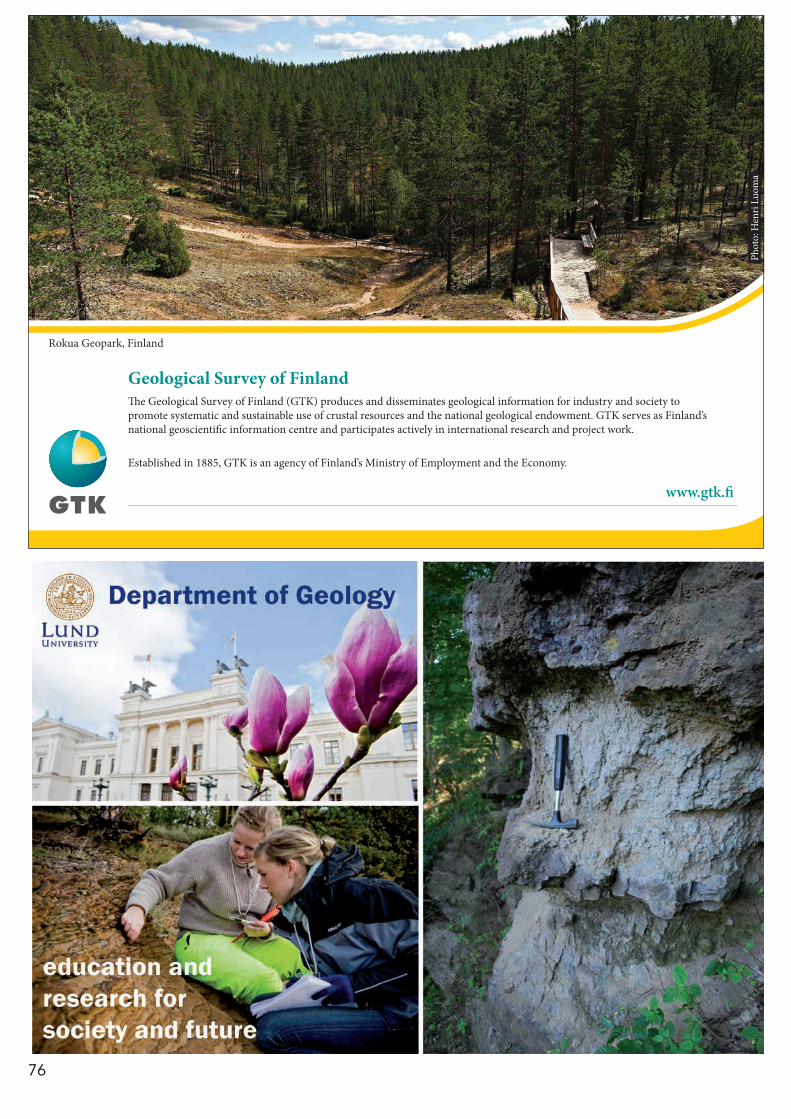
76
The Geological Survey of Finland (GTK) produces and disseminates geological information for industry and society to promote systematic and sustainable use of crustal resources and the national geological endowment. GTK serves as Finland’s national geoscientific information centre and participates actively in international research and project work.
Established in 1885, GTK is an agency of Finland’s Ministry of Employment and the Economy.
Geological Survey of Finland
www.gtk.fi
Phot
o: H
enri
Luom
a
Rokua Geopark, Finland
77
PE
T
How clear is the message from detrital zircon?
Andersen, Tom1
1 Department of Geosciences, University of Oslo, PO Box 1047 Blindern, N-0316 Oslo, Norway, [email protected]
U-Pb age data from detrital zircons in sediments and sedimen-tary rocks are increasingly used as a tracer of sedimentary prov-enance. Typically, ca. 100 grains are analysed by laser ablation ICPMS or by SIMS, and the resulting age data either pooled in age bins and displayed in histograms, or used to construct quasi-continuous kernel density (KDE) age distribution curves or accumulated probability (PDE) distributions. By matching the resulting age pattern to the geochronological “barcode” of potential source terranes, the source of a sediment can be iden-tified, and ideally, the path from “source to sink” worked out. Some basic assumptions of this approach are very prob-lematic: First of all, the robustness of zircon allows repeated events of sedimentary recycling, which will tend to smooth out source-specific characteristics in detritus with time. Secondly, the source signatures of continental terranes may be less than sharp, because of a shared prehistory in ancient supercon-tinents and a general parallelism of evolution through time. A third problem will be addressed here: The inherent uncer-tainty in detrital zircon age distribution patterns that is due to the sampling process itself. A pattern of of age distributions (a histogram or a KDE curve) based on analyses of a random sample of a grains out of a much larger population will have a confidence interval which has a certain probability of enclosing the true age distribution pattern. The 95% confidence interval of a detrital zircon age distribution pattern is dependent on the number of analyses, and is commonly wide enough to have se-rious consequences for the interpretation of data, but this is nearly always neglected in detrital zircon studies. An implementation of confidence intervals of age histograms and KDE curves is suggested that allows a simple visual com-parison of detrital zircon patterns that takes sampling uncer-tainty into account.
Detrital zircon in young sediments from eastern South Africa: Recycling vs. local sources
Andersen, Tom1; Elburg, Marlina2; Cawthorn-Blazeby, Anton2,3
1 Department of Geosciences, University of Oslo, PO Box 1047 Blindern, N-0316 Oslo, Norway, [email protected];
2 Geology Division, SAEES, Westville Campus, University of KwaZulu-Natal, Private Bag x54001, Durban 4000, South Africa, [email protected];
3 Richards Bay Minerals, South Africa
The continental crust of eastern South Africa was uplifted in the early Miocene. Subsequent erosion has exposed rocks of the Archaean to Mesoproterozoic basement and overlying Phan-erozoic cover sequences, including the Permian to Triassic Ka-roo Supergroup. In order to evaluate the relative importance of local basement sources and recycling of cover sequences, detrital zircon from Miocene to Holocene sediments have been and analysed for U-Pb and Lu-Hf by LA-ICPMS. The samples in-clude sands of the Maputaland Group and sediments from mi-nor river catchments on basement rocks ranging from Archaean and Proterozoic gneisses to Karoo dolerite.
Common to all samples is a bimodal distribution of zircon ages, with composite age peaks in the late Mesoproterozoic
and in the Neoproterozoic to early Palaeozoic. Late Palaeozoic sources have only made minor contributions. Archaean zircons are scarce even in sediments deposited on or near to exposed Archean basement, and where found, they can be traced to source rocks in the immediate vicinity of the sampling locality. Late Mesoproterozoic (ca. 1000 - ca. 1150 Ma) zircon has poten-tial source rocks within the Proterozoic basement of the Natal belt, and at least for one deposit, local geology suggests that transport has been directly from basement source to final de-posit. However, the range of variation of Mesoproterozoic zir-con also mimics that of zircon in sedimentary rocks of the Karoo Supergroup, suggesting recycling of earlier cover sequences. This is even more obvious in the Neoproterozoic-Palaeozoic age fractions, which have close overlap in age and initial Hf isotope signature with Karoo sediments. The youngest com-ponent in this fraction (500-550 Ma) overlaps also with granites from the Cape Fold Belt, indicating that these may have acted as a source, either directly or through recycling of Karoo sed-iments. The older Neoproterozoic components (600-650 Ma) do not have known counterparts in South African bedrock. Whereas recycling of Karoo sediments is the obvious imme-diate source for such zircon, the protosource must be located outside of present-day South Africa.
Petrology of delhayelite- and andremeyerite-bearing, peralkaline nephelinite from Nyiragongo, East African Rift
Andersen, Tom1; Elburg, Marlina2; Erambert, Muriel1
1 Department of Geosciences, University of Oslo, PO Box 1047 Blindern, N-0316 Oslo, Norway, [email protected], [email protected];
2 Geology Division, SAEES, Westville Campus, University of KwaZulu-Natal, Private Bag x54001, Durban 4000, South Africa, [email protected]
Highly peralkaline leucite nephelinite from the active volcano Nyiragongo in the Virunga province of the East African Rift contains globules of iron- and volatile-rich, highly peralkaline silicate glass with (Na+K)/Al up to 18, which has formed as a late differentiate of less peralkaline precursors, probably by fractional crystallization at a shallow level in the volcanic sys-tem. A number of uncommon minerals coexist with this glass (kalsilite, kirschsteinite, chlorbartonite, götzenite, delhayelite, zirconian cuspidine, andremeyerite, other Ba-Fe-Ti silicate min-erals, and an unnamed alkali-barium phosphate mineral). These minerals are members of late magmatic assemblages that have survived sub-solidus recrystallization. Combeite occurs as a near-solidus mineral. Delhayelite coexisting with götzenite, an-dremeyerite and peralkaline glass spans the range of published delhayelite analyses, from K4.3Na1.0Ca1.6(Al1.5Fe0.4Si6.0) O19F1.7Cl1.3 to K3.6Na2.0Ca2.4(Al0.9Fe0.3Si6.8) O19F2.0Cl1.0. Low-variance mineral assemblages in Nyiragongo nephelinite define a cooling trend from eruptive temperatures ≥980 ºC to the solidus of extremely peralkaline residual liquids at 600 ºC, followed by sub-solidus recrystallization and metasomatism down to ca. 500 ºC. Oxygen fugacities well below the QFM buffer (QFM-2 to-3) persisted throughout the magmatic crystallization stage. The oxygen fugacity increased to QFM+1 or higher during the final stage of postmagmatic recrystallization. Highly alkaline, volatile-rich minerals such as delhayelite, götzenite and cuspidine were stabilized by a combination of high peralkalinity and elevated activity of chlorine and fluorine; these conditions persisted to sub-solidus temperatures.
PET Petrology

78
PE
T
Hydrogeochemical changes coupled with earthquakes in Hafralaekur, north-ern Iceland
Andrén, Margareta1; Skelton, Alasdair1; Siegmund, Heike1; Mörth, Carl- Magnus1; Stockmann, Gabrielle1; Hjärtsson, Hreinn2
1 Stockholm University, Department of Geological Sciences, Stockholm, Sweden; 2 Landsvirkjun, Landsvirkjun, Husavik, Iceland
Strain coupled with earthquakes has been studied by measur-ing stable isotopes (δ2H and δ18O) in ice age meteoric water. The isotopic signature of the water changes because of either mix-ing with water of different origin or in interaction with the rock. Water- rock interaction can further be confirmed by measuring cation concentrations.
Material and methods: Water samples from a 100 m deep borehole in Hafralaekur, northern Iceland, were collected on a weekly basis from September 2008 to June 2013. During this period there were two major earthquake swarms, one in Sep-tember/ October 2012 and one in April 2013. The water was measured for δ2H and δ18O and cation concentrations.
Result: The stable isotope data show a decrease in δ2H before the earthquake swarms. There is a decrease in δ18O before the earthquakes in September, but an increase 4-8 weeks before the October and April swarms. The concentrations of Al, Na, Ca and Si increased 4-8 weeks before both earthquake swarms.
Conclusion: A decrease in δ2H (and for δ18O in September) before the earthquake swarms indicates that the water in the borehole is mixing with isotopically lighter (older) water before earthquakes. The increase in δ18O, as well as in four cations, 4-8 weeks before the October and April swarms could have been caused by water- rock interaction. The covariation in Al, Na, Ca and Si could be explained by dissolution of plagioclase or zeolites. Measuring stable isotopes and cation concentrations in ice age meteoric water can be a useful tool for earthquake prediction.
0.3 b. y. of drainage stability along the Palaeozoic western Gondwana margin - detrital zircon evidence
Augustsson, Carita1; Rüsing, Tobias2; Niemeyer, Hans3; Kooijman, Ellen4; Berndt, Jasper5; Bahlburg, Heinrich2; Zimmermann, Udo1
1 Institutt for Petroleumsteknologi, Universitetet i Stavanger, 4036 Stavanger, Norway; [email protected], [email protected];
2 Institut für Geologie und Paläontologie, Westfälische Wilhelms-Universität Münster, Corrensstrasse 24, 48149 Münster, Germany; [email protected], [email protected];
3 Departamento de Ciencias Geológicas, Universidad Católica del Norte, Casilla 1280, Antofagasta, Chile; [email protected];
4 Laboratoriet för isotopgeologi, Naturhistoriska riksmuseet, Box 50 007, 104 05 Stockholm, Sweden; [email protected];
5 Institut für Mineralogie, Westfälische Wilhelms-Universität Münster, Correns-strasse 24, 48149 Münster, Germany; [email protected]
We present the detrital zircon record for the complete Pal-aeozoic era in present-day south-central Andes (N Chile and NW Argentina). There the west Gondwana margin is marked by episodic tectonic activity related to subduction and terrane accretions. Variations in transport paths were investigated in re-lation to the tectonic events. Zircon grains from 17 Cambrian to Permian sandstone samples were analysed. Cathodolumi-nescence images reveal a dominance of magmatic origin, little abrasion and mostly only one growth phase. Main age clusters for all time periods, except for Cambrian and Silurian times, are at 630 to 440 Ma, representing the Brasiliano, Pampean and Famatinian orogenies. A smaller group is Grenvillian at 1.3-0.9 Ga. Therefore, eastern and southern transport may have dominated. The Cambrian and Silurian rocks are dominated by
Brasiliano (ca. 0.6 Ga) and Transamazonian age zircons (2.2-1.9 Ga). Pampean and Famatinian ages are less common. We infer transport from the adjacent N-S directed Famatinian arc and the Sierras Pampeanas further south throughout the Palaeozo-ic era. Pre-Famatinian Cambrian and post-Famatinian Silurian transport emanated on the Río de la Plata craton in the east but passed the Sierras Pampeanas. Despite southern transport, the studied zircon suite does not record the accretions of the Cuyania-Precordillera and Chilenia terranes. They collided with west Gondwana west of the Sierras Pampeanas in Ordovician and Devonian time, respectively. Furthermore, Ordovician and Devonian-Carboniferous glaciations in west Gondwana, with probable glacial and glaciofluvial transport from the continent interior into the marginal basins, were not marked in the zircon record. As such the transport system remained stable for ca. 0.3 b. y. with main transport from the nearby arc and from the south. The Famatinian arc acted as an effective erosional bar-rier long after turning inactive and prevented detritus from the Gondwana interior to reach the marginal basins. Hence, detrital zircon ages do not necessarily reflect tectonic changes and may represent a much lesser part of the continent than expected, even during times of tectonic quiescence.
Mantle source characteristics of mid-Proterozoic dyke swarms within the Gardar Igneous Province, South Greenland
Bartels, A.1
1 Geological Survey of Denmark and Greenland (GEUS), Department of Petrology and Economic Geology, Ø. Voldgade 10, 1350 Copenhagen K, Denmark. [email protected]
The mid-Proterozoic Gardar Igneous Province developed in a continental rift-related environment. Several alkaline intrusions and associated dyke swarms were emplaced in Archean and Ketilidian basement rocks. Based on U-Pb data two main mag-matic periods can be identified between 1.30 – 1.25 Ga and 1.18 – 1.14 Ga.
To constrain the mantle source characteristics of the Gardar magmatism, the major and trace element compositions of sev-eral mafic dykes from a broad area of the Gardar province were investigated.
Based on distinct major and trace element features, two dif-ferent trends can be identified for the investigated rocks. The oldest generation of dykes is characterized by positive Ba, K and Sr and negative Th, U and Nb, Ta anomalies as well as moderate enrichment of light rare earth elements (LREE). In comparison, the rocks of younger age are more alkaline, show positive Ba, P as well as less pronounced Nb anomalies and are stronger enriched in LREE. Both generations show distinct groups in incompatible trace element ratio plots (Th/Ta, LaN/SmN or TbN/YbN ).
These data indicate a time dependent compositional change within the Gardar magmatism, providing evidence for the in-volvement of two geochemically distinct mantle components. A first moderately enriched source transitional between mid-ocean ridge basalts (MORB) and ocean-island basalts (OIB) and a second more enriched source with evidence for phlo-gopite and apatite components. Both could be attributed to the sub-continental lithospheric mantle which had been heter-ogeneously metasomatized by subduction-related fluids during Ketilidian orogeny around 500 Ma prior to the emplacement of the Gardar intrusives.

79
PE
T
Zircon formation in gabbro to garnet amphibolite transition, Herrestad, Eastern Segment, Sveconorwegian Province.
Beckman, Victoria1; Möller Charlotte1; Söderlund, Ulf1
1 Department of Geology, Lund University, Sölvegatan 12, 223 62, Sweden; [email protected]
Several morphological different types of zircon occur in metagabbro, partly recrystallized to garnet amphibolite, East-ern Segment, Sveconorwegian Province. Along the Sweconor-wegian front at least three generations of mafic intrusions oc-curs; the c. 0.98–0.95 Ga Blekinge-Dalarna dolerites, the c. 1.22 Ga Protogine Zone dolerites and the c. 1.57 Ga old Värmland dolerites (Söderlund et al. 2005). The Herrestad gabbro be-longs to the oldest generation with a protolith age of 1574± 9 Ma (U-Pb TIMS from baddeleyite, SGU, unpublished data). The gabbroic rocks at Herrestad show gradual transitions from well preserved gabbro to recrystallized garnet amphibo-lite. Throughout the transitions several different zircon types, probably of multiple generations, have been found. In the well preserved gabbro zircon occurs as rims on baddeleyite and as rounded or oval shaped grains along ilmenite grain boundaries. When baddeleyite and ilmenite are in contact, zircon forms a continuous rim around both minerals. In recrystallized coronitic metagabbro zircon occurs as pseudomorphs after baddeleyite. Zircon grains in garnet amphibolite are small, ≤ 10 µm, round-ed and are found as inclusions in ilmenite or garnet. Clearly, firm links between zircon generations and metamorphic miner-al reactions is essential for accurate age determinations of the metamorphic evolution of metagabbroic rocks similar to that at Herrestad.
ReferenceSöderlund, U., Isachsen, C.E., Bylund, G., Heaman, P., Patchett, J., Vervoort, J.D., Andersson, U.B., 2005: U–Pb baddeleyite ages and Hf, Nd isotope chemistry constraining repeated mafic magmatism in the Fennoscandian Shield from 1.6 to 0.9 Ga. Contributions to Mineralogy and Petrology 150, 174–194.
Field Relationships, Petrography and Geochemistry of Proterozoic Dyke Swarms in the Umivik Area, SE Greenland
Bothma, Riaan1; Klausen, Martin, B.1
1 Department of Earth Sciences, Stellenbosch University, Private bag X1, Matie-land 7602, RSA; [email protected], [email protected]
Two roughly E-W trending Proterozoic dyke swarms cut across the Umivik area of Southeast Greenland. This presentation fo-cuses on a dense set of (1) older amphibolitized ENE-WSW, and (2) more doleritic E-W trending mafic dykes, which roughly parallel and span a poorly defined boundary zone between the southern Archaean North Atlantic Craton and the 1900-1680 Ma Nagssugtoqidian Orogen. A more detailed dyke map shows that more E-W dolerites concentrate in the southern part of the area whereas ENE-WSW amphibolites concentrate towards the north. This, however, does not just reflect their positions relative to the Orogen, because there are many cross cutting relation-ships of E-W trending dolerites consistently cutting more ENE-WSW trending amphibolites. The dolerites have ophitic to ne-sophitic textures whereas the amphibolites are porphyroblastic. Norm calculations are similar to modal proportions except for additional olivine and apatite. As most amphiboles appear to be metamorphic, increasing normative and petrographically estimated hornblende proportions, from south to north across both swarms, are consistent with an expected increase in met-
amorphic grade on approaching the Orogen. Major element plots against Mg# indicate clinopyroxene and plagioclase frac-tionation in the doleritic E-W swarm, while the bulk fraction-ating assemblage is inconclusive for the amphibolites. Spider diagram patterns show LILE/HFSE enrichment, with large pos-itive Pb and negative Nb-Ta anomalies for both dyke swarms which are typical arc signatures. We do not think the ENE-WSW swarm was emplaced along a continental arc margin, however, because these were located too far apart. Instead, the swarm may have been emplaced in a back-arc related (or older unre-lated) rift setting, which in either case was deformed and meta-morphosed during the continent-continent collisional stage of the Nagssugtoqidian Orogen. The doleritic E-W swarm, on the other hand, intruded along some post-orogenic rift, but prior to a cross cutting 1630 Ma dyke swarm, so its arc signatures are more likely due to a lithospheric mantle source component and/or crustal contamination.
U-Pb LA-ICPMS dating using variable common Pb-bearing accessory mineral standards with VizualAge/Iolite
Chew, David1; Petrus, Joe2; Kamber, Balz3
1 Trinity College Dublin, Geology, Dublin, Ireland; 2 Laurentian University, Earth Sciences, Sudbury, Canada; 3 Trinity College Dublin, Geology, College Green, Dublin, Ireland
Precise and accurate U–Pb LA-ICPMS dating of many U-bear-ing accessory minerals (e.g. apatite, titantite and rutile) is of-ten compromised by common Pb. We present here a general approach to common Pb correction in U–Pb LA-ICP-MS dating using a modifed version of the VizualAge U-Pb data reduction package for Iolite. The key feature of the method is that it can correct for variable amounts of common Pb in any U-Pb acces-sory mineral standard as long as the standard is concordant in the U/Pb (and Th/Pb) systems following common Pb correction. Common Pb correction of both the age standard and unknowns can be undertaken using either the 204Pb, 207Pb or 208Pb meth-ods, and the approach can be applied to raw data files from the vast majority of modern multi-collector and single-collector ICPMS instruments. The modified version of VizualAge / Io-lite first applies a common Pb correction to user-selected age standard integrations and then fits session-wide “model” U–Th–Pb fractionation curves to the time-resolved U-Pb standard data. This downhole fractionation model is applied to the un-knowns and sample-standard bracketing (using a user-specified interpolation method) is used to calculate final isotopic ratios and ages. Concordia diagrams can be generated using either a 204Pb or 208Pb-based common Pb correction and the this version of VizualAge also incorporates 207Pb-corrected and 208Pb-cor-rected age channels calculated for user-specified initial Pb ra-tios. The approach was tested on apatite, titantite and rutile age standards (for which there are independent constraints on the U-Pb crystallization age) using a Thermo Scientific iCAP-Qc (Q-ICP-MS) coupled to a Photon Machines Analyte Excite 193 nm ArF Excimer laser. The LA-ICPMS standard data are typically within analytical uncertainty of the accepted age of the refer-ence materials, demonstrating the suitability of the common Pb correction approach. The data also demonstrate the accuracy and precision that can be attained on the latest generation of Q-ICPMS instruments, with 2σ uncertainties of <1% on Phan-erozoic apatite and titanite standards and 2σ uncertainties of <2% on Paleogene apatite and titanite standards.
80
PE
T
Significance of an early Sveconorwegian (1100 Ma) granulite facies event at Flatraket and Kråkeneset, Western Gneiss Region
Corfu, Fernando1; Austrheim, Håkon2; Ganzhorn, Anne-Céline3
1 Department of Geosciences and CEED, University of Oslo, PB 1047 Blindern, 0316 Oslo, Norway; [email protected];
2 Physics of Geological Processes, University of Oslo, PB 1048 Blindern, 0316 Oslo, Norway; [email protected];
3 UPMC University of Paris 06, UMR 7193, ISTeP, F-75005 Paris and CNRS, UMR 7193, ISTeP, F-75005 Paris, France; [email protected]
The Flatraket Complex, in the UHP domains of the Western Gneiss Region (WGR) of Norway, preserves granulite facies assemblages, which were locally overprinted by eclogite and amphibolite facies metamorphism. Zircon and monazite indi-cate magmatic crystallization of the rocks at 1680 -1640 Ma and constrain the timing of the granulite facies overprint at 1100 Ma. This age is older than previously reported ages of 1000 to 950 Ma for regional metamorphism reaching anatexis and locally granulite facies elsewhere in the WGR. The granulites at Fla-traket may have developed as a consequence of local meta-somatism, perhaps linked to metasomatism occurring at the same time in the nearby Sandvik peridotite. Granitic rocks from neighbouring Kråkeneset indicate magmatic emplacement at ≥ 1650 Ma, during the event that formed the Flatraket Complex and the bulk of the WGR. A gabbro body at Kråkeneset is dated at 1255 ± 8 Ma by baddeleyite, which was not affected by the granulite event, implying that the rock remained impermeable to fluids, reacting instead to some degree during the Caledo-nian UHP event.
Sveconorwegian granulite-facies meta-morphism in the Kragerø-Bamble area, S Norway
Engvik, Ane K.1; Bingen, Bernard1; Marker, Mogens1; Solli, Arne1
1 Geological Survey of Norway, P.O.Box 6315 Sluppen, N-7491 Trondheim, Norway; [email protected]; [email protected]; [email protected]; [email protected]
New field work uncovered granulite north of Kragerø, Bamble sector, in the gneiss complex generally assigned to an amphi-bolites-facies metamorphic domain. A garnet-bearing ender-bitic-charnockitic gneiss is dominated by garnet (Alm59-67Prp12-
28Grs6-20Sps1-2), orthopyroxene (En40-56Fs44-58; Mg#=0.41-0.56), plagioclase (An22-49Ab50-75) and quartz, with variable amounts of K-feldspar, clinopyroxene (En31Fs22-25; Mg#=0.55-0.58) and bio-tite (Mg#=0.57, Ti=0.29 p.f.u.). The gneiss is strongly foliated with a microlayering characterized by alternating garnet-or-thopyroxene- and quartz-feldspar-rich layers, and a fabric de-fined by parallel orientation of pyroxene long crystal axis and quartz rods. Clinopyroxene occurs only locally, where present usually as fine grains along orthopyroxene grain boundaries. Minor amount of biotite spreads as stable phase in the matrix mineralogy, as inclusions in garnet, or locally as reaction corona on orthopyroxene or garnet. Pargasitic-hastingsitic amphibole occur secondary. The garnet +orthopyroxene ±clinopyroxene +plagioclase +quartz-assemblage document medium-pressure granulite facies conditions. P-T calculations by Thermocalc yield P up to 1.03 ±0.17 GPa and T =838 ±112ºC. P-T pseudosections using Theriak-Domino software show a large stability field of garnet and orthopyroxene. Anatexis occur above ca. 810ºC and biotite starts breaking down above 820-850ºC. Clinopyroxene is stable at higher pressures. Together the information indicates that the granulite reached pressures of about 1.15 GPa around 800ºC. Zircon shows characteristic rounded habit and concen-
A comparison of the P/T conditions between two metamorphic complexes in Tasmania, Australia
Chmielowski, Riia M. 1
1 Luleå Technical University, Luleå, Sweden; [email protected]
Thermodynamic modelling of the pressure/temperature condi-tions for the Franklin Metamorphic Complex, located in central Tasmania, and the Port Davey Metamorphic Complex, located on the south west coast of Tasmania, reveals marked contrast in the metamorphic histories of the two complexes.Garnet-core isopleth thermobarometery for both the Franklin and Port Davey Metamorphic Complexes yielded very similar results (~ 600 C, 6 kbars) for the formation of the garnet cores in the pelitic schists from these two regions. However, their metamorphic history subsequent to their early stage of garnet growth is very different. Garnet rims and matrix minerals from samples from the Port Davey Metamorphic Complex record a temperature (~ 650 C at 6 kbars) for their formation which is only slightly higher temperature than was obtained for the formation of the garnet cores. The Franklin Metamorphic Complex, on the other hand, appears to have maintained nearly isothermal con-ditions whilst undergoing a rapid increase in pressure; garnet rims and matrix minerals. The metapelites in this complex re-cord conditions of ~700 C, 14 kbars. These pelitic schists record a near isothermal compression event with no evidence of the retrograde path retained in the samples, indicating exhumation at plate tectonic rates.
Early Archean crust in the East European Craton
Claesson, Stefan1; Bogdanova, Svetlana2
1 Department of Geological Sciences, Swedish Museum of Natural History, Box 50 007, SE-104 05 Stockholm, Sweden; [email protected];
2 Department of Geology, Lund University, Sölvegatan 12, SE-223 62 Lund, Sweden; [email protected]
Recent investigations have demonstrated the existence of early Archean crust in all three crustal segments of the East European Craton. In Fennoscandia, rocks as old as 3.5 Ga are known from the Karelian Province in Finland, 3.6-3.7 Ga magmatic events are indicated (Lauri et al, J. Geol. Soc. London 168, 2011), and occasional c. 3.7 Ga zircons have been identified in metasedi-ments. In Volgo-Uralia the Paleoproterozoic and Archean sub-surface crust includes 3.3 – 3.2 Ga monzogranites (the Bakaly block, central Volgo-Uralia) and 3.1 Ga charnockites (southern Volgo-Uralia), and Nd and Hf model ages indicate Eo- to Pale-oarchean crustal sources for their magmas. Zircon from Vol-go-Uralia metasedimentary rocks are dominantly 2.7-3.2 Ga, but also include grains with concordant U-Pb ages up to 3.8 Ga. In the Ukrainian Shield in Sarmatia, enderbite from the Dni-estr-Bug region in the southwest has been dated at 3.75 Ga, and zircon from metasedimentary rocks yield ages up to 3.8 Ga. In the Azov Domain in the east, meta-sedimentary rocks from greenstone belts include 3.5-3.6 Ga zircon demonstrating that Paleoarchean crust was widely distributed, and zircon cores old-er than 3.7 Ga have been identified. Crustal ages up to 3.8 Ga in the Ukrainian Shield are supported by Nd whole rock data. Hf isotope compositions for the oldest Ukrainian Shield zircons give chondritic to slightly depleted isotope signatures at 3.75 Ga, indicating an important period of formation of continental crust at that time.
81
PE
T
tric sector zoning typical for high-grade metamorphic crystalli-zation. U-Pb SIMS dating defines a concordia age at 1144 ±6 Ma (±2%) interpreted to date peak metamorphism. The discov-ered garnet-bearing enderbitic-charnockitic gneiss documents a Sveconorwegian medium-pressure granulite facies metamor-phism in the Kragerø region. The new petrological and geo-chronolgical data illustrate an extension of the Sveconorwegian high-temperature metamorphism outside the previous well-known high-T dome of the Arendal area in the central part of the Bamble sector.
Opx-bearing gneisses of Vesterålen, North Norway; granulite facies metamorphism of an Archean to Palaeoproterozoic complex
Engvik, Ane K.1; Davidsen, Børre1; Lutro, Ole1; Schiellerup, Henrik1; Tveten, Einar1
1 Geological Survey of Norway, P.O.Box 6315 Sluppen, N-7491 Trondheim, Norway ([email protected]; [email protected]; [email protected]; [email protected]; [email protected])
The Archean to Palaeoproterozoic Gneiss Complex of Vest-erålen, North Norway, is dominated by orthopyroxene-bearing migmatitic gneisses. The gneiss complex includes horizons of quartzites, calcilicates and amphibolites, and is intruded by the Palaeproterozoic AMCG-suite and gabbros. The gneisses occur as banded rocks including migmatitic layers and are typically characterized by a brownish colour. Locally preserved relation-ships illustrate the migmatitisation process where leucosome intrusive melts breaks up finer grained and foliated restites preserved in lenses. The gneisses consist of perthitic feldspar, quartz, orthopyroxene, minor plagioclase and a variable content of biotite. Garnet is present in extensive parts of the complex. There is no difference in the mineral parageneses between leu-cocome and paleosome, but differences forms by a finer grain size, a higher modal content of biotite and expressed foliation in the lenses. The perthite is normally mesoperthite, but patch perthite and antiperthite is present. Plagioclase is An25-34Ab64-73, orthopyroxene En57-62 and garnet Alm59-66Prp28-35Grs4-6Sps2 with Mg#=0.30-0.37. Biotite has Mg#=0.52-0.69. P-T condition of the metamorphic event is modeled by conventional thermo-barometry using Thermocalc software and calculations of P-T pseudosection by TheriakDomino. P-T calculation yields esti-mates of P=0.75±0.18 GPa and T=903±113 °C. For the calculat-ed P-T-range, pseudosection modeling shows liquid-in above 830-860 °C, biotite-out above 840-870 °C and garnet-in above 0.60-0.85 GPa. Calculation of garnet isopleths for grossular and Mg# restricts the conditions for P to 0.8-0.9 GPa and T=860-880 °C, in accordance with the upper stability field of biotite and presence of melt. Our geological mapping in combination with petrographic and petrological studies and modeled P-T con-ditions of the gneisses document a regionally extensive medi-um-pressure granulite-facies metamorphism of the Archean to Palaeoproterozoic Gneiss Complex in Vesterålen.
Characterization of Na-metasomatism in the Sveconorwegian Bamble Sector of South Norway
Engvik, Ane K.1; Ihlen, Peter1; Austrheim, Håkon2
1 Geological Survey of Norway, P.O.Box 6315 Sluppen, N-7491 Trondheim, Norway ([email protected]; [email protected]);
2 Department of Geosciences, University of Oslo, P.O.Box 1047Blindern, N-0316 Oslo, Norway ([email protected])
Na-metasomatism as albitisation is regional extensive in the Precambrian crust of southern Scandinavia and is particularly
widespread in the Bamble Sector, the Kongsberg-Modum Sec-tor and the Norwegian part of the Mylonite Zone. Sites of albi-tisation outside these belts are associated with hydrothermal breccia pipes and fracture-bound alteration. The albitites are composed of near end-member sodic plagioclase (An0-5Ab94-99) with minor carbonate (calcite and dolomite), rutile, clinopyrox-ene (En30Fs21-23Wo47-49), amphibole (edenite-pargasite), quartz, titanite, tourmaline, epidote and chlorite (Mg#=0.81-0.89). The albitites are studied in detail in the region around Kragerø city, and are described as megascale clinopyroxene-titanite-bearing albitite, albitisation along veining, as breccias, albitic felsites and albite-carbonate deposits. The strong fluid control on their formation is illustrated by the veining and mineral replacement reaction, illustrating fluid transport by a H2O-CO2 rich fluid rich in Na, depleting Fe and Mg, in accordance with calculated mass transfer. Study of mineralogical replacement reactions in com-bination with regional compilation demonstrates the relation-ship between metasomatic processes and formation of apatite and rutile deposits; their importance to other mineral deposits as Fe ores will be discussed. The albitites occur spatial associ-ated with scapolitised metagabbros, but also Mg-Al-rich rocks as orthoamphibole-cordierite schists. It is shown that albitisa-tion cause deformation as brecciation and progressive ductile deformation resulting in foliated albitic felsites. We document that metasomatism is an important mineral and rock forming process in the continental crust, which in the Bamble Sector is a part of the tectonometamorphic Sveconorwegian event.
Evaluating handheld XRF (hXRF) - Is there a wider application horizon?
Esbensen, Kim H.1; Holding, Martin C.2; McDonald, Iain3; Johansson, Leif4
1 Geological Survey of Denmark and Greenland, Copenhagen; 2 Department of Geosciences and natural Resource Management, Copenhagen
University; 3 Cardiff University, Wales; 4 Department of Geology, University of Lund
There are many instances in which primary sampling effects (field or industry sampling) dominate over the combined lab-oratory measurement uncertainty (MU) – and indeed in the full flow path ‘from-field-to-aliquot’, laboratory sub-sampling and sample preparation errors often remain of minor interest, or sometimes even neglected. This may not be an optimal situ-ation however. While important industrial bulk commodity sec-tors (mining, minerals extraction) fully acknowledge the critical need for Theory of Sampling (TOS) at all stages, in order to avoid fatal economic consequences of faulty decisions based on non-representative data, this is still far from daily routine in many other areas in science and technology. In this presenta-tion focus is on modern handheld XRF (hXRF) analytical instru-mentation, which in some field application scenarios is consid-ered, perhaps, to be able to replace the laborious flow path for conventional geoscience laboratory analysis. The critical issue is often presented as concerning the comparative analytical performance, while in reality specific probe/sensor sampling errors have all too often been neglected, causing a severe bias in such comparisons. A recently acquired rock suite originat-ing from collaborator work aimed at providing evidence for a three billion year old impact crater remnant with a diameter of ~150 km, western Greenland: The Maniitsoq project also pro-vided an unequalled basis for assessment of the performance of portable XRF instrumentation. This rock suite stems from a geochemical field survey in 2011, during which strenuous ef-forts were undertaken to ensure that the entire ‘field-to-aliquot’ pathway was in full TOS compliance, securing representative samples and sub-samples at all stages from primary, secondary, tertiary sampling as well as when producing the analytical pow-ders. The latter will allow a completely accurate (unbiased) an-alytical reference, critically necessary for a valid assessment of hXRF vs. laboratory performance. We here present first results pertaining to an extensive experimental campaign involving
82
PE
T
three alternative hXRF instrument application modes: spectral acquisition from pristine rock outcrop surfaces, - on sawn sur-faces, - or on crushed powders. It turns out that what has been hailed as ‘non-sampling procedure’, hXRF in reality has a subset of the same sampling errors as traditional physical sampling, only understandable within the tenets of TOS. A key issue is underlying all of these approaches is: “What exactly does ‘rep-resentative’ mean to a field geologist?”and the logically related issue: “Once ‘representative’ samples are secured in the field, what could possibly go wrong in the laboratory – and is it of any significance?” The Theory of Sampling (TOS) provides cogent answers to all such fundamental issues.
Chemometric verification of the geo-chemical evolution of dual igneous-lava rock suites in the Richtersfeld Hiab province, Namibia
Esbensen, Kim H.1; Minnitt, Richard2
1 Geological Survey of Denmark and Greenland (GEUS), Denmark; e-mail: [email protected];
2 School of Mining Engineering, Witwatersrand University, Johannesburg; e-mail: [email protected]
The Richtersveld province, Namibia was originally mapped as two parallel igneous-effusive rock suites based on compre-hensive field and petrologic characterisations, and interpreted to originate from fractional crystallisation at depth leading to progressively evolved residual magmas, intermittently tapped to produce volcanic lavas displaying a parallel geochemical evolution. This understanding ventures to explain all encoun-tered rock types in the province in one cogent classic magmat-ic differentiation context. There was also a specific interest if regional, economically important Cu-mineralisations could be related to this model. Minitt attempted (1986) a first petrogentic validation based on three selected trace elements (Y, Sr, Ba), but contemporary criticism postulated this to be inconclusive due to exclusion of ‘most other’ geochemical elements howev-er. We here present a 2013 multivariate reassessment of all 129 geochemical analyses from Richtersveld involving the complete suite of 28 major and trace elements. The first four Principal Component Analysis components account for more than 80% of the total data set compositional variance, which present clear evidence for classic geochemical differentiations for both rock suites. Taken together this is a very strong substantiation of the 1986 hypothesis of a parallel, coupled evolution of two inter-re-lated plutonic and effusive series. In fact the PCA model also includes the Cu-mineralisation event on an resolvable, orthog-onal fifth principal component, showing it to be contempora-neous with an intermediary ‘porphyry adamellite’ differentiation stage, whose petrogentic relationships need further substanti-ation in addition to geochemistry. This ‘one-model-explains-all’ manifestation also forms a didactic demonstration of the power of chemometric data analysis in the geosciences.
Validating LA-ICP-MS data for rocks and minerals: A new strategy for manufac-turing homogeneous standards
Garbe-Schönberg, Dieter1
1 CAU Kiel University, Institute of Geosciences, Kiel, Germany
After the 50th anniversary of the LASER in 2011 and Alan Gray’s paper (1985) on “Solid sample introduction by laser ablation for ICP-MS” being almost 30 years old, in situ-microanalysis by LA-ICP-MS has become an established routine method in countless applications of trace element and isotope geochem-istry. While detection limits, precision, interferences from ele-
mental and mass fractionation, spatial resolution, sample size etc. have tremendously improved over this time, calibration and validation of the data is still hampered by the scarcity of suitable certified reference materials for minerals and rocks that are ho-mogeneous on the micro-scale. This contribution compares dif-ferent approaches for producing homogeneous samples from bulk materials by e.g., shock melting with a strip heater, fused lithiumborate beads, pressed powder tablets with binder, hy-drothermal synthesis etc. to a new procedure for manufacturing nano-particulate pressed powder tablets from pure undiluted pulverized sample material.
ReferenceGray, A., 1985: Solid sample introduction by laser ablation for ICP-MS. Analyst 110, 551–556.
Tectonophysical interpretation of the junction zone between the Fennos-candian, Sarmatian and Volga-Uralian segments of the East European Craton
Garetsky, Radim1; Karatayev, German2
1 Institute for Nature Management, National Academy of Sciences of Belarus.Minsk, Belarus; e-mail: [email protected];
2 Institute for Nature Management, National Academy of Sciences of Belarus.Minsk, Belarus; e-mail: [email protected]
The tectonophysical analysis of the junction zone between the Fennoscandian, Sarmatian and Volga-Uralian segments has been performed and involved the tectonic and geodynamic in-vestigations, physical and mathematical simulation of the deep lithosphere structure based on a set of geological and geo-physical data from several profiles running across the junction zone. The Fennoscandia and Sarmatia junction occurred under the law of the Andean type subduction, when the heavy Bela-russian oceanic plate found between them was thrusted under Sarmatia (a relict of the oceanic plate was recorded by seismic and gravimetric studies). The subsequent collision formed the Central-Belarussian suture zone. The subduction process had been observed over a rather long and multistage history of the evolution of magmatic complexes of the Osnitsk-Mikashevichi volcanic-plutonic belt. The collision made for the development of 10 to 15 km deep scaly-thrust deformations of the upper crust confined by listric faults. In the course of the approaching of Sarmatia and Volga-Uralia the oceanic plate between them was compressed to form a fold and submerged to a depth level of the Earth’s crust bottom – upper mantle top. The collision resulted in the formation of the Ryazan-Saratov suture zone and the Sloboda tectonic-geodynamic node developed just at the junction site of all three segments by way of the crust sagging into the mantle. The gravity and magnetic anomalies, as well as old aulacogenes come together to this point like a fan. The formation of this node is associated with the tectonophysical processes due to interacting compressive stresses excited by deep-focus earthquakes and by convection flows of the man-tle material. An asthenolens with vortex motions formed in it and creating a tractive force (Magnus effect) developed in the convective mantle at the end of the Archean – beginning of the Proterozoic. These motions were responsible for drawing the crust material into the lithosphere like into a whirlpool.
The Usushwana Complex: a tale of two igneous events, and a magmatic feeder to one of Earth’s earliest large igneous provinces
Gumsley, Ashley1; Olsson, Johan1; Söderlund, Ulf1, de Kock, Michiel2, Hofmann, Axel2
1 Lund University, Sölvegatan 12, 223 62, Lund, Sweden,
83
PE
T
[email protected], [email protected], [email protected]; 2 University of Johannesburg, P.O. Box 524, Auckland Park, 2006, South Africa,
The Usushwana Complex is the largest layered intrusion on the south-eastern Kaapvaal Craton in southern Africa. It is also one of the oldest, and best preserved layered intrusions in the world. The complex has been regarded as two NW-trending sill- or dyke-like bodies intruding at the contact between Archean basement, and rocks of the 2.98-2.93 Ga basal volcanic-sedi-mentary Nsuze Group of the Pongola Supergroup (Hammer-beck, 1982). The ages of the Usushwana gabbros have previ-ously been determined by Rb-Sr and Sm-Nd isotope whole rock analyses to ca. 2.87 Ga (Davies and Allsopp, 1976; Hegner et al., 1984). Here we present U-Pb baddeleyite crystallization ages of 2990 ± 2 Ma for gabbros from both branches of the layered intrusion, which complicates this history. This enigmatic age discrepancy could be explained by isotopic disturbance of the Rb-Sr and Sm-Nd systems, or it is also plausible that at least two Usushwana magmatic cycles are present. The first one at 2990 Ma includes the Nsuze rifting event of the Pongola basin. This encompasses the Usushwana Complex, the 2980-2965 Ma NW-trending Badplaas dyke swarm, and the Nsuze volcanics. The second cycle occurs during the greater Witwatersrand-Mo-zaan basin sedimentation, and is represented by the emplace-ment of intrusions within the sequence (such as dolerite sills and the Thole Complex), as well as the flood basalts in the Witwatersrand-Mozaan strata at 2870 Ma. This may also include the as yet undated volcanics of the Amsterdam Formation, and post-Pongola granitoids. Further investigations on the mag-matic evolution of the Pongola basin, and Usushwana Complex must consequently take this age data into consideration. This would also include sampling Mozaan dolerite sills for exam-ple, which were thought to have been part of the Usushwana Complex.
Arctic Ocean Mn-stratigraphy: genesis, synthesis and inter-basin correlation
Gyllencreutz, Richard1; Löwemark, Ludvig2; März, Christian3,4; O’Regan, Matt1
1 Department of Geological Sciences and the Bolin Centre for Climate Research, Stockholm University, 106 91 Stockholm, Sweden; [email protected]; [email protected];
2 Department of Geosciences, National Taiwan University, P.O. Box 13-318. 106 Taipei, Taiwan; [email protected];
3 ICBM, University of Oldenburg, 26111 Oldenburg, Germany; [email protected];
4 Civil Engineering and Geosciences, Newcastle University, NE1 7RU Newcastle upon Tyne, UK
Across the Arctic Ocean, late Quaternary sediments typically contain brownish layers with enhanced bioturbation, peaks in Mn content, and abundant micro- and nannofossils. A possible correlation of these supposedly interglacial layers to the global oxygen isotope curve was early surmised, although their timing and underlying formation mechanisms remain controversial. Here we compile and synthesize findings on Mn sources to the Arctic Ocean, processes and pathways for Mn to the deep sea, chemical sedimentary processes, and the spatial and temporal distribution of Mn-rich layers in Arctic deep marine sediments. Budget calculations show that ~ 90 % of Arctic Mn input orig-inates from rivers or coastal erosion; sources effectively shut down during glacial intervals, because rivers were blocked or re-routed by ice sheets, and shelves subaerially exposed by low sea level. Interglacial-glacial cyclicity in Mn content is thus input-related, and only secondarily influenced by chemical processes. On the shelves, high organic carbon content in the sediments enable repeated Mn recycling, before export to the deep basins in the form of Mn-(oxyhydr)oxides. Synchronicity with enhanced bioturbation and elevated fossil abundances shows that Mn peaks closely correspond to interglacial in-tervals. However, under certain biogeochemical conditions, Mn-(oxyhydr)oxides deep in sediments may migrate vertically,
as shown by pore water analyses and X-ray radiograph studies. Diagenetic Mn-dissolution is evident in late Quaternary sedi-ments from the Lomonosov Ridge, where diamicts with elevat-ed organic carbon contents show very low Mn contents within glacial and surrounding interglacial sediments, while thin close-ly spaced Mn-rich horizons in apparently glacial sediments indi-cate diagenetic redistribution of Mn from deeper layers. The in-creasing ability, using XRF-core scanner data, X-ray radiographs and pore water data, to recognize intervals where a diagenetic overprint exists in the Mn record, makes carefully applied Mn stratigraphy a powerful correlation tool, when combined with other proxies and sedimentological data.
Kinematic constraints on the formation of gneiss domes in the Archaean Yilgarn Craton, Western Australia
Hansman, Reuben1; Gessner, Klaus2; Thébaud, Nicolas3; Zibra, Ivan4; Uwe, Ring5; Duclaux, Guillaume6
1 Stockholm University, Department of Geological Sciences, Stockholm, Sweden; [email protected];
2 Department of Mines and Petroleum, WA, Australia; [email protected];
3 University of Western Australia, School of Earth and Environment, WA, Australia; [email protected];
4 Department of Mines and Petroleum, WA, Australia; [email protected]; 5 Stockholm University, Department of Geological Sciences, Stockholm, Sweden;
[email protected]; 6 CSIRO, NSW, Australia; [email protected]
The question of what processes controlled the tectonic evolu-tion of Earth’s crust, during the Archaean, is much debated. Our study in the Neoarchaean Yilgarn Craton in Western Australia aims at understanding if gneiss domes and contemporaneous basins formed by local diapirism with partial convective over-turn, far field tectonic processes, or a combination of both. The Yilgarn Craton consists of the Youanmi Terrane and the East-ern Goldfields Superterrane (EGST). Both terranes comprise of Neoarchaean granite-greenstone belts that have been shaped by a prolonged history of crustal formation, igneous reworking, basin formation and regional deformation. We developed a 3-D structural model of the Lawlers Anticline located at the high-ly mineralized western margin of the EGST, near the bounda-ry of the Youanmi terrane. At the core of the Lawlers Anticline is the Lawlers Tonalite, a granitic pluton that is surrounded by older greenstone sequences, as well as sedimentary sequenc-es, which were deposited during dome formation. Within the pluton are stretching lineations that plunge in a radial pattern towards the domes margins. The pattern of the lineations may shed some light on the dome formation mechanism. We used the Midland Valley MOVE software suite to restore the late stage basin deformation, as well as the shearing and folding of the greenstone sequences. This allows us to understand if the stretching lineations within the dome have been signifi-cantly reorientated. The results from this model will allow us to better constrain the dome formation mechanism, and to test the geometric soundness of the current geological maps and cross-sections.
Neoarchean alkaline rich igneous magmatism at cratonization stage of western part of Karelian (Baltic) Province
Heilimo, Esa1; Mikkola, Perttu1
1 Geological Survey of Finland, P.O. Box 1237, FI-70211 Kuopio, Finland; [email protected]
Over the past decade, classification of the Archean granitoids

84
PE
T
has significantly developed, and their differing geochemical characteristics have been used to construct varying tecton-ic interpretations for their genesis. An important factor in the discussion concerning the existence of the Archean subduc-tion is the globally observed Neoarchean diversification of the granitoid compositions, from the older igneous magmatism consisting almost exclusively of tonalite-trondhjemite-gran-odiorite (TTG) suite rocks. We have studied six small quartz syenite-montzonite intrusions from the western part of the Archean Karelian Province. These 2.74−2.66 Ga intrusions can be distinguished from the other Archean granitoids based on mineralogy, texture (weakly foliated to non-foliated) and alka-line rich “shoshonitic” geochemistry (Na2O+K2O=7.0−12.8 wt. %, K2O/Na2O 0.5−1.45). SiO2 abundances vary generally be-tween 60 and 70 wt. % in the samples. The low MgO, Ni, and Cr characteristics separate quartz syenites-monzonites from the Archean sanukitoid suite. O-isotope compositions of zircons from vary significantly between the intrusions from 5.35 to 7.34 δ18O, which indicate a heterogeneous source with variable in-put from high δ18O sources. The longevity of the low volume syenitic magmatism is a new challenge for understanding the Neoarchean igneous magmatism and cratonization procesess, both globally and in the Karelian Province. Archean syenites are usually interpreted to be derived from lower crust or enriched mantle via partial melting. However, we can demonstrate a sig-nificant role of mineral fractionation in the genesis of these in-trusions. Such fractionation is essential for producing “syenitic” or “monzonitic” composition outside equilibrium crystallisation conditions of the ternary feldspar system.
Updating the knowledge about the SE part of the Paleoproterozoic Central Finland granitoid complex: preliminary insights from field work and geochemistry
Heilimo, Esa1; Mikkola, Perttu1; Hartikainen, Aimo1; Luukas, Jouni1; Niemi, Sami1
1 Geological Survey of Finland, P.O. Box 1237, FI-70211 Kuopio, Finland; [email protected]
The Paleoproterozoic Central Finland granitoid complex in the Svecofennian domain has traditionally been considered as a granitoid dominated area with limited lithological variation. A project, started in 2012 provides new basic geological knowl-edge from the SE part of the Central Finland complex, and es-timates the area’s ore potential. We are carrying out systematic field work, geophysical measurements, geochemistry, and geo-chronology in the study area. The felsic igneous rocks from the area have been divided into synkinematic (1890−1870 Ma) and postkinematic (1880−1860 Ma) groups. Our preliminary results show that the narrow supracrustal belts and remnants in the area display significant variation in lithology, degree of meta-morphism, and deformation. These supracrustal units are wider spread than previously known. Within the plutonic suites, the diorite and gabbro intrusions are more voluminous than previ-ously shown. The updated data will be used to more precisely constrain the processes responsible for the formation of the SE part of the Central Finland granitoid complex. In terms of ore potential the area has been regarded as uninteresting, and only small high-grade mineralizations and glacially transported boulders with unknown sources have been identified from the area. The mineralized samples are variably enriched in Pb, Cu, Zn, Mo, Ag, Au, and variably tectonized and affected by fluid activity in shear zones or faults. Certain characteristics observed in the 1980s suggest that the enriched samples might repre-sent diverged late phase hydrothermal system of mineralized porphyries.
Geochemistry of Palaeoproterozoic greenstone dykes, Dannemora, eastern Bergslagen region, east-central Sweden
Johansson, Åke1; Dahlin, Peter2; Andersson, Ulf Bertil3
1 Swedish Museum of Natural History, Department of Geosciences, Stockholm, Sweden;
2 Uppsala University, Department of Earth Sciences, Uppsala, Sweden;3 LKAB, Research and Development, TFG, Kiruna, Sweden
Metamorphosed and deformed greenstone dykes within the supracrustal sequence and the surrounding granitoids in the Dannemora mining area in eastern Bergslagen, east-central Sweden, have been investigated. The dykes, with an inferred age of c. 1860-1870 Ma, are considered to have formed during an extensional phase of the Svecofennian orogeny.
Eighteen greenstone samples from drill cores and outcrops have been analysed for major and trace elements at Acme An-alytical Labs, and twelve of these were analysed for their Sr and Nd isotope composition at the Swedish Museum of Natural History. One of the samples differs geochemically, and may rep-resent an unrelated extrusive basalt, the others are mafic dyke rocks.
The dykes are calc-alkaline, sub-alkaline and basaltic in com-position, and have a mixed subduction and within-plate geo-chemical affinity. The basaltic overall composition indicates little or no bulk contamination by upper continental crust, but the dykes have undergone later metasomatic changes mainly affecting the alkali elements. While the Rb-Sr system appears disturbed, the Sm-Nd system seems intact, and yields mildly depleted initial ε-Nd values of +0.4 to +1.6. The combined ge-ochemical data suggest that the dykes are the result of mixing of at least three mantle source components with similar basal-tic major element composition, but different concentrations of incompatible trace elements. Magma M1 is strongly enriched both in rare earth elements (REE) and high-field-strength ele-ments (HFSE), magma M2 is highly enriched in large-ion litho-phile elements (LILE; except Sr), with only moderate enrichment in HFSE and REE (particularly low in heavy REE), and magma M3 is enriched in Sr and has a flat REE profile. Magma M3 also has a somewhat more positive (depleted) initial ε-Nd value of +1.8, compared to +0.4 to +0.5 for magmas M1 and M2. The subsequent magma evolution was controlled by a mixture of fractionation, mainly affecting the compatible elements, and mixing, best seen in the incompatible element concentrations and the Nd isotope data.
Relationships between basin architec-ture, basin closure, and occurrence of sulphide-bearing schists: an example from Tampere Schist Belt, Finland
Kalliomäki, Henrik1; Torvela, Taija2; Moreau, Julien3; Kähkönen, Yrjö4
1 University of Helsinki, Department of Geosciences and Geography, Finland; [email protected];
2 University of Leeds, School of Earth and Environment, UK; [email protected]; 3 University of Copenhagen, Department of Geography and Geology, Denmark;4 University of Helsinki, Department of Geosciences and Geography, Finland
The Tampere Schist Belt (TSB) in southern Finland is a c. 1.92-1.88 Ga volcano-sedimentary basin that underwent inversion and closure between c. 1.89-1.88 Ga. We present field ob-servations from the Tampere palaeobasin, where the primary structures have been exceptionally well preserved. The TSB, therefore, offers an excellent opportunity to examine the volca-no-sedimentary evolution of an ancient marginal basin, and the mechanics of and strain distribution during its subsequent clo-sure. The aim of this study is to investigate the structural devel-opment and the architecture of a part of the TSB in more detail,
85
PE
T
including the relationships between the volcano-sedimentary sequences, the tectonic structures, and the sulphide-bearing schist horizons. Important insights are gained into understand-ing the mechanisms of the basin closure and the localisation of the sulphide mineralisation within the basin. We use the obser-vations to construct a new conceptual tectonic model for the closure of the southeastern margin of the Tampere basin. The observed volcano-sedimentary and structural features suggest a change in the local structural style from thick-skinned inversion to thin-skinned thrusting, in order to accommodate the crustal shortening during basin closure. Furthermore, it is suggested that there is a genetic relationship between the interpreted pal-aeothrusts and the sulphide-bearing schist horizons in the study area: early, gently dipping thrusts acted as both channels and traps for the mineralising fluids that possibly sourced either lo-cally or from relatively shallow depths from the base of the basin infill. The continued compression caused a subsequent rotation of the thrusts into their present subvertical position.
Determination of the origin of corundum (ruby and sapphire) from Tanzania by geochemical fingerprinting
Keulen, Nynke1; Kalvig, Per1; Thomsen, Tonny B.2; Kokfelt, Thomas F.2; Vennemann, Torsten3; Jønsson, Jesper B.4
1 Geological Survey of Denmark and Greenland, GEUS, Petrology and Economic Geology, Copenhagen, Denmark;
2 Geological Survey of Denmark and Greenland, GEUS, Petrology and Economic Geology, Øster Voldgade 10, Copenhagen K, Denmark;
3 University of Lausanne, Mineralogy and Geochemistry, Lausanne, Switzerland; 4 Cowi Tanzania, 398 Mwai Kibaki Road, P. O. Box 1007, Dar es Salaam, Tanzania
Geochemical fingerprinting of corundum samples from Tan-zania was investigated in order to examine opportunitites to implement a certification scheme for small-scale mining and processing of rubies. Samples were collected from six locali-ties, viz. Matombo, Mahenge, Winza, Seza Kofi, Umba Valley, and Longido, representing 3 different geological environments (marbles, ultramafic rocks, and secondary (alluvial) deposits). The corundum stones were investigated for inclusions using optical and scanning electron microscopy, analysed for trace element concentrations by LA-ICP-MS and for their oxygen iso-tope composition by LA-fluorination, and in one sample zircon inclusions were dated by U-Pb by LA-ICP-MS. In corundum, 30 different mineral inclusions were observed that were either de-rived from the host rock or from the intruding igneous rock that caused the formation of corundum. Of the 24 trace elements investigated, significant results only occurred for seven, viz. Mg, Si, Ti, V, Cr, Fe and Ga. The variation in the concentration of the trace elements is large, thus samples can be divided into four groups: Matombo (carbonates), Mahenge (carbonates), Winza and Longido (ultramafic rocks), Umba (alluvial deposits). Samples from Matombo and Mahenge have high δ18O values of between 20.0 and 21.6‰. Samples from Winza and Longido have low values of 5.9‰ and 5.5‰, respectively. Alluvial samples from Umba showed slightly higher values of 7.1‰ and 8.5‰. Zir-con inclusions in one sample from Umba yield two age popula-tions at 578±9 Ma and 716±19 Ma, comparable to events in the East African Orogen. The two ages have different Th/U ratios, indicating a formation under two different sets of tectono-met-amorphic conditions. The alluvial samples from Umba are inter-preted to derive from a metamorphosed ultramafic rock, the corundum forming reaction was triggered by the intrusion of a pegmatite. Apart from Seza Kofi, the different investigated re-gions can be separated with reasonable confidence when trace element analyses are combined with oxygen isotope investiga-tions. However, some overlap occurs with a few areas similar to other parts of Gondwanaland.
Formation of parting in quartz
Kjøll, Hans Jørgen1; Sørensen, Bjørn Eske2
1 Department of Geology and Mineral Resources Engineering, Norwegian University of Technology and Science, SEM-SEELANDSVEG 1, 7491 Trondheim, Norway; [email protected];
2 Department of Geology and Mineral Resources Engineering, Norwegian University of Technology and Science, SEM-SEELANDSVEG 1, 7491 Trondheim, Norway; [email protected]
This paper presents hydrothermal quartz displaying macro-scopic planar partings shown as large, mm-spaced continuous planar penetrative faces with pearly luster. The studied quartz comes from hydrothermal quartz veins from the Mesoprotero-zoic Modum complex in Southern Norway containing albite, clinochlore, hornblende and hydroxyl apatite intersecting well foliated and banded amphibolite-mica gneiss at high angle. The quartz is anhedral, inequigranular and has undulose ex-tinction and sub-grain rotation microstructure. Thin sections oriented perpendicular to the most pronounced planar parting show lamellas that extinguishes at approximately 2 degrees to each other.
EBSD mapping has been conducted on sections perpendic-ular to and parallel to the parting. Sections parallel to the part-ing display two orientations {0-111} (r-face) and {1-101} (z-face) separated by irregular boundaries. The misorientation between these two crystallographic orientations on the parting is a 60 degree rotation on [001], in accordance with the Dauphiné twin law. In sections normal to the parting the Dauphiné twins are cut by the parting, but display irregular boundaries in the quartz between the partings.
SEM-CL imaging documents three generations of quartz and two planar structures. The most prominent of the three appears to cut across the recrystallized quartz causing an apparent dis-placement. Some correlation between the recrystallized quartz and the Dauphiné twins are seen, but appear rather inconsist-ent.
Etching has been conducted in attempt to reveal polysyn-thetic Brazil twins. This, however, yielded no evidence of such twinning, but confirmed the irregular Dauphinè twins.
The parting is penetrative and cutting through all preexisting features, such as fluid inclusion trails. We propose, in our work-ing theory, that a sufficiently high differential stress must have been produced to be able to break the strong Si-O bonds in optimally oriented crystals. A rather quick deformation mech-anism is suspected. No pre-deformation weakness zones, such as polysynthetic Brazil twins, have been revealed to ease the formation of a parting plane in either direction.
The >2000 km-long 1.63 Ga Melville Bugt Dyke Swarm and its petrogenetic relationship to the ~1.8 Ga Ketilidian Orogen: Evidence from SE Greenland
Klausen, Martin B.1; Nilsson, Mimmi K.M.2; Snyman, Dian1; Bothma, Riaan1; Kolb, Jochen3; Tappe, Sebastian4; Kokfelt, Thomas F.3; Nielsen, Troels F.D.3; Denyszyn, Steven5
1 Department of Earth Sciences, University of Stellenbosch, Private Bag X1, Matieland 7602, South Africa; [email protected], [email protected], [email protected];
2 Department of Geology, Lund University, Sölvegatan 12, SE 223 62 Lund, Sweden; [email protected];
3 Geological Survey of Denmark and Greenland (GEUS), Øster Voldgade 10, 1350 København K, Denmark; [email protected], [email protected], [email protected];
4 De Beers Corporate Headquarters, Group Exploration, Johannesburg, South Africa; [email protected];
5 School of Earth and Environment, University of Western Australia, Crawley, WA, 6009, Australia; [email protected]

86
PE
T
The ~1.63 Ga Melville Bugt Dyke Swarm (MBDS) of NW Green-land has been hypothesized to extend beneath the ice cap to the southernmost ~1.85-1.75 Ga Ketilidian Orogen (KO) of SE Greenland, forming a >2000 km-long dyke swarm. A correla-tion beneath the large inland ice sheet is supported by both preliminary baddeleyite U–Pb ages and a geochemical match between the swarm’s NW-segment and 25 sampled dykes across SE Greenland. This data also reinstates a remarkable geochemical homogeneity amongst the swarm’s dykes, which necessitates a single homogenized magma reservoir for the en-tire swarm. Typical arc-like geochemical signatures contradicts the MBDS’ rift-like, cratonic and alkaline character, and must be attributed to the partial melting of a sub-continental lith-ospheric mantle (SCLM) that, given its juvenile isotope signa-tures, had to have been metasomatized shortly before melting. There is also a remarkable geochemical overlap between the MBDS and 40 samples from a diverse suite of as much as 150 Myr older, late-orogenic, lamprophyres in SE Greenland, which argues for a common juvenile SCLM source beneath the KO. This indicates that the MBDS propagated laterally for >2000 km, from a single, large and homogeneous magma reservoir inside the KO, apparently without any significant crustal con-tamination and/or differentiation. A similar magmatic record across Scandinavia, of late-orogenic ~1.8 Ga lamprophyres, followed by renewed post-orogenic emplacement of ~1.6 Ga diabase swarms and slightly younger associated rapakivi gran-ites, support a correlation between the KO and a coeval Sve-cofennian Orogen. It, furthermore, identifies a roughly coeval bimodal igneous province in each of these two Orogens, which probably were initiated during the same early Nuna super-con-tinental rifting event. Apart from different Gd/Yb ratios, similar arc-like signatures suggest that a similar metasomatically en-riched SCLM that previously generated the lamprophyres, this time melted at shallower depths to form a large, homogenized and differentiated magma reservoir for the MBDS, which may, in turn, have generated rapakivi granites through the heating of overlying crust.
Preservation of blueschist facies miner-als along a shear zone by fast flowing high XCO2 fluids
Kleine, Barbara1; Skelton, Alasdair1; Huet, Benjamin2; Pitcairn, Iain1
1 Stockholm University, Department of Geological Sciences, Stockholm, Sweden;2 University of Vienna, Geodynamics and Sedimentology, Vienna, Austria
Our study was undertaken at Fabrika Beach on the southeast-ern shore of Syros which belongs to the Greek Cycladic archi-pelago. Here, blueschist facies minerals are observed in haloes (type I and type II) fringing a shear zone within greenschist fa-cies rocks. The shear zone is approximately vertical and cuts a near horizontal layer of greenschist facies rocks. Type I and II blue haloes are 0.3 m and ca. 1 m wide respectively, and are seen on both sides of the shear zone. The type I halo is com-posed of nearly pure glaucophane schist and was formed by metasomatic addition of Na and Si. The type II haloes consist of a carbonated blueschist facies assemblage. Based on petrolog-ical, geochemical and thermodynamic evidence we show that type II halo was preserved at greenschist facies conditions. Fur-thermore, we use a simple mass balance to calculate the fluid flux within the shear zone which would be required to cause the observed preservation of blueschist facies minerals. We con-structed a simplified P-T vs. XCO2 pseudosection using THER-MOCALC to confirm that preservation of carbonated blueschist can occur at greenschist facies conditions in the presence of CO2-bearing fluid. The flux of CO2-bearing fluid along the shear zone was rapid with respect to the fluid flux in the surround-ing rocks. Mass balance calculations reveal that the fluid flux within the shear zone was 10–7.6 ± 0.2 m3.m-2.s-1, which is 100 – 2000 times larger than the fluid flux within the surrounding
rocks. Mineral textures show greenschist facies minerals re-placing blueschist minerals in the type II haloes supporting our interpretation that blueschist facies minerals were preserved during greenschist facies retrogression. Carbonated blueschist was preserved from greenschist facies hydration and its preser-vation was facilitated by elevated XCO2 in the fluid along the shear zone which was rapid with respect to, and contemporane-ous with greenschist facies hydration in the surrounding rocks.
Laser ablation split-stream analysis: advantages and prospects for the new Vegacenter
Kooijman, Ellen1
1 Department of Geosciences, Naturhistoriska riksmuseet, Frescativägen 40, Stockholm, Sweden; [email protected]
New analytical techniques and methods have enabled accesso-ry mineral micro-analysis to become one of the most powerful approaches in investigating petrological processes. Trace-ele-ment geochemistry and U-(Th-)Pb isotope analysis enable con-straints on the physical conditions and timing of these process-es, respectively. Making sure that both pieces of information are obtained from the same exact part of a mineral may be critical to the reliability of data interpretation. Laser ablation split-stream inductively coupled plasma mass spectrometry (LA-SS-ICPMS), involving a LA system coupled to a high-resolution ICPMS and a multi-collector ICPMS, is a novel way of achieving this spatial control.
Accessory minerals from deep crustal xenoliths (Pamir, Tajik-istan) were analysed to demonstrate the usefulness of LA-SS-ICPMS. The data were obtained at the University of California in Santa Barbara where an analytical set-up similar to the one planned for the Vegacenter is present. The Cenozoic history of the Pamir xenoliths is largely unknown, making this study of great relevance to understanding the Pamir-Karakorum-Hima-laya Orogen. Changes in Ti-in-zircon, and the Eu anomaly and HREE systematics of zircon and monazite with U-(Th-)Pb age in-dicate that the rocks 1) progressed at low-P between 42-18 Ma; 2) underwent deep burial since then, and 3) reached peak-P at 12.5 ± 0.6 Ma, less than 2 Myr before eruption (10.9 ± 2 Ma). These data disprove current geodynamic models and provide new detailed information for reassessing the history of the re-gion. This study shows the great advantage of LA-SS-ICPMS, one of the methods that will be implemented in the new Vegacenter for micro-analysis at Naturhistoriska riksmuseet, Stockholm.
Svecofennian orogeny – an evolving orogenic system
Korja, Annakaisa1
1 Institute of Seismology, Dept. Geosciences and Geography, Univ. Helsinki, Finland; [email protected]
The initiation of modern plate tectonics can be followed in the Paleoproterozoic rock record of the Fennoscandian Shield. Dur-ing the first 500 Ma Archean crust suffers from plume driven ex-tension, continental blocks are stabilized and the first modern mid-ocean ridges (MORBs, ophiolites) are formed. At around 1.9 Ga the dominant tectonic mode changes to convergence, the rock record is characterized by subduction-related magma-tism and modern style accretional and collisional orogens. At around 1.8 Ga the subduction systems seem to have stabilized implying that modern type full-scale convection is at operation. The initiation of plate tectonics has produced characteristic crustal structures that can be traced with deep seismic data sets (FIRE, BABEL, SVEKALAPKO, HUKKA2007). Karelian continen-tal nucleus is characterized by highly reflective rifted margin,

87
PE
T
buried rift and aulacogen structures and thin high velocity low-er crustal layer (FIRE4, HUKKA2007). The northern and central parts of the Svecofennian orogen are characterized thickened crust with thick mafic lower crust, block–like internal architec-ture. Reflection sections are dominated by crustal scale de-tachment zones and listric structures flattening on them. These suggest either lateral spreading or collapse of the orogen (FIRE1-3; SVEKALAPKO). The western and southwestern parts are composed of reflective NE-dipping crustal blocks accom-panied by highly layered blocks to the north (BABEL) sugges-tive of a long-lived southwesterly retreating subduction system. Svecofennian orogeny is a Paleoproterozoic analogue of an evolving orogenic system where terrane accretion is followed by lateral spreading or collapse induced by change in the plate architecture and stabilization of a subduction system. It is sug-gested that Svecofennian orogen is one of the first examples of external orogenic systems that formed after the initiation of full-scale convection.
U–Pb age and Lu–Hf signatures of detrital zircon from Palaeozoic sand-stones in the Oslo Rift, Norway
Kristoffersen, Magnus1; Andersen, Tom1; Andresen, Arild1
1 Departmen of Geosciences, University of Oslo, PO Box 1047 Blindern, N-0316 Oslo, Norway; [email protected], [email protected], [email protected]
U–Pb ages and Lu–Hf isotope signatures of detrital zircon from ten sandstone samples from the latest Ordovician Langøyene Formation, the Late Silurian Ringerike Group and the Late Car-boniferous Asker Group were obtained by LA–ICPMS.¬ Overall the U–Pb ages range from 2861 to 313 Ma. Most samples are dominated by an age group at 1300–900 Ma which contains 48% of all U–Pb data. The U–Pb and Lu–Hf data of all sam-ples produce broadly similar signatures, but the Asker Group samples also include a c. 390–313 Ma age fraction which as an εHf–range of -10 to +15. In addition several samples contain a Neoproterozoic zircon fraction. The recorded U–Pb ages and Lu–Hf signatures corresponds to virtually every known event of crustal evolution in Fennoscandia. This geographical and temporal diversity of the proto–sources for the detrital zircon is likely caused by several episodes of recycling of sediments in Fennoscandia, and highlights the intrinsic problem of using zircon as a tracer mineral from ‘source to sink’. The < 390 Ma age group recorded in the Asker Group has no known source in Fennoscandia. The presence of this age group thus confirms the partial sourcing of the Asker Group from the Variscan oro-gen of central Europe as suggested by Dahlgren & Corfu (2001).
References Dahlgren, S. & Corfu, F. 2001. Northward sediment transport from the late Carboniferous Variscan Mountains: zircon evidence from the Oslo Rift, Norway. Journal of the Geological Society, London 158, 29–36.
Store Mosse 2.0: The Story in the Dust Geochemistry
Kylander, Malin1; Martinez, Cortiza A.2; Bindler, R.3; Rauch, S.4; Mörth, C-M1
1 Department of Geological Sciences and the Bolin Center, Stockholm University,
SE-10691 Stockholm, Sweden; [email protected] 2 Departamento de Edafología y Química Agrícola, Facultad de Biología,
Universidad de Santiago de Compostela, Campus Sur E-15706, Santiago de Compostela, Spain; [email protected]
3 Department of Ecology and Environmental Sciences, Umeå University, SE-901 87 Umeå, Sweden; [email protected]
4 Water Environment Technology, Chalmers University of Technology, 41296 Göteborg, Sweden; [email protected]
Store Mosse is the largest mire complex in the boreo-nemoral region of southern Sweden and its development and paleoenvi-ronmental history is well studied. A recently published study by the authors linked bog surface wetness and atmospheric dust deposition at this site over the last 8500 years. This high-resolu-tion (~15 yr/sample) paleoclimate record was based on a com-bination of bog development, colorimetric humification, bulk density and inorganic geochemistry data and interpreted us-ing a combination of Principal Component Analyses (PCA) and changepoint modeling. Significant changes in dust deposition were linked to changes in precipitation and temperature from the same record as well as regionally relevant records. With this paleoclimate framework in place the aim of this second phase of the project is to examine the dust signal archived at Store Mosse. PCA of the geochemical data reveal three main com-ponents of which the first is associated heavily with conserva-tive lithogenic elements and is thus, indicative of mineral dusts. Examination of Rare Earth Element patterns suggests granit-ic sources while the europium anomaly signals a significant change in weathering intensity starting ~6100 ky BP. Baseline conditions are reached again by ~3600 ky BP. In general the geochemistry shows that changes in the mineral dust compo-sition are driven by shifts in source area, the degree of mineral weathering, intensity of soil erosion and human activities.
Applications of in situ Pb, S and Sr isotopic analysis on thin sections using LA-MCICPMS: Additional methods to decipher ore deposits.
Lahaye, Y.1; O’Brien, H.1; Molnar, F.1; Shenhong, Y.2; Maier, W.2,3
1 Finnish Isotope Geosciences Laboratory, Geological Survey of Finland, FI-02151 Espoo, Finland;
2 Department of Geosciences, University of Oulu, FI-90014 Oulu, Finland; 3 School of Earth and Ocean Sciences, Cardiff University, UK
We present the results and analytical problems related to in situ analysis of radiogenic (Sr) and stable (Pb, S) isotope geochem-istry of specific minerals co-genetic with ore mineralization in magmatic sulfides from layered intrusions and in hydrothermal gold deposits. It is well known that (1) Sr isotopic compositions have great potential to decipher the petrogenesis of magmatic rocks, (2) evaluate melt-rock interactions and their relationship with ore deposits, and that (3) the stable Pb isotopic composi-tion of Pb-bearing minerals and S isotopic variations in sulfide phases can be used to trace the sources of metal in ores. When compared to whole rock data, high spatial resolution iso-topic analyses targeting pristine domains within single crystals, clearly linked to the mineralization, provides a much clearer pic-ture of the ore forming process.
Samples from the Bushveld magmatic complex may show considerable Sr isotopic variation among the various mineral phases and within individual grains in the same thin section, indicating mixing of crystals from more than one magma, a pro-cess that may be linked to a mineralisation event. The preci-sion and accuracy of the 87Sr/86Sr ratio measurements strongly depend on the Sr concentration and the beam diameter (200 to 110 µm spot).
In samples from the Pampalo gold mine in eastern Finland, measurements of Pb isotopes with spatial resolution capabil-ities up to 150 micrometers on hydrothermal K-feldspar and down to a few micrometers wide galena rims or thin altaite plates (3*50 µm lines), indicate several episodes of hydrother-mal activity. Pb isotopic compositions of Pb-rich phases is slightly less precise but sometimes more accurate than solution analysis due to preferential leaching of labile radiogenic Pb. Preliminary sulphur isotopic data of pyrite and chalcopyrite var-ies within 1%, suggesting mixing of sulphur from two reservoirs. The main limitation in the accuracy of S isotopes is the lack of certified international standards and plasma interferences.
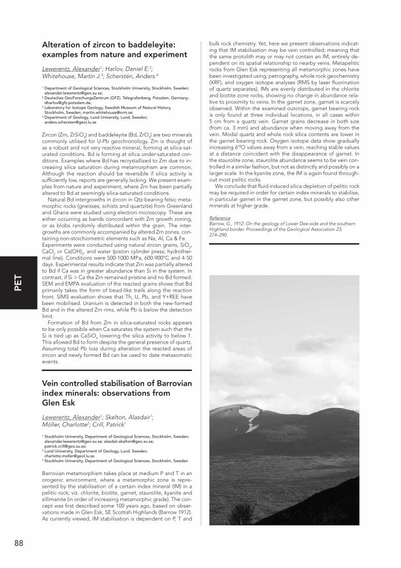
88
PE
T
Alteration of zircon to baddeleyite: examples from nature and experiment
Lewerentz, Alexander1; Harlov, Daniel E.2; Whitehouse, Martin J.3; Scherstén, Anders.4
1 Department of Geological Sciences, Stockholm University, Stockholm, Sweden; [email protected];
2 Deutsches GeoForschungsZentrum (GFZ), Telegrafenberg, Potsdam, Germany; [email protected],
3 Laboratory for Isotope Geology, Swedish Museum of Natural History, Stockholm, Sweden; [email protected];
4 Department of Geology, Lund University, Lund, Sweden; [email protected]
Zircon (Zrn, ZrSiO4) and baddeleyite (Bd, ZrO2) are two minerals commonly utilised for U-Pb geochronology. Zrn is thought of as a robust and not very reactive mineral, forming at silica-sat-urated conditions. Bd is forming at silica under-saturated con-ditions. Examples where Bd has recrystallized to Zrn due to in-creasing silica saturation during metamorphism are common. Although the reaction should be reversible if silica activity is sufficiently low, reports are generally lacking. We present exam-ples from nature and experiment, where Zrn has been partially altered to Bd at seemingly silica-saturated conditions.
Natural Bd intergrowths in zircon in Qtz-bearing felsic meta-morphic rocks (gneisses, schists and quartzite) from Greenland and Ghana were studied using electron microscopy. These are either occurring as bands concordant with Zrn growth zoning, or as blobs randomly distributed within the grain. The inter-growths are commonly accompanied by altered Zrn zones, con-taining non-stoichiometric elements such as Na, Al, Ca & Fe.Experiments were conducted using natural zircon grains, SiO2, CaCl2 or Ca(OH)2, and water (piston cylinder press; hydrother-mal line). Conditions were 500-1000 MPa, 600-900°C and 4-50 days. Experimental results indicate that Zrn was partially altered to Bd if Ca was in greater abundance than Si in the system. In contrast, if Si > Ca the Zrn remained pristine and no Bd formed. SEM and EMPA evaluation of the reacted grains shows that Bd primarily takes the form of bead-like trails along the reaction front. SIMS evaluation shows that Th, U, Pb, and Y+REE have been mobilised. Uranium is detected in both the new-formed Bd and in the altered Zrn rims, while Pb is below the detection limit.
Formation of Bd from Zrn in silica-saturated rocks appears to be only possible when Ca saturates the system such that the Si is tied up as CaSiO4 lowering the silica activity to below 1. This allowed Bd to form despite the general presence of quartz. Assuming total Pb loss during alteration the reacted areas of zircon and newly formed Bd can be used to date metasomatic events.
Vein controlled stabilisation of Barrovian index minerals: observations from Glen Esk
Lewerentz, Alexander1; Skelton, Alasdair1; Möller, Charlotte2; Crill, Patrick1
1 Stockholm University, Department of Geological Sciences, Stockholm, Sweden; [email protected]; [email protected]; [email protected];
2 Lund University, Department of Geology, Lund, Sweden; [email protected]
3 Stockholm University, Department of Geological Sciences, Stockholm, Sweden
Barrovian metamorphism takes place at medium P and T in an orogenic environment, where a metamorphic zone is repre-sented by the stabilisation of a certain index mineral (IM) in a pelitic rock; viz. chlorite, biotite, garnet, staurolite, kyanite and sillimanite (in order of increasing metamorphic grade). The con-cept was first described some 100 years ago, based on obser-vations made in Glen Esk, SE Scottish Highlands (Barrow 1912). As currently viewed, IM stabilisation is dependent on P, T and
bulk rock chemistry. Yet, here we present observations indicat-ing that IM stabilisation may be vein controlled; meaning that the same protolith may or may not contain an IM, entirely de-pendent on its spatial relationship to nearby veins. Metapelitic rocks from Glen Esk representing all metamorphic zones have been investigated using; petrography, whole rock geochemistry (XRF), and oxygen isotope analyses (RMS by laser fluorination of quartz separates). IMs are evenly distributed in the chlorite and biotite zone rocks, showing no change in abundance rela-tive to proximity to veins. In the garnet zone, garnet is scarcely observed. Within the examined outcrops, garnet bearing rock is only found at three individual locations, in all cases within 5 cm from a quartz vein. Garnet grains decrease in both size (from ca. 3 mm) and abundance when moving away from the vein. Modal quartz and whole rock silica contents are lower in the garnet bearing rock. Oxygen isotope data show gradually increasing δ18O values away from a vein, reaching stable values at a distance coincident with the disappearance of garnet. In the staurolite zone, staurolite abundance seems to be vein con-trolled in a similar fashion, but not as distinctly and possibly on a larger scale. In the kyanite zone, the IM is again found through-out most pelitic rocks.
We conclude that fluid induced silica depletion of pelitic rock may be required in order for certain index minerals to stabilise, in particular garnet in the garnet zone, but possibly also other minerals at higher grade.
ReferenceBarrow, G., 1912: On the geology of Lower Dee-side and the southern Highland border. Proceedings of the Geological Association 23, 274–290.
89
PE
T
Identifying paleotsunami deposits in Thailand using geochemical analyses
Löwhagen, Linda1; Jankaew, Kruawun2; Kylander, Malin1; Wohlfarth, Barbara1
1 Department of Geological Sciences, Stockholm University, Sweden; [email protected]; [email protected]; [email protected];
2 Department of Geology, Faculty Science, Chulalongkorn University, Thailand; [email protected]
Paleotsunami research has received considerable attention following the devastating Indian Ocean tsunami of Decem-ber 2004. Specific questions involve the magnitude, frequency and impact of past tsunamis. Phra Thong Island in the east-ern Andaman Sea is an ideal location to study paleotsunami deposits in great detail (Jankaew et al. 2008). Apart from the 2004 Indian Ocean tsunami layer, three more distinct tsunami layers, separated by soil horizons have been identified and dated (Jankaew et al. 2008). In a collaborative project between Stockholm University and Chulalongkorn University, four sites on Phra Thong Island were chosen for detailed geochemical studies and additional AMS 14C dating. Paleotsunami deposits at these sites can be seen as more or less distinct sand layers embedded between the peaty soils. Here we report the initial results of XRF core scanning and loss on ignition analysis, which are supplemented by new 14C dates. The XRF data sets show a good correlation between synchronous tsunami layers along a coast-inland transect. The geochemistry moreover suggests a change in source area for the oldest tsunami layer. Further work will focus on a detailed geochemical characterization of the tsu-nami and soil layers, and on the influence of soil processes on the geochemical record.
ReferenceJankaew, K.; Atwater, B.; Sawai, Y.; Choowong, M.; Charoentitirat, T.; Martin, M. & Prendergast, A., 2008: Medieval forewarning of the 2004 Indian Ocean tsunami in Thailand. Nature 455, 1228–1231.
Petrology of the 2.7 Ga Vend Om Intrusion, Skjoldungen Alkaline Province, SE Greenland
Maarupgaard, Bjørn P.1; Tegner, Christian1; Kokfelt, Thomas F.2; Klausen, Martin B.3.
1 Aarhus University, 8000 Aarhus C, Denmark; [email protected] or [email protected];
2 Geological Survey of Denmark and Greenland (GEUS), 1350 Copenhagen K, Denmark; [email protected];
3 University of Stellenbosch, Stellenbosch, South Africa; [email protected]
The Vend Om Intrusion is part of the Skjoldungen Alkaline Prov-ince that forms a belt of Archaean (2720-2665 Ma) intrusions in southeast Greenland ranging from pyroxenite and horn-blendite over hornblende-rich norite and monzonite, to gran-ite, syenite and carbonatite (Blichert-Toft et al., 1995: J. Pet. 36, 515-561). These intrusions represent a shoshonitic liquid line of descent and were emplaced into the lower crust of an arc setting (Thomsen, 1998, unpubl. PhD thesis, U. Copenha-gen). The Vend Om Intrusion is a small 300x400m oval-shaped (map-view) hornblende-norite plug-like layered intrusion first described by Blichert-Toft et al. (1995). To examine magma chamber processes and subsolidus modifications we present petrography and whole-rock geochemistry data of 93 samples, including a SW-NE transect though the intrusion. The contact to the country-rock orthogneisses is steep/near-vertical and is often intruded by granite sheets up to 3 m wide extending up to 30 m into the intrusion. The outermost up to 40 m thick zone denotes a steeply dipping marginal series of coarse grained hornblende-mela-gabbronorite. The inner layered series con-sists mainly of magnetite-bearing hornblende-norites that show prominent cm- to m-scale modal layering including up to 2 m
thick layers and irregular bodies with up to 80% magnetite (with hercynite). The modal layering locally wraps around blocks of leucogabbro, but overall a general sense of stratigraphic up towards southwest appears to be part of a concentric structure that is steeply inward-dipping. Questions to be addressed in-clude the origin of layering, hornblende, magnetite-rich bodies, granite sheets, and leuconorite blocks, as well as the architec-ture of the Vend Om Intrusion.
Recent advances in 193nm laser ablation-ICP-MS: characteristics of sensitivity, stability, and efficiency
McFarlane, Christopher R.M.1
1 Unversity of New Brunswick, Department of Earth Sciences, 2 Bailey Drive, Fredericton NB, Canada; [email protected]
Modern 193nm excimer (e.g., ArF) laser ablation systems are well-balanced to perform routine trace-element and isotope measurements in a wide variety of materials. Whereas the tech-nique is widely applied to U-Pb geochronology of accessory minerals, it is equally adept at a number of unconventional anal-yses using simple sample preparation techniques. The matrix mismatch tolerance afforded by short-pulse (ns) excimer lasers also facilitates external standardization and verification of ac-curacy. Recent advances in hardware and software control and synchronization of laser pulses and stage motion have spawned a variety of new methodologies. Fast wash-out two-volume sample cells have also revolutionized sample throughput and help minimize instrumental mass biases. The variety of differ-ent ablation techniques is demonstrated using examples of 2D element mapping of garnet, high-spatial resolution (5 µm) line-scans of fish otoliths and speleothems, and low-repetition rate high-precision (0.2%) depth-profiling of zircon. The diversity of material targets and sample preparation strategies is demon-strated using examples of quantification of kerogen flakes, tooth enamel, house paint, and native Cu artifacts. The efficien-cy of the technique is well demonstrated by the ability to collect up to 500 detrital zircon analyses per day and by numerous new automation strategies involving offline definition of targets and image overlay capabilities.
Despite these advances, availability of matrix-matched ho-mogeneous standards remains a major hurdle to future pro-gress. Similarly, the design of ablation cells, data reduction schemes, and reporting conventions continues to evolve. Nonetheless, laser ablation ICP-MS is now an invaluable tool in geochemical labs with diverse user base.
Metamorphic conditions of the Vetlanda formation, southeastern Sweden – support for a pre-TIB origin of the Oskarshamn-Jönköping Belt
Makowsky, Felix1; Mansfeld, Joakim1,*
1 Department of Geological Sciences, Stockholm University, S-106 91 Stockholm, Sweden;
* Corresponding author: [email protected]
We will present a P-T study of metasedimentary rocks in the Vet-landa formation, which shows that the Oskarshamn-Jönköping Belt has an older and different origin than the surrounding rocks of the Transscandinavian Igneous Belt. The Vetlanda formation comprises metasedimentary rocks and forms together with con-temporaneous metavolcanic rocks the Vetlanda supergroup. Together with calc-alkaline intrusive rocks they form the c. 1.83 Ga Oskarshamn-Jönköping Belt (OJB), which is surrounded by 1.81–1.77 Ga units of The Transscandinavian Igneous Belt (TIB). Differences in petrology, chemistry and deformation sug-

90
PE
T
gest that OJB was formed in a different tectonic setting prior to formation of TIB. However, this view has lately been chal-lenged based on age determinations of poorly defined rocks earlier mapped as OJB units, and also the small age difference between OJB and TIB. To settle this, a P-T study of metased-imentary rocks west of Vetlanda reported to carry garnet and andalusite was done. The investigated area comprises an as-semblage of schistose arkoses and conglomerates, together with pelitic rocks and minor epidote-bearing calcic rocks. The metapelitic rocks contain euhedral garnet in contact with bio-tite. Andalusite is present as broken down aggregates and as quartz-biotite pseudomorphs. Twelve garnet-bearing assem-blages analysed with microprobe and evaluated with Thermo-Calc yielded a weighted mean of 604±15°C and 3.5±0.5 kbar. Garnet elemental profiles and the breakdown of andalusite hint to a prograde P-T-t path, maybe the result of tectonic stacking during accretion/collision of an OJB-arc with a Svecofennian continental margin, prior to formation of the Transscandinavian Igneous Belt.
Source and character of hydrothermal calcite veins adjacent to extension-re-lated dolerite dykes on the Baltic Shield
Maskenskaya, Olga1; Drake, Henrik2; Åström, Mats3
1 Linnaeus University, SE-39182 Kalmar, Sweden, [email protected]; 2 Linnaeus University, SE-39182 Kalmar, Sweden, [email protected]; 3 Linnaeus University, SE-39182 Kalmar, Sweden, [email protected]
Calcite, the most common gangue vein mineral, has commonly been used to understand fluid sources in active and paleohy-drothermal systems e.g. Barrat et al. (2000). Here we present results of detailed fine-scale study of Neoproterozoic hydro-thermal carbonate veins that are spatially related to ~0.9 Ga dolerite dykes (Söderlund et al. 2008) and resided in ~1.8 Ga Paleoproterozoic granitoids (Wahlgren et al. 2008) of the Bal-tic Shield. We aimed to define the origin and characteristics of veins through the understanding of behavior of a variety of physicochemical variables (metals, 87Sr/86Sr, δ13C, δ18O, fluid inclusions) recorded in the calcites. Results show that dolerite dykes were important in the formation of the calcite veins by contributing to bedrock fracturing and, probably, triggering calcite precipitation. Brine fluids resided in bedrock fractures prior to calcite precipitation were the main source of fluids that carry saline (13.4-24.5 wt.% CaCl2 eq.), warm fluids (73-106°C) with higher 87Sr/86Sr-ratios (0.7117 to 0.7157) than expected for hydrothermal fluids emanated from dolerite dykes (~0.7041-0.7051; Patchett et al. 1994). The ratios of Mg, Mn, Fe and Sr were relatively stable throughout the calcite veins and likely to be controlled by variability in the Ca2+ concentrations in the brines. Compared to other metals (Fe, Mn, Mg and Sr), rare earth elements (REE) revealed different behaviour in the brines and/or on the calcite-fluid interphase, and are likely to be con-trolled by the variability in within-system chemical processes such as rate of REE uptake in the calcite, REE speciation in the fluid, and fluid heterogeneity in terms of REE abundance.
ReferencesBarrat J.A., Boulegue J., Tiercelin J.J. & Lesourd M., 2000: Stron-tium isotopes and rare-earth element geochemistry of hydrothermal carbonate deposits from Lake Tanganyika, East Africa. Geochimica Et Cosmochimica Acta 64, 287–298.
Söderlund P., Page L.M. & Söderlund U., 2008: 40Ar/39Ar biotite and hornblende geochronology from the Oskarshamn area, SE Sweden: discerning multiple Proterozoic tectonothermal events. Geological Magazine 145, 790–799.
Wahlgren C.H., Curtis P., Hermanson J., Forssberg O., Öhman J., Fox A., Pointe P., Drake H., Triumf C.A., Mattson K.J., Thunehed H. & Juhlin C., 2008: Geology of Laxemar. Site descriptive modelling. SDM-site Laxemar. SKB Report R-08-54, SKB, Stockholm.
Patchett P.J., Lehnert K., Rehkamper M. & Sieber G., 1994: Mantle and crustal effect on the geochemistry of Proterozoic dikes and sills in Sweden. Journal of Petrology 35, 1095–1125.
Micro- to macroscale correlation of metamorphic and deformation events with in situ U-Pb dating and thermometry
Möller, Andreas1; Oalmann, Jeffrey1; Savage, Jessica1,2; Bousquet, Romain3
1 The University of Kansas, Dept. of Geology, Lawrence, KS, USA; [email protected], [email protected];
2 now at, Northern Arizona University, Flagstaff, AZ, USA; [email protected];3 Christian-Albrechts-Universität zu Kiel, Institute of Geosciences, Kiel, Germany;
Relative timing constraints from macroscopic observations (field evidence, cross-cutting relationships) and micropscopic textur-al relationships have been used to complement in situ geochro-nology. Accessory mineral trace element thermometry and the increased use of fast data acquisition by laser-ablation ICP-MS have increased our ability to carry out both detailed and large scale regional studies. Both macro- and microscale thermome-try and geochronology are applied to the Gruf Complex (Cen-tral Alps) host of ultrahigh temperature (UHT) sapphirine granu-lites, but dominated by migmatites with abundant leucosomes and dikes. Galli et al. (2011, CMP) attribute UHT metamorphsim to Permian rifting, whereas others (e.g. Liati & Gebauer, 2003, SMPM; Oalmann et al. 2012 IGC; 2013 Goldschmidt) assign an Alpine age related to slab breakoff (von Blanckenburg & Davies 1995, Tect.). This is supported by ca. 31 Ma monazite in high-grade (850-880ºC) garnet breakdown reactions. Mapping thin sections with in situ rutile thermometry in the sapphirine granu-lites shows 3 temperature groups: a) 660±90°C rutile inclusions in garnet recording prograde temperatures; b) 920±80°C in peak assemblages and within sapphirine-bearing symplectites around garnet porphyroblasts; c) 746±66°C in retrogressed domains. Equilibrium assemblage diagrams agree and show that peak conditions for residual granulites were 900–960°C at 8–10 kbar and that cordierite coronae formed during UHT decompression to <8 kbar. On a regional scale, correlation of zircon ages from the oldest foliated high-grade leucosomes at 32.2±0.2 Ma to the youngest cross-cutting, undeformed and highly fractionated (muscovite, garnet, beryll) dikes at 25.6±0.3 Ma shows partial melting and main deformation to be coeval with Bergell Complex intrusion and deformation continuing un-til ca. 28 Ma, the time of assembly of the rock units in the Gruf complex. Dike emplacement continued until ca. 25 Ma, coeval with Novate leucogranite intrusion and granulite cooling (rutile U-Pb cooling ages).

91
PE
T
Chronology of metamorphic and deformation events derived from in situ U-Pb dating and macro- to microscale evidence
Möller, Andreas1
1 The University of Kansas, Geology, 1475 Jayhawk Blvd, Lawrence, KS, 66045, United States
In situ geochronology combined with trace element thermom-etry and fingerprinting can provide detailed histories of defor-mation and metamorphic events. Examples from Precambrian to Paleogene high grade terranes illustrate how macroscopic and microscopic textural observations are used to achieve this.
Exhumation of an eclogite terrane as a hot, migmatitic nappe, Sveconorwegian orogen
Möller, Charlotte1; Andersson, Jenny2; Dyck, Brendan1,3; Antal Lundin, Ildiko2
1 Department of Geology, Lund University, SE-223 62 Lund, Sweden; [email protected];
2 Geological Survey of Sweden, Box 670, SE-751 28 Uppsala, Sweden; [email protected], [email protected];
3 Present address: Department of Earth Sciences, South Parks Road, Oxford OX1 3 AN, UK; [email protected]
We present geological and geophysical data providing evidence for a structurally bound, strongly migmatitic and eclogite-bear-ing terrane within the parautochthonous Eastern Segment, Sveconorwegian orogen. The structure is an east-plunging re-cumbent fold nappe that formed during tectonic extrusion of eclogitized crust, partial melting, and foreland-directed trans-lation. It accommodated melt weakening-assisted exhumation and foreland-directed flow of eclogitized crust, at 30-45 km depth within the orogen. The eclogitization and exhumation are broadly coeval with the Rigolet phase of the Grenvillian orogeny, and reflect the late stage of continental collision dur-ing build-up of supercontinent Rodinia. The eclogite-bearing terrane is composed of stromatic migmatitic orthogneiss with pods of largely amphibolitized eclogite and has a basal shear zone of mylonitic orthogneiss with boudins of kyanite-bearing eclogite (P>15 kbar) and retroeclogite. The southern-to-eastern boundary of the eclogite terrane is outlined by a semi-continu-ous tectonostratigraphic marker: a heterogenously mylonitized, orthoclase-megacrystic, granitic orthogneiss (1.4 Ga ‘Torpa granite’). U-Pb SIMS metamorphic zircon ages of two eclog-ite pods and a stromatic orthogneiss constrain the timing of eclogitization at 986±4 Ma and 983±6 Ma, and the timing of migmatization, concomitant deformation, and exhumation at 972±8 Ma. The southern Eastern Segment, including the eclog-ite-bearing terrane, underwent near-pervasive recrystallisation and deformation under high-pressure granulite and upper am-phibolite conditions. The partial preservation of early eclogite assemblages demonstrates 1) the existence of different tec-tonometamorphic units in the deepest part of the Sveconorwe-gian orogen, and 2) that it is possible to identify different tec-tonic units from less-deformed rock domains, despite a general reworking under high metamorphic temperatures.
Rutile and Zircon Geochronology and Geochemistry of Banded Rocks from the Isua Supracrustal Belt, SW Greenland
Nielsen, Line S.1, 2; Rosing, Minik2; Kokfelt, Thomas F.1; Thomsen, Tonny B.1
1 Geological Survey of Denmark and Greenland (GEUS), Øster Voldgade 10, DK-1350 Copenhagen K, Denmark;
2 Geologisk Museum, Øster Voldgade 5-6, DK-1350 København K., Denmark
Samples from three different rock units within the Isua Supra-crustal Belt were characterised by their mineralogy, bulk geo-chemistry and zircon and rutile U-Pb ages, in order to under-stand their petrogenesis-age relationship.
The units investigated are all characterised by being distinct-ly banded with narrow sheets of mica-rich, felsic rocks, includ-ing weathered mafic pods that comprise either biotite (locality 1) or amphibole (locality 2 and 3). The bulk rock trace element patterns indicate an origin from shallow-level partially melting in an island arc environment.
Zircon and rutile U/Pb ages were obtained at GEUS by LA-ICP-MS (Frei and Gerdes, 2009). Zircons from locality 1 yield 207Pb/206Pb ages from 3814±4 Ma to 3777±5 Ma (2σ), and are interpreted to reflect the age of the protolith. This is consistent with previous studies (e.g. Crowley, 2003). Rutiles from amphib-olite-dominated outcrops at locality 2 and 3 yield 207Pb/206Pb ages from 2587±3 Ma to 2475±51 Ma (2σ). Thus, they are sig-nificantly younger than the zircons and represent the first rutile ages obtained from the Isua Supracrustal Belt.
Peak metamorphic temperature conditions for garnet-bear-ing biotite were estimated to be ~460°C using Fe+2-Mg parti-tioning between garnet cores and biotite. Acceptable temper-atures were not obtained for the rutile-bearing amphibolites, however, the stability of amphibole and rutile instead of bio-tite and Ti-bearing minerals like ilmenite and titanite is likely to be a consequence of a locally high temperature regime (fx Luvizotto et al., 2009), presumably caused by contact metamor-phosis during a later magmatic event. This could be related to the emplacement of the 2700-2500 Ma old granitic pegmatite dispersed in the Itsaq Gneiss Complex (McGregor et al., 1991).
On the petrogenesis of the late Neo-archaean Qôrqut Granite Complex in the Nuuk region of southern West Greenland
Næraa, Tomas1,2; Kemp, Anthony I.S3; Scherstén, Anders1; Rehnström, Emma F.4; Rosing, Minik T.5; Whitehouse, Martin6.
1 Department of Geology, Lund University, Sölvegatan 12, 223 62 Lund, Sweden; 2 Geological Survey of Denmark and Greenland (GEUS), Øster Voldgade 10, 1350
Copenhagen K., Denmark; 3 Centre for Exploration Targeting (CET), University of Western Australia.
35 Stirling Highway, Crawley WA 6009, Perth, Australia; 4 Avannaa Resources Ltd, Dronningens Tværgade 48 st.tv., 1302 Copenhagen K,
Denmark; 5 Nordic Center for Earth Evolution, Natural History Museum of Denmark. Østre
Voldgade 5-7, 1350 Copenhagen K., Denmark; 6 The Swedish Museum of Natural History, SE-104 05 Stockholm, Sweden
The late Neoarchaean Qôrqut Granite Complex (QGC) is the youngest large igneous intrusion in the Nuuk region in southern West Greenland, where basement is primarily of tonalite-trondh-jemite-granodiorite (TTG) composition with Eoarchaean and Mesoarchaean age. The QGC is generally undeformed and the granite intruded at the end of a period, starting at ca. 2730 Ma, characterised by crustal reworking, possibly related to syn- or
92
PE
T
post accretion tectonics or continental collision. We present whole rock chemistry and combined U/Pb, Hf and O isotope data from zircon grains of the QGC. We obtain a mean zircon U/Pb age of 2547 ± 4 Ma (MSWD = 0.63). Initial εHf values range from -12 to -18 requiring a long residence time and a rather homogeneous source. Hf model age calculations are consistent with a trace element enriched mafic source of Eoarchaean age. Sample averaged zircon δ18O values range from 6.1 ± 0.2‰ to 6.5 ± 0.3/0.7‰ best interpreted with a source region of mainly unweathered mantle derived igneous rocks. Compared to the regional TTG basement, the QGC is characterised by low CaO and Na2O and high K2O, LREE and Rb contents, and a strong-er fractionated REE pattern with a negative Eu anomaly. From trace element modelling the chemistry of QGC is compatible with an enriched mafic source and a residual mineralogy of garnet, clinopyroxene, plagioclase and rutile (± amp). Residual rutile constrain the pressures to > ca. 13-18 kbar, at these high pressures plagioclase might not be stable – plagioclase may thus have been a fractionating magmatic phase rather than being present in the melt source region. Zirconium saturation temperatures suggest magma temperatures in the range 750-850 °C. The obtained P-T conditions suggest a lower crustal source region with a geothermal gradient of ca. 15 °C/km which is consistent with a post or late continental collisional setting. Such a model conforms to the overall understanding of the ge-odynamic setting on the Nuuk region in the late Neoarchaean.
Zircon geochronology of the Skjoldungen region, SE Greenland
Næraa, Tomas1,2; Kokfelt, F. Thomas1; Kristine, Thrane1
1 Geological Survey of Denmark and Greenland, Øster Voldgade 10, 1350 Copen-hagen, Denmark. [email protected];
2 Department of Geology, Lund University, Sölvegatan 12, 223 62 Lund, Sweden
The Skjoldungen region in South-East Greenland (ca. 62º30´N to 63º50´N) represents a middle to deep crustal section of the Archaean crust and is dominated by felsic gneisses and granites with abundant inclusions of mafic and ultramafic rocks making out an agmatitic texture. Isolated narrow ‘supracrustal belts’ of mainly mafic to ultramafic rocks, and rare paragneisses are con-sidered relicts of an older basement that was deformed during two subsequent orogens in the area: (1) The Timmiarmiut Oro-gen (>2800 Ma) and (2) the Skjoldungen Orogen (ca. 2750-2700 Ma) (Kolb et al. 2013). The so-called Skjoldungen Alkaline Prov-ince (SAP) constitutes a number of post- to syn-tectonic maf-ic, ultramafic to more differentiated alkaline intrusions aligned in a ca. 80x30 km WNW-ESE oriented belt (Blichert-Toft et al. 1995). We present new zircon geochronology data, obtained mainly by LA-ICPMS methods, on 88 samples collected during the GEUS led field campaigns in South East Greenland in 2011-12. The samples include a regional coverage of the agmatitic gneisses and granites, as well as the meso- to leucocratic alka-line intrusions of the SAP and late granitic pegmatites. Our new regional geochronological data set indicates that large parts of the basement formed in a restricted time period between 2700 and 2750 Ma, thus corresponding to the latest of the regional orogenic events. This period includes the intrusion of the gran-ite and gneiss protoliths of the agmatitic basement, and the meso- to leucocratic alkaline intrusions of the SAP. Many sam-ples contain relatively abundant zircon inheritance, with ages mainly ranging from 2830 to 3200 Ma and a single sample with ages up to ca. 3880 Ma, suggesting that these melts partly orig-inated from zircon bearing felsic rocks, possibly through crustal anatexis or assimilation (AFC) processes. In the northern part of the region banded gneisses with ages at ca. 3050 Ma represent the only larger fragments of early formed felsic basement in the region.
ReferencesBlichert-Toft, J., Rosing, M.T., Lesher, C.E. & Chauvel, C., 1995: Geo-chemical Constraints on the Origin of the Late Archean Skjoldungen Alkaline Igneous Province, SE Greenland. Journal of Petrology 36, 515–561.
Kolb, J., Thrane, K. & Bagas, L., 2013: Field relationship of high-grade Neo- to Mesoarchaean rocks of South-East Greenland: Tectonometa-morphic and magmatic evolution. Gondwana Research 23, 471–492.
Garnet-orthopyroxene thermometry revisited: a new calibration and appli-cation to granulites and peridotites
Olivotos, Spyros–Christos1; Kostopoulos, Dimitrios2
1 National and Kapodistrian University of Athens School of Science, Faculty of Geology and Geoenvironment, Department of Mineralogy and Petrology, Panepistimioupoli, Zographou, Athens 157 84, Greece; [email protected];
2 Eldorado Gold Corporation, 23A Vasilissis Sophias Avenue, Athens 106 74, Greeece; [email protected]
The Fe-Mg exchange reaction between garnet and orthopy-roxene is a robust geothermometer that has extensively been used to retrieve metamorphic temperatures from granulitic and peridotitic/pyroxenitic lithologies with important implications on the thermal state of the continental lithosphere. We gleaned more than 800 experimental mineral pairs available in the lit-erature and recalibrated the above reaction in the P-T range 0.5-15 GPa / 800-1800°C. Our new thermometer reproduces the experimental data to within 50°C and is independent of P-T-X variations within the bounds of the experimental data set. We subsequently applied our new calibration to metamorphosed crustal and mantle rocks that occur both as massifs and xeno-liths in volcanics. The most significant results of our approach are summarized below. Granulites from Norway display a spread from UHT conditions to subsolidus re-equilibration (Ro-galand: 972±21°C & 828±34°C; Bamble: 857±52°C; Arendal: 692±29°C). The Adirondacks show a clear bimodal distribution of temperatures (856±51°C & 719±25°C). UHT granulites from Brazil (Anapolis) exhibit: 978±86°C [cores], 841±84°C [rims] and 777°C [symplectites]. Orthopyroxene-rich domains from the South Harris granulites, Scotland, also demonstrate UHT con-ditions (990±27 @ 1GPa). The same is true for Indian granulites from the Palni Hills (peak conditions: 1000-1100°C @ 1GPa). Mafic/ultramafic xenoliths from Qilin (SE China), Spitsbergen and Deccan define continental geotherms between 65 and 70mW.m-2 signifying the presence of thinned lithosphere. Man-tle xenoliths from S. African and Lesotho kimberlites demon-strate a remarkable 40mW.m-2 geotherm. UHP mantle perid-otites from China are characterized by the coldest geotherm identified so far (33mW.m-2) implying significant removal of the lithospheric keel.
Contrasting volcanic architecture and geochemistry of interdigitating flood basalt groups: structural and tectono-magmatic implications for Iceland in the Neogene
Óskarsson, Birgir V1,*; Riishuus, Morten S2
1 Institute of Earth Sciences,University of Iceland, Sturlugata 7, 101, Reykjavík; 2 Nordic Volcanological Center, University of Iceland, Sturlugata 7, 101, Reykjavík; * Presently at: the Icelandic Institute of Natural History, Urridaholtsstraeti 6-8,
212, Garðabær; [email protected]
Volcanologic studies of distinct flood basalt groups in eastern Iceland are presented and their architectural and geochemical differences discussed with implications to their tectono-mag-matic setting. The groups of this study are the Hólmar and Grjótá olivine basalt groups, and their enveloping tholeiite groups. The groups can be traced over 60 km north-south and form prominent stratigraphic markers. The olivine basalt groups have compound architecture. Inflation is evident in many lobes and simple calculations combined with the structural relation-ships have yielded eruptions scaled comparable to the Laki fires (~1000 m3/s). The tholeiite groups are dominated by simple/
93
PE
T
tabular flows. Their flow fields are generally thicker than the olivine basalts and individual sheet lobes persist >2 km with plane-parallel contacts, and the simple flow fields lack inflation structures and tubes. Their emplacement implies larger and sustained effusive events, with flooding of large areas in a short time. The olivine basalts are classified compositionally as transi-tional alkaline (Na2O+K2O = 2.8-4.5 wt% and TiO2 = 2.0-3.5 wt% @ SiO2 = 46.5-50.2 wt %) with enriched rare earth element pat-terns (La/YbN = 3.9-5.7, Dy/YbN = 1.36-1.62 and Nb/Y = 0.50-0.74), which suggest an origin in a flank zone or propagating rift setting today. The studied tholeiites share similar compo-sition with lava flows erupted at the axial rift today (Na2O+K2O = ~1.0-3.0 wt% and TiO2 = ~0.2-2.0 wt% @ SiO2 = ~45-50 wt% La/YbN = ~0.1-3.0, Dy/YbN = ~0.9-1.3 and Nb/Y = ~0.10-0.40). The olivine basalt groups thicken up-dip to the east and are linked to the termination of the Reyðarfjörður Volcanic Zone, while the enveloping tholeiites thicken down-dip and must have erupted from an adjacent buried rift zone to the west. Both volcanic zones were active contemporaneously resulting in interdigitation of the groups. The olivine basalt groups show greater burial and shift in locus of volcanism to the south. The architectural and compositional observations raise many ques-tions. Does the volcanism forming large groups with Laki-sized eruptions at a flank zone indicate that the mantle anomaly had a greater melting potential in the Neogene compared to the present? How does the spacing of these two contrasting vol-canic zones correlate with the geometry of the present volcanic zones in Iceland? Does the greater burial of the groups to the south indicate a southward propagating rift? The observations and questions raised here pinpoint that much needs still to be achieved in order to define temporal crustal-plume interactions and improve our understanding of crustal accretion processes in Iceland.
Zircon U-Pb-Hf constraints on growth versus reworking of southern Fennoscandia
Petersson, Andreas1; Scherstén, Anders1; Andersson, Jenny2; Möller, Charlotte1
1 Department of Geology, Lund University, Sölvegatan 12, SE-223 62 Lund, Sweden; 2 Swedish Geological Survey, SGU Uppsala, Uppsala, Sweden
Growth models of southern Fennoscandia, including the east-ern part of the Sveconorwegian Province, are largely based on U–Pb data. This approach however, does not discriminate between juvenile and reworked continental crust, while com-bined zircon U-Pb and Hf isotope data provide constraints on residence time of the crustal protoliths. Zircon U–Pb and Hf isotope data, from the Eastern Segment of the Sveconorwe-gian Province, is best explained by mixing between a 2.1–1.9 Ga juvenile component and reworked Archaean crust. Rework-ing of Archaean crust decreases between 1.9 and 1.7 Ga and a mixed Svecofennian crustal reservoir is generated. Subsequent magmatism between 1.7 and 1.4 Ga is dominated by reworking of this reservoir. At c. 1.2 Ga, an influx of juvenile magma is re-corded by granite to quartz-syenite magmatism with mildly de-pleted signatures. The amount of recycled crust in the 1.9–1.7 Ga arc systems is in contrast to previously proposed models for the growth of the southwestern part of the Fennoscandian proto-continent. One sample from the westernmost part of the Idefjorden terrane shows similar Hf-signature to the rocks in the Eastern Segment, possibly indicating a joint evolution. Howev-er, a statistical comparison of detrital zircon U-Pb ages from the Idefjorden terrane, and zircon U-Pb ages from the crystalline bedrock of southern Fennoscandia show significant dissimi-larities, in particular the striking lack of 1.8 and 1.7 Ga peaks, which are ubiquitous in the presumed surrounding crystalline basement. This might imply that the Idefjorden terrane was separated from the Eastern Segment at the time of Idefjorden supracrustal rock deposition, which is possibly corroborated by
the uncorrelated pre- to syn-Sveconorwegian tectonometamor-phic evolution.
The Vestbrona Formation Re-Interpreted as Sill Complexes of Paleocene Age
Planke, Sverre1,2; Polteau, Stephane1; Hafeez, Amer3; Jerram, Dougal A.2,4; Angard, Kristian3; Prestvik, Tore5
1 Volcanic Basin Petroleum Research (VBPR), Oslo, Norway; [email protected] The Centre of Earth Evolution and Dynamics (CEED), University of Oslo, Norway3 Tullow Oil, Oslo, Norway; 4 DougalEarth, Solihull, UK; 5 Department of Geology and Mineral Resources Engineering, NTNU, Trondheim,
Norway
Silica undersaturated alkaline porphyritic igneous rocks of the Vestbrona Formation were dredged and studied by Bugge et al. (1980) and Prestvik et al. (1999). The dredge contents have been resampled and analyzed with new petrography, geo-chemistry (XRF, XRD), biostratigraphy, and Ar-Ar geochronolo-gy. The new data have been tied to 2D and 3D seismic data and nearby wells to obtain a stratigraphic framework. The seismic data reveal that 0.1 to 9 km2 large saucer-shaped sill intrusions are abundant in lower Paleocene and Cretaceous sediments of the Frøya High. Erosional remnants of the sills are locally pres-ent on the seabed. These sill fragments have previously been interpreted as igneous plugs. Dredged contact metamorphic sediment samples from the erosional remnants have biostrati-graphic ages consistent with the seismic interpretation. Numer-ous pipe-like vent complexes (or mud volcanoes) are further imaged by the seismic data. A few of these vent complexes are sub-cropping on the seafloor. Gravity coring of the subcropping vent complexes in 2013 show that they contain stiff clay and shell fragments, with no evidence of igneous materials.
Preservation bias in the geological record; a Fennoscandian case study
Roberts, Nick M.W.1
1 NERC Isotope Geosciences Laboratory, British Geological Survey, Keyworth, Nottingham, NG12 5GG, UK, [email protected]
The extent to which the current exposure of continental crust represents that which has been made is critical to our under-standing of Earth evolution. Models for crustal growth have commonly been based upon a geological record that features episodes and cycles of activity, including enhanced crustal growth. More recently, the idea that such episodes may reflect preservation bias upon a more continuous geological baseline is becomingly increasingly accepted. However, we now need to understand the complexities of this possible bias, so that we can unpick the geological record and improve our models of earth evolution. Proterozoic Fennoscandia provides a conven-ient case study, since its geological history can be simplified into the lifespan of a long-lived accretionary margin. Using the record of crustal growth and recycling, primarily from modelling of a comprehensive zircon U-Pb and Hf isotope database. It is shown that the 1.9-0.9 Ga period of accretionary orogenesis on the SW margin of Fennoscandia featured quasi-continuous growth for much of its history. However, the preserved crust is dominated by the older part of this history, and the younger part has been largely ‘lost’, and by inference recycled into the mantle. During continent-scale orogenesis, in this case the Sveconorwegian orogeny, crust formed peripheral to the cra-ton (~1.9-1.5 Ga) has been preserved, and crust formed distal (1.4-1.1 Ga) has been lost. This leads to the question: was 2.4-2.1 Ga crust that is small in abundance also lost prior/during the Svecofennian orogeny, or does it represent a true hiatus in crustal growth?
94
PE
T
Laser ablation U-(Th)-Pb geochronolo-gy; progress and pitfalls
Roberts, Nick M.W.1; Horstwood, Matthew S.A.1
1 NERC Isotope Geosciences Laboratory, British Geological Survey, Keyworth, Nottingham, NG12 5GG, UK, [email protected]
Laser ablation U-(Th)-Pb geochronology has been around as a routine method for about a decade now, and in the last few years has seen a rapid expansion in its use due to the availability of off-the-shelf laser ablation systems and ICP-MS instruments. Here we present the current state of play regarding U-Pb geo-chronology of zircon in terms of achievable precision and ac-curacy, including the pertinent conclusions of an international inter-lab comparison. This will be used as a platform to discuss what future progress can be made to increase both the preci-sion and accuracy of U-(Th)-Pb geochronological data, and also the capability in higher spatial resolution. Discussion of meth-ods will utilise both single and multi-collector instruments, as well as laser ablation cell and transport design. New communi-ty-derived protocols for data reduction and uncertainty propa-gation will also be highlighted.
Zircon messenger; cryptic tales from arc magmas
Roberts, Nick M.W.1; Tapster, Simon2
1 NERC Isotope Geosciences Laboratory, British Geological Survey, Keyworth, Nottingham, NG12 5GG, UK, [email protected];
2 University of Leicester, Leicester, LE1 7RH, UK
Zircon is ubiquitous in evolved magmas, and is most commonly used to provide chronological information vital for determin-ing emplacement ages. Additional isotopic data from dated zircons (e.g. δ18O, Lu-Hf) can be used to provide constraints on the sources of the magma they crystallised from. Many petroge-netic/tectonic models are based on major assumptions about the interpretation of such isotopic data that are unequivocal; thus, such isotopic information is frequently misread. Some of the complexities in interpreting zircon data will be highlighted using case studies from arc systems in particular. These include an example from the apparently ‘intra-oceanic’ setting of the Solomon Island Arc, whereby zircons record the emplacement ofdioritic intrusions, but also reveal evidence for the contamina-tion of intermediate magmas by unexposed, ‘cryptic’ crust and document the arc’s early interactions with a continent margin. Pathways of crustal contamination in arc systems will be investi-gated using old (Mesoproterozoic SW Norway) and modern (In-donesia) arc environments. In these instances, combined U-Pb and Hf-O systematics are put to use in the determination of extent, source and location of crustal contamination.
Pentti Eskola – A Personal Outlook
Robinson, Peter1
1 Geological Survey of Norway and Professor Emeritus, University of Massachusetts Amherst, NA, Trondheim, Norway; [email protected]
In 1956, en route home from petrologic study under Doug-las Coombs in New Zealand, I had an accidental and friendly discussion of metamorphism with Pentti Eskola in Helsinki. In Massachusetts, 1958-1963, influenced by J. B. Thompson and Marland Billings, I focused on geologic mapping, graphic anal-ysis of mineral assemblages, cordierite-anthophyllite rocks and gneiss domes, all subjects close to Eskola’s heart. His Orijär-vi Memoir was remarkable for its time, published in English in 1914 by the Russian Imperial Senate, based on work 1908-1913, including maps, rock descriptions, mineral and rock analyses,
and discussion of relationships with ore deposits. The follow-on bulletin, also 1914, but published in Swedish 1915, with English summary, was perhaps more influential. Even then, Eskola was aware of key work by Van Hise (1904) and Becke, Grubenmann, Niggli, and Goldschmidt (all 1911-1914). Here are headings ‘Metamorphic Facies’, ‘Mineral Associations’, ‘Application of the Phase Rule’, and a precise presentation of the ACF and AKF projections. His discussion concerning the diagrams contains warnings concerning behavior of components that occupied and vexed later users in decades to come. Thompson’s 1957 muscovite projection was a direct spin-off from AKF. The dia-grams were perfectly suited to graphic display of V. M. Gold-schmidt’s contact metamorphic assemblages near Oslo, Nor-way, as in his 1912 Ph. D. thesis (published in German), and in some later summaries were wrongly attributed to Goldschmidt himself. The two came together in Oslo after WWI, when Eskola studied eclogites that he first thought of as an igneous facies. In 1963 I was on a field institute for American petrologists in Norway, Sweden, and Finland. The first day in Espoo, we met Eskola, then in his last year, but ready to autograph a copy of the 1915 bulletin, then still available. My targets were to see cordierite-anthophyllite rocks at Orijärvi and gneiss domes at Kuopio (we got one outcrop of each); our leaders had the origin of granite as theirs. Among us was a small ‘Eskola team’, con-stantly seeking examples of his metamorphic facies, along the trail he set, that is still followed today.
U-Pb baddeleyite dating of NE-trending feldspar-phyric dolerite dykes in south-eastern Kaapvaal craton: Validating proposed linkages to magmatic events on the Kaapvaal craton
Rådman, Johan1; Gumsley, Ashley1; Klausen, Martin B.2; Söderlund, Ulf1
1 Department of Geology, Lund University, Sölvegatan 12, SE-223 62 Lund, Sweden, [email protected];
2 Department of Earth Sciences, University of Stellenbosch, Private Bag X1, Matieland 7602, South Africa; [email protected], [email protected], [email protected]
This ongoing project aims to precisely date the NE-trending dolerite dykes of the south-eastern Kaapvaal Craton in northern KwaZulu-Natal, South Africa. This region has received only cur-sory study. However, two tentative ages of 2660±4 Ma (Olsson 2012) and 2652±11 Ma (Gumsley 2013) on NE-trending dolerite dykes respectively from the region have been obtained. One site is in south-eastern Mpumalanga, and the other in north-ern KwaZulu-Natal, a distance approximately 180 km apart. The results provide evidence of a major NE-trending dyke swarm throughout this region of the Kaapvaal Craton. In addition, these ages are coeval to the Ventersdorp magmatic event and a radiating NE-, E- and SE-trending dolerite dyke swarm dat-ed by Olsson et al. (2010; 2011) to 2.70-2.66 Ga. These prelimi-nary ages also suggest that not all of the NE-trending dolerite dykes on the eastern Kaapvaal Craton belong to the ca. 1.90 Ga Black Hills swarm of Olsson (2012). Instead, these data indicate two separate swarms of NE-trending dykes in the south-east-ern Kaapvaal Craton. This feldspar-phyric generation was em-placed marginally and perpendicular to the radiating ca. 2.65 Ga swarm dated by Olsson et al. (2011) further to the north. This would appear to indicate a separate source of magmatism, in addition to the plume-induced radiating dyke swarm of Olsson et al. (2010; 2011). Preliminary geochemistry would also appear to suggest a more depleted source for these NE-trending dol-erite dykes unlike the more enriched source in the radiating swarm seen further north by Klausen et al. (2010).

95
PE
T
Zircon Hf based growth models of the continental crust – a few considerations
Scherstén, Anders1; Kristinsdóttir, Bara1; Petersson, Andreas1; Næraa, Tomas1; Bjärnborg, Karolina1; Hollis, Julie2
1 Department of Geology, Sölvegatan 12, 23 62 Lund, Lund University, Sweden; [email protected], [email protected]; [email protected]; [email protected]; [email protected];
2 Geological Survey of Western Australia, Australia; [email protected]
Growth models for the continental crust generally assume con-tinuous growth, where the current mass is defined as 100%, and the all-time high. Constraints from detrital zircon U-Pb-Hf imply fast early growth with c. 70% of continental crust mass by the end of the mid-Archaean. This is largely the effect of forward modelling and an assumption of constant net growth of the continental crust. We argue that models implying fast Ha-dean growth are speculative and that there is scant geological evidence to support such inferences. The notable correlation between lunar cataclysm and the emergence of a more contin-uous rock record on Earth is striking and might reflect signifi-cant continental crust reduction (or obliteration) in the Hadean. Periodic continental crust reduction should also be considered a potentially important process in eras with plate tectonics in operation. Here, subduction erosion is the most important pro-cess, and might supersede magmatic flux in the Phanerozoic. A final concern is the estimate of the depleted mantle source. Since the Archaean, arc magmatism is likely a primary source of continental crust where the underlying mantle might be expect-ed to be less depleted than depleted MORB mantle (DMM). Application of DMM will lead to underestimation of juvenile crust production and a corresponding overestimate of ancient reworked crust. Overestimated model ages will also come from seemingly concordant zircon that went through ancient Pb-loss as Hf tends to be immobile during metamorphism.
Eskola’s Mineral Facies: Yesterday and Today
Schumacher, John C.1
1 School of Earth Sciences, University of Bristol, Bristol, BS8 1RJ, UK; [email protected]
Eskola’s (1914, 1920, 1939) mineral facies extended the facies concept for sedimentary rocks, where distinctive rock types are indicators of specific environments or processes. Eskola’s mineral facies are distinctive mineral assemblages for specific compositions that indicate P-T regimes. Eskola’s original defini-tion of mineral facies is paraphrased as: “A metamorphic faci-es includes rocks assumed to be metamorphosed at the same P-T conditions. Rocks with the same chemical composition will have the same mineral assemblage within the facies.” Eskola elaborates: “However, facies may include chemical and genetic variation. Equivalent facies may be found in different metamor-phic terrains, while local metamorphic terrains may be com-posed of different facies.” The original facies were: greenschist, amphibolite, hornfels, sanidinite, and eclogite. He later added epidote-amphibolite, glaucophane-schist, and granulite facies, and changed hornfels facies to pyroxene-hornfels facies. Before Eskola’s ideas appeared, Grubenmann (1906-08) classified met-amorphic rocks based on three zones of increasing depth: epi-, meso-, and kata-zones. Each depth zone contained 12 groups of assemblages, based on rock composition. Temperature rise was implicit with increased depth. Eskola and Harker criticized Grubenmann’s scheme. Four objections by Eskola (1939) were: (1) Through usage, the terms epi-, meso-, and kata- were tied to depth as an essential factor, but examples of decreasing metamorphic grade with increasing depth existed; (2) Contact metamorphism could reverse the predicted depth vs. assem-
blage relationship; (3) 3-categories cannot describe all variation of a single composition, e.g., assemblages from mafic hornfels and eclogite both included in the kata-zone; (4) The mineral assemblage of a metamorphic rock, the main criterion of clas-sifications is, considered independently, an insufficient depth indicator. Also glaucophane was included among low-pressure minerals of the epi-zone, but correctly placed at high-P and low-T in Eskola’s (1939) modification. Refinements of Eskola’s work continue, and mineral facies remain essential where field geologists meet metamorphic rocks.
Geochronology of the Norra Kärr alkaline complex, southern Sweden
Sjöqvist, Axel S.L.1,*; Cornell, David H.1; Andersen, Tom2; Andersson, Ulf B.3; Christensson, Ulf I.1; Ranjer, Stina J.E.1; Holtstam, Dan4; Leijd, Magnus5
1 Department of Earth Sciences, University of Gothenburg, PO Box 460, SE-405 30 Göteborg, Sweden;
2 Department of Geosciences, University of Oslo, PO Box 1047 Blindern, N-0316 Oslo, Norway;
3 Department of Earth Sciences, Uppsala University, Villavägen 16, SE-752 36 Uppsala, Sweden (now at LKAB, R&D, TFG, FK9, SE-981 86 Kiruna, Sweden);
4 Swedish Research Council, Research Policy Analysis, Box 1035, SE-101 38 Stockholm, Sweden (formerly at the Swedish Museum of Natural History, Box 50007, SE-104 05 Stockholm, Sweden);
5 Tasman Metals Ltd., Skiftesvägen 14, SE-563 31 Gränna, Sweden; * [email protected]
The Norra Kärr alkaline complex is a small intrusion of agpaitic nepheline syenite, located approximately 10 km north of Grän-na, southern Sweden, that is being explored for REE and Zr. Ag-paitic nepheline syenites per definition do not contain simple Zr minerals like zircon and baddeleyite, despite generally high Zr contents (up to 1–2 wt.% ZrO2). Instead, Zr is mainly hosted in rock-forming complex Na-Ca-Zr silicate minerals such as mem-bers of the catapleiite, eudialyte, rosenbuschite, and wöhlerite groups. U-Pb zircon geochronology is thus highly impeded by the agpaitic nature.
We established a new, reliable igneous age for the Norra Kärr alkaline complex at 1489±8 Ma (MSWD = 0.95) by dating zircons (U-Pb) in the country rocks that were affected by the magmatism-related alkaline alteration (fenitisation) by LA-MC-ICP-MS. Zircons from a satellite body of non-agpaitic syenite gave intercept ages within error of the age of fenitisation. This is an improvement upon an imprecise whole-rock Rb-Sr age of 1545±61 Ma (Blaxland 1977; Welin 1980). The non-fenitised country granite itself is dated at 1781±8 Ma (MSWD = 0.59), and thus belongs to the TIB1 (1.81–1.76 Ga) episode of the Transs-candinavian Igneous Belt (TIB). Rare zircon xenocrysts extracted from the nepheline syenite show ages corresponding to 1.5 Ga lower crustal intrusives (rapakivi?), TIB, Svecofennian, and one Archaean zircon, which suggests the possibility for a remnant of Archaean basement below the TIB.
There has historically been a vivid discussion about wheth-er or not Norra Kärr has been deformed and metamorphosed. New Ar-Ar step heating ages on sodic amphibole from Nor-ra Kärr and muscovite and biotite from the country rocks give plateau ages at 1.1 Ga and 0.94 Ga, which correspond to ages derived for Sveconorwegian shear zones in the area. Together with textural and crystal chemical evidence, these ages make a compelling argument for some form of Sveconorwegian over-print of the Norra Kärr alkaline complex.
ReferencesBlaxland, A.B., 1977: Agpaitic magmatism at Norra Kärr? Rb-Sr isotopic evidence. Lithos 10, 1–8.Welin, E., 1980: Tabulation of recalculated radiometric ages published 1960–1979 for rocks and minerals in Sweden: GFF 101, 135–162.
96
PE
T
New U-Pb ages from the Gothian intrusions in the southern part of the Western Gneiss Region, Norway
Skår, Øyvind1
1 Geological Survey of Norway, Laboratory, Trondheim, Norway
The Gothian rocks in the southern part of the Western Gneiss Region, Norway, consist of granitic to dioritic orthogneisses, mafic and minor ultramafic and supracrustal rocks. The rocks were affected by two later orogenic events. During the Sve-conorwegian orogeny (1250–900 Ma) rocks in whole the area were deformed, migmatized and intruded by granitic plutons late in the orogeny (990-950 Ma). In the later Caledonian orog-eny the eastern areas were little affected, but the degree of deformation increases toward the west where the rocks possess a penetrative gneiss foliation and were affected by eclogite fa-cies metamorphism c. 420 Ma. In this study more than 40 of the Gothian rocks have been dated by the U-Pb method in zircons by Laser-ablation ICP-MS. The dated rocks are predominant-ly orthogneisses of granitic compositions, in addition to some gabbroic compositions. The rocks groups into two age inter-vals. The first, between 1650 and 1600 Ma, and the second from 1520 to 1590 Ma. Rocks in the age interval 1650 – 1600 Ma occur in whole the area. In the second period of magmatism (1520-1490), the dated rocks occur mainly in the western and southern part of the area. Only one gabbro of this age has been dated in the eastern area. The 1520-1490 Ma rocks contain inherited zircon cores of the older Gothian rocks (1650-1600 Ma). How-ever, no older inherited zircon cores have been dated in the Gothian orthogneisses. In contrast, quartzites, folded together with the Gothian rocks, also contain zircons in the 1700–2000 and 2500–2900 Ma time intervals.
Lu-Hf and Sm-Nd garnet geochronology: Closure revisited and new applications in lithosphere studies
Smit, Matthijs A.1,2,3; Scherer, Erik E.3; Mezger, Klaus4; Ratschbacher, Lothar5; Kooijman, Ellen2,6; Hacker, Bradley R.2
1 Institute for Geosciences and Resource Management, University of Copenhagen, Øster Voldgade 10, DK-1350 Copenhagen K, Denmark; [email protected];
2 Münster Isotope Research Center, Westfälische Wilhelms-Universität, Correns-straße 24, D-48149, Münster, Germany;
3 Department of Earth Sciences, University of California, 1006 Webb Hall, CA 93106, Santa Barbara, USA;
4 Institut für Geologie, Universität Bern, Baltzerstraße 1+3, CH-3012, Bern, Switzerland;
5 Institut für Geologie, TU Bergakademie, Bernhard-von-Cottastraße 2, D-09596, Freiberg, Germany;
6 Vegacenter for micro-analysis, Naturhistoriska Riksmuseet, Frescativägen 40, SE-114 18, Stockholm, Sweden.
To investigate the systematics of the Lu-Hf and Sm-Nd garnet chronometers, we analyzed garnet crystals of different size (Ø = 0.90-6.2 mm) from a granulite from the Archean Pikwitonei Granulite Domain, Canada. Metamorphism in this region start-ed at 2716 ± 4 Ma and peak metamorphism (~760 °C) occurred at 2639 ± 2 Ma. The Lu-Hf dates for large grains (Ø > 2.5 mm) yielded 2714 ± 6 Ma, whereas smaller grains exhibit younging towards ~2680 Ma. The Sm-Nd dates are equal to or younger than the peak metamorphism. The age trends enable a quan-titative evaluation of the closure systematics of the Lu-Hf and Sm-Nd chronometers in garnet. Garnet Lu-Hf dates represent (re-)crystallization of the phase in the case of typical grain siz-es (Ø > 0.5 mm). The same applies to Sm-Nd, unless dT/dt is much lower than commonly observed in tectonic settings and/
or ultrahigh-temperatures occurred. We used the chronometer systematics to assess the enigmatic history of the deep crust underlying the Pamir-Tibetan Plateau. The approach provided a detailed record of near-isobaric heating of between 37.0-26.5 Ma. Heating is ascribed to high mantle heat flow, caused by viscous heating and the influx of hot asthenosphere following break-off of the Indian slab at ~45 Ma. The new Lu-Hf results invoke a re-evaluation of models of orogen-wide lithosphere evolution. We tentatively conclude that deep-crustal heating and flow are a uniform feature of the Eurasian margin and, pos-sibly, of other continental margins overlying broken or retreat-ing subducting slabs.
Geochemical modelling of aquifer water from Húsavík, northern Iceland and hydrochemical responses to earthquakes
Stockmann, Gabrielle1; Andrén, Margareta1; Skelton, Alasdair1; Wästeby, Niklas1; Claesson Liljedahl, Lillem-or2; Mörth, Magnus1; Hjärtsson, Hreinn3
1 Department of Geological Sciences, Stockholm University, 106 91 Stockholm, Sweden (e-mail: [email protected]);
2 Swedish Nuclear Waste Management Organisation, Stockholm, Sweden;3 Landsvirkjun, Iceland
The Húsavík area is located in northern Iceland on a transform fault system called the Tjörnes Fracture Zone (TFZ). This zone, which connects the Northern Volcanic Zone to the Kolbeinsey ridge, is part of the mid-Atlantic spreading ridge system and subject to a constant crustal stress build-up with a frequent number of earthquakes above M > 4. Stockholm University has monitored water chemistry from two wells in the Húsavík area: one in Húsavík (HU-01) for more than 10 years and one in Hafralækur (HA-01) since 2008. A large M 5.8 earthquake in 2002 and several M 4-5 earthquakes in 2008 and 2012-2013 occurred within the TFZ and the connecting Kolbeinsey ridge system. This has provided a unique opportunity to study water chemistry changes in response to stress build-up and subse-quent earthquakes. Water is sampled on a weekly basis from wells HU-01 and HA-01 and shipped to Stockholm University for cation, anion and isotope analysis (δ18O and δD). Alkalinity and pH measurements are done both onsite and in Stockholm later on. HU-01 is a ~1500 meter deep well with a temperature of 94 ºC, whereas HA-01 is 100 meters deep and has a temperature of ~73 ºC. The complete series of water analysis results up to July 2013 from both wells have been processed in the PHREEQC geochemical modelling program. Studies in connection with the M 5.8 earthquake in 2002 suggested elements like Fe to give precursor “warning” signals (Claesson et al. 2004), and new data from HA-01 indicate isotopes and other cations to give precursor signals in the 2012-2013 events. According to geo-chemical modelling, pyroxenes, olivine and plagioclase are un-dersaturated at all times, whereas zeolites experience increased saturation during the 2-3 weeks preceding the earthquakes of 2012-2013, changing the stability of some zeolite minerals. A concurrent increase in ionic strength suggests mineral dissolu-tion preceding the earthquakes followed by re-precipitation or new mineral formation. Geochemical modelling can help unrav-el which mineral phases are precipitating and dissolving under pre- and post-earthquake conditions and causing changes in aqueous ion concentrations, ionic strength and pH.
ReferenceClaesson L., Skelton A., Graham C., Dietl C., Mörth M., Torssander P. and Kockum I., 2004: Hydrogeochemical changes before and after a major earthquake. Geology 32, 641–644.
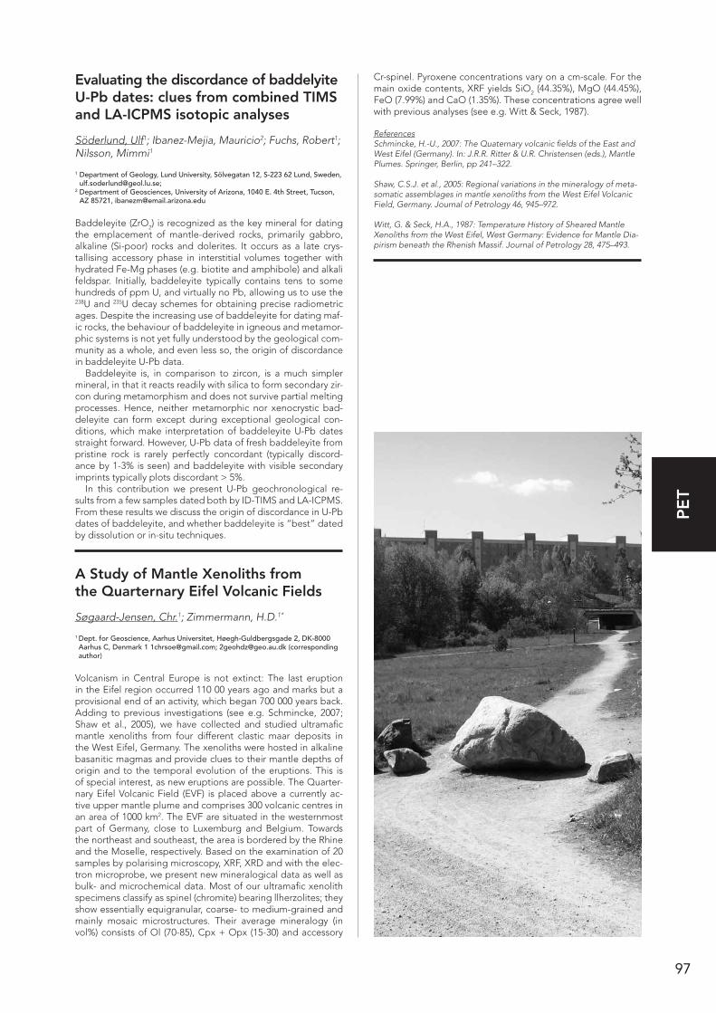
97
PE
T
Evaluating the discordance of baddelyite U-Pb dates: clues from combined TIMS and LA-ICPMS isotopic analyses
Söderlund, Ulf1; Ibanez-Mejia, Mauricio2; Fuchs, Robert1; Nilsson, Mimmi1
1 Department of Geology, Lund University, Sölvegatan 12, S-223 62 Lund, Sweden, [email protected];
2 Department of Geosciences, University of Arizona, 1040 E. 4th Street, Tucson, AZ 85721, [email protected]
Baddeleyite (ZrO2) is recognized as the key mineral for dating the emplacement of mantle-derived rocks, primarily gabbro, alkaline (Si-poor) rocks and dolerites. It occurs as a late crys-tallising accessory phase in interstitial volumes together with hydrated Fe-Mg phases (e.g. biotite and amphibole) and alkali feldspar. Initially, baddeleyite typically contains tens to some hundreds of ppm U, and virtually no Pb, allowing us to use the 238U and 235U decay schemes for obtaining precise radiometric ages. Despite the increasing use of baddeleyite for dating maf-ic rocks, the behaviour of baddeleyite in igneous and metamor-phic systems is not yet fully understood by the geological com-munity as a whole, and even less so, the origin of discordance in baddeleyite U-Pb data.
Baddeleyite is, in comparison to zircon, is a much simpler mineral, in that it reacts readily with silica to form secondary zir-con during metamorphism and does not survive partial melting processes. Hence, neither metamorphic nor xenocrystic bad-deleyite can form except during exceptional geological con-ditions, which make interpretation of baddeleyite U-Pb dates straight forward. However, U-Pb data of fresh baddeleyite from pristine rock is rarely perfectly concordant (typically discord-ance by 1-3% is seen) and baddeleyite with visible secondary imprints typically plots discordant > 5%.
In this contribution we present U-Pb geochronological re-sults from a few samples dated both by ID-TIMS and LA-ICPMS. From these results we discuss the origin of discordance in U-Pb dates of baddeleyite, and whether baddeleyite is “best” dated by dissolution or in-situ techniques.
A Study of Mantle Xenoliths from the Quarternary Eifel Volcanic Fields
Søgaard-Jensen, Chr.1; Zimmermann, H.D.1*
1 Dept. for Geoscience, Aarhus Universitet, Høegh-Guldbergsgade 2, DK-8000 Aarhus C, Denmark 1 [email protected]; [email protected] (corresponding author)
Volcanism in Central Europe is not extinct: The last eruption in the Eifel region occurred 110 00 years ago and marks but a provisional end of an activity, which began 700 000 years back. Adding to previous investigations (see e.g. Schmincke, 2007; Shaw et al., 2005), we have collected and studied ultramafic mantle xenoliths from four different clastic maar deposits in the West Eifel, Germany. The xenoliths were hosted in alkaline basanitic magmas and provide clues to their mantle depths of origin and to the temporal evolution of the eruptions. This is of special interest, as new eruptions are possible. The Quarter-nary Eifel Volcanic Field (EVF) is placed above a currently ac-tive upper mantle plume and comprises 300 volcanic centres in an area of 1000 km2. The EVF are situated in the westernmost part of Germany, close to Luxemburg and Belgium. Towards the northeast and southeast, the area is bordered by the Rhine and the Moselle, respectively. Based on the examination of 20 samples by polarising microscopy, XRF, XRD and with the elec-tron microprobe, we present new mineralogical data as well as bulk- and microchemical data. Most of our ultramafic xenolith specimens classify as spinel (chromite) bearing llherzolites; they show essentially equigranular, coarse- to medium-grained and mainly mosaic microstructures. Their average mineralogy (in vol%) consists of Ol (70-85), Cpx + Opx (15-30) and accessory
Cr-spinel. Pyroxene concentrations vary on a cm-scale. For the main oxide contents, XRF yields SiO2 (44.35%), MgO (44.45%), FeO (7.99%) and CaO (1.35%). These concentrations agree well with previous analyses (see e.g. Witt & Seck, 1987).
ReferencesSchmincke, H.-U., 2007: The Quaternary volcanic fields of the East and West Eifel (Germany). In: J.R.R. Ritter & U.R. Christensen (eds.), Mantle Plumes. Springer, Berlin, pp 241–322.
Shaw, C.S.J. et al., 2005: Regional variations in the mineralogy of meta-somatic assemblages in mantle xenoliths from the West Eifel Volcanic Field, Germany. Journal of Petrology 46, 945–972.
Witt, G. & Seck, H.A., 1987: Temperature History of Sheared Mantle Xenoliths from the West Eifel, West Germany: Evidence for Mantle Dia-pirism beneath the Rhenish Massif. Journal of Petrology 28, 475–493.

98
PE
T
Reproducing interference colors of common minerals combining color theory and optical crystallography
Sørensen, Bjørn Eske1
1 Department of Geology and Mineral Resources Engineering, Norwegian University of Technology and Science, SEM-SEELANDSVEG 1, 7491 Trondheim, Norway; [email protected]
Recent work (Sørensen, 2013) has shown that it is possible to produce Michel Lévy interference color charts from theoreti-cal calculations that matches the inference colors observed in the petrographic microscope. A comparison of the calculated charts with quartz wedge gives a perfect match, documenting that the calculation method works. The improvement in the new chart is not only the reproduction of observed interference color, but also the accurate link between retardation and color, which is significantly different from older charts. This work takes the calculation methods even further and tries to take into ac-count also the effects of dispersion and absorption, giving rise to anomalous interference colors. The charts reproducing the normal interference colors have already been an improvements for the inexperienced students faced with optical mineralogy the first time.
ReferenceSørensen, B.E., 2013:A revised Michel-Lévy interference colour chart based on first-principles calculations. EJM 25, 5–10.
Detailed mapping using aerial photos and automatic rendering of outcrops
Sørensen, Bjørn Eske1; Granseth, Anette Utgården1;
1 Department of Geology and Mineral Resources Engineering, Norway; [email protected]
The mapping of fine-structures is difficult, even with modern GPS-technology. Typical the mapping of for example small-scale shearzones requires the use of manually constructed grids. This is quite time-consuming and does not always allow for easy geo-referencing of the detailed maps. Since 2010, aerial photos with a resolution in the order of 30 cm are available for large parts of Norway. The detail of these photos are easy to com-pare with observations in the field and enables fast navigation. By the use of free software it is possible to auto- contour the outcrops, giving a contour drawing. The drawing is easily used for field mapping, along with a photo showing the outcrops in color, and a smartphone that shows your approximate po-sition in the aerial photo. After mapping the interpreted geol-ogy is easily digitized because the contoured aerial photos are geo-referenced from their source. Construction invlovolves a four step process: 1: Print of images from www.norgeibilder.no to georeferenced PDFs 2: Opening pdf’s in inkscape 3: Auto-contoring and adjusting 4: Printing the contoured and original photos at the same scale.
Fluid controlled infiltration driven retrogression of dry granulite protoliths in the Bamble sector, South Norway – fluid inclusion studies and phase diagram modelling
Sørensen, Bjørn Eske1; Larsen, Rune1
1 Department of Geology and Mineral Resources Engineering, Norwegian University of Technology and Science, SEM-SEELANDSVEG 1, 7491 Trondheim, Norway; [email protected]; [email protected]
This study underlines the importance of fluids in interpreting metamorphic mineral assemblages during infiltration driven retrogression. The position of the equilibria in P-T space varies considerably with changing fluid composition. New informa-tion on the composition of the retrograde fluids in the Bamble sector is derived from fluid inclusion microthermometry. Four fluid inclusion assemblages (FIA1-4) constrained to specific tectono-metamorphic events are defined. Peak metamorphic fluids (FIA1) in partial melts in garnet amphibolite comprise pure CO2, confirming that CO2 was the stable carbonic phase during peak metamorphic conditions. FIA2-4 fluid inclusions document a high salinity averaging 30 wt% throughout cooling and uplift of the Froland area. The saline fluids partially control the retrograde assemblages by shifting hydration reactions to lower temperatures and by activating metamorphic reactions. Accordingly, the previously published PT-path of Froland is reevaluated with PERPLEX modelling: FIA2, first generation of retrograde fluids are observed in quartz in en-echelon quartz veins related to potassic alteration of amphibolite at 626°C and 7 kb and comprise mixed CO2-H2O low salinity fluids and CO2-poor brines with near eutectic composition in NaCl-KCl-H2O system. The total fluid composition for this stage is: XCO2 = 0.30, XH2O=0.62, X(Na,K)Cl = 0.08 (30 wt% NaCl in the aqueous phase). XCO2 decreased with the temperature. FIA3, are brines with 25 wt% NaCl and 6 wt% CaCl2 that formed during uplift at 300 to 400°C during a P-drop from 5-7 kb to 2-3 kb. High puri-ty quartz formed at this stage. Late post-uplift inclusions (FIA4) consist of CaCl2-rich fluids with 31-36 wt% CaCl2 equivalents. A shift from potassic-sodic to sodic-calcic alteration, recorded by a shift from muscovite- to margarite-bearing mica-assemblages is associated with the shift in fluid composition from FIA2 to FIA3. Pseudo-sections constrain PT-conditions of this change to 450-550°C and a minimum P of 4.5 kb.
99
PE
T
3D mapping of lavas: inferences on the structural evolution of the Kap Dalton Graben, Blosseville Kyst, East Greenland
Sørensen, Erik Vest 1; Pedersen, Asger Ken2; Larsen, Lotte Melchior1
1 Geological Survey of Denmark and Greenland, Øster Voldgade 10, DK-1350 Copenhagen K, Denmark; [email protected];
2 Natural History Museum of Denmark, Øster Voldgade 5-7, DK-1350 Copenhagen K, Denmark; [email protected]
During the Palaeogene a c. 65.000 km2 large lava plateau was formed along the Blosseville Kyst, East Greenland, as the result of continental breakup in the vicinity of the ancestral Iceland hotspot. In this study we focus on the post-breakup evolution of the Kap Dalton Area, Central East Greenland. We use ste-reo-images combined with field work to establish the lava stra-tigraphy of the Skrænterne and Igtertivâ Formations on Kap Dalton and to analyse the structure of the area. Lavas of the Igtertivâ Formation were formed at a slow pace, allowing time for erosion of the lava top zones and formation of intra-basal-tic sediments, in an environment that changed from marine to a subaerial environment through time. Structural observations within the graben suggest that the graben evolved asymmetri-cally and that the main part of the graben can be viewed either as a large eroded horst or a block that have moved by strike-slip movement. The graben at Kap Dalton formed after the forma-tion of the Igtertivâ Formation and overlying sediments, pos-sibly in the course of separating Jan Mayen from Greenland.
Simultaneous zircon age & trace element analysis by LA-SF-ICP-MS
Thomsen, T.B.1
1 GEUS, Ø. Voldgade 10, 1350 Cph K., Denmark; [email protected]
Information of both the age and trace elements content in zircons is often requested to get a geological perception of a study area. LA-ICP-MS is regularly used to determine U-Pb ages and trace element contents of the zircons, usually through two separate analysis sessions using the same or different instru-ments, or acquired simultaneously by a split-stream approach. Such approaches typically offer excellent accuracy and preci-sion, however, some studies (e.g. reconnaissance or early stage provenance studies) do not necessarily require the high preci-sion these techniques offer for a robust interpretation. Thus, an approach for simultaneous determination of U-Pb ages and trace elements content in zircons is developed for the Element2 single-collector LA-SF-ICP-MS instrument, offering rapid and cost-effective single spot analyses inter-linking zircon age and trace element content at a moderately reduced accuracy and precision compared to separate session or split-stream analyt-ical approaches.
Using a 25 µm laser spot size, 25 isotopes (Si, P, Ti, Zr, 13 REEs, Hf, Hg202, Mass 204, Pb206, 207, 208, Th232 and U238 were measured on the zircon standards Harvard 91500, Temo-ra-2, Plesovice and A1772 (new std. from GTK, Finland) bracket-ed by the GJ-1 zircon, NIST 612 and BCR-2 standards. Accuracy of 206/238 and 207/235 ages for Plesovice (338 Ma), Temora-2 (416 Ma) and 91500 (1064 Ma) are <3 %RSD on average (10 analyses), and for 207/206 ages the A1776 (2711 Ma) and 91500 show <1 %RSD on average. The 2σ precision of 206/238 and 207/235 ages for all are 2-4 %, and for the 207/206 ages of 91500 and A1776 the precision is <3 %. The 2σ precision and elemen-tal abundance accuracy for element concentrations >0.4 ppm in the NIST-614, BCR-2 and BHVO-2 are generally 5-25 % on average. For element abundances of >1-2 ppm in the zircons that are comparable to reference data, accuracy typically vary 5-30 %RSD and the 2σ precision 5-20 % on average.
Late Cretaceous alkaline volcanism in the High Arctic: Geological and geochemical constraints from the Kap Washington ignimbrites, North Greenland
Thorarinsson, Sigurjon B1; Holm, Paul M2; Duprat, Helene2; Tegner, C3
1 Nordic Volcanological Center, Institute of Earth Sciences, University of Iceland, Askja, Sturlugata 7, 101 Reykjavik, Iceland; [email protected];
2 Department of Geosciences and Natural Resource Management, University of Copenhagen, Øster Voldgade 10, 1350 København K, Denmark; [email protected], [email protected];
3 Department of Geoscience, Aarhus University, Høegh-Guldbergs Gade 2, 8000 Aarhus C, Denmark; [email protected]
The tholeiitic phase of the High Arctic Large Igneous Province was followed by a prolonged phase (85–60 Ma) of alkaline mag-matism. One of the best preserved records of this magmatism is the 71-61 Ma Kap Washington Group (KWG) volcanic sequence of North Greenland. The >5 km thick sequence is bimodal and shows petrological similarities with volcanic sequences of the East African Rift. The sequence has been sampled along four traverses with a combined stratigraphic thickness of ca. 1500 m. The sampled sequence is dominated by silicic ignimbrites show-ing geochemical features typical of ferroan, A-type granitoids and include both peraluminous and peralkaline compositions. The peralkaline ignimbrites classify as comendites and comen-ditic trachytes and have Nd-Pb isotopic compositions (eNd = +4.6–0.1; 206Pb/204Pb = 18.39–18.67; 207Pb/204Pb = 15.545–15.567; 208Pb/204Pb = 38.29–39.30) which overlap with the compositions of KWG alkali basalts, indicating an origin by either fractional crystallisation of basaltic magma or partial melting of juvenile basaltic crust. The most evolved peralkaline ignimbrites can be derived from a mildly peralkaline comendite by up to 50% fractional crystallisation of assemblages dominated by alkali feldspar + quartz. The peraluminous ignimbrites, on the oth-er hand, classify as rhyolites and are characterised by slightly negative eNd (-1.3 to -2.1) and relatively radiogenic 207Pb/204Pb (15.563–15.570) and 208Pb/204Pb (39.16–39.43). Geochemical modelling indicates that they are not cogenetic with the peral-kaline ignimbrites and they are inferred to have originated by partial melting of contaminated, juvenile mafic crust. Variations in Nd-Pb isotopes and trace element ratios, moreover, indicate mixing between peralkaline and peraluminous magma batches.
Plagioclase ultraphyric basalts in the Neogene Austurhorn intrusive com-plex, SE Iceland
Thorarinsson, Sigurjon B1; Tegner, Christian2; Waight, Tod E3
1 Nordic Volcanological Center, Institute of Earth Sciences, University of Iceland, Askja, Sturlugata 7, 101 Reykjavik, Iceland; [email protected];
2 Department of Geoscience, Aarhus University, Høegh-Guldbergs Gade 2, 8000 Aarhus C, Denmark; [email protected];
3 Department of Geosciences and Natural Resource Management, University of Copenhagen, Øster Voldgade 10, 1350 København K, Denmark; [email protected]
The Austurhorn intrusive complex of southeast Iceland repre-sents the exhumed roots of a 6–7 Ma central volcano. A mo-dally layered gabbro, occupies the central part of the complex. The outer part is dominated by granophyre which frequently carries pillow- or sheet-like enclaves of basalt, interpreted to reflect mafic magma intruded into a molten rhyolitic mag-ma chamber. Some of the basaltic pillows are highly plagi-oclase-phyric (20-25%) and carry macrocrysts with cores that are more primitive (An85–75) than overgrowth rims and ground-mass grains (An84–43), indicating disequilibrium with the host melt. The layered gabbro comprises more than 800 m of cpx + plag ± ol ± Fe-Ti oxide cumulates and can be divided into

100
PE
T
at least 8 macrorhythmic units formed by repeated injections of mafic magma. Two distinct populations of high- and low-An plagioclase crystals have also been identifed in the gabbro. The high-An grains are typically 2–4 mm, prismatic to tabular in shape and have bytownite cores (An87-69) abruptly zoned to oligoclase rims (An55–65). The low-An grains (An69-55) are smaller (1–2 mm) and are typically lath-shaped with minor nor-mal and reverse zoning (DAn ≤ 7 mol. %). Core morphologies of both types range from euhedral to extensively rounded or embayed. Modelling indicates that the An-rich grains were not in equilibrium with coexisting clinopyroxene. We suggest that the high-An plagioclase macrocrysts of the basalt pillows and the layered gabbro are two of kind and grew in a deeper, more primtive magma chamber and were carried into the subvolcanic Austurhorn magmatic system during magma recharge events.
Temperature and fluid variations in metamorphic rocks in Nautanen, Gällivare, Sweden
Tollefsen, Elin1; Skelton, Alasdair2; Bergaman, Stefan3; Wanhainen, Christina4
1 Department of Geological Sciences, Stockholm University, 106 91 Stockholm, Sweden; [email protected];
2 Department of Geological Sciences, Stockholm University, 106 91 Stockholm, Sweden; [email protected];
3 Geological Survey of Sweden, P.O. Box 670, SE-751 28 Uppsala, Sweden; [email protected];
4 Department of Civil, Environmental and Natural Resources Engineering, Luleå Technical University, Sweden; [email protected]
This study focuses on the geology of the Nautanen area. It is part of the SGU-financed project, Metamorphic Map of Swe-den, which aims to compile metamorphic data from Sweden and takes the form of a number of Bachelor and Master pro-jects. The main metamorphic event in the Nautanen area is the Svecokarelian orogen (1.96 – 1.75 Ga). The samples are met-amorphosed sedimentary and volcanic rocks, which were sur-rounded by mafic intrusions and a later granite intrusion. The supercrustal rocks are folded and the Nautanen Deformation Zone (NDZ) crosscuts the folded rocks in a NW to SE direction. Petrographic studies, XRF analysis and THERMOCALC were used to estimate pressure and temperature and to elucidate ev-idence of fluid mobility. The average pressure was assumed to be below 400 MPa because of the presence of andalusite. The lowest and highest average temperatures for metamorphism found were 550±7°C and 687±19°C, with highest temperatures recorded nearest to the granite intrusion. XRF analysis revealed high concentrations of Ba (up to 7000 ppm) in the NDZ, on the basis of which we infer fluid mobility along this deformation zone. The increasing temperature towards the granite intrusion suggests a regional or contact prograde metamorphism that need not be related to the NDZ. High concentrations of mo-bile elements (e.g. Ba), skarn formation and and replacement of garnet by chlorite indicates fluid-controlled retrograde met-amorphism in the NDZ.
High T/P metamorphism at 1.45 Ga: P-T evolution and SIMS U-Pb zircon ages of paragneisses from southern-most Sweden
Ulmius, Jan1; Moller, Charlotte1; Andersson, Jenny2
1 Lund University, Department of Geology, Lund, Sweden ([email protected], [email protected]);
2 Geological Survey of Sweden, Uppsala, Sweden ([email protected])
We present the first quantitative P-T estimates on paragneisses from Romeleåsen, in the southernmost Fennoscandian Shield, and demonstrate a clockwise P-T evolution with a metamorphic peak at c. 750°C and 4-5 kbar. SIMS U-Pb zircon ages date this
metamorphism at 1.45 Ga. The rocks are locally associated with granitic injections and intrusions, coeval with the 1.45 Ga meta-morphism. The studied rocks are locally affected by Sveconor-wegian discrete deformation at low grade conditions, typical for the easternmost marginal part of the Sveconorwegian orogen. The 1.45 Ga high-temperature and low-intermediate pressure conditions, and the coeval magmatic association, are in strik-ing contrast to the high-pressure character of the 1.0 Ga met-amorphism of the Sveconorwegian orogeny. Petrography, bulk and mineral geochemistry and pseudosection modelling show that the rocks underwent prograde staurolite-sillimanite grade metamorphism peaking at upper amphibolite to granulite con-ditions, with the formation of Crd + Sill + Grt + K-fsp + Ilm + Melt ± Spl ± Bt. The rocks followed a clockwise P-T path with heating during decompression and partial melting. Later stages involved the formation of sillimanite + biotite at the expense of garnet and cordierite. Local low-temperature and fluid-assisted retrogression caused the formation of chlorite and muscovite at the expense of cordierite and garnet, and pseudomorphism of ilmenite by rutile-rich fine-grained intergrowths. Both granites and paragneisses contain complex zircon grains with inherit-ed 1.7 Ga igneous cores and high-U, low-Th secondary zircon, mainly reworked rims c. 1.45 Ga old. The P-T evolution demon-strates burial and exhumation in a high T/P environment, with coeval granitic magmatism. These conditions are in accordance with an accretionary orogenic setting.
Obsidian Glass: a potential external accuracy reference material for LA ICPMS analysis
Ulrich, Thomas1; Kamber, Balz S.2
1 Aarhus University, Institute for Geoscience, Aarhus, Denmark; 2 Trinity College Dublin, Department of Geology, School of Natural Sciences,
Dublin, Ireland
Assessing the daily performance and accuracy of laser ablation ICPMS analysis is an important part in the quality control pro-tocol. We explored the possibility of using a natural glass to monitor the accuracy of analysis. The potential advantages are that it is widely available, cheap and does not consume valu-able quantification standard materials. We evaluated the ele-ment homogeneity in 6 different obsidian samples and found that apart from the very depleted elements the homogeneity is very good (<8% RSD, using 80µm spot size). Our evaluation of obsidian included the use of two different laser wavelengths (213nm vs. 193nm), different ablation parameters (fluence, rep-etition rates), different external quantification standards (NIST glasses, USGS and MPI-DING glasses), as well as different inter-nal standard elements (44Ca, 23Na, 29Si). Two of the six samples were fully characterized by EPMA and solution ICPMS analysis. Subsequent laser ablation experiments were used to determine the ‘best practise’ for the ablation of obsidian glass. Using NIST 611 and 612 as the external quantification standards, Si as the internal standard element, and fluence between 12 and 18 J/cm2 yielded the best accuracy of the data. In contrast, when less silica-rich external standards (e.g., BHVO-2G, GOR128-G) were used a lower accuracy was achieved. It is obvious from this study that obsidian glass is homogeneous to the extent that it can be used as an external accuracy material. Furthermore, using a very abundant element as the internal standard and a quantification standard with a Si-rich matrix will result in accu-rate and precise data.
101
PE
T
Mantle sources during continental breakup, a geochemical-chronological study of Cretaceous dikes from New Zealand
van der Meer, Quinten H.A1; Waight, Tod E.1; Scott, James M.2; Münker, Carsten3; Storey, Michael4
1 Copenhagen University, Department of Geosciences and Natural Resource Management, Øster Voldgade 10, København 1350, Denmark ([email protected]);
2 Department of Geology, University of Otago, Dunedin 9054, New Zealand; 3 Institut für Geologie & Mineralogie, Universität zu Köln, Zülpicher Strasse 49b,
50674 Köln, Germany; 4 Quaternary Dating Laboratory (QUADLab.dk), Department of Environmental,
Social and Spatial Change, Roskilde University P.O. Box 260, 4000 Roskilde, Denmark
The New Zealand microcontinent (Zealandia) formed as the active margin of Gondwana. Upon cessation of subduction at ~110 Ma, extension led to opening of the Tasman Sea at 82 Ma, preceded by the formation of metamorphic core complex-es, the opening and filling of half-graben structures and the in-trusion of mafic dikes (~88 to 68 Ma). Subsequently, Zealandia has been punctuated by volumetrically minor, intermittent yet widespread intraplate magmatism. This intraplate magmatism has typical OIB-like trace element abundances and radiogenic isotope compositions that trend towards a HIMU mantle com-position that has also been found in the spinel facies lithospher-ic mantle. The current study focuses on the chemistry and age of breakup related dikes.
Dikes were selected and sampled in the Western Province of the South Island, a region close to location of the Tasman Sea opening. Selected samples are analysed for whole rock major and trace elements as well as Sr-Nd-Pb-Hf isotopes. Addition-ally a subset of dikes is dated by 40Ar/39Ar in kaersutite mineral separates.
New geochemical and isotopic analyses suggest the Creta-ceous dike swarms also have an OIB-like chemistry. Initial Pb isotopic compositions of the dikes however are more similar to Pacific MORB. Intrusion of dikes spans an age range from 88 to 68 Ma. The younger dikes may represent a separate generation.It is possible that the HIMU-like component in Zealandia is a result of trace element enrichment (with high U/Pb and Th/Pb) of a depleted mantle melt region in the Cretaceous. This source has remained stable beneath Zealandia while Pb ingrowth pro-ceeded rapidly in U-Th rich domains. The introduced Pb was not very radiogenic. The ‘HIMU-like’ component in NZ in-traplate magmatism does not appear to be directly related to the classical ocean island HIMU source. Lithospheric peridotite mantle is a potential source for the intraplate basalts but re-quires additional melt in equilibrium with garnet.
A new insight to A-type granites and ultra-K rocks from hard-soft acid-base (HSAB) and density functional theory (DFT) concepts
Vigneresse, Jean-Louis1
1 Université de Lorraine, GéoRessources UMR 7359, 54501 Vandoeuvre Cédex, France, [email protected]
Alkaline rocks, from A-type granites, K-rich and ultra-K rocks, anorthosites and rapakivi granites, carbonatites and kimber-lites are widely present in the northern East European Craton. Intrusion periods range from 2.5, 1.8, 1.5, 1.2 and 0.380-0.300 Ga. Their origin is still debated since the latest orogenic cycles over the whole region end at about 1.7 Ga. A new insight to those rocks is presented through hard-soft acid-base (HSAB) and density function theory (DFT) concepts widely used in mod-ern chemistry. They look at chemical reactions from the point
of view of electronic clouds with charge exchange possibilities, providing four descriptors and some principles of reactivity. They are based on the first and second derivatives of the en-ergy when one charge is changed on the element, thus fitting to the chemical potential definition, and its derivative. Com-puting such descriptors for K-rich magmas points to reaction paths involving a mantle (upper mantle or OIB) participation. The classification of such magmas offers new insights on their origin. It also poses some problems regarding the successive occurrences of such a-typical magmatism in more or less sta-bilized cratons. Identifying the possible trails leading to better understand the formation, evolution and destruction of a craton could be a challenge for the upcoming years.
For richer and poorer: depletion and enrichment in sub-continental litho-spheric mantle xenoliths from southern Zealandia
Waight, Tod E.1; Scott, James M.2; van der Meer, Quinten H.A.1; Münker, Carsten3
1 Department of Geosciences and Natural Resource Management, Copenhagen University, Øster Voldgade 10, Copenhagen 1350, Denmark ([email protected]);
2 Department of Geology, University of Otago, Dunedin 9054, New Zealand; 3 Institut für Geologie und Mineralogie, University of Cologne, Cologne 50674,
Germany
New Zealand continental crust has a simple and young history, and the oldest exposed rocks are Cambrian in age. However, xenoliths of the subcontinental lithospheric mantle (SCLM) in Eocene-Miocene intra-plate alkaline volcanics yield Re model ages that indicate ancient depletion and a history that is decou-pled from the overlying crust (McCoy-West et al. 2013).
Laser ablation trace element data and radiogenic isotope compositions have been determined for a suite of clinopyrox-ene separates from spinel peridotite xenoliths from southern New Zealand. Isotope compositions predominantly overlap with those of the host volcanics, especially with respect to Pb isotopic compositions, suggesting that the HIMU-like signature of the volcanics is also present in the SCLM. However, some samples extend to more depleted compositions and point to a depletion history not evident in the overlying crust.
Three groups of xenoliths can be identified. Group 1 has rare earth element (REE) signatures indicative of high degrees of de-pletion and subsequent metasomatism, i.e. generally depleted patterns but enrichments in the lightest REE. Isotopic compo-sitions of group 1 are consistent with ancient depletion (0.5-2.0 Ga) coupled with relatively ancient metasomatism. Group 2 has trace element compositions consistent with moderate degrees of depletion and no evidence for subsequent metasomatism. Isotopic compositions for group 2 suggest that depletion is not modern but occurred at some point in the Phanerozoic. Group 3 has REE compositions indicative of moderate to small degrees of depletion and relatively large amounts of subsequent meta-somatism. The isotopic signatures of these samples represent either relatively recent depletion and metasomatism, or gen-erally large degrees of metasomatism that swamp potentially ancient depleted signatures and thus preclude distinguishing between ancient or recent depletion and metasomatism. No single metasomatising component can explain the observed REE patterns and some samples are best modeled using a low-degree silicate melt as the metasomatising agent, whereas others require a carbonatitic fluid.
ReferenceMcCoy-West et al., 2013: Geology 41, 231–234.
102
PE
T
Evidence for mid-Proterozoic crustal reworking in southern Scandanavia from Hf isotopes in zircon from Bornholm.
Waight, Tod1
1 Copenhagen University, Department of Geoscience and Natural Resource Management, Copenhagen, Denmark
U-Pb dating of zircons from the granitoids and granitic gneisses making up the basement of the Danish island of Borrnholm has shown that these magmas were generated and emplaced over a relatively restricted period in the mid-Proterozoic (1455 ± 10 Ma) (e.g. Waight et al. 2012). Similar granitoids occur in South-ern Sweden and Lithuanian and represent a pulse of magma-tism linked to the Danopolonian orogeny.
Hf isotopes in zircon from seven samples have been deter-mined by LA-MC-ICPMS and, combined with whole rock trace element compositions and Nd isotope analyses, are used to provide constraints on the origin and sources of these grani-toids. The zircons have εHf ranging from +5 to -4 (average = 0.5 ± 3 (2 sd)) and two-stage model ages that are relatively restricted at 2.3 ± 0.2 Ga. Inherited zircons are relatively rare and have Hf isotopic compositions that project back towards more mantle-like compositions. Whole rock Nd isotope com-positions cluster at εNd = 0 with TDM ranging between 1.7 and 2.0 Ga. Trace element compositions are similar for gneisses and granitoids and show a distinct within plate granite signature. The results agree well with other Hf in zircon studies in south-ern Scandinavia (e.g. Petersson et al. in press) and suggest that the granitoids and gneisses predominantly represent reworking and melting of Svecofennian crust with little new juvenile input. Inherited zircons are rare and do not have Archaean crustal Hf signatures, indicated that old crustal components did not play a significant role. The restricted pulse of within plate magmatism is linked to the Danopolonian orogeny which may represent a period of intraplate shearing, extension and associated crustal melting.
References Petersson et al. (in press): Zircon U–Pb and Hf – isotopes from the eastern part of the Sveconorwegian Orogen, SW Sweden: implications for the growth of Fennoscandia. Geological Society, London, Special Publications 389.
Waight et al., 2012: Geochronological constraints on granitic mag-matism, metamorphism, cooling and uplift on Bornholm, Denmark. Bulletin of the Geological Society of Denmark 60, 23–46.
Linking age to stage? Progress and pitfalls in dating metamorphic cycles
Warren, Clare1; McDonald, Christopher1; Mottram, Catherine1; Regis, Daniele1
1 Department of Environment, Earth and Ecosystems, The Open University, Milton Keynes MK7 6AA, UK; [email protected]
Mountains form where tectonic plates collide, and the rates and timescales over which crust is buried, transformed, deformed and recycled in these collision zones informs our understanding of crustal (re)cycling processes. Recent advances in analytical capability mean that geochronologists are now able to measure the dates recorded by geochronometers with increasingly pre-cision. Recent data collected via in-situ techniques commonly yield a protracted range of dates rather than a single age. The data therefore suggest that geochronometers may record pro-tracted crystallization over a range of PT conditions rather than a specific ‘event’. The difficulty lies in linking geochronometer crystallization or cooling dates to the precise PT evolution of the host rock. Here we present new insights into the interpre-tation of metamorphic crystallization (U-Pb) and cooling (Ar/Ar) ages. Trace element data of major and accessory phases
are important for fingerprinting accessory phase crystallization reactions. Modelling different cooling path shapes helps to im-prove interpretation of the Ar/Ar ages. Together the new data help provide precise and reliable rates and timescales of met-amorphic cycles.
Crystallographic and spectroscopic analysis of zoisite
Weis, Franz1,2; Lazor, Peter2; Skogby, Henrik1
1 Naturhisotriska Riksmuseet, SE-114 18 Stockholm, Sweden; [email protected], [email protected];
2 Uppsala University, SE-75236 Uppsala, Sweden; [email protected]
The quantification of water or hydrogen in nominally anhy-drous silicate minerals by means of Raman and IR-spectrosco-py requires the use of well-defined standards and calibrations. Suitable as standards are for example hydrous minerals whose water content has been precisely determined. We present new crystallographic and spectroscopic data of a gem quality crystal of the hydrous silicate mineral zoisite (Ca2Al3Si3O12(OH)) of which the water content was previously determined to be 2.01 wt %, indistinguishable from the theoretical stoichiometric value of 1.98 wt % (cf. O’Leary et al. 2007). Raman- and Infra-red-spectroscopy have been conducted on the zoisite crystal whose crystallographic orientation was ascertained by Laue x-ray diffraction and crystal habits such as cleavage. The IR- and Raman-spectra were compared, OH-peaks identified and Ra-man active modes assigned to individual peaks after rotation of the crystallographic axes. IR spectroscopy of zoisite powder revealed OH-bands in the range 3000 - 3250 cm-1 with a strong peak at 3152 cm-1 (cf. Winkler et al. 1989). Raman spectroscopy of a smaller single crystal shows the same range and behavior of the peaks when analyzed with vertically polarized light along the C-axis plus an additional strong peak at 3500 cm-1 when measured along the B-axis. The precise identification of the OH-bands and their intensity on the Raman spectra together with the known water content of the mineral make the crystal perfect as a standard material for external calibration during studies on water identification in minerals.
References O’Leary, J. A., Rossman, G. R. & Eiler, J. M., 2007: Hydrogen analysis in minerals by continuous-flow mass spectrometry. American Mineralogist 92, 1990–1997.
Winkler, B.; Langer, K. & Johannsen, P. G., 1989: The Influence of Pres-sure on the OH Valence Vibration of Zoisite - An Infrared Spectroscopic Study. Physics and Chemistry of Minerals16, 668–671.
Fluid-induced mineral composition adjustments of Alpine stilbite
Weisenberger, Tobias Björn1; Bucher, Kurt2
1 Department of Geosciences, University of Oulu, P.O. Box 3000, 90014 University of Oulu, Oulu, Finland; [email protected];
2 Institute of Earth and Environmental Sciences, Albert-Ludwigs-University, Albert-strasse 23b, 79104 Freiburg, Germany; [email protected]
Typical methods used in petrology for deducing pressure and temperature conditions are based on the assumption of pre-served and locked equilibria that can be deciphered by equi-librium thermodynamics. A key condition for the success of thermobarometric methods is that minerals once formed at elevated temperature and pressure perfectly preserves their original composition. Stilbite is locally present as very late min-eral on fractures and fissures of granitic basement in the Cen-tral Swiss Alps. Subsurface stilbite samples from the Gotthard rail base tunnel provide evidence that they originally formed as a K-absent variety at depth. However, all stilbite samples from surface outcrops above the tunnel display significant potassium
103
PE
T
concentrations. Water from fractures in the tunnel (at 50 °C) is oversaturated with respect to stilbite and essentially potassi-um-free. In contrast waters from high-Alpine brooks above the tunnel have unusually high K/Na ratios. The data suggest that stilbite that forms on fissures at tunnel level as a K-absent va-riety. Those stilbite minerals were gradually exhumed, uplifted and finally reached the today’s erosion surface. However, the stilbite reaches the erosion surface as a K-rich variety as a result of interaction of the original K-absent stilbite with surface water and near-surface groundwater. This leads to the conclusion that minerals once formed at depth may significantly change their composition once they reach the ground water zone on their way to the erosion surface (Bucher and Weisenberger 2013). In the case of the stilbite, if surface outcrops would have been the only source of samples and data, the K-rich composition could have been mistaken for the composition of the mineral when it formed, which is not the case. Late-stage compositional read-justments may be difficult to discern in samples from surface outcrops.
ReferenceBucher K. & Weisenberger T.B., 2013: Fluid induced mineral compo-sition adjustments during exhumation: The case of Alpine stilbite. Contributions to Mineralogy and Petrology 166, 1489-1503.
Hydrothermal phonolite alteration in the Kaiserstuhl Volcanic Complex, Germany
Weisenberger, Tobias B.1; Spürgin, Simon2
1 Department of Geosciences, University of Oulu, P.O. Box 3000, 90014 University of Oulu, Oulu, Finland; [email protected];
2 Hans G. Hauri Mineralstoffwerke, Bötzingen, Germany; [email protected]
The subvolcanic Fohberg and Endhale phonolitic intrusions in the Kaiserstuhl volcanic complex in SW Germany are economic zeolite deposits, formed by hydrothermal alteration of primary magmatic minerals. Due to the high (>40 wt%) zeolite content, which accounts for the remarkable zeolitic physicochemical properties of the ground rock, the zeolitized phonolites are in economic interest.
New mineralogical and geochemical studies are carried out a) to evaluate the manifestation of hydrothermal alteration of the Fohberg and Endhale phonolitic intrusions, and b) to con-strain the physical and chemical properties of the fluids, which promoted hydrothermal replacement of primary igneous min-erals.
The alkaline intrusive bodies are characterized by the prima-ry mineralogy: feldspathoid mineral, K-feldspar, aegirine-au-gite, wollastonite, and andradite. The REE-phase götzenite is formed during late stage magmatic crystallization. Fluid-in-duced re-equilibration of feldspathoid minerals and wollas-tonite caused breakdown to a set of secondary phases. Feld-spathoid minerals are totally replaced by secondary phases including various zeolite species, calcite, and barite. Wollas-tonite breakdown results in the formation of various zeolites, calcite, pectolite, sepiolite, and quartz. The large variability of secondary minerals indicates a heterogenic fluid composition throughout the phonolitic intrusions and through time. Zeolites formed during sub-solidus hydrothermal alteration under alka-line conditions and completely replace feldspathoid minerals in the matrix of the rock. A sequence of Ca-Na dominated zeolite species (gonnardite, thomsonite, mesolite) is followed by pure sodium endmember species. The sequence reflects an increase in log[aNa+)/(aH+)] of the precipitating fluid. The Fohberg pho-nolite is cut by fractures, which are totally or partially sealed with secondary minerals. Secondary minerals contain zeolites, followed by calcite and a variety of other silicates, carbonates and sulphates as younger generations. Stable isotope analyses of late fracture calcite indicate the late circulation of meteoric fluids and mobilization of organic matter from surrounding sed-imentary units.
Current Challenges in Laser Ablation ICP-MS
Zack, Thomas1,*; Hogmalm, Johan1; Tillberg, Mikael1
1 Department of Earth Sciences, University of Gothenburg, Sweden, * [email protected]
Impressive advancement has been made in recent years in the field of laser ablation (LA)-ICP-MS, in particular in terms of in-creasing sensitivities (e.g., addition of nitrogen to carrier gas, stronger vacuum pumps) and reducing fractionation during the ablation process. In this contribution, we would like to draw at-tention to two more topics where progress can open up new geological applications:
Control of volatile elements: Several volatile elements (e.g., Cl, Br, I, Hg) are readily ionized in the ICP, enriched in numerous minerals and of considerable geologic interest. However, quan-tification is particularly limited by a lack of well-characterized standards, high background signals and signal increase during ablation of volatile-free materials. We are attempting to over-come these problems by identifying standards with sufficient concentrations of the above-mentioned elements, evaluating cleaning procedures and understanding the process behind the background signal increase during ablation. Those techni-cal advancements help a) supporting studies on halogen frac-tionation during hydrothermal processes and b) increasing the reliability of U/Pb dating.
Quantification without internal standards: Generally, different ablation behavior of different materials requires normalizing the measured signal to one known element, either by assum-ing average values (that have a certain amount of uncertainty) or taking electron microprobe data from the same spot (costly and time-consuming). Alternatively, we are developing meth-odologies calculating the concentration of an internal standard by measuring all crucial elements in a single LA-ICP-MS analysis so that results can be normalized to 100%. Agreement within 15% can be achieved between known electron microprobe and LA-ICP-MS data for rutile, apatite and a range of sulphides (see Tillberg et al., this session).
104
STR
-TE
C
Terranes within the Arctic Caledonides and their constraints on Early Paleozoic orogenic evolution
Andresen, Arild1; Agyei-Dwarko, Nana Yaw Nana; Steltenpohl, Mark G.; Augland, Lars E.
1 Department of Geosciences, University of Oslo, [email protected]
Recent geochronological data on igneous rocks and metased-imentary sequences from different segments (East Greenland, Svalbard and Scandinavia) of the Caledonides makes it possible to propose new tectonic models for the evolution of the Arctic Caledonides. (1) TIMS U-Pb zircon data from Liverpool Land (East Greenland) indicate an exotic, most likely Baltican, origin for the Liverpool Eclogite Terrane. (2) Most of the ortho- and para-gneisses N of Bodø are not a western extension of the Fennoscandian Shield but represents a Late Mesoproterozo-ic to Early Neoproterozoic supracrustal sequence intruded by late- to post- Grenvillian plutons (c 950 Ma) belonging to the uppermost thrust sheet. Comparable units are found in the East Greenland Caledonides and a Laurentian origin is inferred. (3) Probability plots of detrital zircon ages from the Late Ne-oproterozoic - Early Cambrian Dividal Group in Finnmark and Troms indicate a northerly source area (Timanides). Similarities between these probability plots and TIMS ages and probability plots from sedimentary sequences of the Kalak Nappe Com-plex indicate a derivation of the latter from the Timanides - not the western margin of Baltica. (4) Preliminary age data on detri-tal zircons present in the tectonically overlying nappes in Troms and Nordland indicates a link to Laurentia rather than Baltica in the Early Paleozoic. (5) New data from the western terranes of Svalbard, located west of the Laurentian-derived terranes of Nordaustlandet, indicate a mix of terranes derived from both the Timanides and the East Greenland Caledonides. A signif-icant component of strike-slip displacement best explains the terrane distribution seen in Svalbard today.
Extension versus contraction in the East Greenland Caledonides
Andresen, Arild1; Hauge, Kristina1; Gasser, Deta2 1 Department of Geosciences, University of Oslo, [email protected]; 2 Geological Survey of Norway, Trondheim
Structural and geochronological studies the last 20 years have documented that the East Greenland Caledonides have been affected by contractional deformation and westward translation of Early Proterozoic Laurentian basement rocks and their Late Mesozoic to Silurian cover sequences onto the foreland prior to “late orogenic” extension. A controversial issue has been to what extent extensional faults, like the Fjord Region Detach-ment, represents reactivated thrusts or not. Also the time of thrusting and extension has been a matter of debate. In this contribution we present structural observations and PT-data from the hanging wall and the foot-wall of a segment of the Fjord Region Detachment where it has been argued that top-to-the-west thrusting preceeded top-to-the-east extension. Structural data demonstrate complex polyphasal deformation of the Late Mesoproterozoic supracrustal rocks both below and above the Fjord Region Detachment. Shear-sense indicators in
the shear zone itself, developed during decreasing PT condi-tion (from ductile to brittle conditions), demonstrate only top-to-the-east displacement of the hanging wall. It is furthermore shown that the migmatized hanging wall rocks have been sub-jected to peak metamorphic conditions at pressure (8–9.5 Kb) lower than that found in the footwall (12.5 –15 Kb). PT-data across the Fjord Region Detachment support thus only crustal extension only.
Ordovician sediments sandwiched between Proterozoic basement slivers in the southern part of the Siljan Ring, central Sweden
Arslan, Arzu1; Lehnert, Oliver2,3; Guido Meinhold4
1 Midland Valley Exploration Ltd, 144 West George Street, G22HG Glasgow, United Kingdom; [email protected];
2 GeoZentrum Nordbayern, Universität Erlangen, Schloßgarten 5, 91054 Erlan-gen, Germany; [email protected];
3 Department of Geology, Lund University, Sölvegatan 12, 22362 Lund, Sweden; 4 Geowissenschaftliches Zentrum der Universität Göttingen, Abteilung Sedimen-
tologie/Umweltgeologie, Goldschmidtstraβe 3, 37077 Göttingen, Germany; [email protected]
The Siljan ring structure (‘Siljan Ring’) in central Sweden was formed around the central uplift of a Late Devonian meteor-ite crater. It is a prime example where impact-induced heat and hydrothermal circulation had an effect on the generation of hydrocarbons and ore deposits. In 2011, the Stumsnäs 1 borehole was drilled in the southern part of the ‘Siljan Ring’ by a private Swedish company (AB Igrene) for exploration of natural gas and geothermal energy reservoirs. The Stumsnäs 1 drill core represents a structurally complex section and records evidence for hydrothermal activity along the impact-induced fracture networks. The core section reveals that about 90 m of Lower to Upper Ordovician sedimentary rocks are sandwiched between Proterozoic igneous basement rocks. The sedimenta-ry contact to the underlying Proterozoic basement (more than 260 m recovered by the drilling) is a prominent unconformity. The contact to the overlying ca. 190 m thick slab of Proterozoic basement is a few meters wide complex fault zone. The tectonic emplacement of the Proterozoic basement over the Palaeozoic sediments is apparently impact related and caused folding and faulting of the underlying sediments. Minor fault zones occur throughout the Stumsnäs 1 drill core and have large damage zones with intense fracture networks. Small-scale faults and fractures are critical for fluid migration and hence for ongoing exploration for natural gas and geothermal energy reservoirs in the Siljan impact structure.
Elements of the structural evolution at Kiirunavaara, northernmost Sweden
Berglund, Johan1; Andersson, Ulf B.2
1 Vattenfall R&D, Rock & Civil Engineering Box 475, 401 27 Göteborg, [email protected];
2 LKAB, R&D, TFG, 981 86 Kiruna, [email protected]
The Kiirunavaara apatite-iron oxide ore forms a 4-5 km con-tinuous to discontinuous irregular layer, with several minor parallel layers, of highly variable thickness (0-c. 200 m) within
STR-TEC Structural geology/tectonics
105
STR
-TE
C
a sequence of volcanic-subvolcanic rocks, and is crosscut by diabase, granophyre and porphyry dykes. Apparent offsets of the ore contact have traditionally been interpreted as faults. Ex-tensive clay alteration is developed discontinuously in the foot and hanging walls, close to the ore. Ductile deformation is re-stricted to narrow zones in the immediate proximity to the ore. All lithologies at Kiirunavaara are cut by extensive sets of brittle to brittle-ductile joints and faults. At least two fractures sets are developed at high angle to the ore, often with extensive fill-ing of mainly carbonates, sulphates and sulphides. Irregularly shaped natural cavities with sizes up to 10:s of m are present in the ore and wall rocks, often following this structural direction or parallel to the ore. Fractures striking along the ore tend to show evidence of movement, more often than the perpendicu-lar ones, along dominantly subhorizontal fault lines. These also typically show greater lateral extent and have been observed to cut early clay formation. Late porous and cataclastic zones are not observed to be cut by brittle structures and are clay altered. Interpretations: Immediately following emplacement of the fluid-rich ore magma local ductile deformation occurred along its contacts; expelled magmatic fluids caused extensive altera-tion, including clay formation. Fracture sets and cavities at high angle to the ore developed in conjunction with contraction of the crystallizing magma. Brittle and brittle-ductile faults, mainly ore-parallel, accommodated rotational strain in response to ex-ternal tectonic forces and facilitated the uplift of the magmat-ic layers to their present position, dipping c. 60°E. Continued strike-slip shearing (predominantly dextral) along the ore strike, is revealed on discrete, extensive, slickensided fault planes across the ore body and nearby country rocks. Late porous and cataclastic zones overprinted the brittle structures. No regional metamorphic overprint is observed.
The case for a mid-crustal channel flow during the Sveconorwegian orogeny?
Bingen, Bernard1; Viola, Giulio1,2; Yi, Keewook3; Engvik, Ane1
1 Geological Survey of Norway, 7491 Trondheim, Norway; [email protected]; [email protected];
2 Norwegian University of Science and Technology, 7491 Trondheim, Norway; [email protected];
3 Korea Basic Science Institute, 363-883 Chungbuk, South Korea; [email protected]
The Sveconorwegian orogen is traditionally interpreted as product of a collision between Baltica and another major plate at the end of the Mesoproterozoic. It is built on Mesoprotero-zoic crust younging towards the west. The orogeny followed 1200-1130 Ma within-plate magmatism in the west. HP met-amorphic rocks are only recorded in the east of the orogen. These observations suggest an already warm lithosphere at the onset of orogeny, warmer toward the west. The main orogenic phase started at c. 1050 Ma. In the Idefjorden terrane in the east, HP granulite-facies mafic boudins and kyanite gneisses locally record conditions of c. 930°C - 1.3 GPa at c. 1050 Ma. HP granulite facies conditions were followed by widespread LP amphibolite-facies partial melting in association with top-to-the-west transport. Leucosomes resulting from muscovite-, biotite- and amphibole- dehydration melting range in age from 1039 ±17 to 997 ±16 Ma. In the centre of the orogen, the low-grade Telemark supracrustals may belong to a shallow orogenic lid, characterized by deposition of immature sediments in ac-tive grabens (e.g. Eidsborg & Kalhovde Fm <1065 Ma). In the west of the orogen, in Rogaland-Vest Agder, the crust exhibits a stratified structure. Low grade supracrustal rocks are underlain by 1050-1020 Ma syn-collisional I-type granite plutons of the Feda and Sirdal suites, themselves in turn underlain by a granu-lite-facies crustal domain with LP-UHT metamorphism peaking at c. 1006 Ma. The orogenic architecture west of the “Mylonite zone” suggests to us development of a mid-crustal west-direct-ed channel flow, activated after c. 1050 Ma. The orogen was hot and probably associated with a slowly eroding orogenic plateau. Lack of foreland basins east of the orogen is consist-
ent with west directed flow. After 1000 Ma, the Sveconorwegian orogeny propagated eastwards, leading to eclogite-facies met-amorphism in the Eastern Segment. Convergence was followed by gravitational collapse after c. 970 Ma.
The origin of allochtonous terranes of the North American Cordillera: the Aptian-Eocene movements
Bjaerke, Tor
Consultant, Storgaten 47, Stavern, Norway; e-mail:[email protected]
By the Aptian (120 Ma), all the far-travelled terranes of the North American Cordillera were situated within one structural zone, between eastern Austral-Antarctica and the Canadian-Euro-pean-Siberian margin. During the Aptian, Albian and ?early Cenomanian, Austral-Antarctica rotated away from the Cana-dian-European-Siberian margin together with a “northern” structural zone including Arctic Alaska, Chukotka, Anadyr-Ko-ryak-Kamchatka, Sakhalin, Sikhote Alin, and Japan (partly left behind as a freelying zone) and the Cordilleran units, which remained closely attached to Austral-Antarctica (118-102 Ma). Compression was created between western Antarctica and the northern part of the Cordilleran margin during the Late Albian (app. 108-102 Ma).
In the early Campanian (app.80 Ma), Austral-Antarctica moved “south”, the far-travelled Cordilleran elements still at-tached to its eastern margin, reaching a “southernmost” po-sition in the earliest Maastrichtian (app.70 Ma). During this movement, pericratonic elements of the Cordillera were forced out from the North American margin and left as a freelying arc. During the Maastrichtian (70-66 Ma), Austral-Antarctica rotated back towards the “northeast”, the pericratonic structural zone and the exotic terranes all being amalgamated with the North American margin.
During the Paleocene-earliest Eocene (60-53 Ma), North America rotated “northwest” creating the Alaskan orocline, fragmentation of the western structural zone etc.A series of maps based on the Bjaerke Continental Drift hy-pothesis, will be presented, showing the formation of the North American Cordillera along these lines.
Trans-Baltic Precambrian correlations: highlights
Bogdanova, Svetlana V.1
1 Department of Geology, Lund University, Sölvegatan 12, Sweden; [email protected]
Recent study of the Paleoproterozoic crust of the East Europe-an Craton (EEC) in Belarus, Estonia, Latvia, Lithuania, Poland and Russia has demonstrated that:
• The South Baltic (SB) alternating granulite- and amphi-bolite facies belts, which comprise various terranes with crustal ages between 2.0 and 1.85 Ga, have counterparts in the Baltic/Fennoscandian Shield on the opposite side of the Baltic Sea in Finland and Sweden.
• The “thick-skinned” crustal structure of the SB belts developed finally at 1.75-1.70 Ga during oblique collision of the Fennoscandian terranes with Volgo-Sarmatia when the EEC was assembled.
• The rigid Karelian and Sarmatian Archean protocratons acted as indentors defining the tectonic pattern of the SB collisional belts.
• Postcollisional extension led to the exhumation of the lower-crustal granulite belts. This extension and tecton-ic block rotations between 1.80 and 1.70 Ga initiated

106
STR
-TE
C
mantle underplating, melting of the lower crust, AMCG magmatism and HT/LP granulite metamorphism along the Fennoscandia-(Volgo-)Sarmatia suture.
• In the west, the Polish-Lithuanian terrane had much in common with the development of the 1.85-1.75 Ga active margin of southern Fennoscandia.
• The 1.70-1.55 Ga evolution of the SB crust was marked by episodic magmatism and high-grade metamorphism as far-field effects of the Gothian orogeny.
• The Danopolonian orogeny between 1.54 and 1.44 Ga affected the western EEC (Baltica) as far as 1 000 km from its present edge. It was accommodated within wide EW and NW linked zones of deformation featuring extension at 1.54-1.50 Ga and compression at ca. 1.45 Ga caused by flat-slab subduction along the Laurentia-Baltica margin of supercontinent Columbia/Nuna.
Field Relationships, Petrography and Geochemistry of Proterozoic Dyke Swarms in the Umivik Area, SE Greenland
Bothma, Riaan; Klausen, Martin, B.1
1 Department of Earth Sciences, Stellenbosch University, Private bag X1, Matie-land 7602, RSA; [email protected], [email protected]
Two roughly E-W trending Proterozoic dyke swarms cut across the Umivik area of Southeast Greenland. This presentation fo-cuses on a dense set of (1) older amphibolitized ENE-WSW, and (2) more doleritic E-W trending mafic dykes, which roughly parallel and span a poorly defined boundary zone between the southern Archaean North Atlantic Craton and the 1900-1680 Ma Nagssugtoqidian Orogen. A more detailed dyke map shows that more E-W dolerites concentrate in the southern part of the area whereas ENE-WSW amphibolites concentrate towards the north. This, however, does not just reflect their positions relative to the Orogen, because there are many cross cutting relation-ships of E-W trending dolerites consistently cutting more ENE-WSW trending amphibolites. The dolerites have ophitic to ne-sophitic textures whereas the amphibolites are porphyroblastic. Norm calculations are similar to modal proportions except for additional olivine and apatite. As most amphiboles appear to be metamorphic, increasing normative and petrographically estimated hornblende proportions, from south to north across both swarms, are consistent with an expected increase in met-amorphic grade on approaching the Orogen. Major element plots against Mg# indicate clinopyroxene and plagioclase frac-tionation in the doleritic E-W swarm, while the bulk fraction-ating assemblage is inconclusive for the amphibolites. Spider diagram patterns show LILE/HFSE enrichment, with large pos-itive Pb and negative Nb-Ta anomalies for both dyke swarms which are typical arc signatures. We do not think the ENE-WSW swarm was emplaced along a continental arc margin, however, because these were located too far apart. Instead, the swarm may have been emplaced in a back-arc related (or older unre-lated) rift setting, which in either case was deformed and meta-morphosed during the continent-continent collisional stage of the Nagssugtoqidian Orogen. The doleritic E-W swarm, on the other hand, intruded along some post-orogenic rift, but prior to a cross cutting 1630 Ma dyke swarm, so its arc signatures are more likely due to a lithospheric mantle source component and/or crustal contamination.
The Karlskrona Deformation Zone and Eringsboda granitic pluton: magmatism and deformation during the Dano- polonian Orogeny
Čečys, Audrius1
1 Department of Geology and Mineralogy, Vilnius University, Lithuania; [email protected]
The ca. 1.45 Ga magmatic-tectonic events of the Danopolonian orogeny left clear traces in southernmost Sweden. There, the rather well-known Småland-Blekinge Deformation Zone (SBDZ) meets the quite recently discovered and still poorly-known Karl-skrona Deformation Zone (KDZ). The conjunction point of these two is concealed by the ca. 1.46 Ga Eringsboda pluton. This pluton is a twin with the neighboring ca. 1.45 Ga Karlshamn plu-ton, both of elliptical shape, size of 20x30 km and composition of mega-porphyritic granites. The Eringsboda pluton shows lit-tle solid-state deformation.
The magnetic anomaly map (SGU) shows that the SE-NW striking KDZ affects the SW part of the Eringboda massif. The EW-trending SBDZ also affects the SE rim of the pluton. In this study, anisotropy of magnetic susceptibility tool was used to reveal foliation pattern in the Eringsboda pluton. In the “unaf-fected” NE part of the pluton, the pattern is typical for growth of granitic bodies within non-compressive environment. In the “affected” part, magnetic foliations form an anastomosing pat-tern parallel to the KDZ and parallel to the SBDZ in its proximity.In conclusion, both deformation zones were active, probable eased intrusion and affected the geometry of the Eringsboda pluton. Since the magnetic foliations within the KDZ and SBDZ are not marked by solid state foliations, it may be implied that both deformation zones were active during ca. 1.46 Ga Danop-olonian event but not later.
This is a contribution to the project “Precambrian rock provinces and active tectonic boundaries across the Baltic Sea and in adjacent areas” of the Visby Programme (the Swedish Institute).
The Vaasa Dome: an in-situ magmatic dome?
Chopin, Francis1; Korja, Annakaisa1; Hölttä, Pentti2
1 University of Helsinki, Department of Geoscience and Geography, Institute of Seismology, Helsinki, Finland;
2 Geological Survey of Finland, Espoo, Finland
This study focuses on the tectonometamorphic evolution of the Vaasa dome (Svecofennian orogen) Finland). It is cored by di-atexites and granitoids and gradually mantled by supracrustal rocks made of biotite-plagioclase schists and gneisses derived from pelites and greywackes with thin metabasite-andesite intercalations. In this metamorphic belt, the grade increases towards the core of the dome from medium-temperature am-phibolite facies to low-temperature granulite facies probably at similar pressure. The age of the derived pelites and greywackes sequence is 1.90–1.92 Ga, with a regional peak metamorphism bracketed at 1.89–1.85 Ga. Geochemical data have demon-strated that the metasedimentary rocks are the sources of the granitoids core. Field work studies highlights the initial forma-tion of a layered middle crust with a strong lateral increases of in-situ melt content towards the core of the dome. It is followed by a regional N–S shortening during persistent high-temper-ature thermal anomaly. This may be the result of distributed thickening competing with regional shortening and perturbed by lateral increase of in-situ melting within middle crust towards the dome core. Heat transfer due to underplating of hot materi-al may be responsible for the origin of the thermal anomaly and formation of this in-situ magmatic dome, without major amount of tectonic related exhumation.
107
STR
-TE
C
Early Archean crust in the East European Craton
Claesson, Stefan1; Bogdanova, Svetlana2
1 Department of Geological Sciences, Swedish Museum of Natural History, Box 50 007, SE-104 05 Stockholm, Sweden; [email protected];
2 Department of Earth and Ecosystems, Lund University, Sölvegatan 12, SE-223 62 Lund, Sweden; [email protected]
Recent investigations have demonstrated the existence of early Archean crust in all three crustal segments of the East Europe-an Craton. In Fennoscandia, rocks as old as 3.5 Ga are known from the Karelian Province in Finland, 3.6-3.7 Ga magmat-ic events are indicated (Lauri et al, J. Geol. Soc. London 168, 2011), and occasional c. 3.7 Ga zircons have been identified in metasediments. In Volgo-Uralia the Paleoproterozoic and Ar-chean subsurface crust includes 3-3 – 3.2 Ga monzogranites (the Bakaly block, central Volgo-Uralia) and 3.1 Ga charnockites (southern Volgo-Uralia), and Nd and Hf model ages indicate Eo- to Paleoarchean crustal sources for their magmas. Zircon from Volgo-Uralia metasedimentary rocks are dominantly 2.7-3.2 Ga, but also include grains with concordant U-Pb ages up to 3.8 Ga. In the Ukrainian Shield in Sarmatia, enderbite from the Dniestr-Bug region in the southwest has been dated at 3.75 Ga, and zircon from metasedimentary rocks yield ages up to 3.8 Ga. In the Azov Domain in the east, meta-sedimentary rocks from greenstone belts include 3.5-3.6 Ga zircon demonstrat-ing that Paleoarchean crust was widely distributed, and zircon cores older than 3.7 Ga have been identified.Crustal ages up to 3.8 Ga in the Ukrainian Shield are supported by Nd whole rock data. Hf isotope compositions for the oldest Ukrainian Shield zircons give chondritic to slightly depleted isotope signatures at 3.75 Ga, indicating an important period of formation of con-tinental crust at that time.
The Nesflaten supracrustal unit – a polydeformed Mesoproterozoic unit in SW Norway
Dalslåen, Bjørgunn Heggem1; Jacobs, Joachim2; Slag-stad, Trond3; Marker, Mogens3
1 Department of Geosciences, University of Oslo, Norway; [email protected];
2 Department of Earth Sciences, University of Bergen, Norway; 3 Norwegian Geological Survey, Trondheim, Norway
The plate tectonic setting, age of deposition and deformation of supracrustal rocks in the pre-Caledonian basement of South Norway, including the Nesflaten supracrustal unit in Suldal, is poorly known. In the type area for the Telemark Supracrustals several unconformities have been identified, indicating phases of tectonic activity prior to the Sveconorwegian orogeny be-tween 1140- 1000 Ma.
The Nesflaten supracrustal unit is composed of fine grained rocks of volcanic or volcanoclastic origin. Features indicative of explosive volcanism is common, and is also observed in the mafic lithologies. Preliminary investigations show that the volcanic rocks range in composition from basaltic to rhyolittic and indicate formation in a continental magmatic or mature arc setting. The rift-related Rjukan Group in central Telemark is broadly coeval with Nesflaten, and might represent back-arc extension to the Nesflaten arc-magmatism.
LA-ICPMS data on zircon from volcanic rocks date the volcan-ism to around 1520 Ma (Roberts 2010). Detailed mapping and LA-ICPMS geochronology on zircon in this study show that the rocks underwent a high-strain deformational event and amphi-bolite facies metamorphism between 1520 Ma and emplace-ment of ca. 1486 Ma granites. Volcanism continued at least until 1468 Ma, and was followed by a second deformational phase that resulted in large scale upright folding. The foliation from this event is cut by an undeformed 1022 Ma granite (Slagstad
et. al 2013). The final magmatic event in the area is represent-ed by sub-horizontal biotite-amphibole-monzonite dikes at 958 Ma.
Deformation within South-western Norway has commonly been attributed to the Sveconorwegian orogeny; however, the new data suggest that a substantial part of at the deformation predates the Sveconorwegian orogeny.
Analogue modelling of ductile deformation at ore lenses in Grängesberg, Bergslagen, Sweden
Eklöf, Sara C.A.1; Högdahl, Karin1; Koyi, Hemin A.1
1 Uppsala University, Department of Earth Sciences, Uppsala, Sweden
The Grängesberg Mining District (GMD) is located in the west-ern part of the Bergslagen ore province in south central Swe-den. GMD is the only known Swedish apatite-iron oxide miner-alization south of Norrbotten. The ore bodies at Grängesberg form a zone of a number of steeply to moderately dipping lens-es, 20–100 m wide, extending to a depth of 1.7 km (Högdahl et al. 2013).
Field relationships indicate that a competent 1.89 Ga grani-toid is structurally emplaced on top of the ore during D2. The less competent host rock to the ore accomodate large parts of the strain, forming the most pronounced structures in the area that are associated to D2, i.e. asymmetric folds with opposite vergence along strike, sheath folds and a localized stretching lineation (Högdahl et al. 2013). To test if these structures are an effect of competence contrast, the D2 scenario was modelled in the centrifuge at the Hans Ramberg Tectonic Laboratory, UU.The competent bodies were simulated by an acrylic glass wedge with two bulges as the ore lenses, having an inclina-tion mimicing the approximate dip. Plasticine was used as an analogue to the host rocks. A thin carbon coat of circles and squares was printed on top of the surfaces as strain markers. During centrifuging, the wedge indented the plasticine, resem-bling the possible deformation during reverse movement of the granitoid. After shortening, the surface circles had deformed into ellipses and the squares into parallelograms, with their long axes showing opposite vergence around the lenses. Verti-cal sections perpendicular to the shortening direction revealed stretching lineation between the lenses, and horizontal sections showed asymmetric folds and sheath folds with opposite ver-gence at the narrowing part of the lenses. Model results thus show that the competence contrast could be sufficient to form the D2-structures observed in Grängesberg.
ReferenceHögdahl, K., Troll, V.R., Nilsson, K.P. & Jonsson, E., 2013: Structural evo-lution of the apatite-iron oxide deposit at Grängesberg, Bergslagen, Sweden. In Jonsson, E. et al. (ed.): Abstract volume: Proceedings of the 12th Biennal SGA meeting, 12–15 August 2013, Uppsala, Sweden.
New insights to the Geological history of the Southern part of the Nagssug-toqidian orogeny in Western Green-land from lineament mapping along the Kangerlussuaq-Russell Thrust Zone
Engström, Jon1; Klint, Knud Erik S.2
1 Geological Survey of Finland, P.O. Box 96, 02151 Espoo, Finland; [email protected];
2 Geological Survey of Denmark and Greenland, Østervoldgade 10, 1350 Copen-hagen K, Denmark; [email protected]
A thorough mapping of lineaments in the Kangerlussuaq area, Western Greenland was conducted in order to construct a
108
STR
-TE
C
conceptual geological model (Klint et al. 2013). The field area is located close to the southern margin of the c. 1.85 Ga old collisional Nagssugtoqidian orogeny and has been subjected to several episodes of deformation. These episodes were com-piled into a local structural deformation history of the study area that recognizes seven different deformation phases, including two stages of folding and one major intrusive stage during which the Kangâmiut mafic dykes were formed 2.05 Ga. Two types of lineaments are especially studied; one semi-ductile type trending E-W with a dextral sense of shear and an impres-sive lineament outlining the Kangerlussuaq-Russell thrust zone. The absolute ages of the different types of ductile and brittle deformations are uncertain because of lack of radiometric ages. However, in relative terms, it is suggested that the E-W trend-ing semi-ductile shear zones and the Kangerlussuaq-Russell thrust zone are ancient features related to the Nagssugtoqid-ian orogeny, while the system 3 and 4 semi brittle lineaments may be of intermediate ages related to tectonic events taking place after the orogeny. The youngest and hence most brittle deformations may be related to the opening of the North At-lantic Ocean, the Labrador Sea and the Baffin Bay over the last 100 Ma. An event succession model has been constructed and correlation with the regional geological event model has been attempted.
ReferenceKlint K.E.S., Engström J., Parmenter A., Ruskeeniemi T., Liljedahl L.C. & Lehtinen A., 2013: Lineament mapping and geological history of the Kangerlussuaq region, West Greenland. Review of Survey activities 2012. Geological Survey of Denmark and Greenland Bulletin 28, 57-61.
The ductile deformation history of Olkiluoto, the site for the high-level nuclear waste repository, SW Finland
Engström, Jon1; Paulamäki, Seppo1; Kärki, Aulis2; Aalto-nen Ismo3
1 Geological Survey of Finland, P.O. Box 96, 02151 Espoo, Finland; [email protected], [email protected];
2 Department of Geosciences, University of Oulu, P.O. Box 3000, 90014 Oulu, Finland; [email protected];
3 Posiva Oy, Olkiluoto, 27160 Eurajoki, Finland; [email protected]
The present study is motivated by the requirement to under-stand the geological evolution and the ductile deformation of crystalline bedrock at the site for the long-term disposal of high nuclear waste in Olkiluoto. Detailed structural geological map-pings and age determinations have been carried out during the site investigations to enhance the knowledge about the poly-phase ductile deformation.
Olkiluoto is situated in the western end of the Svecofenni-an Accretionary Arc Complex of Southern Finland where the rocks have an age span between 1.80-1.90 Ga (Korsman et al. 1997). Various ductile deformation structures have been recog-nized and investigated, and evident crosscutting relationships between the different structures have been detected. Three lat-est deformation phases (D2-D4) have had a significant impact on the ductile deformational history. The area is dominated by migmatitic rocks mainly developed during D2 deformation phase. S2 foliation shows migmatitic structures orientated E-W with a moderate dip towards the south. During D3 the migma-tites were re-deformed and migrated leucosomes were intrud-ed mainly parallel to S3 axial surfaces having a NE-SW strike, and a dip towards the SE. F3 fold structures are asymmetrical, overturned shear folds usually with a dextral sense of shear. Subsequently, all earlier structural elements were again re-de-formed in the fourth deformation phase (D4), which caused lo-cal, small-scale approximately N-S striking shear bands togeth-er with symmetric tight folding and occasionally also large-scale open folds. This latest deformation phase also shows a distinct metasomatic or migmatitic type of rock with pronounced feld-spar or quartz porphyroblasts in a fine-grained matrix.
The ductile deformation in Olkiluoto is zonal and therefore it can be divided into domains where D2, D3 and D4 prevail.
These domains are also directing the occurrence of the subse-quent brittle deformation, which relates to possible hydraulic pathways.
ReferenceKorsman, K., Koistinen, T., Kohonen, J., Wennerström, M., Ekdahl, E., Honkamo, M., Idman, H. & Pekkala, Y., 1997. Suomen kallioperäkartta = Berggrundskarta över Finland = Bedrock map of Finland 1:1 000 000.
Reconstruction of the coastal impact of the Indian Ocean tsunami on December 26, 2004
Ericsson, Linda1; Skelton, Alasdair1
1 Department of Geological Sciences, Stockholm University, 106 91 Stockholm, Sweden
The aim of this study is to reconstruct the coastal impact of the Indian Ocean tsunami on coastal areas of Thailand based on amateur videos. The purpose of such reconstructions is to pro-vide quantitative data needed to verify computer simulations of tsunamis which are used to guide mitigation efforts during the critical time interval following a potentially tsunamigenic earthquake.
Almost nine years have passed since the tsunami catastro-phe in Thailand 2004, and there are almost no visible signs left from the damage it caused. The tsunami hit the coast of Phuket around 10.00 am which was about 1,45’ after the mega earth-quake on the Andaman- Sunda trench. Many of the buildings in Thailand were rebuilt precisely as they were before the catastro-phe. This allowed us to use amateur videos made nine years ago during the tsunami to estimate tsunami height, direction and velocity.
Here, we present the first results of this ongoing study which is an overview of tsunami height data. Tsunami heights were measured relative to the ground level, using a clinometer and tape measure. These heights were first referenced to sea level by levelling and then referenced to the time of the tsunami us-ing tide tables. Our results show an average and standard de-viation of (6.8+/-0.1 m). Measured tsunami height is remarkably uniform across the 100 km x 100 km study area.
Numerical models of finite deformation within down-built diapirs: effects of composite rocksalt rheology on deformation patterns
Fuchs, Lukas1; Koyi, Hemin1; Schmeling, Harro2
1 The Hans Ramberg Tectonic Laboratory, Department of Earth Sciences, Uppsala University, Uppsala, Sweden, [email protected];
2 Goethe-University, Institute of Geosciences, Frankfurt am Main, Germany
Salt diapirs are driven by differential loading of sediments which drive the salt from high to low pressure areas, e.g. a down-built diapir. Rocksalt behaves in a non-Newtonian way under cer-tain natural conditions, e.g. grain size and temperature. The non-Newtonian component of salt affects the general dynamics and therefore the internal deformation patterns within a down-built diapir.
A two-dimensional finite difference code (FDCON) was used to calculate the effect of a composite rocksalt rheology on fi-nite deformation patterns within a down-built diapir. The initial geometry of the diapir was fixed by using two rigid rectangu-lar overburden units which sink into a source layer of a certain rheology.
Model results show three different deformation regimes with-in the “salt” layer: (I) a squeezing channel-flow deformation and (II) a corner-flow/pure shear deformation within the source layer and (III) a pure channel flow deformation within the stem. We

109
analysed the evolution of the individual finite deformation in each regime, the progressive deformation for a particle pass-ing all three regimes, and the total 2D finite deformation with-in the source layer for Newtonian and non-Newtonian rocksalt rheology.
Within the non-Newtonian models strain distribution is more complex. A broader area of less finite deformation within the source layer forms and the deformation is more localized com-pared to the Newtonian model. Within the individual regimes finite deformation can be reduced by up to 50% in regions of lower deformation, whereas it could be increased by up to 10% in regions of higher deformation.
Magnetotellurics nearby the COSC-1 drilling site
García Juanatey, María A.1; Juhlin, Christopher1; Ping, Yan1
1 Uppsala University, Villavägen 16, 75236 Uppsala, Sweden; e-mail, [email protected]
In connection with the drilling project Collisional Orogeny in the Scandinavian Caledonides (COSC), broadband magne-totelluric (MT) data were acquired along a 60 km long transect in central Sweden. The COSC project, with drilling costs fund-ed by the International Continental Scientific Program (ICDP) and the Swedish Research Council (VR), focuses on the study
of mountain building processes through the investigation of the composition and structure of the Caledonides. The project encompasses two fully cored boreholes to ~2.5 km depth. The plan is to locate the boreholes so they penetrate structures at different levels of the tectonostratigraphy of the mountain belt. Before acquisition of the current MT data, several seismic re-flection surveys were carried out to determine the location of the first borehole (COSC-1). The objectives of the MT meas-urements are to provide more information about the deeper structures, and complement the seismic reflection studies car-ried out along the same profile. In total, 86 MT soundings were recorded, three different sampling modes were used: 3 000 Hz for half an hour in daytime, 1 000 Hz for two hours around mid-night and 20 Hz for ~24 hours continuously. All stations record-ed two horizontal components of the electric and magnetic fields, and about 40% of them, distributed along the whole pro-file, recorded also the vertical component of the magnetic field. The station spacing was 600 m close to possible drill sites and where there are gaps in the seismic data. Otherwise the spacing is of the order of 1 km. Data quality varies from very good to noisy nearby urban areas. Results from these data set will be combined with other geophysical methods to improve the 3D geological model of the area around the COSC-1 drill site. Ad-ditionally, it is expected that this data set will help to determine the location of the second borehole, COSC-2.
We are building the future – over and over againStockholm’s Hötorget skyscrapers in glass and metal reflect the 1950s’ take on the future. Office workers were destined to sit and work here on newfangled electric typewriters, despatching post to each other through an elaborate pneumatic tube system. That, too, was IT. Then. Now the new generation has taken over those skyscrapers, taking for granted their tablet computers, smartphones and the world as their workplace. Our needs change. Ideas and materials are renewed. No-one knows what the future holds. But we do know that it will still require metals. Zn
Cu
Au
Metals for modern life
Ag
110
STR
-TE
C
Tectonophysical interpretation of the junction zone between the Fennos-candian, Sarmatian and Volga-Uralian segments of the East European Craton
Garetsky, Radim. G.1, Karatayev, German I.1
1 The Institute for Nature Management, The National Academy of Sciences of Belarus. Minsk, Belarus, e-mail: [email protected]
The tectonophysical analysis of the junction zone between the Fennoscandian, Sarmatian and Volga-Uralian segments has been performed and involved the tectonic and geodynamic in-vestigations, physical and mathematical simulation of the deep lithosphere structure based on a set of geological and geo-physical data from several profiles running across the junction zone. The Fennoscandia and Sarmatia junction occurred under the law of the Andean type subduction, when the heavy Bela-russian oceanic plate found between them was thrusted under Sarmatia (a relict of the oceanic plate was recorded by seismic and gravimetric studies). The subsequent collision formed the Central-Belarussian suture zone. The subduction process had been observed over a rather long and multistage history of the evolution of magmatic complexes of the Osnitsk-Mikashevichi volcanic-plutonic belt. The collision made for the development of 10 to 15 km deep scaly-thrust deformations of the upper crust confined by listric faults. In the course of the approaching of Sarmatia and Volga-Uralia the oceanic plate between them was compressed to form a fold and submerged to a depth level of the Earth’s crust bottom – upper mantle top. The collision resulted in the formation of the Ryazan-Saratov suture zone. The Sloboda tectonic-geodynamic node developed just at the junction site of all three segments by way of the crust sagging into the mantle. The gravity and magnetic anomalies, as well as old aulacogenes come together to this point like a fan. The formation of this node is associated with the tectonophysical processes due to interacting compressive stresses excited by deep-focus earthquakes and by convection flows of the man-tle material. An asthenolens with vortex motions formed in it and creating a tractive force (Magnus effect) developed in the convective mantle at the end of the Archean – beginning of the Proterozoic. These motions were responsible for drawing the crust material into the lithosphere like into a whirlpool. The in-vestigation of the distinguished zones of the segment junction offer the new challenge of the minerogenic potential of these regions.
The Ingul Block of the Ukrainian Shield as a key to the Paleoproterozoic reconstruction of Sarmatia, East European Craton
Gintov, Oleg1; Mychak, Sergii2
1 Institute of Geophysics, National Academy of Sciences of Ukraine, 32 Palladin Ave., 03142 Kiev, Ukraine; e-mail, [email protected];
2 S.I. Subbotin Institute of Geophysics of NAS of Ukraine, Tectonophysics, Kiev, Ukraine
The Paleoproterozoic Ingul block in the central part Ukrainian Shield of Sarmatia (the East European Craton) characterizes the southern part of a ca. 200 km wide orogenic belt of dominant NS-trending dextral strike-slip and extensional faults running across Sarmatia. We investigated structurally major fault zones within this block. As a result, we have defined stress regime and the sequence of deformational events using the interrelation of strain structures for the period between the intrusion of the 2.05 Ga Novoukrainka granitoid massif and the 1.75 Ga Korsun - Novomirgorod AMCG pluton. Our data allow a model of the tectonic evolution and the crustal formation of the Ingul block suggesting that at the end of the Archean there existed two
Western and Eastern microplates separated by an ocean. They were at a considerable distance and developed independently until 2.1-2.05 Ga when they collided obliquely, forming a colli-sional belt. It became a site of intensive extension and magma-tism firstly during the postcollisional collapse at 2.05-2.04 Ga and the Novoukrainka intrusion. Between 1.80 and 1.75 Ga the Ingul block was subjected to several phases of deformation and strike-slip faulting, which indicate transpressional or transten-sional tectonics and tectonic block rotation At 1.75 Ga, during the emplacement of the Korsun-Novomirgorod pluton tension-al regime prevailed along the superimposed Kherson-Smolensk fault zone.
This is a contribution to the project “Precambrian rock provinces and active tectonic boundaries across the Baltic Sea and in adjacent areas” of the Visby Programme (the Swedish Institute).
Late Cretaceous structural inversion in the Sorgenfrei-Tornquist Zone was not linked with Alpine foreland compression
Graversen, Ole1
1 University of Copenhagen, Department of Geosciences and Natural Resource Management, Section for Geology, Øster Voldgade 10, DK-1350 Copenhagen, Denmark
The Tornquist fault zone developed between the NW Europe-an Craton and the Baltic Shield/East European Platform. The Tornquist Zone is divided into a northwestern segment, the Sorgenfrei-Tornquist Zone, and the Teisseyre-Tornquist Zone to the southeast. The two segments are offset in a right-step-ping én echelon fashion, and the segments are joined-up in the overlap zone by the Rønne Graben trending NE-SW. Structural inversion of the Tornquist Zone has generally been accepted to be associated with Alpine foreland compression. Right-lateral transpressional movements along the Tornquist Zone have thus been ascribed to continent/continent collision between Eu-rope and Africa. However, NW translation of the NW European Craton relative to the East European platform should result in extension and subsidence of the Rønne Graben, whereas the Rønne Graben show conspicuous Late Cretaceous inversion structures. Alpine continent/continent collision is therefore not considered to have been reponsible for the Late Creta-ceous basin inversion in the Tornquist Zone. Structural analysis of basin inversion in the Sorgenfrei-Tornquist Zone (STZ) has demonstrated that Late Cretaceous basin inversion was asso-ciated with only local compression during regional extension in a deformation system that involved superposed, opposite dipping extensional fault basins. The evolution of superposed fault blocks in the STZ was integrated with major changes of the tectonic evolution of the North Sea Basin: The tectonic evo-lution was initiated by Triassic rifting, then followed the North Sea Dome in the Jurassic-Early Cretaceous, and the Mesozoic evolution ended with the North Sea Dome collapse in the Late Cretaceous. The three tectonic phases in the North Sea area corresponds with the tectonic evolution in the STZ in Kattegat: a southwest dipping fault basin in the Triassic, superposed by a northeast dipping fault basin in the Jurassic-Early Createcous, and ending with the structural inversion of the fault basins in the Late Cretaceous. Basin inversion in the Sorgenfrei-Tornquist Zone is therefore considered to be linked with the tectonic evo-lution of the North Sea Basin up through the Mesozoic.
111
STR
-TE
C
Basin inversion in the Sorgenfrei- Tornquist Zone was governed by local compression during regional extension
Graversen, Ole1
1 University of Copenhagen, Department of Geosciences and Natural Resource Management, Section for Geology, Øster Voldgade 10, DK-1350 Copenhagen, Denmark
Structural basin inversion is concerned with uplift and defor-mation of the basin fill of a graben that was formed during crustal extension and basin subsidence. The process of basin inversion usually involves reversal of normal faults and folding of the graben sediments. Basin inversion is therefore general-ly accepted to have taken place under regional compression. However, structural analysis of inverted graben basins in the Sorgenfrei-Tornquist Zone demonstrate a mechanism, where the process of basin inversion was integrated with extension and subsidence of a younger, opposite dipping, superposed fault basin. During subsidence of the superposed basin, the tilt direction of the early basin was reversed. The subsidence of the younger basin was associated with tilting along a hinge line and subsidence along a normal fault established along the op-posite block margin, where the bounding halfgraben fault was dipping towards the hinge line. The fault margin of the older basin was situated along the hinge margin of the superposed basin along a non-tilting, stable block next to the hinge line. In this way, the older fault basin was inverted under compression in the zone established along the hinge margin during tilting of the younger fault block against the stable, non-tilting block next to the hinge line. Basin inversion in the Sorgenfrei-Torn-quist Zone was most prominent in the Late Cretaceous. Basin inversion, however, has also been encountered both in the Early and the Late Jurassic of the Bornholm area. Basin inversion in the Sorgenfrei-Tornquist Zone associated with opposite tilting, superposed extensional fault basins is demonstrated by exam-ples from the Christiansø Block and the Rønne Graben-Rise-bæk Graben complex in the Bornholm area, from the Eriksdal inversion zone in the transition between the Vomb Basin and the Colonus Trough in Skåne, and from the graben inversion in Kattegat.
The Usushwana Complex: a tale of two igneous events, and a magmatic feeder to one of Earth’s earliest large igneous provinces
Gumsley, Ashley1; Olsson, Johan1; Söderlund, Ulf1; de Kock, Michiel2; Hofmann, Axel3
1 Lund University, Sölvegatan 12, 223 62, Lund, Sweden, [email protected] ;
2 University of Johannesburg, P.O. Box 524, Auckland Park, 2006, South Africa, [email protected];
3 University of Johannesburg, P.O. Box 524, Auckland Park, 2006, South Africa, [email protected]
The Usushwana Complex is the largest layered intrusion on the south-eastern Kaapvaal Craton in southern Africa. It is also one of the oldest, and best preserved layered intrusions in the world. The complex has been regarded as two NW-trending sill- or dyke-like bodies intruding at the contact between Archean basement, and rocks of the 2.98-2.93 Ga basal volcanic-sedi-mentary Nsuze Group of the Pongola Supergroup (Hammer-beck, 1982). The ages of the Usushwana gabbros have previ-ously been determined by Rb-Sr and Sm-Nd isotope whole rock analyses to ca. 2.87 Ga (Davies and Allsopp, 1976; Hegner et al., 1984). Here we present U-Pb baddeleyite crystallization ages of 2990 ± 2 Ma for gabbros from both branches of the layered intrusion, which complicates this history. This enigmatic age discrepancy could be explained by isotopic disturbance of
the Rb-Sr and Sm-Nd systems, or it is also plausible that at least two Usushwana magmatic cycles are present. The first one at 2990 Ma includes the Nsuze rifting event of the Pongola basin. This encompasses the Usushwana Complex, the 2980-2965 Ma NW-trending Badplaas dyke swarm, and the Nsuze volcanics. The second cycle occurs during the greater Witwatersrand-Mo-zaan basin sedimentation, and is represented by the emplace-ment of intrusions within the sequence (such as dolerite sills and the Thole Complex), as well as the flood basalts in the Witwatersrand-Mozaan strata at 2870 Ma. This may also include the as yet undated volcanics of the Amsterdam Formation, and post-Pongola granitoids. Further investigations on the mag-matic evolution of the Pongola basin, and Usushwana Complex must consequently take this age data into consideration. This would also include sampling Mozaan dolerite sills for exam-ple, which were thought to have been part of the Usushwana Complex.
Fracture patterns and fault kinematics in the Bohus granite at Smögen, SW Sweden
Hallinder, Stina1; Berglund, Johan2
1 University of Gothenburg, Dept. of Earth Sciences; Geology, Box 460, 405 30 Göteborg, [email protected];
2 Vattenfall R&D, Dept. of Rock and Civil Engineering, Box 475, 401 27 Göteborg, [email protected]
Three sub-vertical fracture sets occur in the Bohus granite, at Smögen on the Swedish west coast, with approximate strikes to SE, NE and NS. The fracture pattern can be viewed as a conju-gate set, complemented by the NE-set, orthogonal to the SE-set. The purpose of this M.Sc. study was to analyze the local ge-ometry and relations of fractures, their relative chronology, and also to evaluate the palaeo-stress in the area. A detailed field survey was conducted in three randomly distributed squares (30x30 m), supplemented by a lineament study and a field sur-vey of a ca 1 km2 large area, including the smaller squares. A majority of the brittle structures do not show clear evidence of faulting and may be regarded as joints. However, all three sets show evidence of an early semi-ductile, strike-slip (-oblique) shear, succeeded by the predominant brittle fracturing. Also the latter occasionally show evidence of faulting.
Interpretation of the results from the present study area does not indicate, by necessity, separate stress regimes to form the observed structures. However, looking over a larger region there are indications of at least two different fracture-forming stress fields, which also may be in accordance with the present results. Still, most structure geometries and characteristics can be explained as caused by: 1) stress build up with the interpret-ed σ1 orientation, 2) local stress perturbations from that orienta-tion, 3) rock strength heterogeneities, or 4) the successive uplift and cooling in a dynamic stress field. Apparent cross-cutting relationships between the NE set and the conjugate NS and SE sets, may be an example of how brittle strain is partitioned into existing semi-ductile discontinuities, or of local stress de-viations. An evaluation of the palaeo-stress indicates a NW-SE trending σ1. The timing of the semi-ductile shears is not known, but they may possibly have been developed already during Sveconorwegian post-orogenic uplift of the granite.
112
STR
-TE
C
Kinematic constraints on the formation of gneiss domes in the Archaean Yilgarn Craton, Western Australia.
Hansman, Reuben1; Gessner, Klaus2; Thébaud, Nicolas3; Zibra, Ivan4; Uwe, Ring5; Duclaux, Guillaume6
1 Stockholm University, Department of Geological Sciences, Stockholm, Sweden; [email protected];
2 Department of Mines and Petroleum, WA, Australia; [email protected];
3 University of Western Australia, School of Earth and Environment, WA, Australia; [email protected];
4 Department of Mines and Petroleum, WA, Australia; [email protected]; 5 Stockholm University, Department of Geological Sciences, Stockholm, Sweden;
[email protected]; 6 CSIRO, NSW, Australia; [email protected]
The question of what processes controlled the tectonic evolu-tion of Earth’s crust, during the Archaean, is hotly debated. Our study in the Neoarchaean Yilgarn Craton in Western Australia aims at understanding if gneiss domes and contemporaneous basins formed by local diapirism with partial convective over-turn, far field tectonic processes, or a combination of both.The Yilgarn Craton consists of the Youanmi Terrane and the Eastern Goldfields Superterrane (EGST). Both terranes com-prise of Neoarchaean granite-greenstone belts that have been shaped by a prolonged history of crustal formation, igneous reworking, basin formation and regional deformation. We de-veloped a 3-D structural model of the Lawlers Anticline located at the highly mineralized western margin of the EGST, near the boundary of the Youanmi terrane. At the core of the Lawlers Anticline is the Lawlers Tonalite, a granitic pluton that is sur-rounded by older greenstone sequences, as well as sedimen-tary sequences, which were deposited during dome formation. Within the pluton are stretching lineations that plunge in a radi-al pattern towards the domes margins. The pattern of the linea-tions may shed some light on the dome formation mechanism. We used the Midland Valley MOVE software suite to restore the late stage basin deformation, as well as the shearing and folding of the greenstone sequences. This allows us to under-stand if the stretching lineations within the dome have been significantly reorientated. The results from this model will allow us to better constrain the dome formation mechanism, and to test the geometric soundness of the current geological maps and cross-sections.
Neoarchean alkaline rich igneous mag-matism at cratonization stage of western part of Karelian (Baltic) Province
Heilimo, Esa1; Mikkola, Perttu1
1 Geological Survey of Finland, P.O. Box 1237, FI-70211 Kuopio, Finland; [email protected]
Over the past decade classification of the Archean granitoids has significantly developed, and their differing geochemical characteristics have been used to construct varying tecton-ic interpretations for their genesis. An important factor in the discussion concerning the existence of the Archean subduc-tion is the globally observed Neoarchean diversification of the granitoid compositions, from the older igneous magmatism consisting almost exclusively of tonalite-trondhjemite-gran-odiorite (TTG) suite rocks. We have studied six small quartz syenite-montzonite intrusions 2.74−2.66 Ga from the western part of the Archean Karelian Province. These intrusions can be distinguished from the other Archean granitoids based on mineralogy, texture (weakly foliated to non-foliated) and al-kaline rich “shoshonitic” geochemistry (Na2O+K2O=7.0−12.8 wt. %, K2O/Na2O 0.5−1.45). SiO2 abundances vary generally be-tween 60 and 70 wt. % in the samples. The low MgO, Ni, and Cr characteristics separate quartz syenites- montzonites from the Archean sanukitoid suite. O-isotope compositions of zir-
cons from vary significantly between the intrusions from 5.35 to 7.34 δ18O, which indicate a heterogeneous source with variable input from high δ18O sources. The longevity of the low volume syenitic magmatism is a new challenge for understanding the Neoarchean igneous magmatism and cratonization procesess, both globally and in the Karelian Province. Archean syenites are usually interpreted to be derived from lower crust or enriched mantle via partial melting. However, we can demonstrate a sig-nificant role of mineral fractionation in the genesis of these in-trusions, such fractionation is essential for producing “syenitic” or “monzonitic” composition outside equilibrium crystallisation conditions of the ternary feldspar system.
The Albacken intrusion in the western part of the Granite and Diatexite Belt, central Sweden: Is it a Revsund granite?
Högdahl, Karin1; Sjöström, Håkan1; Väisänen, Markku2; O’Brien, Hugh3
1 Uppsala University, Earth Sciences, Uppsala, Sweden; 2 University of Turku, Geography and Geology, Turku, Finland; 3 Geological Survey of Finland, Finnish Isotope Geosciences Laboratory, Espoo,
Finland
The Albacken intrusion is located on the western shoulder of the Granite and Diatexite Belt in central Sweden. The Granite and Diatexite Belt coincides with a gravity low and has devel-oped at the boundary between the predominantly igneous Ljusdal Domain to the south and the metamorphosed Bothni-an Basin to the north. The rocks within the Belt were formed between 1.87 and 1.86 Ga and were affected by syn-migma-tite deformation. The eastern part of the Belt is dominated by melt depleted diatexites, whereas the western part compris-es K-feldspar megacryst-bearing granitoids of the Transition Belt (TrB). These were previously considered to belong to the 1.80 Ga Revsund suite. The Albacken intrusion has been em-placed at the junction between two steep shear zone systems. The mainly dextral NW-SE Ismunden shear zone terminates at the northwestern part of the intrusion and to the SE there is a NE-SW, sinistral zone that has recorded syn-migmate shear at 1.87 Ga. The northwestern margin of the intrusion crosscut the gneissic fabric. Like the TrB granitoids, the Albacken intrusion is also K-feldspar megacryst-bearing and has well defined mar-gins. In the central parts the megacrysts are evenly distributed, whereas in the outer parts, at least in the south and east, they exhibit tiling parallel to the margins, which is parallel to the gneissic fabric outside the intrusion. Garnet is rather common both as a constituent in the granitoid and in the frequently oc-curring metasedimentary enclaves. The Albacken intrusion has been considered to belong to the Revsund suite. However, zir-con LA-ICP-MS analysis gave a well constrained age of 1859±4 Ma. This implies that this intrusion is coeval with both the gran-itoids of the TrB and the surrounding diatexites. The location of the intrusion might be controlled by the intersecting shear zones. In addition, shearing concomitant with migmatisation and thus with the granitic magma most likely enhanced both accumulation and transport of the melt.
Post-depositional thermal history: inherited fission tracks
Jensen, Peter Klint1; Hansen, Kirsten2
1 Kastanie Allé 3 st. tv., DK-2720 Vanløse, Denmark; [email protected]; 2 Natural History Museum of Denmark, University of Copenhagen; Øster Vold-
gade 5-7, DK-1350 Copenhagen K, Denmark; [email protected]
Introduction: Fission track samples with inherited tracks are usu-ally excluded from thermal history simulations. Inherited tracks are generated before sedimentation in minerals from various source areas and thermal histories. After deposition the grains

113
STR
-TE
C
of a sample experience a common thermal history. We present a new method which extracts the post-depositional part from fission track length histograms hosting inherited tracks. The post-depositional part, now cleaned of inherited tracks, is then used to simulate the post-depositional thermal history. As an example the method is applied to fission track measurements on apatites from the Risebæk sandstone. Fission track age de-termination yields individual pre- and post-depositional grain ages and therefore indicates that the measured fission track length histograms host pre-depositional (inherited) tracks. The post-depositional thermal history is simulated.
Material and methods: The lengths of horizontal, wholly included tracks were measured on samples from the Risebæk sandstone (Bornholm, Denmark). Grain ages are calculated from measurements of track densities. A post-depositional track length histograms is calculated by deconvolution of the measured histogram followed by selection of post-depositional columns and a final convolution. The post-depositional thermal history is simulated considering the known geological history.
Results & Conclusions: The data indicate maximum depth slightly after deposition without significant reheating since buri-al. The skewed length distribution indicates regular exhumation since maximum burial and temperatures below c. 60 °C. Inher-ited tracks can be removed from fission track length histograms by a deconvolution technique. Simulation of the post-deposi-tional thermal history is therefore possible for histograms with inherited tracks.
ICDP drilling in the Scandnavian Caledonieds: The SSDP-COSC project
Juhlin, Christopher1; Lorenz, Henning1; Gee, David1; Pascal, Christophe2; Tsang, Chin-Fu1; Pedersen, Karsten3; Parrish, Randy4; Rosberg, Jan-Erik5
1 Department of Earth Sciences, Uppsala University, Uppsala, Sweden; [email protected], [email protected], [email protected], [email protected];
2 Institute of Geology, Mineralogy and Geophysics, Ruhr University Bochum, Bochum, Germany; [email protected];
3 Chalmers University of Technology, Göteborg and Microbial Analytics Sweden AB, Mölnlycke, Sweden;
4 British Geological Survey and University of Leicester, UK; [email protected];5 Department of Measurement Technology and Industrial Electrical Engineering,
Engineering Geology, Lund University, Lund, Sweden; [email protected]
The Collisional Orogeny in the Scandinavian Caledonides (COSC) project is a multidisciplinary investigation of the Scandian mountain belt. Cenozoic uplift of the Scandes has exposed a lower- to middle-crustal level section through this Himalaya-type orogen, providing unique opportunities to bet-ter understand not only the Caledonides, but also on-going orogeny and the earthquake-prone environments of modern mountains belts. COSC will also contribute to our knowledge of mountain belt hydrology, provide the first information about deep thermal gradients for paleoclimate modeling and poten-tial geothermal energy resources, contribute new information about the deep biosphere, and improve our understanding of the Cenozoic uplift history of the Scandes. The drilling program targets the far-traveled (> 400 km) allochthons of the Scandi-navian Caledonides and their emplacement across the Balto-scandian foreland basin onto the platform of continent Balti-ca. Two 2.5 km deep holes are planned. COSC-1, with drilling to be started in the late Spring of 2014, will target the high-grade metamorphic complex of the Seve Nappes (SNC) and its contact to underlying allochthons. COSC-2 will start in the lower thrust sheets, pass through the basal décollement and investigate the character of the deformation in the underlying basement. An international science team, including expertise on Himalaya-Tibet and other young orogens, is running the science program. New high-resolution reflection seismic data provide excellent images of the upper crust, allowing the drill-ing to also test the origin of the upper crustal reflectivity in this area. The site of COSC-1 is based on a 3D geological model, constructed from surface geology, recent and vintage regional
reflection seismic profiles, regional and local gravity data, and high-resolution aeromagnetics, acquired recently by the Geo-logical Survey of Sweden. The drilling will be carried out utiliz-ing the new Swedish scientific drilling infrastructure, located at Lund University, an Atlas Copco CT20 diamond core-drilling rig, with versatile drilling equipment (see EGU2012-7379), providing the ideal platform for core-drilling to 2.5 km depths. Existing drilling, sampling and testing techniques (e.g. triple-tube core drilling for best core quality) will need to be adapted to highly variable lithologies and new techniques will be developed, as necessary. COSC-1 drilling operations and the directly related on-site investigations are financed by ICDP and the Swedish Research Council.
Sub-lithospheric small scale convection — a process for continental collision magmatism
Kaislaniemi, Lars1; van Hunen, Jeroen1; Allen, Mark B.1; Neill, Iain1
1 Durham University, Department of Earth Sciences, Durham, United Kingdom
We present a geodynamic-petrological model to explain the widespread but relatively small volume mantle-derived volcan-ism that develops during continent-continent collision. The model is applied to the Turkish-Iranian plateau, where irregu-larly (spatially and temporally) distributed volcanism is present, 25-35 Myrs after the initial collision, with heterogeneous geo-chemistry (basalts to rhyolites, alkaline to calc-alkaline) pointing to lithospheric mantle and OIB-like asthenospheric sources. Generally, the model is applicable to many current and previ-ous collision zones. Our numerical mantle convection model, linked with melting, water dependent viscosity and depletion dependent buoyancy parametrizations, shows that the volcan-ism can be caused by a decreased viscosity of the astheno-sphere and lower lithosphere, due to elevated water contents. The viscosity decrease enhances the instabilities at the base of the lithosphere and allows a small scale convection pattern to form. These convection cells erode locally the bottom of the lithosphere small-degree (< 2 %) asthenospheric melts form. These melting pockets form an irregularly spaced pattern of volcanic centres, that have a dominant wavelength of 200-300 km and typical thicknesses from tens of meters to a few hun-dreds of meters. The volcanic centres ar productive for < 500 ka up to 5 Ma and have a periodicity of ~5-20 Myrs. The amount of water in the mantle needs to be about 200-600 ppm (viscosity decrease of ~one order of magnitude). This is not enough to cause deep mantle wedge melting during the pre-collision sub-duction. It is, however, enough to cause melting at shallower level, garnet-spinel transition depths, after erosion of the base of the lithosphere. The source of the increased asthenospheric water amounts can then be attributed to the “leftovers” of the mantle wedge melting. The model shows asthenospheric melt-ing, but also lithosphere melts can be formed as lithospheric material is ripped off from the bottom of the lithosphere. No special “thermal activation” of the lithosphere bottom is need-ed to start the volcanism, only minor amounts of extra water from the past/nearby subduction.
114
STR
-TE
C
Relationships between basin architec-ture, basin closure, and occurrence of sulphide-bearing schists: an example from Tampere Schist Belt, Finland
Kalliomäki, Henrik1, Torvela Taija2,*, Moreau Julien3, Kähkönen, Yrjö1
1 University of Helsinki, Department of Geosciences and Geography, Finland; 2 University of Leeds, School of Earth and Environment, UK, t.m.torvela@leeds.
ac.uk; 3 University of Copenhagen, Department of Geography and Geology, Denmark
The Tampere Schist Belt (TSB) in southern Finland is a c. 1.92-1.88 Ga volcano-sedimentary basin that underwent inversion and closure between c. 1.89-1.88 Ga. We present field ob-servations from the Tampere palaeobasin, where the primary structures have been exceptionally well preserved. The TSB, therefore, offers an excellent opportunity to examine the vol-cano-sedimentary evolution of an ancient marginal basin, and the mechanics of and strain distribution during its subsequent closure.
The aim of this study is to investigate the structural develop-ment and the architecture of a part of the TSB in more detail, including the relationships between the volcano-sedimentary sequences, the tectonic structures, and the sulphide-bearing schist horizons. Important insights are gained into understand-ing the mechanisms of the basin closure and the localisation of the sulphide mineralisation within the basin. We use the obser-vations to construct a new conceptual tectonic model for the closure of the southeastern margin of the Tampere basin.
The observed volcano-sedimentary and structural features suggest a change in the local structural style from thick-skinned inversion to thin-skinned thrusting, in order to accommodate the crustal shortening during basin closure. Furthermore, it is suggested that there is a genetic relationship between the in-terpreted palaeothrusts and the sulphide-bearing schist hori-zons in the study area: early, gently dipping thrusts acted as both channels and traps for the mineralising fluids that possibly sourced either locally or from relatively shallow depths from the base of the basin infill. The continued compression caused a subsequent rotation of the thrusts into their present subvertical position.
The >2000 km-long 1.63 Ga Melville Bugt Dyke Swarm and its petrogenetic relationship to the ~1.8 Ga Ketilidian Orogen: Evidence from SE Greenland
Klausen, Martin B.1, Nilsson, Mimmi K.M.2, Snyman, Dian1, Bothma, Riaan1, Kolb, Jochen3, Tappe, Sebastian4, Kokfelt, Thomas F.3, Nielsen, Troels F.D.3, Denyszyn, Steven5
1 Department of Earth Sciences, University of Stellenbosch, Private Bag X1, Mat-ieland 7602, South Africa; [email protected], [email protected], [email protected];
2 Department of Geology, Lund University, Sölvegatan 12, SE 223 62 Lund, Swe-den; [email protected];
3 Geological Survey of Denmark and Greenland (GEUS), Øster Voldgade 10, 1350 København K, Denmark; [email protected], [email protected], [email protected];
4 De Beers Corporate Headquarters, Group Exploration, Johannesburg, South Africa; [email protected];
5 School of Earth and Environment, University of Western Australia, Crawley, WA, 6009, Australia; [email protected]
The ~1.63 Ga Melville Bugt Dyke Swarm (MBDS) of NW Green-land has been hypothesized to extend beneath the ice cap to the southernmost ~1.85-1.75 Ga Ketilidian Orogen (KO) of SE Greenland, forming a >2 000 km-long dyke swarm. A correla-tion beneath the large inland ice sheet is supported by both preliminary baddeleyite U–Pb ages and a geochemical match between the swarm’s NW-segment and 25 sampled dykes across SE Greenland. This data also reinstates a remarkable
geochemical homogeneity amongst the swarm’s dykes, which necessitates a single homogenized magma reservoir for the en-tire swarm. Typical arc-like geochemical signatures contradicts the MBDS’ rift-like, cratonic and alkaline character, and must be attributed to the partial melting of a sub-continental lithospher-ic mantle (SCLM) that, given its juvenile isotope signatures, had to have been metasomatized shortly before melting. There is also a remarkable geochemical overlap between the MBDS and 40 samples from a diverse suite of as much as 150 Myr older, late-orogenic, lamprophyres in SE Greenland, which argues for a common juvenile SCLM source beneath the KO. This indi-cates that the MBDS propagated laterally for >2000 km, from a single, large and homogeneous magma reservoir inside the KO, apparently without any significant crustal contamination and/or differentiation.
A similar magmatic record across Scandinavia, of late-orogen-ic ~1.8 Ga lamprophyres, followed by renewed post-orogenic emplacement of ~1.6 Ga diabase swarms and slightly younger associated rapakivi granites, support a correlation between the KO and a coeval Svecofennian Orogen. It, furthermore, identi-fies a roughly coeval bimodal igneous province in each of these two Orogens, which probably were initiated during the same early Nuna super-continental rifting event. Apart from different Gd/Yb ratios, similar arc-like signatures suggest that a similar metasomatically enriched SCLM that previously generated the lamprophyres, this time melted at shallower depths to form a large, homogenized and differentiated magma reservoir for the MBDS, which may, in turn, have generated rapakivi granites through the heating of overlying crust.
Shear zones between rock units with no relative movement
Koyi, Hemin1; Schmeling, Harro2; Burchardt, Steffi3; Talbot, Christopher3; Mukherkjee, Soumajit4; Sjöström, Håkan3; Chemia, Zurab5
1 Uppsala University, Department of Earth Sciences, Uppsala, Sweden; 2 J. W. Goethe-University Frankfurt Main, Institute of Earth Sciences, Frankfurt am
Main, Germany; 3 Uppsala University, Earth Sciences, Villav 16, 752 36 Uppsala, Sweden; 4 Indian Institute of Technology Bombay, Department of Earth Sciences, Bombay,
India; 5 University of Copenhagen, Department of Geography & Geology, Copenhagen,
Danmark
Shear zones are normally viewed as relatively narrow deforma-tion zones that accommodate relative displacement between two “blocks” that have moved past each other in opposite di-rections. This study reports localized zones of shear between adjacent blocks that have not moved past each other. Such deformation zones, which we call wakes, form due to the move-ment of exotic blocks within a viscous medium (denser blocks sinking within a salt structure, (the paths) between separated boudins), melt in partially molten surroundings (melt movement during migmatisation), or solid blocks sinking through a par-tially molten magma body (stoping). From the fluid dynamics perspective these shear zones can be regarded as low Reynolds number deformation zones within the wake of a body moving through a viscous medium. While compact moving bodies (aspect ratio 1:1:1) generate axial symmetric (cone like) shear zones or wakes, elongated bodies (vertical plates or horizontal rod-like bodies) produce tabular shear zones or wakes. Unlike conventional shear zones across which shear indicators usually display consistent symmetries, shear indicators on either side of the shear zone or wake reported here show reverse kinemat-ics. Thus profiles exhibit shear zones with opposed senses of movement across their center-lines or -planes. Field observa-tions and results from analytical and numerical models are used in this study to suggest that examples of wakes are the transit paths that develop where denser blocks sink within salt struc-tures, bodies of melt rise through migmatites, between boudins separated by progressive extension and (perhaps) where slabs of subducted oceanic lithosphere delaminate from the conti-nental crust and sink into the asthenosphere. It is also argued
115
STR
-TE
C
here that such shear zones may be more common than they have been given credit for and may be responsible for some reverse kinematics reported in shear zones.
Svecofennian orogeny – an evolving orogenic system
Korja, Annakaisa
Institute of Seismology, Dept. Geosciences and Geography, Univ. Helsinki, Finland; [email protected]
The initiation of modern plate tectonics can be followed in the Paleoproterozoic rock record of the Fennoscandian Shield. Dur-ing the first 500 Ma Archean crust suffers from plume driven ex-tension, continental blocks are stabilized and the first modern mid-ocean ridges (MORBs, ophiolites) are formed. At around 1.9 Ga the dominant tectonic mode changes to convergence, the rock record is characterized by subduction-related magma-tism and modern style accretional and collisional orogens. At around 1.8 Ga the subduction systems seem to have stabilized implying that modern type full-scale convection is at operation. The initiation of plate tectonics has produced characteristic crustal structures that can be traced with deep seismic data sets (FIRE, BABEL, SVEKALAPKO, HUKKA2007). Karelian continen-tal nucleus is characterized by highly reflective rifted margin, buried rift and aulacogen structures and thin high velocity low-er crustal layer (FIRE4, HUKKA2007). The northern and central parts of the Svecofennian orogen are characterized thickened crust with thick mafic lower crust, block–like internal architec-ture. Reflection sections are dominated by crustal scale detach-ment zones and listric structures flattening on them. These sug-gest either lateral spreading or collapse of the orogen (FIRE1-3; SVEKALAPKO). The western and southwestern parts are com-posed of reflective NE-dipping crustal blocks accompanied by highly layered blocks to the north (BABEL) suggestive of a long-lived southwesterly retreating subduction system.
Svecofennian orogeny is a Paleoproterozoic analogue of an evolving orogenic system where terrane accretion is followed by lateral spreading or collapse induced by change in the plate architecture and stabilization of a subduction system. It is sug-gested that Svecofennian orogen is one of the first examples of external orogenic systems that formed after the initiation of full-scale convection.
A novel image of hidden crystalline basement in NE Poland at the junction of Fennoscandia and Sarmatia
Krzeminska, Ewa1; Krzeminski, Leszek2; Wiszniewska, Janina3; Williams, Ian S.4; Petecki, Zdzisław5
1 Polish geological Institute-National Geological Institute, Micro-area Analysis Laboratory, 4, Rakowiecka Street, 00-975 Warszawa, Poland;
2 Polish Geological Institute-National Geological Institute, Geology Mapping Program, 4, Rakowiecka Street, 00-975 Warszawa, Poland
3 Polish geological Institute-National Geological Institute, Mineral Resources Program, 4, Rakowiecka Street, 00-975 Warszawa, Poland;
4 The Australian National University, Research School of Earth Sciences, Canberra ACT 0200, Australia;
5 Polish Geological Institute-National Geological Institute, Energy Security Program, 4, Rakowiecka Street, 00-975 Warszawa, Poland
A new geological map of the hidden crystalline basement of NE Poland has been presently constrained on the basis of the magnetic and gravity imaging, supplemented with data acquired along seismic profiles of POLONAISE’97 and CEL-EBRATION’2000. The direct information on the lithology was provided by the core samples collection from over 280 deep boreholes including a few submarine drillings under the Baltic Sea. All isotope and geochemical analyses and their interpreta-tion contributed to the geological reconstruction of the margin of southern Fennoscandia. The results of U-Pb SHRIMP exten-sive investigations (ca. 160 zircon samples dated) supported by
trace element geochemistry, Sm-Nd, Rb-Sr isotope data and regional geophysical imaging suggest the existence of several Late Svecofennian orogenic domains belonging to the Fen-noscandia, as: Pomorze–Blekinge Belt (1.79–1.74 Ga), Dobrzyn Domain (1.82–1.75 Ga), Mazowsze Domain (1.84–1.80 Ga), Belarus–Podlasie Granulite Belt (1.90–1.85 Ga) and Okolowo–Holeszow Belt (2.0–1.87 Ga),. The continuation of the three ma-jor Lithuanian units were also distinguished. Furthermore, two Paleoproterozoic domains were identified which form integral part of the westernmost youngest rim of the Sarmatia block: Ivanovo–Borisov zone (2.0–1.90 Ga) and Osnitsk–Mikashevichi Igneous Belt (2.02–1.96 Ga). The age of the Paleoproterozoic domains is becoming younger towards NW. The further stag-es of evolution are manifested by Mesoproterozoic anorogenic AMCG suite, which intruded area of Mazury-Warmia (1.54–1.49 Ga) and SE Baltic (1.48-1.45 Ga) and a several, roughly coeval, Early Carboniferous deep-sourced ultramafic-alkaline intrusions emplaced at ca. 354–338 Ma.
This study was undertaken at the request of the Polish Min-ister of the Environment, funded by the National Fund for Environmental Protection and Water Management, project No. 21.2101.0010.
Coupled oroclines in the central part of the composite Svecofennian orogen: From linear magmatic arc to equidi-mensional continental crust
Lahtinen, Raimo1; Johnston, Stephen T.2; Nironen, Mikko3
1 Geological Survey of Finland, Bedrock geology and Resources, Espoo, Finland; 2 University of Victoria,, School of Earth and Ocean Sciences, Victoria, Canada; 3 Geological Survey of Finland, Bedrock geology and resources, P.O. Box 96
FI-02151, Espoo, Finland
The composite Svecofennian orogen (SO) forms the largest piece of Paleoproterozoic crust in Fennoscandia. The central part of the SO shows some linear features, like the Tampere magmatic arc, but as a whole it is equidimensional. One mod-el to make equidimensional crustal blocks out of elongate, narrow magmatic arcs is to shorten elongate arcs or orogens into equidimensional continental domains by buckling of the linear systems about vertical axes of rotation into one or more coupled oroclines or ‘terrane wrecks’. The central part of the SO is characterized by two continuous large arcuate structures; a southerly convex to the west bend that is continuous into a northerly convex to the east bend. We propose that these ar-cuate structures constitute a pair of coupled oroclines. A test of the orocline model is to determine if tectonic vectors (TVs) change as a function of strike around the arcuate structures. TVs established in the SO include: structural vergence; meta-morphic gradient; the direction oceanward as indicated by the distribution of subaerial vs submarine volcanic rocks; the com-ponent of older radiogenic crust as indicated by Epsilon Nd val-ues; and the crustal conductivity gradient. We demonstrate that TVs vary as a function of structural strike around both bends of the SO. In addition, a number of geological belts, including a MORB/EMORB volcanic rocks and Ni-bearing intrusions, are continuous around both bends. These observations are consist-ent with the geometry of the SO being the result of oroclinal buckling of an originally linear orogen. Palinspastic restoration of the central SO to an originally linear geometry yields a 1000 km long orogen; restores the TVs to a common orientation; ex-plains continuity of geological belts around the bends; shows that the orogen consists of a SW-facing arc that was shortened prior to oroclinal buckling along NE-verging thrusts; and im-plies that rapid construction of large areas of stable continental lithosphere in the Paleoproterozoic was facilitated by terrane wrecks.

116
STR
-TE
C
Mid Ordovician Leucogranites in the Lower Seve Nappe of central Jämtland, Swedish Caledonides
Li, Yuan1, Gee, David. G.2, Almqvist, Bjarne2, Klonowska Iwona2, Lorenz Henning2, Ladenberger Anna3, Majka, Jarek2, Sjöström, Håkan2
1 State Key Laboratory for Continental Tectonics and Dynamics, Chinese Academy of Geological Sciences, 26 Baiwanzhuang Road, Beijing, 100037, China.
2 Department of Earth Sciences, Uppsala University, SE-752 36 Uppsala, Sweden.3 Geological Survey of Sweden, Villavägen 16, SE-75236 Uppsala, Sweden.
The Middle Seve (Åreskutan) Nappe in Törnebohm´s type area for very long distance Caledonian thrusting in western central Jämtland is a well exposed allochthon, dominated by earliest Silurian (c 440 Ma) granulite facies migmatites and leucoganites emplaced eastwards over the Lower Seve Nappe. Earlier, high-er pressure metamorphism, pre-dating the migmatization, has been recognized and was probably of Late Ordovician age. The basal shear zone of the Åreskutan Nappe provides evidence of Early Silurian hot emplacement of the nappe giving way to thrusting at 425 Ma and later in the Silurian.
The underlying Lower Seve Nappe is less well exposed and dominated by quartzo-feldspathic and quartzitic gneisses, of-ten calcareous and associated with marbles; amphibolitized dolerites, gabbros and other mafic rocks are abundant and lo-cally associated with ultramafites. These host rocks are intruded by leucogranites and all the lithologies are recumbently folded by isoclines with WNW-ESE axes.
LA-ICPMS analysis of zircons in a Lower Seve leucogranite have yielded an age of 468±2 Ma. A closer analysis of the zir-cons, along with Hf-isotopes, is in progress. The present data suggest that the lower part of the Seve Nappe Complex in Jämtland may well have a tectonothermal history that is com-parable to the HP Seve in Norrbotten County where zircons in eclogites have yielded Early Ordovician, 482 Ma ages (Root and Corfu, 2012). If the new data confirm the first analyses, it can be concluded that these Lower Seve Nappe granitic sheets were intruded significantly earlier than similar lithologies in the over-lying hot Åreskutan Nappe.
Late Paleoproterozoic paleogeography of the East European Craton by paleo-magnetic data
Lubnina, Natalia1; Bogdanova, Svetlana2; Gintov, Oleg3
1 Faculty of Geology, M.V. Lomonosov Moscow State University, Leninskiye Gory, Moscow, Russia; e-mail, [email protected];
2 Department of Geology, Lund University, Solvegatan 12, Lund, Sweden; e-mail, [email protected];
3 Institute of Geophysics, National Academy of Sciences of Ukraine, 32 Palladin Ave., 03142 Kiev, Ukraine; e-mail, [email protected]
The two major continental blocks, Fennoscandia and Vol-go-Sarmatia during their docking to form the East European Craton (Baltica) at 1.8-1.7 Ga are important ‘puzzle pieces’ in the Global Precambrian paleogeography. For paleomagnetic reconstructions we used mafic dike swarms related to the large 1.80 – 1.75 Ga anorthosite-rapakivi granite (AMCG) plutons in the Ukrainian Shield of Volgo-Sarmatia, and ca 1.80 – 1.77 Ga mafic intrusions in Fennoscandia as well as new paleomagnetic data on the 1.75 Ga Ropruchey sill (Karelian block of Fennos-candia). In the Ukrainian Shield we describe the relationships of the mafic dyking with strike-slip faulting during two phases of transtension. NE-SW extension dominated the first one be-tween 1.80 and 1.77 Ga, while E-W extension at 1.76-1.75 Ga. It suggests 45 degrees anticlockwise rotation of the principal stresses. Paleomagnetic reconstructions, which employ the c. 1.77 and 1.75 Ga pair of key poles of Laurentia, Fennoscandia and Volgo-Sarmatia, and the 1.45 Ga key poles for Laurentia and Baltica, agree with the kinematic characteristics and con-firm shifting rotations of Volgo-Sarmatia during its protracted
oblique docking with Fennoscandian terraines and Laurentia as supercontinent Columbia (Nuna) was assembled. Simultane-ously, convergent tectonics and magmatism characterized the Laurentia-Fennoscandia common continental margin, indicat-ing continuing assembly of the Columbia (Nuna) superconti-nent in the Late Paleoproterozoic.
Revealing hidden parts of the Caledo-nian orogen by provenance analysis of Mesozoic sandstones
Lundmark, Mattias1; Kristoffersen, Magnus1; Thomsen, Tonny Bernt2; Gillhespy, Lewis3; Gabrielsen, Roy1
1 Department of Geosciences, University of Oslo, P.O. Box 1047 Blindern, 0316 Oslo, Norway, [email protected];
2 GEUS, Øster Voldgade 10, DK-1350 Copenhagen, Denmark; 3 Suncor Energy Norge AS, Løkkeveien 103, 4007 Stavanger, Norway
The provenance of fourteen late Triassic to early Jurassic sand-stones in the Viking Graben, North Sea has been investigated using zircon, rutile and garnet data. The Lunde Formation and the Cook Formation yield the dominantly Proterozoic zircon age signature that is typical of much of the Greenland, Scan-dinavian and Scottish Caledonides. However, the rutile and garnet signatures are most easily matched to western Norway, which we interpret as the source of the sands. In contrast, the Statfjord Formation is characterized by a nearly bimodal ear-ly Palaeozoic (Caledonian) – Archaean zircon age signature. Based on the heavy mineral signatures, including zircon Lu-Hf data and rutile U-Pb data, we propose that the sands originat-ed in a presently unexposed region of the Caledonides that represents a destructive margin where the Iapetus Ocean was subducted beneath an Archaean part of the Laurentian margin. This represents a hitherto unknown region of the Caledonides inferred to presently lie buried west of the Viking Graben. The Nansen Formation is heterogeneous, with two samples poten-tially representing reworking of the underlying Statfjord Forma-tion sands, and one sample representing influx of detritus from western Norway.
Localization of dextral transpression along the Karesuando-Arjeplog deformation zone, Akkiskera-Kuormakka area, Northern Sweden
Luth, Stefan1; Berggren, Robert2; Thörnerlöf, Mats2; Antal Lundin, Ildikò2
1 SGU, Berggrund och geokemi, Uppsala, Sweden; 2 SGU, Geofysik, Uppsala, Sweden
Introduction The Karesuando-Arjeplog deformation zone (KADZ) in Swedish Lapland is seen on gravity and magnetic anomaly maps as a c. 450 km long, NNE trending lineament. Its regional geological significance in terms of deformation patterns and kinematics is only poorly constrained. Previous mapping of several ductile shear zones and brittle fault steps between Gällivare and Karesuando have indicated western-side-up movement and local dextral movements inferred from mainly s-c fabrics. However, these kinematic indicators were de-rived from only a few observations along the northern part of the shear zone. This study aims to further constrain how defor-mation was accommodated along the KADZ through time and space. Methods The main tools used were structural mapping along profiles orthogonal to the inferred KADZ as well as geo-chemical and geochronological analysis of the rocks affected by deformation within the Akkiskera-Kuormakka key area. Results and Conclusions Detailed profile mapping revealed a sub-ver-tical, NNE-trending, penetrative foliation affecting the meta-morphosed sediments and (sub)volcanic rocks directly east of
117
STR
-TE
C
the KADZ. However, most deformation along the KADZ was lo-calized along several steeply dipping, NNE-trending mylonite zones (ca. 1 to 4 wide that cross-cut and border the Archean basement). Intensive deformation was also accommodated by the overlying quartzite unit (Tjärro group) as indicated by the development of an intense continuous foliation and silici-fication. South to southwest moderately plunging stretching lineations along with rotated clasts and large-scale drag folds implies dextral transpression. These findings will be used in the ongoing Barents project to further study how the KADZ connects with regional structures, such as with the long-lived Mierujávri-Svaerholt shearzone in Norway or the Baltic-Botnian shearzone, and Pajala shear zone in Finland and Sweden.
The structure of the Kakari area with implications to the structural evolution of the Palaeoproterozoic Peräpohja Belt, Northern Finland
Nieminen, Ville1; Skyttä, Pietari2; Piippo, Simo2; Huovinen, Irmeli3; Kilpeläinen, Timo1
1 University of Turku, Dept. of Geography and Geology, FI-20014 Turku, Finland; [email protected] (V. Nieminen); [email protected] (T. Kilpeläinen);
2 University of Helsinki, Box 64, FI-00014 Helsinki, Finland; [email protected] (P. Skyttä); [email protected] (S. Piippo);
3 Pyhäsalmi Mine Oy, Lapinkävijäntie 1, FI-96100 Rovaniemi, Finland; [email protected] (current email)
The geological studies of the Kakari area relate to an ongoing research project aiming to understand the coupling between the deformation structures, stratigraphy and flow of ore-bear-ing fluids within the Palaeoproterozoic Peräpohja Belt in north-ern Finland. To enable regional-scale structural restorations within the wider-scale research project, it is essential to have as detailed understanding about the deformation style from different parts of the Peräpohja Belt as possible. The Kakari area was selected to provide these detailed constraints for the following reasons: i) Two map-scale basin structures enable cor-relating the fold geometry with the observed lineation pattern and the inferred deformation kinematics, ii) the vicinity to ma-jor faults (inferred transfer faults) orthogonal to the structural grain of the area allows evaluation of the structural overprinting relations and structural inheritance caused by the early faults, and iii) the presence of porphyroblastic metasedimentary rocks allows investigating the relationship between the deformation and metamorphism. Preliminary results suggest that tectonic repetition of the mafic Jouttiaapa formation, probably in the form of low-angle thrusting, occurred prior to the formation of the map-scale basin-shaped Kakari structure. In the adjoining Narkaus area, the structural geometry may be explained by one thrusting event with a south-eastern vergence. The contrasting orientations of the two basin-shaped structures are tentatively attributed to structural control by the SE-NW striking structure with an inferred transfer fault origin. The significance of the ob-served post-tectonic age of metamorphism for the fluid flow will be taken into account in the future research.
Asymmetric lateral flow of over- thickened crust: Analogue experiments from the Svecofennian orogen
K. Nikkilä1, H. Koyi2, A. Korja1, O. Eklund3
1 Affiliation, address, country; e-mail, e-mail (Times 11, italics)1 University of Helsinki, Institute of Seismology, P.O Box 68, FI-00014 University of
Helsinki, Finland; [email protected], [email protected] Uppsala University, Department of Earth Sciences, Villavägen 16 B, 75236
Uppsala, Sweden; [email protected] Åbo Akademi University,Natural Sciences, Domkyrkotorget 1, 20500 Åbo,
Finland; [email protected]
Over-thickened orogenic crust suffers from rheological and
topographic unbalancing resulting in discharging of the in-stabilities. If the thickened orogen were also hot, the thermal anomalies would reduce the viscosity of the crust, which in turn may induce large-scale horizontal flow. We have studied crus-tal structures that may develop during asymmetric mid-crustal lateral spreading of three-layered crust that hosts pre-existing weaknesses with the help of analogue modeling.
The experiments were done with a large centrifuge in the Hans Ramberg Tectonic Laboratory at Uppsala University. The models were 3 cm thick replicas of 60 km thick crust and they studied the interplay between two major crustal blocks (A and P) that had slightly different rheological properties. Large scale crustal structures apparent on FIRE (FInnish Reflection Experi-ment) deep seismic reflection profiles were simulated by impos-ing pre-existing weakness zones (cuts) in the models.
The analogue modeling suggests that during extension the rheologically different layers and blocks A and P deformed and spread at different rates during the lateral flow. This resulted in that 1) either the pre-existed weakness zones were extended and became listric or they became shorter and discontinuous, depending on the initial dip direction; 2) dome structures were formed by upward flowing of the low viscosity middle layer, which resulted in both compressional and extensional large scale structures; and 3) the more rigid block A was deformed at slower velocity and showed whole block rotation.
Because corresponding structural observations are found in geological and/or geophysical data sets, we suggest that mid-crustal lateral flow might have been controlling the defor-mation in the Central part of the Fennoscandian Shield at late stage of the Svecofennian orogen after 1.9 Ga.
On the petrogenesis of the late Neo archaean Qôrqut Granite Complex in the Nuuk region of southern West Greenland
Næraa, Tomas1,2; Kemp, Anthony I.S3; Scherstén Anders1; Rehnström, Emma F.4; Rosing, Minik T.5; Whitehouse, Martin6
1 Department of Geology, Lund University, Sölvegatan 12, 223 62 Lund, Sweden; 2 Geological Survey of Denmark and Greenland (GEUS), Øster Voldgade 10, 1350
Copenhagen K., Denmark; 3 Centre for Exploration Targeting (CET), University of Western Australia. 35
Stirling Highway, Crawley WA 6009, Perth, Australia; 4 Avannaa Resources Ltd, Dronningens Tværgade 48 st.tv., 1302 Copenhagen K,
Denmark; 5 Nordic Center for Earth Evolution, Natural History Museum of Denmark. Østre
Voldgade 5-7, 1350 Copenhagen K., Denmark; 6 The Swedish Museum of Natural History, SE-104 05 Stockholm, Sweden
The late Neoarchaean Qôrqut Granite Complex (QGC) is the youngest large igneous intrusion in the Nuuk region in southern West Greenland, where basement is primarily of tonalite-trondh-jemite-granodiorite (TTG) composition with Eoarchaean and Mesoarchaean age. The QGC is generally undeformed and the granite intruded at the end of a period, starting at ca. 2 730 Ma, characterised by crustal reworking, possibly related to syn- or post accretion tectonics or continental collision. We present whole rock chemistry and combined U/Pb, Hf and O isotope data from zircon grains of the QGC. We obtain a mean zircon U/Pb age of 2 547 ± 4 Ma (MSWD = 0.63). Initial εHf values range from -12 to -18 requiring a long residence time and a rather homogeneous source. Hf model age calculations are consistent with a trace element enriched mafic source of Eoarchaean age. Sample averaged zircon δ18O values range from 6.1 ± 0.2‰ to 6.5 ± 0.3/0.7‰ best interpreted with a source region of mainly unweathered mantle derived igneous rocks. Compared to the regional TTG basement, the QGC is characterised by low CaO and Na2O and high K2O, LREE and Rb contents, and a strong-er fractionated REE pattern with a negative Eu anomaly. From trace element modelling the chemistry of QGC is compatible with an enriched mafic source and a residual mineralogy of garnet, clinopyroxene, plagioclase and rutile (± amp). Residual rutile constrain the pressures to > ca. 13-18 kbar, at these high

118
STR
-TE
C
pressures plagioclase might not be stable – plagioclase may thus have been a fractionating magmatic phase rather than being present in the melt source region. Zirconium saturation temperatures suggest magma temperatures in the range 750-850 °C. The obtained P-T conditions suggest a lower crustal source region with a geothermal gradient of ca. 15 °C/km which is consistent with a post or late continental collisional setting. Such a model conforms to the overall understanding of the ge-odynamic setting on the Nuuk region in the late Neoarchaean.
Zircon geochronology of the Skjoldungen region, SE Greenland
Næraa, Tomas1,2; Kokfelt F. Thomas1; Thrane Kristine1
1 Geological Survey of Denmark and Greenland, Øster Voldgade 10, 1350 Copenhagen, Denmark. [email protected];
2 Department of Geology, Lund University, Sölvegatan 12, 223 62 Lund, Sweden
The Skjoldungen region in South-East Greenland (ca. 62º30´N to 63º50´N) represents a middle to deep crustal section of the Archaean crust and is dominated by felsic gneisses and granites with abundant inclusions of mafic and ultramafic rocks making out an agmatitic texture. Isolated narrow ‘supracrustal belts’ of mainly mafic to ultramafic rocks, and rare paragneisses are con-sidered relicts of an older basement that was deformed during two subsequent orogens in the area: (1) The Timmiarmiut Oro-gen (>2800 Ma) and (2) the Skjoldungen Orogen (ca. 2750-2700 Ma) (Kolb et al. 2013). The so-called Skjoldungen Alkaline Prov-ince (SAP) constitutes a number of post-to syn-tectonic mafic, ultramafic to more differentiated alkaline intrusions aligned in a ca. 80x30 km WNW-ESE oriented belt (Blichert-Toft et al. 1995).
We present new zircon geochronology data, obtained main-ly by LA-ICPMS methods, on 88 samples collected during the GEUS led field campaigns in South East Greenland in 2011-12. The samples include a regional coverage of the agmatitic gneisses and granites, as well as the meso- to leucocratic alka-line intrusions of the SAP and late granitic pegmatites.
Our new regional geochronological data set indicates that large parts of the basement formed in a restricted time period between 2700 and 2750 Ma, thus corresponding to the latest of the regional orogenic events. This period includes the intrusion of the granite and gneiss protoliths of the agmatitic basement, and the meso- to leucocratic alkaline intrusions of the SAP. Many samples contain relatively abundant zircon inheritance, with ages mainly ranging from 2830 to 3200 Ma and a single sample with ages up to ca. 3880 Ma, suggesting that these melts partly originated from zircon bearing felsic rocks, possibly through crustal anatexis or assimilation (AFC) processes. In the northern part of the region banded gneisses with ages at ca. 3050 Ma represent the only larger fragments of early formed felsic basement in the region.
ReferencesBlichert-Toft, J., Rosing, M.T., Lesher, C.E. & Chauvel, C., 1995: J.Pet. 36, 515–561.Kolb, J., Thrane, K. & Bagas, L., 2013: Gondwana Res. 23, 471-492.
Mixed carbonate-siliciclastic facies de-velopments within a foreland basin fill: The Upper Ordovician and Silurian in the Oslo Region
Olaussen, Snorre1; Hanken, Nils-Martin2; Larsen, Bjørn T.3; Gabrielsen, Roy H.4; Pedersen, Jon Halvard5
1 The University Centre in Svalbard UNIS, Box 156, 9171 Longyearbyen, Norway; 2 University of Tromsø, Department of Geology, 9037 Tromsø, Norway; 3 Det Norske Oljeselskap, P.O. Box 2070 Vika, 0125 Oslo, Norway; 4 University of Oslo, P.O. Box 1047 Blindern, 0316 Oslo, Norway; 5 Lundin Norway, Strandveien 50 B 1366 Lysaker, Norway
The Lower Palaeozoic of the Oslo Region is the story of an epi-continental sea that developed into a foreland basin in front of
the Caledonian mountain chain during the Scandian stage of the closing of the Iapetus Sea. The Early Palaeozoic of the cen-tral part of the Oslo Region can be subdivided into four stages: Southwards flooding and onlapping of the Precambrian base-ment in the Early to Middle Cambrian accompanied by the deposition of organic rich muds.
Development of a shallow epicontinental sea in Late Cambri-an to Middle Ordovician. Deposition of aggrading siliciclastic mud and carbonate with scattered very fine-grained sand. The sedimentation rate was low.
Onset of foreland basin formation in Latest Katian with devel-opment of forward and back stepping siliciclastic wedges of in-ner shelf to shoreline origin interrupted by aggrading and pro-grading shelf, ramp/platform carbonates until Late Wenlock.Infill of the foreland basin development with thick south-east-ward prograding alluvial deposits in the Latest Silurian.The purpose of the presentation is to demonstrate that the facies belts of the foreland basin fill in the central part of the Oslo Region is in addition due to eustatic sea level fluctuations are generated by small changes in the position of wedge-top, foredeep, forebulge and back-bulge depozones. The Late Lud-fordian sandstone units within Burgsvik Formation of Gotland is interpreted to be the distal part of the latest Silurian clas-tic wedge: the Ringerike and Holmestrand Group in the Oslo Region.
Migrated hydrocarbons and pyrobitumen in sandstone and limestone units are common in the Cambro-Silurian strata. Or-ganic geochemistry analysis of migrated oil suggest two epi-sodes of oil migration in the Oslo Region: one before the onset of the Upper Carboniferous – Permian Rifting, i.e.- the forma-tion of the Oslo Graben and a later, probably a Late Carbonif-erous - Permian phase. This first phase of migration suggests that up to 1 km of the latest foreland basin fill is missing in the central part of the Oslo Region and that this fill must have been eroded before the Late Carboniferous.
3D magnetic modeling of the Korsun’-Novomirgorod pluton and the Novoukrainka massif (Ukrainian Shield), and its geological interpretation
Pashkevich, I.K.1; Bakarjieva, M.I.1; Mychak, S.1
1 Institute of Geophysics NAS of Ukraine, Palladin, av. 32, Kiev, 03680,Ukraine; [email protected]
The 1.76-1.75 Ga Korsun’-Novomirgorod pluton (KNP) and the 2.05 Ga Novoukrainka massif (NUM) of the central part of the Ukrainian Shield (USh) are of general interest for the crustal evo-lution of the USh and the prospecting of ores and diamonds. Both intrusions are restricted to the Kherson – Smolensk trans-regional deformation zone (KSTZ). The 3D modeling of the KNP and NUM upper and middle crust is based on integrated geophysical data and estimates of magnetic source effects. Among the KNP rocks, directly and inversely magnetized gab-bro-anorthosites in the upper crust indicate their polyphase for-mation. In contrast, NUM monzonitic rocks with various magnet-ization intensities are magnetized according to the present-day magnetic field. The modeling shows that the NUM structure is closely connected with deep fault zones, which cross-cut the KSTZ at the bottom of the crust. Using large- and small-scale magnetic maps of low-intensity magnetic anomalies, we out-lined semicircular “layering” structures within each of the two massifs composing the KNP. Characteristic of the positions of the variously magnetized KNP rocks in the upper and middle crust, and a lens of crust-mantle mixture in the lower crust, they appear displaced to the west relative to the KSTZ. The relation-ships of large mafic dyke swarms in the region with the NUM and KNP indicate that they mostly intruded during the period between the formation of these two plutons.
This is a contribution to the project “Precambrian rock provinces and active tectonic boundaries across the Baltic Sea and in adjacent areas” of the Visby Programme (the Swedish Institute).
119
STR
-TE
C
The Gillberga synform – an upper- crustal orogenic lid?
Persson Nilsson, Katarina1; Lundqvist, Lena2
1 Geological Survey of Sweden, PO Box 670,SE-751 28 Uppsala, Sweden; [email protected];
2 Geological Survey of Sweden, Guldhedsgatan 5A,SE-413 20 Göteborg, Sweden; [email protected]
The Sveconorwegian orogen in southwest Scandinavia portray an assembly of several distinct Palaeo- to Mesoproterozoic terranes. In southwest Sweden, the allochtonous “Idefjorden terrane” ” is juxtaposed against the parautochtonous “Eastern Segment” along a major shear belt acting as an arcute terrane boundary, emplacing the Idefjorden terrane above the Eastern segment.
The Idefjorden terrane consists mainly of calc-alkaline and tholeiitic plutonic and volcanic rocks with associated metased-imentary sequences. These lithologies were assembled and af-fected by metamorphism and deformation during the Gothian and Sveconorwegian orogenesis.
The grade of Sveconorwegian metamorphism varies, but a traverse north of Lake Vänern from the Mylonite Zone west-wards towards the Gillberga synform shows that the bedrock is mainly characterized by high-grade ductile deformation and partial melting in the east and that the intensity of metamorphic and structural reworking decreases towards the west. In the high-grade unit, a flat-lying, gneissic structure has been folded by large scale isoclinal folds with subhorizontal axial surfaces and gently dipping, SSW or NNE plunging fold axes. These structures are in turn affected by southwest verging, open folds with shallow NW plunging fold axes.
The Idefjorden terrane hosts a tectonic domain, the Gillber-ga synform, that show less imprint of Sveconorwegian meta-morphism and deformation than the area outside. Textures of a lower metamorphic grade can be observed within the synform in contrast to the granoblastic gneisses to the east. A complex pattern of low- and high temperature shear zones and mylonites have been observed within the synform, the lat-ter with formation of biotite along shear planes. The Gillberga synform itself is tectonically separated from the higher grade units by gently dipping high strain deformation zones. A top to the southwest movement has been observed in the field, suggesting that the Gillberga synform may be an orogenic lid transported from northeast during the late extensional phase of the Sveconorwegian orogeny.
Zircon U-Pb-Hf constraints on growth vs reworking of southern Fennoscandia.
Petersson, Andreas1; Scherstén, Anders2; Andersson, Jenny3; Möller, Charlotte1
1 Lund University, Geology, Lund, Sweden; 2 Lund University, Geology, Lund, Sverige; 3 Swedish Geological Survey, SGU Uppsala, Uppsala, Sweden
Growth models of southern Fennoscandia, including the east-ern part of the Sveconorwegian Province, are largely based on U–Pb data. This approach however, does not discriminate between juvenile and reworked continental crust, while com-bined zircon U-Pb and Hf isotope data provide constraints on residence time of the crustal protoliths. Zircon U–Pb and Hf iso-tope data, from the Eastern Segment of the Sveconorwegian Province, is best explained by mixing of a 2.1–1.9 Ga juvenile component and reworked Archaean crust. Reworking of Ar-chaean crust decreases between 1.9 and 1.7 Ga and a mixed Svecofennian crustal reservoir is generated. Subsequent mag-matism between 1.7 and 1.4 Ga is dominated by reworking of this reservoir. At c. 1.2 Ga, an influx of juvenile magma is re-corded by granite to quartz-syenite magmatism with mildly de-pleted signatures. The amount of recycled crust in the 1.9–1.7 Ga arc systems is in contrast to previously proposed models for the growth of the southwestern part of the Fennoscandi-
an proto-continent. One sample from the westernmost part of the Idefjorden terrane shows similar Hf-signature to the rocks from the Eastern Segment, possibly indicating a joint evolu-tion. However, a statistical comparison of detrital zircon U-Pb ages from the Idefjorden terrane, and zircon U-Pb ages from the crystalline bedrock of southern Fennoscandia show signif-icant dissimilarities, in particular the striking lack of 1.8 and 1.7 Ga peaks, which are ubiquitous in the presumed surrounding crystalline basement. This might imply that the Idefjorden ter-rane was separated from the Eastern Segment at the time of Idefjorden supracrustal rock deposition, which is possibly cor-roborated by the uncorrelated pre- to syn-Sveconorwegian tec-tonometamorphic evolution.
Early Carboniferous thrusting in the Greenland Caledonides
Pierpaolo, Guarnieri1
1 GEUS-Geological Survey of Denmark and Greenland, Petrology and Economic Geology, Copenhagen, Denmark
The Greenland Caledonides display a west-verging thrust ge-ometry resulting from the collision between Baltica and Lauren-tia in Silurian time. Since Middle Devonian the continental Old Red Sandstones unconformably lying onto Ordovician rocks are interpreted as the sedimentary record of the collapse of the over-thickened Caledonian mountain belt. Despite well docu-mented compressive phases described in NE Greenland (Bûtler 1935), these are considered minor episodes of late Caledonian “spasm” and a general extension of the entire mountain belt is invoked to explain the supposed post-collisional stage (Haller 1971). New data collected during fieldwork in NE Greenland show along Stordal in Hudson Land, metasediments of the Na-thorst Land Group (Henriksen and Higgins 2008) in thrust con-tact with Middle-Late Devonian sandstones deeply faulted and folded. The footwall of the SW-verging thrust is represented by 0.5 Km of Early Carboniferous sandstones conformably on top of 8 Km of Middle-Late Devonian sandstones unconformably onto 5 Km of Early Palaeozoic carbonates and siliciclastics of the Kong Oscar Fjord Group, the Tillite Group and 5 Km of car-bonates and sandstones of the Neoproterozoic Eleonore Bay Supergroup. The hangingwall is represented by the lower part of the Eleonore Bay Supergroup and by Caledonian migmatites and granites. Late Carboniferous red beds and lacustrine shales (Stemmerik et al. 1991) post-date the thrusting event and rest onto Caledonian migmatites, eclogite-bearing or granulitic fa-cies rocks all over the area north of Stordal suggesting a direct relationship between exhumation of the deep units and thrust-ing, considering that in this area it is possible to estimate at least 18 km of vertical offset.
Preservation bias in the geological record: a Fennoscandian case study
Roberts, N.M.W.1
1 NERC Isotope Geosciences Laboratory, British Geological Survey, Keyworth, Nottingham, NG12 5GG, UK, [email protected]
The extent to which the current exposure of continental crust represents that which has been made is critical to our under-standing of Earth evolution. Models for crustal growth have commonly been based upon a geological record that features episodes and cycles of activity, including enhanced crustal growth. More recently, the idea that such episodes may reflect preservation bias upon a more continuous geological baseline is becomingly increasingly accepted. However, we now need to understand the complexities of this possible bias, so that we can unpick the geological record and improve our models of earth evolution.
Proterozoic Fennoscandia provides a convenient case study, since its geological history can be simplified into the lifespan of a long-lived accretionary margin. Using the record of crustal

120
STR
-TE
C
growth and recycling, primarily from modeling of a comprehen-sive zircon U-Pb and Hf isotope database. It is shown that the 1.9-0.9 Ga period of accretionary orogenesis on the SW margin of Fennoscandia featured quasi-continuous growth for much of its history. However, the preserved crust is dominated by the older part of this history, and the younger part has been largely ‘lost’, and by inference recycled into the mantle. During conti-nent-scale orogenesis, in this case the Sveconorwegian oroge-ny, crust formed peripheral to the craton (~1.9-1.5 Ga) has been preserved, and crust formed distal (1.4-1.1 Ga) has been lost. This leads to the question: was 2.4-2.1 Ga crust that is small in abundance also lost prior/during the Svecofennian orogeny, or does it represent a true hiatus in crustal growth?
Evolution of the Hardangervidda- Ryfylke Nappe Complex, SW Norwegian Caledonides
Roberts, N.M.W.1,2; Parrish, R.R.1; Horstwood, M.S.A1
1 NERC Isotope Geosciences Laboratory, British Geological Survey, Keyworth, Nottingham, NG12 5GG, UK, [email protected];
2 University of Leicester, Leicester, LE1 7RH, UK
The Hardangervidda-Ryfylke Nappe Complex (HRNC) is the southernmost slice of the Scandinavian Caledonides, tradition-ally assigned as Middle Allochthon, and until recently has been little studied. A recent reconnaissance ID-TIMS U-Pb geochro-nology study has revealed Mesoproterozoic ages for the lower Dyrksard (c. 1500 Ma) and middle Kvitenut (c. 1600 Ma) nappe units, correlative with authochthonous basement in SW Fennos-candia. In the upper Revsegg unit, both Ordovician and Silurian metamorphic ages have been obtained; and are used to infer a possible Upper Allochthon position and Iapetan/Laurentian provenance. Here, we present new in-situ laser ablation U-Pb geochronology that provides further and contrasting results on the HRNC. In brief, deposition of the uppermost Revsegg unit is constrained to c. <900 Ma, and cooling of this unit through c. 500 °C occurred at c. 417 Ma based on a unimodal rutile age population. Deposition of a sedimentary part of the Kvitenut unit occurred after c. <1000 Ma, and metamorphism/cooling is dated at c. 450-460 Ma by overlapping allanite and titanite ages. The underlying Dyrskard unit contains metarhyolite dat-ed at 1060 Ma; this represents the only known extrusive unit correlative with the underlying 1060–1020 Ma Sirdal Magmat-ic Belt. Contrasting ages from these separate studies suggest there is a greater level of complexity within the individual nappe units than is currently understood. Hf isotope data from these allochthonous units overlap those of the local autochthonous basement, which along with the age systematics suggest an in-digenous provenance, i.e. the rifted continental margin of Fen-noscandia and overlying shelf sediments.
The pre- to early-Sveconorwegian history of southwest Norway
Roberts, Nick M W1, Slagstad, Trond2, Marker, Mogens2, Røhr, Torkil2
1 NERC Isotope Geosciences Laboratory, British Geological Survey, Keyworth, Nottingham, NG12 5GG, UK, [email protected];
2 Geological Survey of Norway, 7491 Trondheim, Norway
We present a review of new and published constraints on the pre-to early-Sveconorwegian of the southwestern-most part of Norway. Southwest Norway comprises a c. 1520-1480 Ma (Telemarkian) basement that was formed in a continental arc built upon the thinned margin of a pre-existing continent, pre-sumably Fennoscandia. The subsequent history is enigmatic, since crystalline rocks with ages between 1480 and 1280 Ma are rare to non-existent across the region. Volcano-sedimen-
tary basins, presumably forming in an inboard behind-arc set-ting, cover much of the region, and include the c. 1260-1200 Ma Sæsvatn-Valldall sequence and c. 1315-1200 Ma Setesdalen sequences. More poorly age-constrained sequences include pelite and quartzite metasediments in Rogaland and Suldal, these were deposited after ~1235 Ma, and are interpreted as being ~1230-1220 Ma in age. Widespread juvenile magmatism across Norway around 1260-1200 Ma is inferred to represent magmatic underplating in an extensional setting. In Rogaland, this is evident as c. 1220 Ma granitic magmatism and possibly related mafic dyke intrusions. Younger volcano-sedimentary ba-sins are found in Telemark in the classic Telemark Supracrustal suite, and also in Rogaland as the Faurefjell sediments; the lat-ter have lithological characteristics compatible with a shallow sea depositional environment. At 1060-1020 Ma, a continental magmatic arc (Sirdal Magmatic Belt) intrudes across Rogaland-vest-Agder and Suldal. This arc is non-pervasively deformed, and only recrystallised in high-grade metamorphism in its most southern extent. Inclusions of high-grade paragneiss and or-thogneiss indicate that earlier formed volcano-sedimentary rocks were subject to at least one-stage of enigmatic pre-1060 Ma high-grade metamorphism.
Carbon isotope composition of sedi-mentary carbonates in the Paleoprote-rozoic Kolosjoki Sedimentary Formation, Pechenga Greenstone Belt, NW Russia
Salminen, Paula E.1; Karhu, Juha A.1; Melezhik, Victor A.2
1 Department of Geosciences and Geography, P.O. Box 64 (Gustaf Hällströmin katu 2a), 00014 University of Helsinki, Finland, [email protected];
2 Geological Survey of Norway, Postboks 6315 Sluppen, N-7491 Trondheim, Norway
Sedimentary carbonates extremely enriched in 13C were de-posited during the global Paleoproterozoic (ca. 2200–2100 Ma) positive δ13C excursion termed the Lomagundi-Jatuli iso-tope event (LJIE). The carbonates coeval to the LJIE have been more thoroughly investigated than the carbonates recording the aftermath of the LJIE. The 2056 Ma Kolosjoki Sedimenta-ry Formation (KSF) was deposited in the aftermath of the LJIE. Two overlapping ICDP FAR-DEEP (Fennoscandian Arctic Russia – Drilling Early Earth) drillcores 8A and 8B from the KSF were sampled and analyzed for δ13C, δ18O and major and trace ele-ment contents. The goal of the study was to provide more in-formation about the δ13C evolution in the aftermath of the LJIE. The KSF is 50–300 m thick and has been informally divided into seven members. From oldest to youngest, these are the Sandstone, Lower Greywacke, Gritstone, Hematite, Ferropic-rite, Dolostone and Upper Greywacke members. The low three members were deposited in alluvial and deltaic settings, where-as the rest of the succession accumulated in shallow marine en-vironments. Based on the geochemical screening, the primary C isotope composition has likely been preserved in most of the 88 whole-rock dolostone and limestone samples. Sixty seven micro-drilled carbonate phases from comparable depths show similar δ13C values. Slightly negative δ13C values, from -2 to -1‰ (VPDB), were obtained from the Hematite member. A generally upwards increasing trend from 1 to 3‰ was found in the Dolos-tone member. In combined, a general stratigraphical upwards increase from -2 to 3‰ was found in the KSF. These new results show evidence on the shallow δ13C minimum after the LJIE, fol-lowed by a subtle increase in δ13C.
121
STR
-TE
C
Structure of the Outokumpu Cu-Ni ore district revealed by combined 3D modelling and 2D high-resolution seismic reflection data
Saalmann, Kerstin1; Laine, Eeva-Liisa2
1 University of the Witwatersrand, School of Geosciences, Johannesburg, South Africa;
2 Geological Survey of Finland (GTK), Department of Bedrock and Metallogeny, Espoo, Finland
Ophiolite-hosted Cu-Ni sulphide deposits of the Outokumpu district within the North Karelia Schist Belt in eastern Finland are associated with meta-serpentinites derived from depleted man-tle peridotites that were subsequently tectonically interleaved with allochthonous meta-turbidites. Extensive metasomatism of the peridotites produced a rim of quartz-carbonate-calc-sil-icate rocks, grouped as the Outokumpu assemblage (OKA). A tectonic history comprising various phases of folding and shearing followed by several faulting events dismembered the meta-peridotites so that ore bodies cannot be easily followed along strike. Future exploration has to expand the search into deeper areas and requires profound knowledge of the subsur-face 3D geology. Our approach is to build 3D geologic models of different scale using a variety of data sets like drill core logs, observations from underground mine galleries and mine cross sections, geological and geophysical maps, digital elevation models, and, for crustal structures, data from seismic surveys lines which have been reprocessed for our purpose. The mod-els reveal that the ore body has formed during remobilisation of a proto-ore and is closely related to thrust zones that truncate the OKA. On a larger scale, at least four km-scale thrust sheets separated by major listric shear zones can be recognized, each internally further imbricated by subordinate shear zones con-taining a number of lens-shape bodies of probably OKA rocks. Thrust stacking was followed by at least 3 stages of faulting that divided the ore belt into fault-bounded blocks with heteroge-neous displacements: (i) NW-dipping faults with unresolved kin-ematics, (ii) reverse faulting along c.50°-60° SE-dipping faults , (iii) SW-NE to SSW-NNE striking faults which may have formed at an earlier stage and have been reactivated. Our approach shows that 3D modelling combining surface geology and ge-ophysical data and a good knowledge about the structural evolution substantially improves the interpretation of reflectors and their assignments to rock units of interest. It enhances the chances for locating potentially economic bodies at depth and allows delineating target areas.
Zircon Hf based growth models of the continental crust – a few considerations
Scherstén Anders1; Kristinsdóttir, Bára1; Petersson, Andreas1; Næraa, Tomas1; Bjärnborg, Karolina1; Hollis, Julie2
1 Department of Geology, Sölvegatan 12, 23 62 Lund, Lund University, Sweden; [email protected], [email protected]; [email protected]; [email protected]; [email protected];
2 Geological Survey of Western Australia, Australia; [email protected]
Growth models for the continental crust generally assume con-tinuous growth, where the current mass is defined as 100%, and the all-time high. Constraints from detrital zircon U-Pb-Hf imply fast early growth with c. 70% of continental crust mass by the end of the mid-Archaean. This is largely the effect of forward modelling and an assumption of constant net growth of the continental crust. We argue that models implying fast Ha-dean growth are speculative and that there is scant geological evidence to support such inferences. The notable correlation between lunar cataclysm and the emergence of a more contin-uous rock record on Earth is striking and might reflect signifi-
cant continental crust reduction (or obliteration) in the Hadean. Periodic continental crust reduction should also be considered a potentially important process in eras with plate tectonics in operation. Here, subduction erosion is the most important pro-cess, and might supersede magmatic flux in the Phanerozoic.A final concern is the estimate of the depleted mantle source. Since the Archaean, arc magmatism is likely a primary source of continental crust where the underlying mantle might be expect-ed to be less depleted than depleted MORB mantle (DMM). Application of DMM will lead to underestimation of juvenile crust production and a corresponding overestimate of ancient reworked crust. Overestimated model ages will also come from seemingly concordant zircon that went through ancient Pb-loss as Hf tends to be immobile during metamorphism.
Evolution of the East European craton inferred from ages and Hf isotope composition of detrital zircons
Shumlyanskyy, Leonid1
1 Institute of geochemistry, mineralogy and ore formation, Geochronology, Kyiv, Ukraine
Combination of U-Pb ages and Hf isotope compositions of detrital zircons separated from sedimentary clastic rocks may provide important information about ages of deposition of the otherwise “silent” rocks, possible sources of supply of detrital material, and evolution of the crust in the region under ques-tion. We have studied zircons separated from 4 (meta)sedimen-tary rocks sampled at the Ukrainian shield: (1) c. 3000 Ma quartz-ite of the Bug Series; (2) c. 2000 Ma quartzite of the Topilnya Series; (3) c. 1750 Ma quartzite of the Ovruch Series; and (4) c. 1000 Ma sandstone of the Polissya Series. Distribution of the obtained data in the age – Hf isotope composition (εHfT) space allows recognition of five main crust-forming events at 3750, 3150-3200, 2200-2000, 1600 and 1475 Ma in the south-western part of the East-European craton; two additional events are probable at 2700-2800 and 2400-2500 Ma. The oldest event is represented by enderbites of the Bug domain, south-western part of the Ukrainian shield. Second important crust-forming event occurred at c. 3150-3200 Ma and documented by detrital zircons separated from the Bug Series quartzite and metased-iments of the Soroki greenstone belt, Azov domain. The 2700-2800 Ma crust-forming event may actually indicate re-mobiliza-tion of the older crust due to the high-grade metamorphism. Few zircons with high positive εHfT values indicate some input of the juvenile material into the crust at 2400-2500 Ma, whereas the 2200-2000 Ma event is documented by numerous zircons with positive εHfT values. The 1600 Ma event is represented by relatively few zircons that form a tight group with εHfT varying from +4 to -2. Possible source of these zircons are the Finnish rapakivi and related mafic rocks. The youngest event is repre-sented by numerous zircons that vary in age from 1500 to 1000 Ma and in εHfT – from ~ 11 to ~ 1. The most possible source of these zircons is rock complexes of the western part of the Fennoscandian shield. Our data in general confirms episodic continental crust formation throughout the geological history.
122
STR
-TE
C
TransBaltic Proterozoic correlation: recurrent metamorphism and magma-tism in Lithuania and adjacent areas
Skridlaite, Grazina1; Bogdanova, Svetlana2; Taran, Ludmila3; Baginski, Boguslaw4; Wiszniewska, Janina5
1 Institute of Geology and Geography, Nature Research Centre, Vilnius, Lithuania; [email protected];
2 Department of Geology, Lund University, Sweden; [email protected];
3 Republican Unitary Enterprise “Research and Production Center for Geology”, Minsk, Belarus; [email protected];
4 Faculty of Geology, Warsaw University, Poland; [email protected]; 5 Polish Geological Institute, Warsaw, Poland; [email protected]
Palaeoproterozoic lower crust forms several belts and domains in the crystalline basement of Belarus, Lithuania and Poland to the southeast of the Baltic Sea. Several stages of high grade metamorphism and magmatism have been distinguished in the West Lithuanian Granulite domain (WLG) and the Belarus-Pod-lasie Granulite belt (BPG), of the western part of the East Euro-pean Craton.
The peak granulite metamorphism took place 1.81–1.79 Ga ago at 750 to 900° C and 7–10 kbar. In the BPG, it was related to strong postcollisional extensional deformation and attendant widespread anorthosite-mangerite- charnockite-(rapakivi) gran-ite (AMCG) magmatism at 1.80-1.75 Ga. In the WLG, the peak metamorphism was coincident mostly with accretional events and was accompanied by the intrusion of gabbro-norites, di-orites and granites elsewhere in Lithuania and Poland. Late charnockitic magmatism in the WLG occurred at c. 1.81 Ga as the last pulses of volcanic island arc magmatism in central and southern Lithuania. The 1.81–1.79 Ga stage of the crustal evo-lution was connected with the major Sarmatia-Fennoscandia collision leading to the formation of the East-European Craton (Baltica).
The HT-metamorphic stages at 1.73–1.68 Ga (700-800°C, 6-7 kbar), 1.62–1.58 Ga (700° C, 4–5 kbar) and 1.52–1.50 Ga (900°C, 10 kbar) correlate well with magmatic and deformational events along the southwestern active margin of Fennoscandia. Each of them had a magmatic counterpart during the Gothian accre-tionary orogeny and particularly in the attendant intracratonic AMCG and A-type granitoid magmatism, e.g. the 1.58 Ga Riga AMCG massif and the 1.54–1.50 Ga Mazury AMCG suite in N Poland and S Lithuania. All these high-T metamorphic events were associated with extension of the continental lithosphere and may have been distal manifestations of accretionary pro-cesses along the long-lived common Laurentia-Baltica margin.
Evolution of the Precambrian crust in Lithuania
Skridlaite, Grazina1; Cecys, Audrius2
1 Institute of Geology and Geography, Nature Research Centre, Vilnius, Lithuania; [email protected];
2 Fakulty of Natural Sciences, Vilnius University, Lithuania; [email protected]
The Precambrian crust in Lithuania underwent a complex evo-lution. Several magmatic and metamorphic events have led to the formation of the crystalline basement of Lithuania and ad-jacent areas. The oldest known sediments in eastern Lithuania were formed by c. 2.0 Ga. There are no indication of magma-tism older than 1.89 Ga as recorded by metamorphosed dior-ites in southern Lithuania. The TTG magmatic complexes of 1.86-1.84 Ga tend to form a belt trending from south to north in eastern and turning to NW in western Lithuania. There are indi-cations of magmatism of similar age further south in Poland and Belarus. The TTGs were intruded by c. 1.80 Ga gabbronorites. It seems that volcanic island arc magmatism continued until c. 1.83-1.79 Ga in western and southern Lithuania. The crust was finally formed at c. 1.80 Ga as it was indicated by regional peak metamorphism and magmatism. The crust experienced several stages of metamorphic reworking and deformation during the
time span of 1.73- 1.58 Ga. The 1.58 Ga rapakivi magmatism of the Riga pluton affected the rocks in western and northern Lithuania. An E-W trending chain of AMCG rocks intruded the crust of southern Lithuania at 1.52-1.50 Ga. The younger c. 1.45 Ga granitoids intruded the crust in several places in western Lithuania.
This is a contribution to the project “Precambrian rock provinces and active tectonic boundaries across the Baltic Sea and in adjacent areas” of the Visby Programme (the Swedish Institute).
Structural analysis and 3D-modelling of the structures controlling the spatial distribution and structure of Cu- and Au-deposits in the Peräpohja Belt, Northern Finland
Skyttä, Pietari1; Käpyaho, Asko2; Lauri, Laura3; Piippo, Simo1; Nieminen, Ville4; Kilpeläinen, Timo4; Huovinen, Irmeli5; Kinnunen, Janne6
1 University of Helsinki, Box 64, FI-00014 Helsinki, Finland; [email protected] (P. Skyttä);
2 Geological Survey of Finland, Box 96, FI-02151 Espoo, Finland; [email protected];
3 Geological Survey of Finland, Box 77, FI-96101 Rovaniemi, Finland; [email protected];
4 University of Turku, Dept. of Geography and Geology, FI-20014 Turku, Finland; 5 Pyhäsalmi Mine Oy, Lapinkävijäntie 1, FI-96100 Rovaniemi, Finland;
[email protected] (current email); 6 Mawson Oy, Teknologiantie 1, FI-90590 Oulu, Finland; [email protected]
This recently started research project addresses the coupling between the deformation structures and the stratigraphy of the Palaeoproterozoic Peräpohja Belt in northern Finland, starting from the formation of the sedimentary-volcanic basin, all the way through the polyphase tectonic deformation leading to the present-day appearance of the Belt. Understanding the cou-pling would enable constraining the flow of metal-bearing fluids through the crust, and hence the formation of Cu and Au de-posits in the Peräpohja Belt, generally considered potential for hosting large-scale sedimentary copper deposits. Preliminary results show that the observed structural geometry and style are coupled with deformation intensity, metamorphic grade and relative timing of fabric development, with a general ten-dency of lower-strain and -grade, upright structures present in the south (southeast), and higher-strain and -grade, overturned structures in the north. The metamorphic peak in most parts of the region post-dates the ductile deformation events. The map-scale deformation pattern in the southern, low-grade part of the belt may be explained by one deformation event only, whereas the higher-grade parts show evidence for a polyphase deformation history. The future research has a focus in restor-ing the effects of the compressional deformation events, and this way revealing any syn-sedimentary faults which constrained both the fluid flow within the crust and the localization of the subsequent deformation. The project is expected to result in characterization of prospective domains within the Peräpohja Belt, as well as leading to developments in 3/4D-modelling ap-plied to complex geological environments.
Lithotectonic framework and a palae-otectonic model for the 2.0–1.8 Ga orogenic system in northern Europe
Stephens, Michael1
1 Geological Survey of Sweden, Box 670, SE-751 28 Uppsala, Sweden; [email protected]
Compilations of the bedrock geology in the Fennoscandian Shield have traditionally combined two fundamentally different

123
STR
-TE
C
principles to identify major rock units; lithodemic and tectonic. This procedure has inhibited our understanding of the Precam-brian tectonic evolution. A new lithotectonic framework is pro-posed here and its implications for the palaeotectonic evolution inside the volumetrically most important orogenic belt in north-ern Europe, formed at 2.0–1.8 Ga, discussed. This belt shows a striking contrast in the tectonic evolution of protolith rocks to the east and west of the Pajala shear zone in Sweden and the Raahe–Ladoga shear complex in Finland. Archaean rocks with a Neoarchaean orogenic history and Palaeoproterozoic (2.4–2.0 Ga) cover rocks lacking an orogenic history prior to 2.0 Ga dom-inate to the east. These components were later reworked to var-iable extent during the 2.0–1.8 Ga orogeny. They are pre-oro-genic with respect to this orogenic system but, nonetheless, belong to it. Similarities to the basement windows in the 0.5–0.4 Ga Caledonian orogen are compelling. The eastern part of the orogen also records syn-orogenic rocks, predominantly with protolith ages around 2.0–1.9 Ga, high-P granulite-facies meta-morphism, a collisional event at 1.93–1.91 Ga, and thrusting and strike-slip tectonics. By contrast, syn-orogenic rocks dominate to the west of the shear belts. The rocks in the western part of the orogen formed above a largely retreating subduction zone system and are composed of a sedimentary back-arc ba-sin, migrating continental arcs and significant mineral deposits. Extensional deformation and low-P metamorphism interrupted by short intervals of tectonic switching and transpressive defor-mation at 1.88–1.86 Ga, 1.83–1.82 Ga and after 1.81 Ga prevail; the transition to a brittle regime initiated prior to 1.7 Ga. In this part of the orogen, evidence for a terminal phase of this accre-tionary orogeny by continent-continent collision at 1.8 Ga and the birth of a supercontinent is lacking; the focus of accretion simply continued at 1.7 Ga and later in more outboard domains.
Tectonic deformation of the Ediacaran- Paleozoic bedrock in Estonia
Systra, Y.J.1
1 Tallinn University of Technology, Department of Mining, Estonia
The deeply eroded Svecofennian basement in Estonia is buried beneath an Ediacaran to Devonian sedimentary cover with a thickness of 150 m in the north and 500 m in the south. Uplift of the Fennoscandian Shield resulted in gentle S-SE tilting of the cover sequence, with a gradient of about 3 m per km. Tectonic evolution of Estonia correlates well with tectonic events of the Scandinavian Caledonides located 650 km to the NW. The Fin-nmarkian event (505 Ma) caused a prolonged Late Cambrian hi-atus in sedimentation. After the Trondheim event (480-475 Ma) Baltica started to rotate away from Siberia (Torsvik, Rehnström; 2001), a marine incursion extended across all of Estonia. The Taconian event (470-465 Ma) is not registered in the sediments, but Baltica migrated towards the equator and terrigenous sedi-ments changed to fossil-rich carbonates. In the Late Ordovician global sea level fell by 100 m and caused sea regression to the SW. Late Silurian sediments are present in SW Estonia. The Bal-toscandian margin was subducted obliquely beneath Laurentia in Late Silurian and Early Devonian time. Scandian thrusting and deformation events (peak at 407 Ma) affected the entire Scandinavian Caledonides and influenced areas far to the east (Cocks, Torsvik, 2005). Scandian orogeny formed basement uplifts in SE Estonia with amplitudes of 250-300 m, numerous regional fault zones, mesoscopic and small scale folds and thrusts, and networks of tectonic joints. During the following 20 Ma period, there was a total regression of the sea, erosion of sediments and the formation of a regional unconformity. Solun-dian extension lasted from 405-395 Ma and is recorded by a ma-rine transgression in the eastern and SE part of Estonia, which continued to the end of Devonian period. Later Middle and Upper Devonian sandstones and carbonates were deformed into open folds. The entire territory of Estonia is covered by an extensive network of faults, which differ in orientation.
The study is funded by Estonian Scientific Foundation grant No 8999.
Postglacial and recent paleoseismic dislocations in the SE part of Fennos-candian Shield and on the marginal zone of the Russian Platform
Systra, Ylo1; Spungin, Vadim2; Shvarev, Sergei3
1 Tallinn University of Technology, Ehitajate tee 5, 19086 Tallinn, Estonia; e-mail: [email protected];
2 Institute of Geosphere Dynamics, RAS, Institute of Geospheres Dynamics, Leninsky prospect 38 building 1, 119334 Moscow, Russia; e-mail: [email protected];
3 Schmidt Institute of the Earth, RAS,Bolshaya Gruzinskaya 10, 123995 Moscow, Russia; e-mail: [email protected]
The Weichselian ice sheet retreated from the territory of Esto-nia about 13000-12800 cal yr BP (Saarse, Vassiljev, 2010), and from Lake Paanajärvi, in Russian Karelia, about 9500 years ago. During the past 450 years 24 historical earthquakes have been recorded in Karelia (Nikonov, 2004) and 30 in Estonia (Raukas, 1988); some events have had magnitudes greater than 6.5. De-tailed studies of paleoseismic dislocations in Karelia were done in 1980-1998 by the Institute of Geology, Karelian Research Centre RAS at a potential site for a nuclear power station. The crystalline bedrock of the Fennoscandian Shield consists of multiply folded and metamorphosed rocks, divided into dis-crete blocks by discrete networks of faults and tectonic joints. The seismic-related dislocations may be divided into 3 groups: 1.Seismo-tectonic dislocations are related to fault movements expressed at the surface after earthquakes stronger than M ≥ 6.5, resulting in fault scarps and terraces, depressions, joint opening etc; 2.Seismo-gravitational dislocations formed by seismic vibrations in unstable blocks, rock and soil masses, it causes displacement of large rock masses; 3.Gravitational-seis-motectonic events form by slip on reactivated fault surfaces, with passive opening, shocks and vibration by earthquakes. Im-portant data about seismic dislocations was obtained from the komatiite-basalt association near the River Luashtangi, Western Karelia, where small and large blocks, ranging in size from 3x10 cm to 7x18 m, were extruded from an outcrop surface, with dis-placements of about 1-20 cm for small blocks and up to 160 cm for the largest block, which has dimensions of 7x18x0.75 m a mass about 200 tons. Small blocks were very strongly com-pressed by surrounding rocks. If large blocks are affected by high confining pressure against surrounding blocks, very high stresses are needed for displacing the block upwards. Some seismic dislocations have also been studied in Estonia, near the coast of the Osmussaar Island, following the earthquake of 25.10.1976 and near the Paldiski Town, where limestone is divid-ed into blocks by joints that have a dilation of about 1-3 cm over lengths of about 100 m.
Tectonothermal evolution of the crust of the north-western Belarus during Palaeo- and Mezoproterozoic
Taran, L.1
1 Republican Unitary Enterprise “Research and Production Center for Geology”, Kuprevich str., 10, 220141, Minsk, Belarus, [email protected]
The northwestern and southeastern Central Belarus Suture Zone (NW CBSZ and SE CBSZ) and the Belarus-Podlasie Granu-lite Belt (BPG), Palaeoproterozoic terranes of the East European Craton (EEC) in northwestern Belarus evolved differently prior to the final amalgamation of Fennoscandia and Sarmatia at 1.8 – 1.7 Ga.• 2.0 – 1.95 Ga: subduction and high-grade metamorphism
of sediments during their burial beneath the Sarmatian protocontinent and the development of the Osnitsk-Mi-kashevichi magmatic belt along its margin in the SE CBSZ (the Ivanovo-Borisov zone and Vitebsk granulite block). In NW SBSZ, evolution of the Okolovo-Rudma terrane

124
STR
-TE
C
took place in an oceanic-arc setting, rather comparable to those in northern Fennoscandia.
• 1.90 –1.80 Ga: high-T granulite-facies metamorphism (750 to 900o C and 7–10 kbar), anatectic melting and near isothermal retrograde cooling were related to post-colli-sional tectonism in the BPG. The Okolovo-Rudma supra-crustals subducted beneath the East Lithuanian-Belarus terrane evolved altogether after 1.9 Ga that is confirmed by similar prograde PT trends, time of burial between 1.9 and 1.87 Ga as well association with TTG-magmatism
• 1.8 – 1.7 Ga: the formation of the set of N- to NE trending belts as a result of docking of Fennoscandia and Sarmatia and reactivation of already existing structures.
• 1.6 – 1.5 Ga: Mezoproterozoic activation that included the formation of the E-W Polotsk-Kurzeme deformation zone, emplacement of AMCG intrusions and A-type granites into the upper crust.
This is a contribution to the project “Precambrian rock provinces and active tectonic boundaries across the Baltic Sea and in adjacent areas” of the Visby Programme (the Swedish Institute).
Insight into the dynamics of gneiss and migmatite domes from nature and numerical modeling
Teyssier, Christian1; Rey, Patrice F.2; Whitney, Donna L.1
1 Earth Sciences, University of Minnesota, USA; [email protected], [email protected];
2 Earthbyte, Sydney University, Australia; [email protected]
Mountain building involves driving cold rocks beneath hot rocks, which results in an unstable thermal state for the thick-ened continental crust. During thermal relaxation, stabilization of this crust by orogenic collapse takes various forms depend-ing of surface processes (climate) as well as gravitational and tectonic forces. Orogenic collapse may begin during mountain building and dominate the latest stages of orogenic activity as extensional to transtensional systems. One main contributor to orogenic collapse is the partially molten orogenic lower crust. This layer is mobile and opportunistic: it flows laterally, keeping a flat Moho; it may flow from a thick plateau and thicken the foreland region (plateau growth); and it may rise buoyantly or fill gaps that open in the upper crust, transferring mass and heat from deep to shallow levels in the process.
This partially molten crust is commonly exposed in metamor-phic core complexes that are bounded by extensional detach-ments and cored by gneiss and migmatite domes. Thermal and mechanical numerical modeling of dome development evalu-ates quantitatively the relative importance of crust thickness, geothermal gradients, surface processes, and tectonic bounda-ry conditions (motion) in controlling the flow of the low-viscosity lower crust. During steady extension of a layered crust, results show that upper-crust extension is dynamically linked to lower crustal flow until much of the lower crust material is drained or until boundary conditions change. Therefore, a typical crustal section of a collapsing orogen involves partial convection of material where extension of upper crust (divergent motion) is underlain by lateral flow (convergent motion) and exhumation (upward flow) of the deep crust, resulting in Eskola-style man-tled gneiss domes.
The role of granulite-facies shear zones in the spreading of the orogenic crust in southern Finland
Torvela, Taija1, Kurhila, Matti2
1 University of Leeds, School of Earth and Environment, UK, [email protected];
2 University of Helsinki, Department of Geosciences and Geography, Finland
We present geochronological data from granulite facies, ex-tensional shear zones near Vihti, and from a lower amphibolite facies strike-slip shear zone, the ”Somero-Karkkila fault zone”. Both are located in the West Uusimaa Complex WUC, southern Finland. The WUC consists of supracrustal and igneous rocks formed mostly during the Fennian orogeny at c. 1.89-1.86 Ga. Field and seismic reflection data imply that large-scale exten-sional structures overprint the older structural grain, suggesting orogenic lateral spreading (mid-crustal flow) and/or collapse. Much of this extension is accommodated by the sampled shear zones. U–Pb dating analyses on zircon and titanite, extracted from the samples, were performed using a Nu Plasma HR mul-ticollector ICPMS at the Geological Survey of Finland in Espoo.
The age determination results imply a rapid transition from high-T crustal spreading during the main stage of the 1.85-1.82 Ga Svecobaltic orogeny, to lower amphibolite facies, late-oro-genic strike-slip shearing. The results preliminarily suggest that the sampled granulite facies shear zones formed due to mid-crustal flow, rather than orogenic collapse, and that they played a central role in accommodating the 3D strain during spreading. We focus on the wider implications of the results in terms of i) the timing of the spreading with respect to the crus-tal thickening (mid-crustal flow vs. collapse); ii) models of strain accommodation and partitioning during orogenic growth and syn-kinematic spreading; and iii) comparison of the results with modern orogens (e.g. Himalayan-Tibetan system).
Lateral spreading in the Svecofennian mid-crust revealed by seismic attribute analysis
Torvela, Taija1; Moreau, Julien2; Butler, Robert3; Korja, Annakaisa4; Heikkinen, Pekka4
1 University of Leeds, School of Earth and Environment, Leeds, United Kingdom; 2 University of Copenhagen, Geography and Geology, Copenhagen, Denmark; 3 University of Aberdeen, Geology and Petroleum Geology, Aberdeen, United
Kingdom; 4 University of Helsinki, Geosciences and Geography, Helsinki, Finland
Introduction and methods. In orogenic belts, crustal thicken-ing precedes rheological weakening of the middle and lower orogenic crust leading to lateral spreading and, ultimately, to collapse of an orogen. Recent studies have implied similar de-velopment in the middle crust during the Palaeoproterozoic composite Svecofennian orogen. Details of this spreading are, however, still not clear. The Svecofennian crust is imaged by the Finnish Reflection Experiment (FIRE) that was designed to image the major crustal structures in Finland. Here, we show an example of how seismic attributes, combined with the seis-mic facies interpretation technique, can be used to enhance the FIRE data. We focussed our study to the West Uusimaa complex WUC, where the middle crust of the Svecofennian is exposed. We compare the interpreted, enhanced seismic data with field observations.
Results and conclusions. The attribute analysis of the seis-mic data reveals unprecedentedly detailed information about the deformation fabrics within the WUC. The data show that the extension/lateral flow of the orogenic middle and lower crust was mainly accommodated by km-scale S-C’ structures. The structures form a penetrative deformation fabric that over-print the older, compressional structural grain. The extensional features observed in the seismic are correlated with outcrop observations. The successful enhancement of the seismic data confirms the ductile extension affecting hot orogenic crust, and gives new information about the strain distribution of the re-gional, syn- to late-orogenic deformation. The seismic attrib-ute method and the seismic facies interpretational approach described here should be applicable to other seismic datasets from the crystalline basement.
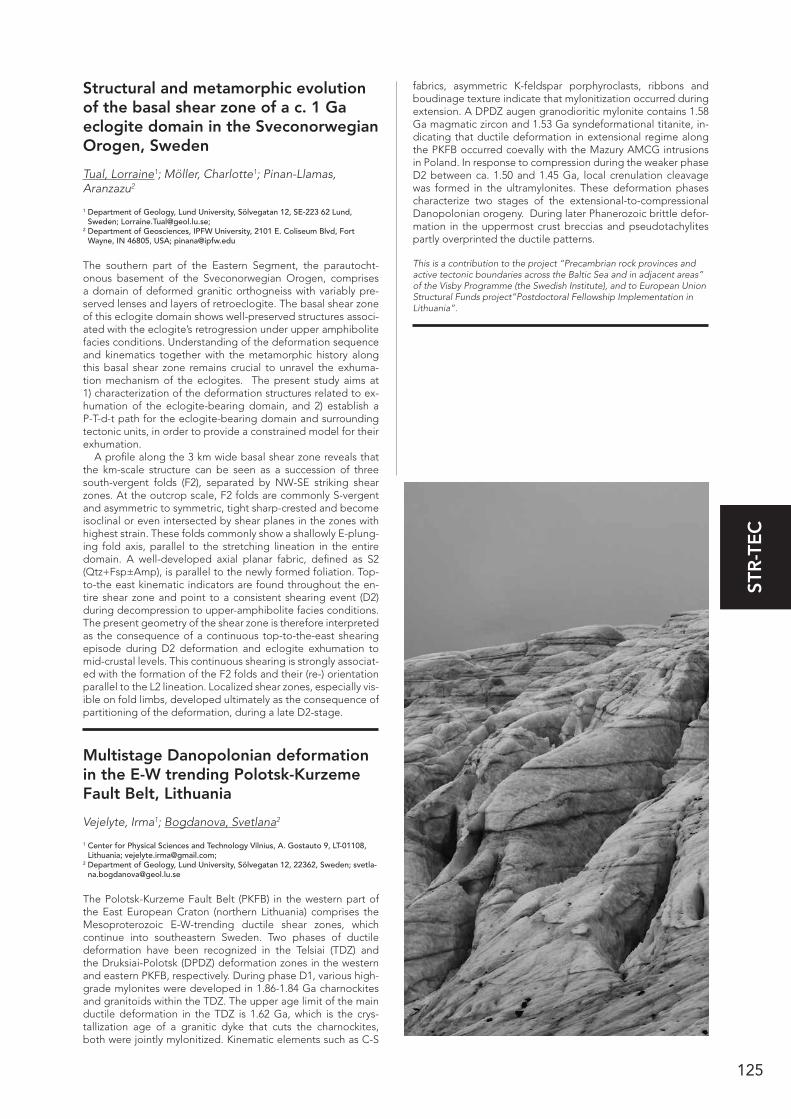
125
STR
-TE
C
Structural and metamorphic evolution of the basal shear zone of a c. 1 Ga eclogite domain in the Sveconorwegian Orogen, Sweden
Tual, Lorraine1; Möller, Charlotte1; Pinan-Llamas, Aranzazu2
1 Department of Geology, Lund University, Sölvegatan 12, SE-223 62 Lund, Sweden; [email protected];
2 Department of Geosciences, IPFW University, 2101 E. Coliseum Blvd, Fort Wayne, IN 46805, USA; [email protected]
The southern part of the Eastern Segment, the parautocht-onous basement of the Sveconorwegian Orogen, comprises a domain of deformed granitic orthogneiss with variably pre-served lenses and layers of retroeclogite. The basal shear zone of this eclogite domain shows well-preserved structures associ-ated with the eclogite’s retrogression under upper amphibolite facies conditions. Understanding of the deformation sequence and kinematics together with the metamorphic history along this basal shear zone remains crucial to unravel the exhuma-tion mechanism of the eclogites. The present study aims at 1) characterization of the deformation structures related to ex-humation of the eclogite-bearing domain, and 2) establish a P-T-d-t path for the eclogite-bearing domain and surrounding tectonic units, in order to provide a constrained model for their exhumation.
A profile along the 3 km wide basal shear zone reveals that the km-scale structure can be seen as a succession of three south-vergent folds (F2), separated by NW-SE striking shear zones. At the outcrop scale, F2 folds are commonly S-vergent and asymmetric to symmetric, tight sharp-crested and become isoclinal or even intersected by shear planes in the zones with highest strain. These folds commonly show a shallowly E-plung-ing fold axis, parallel to the stretching lineation in the entire domain. A well-developed axial planar fabric, defined as S2 (Qtz+Fsp±Amp), is parallel to the newly formed foliation. Top-to-the east kinematic indicators are found throughout the en-tire shear zone and point to a consistent shearing event (D2) during decompression to upper-amphibolite facies conditions. The present geometry of the shear zone is therefore interpreted as the consequence of a continuous top-to-the-east shearing episode during D2 deformation and eclogite exhumation to mid-crustal levels. This continuous shearing is strongly associat-ed with the formation of the F2 folds and their (re-) orientation parallel to the L2 lineation. Localized shear zones, especially vis-ible on fold limbs, developed ultimately as the consequence of partitioning of the deformation, during a late D2-stage.
Multistage Danopolonian deformation in the E-W trending Polotsk-Kurzeme Fault Belt, Lithuania
Vejelyte, Irma1; Bogdanova, Svetlana2
1 Center for Physical Sciences and Technology Vilnius, A. Gostauto 9, LT-01108, Lithuania; [email protected];
2 Department of Geology, Lund University, Sölvegatan 12, 22362, Sweden; [email protected]
The Polotsk-Kurzeme Fault Belt (PKFB) in the western part of the East European Craton (northern Lithuania) comprises the Mesoproterozoic E-W-trending ductile shear zones, which continue into southeastern Sweden. Two phases of ductile deformation have been recognized in the Telsiai (TDZ) and the Druksiai-Polotsk (DPDZ) deformation zones in the western and eastern PKFB, respectively. During phase D1, various high-grade mylonites were developed in 1.86-1.84 Ga charnockites and granitoids within the TDZ. The upper age limit of the main ductile deformation in the TDZ is 1.62 Ga, which is the crys-tallization age of a granitic dyke that cuts the charnockites, both were jointly mylonitized. Kinematic elements such as C-S
fabrics, asymmetric K-feldspar porphyroclasts, ribbons and boudinage texture indicate that mylonitization occurred during extension. A DPDZ augen granodioritic mylonite contains 1.58 Ga magmatic zircon and 1.53 Ga syndeformational titanite, in-dicating that ductile deformation in extensional regime along the PKFB occurred coevally with the Mazury AMCG intrusions in Poland. In response to compression during the weaker phase D2 between ca. 1.50 and 1.45 Ga, local crenulation cleavage was formed in the ultramylonites. These deformation phases characterize two stages of the extensional-to-compressional Danopolonian orogeny. During later Phanerozoic brittle defor-mation in the uppermost crust breccias and pseudotachylites partly overprinted the ductile patterns.
This is a contribution to the project “Precambrian rock provinces and active tectonic boundaries across the Baltic Sea and in adjacent areas” of the Visby Programme (the Swedish Institute), and to European Union Structural Funds project”Postdoctoral Fellowship Implementation in Lithuania”.
126
MO
R-G
LA
Deglaciation of the Fennoscandian Ice Sheet at its northern margin
Andreassen, Karin1,2; Corner, Geoffrey D.2; Stokes, Chris R.3; Winsborrow, Monica, C.M.4
1 Centre of Excellence for Arctic Gas Hydrate, Environment and Climate, University of Tromsø, N-9037 Tromsø, Norway; [email protected];
2 Department of Geology, University of Tromsø; N-9037 Tromsø, Norway; [email protected];
3 Department of Geography, Durham University, Durham, DH1 3LE, UK; [email protected];
4 Statoil ASA, Mølnholtet 42, N-9414Harstad, Norway; [email protected]
The large-scale glacial geomorphology of northern Fennoscan-dia and the SW Barents Sea seafloor is mapped using marine and terrestrial data, giving new insights into the behaviour of the different ice streams, their dynamics and interaction dur-ing deglaciation. The glacial geomorphology indicates clear spatial and temporal variations in ice dynamics as the ice sheet retreated across the continental shelf, with evidence for both active ice streaming and frozen-bed conditions at the maximum and during its stepwise retreat. Deglaciation was initiated along the western continental margin, sometime after 19 cal. ka BP, coinciding with rising global eustatic sea level. Deglaciation of the western sector of the ice sheet was followed by an advance of two short-lived ice streams from its eastern sector into the south-western Barents Sea around 16 cal. ka BP, approximately coinciding with maximum ice extent along its eastern margin in Russia. The stepwise deglaciation of the major north Norwe-gian fjords (spanning ca. 16 to 10 ka) was asynchronous, despite their outlet glaciers experiencing a similar climate forcing. This is interpreted to reflect the complex interplay between climate forcing and topographic and glaciological factors. Maximum retreat rates averaged over a few hundred years typically ex-ceed 100 ma-1, which is higher than rates reported for the early Holocene of the Laurentide and Greenland Ice Sheets. Howev-er, these palaeo-retreat rates are an order of magnitude lower than those reported for shorter-term changes of some major outlet glaciers in contemporary ice sheets.
The Baltic Sea IODP Expedition 347 “Baltic Sea Paleoenvironment” – preliminary results from the cruise
Andrén, Thomas1
1 School of Natural Sciences, Technology and Environmental Studies, Södertörn University, Sweden [email protected]
During second half of September and October, seven sites in the Baltic Basin area were successfully cored as part of the IODP Expedition 347. From the sites at Little Baelt, Kattegatt, Born-holm basin, Hanö Bay, Landsort Deep and the mouth of Ånger-manälven, more than 1 900 meters were drilled and over 1 600 meters of sediment core recovered. These cores have been lithologically described and documented as well as partly ana-lyzed during the cruise. The preliminary results from this will be presented together with some more general impressions from the cruise and the offshore work.
Weichselian glaciation history and palaeoenvironmental development of the SW Baltic Sea
Anjar, Johanna1; Adrielsson, Lena1; Björck, Svante1; Filipsson, Helena L.1; Larsen, Nicolaj Krog2; Möller, Per1
1 Department of Geology, Lund University, Lund, Sweden; [email protected];
2 Department of Geoscience, Aarhus University, Aarhus, Denmark
The Weichselian history of the southwestern Baltic Sea is com-plex with repeated glacial advances and retreats. The area is also situated close to the Baltic Sea inlets, which makes it sen-sitive to changes in relative sea level and salinity. In this study, a Weichselian sediment succession from Kriegers Flak in the southwestern Baltic Sea is presented and correlated with previ-ously published stratigraphies from the region.
We suggest that the lowermost till on Kriegers Flak, dated to the Early or Middle Weichselian, was deposited during the Ristinge advance, previously dated to c. 55-50 ka. Following the deglaciation after this advance, isostatic depression ena-bled a marine influence in the southern Baltic Basin. During this time a low-diversity benthic foraminifera fauna, indicative of cold water and low salinities, established on Kriegers Flak. This phase was followed by a forced regression, probably caused by a combination of isostatic rebound and a falling global sea level. Between 42 and 36 cal. ka BP wetlands and shallow lakes existed on Kriegers Flak. Macrofossils and pollen from this unit suggest tundra-like vegetation, possibly with birch and pine in sheltered locations. From 28.5 to 26 ka, a thick succession of glaciolacustrine clay, unit C, was deposited at Kriegers Flak in-dicating a damming of the Baltic Basin by an ice advance into Kattegat.
The upper part of the stratigraphy has been reconstructed from new sediment sections and published stratigraphies from southernmost Skåne. Three Late Weicselian tills are identified. The lowermost till was deposited after the damming of the Bal-tic Basin at c. 30 ka. It was followed, after a deglaciation, by till deposited during the LGM advances. The uppermost till is correlated to a late readvance over the area.
Early Pleistocene glacial sediments in Denmark.
Beyer, Claus1; Kronborg, Christian2; Nielsen, Ole Bjørslev2
1 CB Magneto, Postboks 4 Nørregade 27, DK 8670 Låsby, Denmark, 2 Aarhus Universitet, Geologisk Institut, Høegh-Guldbergs Gade 2, DK 8000
Aarhus C Denmark; [email protected]
In a study of several sites with assumed old Quaternary sed-iments, two longer sequences of reversely magnetised sedi-ments have been found. One is a rhythmically, layered 25 m thick lacustrine sequence deposited in an ice lake. The calculat-ed virtual geomagnetic pole (VGP) path is starting southwest of South America, then moving westwards and turning northwards to pass just east of New Zealand. An interval with very scattered directions towards the uppermost part of the outcrop may re-cord the precursor to the Matuyama Bruhnes transition occur-ring 21000 years before the actual transition. This would place
MOR-GLA Geomorphology and Glacial Geology
127
MO
R-G
LA
the sequence at the end of the glacial period approximately 801 000 BP. The sedimentation rate estimated from variations in the magnetic directions in the lowermost part of the sequence is estimated to at least 1 m/ky. Frequent occurrences of varves and the rythmic bedding may help to a more precise calculation of the deposition rate.
The other sequence with reverse polarity is from a core containing the Harreskovian interglacial and the Ølgod I and II interstadials which may therefore also be more than 780 000 years old. The palaeomagnetic directions are rather scattered but show persistently reverse directions throughout the core. No VGP positions could be calculated as the core was not hori-zontally oriented.
Internal architecture and structural evolution of a Little Ice Age surge end moraine, Múlajökull, Iceland
Benediktsson, Ívar Örn1; Johnson, Mark D.2; Schomack-er, Anders3; Ingólfsson, Ólafur4,5
1 Department of Geology, Lund University, Sölvegatan 12, 223 62 Lund, Sweden; [email protected];
2 Department of Earth Sciences, University of Gothenburg, Box 460, S-405 30 Göteborg, Sweden; [email protected];
3 Department of Geology, Norwegian University of Science and Technology, Sem Sælands Veg 1, N-7491 Trondheim, Norway; [email protected];
4 Institute of Earth Sciences, University of Iceland, Askja, Sturlugata 7, IS-101 Reykjavík, Iceland; [email protected];
5 Department of Geology, University Centre in Svalbard (UNIS), Box 156, N-9171 Longyearbyen, Norway; [email protected]
Múlajökull is a surge-type glacier of the Hofsjökull ice cap, Cen-tral Iceland. It has a known history of surges every 10-20 years since 1924. The last major surge took place in 1992 but a minor surge occurred in 2008.
A series of end moraines is identified in the glacier forefield, with the outermost moraine located about 2 km from the pres-ent ice margin. This moraine is 5-10 m high and 30-60 m wide and semi-continuous across the forefield. A 50 m wide and 5 m high natural cross-section through the moraine ridge shows a deformed sequence of loess, peat and tephra (LPT), overlain by a veneer of till on the proximal slope and crest.
The internal architecture is dominated by ductile defor-mation overprinted by brittle deformation. The proximal and central parts display overturned, polyclinal folds cross-cut by prominent thrusts whilst the distal part solely exhibits ductile deformation developing from overturned to open folds in distal direction. This moraine resembles end moraines of other surge-type glaciers in Iceland in terms of morphology, sedimentary composition, and internal architecture, indicating a polyphase structural evolution from open and overturned folding to sub-sequent thrusting.
Organic material was sampled for 14C dating of the moraine ridge. Preliminary results give two maximum ages; around 1000 and 3600 cal. yrs. BP. Based on other stratigraphical data and historical references, we suspect that the moraine was formed during the early Little Ice Age. However, the plan is to further constrain the moraine age with more 14C datings and tephro-chronology.
The 2008 mini-surge of Múlajökull, Iceland: end-moraine formation and post-surge ice-marginal dynamics
Benediktsson, Ívar Örn1; Schomacker, Anders2; Johnson, Mark D.3; Jónsson, S.A.4; Ingólfsson, Ó.4,5
1 Department of Geology, Lund University, Sölvegatan 12, 223 62 Lund, Sweden; [email protected];
2 Department of Geology, Norwegian University of Science and Technology, Sem Sælands Veg 1, N-7491 Trondheim, Norway; [email protected];
3 Department of Earth Sciences, University of Gothenburg, Box 460, S-405 30
Göteborg, Sweden; [email protected]; 4 Institute of Earth Sciences, University of Iceland, Askja, Sturlugata 7, IS-101
Reykjavík, Iceland; [email protected]; 5 Department of Geology, University Centre in Svalbard (UNIS), Box 156, N-9171
Longyearbyen, Norway; [email protected]
A LiDAR survey from 2008 of the Múlajökull surge-type outlet of the Hofsjökull ice cap, Central Iceland, revealed a steep, step-like profile of the ice front and an end moraine at the ice mar-gin. Following an annual retreat of 20-60 m since 2003, the ice margin had advanced by 10 m in the autumn 2009 according to measurements of the Iceland Glaciological Society. These ob-servations strongly suggest that Múlajökull had a minor surge in 2008.
A prominent step occurs in the glacier profile about 400-500 m from the 2008 margin. We interpret this step as the surge bulge, which, apparently, stopped just before reaching the ice margin. Nevertheless, it propagated far enough to generate a minor ice margin advance and the formation of an end moraine ridge that is continuous along most of the 6.5-km long mar-gin. Investigations of the moraine show that it is composed of folded and thrust sequence of till and glaciofluvial sand and gravel, and that shortening of marker beds within the moraine was 12-13 m, which corresponds to measurements of the ice margin advance.
Two ice-marginal profiles show an ice flow rate of 7-14 m per year since 2009. This is unusual for ice margins of Icelandic surge-type glaciers, which tend to be inactive between surges. However, this is probably caused by the steep ice front resulting from the surge bulge not passing the ice margin. The ice mar-ginal retreat and surface lowering along the profiles is 10-80 m and 6-12 m per year, respectively.
Mapping aeolian landforms: preliminary results from south-central Sweden
Bernhardson, Martin1; Alexanderson, Helena1
1 Lund University, Department of Geology, Sölvegatan 12, S-223 62, Lund, Sverige
Aeolian deposits in Sweden are generally concentrated to scat-tered inland areas and along the coastline. Even though these deposits have been partly mapped, only few detailed studies exist. This means that we have a largely unused environmental archive just waiting to be explored, since aeolian deposits can tell us much about palaeoenvironments and anthropogenic im-pact on the landscape through time. The advent of LiDAR (Light Detection And Ranging) and high-resolution digital elevation models has allowed these deposits and landforms to be exam-ined in much greater detail than was previously possible, and these remote sensing tools are invaluable for selecting sites for further investigations, as well as classify and quantify the aeo-lian sediments and landforms. The mapping will initially focus on two of Sweden’s most well-known inland dunefields; Brat-tforsheden and Bonäsheden, where Bonäsheden is the largest continuous dunefield in Sweden. The dunefields are analysed through remote sensing with the help of LiDAR, in combination with field work. As this is written, sedimentological and geo-morphological field work at Bonäsheden is about to start and further remote sensing analyses are planned for other sites in south-central Sweden. Recent studies of aeolian sediments in southern Sweden and Norway support deposition of aeolian sediments primarily following the deglaciation, with events of reactivated sand drift in historical time. The results from this project are expected to tell a similar story of the sites to be ex-amined; studies on Brattforsheden have already confirmed this.

128
MO
R-G
LA
Glacier/permafrost interaction, alpine landscape development and paleic surfaces
Berthling, Ivar1; Etzelmüller, Bernd2
1 Department of Geography, Norwegian University of Science and Technology, Trondheim, Norway; [email protected];
2 Department of Geosciences, University of Oslo, Oslo, Norway; [email protected]
The high-altitude, low-relief surfaces of southern Norway are traditionally explained by ancient peneplanation and more recent uplift (e.g. Lidmar Bergström et al., 2000), and survival during Pleistocene glaciations under cold-based ice (Fjellanger and Sørbel, 2007). This account is defied by a model where a glacial buzzsaw effect as well as periglacial and fluvial process-es have shaped these surfaces (Nielsen et al., 2009). In some areas, they coexist with alpine landscapes and blockfields. We show that field relationships between these elements challenge both models. A glacial buzzsaw origin implies that blockfields postdate erosion; however blockfield distribution is at odds with climate and weathering regimes. A preglacial blockfield origin and subsequent preservation beneath cold based ice is the common interpretation (e.g. Strømsøe and Paasche, 2011). Conversely, if cold-based ice sheets protected pre-glacial sur-faces and sediments, why not the glacial sediments related to cirque erosion in the same areas? Permafrost/glacier interac-tions may explain this paradox. Ground ice will respond to the stresses of a growing glacier above it by deformation, which may cause large-scale sediment deformation and entrainment. This is conceptualized as cryo-conditioned landscape develop-ment (Berthling & Etzelmüller 2011).
ReferencesBerthling, I. & Etzelmuller, B., 2011: The concept of cryo-conditioning in landscape evolution. Quaternary Research 75, 378-384.
Fjellanger, J. & Sørbel, L., 2007: Origin of the palaeic landforms and glacial impact on the Varanger Peninsula, northern Norway. Norwegian Journal of Geology 87, 223-238.
Lidmar Bergström, K. et al., 2000: Landforms and uplift history of south-ern Norway. Global and Planetary Change 24, 211-231.
Nielsen, S. B. et al., 2009: The evolution of western Scandinavian topog-raphy: A review of Neogene uplift versus the ICE (isostasy-climate-ero-sion) hypothesis. Journal of Geodynamics 47, 72-95.
Strømsøe, J. R. & Paasche, O., 2011: Weathering patterns in high-lati-tude regolith. Journal of Geophysical Research-Earth Surface 116.
The drainage of the Baltic Ice Lake: a long debated topic in Swedish Quaternary Geology
Björck, Svante
Lund University, Department of Geology, Lund, Sweden
Mapping of raised shore lines in the early 1900s recognized an anomaly between the late-glacial shore lines in the eastern and western parts of the Middle Swedish end moraine zone, where Mt. Billingen (MB) is the northernmost tip of the south Swedish highlands. Mapping and surveys in the 1920s-1940s around MB, with its conspicuous end moraine ridges, resulted in impressive accounts of its stratigraphy and surficial geology. The end mo-raines were described and more or less catastrophic drainage scenarios of the Baltic Ice Lake (BIL) were invoked, supported by local and regional geology. In the 1960s a 20-30 m lowering of the BIL was independently supported by shore displacement studies in SE Sweden and height differences between close-by deglacial delta surfaces in Finland. However, the question where the drainage deposits are found was not answered, and many were still skeptic. In the 1980s studies of shore displace-
ment, stratigraphy and chronology were carried out, presenting a complex drainage model and pin-pointing the potential area with drainage deposits, but members of an IGCP excursion in 1990 were skeptic. In the early 1990s open sections in a gravel pit with obvious drainage deposits were found and reported: a relief for many! Later in the 1990s it was suggested that the sudden release of BIL fresh-water might have triggered the Preboreal Oscillation, and an intriguing question about the drainage often came up: How rapid was it? During the 1990s and 2000s different models came up with similar results: at most a few years. In the 2000s an alternative model, based partly on mathematical uplift calculations, contested the drainage idea and introduced a new concept, the Baltic Ice Sea. However, a Digital Terrain Model study of the situation at the drainage and a common excursion around MB refuted this new concept. New studies west of MB, in and between end moraines, were also under-way. In the 2010s it resulted in detailed accounts of ice dynamics and the interplay between deglaciation, end moraine formation and sedimentologic details of the drainage. In addi-tion, exposures of the distal drainage deposits resulted in more precise depictions of the drainage.
Geomorphology of the Drangajökull ice cap, NW Iceland, with focus on its three surge-type outlets
Brynjólfsson, Skafti1,2,3; Schomacker Anders1; Ingólfsson, Ólafur 2,4
1 Department of Geology, Norwegian University of Science and Technology, Sem Sælands veg 1, N-7491 Trondheim, Norway. E-mail address: [email protected]
2 Institute of Earth Sciences, University of Iceland, Askja, Sturlugata 7, IS-101 Reykjavík, Iceland
3 Icelandic Institute of Natural History, Borgum við Norðurslóð, IS-602 Akureyri, Iceland
4 The University Centre in Svalbard (UNIS), Box 156, N-9171, Longyearbyen, Norway
The first detailed geomorphological maps from the forefields of three surging outlets of the Drangajökull ice cap, northwest Iceland, are presented. The maps are based on field studies in 2011-2013, high-resolution orthorectified aerial photographs recorded in 2005-2006 and airborne LiDAR data from 2011. The maps cover an area of about 40-60 km2 each. Furthermore, we present an overview map that covers the surroundings of the Drangajökull ice cap. Landforms and sediments were manually registered in a geographical information system (ESRI ArcGIS 10).
We mapped glacial landforms such as flutes, ice sculpted bedrock, hummocky moraine, kame terraces and moraines. The fluvial landforms appear as outwash plains/sandur, pitted sandur and eskers, and raised beaches were mapped. The Little Ice Age (LIA) maximum extent of Drangajökull and its outlet glaciers, expressed as a subglacial surfaces, including till and glacially sourced bedrock. Sediments distally to the LIA de-posits were recorded and consists mainly of Late Weichselian and early Holocene sediments and locally weathered bedrock. Periglacial landforms in the area consist of patterned ground, mainly occurring on the 500-700 m high plateaux, and three rock glaciers.
At least 3-4 surge events are recognised from each of the outlet glaciers over the last three centuries. In contrast to most other surge-type outlets from Icelandic ice caps, the outlets from Drangajökull are confined by valleys which affect the fore-field geomorphology. Glaciofluvial landforms, moraines and a thin sheet of till with numerous boulders are characteristic for the forefields of the Drangajökull outlets.
129
MO
R-G
LA
Morphologic evidence for a sackung event in Tröllaskagi mountain (Northern Iceland)
Coquin, Julien1; Mercier, Denis1; Bourgeois, Olivier2; Cossart, Etienne3
1 Université de Nantes, CNRS Laboratoire Géolittomer-UMR 6554 LETG, Campus du Tertre BP 81 227 44 312 Nantes cedex 3, Nantes, France;
2 Université de Nantes, Laboratoire de Planétologie et Géodynamique de Nantes, UMR 6112, Nantes, France;
3 Université Paris 1, Laboratoire PRODIG, Paris, France
Located on the east side of the Skagafjördur, Tröllaskagi moun-tain area features high basaltic plateaus dissected by extensive glacial valleys. Since the last glacial maximum the area under-went major changes from an alpine style glaciation with gla-ciated corries and thick valley glaciers to an ice free situation during Preboreal-Early Holocene time. Recent studies have enlightened relationship between landslides and post-glacial process in the Skagafjörður area where more than one hundred and thirty landslides have been mapped (Pétursson, 2008). Par-aglacial denudation landforms such as rock-slope failures and landslides have already been carefully studied in Skagafjörður, but little attention has been paid to deep-seated gravitational slope deformation known as sackung. Sackung has been de-fined as a major slope failure splitting the crest line of a moun-tain and producing a crestal graben along ridge flanks. Most of them are ascribed in areas that encountered Quaternary glaciations and accordingly have been linked with post-glacial processes (rock debutressing, post-glacial rebound). West of the Tröllaskagi area (65°49N, 19°14W) the Óslandshliðarfjöll mountain displays several series of crestal grabens interpreted as morphologic evidence of a sackung event. Based on both field investigations and spatial dataset analyses (LiDAR DEM, aerial imagery) three distinctive series of grabens were identi-fied and mapped with their related parallel normal fault scarps spreading along the Óslandshliðarfjöll ridge along a 12 km long westward profile. An hypothesis for the sackung onset during an earlier stage of the Late Weichselian deglaciation with a still high ice level is discussed. Then a reconstitution of the deglaci-ation sequences from LGM to present-time, based on both Late Weichselian studies and field evidence, is proposed. Finally the role of sackung in long term mountain denudation and land-scape evolution is discussed. This work is part of a PhD research project related to a comprehensive Late Weichselian deglacia-tion carried out in the Skagafjörður area.
Alluvial fans on Svalbard and implications for past Mars climate
de Haas, Tjalling1; Carbonneau, Patrice2; Hauber, Ernst3; Kleinhans, Maarten G.1
1 Faculty of Geosciences, Utrecht University, PO-Box 80115, 3508 TC Utrecht, The Netherlands; [email protected], [email protected];
2 Department of Geography, Durham University, DH1 3LE Durham, UK; [email protected];
3 DLR-Institut für Planetenforschung, Rutherfordstraße 2, 12489 Berlin, Germany; [email protected]
Alluvial fans are fan- or cone- shaped deposits of sediment at the transition between highlands and fluvial plains and coasts. Fans in polar regions are exposed to different processes than fans in more-studied warmer arid and semi-arid regions. Our aim is to understand fan formation in cold planetary environ-ments. We studied alluvial fans around Longyearbyen (Spitsber-gen) using hyper-spatial imagery and ground truth. In addition to ubiquitous dilute and debris flows, snow avalanches were found to have a large and often dominant effect on fan for-mation on Svalbard. Snow avalanches contribute to and build up fans, but also smooth fans by ‘shoveling’ and redistributing sediment on the fan surface.
We use geomorphic and textural patterns on alluvial fans to infer past hydrological conditions on Mars, which is currently a
polar desert, by relating their volume to the amount of water that was necessary to form them, which requires understanding of the formative processes. Past work shows that dilute flow, debris flows and dry granular flows contributed to Martian fan formation and were likely driven by snowmelt. Our results on Svalbard lead to the hypothesis that snow avalanches also contributed to Martian fan formation, which we are currently investigating by quantitative comparison of patterns on Earth and Mars.
Drumlin morphology and distribution in Sweden
Dowling, Thomas P.F.1; Spagnolo, Matteo2; Hättestrand, Clas3
1 Lund University, Department of Geology, Sölvegatan 12, 223 62, Lund, Sweden; [email protected];
2 University of Aberdeen, Department of Geography and the Environment, School of Geoscience, Elphinstone Road, AB24 3UF, Aberdeen, UK; [email protected];
3 Stockholm University, Department of Physical Geography and Quaternary Geol-ogy, Stockholm University, SE-106 91, Sweden; [email protected]
This study examines drumlin morphometrical parameters in multiple flow-sets throughout Sweden. Building on the work of Hättestrand et al.(2004, GA 86, pp; 155-167) and Spagnolo et al. (2012, Geomorph, 153-154, pp; 179-191), we evaluate drumlin morphometric statistics on 2129 drumlins from nine key sites in Sweden, from the Arctic North to the southerly reaches of the Fennoscandian Ice Sheet in Skåne. These morphometric analyses are combined with an intersection analysis of bedrock occurrence versus drumlin occurrence and a qualitative analy-sis of local bedrock type and distribution (sedimentary versus crystalline) in order to evaluate causal factors for drumlin oc-currence in specific areas and absence in others, as well as their metrics variability. Further work will add to this in including a Quaternary drift depth model, derived from well logs and field based studies. This will feed into the distribution and metrics variability assessment. The morphological analysis is based on the LiDAR-derived New National Height model of Sweden. Pre-liminary results suggest a preference for drumlinized terrain to be located over sedimentary bedrock; in addition to this it may be possible to identify areas of palaeo-ice streaming (or other possible causal factors) from the distribution of highly elongat-ed forms in geographically distinct fields, often bounded by coherent esker networks.
Deglaciation of the outer Hardangerfjord system (Bømlafjorden), western Norway
Egeland, Irene1; Haflidason, Haflidi1; Hjelstuen, Berit Oline1; Sejrup, Hans Petter1
1 Department of Earth Science, University of Bergen, Alleg. 41, 5007 Bergen, Norway.
The large Hardangerfjord area consists of fjord arms and ba-sins and extends from the western coast of Norway and 180 km inland, towards the water divide in Norway. The main fjord, Hardangerfjorden, is ca. 120 km long and with the 40 km long Bømlafjorden this continuous fjord system represents the sec-ond longest fjord system in Norway. The Hardangerfjorden area has acted as an important glacial drainage system for the SW-mountain area of the Fennoscandian Ice Sheet and into the Norwegian Channel Ice Stream system (NCIS) during several glaciation periods. The last deglaciation period in this area has been a scenario for intense research activities and dis-cussion related to the Allerød amelioration and the Younger Dryas readvance and break-up. As the Bømlafjorden, is located outside the pronounced Younger Dryas end moraine ridge has the study of the deglaciation in that area been very limited and the knowledge of the deglaciation prior to Younger Dryas in this outer Hardangerfjord area is basically unknown. The pri-
130
MO
R-G
LA
mary aim of this work is to use new high resolution seismic, ba-thymetric and core data from the 40 km long Bømlafjorden to contribute to a better understanding of the pre-Younger Dryas deglaciation history of the coastal area of western Norway. Preliminary results on the sediment distribution in the Bøm-lafjorden, genesis of the sediments and available dated core stratigraphy will be presented.
Glaciomorphic depositional formations in northern Ostrobothnia, Finland
Eskola, Tiina1; Peuraniemi, Vesa1
1 Department of Geosciences, University of Oulu, P.O. Box 3000, 90014 University of Oulu, Finland; [email protected], [email protected]
The morphology and inner structure of different glaciogene moraine formations and glaciofluvial formations were studied in northern Ostrobothnia, Finland by using aerial photographs, field observations and LiDAR (light detection and ranging) data. The study area is located in the central part of the former Pleis-tocene Fennoscandian ice sheet. The Quaternary sediments consist of different glacial and glaciofluvial deposits. Typical moraine formations in the area are cover moraine, drumlins and hummocky moraines. The formations are composed of different depositional facies as lodgement, melt-out, flow and deformation tills and sorted material such as sand and grav-el lenses and beds occur in places. Drumlin swarms occur on higher ground and hummocky moraine trains on lower ground. Some cross-cutting drumlin ridges have been observed in one specific part of the study area. These drumlins represent older and younger ice-flow directions and can be termed as palimp-sest glacial landforms. Glaciofluvial formations are composed of esker chains where both deltaic parts and ridges occur in the esker chains. Some observations have been made on till covered eskers.
Cold region geomorphology, perma-frost evolution and landscape devel-opment in the north – the concept of cryo-conditioning
Etzelmüller, Bernd1; Lilleøren, Karianne S.1; Berthling, Ivar2
1 Department of Geosciences, University of Oslo, Oslo, Norway; [email protected], [email protected];
2 Department of Geography, Norwegian University of Science and Technology, Trondheim, Norway; [email protected]
Since 2003, numerous shallow boreholes have been equipped to monitor ground temperatures in Norway, Svalbard and Ice-land. The monitoring stations are set up to characterize the ground-thermal regime in different periglacial landforms and environmental settings, and to validate spatially distributed, equilibrium and transient permafrost models (Gisnas et al., 2013; Westermann et al., 2013). We evaluate variations in the ground thermal regime during the period of meteorological observations since the end of the Little Ice Age c. 1870 (Sval-bard since 1912) until today on monthly and daily basis. Fur-thermore, selected sites have been forced by Holocene climate parameters to address the relative age of permafrost (Lilleøren et al., 2012). These analyses display clear regional differenc-es, providing important insights to the climatic response of mountain permafrost in the North Atlantic region and allow us to relate this information to geomorphological processes within the framework of the cryo-conditioning of landform and landscape evolution (Berthling and Etzelmuller, 2011). In this presentation, we use the spatial and temporal development of ground-thermal regime to address geomorphological process-es and longer-term cryo-conditioned landscape development.
Focus will be given to glacier-permafrost interaction, the role of block fields as a factor inpreserving palaeo surfaces, and the spatial distribution of different valley types as an indicator for long-term landscape evolution.
ReferencesBerthling, I. & Etzelmuller, B., 2011: The concept of cryo-conditioning in landscape evolution. Quaternary Research 75, 378-384.
Gisnas, K., Etzelmuller, B., Farbrot, H., Schuler, T.V. & Westermann, S., 2013: CryoGRID 1.0: Permafrost Distribution in Norway estimated by a Spatial Numerical Model. Permafrost and Periglacial Processes 24, 2-19.
Lilleoren, K.S., Etzelmuller, B., Schuler, T.V., Gisnas, K. & Humlum, O., 2012: The relative age of mountain permafrost - estimation of Holocene permafrost limits in Norway. Global and Planetary Change 92-93: 209-223.
Westermann, S., Schuler, T.V., Gisnas, K. & Etzelmuller, B., 2013: Tran-sient thermal modeling of permafrost conditions in Southern Norway. Cryosphere 7, 719-739.
Detailed monitoring of rapid deglaci-ation: Virkisjökull-Falljökull catchment, SE Iceland
Everest, Jez1; Bradwell, Tom2; Finlayson, Andrew2; Jones, Lee3; O’Dochartaigh, Brighid4; Hughes, Leanne5; Black, Andrew6; Flett, Verity7; Phillips, Emrys8; Maurice, Louise9; Raines, Michael10; MacDonald, Alan4; Bergsson, Bergur11; Ofeigsson, Benni12
1 British Geological Survey, Earth Hazards & Systems, Edinburgh, United Kingdom; 2 British Geological Survey, Climate & Landscape Change, Edinburgh, United
Kingdom; 3 British Geological Survey, Engineering Geology, Nottingham, United Kingdom; 4 British Geological Survey, Groundwater, Edinburgh, United Kingdom; 5 British Geological Survey, Geology and Regional Geophysics, Nottingham,
United Kingdom; 6 University of Dundee, Geography, Dundee, United Kingdom; 7 University of Dundee, Geography, Dundee, United Kingdom; 8 British Geological Survey, Climate & Landscape Change, Edinburgh, United
Kingdom; 9 British Geological Survey, Groundwater, Wallingford, United Kingdom; 10 British Geological Survey, Energy and Unconventional Hydrocarbons, Notting-
ham, United Kingdom; 11 Vedurstofa Islands, Observations, Reykjavik, Iceland; 12 Vedurstofa Islands, Processing & Research, Reykjavik, United Kingdom
Since 2009 the British Geological Survey’s glacier observatory at Virkisjökull- Falljökull has enabled constant, real-time and multi-disciplinary investigation of accelerating deglaciation and contemporaneous evolution of a proglacial landscape. Com-plex geomorphology results from both retreat of the active gla-cier margin and in-situ downwasting of a large area of buried ice. Geomorphological processes are conditioned by local climate, and glacier and surface hydrology, with their relative interaction changing significantly over varying timescales. We use a com-bination of continuous real-time monitoring of climate, surface and groundwater hydrology; thrice-daily photography; biennial Ground Penetrating Radar; and annual Terrestrial LiDAR. These are being integrated with moraine dating using lichenometry; dye tracer testing of englacial, subglacial and pro-glacial drain-age networks; and detailed geomorphological and lithological mapping, to reveal a change in glacier response from initial ac-tive retreat, to more recent passive downwasting and the for-mation and evolution of a large area of the foreland buried ice terrain. While the active glacier margin is retreating through a combination of lateral retreat, surface lowering and fault-block collapse, foreland evolution is governed by a combination of downwasting and ‘glacier-karstic’ development. Surface topog-raphy has shown excellent examples of esker, sandur-terrace and proglacial-fan development. Surface change models of the proglacial area record a shifting pattern of deposition and ice wastage with the debris mantling all but the steepest areas of this buried ice terrain, effectively insulating the underlying ice. Loss of the buried ice in this highly dynamic environment re-
131
MO
R-G
LA
sults from englacial channel formation, subsequent widening, abandonment and collapse, the latter marked by networks of rapidly connecting sinkholes. Consequently, this programme of multidisciplinary research and monitoring being undertaken at Virkisjökull- Falljökull is revealing a highly complex record of rapidly changing glacier response set against a backdrop of re-cent climate change.
Fracturing, block-faulting and moulin development associated with the retreat a maritime glacier: Falljökull, SE Iceland
Finlayson, Andrew1; Phillips, Emrys1; Jones, Lee2
1 British Geological Survey, Murchison House, Edinburgh, United Kingdom; 2 British Geological Survey, Sir Kinsley Dunham Centre, Keyworth, United King-
dom
Since 2007, Falljökull in southeast Iceland has been undergo-ing passive downwasting, providing an ideal opportunity to study a range of deformation structures developed in response to ice-marginal collapse and retreat. An integrated terrestrial LiDAR, Ground Penetrating Radar and glaciological structural study of the clean, debris-free ice at the margin of Falljökull has allowed a detailed model of the surface and subsurface 3D structure to be developed. Collapse of the glacier margin takes the form of a multiple rotational failure controlled by large-scale, down-ice dipping normal faults. As the fault-bound blocks of ice are displaced down-slope they rotate leading to localised compression and the formation of down-faulted gra-ben-like structures. Moulins present within the marginal zone of Falljökull are closely associated with the zones of relatively more intense brittle deformation which cross-cut the glacier. A mod-el is proposed where the moulins have formed in response to the progressive collapse of englacial drainage channels located along down-ice dipping normal faults. The preferential devel-opment of the moulins and englacial drainage channels along the normal faults weakens the ice along these structures, pro-moting or even accelerating further collapse of the ice margin. The complex pattern of surface lowering within the marginal zone of Falljökull has also been shown to be directly related to movement on the main faults controlling the collapse of the ice margin. This evidence suggests that structurally controlled col-lapse may, in some instances, have a profound effect on glacier surface lowering and geodetic mass balance measurements.
Rapid glacier surface ablation in south east Iceland
Flett, Verity1; Kirkbride, Martin1; Black, Andrew1; Everest, Jez2; Bradwell, Tom2
1 Geography, School of the Environment, University of Dundee, Dundee DD1 4HN, UK
2 British Geological Survey, West Mains Road, Edinburgh EH9 3LA, UK
A network of ablation stakes distributed across the twin arms of the Virkísjökull/Falljökull glacier has revealed highly variable rates of melt based on local conditions, providing a critical data set to begin modelling the expected acceleration in melting over the coming decades. Three weather stations provide a means for construction of high-resolution lapse rates that can be varied on a daily basis. Using both the meteorological and ablation data in combination gives a level of detail that allows a better understanding of the rate and pattern of deglaciation in the Virkísjökull catchment. Observations indicate an increase in melt over the last 5 years, which has resulted in a rapidly formed pro-glacial lake area. Most recently, melting has resulted in the loss of over 8 m of surface elevation in the lower regions of the glacier during the summer of 2013. Simple degree-day model-
ling reveals the extent of this melt in the years since the weather stations were installed. Also shown are the expected differenc-es between specific areas of the glacier and the high impact of local conditions including topography, shading and debris cover. The outcomes of this melt model will provide baseline data for a wider catchment model that will be used to predict the likely changes in melt water input into the catchment as the glacier retreats to a higher altitude or disappears entirely, enabling a wider understanding of the hydrological processes operating in the catchment.
Hydrology of a rapidly deglaciating catchment: Dye tracing experiments at Virkísjökull/Falljökull south-east Iceland
Flett, Verity1; Maurice, Louise2; Black, Andrew1, Ó Dochartaigh, Brighid2; MacDonald, Alan3
1 Geography, School of the Environment, University of Dundee, Dundee DD1 4HN, UK;
2 British Geological Survey, Maclean Building, Crowmarsh Gifford, Wallingford, OX10 8BB, UK;
3 British Geological Survey, West Mains Road, Edinburgh EH9 3LA, UK
Dye tracing was carried out in the Virkísjökull/Falljökull catch-ment to investigate the drainage system. Experiments were completed targeting three major components of the glacier hydrology: the sub-glacial drainage network; conduits in the buried ice in the glacier foreland and the development of the glacial lake; and the discharge of the pro-glacial river, Virkísá. Preliminary findings suggest that at the time of the tests (at the end of a full melt season), the englacial and subglacial drainage networks are highly evolved and meltwater transmission to the glacier margin is rapid. The glacier injection point (a moulin on the eastern side of Falljökull) fed an efficient subsurface channel discharging at the glacier snout where the river sinks into con-duits within buried ice. Further tracer testing revealed that this conduit system resurfaces on the western side of the lake. The lake and buried ice feed the principal surface drainage from the catchment, the Virkísá river, through a geologically constrained outlet. This work provides a useful indication of the residence times within the buried ice and lake in the glacier foreland area, which will become increasingly significant as the glacier melts. Dilution gauging of the Virkísá revealed some of the difficulties in determining an accurate discharge on glacial rivers, indicat-ing incomplete mixing of the tracer due to turbulence and ed-dies and braided channels, thereby complicating calculation of river discharge.
Ice dynamics and deglaciation in SW Norway constrained by LIDAR mapping and cosmogenic exposure ages of glacial landforms
Fredin, Ola1; Akçar, Naki2; Romundset, Anders1; Reber, Regina2; Kubik, Peter3; Schlüchter, Christian2
1 NGU, Quaternary Geology, Trondheim, Norway, [email protected]; 2 University of Bern, Department of Geological Sciences, Bern, Switzerland; 3 ETH, Department of Ion Physics, Zürich, Switzerland
Southwestern Norway is a key area for understanding interac-tions between the Fennoscandian and British ice sheets, break-up of the Norwegian channel ice stream and chronology of late glacial to Holocene deglaciation. The classical study of Bjørn Andersen in the 1950s outlined several moraine zones includ-ing the Younger Dryas (Ra) deposit. Using new remote sensing data we have remapped the entire area in greater detail than before and together with comprehensive new geochronology we present significant new insights into past ice-sheet behavior in SW Scandinavia. We have acquired airborne LiDAR terrain
132
MO
R-G
LA
data, together with digital 3D infrared aerial photographs, to map glacial landforms and deposits in detail. In addition we have used four field-seasons to field map and sample for ex-posure ages. We have targeted moraines, drumlins and eskers and in total we have mapped approximately 4000 km2. For ge-ochronology, we collected 47 CN samples together with new radiocarbon dates from lake records. Our results show that the ice surface lowered early in the late-glacial and deglaciat-ing mountains of modest altitude (450 m.a.sl.) already at 18 ka. The deglaciation in this dissected coastal landscape was com-plex, with early retreat of fjord glaciers that calved back to fjord heads, with thin ice backstepping onshore. We find little evi-dence of regional ice-margin positions, an important feature of Andersen´s previous reconstruction. Contrary, most of the area outside the Ra is barren, with only few, isolated moraine ridges confined to separate valleys. The ice sheet melted back about 50 km inland, before it readvanced to the Ra position. Here, a complex morphology and our CN-age data indicate several readvances reaching the same position. We present evidence for early thinning and break-up of the ice sheet in SW Norway, which is linked to ice draw-down before and during collapse of the Norwegian channel ice stream. The deglaciation during Bølling- Allerød interstadials was relatively rapid and without major halts. However, the Ra moraine zone is complex and indi-cates at least one major- and one smaller readvance.
Saprolites on- and offshore Norway: New constraints on formation processes and age
Fredin, Ola1,2; Zwingmann, Horst3; Knies, Jochen1; Sørlie, Ronald4; Grandal, Else Margrethe4; Lie, Jan Erik4; Müller, Axel1; Vogt, Christoph5
1 Geological Survey of Norway, NO-7491 Trondheim, Norway, [email protected], [email protected], [email protected];
2 Norwegian University of Science and Technology, NO-7491, Trondheim, Norway, [email protected];
3 CSIRO, ESRE, Bentley, WA 6102, Australia, [email protected]; 4 Lundin Petroleum AS, NO-1366 Lysaker, Norway, ronald.sorlie@lundin-norway.
no, [email protected], [email protected] ; 5 University of Bremen, D-28359 Bremen, Germany, [email protected]
The origin of landscapes in Scandinavia has been debated for more than a century and the discussion is as vigorous as ever today. In short, one school proposes that most of the geomor-phology can be explained by glacial and periglacial processes, while others argue that the landscape partly is inherited from earlier etching, stripping and exhumation episodes, and has been preserved through cover of sedimentary rocks and selec-tive glacial erosion. One key argument used by the latter pro-ponents is the relatively widespread occurrences of saprolite in Scandinavia. Here we attempt to characterize and date these saprolites both on- and offshore Norway.
One key locality is the Utsira high, which is an offshore crystal-line basement horst in the Norwegian North Sea partly overlain by Paleozoic and Mesozoic strata. The area has received signif-icant attention recently due to large petroleum finds, specifical-ly the Edvard Grieg (16/1-8, 2007), the Johan Sverdrup (16/2-6, 2010) and the Luno 2 (16/4-6 S 2013) discoveries done by Lundin Norway.
Significant areas of the Utsira high basement appear to be deeply weathered and saprolite is found in exploration wells. We utilize K-Ar dating of authigenic illite and geochemical analysis of the saprolite to characterize weathering age and processes. The data suggest deep weathering of a granitic landscape during late Triassic, followed by a transgression and deposition of sedimentary strata. The K-Ar data thus agrees with the stratigraphic position of Utsira high saprolite below Ju-rassic sediments. Similar K-Ar data was also obtained from the Ivö kaoline quarry in southern Sweden.
Our hypothesis is that the similar landscape and saprolite on-shore southern Scandinavia is of similar origin and age as the offshore equivalent. Significant portions of the Scandinavian
basement landscape, both on- and offshore bears imprint from etching in Mesozoic time.
Late-glacial retreat and readvance signatures in the Vättern basin, south-central Sweden
Greenwood, Sarah1; Jakobsson, Martin1; O’Regan, Matt1; Swärd, Henrik1; Flodén, Tom1
1 Department of Geological Sciences, Stockholm University, 10691 Stockholm, Sweden, [email protected]; [email protected]; [email protected]; [email protected]; [email protected]
The pattern and timing of Scandinavian ice sheet retreat are relatively well-known at ice sheet scale, based on a long his-tory of terrestrial glacial geological investigation. However, the palaeo-glacial environments of present-day submerged terrain, such as the large Baltic and Bothnian basins, are poorly un-derstood. Lake Vättern, one of south-central Sweden’s ‘Great Lakes’ is one such ‘missing link’. Positioned across the Younger Dryas line of ice margin retreat, this deep basin is expected to have exerted a strong control on ice dynamics during this key climate transition, enhancing drawdown and promoting outlet glacier lobe readvance; and was likely an important component of both the subglacial meltwater system and the proglacial Bal-tic Ice Lake development and drainage. Its glacial archive is, however, virtually unknown.
Here we will present new seismic, acoustic subbottom and multibeam bathymetry surveys of southern and central parts of the basin. We couple our interpretations of these data with new LiDAR-based mapping of surrounding terrestrial glacial land-forms and a 75 m sediment sequence cored from the southern-most part of the lake in 2012. Lake-bottom signatures of stiff glacial sediments and retreat moraines confirm the presence of grounded ice in the basin, and indicate that the most re-cent grounding phase was of relatively thin ice, topographically confined and whose retreat was steady/sluggish where there was strong lateral pinning. These signatures may record the re-treat of a late-stage lobate readvance from the lake basin onto south-western shores, indicated by terrestrial glacial landforms. In the central basin, we speculate that enigmatic glacial land-forms are associated with marginal or shelf ice, and may be correlated with onshore landform assemblages which suggest (south-)eastwards advance of a thin, highly crevassed ice mar-gin across the lake basin at the Younger Dryas. We will discuss plausible ice thicknesses and dynamic properties such as thin-ning rates and flow velocities which may have been associated with the interpreted ice dynamics.
The deglaciation of the outer mid-Norwegian continental shelf
Haflidason, Haflidi1; Bøyum, Eivind S.2; Hjelstuen, Berit O.1
1 Department of Earth Science, University of Bergen, Bergen, Norway, [email protected], [email protected];
2 Schlumberger Information Solutions, Stavanger, Norway, [email protected]
The present knowledge on the last deglaciation of the outer Mid-Norwegian continental shelf is still largely based on works from the late 1970s -1980s and improved by re-dating shell-rich events using the AMS technology in the late 1990s. These new dating results offered a new chronological framework for the two youngest till units identified in the outer shelf setting of the Mid-Norwegian shelf area using a regional grid of sparker lines. These till units were found to have been deposited around 15,000 and 13,500 14C BP. The results showed that the Mid-Nor-wegian shelf ice partly reached the shelf edge as late as ca. 13000 14C BP. Dating from the nearest coastal area show that
133
MO
R-G
LA
most of the shelf area had been deglaciated in less than 1000 years. New high-resolution seismic technology, applying the TOPAS system, the multibeam and the Olex bathymetric data combined with new AMS dated gravity cores have in the recent year made it possible to approach the deglaciation history in a more detailed way than previously available. The results show that the last glacial maximum ice sheet retreated from the outer shelf area around 15,200 14C. The ice sheet readvanced around 14,500 14C and created a large end-moraine complex, and a new minor readvance is interpreted to have occurred around 13,700 14C BP before a rapid retreat to the coastal areas during the Bølling period. The two dated ice sheet readvances have occurred within the period of the cold regional climatic event Heinrich 1.
Bathymetrical characteristics of Loen-vatnet and Strynevatnet fjord lakes affected by delta sedimentation and landslide processes, western Norway
Hansen, Louise1; Eilertsen, Raymond1; Waldmann, Nicolas2; Aritzegui, Daniel3; Chapron, Emmanuel4
1 Geological survey of Norway, Leiv Eirikssonsvei 39, N-7491 Trondheim, Norway; [email protected], [email protected];
2 Charney School of Marine Sciences, University of Haifa, 31905 Mt. Carmel, Israel; [email protected];
3 University of Geneva, Rue des Maraîchers 13, 1205 Genève, Switzerland; [email protected];
4 University of Orleans, 1A, rue de la Férollerie, 45071 Orleans, country; [email protected]
The Loenvatnet and Strynvatnet fjord lakes, western Norway, are surrounded by steep bedrock slopes affected by gravitational processes, including snow avalanches, rock fall and major rock-slope failures. Streams from narrow tributary valleys, with outlet glaciers in their most upstream end, terminate in the lakes. The lake outlets feed rivers that terminate in the innermost part of Nordfjorden. Well-defined fan deltas build into the lakes, and landslide debris is present on the slopes and along the shore-lines. Well-known and devastating rock-fall events followed by tsunamis happened along Lovatnet in 1905 and 1936 causing a total of 135 casualties. Bathymetric data collected by inter-ferometric sonar in 2005 reveal the distribution of associated landslide debris on the lake floor. Landslide debris from a ma-jor, prehistoric rock-slope failure is also present in Strynevatnet. Some delta slopes show transverse ridges as a result of under-currents likely created during flood events. Major, subaqueous channel features are also present. Seismic data help to outline the stratigraphic context of selected features on the lake floor. The primary purpose of this presentation is to describe the ba-thymetrical characteristics of the lake basins of Lovatnet and Strynevatnet to help improving the understanding of the range of processes affecting these lakes.
Depositional environments and glacial event at Nordli following the Younger Dryas maximum advance in Leirfjord, North Norway
Hansen, Louise1; Funder, Svend2; Sveian, Harald1; Dretvik, Håvard1; Husum, Katrine3
1 Geological survey of Norway, Leiv Eirikssonsvei 39, N-7491 Trondheim, Norway; [email protected], [email protected], [email protected];
2 Geological Museum, Øster Voldgade 5-7, 1350 København K, Denmark; [email protected];
3 Universitetet i Tromsø, Dramsveien 201, N-9037 Tromsø, address, Norway; [email protected]
The present study provides evidence for the changing deposi-tional environments following the Younger Dryas maximum at
Nordli, a well-known locality situated in the Leirelva fjord valley near the head of Leirfjord in Nordland. Surficial mapping, anal-ysis of excavated sections and ground penetrating radar (GPR) reveal YD glacial deposits and glacial outwash associated to mi-nor recessional stages during glacier retreat. The outwash was subsequently reworked in a shallow-marine environment with a tidal influence. The above-lying glaciotectonically displaced and deformed fine-grained fjord deposits covered by till tes-tify to a minor readvance of glacier ice. The faunal content of the deformed fine-grained fjord deposits shows that arctic to subarctic marine conditions were established around 9.9-10.0 ka BP (14C). This implies that glaciers had retreated significantly following the YD main advance. Glacier ice subsequently reap-peared at Nordli in the early Preboreal, somewhat later than considered by previous studies. This reappearance is, however, surprising and not easily explained in this topographical setting and does not seem to be a major regional event. A correlation with other localities belonging to the so-called Nordli stage is therefore questioned. Instead, the deforming structures and the upper till could potentially represent a short surge, or col-lapse, of remnant glacier ice in the catchment of the valley. Fully fjord marine conditions prevailed prior to emergence and de-posits were reworked by shallow marine processes during gla-cioisostatic rebound.
Deglaciation history and landscape development of the Nesna-Leirfjord area, north Norway
Hansen, Lousie1; Sveian, Harald1; Olsen, Lars1; Rubens-dotter, Lena1; Romundset, Anders1; Fredin, Ola1; Dretvik, Håvard1; Bøe, Reidulv1
1 Geological survey of Norway, Leiv Eirikssonsvei 39, N-7491 Trondheim, Norway; [email protected], [email protected], [email protected], [email protected], [email protected], [email protected], [email protected], [email protected]
Recent investigations in the Nesna-Leirfjord area, north Nor-way, have given new insights into the glacial history, relative sea-level change and long-term landscape development of the area. Mapping was performed in detail by using 3D digi-tal aerial photographs combined with field investigations. The stratigraphy was described in key sections by use of ground penetrating radar (GPR) and marine seismic data. The area is mountainous and heavily dissected by fjords and sounds. Sur-ficial deposits of glacial, marine, fluvial and gravitational origin are found on gentle slopes, mainly below 100-200 m above sea level. Younger Dryas Maximum moraine ridges are found in Fagervika, Ranafjorden, Hugla and Handnes. Ice flow during the deglaciation generally followed troughs and fjords, howev-er, we also find glacial striae crossing smaller valleys, reflecting ice flow across topographic barriers at earlier stages. The orien-tation of these striae indicates a temporary glacier movement northwards towards Ranafjorden. Marine seismic data show that the retreating ice-margin had a prolonged stillstand south of Leirfjord, which helps explain the distribution and character-istics of glaciomarine sediments now exposed on land. The ma-rine limit varies from 118 m near Ranafjorden, in the east, to less than 108 m near Nesna. The assumed Younger Dryas shoreline is represented by abrasion features in bedrock. The succeeding relative sea level fall during the Holocene was interrupted by a relative still-stand, or possibly a temporary rise associated to the Tapes transgression, as indicated by GPR data. The Tapes level is about 5 m higher than previously indicated for this area.

134
MO
R-G
LA
The Scandinavian ice sheet through the Weichselian: high mobility and climate sensitivity.
Houmark-Nielsen, Michael1
1 Center for GeoGenetics, Natural History Museum, University of Copenhagen, Øster Voldgade 5-7, Dk-1350, København K, Danmark, [email protected]
Through the Weichselian long intervals of interstadial and ame-liorated climatic conditions were interrupted by episodes with out-flow of the Scandianvian Ice Sheet (SIS).
Palaeo-environmental reconstructions, age-dated sediments and biogenic remains from inter-till deposits and genetic inter-pretation and provenance of glacial deposits from key sites, i.e. the Klintholm section in eastern Denmark, document the timing of glacier cover locally. In the present study, larger numbers of such sites are used to picture the distribution of SIS in time in SW-Scandinavia as palaeo-geographic reconstructions, which in turn is up-scaled with data from other regions to generate full-scale palaeo-ice sheet distributions through time.
Following the growth and decay of small Early Weichselian ice sheets, the SIS grew to its largest Middle Weichselian size around 70-60 kyr ago, occupying most of Scandinavia and the Baltic region during Marine Isotope Stage (MIS) 4. As the ice sheet shrank, the Baltic depression was subjected to renewed ice streaming ca. 55-50 kyr during early MIS 3. For the rest of MIS 3 most former glaciated areas experienced low-arctic steppe and shrub tundra. In the end of MIS 3 renewed growth of SIS again led to ice streaming through the Baltic depression 35-30 kyr followed shortly after by the breakdown of intersta-dial habitats and the onset of the Last Glacial Maximum (LGM) glaciations.
The timing of glacier growth and decay seems to suggest an almost direct response to climate change for the part of SIS flowing westwards out of Norway; while the behavior of SIS flowing eastwards seems to show delayed or even an opposite response as indicated by ice streams reaching the NW-Euro-pean lowland through the Baltic depression at times of ame-liorated North Atlantic climate during MIS 3. Palaeo-ice sheet reconstructions may picture odd shaped and unexpected ice stream configurations and flow paths that need to be tested against physical ice-sheet models.
Cosmogenic surface exposure dating of the last de-glaciation in Denmark: 6000-year age scatter suggest shielding effect controlled by periglacial landform transformation
Houmark-Nielsen, Michael1; Linge, Henriette2
1 University of Copenhagen, Natural History Museum – GeoGenetics Centre, Copenhagen, Denmark;
2 University of Bergen, Department of Earth Science, Bergen, Norway
Cosmogenic surface exposure dating in Denmark is tested against exposure ages from the coast south of the Baltic and south Sweden. Dating was performed in Bergen in corporation with Scottish universities. Cosmogenic nuclide surface expo-sure ages were determined from in situ 10Be and 36Cl analysis of 38 rock surfaces found in different glacial landforms in. Expo-sure ages from areas beyond the Last Glacial Maximum margin (LGM) lie between 79 and 62 thousand years (kyr) supporting re-cent results from independent dating suggesting that boulders were released during two glaciation phases in the early part of the Middle Weichselian. Ages from inside the LGM margin lies between 20-11.5 kyr suggesting that erratics were deposited in the Late Weichselian. Confidence in the results is backed by the exposure ages from Bornholm; here almost identical values from boulders and adjacent ice-sculpted bedrock suggests that
little if any inherited nuclides are present in the boulders. To test to what extent post-LGM ages do reflect the time of end moraine formation and subsequent de-glaciation, surface ex-posure ages were evaluated against an independent SW-Scan-dinavian age model. The Bornholm dates agree with the model, however, in the data set for the rest of eastern Denmark less than half of the surface exposure ages appear within the expected time envelope. This apparent mismatch is most likely due to post-ice realease shielding and delayed surface stabilisation compared to the timing of ice-margin and ground moraine for-mation. Thus ages from down-wasting landscapes seem to lack behind initial deglaciation by 3-6 thousand years. The results quantify the impact of exhumation and landform stabilisation on cosmogenic surface exposure ages on millennial scales. Possible post-depositional landform transformation should be included in the interpretation of cosmogenic exposure ages when fine tuning chronologies of glacier fluctuations. Recent-ly proposed deglaciation scenarios from the north European lowland south of the Baltic and based on cosmogenic expo-sure dating alone do not stand up to other independent age models.
The last Eurasian Ice Sheet: a chronological database and time-slice reconstruction
Hughes, Anna L.C.1; Gyllencreutz, Richard2; Mangerud, Jan1; Svendsen, John Inge1; Lohne, Øystein S.3
1 University of Bergen, Department of Earth Science and Bjerknes Centre for Climate Research, Bergen, Norway;
2 Stockholm University, Department of Geological Sciences and Bolin Centre for Climate Research, Stockholm, Sweden;
3 Sweco Norge AS, Storetveitvegen 98, Bergen, Norway
We present a new time-slice reconstruction documenting the changing limits of the Eurasian Ice Sheet complex during the last glaciation (40-10 ka) from the DATED Project. Time-slices are based on a compilation of over 5 000 dates and known ice-margin positions constraining advance and retreat of the British-Irish-Scandinavian-Svalbard-Barents-Kara Sea Ice Sheets. The timing of both maximum extent and retreat were spatially variable across the ice sheet complex, likely reflecting regional contrasts in forcing mechanisms and geographical settings. We expect the time-slices and derived area and vol-ume estimates to be useful for numerical and isostatic mod-elling requiring empirical constraints on past ice-sheet extent, and design the reconstructions for this purpose. The ice-sheet margin is delineated every 1 000 years for the last 25 ka. We also present some reconstructions at uneven intervals back to 40 ka. Uncertainty estimates are represented by maximum, min-imum, and ‘preferred’ positions for each time-slice, reflecting conflicting evidence and gaps in the ice sheet chronology. The database and reconstructions will be updated on an on-going basis as new information becomes published and future ver-sions will also include landform evidence to constrain ice-sheet geometry (e.g. ice-stream locations and ice thickness). Each date is attributed to the source publication, fully documented with information relevant to its interpretation and searchable by metadata including original author(s), location, dated materi-al, dating technique, stratigraphic position or setting, derived age and associated errors, pertinent comments from the source publication and sample elevation or depth, core name, labora-tory id and/or sample name as applicable.

135
MO
R-G
LA
Veiki moraine – morphology, strati- graphy and paleoglaciological impli- cations of an ice-walled lake plain topography in northern Sweden
Hättestrand, Clas1, Alexanderson, Helena2, Hättestrand, Martina1, Sigfúsdóttir, Thorbjörg2, Vidar Jakobsen, Leif3
1 Department of Physical Geography and Quaternary Geology, Stockholm University, SE-10691 Stockholm, Sweden; [email protected], [email protected];
2 Department of Geology, Lund University, Sölvegatan 12, 223 62 Lund; [email protected], [email protected];
3 Department of Plant and Environmental Sciences, Norwegian University of Life Sciences, Postboks 5003 1432 Ås, Norway; [email protected]
Northern Sweden holds a well-preserved, pre-late Weichselian ice-marginal landscape consisting of hummocky moraine, end moraines, glacial lineations and meltwater features. Despite be-ing ice-covered throughout the latter part of the Weichselian, the landscape remains largely intact over large areas due to fro-zen-bed conditions of the subsequently overriding Fennoscan-dian ice sheet. Previous work has shown that the characteristic hummocky moraine of the ice marginal zone (the Veiki moraine) is an ice-walled lake plain topography with well-confined mo-raine plateaus that are often in-filled with water-lain deposits and are confined by rim ridges. In this study, we have performed detailed geomorphological analysis in LiDAR-data, combined with ground-penetrating radar and stratigraphic investigations, to provide new insights into the depositional conditions of this ice-marginal environment. Our results indicate that the forma-tion of the Veiki moraine zone consisted of three stages; where (1) warm-based ice lobes advanced during a topographically confined surge-like event with extensional ice flow, that was fol-lowed (2) by compressive flow and near-marginal up-thrusting of subglacial sediments, and finally (3), a regional downwast-ing period during which ice-walled lake plains with rim ridges formed. During the Late Weichselian, the area was draped by a thin subglacial melt-out till. There are little evidence of dep-osition of supraglacial material in-between the Veiki moraine plateaus, and we also note that the Veiki moraine plateaus are often draped over high relief (>150 m) terrain. This indicates dead-ice disintegration of a thick ice mass (covering also higher hills) that persisted for a long time (allowing all supraglacial sed-iments to slump into the ice-walled depressions). Preliminary luminescence dating indicates that the Veiki moraine forming event took place during marine isotope stage 3.
Pre-Late Weichselian interstadial sediments in Northern Sweden
Hättestrand, Martina1; Alexanderson, Helena2; Hättestrand, Clas1; Sigfúsdóttir, Thorbjörg2; Bjursäter, Stefan1
1 Department of Physical Geography and Quaternary Geology, Stockholm University;
2 Department of Geology, Lund University
Pre-Late Weichselian interstadial sediments have been studied in three main areas along a transect in northernmost Sweden, from the lowlands in the east to the alpine area in the west. Lu-minescence measurements on quartz (OSL) and feldspar (IRSL) and radiocarbon dating have been performed to establish a chronological framework for the studied stratigraphy. The main purpose of the study has been to investigate the timing of in-termediate and minimum glaciation in Scandinavia during the Weichselian. At Riipiharju, the easternmost site, sediments from two Weichselian ice-free phases have earlier been recorded in a kettle hole formed in a pre-Late Weichselian esker. Previous pollen investigations of the younger ice-free phase, Tärendö II, indicate large climatic shifts from warm to cold and back to warm climate again. It was suggested that the cold phase in-
cluded a period of ice sheet growth, possibly resulting in the formation of the Veiki moraine landscape, which has its eastern margin located only 6 km west of Riipiharju. Radiocarbon dat-ing and luminescence measurements from a new core at Riipi-harju indicate that the sediments of Tärendö II were deposited 60 000 – 40 000 years ago, during marine isotope stage (MIS) 3. The second studied area is the Veiki moraine landscape west of Riipiharju, which was deposited during regional downwasting of a stagnating ice lobe of an intermediate sized Scandinavian ice sheet. New dates on the sediments from the Veiki moraine indicate a MIS 3 age of 53 000 – 40 000 ± 6 000 years BP. Wood remains of Betula and Alnus trees in sediments integrated in the Veiki moraine plateaux indicate warm conditions (summer mean temperatures above 10° C) and tree growth at the site during downwasting of the ice sheet. The third and western-most area is Ultevis, a mountain plateau in the eastern part of the Scandinavian mountain range, west of Gällivare. Here, a core from a pre-Late Weichselian meltwater channel, including fluvial sediments and diamict layers, has been studied. Initial lu-minescence measurements indicate that the lowest fluvial sedi-ments in the stratigraphy were deposited during a deglaciation prior to the Weichselian.
Implementing airborne LiDAR data in mapping of Quaternary geology and surficial deposits in Norway
Høgaas, Fredrik1; Fredin, Ola1; Romundset, Anders1
1 NGU, Geological Survey of Norway, Trondheim, Norway
Until now many geomorphologists and Quaternary geolo-gists have used a combination of (digital) aerial photographs and field reconnaissance to produce maps. The relative recent emergence of airborne LiDAR data as a tool for geologists has truly revolutionized mapping procedures, allowing us to pro-duce better maps in shorter time. Here we present “best prac-tice” use of LiDAR data in Quaternary geology mapping at the Geological Survey of Norway (NGU), along with landform ex-amples highlighting usefulness of the method. High-resolution terrain models allow identification of striking, as well as subtle geomorphologic features, and degree of surface roughness in-dicates the presence, and type, of surficial deposit. Airborne LiDAR data of varying quality - typically 1-10 points/m2 - is pro-cessed into DEMs and e.g. grayscale hillshade images of de-sired resolution, by using ESRI ArcGIS 10.1. The true advantage of LiDAR is in the use of clean terrain models with no forest cover, which is obtained by exclusively utilizing ground points in the point cloud. LiDAR data has during the last year been employed in all stages of Quaternary geology mapping pro-cedures at NGU and has already been proved essential for an accurate and efficient workflow. We are now better equipped to map boundaries between different surficial deposits more accurately, particularly in forested areas. In addition, very subtle geomorphologic features, landforms most probably never ob-served before, can now be mapped with confidence. However, it should be pointed out that digital infrared and colour aerial photographs still are superior at detecting some deposits, such as peat and some slope deposits. Good examples where LiDAR data have been pivotal for our work include; ice marginal mo-raines and deglaciation history, drumlin swarms, raised shore-lines, quick clay and geohazard mapping. It is thus clear that technological advances allowing acquisition and processing of massive LiDAR point clouds have brought geomorphological and Quaternary geological mapping a big step forward and may help us to better understand past and present landscapes.
136
MO
R-G
LA
Low amplitude Rogen moraines mapped with LIDAR based DEM
Jakobsen, Peter Roll1; Klint, Knud Erik
1 Geological Survey of Denmark and Greenland (GEUS), [email protected]
On the till plain constituting the surface of the island of Lol-land, south Denmark, low amplitude morphological elements are recognized on a LIDAR based DEM. On most of the island, mega-lineations indicate the ice movement direction of the Bal-tic Ice Stream with amplitude of about 3 m and a spacing of about 900 m.
On the western part of the island, the mega-lineations divide in a northwest direction and a west direction, indicating that the ice stream flowing from the Baltic area splits into two ice streams. Between these two set of mega-lineations there is a field of Rogen moraines. The Rogen moraines are sinusoidal and generally perpendicular to the meg- lineations. The Rogen moraines have a low amplitude of about 3 m with a spacing of about 900 m. In spite of the low amplitude, the Rogen mo-raines controls the shape of the coastline in Nakskov Fjord, West Lolland.
The landforms are formed of the basal till covering the island of Lolland, and the Rogen moraines consist of clayey till with distinct till fabric. There is an intimate transition between the Rogen moraines and the mega-lineations and the Rogen mo-raines are distributed in a wedge between the two ice streams. This leads to the suggestion that they are formed in a zone where lateral basal ice-flow velocity gradients prevail.
Major late glacial-early postglacial tectonic events in Lake Vättern following the Scandinavian ice sheet retreat
Jakobsson, Martin1; Björck, Svante2; O’Regan, Matt1; Flodén, Tom1; Greenwood, Sarah1; Swärd, Henrik1; Lif, Arne1; Ampel, Linda1; Koyi, Hemin3; Skelton, Alasdair1
1 Stockholm University, Department of Geolgical Sciences, Svante Arrhenius vag 8, 106 91, Stockholm, Sweden;
2 Lund University, Department of Geology, Lund, Sweden; 3 Uppsala University, Department of Earth Sciences, Uppsala, Sweden
Lake Vättern is located in a graben formed along the boundary between two Precambrian terrains through rifting between 700 and 800 million years ago. During field campaigns in 2008 and 2013, areas of the southern part of the lake were mapped using multibeam echo sounder, subbottom profiler and single chan-nel airgun seismic reflection equipment. Sediment cores were retrieved with a gravity corer in 2008, and a drilling through the upper 70 m sediment sequence in the southernmost part of Lake Vättern was carried out in 2012 using the drilling platform and rig brought into the lake by the company Asera Mining. In this presentation we show from the geophysical mapping and geological coring that the bounding normal faults of the Lake Vättern graben have been highly active during late glacial-ear-ly postglacial times. This is revealed by abundant deformation structures in the soft sediments accumulated on the lake floor within the graben. These deformation structures suggest up to 13 m tectonic vertical displacements along sections of the fault system we mapped. This fault system extends in a SSW-NNE direction in the southern part of Lake Vättern over a distance of at least 80 km. Using an empirical relationship between seis-mic-moment magnitude, maximum displacement, and fault surface rupture length, we estimate that an earthquake with seismic moment magnitudes at about 7.5 occurred in southern Lake Vättern. Our geophysical mapping shows large landslides located along the eastern coast of Visingsö, where the steep footwall of the normal fault bounding the western part of the graben extends. It is likely that these slides were triggered by earthquakes. Pollen analysis of sediment infillings of some of the most prominent collapse structures place the major seismic
event in time to the Younger Dryas-Preboreal transition around 11 500 years BP. We speculate that the mapped major earth-quake event may be related to the rapid release of ice-sheet load following the deglaciation, combined with hydro-isostatic unloading as an effect of the 25 m drainage of the Baltic Ice Lake when the Scandinavian ice sheet retreated north of Mount Billingen at the end of Younger Dryas.
Burial and exhumation history of southern Sweden estimated from apatite fission-track analysis data
Japsen, Peter1; Green, Paul F.2; Bonow, Johan M.3; Erlström, Mikael4
1 Geological Survey of Denmark and Greenland (GEUS), Gephysical Department, København K, Danmark, [email protected];
2 Geotrack International, Melbourne, Australia; 3 Södertörn University, Stockholm, Sweden; 4Geological Survey of Sweden (SGU),
Lund, Sverige
We present new apatite fission-track analysis (AFTA) data from 39 samples of basement and sediment from the South Swedish Dome and the Sorgenfrei-Tornquist Zone. Stratigraphic land-scape analysis of the South Swedish Dome has identified two major, re-exposed peneplains, the flat sub-Cambrian peneplain and the sub-Cretaceous peneplain with hilly relief. The pres-ervation of these peneplains documents that uplift and den-udation leading to formation of these erosion surfaces were followed by subsidence and burial. The tilted sub-Cretaceous peneplain is cut by the horizontal South Småland Peneplain, demonstrating that the latter is of post-Cretaceous age. The new AFTA data allow us to define timing and magnitude of the events of burial and exhumation that shaped the South Swedish Dome. The AFTA data show that rocks on the sub-Cambrian peneplain reached palaeotemperatures ≥100°C in the Triassic due to burial below the sedimentary cover that had accumulat-ed during the Palaeozoic and Triassic. Cooling from these tem-peratures due to exhumation was followed by a further phase of cooling and exhumation in the Jurassic. A final phase of cooling from palaeotemperatures of ~50°C took place in the Cenozo-ic. In the areas of sub-Cretaceous hilly relief, these palaeotem-peratures indicate burial below Upper Cretaceous – Cenozoic sediments. It is not yet clear when uplift and exhumation be-gan in the Cenozoic, and thus when the formation of the South Småland Peneplain began, but AFTA data still being processed may provide additional constraints on this timing. AFTA data from the Sorgenfrei-Tornquist Zone reveal the same phases as those defined for the South Swedish Dome as well as a pro-nounced mid-Cretaceous phase of heating/burial followed by cooling/exhumation.
Contrast in glaciomarine varves deposited before and after the Baltic Ice Lake drainage: micromorphologic and geochemical evidence
Johnson, Mark D.1 ; Phillips, Emrys2; Kylander, Malin3 ; Casserstedt, Lovise1; Wiborgh, Hanna1; Björck, Svante4
1 Department of Earth Sciences, Box 460, Göteborg 40530, Sweden; [email protected];
2 British Geological Survey, Edinburgh, Scotland; [email protected]; 3 Department of Geology and Geochemistry, Stockholm University, Stockholm,
Sweden; 4 Department of Geology, Quaternary Sciences, Lund University, Lund 223 62,
Sweden
Glaciomarine clay found west of Mt Billingen, central Sweden, contains two distinct varve units separated by a sand layer that we interpret to be sediment deposited in the North Sea during the catastrophic drainage of the Baltic Ice Lake (BIL). The lower varve series was deposited proximal to the retreating ice mar-
137
MO
R-G
LA
gin and consists of varves that grade upward from gray to red. The upper varve series was deposited after the drainage event when fresh water within the Baltic basin flowed westward north of Billingen; the upper varves grade from red to gray. Grain size, elemental composition (Itrax), iron and organic-carbon content vary within each varve, with values that grade upward through each varve, but with a sharp contact with the overlying varve. The two varve units differ from each other, with the lower se-quence being coarser and the upper containing a higher iron and organic-carbon content. Thin sections reveal 5-10 suban-nual units of silty clay that fine upward within each varve. We interpret these to represent meltwater events associated with the nival flood, storms, subglacial drainage events, or high melt rates. Ice-rafted clasts are presence in the pre-drainage varve unit. We attribute the differences between pre- and post-drain-age varves to reflect changes in distance to the ice margin and provenance. Lithostratigraphic correlations to the Lake Lången basin west of Mt Billingen support the idea of glacier ice in the Lången basin during the drainage and a retreat and advance of the ice sheet during Alleroöd and Younger Dryas, including the possibility of an earlier, Alleröd drainage.
The drumlin field and the geomorphology of the Múlajökull surge-type glacier, Central Iceland
Jónsson, Sverrir1; Schomacker, Anders2; Benediktsson, Ívar Örn3; Ingólfsson, Ólafur1,4; Johnson, Mark D.5
1 Institute of Earth Sciences, University of Iceland, Sturlugata 7, Askja, IS-101 Reykjavík, Iceland; [email protected];
2 Department of Geology, Norwegian University of Science and Technology, Sem Sælands Veg 1, N-7491 Trondheim, Norway; [email protected];
3 Department of Geology, Lund University, Sölvegatan 12, S-223 62 Lund, Sweden; [email protected];
4 University Centre in Svalbard (UNIS), P.O. Box 156, N-9171 Longyearbyen, Norway; [email protected];
5 Department of Earth Sciences, University of Gothenburg, Box 460, S-405 30 Göteborg, Sweden; [email protected]
Here we present a new geomorphological map of the active drumlin field and the forefield of Múlajökull, a surge-type out-let glacier, Iceland. The map is based on aerial photographs taken in 1995 and LiDAR data recorded in 2008. Mapping was done using ArcGIS 10 software on orthorectified imagery, Li-DAR data and digital-elevation models. The mapped landforms were initially identified on the aerial imagery and LiDAR and then ground-checked in the field. We mapped subglacial, su-praglacial, ice-marginal, periglacial and glaciofluvial landforms. The geomorphology of the Múlajökull forefield is similar to the forefields of other surge-type glaciers in Iceland with a highly streamlined till plain, crevasse-fill ridges and series of glaci-otectonic end moraines. However, the large number (i.e. ap-proximately 110) of drumlins forming the drumlin field is unique for modern Icelandic surge-type glaciers and as yet, unique for contemporary glaciers in general. It also appears that the drumlins are wider and shorter in the distal part of the drum-lin field, and narrower and longer in the proximal part. Hence, the mapping reveals a development of the drumlins towards a more streamlined shape of the proximal landforms that have experienced more surges. The drumlins in the drumlin field are active, i.e. they form during the modern surges of Múlajökull.
Modeling the Scandinavian Ice Sheet: past, present and future efforts
Kirchner, Nina1; Ahlkrona, Josefin2; Lötstedt, Per2; Schuett, Jorina1; Noormets, Riko3; Jakobsson, Martin4, Classon, Caroline1
1 Department of Physical Geography and Quaternary Geology and Bolin Centre for Climate Research, Stockholm University, SE-106 91 Stockholm, Sweden; [email protected], [email protected], [email protected] ;
2 Division of Scientific Computing, Department of Information Technology, Uppsala
University, Box 337; SE-751 05, Sweden; {josefin.ahlkrona, perl}@it.uu.se; 3 Department of Arctic Geology, The University Centre in Svalbard (UNIS),
P.O. Box 156, N-9171 Longyearbyen, Norway; [email protected]; 4 Department of Geological Sciences and Bolin Centre for Climate Research,
Stockholm University, SE-106 91 Stockholm, Sweden; [email protected]
The evolution of the Scandinavian/Svalbard Barents Sea Ice sheet (SIS/SBIS) on glacial-interglacial timescales was to a large extent controlled by ice-ocean interaction at its marine margins. Fjord-terminating outlet glaciers provided an interface across which changes in oceanic circulation and sea water tempera-ture affected the ice sheet much more rapidly than changes in atmospheric temperatures.
The appropriate representation of marine ice-margin dynam-ics in numerical codes represents an urgent challenge in the field of ice modeling. Until recently, only so-called Shallow Ice Approximation (SIA) models were available, which apply, how-ever, only to the slow motion of the innermost parts of an ice sheet, and which fail at the marine ice margins. Unfortunately, much of the geomorphological evidence upon which spatial reconstructions of the SIS/SBIS are based (mega-scale glacial lineations, grounding zone wedges, ice berg scour marks) re-cord ice dynamics in just those regions where SIA models fail: at the marine ice margins where ice shelves and floating glacier tongues interlink ice sheet and ocean and play an acknowl-edged crucial role for ice sheet stability.
Considerable progress has been made in reconstructing the glacial history of the SIS/SBIS, and in developing numeri-cal models that are better suited to capture marine ice margin dynamics. However, large parts of the progress achieved stays often within either the Earth Science or the Numerical modeling community only, such that synergies are seldom exploited.
Here, we review past modeling approaches, present and dis-cuss current modeling experiments, and advise future mode-ling strategies.
“The Poly Morphological Landform Approach” a new tool for hydrogeological applications in heterogeneous glacial deposits.
Klint, Knud Erik S.1;Nilsson, Bertel1; Troldberg, Lars1; Jakobsen, Peter Roll1
1 GEUS (Geological Survey of Denmark and Greenland). Østervoldgade 10, 1350 Denmark [email protected]
A new approach for evaluating geological and hydraulic varia-bility in areas covered with glacial deposits, “The Poly Morpho-logical Landform Approach,” has been developed in Denmark. The concept attempts to include multidisciplinary GIS-tools, es-pecially geomorphological and geological maps, well data, and geophysical data etc. for the construction of a so called “poly morphological map (PM-map)”, which shows not only the tradi-tional geomorphology of the upper part in a glacial landscape, but also includes buried/superimposed landforms that may in-fluence the heterogeneity (fractures/sand lenses) in the overly-ing till beds. The map may be combined with additional map themes from the GIS database, such as geological maps and clay-till thickness, which may facilitate the formation of smaller polygons representing geological models with potential similar geological/hydraulic variability.
The PM concept is demonstrated through the construction of a poly morphological map for Zealand in Denmark and an ag-gregated map comparing clay-till-thickness distribution within individual PM types.
The method may provide a good first approximation of risk assessment for use of pesticides on regional scale or as a stra-tegic tool for site evaluation of contaminated sites covered with clay till on a local scale. The PM-map may furthermore be used as an important input tool in numerical models attempting to simulate flow and transport of contamination in areas covered with especially clay till.

138
MO
R-G
LA
Asynchronous northern ice sheets – their behavior in time and space
Larsen, Eiliv1; Fjeldskaar, Willy2; Fredin, Ola1; Lyså, Astrid1
1 Geological Survey of Norway, Quaternary Geology, Trondheim, Norway; 2 Tectonor, Tectonor, Stavanger, Norway
Reconstructions of the Last Glacial Maximum (LGM) show a huge confluent Eurasian ice sheet (Svendsen et al. 2004). Focus-ing on the Scandinavian – British ice sheet, dates reveal a highly asynchronous behavior. The maximum position is oldest in the western off-shore areas, whereas the youngest dates are from the eastern continental areas (Vorren & Plassen 2002; Demidov et al. 2006; Larsen et al. 2006; Sejrup et al. 2009; Clark et al 2010; Kalm 2012; Marks 2012). This age difference may be as much as 10,000 years, and by the time the ice sheet had reached its easternmost position, it was considerable reduced in size to the west (Larsen et al. 2006; Sejrup et al. 2007; Clark et al. 2010). Even if it is premature to interpret age differences along the entire ice-sheet margin, one obvious conclusion is that the LGM ice sheet never looked as we normally portray it. A series of new reconstructions taking this asynchronous behavior into ac-count arguably provide a better conceptual representation of ice-sheet growth and decay. Part of the explanation may be the strongly asymmetric ice sheet in terms of its growth nucleus, a western topographic barrier to further growth, and marine influence on retreat. Adding to this is the new LGM reconstruc-tion from NW Russia providing evidence of extremely low-gra-dient ice-lobes whose extent was governed by substratum and pro-glacial lakes (Larsen et al. 2013).
De Geer moraines, a marked feature in the geomorphology formed during the ice regression from eastern himmerland, Denmark
Lerche, Hans1; Jakobsen, Peter Roll2; Pedersen, Stig A. Schack2
1 University of Copenhagen, Department of Geography and Geology, Øster Voldgade 10, DK 1350 Copenhagen K, Copenhagen, Denmark;
2 Geological Survey of Denmark and Greenland, GEUS, Øster Voldgade 10, DK 1350 Copenhagen K, Copenhagen, Denmark
During the systematic geological mapping of Himmerland, Eastern Jutland, Denmark, a landscape of composite, parallel ridges has been recognised. They have been interpreted as de Geer moraines, which form during a rapid, but oscillating retreat of an ice sheet. A detailed geomorphologic analysis of the landscape elements has been made using the detailed LiDAR based DEM. Futhermore, ground penetrating radar in-vestigations has been made on the ridges. The parallel ridge landscape covers an area of approximately 100 km2. The top of the hills have an elevation of about 35 to 70 m.a.s.l. and are 5-10 m higher than the surrounding landscape. The distance between the hills varies from 50 to 125 m. The crests of the hills strike app. N-S, and the length of the hills is up to 2.5 km. The number of distinct parallel ridges amounts to 32, and domains of relatively smaller ridges can be identified and interpreted as differential ice-stream segments of higher velocity in the fringes zone of the ice sheet. The de Geer moraines are interpreted as reflecting the retreat of the Swedish Ice advance, which covered Denmark onto the Main Stationary Line during the Last Glacial Maximum about 25 ka. The retreat is interpreted to have start-ed at about 20 ka, and the formation of the hills was probably concluded at about 19 ka. The total distance of melting back during 1 000 years amounts to app. 50 km. Assuming the ridg-es represent annual moraines, this would correspond to a rate of 50 m/year. The internal architecture of some of the hills has been investigated by Ground Penetrating Radar surveys.
Inherited basement relief and glacial erosion in northern and central Sweden – a review
Lidmar-Bergström, Karna1; Olvmo, Mats2
1 Stockholm University, Department of Physical Geography and Quaternary Geology, Stockholm, Sweden, [email protected];
2 Göteborgs Universitet, Institutionen för geovetenskaper, Göteborg, Sweden
We review the development of knowledge about relief differen-tiation in northern and central Sweden from Högbom 1906 and onwards. The present extent of the sub-Cambrian peneplain is explained by its longlasting preserving cover. The Mesozo-ic deep weathering event is shown to have actualized fracture zones as valleys in the relief causing a hilly relief. The preserva-tion of this hilly relief is explained by longlasting Mesozoic/Early Cenozoic covers. We review the identification and mapping of stepped Cenozoic plains. Preservation of the three main relief types, sub-Cambrian peneplain, Mesozoic undulating hilly re-lief and Cenozoic plains with residual hills, suggests that the Quaternary ice sheets were only able to evacuate saprolites and remaining loose cover rocks, while fresh hard bedrock was just slightly reshaped. Valleys within the mountains are in general glacially reshaped, while valleys outside the mountains are more difficult to interpret as they can reflect both tectonic and glacial events. The river systems are often affected by gla-cial reorganization as exemplified by the deflection of the Lule River. Conclusion: The basic relief is inherited from before the glaciations. Outside the mountains the glacial impact has been largest on the river systems.
Geomorphological indications of palaeo-subglacial lakes in Fennoscandia
Lilleøren, Karianne S1; Sørbel, Leif; Etzelmüller, Bernd1; Hagen, Jon Ove
1 Department of Geosciences, University of Oslo, Oslo, Norway; [email protected], [email protected],
In Norway and Sweden, numerous examples of currently dry canyons and blocky flood deposits exist. These landforms can-not be explained by current geomorphological processes and are most probably associated to Pleistocene glaciations. The observations can be related to the existence of subglacial lakes and that drainage of such lakes produced both linear erosion and flood deposits.
In Antarctica, numerous subglacial lakes have been discov-ered over the past two decades. This discovery has led to new understandings of influences of the subglacial hydrological regime, such as bed lubrication, glacier-surge mechanisms, vi-olent meltwater drainage events, and drainage between sub-glacial water bodies. It has also become more evident that the ice-sheet dynamics are more variable than previously thought and temporal variations in ice divides and ice domes indicate complex subglacial hydrology. There is also the potential for extensive existence of subglacial lakes in Fennoscandia dur-ing the Quaternary glaciations and most likely also during the Weichselian glaciation.
In this presentation, we discuss the hypothesis of sub-glacial lakes under the Fennoscandian ice sheet, and present pos-sible palaeo-subglacial lake sites at the ice sheet ice-divide and margins in terms of geomorphological landform patterns. These landforms are characterised by eskers and outwash ar-eas containing boulder-sized deposits, canyons and very well developed drumlinoide landforms. These geomorphological landform assemblages are suggestive of influence by rapid drainage of lakes and water-saturated subglacial tills.
We also present approximations of possible subglacial hy-draulic-pressure distribution as a first step to assess the phys-ical constraints of subglacial lakes under the Fennoscandian ice sheet. Both the geomorphological and numerical analyses indicate existence of such lakes.

139
MO
R-G
LA
The Weichselian Stage in Western Finnish Lapland – glacial sedimentology and revised stratigraphy
Lunkka, Juha Pekka1; Salonen, Veli-Pekka2
1 Department of Geosciences, P.O. Box 3000, FI-90014 University of Oulu, Finland; [email protected];
2 Department of Geosciences and Geography, P.O. Box 64, FI-00014 University of Helsinki, Finland; [email protected]
A thick Quaternary sediment cover in Finnish Lapland, includ-ing the area investigated here, is exceptionally well preserved in comparison with the adjacent areas that were also repeatedly covered by the Scandinavian Ice Sheet during the Quaternary glaciations. It is widely considered that the preservation of old-er sediments in central Lapland resulted from frozen bed con-ditions during full glacial times and almost in situ melting of stagnant ice masses during deglaciations.
We studied two extensive sediment exposures at Hannukain-en and Rautuvaara mine pits, a number of gravel pit exposures and 29 test pits in order to define sedimentary environments and lithostratigraphy for the western Finnish Lapland. In addi-tion, a total number of 30 OSL-dates were obtained from sand-rich sediments that were deposited in fluvial, glaciofluvial and littoral environments.
Although a comprehensive number of sections were inves-tigated (c. 270 metres logged in total), no organic sediments were found in logged sediment sequences. The sediments studied were deposited in glacial, glaciolacustrine, fluvial and aeolian environments. In addition to glacial till units and glaci-olacustrine silt, clay and sand, fluvial sediments are particularly well preserved in the sedimentary record.
The OSL dating results constrain the age of ice-free peri-ods during which sands were deposited. The youngest OSL age group (11 – 13 kyr) is related to the last deglaciation, two distinct OSL-age groups clustering around 34 – 35 kyr and 45 – 60 kyr relate to two different Mid-Weichselian interstadials and the oldest OSL-age group (92 kyr –108 kyr) is related to the Early Weichselian interstadials. The till units interbedded with sorted sediments were deposited during Early, Middle and Late Weichselian stadials, respectively.
The results suggest that all the observed sediments in the Rautuvaara and Hannukainen areas were deposited during just one glacial stage, the Weichselian.
Morphological and sedimentological imprints of a temporary, glacier-surge ice-dammed lake, Van Mijenfjorden, Svalbard
Lyså, Astrid1; Larsen, Eiliv1; Høgaas, Fedrik1; Jensen, Maria2; Klug, Martin3; Rubensdotter, Lena4; Szczucinski, Witold5
1 Geological Survey of Norway, Quaternary, Trondheim, Norway; 2 University Centre in Svalbard, Arctic Geology, Longyearbyen, Norway; 3 Geological Survey of Norway, Quaternary, Trondheim, Norway; 4 Geological Survey of Norway, Geohazard, Trondheim, Norway; 5 Adam Mickiewicz University in Poznan, Institute of Geology, Poznan, Poland
Paulabreen is a surge-type, tide-water glacier in a tributary to Van Mijenfjorden. During an extensive surge event, the glacier crossed the main fjord and formed a huge push/thrust moraine. As a result, an ice-dammed lake formed and large areas of the inner fjord and the upstream valley became inundated. The mo-raine and shorelines from the ice-dammed lake were described for the first time almost 100 years ago (De Geer 1919; Cöster 1925). Later, radiocarbon dates were interpreted to suggest that the moraine was formed by two surge events (between 8500-7800 14C years and between 600-250 14C years) (Punning et al. 1976; Rowan et al. 1982). More recently, Kristensen et al. (2009) argued, based on genetic interpretation, that the mo-raine was formed as a result of only one (the youngest) event.
In order to constrain the ice-dammed lake`s extent, elevation, drainage, age and duration, as well as to understand how the lake left imprints in the landscape and the sediments, the area has been investigated by using several methods. High-resolu-tion digital aerial photographs and DEMs are used combined with hand carried field-GIS with integrated GPS, enabling us to map the area with high precision regarding topography, mor-phology and sediment distributions. Lithostratigraphical inves-tigations from sections on land and sediment cores retrieved from the tidal zone document lake sediments and their strati-graphical position. Results from radiocarbon AMS dating on marine shells, plant remains and driftwood, and 210Pb/Cs dating from sediment cores are in progress and will be reported.
Neotectonic faulting in Sweden: Surface expression from a LiDAR based digital elevation model
Mikko, Henrik1; Smith, Colby1; Lund, Bjorn2; Ask, Maria3; Munier, Raymond4
1 Geological Survey of Sweden, Quaternary Geology, Uppsala, Sweden, [email protected];
2 Uppsala University, Department of Earth Sciences, Geophysics, Uppsala, Sweden;
3 Lulea University of Technology, Department of Civil, Environmental and Natural Resources Engineering, Lulea, Sweden;
4 Swedish Nuclear Fuel and Waste Management Co, Research and Safety Assessment, Stockholm, Sweden
Glacially induced faulting, alternatively referred to as post-, late- or end-glacial faulting, has been documented in Sweden for several decades, and refers to a special type of intraplate fault movement inferred to have occurred during, or just after, deglaciation. Despite the intraplate setting of Sweden, nu-merous faults have been active during late-glacial and Holo-cene times. Multiple lines of evidence, including stratigraph-ic, geomorphic, and an abundance of landslides assumed to be seismically triggered, support a post-glacial age for these faults. Taken together, the data clearly indicate movement of faults and significant seismic activity following the retreat of the last Fennoscandian ice sheet. Interestingly, all confirmed gla-cially-induced faults identified in previous studies are located in Norrbotten and Västerbotten in northern Sweden. The re-cently released new national elevation model (NNH), based on Light Detection and Ranging (LiDAR) imagery collected by the Swedish mapping agency (Lantmäteriet), offers much improved resolution. Examination of available data reveals that the gla-cially-induced faults are more structurally complex than previ-ously known and allows for refinement, by both increasing and decreasing mapped trace lengths. Additionally, several previ-ously unknown scarps, believed to be of post-glacial age, have been mapped. In contrast to earlier studies, several of these unknown scarps are found in central Sweden. Here we report on the updated scarp catalogue and the spatial relationships be-tween mapped post-glacial scarps, landslides in till, and recent seismicity in Sweden.
Drumlinised MIS 3 glaciofluvial and glaciolacustrine sediments on the Småland peneplain, South Sweden
Möller, Per1
1 Lund University, Department of Geology, Lund, Sweden
North of the subaerial continuation of Göteborg Moraine across southern Småland, with a wide zone of hummocky and ribbed moraine, is a landscape of streamlined landforms. Most are bed-rock-cored drumlins, but within a large area centred around the town of Växjö, this landscape also hosts an order of magnitude larger drumlins with sorted sediment in their cores. The age of deposition has to date been unknown. Machine-dug trenches
140
MO
R-G
LA
at 15 sites were logged for sedimentological interpretation and sampled for Optically Stimulated Luminescence (OSL) dat-ing, in total 45 sediment tubes. Sedimentary successions and facies constituents suggest that the drumlin-core sediments were deposited proglacially, both in glaciolacustrine settings as delta-front and more distal deeper-water sediments, and as glaciofluvial braidplain sediments. From the interrelationship between the drumlin-core sediments and their surficial drape by a till carapace, it is concluded that erosion was the main drumlin-forming process here, reshaping the original sediment morphology into streamlined landforms with a final deposition of till carapaces over the eroded and/or deformed ice–bed in-terface. Drumlin formation probably took place during the last deglaciation over the area. The retrieved OSL ages fall into two distinct groups, both within MIS 3 (c. 60-30 ka). When plotted as mean OSL ages for each site, all but two sites fall either into an older age group, c. 48-56 ka, or into a younger age group, c. 28-36 ka. These age intervals correlate well with the suggested time spans for the Ristinge and Klintholm ice advances in Den-mark by ice flowing from the Baltic Basin westwards, terminat-ing in fan-shaped patterns. These interstadial ice advances in the southwestern sector of the Fennoscandian Ice Sheet give rise to enigmatic questions on the physics and mechanics of ice sheet build-up and decay, especially as palaeoenvironmental data for northern Fennoscandia suggest widespread ice-free conditions within roughly the same time fame as the recorded ice advances in the south.
Palaeovalleys on a main paleic surface of the Scandes in central and eastern South Norway
Nystuen, Johan Petter1; Gabrielsen, Roy; Morisbak Jahrsve, Erlend
1 Department of Geosicence, University of Oslo, [email protected]
Paleic surfaces preserved in the Scandes of central and eastern South Norway are low-relief denudation surfaces, formed dur-ing Paleogene to early Neogene, graded towards the sea of that time. A prominent paleic surface is represented by a moun-tain plateau, 1400-1300 m in Hardangervidda and 1200-800 m in eastern South Norway. Some mountains, up to some hundred metres above the plateau, formed originally as residual hills. As result of Cenozoic uplift(s) of Fennoscandia, highest in the west, base-level fall forced backward erosion by fluvial incision and Pleistocene glacial erosion along major valleys, ending in nickpoints. Broad valleys on the mountain plateau, upstream of nickpoints, are interpreted as palaeovalleys. As an example, the ancient drainage system of the river Klara (Trysilelva) is repre-sented by a broad valley along lake Femunden, the uppermost reaches of Klara to Elvbrua and from here through Grøndalen towards the west, where Grøndalen palaeovalley is cut by a nickpoint in the end of an up to 400 m deep canyon cut by the river Mistra, a tributary to the main river Rena. From Elvbrua, Klara presently runs to the southeast, through the Sennsjøen gorge, another canyon cut about 500 m into a mountain ridge, before Klara joins the drainage system along Engerdalen to the east. The Sennsjøen gorge was likely formed by backward erosion of a steep mountain stream running to the southeast. Due to a lowered base level along the fault zone of Engerdalen, this mountain river captured tributary streams on the north-western side of the water divide of the mountain ridge, streams that flowed towards the palaeo-Klara river through Grøndalen. These stream valleys form today and are valleys to the mod-ern Klara river. This process finally ended by deepening of the Sennsjøen gorge and the capture of Klara to its present course. The present paleic surfaces and palaeodrainage systems in central and eastern South Norway witness the Cenozoic crustal uplift, fall in relative sea level, and shaping of the Scandes.
Groundwater – meltwater coupling in an active proglacial sandur in SE Iceland
Ó Dochartaigh, Brighid1; MacDonald, Alan1; Andrew Black2; Everest, Jez1; Wilson, Paul3
1 British Geological Survey, Murchison House, West Mains Road, Edinburgh EH9 3LA, United Kingdom; [email protected], [email protected], [email protected];
2 University of Dundee, Geography, School of the Environment, University of Dun-dee, Perth Road, Dundee DD1 4HN, United Kingdom; [email protected];
3 Geological Survey of Northern Ireland, Colby House, Stranmillis Court, Belfast BT9 5BF; [email protected]
The sandur proglacial to Virkisjokull, an actively retreating gla-cier in SE Iceland, forms a thick (at least 50-100m), high per-meability, high storage aquifer that is actively coupled with a meltwater river. A combination of borehole drilling and testing, hydrochemistry and stable-isotope evidence, and geophys-ics, has enabled characterisation of the sandur hydrogeology. Groundwater levels and river stage have been continuously monitored for more than 12 months. Groundwater-meltwater river interaction is strongest within ~50-100 m of the river. Here, water levels, temperature, chemistry and stable isotopes indi-cate the river loses to groundwater, maintaining high ground-water levels in summer when glacial melt and river flows are highest. Further away from the river, groundwater levels tend to be higher in winter in response to higher rainfall recharge. Groundwater levels become shallower with distance down the sandur, where there is extensive groundwater discharge via springs, providing baseflow to the river. This ongoing study highlights the important role that groundwater will play in regu-lating river flow as glaciers retreat globally.
Using LiDAR DEM in validating and inter-preting ancient shorelines in Finland
Ojala, Antti E.K.1; Palmu, Jukka-Pekka1
1 Geological Survey of Finland, P.O. Box 96, FI-02151, Espoo, Finland; [email protected]; [email protected]
This paper describes how the LiDAR DEMs can be utilized in surveying and mapping ancient shoreline landforms in Finland. Among the advantages of LiDAR-based digital elevations mod-els is that the data can be seamlessly and rapidly collected and processed for a wide range of different geological and geomor-phological applications. In the present study, the LiDAR cloud-point data were processed to construct a 2-m grid DEM, which was then processed with a multi-directional oblique-weighted hillshade effect. This information was combined with digital maps of superficial deposits and corrected aerial photographs (orthophoto) to validate the published information related to ancient shorelines and to interpret new data points and obser-vations from areas lacking information. The benefits of using LiDAR DEMs in this work are obvious. Among those is that in many places we could effortlessly follow morphological charac-teristics of different kind of landforms and measure their maxi-mum and minimum altitudes, and also interpret supplementary observations near the locations of published data points. All observations were stored into an ArcGIS geodatabase called the Ancient Shoreline Database (ASD) that was developed to store, study and interpret ancient shorelines and shoreline displacement information. We concentrated on collecting in-formation related to the maximum extension of the Litorina Sea and the highest shoreline in Finland, a total 1625 shoreline observations. This paper provides several LiDAR DEM –based examples of these observations, describes the content of the ASD, and finally, presents the reconstructed diachronous shore-lines of the Litorina Sea and the highest shoreline in Finland.
141
MO
R-G
LA
The Younger Dryas ice margin posi-tions in the Oppdal-Trondheim area, Mid-Norway
Olsen, Lars1; Høgaas, Fredrik1; Sveian, Harald1; Follestad, Bjørn1; Klug, Martin1
1 Norges geologiske undersøkelse, P.O. Box 6315 Sluppen, N-7491 Trondheim; [email protected], [email protected], [email protected], [email protected], [email protected]
Based on mapping of the Quaternary geology in map scale 1:50,000 during the last decade an alternative reconstruction of the Younger Dryas (YD) maximum ice-sheet extension be-tween Oppdal and Trondheim is presented. It has previously been suggested that the YD ice margin at its maximum north of Trollheimen mountains extended to Resvatnet in the west and to Storås in the northwest. Based on new data, combined with a lower ice-surface gradient, we now suggest that the maximum ice extension during YD reached Rindal and Orkland-Løfta, which is c. 20 km more extensive in these areas than for the ear-ly YD Tautra substage that supposedly ended at Storås. Lateral moraines from the Tautra substage probably reached at least 1400m a.s.l. southwest of Oppdal. During the late YD Hoklin-gen substage, lateral moraines and lateral drainage features reached c. 1000 m a.s.l. northeast of Oppdal, c. 200 m lower than the supposed lateral features from the Tautra substage in the same area. The extension of the ice during the Hoklingen substage northeast of Trollheimen is very uncertain due to in-distinct or lacking lateral ice margin features and lack of accu-rate datings. However, based on an inferred general c. 200 m lower ice surface compared to the Tautra substage maximum, we suggest a Hoklingen ice front crossing the valley at Renne-bu in Orkdalen, which is 16-20 km upstream to the anticipated Tautra maximum at Storås. It is also more than10-15 km down-stream to the previously suggested Hoklingen ice front position close to Berkåk.
The development of granite domes and their role in understanding the geomorphological evolution in SW Sweden.
Olvmo, Mats1; Johansson, Magnus2
1 Department of Earth Sciences,University of Gothenburg,Gulhedsgatan 5A,413 20 Gothenburg, Sweden; [email protected];
2 Department of Environmental and Life Sciences, Karlstad University, 651 88 Karlstad Sweden; [email protected]
On the island of Ramsvik, SW Sweden the configuration of granite sheet fractures suggests that the sheeting once formed eight antiformal domes separated by valleys or basin-like de-pressions. Today the domes are dissected and eroded into c.70 separate hills. The sheet fractures cut across both the 920 Ma old granite and a c. 40 m wide Permian rhomb porphyry dyke, which constrain their age to post-Permian times. Remnants of clayey saprolites suggest that the basic relief was formed as a result of deep weathering during the Mesozoic. The domes and sheet structures were caused by vertical unloading of Palaeozo-ic cover rocks, possibly in the Triassic since thick sequences of coarse clastic sediments are found in rift basins further to the west. It is likely that Mesozoic differential weathering and strip-ping exposed the domical forms before renewed burial beneath cover rocks in connection with Late Cretaceous transgressions. It is uncertain when re-exposure of the Mesozoic relief start-ed, but a post-Mesozoic denudational event seems to have occurred before the Quaternary glaciations. The reconstruction makes it possible to assess the Quaternary glacial erosion and reshaping in the area. Fracture controlled plucking along sheet fractures has been most effective, while the amount of glacial abrasion is rather limited. A general conclusion is that the pre-glacial relief has been highly decisive for the glacial reshaping.
Geotechnical and sedimentary evidence for late glacial ice dynamics in Southern Lake Vättern
O’Regan, Matt1; Ampel, Linda; Greenwood, Sarah1; Kylander, Malin1; Preto, Preto1, Swärd, Henrik1, Jakobsson, Martin1
1 Department of Geological Sciences, Stockholm University, 106 91 Stockholm, Sweden
In the Autumn of 2012, five boreholes were drilled in southern Lake Vättern, recovering a 75 meter late Pleistocene to Holo-cene sedimentary record. At ~56 meters below the lake floor shear strength and high-resolution bulk density measurements indicate the presence of an unconformity in the glacial clay and silt sediments. Incremental load (IL) consolidation tests reveal a pre-consolidation pressure for the underlying sediments of between 1100-1400 kPa. This is ~800 kPa more than the current in-situ effective stress, and indicates either substantial erosion (the removal of 100-150 meters of sediment), or consolida-tion under a large grounded ice mass (sitting 90-110 m above paleo-sea level). Clear glaciotectonic deformation in underlying sediments supports the interpretation of a grounded ice mass. Decimeter scale interbedded clays and silts in surrounding sed-iments also suggest an ice proximal location. In the ~30 m of overlying glacial clays, there is no further evidence for ground-ed ice. However, changes in the thickness of the interbedded sediments, and the frequency of dropstones, may suggest a re-advance, possibly associated with the Younger Dryas. Fur-ther chronological constraints from the sedimentary record will place these observations more firmly in the context of regional glacial dynamics.
LiDAR DEM use in Quaternary deposits mapping
Palmu, Jukka-Pekka1; Ojala, Antti E.K.1
1 Geological Survey of Finland, P.O. Box 96, FI-02151, Espoo, Finland; [email protected], [email protected]
This paper describes LiDAR based DEM data applied in map-ping of Quaternary geological deposits in Finland at the Ge-ological Survey of Finland (GTK). GTK has processed LIDAR point-cloud data provided by the National Land Survey of Fin-land since 2007. Increasing and improving the information of new mapping and also already mapped data of superficial de-posits is probably the single most important development with LiDAR DEM in GTK. Combining the multidirectional hillshading with superficial deposits mapping data is the primary way to use LiDAR DEM data in Quaternary geology.
Mapping process development with LiDAR information fo-cuses more on interpretation and less on arduous and expen-sive fieldwork. Extensive use of all available geological informa-tion is also essential. Process rationalization and speeding up, especially using field computers and LiDAR data, the geologist can do the mapping with previously unheard of resolution and location accuracy. And observation location selection is guiding field investigations to the most useful terrain points.
There are numerous other applications that benefit from high-resolution DEM’s. Among those are: (i) characteristics of fine-grained deposits and sedimentary basins (slopes, shapes, thicknesses), (ii) location and development of ancient shore-lines during the Baltic Sea history, (iii) search and identification of post-glacial faults.
Using examples from Finland, this paper summarizes and de-scribes some of the applications and activities that have been ongoing at GTK during the last several years.

142
MO
R-G
LA
The Late Weichselian deglaciation of central Scandes; new stratigraphical evidences from laminated lake sedi-ments at Dovre, central Norway.
Paus, Aage1; Boessenkool, Sanne2; Brochmann, Christian3, Haflidason, Haflidi4
1 Dept. of Biology, University of Bergen, Box 7803, N-5020 Bergen, Norway; e-mail: [email protected];
2 Dept. of Biosciences, University of Oslo, Box 1066 - Blindern, N-0316 Oslo, Norway; e-mail: [email protected];
3 National Centre for Biosystematics, Natural History Museum, University of Oslo, Box 1172 Blindern, N-0318 Oslo, Norway; e-mail: [email protected];
4 Dept. of Earth Science, University of Bergen, Allégt. 41, N-5007 Bergen, Norway; e-mail: [email protected]
Data from Dovre, central Norway, add new arguments to the deglaciation of Scandinavia. From 650 cm organic sediments in Lake Finnsjøen (1260 m a.s.l.), 21 AMS-dates of plant mac-rofossils show a continuous record from 11300 cal. yrs BP up to present. XRF-analyses indicate annual varves, whereas plant sedimentary ancient DNA (sedaDNA), macrofossil- and pol-len-analyses visualize the development from pioneer vegeta-tion via forests to the present tundra.
Below the organic sediments, a 110 cm minerogenic layer contains a 3 cm basal clay/silt gyttja, followed by a 7 cm sand layer, a 7 0 cm clay/silt layer with more than 200 laminae, and an uppermost homogenous 30 cm clay/silt layer.
The laminated clay/silt contains sparse amounts of well-pre-served pollen (3-400 per cm3) of pioneers such as Papaver, Salix, and Artemisia cf. norvegica. sedaDNA shows the presence of Salicaceae and Asteraceae. In the uppermost clay/silt, pollen concentration doubles, birch and pine pollen distinctly rise, and Artemisia and grasses decline. These changes indicate, though 14C-dates are lacking, the onset of the Holocene. Hence, the laminated sequence below reflects at least 200 years of the closing of YD, if the laminations are annually deposited.
Well-preserved pollen from the basal gyttja shows abrupt changes from high total pollen concentrations (9 x 10³ per cm3) with dominant pine, alder, and juniper to low conc. (500 per cm3) with dominant Artemisia and grasses. Most probably, this shows a hiatus formed when an early YD local cirque glacier es-tablished and prevented sediment deposition. The sand layer above may reflect rapid outwash when ice melted in late YD. Dominant pollen of pine, alder, and juniper in the basal gyttja is identical to the LG interstadial (LGI) assemblages in the ad-jacent Lake Topptjønna and Lake Ristjønna (Paus et al. 2011). Ristjønna shows uninterrupted records from LGI to early Holo-cene, whereas the Topptjønna records extend back to pre LGI. Including the Finnsjøen data, a continuous record from pre LGI up to present can now be constructed at Dovre. So, Dovre was deglaciated earlier than LGI and stayed unglaciated thereafter, though local YD glaciers formed.
Applications of airborne LiDAR at the Geological survey of Sweden
Peterson, Gustaf1; Mikko, Henrik1; Ising, Jonas1; Smith, Colby A.1
1 Geological Survey of Sweden, Box 671, SE-751 28 Uppsala, Sweden; [email protected]
The advent of airborne light detection and ranging (LiDAR) has revolutionized mapping and interpretation of Quaternary land-forms. A few years ago the Swedish Mapping Cadastral and Land Registration Authority started to use LiDAR to develop a detailed “bare earth” digital elevation model (DEM), the na-tional height model (NH). Presently, the NH covers about three quarters of the country with 2 m horizontal and 0.25 m vertical resolution. Previously, the Geological Survey of Sweden (SGU) used stereo aerial photographs and topographic maps as base
maps for Quaternary deposit and landform mapping. Howev-er, as NH becomes available this new dataset has begun to re-place former methods. This enhanced view of the landscape is being applied in many operations at SGU from preliminary office-based mapping, to field mapping, to final compilation. Further, the NH makes it possible to upgrade older maps with a minimum of fieldwork. Additionally, we have started to invento-ry landforms important for societal and scientific development to produce a digital map and database. Apart from these prac-tical applications, working with LiDAR derived DEM’s has also provided us with a gallery of beautiful imagery, revealed new landforms, and posed questions about Sweden’s glacial history.
Evidence for and potential triggers of enhanced deformation (slippery spot) and liquefaction in subglacial traction tills
Phillips, Emrys1; van der Meer, Jaap2; Lipka, Ewelina3
1 British Geological Survey, Murchison House, West Mains Road, Edinburgh, United Kingdom, [email protected];
2 Queen Mary University of London, School of Geography, Mile End Road, London, United Kingdom;
3 Adam Mickiewicz University, Institute of Geoecology and Geoinformation, Department of Geomorphology, Dziegielowa 27, 61-680, Poznan, Poland
Published models argue that much of the forward motion of a glacier is accommodated by deformation within its bed. The introduction of pressurised meltwater into this highly dynam-ic system has been shown to control the style and intensity of deformation (folding fabric development) within soft-sediment beds (tills). Detailed microscale analysis of subglacial tills has revealed that these polydeformed sediments may also contain evidence for repeated phases of liquefaction and remobilisa-tion leading to the overprinting of any pre-existing structures (homogenisation). The development of patches of liquefied till within the bed would lead to the formation of highly mo-bile (slippery) zones which facilitate the forward motion of the overriding ice mass. As the sediment dewaters it changes to a much stiffer deposit (‘sticky’) capable of undergoing solid-state deformation (folding, fabric development, faulting). Variations in overburden pressure exerted by the ice will result in the mobilisation (displacement) of the liquefied till from relatively higher pressure areas within the bed as the sediment is com-pressed, and injected into relatively lower strain domains to form cross-cutting veins and/or patches of massive diamicton. This process may provide a mechanism for driving a shifting pattern of highly mobile, dilated zones (‘slippery spots’) within the deforming bed. Migration of pulses of liquefied sediment into lower strain domains within the bed would increase the di-lation and mobility of the diamicton in this area, leading to an accompanying decrease in basal friction, facilitating relatively faster movement of the overriding ice. The penecontempora-neous stiffening or hardening of areas of the diamicton as it dewaters in response to collapse would lead to the develop-ment of slower moving ‘sticky spots’. Three potential mecha-nisms leading to liquefaction within the bed are considered: 1) increased porewater content due to the introduction of pres-surised meltwater; 2) increased porewater pressure in response to subglacial deformation; and 3) liquefaction in response to glacier seismic activity.
Micromorphological evidence of liquefaction, injection and sediment deposition during basal sliding
Phillips, Emrys1; Likpa, Ewelina2; van der Meer, Jaap3
1 British Geological Survey, Murchison House, West Mains Road, Edinburgh, United Kingdom;
2 Adam Mickiewicz University, Institute of Geoecology and Geoinformation, Department of Geomorphology, Dziegielowa 27, 61-680, Poznan, Poland;
143
MO
R-G
LA
3 Queen Mary, University of London, School of Geography, Mile End Road,, London, United Kingdom
The sliding of a glacier over its bed represents one of the main mechanisms for forward motion and is facilitated by either re-gelation of the overriding ice and/or the introduction of melt-water along the ice-bed interface. The periodic nature of these conditions results in a stick-slip style of motion with phases of basal sliding leading to the repeated decoupling of the ice from its bed. However, in the geological record, evidence of this process having occurred beneath former ice masses is limited. We present the results of a detailed micromorphological study of stratified subglacial tills exposed at Galmis in Switzerland. These tills comprise alternating layers of massive to weakly fo-liated diamicton and variably deformed (folded, faulted) lami-nated silt and clay. Micromorphological evidence is interpreted in terms of repeated phases of basal sliding as the ice overrode a soft-sediment bed. Elevated meltwater contents/pressures encountered immediately prior to, and during basal sliding promoted localised liquefaction within the underlying bed. De-coupling of the ice from the bed enabled the injection of the liquefied diamicton along the ice-bed interface and/or into the laminated sediments immediately adjacent to this boundary. The laminated sediments record the settling out of fines from meltwater trapped along the ice-bed interface after an individ-ual phase of basal sliding has ceased. Injection of till into the locally water-saturated silts and clays resulted in partial lique-faction and incomplete mixing of these fine-grained sediments with the diamicton. Density contrasts between the two liquefied sediments led to the development of a complex ‘vinaigrette’ like texture comprising rounded till pebbles set in a matrix ho-mogenised silty clay. Recoupling of the ice with its bed led to localised folding and thrusting within the laminated sediments, hydrofracturing and injection of a network of sand-filled veins, and the imposition of a variably developed clast microfabric in the diamicton layers, reflecting the variation in the intensity of deformation imposed by the overriding ice.
“Glacier Downsizing” – the structural response of a maritime glacier to a prolonged period of retreat: evidence from Falljökull, SE Iceland
Phillips, Emrys1; Finlayson, Andrew1; Tom, Bradwell1; Jones, Lee2; Everest, Jez1
1 British Geological Survey, Murchison House, West Mains Road, Edinburgh, United Kingdom;
2 British Geological Survey, Sir Kingsley Dunham Center, Keyworth, Nottingham, United Kingdom
Retreating glaciers are typically thought to fall into two main categories: (i) active - where retreat of the glacier margin due to summer melt is punctuated by small readvances in the colder winter months; and (ii) passive – where the glacier is no longer moving and simply retreats by down wasting. A detailed multi-disciplinary glaciological study of Falljökull in SE Iceland, has revealed that its response to a prolonged period of retreat does not fit this simple model with the dynamics of the glacier having changed over time. Geomorphological mapping of the forefield has revealed that prior to 2007 Falljökull was undergo-ing active retreat with forward motion during the winter/spring leading to the development of two sets of annual recession-al moraines, separated by a major phase of advance during the 1970’s -1980’s. Since 2007, Falljökull has entered a phase of accelerated retreat and its margin is no longer undergoing active retreat, but is now downwasting with its collapse being controlled by large-scale, down-ice dipping normal faults. Time lapse photography of the ice fall which feeds ice from Öræ-fajökull to the lower part of Falljökull, however, has revealed that the upper part of the glacier is still moving. Four GPS stations located along the axis of the glacier have quantify this variation in forward motion, revealing a marked deceleration towards its margin. An integrated structural glaciology study and GPR and
LiDAR surveys has shown that although the lower part of Fall-jökull is essentially static, the upper part of the glacier remains active and is undergoing compressional deformation leading to the overriding (thrusting) of this ‘dynamic’ upper section over the lower ‘stagnant’ portion of the glacier. Consequently, in a period of only 5 years Falljökull has effectively reduced its ac-tive length, or structurally ‘downsized’, by ‘abandoning’ its low-er section to passive downwasting. Structural ‘downsizing’ of a glacier has the potential to represent a much more rapid gla-ciological response to an increasingly negative mass balance during a period of accelerated retreat against a back drop of a warming climate.
A soft-bed system under the Scandi-navian Ice Sheet: Mosaic of stable and deforming spots
Piotrowski, Jan A.1; Tylmann, Karol2; Narloch, Wlodzimi-erz2; Wysota, Wojciech2; Damsgaard, Anders3; Egholm, David L.3; Larsen, Nicolaj K.3; Lesemann, Jerome4
1 Aarhus University, Department of Geoscience, Aarhus, Denmark, [email protected],
2 N. Copernicus University, Department of Earth Sciences, Torun, Poland; 3 Aarhus University, Department of Geoscience, Høegh-Guldbergs Gade 2,
Aarhus, Denmark; 4 Geological Survey of Canada, Earth Surface, Ottawa, Canada
Knowledge of continental-scale processes of glacial erosion, transport and deposition during past glaciations will remain fragmentary as long as the nature of the ice/bed interface is poorly understood. Existing conceptual models of subglacial systems range from ice fully coupled to the bed where ero-sion and deformation are strong to where the ice exerts very little impact on the substratum, typically due to separation by a layer of pressurized basal meltwater. Particularly contentious is how widespread the subglacial deforming beds were and how much sediment has been advected in them by glaciers. We examine geological data from the southern, soft-bedded part of the Scandinavian Ice Sheet (Poland, Germany and Den-mark) to illustrate evidence of spatially and temporarily variable subglacial conditions and further develop the model of inter-vening stable and deforming areas that shifted under the ice in accord with varying hydraulic and thermal regimes. Consist-ent with theoretical considerations we suggest that subglacial deformation should lead to efficient mixing and homogeniza-tion of granular material already at relatively low strain, which is also confirmed by our laboratory experiments using a ring-shear apparatus. Permafrost and/or meltwater layer at the ice sole likely contributed to bed stability, such as in the area of the prominent Vistula Ice Stream in Poland. A stress-based, discrete element method is used to numerically simulate the mechanical behavior of granular material on a grain-by-grain basis. The re-lationship between shear strain and particle advection is investi-gated by numerically shearing the material at a fixed velocity in a two-dimensional geometry with periodic lateral boundaries. We find that the degree of homogenization depends on the square root of the shear strain and high strains cause reverse grading due to mechanical sorting. Our findings may help iden-tifying strain magnitudes in glacial deposits of past glaciations and better resolve the subglacial mosaic model.
The Kattegat Readvance
Påsse, Tore1
1 Geological Survey of Sweden, Göteborg, Sweden, [email protected]
Sedimentary rock clasts, especially flint, are abundant in gla-cial clay and shore deposits in the coastal area of Halland, south-western Sweden, while they are absent in till and glacio-fluvial deposits in this area. Qualitative analyses reveal that the provenance of the clasts is the Öresund area, including western
144
MO
R-G
LA
Skåne and eastern Denmark. Radiocarbon datings of shells of marine molluscs and barnacles enabled a determination of the time interval for the deposition of the sedimentary rock clasts. The deposition started in connection with the deglaciation of the area c. 15 400 cal years BP or somewhat later and ceased most probably around 14 300 BP or somewhat later. These clasts have been deposited by an ice stream or a surge, which protruded into the Kattegat from the Öresund area and where the ice brim reached the coastal areas of the central Halland. This surge is here named the Kattegat readvance.
Detailed slope geomorphology in central Svalbard – a comparative study relating slope landforms and processes to meteorology, geology and topography
Rubensdotter, Lena1; Christiansen, Hanne, H.2
1 Geohazard team, Geological Survey of Norway (NGU), P.b. 6315 Sluppen, N-7491 Trondheim, Norway; [email protected];
2 Arctic Geology Department, The University Centre in Svalbard, P.O. Box 156, N-9171 Longyearbyen, Norway
All periglacial Svalbard landscapes experience an arctic mari-time climate with continuous permafrost and no higher vegeta-tion. The area around the Adventdalen valley in central Svalbard is dominated by periglacial slopes separating raised mountain plateaus and large glaciofluvial river valleys. The physical en-vironment is strongly influenced by the permafrost, effecting both types and rates of weathering and geomorphological processes. The slope systems are diverse and vary in process dominance from physical weathering and rockfalls, over dry snow-avalanches, to slush avalanches and debris flows. Solifluc-tion is to different degrees active on all low angle slopes, and the combined result of all these processes is complex slopes with a range of different deposits.
Four areas within the region have been geomorphologi-cally mapped in large detail using three-dimensional aerial photography combined with detailed field investigations. The Tertiary and Triassic bedrock geology is similar between the areas and consists of near-horizontally laminated sandstone, mudstone and shale. The mapped areas varies in large-scale topographical setting and distance to the sea. The focus was on distinguishing type and distribution of different periglacial slope landforms and their respective relation to meteorologi-cal, geological and topographical setting.
Major factors constraining type and distribution of slope processes we suggest are: i) the bedrock geology of the back walls, influencing slope profile and development of water and snow catchments on the upper slopes; ii) the slope aspect in relation to the dominant winter wind direction, which effects snow deposition; iii) the sediment composition in the starting zones of debris flows and solifluction sheets.
Results from this study are important for evaluating the po-tential impact of slope processes on human infrastructure in central Svalbard today and in the future, but also for improving our understanding of how slope landforms are controlled by climate.
OSL dating of the inter-till stratified sediments of the Naakenavaara key section in Kittilä, northern Finland
Sarala, Pertti1
1 Geological Survey of Finland, Northern Finland Office, Rovaniemi, Finland
The Naakenavaara interglacial deposit in Kittilä, Finnish Lap-land is classified as one of the key sections of Quaternary stra-tigraphy in the Scandinavian Ice Sheet (SIS) centre. It includes
sandy and silty stratified inter-till layers having a 1.5-2-m-thick peat deposit in it. The deposit is covered by three till beds and underlain by one till bed. This deposit, like many other stratified inter-till deposits with organic layers in Finland, was studied at the first time in 1970s and 1980s, but only by the radiocarbon method and/or micro- and macrofossil age estimations. Earlier interpretation based on pollen stratigraphy was that the dep-osition was during Eemian or Holsteinian interglacial (Hirvas 1991). The key microfossil is Aracites johnstrupii. However, to-gether with macrofossils, an interpretation for the deposition has been either during Holsteinian interglacial (MIS7) or even Tertiary age (Aalto et al. 1992, Saarnisto and Salonen 1995). The pollen and macrofossil contents show that pine, spruce (includ-ing Picea omorika) and larch forests grew in northern Finland during deposition (Ambrosian et al. 1998). Present chronolog-ical studies based on Optical Stimulated Luminesence (OSL) dating indicate that the stratigraphical succession of the Naak-enavaara section represents the deposition from the Saalian age to the last deglaciation. OSL ages are for the sand layer under the peat 115 ±10 ka and above the peat 72 ± 4 ka and 39 ± 2 ka. Based on this data the peat represents in situ Eemian interglacial deposition, although, the redeposition of the older peat is not excluded.
ReferencesAalto, M. et al., 1992: Naakenavaara Interglacial - a till-covered peat deposit in western Finnish Lapland. Bull Geol Soc Finland 64, 169-181.
Ambrosian, K. et al., 1998: Relocated interglacial lacustrine sediments from an esker at Snickarekullen, S.W. Sweden. Veget. Hist. Archaeobot 7, 203-218.
Hirvas, H., 1991: Pleistocene stratigraphy of Finnish Lapland. Geological Survey of Finland, Bulletin 354, 123 p.
Saarnisto, M. & Salonen, V.-P. 1995: Glacial history of Finland. In: Ehlers, J. et al. (eds.), Glacial deposits in north-east Europe. Balkema, Rotter-dam, 3-10.
Late Holocene glacial history of the Drangajökull ice cap, NW Iceland, based on proglacial lake sediment records – preliminary results
Schomacker, Anders1; Larsen, Nicolaj K.2; Brynjólfsson, Skafti1,3; Guðmundsdóttir, Esther Ruth3; Julie Andreassen2; Lena Håkansson1,4; Ólafur Ingólfsson3,5
1 Department of Geology, Norwegian University of Science and Technology (NTNU), Sem Sælands Veg 1, Bergbygget, N-7491 Trondheim, Norway, [email protected];
2 Department of Geoscience, Aarhus University, Høegh-Guldbergs Gade 2, DK-8000 Aarhus, Denmark;
3 Institute of Earth Sciences, University of Iceland, Askja, Sturlugata 7, Reykjavík, IS-101, Iceland;
4 Department of Geology, Lund University, Sölvegatan 12, S-22362 Lund, Sweden; 5 Department of Arctic Geology, The University Centre in Svalbard, P.O. Box 156,
N-9171 Longyearbyen, Norway
The Drangajökull ice cap is located at the northwestern penin-sula (Vestfirðir) of Iceland. It is the fifth largest ice cap in Iceland and presently has an area of about 142 km2. It descends from c. 915 m a.s.l., and the main ice drainage takes place through three surge-type outlets in valleys on the northeastern, south-western, and western side of the ice cap. Drangajökull rests on Neogene plateau basalts with numerous lakes around the ice cap. Compared to the other ice caps in Iceland, little is known about the Holocene glacial history of Drangajökull.
We cored lakes around the ice cap in order to reconstruct the Holocene glacial history of Drangajökull from the lacustrine sedimentary records. Some of the lakes are threshold lakes, i.e. they only receive glacial meltwater when the ice cap is much more extensive than at present. Other lakes receive glacial meltwater at present. The lake sediment cores were split open, described, XRF scanned and magnetic susceptibility measured. The chronology is based on tephra stratigraphy and 14C dat-ing of macrofossils recovered from gyttja in the cores. Here, we

145
MO
R-G
LA
present preliminary results from analyses of the lake sediment cores and discuss their implications for the Holocene glacial history of Drangajökull.
Sedimentology and formation of the large latero-frontal moraines of Gígjökull and Kvíarjökull, Iceland
Sigurðardóttir, Minney1; Benediktsson, Ívar Örn2
1 Institute of Earth Sciences, University of Iceland, Askja, Sturlugata 7, IS-101 Reykjavík, Iceland; [email protected];
2 Department of Geology, Lund University, Sölvegatan 12, 223 62 Lund, Sweden; [email protected]
Large latero-frontal end moraines are prominent landforms of the valley-glacier landsystem and important for palaeoglaci-ological reconstructions. However, their sedimentology and mode of formation is still poorly understood compared to other types of end moraines. Here, we present a comprehensive sed-imentological study of the large latero-frontal moraines of Gíg-jökull and Kvíárjökull in South Iceland. These moraines, which dominate the proglacial landscapes, are 1-3 km long, 300-700 m wide and 70-150 m high above their valley floors. The proxi-mal slopes dip 20-75° and are steepest closest to the ice front, whilst the distal slopes vary between 10 and 30°.
The sedimentology was studied in 35 sections excavated in the upper parts of the moraines; 21 at Gígjökull and 14 at Kvíárjökull. The height of the sections varies from 0.7-2.5 m. Two main sediment facies were identified; 1) diamict, varying from massive to stratified, and 2) sorted sediments including fines, sand and gravel. The properties of the diamicts indicate that they were formed as supraglacial accumulations of ice-contact debris and are interpreted as subaerial debris flow tills. Weak clast fabrics (S1 0.3-0.6), and low to moderate RA and C40 in-dices strongly suggest a previous active subglacial transport of the flow-till sediments. The sorted sediments are interpreted as glaciofluvial deposits forming kame terraces superimposed on the proximal slopes of the moraines.
The proposed model claims that these large latero-frontal moraines are formed by dumping of mainly subglacial debris from supraglacial position and superimposed glaciofluvial dep-osition during series of advances and re-advances.
Rootless shields at Dimmuborgir, northern Iceland revealed by airborne laser mapping
Skelton, Alasdair1; Sturkell, Erik2; Jakobsson, Martin1; Einarsson, Draupnir1
1 Department of Geological Sciences, Stockholm University, Sweden, [email protected]; [email protected]; [email protected];
2 Department of Earth Sciences, Gothenburg University, Sweden, [email protected]
Here, we present new evidence based on airborne laser map-ping (LiDAR) and a field study that Dimmuborgir, near Myvátn in northern Iceland, represents the largest of a series of prehistoric rootless shields fed by lava erupted from a nearby crater row. We compare these rootless shields to similar structures formed during the 2007-2008 Thanksgiving Eve Breakout eruptions of Kīlauea Volcano, Hawai’i. The Dimmuborgir shield is 30 m in height and 2 km in diameter, capable of transitorily storing 0.03 km3 of lava. It is fed by lava from the Lúdentarborgir crater rows. This lava descends 60-90 m over a distance of 3 km from the crater row along lava tunnels. We argue that this height dif-ference creates a “lava-static” pressure head that drives lava upwards into several rootless shields, of which Dimmuborgir is the largest, along NNW-SSE trending open fractures. We argue that the Dimmuborgir shield was drained along lava tunnels which emanate radially from its center. For one of these tunnels,
we calculate an effusion rate of 60 m3 s-1 and flow duration of 6 days. These estimates are similar to those for eruptive events during the Krafla Fires of 1975-1984. Finally, we note that struc-tures that resemble Dimmuborgir and could represent rootless shields in varying stages of collapse are common in the Mývatn area and elsewhere in northern Iceland. On this basis, we thus argue that transitory storage of lava in rootless shields is a factor which should be considered during volcanic hazard assessment in Iceland.
Postglacial faults and Pulju moraine detected through airborne LiDAR in Palojärvi, Finnish Lapland
Sutinen, Raimo1, Hyvönen, Eija1, Middleton, Maarit1; Ruskeeniemi, Timo2
1 Geological Survey of Finland, P. O. Box 77, FIN-96101 Rovaniemi, Finland, [email protected];
2 Betonimiehenkuja 4, FIN-02150 Espoo, Finland
Postglacial faults (PGFs) are indicative of young tectonic activity providing crucial information for nuclear repository studies. Air-borne LiDAR (Light Detection And Ranging) data revealed three previously unrecognized late- or postglacial faults in northern-most Finnish Lapland. Under the canopies of mountain birch (Betula pubescens ssp. czerepanovii), we also found clusters of Pulju moraine, typically found on the ice-divide zone of the for-mer Fennoscandian ice sheet (FIS), to be spatially associated with the fault-scarps. Tilt derivative (TDR) filtered LiDAR data revealed the previously unknown Palojärvi fault, that with its NE-SW orientation, parallels the well-documented Lainio-Suijava-ara PGF in northern Sweden. This suggests that PGFs are more extensive features than previously recognized. Two inclined diamond drill holes verified the fractured system of the Palo-järvi fault and revealed clear signs of postglacial reactivation. Two other previously unrecognized PGFs are the W-E trending Paatsikkajoki fault and the SE-NW trending Kultima fault, which differ from the Palojärvi fault in orientation and possibly also with regard to age. The Pulju moraine, a morphological feature showing transitions from shallow (<2-m-high) circular/arcuate ridges to sinusoidal/anastomosing esker networks was found to be concentrated within 6 km from the Kultima fault-scarp. We advocate that some of the past seismic events took place under the retreating wet-base ice sheet and the increased pore-water pressure triggered the sediment mass flows and formation of the Pulju-moraine/esker landscape.
Rapid break-up of the Norwegian Channel Ice Stream of the Scandinavian Ice Sheet during the Last Glacial Maximum
Svendsen, John Inge1,2; Mangerud, Jan1,2; Briner, Jason3; Young Nicolás4
1 Department of Earth Science, University of Bergen, N-5007 Bergen, Norway; [email protected];
2 Bjerknes Centre for Climate Research, Bergen, Norway; [email protected];
3 Department of Geology, University of Buffalo, USA; [email protected]; 4 Lamont-Doherty Earth Observatory, Columbia University, Palisades, NY 10964,
USA; [email protected]
During the Last Glacial Maximum (LGM), a major ice stream of the Scandinavian Ice Sheet was flowing northward along the Norwegian Channel off the west coast of Norway. We here present a series of Cosmogenic-nuclide exposure ages (10Be) of glacially transported boulders from Utsira, Karmøy and the adjacent mainland with the aim to determine the age when this large ice stream finally broke up, and to constrain the timing of the earliest deglaciation. Utsira, the westernmost island of south-western Norway, is located in the open ocean close to

146
MO
R-G
LA
the eastern slope of the Norwegian Channel, about 400 km to the south of the LGM ice sheet margin. All glacial striations that were observed on exposed bedrock surfaces are exclusively di-rected towards the north and must have been inflicted by the ice stream during the last glaciation. We obtained 8 10Be ages from Utsira and additional 4 10Be ages from the neighbor island Karmøy. All 10Be ages (10) that were obtained from erratic boul-ders on Utsira and Karmøy range between 25-20 ka, whereas much younger ages were obtained from the mainland farther to the east. Compared with available dates from the North Sea Fan, the results indicate that the ice stream broke up extremely rapid during LGM leaving the islands ice free as early as ~ 20 ka. The adjacent coastal areas in the Boknafjorden area remained ice covered for another 4 thousand years until about 16 ka when the ice margin coast gradually started to retreat eastwards.
Late Pleistocene to Holocene Sediments from Southern Lake Vättern
Swärd, Henrik1; O´Regan, Matt1; Greenwood, Sarah1; Mörth, Magnus1; Preto, Pedro1; Varga, Tina1; Ampel, Linda1; Jakobsson, Martin1
1 Department of Geological Sciences, Stockholm University, 106 91 Stockholm, Sweden, [email protected]
The Lake Vättern basin, formed by extensional faulting along the Protogine zone around 750 Ma, contains roughly 200 m of sediment in its deeper parts. Seismic profiling of the sediment clearly reveals disturbances from earthquakes likely associated with isostatic rebound following the deglaciation of the area in combination with rapid drainage of the Baltic Ice Lake. In addi-tion, bathymetric data reveal several large subaqueous slope failures that are found on the margins of Lake Vättern and may be linked to these neotectonic events. In the autumn of 2012, five closely spaced boreholes were drilled using a portable drill-ing system from a barge anchored offshore from Trånghalla in southern Lake Vättern. Using high resolution physical property measurements, core images and pore water data, we present the major lithological units of the late Pleistocene to Holocene sediments that are found in the upper 70 m below the lake fl-oor. These units can tentatively be connected to the widely rec-ognized Baltic Sea development stages. Pore water data em-phasize intrusion of saline water into Lake Vättern after the ice retreat and can be connected to the Yoldia Sea stage. Strong indications of neotectonic activity are found below ~10 mblf, and are more pronounced between 20-25 mblf. These sed-iments lie within the interval containing the most saline pore waters, indicating that large-scale seismic activity post-dated the retreat of the Scandinavian ice sheet and was contemporary with the marine intrusion of Lake Vättern.
Point clouds from images: Experiences from Greenland
Sørensen, Erik Vest1; Pedersen, Asger Ken2; David García-Sellés
1 Geological Survey of Denmark and Greenland, Øster Voldgade 10, DK-1350 Copenhagen K, Denmark; [email protected];
2 Natural History Museum of Denmark, Øster Voldgade 5-7, DK-1350 Copenha-gen K, Denmark; [email protected];
3 Institut de Recerca Geomodels, Department de Geodinàmica i Geofisica, Facultat de Geología, Universitat de Barcelona, Martí i Franquès s/n, 08028 Barcelona, Spain; [email protected]
The capability to generate high-resolution terrain models from imagery obtained with handheld digital cameras is evaluated in relation to LIDAR derived data. Using oblique imagery to generate digital elevation models of steep terrain can in many
cases be used in a similar fashion to terrestrial laser-scanner de-rived data. This gives possibilities in terms of increased mobil-ity. This is illustrated with examples from logistical and remote mountainous areas in Greenland that have been photographed during geological field work. Methods and results are discussed and it is shown that Generated terrain models are of high reso-lution and could be used for geomorphology studies.
Ice-free conditions in Sweden during Marine Oxygen Isotope Stage 3?
Wohlfarth, Barbara1
1 Department of Geological Sciences, Stockholm University, SE-10691 Stockholm; [email protected]
Published and unpublished 14C dates for Sweden older than the Last Glacial Maximum ice advance were evaluated. Acceptable 14C dates indicate that age ranges for interstadial organic ma-terial in northern and central Sweden are between ~60 and ~35 cal kyr BP and for similar deposits in southern Sweden between ~40 and ~25 cal kyr BP, which is in good accordance with recent-ly performed OSL ages. 14C dates on mammoth remains show larger scatter possibly due to incomplete laboratory pre-treat-ment. A possible scenario based on calibrated 14C dates from interstadial deposits is that central and northern Sweden was ice free during the early and middle part of MIS 3 and that southern Sweden remained ice free until ca. 25 cal kyr BP. A first ice advance into northern and central Sweden might have occurred as late as around 35 cal kyr BP, more or less in time with the Last Glacial Maximum ice advance onto the Norwegian shelf. To test the conclusions drawn here, new multi-proxy and high-resolution investigations of several key sites in north, cen-tral and south Sweden would be of crucial importance.
Geomorphology and sedimentology of Baltic Ice Lake drainage deposits on Klyftamon, south-central Sweden
Öhrling, Christian1; Isaksson Dreyer, Oskar1; Johnson, Mark. D.1
1 Department of Earth Sciences, University of Gothenburg, Box 460, SE-405 30 Göteborg, Sweden
On Klyftamon, Västergötland, south-central Sweden, geomor-phological features show the traces of the drainage of the Baltic Ice Lake (BIL). The purpose of this project is to investigate the distribution of these features and present a geomorphological map of the drainage area, supported by sedimentological stud-ies of the respective landforms.
Study sites were selected after reviewing LiDAR images. Landforms were identified and evaluated through field recon-naissance as well as a GIS analysis of the DEM. In the field, clasts were analyzed for lithology, and transects at the sites deter-mined the size and roundness of surficial material.
The drainage deposits were subaqueously deposited, pri-marily on the western side of bedrock knobs. The landforms consist of coarse, poorly sorted and loose sediment, and they all contain some Cambrian sandstone and shale. Maximum clast size decreases to the west. Landform morphology of the coarse deposits changes with water depth across Klyftamon. The westernmost deposits are laterally extensive (water depth 23 – 35 m), at intermediate water depth (15 – 19 m) they tend to appear as elongated ridges and the shallow water features (7 – 12 m) are shorter and bar-like.
The sediment was deposited from a hyperconcentrated flow as a result of the drainage of the BIL. The deposits are situated

147
where the flow decreased in velocity and capacity on the lee side of bedrock outcrops and/or in the western part of the area where water depth increased abruptly. We claim that the sand-stone and shale mostly comes from Mt. Billingen, but that the majority of the sediment in the drainage deposits was eroded locally from the surface till.
Geolog – yrkesfolk som är en bristvara och eftersökta i hela världen, nu och länge framöver.
Göteborgs universitet, Institutionen för geovetenskaper
Aldrig tidigare har samhället varit så medveten om den utsatta situation som planeten jorden och dess invånare befinner sig i.
Vi söker idag svar på ytterst väsentliga frågor som ”Hur fungerar vår planet, vilka processer pågår?” ”Kommer resurserna vi behöver att räcka, hur finner vi och utnyttjar vi dem bäst?” och ”Hur påverkar vi allt liv omkring oss och vad kan vi göra för att nå hållbarhet?”
Svaren på frågorna måste komma! Och det är du och vi andra som väljer att arbeta med geovetenskap som kommer att leverera dom – de verkliga hjältarna för kommande generationer!
Utan geologer stannar samhället!Läs geovetenskap vid Göteborgs universitet!
Naturvetarna är akademikerför-bundet för professionella inom life science, jord, skog och miljö, de fysiska vetenskaperna, matematik och data. Naturvetarna vill ge medlemmarna möjlighet att växa på arbetsmarknaden, både som individer och grupp.
Geologer– e n de l av natu rvetar na
I ett förbund med gedigen kunskap om geo-vetenskapliga kompetenser och branscher får du service och förmåner skräddarsydda efter dina behov.
» rådgivning och stöd kring din karriär» Geologsektionen och andra nätverk» Fackligt service- och trygghetspaket
Bli medlem!www.naturvetarna.se
148
QU
AT
Inland dunes and cover sand in southern Sweden and Norway – evidence of late glacial and historical aeolian activity
Alexanderson, Helena1; Bernhardson, Martin1; Henriksen, Mona2; Jakobsen, Leif V.2; Shrestha, Rajendra1
1 Lund University, Department of Geology, Sölvegatan 12, SE-223 62 Lund, Sweden; [email protected]; [email protected]; [email protected];
2 Norwegian University of Life Sciences, Department of Environmental Sciences, Box 5003, N-1432 Ås, Norway; [email protected]; [email protected]
Aeolian deposits in Sweden and Norway are poorly explored as environmental records. Many, mainly small, occurrences of windblown sand have been mapped, but few have been in-vestigated in any detail and even fewer have been absolutely dated. Here we present results from a project aiming to deter-mine the timing and magnitude of wind activity in inland set-tings in southern Sweden and Norway and to better understand the aeolian impact on the landscape. By the end of this year, four areas will have been investigated: three inland dune fields (Bonäsheden, Brattforsheden, Starmoen) and one cover sand site (Blentarp). Our work includes geomorphological mapping, sedimentological and stratigraphic studies, ground penetrat-ing radar investigations, and luminescence and radiocarbon dating. Aeolian sand is in most areas found on top of glacioflu-vial sediments that were deposited during deglaciation. Cover sand is generally thin, but can reach 1-2 m thickness in depres-sions and may contain palaeosols. Most dunes are transverse, and can be used to infer palaeowind directions. Luminescence dating shows that the first aeolian deposition took place during or right after deglaciation, and that the main part of the sand was deposited within a few thousand years after deglaciation. This confirms the supposed deglaciation age of the oldest aeo-lian deposits based mainly on their geomorphological context. In at least two of the areas (Brattforsheden and Blentarp), ae-olian sand has been reactivated at least once during historical times (<500 years ago). This is likely mainly due to human im-pact, such as expansion of agriculture or mining.
Holocene climate and environmental change in north-eastern Kamchatka (Russia)
Andrén, Elinor1; Hammarlund, Dan2; Klimaschewski, Andrea3; Self, Angela E.4; Andreev, Andrei A.5; Barnekow, Lena2; Conley, Daniel2; Solovieva, Nadia6; Bennett, Keith3
1 School of Natural Sciences, Technology and Environmental Studies, Södertörn University, Sweden
2 Quaternary Sciences, Department of Geology, Lund University, Sweden 3 School of Geography, Archaeology and Palaeoecology, Queen’s University,
Belfast, UK4 Department of Life Sciences, The Natural History Museum, London, UK5 Institute of Geology and Mineralogy, University of Cologne, Germany6 Department of Geography, University College London, UK
The peninsula of Kamchatka, eastern Russia, is situated at lat-itude 51°-60°N and longitude 156-163°E, between Sea of Ok-hotsk to the west and Bering Sea to the east, which contributed to its significant strategic military importance and the peninsula was prohibited military territory until the collapse of the Soviet
Union in early 1990’s. With 29 active and 300 extinct volcanoes, Kamchatka is one of the most active volcanic regions in the world. Kamchatka has a sparse population of about 400,000, of which the majority live in the city Petropavlovsk-Kamchatsky, which contribute to provide an unexplored pristine terrain. Few studies have been performed of Holocene environmental and climate change on the Kamchatka peninsula, especially in the northern part.
The present investigation is a part of the Swedish BERING-IA-expedition. The aim of our subproject is to use high-reso-lution lake-sediment archives to understand and bring unique insights to climate change and environmental response of northern Kamchatka. Pechora Lake (59°17.6’N, 163°07.8’E), a small lake located ca 2 km from Bering Sea in northern Kam-chatka, was selected due to its relative remote distance to vol-canoes. On the lake-sediment sequence, which covers the last ca. 10,000 calendar years, a multiproxy study was performed including analyses of diatoms, chironomids, pollen and geo-chemistry. Our results show that environmental changes can be attributed to climate change as well as volcanic eruptions.
First remains of submarine, non-marine, arctic plants from the Danish North Sea
Bennike, Ole1; Jensen, Jørn Bo1; Leth, Jørgen O.1; Nørgaard-Pedersen, Niels1 & Lomholt, Steen1
1 Geological Survey of Denmark and Greenland (GEUS), Øster Voldgade 10, DK-1350 Copenhagen K, Denmark; [email protected], [email protected], [email protected], [email protected], [email protected]
The North Sea is a large shallow epicontinental sea dominated by sandy bottom that reflects a high energy environment. Little is known about the late Quaternary history of this large area that was dry land during long time periods of the last ice age.In connection with mapping of raw material in the Danish part of the North Sea, a number of 6 m long vibro-cores were col-lected by the Geological Survey of Denmark and Greenland. During description of the sediment cores, remains of plants were noted, but most of them were early Holocene. However, a few samples from two sediment cores contained macrofossils of typical arctic plants, such as the dwarf shrubs Dryas octopet-ala, Salix herbecea and Betula nana. Herbaceous plants were represented by Carex sp., Ranunculus sp. and Juncus sp. The samples also contained remains of plants and animals living in fresh water, such as Potamogeton filiformis, the bryozoan Cris-tatella mucedo and larvae of caddis flies.
Two samples were dated by AMS radiocarbon age determi-nation at Lund University. One sample gave an age of ca. 12,600 cal. years BP, corresponding to the Younger Dryas cold period. The other sample was dated to ca. 35,000 cal. years BP, cor-responding to marine isotope stage 3, prior to the last glacial maximum. The floras and faunas are not rich in species, but they provide some of the first information about the biotas of the last glacial stage.
Previous remains of arctic species from the Danish North Sea are confined to three records of walrus. One of these finds were also dated to ca. 35,000 cal. years BP, whereas the two others finds gave somewhat younger ages. In some areas of the Dutch sector of the North Sea, bones of arctic mammals are common. The fauna includes terrestrial species such as mammoth and marine species such as walrus and white whale.
QUAT Quaternary Geology

149
QU
AT
A 37 kyr long record from the central South Atlantic
Björck, Svante1; Ljung, Karl1; Holmgren, Sofia1
1 Department of Geology, Quaternary Sciences, Lund University, Sölvegatan 12, Lund, Sweden; [email protected], [email protected], [email protected]
The Tristan da Cunha island group in the S Atlantic (37°S, 12°W) consists of three main islands: Tristan da Cunha, Inaccessible Island and Nightingale Island (NI). The latter holds four over-grown lake basins (1st-4th Pond) situated in-between lava ridg-es, containing lacustrine sediments and peat. Corings in three of them reveal that they all contain pre-Holocene deposits, and that 1st Pond contains the oldest record. The island group is sit-uated just north of the Subtropical Convergence and the South-ern Hemisphere Westerlies, and just south of the ITCZ, implying that latitudinal shifts of these key climatic boundaries may be registered in geologic records from the islands. A key issue at these latitudes is to what degree the climate development mir-rors the ice core records from Antarctica or Greenland, i.e. if the bipolar seesaw pattern of Antarctica can be seen at such low southern latitudes, or if an independent pattern emerges reflecting the regional zonal boundary shifts, rather than the temperature changes in the polar ice cores. Another key issue is the chronologic robustness of the records, especially as cor-relations to the well-dated ice cores are essential. Therefore we have performed 62 14C measurements of the pre-Holocene deposits (11.5-37 ka BP) in 1st Pond, in addition to the 56 Hol-ocene 14C dates from 2nd Pond. However, the precision of the calibrated 14C dates is rather poor for measurements older than c. 13.0 14C kyr, and therefore alternative ways to establish a reli-able enough chronology will be tested.
A rich array of proxies has been analyzed on the NI deposits, and will be presented: diatoms, pollen, BioSi, C, N, S, 13C, 15N, magnetic susceptibility, and XRF analyses. The biologic proxies show fairly large variations during MIS3 and with a long and rather stable period during LGM. This is followed by a 2 kyr long hiatus, corresponding to the H1 event, possibly caused by an arid event. At 16.3 kyr BP a warming sets in, followed by cooler conditions between 14.5-12.7 ka BP. At the beginning of the Younger Dryas cooling in the north the post-glacial optimum gradually sets in and seems to reach its peak in the very begin-ning of the Holocene.
Landscape, climate, sea-level varia-tions and human living conditions in a coastal area of western Blekinge on the Baltic sea between 11600 cal BP and AD 1000
Broström, Anna1; Persson, Carl2; Svensson, Nils-Olof3, Elisabeth Rudebeck4; E22- Sölvesborg-Stensnäs-project members
1 Riksantikvarieämbetet UV-Syd, Odlarevägen 5, Lund, Sweden; [email protected];
2 Fornforskaren AB, Furuvägen 21, 302 24 Halmstad, Sweden; [email protected];
3 Kristianstad Högskola, Elmetorpsvägen 15, 291 39 Kristianstad, Sweden; [email protected];
4 Sydsvensk Arkeologi AB, Erlandsrovägen 5, 218 45 Vintrie, Sweden; [email protected]
The aim of the project has been to reveal the living conditions for humans in a coastal area of the Baltic sea during thirteen thousand years and to study the implications of variations in cli-mate, sea-level and landscape changes. The archaeological ex-cavations, well integrated with paleoecological studies, along a twenty kilometer new road-built between Sölvesborg and Stensnäs has resulted in unique findings which shed new light on to the human history in southern Scandinavia and adjust-ment of the sea-level curve in western Blekinge. Time periods
from early mesolithic, neolithic, bronze age until late iron age are well represented at the sites along the former bay and lake Vesan. Macrofossil analysis of the plant material at the archae-ological sites has revealed the food resources, burial gifts and given a glimpse of the local environment. Sediment cores from the center and near shore of former lake Vesan has given the opportunity to reconstruct the aquatic conditions and vegeta-tion in the surrounding landscape based on analysis of diatoms, pollen, macrofossils and carbon content. The vast number of radiocarbon dates of the archaeological material from various altitudes at the sites has enabled adjustment of the sea-level curve especially during Ancylus-, Littorina transgressions and a regression around 8.2 ka.
This is a collaboration project between the major archeological firms in southern Sweden: Blekinge museum, Riksantikvarieämbet UV-Syd, Sydsvensk Arkeologi AB, MARK-AB and Kalmar läns museum financed by Trafikverket.
Experiments with benthic foraminifera: Improving our understanding of the conditions of the past
Duffield, Christopher James1; Alve, Elisabeth1
Department of Geosciences, University of Oslo, Box 1047 Blindern, N-0316 Oslo, Norway; [email protected], [email protected]
The shells of benthic foraminifera (marine protists) in the fossil record are a useful and well established tool for reconstructing conditions of the past. However, accurate interpretations of the fossil record require knowledge of the organisms in focus.
One technique of improving this knowledge is the propagule method (Goldstein & Alve, 2011), whereby the juveniles of fo-raminifera are cultivated in the laboratory to observe their re-sponse to induced conditions. Results from these experiments give insight into the requirements of different species. This in-formation can not only be used in ecological studies but also applied to the fossil record.
Here the propagule method has been applied to investigate a number of parameters, primarily the effects of different kinds of potential food sources. The results give a glimpse into the requirements of different species. For example, species such as Nonionella iridea and Textularia earlandi have been found to be capable of growth where there is no input of organic mat-ter. This implies that they are detritivores, feeding on material already existing in the sediment. However, while the addition of certain phytodetritus cause an increasing abundance of some species (e.g., Epistominella vitrea), other types of food (e.g., Emiliania huxleyi) appear detrimental. For some species a fac-tor related to sediment depth is more important than an input of food. Stainforthia fusiformis, for example, has a significantly higher abundance when the sediment depth in the microcosms is increased from 1 to 2 cm. The response of the foraminifera in the feeding experiments has implications for the fate and stor-age of carbon in marine environments.
ReferenceGoldstein, S. T. & Alve, E., 2011: Marine Ecology Progress Series 437, 1- 11.
Reconstruction of the Swedish Baltic coastal environment over the last 6 000 years
Ghosh, Anupam1; Ning, Wenxin1; Khan, Mansoor1; Filipsson, Helena L.1
1 Lund University, Department of Geology, Sölvegatan 12, SE-223 62 Lund, Sweden; [email protected], [email protected], [email protected], [email protected]

150
QU
AT
Environmental problems such as eutrophication and anoxic bottom waters in the Baltic Sea have been a major concern for not only Baltic Sea researchers but also for policymakers and the general public. To better understand the impacts of a range of environmental stressors on the Baltic coastal benthic zone it is necessary to understand how the environment has varied in the past when human impact was significantly less and this is the focus for our research. Two long piston cores and a range of short Gemini cores were sampled at two sites along the Eastern Swedish Baltic coast and analyzed for a range of proxy varia-bles such as particle size distribution, organic carbon, biogenic silica, XRF elemental analysis as well as dinoflagellate cysts, tin-tinnids and foraminifera species assemblages. The microfossil analyses display a poor population of calcareous benthic fo-raminifera and moderate to high abundances of dinoflagellate cysts and tintinnids. Together they indicate a lowering of the salinity over the last 6 000 years. The nutrient enrichment over time is indicated by the moderate to high values of biogenic sil-ica and organic carbon. The XRF results show a high proportion of Bromine content in laminated intervals that can be related to marine organic matter. The Littorina transgression is recorded by early changes in microfossil assemblage and environmental variables. The record corresponding to the Roman Warm Peri-od (300 BC–400 AD) and Medieval Climate Anomaly (800 AD-1300 AD) shows an increase of finer particles and higher nutri-ent conditions.
Absolute sea levels of the Kattegat Sea during the last 5 000 years
Hansen, Jens Morten1
1 Geological Survey of Denmark and Greenland (GEUS), Management, Øster Voldgade 10, 1350 Copenhagen K, Denmark; [email protected]
Læsø is the largest Kattegat-island (118 km2) and exposes a large number of sea-level proxies that formed after the island emerged c. 4900 years BP. The mean level of 1104 individual beach ridges have been measured with a global z-precision of 4-6 cm by applying LiDAR techniques along 100-500 m sections on top of the ridge crests. By ground penetration radar (GPR) the height of the swash zone has been determined, and by 108 OSL-,14C- and tree-ring datings the ages of the palaeo-shore-lines have been determined. Correction for isostatic uplift is based on Påsse & Andersson’s (2005) model, supplemented with Hansen et al.’s (2012) find of a local relaxation uplift due to preceding erosion of the shallow >300 km2 platform upon which Læsø’s beach deposits were formed. The resulting ab-solute sea-level (ASL or ‘eustatic’) curve exposes these trends: 4900-4000 yr BP, ASL raised from -3.7 to 0.0 m above present MSL
4000-2700 yr BP, ASL oscillated around -0.4 m with 4 low-stands around -0.8 to -0.5 m and 3 high-stands around 0.0 m.
2700-2400 yr BP, ASL raised 1.1 m from -0.4 to +0.7 m.2400-1825 yr BP, ASL oscillated around +0.7 m (±0.1 m) with a
distinct low-stand (c. 2000 BP) around +0.1 m.1825-1200 yr BP, ASL fell gradually with minor oscillations
from +0.7 to -0.2 m. A brief high-stand occurred c. 1400 BP at +0.2 m.
1200-860 yr BP (AD c. 810-1150), during the Medieval high-stand ASL raised from -0.2 m (AD c.810), peaked at 0.0 m (AD c. 995), and fell to -0.25 m (AD c. 1150).
860-260 yr BP (AD c. 1150-1750), during the Little Ice Age low-stand ASL fell from -0.25 m (AD c. 1150) to -0.80 m (AD c. 1300) and raised again to -0.25 m (AD c. 1750).
260-225 yr BP (AD c. 1750-1785), ASL raised rapidly from -0.25 to 0.0 m.
225 BP to present (AD 1785-2006), ASL oscillated between -0.1 and 0.0 m around a general SL-rise of 1.2 mm/yr (AD 1850-2006) with peaks around AD 1785-90, 1860, 1930-50 and at the present.
ReferencesPåsse, T. & Andersson, L., 2005: GFF 127, 253–268.
Hansen, J. M., Aagaard, T. & Binderup, M., 2012: Boreas 41, 180–208.
Effects on sea level of anthropogenic global warming has not yet occurred in the eastern North Sea to central Baltic Region
Hansen, Jens Morten1
1 Geological Survey of Denmark and Greenland (GEUS), Management, Øster Voldgade 10, Copenhagen, Denmark; [email protected]
29 long-term tide-gauge records are centered around Denmark in the region between Stavanger, Stockholm, Swinoujscie and Cuxhaven, thus providing Earth’s highest concentration of >70 year long sea-level records. After isostatic correction a mean curve of the 29 time series reveal a very strong correlation be-tween multiples of the Lunar nodal period and absolute sea levels during the last 160 years: A constant sea-level rise by 1.18 mm/year superimposed by five harmonic oscillations with period lengths of 19, 28, 56, 74 and 112 years corresponding to factors 1, 1½, 3, 4 and 6 of the Lunar nodal period (18.61 yr). Instead of commonly applied Fourier transforms and wave-let analyses we apply a new method for iterative least residual sine regression and show that the sea-level fluctuations of the region – including the strong sea-level rise of the last four dec-ades – are almost completely controlled by superposition of the found harmonic oscillations that have been stable through at least 160 years. Based on a 500 year extension of the sum of the oscillations’ parameters it is concluded that the region’s observed sea levels and sea-level proxies of the pre-instrumen-tal period closely follow a pulse pattern of quasi-oscillations re-peated every 223 year (=12 Lunar nodal periods) composed of 158 year periods of relatively strong quasi-oscillations followed by 65 year periods of much smaller oscillations. A new 158 year period of strong, natural oscillations began in 1971, displaying a large quasi-oscillation culminating in 2011 and prospecting naturally falling absolute sea level after 2011 until 2034. No sign of anthropogenic effects on sea level has yet occurred in the eastern North Sea to central Baltic Region.
Early Holocene landscape and Baltic Sea development based on submarine lake sediments and forest remains
Hansson, Anton1; Björck, Svante1; Linderson, Hans1; Nilsson, Björn2; Rundgren, Mats1; Sjöström, Arne2; Hammarlund, Dan1
1 Department of Geology, Lund University, Sölvegatan 12 22362 Lund, Sweden; [email protected], [email protected], [email protected], [email protected], [email protected];
2 MARIS, Södertörn University, Alfred Nobels Allé 7 14189 Huddinge, Sweden; [email protected], [email protected]
A submerged forest landscape with rooted pine remains and organic deposits is situated at a depth down to about 20 m in the Hanö Bay, southeastern Sweden. We hypothesize that two land phases characterize the area, the first around 11,700-10,500 years ago, corresponding to the Yoldia Sea and early Ancylus Lake phases, and the second around 9,800-8,000 years ago, the initial Littorina Sea Stage. The organic deposits found throughout the area are indicative of a small river running through the former landscape as well as lagoonal basins and/or oxbow lakes along the former coastline.
The two major aims of the project are to increase the under-standing of the early Holocene coastal landscape and ecosys-tems in the area, and on a regional scale to connect this to the Baltic Sea development. This project will use several methods to study the former landscape; dendrochronology and dendro-

151
QU
AT
climatology, radiocarbon dating, sediment analysis, multiproxy analyses of lake sediments and high resolution bathymetry data. Collaboration with archeologists from Södertörn Univer-sity will extend this project to include the development of the early Mesolithic cultures in southern Sweden and how they ex-ploited the former coastlands.
A 3.4 m long sediment core sampled at 8 m b.s.l. in the area, consisting of gyttja, has been 14C-dated to c. 8,600-9,100 cal BP indicating a very high sedimentation rate. A preliminary interpretation of the results suggests that the sediments were formed in a semi-enclosed basin close to the former coastline. This material, together with additional sampling of sediments and wood remains, will form the basis for the continued study of the area in order to understand this dynamic coastal landscape.
Excavation of and analysis of Coleop-tera from of a late Holocene natural spring from south central Sweden
Hellqvist, Magnus1
1 Uppsala University, Department of Earth Sciences, Villavägen 16, 752 36 Uppsala, Sweden; [email protected]
Mineralogical perspectives of central Arctic Ocean sediments for under-standing ice sheet transitions, transport mechanism and provenance changes during the Late Pleistocene
Kaparulina, Ekaterina1; Strand, Kari1; Lunkka, Juha Pekka2
1 Thule Institute, PO Box 7300, FI-90014 University of Oulu, Finland; [email protected], [email protected];
2 Department of Geology, P.O. Box 3000, FI-90014 University of Oulu, Finland; [email protected]
The present research is carried out in the project “Rapid en-vironmental changes in the Eurasian Arctic - Lessons from the past to the future” (REAL). The main aim of this project is to produce integrated land-marine information on the rate of nat-ural environmental changes and their mechanisms during the transitions between extreme events within the past 130 ka.The detailed study of one of the distinct transitions in decay of Eurasian Arctic ice sheet by investigating the central Arctic Ocean sediments during Marine Isotopic Stages (MIS) 4-3 for their provenance and transport processes is the main aim of the current research. The lithological, mineralogical and geochem-ical data previously generated from the sediment core AO96-12pc1 (Lomonosov Ridge) make it possible to evaluate the Barents-Kara Ice Sheet history and to make assumptions about those probable sediment drainage and provenance changes. The core contains the distinct sediment layer, the deposition of which is preliminary dated to take place around 50-60 000 years ago. This distinctive, 48 cm thick homogenous layer of grayish silty clay may give an evidence for suggestion about dynamic event, like a drainage of the large ice-dammed lake on the Siberian hinterland, the nature of which is not yet clearly identified. The detailed study of sediments from 40 cm down to 180 cm below sea floor via heavy minerals proxy allows impli-cations of the above mentioned aims. For heavy mineral con-tent in each sediment sample, approximately 40-65 randomly selected grains in 0.125–0.250 mm fraction were analyzed with Electron Probe Microanalyzer (EPMA) and frequencies counted.The obtained results of heavy mineral compositions were com-pared with previously published data generated from the study of rocks of the prospective provenance areas. Correlation of the generated data allows assuming the exact source areas and the prominent pathways of the central Arctic Ocean sediments of terrigenous origin.
The effect of pre-glacial uplift on late Pliocene cooling along the Scandinavian continental margin
Knies, Jochen1,2
1 Geological Survey of Norway, 7491 Trondheim, Norway; [email protected]; 2 AfCentre for Arctic Gas Hydrate, Environment, and Climate, University of
Tromsø, N-9037 Tromsø, Norway
Despite the undisputed role of the Arctic Ocean in the mod-ern and Pliocene climate system, the Arctic has only recently attracted public awareness that ongoing, fundamental change in the Arctic cryosphere could be a response to global warming. Clarification of the Arctic´s role in global climate during the Pli-ocene is, however, largely hampered by equivocal stratigraph-ic constraints. From a well-dated Pliocene sequence from the Yermak Plateau, NW Spitsbergen, we present sedimentologi-cal and geochemical data indicating that 4 million years ago terrigenous sediment supply and sources changed abruptly in response to a regional tectonic uplift event. We argue that this event together with contemporary uplift and tilting along the northwestern European continental margin preconditioned the landmasses for glacial ice build-up during intensification of the Northern Hemisphere Glaciation (INHG). Our data further suggest that the final deepening/widening of the Arctic-Atlan-tic gateway, the Fram Strait, between 6.5 and 5 Ma gradually caused increased deep water mass exchange which, in turn, likely contributed to the intensification of the North Atlantic thermohaline circulation. Coupled to the North Atlantic warm pool as a regional moisture source, declining atmospheric CO2
levels and other feedback mechanisms during the Pliocene, the regional tectonic activities in the high northern latitudes caused decreased summer ablation and thus allowed the initial build-up of glacial ice both in Scandinavia, and the sub-aerially ex-posed Svalbard/Barents Sea, culminating in the first large scale coastline-shelf edge glaciations at ~2.75 Ma ago.
Early Quaternary sediments in Denmark dated by paleomagnetism
Kronborg, Christian1; Nielsen, Ole Bjørslev1; Beyer, Claus2
1 Aarhus Universitet, Geologisk Institut, Høegh-Guldbergs Gade 2, DK 8000 Aarhus C, Danmark; [email protected];
2 CB Magneto, Postboks 4 Nørregade 27, DK 8670 Låsby, Denmark
The Quaternary deposits in Denmark have been referred to the last three glacial cycles, Weichselian-Holocene, Saalian-Eemi-an, Elsterian-Holsteinian/ Harreskovian with the oldest forma-tions so far tentatively dated to approximately 500 000 years in the so-called Cromer Complex. However, the variations of the oxygen isotope, δ18O show that at least 10 times during the last 1 million years the amount of glacier-ice has been as in the Weichselian. This implies that a similar number of potential interglacial deposits may exist in the Danish Quaternary stra-tigraphy. Some of these old glacial and interglacial sediments may have been deposited at the time when the earth’s magnet-ic field was reverse. This reverse period, the Matuyama Chron, ended abruptly at 781 000 years. A sequence of melt water clay, resting on melt water sand and gravel and containing blocks of e.g. rhomb-porphyry, overlying Miocene sand, was selected for a paleomagnetic investigation. It is a 29 m thick lacustrine sequence of rhythmically layered, partly graded, clays and silts which were deposited in an ice lake. The sediment is dominat-ed by smectite in the clay fraction and the carbonate content is mainly reworked Upper Cretaceous coccoliths. Similar deposits are seen in several places in the central part of Jutland. The paleomagnetic investigation shows that all the sequence is of reverse polarity. The declinations are close to 180º as expected, except between 14 and 21 m where they are very scattered. This

152
QU
AT
may record the precursor to the Matuyama-Brunhes transition in which case, it will date the lacustrine sediments to the end of MIS20 at approximately 801 000 years. Consequently, the first glacial sediments, responsible for the supply of rhomb-porphy-ry, are deposited before that.
Reconstruction of land-use change and erosion within the catchment of Lake Vomb in southern Sweden
Ljung, Karl1; Alexanderson, Helena1; Ning, Wenxin1; Broström, Anna2
1 Lund University, Department of Geology, Sölvegatan 12, SE-223 62 Lund, Swe-den; [email protected]; [email protected]; [email protected];
2 Riksantikvarieämbetet UV-Syd, Odlarevägen 5, Lund, Sweden; [email protected]
Nutrient transport from land with terrestrial surface waters to coastal areas affects the marine ecosystem. We know that agricultural land-use and erosion increase the nutrient load in coastal marine areas today, but we know little about how it has varied in the past. There is a potential to study the past variation in nutrient load by comparing records of past land-use change within the catchment of a lake river system and records of nu-trient status in the adjacent coastal marine environment. Here we present a reconstruction of land-use change and erosion based on fossil pollen record and REVEALS modeling and bulk geochemistry within the large catchment of lake Vomb and Käv-linge river system for the last three millennia. During this period agricultural activity increased in the regional area resulting in expansion of grasslands from 20 to 40 percent of the area, and of cultivated fields from 2 to 20 percent. The woodland compo-sition changed from mixed deciduous broadleaved woodland dominated by Corylus to woodland dominated by Fagus. The results also show indication of increased catchment erosion in concert with the expansion of agricultural land. Aeolian activity is also known to have increased periodically during this time period. These substantial changes in land use and catchment erosion most likely increased the nutrient transport to the sea.
Pelagic-benthic coupling within an upwelling system of the subtropical northeast Atlantic over the last 35 ka
McKay, C.L.1; Filipsson, H.L.1; Romero, O.E.2; Stuut, J.-B.W.3,4; Donner, B4
1 Department of Geology, Lund University, Sölvegatan 12, SE-223 62 Lund, Swe-den; Email: Claire.McKay @geol.lu.se ; Helena.Filipsson @geol.lu.se;
2 Instituto Andaluz de Ciencias de la Tierra, (CSIC-Universidad de Granada), Granada, Spain.; Email: [email protected];
3 NIOZ - Royal Netherlands Institute for Sea Research, Marine Geology Department, P.O. Box 59, NL-1790 AB Den Burg, the Netherlands. Email: [email protected];
4 MARUM – Center for Marine Environmental Sciences, Universität Bremen, Leobener Strasse, 28359 Bremen, Germany. Email: [email protected]
We present a high resolution, multiproxy study of the interre-lationship of benthic-pelagic production of a coastal upwelling system in the subtropical NE Atlantic Ocean, corresponding to late MIS 3 to the Holocene. With an aim to reconstruct the link between surficial and benthic productivity with paleocean-ographic changes in upwelling areas, proxies of paleoproduc-tivity (foraminifera, diatoms, organic carbon), and atmospher-ic and terrestrial conditions (Ti/Ca ratios and grain size) were analysed in core GeoB7926-2, retrieved off Mauritania. These proxies show a series of productivity shifts occurred in response to changes in ocean circulation and climate during the last 35 ka. The benthic foraminifera community displays four main suc-cessional phases corresponding to fundamental climatic events during 28-35 ka, 28-19 ka, 19-11 ka and 11-0 ka respectively. In particular, strong benthic-pelagic coupling is apparent in MIS 3, as demonstrated by increased surficial primary productivity
and the dominance of benthic foraminifera which prefer fresh phytodetritus. A decline in upwelling intensity and a change in deep ocean circulation follows, which imported older, degrad-ed organic matter, provoking a successional shift in the benthic foraminifera. This rapid response of the benthic environment continues with a progressive increase in upwelling intensity due to sea level and oceanographic changes and according surface production during the LGM. During the latter half of Heinrich Event 1 and during the Younger Dryas, extreme levels of sur-ficial production actually hindered benthic production to the point of low oxygen conditions. After this period, a final suc-cessional shift with more oxygenated conditions is seen during the Holocene.
Modelling past land use changes and their effects on carbon pools -Using REVEALS and LPJ-Guess
Nielsen, Anne Birgitte1; Poska, Anneli2; Åkesson, Christine1, Broström, Anna4
1 Department of Geology, Lund University, Sölvegatan 12 Sölvegatan 12, 223 62 Lund, Sweden; [email protected], [email protected] ;
2 Department of Physical Geography and Ecosystem Science, Lund University, Sölvegatan 12, 223 62 Lund, Sweden; [email protected];
3 The Swedish National Heritage Board, Odlarevägen 5, 226 60 Lund, Sweden; [email protected]
The environmental problems related to human-induced eu-trophication and anoxic bottom waters are of prime concern in today’s Baltic Sea, and the focus of the project “Managing Mul-tiple Stressors in the Baltic Sea”. Previous studies have indicat-ed that past changes in human impact and land use may have contributed to the occurrence of hypoxia through their effects on nutrient and carbon cycles and sediments transport. How-ever, to determine and evaluate this relationship quantification of past land use and its effect on terrestrial nutrient and carbon cycles are required.
Regional scale vegetation composition and land use is re-flected in subfossil pollen assemblages from large lakes, but to convert pollen percentages to quantitative estimates of past vegetation, it is necessary to consider differences between plant species in terms of pollen productivity and dispersal. This can be done using the REVEALS model.
Once past land use is estimated, it can be incorporated into the dynamic vegetation model LPJ-GUESS to simulate the ter-restrial vegetation dynamics and associated carbon pools. This allows us to quantitatively assess the impact of land use on ter-restrial carbon pools and to estimate the changes of dissolved organic carbon input into aquatic systems.
Focussing on four catchment areas along the Swedish east coast in Blekinge, Småland, Ångermanland and Västerbotten, we present pollen based quantitative landscape reconstruc-tions and associated carbon pool dynamics for the last 2000 years, and attempt to relate them to known periods of hypoxia in the Baltic Sea. The timing and extent of human impact on the landscape differs widely between focus areas, being earlier and stronger in the south. In some areas, there is decreased impact and increased forest cover during the late medieval crisis, which may be related to a period of improved oxygen conditions.
Environmental changes in the Baltic Sea coastal area over the last 6 000 years – a dinoflagellate cysts perspective
Ning, Wenxin1; Ghosh, Anupam1,2; Filipsson, Helena L.1
1 Department of Geology, Lund University, Sölvegatan 12, 223 62 Lund, Sweden; [email protected], [email protected], [email protected];
2 Center of Advanced Study, Department of Geological Sciences, Jadavpur University, Kolkata 700032, India

153
QU
AT
The Baltic Sea coastal areas have received considerable less at-tention than the open Baltic, despite being of large importance both from an ecological and socio-economic perspective. Here we want to better understand the interaction between land and sea in a long-term perspective. And also, through com-parison with open-sea studies, to what degree coastal areas are influenced by the open-sea can also be analyzed. In this study, dinoflagellate cysts are used as a proxy to reconstruct the surface water environment for the last 6000 years. Two long piston cores and several Gemini cores were sampled at two sites along the Swedish Baltic Sea coast. Chronology was obtained through 14C dating on shell and plant remains. The dinoflagellate cyst concentration, dominant by Operculodinium Centrocarpum, Spiniferites spp. and Lingulodinium polyedrum was high and variable, between 6000 to 3500 cal. yrs BP. The abundance became stabilized around 2500 cal. yrs BP. A recent increase of the dinoflagellate cysts concentration was observed during the last 1000 years. Dinoflagellate cyst concentration from this study is able to reconstruct salinity changes and nutri-ent status during the past 6000 years. High dinoflagellate cysts concentration indicates high salinity from 6000 to 1000 cal. yrs BP. Water exchange between coastal areas and the open sea governs the salinity condition. After 2500 cal. yrs BP, the influ-ence from open sea on the coastal sites became reduced. The increase of dinoflagellate cyst during the last 1000 years might be related by a combined effect of climate change and intensi-fied human activity.
Glacio-isostatic equilibrium during the Bølling Interstadial in Western Iceland
Norðdahl, Hreggviður1; Ingólfsson, Ólafur1,2
1 Institute of Earth Sciences, Univerity of Iceland, Sturlugata 7, IS101 Reykjavík, Iceland; [email protected];
2 The University Centre in Svalbard, Pb. 156, N-9171 Longyearbyen, Norway; [email protected]
The highest known raised shorelines in Iceland were formed between 14,930 and 14,745 cal BP – during a period of rapid glacio-isostatic uplift, caused by the rapidly wasted Icelandic inland ice sheet. Formation of prominent shorelines and con-current accumulation of littoral and sub-littoral sediments with shells of marine organisms, could only occur when there was an equilibrium between glacial isostasy and eustasy.
At the height of the last glaciation (LGM) a marine based ice sheet, measuring about 200,000 km2 and containing about 300,000 km3 of ice, was extended well beyond the present coastline and out onto the shelf around Iceland. Between 16.3 and 15.5 ka cal BP the ice was withdrawn from the shelf off Northern and Western Iceland, and to a position inside the present coastlines at about 14.9 and 14.7 ka cal BP, respectively when the earliest raised shorelines were formed there.
This rapid retreat or collapse of the Icelandic ice sheet, losing about half of its LGM volume, initiated an isostatic uplift and re-gression of relative sea level that was subsequently terminated when a temporary equi librium between glacial isostatic uplift and rise eustatic sea level rise was established in Western Ice-land. That equilibrium prevailed for about 400-500 years with formation of a marine limit shoreline at about 150 m a.s.l. and accumulation of extensive marine sediments with shells of ma-rine organisms there. Subsequently, relative sea level regressed to a position close to or below present sea level in about 300 years when the ice sheet retreated and reached its minimum Lateglacial extent at about 13.8 ka cal BP.
The present sea level rise – a natural process
Påsse, Tore1; Daniels, Johan2
1 SGU, Guldhedsgatan 5A, 413 20 Göteborg, Sweden; [email protected]; 2SGU, Box 670, 751 28 Uppsala, Sweden; [email protected]
The present ongoing sea level rise has been suggested to be manmade within the climate change debate. This interpretation presupposes a more or less static sea level before c. 1850 AD, which is contradictory to shore level data. Empirical shore-level data show that the main eustatic development during the Hol-ocene follows a rising trend, which still is in progress. This rising trend is interrupted by short retardations creating periods with regressive sea level changes. The latest retardation occurred during the Little Ice Age but has since then turned into a very modest sea level rise. This sea level rise clearly follows a natu-ral trend and cannot be used as proof for a manmade climatic change. The present eustatic rise will change to lowering within c. 200 years. By then, sea level will be c. 20 cm above present sea level. As most parts of Scandinavia are rising due to land uplift this change of sea level will not result in any shore level transgression.
Wet shifts in Holocene peat records and the role of internal feedbacks: Plant macrofossil evidence from southern Sweden
Rundgren, Mats1; Kokfelt, Ulla2
1 Department of Geology, Lund University, Sölvegatan 12, SE-223 62 Lund, Swe-den; [email protected];
2 Center for Permafrost, Department of Geosciences and Natural Resource Man-agement, University of Copenhagen, Øster Voldgade 10, DK-1350 Copenhagen, Denmark; [email protected]
The Holocene climatic record from NW European bogs displays a pattern of asymmetrical changes in hydrological conditions, with abrupt wet shifts alternating with more gradual changes towards drier conditions. To better understand the processes behind these abrupt wet shifts, we combined detailed plant macrofossil analysis with high-resolution radiocarbon dating across two conspicuous transitions zones separating major bog stages at Store Mosse, the largest bog complex in southern Sweden. We found both transition zones to be characterized by major changes in peat components and decreasing de-gree of peat decomposition, reflecting large-scale increases in bog-surface wetness occurring within a few centuries. Com-munities dominated by vascular plants (mainly Eriophorum vaginatum and some Ericaceae) were gradually replaced by communities dominated by Sphagnum (initially only hummock taxa but later mainly hollow taxa). The first signs of wetter con-ditions within the lower transition zone c. 2800 cal. yr BP appear consistent with a major wet shift documented in numerous NW European peat records and a connection to reduced solar ac-tivity inferred from a synchronous and marked 14C increase in the atmosphere. Within the upper transition zone, macrofossil assemblages indicate initiation of wetter conditions c. 900 cal. yr BP, which does not match any widely recognized wet shift. Based on these results, we discuss how external forcings in combination with feedback mechanisms within the bog-surface system may have contributed to increased bog-surface wetness within the Store Mosse transition zones and to the asymmetrical pattern of hydrological changes in NW European bogs.
154
QU
AT
Coastal lagoon sediments as a recorder of Holocene landscape evolution and sea-level development: Samsø, southern Kattegat Sea, Denmark
Sander, Lasse1,2; Fruergaard, Mikkel1; Johannessen, Peter N.2; Morigi, Caterina2,3; Nielsen, Lars Henrik2; Pejrup, Morten1
1 Department of Geosciences and Resource Management, University of Copenha-gen, Øster Voldgade 10, 1350 København K, Denmark; [email protected], [email protected], [email protected];
2 Geological Survey of Denmark and Greenland (GEUS), Øster Voldgade 10, 1350 København K, Denmark; [email protected], [email protected];
3 Department of Geosciences, University of Pisa, Via Santa Maria 53, Pisa, Italy; [email protected]
Confined shallow-water environments are encountered many places along the coast of the inner Danish waters. Despite their common occurrence, these environments have rarely been studied as sedimentary archives. In this study we set out to trace back changes in relative sea-level and associated geomorpho-logical responses in sediment cores retrieved from coastal la-goon systems on the island of Samsø.
In the mid-Atlantic period, the post-glacial sea-level rise reached central Denmark. Waves, currents and tides began to erode the unconsolidated moraine and melt-out deposits. This initiated the formation of coastal barriers and marine lagoonal sedimentation. Until present day, the ongoing isostatic uplift caused a gradual drop of relative sea-level resulting in shoreline accretion and lagoonal infilling.
Stratigraphy, grain-size distribution, fossil and organic matter content of cores retrieved from the lagoons were analyzed and compared. Age control was established using radiocarbon and optically stimulated luminescence dating.
Our data produced a surprisingly consistent pattern for the sedimentary successions found in the lagoons. The period of initial transgression can be identified as the onset of deposition of fine-grained, organic-rich sediments. However, radiocarbon dates evidence a punctuation of these deposits further upcore. Grain-size analysis suggests that the reworking and abrasion of the lagoon sediments resulted from the gradual lowering of the wave-base. The core sequence is topped off-by marine sands and wind-blown deposits. Based on these findings, we suggest a conceptual model that allows inferring age and elevation of transgressive and regressive stages from the lagoon cores.
The common occurrence of similar environments distributed along gradients of isostatic uplift/subsidence (approximately +0.7 to -0.5 mm/yr) in the south-western Baltic, makes coastal lagoon systems a valuable archive for the reconstruction of Hol-ocene sea-level and coastal evolution.
The Greenland ice sheet is more than 1 million years old
Schmidt, Astrid M.Z.1; Funder, Svend2; Dahl-Jensen, Dorthe1; Steffensen, Jørgen Peder1; Willerslev, Eske2
1 University of Copenhagen, Centre for Ice and Climate, Niels Bohr Institute, Juliane Maries Vej 3, 2100 Copenhagen Ø, Denmark; [email protected], [email protected], [email protected];
2 University of Copenhagen, Centre for GeoGenetics, Natural History Museum, Øster Voldgade 5-7, 1350 Copenhagen K, Denmark; [email protected], [email protected]
A peculiar characteristic of Greenland’s ice sheet is its ability to endure interglacials. Recent studies indicate that the ice sheet apparently survived interglacials that were both warmer and longer than the present has been so far, and in a shape that was not entirely different from now. When did the ice sheet acquire this habit of staying on over interglacials? - The answer may help to brighten our view of the future, where the threat of the ice sheet’s rapid demise ranks among the direst consequences
of Global warming. We report ancient DNA results from basal ice in the Camp Century ice core and DNA and fossils from the sediments of the Kap København Formation, showing that mixed deciduous forests extended far to the north in Green-land, and taiga grew at the shore of the Arctic Ocean in the ear-ly Pleistocene. A contiguous ice sheet could not have existed during these interglacials - but when was it? In order to date the forest periods we have used a large array of methods both on the ice and on the sediment: OSL, meteoric 10Be/36Cl dating, 234U/238U recoil dating, amino acid analyses, paleomagne-tism, 10Be/26Al burial dating, and small mammal biostratigra-phy. None of these methods have been able to give definite ages, but generally serve as minimum dates, allowing us to infer that the forests grew in two of the early Pleistocene “superint-erglacials”. The Camp Century interglacial must be older than c. 1 Ma (MIS 31 or older) and is younger than the Kap Køben-havn interglacial, which we date to the earliest Pleistocene, MIS 91-100 (2.4-2.5 Ma) or alternatively MIS 77-82 (2-2.1 Ma). In the center of the ice sheet, under the GRIP ice core, the bedrock has apparently been ice covered for at least 1 Ma, and we infer this minimum age also for the forest-DNA found in the DYE 3 ice core, which we suggest correlates with the Camp Century interglacial. Together, this implies that the main parts of the ice sheet have existed uninterrupted for 1 Ma at least - also through MIS 11 (0.37-0.42 Ma), which globally has the smallest amount of continental ice within this period and the largest amount of trees in Greenland, as seen from pollen in ODP core 646.
Bølling-Allerød glacier dynamics in lower Borgarfjörður, W-Iceland: multi-scale analysis of a glaciotectonised sequence of marine sediments
Sigfúsdóttir, Þorbjörg1; Benediktsson, Ívar Örn1; Phillips, Emrys2
1 Department of Geology, Lund University, Sölvegatan 12, 223 62 Lund, Sweden; [email protected], [email protected];
2 British Geological Survey, Murchison House, West Mains Road, Edinburgh, EH9 3LA, UK;[email protected]
In the past few decades the volume of research into glacier in-duced deformation (glacitectonism) has increased dramatically, revealing a close spatial and temporal relationship between glacitectonism and sedimentation. Detailed analysis of glacio-tectonic deformation structures can yield important information on glacial processes and ice sheet dynamics, and help resolve stratigraphical problems.
The key objective of this project is to unravel the glacial his-tory of lower Borgarfjörður, Western Iceland, and develop a model of past glacier dynamics. This study will utilise detailed sedimentological and macro-and microscale structural analysis, combined with terrestrial LiDAR and GPR surveys. Fieldwork will focus upon the analysis of the polydeformed glacial sediments of Bølling-Allerød age exposed in the 6-km long and up to 40 m high Melabakkar-Ásbakkar coastal cliffs. Previous studies sug-gest that these sediments were deformed as the Borgarfjörður ice stream advanced (surged) after a rapid ice shelf collapse during the Bølling stage, making this the only known advance of that age in Iceland.
A reconnaissance study of the cliffs in the summer 2013 re-vealed a series of highly deformed ridges which separate pene-contemporaneous sedimentary basins in-filled by undeformed marine sediments. The hypothesis to be tested is that these ridges represent thrust-moraines marking minor readvances or still stands of the Borgarfjörður ice stream as it retreated northwards from its maximum extent. This model of ice stream advance followed by staged retreat will be placed within the context of regional ice sheet dynamics and sea level changes in response to isostatic rebound during Bølling-Allerød age de-glaciation.
155
QU
AT
Ocean Drilling Program (ODP) Site 1233, SE Pacific Ocean: paleoclimatic reconstructions over Antarctic warming event 1
Soltvedt, Natalie1; Kleiven, Helga1,2; Irvali, Nil2
1 Department of Earth Science and Bjerknes Centre for Climate Research University of Bergen, Allegaten 41, 5007 Bergen, Norway, [email protected], [email protected];
2 UNI Research AS, Allegaten 55, 5007 Bergen, Norway; [email protected]
Marine Isotope Stage 3 (MIS 3), a period between 70 and 27 ka during the last glacial cycle, experienced several abrupt climat-ic warming phases known as Dansgaard-Oeschger (DO) events. Resolving the scale, rate and origins of climate variability, such as the DO events during MIS 3 is crucial for predicting how nat-ural variability and anthropogenic forcing will interact to affect future climatic evolution.
In this study we present planktic and benthic foraminiferal stable isotope records with decadal to sub decadal resolution spanning Antarctic Warming Event 1 and the Laschamp pale-omagnetic excursion during MIS 3 (30-42 ka). The time series are constructed from an exceptionally high sedimentation rate (1.5m/kyr) core from the SE Pacific Chilean slope: Ocean Drill-ing Program (ODP) Site 1233 (41°00’S, 74°27’W, 838m) located beneath the northernmost reaches of Southern Westerlies at a water depth intersecting Antarctic Intermediate Water (AAIW). ODP Site 1233 provides an essential marine counterpart to the recent high resolution EPICA ice core from Dronning Maud Land—monitoring changes in circumpolar ocean circulation and water masses on the fringes of the Southern Ocean. The benthic foraminiferal carbon and oxygen isotopic records mon-itor the physical and chemical properties of AAIW close to its source in the SE Pacific, while the planktonic isotopic records monitor the near surface water properties and the large scale atmospheric (Westerlies) and oceanic (ACC) systems influenc-ing them.
Taken together, these records provide a description of both SE Pacific surface and intermediate water properties spanning MIS 3 as well as a record of air temperature from Antarctica. Studying both of these records in high-resolution will increase our understanding of the Southern Hemisphere ocean and at-mospheric circulation and what role these systems play in the global climate.
Quantitative reconstruction of Holocene land-cover in NW Europe for the evaluation of past land cover-climate interactions: first results from the Swedish LANDCLIM project
Trondman, Anna-Kari1; Gaillard, Marie-José1; Sugita, Shinya2; Fyfe, Ralph3; Kaplan, Jed4; Marquer, Laurent1; Mazier, Florence5; Nielsen, Anne Birgitte6; Poska, Anneli7; Strandberg, Gustav8
1 Linnaeus University, Department of Biology and Environmental Science, Kalmar, Sweden; [email protected], [email protected];
2 Tallinn University, Department of Environmental Research, Tallinn, Estonia; [email protected];
3 University of Plymouth, School of Geography, Earth and Environmental Sciences, Plymouth, United Kingdom; [email protected]
4 EPFL, Lausanne, ARVE, Environmental Engineering Institute, Lausanne, Switzerland; [email protected];
5 Université de Toulouse Le Mirail, UMR Laboratoire GÉODE, Toulouse, France; [email protected];
6 Lund University, Department of Geology, Lund, Sweden; [email protected],
7 Lund University, Department of Physical Geography and Ecosystem Science, Lund, Sweden; [email protected];
8 Swedish Meteorological and Hydrological Institute (SMHI), Rossby Centre, Norrköping, Sweden;
The Swedish LANDCLIM project (sponsored by VR and Nord-Forsk; Gaillard et al. 2010) has the objective to produce quanti-tative estimates of Holocene regional land-cover change in NW Europe in order to i) evaluate the performance of the dynamic vegetation model LPJ-GUESS (Smith et al. 2001), the regional climate model RCA3 (Samuelsson et al. 2011), and the scenari-os of anthropogenic land-cover change (ALCC) of Kaplan et al. (2009; KK) and Klein-Goldewijk et al. (2010; HYDE), and ii) un-derstand the effect of ALCCs on past regional climate through biogeochemical and biogeophysical processes.
A data-model comparison approach is used where pol-len-based reconstructions of past land cover at 6k, 3k, 0.6k, 0.2k BP, and modern time using the REVEALS model (Sugita 2007) are compared to the ALCCs and LPJ-GUESS simulations. So far, the LPJ-GUESS potential vegetation (V), V+KK, and V+HYDE were used in RCA3 simulations of present and past climate at 6k and 0.2k.
The REVEALS estimates of land cover for the 5 time win-dows show substantial differences in land cover between the REVEALS estimates and the traditional interpretation of pollen percentages. Comparison of the REVEALS estimates of “open land” (arable land and grassland) with the deforested fraction in ALCCs suggests that the REVEALS estimates are closer to the KK than HYDE scenarios. The RCA3 simulations indicate that deforestation at 200 BP produces a negative feedback in winter in particular in snow-covered regions, and negative (up to -1 °C cooling in south-western Europe) or positive (up to +1 °C warm-ing in Eastern Europe) feedback in summer.
REVEALS estimates of land cover for 5 Holocene time win-dows for 17 countries in NW Europe are now available for use. The choice of anthropogenic land-cover estimate was shown to have a significant influence on the simulated climate.
Gaillard et al. 2010: Climate of the Past 6.
Kaplan et al. 2009: Quaternary Sci. Rev. 28.
Klein Goldewijk et al. 2010: The Holocene 20.
Samuelsson et al. 2011: Tellus 63A.
Smith et al. 2001: Global Ecol. Biogeogr. 10.
Sugita 2007: The Holocene 17.

156
GE
OB
IO
Microbial surface attachment and its importance in mineral weathering
Ahmed, Engy1; Holmström, Sara J.M.1
1 Department of Geological Sciences, Stockholm University, SE-106 91 Stockholm, Sweden; [email protected], [email protected]
Microbial attachment to mineral surfaces leads to the forma-tion of a microenvironment that protects the microorganisms against environmental stress, in which nutrients can be chelated directly from the minerals by certain microorganisms or shared among the surrounding microorganisms. This study aims to compare between the behavior of different fungal, bacterial and actinobacterial species for biotite dissolution in attached and non-attached phases.
Sterilized microplate devices were filled with 4 g/l of biotite (>2 mm) followed by 12 ml of an iron free liquid medium and in-oculated with eight microbial species Erwina amylovora, Pseu-domonas stutzeri, Pseudomonas mendocina, Klebsiella pneu-moniae, Bacillus thuringiensis, Neurospora crassa, Penicillum melinii, and Streptomyses pilosus separately. For non-attached phase, we used 0.4 µm PET track-etched.
Our findings indicate that the biotite dissolution in attached phase was much higher than the non-attached phase. For in-stance, Penicillum spinolosum in attached phase dissolute 592, 6.8, 1.5, and 0.131 mg/l of K, Mg, Fe, and Al, respectively. How-ever, in the non-attached phase, P. spinolosum weathered 41, 0.2, 0.083, and 0.007 mg/l of K, Mg, Fe, and Al, respectively. The SEM analysis showed that the attached microorganisms altered the surface structure more than non-attached ones.
Furthermore, the wide difference in K, Mg, Fe, and Al release and the structure changes of biotite surfaces strongly suggest that the microbial communities that colonize mineral surfaces are more effective in weathering than those of the surrounding non-attached microorganisms. Thus, these findings can be con-sidered as a milestone for deep understanding of the mechan-ics of bioweathering in natural environments.
How animals came about: clues from the fossil record
Bengtson, Stefan
Department of Palaeobiology and Nordic Center for Earth Evolution, Swedish Museum of Natural History, Box 50007, SE-104 05 Stockholm, Sweden; [email protected]
Multicellularity has arisen many times during evolution, through different mechanisms and in different lineages. Of those line-ages that survived, only a few went on to form advanced mul-ticellularity, characterized by a diversity of cells and tissues working in consort. These are the fungi, plants and animals. Fol-lowing the reports of early animal embryos in Cambrian phos-phorites in the 1990s, a rich and rampant literature has grown up bearing on issues of animal development and evolution as borne out by the fossil record. The focus is on the early evolu-tion of animal multicellularity, mainly because Proterozoic and Cambrian sedimentary environments provide good conditions for the fossilization of minute, non-mineralized organisms. Be-tween Palaeoproterozoic pseudo-embryos and Cambrian un-dubitable animals there is a spectrum of embryo-like fossils that have been summoned as evidence for a substantial Neoprote-rozoic diversification of metazoan clades and a consequential
early establishment of developmental patterns. Recognizing that many of these fossils may represent cysts (resting and/or reproductive) or embryoids (aggregations of somatic cells) rath-er than true embryos (early developmental stages of multicel-lular organisms), a wider spectrum of possible interpretations is opened. Testing these we may in the end gain important in-sights into the pathways to animal-type multicellularity.
Analysis of single microbial cells links functions to taxonomy of the uncul-tured microbial communities in Fennos-candian bedrock fluids
Bomberg, Malin1; Rajala, Pauliina1; Itävaara, Merja1
1 VTT Technical Research Centre of Finland, Tietotie 2, 02044 VTT, Finland
Deep bedrock environments are inhabited by mostly uncul-tured microorganisms with unknown roles in this ecosystem. Microbial communities are commonly characterized by com-munity profiling and sequencing based on the 16S rRNA gene, revealing the taxonomy, but not the functionality of these mi-croorganisms.
Metabolic activity of most subsurface microorganisms is low due to limited availability of nutrients and energy. Neverthe-less, sudden carbon and electron acceptor influx due to e.g. increased fluid transmission as bedrock fractures open may ac-tivate these dormant microbes within hours. This is of special importance considering geological disposal of nuclear and oth-er hazardous waste. Here, microbial communities of Fennoscandian bedrock frac-ture fluids were studied by inducing metabolic activity of un-cultured deep subsurface microorganisms with 1C carbon substrates and electron acceptors. The reaction of the micro-organisms was detected by redox sensing fluorescent dyes and flow cytometry, activated microorganisms were harvested as single cells or bulks, and identified by sequencing. CH4 and CO2 had a great activating effect on the microbial communities. In specific samples the number of active cells increased from a few per cent to over 95% after induction with CO2 and up to 50% of the cells activated after induction with CH4 together with sulphate. The first identified amplified single genomes indicat-ed that especially β- and γ-proteobacteria reacted significantly to the carbon substrates, but also other taxa were detected. By further sequencing the genomes, new insights to the roles of the uncultured microorganisms and the potential functions and interactions within the communities may be obtained.
Arsenic crisis in the aftermath of the Precambrian ice ages
Chi Fru, Ernest1
1 Stockholm University, Department of Geological Sciences, SE-106 91; [email protected]
Arsenic plays no known physiological role inside a eukaryotic cell, but has historically gained the reputation of a notorious toxin. The dispersal of arsenic resistance mechanisms across the entire tree of life suggests deep time exposure to compro-
GEOBIO Geobiology and Astrobiology

157
GE
OB
IO
mised environments. However, arsenic distribution in settings where life possibly originated and diversified is sparse. Further-more, how arsenic scales with respect to Earth’s oxygenation history is unknown. Here we present evidence of a three-stage marine arsenic cycle through Earth history, owing to fluctuations in chemical weathering at the dawn of the Great Oxidation Event. The global Proterozoic ice ages record hiatuses in the ar-senic sedimentary record, linked to a sharp decline in chemical weathering of ice capped landmasses. Soon after these events the oceans experienced remarkable arsenic loading, with the most dramatic event recorded ~2.0 billion years ago. The re-peated postglacial perturbation of the arsenic biogeochemi-cal cycle in the Neoproterozoic would have imposed a strong adaptive pressure on biology. The coeval stabilization of resist-ance mechanisms in contemporary eukaryotic lineages that had evolved prior to the terminal Neoproterozoic glaciations likely facilitated arsenic tolerance in the rapidly diversifying Ediacaran fauna.
Peroxy Defects in Rocks and H2O2 Formation on the Early Earth
Gray, Amber1; Balk, Melike2; Mason, Paul2; Freund, Friedemann1; Rothschild, Lynn3
1 The SETI Institute, Earth Science Division, Mountain View, CA, United States; [email protected], [email protected];
2 Utrecht University, Earth Sciences, Utrecht, Netherlands; [email protected], [email protected];
3 NASA Ames Research Center, Earth Science Division, Biospheric Science Branch, Moffett Field, CA, United States; [email protected]
An oxygen-rich atmosphere appears to have been a prerequi-site for complex life to evolve on Earth and possibly elsewhere in the Universe. The question is still shrouded in uncertainty how free oxygen became available on the early Earth. Here we study processes of peroxy defects in silicate minerals which, upon weathering, generate mobilized electronic charge carriers resulting in oxygen formation in an initially anoxic subsurface environment. Reactive Oxygen Species (ROS) are precursors to molecular oxygen during this process. Due to their toxicity they may have strongly influenced the evolution of life. ROS are generated during hydrolysis of peroxy defects, which consist of pairs of oxygen anions. A second pathway for formation occurs during (bio) transformations of iron sulphide minerals. ROS are produced and consumed by intracellular and extracellular reac-tions of Fe, Mn, C, N, and S species. We propose that despite an overall reducing or neutral oxidation state of the macroenvi-ronment and the absence of free O2 in the atmosphere, micro-organisms on the early Earth had to cope with ROS in their mi-croenvironments. They were thus under evolutionary pressure to develop enzymatic and other defenses against the potential-ly dangerous, even lethal effects of ROS and oxygen. We have investigated how oxygen might be released through weather-ing and test microorganisms in contact with rock surfaces. Our results show how early life might have adapted to oxygen. Early microorganisms must have “trained” to detoxify ROS prior to the evolution of aerobic metabolism and oxygenic photosyn-thesis. A possible way out of this dilemma comes from a study of igneous and high-grade metamorphic rocks, whose minerals contain a small but significant fraction of oxygen anions in the valence state 1-, forming peroxy links of the type O3Si-OO-SiO3. As water hydrolyzes the peroxy links hydrogen peroxide, H2O2, forms. Continued experimental discovery of H2O2formation at rock-water interfaces as part of stress-activated currents on the tectonically active Earth may help us better understand the oxi-dation of the early Earth and the evolution of early life.
Structural and catalytic characterization of iron bearing analcime and phillipsite, and its plausible role on the nitrogen reduction in hydrothermal systems.
Iñiguez, Enrique1; Holm, Nils G.1
1 Department of Geological Sciences, Stockholm University, Sweden; [email protected], [email protected]
Iron zeolites are natural minerals formed by condensation of silica, alumina and metallic hydroxides under hydrothermal conditions (Schoonen & Xu 2001). They are known by their porous structure and remarkable catalytic properties related to their high surface area. One of the most important catalyt-ic features is their property to decrease the activation energy barrier of absorbed gases in their crystalline structures (i.e., H2, N2, CO2), where these activated molecules undergo a recombi-nation yielding more complex compounds (Stonecipher 1976). Iron zeolites may be synthetized and deposited within highly reducing and energetic environments of hydrothermal systems. Zeolites may react with dissolved gases in seawater, producing reduced compounds such as CH4 and NH4+, key compounds for the origin of life (Schoonen & Xu 2001). Hydrothermal sys-tems are considered to have been present since the Hadean after the Earth’s oceans were formed. Therefore, the interac-tion of minerals could enhance the nitrogen reduction as well as its subsequent recombination into larger organics (Holm & Charlou 2001). We present the crystallographic and sorption characterization of analcime and phillipsite, two representative marine zeolites, and its iron (II and III) bearing counterparts. The presence and substitution of iron within the minerals induces enlargement of the crystal structure observed as changes of the size of the internal channels and pores, as well as on the chemical selectivity of the gas absorption due to the formation of Brønsted acid sites responsible of a stronger adsorption of N2 or CO2. The ammonia production and catalytic properties of iron zeolites was analyzed with two different reducing sources and in two catalytic devices.
ReferencesSchoonen, M. A. & Xu, Y., 2001. Astrobiology 1, 133–142.
Stonecipher, S. A., 1976. Chemical Geology 17, 307–318.
Holm, N. G. & Charlou, J. L., 2001. Earth and Planetary Science Letters 191, 1–8.
Fungal bio-weathering in subseafloor mineralisations
Ivarsson, Magnus1; Bengtson, Stefan1
1 Swedish Museum of Natural History, Department of Paleobiology, Box 50007, SE-10405 Stockholm, Sweden; [email protected], [email protected]
Fossilized fungal mycelia in open or partly open voids in sub-seafloor basalts show extensive bio-weathering of secondary carbonates and zeolites. Synchrotron-based X-ray tomographic microscopy (SRXTM) reveals how fungal hyphae have formed tunnels, up to millimetres in length, forming complex galler-ies within the minerals. Yeast-like organisms and an unknown plasmodium-like micro-eukaryote form granular etch marks that penetrate to millimetre-depths into the minerals. Both carbonates and zeolites have been chemically dissolved by the fungi, the carbonates preferentially being invaded through cleavages. The reason for the extensive boring could be migra-tion through the pore system, acquiring of habitable space or anchoring of mycelia. A trophic strategy is an alternative. Infra-red, Raman and Mössbauer spectroscopy show that the crystal lattice of the zeolites does not contain compounds like hydro-carbons, molecular hydrogen or mineral inclusions accessible for microbial metabolism. However, the carbonates and zeolites contain Ca, Na and K, which are essential for fungal growth and
158
GE
OB
IO
metabolism. The development of fungal communities in sym-biosis with prokaryotes coincides with the formation of the sec-ondary mineralisations and may therefore be stimulated by the sudden abundance of essential elements. Fungi are known as powerful geobiological agents in terrestrial environments, pro-moting mineral weathering and decomposition of organic mat-ter. It appears that fungi play a similar role in the ocean crust, mediating weathering and mobilization of elements.
Rapid quantification of functional genes involved in carbon and nitrogen metabolism in deep subsurface microbial communities in Fennoscandian bedrock fluids
Purkamo, Lotta1; Bomberg, Malin1; Nyyssönen, Mari1; Kietäväinen, Riikka2; Ahonen, Lasse2; Kukkonen, Ilmo2; Itävaara, Merja1
1 VTT Technical Research Centre of Finland, Tietotie 2, 02044 VTT, Finland; 2 Geological Survey of Finland (GTK), P.O. Box 96, 02151 Espoo, Finland
Deep bedrock fluids host abundant microbial communities. Deep-dwelling microbes utilize inorganic carbon sources, such as methane, which is abundant in deep subsurface environ-ments, or carbon dioxide. Due to the prevailing anaerobic con-ditions, sulphate or nitrate are possible terminal electron ac-ceptors. However, only 1-5 % of these microbes are cultivable, and thus the functionality of these communities remains largely unknown. Metagenomics can reveal diversity and functionali-ty of communities, but high-throughput sequencing and data assembly is still expensive and time-consuming. Here we used functional gene targeted quantitative PCR (qPCR) to rapidly de-termine the functionality of microbes in the Finnish bedrock. We studied microbial communities in two deep drill holes. The drill hole located in Romuvaara reached a depth of 600 m and the drill hole in Outokumpu a depth of 2300 m. We quantified genes involved in sulphate reduction (dsrB), methanogenesis (mcrA), C1-metabolism (pmoA), nitrogen cycling (amoA, narG) and possible dark carbon assimilation (accC). Methane-utiliz-ing, oxygen-tolerant methylotrophs were found in Romuvaara, where measured oxygen concentrations are higher than in Outokumpu. Methanogenesis, sulphate and nitrate reduction appeared to be more relevant to microbes in Outokumpu. Sulphate and nitrate reduction genes were also detected in Romuvaara but in lower amounts. Only few amoA genes were detected from both drill holes, probably because ammonia is scarce in the drill hole fluids. Our results demonstrate that qPCR can be used as a potential screening method for different mi-crobial functions before other, more expensive and laborious experiments are designed for revealing the secrets of the deep biosphere.
Magnetic quantification of Fe and S bound as bacterial greigite in laminated sapropels in the deeper basins of the Baltic Sea
Reinholdsson, Maja1; Snowball, Ian1,2
1 Department of Geology, Lund University, Sölvegatan 12, SE-223 62 Lund, Sweden; [email protected], [email protected];
2 Department of Earth Sciences – Geophysics, Uppsala University, Villavägen 16, SE-752 36 Uppsala, Sweden; [email protected]
Intracellular synthesis of magnetite (Fe3O4) and greigite (Fe3S4) by magnetotactic bacteria (MTB) is an example of biologically controlled mineralization (BCM) but definitive reports of greig-ite magnetofossils are restricted to two studies of sediments
(Reinholdsson et al., 2013; Vasiliev et al., 2008). The character-istic ferrimagnetic properties of magnetofossils can be used to quantify rates of biomineralization and understand elemental cycling. Greigite magnetosomes cause laminated sapropels in the Baltic Sea to be magnetically enhanced by approximately two orders of magnitude, which represents an opportunity to explore the use of magnetic methods to examine rates of BCM.The magnetic properties of three sedimentary sequences from the deeper basins in the Baltic Sea were determined, and the method of Lascu et al. (2010) was used to convert mineral mag-netic concentrations into fluxes of iron (Fe) and sulphur (S).Our calculated fluxes to the sediments range between 0.19-1.46*10-6 g/cm2/yr1 for magnetosomal Fe and between 0.15-1.12*10-6 g/cm2/yr1 for magnetosomal S. The magnetosomal Fe fluxes to the Baltic Sea laminated sapropels are compared to fluxes of Fe bound as magnetite in three Swedish lakes and Brownie Lake in Minnesota. Magnetosomal Fe fluxes in the Swedish lakes range from 0.6-1.3 *10-6 g/cm2/yr1 and Brownie Lake has a Fe flux of 2.9-8.7*10-6 g/cm2/yr1. The magnetosomal iron fluxes are similar, even though the environmental condi-tions differ between the lacustrine and the marine sites.We compare our magnetosomal Fe fluxes in the Baltic Sea lam-inated sapropels to existing total and reactive Fe data, which suggest that magnetosomal greigite contribute less than 1% to the Fe pool. Whilst our calculations are only preliminary the burial of magnetosomal Fe and S might be significant in other organic rich sediments, such as coastal areas suffering from hy-poxia/anoxia.
ReferencesLascu, I., Banerjee, S.K. & Berquo, T.S., 2010: Quantifying the concen-tration of ferrimagnetic particles in sediments using rock magnetic methods. Geochemistry Geophysics Geosystems 11.
Reinholdsson, M., Snowball, I., Zillen, L., Lenz, C. & Conley, D.J., 2013: Magnetic enhancement of Baltic Sea sapropels by greigite magneto-fossils. Earth and Planetary Science Letters 366, 137-150.
Vasiliev, I., Franke, C., Meeldijk, J.D., Dekkers, M.J., Langereis, C.G. & Krijgsman, W., 2008: Putative greigite magnetofossils from the Pliocene epoch. Nature Geoscience 1, 782-786.
Early life and its implications for astrobiology - a case study from Bitter Springs Chert, Australia
Vajda, Vivi1; Sigeman, Hanna1
1 Department of Geology, Lund University, Sölvegatan 12, SE-223 62 Lund, Sweden
Early life research faces additional challenges than those of the study of later life forms. Due to the de-materialization of the earliest rocks, valuable information about the early Earth is forever lost. Furthermore, early life was small and morpho-logically basic, effectuating abiotic pseudofossils to infiltrate the fossil record. A central theme is the close connection early life research share with astrobiology, manifested by the notion that early terrestrial life research should be conducted with as much vigilance as potential fossil findings from a remote planet. Both fields benefit from a broad-minded approach as the basic building blocks of life, previously thought to be present in all life forms, might have room for interchangability. Therefore, the biomarkers traditionally searched for might not reveal the full story of life. Petrography, XRF, SEM and FTIR was applied to rocks from Bitter Springs Formation, Australia, in hope to de-tect biogenic material. Hydrocarbons were detected in one of the samples through FTIR analysis, which is a strong indicator for biogenicity. Many structures were found that are most prob-ably bacterial fossils and oncoid structures.

159
GE
OP
Planar deformation features in quartz grains from the Målingen structure – Evidence of an impact
Alwmark, Carl1; Holm, Sanna1; Ormö, Jens2; Sturkell, Erik3
1 Dept. of Geology, Lund University, Sölvegatan 12, 22362 Lund, Sweden; [email protected], [email protected];
2 Centro de Astrobiología (CSIC/INTA), Instituto Nacional de Técnica Aeroespacial, 28850 Torrejón de Ardoz, Madrid, Spain; [email protected];
3 University of Gothenburg, Department of Earth Sciences, PO Box 460, SE-405 30 Göteborg, Sweden; [email protected].
The 700 meter in diameter circular Målingen structure, located in central Sweden, has for long been considered a geological anomaly (Thorslund 1940; Sturkell et al. 1994; Grahn 1997). Its circular shape in combination with the occurrence of sedimen-tary breccias and similar age as the nearby ~7.5 km diameter early Late Ordovician Lockne impact structure has evoked the idea that it is an impact crater formed in conjunction with Lockne (Sturkell et al. 1994; Grahn 1997; Lindström et al. 1996). In this study, samples of basement breccia from the 148.80 me-ter long Målingen-1 A&B drill core from within the Målingen structure have been investigated and searched for microscopic shock metamorphic features, in an attempt to verify whether the structure is indeed impact derived. After petrographic investi-gation we conclude that quartz grains displaying planar defor-mation features (PDFs) oriented along crystallographic planes typical for shock metamorphism are present in the Målingen structure. The fact that the shocked material is present in sam-ples from the basement breccia below the slumped sediment infill, excludes transportation of this material to Målingen from Lockne, thus proving that Målingen is a separate impact crater. Furthermore, the ages of the deposits that fill the depression at Målingen are identical to those of the Lockne impact struc-ture, implying that Målingen is most likely a small twin crater to Lockne. This makes the Lockne-Målingen pair the first con-firmed marine target doublet impact structures on Earth.
ReferencesGrahn, Y., 1997: Chitinozoan biostratigraphy of the early Caradocian Lockne impact structure, Jämtland, Sweden, MAPS 32, 745–751.
Lindström, M., Sturkell, E., Törnberg, R. & Ormö, J., 1996: The marine impact crater at Lockne, central Sweden, GFF 118, 193–206.
Thorslund, P., 1940: On the Chasmops series of Jemtland and Söder-manland (Tvären). SGU, Vol. C436, Uppsala, 191 pp.
Sturkell, E., Lindström, M. & Sundblad, K., 1994: Excursion Guide to the Lockne Impact Crater. The identification and characterization of impacts, Second international workshop, Lockne, Sweden.
The Role of Thermal Stresses in Magma Fragmentation
Cashman, Katherine1; Nicholson, Emma1; Rust, Alison1; Dobson, Katherine2
1 University of Bristol, School of Earth Sciences, Bristol, UK; [email protected], [email protected], [email protected]
2 The Manchester X-Ray Imaging Facility Research Complex, Rutherford Appleton Laboratory. Didcot, UK, [email protected]
Tephra forms when magma fragments. Most models of frag-mentation examine ‘dry’ eruption conditions, where fragmenta-tion is driven by magma expansion and resulting hydrodynamic instabilities (for low viscosity basalt) or bubble overpressure and/or strain rates sufficient to cause brittle failure of thin bub-ble walls (for high viscosity rhyolite). However, many Icelandic eruptions initiate under glaciers, which introduces thermal quenching as an additional fragmentation mechanism. Non-ex-plosive ‘quench granulation’ has been studied experimentally, and shown to produce platy glass shards from quenched glass rinds. Stored thermal stresses, however, can also be released explosively, as illustrated by water-quenched glass beads known as Prince Rupert’s Drops (PRD). We are using the unique properties of these beads to relate fragmentation mechanisms to the shapes and surface textures of the fragmented particles. We combine x-ray tomographic imaging of PRDs fragmented in gel (to preserve the spatial relationship among fragmented particles) with SEM imaging of particle shapes and surface fea-tures. Surface topography is imaged via Mex software, which constructs a digital elevation model of the particle surface from stereo SEM images. Preliminary results show that explosive frag-mentation of PRDs produces small particles with shapes that range from platey to blocky, that particle shape depends on the location within the PRD and the proximity to interior shrinkage bubbles, and that particle surfaces preserve evidence of both brittle and ductile fracture. All of these features are also seen in ash particles from early stages of the Grimsvötn 2011 eruption.
Mesoscale hypervelocity cratering experimens in sandstone, quartzite, and tuff – the MEMIN project
Deutsch, Alex1; Kenkmann, Thomas2; Poelchau, Michael2; Thoma, Klaus3
1 WWU Münster, Inst. f. Planetology, Münster, Germany; 2 ALU Freiburg, Institut f. Geo- und Umweltnaturwissenschaften, Freiburg,
Germany; 3 Ernst-Mach-Institut, Fraunhofer-Institut für Kurzzeitdynamik, Freiburg, Germany.
The mission. Analysis of impact structures by remote sensing or ground truth techniques yields data of the final crater but only laboratory cratering experiments enable observation and control of the impact process itself: Known are (a) chemical and petrophysical parameters of target and projectile, and (b) mass and velocity of the projectile. (c) High-speed cameras monitor in real-time contact, excavation, and ejection processes. (d) Ejecta is collected with high spatial resolution, and high-speed videos trace ejecta paths. (e) Craters and ejecta are analyzed in unaltered state. (f) Post-mortem study of fresh shocked materi-al is done in defined spatial context. Combining these points with the use of sophisticated two-stage light-gas accelerators was the rationale to set-up MEMIN (Multidisciplinary Experi-mental and Modeling Impact Crater Research Network; DFG Research Unit FOR-887; www.memin.de). Within the frame of MEMIN numerical simulations are developed and refined in order to understand details of the cratering process. <exper-iments< i=””>. So far, 24 experiments were performed using projectiles of steel, Al, and an iron meteorite. The spheres (D 2.5 - 12 mm, mass 0.0224 - 7.34 g) were accelerated at 2.5 to 7.8 km s-2, yielding impact energies from 830 to 42,627 J. The targets were solid SiO2-rich rocks, quartzite, sandstone, and tuff with <1, 23, and 40% porosity. The target blocks were either dry or H2O-saturated.
GEOP Geophysics and Volcanoes
160
GE
OP
Key results (cf., MAPS 48, issue 1). At given impact condi-tions, craters in quartzite, dry sandstone and tuff, all have similar volumes, despite different target strengths. This is due to the inverse correlation of strength and porosity for most geolog-ical materials. Yet water-saturated pore space leads to larger crater volumes by reducing the dampening effect of porosity on the shock wave while keeping the target’s strength. Analy-sis of projectile relics and mixed projectile–silicate target melts shows that Fe of the projectile is preferentially partitioned over Ni and Co into the target melt. This data has consequences in attempting to identify the projectile type in terrestrial craters via analysis of the “meteoritic component”.
Whole rock geochemistry and zircon geochronology of the central Finnefjeld tonalite gneiss from the Maniitsoq impact structure, Western Greenland
Esbensen, Kim H.1; McDonald, Iain2; Johansson, Leif3
1 GEUS , Ö.Voldgade 10, 1350 Copenhagen, Denmark, [email protected]; 2 School of Earth and Ocean Sciences, Cardiff University, P.O.Box 914, Cardiff
CF10 3YE, U.K. [email protected]; 3 Department of Geology, Lund University Sölvegatan 12, 22362 Lund Sweden,
The proposed Maniitsoq impact structure, Western Greenland, has been described in extenso in the last three years by Garde and co-workers and is also prominently presented at this meet-ing. We here complement with an account of the whole-rock geochemical relationships of the central “Finnefjell grey gneiss-es” together with their zircon geochronology. The Finnefjeld gneisses form an almost circular ~40 km wide, central part of the interpreted Maniitsoq impact structure. We here present a Principal Component Analysis (PCA) evaluation of the tonalite geochemistry based on a field sampling in which strenuous ef-forts were made to secure specific representative samples (The-ory of Sampling, TOS). Samples from 32 locations were treated with equal TOS-compliance w.r.t. laboratory mass-reduction and sample preparation, resulting in superior aliquots subject-ed to ICP-MS analysis at Cardiff University (11 major and 9 trace elements). The Maniitsoq tonalities are of remarkable uniform composition with only minor variations, a feature that perhaps may reflect extensive, massive acoustic fluidization homoge-nization. Alternatively, it may represent original characteristics from the Mesoarchean (>3 Gy) original tonalite magmas or manifestations of both processes. In order to unravel this ambi-guity, both geochemical, petrographic and isotope studies are called for. Zircons affected by short lived extreme pressures and temperatures during impacts may preserve structural and iso-tope geochemical evidences of the impact. Zircon from the Fin-nefjeld gneiss show crystallographically oriented fractures that may be caused by deformation at very high pressures. Crushed zircons are common in the Finnefjeld gneiss. Zircons from 12 geographically well distributed samples were selected for geo-chronological and micro-textural analysis (ongoing research at the time of abstract submission). Results from U-Pb ion probe datings (Nordsim) will be presented.
Definitive criteria for meteorite impact — What to look for?
Ferrière, Ludovic1
1 Natural History Museum, Department of Mineralogy and Petrography, Vienna, Austria
On Earth, the identification of meteorite impact craters need to be supported by distinctive impact-metamorphic effects in rocks and minerals (i.e., unique products of impact-generated shock waves) and/or by a chemical or isotopic signature from the projectile itself. Shatter cones (distinctive multiple sets of
striated conical fractures) are the only distinctive shock-defor-mation feature that can be seen with the naked eye. At the mi-croscopic scale, minerals frequently display irregular fractures (which are not diagnostic shock effects), but in case the involved pressure was strong enough, planar microstructures may have formed. These microstructures include: planar fractures (PFs; by definition planar, parallel, thin open fissures), feather fea-tures, and planar deformation features (narrow, individual planes, comprising straight, parallel sets; generally occurring as multiple sets per grain). However, when occurring alone, PFs and feather features are not regarded as definitive criteria. At high-pressure regimes, diaplectic glass forms, while melting of individual minerals and of the whole rock starts at even higher pressures. However, the formation of glasses and/or melts does not necessarily require high shock pressures and can occur through non-impact processes (e.g., in fulgurites). High-pres-sure phases, for example, coesite, stishovite, or diamond are diagnostic features of meteorite impact. However, the use of such high-pressure phases to confirm impact structures must be applied with caution, as coesite and diamond are also products of endogenic processes. In some rare cases, the identification of an impact crater can also be based on the occurrence of me-teorites spatially associated with a structure. Finally, the last de-finitive criteria reliable as evidence for a meteorite impact event is a chemical and/or isotopic signature from the projectile, with for example the detection of siderophile elements or isotopic (Os, Cr) anomalies in specific geological settings. Today, about 185 impact structures have been unambiguously identified on Earth based on these criteria, excluding the “Maniitsoq struc-ture” (West Greenland).
Mechanical mixing of impact-generated feldspar liquids in the Maniitsoq struc-ture, West Greenland
Garde, Adam A.1; Keulen, Nynke2
1 Geological Survey of Denmark and Greenland, Øster Voldgade 10, 1350 Køben-havn K., Denmark; [email protected];
2 Geological Survey of Denmark and Greenland, Øster Voldgade 10, 1350 Køben-havn K., Denmark; [email protected].
The up to 80 km wide melt zone of the deeply exhumed, 3.0 Ga Maniitsoq impact structure displays unique K-feldspar – Plagi-oclase melt textures created by oscillatory mechanical mixing immediately after the impact. Contrary to impact-generated mineral melts in the upper crust, which are typically preserved as devitrified glass, the deep-crustal mineral melts at Maniitsoq are preserved as monocrystalline grains that mimick each melt patch.
K-feldspar and plagioclase occur in three morphological types located side by side, namely monomineralic areas, lo-bate tongues of partly mixed K-feldspar and plagioclase, and intercalated mesoperthite. The individual feldspar composi-tions are identical throughout all morphological types. Quartz forms irregular patches with lobate, commonly concave mar-gins as well as tiny, spherical grains. Fractures are common in monomineralic areas, rare in mixed-feldspar areas, and absent in the mesoperthite. The simple mineralogy and uniform feld-spar compositions imply that the unique feldspar microtextures were formed in situ and without solid-state reactions except for mesoperthite exsolution. The lobate, interfingering texture documents feldspar magma mixing on a microscopic scale. We interpret the microtextures as products of shock melting, incomplete mechanical mixing between K-feldspar and plagi-oclase liquids during impact-induced seismic oscillation, and subsequent exsolution to mesoperthite where feldspar magma mixing was complete.
The feldspar microtextures in granitic rocks of the Maniitsoq melt zone constitute compelling evidence of impact/shock melting and document impact-induced crustal reverberation during the sequential solidification of the individual and mixed feldspar melts.

161
GE
OP
Ni-Cu mineralisation in the impact-in-duced Norite belt, Maniitsoq structure, West Greenland
Garde, Adam A.1; Pattison, John2; Kokfelt, Thomas1; McDonald, Iain3
1 Geological Survey of Denmark and Greenland, Øster Voldgade 10, 1350 København K., Denmark; [email protected];
2 North American Nickel Inc., Canada; [email protected]; 3 Cardiff University, U.K.; [email protected].
The 3 Ga Norite belt at Maniitsoq in the Archaean North At-lantic craton and its Ni-Cu mineralisation have been known for more than 50 years. It has recently gained new importance with a new, impact-related genetic model and improved geo-physical exploration tools. The Norite belt forms a 75 km long, curvilinear field of noritic to dioritic plugs and steeply inclined sheets in the eastern part of the Maniitsoq impact structure (Garde et al. 2012). The intrusions are unshocked, and some were emplaced along screens of intensely crushed orthogneiss. They have mantle-like, strongly suprachondritic Ru/Ir, Rh/Ir, Pt/Ir and Pd/Ir ratios but are in part heavily hydrothermally altered.The numerous pyrrhotite-pentlandite-chalcopyrite-pyrite-min-eralised localities in the Norite belt have a uniformly high Ni tenor of 6–8% Ni, recalculated to 100% sulphide. The whole-rock Ni contents vary from 1–2 wt% over distances up to many metres, with additional 0.1–0.6% Cu, 0.01–0.07% Co, ≤0.2 ppm Pt and Pd and ≤0.3 ppm Au. The sulphides form interconnect-ed, semi-massive, breccia-like networks with rounded, cm-sized and larger lumps of noritic host rock material, closely resem-bling textures in magmatic, conduit-type Ni deposits around the world where the ore was exsolved as immiscible sulphide melts due to crustal contamination and/or addition of sulphur.The Ni-Cu mineralisation at Maniitsoq was caused by a giant impact, like at Sudbury in Canada. The Maniitsoq Ni was most likely derived from mantle olivine. It is thus distinct from the likewise impact-induced mineralisation at Sudbury, where the mineralisation was exsolved from the impact melt sheet itself.
ReferenceGarde A. A. et al., 2012. Earth and Planetary Science Letters 337–338, 197–210.
Impact of tephra deposition on benthic foraminifera: Evidence from the North Icelandic shelf
Gudmundsdóttir, Esther Ruth1; Eiríksson, Jón2; Knudsen, Karen Luise3; Larsen, Gudrún2
1 Nordic Volcanological Centre, Institute of Earth Sciences, University of Iceland2 Institute of Earth Sciences, University of Iceland3 Department of Geoscience, Aarhus University, Denmark
Numerous tephra layers have been identified in marine sedi-ments on the Iceland shelf. The effect of tephra deposition on the sea floor on benthic faunal assemblages is the focal point of the TeMa project: Tephra Fall Impacts on Fossil Benthic Fo-raminifera in Marine Records. In this project, Holocene tephra layers from marine sediments on the North Icelandic shelf are used to test the hypothesis that tephra deposition on the sea floor can influence certain benthic foraminifera significantly and that ecological changes in the benthic environment can be caused by volcanic events. This is important for the climatic interpretation of paleoceanographic data in volcanic regions.
Sediments on the North Icelandic shelf preserve a long, high-resolution record of environmental changes. The sedimen-tation is controlled by oceanic currents and marine ecosystems, as well as terrestrial and volcanic sediment supply. In TeMa, benthic faunal assemblages, oxygen and carbon isotopes, and grain size of the sediment adjacent to selected, dated tephra layers are analysed in two sediment cores, MD99-2271 and MD99-2275, with the purpose of evaluating the impact of
tephra fall on the benthic foraminiferal fauna. A blanket of fresh volcanic material on the sea floor may explain the blooming of certain species, as well as the reduction or temporary dis-appearance of others. Previous studies of tephra layers in core MD99-2275 have revealed about 140 tephra layers for the late glacial and Holocene time period. Within TeMa, core MD99-2271 has also been investigated for the presence of tephra lay-ers during the same time interval. Some 70 tephra layers have been identified, originating from at least six volcanic systems in Iceland: Grímsvötn, Veidivötn-Bárdarbunga, Katla, Hekla, Askja, Snæfellsjökull and Kolbeinsey ridge.
Preliminary results from the marine sediments on the North Icelandic shelf show that peak flux (and percentage) values of the benthic foraminiferal taxon Elphidium excavatum forma clavatum coincide with basaltic tephra layers in the sediments, while other species decline, as observed in connection with sev-eral tephra layers.
An improved understanding of possible physical and biolog-ical changes on the North Icelandic shelf connected to Holo-cene volcanic eruptions is very important for our interpretation of palaeo-records in the area, and it is crucial for future tem-perature reconstructions based on foraminiferal assemblage compositions.
Holocene explosive volcanic activity in Iceland as recorded from Lake Lögurinn, east Iceland
Gudmundsdóttir Esther Ruth1; Ingólfsson, Ólafur2,3; Björck, Svante4; Larsen, Gudrún2
1 Nordic Volcanological center, Institute of Earth Sciences, University of Iceland2 Institute of Earth Sciences, University of Iceland3 Department of Artic Geology, The University Center in Svalbard4 Department of Geology, Lund University, Sweden
A high-resolution sediment core from lake Lagarfljót, east Ice-land has been investigated for the presence of tephra layers with the purpose of gathering information on explosive volcan-ism in Iceland during the Holocene. Some 170 tephra layers have been identified, geochemically analyzed and correlated to a source volcano or volcanic system in Iceland. At least nine volcanic systems have contributed to the tephra stratigraphy in Lake Lögurinn. The majority of the tephra layers originate from the most active volcanic systems in Iceland; Grímsvötn, Veidivötn-Bárdarbunga, Katla and Hekla. Several tephra lay-ers have been correlated to a specific volcanic event dated by historical records or radiocarbon dating. Such tephra layers or tephra markers are especially important for precise dating and correlation purposes.
In the lake sediments in Lagarfljót peaks in tephra layer fre-quency for the Holocene is observed between 1000-2000 yrs, 5000-6000 yrs and 9000- >10000 yrs. Prominent lows in tephra layer frequency are observed between 3000-5000 yrs, often referred to as the Mid Holocene low, and between 7000-8000 yrs. Within the most active volcanic systems in Iceland during the Holocene, Grímsvötn shows the highest frequency in early Holocene, between 9000- >10000 yrs, whereas Veidivötn-Bárd-arbunga and Katla show the highest frequency in late Holocene between 1000-2000 yrs.
The tephra record from lake Lögurinn reveals the most com-prehensive tephrochronological framework reported so far in east Iceland.
162
GE
OP
Shock-induced deformations in feldspar grains from Siljan impactites ( Sweden)
Holm, Sanna1; Ferrière, Ludovic2
1 Department of Geology, Lund University, Sölvegatan 12, SE-223 62 Lund, Sweden ([email protected]);
2 Natural History Museum, Burgring 7, A-1010 Vienna, Austria ([email protected]).
Various shock-induced deformations are known from both al-kali feldspars and plagioclase, including, with increasing shock pressure, fracturing, plastic deformation, planar fractures (PFs), or more frequently planar deformation features (PDFs), and at high pressure regimes diaplectic glass. However, these features have been much less studied and characterized than corre-sponding features in quartz. Therefore, they have not tradition-ally been used as indicators of meteorite impact. Increasing the knowledge of shock-induced microscopic deformation features in feldspars is especially of interest in the case of study of extra-terrestrial material, as quartz is generally lacking in these rocks. In addition, with the current state of knowledge on impact met-amorphism of feldspar, impact structures formed in targets de-void of quartz are hard to confirm.
We present here preliminary results from a petrograph-ic study of feldspar grains in shocked granitic rocks from the Siljan impact structure (Sweden). Quartz crystals in these sam-ples were previously studied in detail, and used for assigning shock pressures to localities across the structure by Holm et al. (2011). Our observations show that planar microstructures, including fracturing, plastic deformation, PFs and PDFs occur in alkali feldspar grains from localities estimated to have been subjected to a pressure range of 10-20 GPa. Feldspar in sam-ples subjected to pressures below this range display no obvious shock-induced planar microstructures. Most of the plagioclase feldspar grains are strongly altered to sericite and clay minerals throughout all the investigated samples, hampering study of them. However, in grains that are somewhat less altered, no ob-vious planar microstructures were seen, suggesting that some-what higher pressure is possibly required for their formation in plagioclase feldspars. Further investigations will be necessary to confirm this observation.
ReferencesHolm, S. et al., 2011: Meteoritics and Planetary Science 46, 1888–1909.
Direct mineral melting in the Maniitsoq structure, West Greenland
Keulen, Nynke1; Garde, Adam A.2; Johansson, Leif3
1 Geological Survey of Denmark and Greenland, Øster Voldgade 10, 1350 København K., Denmark; [email protected];
2 Geological Survey of Denmark and Greenland, Øster Voldgade 10, 1350 København K., Denmark; [email protected];
3 Lund University, Sölvegatan 12, 223 62 Lund, Sweden; [email protected]
The impact melt zone of the 3.01 Ga, deeply exhumed Maniit-soq structure, displays abundant direct mineral melting, local-ised intense crushing and subsequent fluid-induced anatextic melting. Upper-crustal mineral melts are normally preserved as mineral glasses or microcrystalline aggregates, but their deep-crustal counterparts exposed at Maniitsoq solidified to larger, monocrystalline grains at ambient granulite-facies P-T conditions. K-feldspar, plagioclase, biotite and pyrrhotite each display different melt and crush textures, governed by their differential liquidus and solidus temperatures as well as the timing of their solidification relative to the ambient inten-sity of the impact-induced crustal reverberation. Impact melt patches in tonalitic orthogneiss contain new, black, euhedral plagioclase megacrysts. They show intense fracturing, inter-preted as impact-induced crustal reverberation immediately after their crystallisation. With less intense shock melting pla-gioclase is split into a strongly fractured, unmelted calcium-rich
interior surrounded by an albitic melt component without frac-tures. Shock-melted biotite forms large, highly irregular grains with long, slender protrusions into cracks of adjacent, variably crushed plagioclase, or constitutes a monocrystalline matrix between angular plagioclase fragments. Chemical zonation is observed, with magnesian interiors and dark brown, fer-roan margins. Kink banding and folded fractures are common. K-feldspar porphyroblasts in augen gneiss become strongly distorted, but roughly retain their outer shape. In other samples K-feldspar commonly forms partial collars on other, unmelted minerals as well as highly irregular, interstitial melt patches with lobate, Ba-rich margins. Accessory pyrrhotite in orthogneiss may fill fractures in crushed K-feldspar and appears to be the last shock-melted mineral to recrystallise.
Continental boninitic norite intrusions as meteorite impact modified mantle indicators
Klausen, Martin B.1; Garde, Adam A.2; Riisager, Peter2; Söderlund, Ulf3
1 Department of Earth Sciences, University of Stellenbosch, Private Bag X1, Matieland 7602, South Africa; [email protected];
2 Geological Survey of Denmark and Greenland (GEUS), Øster Voldgade 10, 1350 København K, Denmark; [email protected], [email protected];
3 Department of Geology, Lund University, Sölvegatan 12, SE 223 62 Lund, Sweden; Ulf.Sö[email protected]
The newly discovered 3.00 Ga old Maniitsoq impact structure in southern West Greenland overlaps geographically with con-temporaneous, Ni-mineralised norites and with two ~800 Ma younger, conjugate clusters of boninitic norite (BN) dykes. A straightforward explanation for this geographic linkage be-tween the Maniitsoq impact and later-stage BN magmatism is that the impact must have been large enough to physically mix continental crust down into the underlying sub-continental lith-ospheric mantle, thereby creating an impact-modified mantle spot, that when perturbed later by thermal events produced the BN intrusions.
BN intrusions, similar to the West Greenland ones, have been emplaced worldwide between 2.9–2.0 Ga. The intrusions are of considerable economic interest as the BN-magmas are thought to have been parental to some of the most significant magmatic Ni, Cu, PGE and Cr deposits on Earth. The BN intrusions have hitherto been interpreted as either komatiitic, high-degree par-tial mantle melts that were subjected to contamination by large volumes of Archaean crust, or as more moderate-degree partial melts from a highly depleted, fossilized mantle wedge that had been enriched by slab-derived adakitic melts. Our interpreta-tion of the southern West Greenland BN intrusions offers a new and alternative petrogenetic model for BN-intrusions, i.e., be-ing the result of a meteorite impact modified mantle.
In the present study we review the special field relationships and petrographical/geochemical characteristics of the south-ern West Greenland BN dykes, which lead us to suggest a me-teorite impact modified mantle origin. We also explore other BN-provinces across the World and discuss if they might have similar, yet undiscovered links to impacting.
Ni-mineralised norites and post-kine-matic diorites from the Maniitsoq area, southern West Greenland: Evidence for impact-related source modification
Kokfelt, Thomas F.1; Garde, Adam1; Pattison, John2; MacDonald, Ian3
1 Geological Survey of Denmark and Greenland, Øster Voldgade 10, DK-1350 Copenhagen K, Denmark, E-mail: [email protected];
2 North American Nickel Inc., 301-260 W. Esplanade, North Vancouver, BC V7M 3G7, Canada;
3 School of Earth and Ocean Sciences, Cardiff University, P.O. Box 914, Cardiff DF10 3YE, UK.
163
GE
OP
The newly discovered 3.0 Ga old impact structure at Maniit-soq, West Greenland, is associated with numerous intrusions of mainly norites and diorites in a 75 km long, curved belt east of the impact centre (Garde et al. 2013). The norites are distinctly Ni-mineralized, establishing a causative relation be-tween impacting and mineralization. The norites and diorites constitute primitive rocks that can each be divided into low- and high-MgO groups, besides a Ni-mineralized norite group. Both the diorites and norites are distinctly LREE-enriched, with the diorites showing the highest REE contents and steepest REE patterns. The prevalence of highly primitive diorites and norites with pronounced LREE enrichments is best explained by melting of an initially depleted mantle source that underwent later enrichment involving crustal material. The observed large range in LaN/YbN at high Ni values cannot be modelled by AFC processes but requires two-component mixing of primitive mantle-derived magmas and a (range of) crustal component(s). We argue that the most likely scenario is mechanical mixing of continental (TTG-type) crust with the mantle as a direct conse-quence of the giant meteorite impact at 3.0 Ga.
ReferenceGarde, A. A., Pattison, J., Kokfelt, T.F., MacDonald, I. & Secher, K., 2013: The norite belt in the Mesoarchaean Maniitsoq structure, southern West Greenland: conduit-type Ni-Cu mineralisation in impact-trig-gered, mantle-derived intrusions? Geological Survey of Denmark and Greenland Bulletin 28, 45–48.
Brown snow: Remobilisation of volcanic ash from recent Icelandic eruptions
Nicholson, Emma1; Cashman, Katharine1; Beckett, Frances2; Witham, Claire2; Leadbetter, Susan2; Hort, Matthew2
1 University of Bristol, Earth Sciences, Bristol, United Kingdom; 2 UK Met Office, Dispersion Group, Exeter, United Kingdom
An Icelandic blizzard on March 6, 2013, left Reykjavik blan-keted in a “brown snowfall”. This event was initially attribut-ed to remobilization and later deposition of ash from the 2011 Grimsvötn eruption, approximately 200 km to the east. Ash samples were collected from the snow surface on March 7 to determine the source, size distribution, and charac-teristics of the ash responsible for the brown snow event. SEM and EPMA glass analyses indicate that the remobilised ash includes contributions from both Grimsvötn (2011) and Ey-jafjallajökull (2010) eruptive deposits, in approximately equal proportions, as ash particles from the two eruptions differ sufficiently in composition, morphology, crystallinity and ve-sicularity that classification of individual particles by eruption is unambiguous. Grainsize measurements reveal a peak in the mass distribution of 32-63 µm, and show that particles as large 177um can be transported to Reykjavik during resuspen-sion events. Larger ash particles tend to be vesicular and/or highly irregular in shape, indicating that both shape and den-sity may contribute to resuspension and transport processes. By comparing ground-based observations to model simula-tions of the brown snow dispersal using the NAME lagrangian particle dispersion model (UK Met Office), we explore ques-tions relating to the primary sources of resuspended material in Iceland, the temporal evolution of these sources in the years following an eruption, and the resulting implications for op-erational forecasting of ash remobilisation. The model output shows resuspension from both Eyjafjallajökull and Grimsvötn source regions, and is consistent with both the timing of ob-served deposition in Reykjavik and measured ash properties. Nevertheless, disagreement between measured and mod-elled estimates of ash provenance proportions has highlight-ed the need to re-assess how the source regions are defined for NAME. Alteration of the deposits in the form of erosion, re-deposition, compaction, or cementation may have a signifi-cant influence on the dynamics of resuspension over time, and therefore on the ability of the model simulations to accurately forecast remobilisation events.
The Vakkejokk Breccia, an Early Cam-brian proximal impact ejecta layer in the north-Swedish Caledonides. But where is the crater?
Nielsen, Arne Thorshøj1; Ormö, Jens2; Alwmark, Carl3
1 University of Copenhagen, Natural History Museum of Denmark, Øster Voldgade 5-7, DK-1360 Kbh K, Denmark;
2 Instituto Nacional de Tecnica Aeroespacial, Centro de Astrobiologia, ES-28850 Torrejon de Ardoz, Spain;
3 Lund University, Department of Geology, Sölvegatan 12, SE-22362 Lund, Sweden.
In the Torneträsk area, northern Sweden, the Lower Cambrian Torneträsk Fm rests unconformably on the basement. It in-cludes a spectacular polymict breccia, the Vakkejokk Breccia (VB), which is semi-continuously exposed for about 7 km be-tween the Vakkejokk and Tjäurajokk rivulets, but can be traced further east for another c. 7 km. It is generally 2-4 m thick, local-ly up to about 20 m, and contains a mixture of mostly angular clasts of crystalline basement and Lower Cambrian sediments. Clast size varies from gravel to boulders some of which are >100 m long despite being less than 10 m thick. The lower boundary is erosive and locally the breccia even rests directly on the base-ment. Recent suggestions that the VB may be impact related sparked new investigations of the unit and the Torneträsk area was visited by Ormö and Nielsen during 2012 in order to study field relations of the VB and to collect samples. Thin sections of VB samples were studied by Alwmark using a Leitz 5-axes universal stage mounted on an optical microscope and shock features have been established in one sample. Thickness, clast size distribution, stratigraphic position and variation in matrix content suggest that the central parts of the VB exposure along Mount Vaivvancohkka are most proximal to the crater. The loca-tion of the VB within the autochthonous sequence raises hopes that the crater, likely a couple of km wide, has survived erosion. It must be located either within Lake Torneträsk or below the Mount Vaivvancohkka just north of the breccia exposure.
Regional tephra horizons in the E-Norwegian Sea during the last 40 ka
Nilsen, Tonje Elvik1; Haflidason, Haflidi2; Sejrup, Hans Petter3
1 Department of Earth Science, University of Bergen, Alleg. 41, 5007 Bergen, Norway, [email protected]
2 Department of Earth Science, University of Bergen, Alleg. 41, 5007 Bergen, Norway, [email protected]
3 Department of Earth Science, University of Bergen, Alleg. 41, 5007 Bergen, Norway, [email protected]
During the last three decades studies of tephra layers have proven to be a powerful dating tool and for linking different sediment archives like terrestrial basin, marine and ice cores. These archives are of both interglacial and glacial ages where the precision or the application of other dating methods has been poor. The correction for the reservoir age in the marine sediment records has especially been challenging in the glacial and the late glacial records within the limit of the radiocarbon method (< 40 ka). The finding of a few of the key N-Atlantic regional tephra layers in the Greenland ice cores have opened a new possibility to link the calendar age dated ice core records with the reservoir age influenced marine records with the preci-sion only instantaneous tephra layer can offer. Most of the large regional tephra layers found in the N-Atlantic region are origi-nated from the Icelandic volcanic province and they have also a unique geochemical fingerprint making them also suitable to be identified with high confidence. In the present study we will use the three regional tephra layers, the Vedde Ash (12171 cal yrs), the Faroe Marine Ash Zone II (FMAZII)(26740 cal yrs) and FMAZIII (38122 cal yrs) to link the ice core and the high resolu-tion marine record MD992289, located in the E-Norwegian Sea. The finding of these key tephra layers will improve the corre-lation between the marine and the ice core records and also
164
GE
OP
contribute to a better understanding of the reservoir age cor-rection needed for this period. As the marine record is located in the main pathway of the northward flowing Atlantic current the new and precise correlation of these records is expected to contribute to a better understanding of the paleoenviron-mental and the paleoclimatic conditions in the Norwegian Sea region during the last ca. 40 ka.
Chicxulub ejecta deposits – an analogue to Fluidized Ejecta Blankets on Mars
Ocampo, Adriana1; Vajda, Vivi2
1 NASA HQ, Washington DC, WA, United States.; 2 Department of Geology, Lund University, Lund, Sweden ([email protected])
The Chicxulub impact is clearly correlated to a large biotic mass extinction and the Cretaceous-Paleogene boundary is globally identified as a sharp contact associated with an iridium anomaly. The ejecta deposits vary considerably in thickness with distance from the Chicxulub crater, with extensive deposits (including Fluidized Ejecta Blanket) at proximal sites, whilst the distal sites are typified by a centimeter thin boundary clay. Here we apply the Fluidized Ejecta Blanket (FEB) as an analogue to the FEBs on Mars. Proximal impact ejecta deposits from the Chicxulub crater were first identified in Belize and these sites represent the type section for the Albion Formation. The Albion Formation Spheroid bed rest on the fractured and karstified Maastrichtian Barton Creek Dolomite and is a distinct unit composed of clay spherules and dolomite spheroids. The Spheroid Bed is over-lain by a calcareous 15-m-thick unit of coarse diamictite bed containing altered glass, large accretionary blocks, striated, polished, and impacted cobbles, and rare grains of shocked quartz. The Albion Formation’s Spheroid bed and Diamictite Bed is interpreted to be a Fluidized Ejecta Blanket (FEB) and this has only been identified around a few craters and is there-fore a unique terrestrial analogue to the FEBs found and first identified on Mars. A stratigraphical definition of the Chicxulub FEB will provide a clear analogue to the impact cratering pro-cesses on Mars and other planets in our solar system.
Prehistoric Katla eruptions, Iceland: volume estimates of selected basaltic tephra layers
Óladóttir, Bergrún Arna1; Larsen, Guðrún2; Sigmarsson, Olgeir3
1 Nordic Volcanological Center, Institute of Earth Sciences, University of Iceland, Askja Sturlugata 7, Iceland; [email protected], e-mail
2 Institute of Earth Sciences, University of Iceland, Askja Sturlugata 7, Iceland; [email protected]
3 Institute of Earth Sciences, University of Iceland, Askja Sturlugata 7, Iceland; Laboratoire Magmas et Volcans, Université Blaise Pascal, CNRS, 5 rue Kessler, 63038 Clermont-Ferrand, France; [email protected]
The Katla volcano under the Mýrdalsjökull ice-cap is character-ized by explosive eruptions of basalts. Its Holocene eruption frequency has been assessed from tephra stratigraphy and ma-jor element composition. During the last ~8400 years the volca-no has probably erupted over 300 times. Compositional varia-tions with time suggest evolving magma system at depth, with or without high-level magma chambers. Volumes of ten histori-cal tephra layers (erupted after ~870 AD) have been estimated and all of them are ≤1 km3 of freshly fallen tephra. Volume es-timates have been undertaken for eight selected prehistorical Katla tephra layers, younger than ~1860 BC (Hekla-S tephra) but older than ~870 AD (Settlement tephra, Veiðivötn volcanic system). In this time period an active magma chamber appears to have been present, in contrast to a simple magma transfer system in historical time. Prior to this project little was known about volumes of prehistoric Katla eruptions but two eruptions,
>1 km3 each, are known to have occurred in the period under investigation. About 40 soil sections have been measured to map the selected tephra layers. These sections are distribut-ed around the volcano but are most numerous to the east and northeast. Isopach maps of these tephra layers are used for volume estimation using the program Surfer Golden Software. Tmax values similar to those applied in the volume estimates of the historical data were used in order to have comparable data between the historical and the prehistoric volumes. First results indicate that the production of Katla basalt per year in the pre-historic time period was higher than what is observed during historical time (0.013 km3 vs. 0.004 km3, respectively). These variable magma production rates most likely suggest higher magma flux through the magma plumbing system that may re-sult in establishment of a high-level magma chamber and larger resulting erupted volumes per time unit.
Tsunami generation and subsequent resurge at the Wetumpka impact structure (Alabama, USA)
Ormö, J.1; King, D. T. Jr.2; Lepinette, A.1; Petruny, L. W.2; Markin, J.K.2
1 Centro de Astrobiología, Torrejon de Ardoz, 28850, Spain; [email protected]; 2 Geology Office, Auburn University, Auburn, AL 36849 USA; [email protected].
The 5-km wide, Late Cretaceous, marine-target, Wetumpka cra-ter (King et al. 2002; 2006), is situated at the boundary between the Appalachian piedmont and the coastal plain. At the time of impact, the target was a shallow continental shelf with ~ 100 m of mainly unconsolidated, coarse clastic sediments covering a basement schist-gneiss. Marine water, a few 10s of meters in depth, was swept away from the impact site and its close vi-cinity. The seawater returned as a debris flow-like resurge. The resurge generated a chalky deposit that is akin to the Moor-eville Chalk of the adjacent coastal plain (for this reason, the crater’s chalky deposit is mapped as Km, but it is in fact not the gradualistically deposited Mooreville Chalk of the target). Map unit “Km” contains a small component of crystalline ejecta plus certain marine components otherwise not encountered at this paleogeographic location (i.e., relative to the paleoshoreline). These discontinuous chalky deposits vary widely in both com-position and thickness, i.e., from several 10s of meters to only a few centimeters. In this paper, we are analyzing the mechanisms behind the formation of these deposits by means of sedimen-tological studies and simple 2D numerical simulation of the im-pact event. The simulation shows that the ejection of the water layer followed the seafloor crater ejecta curtain (i.e., no “outer crater” formed in the water layer as at Lockne crater, Sweden). The biogenic and mineralogic composition of the resurge de-posits indicates that some material originate far offshore from the impact site. The location of the deposits in low-lying parts of the hummocky crater interior shows that the resurge occurred well after the slumping of the unconsolidated target sediments that make up the apparent crater floor.
References King, D.T. Jr., Neathery, T.L., Petruny, L.W., Koeberl, C. & Hames, W.E., 2002: Shallow marine-impact origin for the Wetumpka structure (Ala-bama, USA). Earth and Planetary Science Letters 202, 541–549.
King, D. T. Jr., Ormö, J., Petruny, L.W. & Neathery, T.L., 2006: Role of sea water in the formation of the Late Cretaceous Wetumpka impact structure, inner Gulf Coastal Plain of Alabama, USA. Meteoritics and Planetary Science 41, 1625–1631.
Wartho, J.-A., van Soest, M.C., King, D.T. Jr. & Petruny, L.W., 2012: An (U-Th)/He age for the shallow-marine Wetumpka impact structure, Alabama, USA. Meteoritics and Planetary Science 47, 1243–1255.

165
GE
OP
The Lockne-Målingen doublet impact structure: A marine impact by a binary asteroid
Ormö, J1; Sturkell, E2; Alwmark, C3; Nõlvak, J.4, Melero- Asensio, I.1, Lepinette, A.1, Frisk, Å.5,6, Holm, S.3, and Wikström, T.7
1 Centro de Astrobiologia (INTA-CSIC), Spain, [email protected]; 2 Department of Earth Sciences, University of Gothenburg, Sweden; 3 Dept. of Earth and Ecosystem Sciences, Division of Geology, Lund University,
Sweden; 4 Institute of Geology at Tallinn University of Technology, Ehitajate tee 5, 19086
Tallinn, Estonia; 5 Paläontologisches Institut und Museum, Universität Zürich, CH-8006 Zürich,
Switzerland; 6 Palaeobiology, Department of Earth Sciences, Uppsala University, Villavägen 16,
752 36 Uppsala, Sweden (present address); 7 Dannemoragatan 4, 5tr, 113 44 Stockholm, Sweden.
The 8 km wide Lockne crater, Sweden, is one of the world’s best preserved and well-known marine-target impact craters. It formed 458 Ma in a ~500 m deep sea covering ~50 m bed-ded limestone, ~30 m of dark mud (today’s alum shale), and the crystalline basement. About 16 km SW of Lockne another circu-lar structure, Målingen, has long been suspected to be linked to the Lockne event but poor knowledge of its geology and geomorphology has prevented a conclusive analysis.
In 2009 a multidisciplinary research project was initiated in-corporating geological mapping, core drilling, biostratigraphy, geophysics, numerical simulation, and the search for diagnostic shock features. The mapping revealed a ~700 m wide structure with an overturned, crystalline rim. The 148.8 m long core from near the crater center reveals: ~1.6m of Dalby Limestone, ~4.7 m of a normally graded, polymict sedimentary breccia that in its uppermost part grades into sandstone and siltstone (resurge deposits), ~97 m of mudstone (slump deposit), ~10 m of pol-ymict crystalline breccia with diagnostic shock features, and ~33 m of fractured basement. Identifications with chitinozoans give a coeval age with Lockne. Geophysical modeling shows a bowl shaped depression surrounded by a one crater diameter wide damaged zone.
The combined data set shows that the Målingen structure formed in conjunction with the Lockne crater in the same ma-rine setting. The stratigraphic and geographic relationship to Lockne suggests the Lockne and Målingen craters to be a rare example of a doublet impact structure from a binary asteroid impact into a marine target setting.
Hydrothermal zircon with complete iso-topic re-equilibration in the Maniitsoq structure, West Greenland: A 3001 Ma minimum age of impact?
Scherstén Anders1; Garde, Adam2
1 Department of Geology, Sölvegatan 12, 23 62 Lund, Lund University, Sweden; [email protected];
2 Geological Survey of Denmark and Greenland – GEUS, Ø. Voldgade 10, 1350 Kbh K, Denmark; [email protected]
Zircon in five samples of variably comminuted, melted, and hy-drothermally altered orthogneiss from the Maniitsoq structure of southern West Greenland yield a weighted mean 207Pb/206Pb age of 3000.9 ±1.9 Ma (ion probe data, n = 37). The age data constitute a rare example of pervasive and nearly complete iso-topic resetting of zircon during a regional hydrothermal event. Many zircon grains are homogeneous or display weak flamelike patterns in backscattered electron images. Other grains show complex internal textures, where homogeneous, high-U fronts commonly cut across relict igneous-type oscillatory zonation. Inclusions of quartz, plagioclase, mica, and other Al ±Na ±Ca ±Fe-bearing silicates are very common. In two samples, selec-tive replacement of zircon with baddeleyite occurs along con-
centric zones with relict igneous zonation, and as specks a few microns large within recrystallized, high-U areas. We interpret the 3000.9 ±1.9 Ma date as the minimum age of the recently proposed impact structure at Maniitsoq. The great geographi-cal extent and intensity of the hydrothermal event suggest mas-sive invasion of water into the currently exposed crust, implying that the age of the hydrothermal alteration would closely ap-proximate the age of the proposed impact at Maniitsoq. At the western margin of the Taserssuaq tonalite complex, which post-dates the Maniitsoq event, a 207Pb/206Pb mean age of 2994.6 ±3.4 Ma obtained from zircon has mostly retained igneous-type oscillatory zonation. A subsequent thermal event at approxi-mately 2975 Ma is recorded in several samples by zircon with baddeleyite replacement textures.
Concentric Impact Structures in the Palaeozoic (CISP)
Sturkell, Erik1; Juhlin, Christopher2; Ormö, Jens3; Ebbestad Jan Ove R.4; Greiling, Reinhard O.5; Högström, Anette6; Kontny, Agnes M.5; Lehnert, Oliver7; Meinhold, Guido8
1 Dept of Earth Sciences, University of Gothenburg, Sweden. [email protected];
2 Dept of Earth Sciences, Geophysics, Uppsala University, Sweden: [email protected];
3 Centro de Astrobiología, Madrid, Spain: [email protected]; 4 Museum of Evolution, Uppsala University, Uppsala, Sweden:
[email protected]; 5 Institut für Angewandte Geowissenschaften Strukturgeologie und Tektono-
physik, Karlsruher Institut fuer Technologie (KIT), Germany: [email protected]: [email protected];
6 Tromsø University Museum, Norway: [email protected]; 7 Geozentrum Nordbayern, Universität Erlangen-Nürnberg, Erlangen, Germany:
[email protected]; 8 Geowissenschaftliches Zentrum der Universität Göttingen, Germany:
The Concentric Impact Structure Project (CISP) focuses on the two best-known craters on the Scandinavian Peninsula - Siljan and Lockne. They are primary models for concentric impact structures, i.e. craters with a shallow, outer crater developed in a weaker/less dense upper layer surrounding a deeper crater in the crystalline basement. The effects of layered target ma-terials on cratering are poorly known, but vital to the under-standing of mechanisms controlling the craters formed by the most frequent impacts on the Earth, the marine, as well as in volatile-rich target materials on Mars. CISP augments the highly successful 2010-13 pilot project, and is under the auspices of the International Continental Drilling Program to finance future deep core drillings in both craters. Thus, initial geophysical sur-veys and drillings are a prerequisite. CISP studies have shown the need for this, by revolutionizing our view on impact related deformation in Siljan. Our preliminary studies show that differ-ent and yet undefined facies belts are preserved in the western part of the Siljan district. The seismic data and recent coring in the area suggest the presence of a deeper paleo-basin towards the southwest with significantly more shales being deposited and the Paleozoic successions being severely disturbed. To maximize the outcome, additional shallow drillings and seismic surveys must investigate these new structures (in Siljan) before the position of a deep hole is decided. The importance of the Lockne crater has increased significantly by the recent finding of a potential doublet crater, the 1 km wide Målingen structure, ~16 km to the SW of the rim of Lockne. The geological out-line of the Lockne crater is today comparably well-known from mapping and shallow drilling. However, further refinement is needed before a deep drilling application can be made. This is best done by multi channel seismic in combination with shallow drilling for reference.

166
GE
OP
Continuous subsidence in the Thingvellir rift graben, Iceland: Geodetic observa-tions since 1966 compared to rheologi-cal models of plate spreading
Sturkell, Erik1; Islam, Tariqul M1; Sigmundsson, Frey-steinn2; Geirsson, Halldor3; La Femina, Peter C3
1 Dept of Earth Sciences, University of Gothenburg, Gothenburg, Sweden. [email protected], [email protected]
2 Nordic Volcanological Center, University of Iceland, Reykjavík, Iceland: [email protected] The Pennsylvania State University, State College, PA,USA: [email protected],
Plate spreading across the Mid-Atlantic Ridge in south Iceland is partitioned between overlapping rift segments – the West-ern Volcanic Zone (WVZ) and the Eastern Volcanic Zone. The Thingvellir graben lies along the central axis of the WVZ. A cen-tral piece of the graben, between main boundary faults spaced 4.7 km apart, has subsided over 30 m since the postglacial lava last covered it about 9000 years ago. An ~7 km long leveling profile crosses the graben was initially measured in 1966. It has been remeasured five times, most recently in 1990 and 2007. A subsidence of about 1.5 mm/year is observed along the central part of the profile, compared to its end. GPS measurements since 1994 document a spreading rate of 3.5 mm/yr or less, distributed over the ~50 km width of the WVZ. This is only a fraction of full spreading between the North American and Eur-asian plates in South Iceland, which is 18.7 mm/yr in direction N103°E according to the MORVEL plate motion model and mostly accommodated by the EVZ. The GPS vertical velocities, corrected for post-glacial rebound, suggest maximum subsid-
ence of ~4.00 mm/yr in the center of the rift, and a broad (>50 km) zone of subsidence across the WVZ. A two-dimensional (length and depth) finite element model (FEM), considering a temperature-dependent non-linear rheology is used to fit the observed surface deformation. The model is stretched to repro-duce the observed deformation, with varying rheological pa-rameters and thermal boundary conditions. The best-fit model, solved by minimizing the residual between the observed and modeled surface displacements, is found for a 700°C isotherm at 8 km depth at the rift axis, with a thermal gradient of 88°C/km above. This depth is consistent with a locking depth inferred from previous elastic dislocation models. The magma inflow in the system is not sufficient to keep up with the subsidence caused by the stretching, causing subsidence. The combined observations and model show that the deformation zone of the WVZ is almost ten times larger than the width of the central segment of the Thingvellir graben.
167
OU
T-E
D
Geology in school – interdisciplinary teaching based on Lgr11 with geology as the theme
Einarsson, Elisabeth1
1 Department of Geology, Lund University, Sölvegatan 12, 223 62 Lund, Sweden; [email protected]
This work aims to help teachers in incorporating geology into the curriculum by integrating topics relevant to the school’s local environment. The work involves supervising teams of teachers at several pre-, compulsory upper secondary and high schools in the municipality of Kristianstad, southern Sweden, where local strata host abundant and diverse Late Cretaceous fossils. During the planning stage, I developed my own objec-tives/outcomes table that tailored specific goals for individual teams of teachers. Based on this table, I developed educational materials and activities that were demonstrated and tested at the various schools. These teaching materials and activities link geology, curriculum and the local environment. This teaching material include the subjects; fossils, paleoecology, time as-pects and evolution.
The evaluation of the teachers’ supervision, the use of ob-jectives/outcomes tables and the developed teaching materials received positive response. It showed that the teachers gained skills and insights that they will continue to use and develop since they have acquired a common ‘educational language’ and new templates for quality reports and written assessments. The investigation also revealed that the teachers now feel more comfortable in the geology subject.
This material now forms the base for the preparatory work for development of the teaching material “Geology in the cur-riculum” based on the curriculum (Lgr11) for upper secondary school. “Geology in the curriculum” shows how to work in-terdisciplinary with geology as the theme including concrete teaching examples based on Lgr11. It is also adapted to the abilities that students should practice through different ap-proaches according to the curriculum.
Helping PhD-students succeed: PhD on Track
Gullbekk, Eystein1; Lundmark, Anders Mattias1; Aus-trheim, Gunhild5; Attinger, Gisela1; Bech, Mia3; Cutler, Ingrid2; Folkestad, Hege2; Gasparini, Andrea Alessan-dro1; Haraldsen, Kirsten Borse1; Kavli, Fredrik4; Kon-estabo, Heidi Sjursen1; Mikki, Susanne2; Ringnes, Hege Kristin1; Roos, Monica5; Rullestad, Tove2; Skagen, Ther-ese1; Torras, Maria-Carme5; Westbye, Hilde1; Ødegaard, Marte1
1 Oslo University Library, PB 1085, Blindern 0317 Oslo, Norway; 2 Bergen University Library, PB 7800, 5020 Bergen, Norway; 3 Aalborg University Library, Fredrik Bajers Vej 5, 9220 Aalborg, Denmark; 4 Norwegian School of Economics, library, Helleveien 30, N-5045 Bergen, Norway; 5 Bergen University College, Library, Møllendalsveien 6, 5009 Bergen, Norway;
Corresponding author e-mail: [email protected]
PhD-students face a range of challenges when entering their years as research students. Besides becoming skilled research-ers within their specific field they are expected to master a number of what is sometimes referred to as generic skills. As
researchers they need to know how to publish their scientific results, how to effectively navigate different sources of informa-tion and literature, how to correctly cite and reference in their papers, and they may have to deal with problematic situations such as handling different co-author practices. Five Scandina-vian university and research libraries have jointly developed a free on-line resource, PhD on Track, to help address the skills and knowledge needs of PhD-students. PhD on track is pri-marily aimed at the inexperienced PhD-student, but may also prove valuable to the more experienced researcher. The www.phdontrack.net site was launched in 2013 and is already used as a resource in 7 countries. It is built on the results of an empirical study of PhD-candidates practices and experienced challenges (Gullbekk et al 2012), conceived as part of the collaborative pro-ject “Information Management for Knowledge Creation” fund-ed by the Norwegian National Library. We present the different elements of PhD on Track and highlight some of its potential uses. We also point to the on-going debate on the demarcation of subject specific matters from generic skills, and the challeng-es inherent in addressing issues ranging from technical to com-plex and ethically tough questions.
ReferenceGullbekk, E., Rullestad, T., & Torras i Calvo, M.-C. (eds.), 2012: PhD candidates and the research process. The library’s contribution. (Vol. 8). Oslo: Universitetsbiblioteket i Oslo.
Developing Earth science education research
Hellqvist, Magnus1; Lundqvist, Jennie1; Hedmark, Mia1
1 Uppsala University, Department of Earth Sciences, Villavägen 16, 752 36 Uppsala; [email protected], [email protected], [email protected]
This paper presents an attempt to build up research within the field earth science education, presenting results from interview studies on the student’s experience of participation to Earth science (1st year earth science students), inventory on previous research, interviews of primary school pupils and a public sur-vey of knowledge in earth science. In Sweden, there is almost no research on Earth science education, the field within science education concerning Earth Science. In both European and international perspective this is in opposite to Physics, Com-puter science, Chemistry and Biology. Also in an international perspective the published research on Earth science education is very low, with one exceptional exception in North America where there is a lot of research in science education of different subjects. The largest number of publications is, therefore, also published in North America. The subjects of highest interest in previous earth science education research are on questions about misconceptions, concept inventories and field related education, where virtual field studies is of special interest.
In the attempt to build up research, focus is primarily on ed-ucation and teaching in university studies, but pre-university studies (primary & secondary school; upper secondary school) and the public knowledge on Earth science are also of interest. The studies focus on: experience of participation (i.e. identity); managing difficult and/or advanced questions; misconceptions; education in particular fields, especially field studies and labo-ratory work. Methodological the research is mainly performed through quantitative and qualitative data analysis, case study research and phenomenographic approaches.
OUT-ED Outreach and Education: Reaching out with WOW to the Many!
168
OU
T-E
D
HELP – I’m on TV
Jansen, Øystein J1
1 The University Museum of Bergen, Natural history collections, P.box 7800, 5020 Bergen, Norway; [email protected]
Back in 2008, the Norwegian national television company (NRK) invited the author to be the presenter and resident expert on a program about geology. The program was part of a series called “Ut i naturen,” a rather popular series about the natural envi-ronment which runs once a week at prime time. Another two programs have been produced so far and a fourth is planned for production in 2014. This invitation followed many years of experience teaching at university level but also a career at the university museum presenting geology to very diverse audienc-es. I came to learn that TV is, however, a very different chal-lenge. You are entirely in the hands of the producer who makes the majority of the decisions about what will actually be shown on-screen. Whilst the geological expertise is essential at many stages – from the early brain-storming, through to co-writing the script and, crucially, for helping the producer understand the significance of the geological setting – ultimately the real question is about time and “What works on TV?” Making it work was, in fact, like producing a geological buffet of tasty courses, from which the producer picked only a few of his favourites. In addition to learning the tricks of what will and won’t work, was the challenge of handling my new role as presenter – “Øystein, the geologist”…My main discovery: do as you are told! The producer knows TV better than you – listen to them and the programs may become a success.
Urban stones as storytellers
Jansen, Øystein J1
1 The University Museum of Bergen, Natural history collections, P.box 7800, 5020 Bergen, Norway; [email protected]
Rocks are storytellers – they tell us about how and when they were formed, whether from sand on a beach or from hot melts far below the surface, from an ancient, unfamiliar world or from modern everyday processes. Then there are the urban rocks, the ones that have been handled and transformed by mankind - and these tell us a different kind of story. They pave the streets; build the structures in which we live, the sculptures we revere. These stones tell us not just about their geological origins, but about the stone masons that extracted them, the architects that handled them and put them to use – they tell us about the people. How did Roman marble pillars from Cartago in to-day’s Tunisia end up in a private garden in Bergen? What is the story behind the mosaic of diverse Norwegian marbles at the Marble Bridge in Copenhagen? How did the rough, undressed surfaces of the stones in the Jugend style buildings at the break of the 20th century become regarded as a specific national ar-chitecture in Norway? And how did larvikite, the national stone of Norway, become known as “pubstone” in London? Having spent many years leading geological walks around urban Ber-gen, it is easy to combine the geological with the historical and it’s always inspiring to see how quickly people can become enthused. Letting the stones tell their very human stories is a powerful tool in making geology more attractive, accessible and easier to understand.
ABCGheritage-project and Barents tour for geotourists
Johansson, Peter1
1 Geological Survey of Finland, Regional Office for Northern Finland, Rovaniemi, Finland; [email protected]
In the wilderness areas of the Barents Region nature tourism, hiking and experience industry are steadily gaining in popular-ity. Based on that a cooperation project ABCGheritage (Arctic Biological, Cultural and Geological Heritage) was planned, in which the tourism services of those branches of science will be boosted and harmonized with the environment. In the spring 2012 project was started with the partial funding of the EU Kolarctic ENPI program. In the geological part of the project main implementing partners are the Geological Survey of Fin-land, Northern Finland Office and the Geological Institute of the Kola Science Centre of the Russian Academy of Scienc-es. Different actions were planned to be implemented in the geological part of the project. One of the biggest tasks is to prepare a “Lapland Tour for Geotourists” trail include the best geological demonstration sites along the circle route from northern Finland to northeastern Norway, from there to Kola Peninsula and then back to northeastern Finland. The demon-stration sites include Precambrian bedrock exposures, minerals and Quaternary deposits. Information will be published as a guide book, web pages and an exhibition. The purpose is also to prepare a geological outdoor map and a guide book of the Khibiny Tundra in Kola Peninsula, materials for schools, exhibi-tions, excursions, seminars and meetings focusing on geology and geotourism. Nature trails and information panels based on the studies of the geological demonstration sites will also be created. The implementation time of the project is lasting to the end of 2014.
Geoconservation – why should we care?
Lundqvist, Sven1; Ransed, Gunnel2
1 Geological Survey of Sweden, Box 671, SE-751 28 Uppsala, Sweden; [email protected];
2 Geological Survey of Sweden, Box 671, SE-751 28 Uppsala, Sweden; [email protected]
Internationally, the importance of safeguarding our geological heritage, and of using a geological perspective in society plan-ning, is slowly gaining momentum. But why is that progress so slow? And what can we learn from recent efforts?
The past 20 years in Sweden has seen many national changes in environmental work and infrastructural planning. The work towards a sustainable society and new concepts like Ecosystem services and Environmental impact assessments have totally transformed nature management. The geological perspective has in all these cases unfortunately suffered a decline.
The green trend in recent years’ politics is however not a closed process, and geologists need to discover the potential of their own participation in that process. There is in fact a number of ways to forward the geological message in today’s projects and programmes, ranging from legal protection to initiatives like the European Landscape Convention and to tourism. The lesson to learn is that it is possible to reclaim geology’s place in nature, but it will only happen by our own effected effort.
Another lesson to learn is that all purposes and all tasks that addresses geology, requires its own information “packaging”. Geologists need to be encouraged to do the relevant interpre-tations and to say not only “Drill here” but “Protect this”, “Use this” and also “Show this”.
The talk focusses on a few cases in Sweden, where attention was given to geological values and also high-lights some key challenges.

169
OU
T-E
D
Anglesey – a landscape carved by ice: a web-based, interactive landform map for Anglesey North Wales (UK) from the British Geological Survey
Phillips, Emrys1; Ritchie, Calum1; Oliver, Lelsey1; Everest, Jez1
1 British Geological Survey, Murchison House, West Mains Road, Edinburgh, United Kingdom, corresponding author e-mail: [email protected]
A web-based interactive educational product describing the Quaternary glacial history of Anglesey has been launched by the British Geological Survey and is freely available via the BGS web site at http://www.bgs.ac.uk/discoveringGeology/geolo-gyOfBritain/anglesey/home.html. This interactive map is built on Adobe Flash based on spatial datasets exported from a GIS that have been prepared using Adobe Creative Suite. At its heart is a combined landform and sediment map draped over a colour shaded NEXTMapTM digital elevation model. Tabbed and dropdown menus, as well as embedded controls allow the user to navigate around this interactive product, revealing ad-ditional information on the bedrock geology and landform as-semblage zones, browse through a photo gallery containing im-ages of the glacial landforms and sediments, access informative summaries of how the main glacial features (including drumlins and meltwater channels) were formed, as well as zoom into, and switch on and off the various layers contained within the map. The Anglesey interactive map is one of a range of digital prod-ucts being developed by the British Geological Survey. It tells the story of Anglesey, northwest Wales (UK) during the last ice age when the island lay beneath a fast moving corridor of ice which fed ice from central and southwest Scotland, through the Irish Sea basin, eventually reaching as far south as the Isles of Scilly. The target audience of the Anglesey interactive map in-cludes school students, geography and earth science teachers, undergraduates and academic researchers, as well as anyone interested in how the landscape around them evolved. Print on demand (A0 size, landscape format) maps and photo gallery wall posters are available as part of this web-based product.
The new edition of ”Landet blir til – Norges geologi”
Rangnes, Kristin1;
1 Gea Norvegica Geopark. Kjølnes Ring 30, 3918 Porsgrunn, Norge, [email protected]
The book ”Landet blir til – Norges geologi ” was published in 2006 and for the first time the geology of mainland Norway, Spitsbergen and offshore Norway was collected and present-ed in a comprehensive way. This edition was also published in English in 2008 (Making of n land – Geology of Norway). A new and updated Norwegian version was published in November 2013, the first edition was completely sold out. This new edition will be presented during the Nordic geological winter meeting. The main geology has not changed over the last seven years, so why did we need a new edition? New petroleum discoveries, new knowledge of the deep sea floor, new ways of outreach and some additional themes such as soil formation and deep erosional processes have all found their place in this enlarged coffee table book, with the aim to make geology understanda-ble for non-geologists and even more enjoyable for geologists. And while the editors were about to finishing the work on this new edition, a new international stratigraphy was published, creating a lot of additional changes. As a result a complete In-ternational Stratigraphic Time Chart was translated into Nor-wegian and published on www.stratigraphy.org. The book is edited by Ivar Ramberg, Arvid Nøttvedt, Inge Bryhni and Kristin Rangnes.
The Virtual Seismic Atlas – an inter- active web-based tool for Earth science teaching and research
Torvela, Taija1,*; Butler, Rob2; McCaffrey, Bill3
1 University of Leeds, School of Earth and Environment, UK; [email protected];
2 University of Aberdeen, Department of Geology and Petroleum Geology, UK; [email protected];
3 University of Leeds, School of Earth and Environment, UK
The internet is a vast resource where, potentially, one can find good examples and analogues for teaching and/or research. However, in practice this can be difficult as the examples are dispersed and finding them can be time-consuming. The Virtu-al Seismic Atlas (VSA; www.seismicatlas.org) aims at correcting this problem. The VSA is an independent, free-to-use, commu-nity-based internet resource that is designed to improve access to and searchability of seismic reflection images and their in-terpretation globally. The images portray a variety of seismic reflection images, in many cases accompanied by geological interpretations, links to related publications, data sources, etc., all searchable and downloadable. The VSA, therefore, pro-vides a platform for the community to find seismic examples and analogues for teaching and research, and to compare in-terpretation strategies and experience. This helps to enhance learning and can drive new creative opportunities for research and teaching.
The VSA format allows viewing and downloading the high-resolution images, all of which can be freely used in re-search and teaching (providing that the IP is acknowledged). At present, the site hosts about 1000 images. The search engine used by the VSA is designed to guide the users based on e.g. the specific geology, geographical area, or type of seismic, that they are interested in. Therefore, it provides a fast way to lo-cate suitable images, while at the same time providing the user with new ideas and easy pathways to explore other content if so desired.
In addition to downloading, anyone can contribute with their own images, or with interpretation of the existing images. Please contact the authors for more details.
Swedish Network of Geoparks
Wickström Linda M.1
1 Geological Survey of Sweden, Box 670 751 28 Uppsala, Sweden; [email protected]
Sweden is one of few countries in Europe without an estab-lished geopark following international standards. Therefore, in 2013, the Geological Survey of Sweden (SGU) launched a national concept of geoparks, based on UNESCO values. A national network in Sweden will facilitate the establishment of geoparks in Sweden and provide a platform for those who to-day do not intend to apply to the international networks. A geopark is a long term project defined by one or several ge-ological themes and based on engagement from the local and regional community. Geological sites reflecting the theme(s) are selected in order to develop geotourism in the area and increase the geological awareness within society. The selected sites may also exhibit cultural or ecological heritage that are closely connected with the geoheritage and in that manner being able to attract more visitors. A good contact with the research community is important in order to present accurate and updated geological information. Geoconservation is a prerequisite for sustainable use of the selected geoheritage. It is therefore essential that the geopark co-operate with the authorities/organizations responsible for the geoconservation at the selected sites.
The first step to become a part of the Swedish Geoparks Net-work, is to report an intention to apply for Swedish geopark to
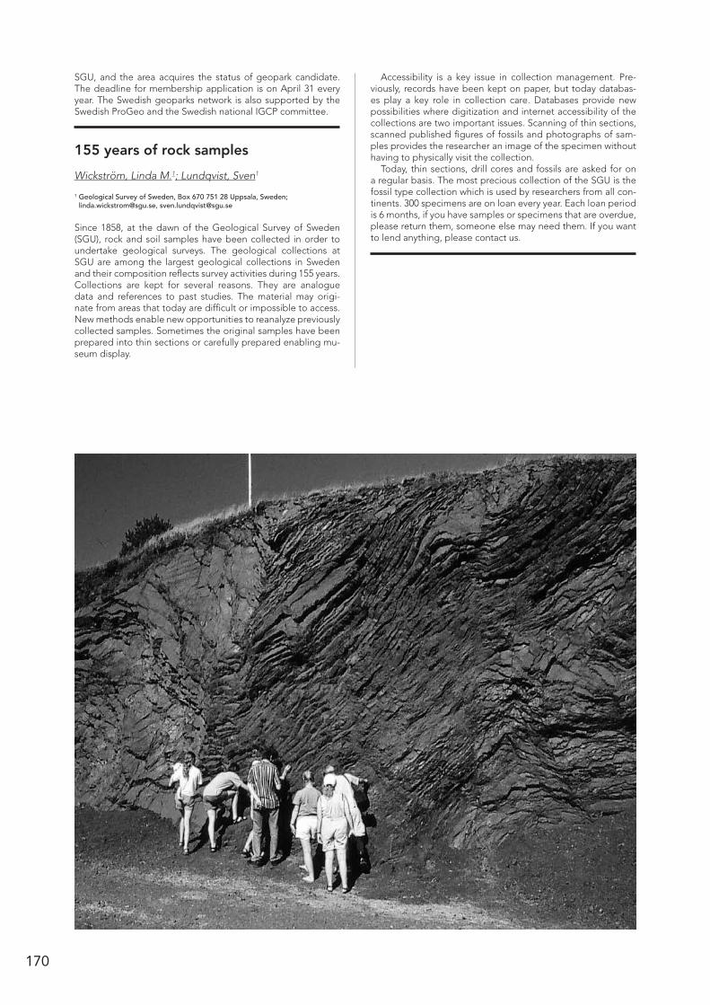
170
SGU, and the area acquires the status of geopark candidate. The deadline for membership application is on April 31 every year. The Swedish geoparks network is also supported by the Swedish ProGeo and the Swedish national IGCP committee.
155 years of rock samples
Wickström, Linda M.1; Lundqvist, Sven1
1 Geological Survey of Sweden, Box 670 751 28 Uppsala, Sweden; [email protected], [email protected]
Since 1858, at the dawn of the Geological Survey of Sweden (SGU), rock and soil samples have been collected in order to undertake geological surveys. The geological collections at SGU are among the largest geological collections in Sweden and their composition reflects survey activities during 155 years. Collections are kept for several reasons. They are analogue data and references to past studies. The material may origi-nate from areas that today are difficult or impossible to access. New methods enable new opportunities to reanalyze previously collected samples. Sometimes the original samples have been prepared into thin sections or carefully prepared enabling mu-seum display.
Accessibility is a key issue in collection management. Pre-viously, records have been kept on paper, but today databas-es play a key role in collection care. Databases provide new possibilities where digitization and internet accessibility of the collections are two important issues. Scanning of thin sections, scanned published figures of fossils and photographs of sam-ples provides the researcher an image of the specimen without having to physically visit the collection.
Today, thin sections, drill cores and fossils are asked for on a regular basis. The most precious collection of the SGU is the fossil type collection which is used by researchers from all con-tinents. 300 specimens are on loan every year. Each loan period is 6 months, if you have samples or specimens that are overdue, please return them, someone else may need them. If you want to lend anything, please contact us.

171
#E22- Sölvesborg-Stensnäs- project members 149
AAagaard, Per 44Aaltonen Ismo 108Aasly, Kari Aslaksen 50Adrielsson, Lena 126Aehnelt, Michaela 64Aerts, M. 72Agyei-Dwarko, Nana Yaw Nana 104Ahlberg, Per 66Ahlkrona, Josefin 137Ahmed, Engy 156Ahokangas, Elina 37Ahonen, Lasse 158Akçar, Naki 131Alexanderson, Helena 127, 135, 148, 152Ali, Syed Anas 37Allen, Mark B. 113Allen, Rodney 50Almqvist, Bjarne 116Alve, Elisabeth 149Alwmark, C 165Alwmark, Carl 159, 163Ampel, Linda 136, 141, 146Amundsen, H. 73Andersen, Tom 77, 87, 95Andersson, Jenny 91, 93, 100, 119Andersson, Stefan 50Andersson, Ulf Bertil 48, 95, 84, 104Andreassen, Karin 126Andreev, Andrei A. 148Andrén, Elinor 148Andrén, Margareta 78, 96Andrén, Thomas 126Andresen, Arild 87, 104Angard, Kristian 93Anjar, Johanna 126Antal Lundin, Ildiko 52, 56, 91, 116Apler, Anna 43Aritzegui, Daniel 133Arp, Trine 64Arslan Arzu 69, 104Artimo, Aki 37Ask, Maria 139Attinger, Gisela 167Augland, Lars E. 104Augustsson, Carita 64, 78Auken, Esben 46Austrheim, Gunhild 167Austrheim, Håkon 80, 81Azer, Mokhles 59
BBackman, Birgitta 37, 38Baden, Katrine 51Baginski, Boguslaw 122Bahlburg, Heinrich 78Bakarjieva, M.I. 118Balk, Melike 157Baranwal, Vikas C. 46
Barnekow, Lena 148Bartels, A. 78Barthel, Roland 37Bastani, Mehrdad 46Bech, Mia 167Beckett, Frances 163Beckman, Victoria 79Begonha, A. 64, 73Bell, Robin-Marie 51Benediktsson, Ívar Örn 35, 127, 137, 145, 154Bengtson, Stefan 65, 156, 157Bennett, Keith 148Bennike, Ole 148Bercovici, Antoine 65, 66Bergaman, Stefan 100Berggren, Robert 52, 56, 116Berglund, Johan 104, 111Bergman, Stefan 52Bergsson, Bergur 130Bering, D. 72Berndt, Jasper 78Berner, Ulrich 69Bernhardson, Martin 127, 148Bernstein, Stefan 53Berthling, Ivar 128, 130Beyer, Claus 126, 151Beylich, Achim A. 38Bindler, R. 87Bingen, Bernard 80, 105Bjaerke, Tor 105Bjursäter, Stefan 135Bjärnborg, Karolina 51, 95, 121Björck, Svante 126, 128, 136, 149, 150, 161Bjørheim, Maren 52Bjørnestad, Andreas 38Black, Andrew 130, 131, 140Boessenkool, Sanne 142Bogdanova, Svetlana 80, 107, 116, 122 125, 105Bogolepova, Olga K. 51, 67Bomberg, Malin 156, 158Bomfleur, Benjamin 70Bonow, Johan M. 136Borst, Anouk M. 52Boskabadi, Ahmad 59Bothma, Riaan 79, 85, 106, 114Bourgeois, Olivier 129Bousquet, Romain 90Boyce, Adrian 59Bradwell, Tom 130, 131Brennwald, Matthias S. 44Briner, Jason 145Brochmann, Christian 142Broman, Curt 59Broström, Anna 149, 152Brynjólfsson, Skafti 128, 144Brönner, M. 71Bucher, Kurt 102Burchardt, Steffi 114Butler, Rob 169Butler, Robert 124Bøe, Reidulv 133
Abstract Index
Böhme, Martina 39Bøyum, Eivind S. 132
CCalner, Hanna 65Calner, Mikael 65, 69Carbonneau, Patrice 129Cashman, Katharine 159, 163Casserstedt, Lovise 136Cawthorn-Blazeby, Anton 77Cecys, Audrius 106, 122Cederström, Peter 66Chapron, Emmanuel 133Charnock, M. 73Chemia, Zurab 114Chew, David 79Chi Fru, Ernest 156Chmielowski, Riia M. 52, 80Chopin, Francis 106Christensson, Ulf I. 95Christiansen, Hanne, H. 144Claesson Liljedahl, Lillemor 96Claesson, Stefan 80, 107Classon, Caroline 137Conley, Daniel 148Cooper, Matthew 59Coquin, Julien 129Corfu, Fernando 80Cornell, David H. 95Corner, Geoffrey D. 126Cossart, Etienne 129Crill, Patrick 88Cutler, Ingrid 167
DDabbert, Stephan 38Dagestad, A. 39Dahl-Jensen, Dorthe 154Dahlin, Peter 84Dahlin, Torleif 46, 49Dahlqvist, Peter 41, 65Dalsegg, E. 71Dalsegg, Einar 46, 49Dalslåen, Bjørgunn Heggem 107Damsgaard, Anders 143Daniels, Johan 153David García-Sellés 146Davidsen, Børre 81de Haas, Tjalling 129de Kock, Michiel 82, 111Debras, Céline 54Decaulne, Armelle 38Dehls, John F. 39Dennis, Bird 53Denyszyn, Steven 85, 114Deutsch, Alex 159Dobson, Katherine 159Donner, B 152Dowling, Thomas P.F. 129Drake, Henrik 90Dretvik, Håvard 46, 133
172
Duclaux, Guillaume 83, 112Duffield, Christopher James 149Duprat, Helene 99Dyck, Brendan 91Dypvik, H. 72
EEbbestad, Jan Ove R. 66, 68, 69, 74, 165Egeland, Irene 129Eggertsson, Ólafur 38Egholm, David L. 143Eiken, Trond 43Eilertsen, Raymond 43, 133Einarsson, Draupnir 145Einarsson, Elisabeth 66, 167Eiríksson, Jón 161Eklund, Olav 42, 61, 117Eklöf, Sara C.A. 74, 107Elbers, Michael 37Elburg, Marlina 77Elisabeth Rudebeck 149Engström, Jon 107, 108Engvik, Ane K. 80, 81, 105Erambert, Muriel 77Ericsson, Linda 108Eriksson, Mats E. 70Erlström, Mikael 136Ernst, Andreas 38Esbensen, Kim H. 47, 81, 82, 160Eskola, Tiina 130Etzelmüller, Bernd 128, 130, 138Everest, Jez 130, 131, 140, 143, 169Evins, Paul 47
FFaleide, J.I. 67Ferrière, Ludovic 160, 162Filipsson, Helena L. 126, 149, 152Finlayson, Andrew 130, 131, 143Fischer, L 42Fjeldskaar, Willy 138Flett, Verity 130, 131Flodén, Tom 132, 136Folkestad, Hege 167Follestad, Bjørn 141Follin, Sven 47Fortelius, Mikael 68Fredin, Ola 71, 131, 132, 133, 135, 138Frengstad, B. 39Freund, Friedemann 157Frisk, Å. 165Fruergaard, Mikkel 154Fuchs, Lukas 108Fuchs, Robert 97Funder, Svend 133, 154Fyfe, Ralph 155
GGabrielsen, Roy H. 67, 116, 118, 140Gaillard, Marie-José 155Galsgaard, Jens 48Ganerød, Guri V. 49Ganzhorn, Anne-Céline 80Garbe-Schönberg, Dieter 82García Juanatey, María A. 109Garde, Adam A. 160, 161, 162, 165Garetsky, Radim. G. 82, 110Gasparini, Andrea Alessandro 167Gasser, Deta 104Gaupp, Reinhard 64Gee, David. G. 113, 116Geirsson, Halldor 166Gessner, Klaus 83, 112
Ghosh, Anupam 149, 152Gillhespy, Lewis 116Gintov, Oleg 110, 116Grandal, Else Margrethe 132Granseth, Anette Utgården 98Graversen, Ole 110, 111Gray, Amber 48, 157Green, Paul F. 136Greenwood, Sarah 132, 136, 141, 146Greiling, Reinhard O. 165Gren, Johan 67Grenne, Tor 56Grigull, Susanne 52Gubanov, Alexander P. 51, 53, 67Gudmundsdóttir Esther Ruth 144, 161Guðmundsdóttir, Anna Stella 67Guido Meinhold 104Gullbekk, Eystein 167Gumsley, Ashley 82, 94, 111Gunnarsdottir, H. 39Gyllencreutz, Richard 83, 134
HHacker, Bradley R. 96Hafeez, Amer 93Haflidason, Haflidi 129, 132, 142, 163Hagen, Jon Ove 138Halland, Eva K. 53Hallinder, Stina 111Hammarlund, Dan 148, 150Hammer, E. 73Hanken, Nils-Martin 118Hannukainen, Lari 38Hansen, Jens Morten 150Hansen, Kirsten 112Hansen, Louise 133Hanski, Eero 56Hansman, Reuben 83, 112Hansson, Anton 150Haraldsen, Kirsten Borse 167Harlov, Daniel E. 88Harris, Chris 60Hartikainen, Aimo 84Hashemi, Hossein 38Hatakka, Tarja 37, 38Hauber, Ernst 129Hauge, Kristina 104Haugen, L.E. 39Hedberg, Claes 48Hedmark, Mia 167Heikkinen, Pekka 124Heilimo, Esa 83, 84, 112Heinzeller, Christoph 37Heldal, Tom 53, 56Helgason, Jon Kristinn 42Hellqvist, Magnus 151, 167Hendrichson, Randi M. 71Hennicker, Rolf 37Henriksen, Mona 148Hermanns, Reginald L 39, 43Hilse, Ulrike 64Hjelstuen, Berit Oline 129, 132Hjärtsson, Hreinn 78, 96Hoffritz, Sara 53Hofmann, Axel 82, 111Hogmalm, Johan 54, 61, 103Holding, Martin C. 81Holgersson, Björn 41Hollis, Julie 95, 121Holm, Nils G. 157Holm, Paul M 99Holm, Sanna 159, 162, 165Holme, Kirsten 54Holmgren, Sofia 149
Holmström, Sara J.M. 156Holtstam, Dan 95Horstwood, Matthew S.A. 94, 120Hort, Matthew 163Houmark-Nielsen, Michael 134Howett, Peter 40Huet, Benjamin 86Huff, Warren D. 69Hughes, Anna L.C. 134Hughes, Leanne 130Hunter, John 65Huovinen, Irmeli 117, 122Husum, Katrine 133Hyvönen, Eija 145Härmä, Paavo 37, 38Hättestrand, Clas 129, 135Hättestrand, Martina 135Høgaas, Fedrik 135, 139, 141Högdahl, Karin 50, 54, 60, 107, 112Högström, Anette E.S. 66, 68, 165Hölttä, Pentti 106Høyberget, Magne 66, 68Höök, Marcus 46
IIbanez-Mejia, Mauricio 97Ihlen, Peter 81Inerfeldt, Andreas 54, 61Ingólfsson, Ólafur 35, 127, 128, 137, 153, 161Iñiguez, Enrique 157Iqbal, Faisal 66Irvali, Nil 155Isaksson Dreyer, Oskar 147Ising, Jonas 142Islam, Tariqul M 166Itävaara, Merja 156, 158Ivarsson, Magnus 65, 157
JJacobs, Joachim 107Jakobsen, Leif V. 148Jakobsen, Peter Roll 136, 137, 138Jakobsson, Martin 132, 136, 137, 141, 145, 146Janisch, Stephan 38Jankaew, Kruawun 89Jansen, Øystein J 168Jansson, Nils 52Japsen, Peter 136Jarsve, E. M. 66Jensen, Jørn Bo 148Jensen, Maria 139Jensen, Peter Klint 112Jensen, Sören 66, 68Jerram, Dougal A. 93Joachimski, Michael M. 65, 69Johannessen, Peter N. 154Johansson, Leif 81, 160, 162Johansson, Magnus 141Johansson, Peter 168Johansson, Åke 84Johnson, Mark D. 127, 136, 137, 147Johnston, Stephen T. 115Jones, Lee 130, 131, 143Jonsson, Erik 50, 54, 60Jónsson, S.A. 127Jónsson, Sverrir 137Juhlin, Christopher 109, 113, 165Julie Andreassen 144Jönberger, Johan 52Jønsson, Jesper B. 85

173
KKaakinen, Anu 68Kaislaniemi, Lars 113Kalliomäki, Henrik 84, 114Kalvig, Per 52, 85Kamber, Balz S. 79, 100Kampmann, Tobias C. 55Kaparulina, Ekaterina 151Kaplan, Jed 155Karatayev, German I. 82, 110Karhu, Juha A. 120Kavli, Fredrik 167Kaye, Matthew N. 51Kemp, Anthony I.S 91, 117Kenkmann, Thomas 159Ketola, Terhi 38Keulen, Nynke 85, 160, 162Khan, Mansoor 149Kierulf, H.P. 71Kietäväinen, Riikka 158Kilpeläinen, Timo 117, 122King, D. T. Jr. 164Kinnunen, Janne 122Kirchner, Nina 137Kirkbride, Martin 131Kjøll, Hans Jørgen 85Klausen, Martin B. 79, 85, 89, 94, 106 ,114, 162Kleine, Barbara 86Kleinhans, Maarten G. 129Kleiven, Helga 155Klimaschewski, Andrea 148Klint, Knud Erik S. 107, 136, 137Klonowska Iwona 116Klug, Martin 139, 141Knies, Jochen 132, 151Knipfer, Sebastian 62Knudsen, Karen Luise 161Knutsson, Gert 40Kokfelt, F. Thomas 85, 89, 91, 92, 114, 118, 161, 162Kokfelt, Ulla 153Kolb, Jochen 51, 55, 85, 114Konestabo, Heidi Sjursen 167Kontny, Agnes M. 165Kooijman, Ellen 78, 86, 96Korja, Annakaisa 86, 106, 115, 117, 124Korkka-Niemi, Kirsti 37, 40Korneliussen, Are 55Korshøj, Joakim Stiel 48Korte, Christoph 53Kostopoulos, Dimitrios 92Koyi, Hemin A. 108, 107, 114, 117, 136Krimly, Tatjana 37Kristine, Thrane 92Kristinsdóttir, Bara 95, 121Kristoffersen, Magnus 87, 116Kronborg, Christian 126, 151Krzeminska, Ewa 115Krzeminski, Leszek 115Kröger, B. 69Kubik, Peter 131Kukkonen, Ilmo 158Kunkel, Cindy 64Kurhila, Matti 124Kværner, J. 39Kylander, Malin 87, 89, 136, 141Kähkönen, Yrjö 84, 114Käpyaho, Asko 57, 122Kärki, Aulis 108
LLa Femina, Peter C 166Ladenberger Anna 116Lahaye, Yann 56, 87Lahtinen, Raimo 115Laiho, Taina 42Laine, Eeva-Liisa 59, 121Larsen B., Rune 55Larsen, Bjørn T. 118Larsen, Eiliv 138, 139Larsen, Gudrún 161Larsen, Guðrún 164Larsen, Lotte Melchior 98Larsen, Nicolaj Krog 126, 143, 145Larsen, Rune 98Lauri, Laura 122Laute, Katja 38Lazor, Peter 102Leadbetter, Susan 163Lehnert, Oliver 65, 69, 104, 165Leijd, Magnus 95Lena Håkansson 144Lepinette, A. 164, 165Lerche, Hans 138Lesemann, Jerome 143Leth, Jørgen O. 148Lewerentz, Alexander 88Li, Yuan 116Lidmar-Bergström, Karna 69, 138Lie, Jan Erik 132Lif, Arne 136Likpa, Ewelina 142Liljedahl, Thomas 58Lilleøren, Karianne S 130, 138Linderson, Hans 150Lindgren, Johan 67Lindgren, Karin 48Lindskog, Anders 70Linge, Henriette 134Lipka, Ewelina 142Liu, Liping 68Ljung, Karl 149, 152Lohne, Øystein S. 134Loke, Meng Heng 46Lomholt, Steen 148Lorenz Henning 113, 116Lubnina, Natalia 116Lund, Bjorn 139Lundmark, Anders Mattias 67, 167Lundmark, Mattias 116Lundqvist, Jennie 167Lundqvist, Lena 119Lundqvist, Sven 168, 170Lunkka, Juha Pekka 139, 151Luolavirta, Kirsi 56Luth, Stefan 52, 56, 116Lutro, Ole 81Luukas, Jouni 84Lynch, Edward 52Lyså, Astrid 138, 139Lötstedt, Per 137Löwemark, Ludvig 83Löwhagen, Linda 89
MMaarupgaard, Bjørn P. 89Maast, T. E. 73MacDonald, Alan 130, 131, 140, 162Maier, W. 87Maier, Wolfgang 56Majka, Jarek 54, 116Makowsky, Felix 89Malmberg Persson, Kärstin 40, 41Mangerud, Jan 134, 145
Mansfeld, Joakim 89Marker, Mogens 80, 107, 120Markin, J.K. 164Marquer, Laurent 155Martinez, Cortiza A. 87Martinsson, Olof 52Maskenskaya, Olga 90Mason, Paul 157Maurice, Louise 130, 131Mauser, Wolfram 37Mazier, Florence 155McCaffrey, Bill 169McDonald, Christopher 102McDonald, Iain 81, 160, 161McFarlane, Christopher R.M. 89McKay, C.L. 152McLoughlin, Stephen 70Mehlqvist, Kristina 70Meinhold, Guido 69, 165Melero- Asensio, I. 165Melezhik, Victor A. 120Mercier, Denis 129Meyer, Gurli B. 50, 56Meyer, Marcus 64Mezger, Klaus 96Middleton, Maarit 145Mikki, Susanne 167Mikko, Henrik 42, 139, 142Mikkola, Perttu 83, 84, 112Minnitt, Richard 82Moberg, Jonas 46Mohamed, Fathy 59Moller, Charlotte 100Molnar, F. 87Molnár, Ferenc 57Mooney, Walter D. 53Moreau, Julien 84, 114, 124Morigi, Caterina 154Morisbak Jahrsve, Erlend 140Mottram, Catherine 102Muerth, Markus 37Mujezinovic, Jasminka 57Mukherkjee, Soumajit 114Munier, Raymond 139Mychak, Sergii 110, 118Müller, Axel 132Münker, Carsten 100, 101Mäkinen, Joni 37Mänttäri, Irmeli 57März, Christian 83Möl Mortensen, Gry 41Möller, Andreas 90, 91Möller, Charlotte 79, 88, 91, 93, 119, 125Möller, Per 126, 139Mørk, Mai Britt E. 57Mörs, Thomas 70Mörth, Carl- Magnus 78, 87Mörth, Magnus 96, 146
NNagy, Jenoe 71Naqvi, S. 72Narloch, Wlodzimierz 143Neill, Iain 113Nguyen, P.D. 72Nicholson, Emma 159, 163Nielsen, Anne Birgitte 152, 155Nielsen, Arne Thorshøj 71, 72, 163Nielsen, Lars Henrik 154Nielsen, Line S. 91Nielsen, Ole Bjørslev 126, 151Nielsen, Troels F.D. 52, 85, 114

174
Niemeyer, Hans 78Niemi, Sami 84Nieminen, Ville 117, 122Nikkilä, K. 117Nilsen, Tonje Elvik 163Nilsson, Bertel 137Nilsson, Björn 150Nilsson, Mimmi K.M. 85, 97, 114Ning, Wenxin 149, 152Nironen, Mikko 115Nisell, Jakob 41Nõlvak, J. 165Noormets, Riko 137Norðdahl, Hreggviður 153Nordgren, Nina 54Nurmi, Heikki 38Nurminen, Tiina 40Nyberg, Johan 40, 41, 43Nyholm, Tuure 38Nykänen, Vesa 60Nystuen, J.P. 67Nystuen, Johan Petter 140Nyyssönen, Mari 158Næraa, Tomas 91, 92, 95, 117, 118, 121Nørgaard-Pedersen, Niels 148
OÓ Dochartaigh, Brighid 130, 131, 140O´Brien, Hugh 56, 87, 112O’Regan, Matt 83, 132, 136, 141, 146Oalmann, Jeffrey 90Oberhardt, N. 72Ocampo, Adriana 164Oen, Endre 55Ofeigsson, Benni 130Ojala, Antti E.K. 140, 141Óladóttir, Bergrún Arna 164Ólafur Ingólfsson 144Olaussen, Snorre 118Olesen, O. 71Oliver, Lelsey 169Olivotos, Spyros–Christos 92Olsen, Lars 133, 141Olsson, Johan 82, 111Olvmo, Mats 138, 141Oppikofer, Thierry 39Ormö, Jens 159, 163, 164, 165Óskarsson, Birgir V 92
PPalacios, Teodoro 66, 68Palmlöf, Erik 58Palmu, Jukka-Pekka 140, 141Paque, H. 64Paquet, H. 73Parrish, R.R. 120Parrish, Randy 113Pascal, Christophe 113Pashkevich, I.K. 118Passey, Benjamin H. 68Patten, Clifford 58Pattison, John 161, 162Paulamäki, Seppo 108Paus, Aage 142Pearson, Dean 65Pedersen, Asger Ken 98, 146Pedersen, Jon Halvard 118Pedersen, Karsten 113Pedersen, Stig A. Schack 138Pedersen, T. 39Pejrup, Morten 154Percival, Ian G 75Persson Nilsson, Katarina 119Persson, Carl 149
Pesonen, Lauri J. 68Petecki, Zdzisław 115Petersen Julius, Lars 47Peterson, Gustaf 142Petersson, Andreas 93, 95, 119, 121Petruny, L. W. 164Petrus, Joe 79Petursson, Halldor G. 42Peuraniemi, Vesa 71, 130Phillips, Emrys 130, 131, 136, 142, 143, 154, 169Pierpaolo, Guarnieri 119Piippo, Simo 117, 122Pinan-Llamas, Aranzazu 125Ping, Yan 109Piotrowski, Jan A. 143Pitcairn, Iain 58, 59, 86Planke, Sverre 93Poelchau, Michael 159Polteau, Stephane 93Porkka, Tero 38Poska, Anneli 152, 155Prestvik, Tore 93Preto, Pedro 146Preto, Preto 141Pullinen, Arto 37, 38Purkamo, Lotta 158Påsse, Tore 143, 153
RRaaness, Agnes 55Raines, Michael 130Rajala, Pauliina 156Rama, Miradije 42Rangnes, Kristin 169Ranjer, Stina J.E. 95Ransed, Gunnel 168Rasmussen, C. M. Ø. 69Rasmussen; Jan Audun 64Ratschbacher, Lothar 96Rauch, S. 87Rautio, Anne 40Reber, Regina 131Regis, Daniele 102Rehnström, Emma F 59, 91, 117Reichenau, Tim G. 37Reinholdsson, Maja 158Rey, Patrice F. 124Riber, L. 72Riis, Fridtjof 38Riisager, Peter 162Riishuus, Morten S 92Ring, Uwe 35Ringnes, Hege Kristin 167Ritchie, Calum 169Roaldset, E. 72Roberts, Nick M W 93, 94, 119, 120Robinson, Peter 94Romero, O.E. 152Romundset, Anders 131, 133, 135Roos, Monica 167Rosberg, Jan-Erik 113Rosing, Minik T. 91, 117Rosqvist, Håkan 46Rothschild, Lynn 157Rubensdotter, Lena 42, 133, 139, 144Rullestad, Tove 167Rundgren, Mats 150, 153Rushton, Adrian W.A. 74Ruskeeniemi, Timo 145Rust, Alison 159Rüsing, Tobias 78Rådman, Johan 94Rød, Rita Sande 38
Røhr, Torkil 120Rønning, Jan Steinar 46, 49
SSaalmann, Kerstin 59, 121Saemundsson, Thorsteinn 42Sahlström, Fredrik 54, 60Sakellaris, Grigorios 57Salad Hersi, Osman 60Salminen, Paula E. 120Salonen, Veli-Pekka 40, 139Sander, Lasse 154Santaguida, Frank 56Sarala, Pertti 60, 144Savage, Jessica 90Scherer, Erik E. 96Scherstén, Anders 51, 88, 91, 93, 95, 117, 119, 121, 165Schiellerup, Henrik 81Schlüchter, Christian 131Schmeling, Harro 108, 114Schmidt, Astrid M.Z. 154Schmude, Jürgen 38Schneider, Karl 37Schomacker, Anders 127, 128, 137, 144Schovsbo, Niels Hemmingsen 71, 72Schuett, Jorina 137Schumacher, John C. 95Schweitzer, Mary Higby 35Scott, James M. 100, 101Sejrup, Hans Petter 129, 163Self, Angela E. 148Sequeira Braga, M.A. 64, 73Shenhong, Y. 87Shrestha, Rajendra 148Shumlyanskyy, Leonid 121Shvarev, Sergei 123Siegmund, Heike 78Sigeman, Hanna 158Sigfúsdóttir, Thorbjörg 135Sigfúsdóttir, Þorbjörg 154Sigmarsson, Olgeir 164Sigmundsson, Freysteinn 166Sigurðardóttir, Minney 145Siikanen, Jonas 46Sjöblom, Sonja 61Sjöqvist, Axel S.L. 95Sjöström, Arne 150Sjöström, Håkan 112, 114, 116Skagen, Therese 167Skelton, Alasdair 78, 86, 88, 96, 100, 108, 136, 145Skogby, Henrik 102Skridlaite, Grazina 122Skyttä, Pietari 117, 122Skår, Øyvind 96Slagstad, Trond 107, 120Sletten, K 42Smit, Matthijs A. 96Smith, Colby A. 42, 139, 142Snowball, Ian 43, 158Snyman, Dian 85, 114Soboll, Anja 38Solbakk, T. 71Solberg, Inger-Lise 46Solli, Arne 80Sollie, Inger Lise 43Solovieva, Nadia 148Soltvedt, Natalie 155Sorjonen-Ward, Peter 57Spagnolo, Matteo 129Sparrenbom, Charlotte 44, 46Spungin, Vadim 123Spürgin, Simon 103

175
Stalsberg, K 42Steemans, Philippe 70Steenfelt, Agnete 61Steffensen, Jørgen Peder 154Steltenpohl, Mark G 104Stemmerik, Lars 64Stephens, Michael B. 55, 122Stern, Robert 59Stevens, Rodney L. 43, 73Stigsson, Martin 47, 49Stockmann, Gabrielle 78, 96Stokes, Chris R. 126Storey, Michael 100Stouge, Svend 75Strand, Kari 151Strandberg, Gustav 155Sturkell, Erik 145, 159, 165, 166Stuut, J.-B.W. 152Sugita, Shinya 155Sundal, Anja 44Sundh, Martin 42Sutinen, Raimo 145Sveian, Harald 133, 141Svendsen, John Inge 134, 145Svensson, Mats 46Svensson, Nils-Olof 149Swärd, Henrik 132, 136, 141, 146Systra, Ylo 123Szczucinski, Witold 139Söderlund, Ulf 51, 79, 82, 94, 97, 111, 162Søgaard-Jensen, Chr. 97Sørbel, Leif 138Sørensen, Bjørn Eske 85, 98Sørensen, Erik Vest 98, 146Sørlie, Ronald 72, 73, 132
TTalbot, Christopher J. 74, 114Tappe, Sebastian 85, 114Tapster, Simon 93Taran, Ludmila 122, 123Tarvainen, Timo 37, 38Tassis, Georgios 49Taylor, Wendy L.T. 66, 68Teagle, Damon 59Tegner, Christian 89, 99Teyssier, Christian 124Thébaud, Nicolas 83, 112Thoma, Klaus 159Thomsen, Tonny Bernt 51, 85, 91, 99, 116Thorarinsson, Sigurjon B 99Thorsbrink, Magdalena 41Thrane Kristine 118Thörelöf, Mats 56Thörnelöf, Mats 52Thörnerlöf, Mats 116Tillberg, Mikael 54, 61, 103Tollefsen, Elin 100Tom, Bradwell 143Torras, Maria-Carme 167Torvela Taija 84, 114, 124, 169Tranholm, Louise 48Troldberg, Lars 137Trondman, Anna-Kari 155Tsang, Chin-Fu 113Tsourlos, Panagiotis 49Tual, Lorraine 125Tuusjärvi, Mari 61Tveten, Einar 81Tylmann, Karol 143Tønnesen, Jan F. 46
UUlmius, Jan 100Ulrich, Thomas 100Uwe, Ring 83, 112
VVajda, Vivi 65, 66, 70, 158, 164van der Meer, Jaap 142van der Meer, Quinten H.A 100, 101van Hunen, Jeroen 113Varga, Tina 146Vejelyte, Irma 125Vennemann, Torsten 85Vidar Jakobsen, Leif 135Vigneresse, Jean-Louis 101Viola, Giulio 105Vogt, Christoph 132Voipio, Teemu 56Vuokko, Jouko 38Väisänen, Markku 112
WWackerbauer, Johann 38Waight, Tod E 52, 99, 100, 101Waldmann, Nicolas 133Wanhainen, Christina 100Warren, Clare 102Wasström, Annika 62Weidner, Thomas 74Weis, Franz 102Weisenberger, Tobias Björn 102, 103Wejden, Bente 44Westbye, Hilde 167Whitehouse, Martin J. 55, 57, 88, 117Whitney, Donna L. 124Wiborgh, Hanna 136Wickström, Linda M. 169, 170Wigforss-Lange, Jane 74Wikström, T. 165Willerslev, Eske 154Williams, Ian S. 115Willumsen, Pi Suhr 74Wilson, Paul 140Winsborrow, Monica, C.M. 126Wiszniewska, Janina 115, 122Witham, Claire 163Wohlfarth, Barbara 89, 146Wu, Rongchang 65, 75Wysota, Wojciech 143Wästeby, Niklas 96
YYi, Keewook 105Young Nicolás 145Yugsi Molina, Freddy X 39
ZZack, Thomas 54, 61, 103Zhan, Renbin 75Zhang, Zhaoqun 68Zibra, Ivan 83, 112Zillén, Lovisa 43Zimmermann, H.D. 97Zimmermann, Udo 78Zwingmann, Horst 132
ÅÅberg, Lina 62Åkesson, Christine 152Åkesson, Maria 44Åström, Mats 90
ÖØdegaard, Marte 167Öhrling, Christian 147Ősi, Attila 75


Table of Contents
Welcome ______________________________________________________ 2
Organizing committee __________________________________________ 3
Scientific program committee ___________________________________ 3
Program Overview _____________________________________________ 4
Social Program ________________________________________________ 5
Scientific Program______________________________________________ 6
- Oral presentations __________________________________________ 7
- Posters ___________________________________________________ 22
Abstracts1 ________________________________________________ 34
- Plenary talks ________________________________________________ 35
- HYD-ENV Hydrogeology/Environmental Geology _______________ 37
- ENG-GEO Engineering Geology ______________________________ 46
- ECON-OIL Economic and Petroleum Geology __________________ 50
- LUNDPAL Lundadagarna i Historisk Geologi och Paleontologi ____________________________________________ 64
- PET Petrology ______________________________________________ 77
- STR-TEC Structural Geology/Tectonics ________________________ 104
- MOR-GLA Geomorphology and Glacial Geology ______________ 126
- QUAT Quaternary Geology _________________________________ 148
- GEOBIO Geobiology and Astrobiology _______________________ 156
- GEOP Geophysics and Volcanoes ____________________________ 159
- OUT-ED Outreach and Education: Reaching out with WOW to the Many! ________________________________________ 167
Author Index ________________________________________________ 171
1 The abstract texts that follow are arranged first by theme, and then alphabetically by first author. For example, all abstracts in the various PET Petrology sessions are found within the PET section of the abstract volume, and alphabetically by author therein. This is to ease searching for abstracts while sitting within a given theme session.
Lund, Sweden, January 8–10 2014
Hosted by the Geological Society of Sweden
Abiskojokk canyon, Abisko SwedenPhoto: Mark Johnson, 2012
31st No
rdic G
eolo
gical W
inter Meeting
. Lund, Sw
eden. January 8-10, 2014
Mai
n sp
ons
ors
Sponsors
Related Documents


![[Nordic Built Challenge 17.12.2013] Trine Pertou Mach, Nordic Built: Nordic Built](https://static.cupdf.com/doc/110x72/547174dcb4af9f980a8b4ad9/nordic-built-challenge-17122013-trine-pertou-mach-nordic-built-nordic-built.jpg)


