(1) Waterbody Name from 2018 List of Impaired Waters (1) Probable cause(s) of impairment to be addressed (ex. metals) (2) Waterbody Name from 2018 List of Impaired Waters (2) Probable cause(s) of impairment to be addressed (ex. metals) (3) Waterbody Name from 2018 List of Impaired Waters (3) Probable cause(s) of impairment to be addressed (ex. metals) Latitude (1) Longitude (1) Latitude (2) Activity 1 Name Activity 2 Name Activity 3 Name Latitude (3) Longitude (2) Longitude (3) Which WRP does the project implement? 319 Nonpoint Source Funding Application FY2019 Applications are due Monday, September 10, 2018 by 2:00 pm Section I: General Information Project Sponsor Information City State Phone Number E-mail Address Project Funding Zip Code Zip Code Registered with SAM? Does your organization have liability insurance? Signatory Title Project Title Sponsor Name Registered with the Secretary of State? DUNS # Primary Contact Title Address City State Phone Number E-mail Address Signature 12 Digit HUC #(s) Address Signature Project Location 319 Funds Requested (including administrative fee) Administrative Fee (not to exceed 10% of total 319 funding request) Other Funds (not 319, not match, not federal) State Cash Match Local Cash Match In-Kind Match Federal Funds Total Non-federal Match Total Project Cost

Welcome message from author
This document is posted to help you gain knowledge. Please leave a comment to let me know what you think about it! Share it to your friends and learn new things together.
Transcript

(1) Waterbody Name from 2018 List of Impaired Waters
(1) Probable cause(s) of impairment to be addressed (ex. metals)
(2) Waterbody Name from 2018 List of Impaired Waters
(2) Probable cause(s) of impairment to be addressed (ex. metals)
(3) Waterbody Name from 2018 List of Impaired Waters
(3) Probable cause(s) of impairment to be addressed (ex. metals)
Latitude (1) Longitude (1)
Latitude (2)
Activity 1 Name
Activity 2 Name
Activity 3 Name Latitude (3)
Longitude (2)
Longitude (3)
Which WRP does the project implement?
319 Nonpoint Source Funding Application FY2019 Applications are due Monday, September 10, 2018 by 2:00 pm
Section I: General Information
Project Sponsor Information
City State
Phone Number
E-mail Address
Project Funding
Zip Code Zip Code
Registered with SAM?
Does your organization have liability insurance?
Signatory
Title
Project Title
Sponsor Name
Registered with the Secretary of State?
DUNS #
Primary Contact
Title
Address
City State
Phone Number
E-mail Address
Signature
12 Digit HUC #(s)
Address
Signature
Project Location
319 Funds Requested (including administrative fee) Administrative Fee (not to exceed 10% of total 319 funding request)
Other Funds (not 319, not match, not federal)
State Cash Match
Local Cash Match
In-Kind Match
Federal Funds
Total Non-federal Match
Total Project Cost

Goal and Objectives: Describe the overall goal and specific objectives for this project.
Section II: Problem Description Problem Description: Describe the nonpoint source pollution problem you plan to address. Identify the root cause of the pollution, the geographic extent of the problem, and who it affects. Reference any photos, data sets, reports, or other documentation you intend to attach to your application.
Collaborative Effort: Describe the collaboration necessary to obtain support from all appropriate project partners. Clearly Identify what's been done, and what remains. (Section III includes space for listing partners and roles.)

Section III: Project Description
Project Methods: Describe how you plan on using 319 funding to address the nonpoint source problem identified in Section II. Where possible, identify and quantify restoration techniques and best management practices. If you are seeking funding for project design or engineering, describe the types of practices you might consider (e.g. grazing management, willow planting, channel reconstruction, etc), and how you will evaluate your alternatives. Reference any photos, maps, design drawings, or other pre-project planning documents you intend to attach to the application.
Partners and Roles: Identify the project partners and their roles.
Partner Role(s)

Technical and Administrative Qualifications: Identify the technical and administrative expertise you will rely upon to complete your project. Include qualifications of project partners that will be involved in design, implementation, monitoring, outreach, etc. Note any credentials project participants may have that will help ensure timely and accurate administration of a potential contract (e.g. experience or training in contract management, accounting, procurement, billing and recordkeeping, technical writing).
Past and Current Projects: Identify previous and/or ongoing grants or contracts your organization has received. This is similar to providing a list of references on a job application.
Funding Organization Contact Name, Phone, Email Award Amount Project Description Project Status

Task 1 Title
Description
Deliverables
Timeline Match Source
Task 2 Title
Description
Deliverables
Timeline Match Source
Section IV: Draft Scope of Work
Task 1 Funding
319 Funds
Non-Federal Match
Federal Funds
Other Funds
Total Cost
Is Match Secured?
Task 2 Funding
319 Funds
Non-Federal Match
Federal Funds
Other Funds
Total Cost
Is Match Secured?
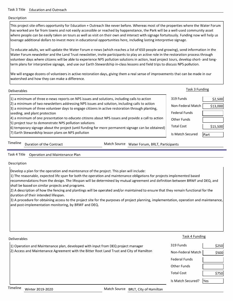
Task 3 Title
Description
Deliverables
Timeline Match Source
Task 4 Title
Description
Deliverables
Timeline Match Source
Is Match Secured?
Task 3 Funding
319 Funds
Non-Federal Match
Federal Funds
Other Funds
Total Cost
Is Match Secured
Task 4 Funding
319 Funds
Non-Federal Match
Federal Funds
Other Funds
Total Cost

Task 5 Title
Description
Deliverables
Timeline Match Source
Is Match Secured?
Task 6 Title
Description
Deliverables
Timeline Match Source
Is Match Secured?
Task 5 Funding
319 Funds
Non-Federal Match
Federal Funds
Other Funds
Total Cost
Task 6 Funding
319 Funds
Non-Federal Match
Federal Funds
Other Funds
Total Cost

Task 7 Title
Description
Deliverables
Timeline Match Source
Is Match Secured?
Task 8 Title
Description
Deliverables
Timeline Match Source
Is Match Secured?
Task 7 Funding
319 Funds
Non-Federal Funds
Federal Funds
Other Funds
Total Cost
Task 8 Funding
319 Funds
Non-Federal Match
Federal Funds
Other Funds
Total Cost

Task 9 Title
Description
Deliverables
Timeline Match Source
Is Match Secured?
Task 10 Title
Description
Deliverables
Timeline Match Source
Is Match Secured?
Task 9 Funding
319 Funds
Non-Federal Match
Federal Funds
Other Funds
Total Cost
Task 10 Funding
319 Funds
Non-Federal Match
Federal Funds
Other Funds
Total Cost

Detailed Project Budget Section V: Supporting Documents
TOTAL COSTS
Task Number and Specific Action 319 FundsState Cash
MatchLocal Cash
MatchIn-KindMatch
Federal Funds Total Costs

Project Timeline: Complete the following Project Timeline by entering task numbers and titles in the left hand column, then check the boxes for the appropriate quarters and years in which you will be working on the task.
Task Spring 2019
Summer 2019
Fall 2019
Winter 2019
Spring 2020
Summer 2020
Fall 2020
Winter 2020
Spring 2021
Summer 2021
Fall 2021
Comments: Use the space provided for additional information that may not have been captured elsewhere in this application.
Attachments: Submit the following attachments with your application. The Project Map and 3 Letters of Support are required. Please include the other attachments if they are available.
Required Attachments
Provide if Available
Project Map(s): Between 1:1000 and 1:12,500 scale; aerial photo background; latitude and longitude of each individual project site; name of project site; name of landowner
Design Drawings Other Supporting Documentation (list)
Applicable Permits
Site Photos
Site Evaluations/Preliminary Engineering Reports
Letters of Support: Minimum of 3; must include a letter from each project site landowner

City of HamiltonRiver Park
Source: Esri, DigitalGlobe, GeoEye, Earthstar Geographics, CNES/Airbus DS,USDA, USGS, AeroGRID, IGN, and the GIS User Community
Bitter Root Land Trust Riverfront Parcel: Channel Migration
²BRLT parcelEast bank position
199520062016
Revegetation priority area
This map is centered on:114°9'52.03"W 46°13'58.731"N 11T 718635 5123842 UTM
0 150 300 450 600 Feet

Proposed treatments
Bitterroot River Park: Riparian Revegetation Project
Planting Installing container plants promotes the development of a riparian buffer to provide shade for the channel, filter sediment and nutrients, and provide more
complex terrestrial habitat.
TransplantsSource young cottonwood transplants from Tract 2 of River Park, as recommended in the “River Park
Management Plan”

Bitterroot River Park: Riparian Revegetation Project
Competition Suppression Brush blankets are three-foot by three-foot pieces of perforated plastic that prevent light from reaching the ground surface around the plant, but allow water through. The brush blankets suppress growth of aggressive plant species, such as pasture grasses, immediately next to the plant. This reduces competition for light, water, and nutrients.
Browse Protection The purpose of this treatment is to protect newly planted vegetation from browse until it can become established and is able to withstand some browse pressure. Animals may preferentially browse new shoots on planted material. Wire browse protectors will be used to limit wildlife browse.

Above, View from North
Above, View from South
Bitterroot River Park: Riparian Revegetation Project

Above, River bottom, View from South
Bitterroot River Park: Riparian Revegetation Project


River Park Vegetation Management Plan & Maintenance Guidelines
Page 3
transporting or impounding pollutants or irrigation waters when waters are used up and not returned to state waters.
FIRE MITIGATION Much of the undeveloped section of the park has a large amount of fuel build-up consisting of woody wind-fall and dense grass under story. This is especially true on the south end of tract 4.
Management Considerations
The trail rights-of-way in the undeveloped parts of the park could be widened to accommodate limited 4-wheeler and/or small vehicle use for wind-fall clean up. There could be an annual clean-up of debris where motorized ATVs are allowed on the trail for a short period of time. The dense stands of grass are another issue. There are some rural parks in Montana where they bring in a small herd of goats or sheep for a brief time to harvest under story grasses.
NOXIOUS WEEDS Several species of noxious weeds are present in River Park. By allowing the noxious weed infestations to expand unchecked, there is an aggressive competition for light, nutrients and water that the native plant community cannot compete. The major noxious weeds in the park include:
� Common tansy (Tanacetum vulgare) � Spotted Knapweed (Centaurea maculosa) � Yellow Toadflax (Linaria vulgaris) � Houndstongue (Cynglossum officinale) � Canada Thistle (Cirsium arvense)
Weed control vs. weed management1
Weed control refers to actions used to achieve the immediate elimination of an existing weed population, usually through the use of herbicides. Weed management goes beyond control of existing weed problems and focuses on reducing weed invasion and emergence, preventing weed reproduction and minimizing weed competition with herbaceous vegetation. The development of a multi-tactic program is known as an Integrated Weed Management (IWM) program. An IWM program takes advantage of cultural, mechanical and chemical weed control strategies in the best possible way to maintain weed
1 Smith, Richard G. & Menalled, Fabian D. Integrated Strategies for Managing Agricultural Weeds: Making Cropping Systems Less Susceptible to Weed Colonization and Establishment. MT 200601 AG.
Common tansy www.co.silverbow.mt.us

River Park Vegetation Management Plan & Maintenance Guidelines
Page 4
densities at manageable levels while preventing shifts in weed populations to more difficult-to-control weeds.
Management Considerations
1. Identify and map weed infestations. Weed scientists have recognized that weeds are plants that are especially successful at colonizing and maintaining their abundance under conditions of repeated disturbance. Documentation of weed infestations will not only track the progress of the mitigation, but will help prioritize the areas of greatest need.
2. Increase natural weed mortality. Manage vegetation and soils favorable towards the desired cover. Once weed species are identified, research the life cycle of the weed and determine the most appropriate time for weed mortality. For example, an annual weed such as kochia, is most vulnerable during the spring when the seedlings arrive. Each major target species should have a most vulnerable time frame in which to launch an attack.
3. Use fertilizers sparingly. Lawns and weeds compete for the same basic resources: sunlight, nutrients, water and space. Fertilizer should be placed in areas with irrigation and minimal run off into water bodies.
4. Reclaim overused or damaged areas quickly. The loss of herbaceous ground cover provides an ample opportunity for weed growth. Reseed with the recommended seed mix and in the methods most effective for establishment. Utilize mulch (straw, fiber) to hold in moisture and provide cover while grasses are established. Sections (i.e. 100’ by 100’ areas) of the park should be roped off in order to protect the soils from compaction.
5. Diversify the weed management practices. Biological applications include the use of insects that specifically target individualized weed species. Insects are being utilized as a means for long-term management of weeds. In Colorado, insects have been released on an experimental basis to control knapweed. At this time, some are available to the general public. Two seed head gall flies are available as adults and a beetle is also available. The flies should be released in June and/or July. Beetles should be released in July.
Goat herds have been hired in Missoula and Helena to graze on the park lands. Call a goat company to discuss the particulars of the project – sometimes a site visit is required to quote larger jobs. Frequently companies have minimum requirements – one company requires a three day minimum and a herd of 60. After deciding upon a strategy – how many goats for how long – the company will deliver the goats to the property. A temporary enclosure – an electric fence - is erected

River Park Vegetation Management Plan & Maintenance Guidelines
Page 5
to contain the goats. The electric fence is battery powered for remote applications. Most companies will also have a shepherd onsite 24 hours a day to manage the goats. Fees vary – one company charges $1100 for a herd of 60 goats for three days.2
Goats are excellent to use in areas where steep slopes, existing trees and other site features limit access by machinery. Goats are also well suited for areas that include wetlands and streams - goats create very limited impact in these areas and any areas of concern can also be fenced out. Goats are a pesticide-free alternative for weed control in sensitive areas and they do not compact the soil. However, goats are non-selective feeders. If the area also contains desirable plants, each plant must be temporarily fenced off with chicken wire or hardware cloth to prevent damage from the herd.
Mechanical weed control includes hand pulling and mowing. However, mowing should be used cautiously as a method as over-mowing may contribute to more harm than benefit.
MOWING Improper mowing causes more problems on lawn than any other maintenance practice. Turf grasses, like other plants, must manufacture sugars through photosynthesis in the leaves if they are to develop into a quality lawn. Turf grasses mowed at low heights have limited leaf area to sustain photosynthesis rates necessary to maintain good plant vigor.
There is a direct relationship between the height of the grass and the depth and total mass of the root system. In general, a lawn mowed too short will have a shallow, weak root system that shows signs of significant stress during hot summer periods. When soil moisture becomes limiting, the closely mowed lawns usually exhibit stress first and the loss of plants is more likely. Higher mowing heights will keep soil temperatures cooler, preserve soil moisture and help maintain turf grass quality.
Mowing height can play an important role in prevention of weeds. Research3 has shown that higher mowing heights result in fewer weeds per unit area. This is due to higher grass providing more shading and competition to the weed seedlings during the initial establishment phases.
Management Considerations
For the lawns receiving irrigation on a regular basis, the mowing height should be between 2.5 to 3 inches. The lawns need to mowed at a height so that not more than 1/3 or the leaf blade is being cut off
2 Weed Control by Goats. www.soundnativeplants.com
3 Pound, William & Street, John R. Lawn Mowing, HYG-4020-93. Ohio State University Extension Fact Sheet


09/05/18 Montana Department of Environmental Quality Attn: Dean Yashan Watershed Protection Bureau P.O. Box 200901 Helena, MT 59620-0901 Re: Letter of Support for the Bitter Root Water Forum’s 2019 319 Nonpoint Source Project Funding Proposal Dean: This is a letter of support for a project the Bitterroot Water Forum is proposing along the Bitterroot River just south of Hamilton. The Bitter Root Land Trust is administering a process to acquire some property adjacent to a city park in Hamilton that will eventually belong to the city. The Bitterroot River is eroding the streambank along this property and the Bitterroot Water Forum expects to revegetate a few hundred feet of bank, approximately 2.25 acres, with cottonwoods, as well as planting in lower elevation areas and exploring the possibility of bioengineered bank stabilization in the future. They will complete a design and preliminary engineering to determine the best approach to revegetate the site and help protect the footprint of the park. The design will identify areas where passive restoration, via revegetation, could benefit areas lacking riparian vegetation that decrease shade coverage of the river. I support this effort and expect that the Bitter Root Water Forum will do a good job of working with local entities to design a project that recognizes the natural processes of the river while at the same time, works to protect this valuable parkland for public use. Sincerely,
Chris Clancy
Chris Clancy Fisheries Biologist
Related Documents