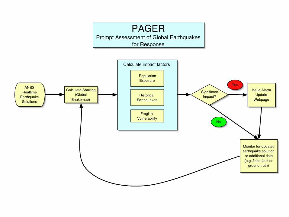
3) 3) P P rompt rompt A A ssessment of ssessment of G G lobal lobal E E arthquakes for arthquakes for R R esponse esponse PAGER PAGER USGS/USAID USGS/USAID Project goal: Project goal: Accurately, rapidly and Accurately, rapidly and automatically estimate the probable automatically estimate the probable human impact of significant global human impact of significant global earthquakes and distribute alarms and earthquakes and distribute alarms and concise summary statements to relief concise summary statements to relief and government agencies. and government agencies. QuickTime™ and a TIFF (Uncompressed) decompressor are needed to see this picture. QuickTime™ and a TIFF (Uncompressed) decompressor are needed to see this picture. QuickTime™ and a TIFF (Uncompressed) decompressor are needed to see this picture. Morocco Feb 24 Morocco Feb 24 th th , 2004 , 2004 Deaths 715 Deaths 715 Iran Dec 26 Iran Dec 26 th th , 2003 , 2003 Deaths 26,000 Deaths 26,000 Algeria May 21 Algeria May 21 st st , 200 , 200 Deaths 2,000 Deaths 2,000

3) P rompt A ssessment of G lobal E arthquakes for R esponse PAGER USGS/USAID
Jan 13, 2016
3) P rompt A ssessment of G lobal E arthquakes for R esponse PAGER USGS/USAID. Project goal: Accurately, rapidly and automatically estimate the probable human impact of significant global earthquakes and distribute alarms and concise summary statements to relief and government agencies. - PowerPoint PPT Presentation
Welcome message from author
This document is posted to help you gain knowledge. Please leave a comment to let me know what you think about it! Share it to your friends and learn new things together.
Transcript

3) 3) PPrompt rompt AAssessment of ssessment of GGlobal lobal EEarthquakes for arthquakes for RResponseesponse
PAGERPAGERUSGS/USAIDUSGS/USAID
Project goal:Project goal: Accurately, rapidly and automatically Accurately, rapidly and automatically estimate the probable human impact of significant global estimate the probable human impact of significant global earthquakes and distribute alarms and concise summary earthquakes and distribute alarms and concise summary statements to relief and government agencies.statements to relief and government agencies.
QuickTime™ and aTIFF (Uncompressed) decompressor
are needed to see this picture.
QuickTime™ and aTIFF (Uncompressed) decompressor
are needed to see this picture.
QuickTime™ and aTIFF (Uncompressed) decompressor
are needed to see this picture.
Morocco Feb 24Morocco Feb 24thth, 2004, 2004
Deaths 715Deaths 715
Iran Dec 26Iran Dec 26thth, 2003, 2003
Deaths 26,000Deaths 26,000
Algeria May 21Algeria May 21stst, 2003, 2003
Deaths 2,000Deaths 2,000

1) Concise color-coded impact alerts suitable for cell-phones, pagers, 1) Concise color-coded impact alerts suitable for cell-phones, pagers, and e-mail.and e-mail.
2) Supplementary information including affected cities, maps of shaking 2) Supplementary information including affected cities, maps of shaking and population available via the Internet.and population available via the Internet.
PAGER OUTPUTPAGER OUTPUT

Give first heads up alertGive first heads up alert Provide an overall estimate of earthquake impact.Provide an overall estimate of earthquake impact. Alert response teams to a damaging earthquake.Alert response teams to a damaging earthquake. Guide the effective use of ground truth damage Guide the effective use of ground truth damage
assessment tools.assessment tools. Aid hazard mitigation efforts through scenario Aid hazard mitigation efforts through scenario
planningplanning
What PAGER can doWhat PAGER can do
What PAGER cannot doWhat PAGER cannot do
Provide a neighborhood by neighborhood damage Provide a neighborhood by neighborhood damage assessments.assessments.
U.S. Department of the InteriorU.S. Geological Survey
Population exposure
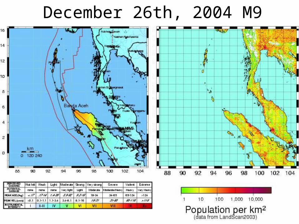
December 26th, 2004 M9
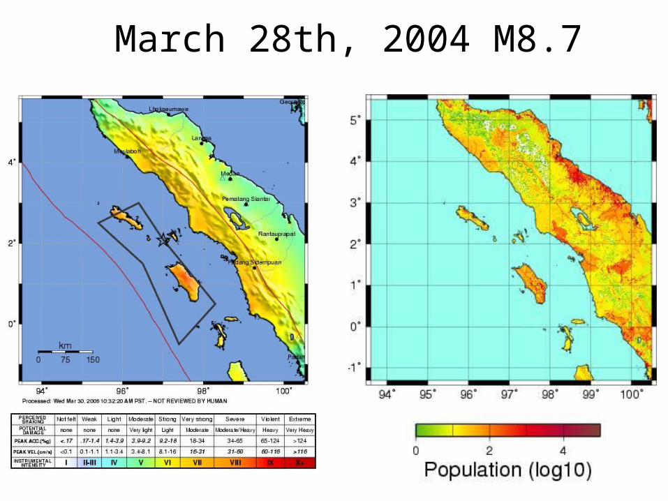
March 28th, 2004 M8.7

Dec 26thDec 26th Mar 28thMar 28th IntensityIntensity1,300,0001,300,000 600,000 600,000 VIIIVIII1,700,0001,700,000 1,800,0001,800,000 VIIVII1,200,0001,200,000 5,000,0005,000,000 VIVI
Estimated Population Exposed to ShakingEstimated Population Exposed to ShakingDecember, 2004 & March, 2005 December, 2004 & March, 2005
Sumatran EarthquakesSumatran Earthquakes

U.S. Department of the InteriorU.S. Geological Survey
PAGERPAGER
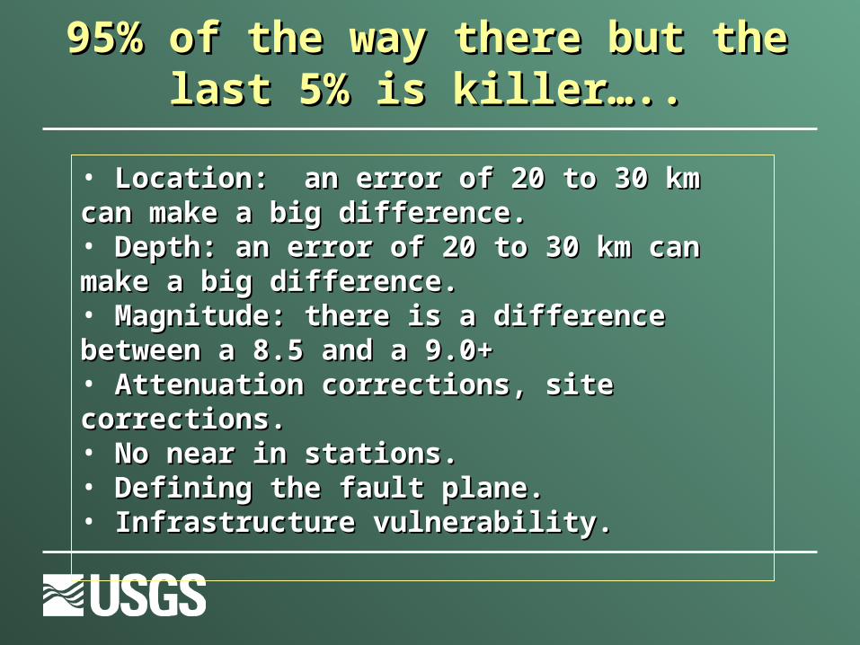
• Location: an error of 20 to 30 km can make a big Location: an error of 20 to 30 km can make a big difference.difference.• Depth: an error of 20 to 30 km can make a big Depth: an error of 20 to 30 km can make a big difference.difference.• Magnitude: there is a difference between a 8.5 and a Magnitude: there is a difference between a 8.5 and a 9.0+9.0+• Attenuation corrections, site corrections.Attenuation corrections, site corrections.• No near in stations.No near in stations.• Defining the fault plane.Defining the fault plane.• Infrastructure vulnerability.Infrastructure vulnerability.
95% of the way there but the last 5% is 95% of the way there but the last 5% is killer…..killer…..
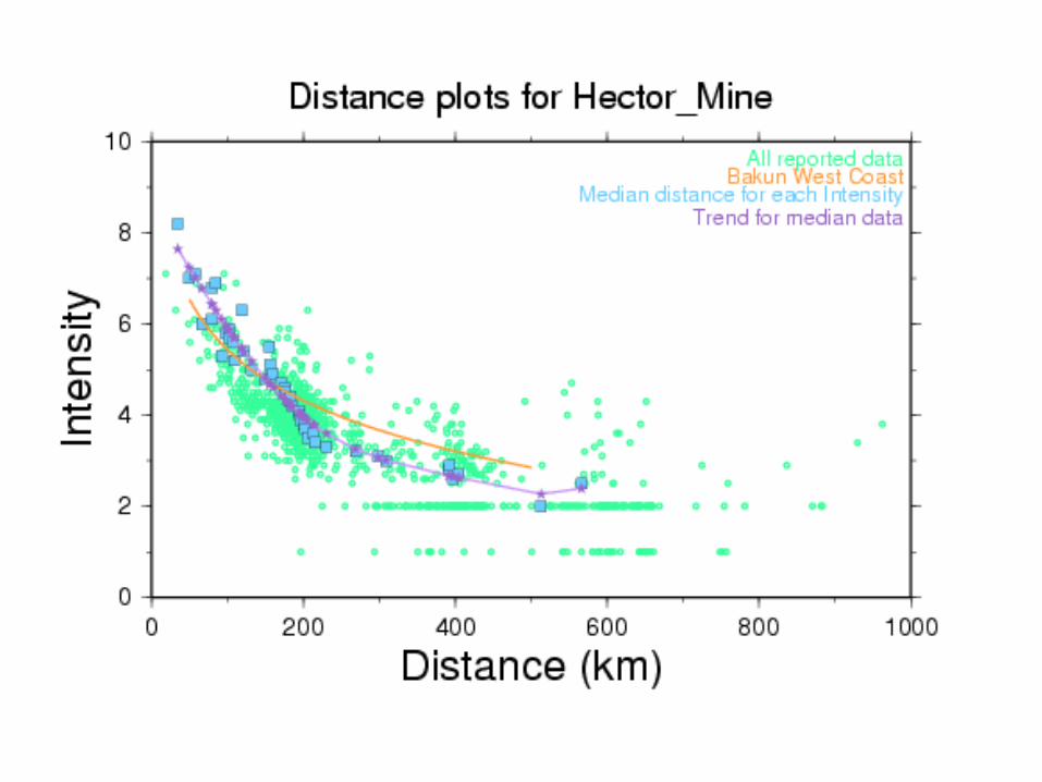

GlobalGlobal Intensity Intensity ReportsReports
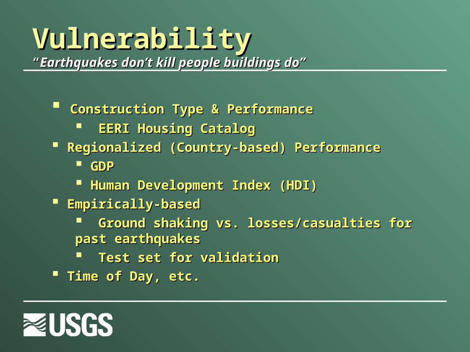
VulnerabilityVulnerability““Earthquakes don’t kill people buildings do”Earthquakes don’t kill people buildings do”
Construction Type & PerformanceConstruction Type & Performance EERI Housing CatalogEERI Housing Catalog
Regionalized (Country-based) PerformanceRegionalized (Country-based) Performance GDPGDP Human Development Index (HDI)Human Development Index (HDI)
Empirically-based Empirically-based Ground shaking vs. losses/casualties for past Ground shaking vs. losses/casualties for past earthquakesearthquakes Test set for validationTest set for validation
Time of Day, etc.Time of Day, etc.
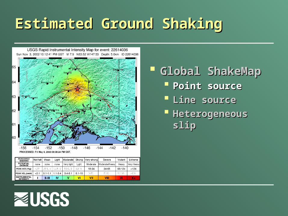
Estimated Ground ShakingEstimated Ground Shaking
Global ShakeMapGlobal ShakeMap Point sourcePoint source Line sourceLine source Heterogeneous slipHeterogeneous slip
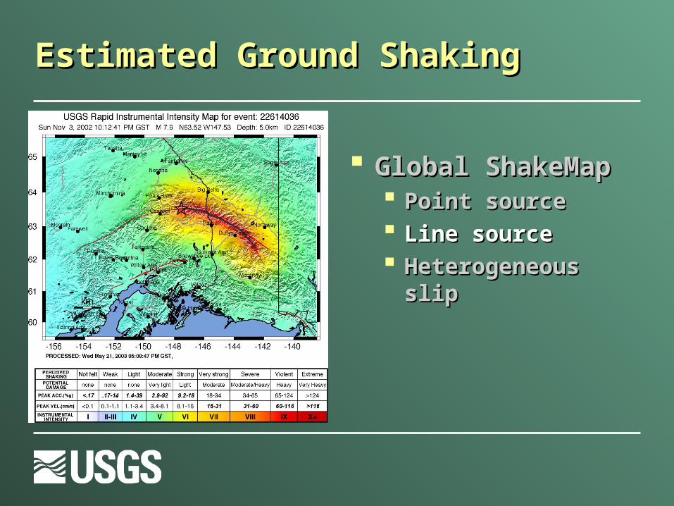
Estimated Ground ShakingEstimated Ground Shaking
Global ShakeMapGlobal ShakeMap Point sourcePoint source Line sourceLine source Heterogeneous slipHeterogeneous slip
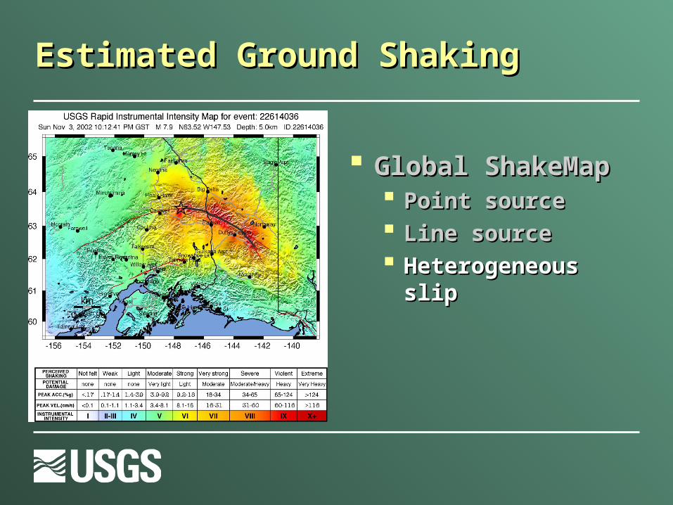
Estimated Ground ShakingEstimated Ground Shaking
Global ShakeMapGlobal ShakeMap Point sourcePoint source Line sourceLine source Heterogeneous slip Heterogeneous slip

Shaking levels at population centersShaking levels at population centers LandslidesLandslides Aid hazard mitigation efforts through scenario Aid hazard mitigation efforts through scenario
planningplanning Other? Proximity to airports, road maps, etc…Other? Proximity to airports, road maps, etc…
Beyond the basics:Beyond the basics:

Example ShakeCast Notification (html email version)

PAGER OUTPUT (supporting Web content)PAGER OUTPUT (supporting Web content)
Estimated critical Estimated critical acceleration to acceleration to trigger landslides trigger landslides
Courtesy of Jon GodtCourtesy of Jon Godt
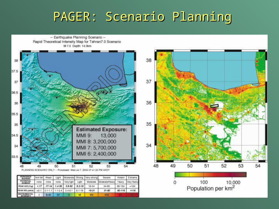
PAGER: Scenario PlanningPAGER: Scenario Planning
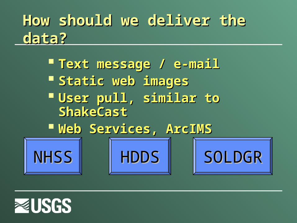
Text message / e-mailText message / e-mail Static web imagesStatic web images User pull, similar to ShakeCastUser pull, similar to ShakeCast Web Services, ArcIMSWeb Services, ArcIMS
How should we deliver the data?How should we deliver the data?
NHSSNHSS HDDSHDDS SOLDGRSOLDGR
Related Documents