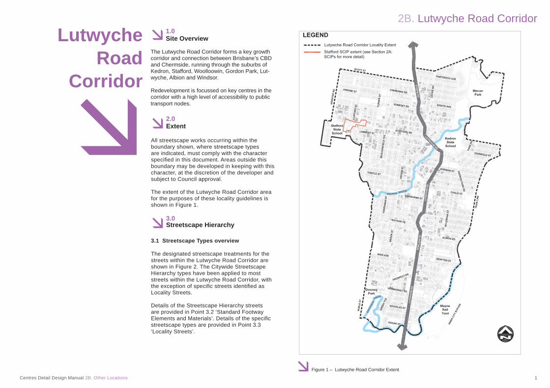
2B. Lutwyche Road Corridor Centres Detail Design Manual 2B. Other Locations 1 Figure 1 – Lutwyche Road Corridor Extent Lutwyche Road Corridor 1.0 Site Overview The Lutwyche Road Corridor forms a key growth corridor and connection between Brisbane’s CBD and Chermside, running through the suburbs of Kedron, Stafford, Woolloowin, Gordon Park, Lut- wyche, Albion and Windsor. Redevelopment is focussed on key centres in the corridor with a high level of accessibility to public transport nodes. 2.0 Extent All streetscape works occurring within the boundary shown, where streetscape types are indicated, must comply with the character specified in this document. Areas outside this boundary may be developed in keeping with this character, at the discretion of the developer and subject to Council approval. The extent of the Lutwyche Road Corridor area for the purposes of these locality guidelines is shown in Figure 1. 3.0 Streetscape Hierarchy 3.1 Streetscape Types overview The designated streetscape treatments for the streets within the Lutwyche Road Corridor are shown in Figure 2. The Citywide Streetscape Hierarchy types have been applied to most streets within the Lutwyche Road Corridor, with the exception of specific streets identified as Locality Streets. Details of the Streetscape Hierarchy streets are provided in Point 3.2 ‘Standard Footway Elements and Materials’. Details of the specific streetscape types are provided in Point 3.3 ‘Locality Streets’.

Welcome message from author
This document is posted to help you gain knowledge. Please leave a comment to let me know what you think about it! Share it to your friends and learn new things together.
Transcript
2B. Lutwyche Road Corridor
Centres Detail Design Manual 2B. Other Locations 1 Figure 1 – Lutwyche Road Corridor Extent
Lutwyche
RoadCorridor
1.0Site Overview
The Lutwyche Road Corridor forms a key growth corridor and connection between Brisbane’s CBD and Chermside, running through the suburbs of Kedron, Stafford, Woolloowin, Gordon Park, Lut-wyche, Albion and Windsor.
Redevelopment is focussed on key centres in the corridor with a high level of accessibility to public transport nodes.
2.0Extent
All streetscape works occurring within the boundary shown, where streetscape types are indicated, must comply with the character specifi ed in this document. Areas outside this boundary may be developed in keeping with this character, at the discretion of the developer and subject to Council approval.
The extent of the Lutwyche Road Corridor area for the purposes of these locality guidelines is shown in Figure 1.
3.0Streetscape Hierarchy
3.1 Streetscape Types overview
The designated streetscape treatments for the streets within the Lutwyche Road Corridor are shown in Figure 2. The Citywide Streetscape Hierarchy types have been applied to most streets within the Lutwyche Road Corridor, with the exception of specifi c streets identifi ed as Locality Streets.
Details of the Streetscape Hierarchy streets are provided in Point 3.2 ‘Standard Footway Elements and Materials’. Details of the specifi c streetscape types are provided in Point 3.3 ‘Locality Streets’.

2B. Lutwyche Road Corridor
Centres Detail Design Manual 2B. Other Locations 2 Figure 2 – Lutwyche Road Corridor Street Hierarchy
3.2 Standard Footway Elements and Materials
These locality guidelines for the Lutwyche Road Corridor are to be read in conjunction with the following sections of Chapter 3 Streetscape Design of this manual.
• 3A Citywide Streetscape Hierarchy – for footways, corner dedication and cross block link typical layouts; and
• 3B Footway Elements and Materials – for footway upgrade standards, standard drawings and reference specifi cations.
Footway upgrades are to include new surfacing, new or reinstated kerb and channel, driveways, pedestrian kerb crossings, tactile markers, roofwater drainage line connections, service pit lids, street trees, garden beds, furniture and pedestrian lighting – as applicable to the streetscape type. The scope, layout and detail of the footway upgrade is to be agreed on a site-by-site basis through the development approval process.
3.3 Locality Streets
In the Lutwyche Road Corridor area, a section of Stafford Road and some adjoining streets have been identifi ed as Locality Streets. These streets are part of the Stafford Suburban Centre Improvement Project (SCIP) area. The Stafford SCIP extent is shown in Figure 1, with the extent of Locality Streets identifi ed in Figure 2.
Any works required to footways within the Stafford SCIP area are to be in accordance with this SCIP locality. (Refer Chapter 2 Locality Advice, Section 2A Suburban Centre Improvement Projects of this manual).
3.4 Laneways
Laneways are to be in accordance with Section 3A: Citywide Streetscape Hierarchy of this manual and the specifi c details listed below.
Layout
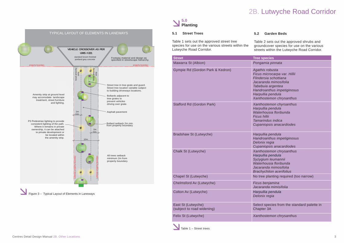
Laneways are to be 10m wide, with a minimum 6m wide carriageway for vehicular access and a minimum 2m wide unobstructed pedestrian pathway. Refer to Figure 3 for a ‘Typical Layout of Elements in Laneways’ plan view.
Laneways are to be designed as shared zones to allow for two-way low speed vehicular traffi c to access carparking and servicing areas within adjoining developments and pedestrian access in accordance with Section 3A7: Lanes of this Manual. No on-street carparking provision is to be made within the laneway.
Materials
Laneways are to be constructed with full width asphalt with no kerb and channel.
As shown in Figure 3, Laneways are to include:
• Street trees in grates• Bollards adjacent to tree grates• Pedestrian lighting • Other street furniture where practical
4.0Public Art
Where public artwork is required refer to Section 4C: Public Art of this manual.
The proposed location of the public artwork within publicly accessible spaces is to be shown on plans submitted for approval.
2B. Lutwyche Road Corridor
Centres Detail Design Manual 2B. Other Locations 3
Figure 3 – Typical Layout of Elements in Laneways
Street tree in tree grate and guard. Street tree location variable subject to building driveways locations.
Bollards adjacent to tree grates to prevent vehicles driving over grate.
All trees setback minimum 2m from property boundary.
Amenity strip at ground level may accomodate landscape
treatment, street furniture and lighting.
loca
l am
enity
stri
p
loca
l am
enity
stri
p
Bollard setback 2m min. from property boundary.
Asphalt pavement
Footway material and design as specified in streetscape hierarchy.
Lane
way
prop
erty
bou
ndar
y
property boundary property boundary
Lane
way
prop
erty
bou
ndar
y
P3 Pedestrian lighting to provide consistent lighting of the path.
Where it remains in private ownership, it can be attached
to private development or be located within the amenity strip.
VEHICLE CROSSOVER AS PERUMS # 221
10m
2m min.
2m min.
standard broom finished portland grey concrete
TYPICAL LAYOUT OF ELEMENTS IN LANEWAYS
5.0Planting
5.1 Street Trees
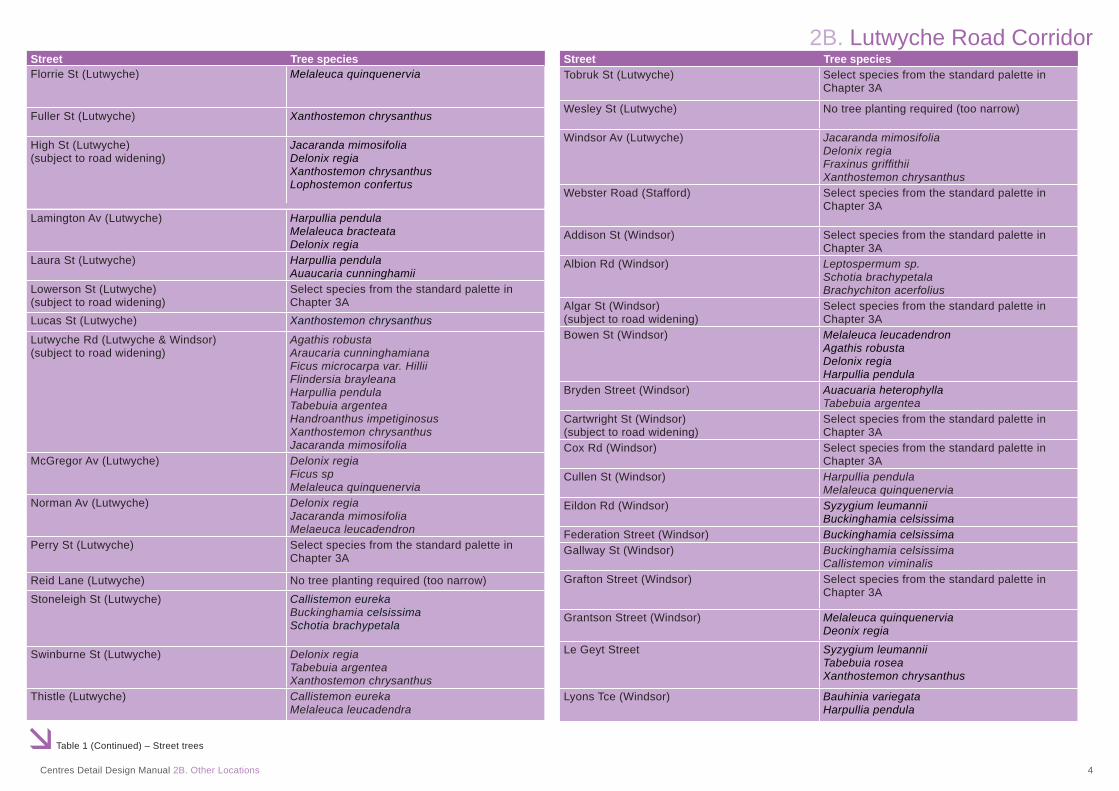
Table 1 sets out the approved street tree species for use on the various streets within the Lutwyche Road Corridor.
5.2 Garden Beds
Table 2 sets out the approved shrubs and groundcover species for use on the various streets within the Lutwyche Road Corridor.
Table 1 – Street trees
Street Tree speciesMawarra St (Albion) Pongamia pinnata
Gympie Rd (Gordon Park & Kedron) Agathis robustaFicus microcarpa var. HilliiFlindersia schottianaJacaranda mimosifoliaTabebuia argenteaHandroanthus impetiginosus Harpullia pendulaXanthostemon chrysanthus
Stafford Rd (Gordon Park) Xanthostemon chyrsanthusHarpullia pendulaWaterhousia fl oribundaFicus hilliiTamarindus indica Cupaniopsis anacardiodes
Bradshaw St (Lutwyche) Harpullia pendulaHandroanthus impetiginosus Delonix regiaCupaniopsis anacardiodes
Chalk St (Lutwyche) Xanthostemon chrysanthusHarpullia pendulaSyzygium leumannii Waterhousia fl oribundaJacaranda mimosifoliaBrachychiton acerifolius
Chapel St (Lutwyche) No tree planting required (too narrow)
Chelmsford Av (Lutwyche) Ficus benjaminaJacaranda mimisifolia
Colton Av (Lutwyche) Harpullia pendulaDelonix regia
East St (Lutwyche)(subject to road widening)
Select species from the standard palette in Chapter 3A
Felix St (Lutwyche) Xanthostemon chrysanthus
2B. Lutwyche Road Corridor
Centres Detail Design Manual 2B. Other Locations 4
Table 1 (Continued) – Street trees
Street Tree species Florrie St (Lutwyche) Melaleuca quinquenervia
Fuller St (Lutwyche) Xanthostemon chrysanthus
High St (Lutwyche)(subject to road widening)
Jacaranda mimosifoliaDelonix regiaXanthostemon chrysanthusLophostemon confertus
Lamington Av (Lutwyche) Harpullia pendulaMelaleuca bracteataDelonix regia
Laura St (Lutwyche) Harpullia pendulaAuaucaria cunninghamii
Lowerson St (Lutwyche)(subject to road widening)
Select species from the standard palette in Chapter 3A
Lucas St (Lutwyche) Xanthostemon chrysanthus
Lutwyche Rd (Lutwyche & Windsor)(subject to road widening)
Agathis robustaAraucaria cunninghamianaFicus microcarpa var. HilliiFlindersia brayleanaHarpullia pendulaTabebuia argenteaHandroanthus impetiginosus Xanthostemon chrysanthusJacaranda mimosifolia
McGregor Av (Lutwyche) Delonix regia Ficus spMelaleuca quinquenervia
Norman Av (Lutwyche) Delonix regiaJacaranda mimosifoliaMelaeuca leucadendron
Perry St (Lutwyche) Select species from the standard palette in Chapter 3A
Reid Lane (Lutwyche) No tree planting required (too narrow)Stoneleigh St (Lutwyche) Callistemon eureka
Buckinghamia celsissimaSchotia brachypetala
Swinburne St (Lutwyche) Delonix regiaTabebuia argenteaXanthostemon chrysanthus
Thistle (Lutwyche) Callistemon eureka Melaleuca leucadendra
Street Tree speciesTobruk St (Lutwyche) Select species from the standard palette in
Chapter 3A
Wesley St (Lutwyche) No tree planting required (too narrow)
Windsor Av (Lutwyche) Jacaranda mimosifoliaDelonix regiaFraxinus griffi thiiXanthostemon chrysanthus
Webster Road (Stafford) Select species from the standard palette in Chapter 3A
Addison St (Windsor) Select species from the standard palette in Chapter 3A
Albion Rd (Windsor) Leptospermum sp.Schotia brachypetalaBrachychiton acerfolius
Algar St (Windsor)(subject to road widening)
Select species from the standard palette in Chapter 3A
Bowen St (Windsor) Melaleuca leucadendronAgathis robustaDelonix regia Harpullia pendula
Bryden Street (Windsor) Auacuaria heterophylla Tabebuia argentea
Cartwright St (Windsor)(subject to road widening)
Select species from the standard palette in Chapter 3A
Cox Rd (Windsor) Select species from the standard palette in Chapter 3A
Cullen St (Windsor) Harpullia pendula Melaleuca quinquenervia
Eildon Rd (Windsor) Syzygium leumanniiBuckinghamia celsissima
Federation Street (Windsor) Buckinghamia celsissima Gallway St (Windsor) Buckinghamia celsissima
Callistemon viminalisGrafton Street (Windsor) Select species from the standard palette in
Chapter 3A
Grantson Street (Windsor) Melaleuca quinquenervia Deonix regia
Le Geyt Street Syzygium leumanniiTabebuia rosea Xanthostemon chrysanthus
Lyons Tce (Windsor) Bauhinia variegata Harpullia pendula

2B. Lutwyche Road Corridor
Centres Detail Design Manual 2B. Other Locations 5
Table 1 (Continued) – Street trees
Street Tree species
Table 1 (Continued) – Street trees
Maygar St (Windsor) Harpullia pendula Xanthostemon chrysanthus Pongamia pinnata
Morris St (Windsor) Select species from the standard palette in Chapter 3A
Newmarket Rd (Windsor) Flindersia australis Xanthostemon chrysanthus
Nicholas St (Windsor) Callistemon eurekaXanthostemon chrysanthus
Northey St (Windsor) Lophostemon confertusFraxinus griffi thii
Prospect Rd (Windsor) Buckinghamia celsissima Flindersia schottiana
Roblane St (Windsor) Agathis robustaAraucaria cunninghamianaFicus microcarpa var. HilliiTabebuia argenteaHandroanthus impetiginosus
Somerset St (Windsor) Melaleuca quinquenerviaTaylor Street (Windsor) Xanthostemon chrysanthus
Syzygium leuhmanniiThondley St (Windsor) Harpullia pendulaTruro Street (Windsor) Agathis robusta
raucaria cunninghamianaicus microcarpa var. Hilliiabebuia argenteaandroanthus impetiginosus
AFTH
Victoria St (Windsor) Syzygium leuhmanniiLophostemon confertusHarpullia pendula
Bridge St (Wooloowin) Callistemon eurekaChalk St (Wooloowin) Xanthostemon chyrsanthus
Waterhousia fl oribundaSyzygium leuhmannii
Dickson Street (Wooloowin) Select species from the standard palette in Chapter 3A
Isedale St (Wooloowin)(subject to road widening)
Callistemon eurekaSyzygium leuhmanni
Kedron Park Rd (Wooloowin) Flindersia australis Harpullia pendulaXanthostemon chrysanthus
Merehaye St (Wooloowin) Callistemon eurekaJacaranda mimosifoliaSyzygium luehmannii
Street Tree speciesNorman St (Wooloowin) Callistemon eureka
Jacaranda mimosifoliaBuckinghamia celsissima
Park Road (Wooloowin) Buckinghamia celsissimaSchotia brachypetala Xanthostemon chrysanthus
Rose St (Wooloowin) Flindersia australisBuckinghamia celsissimaDelonix regia
Table 2 – Shrub and groundcover species
Street Shrub and Groundcover SpeciesCity Streets Liriope ‘Evergreen Giant’
Liriope ‘Stripey White’ Philodendron xanaduTrachelospermum Variegated
Subtropical Boulevards(Lutwyche/Gympie Roads)
Liriope giganticum ‘Evergreen Giant’ Liriope ‘Stripey White’ Lomandra ‘Blue Ridge’Philodendron xanaduStrelitizia reginaeTrachelospermum VariegatedTrachelospermum jasminoides
Related Documents