Oakleigh Major Activity Centre DRAFT - Structure Plan 27 April 2010 1 DRAFT OAKLEIGH MAJOR ACTIVITY CENTRE DRAFT STRUCTURE PLAN 27 April 2010 Prepared by:- City of Monash

Welcome message from author
This document is posted to help you gain knowledge. Please leave a comment to let me know what you think about it! Share it to your friends and learn new things together.
Transcript

Oakleigh Major Activity Centre DRAFT - Structure Plan
27 April 2010
1
DRAFT
OAKLEIGH
MAJOR ACTIVITY CENTRE
DRAFT STRUCTURE PLAN
27 April 2010
Prepared by:-
City of Monash
DDR
2
RAAFT
OakleigD
T
h Major ActDRAFT - Str
27
tivity Centreructure Plan7 April 2010
e n 0

Oakleigh Major Activity Centre DRAFT - Structure Plan
27 April 2010
3
DRAFT
Table of Contents
Oakleigh – Location .............................................................................................................. 5
Context ................................................................................................................................... 6
Demographics ......................................................................................................... 7 Melbourne 2030 (2002) and Melbourne @ 5 Million (2008) ................................. 8 State Planning Policy Framework ........................................................................... 8 Local Planning Policy Framework .......................................................................... 9 Strengths, Weaknesses, Opportunities and Constraints ........................................ 14
Strategic Development Sites ............................................................................................. 16
Key Issues to be addressed in the Oakleigh Structure Plan .......................................... 17
Oakleigh – the Future ......................................................................................................... 17
Vision .................................................................................................................... 17 Oakleigh Major Activity Centre – Precincts Plan ................................................. 18 Objectives .............................................................................................................. 19 Strategies ............................................................................................................... 20
Oakleigh Major Activity Centre – Structure Plan ............................................................. 23
Precinct 1 - Oakleigh Village ................................................................................ 25 Precinct 2 - Oakleigh Centro ................................................................................. 27 Precinct 3 - Commercial Periphery ....................................................................... 29 Precinct 4 - Residential Periphery ......................................................................... 34 Precinct 5 - Civic, Warrawee Park and Heritage .................................................. 38 Station and Railway Areas .................................................................................... 39 Residential Interface Area ..................................................................................... 40 Urban Design - Public Realm Improvements ....................................................... 42 Community Services and facilities ....................................................................... 43 Traffic Management .............................................................................................. 44 Stormwater Drainage Management ...................................................................... 46
Amendment to Monash Planning Scheme ....................................................................... 46
Proposed – ACZ Activity Centre Zone 1 – Oakleigh Major Activity Centre ....... 47
Appendices .......................................................................................................................... 48
1. Monash Planning Scheme - Zones (Existing) ............................................. 49 2. Monash Planning Scheme – Overlay (Existing) ......................................... 50 3. Oakleigh Village – Western Gateway ......................................................... 51 4. Transport and Parking ................................................................................. 52 5. Demographic Data ...................................................................................... 54

Oakleigh Major Activity Centre DRAFT - Structure Plan
27 April 2010
4
DRAFT

Oakleigh Major Activity Centre DRAFT - Structure Plan
27 April 2010
5
DRAFT
Oakleigh – Location
The Oakleigh Major Activity Centre (MAC) is located approximately 14 kilometres to the south-east of Melbourne’s Central Business District. It is situated largely to the east of Warrigal Road, between Atherton Road and the Melbourne – Dandenong railway line. The Oakleigh MAC is one of the primary activity centres in the City of Monash.
The Oakleigh MAC provides a wide range of convenience shopping and comparison shopping. The centre includes modern supermarkets, a traditional market and a wide range of food outlets. It also includes numerous small businesses offering a wide range of goods and services used by households such as clothing, medicines, computing services, travel, banking, real estate, legal services, education and employment services. The activity centre has excellent access to public transport with trains travelling frequently to Melbourne, Dandenong and Pakenham. It is also a focal place for many bus routes to many of Melbourne’s south eastern suburbs, and has a large taxi rank. The area north of Atherton Road includes many significant community resources such as public open space, and places for community activities and meetings.
Oakleigh Major Activity Centre DRAFT - Structure Plan
27 April 2010
6
DRAFT
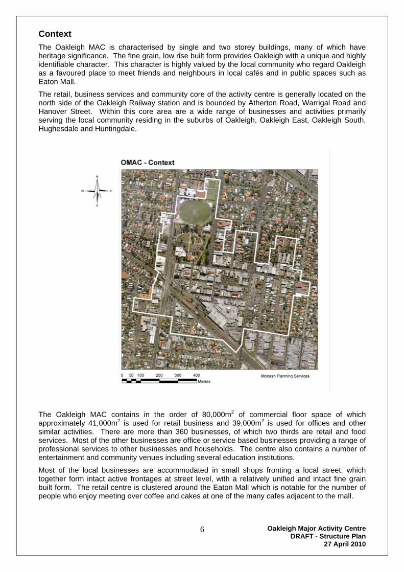
Context
The Oakleigh MAC is characterised by single and two storey buildings, many of which have heritage significance. The fine grain, low rise built form provides Oakleigh with a unique and highly identifiable character. This character is highly valued by the local community who regard Oakleigh as a favoured place to meet friends and neighbours in local cafés and in public spaces such as Eaton Mall.
The retail, business services and community core of the activity centre is generally located on the north side of the Oakleigh Railway station and is bounded by Atherton Road, Warrigal Road and Hanover Street. Within this core area are a wide range of businesses and activities primarily serving the local community residing in the suburbs of Oakleigh, Oakleigh East, Oakleigh South, Hughesdale and Huntingdale.
The Oakleigh MAC contains in the order of 80,000m2 of commercial floor space of which approximately 41,000m2 is used for retail business and 39,000m2 is used for offices and other similar activities. There are more than 360 businesses, of which two thirds are retail and food services. Most of the other businesses are office or service based businesses providing a range of professional services to other businesses and households. The centre also contains a number of entertainment and community venues including several education institutions.
Most of the local businesses are accommodated in small shops fronting a local street, which together form intact active frontages at street level, with a relatively unified and intact fine grain built form. The retail centre is clustered around the Eaton Mall which is notable for the number of people who enjoy meeting over coffee and cakes at one of the many cafes adjacent to the mall.

Oakleigh Major Activity Centre DRAFT - Structure Plan
27 April 2010
7
DRAFT
The Oakleigh MAC also includes two shopping complexes that have internal shops and pedestrian circulation. These complexes are the Centro Oakleigh Plaza and the Oakleigh Market which is presently under renovation. The two complexes provide a wide range of food outlets including large modern supermarkets.
The areas within walking distance of the Oakleigh MAC largely comprise residential areas developed in the inter war period and in the post war boom period and some are recognised for their heritage significance. Some of the areas have undergone considerable change in recent years with the introduction of multi unit residential developments into their streets.
Considerable development interest has also been directed to the Oakleigh MAC and its environs. Planning applications for commercial buildings have been lodged throughout the activity centre, particularly near Warrigal Road and Hanover Street. There has also been considerable interest in the development of multi unit residential proposals within walking distance of the Activity Centre and the railway station.
Customer car parking is conveniently located throughout the Oakleigh MAC. Most off street car parking is provided in public car parks under Council’s management. Additional car parking is provided under the Centro Plaza.
The area to the east of Hanover Street, between Burlington Street and the railway line is a significant industrial area that accommodates a wide range of small, medium sized and a few larger industries. The types of industries found in this precinct include car repairs and detailers, distributors of imported goods, and manufacturers of various products. This area is an important generator of employment within the area. In order to determine the significance of this industrial neighbourhood, it is anticipated that it will be included in a municipal wide review of industrial areas at a later date.
Demographics
In 2006 the total population of Oakleigh, Oakleigh East and Oakleigh South (the primary trade area of the Activity Centre) was 21,431. The demographic profile of the surrounding community indicates that the population increased slightly between 2001 and 2006. Whilst the changes in the population have been slight, there has been an increase in the middle aged population (35 to 54 age group and their children, and a decline in the number of 25 to 34 age group and the very aged (75+ years). The population is becoming more ethnically diverse with the proportion of Greek people declining, and the proportion of people from countries such as China and India increasing. The resident workforce is also more skilled, as an increasing proportion of the local residents work in the retail trade, professional services, education and training and administration, whilst the proportion of local residents working in areas such as manufacturing, construction, wholesale trades and transport has declined.
Three quarters of the dwellings in the immediate area around the Activity Centre are detached dwellings on medium sized lots, predominately developed in the inter-war period. The residential streets in the areas surrounding the Activity Centre comprise leafy streets with extensive street plantings and front private gardens. Most of the adjoining residential areas fall within Residential Character Type “A” in the Council’s Housing Character assessment. Type “A” is architecturally defined by pre-Second World War consistently setback single storey dwellings. A number of streets in the areas adjoining the Activity Centre have Edwardian Villas and Californian bungalows of high integrity and intactness. These areas are now protected from substantial change by a Heritage Overlay in the Monash Planning Scheme.
There has been considerable infill medium density development in some areas adjoining the Activity Centre as older houses have been replaced with two to four dwellings on the same lot. Much of this development in the 1980’s and 1990’s comprised single storey brick veneer dwellings On some sites, a dwelling has been replaced by three storey walk up blocks of flats, although the extent of this type of development is relatively limited.

Oakleigh Major Activity Centre DRAFT - Structure Plan
27 April 2010
8
DRAFT
In recent years, the style of infill development has changed and largely comprises contemporary two storey brick dwellings that feature high levels of articulation and design. Between 2001 and 2006, the number of medium density dwellings increased from 557 to 681 dwellings.
Melbourne 2030 (2002) and Melbourne @ 5 Million (2008)
These strategic documents were produced by the Victorian State Government in order to plan for the population growth that is predicted to continue to occur in Melbourne. Both strategies advocate for stronger links between where people live and their access to public transport, jobs, retail and community facilities particularly in Activity Centres. The strategies also propose that nearly half of Melbourne’s new households should be accommodated within the existing metropolitan area to make better use of the existing infrastructure, including the public transport network.
Activity Centres within the metropolitan area are identified as the preferred locations for new residential development, commercial offices and entertainment facilities. Melbourne 2030 proposes that a substantial amount of residential development (at higher densities) should be located within and close to Activity Centres. Melbourne @ 5 Million also emphasises that more infill residential development is needed to meet the needs of the predicted population growth and that Activity Centres are to be the preferred locations for higher density residential development. Oakleigh is identified as a Major Activity Centre due to its existing range of shops, commercial offices, public transport infrastructure and role as a meeting place for the local community.
State Planning Policy Framework
The State Planning Policy Framework (SPPF) in the Monash Planning Scheme reflects the policies of Melbourne 2030. The policies in the SPPF that are relevant to this Major Activity Centre include:
Concentration of major suburban retail, commercial, administrative, health, education, entertainment and cultural developments in and around activity centres with good access to integrated transport nodes.
The need for activity centres to be planned to:
Provide a range of shopping facilities in locations that are readily accessible to the community.
Include a variety of land uses and activities.
Provide good accessibility to all modes of transport.
Facilitate easy pedestrian movement.
Maximise opportunities for the co-location and sharing of facilities.
Minimise the impacts of increased development on the amenity of nearby residential and parkland areas.
Provide for community activities.
Location of major health facilities such as hospitals in areas highly accessible to public transport, with adequate car parking facilities for staff and visitors.
Encourage residential development and employment within existing urban areas, including higher land use densities and mixed use developments near railway stations and principal bus routes with respect for neighbourhood character in existing residential areas.
Clause 12 sets out the planning framework for development in metropolitan Melbourne. The Clause proposes that Major Activity Centres (MAC’s):
Have a mix of uses that meet local convenience needs.

Oakleigh Major Activity Centre DRAFT - Structure Plan
27 April 2010
9
DRAFT
Are accessible to a viable user population by walking and cycling.
Are accessible by local bus services with public transport links to Principal and Major Activity Centres.
Are an important community focal point.
In respect to urban design, the SPPF proposes that new developments should contribute positively to the environment by:
Ensuring that new development contribute to community and cultural life.
Requiring development to respond to its context in terms of urban character, natural features and surrounding landscape.
Ensuring that new development responds and contributes to an existing sense of place.
Encouraging the use of walking and cycling by creating environments that are safe and attractive.
Framework Plan from Clause 21.06 – Monash Planning Scheme. .
Local Planning Policy Framework
The Local Planning Policy Framework of the Monash Planning Scheme uses Zones and Overlays and special provisions to control particular uses and development. The major strategic directions underpinning the Strategic Framework for Monash include:
Identification of existing treed environments where the special leafy character valued by the community is to be protected by a Vegetation Protection Overlay.
Identification of the hierarchy of the existing activity centres and promotion of the development and expansion of retail and related facilities appropriate to the centre’s role.
Oakleigh Major Activity Centre DRAFT - Structure Plan
27 April 2010
10
DRAFT
Conservation of locally significant residential, commercial and industrial heritage buildings, places, streetscapes and natural environments.
Maintenance of visually significant sites that enhance the image of Monash.
Maintenance and enhancement of the established Garden City Character of Monash on both private and public land including along main roads.
Integration of land use and transport planning around major arterial roads, fixed public transport routes and bicycle paths, in commercial, residential and industrial land use areas.
The Strategic Framework Plan identifies Oakleigh as one of a number of activity centres that form a hierarchy of centres in the municipality. The focus for intensive retail and commercial development will be located at Glen Waverly and Oakleigh. The planning framework indicates that Oakleigh is a Major Activity Centre.
The Oakleigh MAC is centrally located in Melbourne’s long established middle south-eastern suburbs. There are a large number of long established activity centres located within 15 minutes driving time from Oakleigh. At the higher end of the activity centre hierarchy, other centres include Chadstone Shopping Centre (1.6km to the north), Glen Waverley Principal Activity Centre, Southland Shoppingtown and Camberwell. People living in the Oakleigh area would be likely to visit these higher order centres for their wide range of comparison shopping and entertainment that is not readily available in centres such as Oakleigh. These centres tend to complement Oakleigh.
Centres in the middle eastern region similar to Oakleigh in terms of the range of shopping, personal services and entertainment include Caulfield Plaza, Mount Waverley, Brandon Park, and Clayton.
There are also many Neighbourhood Activity Centres and local centres in the Oakleigh trade catchment. These centres are lower in the hierarchy of activity centres to Oakleigh and mainly provide daily and weekly convenience retail outlets and local restaurants and cafes. They are likely to be used by people living or working in the Oakleigh area if they provide a specialised product or service that is not available in Oakleigh, or their level of personal service is preferred compared to Oakleigh, or the shops are more convenient in terms of accessibility, car parking and multi purpose trips. These centres include Carnegie, Hughesdale (1.2km to the north-west) and Huntingdale (1.6km to the south-east).
The Monash Planning Scheme at Clause 21.06 (Retail) sets out Council’s approach to further retail and commercial development:
Council is committed to maintaining and enhancing the cosmopolitan range of business activity centres across the municipality to continue to meet community needs and preferences for retail, entertainment, office and other commercial services. These activities contribute to the significant level of economic activity and employment in Monash,
Council wishes to see Glen Waverley continue to develop as a major entertainment and retail centre for the eastern metropolitan region. This centre is also the appropriate location for the development of high rise residential development.
Monash contains a well connected network of major and neighbourhood activity centres. The major centres of Oakleigh, Clayton, Brandon Park, and Mt Waverley are supported by smaller neighbourhood centres of Pinewood, Wheelers Hill, Waverley Gardens, Syndal, Hughesdale and other smaller centres.

Oakleigh Major Activity Centre DRAFT - Structure Plan
27 April 2010
11
DRAFT
Key issues identified include:-
Activity centres are likely to be the focus of change over the next 30 years. This change must be planned to ensure that the outcomes are consistent with the vision of Council for more sustainable development that is appropriately located, of a high standard of design and built form compatible with local neighbourhood character and accommodates the needs of the community.
The Glen Waverley Principal and Oakleigh Major Activity Centres are the preferred locations for high rise residential development.
The economic health of activity centres is key to their growth and viability. This is enhanced through establishing a rich mix of uses and services.
Heritage places and values within the Oakleigh activity centre should be protected.
Safety, access and appearance are important elements of activity centres that are valued by the community.
Development in the Oakleigh MAC, including an expansion of the shopping centre, is unlikely to challenge the status of the Glen Waverley Principal Activity Centre which is recognised as a major multi-functional activity centre which services the south-eastern metropolitan area.
The identified primary focus of the Oakleigh MAC is to be a regional focus for:-
higher order goods
specialty retailing
entertainment
mixed commercial uses
offices
apartments
hotels
community facilities
public transport.
Strategic directions for the Oakleigh MAC identified at Clause 21.06-3 include:-
Encourage redevelopment and concentration of activity as well as maintaining the existing historical/cultural resources of the Centre.
Encourage medium to high rise development within the Centre (4-8 storeys)
Encourage a wide range of arts, cultural and entertainment facilities
Encourage restaurant uses.
Encourage office uses where contiguous retail frontage is not compromised.
Ensure pedestrian and cycling linkages are enhanced.
Encourage greater public transport linkages and service.
Ensure parking is provided to meet the needs of the Centre.

Oakleigh Major Activity Centre DRAFT - Structure Plan
27 April 2010
12
DRAFT
Poorly sited and/or designed development has the ability to progressively erode the basic fabric of the identity and traditional/cultural character of the Oakleigh MAC.
The objectives of Clause 22.03 Industry and Business Development and Character policy are:- (extract of part of Clause 22.03-2)
To ensure that new development is successfully integrated into existing business or industrial areas to enhance the streetscape character and amenity.
To ensure that the scale and character of future development creates or enhances a high-amenity built form environment and attractive landscape setting.
To ensure that development contributes to the maintenance and development of a high quality urban environment within the industrial and business areas and their environs, including the enhancement of the image of industrial and business areas when viewed from any road.
To provide greater certainty in terms of development outcomes and enhance existing private sector investment by encouraging well designed development.
It is policy that:- (extract of part of Clause 22.03-3)
Development complements the current character statement and contributory elements and satisfies the intent of the desired future character statement for the applicable industry or business Character Type identified in Clause 22.03-4.
A viable industrial and business base be maintained.
Development complements and does not visually overwhelm surrounding buildings, roads or spaces in terms of building scale, height and bulk.
Development conforms with the scale and high quality design suitable for the locality.
Encourage medium to high rise development within the Oakleigh Major Activity Centre (4 – 8 storeys). High rise development should be located adjacent to the Oakleigh railway station, except where an adopted Structure Plan, or some other mechanism, has identified an appropriate height limit.
The number of advertising signs be minimised to reduce visual clutter.
The height, colour and location of advertising signs enhance the streetscape character of the neighbourhood.
It is policy that before deciding on an application, the responsible authority will consider, as appropriate:- (extract of part of Clause 22.03-4)
Whether the proposed development conforms with the scale and high quality design suitable for the locality.
Whether adequate on-site car parking and vehicular access have been provided.
Whether visual clutter caused by advertising signs and overhead services has been minimised.
Whether the subdivision pattern of the proposed development sympathetically integrates with the neighbourhood character.

Oakleigh Major Activity Centre DRAFT - Structure Plan
27 April 2010
13
DRAFT
The existing character of the Oakleigh MAC is derived from pre-WWII civic and retail development on flat topography. This reflects the development of the original Oakleigh township and includes civic, retail, market and transport related functions which tend to centre on several precincts.
The civic role of the area is represented by the Atherton Road and Drummond Street rectangle with larger road widths, building setbacks of several metres, broad lot widths and a range of major public buildings developed in the Inter-war Classical Revival styles. The Pioneer Memorial Park and Warrawee Park form an integral part of this precinct.
The retail function forms the core of the area and is best represented by Atherton Road between Station and Hanover Streets and by the Eaton Mall area within a unique ‘Victorian’ street grid pattern. The village character of this area is generated by the narrow road widths, small lot frontages, two storey Federation and Inter-war buildings featuring concrete, red brick, terracotta tile, steeply pitched roof lines and architecturally detailed upper storeys.
Planting and streetscape works include tree planting and paving and have been consistently applied throughout the area.
The market and transport functions have developed within a complex of roads and larger lot areas to the south of the retail core and are heavily influenced by roadways and parking which fragment the area and reduce the visual definition of the ‘town centre’ in this location.
To the south is the railway station and environs, which consists of car parking and a bus-drop off point.
Elements that contribute to the current character of the Oakleigh MAC include:
Civic area Retail area Rail/Market area
Large lot widths.
Generous building setbacks.
Red brick Inter-war Classical Revival building styles.
Formal open space.
Key public buildings.
Compact, dense building arrangement with strong corner definition (major buildings).
Red brick, two storey buildings with detailed roof lines and upper storeys.
Consistent landscape and streetscape treatment.
Poles and overhead services.
Large lot sizes.
Road, parking and commercial uses.
Vehicle related infrastructure.
Visually intrusive advertising signs.
New development should respect the scale and form of existing development within the retail core of the Oakleigh MAC, while providing for appropriate change.

Oakleigh Major Activity Centre DRAFT - Structure Plan
27 April 2010
14
DRAFT
Strengths, Weaknesses, Opportunities and Constraints
The identification and understanding of the strengths and constraints applicable to the Oakleigh MAC provides a sound basis to consider opportunities and the preparation of effective strategies and their implementation.
Strengths
The Oakleigh Village precinct has a clearly identifiable and valued character. That character is reflected by the traditional village/town centre structure of the existing built form being predominantly of pedestrian scale, two storey shop fronts with narrow property frontages.
The Oakleigh MAC contains a broad mix of commercial land use, with a developing Café society/cultural meeting place emphasis.
The Oakleigh MAC is the central focal point for a broad multi-cultural community.
It is easily and directly accessible by Public Transport.
There are a number of significant strategic opportunity sites, some publicly owned, capable of redevelopment to support the functionality and vitality of the Oakleigh MAC.
Significant buildings and precincts both within and surrounding the Oakleigh MAC are identified within the Heritage Overlay provisions of the Monash Planning Scheme.
A Parking Precinct Plan has been implemented to ensure that adequate parking is provided to meet increased demands associated with new uses and/or developments with the Oakleigh MAC.
Significant public car parking areas are provided within the Oakleigh MAC.
There is community infrastructure both within the Oakleigh MAC and the surrounding interface area including schools, churches and other community service that support the local community.
Weakness
The Oakleigh Station and its surrounds including the bus interchange area are poorly designed for both passenger accessibility and their integration with commercial core of the Oakleigh MAC.
Vacant and deteriorating buildings, particularly to the west of Warrigal Road, and the poor urban design quality of parts of the public realm create a sense of decay and poor security.
Commuter car parking extends long distances from the railway station and bus interchange.
There is a perceived lack of safety in the Oakleigh MAC and around the rail station that is reflected by the lack of activities for young people.
There is a perception that the viability of Oakleigh MAC is limited because it exists in the shadows of Chadstone Shopping Centre.
The Warrigal Road overpass is a barrier and creates a real and perceived sense of isolation and fragmentation.
Centro Oakleigh Plaza, shopping complex has poor exposure and limited visibility within the Oakleigh MAC.
The existing road network within the Oakleigh MAC is complex.
There is a lack of youth activities within the area.
Oakleigh Major Activity Centre DRAFT - Structure Plan
27 April 2010
15
DRAFT
Opportunities
Oakleigh can be promoted as a valued destination within the South East sector of metropolitan Melbourne by emphasising its Café Culture/Community meeting place character and building on the Traditional/Cultural and Heritage values of the Oakleigh Village Precinct.
There is capacity to expand the broad mix of commercial and residential land uses within the Oakleigh MAC.
A significant number of the existing buildings within the Oakleigh MAC have potential for either the use, or redevelopment, of their upper floor levels for residential, “shop top” housing.
Strategic sites located within the Oakleigh MAC could be redeveloped to support the functionality and vitality of the Activity Centre.
The Town Centre/Village atmosphere and character of Oakleigh provides scope for significant improvement of the urban design characteristics of the public realm including the walk-ability of the Oakleigh MAC.
A number of buildings, located close to the periphery of the activity centre which date from the inter-war or earlier periods could be refurbished to respect and complement the character objectives of the Oakleigh MAC.
Demand exists for alternative forms of housing within the Oakleigh MAC with emphasis on the need for the provision of affordable housing.
Constraints
Ownership of land within the Oakleigh MAC is fragmented and its amalgamation to create larger development strategic sites will be difficult and is unlikely to occur.
Land surrounding the Oakleigh MAC consists of largely intact residential precincts, many with significant heritage value. These areas consist of attractive cottages and substantial residences, many of which have been renovated and improved within attractive public realms with good quality street trees, attractive front gardens, and low front fences.
The intact and high quality built form, recognised in the Heritage Overlay constrains opportunities for infill medium density housing in many parts of the interface area.
Warrigal Road and the railway line provide identifiable and distinct boundaries for Precincts within the Oakleigh MAC and create significant obstacles for both vehicle and pedestrian accesability.
A complex road network exists within the Oakleigh MAC.
Oakleigh Major Activity Centre DRAFT - Structure Plan
27 April 2010
16
DRAFT
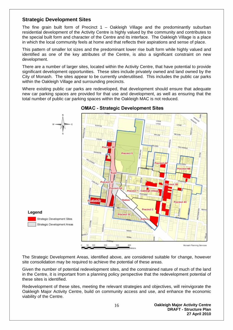
Strategic Development Sites
The fine grain built form of Precinct 1 – Oakleigh Village and the predominantly suburban residential development of the Activity Centre is highly valued by the community and contributes to the special built form and character of the Centre and its interface. The Oakleigh Village is a place in which the local community feels at home and that reflects their aspirations and sense of place.
This pattern of smaller lot sizes and the predominant lower rise built form while highly valued and identified as one of the key attributes of the Centre, is also a significant constraint on new development.
There are a number of larger sites, located within the Activity Centre, that have potential to provide significant development opportunities. These sites include privately owned and land owned by the City of Monash. The sites appear to be currently underutilised. This includes the public car parks within the Oakleigh Village and surrounding precincts.
Where existing public car parks are redeveloped, that development should ensure that adequate new car parking spaces are provided for that use and development, as well as ensuring that the total number of public car parking spaces within the Oakleigh MAC is not reduced.
The Strategic Development Areas, identified above, are considered suitable for change, however site consolidation may be required to achieve the potential of these areas.
Given the number of potential redevelopment sites, and the constrained nature of much of the land in the Centre, it is important from a planning policy perspective that the redevelopment potential of these sites is identified.
Redevelopment of these sites, meeting the relevant strategies and objectives, will reinvigorate the Oakleigh Major Activity Centre, build on community access and use, and enhance the economic viability of the Centre.

Oakleigh Major Activity Centre DRAFT - Structure Plan
27 April 2010
17
DRAFT
Key Issues to be addressed in the Oakleigh Structure Plan
The purpose of the Structure Plan is to provide a long term framework to guide changes to land use, built form and public spaces that together can achieve economic, social and environmental objectives for the centre.
The Structure Plan must give effect to the planning policies that are embedded in the Monash Planning Scheme. Melbourne 2030 is the State Government’s plan for Melbourne’s long term development. It proposes that more people should live and work in areas that are well provided with infrastructure and public transport. Major Activity Centres such as Oakleigh should be the preferred location for much of the new development that will occur in the area.
This Structure Plan aims to provide certainty to Council, local businesses, the wider community and prospective investors regarding the types of land uses and the built form that are likely to be supported by Council.
The key issues to be addressed in the Structure Plan are to:
Ensure that the Oakleigh MAC retains its strong sense of identity and its traditional and cultural character and be an attractive, safe place to work and visit.
Encourage new commercial use and development that builds on the strengths of the Oakleigh MAC to enhance its economic vitality and its focus as a cultural meeting place.
Facilitate new residential housing, particularly affordable housing, within the existing buildings of the core of the Oakleigh MAC and at the periphery, utilising higher built forms.
Make the Oakleigh MAC more friendly and accessible for public transport users, pedestrians and cyclists.
Encouraging the Oakleigh MAC to provide more cultural and entertainment activities.
Ensure the appropriate provision of car parking spaces within the Oakleigh MAC.
Oakleigh – the Future
Vision
The vision for the Oakleigh Major Activity Centre is:-
The Oakleigh Major Activity Centre will be an attractive, safe and highly accessible place where people can access shops and services to meet most of their daily and weekly needs.
It will be a vibrant and prosperous Activity Centre, which retains its strong sense of identity and its multi-cultural character. It will remain the focal point for the community, fostering its social and cultural development.
The centre will provide a range of employment opportunities in enterprises that provide a diverse range of services
It will provide a diverse range of residential buildings to enable a greater choice of housing for the community.

Oakleigh Major Activity Centre DRAFT - Structure Plan
27 April 2010
18
DRAFT
Oakleigh Major Activity Centre – Precincts Plan
The Oakleigh MAC has been divided into 5 distinct precincts, (some with sub-precincts) and is surrounded by an interface area mainly used for residential or industrial purposes.
Each Precinct contains areas that have common objectives, strategies and preferred land use and development characteristics.
Precincts of the Oakleigh MAC Precinct 1 – Oakleigh Village Precinct 2 – Oakleigh Centro Precinct 3 – Commercial Periphery Precinct 4 – Residential Periphery Precinct 5 – Civic, Warrawee Park and Heritage
Oakleigh Major Activity Centre DRAFT - Structure Plan
27 April 2010
19
DRAFT
Objectives
The objectives for the Oakleigh MAC Structure Plan are:-
General
To enhance the structure and function of the Oakleigh MAC by supporting its continuing development as a vibrant and prosperous activity centre.
To promote the Oakleigh MAC as a focal point for the community, fostering its social and cultural development.
Land use
To promote the Oakleigh MAC as a key focus for convenience, multi-cultural and culinary shopping and community services.
To increase residential accommodation that provides housing diversity and choice, including affordable housing, within the Oakleigh MAC.
To provide a mix of land uses, including health, fitness, medical services and a wide range of arts, cultural and entertainment facilities, that support the strategic role of the Oakleigh MAC.
To encourage integrated shopping, workplaces, housing, recreation and community services developments which provide a mix and level of activity that attracts people, creates a safe environment, stimulates interaction and provides a lively community focus.
To provide increased employment opportunities within the Oakleigh MAC.
Built form
To retain the existing strong sense of identity and the traditional and cultural character of Precinct 1 – Oakleigh Village of the Oakleigh MAC.
To ensure that the form and scale of buildings respect the context of their surrounds, and the design objectives relevant to its Precinct, particularly Precinct 1 – Oakleigh Village of the Oakleigh MAC.
To ensure that the interface of new development with any adjoining residentially zoned land is designed to respect the amenity and built form of the adjoining residential land use.
To ensure that residential amenity standards for both new and existing residential development are adequate and maintained.
To encourage the development of medium to high rise residential development (4-8 storeys) on appropriate sites within Precinct 3 – Commercial Periphery of the Oakleigh MAC.
To ensure that buildings are designed to have regard to the specific needs and requirements of all people including those with limited mobility.
Environmental sustainability
To ensure Australian Best Practice environmentally sustainable design is met in relation to building energy management, water sensitive urban design, construction materials, indoor environment quality, waste management and transport.

Oakleigh Major Activity Centre DRAFT - Structure Plan
27 April 2010
20
DRAFT
Public realm
To provide attractive and safe public spaces within the Oakleigh MAC to enhance community interaction, health and connectedness.
To ensure that public spaces in the Oakleigh MAC are well designed and enhance community safety through informal surveillance, lighting and appropriate landscaping.
To encourage public spaces within the Oakleigh MAC to become preferred locations and a resource for community learning and interaction.
Transport and access
To promote sustainable access to the Oakleigh MAC by encouraging walking and cycling through providing safe and accessible public spaces.
To ensure that an adequate supply of car parking is provided to meet the demand needs of the Oakleigh MAC.
To encourage increased use of public transport to access the Oakleigh MAC.
Strategies
The Strategies for the Oakleigh MAC are:-
Enhance the identity and economic viability of the Oakleigh MAC by:-
o retaining the Town Centre/Village atmosphere and the Cultural and Heritage character in Precinct 1 – Oakleigh Village of the Oakleigh MAC.
o ensuring that new development respects the urban design/built form characteristics of Precinct 1 – Oakleigh Village of the Oakleigh MAC.
o encouraging the continued development of the Café Culture/Community meeting place character of the Oakleigh MAC
o promoting the image of the Oakleigh MAC as a valued destination within the south east sector of metropolitan Melbourne.
o promote the development of a large retail store/supermarket on Hanover Street, in the north east sector of the Oakleigh MAC to act as a anchor/focal point of commercial activity in that location.
o promote the development of a small public meeting place, pedestrian “plaza” in the north east sector of the Oakleigh MAC to act as a focus for community activity.
Add capacity within the Oakleigh MAC by encouraging appropriate vertical growth on sites surrounding the core that respects and complements the character and image objectives for the Oakleigh Village Precinct.
Encourage the use of the upper levels of existing buildings within the Precinct 1 - Oakleigh Village with emphasis on the provision of residential, “shop top” housing.
Enhance and expand the broad mix of commercial and residential land uses that support the viability of the Oakleigh MAC.
Encourage the use of water sensitive design techniques to produce ecologically sustainable development within the Oakleigh MAC.

Oakleigh Major Activity Centre DRAFT - Structure Plan
27 April 2010
21
DRAFT
Encourage the development of pedestrian links between the key attraction locations of the Oakleigh MAC. Specifically the Oakleigh Railway Station, Oakleigh Civic area, Eaton Mall, Centro and the public car parks located at the periphery of the Precinct 1 - Oakleigh Village.
Enhance the walk-ability of the Oakleigh MAC by improving the urban design characteristics and pedestrian focused public realm and links to Eaton Mall.
Ensuring that adequate car parking is provided to meet the changing demands and requirements of both the Oakleigh MAC and the individual uses and developments located within the activity centre.
Ensure that where existing public car parks are redeveloped, that development provides adequate new car parking spaces for that use and development, as well replacing the public car park spaces so that the total number of public car parking spaces within the Oakleigh MAC is not reduced.
Mid block pedestrian links should be provided between Station Street and Eaton Mall and Eaton Mall and Hanover Street from Atherton Road to Chester Street and Chester Street to Portman Street.
Establish strong pedestrian linkages to Precinct 1 - Oakleigh Village.
Encourage and promote the appropriate redevelopment of the Strategic Development Sites within the Oakleigh MAC.
Enhance the public realm by an ongoing program of public works to improve pedestrian spaces and streetscapes that complement the identified and valued character of the Precinct 1 - Oakleigh Village.
Encourage the improvement of links between Centro and the surrounding public spaces and streets, particularly Eaton Mall.
Encourage improvement of the transport interchange and Railway Station to improve pedestrian access and links to the station and to the southern side of the railway line.
Encourage the improvement of signage within the Centre to improve pedestrian way finding within the Oakleigh MAC.
Encourage the development of bicycle pathways to link to existing bike infrastructure and train and bus terminals within the Oakleigh MAC.

Oakleigh Major Activity Centre DRAFT - Structure Plan
27 April 2010
22
DRAFT

Oakleigh Major Activity Centre DRAFT - Structure Plan
27 April 2010
23
DRAFT
Oakleigh Major Activity Centre – Structure Plan

Oakleigh Major Activity Centre DRAFT - Structure Plan
27 April 2010
24
DRAFT

Oakleigh Major Activity Centre DRAFT - Structure Plan
27 April 2010
25
DRAFT
Precinct 1 - Oakleigh Village
Location Map:-
Land uses:- Existing
Mainly used for retail and other commercial purposes providing a range of goods and services to the community.
Speciality shops, cafes and restaurants dominate the precinct.
Eaton Mall is the focus of pedestrian based activities.
The wide range of speciality food retailers reinforces its role as a weekly shopping destination.
Preferred
Consolidate as the retail core of the Activity Centre.
Encourage an appropriate mix of residential and commercial uses to develop within the precinct along with the existing retail development.
Development should provide active retail street frontages with residential and/or office uses located at first floor and upper levels.
Encourage the establishment of larger retail premises abutting Hanover Street to strengthen the competitiveness of the Activity Centre and to better meet the needs of residents.
Legend
ççççççççççççççççççççEaton Mall
kj Strategic Development Sites
kj Oakleigh Village - Western Gateway
") Car Parks
Pedestrian Links
One Way Traffic
Primary Arterial Road
Secondary Arterial Road
Collector Road
Railway Line
Oakleigh Major Activity Centre DRAFT - Structure Plan
27 April 2010
26
DRAFT
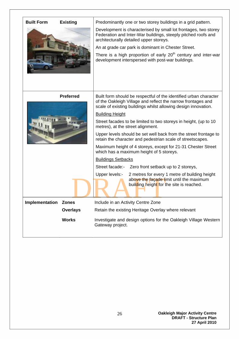
Built Form Existing
Predominantly one or two storey buildings in a grid pattern.
Development is characterised by small lot frontages, two storey Federation and Inter-War buildings, steeply pitched roofs and architecturally detailed upper storeys.
An at grade car park is dominant in Chester Street.
There is a high proportion of early 20th century and inter-war development interspersed with post-war buildings.
Preferred
Built form should be respectful of the identified urban character of the Oakleigh Village and reflect the narrow frontages and scale of existing buildings whilst allowing design innovation.
Building Height
Street facades to be limited to two storeys in height, (up to 10 metres), at the street alignment.
Upper levels should be set well back from the street frontage to retain the character and pedestrian scale of streetscapes.
Maximum height of 4 storeys, except for 21-31 Chester Street which has a maximum height of 5 storeys.
Buildings Setbacks
Street facade:- Zero front setback up to 2 storeys,
Upper levels:- 2 metres for every 1 metre of building height above the façade limit until the maximum building height for the site is reached.
Implementation
Zones
Overlays
Include in an Activity Centre Zone
Retain the existing Heritage Overlay where relevant
Works Investigate and design options for the Oakleigh Village Western Gateway project.

Oakleigh Major Activity Centre DRAFT - Structure Plan
27 April 2010
27
DRAFT
Precinct 2 - Oakleigh Centro
Location Map:-
Land uses:- Existing Centro Oakleigh Shopping Centre containing supermarkets and speciality shops including multi-deck car park.
Preferred Modify shopping centre to improve access, retail and service facilities for the community.
Development should provide active retail street frontages with residential and/or office uses located at first floor and upper levels.
Maintain an adequate supply of car parking on-site.
Built Form Existing Dominated by the enclosed Centro Oakleigh Shopping Centre developed in 1987.
Legend
ççççççççççççççççççççEaton Mall
kj Strategic Development Sites
kj Oakleigh Village - Western Gateway
") Car Parks
Pedestrian Links
One Way Traffic
Primary Arterial Road
Secondary Arterial Road
Collector Road
Railway Line

Oakleigh Major Activity Centre DRAFT - Structure Plan
27 April 2010
28
DRAFT
Preferred Reconfigure and extend the existing shopping centre to form a new and highly visible retail presence to Oakleigh Station, bus interchange area, Station and Portman Streets.
Design integration with the Oakleigh Village Western Gateway project.
Improve the entrance to the shopping centre from Eaton Mall.
Development of a building in the south east sector of the precinct to promote the “Gateway” entrance to the Activity Centre.
Development fronting Hanover Street should exhibit architecture of contemporary excellence that is energy efficient and sustainable.
Building Height
5 storeys
Building Setback
Zero setback to street frontages
Implementation
Zones
Overlays
Include in an Activity Centre Zone
nil
Works Investigate and design options for the Oakleigh Village Western Gateway project.
Oakleigh Major Activity Centre DRAFT - Structure Plan
27 April 2010
29
DRAFT
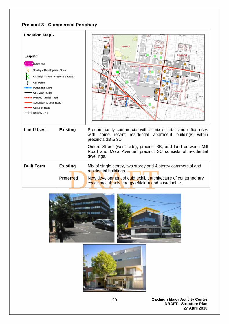
Precinct 3 - Commercial Periphery
Location Map:-
Land Uses:- Existing Predominantly commercial with a mix of retail and office uses with some recent residential apartment buildings within precincts 3B & 3D.
Oxford Street (west side), precinct 3B, and land between Mill Road and Mora Avenue, precinct 3C consists of residential dwellings.
Built Form Existing
Preferred
Mix of single storey, two storey and 4 storey commercial and residential buildings.
New development should exhibit architecture of contemporary excellence that is energy efficient and sustainable.
Legend
ççççççççççççççççççççEaton Mall
kj Strategic Development Sites
kj Oakleigh Village - Western Gateway
") Car Parks
Pedestrian Links
One Way Traffic
Primary Arterial Road
Secondary Arterial Road
Collector Road
Railway Line

Oakleigh Major Activity Centre DRAFT - Structure Plan
27 April 2010
30
DRAFT
Sub-Precinct 3A:- Preferred
Land Use:-
Establishment of high-rise mixed use premises, linking or spanning across Portman Street, the railway line and Haughton Road.
North of the railway line buildings comprising active retail frontages at ground level and commercial and/or residential use above.
Retail shop use is discouraged south of the railway line.
Built Form
Building Height
8 storeys
Building Setbacks
Zero setback to street frontages.

Oakleigh Major Activity Centre DRAFT - Structure Plan
27 April 2010
31
DRAFT
Sub-Precinct 3B:- Preferred
Land Use:-
Establishment of medium-rise commercial and/or residential premises throughout the sub-precinct.
Establishment of larger retail premises abutting Hanover Street to strengthen the competitiveness of the Activity Centre and to better meet the needs of residents.
Development abutting Hanover Street should provide active retail street frontages with residential and/or commercial uses located at upper levels.
Larger retail premises are discouraged abutting Atherton Road, (except south-east corner of Atherton Road and Hanover Street)
Retail shop uses are inappropriate in Oxford, Downing, Regent and Clyde Streets.
Provision of adequate new car parking spaces for any new use and/or development, replacing the existing public car park spaces so that the total number of public car parking spaces within the Oakleigh MAC is not reduced
Built Form
Building Height
5 storeys fronting Atherton Road and the west side of Hanover Street.
7 storeys fronting the east side of Hanover Street.
3 storeys fronting Oxford Street.
4 storeys in the remainder of sub-precinct.
Building Setbacks
Zero setback to street frontages except for properties fronting Oxford Street.
6 metres fronting Oxford Street
Oakleigh Major Activity Centre DRAFT - Structure Plan
27 April 2010
32
DRAFT
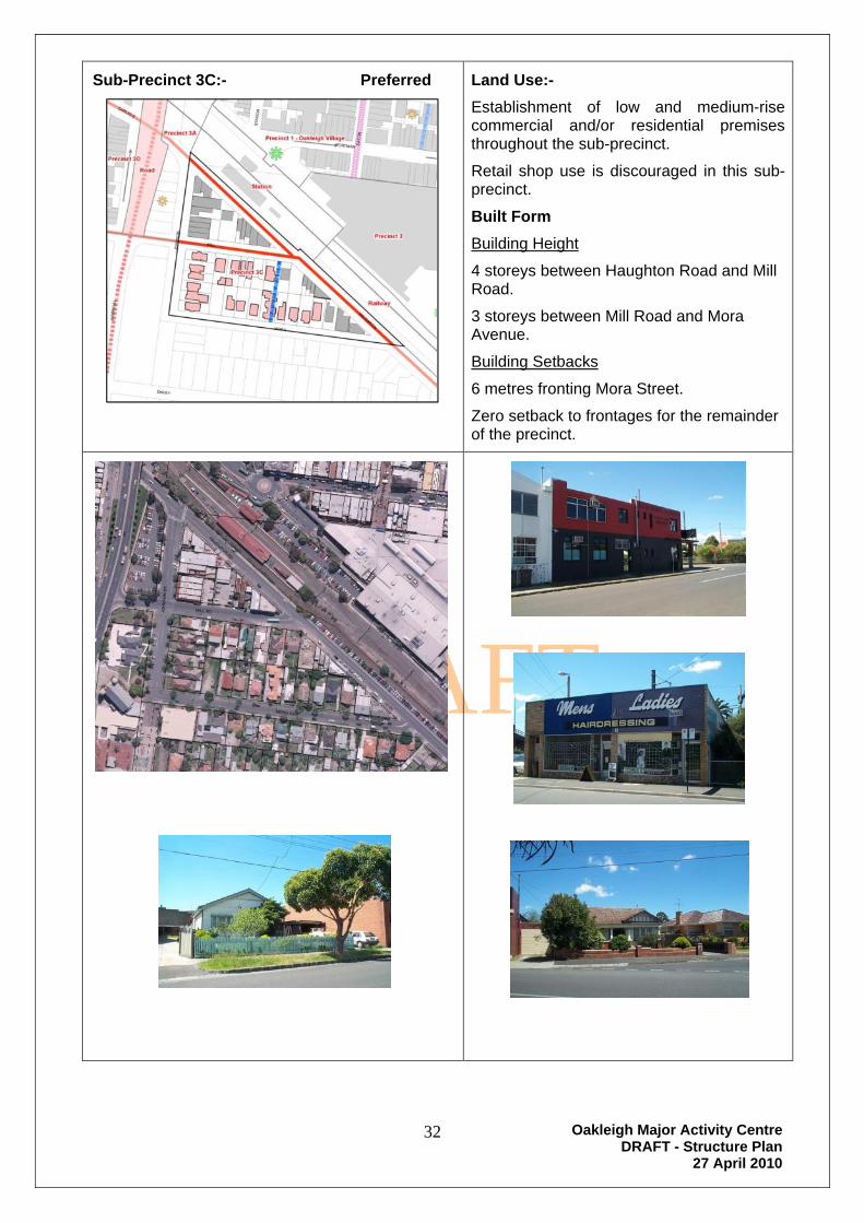
Sub-Precinct 3C:- Preferred
Land Use:-
Establishment of low and medium-rise commercial and/or residential premises throughout the sub-precinct.
Retail shop use is discouraged in this sub-precinct.
Built Form
Building Height
4 storeys between Haughton Road and Mill Road.
3 storeys between Mill Road and Mora Avenue.
Building Setbacks
6 metres fronting Mora Street.
Zero setback to frontages for the remainder of the precinct.
Oakleigh Major Activity Centre DRAFT - Structure Plan
27 April 2010
33
DRAFT
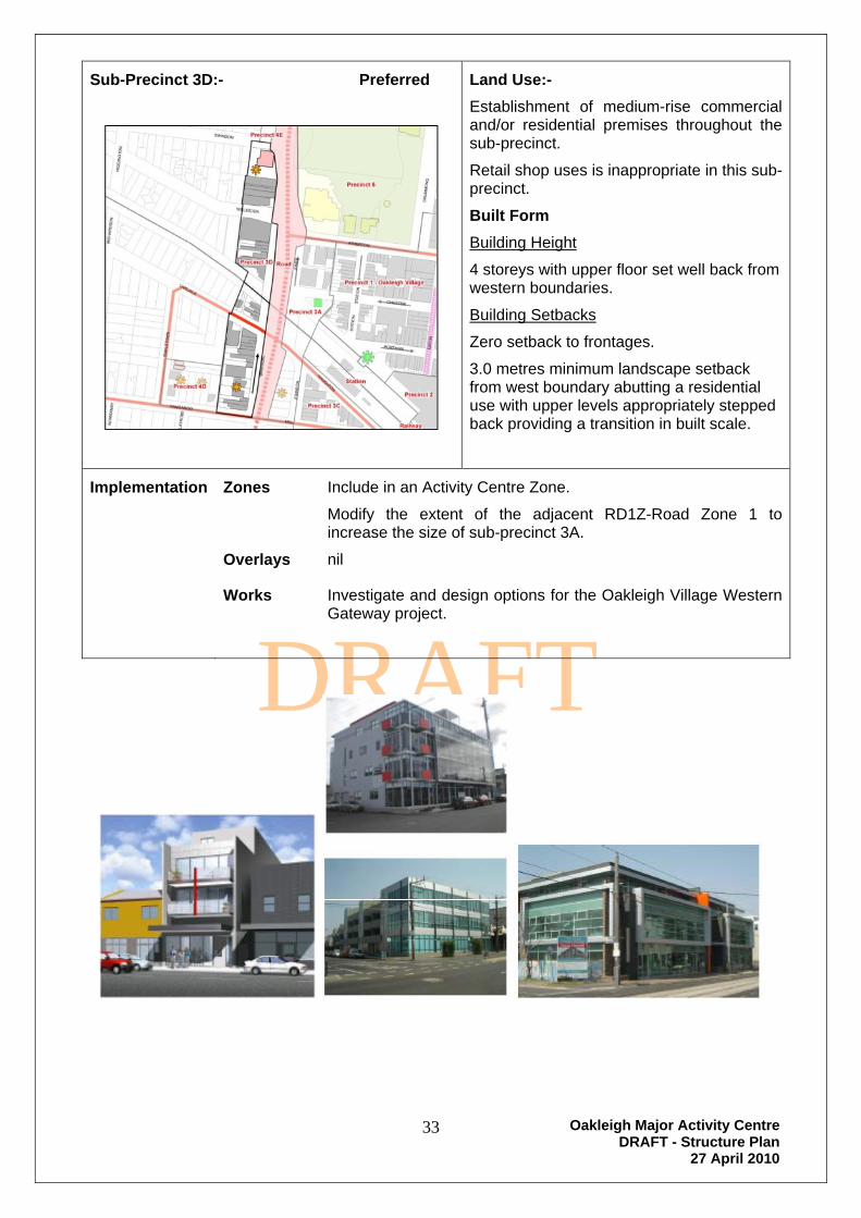
Sub-Precinct 3D:- Preferred
Land Use:-
Establishment of medium-rise commercial and/or residential premises throughout the sub-precinct.
Retail shop uses is inappropriate in this sub-precinct.
Built Form
Building Height
4 storeys with upper floor set well back from western boundaries.
Building Setbacks
Zero setback to frontages.
3.0 metres minimum landscape setback from west boundary abutting a residential use with upper levels appropriately stepped back providing a transition in built scale.
Implementation Zones
Overlays
Include in an Activity Centre Zone.
Modify the extent of the adjacent RD1Z-Road Zone 1 to increase the size of sub-precinct 3A.
nil
Works Investigate and design options for the Oakleigh Village Western Gateway project.
Oakleigh Major Activity Centre DRAFT - Structure Plan
27 April 2010
34
DRAFT
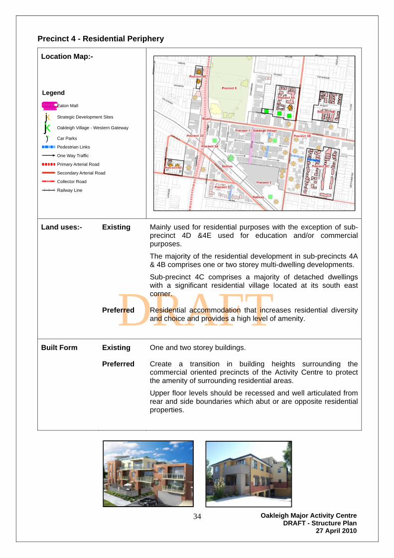
Precinct 4 - Residential Periphery
Location Map:-
Land uses:- Existing Mainly used for residential purposes with the exception of sub-precinct 4D &4E used for education and/or commercial purposes.
The majority of the residential development in sub-precincts 4A & 4B comprises one or two storey multi-dwelling developments.
Sub-precinct 4C comprises a majority of detached dwellings with a significant residential village located at its south east corner.
Preferred Residential accommodation that increases residential diversity and choice and provides a high level of amenity.
Built Form Existing One and two storey buildings.
Preferred Create a transition in building heights surrounding the commercial oriented precincts of the Activity Centre to protect the amenity of surrounding residential areas.
Upper floor levels should be recessed and well articulated from rear and side boundaries which abut or are opposite residential properties.
Legend
ççççççççççççççççççççEaton Mall
kj Strategic Development Sites
kj Oakleigh Village - Western Gateway
") Car Parks
Pedestrian Links
One Way Traffic
Primary Arterial Road
Secondary Arterial Road
Collector Road
Railway Line

Oakleigh Major Activity Centre DRAFT - Structure Plan
27 April 2010
35
DRAFT
Sub-Precinct 4A:- Preferred
Built Form
Building Height
3 storeys
Building Setbacks
6 metre front landscape setback.
Sub-Precinct 4B:- Preferred
Built Form
Context - This sub-precinct is surrounded by buildings located in an HO-Heritage Overlay and abuts Precinct 3B which has potential for 4 storey development.
Building Height
2 storeys
3 storeys within 30 metres of the boundary to Precinct 3B.
Building Setbacks
6 metre front landscape setback.

Oakleigh Major Activity Centre DRAFT - Structure Plan
27 April 2010
36
DRAFT
Sub-Precinct 4C:- Preferred
Built Form
Building Height
3 storeys between Oxford Street and Downing Street.
2 storeys between Downing Street and Regent Street
Building Setback
6 metre front landscape setback.
Sub-Precinct 4D:- Preferred
Built Form
Building Height
3 storeys – 165-171 Kangaroo Road & 10-12 Earlstown Road
4 Storeys – 173-175 Kangaroo Road
Building Setback
6 metre front landscape setback.

Oakleigh Major Activity Centre DRAFT - Structure Plan
27 April 2010
37
DRAFT
Sub-Precinct 4E:- Preferred
Built Form
Building Height
3 storeys
Building Setback
6 metre front landscape setback.
Implementation Zones
Overlays
Include in an Activity Centre Zone
nil
Works Nil

Oakleigh Major Activity Centre DRAFT - Structure Plan
27 April 2010
38
DRAFT
Precinct 5 - Civic, Warrawee Park and Heritage
Location Map:-
Land uses:- Existing
Public Open Space for both active and passive recreation, historic cemetery, Civic facilities, Police Station, RSL and public car parks.
Place of Worship and facilities, Public Library and community facilities, Oakleigh Hall and commercial offices located on the east side of Drummond Street.
A Heritage Overlay covers the majority of buildings located on the east side of Drummond Street.
Preferred Continuation of existing recreation and community activities and services.
Built Form Existing Generally two storey buildings on east side of Drummond Street, single storey buildings within Warrawee Park and surrounds,with the exception of the 3 storey football clubrooms pavilion.
Preferred Minimal change with building height and form respecting the historical character of the precinct.
Implementation Zones
Overlays
Include in an Activity Centre Zone
Retain Heritage Overlay.
Works Nil
Legend
ççççççççççççççççççççEaton Mall
kj Strategic Development Sites
kj Oakleigh Village - Western Gateway
") Car Parks
Pedestrian Links
One Way Traffic
Primary Arterial Road
Secondary Arterial Road
Collector Road
Railway Line

Oakleigh Major Activity Centre DRAFT - Structure Plan
27 April 2010
39
DRAFT
Station and Railway Areas
Location Map:-
Land uses:- Existing Oakleigh Station and Railway Line.
Preferred Continuation of the Station and Railway.
Uses compatible with the Preferred Uses of the abutting Precincts.
Built Form Existing Historic single storey station buildings
Preferred Development linking and/or spanning over the station and railway connecting development in precincts 1 & 2 with sub-precinct 3C.
Building Height
5 storeys
Building Setback
Zero metre frontage setback.
Implementation Zones
Overlays
Include in and Activity Centre Zone
Retain Heritage Overlay
Works Nil
Legend
ççççççççççççççççççççEaton Mall
kj Strategic Development Sites
kj Oakleigh Village - Western Gateway
") Car Parks
Pedestrian Links
One Way Traffic
Primary Arterial Road
Secondary Arterial Road
Collector Road
Railway Line
Oakleigh Major Activity Centre DRAFT - Structure Plan
27 April 2010
40
DRAFT
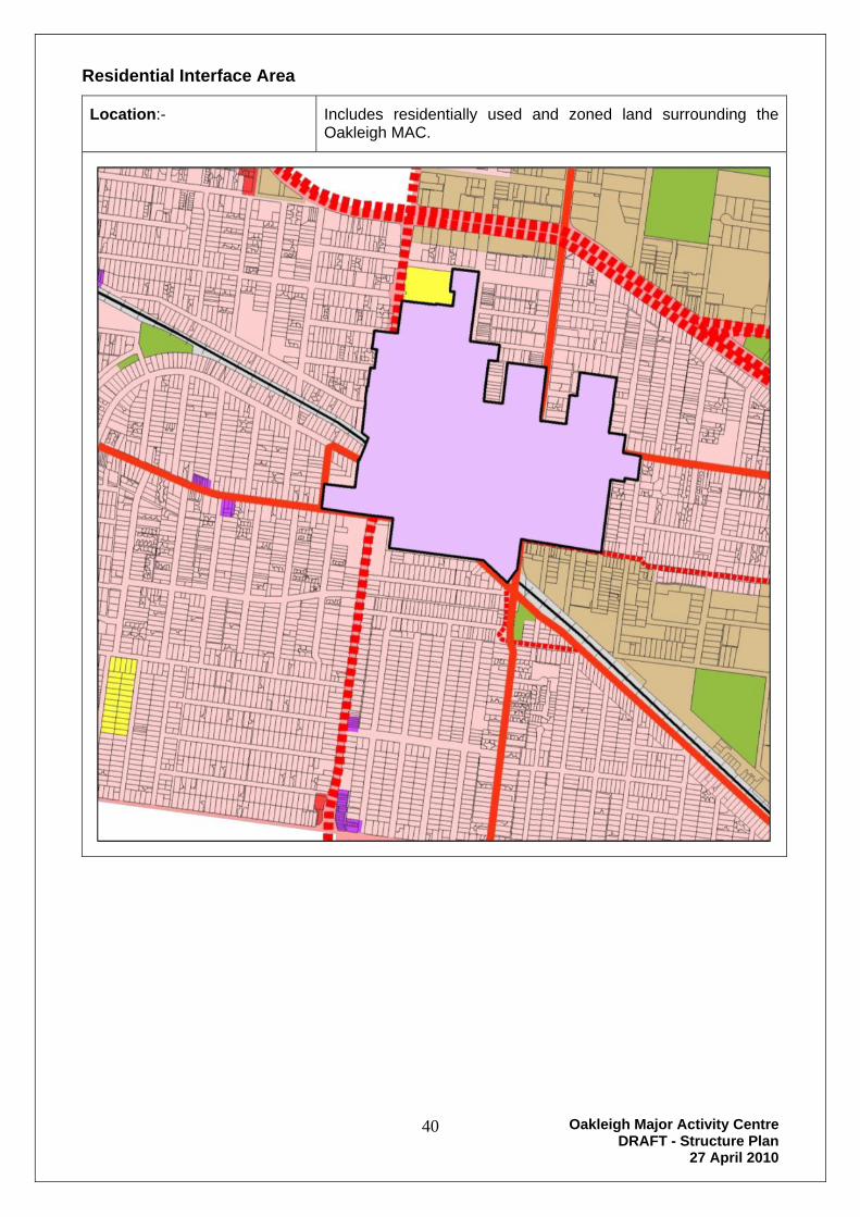
Residential Interface Area
Location:-
Includes residentially used and zoned land surrounding the Oakleigh MAC.

Oakleigh Major Activity Centre DRAFT - Structure Plan
27 April 2010
41
DRAFT
Land uses:- Existing Mainly used for residential purposes, comprising detached dwellings on each allotment with a significant number of medium density developments. Dwellings within this area are one or two storeys, with significant areas recognised for their heritage values and included within the HO-Heritage Overlay provisions of the Monash Planning Scheme.
The area includes several medical clinics, child care facilities and other appropriate discretionary uses.
There are few opportunities for new significant residential developments due to the lack of appropriate land and the extent of the HO–Heritage Overlay.
Preferred Continue to provide housing for families in single and two storey detached dwellings and infill medium density multi-dwelling developments compatible with the context and urban character of each location.
Built Form Existing 1 and 2 storey buildings.
Preferred Building Height:-
1 and 2 storey buildings.
Development Setbacks:-
Prevailing setbacks to maintain streetscape character.
Implementation Zones
Overlays
Retain existing Residential 1 zone.
Retain the HO–Heritage Overlay.
Works Nil

Oakleigh Major Activity Centre DRAFT - Structure Plan
27 April 2010
42
DRAFT
Urban Design - Public Realm Improvements
The City of Monash has initiated a program of urban design improvements to the public realm both within and surrounding the Oakleigh Major Activity Centre.
Streetscape improvement works within the past five years have included the reconstruction of Station Street and the first stage of infrastructure upgrade works at the western end of the Atherton Road shopping strip.
On-going works within the Warrawee Park Heritage Precinct comprise the restoration and enhancement of buildings and landscapes at Warrawee Park, DW Nicoll Reserve, Oakleigh Pioneer Memorial Park, Oakleigh Primary School and Oakleigh Bowling Club.
Landscape works at the Warrigal Road overpass (bridge abutments) and Dandenong Road (central median plantation) have raised the profile of these significant Activity Centre gateways.
Further works to improve public spaces have been identified and are being considered for implementation. This includes enhancement of the "Western Gateway", the area in front of the Oakleigh Station and its surrounds including the bus interchange area. [see Appendix 3]
The objectives of Public Realm Improvements include:
Development of a stronger community by enhancing underused and uninviting public spaces and providing greater opportunity for social activity and interaction.
Providing safe, comfortable, functional and equitable access for all pedestrians, cyclists and public transport users
Creating pedestrian-friendly public environments which express local character that are enjoyed and ‘owned’ by local communities.
Encouraging public/private sector partnerships to deliver synergistic environmental, economic and community benefits.
Creating high quality environments to foster economic, community and cultural growth that benefits the activity centre.
Improving connections to and between existing public places, car parks and major attractors within and surrounding the Activity Centre.

Oakleigh Major Activity Centre DRAFT - Structure Plan
27 April 2010
43
DRAFT
Community Services and facilities
A variety of community services and facilities are located within the Oakleigh Activity Centre and surrounding interface areas. Council facilities are primarily located within the Civic and Warrawee Park Precinct and include the Monash Public Library, Council Service Centre, Maternal and Child Health Centre, Oakleigh Hall, Monash Seminar and Training Centre and Monash Federation Centre. The vast majority of other private facilities are located within the Oakleigh Village Precinct. The range of services is extensive and reflects the demographic mix and established nature of this area.
The area is well serviced with many sporting reserves and facilities within close proximity to the Activity Centre. The Oakleigh Recreation Centre provides for a number of sporting activities including ball sports, a gym and outdoor swimming pool.
As the population increases there will be a need to upgrade and expand facilities within the area.
Community Halls:- The Oakleigh Hall (formerly the Mechanics Institute) located in Drummond Street provides basic hall facilities.
Other facilities:- Community facilities in Oakleigh and the surrounding local area include the Monash Public Library, Adult Multicultural Education Services, Oakleigh Community Information Centre and Monash Seminar and Training Centre.
A need for more meeting room facilities within the Activity Centre has been identified and assessment of this need should be included in any future evaluation of community facilities in the area.
Senior Citizens:- A number of senior citizen groups operate in the area and meet in various locations.
Medical Centres & Community Health Facilities:- A number of medical centres and community health facilities are located within the Oakleigh Activity Centre and these include medical, dental and veterinary services. Additional medical centres would be supported in appropriate locations. Preferred locations are Precincts 1 & 3.
Sporting facilities:- There are a number of notable recreational facilities situated within Oakleigh and the immediate local area. They include:-
Oakleigh Recreation Centre,
Warrawee Park,
Oakleigh Bowling Club,
Jack Edwards Reserve,
Brickmakers Park,
Scotchmans Run Reserve,
Scotchmans Creek and associated parklands and
Other recreational reserves.
In addition, the Oakleigh Public Golf Course, Metropolitan Golf Club and Huntingdale Golf Club are within reasonable distance of the Activity Centre.
Implementation:- Further evaluation of the need for more meeting room facilities within the Activity Centre, and additional services for the elderly should be undertaken.
Oakleigh Major Activity Centre DRAFT - Structure Plan
27 April 2010
44
DRAFT
Traffic Management
Vehicular access to the Centre is mostly provided via a grid network of collector roads and local streets feeding from Princes Highway, Warrigal Road, Poath Road, North Road and Huntingdale Road. The principal access routes are Atkinson Street, Atherton Road, Burlington Street, Haughton Road and Kangaroo Road. Other access routes include Drummond Street, Willesden Road and Mill Road.
Although located immediately to the east of Warrigal Road, the Oakleigh Major Activity Centre has minimal frontage directly onto this arterial road. The main point of access to the Centre is from the siganlised intersection of Warrigal Road and Atherton Road.
Atherton Road provides a significant non-local traffic east – west connection through the Centre from Warrigal Road to Huntingdale/Dandenong Roads..
The Golf Links/Hanover/Atkinson road link forms a very busy connective north-south traffic route used by a significant portion of motorists as a by-pass to Warrigal Road. However, this route is also an integral means of access to the Centre and with Atherton Road, and provides ‘passing trade’ opportunities for future development.
South side of the railway line, Haughton Road carries an established component of traffic passing the Activity Centre. Much of this traffic links with Huntingdale Road to the east and Kangaroo Road to the west.
Vehicle movement within the Oakleigh Village precinct (the retail core of the Activity Centre) is circuitous and can get very congested during peak times. Station, Chester, Portman and Jones Streets operate as one-way streets.
This one-way network minimises the complexity of traffic movements and congestion at street intersections, however vehicle movements associated with motorists seeking parking spaces within the Oakleigh Village precinct area can cause congestion and difficulties particularly in Chester and Portman Streets.
Public Transport
The Centre is well served with public transport. The modal interchange in Portman Street adjacent to the Oakleigh Railway Station accommodates 11 bus routes including a SmartBus Route. Two bus routes also access the Oakleigh Railway Station on the southern side of the railway via Haughton Road/Johnson Street.
A taxi rank is also provided within the interchange area in Portman Street.
Car Parking
In September 2007, Monash City Council prepared a Parking Precinct Plan for the Oakleigh Major Activity Centre. Grogan Richards Pty. Ltd. and SGS Economics and Planning Pty. Ltd. prepared this Plan on behalf of the City of Monash.
The primary objectives of the Oakleigh Parking Precinct Plan are:
To ensure the appropriate provision of car parking spaces in the Oakleigh Major Activity Centre. By application of this Parking Precinct Plan, it is more likely that a balance between car parking supply and demand in the Activity Centre will be maintained; and
To provide for a statutory funding mechanism for cash-in-lieu payments;
This Parking Precinct Plan will enable Council to provide additional car parking facilities funded by contributions received under the scheme implemented by this Parking Precinct Plan.
It is intended to recover part of the cost of the facilities from those that establish new uses or propose new development or intensify existing uses and development within the Activity Centre through a requirement for payment of an amount per car parking space which is required but not provided on the land. This is known as a "cash in lieu" payment.

Oakleigh Major Activity Centre DRAFT - Structure Plan
27 April 2010
45
DRAFT
Long-standing policies on parking provision have always been premised on new uses providing for increased parking demand either on-site or off-site where appropriate. A cash-in-lieu option has been an integral part of this approach and has enabled Council to partly fund the construction of new parking spaces in the Activity Centre in line with increases in parking demand. Should Council abandon this policy, the Centre’s development could be prejudiced by a lack of off-street parking.
A major threat to the achievement of orderly and proper planning in relation to car parking provision is the potential for temporary surpluses of parking to be exploited by proponents on a case by case basis to avoid meeting parking requirements. It is the explicit intention of the Parking Precinct Plan that this anomaly be addressed by adopting a whole of centre and a long term approach to car parking.
The strategic basis for this plan is contained in the Oakleigh Activity Centre Parking Study and Strategy April (2007) and supported by the car parking analysis conducted by Grogan Richards.
This study indicates that parking supply and demand was reasonably in balance in 2007. However, there are some areas where, at certain times, demand exceeds supply. To enable the centre to expand, provision must be made for additional car parking within the centre into the future.
The intended outcomes of the Parking Precinct Plan are:
To more accurately reflect actual demand rates of certain uses in the table to clause 52.06. of the Monash Planning Scheme. Particularly restaurant, shop, hairdresser and office.
To restrict the case by case approach to car parking supply and provision.
To enable a cash-in-lieu contribution for car parking provision to be validly imposed on planning permits and in cases where no permits are required.
To achieve an appropriate balance between the demand and supply of parking spaces while allowing new and intensified development.
To enable new uses and developments that generate new car parking demand to proceed.
To take advantage of the opportunity to construct additional public car parking hence achieving parking spaces cost-effectively.
To fund the cost of the infrastructure on an equitable basis.
Contribution to the Oakleigh Parking Precinct Plan will assist in funding the development of a multi-deck car park on the Atkinson Street / Palmerston Grove site. This car park will provide an additional 208 car parking spaces for the Activity Centre.
The Oakleigh parking Precinct Plan applies to land zoned for business purposes located to the east of warrigal Road and north of the railway line. It does not include the Oakleigh Centro Shopping Centre. [see Appendix 4]
Council off-street car parks are generally provided to the periphery of the core retail area, mainly to the north and east. Exceptions include the Chester Street car park located just east of Eaton Mall and a small car park at the corner of Chester and Portman Streets.
Car parks placed around the periphery of the core area assist in minimising traffic movements within the area which in turn provides a significant benefit to the pedestrian environment within the Oakleigh Village precinct.
Where existing public car parks are redeveloped, that development should ensure that adequate new car parking spaces are provided for that use and development, as well as ensuring that the total number of public car parking spaces within the Oakleigh MAC is not reduced.
Oakleigh Major Activity Centre DRAFT - Structure Plan
27 April 2010
46
DRAFT
Stormwater Drainage Management
The Oakleigh Major Activity Centre is a fully built environment and as such most stormwater is collected off hard surfaces and directed to the underground drainage system.
This drainage system is relatively dated and has limited capacity, which means that during the larger storm events, some overland flow does occur. The overland flow generally flows to the south-west towards the Warrigal Road / Willesden Road area.
It is not expected that redevelopment within the Centre will significantly alter the existing stormwater runoff conditions (eg development will not make things any worse), however there is scope to ensure that future redevelopment occurs in accordance with stormwater management best practice.
Amendment to Monash Planning Scheme
Implementation of this Structure Plan will involve amendment to the Monash Planning Scheme. That amendment will include:-
1. Modification of a Strategic Statement in Clause 21- the Municipal Strategic Statement.
Clause 21.06 would be modified to reflect the strategy and objectives of this Structure Plan and reference the Plan in the Monash Planning Scheme.
2. Inclusion of Clause 37.08 Activity Centre Zone in the Monash Planning Scheme with Schedule 1 to the ACZ which detail the relevant landuse and development provision to implement the OMAC – Structure Plan.
3. Amendment to the Planning Scheme Zone maps to reflect the inclusion of the ACZ – Activity Centre Zone.
Complete detail of the proposed amendment is to be completed and exhibited as part of the formal process to reference the Oakleigh Major Activity Centre in the Monash planning Scheme.
The extent of the proposed ACZ – Activity Centre Zone is shown on the following map.

Oakleigh Major Activity Centre DRAFT - Structure Plan
27 April 2010
47
DRAFT
Proposed – ACZ Activity Centre Zone 1 – Oakleigh Major Activity Centre

Oakleigh Major Activity Centre DRAFT - Structure Plan
27 April 2010
48
DRAFT
Appendices
1. Monash Planning Scheme - Zones (Existing) 49
2. Monash Planning Scheme - Overlays (Existing) 50
3. Oakleigh Village – Western Gateway 51
4. Transport and Parking 52
5. Demographic Data 54
Oakleigh Major Activity Centre DRAFT - Structure Plan
27 April 2010
49
DRAFT
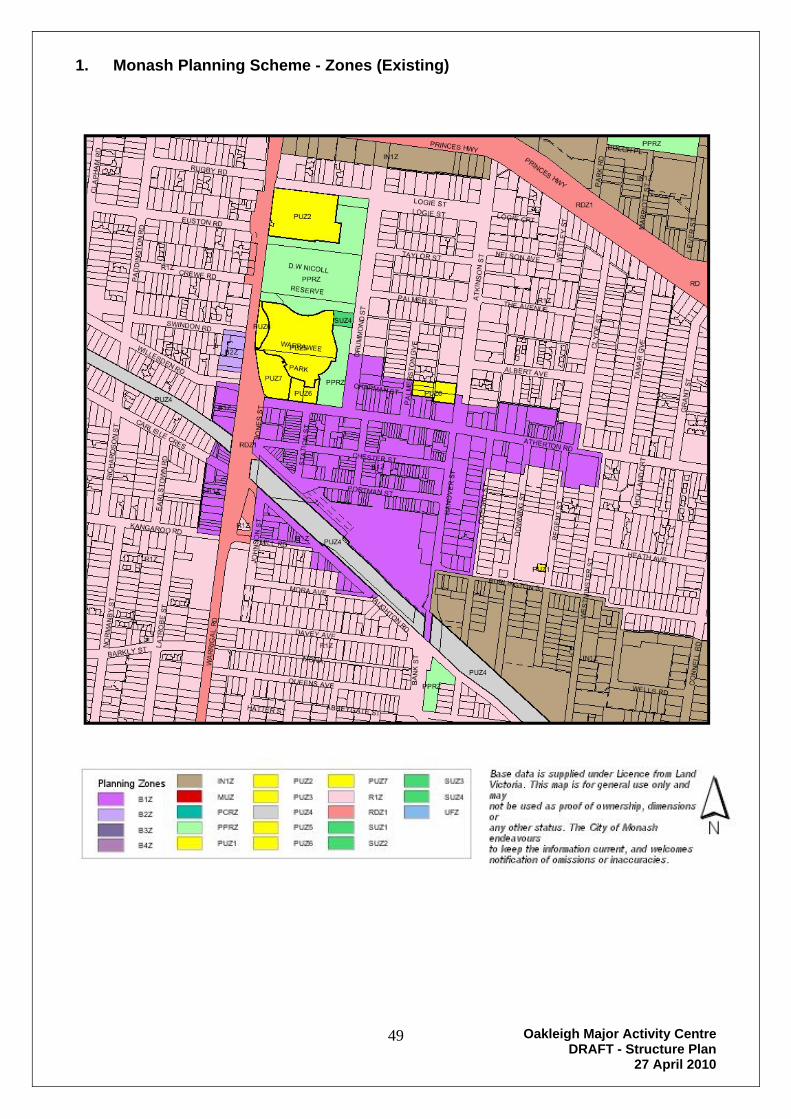
1. Monash Planning Scheme - Zones (Existing)

Oakleigh Major Activity Centre DRAFT - Structure Plan
27 April 2010
50
DRAFT
2. Monash Planning Scheme – Overlay (Existing)

Oakleigh Major Activity Centre DRAFT - Structure Plan
27 April 2010
51
DRAFT
3. Oakleigh Village – Western Gateway
Oakleigh Major Activity Centre DRAFT - Structure Plan
27 April 2010
52
DRAFT
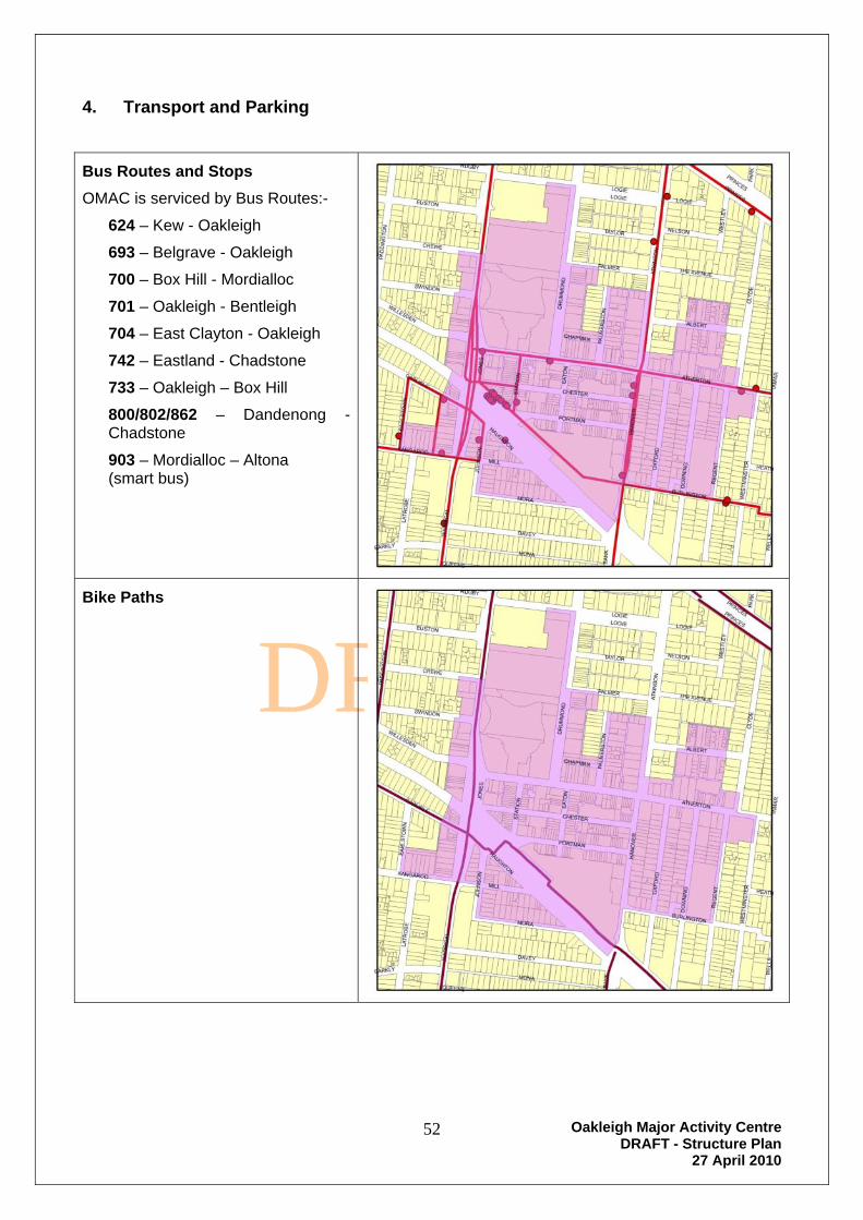
4. Transport and Parking
Bus Routes and Stops
OMAC is serviced by Bus Routes:-
624 – Kew - Oakleigh
693 – Belgrave - Oakleigh
700 – Box Hill - Mordialloc
701 – Oakleigh - Bentleigh
704 – East Clayton - Oakleigh
742 – Eastland - Chadstone
733 – Oakleigh – Box Hill
800/802/862 – Dandenong - Chadstone
903 – Mordialloc – Altona (smart bus)
Bike Paths

Oakleigh Major Activity Centre DRAFT - Structure Plan
27 April 2010
53
DRAFT
Vehicle Parking
There are many public car park facilities in the OMAC.
A Parking Precinct Plan applies to use and development with Precincts 1, 3A and 3B.
Legend
OMAC_Parking Precinct Plan Area
OMAC_Public Car Parks
CLY
DE
ATHERTON
LOGIE
MONA
DAVEY
HAUGHTON
RE
GE
NT
ATK
INS
ON
OX
FO
RD
CHESTER
DO
WN
ING
MORA
WA
RR
IGA
L
MILL
DR
UM
MO
ND
PORTMAN
EUSTON
CREWE
LAT
RO
BE
ALBERT
WE
ST
MIN
ST
ER
PA
DD
ING
TON
BURLINGTON
RUGBY
HA
NO
VE
R
TAYLOR
CARLISLE
PALMER
EAT
ON
SWINDON
PRINCES
BARKLY
WILLESDEN
WE
LLS
QUEENSJO
HN
SO
N
NELSON
KANGAROO
STA
TIO
N
WE
ST
LE
Y
THE AVENUE
PAR
K
EA
RLS
TO
WN
PA
LME
RS
TO
NB
AN
K
JON
ES
CHAPMAN
HEATH
LOGIE
PRINCESLOGIE

Oakleigh Major Activity Centre DRAFT - Structure Plan
27 April 2010
54
DRAFT
5. Demographic Data
Extract of demographic data from Council’s web page: www.monash.vic.gov.au, Community Profile data.
The City of Monash Community Profile is designed to inform community groups, investors, business, students and the general public about the municipality and includes results from the 2006, 2001, 1996, and 1991 Censuses of Population and Housing.
The Demographic Information and data on Council’s web page has been prepared for the City of Monash by id. consulting.
Other tools are available on Council’s web site. These include
Population Forecast Details Monash population and household forecasts.
Economy.id Details the economic profile of Monash.
Community Atlas Details the key socio-demographic characteristics for the City of Monash presented as interactive maps. Each map is prepared using Census Collector Districts providing the finest level of detail to help identify spatial patterns and trends in the City.
Demographic information for the City of Monash and the suburb of Oakleigh, contained in this attachment to the Oakleigh Structure Plan, include:-
Key Drivers of change.
How many will live here in the future?
How will the population Change?
What will be our age structure?
What type of dwellings do we live in? (Dwelling types)
Additional information is also available in the Municipal Strategic Statement of the Monash Planning Scheme and the reference document, the Monash Housing Strategy of June 2004.

Oakleigh Major Activity Centre DRAFT - Structure Plan
27 April 2010
55
DRAFT
Key drivers of change
Historical migration flows, the City of Monash, 2001 to 2006
Note: The migration flows depicted above do not represent future or forecast migration flows. The arrows represent
migration flows to the LGA/SLA as a whole and do not indicate an origin or destination for any specific localities
within the LGA/SLA.
The City of Monash is located in the established eastern suburbs of Melbourne. The municipality is predominantly
residential, although there is a significant industrial belt stretching from Mount Waverley through Clayton-Notting Hill to
Mulgrave and there are major commercial centres at Glen Waverley, Oakleigh, Clayton and Mount Waverley. Urban
development in the City dates back to the nineteenth century, with Oakleigh being established as a township, but it was
not until after the Second World War that significant urban expansion occurred. Initial development along the railway
lines quickly spread across the City generally from west to east, a process that continued up until the 1980s. The
primary housing market role that the City of Monash played during this period was to provide home owning opportunities
for families and prospective families from the eastern suburbs of Melbourne.

Oakleigh Major Activity Centre DRAFT - Structure Plan
27 April 2010
56
DRAFT
The 1980s were a period of population loss in the City as a number of areas matured, with children leaving the family
home, as well as comparatively little residential development to provide housing opportunities. During the 1990s, new
development opportunities were taken, with the conversion of school sites and surplus government and utility land to
residential purposes. There is significant pressure for residential expansion within Monash from both existing residents
and from external migrants, most notably from overseas, as well as areas to the west (Stonnington and Glen Eira),
although affordability issues have resulted in the loss of people to the outer east and south east. It is assumed that a
number of these patterns will continue into the future, notably the large overseas flows into the City.
Note: The migration flows depicted above do not represent future or forecast migration flows.
With the residential development of the City over several decades and the large size of the municipality, areas have
developed different roles within the housing market. These roles generally fall under two categories: 1. Young adults and
tertiary students and; 2. Established and mature families. The first pattern tends to affect areas in the south-west of the
municipality, such as Clayton, Oakleigh, Hughesdale and Chadstone, due to the proximity of Monash University and a
lesser extent Holmesglen TAFE. The second pattern is noteworthy in the north and east of the City, such as Mount
Waverley, Glen Waverley, Wheelers Hill and Mulgrave, where the housing stock, the amenity and attractiveness of the
areas drive local migration patterns. This difference in function and role of the small areas in the City of Monash means
that population outcomes differ significantly across the municipality.
There are also significant differences in the supply of residential property within the City which will also have a major
influence in structuring different population and household futures over the next five to twenty years. The major source
of additional dwellings and households in the City will be in the larger redevelopment sites and through infill and medium
density development in existing residential areas. The larger redevelopment sites include Waverley Park (Mulgrave), the
former Arnotts Factory in Ashwood-Burwood, the former Deakin University site and Monash Green development in
Clayton, the Sienna Falls development in Mount Waverley and a range of sites in central Oakleigh. Higher rates of
residential redevelopment are expected in Clayton-Notting Hill and Oakleigh East-Huntingdale due to demand as a result
of proximity to Monash University and the fact that these areas have an ageing dwelling stock.
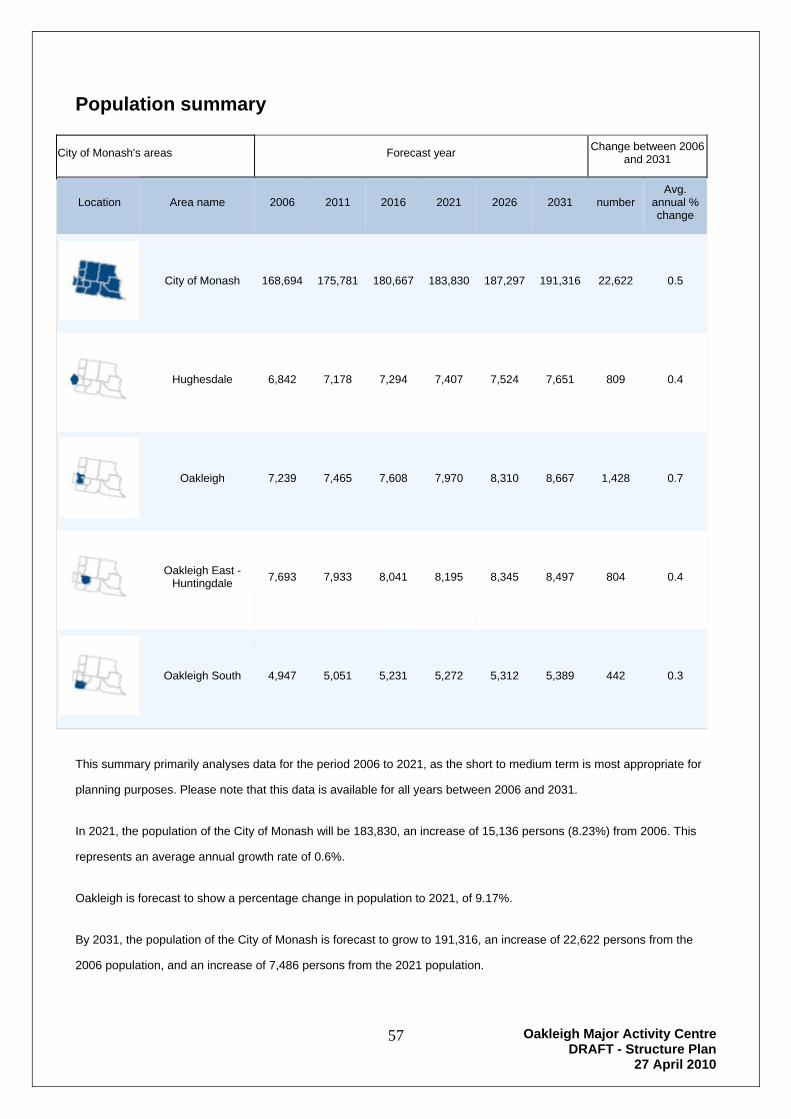
Oakleigh Major Activity Centre DRAFT - Structure Plan
27 April 2010
57
DRAFT
Population summary
City of Monash's areas Forecast year Change between 2006
and 2031
Location Area name 2006 2011 2016 2021 2026 2031 number Avg.
annual % change
City of Monash 168,694 175,781 180,667 183,830 187,297 191,316 22,622 0.5
Hughesdale 6,842 7,178 7,294 7,407 7,524 7,651 809 0.4
Oakleigh 7,239 7,465 7,608 7,970 8,310 8,667 1,428 0.7
Oakleigh East - Huntingdale
7,693 7,933 8,041 8,195 8,345 8,497 804 0.4
Oakleigh South 4,947 5,051 5,231 5,272 5,312 5,389 442 0.3
This summary primarily analyses data for the period 2006 to 2021, as the short to medium term is most appropriate for
planning purposes. Please note that this data is available for all years between 2006 and 2031.
In 2021, the population of the City of Monash will be 183,830, an increase of 15,136 persons (8.23%) from 2006. This
represents an average annual growth rate of 0.6%.
Oakleigh is forecast to show a percentage change in population to 2021, of 9.17%.
By 2031, the population of the City of Monash is forecast to grow to 191,316, an increase of 22,622 persons from the
2006 population, and an increase of 7,486 persons from the 2021 population.
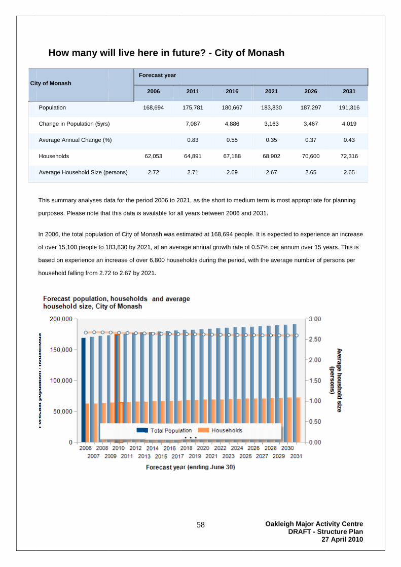
Cit
How m
ty of Monash
Population
Change in Po
Average Annu
Households
Average Hous
This summar
purposes. Ple
In 2006, the t
of over 15,10
based on exp
household fa
many wi
opulation (5yrs)
ual Change (%
sehold Size (p
ry analyses da
ease note tha
total populatio
00 people to 1
perience an in
alling from 2.72
D
ill live he
Fo
1
)
%)
6
ersons)
ata for the per
t this data is a
on of City of M
83,830 by 202
ncrease of ove
2 to 2.67 by 20
DR
ere in fu
orecast year
2006
168,694
62,053
2.72
iod 2006 to 20
available for al
Monash was es
21, at an avera
er 6,800 house
021.
58
RA
ture? - C
2011
175,781
7,087
0.83
64,891
2.71
021, as the sh
ll years betwe
stimated at 16
age annual gr
eholds during
AFT
City of M
2016
180,667
4,886
0.55
67,188
2.69
hort to medium
en 2006 and 2
8,694 people.
rowth rate of 0
the period, wi
OakleigD
T
Monash
2021
183,830
3,163
0.35
68,902
2.67
m term is most
2031.
. It is expected
0.57% per ann
th the average
h Major ActDRAFT - Str
27
2026
187,297
3,467
0.37
70,600
2.65
appropriate fo
d to experienc
num over 15 ye
e number of p
tivity Centreructure Plan7 April 2010
2031
191,316
4,019
0.43
72,316
2.65
or planning
ce an increase
ears. This is
persons per
e n 0
e
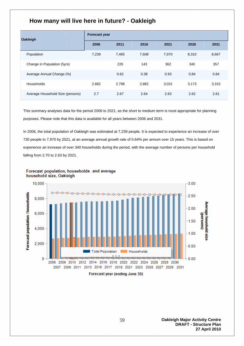
O
How m
Oakleigh
Population
Change in P
Average An
Households
Average Ho
This summar
purposes. Ple
In 2006, the t
730 people to
experience a
falling from 2
many wi
Population (5yr
nnual Change (
s
ousehold Size (
ry analyses da
ease note tha
total populatio
o 7,970 by 202
an increase of
2.70 to 2.63 by
D
ill live he
F
rs)
(%)
(persons)
ata for the per
t this data is a
on of Oakleigh
21, at an aver
over 340 hou
y 2021.
DR
ere in fu
Forecast year
2006
7,239
2,682
2.7
iod 2006 to 20
available for al
h was estimate
rage annual gr
seholds during
59
RA
ture? - O
2011
7,465
226
0.62
2,798
2.67
021, as the sh
ll years betwe
ed at 7,239 pe
rowth rate of 0
g the period, w
AFT
Oakleigh
2016
7,608
143
0.38
2,882
2.64
hort to medium
en 2006 and 2
eople. It is exp
0.64% per ann
with the avera
OakleigD
T
h
2021
7,970
362
0.93
3,031
2.63
m term is most
2031.
ected to expe
num over 15 y
age number of
h Major ActDRAFT - Str
27
2026
8,310
340
0.84
3,173
2.62
appropriate fo
erience an incr
years. This is b
f persons per h
tivity Centreructure Plan7 April 2010
2031
8,667
357
0.84
3,315
2.61
or planning
rease of over
based on
household
e n 0
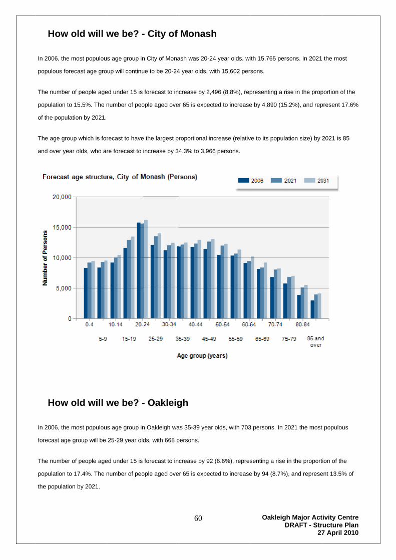
How o
In 2006, the m
populous fore
The number
population to
of the popula
The age grou
and over yea
How o
In 2006, the m
forecast age
The number
population to
the populatio
old will w
most populous
ecast age gro
of people age
o 15.5%. The n
ation by 2021.
up which is for
ar olds, who ar
old will w
most populous
group will be
of people age
o 17.4%. The n
on by 2021.
D
we be? -
s age group in
up will continu
ed under 15 is
number of peo
recast to have
re forecast to
we be? -
s age group in
25-29 year old
ed under 15 is
number of peo
DR
- City of
n City of Mona
ue to be 20-24
forecast to inc
ople aged ove
e the largest p
increase by 34
- Oakleig
n Oakleigh wa
ds, with 668 p
forecast to inc
ople aged ove
60
RA
Monash
ash was 20-24
4 year olds, wi
crease by 2,4
r 65 is expect
roportional inc
4.3% to 3,966
gh
as 35-39 year
persons.
crease by 92
r 65 is expect
AFT
h
4 year olds, wi
th 15,602 pers
96 (8.8%), rep
ed to increase
crease (relativ
6 persons.
olds, with 703
(6.6%), repres
ed to increase
OakleigD
T
th 15,765 per
sons.
presenting a ri
e by 4,890 (15
ve to its popula
3 persons. In 2
senting a rise
e by 94 (8.7%)
h Major ActDRAFT - Str
27
sons. In 2021
ise in the prop
5.2%), and rep
ation size) by 2
2021 the most
in the proport
), and represe
tivity Centreructure Plan7 April 2010
the most
portion of the
present 17.6%
2021 is 85
t populous
ion of the
ent 13.5% of
e n 0
%

The age grou
year olds, wh
up which is for
ho are forecas
D
recast to have
st to increase b
DR
e the largest p
by 29.1% to 3
61
RA
roportional inc
46 persons.
AFT
crease (relativ
OakleigD
T
ve to its popula
h Major ActDRAFT - Str
27
ation size) by 2
tivity Centreructure Plan7 April 2010
2021 is 60-64
e n 0
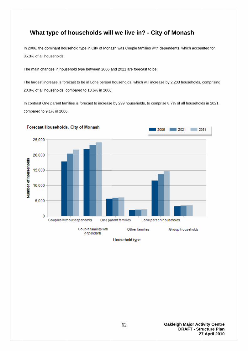
What
In 2006, the d
35.3% of all h
The main cha
The largest in
20.0% of all h
In contrast O
compared to
type of
dominant hou
households.
anges in hous
ncrease is fore
households, c
One parent fam
9.1% in 2006
D
househo
sehold type in
sehold type be
ecast to be in
compared to 1
milies is foreca
6.
DR
olds will
n City of Mona
etween 2006 a
Lone person
8.6% in 2006.
ast to increase
62
RA
l we live
ash was Coupl
and 2021 are f
households, w
.
e by 299 house
AFT
in? - Ci
le families with
forecast to be:
which will incre
eholds, to com
OakleigD
T
ty of Mo
h dependents
:
ease by 2,203
mprise 8.7% of
h Major ActDRAFT - Str
27
onash
, which accou
3 households,
f all household
tivity Centreructure Plan7 April 2010
nted for
comprising
ds in 2021,
e n 0

What
In 2006, the d
all household
The main cha
The largest in
22.3% of all h
In contrast O
to 3.6% in 20
type of
dominant hou
ds.
anges in hous
ncrease is fore
households, c
Other families i
006.
D
househo
sehold type in
sehold type be
ecast to be in
compared to 2
s forecast to i
DR
olds will
n Oakleigh wa
etween 2006 a
Lone person
0.4% in 2006.
ncrease by 5
63
RA
l we live
s Couple fami
and 2021 are f
households, w
.
households, t
AFT
in? - Oa
ilies with depe
forecast to be:
which will incre
o comprise 3.
OakleigD
T
akleigh
endents, which
:
ease by 130 h
4% of all hous
h Major ActDRAFT - Str
27
h accounted fo
households, co
seholds in 202
tivity Centreructure Plan7 April 2010
or 34.6% of
omprising
21, compared
e n 0
Related Documents