OGRS 2009 - 8th July 2009 25.03.22 1 Free and Open Source Desktop GIS Projects and Software: An Analysis Stefan Steiniger, University of Calgary, Canada Swiss NSF Project: PAGEVIS-LD Email: [email protected]

25.08.2015 1OGRS 2009 - 8th July 2009 Free and Open Source Desktop GIS Projects and Software: An Analysis Stefan Steiniger, University of Calgary, Canada.
Dec 25, 2015
Welcome message from author
This document is posted to help you gain knowledge. Please leave a comment to let me know what you think about it! Share it to your friends and learn new things together.
Transcript

OGRS 2009 - 8th July 2009 19.04.23 1
Free and Open Source Desktop GIS Projects and Software:
An Analysis
Stefan Steiniger, University of Calgary, CanadaSwiss NSF Project: PAGEVIS-LDEmail: [email protected]

OGRS 2009 - 8th July 2009 19.04.23 2
OpenJUMP, Image: Uwe Dallüge
GRASS GIS, Image: M. Lennert (http://grass.itc.it)
Quantum GIS, Image: M. Neteler
(pinus.chinju.ac.kr)
uDIG, Image: Refractions.net
GRASS
Thuban
Desktop GIS
GIS ViewerGIS Analyst
MapWindow
iGeoDesktop
QGIS
SAGAuDig
OpenJUMP
GIS EditorOrbisGIS
ILWIS
gvSIG
JUMP
Kosmo

OGRS 2009 - 8th July 2009 19.04.23 3
Questions that I want to answer:
pictures from: http://commons.wikimedia.org
- What distinguishs Free and Open
Source Desktop GIS (FOSGIS)
projects from proprietary projects?
vs.FOSGIS
- Are FOS GIS ready for the Desktop?
- Are FOS Desktop GIS becoming
a success story?
FOSGIS

OGRS 2009 - 8th July 2009 19.04.23 4
Outline
I. What‘s a Desktop GIS?
II. FOS Desktop GIS projects – a selection
III. Comparing FOS vs. Proprietary (Desktop) GIS
IV. Challenges in FOS GIS management
V. So what?

OGRS 2009 - 8th July 2009 19.04.23 5
I. What’s a Desktop GIS?

OGRS 2009 - 8th July 2009 19.04.23 6
Background (I)
What does a “Desktop GIS” look like?
a typical user interface … a bit like Google Earth or Google Maps
OGRS 2009 - 8th July 2009 19.04.23 7
Background (II)
What can I do with a “Desktop GIS”?
Viewing (exploration)
Creation (& extend dataset)
Editing (modify dataset)
Conflation (integrating datasets from different sources)
Transformation (coordinate systems, raster/vector, resampling,…)
Query (new views/selections)
Analysis (new datasets with new information)
Create maps

OGRS 2009 - 8th July 2009 19.04.23 8
Background (III)
So - what is a “Desktop GIS”?
- distinguishing between different types of GIS software by user tasks*
*Steiniger and Weibel (2009)
- desktop GIS tasks: 1 viewing, 2 creating, 3 editing, 4 storage, 5 conflation, 6 transformation, 7 query, 8 analysis, 9 creating maps
- or as ESRI says:
A desktop GIS is a mapping software that is installed onto and runs on a personal computer and allows users to display, query, update, and analyse data about geographic locations and the information linked to those locations. (www.esri.com)
- types of desktop GIS: . GIS Viewer: 1,4,7,(9); . GIS Editor: 1-4,(6),7,9;
. GIS Analyst: 1-9

OGRS 2009 - 8th July 2009 19.04.23 9
II. FOS Desktop GIS – a selection

OGRS 2009 - 8th July 2009 19.04.23 10
Background (IV)
- since 2002 a number of free Desktop GIS projects started (> 5)- GRASS and OpenMap earlier, but with military background- different foci:
. user background: novice, experienced, expert, research
. application: data editing, conflation, analysis, viewing
. main data type: raster vs. vector
. devel. platform: C++, Java, Python, (PhP?)
*P Ramsey (2004, 2006); ** JO Wagner (2006), ***J Reid (2001)
- possible evaluation criteria:. features/functionality . supported (OGC) standards***. documentation* . transparent devel team*. software modular* . developer community*. user community* . license**. support** . platforms & tech. requirements**. useablity . development API

OGRS 2009 - 8th July 2009 19.04.23 11
Background (V)
01. GRASS 02. Quantum GIS (QGIS) 03. JUMP GIS family: OpenJUMP – SkyJUMP – deeJUMP - PirolJUMP 04. uDig : (recently joined by/with JGrass team: dedicated to hydro - geomorphology)
05. SAGA06. MapWindow 07. Thuban : GIS viewer08. Kalypso 09. gvSIG10. Kosmo 11. OpenMap : GIS ToolKit 12. ILWIS 13. mezoGIS : GIS viewer14. Fmaps : (dead)15. OrbisGIS : under development16. Puzzle GIS : under development17. iGeoDesktop : under development
not open source, but free-of-cost: Spatial Commander, Forestry GIS, Google Earth, ArcExplorer, TNTlite, TatukGIS Viewer, ...

OGRS 2009 - 8th July 2009 19.04.23 12
GRASS
LargerDesktop GIS
Projects MapWindow
QGIS
SAGA
uDig
OpenJUMP
ILWIS
gvSIG

OGRS 2009 - 8th July 2009 19.04.23 13
Geographic Resource Analysis Support System
GRASS
LargerDesktop GIS
Projects MapWindow
QGIS
SAGA
uDig
OpenJUMP
ILWIS
gvSIG
user level:
experienced … research
application focus:
vector & raster analysis
users:
worldwide, large community
developers:
mainly from universities
notes:
oldest FOS GIS, ArcInfo functionality
GRASS GIS Image: M. Lennert (http://pinus.chinju.ac.kr/grass/grass63/screenshots/images/native_wingrass63.jpg)

OGRS 2009 - 8th July 2009 19.04.23 14
Integrated Land and Water Information System
GRASS
LargerDesktop GIS
Projects MapWindow
QGIS
SAGA
uDig
OpenJUMP
ILWIS
gvSIG
ILWIS Image: http://52north.org/joomla/images/stories/52n/admin/ilwis_screenshots/ilwisss.jpg
user level:
novice … research
application focus:
vector & raster analysis
users:
several, research (teaching)
developers:
ITC Enschede (NL), 52° Nord
notes:
*1985, Win-based (Visual C++)

OGRS 2009 - 8th July 2009 19.04.23 15
Map Window GIS
GRASS
LargerDesktop GIS
Projects MapWindow
QGIS
SAGA
uDig
OpenJUMP
ILWIS
gvSIG
user level:
novice … research
application focus:
GIS core/ vector & raster analysis
users:
worldwide, large
developers:
lead: Idaho State Univ., worldwide
notes:
Windows only, .NET
used by US Env. Protect. Agency
MapWindow GIS: http://en.wikipedia.org/

OGRS 2009 - 8th July 2009 19.04.23 16
System for Automated Geo-Scientific Analysis
GRASS
LargerDesktop GIS
Projects MapWindow
QGIS
SAGA
uDig
OpenJUMP
ILWIS
gvSIG
user level:
novice…research
application focus:
raster analysis (geomorph./hydro.)
users:
with particular interests
developers:
original: Univ. Göttingen (GER), now
U. of Hamburg, others
notes:
MS Visual C++, but Linux too
SAGA GIS: http://www.saga-gis.uni-goettingen.de/html/images/bild8.gif

OGRS 2009 - 8th July 2009 19.04.23 17
Quantum GIS
GRASS
LargerDesktop GIS
Projects MapWindow
QGIS
SAGA
uDig
OpenJUMP
ILWIS
gvSIG
user level:
novice … research
application focus:
data viewer & editor, interface to
GRASS, tendency to full GIS
users:
huge community worldwide
developers:
worldwide, volunteers
notes:
best marketing
Quantum GIS Image: M. Neteler (pinus.chinju.ac.kr)

OGRS 2009 - 8th July 2009 19.04.23 18
Open Java Unified Mapping Platform
GRASS
LargerDesktop GIS
Projects MapWindow
QGIS
SAGA
uDig
OpenJUMP
ILWIS
gvSIG
user level:
novice … research
application focus:
vector data editing, conflation, analys.
users:
worldwide, public. admin.
developers:
orig. JUMP: VividSolutions Inc. (CA),
now: volunteers worldwide
notes:
versions: deeJUMP, SkyJUMP, ...

OGRS 2009 - 8th July 2009 19.04.23 19
Generalitat Valencia Sistema d‘Informacio Geografica
GRASS
LargerDesktop GIS
Projects MapWindow
QGIS
SAGA
uDig
OpenJUMP
ILWIS
gvSIG
user level:
novice … research
application focus:
ArcView++
users:
public administration (ES), research
developers:
IVER Technologies (ES), univers.
notes:
strong financial support by governm.
non Spanish user base is growing
gvSIG Image: http://www.gvsig.gva.es
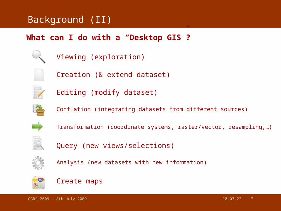
OGRS 2009 - 8th July 2009 19.04.23 20
user friendly Desktop Internet GIS
GRASS
LargerDesktop GIS
Projects MapWindow
QGIS
SAGA
uDig
OpenJUMP
ILWIS
gvSIG
user level:
novice … research
application focus:
viewing, editing, analysis (web/data)
users:
growing comm., worldwide
developers:
Refractions R. Inc. (CA), Axios (ES),
volunteers
notes:
---
uDig Image: http://udig.refractions.net/confluence/display/UDIG/Screenshots

OGRS 2009 - 8th July 2009 19.04.23 21
III. Comparing FOS vs. Proprietary (Desktop) GIS
vs.FOSGIS

OGRS 2009 - 8th July 2009 19.04.23 22
Comparing functionality
Task GRASS QGIS ILWIS uDig SAGA Open-
JUMP
Map
Window
gvSIG ArcView
9.3viewing creation editing integration - - - - - -
Presentation
- maps - charts - - - - tables Overlay Analysis
- raster Via Grass
Via JGrass
Via Sextante
Via Sextante
-
- vector partly
customization
Python, Perl
PythonILWIS scripts
Groovy Python Jython .Net Jython several
functionality : available, : available via plugins, - : not available

OGRS 2009 - 8th July 2009 19.04.23 23
Comparing Development & Support
Free GIS projects vs. Proprietary GIS Vendors (1):
I - Development Drivers
. GIS Projects: companies (commercial), authorities, research and
individuals
. Prop. GIS: companies (commercial), (very) big customers
II – User Focus
. GIS Projects: focus towards particular user groups and tasks
. Prop. GIS: focus towards particular businesses & wide appl. field
III – Development & Shipping models
. GIS Projects: (a) all functions out of the box (GRASS, ILWIS, SAGA)
(b) core & 3rd-party plugins (QGIS, OpenJUMP, gvSIG)
. Prop. GIS: rather (a) but (b) GIS “extensions” exist too
OGRS 2009 - 8th July 2009 19.04.23 24
Comparing Development & Support
Free GIS projects vs. Proprietary GIS Vendors (2):
IV - Support
. GIS Projects: by companies*, free email, free user forums, wikis
. Prop. GIS: by companies (paid), forums (paid + free)
*FOS GIS support: see also http://www.osgeo.org/search_profile
V - Miscellaneous:
FOS GIS Projects
1) not yet ready to create “nice” maps (req. post-processing)2) documentation is sometimes incomplete, but you can talk to the developers in forums and user email lists
3) information needs to be found by user (no marketing)
4) difficult to estimate how projects continue (not market driven)

OGRS 2009 - 8th July 2009 19.04.23 25
Comparing Licenses
Non GIS – specific differences of FOS and Proprietary Software
Proprietary Software
(e.g. Microsoft Office, ArcGIS)
OpenSource / Free Software
(e.g. OpenOffice, GRASS GIS)
+ warranty* of developing company on product :holds for every company
+ components should work together
+ usually well documented software
+ no license fees
+ unrestricted use (e.g. # installations)
+ no update enforcement
+ support of open standards
+ customization at API level - price & maintenance fees
- customized development is difficult
- support as long as company exists
- installation knowhow necessary
- training costs**
Based on a comparison by Martin Weis (2005)*) BUT: license agreements often exclude warranty**) BUT: user choice to invest in own resources or to buy

OGRS 2009 - 8th July 2009 19.04.23 26
IV. Management challenges
- for volunteer projects -

OGRS 2009 - 8th July 2009 19.04.23 27
Challenges (I)
Situation description - OpenJUMP is a “volunteer” project
+ supporting companies Lat/Lon, Intevation, ISA Inc.- ca. 4-5 developers + ca. 3-5 contributing users- ca. 1000 downloads/month - 80 vs. 90 email list users (developers vs. users)
Challenges
users
project
technical

OGRS 2009 - 8th July 2009 19.04.23 28
Challenges - Users
Challenge I – Who are the users? What are their needs? What language do they speak?
How to develop a roadmap?
Challenges
users
project
technical
Challenge II – diversity of users
roadmap: explore new areas or concentrate on strengths?
shipping: all-in-one or plug-in/ extension system

OGRS 2009 - 8th July 2009 19.04.23 29
Challenges - Users
Challenge III – Participation is based on goodwill
Who will do what and who has time for: maintenance of functions, bug fixing, webpage, developing new functions, integrate existing, translate, documentation : RMap?
Challenges
users
project
technical
Challenge VI – few contributors no 1000 eyeballs: bugs may be undiscovered for a long time documentation is delayed function wish list is long “open” wiki’s

OGRS 2009 - 8th July 2009 19.04.23 30
Challenges - hosting
Challenge V – Hosting & Distribution
Who hosts and manages the source code repository?
Who builds the nightly build?
Who “pays” for the massive download traffic?
Who hosts wiki and webpage and downloads?
Challenges
users
project
technical
OGRS 2009 - 8th July 2009 19.04.23 31
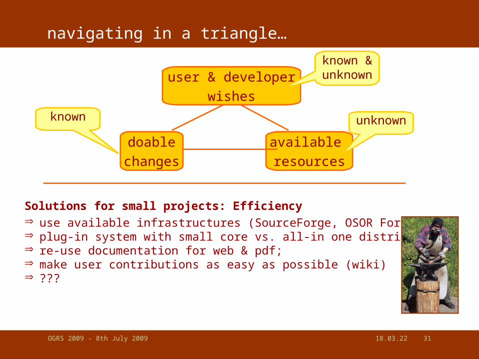
navigating in a triangle…
available
resources
doable
changes
Solutions for small projects: Efficiency use available infrastructures (SourceForge, OSOR Forge); plug-in system with small core vs. all-in one distribution re-use documentation for web & pdf; make user contributions as easy as possible (wiki) ???
user & developer
wishes
unknownknown
known &unknown

OGRS 2009 - 8th July 2009 19.04.23 32
What you can do…
We need Feedback & Participation!
Already 1h/week can make the difference!
Or users that pay for the functionality they wish, i.e. are hiring a
programmer

OGRS 2009 - 8th July 2009 19.04.23 33
V. So what?
- Ready for the Desktop? -
- Become FOS Desktop GIS a success story? -
FOSGIS

OGRS 2009 - 8th July 2009 19.04.23 34
Ready for the Enterprise Desktop?
FOS Desktop GIS are ready for the (enterprise) desktop!- functionality – ArcViewTM level and beyond (Editor) has been achieved- support - free: email & forums, commercial: companies- several users in public authorities (ESP, GER, CAN, FIN, IT, ...)
Issues
- Finding a/the suitable software with respect to functionality and license restrictions (see thesis by Atle. F. Sveen on FOS GIS selection)- There are switching costs! (i.e.: no free lunch)
Benefits- provider independence- cost savings with respect to scale (10+ installations)- easy to add customized functionality

OGRS 2009 - 8th July 2009 19.04.23 35
Ready for the Research Desktop?
FOS Desktop GIS are ready for the (research) desktop!
But avoid it if…… you want to re-invent the wheel… want to spent money for licenses… you just work on your own PC (no scaling needed)… you like black boxes… you love the „one size fits all principle“ (what‘s adaptation?)... you never need what you have done if you move on
AND:
You are scared that somebody exploits your developments! (..but remember, you could use what others accomplished...)

OGRS 2009 - 8th July 2009 19.04.23 36
A success story?
YES, FOS Desktop GIS…
… had a good start so far
… and can continue to be successful if:
- more people start using it
- more “people” contribute
- management issues can be resolved

OGRS 2009 - 8th July 2009 19.04.23 37
Thank you!
more info:
- www.spatialserver.net/osgis/ ( 2 articles)
- www.osgeo.org- Gary E. Sherman: „Desktop GIS: Mapping the Planet
with Open Source Tools“ (2008)
icons from: http://www.iconspedia.com

OGRS 2009 - 8th July 2009 19.04.23 38

OGRS 2009 - 8th July 2009 19.04.23 39

OGRS 2009 - 8th July 2009 19.04.23 40
Outline
I. Open Source and Free Software
A. Terms and Definitions
B. 2 Licenses (GPL & LGPL)
C. 3 Possible Misconceptions
Note: talking about software licensing isn‘t a piece of cake

OGRS 2009 - 8th July 2009 19.04.23 41
I. Open Source and Free Software (1)
Some terms you may have heard of…
Free software
Open source
Shareware
GPL
Freeware
commercial software
FOSS
OSS
LGPL
- What does it mean?…
- Is “free” software the same as “open source” software?

OGRS 2009 - 8th July 2009 19.04.23 42
I. Open Source and Free Software (2)
putting (some) of those terms in an order...
Proprietary = All Software – (Free Software + Open Source Software)
GPL
Open Source (OSS)
Free SoftwareProprietary
Software
SharewareFreeware
LGPL
?commercial software?
OGRS 2009 - 8th July 2009 19.04.23 43
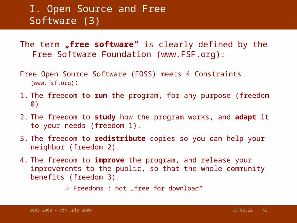
I. Open Source and Free Software (3)
The term „free software“ is clearly defined by the Free Software Foundation (www.FSF.org):
Free Open Source Software (FOSS) meets 4 Constraints (www.fsf.org):
1. The freedom to run the program, for any purpose (freedom 0)
2. The freedom to study how the program works, and adapt it to your needs (freedom 1).
3. The freedom to redistribute copies so you can help your neighbor (freedom 2).
4. The freedom to improve the program, and release your improvements to the public, so that the whole community benefits (freedom 3).
Freedoms : not „free for download“

OGRS 2009 - 8th July 2009 19.04.23 44
I. Open Source and Free Software (4)
„open source“ vs. „free“ software
open source:
- is a term and „brand“ : Open Source Initiative - OSI: opensource.org)
- is an insufficient term : you can look into? But are you allowed to modify and distribute?
Do I need to care? yes (distinction of freedom), and
no (license terms will tell you)
free software:
- free as in „freedom“ not „free-beer“
- guaranty of four user freedoms

OGRS 2009 - 8th July 2009 19.04.23 45
I. Open Source and Free Software (5)
„free“ vs. „commercial“
free:
- as in „freedom“
- stress on (public) ownership, not on „price“
opposite of „free software“ is „proprietary software“, not „commercial“
Note: to avoid confusions people use the term
„Free and Open Source Software“ (= FOSS)

OGRS 2009 - 8th July 2009 19.04.23 46
Outline
I. Open Source and Free Software
A. Terms and Definitions
B. 2 Licenses (GPL & LGPL)
C. 3 Possible Misconceptions

OGRS 2009 - 8th July 2009 19.04.23 47
I. Open Source and Free Software (6)
- Several OSI and FSF approved licenses exists (large development projects have sometimes own ones)
- well known free software licenses:
• GNU General Public License (GPL – full protection of freedoms)
• GNU Lesser General Public License (LGPL – full protection)
• BSD (Berkeley), XFree86 (MIT), Apache, Mozilla, … (limited prot.) | (no protection) | …
Btw: What‘s GNU?

OGRS 2009 - 8th July 2009 19.04.23 48
I. Open Source and Free Software (7)
The GNU General Public License
important license terms (of GPL Version 2):
• allows to run the program for your own purpose (§0)
• allows to copy and distribute (§1)
• allows to modify the code and to distribute these versions (§2)
• allows distribution of the program and modified versions only if source code is attached or available (written offer) for 3 years (§3)
• „You may charge a fee for the physical act of transferring a copy, and
you may at your option offer warranty protection in exchange for a fee.”

OGRS 2009 - 8th July 2009 19.04.23 49
I. Open Source and Free Software (8)
What is meant if people say GPL is immune?
- The GPL license terms don‘t allow to change the license of the software, including new and changed parts it musst still be GPL is called „copylefting“
- When GPL software parts (i.e. as a function library) are used by other software, then the license with the stronger restrictions/freedom remains – example: ESRI licence + GPL=
To avoid the latter effect: Lesser GPL was introduced.
LGPL is very similar to GPL, but LGPL libraries can be used by non-GPL licensed software. ( ESRI+LGPL = )
Note: dual-licensing (GPL & proprietary license) is possible, because the developer has still author rights on his work.

OGRS 2009 - 8th July 2009 19.04.23 50
Outline
I. Open Source and Free Software
A. Terms and Definitions
B. 2 Licenses (GPL & LGPL)
C. 3 Possible Misconceptions

OGRS 2009 - 8th July 2009 19.04.23 51
1. Open Source and Free Software (8)
Possible Misconceptions about the GPL license*:
1 – If I use code licensed under the GPL – Do I need to release my changes to the program's source?
* http://en.wikipedia.org/wiki/GNU_General_Public_License
No - source code must be released only if you distribute the software
2 – If I program software and license it under the GPL I have to give the software away for free?
No - copies can be sold and download fees raised. What you may pay for is documentation, packaging & support.
3 – If I create (new) software (and data) with GPL tools they must be released under the GPL as well?
No - programs & data created with open source software are not affected by the GPL. Only programs that inlcude GPL code.

OGRS 2009 - 8th July 2009 19.04.23 52
Some people say… such things…Are those things myths or facts?

OGRS 2009 - 8th July 2009 19.04.23 53
Why using open source? - Myths
Parts of the following are taken from M. Wheatley*:
- Myth 1: The attraction is the price tag Wheatley: stability and effectivity may be other factors**
- Myth 2: Savings aren‘t real Wheatley: because you don‘t pay for every copy of the software you can safe money
- Myth 3: There is no support If there is a user base, there is support. For instance for OpenJump GIS offer 2 companies paid support in Germany alone.
- Myth 4: It is a legal minefield several off-court arrangements took place; indemnifications are offered; in 2006 GPL proved ist validity as license on a court in Munich (Landgericht I).
* M. Wheatley, 2004: The myths of Open Source, www.cio.com
** ACTUATE, 2007: attraction no license fees: 82.8%

OGRS 2009 - 8th July 2009 19.04.23 54
Why using open source? - Myths
Parts of the following are taken from M. Wheatley*:
- Myth 5: Open Source isn‘t for mission-critical applications Wheatley: a banking system (Banca Popolare di Milano) runs with opensource components
- Myth 6: Open Source isn‘t ready for the desktop that‘s something I hopefully refuted
Btw: interesting figures- 50% of OSS projects started by companies with comercial intention*- In Germany 59% of companies „use“[?] OSS software (US: 48%)**- 80% of OSS developers are IT professionals (96% male )***
*) missing original source
**) ACTUATE (2007)
***) Robes et al. (2001), Hertel et al (2003), Open Source
Jahrbuch 2006: p. 210

OGRS 2009 - 8th July 2009 19.04.23 55
History and organization
Some „Bits“ of History:Grass GIS* – 1978/80 first libraries: US Army Corps of Eng. (CERL)
. because ArcInfo was to expensive
. Fort Hood Inf. Syst. in 1982, Grass 1.0 in 1985,
. last release (V4.1) in 1992
. revival in 1997/1998 (Baylor Univ. & U. of Hannover)
. relicensing to GPL in 1999
Proj/Proj.4 – early 1980, Library for projections by USGS (Evenden 2003)
OpenMap – GIS toolkit, started 1992 as MATT with DARPA founding
OGR/GDAL – Library for GIS data format conversion by F. Warmerdam
. launch in 1998
FreeGIS.org ‘99, UMN MapServer 96/97, PostGIS in 00/01, JTS 00/02
Desktop: SAGA ‘01/2, Thuban ‘03, JUMP ‘02/3, QGIS ‘02/3, uDIG ‘04/5*) Westervelt (2004)

OGRS 2009 - 8th July 2009 19.04.23 56
Example of a Spatial Data Infrastructure (SDI):
Desktop GIS
Data Collector
(create map..)
Desktop GIS
GIS Analyst
Data Storage
Data Provider
http://INTERNET
WebMap Server
Map Viewer
Thin Client
Map Editor
Thick Client
End User (e.g.Municipality / NGO)
GeoPortal

OGRS 2009 - 8th July 2009 19.04.23 57
... or software from a vendor (ESRI®) perspective
Example of a Spatial Data Infrastructure (SDI):
http://INTERNET
WebMap Server
ArcGIS Server, ArcIMS
Desktop GIS
ArcGIS - ArcEditor
Desktop GIS
ArcGIS - ArcInfo
Data Storage
ArcSDE / Oracle
Spatial
Map Viewer
Arc Explorer
Map Editor
ArcGIS X
End User (e.g.Municipality / NGO)
GeoPortal

OGRS 2009 - 8th July 2009 19.04.23 58
...or OS GIS projects
Example of a SDI with OpenSource Components:
http://INTERNET
UMN MapServer,
GeoServer,
Deegree,
(MapGuide
OpenSource)
Data Collection:
OpenJUMP, ...
GIS Analysis:
GRASS GIS + QGIS,
Kosmo, gvSIG, SAGA,...
Data Storage:
PostGIS,
(H2 spatial)
Thin Client:
MapBuilder,
Mapbender
Thick Client:
uDig, QGIS,
Thuban, ...
End User (e.g.Municipality / NGO)
GeoPortal

OGRS 2009 - 8th July 2009 19.04.23 59
…types of GIS software:

OGRS 2009 - 8th July 2009 19.04.23 60
Diversity of GIS software & projects…
Web stuff: . OpenLayers (GMaps)
. MapFish
. MapBender
. NASA World Wind (GEarth)
. GDAL/OGR (data formats)
. Geotools (all in one)
. OpenMap
. Sextante (raster analysis)
. JTS Topology Suite / GEOS
. MapServer
. GeoServer
. MapGuide OS
. deegree
. PostGIS
. MySQL Spatial
. SpatialLite
. H2 Spatial
. TerraView
. gvSIG Mobile Pilot
Non-exhaustive overview of projects in Paul Ramsey (2007)
. OSSIM

OGRS 2009 - 8th July 2009 19.04.23 61authors ranking
Desktop GISEvaluation criterion
user level appl. focus platfom standards community support
GRASSFamiliarU-
Expert (Res)
Vec+Raster, Analysis
Linux, Mac (Win) [C]
Grass 6.3: GML (via OGR), WFS, WMS
User:ww, large
Dev: Universities
Prof., lists (++)
QGIS*Novice-FamiliarU
Vec+Raster, Viewing, GRASS-GUI
Win,Linux, Mac [C++]
QGIS 0.9: WMS, WFS, SFS (via PostGIS), GML (via OGR)
User: ww, strong
Dev: ww, Volunt.
Prof., lists (++)
uDig*FamiliarU Vector, Web,
ViewingWin,Linux, Mac [Java]
uDig 1.1: SFS, WMS, WFS, GML, SLD
User: ww, growing
Dev: Company
Prof., lists (++)
gvSIGFamiliarU-Expert (Res)
Vec+Raster
goal: ArcView functionality++
Win,Linux, Mac [Java]
gvSIG 1.0: SFS, WMS, WFS, WCS, WMC, GML
User: ww, strong
Dev: Company
Prof., lists (++)
ILWISNovice-Expert
Vec+Raster Analysis
Win [MS Visual C]
WFS,WCS under development
User: ww. strong
Dev: ITC/ 52°Nord
Prof., lists (++)
MapWindowNovice-Expert (Res)
GIS core, V+R, Analysis
Win [.NET] WFS,WCS under development
User: strong
Dev: Idaho S.U.
Prof., lists (+)
SAGAFamiliarU-Expert (Res)
Raster, Analysis
Win,Linux, [C++]
??? User: strong
Dev: UoHamburg
Prof., lists (+)
JUMP / OpenJUMP
Novice-Expert (Res)
Vec, Editing, Analysis
Win,Linux, (Mac)[Java]
OJ 1.2: SFS, WMS,GML,SLD (WFS/-T plugin)
User: ww, growing
Dev: ww, Volunt.
Prof., lists (++)
*) strong development activities: application focus may extend, ww = worldwide

OGRS 2009 - 8th July 2009 19.04.23 62
Challenges (I)
Situation description - OpenJUMP is a “volunteer” project (+ supporting companies Lat/Lon,
Intevation, ISA Inc.)- ca. 4-5 developers + ca. 3-5 contributing users- ca. 1000 downloads/month - 80 vs. 90 email list users (developers vs. users)
We achieved a lot, but… - Who will fix the bugs and maintains functions?- Who will add new functions and improve the core?- Who writes documentation?- Who maintains the webpage & wiki?
we can not enforce anything, since all are volunteers!
Related Documents