A 7 - 24 7.3 Hydrological Characteristics of Identified Potential Sub-Projects Sub-projects by Inundation Land Type is shown in Fig. A7.2.6. Most of the sub-project area lies in Medium High Land (56%); followed by High Land (17%), Low Land (16%) and Medium Low Land (11%). An analysis on topographic characteristics of the sub-projects show that mean elevation of sub-projects varies from as low as EL. 2.5m in Austagram of Kishoreganj to as high as EL. 29.2m in Bakshiganj of Jamalpur and EL. 28.5m in Jhenaigati of Sherpur. Mean slope of the sub-projects varies from as low as 0.016% in Bhairab and 0.017% in Bajitpur of Kishoreganj to as high as 0.64% in Bakshiganj of Jamalpur and 0.65% in Basail of Tangail. NWMP divides the whole Bangladesh into 8 hydrological regions including one region for River and Estuary. Greater Mymensingh lies within North Central (NC) and North East (NE) hydrological regions and intercepts 15 out of a total 20 catchments of NC region and 23 out of a total 57 catchments of NE region. The identified sub-projects area almost uniformly distributed over the catchments. Fig. A 7.3.1 Inundation Land Types of Identified Potential Sub-Projects [ [ [ [ [ [ · · · · · · · · · · · · · · · · · · · · · · · · · · · · · · · · · · · · · · · · · · · · · · · · · · · · · · · · · · DELDUAR TANGAIL SADAR SHAKHIPUR NAGARPUR MIRZAPUR MADHUPUR KALIHATI GOPALPUR GHATAIL BHUAPUR BASAIL SREEBORDI SHERPUR SADAR NALITABARI NAKLA JHENAIGATI BAKSHIGANJ SARISHABARI MELENDAH MADARGANJ JAMALPUR SADAR ISLAMPUR DEWANGANJ MITHAMOIN TARAIL PAKUNDIA NIKLI KULIARCHAR KISHOREGANJ SADAR KATIADI KARIMGANJ ITNA HOSSAINPUR BHAIRAB BAJITPUR AUSTAGRAM PURBADHALA NETRAKONA SADAR MOHANGANJ MADAN KENDUA KALMAKANDA KHALIAJURI DURGAPUR BARHATTA ATPARA DHOBAURA TRISHAL MUKTAGACHA MYMENSINGH SADAR GAFFARGAON FULBARIA BHALUKA GAURIPUR PHULPUR NANDAIL ISHWARGANJ HALUAGHAT TANGAIL SHERPUR JAMALPUR NETRAKONA KISHOREGANJ MYMENSINGH N E W S 6 0 6 12 18 Kilometers JICA SSWRDP Scale Inundation Land Type of SP F0: High Land F1: Medium High Land F2: Medium Low Land F3: Low Land LEGEND District Boundary Upazila Boundary [ District Head Quarter · Upazila Head Quarter

Welcome message from author
This document is posted to help you gain knowledge. Please leave a comment to let me know what you think about it! Share it to your friends and learn new things together.
Transcript

A 7 - 24
7.3 Hydrological Characteristics of Identified Potential Sub-Projects Sub-projects by Inundation Land Type is shown in Fig. A7.2.6. Most of the sub-project area lies in Medium High Land (56%); followed by High Land (17%), Low Land (16%) and Medium Low Land (11%). An analysis on topographic characteristics of the sub-projects show that mean elevation of sub-projects varies from as low as EL. 2.5m in Austagram of Kishoreganj to as high as EL. 29.2m in Bakshiganj of Jamalpur and EL. 28.5m in Jhenaigati of Sherpur. Mean slope of the sub-projects varies from as low as 0.016% in Bhairab and 0.017% in Bajitpur of Kishoreganj to as high as 0.64% in Bakshiganj of Jamalpur and 0.65% in Basail of Tangail. NWMP divides the whole Bangladesh into 8 hydrological regions including one region for River and Estuary. Greater Mymensingh lies within North Central (NC) and North East (NE) hydrological regions and intercepts 15 out of a total 20 catchments of NC region and 23 out of a total 57 catchments of NE region. The identified sub-projects area almost uniformly distributed over the catchments.
Fig. A 7.3.1 Inundation Land Types of Identified Potential Sub-Projects
[
[
[
[
[
[
·
·
·
·
·
·
·
·
··
·
·
·
·
·
··
·
·
··
·
·
·
·
· ·
·
·
·
·
·
·
·
·
·
·
· ·
·
·
·
·
·
·
·
·
·
··
·
·
·
·
·
·
·
·
DELDUAR
TANGAIL SADAR
SHAKHIPUR
NAGARPUR
MIRZAPUR
MADHUPUR
KALIHATI
GOPALPUR
GHATAILBHUAPUR
BASAIL
SREEBORDI
SHERPUR SADAR
NALITABARI
NAKLA
JHENAIGATIBAKSHIGANJ
SARISHABARI
MELENDAH
MADARGANJJAMALPUR SADAR
ISLAMPUR
DEWANGANJ
MITHAMOIN
TARAIL
PAKUNDIA NIKLI
KULIARCHAR
KISHOREGANJ SADAR
KATIADI
KARIMGANJ
ITNA
HOSSAINPUR
BHAIRAB
BAJITPUR
AUSTAGRAM
PURBADHALA
NETRAKONA SADAR MOHANGANJ
MADAN
KENDUA
KALMAKANDA
KHALIAJURI
DURGAPUR
BARHATTA
ATPARA
DHOBAURA
TRISHAL
MUKTAGACHAMYMENSINGH SADAR
GAFFARGAON
FULBARIA
BHALUKA
GAURIPUR
PHULPUR
NANDAIL
ISHWARGANJ
HALUAGHAT
TANGAIL
SHERPUR
JAMALPUR NETRAKONA
KISHOREGANJ
MYMENSINGH
N
EW
S
6 0 6 12 18 Kilometers
JICA SSWRDP
Scale
Inundation Land Type of SPF0: High LandF1: Medium High LandF2: Medium Low LandF3: Low Land
LEGEND
District BoundaryUpazila Boundary
[ District Head Quarter· Upazila Head Quarter

A 7 - 25
Reference: Sample of scoring
For better understanding, the scoring process of sample subprojects are indicated in the following. 1. Parameters of sample subprojects The first step for scoring will be collecting necessary information for the individual SPs to collate with the set of criteria. The following are sample values for scoring the sample SPs.
Subp
roje
ct A
Subp
roje
ct B
Subp
roje
ct C
Subp
roje
ct D
Subp
roje
ct E
Probability of high level of extreme poverty 80% 60% 80% 40% 55% Inundation land type F2 F1 F4 F3 F2 Distance to nearby growth center 5km 4km 2km 10km 7km Distance to nearby national and regional highway 4km 15km 8km 22km 4km Arsenic contamination 0.02mg/L 0.06mg/L 0.03mg/L <0.01mg/L 0.07mg/LAverage rainfall during Nov - Mar 75mm 110mm 160mm 130mm 50mm Average rainfall during Sep - Oct 350mm 400mm 700mm 800mm 550mm Average groundwater table during Nov - Mar 4m 8m 5.5m 2m 7m Number of unions of which the subproject lies in 1 1 2 3 1 Number of regulators / maximum width of regulator 3nos. / 25m 2 nos./ 15m 2 nos./ 8m 1nos. / 6m 3 nos. / 5mType of SP WC DIWC FM FMDI CAD
2. Primary Score of sample subprojects The information of the individual SPs are collated with the criteria for primary scoring, and primary scores will be calculated. Primary scores on effect on poverty (L2_P-V, H, M, L) Primary scores on cropping intensity (L3_B-C-L, M, H)
Probability of high level of extreme
poverty Parameter Primary score Inundation land
type Parameter Primary score
Subproject A 80% Very high 1.00 F2 Medium 0.21 Subproject B 60% High 0.37 F1 High 0.11 Subproject C 80% Very high 1.00 F4 Low 1.00 Subproject D 40% Moderate 0.21 F3 Low 1.00 Subproject E 55% High 0.37
F2 Medium 0.21 Primary scores on access to and from growth center (L3_B-B-E, M, D) Primary scores on proximity to national and
regional highways (L3_B-N-C, M, F)
Distance to nearby growth
center Parameter Primary score
Distance to national and
regional highways Parameter Primary score
Subproject A 5 km Moderate 0.32 4 km Close 1.00 Subproject B 4 km Moderate 0.32 15 km Moderate 0.32 Subproject C 2 km Easy 1.00 8 km Close 1.00 Subproject D 10 km Difficult 0.15 22 km Far 0.15 Subproject E 7km Difficult 0.15
4km Close 1.00 Primary scores on arsenic contamination (WC type, L3_H-A-H, M, L) Primary scores on dry Season rainfall (WC type, L3_H-
D-L, M, H)
Arsenic contamination SP type Parameter Primary
score Average
rainfall during Nov - Mar
SP type Parameter Primary score
Subproject A 0.02mg/L WC Medium 0.33 75mm WC Low 1.00 Subproject B 0.06mg/L DIWC High 1.00 110mm WC Moderate 0.35 Subproject C 0.03mg/L FM Not applicable - 160mm FM Not applicable - Subproject D <0.01mg/L FMDI Not applicable - 130mm FMDI Not applicable - Subproject E 0.07mg/L CAD Not applicable -
50mm CAD Not applicable -

A 7 - 26
Primary scores on dry Season rainfall (WC type, L3_H-P-L, M, H) Primary scores on post monsoon rainfall (DI type,
L3_H-P-L, M, H)
Average rainfall
during Nov - Mar
SP type Parameter Primary score
Average rainfall during
Sep - Oct SP type Parameter Primary
score
Subproject A 75mm WC Low 1.00 350mm WC Not applicable - Subproject B 110mm DIWC Moderate 0.35 400mm DIWC Not applicable - Subproject C 160mm FM Not applicable - 700mm FM Moderate 0.35 Subproject D 130mm FMDI Not applicable - 800mm FMDI High 1.00 Subproject E 50mm CAD Not applicable -
550mm CAD Not applicable - Primary scores on dry season G.W.T. (WC/CAD type, L3_H-G-D, M, S) Primary scores on administrative issues (L3_I-A-S, M)
Average
groundwater table during Nov - Mar
SP type Parameter Primary score
Number of unions of which the subproject lies in Parameter Primary score
Subproject A 4m WC Medium 0.35 1 Single 1.00 Subproject B 8m DIWC Deep 1.00 1 Single 1.00 Subproject C 5.5m FM Not applicable - 2 Multiple 0.20 Subproject D 2m FMDI Not applicable - 3 Multiple 0.20 Subproject E 7m CAD Deep
1 Single 1.00 *If 90% or more of the SP area lies within one union, the SP is regarded “single”
Primary scores on technical suitability (L3_I-T-Y, N)
Number of regulators /
maximum width of regulator
Parameter Primary score
Subproject A 3nos. / 25m Complex 0.11 Subproject B 2 nos./ 15m Simple 1.00 Subproject C 2 nos./ 8m Simple 1.00 Subproject D 1nos. / 6m Simple 1.00 Subproject E 3 nos. / 5m Complex 0.11
*Criteria for simple/complex is “more than 3 regulators” and / or “width of regulator exceeding 20m” 3. Multiplying Primary Score with weight Each primary score shall be multiplied with the weight of the criteria as defined in the decision tree. The weight is usually uniform for each criteria, but in this case, different weight were applied depending on types of SPs because some criteria were not applied to certain SP types (for example, Arsenic contamination is not applied to non-WC type SPs). Weighed scores on effect on poverty
Primary score SP type Weight (Level1) Score Subproject A 1.00 WC 0.61 0.61 Subproject B 0.37 DIWC 0.61 0.23 Subproject C 1.00 FM 0.68 0.68 Subproject D 0.21 FMDI 0.61 0.13 Subproject E 0.37 CAD 0.61 0.23
Weighed scores on cropping intensity
Primary score SP type Weight (Leve2) Weight (Level1) Score Subproject A 0.21 WC 0.75 0.13 0.02 Subproject B 0.11 DIWC 0.75 0.13 0.01 Subproject C 1.00 FM 0.75 0.15 0.11 Subproject D 1.00 FMDI 0.75 0.13 0.10 Subproject E 0.21 CAD 0.75 0.13 0.02
Weighed scores on access to and from growth center
Primary score SP type Weight (Leve2) Weight (Level1) Score Subproject A 0.32 WC 0.18 0.13 0.01 Subproject B 0.32 DIWC 0.18 0.13 0.01 Subproject C 1.00 FM 0.18 0.15 0.03 Subproject D 0.15 FMDI 0.18 0.13 <0.005 Subproject E 0.15 CAD 0.18 0.13 <0.005
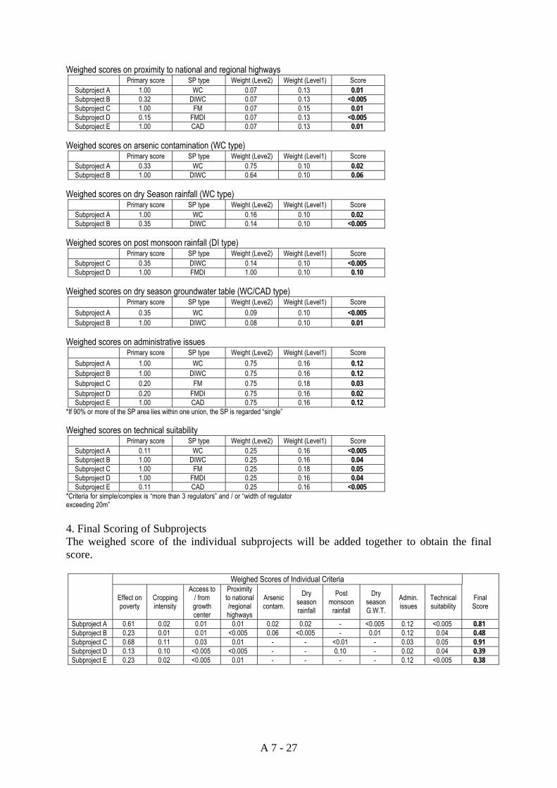
A 7 - 27
Weighed scores on proximity to national and regional highways
Primary score SP type Weight (Leve2) Weight (Level1) Score Subproject A 1.00 WC 0.07 0.13 0.01 Subproject B 0.32 DIWC 0.07 0.13 <0.005 Subproject C 1.00 FM 0.07 0.15 0.01 Subproject D 0.15 FMDI 0.07 0.13 <0.005 Subproject E 1.00 CAD 0.07 0.13 0.01
Weighed scores on arsenic contamination (WC type)
Primary score SP type Weight (Leve2) Weight (Level1) Score Subproject A 0.33 WC 0.75 0.10 0.02 Subproject B 1.00 DIWC 0.64 0.10 0.06
Weighed scores on dry Season rainfall (WC type)
Primary score SP type Weight (Leve2) Weight (Level1) Score Subproject A 1.00 WC 0.16 0.10 0.02 Subproject B 0.35 DIWC 0.14 0.10 <0.005
Weighed scores on post monsoon rainfall (DI type)
Primary score SP type Weight (Leve2) Weight (Level1) Score Subproject C 0.35 DIWC 0.14 0.10 <0.005 Subproject D 1.00 FMDI 1.00 0.10 0.10
Weighed scores on dry season groundwater table (WC/CAD type)
Primary score SP type Weight (Leve2) Weight (Level1) Score Subproject A 0.35 WC 0.09 0.10 <0.005 Subproject B 1.00 DIWC 0.08 0.10 0.01
Weighed scores on administrative issues
Primary score SP type Weight (Leve2) Weight (Level1) Score Subproject A 1.00 WC 0.75 0.16 0.12 Subproject B 1.00 DIWC 0.75 0.16 0.12 Subproject C 0.20 FM 0.75 0.18 0.03 Subproject D 0.20 FMDI 0.75 0.16 0.02 Subproject E 1.00 CAD 0.75 0.16 0.12
*If 90% or more of the SP area lies within one union, the SP is regarded “single” Weighed scores on technical suitability
Primary score SP type Weight (Leve2) Weight (Level1) Score Subproject A 0.11 WC 0.25 0.16 <0.005 Subproject B 1.00 DIWC 0.25 0.16 0.04 Subproject C 1.00 FM 0.25 0.18 0.05 Subproject D 1.00 FMDI 0.25 0.16 0.04 Subproject E 0.11 CAD 0.25 0.16 <0.005
*Criteria for simple/complex is “more than 3 regulators” and / or “width of regulator exceeding 20m” 4. Final Scoring of Subprojects The weighed score of the individual subprojects will be added together to obtain the final score.
Weighed Scores of Individual Criteria
Effect on poverty
Cropping intensity
Access to / from growth center
Proximity to national /regional highways
Arsenic contam.
Dry season rainfall
Post monsoon
rainfall
Dry season G.W.T.
Admin. issues
Technical suitability
Final Score
Subproject A 0.61 0.02 0.01 0.01 0.02 0.02 - <0.005 0.12 <0.005 0.81 Subproject B 0.23 0.01 0.01 <0.005 0.06 <0.005 - 0.01 0.12 0.04 0.48 Subproject C 0.68 0.11 0.03 0.01 - - <0.01 - 0.03 0.05 0.91 Subproject D 0.13 0.10 <0.005 <0.005 - - 0.10 - 0.02 0.04 0.39 Subproject E 0.23 0.02 <0.005 0.01 - - - - 0.12 <0.005 0.38

ANNEX 8
ENVIRONMENTAL AND SOCIAL CONSIDERATIONS

ANNEX 8: ENVIRONMENTAL AND SOCIAL CONSIDERATIONS
TABLE OF CONTENTS 8.1 Draft Scoping-------------------------------------------------------------------------------------- A8 - 1
8.1.1 Totile of the Project, and Names of Project Proponent and Consultants -------- A8 - 1
8.1.2 Categorization and its Reasons-------------------------------------------------------- A8 - 1
8.1.3 Outline of the Project------------------------------------------------------------------- A8 - 2
8.1.4 Overall Environmental and Social Conditions of the Project Area -------------- A8 - 5
8.1.5 Adverse Environmental and Social Impacts----------------------------------------- A8 - 8
8.1.6 Alternatives including without Project Option-------------------------------------- A8 - 19
8.1.7 Terms of Reference --------------------------------------------------------------------- A8 - 20
8.1.8 Related Documentation ---------------------------------------------------------------- A8 - 20
8.2 Rough Outline of Environmental and Social Consideration -------------------------------- A8 - 29
8.2.1 Title of the Project, Names of Project Proponent and Consultants--------------- A8 - 29
8.2.2 Categorization and its Reasons-------------------------------------------------------- A8 - 29
8.2.3 Outline of the Project------------------------------------------------------------------- A8 - 30
8.2.4 Analysis of Alternatives---------------------------------------------------------------- A8 - 33
8.2.5 Key Impacts Identified and Mitigation----------------------------------------------- A8 - 34
8.2.6 Consultation ----------------------------------------------------------------------------- A8 - 41
8.2.7 Related Documents --------------------------------------------------------------------- A8 - 41

A 8 - 1
A 8 ENVIRONMENTAL AND SOCIAL CONSIDERATION
Environmental and Social Considerations for the Master Plan has been done under the JICA Guidelins for Environmental and Social Considerations in reference to the environmental legislations of the Peoples Republic of Bangladesh. Under the environmental legislations of Bangladesh do not necessarily call for Strategic Environmental Assessment (SEA), and there are no provisions in the Environment Conservation Rules, 1997, for environmental and social considerations at Master Plan level. Moreover, the validity of environmental clearance is one year after approval (except for those in Green category, which are three years). In this regard it may be pointed out that there will be a gap of several years between the finalization of the Master Plan and actual implementation of the subprojects. Therefore, environmental and social considerations for the Master Plan Study has been done with premise that IEE and subsequent EIA process (where necessary) will be pursued for individual subprojects at the stage of their detailed design.
8.1 Draft Scoping
8.1.1 Title of the Project, and Names of Project Proponent and Consultants
(1) The title of the Cooperation Project
The Master Plan Study on Small Scale Water Resources Development for Poverty Alleviation through Effective Use of Surface Water in Greater Mymensingh of Bangladesh
(2) The Name of Project Proponent
The Local Government Engineering Department (LGED) under the Local Government Division of the Ministry of Local Government, Rural Development and Cooperatives of the Government of the People’s Republic of Bangladesh
(3) The name of Consultants Supporting the Preparation of the Draft of Scoping
Pacific Consultants International, Japan
8.1.2. Categorization and its Reasons
During discussions in the joint meeting dated from 20th to 26th July, 2004 in respect of The Master Plan Study on Small Scale Water Resources Development for Poverty Alleviation through Effective Use of Surface Water in Greater Mymensingh of Bangladesh, it was agreed upon between Local Government Engineering Department under the Local Government Division of the Ministry of Local Government, Rural Development and Cooperatives of the Government of Bangladesh and the Japan International Cooperation Agency that the Project was defined as Category B, which according to the JICA Guidelines for Environment and Social Considerations, requires environmental and social consideration in the level of Initial Environmental Examination (IEE). The main reasons for this definition area are as follows:
Activities encompassed in the Master Plan will include construction of physical infrastructure and consequential changes in land use pattern likely to affect the physical environment to some extent.
Under the National Water Policy, the scale of interventions for Small Scale Water Resources Development is limited to the command area of 1,000 ha. Accordingly, the activities, which will be recorded in the Master Plan, will be within this limit, and interventions beyond this limit will be excluded. Therefore, large-scale involuntary resettlement will not occur.

A 8 - 2
Moreover, activities, which will be delineated in the Master Plan, on their implementation, will enhance / reinforce existing activities / infrastructure, without jeopardizing the natural and social environment of the area.
However, it is should be noted that under the Environment Conservation Rules 1997, construction / reconstruction / expansion of flood control embankment, polder, dyke, etc. as well as engineering works with capital over ten hundred thousand Taka, are categorized as “Red category”, where IEE is required to identify the possible negative impacts and necessity of EIA. A considerable portion of the subprojects to be recommended in the Study are expected to encompass construction or rehabilitation of flood management facilities, while engineering works also are expected to exceed the said limit.
However, environmental laws and regulations of Bangladesh do not necessarily call for Strategic Environmental Assessment (SEA), and there are no provisions in the Environment Conservation Rules, 1997, for environmental and social considerations at Master Plan level. Moreover, the validity of environmental clearance is one year after approval (except for those in Green category, which are three years). In this regard it may be pointed out that there will be a gap of several years between the finalization of the Master Plan and actual implementation of the subprojects. Therefore, based on the environmental legislation of Bangladesh, IEE and subsequent EIA process (where necessary) should be pursued for individual subprojects at the stage of their detailed design.
Therefore, environmental and social consideration at this stage shall be done on premise that individual considerations will be done at the point of F/S and D/D, and will focus on identification of necessary mitigation options at the upstream of the planning process. Also in this regard, the Master Plan its self should be categorized as “Category B” under the JICA Guidelines, while further consideration should be made at implementation of the individual sub-projects.
8.1.3 Outline of the Project
(1) Background of the Study
The policy of the People’s Republic of Bangladesh towards water resources development has been recently shifting to “living alongside with floods”, rather than emphasizing the “containment of floods” with large-scale structures as in past projects. Also the budget constraints of the relevant government agencies are acting as major constraints in the sustainability of water resources development projects. Development activities in smaller scale, with participation of local beneficiaries are regarded to have much potential for efficiently developing the water sector. The National Water Policy (NWPo, 1999) declares that the Local Government will implement Flood Control, Drainage and Irrigation (FCDI) projects with the command area of 1,000 ha or less (Small Scale Water Resource Development), while projects exceeding this scale will be under the authority of the Bangladesh Water Development Board (BWDB).
Under this policy, LGED, under Local Government Division (LGD) of the Ministry of Local Government, Rural Development and Cooperatives of the Government of Bangladesh, along with the support from ADB, IFAD and the Government of Netherlands, has carried out the Small-Scale Water Resources Development Sector Project (SSWRDSP-1) aiming at the rehabilitation and improvement of small-scale water resource management systems. The project was carried out from 1995 covering 37 districts of the western part of Bangladesh. The second phase of this project (SSWRDSP-2), excluding three hill districts of Bandarban, Khagrachhari and Rangmati is currently being implemented throughout the country.
Though SSWRDSP-1 has brought promising results, the lessons learned indicated that preparation of District Level Master Plans would have particular importance in identification, selection and implementation of Small-Scale Water Resources Development (SSWRD) subprojects. Under such circumstances, the Government of Bangladesh requested the Government of Japan for technical assistance for the preparation of Master Plans for SSWRD, which will be positioned as the basic

A 8 - 3
development plans at district levels. In response, the Government of Japan (GoJ), through the Japan International Cooperation Agency (JICA), the official agency responsible for implementing technical cooperation programs of GoJ, dispatched a Preparatory Study Team from February 17 to March 5, 2004, and signed the Scope of Works (S/W) for the Master Plan Study on Small-Scale Water Resources Development for Poverty Alleviation through Effective Use of Surface Water in Greater Mymensingh of Bangladesh on February 25, 2004.
(2) Objective of the Study
The objectives of the Master Plan Study on Small Scale Water Resources Development for Poverty Alleviation through Effective Use of Surface Water in Greater Mymensingh of Bangladesh (the Study) are to:
To formulate Master Plan for SSWRD (the Master Plan) in Greater Mymensingh comprising strategies, priority programs, and the scope for the follow-on investment projects supportive to effective use of surface water; and
To enhance and strengthen the capacity of the counterpart personnel in formulation of Maser Plan of SSWRD.
The contents of the Master Plans of the Study will be:
Strategies and priority programs which would include flood management, irrigation and drainage, agriculture and fishery extension, rural water supply, arsenic mitigation, and institutional strengthening
Guidelines for project assessment
Prioritized list of subprojects
Action plan
However, it should be noted that according to the Minutes of Meeting for the discussing on the Scope of Work (M/M) in respect of the Study describes that the strategies and priority programs on “rural water supply” and “arsenic mitigation” means advice on the respective issues based on other studies. This will somewhat focus the Study will focus mainly on “flood management”, “drainage improvement”, “water conservation”, “development of irrigation command area”, “agriculture and fishery extension” and other possible SSWRD interventions. The implementation of SSWRD activities based on the Master Plan will induce income improvement of the villagers through effective utilization and management of water resources; and surface water in particular, which will enable increased agricultural production. Thus, in combination with various other activities by the concerned agencies, it is expected to lead to alleviation of poverty in the Study Area.
(3) The Study Area
The Study area covers the six districts namely, Mymensingh, Tangail, Sherpur, Jamalpur, Netrakona and Kishoreganj. The Study Area lies in the north-central part of the country bordered by the Meghna River in the east, Gazipur district in the south, the Jamuna (Brahmaputra) River in the west, and the Indian state of Assam in the north. The Old Brahmaputra River runs through the Area flowing from the northwest and to the southeast. In the southern part of the Study Area, the Modhupur Tract of Old Alluvium with an elevation of about 15 m appears in the lowland area of about 3m elevation. The Study Area occupies 11.3 % of the country with 16,672 km2 of land area, and holds 12.6 % (15.62 million people) of the total population. The local administration comprises of 6 Districts, 58 Upazilas (sub-districts) and 560 Unions. The average area of one Union is approximately 3,000 ha with about 28,000 residents. The Location of the Study Area is indicated in “6 Related Documents”.
(4) Scale of Operation
1) The Scale of Operation of individual Subprojects

A 8 - 4
The benefiting area of the individual subprojects (SPs), which are the basic unit of SSWRD activities, are limited to the extent of 1,000 ha or less in reference to the NWPo. Naturally, the scale of the operation for the subprojects will also be limited to this extent. The provisional scale of the major SSWRD activities which are deemed to be encompassed in the Master Plan are as follows.
Construction of Physical Infrastructure
The prospects of main physical infrastructure to be constructed in the SPs are those necessary for Flood Management, Drainage Improvement, Command Area Development, and Surface Water Conservation. In reference of SSWRDSP-1 and 2, which is a preceding case of Small Scale Water Resources Development by LGED, the main items of physical infrastructure will include the following:
Flood Management - Reconstruction of embankments - Construction of embankments - Installation of regulators - Installation of sluice
Drainage - Re-excavation of drainage channels - New excavation of drainage channels
CAD - Re-excavation of irrigation channels - New excavation of irrigation channels - Lining of irrigation channels - Installation of siphons - Installation of aque-ducts - Installation of culverts
WCS - Installation of Rubber Dams - Installation of weirs - Excavation of existing water bodies (Channels, Beels)
The scale of physical infrastructure to be installed is an area-specific issue, and will not be finalized until the stage of detailed design. However, in reference to SSWRDSP-1, which is a preceding case for SSWRD, a very course figure of physical infrastructure per subproject can be calculated as <total installation / number of subprojects>, whereof the number was 2 regulators, 3 km embankment and 4 km excavation / re-excavation of channels. This figures shall not be referred as a standard of installation, but provides a general view of the magnitude of the subprojects.
Management of Water Resources
In order to mitigate flood damage and to effectively utilize surface water resources, the activities for subproject operation will mainly focus on regulation of water levels in the surrounding environment. Though more concrete figures on number of subprojects to be implemented are yet to be arrived at, water level regulating activities can be categorized as follows.
Category of water level regulating activities Period of year Prevention of damages caused by early and / or late floods Pre-monsoon to monsoonRetention of surface water in Khals, Beels and depressions for agricultural use in dry season
Dry season
Drainage of excessive water for enhancing cultivation area / period after rainy season is over
Post-monsoon
Drainage of excessive water for enhancing cultivation area / period for dry season
Late autumn to winter
The quantum of water resources to be regulated, is to be clarified in phase-2 of the Master Plan Study, but that the benefited areas for Small Scale Water Resources are restricted to 1,000 ha, and that examples of SSWRD in SSWRDSP-1 indicate that many of the subprojects targeted the benefited area

A 8 - 5
much smaller than this, the areas where water levels are to be regulated in the individual subprojects are expected to be in relatively small scales.
Social Activities related to Small-Scale Water Resources Development
Activities related to mobilization of social resources in the subproject areas will be encompassed in the Master Plan, as the vital involvement of the local stakeholders is the key to sustainable and effective operation of the subprojects. The main activity will be establishment of Water Management Cooperative Associations (WMCAs). WMCAs refer to the SSWRDSP-1 and 2, where groups were formed who represent the local stakeholders, and interact with LGED at design, implementation and Operation and Maintenance (O&M) stage of the subprojects. Necessary training activities (O&M of water resources infrastructure, organizational management, efficient water utilization for agricultural and fisheries production, proper management of agricultural input, other possible economic activities, etc;) are expected to be the main items to be encompassed in the Master Plan.
Other activities within the scope of the Master Plan
The final goal of the Master Plan is to alleviate poverty through development of SSWR in the 6 districts of the Study Area. In regard that agriculture is the predominant economic activity in the area, this will be accomplished based mainly on agricultural activities. In relation, activities regarding agriculture and fishery extension, and institutional strengthening of LGED at central and field level will be encompassed in the Master Plan. In addition, various activities relevant to water resources management such as rural water supply, arsenic mitigation would be addressed as recommendations. Furthermore, in the course of agricultural development based on efficient utilization of water resources, views on further development activities such as marketing / distribution, agricultural credits, agro-processing and other relevant industries shall also be indicated in the master plan.
2) The Scale of Operation of the Master Plan as a whole
The output of the Master Plan will include a list of Subprojects for the six districts of the Study Area. Subprojects will be implemented according to their priority. The actual number of the potential subprojects will be identified further in the Study.
The results of the First Survey in Bangladesh under this study have indicated that the number of perennial water bodies in the study area is to the tune of 2,800 out of which the number of beels is around 500. It is presumed that the provisional number of potential subprojects will be around 500 consisting of most of the beels and some other water bodies.
The target year, by which the Master Plan is expected to be implemented is 2015, leaving 10 years after the completion of Master Plan preparation, some 100 subprojects were assumed as the provisional number for those with higher priority. However, this number, based on very rough estimation, is to be referred as a provisional figure, and should be revised in the course of the Study.
8.1.4 Overall Environmental and Social Conditions on the Project Area
(1) Environmental issues
According to the “State of Environment Bangladesh 2001”, the key environmental issues in Bangladesh is summarized in the 5 items of land degradation, water pollution and scarcity, air pollution, depletion of biodiversity, and natural disasters. Comprehensive studies indicating actual figures for the state of these issues were not obtained up to date. Relationship of these issues with SSWRD in the Study Area is briefly stated below.
1) Land degradation
Loss of topsoil layers due to removal of vegetation (mainly forests) and change in hydrological conditions, siltation due to floods, changes in chemical and physical soil properties due to

A 8 - 6
inappropriate cropping pattern and use of agrochemicals are the main effects related to land degradation. Also, construction of embankments and other water related infrastructure is causing erosion and siltation. Although actual figures are not available, the Study Area, largely comprising of agricultural land is deemed to be effected by inappropriate cropping pattern / usage of agrochemicals, and possible erosion / sitlation by water resources infrastructures. The Modhpur forest area, located in Tangail is under heavy deforestation, and is deemed vulnerable to land degradation.
2) Water pollution and scarcity
The two major sources of water pollution are agrochemicals in the rural areas, and industrial / domestic discharges of effluents in the industrial / urban areas, of which observations of the Department of Environment indicates, the latter more crucial. Excessive / inappropriate use of agrochemical is the major elements that may cause water pollution in the Study Area. Another concern is the occurrence of Arsenic in the ground water. The Study Area is said to have relatively low range of contamination in wells, but in absence of detailed surveys, it can’t be confirmed. Scarcity of water is a seasonal phenomenon in most part of the Study Area, which occurs, in the dry season. The water scarcity in the Study Area is lower compared to those in the southern areas of the country, but still it is an important issue in agricultural production.
3) Air pollution
Air pollution is generally a phenomenon usually experienced in urban areas. However, this will have little or no significant relationship with the Study.
4) Biodiversity
Most part of the Study Area consists somewhat of a “secondary ecosystem”, where the area has long been utilized for cultivation and various other activities. The area consists of seasonally flooded cropland and seasonal and perennial water bodies, which represent the majority of the country. Notable areas are the Modhpur forest area in Tangail and haor areas in Netrokona and Kishoreganj.
5) Natural disasters
Out of the variety of natural disasters that hit Bangladesh, flood and drought are the major problems in the Study Area. Placed between the Brahmaputra and Meghna, and with the Old Brahmaputra flowing in the area, the Study Area is most likely to be effected by flooding during the rainy season. Droughts are common phenomenon in Bangladesh and particularly in the northwest areas of the country. The Study Area is also influenced during the dry season and agricultural production is disrupted. The northern hillsides of the Study Area are also influenced by flash floods, where intensive rainfalls on the mountains result in rapid rise of water level. Compared to floods coming from increase of water levels in rivers, flash floods are difficult so far as it relates to taking precautionary measures. Agricultural production is largely effected when this occurs in pre-monsoon (season for Boro) and late summer (season for Aus).
(2) Ecosystem
In history, most of the plain lands of Bangladesh have been converted to agricultural fields, forming somewhat a secondary ecosystem. The remaining terrestrial ecosystems of Bangladesh are divided into ten divisions – (1) Evergreen and semi-evergreen forest, (2) Mangrove forest, (3) Deciduous forests of Sal and other mixed species, (4) The uplands of Barind tract, (5) Undulating terrains with acid soil, (6) costal islands and coral resources, (7) Estuarine Ecosystems, (8) Sand dunes/beach, (9) Recently accreted poldered land in the south, and (10) Chars or small islands in the major riverbeds.
The Study Area, largely comprising of agricultural fields, includes (1) Deciduous forests of Sal and other mixed species, which are mainly located in Tangail and Mymensingh, and (2) Chars or small islands in the major river systems.
The aquatic ecosystems consist of (1) Fresh-water rivers and canals, (2) Beels (geologic depressions or

A 8 - 7
swampy lands formed in dead channels of former rivers which contain water round the year) and Haors (tectonic depressions which may dry up during winter), (3) Oxbow lakes formed in the meandering parts of rivers, (4) Ponds, and (5) Borrow pits.
(3) Land use
Land use of the Study Area largely consists seasonally flooded agricultural fields. 59.3 % of the area is cultivated as of 1997 (Mymensingh: 59.3%, Tangail: 57.4%, Jamalpur: 65.1%, Sherpur: 67.9%, Netrakona: 57.2%, Kishoreganj: 55.2%). The cultivated areas in Netrakona and Kishoreganj were slightly lower than the other districts, and are believed to be reflecting the long period of inundation. Out of the cultivated areas, more than 70% produces rice. The kind of rice produced differs by district where Mymensingh, Jamalpur and Sherpur have high rates of Aman production while Tangail, Netrakona and Kishoreganj have higher rates of Boro production. This is believed to reflect the flooding conditions of the districts where districts with more severe floods tend to put weight on production of Boro.
(4) Population
The total population of the Study Area is 15,491,870 as of 2001, and comprises some 13% of the National population. Mymensingh holds the highest population of some 4.4 million, followed by Tangail and Kishoreganj with the population of 3.3 million and 2.5 million, respectively. Population density of the 5 districts excluding Netrakona ranges from 913 heads / km2 to 1,022 heads / km2. The population density of Netrakona, indicating 690 heads / km2 reflects the area dominated by perennial/seasonal wetlands. The male/female ratio ranges from 100% to 103.5 showing more male population in almost all districts.
(5) Environment quality criteria
The environmental standards in Bangladesh are defined in the Environment Conservation Rules, 1997. The fields, which the standards cover are (1) Air, (2) Surface water, (3) Drinking water, (4) Sound, (5) Sound originating from motor vehicles or mechanized vessels, (6) Emission from mechanized vehicles, (7) Odor, (8) Sewage discharge, (9) Waste from industrial units or project waste, (10) Gaseous emission from industries or projects, and (11) Sector-wise industrial effluent or emission. However, compliance to these standards is deemed inadequate at the current state. Regarding the Study, standards for ‘Surface water’ and ‘Drinking water’ are relevant.
(6) Institution
1) The Agency In-charge of Environmental Issues
The Department of Environment has de-facto been established in the seventies under the Environmental Pollution Control Ordinance, 1976, and is responsible for implementation of the Environment Conservation Act, 1995 and the rules made there-under. The department is currently organized into two main functional areas "Administration, Planning and Development" and "Technical", with 4 Units under Administration, Planning and Development and 5 under Technical. In addition there are six Divisional Offices that carry out enforcement activities including overall management of the environment supported by laboratory analysis. Under the Environment Conservation Act, 1995, the function of the department is defined as under:
- co-ordination of the activities with any authority or agency having relevance to the objectives of this Act;
- prevention of probable accidents which may cause environmental degradation and pollution, undertaking safety measures and determination of remedial measures for such accidents and issuance of directions relating thereto;
- giving advice or, as the case may be, issuing directions to the concerned person regarding the environmentally sound use, storage, transportation, import and export of a hazardous substance or its components.
- conducting inquiries and undertaking research on conservation, improvement and pollution of

A 8 - 8
the environment and rendering assistance to any other authority or organization regarding those matters;
- searching any place, examining any equipment, manufacturing or other processes, ingredients, or substance for the purpose of improvement of the environment, and control and mitigation of pollution; and issuance of direction or order to the appropriate authority or person for the prevention, control and mitigation of environmental pollution;
- collection and publication of information about environmental pollution; - advising the Government to avoid such manufacturing processes, commodities and substances
as are likely to cause environmental pollution; - carrying out programs for observation of the quality of drinking water and preparation of
reports thereon, and rendering advice or, as the case may be, issuing direction to the concerned persons to follow standards for drinking water.
Other Policy Documents, Acts and Rules relating to the activities of the Department of Environment are as follows.
- Environment Policy, 1992 - Environment Conservation Act, 1995 and subsequent amendments - Environment Conservation Rules, 1997 - Environment Court Act, 2000 and subsequent amendments - Ozone Depleting Substances (Control) Rules, 2004
2) Environmental clearance
The Environment Conservation Act provides for environmental clearance. The procedure for environmental clearance, as defined in the Environment Conservation Rules, 1997, refers to Initial Environmental Examination (IEE) and Environmental Impact Assessment (EIA). Development activities are divided into 4 categories (green, orange-A, orange-B and red) and necessary procedures are provided accordingly. The activities to be indicated in the Master Plan prepared in this study are likely to be categorized in Orange A & B and Red Categories where IEE and/or EIA are required for environmental clearance. Detailed procedure for environmental clearance is indicated in the Environment Conservation Rules, 1997.
3) Protected Areas
Protected areas managed under the Forest Department of Bangladesh covers an area of 2,43,435 ha which accounts for about 2% of total area of Bangladesh. It includes 8 National Parks, 7 Wildlife Sanctuaries, 1 Game Reserve and 5 other Conservation sites. Out of this, the Study Area embraces the Modhupur National Park known for its deciduous forest. The area is located in the eastern part of Tangail and covers an area of 8,436 ha.
Besides from the above, there are eight designated “Ecologically Critical Areas (ECAs)” as defined in the Environment Conservation Act (1995). However, none of these areas are within the Study Area.
8.1.5 Adverse Environmental and Social Impacts
(1) Environmental and Social Impacts
1) Land Acquisition / Involuntary Resettlement
Involuntary resettlement may occur in a limited scale on installing / implementation of physical infrastructure. Due attention should be paid to the point that consensus is built amongst all stakeholders. Case study should be conducted for involuntary resettlement enforced in previous subprojects of SSWRDSP-1 and 2, and necessary measures for mitigation of social conflict should be examined. The assessment of impact on involuntary resettlement should be done with the following scope.

A 8 - 9
Spatial and time range: Impact will be assessed for the whole Study Area. The time of prediction will be after completion of sub-projects.
Range of impacts: Possibility of involuntary resettlement.
Method of prediction and evaluation: Case of study on existing cases of involuntary resettlement in SSWRDWP-1 and 2, description of necessary measures for mitigation in Final Report.
2) Local Economy such as Employment and Livelihood, etc.
Implementation of the activities of the Master Plan is expected to have positive impact on local economy such as employment and livelihood, etc, as it aims mainly at enhancing agricultural production. The Master Plan is also expected to include recommendations on development of small-scale industries related to agriculture. However, attention should be paid not to reduce the intensity of existing employment opportunities and economic activities. The assessment of impact on local economy such as employment and livelihood, etc. shall be done with the following scope.
Spatial and time range: Impact will be assessed for whole Study Area. The time of prediction will be during construction and after completion of sub-projects.
Range of impacts: New employment opportunities and economic activities.
Method of prediction and evaluation: Review of possible employment opportunities and economic activities based on the JICA Study Team, confirmation of overall positive impact.
3) Land Use and Utilization of Local Resources
Implementation of subprojects will enhance cropland through activities such as flood management, drainage improvement, command area cropping intensity development and surface water conservation. In regard to the magnitude of possible adverse impacts, further assessment of impact on land use and utilization of local resources is considered unnecessary.
4) Social Institutions such as Social Infrastructure and Local Decision-Making Institutions
Participation of local stakeholders in SSWRD subproject formulation is essential in regard that their participation in regular O&M activities is a necessity. The activities in the Master Plan will mainly enforce the participation of local stakeholders on the decision making process. On designing and implementing actual interventions, due attention must be paid to participation so that no local stakeholder is discriminated from the decision making processes in order to maintain ownership of the stakeholders and to avoid social conflicts due to subproject implementation. In regard to the magnitude of possible adverse impacts, further assessment of impact on social institutions such as social infrastructure and local decision-making institutions is considered unnecessary.
5) Existing Social Infrastructures and Services
The Master Plan will not take into account plans for installation of social infrastructure such as educational institutions, hospitals and health care centers. The Master Plan is silent on this issue. However, embankment / roads may be improved to a limited extent in the course of rehabilitation of embankments for SSWRD. In regard to the magnitude of possible adverse impacts, further assessment of impact on existing social infrastructures and services is considered unnecessary.
6) The Poor, Indigenous and Ethnic People
Communities of non-Muslims and minority tribes are seen in some areas of the Study Area. Tribe communities are particularly common in the hill areas near the borders with India and in the Madhupur tracks located between Tangail and Mymensingh. The activities of the Master Plan will neither target nor discriminate specific ethnic communities, and therefore are not expected to raise discrimination of these groups. However, it must be confirmed in the process of subproject planning, that consensus on the subproject components are built among all stakeholders including minorities. In

A 8 - 10
regard to the magnitude of possible adverse impacts, further assessment of impact on the poor, indigenous and ethnic people is considered unnecessary.
7) Misdistribution of benefit and damage
The Activities of the Master Plan will attach more emphasis on people with relatively low income and therefore is not expected to cause inequitable distribution of benefits. However, this must carefully be examined in the process of subproject selection. In regard to the magnitude of possible adverse impacts, further assessment of impact on misdistribution of benefit and damage is considered unnecessary.
8) Cultural Heritage
Specific areas of cultural / archaeological importance in the Study Area are not identified up till now. In case any such site are found in the Study Area, special attention must be paid not to locate any subprojects in and around the site. In regard to the magnitude of possible adverse impacts, further assessment of impact on cultural heritage is considered unnecessary.
9) Local Conflict of Interests
Local conflict of interests may particularly arise when there is lack of consensus for the subprojects among the stakeholders. In order to avoid this, due attention should be paid at the planning stage of the subprojects. In regard to the magnitude of possible adverse impacts, further assessment of impact on local conflicts of interest is considered unnecessary.
10) Water Usage or Water Rights and Rights of Common
Use of new but installed water sources in the dry season may need appropriate consideration to establish rights of common use at the planning stage, and their spatial distribution. The use of conventional water bodies may be affected if the period of inundation is changed. The assessment of impact on water usage or water rights and rights of common use shall be done with the following scope.
- Spatial and time range: Impact will be assessed for whole Study Area. The time of prediction will be after completion of sub-projects.
- Range of impacts: Conflicts involving water use and rights of common use caused due to subproject implementation.
- Method of prediction and evaluation: Case study on existing subprojects in SSWRDSP-1 and 2, description of necessary measures for mitigation in Final Report.
11) Sanitation
The implementation of the activities is deemed to have positive impacts on health on sanitation through improved food supply. However, occurrence of water borne diseases should be kept under surveillance. In regard to the magnitude of possible adverse impacts, further assessment of impact on sanitation is considered unnecessary.
12) Hazards (Risk), Infectious diseases such as HIV/AIDS
The implementation of the activities is deemed to have positive impacts on health and hygiene through increased supply of nutrient enriched food. However, occurrence of water borne diseases should be kept under surveillance. In regard to the magnitude of possible adverse impacts, further assessment of impact on hazards (risk), infectious diseases such as HIV/AIDS is considered unnecessary.

A 8 - 11
13) Gender Issues
The main aim of the Master Plan is not to address gender specific issues. However, as in many countries, Bangladeshi women, like in many countries of the world, are also expected to have great potential in rural development. Activities enhancing the role of women in various activities are expected to be mentioned in the recommendations of the Master Plan and therefore, it is expected to have positive impact on gender issues. In regard to the magnitude of possible adverse impacts further assessment of impact on gender issues is considered unnecessary.
14) Topography and Geological Features
There will be no major change in topography and geographical features resultant to the implementation of the recommended interventions in the Master Plan. In regard to the magnitude of possible adverse impacts, further assessment of impact on topography and geological features is considered unnecessary.
15) Soil Erosion
In terms of soil erosion, the impact of the activities of the Master Plan is expected to be neutral, because it will not involve the main river systems where riverbank erosion is a major problem. Further more, experiences in SSWRDSP-1 indicate that subprojects may have positive impact on the issue. In regard to the magnitude of possible adverse impacts, further assessment of impact on soil erosion is considered unnecessary.
16) Groundwater
The Master Plan will dedicate itself mainly to the development of surface water. Development of surface water will eventually lead to reduction of dependence on ground water so far irrigation is concerned. Thus contributing to decreased over exploitation of ground water and somewhat mitigating the potential risk for arsenic intoxication. Further more, experiences in SSWRDSP-1 indicate that subprojects may have positive impact on ground water levels. The Master Plan is expected to have positive impact on ground water and in this regard, further assessment of impact on groundwater is considered unnecessary.
17) Hydrological Situation
Regulation of water levels in particular areas will be done by taking or removing a quantity of water from the surrounding areas. While improving the hydrological conditions in the subproject areas, regulation of water may induce undesirable situations in the areas outside the subproject such as increased floods or insufficient water flow in the downstream areas of the watersheds. This may be avoided by giving due consideration in the planning of the subprojects. At this moment, there are no indications of particular cases in the completed subprojects of SSWRDSP-1. However, as this may, because of the relatively short time-scale after completion, further examination for model subprojects should be done. Possible changes in hydrological environment should be examined for model subprojects of high priority for implementation, and necessary mitigation measures / considerations in design should be made. The assessment of impact on hydrological situation shall be done with the following scope.
Spatial and time range: Impact will be assessed for the surroundings of model subprojects selected from subprojects of high priority. The time of prediction will be the first year after completion of sub-projects.
Range of impacts: Possibility of increased flood in areas adjacent to subprojects.
Method of prediction and evaluation: Qualitative prediction by case study on existing sub-projects, description of necessary measures for mitigation in Final Report.
18) Costal Zone

A 8 - 12
The Study Area is far away from the coastline. Further the activities indicated in the Master Plan will not include large-scale projects in major river systems. Therefore, the recommended interventions would practically have no impact on the coastal zones. Thus the effects on costal zones are neutral. In regard to the magnitude of possible adverse impacts, further assessment of impact on costal zones is considered unnecessary.
19) Flora, Fauna and Biodiversity
a) Flora
The implementation of the Master Plan will bring about change in the land use pattern, as it will create opportunity for crop production throughout the year (cropping intensity will increase). This will induce some change in the composition of the flora to a certain extent. The major land use pattern and its expected effects are indicated in the following table:
Before implementation
After Implementation Changes in Flora
(a) Areas inundated during whole rain season
→ Areas mostly inundated during the rain season but cultivable at beginning and end of rain season
Seasonal change from hydrophyte to terrestrial vegetation (crop)
(b) Area inundated during dry season
→ Area cultivable during dry season after drainage improvement
Seasonal change from hydrophyte to terrestrial vegetation (crop)
(c) Area uncultivable during dry season due to drought
→ Area cultivable during dry season Due to enhanced soil moisture/ supplementary irrigation
Seasonal change of moor to cropland
(d) Area around existing water bodies
→ Seasonal reservoirs for surface water retention
Seasonal change of terrestrial vegetation to hydrophyte
*Conversion of forestland is not expected to be encompassed in the Master Plan
In reference of the above table, and that most of the land in the Study Area are deemed to be seasonally used for agriculture, the changes brought about by implementation of subprojects are mainly changes in seasonal distribution of vegetation. Thus the implementation of subprojects is not expected to bring major irreversible changes in vegetation.
Till date information on distribution of rare and endangered flora species was not comprehensively stated in the materials so far collected from government agencies. Though the implementation of subprojects is not expected to completely destroy the habitats of these species, more information should be collected from sources such as local educational institutions for examining various mitigation options. The assessment of impact on flora shall be done with the following scope.
Spatial and time range: Impact will be assessed for the whole Study Area. The time of prediction will be during and after sub-projects completion.
Range of impacts: Changes in general vegetation coverage, rare and endangered plant species.
Method of Prediction and evaluation: Quantitative analysis based on examination of existing material and interviews to authorities, description of necessary measures for mitigation in Final Report.
b) Fauna
The activities identified in the Master Plan may bring about some changes in the seasonal distribution of fauna. This may lead to reduction / expansion of the conventional habitats in the subproject areas. However, in regard that the conventional land use that is predominant in the area is already agriculture, the quality of the habitats will not largely change. The magnitude of impact on fauna may differ upon

A 8 - 13
the quantity of natural habitats affected by the subprojects.
However, the impact is expected to be rather in minor scale as the area to be under the subprojects is estimated to be below 6 % of the Study Area, of which a smaller portion will be directly effected by the subprojects.
Till date information on distribution of rare and endangered fauna species were not comprehensively stated in the materials so far collected from government agencies. However, more information should be collected from sources such as local educational institutions for examining various mitigation options. The assessment of impact on fauna shall be done with the following scope.
Spatial and time range: Impact will be assessed for the whole Study Area. The time of prediction will be during and after completion of sub-projects.
Range of impacts: Changes in distribution of general fauna, rare and endangered fauna species.
Method of prediction and evaluation: Quantitative analysis based on examination of existing material and interviews to authorities, description of necessary measures for mitigation in Final Report.
c) Biodiversity
The major elements, which could affect the ecosystem, are changes in vegetation from wetland and moorland to cropland. Of this, the impact on aquatic ecosystems may be of more significance, compared to the changes in terrestrial ecosystems. On the other hand, activities in the Master Plan do not aim at land reclamation at large scale water bodies, and the areas to be converted will be of relatively small of scale and in period. Furthermore, in general, migration and crossing of aquatic species is expected to be possible during high flood season, as water will not be completely controlled during this season. However, due consideration on necessary mitigation measures should be made for high priority subprojects for flood control during high flood season, and those which re-excavate large water bodies periodically destroying the existing natural habitat. The assessment of impact on biodiversity shall be done with the following scope.
Spatial and time range: Impact will be assessed for the whole Study Area. The time of prediction will be during and after completion of sub-projects.
Range of impacts: Changes in distribution of general habitats, vulnerable ecosystems.
Method of Prediction and evaluation: Quantitative analysis based on examination of existing material and interviews to authorities, description of necessary measures for mitigation in Final Report.
d) Impact on Protected Areas
Though the activities in the Master Plan is not expected to include development activities in protected areas, due consideration should be given to priority subprojects located near the Modhpur National Park. Negative impact on the area, through changes in hydrological conditions and water quality along with possible impacts during the construction of physical infrastructure, will be considered. The assessment of impact on protected areas shall be done with the following scope.
Spatial and time range: Impact will be assessed for the major protected areas. The time of prediction will be during and after completion of sub-projects.
Range of impacts: Water quality, changes in hydrological conditions, effect of construction activities in adjacent areas, and development activities to take place in the protected areas.
Method of Prediction and evaluation: Overlay of priority project areas and protected areas, description of necessary measures for mitigation in Final Report.
20) Meteorology
The Master Plan will not encompass activities that may significantly impact the meteorological

A 8 - 14
aspects. In regard to the magnitude of possible adverse impacts, further assessment of impact on meteorology is considered unnecessary.
21) Landscape
Rehabilitation and new construction of physical infrastructure such as embankments and gates will not significantly affect the landscape, as they constitute some common elements in the Study Area. In regard to the magnitude of possible adverse impacts, further assessment of impact on landscape is considered unnecessary.
22) Global Warming
Recent studies indicate that irrigated rice cultivation may be a significant source of methane emission, which is one of the causes of global warming. However, the major outcome of this Master Plan is to reduce the damage of early and late floods, and securing the harvest of the cultivated crops. In regard of the situation that post/pre-monsoon rice crops are already cultivated, or if not, the land is inundated and resembles an anaerobic environment likely to produce methane as well, implementation of the Master Plan will not necessarily change the environment regarding the formulation of methane, thus not resulting in increased emission of the said substance. On the other hand, the Master Plan will have positive impact with activities enhancing tree coverage for the dry season and preventing decomposition of flood damaged crops in water. In regard to the magnitude of possible adverse impacts, further assessment of impact on global warming is considered unnecessary.
23) Air Pollution
As the project is not concerned with emission of air pollutants, there is no adverse environmental impact. In regard to the magnitude of possible adverse impacts, further assessment of impact on air pollution is considered unnecessary.
24) Water Pollution
The quality of water in the subproject areas is likely to be negatively affected by inappropriate use of agricultural inputs (fertilizers, pesticides etc.). This may cause eutrophication and/or chemical pollution of water in the water bodies within the Study Area. The negative impact can be reduced by incorporating training activities for appropriate use of agricultural inputs. However, due consideration should be given for necessary mitigation measures and monitoring activities based on the desired changes in agricultural inputs. The assessment of impact on water pollution shall be done with the following scope.
Spatial and time range: Impact will be assessed for model subprojects selected from subprojects of high priority. The time of prediction will be the first year after completion of sub-projects.
Range of impacts: Eutrophication of water bodies and chemical pollution of surface and groundwater.
Method of prediction and evaluation: Quantitative prediction of adverse impacts due to agrochemicals based on present usage, description of necessary measures for mitigation in Final Report.
25) Soil Contamination
As revealed in the IEE reports for the subprojects in SSWRDSP-1 and 2, possibility of reduction in soil fertility might be accredited mainly to excessive / inappropriate use of agro-chemicals and limitations of sediments flowing in with the annual flooding due to flood control measures. The subprojects to be identified in the Master Plan are not actually expected to aim at controlling the flood, but to mitigate its effects in early and late flood seasons. Therefore, limitations of sediments flowing into the subproject areas are not expected to be of major impact. The negative impact caused by agrochemical can also be addressed incorporating training activities for appropriate usage of agricultural inputs including the use of organic material. The assessment of impact on soil contamination shall be done with the following scope.

A 8 - 15
Spatial and time range: Impact will be assessed for model subprojects selected from subprojects of high priority. The time of prediction will be the first year after completion of sub-projects.
Range of impacts: Amount of agrochemicals used
Method of Prediction and evaluation: Quantitative prediction of agrochemicals based on present usage / case study on existing subprojects, description of necessary measures for mitigation in Final Report.
26) Waste
Construction activities such as excavation / re-excavation of khals and re-habilitation of embankments will produce waste such as sediments and excessive earth. As land is usually intensively used in the Study Area, it is most likely that there will be no place to renounce this waste. As preparation of waste management plans are not practical without actual construction plans, the scope should be encompassed in the Master Plan in terms of project budget. The assessment of impact on waste shall be done with the following scope.
Spatial and time range: Impact will be assessed for model subprojects selected from subprojects of high priority. The time of prediction will be the construction period of physical infrastructures.
Range of impacts: Amount of waste produced.
Method of Prediction and evaluation: Qualitative analysis of amount of waste produced, description of necessary measures for mitigation in Final Report.
27) Noise and Vibration
The Master Plan will not involve activities causing major noise of vibration. In regard to the magnitude of possible adverse impacts, further assessment of impact on noise and vibration is considered unnecessary.
28) Ground subsidence
The Master Plan will dedicate itself mainly to the development of surface water. It is expected that it will have little impact on the use of groundwater and consequent ground subsidence. In regard to the magnitude of possible adverse impact, further assessment of impact on ground subsidence is considered unnecessary.
29) Offensive odor
The Master Plan will not involve in activities causing major emission of offensive odor. In regard to the magnitude of possible adverse impacts, further assessment of impact on offensive odor is considered unnecessary.
30) Bottom sediment
The Activities encompassed in the Master Plan will change the hydrological environment at local levels. This may result in sedimentation of small rivers and channels. However, as there will be no large-scale operation in major river systems, the effect is expected to a limited extent. In regard to the magnitude of possible adverse impacts, further assessment of impact on bottom sediment is considered unnecessary.
31) Accidents
Factors that may lead to increased accidents, such as construction of major roads or implementation of factory machinery will not be encompassed in the Master Plan. New or enlarged water reservoirs may, however, be installed, but since water bodies are common in the Study Area, water related accidents are not expected to be a major problem. In regard to the magnitude of possible adverse impacts, further assessment of impact on accidents is considered unnecessary.

A 8 - 16
(2) Environmental and Social Impacts
Checklist for Scoping
Name of Cooperation Name
The Master Plan Study on Small Scale Water Resources Development for Poverty Alleviation through Effective Use on Surface Water in Greater Mymensingh of Bangladesh
No. Impacts Rating A Brief Description Social Environment: *Regarding the impacts on “Gender” and “Children’s Right”, might be related to all criteria of Social Environment.
1 Land acquisition / Involuntary Resettlement
B Involuntary resettlement may occur when installing / rehabilitating physical infrastructure. However, as the Master Plan will not encompass any large-scale interventions, the number of involuntarily resettlement, if any, will be up to a limited extent with limited impact.
2 Local economy such as
employment and livelihood, etc.
B The Master Plan aims mainly at enhancing agricultural production, and its implementation is expected to have positive effect on employment and economic activities. However Attention should be paid not to reduce the existing employment opportunities and economic activities.
3 Land use and utilization of
local resources
+ Implementation of subprojects will enhance cropland through activities such as flood management and drainage improvement. In this regard, the activities of the Master Plan on their implementation is expected to create some positive impact.
4 Social institutions such
as social infrastructure
and local decision-making
institutions
The activities in the Master Plan will create opportunities for the participation of local stakeholders in the decision making process.
5 Existing social infrastructures and services
+ The Master Plan Study will not plan for installation of social infrastructure such as educational institutions, hospitals and health care centers. Installing / rehabilitating embankments may result in positive effect at least in relation to improved road communication.
6 The poor, indigenous and ethnic people
C The activities of the Master Plan will not deal with specific kinds of communities and therefore is not expected to raise discrimination of these groups.
7 Misdistribution of benefit and
damage
The activities of the Master Plan will put more emphasis on people with relatively low income and therefore, is not expected to cause misdistribution of benefit and incur damage.
8 Cultural heritage
Areas of cultural / archaeological importance in the Study Area have not been identified up to date.
9 Local conflict of interests
Social conflicts may arise when there is lack of consensus for the subprojects among the stakeholders. To avoid this, due attention should be paid at the planning stage of the subprojects.
10 Water Usage or Water Rights and
Rights of Common
C There are no conventional or legal water rights in the Study Area. Use of new water sources in the dry season may need measures for considering its distribution at the planning stage.
11 Sanitation The implementation of the activities is likely to have positive impacts on health and hygiene through improved food supply
12 Hazards (Risk) Infectious
diseases such as HIV/AIDS
The implementation of the activities is deemed to have positive impacts on health and hygiene through improved food supply.
13 Gender Issues + Activities enhancing the role of women in various activities are expected to be recommended in the Master Plan, and therefore, it is expected to have positive impact on gender issues.

A 8 - 17
Natural Environment 14 Topography and
Geographical features
There will be no major change in topography and geographical features resultant to implementation of the recommended activities in the Master Plan.
15 Soil Erosion The Master Plan will not encompass activities involving major river systems, where river bank erosion is considered a major problem.
16 Groundwater The Master Plan will mainly concentrate on activities relating to surface water development.
17 Hydrological Situation
C Improving of hydrological conditions in the subproject areas may induce undesirable situations in the areas outside the subproject areas such as increased floods or insufficient water flow in the downstream areas of the watersheds.
18 Coastal Zone (Mangroves,
Coral reefs, Tidal flats, etc.)
There are no costal zones in the Study Area. The activities indicated in the Master Plans will not include large-scale projects in major river systems. Thus the effects on costal zones are neutral.
19 Flora, Fauna and Biodiversity
B The activities encompassed in the Master Plan will bring about change in land use, and will involve changes in vegetation. This may also lead to reduction / expansion of the conventional habitats in the subproject areas. Changes of vegetation from wetland and moorland to cropland, though in relatively in small scale, may affect the existing ecosystem. Activities located near protected areas such as the Modhpur National Park should also be under careful consideration.
20 Meteorology
The Master Plan will not encompass activities that may have significant impact on the meteorological parameters.
21 Landscape
Rehabilitation and new construction of physical infrastructures (embankments, regulators, etc.) are already common elements in the area and will not significantly affect the landscape.
22 Global Warming
+ Emission of greenhouse gas is not expected to take from implementation of activities in the Master Plan. The Master Plan may, however, have possible positive impact in this regard with activities enhancing plant coverage.
Pollution 23 Air Pollution
Project activities will not lead to emission of atmospheric pollutants, possibility of
air pollution is bleak. 24 Water Pollution
B Excessive / inappropriate use of agricultural input (fertilizers, agrochemicals) may
affect surface and ground water to some extent. However, at present, there are no clear indications of water pollution by this reason.
25 Soil Contamination
B The Master Plan will not involve activities causing major soil contamination. However, excessive / inappropriate usage of agricultural input (fertilizers, agrochemicals) may effect soil at some extent.
26 Waste B Construction activities such as excavation / re-excavation of khals and re-enforcement of embankments will produce waste such as sediments and excessive earth.
27 Noise and Vibration
The Master Plan will not involve activities causing major noise of vibration.
28 Ground Subsidence
The Master Plan will mainly comprise of activities relating to surface water. Thus ground subsidence is not expected.
29 Offensive Odor The Master Plan will not involve activities causing major emission of offensive odor.30 Bottom sediment The activities encompassed in the Master Plan will change the hydrological
environment at local levels. This may result in sedimentation of small rivers and channels. However, as there will be no large-scale operation in major river systems, the effect is expected at a limited extent.
31 Accidents Factors leading the increased accidents, such as construction of major roads or implementation of factory machinery is will not be encompassed in the Master Plan. New of enlarged reservoirs may be installed, but as water bodies are common in the Study Area, water related accidents are not expected to be a major problem.
Rating: A: Serious adverse impact is expected B: Some adverse impact is expected C: Extent of impact is unknown (examination is needed, impacts may become clear as study progresses) No Mark: No or neglectable impact is expected. IEE / EIA is not necessary. * Possible positive impact is expected

A 8 - 18
Matrix for Scoping
Name of Cooperation Project The Master Plan Study on Small Scale Water Resources Development for Poverty Alleviation through Effective Use on Surface Water in Greater Mymensingh of Bangladesh
No Likely Impacts
Ove
rall
Rat
ing
Inst
alla
tion
of n
ew F
lood
con
trol
faci
litie
s R
einf
orce
men
t / R
ehab
ilita
tion
of e
xist
ing
Floo
d co
ntro
l Fa
cilit
ies
Inst
alla
tion
of n
ew D
rain
age
faci
litie
s
Rei
nfor
cem
ent /
Reh
abili
tatio
n of
exi
stin
g D
rain
age
Faci
litie
s
Inst
alla
tion
of N
ew Ir
rigat
ion
Faci
litie
s
Rei
nfor
cem
ent /
Reh
abili
tatio
n of
exi
stin
g Ir
rigat
ion
Faci
litie
s
Inst
alla
tion
of N
ew R
ubbe
r D
ams
Enha
ncem
ent o
f wat
er re
tent
ion
capa
city
of E
xist
ing
Wat
er
Bod
ies
Inst
alla
tion
of n
ew re
serv
oirs
Man
agem
ent o
f Wat
er R
esou
rces
Esta
blis
hmen
t of W
MC
As
Agr
icul
ture
/ Fi
sher
ies E
xten
sion
an
d ot
her t
rain
ing
activ
ities
1 Land acquisition / Involuntary Resettlement B B B B B B B B +
2 Local economy such as employment and livelihood, etc.
B B B B B + +
3 Land use and utilization of local resources + + + + + + + +
4 Social institutions such as social infrastructure and local decision-making institutions
+
5 Existing social infrastructures and services + + +
6 The poor, indigenous and ethnic people
7 Misdistribution of benefit and damage
8 Cultural heritage 9 Local conflict of interests
10 Water Usage or Water Rights and Rights of Common C C C C C C C C C +
11 Sanitation
12 Hazards (Risk) Infectious diseases such as HIV/AIDS
Soci
al E
nviro
nmen
t *
the
impa
cts o
n “G
ende
r” a
nd “
Chi
ldre
n’s R
ight
” m
ight
be
rela
ted
to
all c
riter
ia o
f Soc
ial E
nviro
nmen
t.
13 Gender issues + +
14 Topography and Geographical features
15 Soil Erosion 16 Groundwater 17 Hydrological Situation C C C C C 18 Coastal Zone 19 Flora, Fauna and Biodiversity B B B B B B B 20 Meteorology 21 Landscape N
atur
al E
nviro
nmen
t
22 Global Warming + + 23 Air Pollution 24 Water Pollution B B 25 Soil Contamination B B 26 Waste B B B B B B B B B B 27 Noise and Vibration 28 Ground Subsidence 29 Offensive Odor 30 Bottom sediment
Pollu
tion
31 Accidents Rating: A: Serious adverse impact is expected B: Some adverse impact is expected C: Extent of impact is unknown (examination is needed, impacts may become clear as study progresses) No Mark: No or neglectable impact is expected. IEE / EIA is not necessary. +: Possible positive impact is expected

A 8 - 19
8.1.6 Alternatives including without Project Option
The following possible alternatives for the project were examined:
(i) Non-implementation of SSWRD activities (ii) Implementation of SSWRD without Master Plan (iii) Implementation of SSWRD with Master Plan
(1) Non- implementation of SSWRD activities
The notion of SSWRD was introduced with the aim of efficient and sustainable management of water resources with the participation of local beneficiaries. Without SSWRD, water resources development will mainly be practiced based on conventional large-scale projects. Though large-scale projects have significant importance in specific areas such as large river systems and installation of major production areas, they are not fully efficient in reaching the individual farmers of all areas of the country. Past experiences indicate that beneficiary participation for large-scale projects will be more difficult as they will encompass large number of various stakeholders. Also with limited government budget for operation and maintenance, large scale projects are likely to have more obstacles for project sustainability compared to SSWRD. Moreover, large-scale water resources development projects are generally more likely to have large impact on the environment, connected to the large area of operation.
(2) Implementation of SSWRD without Master Plan
As already mentioned, SSWRD interventions have been made under SSWRDSP-1 and currently subprojects are being implemented under SSWRDSP-2. Under the guidelines of these projects, subprojects are designed with the participation of local stakeholders, and possible environmental impacts and necessary mitigation measures are examined for each sub-project separately. In this approach, it may be stated that negative impact on environment and society is minimized upon implementation of the subproject. However, because subprojects are planned and implemented on an individual basis, there is currently no scope in assessing the interactions between individual SSWRD interventions or with large-scale projects on an areal basis. Water resources are a continuum where consumption / discharge at one point is likely to affect the other. Particularly with considerable amounts of SSWRD interventions to be implemented in the future may lead to the accumulation of minor negative impacts and resulting in undesirable conditions for the environment. Coordination between subprojects will also be necessary to avoid excessive flooding at the outer-subproject areas and intensive water utilization in subproject areas resulting in water scarcity in downstream areas and vice versa.
(3) Implementation of SSWRD with Master Plan
The preparation of the Master Plan will enable rational implementation of subprojects for SSWRD and other related activities, thus is expected to realize efficient utilization and management of water resources. The major items of negative impacts on environmental and social conditions may include quality of water, changes in hydrological environment, temporary disturbance to the aquatic ecosystem and involuntary resettlement. However, these effects at subprojects levels will be at the same magnitude with implementation of subprojects for SSWRD without the Master Plan. Moreover, the Master Plan will reduce pressure on the environment to some extent, through prioritization of subprojects, avoiding indiscriminate implementation. As for the positive impacts, implementation of SSWRD activities based on the Master Plan will efficiently induce income improvement of the local villagers through increased agricultural production and possibly through increased employment opportunities.

A 8 - 20
8.1.7 Terms of Reference
(1) Objectives
The objectives are to support LGED, to undertake the Master Plan Study on Small Scale Water Resources Development for Poverty Alleviation through Effective Use of Surface Water in Greater Mymensingh of Bangladesh (the Master Plan Study) following the procedures as required by the JICA guidelines for Environmental and Social Considerations.
This will include 1) Examination of the necessity of assessing additional environmental and social elements due to changes in condition, 2) Assessing the impacts against the said environmental and social elements and recommending necessary measures for mitigation, and 3) Supporting LGED in preparation of the Rough Outline of Environmental and Social Considerations and Draft Final Report for Environmental and Social Consideration thereof. In the process if the report warrants people’s consultation the issue will be discussed with the LGED.
(2) EIA Requirements
Under the Environment Conservation Rules 1997, construction / reconstruction / expansion of flood control embankment, polder, dyke, etc. as well as engineering works with capital over ten hundred thousand Taka, are categorized as “Red category”, where IEE is required to identify the possible negative impacts and necessity of EIA. A considerable portion of the subprojects to be recommended in the Study are expected to encompass construction or rehabilitation of flood management facilities, while engineering works also are expected to exceed the said limit.
However, environmental laws and regulations of Bangladesh do not necessarily call for Strategic Environmental Assessment (SEA), and there are no provisions in the Environment Conservation Rules, 1997, for environmental and social considerations at Master Plan level. Moreover, the validity of environmental clearance is one year after approval (except for those in Green category, which are three years). In this regard it may be pointed out that there will be a gap of several years between the finalization of the Master Plan and actual implementation of the subprojects. Therefore, IEE and / or EIA process should be pursued for individual subprojects at the stage of their detailed design.
Therefore, environmental and social consideration at this stage shall not focus on preparing documents for IEE / EIA procedures. While preparing for implementation of the activities of the Master Plan identification of necessary mitigation options at the upstream of the planning process.
(3) Study Area
The Study Area for environmental and social consideration shall cover all the six districts of greater Mymensingh (Mymensingh, Tangail, Jamalpur, Sherpur, Netrakona and Kishoreganj), and the subprojects sites of SSWRDSP-2, located within those districts.
(4) Study Period
The study will be carried out over a period of one and half a month (45 days) in the latter part of the Phase-2 Study for the Master Plan.
(5) Scope of Work
The Consultant will be expected to comprehensively undertake the following:
- Confirmation of changes of conditions for environmental and social consideration between the time of Draft Scoping preparation and Master Plan finalization
- Examination of the necessity of assessing additional environmental and social elements due to changes in condition
- Analysis of alternatives for the Master Plan - Further collection and examination of data and information on environmental and social
elements indicated in the draft scoping and subsequent examination of the same.

A 8 - 21
- Conducting case studies on selected subprojects of SSWRDSP-1 and 2 as indicated in the Draft Scoping, and other elements as identified.
- Assessing the impacts on the said environmental and social elements and recommending necessary mitigation measures.
- Assisting LGED in preparation of the Outline of Environmental and Social Considerations and Draft Final Report thereof.
Furthermore, the report thus prepared following the procedure described above, consultation with LGED will be made in cases where there is necessity for public consultation.
8.1.8 Related Documentation
8.1.8.1 Map of Study Area

A 8 - 22
(2) Summary of Draft Scoping on JICA Formats
1) Project Description
Format for Project Description (Agricultural and Rural Development)
Item Description Name of
Cooperation Project
The Master Plan Study on Small Scale Water Resources Development for Poverty Alleviation through Effective Use of Surface Water in Greater Mymensingh of Bangladesh
Project Proponent
The Local Government Engineering Department (LGED) of the Local Government Division under the Ministry of Local Government, Rural Development and Cooperatives of the Government of the People’s Republic of Bangladesh
Background The National Water Policy (NWPo, 1999) of the People’s Republic of Bangladesh (Bangladesh) authorizes the local governments for implementing Flood Control and Drainage Improvement projects with the command area of 1,000 ha or less. Under this Policy, LGED is currently implementing Small Scale Water Resource Development (SSWRD) projects through the ADB funded SSWRDSP. However, past experiences indicate the need for District Level Master Plans, which will enable efficient planning and implementation of SSWRD. Under such circumstances, the Government of Bangladesh requested the Government of Japan (GoJ) for technical assistance for preparation of these Master Plans. In response, GoJ, through the Japan International Cooperation Agency (JICA), dispatched a Preparatory Study Team and signed the Scope of Works (S/W) for the captioned project on February 25, 2004.
Objectives 1) To formulate Master Plan for SSWRD (the Master Plan) in Greater Mymensingh comprising strategies, priority programs, and the scope for the follow-on investment projects which include effective use of surface water; and
2) To enhance and strengthen the capacity of the counterpart personnel in formulation of Maser Plan on SSWRD.
Location The Study covers the six districts of Mymensingh, Tangail, Sherpur, Jamalpur, Netrakona and Kishoreganj. The Study Area lies in the north-central part of the country bordered by the Meghna River in the east, Gazipur district in the south, the Jamuna (Brahmaputra) River in the west, and the Indian state of Assam in the north. The local administration comprises of 6 Districts, 58 Upazilas (sub-districts) and 558 Unions.
Population of Beneficiaries
The population of the Study Area is approximately 15million as of 2001. Farm households are reported to be predominant in all the six districts, as more than 65% of the total land holdings are owned by farm households (Agricultural Census, 1996, Zila series). As the Master Plan aims to increase agricultural production, this population as a whole may be regarded as the beneficiaries in broad sense. The population directly benefiting from the Master Plan at its implementation will enjoy a change but the number is contingent upon to the number of prioritized subprojects (basic implementation units of SSWRD interventions) that will be identified. As these subprojects are yet to be identified, the actual numbers of beneficiaries are yet to be ascertained. The target year, by which the Master Plan is expected to be implemented, is 2015, 10 years after the completion of Master Plan preparation, when some 100 subprojects can be assumed as the provisional number with higher priority. The average number of households benefiting from the subprojects in SSWRDSP-1 was 685, from which a rough estimate of the population of beneficiaries can be made at 68,500 households (approx. 360,000 heads). This is based on the premise that latter projects will be in similar magnitude. However, it should be clearly noted that this number is notional and only for reference, and that the actual number may change in course of the Study/implementation of the subprojects
Project Components
The output of the project will be District Level Master Plans for SSWRD in the Greater Mymensingh. These will include: 1) Strategies and priority programs which could include flood management, irrigation and
drainage, agriculture and fishery extension, rural water supply, arsenic mitigation, and institutional strengthening
2) Guidelines for project assessment 3) Prioritized list of subprojects 4) Action plan

A 8 - 23
Type of Project
The Master Plan will include both construction of new water resources infrastructure and rehabilitation of old ones. However, regarding efficient allocation of resources, rehabilitation / upgrading of existing infrastructure will be particularly emphasized.
Type of Activity
Sea/swamp Reclamation/ Land Consolidation/ New land Settlement/ Dam & Reservoir/ Substantial Changes in Farming System. The physical aspects of the subprojects to be indicated in the Master Plans will mainly consist of irrigation / drainage improvement. Installation / enhancement of reservoirs and construction of rubber dams may also be included where found feasible. Other aspects may include training activities in various fields such as agriculture / fisheries extension. This may bring to some extent, changes in the farming system such as augmenting the production of cash crops. However, emphasis will be put on enhancing agricultural production through effective management of water, and therefore, changes in farming systems will not be in major scale, and is not expected to be substantial
Scale of project Area: (cannot specify) ha. The total Study Area is 16,672 km2. However, the areas to be directly under the subprojects will be much less as the command areas of the individual subprojects are limited to the extent of 1,000 ha. The area to be directly under the subprojects will contingent upon the number of prioritized subprojects identified. A provisional figure of 100,000 ha may be referred as worked out following the same principle as indicated in “Population of Beneficiaries”. This will comprise some 6 % of the total Study Area.
New settlement (cannot specify) Households Though the Master Plan does not aim at installing new settlements, activities such as reinforcement /rehabilitation of embankments and re-excavation of khals it may lead to resettlement of the local residents to at a limited extent.
Dam & reservoir
Number of reservoirs: (cannot specify) reservoir(s): Reservoir area: (cannot specify) ha., Storage capacity: (cannot specify) m3 Installation / enhancement of reservoirs and construction of rubber dams / reservoirs may also be included where found feasible. The potential number of these facilities will be identified in course of the Study. The capacity of rubber dams / reservoirs is expected to be limited to a relatively small extent as the command area will be limited to less than 1,000 ha.
Substantial changes
in farming system
Area: (cannot specify) ha. Name of new crops: Maize, Sugarcane, etc. Since emphasis will be put on enhancing agricultural production through effective management of water, changes in farming systems will not be in major scale, and is not expected to be substantial. However, introduction of crops that may be new to some areas (though conventional in others areas) may be included in the Master Plan to some extent.
Others Besides installation of physical infrastructures, the Master Plan will include the following items. Activities regarding agriculture and fishery extension, and institutional strengthening of LGED at central and field level. Activities relevant to water resources management such as rural water supply, arsenic mitigation will be proposed as recommended. In the course of agricultural development based on efficient utilization of water resources, views of further development activities such as marketing / distribution, agricultural credits, agro-processing and other relevant industries shall also be indicated.
Note: The format should be filled in on the basis of the available existing data and information.
Irrigation Drainage Land cleaning & leveling
New project Rehabilitation /
/ /

A 8 - 24
2) Site Description
Format for Site Description (For all projects)
Name of Cooperation Project The Master Plan Study on Small Scale Water Resources Development for Poverty Alleviation through Effective Use on Surface Water in Greater Mymensingh of Bangladesh
Present Situation Description Affected and /or related peoples /groups: (Livelihood / Population / Gender factor / Residents / Squatters / NGOs / the Poor / Indigenous, Ethnic and Vulnerable People / People’s perception to the project, etc.)
The total population of the Study Area is some 15.5 million as of 2001. The population is reported to be predominated by farmers in all districts. The male-female ratio showed a range from 1.00 to 1.04 in the studied districts, showing more male population in almost all districts. Communities of non-Muslims and minority tribes are seen in some areas, and are particularly common in the hill areas near the borders with India.
Land Use and Utilization of local resources: (Urban area / Farmlands / Industrial and Commercial Zone / Historic site / Scenic spot / Fishing ground / Coastal industrial zone / Historical assets, etc.)
The Study Area is predominated by farmlands where nearly 60 % is cultivated. Urban areas are seen to a limited extent at the district centers. There are no specific industrial or commercial areas in the Study Area. Seasonal water bodies are seen to a large extent, particularly in the eastern part of the Study Area where a large area remains flooded for several months in the rainy season. Modhpur National Park (protected area) located in the eastern part of Tangail.
Public Facilities / Social Institutions: (Local decision-making institutions / Education / Transportation network / Drinking water / Wells, Reservoirs, Water supply / Electricity / Sewerage / Garbage, Bus or Ferry terminal, etc.)
The local government institutions are placed down to the Union Level. Each Union has a Union Parishad (council) consisting of representative from each of the 9 wards and 3 other female members. However, there is another traditional arbitration system called the shomaj at lower level communities. Though often interrupted by floods in the rainy season, road network is relatively well outspread. Electricity is also available to some extent mainly through the Rural Electrification Board. Water supply is usually obtained through tube wells. Due to scarcity of surface water in dry season, water for irrigation is usually obtained through shallow wells.
Economy: (Agriculture / Fishery / Industry / Commerce / Tourism, etc.)
There are no major industries or commerce centers in the Study Area. Agriculture is the predominant economic activity in the Study Area. Rice is the major agricultural produce of the Study Area, where climatic conditions permits up to three crops per year. Rice is both for self-consumption and marketing. Other crops such as wheat, jute, spices, pulses, oilseeds and potatoes are also produced in the area. With the exception of relatively large fishponds in Mymensingh, and other parts of the study area, fisheries in the Study Area are mainly for elf consumption.
Social Environment
Public Health and Sanitation: (Illness/ Infectious diseases such as HIV/AIDS, Hospitals, Sanitary habits, etc)
Hygienic sanitation systems are rarely seen in rural areas of Bangladesh. This is one of the major predicaments leading to various health problems in the country. Drinking water in the Study Area is usually obtained from hand tube wells. Though the Study Area is generally said to be less affected, the possibility of Arsenic pollution is of concern. Other major health concerns include malaria, AIDS, tuberculosis dengue, etc.
Natural Environment
Topography and Geology: (Steep Slopes / Soft Ground / Wetlands / Faults, etc.)
The Study Area mainly consists of alluvial plains formed by the Brahmaptra and Megna river systems. The rare exceptions are areas near the Indian boarders at the skirts of the mountains in the north, and the Modhupur hilly area located in the eastern part of Tangail that has an altitude of 15m above mean sea level. Large wetlands called “Haors” and “Beels”, are most common in the eastern part of the Study Area located near the Megna river system. Other seasonal and perennial water bodies are commonly seen in the Study Area.

A 8 - 25
Name of Cooperation Project The Master Plan Study on Small Scale Water Resources Development for Poverty Alleviation through Effective Use on Surface Water in Greater Mymensingh of Bangladesh
Present Situation Description
Flora and Fauna, and their habitats: (Protected area/ National parks/ Habitats of rare species/ Mangroves/ Coral reefs/ Aquatic life, etc.)
The Majority of the Study Area is covered by agricultural land; mainly consisting of paddy fields producing rice in various seasons. Some area of tropical deciduous forest is seen around the boarders of Tangail and Mymensingh. Out of this area, 8,436 ha is registered as the Modhpur National Park. The park is characterized by its natural Sal (Shorea robusta) forests, which have become more unique as much of them have been already deforested. There are no areas under international conventions The IUCN Bangladesh Red Data Book (2000) has described 226 species of inland fishes, 22 amphibians, 109 inland reptiles, 388 resident birds, 240 migratory birds and 110 inland mammals. Many of the species are under pressure of over exploitation and destruction of habitats. Comprehensive data on the kind and distribution of threatened plant species in Bangladesh is yet to be prepared. The temporary list expected to be completed by the Bangladesh National Herbarium in the near future counts up to more than 100.
Coast and Marine Zone: (Erosion/ Sedimentation/ Current/ Tide/ Water depth/ Current, etc.)
The Study Area is located inland, and there is no Costal / Marine zones.
Lakes, River System, Coast and / or Climate: (Water quality and quantity, Rainfall, etc.)
Many rivers run in and around the Study Area including the Brahmaptra and Megna. The old Brahmaptra runs through the Study Area, entering from the northeast and out to the south. Riverbank erosion has been considered as one of the major issues concerning river management. The clear seasonal pattern of rainfall: extensive rain in summer and scarcity in winter, throughout the country and in the upstream of the major river systems resulting in flooding in summer and drought in winter. The overall inland surface water quality is said to be in general within tolerable limits, detailed data is yet to be collected.
Present Pollution: (Air, Water, Sewage, Noise, Vibration, etc.)
The Study Area, in general can be said to be “underdeveloped” in terms of industrialization. Most of the areas are farmlands and village areas. Accordingly, major pollution is not a common problem in the area. Contamination of groundwater by naturally derived Arsenic is one of the Major Problems in Bangladesh. The contamination of groundwater in the Study Area is said not to be severe. However, some indications show occurrence of Arsenic pollution in the northern hillsides and eastern edge of Netrakona. Overuse of agricultural inputs are said to be a potential source of surface water pollution. However, there are no clear indications of this kind of pollution in the Study Area.
Complaints which people have utmost concern:
Information on local people’s concern for the environment is to be obtained. However, the farm household survey conducted under the Master Plan Study indicated that some farmers were complaining about sanitation. Previous flood management projects indicate the importance of fish catchment, where decrease of catchment can directly influence life of the local people.
Pollution
Measures taken for pollution: (Institutional measures such as regulation/ Compensation, etc.)
At this point there are no recognizable measures taken for the problems indicated above.
Others - - Note: The format should be filled in on the basis of the available existing data and information.

A 8 - 26
3) Summary of Adverse Impacts
Summary of Adverse Impacts (For all Projects)
Name of Cooperation Project
The Master Plan Study on Small Scale Water Resources Development for Poverty Alleviation through Effective Use on Surface Water in Greater Mymensingh of Bangladesh
Likely Impacts Rating
Impact severity (e.g. magnitude, area extent, duration, frequency, reversibility, likelihood of occurrence)
Methods used to predict Assumed mitigation measures
Land acquisition / Involuntary Resettlement
B Involuntary resettlement may occur to a limited extent when installing / rehabilitating physical infrastructures. Due attention should be paid to the point that consensus is built between amongst stakeholders.
Case study on existing cases of involuntary resettlement in SSWRDSP-1 and 2
- Feedback of case study on Master Plan
- Regarding involuntary resettlement in prioritization criteria of subprojects
- Consensus building at planning stage
- Provision of necessary budget for compensation purposes
Local economy such as
employment and livelihood, etc.
B Implementation of the activities of the Master Plan is expected to have generally positive effect on employment and economic activities. However, there may be some adverse effect through limiting factors for fisheries.
Review of possible employment opportunities and economic activities based on the findings of the JICA Study Team
- Consideration of possible impact on fish production at planning stage
- Consideration of exclusive rights for utilization of new water bodies
- Introduction of improved fish cultivation methods
- Planning of new economic activities
Water Usage or Water Rights and Rights of
Common
C Conflicts on water use may occur in dry season when new but limited water resources are installed. The use of conventional water bodies may also be affected, when the period of inundation changes.
Case study on existing subprojects in SSWRDSP-1 and 2
- Consensus building prior to detailed planning (considering participatory planning as an activity of the Master Plan)
- Preparation of monitoring / feedback system
Hydrological Situation
C Improving the hydrological conditions in the subproject areas it may induce undesirable situations in the areas outside the subproject areas such as increased floods or insufficient water flow in the downstream areas of the watersheds.
Qualitative prediction by case study on existing subprojects
- Feedback of case study on Master Plan
- Due consideration at detailed design
Flora, Fauna and Biodiversity
B Implementation of subprojects will mainly result in changes in seasonal distribution of vegetation. This may lead to reduction / expansion of conventional habitats in the subproject areas. Because the conventional land use is already agriculture, the quality of the habitats will not largely change. The effect on endangered species is not clear as information is insufficient.
Quantitative analysis based on examination of existing material and interviews to authorities
- Consideration of possible major impacts in prioritization criteria of subprojects
- Habitat restoration through water conservation and tree plantation
Water Pollution B The quality of water in the subproject areas may be negatively affected by excessive / inappropriate use of agricultural inputs (fertilizers, pesticides etc.).
Quantitative prediction of agrochemicals based on present usage
- Considering training program for appropriate use of agrochemicals / fertilizers as an activity of the Master Plan

A 8 - 27
Soil
Contamination B Reduction in soil fertility, due to
excessive / inappropriate usage of agro-chemical and limitations of sediments flowing in with the annual flooding due to flood control measures, may occur.
Quantitative prediction of agrochemicals based on present usage / case study on existing subprojects
- Feedback of case study on Master Plan
- Considering training program for appropriate use of agrochemicals / fertilizers as an activity of the Master Plan
Waste B Construction activities such as excavation / re-excavation of khals and rehabilitation of embankments will produce waste such as sediments and excessive earth
Qualitative analysis of amount of waste produced
- Considering waste management planning as an activity of the Master Plan
Note: Rating Criteria: A: Serious impact is expected. B: Some impact is expected. C: Extent of impact is unknown (Examination is needed. Impacts may become clear as study progresses).
4) Summary of Alternatives
Summary of Alternatives
Alternatives Description No action
Implementation of SSWRD without Master Plan (No Action) As previously mentioned, SSWRD interventions have already been implemented under SSWRDSP-1 and are being implemented under SSWRDSP-2. Under the guidelines of these projects, subprojects are designed with participation of local stakeholders, and possible environmental impact assessment and necessary mitigation measures are examined for each sub-project. Under this approach, it may be said that negative impact on environment and society is minimized upon subproject implementation. However, because subprojects are planned and implemented on an individual basis, there is currently no scope in assessing the interactions between individual SSWRD interventions or with large-scale projects on an areal basis. Water resources are a continuum where consumption / discharge at one point is likely to affect the other. Particularly with considerable amounts of SSWRD interventions to be implemented in the future, and it may lead to the accumulation of minor negative impacts and resulting in undesirable conditions for the environment. Coordination between subprojects may also be necessary to avoid excessive water flooding the outer-subproject areas and intensive water utilization in subproject areas resulting in water scarcity in downstream areas.
Proposed Project
Implementation of SSWRD with Master Plan (Proposed Project) The preparation of the Master Plan will enable rational implementation of subprojects for SSWRD and other related activities, thus is expected to realize efficient utilization and management of water resources. The major items of negative impacts on environmental and social conditions may include quality of water, changes in hydrological environment, temporary disturbance to the aquatic ecosystem and involuntary resettlement. However, these effects at subprojects levels will be at the same magnitude with implementation of subprojects for SSWRD without the Master Plan. Moreover, the Master Plan will reduce pressure on the environment to some extent, through prioritization of subprojects, avoiding indiscriminate implementation. As for the positive impacts, implementation of SSWRD activities based on the Master Plan, will efficiently induce income improvement of the local villagers through increased agricultural production.
Alternative
Non- implementation of SSWRD activities The notion of SSWRD was introduced with the aim of efficient and sustainable management of water resources with the participation of local beneficiaries. Without SSWRD, water resources development will mainly be practiced based on conventional medium and large-scale projects. Though medium and large-scale projects have significant importance in specific areas such as large river systems and installation of major production areas, they are not fully efficient in reaching the individual farmers of all areas of the country. Past experiences indicate that beneficiary participation for large-scale projects will be more difficult as they involve large numbers of various stake-holders. Also with limited government budget for operation and maintenance, medium and large-scale projects are likely to have more obstacles for project sustainability compared to SSWRD. Moreover, medium and large-scale water resources development projects are generally more likely to have large impact on the environment, connected to the large area of operation.

A 8 - 28
(3) Referred Documents
1) Bangladesh Compendium of Environmental Statistics 1997, BBS, 1999 2) Bangladesh Environment Facing the 21st Century (Second Edition), SEHD, 2002 3) Environmental Aspects of Surface Water Systems of Bangladesh (second impression), A Atiq
Rahman etal., 2000 4) Peoples Report on Bangladesh Environment 2001, Unnayan Shamannay, 2001 5) State of Environment Bangladesh 2001, UNEP, 2001 6) 2001 Statistical Yearbook of Bangladesh 22nd Edition, BBS, 2003
Various IEE / EIA reports for SSWRDSP-1 & 2 prepared by PMO of SSWRDSP of LGED were also referred.

A 8 - 29
8.2 Rough Outline of Environmental and Social Considerations
8.2.1 Title of the Project, and Names of Project Proponent and Consultants
(1) The title of the Cooperation Project
The Master Plan Study on Small Scale Water Resources Development for Poverty Alleviation through Effective Use of Surface Water in Greater Mymensingh of Bangladesh
(2) The Name of Project Proponent
The Local Government Engineering Department (LGED) under the Local Government Division of the Ministry of Local Government, Rural Development and Cooperatives of the Government of the People’s Republic of Bangladesh
(3) The name of Consultants Supporting the Preparation of the Draft of Scoping
Pacific Consultants International, Japan
8.2.2 Categorization and its Reason
During discussions in the joint meeting dated from 20th to 26th July, 2004 in respect of The Master Plan Study on Small Scale Water Resources Development for Poverty Alleviation through Effective Use of Surface Water in Greater Mymensingh of Bangladesh, it was agreed upon between Local Government Engineering Department under the Local Government Division of the Ministry of Local Government, Rural Development and Cooperatives of the Government of Bangladesh and the Japan International Cooperation Agency that the Project was defined as Category B, which according to the JICA Guidelines for Environment and Social Considerations, requires environmental and social consideration in the level of Initial Environmental Examination (IEE). The main reasons for this definition area are as follows:
(1) Activities encompassed in the Master Plan will include construction of physical infrastructure and consequential changes in land use pattern likely to affect the physical environment to some extent.
(2) Under the National Water Policy, the scale of interventions for Small Scale Water Resources Development is limited to the command area of 1,000 ha. Accordingly, the activities, which will be recorded in the Master Plan, will be within this limit, and interventions beyond this limit will be excluded. Therefore, large-scale involuntary resettlement will not occur.
(3) Moreover, activities, which will be delineated in the Master Plan, on their implementation, will enhance / reinforce existing activities / infrastructure, without jeopardizing the natural and social environment of the area.
However, it is should be noted that under the Environment Conservation Rules 1997, construction / reconstruction / expansion of flood control embankment, polder, dyke, etc. as well as engineering works with capital over ten hundred thousand Taka, are categorized as “Red category”, where IEE is required to identify the possible negative impacts and necessity of EIA. A considerable portion of the subprojects to be recommended in the Study are expected to encompass construction or rehabilitation of flood management facilities, while engineering works also are expected to exceed the said limit.
However, environmental laws and regulations of Bangladesh do not necessarily call for Strategic Environmental Assessment (SEA), and there are no provisions in the Environment Conservation Rules, 1997, for environmental and social considerations at Master Plan level. Moreover, the validity of environmental clearance is one year after approval (except for those in Green category, which are three years). In this regard it may be pointed out that there will be a gap of several years between the

A 8 - 30
finalization of the Master Plan and actual implementation of the subprojects. Therefore, based on the environmental legislation of Bangladesh, IEE and subsequent EIA process (where necessary) should be pursued for individual subprojects at the stage of their detailed design.
Therefore, environmental and social consideration at this stage shall be done on premise that individual considerations will be done at the point of F/S and D/D, and will focus on identification of necessary mitigation options at the upstream of the planning process. Also in this regard, the Master Plan its self should be categorized as “Category B” under the JICA Guidelines, while further consideration should be made at implementation of the individual sub-projects.
8.2.3 Outline of the Project
(1) Background of the Study
The policy of the People’s Republic of Bangladesh towards water resources development has been recently shifting to “living alongside with floods”, rather than emphasizing the “containment of floods” with large-scale structures as in past projects. Also the budget constraints of the relevant government agencies are acting as major constraints in the sustainability of water resources development projects. Development activities in smaller scale, with participation of local beneficiaries are regarded to have much potential for efficiently developing the water sector. The National Water Policy (NWPo, 1999) declares that the Local Government will implement Flood Control, Drainage and Irrigation (FCDI) projects with the command area of 1,000 ha or less (Small Scale Water Resource Development), while projects exceeding this scale will be under the authority of the Bangladesh Water Development Board (BWDB).
Under this policy, LGED, under Local Government Division (LGD) of the Ministry of Local Government, Rural Development and Cooperatives of the Government of Bangladesh, along with the support from ADB, IFAD and the Government of Netherlands, has carried out the Small-Scale Water Resources Development Sector Project (SSWRDSP-1) aiming at the rehabilitation and improvement of small-scale water resource management systems. The project was carried out from 1995 covering 37 districts of the western part of Bangladesh. The second phase of this project (SSWRDSP-2), excluding three hill districts of Bandarban, Khagrachhari and Rangmati is currently being implemented throughout the country.
Though SSWRDSP-1 has brought promising results, the lessons learned indicated that preparation of District Level Master Plans would have particular importance in identification, selection and implementation of Small-Scale Water Resources Development (SSWRD) subprojects. Under such circumstances, the Government of Bangladesh requested the Government of Japan for technical assistance for the preparation of Master Plans for SSWRD, which will be positioned as the basic development plans at district levels. In response, the Government of Japan (GoJ), through the Japan International Cooperation Agency (JICA), the official agency responsible for implementing technical cooperation programs of GoJ, dispatched a Preparatory Study Team from February 17 to March 5, 2004, and signed the Scope of Works (S/W) for the Master Plan Study on Small-Scale Water Resources Development for Poverty Alleviation through Effective Use of Surface Water in Greater Mymensingh of Bangladesh on February 25, 2004.
(2) Objective of the Study
The objectives of the Master Plan Study on Small Scale Water Resources Development for Poverty Alleviation through Effective Use of Surface Water in Greater Mymensingh of Bangladesh (the Study) are to:
(i) To formulate Master Plan for SSWRD (the Master Plan) in Greater Mymensingh comprising strategies, priority programs, and the scope for the follow-on investment projects supportive to effective use of surface water; and
(ii) To enhance and strengthen the capacity of the counterpart personnel in formulation of Maser

A 8 - 31
Plan of SSWRD.
The contents of the Master Plans of the Study will be:
(i) Strategies and priority programs which would include flood management, irrigation and drainage, agriculture and fishery extension, rural water supply, arsenic mitigation, and institutional strengthening
(ii) Guidelines for project assessment (iii) Prioritized list of subprojects (iv) Action plan
However, it should be noted that according to the Minutes of Meeting for the discussing on the Scope of Work (M/M) in respect of the Study describes that the strategies and priority programs on “rural water supply” and “arsenic mitigation” means advice on the respective issues based on other studies. This will somewhat focus the Study will focus mainly on “flood management”, “drainage improvement”, “water conservation”, “development of irrigation command area”, “agriculture and fishery extension” and other possible SSWRD interventions. The implementation of SSWRD activities based on the Master Plan will induce income improvement of the villagers through effective utilization and management of water resources; and surface water in particular, which will enable increased agricultural production. Thus, in combination with various other activities by the concerned agencies, it is expected to lead to alleviation of poverty in the Study Area.
(3) The Study Area
The Study area covers the six districts namely, Mymensingh, Tangail, Sherpur, Jamalpur, Netrakona and Kishoreganj. The Study Area lies in the north-central part of the country bordered by the Meghna River in the east, Gazipur district in the south, the Jamuna (Brahmaputra) River in the west, and the Indian state of Assam in the north. The Old Brahmaputra River runs through the Area flowing from the northwest and to the southeast. In the southern part of the Study Area, the Modhupur Tract of Old Alluvium with an elevation of about 15 m appears in the lowland area of about 3m elevation. The Study Area occupies 11.3 % of the country with 16,672 km2 of land area, and holds 12.6 % (15.62 million people) of the total population. The local administration comprises of 6 Districts, 58 Upazilas (sub-districts) and 560 Unions. The average area of one Union is approximately 3,000 ha with about 28,000 residents. The Location of the Study Area is indicated in “6 Related Documents”.
(4) Scale of Operation
1) The Scale of Operation of individual Subprojects
The benefiting area of the individual subprojects (SPs), which are the basic unit of SSWRD activities, are limited to the extent of 1,000 ha or less in reference to the NWPo. Naturally, the scale of the operation for the subprojects will also be limited to this extent. The scale of the major SSWRD activities which are deemed to be encompassed in the Master Plan are as follows.
Construction of Physical Infrastructure
The main physical infrastructure to be constructed in the SPs are those necessary for Flood Management, Drainage Improvement, Command Area Development, and Surface Water Conservation. Though the details of the infrastructure are to be decided at the stage of Detailed Design, the main items of physical infrastructure will include the following:
Flood Management - Reconstruction of embankments - Construction of embankments - Installation of regulators - Installation of sluice
Drainage - Re-excavation of drainage channels - New excavation of drainage channels

A 8 - 32
CAD - Re-excavation of irrigation channels - New excavation of irrigation channels - Lining of irrigation channels - Installation of siphons - Installation of aque-ducts - Installation of culverts
WCS - Installation of Rubber Dams - Installation of weirs - Excavation of existing water bodies (Channels, Beels)
Each SP to be implemented aims at a single or a combination of the above mentioned objectives. Accordingly, the contents of the individual SP will be selected where Drainage Improvement (DI) SPs will mainly involve khal excavation / re-excavation and Flood Management (FM) SPs will involve construction / rehabilitation of embankments. Among all SPs encompassed in the Master Plan, SPs with the objective of DI were most dominant. This was followed by SPs related to FM. The tendency seemed to be similar in most of the districts in the Study Area. However, in Jamalpur, the majority of the SPs aimed at FM, and showed a different trend. The location of the SPs are shown in 8.2.7 of this report.
Number and Area of SPs (Priority A-C) in the Study Area
District Number of
category A- C subprojects
Gross area of category A-C subprojects
(ha)
Average gross area of
category A-C subproject (ha)
Total area in the District
(ha)
% of gross area of category A-C
subprojects within the District
Jamalpur 39 26,198 671.7 203,200 12.9 Kishoreganj 66 33,420 506.4 268,900 12.4 Mymensingh 82 52,443 639.5 436,300 12.0 Netrakona 66 36,580 554.2 281,000 13.0 Sherpur 31 18,864 608.5 136,400 13.8 Tangail 66 33,437 506.6 341,400 9.8
Study Area Total 350 200,942 574.1 1,667,200 12.1 Notes: DI: Drainage improvement, DIWC: Drainage Improvement and Surface Water
Conservation, FM: Flood Management, FMDI: Flood Management and Drainage improvement, FMDIWC: Flood Management, Drainage improvement and Surface Water Conservation, FMWC: Flood Management and Surface Water Conservation, WC: Surface Water Conservation
The average number / scale of the physical infrastructures to be constructed / rehabilitated in a single SP are indicated in the below table. Khal excavation / re-excavation is planned at a variation from 3.6 to 5.6 km per one SP except for SPs aiming only at FM. Construction / rehabilitation of embankments were seen for SPs aiming at FM but not for SPs without this objective. The Number of gates were about 1 No. per SP in most of the SP types.
Average quantity of physical infrastructure for one SP DI DIWC FM FMDI FMDIWC FMWC WC
Khal (km) 4.8 5.6 0.5 5.0 4.1 3.6 3.6 Embt (km) 0.0 0.8 4.5 3.7 3.7 4.4 0.0 Gate (Nos) 0.3 0.9 0.8 1.2 1.2 0.8 0.4
Notes: DI: Drainage improvement, DIWC: Drainage Improvement and Surface Water Conservation, FM: Flood Management, FMDI: Flood Management and Drainage improvement, FMDIWC: Flood Management, Drainage improvement and Surface Water Conservation, FMWC: Flood Management and Surface Water Conservation, WC: Surface Water Conservation
Social Activities related to Small-Scale Water Resources Development
Activities related to mobilization of social resources in the subproject areas is one of the important items encompassed in the Master Plan as the vital involvement of the local stakeholders is the key to

A 8 - 33
sustainable and effective operation of the subprojects. The main activity is the establishment of Water Management Associations (WMAs). These are groups formulated as representatives of local stakeholders, which interact with LGED at design, implementation and Operation and Maintenance (O&M) stage of the subprojects. Necessary training activities (O&M of water resources infrastructures, organizational management, efficient water utilization for agricultural and fisheries production, proper management of agricultural input, other possible economic activities, etc.) will be the main items to be encompassed in the Master Plan.
Other activities within the scope of the Master Plan
Other major activities encompassed in the Master Plan include:
- Enhancement of collaboration and coordination among stakeholders through national, district and Upazila level government agencies coordination committees
- Strengthening of LGED through technical training programs and improvement office equipment and facilities at district / upazila level
- Training and promotion of WMA - Installation and maintenance of GIS database
Changes in premise of Environmental and Social Consideration
The final contents of the Master Plan do not largely differ from the assumptions made for environmental and social consideration at the end of Phase-1 survey. However, some differences were present for the number of potential interventions identified in the Study Area. The number of potential interventions, which were assumed to be at around 500 at Phase-1 survey were 597 in total after identification in the field. This was some 20% higher than assumed, but after primary screening, 335 were found suitable for implementation as SPs for SSWRD and area and were compiled into the Master Plan. SPs with higher priority were 58. This falls below the amount of 100 and will not conflict with the assumptions made in Phase-1 survey. In regard of these figures, it may be said that the assumptions made environmental and social considerations in Phase-1 survey is also valid for the Master Plan.
8.2.4 Analysis of Alternatives
The following possible alternatives for the project were examined:
(i) Non-implementation of SSWRD activities (ii) Implementation of SSWRD without Master Plan (iii) Implementation of SSWRD with Master Plan
(1) Non- implementation of SSWRD activities
The notion of SSWRD was introduced with the aim of efficient and sustainable management of water resources with the participation of local beneficiaries. Without SSWRD, water resources development will mainly be practiced based on conventional large-scale projects. Though large-scale projects have significant importance in specific areas such as large river systems and installation of major production areas, they are not fully efficient in reaching the individual farmers of all areas of the country. Past experiences indicate that beneficiary participation for large-scale projects will be more difficult as they will concern large numbers of various stakeholders. Also with limited government budget for operation and maintenance, large scale projects are likely to have more obstacles for project sustainability compared to SSWRD. Moreover, large-scale water resources development projects are generally more likely to have large impact on the environment, connected to the large area of operation.
(2) Implementation of SSWRD without Master Plan

A 8 - 34
As previously mentioned, SSWRD interventions are already being implemented under SSWRDSP-1 and 2. Under the guidelines of these projects, subprojects are designed with participation of local stakeholders. In this procedure, possible environmental impacts and necessary mitigation measures are examined for each sub-project. Under this approach, it may be said that negative impact on environment and society is minimized upon subproject implementation. However, because subprojects are planned and implemented on an individual basis, there is currently no scope in assessing the interactions between individual SSWRD interventions or with large-scale projects on an areal basis. Water resources are a continuum where consumption / discharge at one point is likely to affect the other. Particularly with considerable amounts of SSWRD interventions to be implemented in the future may lead to the accumulation of minor negative impacts and resulting in undesirable conditions for the environment. Coordination between subprojects will also be necessary to avoid excessive water flooding the outer-subproject areas and intensive water utilization in subproject areas resulting in water scarcity in downstream areas.
(3) Implementation of SSWRD with Master Plan
The preparation of the Master Plan will enable rational implementation of subprojects for SSWRD and other related activities, thus is expected to realize efficient utilization and management of water resources. The major items of negative impacts on environmental and social conditions may include quality of water, changes in hydrological environment, temporary disturbance to the aquatic ecosystem and involuntary resettlement. However, these effects at subprojects levels will be at the same magnitude with implementation of subprojects for SSWRD without the Master Plan. Moreover, the Master Plan will reduce pressure on the environment at some extent, through prioritization of subprojects, avoiding indiscriminate implementation. As for the positive impacts, implementation of SSWRD activities based on the Master Plan, will efficiently induce income improvement of the local villagers through increased agricultural production.
8.2.5 Key Impacts Identified and Mitigation
(1) Positive impacts
Economic Impacts The main aim of this Study is to alleviate poverty in the Study Area through improved agricultural production. Efficient utilization of surface water resources, along with enhancement of existing water sources will expand the potential for agricultural production, and will result in increased production. Extension activities for agriculture and fisheries will also lead to more production with better quality. Furthermore, future views on rural development are also encompassed in the Study as recommendations. This includes further agricultural development such as marketing systems and rural industrial complexes. The implementation of the activities encompassed in the Master Plan is expected to have significant positive impact on the rural economy, thus alleviating poverty and contributing to improved livelihood of the local residents.
Social Impacts In overall, implementation of the Master Plan is expected to enhance the social capacity of local stakeholders. Participation of all stakeholders in decision making for the subprojects will be good experience for the locals in future occasions. Mutual trust may be built through co-working of villagers and field officers of LGED. The establishment of WMAs, when properly functioning, will provide a scene for co-operational activities, developing co-working fields besides water resources management. Improvement of roads in relation to installing / rehabilitating embankments, though limited in terms of quantity, will also have a positive impact through improved communication.
Environmental Impacts
For the environment, the most significant positive impact will be the realization of better management of water resources. Efficient utilization of surface water resources are in line with the NWPo and

A 8 - 35
NWMP, and will contribute to the national goals of the water sector. Efficient utilization of surface water resources will reduce pressure on groundwater, which is regarded as a potential issue in Bangladesh. Extension of appropriate knowledge and techniques regarding the use of agrochemicals and fertilizers will also have a positive impact on the environment, as it will reduce overuse / misuse of these materials. Reduction of flood damages will also be a significant effect of the Master Plan, as floods are the most common problem in Bangladesh. Implementation of the Master Plan is also expected to enhance the efficiency of land use, making best use of the land resources. Increased production of certain crops may link to increased fixation of greenhouse substances.
(2) Negative Impacts and Measures for Mitigation
In the Phase I of the Master Plan Study, scoping of possible negative impact to environmental and social factors in the Study Area were done, based on examination of existing materials and discussion with stakeholders. The negative key impacts of the identified at this stage are as follows.
Key Negative Impacts Identified in Phase I Study
Key Impacts Description of Impact Land acquisition / Involuntary Resettlement
Involuntary resettlement may occur to a limited extent when installing / rehabilitating physical infrastructures. Due attention should be paid to the point that consensus is built amongst stakeholders.
Local economy such as employment and livelihood, etc.
Implementation of the activities of the Master Plan is expected to have generally positive effect on employment and economic activities. However, there may be some adverse effect through limiting factors for fisheries.
Water Usage or Water Rights and Rights of Common
Conflicts on water use may occur in dry season when new but limited water resources are installed. The use of conventional water bodies may also be affected, when the period of inundation changes.
Hydrological Situation
Improving the hydrological conditions in the subproject areas may induce undesirable situations in the areas outside the subproject areas such as increased floods or insufficient water flow in the downstream areas of the watersheds.
Flora, Fauna and Biodiversity
Implementation of subprojects will mainly result in changes in seasonal distribution of vegetation. This may lead to reduction / expansion of conventional habitats in the subproject areas. Because the conventional land use is already agriculture, the quality of the habitats will not largely change. The effect on endangered species is not clear as information is insufficient.
Water Pollution The quality of water in the subproject areas may be negatively effected by excessive / inappropriate use of agricultural inputs (fertilizers, pesticides etc.).
Soil Contamination Reduction in soil fertility, due to excessive / inappropriate usage of agro-chemical and limitations of sediments flowing in with the annual flooding due to flood control measures, may occur.
Waste Construction activities such as excavation / re-excavation of khals and rehabilitation of embankments will produce waste such as sediments and excessive earth
As previously mentioned in section 3.4, the contents of the Master Plan have not largely differed from the assumptions made for Environmental and Social Considerations during the Phase I Study. Therefore, examinations for Environmental and Social Considerations has been done based on these identified key impacts.
Land acquisition / Involuntary resettlement
Physical infrastructure which are likely to require reclamation of government land (kash land) and / or acquisition of private land are new construction / enlargement of embankment and khal. It was pointed out in the consultation meetings with the Upazila Development Coordination Committees (UDCCs) that both kash and private land are present in many of the locations of the planned infrastructures. On the other hand, interviews with project officers of SSWRDSP-1 at LGED Rajbari indicated that in most cases, government land is selected for the final location of the infrastructure due to difficulty of land acquisition. However, the actual amount of land and ratio of kahs / private land is not clarified at this point, and will have to wait until detailed design and feasibility study.

A 8 - 36
The current process for land reclamation / acquisition under SSWRDSP is as follows:
Reclamation of kash land: The land to be reclaimed will be reported to an inter agency committee for land reclamation depending on size (Upazila Committee: up to 20 acres, District Committee, up to 50 acres, National Committee: exceeding 50 acres). Land reclamation will be possible after the approval of this committee. However, local stakeholders are not involved in this process.
Acquisition of private land: The land to be reclaimed will be reported to the Land Acquisition Office which evaluates the land to be acquired and secures necessary budget from the implementing agency and acquires the land from the landowner. Decision making in this process is totally done by the government and there are usually no chances for local stakeholders to participate. Furthermore, the payment to the landowners only considers the value of land and will not include further compensation for the landowners.
The importance of consensus building among the landowners of such land seemed to be clearly understood by the project officers of LGED, and in actual efforts for consensus building were made at the stage of WMA formulation. However, official procedures focusing on such landowners / users were not found. In order to reduce the impact of land acquisition / reclamation to minimum extent, the followings measures should be taken.
Consensus building among landowners / users on land acquisition / reclamation Incorporating presence of consensus into official procedures for project appraisal
Local economy such as employment and livelihood, etc. Implementation of the activities of the Master Plan is expected to have generally positive effect on employment and economic activities. However, there may be some adverse effect through limiting factors for fisheries, particularly for SPs with the aim of FM. In such SPs, management of early / late floods may obstruct the regeneration of fish population which has decreased by capture fishery. SPs with the aim of DI may also affect capture fisheries through reduction of habitat. On the other hand, re-excavation of buried-up khals with consideration of “fish-friendly” structures (regulators equipped with fish-pass etc.) may enhance natural fish production in some areas where habitats are already degraded.
Site visits to SPs implemented in SSWRDSP-1 indicated that some WMAs have newly started fish cultivation under the support of LGED and Department of Fisheries. In the sites visited by the Study Team, it was observed that such practices are done by Fishery Sub-Committee (FSC) under WMA, and are baring considerable amounts of benefit. The FSCs are formulated by fishermen in the SP area and the profit is mainly distributed to the FSC members. Success of such practice may compensate the partial loss of capture fisheries and further develop additional employment opportunities. However, the accessibility of stakeholders acquainted to capture fishery should be ensured in order to avoid discrimination of certain stakeholders. Beels consisting of khash lands, which are one of the potential areas for aquaculture, are conventionally open to public and are regarded as commons. Particularly the poor are regarded to be dependant on fish capture from these water bodies. Therefore, new aquaculture activities should be promoted mainly for fishponds, and leasing of beels should be avoided at the extent possible. Moreover, a portion of public water bodies with free access from local stakeholders should be secured. Such situation will be realized through appropriate functioning of WMAs with the guidance of LGED.
To mitigate possible negative impact on local economy, the following measures should be taken.
Consideration for fish-friendly structures in feasibility study Promotion of aquaculture (mainly in ponds) as activity of WMA (FSC) with priority to
stakeholders conventionally practicing substantial capture fisheries Securing access of all stakeholders (including non-WMA members) to fisheries activities
(release public water bodies to local residents) Fishery training to WMA members

A 8 - 37
Water usage or water rights and rights of common
Conflicts on water use may occur in dry season when new but limited water resources are installed in SPs aiming at WC. On the other hand, interviews in site surveys at SPs implemented in SSWRDSP-1 indicates that with efficient functioning of WMAs as a venue for consensus building, such conflict can be avoided. The roll of WMA is crucial in realizing fair distribution of water and in solving such local conflicts. Thus intensive training for water management should be conducted for key members. Furthermore, doors should be open for discussion with stakeholders outside of the SP area in the downstream areas where management of water resources by the SP may lead to deficiency of water. The venue for such consensus building should be facilitated by LGED.
To mitigate possible negative impact on water usage or water rights and rights of common, the following measures should be taken.
Training of WMA members on methods of social development for Consensus building on water distribution for SPs aiming at WC in WMAs
Hydrological situation New construction of embankments and regulators for SPs aiming at FM may obstruct the conventional drainage system and result in congestion of water in adjacent areas. Such situation was observed in the field visits to SPs implemented in SSWRDSP-1, where the drainage route of the area adjacent to the SP was disconnected by two regulators separately installed by BWDB and LGED. Though negative impact can be reduced to some extent through appropriate management of the regulator with consensus of the stakeholders of the adjacent areas, interviews to the local stakeholders indicated that there is no scope for the WMAs to discuss the mater with people outside the SP area.
Operation of regulators indiscreet of the surrounding may lead to relatively major negative impact particularly when a regulator for FM is installed in the middle of a single river / khal where there are no other drainage routes. SPs with such contents should be excluded at the planning stage in order to avoid such situations. Regulators for FM at other locations (i.e. confluence points) are expected to have less impact due to the existence of other drainage routs, but also should be managed in consideration of the adjacent areas. This will be realized through discussion with stakeholders outside of the SP area. New construction of embankments may also cause negative impact to adjacent areas, but at an extent more limited because the structures normally run parallel to rivers, the impact is expected to be smaller.
To mitigate possible negative impact on hydrological situation, the following measures should be taken.
Avoid SPs which may obstruct the conventional drainage system of the area at planning stage
Operation of regulator should be done with consensus with stakeholders outside of the SP area
Flora, fauna and biodiversity
Implementation of the Master Plan will bring about changes in the land use pattern, as it will create opportunity for crop production around the year. This will induce some changes in the composition of flora, leading to reduction / expansion of conventional habitats in the Study Area. However, because the conventional land use of the Study Area is already agriculture, the quality of habitat will not largely change. An important issue regarding bio-diversity of the Study Area is the existence of Modhupur National Park located between Tangail and Mymensingh The National Park characterized by its natural Sal (Shorea robusta) forests are under the threat of degradation due to illegal felling. In order to avoid affecting the environment of the Madhupur National Park, interventions for SSWRD in the designated area should be excluded from the Master Plan. Besides Modhupur National Park, there are no designated protected areas managed under the Forest Department or Ecologically Critical Areas

A 8 - 38
(ECAs) defined under the Bangladesh Environment Conservation Act (1995) in the Study Area. The haor basins of Kishoreganj and Netrakona are also regarded to have rich wetland biodiversity. To avoid negative impact in haor areas, monitoring should be done to correlate any impact of the SPs and necessary mitigation measures should be taken. LGED is to undertake similar monitoring activities under SSWRDSP-2. As a preceding case study, these results should be reviewed and necessary measures should be taken at the stage of detailed design and feasibility study. To mitigate possible negative impact on flora, fauna and bio-diversity, the following measures should be taken.
Avoid selection of SPs located in Modhupur National Park Feed back the results of Bio-diversity monitoring which is to be carried out in the haor areas
under SSWRDSP-2 Habitat restoration through water conservation and tree plantation
Water pollution
The overall goal of the Master Plan is to alleviate poverty through effective use of surface water. This is realized through mainly enhancing agricultural activities including fishery and livestock. In this regard, implementation of the SPs may indirectly lead to water pollution through excessive use of agrochemicals such as fertilizers and pesticides. Urea is said to be the most popular fertilizer in Bangladesh followed by products such as TSP, SSP and MOP. Rice production in the SP areas, according to the information obtained from the Union Chairpersons, may rise up to 2.5 times of the current state with the implementation of SPs. Though this figure does not necessarily indicate new cultivation of rice, but mainly reduction of flood damage to conventional crops, there is still a possibility of considerable increase in usage of agro-chemicals due to stable production facilitating higher input for production. Excessive use of agrochemicals without proper management may lead to deterioration of surface / ground water quality. Such impact should be minimized through dissemination of proper knowledge on fertilizer / pesticide management through training. Furthermore, monitoring of water quality should be carried out so that additional measures can be taken when required.
To mitigate possible negative impact on water pollution, the following measures should be taken.
Training for proper fertilizer / pesticide management to WMA members Monitoring of water quality for selected SPs
Soil contamination
In long term, excessive and inappropriate use of agrochemicals and limitations of sediments flowing in with the annual flooding due to flood control measures may lead to reduction of soil fertility in the SP area. Such impact should be minimized through dissemination of proper knowledge on fertilizer / pesticide management through training along with promotion of organic fertilizers which can be combined with training from the view point of water pollution.
To mitigate possible negative impact on soil contamination, the following measures should be taken.
Training for proper fertilizer / pesticide management to WMA members, including promotion of organic fertilizers
Monitoring of water quality for selected SPs
Waste Construction activities such as excavation / re-excavation of khals and rehabilitation of embankments will produce waste such as sediments and excessive earth. Part of this will be utilized for construction / rehabilitation of embankments. Also, there are needs of soil for raising the elevation of housing areas. However, the situation of khals differ from SP to SP and it is not possible to define how much of the excavated earth can be recycled. The amount should be clarified at the point of detailed design, and management plans should be prepared.

A 8 - 39
To mitigate possible negative impact on waste, the following measures should be taken.
Examination of sediments and excessive earth that will occur from the SPs at the stage of detailed design and calculation of recyclable material
Inclusion of plan for waste management in detailed design of the SPs
The key negative impacts and mitigation measures are summarized in the following table.
Summary of Negative Key Impacts and Measures for Mitigation
Negative key impacts
Measures for mitigation Action to be taken Timing
Consensus building among landowners / users on land acquisition / reclamation
District LGED staff shall facilitate meetings with relevant stakeholders at the stage of feasibility study. The location and area of land to be acquired / reclaimed along with the amount and procedures for compensation will be explained. WMA preparation committee, with the support of LGED will discuss the issues and the final decision will be agreed between the land owner / user, WMA preparation committee representative and LGED District Office
Feasibility Study to Implementation Agreement
Land acquisition / Involuntary resettlement
Incorporating presence of consensus into official procedures for project appraisal
Agreement of landowners / users to cooperate to implementation of the SP will be prepared in a written form to be added to the Implementation agreement between WMA and LGED
Implementation Agreement
Consideration for fish-friendly structures in feasibility study
Necessity of fish friendly structures for FM SPs shall be examined by LGED consultants at the stage of feasibility study.
Feasibility Study
Promotion of aquaculture as activity of WMA (FSC) with priority to stakeholders conventionally practicing substantial capture fisheries
District LGED staff and facilitators shall support the formulation of Fisheries Sub-Committee under the WMA at the stage of WMA formulation. SP-wise fishery development plan shall be prepared by FSC with the support of LGED and DoFish, and necessary technical support should be provided to initiate aquaculture activities
WMA formulation to 1 year after handover
Securing access of all stakeholders (including non-WMA members) to fisheries activities (release public water bodies to local residents)
District LGED shall support preparation of the above mentioned fishery development plan so that promotion of aquaculture for FSC will be done mainly for fishponds and leasing of beels consisting of khash land will be avoided at the extent possible. The extent of public water bodies to remain with free access shall be defined through discussion with non WMA stakeholders. LGED shall facilitate such meeting during preparation of fishery development plan.
WMA formulation to 1 year after handover
Local economy such as employment and livelihood, etc.
Fishery training to WMA members
LGED, with the support of DoFish shall arrange intensive training for core members of FSC, during trial operation of WRD facilities. For further support, means to obtain technical support from LGED and / or DoFish shall be clarified and noticed to FSC
Trial Operation to end of Project
Water usage or water rights and rights of common
Consensus building on water distribution for SPs aiming at WC in WMAs
The Issue of water deficiency shall be discussed in the periodical meetings of WMA in order to build consensus on water distribution. LGED shall arrange a venue for discussion between WMA preparatory committee and the down stream stakeholders (land owners / users, matabors, UP members) at the stage of feasibility study to discuss the issues. After completion of construction works, LGED shall clarify the means for the down stream stakeholders to state further opinions, and facilitate discussion meetings when required.
Feasibility Study to end of Project

A 8 - 40
Negative
key impacts Measures for mitigation Action to be taken Timing
Avoid SPs which may obstruct the conventional drainage system of the area at planning stage
The contents and layout of the SPs shall be examined at the point of identification of SPs qualified for SSWRD. Such SPs should be excluded from implementation plan. District LGED shall review SPs accordingly whenever substantial changes are made in SP contents and layouts.
SP identification to Feasibility Study
Hydrological situation
Operation of regulator should be done with consensus with stakeholders outside of the SP area
LGED shall arrange a venue for discussion between WMA preparatory committee and the up stream stakeholders (land owners / users, matabors, UP members) at the stage of feasibility study to discuss the issues. After completion of construction works, LGED shall clarify the means for the up stream stakeholders to state further opinions, and facilitate discussion meetings when required.
Feasibility Study to end of Project
Avoid selection of SPs located in / adjacent to Madhupur National Park
The contents and layout of the SPs shall be examined at the point of identification of SPs qualified for SSWRD. Such SPs should be excluded from implementation plan.
SP identification to qualification
Feed back the results of Bio-diversity monitoring which is to be carried out in the haor areas under SSWRDSP-2
The results of monitoring shall be reviewed by PMO. When any significant linkage is identified between the interventions of SSWRD and wild-life species in the haor areas, necessary measures for mitigation (including establishment of sanctuaries) shall be examined.
Beginning of Project to end of Project
Flora, fauna and biodiversity
Habitat restoration through water conservation and tree plantation
Subprojects planning and operation of water resources facilities must be done with due consideration so that the water, particularly that of beels and haor areas will not be completely drained out. Tree plantation shall be planned in suitable areas.
F/S, D/D, Preparation of O&M Plan, During operation of SP
Training for proper fertilizer / pesticide management to WMA members
LGED, with the support of DAE shall arrange intensive training for core members of WMA, during trial operation of WRD facilities. For further support, means to obtain technical support from LGED and / or DAE shall be clarified and noticed to WMA
Trial Operation to end of Project
Water pollution
Monitoring of water quality for selected SPs
2 sites shall be selected from each district among the Priority A SPs, while 1 non-SP site shall be selected as control. Collection of surface water samples (6 times / yr) shall be carried out by District LGED with guidance by LGED headquarters. The samples will be analyzed in the Environmental Laboratory to be established under SSWRDSP-2, and will be monitored by PMO. The Selected sites may be changed during the process according to their implementation / non-implementaton.
Beginning of Project to end of Project
Training for proper fertilizer / pesticide management to WMA members, including promotion of organic fertilizers
Soil contamination
Monitoring of water quality for selected SPs
Same means as for “Water Pollution” Same timing as for “Water Pollution”
Examination of sediments and excessive earth that will occur from the SPs at the stage of detailed design and calculation of recyclable material
Waste
Inclusion of plan for waste management in detailed design of the SPs
The contractors for Detailed Design are to examine the amount of sediments and excessive earth that will occur from the SPs and prepare plans for management as appropriate during their assigned work period. PMO will review the plan in view that earth will not be taken from / renounce to agricultural land with out approval of the land owner / user and will instruct the contractor for necessary amendments of the plan.
Detailed Design

A 8 - 41
8.2.6 Consultation
Major Stakeholders Consulted
Contacted offices / stakeholders Period of Contact Means of Contacting
Department of Environment Phase-1, 2 Interview, Workshops Forest Department Phase-1, 2 Workshops Tangail Forest Divisional Office Phase-2 Interview Modhupur Forest Subdivisional Office Phase-2 Interview Haor and Wetland Development Board Phase-2 Interview LGED Rajbari (SSWRDSP-1) Phase-2 Interview WMA members and local stakeholders, Brazamul-Bhiti Khal SP
Phase-2 Interview
WMA members and local stakeholders, Irsalbari – Madardoel FCD SP
Phase-2 Interview
WMA members and local stakeholders, Baronurpur WCS SP
Phase-2 Interview
LGED District Office (6 Districts within Study Area) Phase-1, 2 Interview, Workshops LGED Upazila Office (58 Upazilas withinStudy Area) Phase-1, 2 Interview, Workshops UP Chairpersons (582 Unions within Study Area) Phase-1, 2 Workshops,
Union Questionnaire
8.2.7 Related Documents
(1) Location of Prioritized SPs

A 8 - 42
(2) List of Protected Areas
Protected Areas under the Forest Department
A NATIONAL PARKS Location Area (ha.) Established 1 Bhawal National Park Gazipur 5,022 1974/1982 2 Modhupur National Park Tangail/Mymensingh 8,436 1962/1982 3 Ramsagar National Park Dinajpur 27.75 2001 4 Himchari National Park Cox’ Bazar 1,729 1980 5 Lawachara National Park Moulavibazar 1,250 1996
6 Kaptai National Park Chittagong Hill Tracts 5,464 1999
7 Nijhum Dweep National Park Noakhali 16,352 2001 8 Medha Kassapia Natioal Park Cox’s Bazar 396 2004 B WILD LIFE SANCTUARIES Location Area (ha.) Established 9 Rema-Kelenga Wildlife Sanctuary Hobigonj 1,796 1996 10 Char Kukri-Mukri Wildlife Sanctuary Bhola 40 1981 11 Sundarban (East) Wildlife Sanctuary Bagerhat 31,227 1960/1996 12 Sundarban (West) Wildlife Sanctuary Satkhira 71,502 1996 13 Sundarban (South) Wildlife Sanctuary Khulna 36,970 1996
14 Pablakhali Wildlife Sanctuary Chittagong Hill Tracts 42,087 1962/1983
15 Chunati Wildlife Sanctuary Chittagong 7,761 1986 C GAME RESERVE Location Area (ha.) Established 16 Teknaf Game Reserve Cox’s Bazar 11,615 1983 D Other Conservation Sites Location Area (ha.) Established 1 National Botanical Garden Dhaka 84 1961 2 Baldha Garden Dhaka 1.37 1909 3 Madhabkunda Eco-Park Moulavibazar 266 2001 4 Sitakunda Botanical Garden and Eco-park Chittagong 808 1998 5 Dulahazara Safari Parks Cox’s Bazar 600 1999
Ecologically Critical Areas
S/N Name District Area (ha.)
1 Strip of 10 km. outside the Sundarbans Reserved Forest
Khulna, Bagerhat, Satkhira 762, 034
2 Sea Front of Cox’s Bazar and Teknaf Cox’s Bazar 10,465 3 St Martin’s Island Cox’s Bazar 590 4 Sonadia Island Cox’s Bazar 4,916 5 Hakaluki Haor Moulvibazar 18,383 6 Tanguar Haor Sunamganj 9,727 7 Marjat Baor Jhenaidaha 200 8 Gulshan Lake Dhaka city 20

A 8 - 43
(3) Distribution of Forests in Bangladesh

ANNEX 9
DATABASE, GIS AND REMOTE SENSING

ANNEX 9: DATABASE, GIS AND REMOTE SENSING
TABLE OF CONTENTS 9.1 Development of GIS Database------------------------------------------------------------------ A9 - 1
9.2 Remote Sensing Database ----------------------------------------------------------------------- A9 - 2

A9 - 1
A 9 DATABASE, GIS AND REMOTE SENSING
9.1 Development of GIS Database A comprehensive database on GIS has been developed during this Study. The sources of GIS data are:
• WARPO’s National Water Resources Database (NWRD): The data contains basic data on natural condition such as topography, meteo-hydrology, river system, water bodies, agro-ecology etc. The data has been checked and analyzed. Attribute tables of some WARPO GIS data have been also updated by the Study team.
• LGED’s GIS Department’s Database: The data contains socio-administrative data such as union-upazila-district boundaries and headquarters, growth centers, roads, settlements etc. The JICA Study Team has updated the union boundaries based on field information since LGED’s present administrative boundaries are not complete and updated.
• The JICA Study Team’s Developed Database: Not all the data from WARPO were in GIS format but some point data (such as meteo-hydrological monitoring stations) were in Microsoft Excel format and the GIS data has been generated by the JICA Study Team. The JICA Study Team has also developed own database on using AutoCAD Map and ArcView GIS software.
There is a difference in projection system between the NWRD and LGED GIS data. WARPO uses Bangladesh Transverse Mercator (BTM) projection while LGED uses Lambert Conformal Conical (LCC) projection. To be in same platform, all the NWRD GIS data has been transformed from BTM projection to LCC projection using ArcInfo software. Below is listed the parameters of the two projections:
NWRD’s BTM Projection LGED’s LCC Projection Projection : Transverse Mercator Ellipsoid : Everest 1830 Scale Factor : 0.9996 Central Meridian : 90o E Latitude of Origin : 0o False Easting : +500,000 m False Northing : -2,000,000 m
Projection: Lambert Spheroid: Everest Units: meters Parameters: 23 09 00 28 48 00 90 00 00 26 00 00 2743185.699 914395.233
Table A 9.1.1 lists all the GIS data collected from LGED and WARPO and updated, processed and developed by the JICA Study Team. The GIS database has been handed over to LGED. It is suggested that LGED collect and develop and maintain similar data base covering all over the Bangladesh for its completed and ongoing SSWRDSP-1 and SSWRDSP-2 projects. It is also suggested to develop a common platform/projection for GIS database of different agencies. The GIS database can ultimately be linked with a Management Information System (MIS) for ease in monitoring the progress as well as analyzing the characteristics of SSWRDSPs.

A9 - 2
9.2 Remote Sensing Database Two types of satellite image data has been collected and used:
• ASTER Satellite Image Data: Origin of the images are from Japan which have 15m resolution. The images are taken during the monsoon season of 2004 and therefore have been used during wet season field investigations to identify extent of flood area. Total number of images are 12 with 60 km x 60 km spatial extent each.
• IRS Satellite Image Data: Origin of the images are from India which have 5.8m resolution.
The images are taken during the dry season of 2004 and 2005 (November to January) and therefore have been used during dry season field investigations to identify the water bodies and infrastructures. The image resolution is suitable for identifying rivers and beels but is not suitable for identifying the khals. Total number of images are 10 with 70 km x 70 km spatial extent each. For ease of use, the images have been transformed into Jpeg format and have been clipped by upazila overlaying upazila and union boundaries.
Both the ASTER and IRS satellite images have been handed over to LGED. It is suggested that LGED can use the images for simple landuse analysis as well as identification of exact locations of water bodies and update the present LGED published Upazila maps. The JICA Inventory Survey teams have collected GPS locations of many of the water bodies and hydraulic infrastructures located inside the identified potential sub-projects which are listed in the survey report. During detailed investigations on the sub-projects, LGED can use those information and overlay with satellite images to have overall picture of the present status of the identified potential sub-project areas.

Table. Data Compiled in the NWRD by WARPO and its use in the Master Plan 1/11
Sl No Data Contents Source Use within the Master Plan Study
1 The number of arsenic contaminated wells in 62 Upazilla covering all the wells of the Upazilla. BAMWSP ○2 Irrigated area coverage of Aman in different modes in the country. NMIDP
3 Irrigated area coverage of Rabi crops in the country. NMIDP
4 Rural water supply system condition in each surveyed thana conducted by DPHE. DPHE ○5 Iso-saline intrusion in the coastal region for 1973 and 1997 SRDI
6 District wise urban water supply system condition in Bangladesh conducted over 61 districts by DPHE. DPHE ○7 Locational information of 47 waterlevel stations maintained by BIWTA. BIWTA ○8 Overall generalized agriculture landuse covering the dominant crop and its rotation over the season. SRDI,1: 50,000
9 Bagda culture area of Khulna, Bagerhat and Satkhira districts generated from LANDSAT TM 2001. MOE
10 Information on different physical parameters of 18 polders CERP
11 Old district (21) wise statistics of cropped areas and production of 17 major crops from 1947/48 to 1991/92 and 1992/93 to 1998/99 collected by BBS
BBS published report
12 The limits of the sea declared by the Government beyond the land territory and internal waters of Bangladesh. ICZMP
13 Species type wise annual fish catch from 1985-86 to 2001-02. DoF
14 Annual fish catch information of all rivers from 1983-84 to 1994-95 of 19 districts. DoF
15 Annual fish catch information of all rivers from 1995-96 to 2001-02 of 64 districts. DoF
16 Annual fish catch information of all rivers excluding the major rivers (Padma, Meghna, Jamuna, Brahmaputra, Gorai and Old Brahmaputra) from 1983-84 to 1994-95 of 19 districts.
DoF
17 Annual fish catch information of all rivers excluding the major rivers (Padma, Meghna, Jamuna and Brahmaputra) from 1995-96 to 2001-02 of 64 districts.
DoF
18 Annual fish catch information of major rivers (Padma, Meghna, Jamuna, Brahmaputra, Gorai and Old Brahmaputra) from 1983-84 to 1994-95 of 19 districts.
DoF
19 Annual Fish catch information of major rivers (Padma, Meghna, Jamuna and Brahmaputra) from 1995-96 to 2001-02 of 64 districts.
DoF
20 Annual fish catch from baors collected by DoF from 1983-84 to 2001-02. DoF
21 Annual fish catch from beels collected by DoF from 1983-84 to 2001-02. DoF
22 19 districts wise annual fish catch from floodLands collected by DoF from 1983-84 to 1992-93. DoF
23 Average fish catch per household and annual total estimated catch statistics from flood land from 1993-94 to 2001-02 for 64 district.
DoF
24 19 district wise fish catch information from 1983-84 to 1992-93 collected by DoF. IWT3
25 64 District wise annual fish catch information from 1995-96 to 2001-02. DoF
26 Annual fish catch from Kaptai Lake collected by DoF from 1983-84 to 2001-02. DoF
27 Annual fish catch from marine source collected by DoF from 1983-84 to 2001-02. DoF
28 19 districts wise annual fish catch from pond collected by DoF from 1983-84 to 1992-93. DoF
29 Area of ponds and total fish production from ponds by 64 district. DoF
30 19 districts wise annual fish catch from three major rivers and others rivers collected by DoF from 1984-85 to 1994-95
DoF
31 Total fish production from three major and some other rivers by 64-district. DoF
32 Annual shrimp catch collected by DoF from 1983-84 to 2001-02. DoF
33 Annual fish catch from water way from 1983-84 to 2001-02. DoF
34 Overall geological (alluvial deposits and bed rock ) formation of the country GSB, USGS, 1:1,00,000 ○35 Golda culture area of Khulna, Bagerhat, Satkhira, Jessore, some part of Gopalganj district and some part of Narail
district generated from LANDSAT TM 2001 image.MOE
36 Ground water level recorded yearly at 4474 stations by DPHE from 1986 to 2002 DPHE ○37 Ground water well (5665) locations maintained by DPHE DPHE ○38 Location of the growth centers LGED
39 Statistics of total irrigated area collected by NMIC from 1975 to 97 NMIC
40 Main river system of Bangladesh captured by FAP19 and NWRD from SPOT89 and LANDSAT97 image. SPOT 89 & Landsat 97 images 1:50,000 (20m), (30m) BWDB & BIWTA ○
41 Information depicting the status of nutrition, diarrhoeal disease, education, water and sanitation facilities and other diseases condition.
UNICEF
42 Information depicting the status of nutrition, diarrhoeal disease, education, water and sanitation facilities and other diseases condition.
UNICEF

Table. Data Compiled in the NWRD by WARPO and its use in the Master Plan 2/11
Sl No Data Contents Source Use within the Master Plan Study
43 Chemical analysis of the systematic regional arsenic survey results conducted by DPHE in 2000. DPHE ○44 Monthly salinity data collected at 50 salinity staions by BWDB BWDB
45 Annual spawn collection from natural sources from 1983-84 to 2001-02 DoF
46 Species type wise annual fish catch from beels from 1985-86 to 2001-02. DoF
47 Species composition type wise annual fish catch from ponds collected by DoF from 1985-86 to 2001-02. DoF
48 19 districts wise species group composition wise annual fish catch from 1985-86 to 1992-93. DoF
49 Species group composition wise annual fish catch by 64 districts from 1993-94 to 2001-02 DoF
50 Surface water quality information of Chittagong division collected by DoE from 1984-93 and from 1997-99 DoE
51 Surface water quality information of Dhaka Division collected by DoE and IWT3 from 1980-1996 IWT3/DoE
52 Surface Water quality of Khulna division collected by DoE from 1980-1993 DoE
53 Surface water quality information of Rajshahi division collected by DoE from 1984-1993, DoE
54 Daily nontidal water level data collected at 260 stations by BWDB BWDB
55 ADCP (Acoustic Doppler Current Profiler) data presenting initial velocity, discharge and sediment concentration across the Meghna estuary up to the southern limit collected by MES (Meghna Estuary Study) project.
MES
56 District (64) wise agricultural houehold statistics of 1996 BBS
57 Agro ecological regions and subregions generated from AEZ mapping by FAP19 and updated by NWRD SRDI/BARC,Land Resource Database
58 Thana (490) wise aquifer transmissivity information collected by MPO MPO ○59 Location of 137 pump test wells with aquifer transmissivity analysis information BWDB, 1982 ○60 Thana (490) wise arsenic concentration records collected by DPHE DPHE ○61 Results of arsenic field test based on thana and depth conducted by DPHE DPHE ○62 Results of arsenic field test based on union & depth conducted by DPHE DPHE ○63 Chemical analysis of arsenic water sampling results in 3 thanas conducted by DPHE in1998 DPHE
64 Results of detail arsenic sampling survey in 3 thanas conducted by DPHE in 1998 DPHE
65 Asian highway generated by RHD RHD
66 Average crop yield and input estimated by WARPO & NWMP on the basis of Guidelines for Project assessment of FPCO
WARPO,NWMP
67 Division wise average harvest-time 1994 / 95 to 1998 / 99 crop prices (Tk per 100 kg (quintal) at constant 1998/99 prices) estimated by WARPO & NWMP on the basis of Guidelines for Project assessment of FPCO under Flood Action Plan,May 1992
WARPO,NWMP
68 Banklines of three major rivers (the Ganges, the Padma and the Meghna) delineated from LANDSAT MSS Images of 1973.
NWRD
69 Banklines of three major rivers (the Ganges, the Padma and the Meghna) delineated from LANDSAT MSS Images of 1980.
NWRD
70 Banklines of three major rivers (the Ganges, the Padma and the Meghna) delineated from LANDSAT MSS Images of 1984.
NWRD
71 Banklines of three major rivers (the Ganges, the Padma and the Meghna) delineated from LANDSAT MSS Images of 1993.
NWRD
72 Banklines of three major rivers (the Ganges, the Padma and the Meghna) delineated from LANDSAT MSS Images of 1997.
NWRD
73 Banklines of three major rivers (the Ganges, the Padma and the Meghna) delineated from LANDSAT MSS Images of 1999.
NWRD ○74 Bathymetric records collected at Arial Khan Offtake, Dhaleswari Offtake, Hurasagar, Aricha Confluence and float
tracking and land survey data collected by FAP24.SWMC
75 Bathymetric, float tracking and land survey records at Gorai Offtake and Kamarjani Offtake collected by FAP24 during 1994 to 1996.
SWMC
76 Bathymetric, float tracking and land survey records at Bahadurabad collected by FAP24 during 1993 to 1996. SWMC
77 Bathymetric records collected along the Meghna estuary up to the southern limit of MES (Meghna Estuary Study) study area dividing the whole area in 18 cruises.
MES
78 Borehole locations maintained by BWDB/BADC BWDB/BADC ○79 Circle (Jurisdiction) boundary identified by Bangladesh Water Development Board (BWDB). BWDB
80 All embankment locations of BWDB FCDI Projects capturd by NWRD from Inventory of Water Development Systems 1991 published by BWDB
BWDB,Inventory of water development systems 1991,1:50,000 scale ○

Table. Data Compiled in the NWRD by WARPO and its use in the Master Plan 3/11
Sl No Data Contents Source Use within the Master Plan Study
81 BWDB FCDI project locations as closed boundaries (Polygon) capturd by NWRD from Inventory of Water Development Systems 1991 published by BWDB
BWDB,Inventory of water development systems 1991,1:50,000 scale ○
82 Attribute information of BWDB FCDI schemes (WSIP) BWDB/WSIP, Inventory of BWDB Projects ○
83 Catchment boundaries delineated by MPO WARPO ○84 Catchment boundary of NAM (EH) delineated for surface water modelling by Surface Water Simulation Modelling
Program in 1990SWMC
85 Catchment boundary of NAM(General Model) delineated for surface water modelling by Surface Water Simulation Modelling Program in 1990
SWMC ○86 Catchment boundary of NAM(North Central) delineated for surface water modelling by Surface Water Simulation
Modelling Program in 1990SWMC ○
87 Catchment boundary of NAM(North East) delineated for surface water modelling by Surface Water Simulation Modelling Program in 1990
SWMC ○88 Catchment boundary of NAM(North West) delineated for surface water modelling by Surface Water Simulation
Modelling Program in 1990SWMC
89 Catchment boundary of NAM(South East) delineated for surface water modelling by Surface Water Simulation Modelling Program in 1990
SWMC
90 Catchment boundary of NAM(South West) delineated for surface water modelling by Surface Water Simulation Modelling Program in 1990
SWMC
91 Output of physical and human environment study conducted over the char lands of Ganges river in 1993. FAP16, FAP19, ISPAN
92 Output of physical and human environment study conducted over the charlands of Jamuna river in 1993. FAP16, FAP19, ISPAN
93 Output of physical and human environment study conducted over the charlands of Meghna river in 1993. FAP16, FAP19, ISPAN
94 Output of physical and human environment study conducted over the charlands of Padma river in 1993. FAP16, FAP19, ISPAN
95 Chemical Analysis of Ground Water Arsenic Survey results DPHE ○96 Location of 31 climatic stations maintained by BMD BMD ○97 Coastal boundary generated by FAP 19 from Topomaps and updated by NWRD using LANDSAT97 image LANDSAT Image 1997
98 Field kit test results of the study conducted by DPHE/UNICEF,NGO Forum and Grameen Bank DPHE/UNICEF,NGO Forum and Grameen Bank
○99 Chemical analysis of arsenic field kit test results conducted by DPHE/UNICEF,NGO Forum and Grameen Bank in
1998DPHE/UNICEF,NGO Forum and Grameen Bank
○100 Comparison of international parity (IP) prices and Bangladesh market prices for rice and wheat from July 1993 to
July 1998WARPO,NWMP
101 Estimated costs and returns from different food grains by WARPO & NWMP on the basis of Guidelines for Project Assessment of FPCO under Flood Action Plan,May 1992
WARPO,NWMP
102 Assumed harvest time crop price estimated by WARPO & NWMP from 1994/95 to 1997-98 on the basis of Guidelines for Project Assessment of FPCO under Flood Action Plan,May 1992
WARPO,NWMP
103 Assumed input prices at farm-gate by WARPO & NWMP on the basis of Guidelines for Project assessment of FPCO
WARPO,NWMP
104 Statistics of major crop Loss due to natural calamities from 1977 to 1988 BBS
105 Assumed output prices at farm-gate by WARPO & NWMP on the basis of Guidelines for Project assessment of FPCO
WARPO,NWMP
106 Crop by-product prices estimated by WARPO & NWMP on the basis of Guidelines for Project assessment of FPCO
WARPO,NWMP
107 Thana (490) wise statistics of cropped areas and production of 17 major crops from 1974-75 to 85-86 collected by BBS
BBS published report
108 Farmsize wise crops statistics for 6 divisions published by BBS BBS
109 Farmsize wise crops statistics of 1996 for 64 districts BBS published report
110 Crop suitability classification of Bangladesh generated from AEZ mapping SRDI/BARC,Land Resource Database
111 Statistics of total cropped areas of Bangladesh from 1975/76 to 1994/95 BBS published report
112 Cross Section locations of EHRM generated by SWMC for mathematical modelling SWMC
113 Cross Section locations of GM generated by SWMC for mathematical modelling SWMC

Table. Data Compiled in the NWRD by WARPO and its use in the Master Plan 4/11
Sl No Data Contents Source Use within the Master Plan Study
114 Cross Section locations of NCRM generated by SWMC for mathematical modelling SWMC
115 Cross Section locations of NERM SWMC
116 Cross Section locations of NWRM generated by SWMC for mathematical modelling SWMC
117 Cross Section locations of SERM generated by SWMC for mathematical modelling SWMC
118 Cross Section locations of SWRM generated by SWMC for mathematical modelling SWMC
119 Raw Cross Section Data collected by BWDB BWDB/SWMC
120 Cyclone risk map was captured by NWRD from a hardcopy map published by Ministry of Relief Disaster Management Bureau, Govt of Bangladesh in natural hazard mapping.
Cyclone Rehabilitation,1:10,00,000
121 Cyclone shelter locations generated by LGED LGED
122 Monthly dependable rainfall data exceeded 80% of the time BMD
123 Monthly dependable rainfall data exceeded 80% of the time BWDB
124 Depth-Duration-Frequency (DDF) Analyzed data at 92 BWDB stations by IFCDR IFCDR ○125 Thana wise ground water depth and storage computed through MPO groundwater model MPO ○126 Detail river system of Bangladesh captured by FAP19 and NWRD from SPOT89 image and LANDSAT97 image SPOT 89 & Landsat 97 images
1:50,000 (20m), (30m) BWDB & BIWTA ○
127 Detail river system of Bangladesh updated from LANDSAT97 along the changed river course for the whole country by NWRD
LANDSAT Image 1997 ○128 Digital elevation model of Bangladesh at 300m resolution BWDB irrigation map
1:40,000 SoB Topo 1:50,000
○129 Daily nontidal discharge data collected at 129 stations by BWDB BWDB
130 Daily nontidal discharge data collected from 16 stations by BWDB BWDB
131 Locational information of 129 nontidal discharge stations maintained by BWDB BWDB, 1:750,000 ○132 Locational information of 16 tidal discharge stations maintained by BWDB BWDB, 1:750,000 ○133 Location of (64) district head quarters captured from a hardcopy map published by MPO MPO/ Graphosman
Atlas,1:5,00000134 District boundaries (17) generated by NWRD from AEZ mapping based on 1961 population census AEZ 1:250,000 map
135 District boundaries (19) generated by NWRD from AEZ mapping based on 1974 population census AEZ 1:250,000 map
136 District boundaries (21) generated by NWRD from AEZ mapping based on 1981 population census AEZ 1:250,000 map
137 District boundaries (64) generated by NWRD from AEZ mapping based on 1991 Population census AEZ 1:250,000 map
138 Districtwise railway route statistics with no of stations published by Bangladesh Railway in 1998 Bangladesh Railway, Information Book, 1998
139 Division (4) boundaries generated by NWRD from AEZ mapping based on 1981 population census AEZ 1:250,000 map
140 Division boundaries (6) generated by NWRD from AEZ mapping based on 1991 population census AEZ 1:250,000 map
141 Division boundaries (6) generated by NWRD from Police station maps of DLRS DRLS 1" 1 mile map
142 Draft restriction rutes generated from Draft Restriction map published by BIWTA in 1998 BIWTA, 1: 1,000,000
143 Draft restriction routes generated from Draft Restriction map published by BIWTA in 1999 BIWTA, 1: 1,000,000
144 Drought map of kharif season captured by NWRD from a hardcopy map published by BARC SRDI/BARC
145 Drought map of Rabi season captured by NWRD from a hardcopy map published by BARC SRDI/BARC
146 Economic and financial crop prices at farm-gate estimated by WARPO & NWMP on the basis of Guidelines for Project assessment of FPCO
WARPO,NWMP
147 District (64) economic hardship condition of Bangladesh BBS
148 Statistics of electricity generation by IPPs and others organisation WARPO,NWMP
149 Thana wise 16 environmental parameters from NEMAP database NEMAP/OGDA ○150 Daily evaporation data collected from 12 evaporation stations maintained by BMD from 1983 to 1996 BMD
151 Daily evaporation data collected from 50 evaporation stations by BWDB from 1964 to 1998 BWDB
152 Location of 12 evaporation stations maintained by BMD BMD ○153 Location of 47 evaporation stations maintained by BWDB BWDB 1:250,000 ○154 Annual fish and fish products export from 1983-84 to 2001-02 DoF
155 Export parity prices of paddy and Jute estimated by WARPO & NWMP on the basis of Guidelines for Project assessment of FPCO
WARPO,NWMP
156 Present and projected export parity prices of different crops estimated by NWMP. NWMP
157 8 extended hydrological planning area of Bangladesh generated by NWRD. NWRD,1:50,000 ○

Table. Data Compiled in the NWRD by WARPO and its use in the Master Plan 5/11
Sl No Data Contents Source Use within the Master Plan Study
158 Road network upto to feeder road type A generated by RHD and updated by NWRD RHD
159 Feeder road type - B generated by LGED LGED
160 Sales of major fertilizer from 1965/66 to 1995/96 BBS
161 Old district (21) wise statistics of fertilizer use from 1987-88 to 1993-94 collected by BBS BBS
162 Use of major fertilizer in nutrient equivalent collected by FAO,BBS FAO,BBS
163 Flood and river bank erosion map captured by NWRD from a hardcopy map published by Ministry of Relief Disaster Management Bureau,Govt of Bangladesh in natural hazard mapping.
Cyclone Rehabilitation,1:10,00,000
164 Flood regime landtype generated from a GIS analysis involving digital elevation model and soil classification dataset by FAP19
SRDI/BARC ○165 Historical foreign exchange rates from 1971-72 to 1997-98 generated by BBS BBS
166 Districtwise forest land ststistics of Bangladesh of 1998 DoFo
167 Forest Location identified and captured by LGED LGED ○168 Forest area of Bangladesh identified by SPARRSO in 1984 SPARRSO ○169 Forest Range Offices in Sundarban Reserved Forest captured by NWRD from a hard copy map published by DoFo DoFo
170 Total freight of different commodities calculated by Bangladesh railway in 69-70,96-97,97-98 BRailway, Information Book, 1999
171 Output generated from frequency analysis of discharge of GM area for dry period by SWMC SWMC
172 Output generated from frequency analysis of discharge of NC region for dry period by SWMC SWMC
173 Output generated from frequency analysis of discharge of NE region for dry period by SWMC SWMC
174 Output generated from frequency analysis of discharge of NW region for dry period by SWMC SWMC
175 Output generated from frequency analysis of discharge of SE region for dry period by SWMC SWMC
176 Output generated from frequency analysis of discharge of GM area for monsoon period by SWMC SWMC
177 Output generated from frequency analysis of discharge of NC region for monsoon period by SWMC SWMC
178 Output generated from frequency analysis of discharge of NE region for monsoon period by SWMC SWMC
179 Output generated from frequency analysis of discharge of NW region for monsoon period by SWMC SWMC
180 Output generated from frequency analysis of discharge of SE region for monsoon period by SWMC SWMC
181 Output generated from frequency analysis of discharge of SW region for monsoon period by SWMC SWMC
182 Output generated from frequency analysis of water level of GM area for dry period by SWMC SWMC
183 Output generated from frequency analysis of water level of NC region for dry period by SWMC SWMC
184 Output generated from frequency analysis of water level of NE region for dry period by SWMC SWMC
185 Output generated from frequency analysis of water level of NW region for dry period by SWMC SWMC
186 Output generated from frequency analysis of water level of SE region for dry period by SWMC SWMC
187 Output generated from frequency analysis of water level of SW region for dry period by SWMC SWMC
188 Output generated from frequency analysis of water level of GM area for monsoon season by SWMC SWMC
189 Output generated from frequency analysis of water level of NC region for monsoon season by SWMC SWMC
190 Output generated from frequency analysis of water level of NE region for monsoon season by SWMC SWMC
191 Output generated from frequency analysis of water level of NW region for monsoon season by SWMC SWMC
192 Output generated from frequency analysis of water level of SE region for monsoon season by SWMC SWMC
193 Output generated from frequency analysis of water level of SW region for monsoon season by SWMC SWMC
194 Gas field location generated by LGED LGED
195 Computed new cross section locations of EHRM by discharge analysis for dry season using MIKE-11,, a one dimentional mathematical model by SWMC
SWMC
196 Computed new cross section locations of GM by discharge analysis for dry season using MIKE-11,, a one dimentional mathematical model by SWMC
SWMC
197 Computed new cross section locations of NCRM by discharge analysis for dry season using MIKE-11,, a one dimentional mathematical model by SWMC
SWMC
198 Computed new cross section locations of NERM by discharge analysis for dry season using MIKE-11,, a one dimentional mathematical model by SWMC
SWMC
199 Computed new cross section locations of NWRM by discharge analysis for dry season using MIKE-11,, a one dimentional mathematical model by SWMC
SWMC
200 Computed new cross section locations of SERM by discharge analysis for dry season using MIKE-11, a one dimentional mathematical model by SWMC
SWMC
201 Computed new cross section locations of SWRM by discharge analysis for dry season using MIKE-11, a one dimentional mathematical model by SWMC
SWMC

Table. Data Compiled in the NWRD by WARPO and its use in the Master Plan 6/11
Sl No Data Contents Source Use within the Master Plan Study
202 Computed new cross section locations of EHRM by waterlevel analysis for dry season using MIKE-11, a one dimentional mathematical model by SWMC
SWMC
203 Computed new cross section locations of GM by waterlevel analysis for dry season using MIKE-11, a one dimentional mathematical model by SWMC
SWMC
204 Computed new cross section locations of NCRM by waterlevel analysis for dry season using MIKE-11, a one dimentional mathematical model by SWMC
SWMC
205 Computed new cross section locations of NERM by waterlevel analysis for dry season using MIKE-11, a one dimentional mathematical model by SWMC
SWMC
206 Computed new cross section locations of NWRM by waterlevel analysis for dry season using MIKE-11, a one dimentional mathematical model by SWMC
SWMC
207 Computed new cross section locations of SERM by waterlevel analysis for dry season using MIKE-11, a one dimentional mathematical model by SWMC
SWMC
208 Computed new cross section locations of SWRM by waterlevel analysis for dry season using MIKE-11, a one dimentional mathematical model by SWMC
SWMC
209 Computed new cross section locations of EHRM by discharge analysis for monsoon season using MIKE-11, a one dimentional mathematical model by SWMC
SWMC
210 Computed new cross section locations of GM by discharge analysis for monsoon season using MIKE-11, a one dimentional mathematical model by SWMC
SWMC
211 Computed new cross section locations of NCRM by discharge analysis for monsoon season using MIKE-11, a one dimentional mathematical model by SWMC
SWMC
212 Computed new cross section locations of NERM by discharge analysis for monsoon season using MIKE-11, a one dimentional mathematical model by SWMC
SWMC
213 Computed new cross section locations of NWRM by discharge analysis for monsoon season using MIKE-11, a one dimentional mathematical model by SWMC
SWMC
214 Computed new cross section locations of SERM by discharge analysis for monsoon season using MIKE-11, a one dimentional mathematical model by SWMC
SWMC
215 Computed new cross section locations of SWRM by discharge analysis for monsoon season using MIKE-11, a one dimentional mathematical model by SWMC
SWMC
216 Computed new cross section locations of EHRM by waterlevel analysis for monsoon season using MIKE-11, a one dimentional mathematical model by SWMC
SWMC
217 Computed new cross section locations of GM by waterlevel analysis for monsoon season using MIKE-11, a one dimentional mathematical model by SWMC
SWMC
218 Computed new cross section locations of NCRM by waterlevel analysis for monsoon season using MIKE-11, a one dimentional mathematical model by SWMC
SWMC
219 Computed new cross section locations of NERM by waterlevel analysis for monsoon season using MIKE-11, a one dimentional mathematical model by SWMC
SWMC
220 Computed new cross section locations of NWRM by waterlevel analysis for monsoon season using MIKE-11, a one dimentional mathematical model by SWMC
SWMC
221 Computed new cross section locations of SERM by waterlevel analysis for monsoon season using MIKE-11, a one dimentional mathematical model by SWMC
SWMC
222 Computed new cross section locations of SWRM by waterlevel analysis for monsoon season using MIKE-11, a one dimentional mathematical model by SWMC
SWMC
223 Grid substation statistics published by BPDB in 1996-97 BPDB, Annual Report, 1996-97
224 Arsenic testing well locations of the Ground Water Arsenic Survey project of DPHE DPHE ○225 GW depth recorded yearly at 1477 stations by BADC-DTW-II from 1984 to 1991 BADC-DTW-II
226 Ground water level recorded fortnightly at 50 stations by BMDA from 1986 to 1999 BMDA
227 Ground water level recorded fortnightly at 258 stations by NEMIP from 1994 to 1998 NEMIP
228 Attribute information of groundwater level monitoring wells of Bangladesh Water Development Board (BWDB). BWDB ○229 Forecast of ground waterlevel declination of Bangladesh for the year of 1992, 1995, 2000 and 2010 Declination of GW
Level,EPC,1994 ○230 Ground water level recorded weekly at 1256 stations by BWDB from 1978 to 1997 BWDB ○231 Ground water well locations maintained by BADC/DTW II BADC-DTW-II ○232 Ground water well (50) locations maintained by BMDA Corrected from union
level database ○233 Ground water well (1256) locations maintained by BWDB BWDB, 1:10,00,000 ○234 Ground water well locations maintained by NEMIP NEMIP ○235 Daily observed data of 19 parameters of ground water quality at 117 ststions maintained by BWDB FROM 1972 to
1997BWDB ○

Table. Data Compiled in the NWRD by WARPO and its use in the Master Plan 7/11
Sl No Data Contents Source Use within the Master Plan Study
236 Daily observed data of ground water quality at 228 stations maintained by DPHE from 1993 to 1997 DPHE ○237 Daily observed data of ground water quality at 249 stations maintained by NEMIP of 1997 NEMIP
238 Daily observed data of ground water quality at 31 stations maintained by NMIDP from 1996 to 1997 NMIDP
239 Location of 117 ground water quality measuring stations maintained by BWDB BWDB, 1:50,000 ○240 Location of 228 ground water quality measuring stations maintained by DPHE DPHE ○241 Location of 249 ground water quality measuring stations maintained by NEMIP NEMIP ○242 Location of 31 ground water quality measuring stations maintained by NMIDP NMIDP ○243 District (64) wise hardcore and basic poverty information BBS/ OGDA
244 Crop prices at harvest-time was estimated on the basis of Guidelines for Project Assessment of FPCO under Flood Action Plan,May 1992 by WARPO & NWMP
WARPO,NWMP
245 Division wise harvest-tme prices of some selected crops at local markets estimated at current prices ((Tk/100 kg) (quintal)) by WARPO &NWMP on the basis of Guidelines for Project Assessment of FPCO under Flood Action Plan,May 1992
WARPO,NWMP
246 Division wise harvest-time prices of some selected crops at local markets estimated at constant prices (1998/99 Prices) by WARPO & NWMP on the basis of Guidelines for Project assessment of FPCO under Flood Action Plan,May 1992
WARPO,NWMP
247 Concentration of heavy metals in and around Dhaka city collected by 4th Dhaka Water Supply Project, 1997 Report -4th Dhaka Water Supply Project, 1997
248 High crop yield and input of crop production estimated by WARPO & NWMP on the basis of Guidelines for Project assessment of FPCO
WARPO,NWMP
249 District (64) wise average household income of 1995 BBS/ OGDA
250 Thana (464) wise household information of 1981 BBS
251 Thana (490) wise household information of 1991 BBS
252 Human development index of South Asia generated by UNICEF UNDP,1987
253 Daily obsevation of relative humidity at 31 meteorological stations conducted by BMD BMD
254 Hydraulic properties of cross section of EH SWMC
255 Hydraulic properties of cross section of GM SWMC
256 Hydraulic properties of Cross Section of NC SWMC
257 Hydraulic Properties of Cross Section of NE SWMC
258 Hydraulic Properties of Cross Section of NW SWMC
259 Hydraulic Properties of Cross Section of SE SWMC
260 Hydraulic Properties of Cross Section of SW SWMC
261 A spreadsheet calculation that helps to covert the data distributed according to 490 thanas,64 districts and 21 districts to 7 hydrological regions wise distribution
NWMP ○262 Hydrological region boundaries of Bangladesh captured by NWRD from MPO Catchment & Planning unit map MPO catchment & planning unit
map 1:250,000
263 Statistics of HYV Rice production of Bangladesh from 1969/70 to 1997/98 BBS published report
264 Import parity prices of fertilizers estimated by WARPO & NWMP on the basis of Guidelines for Project assessment of FPCO
WARPO,NWMP
265 Import parity prices of foodgrains estimated by WARPO & NWMP on the basis of Guidelines for Project assessment of FPCO under Flood Action Plan,May 1992
WARPO,NWMP
266 Import parity prices of diesel and others estimated by WARPO & NWMP on the basis of Guidelines for Project assessment of FPCO
WARPO,NWMP
267 Industrial(clustered) discharge location map BIWTA,IWT3
268 Type wise list of industries those dispose to the rivers derived from IWT3 project IWT3
269 District (64) wise statistics of manufacturing establishment and person engaged in each type of industries from 1991 to 92
BSIC
270 Inflation factors and deflators from 1972-73 to 1998-99 generated by BBS BBS
271 Statistics of inland waterway facilities of 1996-97 collected from Annual Port & Traffic Report 1996-97 published by Chittagong Port Authority & Mongla Port Authority,Bangladesh Railway,Biman Bangladesh Air Lines and BRTC.
BIWTA, Annual Ports & Traffic Report, 1996-97
272 Input conversion factors adopted by NWMP & WARPO in order to convert the costs at financial prices to economic costs on the basis of Guidelines for Project Assessment of FPCO under Flood Action Plan,May 1992
WARPO,NWMP
273 Statistics of irrigated area and ground water abstraction by STW and other modes of 1975,79-80, 82-89, 91, 93-97 collected by NMIC
NMIC

Table. Data Compiled in the NWRD by WARPO and its use in the Master Plan 8/11
Sl No Data Contents Source Use within the Master Plan Study
274 Spot elevation points of whole Bangladesh derived from BWDB topographic maps,Irrigation maps and SoB Topo maps by FAP19 and NWRD
BWDB irrigation map 1:40,000 SoB Topo 1:50,000 ○
275 Lithological Information collected by BWDB/BADC BWDB/BADC
276 Aerodrome (14) locations of Bangladesh generated by Civil Aviation Authority Civil Aviation Authority
277 Location of transmission substations captured by NWRD from a hardcopy map published by BPDB in 1992 BPDB, Annual Report, 1996-97
278 Location of inland waterway facilities generated by NWRD from Inland Waterway map published by BIWTA BIWTA, 1: 1,000,000 ○279 Low crop yield and input for crop production estimated by WARPO & NWMP on the basis of Guidelines for Project
assessment of FPCOWARPO,NWMP
280 Major river system of Bangladesh captured by FAP19 and NWRD from SPOT89 image and LANDSAT97 image SPOT 89 & Landsat 97 images 1:50,000 (20m), (30m) BWDB & BIWTA ○
281 Model rivers identified by SWMC and captured by FAP19 and NWRD from SPOT89 image and LANDSAT 97 image.
SPOT 89 & Landsat 97 images 1:50,000 (20m), (30m) BWDB & BIWTA ○
282 Monthly evapo-transpiration data calculated by NWMP from daily data collected by BMD NWMP ○283 MUV index developed by UNICEF from 1950 to 1998 World Bank
284 Monthly decade wise analysed rainfall runoff data for dry season of NAM catchment (EH) by SWMC SWMC
285 Monthly decade wise analysed rainfall runoff data for dry season of NAM catchment (GM) by SWMC SWMC
286 Monthly decade wise analysed rainfall runoff data for dry season of NAM catchment (NC) by SWMC SWMC
287 Monthly decade wise analysed rainfall runoff data for dry season of NAM catchment (NE) by SWMC SWMC
288 Monthly decade wise analysed rainfall runoff data for dry season of NAM catchment (NW) by SWMC SWMC
289 Decade wise analysed rainfall runoff data for dry season of NAM catchment (SE) by SWMC SWMC
290 Monthly decade wise analysed rainfall runoff data for dry season of NAM catchment (SW) by SWMC SWMC
291 Monthly decade wise analysed rainfall runoff data for monsoon season of NAM catchment (EH) by SWMC SWMC
292 Monthly decade wise analysed rainfall runoff data for monsoon season of NAM catchment (GM) by SWMC SWMC
293 Monthly decade wise analysed rainfall runoff data for monsoon season of NAM catchment (NC) by SWMC SWMC
294 Monthly decade wise analysed rainfall runoff data for monsoon season of NAM catchment (NE) by SWMC SWMC
295 Monthly decade wise analysed rainfall runoff data for monsoon season of NAM catchment (NW) by SWMC SWMC
296 Monthly decade wise analysed rainfall runoff data for monsoon season of NAM catchment (SE) by SWMC SWMC
297 Monthly decade wise analysed rainfall runoff data for monsoon season of NAM catchment (SW) by SWMC SWMC
298 National and regional highway map generated by RHD and updated by NWRD RHD
299 National boundary generated by FAP 19 from SOB Topo maps and updated by NWRD using Topomaps SoB 1:50,000 Topo map
300 Navigation route 1994-95 generated by BIWTA BIWTA, Annual Ports & Traffic Report, 1994-95, 1:1,000,000 ○
301 Net Return at different yield levels at 1998/99 constant prices estimated by WARPO & NWMP on the basis of Guidelines for Project assessment of FPCO
WARPO,NWMP
302 District (64) wise ownership of establishment, fixed asset assesment BBS
303 Information depicting the status of nutrition,diarrhoeal disease,education,water and sanitation facilities and other diseases condition.
UNICEF
304 Information depicting the status of nutrition,diarrhoeal disease,education,water and sanitation facilities and other diseases condition.
UNICEF
305 Information depicting the status of nutrition,diarrhoeal disease,education,water and sanitation facilities and other diseases condition.
UNICEF
306 Information depicting the status of nutrition,diarrhoeal disease,education,water and sanitation facilities and other diseases condition.
UNICEF
307 Information depicting the status of nutrition,diarrhoeal disease,education,water and sanitation facilities and other diseases condition.
UNICEF
308 Peoples Participation and Consultation Process at 28 districts NWMP
309 Perennial water bodies of Bangladesh captured by NWRD from SPOT89. SPOT 89, SoB Topo 1:50,000 (20m), (30m), (6m) 1:50000 ○

Table. Data Compiled in the NWRD by WARPO and its use in the Master Plan 9/11
Sl No Data Contents Source Use within the Master Plan Study
310 Perennial water bodies of Bangladesh captured by NWRD from SPOT89, LANDSAT97 and IRS image SPOT 89, Landsat 97, IRS image 98, SoB Topo 1:50,000 (20m), (30m), (6m) 1:50000 ○
311 Physiographic units of Bangladesh captured from AEZ mapping by FAP19/NWRD SRDI/BARC,Land Resource Database ○
312 Planning units and catchment boundaries generated by NWRD from a hard copy map published by MPO in 1983 MPO, 1:5,00,000 ○313 Population census data according to 1961population census BBS
314 Population census data according to 1974 population census BBS
315 Population census data according to 1981 population census BBS
316 Population census data according to 1991 population census BBS
317 Projected population prediction in each Upazila of the country. NWMP
318 Thana wise useable ground water recharge data computed through MPO groundwater model MPO ○319 Different zone wise power demand statistics from 1970-71 to 1996-97 published by BPDB BPDB, Annual Report,
1996-97320 Different plant wise power generation statistics of 1996-97 BPDB, Annual Report,
1996-97321 Location of transmission lines captured by NWRD from a hardcopy map published by BPDB in 1992 BPDB, Annual Report,
1996-97322 Public sector investment allocation in the third fourth and fifth five year plan WARPO
323 Railway station locations of Bangladesh generated by Bangladesh Railway in 1999 and updated by NWRD Bangladesh Railway 1999,Scale 1:601920 Updated using IRS image
324 Rail Line location of Bangladesh generated by Bangladesh Railway in 1999 and updated by NWRD Bangladesh Railway 1999,Scale 1:601920 Updated using IRS image
325 Railway route statistics of 1969-70,96-97,97-98 published by Bangladesh Railway Bangladesh Railway, Information Book, 1999
326 Monthly total rainfall data calculated by NWRD from daily rainfall data collected by BMD BMD ○327 Monthly total rainfall data calculated by NWRD from daily rainfall data collected by BWDB BWDB ○328 Daily Rainfall data collected at 31 meteorological stations by BMD from 1960 -1999 BMD
329 Daily Rainfall data collected at 304 rainfall stations by BWDB from 1957 to 1997 BWDB
330 Location of 31 rainfall stations of BMD. BMD ○331 Location of 304 rainfall stations maintained by BWDB BWDB 1:250,000 ○332 Chemical analysis of the systematic regional arsenic survey results conducted by DPHE in 1998 DPHE ○333 Location of wells in regional arsenic survey project captured by DPHE in 1998 DPHE ○334 Thana wise ground water resource potentials at different flood phase using various pumping modes MPO ○335 Rivers that are ³ 100 meter wide captured as polygon by FAP19 from SPOT image 1989 SPOT 89 & Landsat 97 images
1:50,000 (20m), (30m) BWDB & BIWTA ○
336 Rural road network of Bangladesh generated by LGED LGED
337 Daily salinity data collected at 50 stations by BWDB BWDB
338 Impact of salinity in Sundarbans measured at 4 stations considering 6 parameters from 1989-97 DoFo
339 Location of 50 salinity measurement stations maintained by BWDB BWDB
340 Daily sediment Data collected by BWDB at 46 stations BWDB
341 Location of 46 sediment measurement stations maintained by BWDB SRDI/BARC ○342 Seismic Risk Map captured by NWRD from a hardcopy map published by Ministry of Relief Disaster Management
Bureau,Govt of Bangladesh in natural hazard mapping.Ministry of Relief in coordination of Cyclone Rehabilitation
343 Settlement location of Barisal Division captured by LGED LGED
344 Settlement location of Chittagong Division captured by LGED LGED
345 Settlement location of Dhaka Division captured by LGED LGED
346 Settlement location of Khulna Division captured by LGED LGED
347 Settlement location of Rajshahi Division captured by LGED LGED
348 Settlement location of Sylhet Division captured by LGED LGED
349 Shrimp area statistics from 1983-84 to 2001-02. DoF

Table. Data Compiled in the NWRD by WARPO and its use in the Master Plan 10/11
Sl No Data Contents Source Use within the Master Plan Study
350 Small scale water resource project area of LGED. LGED,1: 50,000,1:75,000,1:100,000 etc
351 Soil association map generated from AEZ mapping BARC/SRDI
352 Monthly decade wise output generated from statistical analysis of discharge for dry period by SWMC (EH region) SWMC
353 Monthly decade wise output generated from statistical analysis of discharge for dry period by SWMC (GM) SWMC
354 Monthly decade wise output generated from statistical analysis of discharge for dry period by SWMC (NC region) SWMC
355 Monthly decade wise output generated from statistical analysis of discharge for dry period by SWMC (NE region) SWMC
356 Monthly decade wise output generated from statistical analysis of discharge for dry period by SWMC (NW region) SWMC
357 Monthly decade wise output generated from statistical analysis of discharge for dry period by SWMC (SE region) SWMC
358 Monthly decade wise output generated from statistical analysis of discharge for dry period by SWMC (SW region) SWMC
359 Monthly decade wise output generated from statistical analysis of discharge for monsoon period by SWMC (EH region)
SWMC
360 Monthly decade wise output generated from statistical analysis of discharge for monsoon period by SWMC (NE region)
SWMC
361 Monthly decade wise output generated from statistical analysis of discharge for monsoon period by SWMC (NW region)
SWMC
362 Monthly decade wise output generated from statistical analysis of discharge for monsoon period by SWMC (SE region)
SWMC
363 Monthly decade wise output generated from statistical analysis of discharge for monsoon period by SWMC (SW region)
SWMC
364 Monthly decade wise output generated from statistical analysis of water level for dry period by SWMC (EH region) SWMC
365 Monthly decade wise output generated from statistical analysis of water level for dry period by SWMC (GM) SWMC
366 Monthly decade wise output generated from statistical analysis of water level for dry period by SWMC (NC region) SWMC
367 Monthly decade wise output generated from statistical analysis of water level for dry period by SWMC (NE region) SWMC
368 Monthly decade wise output generated from statistical analysis of water level for dry period by SWMC (NW region) SWMC
369 Monthly decade wise output generated from statistical analysis of water level for dry period by SWMC (SE region) SWMC
370 Monthly decade wise output generated from statistical analysis of water level for dry period by SWMC (SW region) SWMC
371 Monthly decade wise output generated from statistical analysis of water level for monsoon period by SWMC (EH region)
SWMC
372 Monthly decade wise output generated from statistical analysis of water level for monsoon period by SWMC (GM) SWMC
373 Monthly decade wise output generated from statistical analysis of water level for monsoon period by SWMC (NC region)
SWMC
374 Monthly decade wise output generated from statistical analysis of water level for monsoon period by SWMC (NE region)
SWMC
375 Monthly decade wise output generated from statistical analysis of water level for monsoon period by SWMC (NW region)
SWMC
376 Monthly decade wise output generated from statistical analysis of water level for monsoon period by SWMC (SE region)
SWMC
377 Monthly decade wise output generated from statistical analysis of water level for monsoon period by SWMC (SW region)
SWMC
378 District (64) wise malnutrition information collected by UNICEF Unicef/ OGDA
379 Daily obsevation of sunshine hours conducted by BMD BMD
380 Surface water salinity levels and river discharge from 1991to 92 measured at different stations of Khulna DoE
381 Surface water rainfall and evapotranspiration data collected by MPO MPO
382 Catchment wise monthly surface water parameters calculated by MPO (average and 80% dependable) MPO ○

Table. Data Compiled in the NWRD by WARPO and its use in the Master Plan 11/11
Sl No Data Contents Source Use within the Master Plan Study
383 Surface water quality monitoring information around greater Dhaka city collected by SWMC in 1998 SWMC
384 Surface water storage potential calculated by MPO MPO ○385 Suspended sediment data collected at 16 Stations by BWDB in 1998 BWDB
386 Daily obsevation of maximum and minimum temperature conducted by BMD from 1960 to 1999 BMD
387 Thana boundaries (408) generated by NWRD from AEZ mapping based on 1961 population census AEZ 1:250,000 map
388 Thana boundaries (418) generated by NWRD from AEZ mapping based on 1974 population census AEZ 1:250,000 map
389 Thana boundaries (464) generated by NWRD from AEZ mapping based on 1981 population census AEZ 1:250,000 map
390 Thana boundaries (490) generated by NWRD from AEZ mapping based on 1991 population census AEZ 1:250,000 map
391 Thana headquarter (490) locations of Bangladesh captured by NWRD from a hardcopy map published by MPO MPO/ Graphosman Atlas
392 Tornado affected areas captured by NWRD from a hardcopy map published by Ministry of Relief Disaster Management Bureau,Govt of Bangladesh in natural hazard mapping.
Cyclone Rehabilitation, 1:10,00,000
393 Transboundary catchment captured by NWRD NWMP
394 Transboundary rivers demarked by NWRD according to a report published by Joint River Commission and captured from SPOT89, LANDSAT 97 image
SPOT 89 & Landsat 97 images 1:50,000 (20m), (30m) BWDB & BIWTA
395 Statistics of existing transmission Line published by BPDB in 1996-97 BPDB, Annual Report, 1996-97
396 District (64) wise tribal population distribution BBS, 1991 Census
397 Union boundaries (4451) captured by NWRD from Police Station maps published by DLRS DLRS 1 in 1 mile scale map 1:63,630
398 Union headquarter locations generated by LGED LGED
399 Degree of variation of harvest-time crop prices estimated by WARPO & NWMP on the basis of Guidelines for Project assessment of FPCO under Flood Action Plan,May 1992
WARPO,NWMP
400 Waste water and Pollution status in surveyed tanneries BKH 1997, TA No 1769-BAN, Industrial Pollution Control Management, Bangladesh
401 Daily tidal water level data collected at 176 stations by BWDB BWDB
402 Locational information of 260 nontidal waterlevel stations maintained by BWDB BWDB ○403 Locational information of 176 tidal waterlevel stations maintained by BWDB BWDB ○404 Wildlife santuaries & national park (protected areas) locations of Bangladesh generated by DoFo DoFo
405 Daily obsevation of wind speed collected by BMD BMD

ANNEX 10
PROJECT COST ESTIMATION AND ECONOMIC ANALYSIS

ANNEX 10: PROJECT COST ESTIMATION AND ECONOMIC ANALYSIS
TABLE OF CONTENTS
10.1 Cost Estimation -----------------------------------------------------------------------------------A10 - 1
10.1.1 Basis of Cost Estimation ---------------------------------------------------------------A10 - 1
10.1.2 Estimated Cost---------------------------------------------------------------------------A10 - 4
10.1.3 Disbursement ----------------------------------------------------------------------------A10 - 4
10.2 Economic Analysis of Sub Projects ------------------------------------------------------------A10 - 5

A 10 - 1
A 10 PROJECT COST ESTIMATION AND ECONOMIC ANALYSIS
10.1 Cost Estimation
10.1.1 Basis of Cost Estimation
The project cost concerning the Master Plan largely consists of five items. These are: preparatory works for subproject implementation, construction of physical infrastructure, institutional strengthening, monitoring and quality control and project management.
The basis of estimation for the individual cost items are as follows.
- The basic costs for civil works are based on the costs of SSWRDSP-2, the results of SSWRDSP-1, unit costs adopted by LGED, and Unit cost adopted in Narayanganj-Narsingdi Flood Protection and Irrigation Project by BWDB.
- The civil works of the project are calculated in premise that they will be contracted to local contractors, as done in SSWRDSP-2. Similarly, earthwork will be contracted to LCS
- The construction cost are estimated with foreign and local components, However, US$ is used for both components.
- The exchange rate used is US$ 1.00 = 65.15 Bangladesh Taka, as of 1 September, 2005
(1) Preparatory Works
Preparatory works for the implementation of subprojects include; follow-up activities to further develop and mature the potential subprojects and facilitate the submittal of technical proposals, detailed survey works to collect information necessary for subproject evaluation in the subproject development cycle (F/S, PRA, etc), and activities related to formulation and strengthening of local stakeholder institutions (WMAs).
The breakdown of preparatory works are:
Breakdown of Preparatory works Unit: US$ 1,000
Further arrangements for Implementation
Institutional arrangements of local stakeholders
Remarks
vehicles/equipment purchase vehicles 0.0 180.0 One 4WD vehicle in each district equipment 0.0 36.8 One LCD Projector, laptop computer and digital
camera for each district surveys and investigation 525 0.0 Lumpsum, USD1,500/SP training WMAs and beneficiaries 0.0 2,100 12 training sessions for 350 SPs NGO staff 840.0 1,680.0 2MM/SP for implementation arrangements,
4MM/SP for institutional arrangements Vehicles and equipment O&M 0.0 396.8 20% of vehicle and 10% of equipment cost Total 1,365.0 4,357.4
(2) Construction of Physical Infrastructure
Costs for the construction of physical infrastructures are estimated based on the actual work volume included in the subprojects identified and prioritized in the Master Plan. The total cost for construction of physical are indicated as that of A, B and C category based in the implementation plan indicated in the Master Plan. The breakdown of costs for the construction of physical infrastructure are:

A 10 - 2
Breakdown of Construction of physical infrastructure Unit: US$ 1,000
Construction of physical infrastructure
Remarks
civil works civil works: design & Supporting Cost
4,252.2 Supporting cost: (Structure+Earthwork)*3%, Design cost: (Structure+Earthwork+Supporting+Land acquisition)*5%
civil works: structures 23,003.8 estimated from work volume of potential SPs civil works: earth works 27,705.2 estimated from work volume of potential SPs land acquisition and contribution 2,388.3 estimated from layout of potential SPs surveys and investigation 525 Lumpsum: USD1,500/SP Total 57,874.5
The bases of cost estimation for construction of physical infrastructure are as follows.
a) Work volume
The work volumes for the estimation of subproject construction costs were estimated from the actual contents of the potential subprojects. The work volumes were examined for all verified subprojects, and the costs were estimated for the 350 potential subprojects which were classified into category A, B and C. Also, the costs for additional sluice gates, based on the results of SSWRDSP-1 were considered for some DI type subprojects, where necessary.
b) Unit Cost
The unit costs for construction of physical infrastructure are based on the costs of SSWRDSP-2, the results of SSWRDSP-1, unit costs adopted by LGED, and Unit cost adopted in Narayanganj-Narsingdi Flood Protection and Irrigation Project by BWDB. The item wise costs and basis are as follows.
Item wise unit costs and basis for construction of physical infrastructures (besides water retention structures)
Unit: US$ 1,000 Work item Unit cost Basis
Excavation of khal / beel TK. 31.58/m3 Based on the unit cost used for F/S in SSWRDSP-2 Embankment TK. 44.97/m3 Based on the unit cost used for F/S in SSWRDSP-2 Protection of khal / river TK. 1,920/m Based on the costs used for Narayanganj- Narsingdi (N-N)
Flood Protection and Irrigation Project by BWDB. 20% escalation is regarded due to time lag.
Protection of embankments (concrete blocks)
TK. 5,400/m Based on the costs used for N-N Flood Protection and Irrigation Project by BWDB. 20% escalation is regarded due to time lag.
Culverts TK. 372,000/location Based on the costs used for N-N Flood Protection and Irrigation Project by BWDB. 20% escalation is regarded due to time lag.
Bridges TK. 2,340,000 /location
Based on the costs used for N-N Flood Protection and Irrigation Project by BWDB. 20% escalation is regarded due to time lag.
Submersible embankments - Sum of cost for embankment and embankment protection Water retention structures - Refer to next table
The unit costs adopted by LGED are used cost estimation of sluice gates (regulators), water retention structures, weirs, pipe sluice and pipe culvert adopted are as follows.
Item wise unit costs and basis for construction of sluice gates, etc.
Sluice Gate / Regulator Water Retention Structure Weir Pipe Sluice / Pipe Culvert 1 vent (x1.5m):TK. 2,750,000 1.5m:TK. 2,250,000 8m:TK. 1,100,000 1.5m:TK. 1,000,000 2 vent (x1.5m):TK. 3,600,000 3.0m:TK. 2,900,000 10m:TK. 1,300,000
4.5m:TK. 3,650,000 15m:TK. 1,700,000 6m:TK. 4,600,000 20m:TK. 2,050,000
+TK. 1,000,000 per additional 1.5m
+TK. 1,000,000 per additional 1.5m
+TK. 450,000 per additional 5m
+TK. 500,000 per additional 1.5m

A 10 - 3
c) Design and Supporting works
Design and supporting works for the construction of physical infrastructures are calculated according to the the Small Scale Water Resources Subproject Planning and Design guidelines prepared under SSWRDSP-2. The numerical expressions are as follows.
Supporting works = 3% of the cost for structure and earth work
Design works = 5% of the total of cost of structure, earthwork, supporting works and land acquisition
(3) Institutional Strengthening
Institutional strengthening is further divided into three items; agricultural training / extension, fisheries training (including necessary measures for mitigation of negative impact by subprojet), and capacity building of LGED. The breakdown of costs for institutional strengthening are as follows.
Breakdown of Institutional Strengthening Unit: US$ 1,000
Agricultural training / extension
fisheries training (include measures
for mitigation)
Capacity Building of
LGED
Remarks
material 1,050.0 0.0 0.0 30 sessions per SP vehicles/equipment purchase
vehicles 60.0 60.0 0.0 Two 4WD vehicles each for agricuture and fisheries training activities for the Study Area
equipment 36.8 36.8 0.0 6 projectors, laptops and digital cameras each for agriculture and fisheries training activities in each district
surveys and investigation
0.0 0.0 100.0 Lumpsum.
training WMAs and beneficiaries
1,050 2,841.8 0.0 12 sessions/WMA for agriculture. 12 sessions/WMA and 5% of construction cost for fisheries
Staff 0.0 0.0 1,800.0 1 session per 2 months in each district NGO staff 700.0 700.0 0.0 USD2,000/SP each for agriculture and fisheries
training Vehicles and equipment O&M
156.8 156.8 0.0 20% of cost per year
Total 3,053.7 3,795.5 1,900.0
(4) Monitoring and Quality Control
Monitoring and quality control are further divided into; environmental monitoring, monitoring and evaluation of subproject implementation, and system operation. Breakdown are as follows.
Breakdown of monitoring and quality control (1/2) Unit: US$ 1,000
environmental monitoring
monitoring & evaluation
system operation Remarks
material 840.0 0.0 0.0 5years period bi-monthly (30 times/SP) vehicles/equipment purchase vehicles 30.0 0.0 60.0 One 4WD vehicle for environmental
monitoring, two 4WD vehicles for system operation
equipment 30.0 0.0 39 Environment: 1 portable water analysis kit, laptop PC and digital camera in each district. 1 laptop PC in HQ, System operation: 1 laptop PC, digital camera and printer in each district, 3 laptop PC, 1 digital camera and printer in HQ

A 10 - 4
Breakdown of monitoring and quality control (2/2) Unit: US$ 1,000
environmental monitoring
monitoring & evaluation
system operation Remarks
surveys and investigation 10.0 0.0 0.0 Lumpsum training WMAs and beneficiaries 35.0 0.0 0.0 One session/SP for core members of WMA Management information system
0.0 200.0 0.0 Lumpsum, contract maintenance of GIS database
consulting services foreign exchange services 0.0 0.0 0.0 local currency services 0.0 216.0 0.0 120 MM in the period of 10 years supervision and implementation costs
project staff 0.0 0.0 3,600.0 12 staff of adequate ability for 10 years office O&M 0.0 0.0 2,400.0 6 offices and staff Vehicles and equipment O&M 90.0 0.0 158.8 20% of cost per year Total 1,035.1 416.0 4,697.5
(5) Project Management
Project management will mainly consist of consultancy services, both foreign and local. The basis of the man-month for the calculation of consulting services for project management is indicated in Table A.10.1.
Breakdown of project management Unit: US$ 1,000
Project Management Remarks
vehicles purchase 60.0 Two 4WD vehicles
consulting services
foreign exchange consulting services
4,060.8 172MM & International travel and communication
local currency consulting services
3,668.0 2,313MM in the period of 10 years
office O&M 800.0 1 Offices and office staff
total 8,588.8
10.1.2 Estimated Cost
Based on the conditions set in formers section, the base cost for implementation of the Master Plan has been estimated. The total cost is estimated to be around US$ 88.5 million.
Item wise cost as indicated in the previous section is summarized in the Table A10.2.
10.1.3 Disbursement
Disbursement of the estimated cost has been calculated on the following conditions. The total amount of disbursement including price escalation and physical contingency was US$ 127.5 million.
The amount and timing of disbursement is summarized in Table A.10.3
Price Escalation: 1.3% for foreign currency and 5% for local currency
Physical Contingency: 10%
Project implementation: as indicated in the following chart

A 10 - 5
Implementation Plan
10.2 Economic Analysis of Sub-Projects
Economic and financial evaluation of the Project was done by two approaches: by confirming the result of economic and financial evaluation of SSWRDSP-2 which has similar components for SSWRD and; by examining the EIRR of the subprojects to be implemented by this Master Plan. Calculation of EIRR was done based on the actual SP contents for cost estimation and amount of benefit born by sample SPs of SSWRDSP-1. Furthermore, the Master Plan was also evaluated in terms of environmental and social acceptability by examining possible adverse impacts and necessary measures for mitigation.
(1) Economic and financial evaluation of SSWRDSP-2
The SSWRDSP-2, which is a preceding case of SSWRD intervention carried out in 61 districts throughout the country (excluding the 3 hill track districts), aims to implement 300 SPs for SSWRD. The project is expected to cover some 195,000 ha and benefit over 280,000 farm households. Some of the major benefits of the project are indicated as follows:
While direct beneficiaries will be families with land, many smallholders and marginal farmers as well as the functionally landless will attain some level of output benefit. In addition, increased cropping intensity and a shift to high-yielding crop varieties will
increase labor usage and family wage income. Drainage infrastructure can bring more land into production and/or allow land to be
productive throughout more of the year. Flood management projects reduce losses from flooding and allow the use of
high-yielding varieties on more land. Water conservation schemes will allow supplementary irrigation in addition to increasing
retained soil moisture after the rainy season. Command area development directly increases irrigation and leads to a shift to higher
productivity irrigated agriculture.
Economic and financial analysis for SSWRDSP-2 is done based on the results of SSWRDSP-1, which was the first phase of the project. According to the analysis, farm financial returns (as indicated by increased net cropped income for benefited farms) are
PhaseYear 2006 2007 2008 2009 2010 2011 2012 2013 2014 2015
3 4 3 4 4 5 6 5 5 39
6 7 6 6 7 8 9 9 8 66
6 6 8 8 9 12 11 11 11 82
5 5 5 6 6 10 10 10 9 66
2 3 2 3 3 4 5 5 4 31
5 6 6 6 7 9 9 9 9 66
Study Area Total 27 31 30 33 36 48 50 49 46 0 350
Long Term
Jamalpur
Small Scale Water Resources Development (No. of Subproject)
Collaboration works on the Stakholders
Tangail
Monitoring & Evaluation by PMO
Engineering ServicesPriority Programs
Total
Capacity Building of Upazila Engineers Office
Training of WMA Management Board Members
GIS Database system improvement
Kishoreganj
Mymensingh
Netrokona
Sherpur
Short Term Medum Term

A 10 - 6
expected to range from Tk. 4,400 to Tk. 6,100 per ha, with the EIRR varying from 25 to 56 %. The overall project EIRR was 19 % when costs of the participatory water resource development component (including social mobilization, subproject selection, project management, monitoring, and post-construction agricultural and fisheries programs) are included. If the costs of the institutional strengthening component are also included, the EIRR was 17 %.
(2) Economic evaluation of the Master Plan
The Master Plan prepared in this Study aims to implement SPs for SSWRD such as those implemented under SSWRDSP-1 and 2 with rational planning. Therefore, the expected benefits derived by implementation of the Master Plan will be reflecting those of the said projects. Implementation of the SPs indicated in the Master Plan is expected to cover some 191,109 ha benefiting about 391,000 households. Also in regard of the scale of the activities, it is expected that the Master Plan can be justified as well as SSWRDSP-2. In this context, EIRR of the SPs indicated in the Master Plan has been calculated based on the below parameters for confirmation of its economic adequacy.
Conditions and Parameters used for Calculation of EIRR
Conditions / Parameters Remarks
Net benefiting area per 1 SP: 455 ha
Calculated based on the average gross project area of the verified potential SPs and average area of settlements*.
Construction Period: Two dry seasons (18 months)
Based on the practice of the current SSWRDSP-2
Life of SP: 30 years (incl. construction)
Based on the evaluation method indicated in the Project Design Guidelines of LGED
Conversion factor for economic price: Earthwork=0.67, Structure=0.77, O&M costs=0.87
Based on the evaluation method indicated in the Project Design Guidelines of LGED
Incremental benefit by SP per year per ha: TK. 5802.25
Based on result of SSWRDSP-1 (average of the incremental benefit of the SPs used for economic and financial evaluation for SSWRDSP-2)
Initial investment cost per SP: TK. 5,828,115
Based on the amount of earthwork and structures included in the verified potential SPs and other costs as indicated in the evaluation method indicated in the Project Design Guidelines of LGED. Unit costs were collected from LGED
O&M cost per SP: TK. 230,850 Based on the above initial investment per SP and evaluation method indicated in the Project Design Guidelines of LGED.
* the area was calculated by overlaying the digitized upazila maps of LGED and verified potential SPs on GIS database
The EIRR for the 350 verified potential SPs calculated with the conditions and parameter mentioned in the above table was 18%. This figure largely exceeds the criteria for SPs in SSWRDSP-2 (12%). Furthermore, three alternative cases were examined. These are: 1) increase in project cost be 10%, 2) decrease in benefit by 10% and 3) combined case of 1) and 2) The EIRR in these three cases were 17%, 16% and 15% respectively.

Table A.10.1 Man-month table for consulting services
2006 2007 2008 2009 2010 2011 2012 2013 2014 2015 M/M Rate Cost
1 2 3 4 1 2 3 4 1 2 3 4 1 2 3 4 1 2 3 4 1 2 3 4 1 2 3 4 1 2 3 4 1 2 3 4 1 2 3 4
I. Remuneration
Expatriates
Team Leader 57 $23,000 $1,311,000 1 1 1 1 1 1 1 1 1 1 1 1 1 1 1 1 1 1 1
Water Resources Engineer 12 $21,000 $252,000 1 1 1 1
Participatory Development Spec. 54 $21,000 $1,134,000 1 1 1 1 1 1 1 1 1 1 1 1 1 1 1 1 1 1
Gender Specialist 21 $21,000 $441,000 1 1 1 1 1 1 1
System Engineer (GIS) 12 $21,000 $252,000 1 1 1 1
Other Specialists Requires 16 $21,000 $327,600 1 1 1 1 1 1 1 1 1 1
sub-total 172 $128,000 $3,717,600
National Consultants
Co-Team Leader 90 $2,500 $225,000 1 1 1 1 1 1 1 1 1 1 1 1 1 1 1 1 1 1 1 1 1 1 1 1 1 1 1 1 1 1
Water Resources Engineer (2) 12 $2,000 $24,000 1 1 1 1
Agriculturist 42 $2,000 $84,000 1 1 1 1 1 1 1 1 1 1 1 1 1 1
Fishery Expert 42 $2,000 $84,000 1 1 1 1 1 1 1 1 1 1 1 1 1 1
Participatory Develop. Spec. (X2) 228 $1,500 $342,000 1 1 1 1 1 1 1 1 1 1 1 1 1 1 1 1 1 1 1 1 1 1 1 1 1 1 1 1 1 1 1 1 1 1 1 1 1 1
EME Specialist 63 $1,500 $94,500 1 1 1 1 1 1 1 1 1 1 1 1 1 1 1 1 1 1 1 1 1
Gender Specialist 33 $1,500 $49,500 1 1 1 1 1 1 1 1 1 1 1
Institutional M&E Specialist 39 $2,000 $78,000 1 1 1 1 1 1 1 1 1 1 1 1 1
O&M Specialist 39 $2,000 $78,000 1 1 1 1 1 1 1 1 1 1 1 1 1
Environmental Specialist 42 $2,000 $84,000 1 1 1 1 1 1 1 1 1 1 1 1 1 1
System Engineer (GIS) 33 $1,500 $49,500 1 1 1 1 1 1 1 1 1 1 1
District Construction Supervisors(X2) 1,440 $1,500 $2,160,000
Other Specialists Requires (5 persons) 210 $1,500 $315,450 1 1 1 1 1 1 1 1 1 1 1 1 1 1 1 1 1 1 1 1 1 1 1 1 1 1 1 1 1 1 1 1 1 1 1 1 1 1 1
sub-total 2,313 $23,500 $3,667,950
II. International Travel and Communication 57 $6,000 $343,200
A10 - 7

Table A.10.2 Estimated Cost for Implementation of the Master Plan
Unit: US$ 1,000
Preparatory works Institutional Strengthening Monitoring and quality control
Further arrangements for Implementation
Institutional arrangements of
local stakeholders
Agricultural training / extension
fisheries training (including
mesures for mitigation)
Capacity Building of
LGED
environmental monitoring
monitoring and evaluation
system operation
Investment costscivil works
civil works: design & Supporting Cost 4,252.2civil works: structures 23,003.8civil works: earth works 27,705.2subtotal 0.0 0.0 54,961.2 0.0 0.0 0.0 0.0 0.0 0.0 0.0 54,961.2
land acquisition and contribution 0.0 0.0 2,388.3 0.0 0.0 0.0 0.0 0.0 0.0 0.0 2,388.3material 0.0 0.0 0.0 1,050.0 0.0 0.0 840.0 0.0 0.0 0.0 1,890.0vehicles and equipment purchase
vehicles 0.0 180.0 0.0 60.0 60.0 0.0 30.0 0.0 60.0 60.0 450.0equipment 0.0 36.8 0.0 36.8 36.8 0.0 30.0 0.0 39 0.0 179.3subtotal 0.0 216.8 0.0 96.8 96.8 0.0 60.0 0.0 98.8 60.0 629.3
surveys and investigation 525 0.0 525 0.0 0.0 100.0 10.0 0.0 0.0 0.0 1,160.0training
training: WMAs and beneficiaries 0.0 2,100 0.0 1,050 2,841.8 0.0 35 0.0 0.0 0.0 6,026.8training: Staff 0.0 0.0 0.0 0.0 0.0 1,800.0 0.0 0.0 0.0 0.0 1,800.0subtotal 0.0 2,100.0 0.0 1,050.0 2,841.8 1,800.0 35.0 0.0 0.0 0.0 7,826.8
Management information system (GIS) 0.0 0.0 0.0 0.0 0.0 0.0 0.0 200.0 0.0 0.0 200.0consulting services
foreign exchange consulting services 0.0 0.0 0.0 0.0 0.0 0.0 0.0 0.0 0.0 4,060.8 4,060.8local currency consulting services 0.0 0.0 0.0 0.0 0.0 0.0 0.0 216.0 0.0 3,668.0 3,884.0subtotal 0.0 0.0 0.0 0.0 0.0 0.0 0.0 216.0 0.0 7,728.8 7,944.8
supervision and implementation constsstaff costs project staff 0.0 0.0 0.0 0.0 0.0 0.0 0.0 0.0 3,600.0 0.0 3,600.0implementation support costs office costs 0.0 0.0 0.0 0.0 0.0 0.0 0.0 0.0 0.0 0.0 0.0 office O&M 0.0 0.0 0.0 0.0 0.0 0.0 0.0 0.0 2,400.0 800.0 3,200.0subtotal 0.0 0.0 0.0 0.0 0.0 0.0 0.0 0.0 6,000.0 800.0 6,800.0
NGO staff 840.0 1,680.0 0.0 700.0 700.0 0.0 0.0 0.0 0.0 0.0 3,920.0Vehicles and equipment O&M 0.0 396.8 0.0 120.6 120.6 0.0 60.5 0.0 120.6 0.0 819.0Total 1,365.0 4,393.7 57,874.5 3,017.4 3,759.2 1,900.0 1,005.5 416.0 6,219.4 8,588.8 88,539.4
Construction of physical
infrastructure
Project Management total
A10 - 8

Table A.10.3 Disbursement of Project Cost
Base Year for Cost Estimation: sep. 2005Exchange rates: US$1 = 65.15 Bangladesh TakaPrice Escalation: FC=1.3%, LC=5%Physical contingency: 10%
Unit: US$ 1,000Total 2,006 2,007 2,008 2,009 2,010 2,011 2,012 2,013 2,014 2,015
LC FC Total LC FC Total LC FC Total LC FC Total LC FC Total LC FC Total LC FC Total LC FC Total LC FC Total LC FC Total LC FC Totalcivil works Base cost 54,961 0 54,961 4,240 4,240 4,868 4,868 4,711 4,711 5,182 5,182 5,653 5,653 7,538 7,538 7,852 7,852 7,695 7,695 7,223 7,223 0
Price escalation 18,053 0 18,053 212 0 212 499 0 499 743 0 743 1,117 0 1,117 1,562 0 1,562 3,069 0 3,069 3,196 0 3,196 3,674 0 3,674 3,983 0 3,983 0 0 0Physical Contingency 7,301 0 7,301 445 0 445 537 0 537 545 0 545 630 0 630 722 0 722 1,061 0 1,061 1,105 0 1,105 1,137 0 1,137 1,121 0 1,121 0 0 0
land acquisition Base cost 2,388 0 2,388 184 184 212 212 205 205 225 225 246 246 328 328 341 341 334 334 314 314 0and contribution Price escalation 784 0 784 9 0 9 22 0 22 32 0 32 49 0 49 68 0 68 133 0 133 139 0 139 160 0 160 173 0 173 0 0 0
Physical Contingency 317 0 317 19 0 19 23 0 23 24 0 24 27 0 27 31 0 31 46 0 46 48 0 48 49 0 49 49 0 49 0 0 0material Base cost 0 1,890 1,890 840 840 117 117 117 117 117 117 117 117 117 117 117 117 117 117 117 117 117 117
Price escalation 0 96 96 0 11 11 0 3 3 0 5 5 0 6 6 0 8 8 0 9 9 0 11 11 0 13 13 0 14 14 0 16 16Physical Contingency 0 189 189 0 84 84 0 12 12 0 12 12 0 12 12 0 12 12 0 12 12 0 12 12 0 12 12 0 12 12 0 12 12
vehicles and Base cost 0 629 629 436 436 194 194 0 0 0 0 0 0 0 0equipment purchase Price escalation 0 11 11 0 6 6 0 5 5 0 0 0 0 0 0 0 0 0 0 0 0 0 0 0 0 0 0 0 0 0 0 0 0
Physical Contingency 0 63 63 0 44 44 0 19 19 0 0 0 0 0 0 0 0 0 0 0 0 0 0 0 0 0 0 0 0 0 0 0 0surveys and Base cost 1,160 0 1,160 111 111 117 117 116 116 120 120 125 125 143 143 146 146 144 144 140 140 0investigation Price escalation 359 0 359 6 0 6 12 0 12 18 0 18 26 0 26 34 0 34 58 0 58 59 0 59 69 0 69 77 0 77 0 0 0
Physical Contingency 152 0 152 12 0 12 13 0 13 13 0 13 15 0 15 16 0 16 20 0 20 20 0 20 21 0 21 22 0 22 0 0 0training Base cost 7,827 0 7,827 417 417 850 850 850 850 850 850 850 850 850 850 850 850 850 850 850 850 612 612
Price escalation 2,611 0 2,611 21 0 21 87 0 87 134 0 134 183 0 183 235 0 235 346 0 346 346 0 346 406 0 406 468 0 468 385 0 385Physical Contingency 1,044 0 1,044 44 0 44 94 0 94 98 0 98 103 0 103 108 0 108 120 0 120 120 0 120 126 0 126 132 0 132 100 0 100
Management Base cost 200 0 200 20 20 20 20 20 20 20 20 20 20 20 20 20 20 20 20 20 20 20 20information system Price escalation 65 0 65 1 0 1 2 0 2 3 0 3 4 0 4 6 0 6 8 0 8 8 0 8 10 0 10 11 0 11 13 0 13
Physical Contingency 27 0 27 2 0 2 2 0 2 2 0 2 2 0 2 3 0 3 3 0 3 3 0 3 3 0 3 3 0 3 3 0 3consulting services Base cost 3,884 4,061 7,945 439 961 1,400 394 394 788 380 457 837 376 268 644 398 268 666 376 394 770 376 331 707 376 136 512 383 331 714 388 520 908
Price escalation 1,253 263 1,517 22 12 34 40 10 51 60 18 78 81 14 95 110 18 128 153 32 185 153 31 184 179 15 194 211 41 252 244 72 315Physical Contingency 514 406 920 46 96 142 43 39 83 44 46 90 46 27 72 51 27 78 53 39 92 53 33 86 55 14 69 59 33 93 63 52 115
supervision and Base cost 6,800 0 6,800 680 680 680 680 680 680 680 680 680 680 680 680 680 680 680 680 680 680 680 680implementation costs Price escalation 2,226 0 2,226 34 0 34 70 0 70 107 0 107 147 0 147 188 0 188 277 0 277 277 0 277 325 0 325 375 0 375 428 0 428
Physical Contingency 903 0 903 71 0 71 75 0 75 79 0 79 83 0 83 87 0 87 96 0 96 96 0 96 100 0 100 105 0 105 111 0 111NGO staff Base cost 3,920 0 3,920 280 280 436 436 436 436 436 436 436 436 436 436 436 436 436 436 436 436 156 156
Price escalation 1,242 0 1,242 14 0 14 45 0 45 69 0 69 94 0 94 120 0 120 177 0 177 177 0 177 208 0 208 240 0 240 98 0 98Physical Contingency 516 0 516 29 0 29 48 0 48 50 0 50 53 0 53 56 0 56 61 0 61 61 0 61 64 0 64 68 0 68 25 0 25
Vehicles and Base cost 959 0 959 65 65 99 99 99 99 99 99 99 99 99 99 99 99 99 99 99 99 99 99equipment O&M Price escalation 324 0 324 3 0 3 10 0 10 16 0 16 21 0 21 27 0 27 40 0 40 40 0 40 47 0 47 55 0 55 63 0 63
Physical Contingency 128 0 128 7 0 7 11 0 11 12 0 12 12 0 12 13 0 13 14 0 14 14 0 14 15 0 15 15 0 15 16 0 16Total 119,920 7,608 127,528 6,436 2,237 8,672 7,675 704 8,379 7,496 574 8,070 7,988 385 8,372 8,506 385 8,891 10,468 511 10,979 10,799 448 11,246 10,633 253 10,886 10,145 448 10,592 1,955 637 2,592
A10 - 9

Table A.10.4 EIRR of Subprojects
Priority A Priority B Priority CNo of SPs Cost No of SPs Cost No of SPs Cost
Yr Cost Benefit Const Opr Ben Preparation Construction Const Opr Ben Preparation Construction Const Opr Ben Preparation Construction1 222,555,268 0 -222,555,268 27 9,510,909 213,044,3592 255,526,419 0 -255,526,419 31 10,919,932 244,606,4873 171,087,482 0 -171,087,482 27 6,231,728 20 7,045,118 157,810,6374 194,728,004 35,641,999 -159,086,005 58 14 13,386,674 35,641,999 22 7,749,629 173,591,7005 232,315,250 94,385,294 -137,929,956 58 36 13,386,674 94,385,294 26 20 9,158,653 205,153,828 4,616,0956 418,734,283 159,068,922 -259,665,361 58 50 13,386,674 132,667,441 42 10 9,693,799 26,401,481 48 16,908,282 378,745,5287 441,220,782 221,772,439 -219,448,343 58 58 13,386,674 153,128,589 68 26 15,694,722 68,643,850 50 17,612,794 394,526,5928 444,056,621 283,815,919 -160,240,702 58 58 13,386,674 153,128,589 68 50 15,694,722 130,687,330 49 48 17,260,538 386,636,060 11,078,6279 430,868,495 378,861,250 -52,007,245 58 58 13,386,674 153,128,589 68 62 15,694,722 162,369,107 46 98 24 16,203,771 362,964,464 22,618,864 63,363,554
10 63,009,691 493,707,692 430,698,000 58 58 13,386,674 153,128,589 68 68 15,694,722 179,530,070 147 61 33,928,295 161,049,03311 73,626,709 623,074,948 549,448,239 58 58 13,386,674 153,128,589 68 68 15,694,722 179,530,070 193 110 44,545,313 290,416,28912 73,626,709 749,142,019 675,515,310 58 58 13,386,674 153,128,589 68 68 15,694,722 179,530,070 193 158 44,545,313 416,483,36013 73,626,709 811,845,536 738,218,827 58 58 13,386,674 153,128,589 68 68 15,694,722 179,530,070 193 182 44,545,313 479,186,87714 73,626,709 842,207,239 768,580,530 58 58 13,386,674 153,128,589 68 68 15,694,722 179,530,070 193 193 44,545,313 509,548,58015 73,626,709 842,207,239 768,580,530 58 58 13,386,674 153,128,589 68 68 15,694,722 179,530,070 193 193 44,545,313 509,548,58016 73,626,709 842,207,239 768,580,530 58 58 13,386,674 153,128,589 68 68 15,694,722 179,530,070 193 193 44,545,313 509,548,58017 73,626,709 842,207,239 768,580,530 58 58 13,386,674 153,128,589 68 68 15,694,722 179,530,070 193 193 44,545,313 509,548,58018 73,626,709 842,207,239 768,580,530 58 58 13,386,674 153,128,589 68 68 15,694,722 179,530,070 193 193 44,545,313 509,548,58019 73,626,709 842,207,239 768,580,530 58 58 13,386,674 153,128,589 68 68 15,694,722 179,530,070 193 193 44,545,313 509,548,58020 73,626,709 842,207,239 768,580,530 58 58 13,386,674 153,128,589 68 68 15,694,722 179,530,070 193 193 44,545,313 509,548,58021 73,626,709 842,207,239 768,580,530 58 58 13,386,674 153,128,589 68 68 15,694,722 179,530,070 193 193 44,545,313 509,548,58022 73,626,709 842,207,239 768,580,530 58 58 13,386,674 153,128,589 68 68 15,694,722 179,530,070 193 193 44,545,313 509,548,58023 73,626,709 842,207,239 768,580,530 58 58 13,386,674 153,128,589 68 68 15,694,722 179,530,070 193 193 44,545,313 509,548,58024 73,626,709 842,207,239 768,580,530 58 58 13,386,674 153,128,589 68 68 15,694,722 179,530,070 193 193 44,545,313 509,548,58025 73,626,709 842,207,239 768,580,530 58 58 13,386,674 153,128,589 68 68 15,694,722 179,530,070 193 193 44,545,313 509,548,58026 73,626,709 842,207,239 768,580,530 58 58 13,386,674 153,128,589 68 68 15,694,722 179,530,070 193 193 44,545,313 509,548,58027 73,626,709 842,207,239 768,580,530 58 58 13,386,674 153,128,589 68 68 15,694,722 179,530,070 193 193 44,545,313 509,548,58028 73,626,709 842,207,239 768,580,530 58 58 13,386,674 153,128,589 68 68 15,694,722 179,530,070 193 193 44,545,313 509,548,58029 73,626,709 842,207,239 768,580,530 58 58 13,386,674 153,128,589 68 68 15,694,722 179,530,070 193 193 44,545,313 509,548,58030 73,626,709 842,207,239 768,580,530 58 58 13,386,674 153,128,589 68 68 15,694,722 179,530,070 193 193 44,545,313 509,548,580
EIRR 17.74%
O&M BenefitO&M Benefit O&M Benefit
A10 - 10

PART II: District Level Master Plan Reports
The District Level Master Plans for Small Scale Water Resources Development for the 6 districts of the Study Area are combined in this volume. There are six annexes, each incorporating strategies, development plans and a prioritized lists of potential sub-projects in the particular district, and will serve as an individual District Level master Plan. For its practical use, each annex is to be separated and provided to the relevant officials and local stakeholders of each district.

ANNEX 11
MASTER PLAN ON SSWRD IN JAMALPUR DISTRICT

JAPAN INTERNATIONAL COOPERATION AGENCY (JICA) MINISTRY OF LOCAL GOVERNMENT, RURAL DEVELOPMENT AND COOPERATIVES (MLGRD&C) LOCAL GOVERNMENT ENGINEERING DEPARTMENT (LGED)
MASTER PLAN STUDY ON
SMALL SCALE WATER RESOURCES DEVELOPMENT FOR
POVERTY ALLEVIATION THROUGH EFFECTIVE USE OF SURFACE WATER IN GREATER MYMENSINGH
MASTER PLAN ON
SMALL SCALE WATER RESOURCES DEVELOPMENT IN
JAMALPUR DISTRICT
NOVEMBER 2005
PACIFIC CONSULTANTS INTERNATIONAL (PCI), JAPAN


- i -
JICA MASTER PLAN STUDY ON SMALL SCALE WATER RESOURCES DEVELOPMENT FOR POVERTY ALLEVIATION THROUGH EFFECTIVE USE OF SURFACE WATER
IN GREATER MYMENSINGH
MASTER PLAN ON
SMALL SCALE WATER RESOURCES DEVELOPMENT IN
JAMALPUR DISTRICT
Map of Jamalpur District
Chapter 1 Outline of the Master Plan Study
1.1 Background ・・・・・・・・・・・・・・・・・・・・・・・・・・・・・・・・・・・・・・・・・・・・・・・・・・・・・・・・・・・ 1 1.2 Objectives and Scope of the Study ・・・・・・・・・・・・・・・・・・・・・・・・・・・・・・・・・・・・・・・・・ 1 1.3 The Study Area ・・・・・・・・・・・・・・・・・・・・・・・・・・・・・・・・・・・・・・・・・・・・・・・・・・・・・・・・ 2 1.4 Counterparts of the Study ・・・・・・・・・・・・・・・・・・・・・・・・・・・・・・・・・・・・・・・・・・・・・・・・ 2 1.5 Survey and Workshops conducted in the Study ・・・・・・・・・・・・・・・・・・・・・・・・・・・・・・・ 3
Chapter 2 Jamalpur District
2.1 General Conditions ・・・・・・・・・・・・・・・・・・・・・・・・・・・・・・・・・・・・・・・・・・・・・・・・・・・・・ 4 2.2 Natural Conditions ・・・・・・・・・・・・・・・・・・・・・・・・・・・・・・・・・・・・・・・・・・・・・・・・・・・・・ 4 2.3 Socio-economic Conditions ・・・・・・・・・・・・・・・・・・・・・・・・・・・・・・・・・・・・・・・・・・・・・・ 4 2.4 Agriculture in the District ・・・・・・・・・・・・・・・・・・・・・・・・・・・・・・・・・・・・・・・・・・・・・・・・ 5 2.5 Fisheries in the District ・・・・・・・・・・・・・・・・・・・・・・・・・・・・・・・・・・・・・・・・・・・・・・・・・・ 6 2.6 Livestock in the District ・・・・・・・・・・・・・・・・・・・・・・・・・・・・・・・・・・・・・・・・・・・・・・・・・ 7 2.7 Zoning of the District ・・・・・・・・・・・・・・・・・・・・・・・・・・・・・・・・・・・・・・・・・・・・・・・・・・・ 8 2.8 Water Resources Development ・・・・・・・・・・・・・・・・・・・・・・・・・・・・・・・・・・・・・・・・・・・・ 8
Chapter 3 Problem Analysis and Participatory Workshops in the District
3.1 Problem Identified through the Workshops/Interviews in the District ・・・・・・・・・・・・・・ 10 3.2 Problems and Issues Identified ・・・・・・・・・・・・・・・・・・・・・・・・・・・・・・・・・・・・・・・・・・・・ 11 3.3 Participatory Workshop (PRA) for Sustainable Water Resources Management ・・・・・・・ 12
Chapter 4 Small Scale Water Resources Development Potentials
4.1 Surface Water Resources in the District ・・・・・・・・・・・・・・・・・・・・・・・・・・・・・・・・・・・・・ 16 4.2 Small Scale Water Resources Development in the District・・・・・・・・・・・・・・・・・・・・・・・ 16 4.3 Identification of Potential Subprojects ・・・・・・・・・・・・・・・・・・・・・・・・・・・・・・・・・・・・・・ 16 4.4 Prioritization of Potential Subprojects ・・・・・・・・・・・・・・・・・・・・・・・・・・・・・・・・・・・・・・ 19
Chapter 5 Master Plan on Small Scale Water Resources Development
5.1 Basic Concepts of Small Scale Water Resources Development Plan ・・・・・・・・・・・・・・・・・・ 25 5.2 Small Scale Water Resources Development Plan ・・・・・・・・・・・・・・・・・・・・・・・・・・・・・・ 25 5.3 Relevant Sectors’ Development Strategies and Plan・・・・・・・・・・・・・・・・・・・・・・・・・・・・ 28 5.4 Priority Programs ・・・・・・・・・・・・・・・・・・・・・・・・・・・・・・・・・・・・・・・・・・・・・・・・・・・・・・ 28 5.5 Implementation Plan (Action Plan)・・・・・・・・・・・・・・・・・・・・・・・・・・・・・・・・・・・・・・・・・ 29
Chapter 6 Further Activities Required at Upazila Level
6.1 Union Level ・・・・・・・・・・・・・・・・・・・・・・・・・・・・・・・・・・・・・・・・・・・・・・・・・・・・・・・・・・・ 31 6.2 Upazila Level・・・・・・・・・・・・・・・・・・・・・・・・・・・・・・・・・・・・・・・・・・・・・・・・・・・・・・・・・・ 31
APPENDIX: UPAZILA-WISE SUMMARY OF UNION QUESTIONNAIRE ・・・・・・・・・・・ A - 1

- ii -
List of Tables Table 1.1 Outline of National Water Policy (NWPo) ・・・・・・・・・・・・・・・・・・・・・・・・・・・・・・・ 32 Table 4.1 List of Proposed Subproject to SSWRDSP-2 in Mymensingh District・・・・・・・・・・ 33 Table 4.2 List of Prioritized Potential Subproject in Mymensingh District ・・・・・・・・・・・・・・ 34 Table 5.1 List of Potential Subproject in Mymensingh District ・・・・・・・・・・・・・・・・・・・・・・・ 37 Table 5.2 Major Development Potential of Agroecological Zone in the District ・・・・・・・・・・ 41 Table 5.3 Promising Farming in various Area in the District ・・・・・・・・・・・・・・・・・・・・・・・・・ 42 Table 5.4 Development Potential of Fish Production by Agroecological Zone in the District 43
List of Figures Fig. 2.1 Topographic Map of Mymensingh District and Greater Mymensingh ・・・・・・・・・・・・ 44 Fig. 2.2 Perennial Water Bodies and Large Scale Water Resources Development in the District and Greater Mymensingh ・・・・・・・・・・・・・・・・・・・・・・・・・・・・・・・・・・・ 45 Fig. 2.3 Zoning of Mymensingh District and Greater Mymensingh ・・・・・・・・・・・・・・・・・・・・ 46 Fig. 3.1 Problem Trees of Union Level Workshops in the District・・・・・・・・・・・・・・・・・・・・・・ 47 Fig. 3.2 Problem Analysis Model for Greater Mymensingh・・・・・・・・・・・・・・・・・・・・・・・・・・・ 48 Fig. 4.1 Location of Identified Potential Subproject in the District ・・・・・・・・・・・・・・・・・・・・・ 49 Fig. 4.2 Location of Verified Potential Subproject in the District ・・・・・・・・・・・・・・・・・・・・・・ 49 Fig. 4.3 Location of Prioritized Subproject in the District ・・・・・・・・・・・・・・・・・・・・・・・・・・・・ 50
Abbreviations ADB Asian Development Bank BADC Bangladesh Agricultural Development Corporation BBS Bangladesh Bureau of Statistics BMD Bangladesh Meteorological Department BRDB Bangladesh Rural Development Board BWDB Bangladesh Water Development Board CAD Command Area Development DAE Department of Agricultural Extension DFID Department for International Development of UK DI Drainage Improvement DIWC Drainage Improvement and Water Conservation DOC Department of Cooperatives DOE Department of Environment DoF Department of Fisheries DPHE Department of Public Health Engineering DTW Deep Tubewell EIRR Economic Internal Rate of Return FAP Flood Action Plan FCD Flood Control and Drainage FCDI Flood Control, Drainage and Irrigation FD Forestry Department FM Flood Management FMDI Flood Management and Drainage Improvement

- iii -
GDP Gross Domestic Product GIS Geographical Information System HQ Headquarter HTW Hand Tubewell HYV High Yield Variety IEE Initial Environmental Examination IFAD International Fund for Agricultural Development IMCC Inter-ministerial Coordination Committee set under the TAPP JICA Japan International Cooperation Agency LCS Labour Contracting Society LGED Local Government Engineering Department LGI Local Government Institutions LLP Low Lift Pump M&E Monitoring and Evaluation MIS Management Information System MLGRD&C Ministry of Local Government, Rural Development and Co-operatives MoA Ministry of Agriculture MoEF Ministry of Environment and Forest MoFL Ministry of Fisheries and Livestock MoL Ministry of Land MoWR Ministry of Water Resources NGO Non-Governmental Organization NWMP National Water Management Plan NWPo National Water Policy NWRD National Water Resources Database O&M Operation and Maintenance PMO Project Management Office PRA Participatory Rural Appraisal PWD Public Works Datum (0.0 m PWD = 0.457 m of SOB datum) SOB datum Survey of Bangladesh datum (identifiable with mean sea level) SP Subproject SSWRDSP Small-Scale Water Resources Development Sector Project STW Shallow Tubewell TIP Thana Irrigation Program TK. Taka, US$ 1.00=Tk 57.4 as of October 2004 UDCC Upazila Development Coordination Committee UP Union Parishad (Council) UE Upazila Engineer WARPO Water Resources Planning Organization WC Water Conservation WMA(WMCA) Water Management (Cooperative) Association

- 1 -
Chapter 1 Outline of the Master Plan Study
1.1 Background
The provisions of the National Water Policy (NWPo) of 1999 states that the local government and relevant agencies are responsible for planning and execution of water management based on the National Water Management Plan (NWMP) approved by the National Water Resources Council (NWRC) on 31st March 2004, and in regard to the regional features of local water resources1.
The Government of Bangladesh (hereinafter referred to as “GOB”), with the support from ADB, IFAD and the Government of the Netherlands, has carried out the Small Scale Water Resources Development Sector Project (SSWRDSP-1) aiming at the rehabilitation and improvement of small-scale water resource management systems. The project was carried out from 1995 covering 37 districts of the western part of Bangladesh. Following the same concept, the second phase of this project (SSWRDSP-2), covering 61 districts throughout the country commenced in 2003 with the planned period of 7 years. However, from lessons learned from SSWRDSP-1, the preparation of district level small scale water resources development plans are recognized to have significant importance for further implementation of SSWRDSP.
Under such circumstances, the GOB requested the Government of Japan (hereinafter referred to as “GOJ”) for technical assistance regarding the preparation of district level plans for small scale water resources development (SSWRD), which will be considered as the basic development plans at district levels. In response to the GOB’s request, the GOJ dispatched a Preparatory Study Team from February to March, 2004, and signed the Scope of Work for the Master Study on Small Scale Water Resources Development for Poverty Alleviation through Effective Use of Surface Water in Greater Mymensingh of Bangladesh (hereafter referred as “the Study”) on February 25, 2004.
Based on the Scope of Works, the JICA Study Team, carried out the Study in Bangladesh from July 18, 2004 to July 23, 2005.
1.2 Objectives and Scope of the Study
(1) Objectives The overall goal of the Study is to secure safe and sustainable water resources management and to increase farmers’ income, and objectives of the Study are;
1) to formulate Plan for SSWRD in Greater Mymensingh comprising program of priority programs, and the scope for the follow-on investment projects which include effective use of surface water, and
2) to enhance and strengthen the capacity of the counterpart in preparation of the SSWRD Plan
(2) Scope of the Study
The Study is conducted in the following 2 phases:
Phase I: Field Survey in wet season, Identification of problems on SSWRD in the Study Area (July 2004 to November 2004)
Phase II: Field survey and Formulation of Small Scale Water Resources Development Plans (January 2005 to July 2005)
The Study will consist of the following study items.
1) Data Collection and Analysis
(a) Collect and review the existing data and information on physical, socio-economical and institutional settings, including hydrology, water availability and quality, land use, population, poverty and other human development indices, income, gender issues and occupational patterns; and collate the same with project objectives and outputs.
1 Outline of the NWPo (1999) is shown in Table 1.1.

- 2 -
(b) Assess the performance and issues of the economic activities of the Sub-districts (Upazila), including agriculture, fishery, forestry, and other natural resources, roads and road transport, water supply and sanitation.
(c) Collect information on the ongoing and proposed interventions in the Upazila in water and other relevant sectors
2) Inventory Survey and Participatory Rural Appraisal (PRA)
(a) Carry out the inventory survey of existing infrastructure related to water resources, along with their status and location maps
(b) Select potential areas for SSWRD (c) Undertake PRA at representative Unions and Upazilas that includes the potential area and
assess the following: i) development status, needs and priorities; ii) water-related problems, their causes and proposed solutions; iii) stakeholders’ views on the ongoing and proposed initiatives; and iv) stakeholders’ willingness to contribute to the construction, operation and maintenance (O&M).
3) Preparation of Master Plan for SSWRD with the Target Year of 2015
(a) Strategies and priority programs which could include flood management, irrigation and drainage, agriculture and fishery extension, rural water supply, arsenic mitigation, and institutional strengthening.
(b) Preparing guidelines for project assessment (c) Preparing prioritized list of sub-projects (d) Preparing Action Plans
4) Technology transfer to counterpart personnel
(a) On-the-job training in the process of preparing the Master Plan (b) Conduct workshops
1.3 The Study Area
The Study Area, as indicated in the location map, covers the six districts (Mymensingh, Tangail, Sherpur, Jamalpur, Netrakona and Kishoreganj) of the Greater Mymensingh area. The Study Area is located in the north-central part of the country bordered by the Meghna River in the east, Gazipur District and Dhaka City in the south, the Jamuna River in the west, and the Indian state of Meghalaya in the north. The Old Brahmaputra River runs through the Area flowing from the northwest to the southeast. In the southern part of the Study Area, the Madhupur terrace with an elevation of about 15 m lies in the 3 m-lowlands. The Study Area occupies 11.3 % of the country with a land area of 16,672 km2 , and has a population of 12.6 % (15.5 million people) of the total population (BBS, 2001). The local administration in the Study Area comprises of 6 Districts, 58 Upazilas (sub-districts) and 562 Unions.
1.4 Counterparts of the Study
As stated in S/W, the GOB counterpart institution is Integrated Water Resources Management Units (IWRMU) of Local Government Engineering Department (LGED) under the Ministry of Local Government, Rural Development and Cooperatives (MLGRD&C).
The counterparts of the Study are consisting of the staff of LGED headquarters and Executive Engineers and Upazila Engineers at the local government institution in the Study Area.

- 3 -
1.5 Surveys and Workshops conducted in the Study
The Study designed as participatory plan formulation with several workshops and meetings, and several surveys at each level of the administration. They are summarized as follows:
Stages Workshops/Surveys
IMC
C
Nat
iona
l
Dis
trict
Upa
zila
Uni
on
Com
mun
ity
W/S on the Inception Report and PCM Problem Analysis ◎ ◎ ○ Socio-economic Interview Survey ○ ◎ ◎
Farm Household Interview Survey ○ ◎ ◎
Union Questionnaire Survey(UQS) ○ ◎ ◎
W/S on Phase I Survey Results ◎ ◎ ○
Phas
e I:
Prob
lem
Id
entif
icat
ion
W/S on Interim Report ◎ ◎ ◎ ○ W/S on Planned Field Survey & Questionnaire Survey to Upazila Engineers ○ ◎
Participatory Workshops (PRA) ○ ◎ ◎
Inventory Survey ○ ◎ ◎
UQS Verification Survey ○ ◎ ◎
CM of UDCC/DSSWRDC on Master Plan Concepts and verification of potential subproject ◎ ◎ ◎
Explanation on Master Plan Concepts and verified of Potential Subproject ◎ ◎ Phas
e II
: Dev
elop
men
t Po
tent
ial a
nd M
aste
r Pl
an F
orm
ulat
ion
W/S on Draft Master Plan Explanation and Discussion ◎ ◎ ◎ ○ Notes: W/S= Workshop(s), PCM=Project Cycle Management, UQS= Union Questionnaire Survey, PRA= Participatory Rural Appraisal, CM= Consultation Meeting(s), UDCC= Upazila Development Coordination Committee(s), DSSWRDC= District Small Scale Water Resources Development Committee, IMCC= Inter-ministerial Coordination Committee, ◎= main targeted group, ○=secondary targeted group

- 4 -
Chapter 2 Jamalpur District
2.1 General Conditions
Jamalpur District (the District) with an area of 2,031.98 km2, is bounded by Meghalaya State of India, Kurigram and Sherpur districts on the north, Tangail district on the south, Mymensingh and Sherpur districts on the east, Jamuna river, Bogra, Sirajganj and Gaibandha districts on the west.
Jamalpur District was established in 1978. The district consists of 7 upazilas, 6 municipalities, 68 union parishads, 224 mahallas and 1532 villages. 7 upazilas and their areas are shown in table below.
Upazila-wise Area in km2 Name of Upazila Effective area Small River
area Forest area Total area % over District
District total 1863.81 150.01 18.16 2031.98 100.00 Bakshigonj 199.35 - 4.95 204.30 10.05 Dewangonj 245.99 20.67 266.59 13.12
Islampur 274.02 69.00 343.02 16.88 Jamalpur Sadar 454.13 22.22 13.21 489.56 24.09
Madargonj 201.68 23.70 225.38 11.09 Melandah 236.96 2.69 239.65 11.79
Sharishabari 251.75 11.73 263.48 12.97 Source: Census of Agriculture 1996
2.2 Natural Conditions
Annual average temperature is; maximum 33.3 oC, minimum 12 oC. Annual average rainfall at BWDB Jamalpur station is 2,526 mm, 71% of it concentrated in monsoon season (June - September) and only 3% of the annual rainfall in dry season (December – March).
The District belongs to North Central Hydrological Zone. The rivers running through the District are the Jamuna, the Old Brahmaputra, Banar, Chital and Jumai rivers. Among them the Jamuna and the Old Brahmaputra rivers are the most important rivers and they are navigable throughout the year. The Jamuna River has regular steamer services as well. The area of rivers is about 150.01 km2 which is about 7.38% of total area of the District.
The soil of the District is mainly formed with the influence of the Brahmaputra and the Jamuna rivers. The western part of the district contains silty and sandy alluviums of the active and young Jamuna and Brahmaputra river floodplain. The eastern part contains dark grey clay loam of the old Brahmaputra and Jamuna river floodplain.
Arsenic contamination of groundwater in the District is not serious compare with districts in haor area of Greater Mymensingh.
2.3 Socio-economic Conditions
Population of the District is 2.1 million; male 50.58%, female 49.42%; Muslim 97.74%, Hindu 1.98%, Christian 0.10%, Buddhist 0.04% and others 0.14%; ethnic nationals: Garo, Hodi, Kurmi and Mal. Main occupations are; Agriculture 44.01%, transport 1.39%, fishing 1.26%, agricultural laborer 24.6%, wage laborer 2.86%, commerce 10.62%, service 4.84% and others 10.42%.
Average literacy rate of the District is 21.5%; male 26.6% and female 16%. Educational institutions: government college 5, non-government college 20, government secondary school 7, non-government secondary school 224, madrasa 113, junior high school 38, government primary school 588, non-government primary school 390, kinder garden school 13, law college 1, homeopathy college 1, agricultural research centre 1.

- 5 -
GDP of the District at current market prices in 1999-2000 is estimated at Tk. 31,429 million with growth rate at 5.97 %, and per capita GDP is US$ 275 (Tk. 13,834) which ranked the 50th among 64 districts in Bangladesh. Sectorial shares of GDP are; 22 % by crops & horticulture, 3.6 % by Fishing, 10 % by wholesale & retail trade (1999-2000).
Population ratio below the lower poverty line in the District is mostly very high at 37% to 55% except Jamalpur Sadar and Sarishabari Upazila. Percentage of population with calories intake lower than 1,805 Kcal/capita/day is very high (more than 30%) in Jamalpur Sadar and Melandaha upazilas.
Communication facilities are; pucca roads 772.67 km, semi roads 120.55 km, earthen roads 3374.90 km; railways 108.50 km; waterways 68 nautical mile (126 km). The most noted hats and bazars are Balijuri, Baxiganj, Islampur, Melandaha, Sarisabari, Nandig, Dewanganj, Gutail, Tarakandhi, Jamalpur; most noted fairs are Jamalpur Mela, Gouripur Kachari Baishaki Mela, Bagerhaut Mela.
Health centers are; General hospital 1, upazila health complex 6, family welfare centre 39, rail way hospital 2, TB clinic, union health centre 28 and leprosy clinic 7.
2.4 Agriculture in the District
According to the DAE Annual Report 2000-2001, the total agriculture land is 165,000 ha; cultivable waste land 6,512 ha, cultivable fallow land at 1,537 ha, seasonal fallow land 483 ha. The major farming style in the Study Area is rice based farming including rice and upland crops. In the District also, the major cropping pattern is T.Aman – Boro – Fallow (51%), T.Aman – wheat – jute (10%), and T.Aman – Mustard/Boro – Fallow (8%).
The cropping pattern and area land holding of the District is as follows:
No. of holding Operated area Land holding and use No. % ha %
Total 380,336 100.0 370,194 100.0 Non farm holding 141,889 37.3 10,326 2.8
Small holding 198,089 46.4 176,377 47.6 Medium holding 36,490 9.6 141,249 38.2 Large holding 3,868 1.0 42,243 11.4
Source: Census of Agriculture, 1996
Cropping pattern Area (ha)
Share of Total Area
Single cropped area 18,920 12.1 % Double cropped area 104,370 66.5 % Triple cropped area 33,662 21.4 % Net cropped area 156,952 -
Cropping Intensity % 209 Source: 2000-2001 Annual Report of DAE
As shown the above table, 46.4% of farm house holdings belong to the small farm holdings with an area of less than 1 ha. The medium and the large farm holdings were 9.6% and 1% respectively in the District. In the Study Area, the farm holdings, 84.1% belongs to the small farm holdings. Comparison of the 1983-84 of holdings with the 1996 indicates that the non-farm holdings increased by 1.70 times during this period. The farm holdings increased by 1.23 times, much smaller than the non-farm holdings. The small farm holdings increased by 1.42 times. On the other hand, the medium farm holdings decreased to 0.82, and the large farm holdings decreased to 0.62.
The rice cultivated area is low in the District, but has the largest share of cultivation of wheat, spices and jute among the districts. Sugarcane cropped area is high due to a sugar processing company in the district. The gross cropped area and the percentage of distribution of crops in the study area is shown below.
Distribution of Crops in the District and Study Area (%)
District Gross
Cropped Area
(1,000 acre) Aus Aman Boro Rice
Total Wheat
/ maize
Potato Vege- tables
Spi- ces
Pul- ses
Oil Seeds
Jute
Sugar Cane
Jamalpur 593 6.4 31.6 27.4 65.3 7.8 1.5 1.4 5.1 1.1 6.8 8.9 1.7 Study Area Average 12.9 31.7 32.6 77.3 4.2 1.4 1.2 2.5 1.3 5.4 5.5 0.8
Source: Census of Agriculture - 1996 (BBS)
Gross value-added of major crops in the District is shown below. Jamalpur District showed a high percentage in the crops.

- 6 -
Gross Value-added of Agriculture in the District at constant Prices (2000-01) (Unit: million Taka)
District Crops Animal farming Forestry Fishing Total Jamalpur 5,901 1,078 669 846 8,494
Bangladesh 287,664 59,470 36,996 120,020 504,150 <Share in Agriculture (%)>
Jamalpur 69.5 12.7 7.9 10.0 100.0 Bangladesh 57.1 11.8 7.3 23.8 100.0
Source: Statistical Yearbook of Bangladesh (2001)
2.5 Fisheries in the District
(1) Production of Fishery in Greater Mymensingh Area
Inland water fisheries of Bangladesh are divided into two types. One is inland open-water (river & estuary, Sundarban, Beel, Kaptai Lake, flood land), and the other is inland close-water (pond & ditch, baor, shrimp (freshwater shrimp) and fish farm). However in Greater Mymensingh area, there is no estuary and baor.
In the rainy season, a lot of young and old men and women in rural areas catch fish in the floodplain, public canal, river etc. In addition, backyard pond culture using the hole that has been dug when soil is taken for the construction of house, road etc., becomes active every year. Freshwater fish is an important source of animal protein accounting for around 60% of the total animal protein intake. Moreover, freshwater fish, both caught in public water and cultured, is also an important source of cash income.
(2) Fisheries in Jamalpur District
The District is situated in the area between two rivers, namely, the Jamuna River to the west and old Brahmaputra River to the east. Therefore, fish culture activities suffer from damages caused by the flood every year. The proportions of the fishery industry in the District were 3% of district GDP, which is lower than the average of districts in Greater Mymensingh. The total fisheries production in the district is low (5th among 6 districts), even though the ratio of subsistence fisheries households is the highest (85%).
As shows in the table below, annual catches from various inland waters. According to District Fisheries Official, the present demand on fish fry can not be covered by the fish fry production in the district, and the demand on fish fry keeps increasing.
Annual catches from inland waters in the Study Area (MT) Location 1998 1999 2000 2001 2002
River 1985 1,708 963 905 755 Beel* n.a. n.a. n.a. n.a. 2,287
Floodland 4,522 4,535 4,377 6,948 6,746 Pond 3,286 4,184 4,623 2,272 3,241
Shrimp farm 0 0 0 0 0 Total 9,793 10,427 9,963 10,125 13,029
Source: Fisheries Statistical Yearbook of Bangladesh, DoF Note: * under old statistic system from 1998 to 2001, separate data of Jamal District not available.
The table below shows annual fisheries production from inland waters in the Districts in 2002. Area of beels for fisheries in the District was 3,3,60 ha and unit catch was 680.7 kg/ha which was lower than the average of the Study Area (788 kg/ha). .Pond and shrimp farm are culture fisheries and others are capture fisheries.
Total Catch of Inland Water, 2002 (Unit: MT)
District River Beel Floodland Pond Shrimp farm Total
Jamalpur 755 2,287 6,746 3,241 13,029 Study Area Total 7,107 25,002 73,245 59,565 15.82 164,935
Source, Fisheries Statistical Yearbook of Bangladesh (2002), Department of Fisheries

- 7 -
2.6 Livestock in the District
Climatic and topographic conditions, especially the high temperature and high humidity and frequent flooding, are not suitable to domestic animals. Pasture lands are not abundantly available for cattle and goats. Recently water shortages and development of agricultural machinery have caused unfavorable conditions to water buffalos. Due to the low feed efficiency, it has been difficult to enhance livestock farming in Bangladesh under the low food self-sufficiency. From these reasons, livestock farming has not been a priority area in the past. However, livestock is necessary to be developed in the future as an important income source of farmers. Livestock can be a demand-driven product. As the national economy develops, consumption of livestock will be increased.
Number of livestock in the District and the Study Area by the size of holdings is shown below. Number of livestock in the District and Greater Mymensingh
Number in 1000s Holdings Farm Holdings Districts
All Non-farm Total Small Medium Large Jamalpur 367 25 342 224 101 17 Cattle Study Area Total 2,526 156 2,370 1,493 724 152 Jamalpur 180 42 138 104 30 4 Goats Study Area Total 1,351 260 1,091 805 244 42 Jamalpur 1,517 333 1,184 881 262 41 Fowls Study Area Total 10,346 2,070 8,311 6,088 1,896 328
Source: Census of Agriculture - 1996 (BBS) * In 1983-84, Cattle include Cattle and Buffaloes, Goat includes Goats and Sheep, Fowl
includes Fowls and Ducks.
Percentages of households which raise animals are generally high in all the size of farm holdings. It indicates that the farming is closely related with animal husbandry, and recycling and scavenging of livestock are well functioned. Difference in the number by district in the Study Area was not large in cattle. The high water level during rainy seasons is suitable for water animals and brings about high value. In the scavenging livestock, farming area of the farm lands has large effects on number of animals.
Land limitation causes a shortage of feed supply in Bangladesh. Various chars along large rivers such as the Jamuna River and the old Brahmaputra River are expected to be good pasturing areas. For that purpose, the water management of the rivers is important.
In Bangladesh, veterinary services are key issues for the development of livestock farming. According to the officers in Ministry of Livestock and Fisheries, the veterinary services in the Greater Mymensingh are not much different among the districts. Vaccination to poultry is already well organized. However, vaccination services to cattle and ducks are not well managed. Veterinary services in Kishoreganj and Netrakona, where duck farming is widely extended, need to be improved.

- 8 -
2.7 Zoning of the District
Based on the Agroecological Zone (AEZ) and inundation land type, upazilas in the District is mainly classified as 1) medium highland of Young Brahmaputra and Jamuna Floodplain, and 2) medium highland of Old Brahmaputra Floodplain (Fig. 2.3). Development strategies of these major zone areas are shown in Table 5.1 and shares of zones in the Upazila-wise classifications are shown in the table below:
(unit in ha)
2.8 Water Resources Development
(1) Hydrological Region and NWMP
The District locates in the Central Hydrological Zone. The FAP study in relation to the District is FAP 3: North Central Regional Study (NCRS). Its outlines are as follows:
Funded by Commission of the European Communities and Caisse Francaise de Development, the Study submitted the Final Report in February 1993. The Study area was 12,000 km2 lying between Jamuna, Padma, Meghna, old Brahmaputra and Lakhya rivers. The objective of the Study was to formulate a Regional Water Resources Development Plan (RWRDP) with emphasis on flood control and drainage. In the Development Plan, the region was divided into 13 Planning Units (PUs) based on hydrology, soils, land use, population density and socio-economic characteristics. After considering the main physical development constraints, PUs 1, 2, 4, 6, 7 and 10 were selected as priority development areas. Pre-Feasibility Studies were carried out on the following 6 Regional Schemes (RS), but no more progress achieved after that:
o Jamalpur Priority Project Scheme (RS1) also known as FAP 3.1 o Jamalpur to Bhuapur Development Scheme (RS2) in PUs 2 & 4 covering area of 149,000 ha
(116,000 ha Net Cultivable Area, NCA) o Dhaleswari-Kaliganga Development Scheme (RS3) in PUs 6a & 7 covering area of 150,000
ha (117,000 NCA) o Bangshi River Improvement and Drainage Scheme (RS4) consisting of river widening,
deepening and widening for a total length of 81 km o Muktagacha-Bhaluka Development Scheme (RS5) in PU 3 covering an area of 172,000 ha o Bhuapur-Aricha development Scheme (RS6) is an alternative to RS3
Active Brahmaputra-Jamuna
(7)
Young Brahmaputra and Jamuna
(802)
Old Brahmaputra Floodplain (901, 902)
North-western Plains and Basins
(2201)
Madhupur Tract
(2800)
Northern and
Eastern Hills (2900)
Upazila
F1 F1 F0 F1 F1 F0 F0
Total
Total 4,670 9,740 3,014 1,797 19,221 Bakshiganj Share 24.3% 50.7% 15.7% 9.3% 100.0% Total 7,428 12,710 2,520 109 22,767 Dewanganj Share 32.6% 55.8% 11.1% 0.5% 100.0% Total 4,556 14,409 3,042 6,933 28,939 Islampur Share 15.7% 49.8% 10.5% 24.0% 100.0% Total 0 22,476 80 20,822 4,990 48,368 Jamalpur
Sadar Share 0.0% 46.5% 0.2% 43.0% 10.3% 100.0% Total 5,628 15,236 329 21,193 Madarganj Share 26.6% 71.9% 1.6% 100.0% Total 8,368 865 14,668 23,902 Melandaha Share 35.0% 3.6% 61.4% 100.0% Total 10,206 12,446 2,958 25,610 Sarishabari Share 39.9% 48.6% 11.6% 100.0% Total 27,818 90,314 16,247 45,819 3,014 4,990 1,797 189,999 District Share 14.6% 47.5% 8.6% 24.1% 1.6% 2.6% 0.9% 100.0%

- 9 -
(2) Large Scale Water Resources Development Projects
Among the large scale water resources constructed by BWDB, major information in the District is as follows:
1) Banar River System is now obsolete. 2) Subproject planned by LGED in relation to the BWDB’s project
・ O&M duration will be approved by BWDB without any objection. ・ Jamalpur Flood Control & Drainage Project (First Phase) is under-going to obtain the
approval by the Government.
According to the NWRD of WARPO, there are seven (7) large scale water resources development projects, which were constructed by BWDB (Fig. 2.2). Their outlines are summarized as follows:
Name of Structure
Leng
th of
Emba
nkme
nt (km
)
Leng
th of
Cana
l (km)
No. o
f Re
gulat
or or
Sl
uice G
ate
New
Type
of
Syste
m
Proje
ct Ar
ea
(ha)
Bene
fited
Area
Irr
igatio
n (ha
) Be
nefite
d Ar
ea P
rope
r Dr
ainag
e (ha
) Be
nefite
d Ar
ea F
lood
Contr
ol (h
a)
Star
ting Y
ear
Comp
letion
Ye
ar
Statu
s
1 Gobakhali Khal Bridge Cum Regulator 1.21 9.66 1 FCDI 1,710 710 350 365 1979 1982 Complete
2 Dewanganj Protection Scheme 0.00 9.50 0 DR 18,212 0 7,300 0 1982 1986 Complete
3 Banar River System 0.00 48.50 2 DR 284 0 284 0 1988 Complete 4 Ganakkhali Subproject 14.97 0.00 0 FCD 2,665 0 630 1,750 1992 1993 Complete
5 Rouha Bakchori & Other Beel System 17.50 4.45 1 FCD 810 0 810 500 1983 1987 Complete
6 Kabaria Bari System 36.00 11.00 2 FCDI 6,342 1,790 2,190 800 1990 Complete 7 Katakhali Sub- Project 0.00 0.00 1 FCDI 2,662 1,110 550 565 1981 1983 Complete
(3) Minor Irrigation Development
Minor irrigation equipment and irrigated area during Boro 2003 in the Upazila is show as follows: Upazila
J. Sadar Sarishabari Madarganj Islampur Melandha Dewanganj Bakshiganj Total Study Area
Numbers. 297 20 1 10 18 4 1 351 4,930 DTW Area (ha) 6,700 331 5 121 271 28 3 7,458 106,650 Numbers. 6,028 4,956 7,118 4,376 5,485 3,182 3,812 34,957 156,497 STW Area (ha) 16,340 11,884 11,471 9,791 12,645 7,207 8,333 77,670 441,009 Numbers. 36 47 9 0 0 0 0 92 8,068 LLP Area (ha) 102 174 9 0 0 0 0 285 79,708
Total Irrigated (ha) 23,141 12,391 11,492 9,912 12,916 7,236 8,336 85,424 631,268 Sources: Survey Report on irrigation Equipment and irrigated Area 2003, BADC, Total irrigated area including the area irrigated by other traditional equipment

- 10 -
Chapter 3 Problem Analysis and Participatory Workshops in the District
3.1 Problem Identified through the Workshops/Interviews in the District
In order to clarify the main issues concerning water resources management and livelihood in the District, three (3) workshops were conducted at various levels. Problem analyses were carried out in each workshop.
(1) Problem Identification Workshops of Government Officials
A workshop targeting government officials was held at district levels. District-level workshop was participated by LGED officials/officers, government district agencies and representative of Union Parishads. The results were summarized in problem trees as shown below.
Production costof fisheryis high.
There is notenough waterin dry season.
Use of fertilizerfor agriculture
damages fishes.
Fishermen usecurrent-net.
Fingerlings arecaught byfishermen.
3. (10%) Fish productionis low.
Landper capitais small.
Cultivableland
is small.
Production costof agriculture
is high.
Many lands arewater logged.
Many of thelands are
over cropped.
Lack ofelectricity.
Lack offuel.
Farmerscannot irrigate
the land.
Same crops in thesame land every year.
Land fertilityis
reducing.
Farmers arenot usingmanure.
Insectsdamagecrops.
Price of HYVseeds is high.
Supply of HYVseeds is limited.
Farmers cannotget high yield
variety (HYV) seeds.
1. (50%) Agriculturalproduction is low.
Road communicationis not good.
Facilities formarketing produce
is inadequate.
Storage forcrops is
inadequate.
Transportationcost
is high.
They need money forloans, etc. immediately
Small farmers haveto sell their productsas soon as possible.
Villagers do not getgood price of their produce.
Inadequate job / workdiversification.
Opportunities ofemployment are
inadequate.
Many farmers do not havementality to work otherthan their own fields.
Villagers do not get jobother than agriculture.
Lack of marketingfacilities of handicraft &
sewing products for women.
2. (30%) Not many incomegenerating activities in the village.
Steal ofproducts.
Villagers'income is low.
(2) Problem Identification Workshops of Villagers in Subproject Areas
Workshops at Union level were held at 2 unions and WMAs during the period of 11 - 12 Sep. 2004. Selection of the workshop sites was done based on the zoning of the Upazilas. Their problem trees are shown in Fig. 3.1.
(3) Summary of the Problem Analysis Workshops
Problem analyses were carried out at each workshop with the core problem defined as “villager’s income is low”. Direct causes in each workshop in the District are shown below.
Name of District/Upazila/Union Jamalpur District Kendua Union, Sadar Upazila
(Passed) Chukaibari Union, Dewanganj
Upazila (PRA failed) Direct Cause 1. 1. Low agri. Production Low agri. Production 1. Low agri. Production Direct Cause 2. 2. No jobs / work Low price of products 2. Low fish production Direct Cause 3. 3. Low fish production Low fish production 3. No jobs / work Direct Cause 4. Low livestock production 4. Low livestock production Direct Cause 5. No jobs / work 5. Expenditure is large
The direct causes identified as the least common multiplier of all the problems identified are: 1) Low agricultural production, 2) Limited work opportunity, 3) Low profit from products, 4) Low fish production, 5) Large family expenditure, and 6) Women cannot earn, low livestock production, etc. (Fig. 3.2).

- 11 -
3.2 Problems and Issues Identified
(1) Problems identified in the District
Problems for small scale water resources development identified in the District through interviews, discussion and hearings are summarized in the following table.
Problems related to Natural Conditions: - Flat low lying terrain - Strong Seasonal Bias of Rainfall Problems related to Socio-economic Conditions: - Poverty/Vulnerability of Farmers - Gender Issues - Local Conflicts - Illegal Land Occupation - Fragmented Agricultural Area and Small Landholdings - Communication Gap between Local Government and Villagers Problems related to agriculture, livestock and fisheries: (Agriculture) - Land development - Water Related Problems - Rice Monoculture - Problems of deficit farmers - Seed Production and Supply - Traditional Farming (Fisheries) - Flood damages - Shortage of water during dry season - Insufficient fishery extension services - Shortage of improved species/varieties, quality fingerling and fish feed (Livestock) - Feed shortages in dry seasons - Integrated forestry-livestock farming - Veterinary services (Marketing) - Poor marketing environment Rural Infrastructure Conditions: - Damages to roads - Rural Community Water Supply - Poor road network
(2) Findings of Farm Household Interview Survey and Union Questionnaire Survey
The survey was conducted to understand/identify profitable farming style. According to the results of farmers’ interview survey, farmers expressing their request to the Union Parishads are summarized in the table. As far as water resources concerned, irrigation and drainage problems are expressed by farmers.
(3) Other Issues
1) PRA used in SSWRDSP-2 The PRA used in SSWRDSP-2 is a step of a project appraisal. Therefore, PRA starts from the proposed project, not from the needs of the villagers or their future image. However, PRA workshops become the venue to talk about the development of the area, to get better consensus among stakeholders and improve subproject design.
2) Communication Gap There found two major communication gaps in subproject planning, one between Union level and village/para level, and the other between project employee and LGED employee line. The former gap hinders getting the consensus of the people and establishing participation and ownership of the people. The latter gap hinders identifying and designing a good subproject. In this context, more participation of Upazila Engineer and Community Organizer to design- discussion meeting seems to be necessary. Also, consensus of shomaj elders at
Para
Union
LGED HQs
Greater Mymensingh
District
Upazila
SSWRDSPPMO
S. Eng.IWRM
Ward / Inter-village
Gram (Village)
U. Eng.,CO
SoE,A. Eng
Ex. Eng.District
S. Eng.GM
UPChairman
UPMembers
Village-levelShomaj
Para-levelShomaj
Union-levelShomaj
LGED
Shomaj
Communication Gap
Requests JamalpurDistrict
Average inStudy Area
Transportation (Marketing) 1 1.2Sanitary facilities 2 1.7
Irrigation 3 3.0Seed supply 3 4.5
Drainage 6 4.8Health services 3 5.2Fertilizer supply 7 5.5
Training for new tgechnologies 7 7.2Credit services. 9 8.7
Inform ation services 10 9.5Cooporative services 10 9.8
Source: JICA Farm household survey (2004)
Priority of Farm ers Requests to Union

- 12 -
village-level and para-level should be reached before finalizing the proposal of subproject.
3.3 Participatory Workshop (PRA) for Sustainable Water Resources Management
(1) Methodology
1) Issues:
Two communication gaps; one between union level and gram (village) / para level, and the other between project employee and LGED employee line.
2) Assumptions:
Organizing several participatory workshops (PRA) at gram level beside sub-project level, with active participation of villagers, local leaders, UEs, AEs (SP-2), SoEs (SP-2), SAEs (SP-2) and other local LGED staff, can conquer these communication gaps and promote better project design and better consensus among all the actors.
The Study Team requested AE (SP-2) and/or SoE (SP-2) of each district to choose one promising sub-project area to organize participatory workshops.
3) Expected Outputs
Benefits for the Study Team / LGED
① To collect more grass-roots information especially on decision-making and collaboration in the community-base projects and activities.
② To clarify the needs of the community ③ To verify a participatory planning and decision making process for small-scale
water resources development including involvement of UEs, AEs (SP-2), SoEs (SP-2), SAEs (SP-2) and other local LGED Staff.
Expected benefits for the local communities as a by-product
① To share the ideas and opinions at intra-gram, inter-gram and sub-project levels.
② To start some collaborative actions for consensus and for the future. ③ Capacity building of the individuals and the communities.
(2) Process of Participatory Workshops (PRA)
1) Arrangement of workshops with local leaders
① Preparation of about four gram level workshops to strategically cover all the study area. ② Preparation of one integrated workshop at sub-project level for summary and some consensus
building. ③ Miking by UP Chairpersons, UP Members, matabbors and other local leaders for participation.
2) Gram level interviews and workshops
① Interviews focused on poor villagers. ② Mapping, rich-poor profile and other RRA tools if necessary. ③ Appreciative Inquiry : a) Discovery Stage by sharing success stories of community- based
projects and activities, b) Dream Stage by sharing the future image of individuals and the community where they can repeat more success stories, c) Design Stage by sharing what actions they can take today, tomorrow and next week.
3) Integrated workshops
① Presentation of the results of the gram level workshops. ② Presentation of observation and analysis by the Team: identification of intra-gram / inter-gram
issues, and sub-project / upazila / district level issues if any. ③ Discussion especially on inter-gram and sub-project level issues, and on immediate actions.

- 13 -
Interviews and Participatory Workshops Schedule at Each Sub-project Area
1st – 3rd day: Meeting with key persons and arrangement of workshops by the Study Team, transect of the study area and interviews of villagers by the PRA Contractor.
4th – 7th day: Four gram level workshops (three para level workshops at the sub-project area in Sherpur District) using mapping, rich-poor profile and Appreciative Inquiry.
8th day: An integrated workshop at sub-project level: - Presentation of the results of the four gram level workshops by villagers - Presentation of the observation and analysis by the Study Team and the PRA Contractor - Technical issues of the proposed sub-project by UE and/or AE (SP-2) or SA (SP-2) - Social issues and WMCA by SoE (SP-2) - Question & answer, and free discussion
9th – 10th day: Reporting by the PRA Contractor. (3) Records of Participatory Workshops (PRA) in Jamalpur District
Sub-project Name: Chinitola-Madardaha Sub-Project District: Jamalpur Upazila: Melandaha Unions: Kulia Union, Nangla Union and Melandaha Pouroshova
Grams: 1) Chinitola, 2) Bhaluka, 3) Sadipati and 4) Tarakandi in Kulia Union, 5) Haripur-Pathaliya, 6) Charaildar, 7) Bagurpara, 8) Gobindapur and 9) Boiradanga in Nangla Union, and 10) Pachurpara in Melandaha Pouroshova
Appraisal Status: Feasibility Study completed, but no decision yet.
Type / Project Area (Benefited Area): Flood management and drainage Improvement / 1,000 ha (900 ha). Major Proposed Activities / Facilities: Re-excavation of canals, re-sectioning of embankment and construction of three regulators and one sluice gate. Necessary Modification: Outlets of the canals and outside of the embankment need to be included in the sub-project area. ① The embankment along the river in the PRA Report was originally re-sectioning of the road in the proposal. It was changed
by the reconnaissance team. The UP Chairperson of the other side of the river attended the integrated workshop andexpressed his worry about the negative impact of embankment to the other side.
② Some villagers live along the embankment along the canal said at a gram level workshop that they cannot cultivate their landif surface soil is taken away for embankment. They said the soil is only 1 ft thick and the bottom is sand. After the workshop,village leaders gathered and reached consensus to take a little bit of soil from a wide area to mitigate the negative impact.
③ Some villagers who live downstream of the project area expressed their worry about the negative impact of making a sluicegate and of re-excavation. AE (SP-2) Jamalpur explained that another proposal for the downstream area has been alreadysubmitted.
(4) Some Cross Sectional Analysis
1) Rich-poor profiles at the gram level workshop
18 Rich-poor profiles conducted at the gram level workshops show that villagers define landless farmers as poor and the ratio of the poor ranges from 50% to 85%. The villagers of Haripur-Pathaliya and Charaildar Grams in Nangla Union, Melandaha Upazila in Jamalpur District (J2) said the poor, who own no farmland, account for as high as 90% in the area.
2) Cash income of relatively poor
M1 M4 K1 K2 K3 K4 N1 N2 S1 T1 T2-1 T2-2 T4 J1-1 J1-2 J2 J3 J4
No homestead 25%
No farmland 30% 60% 70% 65% 60% 60% 50% 77% 78% 35% 85% 60% 70% 65% 50% 90% 60% 50%
a half acre 25% 30%
1 to 2 acre 40% 25% 30% 30% 20% 10% 30% 20% 25% 40% 7% 40%2 to 4 acre 10% 25% 40% 50% 10% 10% 3% 10% 10%4 to 5 acre 10% 15% 10% 5 to 10 acre 5% 5% 10% 10% 20% 2% 5% 10%Over 10 acre 5% 10% 3%
Rich-Poor Profile at Gram Level Workshops
Note: Mymensingh (M1, M4), Kishoreganj (K1 to 4), Netorakona (N1, N2), Sherpur (S1), Tangail (T1, T2-1, T2-2, T4), Jamalpur (J1-1,J1-2, J2 to 4)
0%
10%
20%
30%
40%
50%
60%
70%
80%
90%
100%
M1 M4 K1 K2 K3 K4 N1 N2 S1 T1 T2-1 T2-2 T4 J1-1 J1-2 J2 J3 J4
Over 10 acre
5 to 10 acre
4 to 5 acre
2 to 4 acre
1 to 2 acre
a half acre
No farmland
No homestead

- 14 -
villagers
① The PRA Consultant Team made 92 interviews in total, 15 or 16 interviews at each sub-project site. They did a purposeful sampling of interviewees by visiting rather small and shabby huts. 26 out of 92 interviewees or 28.3% are women, and strikingly, 14 out of 26 or 53.8% of the women are single (13 widows and one divorcee). At the sub-project area in Kishoreganj, all the four women interviewed are widows.
② 8 out of 26 female interviewees or 30.8% said they are doing maid and earn something like three meals and Tk. 30/day or 0.5 kg of rice per day to 1 mond (40kg) per month. 6 out of 26 or 23.1% are day laborer earning Tk. 30 to 100 and they are all in Sherpur. 5 out of 26, or 19.2% said they are hawkers of fishes, vegetables and household goods, and earn Tk. 25 to 60/day. Also another 5 said they are housewives.
③ 32 out of 92 interviewees or 34.8% said their major income source is day labor and the daily wages range from Tk. 30 to 100/day. At the sub-project area in Sherpur, 14 out of 15 interviewees or 93.3% are engaged in day labor of farming, forestry and earthen work etc. One villager said he is a farmer with 50 decimal (0.5 acre) of farmland.
④ The daily wages and availability of farming labor vary from month to month. For example in Jamalpur, the wage is about Tk. 50/day in July-September, about Tk. 60/day in January-March, about Tk. 80/day in November-December, and about Tk. 100 in April-June. Usually one meal and 0.5 kg of rice are provided by the landowners in planting and weeding seasons, and two meals and 1 kg of rice in harvesting season.
⑤ 9 out of 92 interviewees or 9.8% said they are sharecroppers but their land sizes are something like one or two bigha (0.33 or 0.66 acre) and they do day labor substantially. 8 out of 92 interviewees or 8.7% are rickshow/van pullers and earn Tk. 50 to 200/day. Some are working in Dhaka. 7 out of 92 interviewees or 7.6% are hawkers of fishes, vegetables, ice cream and household goods and earn Tk. 25 to 100 (Tk. 25 to 60 for women)/day.
⑥ In conclusion, options of day labor for women are less and wages are lower than men. Men can choose fishery or farm labor in high season, and rickshaw/van pullers, earthen work or hawkers in low season. Many of them can still make Tk. 50-70 per day all year round. Maximum wages women can make, however, is Tk. 60/day if earthen work is available. Only some women are lucky enough to find wood cutting / planting jobs or to be able to work in the field. Otherwise, to work as a maid might be the best regular occupation.
⑦ The majority of poor farmers (55 out of 92 interviewees or 59.8%, the cases with no interest are excluded) are borrowing money at very high interest (8% to 20% per month or 100% to 240% per year). 57.9% are the loans for food, agriculture, business etc. and the average amount is Tk. 1,873. 34.2% are for health problems and the average amount is Tk. 3,431. Others are for land and houses (Tk. 20,000 and Tk. 14,000 from NGOs), and for wedding (Tk. 7,800)
(5) Participatory Planning and Decision Making Process
COMMON ISSUES POSSIBLE IMMEDIATE ACTION On Project Designing For Project Designing
1. All of the six sub-projects where the Team had workshops go beyond union borders. If the benefited area is close to 1,000 ha and the area of each union is something like 2,000-3,000 ha, the sub-project most likely is a multi-union project.
1. Assuming all the sub-projects are multi-union, UE, AE (SP-2), SoE (SP-2) and other local LGED Staff need to check all the sub-project proposals and rewrite them accordingly.
2. Negative impacts tend to occur near the border of the project area, especially beside the facilities such as embankment, sluice gates and culverts. They are not paid attention so that no mitigation measures can be taken, if appraisal teams only study inside of the project area.
2. The study area for the appraisal teams need to include potentially affected areas such as outside of embankment, outlets or inlets of sluice gates and culverts, and upstream of dams. The study area must be significantly wider than the project area.
3. Project purpose, major project facilities and activities are not so clear in the sub-project proposals, and they are being refined through “appraisal” process by the appraisal teams.
3. UEs, AEs (SP-2), SoE (SP-2) and other local LGED staff must refine the sub-project proposals so that the project purpose, major project facilities and activities are clear.
4. UEs, AEs (SP-2) and other local LGED staff are not involved in substantial project designing because it is considered as “appraisal” process.
4. Full and active participation of UEs, AEs (SP-2), SoE (SP-2) and other local LGED staff in project designing is a must. Participation does not only mean participation of the villagers, but of all the actors.
5 Phasing of the projects and priority in upazila / district development (plans) are not so clear.
5. UEs, AEs (SP-2) and other LGED staff at Upazila and District levels need to add comments to the sub-project proposals on phasing and priority in the upazila and the district.

- 15 -
On Consensus Building For Consensus Building
1. Few districts or upazilas have full appraisal reports, so that local LGED staff cannot explain the results, either the proposals pass or fail, fully to UP Chairpersons and villagers.
1. For transparency and accountability to UP Chairpersons, UP members, local leaders and villagers, copies of all the appraisal reports must be sent to each district and the upazila(s) so that AEs (SP-2), SoE (SP-2), UEs and other local LGED staff can explain the results of appraisals to them.
2. Few UP Chairpersons consult gram level leaders, sometimes not even UP members, before submitting sub-project p4roposals.
2. Accountability to the villagers and consensus of gram level leaders such as matabbors need to be the pre-requisites for UP Chairpersons to submit sub-project proposals
3. One transect walk and one workshop in a sub-project area are not enough for consultation. Important negative impacts and social conflicts can be unrecognized by the appraisal teams, and many questions of the villagers will be unanswered.
3. Two-day interviews and three to five gram level workshops need to be conducted in addition to one transect walk and one workshop by the PRA team. A workshop for more than three grams usually cannot attract so many ordinary villagers from all the grams. A workshop for every one or two grams is recommended.
4. Neighboring villagers of a sub-project do not have opportunities to be consulted by the appraisal teams
4. The villagers of neighboring grams and unions must be included to the interviews and workshops by the PRA team. They could be affected negatively by the proposed sub-project. The primary purpose of impact assessment is not to show there are little negative impacts, but to show how many mitigation measures are identified and how much project design has improved from the original one.
5. Many villagers do not have opportunities to get information on WMCA so that they do not know what WMCA is even after they have agreed to join WMCA.
5. Full explanation to the villagers on major activities, pre-requisites and benefits of WMCA is necessary before asking about their promises to join WMCA.
(6) WMA
1) WMAs in SSWRDSP-1 ① There are 280 sub-projects in SSWRDSP-1 and the average members of WMA are 413, of which 100 or
24.2% in average are female members. The members are largest at 833 (an average of four WMCAs) in Pabna District and smallest at 110 (an average of four WMCAs) in Bogra District.
② The target amount of beneficiary contribution is Tk. 128,417 in average per WMA. The amount is highest at Tk. 363,342 (an average of six WMCAs) in Chapai Nawabganj District and lowest at Tk. 27,259 (an average of seven WMCAs) in Thakurgaon District.
③ The collected amount of beneficiary contribution is Tk. 290 per member in average. It is highest at Tk. 1,247 per member in Bogra District and lowest at Tk. 104 per member in Jhenaidah District.
2) Community-Based Projects ① From the success stories of community-based projects, the Team has found that about 20 villagers invested for a
gram level earthen dam project in Sherpur District about Tk. 240,000 every season for nine years. In case of a gram level DTW project in Mymensingh, 35 villagers invested Tk. 350,000. The amount is almost as much as the target amount of beneficiary contribution in Chapai Nawabganj District.
② The water fee of the earthen dam project in Sherpur District is Tk. 800 per acre, and that of the DTW project in Mymensingh District is Tk. 140per Katha (Tk. 1,750 per acre). The investment, water fee, construction wages and who work as day laborer etc. were decided by shomaj of matabbors and villagers have had no serious problems of investment nor collecting water fees.
③ The interviews showed that more than 20% of the poorer households in the villages could be female-headed. Also more than half of the population is usually landless and poor. The figure could be as high as 90% in some grams.
④ Women have much less options and opportunities for cash income in the villages. If they are not lucky enough to be able to work in the forest or in the paddy field, the best they can do is to find temporary earthen work, work as a maid (usually 40kg of rice per month plus three meals) or as a hawker (could be Tk. 30-40/day).
3) RECOMMENDATION It seems to be very difficult for poor families, especially female-headed families, to contribute Tk. 300, sometimes more than Tk,1,000 in cash to join WMCA. They might not be the direct beneficiaries of the sub-projects either if they are landless. On the other hand, it is not difficult for villagers to invest Tk. 300,000 at gram level if they are community-based projects, the decision was made through shomaj, and landowners, who are more likely the real direct beneficiaries of sub-projects, invest and pay the water fee. Therefore: ① To exempt poor landless farmers, especially female-headed households, from cash contribution to join
WMCA. ② To introduce progressive cash contribution system based on gram level decision. ③ To charge operation and maintenance fee solely on landowners’ accounts. ④ To include community-based water resources development projects into WMCAs under SSWRDSP-2 even if
they are not selected as sub-projects.

- 16 -
Chapter 4 Small Scale Water Resources Development Potentials
4.1 Surface Water Resources in the District
(1) Perennial/seasonal waterbodies
There are about 285 perennial waterbodies, with a total area of about 2,182 ha which cover 1.1% of the District. Among them, beels are counted as 62 with an area of 879 ha in the District as shown in the following table. There is no beel in one upazila and 36 unions; in other wards, only 48% of unions have beels in the District.
Total Number Number. With Beel District Upazila Union Upazila Union No. of Beel* Beel Area (ha)
Jamalpur 7 69 6 33 62 879 Total 58 565 52 250 664 15,033 Source: NWRDB, WARPO Notes: * because a beel locates in the several unions
In regard to the water scarcity in dry season, it may be said that all waterbodies especially beels with considerable scale have some potential for SSWRD. Installation of supplemental water retention facilities or dredging may improve its utilization.
(2) Flood water
While floods are the major constraints for livelihood in the Study Area, it is also a fact that it is a source of water, and with an excessive amount. Retention and utilization of flood water for supplementary irrigation may enhance agricultural production particularly in areas with relatively high altitude.
(3) Groundwater
Though excessive utilization of groundwater for irrigation in the dry season may result in temporary declining of groundwater table, it is believed to recover to its normal levels during monsoon season. However, potential for groundwater utilization is yet ambiguous considering its potential danger of arsenic contamination.
4.2 Small Scale Water Resources Development in the District
(1) Previous SSWRD Program
There was not significant project operated in the District except Thana Irrigation Program (TIP) in 1960s and Canal Digging Program (CDP) since 1979 up to 1996, Also the SSWRDSP, started 1995, was implemented in the western part of Bangladesh. Since July 2002, the SSWRDSP-2 has started covering the District.
(2) Progress of SSWRDSP-2
There are 40 subprojects proposed from 27 unions of 6 upazilas of the district as shown in the subproject list of PMO office of SSWRDSP-2 as shown in Table 4.1. The subprojects proposals were screened by the following procedures: 1) prescreening at district level, 2) reconnaissance by PMO, 3) PRA/Pre-feasibility survey by local consultants, 4) Feasibility Study by consultant. Up to the reporting period, four (4) subprojects were granted approval for implementation. Most of reasons for failure at prescreening stage are incomplete format.
4.3 Identification of Potential Subprojects
(1) Methodology
Identification of potential SSWRD subproject was conducted by the inventory and union questionnaire verification surveys. Both surveys conducted firstly, discussion and clarification of the answer of union questionnaires on the water related problems in the Union among UP chairman and members,

- 17 -
representative of villagers and staff of Upazila engineer’s office at Union office. Then the locations, necessary countermeasures for the problems faced by people in the Union were confirmed. These scopes of works for the potential subprojects not only the technical aspects but also environmental and social aspects were discussed and recorded by surveyor and enumerator of the Study Team. In case of the inventory survey, the proposed potential subprojects were visited to confirm the present conditions and conduct the preliminary technical assessment including interviewing the potential beneficiaries by members discussed in the Union office. Processes of both surveys are shown below:
Inventory Survey & UQ Verification
Discussion on the problems related water resources development at UP Office with representatives of Union and Upazila Engineers office
Inventory of water bodiesand related infrastructure by
hearings on Upazila Map
Confirmation of problems described in the union questionnaire and previously proposed potential subprojects for SSWRDSP-2
Tools- Upazila Map- IRS Satellite Image- WARPO GIS Images (Digital elevation, BWDB projects location, Water body location,
ect.)- Others
Information of the potential subprojects including social and environmental aspects
Mapping the location and outline of potential
subproject
Joint field visit of the proposed potential
subproject area including interviews to villagers
(only for Inventory Survey)
Output of UQ Verification Survey
Output of Inventory Survey
Discuss the countermeasures for problems and details of the present infrastructures in the Union
(3) Inventory Survey 1) Objectives
To examine the situation of water resources related infrastructure, confirm the contents of the collected Union Questionnaires and to identify the potential subprojects for SSWRD in selected 28 unions of the District
2) Selection of Unions to be surveyed
Selection of unions to conduct the inventory survey was done based on the submission of subproject proposals for SSWRDSP-2. Unions, which were previously selected, based on the understanding that information on present water bodies and related infrastructure is required.
3) Survey Procedures
The survey was conducted by dispatching consultants to each Union and by conducting interviews to relevant government officers, UP chairmen and members, village heads, Upazila Engineers and other local stakeholders and actual field survey to the water resources infrastructures and potential subproject sites. The survey process for each union was as follows:
a) Explanation of survey to relevant officers at Union complex b) Identification of water bodies / infrastructure location and access route c) Survey on water bodies / infrastructure d) Verification of information indicated in the Union Questionnaires e) Discussion with relevant officers at Union complex for identification of potential subproject
areas and possible intervention plans based on identified water bodies/ infrastructure
(3) Union Questionnaire Verification Survey
1) Objective
To verify the contents of the collected Union Questionnaires and to identify/collect information relevant to potential subprojects for SSWRD in the 40 unions of the District, which were not selected

- 18 -
for the Inventory Survey.
2) Survey Procedures
The Survey was done through interviews to local stakeholders including UP chairmen, members, village heads, Upazila Engineers and other local representatives.
(4) Identified Potential Subprojects
1) Results of Potential Subproject Identification Survey
In preparation of the list of potential subprojects for SSWRD in the District, the results of field surveys were carefully examined and necessary modification were made. Accordingly, the Study Team identified 85 ungrouped potential subprojects in the District. The identified potential subprojects were categorized into four types; 1) Flood Management: FM, 2) Drainage Improvement: DI, 3) Command Area Development: CAD and 4) Surface Water Conservation: WC, accordingly to their contents. The type, scale of gross area and relation with BWDB projects in the District are summarized in the following tables, while the locations of these subprojects are indicated in Fig. 4.1. The preliminary list of potential subprojects has further been screened to clarify whether they should be implemented under small-scale water resources development schemes, and then has been prioritized in order to select those for further implementation arrangements.
Identified Potential Subprojects by type
District FM DI CAD WC FM& DI
FM & WC
DI& WC
FM, WC&DI Total
Jamalpur 31 14 0 0 9 1 19 11 85Study Area Total 118 145 2 67 83 25 185 69 694
% within total 17.0 20.9 0.3 9.7 12.0 3.6 26.7 9.9 100
Identified Potential Subprojects by Scale of Area
Gross Subproject Area (ha) Upazila
≦1,0001,000 <≦1,500
1,500 < ≦2,000 > 2,000 Total
BWDB Related
Jamalpur 77 7 1 - 85 16 Total 572 57 18 47 694 176
2) Verification of Identified Potential Subprojects
After discussion in the UDCC, DSSWRC and IMCC, the identified subprojects were reviewed in the light of the comments received in these meetings. The hydrological features and contents of the identified subprojects were also examined to verify its adequacy as a single subproject. Consequently, a total of 64 potential subprojects were verified. About 5 to 20% of the potential subprojects were grouped in each district. This was mainly due to: 1) multiple upstream-downstream subprojects with contents of re-excavation continuously located on the same river/khal and 2) multiple subprojects with continuous contents of embankment rehabilitation/construction. These were seen most in Jamalpur and Sherpur where some 20% of the identified subprojects were grouped.
Verified Potential Subprojects by type
District FM DI CAD WC FM& DI
FM &
WC
DI& WC
FM, WC&
DI Total Total before
verification
Jamalpur 20 6 0 1 10 0 14 13 64 85Study Area Total 91 101 2 57 80 23 157 82 593 694
% within total 15.3 17.0 0.3 9.6 13.5 3.9 26.5 13.8 100.0 -
Verified Potential Subprojects by Scale of Area
Gross Subproject Area (ha) District
≦1,000 1,000 <≦1,500
1,500 < ≦2,000 > 2,000 Total
BWDB Related
Jamalpur 47 11 4 2 64 13 Study Area Total 473 63 24 33 593 170

- 19 -
4.4 Prioritization of Potential Subprojects
(1) Necessity of Prioritization
In order to effectively utilize limited inputs, development activities of the Master Plan should be implemented at the right place for the right purposes, contributing at the maximum extent to its overall goals. Prioritization of subprojects should be done with necessary criteria to select the most important interventions. Before prioritization, the verified subprojects which were obviously unqualified for SSWRDSP were screened out, and then the qualified potential subprojects were scored and categorized into four categories (A, B, C and D) depending on their scores and maturity in planning.
(2) Method of Prioritization
Identification of potential subprojects was done by first identifying the needs of the local villagers and then by formulating a package of measures to cope with these problems. This was done so that the measures to cope with the most important problems were not forced to take the form of SSWRD, neglecting the possibilities of other forms such as medium and large-scale interventions, which may be more suitable in certain cases. In this context, the verified subprojects were not necessarily designed as SSWRD subprojects from the beginning.
Among prioritization, the verified potential subprojects were pre-screened to exclude subprojects that clearly do not fit into the SSWRD scheme. For this process, the gross area and location of the verified subprojects were applied, where medium and large-scale subprojects as well as small-scale subprojects lying in areas protected for the purpose of environmental conservation were excluded.
After pre-screening, the qualified subprojects were scored by applying a method for multi-criteria analysis. The criteria and weight of the scores were carefully examined based on available information, and each qualified subproject was scored accordingly. The main items regarded in the criteria were: 1) Impact on Poverty Alleviation, 2) Significance of Benefit, 3) Hydrological and Environmental Considerations, and 4) Easiness of Implementation of the Subproject and O&M by Local Beneficiaries in the Subproject Area Subsequently, the maturity of the qualified subprojects were checked based on the criteria developed under the SSWRDSP-2, which is the current scheme for implementation of SSWRD subprojects. Those found to require further examination for implementation as SSWRD subprojects were categorized as Priority D, while others were categorized into A, B and C according to their scores.
(3) Qualification of Verified Subprojects
1) Criteria for Qualification of Verified Subprojects
Under the NWPo, water resources development interventions with the benefiting are of 1,000 ha or less are categorized as “Small-Scale”. In this regard, all such interventions can be referred to as potential SSWRD subprojects. However, LGED has developed a set of selection criteria under the SSWRDSP-1 and 2 to qualify subprojects that are expected to be effective and efficient. This criterion covers a wide range of issues from economic viability / technical feasibility to social acceptability and environmental soundness.
Needs of Villagers / Farmers
Request to Union / Upazila
Reconnaissance Survey
Verification of Potential SP
Cla
rific
atio
n
Qualification For SSWRD
Clarification required
Not qualified for SSWRD
Mod
ifica
tion
Implementation UndOther Schemes
(Large-Scale, etc.
Scoring of Potential SP
Prioritization
Category D
Reconsideration of Potential SP
Further examination required
Category CCategory BCategory A
Further Implementation Arrangements as SSWRD Subprojects According to their Priority
Furth
er E
xam
inat
ion
Flow of Prioritization

- 20 -
In regard that the potential subprojects that are identified and prioritized under this study are to be implemented by LGED, and that the SSWRDSP-2 following its first phase is currently the only scheme under LGED to implement SSWRD subprojects, these criteria (or modified according to future needs) would be most appropriate in qualifying such potential subprojects.
However, in order to give concrete decisions on whether the potential subproject is fully qualified or not, analysis must be done in detail for each individual criteria. In regard that the Master Plan Study has not stepped in to the very details of the individual subprojects, but rather concentrated in collecting general but overall information to provide the directionality for SSWRD, it is not favorable to completely judge the potential subprojects at this stage, where those judged unqualified will be excluded from further examinations. In this regard, two fundamental criteria were applied for qualification (pre-screening) of the verified potential subprojects, while the remaining selection-criteria were considered later on for the prioritization of qualified subprojects. The criteria applied were:
a) Gross subproject area: Based on the definition of SSWRD subprojects, the benefiting are of each subproject must be 1,000 ha or less. At this stage, detailed analysis of topography and hydrology is not done for individual subprojects and therefore, accurate figures of benefiting areas are not present. Taking into regard that based on GIS analysis of the layout of verified subprojects, some 20% of the subprojects area is expected to be settlements, roads etc., qualification of the subprojects were done by adding 20% margin to the current frame. Also taking into regard that the range of benefiting area as defined in SSWRDSP-2 is 50 to 1,000 ha, verified subprojects with the gross area falling outside of the range of 60 to 1,200 ha were excluded. b) Overlapping with protected areas: In order to prevent obvious negative impact on the environment, implementation of subprojects in protected areas should be avoided. In this regard, verified subprojects located in Madhupur National Park and its buffer zone as defined by the Department of Forestry was excluded.
2) Qualified potential subprojects
Through the process of pre-screening in regard to the criteria set above, some 16% of the verified subprojects were considered to be of large scale. As a result, 53 subprojects out of the 64 verified subprojects were found qualified. These qualified subprojects will be prioritized for further implementation arrangements. The average area of a single qualified subproject is 619.6 ha in the District.
District-wise Number and Area of Qualified Subprojects
District Number of
verified subprojects
Number of qualified
subprojects
Total gross area of
subprojects (ha)
Average gross area of
subprojects (ha)
Total area of district
(ha)
% of Total gross area within the district
Jamalpur 64 53 32,837 619.6 203,200 16.2
Total 593 496 266,743 537.8 1,667,20
0 16.0
Type-wise Number of Qualifies Subprojects
District FM DI CAD WC FMDI FMWC
DIWC
FMDI&WC
District total
Jamalpur 19 4 0 1 9 0 10 10 53Total by Type 81 89 2 52 70 21 118 63 496
(4) Prioritization of Qualified Potential Subprojects
1) Prioritization Method
After qualification, the potential subprojects were prioritized and categorized into four categories (A, B, C and D) according to their priority. This was done by two approaches. One to screen out and lower

- 21 -
the priority of potential subprojects that are qualified but yet require additional information to confirm if they satisfy certain criteria for SSWRDSP-2. The other is to score the qualified subprojects by using a multi-criteria analysis method, and selecting those with higher priority based on a set of criteria. The potential subprojects selected in the former process was categorized into category D, while the remaining were categorized in to A, B, and C.
a) Screening of Category D Subprojects
Out of the set of selection criteria developed under SSWRDSP-2, two were applied in the process of qualifying the potential subprojects. The remaining criteria were not applied in consideration that the potential subprojects should not be completely screened at Master Plan level. However, based on the information collected in the study, preliminary judgment for the criteria concerning subproject construction cost can be made, where potential subprojects not satisfying the criteria at this point should be bound for further examination. In regard that such examination will require more time and resources, they should have lower priority among implementation. The potential subprojects not satisfying the criteria were categorized into “Category D”, which require further examination to clarify whether they can (with or without modification) satisfy the set of selected criteria.
SSWRDSP-2 Selection Criteria and its Application for Screening “D Category” Subprojects
SSWRDSP-2 Selection Criteria Application Reason
The SP must be in line with district strategies and guidelines for SSWR and approved by DIAPEC
Applied for qualification
The Master Plan itself is positioned as the district strategy for SSWRD. Approval of DIAPEC will be done at the stage of implementation
More than 40 % of the SP benefited area will be operated by landless share croppers, marginal farmers Not applied Examination should be done based on reliable information
obtained at the stage of feasibility study No more than 30 % of the households depend on subsistence capture fisheries. Not applied Examination should be done based on reliable information
obtained at the stage of feasibility study Each SP will entail rehabilitation / upgrading of an existing water control system Not applied Examination will be done at field reconnaissance
SP cost must not exceed US$ 1000/ha for CAD and US$ 500 for other schemes without ADB’s prior approval. Applied Examination will be done by checking the contents of the
potential SPs Benefited area served by the SP must be more than 50 ha and not exceed 1000 ha.
Applied for qualification Already applied for qualification of verified subprojects
Each subproject must be technically feasible; economically viable (EIRR > 12 %) Not applied Detailed study should be examined at the stage of feasibility
study. Capacity of beneficiaries in ensuring the sustainability of submersible embankments must be shown for Interventions in the deeply flooded part of the Northeast Region
Not applied Detailed study should be examined at the stage of feasibility study
The SP shall be environmentally sound and IEE/EIA study has to be undertaken and appropriately approved after consulting the beneficiaries and project affected people
Partially applied for qualification
SP areas in environmentally sensitive areas have been taken into consideration
The SP shall be socially sound and require no or minimal displacement of people and land acquisition, and not involving sensitive areas Not applied Detailed study should be examined at the stage of PRA
Enrollment of 70 % of the direct beneficiary households as member of the WMA. Not applied Detailed study should be examined at the stage of PRA –
WMA formulation Recurrent cost of subproject O&M shall be covered by beneficiaries through formulated WMA Not applied Detailed study should be examined at the stage of PRA –
WMA formulation
b) Scoring Method of Qualified Subprojects
Scoring of subprojects was done by applying Analytical Hierarchy Process (AHP) method, which is a tool for decision making with various parameters (multi-criteria analysis). During the last three decades, especially when the social or administrative and environmental or hydrological impacts have been emphasized in decision making process, traditional methodologies such as Cost-Benefit Analysis (CBA) or Cost-Utility Analysis (CUA) have been gradually replaced or complemented by Multi-Criteria Decision Methods (MCDM), with prominence for AHP. The main concept is to examine relative importance of various factors for decision-making using a matrix chart called a "decision-tree”. Comparison of importance is examined by hierarchy by examining relations of two items and then integrating the relations into one matrix.
Relative importance of items/decision factor called “natural states” regarded for categorization of SPs

- 22 -
was considered and weights for scoring of these items were examined. The main procedure consists of
four steps.
- Examining weight of importance of each category - Examining weight of importance of each item in
the same category - Scoring of individual items in consideration of
each state - Integration of individual scores and weight to
prioritize potential subprojects
In scoring individual items, a pair-wise comparison matrix is formed reflecting relative importance of the items based on a nine-point Relative Importance Scale as shown on the right.
c) Criteria for Scoring
Among implementation, the basic requirements for SSWRD subprojects will be covered by applying the selection criteria of SSWRDSP-2. In this regard, scoring for prioritization of potential subprojects shall concentrate on selecting subprojects that may have more positive effect than the others. The items for considering the scoring of the subprojects are; 1) Effect on Poverty by the Subproject (applicable to all types of subprojects), 2) Significance of Benefit, 3) Hydrological and Environmental Considerations ,and 4) Easiness in Implementation of the Subproject and O&M by Local Beneficiaries
d) Weighting of Scoring Criteria
The basic idea of calculating evaluation weight of categories/items and scoring of individual items are shown in the table below. Importance of each factor is calculated so that the total of each category / item will sum up to a total of one (1). The method and weight of each criterion for prioritization are indicated in the following table.
Pair wise Comparison Scale
Relative Preference / Importance Numerical Rating Extremely preferred/important 9 Very strong to extremely 8 Very strongly preferred/important 7 Strongly to very strongly 6 Strongly preferred/important 5 Moderate to strongly 4 Moderately preferred/important 3 Equally to Moderately 2 Equally preferred/important 1
Final DecisionFinal Decision
Factor for ...Factor for ...
Factor for ...Factor for ...
Factor for ...Factor for ...Factor for
decision making
Factor fordecision making
Factor for ...Factor for ...
Factor for ...Factor for ...
Factor for ...Factor for ...
Factor for ...Factor for ...
Score of ...Score of ...
Score of ...Score of ...
Score of ...Score of ...Score of
specific item
Score ofspecific item Score of ...
Score of ...
(1) Evaluation of weight indesicion making of theupper hierarchy
(2) Evaluation of weightin desicion making of theupper hierarchy
(3) Scoring of individualitems based on theimportannce of their state
Selection of SPs withhigh priority
(4) Integration of weight and score
Process of Subprojects Prioritization
ArsenicContamination
ArsenicContamination
Dry-SeasonGroundwater
Table
Dry-SeasonGroundwater
Table
Post-MonsoonRainfall
Post-MonsoonRainfall
Dry-SeasonRainfall
Dry-SeasonRainfall
Access fromGrowth Center
Access fromGrowth Center
Proximity toHighways
Proximity toHighways
CroppingIntensity
CroppingIntensity
Poverty LevelPoverty Level
TechnicalSuitability
(Regulator &Khal Width)
TechnicalSuitability
(Regulator &Khal Width)
AdministrativeIssue
(% Union Area)
AdministrativeIssue
(% Union Area)
Effect onPoverty
Significance toBenefit
Hydro-EnvironmentalConsiderations
Ease inImplementation
Prioritized SP
AHP Data LayersAHP Data Layer

- 23 -
In applying the AHP method, overlaying subproject with various data collected, updated and developed by the study team and converted them to buffers and grids, has been carried out under GIS environment. The figure on the right gives an image of the GIS data layers used in prioritization.
Sensitivity Analysis has been carried out to check the effect of weight of particular criteria on overall scores of the sup-projects. This eliminates skewness in subproject priority such that a single criterion doesn’t play a sharp role in overall priority and smoothes out the effect of different criteria. Through such sensitivity analysis, the final weights of the criteria have been decided as shown below.
Weight of Multi-Level Criteria for Subproject Prioritization
Primary Criteria (Level 1) Weight Secondary-Criteria (Level 2) Weight Tertiary Criteria (Level 3) Weight
Very High Poverty Area 0.59 - -
High Poverty Area 0.22 - -
Moderate Poverty Area 0.12 - -
Effect on Poverty by the Subproject (Applicable to all types of SPs)
0.61*
Low Poverty Area 0.07 - - Low having Inundation Land Type F3 & F4 0.76
Medium having Inundation Land Type F2 0.16 Cropping Intensity 0.75
High having Inundation Land Type F0 & F1 0.08
Easy 0.68
Moderate 0.22 Access to and from Growth Center 0.18
Difficult 0.10
Close 0.68
Moderate 0.22
Significance of Benefit (applicable to all types of SPs) 0.13*
Proximity to National and Regional Highways 0.07
Far 0.10 High Contaminated Area 0.69
Medium Contaminated Area 0.23 Arsenic Contamination (applicable to WC type only) 0.64*
Low Contaminated Area 0.08
Low Rainfall 0.65
Moderate Rainfall 0.23 Dry Season Rainfall: Nov. ~ Mar. (applicable to WC type only)
0.14*
High Rainfall 0.12
High Rainfall 0.65
Moderate Rainfall 0.23 Post-Monsoon Rainfall: Sep. ~ Oct. (applicable to DI type only)
0.14*
Low Rainfall 0.12
Deep Groundwater Table 0.65
Medium Groundwater Table 0.23
Hydrological and Environmental Considerations (depends on types of SP)
0.10*
Dry Season Ground Water Table: Nov. ~ Mar. (applicable to WC/ CAD type only)
0.08*
Shallow Groundwater Table 0.12
Single Union 0.83 Administrative Issue 0.75
Multiple Unions 0.17 Structures are of adequate scale 0.90
Easiness in Implementation of the SP and O&M by Local Beneficiaries in the SP Area (applicable to all types of SPs)
0.16* Technical Suitability 0.25
Structures exceed adequate scale 0.10 * Different weight applied depending on type of SPs. For detailed figure, refer to Annex-7.
2) Prioritization of Potential Subprojects
a) Screening of D Category Subprojects
Screening of Category D subprojects were done based on the costs of individual subprojects estimated from their components. In the District, out of the 53 qualified subprojects, 13 subprojects were

- 24 -
determined to have costs exceeding US$ 500/ha (US$ 1,000/ha for CAD type subprojects). In addition to this, one CAD type subproject was screened into category D in regard that necessity of medium scale low-lift pumps should be further examined. In total, 14 subprojects were screened into Category D. The numbers of such subprojects by district are indicated below.
Screening of Category D Subprojects
District Number of qualified
subprojects
Number of category D subprojects
Number of category A- C
subprojects
Gross area of category A-C subprojects
(ha)
Average gross area of category A-C
subproject (ha)
Total area in the
District (ha)
% of gross area of category A-C
subprojects within the
District Jamalpur 53 14 39 26,198 671.7 203,200 12.9 The Study Area Total 496 146
350 200,942 574.1 1,667,200 12.1
Type-wise Number of Category D Subprojects
FM DI CAD WC FMDI FMWC DIWC FMDI&WC
Districttotal
Jamalpur 5 0 0 0 4 0 4 1 14The Study Area Total by type 32 3 2 22 25 7 32 23 146
b) Prioritization of Qualified Subprojects
After screening of Category D subprojects, each of the remaining subprojects are marked with a score indicating its relative importance in the light of the set criteria. The scores varied from 0.18 to 0.98 with the average of 0.45. However, it should be noted that because of the characteristics of the AHP method, the scores do not indicate the value of actual importance of the subprojects, but represent relative importance between the subprojects.
Prioritization of the scored subprojects was done upazila-wise in regard of the capacity of the Upazila Engineer office in implementation. One subproject with the highest score was selected in each upazila for implementation under the short-term activities of the Master Plan. Such subprojects were categorized as Priority A. Furthermore, some 30% were selected from the remaining 46 subprojects for categorization in Priority B. This counted up to 11 subprojects. Finally, the remaining 21 subprojects were categorized into Priority C, which will be implemented under the long-term activities of the Master Plan. The prioritized subprojects have been checked upazila-wise and then district-wise so that implementations of the prioritized subprojects become distributed among the upazilas and districts. Lists of prioritized subproject in each district are shown in Table 4.2. The following table summarizes the number of subprojects in each category. The distribution of prioritized subprojects is indicated in Fig. 4.3.
Prioritized Verified Potential Subprojects by Type
Categories FM DI CAD WC FMDI FMWC DIWC FMDI&WC Total BWDB
related Category A 5 0 0 0 1 0 0 1 7 3 Category B 3 2 0 1 1 0 3 1 11 0 Category C 6 2 0 0 3 0 3 7 21 21 Category D 5 0 0 0 4 0 4 1 14 5
Jamalpur Total 19 4 0 1 9 0 10 10 53 29 Study Area Total 81 89 2 52 70 21 115 59 496 136

- 25 -
Chapter 5 Master Plan on Small Scale Water Resources Development
5.1 Basic Concept of Small Scale Water Resources Development Plan
(1) Objectives
The National Water Policy (NWPo) has been formulated to provide direction to all agencies working with the water sector, and institutions that relate to the water sector, for achievement of specified objectives. Under this policy, the sector agencies of Government and local bodies will prepare sub-regional and local water-management plans in conformance with the NWMP and approved Government project appraisal guidelines. In regard of the above, the Master Plan of District Water Resources Development has been started by LGED including the Study covering 6 districts in Greater Mymensingh as one of the pioneers. The overall goal of the Study is to secure safe and sustainable water resources management and to increase farmers’ income. The Master Plan is prepared comprising of strategies, prioritized subproject list, priority programs, and the scope for the follow-on investment project which include effective use of surface water.
(2) Basic Concepts of the Small Scale Water Resources Development
Integrated Rural Development: Improvement plan of agriculture, livestock, and fisheries including extension credit, system, post harvesting, marketing, etc., shall be conducted in the subprojects.
Water Resources Development complying with NWPo and NWMP: The Master Plan prepared through this Study should be positioned under the NWPo and NWMP, and must be in line with the contents of the policy.
Flood management in Small Scale Water Resources Development: Human life shall be protected from all the conceivable floods. In reality, complete flood management conditions cannot be realized, and flood management would be improved only in steps both in areal extent and increase level of protection.
Participatory Development Process: At all stages of the subproject, local stakeholders shall be involved or participated in order to formulate the ownership of the subproject for the sustainable O&M.
Income Generation for Weak through the Project Implementation: Specific measures shall be taken to ensure the poor, marginal/small farmers and destitute women benefit from the subprojects.
Institutional Strengthening: Small scale water resources development is implemented in the rural area, and Union and Upazila level officials shall act as the enabler. But considering the present conditions, they need capacity building for implementation.
5.2 Small Scale Water Resources Development Plan
(1) Target Year and Phasing of the Implementation
The target year of these plans, the target year of the Master Plan shall be the year of 2015. And the target year of the Master Plan is set in the following three stages;
- Short Term: by 2007 to complete the feasibility study and some construction of priority A category subprojects
- Mid Term: by 2010 to implement the priority B category subprojects along with or within the SSWRDSP-3 as much as possible
- Long Term: by 2015 to implement the priority C category subprojects and complete the permissive subprojects proposed
(2) Strategy of Small Scale Water Resources Development Plan
Basically the implementation of Master Plan will follow the on the line of SSWRDSP-2 after modification of its procedures.

- 26 -
Upazilas in the District is categorized into three (3) major zones; 1) highland, 2) medium highland, and 3) Medium lowland by the inundation land type. Strategies for the small scale water resources development of each zone shall be set as follows:
Highland: The Madhupur Tract area is a typical area of the highland zone. Strategy of SSWRD shall be based on water retentions of the monsoon flood water and rainfall for irrigation during the dry season. The development potential of the pond at the depression of the hill shall be examined.
Medium highland: The medium highland spreads outside of the highland zone in the old Brahmaputra flood plain. Strategy of the SSWRD of the zone shall be based on flood management to reduce damage of aman at the beginning of flood season and to drain submerged water for the early re-trans planting aman paddy.
Medium lowland: The medium lowland spread outside of the lowland and the young Brahmaputra and Jamuna flood plain. The strategy of SSWRD shall be based on flood management to delay the submergence of grown aman, and drainage improvement after flooding. Embankment height will be reasonably set.
Char Land : In this Study, char land will be mostly concentrated or prioritized in the stable char area in Jamalpur District as same as adopted by the FPP.
Paurshavas: In this Master Plan Study, paurashavas areas are excluded from the Study, basically.
(3) Upazila-wise hydrological condition and Development Strategy of SSWRD
1) Bakshigonj Upazila
The topography of Upazila has so much variation from the Susang Hills on the northern border to Jamuna lowland floodplain. The Upazila locate almost western border of the Northeast Hydrological Region. Main rivers are the Dasani, Jirjira and Old Brahmaputra rivers; noted depressions are Singijan and Kuiya Beels; The Garo Hills are on the north east part of the upazila. The annual average rainfall at BWDB Dewanganj station, the nearest station, recorded at 2,440 mm of which 68 % of rainfall concentrates in monsoon season. The land in the Upazila is at the elevation between 10 m to 90 m (PWD).
Most part of the Upazila classified as highland of Old Brahmaputra Floodplain, and as a minor zone, Northern and eastern piedmont and Northern and eastern hills in the north of the Upazila and medium highland of Young Brahmaputra Floodplain along the Old Brahmaputra River. The strategy of SSWRD of the highland will be water conservation of the monsoon flood water for the supplemental irrigation during early dry season. Also the flash flood from the Indian mountains causes serious damage of the agricultural products, therefore, the flood management of the flash flood shall be in consideration.
2) Dewangonj Upazila
The Upazila locates in the Northeast Region and North Central Hydrological Region of the hydrological zone at the northern part (the Brahmaputra right bank) and at southern part (the Brahmaputra left bank). According to FAP-3, northern part of the Upazila is classified morphologically unstable area and annually flooded zone. The southern part of the Upazila is north boundary of the Jamalpur Priority Project which planning construction of embankment covering large area of Jamalpur district. Main rivers are the Jamuna and Old Brahmaputra rivers. The annual average rainfall at BWDB Dewanganj station is recorded at 2,440 mm of which 69 % of rainfall concentrates in monsoon season. The land in the Upazila is at the elevation between 10 m to 20 m (PWD).
Most part of the Upazila classified as medium highland of Active or Young Jamuna/Brahmaputra Floodplains. The strategy of SSWRD in the medium highland will be the flood management to reduce the damage of planted paddy in the pre-monsoon season and drainage improvement at post monsoon season to accelerate transplanting aman paddy.
3) Islampur Upazila
The western part (the Brahmaputra right bank) of Upazila locates in the proposed Jamalpur Priority

- 27 -
Project area. Main rivers are the Old Brahmaputra, Jamuna, Chatal and Alai rivers. Kata khal and Dashani khal are important; depressions 8: Bakar, Kumargari, Bamna, Singhbhanga, Hashal, Paikha, Bara Setrail and Chilmari Beel. The annual average rainfall at BWDB Jamalpur station, the nearest station, is recorded at 2,526 mm of which 70 % of rainfall concentrates in monsoon season. The land in the Upazila is at the elevation between 10 m to 20 m (PWD).
Most part of the Upazila classified as medium highland of Young Jamuna or Old Brahmaputra Floodplains. The strategy of SSWRD in the medium highland will be the flood management to reduce the damage of planted paddy in the pre-monsoon season and drainage improvement at post monsoon season to accelerate transplanting aman paddy
4) Jamalpur Sadar Upazila
The Upazila locates in the planned Jamalpur Priority Project area. Main rivers are the Old Brahmaputra, Banar, Madardhaw and Aiman rivers. The annual average rainfall at BWDB Jamalpur station is recorded at 2,526 mm of which 71 % of rainfall concentrates in monsoon season. The land in the Upazila is at the elevation between 10 m to 20 m (PWD).
Most part of the Upazila classified as medium highland of Young and Old Brahmaputra floodplains. The strategy of SSWRD in the medium highland will be the flood management to reduce the damage of planted paddy in the pre-monsoon season and drainage improvement at post monsoon season to accelerate transplanting Aman or Boro paddy
5) Madargonj Upazila
The Upazila locates in the planned Jamalpur Priority Project area. Main rivers are the Jamuna and Jhenai rivers. The depressions are 172 ha; noted beels are Kharka and Chiradhuna Beels. The annual average rainfall at BWDB Saishabari station, the nearest station, is recorded at 2,159 mm of which 69 % of rainfall concentrates in monsoon season. The land in the Upazila is at the elevation between 10 m to 20 m (PWD).
Most part of the Upazila classified as medium highland of Young Jamuna Floodplains. The strategy of SSWRD in the medium highland will be the flood management to reduce the damage of planted paddy in the pre-monsoon season and drainage improvement at post monsoon season to accelerate transplanting Aman or Boro paddy
6) Melandah Upazila
The Upazila locates in the proposed Jamalpur Priority project area. Main rivers are the Jhinai, Madardaha and Old Brahmaputra rivers; marsh land 586 ha; noted beels are Bagbar, Dengar, Bagdeo, Silan; noted canals are Chatal, Madardaha, Nujang. The annual average rainfall at BWDB Jamalpur station, the nearest station, is recorded at 2,526 mm of which 70 % of rainfall concentrates in monsoon season. The land in the Upazila is at the elevation between 15 m to 20 m (PWD).
Most part of the Upazila classified as medium highland of Young Jamuna or Old Brahmaputra Floodplains. The strategy of SSWRD in the medium highland will be the flood management to reduce the damage of planted paddy in the pre-monsoon season and drainage improvement at post monsoon season to accelerate transplanting aman paddy
7) Sharishabari Upazila
The Upazila locates along the Jamuna River, therefore, there are many char land. Main rivers are the Jamuna, Jhinai and Shishua; depressions 11 most noted beels of Kathakhal, Taltala and Hasba. The annual average rainfall at BWDB Sarishabari station is recorded at 2,159 mm of which 69 % of rainfall concentrates in monsoon season. The land in the Upazila is at the elevation between 10 m to 15 m (PWD).
Most part of the Upazila classified as medium highland of Active Jamuna or Young Jamuna or Old Brahmaputra Floodplains. The strategy of SSWRD in the medium highland will be the flood management to reduce the damage of planted paddy in the pre-monsoon season and drainage improvement at post monsoon season to accelerate transplanting aman paddy

- 28 -
5.3 Relevant Sectors’ Development Strategies and Plan
As the nature of SSWRD other sector activities can not involve in the project like those in integrated rural development. It is considered that beneficiary sector activities will be implemented by the other financial resources. However, beneficiary sector development shall be implemented together with small scale water resources development in order to achieve the targets of the Master Plan.
(1) Agricultural Development
- Improve human nutrition by diversified agriculture - Focus on profitable farming through higher productivity - Upgrade of general agricultural technology–Technical packages other than water management
will not be obstacle to agricultural production - Collaborate with other agricultural projects - Develop Value Added Agriculture - Develop community-based activities to fulfill basic regional needs for the rural human security - Develop wide-area based water management: Ex. Multiple function of paddy fields - Human Resources Development
(2) Fishery Development
- Encouragement of integrated fish culture - Introduction of tilapia culture - Introduction of freshwater prawn culture - Introduction of freshwater ornamental fish culture - Conservation of indigenous/natural fish in Beel, Khal, River and Haor - Propagation of indigenous/natural fish by fish culture
(3) Livestock Development
- Stability of feed supply - Development of animal health - Processing/ slaughtering of animals
(4) Suggestions to Future Development in Agriculture and Livestock
- Rice Terrace Cultivation in. Haor Area - Rural Industrial Complex - Development of vaccination system in rural areas. - Efficient Irrigation Technology in Highland Area. - Small Scale Mechanization - Field Training for Seed Production and Processing for Farmers Own Use. - Development of Rural Recycling in Farming System - Integrated forestry-livestock farming - Development of market information system for fish and fresh vegetables - Human Resources Development
5.4 Priority Programs
In order to implement the SSWRD Project smoothly and assure the expected effects, the priority programs will be conducted in parallel with the SSWRD subproject implementation.
(1) Collaboration and Coordination among Stakeholders
Collaboration works with relevant government agencies are strongly expected to the implementation of SSWRD Project. National, district and Upazila level government agencies coordination committees should be maintained to achieve multiplication effects of the Project.
(2) Strengthening of Local Government Engineering Department
In order to support smooth implementation of daily works of the Project office equipment and facilities will be improved at District and Upazila level offices. This includes transportation vehicles,

- 29 -
computer and peripherals/software, photocopy machines, etc.
(3) Capacity Building of the Local Government Level Technical Officers
There are not enough water resources development planners/engineers in LGED, especially at district and upazila level. Technical training program shall be considered to strengthen the capacity of local government level officials of LGED for planning and implementation of SSWRD.
(4) Water Management Associations
In order to maintain the sustainability of SSWRDP sub-projects, capacity building of WMA members is indispensable. In parallel with training of WMA members, national level association of WMAs will be formulated to exchange experiences and information among individual WMAs for better activities of WMAs.
(5) GIS and IT
At present, the GIS coordination system between WARPO and LGED is deferent. Standardization is required for exchanging information of GIS. Inventory of water bodies and existing projects under the NWRD is no completed yet. It needs to formulate nation wide inventory survey of water resources among stakeholders under the coordination of WARPO.
5.5 Implementation Plan (Action Plan)
(1) Project Implementation
The Project aims to achieve the sustainable agriculture and improve the farmers’ living conditions through increase of agricultural production and resources mobilization in the Project Area. The Project consists of two major components; 1) SSWRD Subprojects and 2) Priory programs. Considering the similarity of interventions, implementation arrangement of SSWRDSP-2 will be applied for the Project with improvement, if appropriate. The Project is basically assumed to be implemented by the Bangladesh Government budget with external financial support.
(2) Executing Agencies
The LGED will be the executing agency of the Project. The project management office (PMO) will be established at LGED headquarters. The major functions of the PMO are: i) coordination of agencies concerned, ii) preparation of overall implementation plan, annual project work plans and budget, iii) review and approve subproject appraisals, iv) review and approve designs, v) supervise LGED district offices in preparing tender documents, evaluating bids, and awarding contracts, vi) maintain financial accounts, vii) prepare periodic reports on implementation progress and viii) monitor project progress and evaluate environmental impact. PMO will procure the consultants to support the PMO on the technical aspects and institutional strengthening.
Under close guidance and supervision of the PMO, LGED district offices will be responsible for the day-to-day implementation at the subproject level with assistance from the upazila offices. The LGED district Executive Engineer will act as Subproject Manager and 1) prepare individual subproject implementation with stakeholder participation, 2) coordinate with other agencies and organizations, 3) support organization of WMAs, 4) carry out field surveys, 5) supervise construction activities and make payments to contractors, and 6) monitor and report subproject development to the PMO.
At National Level, Inter-ministerial Coordination Committee (IMCC) shall coordinate the agencies for smooth implementation of the Project. District-level Small-scale Water Resources Development Committees (DSSWRDCS) will meet when required to coordinate the activities of the district level Government agencies. MOLGRDC will issue an order requiring the Upazalial Development Coordination Committee (UDCC), composed of the union chairpersons and upazila-level officials, to put the review of subproject progress on the agenda of all its regular meetings. LGED district offices will maintain close coordination with BWDB through the Inter-Agency Project Evaluation Committee to ensure that proposed subprojects do not conflict with planned or existing BWDB projects.

- 30 -
(3) Implementation Plan
Identification and appraisal process for an individual sub- project on SSWRDSP-2 set by the LGED are as indicated in the diagram.
The high priority subprojects, after prioritization, are not equally distributed to each district and upazila. Some Upazila concentrate many high priority subprojects and only few high priority subprojects in some upazila. If subproject selected to implement from higher priority, some upazila has no subproject and some upazila concentrate more than 3 subprojects. To avoid these cases, SPs were selected based on higher prioritized subprojects in the upazila.
Selection of subprojects in each phase, are set as follows:
Short term (2 years): 7 Category A subprojects of the highest in each upazila Medium term (3 years): 11 Category B subprojects of the secondary highest in each upazila Long term (5/4 years): 21 Category C subprojects of the thirdly highest in each upazila
Civil works of subproject will be contracted with local contractors under local competitive bidding (LCB) under the standard LGED procurement procedures. Small scale earthwork contracts with labour contracting societies (LCSs).
After completion of the sub- project construction, WMA conduct O&M and management under guidance of Upazila Engineer office for one year. After one year, O&M committee of WMA takes responsibility of subproject O&M. WMA bare the O&M expenses by collecting fees, based on the investment cost of subproject, from WMA members.
Implementation schedule of the whole Project component are indicated in the following chart.
PhaseYear 2006 2007 2008 2009 2010 2011 2012 2013 2014 2015
3 4 3 4 4 5 5 5 6 39
Study Area Total 25 33 29 33 37 46 50 52 45 0 350
Total
Capacity Building of Upazila EngineersOffice
Training of WMA Management BoardMembers
GIS Database system improvement
Short Term Medum Term Long Term
Jamalpur District
Small Scale Water Resources Development (No. of Subproject)
Collaboration works on the Stakholders
Monitoring & Evaluation by PMO
Engineering Services
Priority Programs

- 31 -
(4) Subproject Investment Costs
Subproject investment cost of 66 subprojects in the District is estimated at Tk. 466 million, based on the unit rates of SSWRDSP-2. Their breakdowns by the short, medium and long term periods are summarized as follows:
Investment Costs in Tk. ‘000* Terms
Total Number of SP
Total Gross Area
(ha)
Average Gross Area
(ha/SP) Earthworks Structures Total Construction
Land Acquisition
Total Investment
Short Term 7 4,140 591 40,490 39,600 80,090 14,676 94,766 Medium Term 11 6,536 594 39,633 61,200 100,833 5,741 106,574
Long Term 21 15,522 739 101,391 147,522 248,913 15,727 264,640 Total 39 26,198 672 181,514 248,322 429,836 36,144 465,981 Notes: *direct investment costs only, not including engineering service, contingencies, price escalations etc.
Chapter 6 Further Activities Required at Upazila Level
Potential subprojects identified and prioritized through surveys under the Study are only at the initial stage of the whole procedure. The Upazila Engineers are required to take necessary measures to mature the technical proposals of these subprojects. In this process, emphasis should be put on potential subprojects with higher priority. At the actual proposal preparation stage, some of them will be selected and requested as subprojects for SSWRDSP-2.
6.1 Union Level
The potential subproject appeared through the discussion with UP members and representatives of villagers. It is necessary to discuss among the potential stakeholders at union level to confirm the needs and get the consensus among stakeholders to the potential subproject. It is recommended to conduct the PRA among stakeholders as the JICA Study team demonstrated in Noabad, Joyka nad Boulai Unions of Karimganj Upazila in the District. During the formulation of consensus of the potential subproject, technical assistance will be required from the upazila engineer’s staff. The proposal will be discussed and authorized at UP meeting for submission to Upazila Engineer.
6.2 Upazila Level
After the approval of the prioritized potential subproject list, the upazila engineers are expected to start the technical support for the stakeholders’ discussions/workshops in the union level for the preparation of the technical proposal to submit to District LGED executive engineers.

- 32 -
Table 1.1 Outline of National Water Policy (NWPo) Issues Description
River Basin Management
The government will work with co-riparian countries to establish a system for exchange of information and data on relevant aspects of hydrology, morphology, water pollution, ecology, changing watershed characteristics, cyclone, drought, flood warning, etc., and to help each other understand the current and emerging problems in the management of the shared water sources.
Planning and Management of Water Resources
• WARPO will prepare, and periodically update, a NWMP addressing the overall resource management issues in each region and the whole of Bangladesh.
• Sector agencies of the government and local bodies will prepare and implement sub-regional and local water-management plans in conformance with the NWMP and approved government project appraisal guidelines. The Executive Committee of the National Water Resources Council (ECNWRC) will resolve any interagency conflict in this regard.
• BWDB will implement all major surface water development projects and other FCDI projects with command area above 1,000 hectares. The Local Government will implement FCDI projects having a command area of 1,000 hectares or less after identification and appraisal through an interagency Project Appraisal Committee. Any interagency dispute will be resolved by means prescribed by the government
Water Rights and Allocation
• In general, the priority for allocating water during critical periods in the water shortage zones will be in the following order: domestic and municipal uses, non-consumptive uses (e.g. navigation, fisheries and wild-life), sustenance of the river regime, and other consumptive and non-consumptive uses such as irrigation, industry, environment, salinity management, and recreation. The above order of priority could however be changed on specific socio-economic criteria of an area by local bodies through local consensus.
• The government may empower the local government or any local body it deems fit, to exercise its right to allocate water in scarcity zones during periods of severe drought, and it will monitor the water regime and enforcement of the regulations through specifically designed mechanisms.
Public and Private
Involvement
• The management of public water schemes, barring municipal schemes, with command area up to 5,000 ha will be gradually made over to local and community organizations and their O&M will be financed through local resources.
• Public water schemes, barring municipal schemes, with command area of over 5,000 ha will be gradually placed under private management, through leasing, concession, or management contract under open competitive bidding procedures, or jointly managed by the project implementing agency along with local government and community organizations.
• Ownership of FCD and FCDI projects with command area of 1,000 ha or less will gradually be transferred to the local governments, beginning with the ones that are being satisfactorily managed and operated by the beneficiary/ community organizations.
Public Water Investment
• Planning and feasibility studies of all projects will follow the Guidelines for Project Assessment (GPA), the Guidelines for People’s Participation (GPP), the Guidelines for Environmental Impact Assessment (EIA), and all other instructions that may be issued from time to time by the government.
• Interests of low-income water users, and that of women, are adequately protected in water resource management.
Water Supply and Sanitation
• Preserve natural depressions and water bodies in major urban areas for recharge of underground aquifers and rainwater management.
• Mandate local governments to create awareness among the people in checking water pollution and wastage.
Water and Agriculture
• Improve efficiency of resource utilization through conjunctive use of all forms of surface water and groundwater for irrigation and urban water supply.
• Strengthen crop diversification programs for efficient water utilization. Water and
Industry Standards of effluent disposal into common watercourses will be set by WARPO in consultation with DOE
Water and Fisheries and
Wildlife
• Water bodies like baors, haors, beels, roadside borrow pits, etc. will, as far as possible, be reserved for fish production and development. Perennial links of these water bodies with the rivers will also be properly maintained.
• Water development plans will not interrupt fish movement and will make adequate provisions in control structures for allowing fish migration and breeding.
Water and Navigation
• Water development projects should cause minimal disruption to navigation and, where necessary, adequate mitigation measures should be taken.
• Minimum stream-flows in designated rivers and streams will be maintained for navigation after diversion of water for drinking and municipal purposes.
Water for Hydropower and
Recreation
Recreational activities at or around water bodies will be allowed provided it is not damaging to the environment.
Water for the Environment
• Give full consideration to environmental protection, restoration and enhancement measures consistent with the National Environmental Management Action Plan (NEMAP) and the NWMP.
• Adhere to a formal environmental impact assessment (EIA) process, as set out in EIA guidelines and manuals for water sector projects, in each water resources development project or rehabilitation program of size and scope specified by the Government from time to time.
• Protect against degradation and resuscitate natural water-bodies such as lakes, ponds, beels, khals, tanks, etc. affected by man-made interventions or other causes.
Preservation of Haors, Baors,
and Beels
• Haors that naturally dry up during the winter will be developed for dry season agriculture. • Take up integrated projects in those water bodies for increasing fish production.
Economic and Financial
Management
• Water charges realized from beneficiaries for O&M in a project would be retained locally for the provision of services within that project.
• Effective beneficiary participation and commitment to pay for O&M will be realized at the project identification and planning stages by respective public agencies.
Research and Information Management
Develop a central database and management information system (MIS) consolidating information from various data collection and research agencies on the existing hydrological systems, supply and use of national water resources, water quality, and the eco-system.
Stakeholder Participation
• The "Guidelines for People's Participation (GPP) in Water Development Projects" be adhered to as part of project planning by all institutions and agencies involved in public sector management of water resources.
• Guidelines for formation of water user groups (WUG) and similar community organizations will be formulated. • Generally 25 % of the earthwork of any public water project will be offered to specific target groups or beneficiaries. • New projects proposed by a community or local institution will be considered for implementation on a priority basis only when
the beneficiaries have mobilized a certain percentage of the total cost as their contribution to the project.

- 33 -
Table 4.1 List of Proposed Subproject to SSWRDSP-2 in the District
Upazila UnionNo. of
SPPropose Subproject Name
Pre- screen
Reconnaissance
PRA Appraisal
Dew anganj Chukaibari 1 Begid beel Subproject Pass Pass Pass PassAirmari Subproject XDigrir Char Dakshinpara-Agrakhali Subproject X
Char Putimari & Char 1 Digrir Char Drainage Subproject Pass Pass Pass PassBamna-Satbila Beel SubprojectBoliadaha Beel SubprojectShashariabarir Bamanmara, Baka Beel SubprojectMashia Khal Subproject XDashani Nadi Rubber Dam Subproject XFulkarchar-Kandar Char Drainage Subproject Pass XGoaler Char Subproject XGoalerchar Bolaki Subproject XKumirdah Subproject XAgrakhali Khal Subproject XKandarchar Subproject XKanchihara Shankarpur Subproject XVengura-Shankarpur FMD Subproject Pass XBatikamari Beel Subproject Pass Pass Pass ProcessJuladanga Subproject XUttar Sirajabad Subproject X
Madarganj Char Pakerdah 1 Key alikandi-Char Gobindi Subproject Pass Pass PassBandarruha Sluicegate-Steel Bridge SubprojectVaradaha Beel Subproject X
Durmut 1 Ruknai Railline-Jangalia Subproject XFulkocha 1 Danthbhanga Subproject XGosherpara 1 Deberchar-Tupkerchar Subproject XJaw gara 1 Row mari Beel Embankment Subproject Pass XKulia 1 Chinitala-Madargah Subproject Pass Pass Pass ProcessMahmudpur 1 Radhuni Beel Subproject XNangla 1 Poy la Bazar-Bandruha SubprojectShahbajpur 1 Jerakura-Nirkhali Khal Subproject XShay ampur 1 Uttar Balur Char-Malibari Subproject X
Satkura Maguri Beel Subproject XTetulia-Sadarbari Subproject Pass Pass Pass Pass
Mesta 1 Hazipur-Haripur FMD Subproject XRasidpur 1 Rasidpur-Sheikhpara-Chandpara Ghat Subproject Pass Pass Pass PassDoail 1 Chaparkona Purba Char-Rothkhola Subproject XPingna 1 Pingna Bazar-Naropara Subproject XPourashav a (Komrabad) 1 Kamrabad-Konabari Subproject Pass XSatpoa 1 Jhalupara Subproject X
2Kendua
Char Putimari
Chinaduli
Gaibandha
Goaler Char
Goalini
Islampur
Polbandha
Adra
2
4
2
3
2
2
3
2
Islampur
Melandah
Sadar
Sharishabari

- 34 -
Table 4.2 List of Prioritized Potential Subprojects in Jamalpur District (1/3)
Implementation as SP for SSWRD
Upaz
ila
Proposed Union SP. ID Title Type
Gross Area (ha)
BWDB Project Priority Remarks
Bagarchar 33907010 Sharmara Ramrampur-Taliapara Embankment SP FM 511 Flood Control
Embankment. A
Sadhurpara 33907020 Sadhupara SP FMDI 786 None B
Bakshigonj 33907040 Khorakhali Khal SP DIWC 1,186 None C
Merurchar 33907030 Bhoti Kheyar Char- Kathatoli Jhora SP DIWC 643 No D Further examination to be
required
Nilakshmia 33907070 Kokra Beel SP DIWC 765 None D Further examination to be required
Dhanua Kamalpur 33907050 Ramcon-Shanathpara-Lowchapra
Jharna SP DIWC 1,818 None L Benefited area more than 1,000 ha
Baks
higon
j
Battajore 33907060 Durgadaha-Kuri Beel SP DI 1,360 None L Benefited area more than 1,000 ha
Char Amkhaoa 33915030 Shananda Bari - Moulavir Char
Embankment SP FM 722 None A
Par Ramrampur 33915050 Lukaijura Mora River SP DIWC 620 None B Rubber dam
Dewangonj 33915080 Gamaria-Tilakpur Embankment SP FM 651 None B
Dangdhara 33915010 Tinthopa Beel and Kauniar Char River SP FMDIWC 1,058 None C
Hatibhanga & Par Ramrampur 33915041 Pakra Chara Beel - Porabhita
Embankment SP FMDIWC 711 None C
Chikajani & Chukaibari 33915072 Kajla Para - Horindhara and
Horindhara Embankment SP FM 710 None C
Dangdhara 33915020 Harua Bari - Piarer Chara Beel SP FMDIWC 539 None D Further examination to be
required
Dewa
ngon
j
Bahadurabad 33915060 Jhalor Char - Sardar Para Embankment SP FMDI 622 None D Further examination to be
required
Noapara 33929060 Kajla-Koritar Embankment SP FM 705 Flood Controlling Embankment A
Belgachha. 33929030 Ghutail-Shorabtha-Jarultala Embankment SP FM 243 None B
Gaibandha 33929100 Shialdaha Khal SP WC 316 None B Chinaduli &
Islampur 33929040 Baliadaha Khal and Bamna Beel, Panchabahala S/P DIWC 1,121 None C
Palabandha 33929080 Batikamari Beel SP FMDIWC 827 None C
Goalerchar 33929090 Goalerchar SP FMDI 567 None C Char Putimari &
Shyampur of Melandaha
33929130 Degreerchar and Amdanga - Kazaikata - Uttar Baluchar SP FMDIWC 884 None C
Sapdhari 33929070 Akandapara Beel SP FM 360 None D Further examination to be required
Kulkandi & Patharsi 33929010 Katakhali Khal, Baka-Hoholia-Deli
Khal SP DIWC 1,580 Flood Controlling
Embankment outside the SP Area
L Benefited area more than 1,000 ha
Islam
pur
Char Goalini & Gaibandha 33929120 Uttar Goalini, Dattapara-Dosani
Khal Embankment SP FMDIWC 1,245 None L Benefited area more than 1,000 ha

- 35 -
Table 4.2 List of Prioritized Potential Subprojects in Jamalpur District (2/3)
Implementation as SP for SSWRD
Upaz
ila
Proposed Union SP_ID Title Type
Gross Area (ha)
BWDB Project Priority Remarks
Ghoradhap 33936120 Nolikhali - Borobila SP FMDIWC 792 None A Kendua 33936150 Satkura Khal SP DI 230 None B Meshta 33936160 Sadarbari Khal SP DIWC 564 None B Digpaith 33936040 Aira - Tarar Bhita Beel SP FMDIWC 246 None C
Shahbajpur 33936060 Banar Shashakhali Khal SP DI 800 None C Ranagachha 33936100 Banar Khal SP DI 724 None C
Banschara 33936111 Airakuri - Jhaldhara - Zigatola Beel SP FMDIWC 346 None C
Banschara 33936112 Shankhola Khal SP FM 208 None C
Lakshmirchar 33936090 Sutir Khal SP DIWC 631 Embankment from
Char Guzaria to Char Jathathapur
D Further examination to be required
Tulshirchar 33936130 Chalta - Puber Beel SP FMDI 100 Manikerchar Embankment
Project D Further examination to
be required
Narundi 33936143 Dhiakhola - Mirapur Beel SP DIWC 426 None D Further examination to be required
Digpaith, Shahbajpur & Titpalla 33936030 Bongshai Mora River, Maguri -
Paiska Beel, Bamonji Beel SP FMDIWC 2,647 None L Benefited area more than 1,000 ha
Sripur 33936070 Nasna - Shalika Khal SP DIWC 1,366 None L Benefited area more than 1,000 ha
Sharifpur 33936080 Banar Khal SP DIWC 1,428 None L Benefited area more than 1,000 ha
Itail 33936141 Bokchari Beel, Doubail - Hugli Beel SP FMDIWC 1,902 BWDB sluice
gate L Benefited area more than 1,000 ha
Digpaith & Rashidpur 33936190 Gaila Khal, Soniakhali SP FMDI 1,223 None L Benefited area more
than 1,000 ha Meshta 33936170 Please Refer to SP33985050 of Sarishabari/Jamalpur
Jama
lpur S
adar
Meshta 33936180 Please Refer to SP33985060 of Sarishabari/Jamalpur Char
Pakerdaha 33958010 Kayali Kandi - Char Gobindo SP FMDI 1,069 None A
Gunaritala & Karaichhara 33958020 Char Nagar - Bhang Bari -
Bhelamari Embankment SP FM 999 None B
Adarbhita & Siduli 33958060
Bharabatakar - Char Dhudia, Char Madangopal - Char Dhudhiagacha Embankment SP
FM 1,092 1 km embankment
at 1south of proposed regulator
D Further examination to be required
Mada
rgon
j
Adarbhita & Balijuri & Jorekhali
33958080 Koira Golabari Ghat - Dakatia, Khorka Beel, Khil Kati - CharGolabari , Jorekhali - Baroipara Embankment SP
FM 1,787 None L Benefited area more than 1,000 ha
Nayanagar 33961910 Dhamala Beel SP FM 159 None A Fulkocha 33961050 Guija-Baida Khal SP DI 421 None B
Adra 33961041 Napithkhali-Challa khali, , SP FMDI 846 None C Fulkocha &
Ghosherpara 33961060 Chinashoka-Moragangi Khal, Ghosherpara SP FMDI 1,019 None C
Char Banipakuri 33961110 Kalihari Beel SP FMDIWC 525 None C
Mahmudpur 33961010 Imampur Baniabari, Mahmudpur-Khabulia, Takimari-Makhla Khal Embankment SP
FMDI 699 None D Further examination to be required
Jhaugara 33961080 Roumari Khal SP FMDI 134 None D Further examination to be required
Nayanagar 33961100 Chatla Bell SP FM 149 None D Further examination to be required
Melan
dah
Durmut & Kulia & Nangla 33961044 Hutijan Beel-Sitani Beel,
Boidakhali, Madardaha Khal SP DI 2,427 None L Benefited area more than 1,000 ha

- 36 -
Table 4.2 List of Prioritized Potential Subprojects in Jamalpur District (3/3)
Implementation as SP for SSWRD
Upaz
ila
Proposed Union SP_ID Title Type
Gross Area (ha)
BWDB Project Priority Remarks
Dowail 33985110 Chaparkona Purbachar Rothkhola SP FM 182
Embankment along the right
bank of the Jhenai River
A
Saris
haba
ri
Mahadan 33985080 Baila Beel Khal SP DIWC 962 None B
Saris
haba
ri &
Jama
lpur
Sada
r Bhatara & Mesta 33985517
Fularpar-Fulbaria Embankment, Chatal Beel SP
FMDIWC 744 None B
Sarishabari Pourashava 33985070 Kamrabad-Konabari SP FM 226
Embankment along the bank of the Jhenai River
C
Aona 33985090 Ponchashi-Kabaribari Embankment SP FM 929 Flood Control
Embankment C
Saris
haba
ri
Pogaldigha 33985230 Takuria-Malipara Beel SP FM 728 None C Sarishabari & Jamalpur
Sadar Bhatara &
Mesta 33985618 Hollikhal, Shaplenja Beel SP DIWC 933 None C
Satpoa 33985010 Satpoa Embankment SP FM 293 Embankment to the southeast of
the SP D
Further examination to be required
Kamrabad 33985040 Kamrabad-Konabari SP FM 928 Flood Control Embankment D
Further examination to be required Sa
risha
bari
Pingna 33985100 Pingnabazar-Kabulibari Embankment SP FM 186
Embankment to the northeast, transferred to LGED in 1994
D Further examination to be required

Table 5.1 List of Potential Subproject in Jamalpur District (1/4)
Expected Work Volume Sr. No. Upazila Proposed
Union Priority SP_ID Title Type Gross Area (ha) Earth Work Structure
BWDB Project
Investment Costs
(Tk. ‘000)
1 Bakshigonj Bagarchar A 33907010 Sharmara Ramrampur-Taliapara Embankment SP FM 511
New Construction of Embankment cum Road at two places of Sharmara Ramrampur and Taliapara touching the existing BWDB Embankment (L=1.5 km, W=2.4m, H=1.2m) and Rehabilitation of existing BWDB Embankment (L= 4km, W=2.25m, H=1.2m)
None Flood
Control Embankment
. 9,024
2 Dewangonj Char Amkhaoa A 33915030 Shananda Bari - Moulavir Char
Embankment SP FM 722 New construction of Patadhua Para - Moulavir Char embankment: L=4 km, W=6m, H=3m; Rehabilitation of Shananda Bari embankment: L=5km, W=3m, H=1.2m
None None 18,013
3 Islampur Noapara A 33929060 Kajla-Koritar Embankment SP FM 705
Renovation of Embankment cum Road from Kajla to Bromothar (L=2.5km, W=4.2m, H=3m)-Hightening of embankment. New construction of Embankment cum Road from Bromothar to Notunpara (L=3.5 km, W=4.5m, H=3.6m) and from Rajanagar to Koritar (L=1.5km, W=4.5m, H=3.6m)
None Flood
Controlling Embankment
20,291
4 Jamalpur Sadar Ghoradhap A 33936120 Nolikhali - Borobila SP FMDI
WC 792 New construction of embankment over the old earthen road along Banar river: L=3 km, W=4.8m, H=1.2m; Re-excavation of Nalikhali - Shakbari khal: L=4km, W=9m, D=1.2m; Re-excavation of Borobila khal: L=3km, W=4.6m, D=1.2m
1 regulator at the mouth of Borobila
khal on the embankment
None 11,132
5 Madargonj Char
Pakerdaha A 33958010 Kayali Kandi - Char Gobindo SP FMDI 1,069 Rehabilitation of embankment: L=3km, W=4.8m, H=0.6m; New construction of embankment: L=11km, W=4.8m, H=1m; Re-excavation of Bhanga khal: L=5km, W=30m, D=1.5m
1 regulator on east embankment over
Bhanga khal None 26,846
6 Melandah Nayanagar A 33961910 Dhamala Beel SP FM 159 Re-excavation of Gangapara Khal (L=500m, W=6m, D=0.75m) Re-excavation of Dagi Khal (L=800m, W=6m, D=0.6m)
1 sluice gate near Gangapara Bridge None 3,735
7 Sarishabari Dowail A 33985110 Chaparkona Purbachar Rothkhola SP FM 182 (i). Rehabilitation of the existing BWDB embankment (L=1.5km, W=3.5m, H=3m), (ii).New construction of Embankment (L=2km, W=3.5m, H=3m) None
Flood Controlling Embankment along the right
bank of the Jhenai River
5,726
8 Bakshigonj Sadhurpara B 33907020 Sadhupara SP FMDI 786 Re-excavation of Sadhurpara Khal (L=4.5km, W=9m, D=1.5m) and New construction of Embankment (L=4.5km, W=4.27m, D=2.44m) None None 15,682
9 Par Ramrampur B 33915050 Lukaijura Mora River SP DIWC 620 Re-excavation of Lukaijura Mora river: L=5km, W=15m, D=1.2m One regulator or
rubber dam None 2,501
10 Dewangonj
Dewangonj B 33915080 Gamaria-Tilakpur Embankment SP FM 651 New construction of Gamaria-Tilakpur embankment: L=6km, W=4.6m, H=2.2m None None 15,758
11 Belgachha. B 33929030 Ghutail-Shorabtha-Jarultala Embankment SP FM 243
Renovation of Embankment cum Road from Jarultala Bazar to Shorabtha (L=3km, W=3m, H=1.8m) and new construction of Embankment cum Road from Ghutail Bazar to Sharabtha (L=3km, W=6m, H=3m)
None None 6,419
12
Islampur
Gaibandha B 33929100 Shialdaha Khal SP WC 316 Re-excavation of Shialdaha Khal (L=3.5km, W=15m, D=1.5m) 1 regulator at Tengrakura Village None 5,714
13 Jamalpur Sadar Kendua B 33936150 Satkura Khal SP DI 230 Re-excavation of Satkura khal: L=1km, W=6m, D=1.5m None None 178
-37-

Table 5.1 List of Potential Subproject in Jamalpur District (2/4)
Expected Work Volume Sr. No. Upazila Proposed
Union Priority SP_ID Title Type Gross Area (ha) Earth Work Structure
BWDB Project
Investment Costs
(Tk. ‘000)
14 Jamalpur Sadar Meshta B 33936160 Sadarbari Khal SP DIW
C 564 Re-excavation of Sadarbari khal: L=1.5km, W=5m, D=1m One regulator at
the mouth of Sadarbari khal
None 7,366
15 Madargonj Gunaritala & Karaichhara B 33958020 Char Nagar - Bhang Bari -
Bhelamari Embankment SP FM 999 Rehabilitation of emabnkment from Char Nagar to Bhang Bari: L=3km, W=5.5m, H=1.8m Rehabilitation of embankment from Bhangbari to Bhelamari: L=6.5km, W=4.8m, H=2.4
Two regulators on the
embankment None 19,745
16 Melandah Fulkocha B 33961050 Guija-Baida Khal SP DI 421 Excavation of new Khal (L=1.5km, W=9m, D=1m) 1 sluice gate
(W=9m, H=4m) at road side.
None 7,555
17 Mahadan B 33985080 Baila Beel Khal SP DIWC 962 Re-excavation of Baila Beel Khal (L=10km, W=3.6m, D=0.9m)
Re-habilitation of 4 vent sluice gate at
Kutirhatkhola of BWDB.
None 11,823
18 Sarishabari & Jamalpur
Sadar Bhatara & Mesta B 33985517 Fularpar-Fulbaria Embankment,
Chatal Beel SP FMDIWC 744
Rehabilitation of Fularpara to Fulbaria Embankment cum Road: L=5km, W=4.2m, H=1.2m Rehabilitation of embankment (Mesta): L=7km, W=7m, H=1.5m Re-excavation of Chatal khal: L=1km, W=5m, D=1.5m
One regulator at the mouth of
Chatal beel khal None 13,833
19 Bakshigonj Bakshigonj C 33907040 Khorakhali Khal SP 1). DIWC 1,186 Re-excavation of Khorakhali Khal (L=6km, W=10.5m, D=1.05m) 1 sluice gate None 12,576
20 Dangdhara C 33915010 Tinthopa Beel and Kauniar Char River SP
FMDIWC 1,058 Re-excavation of Tinthopa khal: L=0.3km, W=9m., D=1.5m;
Re-excavation of Kauniar Char river: L=4km, W=100m., D=1m One regulator at
the mouth of Tinthopa khal
None 23,338
21
Hatibhanga & Par
Ramrampur
C 33915041 Pakra Chara Beel - Porabhita Embankment SP
FMDIWC 711
Re-excavation of Katherbeel khal: L=3km, W=15m, D=1m; New construction of Katherbeel - Goirdoba embankment: L=3km, W=4.9m, H=2.4m; Rehabilitation of Hatibhanga (Goirdoba to Bhitakandi) embankment: L=5km, W=4.9m, H=1.8m Rehabilitation of Porabhita (Porabhita to Bablamor) embankment: L=5km, W=4.9m, H=1.8m
One regulator at downstream of Katherbeel khal on embankment
None 15,359
22
Dewangonj
Chikajani & Chukaibari C 33915072
Kajla Para - Horindhara (Momin's House to Kelnakata) and Horindhara (Kelnakata to Chakuria Village) Embankment SP
FM 710
New construction of embankment from Kajla Para Adorsho Gram to Momin's house: L=1.5km, W=4.9m, H=3m; Rehabilitation of Horindhara embankment from Momin's house to Kelnakata: L=5km, W=4.9m, H=1.2m Rehabilitation of Horindhara embankment from Kelnakata to Chakuria village: L=2km, W=4.9m, H=1.2m Re-excavation of khal: L=3km, W=6m, D=1m
1 sluice gate (W=15m, H=4m) None 12,816
-38-

Table 5.1 List of Potential Subproject in Jamalpur District (3/4)
Expected Work Volume Sr. No. Upazila Proposed
Union Priority SP_ID Title Type Gross Area (ha) Earth Work Structure
BWDB Project
Investment Costs
(Tk. ‘000)
23 Chinaduli & Islampur C 33929040 Baliadaha Khal and
Bamna Beel, Panchabahala S/P DIW
C 1,121 Re-excavation of Baliadaha Khal (L=4km, W=15m, D=1.8m) Kulkandi-Islampur-Patharsi-Chinaduli-Islampur. L=25-30 km. Re-excavation of Khal (L=6km, W=12m, H=1.5m)
None None 16,368
24 Palabandha C 33929080 Batikamari Beel SP FMDIWC 827 Re-excavation of Batikamari Khal (L=6km, W=6m, D=2.1m), New
construction of Embankment (L=7km, W=2.4m, H=1m)
1 regulator (Location of the
existing regulator need to be changed.).
None 15,111
25 Goalerchar C 33929090 Goalerchar SP FMDI 567 Re-excavation of Goalerchar Khal (L=4km, W=6m, D=1.5m) and New
Construction of Emabnkment (L=6km, W=4.27m, H=3m) None None 12,929
26
Islampur
Char Putimari &
Shyampur of Melandaha
C 33929130 Degreerchar and Amdanga - Kazaikata - Uttar Baluchar SP
FMDIWC 884 Re-excavation of Khal (L=7km, W=15m, H=2.1m);
Rehabilitation of Embankment cum Road (L=6-7km, W=6m, H=0.9m) None None 18,416
27
Digpaith C 33936040 Aira - Tarar Bhita Beel SP FMDIWC 246
Re-excavation of Aira - Nadra khal: L=0.15km, W=2.1m, D=1.5m; Re-excavation of Nadra - Kankati khal: L=0.5km, W=2.1m, D=1.4m; Re-excavation of Poin - Kankati khal: L=0.5km, W=3.7m, D=1m; Re-excavation of Tarar Bhita khal: L=1km, W=6m, D=1.5m
1 regulator at the mouth of Tarar
Bhita khal None 3,956
28 Shahbajpur C 33936060 Banar Shashakhali Khal SP DI 800 Re-excavation of Banar Shashakhali khal: L=8km, W=6m, D=2m One culvert None 9,088
29 Ranagachha C 33936100 Banar Khal SP DI 724 Re-excavation of Banar khal: L=5km, W=18m, D=1.5m None None 3,730
30 Banschara C 33936111 Airakuri - Jhaldhara - Zigatola Beel SP
FMDIWC 346 Re-excavation of Jhaldharar khal: L=2km, W=3m, H=1.2m;
Re-excavation of Zigatola khal: L=0.5km, W=4.6m, H=1m;
3 regulators at the mouths of Airakuri,
Jhaldhara and Zigatola khals
None 10,250
31
Jamalpur Sadar
Banschara C 33936112 Shankhola Khal SP FM 208 None 1 regulator at the
mouth of Shankhola khal
None 3,600
32 Melandah Adra C 33961041 Napithkhali-Challa khali, , SP FMDI 846
New construction of embankment (L=10km, W=6m, H=2.5m):Rehabilitation of existing embankment (L= 15 km, W=2.7m. H=0.9m.) Re-excavation of Napithkhali Khal (L=3km, W=7m, D=1m), Charaldaha Khal (L=1km, W=7m, D=1m) and Hurikhali Khal (L=0.27km, W=3.6m, D=0.9m)
one sluice gate None 26,821
-39-

Table 5.1 List of Potential Subproject in Jamalpur District (4/4)
Expected Work Volume Sr. No. Upazila Proposed
Union Priority SP_ID Title Type Gross Area (ha) Earth Work Structure
BWDB Project
Investment Costs
(Tk. ‘000)
33 Melandah Fulkocha & Ghosherpara C 33961060 Chinashoka-Moragangi Khal,
Ghosherpara SP FMD
I 1,019 Excavation of Khal from Gudadanga through Chinashoka (L=5km, W=9m, D=1.5m) Excavation of Khal (L=5km, W=12m, D=1m).
1 sluice gate at Beltali-Pathanpara 3 regulators, one 15m wide and 5m deep, and each of
other two 10m wide and 5m deep
None 20,657
34 Melandah Char Banipakuri C 33961110 Kalihari Beel SP FMD
IWC 525 Re-excavation of Kalihari-Atbari Khal: L=2km, W=6m, D=1.5m. New construction of Embankment cum Road from Charpolisha (east) to Bhabki Fakirbari (L=5km, W=2.4m, H=1.5m)
1 sluice gate at Atbari None 11,057
35
Kamrabad C 33985040 Kamrabad-Konabari West bankSP FM 928 (ii). Rehabilitation of Road as Embankment (L=4.5km, W=10m, H=3m), (iii). Suapur Khal and Baro Bari khal Re-excavation (L=2.5km, W=5m, D=1m & L=1.5km, W=4m, D=1m)
2 regulators at Baro Bari Khal
and at Suapur Khal.
Flood Controlling Embankme
nt 20,979
36 Sarishabari Pourashava C 33985070 Kamrabad-Konabari East Bank
SP FM 226 None
1 No. 1 vent Regulator (L=3m, W=3m, H=2m) on the existing BWDB
Embankment
Flood Controlling
Embankment along the bank of the
Jhenai River
3,600
37
Sarishabari
Aona C 33985090 Ponchashi-Kabaribari Embankment SP FM 929 Rehabilitation of Ponchashi to Kabaribari Embankment (L=7km,
W=3.3m, H=2.1m) None Flood
Controlling Embankme
nt 4,958
38 C 33985230 Takuria-Malipara Beel SP FM 728 New Construction of Embankment cum Road from Takuria to Malipara (L=1.5km, W=6m, H=2.4m) and Re-habilitation of Embankment cum Road from Malipara to Gasboira (L=12km, W=2.4m, H=1.5m)
1 sluice gate at Gasboira None 14,256
39
Sarishabari & Jamalpur
Sadar
Pogaldigha Bhatara &
Mesta C 33985618 Hollikhal, Shaplenja Beel SP DIWC 933 Re-excavation of Hollikhal (L=5km, D=0.9m, W=9m) up to Jhenai river
Re-excavation of Shaplenja khal: L=0.5km, W=6m, D=1.5m One regulator at
the mouth of Shaplenja khal
None 4,776
-40-

Table 5.2 Major Development Possibilities of Agroecological Zones in the Study Area
Major Development Possibilities No Region Agriculture Fishery Livestock Water resources Infrastructure Socio economy Forestry/ Environment
1
Hilly Areas (AEZ-22: Northern and eastern piedmont and AEZ-29 Northern and eastern hills)
Integrated agriculture on cereals, horticultural (especially pineapple, jack fruit, banana), green manure crops.
Open water and closed water fisheries
Dairy farm. Aqua animal mainly duck.
Surface water storage by dyking hill streams.
Development of road communication, settlements market places.
Improvement of social amenities.
Protection of the environment.
2 Terrace Areas (AEZ-28: Madhupur Tract)
The region is no longer subject to inundation by normal flooding. The soils are comprised of Madhupur clays. The dominant cropping pattern is two rice crops followed by a rabi crop.
Open water and closed water fisheries
Duck, poultry (mainly layer and broiler) farm.
Surface water storage by dyking hill streams..
Improvement of all weather road communication, housing and settlements, market places etc.
Improvement of social amenities.
Protection of poor masses.
3a Floodplain Areas (AEZ-9: Old Brahmaputra & Jamuna river)
Rice based agriculture is the main economic output of the area and increased production is caused by inadequate pre-monsoon and post-monsoon drainage. On-going sediment deposition in the drainage system will result in increasing crop losses in dry season.
Open water and closed water fisheries
Aqua animal (Duck in T.Aman field).
Planned expansion and efficient use of tube-well irrigation Multipurpose development of surface water.
Improvement of road communication, housing and settlements, commercial, administrative and educational centers.
Planned population settlement. Backyard poultry and kitchen, gardening to improve family income. Village banking to promote saving habit.
Protection against water and air pollution. Strict compliance of land use policy. Expansion of trees through annual programs.
4
Charlands, River Char Lands. (AEZ-7: Active Brahmaputra & Jamuna Floodplain)
Enhanced production systems on seasonally flooded areas. Intensive boro cultivation, green manure crop.
Boro+ Green fodder+Pasture/Grazing field.
Limited power pump irrigation expansion.
Improvement of village roads. Development of marketing, primary education and health care centers and disaster centers.
Provision of social amenities and securities. Alternative employment opportunities to improve family income.
Planned population settlement, social forestation.
-41-

- 42 -
Table 5.3 Promising Farming in Various Areas in the Study Area
Zone Characteristics Promising Farming System
Characteristics of char area (Unstable)
The area is composed of sandy soil newly sedimented by river water, especially flooding. Almost no vegetation are appeared on the sand, and the land is eroded or sediment; therefore, the land itself are unstable/moving by flood.
Fishing is the major work, and it is performed all year round. However, crops of short growth periods can be grown in these areas during winter There are no permanent fields, but depending on land conditions short growing crops such as mustard and feed crops can be grown
Char area (Stable)
The soil of the area is silty- sand, and inhabited without scoring/erosion over 20 years. The agricultural land is porous and has high percolation. It needs frequent irrigation and fertilization. Through the field observation, costs of these inputs were generally 20% higher than ordinary soils. Organic substances in soils are less than other soils. Soil fertility is low but clean in biological infection
In Chadfassion, Bhola, water depth was decreased/ managed by the water works of the SSWRDSP-1. Areas of cropped land was not changed karge, but by its activities HYV of Aus and Aman were introduced instead of LT (Local variety Transplanted) The areas of HYV were increased from 90 ha at pre-project to 364 ha at post-post project. The area of Rabi decreased in the post-project. It indicates that the post-project cultivation still needs appropriate irrigation. Mungbean was changed to potato and lentil. In char area irrigation cost is about Tk. 4,000/acre, while in normal fields irrigation of Tk. 3000-3,500 /acre is required. Other costs are also estimated to be higher in char areas
Medium lowland
In the appropriate natural conditions integrated agricultural activities can be widely accepted by various combination of agriculture.
The integrated farming is useful for the development of rural areas. It has already been practiced in various areas,and successful cases are reported. Examples of development projects are: (1) Integrated rice-duck farming (2) Rice-fish farming
Medium highland
The area is flood-free or slightly flooded but no sedimentation area. ‘Triple cropping is practiced in the area: Boro-Aman-potato/ vegetables. Due to Boro-Aman crop rotation, soil-born diseases or laterization are limited.
Examples of development projects. (1) Triple paddy + potato cropping after flood-free
condition by SSWRDSP-1, Kanmona-Haraboti WCS Subproject, Kalai, Joypurhat>
(2) Traditional potato farmers, Kishoreganj (3) Goat rearing by a rural woman of farm household.
Highland area
Highland areas are flood-free, but soil problems such as soil-nematode and laterization always happen. Water is usually supplied to soil only by rainwater. The water is short for crop growth, especially in winter.
Although natural conditions are severe, there are several promising farming systems in these areas.
a. Perennial crops such as banana and pineapples b. Rice cultivation in depressed areas. c. High value-added crops can be cropped using DTW. d. Aman-vegetables-livestock (poultry) e. Crop rotation, ex. Eggplant-wheat-leek will be effective
Due to no submerged conditions, damages by soil nematode are severe, crop rotation is important as well as chemicals to nematodes

- 43 -
Table 5.4 Potential of Development Fish Production by Agroecological Zone
No Region Potential of development fish production in SSWRD
2 Terrace Area
(AEZ-28:Madhupur Tract)
Generally it is a suitable for fish culture. If water remains in ponds/ditches/khals/rivers/beels more than 1m depth and minimum 6-10 months, Such site may be possible to introduce low cost subsistence fish culture or income generating fish culture such as; • Closed water bodies- pond and ditch etc,.
° Tilapia with Pangas poly culture, ° Integrated fish culture; major carps, grass carp or plankton feeder fish with chicken/duck and vegetable
crop on the dike, ° Rice- com fish culture, ° Rice- com fish culture with duck, ° Poly fish culture (major carps, Indian carps, pangus, etc,.)
To need investment large amount of finance ° Integrated fish culture: fish with chicken/duck (poultry house on the pond or side) and vegetable crop on
the dike, ° Fresh water shrimp poly culture (shrimp with fish, except carnivorous fish) ° Fresh water ornamental fish poly culture (golden fish, fancy carp etc,.) ° Indigenous/natural fish culture (for natural resource propagation)
• Open water bodies- Khal/ beel/river ° Khal: pen or cage culture of pangus or major carps ° Beel fish culture (stocking cultured fingering only or with natural fish ) ° Khal ,beel and river: Indigenous/natural fish conservation and capture by Katas/ pen (making habitat and
fishing ground by some structure) ° Kuas in beel and khal (like small hole or pool, it becomes fish shelter in low level water)
3a
Floodplain Areas 8AEZ-9:
Old Brahmaputra & Jamina river)
Generally it is a partly suitable for fish culture. If water remains in ponds/ ditches/ khals/ rivers/ beels more than 1m depth and minimum 6-10 months, it may be possible to introduce low cost subsistence fish culture or income generating fish culture such as; Closed water bodies- pond and ditch etc,., if the flood doesn't break the pond or ditch. • Closed water bodies- pond and ditch
° Tilapia with Pangas poly culture, ° Integrated fish culture; major carps, grass carp or plankton feeder fish with chicken/duck and vegetable
crop on the dike, ° Rice- com fish culture with duck, ° Poly fish culture ° Indigenous/natural fish (fish naturally enters the pond due to a flood) and stocking fish culture
To need investment large amount of finance ° Integrated fish culture: fish with chicken/duck (poultry house on the pond or side) and vegetable crop on
the dike, ° Fresh water shrimp poly culture (shrimp with fish, except carnivorous fish) ° Fresh water ornamental fish poly culture (golden fish, fancy carp etc,.) ° Indigenous/natural fish culture (for natural resource propagation)
• Open water bodies- Khal/ beel/river ° Khal: pen or cage culture of Pangas or Major carps ° Beel fish culture (stocking cultured fingering only or with natural fish ) ° Khal ,beel and river: Indigenous/natural fish conservation and capture by Katas/ pen (making habitat and
fishing ground ° Kuas in beel, khal (like small hole, pool, it becomes fish shelter in low level water) by some structure) and
Kuas
4
Charlands, River Char
Lands(AEZ-7:Active
Brahmaputra & Jamuna
Floodplain)
It is not suitable for fish culture. But fishing can be conducted at open water surrounding the area to get protein and income. • Open water bodies- Khal/ beel/river
° Rivers: Indigenous/natural fish conservation and capture by Katas/ pen (making habitat and fishing ground by some structure)
° Rivers: Floating cage culture ° Rivers: Collecting natural fish seed/fry for sale or own fish culture

NScale10 0 10 20 Kilometers
Source: NWRD(WARPO)
%%%%%%% %%%%%%%%%%%%%%%%%%%%%%%%% %%%%%%%%%%% %%%%%%%%%%%%%%%% %%%%%%%%%%%%%%%%%%%%%%%%%%%%%%%%%%%%%%%%%%%%%%%%%%%%%%%%%%%%%%%%%%%%%%%%%%%%%%%%%%%%%%%%%%%%%%%%%%%%%%%%%%%% %%%%%%%%%%%%%%%%%%%%%%%%%%%% %%%%%%%%%%%%%%%%%%%%%%%%%%%%%%%%%%%%%%%%%%%%%%%%%%% % %%%%%%%%%%%%%%%%%%%%%%%%%%%%%%%%%%%% %%%% %%%%%%%%%%%%%%%%%%%%%%%%%%%%%%%%%%%%%% %%%%%%%%%%%%%%%%%%%%%%%%%%%%%%%%%%%%%%%%%%%%%%% %%%%%%%%%%%%%%%%%%%%%%%%%%%%%%% %%%%%%%%%%%%%%%%%% %%%%%%%%%%%%%%%%%%%%%%%%%%%%%%%% %%% %%%%%%%%%%%%%%%%%%% %%%%%%%%%%%%%%%%%%%%%%%%%%%%%%%% %%%%%%%%%%%%%%%%%%%%%%%%%%%%%%%%% %%%%%%%%%%%%%%%%%%%%%%%%%%%%%%%%% %%%%%%%%%%%%%%%%%%%%%%%%%%%%%%%%%%%%%%%%%%%%%%%%%%%%% %%%%%%%%%%%%%%%%%%%%%%%%%%%%%%%%% %%%%%%%%%%%%%%%%%%%%%%%%%%%%%%%%%%%%%%%%%%%%%%%%%%%%%%%%% %%%%%%%%%%%%%%%%%%%%%%%%%%%%%%%%% %%%%%%%%%%%%%%%%%%%%%%%%%%%%%%%%%%%%%%%%%%%%%%%%%%%%%%%%%%%%%% %%%%%%%%%%%%%%%%%%%%%%%%%%%%%%%% %%%%%%%%%%%%%%%%%%%%%%%%%%%%% %%%%%%%%%%%%%%%%%%%%%%%%%%%%%%%%%%%%%%%%%%%%%%%%%%%%%%%% %%%%%%%%%%%%%%%%%%%%%%%%%%%%%%%% %%%%%%%%%%%%%%%%%%%%%%%%%%%%%%%%%%%%%%%%%% %%%%%%%%%%%%%%%%%%%%%%%%%%%%%%%%%%%%%%%%%%%%%%%%%%%%%%%%%%%%% %%%%%%%%%%%%%%%%%%%%%%%%%%%%%%%%%% %%%%%%%%%%%%%%%%%%% %%%%%%% % %%%%%%%%%%%%%%%%%%%%%%%%%%%%%%%%%%%%%%%%%%%%%%%%%%%%%%%%%%%%%%%%%%%%%%%%%%%%%%%%%%%%%%%%%%%%% %%%%%%%%%%%%%%%%%%%%%%%%%%%%%%%%%% %%%%%%%%%%%%%%%%%%%%%%%%%%%%%%% %%%%%%%%%%%%% % %%%% %%%%%%%%%%%%%%%%%%%%%%%%%%%%%%%%%%%%%%%%%%%%%%%%%%%%%%%%%%%%%%%%%%%%%%%%%%%%%%%%%%%% %%%%%%%%%%%%%%%%%%%%%%%%%%%%%%%%%% %%%%%%%%%%%%%%%%%%%%%%%%%%%%%%%%%%%%%%%%%%%%%%%%%%%%%%% %%%%%%%%%%%%%%%%%%%%%%%%%%%%%%%%%%%%%%%%%%%%%%%%%%%%%%%%%%%%%%%%%%%%%%%%%%%%%%%%%%%%%%%%%%%%%%%%%%%% %%%%%%%%%%%%%%%%%%%%%%%%%%%%%%%%% %%%%%%%%%%%%%%%%%%%%%%%%%%%%%%%%%%%%%%%%%%%%%%%% %%%%%%%%%%%%%%%%%%%%%%%%%%%%%%%%%%%%%%%%%%%%%%%%%%%%%%%%%%%%%%%%%%%%%%%%%%%%%%%%%%%%%%%%%%%%%%%%%%%%%%%% %%%%%%%%%%%%%%%%%%%%%%%%%%%%%%%%% %%%%%%%%%%%%%%%%%%%%%%%%%%%%%%%%%%%%%%%%%%%%%%%%%%%%%%%%%%%%%%%%%%%%%%%%%%%%%%%%%%%%%%%%%%% %%%%%%%%%%%%%%%%%%%%%%%%%%%%%%%%%%%%%%%%%%%%%%%%%%%%%%%%%%%%%%%%%%%% %%%%%%%%%%%%%%%%%%%%%%%%%%%%%%%%%% %%%%%%%%%%%%%%%%%%%%%%%%%%%%%%%%%%%%%%%%%%%%%%%%%%%%%%%%%%%%%%%%%%%%%%%%%%%%%%%%%%%%%%%%%%%%%%%%%%%%%%%%%%%%%%%%%%%%%%%%%%%%%%%%%%%%%%%%%%%%%%%%%%%%%%%%%%%%%%%%%%%% %%%%%%%%%%%%%%%%%%%%%%%%%%%%%%%%%% %%%%%%%%%%%%%%%%%%%%%%%%%%%%%%%%%%%%%%%%%%%%%%%%%%%%%%%%%%%%%%%%%%%%%%%%%%%%%%%%%%%%%%%%%%%%%%%%%%%%%%%%%%%%%%%%%%%%%%%%%%%%%%%%%%%%%%%%%%%%%%%%%%%%%%%%%%%%%%%%%%%%%%% %%%%%%%%%%%%%%%%%%%%%%%%%%%%%%%%%% %%%%%%%%%%%%%%%%%%%%%%%%%%%%%%%%%%%%%%%%%%%%%%%%%%%%%%%%%%%%%%%%%%%%%%%%%%%%%%%%%%%%%%%%%%%%%%%%%%%%%%%%%%%%%%%%%%%%%%%%%%%%%%%%%%%%%%%%%%%%%%%%%%%%%%%%%%%%%%%%%%%% %%%%%%%%%%%%%%%%%%%%%%%%%%%%%%%%%% %%%%%%%%%%%%%%%%%%%%%%%%%%%%%%%%%%%%%%%%%%%%%%%%%%%%%%%%%%%%%%%%%%%%%%%%%%%%%%%%%%%%%%%%%%%%%%%%%%%%%%%%%%%%%%%%%%%%%%%%%%%%%%%%%%%%%%%%%%%%%%%%%%%%%%%%%%%%%%%%%%%%%%% %%%%%%%%%%%%%%%%%%%%%%%%%%%%%%%%%% %%%%%%%%%%%%%%%%%%%%%%%%%%%%%%%%%%%%%%%%%%%%%%%%%%%%%%%%%%%%%%%%%%%%%%%%%%%%%%%%%%%%%%%%%%%%%%%%%%%%%%%%%%%%%%%%%%%%%%%%%%%%%%%%%%%%%%%%%%%%%%%%%%%%%%%%%%%%%%%%%% %%%%%%%%%%%%%%%%%%%%%%%%%%%%%%%%%% %%%%%%%%%%%%%%%%%%%%%%%%%%%%%%%%%%%%%%%%%%%%%%%%%%%%%%%%%%%%%%%%%%%%%%%%%%%%%%%%%%%%%%%%%%%%%%%%%%%%%%%%%%%%%%%%%%%%%%%%%%%%%%%%%%%%%%%%%%%%%%%%%%%%%%%%%%%%%%%%%%%% %%%%%%%%%%%%%%%%%%%%%%%%%%%%%%%%%% %%%%%%%%%%%%%%%%%%%%%%%%%%%%%%%%%%%%%%%%%%%%%%%%%%%%%%%%%%%%%%%%%%%%%%%%%%%%%%%%%%%%%%%%%%%%%%%%%%%%%%%%%%%%%%%%%%%%%%%%%%%%%%%%%%%%%%%%%%%%%%%%%%%%%%%%%%%%%%%%% %%%%%%%%%%%%%%%%%%%%%%%%%%%%%%%%%% %%%%%%%%%%%%%%%%%%%%%%%%%%%%%%%%%%%%%%%%%%%%%%%%%%%%%%%%%%%%%%%%%%%%%%%%%%%%%%%%%%%%%%%%%%%%%%%%%%%%%%%%%%%%%%%%%%%%%%%%%%%%%%%%%%%%%%%%%%%%%%%%%%%%%%%%%%%%%%%% %%%%%%%%%%%%%%%%%%%%%%%%%%%%%%%%%% %%% %%%%%%%%%%%%%%%%%%%%%%%%%%%%%%%%%%%%%%%%%%%%%%%%%%%%%%%%%%%%%%%%%%%%%%%%%%%%%%%%%%%%%%%%%%%%%%%%%%%%%%%%%%%%%%%%%%%%%%%%%%%%%%%%%%%%%%%%%%%%%%%%%%%%%%%%%%%%% %%%%%%%%%%%%%%%%%%%%%%%%%%%%%%%%%% %%%% %%%%%%%%%%%%%%%%%%%%%%%%%%%%%%%%%%%%%%%%%%%%%%%%%%%%%%%%%%%%%%%%%%%%%%%%%%%%%%%%%%%%%%%%%%%%%%%%%%%%%%%%%%%%%%%%%%%%%%%%%%%%%%%%%%%%%%%%%%%%%%%%%%%%%%%%%% %%%%%%%%%%%%%%%%%%%%%%%%%%%%%%%%% %%%%%% %%%%%%%%%%%%%%%%%%%%%%%%%%%%%%%%%%%%%%%%%%%%%%%%%%%%%%%%%%%%%%%%%%%%%%%%%%%%%%%%%%%%%%%%%%%%%%%%%%%%%%%%%%%%%%%%%%%%%%%%%%%%%%%%%%%%%%%%%%%%%%%%%%%%%%%%%%%%%%%%%%%%%%%%%%%%%%%%%%%%%%%%%%% %%%%%%%%% %%%%%%%%%%%%%%%%%%%%%%%%%%%%%%%%%%%%%%%%%%%%%%%%%%%%%%%%%%%%%%%%%%%%%%%%%%%%%%%%%%%%%%%%%%%%%%%%%%%%%%%%%%%%%%%%%%%%%%%%%%%%%%%%%%%%%%%%%%%%%%%%%%%%%%%%%%%%%%%%%%%%%%%%%%%%%%%%%% %%%%%%%% %%%%%%%%%%%%%%%%%%%%%%%%%%%%%%%%%%%%%%%%%%%%%%%%%%%% %%%%%%%%%%%%%%%%%%%%%%%%%%%%%%%%%%%%%%%%%%%%%%%%%%%%%%%%%%%%%%%%%%%%%%%%%%%%%%%%%%%%%%%%%%%%%%%%%%%%%%%%%%%%%%%%%%%%%%%%%%%%% %%%%%%%% %%%%%%%%%%%%%%%%%%%%%%%%%%%%%%%%%%%%%%%%%%%%%%%%%%%%%%%%%%%%%%%%%%%%%%%%%%%%%%%%%%%%%%%%%%%%%% %%%%%%%%%%%%%%%%%%%%%%%%%%%%%%%%%%%%%% %%%%%%%%%%%%%%%%%%%%%%%%%%%%%%%%%%%%%%%%%%%%%%%%%%%%%%%%%%%%%%%%%%%%%%%%%%%%%% %%%%%%%%%%%%%%%%%%%%%%%%%%%%%%%%%%%%%%%%%%%%%%%%%%%%%%%%%%%%%%%%%%%%%%%%%%%%%%%%%%%%%%%%%%%%%%%%%%%%%%%%%%%%%%%%%%%%%%%%%%%%%%%%%%%%%%%%%%%%%%%%%%%%%%%%%%%%%% %%%% %%%%%%%%%%%%%%%%%%%%%%%%%%%%%%%%%%%%%%%%%%%%%%%%%%%%%%%%%%%%%%%%%%%%%%%%%%%%%%%%%%%%%%%%%%%%%%%%%%%%%%%%%%%%%%%%%%%%%%%%%%%%%%%%%%%%%%%%%%%%%%%%%%%%%%%%%%%%%%%%%%%%%%%%%%%%%%%%%%%% %%%% %%%%%%%%%%%%%%%%%%%%%%%%%%%%%%%%%%%%%%%%%%%%%%%%%%%%%%%%%%%%%%%%%%%%%%%%%%%%%%%%%%%%%%%%%%%%%%%%%%%%%%%%%%%%%%%%%%%%%%%%%%%%%%%%%%%%%%%%%%%%%%%%%%%%%%%%%%%%%%%%%%%%%%%%%%%%% %%%%%%%%%%%%%%%%%%%%%%%%%%%%%%%%%%%%%%%%%%%%%%%%%%%%%%%%%%%%%%%%%%%%%%%%%%%%%%%%%%%%%%%%%%%%%%%%%%%%%%%%%%%%%%%%%%%%%%%%%%%%%%%%%%%%%%%%%%%%%%%%%%%%%%%%%%%%%%%%%%%%%%%%%%%%%%% %%%%%%%%%%%%%%%%%%%%%%%%%%%%%%%%%%%%%%%%%%%%%%%%%%%%%%%%%%%%%%%%%%%%%%%%%%%%%%%%%%%%%%%%%%%%%%%%%%%%%%%%%%%%%%%%%%%%%%%%%%%%%%%%%%%%%%%%%%%%%%%%%%%%%%%%%%%%%%%%%%%%%%%%%%%%%%%%% %%%%%%%%%%%%%%%%%%%%%%%%%%%%%%%%%%%%%%%%%%%%%%%%%%%%%%%%%%%%%%%%%%%%%%%%%%%%%%%%%%%%%%%%%%%%%%%%%%%%%%%%%%%%%%%%%%%%%%%%%%%%%%%%%%%%%%%%%%%%%%%%%%%%%%%%%%%%%%%%%%%%%%%%%%%%% %%%%%%%%%%%%%%%%%%%%%%%%%%%%%%%%%%%%%%%%%%%%%%%%%%%%%%%%%%%%%%%%%%%%%%%%%%%%%%%%%%%%%%%%%%%%%%%%%%%%%%%%%%%%%%%%%%%%%%%%%%%%%%%%%%%%%%%%%%%%%%%%%%%%%%%%%%%%%%%%%%%%%%%%%%%% %%%%%%%%%%%%%%%%%%%%%%%%%%%%%%%%%%%%%%%%%%%%%%%%%%%%%%%%%%%%%%%%%%%%%%%%%%%%%%%%%%%%%%%%%%%%%%%%%%%%%%%%%%%%%%%%%%%%%%%%%%%%%%%%%%%%%%%%%%%%%%%%%%%%%%%%%%%%%%%%%%%%%%%%%%%%% %%%%%%%%%%%%%%%%%%%%%%%%%%%%%%%%%%%%%%%%%%%%%%%%%%%%%%%%%%%%%%%%%%%%%%%%%%%%%%%%%%%%%%%%%%%%%%%%%%%%%%%%%%%%%%%%%%%%%%%%%%%%%%%%%%%%%%%%%%%%%%%%%%%%%%%%%%%%%%%%%%%%%%%%%%% %%%%%%%%%%%%%%%%%%%%%%%%%%%%%%%%%%%%%%%%%%%%%%%% %%%%%%%%%%%%%%%%%%%%%%%%%%%%%%%%%%%%%%%%%%%%%%%%%%%%%%%%%%%%%%%%%%%%%%%%%%%%%%%%%%%%%%%%%%%%%%%%%%%%%%%%%%%%%%%%%%%%% %%%%%%%%%%%%%%%%%%%%%%%%%%%%%%%%%%%%%%%%%%%%%%%%%%%%%%%%%%%%%%%%%%%%%%%%%%%%%%%%%%%%%%%%%%%%%%%%%%%%%%%%%%%%%%%%%%%%%%%%%%%%%%%%%%%%%%%%%%%%%%%%%%%%%%%%%%%%%%%%%%%%%%%%%%% %%%%%%%%%%%%%%%%%%%%%%%%%%%%%%%%%%%%%%%%%%%%%%%%%%%%%%%%%%%%%%%%%%%%%%%%%%%%%%%%%%%%%%%%%%%%%%%%%%%%%%%%%%%%%%%%%%%%%%%%%%%%%%%%%%%%%%%%%%%%%%%%%%%%%%%%%%%%%%%%%%%%%% %%%%%%%%%%%%%%%%%%%%%%%%%%%%%%%%%%%%%%%%%%%%%%%%%%%%%%%%%%%%%%%%%%%%%%%%%%%%%%%%%%%%%%%%%%%%%%%%%%%%%%%%%%%%%%%%%%%%%%%%%%%%%%%%%%%%%%%%%%%%%%%%%%%%%%%%%%%%%%%%%%%%% %%%%%%%%%%%%%%%%%%%%%%%%%%%%%%%%%%%%%%%%%%%%%%%%%%%%%%%%%%%%%%%%%%%%%%%%%%%%%%%%%%%%%%%%%%%%%%%%%%%%%%%%%%%%%%%%%%%%%%%%%%%%%%%%%%%%%%%%%%%%%%%%%%%%%%%%%%%%% %%%%%%%%%%%%%%%%%%%%%%%%%%%%%%%%%%%%%%%%%%%%%%%%%%%%%%%%%%%%%%%%%%%%%%%%%%%%%%%%%%%%%%%%%%%%%%%%%%%%%%%%%%%%%%%%%%%%%%%%%%%%%%%%%%%%%%%%%%%%%%%%%%%%%%%%%%%%%%%%%% %%%%%%%%%%%%%%%%%%%%%%%%%%%%%%%%%%%%%%%%%%%%%%%%%%%%%%%%%%%%%%%%%%%%%%%%%%%%%%%%%%%%%%%%%%%%%%%%%%%%%%%%%%%%%%%%%%%%%%%%%%%%%%%%%%%%%%%%%%%%%%%%%%%%%%%%%%%% %%%%%%%%%%%%%%%%%%%%%%%%%%%%%%%%%%%%%%%%%%%%%%%%%%%%%%%%%%%%%%%%%%%%%%%%%%%%%%%%%%%%%%%%%%%%%%%%%%%%%%%%%%%%%%%%%%%%%%%%%%%%%%%%%%%%%%%%%%%%%%%%%%%%%%%%%%%%%%% %%%%%%%%%%%%%%%%%%%%%%%%%%%%%%%%%%%%%%%%%%%%%%%%%%%%%%%%%%%%%%%%%%%%%%%%%%%%%%%%%%%%%%%%%%%%%%%%%%%%%%%%%%%%%%%%%%%%%%%%%%%%%%%%%%%%%%%%%%%%%%%%%%%%%%%%%%%%%% %%%%%%%%%%%%%%%%%%%%%%%%%%%%%%%%%%%%%%%%%%%%%%%%%%%%%%%%%%%%%%%%%%%%%%%%%%%%%%%%%%%%%%%% %%%%%%%%%%%%%%%%%%%%%%%%%%%%%%%%%%%%%%%% %%%%%%%%%%%%%%%%%%%%%%%%%%%%%%%%%%%%%%%%%%%%%%%%%%%%%% %%%%%%%%%%%%%%%%%%%%%%%%%%%%%%%%%%%%%%%%%%%%%%%%%%%%%%%%%%%%%%%%%%%%%%%%%%%%%%%%%%%%%%%%%%%%%%%%%%%%%%%%%%%%%%%%%%%%%%%%%%%%%%%%%%%%%%%%%%% %%%%%%%%%%%%%%%%%%%%%%%%%%%%%%%%%%%%%%%%%%%%%%%%%%%%%%%%%%%%%%%%%%%%%%%%%%%%%%%%%%%%%%%%%%%%%%%%%%%%%%%%%%%%%%%%%%%%%%%%%%%%%%%%%%%%%%%%%%%%%%%%%%%%%%%%%%%%% %%%%%%%%%%%%%%%%%%%%%%%%%%%%%%%%%%%%%%%%%%%%%%%%%%%%%%%%%%%%%%%%%%%%%%%%%%%%%%%%%%%%%%%%%%%%%%%%%%%%%%%%%%%%%%%%%%%%%%%%%%%%%%%%%%%%%%%%%%%%%%%%%%%%%%%%%%%%%% %%%%%%%%%%%%%%%%%%%%%%%%%%%%%%%%%%%%%%%%%%%%%%%%%%%%%%%%%%%%%%%%%%%%%%%%%%%%%%%%%%%%%%%%%%%%%%%%%%%%%%%%%%%%%%%%%%%%%%%%%%%%%%%%%%%%%%%%%%%%%%%%%%%%%%%%%%%%% %%%%%%%%%%%%%%%%%%%%%%%%%%%%%%%%%%%%%%%%%%%%%%%%%%%%%%%%%%%%%%%%%%%%%%%%%%%%%%%%%%%%%%%%%%%%%%%%%%%%%%%%%%%%%%%%%%%%%%%%%%%%%%%%%%%%%%%%%%%%%%%%%%%%%%%%%%% %%%%%%%%%%%%%%%%%%%%%%%%%%%%%%%%%%%%%%%%%%%%%%%%%%%%%%%%%%%%%%%%%%%%%%%%%%%%%%%%%%%%%%%%%%%%%%%%%%%%%%%%%%%%%%%%%%%%%%%%%%%%%%%%%%%%%%%%%%%%%%%%%%%%%%% %%%%%%%%%%%%%%%%%%%%%%%%%%%%%%%%%%%%%%%%%%%%%%%%%%%%%%%%%%%%%%%%%%%%%%%%%%%%%%%%%%%%%%%%%%%%%%%%%%%%%%%%%%%%%%%%%%%%%%%%%%%%%%%%%%%%%%%%%%%%%%%%% %%%%%%%%%%%%%%%%%%%%%%%%%%%%%%%%%%%%%%%%%%%%%%%%%%%%%%%%%%%%%%%%%%%%%%%%%%%%%%%%%%%%%%%%%%%%%%%%%%%%%%%%%%%%%%%%%%%%%%%%%%%%%%%% %%%%%%%%%%%%%%%%% %%%%%%%%%%%%%%%%%%%%%%%%%%%%%%%%%%%%%%%%%%%%%%%%%%%%%%%%%%%%%%%%%%%%%%%%%%%%%%%%%%%%%%%%%%%%%%%%%%%%%%%%%%%%%%%%%%%%%%%%%%%%%%%%%%%%%%%%%%%%%%%%%%%%%%% %%%%%%%%%%%%%%%%%%%%%%%%%%%%%%%%%%%%%%%%%%%%%%%%%%%%%%%%%%%%%%%%%%%%%%%%%%%%%%%%%%%%%%%%%%%%%%%%%%%%%%%%%%%%%%%%%%%%%%%%%%%%%%%%%%%%%%%%%%%%%%%%%%%% %%%%%%%%%%%%%%%%%%%%%%%%%%%%%%%%%%%%%%%%%%%%%%%%%%%%%%%%%%%%%%%%%%%%%%%%%%%%%%%%%%%%%%%%%%%%%%%%%%%%%%%%%%%%%%%%%%%%%%%%%%%%%%%%%%%%%%%%%%%%%%%%%% %%%%%%%%%%%%%%%%%%%%%%%%%%%%%%%%%%%%%%%%%%%%%%%%%%%%%%%%%%%%%%%%%%%%%%%%%%%%%%%%%%%%%%%%%%%%%%%%%%%%%%%%%%%%%%%%%%%%%%%%%%%%%%%%%%%%%%%%%%%%%%%%% %%%%%%%%%%%%%%%%%%%%%%%%%%%%%%%%%%%%%%%%%%%%%%%%%%%%%%%%%%%%%%%%%%%%%%%%%%%%%%%%%%%%%%%%%%%%%%%%%%%%%%%%%%%%%%%%%%%%%%%%%%%%%%%%%%%%%%%%%%%%%%%% %%%%%%%%%%%%%%%%%%%%%%%%%%%%%%%%%%%%%%%%%%%%%%%%%%%%%%%%%%%%%%%%%%%%%%%%%%%%%%%%%%%%%%%%%%%%%%%%%%%%%%%%%%%%%%%%%%%%%%%%%%%%%%%%%%%%%%%%%%%%%%% %%%%%%%%%%%%%%%%%%%%%%%%%%%%%%%%%%%%%%%%%%%%%%%%%%%%%%%%%%%%%%%%%%%%%%%%%%%%%%%%%%%%%%%%%%%%%%%%%%%%%%%%%%%%%%%%%%%%%%%%%%%%%%%%%%%%%%%%%%% %%%%%%%%%%%%%%%%%%%%%%%%%%%%%%%%%%%%%%%%%%%%%%%%%%%%%%%%%%%%%%%%%%%%%%%%%%%%%%%%%%%%%%%%%%%%%%%%%%%%%%%%%%%%%%%%%%%%%%%%%%%%%%%%%%%%%%%%%% %%%%%%%%%%%%%%%%%%%%%%%%%%%%%%%%%%%%%%%%%%%%%%%%%%%%%%%%%%%%%%%%%%%%%%%%%%%%%%%%%%%%%%%%%%%%%%%%%%%%%%%%%%%%%%%%%%%%%%%%%%%%%%%%%%%%%%%%% %%%%%%%%%%%%%%%%%%%%%%%%%%%%%%%%%%%%%%%%%%%%%%%%%%%%%%%%%%%%%%%%%%%%%%%%%%%%%%%%%%%%%%%%%%%%%%%%%%%%%%%%%%%%%%%%%%%%%%%%%%%%%%%%%%%%%% %%%%%%%%%%%%%%%%%%%%%%%%%%%%%%%%%%%%%%%%%%%%%%%%%%%%%%%%%%%%%%%%%%%%%%%%%%%%%%%%%%%%%%%%%%%% %%%%%%%%%%%%%%%%%%%%%%%%%%%%%%%%%%%%%%%%% %%%%%%%%%%%%%%%%%%%%%%%%%%%%%% %%%%%%%%%%%%%%%%%%%%%%%%%%%%%%%%%%%%%%%%%%%%%%%%%%%%%%%%%%%%%%%%%%%%%%%%%%%%%%%%%%%%%%%%%%%%%%%%%%%%%%%%%%%%%%% %%%%%%%%%%%%%%%%%%%%%%%%%%%%%%%%%%%%%%%%%%%%%%%%%%%%%%%%%%%%%%%%%%%%%%%%%%%%%%%%%%%%%%%%%%%%%%%%%%%%%%%%%%%%%%%%%%%%%%%%%%%%%%%%%%% %%%%%%%%%%%%%%%%%%%%%%%%%%%%%%%%%%%%%%%%%%%%%%%%%%%%%%%%%%%%%%%%%%%%%%%%%%%%%%%%%%%%%%%%%%%%%%%%%%%%%%%%%%%%%%%%%%%%%%%%%%%%%%%%%%%% %%%%%%%%%%%%%%%%%%%%%%%%%%%%%%%%%%%%%%%%%%%%%%%%%%%%%%%%%%%%%%%%%%%%%%%%%%%%%%%%%%%%%%%%%%%%%%%%%%%%%%%%%%%%%%%%%%%%%%%%%%%%%%%%%%%%%%%% %%%%%%%%%%%%%%%%%%%%%%%%%%%%%%%%%%%%%%%%%%%%%%%%%%%%%%%%%%%%%%%%%%%%%%%%%%%%%%%%%%%%%%%%%%%%%%%%%%%%%%%%%%%%%%%%%%%%%%%%%%%%%%%%%%%%% %%%%%%%%%%%%%%%%%%%%%%%%%%%%%%%%%%%%%%%%%%%%%%%%%%%%%%%%%%%%%%%%%%%%%%%%%%%%%%%%%%%%%%%%%%%%%%%%%%%%%%%%%%%%%%%%%%%%%%%%%%%%%%%%%%%%%%%%%%%%%%%%%%% %%%%%% %%%%%%%%%%%%%%%%%%%%%%%%%%%%%%%%%%%%%%%%%%%%%%%%%%%%%%%%%%%%%%%%%%%%%%%%%%%%%%%%%%%%%%%%%%%%%%%%%%%%%%%%%%%%%%%%%%%%%%%%%%%%%%%%%%%%%%%%%%%%%%%%%%%% %%%%%%%%%%%%%%%%%%%%%%%%%%%%%%%%%%%%% %%%%%% %%%%%%%%%%%%%%%%%%%%%%%%%%%%%%%%%%%%%%%%%%%%%%%%%%%%%%%%%%%%%%%%%%%%%%%%%%%%%%%%%%%%%%%%%%%%%%%%%%%%%%%%%%%%%%%%%%%%%% %%%%%%%%%%%%%%%%%%%%%%%%%%%%%%%%%%%%%%%%%%%%%%%%%%%%%%%%%%%%%%%%%%%%%%%%%%%%%%%%%%%%%%%%%%%%%%%%%%%%%%%%%%%%%%%%%%%%%%%%%%%%%%%%%%%%%%%%%%%%%%%%%%%%%%%%%%%%%%%%%%%%% %%%%%%%%%%%%%%%%%%%%%%%%%%%%%%%%%%%%%%%%%%%%%%%%%%%%%%%%%%%%%%%%%%%%%%%%%%%%%%%%%%%%%%%%%%%%%%%%%%%%%%%%%%%%%%%%%%%%%%%%%%%%%%%%%%%%%%%%%%%%%%%%%%%%%%%%%%%%%%%%%%%% %%%%%%%%%%%%%%%%%%%%%%%%%%%%%%%%%%%%%%%%%%%%%%%%%%%%%%%%%%%%%%%%%%%%%%%%%%%%%%%%%%%%%%%%%%%%%%%%%%%%%%%%%%%%%%%%%%%%%%%%%%%%%%%%%%%%%%%%%%%%%%%%%%%%%%%%%%%%%%%%%%%%%% %%%%%%%%%%%%%%%%%%%%%%%%%%%%%%%%%%%%%%%%%%%%%%%%%%%%%%%%%%%%%%%%%%%%%%%%%%%%%%%%%%%%%%%%%%%%%%%%%%%%%%%%%%%%%%%%%%%%%%%%%%%%%%%%%%%%%%%%%% %%%%%%%%%%%%%%%%%%%%%%%%%%%%%%%%% %%%%%%%%%%%%%%%%%%%%%%%%%%%%%%%%%%%%%%%%%%%%%%%%%%%%%%%%%%%%%%%%%%%%%%%%%%%%%%%%%%%%%%%% %%%%%%%%%%%%%%%%%%%%%%%%%%%%%%%%%%%%%%%%%%%%%%%%%%%%%%%%%%%%%%%%%%%%%%%%%%%%%%%%%% %%%%%%%%%%%%%%%%%%%%%%%%%%%%%%%%%%%%%%%%%%%%%%%%%%%%%%%%%%%%%%%%%%%%%%%%%%%%%%%%%%%%%%%%%%%%%%%%%%%%%%%%%%%%%%%%%%%%%%%%%%%%%%%%%%%%%%%%%%%%%%%%%%%%%%%%%%%%%%%%%%%%%%%%%% %%%%%%%%%%%%%%%%%%%%%%%%%%%%%%%%%%%%%%%%%%%%%%%%%%%%%%%%%%%%%%%%%%%%%%%%%%%%%%%%%%%%%%%%%%%%%%%%%%%%%%%%%%%%%%%%%%%%%%%%%%%%%%%%%%%%%%%%%%%%%%%%%%%%%%%%%%%%%%%%%%%% %%%%%%%%%%%%%%%%%%%%%%%%%%%%%%%%%%%%%%%%%%%%%%%%%%%%%%%%%%%%%%%%%%%%%%%%%%%%%%%%%%%%%%%%%%%%%%%%%%%%%%%%%%%%%%%%%%%%%%%%%%%%%%%%%%%%%%%%%%%%%%%%%%%%%%%%%%%%%%%%%%%%%%% %%%%%%%%%%%%%%%%%%%%%%%%%%%%%%%%%%%%%%%%%%%%%%%%%%%%%%%%%%%%%%%%%%%%%%%%%%%%%%%%%%%%%%%%%%%%%%%%%%%%%%%%%%%%%%%%%%%%%%%%%%%%%%%%%%%%%%%%%%%%%%%%%%%%%%%%%%%%%%%%%%% %%%%%%%%%%%%%%%%%%%%%%%%%%%%%%%%%%%%%%%%%%%%%%%%%%%%%%%%%%%%%%%%%%%%%%%%%%%%%%%%%%%%%%%%%%%%%%%%%%%%%%%%%%%%%%%%%%%%%%%%%%%%%%%%%%%%%%%%%%%%%%%%%%%%%%%%%%%%%%%%%%%%%%%%%% %%%%%%%%%%%%%%%%%%%%%%%%%%%%%%%%%%%%%%%%%%%%%%%%%%%%%%%%%%%%%%%%%%%%%%%%%%%%%%%%%%%%%%% %%%%%%%%%%%%%%%%%%%% %%%%%%%%%%%%%%%%%%%%%%%%%%%%%%%%%%%% %%%%%%%%%%%%%%%%%%%%%%%%%%%%%%%%%%%%%%%%%%%%%%%%%%%%%%%%%%%%%%%%%%%% %%%%%%%%%%%%%%%%%%%%%%%%%%%%%%%%%%%%%% %%%%%%%%%%%%%%%%%%%%%%%%%%%%%%%%%%%%%%%%%%%%%%%%%%%%%%%%%%%%%%%%%%%%%%%%%%%%%%%%%%%%%%%%%%%%%%%%%%%%%%%%%% %%%%%%%%%%%%%%%% %%%%%%%%%%%%%%%%%%%%%%%%%%%%%%%%%%%%%%%%%%%%%%%%%%%%%%%%%%%%%%%%%%%%%%%%% %%%%%%%%%%%%%%%%%%%%%%%%%%%%%%%%%%%%%%%%%%%%%%%%%%%%%%%%%%%%%%%%%%%%%%%%%%%% %%%%%%%%%%%%%%%%%%%% %%%%%%%%%%%%%%%%%%%%%%%%%%%%%%%%%%%%%%%%%%%%%%%%%%%%%%%%%%%%%%%%%%%%%%%%%%%%%%%%%%%%%%%%%%%%%%%%%%%%%%%%%%%%%%%%%%%%%%%%%%%%%%%%%%%%%%%%%%%%%%%%%%%%%%%%%% %%%%%%%%%%%%%%%%%% %%%%%%%%%%%%%%%%%%%%%%%%%%%%%%%%%%%%%%%%%%%%%%%%%%%%%%%%%%%%%%%%%%%%%%%%%%%%%%%%%%%%%%%%%%%%%%%%%%%%%%%%%%%%%%%%%%%%%%%%%%%%%%%%%%%%%%%%%%%%%%%%%%%%%%%%%%%% %%%%%%%%%%%%%%%%%%%% %%%%%%%%%%%%%%%%%%%%%%%%%%%%%%%%%%%%%%%%%%%%%%%%%%%%%%%%%%%%%%%%%%%%%%%%%%%%%%%%%%%%%%%%%%%%%%%%%%%%%%%%%%%%%%%%%%%%%%%%%%%%%%%%%%%%%%%%%%%%%%%%%%% %%%%%%%%%%%%%%%%%% %%%%%%%%%%%%%%%%%%%%%%%%%%%%%%%%%%%%%%%%%%%%%%%%%%%%%%%%%%%%%%%%%%%%%%%%%%%%%%%%%%%%%%%%%%%%%%%%%%%%%%%%%%%%%%%%%%%%%%%%%%%%%%%%%%%%%%%%%%%%%%%%%%% %%%%%%%%%%%%%%%%%% %%%%%%%%%%%%%%%%%%%%%%%%%%%%%%%%%%%%%%%%%%%%%%%%%%%%%%%%%%%%%%%%%%%%%%%%%%%%%%%%%%%%%%%%%%%%%%%%%%%%%%%%%%%%%%%%%%%%%%%%%%%%%%%%%%%%%%%%%%%%%%%%%%%%% %%%%%%%%%%%%%%%% %%%%%%%%%%%%%%%%%%%%%%%%%%%%%%%%%%%%%%%%%%%%%%%%%%%%%%%%%%%%%%%%%%%%%%%%%%%%%%%%%%%%%%%%%%%%%%%%%%%%%%%%%%%%%%%%%%%%%%%%%%%%%%%%%%%%%%%%%%%%%%%%%%%%%%%% %%%%%%%%%%%%%%%%%% %%%%%%%%%%%%%%%%%%%%%%%%%%%%%%%%%%%%%%%%%%%%%%%%%%%%%%%%%%%%%%%%%%%%%%%%%%%%%%%%%%%%%%%%%%%%%%%%%%%%%%%%%%%%%%%%%%%%%%%%%%%%%%%%%%%%%%%%%%%%%%%%%% %%%%%%%%%%%%%%%%%% %%%%%%%%%%%%%%%%%%%%%%%%%%%%%%%%%%%%%%%%%%%%%%%%%%%%%%%%%%%%%%%%%%%%%%%%%%%%%%%%%%%%%%%%%%%%%%%%%%%%%%%%%%%%%%%%%%%%%%%%%%%%%%%%%%%%%%%%%%%%%% %%%%%%%%%%%%%%%%%%%%%%%%%%%%%%%%%%%%%%%%%%%%%%%%%%%%%%%%%%%%%%%%%%%%%%%%%%%%%%%%%%%%%%%%%%%%%%%%%%%%%%%%%%%%%%%%%%%%%%%%%%%%%%%%%%%%%%%%%%%%%%%%%%%%%%%%%%%%%%%%%%%%%% %%%%%%%%%%%%%%%%%%%%%%%%%%%%%%%%%%%%%%%%%%%%%%%%%%%%%%%%%%%%%%%%%%%%%% %%%%%%%%%%%%%%%%%%%%%%%%%%%%%%%%%%%%%%%%%%%%%%%%%%%%%%%%%%%%%%%%%%%%%%%%%%%%%%%%%%%%%%%%%%%%%%%%%% %%%%%%%%%%%%%%%%%%%%%%%%%%%%%%%%%%%%%%%%%%%%%%%%%%%%%%%%%%%%%%%%%%%%%%%%%%%%%%%%%%%%%%%%%%%%%%%%%%%%%%%%%%%%%%%%%%%%%%%%%%%%%%%%%%%%%%%%%%%%%%%%%%%%%%%%%%%%%%%%%%%%%%%%%%%% %%%%%%%%%%%%%%%%%%%%%%%%%%%%%%%%%%%%%%%%%%%%%%%%%%%%%%%%%%%%%%%%%%%%%%%%%%%%%%%%%%%%%%%%%%%%%%%%%%%%%%%%%%%%%%%%%%%%%%%%%%%%%%%%%%%%%%%%%%%%%%%%%%%%%%%%%%%%%%%%%%%%%%%%%%%% %%%%%%%%%%%%%%%%%%%%%%%%%%%%%%%%%%%%%%%%%%%%%%%%%%%%%%%%%%%%%%%%%%%%%%%%%%%%%%%%%%%%%%%%%%%%%%%%%%%%%%%%%%%%%%%%%%%%%%%%%%%%%%%%%%%%%%%%%%%%%%%%%%%%%%%%%%%%%%%%%%%%%%%% %%%%%%%%%%%%%%%%%%%%%%%%%%%%%%%%%%%%%%%%%%%%%%%%%%%%%%%%%%%%%%%%%%%%%%%%%%%%%%%%%%%%%%%%%%%%%%%%%%%%%%%%%%%%%%%%%%%%%%%%%%%%%%%%%%%%%%%%%%%%%%%%%%%%%%%%%%% %%%%%%%%%%%%%%%%%%%%%%%%%%%%%%%%%%%%%%%%%%%%%%%%%%%%%%%%%%%%%%%%%%%%%%%%%%%%%%%%%%%%%%%%%%%%%%%%%%%%%%%%%%%%%%%%%%%%%%%%%%%%%%%%%%%%%%%%%%%%%%%%%%%%%%%%%%%%%% %%%%%%%%%%%%%%%%%%%%%%%%%%%%%%%%%%%%%%%%%%%%%%%%%%%%%%%%%%%%%%%%%%%%%%%%%%%%%%%%%%%%%%%%%%%%%%%%%%%%%%%%%%%%%%%%%%%%%%%%%%%%%%%%%%%%%%%%%%%%%%%%%%%%%%% %%%%%%%%%%%%%%%%%%%%%%%%%%%%%%%%%%%%%%%%%%%%%%%%%%%%%%%%%%%%%%%%%%%%%%%%%%%%%%%%%%%%%%%%% %%%%%%%%%%%%%%%%%%%%%%%%%%%%%%%%%%%%%%%%%%%%%%%%%%%%%%% %%%%%%%%%%%%%%%%%%%%%%%%%%%%%%%%%%%%%%%%%%%%%%%%%%%%%%%%%%%%%%%%%% %%%%%%%%%%%%%%%%%%%%%%%%%%%%%%%%%%%%%%%%%%%%%%%%%%%%%%%%%%%%%%%%%%%%%%%%%%%%%%%%%%%%%%%%%%%%%%%%% %%%%%%%%%%%%%%%%%%%%%%%%%%%%%%%%%%%%%%%%%%%%%%%%%%%%%%%%%%%%%%%%%%%%%%%%%%%%%%%%%%%%%%%%%%%%%%%%%%%%%%%%%%%%%%%%%%%%%%%%%%%%%%%%%%%%%%%%%%%%%%%%%%%%%%%%%%%%% %%%%%%%%%%%%%%%%%%%%%%%%%%%%%%%%%%%%%%%%%%%%%%%%%%%%%%%%%%%%%%%%%%%%%%%%%%%%%%%%%%%%%%%%%%%%%%%%%%%%%%%%%%%%%%%%%%%%%%%%%%%%%%%%%%%%%%%%%%%%%%%%%%%%%%%%%%%% %%%%%%%%%%%%%%%%%%%%%%%%%%%%%%%%%%%%%%%%%%%%%%%%%%%%%%%%%%%%%%%%%%%%%%%%%%%%%%%%%%%%%%%%%%%%%%%%%%%%%%%%%%%%%%%%%%%%%%%%%%%%%%%%%%%%%%%%%%%%%%%%%%%%%%%%%%%%%% %%%%%%%%%%%%%%%%%%%%%%%%%%%%%%%%%%%%%%%%%%%%%%%%%%%%%%%%%%%%%%%%%%%%%%%%%%%%%%%%%%%%%%%%%%%%%%%%%%%%%%%%%%%%%%%%%%%%%%%%%%%%%%%%%%%%%%%%%%%%%%%%%%%%%%%%%% %%%%%%%%%%%%%%%%%%%%%%%%%%%%%%%%%%%%%%%%%%%%%%%%%%%%%%%%%%%%%%%%%%%%%%%%%%%%%%%%%%%%%%%%%%%%%%%%%%%%%%%%%%%%%%%%%%%%%%%%%%%%%%%%%%%%%%%%%%%%%%%%%%%%%%%%%%% %%%%%%%%%%%%%%%%%%%%%%%%%%%%%%%%%%%%%%%%%%%%%%%%%%%%%%%%%%%%%%%%%%%%%%%%%%%%%%%%%%%%%%%%%%%%%%%%%%%%%%%%%%%%%%%%%%%%%%%%%%%%%%%%%%%%%%%%%%%%%%%%%%%%%%%%%% %%%%%%%%%%%%%%%%%%%%%%%%%%%%%%%%%%%%%%%%%%%%%%%%%%%%%%%%%%%%%%%%%%%%%%%%%%%%%%%%%%%%%%%%%%%%%%%%%%%%%%%%%%%%%%%%%%%%%%%%%%%%%%%%%%%%%%%%%%%%%% %% %%%%%%%%%%%%%%%%%%%%%%%%%%%%%%%%%%%%%%%%%%%%%%%%%%%%%%%%%%%%%%%%%%%%%%%%%%%%%%%%%%%%%%%%%%%%%%%%%%%%%%%%%%%%%%%%%%%%%%%%%%%%%%%%%%%%%%%%%%%%%%%%%%%%%%%%%%%%%%% %%%%%%%% %%%%%%%%%%%%%%%%%%%%%%%%%%%%%%%%%%%%%%%%%%%%%%%%%%%%%%%%%%%%%%%%%%%%%%%%%%%%%%%%%%%%%%%%%%%%%%%%%%%%%%%%%%%%%%%%%%%%%%%%%%%%%%%%%%%%%%%%%%%%%%%%%%%%%%%%%%% %%%%%%%%%%%%%%%%%%%%%%%%%%%%%%%%%%%%%%%%%%%%%%%%%%%%%%%%%%%%%%%%%%%%%%%%%%%%%%%%%%%%%%%%%%%%%%%%%%%%%%%%%%%%%%%%%%%%%%%%%%%%%%%%%%%%%%%%%%%%%%%%%%%%%%%%%%%%%%%%%%%%%%%%%%%%% %%%%%%%%%%%%%%%%%%%%%%%%%%%%%%%%%%%%%%%%%%%%%%%%%%%%%%%%%%%%%%%%%%%%%%%%%%%%%%%%%%%%%%%%%%%%%%%%%%%%%%%%%%%%%%%%%%%%%%%%%%%%%%%%%%%%%%%%%%%%%%%%%%%%%%%%%%%%%%%%%%%%%%%%%%%%%%%%% %%%%%%%%%%%%%%%%%%%%%%%%%%%%%%%%%%%%%%%%%%%%%%%%%%%%%%%%%%%%%%%%%%%%%%%%%%%%%%%%%%%%%%%%%%%%%%%%%%%%%%%%%%%%%%%%%%%%%%%%%%%%%%%%%%%%%%%%%%%%%%%%%%%%%%%%%%%%%%%%%%%%%%%%%% %%%%%%%%%%%%%%%%%%%%%%%%%%%%%%%%%%%%%%%%%%%%%%%%%%%%%%%%%%%%%%%%%%%%%%%%%%%%%%%%%%%%%%%%%%%%%%%%%%%%%%%%%%%%%%%%%%%%%%%%%%%%%%%%%%%%%%%%%%%%%%%%%%%%%%%%%%%%%%%%%%%%%%%%%%%%%%%% %%%%%%%%%%%%%%%%%%%%%%%%%%%%%%%%%%%%%%%%%%%%%%%%%%%%%%%%%%%%%%%%%%%%%%%%%%%%%%%%%%%%%%%%%%%%%%%%%%%%%%%%%%%%%%%%%%%%%%%%%%%%%%%%%%%%%%%%%%%%%%%%%%%%%%%%%%%%%%%%%%%%%%%%%%%%%%%%%%%%%% %%%%%%%%%%%%%%%%%%%%%%%%%%%%%%%%%%%%%%%%%%%%%%%%%%%%%%%%%%%%%%%%%%%%%%%%%%%%%%%%%%%%%%%%%%%%%%%%%%%%%%%%%%%%%%%%%%%%%%%%%%%%%%%%%%%%%%%%%%%%%%%%%%%%%%%%%%%%%%%%%%%%%%%%%%%%%%%%%%%%% %%%%%%%%%%%%%%%%%%%%%%%%%%%%%%%%%%%%%%%%%%%%%%%%%%%%%%%%%%%%%%%%%%%%%%%%%%%%%%%%%%%%%%%%%%%%%%%%%%%%%%%%%%%%%%%%%%%%%%%%%%%%%%%%%%%%%%%%%%%%%%%%%%%%%%%%%%%%%%%%%%%%%%%%%%%%%%%%%%%%%%%%% %%%%%%%%%%%%%%%%%%%%%%%%%%%%%%%%%%%%%%%%%%%%%%%%%%%%%%%%%%%%%%%%%%%%%%%%%%%%%%%%%%%%%%%%%%%%%%%%%%%%%%%%%%%%%%%%%%%%%%%%%%%%%%%%%%%%%%%%%%%%%%%%%%%%%%%%%%%%%%%%%%%%%%%%%%%%%%%%%%%%%%%%%% %%%%%%%%%%%%%%%%%%%%%%%%%%%%%%%%%%%%%%%%%%%%%%%%%%%%%%%%%%%%%%%%%%%%%%%%%%%%%%%%%%%%%%%%%%%%%%%%%%%%%%%%%%%%%%%%%%% %%%%%%%%%%%%%%%%%%%%%%%%%%%%%%%%%%%%%%%%%%%%%%%%%%%%%%%%%%%% %%%%%%%%%%%%%%%%%%%%%%%%%%%%%%%%%%%%%%% %%%%%%%%%%%%%%%%%%%%%%%%%%%%%%%%%%%%%%%%%%%%%%%%%%%%% %%%%%%%%%%%%%%%%%%%%%%%%%%%%%%%%%%%%%%%%%%%%%%%%%%%%%%%%%%%%%%%%%%%%%%%%%%%%%%%%%%%%%% %%%%%%%%%%%%%%%%%%%%%%%%%%%%%%%%%%%%%%%%%%%%%%%%%%%%%%%%%%%%%%%%%%%%%%%%%%%%%%%%%%%%%%%%%%%%%%%%%%%%%%%%%%%%%%%%%%%%%%%%%%%%%%%%%%%%%%%%%%%%%%%%%%%%%%%%%%%%%%%%%%%%%% %%%%%%%%%%%%%%%%%%%%%%%%%%%%%%%%%%%%%%%%%%%%%%%%%%%%%%%%%%%%%%%%%%%%%%%%%%%%%%%%%%%%%%%%%%%%%%%%%%%%%%%%%%%%%%%%%%%%%%%%%%%%%%%%%%%%%%%%%%%%%%%%%%%%%%%%%%%%%%%%%%%%%%%%%%%%%%%%% %%%%%%%%%%%%%%%%%%%%%%%%%%%%%%%% %%%%%%%%%%%%%%%%%%%%%%%%%%%%%%%%%%%%%%%%%%%%%%%%%%%%%%%%%%%%%%%%%%%%%%%%%%%%%%%%%%%%%%%%%%%%%%%%%%%%%%%%%%%%%%%%%%%%%%%%%%%%%%%%%%%%%%%%%%%%% %%%%%%%%%%%%%%%%%%%%%%%%%%%%%%%%%%%%%%%%%%%%%%%%%%%%%%%%%%%%%%%%%%%%%%%%%%%%%%%%%%%%%%%%%%%%%%%%%%%%%%%%%%%%%%%%%%%%%%%%%%%%%%%%%%%%%%%%%%%%%%%%%%%%%%%%%%%%%%%%%%%%%%%%%%%%%%%% %%%%%%%%%%%%%%%%%%%%%%%%%%%%%%%%%%%%%%%%%%%%%%%%%%%%%%%%%%%%%%%%%%%%%%%%%%%%%%%%%%%%%%%%%%%%%%%%%%%%%%%%%%%%%%%%%%%%%%%%%%%%%%%%%%%%%%%%%%%%%%%%%%%%%%%%%%%%%%%%%%%%%%% %%%%%%%%%%%%%%%%%%%%%%%%%%%%%%%%%%%%%%%%%%%%%%%%%%%%%%%%%%%%%%%%%%%%%%%%%%%%%%%%%%%%%%%%%%%%%%%%%%%%%%%%%%%%%%%%%%%%%%%%%%%%%%%%%%%%%%%%%%%%%%%%%%%%%%%%%%%%%%%% %%%%%%%%%%%%%%%%%%%%%%%%%%%%%%%%%%%%%%%%%%%%%%%%%%%%%%%%%%%%%%%%%%%%%%%%%%%%%%%%%%%%%%%%%%%%%%%%%%%%%%%%%%%%%%%%%%%%%%%%%%%%%%%%%%%%%%%%%%%%%%%%%%%%%%%%%%%%%%%% %%%%%%%%%%%%%%%%%%%%%%%%%%%%%%%%%%%%%%%%%%%%%%%%%%%%%%%%%%%%%%%%%%%%%%%%%%%%%%%%%%%%%%%%%%%%%%%%%%%%%%%%%%%%%%%%%%%%%%%%%%%%%%%%%%%%%%%%%%%%%%%%%%%%%%%%%%%%%%%%%% %%%%%%%%%%%%%%%%%%%%%%%%%%%% %%%%%%%%%%%%%%%%%%%%%%%%%%%%%%%%%%%%%%%%%%%%%%%%%%%%%%%%%%%%%%%%%%%%%%%%%%%%%%%%%%%%%%%%%%%%%%%%%%%%%%%%%%%%%%%%%%%%%%%%%%% %%%%%%%%%%%%%%%%%%%%%%%%%%%%%%%%%%%%%%%%%%%%%%%%%%%%%%%%%%%%%%%%%%%%%%%%%%%%%%%%%%%%%%%%%%%%%%%%%%%%%%%%%%%%%%%%%%%%%%%%%%%%%%%%%%%%%%%%%%%%%%%%%%%%%%%%%%%%% %%%%%%%%%%%%%%%%%%%%%%%%%%%%%%%%%%%%%%%%%%%%%%%%%%%%%%%%%%%%%%%%%%%%%%%%%%%%%%%%%%%%%%%%%%%%%%%%%%%%%%%%%%%%%%%%%%%%%%%%%%%%%%%%%%%%%%%%%%%%%%%%%%%%%%%%% %%%%%%%%%%%%%%%%%%%%%%%%%%%%%%%%%%%%%%%%%%%%%%%%%%%%%%%%%%%%%%%%%%%%%%%%%%%%%%%%%%%%%%%%%%%%%%%%%%%%%%%%%%%%%%%%%%%%%%%%%%%%%%%%%%%%%%%%%%%%%%%%%%%%%% %%%%%%%%%%%%%%%%%%%%%%%%%%%%%%%%%%%%%%%%%%%%%%%%%%%%%%%%%%%%%%%%%%%%%%%%%%%%%%%%%%%%%%%%%%%%%%%%%%%%%%%%%%%%%%%%%%%%%%%%%%%%%%%%%%%%%%%%%%%%%%%%%%%%%%%% %%%%%%%%%%%%%%%%%%%%%%%%%%%%%%%%%%%%%%%%%%%%%%%%%%%%%%%%%%%%%%%%%%%%%%%%%%%%%%%%%%%%%%%%%%%%%%%%%%%%%%%%%%%%%%%%%%%%%%%%%%%%%%%%%%%%%%%%%%%%%%%%%%%%%%%%%%%%% %%%%%%%%%%%%%%%%%%%%%%%%%%%%%%%%%%%%%%%%%%%%%%%%%%%%%%%%%%%%%%%%%%%%%%%%%%%%%%%%%%%%%%%%%%%%%%%%%%%%%%%%%%%%%%%%%%%%%%%%%%%%%%%%%%%%%%%%%%%%%%%%%%%%%%%%%%% %%%%%%%%%%%%%%%%%%%%%%%%%%%%%%%%%%%%%%%%%%%%%%%%%%%%%%%%%%%%%%%%%%%%%%%%%%%%%%%%%%%%%%%%%%%%%%%%%%%%%%%%%%%%%%%%%%%%%%%%%%%%%%%%%%%%%%%%%%%%%%%%%%%%%%%% %%%%%%%%%%%%%%%%%%%%%%%%%%%%%% %%%%%%%%%%%%%%%%%%%%%%%%%%%%%%%%%%%%%%%%%%%%%%%%%%%%%%%%%%%%%%%%%%%%%%%%%%%%%%%%%%%%%%%%%%%%%%%%%%%%%%%%%%%%%%%%%%%%%%%%% %%%%%%%%%%%%%%%%%%%%%%%%%%%%%%%%%%%%%%%%%%%%%%%%%%%%%%%%%%%%%%%%%%%%%%%%%%%%%%%%%%%%%%%%%%%%%%%%%%%%%%%%%%%%%%%% %%%%%%%%%%%%%%%%%%%%%%%%%%%%%%%%%%%%%%%%%%%%%%%%%%%%%%%%%%%%%%%%%% %%%%%%%%%%%%%%%%%%%%%%%%%%%%%%%%%% %%%%%%%%%%%%%%%%%%%%%%%%%% %%%%%%%%%%%%%%%%%%%%%%%%%%%%%%%%%%%%%%%%%%%%%%%%%%%%%%%%%%%%%%%%%%%%%%%%%%%%%% %%%%%%%%%%%%%%%%%%%%%%%%%%%%%%%%%%%%%%%%%%%%%%%%%%%%%%%%%%%%%%%%%%%% %%%%%%%%%%%%%%%%%%%%%%%%%%%%%%%%%%%%%%%%%%%%%%%%%%%%%%%%%%%%%%%%%%%%%%%%%%%%%%%%%%%%%%%%%%%%% %%%%%%%%%%%%%%%%%%%%%%%%%%%%%%%%%%%%%%%%%%%%%%%%%%%%%%%%%% %%%%%%%%%%%%%%%%%%%%%%%%%%%%%%%%%%%%%%%%%%%%%%%%%%%%%%%%%%%%%%%%%%%%%%%%%%%%%%%%%%%%%%%%%%%%%%% %%%%%%%%%%%%%%%%%%%%%%%%%%%%%%%%%%%%%%%%%%%%%%%%%%%%%%%%%%%% %%%%%%%%%%%%%%%%%%%%%%%%%%%%%%%%%%%%%%%%%%%%%%%%%%%%%%%%%%%%%%%%%%%%%%%%%%%%%%%%%%%%%%%%%%%%%%%%%% %%%%%%%%%%%%%%%%%%%%%%%%%%%%%%%%%%%%%%%%%%%%%%%%%%%%%%%%%%%%%%%% %%%%%%%%%%%%%%%%%%%%%%%%%%%%%%%%%%%%%%%%%%%%%%%%%%%%%%%%%%%%%%%%%%%%%%%%%%%%%%%%%%%%%%%%%%%%%%%%%%% %%%%%%%%%%%%%%%%%%%%%%%%%%%%%%%%%%%%%%%%%%%%%%%%%%%%%%%%%%%%%%%% %%%%%%%%%%%%%%%%%%%%%%%%%%%%%%%%%%%%%%%%%%%%%%%%%%%%%%%%%%%%%%%%%%%%%%%%%%%%%%%%%%%%%%%%%%%%%%%%%%%% %%%%%%%%%%%%%%%%%%%%%%%%%%%%%%%%%%%%%%%%%%%%%%%%%%%%%%%%%%%%%%%%%% %%%%%%%%%%%%%%%%%%%%%%%%%%%%%%%%%%%%%%%%%%%%%%%%%%%%%%%%%%%%%%%%%%%%%%%%%%%%%%%%%%%%%%%%%%%%%%%%%%% %%%%%%%%%%%%%%%%%%%%%%%%%%%%%%%%%%%%%%%%%%%%%%%%%%%%%%%%%%%%%%%% %%%%%%%%%%%%%%%%%%%%%%%%%%%%%%%%%%%%%%%%%%%%%%%%%%%%%%%%%%%%%%%%%%%%%%%%%%%%%%%%%%%%%%%%%%%%%%%%%% %%%%%%%%%%%%%%%%%%%%%%%%%%%%%%%%%%%%%%%%%%%%%%%%%%%%%%%%%% %%%%%%%%%%%%%%%%%%%%%%%%%%%%%%%%%%%%%%%%%%%%%%%%%%%%%%%%%%%%%%%%%%%%%%%%%%%%%%%%%%%%%%%%%%%%%%%%% %%%%%%%%%%%%%%%%%%%%%%%%%%%%%%%%%%%%%%%%%%%%%%%%%%%%%%%%%%%%%% %%%%%%%%%%%%%%%%%%%%%%%%%%%%%%%%%%%%%%%%%%%%%%%%%%%%%%%%%%%%%%%%%%%%%%%%%%%%%%%%%%%%%%%%%%%%%%%%% %%%%%%%%%%%%%%%%%%%%%%%%%%%%%%%%%%%%%%%%%%%%%%%%%%%%%% %%%%%%%%%%%%%%%%%%%%%%%%%%%%%%%%%%%%%%%%%%%%%%%%%%%%%%%%%%%%%%%%%%%%%%%%%%%%%%%%%%%%%%%%%%%%%% %%%% %%%%%%%%%%%%%%%%%%%%%%%%%%%%%%%%%%%%%%%%%%%%%%%%%%%%%%%% %%%%%%%%%%%%%%%%%%%%%%%%%%%%%%%%%%%%%%%%%%%%%%%%%%%%%%%%%%%%%%%%%%%%%%%%%%%%%%%%%%%%%%%%%%%% %%%%%%%%%%%%%%%%%%%%%%%%%%%%%%%%%%%%%%%%%%%%%%%%%%%%%%%% %%%%%%%%%%%%%%%%%%%%%%%%%%%%%%%%%%%%%%%%%%%%%%%%%%%%%%%%%%%%%%%%%%%%%%%%%%%%%%%%%%%%%%%%%% %%%%%%%%%%%%%%%%%%%%%%%%%%%%%%%%%%%%%%%%%%%%%%%%%%%%%%%%%%%%%% %%%%%%%%%%%%%%%%%%%%%%%%%%%%%%%%%%%%%%%%%%%%%%%%%%%%%%%%%%%%%%%%%%%%%%%%%%%%%%%%%%%%%%% %%%%%%%%%%%%%%%%%%%%%%%%%%%%%%%%%%%%%%%%%%%%%%%%%%%%%%%%%%%%%%%% %%%%%%%%%%%%%%%%%%%%%%%%%%%%%%%%%%%%%%%%%%%%%%%%%%%%%%%%%%%%%%%%%%%%%%%%%%%%%%%%%%%%% %%%%%%%%%%%%%%%%%%%%%%%%%%%%%%%%%%%%%%%%%%%%%%%%%%%%%%%%%%%%%%%%%% %%%%%%%%%%%%%%%%%%%%%%%%%%%%%%%%%%%%%%%%%%%%%%%%%%%%%%%%%%%%%%%%%%%%%%%%%%%%%%%%%% %%%%%%%%%%%%%%%%%%%%%%%%%%%%%%%%%%%%%%%%%%%%%%%%%%%%%%%%%%%%%%%%%% %%%%%%%%%%%%%%%%%%%%%%%%%%%%%%%%%%%%%%%%%%%%%%%%%%%%%%%%%%%%%%%%%%%%%%%%%%%%%% %%%%%%%%%%%%%%%%%%%%%%%%%%%%%%%%%%%%%%%%%%%%%%%%%%%%%%%%%%%%%%%%%% %%%%%%%%%%%%%%%%%%%%%%%%%%%%%%%%%%%%%%%%%%%%%%%%%%%%%%%%%%%%%%%%%%%%%% %%%%%%%%%%%%%%%%%%%%%%%%%%%%%%%%%%%%%%%%%%%%%%%%%%%%%%%%%%%%%%%%%% %%%%%%%%%%%%%%%%%%%%%%% %%%%%%%%%%%%%%%%%%%%%%%%% %%%%%%%%%%%%%%%%%%%%%%%%%%%%%%%%%%%%%%%%%%%%%%%%%%%%%%%%%%%% %%%%%%%%%%%%%%%%%%%%%%%%%%%%%%%%%%%%%%%%%%%%%%%%%%%%%%%%%%%%%%%%%%%%%%%%%%%%%%%%%%%%%%%%%%%%% %%%%%%%%%%%%%%%%%%%%%%%%%%%%%%%%%%%%%%%%%%%%%%%%%%%%%%%%%%%%%%%%%%%%%%%%%%%%%%%%%%%%%%%%%%%%%%%%%%%%%%%%%%%%%%%%% %%%%%%%%%%%%%%%%%%%%%%%%%%%%%%%%%%%%%%%%%%%%%%%%%%%%%%%%%%%%%%%%%%%%%%%%%%%%%%%%%%%%%%%%%%%%%%%%%%%%%%%%%%%%%%%%% %%%%%%%%%%%%%%%%%%%%%%%%%%%%%%%%%%%%%%%%%%%%%%%%%%%%%%%%%%%%%%%%%%%%%%%%%%%%%%%%%%%%%%%%%%%%%%%%%%%%%%% %%%%%%%%%%%%%%%%%%%%%%%%%%%%%%%%%%%%%%%%%%%%%%%%%%%%%%%%%%%%%%%%%%%%%%%%%%%%%%%%%%%%%%%%%%%%%%%%%%%%%%%%%%%%%%%%% %%%% %%%%%%%%%%%%%%%%%%%%%%%%%%%%%%%%%%%%%%%%%%%%%%%%%%%%%%%%%%%%%%%%%%%%%%%%%%%%%%%%%%%%%%%%%%%%%%%%%%%%%%%% %%%%%%%%%%%%%%%%%%%%%%%%%%%%%%%%%%%%%%%%%%%%%%%%%%%%%%%%%%%%%%%%%%%%%%%%%%%%%%%%%%%%%%%%%%%%%%%%%%%%%%%%%%%%%%%%%%%%%%% %%%%%% %%%%%%%%%%%%%%%%%%%%%%%%%%%%%%%%%%%%%%%%%%%%%%%%%%%%%%%%%%%%%%%%%%%%%%%%%%%%%%%%%%%%%%%%%%%%%%%%%%%%%%%%%%%%%%%%%%%%%%%%% %%%% %%%%%%%%%%%%%%%%%%%%%%%%%%%%%%%%%%%%%%%%%%%%%%%%%%%%%%%%%%%%%%%%%%%%%%%%%%%%%%%%%%%%%%%%%%%% %%%%%%%%%%%%%%%%%%%%%%%%%%%%% %%%%%% %%%%%%%%%%%%%%%%%%%%%%%%%%%%%%%%%%%%%%%%%%%%%%%%%%%%%%%%%%%%%%%%%%%%%%%%%%%%%%%%%%%%%%%%%%%%%%%%%%%%%%%%%%%%%%%%%%%%%%%%%% %%%%%%%%%%%%%%%%%%%%%%%%%%%%%%%%%%%%%%%%%%%%%%%%%%%%%%%%%%%%%%%%%%%%%%%%%%%%%%%%%%%%%%%%%%%%%%%%%%%%%%%%%%%%%%%%%%%%%%%%%%%%%%%%%%%%% %%%%%%%%%%%%%%%%%%%%%%%%%%%%%%%%%%%%%%%%%%%%%%%%%%%%%%%%%%%%%%%%%%%%%%%%%%%%%%%%%%%%%%%%%%%%%%%%%%%%%%%%%%%%%%%%%%%%%%%%%%%%%%%%%%%%%%% %%%%%%%%%%%%%%%%%%%%%%%%%%%%%%%%%%%%%%%%%%%%%%%%%%%%%%%%%%%%%%%%%%%%%%%%%%%%%%%%%%%%%%%%%%%%%%%%%%%%%%%%%%%%%%%%%%%%%%%%%% %%%%%%%%%%%%%%%%%%%%%%%%%%%%%%%%%%%%%%%%%%%%%%%%%%%%%%%%%%%%%%%%%%%%%%%%%%%%%%%%%%%%%%%%%%%%%%%%%%%%%%%%%%%%%%%%%%%%%%%%%%%%%%%%%% %%%%%%%%%%%%%%%%%%%%%%%%%%%%%%%%%%%%%%%%%%%%%%%%%%%%%%%%%%%%%%%%%%%%%%%%%%%%%%%%%%%%%%%%%%%%%%%%%%%%%%%%%%%%%%%%%%%%%%%%%%%%%%%%%%%%%% %%%%%%%%%%%%%%%%%%%%%%%%%%%%%%%%%%%%%%%%%%%%%%%%%%%%%%%%%%%%%%%%%%%%%%%%%%%%%%%%%%%%%%%%%%%%%%%%%%%%%%%%%%%%%%%%%%%%%%%%%%%%%%%%%%%%%%% %%%%%%%%%%%%%%%%%%%%%%%%%%%%%%%%%%%%%%%%%%%%%%%%%%%%%%%%%%%%%%%%%%%%%%%%%%%%%%%%%%%%%%%%%%%%%%%%%%%%%%%%%%%%%%%%%%%%%%%%%%%%%%%%%%%% %%%%%%%%%%%%%%%%%%%%%%%%%%%%%%%%%%%%%%%%%%%%%%%%%%%%%%%%%%%%%%%%%%%%%%%%%%%%%%%%%%%%%%%%%%%%%%%%%%%%%%%%%%%%%%%%%%%%%%%%%% %%%%%%%%%%%%%%%%%%%%%%%%%%%%%%%%%%%%%%%%%%%%%%%%%%%%%%%%%%%%%%%%%%%%%%%%%%%%%%%%%%%%%%%%%%%%%%%%%%%%%% %%%%%%%%%%%%%%%%%%%%%%%%%%%%%%%%%%%%%%%%%%%% %%%%%%%%%%%%%%%%%%%%%%%%%%%%%%%%%%%%%%%%%%%%%%%%%%%%%%%%%%%%%%%%%%%%%%%%%%%%%%%%%%%%%%%%%%%%%%%%%%%%%%%% %%%%%%%%%%%%%%%%%%%%%%%%%%%%%%%%%%%%%%%%%%%%%%%%%%%%%%%%%%%%%%%%%%%%%%%%%%%%%%%%%%%%%%%%%%%%%%%%%%%%%%%%%%%%%%%%%%%%%%% %%%%%%%%%%%%%%%%%%%%%%%%%%%%%%%%%%%%%%%%%%%%%%%%%%%%%%%%%%%%%%%%%%%%%%%%%%%%%%%%%%%%%%%%%%%%%%%%%%%%%%%%%%%%%%%%%%%%%%%%%%% %%%%%%%%%%%%%%%%%%%%%%%%%%%%%%%%%%%%%%%%%%%%%%%%%%%%%%%%%%%%%%%%%%%%%%%%%%%%%%%%%%%%%%%%%%%%%%%%%%%%%%%%%%%%%%%%%%% %%%%%%%%%%%%%%%%%%%%%%%%%%%%%%%%%%%%%%%%%%%%%%%%%%%%%%%%%%%%%%%%%%%%%%%%%% %%%%%%%%%%%%%%%%%%%%%%%%%%%%%%%%%%%%%%% %%%%%%%%%%%%%%%%%%%%%%%%%%%%%%%%%%%%%%%%%%%%%%%%%%%%%%%%%%%%%%%%%%%% %%%%%%%%%%%%%%%%%%%%%%%%%%%%%%%%%%%%%%%%%%%%%%%%%%% %%%%%%%%%%%%%%%%%%%%%%%%%%%%%%%%%%%%%%%%%%%%%%%%%%%%%%%%%%%%%%%%%%%%%%%%%%%%%%%%%%%%%%%%%%%%%%%%%%%%%%%%%%%%%%%%%%%%%%%%%%%%%% %%%%%%%%%%%%%%%%%%%%%%%%%%%%%%%%%%%%%%%%%%%%%%%%%%%%%%%%%%%%%%%%%%%%%%%%%%%%%%%%%%%%%% %%%%%%%%%%%%%%%%%%%%%%%%%%%%%%%%%%%%%%%%% %%%%%%%%%%%%%%%%%%%%%%%%%%%%%%%%%%%%%%%%%%%%%%%%%%%%%%%%%%%%%%%%%%%%%%%%%%%%%%%%%%%%%%%%%%%%%%%%%%%%%%%%%%%%%%% %%%%%%%%%%%%%%%%%% %%%%%%%%%%%%%%%%%%%%%%%%%%%%%%%%%%%%%%%%%%%%%%%%%%%%%%%%%%%%%%%%%%%%%%%%%%%%%%%%%%%%%%%%%%%%%%%%%%%%%%%%%%%%%%%%%%%%%%%%%%%%%% %%%%%%%%%%%%%%%%%%%%%%%%%%%%%%%%%%%%%%%%%%%%%%%%%%%%%%%%%%%%%%%%%%%%%%%%%%%%%%%%%%%%%%%%%%%%%%%%%%%%%%%%%%%%%%%%%%%%%% %%%%%%%%%%%%%%%%%%%%%%%%%%%%%%%%%%%%%%%%%%%%%%%%%%%%%%%%%%%%%%%%%%%%%%%%%%%%%%%%%%%%%%%%%%%%%%%%%%%%%%%%%%%%%%%%%% %%%%%%%%%%%%%%%%%%%%%%%%%%%%%%%%%%%%%%%%%%%%%%%%%%%%%%%%%%%%%%%%%%%%%%%%%%%%%%%%%%%%%%%%%%%%%%%%%%%%%%%%%%%%%%%%%%%%%%%%% %%%%%%%%%%%%%%%%%%%%%%%%%%%%%%%%%%%%%%%%%%%%%%%%%%%%%%%%%%%%%%%%%%%%%%%%%%%%%%%%%%%%%%%%%%%%%%%%%%%%%%%%%%%%%%%%%%%%% %%%%%%%%%%%%%%%%%%%%%%%%%%%%%%%%%%%%%%%%%%%%%%%%%%%%%%%%%%%%%%%%%%%%%%%%%%%%%%%%%%%%%%%%%%%%%%%%%%%%%%%%%%%%%%%%%%%%%%%%% %%%%%%%%%%%%%%%%%%%%%%%%%%%%%%%%%%%%%%%%%%%%%%%%%%%%%%%%%%%%%%%%%%%%%%%%%%%%%%%%%%%%%%%%%%%%%%%%%%%%%%%%%%%%%%%%%%%%%%% %%%%%%%%%%%%%%%%%%%%%%%%%%%%%%%%%%%%%%%%%%%%%%%%%%%%%%%%%%%%%%%%%%%%%%%%%%%%%%%%%%%%%%%%%%%%%%%%%%%%%%%%%%%%%%%% %%%%%%%%%%%%%%%%%%%%%%%%%%%%%%%%%%%%%%%%%%%%%%%%%%%%%%%%%%%%%%%%%%%%%%%%%%%%%%%%%%%% %%%%%%%%%%%%%%%%%%%%%%%%%%%%%%%%% %%%%%%%%%%%%%%%%%%%%%%%%%%%%%%%%%%%%%%%%%%%%%%%%%%%%%%%%%%%%%%%%%%%%%%%%%%%%%%%%%%%%%%%%%%%%%%%%%%%%%%%%%%% %%%%%%%%%%%%%%%%%%%%%%%%%%%%%%%%%%%%%%%%%%%%%% %%%%%%%%%%%%%%%%%%%%%%%%%%%%%%%%%%%%%%%%%%%%%%%%%%%%%%%%%%%%%%%%%%%%%%%%%%%%%%%%%%%%%%%%%%%%%%%%%%%%%%% %%%%%%%%%%%%%%%%%%%%%%%%%%%%%%%%%%%%%%%%%%%%%%%%%%%%%%%%%%%%%%%%%%%%%%%%%%%%%%%%%%%%%%%%%%%%%%%%%%%%% %%% %%%%%%%%%%%%%%%%%%%% %%%%%%%%%%%%%%%%%%%%%%%%%%%%%%%%%%%%%%%%%%%%%%%%%%%%%%%%%%%%%%%%%%%%%%%%%%%%%%%%%%%%%%%%%%%%%%%%%%%%%%%%%%%%%%%%%%%%%%%%%%%% %% %%%%%%%%%%%%%%%%%%%%%%%%%%%%%%%%%%%%%%%%%%%%%%%%%%%%%%%%%%%%%%%%%%%%%%%%%%%%%%%%%%%%%%%%%%%%%%%%%%%%%%%%%%%% %%%%%%%%%%%%%%%%%%%%%%%%%%%%%%%%%%%%%%%%%%%%%%%%%%%%%%%%%%%%%%%%%%%%%%%%%%%%%%%%%%%%%%%%%%%%%%%% %%%%%%%%%%%%%%%%%%%%%%%%%%%%%%%%%%%%%%%%%%%%%%%%%%%%%%%%%%%%%%%%%%%%%%%%%%%%%%%%%%%%%%%%%%%%%%%% %%%%%%%%%%%%%%%%%%%%%%%%%%%%%%%%%%%%%%%%%%%%%%%%%%%%%%%%%%%%%%%%%%%%%%%%% %%%%%%%%%%%%%%%%%%%%% %%%%%%%%%%%%%%%%%%%%%%%%%%%%%%%%%%%%%%%%%%%%%%%%%%%%%%%%%%%%%%%%%%%%%%%%%%%%%%%%%%%%%%%%%% %%%%%%%%%%%%%%%%%%%%%%%%%%%%%%%%%%%%%%%%%%%%%%%%%%%%%%%%%%%%%%%%%%%%%%%%%%%%%%%%%%%%%%%% %%%%%%%%%%%%%%%%%%%%%%%%%%%%%%%%%%%%%%%%%%%%%%%%%%%%%%%%%% %%%%%%%%%%%%%%%%%%%%%%%%%%%%% %%%%%%%%%%%%%%%%%%%%%%%%%%%%%%%%%%%%%%%%%%%%%%%%%%%%%%%%%%%%%%%%%%%%%%%%%%%%%%%%%%%%%%%%%%%% %%%%%%%%%%%%%%%%%%%%%%%%%%%%%%%%%%%%%%%%%%%%%%%%%%%%%%%%%%%%%%%%%%%%%%%%%%%%%%%%%%%%%%%%%%%%%%%%%%%% %%%%%%%%%%%%%%%% %%%%%%%%%%%%%%%%%%%%%%%%%%%%%%%%%%%%%%%%%%%%%%%%%%%%%%%%%%%%%%%%%%%%% %%%%%%%%%%%%%%%%%%%%%%%%%%%%%%%%%%%%%%%%%%%%%%%%%%%%%%%%%%%%%%%%%%%%%%%%%%%%%%%%%%%%%%%%%%%%%% %%%%%%%%%%%%%%%%%%%%%%%%%%%%%%%%%%%%%%%%%%%%%%%%%%%%%%%%%%%%%%%%%%%%%%%%%%%%%%%% %%%%%%%%%%% %%%%%%%%%%%%%%%%%%%%%%%%%%%%%%%%%%%%%%%%%%%%%%%%%%%%%%%%%%%%%%%%%%%%%%%%%%%%%%%%%%%%%%%%%%%%% %%%%%%%%%%%%%%%%%%%%%%%%%%%%%%%%%%%%%%%%%%%%%%%%%%%%%%%%%%%%%%%%%% %%%%%%%%%%%%%%%%%%%%% %%%%%%%%%%%%%%%%%%%%%%%%%%%%%%%%%%%%%%%%%%%%%%%%%%%%%%%%%%%%%%%%%%%%%%%%%%%%%%%%%%%%%% %%%%%%%%%%%%%%%%%%%%%%%%%%%%%%%%%%%%%%%%%%%%%%%%%%%%%%%%%%%%%%%%%%%%%%%%%%%%%%%%%%%%%%%%%%%%%%%%%%%%%%%%%%%%%%%%%% %%%%%%%%%%%%%%%%%%%%%%%%%%%%%%%%%%%%%%%%%%%%%%%%%%%%%%%%%%% %%%%%%%%%%%%%%%%%%%%%%%%%%%%%%%%%%%%%%%%%%%%%%%%%%%%%%%% %%%%%%%%%%%%%%%%% %%%%%%%%%%%%%%%%%%%%%%%%%%%%%%%% %%%%%%%%%%%%%%%%%%%%%%%%%%%%%%%%%%%%%%%%%%% %%%%%%%%%%%%%%%%%%%%%%%%%%%%%%%%%%%%%%%%%%% %%%%%%%%%%%%%%%%%%%%%%%%%%%%%%%%%%%%%%%%%% %%%%%%%%%%%%%%%%%%%%%%%%%%%%%%%%%%%%%%%% %%%%%%%%%%%%%%%%%%%%%%%%%%%%%%%%%%%%%%%%% %%%%%%%%%%%%%%%%%%%%%%%%%%%%%%%%%%%%%%%%%%%% %%%%%%%% %%%%%%%%%%%%%%%%%%%%%%%%%%% %%%%%%%%%%%%%%%%%%%%%%%%%%%%%%%% %%%%%%%%%%%%%%%%%%%%%%%%%%%%%%% %%%%%%%%%%%%%%%%%%%%%%%%%%%%%% %%%%%%%%%%%%%%%%%%% %%%%%%% %%%%%%%%%%%%%%%%%%%%%%%%% %%%%%%%%%%%%%%%%%%%%%%%%%% %%%%%%%%%%%%%%%%%%%%%%%% %%%%%%%%%%%%%%%%%%%%%%%%%%%%%%%%%%%%%%%%%%%%%%%%%%%%%%%% %%%%%%%%%%%%%%%%%%%%%%%%%%%%%%%%%%%%%%%%%%%%%%%%%%%%%%%%%%%%%%%%%%%%%%%%%%%%%%%%%%%%%%%%%%%%%%%%%%%%%%%%%%%%%%%%%%%%%%%%%%%%%%%%%%%%%%%%%%%%%%%%%%%%%%%%%%%%%%%%%%%%%%%%%%%%%%%%%%%%%%%%%%%%%%%%%%%%%%%%%%%%%%%%%%%%%%%%%%%%%%%%%%%%%%%%%%%%%%%%%%%%%%%%%%%%%%%%%%%%%%%%%%%%%%%%%%%%%%%%%%%%%%%%%%%%%%%%%%%%%%%%%%%%%%%%%%%%%%%%%%%%%%%%%%%%%%%%%%%%%%%%%%%%%%%%%%%%%%%%%%%%%%%%%%%%%%%%%%%%%%%%%%%%%%%%%%%%%%%%%%%%%%%%%%%%%%%%%%%%%%%%%%%%%
%%%%%%%%%%%%%%%%%%%%%%%%%%%%%%%%%%%%%%%%%%%%%%%%%%%%%%%%%%%%%%%%%%%%%%%%%%%%%%%%%%%%%%%%%%%%%%%%%%%%%% %%%%%%%%%%%%%%%%%%%%%%%%%%%% %%%%%%%%%%%%%%%%%%%%%%%%%%%%%%%%%%%%%%%%% %%%%%%%%%%%%%%%%%%%%%%%%%%%%%%%%%%%%%%%%%%%%%%%%%%%%%%%%%%%%%%%%%%%%%%%%%%%%%%%%%%%%%%%%%%%%%%%%%%%%%%%%%%%%%%%%%%%%%%%%%%%%%%%%%%%%%%%%%%%%%%%%%%%%%%%%%%%%%%%%%%%%%%%%%%%%%%%%%%%%%%%%%%%%%%%%%%%%%%%%%%%%%%% %%%%%%%%%%%%%%%%%%%% %%%%%%%%%%%%%%%%%%%%%%%%%%%%%%%%%%%%%%%%%%%%%%%%%%%%%%%%%%%%%%%%%%%%%%%%%%%%%%%%%%%%%%%%%%%%%%%%%%%%%%%%%%%%%%%%%%%%%%%%%%%%%%%%%%%%%%%%%%%%%%%%%%%%%%%%%%%%%%%%%%%%%%%%%%%%%%%%%%%%%%%%%%%%%%%%%%%%%%%%%%%%%%%%%%%%%%%%%%%%%%%%%%%%%%%%%%%%%%%%%%%%%%%%%%%%%%%%%%%%%%%%%%%%%%%%%%%%%%%%%%%%%%%%%%%%%%%%%%%%%%%%%%%%%%%%%%%%%%%%%%%%%%%%%%%%%%%%% %%%%%%%%%%%%%%%%%%%%%%%%%%%%%%%%%%%%%%%%%%%%%%%%%%%%%%%%%%%%%%%%%%%%%%%% %%%%%%%%%%%%%%%%%%%%%%%%%%%%%%%%%%%%%%%%%%%%%%%%%%%%%%%%%%%%%%%%%%%%%%%%%%%%%%%%%%%%%%%%%%%%%%%% %%%%%%%%%%%%%%%%%%%%%%%%%%%%%%%%%%%%%%%%%%%%%%%%%%%%%%%%%%%%%%%%%%%%%%%%%%%%%%%%%%%%%%%%%%%%%%%%%%%%%%%%%%%%%%%%%%%%%%%%%%%%%%%%%%%%%%%%%%%%%%%%%%%%%%%%%%%%%%%%%%%%%%%%%%%%%%%%%%%%%%%%%%%%%%%%%%%%%%%%%%%%%%%%%%%%%%%%%%%%%%%%%% %%%%%%%%%%%%%%%%%%%%%%%%%%%%%%%%%%%%%%%%%%%%%%%%%%%%%%%%%%%%%%%%%%%%%%%%%%%%%%%%%%%%%%%%%%%%%%%%%%%%%%%%%%%%%%%%%%%%%%%%%%%%%%%%%%%%%%%%%%%%%%%%%%%%%%%%%%%%%%%%%%%%%%%%%%%% %%%%%%%%%%%%%%%%%%%%%%%%%%%%% %%%%%%%%%%%%%%%%%%%%%%%%%%%%%%%%%%%%%%%%%%%%%%%%%%%%%%%%%%%%%%%%%%%%%%%%%%%%%%%%%%%%%%%%%%%%%%%%%%%%%%%%%%%%%%%%%%%% %%%%%%%%%%%%%%%%%%%%%%%%%%%%%%%%%%%%%% %%%%%%%%%%%%%%%%%%%%%%%%%%%%%%%%%%%%%%%%% %%%%%%%%%%%%%%%%%%%%%%%%%%%%%%%%%%%%%%%%%%%%%%%%%%%%%%%%%%%%%%%%%%%%%%%%%%%%%%%%%%%%%%%%%%%%%%%%%%%%%%%%%%%%%%%%%%%%%%%%%%%%%%%%%%%%%%%%%%%%%%%%%%%%%%%%%%%%%%%%%%%%%%%%%%%%%%%%%%%%%%%%%%%%%%%%%%%%%%%%%%%%%%%%%%%%%%%%%%%%%%%%%%%%%%%%%%%%%%%%%%%%%%%%%%%%%%%%%%%%%%%%%%%%%%%%%%%%%%%%%%%%%%%%%%%%%%%%%%%%% %%%%%%%%%%%%%%%%%%%%%%%%%%%%%%%%%%%%%%%%%%%%%%%%%%%%%% %%%%%%%%%%%%%%%%%%%%%%%%%%%%%%%%%%%%%%%%%%%%%%%%%%%%%%%%%%%%%%%%%%%%%%%%%%%%%%%%%%%%%%%%%%%%%%%%%%%%%%%%%%%%%%%%%%%%%%%%%%%%%%%%%%%%%%%%%%%%%%%%%%%%%%%%%%%%%%%%%%%%%%%%%%%%%%%%%%%%%%%%%%%%%%%%%%%%%%%%%%%%%%%%%%%%%%%%%%%%%%%%%%%%%%%%%%%%%%%%%%%%%%%%%%%%%%%%%%%%%%%%%%%%%%%%%%%%%%%%%%%%%%%%%%%%%%%%%%%%%%%%%%%%%%%%%%%%%%%%%%%%%%%%%%%%%%%%%%%%%%%%%%%%%%%%%%%%%%%%%%%%%%%%%%%%%%%%%%%%%%%%%%%%%%%%%%%%%%%%%%%%%%%%%%%%%%%%%%%%%%%%%%%%%%%%%%%%%%%%%%%%%%%%%%%%%%%%%%%%%%%%%%%%%%%%%%%%%%%%%%%%%%%%%%%%%%%%%%%%%%%%%%%%%%%%%%%%%%%%%%%%%%%%%%%%%%%%%%%%%%%%%%%%%%%%%%%%%%%%%%%%%%%%%%%%%%%%%%%%%%%%%%%%%%%%%%%%%%%%%%%%%%%%%%%%%%%%%%%%%%%%%%%%%%%%%%%%%%%%%%%%%%%%%%%%%%%%%%%%%%%%%%%%%%%%%%%%%%%%%%%%%%%%%%%%%%%%%%%%%%%%%%%%%%%%%%%%%%%%%%%%%%%%%%%%%%%%%%%%%%%%%%%%%%%%%%%%%%%%%%%%%%%%%%%%%%%%%%%%%%%%%%%%%%%%%%%%%%%%%%%%%%%%%%%%%%%%%%%%%%%%%%%%%%%%%%%%%%%%%%%%%%%%%%%%%%%%%%%%%%%%%%%%%%%%%%%%%%%%%%%%%%%%%%% %%%%%%%%%%%%%%%%%%%%%%%%%%%%%%%%%%%%%%%%%%%%%%%%%%%%%%%%%%%%%%%%%%%%%%%%%%%%%% %%%%%%%%%%%%%%%%%%%%%%%%%%%%%%%%%%%%%%%%%%%%%%%%%%%%%%%%%%%%%%%%%%%%%%%%%%% %%%%%%%%%%%%%%%%%%%%%%%%%%%%%%%%%%%%%%%%%%%%%%%%%%%%%%%%%%%%%%%%%%%%%%%%%%%%%%%% %%%%%%%%%%%%%%%%%%%%%%%%%%%%%%%%%%%%%%%%%%%%%%%%%%%%%%%%%%%%%%%%%%%%%%%%%%%%%%%%%% %%%%%%%%%%%%%%%%%%%%%%%%%%%%%%%%%%%%%%%%%%%%%%%%%%%%%%%%%%%%%%%%%%%%%%%%%%%%%%%%%%% %%%%%%%%%%%%%%%%%%%%%%%%%%%%%%%%%%%%%%%%%%%%%%%%%%%%%%%%%%%%%%%%%%%%%%%%%%%%%%%%%%% %%%%%%%%%%%%% %%%%%%%%%%%%%%%%%%%%%%%%%%%%%%%%%%%%%%%%%%%%%%%%%%%%%%%%%%%%%%%%%%%%%% %%%%%%%%%%%%%%%%%%%%%%%%%%%%%%%%%%%%%%%%%%%%%%%%%%%%%%%%%%%%%%%%%%%%%%%%%%%%%%%%%%%%%% %%%%%%%%%%%%%%%%%%%%%%%%%%%%%%%%%%%%%%%%%%%%%%%%%%%%%%%%%%%%%%%%%%%%%%%%%%%%%%%%%%%%%%%%%% %%%%%%%%%%%%%%%%%%%%%%%%%%%%%%%%%%%%%%%%%%%%%%%%%%%%%%%%%%%%%%%%%%%%%%%%%%%%%%%%%%%%%%%%%% %%%%%%%%%%%%%%%%%%%%%%%%%%%%%%%%%%%%%%%%%%%%%%%%%%%%%%%%%%%%%%%%%%%%%%%%%%%%%%%%%%%%%%%%% %%%%%%%%%%%%%%%%%%%%%%%%%%%%%%%%%%%%%%%%%%%%%%%%%%%%%%%%%%%%%%%%%%%%%%%%%%%%%%%%%%%%%%%%%%%% %%%%%%%%%%%%%%%%%%%%%%%%%%%%%%%%%%%%%%%%%%%%%%%%%%%%%%%%%%%%%%%%%%%%%%%%%%%%%%%%%%%%%%%%%%%% %%%%%%%%%%%%%%%%%%%%%%%%%%%%%%%%%%%%%%%%%%%%%%%%%%%%%%%%%%%%%%%%%%%%%%%%%%%%%% %%%%%%%%%%%%%%%%% %%%%%%%%%%%%%%%%%%%%%%%%%%%%%%%%%%%%%%%%%%%%%%%%%%%%%%%%%%%%%%%%%%%%%%%%%%%%% %%%%%%%%%%%%%%%%% %%%%%%%%%%%%%%%%%%%%%%%%%%%%%%%%%%%%%%%%%%%%%%%%%%%%%%%%%%%%%%%%%%%%%%%%%%%% %%%%%%%%%%%%%%%%%%% %%%%%%%%%%%%%%%%%%%%%%%%%%%%%%%%%%%%%%%%%%%%%%%%%%%%%%%%%%%%%%%%%%%%%%%%%%%%%%%% %%%%%%%%%%%%%%%%% %%%%%%%%%%%%%%%%%%%%%%%%%%%%%%%%%%%%%%%%%%%%%%%%%%%%%%%%%%%%%%%%%%%%%%%%%%%%% %%%%%%%%%%%%%%%%%%%%%% %%%%%%%%%%%%%%%%%%%%%%%%%%%%%%%%%%%%%%%%%%%%%%%%%%%%%%%%%%%%%%%%%%%%%%%%%%%%%% %%%%%%%%%%%%%%%%%%%%%%% %%%%%%%%%%%%%%%%%%%%%%%%%%%%%%%%%%%%%%%%%%%%%%%%%%%%%%%%%%%%%%%%%%%%%%%%%%% %%%%%%%%%%%%%%%%%%%%%%%% %%%%%%%%%%%%%%%%%%%%%%%%%%%%%%%%%%%%%%%%%%%%%%%%%%%%%%%%%%%%%%%%%%%%%%%%%%% %%%%%%%%%%%%%%%%%%%%%%%%%% %%%%%%%%%%%%%%%%%%%%%%%%%%%%%%%%%%%%%%%%%%%%%%%%%%%%%%%%%%%%%%%%%%%%%%%%%%%%% %%%%%%%%%%%%%%%%%%%%%%%%%%%%% %%%%%%%%%%%%%%%%%%%%%%%%%%%%%%%%%%%%%%%%%%%%%%%%%%%%%%%%%%%%%%%%%%%%%%%%%%%%% %%%%%%%%%%%%%%%%%%%%%%%%%%%%%%% %%%%%%%%%%%%%%%%%%%%%%%%%%%%%%%%%%%%%%%%%%%%%%%%%%%%%%%%%%%%%%%%%%%%%%%%%%%%% %%%%%%%%%%%%%%%%%%%%%%%%%%%%%%%% %%%%%%%%%%%%%%%%%%%%%%%%%%%%%%%%%%%%%%%%%%%%%%%%%%%%%%%%%% %%%%%%%%%%%%%%%%%% %%%%%%%%%%%%%%%%%%%%%%%%%%%%%%% %%%%%%%%%%%%%%%%%%%%%%%%%%%%%%%%%%%%%%%%%% %%%%%%%%% %%%%%%%%%%%%%%%%%%% %%%% %%%%%%%%%%%%%%%%%%%%%% %%%%%%%%%%%%%%%%%%%%%%%%%%%%%%%%%%%%%%%%%%%% %%%%%%%%%%%% %%%%%%%%%%%%%%%%%%%% %%%%%%%%%%%%%%%%%%%%%% %%% %%%%%%%%%%%%%%%%%%%%%%%%%%%%%%%%%%%%%%%%%%%%%%%%%%%%%%%%%%%%% %%%%%%%%%%%%%%%%%%%% %%%%%%%%%%%%%%%%%%%%%%%%%%%%%%% %%%%%%%%%%%%%%%%%%%%%%%%%%%%%%%%%%%%%%%%%%%%%%%%%%%%%%%%%%%%% %%%%%%%%%%%%%%%%%% %%%%%%%%%%%%%%%%%%%%%%%%%%%%%%%% %%%%%%%%%%%%%%%%%%%%%%%%%%%%%%%%%%%%%%%%%%%%%%%%%%%%%%%%%%%%% %%%%%%%%%%%%%%%%%%% %%%%%%%%%%%%%%%%%%%%%%%%%%%%%%%%% %%%%%%%%%%%%%%%%%%%%%%%%%%%%%%%%%%%%%%%%%%%%%%%%%%%%%%%%%%%% %%%%%%%%%%%%%%%%%%%%%% %%%%%%%%%%%%%%%%%%%%%%%%%%%%%%%%% %%%%%%%%%%%%%%%%%%%%%%%%%%%%%%%%%%%%%%%%%%%%%%%%%%%%%%%%%%%% %%%%%%%%%%%%%%%%%%%%%%%% %%%%%%%%%%%%%%%%%%%%%%%%%%%%% %%%%%%%%%%%%%%%%%%%%%%%%%%%%%%%%%%%%%%%%%%%%%%%%%%%%%%%%%%%% %%%%%%%%%%%%%%%%%%%%%%%% %%%%%%%%%%%% %%%%%%%%%%%%%% %%%%%%%%%%%%%%%%%%%%%%%%%%%%%%%%%%%%%%%%%%%%%%%%%%%%%%%%%%%% %%%%%%%%%%%%%%%%%%%%%%%% %%%%%%%%%%%%%%%%%%%%%%%%%%% %%%%%%%%%%%%%%%%%%%%%%%%%%%%%%%%%%%%%%%%%%%%%%%%%%%%%%%%%% %%%%%%%%%%%%%%%%%% %%%%%%% %%%%% %%%%%%%%%%%%%%%%%%%% %%%%%%%%%%%%%%%%%%%%%%%%%%%%%%%%%%%%%%%%%%%%%%%%%%%%%%%%%% %%%%%%%%%%%%%% %%%%%%%%%%% %%%%%%%%%%%%%%%%%%%%%%%%%%%%%%% %%%%%%%%%%%%%%%%%%%%%%%%%%%%%%%%%%%%%%%%%%%%%%%%%%%%%%%%% %%%%%%%%%%%%%%%%%%%%%%%%%%%% %%%%%%%%%%%%%%%%%%%%%%%%%%%%% %%%%%%%%%%%%%%%%%%%%%%%%%%%%%%%%%%%%%%%%%%%%%%%%%%%%%%%%%% %%%%%%%%%%%%%%%%%%%%%%%%%%%%%% %%%%%%%%%%%%%%%%%%%%%%%%%%%%% %%%%%%%%%%%%%%%%%%%%%%%%%%%%%%%%%%%%%%%%%% %%%%%%%%%%%%%%%%%% %%%%%%%%%%%%%%%%%%%%%%%%%%%%%%%%% %%%%%%%%%%%%%%%%%%%%%%%%%%%%%%%% %%%%%%%%%%%%%%%%%%%%%%%%%%%%%%%%%%%%%%%%% %%%%%%%%%%%%%%%%%% %%%%%%%%%%%%%%%%%%%%%%%%%%%%%%%% %% %%%%%%%%%%%%%%%%%%%%%%%%%%%% %%%%%%%%%%%%%%%%%%%%%%%%%%%%%%%%%%%%%%%%% %%%%%%%%%%%%%%%%%%%%%% %%%%%%%%%%%%%%%%%%% %%%%%%%%%%%% %%%%%%%%%%%%%%%%%%%%%%%%%%%%%%% %%%%%%%%%%%%%%%%%%%%%%%%%%%%%%%%%%%%%%%% %%%%%%%%%%%%%%%%%%%%%%% %%%%%%%%%%%%%%%%%%%%%%%%%%%% %%%%%%%%%%%%%%%%%%%%%%%%%%%%%%%%%% %%%%%%%%%%%%%%%%%%%%%%%%%%%%%%%%%%%%%%% %%%%%%%%%%%%%%%%%%%%%%%% %%%%%%%%%%%%%%%%%%%%%%%%%% %%%%%%%%%%%%%%%%%%%%%%%%%%%%%%%%%% %%%%%%%%%%%%%%%%%%%%%%%%%%%%%%%%%%%%%%%%% %%%%%%%%%%%%%%%%%%%%%%% %%%%%%%%%%%%%%%%%%%%% % %%%%%%%%%%%%%%%%%%%%%%%%%%%%%%%%%% %%%%%%%%%%%%%%%%%%%%%%%%%%%%%%%%%%%%%%% %%%%%%%%%%%%%%%%%%%%%%%%% %%%%%%%%%%%%%%%%%%%%%%%%%%%%%% %%%%%%%%%%%%%%%%%%%%%%%%%%%%%%%%%% %%%%%%%%%%% %%%%%%%%%%%%%%%%%%%%%%%%%% %%%%%%%%%%%%%%%%%%%%%%%%%%% %%%%%%%%%%%%%%%%%%%%%%%% % %%%%%%%%%%%%%%%%%%%%%%%%%%%%%%%%%% %%%%%%%%%%%% %%%%%%%%%%%%%%%%%%%%%%%%%% %%%%%%%%%%%%%%%%%%%%%%%%%%%% %%%%%%%%%%%%%%%%%%%%%%%%%% %%%%%%%%%%%%%%%%%%%%%%%%%%%%%%%%%% %%%%%%%%%%%%%%%%%%%%%%%%%%%%%%%%%% %%%%%%%%%%%%%%%%%%%%%%%%%%%% %%%%%%%%%%%%%%%% %%%%%%%%%%%% %%%%%%%%%%%%%%%%%%%%%%%%%%%%%%%%%% %%%%%%%%%%%%%%%%%%%%%%%%%%%%%%%%%% %%%%%%%%%%%%%%%%%%%%%%%%%%%% %%% %%%%%%%%%%%%%%%%%%%%%%%%%% %%%%%%%%%%%%%%%%%%%%%%%%%%%%%%%%% %%%%%%%%%%%%%%%%%%%%%%%%%%%%%%%%%% %%%%%%%%%%%%%%%%%%%%%%%%%%%%%% %%% %%%%%%%%%%%%%%%%%%%%%%%%%%% %%%%%%%%%%%%%%%%%%%%%%%%%%%%%%%%%% %%%%%%%%%%%%%%%%%%%%%%%%%%%%%%%%%% %%%%%%%%%%%%%%%%%%%%%%%%%%%%%% %%%%%%%%%%%%%%%%%%%%%%%%%%%%%%%% %%%%%%%%%%%%%%%%%%%%%%%%%%%%%%%% %%%%%%%%%%%%%%%%%%%%%%%%%%%%%%%%%% %%%%%%%%%%%%%%%%%%%%%%%%%%%%%%% %%%%%%%%%%%%%%%%%%%%%%%%%%%%%%%%% %%%%%%%%%%%%%%%%%%%%%%%%%%%%%%% %%%%%%%%%%%%%%%%%%%%%%%%%%%%%%%%%% %%%%%%%%%%%%%%%%%%%%%%%%%%%%%%%% %%%%%%%%%%%%%%%%%%%%%%%%%%%%%%% %%%%%%%%%%%%%%%%%%%%%%%%%%%%%%%% %%%%%%%%%%%%%%%%%%%%%%%%%%%%%%%%%% %%%%%%%%%%%%%%%%%%%%%%%%%%%%%%%%%%% %%%%%%%%%%%%%%%%%%%%%%%%%%%%%%% %%%%%%%%%%%%%%%%%%%%%%%%%%%%%%%%% %%%%%%%%%%%%%%%%%%%%%%%%%%%%%%%%%% %%%%%%%%%%%%%%%%%%%%%%%%%%%%%%%%%%%% %%%%%%%%%%%%% %%%%%%%%%%%%%%%%% %%%%%%%%%%%%%%%%%%%%%%%%%%%%%%% %%%%%%%%%%%%%%%%%%%%%%%%%%%%%%%%%% %%%%%%%%%%%%%%%%%%%%%%%%%%%%%%%%%%% %%%%%%%%%%%%%%%%%%%%%%%%%%% %%%%%%%%%%%%%%%%%%%%%%%%%%%%%%%%% %%%%%%%%%%%%%%%%%%%%%%%%%%%%%%%%%% %%%%%%%%%%%%%%%%%%%%%%%%%%% %%%%%%%%% %%%%%%%%%%%%%%%%%%%%%%%%%%%%%%%% %%%%%%%%%%%%%%%%%%%%%%%%%%%%%%% %%%%%%%%%%%%%%%%%%%%%%%%%%%%%%%%%% %%%%%%%%%%%%%%%%%%%%%%%%%%% %%%%%%%%%% %%%%%%%%%%%%%%%%%%%%%%%%%%%%%%%%%% %%%%%%%%%%%%%%%%%%%%%%%%%%%%%%%%%% %%%%%%%%%%%%%%%%%%%%%%%%%%%%%%%%%% %%%%%%%%%%%%%%%%%%%%%%%%%%%% %%%%%%%%%%% %%%%%%%%%%%%%%%%%%%%%%%%%%%%%%%%% %%%%%%%%%%%%%%%%%%%%%%%%%%%%%%%%%% %%%%%%%%%%%%%%%%%%%%%%%%%%%%%%% %%%%%%%%%%%%%%%%%%%%%%%%%%%%%%%%%%%%%%%%% %%%%%%%%%%%%%%%%%%%%%%%%%%%%%%%% %%%%%%%%%%%%%%%%%%%%%%%%%%%%%%% %%%%%%%%%%%%%%%%%%%%%%%%%%%%%%% %%%%%%%%%%%%%%%%%%%%%%%%%%%%%%%%%%%%%%% %%%%%%%%%%%%%%%%%%%%%%%%%%%%%%%%%% %%%%%%%%%%%%%%%%%%%%%%%%%%%%%%% %%%%%%%%%%%%%%%%%%%%%%%%%%%%% %%%%%%%%%%%%%%%%%%%%%%%% %%%%%%%% %%%%%%%%%%%%%%%%%%%%%%%%%%%%%%%%% %%%%%%%%%%%%%%%%%%%%%%%%%%%%%%%%% %% %%%%%%%%%%%%%%%%%%%%%%% %%%%%%%%%%%%%%%%%%%%%%%%%%%%%%%%%%%% %%%%%%%%%%%%%%%%%%%%%%%%%%%%%%%%% %%%%%%%%%%%%%%%%%%%%%%%%%%%%%%%%%% %%%% %%%%%%%%%%%%%%%%%% %%% %%%%%%%%%%%%%%%%%%%%%%%%%%%%%%%%%%%% %%%%%%%%%%%%%%%%%%%%%%%%%%%%%%%% %%%%%%%%%%%%%%%%%%%%%%%%%%%%%%%% %%%%% %%%%%%%%%%%%%%%%% %% %%%%%%%%%%%%%%%%%%%%%%%%%%%%%%%%%%% %%%%%%%%%%%%%%%%%%%%%%%%%%%%%%%%%% %%%%%%%%%%%%%%%%%%%%%%%%%%%%%%%% %%%%% %%%%%%%%%%%%%%%%%%% % %%%%%%%%%%%%%%%%%%%%%%%%%%%%%%%%%%%% %%%%%%%%%%%%%%%%%%%%%%%%%%%%%%%%%% %%%%%%%%%%%%%%%%%%%%%%%%%%%%%%% %%%%% %%%%%%%%%%%%%%%%%%% %% %%%%%%%%%%%%%%%%%%%%%%%%%%%%%%%%%% %%%%%%%%%%%%%%%%%%%%%%%%%%%%%%%% %%% %%%%%%%%%%%%%%%%%%%%%%%%%%% %%%%%% %%%%%%%%%%%%% %%% %%%%%%%%%%%%%%%%%%%%%%%%%%%%%%%%%%%% %%%%%%%%%%%%%%%%%%%%%%%%%%%%%%% %%% %%%%%%%%%%%%%%%%%%%%%%%%%%% %%%% %%%%%%%%%%%%% %%% %%%%%%%%%%%%%%%%%%%%%%%%%%%%%%%%%%%%%%%% %%%%%%%%%%%%%%%%%%%%%%%%%%%%%%%%% %%%%%%%%%%%%%%%%%%%%%%%%%%%%%%%% %%%%%%%%%%%%%%%% %% %%%%%%%%%%%%%%%%%%%%%%%%%%%%%%%%%%%%%%% %%%%%%%%%%%%%%%%%%%%%%%%%%%%%%%%% %%%%%%%%%%%%%%%%%%%%%%%%%%%%%%%%%% %%% %%%%%%%%%% % %%%%%%%%%%%%%%%%%%%%%%%%%%%%%%%%%%%%%%%% %%%%%%%%%%%%%%%%%%%%%%%%%%%%%%% %%%%%%%%%%%%%%%%%%%%%%%%%%%%%%%%%% % %%%%%%%%% %%%%%%%%%%%%%%%%%%%%%%%%%%%%%%%%%%%%%%%%% %%%%%%%%%%%%%%%%%%%%%%%%%%%%%%% %%%%%%%%%%%%%%%%%%%%%%%%%%%%%%%%% %%%%%%%% %%%%%%%%%%%%%%%%%%%%%%%%%%%%%%%%%%%%%%%% %%%%%%%%%%%%%%%%%%%%%%%%%%%%%%%% %%%%%%%%%%%%%%%%%%%%%%%%%%%%%%%%%% %%%%%%%% %%%%%%%%%%%%%%%%%%%%%%%%%%%%%%%%%%%%%%%%%% %%%%%%%%%%%%%%%%%%%%%%%%%%%%%% %%%%%%%%%%%%%%%%%%%%%%%%%%%%%%%%%% %%%%%%%% %%%%%%%%%%%%%%%%%%%%%%%%%%%%%%%%%%%%%%%%% %%%%%%%%%%%%%%%%%%%%%%%%%%%%%%% %%%%%%%%%%%%%%%%%%%%%%%%%%%%%%%%% %%%%%%% %%%%%%%%%%%%%%%%%%%%%%%%%%%%%%%%%%%%%%%%%%%%%% %% %%%%%%%%%%%%%%%%%%%%%%%%%%% %%%%%%%%%%%%%%%%%%%%%%%%%%%%%%%%%% %%%%%% %%%%%%%%%%%%%%%%%%%%%%%%%%%%%%%%%%%%%%%%%%%%%% %%%%%%%%%%%%%%%%%%%%%%%%%%%%%%% %%%%%%%%%%%%%%%%%%%%%%%%%%%%%%%%% %%%%%% %%%%%%%%%%%%%%%%%%%%%%%%%%%%%%%%%%%%%%%%%%%%%%% %%%%%%%%%%%%%%%%%%%%%%%%%%%%%%% %%%%%%%%%%%%%%%%%%%%%%%%%%%%%%%%%% %%%%%% %%%%%%%%%%%%%%%%%%%%%%%%%%%%%%%%%%%%%%%%%%%%%%% %%%%%%%%%%%%%%%%%%%%%%%%%%%%%%% %%%%%%%%%%%%%%%%%%%%%%%%%%%%%%%%%% % %%%%%%%% % %%%%%%%%%%%%%%%%%%%%%%%%%%%%%%%%%%%%%%%%%%%%% %%%%%%%%%%%%%%%%%%%%%%%%%%%%%%%% %%%%%%%%%%%%%%%%%%%%%%%%%%%%%%%%%% % %%%%%%%%% %% %%%%%%%%%%%%%%%%%%%%%%%%%%%%%%%%%%%%%%%%%%%%% %%%%%%%%%%%%%%%%%%%%%%%%%%%%%%%%% %%%%%%%%%%%%%%%%%%%%%%%%%%%%%%%%%% % %%%%%%%% %% %%%%%%%%%%%%%%%%%%%%%%%%%%%%%%%%%%%%%%%%%%%%%%% %%%%%%%%%%%%%%%%%%%%%%%%%%%%%%%% %%%%%%%%%%%%%%%%%%%%%%%%%%%%%%%%%% % %%%%%%%%%%% %% %%%%%%%%%%%%%%%%%%%%%%%%%%%%%%%%%%%%%%%%%%%%%%%%%% %%%%%%%%%%%%%%%%%%%%%%%%%%%%%%%%%% %%%%%%%%%%%%%%%%%%%%%%%%%%%%%%%%%% % %%%%%%%%%% %%% %%%%%%%%%%%%%%%%%%%%%%%%%%%%%%%%%%%%%%%%%%%%%%%%%% %%%%%%%%%%%%%%%%%%%%%%%%%%%%%%%% %%%%%%%%%%%%%%%%%%%%%%%%%%%%%%%%%% %%%%%%%%%%%%%%%% %%%%%%%%%%%%%%%%%%%%%%%%%%%%%%%%%%%%%%%%%%%%%%%%%% %%%%%%%%%%%%%%%%%%%%%%%%%%%%%%% %%%%%%%%%%%%%%%%%%%%%%%%%%%%%%%%%% %%%%%%%%%%%%%%%% %%%%%%%%%%%%%%%%%%%%%%%%%%%%%%%%%%%%%%%%%%%%%%%%%%% %%%%%%%%%%%%%%%%%%%%%%%%%%%%%%%%%% %%%%%%%%%%%%%%%%%%%%%%%%%%%%%%%%%% %%%%%%%%%%%%%%%%%%%% %%%%%%%%%%%%%%%%%%%%%%%%%%%%%%%%%%%%%%%%%%%%%%%%% %%%%%%%%%%%%%%%%%%%%%%%%%%%%%%%%% %%%%%%%%%%%%%%%%%%%%%%%%%%%%%%%%%% %%%%%%%%%%%%%%%%%%%%% %%%%%%%%%%%%%%%%%%%%%%%%%%%%%%%%%%%%%%%%%%%%%%%%%%%%%% %%%%%%%%%%%%%%%%%%%%%%%%%%%%%%%%% %%%%%%%%%%%%%%%%%%%%%%%%%%%%%%%%%% %%%%%%%%%%%%%%%%%%%% %%%%%%%%%%%%%%%%%%%%%%%%%%%%%%%%%%%%%%%%%%%%%%%%%%%% %%%%%%%%%%%%%%%%%%%%%%%%%%%%%%%%% %%%%%%%%%%%%%%%%%%%%%%%%%%%%%%%%%% %%%%%%%%%%%%%%%%%%%% %%%%%%%%%%%%%%%%%%%%%%%%%%%%%%%%%%%%%%%%%%%%%%%%%%% %%%%%%%%%%%%%%%%%%%%%%%%%%%%%%%%%% %%%%%%%%%%%%%%%%%%%%%%%%%%%%%%%%%% %%%%%%%%%%%%%%%%%%%% %%%%%%%%%%%%%%%%%%%%%%%%%%%%%%%%%%%%%%%%%%%%%%%%%%%% %%%%%%%%%%%%%%%%%%%%%%%%%%%%%%%% %%%%%%%%%%%%%%%%%%%%%%%%%%%%%%%%%% %%%%%%%%%%%%%%%%%%%% %%%%%%%%%%%%%%%%%%%%%%%%%%%%%%%%%%%%%%%%%%%%%%%%%%%%%%%% %%%%%%%%%%%%%%%%%%%%%%%%%%%%%%%%% %%%%%%%%%%%%%%%%%%%%%%%%%%%%%%%%%% %%%%%%%%%%%%%%%%%% %%%%%%%%%%%%%%%%%%%%%%%%%%%%%%%%%%%%%%%%%%%%%%%%%%%%%%%% %%%%%%%%%%%%%%%%%%%%%%%%%%%%%%% %%%%%%%%%%%%%%%%%%%%%%%%%%%%%%%%%% %%%%%%%%%%%%%%%%%%% %%%%%%%%%%%%%%%%%%%%%%%%%%%%%%%%%%%%%%%%%%%%%%%%%%%%%%%% %%%%%%%%%%%%%%%%%%%%%%%%%%%%%%% %%%%%%%%%%%%%%%%%%%%%%%%%%%%%%%%% %%%%%%%%%%%%%%%%%%% %%%%%%%%%%%%%%%%%%%%%%%%%%%%%%%%%%%%%%%%%%%%%%%%%%%%%%%% %%%%%%%%%%%%%%%%%%%%%%%%%%%%% %%%%%%%%%%%%%%%%%%%%%%%%%%%%%%%%%% %%%%%%%%%%%%%%%%%%%%% %%%%%%%%%%%%%%%%%%%%%%%%%%%%%%%%%%%%%%%%%%%%%%%%%%%%%%%% %%%%%%%%%%%%%%%%%%%%%%%%%%%%%%%% %%%%%%%%%%%%%%%%%%%%%%%%%%%%%%%%%% %% %% %%%%%%%%%%%%%%%%%%%% %%%%%%%%%%%%%%%%%%%%%%%%%%%%%%%%%%%%%%%%%%%%%%%%%%%%%%%%%% %%%%%%%%%%%%%%%%%%%%%%%%%%%%%%%% %%%%%%%%%%%%%%%%%%%%%%%%%%%%%%%%%% %%%%%%%%%%%%%%%%%%%%%%%%%%%%%%% %%%%%%%%%%%%%%%%%%%%%%%%%%%%%%%%%%%%%%%%%%%%%%%%%%%%%%%%%%% %%%%%%%%%%%%%%%%%%%%%%%%%%%%%%%%% %%%%%%%%%%%%%%%%%%%%%%%%%%%%%%%%% %%%%%%%%%%%%%%%%%%%%%%%%%%%%%%% %%%%%%%%%%%%%%%%%%%%%%%%%%%%%%%%%%%%%%%%%%%%%%%%%%%%%%%%%%% %%%%%%%%%%%%%%%%%%%%%%%%%%%%%%%%%% %%%%%%%%%%%%%%%%%%%%%%%%%%%%%%%%%% %%%%%%%%%%% %%%%%%%%%%%%%%%%%%%% %%%%%%%%%%%%%%%%%%%%%%%%%%%%%%%%%%%%%%%%%%%%%%%%%%%%%%%%%%%%% %%%%%%%%%%%%%%%%%%%%%%%%%%%%%%% %%%%%%%%%%%%%%%%%%%%%%%%%%%%%%%%%% %%%%%%%%%%%%%%%%%%%%%%%%%%%%%%%% %%%%%%%%%%%%%%%%%%%%%%%%%%%%%%%%%%%%%%%%%%%%%%%%%%%%%%%%%%%%% %%%%%%%%%%%%%%%%%%%%%%%%%%%%%%% %%%%%%%%%%%%%%%%%%%%%%%%%%%%%%%%%% %%%%%%%%%% %%%%%%%%%%%%%%%%%%%% %%%%%%%%%%%%%%%%%%%%%%%%%%%%%%%%%%%%%%%%%%%%%%%%%%%%%%%%%%%%%% %%%%%%%%%%%%%%%%%%%%%%%%%%%%%%%%% %%%%%%%%%%%%%%%%%%%%%%%%%%%%%%%%%% %%%%%%%%%% %%%%%%%%%%%%%%%%%%%% %%%%%%%%%%%%%%%%%%%%%%%%%%%%%%%%%%%%%%%%%%%%%%%%%%%%%%%%%%%%%% %%%%%%%%%%%%%%%%%%%%%%%%%%%%%%% %%%%%%%%%%%%%%%%%%%%%%%%%%%%%%%%%% %%%%%%%%%%% %%%%%%%%%%%%%%%%%%% %%%%%%%%%%%%%%%%%%%%%%%%%%%%%%%%%%%%%%%%%%%%%%%%%%%%%%%%%%%%%% %%%%%%%%%%%%%%%%%%%%%%%%%%%%%%%%% %%%%%%%%%%%%%%%%%%%%%%%%%%%%%%%%%% %%%%%%%%%%%% %%%%%%%%%%%%%%%%%%% %%%%%%%%%%%%%%%%%%%%%%%%%%%%%%%%%%%%%%%%%%%%%%%%%%%%%%%%%%%% %%%%%%%%%%%%%%%%%%%%%%%%%%%%%%%% %%%%%%%%%%%%%%%%%%%%%%%%%%%%%%%%%% %%%%%%%%%%%% %%%%%%%%%%%%%%%%%%% %%%%%%%%%%%%%%%%%%%%%%%%%%%%%%%%%%%%%%%%%%%%%%%%%%%%%%%%%%% %%%%%%%%%%%%%%%%%%%%%%%%%%%%%%%%%% %%%%%%%%%%%%%%%%%%%%%%%%%%%%%%% %%%%%%%%%%%%%%%%%%%%%%%%%%%%%%% %%%%%%%%%%%%%%%%%%%%%%%%%%%%%%%%%%%%%%%%%%%%%%%%%%%%%%%% %%%%%%%%%%%%%%%%%%%%%%%%%%%%%% %%%%%%%%%%%%%%%%%%%%%%%%%%%%% %%%%%%%%%%%%%%%%%%%%%%%%%%%% %%%%%%%%%%%%%%%%%%%%%%%%%%%%%%%%%%%%%%%%%%%%%%%%%%%%%%%%%% %%%%%%%%%%%%%%%%%%%%%%%%%%%%%% %%%%%%%%%%%%%%%%%%%%%%%%%%% %%%%%%%%%%%%%%%%%%%%%%%%%%%%%% %%%%%%%%%%%%%%%%%%%%%%%%%%%%%%%%%%%%%%%%%%%%%%%%%%%%%%%%%%%%%% %%%%%%%%%%%%%%%%%%%%%%%%%%%%% %%%%%%%%%%%%%%%%%%%%%%%%% %%%%%%%%%%%%%%%%%%%%%%%%%%%%% %%%%%%%%%%%%%%%%%%%%%%%%%%%%%%%%%%%%%%%%%%%%%%%%%%%%%%%%%%%%% %%%%%%%%%%%%%%%%%%%%%%%%%%%%%%%% %%%%%%%%%%%%%%%%%%%%% %%%%%%%%%%%%%%%%%%%%%%%%%% %%%%%%%%%%%%%%%%%%%%%%%%%%%%%%%%%%%%%%%%%%%%%%%%%%%%%%%%%%%% %%%%%%%%%%%%%%%%%%%%%%%%%%%%%%%%% %%% %%%%%%%%%%%%%%%%%%%%%%%%%% %%%%%%%%% %%%%%%%%%%%%%%%%%%% %%%%%%%%%%%%%%%%%%%%%%%%%%%%%%%%%%%%%%%%%%%%%%%%%%%%%%%%%%%%%%% %%%%%%%%%%%%%%%%%%%%%%%%%%%%%%%% %%%%%%%%%%%%%%%%%%%%%%%%%%%%%% %%%%%%%%%%%%%%%%%%%%%%%%%%%%%%%% %%%%%%%%%%%%%%%%%%%%%%%%%%%%%%%%%%%%%%%%%%%%%%%%%%%%%%%%%%%%%%% %%%%%%%%%%%%%%%%%%%%%%%%%%%%%%%%%% %%%%%%%%%%%%%%%%%%%%%%%%%%%%%%%%% %%%%%%%%%%%%%%%%%%%%%%%%%%%%%%%%% %%%%%%%%%%%%%%%%%%%%%%%%%%%%%%%%%%%%%%%%%%%%%%%%%%%%%%%%%%%% %%%%%%%%%%%%%%%%%%%%%%%%%%%%%%%% %%%%%%%%%%%%%%%%%%%%%%%%%%% %%%%%%%%%%%%%%%%%%%%%%%%%%%%%% %%%%%%%%%%%%%%%%%%%%%%%%%%%%%%%%%%%%%%%%%%%%%%%%%%%%%%%%%%%%%%%%%% %%%%%%%%%%%%%%%%%%%%%%%%%%%%%%%%% %%%%%%%%%%%%%%%%%%%%%%%%%%%%%%%% %%%%%%%%%%%%%%%%%%%%%%%%%%%%%% %%%%%%%%%%%%%%%%%%%%%%%%%%%%%%%%%%%%%%%%%%%%%%%%%%%%%%%%%%%%%%%%%% %%%%%%%%%%%%%%%%%%%%%%%%%%%%%% % %%%%%%%%%%%%%%%%%%%%%%%%%%%% %%%%%%%%%%%%%%%%%%%%%%%%%%%% %%%%%%%%%%%%%%%%%%%%%%%%%%%%%%%%%%%%%%%%%%%%%%%%%%%%%%%%%%%%%%%% %%%%%%%%%%%%%%%%%%%%%%%%%%%%%%%%%% %%%%%%%%%%%%%%%%%%%%%%%%%%%%%%%% %%%%%%%%%%%%%%%%%%%%%%%%%%%%% %%%%%%%%%%%%%%%%%%%%%%%%%%%%%%%%%%%%%%%%%%%%%%%%%%%%%%%%%%%%%%%%%%%%%%% %%%%%%%%%%%%%%%%%%%%%%%%%%%%%%%%% %%%%%%%%%%%%%%%%%%%%%%%%%%%%%%%%%% %%%%%%%%%%%%%%%%%%%%%%%%%%%%%% %%%%%%%%%%%%%%%%%%%%%%%%%%%%%%%%%%%%%%%%%%%%%%%%%%%%%%%%%%%%%%%%%%%%% %%%%%%%%%%%%%%%%%%%%%%%%%%%%%% %%%%%%%%%%%%%%%%%%%%%%%%%%%%%%%% %%%%%%%%%%%%%%%%%%%%%%%%%%%%% %%%%%%%%%%%%%%%%%%%%%%%%%%%%%%%%%%%%%%%%%%%%%%%%%%%%%%%%%%%%%%%%%%%%% %%%%%%%%%%%%%%%%%%%%%%%%%%%%% %%%%%%%%%%%%%%%%%%%%%%%%%%%%%%%%% %%%%%%%%%%%%%%%%%%%%%%%%%%%%%% %%%%%%%%%%%%%%%%%%%%%%%%%%%%%%%%%%%%%%%%%%%%%%%%%%%%%%%%%%%%%%%%%%%%%%%%%%% %%%%% %%%%%%%%%%%%%%%%%%%%%%%%% %%%%%%%%%%%%%%%%%%%%%%%%%%%%%%%%% %%%%%%%%%%%%%%%%%%%% %%%%%%%%% %%%%%%%%%%%%%%%%%%%%%%%%%%%%%%%%%%%%%%%%%%%%%%%%%%%%%%%%%%%%%%%%%%%%%%%%%%% %%%%%%%%%%%%%%%%%%%%%%%%%%%%%%%%% %%%%%%%%%%%%%%%%%%%%%%%%%%%%%%% %%%%%%%%%%%%%%% %%%%%%%%% %%%%%%%%%%%%%%%%%%%%%%%%%%%%%%%%%%%%%%%%%%%%%%%%%%%%%%%%%%%%%%%%%%%%%%%%%%%%% %%%%%%%%%%%%%%%%%%%%%%%%%%%%%%% %%%%%%%%%%%%%%%%%%%%%%%%%%%%%%%% %%%%%%%%%%%%%%%%%% %%%%%%%%% %%%%%%%%%%%%%%%%%%%%%%%%%%%%%%%%%%%%%%%%%%%%%%%%%%%%%%%%%%%%%%%%%%%%%%%%%%%%%%%%%%%%%%%%%%%%%%%%%%%%%%%%%%%%%%%%%%%%%%%%% %%%%%%%%%%%%%%%%%%%%%%%%%%%%%%%%%%%%%%%%%%%%%%%%%%%%%%%%%%%%%%%%%%%%%%%%%%%%%%%%%%%%%%%%%%%%%%%%%%%%%%%%%%%%%%%%%%%%%% %%%%%%%%%%%%%%%%%%%%%%%%%%%%%%%%%%%%%%%%%%%%%%%%%%%%%%%%%%%%%%%%%%%%%%%%%%%%%%%%%%%%%%%%%%%%%%%%%%%%%%%%%%%%%%%%%%%%%%%%%% %%%%%%%%%%%%%%%%%%%%%%%%%%%%%%%%%%%%%%%%%%%%%%%%%%%%%%%%%%%%%%%%%%%%%%%%%%%%%%%%%%%%%%%%%%%%%%%%%%%%%%%%%%%%%%%%%%%%%%%%%% %%%%%%%%%%%%%%%%%%%%%%%%%%%%%%%%%%%%%%%%%%%%%%%%%%%%%%%%%%%%%%%%%%%%%%%%%%%%%%%%%%%%%%%%% %%%% %%%%%%%%%%%%%%%%%%%%%%%%%%%%%%%%%%% %%%%%%%%%%%%%%%%%%%%%%%%%%%%%%%%%%%%%%%%%%%%%%%%%%%%%%%%%%%%%%%%%%%%%%%%%%%%%%%%%%%%%%%%%%% %%%%%%%%%%%%%%%%%%%%%%%%%%%%%%%%%%%%% %%%%%%%%%%%%%%%%%%%%%%%%%%%%%%%%%%%%%%%%%%%%%%%%%%%%%%%%%%%%%%%%%%%%%%%%%%%%%%%%%%%%%%% %%%% %%%%%%%%%%%%%%%%%%%%%%%%%%%%%%%%%%%%% %%%%%%%%%%%%%%%%%%%%%%%%%%%%%%%%%%%%%%%%%%%%%%%%%%%%%%%%%%%%%%%%%%%%%%%%%%%%%%%%%%%%%%%% %%%% %%%%%%%%%%%%%%%%%%%%%%%%%%%%%%%%%%%%%% %%%%%%%%%%%%%%%%%%%%%%%%%%%%%%%%%%%%%%%%%%%%%%%%%%%%%%%%%%%%%%%%%%%%%%%%%%%%%%%%%%%%%%%%%% %%%% %%%%%%%%%%%%%%%%%%%%%%%%%%%%%%%%%%%%%%%% %%%%%%%%%%%%%%%%%%%%%%%%%%%%%%%%%%%%%%%%%%%%%%%%%%%%%%%%%%%%%%%%%%%%%%%%%%%%%%%%%%%% %%%% %%%%%%%%%%%%%%%%%%%%%%%%%%%%%%%%%%%%%%%% %%%%%%%%%%%%%%%%%%%%%%%%%%%%%%%%%%%%%%%%%%%%%%%%%%%%%%%%%%%%%%%%%%%%%%%%%%%%%%%%%%%%%%%%%%% %%%%% %%%%%%%%%%%%%%%%%%%%%%%%%%%%%%%%%%%%%%%%%%% %%%%%%%%%%%%%%%%%%%%%%%%%%%%%%%%%%%%%%%%%%%%%%%%%%%%%%%%%%%%%%%%%%%%%%%%%%%%%%%%%%%%%%%%%% %%% %%%%%%%%%%%%%%% %%%%%%%%%%%%%%%%%%%%%%%%%%%%%%%%%%%%%%%%%%%%%%%%%%% %%%%%%%%%%%%%%%%%%%%%%%%%%%%%%%%%%%%%%%%%% %%%%%%%%%%%%%%%%% %%% %%%%%%%%%%%%%%%% %%%%%%%%%%%%%%%%%%%%%%%%%%%%%%%%%%%%%%%%%%%%%%%%%%% %%%%%%%%%%%%%%%%%%%%%%%%%%%%%%%%%%%%%%%%%%%%%%%%%%%%%%%%%%%%% %% %%%%%%%%%%%% %%%%%%%%%%%%%%%%%%%%%%%%%%%%%%%%%%%%%%%%%%%%%%%%%%% %%%%%%%%%%%%%%%%%%%%%%%%%%%%%%%%%%%%%%%%%%%%%%%%%%%%%%%%%%%% % %%%%%% %%%%%% %%%%%%%%%%%%%%%%%%%%%%%%%%%%%%%%%%%%%%%%%%%%%%%%%%% %%%%%%%%%%%%%%%%%%%%%%%%%%%%%%%%%%%%%%%%%%%%%%%%%%%%%%%%%%%%%% %% %%%%%%%%%%%%%% %%%%%%%%%%%%%%%%%%%%%%%%%%%%%%%%%%%%%%%%%%%%%%%%%%% %%%%%%%%%%%%%%%%%%%%%%%%%%%%%%%%%%%%%%%%%%%%%%%%%%%%%%%%%%%%% %% %%%%%%%%%%%%%% %%%%%%%%%%%%%%%%%%%%%%%%%%%%%%%%%%%%%%%%%%%%%%%%%%% %%%%%%%%%%%%%%%%%%%%%%%%%%%%%%%%%%%%%%%%%%%%%%%%%%%%%%%%%% %% %%%%%%%%%%% %%%% %%%%%%%%%%%%%%%%%%%%%%%%%%%%%%%%%%%%%%%%%%%%%%%%%%% %%%%%%%%%%%%%%%%%%%%%%%%%%%%%%%%%%%%%%%%%%%%%%%%%%%%%%%%%%%%%%%%%%%%%%% %%%%%%%%%%%%%%%%%%%%%%%%%%%%%%%%%%%%%%%%%%%%%%%%%%%%%%%%%%%%%%%%%%%%%%%%%%%%%%%%%%%%%%%% %%%%%%%%%%%%%%%%%%%%%%%%%%%%%%%%%%%%%% %%%%%%%%%%%%%%%%%%%%%%%%%%%%%%%%%%%%%%%%%%%%%%%%%%%%%%%%%%%%%%%%%%%%%%%%%%%%%%%%%%%%% %%%%%%%%%%%%%%%%%%%%%%%%%%%%%%%%%%%%%% %%%%%%%%%%%%%%%%%%%%%%%%%%%%%%%%%%%%%%%%%%%%%%%%%%%%%%%%%%%%%%%%%%%%%%%%%%%%%%%%%%%%% %%%%%%%%%%%%%%%%%%%%%%%%%%%%%%%%%%%% %%%%%%%%%%%%%%%%%%%%%%%%%%%%%%%%%%%%%%%%%%%%%%%%%%%%%%%%%%%%%%%%%%%%%%%%%%%%%%%%% %%%%%%%%%%%%%%%%%%%%%%%%%%%%%%%%%%%%% %%%%%%%%%%%%%%%%%%%%%%%%%%%%%%%%%%%%%%%%%%%%%%%%%%%%%%%%%% %%%%%%%%%%%%%%%%%%%%%%%%%% %%%%%%%%%%%%%%%%%%%%%%%%%%%%%%%%%%%% %%%%%%%%%%%%%%%%%%%%%%%%%%%%%%%%%%%%%%%%%%%%%%%%%%%%%%%%%%%%%%%%%%%%%%%%%%%%%%%%%%%% %%%%%%%%%%%%%%%%%%%%%%%%%%%%%%%%%%%% %%%%%%%%%%%%%%%%%%%%%%%%%%%%%%%%%%%%%%%%%%%%%%%%%%%%%%%%%%%%%%%%%%%%%%%%%%%%%%%%%%%% %%%%%%%%%%%%%%%%%%%%%%%%%%%%%%%%%%% %%%%%%%%%%%%%%%%%%%%%%%%%%%%%%%%%%%%%%%%%%%%%%%%%%%%%%%%%%%%%%%%%%%%%%%%%%%%%%%%%%%%%%%%%%%%%%%%%%%%%%%%%%%%%%%%%%%%%%%%% %%%%%% %%%%%%%%%%%%%%%%%%%%%%%%%%%%%%%%%%%%%%%%%%%%%%%%%%%%%%%%%%%%%%%%%%%%%%%%%%%%%%%%%%%%%%%%%%%%%%%%%%%%%%%%%%%%%% %%%%% %%%%%%%%%%%%%%%%%%%%%%%%%%%%%%%%%%%%%%%%%%%%%%%%%%%%%%%%%%%%%%%%%%%%%%%%%%%%%%%%%%%%%%%%%%%%%%%%%%%%%%%%%%%%%%%%% %%%%%%%%%%%%%%%%%%%%%%%%%%%%%%%%%%%%%%%%%%%%%%%%%%%%%%%% %%%%%%%%%%%%%%%%%%%%%%%%%%%%%%%%%%%%%%%%%%%%%%%%%%%%%%%%%%%%%%%%%% %%%%%%%%%%%%%%%%%%%%%%%%%%%%%%%%%%%%%%%%%%%%%%%%%%%%%%%%%%%%%%%%%%%%%%%%%%%%%%%%%%%%%%%%%%%%%%%%%%%%%%%%%%%%%%%%%%%%%%%%%%% %%%%%%%%%%%%%%%%%%%%%%%%%%%%%%%%%%%%%%%%%%%%%%%%%%%%%%%%%%%%%%%%%%%%%%%%%%%%%%%%%%%%%%%%%%%%%%%%%%%%%%%%%%%%%%%%%%%%%%%%%% %%%%%%%%%%%%%%%%%%%%%%%%%%%%%%%%%%%%%%%%%%%%%%%%%%%%%%%%%%%%%%%%%%%%%%%%%%%%%%%%%%%%%%%%%%%%%%%%%%%%%%%%%%%%%%%%%%% %%%%%%%%%%%%%%%%%%%%%%%%%%%%%%%%%%%%%%%%%%%%%%%%%%%%%%%%%%%%%%%%%%%%%%%%%%%%%%%%%%%%%%%%%%%%%%%%%%%%%%%%%%%%%%%%%%% %%%%%%%%%%%%%%%%%%%%%%%%%%%%%%%%%%%%%%%%%%%%%%%%%%%%%%%%%%%%%%%%%%%%%%%%%%%%%%%%%%%%%%%%%%%%%%%%%%%%%%%%%%%%%%%%%% %%%%%%%%%%%%%%%%%%%%%%%%%%%%%%%%%%%%%%%%%%%%%%%%%%%%%%%%%%%%%%%%%%%%%%%%%%%%%%%%%%%%%%%%%%%%%%%%%%%%%%%%%%%%%%%%%%%% %%%%%%%%%%%%%%%%%%%%%%%%%%%%%%%%%%%%%%%%%%%%%%%%%%%%%%%%%%%%%%%%%%%%%%%%%%%%%%%%%%%%%%%%%%%%%%%%%%%%%%%%%%%%%%%%%%%%%%%%%% %%%%%%%%%%%%%%%%%%%%%%%%%%%%%%%%%%%%%%%%%%%%%%%%%%%%%%%%%%%%%%%%%%%%%%%%%%%%%%%%%%% %%%%%%%%%%%%%%%%%%%%%%%%%%%%%%%%%%%%%%%%%%%%%%%%%%%%%%%%%%%%%%%%%%%%%%%%%%%%%%%%%%%%%%%%%%%%%%%%%%%%%%%% %%%%%%%%%%%%%%%%%%%%%%%%%%%%%%%%%% %%%%%%%%%%%%%%%%%%%%%%%%%%%%%%%%%%%%%%%%%%%%%%%%%%%%%%%%%%%%%%%%%%%%%%%%%%%%%%%%%%%%%%%%%%%%%%%%%%%%% %%%%%%%%%%%%%%%%%%%%%%%%%%%%%%%%% %%%%%%%%%%%%%%%%%%%%%%%%%%%%%%%%%%%%%%%%%%%%%%%%%%%%%%%%%%%%%%%%%%%%%%%%%%%%%%%%%%%% %%%%%%%%%%%%%%%%%%%%%%%% %%%%%%%%%%%%%%%%%%%%%%%%%%%%%%%%%%%%% %%%%%%%%%%%%%%%%%%%%%%%%%%%%%%%%%%%%%%%%%%%%%%%%%%%%%%%%%%%%%%%%%%%%%%%%%%%%%%%%%%%% %%%%%%%%%%%%%%%%%%%%%%%%%% %%%%%%%%%%%%%%%%%%%%%%%%%%%%%%%%%%%%%%% %%%%%%%%%%%%%%%%%%%%%%%%%%%%%%%%%%%%%%%%%%%%%%%%%%%%%%%%%%%%%%%%%%%%%%%%%%%%%%%%%%%%%% %%%%%%%%%%%%%%%%%%%%%%%%%%% %%%%%%%%%%%%%%%%%%%%%%%%%%%%%%%%%%%%%% %%%%%%%%%%%%%%%%%%%%%%%%%%%%%%%%%%%%%%%%%%%%%%%%%%%%%%%%%%%%%%%%%%%%%%%%%%%%%%%%% %%%%%%%%%%%%%%%%%%%%%%%%%%%% %%%%%%%%%%%%%%%%%%%%%%%%%%%%%%%%%%%%% %%%%%%%%%%%%%%%%%%%%%%%%%%%%%%%%%%%%%%%%%%%%%%%%%%%%%%%%%%%%%%%%%%%%%%%%%%%%%%%%% %%%%%%%%%%%%%%%%%%%%%%%%%%%% %%%%%%%%%%%%%%%%%%%%%%%%%%%%%%%%%% %%%%%%%%%%%%%%%%%%%%%%%%%%%%%%%%%%%%%%%%%%%%%%%%%%%%%%%%%%%%%%%%%%%%%%%%%%%% %%%%%%%%%%%%%%%%%%%%%%%%%%%%%% %%%%%%%%%%%%%%%%%%%%%%%%%%%%%%%%% %%%%%%%%%%%%%%%%%%%%%%%%%%%%%%%%%%%%%%%%%%%%%%%%%%%%%% %%%%%%%%%%%%%%%% %%%%%%%%%%%%%%%%%%%%%%%%%%%%%%%%%%%%%%%%%%%%%%%%%%%%%%%%%%%%%%% %%%%%%%%%%%%%%%%%%%%%%%%%%%%%%%%%%%%%%%%%%%%%%%%%%%%%%%%%%%%%%%%%%%%%%% %%%%%%%%%%%%%%%%%%%%%%%%%%%%%%%%%%%%%%%%%%%%%%%%%%%%%%%%%%%% %%%%%%%%%%%%%%%%%%%%%%%%%%%%%%%%%%%%%%%%%%%%%%%%%%%%%%%%%%%%%%%%%%%%%%%%%%% %%%%%%%%%%%%%%%%%%%%%%%%%%%%%%%%%%%%%%%%%% %%%%%%%%%%%%%%%%%% %%%%%%%%%%%%%%%%%%%%%%%%%%%%%%%%%%%%%%%%%%%%%%%%%%%%%%%%%%%%%%%%%%% %%%%%%%%%%%%%%%%%%%%%%%%%%%%%%%%%%%%%%%%% %%%%%%%%%%%%%%%%%% %%%%%%%%%%%%%%%%%%%%%%%%%%%%%%%%%%%%%%%%%%%%%%%%%%%%%%%%%%%%%%%%% %%%%%%%%%%%%%%%%%%%%%%%%%%%%%%%%%%%% %%%%%%%%%%%%%%%%%%%% %%%%%%%%%%%%%%%%%%%%%%%%%%%%%%%%%%%%%%%%%%%%%%%%%%%%%%%%%%%%%% %%%%%%%%%%%%%%%%%%%%%%%%%%%%%%%%%%%%%% %%%%%%%%%%%%%%%%%%%% %%%%%%%%%%%%%%%%%%%%%%%%%%%%%%%%%%%%%%%%%%%%%%%%%%%%%%%%%%%%%%%%% %%%%%%%%%%%%%%%%%%%%%%%%%%%%%%%%%%%%%%% %%%%%%%%%%%%%%%%%%%%% %%%%%%%%%%%%%%%%%%%%%%%%%%%%%%%%%%%%%%%%%%% %%%%%%%%%%%%%%%%% %%%%%%%%%%%%%%%%%%%%%%%%%%%%%%%%%%%%%% %%%%%%%%%%%%%%%%%%%%%% %%%%%%%%%%%%%%%%%%%%%%%%%%%%%%%%%%%%%%%% %%%%%%%%%%%%% %%%%%%%%%%%%%%%%%%%%%%%%%%%%%%%%%%%%%%% %%%%%%%%%%%%%%%%%%%%%%% %%%%%%%%%%%%%%%%%%%%%%%%%%%%%%%%%%%%%%%% %%%%%%%%%%% %%%%%%%%%%%%%%%%%%%%%%%%%%%%%%%%%%%%% %%%%%%%%%%%%%%%%%%%%%%% %%%%%%%%%%%%%%%%%%%%%%%%%%%%%%%%%%%%%%% %%%% %%%%%%%%%%%%% %%%%%%%%%%%%%%%%%%%%%%%%%%%%%%%%%%%%% %%%%%%%%%%%%%%%%%%%%%%% %%%%%%%%%%%%%%%%%%%%%%%%%%%%%%%%%%%%%%%%%%%%%%%%%%%%%%%%%% %%%%%%%%%%%%% %%%%%%%%%%%%%%%%%%%%%%%%%%%%%%%%%%%%%%%%%%% %%%%%%%%%%%%%%%%%%%%%%%%%%%%%%%%%%% %%%%%%%%%%%%%% %%%%%%%%%%%%%%%%%%%%%%%%%%%%%%%%%%%%%%%%%% %%%%%%%%%%%%%%%%%%%%%%%%%%%%%%% %%%%%%%%%%%%%% %%%%%%%%%%%%% %%%%%%%%%%%%%%%%%%%%%%%%%%%% %%%%%%%%%%%%%%%%%%%%%%%%%% %%%%%%%%%%%%%% %%%%%%%%%%%%%%%%%%%%%%%%%%%%%%%%%%%%%%%%%%% %%%%%%%%%%%%%%%%%%%% %%%%%%%%%%%%% %%%%%%%%%%%%%%%%%%%%%%%%%%%%%%%%%%%%%%%%% %%%%%%%%%%%%%%%%%%%%%%%% %%%%%%%%%%%%% %%%%%%%%%%%%%%%%%%%%%%%%%%%%%%%%%%%%%%%% %%%%%%%%%%%%%%%%%%%%%%%%%% %%%%%%%%%%%%%% %%%%%%%%%%%%%%%%%%%%%%%%%%%%%%%%%%%%%%%% %%%%%%%%%%%%%%%%%%%%%%%%%%% %%%%%%%%%%%%% %%%%%%%%%%%%%%%%%%%%%%%%%%%%%%%%%%%%%%%%% %%%%%%%%%%%%%%%%%%%%%%%%%%%%% %%%%%%%%%%%%% %%%%%%%%%%%%%%%%%%%%%%%%%%%%%%%%%%%%%%%%%% %%%%%%%%%%%%%%%%%%%%%%%%%%%%%% %%%%%%%%%%%%%% %%%%%%%%%%%%%%%%%%%%%%%%%%%%%%%%%%%%%%%%%% %%%%%%%%%%%%%%%%%%%%%%%%%%%% %%%%%%%%%%%%%%% %%%%%%%%%%%%% %%%%%%%%%%%%%%%%%%%%%%%%%%% %%%%%%%%%%%%%%%%%%%%%%%%%%%%% %%%%%%%%%%%%%%%%%%%%%%%%%%%%%%%%%%%%%%%%%%%%%%%%%%%%%%%% %%%%%%%%%%%%%%%%%%%%%%%%%%%% %%%%%%%%%%%%%%%%%%%%%%%%%%%%%%%%%%%%%%%%%%%%%%%%%%%%%%%%% %%%%%%%%%%%%%%%%%%%%%%%%%% %%%%%%%%%%%%%%%%%%%%%%%%%%%%%%%%%%%%%%%%%%%%%%%%%%%%% %%%%%%%%%%%%%%%%%%%%%%%%%% %%%%%%%%%%%%%%%%%%%%%%%%%%%%%%%%%%%%%%%%%%%%%%%%%%%%%%%% %%%%%%%%%%%%%%%%%%%%%%%%% %%%%%%%%%%%%%%%%%%%%%%%%%%%%%%%%%%%%%%%%%%%%%%%%%%%%%% %%%%%%%%%%%%%%%%%%%%%%%%%% %%%%%%%%%%%%%%%%%%%%%%%%%%%%%%%%%%%%%%%%%%%%%%%%%%%%%%% %%%%%%%%%%%%%%%%%%%%%%%% %%%%%%%%%%%%%%%%%%%%%%%%%%%%%%%%%%%%%%%%%%%%%%%%%%%%%%%% %%%%%%%%%%%%%%%%%%%%%%%%%%%%%%%%%%%%%%%%%% %%%%%%%%%%%%%%%%%%%%%%%% %%%%%%%%%%%%%%%%%%%%%%%%%%%%%%%%%%%%%%%%%% %%%%%%%%%%%%%%%%%%%%%%%%%%%%%%%%%%%%%%%%%%%%%%%%%%%%%%%%%%%%%%%%%%%%%%%%%% %%%%%%%%%%%%%%%%%%%%%%%%%%%%%%%%%%%%%%%%%%%%%%%%%%%%%%%%%%%%%%%%%%%%%%%%%%%%%% %%%%%%%%%%%%%%%%%%%%%%%%%%%%%%%%%%%%%%%%%%%%%%%%%%%%%%%%%%%%%%%%%%%%%%%%%%%% %%%%%%%%%%%%%%%%%%%%%%%%%%%%% %%%%%%%%%%%%%% %%%%%%%%%%%%%%%%%%%%%%%%%% %%%%%%%%%%%%%%%%%%%%%%%%%%%%%%%%%%%%%%%%%%%%%%%% %%%%%%%%%%%%%%%%%%%%%%%%% %%%%%%%%%%%%%%%%%%%%%%%%%%%%%%%%%%%%%%%%%%%%%%%%%%%%%%%%%%%%%%%%%%%% %%%%%%%%%%%%%%%%%%%%%%%%%%%%%%%%%%%%%%%%%%%%%%%%%%%%%%%%%%%%%%%%%%%%%%%%%% %%%%%%%%%%%%%%%%%%%%%%%%%%%%%%%%%%%%%%%%%%%%%%%%%%%% %%%%%%%%%%%%%%%%%%%%%%% %%%%%%%%%%%%%%%%%%%%%%%%%%%%%%%%%%%%%%%%%%%%%%%%%%%%%%%% %%%%%%%%%%%%%%%%%%%%%% %%%%%%%%%%%%%%%%%%%%%%%%%%%%%%%%%%%%%%%%%%%%%%%%%%%%%%%%%%%% %%%%%%%%%%%%%%%%%%%%% %%%%%%%%%%%%%%%%%%%%%%%%%%%%%%%%%%%%%%%%%%%%%%%%%%%%%%%%%%%%%% %%%%%%%%%%%%%%%%%%% %%%%%%%%%%%%%%%%%%%%%%%%%%%%%%%%%%%%%%%%%%%%%%%%%%%%%%%%%%%%%%%%%%%%%%%%%%%%%%%%%%%%%%% %%%%%%%%%%%%%%%%%%%%%%%%%%%%%%%%%%%%%%%%%%%%%%%%%%%%%%%%%%%%%%%%%%%%%%%%%%%%%%%%%%%%%%%%%% %%%%%%%%%%%%%%%%%%%%%%%%%%%%%%%%%%%%%%%%%%%%%%%%%%%%%%%%%%%%%%%%%%%%%%%%%%%%%%%%%% %%%%%%%%%%%%%%%%%%%%%%%%%%%%%%%%%%%%%%%%%%%%%%%%%%%%%%%%%%%%%%%%%%%%%%%%%%%% %%%%%%%%%%%%%%%%%%%%%%%%%%%%%%%%%%%%%%%%%%%%%%%%%%%%%%%%%%%%%%%%%%%%%%%%%%%%%% %%%%%%%%%%%%%%%%%%%%%%%%%%%%%%%%%%%%%%%%%%%%%%%%%%%%%%%%%%%%%%%%%%%%%%%%%%% %%%%%%%%%%%%%%%%%%%%%%%%%%%%%%%%%%%%%%%%%%%%%%%%%%%%%%%%%%%%%%%%%%%%%%%%%%%%%%%%%%%%%%%%%%% %%%%%%%%%%%%%%%%%%%%%%%%%%%%%%%%%%%% %% %%%%%%%%%%%%%%%%%%%%%%%%%%%%%%%%%%%%%%%%% %%%%%%%%%%%%%%%%%%%%%%%%%%%%%%%%%%%% %%%%%%%%%%%%%%%%%%%%%%%%%%%%%%%%%%%%%%%%% %%%%%%%%%%%%%%%%%%%%%%%%%%%%%%%%%%% %%%%%%%%%%%%%%%%%%%%%%%%%%%%%%%%%%%%%%%%% %%%%%%%%%%%%%%%%%%%%%%%%%%%%%%%%%% %%%%%%%%%%%%%%%%%%%%%%%%%%%%%%%%%%%%%%% %%%%%%%%%%%%%%%%%%%%%%%%%%%%%%%% %%%%%%%%%%%%%%%%%%%%%%%%%%%%%%%%%%%%%%%% %%%%%%%%%%%%%%%%%%%%%%%%%%%%%%%% %%%%%%%%%%%%%%%%%%%%%%%%%%%%%%%%%%%%%%%%% %%%%%%%%%%%%%%%%%%%%%%%%%%%%%%% %%%%%%%%%%%%%%%%%%%%%%%%%%%%%%%% %%%%%%%%% %%%%%%%%%%%%%%%%%%%%%%%%%%%%%%%% %%%%%%%%%%%%%%%%%%%%%%%%%%%%%%%%%%%%%%%%%%%%%% %%%%%%%%%%%%%%%%%%%%%%%%%%%%%%% %%%%%%%%%%%%%%%%%%%%%%%%%%%%%%%%%%%%%%%%%%%%%% %%%%%%%%%%%%%%%%%%%%%%%%%%%%%%%%%%%%%%%%%%%%%%%%%%%%%%%%%%%%%%%%%%%%%%%% %%%%%%%%%%%%%%%%%%%%%%%%%%%%%%%%%%%%%%%%%%%%%%%%%%%%%%%%%%%%%%%%%%%%%% %%%%%%%%% %%%%%%%%%%%%%%%%%%%%%%%%%%%%%%%%%%%%%%%%%%%%%%%%% %%%%%%%%%%%%%%%%%%%%%%%%%%%%%%%%%%%%%%%%%%%%%%%%%%%%%%%%%%%% %%%%%%%%%%%%%%%%%%%%%%%%%%%%%%%%%%%%%%%%%%%%%%% %%%%%%%%%%%%%%%%%%%%%%%%%%%%%%%%%% %%% %%%%%%%%%%%%%%%%%%%%%%%%%%%%%%%%%%%%%%%%% %%%%%%%%%%%%%%%%%%%%%%%%%%%%%%%%%%%% %%%%%%%%%%%%%%%%%%%%%%%%%%%%%%%%%%%%% %%%%%%%%%%%%%%%%%%%%%%%%%%%%%%% %%%%%%%%%%%%%%%%%%%%%%%%%%%%%%%%%%%%%%%%%%%%%%%%%%%%%%%%%%%%%%%%%%%%%%%%%%%%%%%%%%%%%%%%% %%%%%%%%%% %%%%%%%%%%% %
%%%%%%%%%%%%%%%%%%% %%%%%%%%%%
%%%%
%%%%%%%%%
%%%%%%%%%%%%%%%%%%
%%%%%%%%%%%%%%%%%%%%%%%%%%%%%%%%%%%
%
%%%
%%%
%
%%%%%%%%
%
%%%%
%%%
%%
%%
%%%%%%%%%%%%%%%%%%%%%%%%%%%%%%%%%%%%%%%%%%%%%%%%%%%%%%%%%%%%%%%%%%%%%%%%%%%%%%%%%%%%%%%%%%%%%%%%%%%%%%%%%%%%%%%%%%%%%%%%%%%%%%%%%%%%%%%%%%%%%%%%%%%%%%%%%%%%%%%%%%%%%%%%%%%%%%%%%%%%%%%%%%%%%%%%%%%%%%%%%%%%%%%%%%%%%%%%%%%%%%%%%%%%%%%%%%%%%%%%%%%%%%%%%%%%%%%%%%%%%%%%%%%%%%%%%
%%% %%%%%%%%%%%%% %%% %%% %%%%%%%%%%%%%
%%%%%%%%%%%%%%%%%%%%%%%%%%%%%%%%%%%%%%%%%%
%%%%%%%%%% %%%%%%%% %%%%%%%% %%%%%%%%% %%%%%% %% %%%%%%%%%%%%%% %%%%%%%% %%%%%%%%% %%%%%%%%% %%%%%%%%% %%%%%%%%% %%%%%%%%%%% %%%%%%%%% %%%%%%% %%%%%%%%%%%%%%%%% %%%%%%%%% %%%%%%% %%%%%% %%%%%%% %%%%%%%%%%%%%%%%%%%%%%%%%%%%%%%%%%%%%%%%%%%%%%%%%%%%%%%%%%%%%%%%%%%%%%%%%%%%%%%%%%%%%%%%%%%%%%%%%%%%%%%%%%%%%%%%
%%%%%%%%%%%%%%%%%%%%%%
%%%%%%%%%%%%%%%%%%%%%%%%%%%%%%%%%%%%%%%%%%%%%%%%%%%%%%%%%%%%%%%%%%%%%
%%%%%%%%%%%%
%%%%%%%%%%%%%%%%%%%%%%%%%%%%%%% %%%%%%%%%%%%%%
%%%%
%%%%%%%%%%%%%%%%%%%%%%%%%%%%%%%%%%%%%%
%%%%%%%%%%%%%% %%%%%
%%%%%%%%%%%%%%%%%%%%%%%%%%%%%%%%%%%%%%%%
%%%%%%%%%%%%%%%%
%%%%%%%%%%%%%%%%%%%%%%%%%%%%%%
%%%%%%%%%%%%%%%%%%%%%
%
%%%%%%%%%%%%%%%%%%%%%%%%%%%%%%%%%%%%%%%%%%%%%%%%%%%%%%%%%%%%%%%%%%%%%%%%%%
%%%%%%%%%%%%%%%%%%%%%%%%%%%%%%%%%%%%%%%%%%%%%%%%%%%%%%%%%%%%%%%%%%%%%%%%%%%%%%%%%%%%%%%%%%%%%%%%%%%%%%
%%%%%%%%%%%%%%%%%%%%%%%%%%%%%%%%%%%%%%%%%%%%%%%%%%%%%%%%%%%%%%%%%%%%%
%%%%%%%%%%%%%%%%%%%%%%%%%%%%%%%%%%%%%%%%%%%%%%%%%%%%%%%%%%%%%%%%%%%%
%%%%%%%%%%%%%%%%%%%%%%%%%%%%%%%%%%%%%%%%
%%%%%%%%%%%%%%%%%%%%%%%%%%%%%%%%%%%%%%%%%%%%%
%%%%%%%%%%%%%%%%%%%%%%%%%
%%%%
%%%%%%%%%%%%%
%%%%%%%%%%%%%%%%%%%%%%%%%%%%%%%%
%%%%%%%
%%%%%%%%%%%%%%%%
%%%%%%%%%%%%%%%%
%%%%%%%%%%%%%%%%%%%%%%%%
%%%%%%%%%%%%%%%%% %%%%%%%%%%% %%%%%%%%%%%%%%%%%%%%%
%%%%%%%%%%%%%%% %%%%
%%%%%%%%%%%%%%%%%%%%%%%%%%%%%%%%%%%%%%%%
%%%%%%%% %%%%%%
%%%%%%%%%%%%%%%%
%%%%%%%%%
%%%%%%%
%%%%%%%%%%
%%%%%%%%%%%%%%%%%%%%%%%%%%
%%%%
%%%%%%%%%%%%%%
%%%%%%%%%%%%%%%%%
%%%%%%%%%%%%%%%%%%%%%%%%%%%%%%%%%%%%%%%%%%%%%%%%%%%
%%%%%%%%%%%%%%%%%%%%%%%
%%%%%%%
%%%%%%%%%%
%%%%%%%%%%%%
%%%%%%%%%%
%%%%%%%%%%%%
%%%%%%%%%%%%%%%%%%%%%%%
%%%%%%
%%%%%%%%%%%%
%%%%%%%%%%%%%%%%%%%%%
%%%%%%%%%
%%%%%%%%%%%
%%%%%%%%%%%%%%%%%%%
%%%%%%%%%%%%%%%
%%%
%%%%%%%
%%%%%%%%%%%%%%%%%%%%%%%%%%%%%%%%%%%%%%%%%%%%%%%%%%%%%%%%%
%
%%%%%%%%%%%%%%%%%%%%%%%%
%%%%%%%
%%%%%%%%%%%%%%%%%%%%%%%%%%%%%%%%%%%%%%%%%%%%%%%%%%%%%%%
%%%%%%%%%%%%%%%%%%%%%%
%%%%%%%%%%%%%%%%%%%%%%%%%%%%%%%%%%%%%%%%%%%%%%%%%%%%%%%%%%%%%%
%%%%%%%%%%%%%%%%%%%%
%%%%%%%%%%%%
%%%%%%%%%%%%%%%%%%%%
%%%%%%%%%%%%%%
%%%%%%%%%%%%%%%%%%%
%%%%%%%%%%%%%%%%%%%%%%%%%%%%%%%%%%%%%%%%%%%%%%
%%%%%%%%%%%%%%%%%%%%%%%%%%%%%%%%
%%%%%%%%%%%%%%%%%%%%%%%%%%%%%%%%%%%%%%%%%%%%%%%%%%%%%%%%%%%%%%%%%%%%%%%%%%%%%%%%%%%%%%%%%%%%%%%%%%%%%%%%%%%%%%%%%%%%%%%%%%%%%%%%%%%%%%%%%%%%%%%%%%%%%%%%%%%%%%%%%%%%%%%%%%%%%%%%%%%%%%%%%%%%%%%%%%%%%%%%%%%%%%%%%%%%%%%%%%%%%%%%%%%%%%%%%%%%%%%%%%%%%%%%%%%%%%%%%%%%%%%%%%%%%%%%%%%%%%%%%%%%%%%%%%%%%%%%%%%%%%%%%%%%%%%%%%%%%%%%%%%%%%%%%%%%%%%%%%%%%%%%%%%%%%%%%%%%%%%%%%%%%%%%%%%%%%%%%%%%%%%%%%%%%%%%%%%%%%%%%%%%%%%%%%%%%%%%%%%%%%%%%%%%%%%%%%%%%%%%%%%%%%%%%%%%%%%%%%%%%%%%%%%%%%%%%%%%%%%%%%%%%%%%%%%%%%%%%%%%%%%%%%%%%%%%%%%%%%%%%%%%%%%%%%%%%%%%%%%%%%%%%%%%%%%%%%%%%%%%%%%%%%%%%%%%%%%%%%%%%%%%%%%%%%%%%%%%%%%%%%%%%%%%%%%%%%%%%%%%%%%%%%%%%%%%%%%%%%%%%%%%%%%%%%%%%%%%%%%%%%%%%%%%%%%%%%%%%%%%%%%%%%%%%%%%%%%%%%%%%%%%%%%%%%%%%%%%%%%%%%%%%%%%%%%%%%%%%%%%%%%%%%%%%%%%%%%%%%%%%%%%%%%%%%%%%%%%%%%%%%%%%%%%%%%%%%%%%%%%%%%%%%%%%%%%%%%%%%%%%%%%%%%%%%%%%%%%%%%%%%%%%%%%%%%%%%%%%%%%%%%%%%%%%%%%%%%%%%%%%%%%%%%%%%%%%%%%%%%%%%%%%%%%%%%%%%%%%%%%%%%%%%%%%%%%%%%%%%%%%%%%%%%%%%%%%%%%%%%%%%%%%%%%%%%%%%%%%%%%%%%%%%%%%%%%%%%%%%%%%%%%%%%%%%%%%%%%%%%%%%%%%%%%%%%%%%%%%%%%%%%%%%%%%%%%%%%%%%%%%%%%%%%%%%%%%%%%%%%%%%% %%%%%%%%%%%%%%%%%%%%%%%%%%%%%%%%%%%%%%%%%%%%%%%%%%%%%%%%%%%%%%%%%%%%%%%%%%%%%%%%%%%%%%%%%%%%%%%%%%%%%%%%%%%%%%%%%%%%%%%%%%%%%%%%%%%%%%%%%%%%%%%%%%%%%%%%%%%%%%%%%%%%%%%%%%%%%%%%%%%%%%%%%%%%%%%%%%%%%%%%%%%%%%%%%%%%%%%%%%%%%%%%%%%%%%%%%%%%%%%%%%%%%%%%%%%%%%%%%%%%%%%%%%%%%%%%%%%%%%%%%%%%%%%%%%%%%%%%%%%%%%%%%%%%%%%%%%%%%%%%%%%%%%%%%%%%%%%%%%%%%%%%%%%%%%%%%%%%%%%%%%%%%%%%%%%%%%%%%%%%%%%%%%%%%%%%%%%%%%%%%%%%%%%%%%%%%%%%%%%%%%%%%%%% %%%%%%%%%%%%%%%%%%%%%%%%%%%%%%%%%%%%%%%%%%%%%%%%%%%%%%%%%%%%%%%%%%%%%% %%%%%%%%%%%%%%%%%%%%%%%%%%%%%%%%%%%%%%%%%%%%%%%%%%%%%%%%%%%%%%%%% %%%%%%%%%%%%%%%%%%%%%%%%%%%%%%%%%%%%%%%%%%%%%%%%%%%%%%%%%%%%%%%%%% %%%%%%%%%%%%%%%%%%%%%%%%%%%%%%%%%%%%%%%%%%%%%%%%%%%%%%%%%%%%%%%%%%%% %%%%%%%%%%%%%%%%%%%%%%%%%%%%%%%%%%%%%%%%%%%%%%%%%%%%%%%%%%%%%%%%% %%%%%%%%%%%%%%%%%%%%%%%%%%%%%%%%%%%%%%%%%%%%%%%%%%%%%%%%%%%%%%%%% %%%%%%%%%%%%%%%%%%%%%%%%%%%%%%%%%%%%%%%%%%%%%%%%%%%%%%%%%%%%%%%% %%%%%%%%%%%%%%%%%%%%%%%%%%% %%%%%%%%%%%%%%%%%%%%%%%%%%%%%%% %%%%%%%%%%%%%%%%%%%%%%% %%%%%%%%%%%%%%%%%%%%%%% %%%%%%%%%%%%%%%%%%%%%% %%%%%%%%%%%% %%%%%%%%%%%%%%%%%%%% %%%%%%%%%%%%%%%%% %%%%%%%%%%%%% %%%%%%%%%%%% %%%%%%%%%% %%%%%%%%%% %%%%%%%%%%%%%% %%%%%%%%%% %%%%%%% %%%%%%%%%%%%%%%%%%%%%%%%%%%%%%%%%%%%%%%%%%%%%%%%%%%%%%%%%%%%%%%%%%%%%%%%%%%%%%%%%%%%%%%%%%%%%%%%%%%%%%%%%
%%%%%%%%%%%%%%%%%%%%%%%% %%%%%%%%%%%%% %%%%%%%%%%%%%% %%%%%%%%%%%%%%%%%%%%%%%%%%%%%%%%%%%%%%%%%%%%%%%%%%%%%%%%%%%%%%%%%%%%%%%%%%%%%%%%%%%%%%%%%%%%%%%%%%%%%%%%%%%%%%%%%%%%%%%%%%%%%%%%%%%%%%%%%%%%%%%%%%%%%%%%%%%%%%%%%%%%%%%%%%%%%%%%%%%%%%%%%%%%%%%%%%%%%%%%%%%%%%%%%%%%%%%%%%%%%%%%%%%%%%%%%%%%%%%%%%%%%%%%%%%%%%%%%%%%%%%%%%%%%%%%%%%%%%%%%%%%%%%%%%%%%%%%%%%%%%%%%%%%%%%%%%%%%%%%%%%%%%%%%%%%%%%%%%%%%%%%%%%%%%%%% %%%%%%%%%%%%%%%%%%% %%%%%%%%%%%%%%%%%% %%%%%%%%%%%%%%%%% %%%%%%%%%%%%%%%%%%%%%%%%%%%%%%%%%%%%%%%%%%%%%%%%%%%%%%%%%%%%%%%%%%%%%%%%%%%%%%%%%%%%%%%%%%%%%%%%%%%%%%%%%%%%%%%%%%%%%%%%%%%%%%%%%%%%%%%%%%%%%%%%%%%%%%%%%%%%%%%%%
%%%%%%%%%%%%%%%%%%%%%%%%%%%%%%%%%%%%%%%%%%%%%%%%%%%%%%%%%%%%%%%%%%%%%%%%%%%%%%%%%%%%%%%%%%%%%%%%%%%%%%%%%%%%%%%%%%%%%%%%%%%%%%%%%%%%%%%%%%%%%%%%%%%%%%%%%%%%%%%%%%%%%%%%%%%%%%%%%%%%%%%%%%%%%%%%%%%%%%%%%%%%%%%%%%%%%%%%%%%%%%%%%%%%%%%%%%%%%%
%%%%%%%%
%%
%%%%%%%%%%%%%%%%%%%%%%%% %%%%%%%%%%%%% %%%%%%%%%%%%%% %%%%%%%%%%%%%%%%%%%%%%%%%%%%%%%%%%%%%%%%%%%%%%%%%%%%%%%%%%%%%%%%%%%%%%%%%%%%%%%%%%%%%%%%%%%%%%%%%%%%%%%%%%%%%%%%%%%%%%%%%%%%%%%%%%%%%%%%%%%%%%%%%%%%%%%%%%%%%%%%%%%%%%%%%%%%%%%%%%%%%%%%%%%%%%%%%%%%%%%%%%%%%%%%%%%%%%%%%%%%%%%%%%%%%%%%%%%%%%%%%%%%%%%%%%%%%%%%%%%%%%%%%%%%%%%%%%%%%%%%%%%%%%%%%%%%%%%%%%%%%%%%%%%%%%%%%%%%%%%%%%%%%%%%%%%%%%%%%%%%%%%%%%%%%%%%% %%%%%%%%%%%%%%%%%%% %%%%%%%%%%%%%%%%%% %%%%%%%%%%%%%%%%% %%%%%%%%%%%%%%%%%%%%%%%%%%%%%%%%%%%%%%%%%%%%%%%%%%%%%%%%%%%%%%%%%%%%%%%%%%%%%%%%%%%%%%%%%%%%%%%%%%%%%%%%%%%%%%%%%%%%%%%%%%%%%%%%%%%%%%%%%%%%%%%%%%%%%%%%%%%%%%%%%
TANGAIL
MYMENSINGH
NETRAKONA
JAMALPUR
KISHOREGANJ
SHERPUR
Figure 4.2.1 Topographic Map of the Sudy Area
LEGEND
Land Elevation (m)% 0.15 - 1% 1 - 3% 3 - 5% 5 - 7% 7 - 10% 10 - 15% 15 - 20% 20 - 25% 25 - 30% 30 - 40% 40 - 90% 90 - 100% No Data
Major RiverDistrict BoundaryUpazila Boundary
Fig. 2.1 Topographic Map of Jamalpur District and Study Area
-44-
Related Documents