FARMLAND PROTECTION A CTION G UIDE 24 Strategies for California

Welcome message from author
This document is posted to help you gain knowledge. Please leave a comment to let me know what you think about it! Share it to your friends and learn new things together.
Transcript

8/8/2019 22457.Farmland Action Guide
http://slidepdf.com/reader/full/22457farmland-action-guide 1/164
FARMLAND PROTECTION ACTION GUIDE 24 Strategies for California
8/8/2019 22457.Farmland Action Guide
http://slidepdf.com/reader/full/22457farmland-action-guide 2/164
ABOUT THE INSTITUTE AND THE C OMMUNITY L AND USE P ROJECT
The Institute for Local Self Government is the nonprofit research arm of the League of California Cities. The Institute was founded in 1955 as an educational organization to promoteand strengthen the processes of local self-government. The Institute’s mission is to serve as asource of independent research and information that supports and improves the development of public policy on behalf of California’s communities and cities. The Institute’s work isconcentrated in three areas: land use, fiscal issues and public confidence in local government.
The Community Land Use Project is the program within the Institute that focuses on land useissues. The Project’s charge is to assist local agencies with land use and resource issues,particularly those that involve a balancing of public interests with private property rights. TheProject focuses on land use issues, such as farmland protection, that pose significantopportunities and challenges for local agencies.
SUPPORT FOR THIS P UBLICATION Provided by:
THE CALIFORNIA DEPARTMENT OF CONSERVATION
(CALIFORNIA FARMLAND CONSERVANCY PROGRAM )THE GREAT VALLEY CENTER (LEGACI P ROGRAM )
THE DAVID AND LUCILE PACKARD FOUNDATION
THE R ESOURCES LEGACY FUND
THE LEAGUE OF CALIFORNIA CITIES

8/8/2019 22457.Farmland Action Guide
http://slidepdf.com/reader/full/22457farmland-action-guide 3/164
FARMLAND PROTECTION ACTION GUIDE :24 Strategies for California
A CKNOWLEDGEMENTS
The Institute is grateful to the following individuals for sharing theirtime and expertise in the development of this publication .
Erik VinkAssistant Director,
Department of Conservation
Greg KirkpatrickLand Protection Representative,
American Farmland Trust
Holly KingAgricultural Programs Director,
Great Valley Center
Jeff Loux, Ph.D.Director, Land Use and NaturalResource Program , UC Davis
Extension Center
Ben HulseDirector,
Community DevelopmentDepartment, San Joaquin County
Janet RuggieroDirector,
Community Development
City of Citrus Heights
Al SokolowProfessor of Policy and Agriculture,
University of California, Davis
Tim ByrdPlanning Commissioner,
Stanislaus County
John GamperDirector, Taxation and Land Use
California Farm Bureau Federation
Kerry McCantsPlanning Director (retired),
City of Arroyo Grande and FresnoCounty
Kelly CasillasAttorney,
Richards, Watson and Gershon
Charlie WoodsDirector,
Community ServicesCity of Turlock
Betsy StraussCity Attorney,
City of Rohnert Park
Bruce BlodgettDirector, National Affairs,
California Farm Bureau Federation
Robert HargreavesCity Attorney, Needles
Partner, Best, Best & Kreiger
Tom Jacobson Professor, Sonoma State University
I NSTITUTE P RODUCTION T EAM
Project Leader: Bill Higgins Editor: Jude Hudson, Hudson and Associates
Research: Charles Summerell, JoAnne Speers, Caitlin Dyckman, Armand Feliciano,Del Deletesky and Cathy Lemp Production: Traci Quan and Meghan Sokol
All final decisions about the content and formatting of this publication weremade by the Institute for Local Self Government.
8/8/2019 22457.Farmland Action Guide
http://slidepdf.com/reader/full/22457farmland-action-guide 4/164
FARMLAND PROTECTION ACTION GUIDE: 24 Strategies for California
© 2002 by the I NSTITUTE for LOCAL SELF GOVERNMENT
1400 K Street, Suite 400Sacramento, CA 95814916/658-8208
www.ilsg.org
To order additional copies of this publication, please contact CityBooks at (916) 658-8257 oruse the order form included at the end of this publication.
T HIS P UBLICATION I S N O S UBSTITUTE FOR L EGAL A DVICE
This publication provides an overview of farmland protection practices and at timesprovides summaries of the law. Readers should note that attorneys can, and do, disagreeabout many of the issues addressed in this Farmland Protection Action Guide .Moreover, proposals to change the land use regulatory process are frequently introducedin the state Legislature and new court decisions can alter the practices a public agencyshould follow. Accordingly:
• Public officials should always consult with agency counsel when confronted withspecific situations related to land use laws;
• Agency counsel using this publication as a resource should always read and updatethe authorities cited to ensure that their advice reflects a full examination of thecurrent and relevant authorities; and
• Members of the public and project proponents reading this publication shouldconsult with an attorney knowledgeable in the fields of land use and real propertydevelopment law.

8/8/2019 22457.Farmland Action Guide
http://slidepdf.com/reader/full/22457farmland-action-guide 5/164
1400 K S t ree t , Su i te 400Sacramento , CA 95814
(916) 658-8208www.ilsg.org
Spring 2002
Dear Reader,
Was there something we missed? Or was a piece of information provided in this publicationthe “difference maker” on a project?
Either way, we want to know. The Institute strives to produce meaningful and helpfulpublications that can assist local officials in carrying out their duties. Your input and feedback,therefore, is vital! Comments from readers help us understand what you need and expect fromInstitute publications.
We have provided a feedback form at the end of this publication and would greatly appreciate itif you could take a moment to provide some constructive comments.
Sincerely,
JoAnne Speers Jerry PattersonExecutive Director President, Board of Directors
8/8/2019 22457.Farmland Action Guide
http://slidepdf.com/reader/full/22457farmland-action-guide 6/164
I NSTITUTE for L O C A L S EL F G OVERNMENT C O M M U N I T Y L A N D U SE P R O J E C T | i
CONTENTS
I. H ER E C OMES THE NEIGHBORHOOD ......................................1
STRATEGY
1: 10 STEPS FOR
CONSERVING
FARMLAND
. . . . .. . . . .. . . . .. . . . .. . . .. . . . .. 3
II. M ANAGING THE C ONVERSION OF F ARMLAND ... . . . . . . . . . . .. . . . . . . . . . . . . . . 9 STRATEGY 2: D EVELOP A GR O W T H MA N A G E M E N T ST R AT E G Y . . . . . . . . . . . . . . . . . .11
GR O W T H A N D FARMLAND P ROTECTION . . . . . . . . . . . . . . . . . . . . . . . . . . . . . . . . . . . . . . . . . .11THE G ROWTH MANAGEMENT TO O L B O X . . . . . . . . . . . . . . . . . . . . . . . . . . . . . . . . . . . . . . . . .13THE SOUTH L I V E R M O R E V ALLEY P LA N . . . . . . . . . . . . . . . . . . . . . . . . . . . . . . . . . . . . . . . . . .17
STRATEGY 3:M AKE FARMLAND P ROTECTION A P RIORITYIN THE G ENERAL P LA N . . . . . . . . . . . . . . .. . . . . . . . . . . . . . . .. . . . . . . . . . . . . . . . .. . . . . . . . . . . . . . . .. . . . . .19
MANDATORY P LA N ELEMENTS . . . . . . . . . . . . . . . .. . . . . . . . . . . . . . . .. . . . . . . . . . . . . . . .. . . . . .19
THE O P T I O N A L A G R I C U LT U R A L E LEMENT . . . . . . . . . . . . . . . . . . . . . . . . . . . . . . . . . . . . . .20FOLLOWING TH R O U G H . . . . . . . . . . . . . . . .. . . . . . . . . . . . . . . .. . . . . . . . . . . . . . . .. . . . . . . . . . . . . . . . .21
STRATEGY 4: ZO NE FO R A G R I C U LT U R E . . . . . . . . . . . . . . . .. . . . . . . . . . . . . . . . .. . . . . . . . . . . . . . . .25ELEMENTS OF A GRICULTURAL ZONING . . . . . . . . . . . . . . . . . . . . . . . . . . . . . . . . . . . . . . . . . .25D ESIGN I SSUES : C LUSTER D EVELOPMENT . . . . . . . . . . . . . . . . . . . . . . . . . . . . . . . . . . . . . . .28
STRATEGY 5: MANAGE THE SU B D I V I S I O N O F A G R I C U LT U R A L LAND . . . . . . . . . .31BA S I C S O F SU B D I V I S I O N LA W . . . . . . . . . . . . . . . . .. . . . . . . . . . . . . . . .. . . . . . . . . . . . . . . .. . . . . .31CONDITIONAL A P P R O VA L S . . . . . . . . . . . . . . . .. . . . . . . . . . . . . . . . .. . . . . . . . . . . . . . . .. . . . . . . . . . .33A NTIQUATED SU B D I V I S I O N S . . . . . . . . . . . . . . . .. . . . . . . . . . . . . . . .. . . . . . . . . . . . . . . . .. . . . . . . .34
STRATEGY 6: I NVEST IN A CO N S E RVAT I O N EA S E M E N T P ROGRAM . . . . . . . . . . . . .37CONSIDERATIONS FOR LOCAL A G E N C I E S . . . . . . . . . . . . . . . . . . . . . . . . . . . . . . . . . . . . . . . .38COOPERATING WITH LAND T RUSTS . . . . . . . . . . . . . . .. . . . . . . . . . . . . . . .. . . . . . . . . . . . . . . . .40WORKING WITH LAND O W N E R S . . . . . . . . . . . . . . .. . . . . . . . . . . . . . . .. . . . . . . . . . . . . . . .. . . . . .42MONITORING AND ENFORCEMENT . . . . . . . . . . . . . .. . . . . . . . . . . . . . . . .. . . . . . . . . . . . . . . .. . .43
STRATEGY 7: B ALANCE REGULATORY BU R D E N S F O R LA N D O W N E R S . . . . . . . . . .45D EVELOPMENT CREDIT T R A N S F E R S . . . . . . . . . . . . . . . . .. . . . . . . . . . . . . . . .. . . . . . . . . . . . . .45M ITIGATION : FE E S A N D D E D I C AT I O N S . . . . . . . . . . . . . . . . . . . . . . . . . . . . . . . . . . . . . . . . . . .48C ITY OF BR E N T W O O D CA SE ST U D Y . . . . . . . . . . . . . . .. . . . . . . . . . . . . . . .. . . . . . . . . . . . . . . . .50
STRATEGY 8: P R O M O T E SO U N D A NNEXATION P OLICIES . . . . . . . . . . . . . . . . . . . . . . . . . . .53LAFCO B A S I C S . . . . . . . . . . . . . . .. . . . . . . . . . . . . . . .. . . . . . . . . . . . . . . .. . . . . . . . . . . . . . . . .. . . . . . . . . . .53D EVELOPING CO U N T Y -SP E C I F I C P OLICIES . . . . . . . . . . . . . . . . . . . . . . . . . . . . . . . . . . . . . .54THE G ILROY A G R I C U LT U R A L LANDS A REA . . . . . . . . . . . . . . . . . . . . . . . . . . . . . . . . . . . . .55
STRATEGY 9: THINK R E G I O N A L LY . . . . . . . . . . . . . . .. . . . . . . . . . . . . . . .. . . . . . . . . . . . . . . . .. . . . . . . .57COOPERATIVE P LANNING A G R E E M E N T S . . . . . . . . . . . . . . . . . . . . . . . . . . . . . . . . . . . . . . . . .57P OTENTIAL MA N A G E M E N T ST R U C T U R E S . . . . . . . . . . . . . . . . . . . . . . . . . . . . . . . . . . . . . . . . .60
8/8/2019 22457.Farmland Action Guide
http://slidepdf.com/reader/full/22457farmland-action-guide 7/164
ii | F ARMLAND P ROTECTION A CTION G UIDE C O N T E N T S
III. P LANNING FOR AGRICULTURE ... . . . . . . . . . . . . .. . . . . . . . . . . . . . . .. . . . . . . . . . . . . . . .. . . . . 63
STRATEGY 10: A D O P T A P ROPERTY TA X INCENTIVE P ROGRAM . . . . . . . . . . . . . . . . .65A GRICULTURAL P RESERVES AND FA R M S ECURITY ZO N E S . . . . . . . . . . . . . . . . .66
FISCAL
IM PA C T S O N
LO C A L
AG E N C I E S
. . . . . . . . . . . . . . . . . . . . . . . . . . . . . . . . . . . . . . . . . . .69STRATEGY 11:P LAN FOR A DEQUATE WATER SU P P L I E S . . . . . . . . . . . . . . . . . . . . . . . . . . . .73
P LANNING FOR N EW D EVELOPMENT . . . . . . . . . . . . . . . . .. . . . . . . . . . . . . . . .. . . . . . . . . . . . . .73IMPROVING G ROUNDWATER SUPPLIES . . . . . . . . . . . . . . . . . . . . . . . . . . . . . . . . . . . . . . . . . . . .76
WATER R ECYCLING . . . . . . . . . . . . . .. . . . . . . . . . . . . . . .. . . . . . . . . . . . . . . . .. . . . . . . . . . . . . . . .. . . . . .78
STRATEGY 12: S P O N S O R P R O G R A M S TO E STABLISH N EW FA R M E R S . . . . . . . . . .81INCUBATOR FA R M S . . . . . . . . . . . . . . .. . . . . . . . . . . . . . . .. . . . . . . . . . . . . . . . .. . . . . . . . . . . . . . . .. . . . . .81 FARM L INK P R O G R A M S . . . . . . . . . . . . . . . .. . . . . . . . . . . . . . . .. . . . . . . . . . . . . . . .. . . . . . . . . . . . . . . . .83
STRATEGY 13: D ESIGN FARM -F RIENDLY P E R M I T P ROCESSES . . . . . . . . . . . . . . . . . . .85
SIMPLIFY THE P ERMIT P R O C E S S . . . . . . . . . . . . . . . .. . . . . . . . . . . . . . . . .. . . . . . . . . . . . . . . .. . .85FEE A D J U S T M E N T S . . . . . . . . . . . . . . .. . . . . . . . . . . . . . . .. . . . . . . . . . . . . . . . .. . . . . . . . . . . . . . . .. . . . . .87CREATE A “F ARMBUDSPERSON ” P OSITION . . . . . . . . . . . . . . . . . . . . . . . . . . . . . . . . . . . . . .87
STRATEGY 14: P ROVIDE ENVIRONMENTAL COMPLIANCE P R O G R A M S . . . . . . . . .89RESOURCE CONSERVATION D I S T R I C T S . . . . . . . . . . . . . . . . . . . . . . . . . . . . . . . . . . . . . . . . . . .89UC C OOPERATIVE EXTENSION S ERVICE . . . . . . . . . . . . . . . . . . . . . . . . . . . . . . . . . . . . . . . . .91FEDERAL INCENTIVE P R O G R A M S . . . . . . . . . . . . . . .. . . . . . . . . . . . . . . . .. . . . . . . . . . . . . . . .. . .92
STRATEGY 15: B UILD FA R M W O R K E R H OUSING . . . . . . . . . . . . . . . . . . . . . . . . . . . . . . . . . . . . . . .93LEADERSHIP ROLE FOR LO C A L A G E N C I E S . . . . . . . . . . . . . . . . . . . . . . . . . . . . . . . . . . . . . . .93TEMPORARY AND P ERMANENT H OUSING . . . . . . . . . . . . . . . . . . . . . . . . . . . . . . . . . . . . . . . .94FUNDING FOR H OUSING . . . . . . . . . . . . . . .. . . . . . . . . . . . . . . .. . . . . . . . . . . . . . . .. . . . . . . . . . . . . . . . .97
STRATEGY 16: D ESIGN AN ECONOMIC D EVELOPMENT P LAN FOR
A G R I C U LT U R E . . . . . . . . . . . . . . . .. . . . . . . . . . . . . . . . .. . . . . . . . . . . . . . . .. . . . . . . . . . . . . . . . .. . . . . . . . . . . . . . . .99FARMING IN TO D AY ’ S E C O N O M Y . . . . . . . . . . . . . . .. . . . . . . . . . . . . . . . .. . . . . . . . . . . . . . . .. . .99A GRICULTURE AND E CONOMIC D EVELOPMENT . . . . . . . . . . . . . . .. . . . . . . . . . . . . . . 100O PPORTUNITY FOR R EGIONAL L EADERSHIP . . . . . . . . . . . . . . .. . . . . . . . . . . . . . . .. . . . 102
STRATEGY 17: E N C O U R A G E MA R K E T D IVERSIFICATION . . . . . . . . . . . . . . .. . . . . . . . . 103ZO N I N G F O R V A L U E -A D D E D EN T E R P R I S E S . . . . . . . . . . . . . . . .. . . . . . . . . . . . . . . .. . . . 103D IRECT MARKETING . . . . . . . . . . . . . . . .. . . . . . . . . . . . . . . .. . . . . . . . . . . . . . . . .. . . . . . . . . . . . . . . .. 104
D EVELOPING A R EGIONAL B RAND . . . . . . . . . . . . . . . .. . . . . . . . . . . . . . . . .. . . . . . . . . . . . . . 106A GRICULTURAL TOURISM . . . . . . . . . . . . . .. . . . . . . . . . . . . . . . .. . . . . . . . . . . . . . . .. . . . . . . . . . . . 107

8/8/2019 22457.Farmland Action Guide
http://slidepdf.com/reader/full/22457farmland-action-guide 8/164
I NSTITUTE for L O C A L S EL F G OVERNMENT C O M M U N I T Y L A N D U SE P R O J E C T | iii
IV. A G-URBAN BOUNDARIES .. . . . . . . . . . . . . . .. . . . . . . . . . . . . . . . .. . . . . . . . . . . . . . . .. . . . . . . . . . 109 STRATEGY 18: R ESOLVE A G -U RBAN CO N F L I C T S . . . . . . . . . . . . . . . . .. . . . . . . . . . . . . . . .. 111
SO U R C E S O F CO N T R O V E R S Y . . . . . . . . . . . . . . . . .. . . . . . . . . . . . . . . .. . . . . . . . . . . . . . . . .. . . . . . 111INFLUENCE OF P LANNING AND D ESIGN . . . . . . . . . . . . . . .. . . . . . . . . . . . . . . . .. . . . . . . . . 113MEDIATION T ECHNIQUES . . . . . . . . . . . . . . .. . . . . . . . . . . . . . . . .. . . . . . . . . . . . . . . .. . . . . . . . . . . . 114
STRATEGY 19: A D O P T A “R IGHT -T O -F ARM ” O R D I N A N C E . . . . . . . . . . . . . . . . .. . . . . . 115O RDINANCE E LEMENTS . . . . . . . . . . . . . . .. . . . . . . . . . . . . . . .. . . . . . . . . . . . . . . .. . . . . . . . . . . . . . . 115INCREASING P U B L I C A WA R E N E S S . . . . . . . . . . . . . .. . . . . . . . . . . . . . . . .. . . . . . . . . . . . . . . .. 117
STRATEGY 20: C R E AT E BUFFER ZONES . . . . . . . . . . . . . . . .. . . . . . . . . . . . . . . . .. . . . . . . . . . . . . . 119TYPES OF P HYSICAL BU F F E R S . . . . . . . . . . . . . . . . .. . . . . . . . . . . . . . . .. . . . . . . . . . . . . . . .. . . . 120IMPLEMENTATION I SSUES . . . . . . . . . . . . . .. . . . . . . . . . . . . . . . .. . . . . . . . . . . . . . . .. . . . . . . . . . . . 121A G -R ESIDENTIAL T RANSITION ZO N E S . . . . . . . . . . . . . . . .. . . . . . . . . . . . . . . . .. . . . . . . . . 123
V. P ROGRAM I MPLEMENTATION . . . . . . .. . . . . . . .. . . . . . .. . . . . . .. . . . . . .. . . . . . . 125STRATEGY 21: C OLLECT H ELPFUL AND A C C U R AT E LOCAL D A T A . . . . . . . . . . . 127
INVENTORY FARMLAND . . . . . . . . . . . . . . .. . . . . . . . . . . . . . . .. . . . . . . . . . . . . . . .. . . . . . . . . . . . . . . 127ECONOMIC AND D EMOGRAPHIC D AT A . . . . . . . . . . . . . . . .. . . . . . . . . . . . . . . . .. . . . . . . . . 130A NALYZING D A T A . . . . . . . . . . . . . . . .. . . . . . . . . . . . . . . . .. . . . . . . . . . . . . . . .. . . . . . . . . . . . . . . .. . . . 131
STRATEGY 22: D EVELOP CO N S E N S U S . . . . . . . . . . . . . . . .. . . . . . . . . . . . . . . . .. . . . . . . . . . . . . . . .. 133ENCOURAGING P UBLIC IN V O LV E M E N T . . . . . . . . . . . . . . .. . . . . . . . . . . . . . . . .. . . . . . . . . 133STAKEHOLDER AND A D V I S O RY GR O U P S . . . . . . . . . . . . . . . .. . . . . . . . . . . . . . . . .. . . . . . 135CO N S E N S U S -B U I L D I N G P ROCESSES . . . . . . . . . . . . . . .. . . . . . . . . . . . . . . .. . . . . . . . . . . . . . . 136
STRATEGY 23: U N D E R S TA N D T H E TA K I N G S I S S U E . . . . . . . . . . . . . . .. . . . . . . . . . . . . . . .. 137WHY MOS T FA R M L A N D P ROTECTION M EASURES A RE N O T TA K I N G S 137P ROACTIVE ME A S U R E S TO A VOID TA K I N G S . . . . . . . . . . . . . . . . .. . . . . . . . . . . . . . . .. 138A DDRESSING SP E C I F I C A RGUMENTS . . . . . . . . . . . . . . . . .. . . . . . . . . . . . . . . .. . . . . . . . . . . . 138
STRATEGY 24: S ECURING FU N D S . . . . . . . . . . . . . . . . .. . . . . . . . . . . . . . . .. . . . . . . . . . . . . . . . .. . . . . . 143GR A N T S A N D FO U N D AT I O N A SSISTANCE . . . . . . . . . . . . . . . .. . . . . . . . . . . . . . . . .. . . . . . 143LOCAL REVENUE SO U R C E S . . . . . . . . . . . . . . .. . . . . . . . . . . . . . . .. . . . . . . . . . . . . . . . .. . . . . . . . . 145
INDEX .................................... ..................................... ........... 152
8/8/2019 22457.Farmland Action Guide
http://slidepdf.com/reader/full/22457farmland-action-guide 9/164
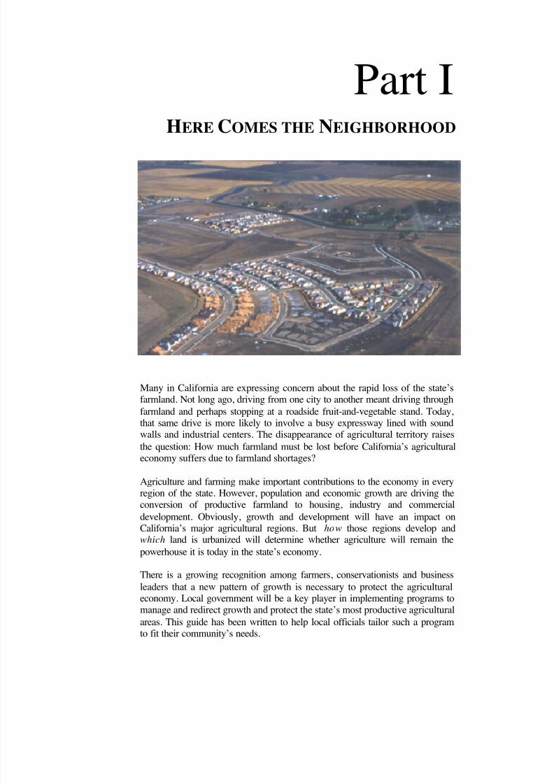
HERE COMES THE NEIGHBORHOOD
Many in California are expressing concern about the rapid loss of the state’sfarmland. Not long ago, driving from one city to another meant driving through
farmland and perhaps stopping at a roadside fruit-and-vegetable stand. Today,that same drive is more likely to involve a busy expressway lined with soundwalls and industrial centers. The disappearance of agricultural territory raisesthe question: How much farmland must be lost before California’s agriculturaleconomy suffers due to farmland shortages?
Agriculture and farming make important contributions to the economy in everyregion of the state. However, population and economic growth are driving theconversion of productive farmland to housing, industry and commercialdevelopment. Obviously, growth and development will have an impact onCalifornia’s major agricultural regions. But how those regions develop andwhich land is urbanized will determine whether agriculture will remain thepowerhouse it is today in the state’s economy.
There is a growing recognition among farmers, conservationists and businessleaders that a new pattern of growth is necessary to protect the agriculturaleconomy. Local government will be a key player in implementing programs tomanage and redirect growth and protect the state’s most productive agriculturalareas. This guide has been written to help local officials tailor such a programto fit their community’s needs.
Part I

8/8/2019 22457.Farmland Action Guide
http://slidepdf.com/reader/full/22457farmland-action-guide 10/164
L AY OF THE L AND
Percentage of an American’s disposable personal income spent on food in 1952: 21%1
Percentage of an American’s disposable personal income spent of food in 1998: 11% 1
Percentage of Californians who believe that the loss of farmland is a “very serious” problem: 57% 2
Percentage of Californians who agree or strongly agree that agricultural land is an essential part of California’s identity and we must fight to preserve it: 90% 2
Total cash receipts generated by California agriculture in 2000: $24.8 billion 1
Total cash receipts generated by Texas, the second leading agricultural state: $13.2 billion 3
Number of California counties where the value of agricultural produce exceeded $1 billion: 10 3
Number of the nation’s top 10 agricultural counties that are located in California: 8 3
Total agricultural acres converted to urban uses in California from 1988 to 1998: 497,000 acres 5
Amount of the state’s agricultural land rated as prime: 18% 5
Proportion of farmland converted to urban use that was rated as prime: 30% 5
Ratio of new residents to acres of farmland converted: 10-to-1 5
Typical value of farmland on urban edge subject to development pressures: $12,000 per acre
Typical value of land for high-end agricultural crops, such as fruits and nuts: $5,500 per acre 5
Typical value of rangeland: $1,050 per acre 5
SOURCES: (1) Agricultural Issues Center, The Measure of California Agriculture 2000 ( www.aic.ucdavis.edu) • (2) Poll conducted byFairbank, Maslin, Maullin & Associates for the Nature Conservancy and the Conservation Fund (July 13, 1999) • (3) California Farm BureauFederation (www.cfbf.org) • (4) Public Policy Institute of California (www.ppic.org), special surveys on Land Use (Nov. 2001) and Growth(May 2001) • (5) Kuminoff et al , Issues Brief: Farmland Conversion: Perceptions and Realities, Agricultural Issues Center (May 2001)(www.aic.ucdavis.edu) • (6) American Farmland Trust, Owners' Attitudes Toward Regulation of Agricultural Land: Technical Report on a
National Survey (1998) (www.farmland.org/cfl/survey.htm).

8/8/2019 22457.Farmland Action Guide
http://slidepdf.com/reader/full/22457farmland-action-guide 11/164
10 STEPS FOR
CONSERVING FARMLAND
Will Rogers once observed that there was only so much land in California,and “… they wasn’t making any more.” His point succinctly underlines theimportance of conserving farmland. California, the state that leads thenation in agricultural production and population growth, has a finiteamount of farmland.
This guide has been written for elected officials, planning commissioners,planners, attorneys and community members who are interested inprotecting California’s farmland. The guide’s focus is how to conservefarmland. What strategies are available to local government? What aretheir potential benefits and pitfalls? How are such programs funded?
This guide is specific to California. It makes no attempt to describeprograms that are not authorized by California law. Moreover, the guideshould not be considered an exhaustive resource. Instead, each sectionbriefly highlights the issues and policy consideration of a particularstrategy. Where practicable, additional resources for local government areidentified.
A total of 24 strategies are presented here. Each can be used to protectfarmland and improve the economic viability of agriculture. The strategiesare grouped into five parts:
• Ten Steps for Conserving Farmland (Part I);
• Managing the Conversion of Farmland (Part II);
• Planning for Agriculture (Part III);
• Ag-Urban Boundaries (Part IV); and
• General Implementation Issues (Part V).
The following text explains how these 24 individual strategies can be usedto form a comprehensive farmland conservation program.
STEP 1: START WITH URBAN PLANNING
In the context of farmland protection, there is no substitute for sound urbanplanning. Low-density urban sprawl is a significant factor in the loss of farmland and one for which local agencies — as land use decision-makers
Start with Urban Planning .......3
Get the Facts ................................4Engage the Community.............4
Manage the Conversion of Farmland.......................................5
Consider Incentives forAgriculture ...................................5
Address the “Urban Edge”Issues ..............................................6
Tailor a Plan.................................7
Secure Funding ............................8
Overcome Obstacles ...................8
See It Through .............................8
1STRATEGY
8/8/2019 22457.Farmland Action Guide
http://slidepdf.com/reader/full/22457farmland-action-guide 12/164
4 | F ARMLAND P ROTECTION A CTION G UIDE S TRATEGY 1
— have primary responsibility. This is not to say that cities and countiesshould not grow or that farmland should never be converted to urban use.Instead, by increasing population densities, encouraging infill and settingurban boundaries, communities can significantly reduce the amount of landnecessary to accommodate new growth. Indeed, local agencies that striveto use land efficiently and manage growth effectively are already ahead inthe effort to protect farmland.
A comprehensive growth management plan may even increase agriculturalproductivity. Farms in fast-growing urban regions often suffer from the“impermanence syndrome” — when farmers perceive that it’s only amatter of time before their farm is converted to urban use, they stopmaking long-term investments in the operation. As a result, the farmbecomes less efficient and marginalized, which in turn increases thefarmer’s willingness to sell the property for development. One way tooffset the impermanence syndrome is by shaping urban growth in acompact and predictable manner, so that farmers are less likely to think of their land as slated for development “sooner or later.”
STEP 2: G ET THE FACTS
Amassing data about local agriculture is helpful for any farmlandprotection program. California has the most varied and productiveagricultural industry in the world. The state produces more than 250 cropsand generates $24.8 billion in cash receipts annually. 1 Knowing how local
agriculture fits into statewide and international markets will help decision-makers to shape policy. Other local factors, such as soil quality,microclimates and water availability, are also important considerations.Strategy 22 offers tips for collecting information to use in developing acomprehensive local program.
STEP 3: E NGAGE THE COMMUNITY Public support is important when developing any new policy. However,it’s particularly important when developing farmland protection programs.Polls consistently show that voters see the loss of farmland as one of the
state’s most serious environmental problems.2
Moreover, discussions of how to conserve farmland often evoke visionsabout how the community should grow, because any proposed programwill affect different people in different ways. For example, a zoningdesignation that encourages compact, higher-density development may
1Agricultural Issues Center, The Measure of Agriculture 2000 , p. 4.
2Fairbank, Maslin, Maullin & Associates, Results of Recent Polling Relating to Agriculture in
California , July 13, 1999; www.ilsg.org/farmland.

8/8/2019 22457.Farmland Action Guide
http://slidepdf.com/reader/full/22457farmland-action-guide 13/164
I NSTITUTE for L O C A L S EL F G OVERNMENT C O M M U N I T Y L A N D U SE P R O J E C T | 5
meet resistance from neighborhood groups unless their concerns areaddressed in advance. Finally, productive community engagementincreases the public’s confidence in both the growth program ultimately
adopted and the local agency. Ideas for involving the public anddeveloping community consensus are included in Strategy 22, and, to someextent, Strategy 18.
STEP 4: M ANAGE THE CONVERSION OFFARMLAND
Local agencies have a variety of regulatory options available to help thembegin managing the conversion of agricultural land. These tools can beused to protect broad swaths of agricultural land and decrease the impact of “leapfrog” development. Although sometimes such measures initially meetresistance, they usually gain more support after they are adopted,particularly when they are part of an overarching plan to protect andenhance local agriculture. This guide addresses these options in eightstrategies:
• Incorporating policies into the general plan or developing a specificplan (Strategies 2 and 3);
• Zoning for agriculture (Strategy 4);
• Managing the subdivision of farmland (Strategy 5);
• Conservation easement purchase programs (Strategy 6);
• Mitigation fees and development credit transfers (Strategy 7);
• Local agency formation commission policies (Strategy 8); and
• Regional or interagency cooperation (Strategy 9).
Some land use choices, such as mitigation and transfer of developmentcredit programs, can reduce community objections even further bydistributing regulatory burdens among landowners. Moreover,conservation easement programs are developing statewide that actually
purchase the right to develop farmland directly from the farmer.
STEP 5: C ONSIDER INCENTIVES FORAGRICULTURE Voluntary approaches to ensuring the viability of local agriculture are justas important as regulatory options. Even the most effective regulationwould fall short if it merely preserved land that could not be profitablyfarmed. Admittedly, many factors that affect agriculture, such as
8/8/2019 22457.Farmland Action Guide
http://slidepdf.com/reader/full/22457farmland-action-guide 14/164
6 | F ARMLAND P ROTECTION A CTION G UIDE S TRATEGY 1
international trade and technology, are beyond the scope of most localagency actions. Nevertheless, local agencies can take a wide variety of actions to help farm operators be more productive and profitable,
including: • Providing property tax incentives (Strategy 10);
• Developing adequate water supplies (Strategy 11);
• Simplifying farm permit processes (Strategy 12);
• Encouraging new farmers (Strategy 13);
• Assisting farmers with environmental compliance (Strategy 14);
• Building quality farmworker housing (Strategy 15);
• Promoting the economic development of agriculture (Strategy 16); and
• Encouraging farm marketing (Strategy 17).
Incorporating these elements into a plan will help ensure that agricultureremains a vital part of the community.
STEP 6: ADDRESS “URBAN EDGE ” I SSUES No agricultural protection program is complete without addressing the ag-urban border issue. This area is contentious because farming andresidential living are fundamentally incompatible land uses. New residentswho moved into an area because of its scenic views are often frustrated bythe “nuisance” activities associated with agriculture, such as dust, odors,slow-moving tractors on public roads and use of pesticides. Likewise,farmers have genuine concerns about increased vandalism and trespassing.Local agencies have developed a number of tools to address these issues,including:
• Facilitating informal dispute resolution processes (Strategy 18);
• Adopting “right-to-farm” ordinances (Strategy 19); and
• Creating agricultural buffer zones (Strategy 20).
8/8/2019 22457.Farmland Action Guide
http://slidepdf.com/reader/full/22457farmland-action-guide 15/164
I NSTITUTE for L O C A L S EL F G OVERNMENT C O M M U N I T Y L A N D U SE P R O J E C T | 7
STEP 7: T AILOR A PLAN Having reviewed the wide variety of choices for protecting farmlandavailable to local agencies, the next step is to examine the community’scharacteristics and policy options, and then design a program that best fitscommunity needs. In most cases, the plan will include elements to controlurban growth, manage the conversion of farmland, provide economicincentives and address concerns about the ag-urban boundary. In finalizingthe plan, decision-makers should be prepared to make tough calls.Eventually, most plans involve drawing a line separating developable landfrom agricultural land. Those who are near the line will often want itadjusted one way or another. Decision-makers will have to balancelegitimate political considerations with the need to draw the line or create azone in a way that is most supportive of the entire program.
3Summarized from Mark Cordes, Takings , Fairness and Farmland Preservation , 60 Ohio St. L.J. 1033
(1999).
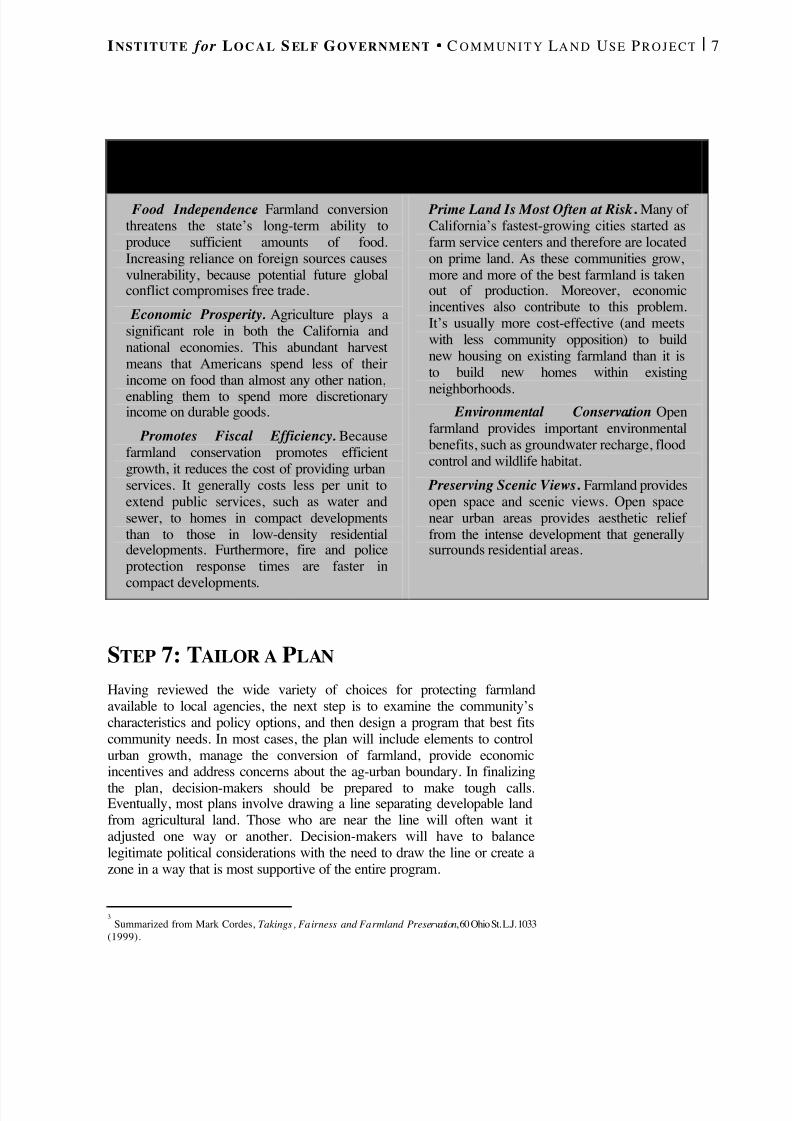
POLICY CONSIDERATIONS SUPPORTING FARMLAND CONSERVATION
3
Food Independence . Farmland conversionthreatens the state’s long-term ability toproduce sufficient amounts of food.Increasing reliance on foreign sources causesvulnerability, because potential future globalconflict compromises free trade.
Economic Prosperity. Agriculture plays asignificant role in both the California andnational economies. This abundant harvestmeans that Americans spend less of theirincome on food than almost any other nation,enabling them to spend more discretionaryincome on durable goods.
Promotes Fiscal Efficiency. Becausefarmland conservation promotes efficientgrowth, it reduces the cost of providing urbanservices. It generally costs less per unit toextend public services, such as water andsewer, to homes in compact developmentsthan to those in low-density residentialdevelopments. Furthermore, fire and policeprotection response times are faster in
compact developments.
Prime Land Is Most Often at Risk . Many of California’s fastest-growing cities started asfarm service centers and therefore are locatedon prime land. As these communities grow,more and more of the best farmland is takenout of production. Moreover, economicincentives also contribute to this problem.It’s usually more cost-effective (and meetswith less community opposition) to buildnew housing on existing farmland than it isto build new homes within existing
neighborhoods. Environmental Conservation. Openfarmland provides important environmentalbenefits, such as groundwater recharge, floodcontrol and wildlife habitat.
Preserving Scenic Views . Farmland providesopen space and scenic views. Open spacenear urban areas provides aesthetic relief from the intense development that generallysurrounds residential areas.

8/8/2019 22457.Farmland Action Guide
http://slidepdf.com/reader/full/22457farmland-action-guide 16/164
8 | F ARMLAND P ROTECTION A CTION G UIDE S TRATEGY 1
STEP 8: SECURE FUNDING The costs farmland protection programs vary for local agencies, dependingon their scope and complexity. One of the most encouraging aspects of farmland protection programs is that there is a great deal of funding —both private and public — to help local agencies and other organizationsprotect and conserve farmland. For example, the state will have more than$75 million in the coming years for preserving land (Strategy 6). Whencombined with other resources, this means that communities need onlyraise 5 to 25 percent of an easement’s value in order to leverage additionalfunding. Moreover, traditional revenue-raising tools, such as assessmentsand bonds, can also be used when there is there is sufficient communitysupport. Several funding sources are summarized in Strategy 24.
STEP 9: O VERCOME OBSTACLES
Despite the best-laid plans, setbacks are likely to occur duringimplementation. A grant will not come through, or a key element of theprogram will get off to a slow start, or the local media may run a negativestory. Indeed, it’s unlikely that even the most inclusive process willgenerate unanimous community support for farmland conservation. Somelandowners are likely to be skeptical, and may even raise the issue that theplan amounts to a taking of property (Strategy 23). Proponents of a goodplan will usually persevere — particularly when the plan has been createdwith significant public input. Actively involving community members indeveloping and then implementing the program is one way to maintainpublic support (see Strategy 22).
STEP 10: S EE IT THROUGH
Planning and adopting an effective farmland protection program is only 49percent of the battle. The other 51 percent is seeing it through. If there is a“Murphy’s Law” of farmland protection, it is: Soon after adopting aprogram, a project will materialize that seems “too good to pass up” butthat will compromise the plan.
How a community responds to such proposals says a lot about itscommitment to the plan. Public trust is an important factor in such asituation. Local officials must strike a balance between the community’soverall economic health and the public expectation that the program will befully implemented. Ultimately, the deciding factor is the community’slevel of commitment to preserving its agricultural heritage and assets.

8/8/2019 22457.Farmland Action Guide
http://slidepdf.com/reader/full/22457farmland-action-guide 17/164
M ANAGING THE CONVERSIONOF FARMLAND
Farmland protection begins with sound urban planning. Each year, urban
sprawl consumes 15,000 acres of farmland in the Central Valley alone. Givencurrent growth rates and development patterns, the valle y's $16.5 billion inannual agricultural production could be slashed by as much $2.1 billion by2040 — a reduction equivalent to the current agricultural production of NewYork, Virginia, Oregon or Mississippi. And that is just in the Central Valley.Other key agricultural regions in Imperial and San Diego counties and in thecoastal valleys are facing a similar threat.
Finding ways to manage urban growth has the potential to protect morefarmland than all of the conservation easements, mitigation fees andWilliamson Act contracts combined. This is not to say that farmland protectiontools do not play a significant role ? they do. But a sound growth management
plan is the cornerstone of any comprehensive farmland protection program.Consequently, most farmland protection tools supplement a growthmanagement plan. Part II addresses these tools, such as conservation easementsand agricultural zoning, which complement the other elements of a localagency’s general plan. In addition, regional cooperation between adjoiningdistricts and agencies can help to ensure that farmland is protected on a broadbasis.
Part II
8/8/2019 22457.Farmland Action Guide
http://slidepdf.com/reader/full/22457farmland-action-guide 18/164
L AY OF THE L AND
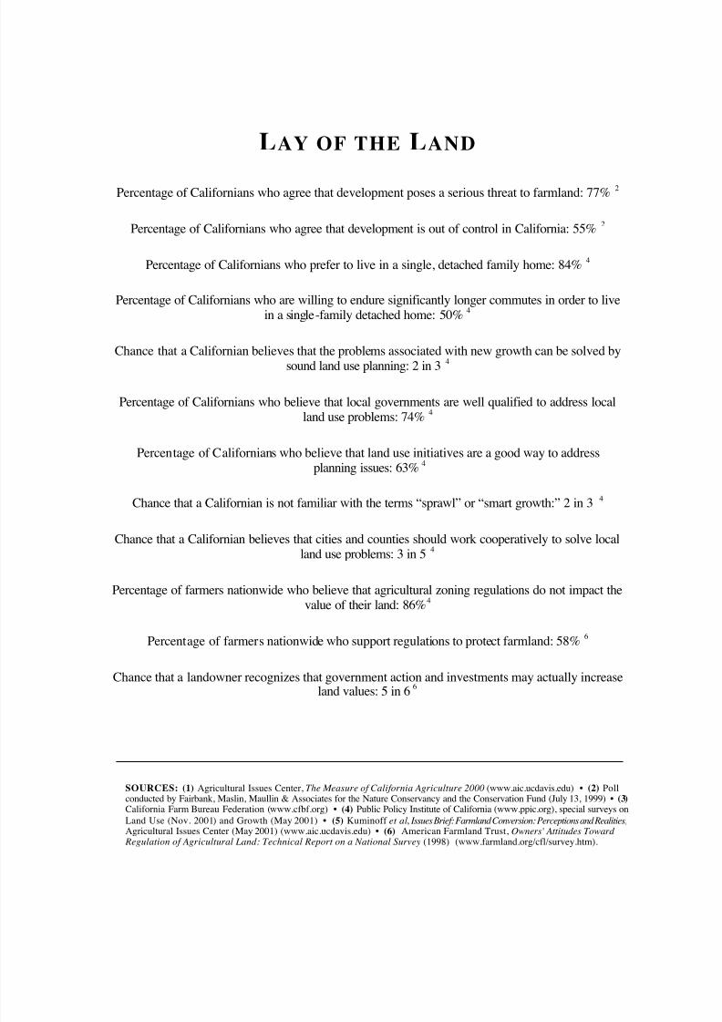
Percentage of Californians who agree that development poses a serious threat to farmland: 77% 2
Percentage of Californians who agree that development is out of control in California: 55% 2
Percentage of Californians who prefer to live in a single, detached family home: 84% 4
Percentage of Californians who are willing to endure significantly longer commutes in order to livein a single-family detached home: 50% 4
Chance that a Californian believes that the problems associated with new growth can be solved bysound land use planning: 2 in 3 4
Percentage of Californians who believe that local governments are well qualified to address localland use problems: 74% 4
Percentage of Californians who believe that land use initiatives are a good way to addressplanning issues: 63% 4
Chance that a Californian is not familiar with the terms “sprawl” or “smart growth:” 2 in 3 4
Chance that a Californian believes that cities and counties should work cooperatively to solve localland use problems: 3 in 5 4
Percentage of farmers nationwide who believe that agricultural zoning regulations do not impact thevalue of their land: 86% 4
Percentage of farmers nationwide who support regulations to protect farmland: 58% 6
Chance that a landowner recognizes that government action and investments may actually increaseland values: 5 in 6 6
SOURCES: (1) Agricultural Issues Center, The Measure of California Agriculture 2000 (www.aic.ucdavis.edu) • (2) Pollconducted by Fairbank, Maslin, Maullin & Associates for the Nature Conservancy and the Conservation Fund (July 13, 1999) • (3) California Farm Bureau Federation (www.cfbf.org) • (4) Public Policy Institute of California (www.ppic.org), special surveys onLand Use (Nov. 2001) and Growth (May 2001) • (5) Kuminoff et al , Issues Brief: Farmland Conversion: Perceptions and Realities,Agricultural Issues Center (May 2001) (www.aic.ucdavis.edu) • (6) American Farmland Trust, Owners' Attitudes Toward
Regulation of Agricultural Land: Technical Report on a National Survey (1998) (www.farmland.org/cfl/survey.htm).

8/8/2019 22457.Farmland Action Guide
http://slidepdf.com/reader/full/22457farmland-action-guide 19/164
DEVELOP A GROWTHMANAGEMENT STRATEGY Growth management doesn’t mean “no growth.” Indeed, achieving zerogrowth is undesirable — and probably impossible — for most Californiacities. Not only is the state’s population projected to increase by nearly 50percent (or 18 million) in the next 25 years, but state housing laws requireeach city and county to plan for its fair share of new housing. The questionfor local officials is how to accommodate an appropriate share of growth ina way that satisfactorily addresses the competing issues of housing,economic development and resource (including farmland) protection.
GROWTH AND FARMLANDPROTECTION Thoughtful growth management can have a significant impact on limitingfarmland conversion. A study by the American Farmland Trustdemonstrates this point. 1 The study compared two growth scenarios for theCentral Valley. In the first, development continued at an average density of three dwellings per acre. In the second, the density was doubled to sixdwellings per acre. The study found that the lower-density model wouldconsume more than 1 million acres of farmland by 2040, 60 percent of which would be prime farmland and farmland of statewide importance. Anadditional 2.5 million acres would be located sufficiently close to urbanareas to put agricultural operations at risk. By contrast, more compact,efficient growth would reduce farmland conversion to 474,000 acres, orless than half the amount projected in the first scenario.
Moreover, the study demonstrated that more compact growth was alsogood for local agencies’ bottom line. The cost of providing public servicesto the lower-density development would exceed city revenues by morethan $1 billion per year. In contrast, the more compact development patternyielded a $200 million surplus, a difference of $1.2 billion per year.
Members of the public and local agencies are taking notice. In one case, anextraordinary coalition has formed to curb sprawl in Fresno. This effort,
1 American Farmland Trust, Alternatives for Future Urban Growth in California’s Central Valley (1995).
Growth andFarmland Protection ...............11
The GrowthManagement Tool Box ............13
The South LivermoreValley Plan..................................17
2STRATEGY
8/8/2019 22457.Farmland Action Guide
http://slidepdf.com/reader/full/22457farmland-action-guide 20/164
12 | F ARMLAND P ROTECTION A CTION G UIDE S TRATEGY 2
called the Growth Alternatives Alliance, exemplifies a community-basedapproach to balancing agricultural protection with economic development.Its members include the County Farm Bureau, Fresno Chamber of
Commerce, Fresno Business Council, the American Farmland Trust andthe Building Industry Association of the San Joaquin Valley. Thealliance’s commitment to managed growth is based on the commonrecognition that Fresno’s agriculture is threatened by the same forces thattransformed the historically agricultural economies of Los Angeles, SantaClara and other California counties into large metropolitan areas.
The coalition set out to frame a common vision for managing land use inFresno County. 2 Its efforts resulted in the April 1998 publication, A
Landscape of Choice: Strategies for Changing the Patterns of CommunityGrowth , whose centerpiece is a 10-point policy statement (see “PolicyRecommendations of the Growth Alternatives Alliance,” below). FresnoCounty and its 15 cities have adopted resolutions supporting theseprinciples. The county and the City of Fresno are also incorporating thesestrategies into their general plan updates, and several other cities areadopting specific development plans based on growth envisioned in thereport. 3
2 Fresno Growth Alternatives Alliance, A Landscape of Choice: Strategies for Changing the Patterns of Community Growth (1998).3 Greg Kirkpatrick, Building a Constituency for Change: The Growth Alternatives Alliance (visitedMar. 8, 2002) http://wsare.usu.edu/sare2000/136.htm.
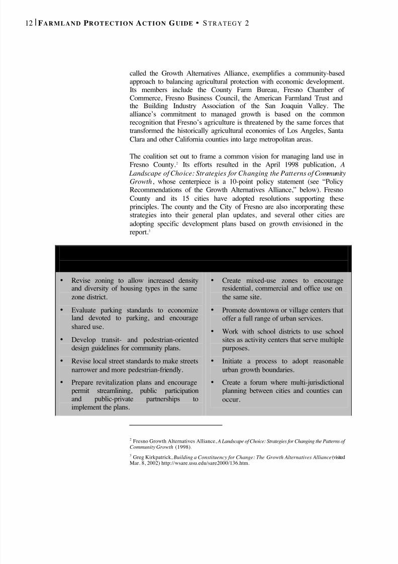
P O L I C Y R E C O M M E N D AT I O N S O F T H E
G R O W T H A LT E R N AT I V E S A L L I A N C E
• Revise zoning to allow increased densityand diversity of housing types in the same
zone district.• Evaluate parking standards to economize
land devoted to parking, and encourageshared use.
• Develop transit- and pedestrian-orienteddesign guidelines for community plans.
• Revise local street standards to make streetsnarrower and more pedestrian-friendly.
• Prepare revitalization plans and encouragepermit streamlining, public participationand public-private partnerships toimplement the plans.
• Create mixed-use zones to encourageresidential, commercial and office use on
the same site.• Promote downtown or village centers that
offer a full range of urban services.• Work with school districts to use school
sites as activity centers that serve multiplepurposes.
• Initiate a process to adopt reasonableurban growth boundaries.
• Create a forum where multi-jurisdictionalplanning between cities and counties canoccur.
8/8/2019 22457.Farmland Action Guide
http://slidepdf.com/reader/full/22457farmland-action-guide 21/164
I NSTITUTE for L O C A L S EL F G OVERNMENT C O M M U N I T Y L A N D U SE P R O J E C T | 13
THE GROWTH MANAGEMENT
TOOLBOX Exactly what constitutes a sound growth management policy varies witheach jurisdiction. A thorough discussion of growth management is beyondthe scope of this guide. The issue is briefly addressed here to underscorethe need for farmland protection measures to work in tandem with growthmanagement. Programs adopted without such support are likely to beineffective or, at best, implemented in a piecemeal fashion. In California,growth management strategies are incorporated within the local agency’sgeneral plan and various implementing ordinances.
INFILL INCENTIVES
Encouraging infill in existing urban areas decreases the pressure to turnfarmland into single-family subdivisions. 4 For example, the City of Salinasrecently revised its general plan to encourage infill at higher densities, inpart to protect the rich land at the city’s outskirts (known as “the world’ssalad bowl” for its produce). Infill development can also save money forlocal agencies because it relies more heavily on existing infrastructure. 5
Local agencies adopting infill policies face two challenges: developerpreference for “greenfield” development and neighborhood opposition toincreased density. These challenges can be addressed by providingincentives for infill construction, such as fee reduction and permit
streamlining, to help make projects “pencil out.” Involving the public indeveloping design guidelines helps to address neighborhood opposition.Neither solution is a cure-all, but such efforts and other creative strategiesare often enough to help projects move forward.
ZONING
Zoning directs growth and ensures that neighboring uses are compatible.Large-lot zoning (such as one residence for every 40 to 160 acres) is oftenused to help keep farmland viable. Zoning is an attractive strategy thatappeals to many people because it is familiar and relatively easy to adopt.The major flaw attributed to zoning, however, is that it cannot guarantee
permanent protection. It is always subject to future amendment by the
4 A great resource for infill housing issues is published by the Local Government Commission entitled Building Livable Communities: A Policy Makers Guide to Infill Development . See www.lgc.org(landuse publications).5 Rolf Pendall , Myths and Facts About Affordable and High Density Housing (1993) (available throughthe Association of Bay Area Governments Web site atwww.abag.ca.gov/services/finance/fan/housingmyths2.htm).
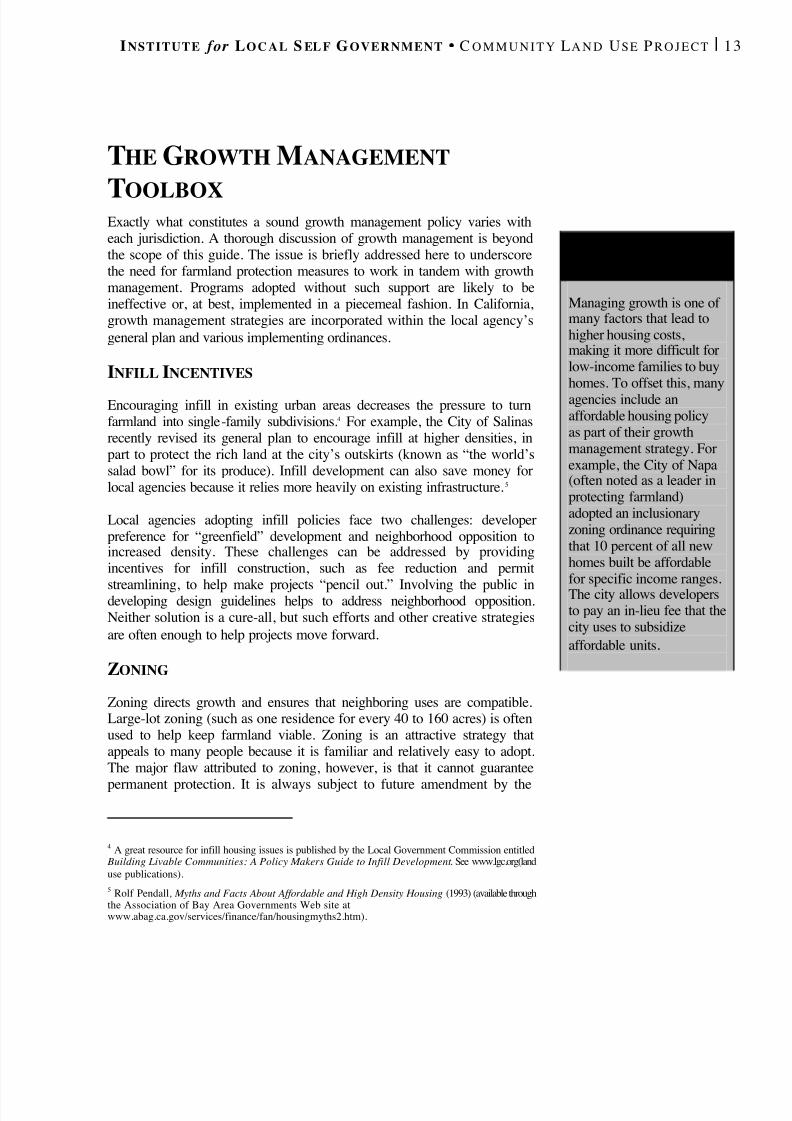
A FFORDABLEH O U S I N G
Managing growth is one of many factors that lead tohigher housing costs,making it more difficult forlow-income families to buyhomes. To offset this, manyagencies include anaffordable housing policyas part of their growthmanagement strategy. Forexample, the City of Napa(often noted as a leader inprotecting farmland)adopted an inclusionaryzoning ordinance requiringthat 10 percent of all newhomes built be affordablefor specific income ranges.The city allows developersto pay an in-lieu fee that thecity uses to subsidizeaffordable units .

8/8/2019 22457.Farmland Action Guide
http://slidepdf.com/reader/full/22457farmland-action-guide 22/164
14 | F ARMLAND P ROTECTION A CTION G UIDE S TRATEGY 2
legislative body. In addition, zoning does not necessarily lead tocoordinated regional growth. If area jurisdictions don’t coordinate effortswhen developing their zoning ordinances, the land use pattern across a
region is likely to be inconsistent.
UTILITY SERVICE CONTROLS
Limiting the geographical extension of utility services is one of the mosteffective techniques for controlling urban growth. New subdivisions aredependent on such infrastructure. Consequently, plans that control or phasethe extension of water and sewer services place a physical limitation ongrowth. 6 These restrictions also help control costs. For example, the City of Woodland has phased its development geographically by controlling whenand where utility services can be extended. An alternative is to develop afee program that encourages compact development. For example, the Cityof Lancaster charges a variable traffic impact fee, depending on thedevelopment’s distance from the urban core; greater distances incur higherfees. (Such fees should be crafted carefully and in consultation with theagency’s attorney).
URBAN GROWTH BOUNDARIES
Urban growth boundaries (UGBs) are a popular tool in many areas.Growth boundaries specifically delineate where growth can — and cannot— occur. 7 They are usually enforced by two underlying mechanisms:zoning controls and urban service-area limitations. This combinationprevents development beyond the boundary line. An interesting variationon the growth boundary concept has been adopted by the City of Visalia,which has developed interim growth boundaries that expand automaticallywhen development within the existing boundary reaches specific build-outcriteria.
Several organizations have sponsored initiatives to adopt urban growthboundaries. In these cases, the boundary is reviewed automatically aftersome period of time, usually 20 years. 8 In the meantime, the only way tochange the boundary is through another vote. Most (if not all) of the citiesin Sonoma, Napa and Ventura counties have adopted growth boundaries inthis way.
6 Such actions to l imit water and sewer hookups have generally been upheld as a valid exercise of thepolice power. See Dateline Builders, Inc. v. City of Santa Rosa , 146 Cal. App. 3d 520 (1983).7 See Dateline Builders, Inc. v. City of Santa Rosa , 146 Cal. App. 3d 520, 531 (1983). The UGB oftencorresponds with a city’s sphere of influence boundary.8 To the extent that urban growth boundaries affect the ability to meet fair share housing requirements,it may have to be amended every five years. See DeVita v. County of Napa , 9 Cal. 4th 763, 790 (1995).
T HEI MPERMANENCE
S YNDROME
Sound growth managementpractices can actuallyncrease local agricultural
production by offsetting the“ImpermanenceSyndrome.” Farmers whoknow that their land isunavailable fordevelopment are moreikely to make newnvestments in their
operations.
8/8/2019 22457.Farmland Action Guide
http://slidepdf.com/reader/full/22457farmland-action-guide 23/164
I NSTITUTE for L O C A L S EL F G OVERNMENT C O M M U N I T Y L A N D U SE P R O J E C T | 15
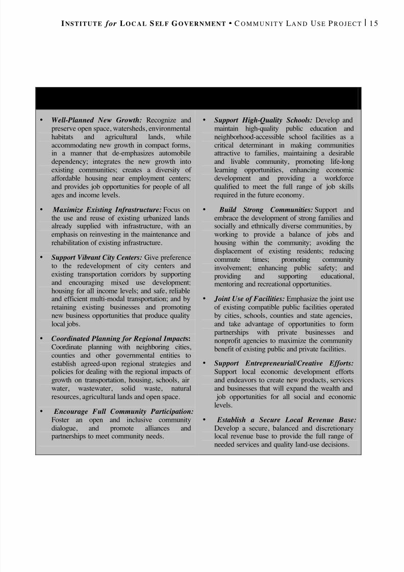
L EAGUE OF C ALIFORNIA C ITIES ’ S MART G R O W T H P RINCIPLES
• Well-Planned New Growth: Recognize andpreserve open space, watersheds, environmentalhabitats and agricultural lands, whileaccommodating new growth in compact forms,in a manner that de-emphasizes automobiledependency; integrates the new growth intoexisting communities; creates a diversity of affordable housing near employment centers;and provides job opportunities for people of allages and income levels.
• Maximize Existing Infrastructure: Focus onthe use and reuse of existing urbanized landsalready supplied with infrastructure, with anemphasis on reinvesting in the maintenance andrehabilitation of existing infrastructure.
• Support Vibrant City Centers: Give preferenceto the redevelopment of city centers andexisting transportation corridors by supportingand encouraging mixed use development;housing for all income levels; and safe, reliable
and efficient multi-modal transportation; and byretaining existing businesses and promotingnew business opportunities that produce qualitylocal jobs.
• Coordinated Planning for Regional Impact s:Coordinate planning with neighboring cities,counties and other governmental entities toestablish agreed-upon regional strategies andpolicies for dealing with the regional impacts of growth on transportation, housing, schools, airwater, wastewater, solid waste, naturalresources, agricultural lands and open space.
• Encourage Full Community Participation: Foster an open and inclusive communitydialogue, and promote alliances andpartnerships to meet community needs.
• Support High-Quality Schools: Develop andmaintain high-quality public education andneighborhood-accessible school facilities as acritical determinant in making communitiesattractive to families, maintaining a desirableand livable community, promoting life-longlearning opportunities, enhancing economicdevelopment and providing a workforcequalified to meet the full range of job skillsrequired in the future economy.
• Build Strong Communities: Support andembrace the development of strong families andsocially and ethnically diverse communities, byworking to provide a balance of jobs andhousing within the community; avoiding thedisplacement of existing residents; reducingcommute times; promoting communityinvolvement; enhancing public safety; andproviding and supporting educational,mentoring and recreational opportunities.
•
Joint Use of Facilities: Emphasize the joint useof existing compatible public facilities operatedby cities, schools, counties and state agencies,and take advantage of opportunities to formpartnerships with private businesses andnonprofit agencies to maximize the communitybenefit of existing public and private facilities.
• Support Entrepreneurial/Creative Efforts:Support local economic development effortsand endeavors to create new products, servicesand businesses that will expand the wealth and
job opportunities for all social and economiclevels.
• Establish a Secure Local Revenue Base: Develop a secure, balanced and discretionarylocal revenue base to provide the full range of needed services and quality land-use decisions.
8/8/2019 22457.Farmland Action Guide
http://slidepdf.com/reader/full/22457farmland-action-guide 24/164
16 | F ARMLAND P ROTECTION A CTION G UIDE S TRATEGY 2
INTERIM MORATORIA
Interim moratoria are used to temporarily halt development so that a localagency can develop a comprehensive plan to address related issues. 9 In thefarmland protection context, moratoria might be imposed when a localagency experiences an unexpected rush of applications to develop largetracts of farmland. Sometimes, moratoria are criticized for being misusedto stall controversial projects. But the Legislature has built in severalprotections against such use, such as requiring a super-majority (four-fifths) vote by the governing body for adoption and limiting their durationto no more than two years.
SPECIFIC PLANS
Specific plans are flexible tools that implement the general plan in specificareas. 10 A specific plan can set forth broad policies or provide direction toevery facet of development. They are optional, and range in size from asingle parcel to large areas within a city or county. Specific plans can beused to develop detailed infrastructure plans and financing strategies,enabling local agencies to phase growth in a deliberate way. For example,the City of Reedley adopted a specific plan for limiting the city’s urbanfootprint that included the following elements:
• Increase Densities . Increase urban densities to limit development of surrounding farmland. Use design standards like large front porchesand recessed garages to offset the negative image of increased density.
• Avoid Leapfrog Development. New subdivisions must be within one-eighth of a mile (660 feet) of existing development.
• Limit Annexations . Forward annexation requests only after 80 percentof land available for residences has been developed.
• Revise Street Standards. Encourage narrower streets to reduce theamount of land used for urban development.
• Infill . Implement a policy that encourages infill development forvacant or underdeveloped parcels within the existing urban area.
9 It may only be extended for a period of two years. See Cal. Gov't Code § 65858. Moratoria have longbeen held a proper exercise of the police power. Tahoe Sierra Preservation Council v. Tahoe RegionalPlanning Agency, __ U.S. __ (2002).; Miller v. Board of Public Works , 195 Cal. 477, 486-487 (1925).Under SB 1098 (stats. 2001 c. 939) these requirements now apply to charter cities.10 Cal. Gov't Code §§ 65450 – 65457; Governor’s Office of Planning and Research, The Planners’Guide to Specific Plans (1998) ( http://ceres.ca.gov/planning/specific).
8/8/2019 22457.Farmland Action Guide
http://slidepdf.com/reader/full/22457farmland-action-guide 25/164
I NSTITUTE for L O C A L S EL F G OVERNMENT C O M M U N I T Y L A N D U SE P R O J E C T | 17
This is only one example of how a specific plan can be used to managegrowth (for another, see “The South Livermore Valley Plan,” below).
BUILDING CAPS Building caps manage growth by limiting the number of residentialbuilding permits that a local agency may issue annually. 11 The restriction isusually based on a resource or infrastructure limitation. Many localagencies have developed criteria (sometimes called “beauty contests”) toreward projects that include affordable housing, farmland protection,innovative design or other desirable factors. 12
Building caps are popular because they are easy to understand and give thepublic a sense of control. Moreover, many systems have been in placesince the 1970s, so they are also familiar. But building caps have beencriticized for effectively exporting growth to neighboring communities. Inaddition, they do not necessarily influence the type of growth that occurs.In other words, sprawling growth may continue under a building cap, but ata slower pace.
THE SOUTH LIVERMOREVALLEY PLANThe City of Livermore’s South Livermore Valley Specific Plan balancesnew housing with enhancing the area’s wine industry. 13 Not long ago, the
valley was a bucolic place where cattle and vineyards outnumbered people.But things have changed. Spillover from nearby Silicon Valley and SanFrancisco has converted much of the farmland into high-priced houses andbusiness parks.
Livermore’s specific plan complements an area plan adopted by AlamedaCounty. It applies to seven areas, totaling nearly 1,900 acres, on the city’ssouthern boundary. The plan calls for developing 481 acres toaccommodate 1,200 housing units. The remaining acreage will be placed inagricultural conservation easements (see Strategy 6) to provide apermanent growth boundary along the city’s southern edge.
11 Most are modeled on the Petaluma plan, which limited growth to 500 new houses each year in theearly 1970s. See Construction Industry Assn. v. City of Petaluma , 522 F.2d 897 (9th Cir. 1975), cert.denied, 424 U.S. 934 (1976) (finding that the concept of public welfare is sufficiently broad to upholdthe city’s desire to preserve its small-town character and grow at an orderly pace).12 Other decision criteria may include equitable considerat ions, such as how long a development hasbeen in the pipeline. See Pacifica Corp. v. City of Camarillo , 149 Cal. App. 3d 168, 182 (1983).13 The plan was adopted in November of 1997 and amended in February 2001. Selective portions of theplan are available on the Institute’s Web site.
8/8/2019 22457.Farmland Action Guide
http://slidepdf.com/reader/full/22457farmland-action-guide 26/164
18 | F ARMLAND P ROTECTION A CTION G UIDE S TRATEGY 2
The plan’s lynchpin is its mitigation program. Developers are required topay for planting one acre of new vineyards for each acre converted tohousing and for each new house. Other crops, such as olives, also be
planted. The new vineyard must also be protected by a conservationeasement and the developer must arrange for its maintenance for at leasteight years — either by placing additional covenants on the property or byentering into a long-term maintenance contract with an experienced farmoperator. The South Livermore Valley Agricultural Land Trust was formedto negotiate and purchase these easements, which it holds jointly with theCity of Livermore.
One result of this policy has been the creation of several agriculturallyviable 10-acre ranchettes in the county planning area. A typical parcel mayhave one acre of living space on nine acres of income-producing vineyardsthat, when mature, can generate more than $100,000 annually in revenue
for the owner. Other elements of the plan include:• Nuisances . Viticulture is very noisy at times. Large fans, typically
powered by loud V-8 engines, operate during cold weather to reducefrost damage. Before harvest, blank cartridges are often fired to scareaway birds. A proactive education program warns new residents of thepotential consequences of living near vineyards.
• Scenic Corridors . Because the wine area attracts tourists, designstandards help to maintain the city’s scenic edge. New subdivisionsmust include a visual buffer (consisting of a vineyard) betweenresidential lots and the main roadways.
The plan is a comprehensive approach to growth management andfarmland conservation. However, it may be difficult for some agencies toduplicate the results. Several unique regional factors, such as a well-developed wine and tourism industry and extremely high land values(ranging from $78,000 to $150,000 per acre of developable land),contribute to the plan’s success. Livermore has chosen to embrace its wineindustry. In other parts of the state, new vineyards are seen as a threat tomore traditional forms of agriculture.
Moreover, the very profitable nature of the region’s vineyards ensures thatrequiring landowners to actually engage in grape production is not as
burdensome as it might be for a less valuable crop. The Livermoreexperience underscores the importance of tailoring a growth managementand agricultural protection program to the community’s uniquecharacteristics.
8/8/2019 22457.Farmland Action Guide
http://slidepdf.com/reader/full/22457farmland-action-guide 27/164
I NSTITUTE for L O C A L S EL F G OVERNMENT C O M M U N I T Y L A N D U SE P R O J E C T | 19
MAKE FARMLAND
PROTECTION A PRIORITYIN THE GENERAL PLAN
A city or county general plan is the foundation for all local land-useplanning in California. At its best, the general plan encapsulates a visionfor the community and translates it into a set of policies for physicaldevelopment. All other ordinances and policies that control zoning andsubdivisions flow from the general plan., 1 which includes goals and
objectives for long-range planning, and specific policies to support them.
General plans must be both horizontally and vertically consistent.Horizontal consistency means that the separate elements do not conflictwith one another. 2 In other words, if a local agency designates an area asfarmland within a land use element, it cannot adopt a policy within itshousing element that would require the designated farmland to bedeveloped. Vertical consistency means that other policies do not conflictwith the general plan. To use the same example, land designated asfarmland in the general plan cannot be rezoned as industrial withoutamending the general plan. 3
M ANDATORY PLAN ELEMENTS General plans are required to address seven elements: land use, circulation,housing, conservation, opens space, noise and safety. 4 Most local agenciesaddress farmland conservation within one or more of these elements in thefollowing ways:
• Land Use Element . The land use element describes the location andextent of uses such as housing, business, agriculture and other
1 See Lesher Communications, Inc. v. City of Walnut Creek , 52 Cal. 3d 531 (1990); Citizens of GoletaValley v. Board of Supervisors , 52 Cal. 3d 553 (1990).2 Sierra Club v. Board of Supervisors , 126 Cal. App. 3d 698 (1981).3 Zoning ordinances in charter cities are not required to be consistent, though most charter cities followthe practice. Cal. Gov't Code § 65803.4 Cal. Gov't Code § 65302.
Mandatory PlanElements ...............................19
The OptionalAgricultural Element……20
Following Through............21
3STRATEGY

8/8/2019 22457.Farmland Action Guide
http://slidepdf.com/reader/full/22457farmland-action-guide 28/164
20 | F ARMLAND P ROTECTION A CTION G UIDE S TRATEGY 3
activities. It must specify population density and building intensitystandards for each land use category. 5
•
Conservation Element. The conservation element addresses thedevelopment of natural resources, including agricultural soils. 6
• Open Space Element. The open space element addresses thepreservation and management of natural resources. Agricultural landsare listed as one of the resources to be managed. 7
• Housing Element. The housing element, while not directly related toagriculture, often describes how new areas will be developed. Themore it emphasizes infill and higher-density development, the lessimpact it will have on farmland conversion. Housing elements can alsoplan for farmworker housing.
Local agencies enjoy a great deal of flexibility in tailoring general plans tofit community needs. There is no single “right” way to develop a farmlandprotection program. For example, the City of Stockton’s land use elementincludes a goal to “promote and maintain environmental quality and thepreservation of agricultural land while promoting logical and efficienturban growth.” A policy under this goal states that “wasteful andinefficient sprawl of urban uses into agricultural lands ... should beavoided.” Butte County’s land use element uses a somewhat differentapproach: It designates different agricultural areas within the county andprovides that zoning and other regulations be adopted accordingly. 8 Thecounty’s open space element also encourages farmers to enter into openspace agreements, such as those offered under the Williamson Act.
THE OPTIONAL AGRICULTURALELEMENT Local agencies may also incorporate optional elements into their generalplan to address agricultural issues. 9 An agricultural element allows
5 The land use element must make designations for housing, industry, business, open space, naturalresources, public facilities, waste disposal sites and other categories. Cal. Gov't Code § 65302(a).6 The conservation element of the general plan must address the identification, conservation,development and use of natural resources. "Natural resources" include water, forests, soils, waterways,wildlife and mineral deposits. Cal. Gov't Code § 65302(d).7 Cal. Gov't Code §§ 65560 and following. The open space element should details long-range measuresfor preserving open space for natural resources, managing the production of resources, for outdoorrecreation, and for public health and safety. Cal. Gov't Code §§ 65302(e), 65560 - 65568.8 County of Butte, Cal., G ENERAL P LA N LAN D USE ELEMENT (2000) (available online atwww.buttecounty.net/dds/land.htm.9 Cal. Gov't Code § 65303.
S P E C I F I C P L A N S
Specific plans (addressed inStrategy 1) can also be usedto implement general planpolicies. A specific planworks like a general planfor a specific area, andtherefore often allows thepolicies and goals to bemuch more specific.Specific plans must beconsistent with the general
plan.
8/8/2019 22457.Farmland Action Guide
http://slidepdf.com/reader/full/22457farmland-action-guide 29/164
I NSTITUTE for L O C A L S EL F G OVERNMENT C O M M U N I T Y L A N D U SE P R O J E C T | 2 1
farmland designation, farmworker housing and economic support issues tobe addressed more directly (see “Sample Agricultural Element Policies,”page 22). It also has the same force and effect as the general plan’s
mandatory elements. All other elements, ordinances and policies mustremain consistent with the agricultural element’s goals and purposes.
Sonoma County’s general plan includes an agricultural element thatoutlines the county’s intentions of stabilizing agriculture at the urbanfringe. Its policies also limit the intrusion of new residential uses intoagricultural areas and mitigate conflicts between agricultural andnonagricultural uses in designated production areas. To provide anotherexample, the City of Arroyo Grande’s agricultural element promotesagricultural tourism in connection with its downtown area’s historiccharacter.
There are several good reasons to develop a separate agricultural element.First, the seven mandatory elements are not always the best vehicles forfocusing on agricultural production requirements. For example, addressingfarmland protection wholly within the open space element risks de-emphasizing the business needs of agriculture. Second, it is difficult toachieve a comprehensive strategy for agriculture when the most relevantpolicies are spread over three or more general plan elements.
Finally, a local agency is more likely to seek and obtain more accurateinformation on the status of local resources and production if it is planningfor agriculture as a whole. Thus, the agricultural element becomes morethan just a delineation of agricultural zones. It becomes a platform on
which a local agency can endorse strategies to ensure the local agriculturaleconomy’s long-term vitality.
FOLLOWING THROUGH A general plan provides the starting point for protecting farmland.However, some critics have observed that it’s relatively easy to amend ageneral plan. 10 Thus, simply adopting general plan policies to protectfarmland is not enough to limit the conversion of agricultural land — thepolicies must actually be implemented. Indeed, a number of communitiesthroughout the state have adopted model policies, only to amend them assoon as a large development is proposed. In other words, there is noguarantee that a general plan will be implemented as adopted.
10 With some exceptions, mandatory elements can be amended up to four times during any calendaryear. Cal. Gov't Code §§ 65358. No similar restriction applies to specific plans.
8/8/2019 22457.Farmland Action Guide
http://slidepdf.com/reader/full/22457farmland-action-guide 30/164
22 | F ARMLAND P ROTECTION A CTION G UIDE S TRATEGY 3
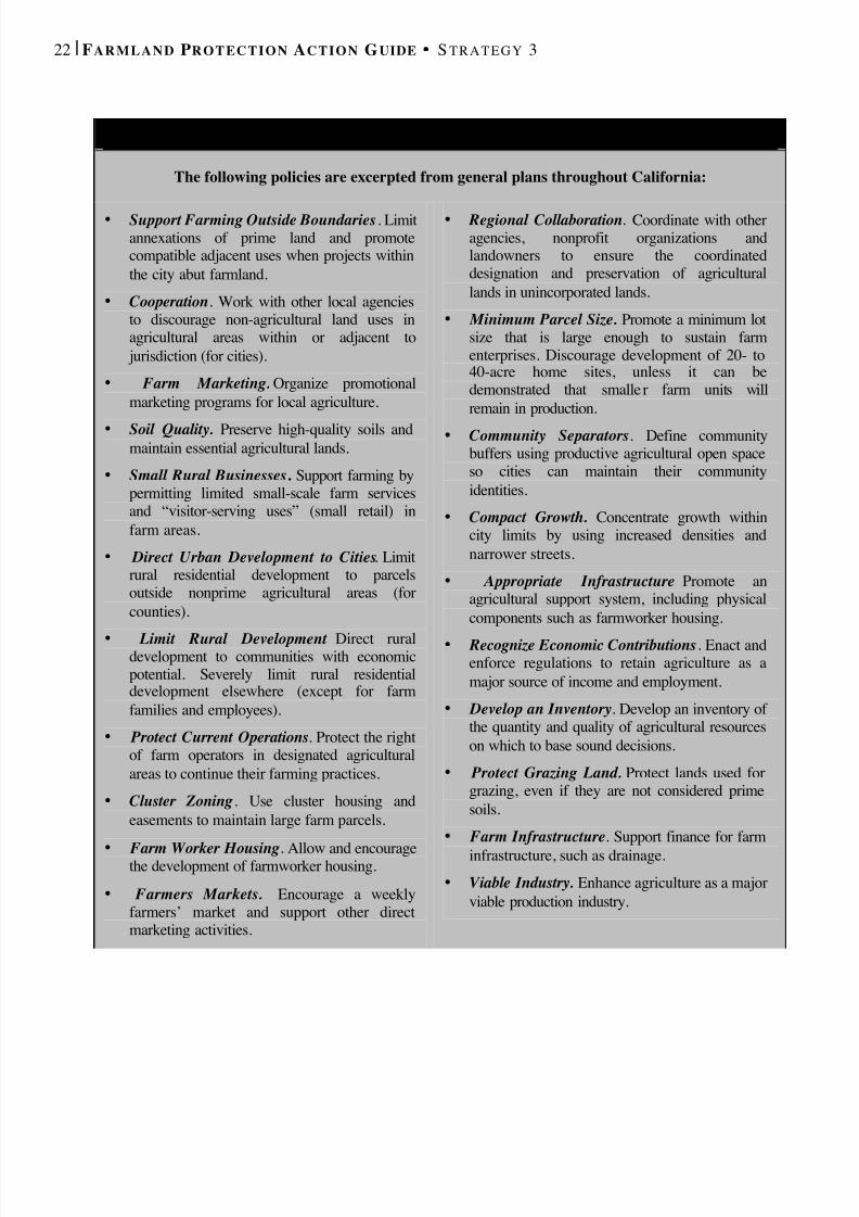
S AMPLE A GRICULTURAL E LEMENT P OLICIES
The following policies are excerpted from general plans throughout California:
• Support Farming Outside Boundaries . Limitannexations of prime land and promotecompatible adjacent uses when projects withinthe city abut farmland.
• Cooperation . Work with other local agenciesto discourage non-agricultural land uses inagricultural areas within or adjacent to
jurisdiction (for cities).• Farm Marketing. Organize promotional
marketing programs for local agriculture.• Soil Quality. Preserve high-quality soils and
maintain essential agricultural lands.• Small Rural Businesses . Support farming by
permitting limited small-scale farm servicesand “visitor-serving uses” (small retail) infarm areas.
• Direct Urban Development to Cities . Limitrural residential development to parcelsoutside nonprime agricultural areas (forcounties).
• Limit Rural Development . Direct ruraldevelopment to communities with economicpotential. Severely limit rural residentialdevelopment elsewhere (except for farmfamilies and employees).
• Protect Current Operations . Protect the rightof farm operators in designated agriculturalareas to continue their farming practices.
• Cluster Zoning . Use cluster housing andeasements to maintain large farm parcels.
•
Farm Worker Housing . Allow and encouragethe development of farmworker housing.• Farmers Markets. Encourage a weekly
farmers’ market and support other directmarketing activities.
• Regional Collaboration . Coordinate with otheragencies, nonprofit organizations andlandowners to ensure the coordinateddesignation and preservation of agriculturallands in unincorporated lands.
• Minimum Parcel Size. Promote a minimum lotsize that is large enough to sustain farmenterprises. Discourage development of 20- to40-acre home sites, unless it can bedemonstrated that smalle r farm units willremain in production.
• Community Separators . Define communitybuffers using productive agricultural open spaceso cities can maintain their communityidentities.
• Compact Growth. Concentrate growth withincity limits by using increased densities andnarrower streets.
• Appropriate Infrastructure . Promote anagricultural support system, including physicalcomponents such as farmworker housing.
• Recognize Economic Contributions . Enact andenforce regulations to retain agriculture as amajor source of income and employment.
• Develop an Inventory . Develop an inventory of the quantity and quality of agricultural resourceson which to base sound decisions.
• Protect Grazing Land. Protect lands used forgrazing, even if they are not considered primesoils.
• Farm Infrastructure . Support finance for farminfrastructure, such as drainage.
• Viable Industry. Enhance agriculture as a majorviable production industry.
8/8/2019 22457.Farmland Action Guide
http://slidepdf.com/reader/full/22457farmland-action-guide 31/164
I NSTITUTE for L O C A L S EL F G OVERNMENT C O M M U N I T Y L A N D U SE P R O J E C T | 2 3
Local agencies risk losing the public’s confidence when they approveamendments that are clearly contrary to the plan’s original intent. Frequentamendments can also lead to citizen frustration, particularly in cases where
the community was very active in developing the plan. Sometimes thisfrustration manifests itself in a ballot initiative that prohibits local agenciesfrom making any amendments to the parts of the general plan that protectfarmland and open space. 12 One way to “see a plan through” is for localagencies to find voluntary ways that make it more difficult to amend thegeneral plan, including the following:
• Include Specific Goals in the General Plan. General plans thatinclude specific provisions to protect farmland are more difficult tochange than those that merely include vague goals. This is becausegeneral plan revisions are subject to the California EnvironmentalQuality Act (CEQA). Thus, when an agency goes to change a plan that
specifically protects farmland, the action is more likely to trigger themitigation provisions required by CEQA. Vague goals, however, areeasier to explain away in a negative declaration.
• Add Public Input Opportunities. Increased opportunities for publicinput (beyond those required by statute) 13 can also help protectfarmland in communities where the public has made it a priority. Apolicy that requires a community town hall meeting near the locationor requires the input of a stakeholder advisory committee will increasepublic input. Having such policies in place before an amendment isproposed will give proponents of plan amendments a clearer indicationof the agency’s commitment to its plan.
• Consider Supermajorities for Charter Cities. Charter cities havegreater control over their own voting processes because suchprocedures are not matters of “statewide concern.” 14 Thus, chartercities could impose supermajority requirements for certain kinds of general plan amendments in their charters. But this option wouldprobably be ineffective for general law cities and counties, which aregoverned by contrary language in the state Planning and Zoning Law. 15
11 DeVita v. County of Napa , 9 Cal. 4th 763 (1995). Cal. Elec. Code §§ 9125, 9217.12 In most cases, such initiatives merely adopt existing agriculture and open space conditions. Inanother common form, they designate urban growth boundaries. In either event, the legislative body isprohibited from amending the provisions adopted by initiative. The only way to amend it is besubsequent initiative. Cal. Elec. Code §§ 9125, 9217.13 Cal. Gov't Code § 65353.14 Cal. Const. art. XI, § 5(b).15 An amendment to the general plan shall be initiated in the manner specified by the legislative body.Cal. Gov't Code § 65358.
G OT I NITIATIVES ?
Frequent amendments to thegeneral plan can lead to publicfrustration, particularly if theyhasten development of primefarmlands. Such dissatisfactioncan result in “slow growth”initiatives. If such an initiativepasses, not only will it changethe way the community grows,but it also makes amending thegeneral plan more difficult. As ageneral rule, provisions adoptedby initiative can be amendedonly by initiative unless theinitiative states otherwise. 11

8/8/2019 22457.Farmland Action Guide
http://slidepdf.com/reader/full/22457farmland-action-guide 32/164
24 | F ARMLAND P ROTECTION A CTION G UIDE S TRATEGY 3
• Establish Finding Thresholds . A general plan amendment does notrequire the legislative body to make findings. However, the agencymay adopt its own rules stating that such amendments will not be
approved unless certain findings can be made.16
This solution isperhaps a bit cosmetic, because the legislative body could adopt anamendment exempting such projects from review at any given time.However, it does make amending the general plan more difficult,because it provides proponents of farmland protection with a politicaltool they can use to ask why any given project should receive “specialtreatment” under the local agency’s policies.
Finally, there is one other way that a local agency can raise the bar of difficulty on amending general plans: It can place the plan on the ballot forapproval by local citizens. If approved, the plan can be amended only bysubsequent initiative, which gives the general plan the greatest protection
against arbitrary amendment. The City of Napa employed this strategy in1990 when it asked voters to reaffirm certain portions of the general plandesignating land for agriculture, watershed and open space uses for aperiod of 30 years. Of course, such action also limits the extent to which“good” amendments may be adopted. Local agencies using this optionshould draft the initiative carefully in order to maintain a fair degree of flexibility and avoid liability. 17
16 A legislative body may establish for its planning agency any rules, procedures or standards that donot conflict with state or federal law. Cal. Gov't Code § 65102.17 Tips for drafting init iatives are included in another Institute publication: Ballot Box Planning:Understanding Land Use Initiatives in California , 37-49 (2001).
B EWARE T HE “ P LA N B U S T E R ”
This scenario occurs just often enough to make it worth noting.
Typically, it involves a community that has just adopted a newcomprehensive general plan balancing new growth and resourceprotection. Soon after its adoption, however, a “plan buster” is proposed.
A plan buster is a project that seems too good to pass up but thatcompromises the original plan. It’s a tactic sometimes employed by thosewho want to develop outside the urban service boundaries. Rather thanseek an amendment to the general plan on the basis of the developmentalone, they offer to donate a portion of the land for a school, hospital orsome other special amenity needed in the community. If accepted, thenext step for the local agency will be to amend the general plan itself andbegin extending water, sewage and road improvements to the site. These
actions, of course, making the surrounding land ripe for furtherdevelopment. The original plan is effectively “busted.”

8/8/2019 22457.Farmland Action Guide
http://slidepdf.com/reader/full/22457farmland-action-guide 33/164
ZONE FOR AGRICULTURE Zoning is perhaps the most widely used land use tool, and often one of thefirst lines of defense in farmland protection programs. When usedeffectively, agricultural zoning has several benefits. It is also an efficientway to protect agricultural land. By simply passing an ordinance, localagencies can channel residential development away from broad swaths of farmland. 1
But zoning is not without critics. Poorly implemented zoning can actuallyspeed farmland conversion. Extensive reliance on low-density ruralresidential zoning, for example, causes urban areas to expand at very low
densities and often leads to “leapfrog” development patterns. In addition,zoning is often criticized for how easily it can be changed. Land can beredesignated from agricultural to auto mall by a simple majority vote atany given meeting of the legislative body when general plans are draftedfor that kind of flexibility.
Nevertheless, zoning remains one of the most essential tools to use inprotecting farmland. It is generally most effective when used with otherplanning tools in this guide, such as conservation easements, subdivisioncontrols or urban growth boundaries.
ELEMENTS OF AGRICULTURALZONINGThere are at least four key elements to consider when drafting or reviewingan agricultural zoning ordinance: the size of the parcel; extent of permittedor conditional uses; design; and implementation enforcement. In addition,a variety of local factors, such as the characteristics of local agriculture,soil quality and pre-existing regional growth and infrastructure patterns,will influence how the local agency ultimately designs and implements itszoning ordinances.
PARCEL SIZE Large lot zoning is a common farmland protection tool. Minimum lot sizes,such as 80 or 160 acres, ensure that parcel sizes remain large enough to befarmed profitably. Large lot zoning also discourages land purchases for
1 See Cal. Gov't Code § 65850(a); 65910 (authorizing open space zoning).
Elements of Agricultural Zoning ................25
Design Issues:Cluster Development ................28
4STRATEGY
8/8/2019 22457.Farmland Action Guide
http://slidepdf.com/reader/full/22457farmland-action-guide 34/164
26 | F ARMLAND P ROTECTION A CTION G UIDE S TRATEGY 4
residential use. 2 Setting an appropriate minimum parcel size is crucial tothe effectiveness of agricultural zoning. If it’s too low, the farmland maybe divided into parcels that are too small to farm. If it’s too high, the policy
may not gain popular support.
An effective density standard can also preserve the production capability of typical farming or ranching operations. For instance, a five-acre vegetablefarm (also known as a “truck farm”) may be viable in some coastal zoneareas. On the other hand, a cattle ranch in the Sierra foothills may needmore than 1,000 acres to maintain a viable operation.
Many agencies “feather” smaller minimum lot designations, such as five or10 acres, in transition areas to create “rural residential” units between largeagricultural operations and urban residences. The idea is to createprogressively smaller lots, going from agricultural to urban areas, to reduce
some of the conflicts that arise with largely incompatible agriculture andresidential uses. This approach has lost favor in some planning circles fortwo reasons. First, many of the primary conflicts, such as pesticide drift,remain. Second, such designations sometimes impede more efficienthigher-density developments as cities expand. Nevertheless, it can be aneffective tool in some circumstances (see Strategy 20, page 119).
MANAGING USE
The scope of permitted uses within the zone will determine whether non-agricultural or quasi-agricultural uses will be allowed. Overly broaddefinitions of agricultural uses may permit golf courses and othernonagricultural activities that may be incompatible with farming. On theother hand, a very narrow definition may limit economic opportunities toexpand farming operations into processing and service activities. Mostagricultural zoning can be classified in one of the following two ways:
1. Exclusive Zoning . Only agricultural uses are permitted. Limiting thescope of allowable uses is particularly significant in farm securityzones and other Williamson Act areas (see Strategy 10). The permitteduses for lands enrolled under the act are defined by state statute.
2. Non-Exclusive Zoning . Non-agricultural compatible uses, such asrecreation or storage, are permitted. Non-exclusive areas tend to
urbanize over time, meaning that this designation should probably notbe used in areas slated for long-term farming .
2 See Barancik v. County of Marin, 872 F.2d 834 (9th Cir. 1988) (upholding zoning of one residenceper 60 acres).
D O W N ZO N I N G :P O L I T I C S A N D
P ROPERTY
One of the toughest issuesfor local decision-makers isthe extent to which theywill “down zone” land toprotect the agriculturalcharacter of an area. Suchdecisions often raisepolitical considerations.
But contrary to what isoften argued, most zoningchanges will not amount toa taking of propertybecause zoning ordinancesdo not confer a right todevelop; they are alwayssubject to change. Thus, noproperty right has beentaken (see Strategy 23).
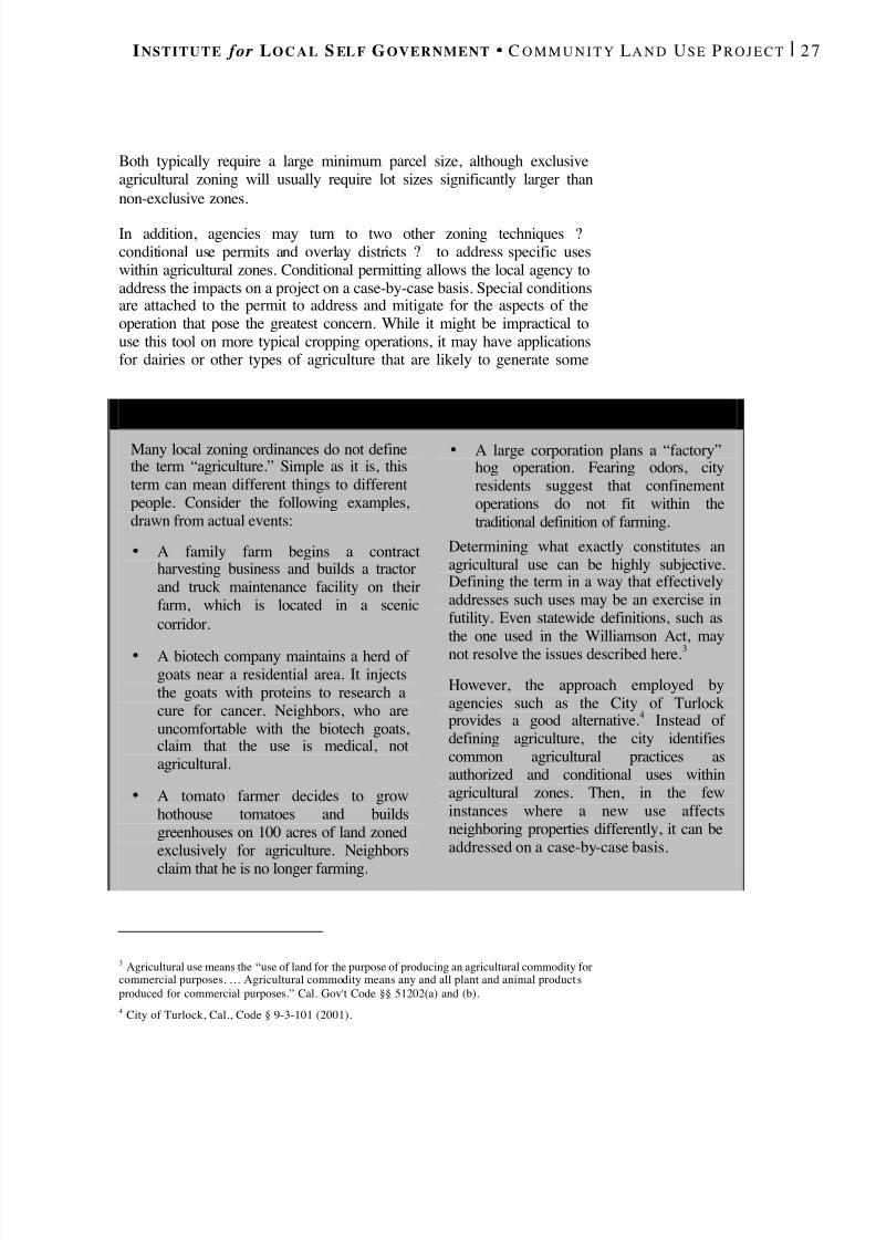
8/8/2019 22457.Farmland Action Guide
http://slidepdf.com/reader/full/22457farmland-action-guide 35/164
I NSTITUTE for L O C A L S EL F G OVERNMENT C O M M U N I T Y L A N D U SE P R O J E C T | 2 7
Both typically require a large minimum parcel size, although exclusiveagricultural zoning will usually require lot sizes significantly larger thannon-exclusive zones.
In addition, agencies may turn to two other zoning techniques ?conditional use permits and overlay districts ? to address specific useswithin agricultural zones. Conditional permitting allows the local agency toaddress the impacts on a project on a case-by-case basis. Special conditionsare attached to the permit to address and mitigate for the aspects of theoperation that pose the greatest concern. While it might be impractical touse this tool on more typical cropping operations, it may have applicationsfor dairies or other types of agriculture that are likely to generate some
3 Agricultural use means the “use of land for the purpose of producing an agricultural commodity forcommercial purposes. … Agricultural commodity means any and all plant and animal product sproduced for commercial purposes.” Cal. Gov't Code §§ 51202(a) and (b).4 City of Turlock, Cal., Code § 9-3-101 (2001).
D EFINING A GRICULTURE : W HAT ’ S I N A N AM E ?
Many local zoning ordinances do not definethe term “agriculture.” Simple as it is, thisterm can mean different things to differentpeople. Consider the following examples,drawn from actual events:
• A family farm begins a contractharvesting business and builds a tractorand truck maintenance facility on theirfarm, which is located in a sceniccorridor.
• A biotech company maintains a herd of goats near a residential area. It injectsthe goats with proteins to research acure for cancer. Neighbors, who areuncomfortable with the biotech goats,claim that the use is medical, notagricultural.
• A tomato farmer decides to growhothouse tomatoes and buildsgreenhouses on 100 acres of land zonedexclusively for agriculture. Neighbors
claim that he is no longer farming.
• A large corporation plans a “factory”hog operation. Fearing odors, cityresidents suggest that confinementoperations do not fit within thetraditional definition of farming.
Determining what exactly constitutes anagricultural use can be highly subjective.Defining the term in a way that effectivelyaddresses such uses may be an exercise infutility. Even statewide definitions, such asthe one used in the Williamson Act, maynot resolve the issues described here. 3
However, the approach employed byagencies such as the City of Turlockprovides a good alternative. 4 Instead of defining agriculture, the city identifiescommon agricultural practices asauthorized and conditional uses withinagricultural zones. Then, in the fewinstances where a new use affectsneighboring properties differently, it can beaddressed on a case-by-case basis.
8/8/2019 22457.Farmland Action Guide
http://slidepdf.com/reader/full/22457farmland-action-guide 36/164
28 | F ARMLAND P ROTECTION A CTION G UIDE S TRATEGY 4
concerns. Once the permit is granted, it is passed to subsequent owners andcannot be revoked without a hearing. However, it can be revoked if theconditions are not met.
Finally, overlay zones can be used to either encourage or limit a specificactivity within a smaller sub-zone or across zoning area boundaries. Forexample, a local agency seeking to encourage farm tourism within anagriculture zone can design an overlay district that would permit a limitedamount of construction for small buildings, bed-and-breakfast inns,roadside food stands and other uses consistent with farm tourism.
VARIANCES AND ENFORCEMENT CONSIDERATIONS
How the zoning ordinance will be implemented and enforced is also animportant consideration. An issue that arises with many ordinances is
whether the agency should grant a variance (or exception) to a landownerwho claims to be unfairly affected by the ordinance. Generally, variancescan be granted only when special circumstances applicable to the property(such as size, shape, topography, location or surroundings) deprive thelandowner of privileges enjoyed by other local landowners under the sameordinance. 5
Finding cost-effective ways to enforce ordinances is a significant challengefor local government. Typically, code enforcement officers ensurecompliance with local zoning ordinances. Fortunately, most agriculturalzoning ordinances are aimed at limiting the extent to which farmland isconverted to nonfarm uses. Thus, the building permit process will check
most nonconforming projects. Additional monitoring may be as easy asdriving through flat open country in the area. In more hilly and woodedsections, periodic aerial photographs can also be used to monitorcompliance.
DESIGN ISSUES : C LUSTERDEVELOPMENT Cluster zoning is a technique that can be used to protect farmland whilestill accommodating some level of development. Homes are generally“clustered” in one area of a parcel to be developed. 6 The remaining land issaved for farming or serves as a buffer. 7 Cluster zoning has worked in areas
5 Cal. Gov't Code § 65906. This standard may be supplemented with additional local guidelines. SeeTopanga Assn. for a Scenic Community v. County of Los Angeles , 11 Cal. 3d 506, 511 n.6 (1974).6 Randall Arendt, Rural by Design (1994).7 Many local agencies in California employ variations of this kind of zoning, sometimes referred to asarea-based or sliding scale zoning. Area-based zoning establishes a ratio of residences per specifiednumber of acres. For example, a ratio of one residence per 40 acres would allow five residences to be
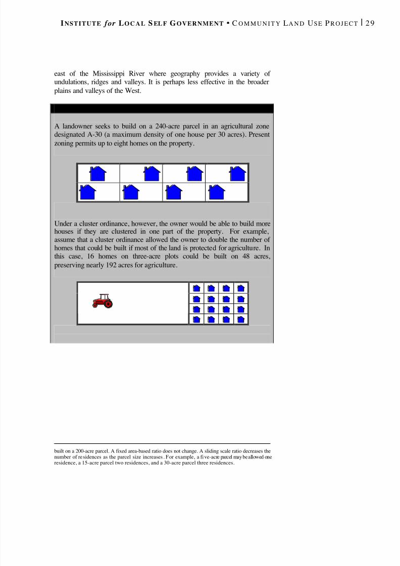
8/8/2019 22457.Farmland Action Guide
http://slidepdf.com/reader/full/22457farmland-action-guide 37/164
I NSTITUTE for L O C A L S EL F G OVERNMENT C O M M U N I T Y L A N D U SE P R O J E C T | 2 9
east of the Mississippi River where geography provides a variety of undulations, ridges and valleys. It is perhaps less effective in the broaderplains and valleys of the West.
built on a 200-acre parcel. A fixed area-based ratio does not change. A sliding scale ratio decreases thenumber of residences as the parcel size increases . For example, a five-acre parcel may be allowed oneresidence, a 15-acre parcel two residences, and a 30-acre parcel three residences.
H O W C LUSTERING W ORKS
A landowner seeks to build on a 240-acre parcel in an agricultural zonedesignated A-30 (a maximum density of one house per 30 acres). Presentzoning permits up to eight homes on the property.
Under a cluster ordinance, however, the owner would be able to build morehouses if they are clustered in one part of the property. For example,assume that a cluster ordinance allowed the owner to double the number of homes that could be built if most of the land is protected for agriculture. Inthis case, 16 homes on three-acre plots could be built on 48 acres,preserving nearly 192 acres for agriculture.
8/8/2019 22457.Farmland Action Guide
http://slidepdf.com/reader/full/22457farmland-action-guide 38/164
30 | F ARMLAND P ROTECTION A CTION G UIDE S TRATEGY 4
In California, the clustering technique is most practical in coastal andmountainous areas, where a small cluster of homes is less likely to affectlarge-scale farming. For example, San Luis Obispo County has an
“agricultural cluster” designation that concentrates development inagricultural areas. 8 Clustering can also be practical in and near ruralresidential subdivisions as a means of transitioning from urban toagricultural areas. But it is less effective in California’s large fertile valleyfloors because it creates disconnected “islands” of farmland and residentialunits — in effect, sponsoring a form of “leapfrog” development.
Some developers express concern that placing homes close to one anotherwill destroy the “country feel” that makes the property marketable. But awell-designed development can preserve much of that ambiance by takingadvantage of its proximity to the newly protected farmland. In addition,local agencies can provide an incentive by increasing the total number of
units that can be built in a cluster, making the project more profitable.Cluster zoning can also reduce the cost of servicing the new developmentbecause it requires fewer roadways, sewers and water lines than the samenumber of homes spread over a larger area.
Clustering typically requires the developer to provide a management planfor the undeveloped portion of the property. If the new development isdesigned as a planned unit development, then the remaining land could bedeeded with restrictions to the homeowners association, which in turncould lease it to local farmers. But the local agency would need to be ableto enforce the original terms if the homeowners association sought to putthe land to alternative uses. One way to provide this security is to identify
the local agency as a third-party beneficiary to the agreement that deeds theland to the homeowners association.
Selling or donating a conservation easement may be another option,providing that there is a land trust (see Strategy 6) willing to monitor theeasement. A third option may be to allow the land to be sold to anotherfarmer with a deeded restriction prohibiting further development. Finally,the local agency may elect to own and maintain the property if it willbecome part of a buffer or trail system.
8 County of San Luis Obispo, Cal., Code § 22.04.037 (2000).
8/8/2019 22457.Farmland Action Guide
http://slidepdf.com/reader/full/22457farmland-action-guide 39/164
I NSTITUTE for L O C A L S EL F G OVERNMENT C O M M U N I T Y L A N D U SE P R O J E C T | 3 1
MANAGE THE
SUBDIVISION OFAGRICULTURAL LAND Subdividing agricultural parcels into minimum parcel sizes is often the firsttangible step toward development and consequent loss of farmland.Managing how rural land is subdivided can help protect farmland fromunchecked residential development. The Subdivision Map Act (Map Act)authorizes local agencies to regulate the design and improvement of
subdivisions within their boundaries.1
BASICS OF SUBDIVISION LAW The Map Act authorizes each city and county to adopt an ordinance thatdesignates a local process for subdivision approval. 2 When a subdivisionincludes five or more parcels, the landowner files a tentative map. 3 Thetentative map establishes the proposed design of the subdivision as well asthe location of public streets, sidewalks, parks and public utilities. When aproposed subdivision consists of four or fewer parcels, the landowner filesa parcel map and oversight is more abbreviated.
The Map Act designates the extent to which a local agency may approve,conditionally approve or reject the proposed tentative or parcel map. Inmost circumstances, the local agency may require the landowner to meetcertain conditions before the map can become final. The owner then has aperiod of time — usually two years — to meet these standards, though theowner can seek a series of extensions. Upon completion of the conditions,a final map is recorded and the land is subdivided.
GROUNDS FOR APPROVAL AND DENIAL
When a local agency considers an application to subdivide, it can apply
only those ordinances and policies that are in effect at the time that the
1 Cal. Gov't Code §§ 66410 and following. The Map Act applies when land is subdivided for sale,lease, or financing, but an exception has been created for agricultural purposes such as when a portionof land is subleased to another producer. Cal. Gov't Code § 66412(k).2 Cal. Gov't Code § 66411.3 See Cal. Gov't Code § 66426(f).
Basics of Subdivision Law .......................31
Conditional Approvals ............33
Antiquated Subdivisions .........34
5STRATEGY

8/8/2019 22457.Farmland Action Guide
http://slidepdf.com/reader/full/22457farmland-action-guide 40/164
32 | F ARMLAND P ROTECTION A CTION G UIDE S TRATEGY 5
application is deemed complete. 4 The Map Act limits the scope of localdiscretion to approve or reject specific applications. To approve anapplication, the local agency must find that the proposed subdivision is
consistent with the general plan and any applicable specific plan.5
Thedegree to which a local agency can reject a tentative map application isalso limited to specified grounds. The limitations most relevant to farmlandprotection are: 6
• General Plan Inconsistency . The proposed map, design orimprovement is inconsistent with the general plan or applicablespecific plan.
• Williamson Act. The land is subject to a Williamson Act contract andthe resulting subdivision would create parcels too small to sustainagricultural use.
• Water Supply . Sufficient water supplies are not available to serve theproject when the project consists of more than 500 dwelling units (orin projects that would cause a 10 percent increase in serviceconnections for public water systems of fewer than 5,000 units). 7
Thus, the general plan (or applicable specific plan) provides an importantcheck against unplanned development. If, for example, the general plandesignates an area as agricultural, then it should be relatively easy for theagency to deny an application on the grounds that the proposal isinconsistent with the general plan.
Agricultural lands bound by Williamson Act contracts (see Strategy 10)also receive special consideration. Subdivision of contracted land ispermitted only when the resulting parcels remain large enough to sustainagriculture. Parcel sizes of 10 acres of prime agricultural land and 40 acresof nonprime land are presumed large enough to sustain agriculture. 8 However, local agencies are permitted to establish larger sizes. They can
4 The agency may also apply an ordinance that it is in the process of amending or updating. See Cal.Gov't Code § 66474.2. The agency may also apply any subsequent change in the law in response to asubdivider request. Cal. Gov't Code § 66413(b). By designating the map as a “vesting tentative map,”the subdivider gains the vested right to proceed under the law in effect when the application isconsidered complete. Cal. Gov't Code §§ 66498.1 - 66498 .9.5 Cal. Gov't Code § 66473.5.6 See Cal. Gov't Code §§ 66474(e) and (f). A proposed subdivision may also be rejected if the design orproposed improvements are likely to cause substantial environmental damage, injure fish, wildlife, ortheir habitats, or cause serious public health problems.7 Cal. Gov't Code § 66473.7 (requiring local agencies to make specified findings of sufficient watersupply before approving a tentative map).8 Cal. Gov't Code § 66474.4(a).
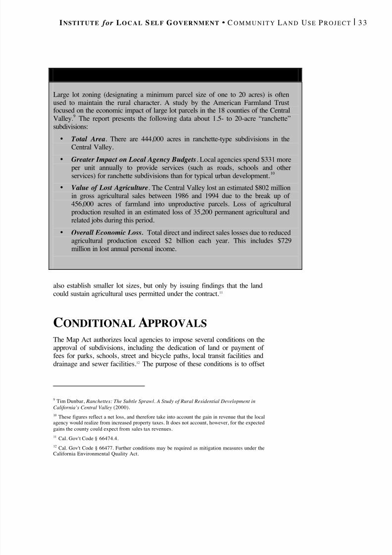
8/8/2019 22457.Farmland Action Guide
http://slidepdf.com/reader/full/22457farmland-action-guide 41/164
I NSTITUTE for L O C A L S EL F G OVERNMENT C O M M U N I T Y L A N D U SE P R O J E C T | 3 3
also establish smaller lot sizes, but only by issuing findings that the landcould sustain agricultural uses permitted under the contract. 11
CONDITIONAL APPROVALS The Map Act authorizes local agencies to impose several conditions on theapproval of subdivisions, including the dedication of land or payment of fees for parks, schools, street and bicycle paths, local transit facilities anddrainage and sewer facilities. 12 The purpose of these conditions is to offset
9 Tim Dunbar, Ranchettes: The Subtle Sprawl. A Study of Rural Residential Development inCalifornia’s Central Valley (2000).10 These figures reflect a net loss, and therefore take into account the gain in revenue that the localagency would realize from increased property taxes. It does not account, however, for the expectedgains the county could expect from sales tax revenues.11 Cal. Gov't Code § 66474.4.12 Cal. Gov't Code § 66477. Further conditions may be required as mitigation measures under theCalifornia Environmental Quality Act.
D O L ARGE -L O T S U B D I V I S I O N S M AK E “ C ENTS ” ?
Large lot zoning (designating a minimum parcel size of one to 20 acres) is oftenused to maintain the rural character. A study by the American Farmland Trustfocused on the economic impact of large lot parcels in the 18 counties of the CentralValley. 9 The report presents the following data about 1.5- to 20-acre “ranchette”subdivisions:
• Total Area . There are 444,000 acres in ranchette-type subdivisions in theCentral Valley.
• Greater Impact on Local Agency Budgets . Local agencies spend $331 moreper unit annually to provide services (such as roads, schools and otherservices) for ranchette subdivisions than for typical urban development. 10
• Value of Lost Agriculture . The Central Valley lost an estimated $802 millionin gross agricultural sales between 1986 and 1994 due to the break up of 456,000 acres of farmland into unproductive parcels. Loss of agriculturalproduction resulted in an estimated loss of 35,200 permanent agricultural andrelated jobs during this period.
• Overall Economic Loss. Total direct and indirect sales losses due to reducedagricultural production exceed $2 billion each year. This includes $729million in lost annual personal income.
8/8/2019 22457.Farmland Action Guide
http://slidepdf.com/reader/full/22457farmland-action-guide 42/164
34 | F ARMLAND P ROTECTION A CTION G UIDE S TRATEGY 5
the long-term impacts (which may include the loss of agricultural land)that the subdivision will have on public resources.
Local agencies may impose additional requirements when the conditionreasonably offsets the impact of development and furthers the purposes of the general plan. 13 A common practice is to conduct a nexus study to justifythe fee by quantifying the impacts of development and showing how a feeor other requirement would offset such impacts. 14 If the general planrequires the mitigation of loss of farmland, then the local agency mayimpose that condition on development. For example, based on a nexusstudy, the City of Davis imposes a fee on new subdivisions that is thenused to purchase conservation easements on neighboring farmland. 15
Such fees are sometimes challenged as a “taking” of property. However,fees that are adopted by ordinance and are applicable to a broad class of
landowners generally survive judicial scrutiny. The cases often cited insupport of such claims — the Nollan and Dolan cases 16 — hold that suchfees are more likely to become a taking only if they are imposed in an adhoc or individual fashion on a single landowner. While such claims shouldnot be ignored, local agencies working closely with legal counsel should beable to craft a program that does not amount to a taking.
ANTIQUATED SUBDIVISIONS The term “antiquated subdivisions” describes lots that have been createdunder early versions of the Map Act. The date that the subdivision was
legally created is important. Antiquated lots can be developed under theversion of the Map Act that was in effect on the day the lot was legallycreated. 17 For example, if a lot was created in 1910, it would not necessarilyhave to be consistent with today’s general plan because there was nogeneral plan conformity requirement in 1910.
Thus, landowners have a valuable incentive to determine the extent towhich their land may already have been subdivided. Assuming their
13 Cal. Gov't Code §§ 66418, 66419. Soderling v. City of Santa Monica , 142 Cal. App. 3d 501 (1983).
14 Sometimes this analysis is done as part of an environmental impact report (EIR).15 Such fee programs must be imposed and managed in accordance with the Mitigation Fee Act. SeeCal. Gov't Code §§ 66000 and following.16 Nollan v. California Coastal Commission , 483 U.S. 825 (1987); Dolan v. City of Tigard , 512 U.S.374 (1994).17 The Map Act recognizes the legality of parcels created by deed and federal patent. See Cal. Gov'tCode § 66451.10. See also J ohn Taft Corp. v. Advisory Agency , 161 Cal. App. 3d 749 (1984) (holdingthat a United States Government Survey Map is insufficient to create legal parcels); Lakeview
Meadows Ranch v. County of Santa Clara, 27 Cal . App. 4th 593 (1994) (finding three parcels, twocreated by federal patent and one by deed, on ranch covering thousands of acres).
W HAT TO DO WHENALL THE C O N T R O L SA RE NOT IN P LACE
Update the General Plan . Allubdivision applications filed after
he update will be subject to thoseevisions as adopted.
Use a Development Agreement . Developers will often tradedditional public improvements forertainty. Under a developmentgreement, the agency canncourage the subdivider to clusterhe development in a portion of theand to be subdivided and keep theemainder of the land in agriculture.
The Institute has published theDevelopment Agreement Manual ,vailable for purchase online at
www.ilsg.org (keyword searchdevelopment agreement”).
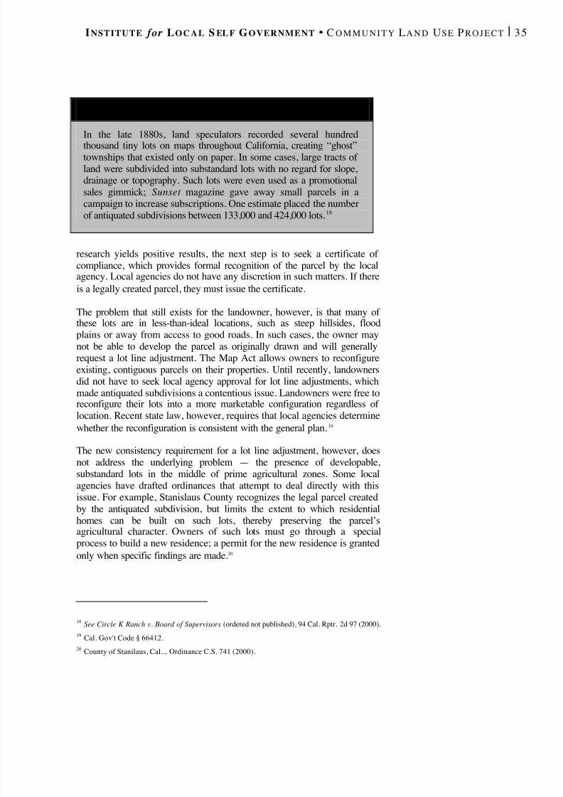
8/8/2019 22457.Farmland Action Guide
http://slidepdf.com/reader/full/22457farmland-action-guide 43/164
I NSTITUTE for L O C A L S EL F G OVERNMENT C O M M U N I T Y L A N D U SE P R O J E C T | 3 5
research yields positive results, the next step is to seek a certificate of compliance, which provides formal recognition of the parcel by the local
agency. Local agencies do not have any discretion in such matters. If thereis a legally created parcel, they must issue the certificate.
The problem that still exists for the landowner, however, is that many of these lots are in less-than-ideal locations, such as steep hillsides, floodplains or away from access to good roads. In such cases, the owner maynot be able to develop the parcel as originally drawn and will generallyrequest a lot line adjustment. The Map Act allows owners to reconfigureexisting, contiguous parcels on their properties. Until recently, landownersdid not have to seek local agency approval for lot line adjustments, whichmade antiquated subdivisions a contentious issue. Landowners were free toreconfigure their lots into a more marketable configuration regardless of
location. Recent state law, however, requires that local agencies determinewhether the reconfiguration is consistent with the general plan. 19
The new consistency requirement for a lot line adjustment, however, doesnot address the underlying problem — the presence of developable,substandard lots in the middle of prime agricultural zones. Some localagencies have drafted ordinances that attempt to deal directly with thisissue. For example, Stanislaus County recognizes the legal parcel createdby the antiquated subdivision, but limits the extent to which residentialhomes can be built on such lots, thereby preserving the parcel’sagricultural character. Owners of such lots must go through a specialprocess to build a new residence; a permit for the new residence is granted
only when specific findings are made.20
18 See Circle K Ranch v. Board of Supervisors (ordered not published), 94 Cal. Rptr. 2d 97 (2000).19 Cal. Gov't Code § 66412.20 County of Stanilaus, Cal.., Ordinance C.S. 741 (2000).
A S HORT H ISTORY OF A NTIQUATED S U B D I V I S I O N S
In the late 1880s, land speculators recorded several hundredthousand tiny lots on maps throughout California, creating “ghost”townships that existed only on paper. In some cases, large tracts of land were subdivided into substandard lots with no regard for slope,drainage or topography. Such lots were even used as a promotionalsales gimmick; Sunset magazine gave away small parcels in acampaign to increase subscriptions. One estimate placed the numberof antiquated subdivisions between 133,000 and 424,000 lots. 18
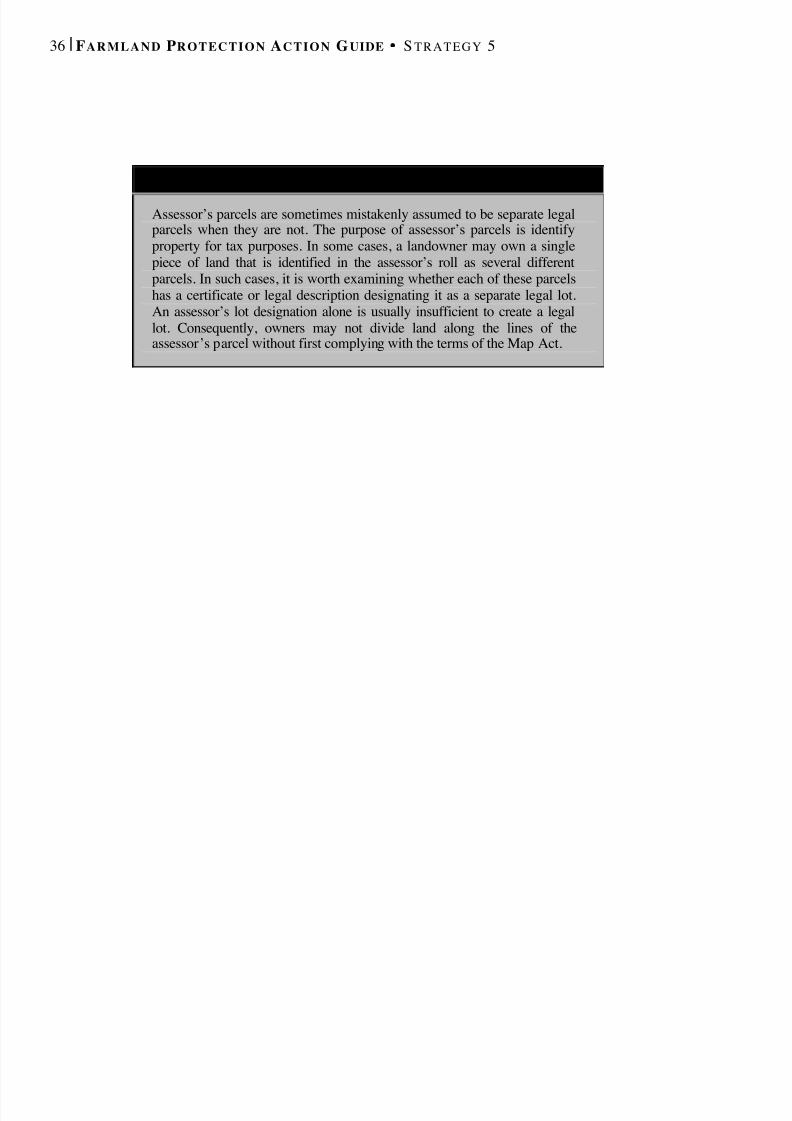
8/8/2019 22457.Farmland Action Guide
http://slidepdf.com/reader/full/22457farmland-action-guide 44/164
36 | F ARMLAND P ROTECTION A CTION G UIDE S TRATEGY 5
A N OTE A BOUT A S S E S S O R ’ S P ARCELS
Assessor’s parcels are sometimes mistakenly assumed to be separate legalparcels when they are not. The purpose of assessor’s parcels is identifyproperty for tax purposes. In some cases, a landowner may own a singlepiece of land that is identified in the assessor’s roll as several differentparcels. In such cases, it is worth examining whether each of these parcelshas a certificate or legal description designating it as a separate legal lot.An assessor’s lot designation alone is usually insufficient to create a legallot. Consequently, owners may not divide land along the lines of theassessor’s parcel without first complying with the terms of the Map Act.
8/8/2019 22457.Farmland Action Guide
http://slidepdf.com/reader/full/22457farmland-action-guide 45/164
INVEST IN A
CONSERVATIONEASEMENT PROGRAM Agricultural conservation easements have emerged during the past 20 yearsas a potentially effective way both to permanently protect farmland andchannel urban growth. New efforts are encouraging the use of this tool.The state Department of Conservation’s Farmland Conservancy Programwas created to fund easement transaction statewide. In 2000, voters passed
Proposition 12, a parks bond, which included $25 million for agriculturaleasements. The approval of Prop. 40 in March 2002 increased this amountsignificantly.
Conservation easements are established by legal agreements betweenlandowners and conservation organizations, in which the landownervoluntarily places a permanent deed restriction on a property to ensure thatthe land remains in agriculture. 1 In exchange, the landowner receivessomething of value — cash, tax advantages or simply the satisfaction of knowing the land is protected. Once the opportunity to develop has beensold, the land is permanently restricted to agricultural use, even if ownership of the land changes. But the landowner retains title to the
property and can still restrict public access or use the land as collateral fora loan. The primary advantage of a conservation easement is its certainty— even the best general plan can be amended, but a permanent deedrestriction is binding forever.
Although most easements are permanent, this is not mandatory. Aneasement can also be purchased for a specific term, such as 20, 30 or 50years. 2 Term easements may be good solutions in circumstances wherethere is an open question of whether the land should be permanentlypreserved for agriculture.
1 More officially, and easement is defined as “any limitation in a deed, will, or other instrument in theform of an easement, restriction, covenant, or condition, which is or has been executed by or on behalf of the owner of the land subject to such easement and is binding upon successive owners of such land.”Cal. Civ. Code § 815.1.2 Local agencies are authorized to hold open space easements either in perpetuity or for a term of notless than ten years, renewable annually. Cal. Gov't Code § 51070. This provision can be extended toagricultural lands. See Cal. Gov't Code §§ 51075(a), 65560(b)(2).
Considerations ForLocal Agencies ..........................38
Cooperating WithLand Trusts ................................40
Working WithLand Owners..............................42
Monitoring andEnforcement ...............................43
6STRATEGY

8/8/2019 22457.Farmland Action Guide
http://slidepdf.com/reader/full/22457farmland-action-guide 46/164
38 | F ARMLAND P ROTECTION A CTION G UIDE S TRATEGY 6
C IT Y L EADERSHIP K EY T O C O N S E RVAT I O N E ASEMENT 3
The City of Arroyo Grande played a key role inacquiring a agricultural conservation easementwithin its city limits. The Dixson Family Trustsold the easement on its 40-acre ranch on thecity’s east side for $550,000. The easement is acollaborative effort between the Coastal San LuisResources Conservation District and theAmerican Farmland Trust. The CaliforniaFarmland Conservancy Program and the U.S.Department of Agriculture Farmland ProtectionProgram contributed funding for the easement.
“The beauty of a conservation easement is that itcompensates landowners based upon marketvalues for giving up the development potential of their land,” said Jim Dickens, grandson of WilmaDixson. “We were able to convert some of ourland equity into cash and diversify the holdingsof the trust while honoring my grandmother’sdream of protecting the farm for futuregenerations.” The farm will continue to earnlease income from its current tenant.
The American Farmland Trust seldom brokersprojects within city boundaries. But ArroyoGrande’s 30-year commitment to farmlandconservation made it the exception. The citydeveloped long-range plans to protect most of its340 acres by designating the land for agriculturein its general plan, participating in theWilliamson Act and adopting a right-to-farmordinance.
Protection of the Dixson Ranch draws a line onthe eastward expansion of urban developmentinto the upper Arroyo Grande Valley. From theranch, the valley opens up to a landscape of smallvegetable farms. About 2,500 acres of primefarmland in the Arroyo Grande Valley producemore than $26 million a year in farm revenue.
“It is our hope that other farmers in the valleywill follow our lead and consider sellingagricultural conservation easements,” said SarahDickens, Wilma Dixson’s daughter.
CONSIDERATIONS F OR LOCALAGENCIES Because of their nonregulatory nature, agricultural conservation easementsare increasingly gaining acceptance in communities throughout California.Before designing a program or entering into a transaction, the easementpurchaser has a number of considerations to study.
F INANCIAL CONSIDERATIONS
From a regulatory standpoint, easements are too expensive to use on alarge scale. Typically, the value of an agricultural easement will be theland’s fair market value less its agricultural value (see “Value of Agricultural Conservation Easements,” page 39). Although there are an
3 American Farmland Trust, Family Fulfills Dream of Protecting Farm for Future Generations (October 21, 2001). Available at www.farmland.org/news_2001/102201_ca.htm.

8/8/2019 22457.Farmland Action Guide
http://slidepdf.com/reader/full/22457farmland-action-guide 47/164
I NSTITUTE for L O C A L S EL F G OVERNMENT C O M M U N I T Y L A N D U SE P R O J E C T | 3 9
exceptional variety of funding mechanisms available to assist with thesepurchases (see Strategy 24), most funding sources favor projects where atleast 5 to 25 percent of the cost of the easement is raised locally or
contributed by landowner donation (which has certain taxadvantages) .
Moreover, easement transactions require a great deal of time andexpertise. Anecdotal evidence suggests that land trusts budget asmuch as $15,000 in staff time for each transaction. Work that mustbe completed before making the purchase includes title research,appraisals and securing funding (which may include grant proposalwriting).
Each conservation easement should be individually negotiated toreflect the needs of the landowner and the purchaser. After the
purchase, the easements must still be monitored and enforced.Thus, another important consideration is what role the local agencywill play in the easement’s long-term holding and enforcement.
PARCEL -SPECIFIC CONSIDERATIONS
Parcel-specific considerations, such as soil quality, productivity andproximity to development, should also be taken into account. Answeringthe following questions can provide some guidance: 4
• Will acquisition further policy goals? Will acquisition complementthe general plan or enhance the viability of local agriculture?
• Does the land’s location have special significance in light of the general plan? To what extent has the area been affected bycheckerboard or leapfrog development?
• Will the general plan be enforced? Farmers are more likely to selleasements when they realize that the general plan will not befrequently amended to favor new development.
• Is the purpose to protect the environment or farmland ? Althoughfarm operations can provide environmental benefits, they aresometimes incompatible with natural resources or environmental
priorities.• Is there an imminent threat of conversion? Land should be given
priority if it is vulnerable to development and in need of protection.
4 Adopted from Great Valley Center, Agricultural Land Conservation in the Great Central Valley (1998).
AgriculturValue(EasementRestricted)
$14,000
$12,000
$10,000
$ 8,000
$ 6,000
$ 4,000
$ 2,000
Market ValueBefore Easement
Market ValueAfter Easement
$4,500
$8,000
VALUE OF AGRICULTURAL CONSERVATION EASEMENTS
EasementValue
Courtesy: American Farmland Trust
$ 1 2 , 5 0 0

8/8/2019 22457.Farmland Action Guide
http://slidepdf.com/reader/full/22457farmland-action-guide 48/164
40 | F ARMLAND P ROTECTION A CTION G UIDE S TRATEGY 6
STRATEGIC CONSIDERATIONS
The next task after securing funding is determining where the easementswill be purchased. The purchaser often needs to balance opportunity withstrategy. Most easements are purchased opportunistically — or as theybecome available. 5 Given the cost and staff time necessary for just onetransaction, this trend is not surprising. Transaction costs often decreasewhen the landowner is motivated to sell. Ultimately, however, thisapproach usually results in widely dispersed holdings that do little toconserve surrounding properties.
As a result, some local agencies and land trusts have taken a more strategicapproach, such as attempting to purchase easements over severalcontiguous parcels to form a large block of protected farmland.Alternatively, easements may be purchased at a strategic location in orderto create a de facto urban growth boundary (see “Using StrategicEasements in the City of Madera,” page 44). Indeed, such strategies areconsistent with the California Farmland Conservancy Program’s goal of targeting farmland sites for easements that can shield a much larger areafrom development. 6
COOPERATING WITH LAND TRUSTS Because it is an interest in real property, the easement must be owned byan entity, such as a public agency or a nonprofit organization. Localagencies often find it difficult to dedicate the staff and resources necessary
to maintain an effective program. Indeed, one survey of public and privatecommunity leaders in the Central Valley favored land trusts over otherpublic agency options (such as open space districts) by a 4-to-1 margin. 7
Most easements are held by a land trust or conservancy. There are about 10regional land trusts that focus on agricultural easements statewide. Another15 trusts also work with farmers as part of a larger environmental and openspace focus, usually on transactions involving rangeland. Three otherorganizations, the American Farmland Trust, the Nature Conservancy andthe California Rangeland Trust, manage a statewide program. Most localland trusts are concentrated in the central and northern coastal counties,and a few are located in the Central Valley and Sierra Nevada. But large
5 Alvin D. Sokolow, Robin Meadows, Ellen Rilla and Cathy Lemp, Agricultural Easements: New Toolfor Farmland Protection, California Agriculture , Jan.-Feb. 2002, at 15.6 Id at 7.7 Id at 15.
B UILDINGC REDIBILITY WITH
F ARMERS
Not all land trusts are alike.Some are formed for envi-onmental purposes rather
han agricultural preserva-ion. Most farmers are morewilling to work with trustshat have farmers on its
board and thus inherentlyunderstand the specialneeds of agriculturaloperations.
8/8/2019 22457.Farmland Action Guide
http://slidepdf.com/reader/full/22457farmland-action-guide 49/164
I NSTITUTE for L O C A L S EL F G OVERNMENT C O M M U N I T Y L A N D U SE P R O J E C T | 4 1
portions of the state, including most of Southern California, do not have alocal land trust operating to protect agriculture. 8
This absence is significant, given the initial success these organizationshave had in obtaining funding. Independent land trusts, particularly thosewith an agricultural focus, can be useful sources of information. Theirexpertise can guide agencies through a complex process fraught withpitfalls. They also provide other advantages, including:
• Funding and Grant Proposal Writing. As 501(c)(3) charitableorganizations, trusts can often secure independent sources of funding,are well-versed in grant proposal writing and have contacts withfunding sources.
• Credibility Among Landowners. Independent land trusts, particularly
those with farmers on their board, are usually well-connected to thefarming community and less threatening to landowners uneasy aboutgiving up rights to their land.
• A Primary Focus . Land trusts can dedicate full attention to landprotection and have volunteers that provide vital professional services.
• Long-Term Monitoring . Land trusts are well suited to manage andmonitor easements.
An effective partnership between a local agency and a land trust requires agreat deal of forethought, particularly when designing a program thatconnects easement purchases to larger land use goals. In some cases, itmay be appropriate to enter into an agreement, such as a memorandum of understanding, to clarify each party’s responsibilities.
Some local agencies have addressed this issue by forming their own landtrust. The City of Livermore worked closely with Alameda County and theCity of Pleasanton to form the South Livermore Valley Agricultural LandTrust, which helps implement its South Livermore Valley Plan (see page17). Easements are acquired under two ordinances. One requiresdevelopers to purchase easements, which are passed on to the trust. Thesecond imposes a fee that is deposited with the trust for purchasingadditional easements.
The City of Livermore is the third-party beneficiary for the easements andwill take over the easement program if something unforeseen happens tothe trust. The drawback to a trust formed by a local agency is that it is morelikely to be viewed skeptically by some members of the farmingcommunity. The City of Brentwood, which also created a new land trust,
8 Id at 9-11.
F O R M OREI NFORMATION
American Farmland Trust260 Russell Blvd., Suite D
Davis, CA 95616(530) 753-1073
www.farmland.org
California FarmlandConservancy Program801 K Street, MS 13-71Sacramento, CA 95814
(916) 324-0850www.consrv.ca.gov/dlrp
Great Valley CenterAgricultural Program
911 13th StreetModesto, CA 95354
(209) 522-5103www.greatvalley.org
Land Trust Alliance2001 P Street, Suite 110Sacramento, CA 95814
(916) 441-4766www.lta.org
8/8/2019 22457.Farmland Action Guide
http://slidepdf.com/reader/full/22457farmland-action-guide 50/164
42 | F ARMLAND P ROTECTION A CTION G UIDE S TRATEGY 6
addressed this issue by including a significant number of local farmers onits board of directors.
Open space districts are an alternative to land trusts. 9 At least four counties(Marin, Sonoma, Santa Clara and San Mateo) have chosen this alternative.In Sonoma County, the board of supervisors included agriculturalprotection among the purposes of the Sonoma County AgriculturalPreservation and Open Space District. Sonoma County voters thenapproved formation of the district and funded it with a quarter-cent salestax. The district now holds 67 easements protecting more than 17,000 acresof farmland and rangeland. 10 Despite this success, the district continues tostruggle with one of its primary mandates — forming buffer zones betweencommunities — because that land is also the most developable andlandowners are often unwilling to sell.
WORKING WITH LANDOWNERS Finding landowners interested in selling is a big challenge. One barrier thatfrequently must be overcome is the general lack of understanding andknowledge about conservation easements. Many farmers fear that once theeasement documents are signed, the easement holder will start telling thefarmer how to farm. 11 Thus, it often requires a number of informaldiscussions — sometimes over a period of years — before a landownerwill consider selling an easement. Even then, additional negotiations,appraisals and paperwork must usually be completed before a formal offercan be extended. The landowner should be encouraged to seek legal and
financial advice prior to drafting the easement language.One successful strategy is to have a land trust representative initiate contactand develop a relationship. Not only are they more likely to have thespecific knowledgeable necessary to make the deal, they are generallytreated with less initial skepticism by farmers. Most farmers sellagricultural conservation easements for specific reasons, such as cash toinvest in additional agricultural operations, cash for nonfarm use, estateconsiderations and the preservation of farmland. 12 In addition, landownersmay realize certain tax benefits from donating all or a portion of aneasement (often called a “bargain sale”).
The American Farmland Trust recently published Winning the Development Lottery (April 2002), a report that can be very helpful to
9 Cal. Pub. Res. Code §§ 5500 and following; Cal. Gov’t Code §§ 56000 and following.10 Sokolow, supra. at 17.11 Id. at 7 (quoting John Gamper, California Farm Bureau Federation).12 Id at 24.
T H I N G S T O C O N S I D E RW H EN B U Y I N G O R
S E L L I N G A NE A S E M E N T
• Does it include the entirefarm?;
• Additional housing;•
Farm tourism uses;• Water rights;• Indemnification for farm
activities;• Williamson Act contracts
(see Strategy 10);• Price;• Payment of assessments;• Monitoring;• Dispute mediation;• Public access (if any);• Permissible buildings;
and• Alternative uses, if any.
8/8/2019 22457.Farmland Action Guide
http://slidepdf.com/reader/full/22457farmland-action-guide 51/164
I NSTITUTE for L O C A L S EL F G OVERNMENT C O M M U N I T Y L A N D U SE P R O J E C T | 4 3
landowners considering whether or not to sell a conservation easement. 13 Its content also provides good background for local officials and plannerswho are considering using the easement tool in connection with other land
use planning objectives.
M ONITORING AND ENFORCEMENT Another critical issue is how the easement will be monitored and enforced.A long-term plan can help ensure compliance with the terms of theeasement. Monitoring programs may include the following elements:
• Endowment. An amount of money that is set aside and draws interestto provide permanent funding to monitor and enforce the easement.
• Baseline Inventory. A document that describes the baseline conditionsat the beginning of an easement acquisition.
• Management Plan. A document that outlines how the land will bemanaged. It may also include minimum level of best managementpractices.
• Transition Plan. A plan that ensures a smooth transition when a newlandowner purchases the land burdened with the easement.
• Periodic Site Visits. A schedule of periodic site visits, usually one ortwo per year, where a representative of the easement holder may enterto survey the condition of the property.
• Maintenance Costs . A plan or budget for monitoring the easement.
• Violations . A plan for handling easement violations. 14
Land trusts train volunteers to monitor easements as a way of keepingexpenses down, involving the community and maintaining an air of informality that is reassuring to landowners unaccustomed to supervision.Infractions of conservation easement contracts rarely occur while thelandowner who signed the agreement holds the property. If they do occur,the cause is usually a misunderstanding that can be resolved withoutlitigation. Greater vigilance must be exercised when the property changeshands. But in most circumstances, a good monitoring program and ongoingcommunication with the property owner will prevent most problems.
13 The report is available online at www.farmland.org/regions/ca/central_valley_ag_easement.pdf.14 Local agencies may seek injunctive relief or seek monetary damages. Cal. Civ. Code § 815.7; Cal.Gov't Code § 51086(a) (applying to open space easements).
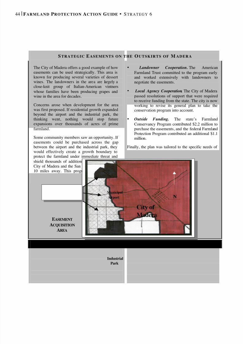
8/8/2019 22457.Farmland Action Guide
http://slidepdf.com/reader/full/22457farmland-action-guide 52/164
44 | F ARMLAND P ROTECTION A CTION G UIDE S TRATEGY 6
S TRATEGIC E ASEMENTS ON THE O UTSKIRTS OF M ADERA
The City of Madera offers a good example of howeasements can be used strategically. This area isknown for producing several varieties of dessertwines. The landowners in the area are largely aclose-knit group of Italian-American vintnerswhose families have been producing grapes andwine in the area for decades.
Concerns arose when development for the areawas first proposed. If residential growth expandedbeyond the airport and the industrial park, the
thinking went, nothing would stop futureexpansions over thousands of acres of primefarmland.
Some community members saw an opportunity. If easements could be purchased across the gapbetween the airport and the industrial park, theywould effectively create a growth boundary toprotect the farmland under immediate threat andshield thousands of additional acres between theCity of Madera and the San Joaquin River, nearly10 miles away. This program worked becauseseveral key elements came together.
• Landowner Cooperation. The AmericanFarmland Trust committed to the program earlyand worked extensively with landowners tonegotiate the easements.
• Local Agency Cooperation . The City of Maderapassed resolutions of support that were requiredto receive funding from the state. The city is nowworking to revise its general plan to take theconservation program into account.
•
Outside Funding. The state’s FarmlandConservancy Program contributed $2.2 million topurchase the easements, and the federal FarmlandProtection Program contributed an additional $1.1million.
Finally, the plan was tailored to the specific needs of the community and geography of the region. Thus,while some of the techniques could be borrowed inother communities, it would be difficult to replicatethe program wholesale in other communities.
City of Madera
IndustrialPark
MunicipalAirport N
EASEMENT ACQUISITION
AREA
8/8/2019 22457.Farmland Action Guide
http://slidepdf.com/reader/full/22457farmland-action-guide 53/164
I NSTITUTE for L O C A L S EL F G OVERNMENT C O M M U N I T Y L A N D U SE P R O J E C T | 4 5
BALANCE REGULATORY
BURDENS FORLANDOWNERS One criticism of farmland protection programs is that that they do not treatall landowners the same. Those who are permitted to develop theirproperty often reap the windfall of dramatically increased land values,while in protected farmland areas, landowners’ property values remainunchanged. A few local agencies have adopted regulations that attempt to
balance these impacts, using development credit transfers and mitigationfees.
DEVELOPMENT CREDIT TRANSFERS
Transferable development credits 1 (development credits or TDCs) allowlandowners to transfer the opportunity to develop property from one parcelto another. Typically, a credit is transferred from an agriculturally zoned“sending area” to a developable parcel in a “receiving area.” The numberof credits assigned to each property can be set at a constant ratio or mayvary, depending on soil quality, slope or location. Once sold, the sendingsite is “burdened” with a conservation easement to prevent futuredevelopment. 2 There are several ways to implement such programs,including:
• Different Parcels, Same Owner . This arrangement allows an owner todevelop one parcel at increased density in exchange for protectingother parcels. Such programs can be limited to adjacent parcels orextended to nonadjacent parcels under the same ownership.
• Different Parcels, Different Ownership . Owners of tracts in receivingareas must purchase an appropriate number of credits from a sendingarea in order to develop at increased densities.
1 “Transferable development right” or “TDR” is perhaps the more common term for this land use tool.However , it is a misnomer insofar as it implies that, in absence of the program, there is an underlying“right” to develop according to the number of credits assigned.2 The courts have generally upheld such programs. See Tahoe-Sierra Preservation Council, Inc. v.Tahoe Regional Planning Agency, 535 U.S. ___ (2002); Penn Central Transp. Co. v. City of New York ,438 U.S. 104 (1978); Suitum v. Tahoe Regional Planning Agency , 520 U.S. 725 (1997); AmericanSavings & Loan Assn. v. County of Marin , 653 F.2d 364 (9 th Cir. 1991); Aptos Seascape Corp v.County of Santa Cruz , 138 Cal. App. 3d 484 (1982).
Development CreditTransfers……………….…..45
Mitigation:Fees and Dedications………48
Brentwood Case Study…….50
7STRATEGY
8/8/2019 22457.Farmland Action Guide
http://slidepdf.com/reader/full/22457farmland-action-guide 54/164
46 | F ARMLAND P ROTECTION A CTION G UIDE S TRATEGY 7
• Regional Transfers . This option allows the transfer of credits acrosslocal agency boundaries.
The key to a development credit program is the zoning ordinance, whichestablishes the sending and receiving zones. Ideally, the program isdesigned so that purchasing the development credits is the most profitableway to develop property in the receiving zone. For example, San LuisObispo County’s transferable credit program allows development at levelsof 50 percent over maximum density when sufficient credits are purchasedfrom sending areas. To further encourage compact development, the bonuspercentage decreases as the distance increases from the development to anurban center. 3
IMPLEMENTATION ISSUES
Development credits are most suitable in places where large areas of farmland remain and growth can be channeled to distinct areas. The idea
3 County of San Luis Obispo, Cal., Ordinance § 22.040.500 and following (2001).
H O W D EVELOPMENT C REDITS I DEALLY W O R K
Assume that three farmers own separate 100-acre tracts of prime farmland in a “sending”area. Each tract is zoned “ExclusiveAgriculture” with a development capacity of 100 residences (one house per acre) under adevelopment credit ordinance. A developerowns a fourth 100-acre tract in a “receiving”area that is zoned at one house per acre. Thezoning in the receiving area, however, permitsdevelopment at four houses per acre upon thepurchase of the appropriate number of creditsfrom the sending area. Assume that:
• The full cost for building and marketing asingle-family residence is $150,000.
• The market price for a single house on anacre lot is $210,000. The price of four
homes on smaller lots is $185,000 each.• The market rate for credits is $15,000.
Under these conditions, the agency hascreated an incentive. Without purchasing anycredits, the developer will make $60,000 peracre ($220,000 sales price minus $160,000building costs) or $6 million on 100 acres.But by purchasing the development credits,the developer nets $95,000 per acre($740,000 in sales minus $600,000 for costsminus $45,000 for TDCs). The developer’sprofit margin has increased by 50 percent. Inthe process, 300 acres of farmland have beenprotected, and each of the three farmersreceived $1.5 million ($15,000 per acre for100 acres) to offset lost developmentopportunities, which can be reinvested intotheir operation .
This successful outcome depends on a varietyof factors, including all three farmers’willingness to sell their development creditsto the developer in a timely fashion. 4
8/8/2019 22457.Farmland Action Guide
http://slidepdf.com/reader/full/22457farmland-action-guide 55/164
I NSTITUTE for L O C A L S EL F G OVERNMENT C O M M U N I T Y L A N D U SE P R O J E C T | 4 7
behind most programs is that imposing low densities on development inreceiving zones will encourage developers to purchase development creditsin sending areas. Setting these ratios, however, requires technical expertiseand a working knowledge of the margins that drive the building industry.A poorly planned program could stall growth altogether.
Timing imposes another hurdle. Most TDC programs occur in small areas,which limits the ability of the market to match willing buyers and sellers.Some agencies create a development credit bank to facilitate transactions.The bank purchases credits from farmers when there is no buyer and sellscredits to buyers when there is no seller. Other considerations include:
• Clear Definitions . It’s important to clearly define what a credit is.Including square-foot definitions and other specifics helps to clarifyexactly what is being transferred.
• Efficient Process . Paperwork can be complex. Designing a simpleprocess and sample forms helps considerably. With a little planning,most problems or glitches can be spotted and solved in advance.
• Public Education . Buying or selling an intangible like a developmentcredit is a difficult concept to understand for those who are unfamiliarwith the regulatory process. Programs that explain the processaccelerate the participation rate.
• Interagency Cooperation . The pool of buyers and sellers increaseswhen the program covers a larger geographic area, which is morelikely when agencies cooperate.
California has a few examples of successful TDC programs. The SantaMonica Mountain Conservancy has facilitated more than 500 transactions.San Luis Obispo County also manages a program to discouragedevelopment on steep coastal hillsides near Cambria. 5 However, of the 27programs listed in one survey, most saw little or no activity. 6 The mostdifficulty appears to be developing the right mix of incentives to create aviable market for the credits. 7 Thus, although there are a few successfulexamples of TDCs, the number of inactive programs underscores theimportance of a well-designed program.
4 This example is a voluntary program - the developer can still opt to build only one house per acre. Amandatory program requires that the developer must purchase TDRs before development can proceed.See Johnston, R., and Madison M., From Landmarks to Landscapes: A Review of Current Practices inthe Transfer of Development Rights , J. Am. Plan. Ass’n , Summer 1997, at 365.5 The County also allows a land trust to sell credits to the land it is conserving to fund additionalconservation. See Land Conservancy of San Luis Obispo County, About the Land Conservancy (visitedMar. 15, 2002) www.special-places.org/about.htm.6 Rick Pruetz, Putting Transfer of Development Rights to Work in California 73-74 (1993).7 Id. at 101.
I NGREDIENTS FOR AS UCCESSFUL
P R O G R A M
• Well-defined “sending”and “receiving” zones;
• Integration with theWilliamson Act(Strategy 10);
• Worthwhile investmentincentives;
• Certainty that zoningwill not be changed;
• Clear, easy-to-understand definitions;
• Easements thateffectively protectfarmland;
• Consistency with thegeneral plan;
• A public educationprogram; and
• Efficient, consistentprocedures.
8/8/2019 22457.Farmland Action Guide
http://slidepdf.com/reader/full/22457farmland-action-guide 56/164
48 | F ARMLAND P ROTECTION A CTION G UIDE S TRATEGY 7
M ITIGATION : F EES AND DEDICATIONS Another mechanism for balancing the burdens of agricultural regulation isto place a mitigation, or linkage, fee as a condition on new development. 8 Mitigation fee ordinances usually ask developers to protect one acre of farmland of equal or greater quality for each acre of farmland that isconverted to non-farm uses. 9 Similar fees have been imposed to buildaffordable housing, protect habitat and offset other offsite impacts of development, such as water pollution. The present fee rates generally rangefrom $2,500 to $10,000 per acre, but can vary widely depending on localland and crop values.
Only a few agencies in the state have adopted mitigation programs to offsetthe conversion of farmland. These programs generally require developersto negotiate and purchase an easement themselves (with agency approval)or pay an alternative in-lieu fee. Paying the fee is usually easier and lesstime-consuming for the developer. But the in-lieu fee means that theagency must devote resources, such as staff time and acquisition funds, topurchasing conservation easements. In such cases, several local agencieshave found it beneficial to work with local land trusts that have expertise inworking with landowners and negotiating easements (see Strategy 6).
For example, the City of Davis has a one-to-two mitigation requirement;that is, for each acre of farmland that is converted to nonfarm use, twoacres must be permanently protected. 10 Yolo County Land Trust actuallyacquires and holds the easements. Locations of the easements accepted orpurchased by the city are coordinated through the open space plan. Alleasements must be located within the Davis planning area (160 squaremiles). Easement lands are organized in large contiguous blocks thatprovide farmland and habitat value and define urban form. The city hassecured 2,500 acres of easements and received in-lieu fees of more than$900,000, which have been used as matching funds for CaliforniaFarmland Conservancy Program grants.
8 The distinction between a mitigation fee and linkage fee is blurred. See Abbot, et al, Exactions and Impact Fees in California 26 (2001). Generally, impact fees fund physical improvements directly
attributable to development and linkage fees are used mitigate secondary impacts. The sameconstitutional and statutory limitations apply to both. Our research suggests that the term “mitigation”is commonly used for what are technically linkage fees. See City of Davis, Cal., Municipal Code art.15.15 (2002).9 A 1 to 1 ratio is common. See American Farmland Trust, Saving American Farmland: What Works (1997).10 Developers can grant a conservation easement or pay a fee that would cover the cost of protecting acomparable amount of land. But lands identified by developers to satisfy this requirement must meetseveral standards, including: (1) No more than 20 percent habitat present; (2) Compatible with city andcounty general plan; (3) Comparable soil quality; (4) Adequate water supply for continued farming;and (5) No other encumbrances on the land.

8/8/2019 22457.Farmland Action Guide
http://slidepdf.com/reader/full/22457farmland-action-guide 57/164
I NSTITUTE for L O C A L S EL F G OVERNMENT C O M M U N I T Y L A N D U SE P R O J E C T | 4 9
Several elements of fee programs should be addressed in advance:
• Ordinance. These fees should always be adopted by ordinance andapply equitably to a broad class of landowners. Fees that are adoptedindividually or on an ad hoc basis will attract greater judicial scrutinyif challenged (see discussion in Strategy 23).
• Setting Fees. The fee must be high enough to pay for the conservationeasement, transaction costs and staff time to administer the process.Some fee programs also include the cost of an endowment to fund themonitoring program. Rapidly rising land prices can often cause feerevenues to fall short of the amount needed to complete the easementpurchase. One possible solution is to adopt an adjustable fee based oncurrent land valuations or to reset the fee annually.
• Setting Conversion Thresholds. In most cases, it’s probably inefficientto purchase conservation easements on one, two or five acres of farmland. Setting a minimum project size will allow small projects tomove forward. Such thresholds vary. While 10 acres might beappropriate for vineyards and “truck” farms, 20 acres or more isprobably more appropriate in areas where commodity crops are grown.
• Time to Purchase. Given the speed at which California land canappreciate in value, the longer agency holds onto the fee withoutpurchasing the easement, the less likely it will be able to protect theamount of farmland intended when the fee was originally collected.
• Purchasing Strategy. A “block” of contiguous easements is moreeffective at controlling growth than a patchwork of individual ones.The downside is that some farmers will hold out for better prices whenthey realize their farm is targeted. Including a fair price cap orproviding a degree of discretion in implementing the program mayhelp avoid such situations.
C OMPARING D EVELOPMENT C REDITS AND M ITIGATION F EES
DEVELOPMENT CREDITS MITIGATION FEE
ACQUISITION Developer must locate farmers willingto sell and negotiate credits Development fee used by local agency topurchase conservation easements
INTERMEDIARIES Development credit bank facilitatestransfers; land trust holds easements
Local agency can act on its own or work witha land trust to negotiate and hold easements
PUBLICEDUCATION
Market may not readily understandwhat constitutes a “credit”
Some education necessary, but easier tounderstand, particularly for developers
THRESHOLDS Can be designed to accommodatesmall parcels
Lends itself to bigger parcels except whereland values are exceptionally high
SETTINGTHE FEE
Determined by willing buyers andsellers
Amount charged to developers is set byformula and is usually updated annually
8/8/2019 22457.Farmland Action Guide
http://slidepdf.com/reader/full/22457farmland-action-guide 58/164
50 | F ARMLAND P ROTECTION A CTION G UIDE S TRATEGY 7
Another issue that arises in connection with mitigation fees is whether anexus, or a direct relationship, is required between the impact of thedevelopment and the purpose of the fee. 11 While there is good authority to
suggest that such a nexus is not necessary ,12
some agencies elect to developa nexus study to identify the linkage between new development and theloss of agricultural land. A nexus study can also be useful in developingthe formula for the fee and developing supporting findings if a mitigationordinance is adopted. It provides a good reference if a developer decides tochallenge the fee in court .
CITY OF BRENTWOOD CASE STUDY
The fast-growing City of Brentwood in northwest Contra Costa County ishome to high-producing orchards and row crops. Regional agriculturalproduction generated $51.2 million in 1998. Local farming was threatened,however, as the suburbs of the San Francisco Bay Area expanded eastward.The city’s population has grown more than 200 percent since 1990 and itscurrent population of 23,000 is expected to nearly double again before thecity reaches its anticipated build-out population of 43,000. 13
In response, the council appointed an Agricultural Enterprise Committee,composed of farmers, developers and others, to advise the city on how toprotect and enhance agriculture in Brentwood. The committee met 11 timesin one year and developed recommendations, many of which wereimplemented by the council. The program’s cornerstone is the use of conservation easements to permanently protect farmland. The city designeda process that relies on both a mitigation program and transferableagricultural credits. The city also created a land trust to hold easements. 14
M ITIGATION PROGRAM
Brentwood’s mitigation program is straightforward. Developers mustprovide one-to-one mitigation when farmland is converted to any otheruse, including residential and commercial development. Developers havetwo choices: They may either purchase a conservation easement over anequivalent acreage or pay an in-lieu fee of $5,000 per acre. The fee isbased on an economic analysis of easements in the area. The city elected toapply the fee to current applications where full discretionary approval was
11 See San Remo Hotel v. City and County of San Francisco , 27 Cal. 4th 643 (2002) (holding that agenerally applicable fee adopted by ordinance is not subject to heightened judicial scrutiny).12 Homebuilders Association of Northern California v. City of Napa , 90 Cal. App. 4th 188 (2001).13 DDS Marketing, Economic Analysis Report for the City Of Brentwood April 2000 (last visited Mar.28, 2002) www.ci.brentwood.ca.us/department/econ/demographic_Study/index.htm.14 See City of Brentwood, Cal., Municipal Code § 17.730 (2001); Agricultural Advisory Commission ,(visited Mar. 28, 2002) www.ci.brentwood.ca.us/boards/aarg/aarg.htm.
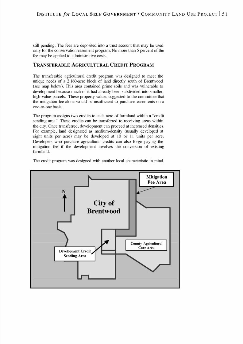
8/8/2019 22457.Farmland Action Guide
http://slidepdf.com/reader/full/22457farmland-action-guide 59/164
I NSTITUTE for L O C A L S EL F G OVERNMENT C O M M U N I T Y L A N D U SE P R O J E C T | 5 1
still pending. The fees are deposited into a trust account that may be usedonly for the conservation easement program. No more than 5 percent of thefee may be applied to administrative costs.
TRANSFERABLE AGRICULTURAL CREDIT PROGRAM
The transferable agricultural credit program was designed to meet theunique needs of a 2,160-acre block of land directly south of Brentwood(see map below). This area contained prime soils and was vulnerable todevelopment because much of it had already been subdivided into smaller,high-value parcels. These property values suggested to the committee thatthe mitigation fee alone would be insufficient to purchase easements on aone-to-one basis.
The program assigns two credits to each acre of farmland within a “creditsending area.” These credits can be transferred to receiving areas withinthe city. Once transferred, development can proceed at increased densities.For example, land designated as medium-density (usually developed ateight units per acre) may be developed at 10 or 11 units per acre.Developers who purchase agricultural credits can also forgo paying themitigation fee if the development involves the conversion of existingfarmland.
The credit program was designed with another local characteristic in mind.
City of Brentwood
County AgriculturalCore Area
N
Development CreditSending Area
MitigationFee Area

8/8/2019 22457.Farmland Action Guide
http://slidepdf.com/reader/full/22457farmland-action-guide 60/164
52 | F ARMLAND P ROTECTION A CTION G UIDE S TRATEGY 7
Many of the landowners who own developable land within the city alsoown land in the sending area. The city expects that one of the usualdrawbacks to TDC programs — the challenge of matching willing buyerswith sellers — will not affect transactions that merely involve the sameowner transferring credits from one parcel to another. Of course,developers who don’t own property in the sending area may stillparticipate by negotiating their own purchases of credits from otherfarmers in the area.
FORMATION OF A NEW LAND TRUST
The city also created the East Contra Costa County Agricultural LandTrust. Interestingly, there was another land trust operating in the area, butfarmers felt uncomfortable working with it because they believed that itwas “too environmental.” So Brentwood formed its own land trust. Thetrust’s board consists of three members appointed by the city, threeappointed by the East Contra Costa County Irrigation District (representingagricultural interests) and one member selected by the first six. The trustoversees the purchase and monitoring of conservation easements and seeksadditional funding, such as that provided by the state Department of Conservation, to purchase additional easements.
COMMUNITY EDUCATION
To successfully implement the plan, the city is now beginning to conduct apublic education program. Its components include:
• A New Farmers’ Market. The city is helping establish a weeklyfarmers’ market to give residents more access to local produce andpromote the benefits of farmland protection in the community.
• Information at the Corn Festival . The city’s annual Corn Festivalincludes an “information alley” feature where groups can shareinformation. The city will sponsor an information booth here as well.
• Education about Agricultural Credits . The city has mailedinformation to landowners in the agricultural credit sending area thatexplains the program and how owners can sell credits.
•
General Plan Update. The city embraced the agricultural enterpriseprogram by including the elements in a recently revised general plan.
Through these efforts, the city is working to educate urban residents aboutthe connection between land use planning and agriculture. It is hoped, forexample, that the community will be less opposed to increases in densityassociated with the credit program when they understand that it is helpingto save farmland at the city’s edge. Only time will tell how successful theprogram will be. However, Brentwood’s experience provides a great dealof information that’s helpful for other agencies.
M ORE A BOUT THEB RENTWOOD P LAN
n developing its program, theCity of Brentwood used aomprehensive approach torotecting farmland extendingeyond the componentsescribed here. Buffer policiesnd economic developmenttrategies, among other things,
were also part of the plan.
A copy of the final report of he Agricultural Enterprise
Committee is posted on theortion of the Institute’s Webite that supports this guidewww.ilsg.org/farmland,eyword search “Brentwood”).
8/8/2019 22457.Farmland Action Guide
http://slidepdf.com/reader/full/22457farmland-action-guide 61/164
PROMOTE SOUND
ANNEXATION POLICIES Local agency formation commissions (LAFCOs) govern changes to cityand special district boundaries, and the extension of public services. Nearlyevery county in the state has a LAFCO. Consequently, LAFCOs provideanother possible forum for implementing farmland protection policies.
Each county may develop LAFCO guidelines and policies to address issueswithin its region. In the context of farmland protection, policies can be
useful to offset the problem that sometimes occurs when different agencieswithin a county don’t share the same conservation goals. An agency thathas a desire to confine growth may abandon such policies if the net effectof this effort merely enables neighboring jurisdictions to annex more land.Adopting countywide rules that specifically address the degree to whichfarmland may be annexed or developed helps to ensure that large tracts of farmland remain intact.
LAFCO B ASICS
LAFCOs oversee annexations, service extensions and even new agency
formation. They are charged with seeing that services are provided to thepublic as efficiently and economically as possible. 1 At the same time, theymust also attempt to direct new growth away from prime agricultural land. 2 LAFCOs do not dictate planning goals to other local agencies. Instead,they reconcile differences between agency plans. The most significant of these powers related to farmland protection concerns the following issues:
• Annexations . The authority to approve, reject or impose conditions onall boundary-change proposals; 3
• Service Extensions . The authority to review requests to provide orextend services outside jurisdictional boundaries; 4 and
• Sphere of Influence. The authority to oversee and update sphere of influence (or, for an agency, probable growth area) boundaries. 5
1 Cal. Gov't Code § 56301.2 Cal. Gov't Code § 56377.3 Cal. Gov't Code §§ 56375(a), 56886.4 Cal. Gov't Code §§ 56133, 56434.
LAFCO Basics ........................53
Developing County-SpecificPolicies ......................................54
The Gilroy AgriculturalLands Area ..............................55
8STRATEGY
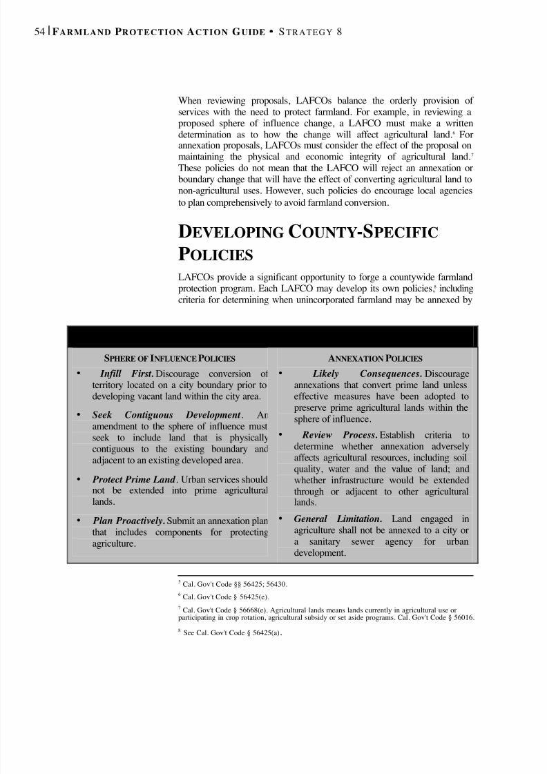
8/8/2019 22457.Farmland Action Guide
http://slidepdf.com/reader/full/22457farmland-action-guide 62/164
54 | F ARMLAND P ROTECTION A CTION G UIDE S TRATEGY 8
When reviewing proposals, LAFCOs balance the orderly provision of services with the need to protect farmland. For example, in reviewing aproposed sphere of influence change, a LAFCO must make a written
determination as to how the change will affect agricultural land.6
Forannexation proposals, LAFCOs must consider the effect of the proposal onmaintaining the physical and economic integrity of agricultural land. 7 These policies do not mean that the LAFCO will reject an annexation orboundary change that will have the effect of converting agricultural land tonon-agricultural uses. However, such policies do encourage local agenciesto plan comprehensively to avoid farmland conversion.
DEVELOPING COUNTY -SPECIFICPOLICIES LAFCOs provide a significant opportunity to forge a countywide farmlandprotection program. Each LAFCO may develop its own policies, 8 includingcriteria for determining when unincorporated farmland may be annexed by
5 Cal. Gov't Code §§ 56425; 56430.6 Cal. Gov't Code § 56425(e).7 Cal. Gov't Code § 56668(e). Agricultural lands means lands currently in agricultural use orparticipating in crop rotation, agricultural subsidy or set aside programs. Cal. Gov't Code § 56016.
8 See Cal. Gov't Code § 56425(a) .
S AMPLE LAFCO P OLICIES
SPHERE OF INFLUENCE POLICIES • Infill First. Discourage conversion of
territory located on a city boundary prior todeveloping vacant land within the city area.
• Seek Contiguous Development . Anamendment to the sphere of influence mustseek to include land that is physicallycontiguous to the existing boundary andadjacent to an existing developed area.
• Protect Prime Land . Urban services shouldnot be extended into prime agriculturallands.
• Plan Proactively. Submit an annexation planthat includes components for protectingagriculture.
ANNEXATION POLICIES • Likely Consequences. Discourage
annexations that convert prime land unlesseffective measures have been adopted topreserve prime agricultural lands within thesphere of influence.
• Review Process. Establish criteria todetermine whether annexation adverselyaffects agricultural resources, including soilquality, water and the value of land; andwhether infrastructure would be extendedthrough or adjacent to other agriculturallands.
• General Limitation. Land engaged inagriculture shall not be annexed to a city or
a sanitary sewer agency for urbandevelopment.

8/8/2019 22457.Farmland Action Guide
http://slidepdf.com/reader/full/22457farmland-action-guide 63/164
I NSTITUTE for L O C A L S EL F G OVERNMENT C O M M U N I T Y L A N D U SE P R O J E C T | 5 5
a local agency. Several counties have adopted comprehensive proceduresfor evaluating such proposals. Solano County has developed five specificcriteria for addressing an annexation’s impact on maintaining the integrity
of agricultural lands: 9
• Soil Quality. The quality of the agricultural land in question.
• Justification for Conversion. A determination of: (1) whether theprobable 10-year growth horizon justifies the conversion; (2) whetherthe proposed annexation abuts existing urban development; and (3) theextent to which there is a shortage of nonprime land.
• Infill Alternatives. The extent to which the agency facilitates infilldevelopment through redevelopment, capital improvement programs,land use changes and housing programs.
• Planning Consistency. Consistency with the city’s comprehensiveannexation plan (which inventories 10-year growth projections).
• Williamson Act Provisions. Annexation of Williamson Act lands isgenerally prohibited unless certain conditions app ly.
There are two additional reasons for working through LAFCOs to developcountywide policies. First, LAFCOs can be effective forums because theyare composed equally of representatives from cities, special districts andthe county. Second, recent legislative amendments require that LAFCOs beindependent. 10 As such, LAFCOs provide a good forum in which differentlocal agencies can work together on farmland protection and other growthmanagement issues.
THE GILROY AGRICULTURALLANDS AREA In 1994, a unique collaboration began in Santa Clara County. The county,LAFCO and the City of Gilroy jointly commissioned a study to identifyways ensuring the long-term viability of agriculture in 14,000 acres of farmland south and east of Gilroy (also known as “the garlic capital of theworld”). The study, Strategies to Balance Planned Growth and
Agricultural Viability , presented several strategies supporting the region’sagricultural productivity. A key element of the study suggested that the
9 Solano Local Agency Formation Commission, Standards and Procedures 25-28 (1999) (availableonline at www.solanocounty.com/em/forms/lafco/lafco_stdsproc.pdf).10 Cal. Gov't Code § 56381.
M I S S I O NS TATEMENT
“To encourage the orderlydevelopment and reorgani-zation of local govern-mental agencies, topreserve agricultural landand to discourage urbansprawl.”
? San Joaquin CountyLAFCO
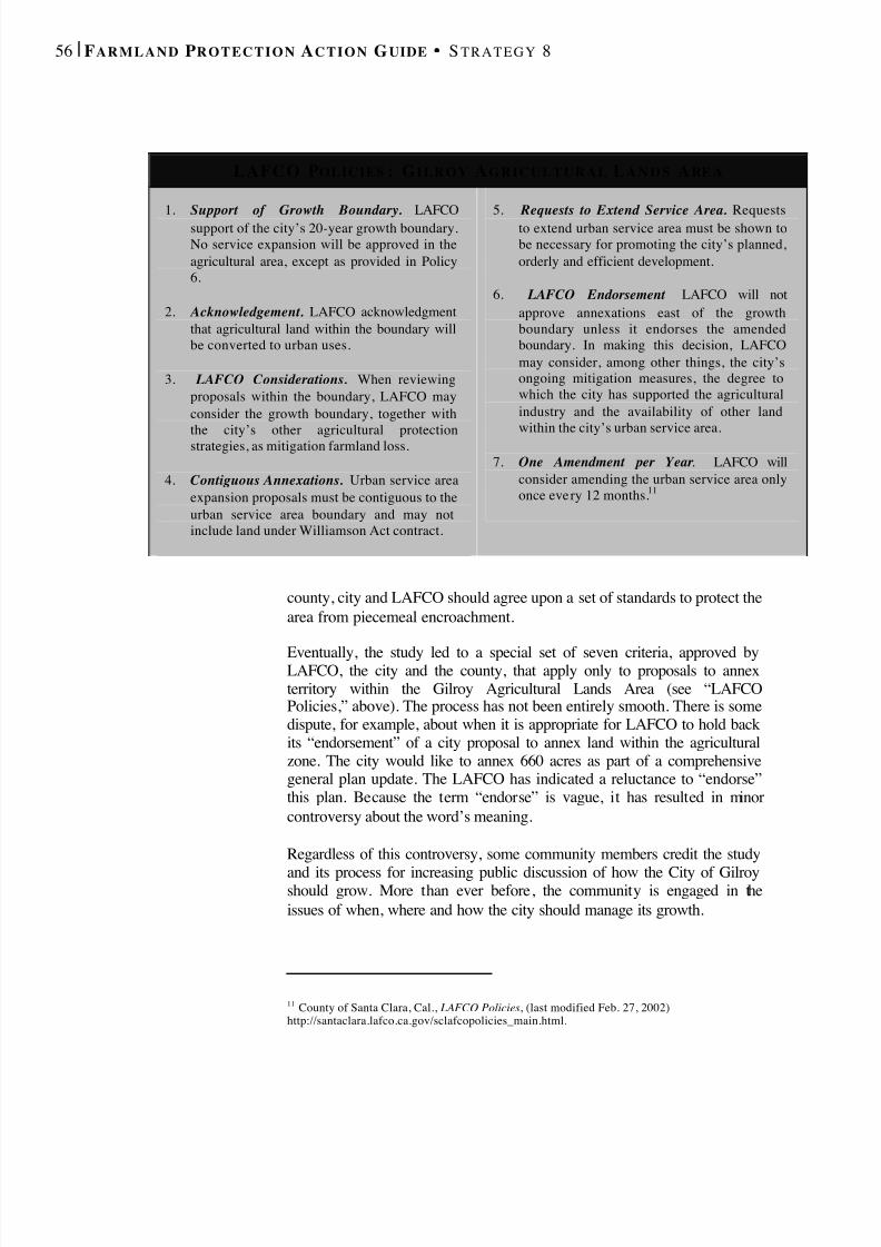
8/8/2019 22457.Farmland Action Guide
http://slidepdf.com/reader/full/22457farmland-action-guide 64/164
56 | F ARMLAND P ROTECTION A CTION G UIDE S TRATEGY 8
county, city and LAFCO should agree upon a set of standards to protect thearea from piecemeal encroachment.
Eventually, the study led to a special set of seven criteria, approved byLAFCO, the city and the county, that apply only to proposals to annexterritory within the Gilroy Agricultural Lands Area (see “LAFCOPolicies,” above). The process has not been entirely smooth. There is somedispute, for example, about when it is appropriate for LAFCO to hold backits “endorsement” of a city proposal to annex land within the agriculturalzone. The city would like to annex 660 acres as part of a comprehensivegeneral plan update. The LAFCO has indicated a reluctance to “endorse”this plan. Because the term “endorse” is vague, it has resulted in minorcontroversy about the word’s meaning.
Regardless of this controversy, some community members credit the study
and its process for increasing public discussion of how the City of Gilroyshould grow. More than ever before, the community is engaged in theissues of when, where and how the city should manage its growth.
11 County of Santa Clara, Cal., LAFCO Policies , (last modified Feb. 27, 2002)http://santaclara.lafco.ca.gov/sclafcopolicies_main.html.
LAFCO P OLICIES : G ILROY A GRICULTURAL L A N D S A RE A
1. Support of Growth Boundary. LAFCOsupport of the city’s 20-year growth boundary.No service expansion will be approved in theagricultural area, except as provided in Policy6.
2. Acknowledgement. LAFCO acknowledgmentthat agricultural land within the boundary willbe converted to urban uses.
3. LAFCO Considerations. When reviewingproposals within the boundary, LAFCO mayconsider the growth boundary, together with
the city’s other agricultural protectionstrategies, as mitigation farmland loss.
4. Contiguous Annexations. Urban service areaexpansion proposals must be contiguous to theurban service area boundary and may notinclude land under Williamson Act contract.
5. Requests to Extend Service Area. Requeststo extend urban service area must be shown tobe necessary for promoting the city’s planned,orderly and efficient development.
6. LAFCO Endorsement . LAFCO will notapprove annexations east of the growthboundary unless it endorses the amendedboundary. In making this decision, LAFCOmay consider, among other things, the city’songoing mitigation measures, the degree towhich the city has supported the agriculturalindustry and the availability of other landwithin the city’s urban service area.
7. One Amendment per Year . LAFCO willconsider amending the urban service area onlyonce every 12 months. 11
8/8/2019 22457.Farmland Action Guide
http://slidepdf.com/reader/full/22457farmland-action-guide 65/164
THINK REGIONALLY A regional approach to protecting farmland can be an important element of along-term protection strategy. One agency’s farmland protection programwill accomplish little over time if nearby communities continue to annex landand expand at low densities.
Regional or cooperative planning agreements, supported by appropriatechanges to the general plan and implementation ordinances, can be useful inmanaging growth in a way that takes neighboring communities into account.Working across jurisdictional lines is not always easy — particularly whenland use decisions can have major fiscal impacts. But several local agencies
have found a way to deal with these issues positively, using cooperativeplanning agreements.
COOPERATIVE PLANNINGAGREEMENTSCooperative planning agreements between public agencies enable localagencies to coordinate their planning on a regional level. Because of theirvoluntary — and thus political — nature, cooperative plans usually require agreat deal of discussion and negotiation before they are adopted. But onceadopted, such agreements can help individual local agencies avoid piecemealplanning decisions.
Cooperative planning efforts require an ongoing commitment from everyoneinvolved. Changes in the political or economic climate of even one of theparticipating agencies can affect the outcome of the planning process. It’sessential to address the structure, implementation and funding of the planningeffort. Additionally, a cooperative agreement cannot limit an agency’sauthority to adopt future ordinances that might conflict with the agreement.1As a general rule, governing bodies are prohibited from adopting resolutionsthat would restrict the options of future governing bodies.
Nevertheless, there are several examples of successful joint planning. A jointeffort between the cities of Vallejo, Fairfield and Benicia involving 10,000acres of ranchland demonstrates the promise of cooperative planning. The
1 A provision of a planning agreement that made any general plan amendment adopted by one cityregarding the plan area ineffective without adoption of a parallel amendment by another city was rejectedas an unlawful delegation of the police power. See Alameda County Land Use Association v. City of
Hayward , 38 Cal. App. 4th 1716 (1995). Legislation that would have authorized such agreements wasvetoed. See AB 1877 (Klehs), 1993-94 session (vetoed Sept. 30, 1994).
Cooperative PlanningAgreements .................................57
Potential ManagementStructures....................................60
9STRATEGY

8/8/2019 22457.Farmland Action Guide
http://slidepdf.com/reader/full/22457farmland-action-guide 66/164
58 | F ARMLAND P ROTECTION A CTION G UIDE S TRATEGY 9
cities created the Tri-City and County Cooperative Planning Group, a jointpowers agency, to develop a plan. 2 Once the plan was in place, the citiesrevised their general plans to conform to the plan. Each planning groupmember must consult with the agency before amending its general plan in away that directly impacts the planning area. The cooperative planning groupcannot actually stop such actions, but the consultation requirement provides aforum for expressing and addressing concerns.
City of Vacaville
Napa County
Solano County
City of Fairfield
City of Benicia
CooperativePlanning
Area
I-80
I-680
I-80
N
Adopted from Tri-City and CountyCooperative Plan for Agriculture and Open Space Preservation , p.6 (1994)
Not to Scale

8/8/2019 22457.Farmland Action Guide
http://slidepdf.com/reader/full/22457farmland-action-guide 67/164
I NSTITUTE for L O C A L S EL F G OVERNMENT C O M M U N I T Y L A N D U SE P R O J E C T |
The formation of the Tri-City and County Cooperative Planning Group alsoprovides a vehicle to obtain outside funding. Many funding sources givepriority to programs that demonstrate cooperation among multiple
jurisdictions. The agency has also worked with a land trust to secure anoption to purchase an additional several thousand acres, or more than half of the total planning area.
Some cooperative planning efforts include a revenue-sharing element. Onereason for this is to address a possible consequence of joint planning. Someagreements may have fiscal impacts that would limit the ability of one ormore of the participating agencies to continue to provide public services atdesired levels. The decision to forgo new development in unincorporatedrural areas, for example, may reduce revenues that the county was dependingon to provide health and social services to a broader population.
Revenue sharing has its limitations. For example, revenue-sharingagreements do not necessarily generate new revenue as much as they directgrowth and reapportion existing funds. Thus, they are not a substitute forlong-term, statewide reform of local government finance in California. Inaddition, it is difficult to precisely predict future revenue streams. Since nolocal agency wants to be placed at a disadvantage, the agreements may needto take certain contingencies into account.
I N T E R G O V E R N M E N TA L A GR EE ME N T C H E C K L I S T
Most intergovernmental agreements should address the following issuesto minimize the risk of misunderstanding:
• Identify Parties . Specify which agencieswill be involved, including cities,counties, special districts and state andfederal agencies.
• Set Out Expectations . Describe the natureof relationships. Explain the purpose of the agreement and define its parameters.
• Create Accountability . Assign roles,responsibilities and powers.
• Define Process . Define procedures formeetings and votes of the overseeingbody.
• Assign Risk . Address risk, liability andindemnification.
• Address Costs and Finances . Apportioncosts, including unexpected costs, andinclude a process for ensuring fairness.Identify “in-kind” contributions. Explainhow financial returns and remunerationwill be handled.
• Plan for Termination . Define theduration of the agreement and the processfor termination and disposition of holdings.
• Plan for Disputes . Provide a procedure toresolve disputes.
• Retain Flexibility. Provide flexibility todeal with changed conditions.

8/8/2019 22457.Farmland Action Guide
http://slidepdf.com/reader/full/22457farmland-action-guide 68/164
60 | F ARMLAND P ROTECTION A CTION G UIDE S TRATEGY 9
POTENTIAL MANAGEMENT
STRUCTURES At some point in a joint planning process, the parties consider what form thecooperative effort will take. This structure can range from a simpleagreement of principles to the more complex action of creating a new publicentity to oversee the effort. The appropriate structure varies on a case-by-case basis. There are, however, a few basic forms that lend themselves mostreadily to cooperative planning. 3
AGREEMENTS IN PRINCIPLE
An agreement in principle is a nonbinding document that endorses or statesan intention to plan cooperatively, manage growth in a certain manner orundertake some other kind of activity. For example, several cities in FresnoCounty endorsed the principles contained in the Landscapes of Choice reportpublished by the Growth Alternatives Alliance (see Strategy 1). Entering intothe agreement is significant because it creates the expectation that the agencywill follow through on its commitment. The agency risks negative publicattention (sometimes referred to as the “shame factor”) if it does not followthrough.
PUBLIC -PRIVATE PARTNERSHIPS
Public-private partnerships involve public and private organizations working
cooperatively toward shared goals. One of the most active public -privatepartnerships in the state related to agricultural land protection is the Tri-Valley Business Council in Alameda and Contra Costa counties. The councilrecently published Vision 2010 , which includes several regional goals forprotecting agriculture. While such partnerships are very productive indeveloping plans and building community support, they are sometime lesseffective at instigating real change because they do not usually enjoy any trueauthority to take action.
NONPROFIT LAND TRUSTS
A nonprofit organization, such as a land trust, can be effective when the
primary purpose of the joint effort is to hold agricultural conservationeasements. Such trusts are flexible and, as 501(c)(3) nonprofit organizations,can qualify for funding unavailable to government agencies. Oneconsideration is how the trust’s board of directors will be formed. Although
3 For a good discussion of these options within an open space planning context, see Placer Legacy OpenSpace and Agricultural Conservation Program, Public Review Draft, May15, 2000 (Chapter 7, OpenSpace Government Structure) (www.placer.ca.gov/planning/legacy/5-18-00-draft-toc. htm).
8/8/2019 22457.Farmland Action Guide
http://slidepdf.com/reader/full/22457farmland-action-guide 69/164
I NSTITUTE for L O C A L S EL F G OVERNMENT C O M M U N I T Y L A N D U SE P R O J E C T |
the local agency may want to appoint the board, farmers often prefer trustswhere other farmers make up a majority of the board. Accordingly, theagency may have to give up a degree of control in order to be effective.
A memorandum of understanding (MOU) works like a contract. Any numberof parties can sign an MOU, including state and federal agencies andnonprofit organizations. These agreements work well for program elementsthat are functional or self-executing, like crediting funds or operation andmaintenance, and that don’t require a lot of additional decision-making.Attempts to use MOUs to limit the discretionary land use authority of a cityor county legislative body would almost certainly constitute an invaliddelegation of the police power.
J OINT POWERS AUTHORITY
State law permits two or more public agencies to combine forces to jointlyexercise their powers to accomplish mutual goals. 4 In effect, the partneringagencies create a new public entity, such as the Tri-City and CountyCooperative Planning Group mentioned earlier, that focuses on implementingthe terms of the underlying agreement.
D I X O N A N D V ACAVILLE S EIZE AN O PPORTUNITY :
J OINT P O W E R S F O R J OINT S U C C E S S
The neighboring cities of Vacaville and Dixon are a central part of the fast-growing I-80 corridor between San Francisco and Sacramento. In the midstof the economic downturn in the early 1990s, a key thousand-acre parcel of prime farmland located between the two cities became available forpurchase. In addition to physically separating the two communities, the landserved as an important regional scenic asset owing to its location alongInterstate 80.
Vacaville and Dixon seized the opportunity. They formed a joint powersagency to purchase and manage the property. The JPA placed a conservationeasement on the property and then resold it. Although it was prepared to sellat a loss in order to protect the agricultural land, the agency was able torecover its entire purchase price. The JPA continues to monitor the
easement, but little staff time is required to maintain the project. The projectreceived a Helen Putnam Award for Excellence from the League of California Cities.
8/8/2019 22457.Farmland Action Guide
http://slidepdf.com/reader/full/22457farmland-action-guide 70/164
62 | F ARMLAND P ROTECTION A CTION G UIDE S TRATEGY 9
The authority of joint powers authorities (JPAs) is limited to the terms of theunderlying formation agreement and by the principle that it may notundertake any activity that could not be conducted by at least one of itsmember agencies. A JPA may, however, issue bonds irrespective of whetherthe JPA agencies could independently exercise such powers. 5
The organization of each joint powers agreement is generally defined in theoperating agreement. The member agencies usually appoint representativesto the organization’s board. In some cases, the JPA will have its own staff; inothers, staff is provided by one or more of the member agencies. A JPA mayencounter difficulty if the cooperating agencies’ interests and fundingpriorities change, but it does provide a flexible structure for creating anagency that is dedicated to a particular task, such as conserving of farmland.
OPEN SPACE DISTRICTS
A special district is the most formal option available for implementing aregion wide open space or farmland protection program. The Sonoma CountyAgriculture and Open Space District is perhaps the most active example inthe state, in terms of agricultural preservation. The district has more than20,000 acres in easements and is funded by a voter-approved sales taxincrease. One primary advantage of this structure is that it institutionalizesthe effort to protect farmland. Funding sources may include taxes, bondmeasures and fees. The process for forming such districts is more rigid thanmost other alternatives. There must be specific statutory authority 6 andLAFCO approval. 7 Working with a pre-existing district may be appropriate insome instances.
Some districts, such as the Marin County Open Space District, are“dependent” because the county board of supervisors serves as the board forthe district. This structure has the advantage of ensuring that the district’sactions are consistent with county policy. However, such a board may subjectthe district to greater political pressures. An “independent” district, where thedistrict’s board members are elected, is another possibility. An independentdistrict, however, may result in overlapping duties with other local agencieswithin the district.
4 See Cal. Gov't Code § 6500 and following.5 See Cal. Gov't Code §§ 6584-6599 (commonly referred to as Marks-Roos Local Bond Pooling Act of 1985; 75 Cal. Op. Att’y. Gen. 6, 7-8 (1992).6 Cal. Pub. Res. Code §§ 5500 and following.7 Cal. Gov’t Code §§ 56000 and following.
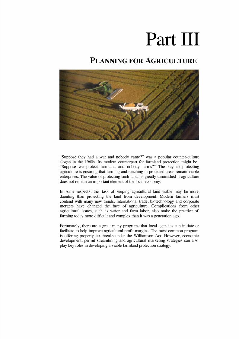
8/8/2019 22457.Farmland Action Guide
http://slidepdf.com/reader/full/22457farmland-action-guide 71/164
Part IIIPLANNING FOR AGRICULTURE
“Suppose they had a war and nobody came?” was a popular counter-cultureslogan in the 1960s. Its modern counterpart for farmland protection might be,“Suppose we protect farmland and nobody farms?” The key to protectingagriculture is ensuring that farming and ranching in protected areas remain viable
enterprises. The value of protecting such lands is greatly diminished if agriculturedoes not remain an important element of the local economy.
In some respects, the task of keeping agricultural land viable may be moredaunting than protecting the land from development. Modern farmers mustcontend with many new trends. International trade, biotechnology and corporatemergers have changed the face of agriculture. Complications from otheragricultural issues, such as water and farm labor, also make the practice of farming today more difficult and complex than it was a generation ago.
Fortunately, there are a great many programs that local agencies can initiate orfacilitate to help improve agricultural profit margins. The most common program
is offering property tax breaks under the Williamson Act. However, economicdevelopment, permit streamlining and agricultural marketing strategies can alsoplay key roles in developing a viable farmland protection strategy.
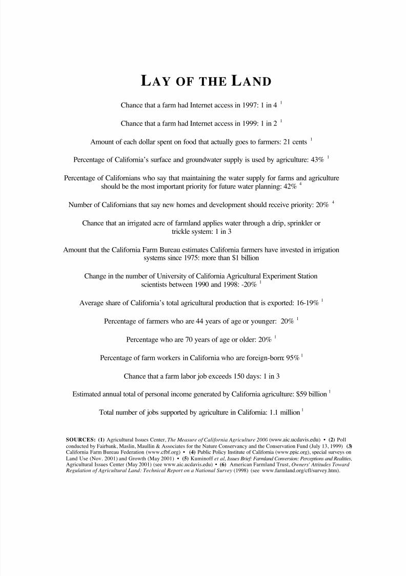
8/8/2019 22457.Farmland Action Guide
http://slidepdf.com/reader/full/22457farmland-action-guide 72/164
L AY OF THE L AND
Chance that a farm had Internet access in 1997: 1 in 4 1
Chance that a farm had Internet access in 1999: 1 in 2 1
Amount of each dollar spent on food that actually goes to farmers: 21 cents 1
Percentage of California’s surface and groundwater supply is used by agriculture: 43% 1
Percentage of Californians who say that maintaining the water supply for farms and agricultureshould be the most important priority for future water planning: 42% 4
Number of Californians that say new homes and development should receive priority: 20% 4
Chance that an irrigated acre of farmland applies water through a drip, sprinkler ortrickle system: 1 in 3
Amount that the California Farm Bureau estimates California farmers have invested in irrigationsystems since 1975: more than $1 billion
Change in the number of University of California Agricultural Experiment Stationscientists between 1990 and 1998: -20% 1
Average share of California’s total agricultural production that is exported: 16-19%1
Percentage of farmers who are 44 years of age or younger: 20% 1
Percentage who are 70 years of age or older: 20% 1
Percentage of farm workers in California who are foreign-born: 95% 1
Chance that a farm labor job exceeds 150 days: 1 in 3
Estimated annual total of personal income generated by California agriculture: $59 billion 1
Total number of jobs supported by agriculture in California: 1.1 million 1
SOURCES: (1) Agricultural Issues Center, The Measure of California Agriculture 2000 (www. aic.ucdavis.edu ) • (2) Pollconducted by Fairbank, Maslin, Maullin & Associates for the Nature Conservancy and the Conservation Fund (July 13, 1999) (3) California Farm Bureau Federation (www.cfbf.org) • (4) Public Policy Institute of California (www.ppic.org), special surveys onLand Use (Nov. 2001) and Growth (May 2001) • (5) Kuminoff et al , Issues Brief: Farmland Conversion: Perceptions and Realities,Agricultural Issues Center (May 2001) (see www.aic.ucdavis.edu) • (6) American Farmland Trust, Owners' Attitudes Toward
Regulation of Agricultural Land: Technical Report on a National Survey (1998) (see www.farmland.org/cfl/survey.htm).
8/8/2019 22457.Farmland Action Guide
http://slidepdf.com/reader/full/22457farmland-action-guide 73/164
I NSTITUTE for L O C A L S EL F G OVERNMENT C O M M U N I T Y L A N D U SE P R O J E C T | 6 5
ADOPT A PROPERTY TAX
INCENTIVE PROGRAM The Williamson Act was one of California’s first farmland protectiontools. 1 It allows farmers to contract with local agencies to lower theirproperty taxes. Instead of paying a property tax based on the land’s marketvalue, the land is assessed at its agricultural value. In exchange, farmersgive up the option to develop the land for urban uses for a minimum of 10or 20 years. The state then pays a subvention to local agencies to offset thereduced revenues that result from lower property taxes. 2
Nearly 16 million acres are enrolled under Williamson Act contracts,approximately one-third of which is prime land. 3 The Department of Conservation estimates that the Williamson Act saves most la ndownersfrom 20 to 75 percent in property tax liability each year. In one survey, onein three farmers with enrolled land claimed that they would no longer befarming were it not for the Williamson Act. 4 Property tax reductions can bea valuable incentive to keep land in agriculture. Without such protection,property tax on farmland will be based on its appraised sale price, whichoften reflects the development potential of land. Thus, land that is worth$3,000 per acre for agricultural production might be assessed at values inexcess of $10,000 per acre when demand for development is high.
Despite its success, the Williamson Act is not without critics. Manybelieve that it failed to provide sufficient incentives to enroll land that wasmost at risk near fast-developing urban areas. In addition, the permitteduses were so broad that many nonfarm uses, such as golf courses, receivedthe same benefits as neighboring farms. The Legislature addressed many of these perceived loopholes in 1998 and 1999. One key development was thepassage of the “Super Williamson Act,” which authorized the creation of farm security zones to provide increased benefits and new restrictions forenrolling farmers. 5 Agricultural Preserves and Farm Security Zones
1 See Cal. Gov't Code 51200 and following.2 See Cal. Gov't Code § 16140; California Farm Bureau Federation, The Farmland Security Zone:Preserving California’s Prime Agricultural Farmland (visited Mar. 18, 2002)www.cfbf.com/issues/landuse/fsz.htm.3 Division of Land Resource Protection, Williamson Act Enrollment Patterns (last modified Mar. 12,2002) www.consrv.ca.gov/dlrp/LCA9798_enrollment.htm.4 UC Agricultural Issues Center, Land in the Balance (1989).5 Cal. Gov't Code §§ 51296 and following.
Agricultural Preserves andFarm Security Zones................66
Fiscal Impacts onLocal Agencies ...........................69
10STRATEGY
8/8/2019 22457.Farmland Action Guide
http://slidepdf.com/reader/full/22457farmland-action-guide 74/164
66 | F ARMLAND P ROTECTION A CTION G UIDE S TRATEGY 10
AGRICULTURAL PRESERVES AND
FARM SECURITY ZONES Agricultural preserves are the cornerstone of the Williamson Act. Ownersof land located within the preserve can enter into contracts to receivereduced tax assessments. This process involves three steps:
1. Develop an Administrative Framework. The agency adopts rules forauthorizing preserves, such as filing and processing requirements. 6 Within certain guidelines, the agency also determines the extent towhich nonagricultural uses may be allowed within the preserve. 7
2. Establish the Preserves . Preserves are established after conducting a
public hearing. The planning department must also report on theproposal’s consistency with the general plan. The minimum size of apreserve is 100 acres. 8 Minimum parcel sizes within the preserve are10 acres for prime agricultural land and 40 acres for nonprime land.
3. Contract with Landowners. The agency may contract with landownerswhose land is devoted to agricultural use within a preserve. 9 Localagencies also have the option to negotiate more restrictive contracts. 10
There are two types of Williamson Act contracts: the traditional 10-yearcontract and the newer farmland security zone or 20-year contract. Most of the nearly 16 million acres enrolled in agricultural preserves statewide areunder 10-year contracts. Only 400,000 are in farm security zone contracts,but this is beginning to change. For example, San Joaquin County isactively trying to convert its 10-year contracts to farm security zones.
TRADITIONAL TOOL : T HE 10-YEAR CONTRACT Landowners can enter into 10-year contracts by agreeing to restrict theirland to agricultural use. 11 The local agency determines specific eligibilitycriteria, such as minimum parcel size and farm income requirements. Thecontracts automatically renew each year unless a notice of nonrenewal isfiled. Upon such notice, the contract terminates in nine years and the
6 Cal. Govt. Code § 51231.7 Cal. Govt. Code § 51238.18 Smaller preserves can also be created. Cal. Govt. Code § 51230.9 Cal. Govt. Code § 51201(b).10 Cal. Govt. Code § 51240.11 Cal. Gov’t Code § 51201(d).
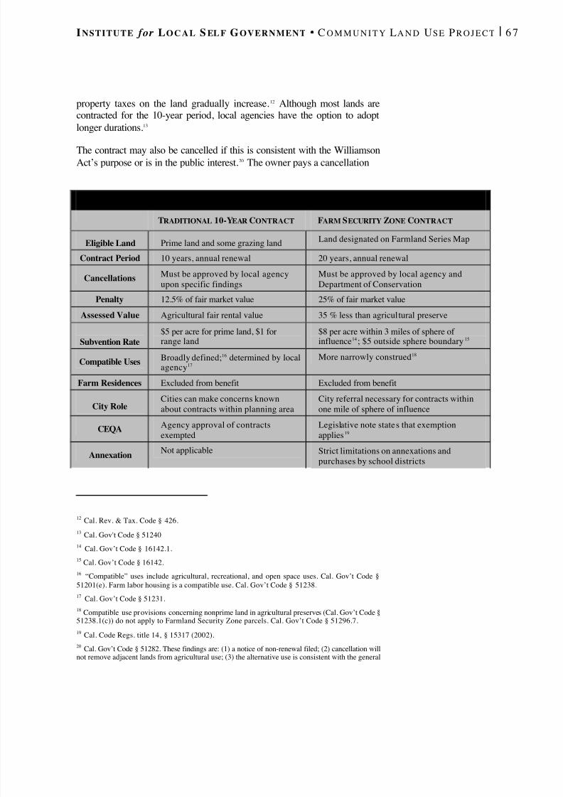
8/8/2019 22457.Farmland Action Guide
http://slidepdf.com/reader/full/22457farmland-action-guide 75/164
I NSTITUTE for L O C A L S EL F G OVERNMENT C O M M U N I T Y L A N D U SE P R O J E C T | 6 7
property taxes on the land gradually increase. 12 Although most lands arecontracted for the 10-year period, local agencies have the option to adoptlonger durations. 13
The contract may also be cancelled if this is consistent with the WilliamsonAct’s purpose or is in the public interest. 20 The owner pays a cancellation
12 Cal. Rev. & Tax. Code § 426.13 Cal. Gov't Code § 5124014 Cal. Gov’t Code § 16142.1. 15 Cal. Gov’t Code § 16142. 16 “Compatible” uses include agricultural, recreational, and open space uses. Cal. Gov’t Code §51201(e). Farm labor housing is a compatible use. Cal. Gov’t Code § 51238. 17 Cal. Gov’t Code § 51231. 18 Compatible use provisions concerning nonprime land in agricultural preserves (Cal. Gov’t Code §51238.1(c)) do not apply to Farmland Security Zone parcels. Cal. Gov’t Code § 51296.7. 19 Cal. Code Regs. title 14, § 15317 (2002). 20 Cal. Gov’t Code § 51282. These findings are: (1) a notice of non-renewal filed; (2) cancellation willnot remove adjacent lands from agricultural use; (3) the alternative use is consistent with the general
C O N T R A C T O P T I O N S
TRADITIONAL 10-YEAR CONTRACT FARM SECURITY ZONE CONTRACT
Eligible Land Prime land and some grazing land Land designated on Farmland Series Map
Contract Period 10 years, annual renewal 20 years, annual renewal
CancellationsMust be approved by local agencyupon specific findings
Must be approved by local agency andDepartment of Conservation
Penalty 12.5% of fair market value 25% of fair market value
Assessed Value Agricultural fair rental value 35 % less than agricultural preserve
Subvention Rate$5 per acre for prime land, $1 forrange land
$8 per acre within 3 miles of sphere of influence 14 ; $5 outside sphere boundary 15
Compatible Uses Broadly defined; 16 determined by localagency 17
More narrowly construed 18
Farm Residences Excluded from benefit Excluded from benefit
City RoleCities can make concerns knownabout contracts within planning area
City referral necessary for contracts withinone mile of sphere of influence
CEQA Agency approval of contractsexempted
Legislative note states that exemptionapplies 19
Annexation Not applicable Strict limitations on annexations andpurchases by school districts
8/8/2019 22457.Farmland Action Guide
http://slidepdf.com/reader/full/22457farmland-action-guide 76/164
68 | F ARMLAND P ROTECTION A CTION G UIDE S TRATEGY 10
fee equaling 12.5 percent of the current fair market value of the land 21 andreimburses the deferred taxes for the period that the land was restricted.The landowner may avoid the cancellation fee by dedicating a conservation
easement on comparable lands. 22
NEW TOOL : F ARMLAND SECURITY ZONE CONTRACT Farm security zone contracts differ from traditional 10-year contracts inthat landowners receive an additional 35 percent reduction in their propertytax. In return, the landowners are subject to stricter provisions, such as a20-year contract period, state approval of cancellations and a penalty set at25 percent of the land’s fair market value. Farmers in 10-year contractsmay re-enroll their land in a farm security zone contract without penalty. 23
Requirements for entering the program are also stricter. Only land
designated on the Department of Conservation’s Important FarmlandSeries Maps as prime farmland, farmland of statewide significance, uniquefarmland or farmland of local importance is eligible 24 (see Strategy 21).Procedures for nonrenewal and cancellation are substantially the same asfor agricultural preserves. 25 However, the local agency’s discretion is morelimited in approving alternative land uses in such zones. 26
A farm security zone contract also affects local agencies’ ability to annexterritory. In most cases, a city is prohibited from annexing contractedlands. 27 Contracted land may not be annexed to a special district thatprovides sewers, nonagricultural water or streets and roads unless theseservices benefit the uses allowed under the contract. 28 A school district is
also prohibited from acquiring land enrolled as a farm security zone.Finally, newly adopted special taxes for urban-related services must belevied on contracted land at reduced rates unless the tax specificallybenefits the land within the farm security zone.
plan; (4) cancellation will not result in discontiguous growth patterns; and (5) that there is no proximatenon-contracted land which is both available and suitable for the proposal. See also , Sierra Club v. Cityof Hayward , 28 Cal. 3d 840 (1981) (construing the ability to terminate contracts narrowly).21 Cal. Gov’t Code § 51283(a). See People ex rel. Wheeler v. Triplett , 48 Cal. App. 3d 233 (1996)(regarding the appraisal of current fair market value for purposes of calculating the cancellation fee). Insome cases, the local agency may waive the cancellation fee. Cal. Gov’t Code § 51283.1.22 This program is a link between the Williamson Act and the California Farmland ConservancyProgram Act (Cal. Pub. Res. Code §§ 10200 and following). The comparable land must be of equal sizeor suitable for agricultural use. Cal. Gov’t Code § 51256.23 Cal. Gov’t Code § 51296.1. Landowners not enrolled in Williamson Act contracts may apply directlyfor farm security zone contracts.24 Cal. Gov’t Code § 51296.8.25 Cal. Gov’t Code §§ 51296.9 and 51297.26 Cal. Gov’t Code § 51296.7.27 Cal. Gov’t Code §§ 56749; 51296.3.28 Cal. Gov’t Code §§ 56856; 51296.4.
S HOULD C ITIES
C REATE F ARMS ECURITY ZONES ?
Counties are probably bestuited to create farm securityones for two reasons. First,uch zones require minimumcreages not likely to be found
within city boundaries.econd, if the overall goal of armland protection program iso encourage compact urbanrowth, then it is unlikely thatities will be managing theroad swaths of farmlandeeded for a viable agriculturalistrict. Of course, there arexceptions. Cities that havelready annexed large areas of armland may want to use the
Williamson Act to phase inrowth or otherwise protectgricultural land of significantmportance .
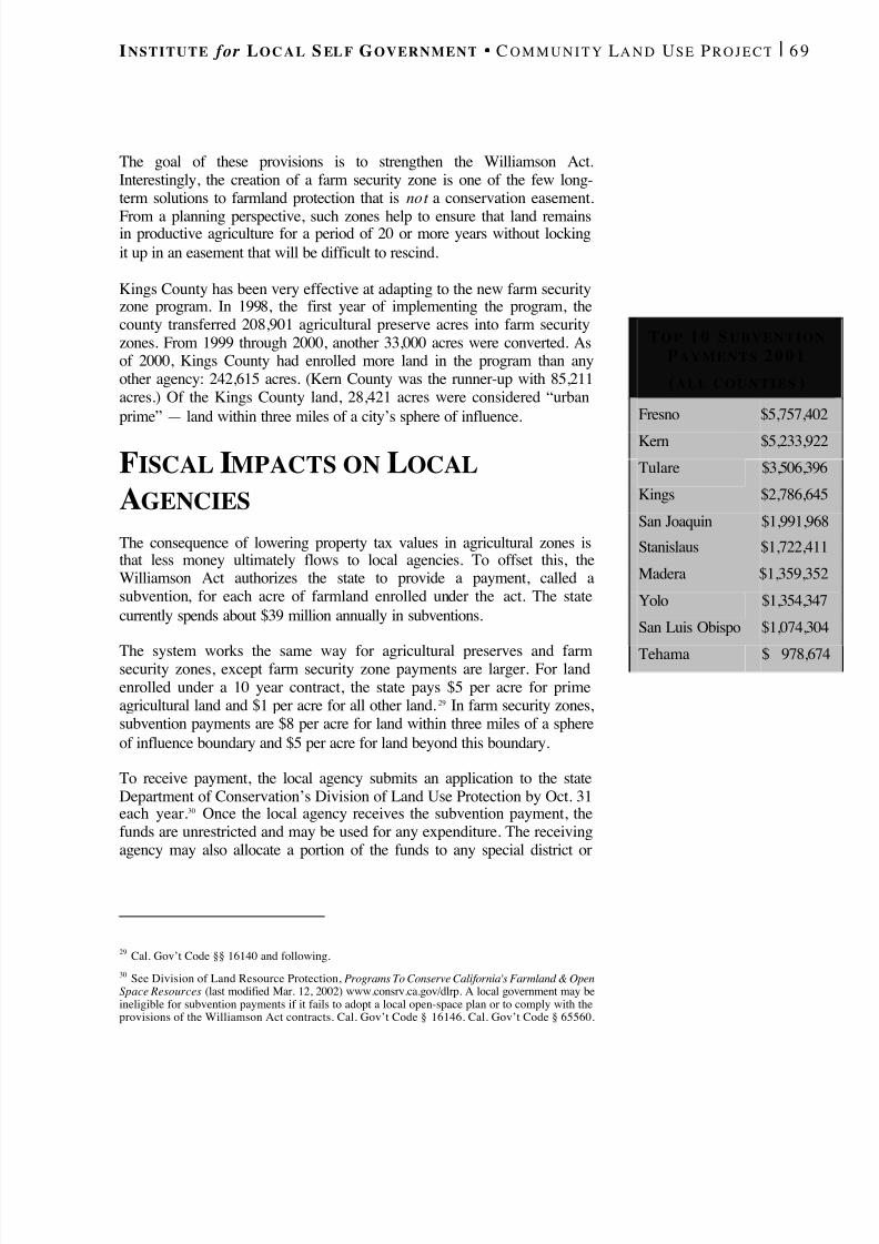
8/8/2019 22457.Farmland Action Guide
http://slidepdf.com/reader/full/22457farmland-action-guide 77/164
I NSTITUTE for L O C A L S EL F G OVERNMENT C O M M U N I T Y L A N D U SE P R O J E C T | 6 9
The goal of these provisions is to strengthen the Williamson Act.Interestingly, the creation of a farm security zone is one of the few long-term solutions to farmland protection that is not a conservation easement.
From a planning perspective, such zones help to ensure that land remainsin productive agriculture for a period of 20 or more years without lockingit up in an easement that will be difficult to rescind.
Kings County has been very effective at adapting to the new farm securityzone program. In 1998, the first year of implementing the program, thecounty transferred 208,901 agricultural preserve acres into farm securityzones. From 1999 through 2000, another 33,000 acres were converted. Asof 2000, Kings County had enrolled more land in the program than anyother agency: 242,615 acres. (Kern County was the runner-up with 85,211acres.) Of the Kings County land, 28,421 acres were considered “urbanprime” — land within three miles of a city’s sphere of influence.
F ISCAL IMPACTS ON LOCALAGENCIES The consequence of lowering property tax values in agricultural zones isthat less money ultimately flows to local agencies. To offset this, theWilliamson Act authorizes the state to provide a payment, called asubvention, for each acre of farmland enrolled under the act. The statecurrently spends about $39 million annually in subventions.
The system works the same way for agricultural preserves and farmsecurity zones, except farm security zone payments are larger. For landenrolled under a 10 year contract, the state pays $5 per acre for primeagricultural land and $1 per acre for all other land. 29 In farm security zones,subvention payments are $8 per acre for land within three miles of a sphereof influence boundary and $5 per acre for land beyond this boundary.
To receive payment, the local agency submits an application to the stateDepartment of Conservation’s Division of Land Use Protection by Oct. 31each year. 30 Once the local agency receives the subvention payment, thefunds are unrestricted and may be used for any expenditure. The receivingagency may also allocate a portion of the funds to any special district or
29 Cal. Gov’t Code §§ 16140 and following.30 See Division of Land Resource Protection, Programs To Conserve California's Farmland & OpenSpace Resources (last modified Mar. 12, 2002) www.consrv.ca.gov/dlrp. A local government may beineligible for subvention payments if it fails to adopt a local open-space plan or to comply with theprovisions of the Williamson Act contracts. Cal. Gov’t Code § 16146. Cal. Gov’t Code § 65560.
T O P 1 0 S UBVENTIONP AYMENTS 2 0 0 1
( ALL COUNTIES )
Fresno $5,757,402
Kern $5,233,922
Tulare $3,506,396
Kings $2,786,645
San Joaquin $1,991,968
Stanislaus $1,722,411
Madera $1,359,352
Yolo $1,354,347
San Luis Obispo $1,074,304
Tehama $ 978,674

8/8/2019 22457.Farmland Action Guide
http://slidepdf.com/reader/full/22457farmland-action-guide 78/164
70 | F ARMLAND P ROTECTION A CTION G UIDE S TRATEGY 10
school district located within the assessed area whose revenues are reducedby the lower property valuation. 31
ASSESSING THE IMPACT ON LOCAL REVENUES The California Constitution requires that property tax assessments of land
reserved for agriculture be based on the land’s actual use.33
Land coveredby a Williamson Act contract is valued according to the annual income itcan be expected to generate from rent or agricultural production. 34 This iscalled the “capitalization of income formula.”
The California Farm Bureau Federation has developed an analysis of theeconomic effects of Williamson Act contracts for counties and landowners(see “Local Agency Revenues Under the Williamson Act,” above). 35 Thisanalysis takes a parcel of prime land with an assessed value of $2,000 and
31 Cal. Gov’t Code § 16145.32 Actual proportions vary from area to area and even parcel-to-parcel. See Legislative Analyst’sOffice, Property Taxes: Why Some Local Governments Get More Than Others (1996).33 Cal. Const. art. XIII, § 8.34 Cal. Rev. & Tax. Code §§ 423, 423.4. Proposition 13 establishes a property tax rate of one percentof full cash value as determined by the 1975-76 assessor’s roll. Reassessment occurs due to a change inownership or new construction. Full cash value increases by two percent each year.35 California Farm Bureau Federation, Economic Effects of Farmland Security Zone (FSZ) Contract for
Landowners and Counties , www.cfbf.com/issues/landuse/study.htm.
L O C A L A GENCY R EVENUES UNDER THE W ILLIAMS ON A CT
(P ER A CRE OF F ARMLAND )
N O R M A L 1 0 Y E A R C O N T R A C T F A R M S E C U R I T Y Z O N E
VALUATION Sale price -fairmarket value
Capitalized of
fair rental value65% of 10-year contract or
market value, whichever is less
ASSESSED VALUE $2,000 $1,250 $812.50
TAX RATE 1 % 1 % 1 %
TAX BILL $20.00 $12.50 $8.12
COUNTY SHARE 32 $3.40 $2.12 $1.38
REVENUE DECREASE 0 $1.28 $2.02
SUBVENTION $0 $5 on prime and $1 on
nonprime land
$8 within 3 miles of sphere;
otherwise $5TOTAL GENERALFUND REVENUE
$3.40 $7.12 on prime land:otherwise $3.12
$9.38/acre within 3 miles of sphere; otherwise $6.38.
8/8/2019 22457.Farmland Action Guide
http://slidepdf.com/reader/full/22457farmland-action-guide 79/164
I NSTITUTE for L O C A L S EL F G OVERNMENT C O M M U N I T Y L A N D U SE P R O J E C T | 7 1
provides a comparison of the per-acre property tax payments by thelandowner and the corresponding effect on local agency revenues.
Of course, the bottom line for many agencies is whether they come outahead financially after recouping the subvention from the state. Today, theanswer appears to be that many local agencies do come out ahead. Theinformation provided by Sutter and San Joaquin counties (see “Impact of Williamson Act Assessments,” next page) demonstrates that the state’ssubvention payment more than compensates for reduced property taxrevenues.
On a parcel-by-parcel basis, the following “break-even points” can be usedas a very rough rule of thumb to determine at what property value level thestate’s farm security zone subvention payment becomes less than the localagency’s share of lost property tax revenue: 36
• Within a Three-Mile Boundary. The break-even point is $6,700 peracre. 37 If land values exceed that amount, the subvention will not offsetlost revenue. This break-even point is probably higher for most cities— $13,450 — because designations are less likely to affect specialdistrict revenues. 38
• Outside the Boundary. For land more than three miles from a sphere-of-influence boundary, the value is $4,200 per acre.
These break-even figures suggest that there is sufficient incentives for localagencies to create farm security zones. 39 However, these figures are only
approximations and vary from county to county and even from parcel toparcel, depending on various factors.
While this information is helpful, there are at least three compellingreasons to review the program on a jurisdiction wide basis, rather thanusing a parcel-by-parcel approach: First, wide variations in the assessedvalue of thousands of parcels make the exact financial gain or lossresulting from individual Williamson Act contracts difficult (and time-consuming) to calculate. Second, any net loss on a single contract is more
36 Per acre break-even point calculated by the following equation: (LV)(.34)(.01) = [LV (.65)(.01)(.34)]+8; where LV = break-even land value; (.01) = property tax rate; (.34) = estimated share of property taxrevenue for counties and special districts; (.65) = reduced property tax rate in farm security zone; (8) =subvention payment within three miles of sphere of influence.37 This assumes that the county will reimburse special districts for lost revenues.38 This number assumes that the subvention would not have any effect on special district revenues andthat the city only receives 17 percent of the property tax.39 It is only in the limited circumstance when agricultural land has a high value (vineyards, forexample); or when the land value reflects some development pressure, that the incentives may notpencil out for local government on a case-by-case basis.
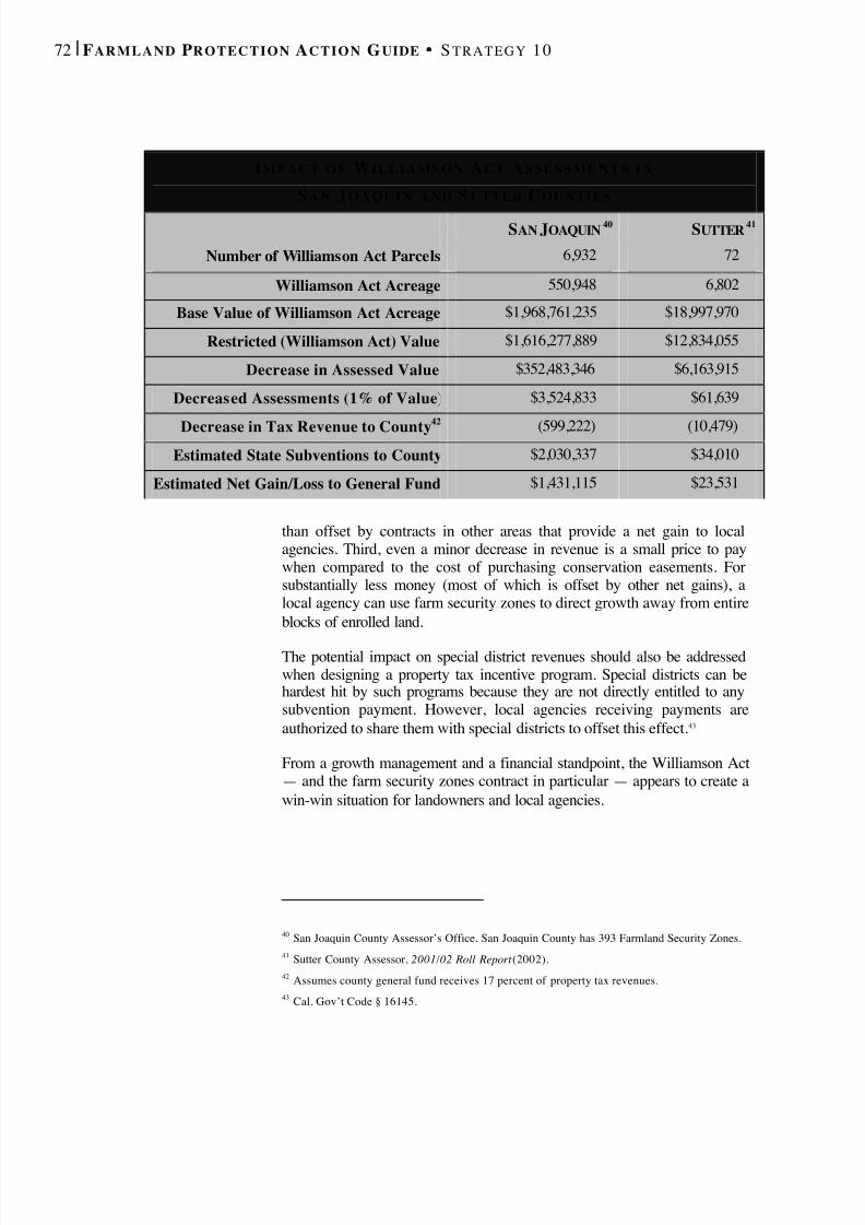
8/8/2019 22457.Farmland Action Guide
http://slidepdf.com/reader/full/22457farmland-action-guide 80/164
72 | F ARMLAND P ROTECTION A CTION G UIDE S TRATEGY 10
than offset by contracts in other areas that provide a net gain to localagencies. Third, even a minor decrease in revenue is a small price to paywhen compared to the cost of purchasing conservation easements. Forsubstantially less money (most of which is offset by other net gains), alocal agency can use farm security zones to direct growth away from entireblocks of enrolled land.
The potential impact on special district revenues should also be addressedwhen designing a property tax incentive program. Special districts can behardest hit by such programs because they are not directly entitled to anysubvention payment. However, local agencies receiving payments areauthorized to share them with special districts to offset this effect. 43
From a growth management and a financial standpoint, the Williamson Act— and the farm security zones contract in particular — appears to create awin-win situation for landowners and local agencies.
40 San Joaquin County Assessor’s Office. San Joaquin County has 393 Farmland Security Zones.41 Sutter County Assessor, 2001/02 Roll Report (2002).42 Assumes county general fund receives 17 percent of property tax revenues.43 Cal. Gov’t Code § 16145.
I MPACT OF W ILLIAMSON A CT A S S E S S M E N T S I N
S A N J OAQUIN AND S UTTER C OUNTIES
SAN J OAQUIN 40 SUTTER 41
Number of Williamson Act Parcels 6,932 72
Williamson Act Acreage 550,948 6,802
Base Value of Williamson Act Acreage $1,968,761,235 $18,997,970
Restricted (Williamson Act) Value $1,616,277,889 $12,834,055
Decrease in Assessed Value $352,483,346 $6,163,915
Decreased Assessments (1% of Value) $3,524,833 $61,639
Decrease in Tax Revenue to County42
(599,222) (10,479)Estimated State Subventions to County $2,030,337 $34,010
Estimated Net Gain/Loss to General Fund $1,431,115 $23,531
8/8/2019 22457.Farmland Action Guide
http://slidepdf.com/reader/full/22457farmland-action-guide 81/164
PLAN FOR ADEQUATE
WATER SUPPLIESWater is a vital resource for California agriculture. By managing andincreasing the local water supply, local agencies can help to ensure thatfarms remain viable. Although many policy alternatives are beyond thescope of local agencies, several proactive policies and programs can beimplemented to maintain an affordable water supply.
The Tri-Valley Business Council, a public-private partnership operating infast-growing Alameda and Contra Costa counties, recently created the
Agricultural Water Task Force to implement a planning process thatfocuses on identifying sufficient water supplies to support local agriculture.The task force has three goals: 1
1. Create a plan to obtain water for increased irrigated agriculture in away that integrates economic profitability and environmental health,and respects the needs and desires of all people in the region;
2. Identify and resolve issues of common concern related to an increasein irrigated agriculture; and
3. Promote communication and understanding among the differentinterests involve in agricultural land decisions.
The task force is composed of community leaders from a variety of interestgroups. Although there are very significant challenges in achieving thesegoals, the fact that diverse interests are working together for the benefit of agriculture and the community as a whole may provide the momentumnecessary to accomplish the task.
PLANNING FOR NEW DEVELOPMENT New developments can pose a threat to local agriculture when they sharethe same source of water. When urban uses require ever-increasingamounts of water, it makes the availability of water uncertain foragriculture — particularly in times of drought. Consequently, ensuring thatlocal agriculture has an adequate water supply means that there must alsobe adequate water for new urban development.
1 See www.tri-valley.org
Planning for NewDevelopment...............................73
Improving GroundwaterSupplies........................................76
Water Recycling ........................78
11STRATEGY
8/8/2019 22457.Farmland Action Guide
http://slidepdf.com/reader/full/22457farmland-action-guide 82/164
74 | F ARMLAND P ROTECTION A CTION G UIDE S TRATEGY 11
An initial step is identifying sources of water to serve new developmentbefore it is built. State legislation now requires most large projects 2 toconduct water availability assessments at various stages of thedevelopment process, such as environmental review and subdivisionapproval. 3 Water suppliers (or purveyors) have traditionally producedurban water management plans that describe total water supplies forpresent use (including agriculture) and all planned development.Proponents of new development must now show that there are sufficientsupplies, even in multiple dry years, to meet new water demand for 20years. This requires greater agency understanding of water supply issues.
In some respects, these new requirements codify what several agencieshave already been doing. For example, Santa Barbara County alreadyrequires developers to provide the gross and net water demand for newdevelopments and a description of how the project will be served duringdroughts. Furthermore, water purveyors have a standing obligation todetermine whether there is an adequate supply of water to serve existingcustomers before the supplier can add new connections. 5
2 500 units or equivalent, retail of 500,000 square feet, office space of 250,000 square feet, 500 roomhotel, 650,000 square feet of industrial or 10 percent increase in service connections for communities of 5,000 connections or less. See Cal. Water Code § 10912.3 SB 221 (ch. 642, stats. of 2001); AB 901 (ch. 644, stats. of 2001).
W ATER C ERTAINTY AND F ARMLAND P ROTECTION :I S T HERE A D EAL T O B E M A DE ?
From time to time, the issue arises of how to better connect water
certainty to farmland conservation. In other words, is there a way toreward farmers for forgoing development by providing them with acertain, affordable water supply?
Such proposals take various forms. Noted Cadillac Desert author andwater commentator Marc Reisner suggested offering guaranteed Bureauof Reclamation water deliveries to farmers at reduced costs in return forentering into 20- to 40-year contracts to conserve farmland (similar to aWilliamson Act for water supply). 4 While it’s impossible to predict if orwhen such a statewide program would go into effect, the underlyingconcept may be helpful for local agencies working to develop localsolutions to farmland protection.

8/8/2019 22457.Farmland Action Guide
http://slidepdf.com/reader/full/22457farmland-action-guide 83/164
I NSTITUTE for L O C A L S EL F G OVERNMENT C O M M U N I T Y L A N D U SE P R O J E C T | 7 5
The new water assessment requirements are likely to mean more proposalsto increase nontraditional sources of water, such as water marketing,improved efficiencies and water recycling. For example, the City of Tracy
is planning to construct an aquifer storage and recovery well and fourmonitoring wells and pipelines to store treated surface water in its areaaquifer. The project would bank 2,000 acre-feet per year of treated DeltaMendota Canal contract water. Extraction will depend on dry-year needsand storage availability.
4 Marc Reisner, Water Policy and Farmland Protection: A New Approach to Saving California’s Best Agricultural Lands www.farmlandinfo.org/fic/ft/calwater.html.5 Cal. Health & Safety Code § 4010. Scott S. Slater, The Role of Cities in Managing and RegulatingWater , 1996 League of California Cities City Attorneys Spring Conference Papers, 553, 568.6 D. Villarejo, 93640 at Risk: Farmers, Workers and Townspeople in an Era of Water Uncertainty(1996).
T HE E CONOMIC VALUE OF W ATER
What does water mean to a community? One study examined theeffects of a 56 percent reduction in surface water deliveries to the
community of Mendota from 1990–92.6
The study found that:• Irrigated cropland decreased by 14 percent;• Farmers substituted pumped groundwater for lost surface
deliveries;
• Demand for farm labor decreased dramatically;
• Farm and packing wage and salary income declined by $4.8million;
• Three out of seven area wholesale firms went out of business;
• A total of 18 farms went out of business;• Retail sales in Mendota decreased 11 percent (compared to a 4
percent countywide increase );
• Agricultural land values declined by 30 percent; and
• City tax revenues and business license fees declinedsubstantially.
8/8/2019 22457.Farmland Action Guide
http://slidepdf.com/reader/full/22457farmland-action-guide 84/164
76 | F ARMLAND P ROTECTION A CTION G UIDE S TRATEGY 11
IMPROVING GROUNDWATER
SUPPLIES Many farming operations are partially or wholly dependent on groundwater— particularly in times of drought. Thus, local aquifer management canplay an important role in keeping agriculture viable. The amount of groundwater in each basin is a function of inputs (rainfall and rechargefrom surface water) less extractions (pumping). Local agencies retain someauthority to manage groundwater supplies, 7 unlike surface water, where thestate regulatory authority has largely pre-empted local discretion. 8 Inaddition, recent court decisions confirmed the right of landowners to pumpunderlying groundwater from their properties, making comprehensive
management of the resource a more difficult prospect. 9
Nevertheless, the water planning legislation addressed in the previoussection (page 74) highlights the significance of managing groundwater.
7 See Baldwin v County of Tehama , 31 Cal. App. 4th 166 (1994). In the Sacramento Valley and theSacramento-San Joaquin Delta, Water Code section 1220 limits exportation of water withoutconsultation with water distr icts and a vote of the counties overlying the groundwater.8 Surface water transfers are subject to extensive state regulation, but there may be some room for localregulation that does not conflict with the State Water Resources Control Board. Slater, supra . at 567.For example, surface water transfers that are promised on the fact that lost water will be supplementedby increase groundwater pumping may be subject to local reticulation. Id. 9 City of Barstow v. Mojave Water Agency , 23 Cal. 4th 1224 (2000).
U SEFUL R ESOURCES FROM DWR
The State Department of Water Resources (DWR) will publish (July2002) two documents that can be useful in helping assess local watersupplies:
• Bulletin 118 . Bulletin 118 is a statewide inventory of groundwaterbasins that provides a detailed analysis about nearly 500 Californiagroundwater basins. It also includes a discussion of policy options.
• Water Planning Guidebook. A guide for water suppliers, citiesand counties to implementing recent legislation that requires theintegration of water supply management and land use planning .
More information can be obtained by visiting the Web site:
http://wwwdwr.water.ca.gov

8/8/2019 22457.Farmland Action Guide
http://slidepdf.com/reader/full/22457farmland-action-guide 85/164
I NSTITUTE for L O C A L S EL F G OVERNMENT C O M M U N I T Y L A N D U SE P R O J E C T | 7 7
Local water purveyors will have to include an assessment of groundwateravailability, including any groundwater management plan, whenevergroundwater will be used to serve large development projects. As a result,it’s important to develop a groundwater budget and collect other data aboutthe quantity and quality of local groundwater sources. 10
The need for a local agency to take action on conserving groundwaterresources varies by area. Many regions already have special districts inplace that manage groundwater basins. 12 A few counties have also takensteps to address groundwater issues by adopting a groundwater exportordinance. For example, Fresno County has implemented a permit systemthat requires anyone who directly or indirectly exports groundwater outsidethe county to apply for a permit. The permit is conditioned on a findingthat the extraction will not increase the overdraft or injure also the
10 See Cal. Water Code § 10910.11 Department of Water Resources, 7 Steps for Managing Groundwater Supplies, Water Facts: (February 1996) (http://wwwdpla.water.ca.gov/publications/pubs/supply/gw/water_facts_2.pdf).12 For a listing, see Department of Water Resource, Groundwater Management in California (1999)(www.dpla.water.ca.gov/publications/pubs/supply/gw/gwm_report.pdf).
S EVEN S T E P S F O R M ANAGING G ROUNDWATER S UPPLIES 11
1. Identify Extraction Points. Record eachwell’s location. Collect driller’s logs andcompile water level measurements and awater quality analysis for each well. Plotthese data on maps to begin a monitoringprogram.
2. Define Outputs. Calculate the amount of groundwater extracted plus consumptiveuse, exports, evapotranspiration, surfaceflow and other outputs.
3. Define Inputs. Quantify how much wateris coming into the basin throughprecipitation, surface water and otherinputs.
4. Draft and Map a Water Budget. Inflowminus outflow equals the change ingroundwater. Mapping this information isuseful for understanding past, present and
projected inflow and extraction levels.
5. Estimate Specific Yield. Estimate the amount of water available from an unconfined aquifer. Thespecific yield can be used to calculate theamount of groundwater in storage.
6. Project Future Extractions. Use the specificyield values to calculate the estimated change ingroundwater level that will occur during a givenperiod of time. Groundwater quality data canalso be used to estimate the effect of suchextractions on the movement of undergroundcontaminants.
7. Develop a Management Plan. A managementplan can reduce the amount extracted by specificwells, either through a reduced rate of pumpingor by restricting the length of time the pump canbe operated. Such reductions have to bevoluntary unless the plan is adopted andimplemented by a local agency.
8/8/2019 22457.Farmland Action Guide
http://slidepdf.com/reader/full/22457farmland-action-guide 86/164
78 | F ARMLAND P ROTECTION A CTION G UIDE S TRATEGY 11
reasonable uses of other groundwater users. 13
Conjunctive use management (the combined use of groundwater andsurface water) is another way to increase local water supplies. Conjunctiveuse involves managing the aquifer system as an underground reservoir.During wet years, when more surface water is available, surplus surfacewater is stored underground by recharging the aquifers with it. During dryyears, the stored water is available in the aquifer system to supplementdiminished surface water supplies. A groundwater management plan canalso be used to address other specific issues, such as salinity intrusion,contaminants, wellhead protection, overdraft mitigation, replenishment andmonitoring.
The state Department of Water Resources also has periodic fundingprograms, such as the Local Groundwater Assistance Fund Grant Program,that can be tapped by local agencies to underwrite some of the initial costsof developing a groundwater management program. Although theavailability of funds varies from year to year, it’s worth monitoring theseprograms at least annually to see whether funding is available toimplement a new management plan. 14
WATER RECYCLING Recycling wastewater is a relatively new option for local agencies. Newtechnology purifies used water for reuse. Now, instead of dischargingwastewater into rivers, it’s treated and stored until needed. This reclaimedwater is delivered to various points to irrigate crops, golf courses and otherlandscaped areas. In the southern San Joaquin Valley, more than 32.7billion gallons of reclaimed water are used largely for agriculturalirrigation. 15
Water recycling is not without its drawbacks, however. Its implementation,including a system of pipes to deliver the water, can be costly. Waterquality can also be an issue. The treatment processes must be carefullymonitored to ensure that the discharged water is safe for the environment.
13 County of Fresno, Cal., Code § 14.03.01 (2000).14 See Department of Water Resources, Division of Planning and Local Assistance Grants and Loans (last modified Mar. 8, 2002) wwwdpla.water.ca.gov/grants-loans/.15 Great Valley Center, The State of the Great Central Valley: The Environment 38 (2001)(www.greatvalley.org/research/publications/pdf_folder/indicator_enviro_report.pdf.)
8/8/2019 22457.Farmland Action Guide
http://slidepdf.com/reader/full/22457farmland-action-guide 87/164
I NSTITUTE for L O C A L S EL F G OVERNMENT C O M M U N I T Y L A N D U SE P R O J E C T | 7 9
If the discharged water is highly saline, it can damage salt-sensitive cropsor reduce soil productivity. 16
Nevertheless, water recycling’s potential deserves serious consideration.Monterey County built a $78 million recycling system to offset the seriousgroundwater overdraft and concurrent threat of salt-water intrusion fromthe adjacent Monterey Bay. The reclaimed water is mixed withgroundwater in a 2-to-1 ratio and used to irrigate 12,000 acres of lettuceand other vegetables. The project is expected to reduce the groundwaterextraction by 20,000 acre-feet in and around the City of Castrovilleannually. Some local farmers, however, have expressed concern aboutpossible market impacts due to the public’s potentially negative perceptionof irrigating vegetables with recycled water. 17
The State Revolving Fund program offered by the U.S. EnvironmentalProtection Agency provides low-interest loans (at half the interest rate of general obligation bonds) for planning, designing and constructingmunicipal wastewater treatment works, including water-recycling systems.The federal government matches the state funds on a 5-to-1 basis. Suchfunding played a key role in the development of the Monterey Countyproject mentioned above. The county received an $8.8 million loan fromthe State Revolving Fund program and $52 million (over an eight-yearperiod) from the Bureau of Reclamation to finance the project. 18
16 Water Education Foundation, A Layperson’s Guide To Water Recycling (1999). This publication isan excellent introduction to the issue and only costs $6. See www.water-ed.org/.17 Id .18 Id . See www.epa.gov/safewater/dwsrf.html for more information about loan program.
T HE W ATER E DUCATION F OUNDATION
A good starting point for gaining a better understanding of waterissues in California is the Water Education Foundation. TheFoundation serves as an impartial nonprofit organization dedicatedto creating a better understanding of water issues and helpingresolve water resource problems through educational programs.The Foundation’s Laypersons Guide series (priced at $7 each) provides excellent, easy-to-read executive summaries of most of theurgent water issues facing California today. Visit their Web site formore information:
www.water-ed.org

8/8/2019 22457.Farmland Action Guide
http://slidepdf.com/reader/full/22457farmland-action-guide 88/164
80 | F ARMLAND P ROTECTION A CTION G UIDE S TRATEGY 11
R ESOURCES FOR W ATER R ECYCLING
• Bureau of Reclamation . The bureau haslimited funding for up to 25 percent of design and construction costs and 50percent of planning costs (Title 16program). It also works with local agenciesto develop feasibility studies. Contact: Water Recycling Coordinator, 2800Cottage Way, Sacramento, CA 95825-1898; (916) 978-5100; www.mp.usbr.gov/ .
• State Water Resources Control Board . Thestate board regulates and permits the state’ssurface water. Contact: P.O. Box 100,Sacramento, CA 95812; (916) 341-5250;www.swrcb.ca.gov.
• Environmental Protection Agency. The U.S. EPA sets applicable biosolidstandards. It also administers the State
Revolving Fund program. Contact: Officeof Groundwater and Drinking Water, 1200Pennsylvania Ave., NW, Washington, D.C.20460; (202) 564-3750; www.epa.gov/OW.
• California Department of Health. Thedepartment establishes health criteria forthe treatment and use of recycled water.Contact: Recycled Water Unit, 601North 7th Street, Sacramento, CA 95814;(916) 445-0498; www.dhs.ca.gov(search: “water recycling”).
• Department of Water Resources. Thedepartment provides resources andinformation for recycling programs.Contact : Division of Planning and LocalAssistance, P.O. Box 942836,Sacramento, CA 94236-0001; (916) 651-9236; http://wwwdwr.water.ca.gov.
• WateReuse Association. This is anorganization of groups and agenciesinvolved in water recycling. A portion of
its Web site is dedicated to California andincludes a model water-recyclingordinance. Contact: 635 Slaters Lane, 3 rd floor, Alexandria, VA 22314; (703) 684-2409; www.watereuse.org (only one “r”).
8/8/2019 22457.Farmland Action Guide
http://slidepdf.com/reader/full/22457farmland-action-guide 89/164
I NSTITUTE for L O C A L S EL F G OVERNMENT C O M M U N I T Y L A N D U SE P R O J E C T | 8 1
SPONSOR PROGRAMS TO
ESTABLISH NEW FARMERSThe pool of available skilled farmers who have the means to enter theindustry is a resource that’s vital to a strong, successful local agriculturaleconomy, and it’s often overlooked. This is becoming a more significantissue in California, where the farmer’s average age is 55 and rising(compared to the national average age of 47). This trend is compounded bythe fact that many in the next generation do not follow in their parents’footsteps, increasing the likelihood that farms will be sold fordevelopment.
New farmers face several challenges. Not only is it difficult to obtain thecapital necessary to purchase a working farm, but banks and other financialinstitutions also generally require the borrower to have experienceoperating a farm or other business before financing such a purchase. Localagencies can play an important role in preparing prospective farmers toovercome these challenges and other initial barriers.
INCUBATOR FARMS A new farm incubator program can be an innovative way to help new
farmers become established. Typically, a farm is purchased, divided (notformally or legally) and then subleased at affordable rates to people whohave demonstrated an interest in owning and operating a farm. In manycases, these individuals have a great deal of experience as farmworkers, buthave never had the opportunity to own a farm.
Once invited to participate in the program, the prospective farmers makeall the farming decisions for their section, but receive guidance fromadvisors. Classes on farm business management are usually provided.Where practicable, other local farmers offer advice and experience througha mentor relationship. Ideally, the program also includes additionalassistance, such as low-interest loans, to help new farmers get started.
Prospective farmers generally stay in the program for two to five years.The benefit to the prospective farmers can be significant. Not only do theyreceive valuable experience in operating a farm, but they also generate atrack record that will help obtain financing to purchase their own farm.
Incubator Farms .......................81
FarmLink Programs ................83
12STRATEGY

8/8/2019 22457.Farmland Action Guide
http://slidepdf.com/reader/full/22457farmland-action-guide 90/164
82 | F ARMLAND P ROTECTION A CTION G UIDE S TRATEGY 12
While local agencies may not have the resources to manage a farmincubator, they can help launch a program with funding and by bringingkey players together. A local land trust and the local cooperative extension
service are ideal partners for this purpose, as they are generally betterpositioned to engage and help in the program’s long-term management.Communities that are home to a university with an agriculture programmay also be excellent partners.
1 American Farmland Trust, Farmland Provides Training Grounds for New Farmers (May 13, 1999).Available online at www.farmland.org/news/051399.htm.
C AS E S TUDY : F R E S N O ’ S M ISITA P ROPERTY 1
The Misita Farm operates on the City of Fresno’ssouth side. The farm is 40 acres of rich farmlandplanted in a variety of Asian vegetables. The land isbordered to the east by a large subdivision and to
the west by productive farmland.When the farm's original owner, Dusan Misita,decided to retire from farming, he received manyoffers from developers with plans to subdivide theproperty or convert it to non-agricultural uses.However, Misita wanted to see his farm remain inproduction. Through a unique collaborationbetween the American Farmland Trust (AFT) andthe local Hmong-American community, the landbecame a farm incubator and demonstration site fornew farmers. Small plots of land are leased tominority or small-scale farmers until they qualifyfor land-acquisition loans to buy their own largerparcels of land. During this period, these farmersreceive technical assistance to improve their skillsand chance for commercial success.
“This project will help transform minority and smallfarmers from farm laborers and tenants on smallplots of land to commercially successfullandowners,” said Greg Kirkpatrick, AFT’sCalifornia field representative. “At the same time,we ensure that the Misita land stays in farming. It'sa win-win solution.”
To guarantee that the land is used solely forfarming, AFT is placing an easement restriction onthe property. The trust’s investment in Misita Farmis part of a strategy to identify and protect high-
quality farmland located at the edges of cities.Purchasing and protecting Misita Farm begins todraw the line on urban growth southwest of Fresno,where farming historically has dominated thelandscape.
“The purchase of Misita Farm is a first step towardmaking farmland available to hundreds of localfarmers who are crying for land,” said Toulu Thao,community builder for the Department of Housingand Urban Development, and a member of the localHmong community. “The project will be a dreamcome true for many farmers.”
The Misita Farm project is an outgrowth of theSmall Farm Development Task Force convened byCongressman Calvin Dooley to identify the needsof small farmers and develop a comprehensiveprogram to ensure their success. The Small FarmResource Network, a collaborative effort involvingseveral agricultural agencies and nonprofitorganizations that offer assistance to small farmers,is now implementing many of the task forcerecommendations. The network’s goal is to providecoordinated services for helping small farmers
acquire land, as well as providing access to capital,technical assistance and marketing.

8/8/2019 22457.Farmland Action Guide
http://slidepdf.com/reader/full/22457farmland-action-guide 91/164
I NSTITUTE for L O C A L S EL F G OVERNMENT C O M M U N I T Y L A N D U SE P R O J E C T | 8 3
An incubator farm also provides other advantages. For example, fundingcan be used to place the farm in a location to help reduce sprawl or serve asa buffer between residences and large farm operations. It may also provide
an opportunity for public education through the local schools or otherprograms that can help connect people to local agriculture.
FARM LINK PROGRAMS One relatively new nonprofit association, California FarmLink, specializesin structuring creative financial deals to help entry-level farmers getstarted. The organization, which presently has staff and offices in Sonoma,Yolo and Fresno counties, is modeled after other successful programsaround the country that match retiring farmers with prospective or currentfarmers who wish to purchase a farm but generally cannot yet afford it.
FarmLink can structure real estate transactions in a way that it makes iteasier for new farmers to purchase farmland. Sometimes, thesetransactions are coupled with the sale of a conservation easement to a localland trust. This reduces the overall cost for the new farmer and helps toensure that the land remains as farmland. While such transactions are oftencomplex and time-consuming, retiring farmers may be willing to enter intothem on the knowledge that their farm will be transferred into good hands.In addition, if the deal is structured with the help of a good attorney orfinancial planner, the farmer may realize substantial tax benefits from sucha sale.
FarmLink conducts community workshops on a variety of related topics,including farm succession planning, business planning, farm financing anddeveloping on-farm mentoring relationships. It also serves as aclearinghouse for farm apprenticeship programs and opportunitiesthroughout the state.
Finally, California FarmLink has started to partner with local agencies,such as the Sonoma County Agriculture and Open Space District, that wantto implement farm transition policies on a regionwide scale. Thesepartnership activities include making presentations to communitystakeholder planning groups and at public meetings about strategies forfarm transitions and promoting economic development, conservation and
smart growth.
F O R M OREI NFORMATION
California FarmLinkP.O. Box 2224
Sebastopol, CA 95473
(707) 829-1691www.californiafarmlink.org
Beginning Farmer CenterNational Farm
Transaction Network(Iowa University Extension)
www.extension.iastate.edu/bfc/
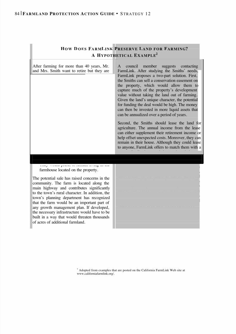
8/8/2019 22457.Farmland Action Guide
http://slidepdf.com/reader/full/22457farmland-action-guide 92/164
84 | F ARMLAND P ROTECTION A CTION G UIDE S TRATEGY 12
2 Adopted from examples that are posted on the California FarmLink Web site atwww.californiafarmlink.org/.
H O W D O E S F A R M L INK P RESERVE L A N D F O R F ARMING ?A H YPOTHETICAL E XAMPLE 2
After farming for more than 40 years, Mr.and Mrs. Smith want to retire but they areunsure about how to proceed. Developershave inquired whether they would beinterested in selling, but no firm offer hasbeen made. Although they want to see theland remain in agriculture, their threechildren aren’t interested in farming. TheSmiths reluctantly decide to sell their farm,but they have concerns:
• They want to realize their equity in thefarm;
• If possible, the land should remain inagriculture;
• They want to retain a source of income totake care of special needs, such as long-term health care, as they arise; and
• They would prefer to remain living in thefarmhouse located on the property.
The potential sale has raised concerns in thecommunity. The farm is located along themain highway and contributes significantlyto the town’s rural character. In addition, thetown’s planning department has recognizedthat the farm would be an important part of any growth management plan. If developed,the necessary infrastructure would have to bebuilt in a way that would threaten thousandsof acres of additional farmland.
A council member suggests contactingFarmLink. After studying the Smiths’ needs,FarmLink proposes a two-part solution. First,the Smiths can sell a conservation easement onthe property, which would allow them tocapture much of the property’s developmentvalue without taking the land out of farming.Given the land’s unique character, the potentialfor funding the deal would be high. The moneycan then be invested in more liquid assets thatcan be annualized over a period of years.
Second, the Smiths should lease the land foragriculture. The annual income from the leasecan either supplement their retirement income orhelp offset unexpected costs. Moreover, they canremain in their house. Although they could leaseto anyone, FarmLink offers to match them with ayoung family interested in starting their ownfarm. While such arrangements may start under alease, they often evolve into a sale when theSmiths (or their heirs) are ready to part with theland. To help facilitate the transaction, the cityalters zoning on the parcel so that an additionalhome can be built to house the tenant family. TheSmiths’ proximity on the land also gives the newtenant the opportunity to learn from theirexperience. Even after their retirement, theSmiths periodically visit the farm’s fruit stand,much to the delight of their former customers.

8/8/2019 22457.Farmland Action Guide
http://slidepdf.com/reader/full/22457farmland-action-guide 93/164
DESIGN FARM -FRIENDLY
PERMIT PROCESSES Designing and implementing farm-friendly local permit processes is aprudent step for local agencies interested in farmland protection. Mostfarmers must split their time between tending their fields and managingtheir business. They have little spare time to engage in lengthy permitprocedures — particularly for a relatively minor project like a barnexpansion or a small building improvement. When local agencies canstreamline their permit process, adjust their fee schedule or otherwise makethe process easier to navigate, farmers can spend more time and energy on
the farm.
SIMPLIFY THE PERMIT PROCESS Simplifying permit procedures means making the process of seeking apermit easier and more intuitive for permit applicants. There are severalways to streamline permit processes, including the following:
• Consolidate . Create “one-stop” permitting centers that provide allinformation and approvals in one location.
• Expedite Review .Provide clear directions about the informationneeded to complete the application and then work to make quick
determinations.
• Delegate Approval Authority . For small projects, such as barns andsheds, give approval authority to the zoning administrator.
• Assign Permit Coordinators . Assign a permit coordinator for eachapplication to avoid situations where applicants receive conflictingmessages from different staff members.
• Improve Customer Service . Providing attentive customer service helpsto create public confidence.
• Use the Web . While it may be a few years before most agencies canaccept permit applications via the Internet, they can use their existingWeb site to explain the permit process to farmers and others interestedin seeking a permit.
Simplify the PermitProcess.........................................85
Fee Adjustments........................87
Create a “Farmbudsperson”Position .............................. 87
13STRATEGY

8/8/2019 22457.Farmland Action Guide
http://slidepdf.com/reader/full/22457farmland-action-guide 94/164
86 | F ARMLAND P ROTECTION A CTION G UIDE S TRATEGY 13
• Consider Self-Imposed Timelines . Local agencies that are trulycommitted to speedy processes may want to impose timelines onthemselves for issuing permit decisions, and discount the permit fees(or provide some other benefit) when those deadlines are missed. 1
Regardless of which methods are ultimately chosen, the important thing isto make the process easily understood and user-friendly. The community’sinterest is best served when the permit process, which protects publichealth and safety, is both efficient and responsive to its customers’ needs.
1 Such action would be very different from the local agency obligations under the Permit StreamliningAct, which requires agencies to process certain development applications within specific time periods.Cal. Gov't Code §§ 65920 and following.
P E R MI T S I M P L I F I C AT I O N :I D E A S F O R G E T T I N G S TA RTE D 2
• Know the Purpose of the Regulation. Simplifying permit
procedures should not compromise their fundamental health andsafety purposes. Identify the underlying purposes of theregulations and keep them in mind when considering changes.
• Involve Stakeholders . Bring local officials and stakeholderstogether to determine the scope of the streamlining effort. Thosewho have been involved in the process can best identify itsflaws and those who use the permit system can make sure thatthe result still supports the public good.
• Learn From Other Agencies . Talking with agencies in other jurisdictions that have implemented permit streamlining canyield important lessons and reduce the time needed to study the
issue.• Coordinate with Other Agencies . Some permits require review
by multiple public agencies. Work with these agencies todetermine whether there are ways to streamline the process.
• Identify and Collect Key Information . Consider conducting apermit audit or inventory to see whether the permitting processis inconsistent or redundant. Create a timeline for a typicalpermit, and look for trends in appeals. Identify the mostcommon mistakes. Such audits often identify several potentialsolutions.
• Make it a Priority . Include permit simplification for farmers(or everyone) within an element of the general plan.

8/8/2019 22457.Farmland Action Guide
http://slidepdf.com/reader/full/22457farmland-action-guide 95/164
I NSTITUTE for L O C A L S EL F G OVERNMENT C O M M U N I T Y L A N D U SE P R O J E C T | 8 7
FEE ADJUSTMENTS Another way of encouraging farming is to analyze the agency’s feestructure for typical agricultural permit applications. For example, permitfees can be reduced for typical agricultural structures such as barns,packing sheds and silos. Simplifying some of the requirements may dimishthe amount of time staff spends processing the fee, which in turn decreasesthe cost that must be recaptured through the fee.
The Stanislaus County winery ordinance offers a good example of tailoringan ordinance to fit such needs. This ordinance classifies wineries by theirsize (such as boutique, small and large) and provides a graduated fee scale.As a winery expands, the fees increase. This process better suits the smallwineries, which originally had to pay the same fees as the large wineries.
This solution was reached as part of a collaborative effort involving theCalifornia Farm Bureau, the county’s Community DevelopmentDepartment and the wine industry.
CREATE A “F ARMBUDSPERSON ”POSITION Ombudspersons are government officials who work independently of regulatory staff to serve as a neutral contact for the public. A“farmbudsperson,” therefore, serves as an ombudsperson for the farming
community. Frequently, farmers do not have the necessary resources toparticipate in the regulatory process that affects them. A farmbudspersoncan help farmers gain access to and navigate the regulatory process.
Depending on how the local agency structures the position, afarmbudsperson can be vested with a variety of responsibilities. Generally,ombudspersons do not advocate for a specific party. Many agencies,including the California Air Resources Board, 3 have such positions to helpcitizens navigate regulatory processes. Other duties of a farmbudspersonmay include:
• Reviewing and making recommendations to local authorities about
the development and implementation of regulations that affect thefarm community;
2 See Office of Permit Assistance, Twelve Tips to Make the Permitting Process Easier (last visited Mar.18, 2002) http://commerce.ca.gov. Search on keyword “twelve tips.”3 See California Air Resources Board, Office of the Ombudsman (last modified Nov. 1, 2001)http://arbis.arb.ca.gov/ba/omb/omb.htm.
8/8/2019 22457.Farmland Action Guide
http://slidepdf.com/reader/full/22457farmland-action-guide 96/164
88 | F ARMLAND P ROTECTION A CTION G UIDE S TRATEGY 13
• Investigating complaints. Investigating complaints aboutenforcement;
•
Helping to disseminate information about upcoming regulations andland use controls that might affect farming;
• Connecting farmers with grant programs , such as environmentalcompliance assistance grants, for which they may be eligible;
• Explaining the permit process and helping farmers navigate it;
• Referring Farmers. Referring farmers to appropriate specialists forhelp with specific needs; and
• Conducting studies to evaluate the role that farming plays in theeconomy and the potential impact of proposed legislation.
In many counties, the agriculture commissioner plays some of these roles.But the commissioner is also expected to enforce county regulations. Aseparate farmbudsperson who is not charged with regulatory compliancemay be better able — at least in some instances — to help improvecommunication between local government and the farming community.
8/8/2019 22457.Farmland Action Guide
http://slidepdf.com/reader/full/22457farmland-action-guide 97/164
I NSTITUTE for L O C A L S EL F G OVERNMENT C O M M U N I T Y L A N D U SE P R O J E C T | 8 9
PROVIDE
ENVIRONMENTALCOMPLIANCE PROGRAMS In the past 30 years, the public has demanded better environmentalperformance from agriculture. Concern about conserving soil and waterhas expanded to include nonpoint source pollution, wetland protection andbiodiversity. Environmental regulations on agriculture have become morestringent, and farmers have had to find alternatives to conventionalpractices. New technologies may not be as well researched, proven orprofitable as the methods that were promoted and used in the past. 1
Environmental problems can result in farmland conversion. If watersupplies become scarce or polluted, rationing and regulations may increasethe cost of farming. Soil erosion also reduces agricultural productivity.Maintaining the natural resource base is a relatively new issue for state andlocal farmland protection programs.
By collecting and providing helpful information about environmental laws,local agencies can make compliance easier for farmers, particularly inareas where a group of farmers is facing the same regulatory problems. Inaddition, local agencies may also help to identify and obtain funds forprograms that protect the environment. Finding ways to assist local farmerscan help protect environmental quality and the vitality of local agriculturaleconomies.
RESOURCE CONSERVATIONDISTRICTS Resource conservation districts (“resource districts”) provide a unique andoften overlooked way to help farmers with environmental compliance andconservation issues on their properties. Resource districts operate asspecial districts 2 and are governed by locally elected or appointed volunteerboards composed of landowners. Generally, the county supervisors appoint
1 American Farmland Trust, Saving the Farm: A Handbook for Conserving Agricultural Land, 13(1990).2 Cal. Pub. Res. Code §§ 9001, 9151. As such, the county’s local agency formation commissiongoverns their formation. See Cal. Gov't Code § 56000.
Resource ConservationDistricts........................................89
Cooperative ExtensionService..........................................91
Federal IncentivePrograms .....................................92
14STRATEGY
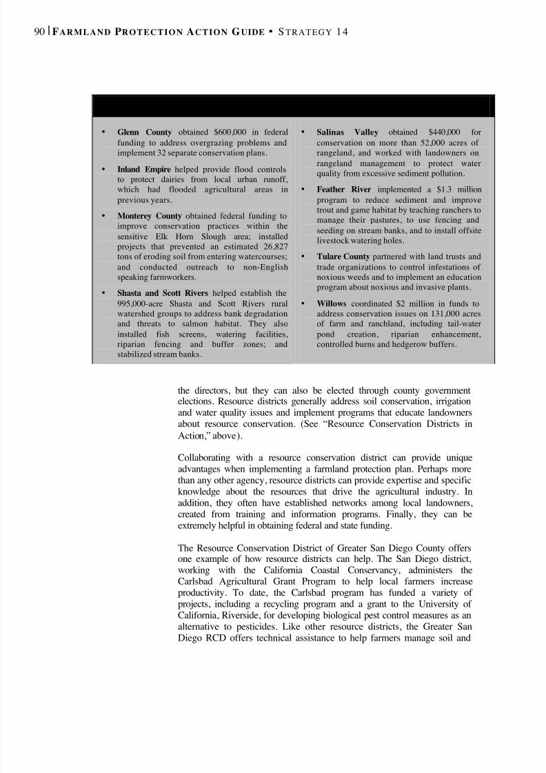
8/8/2019 22457.Farmland Action Guide
http://slidepdf.com/reader/full/22457farmland-action-guide 98/164
90 | F ARMLAND P ROTECTION A CTION G UIDE S TRATEGY 14
the directors, but they can also be elected through county government
elections. Resource districts generally address soil conservation, irrigationand water quality issues and implement programs that educate landownersabout resource conservation. (See “Resource Conservation Districts inAction,” above).
Collaborating with a resource conservation district can provide uniqueadvantages when implementing a farmland protection plan. Perhaps morethan any other agency, resource districts can provide expertise and specificknowledge about the resources that drive the agricultural industry. Inaddition, they often have established networks among local landowners,created from training and information programs. Finally, they can beextremely helpful in obtaining federal and state funding.
The Resource Conservation District of Greater San Diego County offersone example of how resource districts can help. The San Diego district,working with the California Coastal Conservancy, administers theCarlsbad Agricultural Grant Program to help local farmers increaseproductivity. To date, the Carlsbad program has funded a variety of projects, including a recycling program and a grant to the University of California, Riverside, for developing biological pest control measures as analternative to pesticides. Like other resource districts, the Greater SanDiego RCD offers technical assistance to help farmers manage soil and
R ESOURCE C O N S E RVAT I O N D I S T R I C T S I N A CTION
•
Glenn County obtained $600,000 in federalfunding to address overgrazing problems andimplement 32 separate conservation plans.
• Inland Empire helped provide flood controlsto protect dairies from local urban runoff,which had flooded agricultural areas inprevious years.
• Monterey County obtained federal funding toimprove conservation practices within thesensitive Elk Horn Slough area; installedprojects that prevented an estimated 26,827tons of eroding soil from entering watercourses;
and conducted outreach to non-Englishspeaking farmworkers.• Shasta and Scott Rivers helped establish the
995,000-acre Shasta and Scott Rivers ruralwatershed groups to address bank degradationand threats to salmon habitat. They alsoinstalled fish screens, watering facilities,riparian fencing and buffer zones; andstabilized stream banks.
•
Salinas Valley obtained $440,000 forconservation on more than 52,000 acres of rangeland, and worked with landowners onrangeland management to protect waterquality from excessive sediment pollution.
• Feather River implemented a $1.3 millionprogram to reduce sediment and improvetrout and game habitat by teaching ranchers tomanage their pastures, to use fencing andseeding on stream banks, and to install offsitelivestock watering holes.
• Tulare County partnered with land trusts and
trade organizations to control infestations of noxious weeds and to implement an educationprogram about noxious and invasive plants.
• Willows coordinated $2 million in funds toaddress conservation issues on 131,000 acresof farm and ranchland, including tail-waterpond creation, riparian enhancement,controlled burns and hedgerow buffers.

8/8/2019 22457.Farmland Action Guide
http://slidepdf.com/reader/full/22457farmland-action-guide 99/164
I NSTITUTE for L O C A L S EL F G OVERNMENT C O M M U N I T Y L A N D U SE P R O J E C T | 9 1
water resources, and reduce farm operations’ negative environmentalimpacts. In many cases, practices that conserve soil and water resources forfarming benefit the environment as well. 3
Throughout California, resource districts provide training and hands-onassistance to farmers facing a variety of environmental compliancechallenges. The U.S. Department of Agriculture’s Environmental QualityIncentives Program (EQIP) funds a variety of education projects andsupports cost-share programs for “on-farm” conservation practices. In2001, EQIP provided $5.8 million for projects in California, including$340,000 for education projects sponsored by resource conservationdistricts and other local farm and conservation groups. 4
UC C OOPERATIVE EXTENSION
SERVICEThe University of California Cooperative Extension Service is anotherresource on environmental compliance issues. Its farm advisors are basedin more than 50 county offices and collaborate with campus-basedresearchers to help farmers improve productivity using environmentallysound agricultural practices. For example, the UC Cooperative Extensionservice offers a program that helps dairy producers comply with the waterquality regulations. The program teaches techniques for using manure tooptimize cropland production and minimize groundwater contamination. 5
One area where the extension service has been particularly active in recentyears is helping dairy producers comply with water quality laws. Theprogram is a cooperative effort between the University of California, theCalifornia dairy industry and the U.S. Environmental Protection Agency.These organizations created a voluntary environmental compliancecertification program, called the California Dairy Quality AssuranceProgram. The program provides classroom and onsite instruction on howto dairy producers on how operate their facilities in compliance with stateand federal regulations. UC Cooperative Extension dairy and animal wastemanagement specialists developed the curriculum for the project. The UC
3 See the Resource Conservation District of Greater San Diego Web site at www.rcdsandiego.org.4 U.S. Natural Resource Conservation Service, Over $340,000 Released For California Conservation(last visited Mar. 18, 2002) www.ca.nrcs.usda.gov/eqip/graphic/indexg.html.5 Practical Dairy Nutrient Management Education Program for Dairy Producers. For more information,contact UC Cooperative Extension, 3800 Cornucopia Way, Suite A, Modesto, CA 95358; (209) 525-6800.
F OR MORE
INFORMATION
California Association of Resource Conservation
Districts801 K Street, Suite 1318Sacramento, CA 95814
(916) 447-7237www.carcd.org
UC CooperativeExtension Service (offices statewide)
http://ucanr.org
USDA Natural ResourceConservation ServiceCalifornia State Office430 G Street, No. 4164Davis, CA 95616-4164
(530) 792-5600
www.ca.nrcs.usda.gov/
8/8/2019 22457.Farmland Action Guide
http://slidepdf.com/reader/full/22457farmland-action-guide 100/164
92 | F ARMLAND P ROTECTION A CTION G UIDE S TRATEGY 14
Cooperative Extension Service, in partnership with local agencies,provides instruction .6
FEDERAL INCENTIVE PROGRAMS A number of federal programs also provide assistance with environmentalissues, such as nonpoint sources of water pollution, wetlands preservationand wildlife habitat, including:
• Conservation Reserve Program . This program encourages farmers toplant cover crops to reduce soil erosion and runoff on land that meetsspecific criteria. Farmers can be reimbursed for up to 50 percent of their costs. Contracts usually are for periods of 10 to 15 years.
• Wildlife Habitat Incentives Program. This program provides technicalassistance and cost-share payments to help improve habitat on privatelands. Property owners must prepare and implement a habitat plan.Contracts usually last between five and 10 years, and NRCS monitorsimplementation. In return, NRCS offers technical assistance and paysup to 75 percent of the installation cost. Funds cannot be used formitigation.
• Environmental Quality Incentives Program . This program offersfinancial and technical aid for conservation management. Otherincentives encourage nutrient, manure, pest, irrigation water andhabitat management. Contracts last for five to 10 years, and otherfederal, state or local governments can partner to preserve habitat onprivate property.
A good place to start is the Natural Resources Conservation Service(formally the Soil Conservation Service) of the U.S. Department of Agriculture (see “For More Information,” previous page, for contactinformation).
6 Id.

8/8/2019 22457.Farmland Action Guide
http://slidepdf.com/reader/full/22457farmland-action-guide 101/164
ROTECTION A CTION G UIDE S TRATEGY 1 5
BUILD FARMWORKER
HOUSING Farmworkers are an essential component of California’s agriculture. Farmemployees and their families need access to adequate housing, whetherthey are temporarily or permanently employed in an area. Withoutadequate housing, farmers cannot attract and retain the labor necessary tooperate profitably. In some cases, farmers improvise by converting garagesand sheds to house workers. Such improvised housing often lackssufficient plumbing and electricity, and overcrowding frequentlycompounds these hazardous conditions.
One estimate places the housing shortfall at 164,000 units for nonmigrantworkers and 121,000 units for migrant workers. 1 Accordingly, anythinglocal agencies can do to provide adequate housing for farmworkers canhelp give local farmers a competitive edge. Many communities addressfarmworker housing within their general plans. 2 Fortunately, this is anotherarea where local funding can be leveraged to attract state and federalfunding.
LEADERSHIP ROLE FOR LOCAL
AGENCIES Local agencies play a pivotal role in providing affordable housing forfarmworkers. Not only are they instrumental in obtaining various sourcesof funding, but they also have ultimate approval and siting authority overmost projects. As a result, local agencies interested in developing projectscan facilitate collaboration among a variety of interested parties, includinghousing advocates, developers and even other governmental agencies.
In addition, through the general plan process, local agencies can identifyplaces where farmworker housing would be most appropriate. Siting suchprojects is often a challenge because of conflicting priorities in location
requirements, including proximity to education, health care, transportation
1 Rural Housing Conditions, Trends, and Needs: California and the Nation, Hearings Before theMillennial Housing Commission, (June 4, 2001), [hereinafter Hearings](testimony of Robert J. Wiener,Executive Director, California Coalition for Rural Housing).2 In 1999, state law required local housing elements to identify adequate sites for farmworker housing.See Cal. Gov’t Code § 65583.
Leadership Role for LocalAgencies.......................................93
Temperary and PermanentHousing ........................................94
Funding for Housing ................97
15STRATEGY
8/8/2019 22457.Farmland Action Guide
http://slidepdf.com/reader/full/22457farmland-action-guide 102/164
94 | F ARMLAND P ROTECTION A CTION G UIDE S TRATEGY 15
routes and job sites. Local agencies are uniquely situated to design projectsaddress these needs.
Once a project is under way, local agencies can streamline the permitprocess, waive fees or reduce the length of the design review. There aremultiple examples of successful programs, including:
• Sonoma County . Sonoma County amended its zoning regulations toallow growers to build farmworker housing on parcels larger than 10acres. Projects that meet basic criteria do not require use permits andreceive administrative approval within one week. Growers pay forbuilding permits, but the county waives all impact fees.
• Napa County . Napa County recently loosened zoning restrictions infarm areas for farmworker housing. In addition, the county provided
$800,000 for a 60-bed facility to the Napa Valley Housing Authority,which will also seek state funding. 3 A local trade organizationcontributed a loan and a local vineyard provided the land for theproject.
Finally, local agencies can work to develop community consensus andsupport for such projects. Many projects meet initial resistance based onpreconceived stereotypes. Local education programs and communityinvolvement can help people overcome such fears. 4
TEMPORARY AND PERMANENT
HOUSING Farm housing can be permanent or temporary. Both types of housing areessential to the success of agricultural operations, but they are constructed,regulated and financed differently.
TEMPORARY HOUSING
Providing housing for seasonal labor is often the more difficult problem tosolve. Many agricultural crops require a great deal of labor for shortperiods of time, such as two or three weeks. Growers and labor contractors
3 See Cal. Gov’t Code § 25210.4(h) (authorizing the Napa County Board of Supervisors to establish acounty service area to acquire, construct and maintain farmworker housing). The County can taxproper ty owners up to $10 per acre of vineyard, assuming that two -thirds of the growers approve theassessment.4 See Strategy 22: Develop Consensus .

8/8/2019 22457.Farmland Action Guide
http://slidepdf.com/reader/full/22457farmland-action-guide 103/164
I NSTITUTE for L O C A L S EL F G OVERNMENT C O M M U N I T Y L A N D U SE P R O J E C T | 9 5
have renewed interest in providing housing as a means of attracting theirbest workers back each year.
One of the largest sources of temporary housing is offered by the stateOffice of Migrant Services (OMS), which provides housing for more than12,000 workers in 26 migrant agricultural housing centers throughout the
state.6
But this is not enough to assist the estimated 90,000 migrant workerswho work in the state each year. Part of the problem is that there areregulatory and financial disincentives to building additional housing,including:
• Federal Regulation. Unlike housing for permanent workers,temporary housing is governed extensively by federal law. 7 FederalOccupational Safety and Health Administration regulations includedetailed standards for labor camp location, sleeping quarters, kitchen
5 Nesting Bird Yurts, 713 West Park Ave., Port Townsend, WA 98368; www.nbyurt s.com.6 Typically, counties, housing authorities and grower associations provide the land for migrant centersas an in-kind contribution. OMS owns the structures and contracts for management for each center. Thefurnished units rent for $5 to $8.50 per day. To qualify, workers must earn at least 50 percent of theirtotal annual household income from agricultural employment, and travel outside a 50-mile radius of thehousing center for three of the past six months.7 Migrant and Seasonal Agricultural Worker Protection Act, 29 U.S.C. §§ 1801-1872 (1983).
N APA ’ S U N I Q U E S O L U T I O N F O R T EMPOR A RY H O U S I N G
Traditionally used in the Siberian desert, Mongolian yurts provide aunique farmworker housing solution outside the City of Yountville.The tent-like structures are constructed from wood frames, vinyl roofsand foam-insulated fabric walls.
The program started at the joint suggestion of a local farmworkerhousing committee and the Nesting Bird Yurts company. 5 NapaCounty purchased 12 yurts for $130,000. Two larger structures areused for dining and recreation. The remaining 10 units accommodatefour people each. Each structure is connected to electricity, water anda septic system.
The Napa Valley Housing Authority operates the camp during theannual grape crush. Residents pay $10 per day for three hot meals anda bed. Occupancy is first-come, first-served. The yurts are easilydisassembled and stored for the next season.

8/8/2019 22457.Farmland Action Guide
http://slidepdf.com/reader/full/22457farmland-action-guide 104/164
8/8/2019 22457.Farmland Action Guide
http://slidepdf.com/reader/full/22457farmland-action-guide 105/164
I NSTITUTE for L O C A L S EL F G OVERNMENT C O M M U N I T Y L A N D U SE P R O J E C T | 9 7
The complex is available to those with annual incomes of between$10,000 and $15,000. Local officials facilitated the project byfamiliarizing developers with the low-income housing tax credit
program. 13 Building projects to accommodate education and health services helps toensure their effective delivery and improves the community’s quality of life.
FUNDING FOR HOUSING A variety of state and federal programs provide funding for farmworkerhousing. The California Department of Housing and CommunityDevelopment, the U.S. Department of Housing and Urban Development
and the U.S. Department of Agriculture offer the following specificfunding for farmworker housing:
• Joe Serna, Jr. Farmworker Housing Grant Program 14 providesgrants and loans for the construction or rehabilitation of housing foragricultural workers and their families. The program favors fundingfor permanent dwellings for year-round occupancy. The programawards funding on an annual basis as it is made available by theLegislature.
• Home Investment Partnership Program (HOME) 15 provides grantsand loans to local agencies to create and retain affordable housing.Most assistance is in the form of loans from local agencies to projectdevelopers. The loans are repaid to local HOME accounts for reuse.
• State Community Development Block Grants (CDBGs) 16 are anothersource of federal funds for affordable housing, including farmworkerhousing. 17 The program provides states with annual direct grants,which they in turn award to smaller communities and rural areas foruse in revitalizing neighborhoods, expanding affordable housing andincreasing economic opportunities. Program funds serve communitieswith populations of up to 50,000. 18
13 See the Coachella Valley Housing Coalition Web site at www.ruralisc.org/cvhc.htm.14 See also Cal. Health & Safety Code §§ 50517.5 and following; Cal. Code Regs., tit. 25, §§ 7200 andfollowing.15 Cal. Health & Safety Code §§ 50896 and following.16 Administered by the U.S. Department of Housing and Urban Development, Office of CommunityPlanning and Development.17 Hearings, supra. 18 42 U.S.C. §§ 5301 and following.
F O R M OREI NFORMATION
USDA Rural DevelopmentState Office
430 G Street, #4169Davis, California 95616
(530) 792-5800www.rurdev.usda.gov/ca
Department of Housing andCommunity Development
1800 Third StreetP.O. Box 952050Sacramento, CA(916) 445-4782
www.hcd.ca.gov/fwhg
California HousingLaw Project
1225 8th Street, Suite 425Sacramento CA 95814
www.housingadvocates.org(keyword search
“farmworker”)

8/8/2019 22457.Farmland Action Guide
http://slidepdf.com/reader/full/22457farmland-action-guide 106/164
98 | F ARMLAND P ROTECTION A CTION G UIDE S TRATEGY 15
• Farm Labor Housing Loan and Grant Program provides capitalfinancing to develop or renovate farmworker housing. 19 Local agenciesare eligible for these funds. Applications are available from the Rural
Housing Service, a branch of the U.S. Department of Agriculture.Typical loan amounts range from $1 million to $2 million.
In addition, local agencies can also provide seed money or developadditional sources of funding, such as development impact fees, to ensurethat adequate housing is built.
A SUCCESS IN SANTA MARIA
These funding sources can often be used in combination. For example, the65-unit Los Adobes project in the City of Santa Maria used funding fromseveral different sources:
• $490,000 from a Community Development Block Grant;• $6,690,000 from USDA Farm Labor Housing Funds;
• $320,000 in state Housing and Community Development FarmworkerHousing Grants; and
• $30,000 in county In-Lieu Mitigation Housing Grants.
The program offers day care, health services and English language classes.To qualify for housing, families must earn at least 51 percent of theirannual income from agriculture. Rents are capped at 30 percent of thefamily’s income. Some nonprofit housing organizations provide training
and technical support to help local agencies apply for housing assistanceand implement housing development programs. 20
19 42 U.S.C §§ 1484 and 1486.20 Hearings, supra. See also California Housing Law Project, Links www.housingadvocates.org/default.asp?ID=111.

8/8/2019 22457.Farmland Action Guide
http://slidepdf.com/reader/full/22457farmland-action-guide 107/164
DESIGN AN ECONOMIC
DEVELOPMENT PLAN FORAGRICULTURE Perhaps the best way to keep land in agriculture is to ensure that farmingremains profitable. A vibrant agricultural economy creates an incentive tokeep farming instead of selling land for development. In communities thathave implemented land use controls to protect farmland, this strategy helpsthe land designated for agriculture remain productive.
FARMING IN TODAY ’S ECONOMY As in many other industries, a great deal of change is occurring inagriculture. The factors driving this change are detailed in a New ValleyConnexions report entitled Producing a Competitive Advantage .1 Although written to addresses specific issues in the San Joaquin Valley,these underlying trends identified in the report are affecting farmingstatewide:
• Market Fragmentation. Current marketing practices have movedaway from the mass market to niche markets. Thus, collecting data toand other techniques to better understand changing marketdemographics is increasingly important to local producers.
• Consolidation of the Food Distribution Chain . In the past, mostagricultural commodities moved from producer to consumer through amulti-tiered marketing system. That model is quickly changing astraditional channels are eliminated to increase efficiency.Consolidation among producers, processors, and retailers will continueto divide producers into two distinct categories: mega-marketers andniche marketers.
• Globalization. The trend toward global partnerships and marketing isaccelerating. While globalization means more worldwide competitors,it also provides growth opportunities for producers and processors whooperate competitively and efficiently. Consumers expectations also
1 Producing a Competitive Advantage: Agritech in t he San Joaquin Valley (2000). Available online atwww.greatvalley.org/nvc/. New Valley Connexions is a partnership of the Great Valley Center andthe Division of Science, Technology and Innovation of the California Trade and Commerce Agency.
Farming in Today’sEconomy ......................................99
Agriculture and EconomicDevelopment............................ 100
Opportunity for RegionalLeadership ...............................102
16STRATEGY
8/8/2019 22457.Farmland Action Guide
http://slidepdf.com/reader/full/22457farmland-action-guide 108/164
100 | F ARMLAND P ROTECTION A CTION G UIDE S TRATEGY 1 6
expect year round-supplies and are more likely to accept new producevarieties.
•
Technology. Technology is both a force for change and a tool thatenables competitive advantage. The flow of information betweenproducer and seller is becoming increasingly significant and requiresgrower access to advanced communication infrastructure.
• Science and the Environment. Environmental regulations and otherconcerns, such as limited water supplies, pose new challenges. Newscience in combination with technology (such as satellite imagery), isimproving the ability to solve environmental problems. This will leadto new management styles and more efficient farming techniques anduse of natural resources.
Finally, regional areas of expertise, or industry clusters, are increasinglybecoming key elements in developing new economic bases. 2 An industrycluster is a regional concentration of companies and industries that shareinterconnected markets or products and support suppliers, tradeassociations and educational institutions. The wine industry in Napa andSonoma counties is a classic example of an industry cluster. While theindividual wineries compete in the same markets, their concentrationcreates significant benefits: There are a greater number of specializedsuppliers (bottling, harvesting, fermentation supplies, etc.), and the pool of available labor is especially skilled for the industry. These combinedbenefits give each winery in the region a competitive advantage againstwineries outside the region. 3
AGRICULTURE AND ECONOMICDEVELOPMENT An agricultural development strategy is best incorporated as an integralpart of the vision for the community and the region. Although agricultureis not often thought of as a “high end” industry like high tech, it maynevertheless be the driving force behind many higher-end industries. Forexample, in the Sacramento Valley, the emergence of a new biotechindustry is largely due to the area’s simultaneous proximity to a large
agricultural region, advanced universities and Silicon Valley. Identifying
2 An easy to read but more detailed description of these trends can be found in three New ValleyConnections reports: Producing a Competitive Advantage, The Economic Future of Sacramento Valleyand The Economic Future of the San Joaquin Valley. These reports are available online atwww.greatvalley.org/nvc/index2.html.3 Michael Porter, Clusters and the New Economics of Competition , Harv. Bus. Rev ., Nov.-Dec. 1998, at78-90 (describing the wine industry cluster in the Napa region).

8/8/2019 22457.Farmland Action Guide
http://slidepdf.com/reader/full/22457farmland-action-guide 109/164
I NSTITUTE for L O C A L S EL F G OVERNMENT C O M M U N I T Y L A N D U SE P R O J E C T | 1 0 1
these kinds of benefits will help local agencies structure some land usecontrols as economic protection measures. If the agricultural land uponwhich this industry is based were converted, it could increase the
likelihood of such industries relocating to areas where the long-term futureof agriculture is more certain.
Local agencies can also provide significant leadership in building thecapacity to support agriculture in today’s economy. Local agencies can beactive partners in developing new businesses, leadership models andtechnologies by using the following methods:
• Identify Regional Strengths . Each region has natural economicstrengths based on a combination of factors, including proximity tomarkets, labor and natural resources. Identifying cluster networks canbe key to developing an effective economic strategy. Local agencies
can finance studies to help identify cluster network areas within theregional economy.
• Create Interlinked Networks . Once a cluster is identified, localofficials can facilitate forums, workshops and electronic networks thatbuild relationships between companies and producers that are involvedin the same industry. Although these groups and companies competein the marketplace, such collaboration fosters innovation within anindustry, particularly with respect to common support and distributionneeds. As a result, small and medium-sized companies can create thelarge scale efforts necessary to serve global markets.
• Encourage Innovation and Entrepreneurship . Entrepreneurship oftenfollows collaboration and frequently leads to the production of higher-value products and higher salaries. When it involves agriculturalproducts, entrepreneurship can also create new markets for agriculturalproduction. Local agencies can help cultivate innovation by providingmeeting space, financial support and other resources that encouragepeople to work together on developing new products.
• Build Infrastructure . Build an infrastructure that gives businesses andthe workforce to have access to high-end technology. Broadbandcommunication technologies are necessary to establish and maintainniches. In addition, basic infrastructure needs, such as roads and
utilities, play a more important role as manufacturing and processingindustries develop more refined inventory strategies.
• Maintain the Quality of Life . Attracting and retaining a skilledworkforce is essential. As an economic development tool, create ahigh-quality living environment attractive to workers, including vitaldowntowns and protected landscapes. In addition, local agencies canmaintain local environmental standards by encouraging the use of technology to address air and water quality issues often associatedwith agricultural production.
8/8/2019 22457.Farmland Action Guide
http://slidepdf.com/reader/full/22457farmland-action-guide 110/164
102 | F ARMLAND P ROTECTION A CTION G UIDE S TRATEGY 1 6
OPPORTUNITY FOR REGIONAL
LEADERSHIP The new economy’s focus is shifting from a system that pits local agenciesagainst each other to one that focuses on how a region can best takeadvantage of its collective assets. It is becoming more common for entireregions to work collectively. This requires participants to understand thatsiting a new processing facility in one region will strengthen thesurrounding economies as well. To compete globally, leaders within aregion must cooperate in establishing an identity and filling niches in theglobal marketplace. Local agencies can develop networks of business andcommunity leaders to take the lead in responding to such challenges (see“Economic Development for the New Economy,” below).
4 Donna Silva, 5 Cities JPA a First , New Valley CONNEXIONS Newsl ., Winter 1999/2000, at 14.5 City of Fresno, General Plan (1984).6 A private consulting firm. See www.coecon.com.7 Such analysis has already been conducted for the Sacramento and San Joaquin Valleys. Great ValleyCenter, New Valley CONNEXIONS ; www.greatvalley.org/nvc/index2.html.
E C O N O M I C D E V E L O P M E N T F O R T H E N EW E C O N O M Y
Stanislaus County . The nine cities withinStanislaus County joined with the county todevelop vision statements that address thecommunity’s future. This vision recognizesagriculture as an ongoing base industry fornew specialties in manufacturing, processingand support services. As a result, localagencies are working to implement a
countywide sales tax agreement andreprioritize projects of regional significance.
Five Cities Economic DevelopmentAuthority . Five rural cities in Fresno County(Fowler, Parlier, Reedley, Sanger and Selma)have created a joint powers authority 4 toexpand the region’s economic developmentopportunities. Although the agency is notfocused solely on agricultural issues, this kindof formalized cooperation provides a possiblemodel for other local agencies.
Fresno General Plan . Amendments to theCity of Fresno’s general plan acknowledge theexistence of the agricultural cluster in thecommunity and call for the city to take stepssupporting its continued development. 5
Rice Straw Industries in the SacramentoValley . Efforts are under way in theSacramento Valley to find new uses for an oldwaste: rice straw. This byproduct’s abundanceis driving new development of fuels andbuilding products.
New Valley Connexions . New ValleyConnexions, a joint project of the Great ValleyCenter and the California Trade andCommerce Agency, worked withCollaborative Economics 6 to develop a seriesof reports identifying economic opportunitiesin the predominantly agricultural areas of theSan Joaquin and Sacramento valleys. Thesereports are available online. 7

8/8/2019 22457.Farmland Action Guide
http://slidepdf.com/reader/full/22457farmland-action-guide 111/164
ENCOURAGE MARKET
DIVERSIFICATIONThe inability to generate consistent profits from crops is an ongoingproblem for small farmers. In a way, farmers and ranchers are victims of their own efficiency: Although per-acre yields have increased over theyears, the price a farmer receives has remained relatively constant or, insome instances, even decreased. Some farmers, however, have found waysto bypass wholesale markets and market directly to consumers. Othersdifferentiate or “position” their goods, which helps in negotiating a higherprice for them. Such strategies have added benefits for local economies. In
most circumstances, products that are higher in value require more labor tohandle them, which creates jobs and increases wealth throughout thecommunity.
Issues such as marketing, branding and agricultural tourism may not betypical activities for a local agency. Nevertheless, these issues seem toarise consistently in stakeholder and community groups that meet todiscuss local needs in agriculture. A workshop sponsored by the SolanoCounty Board of Supervisors illustrates this point. The attendees wereasked what barriers prevented them from developing a profitableagricultural business in the next 10 years. Then they were asked to developsolutions. The group decided that local marketing could have the greatest
impact in keeping local agriculture profitable.
ZONING FOR VALUE -ADDEDENTERPRISES Most people think of agriculture as a raw-product industry. A farmer growsa crop, such as tomatoes, and then sells it to a processor who turns it intosoup, salsa or pasta sauce. However, some farmers process or “add value”to their crop before it leaves the farm. Value can be added by simplycleaning or freezing, and can extend to processing, packaging and
distributing the farm’s produce. For example, a dairy might process its ownmilk to make cheese, or an orchard farmer may add value by allowingconsumers direct access by selling peaches on a “u-pick” basis. In othercases, the farmer may supply a restaurant or operate a fruit stand thatfeatures the farm’s produce.
Value-added enterprises enable farmers to be more productive. Generally,the farmer must invest in processing or retail facilities to increase thefarm’s profitability. These projects can open new markets, establish name
Zoning for Value-AddedEnterprises .............................. 103
Direct Marketing ................... 104
Developing a RegionalBrand.........................................106
Agricultural Tourism............ 107
17STRATEGY

8/8/2019 22457.Farmland Action Guide
http://slidepdf.com/reader/full/22457farmland-action-guide 112/164
104 | F ARMLAND P ROTECTION A CTION G UIDE S TRATEGY 1 7
recognition for the farm and create local jobs. Such operations have thepotential to add a great deal to the local economy.
One of the major burdens for this kind of value-added enterprise can belocal zoning ordinances and other land use restrictions. In fact, farmlandprotection programs that are designed with an eye toward protecting theopen space nature of farmland do not always address agriculture’s businessneeds. Successful value-added enterprises often require processing or retailfacilities to be built on agricultural land. Thus, one way to retain thevitality of local agriculture is to implement land use policies in a way thatallows farmers to engage in value-added enterprises. There are severalways that local agencies can expand the scope of value-added enterprisesin agricultural areas, including:
• Flexible Zoning . Local officials can acknowledge the importance of
value-added enterprises in the general plan and permit the constructionof facilities in agricultural areas. Conditional use permits can addressconcerns about haphazard or disproportionate development.
• Thinking Creatively for Extended Growth . When value-addedenterprises become very successful, they can outgrow their ruralsurroundings. When larger facilities are proposed, it may be worthreviewing whether, through incentives or reduced permitting fees, thelocal agency can encourage the farmer to locate the facility in a nearbycommercial area where the needed infrastructure already exists.
• Providing Education . As an economic development strategy, localagencies can match farmers with experts in the food manufacturingbusiness to determine the viability of value-added enterprises.
Value-added enterprises are an important method of diversifyinginvestment and potentially increasing the value of the farmer’s product. Inaddition, it opens new markets and extends the market season, whichcreates additional jobs and captures the community’s character withlocally produced specialty foods. It can play a vital role in ensuring thelong-term viability of agricultural protection programs.
DIRECT M ARKETING Direct marketing of farm products is a growing trend in agriculture thatprovides farmers an opportunity to bypass middlemen and sell directly toconsumers. One of the prime examples of direct marketing efforts is sellingthrough local farmers’ markets. Such markets draw consumers a step closerto the farm and create popular meeting places in urban locations.
Community-supported agriculture is also increasingly popular. Under thisstrategy, customers sign up in advance to buy “shares” of a farm’s harvest.The customer assumes part of the risk, accepting less produce if a crop isdamaged or fails. Shareholders sometimes help on the farm for additional
M ARKETING 1 0 1
Access to U.S. Highway 101is the key for a small farmers’market in the Marin Countycommunity of Laytonville. Itslocation attracts many touristswho continue to purchasegoods from the vendorsafterward through a mail-order business. Not all
farmers’ markets need to beso ideally located. Manysuccessful roadside stands arelocated along roads with lesstraffic, and the Internet isproviding fresh opportunitiesfor farmers to reach newmarkets.
8/8/2019 22457.Farmland Action Guide
http://slidepdf.com/reader/full/22457farmland-action-guide 113/164
I NSTITUTE for L O C A L S EL F G OVERNMENT C O M M U N I T Y L A N D U SE P R O J E C T | 1 0 5
credit. Harvested crops are usually delivered to a central pick-up point or,for a higher price, delivered directly to the shareholder. Although this typeof farming is labor-intensive — it requires one farmer to grow a variety of
crops in smaller quantities — the farmer gains by minimizing risks. Suchfarms are ideal when located close to urban areas. Not only do they providea service close to its customer base, but their small scale is also less likelyto create “nuisance”-related problems encountered when larger farmsoperate next to residences.
Direct marketing, however, is not for every farmer or crop. It’s most likelyto be successful for seasonal items or relatively high-value products,including value-added or processed products, and for small farmers closeto urban population centers or on access roads in major tourism areas.
1 A good general resource is the Direct Farm Marketing and Tourism Handbook published by theUniversity of Arizona, and available at http://ag.arizona.edu/arec/pubs/dmkt/dmkt.html. Moreinformation, including insurance, is available through the North American Farmers Direct MarketingAssociation at www.nafdma.com.
D I R E C T M A R K E T I N G M O D E L S 1
CHARACTERISTICS LOCAL AGENCY ’S ROLE
FARMERS ’M ARKET
Farmer sells at a weekly market. Thisprovides direct access to consumers andenhances the ability to establishpersonal relationships with them.
Helps facilitate siting and issue appropriatepermits, and promotes market in media andannouncements. Sponsors booth to informshoppers about programs to protectagriculture.
COMMUNITY -SUPPORTEDFARMING
Steady income during extended harvestseason. Requires farmers to growseveral crops on a small scale. Deliverycosts and logistics need to be addressed.Producers often use newsletters to keepconsumers interested.
Connects local producers with experts inoperating this type of business. Encouragessuch farms near urban boundaries.
ROADSIDESTANDS
Low-cost, low-tech way to sell. Involvessome liability is sues, particularly with“u-pick” operations.
Allows flexible zoning standards, connectsproducers with expertise and training tominimize risks and liabilities, and promotesfarm tours in the region where appropriate.
INTERNETM ARKETING
Provides broad consumer access. Easierto establish specialty niche in largemarket; there may be some difficulty ingetting started; relies on shipping.
Works to improve broadband access inrural areas, and connects local producerswith business experts.
8/8/2019 22457.Farmland Action Guide
http://slidepdf.com/reader/full/22457farmland-action-guide 114/164
106 | F ARMLAND P ROTECTION A CTION G UIDE S TRATEGY 1 7
DEVELOPING A REGIONAL BRAND The value of “branding” local products is gaining recognition in manyagricultural regions. Demand for local agricultural products can grow whenlocal products are differentiated from typical market offerings. Suchproducts do not necessarily have to be superior in quality, though that’scertainly one of the easiest ways to make a distinction. It’s enough thatthere is some other distinguishing characteristic, such as locally grown,organic, environmentally friendly, pesticide-free or high quality.
Regional branding requires significant cooperation among area growers.Voluntary marketing associations are usually the mechanism that farmersuse to develop brands and marketing plans to distinguish their products.Association membership can vary. Some associations consist only of
growers, while others include processors and retailers.
Marketing associations, however, can be difficult to get started. Manygrowers don’t have time to invest in developing such programs fromscratch. Others are hesitant to make contributions until they are certain thatthe effort will actually make a difference to their operation. Local agenciescan play a key economic development role by facilitating initial meetings,providing meeting space and seed money or sponsoring speakers who canhelp the group get a project off the ground.
As the effort gains momentum, the group may need additional guidance informing an organization to carry out its mission. Useful second-phase
skills that local agencies can help secure include grant proposal writing,legal advice and financial management. As the organization matures, thelocal agency’s role will diminish.
The Sonoma County Board of Supervisors created the “Select! SonomaCounty” program in 1989 (see “Case Study: Sonoma County MarketingAssociation,” next page). Its goal was to increase farm revenues byfinancially supporting and promoting local agricultural products andencouraging farmers to stay in agriculture instead of converting their landfor non-agricultural uses. The program costs about $200,000 annually. Thecounty contributes approximately 50 percent of this amount throughtransient-occupancy-tax revenues. Grants, special events and dues from its
350-members fund the remainder. The funds are used for promotions,consumer education special events and a monthly newsletter.
P RACTICE T IP
When working to developa regional brand, it’shelpful to revieweconomic developmentstrategies in the regionbefore settling on a logoand message, to ensurethat the two are consistent.
8/8/2019 22457.Farmland Action Guide
http://slidepdf.com/reader/full/22457farmland-action-guide 115/164
I NSTITUTE for L O C A L S EL F G OVERNMENT C O M M U N I T Y L A N D U SE P R O J E C T | 1 0 7
AGRICULTURAL TOURISM Agricultural tourism is a hot topic in agricultural market development.Agri-tourism works best in scenic farming communities close to largeurban areas. Entrepreneurial growers are offering educational andrecreational services, including school tours, hay rides, crop mazes, pettingzoos and overnight farm home stays 2
as well as “u-pick” operations,roadside stands, harvest festivals and various other activities, such as bird-watching hikes and farm tours. The success of Napa and Sonoma countiesin attracting tourism dollars has spurred this interest. Areas along thecentral coast and in the Sierra Nevada, including Santa Barbara andAmador counties, have also successfully promoted certain regions as wine-
tasting destinations.
2 Farmers offering guest accommodations may serve meals without having to meet all the public healthstandards of a typical commercial kitchen when agriculture is the primary source of income for theestablishment. See Cal. Health & Safety Code § 113870 .
C A S E S TUDY : S O N O M A C OUNTY M ARKETING A S S O C I AT I O N
“Select! Sonoma County” is a regional nonprofitagricultural marketing association that has been in
operation since 1989. The program was foundedwith the help of a three-year, $250,000 grant fromthe U.S. Department of Agriculture. Its purpose isto encourage consumers in the North Bay Area topurchase locally grown produce.
Select! Sonoma County membership consists of 300 producers, processors and productconsumers. The association licenses its “SonomaGrown” and “Sonoma Made” logos, and developspromotions, educational programs and marketingopportunities for the county’s producers. Duesvary by the size and type of farm or processingfacility. In return, members receive a referralservice, marketing leads and advertising.
One early issue was establishing a brand identity.The “Sonoma Grown” and “Sonoma Made”brands were developed, but the next step was toidentify their meaning. For example, severalwines produced in Sonoma County use acombination of grapes, only some of which aregrown in the county. Could a wine that was
of only 40 percent Sonoma County grapes callitself “Sonoma Grown”?
Ultimately, the association established standards.To be certified as Sonoma Grown, at least 70percent of the ingredients, by both weight andvolume, must have been grown in SonomaCounty. For wine or olive oil, the standard is 75percent. For meat, the animal must have spent 70percent of its life in Sonoma County. To becertified “Sonoma Made,” the majority of aproduct’s manufacturing must have occured inSonoma County.
Select! Sonoma County also works with retailersto post “We feature …” or “Proud supporter of …” signs to inform shoppers about the brand. Theorganization also provides advocacy foragricultural marketing concerns, and a database of programs and information. Its Web site has aproduct directory with links to sellers of Select!Sonoma County products. Member farmers whosell at farmers’ markets can use Sonoma Grownbanners on their booths, while grocery stores usepoint-of-sale cards.
F O R M OREI NFORMATION
The Web site for the SmallFarm Center, a program of the U.C. CooperativeExtension Service, servesas an excellent resource foragricultural tourism.
www.sfc.usdavis.edu
8/8/2019 22457.Farmland Action Guide
http://slidepdf.com/reader/full/22457farmland-action-guide 116/164
108 | F ARMLAND P ROTECTION A CTION G UIDE S TRATEGY 1 7
Other efforts to capitalize on the natural character of agricultural lands arealso under way. The communities around Fresno and Chico promote spring“blossom tours” to showcase flowering orchards. Chico and Butte County
also promote waterfowl tours to attract bird-watching tourists in the fall.The communities designate tourist routes and, in some instances, suchpromotions may require improvements to roads or other amenities.
While these efforts demonstrate promise, agricultural tourism is probablybest considered a secondary or supplemental marketing or economicdevelopment strategy. Agricultural tourism alone cannot ensure the long-term viability of local farms. The unique natural amenities associated withparticular type of agriculture are not easily replicated. Agricultural tourismis most successful in areas where geography and specialty crops combineto create an especially attractive rural character. The most successfulprograms already have an established base of crops with particular public
appeal, such as grapes, berries, pumpkins or apples. Areas that are far fromrural areas or that primarily grow crops like wheat and cotton, for example,may have more difficulty generating public interest.
3 Some agencies have fairly restrictive sign ordinances to protect the scenic character of rurallandscapes. Creating an exception for farm signs may compromise the entire ordinance on FirstAmendment grounds if it is determined that the exceptions effectively regulate the content of speech.Such programs should be reviewed by the agency’s attorney.
T HREE O THER M ARKETING I DEAS
1. Farm Sign Programs. A farm sign program usually involves placing signsin farm fields, along major highways, that identify the crop grown there, andalso involves membership in a local marketing association. 3 The signsconnect local and interstate consumers to local food sources, and createbrand awareness.
2. Farm Reports. A lighthearted weekly or monthly farm report included withother local government announcements and media can create a connectionbetween residents and local farm produce. Anecdotes, biographies, recipesand harvest reports encourage the community to purchase local produce.
3. Data Collection. Local officials can collect and distribute meaningful datato help producers market agricultural goods. A good way to start is byconducting a survey or focus group to identify what information would bemost useful to local growers. The next step is to collect the data and find away to effectively disseminate it to growers. Such information might also beuseful in supporting the agency’s economic development strategy .
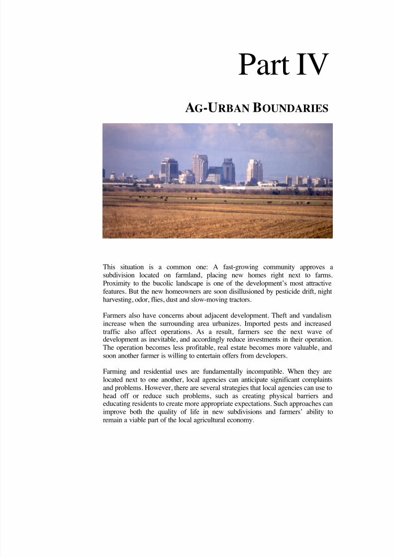
8/8/2019 22457.Farmland Action Guide
http://slidepdf.com/reader/full/22457farmland-action-guide 117/164
Part IVAG-URBAN BOUNDARIES
This situation is a common one: A fast-growing community approves asubdivision located on farmland, placing new homes right next to farms.Proximity to the bucolic landscape is one of the development’s most attractive
features. But the new homeowners are soon disillusioned by pesticide drift, nightharvesting, odor, flies, dust and slow-moving tractors.
Farmers also have concerns about adjacent development. Theft and vandalismincrease when the surrounding area urbanizes. Imported pests and increasedtraffic also affect operations. As a result, farmers see the next wave of development as inevitable, and accordingly reduce investments in their operation.The operation becomes less profitable, real estate becomes more valuable, andsoon another farmer is willing to entertain offers from developers.
Farming and residential uses are fundamentally incompatible. When they arelocated next to one another, local agencies can anticipate significant complaints
and problems. However, there are several strategies that local agencies can use tohead off or reduce such problems, such as creating physical barriers andeducating residents to create more appropriate expectations. Such approaches canimprove both the quality of life in new subdivisions and farmers’ ability toremain a viable part of the local agricultural economy.
8/8/2019 22457.Farmland Action Guide
http://slidepdf.com/reader/full/22457farmland-action-guide 118/164
L AY OF THE L AND
Percentage of Californians who feel that it is at least somewhat likely that too much farmland will be builtover, causing food shortages and rising food prices: 63% 2
Number of agricultural commodities in which California leads the nation: 77 3
Percentage of woman farm operators in California in 1978: 7.6% 1
Percentage of woman farm operators in California in 1998: 13.6% 1
Estimated number of farmers’ markets in the United States: 2,800
Increase in the number of local farmers’ markets from 1994 to 2000: 63%
Chance that a pound of fertilizer sold in California will be used in agricultural production: 1 in 3 1
Percentage of farm operators who consider farming their principal occupation: 53% 1
Number of people fed annually by the typical farmer in 1980: 25
Number of people fed by annually the typical farmer today: 135
Number of California farms owned by African Americans, Hispanics,Asians and Pacific Islanders: 10.5% 1
Percentage of farms owned by African Americans, Hispanics, Asiansand Pacific Islanders nationally: 3.3% 1
Approximate number of California counties that have adopted right-to-farm ordinances: 50
Approximate number of California cities that have done the same: 40
Amount spent in legal fees by one Elk Grove, California farmer defending his turkey operation against asingle nuisance complaint from a neighboring landowner: $1.5 million 7
SOURCES: (1) Agricultural Issues Center, The Measure of California Agriculture 2000 (www.aic.ucdavis.edu) • (2) Poll conducted byFairbank, Maslin, Maullin & Associates for the Nature Conservancy and the Conservation Fund (July 13, 1999) (3) California Farm BureauFederation (www.cfbf.org) • (4) Public Policy Institute of California (www.ppic.org), special surveys on Land Use (Nov. 2001) and Growth(May 2001) • (5) Kuminoff et al , Issues Brief: Farmland Conversion: Perceptions and Realities, Agricultural Issues Center (May 2001)(www.aic.ucdavis.edu) • (6) American Farmland Trust, Owners' Attitudes Toward Regulation of Agricultural Land: Technical Report on a
National Survey (1998) (www.farmland.org/cfl/survey.htm) • (7) Sacramento Bee, Farms and suburbs can make troublesome neighbors(October 19, 1998).
8/8/2019 22457.Farmland Action Guide
http://slidepdf.com/reader/full/22457farmland-action-guide 119/164
RESOLVE AG-URBAN
CONFLICTS Residential neighborhoods and agricultural zones are not ideally suited tobe located side by side. The business of farming produces side-effects thaturban residents may find objectionable. Likewise, farmers often incuradditional costs associated with living in close to large residential areas.This section describes the sources of this controversy; how to minimize itby reorienting local planning and structural design practices; and examinesmediation and other community solutions to unavoidable disputes.
SOURCES OF CONTROVERSY A number of potential conflicts are likely when urban areas encroach onfarmland. Pesticide application, addressed on the next page, is perhaps themost obvious. Other issues include:
• Farm Equipment Storage. Farmers often accumulate equipment to usefor parts or future needs. But urban neighbors see the collection of pipes, trailers and other miscellaneous objects as a junkyard andcomplain to the code enforcement officer. Similar problems result fromdilapidated storage sheds, barns and other structures.
• Trespassing and Theft. Urban communities pose the threat of theft.Targets include vehicles, fruit, livestock or anything else that may bevaluable. Farmers have greater liability risk when increasing numbersof people are tempted to wander onto farm property. Theft can alsohave a major impact on a farmer’s livelihood. In San Joaquin County,farm thefts (including trucks and tractors) exceeded $683,000 in 2001. 1
• Shared Roadways. Residential development brings cars, bicycles andpedestrians onto roadways used by farm trucks and slow-movingtractors. This increases the risk of accidents and mutual inconvenience.
• Odors and Livestock. Wind shifts can cause unpleasant reminders of
nearby cows, pigs and turkeys. Farm animals occasionally escape andappear unexpectedly on roads. Farm pests sometimes stray from fieldsto make new homes in backyards and living areas.
1 Farm Theft Reaps Big Rewards for Criminals, Oakland Tribune (April 29, 2002).
Sources of Controversy........111
Influence of Planning andDesign........................................113
Mediation Techniques .......... 114
18STRATEGY

8/8/2019 22457.Farmland Action Guide
http://slidepdf.com/reader/full/22457farmland-action-guide 120/164
112 | F ARMLAND P ROTECTION A CTION G UIDE S TRATEGY 1 8
• Pets. New residents bring pets that may attack livestock. Dog attackscause livestock stress, which can reduce the number of lambs born insheep operations or reduce milk production in dairies.
• Noise. Machinery often operates late into the night during harvestseason and other times of the year.
PESTICIDE ISSUES
Perhaps the most difficult and persistent point of conflict between farmersand their urban neighbors is the spraying of pesticides. 2 Agriculturalcommissioners enforce regulations on pesticide application. 3 Nevertheless,the increased proximity of urban populations heightens concern thatdrifting pesticides will create human health risks and damage property.
State law prohibits local agencies from adopting regulations that controlpesticide application or its timing. 4 Accordingly, local agencies must relyon informal processes to resolve disputes. The silver lining is that theremaining available options require farmers and their neighbors to engagein community problem-solving.
Kern and Napa counties are good examples of an informal process that hasbeen developed between grape growers and their neighbors. The grapefarmers provide notice before dusting their crops with sulfur (necessary tocombat a grapevine fungus). The nearby residents can then plan around thefarmers’ dusting schedule. The county agricultural commissioners take an
active role in making sure that the parties communicate.
Another type of resolution was reached in Fresno County, where a largepercentage of farms use crop dusters (airplanes and helicopters) to applypesticides and fertilizers. Fresno County uses an ad hoc method of restricting air space to crop dusters, called ‘red zoning.” Red zoning beganin the 1970s, when the agricultural commissioner drew a lineapproximately a one-half mile outside the City of Fresno’s developedareas. Inside the line, crop dusters voluntarily seek the commissioner’sapproval before they apply any material. 5
2 In California, laws regulating pesticide application include herbicides as well. Cal. Food & Agric.Code § 12753.3 See Cal. Code Regs. tit. 3, § 6460.4 Cal. Food & Agric. Code §§ 11501 and following. Methyl bromide is the only chemical for which thestate has a fumigation notification requirement. Cal. Food & Agric. Code §§ 14081, 14082.5 Douglas N. Edwards, Proceedings of a Workshop: Farmers & Neighbors, Land Use, Pesticides, and Other Issues, UC Agricultural Issues Center (1996) at 39.

8/8/2019 22457.Farmland Action Guide
http://slidepdf.com/reader/full/22457farmland-action-guide 121/164
I NSTITUTE for L O C A L S EL F G OVERNMENT C O M M U N I T Y L A N D U SE P R O J E C T | 1 13
INFLUENCE OF PLANNING AND DESIGN Some conflicts between farmers and their urban neighbors can be “plannedaway” by using design elements that increase the distance betweenfarmland and residential properties near urban limit lines. For example,planners may require that a large buffer be placed between farmland and anew development to physically separate the two uses. Other techniquesinclude increasing set-back requirements or even planting trees. Anothertechnique is to gradually “feather” densities toward farmland to decreasethe number of residents that actually abut farm areas.
Thoughtful design can minimize some conflicts by changing a building’s
orientation or adjusting the window or deck locations according to theirsurroundings. In one example in San Diego County, a design flaw causedproblems for residents of a condominium development, which wasconstructed adjacent to well-established greenhouses. The condo balconiesfaced the greenhouses, and the greenhouse vents released pesticidesdirectly toward the balconies on treatment days. This problem could havebeen avoided if the design review committee had recognized the proximityto the greenhouses as a potential problem, and refused to issue a permit forthe project without an alternate design that solved the problem byreorienting the balconies.
O THER T O O L S F O R C OMMUNITY P ROBLEM - S O LV I N G
Many conflicts can be addressed by creatingforums to resolve differences before people’spositions become entrenched. Communityproblem-solving can be achieved through:
• Community Meetings. One-time eventsare held to identify problems andsolutions.
• Neighborhood Committees. Arearesidents address issues in an ongoingseries of meetings.
•
Advisory Committees. Stakeholdersaddress issues in an ongoing series of meetings.
• Study Circles . A fact-finding groupstudies a single issue; participants aregiven reading material prior to meeting;and moderating duties rotate.
• Roundtables . These small groups usefacilitated discussions around a particularissue, generally held in a single meetingso citizens can share ideas and concerns.
• A Working Committee . A fact-findingcommittee investigates issues and makesrecommendations; it can includerepresentatives from the legislative body.
• Hotlines or an E-mail Suggestion Box .Hotlines and e-mail are effective,convenient tools for gathering informationand viewpoints.
• A Web Site . Feedback is often improvedwhen the community has access to betterinformation. The Internet provides anaffordable way to disseminateinformation.
8/8/2019 22457.Farmland Action Guide
http://slidepdf.com/reader/full/22457farmland-action-guide 122/164
114 | F ARMLAND P ROTECTION A CTION G UIDE S TRATEGY 1 8
MEDIATION TECHNIQUES
Inevitably, disputes arise despite all efforts to isolate residences fromagricultural operations or improve communication between farmers andurban neighbors. When direct negotiation fails, local agencies can usedispute resolution programs that offer a simple, inexpensive means forthose involved to air their differences. Mediation is generally a method of nonbinding dispute resolution, involving a neutral third party who tries tohelp the disputing parties reach a mutually agreeable solution.
The City of Davis has established a grievance procedure intended to settledisputes resulting from “inconveniences or discomfort” caused byagricultural operations. The process involves a meeting held within 25days of submitting of the dispute to a hearing officer. Prior to the meeting,
the hearing officer investigates the underlying facts. The parties in theconflict are encouraged to ask the county agricultural commissioner for astatement that addresses whether the underlying activity is an acceptedfarming practice. At the meeting, both parties have an opportunity topresent their side of the dispute. Attorneys may be present only if bothsides agree to it beforehand. The hearing officer issues a written decisionwithin five days of the meeting and the parties split the cost. The processdoes not preclude either party from bringing legal action against the other.Neither party is required to use the grievance procedure before pursuinglegal action.
San Diego County’s Agricultural Interface Board provides a different
model. The board brings farmers, neighbors and the relevant publicagencies together to discuss complaints concerning agricultural operations.At the request of community members, the agricultural commissioner mayconvene the board, which then holds a series of meetings. The first meetingallows neighbors to vent frustrations and concerns. Agencies and farmersspend most of their time listening. The meeting is facilitated because of itsemotional nature.
After the first meeting, the agricultural commissioner assigns a staff personto serve as an intermediary between the farmer, the neighbor and theappropriate contact people in the agencies. Follow-up meetings are used toassess progress, and provide the agencies and farmer an opportunity toexplain the factors affecting their ability to address the complaint.

8/8/2019 22457.Farmland Action Guide
http://slidepdf.com/reader/full/22457farmland-action-guide 123/164
I NSTITUTE for L O C A L S EL F G OVERNMENT C O M M U N I T Y L A N D U SE P R O J E C T | 1 15
ADOPT A “R IGHT -TO -FARM ” O RDINANCE One difficulty that farmers face in urbanizing areas is that new residentsmay perceive typical farming practices as a “nuisance” (see “A WordAbout Nuisances,” next page). Right-to-farm ordinances were developed tooffset this problem in two ways: by providing dispute resolutionmechanisms for neighbors as an alternative to filing nuisance-type lawsuitsagainst farming operations; and by notifying prospective buyers about therealities of living close to farms before they purchase property.
When new residents have clear expectations, the theory goes, they are lessinclined to complain about sprays, dust, odors, noise and other aspects of agricultural activities. However, it’s one thing to acknowledge that farmerswork long hours in the fields and quite another to be awakened at sunriseby the sound of a nearby tractor. While right-to-farm ordinances do noteliminate all conflicts, they can help reduce problems by educating newand prospective residents about life near a farm.
ORDINANCE ELEMENTS Approximately 40 counties and 50 cities have adopted right-to-farmordinances. These ordinances, however, are more about awareness thanproperty rights. State law already limits lawsuits resulting from farmpractices that disturb neighboring property owners. 1 Local agenciesaccordingly focus on public education and dispute mediation. Most localright-to-farm ordinances include one or more of the following elements:
• A Policy Statement. A policy statement can outline the intent topreserve agricultural operations, promote a good-neighbor policy orarticulate agriculture’s valuable role in the local economy.
• Definitions. Most ordinances define “agricultural operation” accordingto state code. 2 This section may also designate the areas where the
1 Cal. Civ. Code §§ 3482.5, 3482.6 (protecting agricultural and agricultural processing activities).2 Cal. Gov't Code § 3482.5 (defining “agricultural operation” as the cultivation and tillage of the soil,dairying, the production, cultivation, growing and harvesting of any agricultural commodity includingtimber, viticulture, apiculture, or horticulture, the raising of livestock, fur -bearing animals, fish orpoultry, and any practices performed by a farmer or on a farm as incident to or in conjunction withthose farming operations, including preparation for market, delivery to storage or to market, or deliveryto carriers for transportation to market).
Ordinance Elements..............115
Increasing PublicAwareness ................................117
19STRATEGY
8/8/2019 22457.Farmland Action Guide
http://slidepdf.com/reader/full/22457farmland-action-guide 124/164
116 | F ARMLAND P ROTECTION A CTION G UIDE S TRATEGY 1 9
protection applies. Some counties define farmland more broadly asland that currently or potentially supports active farm operations.
•
A “Coming to the Nuisance” Warning . This is a declaration thatnormal farming operations do not constitute a nuisance. State lawalready protects operations that have been in place for three or moreyears. 3 Some local ordinances reduce this time to one year.
• An Agricultural Use Notice . An agricultural use notice requiressellers, real estate agents or title companies to inform prospectivehomebuyers that commercial farming operations are close by and thatodors, dust, flies and noise may accompany such operations. 4
• Grievance Procedures . A grievance committee may be established tomediate disputes between farmers and nonfarm residents. 5
• Vandalism Fines . Fines may be levied for vandalism, pilferage or lossof livestock due to domestic animal predation.
These elements can create a degree of certainty for farmers. Knowing thattheir operations have some protection, farmers are more likely to continueto invest in farming.
3 Cal. Civ. Code § 3482.5. However, this is not a blanket protection. The activity must be conducted ina manner consistent with accepted industry standards in the locality. Mohilef v. Janovici , 51 Cal. App.4th 267 (1996). The protection only applies when: (1) it’s an agricultural activity (2) conducted forcommercial purposes (3) in manner consistent with proper standards (4) as followed by similaroperations in same locality; and (5) the claim of nuisance arises due to any changed condition (6) afteractivity has been in operation for more than three years; and (7) the activity was not nuisance at time itbegan. Souza v. Lauppe, 59 Cal. App. 4th 865 (1997).4 Local agencies are authorized to adopt such provisions under Cal. Civ. Code § 1102.6(a).
A W O R D A BOUT “ N UISANCES ”
The original idea behind right-to-farm ordinances was to prevent new
residents from suing to stop or alter established farm practices. Suchdisputes usually involved claims that farm practices were so invasive interms of noise, odor or other elements that they unreasonably interferedwith the use and enjoyment of neighboring properties. Typically, theremedies sought (in addition to money) involved regulating theoperation of farm machinery, application of pesticides and fertilizers,disposal of manure, storage of machinery or other typical farmingactivities. State law limits neighboring property owners from bringingthese types of claims against farm operations and agriculturalprocessing facilities.
8/8/2019 22457.Farmland Action Guide
http://slidepdf.com/reader/full/22457farmland-action-guide 125/164
I NSTITUTE for L O C A L S EL F G OVERNMENT C O M M U N I T Y L A N D U SE P R O J E C T | 1 17
INCREASING PUBLIC AWARENESS Right-to-farm ordinances can shape community expectations by providinga clear picture of what it means to live close to agricultural operations.Disclosure is usually accomplished in one of three ways:
1. Tax Bills. The annual tax bills sent to owners of property close to farmareas may include disclosure information.
2. New Projects. Disclosure information may be provided in connectionwith new development located near agricultural activity, usually whena subdivision or parcel map is approved or building permits are issued.
5 Most programs are seldom used. M. Wacker, A. Sokolow and R. Elkins, County Right-to-FarmOrdinances in California: An Assessment of Impact and Effectiveness , University of CaliforniaAgricultural Issues Center, AIC Issues Briefs, May 2001, at 4.6 Wacker, et al., supra. at 3.
H O W E FFECTIVE ARE R IGHT - TO -F ARM O RDINANCES ?
What do people who manage urban-agricultural issues say about right-to-farm ordinances?This question was posed to agricultural commissioners, farm bureau leaders, real estaterepresentatives and UC Cooperative Extension Service staff in 15 counties. The study’sfindings are summarized below. 6
• Primarily Educational Tools. Right-to-farm ordinances are primarilyeducational tools. They promoteawareness of the value of agriculture.Their most important role is to alerthomebuyers to the realities of living neara farm.
• Useful for Mediation . Right-to-farmordinances serve as a valuable referencefor local officials responding tocomplaints and facilitating disputeresolution.
• No Substitute for Good Planning .Right-to-farm ordinances do not take theplace of land use regulations that defineurban-agricultural boundaries. They lackthe power of zoning and subdivision
controls to preserve farmland.
• Weak Implementation . Only a fewlocal agencies play an active role inimplementing disclosure requirementsfor real estate transactions. In general,this implementation suffers from a lackof coordination among agenciesinvolved in developing and revisingright-to-farm ordinances.
• Do Not Insulate Farmers from Lawsuits . Right-to-farm ordinancesoffer little additional protection fromlawsuits beyond that already providedin the state’s right-to-farm law.
• Impact on Complaints is Uncertain .Adopting a right-to-farm ordinance hasno definitive impact on the number of complaints directed against farming.

8/8/2019 22457.Farmland Action Guide
http://slidepdf.com/reader/full/22457farmland-action-guide 126/164
118 | F ARMLAND P ROTECTION A CTION G UIDE S TRATEGY 1 9
3. Notice at Sale. Disclosure information may be included as part of areal estate sale transaction involving residential or other propertylocated near agricultural activity.
Each of these methods reaches different audiences and has varying levelsof effectiveness. Tax bill notifications, for example, while broad in scope,serve notice only after the property has been purchased. A notice at thetime of sale, however, is not an ongoing notice. As a result, many localagencies require more than one method of notification. For example,Stanislaus and Sonoma counties use all three methods. Sonoma County haseven added a fourth component by having sheriff’s deputies distributepamphlets that describe county agriculture to residents. 7
Thus, local agencies that want to implement or revisit a right-to-farmordinance have several options. An effective ordinance is one that fully
informs affected parties and the community at large about the importanceof maintaining productive agriculture in the face of urban growth.
7 Id. at 5.
T HE R IGHT - TO - F ARM IN D AV I S
The City of Davis has a right-to-farm ordinance with the followingelements:
• Notification . Buyers considering home purchases within 1,000feet of agricultural land and processing facilities must be notifiedthat farming operations are permitted within the city and county;
• Acknowledgement . The possibility of inconvenience ordiscomfort from such operations is acknowledged;
• Environmental Compliance. Farmers, agricultural processors orothers must still comply with all local, state and federal laws. Fornoncompliance with appropriate state, federal or local laws, legalrecourse is possible by, among other ways, contacting theappropriate agency;
• Contact Point . Concerned citizens may contact the countyagricultural commissioner; and
• Grievance Procedure . A grievance procedure is provided if adispute escalates.

8/8/2019 22457.Farmland Action Guide
http://slidepdf.com/reader/full/22457farmland-action-guide 127/164
CREATE BUFFER ZONES
Every city adjacent to agricultural areas has a point where the urban areaends and farming begins. Agricultural buffers provide a way to minimizeconflict by creating space or improving the barrier between agriculturaloperations and urban residents. There are two basic methods of creatingbuffers. The first is to create space or place a physical barrier between theagricultural operation and the residential use. The second is to usetransitional zoning techniques to ensure that the uses on the boundary aregenerally compatible.
An ideal buffer would be located along a permanent boundary betweenagricultural and urban uses. Indeed, many agencies report a reduction inthe number of complaints they receive about neighboring agriculturaloperations in areas where buffers have been created. 1 A buffer area may beas narrow as a stand of trees or a country road, or as large as 1,000 feet ormore. Buffer zones reduce the amount of noise and odor that can carry toresidential areas. They also reduce the risk to farmers of domestic animalpredation, crop theft and damage and complaints from neighboring urbandwellers. A fixed boundary also reduces the chance that additionalfarmland will be converted to urban uses.
Buffers can also be used to protect environmental quality. Appropriately
placed buffer strips control soil erosion and protect water quality, whichcan help local farmers comply with environmental regulations. Buffers canremove up to 50 percent of the nutrients and pesticides, 60 percent of thepathogens and 75 percent of the sediment associated with agriculturalrunoff, which can harm water quality. 2 When coupled with farmmanagement practices such as nutrient control and cover cropping, bufferstrips achieve a measure of environmental sustainability. Furthermore,farmers with buffer strips usually undertake additional conservationpractices, such as minimum tillage. 3 One study found that buffers can
1 Laura Thompson, The Conflict at the Edge, Zoning News, February 1997, at 1. See AmericanPlanning Association Web site at www.planning.org/ZoningNews.2 U.S. Department of Agriculture, Natural Resources Conservation Service, Benefits of Buffers www.nhq.nrcs.usda.gov/CCS/Buffers.html#Anchor-WhatBuffer.3 Applied Research Systems, Inc., The National Conservation Buffer Initiative: A Qualitative Analysis 51 (1999). Available through the Natural Resources Conservation Service Web site atwww.nhq.nrcs.usda.gov/CCS/BuffQual.pdf.
Types of Physical Buffers ....120
Implementation Issues..........121
Ag-ResidentialTransition Zones .................... 123
20STRATEGY
8/8/2019 22457.Farmland Action Guide
http://slidepdf.com/reader/full/22457farmland-action-guide 128/164
120 | F ARMLAND P ROTECTION A CTION G UIDE S TRATEGY 2 0
actually increase the value of the farm on which they are located by asmuch as 5 to 15 percent. 4
TYPES OF PHYSICAL BUFFERS Buffers should be designed to fit each community’s needs. In most cases,farmers want to maintain the land’s traditional use. Urban residents,however, may have multiple demands. In addition to keeping theagricultural operation (and its “nuisance” activities) at a safe distance,urban residents may also be concerned about the buffer’s aesthetics,maintenance and landscaping. Fortunately, there are a variety of tools thatlocal agencies can use to implement buffer programs, including:
• Fences and Barriers. Particularly in cases where houses are built
immediately adjacent to farmland, barriers such as fences, walls or treerows may be the only available option. Many farmers already plant treerows to reduce the likelihood of pesticide drift onto neighboringproperties. One consideration is whether to include some designelement for walls and fences to avoid a pla in, stark appearance.
• Physical Dedications. When large developments are approved, a localagency will sometimes require that a strip of land be dedicated ormaintained as a buffer as a condition of new development. 5 Otherinfrastructure requirements, such storm drainage, can often beincorporated into the buffer area to limit the developer’s cost.
• Topographic Buffers . Existing land uses and topography can formvery effective buffers. Such barriers can be natural, such as rivers,flood plains or hillsides; or man-made, such as roads, railroad tracks,parking lots or power line rights-of-way. Some communities useirrigation canals, which can often contribute a swath of 100 feet ormore (including service roads) to the buffer. Integrating buffers intothe existing landscape saves money and reduces the perception thatthey impose an “artificial” boundary on development.
• Setback Requirements. A setback is a restriction (usually implementedby zoning ordinance) that limits building within a certain number of feet from the property line that abuts the farming operation. Setbacksrange from 100 to 1500 feet, but are commonly set at 150 to 300 feet.Setbacks are typically used in connection with rural residential zoning,
4 National Association of Conservation Districts, Buffers Work in Urban Areas Too! , Buffer Notes (June 2000) www.nacdnet.org/buffers/00Jun/urban.htm.5 To the extent that a local agency imposes such a requirement on new development, it is better to adoptthe requirement by ordinance. See Strategy 2.
P R A C T I C E T IPS
Take Advantage of Existing Geography. Look for existingphysical features whenplanning a buffer zone.A road, canal, railroadtracks, streams andwaterways or other
pre-existing featurescan provide elementsto help separatefarmland from itssurroundings.
Health and Safety Findings. Whenimplementing bufferprograms, publicagencies should makefindings describing the
health and safetybenefits of bufferzones and how theagency’s individualprogram is tailored tomeet the community’shealth and safetyneeds .

8/8/2019 22457.Farmland Action Guide
http://slidepdf.com/reader/full/22457farmland-action-guide 129/164
I NSTITUTE for L O C A L S EL F G OVERNMENT C O M M U N I T Y L A N D U SE P R O J E C T | 1 2 1
which creates a block of large “ranchette” lots (five to 20 acres)between farmland and urban residential areas. The ranchette landownercan use the buffer strip for less intensive purposes, such as storage or
livestock grazing.
IMPLEMENTATION ISSUES Many of the same funding sources that are available for agriculturalconservation easements (see Strategy 23) may be available for bufferprograms. Two other key considerations are the arrangements for long-term maintenance and use of the buffer:
• Maintenance. One critical issue that should be addressed in any bufferprogram is who will own the buffer and assume responsibility for weedand pest control, fire hazard management and other maintenanceissues. In many cases, the local agency elects to maintain the bufferitself and includes the costs in its park maintenance budget. In somecases, where the buffer set-aside was required as a condition of development, the ownership may remain with a homeowners
6 City of Davis, Cal., Code §§ 40A.01.050 and following (1995).7 Thompson, supra . at 2.
T W O B UFFER P R O G R A M E XAMPLES
City of Davis. The City of Davis requires a 150-foot buffer and encouragesa 500-foot aerial spray setback. 6 Public access is kept to a minimum in thefirst 100 feet adjacent to the agricultural operation. Buffers allow these
types of land uses: trees, drainage swales, utility corridors and certainagricultural uses, such as organic farming. The last 50 feet abutting thedevelopment allows increased public uses, such as bike paths, hedgerowsand trash enclosures. The entire 150 feet is generally dedicated to the cityby the developer after the improvements have been made, whereupon thecity annexes the area to an existing lighting and landscape district formaintenance.
San Luis Obispo County. San Luis Obispo designates buffer width on acase-by-case basis. Factors in the calculation include the type of cropproduction, zoning, site topography and wind direction. Distances rangefrom 400 to 800 feet for vineyards, 300 to 800 feet for irrigated orchards,
and 100 to 400 feet for field crops.7

8/8/2019 22457.Farmland Action Guide
http://slidepdf.com/reader/full/22457farmland-action-guide 130/164
122 | F ARMLAND P ROTECTION A CTION G UIDE S TRATEGY 2 0
association — particularly if the area doubles as a park or stormdrainage. If the buffers are maintained privately, then codeenforcement officers should be assigned to conduct periodic visits to
ensure the program’s integrity.• Permitted Uses. It is often tempting to create some kind of trail to
provide public access to a buffer and its views of agricultural land.However, farmers may be concerned about having trails close to theircropland. The presence of human activity too close to farmland mayrestrict farmers’ ability to apply pesticides. 8 Encouraging public use of the strip may also increase the number of complaints. One way tobalance these competing interests is to divide the buffer into subzones.The City of Davis accomplished this by locating trails in the part of thebuffer closest to the residential area, while the part of the bufferadjacent to the farmland includes trees and drainage swales.
8 Cal. Code Regs. tit. 3, § 6614 (1995) (prohibiting pesticide application where there is a reasonablepossibility of contamination of persons not involved in the application process).
F IVE S T E P S F O R G E T T I N G S TA RT E D
A report by the Great Valley Center (see ‘For More Information”, next page)provides a five step process for designing and implementing a buffer policy:
1. Determine Local Need. Study the community issues. What type of farming exists at the urban fringe? Assess the type and frequency of complaints. What role should buffers play in addressing these issues?
2. Examine the Process. Establish a buffer team. Are there special issues that
should be addressed at the outset? What other jurisdictions should beinvolved? To what extent will LAFCO policies affect options? Encouragecommunitywide agriculture awareness and education.
3. Define the Community’s Agricultural Principals. How does thecommunity envision its growth? Assess the strength of local will tomaintain agriculture as economic contributor.
4. Adopt an Effective Policy. How well do current policies address growthissues? How can existing buffer programs be improved? Review generalplans to determine how best to close existing gaps. Review policydirection on rural residential development: Where will it be allowed andwhere does it fit in?
5. Investigate Funding Options. Explore local options for funding buffers aspart of the necessary infrastructure. Identify potential external fundingsources.

8/8/2019 22457.Farmland Action Guide
http://slidepdf.com/reader/full/22457farmland-action-guide 131/164
I NSTITUTE for L O C A L S EL F G OVERNMENT C O M M U N I T Y L A N D U SE P R O J E C T | 1 2 3
• Environmental Considerations. Several federal programs to improvewater quality and erosion are encouraging farmers to place bufferzones on their land. More information on these programs is available
on the National Conservation Buffer Initiative Web site, operated bythe U.S. Department of Agriculture. 9
Finally, a truly effective buffer strategy depends upon the permanence of the ag-urban boundary. Today’s buffer zone can be tomorrow’s linear park,if the ag-urban boundary is continually advancing into farmland.
AGRICULTURE -RESIDENTIALTRANSITION ZONES Parcels of land are not always available to serve as dedicated buffer areas.In such cases, zoning regulations provide another alternative for separatingincompatible uses by creating intermediate zones where only less-intensiveurban and agricultural uses are permitted.
On the urban side, zoning can be used to discourage the build-out of residential neighborhoods adjoining rural lands. For example, parcels thatare likely to border agricultural operations may be better suited forcommercial or light industrial uses rather than parks, schools or homes.Such uses are less likely to generate the conflicts associated withresidential uses. Ideally, agricultural service industries, such as processing,warehousing or farm machinery businesses, could also be located in theseareas. It is unlikely that agriculturally related businesses would perceiveneighboring agricultural operations as a nuisance.
Similarly, agricultural operations can also be zoned to reduce potentialconflicts. Not all farming activities have the same impact on surroundingresidents. For example, zoning can be used to separate foul-smellinglivestock and poultry operations from residential neighborhoods. Thisconcept is analogous to creating light and heavy industrial zones.
Such programs usually require an initial investment in documenting localresources and conditions. Soil quality, residential development patterns,farming needs, drainage patterns and prevailing winds are just a few of thefactors that should be taken into account. Once the agricultural zones are
9 Natural Resources Conservation Service, USDA Conservation Programs (last visited Mar. 19, 2002)www.nrcs.usda.gov/NRCSProg.html.10 The actual link is www.greatvalley.org/programs/agprograms/pdf/buffer_study.pdf. The report isalso available by contacting the Great Va lley Center, 911 13 th Street, Modesto, CA 95354, (209) 522-5103, e-mail [email protected].
F O R M OREI NFORMATION
An excellent resource on theseissues is Can City and FarmCoexist? The Agricultural
Buffer Experience inCalifornia, published by theGreat Valley Center. It isposted online at.
www.greatvalley.org
(click on ag programs, thenclick “buffer study”). 10
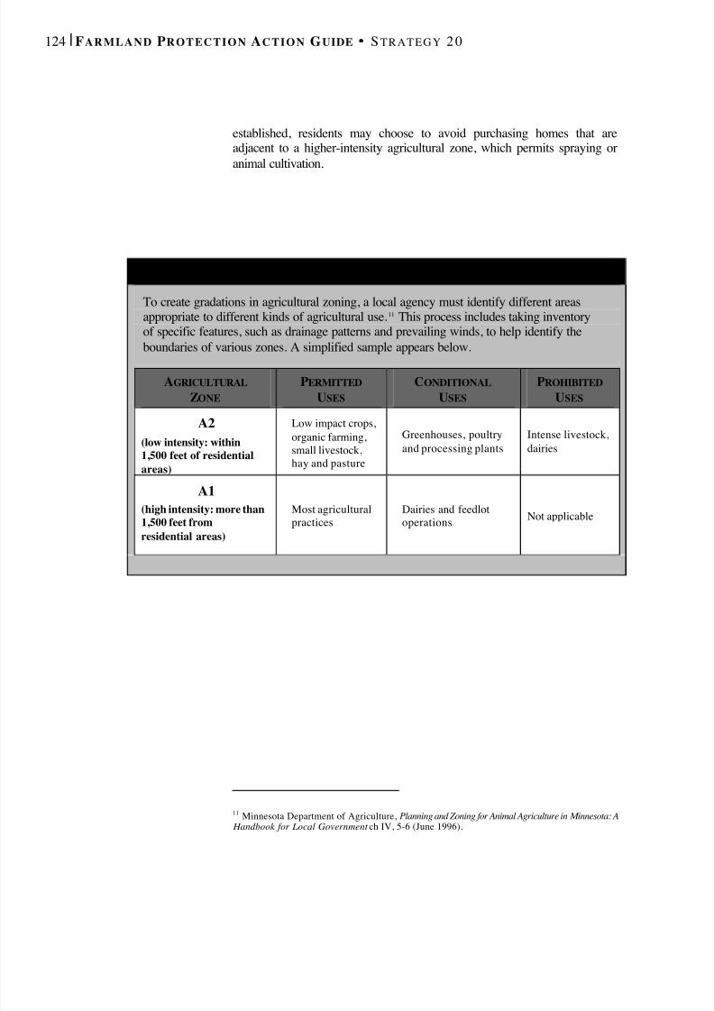
8/8/2019 22457.Farmland Action Guide
http://slidepdf.com/reader/full/22457farmland-action-guide 132/164
124 | F ARMLAND P ROTECTION A CTION G UIDE S TRATEGY 2 0
established, residents may choose to avoid purchasing homes that areadjacent to a higher-intensity agricultural zone, which permits spraying oranimal cultivation.
11 Minnesota Department of Agriculture, Planning and Zoning for Animal Agriculture in Minnesota: A Handbook for Local Government ch IV, 5-6 (June 1996).
S AMPLE A GRICULTURAL D ISTRICT ZONES
To create gradations in agricultural zoning, a local agency must identify different areasappropriate to different kinds of agricultural use. 11 This process includes taking inventoryof specific features, such as drainage patterns and prevailing winds, to help identify theboundaries of various zones. A simplified sample appears below.
AGRICULTURALZONE
PERMITTEDUSES
CONDITIONALUSES
PROHIBITEDUSES
A2(low intensity: within1,500 feet of residentialareas)
Low impact crops,organic farming,small livestock,hay and pasture
Greenhouses, poultryand processing plants
Intense livestock,dairies
A1(high intensity: more than1,500 feet fromresidential areas)
Most agriculturalpractices
Dairies and feedlotoperations Not applicable
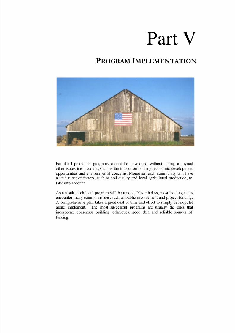
8/8/2019 22457.Farmland Action Guide
http://slidepdf.com/reader/full/22457farmland-action-guide 133/164
Part VP ROGRAM I MPLEMENTATION
Farmland protection programs cannot be developed without taking a myriadother issues into account, such as the impact on housing, economic development
opportunities and environmental concerns. Moreover, each community will havea unique set of factors, such as soil quality and local agricultural production, totake into account.
As a result, each local program will be unique. Nevertheless, most local agenciesencounter many common issues, such as public involvement and project funding.A comprehensive plan takes a great deal of time and effort to simply develop, letalone implement. The most successful programs are usually the ones thatincorporate consensus building techniques, good data and reliable sources of funding.

8/8/2019 22457.Farmland Action Guide
http://slidepdf.com/reader/full/22457farmland-action-guide 134/164
L AY OF THE L AND Chance that a citizen trusts the local agency to do what is right in the land use context: 1 in 2 4
Percentage of Californians who claim to have “a lot” of personal experience inlocal land use decision-making: 6% 4
Length of time that California has been the nation’s top producing agricultural state: 53 years 1
Total funding for conservation easements made available by Proposition 12: $25 million
Factor by which this exceeds previous funding levels: 4
Funding made available for agricultural preservation by Proposition 40: $75 million
Estimated total number of acres in conservation easements in California: 350,000
Estimated total number of agricultural acres enrolled in Williamson Act: 16 million
Percentage of agric ultural land converted to urban uses between 1988 and 1998: 1.5% 1
Number of farms in California in 1950: 144,000 1
Number of farms in California in 2000: 74,000 1
Percentage of these farms that are family or individually operated: 76% 3
Percentage of market value attributable to the 5,000 largest farms: 75% 1
Number of farms that have annual sales of less than $250,000: 62,000 1
California’s contribution to total national cash receipts from agriculture: 13% 1
Percentage of federal support programs benefiting agriculture in California: 3% 1
Percentage of landowners in a national survey who said their property value had not been reduced bygovernment environmental regulations: 70% 6
Percentage claiming that they had experienced a large decrease in land value: 8% 6
SOURCES: (1) Agricultural Issues Center, The Measure of California Agriculture 2000 (www.aic.ucdavis.edu) • (2) Poll conducted byFairbank, Maslin, Maullin & Associates for the Nature Conservancy and the Conservation Fund (July 13, 1999) (3) California Farm BureauFederation (www.cfbf.org) • (4) Public Policy Institute of California (www.ppic.org), special surveys on Land Use (Nov. 2001) and Growth(May 2001) • (5) Kuminoff et al , Issues Brief: Farmland Conversion: Perceptions and Realities, Agricultural Issues Center (May 2001)(www.aic.ucdavis.edu) • (6) American Farmland Trust, Owners’ Attitudes Toward Regulation of Agricultural Land: Technical Report on a
National Survey (1998) (www.farmland.org/cfl/survey.htm).
8/8/2019 22457.Farmland Action Guide
http://slidepdf.com/reader/full/22457farmland-action-guide 135/164
COLLECT HELPFUL AND
ACCURATE LOCAL DATA Obtaining accurate data on local agriculture helps any farmland protectioneffort. While farming challenges can be similar across regions, localproblems can be quite different. For example, farmland on the outskirts of the San Francisco Bay Area tends to be used for small vegetable or “truck”farms, farmers struggle with high land values and intense developmentpressure. On the other hand, Central Valley farmers with larger farms mayexperience less pressure to develop, but may still be willing to sell due tolow commodity prices.
Strategies to protect farmland should be tailored to take such factors intoaccount. Demographic and general economic trends should also beconsidered, along with the local agricultural economy’s strengths andweaknesses. Potential threats to the long-term viability of agriculture in theregion are another important consideration. Fortunately, there are a varietyof sources available to help local agencies gather this information.
INVENTORY FARMLANDMost local agencies want to focus their efforts on protecting the highest-
quality, most productive farmland. But where exactly are these areas? TheCalifornia Department of Conservation provides two useful starting pointsfor determining which lands are most threatened and most productive: theFarmland Mapping and Monitoring Program and the Land Evaluation andSite Assessment system.
FARMLAND MAPPING AND MONITORINGPROGRAM To help facilitate land use planning, the Farmland Mapping andMonitoring Program (FMMP) provides maps and statistical data on
agricultural land resources. 1 These maps provide a visual representation of how quickly and where farmland is being developed in each community.Local agencies can also use these maps to explain their land use strategy tothe public.
1 Farmland Mapping and Monitoring Program, California Farmland Conversion Report 1996-98(2000) ( www.consrv.ca.gov/dlrp/FMMP/fmmp_98rpt.htm). See Cal. Gov’t Code § 65570(b).
Inventory Farmland.............. 127
Economic andDemographic Data................. 130
Analyzing the Data ................131
21STRATEGY
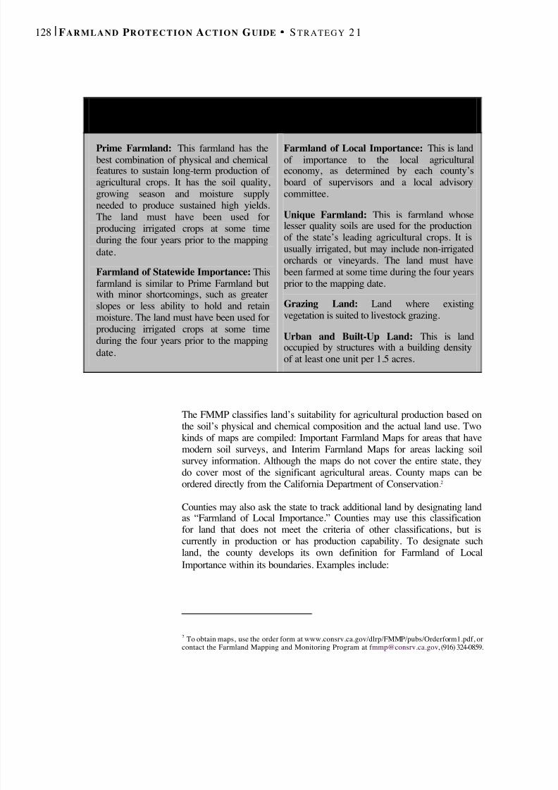
8/8/2019 22457.Farmland Action Guide
http://slidepdf.com/reader/full/22457farmland-action-guide 136/164
128 | F ARMLAND P ROTECTION A CTION G UIDE S TRATEGY 2 1
The FMMP classifies land’s suitability for agricultural production based onthe soil’s physical and chemical composition and the actual land use. Twokinds of maps are compiled: Important Farmland Maps for areas that havemodern soil surveys, and Interim Farmland Maps for areas lacking soilsurvey information. Although the maps do not cover the entire state, theydo cover most of the significant agricultural areas. County maps can beordered directly from the California Department of Conservation .2
Counties may also ask the state to track additional land by designating landas “Farmland of Local Importance.” Counties may use this classificationfor land that does not meet the criteria of other classifications, but iscurrently in production or has production capability. To designate such
land, the county develops its own definition for Farmland of LocalImportance within its boundaries. Examples include:
2 To obtain maps, use the order form at www.consrv.ca.gov/dlrp/FMMP/pubs/Orderform1.pdf, orcontact the Farmland Mapping and Monitoring Program at [email protected] , (916) 324-0859.
S TATE D EPARTMENT OF C O N S E RVAT I O N
S OIL Q UALITY C L A S S I F I C AT I O N S
Prime Farmland: This farmland has thebest combination of physical and chemicalfeatures to sustain long-term production of agricultural crops. It has the soil quality,growing season and moisture supplyneeded to produce sustained high yields.The land must have been used forproducing irrigated crops at some timeduring the four years prior to the mappingdate.
Farmland of Statewide Importance: Thisfarmland is similar to Prime Farmland butwith minor shortcomings, such as greaterslopes or less ability to hold and retainmoisture. The land must have been used forproducing irrigated crops at some timeduring the four years prior to the mappingdate.
Farmland of Local Importance: This is landof importance to the local agriculturaleconomy, as determined by each county’sboard of supervisors and a local advisorycommittee.
Unique Farmland: This is farmland whoselesser quality soils are used for the productionof the state’s leading agricultural crops. It isusually irrigated, but may include non-irrigatedorchards or vineyards. The land must have
been farmed at some time during the four yearsprior to the mapping date.
Grazing Land: Land where existingvegetation is suited to livestock grazing.
Urban and Built-Up Land: This is landoccupied by structures with a building densityof at least one unit per 1.5 acres.
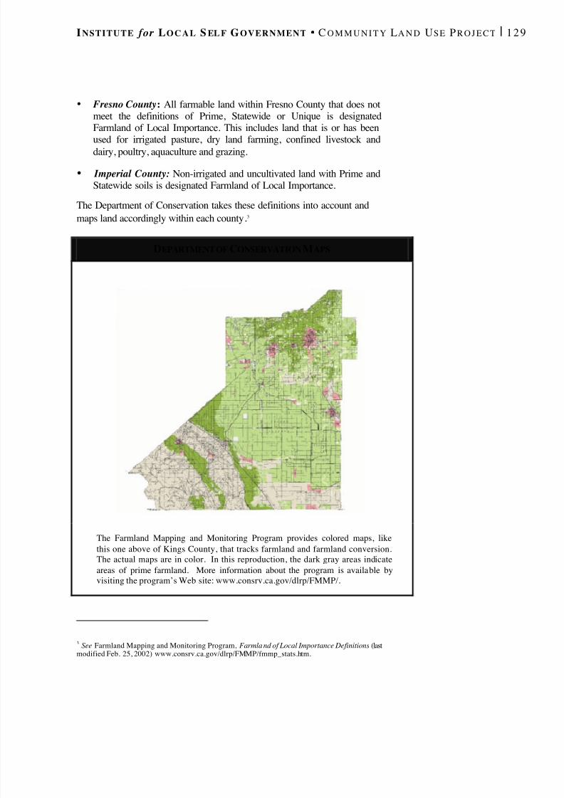
8/8/2019 22457.Farmland Action Guide
http://slidepdf.com/reader/full/22457farmland-action-guide 137/164
I NSTITUTE for L O C A L S EL F G OVERNMENT C O M M U N I T Y L A N D U SE P R O J E C T | 1 2 9
• Fresno County : All farmable land within Fresno County that does notmeet the definitions of Prime, Statewide or Unique is designatedFarmland of Local Importance. This includes land that is or has been
used for irrigated pasture, dry land farming, confined livestock anddairy, poultry, aquaculture and grazing.
• Imperial County: Non-irrigated and uncultivated land with Prime andStatewide soils is designated Farmland of Local Importance.
The Department of Conservation takes these definitions into account andmaps land accordingly within each county .3
DEPARTMENT OF CONSERVATION M APS
The Farmland Mapping and Monitoring Program provides colored maps, likethis one above of Kings County, that tracks farmland and farmland conversion.
The actual maps are in color. In this reproduction, the dark gray areas indicateareas of prime farmland. More information about the program is available byvisiting the program’s Web site: www.consrv.ca.gov/dlrp/FMMP/.
3 See Farmland Mapping and Monitoring Program, Farmla nd of Local Importance Definitions (lastmodified Feb. 25, 2002) www.consrv.ca.gov/dlrp/FMMP/fmmp_stats.htm.
8/8/2019 22457.Farmland Action Guide
http://slidepdf.com/reader/full/22457farmland-action-guide 138/164
130 | F ARMLAND P ROTECTION A CTION G UIDE S TRATEGY 2 1
LAND EVALUATION AND SITE ASSESSMENT
The Land Evaluation and Site Assessment (LESA) is a method of measuring the quality of specific farmland parcels. 4 LESA helps todetermine which land should be protected and which are suitable fordevelopment. The model was originally designed to assist local agenciesand individuals in evaluating the agricultural characteristics of specificsites, as indicated in the California Environmental Quality Act (CEQA)guidelines.
The LESA model is composed of six different factors that account for soilquality, size, water availability and location. Each factor is rated separatelyon a 100-point scale. The factors are then weighted and combined,resulting in a single numeric score. The project score becomes the basis formaking a determination about a project’s potential significance.
LESA can be a particularly effective tool for local decision-makingbecause it combines objective and subjective criteria. The land evaluationcomponent is based on scientific criteria, such as soil quality. The siteassessment component, however, is more subjective. Some jurisdictionsuse LESA to determine where agric ulture is likely to be viable in thefuture. Others use the scores to determine whether specific parcels shouldbe included in an agricultural zone.
ECONOMIC AND DEMOGRAPHIC DATA
Economic and demographic data are also helpful in developing a farmlandprotection program. Such data often include the total value of the farmservice economy (including processing and employment) and the value of agricultural production by each commodity. Other information that mayalso be useful includes:
• Minimum Farm Size : The minimum parcel size necessary for aneconomically viable farming operation.
• Industry Trends: Factors that affect the production and marketing of various commodities, such as market access, competition, newtechnologies and potential niche markets.
• Land Use Patterns: The history and development of agriculture withinthe region, as well as the historical growth patterns of urban areas.
4 7 C.F.R. § 658.4 (1994).
T HE LESAG UIDEBOOK
The California Departmentof Conservation published a
Model Instruction Manual for the LESA process,which provides step-by-stepinstructions on scoring andrating agricultural land.Forms are also included.
The manual is posted on theWeb at:
www.consrv.ca.gov
(keyword search “lesa”).
8/8/2019 22457.Farmland Action Guide
http://slidepdf.com/reader/full/22457farmland-action-guide 139/164
I NSTITUTE for L O C A L S EL F G OVERNMENT C O M M U N I T Y L A N D U SE P R O J E C T | 1 3 1
• Location of Existing Infrastructure: Physical features andinfrastructure, such as road sewers and water lines, that have a criticalimpact on the productivity of agricultural land.
• Environmental Issues : Any special environmental issues, such as soilsalinization, groundwater quality and quantity, air quality, agriculturalwastes, etc.
• Other Issues of Local Importance: Individual communities often haveunique issues.
Much of this information is readily available, and the local UCCooperative Extension Service is a good place to start. In addition,developing new primary data through the use of surveys and interviewscan help shape policy by providing additional information about localconditions.
ANALYZING THE DATA After collecting comprehensive data, what should be done next?Reviewing the data may reveal certain trends in the development of agriculture in the community and threats to it. This information may pointthe way to preservation options that are more likely to fit the community’sunique needs.
For example, in the City of Fresno, a soil quality is helping direct growthto the northwest portion of the city, which has a clay hardpan hindersdrainage and makes farming difficult. As a result, the city is trying toencourage development in this area and away from the higher quality soilsto the southwest. Analyzing quality local data can inform community-specific protection programs and improve their chances of success.
The following questions may be helpful to ask when discussing growthmanagement policy options:
• Based on agricultural production value, which areas have the highestpriority for protection? Which should have medium or low priority?
• Based on the threat of urban conversion, which areas have the highestpriority for protection? Which should have medium or low priority?
• Does one crop have a specialized service industry within the regionthat provides additional jobs?
• Is there an area with a particularly committed group of landownerswho would be willing to work together on a program?
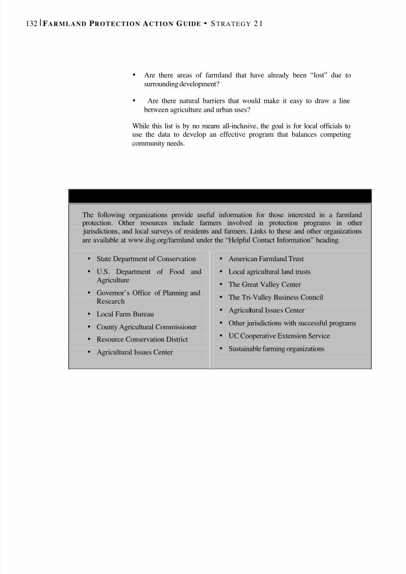
8/8/2019 22457.Farmland Action Guide
http://slidepdf.com/reader/full/22457farmland-action-guide 140/164
132 | F ARMLAND P ROTECTION A CTION G UIDE S TRATEGY 2 1
• Are there areas of farmland that have already been “lost” due tosurrounding development?
• Are there natural barriers that would make it easy to draw a linebetween agriculture and urban uses?
While this list is by no means all-inclusive, the goal is for local officials touse the data to develop an effective program that balances competingcommunity needs.
R ESOURCES FOR A GRICULTURAL D ATA A N D I NFORMATION
The following organizations provide useful information for those interested in a farmlandprotection. Other resources include farmers involved in protection programs in other
jurisdictions, and local surveys of residents and farmers. Links to these and other organizationsare available at www.ilsg.org/farmland under the “Helpful Contact Information” heading.
• State Department of Conservation• U.S. Department of Food and
Agriculture• Governor’s Office of Planning and
Research• Local Farm Bureau• County Agricultural Commissioner• Resource Conservation District• Agricultural Issues Center
• American Farmland Trust• Local agricultural land trusts• The Great Valley Center• The Tri-Valley Business Council• Agricultural Issues Center• Other jurisdictions with successful programs• UC Cooperative Extension Service• Sustainable farming organizations
8/8/2019 22457.Farmland Action Guide
http://slidepdf.com/reader/full/22457farmland-action-guide 141/164
I NSTITUTE for L O C A L S EL F G OVERNMENT C O M M U N I T Y L A N D U SE P R O J E C T | 1 3 3
DEVELOP CONSENSUS Developing community consensus is a key component of any farmlandprotection program. There are some very effective participation tools fordeveloping land use policy. 1 Many local agencies have created alternativeforums, such as town hall meetings and even e-mail discussion groups, toreach more people in their communities. Citizen panels can also developrecommended actions. Offering a number of ways for residents toparticipate serves as a proactive strategy to address contentious issuesbefore they become major problems — or even lawsuits.
Broad public involvement offers benefits that extend beyond farmlandconservation and urban planning. It builds community. Citizens who makecontributions to the process often report that they walk away with a feelingof pride and a stronger connection to the community.
ENCOURAGING PUBLIC INVOLVEMENT As a general rule, public involvement should occur early and often. To beeffective, public participation must be structured and meaningful. Endlessmeetings that lead nowhere can be a considerable drain on agencyresources and community patience.
There are several inherent barriers to meaningful participation. Manypeople dismiss such planning as “mere politics.” For others, the complexityof government structure and finance is overwhelming. Designing aninclusive process means taking these and other issues into account. Publicparticipation strategies should address basic logistical questions and moresubtle limitations to participation, such as:
• Outreach. Are notices posted where they are likely to be read? Arethey published in languages other than English? Are thereopportunities to reach a broader audience?
• Logistics. Are meetings always scheduled for the same time? Do theyoften extend late into the evening? Are they easily accessible by publictransit? Are interpreters available?
1 Many land use decisions require a formal public hearing even after the most inclusive publicparticipation process. Fo r example, a public hearing must be held before a city or county can adopt ageneral plan or general plan amendment. See Cal. Gov't Code § 65351.
Encouraging PublicInvolvement ............................. 133
Stakeholder and AdvisoryGroups ...................................... 135
Consensus-BuildingProcesses ................................... 136
22STRATEGY
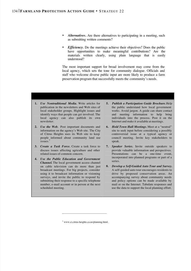
8/8/2019 22457.Farmland Action Guide
http://slidepdf.com/reader/full/22457farmland-action-guide 142/164
134 | F ARMLAND P ROTECTION A CTION G UIDE S TRATEGY 2 2
• Alternatives . Are there alternatives to participating in a meeting, suchas submitting written comments?
• Efficiency . Do the meetings achieve their objectives? Does the publichave opportunities to make meaningful contributions? Are thematerials written clearly, using plain language that is easilyunderstood?
The most important support for broad involvement may come from thelocal agency, which sets the tone for community dialogue. Officials andstaff who welcome diverse public input are more likely to produce a farmpreservation program that successfully meets the community’s needs.
2 www.ci.citrus-heights.ca.us/planning.html.
E IGHT C REATIVE W A Y S T O E NCOURAGE P UBLIC I NVOLVEMENT
1. Use Nontraditional Media. Write articles forpublication in the newsletters and Web sites of local stakeholder groups. Highlight issues andidentify ways that people can get involved. Thelocal agency can also publish its ownnewsletter.
2. Use the Web. Post important documents andinformation on the agency’s Web site. The Cityof Citrus Heights uses its Web site to keeppeople informed about community land use
issues.2
3. Create a Task Force. Create a task force to
discuss issues affecting agriculture and otherrelated issues of common concern.
4. Use the Public Education and Government Channel . The local government access channelon cable television can do more than justbroadcast meetings. For big projects, considerusing it to broadcast information or visioningsurveys, and invite the public to respond bysubmitting their response to a specific telephonenumber, e-mail account or in person at the nextscheduled meeting.
5. Publish a Participation Guide Brochure. Helpthe public understand how local governmentworks. Avoid jargon. A guide can share contactand meeting information to help bringindividuals into the process. Post it on theInternet and make it available at meetings.
6. Hold Town Hall Meetings. Meet at a “neutral”site to seek input before considering a possiblycontroversial issue at a typical agency orcouncil meeting. Invite key stakeholders to
speak.7. Speaker Series. Invite outside speakers to
provide valuable information and perspectives.Presentations can be a one-time event,incorporated into planned programs or part of aseries.
8. Develop a Self-Guided Auto Tour and Survey.A self-guided auto tour encourages residents todrive by proposed conservation areas. Anaccompanying survey about community needsand policy options can be made available bymail or on the Internet. Tabulate responses anduse the data to support the local planning effort.
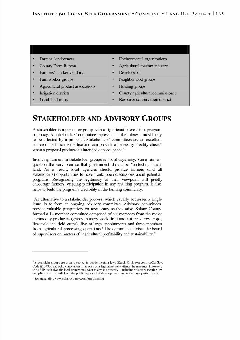
8/8/2019 22457.Farmland Action Guide
http://slidepdf.com/reader/full/22457farmland-action-guide 143/164
I NSTITUTE for L O C A L S EL F G OVERNMENT C O M M U N I T Y L A N D U SE P R O J E C T | 1 3 5
STAKEHOLDER AND ADVISORY GROUPSA stakeholder is a person or group with a significant interest in a programor policy. A stakeholders’ committee represents all the interests most likelyto be affected by a proposal. Stakeholders’ committees are an excellentsource of technical expertise and can provide a necessary “reality check”when a proposal produces unintended consequences. 3
Involving farmers in stakeholder groups is not always easy. Some farmersquestion the very premise that government should be “protecting” theirland. As a result, local agencies should provide farmers (and allstakeholders) opportunities to have frank, open discussions about potentialprograms. Recognizing the legitimacy of their viewpoint will greatlyencourage farmers’ ongoing participation in any resulting program. It alsohelps to build the program’s credibility in the farming community.
An alternative to a stakeholder process, which usually addresses a singleissue, is to form an ongoing advisory committee. Advisory committeesprovide valuable perspectives on new issues as they arise. Solano Countyformed a 14-member committee composed of six members from the majorcommodity producers (grapes, nursery stock, fruit and nut trees, row crops,livestock and field crops), five at-large appointments and three membersfrom agricultural processing operations. 4 The committee advises the boardof supervisors on matters of “agricultural profitability and sustainability.”
3 Stakeholder groups are usually subject to public meeting laws (Ralph M. Brown Act, see Cal. Gov'tCode §§ 54950 and following) unless a majority of a legislative body attends the meetings. However,to be fully inclusive, the local agency may want to devise a strategy – including voluntary meeting lawcompliance – that will keep the public apprised of developments and encourage participation.4 See generally, www.solanocounty.com/em/planning
P OTENTIAL S TAKEHOLDER C HECKLIST
•
Farmer–landowners• County Farm Bureau• Farmers’ market vendors• Farmworker groups• Agricultural product associations• Irrigation districts• Local land trusts
•
Environmental organizations• Agricultural tourism industry• Developers• Neighborhood groups• Housing groups• County agricultural commissioner• Resource conservation district

8/8/2019 22457.Farmland Action Guide
http://slidepdf.com/reader/full/22457farmland-action-guide 144/164
136 | F ARMLAND P ROTECTION A CTION G UIDE S TRATEGY 2 2
CONSENSUS -BUILDING PROCESSES Consensus-building processes involve ongoing dialogue between membersof the public, key stakeholder groups, technical professionals and localdecision-makers. Such processes do not occur without a lot of effort.Sometimes, positions are staked out before the process begins. Sweepingstatements like “The market will not support high-density homes” or “Weare losing all of our farmland” are made without supporting data. Aninclusive participation process, informed by reliable data, can effectivelycounterbalance this situation. The following guidelines are generally partof the process:
• Be Open-Minded. Most participants don’t respond well when someoneuses the process to legitimize a predetermined policy. If all participants
are open to new ideas, the final product will be probably be quitedifferent than anyone would have expected — and more effective.
• Develop Rules for Engagement. The participants should agree onrules and protocols for the group. Everyone participating should agreeto be bound by the rules. It’s critically important for the stakeholders tobe involved in designing the process — involvement creates buy-in.
• Provide Reliable, Easily Understood Information . Include people whounderstand farming, housing and other growth-related issues and canspeak to the probable impacts of various policy choices. Provide factsin an easy-to-understand format. Unveil “the numbers,” then explain
what they mean. For example, explaining how soil quality caninfluence farm profitability in dollars per acre may build support fordeveloping less valuable — but perhaps more visible — locations.
• Consider Hiring a Facilitator . Professional facilitators can keep aconsensus-building process on track. Their focus on building a soundprocess — from creating a dialogue to developing assurances — canhelp the group reach its goals.
Finally, taking the time for everyone to understand opposing viewpointscan help when parties are locked in negotiating a stalemate. Though such aprocess usually requires a great deal of time, the results are often worth theeffort. For example, an ongoing process in the City of Brentwood yielded acomprehensive plan that includes a mix of regulations and incentives toprotect agricultural land (see “Brentwood Case Study” page 50).
8/8/2019 22457.Farmland Action Guide
http://slidepdf.com/reader/full/22457farmland-action-guide 145/164
I NSTITUTE for L O C A L S EL F G OVERNMENT C O M M U N I T Y L A N D U SE P R O J E C T | 1 3 7
UNDERSTAND THE
TAKINGS ISSUE The “takings” issue comes up often enough in connection with farmlandprotection programs that it deserves some consideration here. The termderives from the Takings Clause of the Fifth Amendment of the U.S.Constitution, which states that public agencies may not take property forpublic use without paying just compensation. 1
In many instances, the takings issue can be avoided by conductingstakeholder meetings and public forums to address the concerns of landowners before serious problems can occur. But a time may come whenone or more landowners argue that a proposed regulation will amount to anunconstitutional “taking” of their property. In most cases, however, thelocal agency is on firm ground. The Takings Clause does not guarantee alandowner the most speculative or profitable use of land. Instead, itrequires compensation when a regulation has approximately the sameeffect as a physical appropriation of property.
WHY MOST FARMLAND PROTECTIONMEASURES ARE NOT TAKINGS Most farmland protection programs will not reach the level of a taking.There are several common misperceptions about what constitutes a taking.Some of this confusion comes from the fact that the courts have beenunable to articulate a uniform standard for judging taking claims, optinginstead for a case-by-case balancing approach. Thus, it may not always beclear whether a particular action rises to the level of a taking.
Two specific aspects of most farmland protection programs, however,make it difficult for landowners to bring successful takings challenges.
1. Farming is Economically Viable. Farmland protection programsguarantee that landowners retain an economically viable use:agriculture. As long as land can be put to productive use, it retainsvalue and the regulation does not amount to a taking.
1 To the same effect is article 1, section 19 of the California Constitution: “Private property may betaken or damaged for public use only when just compensation, ascertained by a jury unless waived, hasfirst been paid.”
Why Most FarmlandProtection MeasuresAre Not Takings .....................137
Proactive Measuresto Avoid Takings.................... 138
Addressing SpecificArguments ...............................139
23STRATEGY
8/8/2019 22457.Farmland Action Guide
http://slidepdf.com/reader/full/22457farmland-action-guide 146/164
138 | F ARMLAND P ROTECTION A CTION G UIDE S TRATEGY 2 3
2. Conserving Farmland Advances an Important Government Interest .Public agencies are advancing an important governmental interest inprotecting farmland. Regulations that advance such interests are on
firmer legal ground than those that are more arbitrary in nature.2
These two characteristics are not guarantees. But in the overwhelmingmajority of cases, farmland protection programs that direct urban growth orcontain the expansion of urban services not considered takings.
PROACTIVE MEASURES TO AVOID TAKINGS There are a few simple actions that a local agency can take to reduce therisk of litigation:
• Create Realistic Expectations . An up-to-date and comprehensivegeneral plan, supported by a master environmental document, lays asolid foundation for all land use regulation. These documents alsocreate realistic expectations among landowners by describing thecommunity’s vision for development. Provided with this direction,landowners are more likely to propose new land uses that areconsistent with the vision articulated in the general plan, which reducesthe potential for litigation.
• Include Safety Valves/Variance Provisions . Landowners must seek avariance, if one is offered, before going to court. So, a varianceprocedure that allows for exceptions in cases of extreme economichardship ensures that the agency has the opportunity to modify itspolicies to avoid unfair results that might deny all economic use of land.
• Draft Sound Findings . Providing a thorough explanation of thereasons for an agency’s decision makes it less likely that a court willbe inclined to second-guess the agency’s judgment. 3
• Be Alert to Risky Situations . Some kinds of agency actions seem toattract more takings claims than others. For example, open spacezoning, interference with vested rights, and transferable developmentrights that have no market value are examples of situations that could
potentially result in a taking claim.
2 Home Builders Association of Northern California v. City of Napa , 90 Cal. App. 4th 188 (2001)(finding in a parallel analysis, that local agency action to provide affordable housing substantiallyadvanced a legitimate state purpose). The state legislature has similarly noted the importance of farmland protection. See e.g., Cal. Gov’t Code § 51220.3 Findings 101: Explaining a Public Agency Decision , Western City , May 2000, at 13.
F O R M O R EI N F O R M AT I O N
A B O U T TA K I N G S
Visit the Institute for LocalSelf Government’s Web siteat: www.ilsg.org/clp.
Posted items include:More tips for avoidingtakings
Takings in plain English;
Case summaries;
Litigation updates; and
A brief an ordinancebank.

8/8/2019 22457.Farmland Action Guide
http://slidepdf.com/reader/full/22457farmland-action-guide 147/164
I NSTITUTE for L O C A L S EL F G OVERNMENT C O M M U N I T Y L A N D U SE P R O J E C T | 1 3 9
Finally, local agencies must consider the overall fairness of their actions.Courts often view their fundamental role as dispensing justice. A publicagency will have an easier time in the courtroom if the regulation was
adopted with significant public involvement and ample opportunities toavoid unjust results.
ADDRESSING SPECIFIC ARGUMENTSTwo types of challenges are most common: “diminution in value” and“condition on development” cases. Another type of takings challenge,based on delays in the planning process, is less common.
DECREASE IN PROPERTY VALUE Most takings challenges are based on the claim that the regulation hasdiminished the value of land. Down zoning, for example, can significantlydecrease the land’s development value. 4 But the fact that land has a lowermarket value does not mean a taking has occurred. Landowners are notentitled to the most profitable use of their land. The Takings Clause merelyprovides that the property owner can put the property to an economicallyviable use.
When courts review such challenges, they examine the degree to which theregulation has diminished the value of land. In the rare circumstance that aregulation causes a total wipeout (a 100 percent decrease) of all value, thecourt will usually find that it is a taking. 5 Alternatively, when a severediminishment of value — but not a total wipeout — has occurred, courtswill usually look at three factors: 6
• The severity of the loss in value;
• The investment-backed expectations of the property owner; and
• The character of the governmental regulation (whether the regulationcompels a physical occupation of the land).
4 A down zone in itself does not “take” a property interest. A zoning designation does not confer a“right” to develop land. It is merely a planning designation that is subject to change.5 See Lucas v. South Carolina Coastal Council , 505 U.S. 1003 (1992).6 Penn Central Transp. Co. v. City of New York , 438 U.S. 104 (1978). These factors are sometimesmischaracterized as a balancing test. However, nothing in the Penn Central decision indicates that thefactors should be balanced against one anot her. See Tahoe-Sierra Preservation Council, Inc. v. Tahoe
Regional Planning Agency, 535 U.S. ___ (2002), available online at www.ilsg.org, keyword search“Tahoe.”

8/8/2019 22457.Farmland Action Guide
http://slidepdf.com/reader/full/22457farmland-action-guide 148/164
140 | F ARMLAND P ROTECTION A CTION G UIDE S TRATEGY 2 3
The most important factor is the extent to which the land’s value hasdiminished. The decrease must be substantial. Courts have rejected takingsclaims even when the property’s value diminished by 95 percent. 7
Although these standards have rarely been applied to find a taking, theirimprecise nature allow courts a degree of discretion when reviewing suchclaims. Thus, in situations where a court perceives that a landowner hasbeen treated unfairly, the court may apply these factors to find a taking. 8 Accordingly, local agencies should carefully review any farmlandprotection program that decreases property value by more than 65 percent.This is not to say that a 65 percent reduction in value equates a taking, nordoes the figure have any special legal significance, it is just that the natureof the regulation is more likely to be reviewed closely by a court if challenged.
DEVELOPMENT FEES AND CONDITIONS
The common practice of imposing conditions on development is also asource of challenges. Typical conditions include requiring the landowner todedicate a portion of property for an agricultural buffer, purchase aconservation easement or pay a mitigation fee to offset the loss of farmland. Local agencies are again on solid footing here, particularly if they have adopted the condition of development by an ordinance that isapplicable to a broad class of landowners .9 Courts are more deferential toactions adopted by ordinance, looking only to see that the actionreasonably furthers a legitimate governmental purpose — a relatively easyhurdle for the local agency to clear.
In contrast, conditions imposed in an ad hoc fashion on a project-by-project basis must meet a more stringent test. The agency mustdemonstrate that there is an essential nexus (a direct relationship) andrough proportionality between the condition imposed and the impact of thedevelopment. 10 This is also commonly referred to as the Nollan-Dolanstandard, or heightened scrutiny. This is a tougher, but not impossible,obstacle for public agencies to overcome. The reason for the strict standardis that courts are concerned that local agencies might “leverage” theirpermit approval authority to obtain excessive conditions from a singleproperty owner. Local agencies can avoid this standard by legislativelyadopting conditions so that they apply to a broad class of landowners.
7 Hadacheck v. Sebastian , 239 U.S. 394 (1915).8 See for example Monterey v. Del Monte Dunes at Monterey, Ltd ., 526 U.S. 687 (1999) (finding thatinherent unfairness in five successive permit denials on a coastal property).9 See San Remo Hotel v. City and County of San Francisco , 27 Cal. 4th 643 (2002).10 Nollan v. California Coastal Commission , 483 U.S. 825 (1987); Dolan v. City of Tigard , 512 U.S.374 (1994).
8/8/2019 22457.Farmland Action Guide
http://slidepdf.com/reader/full/22457farmland-action-guide 149/164
I NSTITUTE for L O C A L S EL F G OVERNMENT C O M M U N I T Y L A N D U SE P R O J E C T | 1 4 1
DELAY CAUSED BY PLANNING PROCESSES Finally, another type of claim sometimes arises based on any delay that canbe attributed to the local agency in approving the development. Thesetypes of claims arise in two cases:
• Temporary Moratoria. A moratorium is a temporary halt ondevelopment in order to study a problem caused by development andadopt a permanent solution. 12 Such claims hardly ever amount totakings because state law provides a set of procedures and a maximum
11 Cal. Gov't Code §§ 66000 and following.12 See Tahoe-Sierra Preservation Council, Inc. v. Tahoe Regional Planning Agency, 535 U.S. ___(2002), available online at www.ilsg.org, keyword search “Tahoe.”
D EDICATIONS , F EES AND T AKINGS
As more local agencies rely on mitigation fees as a means of offsettingdevelopment, more developers are challenging such fees as a “taking.”However, the fee will generally be upheld if the local agency takes thefollowing precautions:
• Conduct an Optional Nexus Study . Although not mandatory, theagency may want to invest in a “nexus” study that quantifies theproblem and establishes the relationship between new homedevelopment and the need for farmland protection.
• Adopt an Ordinance . Adopt a fee by legislative act that applies toa broad class of landowners, instead of imposing the fee on a case-by-case basis.
• Develop a Formula . Develop an implementation formula so thatall landowners are treated similarly.
• Adopt Findings . When implementing the act, adopt findings thatrelate the action as a means of advancing the overall purpose of protecting farmland and the local agricultural economy. Thefindings can also cite conclusions in the nexus study (if conducted).
• Account for the Funds. Comply with the Mitigation Fee Act’sprovisions. 11

8/8/2019 22457.Farmland Action Guide
http://slidepdf.com/reader/full/22457farmland-action-guide 150/164
142 | F ARMLAND P ROTECTION A CTION G UIDE S TRATEGY 2 3
time period of two years during which local agencies can implementmoratoria. Thus, local agencies that follow these provisions almostalways survive such a challenge. 13
• Delay . A delay claim arises when a landowner complains that theplanning or permit process takes too long. In most cases, however,courts recognize that land use planning takes time and have beenreluctant to find a taking on such grounds. Thus, regulations have beenupheld even when they take a period of years to implement. 14
To date, the only case that has been held to be a taking in Californiainvolved the court’s conclusion that the public agency had unreasonablyand incorrectly applied a state law. 15 In contrast, reasonable mistakes anddelays by a public agency have been upheld. 16 Delays of 10 years or morein developing plans have also been upheld when a special permittingprocess is still made available to the landowner. 17 Consequently, if thepublic agency is acting reasonably in its permit approval process, thelikelihood of a court finding a taking is slim.
13 Cal. Gov't Code § 65858.14 Calprop Corp. v. City of San Diego , 77 Cal. App. 4th 582 (2000).15 Ali v. City of Los Angele s, 77 Cal. App. 4th 246 (1999) (finding that city’s wrongful denial of ademolition permit in violation of state law effected a temporary regulatory taking).16 Landgate v. California Coastal Commission , 17 Cal. 4th 1006 (1998).17 Calprop Corp. v. City of San Diego , 77 Cal. App. 4th 582 (2000).
8/8/2019 22457.Farmland Action Guide
http://slidepdf.com/reader/full/22457farmland-action-guide 151/164
SECURE FUNDING
There are a significant number of financial resources available to localagencies to assist in their farmland protection efforts. Several philanthropicfoundations have made farmland conservation a top priority. Land trustsalso provide funds for farmland protection programs. Fees, assessmentsand other revenue-raising strategies can also support open space andagricultural preservation in many communities.
GRANTS AND FOUNDATION
ASSISTANCE
Perhaps the most encouraging news for farmland protection programs isthe current widespread interest in farmland preservation. This interest hastranslated into significant amounts of funding to supplement local farmlandprotection programs. While the initial financial obligation of protectingfarmland falls on local agencies, a number of state and private programsallow these agencies to leverage their funds. Nevertheless, local agenciesthat apply for such funds should recognize that the application process iscompetitive and there is no guarantee of success. There is an art to writingsuccessful grant proposals. Identifying funding opportunities and followingthrough takes time.
FEDERAL PROGRAMS The Farmland Protection Program (FPP), which is part of the Farm Bill,includes money for purchasing conservation easements. 1 In the past,applying for funding was impractical for most agencies, due to low fundinglevels. In 1998, for example, Congress committed $17 million under thisprogram for the purchase of easements nationwide. 2 Senate and Houseversions of the Farm Bill, which are being debated as this publication goesto press, indicate that federal funding may be slightly higher for thisprogram in the future.
1 H.R. 2646, 107th Cong. § 253 (2001). This program is intended to supplement other sources.Participating state or local agencies must provide at least 50 percent of the funding for the easement.2 63 Fed. Reg. 54 (1998). See U.S. Department of Agriculture, Farmland Protection Program Request
for Proposals (3/20/98) (visited Mar. 29, 2002) www.nhq.nrcs.usda.gov/CCS/FB96OPA/FPPrfp2.html.At the time of this publication, Congress was in the process of negotiating a new farm bill. The versionproposed in the Senate in includes a substantial increase in funding to this program. If passed, upwardsof an addition $50 million may be available for the purchase of easements in California alone.
Grants and FoundationAssistance................................. 143
Local Revenue Sources.........145
24STRATEGY
8/8/2019 22457.Farmland Action Guide
http://slidepdf.com/reader/full/22457farmland-action-guide 152/164
144 | F ARMLAND P ROTECTION A CTION G UIDE S TRATEGY 2 4
There are a number of other programs, such as the Conservation ReserveProgram, the Wetlands Reserve Program and the Wildlife HabitatIncentives Programs, available to farmers who make environmental
improvements to their land. Information on these and other programs canbe found on the Natural Resources Conservation Service (NRCS) Web site(see “Contact Information,” page 145). With some initiative, local agenciesmay be able to identify additional funding from USDA to initiateagricultural marketing programs.
STATE FUNDING Most state funding for farmland protection programs comes from theDepartment of Conservation. 3 In addition to managing the Williamson Actprogram (see Strategy 10), the department’s California FarmlandConservancy Program (CFCP) provides grants to local governments andnonprofit organizations to protect agricultural lands at risk for conversionto non-agricultural uses. CFCP grants fund the following activities:
• Vo luntary acquisition of conservation easements;
• Temporary purchase of agricultural lands pending placement of aconservation easement;
• Restoration and improvement of land already under easement; and
• Agricultural land conservation planning and policy projects.
Funds raised through bond measures will make CFCP a particularly richsource of support for the next few years. The passage of Proposition 12 in2000 provided $25 million for CFCP grants. 4 In addition, the recentpassage of Prop. 40 made another $75 million available over a five-yearperiod for farmland preservation. 5 Specific allocation of these fundsremains to be determined, but it is likely that the CFCP will administer asignificant portion of these funds to purchase of conservation easements.
FOUNDATIONS AND LAND TRUSTS Many philanthropic foundations and conservation organizations have
focused on purchasing land or easements to secure long-term protection for
3 See Cal. Pub. Res. Code §§ 10200 and following; Cal. Rev. & Tax. Code §§ 421.5 and 422.5; Cal.Code Regs. title 14, §§ 3000 (1997) and following.4 Cal. Pub. Res. Code §§ 5096.310 and following.5 Cal. Pub. Res. Code §§ 5096.600 and following.
T O O G O O D T O
B E T RU E ?
magine a state program thatprovided local agencies withadditional discretionaryevenue for creating farmland
protection areas. Does itound too good to be true? It
may not be. Some agenciesmay see an increase in localevenues when farmland is
enrolled in farm securityzones.
For more information, seeStrategy 10.
8/8/2019 22457.Farmland Action Guide
http://slidepdf.com/reader/full/22457farmland-action-guide 153/164

8/8/2019 22457.Farmland Action Guide
http://slidepdf.com/reader/full/22457farmland-action-guide 154/164
146 | F ARMLAND P ROTECTION A CTION G UIDE S TRATEGY 2 4
example, the federal Farmland Protection Program requires state and localagencies to provide at least 50 percent of the funds needed to purchase aconservation easement. 6 Local agencies may take advantage of a variety of
potential revenue sources to fund agriculture and open space protectionprograms. Factors determining the best funding option include the type of agency implementing the program, the program objectives and the degreeof public support for these objectives.
FEES ON DEVELOPMENT Development fees can be charged by local agencies to fund land andeasement acquisition programs. (Fee mitigation is described in more detailin Strategy 7.) Typically, a fee is imposed to offset the conversion of agricultural to urban use. The fee is determined by dividing the total cost of the acquisition program proportionately among all development. The feerevenue is then used to purchase title or an easement over farmland in aneighboring agricultural area. A number of agencies have successfullyimplemented fee programs. For example:
• The City of Carlsbad imposed a $5,000-per-acre fee for the conversionof 312 acres of coastal agricultural land. The city used the funds forerosion controls and easements on an adjoining 670 acres of farmland.
• The City of Davis requires proponents of projects that convertfarmland to urban use to purchase a conservation easement onfarmland of equivalent quality or pay an in-lieu fee. 7
SALES TAX INCREASE In cases where there is widespread political support for protectingagricultural lands, a sales tax increase may be an effective method forfunding land acquisition programs. For example, Sonoma County votersapproved a quarter-cent sales tax increase to fund the Sonoma CountyAgricultural Land Conservation District. The revenues from the tax exceed$10 million annually. 8 To date, Sonoma County has protected more than28,000 acres with these funds.
Nevertheless, expressions of popular support for open space may not
always translate into the votes to pay for it. In November 2000, a measurethat would have authorized Placer County to increase its sales tax for open
6 Natural Resources Conservation Service, Farmland Protection Program (last visited April. 3, 2002)www.info.usda.gov/nrcs/fpcp/fpp.htm. See 16 U.S.C. § 3830 (1996).7 Id. at 3-12.8 Ryan McCarthy, Sonoma Supervisor Boosts Placer Legacy , Sacramento Bee , Nov. 14, 1999, at N7.
8/8/2019 22457.Farmland Action Guide
http://slidepdf.com/reader/full/22457farmland-action-guide 155/164
I NSTITUTE for L O C A L S EL F G OVERNMENT C O M M U N I T Y L A N D U SE P R O J E C T | 1 4 7
space (including farmland) acquisition received only 27 percent of thevote. Local agencies considering this option should take such possibilitiesinto account. The percentage by which a local agency can increase its sales
tax, however, is capped. Thus, if the local agency implements this option toprotect farmland, it cannot raise the sales tax again to address a differentfunding need.
MELLO -ROOS COMMUNITY FACILITY TAXES The Mello-Roos Community Facilities Act authorizes local agencies toimpose a special tax to finance public facilities, infrastructure and publicservices. Such taxes can also be used for open space acquisition andmaintenance through formation of community facilities districts. 10 The taxmust be authorized by a two-thirds vote of the registered voters livingwithin the district. If fewer than 12 voters live within the district, approvalrequires a two-thirds vote of the district’s landowners. 11 The two-thirds
9 1 Adopted from Bruce Randolph Anderson & Associates, Implementation Study: Tri-City and CountyCooperative Plan for Agriculture and Open Space Preservation § 4 (2001)10 Cal. Gov’t Code §§ 53311 and following. See Governor’s Office of Planning and Research, Putting
Action into the Open Space Element: Financing Acquisition (last modified Nov. 1997)www.ceres.ca.gov/planning/open_space/financing.html.
F IV E C RITERIA FOR E VALUATING R EVENUE O P T I O N S 9
Each agency should conduct its own analysis to determine which, if any, local funding tools are appropriate. The following points may behelpful to consider when conducting the analysis:
• Total Revenue Generated. What is the total amount of revenuegenerated? Will it be sufficient to implement an effective program?
• Adoption Requirements. Revenue measures that require a vote of thepeople may be harder to implement than a mitigation fee program,which often can be adopted by ordinance.
• Revenue Stability. Will the revenue source be constant or fluctuatefrom year to year? A constant level of revenue, such as that generatedby bonds and parcel taxes, is preferable.
• Administrative Cost. How much revenue will go to administrativecosts? High administrative costs reduce the amount of money thatcan be committed to farmland protection.
• Regional Considerations . How does the option fit with the efforts of neighboring jurisdictions? Is it feasible to implement a countywide orregionwide funding strategy?
8/8/2019 22457.Farmland Action Guide
http://slidepdf.com/reader/full/22457farmland-action-guide 156/164
148 | F ARMLAND P ROTECTION A CTION G UIDE S TRATEGY 2 4
vote requirement generally limits the availability of Mello-Roos to largeundeveloped parcels with less than 12 registered voters.
The City of Fairfield and County of Solano jointly formed a Mello-Roosdistrict as part of an annexation proceeding to preserve a portion of therange and farmland included in the annexation area. District revenues paidfor the land purchase, and now fund additional open space acquisitions.The revenues are passed through to the Solano County Farmlands andOpen Space Foundation, a public benefit land trust created to administerthese funds. The foundation oversees and manages more than 6,500 acresof farmland, ranchland, wetlands and open space countywide. 12
ASSESSMENTS Assessments, sometimes called benefit assessments or special assessments,are levied on real property to finance public improvements that speciallybenefit the assessed property. The area where the property is specificallybenefited, and therefore assessed, is the assessment district. The publicimprovement financed by an assessment district will be of special benefitto the properties within the district, and of general benefit to propertiesoutside the district. Only the portion of the cost of the improvement that isattributable to the special benefit may be raised through the assessment.Classes of properties pay different assessment amounts, calculated inproportion to the special benefit received. 13 The Open Space MaintenanceAct, for example, authorizes local governments to levy special assessmentsto improve and maintain open spaces. 14
Prior to Proposition 218, many local agencies created landscape andlighting districts to acquire land for open space and recreation on the basisthat these amenities increased property values. 15 However, determininghow property is specially benefited by open space has been a challengesince the adoption of Prop. 218. 16 A new assessment requires the approvalof two-thirds of the property owners returning mailed ballots through an
11 Since the Mello-Roos taxes already require a two -thirds vote, they are not affected by the voterapproval requirements of Proposition 218. However, as with all special taxes, Mello-Roos taxes aresubject to reduction or repeal by initiative under Proposition 218.
12 See Solano County Farmlands and Open Space Foundation Web site (visited Mar. 8, 2002)http://solanolandtrust.org/.13 Cal. Const. art. XIIID, § 2.14 Cal. Gov't Code §§ 50575 and following . The definition of “open space” is broad enough to includeagricultural lands. See Cal. Gov't Code § 50580.15 Governor’s Office of Planning and Research, Putting Action into the Open Space Element: Financing Acquisition (Nov. 1997) www.ceres.ca.gov/planning/open_space/financing.html. TheLandscape and Lighting Act of 1972 enables local agencies to acquire land for parks, recreation, andopen space. Cal. Sts. & High. Code §§ 22500 and following .16 Cal. Const. art. XIIID, § 2.

8/8/2019 22457.Farmland Action Guide
http://slidepdf.com/reader/full/22457farmland-action-guide 157/164
I NSTITUTE for L O C A L S EL F G OVERNMENT C O M M U N I T Y L A N D U SE P R O J E C T | 1 4 9
assessment ballot proceeding. Voting is weighed in accordance with theamount of the assessment. 17 Local agencies implementing new assessmentsin pre-existing neighborhoods have to conduct a great deal of community
outreach. Creating assessments in new developments is often easier, wherethe developer of a large tract agrees to create the assessment district beforesubdividing the property. Once created, the assessment applies to all newlots and homes built or created within the assessment district.
GENERAL OBLIGATION BONDS General obligation bonds are “IOUs” issued by public entities to financelarge public projects. In most circumstances, a specific revenue stream(such as a tax or assessment) must back a bond issue. The agency then usesthis revenue stream to repay the bond amount over time, typically 20 to 30years. General obligation bonds are backed by property tax. Increasing theproperty tax to repay the debt requires two-thirds voter approval. 18 Sinceinvestors perceive property taxes as being less risky than the security forother types of indebtedness, general obligation bonds may be issued atrelatively low interest rates. Some examples of how general obligationbonds have been used to fund open space (although not yet farmland)acquisition include: 19
• Redlands . In 1987, Redlands passed a $7.6 million bond with 71percent of the vote. Approximately half of the funds were designatedfor land acquisition for open space, trails and recreation facilities.
• Alameda County . Voters approved an issue of $225 million to expandthe East Bay Regional Park District’s holdings.
Bonds enable programs to commit large sums to farmland protection whileland is still available and relatively affordable. They also distribute the costof the acquisition over time. On the other hand, increased interest costsraise the overall amount that the agency will pay for the acquisition. 20
17 A list of cities that have conducted assessment ballot proceedings is available online at
www.cacities.org (search keyword “Proposition 218”). The ballots are weighted according to the dollarvalue of their proposed assessments (the equivalent of one vote per dollar). Thus, a landowner of a lotthat has an assessed value of $50,000 must be weighted twice as heavily as the owner of a $25,000 lot.18 Cal. Const. art. XIIIA, § 1(b).19 Governor’s Office of Planning and Research, Putting Action into the Open Space Element: Financing
Acquisition www.ceres.ca.gov/planning/open_space/financing.html.20 State law restricts the use of public funds to advocate for passage of a ballot measure. See Stanson v.
Mott , 17 Cal. 3d 206 (1976); Miller v. California Commission on the Status of Women , 151 Cal. App.3d 693 (1984). Such expenditures are reportable to the Fair Political Practices Commission. Cal. Gov'tCode § 84203.5. See also Institute for Local Self Government, Ballot Box Planning: Understanding
Land Use Initiatives in California ch. 7 (2001).
F O R M OREI NFORMATION
Two League of CaliforniaCities publications may beof assistance in under-standing and obtaining voterapproval for revenuemeasures:
• Securing VoterApproval of LocalRevenue Measures.Contact CityBooks at
(916) 658-8257; and• The Proposition 218
Implementation Guide. Available online atwww.cacities.org(keyword search:“218”).
8/8/2019 22457.Farmland Action Guide
http://slidepdf.com/reader/full/22457farmland-action-guide 158/164

8/8/2019 22457.Farmland Action Guide
http://slidepdf.com/reader/full/22457farmland-action-guide 159/164
I NSTITUTE for L O C A L S EL F G OVERNMENT C O M M U N I T Y L A N D U SE P R O J E C T | 1 5 1
27 See Coleman v. County of Santa Clara , 64 Cal. App. 4th 682 (1998). After the Passage of Proposition 218, however, some attorneys believe that courts may now treat such actions as a specialtax requiring a 2/3-majority vote.
L O C A L A G E N C Y F U N D I N G T O O L S
ADOPTION ADVANTAGES DISADVANTAGES
GENERAL FUNDALLOCATION
Legislative body authorizesexpenditure from generalrevenues.
Requires approval only bygoverning body. Does notcost taxpayers extra money.
Competes with otherbudget priorities; noguarantee of ongoingfunding.
DEVELOPMENTIMPACT FEES
Legislative body adopts afee formula to be applied toprojects that convertfarmland to housing orcommercial uses.
Easy to implement; helpsoffset negative impact of development; can raisesubstantial revenues.
Increases housing costs.Agency must track howfees are spent. Fundingdepends on number of permit applications.
GENERAL TAXES
Implemented upon amajority vote. Sometimesaccompanied by an“advisory” measure. 27
Can provide substantiallong-term funding. Requiresless administration than anassessment district. Agencyretains discretion in howfunds are spent.
Public may be skeptical of a tax increase, particularlywhen there is no guaranteethat funds will be spent onprotection measures.
SPECIAL TAXES
Requires a two -thirdsmajority vote. Revenues canbe spent only for dedicatedpurposes.
Provides long-term fundingfor operations andmaintenance. Potentially lessoverhead than an assessmentdistrict.
Obtaining a two -thirdsmajority vote is difficult.
GENERALOBLIGATION
BONDS
Sale of bonds secured by anincrease in property tax orassessment. Requires a two-thirds majority vote if basedon new taxes.
Provides funding up-front.Increased tax amount sunsetswhen bonds are paid off.
Not permanent; cannot beused for operation andmaintenance. Subject tomarket and credit rating.High administrative costs.
MELLO -ROOSFINANCING
Requires two -thirdsapproval of owners of voting electorate ininhabited areas or two-thirdsof the landowners inuninhabited areas.
Provides ongoing fundingfor acquisition, improvementand maintenance. Propertyneed not be located within
jurisdiction. Tax formulaneed not be based on specialbenefit to taxpayer.
Two-thirds voterequirement generallylimits Mello-Roos to largeundeveloped parcels withless than 12 registeredvoters.
ASSESSMENTDISTRICTS
Requires approval of themajority of affectedproperty owners. Votes areweighted according to thedollar value of theirproposed assessments.
Can provide ongoingfunding for operation andmaintenance. Benefit-basedassessments may be viewedas the fairest method of funding.
Must identify benefit toassessed properties.Subject to majority protestand election requirements.Requires expensive annualengineer’s report and moreaccounting than a specialtax.
8/8/2019 22457.Farmland Action Guide
http://slidepdf.com/reader/full/22457farmland-action-guide 160/164
I NSTITUTE for L O C A L S EL F G OVERNMENT C O M M U N I T Y L A N D U SE P ROJECT | 15 2
INDEX
A-BAdvisory committee......................135Affordable housing...................13, 93
Agreements in principle..................60Agricultural tourism ............. 107-108Agriculture, defining.......................27Ag-urban conflicts ................ 111-114
dispute resolution ........... 114-115pesticide issues .......................112planning and design ................113sources of........................ 111-112
American FarmlandTrust......................11, 33, 41, 145
Annexations.............................. 53-54Antiquated subdivisions............35-36Arroyo Grande, City of.............21, 38Brands...........................................106
Marketing Associations ..... 106-7Brentwood, City of ................... 50-52Buffer zones.......................... 119-124
implementation............... 121-123physical buffers ..............120-121transition zones............... 123-124
Building caps..................................17Bureau of Reclamation ...................80
C-DCalifornia Farmland ConservancyProgram...........................................41California Housing Law Project .....97California Rangeland Trust...........145Cluster development................. 28-30Conservation Reserve Program .....92Community consensus development
generally ...........................133-36mechanisms for...............113, 134mediation ................................114stakeholders............................135processes of building..............136
Community supported agriculture105Conditional use permits ..................27Conservation easements............ 37-44
Fiancial considerations....... 383-9Strategic considerations......39-40land trusts ...........................40-43landowners................................42Madera example .......................44monitoring ................................43open space district ....................42purchasing considerations ........42term...........................................37
Cooperative ExtensionService ..............................91, 131
Cooperative planning .............58-59Agreement checklist.................59revenue sharing........................59
Data collection.......................129-133analysis............................132-133economic and demographic
factors .......................131-132David and Lucile Packard
Foundation .............................145Data Collection.............................129Department of Conservation .....144-5Department of Housing and
Community Development........97Department of Water
Resources .....................76, 77, 80Development agreements ...............34Development credit transfers.....45-46
implementation....................46-47types ....................................45-46sending-receiving.....................45
Development Fees ........34, 48-50,146funding option........................148takings issue...........................142
Direct marketing....................104-105Dispute resolution.........................114Down zone......................................26
E-GEconomic development ...........99-102
Economic trends................99-100regional leadership .................102
Environmental complianceprograms..............................89-92federal.......................................92
Environmental Protection Agency............................................80, 92
Environmental Quality IncentivesProgram ....................................92
Farm security zone....................65-72Farmers’ market .....................52, 105Farmworker housing..................93-98
contacts.....................................97funding for...........................97-98local agency role .................93-94permanent housing..............96-97Santa Maria ..............................98temporary housing...............94-96yurts..........................................95
“Farmbudsperson”.....................87-88Farmland Mapping and
Monitoring Program..........127-30Farmlink ....................................83-84
Fee adjustments..............................87Fees (mitigation)..........48-50, 51, 140Findings ..........................................24Fresno
Growth Alternative Alliance ...12Misita farm...............................83economic development ..........102
Fundingassessments.........................158-9evaluation criteria...................147federal programs .................143-4fees .........................................146foundations..........................144-5general obligation bonds ........149grants...................................144-5lease-purchase agreements.....150Mello-Roos Community
Facilities Act .................147-8sales tax increase....................146summary table........................151state programs ........................144
General plan ..............................19-24agricultural element.............20-21horizontal consistency..............19implementation of ....................23mandatory elements ............19-20plan buster................................24subdivisions........................32, 34vertical consistency ..................19
Gilroy Agricultural LandsArea.....................................55-56
Great Valley Center ...............41, 102Buffer study............................123
Groundwater..............................76-79Growth management .................13-18
H-NImpermanence syndrome ............4,14Incubator farms..........................81-83Infill ...............................13, 20, 54-55Initiative.....................................22-23Interim moratoria............................16James Irvine Foundation ..............145Joint powers authority ...............61-62
Vacaville and Dixon .................61
Local Agency FormationCommission (LAFCO)..............53-56annexations...............................53county-specific policies.......54-55Gilroy example....................55-56service extensions ....................53sphere of influence ...................53

8/8/2019 22457.Farmland Action Guide
http://slidepdf.com/reader/full/22457farmland-action-guide 161/164
153 | F ARMLAND P ROTECTION ACTION G UIDE I NDEX
League of California CitiesSmart growth principles...........15
Land Evaluation and SiteAssessment tool......................130
Land trusts..................... 40-42, 60-61Livermore, City of.....................20,41Local revenues .......................146-153
see also fundingMarket diversification ...........103-108
agricultural tourism.........107-108data collection ........................108direct marketing..............104-105farm signs ...............................108regional brand ........................106value-added .........................103-4
Memorandum of understanding ....61Mitigation programs ..................48-50Moratoria........................................16Nonprofit land trusts..................60-61Nuisance.................................18, 116
O-ROpen space district ...................42, 62Overlay districts........................27-28Packard Foundation......................146Permit simplification.................85-86Pesticide issues .............................112Policy considerations........................7Property tax incentives ..............65-72
see Williamson Act
Proposition 12.................................37Proposition 40.........................37, 144Public involvement................133-134Public-private partnerships.......12, 60Reedley, City of..............................16Reisner, Mark .................................74Regional brand .............................106Regional cooperation.................57-62Resource conservation districts 89-91Resources Legacy Fund................145Right-to-farm ordinance ........115-118
disclosure ........................117-118effectiveness of ......................117elements ..........................115-116
nuisances ......................................116
S-T
San Luis Obispo County.................30
Scenic Corridor ...............................18Service extensions ..........................53South Livermore Valley
Plan................................17-18, 41Specific plan ....................16, 17-8, 20Sphere of influence.........................53Stakeholder committee.................135State Water Resources Control Board
..................................................80Subdivision ................................31-36
antiquated subdivisions.......34-35assessor’s parcels .....................36local agency approval..........31-32
conditions......................33-34fee ......................................34general plan consistency ...32water supply.......................32
lot line adjustment ....................35parcel map................................31Subdivision Map Act ...............31Stanislaus County.....................35tentative map............................31taking........................................34
Takings ............................34, 137-142avoidance of ....................140-141conditions on development ...142delay claim ......................143-144diminution in value .........141-142farmland protection.........139-140temporary moratoria...............143
Tracy, City of.................................75Tri-City and County PlanningGroup.........................................58-59Tri-Valley BusinessCouncil ...73, 145
U-Z
UC Cooperative Extension Service 91Small farm center ...................107
USDA Natural ResourceConservation Service........91, 92, 145USDA Office of RuralDevelopment .................................97Urban growth boundary..................14
Urban growth boundaries ...............14Value-added enterprises ........103-104Variance..........................................28Water Education Foundation..........79Water supplies ...........................73-80
policy consideration.................74conjunctive use.........................77groundwater .............................75economic value of ....................75interagency cooperation...........73urban development..............73-75water recycling ....................78-79
WateReuse Association..................80Wildlife Habitat Incentives Program
..................................................92Williamson Act ......................... 65-72
10 year contracts.................66-67agricultural preserves ...............66farm security zones .............67-69farmworker housing exception.96impact on local agencies ..........69Sutter-San Joaquin Counties ....72Subdivisions .............................32subventions...............................69use with easements....................??
Zoninggenerally........................13, 25-30Buffer transitions....................123cluster development ............28-30conditional use permits ............27overlay districts........................28value added agriculture..........103elements ..............................25-30exclusive...................................26non-exclusive ...........................26overlay districts........................27parcel size............................25-26variance....................................28

8/8/2019 22457.Farmland Action Guide
http://slidepdf.com/reader/full/22457farmland-action-guide 162/164

8/8/2019 22457.Farmland Action Guide
http://slidepdf.com/reader/full/22457farmland-action-guide 163/164
[staple]
[fold second]
INSTITUTE FOR LOCAL SELF GOVERNMENTATTN: 2002 FARMLAND ACTION GUIDE1400 K ST., 4TH FLOORSACRAMENTO, CA 95814
[fold first]
PlaceStampHere

8/8/2019 22457.Farmland Action Guide
http://slidepdf.com/reader/full/22457farmland-action-guide 164/164
24 STRATEGIES FOR FARMLAND PROTECTION
1 A 10-STEP PLAN 10 Steps to Implement a Program From Gathering Data to Seeing itThrough
........................................ 3
9 THINK REGIONALLY Cooperative Planning Implementation Structures
.................................... 57
17 M ARKET DIVERSIFICATION Value-Added Enterprises Marketing RegionalBranding Ag Tourism
............................... 103
2 M ANAGE GROWTH
Growth and Farmland Protection Growth Management Tools TheSouth Livermore Plan
..................................... 11
10 PROPERTY TAX BREAKS
Ag Preserves and FarmSecurity Zones Fiscal Impacton Local Agencies
................................... 65
18 AG-URBAN CONFLICTS Sources of Controversy Planning and Design Mediation
................................. 111
3 THE GENERAL PLAN
Mandatory Elements OptionalAgricultural Element Following Through
............................... 19
11 WATER SUPPLIES Planning for New Development
Groundwater Supplies Water Recycling
................................ 73
19 R IGHT -TO -FARM LAWS Ordinance Elements Nuisances Notice Increasing Awareness
............................... 115
4 AGRICULTURAL ZONING Density Regulating Use Enforcement Clustering
..................................... 25
12 HELPING NEW FARMERS Incubator Farms FarmlinkPrograms Case Study
............................... 81
20 BUFFER ZONES Buffer Types ZoningOptions Implementation
............................. 119
Related Documents