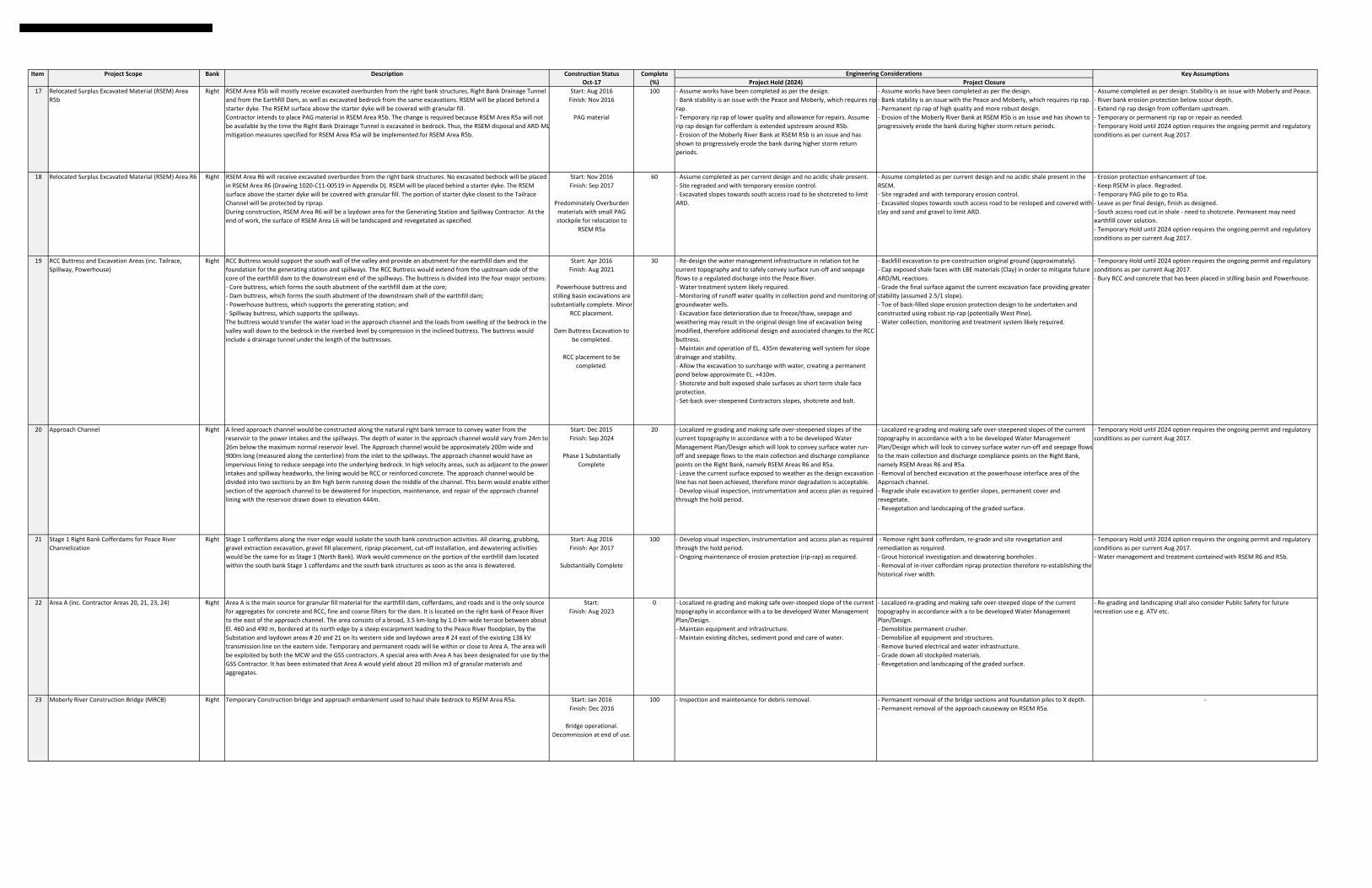
Item Project Scope Bank Description Construction Status Complete Key Assumptions Oct‐17 (%) Project Hold (2024) Project Closure Left (North) Bank Site Components 1 Left Bank Stabilization Excavation (LBE) Left The excavation of a substantial volume of overburden on the left bank is required to stabilize the slope over the long term, for both static and seismic loading conditions. The excavation limits have been established to provide safe long term slopes wherever slope failure could adversely impact dam safety. Start: Jun 2016 Finish: Dec 2018 Ongoing Substantial completion above Inlet Portal approx. 90% complete. 60 ‐ Stop excavation of the LBE overburden materials and hauling for disposal (except what is required for RSEM and Approach Channel capping of shale bedrock). ‐ Re‐grade the slope locally to mitigate current and known historical slide areas (buttressing etc.) such as the upper middle slide. ‐ Re‐design the water management infrastructure in relation tot he current topography and to safely convey surface run‐off and seepage flows down the slope to a regulated discharge into the Peace River (potentially construct temporary sediment pond at base of the excavation and management of flows for 1 or 2 years until hydro seeding takes hold. ‐ Slope revegetation for Erosion, Sediment control. ‐ Develop visual inspection, instrumentation and access plan as required through the hold period. ‐ Hydro seeding twice over the first 2 years. ‐ Stop excavation of the LBE overburden materials and hauling for disposal (except what is required for RSEM and Approach channel capping of shale bedrock). ‐ Re‐grade the slope locally to mitigate current and known historical slide areas (buttressing etc.). ‐ Re‐design the water management infrastructure in relation tot he current topography and to safely convey surface run‐off and seepage flows down the slope to a regulated discharge into the Peace River. ‐ Slope revegetation for Erosion, Sediment control. ‐ Develop visual inspection, instrumentation and access plan as required through the hold period. ‐ Excavation predominately complete on the west extremity of the work area. ‐ Additional design effort will be required for the Water Management Design and the applied storm return period would potentially be greater for the Project Closure option (greater capital costs). ‐ Additional excavation volumes of clay from the LBE for capping shales in all RSEM areas. ‐ Temporary Hold until 2024 option requires the ongoing permit and regulatory conditions as per current Aug 2017. 2 Relocated Surplus Excavated Material (RSEM) Area L5 Left RSEM Area L5 will mostly receive excavated overburden from the Left Bank Excavation and from the Earthfill Dam, as well as bedrock from the Diversion and Earthfill Dam excavations. RSEM will be placed behind a starter dyke. Some portions of the starter dyke will comprise riprap protection, to prevent erosion. The RSEM surface above the starter dyke will be covered with granular fill, while the top of the RSEM Area will be backfilled with select granular material to create fish habitat. The MCW Contractor will design and construct a temporary diversion of flow from the existing creek in order to divert it from work areas. Start: Oct 2016 Finish: Jan 2022 Ongoing Overburden and PAG 20 ‐ Mitigation of acid drainage from exposed shale surfaces with a temporary cover. ‐ Water Management: uphill surface diversion runoff, RSEM runoff and new channel for Garbage Creek ‐ Install temporary rip‐rap (Wuthrich rock) along the river side of the Starter Dyke for erosion protection. ‐ Monitoring of runoff water quality in collection pond. ‐ Water treatment system likely required. ‐ Mitigation of acid drainage from exposed shale surfaces with a permanent cover. ‐ Water Management: uphill surface diversion runoff, RSEM runoff and new channel for Garbage Creek ‐ Potential realignment of the Starter Dyke to re‐establish pre‐construction river width. ‐ Install permanent rip‐rap (West Pine rock) along the river side of the Starter Dyke for erosion protection. ‐ Monitoring of runoff water quality in collection pond. ‐ Water treatment system likely required. ‐ Clay cover and granular cover, Permanent option trim back starter dyke and reslope. ‐ Garbage Creek ‐ pipes, channels what happens in high flow‐overflow channel ‐ more robust. new channel on top. ‐ Monitor pond behind the berm (200 year flow) Permanent more robust ‐ Temporary Hold until 2024 option requires the ongoing permit and regulatory conditions as per current Aug 2017. 3 Relocated Surplus Excavated Material (RSEM) Area L6 Left RSEM Area L6 will mostly receive excavated overburden from the Left Bank Excavation and from the Earthfill Dam, as well as bedrock from the Diversion and Earthfill Dam excavations. If the Contractor elects to place excavated bedrock in RSEM Area L6, the rock shall be placed only in the lower portion of the Area in order to remain permanently submerged or, if placed higher, it will have to be encapsulated within compacted low‐permeability fill. The surface of RSEM above the starter dyke will be covered with granular fill. The starter dyke will be protected by riprap along its entire length. During construction, RSEM Area L6 will be a laydown area for the MCW Contractor. At the end of work, the surface of RSEM Area L6 will be landscaped and revegetated as specified. The Peace River Construction Bridge north approach is partly located within RSEM Area L6. Upon decommissioning of the PRCB, the north approach will be removed to the lines indicated on Drawings in order to complete the permanent slope protection of the starter dyke and the granular cover and revegetation on top of the RSEM. Start: Aug 2017 Finish: May 2018 Not Started Overburden and PAG 5 ‐ Limited disturbance requires regrading temporary silt fencing and ESC measures. ‐ Limited disturbance requires regrading and reclamation of surfaces. ‐ Little construction to date. ‐ Assume some regrading of starter dyke granular fill material only. ‐ Temporary Hold until 2024 option requires the ongoing permit and regulatory conditions as per current Aug 2017. 4 Stage 1 Left Bank Cofferdams for Peace River Channelization (inc. Diversion inlet and outlet cofferdams) Left Stage 1 cofferdams on the north bank would include the cofferdams around the diversion tunnel inlet and outlet locations, as well as along the shore of the central island between these two locations, in order to isolate the north side of the river and enable construction activities on the north bank of the river to commence. These cofferdams would be constructed in riparian zones that would require clearing, grubbing and excavations. Gravel from local sources in or near the river would be excavated for cofferdam construction. Gravel extraction would be done, keeping a berm of gravel between the extraction area and the river to provide isolation. The gravel fill would be placed to construct the cofferdams and riprap from the off‐site locations would be transported via truck to the site and placed on the slopes of the cofferdams for erosion control. In order to control seepage under the gravel cofferdams, a vertica cut‐off would be installed through the cofferdams to provide an impermeable barrier. The cut‐offs would be either a slurry trench wall or a steel secant pile wall. Alternate methods of cut‐off construction could be used, depending on contractor preferences. Work would commence on the portion of the earthfill dam located within the north bank Stage 1 cofferdams as soon as the area is dewatered. Start: Apr2017 Finish: Dec 2017 Ongoing 70 ‐ Cofferdam and associated works to remain in place. ‐ Develop visual inspection, instrumentation and access plan as required through the hold period. ‐ Ongoing maintenance of temporary erosion protection (rip‐rap) as required. ‐ Re‐design the water management infrastructure considering the passage of seepage and surface water runoff into the peace river i.e. conveyance of flows through the cofferdams. ‐ Monitoring of runoff water quality in collection pond as potential for ARD/ML from shale face at Diversion Inlet Portal. ‐ Shotcrete and bolt exposed shale surfaces as short term shale face protection for the Diversion Inlet Portal works. ‐ Remove left bank cofferdam, re‐grade and site revegetation and remediation as required. ‐ Excavate slurry wall material and relocated to RSEM L5 ‐ Re‐establishment of the pre‐construction river width. ‐ Cap exposed shale faces in order to mitigate future ARD/ML reactions at the Diversion Inlet Portal. ‐ Grade the final surface against the current Diversion Inlet Portal excavation face providing greater stability. ‐ Stage 1 Cofferdams on the North Shore assumed to be completed by end of October 2017. ‐ Slurry wall cut off complete in the Diversion Inlet and Outlet cofferdam only. The inter‐connecting cofferdam is granular fill only. ‐ If slurry wall completed maintain pumping system to pump water inside the cofferdam to match river levels. ‐ Diversion Inlet Portal Excavation started by October 2017. ‐ Temporary Hold until 2024 option requires the ongoing permit and regulatory conditions as per current Aug 2017. 5 Left Bank Drainage Adit Left The Left Bank Drainage Adit (LBDA) will be located downstream of the dam grout curtain, upstream of the historic test chamber at the end of Adit 4, and above the diversion tunnels. The LBDA is required to relieve pore water pressure in the left abutment bedrock. An access adit will extend from the drainage adit to downstream of the dam, adjacent to the diversion tunnel outlet portal. Drain holes will be drilled from both the invert and crown of the drainage adit and part of the access adit. Start: Aug 2017 Finish: Nov 2018 Not Started 0 ‐ ‐ ‐ Construction not started by October 2017. 6 Historical Adits and Drill Holes Left / Right As part of geotechnical investigations completed at Site C in the late 1970’s and early 1980’s, four exploratory adits, 1 through 4 and a test chamber in Adit 4, were constructed on both the left and right banks of the Peace River at the proposed dam site (see Figure 2). In 2012, Adit 5 was excavated on the right bank of the proposed dam site behind the proposed powerhouse RCC buttress foundation. Backfilling of all Adits 1 to 5 and the test chamber is required as part of project construction More than 150 exploratory drill holes are located within and near the proposed footprint of the earthfill and cofferdams, left bank stabilization, right bank RCC buttress foundation and approach channel excavation. Holes range in depth from less than 10 m to greater than 150 m, and include some large diameter holes (LDH) which have a diameter of 910 mm. Following drilling, a number of historical drill holes were either backfilled or instrumented. Some drill holes were not backfilled and still remain open. Open or partially open drill holes, backfilled drill holes without proper documentation or drill holes containing geotechnical instrumentation will require condition assessment and backfilling as part of the project construction. Start: Aug 2016 Finish: Jul 2018 Ongoing 20 ‐ All Adits and Boreholes to be infilled as per current design. ‐ All Adits and Boreholes to be infilled as per current design. ‐ In accordance to Groundwater Management / Protections Regulations for British Columbia. Engineering Considerations

Welcome message from author
This document is posted to help you gain knowledge. Please leave a comment to let me know what you think about it! Share it to your friends and learn new things together.
Transcript

Item Project Scope Bank Description Construction Status Complete Key AssumptionsOct‐17 (%) Project Hold (2024) Project Closure
Left (North) Bank Site Components
1 Left Bank Stabilization Excavation (LBE) Left The excavation of a substantial volume of overburden on the left bank is required to stabilize the slopeover the long term, for both static and seismic loading conditions.The excavation limits have been established to provide safe long term slopes wherever slopefailure could adversely impact dam safety.
Start: Jun 2016Finish: Dec 2018
OngoingSubstantial completion above
Inlet Portal approx. 90% complete.
60 ‐ Stop excavation of the LBE overburden materials and hauling for disposal (except what is required for RSEM and Approach Channel capping of shale bedrock).‐ Re‐grade the slope locally to mitigate current and known historical slide areas (buttressing etc.) such as the upper middle slide. ‐ Re‐design the water management infrastructure in relation tot he current topography and to safely convey surface run‐off and seepage flows down the slope to a regulated discharge into the Peace River (potentially construct temporary sediment pond at base of the excavation and management of flows for 1 or 2 years until hydro seeding takes hold.‐ Slope revegetation for Erosion, Sediment control. ‐ Develop visual inspection, instrumentation and access plan as required through the hold period. ‐ Hydro seeding twice over the first 2 years.
‐ Stop excavation of the LBE overburden materials and hauling for disposal (except what is required for RSEM and Approach channel capping of shale bedrock).‐ Re‐grade the slope locally to mitigate current and known historical slide areas (buttressing etc.). ‐ Re‐design the water management infrastructure in relation tot he current topography and to safely convey surface run‐off and seepage flows down the slope to a regulated discharge into the Peace River.‐ Slope revegetation for Erosion, Sediment control. ‐ Develop visual inspection, instrumentation and access plan as required through the hold period.
‐ Excavation predominately complete on the west extremity of the work area. ‐ Additional design effort will be required for the Water Management Design and the applied storm return period would potentially be greater for the Project Closure option (greater capital costs).‐ Additional excavation volumes of clay from the LBE for capping shales in all RSEM areas. ‐ Temporary Hold until 2024 option requires the ongoing permit and regulatory conditions as per current Aug 2017.
2 Relocated Surplus Excavated Material (RSEM) Area L5 Left RSEM Area L5 will mostly receive excavated overburden from the Left Bank Excavation and from the Earthfill Dam, as well as bedrock from the Diversion and Earthfill Dam excavations. RSEM will be placed behind a starter dyke. Some portions of the starter dyke will comprise riprap protection, to prevent erosion. The RSEM surface above the starter dyke will be covered with granular fill, while the top of the RSEM Area will be backfilled with select granular material to create fish habitat.The MCW Contractor will design and construct a temporary diversion of flow from the existing creek in order to divert it from work areas.
Start: Oct 2016Finish: Jan 2022
Ongoing
Overburden and PAG
20 ‐ Mitigation of acid drainage from exposed shale surfaces with a temporary cover.‐ Water Management: uphill surface diversion runoff, RSEM runoff and new channel for Garbage Creek‐ Install temporary rip‐rap (Wuthrich rock) along the river side of the Starter Dyke for erosion protection.‐ Monitoring of runoff water quality in collection pond.‐ Water treatment system likely required.
‐ Mitigation of acid drainage from exposed shale surfaces with a permanent cover.‐ Water Management: uphill surface diversion runoff, RSEM runoff and new channel for Garbage Creek ‐ Potential realignment of the Starter Dyke to re‐establish pre‐construction river width.‐ Install permanent rip‐rap (West Pine rock) along the river side of the Starter Dyke for erosion protection.‐ Monitoring of runoff water quality in collection pond.‐ Water treatment system likely required.
‐ Clay cover and granular cover, Permanent option trim back starter dyke and reslope. ‐ Garbage Creek ‐ pipes, channels what happens in high flow‐overflow channel ‐ more robust. new channel on top. ‐ Monitor pond behind the berm (200 year flow) Permanent more robust‐ Temporary Hold until 2024 option requires the ongoing permit and regulatory conditions as per current Aug 2017.
3 Relocated Surplus Excavated Material (RSEM) Area L6 Left RSEM Area L6 will mostly receive excavated overburden from the Left Bank Excavation and from the Earthfill Dam, as well as bedrock from the Diversion and Earthfill Dam excavations. If the Contractor elects to place excavated bedrock in RSEM Area L6, the rock shall be placed only in the lower portion of the Area in order to remain permanently submerged or, if placed higher, it will have to be encapsulated within compacted low‐permeability fill. The surface of RSEM above the starter dyke will be covered with granular fill. The starter dyke will be protected by riprap along its entire length.During construction, RSEM Area L6 will be a laydown area for the MCW Contractor. At the end of work, the surface of RSEM Area L6 will be landscaped and revegetated as specified.The Peace River Construction Bridge north approach is partly located within RSEM Area L6. Upon decommissioning of the PRCB, the north approach will be removed to the lines indicated on Drawings in order to complete the permanent slope protection of the starter dyke and the granular cover and revegetation on top of the RSEM.
Start: Aug 2017Finish: May 2018
Not Started
Overburden and PAG
5 ‐ Limited disturbance requires regrading temporary silt fencing and ESC measures.
‐ Limited disturbance requires regrading and reclamation of surfaces. ‐ Little construction to date. ‐ Assume some regrading of starter dyke granular fill material only. ‐ Temporary Hold until 2024 option requires the ongoing permit and regulatory conditions as per current Aug 2017.
4 Stage 1 Left Bank Cofferdams for Peace River Channelization (inc. Diversion inlet and outlet cofferdams)
Left Stage 1 cofferdams on the north bank would include the cofferdams around the diversion tunnel inlet and outlet locations, as well as along the shore of the central island between these two locations, in order to isolate the north side of the river and enable construction activities on the north bank of the river to commence. These cofferdams would be constructed in riparian zones that would require clearing, grubbing and excavations. Gravel from local sources in or near the river would be excavated for cofferdam construction. Gravel extraction would be done, keeping a berm of gravel between the extraction area and the river to provide isolation. The gravel fill would be placed to construct the cofferdams and riprap from the off‐site locations would be transported via truck to the site and placed on the slopes of the cofferdams for erosion control. In order to control seepage under the gravel cofferdams, a verticacut‐off would be installed through the cofferdams to provide an impermeable barrier. The cut‐offs would be either a slurry trench wall or a steel secant pile wall. Alternate methods of cut‐off construction could be used, depending on contractor preferences. Work would commence on the portion of the earthfill dam located within the north bank Stage 1 cofferdams as soon as the area is dewatered.
Start: Apr2017Finish: Dec 2017
Ongoing
70 ‐ Cofferdam and associated works to remain in place. ‐ Develop visual inspection, instrumentation and access plan as required through the hold period. ‐ Ongoing maintenance of temporary erosion protection (rip‐rap) as required.‐ Re‐design the water management infrastructure considering the passage of seepage and surface water runoff into the peace river i.e. conveyance of flows through the cofferdams.‐ Monitoring of runoff water quality in collection pond as potential for ARD/ML from shale face at Diversion Inlet Portal. ‐ Shotcrete and bolt exposed shale surfaces as short term shale face protection for the Diversion Inlet Portal works.
‐ Remove left bank cofferdam, re‐grade and site revegetation and remediation as required.‐ Excavate slurry wall material and relocated to RSEM L5‐ Re‐establishment of the pre‐construction river width.‐ Cap exposed shale faces in order to mitigate future ARD/ML reactions at the Diversion Inlet Portal. ‐ Grade the final surface against the current Diversion Inlet Portal excavation face providing greater stability.
‐ Stage 1 Cofferdams on the North Shore assumed to be completed by end of October 2017.‐ Slurry wall cut off complete in the Diversion Inlet and Outlet cofferdam only. The inter‐connecting cofferdam is granular fill only.‐ If slurry wall completed maintain pumping system to pump water inside the cofferdam to match river levels.‐ Diversion Inlet Portal Excavation started by October 2017. ‐ Temporary Hold until 2024 option requires the ongoing permit and regulatory conditions as per current Aug 2017.
5 Left Bank Drainage Adit Left The Left Bank Drainage Adit (LBDA) will be located downstream of the dam grout curtain, upstream of the historic test chamber at the end of Adit 4, and above the diversion tunnels. The LBDA is required to relieve pore water pressure in the left abutment bedrock. An access adit will extend from the drainage adit to downstream of the dam, adjacent to the diversion tunnel outlet portal. Drain holes will be drilled from both the invert and crown of the drainage adit and part of the access adit.
Start: Aug 2017Finish: Nov 2018
Not Started
0 ‐ ‐ ‐ Construction not started by October 2017.
6 Historical Adits and Drill Holes Left / Right
As part of geotechnical investigations completed at Site C in the late 1970’s and early 1980’s, four exploratory adits, 1 through 4 and a test chamber in Adit 4, were constructed on both the left and right banks of the Peace River at the proposed dam site (see Figure 2). In 2012, Adit 5 was excavated on the right bank of the proposed dam site behind theproposed powerhouse RCC buttress foundation.Backfilling of all Adits 1 to 5 and the test chamber is required as part of project constructionMore than 150 exploratory drill holes are located within and near the proposed footprint of the earthfill and cofferdams, left bank stabilization, right bank RCC buttress foundation and approach channel excavation. Holes range in depth from less than 10 m to greater than 150 m, and include some large diameter holes (LDH) which have a diameter of 910 mm. Following drilling, a number of historical drill holes were either backfilled or instrumented. Some drill holes were not backfilled and still remain open. Open or partially open drill holes, backfilled drill holes without proper documentation or drill holes containing geotechnical instrumentation will require condition assessment and backfilling as part of the project construction.
Start: Aug 2016Finish: Jul 2018
Ongoing
20 ‐ All Adits and Boreholes to be infilled as per current design. ‐ All Adits and Boreholes to be infilled as per current design. ‐ In accordance to Groundwater Management / Protections Regulations for British Columbia.
Engineering Considerations

Item Project Scope Bank Description Construction Status Complete Key AssumptionsOct‐17 (%) Project Hold (2024) Project Closure
Engineering Considerations
7 Howe Pit Reclamation (Contractors Area 27) Left Contractors Laydown Area 27. Also contains stockpiled PAG material from River Road construction. Historical quarry area with known ARD/ML issues.
Start: Sep 2015Finish: Aug 2023
Ongoing
0 OPTION 1: ‐ Inspection and maintenance of the temporary PAG stockpile cover and containment.‐ Water management of surface water and seepage. ‐ Revegetation and landscaping.
OPTION 2 ‐ Removal and haul temporary PAG stockpile to RSEM Area L5 for encapsulating and containment.‐ Water management of surface water and seepage. ‐ Revegetation and landscaping.
‐ Removal and haul temporary PAG stockpile to RSEM Area L5 for encapsulating and containment.‐ Remediate the PAG exposures in Howe Pit, infill cuts and cap slopes.‐ Water management of surface water and seepage. ‐ Revegetation and landscaping.
‐
8 Peace River Construction Bridge (PRCB) Left The bridge is temporary and will be removed after construction. The bridge consists of precast deck panels supported by four steel girders. Piers are detailed with steel pipe piles and steel pier caps. Piles will consist of steel casings penetrating a distance into bedrock with or without rock sockets which may extend beyond the casing tip.
North Approach will be a 250 m causeway leaving the River Road and connecting to the Peace River Construction Bridge. The South Approach will be a 150 m road off of the South Bank Initial Access Road and connecting to the PeaceRiver Construction Bridge
Start: Jul 2015Finish: Feb 2025
Bridge operational. Decommission at end of
Project.
100 ‐ Inspection and maintenance for debris removal. ‐ Permanent removal of the bridge sections and foundation piles to X depth. ‐ Permanent removal of the approach causeway (restriction of Peace River flow).
‐
9 River Road Left 4.1 km permanent two‐lane access road on the north bank of the dam site that will originate at the turn‐off from the existing public Old Fort Road to the Howe Pit and descend into the river valley bottom, before running in a westerly direction along the north shore of the Peace River and terminating near the proposed diversion tunnel outlet portal location. The River Road will be both the primary construction access route and primary permanent access route to the dam and generating station. During construction, this road will be paved from Old Fort Road to the river’s edge and then be a gravel road from this point to its termination. Rock berms will be provided along the river edge of the road for habitat complexing
Start: Aug 2015Finish: Mar 2017
Completion of Early Works portion for handover to
MCW. MCW to raise road for completion circa 2023
100 ‐ Inspection and maintenance. ‐ Removal of ATCO Raw Water intake infrastructure ‐ Cover exposed PAG slopes to mitigate ARD/ML drainage issues e.g. placement of Geo‐cell and/or clay/granular materials.
‐ Inspection and maintenance. ‐ Removal of ATCO Raw Water intake infrastructure ‐ Cover exposed PAG slopes to mitigate ARD/ML drainage issues e.g. placement of Geo‐cell and/or clay/granular materials. ‐ Decommission Roads, deactivate, hydro‐seed roads.
‐ Assumes road prisms are left in place, cost to remove road embankment fill would be an order of magnitude higher;
10 North Bank Access Road Left North Bank Road is a new 3.2 km permanent two lane paved access road that traverses across the north bank of the Dam Site Area providing a connection between project facilities and areas directly north of the dam to the River Road and Mica Sand and Gravel Pit (also referenced in documents as Howe Pit ). The North Bank Road will originate at the limits of the Ministry of Transportation and Infrastructure’s upgraded 269 Road, and run south‐east past the worker accommodation location, before transitioning east across the gully on the un‐named creek south of the RSEM Area L3 , and connecting to the River Road
Start: Aug 2015Finish: Mar 2017
Completion of Early Works portion for handover to
MCW. MCW substantially complete.
100 ‐ Inspection and maintenance. ‐ North Bank Road L3 fill structure and culvert ‐ inspection, maintenance
‐ Inspection and maintenance.‐ North Bank Road L3 fill structure and culvert ‐ inspection, maintenance (ongoing / long term). ‐ Cover exposed PAG slopes to mitigate ARD/ML drainage issues e.g. placement of Geo‐cell and/or clay/granular materials. ‐ Decommission Roads, deactivate, hydro‐seed roads.
‐ Assumes road prisms are left in place, cost to remove road embankment fill would be an order of magnitude higher.‐ Long term commitment to maintain the culvert for the safe passage of L3/L4 creek flow.‐ Temporary Hold until 2024 option requires the ongoing permit and regulatory conditions as per current Aug 2017.
11 Relocated Surplus Excavated Material (RSEM) Area L3 Left LBE overburden material placement of approximately 4.2M m3 of material. Valley infill with closure including revegetation and landscaping.
Start: Sep 2015Finish: Jan 2017
90 ‐ Complete closure, landscaping and revegetation as per MCW Contract.‐ Inspection and maintenance.
‐ Complete closure, landscaping and revegetation as per MCW Contract.‐ Inspection and maintenance.
‐ Temporary Hold until 2024 option requires the ongoing permit and regulatory conditions as per current Aug 2017.
12 Viewpoint Road and public viewing area Left Dedicated access road and viewpoint which allows the general public observe construction activities on the site. Start: Jun 2016Finish: Apr 2018
Ongoing
80 ‐ Inspection and maintenance. ‐ Remove, revegetation and landscaping of the graded surface. ‐
13 Contractors Area 25 Left Contractor Laydown Area adjacent to the Worker Accommodation storm water ponds. Overburden from the LBE has been hauled and placed in Area 25.
Start: Finish: Aug 2023
‐ Inspection and maintenance.‐ Maintain water management including sediment ponds for TSS control.
‐ Re‐grade topography, infill sediment pond and associated drainage ditches, landscape and revegetate.‐ Construct water management conveyance infrastructure from the surface water cut off ditch above the Left Bank Excavation through Area 25 with satisfactory discharge into the L3 creek, downstream of the North Bank Road Fill.
‐ Temporary Hold until 2024 option requires the ongoing permit and regulatory conditions as per current Aug 2017.
14 ATCO Accommodation Buildings and project area (inc. BCH and PRHP Offices)
Left Provision of worker accommodation during the construction phase Start: Apr 2015Finish: Jan 2025
100 ‐ Inspection and maintenance. ‐ Remove, revegetation and landscaping of the graded surface. ‐
15 ATCO water/wastewater infrastructure Left Infrastructure to support provision of worker accommodation during the construction phase up to an estimated 2100 workers
Start: Sep 2015Finish: Jun 2016
RAW Water Intake Structure to be completed.
100 ‐ Inspection and maintenance. ‐ Remove, revegetation and landscaping of the graded surface. ‐
Right (South) Bank Project Site Components
16 Relocated Surplus Excavated Material (RSEM) Area R5a
Right RSEM Area R5a will mostly receive excavated overburden from the right bank structures (Approach Channel, RCC Buttress, Tailrace Channel) and from the Earthfill Dam, as well as excavated bedrock from the same excavations. RSEM will be placed behind a starter dyke. The RSEM surface above the starter dyke will be covered with granular fill, while the top of the RSEM Area will be covered with select granular material to create fish habitat
Start: Nov 2016Finish: Aug 2023
OngoingStarter Dykes and non‐
contact water diversion ditch substantially complete.
PAG material
20 ‐ Mitigation of acid drainage from exposed shale surfaces with a temporary cover.‐Water Management: uphill surface diversion runoff, RSEM runoff and riprap protection for Peace River‐ Monitoring of runoff water quality in collection pond and monitoring of groundwater wells.
‐ Mitigation of acid drainage from exposed shale surfaces with a permanent cover and revegetate.‐ Water Management: uphill surface diversion runoff, RSEM runoff and rip rap protection for Peace River‐ Monitoring of runoff water quality in collection pond and monitoring of groundwater wells.
‐ Reslope, clay cover, collect water in pond to monitor, local rip rap. ‐ Clay from left bank. Finish starter dyke and rip rap. ‐ Diversion channel on up‐hill decommission. ‐ Grading of RSEM to include uphill drainage. ‐ GW monitoring wells, water quality tests in pond. ‐ Permanent rip rap to be West Pine rather than lesser Wuthrich rock. ‐ Temporary Hold until 2024 option requires the ongoing permit and regulatory conditions as per current Aug 2017.
Item Project Scope Bank Description Construction Status Complete Key AssumptionsOct‐17 (%) Project Hold (2024) Project Closure
Engineering Considerations
17 Relocated Surplus Excavated Material (RSEM) Area R5b
Right RSEM Area R5b will mostly receive excavated overburden from the right bank structures, Right Bank Drainage Tunnel and from the Earthfill Dam, as well as excavated bedrock from the same excavations. RSEM will be placed behind a starter dyke. The RSEM surface above the starter dyke will be covered with granular fill. Contractor intends to place PAG material in RSEM Area R5b. The change is required because RSEM Area R5a will not be available by the time the Right Bank Drainage Tunnel is excavated in bedrock. Thus, the RSEM disposal and ARD‐MLmitigation measures specified for RSEM Area R5a will be implemented for RSEM Area R5b.
Start: Aug 2016Finish: Nov 2016
PAG material
100 ‐ Assume works have been completed as per the design.‐ Bank stability is an issue with the Peace and Moberly, which requires riprap.‐ Temporary rip rap of lower quality and allowance for repairs. Assume rip rap design for cofferdam is extended upstream around R5b.‐ Erosion of the Moberly River Bank at RSEM R5b is an issue and has shown to progressively erode the bank during higher storm return periods.
‐ Assume works have been completed as per the design.‐ Bank stability is an issue with the Peace and Moberly, which requires rip rap.‐ Permanent rip rap of high quality and more robust design.‐ Erosion of the Moberly River Bank at RSEM R5b is an issue and has shown to progressively erode the bank during higher storm return periods.
‐ Assume completed as per design. Stability is an issue with Moberly and Peace. ‐ River bank erosion protection below scour depth. ‐ Extend rip rap design from cofferdam upstream. ‐ Temporary or permanent rip rap or repair as needed.‐ Temporary Hold until 2024 option requires the ongoing permit and regulatory conditions as per current Aug 2017.
18 Relocated Surplus Excavated Material (RSEM) Area R6 Right RSEM Area R6 will receive excavated overburden from the right bank structures. No excavated bedrock will be placed in RSEM Area R6 (Drawing 1020‐C11‐00519 in Appendix D). RSEM will be placed behind a starter dyke. The RSEM surface above the starter dyke will be covered with granular fill. The portion of starter dyke closest to the Tailrace Channel will be protected by riprap.During construction, RSEM Area R6 will be a laydown area for the Generating Station and Spillway Contractor. At the end of work, the surface of RSEM Area L6 will be landscaped and revegetated as specified.
Start: Nov 2016Finish: Sep 2017
Predominately Overburden materials with small PAG stockpile for relocation to
RSEM R5a
60 ‐ Assume completed as per current design and no acidic shale present.‐ Site regraded and with temporary erosion control.‐ Excavated slopes towards south access road to be shotcreted to limit ARD.
‐ Assume completed as per current design and no acidic shale present in the RSEM.‐ Site regraded and with temporary erosion control.‐ Excavated slopes towards south access road to be resloped and covered with clay and sand and gravel to limit ARD.
‐ Erosion protection enhancement of toe. ‐ Keep RSEM in place. Regraded. ‐ Temporary PAG pile to go to R5a. ‐ Leave as per final design, finish as designed. ‐ South access road cut in shale ‐ need to shotcrete. Permanent may need earthfill cover solution. ‐ Temporary Hold until 2024 option requires the ongoing permit and regulatory conditions as per current Aug 2017.
19 RCC Buttress and Excavation Areas (inc. Tailrace, Spillway, Powerhouse)
Right RCC Buttress would support the south wall of the valley and provide an abutment for the earthfill dam and the foundation for the generating station and spillways. The RCC Buttress would extend from the upstream side of the core of the earthfill dam to the downstream end of the spillways. The buttress is divided into the four major sections:‐ Core buttress, which forms the south abutment of the earthfill dam at the core;‐ Dam buttress, which forms the south abutment of the downstream shell of the earthfill dam;‐ Powerhouse buttress, which supports the generating station; and‐ Spillway buttress, which supports the spillways.The buttress would transfer the water load in the approach channel and the loads from swelling of the bedrock in the valley wall down to the bedrock in the riverbed level by compression in the inclined buttress. The buttress would include a drainage tunnel under the length of the buttresses.
Start: Apr 2016Finish: Aug 2021
Powerhouse buttress and stilling basin excavations are substantially complete. Minor
RCC placement.
Dam Buttress Excavation to be completed.
RCC placement to be completed.
30 ‐ Re‐design the water management infrastructure in relation tot he current topography and to safely convey surface run‐off and seepage flows to a regulated discharge into the Peace River.‐ Water treatment system likely required. ‐ Monitoring of runoff water quality in collection pond and monitoring of groundwater wells.‐ Excavation face deterioration due to freeze/thaw, seepage and weathering may result in the original design line of excavation being modified, therefore additional design and associated changes to the RCC buttress.‐ Maintain and operation of EL. 435m dewatering well system for slope drainage and stability. ‐ Allow the excavation to surcharge with water, creating a permanent pond below approximate EL. +410m. ‐ Shotcrete and bolt exposed shale surfaces as short term shale face protection. ‐ Set‐back over‐steepened Contractors slopes, shotcrete and bolt.
‐ Backfill excavation to pre‐construction original ground (approximately). ‐ Cap exposed shale faces with LBE materials (Clay) in order to mitigate future ARD/ML reactions. ‐ Grade the final surface against the current excavation face providing greater stability (assumed 2.5/1 slope). ‐ Toe of back‐filled slope erosion protection design to be undertaken and constructed using robust rip‐rap (potentially West Pine). ‐ Water collection, monitoring and treatment system likely required.
‐ Temporary Hold until 2024 option requires the ongoing permit and regulatory conditions as per current Aug 2017.‐ Bury RCC and concrete that has been placed in stilling basin and Powerhouse.
20 Approach Channel Right A lined approach channel would be constructed along the natural right bank terrace to convey water from the reservoir to the power intakes and the spillways. The depth of water in the approach channel would vary from 24m to 26m below the maximum normal reservoir level. The Approach channel would be approximately 200m wide and 900m long (measured along the centerline) from the inlet to the spillways. The approach channel would have an impervious lining to reduce seepage into the underlying bedrock. In high velocity areas, such as adjacent to the power intakes and spillway headworks, the lining would be RCC or reinforced concrete. The approach channel would be divided into two sections by an 8m high berm running down the middle of the channel. This berm would enable either section of the approach channel to be dewatered for inspection, maintenance, and repair of the approach channel lining with the reservoir drawn down to elevation 444m.
Start: Dec 2015Finish: Sep 2024
Phase 1 Substantially Complete
20 ‐ Localized re‐grading and making safe over‐steepened slopes of the current topography in accordance with a to be developed Water Management Plan/Design which will look to convey surface water run‐off and seepage flows to the main collection and discharge compliance points on the Right Bank, namely RSEM Areas R6 and R5a. ‐ Leave the current surface exposed to weather as the design excavation line has not been achieved, therefore minor degradation is acceptable. ‐ Develop visual inspection, instrumentation and access plan as required through the hold period.
‐ Localized re‐grading and making safe over‐steepened slopes of the current topography in accordance with a to be developed Water Management Plan/Design which will look to convey surface water run‐off and seepage flows to the main collection and discharge compliance points on the Right Bank, namely RSEM Areas R6 and R5a.‐ Removal of benched excavation at the powerhouse interface area of the Approach channel. ‐ Regrade shale excavation to gentler slopes, permanent cover and revegetate.‐ Revegetation and landscaping of the graded surface.
‐ Temporary Hold until 2024 option requires the ongoing permit and regulatory conditions as per current Aug 2017.
21 Stage 1 Right Bank Cofferdams for Peace River Channelization
Right Stage 1 cofferdams along the river edge would isolate the south bank construction activities. All clearing, grubbing, gravel extraction excavation, gravel fill placement, riprap placement, cut‐off installation, and dewatering activities would be the same for as Stage 1 (North Bank). Work would commence on the portion of the earthfill dam located within the south bank Stage 1 cofferdams and the south bank structures as soon as the area is dewatered.
Start: Aug 2016Finish: Apr 2017
Substantially Complete
100 ‐ Develop visual inspection, instrumentation and access plan as required through the hold period. ‐ Ongoing maintenance of erosion protection (rip‐rap) as required.
‐ Remove right bank cofferdam, re‐grade and site revegetation and remediation as required.‐ Grout historical investigation and dewatering boreholes . ‐ Removal of in‐river cofferdam riprap protection therefore re‐establishing the historical river width.
‐ Temporary Hold until 2024 option requires the ongoing permit and regulatory conditions as per current Aug 2017.‐ Water management and treatment contained with RSEM R6 and R5b.
22 Area A (inc. Contractor Areas 20, 21, 23, 24) Right Area A is the main source for granular fill material for the earthfill dam, cofferdams, and roads and is the only source for aggregates for concrete and RCC, fine and coarse filters for the dam. It is located on the right bank of Peace River to the east of the approach channel. The area consists of a broad, 3.5 km‐long by 1.0 km‐wide terrace between about El. 460 and 490 m, bordered at its north edge by a steep escarpment leading to the Peace River floodplain, by the Substation and laydown areas # 20 and 21 on its western side and laydown area # 24 east of the existing 138 kV transmission line on the eastern side. Temporary and permanent roads will lie within or close to Area A. The area will be exploited by both the MCW and the GSS contractors. A special area with Area A has been designated for use by the GSS Contractor. It has been estimated that Area A would yield about 20 million m3 of granular materials and aggregates.
Start: Finish: Aug 2023
0 ‐ Localized re‐grading and making safe over‐steeped slope of the current topography in accordance with a to be developed Water Management Plan/Design.‐ Maintain equipment and infrastructure. ‐ Maintain existing ditches, sediment pond and care of water.
‐ Localized re‐grading and making safe over‐steeped slope of the current topography in accordance with a to be developed Water Management Plan/Design. ‐ Demobilize permanent crusher.‐ Demobilize all equipment and structures.‐ Remove buried electrical and water infrastructure.‐ Grade down all stockpiled materials.‐ Revegetation and landscaping of the graded surface.
‐ Re‐grading and landscaping shall also consider Public Safety for future recreation use e.g. ATV etc.
23 Moberly River Construction Bridge (MRCB) Right Temporary Construction bridge and approach embankment used to haul shale bedrock to RSEM Area R5a. Start: Jan 2016Finish: Dec 2016
Bridge operational. Decommission at end of use.
100 ‐ Inspection and maintenance for debris removal. ‐ Permanent removal of the bridge sections and foundation piles to X depth. ‐ Permanent removal of the approach causeway on RSEM R5a.
‐

Item Project Scope Bank Description Construction Status Complete Key AssumptionsOct‐17 (%) Project Hold (2024) Project Closure
Engineering Considerations
24 Right Bank Drainage Tunnel (RBDT) Right The Right Bank Drainage Tunnel is approximately 975 meters long and generally consists of a 3.7 meter wide by 4.3 meter tall almost rectangular tunnel, with a reinforced shotcrete liner. The Right Bank Drainage Tunnel starts at a portal near RSEM Area R6, and then follows a downgrade before leveling out. The tunnel generally follows the alignment of the RCC Buttress. The total main tunnel length isapproximately 975 m, with another approximately 125 to 130 m of side tunnels. Right Bank Drainage Tunnel is shown on the Project Drawings as having a minimum of 100 mm of shotcrete lining with fiber reinforced and a 100 mm layer of wire‐reinforced shotcrete, with both pattern and spot rock dowels, and with a cast‐in‐place invert slab. For the portion of the excavation near the portal, steel sets are shown. The portal is shown tobe supported with dowels, rock dowels and shotcrete.
Start: Jun 2016Finish: Dec 2018
10 ‐ Construct a new tunnel portal secure entrance.‐ Install permanent support for completed portion of the tunnel.‐ Harden the Portal Shotcrete. Extend the tunnel to allow for infilling of portal cut with fill to provide long term support.‐ Maintain ventilation and dewatering.‐ Water management to be managed through RSEM R6.
‐ Backfill approximately 40m of constructed to date tunnel. Backfill material selection to be further considered e.g. grout. ‐ Support the portal excavation entrance through construction of a fill wedge onto the slope.‐ Revegetation and landscaping of the graded surface.
‐ Right Bank Drainage Tunnel works will likley proceed beyond the 40m completed as of August 2017. the activities describe would be applied regardsless of the distance completed.
25 Peace River Erosion Protection (Rip‐rap) Right Erosion Protection on the Right Bank Island from the PRCB upstream connecting to the Right bank Cofferdam. Start: Apr 2016 Finish: Sep 2016
Substantially Complete except small areas which
require additional protection.
100 ‐ Inspection and maintenance.‐ Completion of rip‐rap protection at locations where no protection has been provided / or relocate downstream portion to protect the RSEM R6 starter dyke.
‐ Inspection and maintenance.‐ Completion of rip‐rap protection at locations where no protection has been provided / or relocate downstream portion to protect the RSEM R6 starter dyke.
‐ RSEM R6 and associated water treatment infrastructure would be required to achieve regulatory requirements.
26 Septimus Access Road and South Bank Initial Access Road
Right The Septimus Road will be a permanent 4.3 km gravel access road on the south bank that will connect the contractor work area at the Septimus Rail Siding to the river level construction area near the site of the future spillway structures. The road will start adjacent to the rail siding and descend from the plateau through a sweeping u‐bend onto the south bank terrace. The road will then extend across to the western side of the south bank terrace and from there descend down into the river valley bottom. The Septimus Road will provide a connection to the existing road on the south slope
Start: Sep 2015Finish: Nov 2016
Substantially Complete
100 ‐ Inspection and maintenance. ‐ Revegetation and landscaping ‐ Assumes roads remain in places and access is decommissioned by water bars. To remove access such as SBIAR and Septimus road would be an order of magnitude larger cost
27 Septimus Rail Siding Right An additional materials siding and a fuel siding has been constructed. Material siding track alignment running 944 m parallel to the existing CN track (40 m centerline offset from CN track) and Fuel siding track alignment running 192 m parallel
Start: Sep 2015Finish: Mar 2017
Substantially Complete
100 ‐ Revegetation and landscaping ‐ Revegetation and landscaping ‐
28 Back Channel Right Removal of Peace River back channel between the upper terrace and lower island on the right bank. Back channel is cut off by the South bank Initial Access Road and RSEM Area R6 and the Right Bank Drainage Tunnel Portal works (downstream) and cut off by the Cofferdam upstream.
Start: ‐Finish: ‐
Linked to RSEM R6 and Right Bank Cofferdam construction
dates.
100 ‐ ‐ ‐ Backchannel will remain infilled as RSEM R6 and cut off upstream.‐ Item included within Environmental summary tables.
Reservoir Project Components
29 Reservoir Instruments ‐ Slope indicators and Piezometers installed on historic landslides. Start: Mar 2016Finish: Jan 2019
70 ‐ Inspection and maintenance. ‐ Inspection and maintenance.‐ All Boreholes to be infilled.
‐
30 Hudson Hope instruments – berm, sewage pond, wells in town
‐ Installed wells and instruments water level monitoring for groundwater. Start: Sep 2016Finish: Sep 2022
5 ‐ Inspection and maintenance. ‐ All Boreholes to be infilled. ‐
31 Clearing Lower Reservoir ‐ Clearing in the Moberly and eastern side of the proposed reservoir completed to date. Start: Aug 2015Finish: Jan 2018
20 ‐ Revegetation ‐ Revegetation ‐
Transmission Project Components
32 Transmission Line Access Roads ‐ There are 9 roads that lead transmission line right of way that have been partially upgraded this past year. These roads are existing roads that we cleared and upgraded to subgrade this past year. A contract was just awarded to complete the road upgrade works including the top surfacing layer and completing all of the ESC measures
Start: Sep 2015Finish: Jan 2023
Ongoing
50 ‐ Maintenance and inspection. ‐ Revegetation and landscaping ‐ Assumes roads remain in places.
33 Transmission Line Clearing ‐ The line is separated into section, Section A and Section B. The past clearing season, we had started clearing in section A and have cleared approximately 60% of section A. Note that the remaining sections are mainly hand clearing areas or area that wasn’t able to be accessed due to road upgrade required. The dividing line is between Del Rio Pit and Jackfish Lake Road (approximately 36 km from Site C). Please see attached for reference of clearing that has been complete and what remains in section A. A sample of what it physically looks like in the field is in the attached photo. Please note that Section B clearing is out for quotation and we are anticipating to start work as soon as possible
Start: Sep 2015Finish: Jan 2023
Ongoing
10 ‐ Maintenance and inspection. ‐ Revegetation and landscaping ‐
34 Site C Substation (SBK) Right Captured by MCW works that is on‐going right now. Key thing to note is that there is a lot of equipment that has been already ordered.
Start: Apr 2015Finish: May 2020
MCW prep subgrade Aug 2017
20 ‐ Localized re‐grading and making safe over‐steeped slope of the current topography in accordance with a to be developed Water Management Plan/Design.‐ Maintain existing ditches, sediment pond and care of water.
‐ Localized re‐grading and making safe over‐steeped slope of the current topography in accordance with a to be developed Water Management Plan/Design. ‐ Grade down all stockpiled materials.‐ Revegetation and landscaping of the graded surface.
‐ Re‐grading and landscaping shall also consider Public Safety for future recreation use e.g. ATV etc.
35 Site C Temp Sub (SCX) Right Dam Site but this substation is fully operational. It is also the sole supply to Septimus Repeater Station (SUR), and if SCX is gone, the diesel generator onsite is not sized for prime power
Start: Mar 2015Finish: Jul 2016
100 ‐ Maintenance and inspection. ‐ Decommission, revegetate and landscape. ‐

Item Project Scope Bank Description Construction Status Complete Key AssumptionsOct‐17 (%) Project Hold (2024) Project Closure
Engineering Considerations
36 Distribution Infrastructure ‐ Constructed some new distribution lines off the dam site and within the dam site. This would need to be considered but typically there are remediation that needs to be done when poles are removed
Start: ‐Finish: ‐
Ongoing
10 ‐ Maintenance and inspection. ‐ Remove all distribution lines ‐
Highways Project Components
37 Highway 29 Realignment ‐ Project component in design stage; construction scheduled to commence summer of 2019 for Western Segments. Start: ‐Finish:‐
0 ‐ ‐ ‐
38 Half Way River ‐ Project in design stage; construction scheduled to commence Summer 2018. Start: May 2016Finish: Oct 2020
0 ‐ ‐ ‐
39 Cache Creek ‐ Clearing of the highway realignment corridor and portions of the future reservoir was conducted in early 2017. Grading, Paving and Bridge construction now scheduled to commence Summer 2018.
Start: Nov 2015Finish: Oct 2019
5 ‐ Revegetation (hydro seeding of clear right of way required for erosion and sediment control) ‐ Cleared right of way will require periodic monitoring by MoTI during shutdown.
‐ Revegetation and landscaping ‐
40 Portage Mountain ‐ Contractor currently mobilizing to site.Commence quarry development construction Aug 14th.
Start: Jul 2017Finish:
0 ‐ Revegetation of disturbed areas will be required for erosion and sediment control‐ Plan to transfer Quarry over to MOTI.
‐ Revegetation and landscaping.‐ BCH has Crown Land Licence of Occupation for Portage Mt quarry. ‐ Plan to transfer Quarry over to MOTI.
‐
Other Project Components
41 Industrial Lands Till Borrow Area ‐ The 85th Avenue Industrial Lands is a 96 ha parcel of land. All impervious material (i.e., glacial till) required for the construction of the earthfill dam core and the approach channel lining would be excavated from the 85th Avenue Industrial Lands. The impervious core in the closure section of the Stage 2 upstream cofferdam may also be sourced from the 85th Avenue Industrial Lands depending on the suitability of material available on‐site.
Start: Aug 2018Finish: Sep 2020
Not Started. (Dam Till fill placement dates
shown).
0 ‐ Revegetation and landscaping ‐ Revegetation and landscaping ‐
42 Till Conveyor corridor Left Conveyor would transport material from 85th Avenue Industrial Lands to the dam site area. Start: Aug 2017Finish: Jan 2018
Not Started. (Clearing has been started along the corridor approx.
50% complete.)
0 ‐ Revegetation and landscaping ‐ Revegetation and landscaping ‐
43 Wuthrich Quarry ‐ Temporary riprap and bedding material would be required for construction of parts of cofferdams, for lining parts of the inlet and outlet channels of the diversion tunnels, and for the erosion protection of the access road along the north bank of the river The source of this temporary riprap would be the Wuthrich Quarry, which is an existing BCMOTI quarry located approximately 7 km northwest of Fort St. John
Start: Finish: Oct 2021
0 ‐ Hand back to MoTI‐ Revegetation and landscaping
‐ Hand back to MoTI‐ Revegetation and landscaping
‐
44 West Pine Quarry ‐ Permanent riprap and bedding material would be required for the upstream face of the dam, approach channel lining,containment dikes, cofferdams, some parts of the diversion tunnel inlet and outlet channels, the tailrace, and the discharge channel. The source of this permanent riprap and bedding material is the West Pine Quarry, located on provincial Crown land approximately 75 km southwest of Chetwynd along Highway 97
Start: Finish: Sep 2022
0 ‐ ‐ ‐
1:30,000
!!
!!
!!
!!
!!
!!
!!
!!
!!
!!
!!
!!
!
!!!!!!!!!!!!!!!!!!!!!!!!!!!!!!
!
!
!
!
!
!
!
!
!
!
!
!
!
!!
!
! ! !
! !
! !
!
!!
!
! !
!
! !
!!! ! !
!!
!
!
!!
! !
!
!
!
!!
!
!
!!
!
!!
!
!
!
!
!
!
!!
!
!
! !
!
!
!
!!
!
!
!
!
!!
!!!
!
!!
!
!
!
!!
!
!
!!
!
!!
!
!
!
!
!
!
!
!
!!
!!
!
!
!!
!!
!
! !!
!!
!!
!
!
!
!
!
!
!
!
!
!
!
!!!
!!
!!
!
!
! !!
!!
!!
!
!
!
!!
!
!
!!! !!
!
!
!
!!
!
!
!
!!
!!
!
!
!!
!
!
!
!
!
!
!
!
!
!
!
!
!!
! !
!!
!
!
!
!
!
!
!
!!
!!!
!
!
!
!!
!
!
!
!!!
!
!!
!
!
!
!
!!
!
!!!
!
!
!!!
!
!!!
!
!
!
!
!
!
!
!
!
!
! !
!!
!
!
!
!
!!
!!
!
!
!
!
!
!
!
!! !!
!! !
!
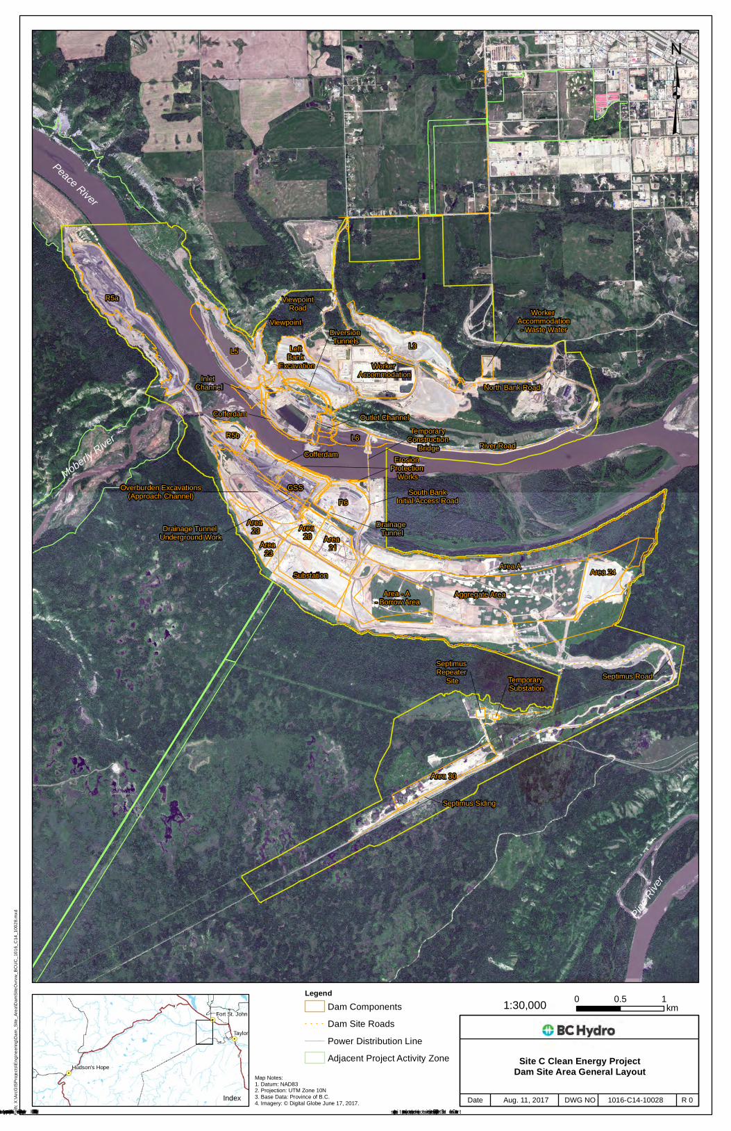
Peace River
Moberly River
Pine R
iver
Area A
Aggregate Area
L3
Area 24
L5
Substation
Area 21
R6
R5a
Area 30
Left Bank
Excavation
Area - A - Borrow Area
Worker Accommodation
GSS
Area 20
L6
Area 23
R5b
Overburden Excavations(Approach Channel)
Area 23
Inlet Channel
Outlet ChannelCofferdam
Cofferdam
Worker Accommodation- Waste WaterDiversion
Tunnels
Viewpoint
Septimus Repeater
Site
Drainage Tunnel
Erosion Protection
Works
Temporary Substation
Drainage Tunnel Underground Work
Temporary Construction
Bridge
Septimus Siding
River Road
North Bank Road
ViewpointRoad
Septimus Road
South BankInitial Access Road
LegendDam ComponentsDam Site Roads
! ! Power Distribution LineAdjacent Project Activity Zone
³Pa
th: X
:\ArcG
ISProj
ects\
Engin
eerin
g\Dam
_Site
_Area
\Dam
SiteO
vrvw_
BCUC
_101
6_C1
4_10
028.m
xd
!.
!.
!.
!(29
!(97
Index
Taylor
Hudson's Hope
Fort St. John
© BC Hydro 2017 – all rights reserved. This map is for information purposes only and accuracy is not guaranteed.
Map Notes:1. Datum: NAD832. Projection: UTM Zone 10N3. Base Data: Province of B.C.4. Imagery: © Digital Globe June 17, 2017.
0 10.5km
Cons truction of the Site C Clean Energy Project is s ubject to required regulatory and permitting approvals.
Site C Clean Energy ProjectDam Site Area General Layout
R 01016-C14-10028Aug. 11, 2017Date DWG NO

1016-C14-08864 R 2Aug. 14, 2017Cons truction of the Site C Clean Energy Project is s ubject to required regulatory and permitting approvals.
Date DWG NO
Map Notes:1. Datum: NAD832. Projection: UTM Zone 10N3. Base Data: Province of B.C.
1:215,000
DRAFT - FOR DISCUSSION PURPOSES ONLY
Path:
X:\A
rcGISP
rojec
ts\En
viron
ment\
Fores
try\C
learin
gToD
ate_1
016_
C14_
0886
4.mxd
© BC Hydro 2017 – all rights reserved. This map is for information purposes only and accuracy is not guaranteed.
!.
!.
!.
Tea Creek
Red Creek
Dry Creek
Pine RiverLynx Creek
Cache Creek
Wilder Creek
Charlie Lake
Portage Creek
Moberly River
Halfway River
Farrell
Creek
Boudreau Lake
Peace River
Dinosaur Reservoir
¬«97
¬«29
¬«29
Hudson's Hope
Fort St. John ³
LegendApproximate Areas Cleared as of August 14, 2017 (Approx. 2,610 ha)
!.
!.
!.
!.
!.
!(29
!(97
Index Taylor
ChetwyndDawson Creek
Hudson's HopeFort St. John
Approximate Completed Clearing as of August 14, 2017Approximately 2,610 ha
0 4 82km
¬«97
0 2 41 km
West Pine Inset Map
Clearing areas are an approximation as "as-built" files have not been received from all the clearing contractors as of yet. Some field (non-treed) areas are included.
Related Documents