MACRO-INVERTEBRATE SAMPLING ON THE NAM OU RIVER Peter-John Meynell WLE Forum 10 November 2016 November 11, 2016

Welcome message from author
This document is posted to help you gain knowledge. Please leave a comment to let me know what you think about it! Share it to your friends and learn new things together.
Transcript
MACRO-INVERTEBRATE SAMPLING ON THE NAM OU RIVER Peter-John Meynell WLE Forum 10 November 2016
November 11, 2016
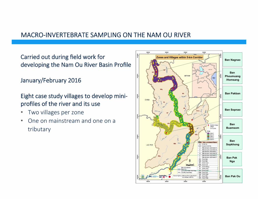
MACRO-INVERTEBRATE SAMPLING ON THE NAM OU RIVER
Carried out during field work for developing the Nam Ou River Basin Profile
January/February 2016
Eight case study villages to develop mini-profiles of the river and its use • Two villages per zone • One on mainstream and one on a
tributary
November 11, 2016
Ban Nagnao
Ban Phoumuang/Homsang
Ban Pakban
Ban Sopnao
Ban Buamsom
Ban Sopkhong
Ban Pak Nga
Ban Pak Ou

Sampling with nets along banks and shallow gravel/rock boTom
Using simple Southern African Scoring System
IdenUfy macroinvertebrates according to group, not species
10 sites sampled, but some sites could not be sampled because of high or fluctuaUng water levels
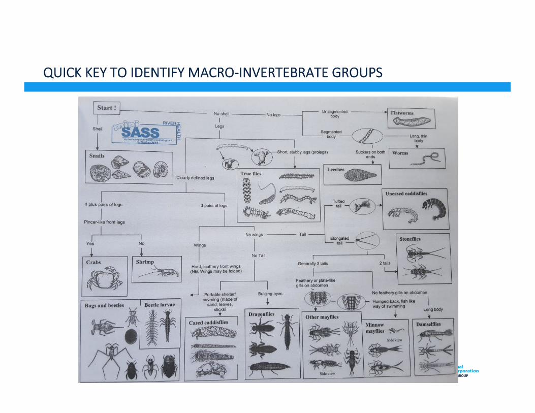
QUICK KEY TO IDENTIFY MACRO-INVERTEBRATE GROUPS

SCORE SHEET TO RECORD PRESENCE OF GROUPS

MACRO-INVERTEBRATE SAMPLING RESULTS
Date Description Flatworms
Worms
Leeches
Crabsandshrimps
Stoneflies
Minnowmayflies
Othermayflies
Damselflies
Dragonflies
BugsandBeetles
Caddisflies
Trueflies,Diptera
Molluscs
Megaloptera
Tadpoles
Fish
Totalscore
Average
Score 3 2 2 6 17 5 11 4 6 5 9 2 4 901-Feb NamOusource 17 11 6 5 9 2 x x 50 8.302-Feb NaturalsitebetweenSourceandGnotOutown 6 17 11 6 5 9 4 9 67 8.302-Feb BridgebelowGnotOutown 17 5 11 6 5 4 x 48 8.003-Feb BanPhoumouangboatlanding Biosurveynotdonebecauseriverisnowpartofreservoir05-Feb Pakban Biosurveynotdonebecauseattimeofsamplingthewaterlevelhadrisenby1mbetweenamandpm08-Feb BanSopkongFCZDOprofile 6 11 6 5 9 4 x x 41 6.830-Jan BanPakNga 6 11 5 4 x 26 6.508-Jan BanHatkhe 6 5 9 4 x 24 6.029-Jan IslandnearBanVangle 6 11 5 4 x 26 6.5
Tributaries31-Jan NamKor-fastwater 6 5 11 6 5 9 2 4 x 48 6.0
slowwater 6 5 11 5 4 9 x 40 6.231-Jan ConfluenceofNamKorandNamPhak 6 5 11 6 5 9 2 4 48 6.006-Feb BanSopNao 5 11 6 5 9 36 7.2
ColourcodeforrockytyperiversUnmodified(Naturalcondition) >7.9Largelynatural/fewmodifications(Goodcondition) 6.8-7.9Moderatleymodified(Faircondition) 6.1-6.8Largelymodified(Poorcondition) 5.1-6.1Seriously/criticallymodified(VeryPoorcondition) <5.1

NATURAL CONDITION, LARGELY UNMODIFIED

GNOD OU BRIDGE SAMPLING SITE
Natural conditions according to macroinvertbrates, but river weed growth showing signs of eutrophication

RIVER HABITAT SURVEY
• Study Google Earth images and topographic maps of the area
• Use river habitat survey observaUon on: • River features – width, flow rate, rapids, riffles, pools, narrows, channels,
midstream rocks, sandbars, in channel bushes and shrubs, tributary joining • Presence and character of islands – small, medium sized, large,
vegetated or cultivated, with houses • River bed – rocks and boulders, pebbles, gravel, sand, mud • River bank - rocks and boulders, pebbles, gravel, sand, mud, man-made,
structures • Aquatic vegetation – submerged water weed, floating plants, emergent
plants, bushes and shrubs in the river, trees growing in the river • River bank vegetation – reeds and grasses, bushes and shrubs, large
trees • People using the river – fishers, river bank gardeners, NTFP harvesters,
small scale gold panners

PAK OU ROAD BRIDGE – DEEP POOL (20 M)

BUILDING RIVER HABITAT MAPS – UPSTREAM FROM PAK OU

CHALLENGES AND CONSTRAINTS
1. Macro-invertebrate sampling appeared to be effecUve in showing river health especially when used with other observaUons e.g. water quality and habitat surveys
2. Easier to carry out in smaller, shallower rivers
3. Larger rivers are oeen deep and fast flowing, with steep banks – safety issue
4. Important to select the best habitats to sample • Gravel and rocky river beds with shallow, gently sloping banks are best • Slower moving reaches with water weeds • Sand bars tend to be rather poor substrates
5. Recent and rapid changes (increase and decrease) in water level tends to depress macro-invertebrate populaUons, e.g. from recent rain storms, beginning of wet season, and flow changes from hydropower.
Related Documents