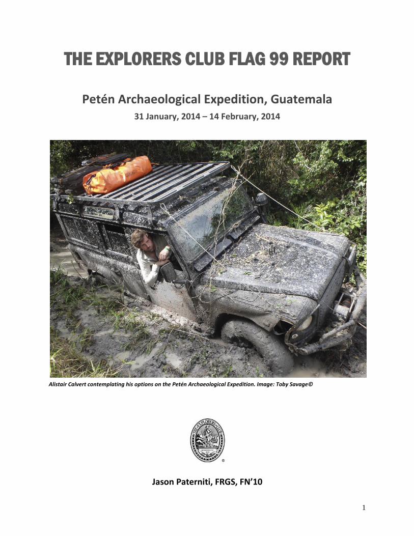
1 THE EXPLORERS CLUB FLAG 99 REPORT Petén Archaeological Expedition, Guatemala 31 January, 2014 – 14 February, 2014 Alistair Calvert contemplating his options on the Petén Archaeological Expedition. Image: Toby Savage© Jason Paterniti, FRGS, FN’10

Welcome message from author
This document is posted to help you gain knowledge. Please leave a comment to let me know what you think about it! Share it to your friends and learn new things together.
Transcript
1
THE EXPLORERS CLUB FLAG 99 REPORT
Petén Archaeological Expedition, Guatemala 31 January, 2014 – 14 February, 2014
Alistair Calvert contemplating his options on the Petén Archaeological Expedition. Image: Toby Savage©
Jason Paterniti, FRGS, FN’10
2
Contents:
Project Overview: .......................................................................................................................................... 3
Project Explanation: ...................................................................................................................................... 4
Research Aims: .............................................................................................................................................. 8
Project Objectives: ........................................................................................................................................ 9
Orientation: ................................................................................................................................................... 9
Site Selection ................................................................................................................................... 11
History of El Zotz ............................................................................................................................. 12
Modern History of El Zotz ............................................................................................................... 12
Expedition Members & Areas of Responsibility: ........................................................................................ 12
Logistics: ...................................................................................................................................................... 14
Project Methods: ........................................................................................................................................ 16
Laser sensor .................................................................................................................................... 16
Structure from Motion .................................................................................................................... 18
Long range UAV based aerial survey: ............................................................................................. 21
Inter regional study: Site prediction using remote sensing technologies: ..................................... 26
Project Results & Outcomes: ...................................................................................................................... 29
Acknowledgments: ..................................................................................................................................... 32
Works Cited: ................................................................................................................................................ 33
Lessons learned: .......................................................................................................................................... 34
APPENDIX .................................................................................................................................................... 35
3
Project Overview:
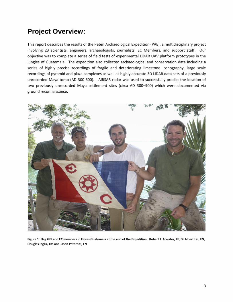
This report describes the results of the Petén Archaeological Expedition (PAE), a multidisciplinary project
involving 23 scientists, engineers, archaeologists, journalists, EC Members, and support staff. Our
objective was to complete a series of field tests of experimental LiDAR UAV platform prototypes in the
jungles of Guatemala. The expedition also collected archaeological and conservation data including a
series of highly precise recordings of fragile and deteriorating limestone iconography, large scale
recordings of pyramid and plaza complexes as well as highly accurate 3D LiDAR data sets of a previously
unrecorded Maya tomb (AD 300-600). AIRSAR radar was used to successfully predict the location of
two previously unrecorded Maya settlement sites (circa AD 300–900) which were documented via
ground reconnaissance.
Figure 1: Flag #99 and EC members in Flores Guatemala at the end of the Expedition: Robert J. Atwater, LF, Dr Albert Lin, FN,
Douglas Inglis, TM and Jason Paterniti, FN
4
Project Explanation:
The Petén in northern Guatemala covers approximately 36,000 square kilometers. This area was once
the home of the ancient Maya, a civilization which flourished from the Pre-classic period circa 1,500
B.C., and then abruptly collapsed starting around AD 900. (William Saturno, 2007).
For the last 200 years, non indigenous explorers have battled heat, humidity, insects and disease in their
efforts to penetrate the dense jungles of the Petén in search of Maya ruins. More often than not, the
objective of these efforts was to loot these sites for profit, not to learn from or preserve them.
While many monumental Maya sites have been discovered and recorded in the last century, Maya
scholars believe that much of the physical remains of the ancient Maya civilization may still be buried
deep in the jungle (Barnhart). Today, advances in remote sensing technologies can help researchers and
scholars to level the playing field against looters before these precious unrecorded cultural heritage
sites are lost forever.
History of Remote Sensing Exploration in the Petén:
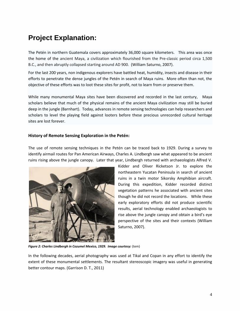
The use of remote sensing techniques in the Petén can be traced back to 1929. During a survey to
identify airmail routes for Pan American Airways, Charles A. Lindbergh saw what appeared to be ancient
ruins rising above the jungle canopy. Later that year, Lindbergh returned with archaeologists Alfred V.
Kidder and Oliver Ricketson Jr. to explore the
northeastern Yucatan Peninsula in search of ancient
ruins in a twin motor Sikorsky Amphibian aircraft.
During this expedition, Kidder recorded distinct
vegetation patterns he associated with ancient sites
though he did not record the locations. While these
early exploratory efforts did not produce scientific
results, aerial technology enabled archaeologists to
rise above the jungle canopy and obtain a bird’s eye
perspective of the sites and their contexts (William
Saturno, 2007).
Figure 2: Charles Lindbergh in Cozumel Mexico, 1929. Image courtesy: (tem)
In the following decades, aerial photography was used at Tikal and Copan in any effort to identify the
extent of these monumental settlements. The resultant stereoscopic imagery was useful in generating
better contour maps. (Garrison D. T., 2011)
5
In the 1970’s, Radar1 was first used in the Petén as part of environmental studies of soil analyses and to
identify vegetation types in the satellite imagery near Tikal. While early satellite technology could not
match the resolution of aerial based image collects, satellite remote sensing provided two critical
advantages over aerial photography. First landscapes could be viewed in different resolutions to provide
different perspectives and second, satellites can collect data across a wider range of the electromagnetic
(EM) spectrum. This later feature would prove to have a significant impact on the development of Maya
research. A key breakthrough came as researchers began to recognize that the archaeological sites
themselves were impacting their environments in ways that could not be seen in visible part of the
electromagnetic spectrum. Through remote sensing technology, changes which were only observable
outside of the visible EM spectrum could be detected and used as a proxy to predict the existence of
other archaeological sites (Parcak, 2009).
In the 1980’s, Thomas Sever from NASA began looking for vegetation signatures in multispectral imagery
as an indicator of potential presence of archaeological material (Saturno, 2007). While the resolution of
this technology was not sufficient to identify structures, Sever was successful in identifying canals and
roads.
In the 1990’s Sever conducted further surveys using the new STAR3i system which was able to identify
islands in the bajo areas. These islands coincided with the location of modest bajo communities. Sever
next experimented with satellite imagery using the 30m resolution per pixel images generated from the
LANDSAT satellite. (Garrison, 2011)
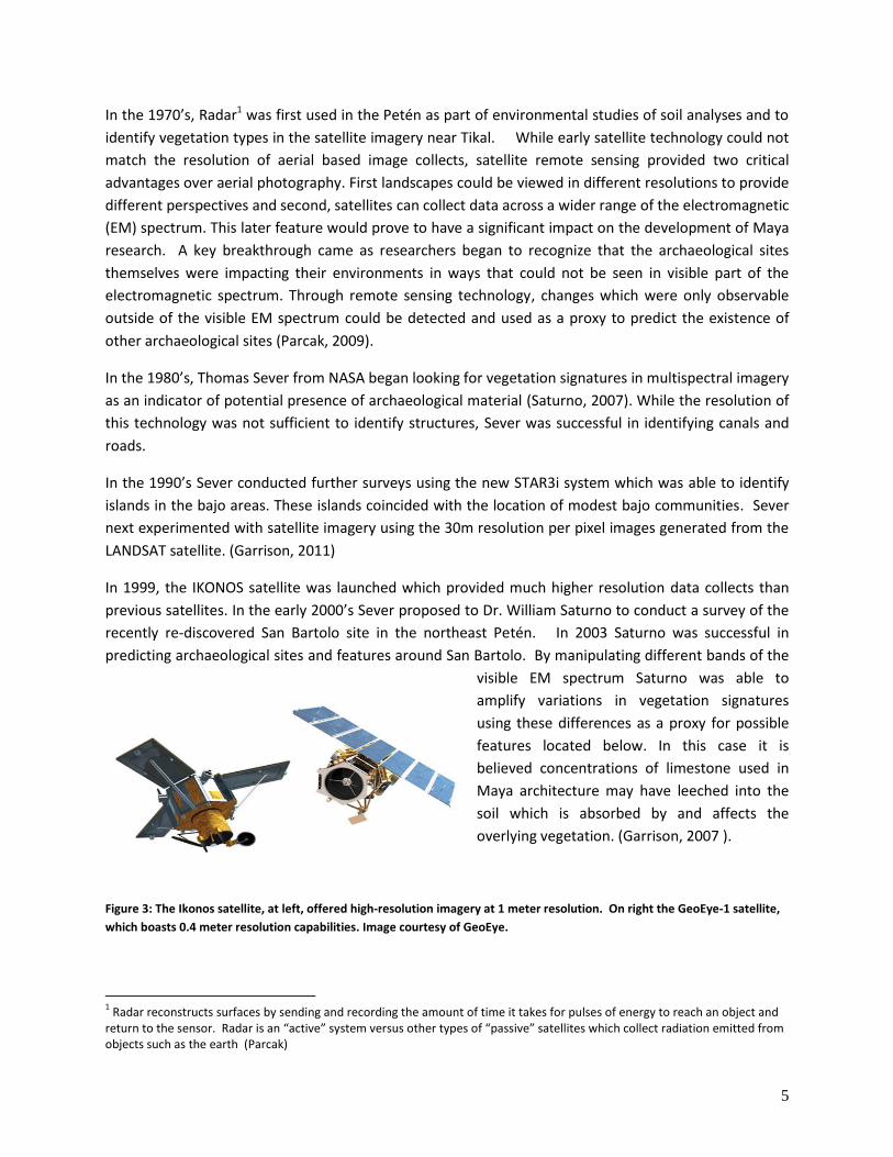
In 1999, the IKONOS satellite was launched which provided much higher resolution data collects than
previous satellites. In the early 2000’s Sever proposed to Dr. William Saturno to conduct a survey of the
recently re-discovered San Bartolo site in the northeast Petén. In 2003 Saturno was successful in
predicting archaeological sites and features around San Bartolo. By manipulating different bands of the
visible EM spectrum Saturno was able to
amplify variations in vegetation signatures
using these differences as a proxy for possible
features located below. In this case it is
believed concentrations of limestone used in
Maya architecture may have leeched into the
soil which is absorbed by and affects the
overlying vegetation. (Garrison, 2007 ).
Figure 3: The Ikonos satellite, at left, offered high-resolution imagery at 1 meter resolution. On right the GeoEye-1 satellite,
which boasts 0.4 meter resolution capabilities. Image courtesy of GeoEye.
1 Radar reconstructs surfaces by sending and recording the amount of time it takes for pulses of energy to reach an object and
return to the sensor. Radar is an “active” system versus other types of “passive” satellites which collect radiation emitted from objects such as the earth (Parcak)
6
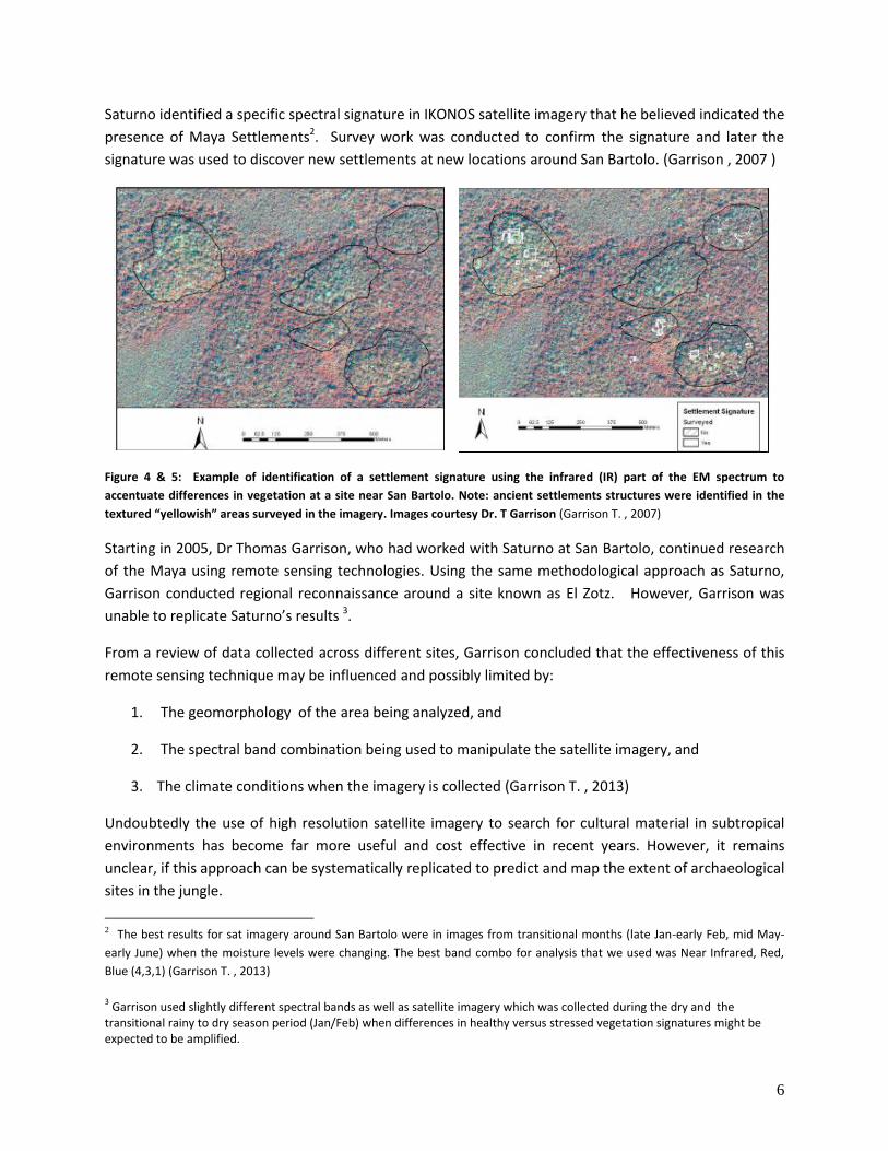
Saturno identified a specific spectral signature in IKONOS satellite imagery that he believed indicated the
presence of Maya Settlements2. Survey work was conducted to confirm the signature and later the
signature was used to discover new settlements at new locations around San Bartolo. (Garrison , 2007 )
Figure 4 & 5: Example of identification of a settlement signature using the infrared (IR) part of the EM spectrum to
accentuate differences in vegetation at a site near San Bartolo. Note: ancient settlements structures were identified in the
textured “yellowish” areas surveyed in the imagery. Images courtesy Dr. T Garrison (Garrison T. , 2007)
Starting in 2005, Dr Thomas Garrison, who had worked with Saturno at San Bartolo, continued research
of the Maya using remote sensing technologies. Using the same methodological approach as Saturno,
Garrison conducted regional reconnaissance around a site known as El Zotz. However, Garrison was
unable to replicate Saturno’s results 3.
From a review of data collected across different sites, Garrison concluded that the effectiveness of this
remote sensing technique may be influenced and possibly limited by:
1. The geomorphology of the area being analyzed, and
2. The spectral band combination being used to manipulate the satellite imagery, and
3. The climate conditions when the imagery is collected (Garrison T. , 2013)
Undoubtedly the use of high resolution satellite imagery to search for cultural material in subtropical
environments has become far more useful and cost effective in recent years. However, it remains
unclear, if this approach can be systematically replicated to predict and map the extent of archaeological
sites in the jungle.
2 The best results for sat imagery around San Bartolo were in images from transitional months (late Jan-early Feb, mid May-
early June) when the moisture levels were changing. The best band combo for analysis that we used was Near Infrared, Red,
Blue (4,3,1) (Garrison T. , 2013)
3 Garrison used slightly different spectral bands as well as satellite imagery which was collected during the dry and the
transitional rainy to dry season period (Jan/Feb) when differences in healthy versus stressed vegetation signatures might be expected to be amplified.
7
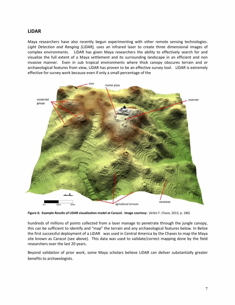
LiDAR
Maya researchers have also recently begun experimenting with other remote sensing technologies. Light Detection and Ranging (LiDAR), uses an infrared laser to create three dimensional images of complex environments. LiDAR has given Maya researchers the ability to effectively search for and visualize the full extent of a Maya settlement and its surrounding landscape in an efficient and non invasive manner. Even in sub tropical environments where thick canopy obscures terrain and or archaeological features from view, LiDAR has proven to be an effective survey tool. LiDAR is extremely effective for survey work because even if only a small percentage of the
Figure 6: Example Results of LiDAR visualization model at Caracol. Image courtesy: (Arlen F. Chase, 2013, p. 186)
hundreds of millions of points collected from a laser manage to penetrate through the jungle canopy, this can be sufficient to identify and “map” the terrain and any archaeological features below. In Belize the first successful deployment of a LiDAR was used in Central America by the Chases to map the Maya site known as Caracol (see above). This data was used to validate/correct mapping done by the field researchers over the last 20 years.
Beyond validation of prior work, some Maya scholars believe LiDAR can deliver substantially greater
benefits to archaeologists.
8
“LiDAR holds the greatest promise for finding every last major (and minor) site in the jungles of
Northern Guatemala. This is the purest, most authentic exploration, of course, and momentous
scientifically.
-Dr Stephen Houston, Brown University
As of the writing of this report, LIDAR technology has been used at archaeological sites where survey
and excavation work has already been conducted. While this has proven useful to identify
archaeological features not identified through traditional survey methods or to correct locational errors
in surveys, it has not been used as the basis to visualize a previously un-surveyed landscape and direct a
more efficient and effective field survey and research program (Garrison , 2013).
Recent successes of manned LiDAR surveys over portions of Central America and Southeast Asia have
highlighted the revolutionary utility of this sensor to identify and visualize archaeological remains from
above. However, LiDAR has not been used extensively to search for, identify or map archaeological sites
to date in large part because of cost LiDAR mapping deployed from fixed wing manned aircraft remains
prohibitively expensive for most projects.
Research Aims:
Maya sites remain undocumented in the Jungles of Central America. Artifacts are constantly being
unearthed and distributed on the black market. Searching for and scientifically documenting sites
requires an enormous amount of time and labor. At present, looters are identifying sites faster than
Archaeologists can record them. Manned aerial LIDAR surveys allow archaeologists to rapidly identify
and precisely map archaeological sites. However this technology is very expensive to deploy. Our team
believes they we have revolutionary answer to this problem: compact LIDAR arrays mounted on
portable UAVs that can be launched from within the jungle itself. We believe this technology will change
the landscape of Maya archaeology by reducing the cost of aerial LIDAR surveys, and place the controls
of the survey equipment in the hands of archaeologists. The aim of the Petén Archaeological Expedition
is to conduct the preliminary field tests in order to develop a cost effective UAV based LIDAR prototype
to assist archaeologists in their efforts to understand the ancient Maya. Building on the remote sensing
work of Dr William Saturno and other Maya researchers, our team intends to construct a robust and
economic UAV based LiDAR system for remote sensing data capture. Successfully field testing our
prototype equipment on this Flag expedition was the first stage in an effort to build a UAV based LiDAR
prototype which will allow future archaeologists to capture a comprehensive survey data of targeted
Maya Landscapes at a fraction of the cost required to deploy LiDAR via fixed wing manned aircraft.
9
Project Objectives:
Demonstration of unmanned aerial vehicle (UAV) survey capacity in sub tropical jungle environment
including full path plan, data capture, data processing (stitching, geo-referencing, ortho-
rectification), and LiDAR and SFM workflow
Capture images of temple complexes from above jungle canopy
UAV reconnaissance to explore cliffs at El Zotz for cave entrances
Collect high resolution LiDAR and SfM recordings of monumental cultural material for conservation
Collect large scale SFM of Plaza complexes and pyramid of context visualization and archaeological
recording purposes
Collect high resolution LiDAR data of tomb for recording
Test research hypothesis that the Maya built on geographically favored topography to take
advantage of view sheds by ground truthing targets predicted from high orbit remote sensing Radar
data
Orientation:
Our team arrived by various small planes to Flores Guatemala, our rendezvous location and the
traditional jumping off point for many expeditions heading into the Petén. From Flores our introduction
to this intense environment was much like early explorers descriptions of their own incidents of travel:
mud, insects, and more mud which resulted in our failure to reach our first objective- the Maya site
today known as Nakum. Wary of our tight schedule and running low on fuel, we reluctantly turned back
after 18 hours of winching and digging, having covered only 30 kms. At our next target site-Naranjo we
found more favorable driving conditions and mostly undocumented temple ruins. Many of the ruins at
Naranjo are obscured by thick jungle and covered by a millennium of earth and organic material. Much
like explorers must have done almost two centuries ago, we could only wonder about the size and
context of these ruins and of the people who built these cities.
10
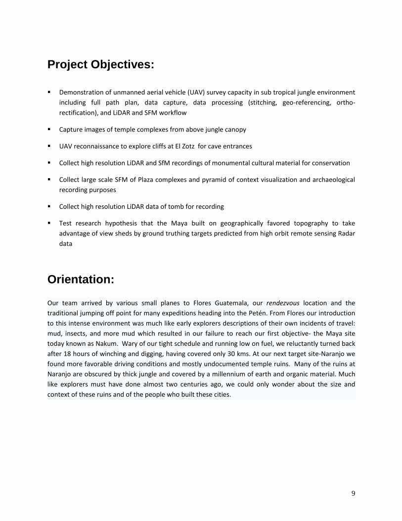
Figure 7: PAE Route, Inset: Petén, Guatemala Inset Central America
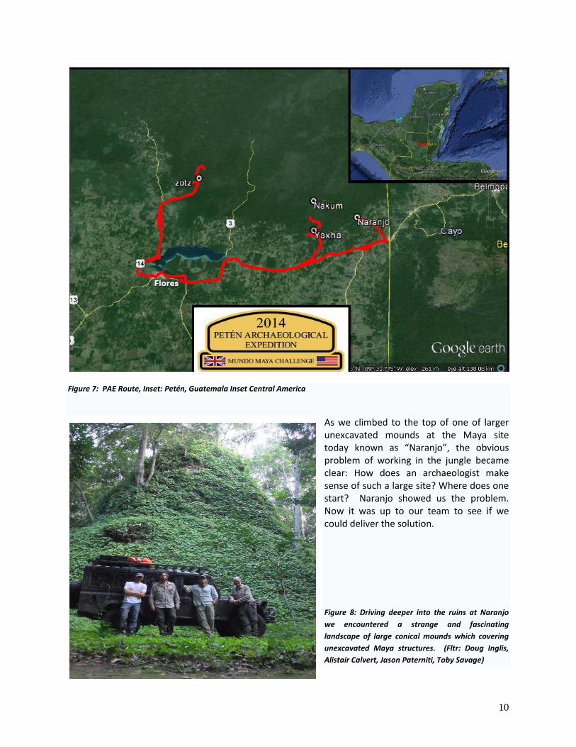
As we climbed to the top of one of larger unexcavated mounds at the Maya site today known as “Naranjo”, the obvious problem of working in the jungle became clear: How does an archaeologist make sense of such a large site? Where does one start? Naranjo showed us the problem. Now it was up to our team to see if we could deliver the solution.
Figure 8: Driving deeper into the ruins at Naranjo
we encountered a strange and fascinating
landscape of large conical mounds which covering
unexcavated Maya structures. (Fltr: Doug Inglis,
Alistair Calvert, Jason Paterniti, Toby Savage)
11
Geography
The Maya Lowlands is generally composed of a karst topography with bajos (seasonal wetlands)
comprising 40% or more of the land surface (Garrison D. T., 2011). The porous limestone bedrock acts
as a sponge. Instead of flowing into streams and rivers, rainwater flows down through sinkholes to
underground drainage systems far below the surface.
Site Selection For this project we identified four potential locations for study based on three criteria: accessibility,
canopy density and site excavation status. For practical reasons, logistics required we have at least
marginally passable roads to reach the sites in the time available for the field study. In order to deploy
and recover the UAV system, canopy density was an additional constraint for the project. We needed at
least 3 meter gaps to deploy and recover the UAV.
The state of excavation of a site was also factored into our decision. Mostly cleared and excavated sites
like Nakum and Yaxha offered comparatively little for scholars to learn from our results. From a research
perspective, El Zotz and Naranjo offered an excellent location to field test our equipment while also
potentially allowing us to collect useful data as part of the effort to conduct a complete inventory of
cultural sites. Based on road and canopy accessibility we selected the archaeological site at El Zotz
located in the San Miguel la Palotada Biotope for our field study4.
4 We are extremely grateful to the Instituto de Antropologia e Historia de Guatemala for authorizing this project
and to CECON and the Universidad de San Carlos San Miguel Biotopo which runs the reserve.
SITE Location Accesibility Canopy Site status
Nakum 17° 10.570'N Very Muddy Track. 10 hours to cover 16kms. Trucks
had to turn back 10 kms short of target as we were
running low on fuel and time.
Partia l ly open Partia l ly
excavated
89° 24.278'W
Yaxha 17° 4.508'N Dirt road, maintained. Open Excavated
89° 24.125'W
Naranjo 17° 7.537'N dirt road/ muddy track 8 hours to go 19kms Dense coverage Un Recorded
89° 15.359'W
El Zotz 17° 14.491'N Dirt road/ muddy track: 4 hours to go 21 kms Dense/smal l
openings
Partia l ly
excavated
12
History of El Zotz El Zotz is located 14 miles west of the more famous major center of Tikal. The site contains many
unexcavated mounds and tombs and is so named for the hundreds of thousands of bats that fly out
from under nearby cliffs at sunset. El Zotz is also known for its well preserved Early Classic (AD 300-600)
architecture, with elaborately decorated stucco surfaces. The Maya most likely referred to El Zotz as Pa’
Chan, or “fortified-sky,” and the site was occupied for over nine centuries between (AD 300–1250)
(Garrison D. T., 2013). The earliest royal palace at the site is located on a hilltop overlooking the area
where the major ruins are located. This palace, known as the El Diablo Group, would have housed the
royal family for about two centuries and included a 13–meter-tall funerary pyramid.
Modern History of El Zotz It is unclear when El Zotz was first rediscovered, but we do know that the site was heavily looted in the
1960’s and 1970’s. During this period, academic study of the site was limited to a handful of survey and
mapping efforts undertaken first by Marco Antonio Bailey followed by George Andrews in 1977 and Ian
Graham in 1978.
In the 1980’s the Proyecto Nacional Tikal and the Departmento de Monumentos Prehispanicos
(DEMOPRE) of the Guatemalan Institute of Anthropology and History (IDAEH) conducted mapping and
limited test pits excavations with some removal of artifacts in 1987, 1995, 1999 and 2000. In 2006 a
team led by Dr. Stephen Houston of Brown University and Héctor Escobedo (Ministerio de Cultura y
Deportes de Guatemala) began a five year project to map El Zotz. (Houston D. S., 2008)
In 2009 Dr Tom Garrison joined the project as the director of regional investigations. As of 2012,
Garrison became Project Director (based at the University of Southern California) in collaboration with
Edwin Román (University of Texas at Austin) who served as Guatemalan project co-director.
Expedition Members & Areas of Responsibility: The Petén Archaeological Expedition brought together two groups of highly talented scientists and
researchers. Dr Thomas Garrison and his team of Maya Archaeologists partnered with Dr Albert Lin,
Prof Ryan Kastner and Dr Curt Schurgers and their team from University of California San Diego’s
Institute for Telecommunications and Information Technology or (Calit2). Dr. Lin, a Lowell Thomas
award recipient, describes the Engineers for Exploration (E4E) program at Calit2, which is also known as
the Qualcomm Institute, as “a student-powered innovation incubator for exploration. By the end of this
expedition the UCSD team had more than lived up to this description.
13
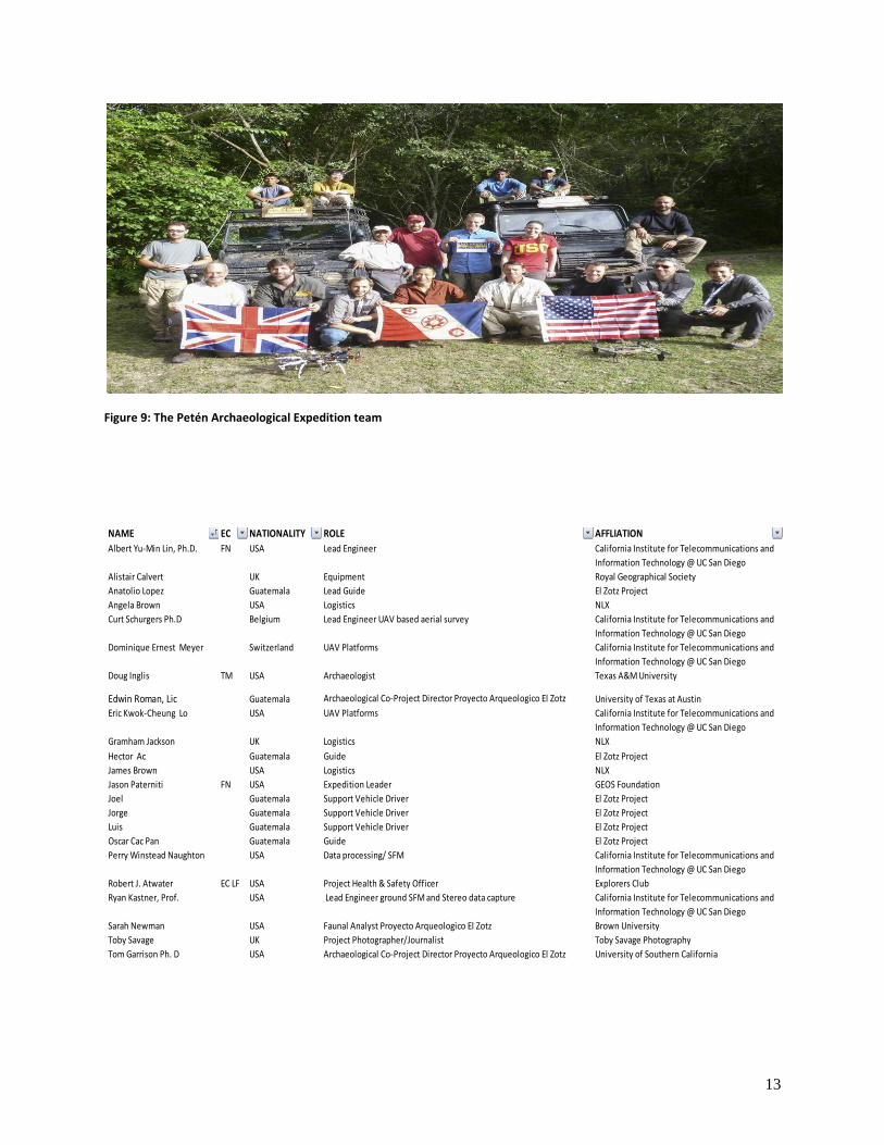
Figure 9: The Petén Archaeological Expedition team
NAME EC NATIONALITY ROLE AFFLIATION
Albert Yu-Min Lin, Ph.D. FN USA Lead Engineer California Institute for Telecommunications and
Information Technology @ UC San Diego
Alistair Calvert UK Equipment Royal Geographical Society
Anatolio Lopez Guatemala Lead Guide El Zotz Project
Angela Brown USA Logistics NLX
Curt Schurgers Ph.D Belgium Lead Engineer UAV based aerial survey California Institute for Telecommunications and
Information Technology @ UC San Diego
Dominique Ernest Meyer Switzerland UAV Platforms California Institute for Telecommunications and
Information Technology @ UC San Diego
Doug Inglis TM USA Archaeologist Texas A&M University
Edwin Roman, Lic Guatemala Archaeological Co-Project Director Proyecto Arqueologico El Zotz University of Texas at Austin
Eric Kwok-Cheung Lo USA UAV Platforms California Institute for Telecommunications and
Information Technology @ UC San Diego
Gramham Jackson UK Logistics NLX
Hector Ac Guatemala Guide El Zotz Project
James Brown USA Logistics NLX
Jason Paterniti FN USA Expedition Leader GEOS Foundation
Joel Guatemala Support Vehicle Driver El Zotz Project
Jorge Guatemala Support Vehicle Driver El Zotz Project
Luis Guatemala Support Vehicle Driver El Zotz Project
Oscar Cac Pan Guatemala Guide El Zotz Project
Perry Winstead Naughton USA Data processing/ SFM California Institute for Telecommunications and
Information Technology @ UC San Diego
Robert J. Atwater EC LF USA Project Health & Safety Officer Explorers Club
Ryan Kastner, Prof. USA Lead Engineer ground SFM and Stereo data capture California Institute for Telecommunications and
Information Technology @ UC San Diego
Sarah Newman USA Faunal Analyst Proyecto Arqueologico El Zotz Brown University
Toby Savage UK Project Photographer/Journalist Toby Savage Photography
Tom Garrison Ph. D USA Archaeological Co-Project Director Proyecto Arqueologico El Zotz University of Southern California
14
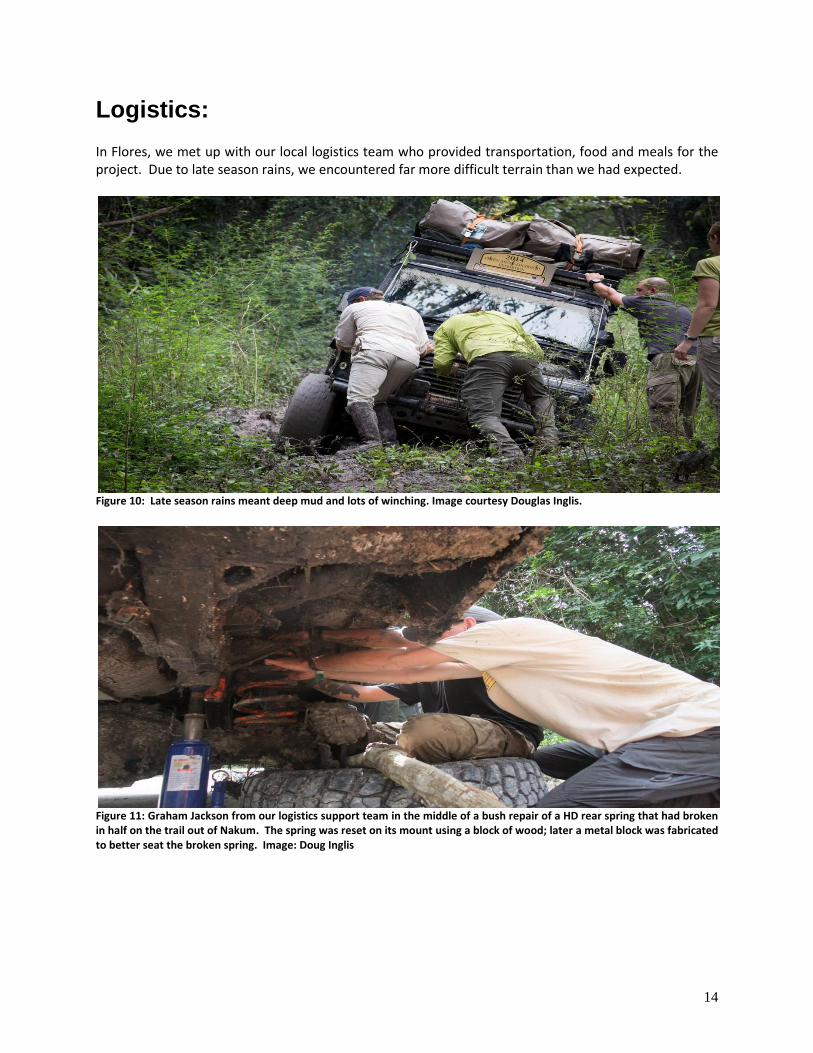
Logistics: In Flores, we met up with our local logistics team who provided transportation, food and meals for the project. Due to late season rains, we encountered far more difficult terrain than we had expected.
Figure 10: Late season rains meant deep mud and lots of winching. Image courtesy Douglas Inglis.
Figure 11: Graham Jackson from our logistics support team in the middle of a bush repair of a HD rear spring that had broken in half on the trail out of Nakum. The spring was reset on its mount using a block of wood; later a metal block was fabricated to better seat the broken spring. Image: Doug Inglis
15
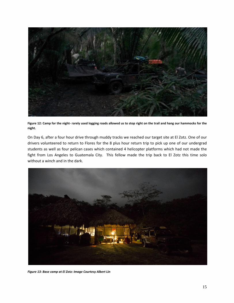
Figure 12: Camp for the night- rarely used logging roads allowed us to stop right on the trail and hang our hammocks for the
night.
On Day 6, after a four hour drive through muddy tracks we reached our target site at El Zotz. One of our
drivers volunteered to return to Flores for the 8 plus hour return trip to pick up one of our undergrad
students as well as four pelican cases which contained 4 helicopter platforms which had not made the
fight from Los Angeles to Guatemala City. This fellow made the trip back to El Zotz this time solo
without a winch and in the dark.
Figure 13: Base camp at El Zotz: Image Courtesy Albert Lin
16
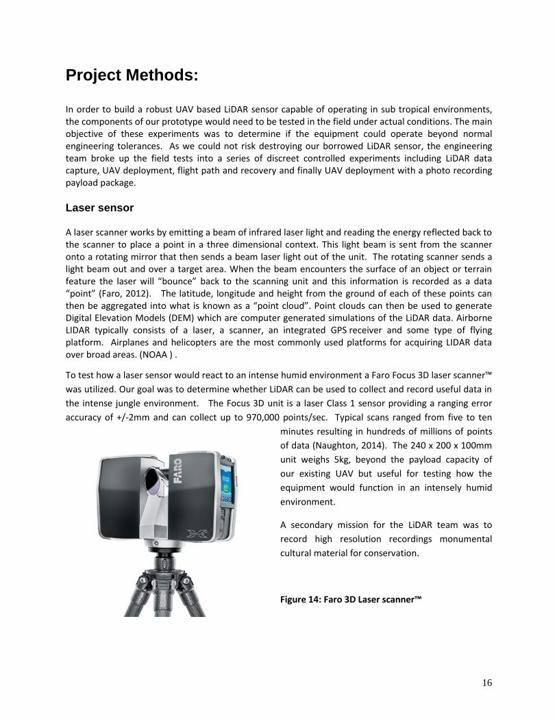
Project Methods: In order to build a robust UAV based LiDAR sensor capable of operating in sub tropical environments, the components of our prototype would need to be tested in the field under actual conditions. The main objective of these experiments was to determine if the equipment could operate beyond normal engineering tolerances. As we could not risk destroying our borrowed LiDAR sensor, the engineering team broke up the field tests into a series of discreet controlled experiments including LiDAR data capture, UAV deployment, flight path and recovery and finally UAV deployment with a photo recording payload package. Laser sensor A laser scanner works by emitting a beam of infrared laser light and reading the energy reflected back to the scanner to place a point in a three dimensional context. This light beam is sent from the scanner onto a rotating mirror that then sends a beam laser light out of the unit. The rotating scanner sends a light beam out and over a target area. When the beam encounters the surface of an object or terrain feature the laser will “bounce” back to the scanning unit and this information is recorded as a data “point” (Faro, 2012). The latitude, longitude and height from the ground of each of these points can then be aggregated into what is known as a “point cloud”. Point clouds can then be used to generate Digital Elevation Models (DEM) which are computer generated simulations of the LiDAR data. Airborne LIDAR typically consists of a laser, a scanner, an integrated GPS receiver and some type of flying platform. Airplanes and helicopters are the most commonly used platforms for acquiring LIDAR data over broad areas. (NOAA ) .
To test how a laser sensor would react to an intense humid environment a Faro Focus 3D laser scanner™
was utilized. Our goal was to determine whether LiDAR can be used to collect and record useful data in
the intense jungle environment. The Focus 3D unit is a laser Class 1 sensor providing a ranging error
accuracy of +/-2mm and can collect up to 970,000 points/sec. Typical scans ranged from five to ten
minutes resulting in hundreds of millions of points
of data (Naughton, 2014). The 240 x 200 x 100mm
unit weighs 5kg, beyond the payload capacity of
our existing UAV but useful for testing how the
equipment would function in an intensely humid
environment.
A secondary mission for the LiDAR team was to
record high resolution recordings monumental
cultural material for conservation.
Figure 14: Faro 3D Laser scanner™
17
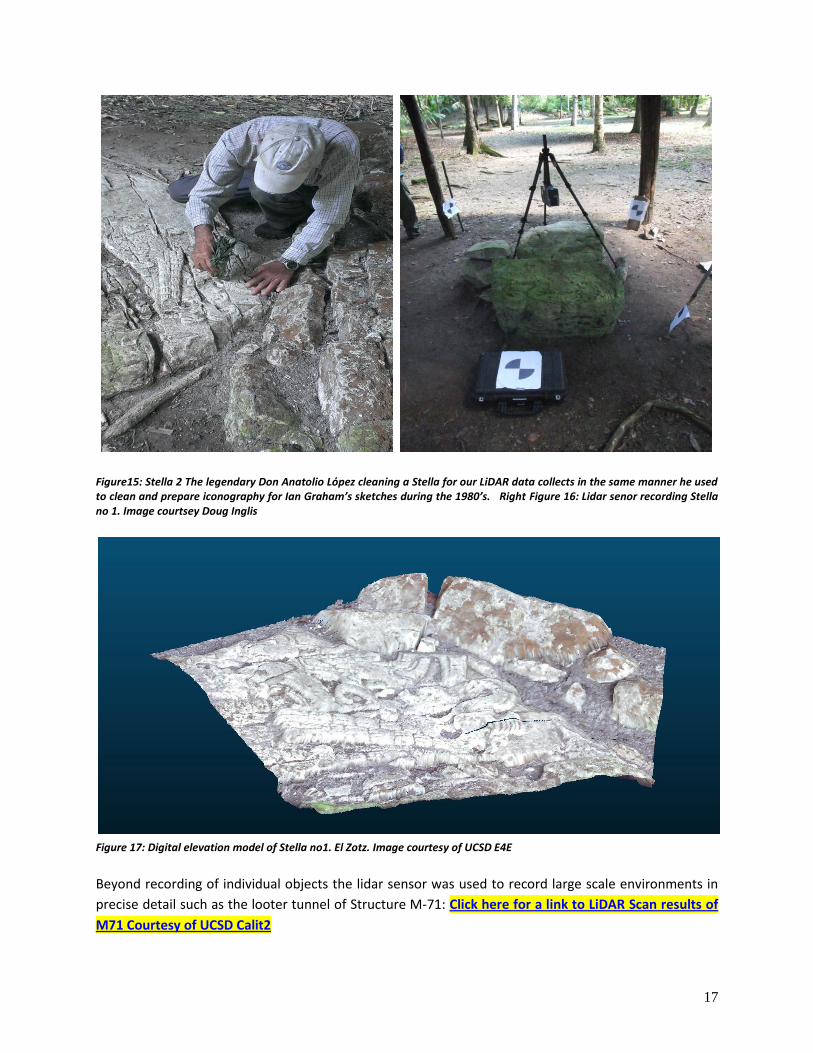
Figure15: Stella 2 The legendary Don Anatolio Lόpez cleaning a Stella for our LiDAR data collects in the same manner he used to clean and prepare iconography for Ian Graham’s sketches during the 1980’s. Right Figure 16: Lidar senor recording Stella no 1. Image courtsey Doug Inglis
Figure 17: Digital elevation model of Stella no1. El Zotz. Image courtesy of UCSD E4E
Beyond recording of individual objects the lidar sensor was used to record large scale environments in
precise detail such as the looter tunnel of Structure M-71: Click here for a link to LiDAR Scan results of
M71 Courtesy of UCSD Calit2
18
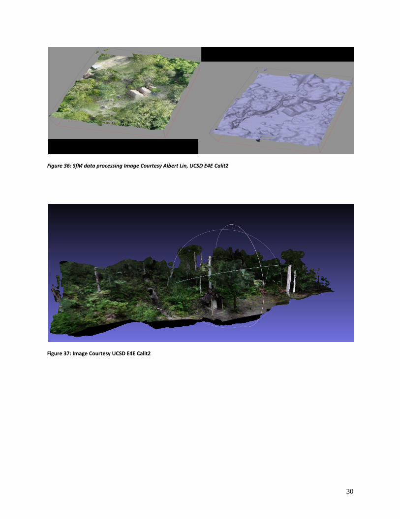
Structure from Motion
While LiDAR technology undoubtedly represents the cutting edge in remote sensing research tools,
Structure from Motion (SfM) provided us with a cost effective proxy for LiDAR for our field tests. SfM is
a process which combines a series of two dimensional image sequences into a three dimensional
visualization model. The process entails taking two-dimensional photographs of an object or site from
multiple angles and then tracking and aligning features in the photos (such as corner points) to 'stitch
together' and reconstruct the object digitally in 3D (Kastner D. R., 2014) For our tests, SfM recording
equipment was also used as a proxy to deploying a highly sensitive (and expensive) LiDAR sensor on our
prototype UAV system.
For SfM image collection we used Canon DSLR cameras. SfM data input into a commercially available
Agisoft software program http://www.agisoft.ru/. However in order to process and view the resultant
models, UCSD’s CISA3 group developed custom software to process the data sets (Naughton, 2014).
For our tests, we selected several plaza and pyramid complexes at El Zotz. These tests would also
represent the initial trials of SfM recording at El Zotz in advance of deploying a team in June 2014 to
record a series of monumental masks found by Garrison’s team in 2010 at Diablo Complex at El Zotz.
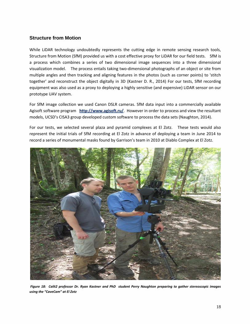
Figure 18: Calit2 professor Dr. Ryan Kastner and PhD student Perry Naughton preparing to gather stereoscopic images
using the “CaveCam” at El Zotz
19
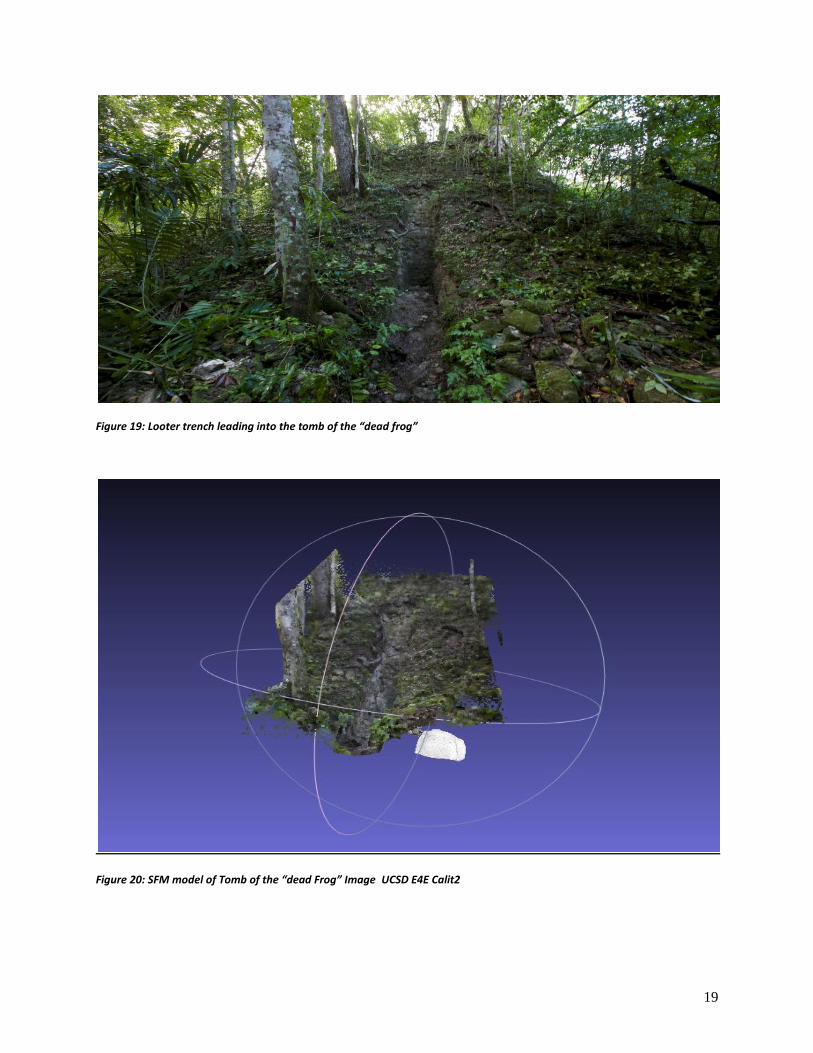
Figure 19: Looter trench leading into the tomb of the “dead frog”
Figure 20: SFM model of Tomb of the “dead Frog” Image UCSD E4E Calit2
20
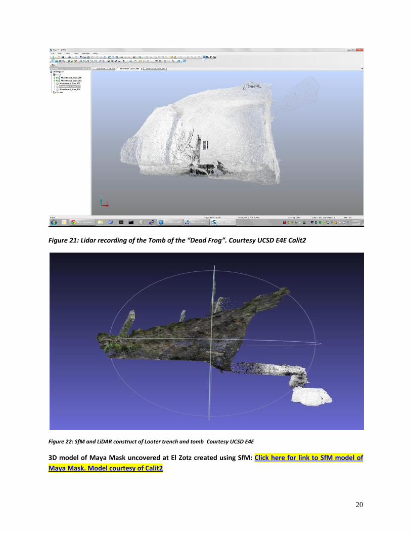
Figure 21: Lidar recording of the Tomb of the “Dead Frog”. Courtesy UCSD E4E Calit2
Figure 22: SfM and LiDAR construct of Looter trench and tomb Courtesy UCSD E4E
3D model of Maya Mask uncovered at El Zotz created using SfM: Click here for link to SfM model of
Maya Mask. Model courtesy of Calit2
21
Long range UAV based aerial survey:
The final set of engineering experiments at El Zotz involved demonstration of multiple path plans, data
capture, data processing (stitching, geo-referencing, ortho-rectification5 and SfM workflow) in order to
demonstrate UAV platform validation.
UAV:
Our experimental copters were equipped with fully integrated flight and position systems. The larger
“hexacopter” was based on an RC Timer F800 airframe with a brushless gimbal to support various
sensors. Flight time for the hexacopter was approximately 10 minutes, moving at 5 meters per second.
Payload capacity for this UAV including gimbal is approximately 1kg. The quadcopter "crawler" is an
entirely custom built in the UCSD machine shop, and carries the QX100 mounted directly on the copter.
Flight time is for the crawler is approximately 15 minutes with a payload of 0.5kg. The third hexacopter
used was a DJI F550 with a Zenmuse GoPro gimbal. Flight time for this UAV is approximately 10
minutes. We used this UAV with the GoPro Hero 3 Black to conduct aerial filming. Payload including
gimbal is approximately 0.5kg sensor. For our field trials we used a Sony QX100, a 20MP camera with a
1" sensor, and weighs ~200g, at 28mm focal length in 35mm equivalent. (Lo, 2014)
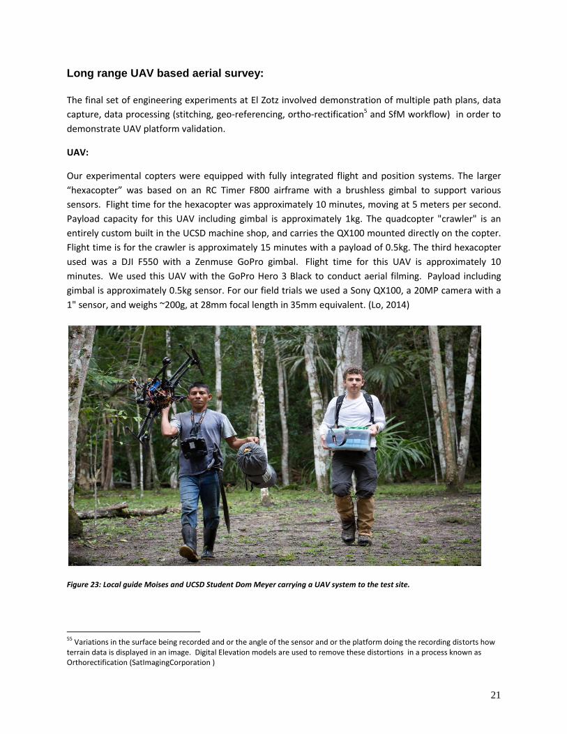
Figure 23: Local guide Moises and UCSD Student Dom Meyer carrying a UAV system to the test site.
55
Variations in the surface being recorded and or the angle of the sensor and or the platform doing the recording distorts how terrain data is displayed in an image. Digital Elevation models are used to remove these distortions in a process known as Orthorectification (SatImagingCorporation )
22
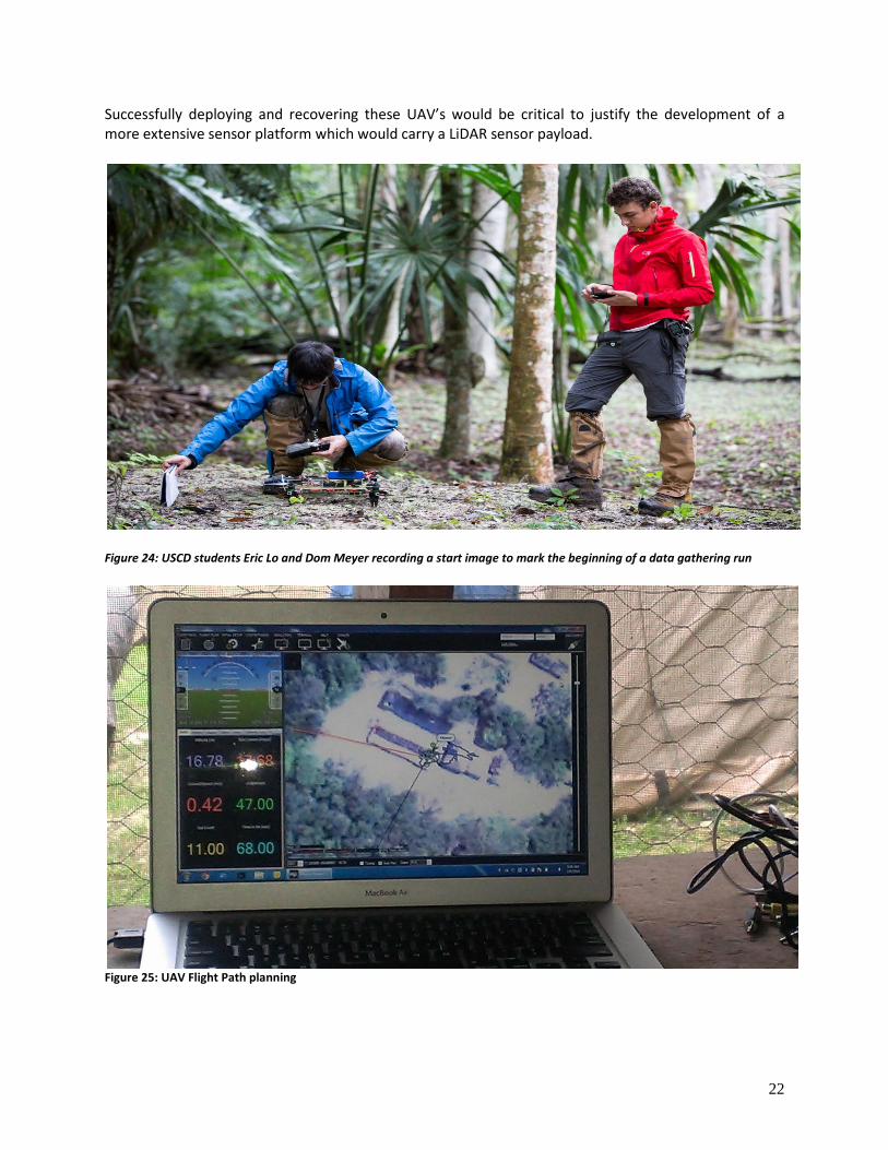
Successfully deploying and recovering these UAV’s would be critical to justify the development of a more extensive sensor platform which would carry a LiDAR sensor payload.
Figure 24: USCD students Eric Lo and Dom Meyer recording a start image to mark the beginning of a data gathering run
Figure 25: UAV Flight Path planning
23
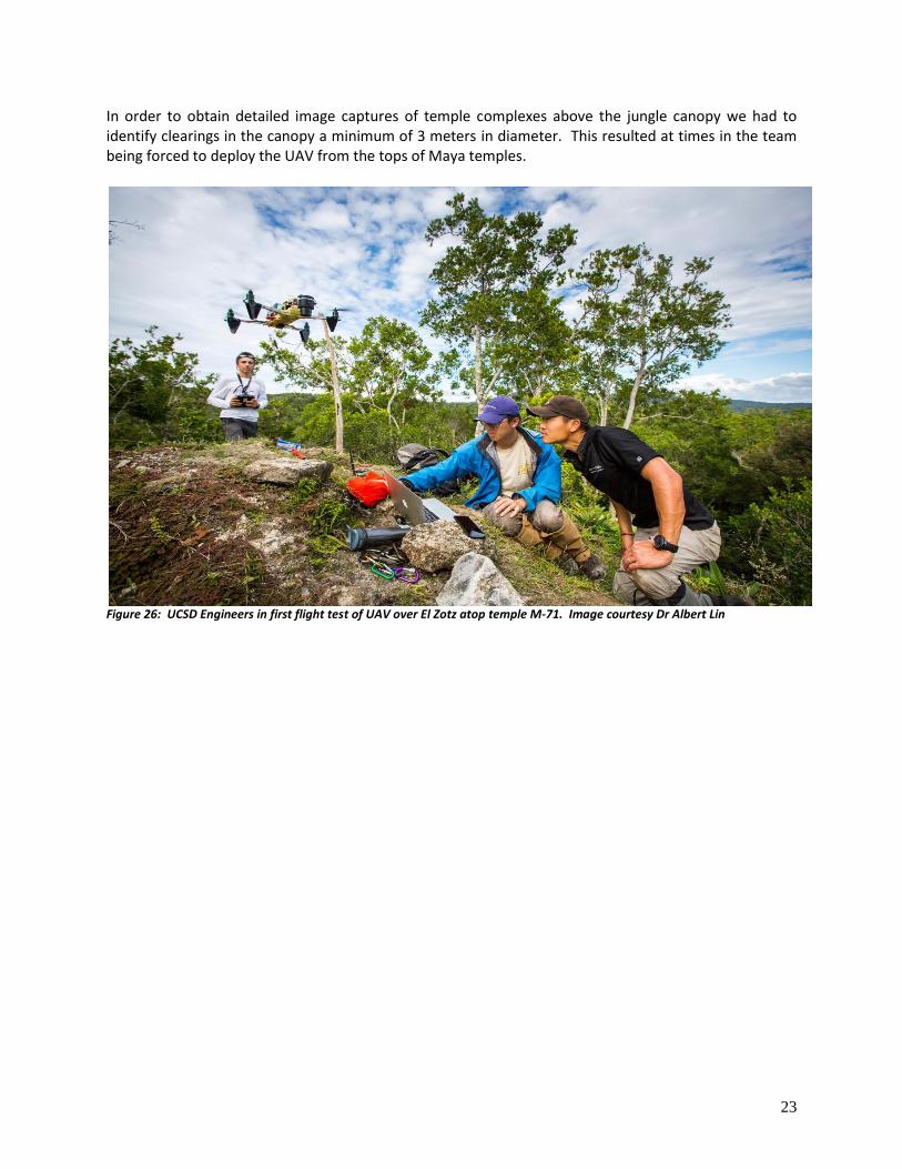
In order to obtain detailed image captures of temple complexes above the jungle canopy we had to identify clearings in the canopy a minimum of 3 meters in diameter. This resulted at times in the team being forced to deploy the UAV from the tops of Maya temples.
Figure 26: UCSD Engineers in first flight test of UAV over El Zotz atop temple M-71. Image courtesy Dr Albert Lin
24
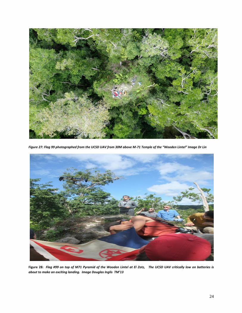
Figure 27: Flag 99 photographed from the UCSD UAV from 30M above M-71 Temple of the “Wooden Lintel” Image Dr Lin
Figure 28: Flag #99 on top of M71 Pyramid of the Wooden Lintel at El Zotz, The UCSD UAV critically low on batteries is
about to make an exciting landing. Image Douglas Inglis TM’13
25
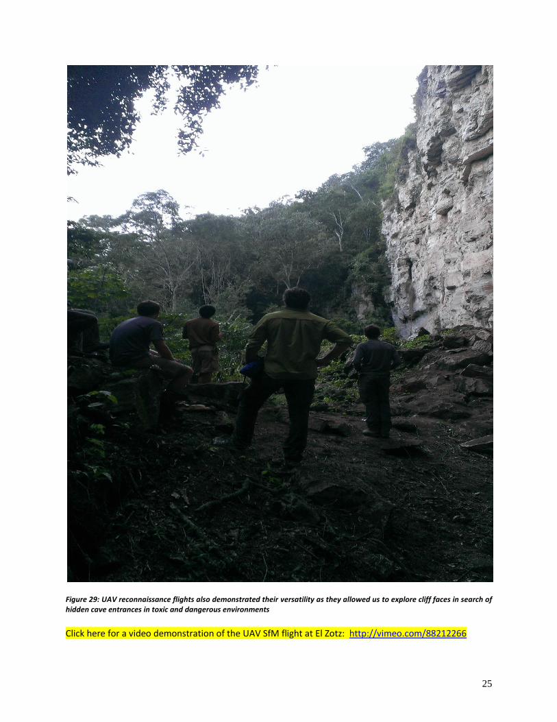
Figure 29: UAV reconnaissance flights also demonstrated their versatility as they allowed us to explore cliff faces in search of hidden cave entrances in toxic and dangerous environments
Click here for a video demonstration of the UAV SfM flight at El Zotz: http://vimeo.com/88212266
26
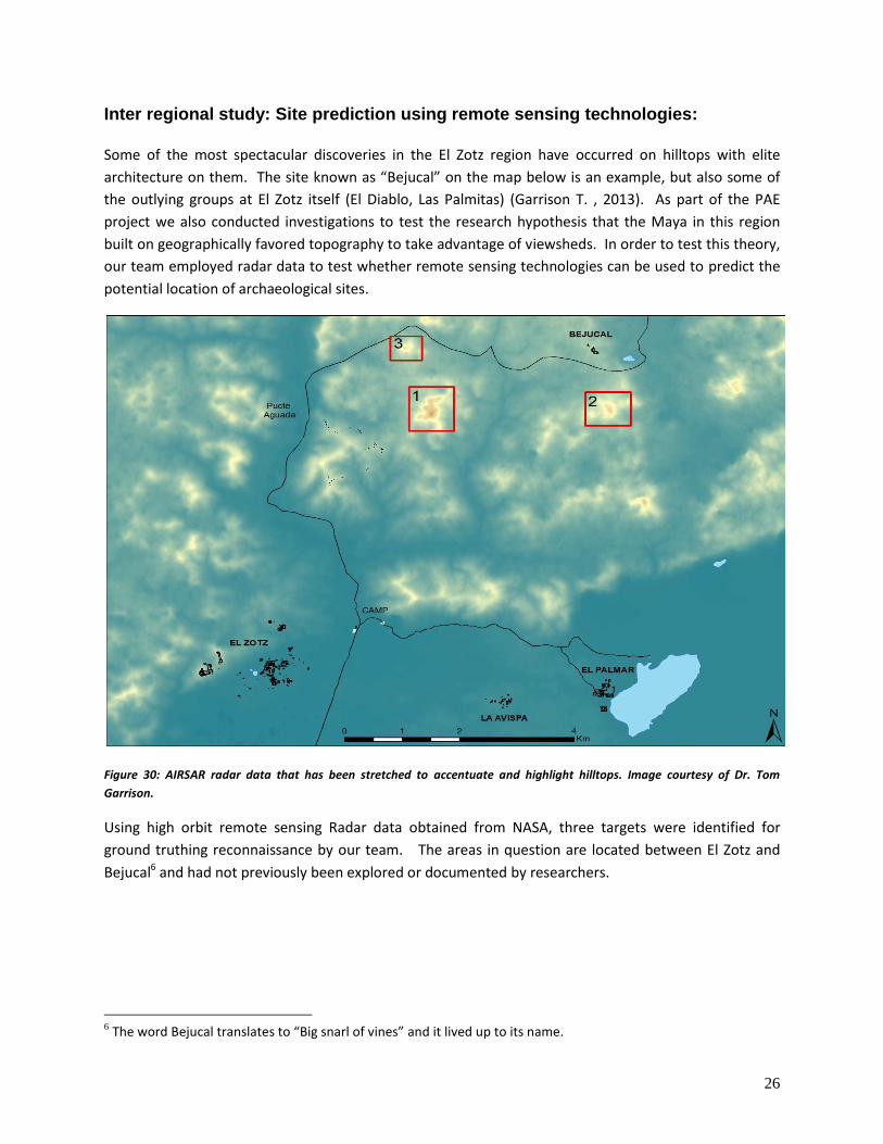
Inter regional study: Site prediction using remote sensing technologies: Some of the most spectacular discoveries in the El Zotz region have occurred on hilltops with elite
architecture on them. The site known as “Bejucal” on the map below is an example, but also some of
the outlying groups at El Zotz itself (El Diablo, Las Palmitas) (Garrison T. , 2013). As part of the PAE
project we also conducted investigations to test the research hypothesis that the Maya in this region
built on geographically favored topography to take advantage of viewsheds. In order to test this theory,
our team employed radar data to test whether remote sensing technologies can be used to predict the
potential location of archaeological sites.
Figure 30: AIRSAR radar data that has been stretched to accentuate and highlight hilltops. Image courtesy of Dr. Tom
Garrison.
Using high orbit remote sensing Radar data obtained from NASA, three targets were identified for
ground truthing reconnaissance by our team. The areas in question are located between El Zotz and
Bejucal6 and had not previously been explored or documented by researchers.
6 The word Bejucal translates to “Big snarl of vines” and it lived up to its name.
27
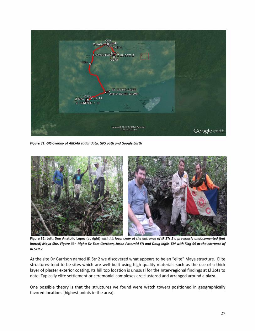
Figure 31: GIS overlay of AIRSAR radar data, GPS path and Google Earth
Figure 32: Left: Don Anatolio Lόpez (at right) with his local crew at the entrance of IR STr 2 a previously undocumented (but
looted) Maya Site. Figure 33: Right: Dr Tom Garrison, Jason Paterniti FN and Doug Inglis TM with Flag 99 at the entrance of
IR STR 2
At the site Dr Garrison named IR Str 2 we discovered what appears to be an “elite” Maya structure. Elite structures tend to be sites which are well built using high quality materials such as the use of a thick layer of plaster exterior coating. Its hill top location is unusual for the Inter-regional findings at El Zotz to date. Typically elite settlement or ceremonial complexes are clustered and arranged around a plaza. One possible theory is that the structures we found were watch towers positioned in geographically favored locations (highest points in the area).
28
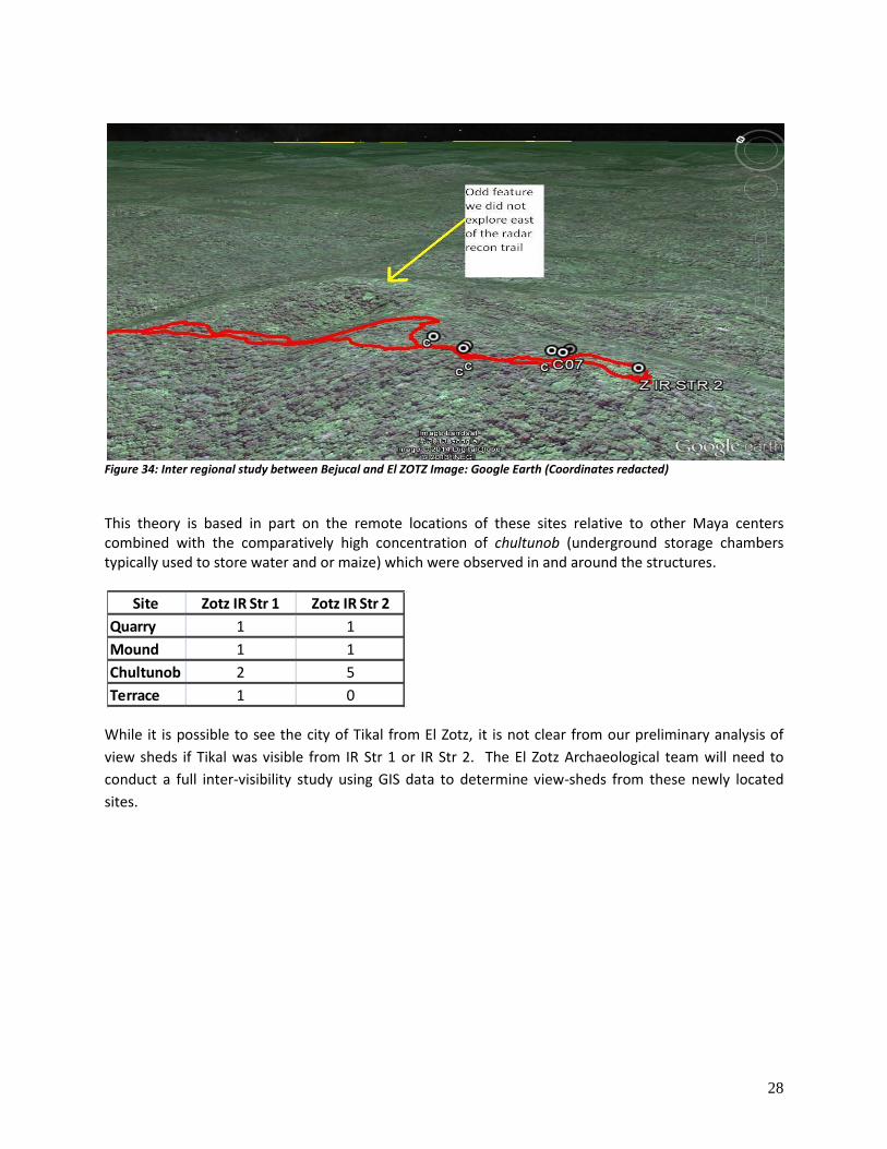
Figure 34: Inter regional study between Bejucal and El ZOTZ Image: Google Earth (Coordinates redacted)
This theory is based in part on the remote locations of these sites relative to other Maya centers combined with the comparatively high concentration of chultunob (underground storage chambers typically used to store water and or maize) which were observed in and around the structures.
While it is possible to see the city of Tikal from El Zotz, it is not clear from our preliminary analysis of
view sheds if Tikal was visible from IR Str 1 or IR Str 2. The El Zotz Archaeological team will need to
conduct a full inter-visibility study using GIS data to determine view-sheds from these newly located
sites.
Site Zotz IR Str 1 Zotz IR Str 2
Quarry 1 1
Mound 1 1
Chultunob 2 5
Terrace 1 0

29
Project Results & Outcomes:
Figure 35: Doug Inglis, TM and UCSD student Dom Meyer working late into the night to process data collected from the day’s
trials. Image Dr Albert Lin
Some experts believe that looting, resource extraction and human development will destroy most of the
world’s remaining undiscovered cultural heritage sites in the next 20 to 25 years (Parcak, 2009).
Advances in remote sensing technologies offer researchers the potential to level the playing field to
locate and record these precious cultural heritage sites before this information is lost forever. As part
of this effort, the development of an economic UAV LiDAR platform can bring the significant benefits of
LiDAR data collection to archaeologists working in dense sub tropical environments where traditional
survey methodologies remain both expensive and inefficient.
During the Petén expedition, we obtained positive outcomes across a wide range of trials. From our
field test results our engineering team has a clear understanding of the potential and current limitations
of UAV systems. Our challenge will be to develop a UAV which can handle a larger payload capacity
without loss of battery life and to integrate a small lightweight LiDAR into the system.
From an archaeological and conservation perspective, useful data was collected including a series of
highly precise recordings of fragile and deteriorating limestone monumental cultural material, large
scale recordings of pyramid and plaza complexes as well as highly accurate 3D LiDAR data sets of a
previously unrecorded Maya tomb (AD 300-600). AIRSAR radar and HRSI was used to successfully
predict the location of two previously unrecorded elite Maya settlement sites (AD 300–1250) which
were documented via ground reconnaissance. Study of this newly discovered Maya site and its
geographical context is currently being investigated by archaeologists from USC and may form the basis
for a future MA thesis.
30
Figure 36: SfM data processing Image Courtesy Albert Lin, UCSD E4E Calit2
Figure 37: Image Courtesy UCSD E4E Calit2
31
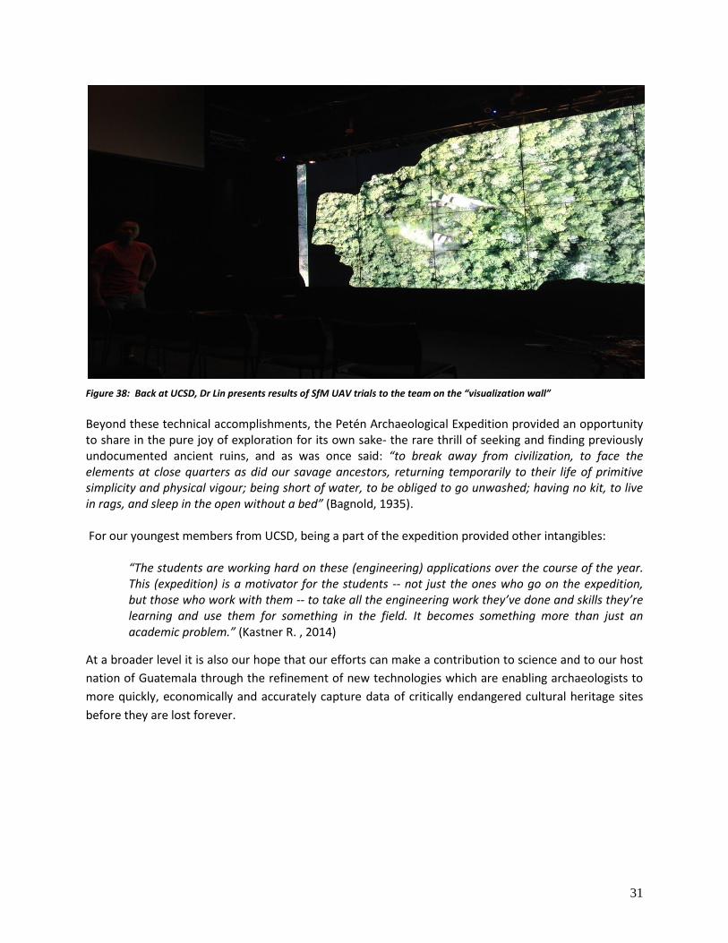
Figure 38: Back at UCSD, Dr Lin presents results of SfM UAV trials to the team on the “visualization wall”
Beyond these technical accomplishments, the Petén Archaeological Expedition provided an opportunity to share in the pure joy of exploration for its own sake- the rare thrill of seeking and finding previously undocumented ancient ruins, and as was once said: “to break away from civilization, to face the elements at close quarters as did our savage ancestors, returning temporarily to their life of primitive simplicity and physical vigour; being short of water, to be obliged to go unwashed; having no kit, to live in rags, and sleep in the open without a bed” (Bagnold, 1935). For our youngest members from UCSD, being a part of the expedition provided other intangibles:
“The students are working hard on these (engineering) applications over the course of the year. This (expedition) is a motivator for the students -- not just the ones who go on the expedition, but those who work with them -- to take all the engineering work they’ve done and skills they’re learning and use them for something in the field. It becomes something more than just an academic problem.” (Kastner R. , 2014)
At a broader level it is also our hope that our efforts can make a contribution to science and to our host
nation of Guatemala through the refinement of new technologies which are enabling archaeologists to
more quickly, economically and accurately capture data of critically endangered cultural heritage sites
before they are lost forever.
32
Acknowledgments:
Instituto de Antropologia e Historia de Guatemala, CECON and the Universidad de San Carlos
San Miguel Biotopo for authorizing this project and allowing our team to conduct research at El
Zotz
Dr. William Saturno, Boston University
Dr. Stephen Houston, Brown University
Dr Tom Garrison, Archaeological Co-Project Director Proyecto Arqueologico El Zotz
Lic. Edwin Roman, Archaeological Co-Project Director Proyecto Arqueologico El Zotz
Expedition Sponsors Roseann and Jonathan Hanson ConserVentures LLC
UC San Diego Computer Science and Engineering Endowment Fund
The National Science Foundation’s Research Experience for Undergraduates program and the E4E program
The GEOS Foundation
33
Works Cited: (n.d.). Retrieved from temazcalcozumel.com/cozfacts.html
Arlen F. Chase, D. Z. (2013). The use of LiDAR at the Maya Site of Caracol, Belize. A primer on Space Archaeology: In Obserence
of the 40th Anniversaery of the World Heritage Convention , 179-189.
Bagnold, R. A. (1935). Libyan Sands -Travel ina Dead World. In R. A. Bagnold, Libyan Sands -Travel ina Dead World. London:
Hodder and Stoughton.
Barnhart, D. E. (n.d.). Apocolypse Island.
Doyle, J. (2012, August 1). (J. Paterniti, Interviewer)
Faro. (2012). White paper: large Volume 3D laser Scanning technology. Faro.
Garrison, D. T. (2013, May 12). Retrieved from World Monuments Fund: http://www.wmf.org/journal/el-zotz-archaeological-
gem-guatemalan-jungle
Garrison, D. T. (2011). Remote ideas from remote locations: Tenchnology in Maya settlement Archaeology. University of Penn.
Garrison, T. (2007). Ancient Maya Territories, Adaptaive Regions, And Alliances: Contextualizing the San Bartolo-Xultun Intersite
Survey. Cambridge: Harvard University.
Garrison, T. (2013, 8 5). Private Correspondence. (Paterniti, Interviewer)
Graham, I. (2010). The Road to Ruins. Albuquerque: University of New Mexico Press.
Gugliottta. (n.d.). Retrieved from http://ngm.nationalgeographic.com/2007/08/maya-rise-fall/gugliotta-text/8
Houston, D. S. (2008). In the Shadow of A Giant. MesoWeb , 1-13.
Houston, S. (2013, 7 29). Private communications. (Paterniti, Interviewer)
Kastner, D. R. (2014). forthcoming report . University of San Diego.
Kastner, R. (2014).
lin, A. (2013). Search and Discovery through Human Computation. forthcoming , 1-16.
Lo, E. (2014, August 08). (J. Paterniti, Interviewer)
Naughton, P. (2014, June ). (J. Paterniti, Interviewer)
NOAA . (n.d.). Retrieved August 4, 2014, from NOAA: http://oceanservice.noaa.gov/facts/lidar.html
Parcak, S. H. (2009). Satellite remote sensing for archaeology. New York: Routledge.
Parkswatch El Zotz. (none). Retrieved from Parkswatch: www.parkswatch.org
SatImagingCorporation . (n.d.). Retrieved from satimagingcorp.com: www.satimagingcorp.com/services/orthorecticiation.com
Saturno, W. (2013, September 1). Private communication. (J. Paterniti, Interviewer)
William Saturno, T. L. (2007). Putting us on the Map: Remote Sensing Investigation of the Ancient Maya Landscape. Remote
Sensing in Archaeology , 137-160.

34
Lessons learned:
Clarify image/article rights issues in writing in advance
Take deposits early for Expedition cost sharing and be transparent upfront with regards to
cancellation /refund policy
If using local logistics company establish roles and responsibilities in advance in writing:
o Provisions list
o Damage to equipment terms
o Expected Fuel & water consumption rates for intended route and conditions (V8 used
fuel tank of petrol to go 11kms in deep mud)
o Fuel & Water reserves
o Establish daily start /end times and communicate to entire team in advance (lost ½ day
of recording due to logistics team requiring we leave at first light on last day
o Review key equipment condition and spares (spare Winches, spare tires) and
contingency plans

35
APPENDIX
Terrain Sum of kms HOURS Data
DIRT 50.15 14.2 Terrain Average of OA kph Average of MA kph
DIRT ROAD 60.52 2.9 DIRT 4.42 8.12
DIRT ROAD SHOCK REPAIR 12.06 3.5 DIRT ROAD 20.63 22.70
JUNGLE 5.63 4.1 DIRT ROAD SHOCK REPAIR 3.10 24.10
MUD 72.22 25.7 MUD 4.03 7.80
SEALED ROAD 200.55 4.1 SEALED ROAD 48.63 56.35
Grand Total 401.13 54.4 Grand Total 16.71 21.50
Start End DATE kms Cummulative Terrain OA kph MA kph MT mins T otal time mins mode diesel
flores Dirt road 3-Feb-14 60.8 60.8 SEALED ROAD 40.0 58.0 64 92 truck 76
CA 13 to dirt road nakum track 3-Feb-14 11.1 71.9 DIRT ROAD 16.0 19.0 35 43 truck
nakum track Nakum jungle camp 3-Feb-14 16.57 88.47 MUD 1.6 6.0 168 625 truck
Nakum jungle camp yahxa 4-Feb-14 15.28 103.75 MUD 1.6 7.1 129 428 truck
yaxha CA 13 6-Feb-14 12.06 115.81 DIRT ROAD SPRING REPAIR3.1 24.1 30 207 truck
CA 13 Melchor de menos 6-Feb-14 27.99 143.8 SEALED ROAD 54.7 54.7 30 30 truck
Melchor de menos Naranjo dirt 6-Feb-14 3.37 147.17 DIRT ROAD 19.3 19.3 10 10 truck
Naranjo dirt Naranjo Camp 6-Feb-14 15.90 163.07 DIRT 1.8 11.3 77 453 truck
Naranjo Camp Naranjo dirt 7-Feb-14 16.40 179.47 DIRT 5.8 7.2 138 171 truck
Naranjo dirt CA 13 7-Feb-14 1.50 180.97 DIRT ROAD 22.5 22.5 4 4 truck
CA 13 Flores 7-Feb-14 82.00 262.97 SEALED ROAD 61.2 61.2 81 81 truck
flores San Andres 8-Feb-14 29.76 292.73 SEALED ROAD 38.6 51.5 34 45 truck
San Andres Cruces Dos Aguadas 8-Feb-14 18.50 311.23 DIRT ROAD 30.6 30.6 36 36 truck
Cruces Dos Aguadas El Zotz Park entrance 8-Feb-14 5.95 317.18 DIRT 6.8 12.9 29 53 truck
El Zotz Park entrance El Zotz 8-Feb-14 14.64 331.82 MUD 5.0 8.0 99 173 truck
El Zotz Bujcal Road 9-Feb-14 5.14 336.96 MUD 5.3 8.0 39 57 truck
Bujcal Road jungle 9-Feb-14 3.70 340.66 DIRT 3.4 3.9 58 67 foot
jungle Bujcal Road 9-Feb-14 5.63 346.29 JUNGLE 1.4 2.1 157 245 foot
Bujcal Road El Zotz 9-Feb-14 8.20 354.49 DIRT 4.3 5.3 92 105 foot
El Zotz El Zotz Park entrance 11-Feb-14 14.48 368.97 MUD 4.3 8.0 118 200 truck
El Zotz Park entrance Cruces Dos Aguadas 11-Feb-14 6.11 375.08 MUD 6.4 9.7 36 58 truck
Cruces Dos Aguadas San Andres 11-Feb-14 20.10 395.18 DIRT ROAD 24.1 27.1 45 49 truck
San Andres lake hotel 11-Feb-14 5.95 401.13 DIRT ROAD 11.3 17.7 20 29 truck 19
401.13 16.05 20.66 25.48 54.35 94.625
Average of H20 Consumption(litres)
Conditions Total
dirt 2.3
hiking 4.3
mud 4.1
Grand Total 3.78
36
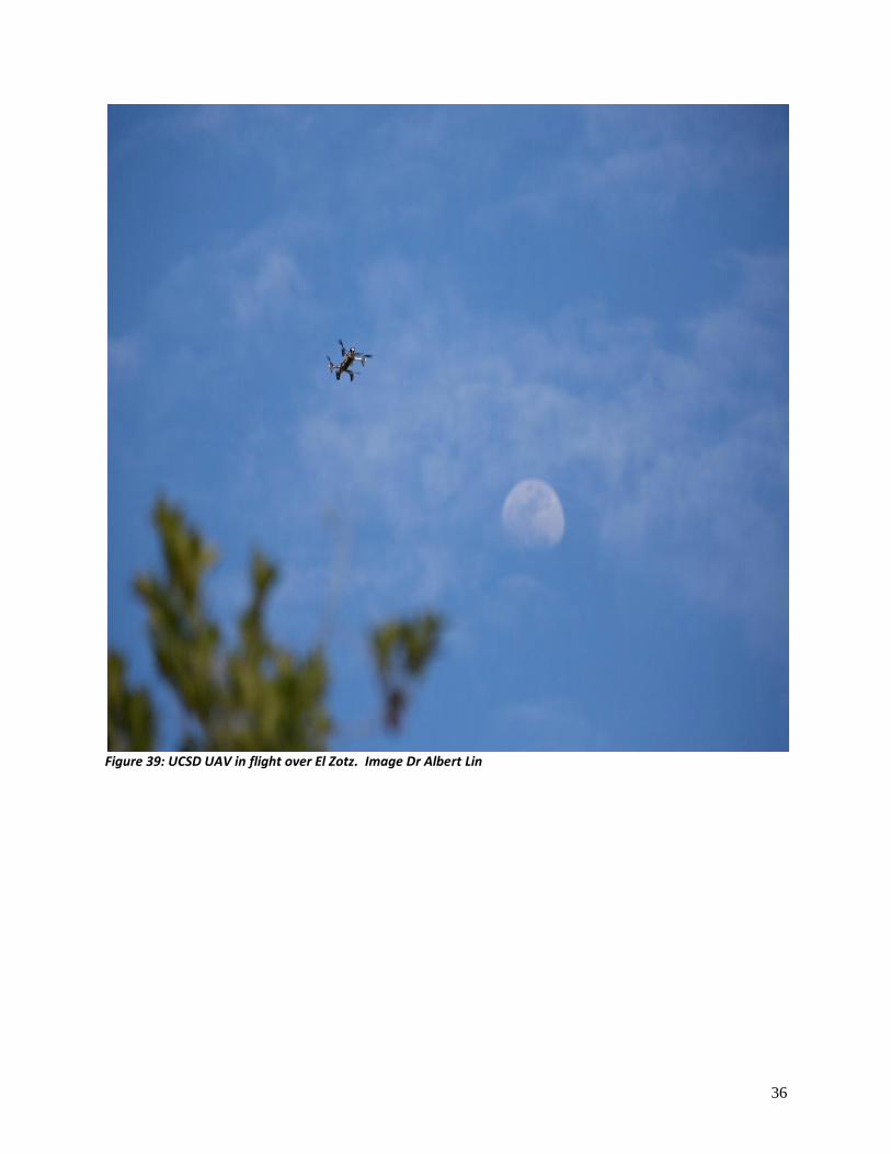
Figure 39: UCSD UAV in flight over El Zotz. Image Dr Albert Lin
Related Documents