2013 Annual Fire Weather Report WFO Riverton, WY Kelly Allen, Fire Weather Program Manager December 2013

Welcome message from author
This document is posted to help you gain knowledge. Please leave a comment to let me know what you think about it! Share it to your friends and learn new things together.
Transcript

2013 Annual Fire Weather Report WFO Riverton, WY
Kelly Allen, Fire Weather Program Manager
December 2013
To: W/CR1x11 - Jennifer Zeltwanger c/o Derek Deroche
NWS Central Region Headquarters
7220 NW 101ST
Terrace
Kansas City, MO 64153-2371
From: Kelly Allen, NWS Riverton
Fire Weather Program Manager
Subject: 2013 NWS Riverton Fire Weather Program Summary
Please find attached the 2013 NWS Riverton Fire Weather Program Summary which also includes Red Flag
Warning Verification and Statistics, the number of Fire Weather Watches issued, Spot Forecast Statistics, and
information on IMET Dispatches

WFO Riverton Fire Weather Program Summary - 2013
Month to Month Climate and Operations:
January, February, March
Climate:
January was cooler than average for western and central Wyoming. There were a few storms that
managed to bring some significant snowfall to both sides of the divide; which is a rather rare event for
the typically dry month of January. As a result, the basins remained cooler than normal with this fresh
snowpack and the mountains were able to benefit from a couple of waves of mild air aloft. There was
another storm at the beginning of February that delivered a few more inches of snow in the favored
upslope areas east of the Divide, like Lander and Riverton, but most of the area remained colder and
drier than normal. March delivered little relief from the drought, even as a few storms moved across the
region. One storm, on St. Patrick’s day delivered a rare strong wind event when 60 mph winds from the
northeast (an odd direction for winds this strong) downed trees, blew out windows, and took down
business signs across central and southern Wyoming. Overall, the year began colder and drier than
normal (figures 1 and 2) with some warmer than normal conditions experienced over the higher
elevations. The long term drought left over from 2012 saw little to no relief during this period as there
Fig. 1 Fig. 2
Fig. 3
Fig. 4 – February 8-10: 20 inches fell in Sinks Canyon
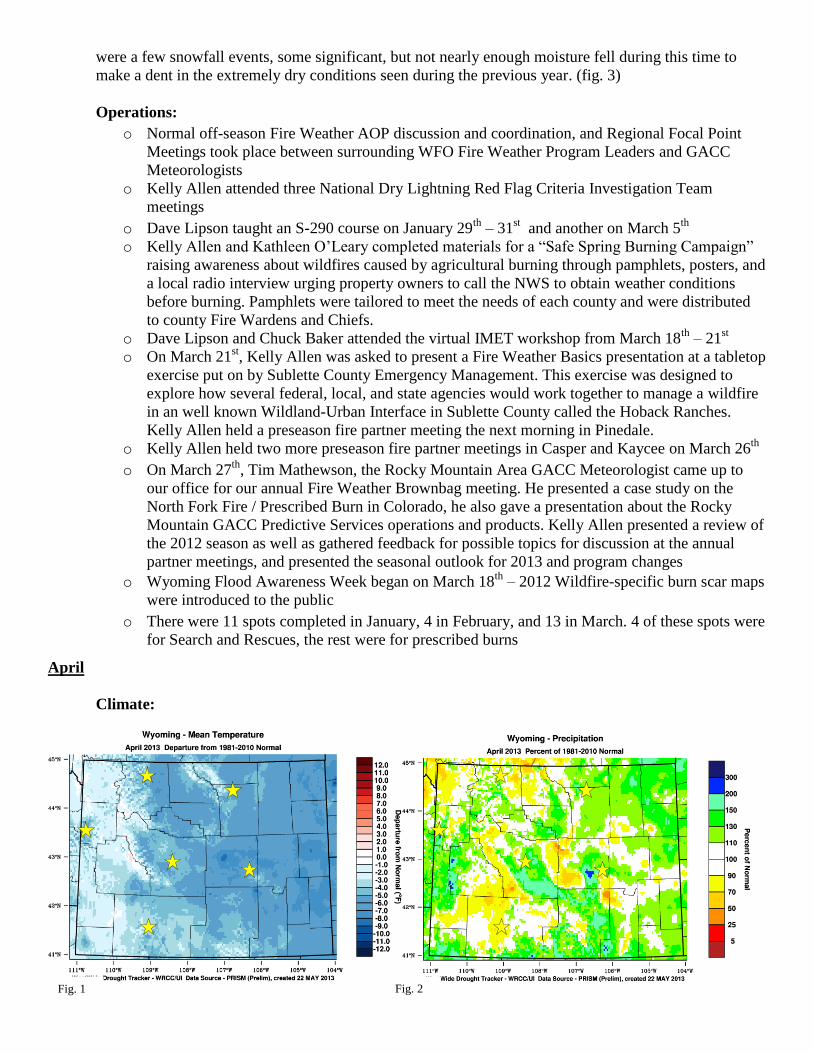
were a few snowfall events, some significant, but not nearly enough moisture fell during this time to
make a dent in the extremely dry conditions seen during the previous year. (fig. 3)
Operations:
o Normal off-season Fire Weather AOP discussion and coordination, and Regional Focal Point
Meetings took place between surrounding WFO Fire Weather Program Leaders and GACC
Meteorologists
o Kelly Allen attended three National Dry Lightning Red Flag Criteria Investigation Team
meetings
o Dave Lipson taught an S-290 course on January 29th
– 31st and another on March 5
th
o Kelly Allen and Kathleen O’Leary completed materials for a “Safe Spring Burning Campaign”
raising awareness about wildfires caused by agricultural burning through pamphlets, posters, and
a local radio interview urging property owners to call the NWS to obtain weather conditions
before burning. Pamphlets were tailored to meet the needs of each county and were distributed
to county Fire Wardens and Chiefs.
o Dave Lipson and Chuck Baker attended the virtual IMET workshop from March 18th
– 21st
o On March 21st, Kelly Allen was asked to present a Fire Weather Basics presentation at a tabletop
exercise put on by Sublette County Emergency Management. This exercise was designed to
explore how several federal, local, and state agencies would work together to manage a wildfire
in an well known Wildland-Urban Interface in Sublette County called the Hoback Ranches.
Kelly Allen held a preseason fire partner meeting the next morning in Pinedale.
o Kelly Allen held two more preseason fire partner meetings in Casper and Kaycee on March 26th
o On March 27th
, Tim Mathewson, the Rocky Mountain Area GACC Meteorologist came up to
our office for our annual Fire Weather Brownbag meeting. He presented a case study on the
North Fork Fire / Prescribed Burn in Colorado, he also gave a presentation about the Rocky
Mountain GACC Predictive Services operations and products. Kelly Allen presented a review of
the 2012 season as well as gathered feedback for possible topics for discussion at the annual
partner meetings, and presented the seasonal outlook for 2013 and program changes
o Wyoming Flood Awareness Week began on March 18th
– 2012 Wildfire-specific burn scar maps
were introduced to the public
o There were 11 spots completed in January, 4 in February, and 13 in March. 4 of these spots were
for Search and Rescues, the rest were for prescribed burns
April
Climate:
Fig. 1 Fig. 2
Fig. 1

Things really began to change in April. A very wet month shot precipitation averages at many climate
sites east of the divide from well below to well above normal for the month (Fig. 2). Nearly SEVEN
FEET of snow fell on Casper Mountain, over two feet fell in
the town of Casper during the first two snow storms, likewise
in Lander; a foot and a half fell in the town of Riverton. In fact,
this was Casper's second snowiest April on record with 37.8"
of snow and the season total now came to 81.0" with only 20.2
more inches needed to bring this season into the top 10
snowiest of all time. In Lander, the month of April looked like
it was going to be as dry as it was last year with snowfall over
a foot below normal for the water year. However, the first two
storms brought Lander into a surplus; standing at 23.7"
ABOVE normal for the month. The snowfall season (July 2012
- present) delivered 97.8" of snow by the end of April, putting
Lander 14.9" above normal for the year, and 34.5" above
where we were at this time last year. In Riverton, 24.7" of
snow fell during the month, which is 18.6" above normal for the month, and the 3rd snowiest April on
record. Riverton accumulated 54.5" of snow through the current snowfall season (July 2012 - April
2013), or 20.9" above normal for the season , and 34.1" above where we were at this time last year.
However, the snowpack up to this point was so far below normal that this month only shot levels up
toward normal. This abundance of moisture also moderated the drought (Fig. 3), but did not completely
cure it.
Operations:
o Three partner meetings took place in April: Lander, Cody, and Rock Springs. Kelly Allen also
gave a presentation in Rock Springs wrapping up the 2012 season and going over the 2013
seasonal outlook
o First spot for a wildfire was issued for the season on April 28th
for the “Big Fork” fire in the
Bighorn Basin
o 34 Spots were issued in April, 2 of which were for wildfire
o A Fire Weather Drill was issued to the staff in early April, those were to be completed by May
24th
o Kelly Allen attended another Dry Lightning Team meeting
Fig. 3 – The drought improved from D3 to D2
during the month of April Fig. 4 – Several large snow storms improved snowpack
May
Climate:
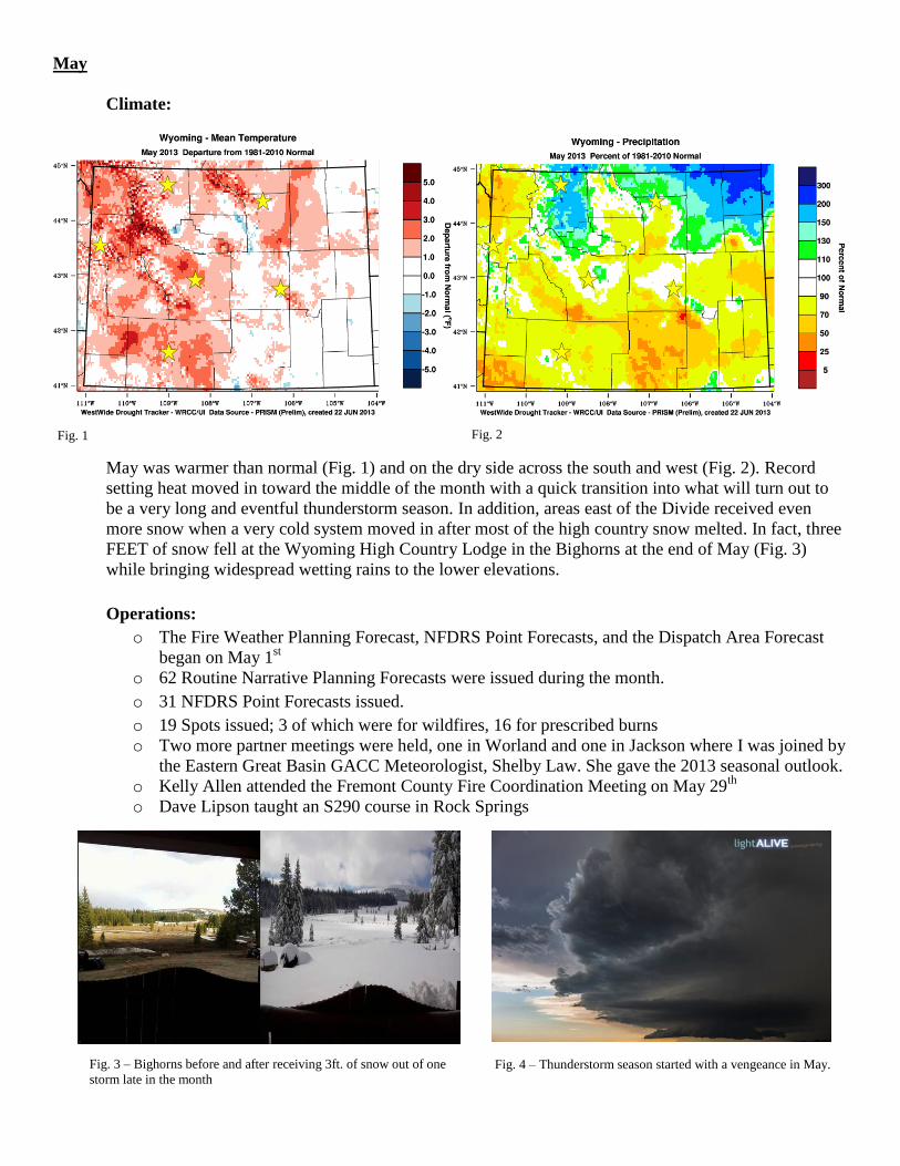
May was warmer than normal (Fig. 1) and on the dry side across the south and west (Fig. 2). Record
setting heat moved in toward the middle of the month with a quick transition into what will turn out to
be a very long and eventful thunderstorm season. In addition, areas east of the Divide received even
more snow when a very cold system moved in after most of the high country snow melted. In fact, three
FEET of snow fell at the Wyoming High Country Lodge in the Bighorns at the end of May (Fig. 3)
while bringing widespread wetting rains to the lower elevations.
Operations:
o The Fire Weather Planning Forecast, NFDRS Point Forecasts, and the Dispatch Area Forecast
began on May 1st
o 62 Routine Narrative Planning Forecasts were issued during the month.
o 31 NFDRS Point Forecasts issued.
o 19 Spots issued; 3 of which were for wildfires, 16 for prescribed burns
o Two more partner meetings were held, one in Worland and one in Jackson where I was joined by
the Eastern Great Basin GACC Meteorologist, Shelby Law. She gave the 2013 seasonal outlook.
o Kelly Allen attended the Fremont County Fire Coordination Meeting on May 29th
o Dave Lipson taught an S290 course in Rock Springs
Fig. 1 Fig. 2
Fig. 3 – Bighorns before and after receiving 3ft. of snow out of one
storm late in the month Fig. 4 – Thunderstorm season started with a vengeance in May.
June
Climate:
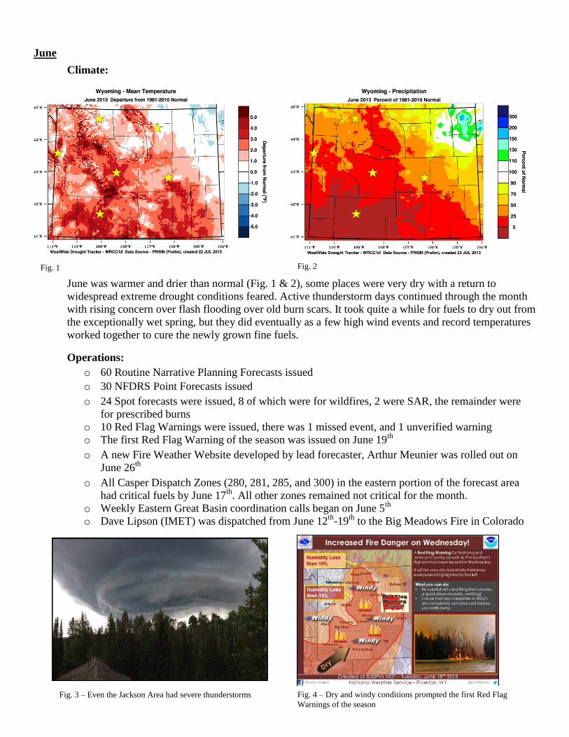
June was warmer and drier than normal (Fig. 1 & 2), some places were very dry with a return to
widespread extreme drought conditions feared. Active thunderstorm days continued through the month
with rising concern over flash flooding over old burn scars. It took quite a while for fuels to dry out from
the exceptionally wet spring, but they did eventually as a few high wind events and record temperatures
worked together to cure the newly grown fine fuels.
Operations:
o 60 Routine Narrative Planning Forecasts issued
o 30 NFDRS Point Forecasts issued
o 24 Spot forecasts were issued, 8 of which were for wildfires, 2 were SAR, the remainder were
for prescribed burns
o 10 Red Flag Warnings were issued, there was 1 missed event, and 1 unverified warning
o The first Red Flag Warning of the season was issued on June 19th
o A new Fire Weather Website developed by lead forecaster, Arthur Meunier was rolled out on
June 26th
o All Casper Dispatch Zones (280, 281, 285, and 300) in the eastern portion of the forecast area
had critical fuels by June 17th
. All other zones remained not critical for the month.
o Weekly Eastern Great Basin coordination calls began on June 5th
o Dave Lipson (IMET) was dispatched from June 12th
-19th
to the Big Meadows Fire in Colorado
Fig. 1 Fig. 2
Fig. 3 – Even the Jackson Area had severe thunderstorms Fig. 4 – Dry and windy conditions prompted the first Red Flag
Warnings of the season
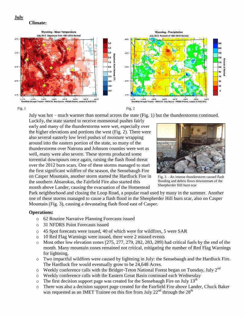
Fig. 3 – An intense thunderstorm caused flash
flooding and debris flows downstream of the
Sheepherder Hill burn scar
July
Climate:
July was hot – much warmer than normal across the state (Fig. 1) but the thunderstorms continued.
Luckily, the state started to receive monsoonal pushes fairly
early and many of the thunderstorms were wet, especially over
the higher elevations and portions the west (Fig. 2). There were
also several easterly low level pushes of moisture wrapping
around into the eastern portion of the state, so many of the
thunderstorms over Natrona and Johnson counties were wet as
well, many were also severe. These storms produced some
torrential downpours once again, raising the flash flood threat
over the 2012 burn scars. One of these storms managed to start
the first significant wildfire of the season, the Sensebaugh Fire
on Casper Mountain, another storm started the Hardluck Fire in
the southern Absarokas, the Fairfield Fire also started this
month above Lander, causing the evacuation of the Homestead
Park neighborhood and closing the Loop Road, a popular road used by many in the summer. Another
one of these storms managed to cause a flash flood in the Sheepherder Hill burn scar, also on Casper
Mountain (Fig. 3), causing a devastating flash flood east of Casper.
Operations:
o 62 Routine Narrative Planning Forecasts issued
o 31 NFDRS Point Forecasts issued
o 45 Spot forecasts were issued, 40 of which were for wildfires, 5 were SAR
o 10 Red Flag Warnings were issued, there were 2 missed events
o Most other low elevation zones (275, 277, 279, 282, 283, 289) had critical fuels by the end of the
month. Many mountain zones remained not critical, mitigating the number of Red Flag Warnings
for lightning.
o Two impactful wildfires were caused by lightning in July: the Sensebaugh and the Hardluck Fire.
The Hardluck fire would eventually grow to be 24,648 Acres.
o Weekly conference calls with the Bridger-Teton National Forest began on Tuesday, July 2nd
o Weekly conference calls with the Eastern Great Basin continued each Wednesday
o The first decision support page was created for the Sensebaugh Fire on July 13th
o There was also a decision support page created for the Fairfield Fire above Lander, Chuck Baker
was requested as an IMET Trainee on this fire from July 22nd
through the 28th
Fig. 1 Fig. 2

Fig. 3 – Alum Fire closed a portion of the Grand
Loop in Yellowstone
August
Climate:
The warm trend continued into August (Fig. 1) but it was much drier than normal just about everywhere
(Fig. 2). Every single official climate site in the forecast area had above normal temperatures and below
normal precipitation. Some low elevation sites east of the Divide had less than 0.05” of rain for the
entire month. Lake Yellowstone set 9 new high temperature records during the month and was by far the
most active zone when it came to major wildfires. Even with all of the hot and dry days, it still took a
while for the fuels to cure out enough to become critical in the mountain zones, otherwise there probably
would have been quite a few Red Flag Warnings for critical thunderstorm activity. There were not too
many windy days, this also kept the number of Red Flag Warnings down. However, wildfire activity
really began ramping up toward the end of the month for much of the west once the fuels did reach
critical levels, and wildfire smoke began to overspread the state.
Yellowstone was impacted the most with several wildfires starting
near some of the most widely used areas. In fact, a NIMO team was
eventually brought in to manage the complex, what would
eventually be known as the “Druid Complex.” The most impactful
fire was the Alum fire, which burned several acres along the Grand
Loop, leading to some temporary closures of the road in addition to
some popular tourist attractions (Fig. 3).
Operations:
o 62 Routine Narrative Planning Forecasts issued.
o 31 NFDRS Point Forecasts issued.
o 161 Spot Forecasts were issued, 159 for wildfires, 2 for search and rescue operations. This was
by far our busiest month for spots.
o 17 Red Flag Warnings were issued, 3 events were missed
o Dave Lipson (IMET) was dispatched on the Eureka Fire near Ennis, Montana from August 16th
through the 29th
o The Packer Creek Wildfire started 16 miles east of Bondurant on August 2nd
, it was later joined
by two other wildfires that would eventually be managed together as the Packer Creek / Green /
Kendall Wildfires. A DSS Page was created for these fires and hosted on our homepage
o A DSS page was also created and routinely updated for the fires in Yellowstone
o A DSS page was created for the Hardluck Fire as it became more impactful on the area
o IMET Dan Borsum arrived on the Druid Complex on August 28th
o Bridger-Teton and Eastern Great Basin coordination calls continued weekly through the month
Fig. 1 Fig. 2
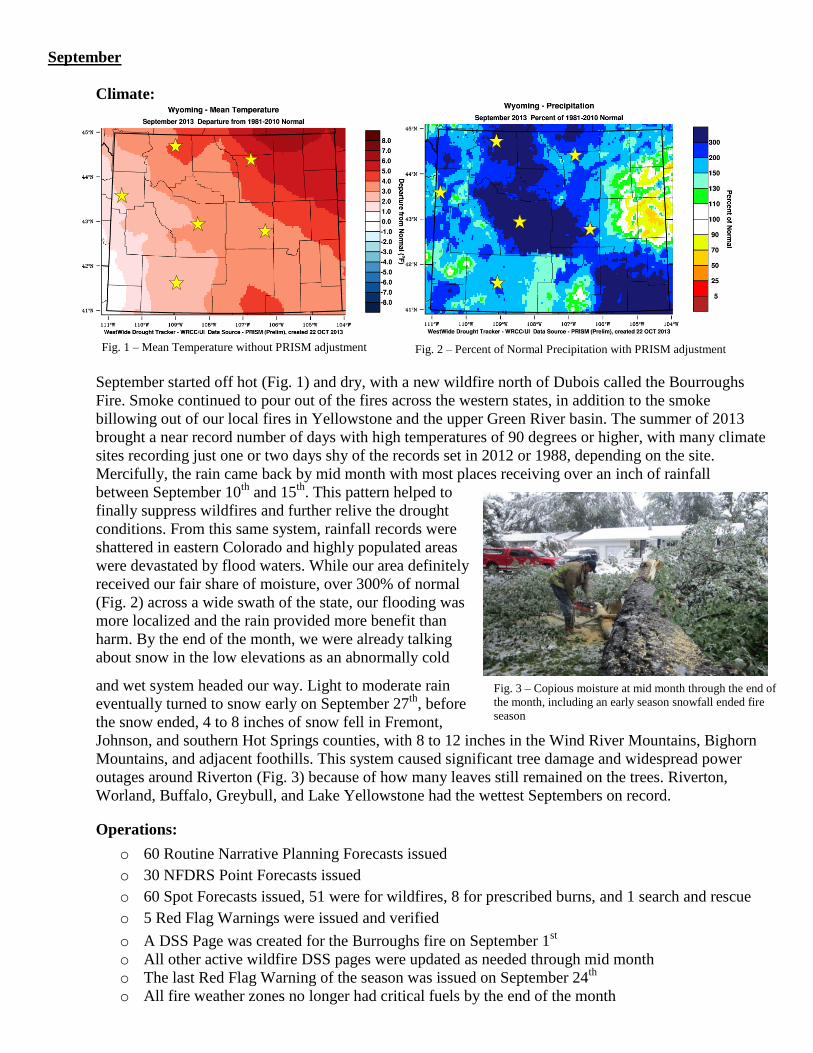
Fig. 3 – Copious moisture at mid month through the end of
the month, including an early season snowfall ended fire
season
September
Climate:
September started off hot (Fig. 1) and dry, with a new wildfire north of Dubois called the Bourroughs
Fire. Smoke continued to pour out of the fires across the western states, in addition to the smoke
billowing out of our local fires in Yellowstone and the upper Green River basin. The summer of 2013
brought a near record number of days with high temperatures of 90 degrees or higher, with many climate
sites recording just one or two days shy of the records set in 2012 or 1988, depending on the site.
Mercifully, the rain came back by mid month with most places receiving over an inch of rainfall
between September 10th
and 15th
. This pattern helped to
finally suppress wildfires and further relive the drought
conditions. From this same system, rainfall records were
shattered in eastern Colorado and highly populated areas
were devastated by flood waters. While our area definitely
received our fair share of moisture, over 300% of normal
(Fig. 2) across a wide swath of the state, our flooding was
more localized and the rain provided more benefit than
harm. By the end of the month, we were already talking
about snow in the low elevations as an abnormally cold
and wet system headed our way. Light to moderate rain
eventually turned to snow early on September 27th
, before
the snow ended, 4 to 8 inches of snow fell in Fremont,
Johnson, and southern Hot Springs counties, with 8 to 12 inches in the Wind River Mountains, Bighorn
Mountains, and adjacent foothills. This system caused significant tree damage and widespread power
outages around Riverton (Fig. 3) because of how many leaves still remained on the trees. Riverton,
Worland, Buffalo, Greybull, and Lake Yellowstone had the wettest Septembers on record.
Operations:
o 60 Routine Narrative Planning Forecasts issued
o 30 NFDRS Point Forecasts issued
o 60 Spot Forecasts issued, 51 were for wildfires, 8 for prescribed burns, and 1 search and rescue
o 5 Red Flag Warnings were issued and verified
o A DSS Page was created for the Burroughs fire on September 1st
o All other active wildfire DSS pages were updated as needed through mid month
o The last Red Flag Warning of the season was issued on September 24th
o All fire weather zones no longer had critical fuels by the end of the month
Fig. 1 – Mean Temperature without PRISM adjustment Fig. 2 – Percent of Normal Precipitation with PRISM adjustment
October, November, December
Climate:
October continued to be wet with another big snow storm on October 3rd
through 5th
, this time,
widespread power outages and tree damage visited Casper. Another storm hit mid month, with yet
another at the end of the month, effectively putting the nail in the coffin of the long term drought that
began in early 2012 (Fig. 3). It was also cooler than normal. Riverton, Lander, Casper, Buffalo,
Greybull, and Lake Yellowstone had one of the top 5 wettest Octobers on record. After a wet October,
November was much drier than normal and had near to slightly above normal temperatures. Some
locations, such as Riverton, Rock Springs, Buffalo, Greybull and Lake Yellowstone had one of the top 5
driest Novembers on record. There were not many high temperature records in November, however, a
strong arctic front brought several record low temperatures toward the end of the month. This front also
brought some snow with it, mostly benefiting the western mountains. December started out cold and
unsettled with a few storms bringing snow to the area. A deep arctic cold pool sunk temperatures well
below zero following the fresh layer of snow.
Operations:
o Routine Fire Weather Planning Forecasts and NDFRS Point Forecasts stopped for the season on
October 31st , 31 FWF forecasts were issued in October and 31 NDFRS Forecasts were issued
o 13 Spot Forecasts were issued during the period, all of which were for prescribed burns
o Kelly Allen attended the Western Region Fire Weather Focal Point seasonal wrap up conference
call on November 20th
Fig. 1 – Early snow led to inversion-dominated temp patterns Fig. 2 – Overall, the wet October made up for the very dry November
in the lower elevations. Precip in the mountains was near normal.
Fig. 3 – The timeline above center shows the percentage of area in Wyoming covered by drought type from January 2012 through November
2013. The area covered by D2 drought and worse increased significantly in June of 2012 and persisted through winter of 2013, it was reduced
significantly by the end of March 2013, and was gone by November 2013
WY Drought - Jan 2013 WY Drought - Nov 2013 Drought Condition over time

NWS Riverton 2013 Red Flag Warning Events and Verification:
Summary:
A total of 43 RFW events occurred this season, much fewer than the 487 warnings issued during the
2012 season. The zone with the most Red Flags issued was Zone 280, Natrona County, with 8 Red
Flags issued; the least warned zones are located in the Bighorn Basin (Zones 275 and 282) where 0
Red Flags were issued for the season. Of the 43 warnings, 42 of them were verified. There were a
total of 6 missed events. The following represents our performance for these events:
POD: 0.88
FAR: 0.02
CSI: 0.86
The average lead time for the Red Flag Warning was 12.2 hours.
There were a total of 17 Fire Weather Watches, 15 of which were followed by a successful Red Flag
Warning. There were 6 watches not followed by a successful warning. 30 Red Flag Warnings were not
preceded by a watch.
NWS Riverton 2013 Fire Weather Spot Forecast Archive:
Spot forecasts issued for Wildfires: 263
Spot forecasts issued for prescribed burns: 110
Spot forecasts issued for other purposes: 14
Total Number of Spot Forecasts issued: 387
This year ranks 7th
for total number of spots. Last year, 451 spots were issued, which ranked the 2012
season second for number of spots behind 2006 when 496 spots were issued. National Weather Service-
wide, the Riverton office ranked 15th
for number of spots this year, but #2 in the Central Region behind
Grand Junction. Riverton ranked 4th
overall for number of spots for wildfire.
NWS Riverton IMET Dispatch Days:
Dave Lipson was dispatched for a total of 22 Days during the 2013 fire season (this includes travel
days). Chuck baker was dispatched for a total of 7 days; since the fire was local, no travel days were
needed.
Total number of IMET dispatches: 3
Total number of IMET dispatch days: 29
Related Documents