
2012
Mar 11, 2016
portfolio in practice and academy
Welcome message from author
This document is posted to help you gain knowledge. Please leave a comment to let me know what you think about it! Share it to your friends and learn new things together.
Transcript


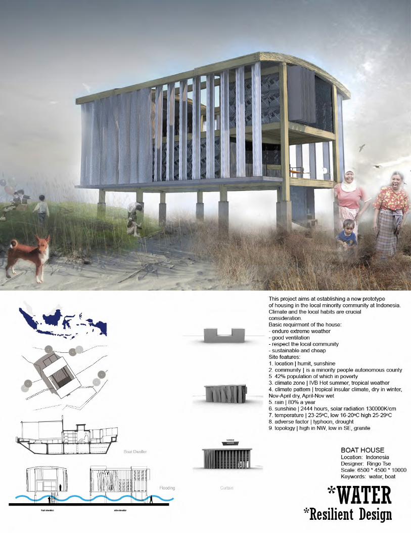
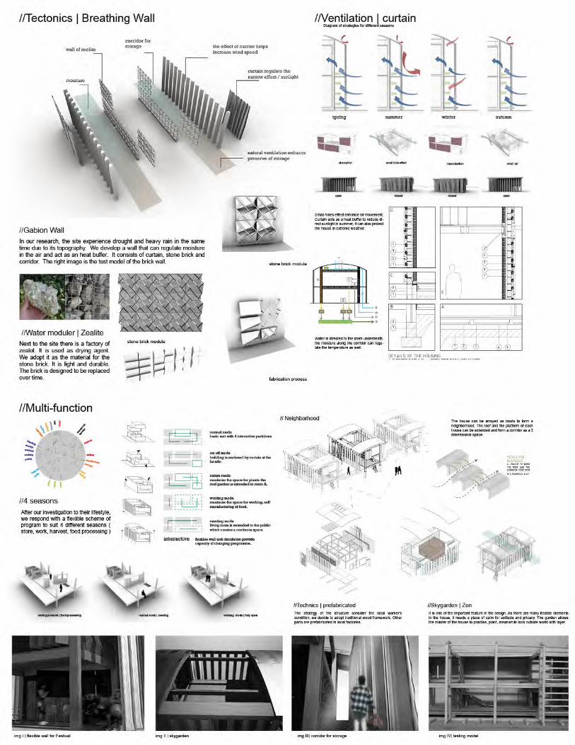


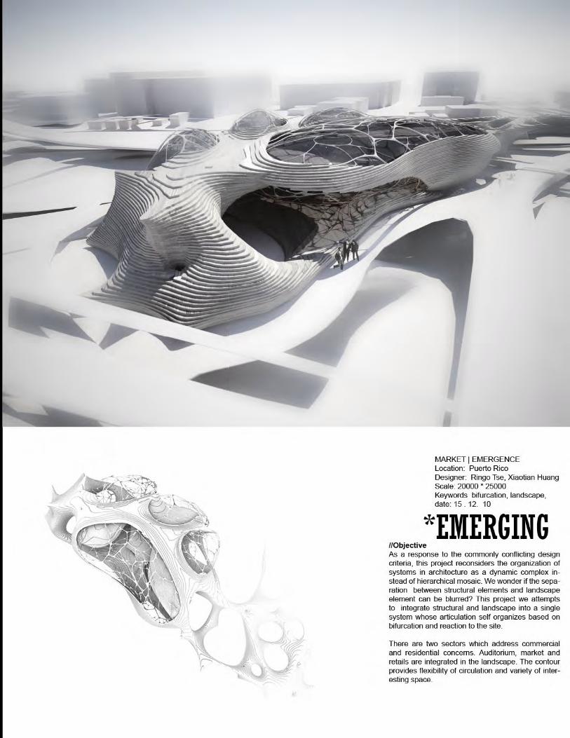
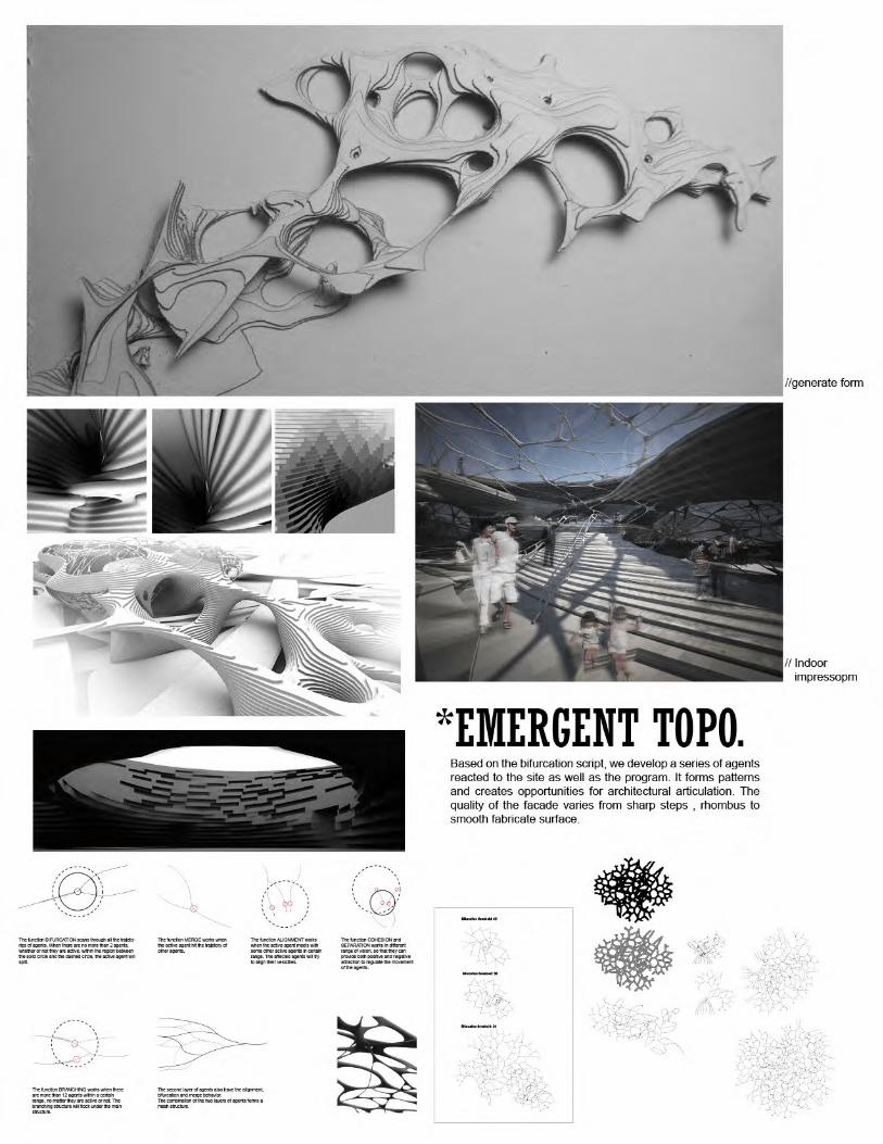
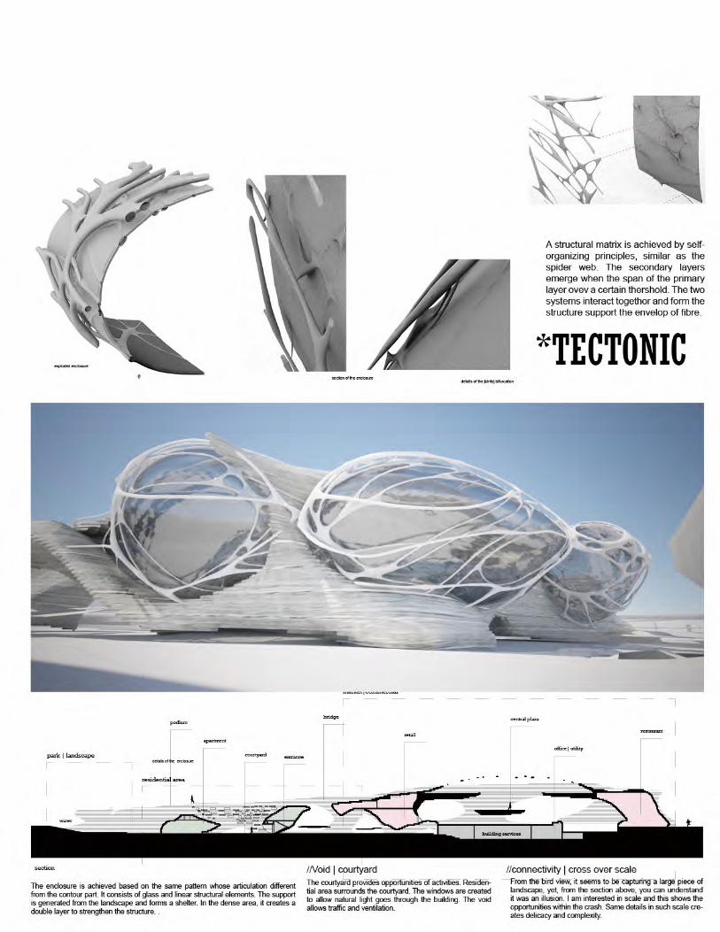

LANDSCAPE
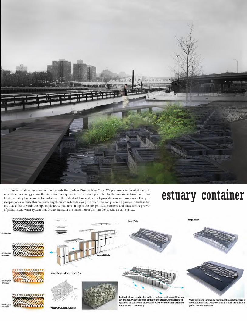
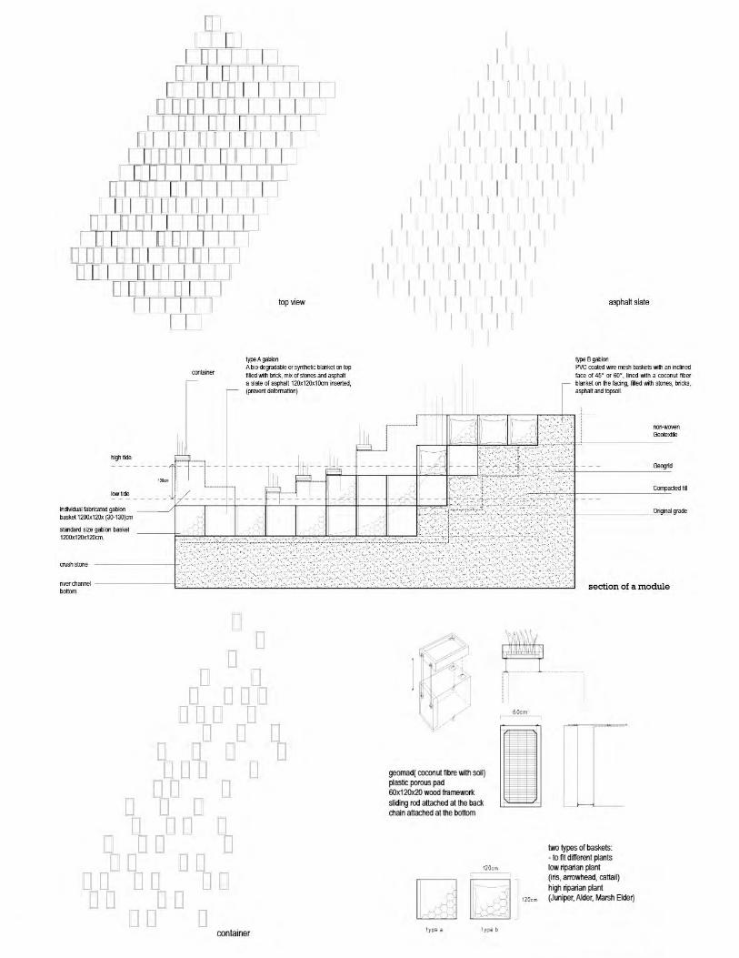
estuary containerThis project is about an intervention towards the Harlem River at New York. We propose a series of strategy to rehabitate the ecology along the river and the raptian lives. Plants are protected by the containers from the strong tidal created by the seawalls. Demolistion of the industrial land and carpark provides concrete and rocks. This pro-ject proposes to reuse this materials as gabion stone facade along the river. This can provide a gradient which soften the tidal effect towards the raptian plants. Containers on top of the box provides nutrients and place for the growth of plants. Extra water system is added to maintain the habitation of plant under special circumstance..
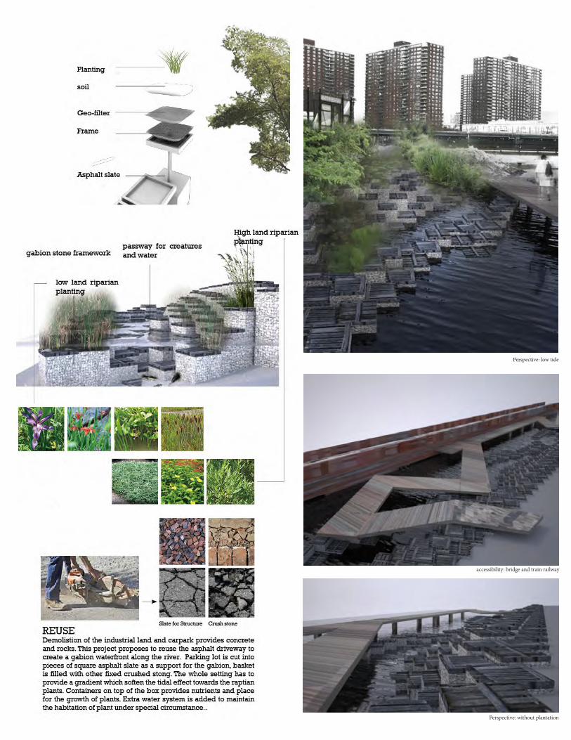
Perspective: low tide
accessibility: bridge and train railway
Perspective: without plantation
URBANISM
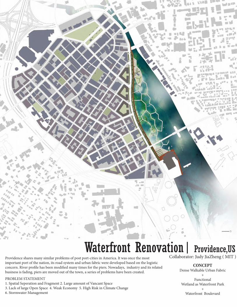
Waterfront Renovation| Providence,USProvidence shares many similar problems of post port-cities in America. It was once the most important port of the nation, its road system and urban fabric were developed based on the logistic concern. River profile has been modified many times for the piers. Nowadays, industry and its related business is fading, piers are moved out of the town, a series of problems have been created.
Collaborator: Judy JiaZheng ( MIT )
PROBLEM STATEMENT1. Spatial Seperation and Fragment 2. Large amount of Vancant Space 3. Lack of large Open Space 4. Weak Economy 5. High Risk in Climate Change 6. Stormwater Management
CONCEPTDense Walkable Urban Fabric
+ Functional
Wetland as Waterfront Park+
Waterfront Boulevard

URBAN MANIFESTOPreamble: There are no universal criteria for a good city. City form plays one of key roles in city making. Good city form is necessary to good city. But good city form does not always imply good city. Place matters. The climate, geography, history, culture, religion, politics and economy generate varied forms of human settlement all over the world. A good city form cannot always be successfully duplicated from one place to another. Time matters. The role of city transforms over time and the city forms can hardly be permanently good. City form is dynamic in response to the changes of other factors. Principles: -Flexibility: Good city form should embrace flexibility that endures over time. -Equity and Pluralism: Good city form should be shared and perceived by everyone. -Layers: Good city form should be a layer that appropriately fits with other layers such as topography, hydrology, flora and fauna, infrastructure, history, demography, cyberspace, etc. -Relationship with Nature: Good city form should embed harmoniously and humbly into the regional ecological system, connect the corridors and patches effectively. And it should also generate healthy micro eco-systems. -Disaster Resilience: Good city form should have the resilience facing the hazardous world to protect health, safety and welfare. It also conveys adaptation to climate change. -Sanitation: Good city form should allow optimization of the use of sun, wind and water, as well as the operation of waste to create a sanitary built environment. -Sustainability: Good city form should minimize its pollution. It should also encourage lifestyles that are very low-impact and low-energy- consumption on a per-capita basis. -Capacity and Participation: Good city form should convey capability of providing something for everybody. And it only works well when it allows everyone to participate in the process. -Accessibility: Good city form should have easy access to other settlements. -Diversity and Vibrancy: Good city form should allow diverse ownership and activities. Diverse surroundings have the practical power of inducing a natural, continuing flow of life and use, so as to create vibrant city life. -Density and Intimacy: Good city form should be compact to generate higher density and children and family accessible activities, which enhance communication and interaction. -Mixed Use: The land use should maximum mixed use rather than functional separation. -Walkability and Public Transportation: Good city form should be walkable and pedestrian-friendly. Public transportation reaches all main destinations in and around the city. -Belonging: Good city form should evoke spiritual feelings of belonging. -Recreation: Good city form should encourage people to go outside their homes. -Conservation: Good city form should include buildings of different ages in use. -Memory: Good city form conveys memories of all layers of history and narratives.
Guidelines: This guideline fits the context of North America. It can be used for grid plan in downtown areas of the cities in mild climate targeting in the years from 2010 to 2050. Public Participation 1. For any plan or project, public participation must be effectively involved for appropriate times in the decision-making process Natural Context 2. The natural context is a fundamental consideration in a city’s formation. Historic Conservation 3. Material and non-material heritages of the city should be surveyed, docu-mented, evaluated and conserved for any construction project of the city. Urban structure 4. Generate a relatively homogeneous grid system. 5. Important public buildings, public space, monuments should be closely connected to city axises Public Transportation 6. People from every part of the downtown can access public transportation system within 5 minutes walk. 7. Public transportation can reach all the neighborhoods in downtown. Parking 8. Underground parking and parking buildings are greatly encour-aged. Side parking is acceptable but not encouraged. 9. Ground parking larger than one parcel should be prohibited in downtown Neighborhood 10. Each neighborhood should be identifiable and have relatively continuous fabric Open Space 11. There should be enough open space for buffer zone and emergency shelter space for disaster 12. There should be at least one large public open space in downtown. Each neighborhood should have at least one public open space at least as big as half of the block Street 13. At least one vibrant main street (depending on the size, shape and history of the city) should be designated in downtown 14. The streets should form a “capillary-like” auto-mobile system rather than concentrate transportation on one or two “arteries” 15. The proportion of the height of the building to the distance between building to building (across the street) should be controlled to 1:1 to 3:1. 16. The widest street should not exceed 6 lanes. Sidewalk 17. All the streets should have pedestrian-friendly sidewalks Bicycle system 18. Bicycle lanes and parking space should be set to almost every street. Trees 19. Shade trees should be planted in all the streets and public open space. Block 20. The shape and size of the block can be referred to history and precedents. The block size should not exceed 200,000sqf, and the length of the long side should not exceed 600 ft. 21.Main entrances to the building should face the street rather than facing inner block.22. The center of the block should have a shared private-owned open space accessible from outside of the block Parcel 23. The basic parcel should range from 20 to 30 ft in width, and 80 to 120 ft in depth. 24. The biggest parcel should not exceed 60 feet. Each block can have at most 6 big parcels 25. Party walls can be built right within the side property lines. Ground Floor 26. An open space of at least 5 feet wide from the property line should be shared with the public. 27. No residential apartment on the ground floor. Building height and massing 28. Buildings should not break the city’s skyline 29. Buildings’ heights should differ in an appropriate range. Both same height and outliers should be avoided. 30. Avoid super-massing buildings except for important public buildings or monuments. Skyline 31. The skyline of the city should be studies, proposed and controlled. Landmark 32. Create landmarks at the civic / commercial cent-ers or focal points where appropriate. Visual Corridor 33. Existing visual corridor to natural context or monuments should be preserved. This will allow visual permeability.

22.5km
Natural Resources, plantation, water features
culturalfacilities | conventional center | academy walking distance : 50m | commercial streets
neighourhood | accessibility | inttersection point | thershold
community | neighbourhood
river
community | neighbourhood
driving | suburban
height of the building | gap of parking lot | idea of loop | parking lot | leisure area | overlapping from com-mercial streets | strengthen green area | colours of the city
relative higher proportion of plantation in residential area
LOOPsProvidenceplace forjogging running cycling 22.5kmto connect the negative space | to exercise | to experienceWe proposal a loop that can balance the environment, ,,,,
Natural Resources, plantation, water features
40m
50m
40m
50m
Urban Manifesto
Judy Zheng Jia, MCP | SMArchS Urbanism 2013’
Preamble: There are no universal criteria for a good city. City form plays one of key roles in city making.
Good city form is necessary to good city. But good city form does not always imply good city. Place matters. The climate, geography, history, culture, religion, politics and economy generate
varied forms of human settlement all over the world. A good city form cannot always be successfully duplicated from one place to another.
Time matters. The role of city transforms over time and the city forms can hardly be permanently good. City form is dynamic in response to the changes of other factors. Principles: - Flexibility: Good city form should embrace flexibility that endures over time. - Equity and Pluralism: Good city form should be shared and perceived by everyone. - Layers: Good city form should be a layer that appropriately fits with other layers such as
topography, hydrology, flora and fauna, infrastructure, history, demography, cyberspace, etc. - Relationship with Nature: Good city form should embed harmoniously and humbly into the
regional ecological system, connect the corridors and patches effectively. And it should also generate healthy micro eco-systems.
- Disaster Resilience: Good city form should have the resilience facing the hazardous world to protect health, safety and welfare. It also conveys adaptation to climate change.
- Sanitation: Good city form should allow optimization of the use of sun, wind and water, as well as the operation of waste to create a sanitary built environment.
- Sustainability: Good city form should minimize its pollution. It should also encourage lifestyles that are very low-impact and low-energy- consumption on a per-capita basis.
- Capacity and Participation: Good city form should convey capability of providing something for everybody. And it only works well when it allows everyone to participate in the process.
- Accessibility: Good city form should have easy access to other settlements. - Diversity and Vibrancy: Good city form should allow diverse ownership and activities. Diverse
surroundings have the practical power of inducing a natural, continuing flow of life and use, so as to create vibrant city life.
- Density and Intimacy: Good city form should be compact to generate higher density and children and family accessible activities, which enhance communication and interaction.
- Mixed Use: The land use should maximum mixed use rather than functional separation. - Walkability and Public Transportation: Good city form should be walkable and
pedestrian-friendly. Public transportation reaches all main destinations in and around the city. - Belonging: Good city form should evoke spiritual feelings of belonging. - Recreation: Good city form should encourage people to go outside their homes. - Conservation: Good city form should include buildings of different ages in use. - Memory: Good city form conveys memories of all layers of history and narratives.
Guidelines: This guideline fits the context of North America. It can be used for grid plan in downtown areas of the cities in mild climate
targeting in the years from 2010 to 2050.
Public
Participation
For any plan or project, public participation must be effectively involved for appropriate times in the
decision-making process
Natural Context The natural context is a fundamental consideration in a city’s formation.
Historic
Conservation
Material and non-material heritages of the city should be surveyed, documented, evaluated and conserved for any
construction project of the city.
Urban structure Generate a relatively homogeneous grid system.
Important public buildings, public space, monuments should be closely connected to city axises
Public
Transportation
People from every part of the downtown can access public transportation system within 5 minutes walk.
Public transportation can reach all the neighborhoods in downtown.
Parking Underground parking and parking buildings are greatly encouraged. Side parking is acceptable but not encouraged.
Ground parking larger than one parcel should be prohibited in downtown
Neighborhood Each neighborhood should be identifiable and have relatively continuous fabric
Open Space There should be enough open space for buffer zone and emergency shelter space for disaster
There should be at least one large public open space in downtown. Each neighborhood should have at least one
public open space at least as big as half of the block
Street At least one vibrant main street (depending on the size, shape and history of the city) should be designated in
downtown
The streets should form a “capillary-like” automobile system rather than concentrate transportation on one or two
“arteries”
The proportion of the height of the building to the distance between building to building (across the street) should
be controlled to 1:1 to 3:1.
The widest street should not exceed 6 lanes.
Sidewalk All the streets should have pedestrian-friendly sidewalks
Bicycle system Bicycle lanes and parking space should be set to almost every street.
Trees Shade trees should be planted in all the streets and public open space.
Block The shape and size of the block can be referred to history and precedents. The block size should not exceed
200,000sqf, and the length of the long side should not exceed 600 ft.
Main entrances to the building should face the street rather than facing inner block.
The center of the block should have a shared private-owned open space accessible from outside of the block
Parcel The basic parcel should range from 20 to 30 ft in width, and 80 to 120 ft in depth.
The biggest parcel should not exceed 60 feet. Each block can have at most 6 big parcels
Party walls can be built right within the side property lines.
Ground Floor An open space of at least 5 feet wide from the property line should be shared with the public.
No residential apartment on the ground floor.
Building height
and massing
Buildings should not break the city’s skyline
Buildings’ heights should differ in an appropriate range. Both same height and outliers should be avoided.
Avoid super-massing buildings except for important public buildings or monuments.
Skyline The skyline of the city should be studies, proposed and controlled.
Landmark Create landmarks at the civic / commercial centers or focal points where appropriate.
Visual Corridor Existing visual corridor to natural context or monuments should be preserved. This will allow visual permeability.
Visual access should be maintained to the waterfront by preserving and providing additional view corridors.
Providence in 1720 Providence in 1840 Providence in 2011 Providence in 2025
Dorrance Street
Westminster Street
Weybosset Street
Providence in the region
Hurricane Storm Surge Risk Map
Topography of Providence Existing Public Buildings in downtown Providence
Existing transportation in downtown Providence
Existing open space in downtown Providence
Existing buildings in downtown Providence
PROVIDENCE,WATERFRONT RENOVATION
Judy Zheng Jia, SMArchS | MCP ‘13Introductory Urban Design Studio, Fall 2011
Instructors: Michael Dennis, Alistair McIntoshDecember 19th, 2011
PROBLEM STATEMENT1. Spatial Seperation and Fragment2. Large amount of Vancant Space3. Lack of large Open Space4. Weak Economy5. High Risk in Climate Change6. Stormwater Management
CONCEPTDense Walkable Urban Fabric
+Functional Wetland as Water-
front Park+
Waterfront Boulevard
MANIFESTOUrban Spatial Structure Concept of Wetland Design Vision of Providence Waterfront
Existing Buildings
Preserved Buildings
Proposed Plan
Proposed Blocks
Proposed Open Space
TopThe profile of the river side throughout the year1900 1950 2000 2030
Leftanalysis of the traffic and circulation of the cityOpen space of the citymain road of the siteparking lot
RightWater flooding prone areatopology contour map
1950 2000 20501900

London pine
London pine
Chestnut
Japanese AngelicaJapanese Stewatia
- La Lamra in old city of Barcelona (115 ft )
- Market St in downtown San Francisco where two grids meet (110ft )
-Common Wealth in Boston Back Bay which is the main green axis (230ft)
10’
30’ 30’50’
33’ 36’ 40’ 20’ 40’ 36’ 25’
20’ 55’ 20’ 10’
Storm waterdetention basin1m high stone
Storm waterdetention basin1m high stone
shallowmarsh
shallowmarsh
deepmarsh
deepmarsh
high tide6 ft
4 ft
2 ft
0 ft
-2 ftlow tide
60 80 60 20 10 52 45 15
Cells of Constructed Wetland Water Flow in Constructed Wetland
Research of Street Design
Design of Typical Blocks
Size: 200ft * 300ftFAR: 3.7Coverage: 65%Stories: 5-7
Buildings
Platforms
Promanade and docks
Wetland
PROVIDENCE,WATERFRONT RENOVATION
Judy Zheng Jia, SMArchS | MCP ‘13Introductory Urban Design Studio, Fall 2011
Instructors: Michael Dennis, Alistair McIntoshDecember 19th, 2011
Storm water retention pool, sediment
overflow control system pedestrian deck
floating pedestrian deck
Wetland, marsh, habitat Wetland, marsh, deep marsh
London pine
London pine
Chestnut
Japanese AngelicaJapanese Stewatia
- La Lamra in old city of Barcelona (115 ft )
- Market St in downtown San Francisco where two grids meet (110ft )
-Common Wealth in Boston Back Bay which is the main green axis (230ft)
10’
30’ 30’50’
33’ 36’ 40’ 20’ 40’ 36’ 25’
20’ 55’ 20’ 10’
Storm waterdetention basin1m high stone
Storm waterdetention basin1m high stone
shallowmarsh
shallowmarsh
deepmarsh
deepmarsh
high tide6 ft
4 ft
2 ft
0 ft
-2 ftlow tide
60 80 60 20 10 52 45 15
Cells of Constructed Wetland Water Flow in Constructed Wetland
Research of Street Design
Design of Typical Blocks
Size: 200ft * 300ftFAR: 3.7Coverage: 65%Stories: 5-7
Buildings
Platforms
Promanade and docks
Wetland
PROVIDENCE,WATERFRONT RENOVATION
Judy Zheng Jia, SMArchS | MCP ‘13Introductory Urban Design Studio, Fall 2011
Instructors: Michael Dennis, Alistair McIntoshDecember 19th, 2011
Storm water retention pool, sediment
overflow control system pedestrian deck
floating pedestrian deck
Wetland, marsh, habitat Wetland, marsh, deep marsh
22.5km
Natural Resources, plantation, water features
culturalfacilities | conventional center | academy walking distance : 50m | commercial streets
neighourhood | accessibility | inttersection point | thershold
community | neighbourhood
river
community | neighbourhood
driving | suburban
height of the building | gap of parking lot | idea of loop | parking lot | leisure area | overlapping from com-mercial streets | strengthen green area | colours of the city
relative higher proportion of plantation in residential area
LOOPsProvidenceplace forjogging running cycling 22.5kmto connect the negative space | to exercise | to experienceWe proposal a loop that can balance the environment, ,,,,
Natural Resources, plantation, water features
40m
50m
40m
50m
Urban Manifesto
Judy Zheng Jia, MCP | SMArchS Urbanism 2013’
Preamble: There are no universal criteria for a good city. City form plays one of key roles in city making.
Good city form is necessary to good city. But good city form does not always imply good city. Place matters. The climate, geography, history, culture, religion, politics and economy generate
varied forms of human settlement all over the world. A good city form cannot always be successfully duplicated from one place to another.
Time matters. The role of city transforms over time and the city forms can hardly be permanently good. City form is dynamic in response to the changes of other factors. Principles: - Flexibility: Good city form should embrace flexibility that endures over time. - Equity and Pluralism: Good city form should be shared and perceived by everyone. - Layers: Good city form should be a layer that appropriately fits with other layers such as
topography, hydrology, flora and fauna, infrastructure, history, demography, cyberspace, etc. - Relationship with Nature: Good city form should embed harmoniously and humbly into the
regional ecological system, connect the corridors and patches effectively. And it should also generate healthy micro eco-systems.
- Disaster Resilience: Good city form should have the resilience facing the hazardous world to protect health, safety and welfare. It also conveys adaptation to climate change.
- Sanitation: Good city form should allow optimization of the use of sun, wind and water, as well as the operation of waste to create a sanitary built environment.
- Sustainability: Good city form should minimize its pollution. It should also encourage lifestyles that are very low-impact and low-energy- consumption on a per-capita basis.
- Capacity and Participation: Good city form should convey capability of providing something for everybody. And it only works well when it allows everyone to participate in the process.
- Accessibility: Good city form should have easy access to other settlements. - Diversity and Vibrancy: Good city form should allow diverse ownership and activities. Diverse
surroundings have the practical power of inducing a natural, continuing flow of life and use, so as to create vibrant city life.
- Density and Intimacy: Good city form should be compact to generate higher density and children and family accessible activities, which enhance communication and interaction.
- Mixed Use: The land use should maximum mixed use rather than functional separation. - Walkability and Public Transportation: Good city form should be walkable and
pedestrian-friendly. Public transportation reaches all main destinations in and around the city. - Belonging: Good city form should evoke spiritual feelings of belonging. - Recreation: Good city form should encourage people to go outside their homes. - Conservation: Good city form should include buildings of different ages in use. - Memory: Good city form conveys memories of all layers of history and narratives.
Guidelines: This guideline fits the context of North America. It can be used for grid plan in downtown areas of the cities in mild climate
targeting in the years from 2010 to 2050.
Public
Participation
For any plan or project, public participation must be effectively involved for appropriate times in the
decision-making process
Natural Context The natural context is a fundamental consideration in a city’s formation.
Historic
Conservation
Material and non-material heritages of the city should be surveyed, documented, evaluated and conserved for any
construction project of the city.
Urban structure Generate a relatively homogeneous grid system.
Important public buildings, public space, monuments should be closely connected to city axises
Public
Transportation
People from every part of the downtown can access public transportation system within 5 minutes walk.
Public transportation can reach all the neighborhoods in downtown.
Parking Underground parking and parking buildings are greatly encouraged. Side parking is acceptable but not encouraged.
Ground parking larger than one parcel should be prohibited in downtown
Neighborhood Each neighborhood should be identifiable and have relatively continuous fabric
Open Space There should be enough open space for buffer zone and emergency shelter space for disaster
There should be at least one large public open space in downtown. Each neighborhood should have at least one
public open space at least as big as half of the block
Street At least one vibrant main street (depending on the size, shape and history of the city) should be designated in
downtown
The streets should form a “capillary-like” automobile system rather than concentrate transportation on one or two
“arteries”
The proportion of the height of the building to the distance between building to building (across the street) should
be controlled to 1:1 to 3:1.
The widest street should not exceed 6 lanes.
Sidewalk All the streets should have pedestrian-friendly sidewalks
Bicycle system Bicycle lanes and parking space should be set to almost every street.
Trees Shade trees should be planted in all the streets and public open space.
Block The shape and size of the block can be referred to history and precedents. The block size should not exceed
200,000sqf, and the length of the long side should not exceed 600 ft.
Main entrances to the building should face the street rather than facing inner block.
The center of the block should have a shared private-owned open space accessible from outside of the block
Parcel The basic parcel should range from 20 to 30 ft in width, and 80 to 120 ft in depth.
The biggest parcel should not exceed 60 feet. Each block can have at most 6 big parcels
Party walls can be built right within the side property lines.
Ground Floor An open space of at least 5 feet wide from the property line should be shared with the public.
No residential apartment on the ground floor.
Building height
and massing
Buildings should not break the city’s skyline
Buildings’ heights should differ in an appropriate range. Both same height and outliers should be avoided.
Avoid super-massing buildings except for important public buildings or monuments.
Skyline The skyline of the city should be studies, proposed and controlled.
Landmark Create landmarks at the civic / commercial centers or focal points where appropriate.
Visual Corridor Existing visual corridor to natural context or monuments should be preserved. This will allow visual permeability.
Visual access should be maintained to the waterfront by preserving and providing additional view corridors.
Providence in 1720 Providence in 1840 Providence in 2011 Providence in 2025
Dorrance Street
Westminster Street
Weybosset Street
Providence in the region
Hurricane Storm Surge Risk Map
Topography of Providence Existing Public Buildings in downtown Providence
Existing transportation in downtown Providence
Existing open space in downtown Providence
Existing buildings in downtown Providence
PROVIDENCE,WATERFRONT RENOVATION
Judy Zheng Jia, SMArchS | MCP ‘13Introductory Urban Design Studio, Fall 2011
Instructors: Michael Dennis, Alistair McIntoshDecember 19th, 2011
PROBLEM STATEMENT1. Spatial Seperation and Fragment2. Large amount of Vancant Space3. Lack of large Open Space4. Weak Economy5. High Risk in Climate Change6. Stormwater Management
CONCEPTDense Walkable Urban Fabric
+Functional Wetland as Water-
front Park+
Waterfront Boulevard
MANIFESTOUrban Spatial Structure Concept of Wetland Design Vision of Providence Waterfront
Existing Buildings
Preserved Buildings
Proposed Plan
Proposed Blocks
Proposed Open Space
TopPerspective ( bird view ) of the park
Leftplantation varies according to the depth of the water. It is divided into cells with differ-ent depth. Different colors are considered. It is developed based on observation quality from the shore and also the volumn needed during storm seaon.Lelf2The storm water flow line. water is pumped from the river to maintain the mini-mum water level of the cells. During rain storm, water throws from the pipe along the road to the cells which are able to lower its speed to the river, so as to minimize pollution. RightFabric of the city is consid-ered, such as arking lot, open space, circulation. A new road system is suggested to accomodate the new park.BottomExample of how the guideline will affect the building form of pacels of the affected area

London pine
London pine
Chestnut
Japanese AngelicaJapanese Stewatia
- La Lamra in old city of Barcelona (115 ft )
- Market St in downtown San Francisco where two grids meet (110ft )
-Common Wealth in Boston Back Bay which is the main green axis (230ft)
10’
30’ 30’50’
33’ 36’ 40’ 20’ 40’ 36’ 25’
20’ 55’ 20’ 10’
Storm waterdetention basin1m high stone
Storm waterdetention basin1m high stone
shallowmarsh
shallowmarsh
deepmarsh
deepmarsh
high tide6 ft
4 ft
2 ft
0 ft
-2 ftlow tide
60 80 60 20 10 52 45 15
Cells of Constructed Wetland Water Flow in Constructed Wetland
Research of Street Design
Design of Typical Blocks
Size: 200ft * 300ftFAR: 3.7Coverage: 65%Stories: 5-7
Buildings
Platforms
Promanade and docks
Wetland
PROVIDENCE,WATERFRONT RENOVATION
Judy Zheng Jia, SMArchS | MCP ‘13Introductory Urban Design Studio, Fall 2011
Instructors: Michael Dennis, Alistair McIntoshDecember 19th, 2011
Storm water retention pool, sediment
overflow control system pedestrian deck
floating pedestrian deck
Wetland, marsh, habitat Wetland, marsh, deep marsh
London pine
London pine
Chestnut
Japanese AngelicaJapanese Stewatia
- La Lamra in old city of Barcelona (115 ft )
- Market St in downtown San Francisco where two grids meet (110ft )
-Common Wealth in Boston Back Bay which is the main green axis (230ft)
10’
30’ 30’50’
33’ 36’ 40’ 20’ 40’ 36’ 25’
20’ 55’ 20’ 10’
Storm waterdetention basin1m high stone
Storm waterdetention basin1m high stone
shallowmarsh
shallowmarsh
deepmarsh
deepmarsh
high tide6 ft
4 ft
2 ft
0 ft
-2 ftlow tide
60 80 60 20 10 52 45 15
Cells of Constructed Wetland Water Flow in Constructed Wetland
Research of Street Design
Design of Typical Blocks
Size: 200ft * 300ftFAR: 3.7Coverage: 65%Stories: 5-7
Buildings
Platforms
Promanade and docks
Wetland
PROVIDENCE,WATERFRONT RENOVATION
Judy Zheng Jia, SMArchS | MCP ‘13Introductory Urban Design Studio, Fall 2011
Instructors: Michael Dennis, Alistair McIntoshDecember 19th, 2011
Storm water retention pool, sediment
overflow control system pedestrian deck
floating pedestrian deck
Wetland, marsh, habitat Wetland, marsh, deep marsh
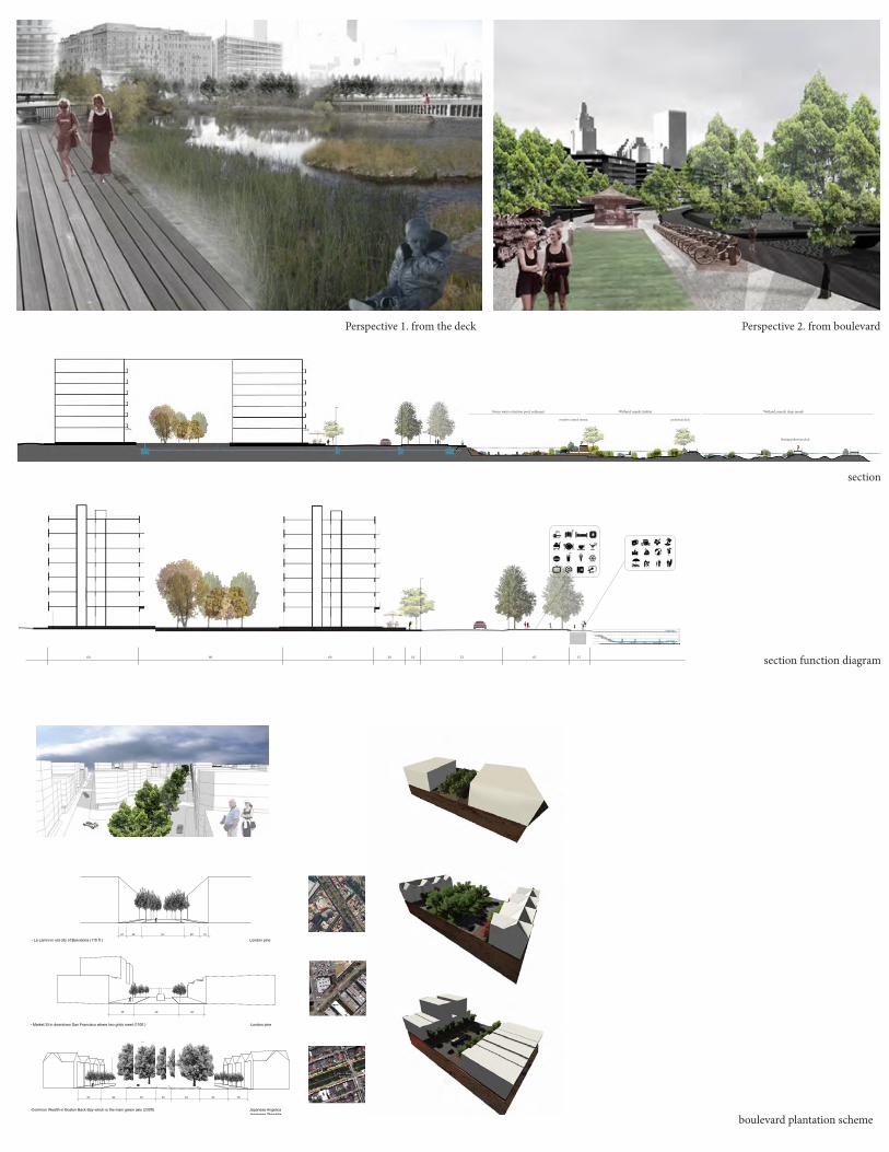
Perspective 1. from the deck Perspective 2. from boulevard
section
section function diagram
boulevard plantation scheme

1
0

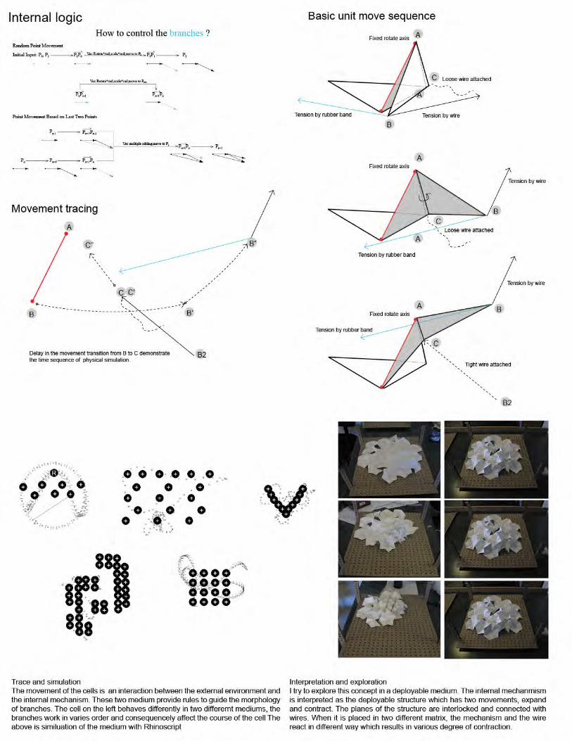
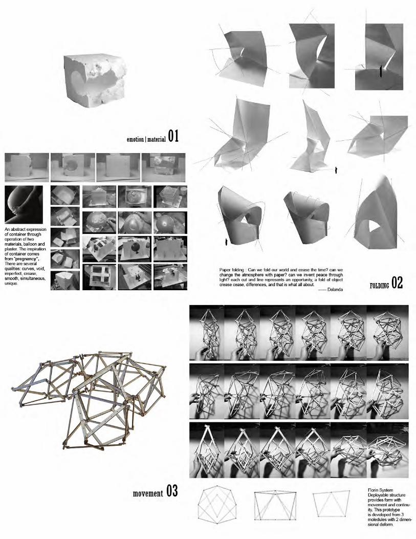
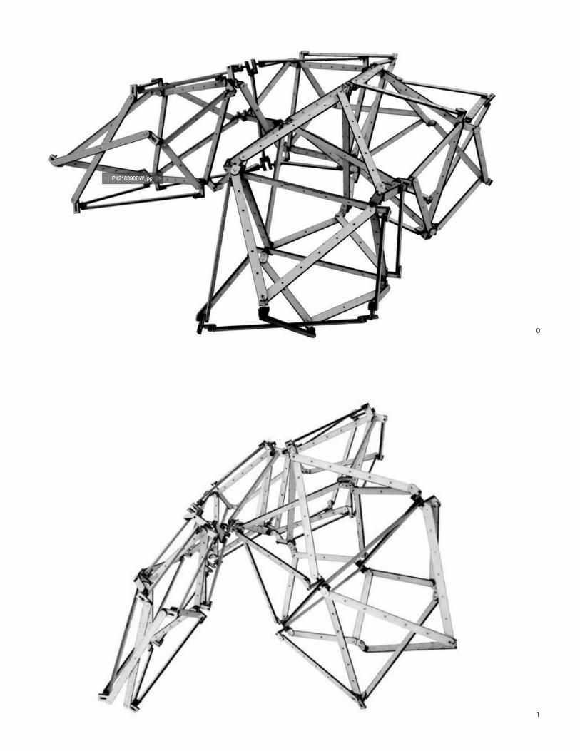
Transformation :The morphology. of the script is transformed with the discourse of deployable structure. The FLORIN SYSTEM structures the basic module. It has 4 triangles, one rhombus and 4 hyperboloid, The scissors joint at the bottom emables 2 direction movements..00 01 10 11
Joint:The accuracy of the joint is crucial. The axis of the movement has to offset in order to accommodate the thickness of the material. The left is a join of 6 axis. The right is joint of iron stell and timber.
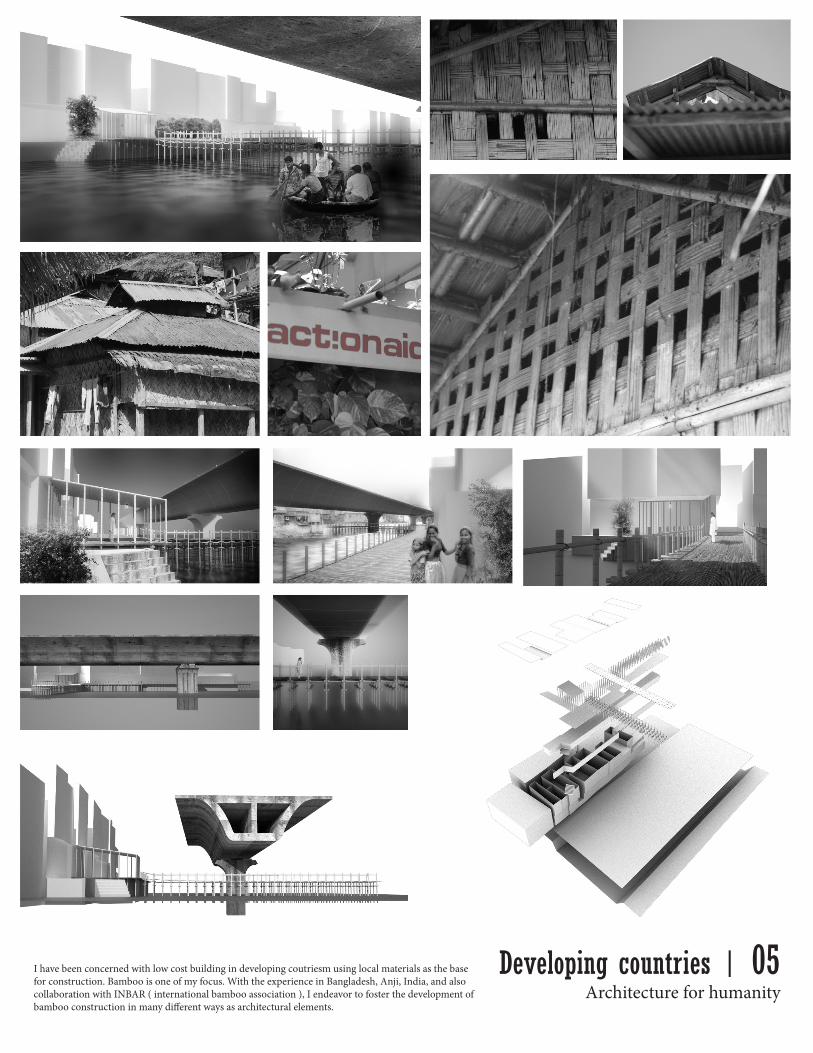
Architecture for humanityI have been concerned with low cost building in developing coutriesm using local materials as the base for construction. Bamboo is one of my focus. With the experience in Bangladesh, Anji, India, and also collaboration with INBAR ( international bamboo association ), I endeavor to foster the development of bamboo construction in many different ways as architectural elements.
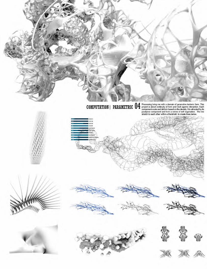
Developing countries | 05

PRACTICE


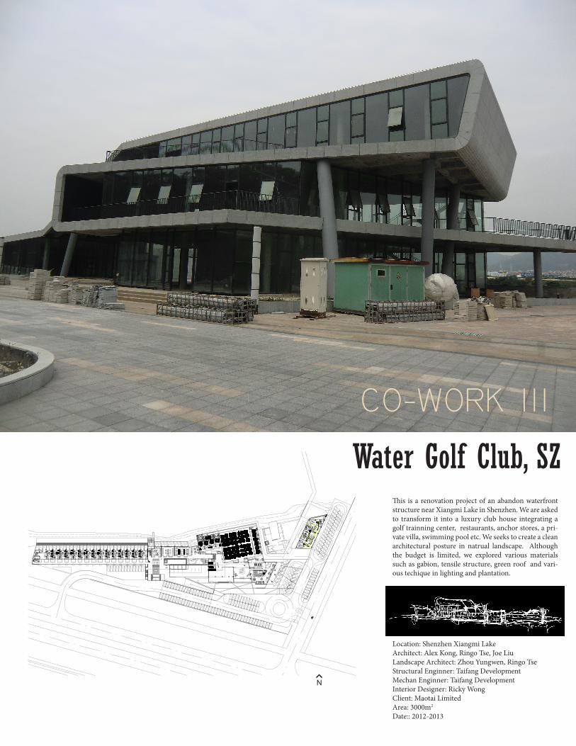
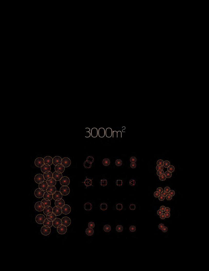
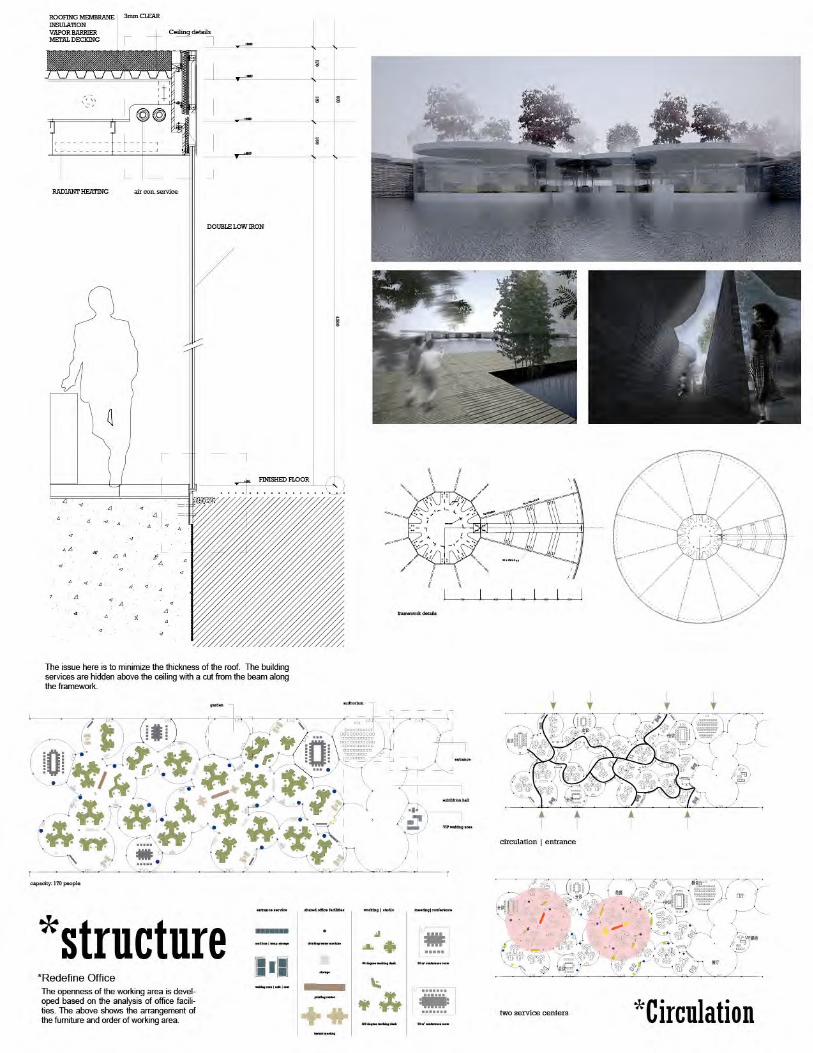
Water Golf Club, SZ
Location: Shenzhen Xiangmi LakeArchitect: Alex Kong, Ringo Tse, Joe LiuLandscape Architect: Zhou Yungwen, Ringo TseStructural Enginner: Taifang DevelopmentMechan Enginner: Taifang DevelopmentInterior Designer: Ricky WongClient: Maotai LimitedArea: 3000m2
Date:: 2012-2013
N
This is a renovation project of an abandon waterfront structure near Xiangmi Lake in Shenzhen. We are asked to transform it into a luxury club house integrating a golf trainning center, restaurants, anchor stores, a pri-vate villa, swimming pool etc. We seeks to create a clean architectural posture in natrual landscape. Although the budget is limited, we explored various materials such as gabion, tensile structure, green roof and vari-ous techique in lighting and plantation.
CO-WORK III

Golf is a sport belongs its landscape. Landscape and water have an inseparable relationship. The design is developed based on 4 keywords:{Material} Main building has a sculptural form, the landscape is more restraint and draw the audience to the detail. Wood and stone are the two main actors in this project. They work togethor to form space. {Experience} On top of visual satisfaction, walking through the landscape and the outdoor environment shall be another highlight of the project. Delicate control to sound, materials and plant enables people to sense the beauty of waterfrtont. The continued roofgarden is like the backbone of the building linking west and east, finally it rests on the top of the main building as the focal point of the city. [Technology] its unique location has provided the room to adopt various landscape techique. {Nature} We try to create a natural landscape with grass. Colors and softness are the main
Related Documents


![[XLS] · Web view2012 40000 7018 2012 40001 7005 2012 40002 7307 2012 40003 7011 2012 40004 7008 2012 40005 7250 2012 40006 7250 2012 40007 7248 2012 40008 7112 2012 40009 7310 2012](https://static.cupdf.com/doc/110x72/5af7ff907f8b9a7444917b2d/xls-view2012-40000-7018-2012-40001-7005-2012-40002-7307-2012-40003-7011-2012-40004.jpg)