
Welcome message from author
This document is posted to help you gain knowledge. Please leave a comment to let me know what you think about it! Share it to your friends and learn new things together.
Transcript
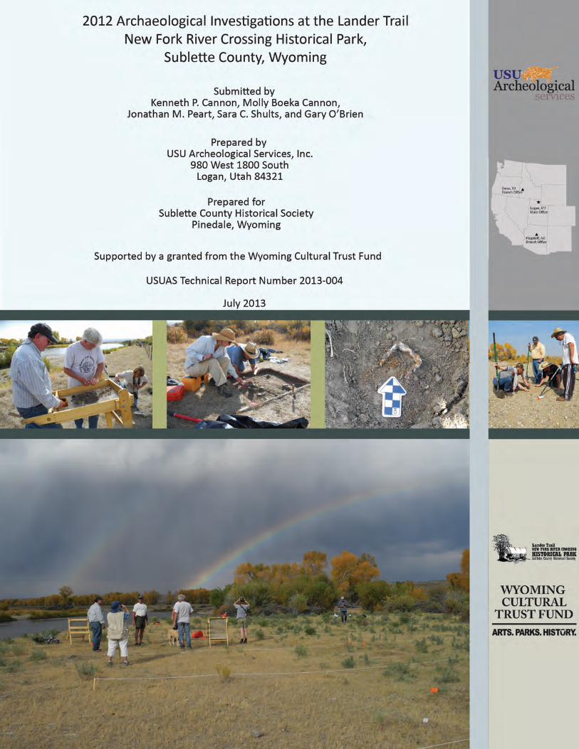

2012 ARCHAEOLOGICAL INVESTIGATIONS AT THE LANDER TRAIL NEW FORK RIVER CROSSING
HISTORICAL PARK, SUBLETTE COUNTY, WYOMING
Submitted by
Kenneth P. Cannon Molly Boeka Cannon
Jonathan M. Peart Sara C. Shults Gary O’Brien
Principal Investigators Kenneth P. Cannon, PhD, RPA
Molly Boeka Cannon
Prepared for Sublette County Historical Society
Pinedale, Wyoming
Supported by a grant from the Wyoming Cultural Trust Fund, a program of the Department of State Parks and Cultural Resources
Prepared by
USU Archeological Services, Inc. 980 West 1800 South
Logan, Utah 84321
USUAS Technical Report Number USUAS-2013-004
July 2013

USU Archeological Services | 2012 Archaeological Investigations at New Fork Crossing Historical Park ii

USU Archeological Services | 2012 Archaeological Investigations at New Fork Crossing Historical Park iii
EXECUTIVE SUMMARY
In September 2012, USUAS conducted a second year of investigations that again focused on the Island Area, but also expanded their investigations east of the river onto the Olson property. This year’s work was an expansion of the 2011 investigations that focused on excavation, or ground-truthing, of identified geophysical anomalies, as well as additional metal detection and geophysical prospecting.
The results of the work were quite fruitful and produced additional buried evidence of Emigrant Era artifacts that included a range of fire arm munitions (e.g., bullets, percussion caps, melted lead), plus domestic items (.e.g., tent stake and hog scraper candlestick holder).
Additional geophysical surveys using ground penetrating radar and a fluxgate gradiometer identified a number of linear features and, based upon our previous work, buried hearth features. Hand excavation, in concert with chronometric dating techniques, will be necessary to understand the context and origin of these anomalies.
USU Archeological Services | 2012 Archaeological Investigations at New Fork Crossing Historical Park iv
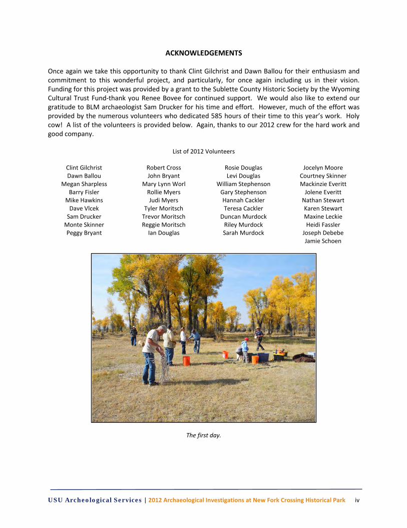
ACKNOWLEDGEMENTS Once again we take this opportunity to thank Clint Gilchrist and Dawn Ballou for their enthusiasm and commitment to this wonderful project, and particularly, for once again including us in their vision. Funding for this project was provided by a grant to the Sublette County Historic Society by the Wyoming Cultural Trust Fund-thank you Renee Bovee for continued support. We would also like to extend our gratitude to BLM archaeologist Sam Drucker for his time and effort. However, much of the effort was provided by the numerous volunteers who dedicated 585 hours of their time to this year’s work. Holy cow! A list of the volunteers is provided below. Again, thanks to our 2012 crew for the hard work and good company.
List of 2012 Volunteers
Clint Gilchrist Dawn Ballou
Megan Sharpless Barry Fisler
Mike Hawkins Dave Vlcek
Sam Drucker Monte Skinner Peggy Bryant
Robert Cross John Bryant
Mary Lynn Worl Rollie Myers Judi Myers
Tyler Moritsch Trevor Moritsch Reggie Moritsch
Ian Douglas
Rosie Douglas Levi Douglas
William Stephenson Gary Stephenson Hannah Cackler Teresa Cackler
Duncan Murdock Riley Murdock Sarah Murdock
Jocelyn Moore Courtney Skinner Mackinzie Everitt
Jolene Everitt Nathan Stewart Karen Stewart Maxine Leckie Heidi Fassler
Joseph Debebe Jamie Schoen
The first day.
USU Archeological Services | 2012 Archaeological Investigations at New Fork Crossing Historical Park v
TABLE OF CONTENTS Executive Summary ...................................................................................................................................... iii Acknowledgments ........................................................................................................................................ iv Table of Contents .......................................................................................................................................... v List of Tables ................................................................................................................................................ vii List of Figures ............................................................................................................................................... vii Chapter 1: Undertaking and Project Description .......................................................................................... 1 2012 Investigations ................................................................................................................................ 5 Chapter 2: Environmental Context ............................................................................................................... 7 Chapter 3: Background Research ................................................................................................................ 15 Historic Context .................................................................................................................................... 15 Chapter 4: Methodology ............................................................................................................................. 19 Mapping................................................................................................................................................ 19 Metal Detection Survey ........................................................................................................................ 20 Unit Excavation ..................................................................................................................................... 21 Ground Penetrating Radar and Magnetometer Methods ................................................................... 22 Archaeology and Geophysical Surveys .......................................................................................... 22 Efficiency and Non-destructive ...................................................................................................... 22 Open Site Feature Detection ......................................................................................................... 23 Target Feature Identification ......................................................................................................... 24 Chapter 5: Results ....................................................................................................................................... 25 Metal Detection Survey Results ........................................................................................................... 25 Firearms and Munitions Artifacts .................................................................................................. 30 .22 Caliber Bullets and Cartridges ........................................................................................... 30 .31 Caliber Bullets .................................................................................................................... 32 .32 Extra Short ………………………………………………………….. ………………………………………………………33 .42 Caliber Bullet …………………………………………………… .. ……………………………………………………….33 .44 WCF……………………………………………………………………… ........................................................ .33 Modern Rifle and Pistol Cartridges and Bullets (post-1900) ................................................... 34 Shot Shells and Round Lead Shot ............................................................................................ 34 Percussion Cap ........................................................................................................................ 35 Lead ......................................................................................................................................... 35 Nails, Bolts and Staples .................................................................................................................. 36 Wagon Staple .......................................................................................................................... 37 Personal Items ............................................................................................................................... 39 Other Artifacts ............................................................................................................................... 41 Metal Detection Results Summary ................................................................................................ 42 Excavation Results ................................................................................................................................ 43 Summary ........................................................................................................................................ 47 Results of the Geophysical Survey ....................................................................................................... 48 Block A............................................................................................................................................ 48 Grid 3………………………………………………………….. ........................................................................ 48 Grid 4…………………………………….. .............................................................................................. 48 Grid 5….. .................................................................................................................................. 49 Recommendations for Block A ....................................................................................................... 49 Block I ............................................................................................................................................. 51 Grid 1…………… ......................................................................................................................... 51
USU Archeological Services | 2012 Archaeological Investigations at New Fork Crossing Historical Park vi
Grid 2. ...................................................................................................................................... 52 Grid 3………. .............................................................................................................................. 54 Recommendations for Block I ........................................................................................................ 55 CHAPTER 6: SUMMARY AND CONCLUSIONS .............................................................................................. 57 Metal Detection Results ....................................................................................................................... 57 Test Excavation Results ........................................................................................................................ 57 Geophysical Survey Results .................................................................................................................. 57 Suggestions for Future Reseasrch ........................................................................................................ 57 References Cited ......................................................................................................................................... 59
USU Archeological Services | 2012 Archaeological Investigations at New Fork Crossing Historical Park vii
LIST OF TABLES 1. Sedimentary unit descriptions for Figure 10 .......................................................................................... 10 2. List of project datums with UTM locations ............................................................................................ 19 3. Recent archaeological geophysical surveys in the western United States ............................................ 24 4. 2012 metal detection results ................................................................................................................. 26 5. Recovered round shot ............................................................................................................................ 34 6. List of recovered lead weights ............................................................................................................... 36 7. Description of soils in profile of south wall of Unit 1 ............................................................................. 44 8. Description of soils in profile of north wall of Unit 4 ............................................................................. 44 9. Munsell colors of soils in Unit 6 ............................................................................................................. 45 10. Description of soils from Unit 7 ........................................................................................................... 46 11. Artifacts recovered during test excavations ........................................................................................ 47 12. Identified anomalies with Block A ........................................................................................................ 48 13. Identified anomalies within Block I ...................................................................................................... 51
LIST OF FIGURES 1. Map of Oregon-California Trial System .................................................................................................... 1 2. Map of the Lander Trail route in relation to other trail systems ............................................................. 1 3. Project location map ................................................................................................................................ 2 4. Map of New Fork River Crossing Historical Park Boundary ..................................................................... 3 5. Map of 2011 archaeological investigations at the New Fork Historical Park .......................................... 4 6. Map of the New Fork River Crossing Historical Park 2012 investigations ............................................... 4 7. View of the thick grass cover and cottonwood overstory in Island area ................................................. 7 8. Sagebrush-steppe environment on upland beach ................................................................................... 7 9. Mean annual precipitation and temperature for Big Piney, Wyoming ................................................... 8 10. Soil profile from the west facing cut bank of New Fork River Crossing Park ......................................... 9 11. Aerial view of the New Fork Crossing Park illustrating changes in the New Fork River flow pattern . 11 12. Eroding precontact fired rock feature exposed along east bank of the New Fork River ..................... 11 13. View of the Bertram Homestead ......................................................................................................... 12 14. Annotated 2005 aerial photograph of the New Fork River Crossing Historical Park ........................... 13 15. Close-up view of a Cadastral Plat Map dated 1893 ............................................................................. 16 16. Gary O’Brien and Stephanie Crockett using the RTK unit to map the project area ............................. 19 17. Metal detection survey in Block I ......................................................................................................... 20 18. In situ wagon staple ............................................................................................................................. 21 19. Unit 7 excavation in progress ............................................................................................................... 21 20. Clint Gilchrist at water screening station ............................................................................................. 22 21. Molly Boeka Cannon conducting magnetometer survey ..................................................................... 23 22. Molly Boeka Cannon and ground penetrating radar unit .................................................................... 23 23. Excavation of fan cover shroud in Block H ........................................................................................... 25 24. Close-up of the fan cover shroud ......................................................................................................... 25 25. Histogram of .22 caliber bullet grain sizes ........................................................................................... 30 26. .22 Short bullets ................................................................................................................................... 31 27. Sample of .22 LR bullets ....................................................................................................................... 31 28. Sample of .22 LR cartridges .................................................................................................................. 32 29. .22 WMR cartridge ............................................................................................................................... 32
USU Archeological Services | 2012 Archaeological Investigations at New Fork Crossing Historical Park viii
30. .31 caliber conical bullet ...................................................................................................................... 32 31. Heavily deformed .31 caliber bullet ..................................................................................................... 33 32. .32 Extra Short rim fire cartridge ......................................................................................................... 33 33. .42 Caliber bullet .................................................................................................................................. 33 34. .44 WCF cartridge ................................................................................................................................. 34 35. Sample of recovered round shot ......................................................................................................... 35 36. Percussion caps .................................................................................................................................... 35 37. Two lead globules ................................................................................................................................ 36 38. Rusted bolt ........................................................................................................................................... 36 39. Tent stake ............................................................................................................................................. 36 40. Nails ...................................................................................................................................................... 37 41. Horseshoe nail ...................................................................................................................................... 37 42. Wagon staple ....................................................................................................................................... 37 43. Common wagon staple types ............................................................................................................... 38 44. Wagon staple in Sears Roebuck & Company catalog ........................................................................... 38 45. Conestoga wagon diagram ................................................................................................................... 38 46. Diagram of a typical small Emigrant wagon ......................................................................................... 39 47. Axe head ............................................................................................................................................... 39 48. Possible saddle O-ring .......................................................................................................................... 40 49. Shell inlayed grommet ......................................................................................................................... 40 50. Hog scraper candlestick holder ............................................................................................................ 40 51. Example of the hog scraper candlestick holder ................................................................................... 41 52. Close-up of the vaccine bottle ............................................................................................................. 41 53. Close-up of the Thomas Fishing Lure ................................................................................................... 41 54. Graph of diagnostic Emigrant Era artifact’s general date ranges ........................................................ 42 55. The location of possible Emigrant Era artifacts located during metal detection ................................ 43 56. Excavation Block A ............................................................................................................................... 43 57. Stratigraphic profile of the south wall of Unit 1 .................................................................................. 44 58. Stratigraphic profile of the north wall of Unit 4................................................................................... 44 59. Profile view of north wall of Unit 5 ...................................................................................................... 45 60. Stratigraphic profile of the west wall of Unit 6 .................................................................................... 45 61. Stratigraphic profile of the north wall of Unit 7................................................................................... 45 62. Plan view of Unit 7 Level 1 ................................................................................................................... 46 63. Plan view of Unit 7 Level 2 ................................................................................................................... 46 64. Plan view of Feature 1 in Level 2 of Unit 7 ........................................................................................... 46 65. Lead globules found during the excavation of Unit 8 .......................................................................... 47 66. Results of the magnetic gradiometer survey for Block A ..................................................................... 50 67. Results of the GPR survey for Grid 3 Block A ....................................................................................... 51 68. Results of the GPR survey for Grid 3 Block A ....................................................................................... 52 69. Results of the GPR survey for Grid 3 Block A ....................................................................................... 53 70. Results of the magnetic gradiometer survey for Block A, Grids 1, 2 and 3 ......................................... 53 71. Results of the GPR survey for Block I Grid 1 ........................................................................................ 54 72. Results of the GPR survey for Block I Grid 2 .......................................................................................... 5 73. Results of the GPR survey for Block I Grid 3 ........................................................................................ 55
USU Archeological Services | 2012 Archaeological Investigations at New Fork Crossing Historical Park 1
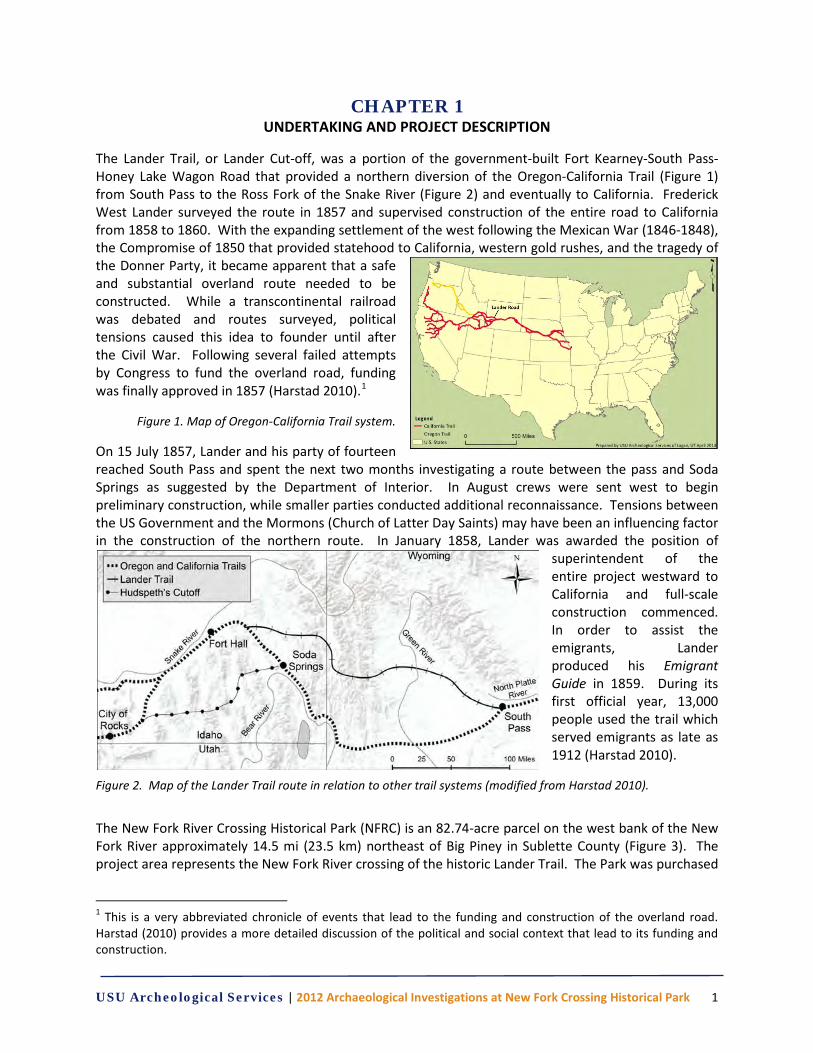
CHAPTER 1 UNDERTAKING AND PROJECT DESCRIPTION
The Lander Trail, or Lander Cut-off, was a portion of the government-built Fort Kearney-South Pass-Honey Lake Wagon Road that provided a northern diversion of the Oregon-California Trail (Figure 1) from South Pass to the Ross Fork of the Snake River (Figure 2) and eventually to California. Frederick West Lander surveyed the route in 1857 and supervised construction of the entire road to California from 1858 to 1860. With the expanding settlement of the west following the Mexican War (1846-1848), the Compromise of 1850 that provided statehood to California, western gold rushes, and the tragedy of the Donner Party, it became apparent that a safe and substantial overland route needed to be constructed. While a transcontinental railroad was debated and routes surveyed, political tensions caused this idea to founder until after the Civil War. Following several failed attempts by Congress to fund the overland road, funding was finally approved in 1857 (Harstad 2010).1
Figure 1. Map of Oregon-California Trail system.
On 15 July 1857, Lander and his party of fourteen reached South Pass and spent the next two months investigating a route between the pass and Soda Springs as suggested by the Department of Interior. In August crews were sent west to begin preliminary construction, while smaller parties conducted additional reconnaissance. Tensions between the US Government and the Mormons (Church of Latter Day Saints) may have been an influencing factor in the construction of the northern route. In January 1858, Lander was awarded the position of
superintendent of the entire project westward to California and full-scale construction commenced. In order to assist the emigrants, Lander produced his Emigrant Guide in 1859. During its first official year, 13,000 people used the trail which served emigrants as late as 1912 (Harstad 2010).
Figure 2. Map of the Lander Trail route in relation to other trail systems (modified from Harstad 2010).
The New Fork River Crossing Historical Park (NFRC) is an 82.74-acre parcel on the west bank of the New Fork River approximately 14.5 mi (23.5 km) northeast of Big Piney in Sublette County (Figure 3). The project area represents the New Fork River crossing of the historic Lander Trail. The Park was purchased
1 This is a very abbreviated chronicle of events that lead to the funding and construction of the overland road. Harstad (2010) provides a more detailed discussion of the political and social context that lead to its funding and construction.

USU Archeological Services | 2012 Archaeological Investigations at New Fork Crossing Historical Park 2
in August 2010 with donations from Shell, Ultra and PacifiCorp via Pinedale Anticline mitigation agreements with the Bureau of Land Management (BLM), Wyoming State Historic Preservation Office (SHPO), and Advisory Council on Historic Preservation (ACHP). The Sublette County Historical Society (SCHS) has committed to raise the money to develop the property and open it to the public in the summer of 2013. The park will be the only public access to a major river crossing along the Lander Trail. Major river crossing and emigrant camp sites are very rare because they were also prime homestead lands long ago put into private ownership. The park borders a half mile of the New Fork River on the east and the BLM New Fork Campground on the south. Because of an old island and abandoned river channels, the property was not favorable to agricultural development, so the setting remains mostly undeveloped and substantially like what emigrants encountered 150 years ago (Figure 4).
Figure 3. Project location map.
The goal of the historical park is to preserve what remains of the Lander Cutoff New Fork Crossing and promote public interest in associated historically significant events and persons. Developments at the park will be minimal, but include a parking lot, walking trails, and the placement of interpretive historical signs.
With the purchase of the land, the initial goal of preserving the park in perpetuity was obtained. The focus in 2011 and 2012 has been to develop a destination emigrant trail interpretative site for the public and to archaeologically explore the presence of emigrant trail campsite. A grand opening to the public is planned for June 2014. In order to assist with these goals, the SCHS received a grant from the Wyoming Cultural Trust Fund and contracted with USU Archeological Services, Inc., of Logan, Utah to conduct cultural resource investigations.
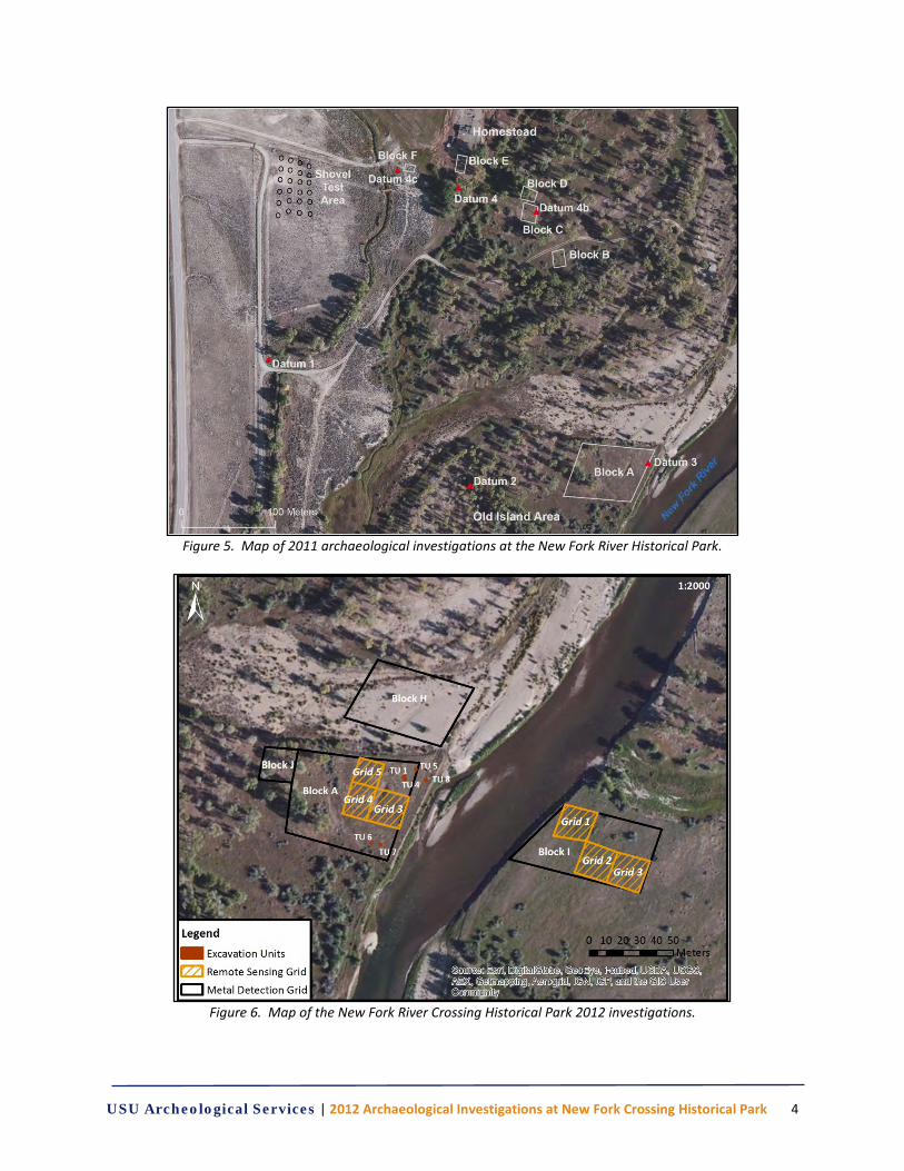
In August 2011, USU Archeological Services (USUAS) began archaeological investigations within the park boundary (Cannon et al., 2012). This work included an intensive pedestrian survey, shovel testing, metal detection and geophysical survey. Initial work at the park conducted by the Pinedale BLM

USU Archeological Services | 2012 Archaeological Investigations at New Fork Crossing Historical Park 3
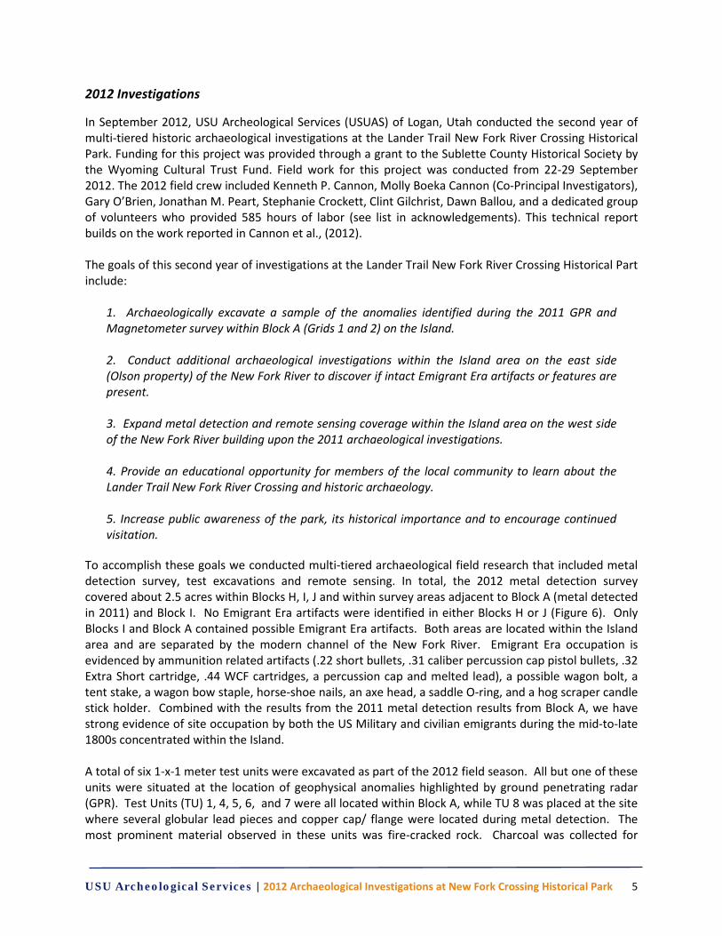
archaeologists (2009) indicated that buried deposits associated with Lander Trail period were present which facilitated this multiphase approach to the investigations (Figure 5). In September 2012, USUAS conducted a second year of investigations that again focused on the Island Area, but also expanded their investigations east of the river onto the Olson property (Figure 6).
Figure 4. Map of New Fork River Crossing Historical Park boundary.
USU Archeological Services | 2012 Archaeological Investigations at New Fork Crossing Historical Park 4
Figure 5. Map of 2011 archaeological investigations at the New Fork River Historical Park.
Figure 6. Map of the New Fork River Crossing Historical Park 2012 investigations.
USU Archeological Services | 2012 Archaeological Investigations at New Fork Crossing Historical Park 5
2012 Investigations
In September 2012, USU Archeological Services (USUAS) of Logan, Utah conducted the second year of multi-tiered historic archaeological investigations at the Lander Trail New Fork River Crossing Historical Park. Funding for this project was provided through a grant to the Sublette County Historical Society by the Wyoming Cultural Trust Fund. Field work for this project was conducted from 22-29 September 2012. The 2012 field crew included Kenneth P. Cannon, Molly Boeka Cannon (Co-Principal Investigators), Gary O’Brien, Jonathan M. Peart, Stephanie Crockett, Clint Gilchrist, Dawn Ballou, and a dedicated group of volunteers who provided 585 hours of labor (see list in acknowledgements). This technical report builds on the work reported in Cannon et al., (2012). The goals of this second year of investigations at the Lander Trail New Fork River Crossing Historical Part include:
1. Archaeologically excavate a sample of the anomalies identified during the 2011 GPR and Magnetometer survey within Block A (Grids 1 and 2) on the Island. 2. Conduct additional archaeological investigations within the Island area on the east side (Olson property) of the New Fork River to discover if intact Emigrant Era artifacts or features are present. 3. Expand metal detection and remote sensing coverage within the Island area on the west side of the New Fork River building upon the 2011 archaeological investigations. 4. Provide an educational opportunity for members of the local community to learn about the Lander Trail New Fork River Crossing and historic archaeology. 5. Increase public awareness of the park, its historical importance and to encourage continued visitation.
To accomplish these goals we conducted multi-tiered archaeological field research that included metal detection survey, test excavations and remote sensing. In total, the 2012 metal detection survey covered about 2.5 acres within Blocks H, I, J and within survey areas adjacent to Block A (metal detected in 2011) and Block I. No Emigrant Era artifacts were identified in either Blocks H or J (Figure 6). Only Blocks I and Block A contained possible Emigrant Era artifacts. Both areas are located within the Island area and are separated by the modern channel of the New Fork River. Emigrant Era occupation is evidenced by ammunition related artifacts (.22 short bullets, .31 caliber percussion cap pistol bullets, .32 Extra Short cartridge, .44 WCF cartridges, a percussion cap and melted lead), a possible wagon bolt, a tent stake, a wagon bow staple, horse-shoe nails, an axe head, a saddle O-ring, and a hog scraper candle stick holder. Combined with the results from the 2011 metal detection results from Block A, we have strong evidence of site occupation by both the US Military and civilian emigrants during the mid-to-late 1800s concentrated within the Island. A total of six 1-x-1 meter test units were excavated as part of the 2012 field season. All but one of these units were situated at the location of geophysical anomalies highlighted by ground penetrating radar (GPR). Test Units (TU) 1, 4, 5, 6, and 7 were all located within Block A, while TU 8 was placed at the site where several globular lead pieces and copper cap/ flange were located during metal detection. The most prominent material observed in these units was fire-cracked rock. Charcoal was collected for

USU Archeological Services | 2012 Archaeological Investigations at New Fork Crossing Historical Park 6
carbon-14 dating from three of the test units. In addition to fire-related materials, chert flakes, percussion caps, lead globules, faunal bones, and a nail. In TU 7, a cluster of fire-cracked rocks was recorded as Feature 1, but no cultural materials were observed in association with this feature.
USU Archeological Services | 2012 Archaeological Investigations at New Fork Crossing Historical Park 7
CHAPTER 2 ENVIRONMENTAL SETTING
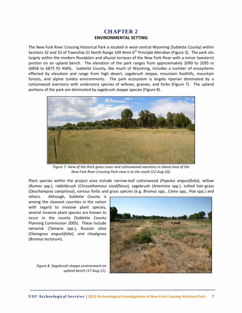
The New Fork River Crossing Historical Park is located in west-central Wyoming (Sublette County) within Sections 32 and 33 of Township 31 North Range 109 West 6th Principle Meridian (Figure 3). The park sits largely within the modern floodplain and alluvial terraces of the New Fork River with a minor (western) portion on an upland bench. The elevation of the park ranges from approximately 2090 to 2095 m (6858 to 6875 ft) AMSL. Sublette County, like much of Wyoming, includes a number of ecosystems effected by elevation and range from high desert, sagebrush steppe, mountain foothills, mountain forests, and alpine tundra environments. The park ecosystem is largely riparian dominated by a cottonwood overstory with understory species of willows, grasses, and forbs (Figure 7). The upland portions of the park are dominated by sagebrush steppe species (Figure 8).
Figure 7. View of the thick grass cover and cottonwood overstory in Island area of the
New Fork River Crossing Park view is to the south (12-Aug-10).
Plant species within the project area include narrow-leaf cottonwood (Populus angustifolia), willow (Rumex spp.), rabbitbrush (Chrysothamnus visidiflorus), sagebrush (Artemisia spp.), tufted hair-grass (Deschampsia caespitosa), various forbs and grass species (e.g. Bromus spp., Carex spp., Poa spp.) and others. Although, Sublette County is among the cleanest counties in the nation with regard to invasive plant species, several invasive plant species are known to occur in the county (Sublette County Planning Commission 2005). These include tamarisk (Tamarix spp.), Russian olive (Elaeagnus angustifolia), and cheatgrass (Bromus tectorum).
Figure 8. Sagebrush-steppe environment on upland bench (17-Aug-11).
USU Archeological Services | 2012 Archaeological Investigations at New Fork Crossing Historical Park 8
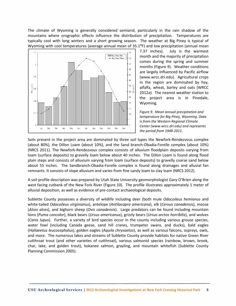
The climate of Wyoming is generally considered semiarid, particularly in the rain shadow of the mountains where orographic effects influence the distribution of precipitation. Temperatures are typically cool with long winters and a short growing season. The weather at Big Piney is typical of Wyoming with cool temperatures (average annual mean of 35.1⁰F) and low precipitation (annual mean
7.37 inches). July is the warmest month and the majority of precipitation comes during the spring and summer months (Figure 9). Weather conditions are largely influenced by Pacific airflow (www.wrcc.dri.edu). Agricultural crops in the region are dominated by hay, alfalfa, wheat, barley and oats (WRCC 2012a). The nearest weather station to the project area is in Pinedale, Wyoming.
Figure 9. Mean annual precipitation and temperature for Big Piney, Wyoming. Data is from the Western Regional Climate Center (www.wrcc.dri.edu) and represents the period from 1948-2011.
Soils present in the project area are dominated by three soil types the Newfork-Rendezvous complex (about 80%), the Dillon Loam (about 10%), and the Sand branch-Obadia-Forelle complex (about 10%) (NRCS 2011). The Newfork-Rendezvous complex consists of alluvium floodplain deposits varying from loam (surface deposits) to gravelly loam below about 40 inches. The Dillon Loam is found along flood plain steps and consists of alluvium varying from loam (surface deposits) to gravelly coarse sand below about 55 inches. The Sandbranch-Obadia-Forelle complex is found along drainages and alluvial fan remnants. It consists of slope alluvium and varies from fine sandy loam to clay loam (NRCS 2012).
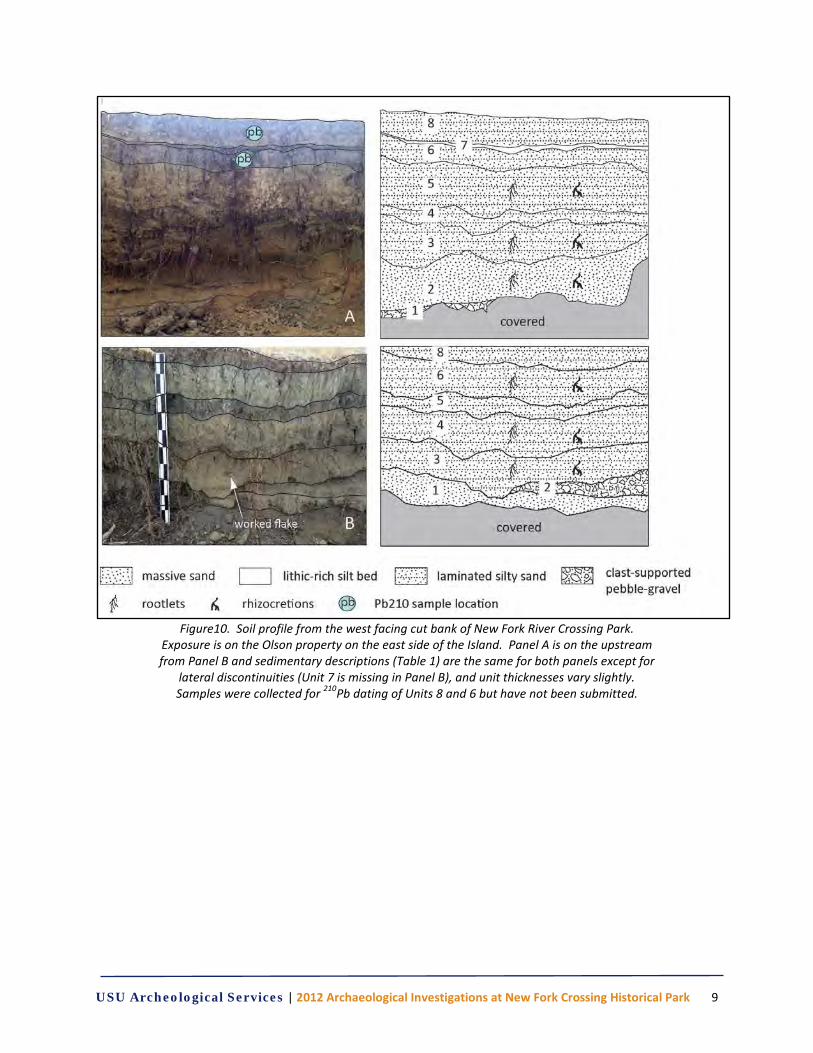
A soil profile description was prepared by Utah State University geomorphologist Gary O’Brien along the west facing cutbank of the New Fork River (Figure 10). The profile illustrates approximately 1 meter of alluvial deposition, as well as evidence of pre-contact archaeological deposits.
Sublette County possesses a diversity of wildlife including deer (both mule Odocoileus hemionus and white-tailed Odocoileus virginianus), antelope (Antilocapra americana), elk (Cervus canadensis), moose (Alces alces), and bighorn sheep (Ovis canadensis). Large predators can be found including mountain lions (Puma concolor), black bears (Ursus americanus), grizzly bears (Ursus arctos horribilis), and wolves (Canis lupus). Further, a variety of bird species occur in the county including various grouse species, water fowl (including Canada geese, sand hill cranes, trumpeter swans, and ducks), bald eagles (Haliaeetus leucocephalus), golden eagles (Aquila chrysaetos), as well as various falcons, ospreys, owls, and more. The numerous lakes and streams of Sublette County provide habitats for native Green River cutthroat trout (and other varieties of cutthroat), various salmonid species (rainbow, brown, brook, char, lake, and golden trout), kokanee salmon, grayling, and mountain whitefish (Sublette County Planning Commission 2005).
USU Archeological Services | 2012 Archaeological Investigations at New Fork Crossing Historical Park 9
Figure10. Soil profile from the west facing cut bank of New Fork River Crossing Park.
Exposure is on the Olson property on the east side of the Island. Panel A is on the upstream from Panel B and sedimentary descriptions (Table 1) are the same for both panels except for
lateral discontinuities (Unit 7 is missing in Panel B), and unit thicknesses vary slightly. Samples were collected for 210Pb dating of Units 8 and 6 but have not been submitted.
USU Archeological Services | 2012 Archaeological Investigations at New Fork Crossing Historical Park 10
Table 1. Sedimentary unit descriptions for Figure 10. Unit Description Unit Description
8 Historic overbank deposit. Silty very fine sand, 91-107 cm, 1-2 cm thick subunits alternate with sandy silt; reverse-graded, heavy root Bioturbation with moderate calcic ppt, rare rhizoliths. Loose at surface, form consistency at base. 10YR5.3.
4 Sandy silt and clay, 5-56 cm; clumpy, very hard consistency, vertical cracking defins pedons. Rootlet Bioturbation, clear to sharp lower contact. 10YR4/2.
7 Thin O or A horizon (buried paleosol). Silty very fine sand containing coarse to medium sandy lithics, 90-01 cm, sharp upper and lower contacts, loose consistency, heavy rootlet Bioturbation. 10YR3/2.
3 B horizon of Unit 4 (?). Silty very sand, 37-50 cm, gradual lower contact, sharp upper contact with Unit 4. Firm to hard consistency, moderate to heavy root Bioturbation, abundant rhizoliths. 10YR5/4 at base and 10YR6/3 at top.
6 B horizon. Sandy silt, 82-90 cm, clumpy and hard consistency, heavy rootlet Bioturbation, CaCO3 ppt. in upper half (possible rhizoliths), gradual lower and sharp contact. 10YR4/2.
2 Flood package with significant tributary input. Sand, 10-37 cm, poorly sorted coarse to medium sand, minor fine sand. Moderate root Bioturbation, subtle reverse grading, loose consistency with faint rusty staining, gradual upper contact. 10YR5/4.
5 B or C horizon. Silt with minor sand, 57-82 cm, rusty, mottled staining; porous silty matrix contains occasional fine lithics. Gradual/graded upper contact, abundant rhizoliths and vertical cracking. Very hard consistency. 10YR6/3 to 5/3.
1 Tributary-sourced flood unit. Pebble-gravel, at least 7 cm thick (base buried by slumping), poorly sorted angular clasts contain minor sand, light rootlet Bioturbation. Distinct normal grading. 19YR5/4.
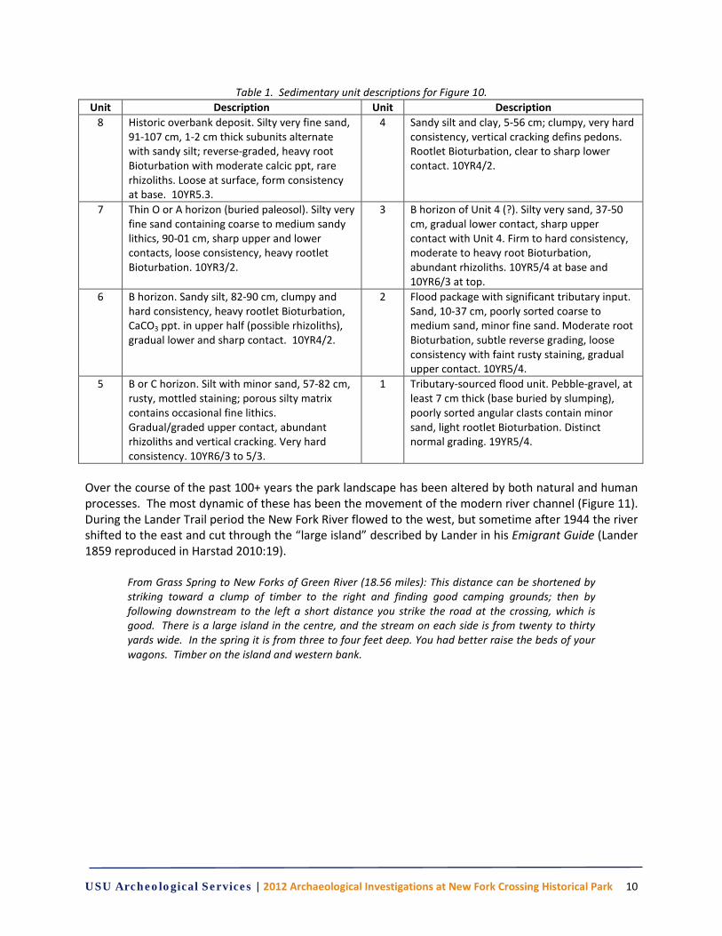
Over the course of the past 100+ years the park landscape has been altered by both natural and human processes. The most dynamic of these has been the movement of the modern river channel (Figure 11). During the Lander Trail period the New Fork River flowed to the west, but sometime after 1944 the river shifted to the east and cut through the “large island” described by Lander in his Emigrant Guide (Lander 1859 reproduced in Harstad 2010:19).
From Grass Spring to New Forks of Green River (18.56 miles): This distance can be shortened by striking toward a clump of timber to the right and finding good camping grounds; then by following downstream to the left a short distance you strike the road at the crossing, which is good. There is a large island in the centre, and the stream on each side is from twenty to thirty yards wide. In the spring it is from three to four feet deep. You had better raise the beds of your wagons. Timber on the island and western bank.
USU Archeological Services | 2012 Archaeological Investigations at New Fork Crossing Historical Park 11
Figure 11. Aerial views of the New Fork Crossing Park illustrating changes in the New Fork River
flow pattern. View on left is 1944 aerial photograph with “large island” intact and view on right is 2005 aerial photograph (after BLM 2009).
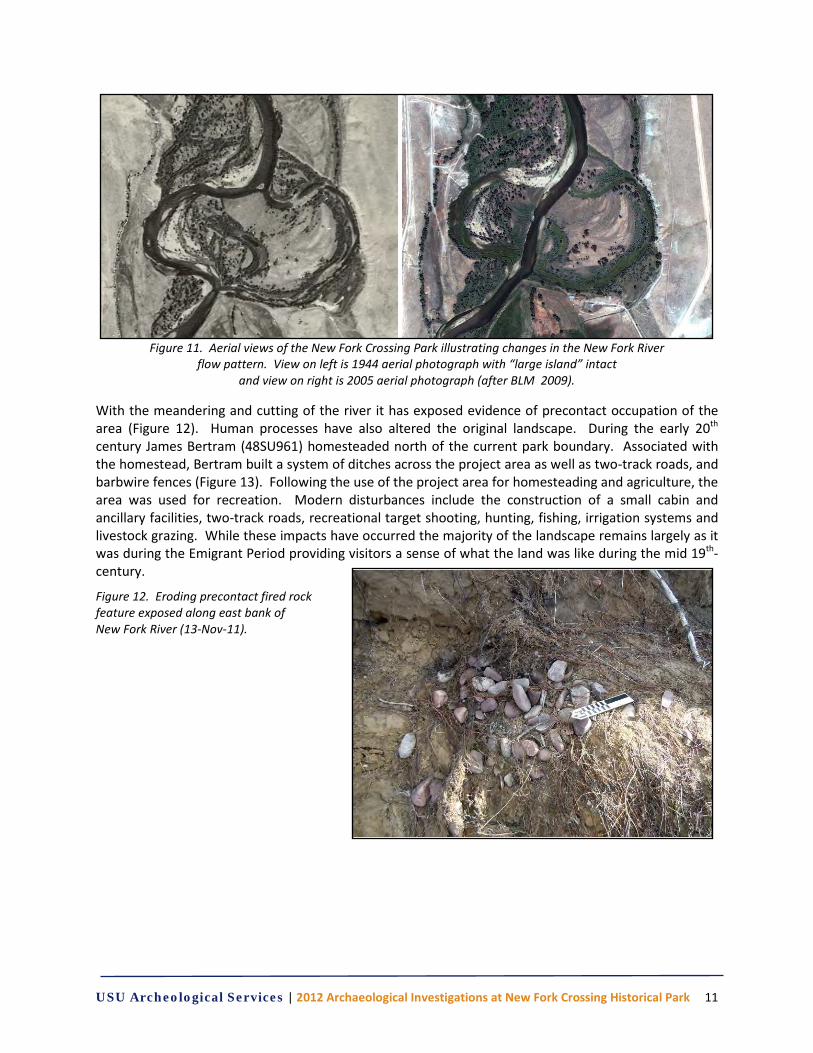
With the meandering and cutting of the river it has exposed evidence of precontact occupation of the area (Figure 12). Human processes have also altered the original landscape. During the early 20th century James Bertram (48SU961) homesteaded north of the current park boundary. Associated with the homestead, Bertram built a system of ditches across the project area as well as two-track roads, and barbwire fences (Figure 13). Following the use of the project area for homesteading and agriculture, the area was used for recreation. Modern disturbances include the construction of a small cabin and ancillary facilities, two-track roads, recreational target shooting, hunting, fishing, irrigation systems and livestock grazing. While these impacts have occurred the majority of the landscape remains largely as it was during the Emigrant Period providing visitors a sense of what the land was like during the mid 19th-century.
Figure 12. Eroding precontact fired rock feature exposed along east bank of New Fork River (13-Nov-11).
USU Archeological Services | 2012 Archaeological Investigations at New Fork Crossing Historical Park 12
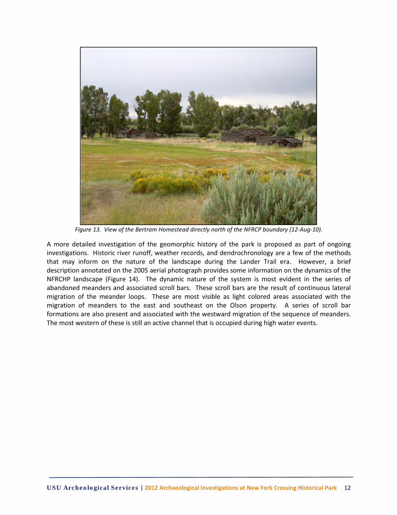
Figure 13. View of the Bertram Homestead directly north of the NFRCP boundary (12-Aug-10).
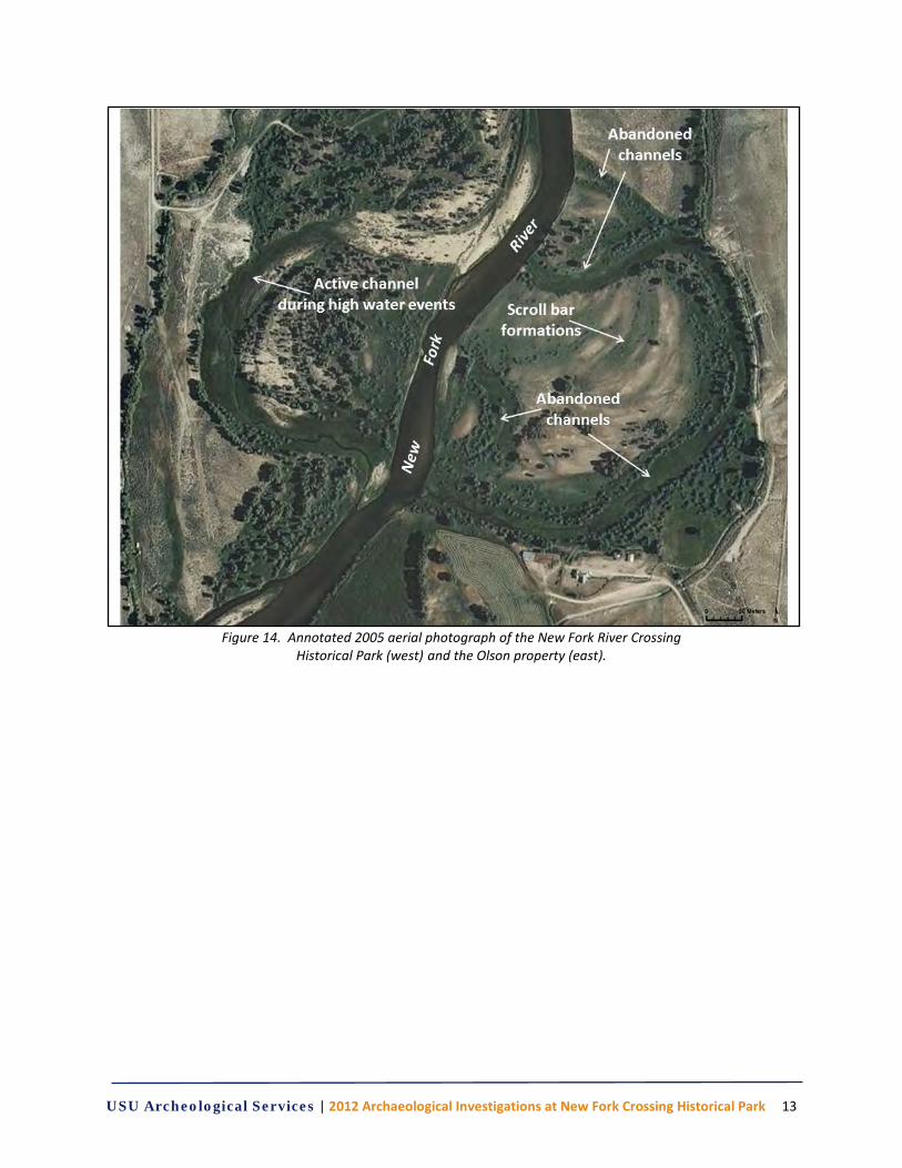
A more detailed investigation of the geomorphic history of the park is proposed as part of ongoing investigations. Historic river runoff, weather records, and dendrochronology are a few of the methods that may inform on the nature of the landscape during the Lander Trail era. However, a brief description annotated on the 2005 aerial photograph provides some information on the dynamics of the NFRCHP landscape (Figure 14). The dynamic nature of the system is most evident in the series of abandoned meanders and associated scroll bars. These scroll bars are the result of continuous lateral migration of the meander loops. These are most visible as light colored areas associated with the migration of meanders to the east and southeast on the Olson property. A series of scroll bar formations are also present and associated with the westward migration of the sequence of meanders. The most western of these is still an active channel that is occupied during high water events.
USU Archeological Services | 2012 Archaeological Investigations at New Fork Crossing Historical Park 13
Figure 14. Annotated 2005 aerial photograph of the New Fork River Crossing
Historical Park (west) and the Olson property (east).

USU Archeological Services | 2012 Archaeological Investigations at New Fork Crossing Historical Park 14
USU Archeological Services | 2012 Archaeological Investigations at New Fork Crossing Historical Park 15
CHAPTER 3 BACKGROUND RESEARCH
The multi-tiered archaeological investigations for this project are rather straightforward, to find evidence of the emigrant era use of the Lander Trail, with each of the methods and techniques applied to address distinct aspects of the archaeological record. Our work is a direct result of the documentary and archaeological work conducted by Bureau of Land Management archaeologists in 2009. The BLM’s (2009:1) historic property evaluation “was conducted in support of off-site mitigation options for the Shell and Ultra Lander Road Amended Programmatic Agreement.” The goals of the evaluation were three-fold:
1. Identify extant segments of the historic trail and any associated features;
2. Document the historical integrity of the trail on the west side of the New Fork River; and
3. Determine suitability for property acquisition as mitigation to off-set adverse effects to the historic setting of the Lander Trail from extractive energy projects in the area (BLM 2009:2).
Applying documentary, cartographic, physical, and archaeological evidence, Crowley provides significant evidence to illustrate that the property retains significant historical integrity. The protection and conservation of the property is justified and offsets adverse effects to other portions of the Lander Trail system.
Historic Context
The Lander Trail, or Lander Cut-off, was a portion of a congressionally-funded road system officially designated as the Fort Kearney, South Pass, and Honey Lake Wagon Road that was to provide an easier and safer road for travel to the western territories (Harstad 2010; Figure 1). Outgoing President Franklin Pierce signed the act into law on 17 February 1857, but was implemented by incoming President James Buchanan. The newly appointed Secretary for the Department of Interior, Jacob Thompson, entrusted the technical responsibilities of the road design and construction to Albert Campbell, Chief Engineer for the United States. As well as Chief Engineer, Campbell was given the additional title of General Superintendent of the Pacific Wagon Roads and the creation of the Pacific Wagon Roads Office (PWRO).
Campbell and the staff of the PWRO developed an initial plan for the improvement and upgrade to the Oregon Trail from Fort Kearney past Independence Rock to South Pass and then southwest through the Great Salt Lake Valley and on to Honey Lake in California. However, a series of political and logistical issues forced potential reroutes to be considered. An acquaintance of Campbell’s, Frederick W. Lander, who had developed a reputation for being a competent civil engineer, explorer and leader during surveys for the northern railroad route to the Pacific, proposed an alternative route he had personally explored on his return trip from the railroad surveys. The impression Lander made upon Campbell with his knowledge and experience led to his appointment as chief engineer of the Fort Kearney, South Pass, and Honey Lake Wagon Road (Jackson 1952; Wight 1993; Ecelbarger 2000; Harstad 2010).
Survey of the new route from South Pass across the Green River Valley to Fort Hall began with the arrival of Lander and his crew at South Pass on 15 July 1857. By October of 1857 Lander and his men had covered 3,000 miles of exploration and surveyed several practical routes for the road. On 30 November 1857 Lander presented the results to Congress. In January 1858, Secretary Thompson appointed Lander Superintendent of the Fort Kearney South Pass and Honey Lake Wagon Road. Orders
USU Archeological Services | 2012 Archaeological Investigations at New Fork Crossing Historical Park 16
for the work to proceed were presented to Lander in March of 1858 and construction began in mid June (Wight 1993; Harstad 2010).
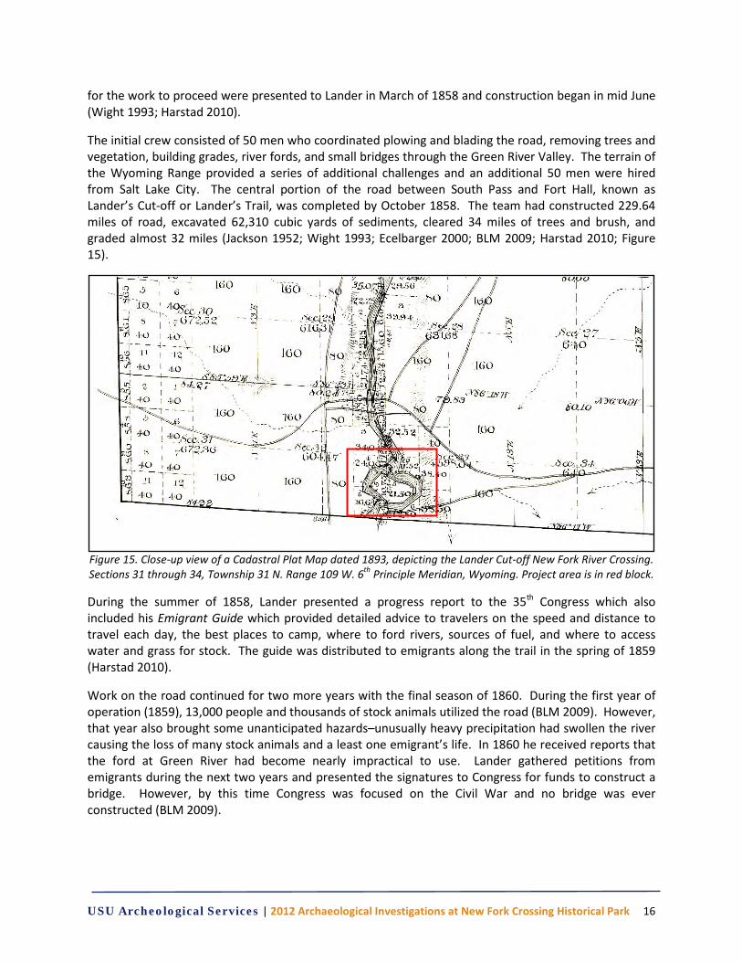
The initial crew consisted of 50 men who coordinated plowing and blading the road, removing trees and vegetation, building grades, river fords, and small bridges through the Green River Valley. The terrain of the Wyoming Range provided a series of additional challenges and an additional 50 men were hired from Salt Lake City. The central portion of the road between South Pass and Fort Hall, known as Lander’s Cut-off or Lander’s Trail, was completed by October 1858. The team had constructed 229.64 miles of road, excavated 62,310 cubic yards of sediments, cleared 34 miles of trees and brush, and graded almost 32 miles (Jackson 1952; Wight 1993; Ecelbarger 2000; BLM 2009; Harstad 2010; Figure 15).
Figure 15. Close-up view of a Cadastral Plat Map dated 1893, depicting the Lander Cut-off New Fork River Crossing. Sections 31 through 34, Township 31 N. Range 109 W. 6th Principle Meridian, Wyoming. Project area is in red block.
During the summer of 1858, Lander presented a progress report to the 35th Congress which also included his Emigrant Guide which provided detailed advice to travelers on the speed and distance to travel each day, the best places to camp, where to ford rivers, sources of fuel, and where to access water and grass for stock. The guide was distributed to emigrants along the trail in the spring of 1859 (Harstad 2010).
Work on the road continued for two more years with the final season of 1860. During the first year of operation (1859), 13,000 people and thousands of stock animals utilized the road (BLM 2009). However, that year also brought some unanticipated hazards–unusually heavy precipitation had swollen the river causing the loss of many stock animals and a least one emigrant’s life. In 1860 he received reports that the ford at Green River had become nearly impractical to use. Lander gathered petitions from emigrants during the next two years and presented the signatures to Congress for funds to construct a bridge. However, by this time Congress was focused on the Civil War and no bridge was ever constructed (BLM 2009).
USU Archeological Services | 2012 Archaeological Investigations at New Fork Crossing Historical Park 17
On 4 March 1861 Lander resigned as Superintendent and took a post as colonel, with a later promotion to brigadier general, for the U.S. Army. In less than a year he was killed from complications of gunshot wound inflicted five months previously at Edward’s Ferry, Maryland (Ecelbarger 2000).
Lander’s Trail continued in use over the decades, although travel dwindled with the construction of the transcontinental railroad in 1869. Army volunteers, as well as the emigrants, were tasked with maintaining the trail. From about 1877 to 1920, the trail experienced a resurgence in use as cattlemen and families traveled east in search of open range and brought the earliest settlers to Sublette County (BLM 2009).
The Lander Trail represents an important artifact of the emigrant experience during the mid-nineteenth century and the settlement of the western United States. However, the trail is also important to the local settlement of Sublette County later in the century. The Lander Trail New Fork River Crossing Park provides a unique opportunity to explore archaeologically the record of this history. In Chapter 4 we present our methodology for this project building on the BLM’s research.

USU Archeological Services | 2012 Archaeological Investigations at New Fork Crossing Historical Park 18
USU Archeological Services | 2012 Archaeological Investigations at New Fork Crossing Historical Park 19
CHAPTER 4 METHODOLOGY
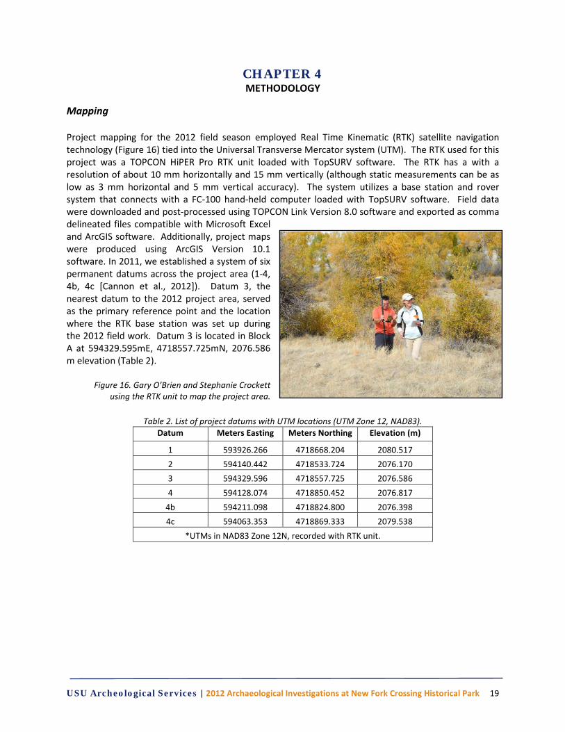
Mapping Project mapping for the 2012 field season employed Real Time Kinematic (RTK) satellite navigation technology (Figure 16) tied into the Universal Transverse Mercator system (UTM). The RTK used for this project was a TOPCON HiPER Pro RTK unit loaded with TopSURV software. The RTK has a with a resolution of about 10 mm horizontally and 15 mm vertically (although static measurements can be as low as 3 mm horizontal and 5 mm vertical accuracy). The system utilizes a base station and rover system that connects with a FC-100 hand-held computer loaded with TopSURV software. Field data were downloaded and post-processed using TOPCON Link Version 8.0 software and exported as comma delineated files compatible with Microsoft Excel and ArcGIS software. Additionally, project maps were produced using ArcGIS Version 10.1 software. In 2011, we established a system of six permanent datums across the project area (1-4, 4b, 4c [Cannon et al., 2012]). Datum 3, the nearest datum to the 2012 project area, served as the primary reference point and the location where the RTK base station was set up during the 2012 field work. Datum 3 is located in Block A at 594329.595mE, 4718557.725mN, 2076.586 m elevation (Table 2).
Figure 16. Gary O’Brien and Stephanie Crockett using the RTK unit to map the project area.
Table 2. List of project datums with UTM locations (UTM Zone 12, NAD83).
Datum Meters Easting Meters Northing Elevation (m)
1 593926.266 4718668.204 2080.517 2 594140.442 4718533.724 2076.170 3 594329.596 4718557.725 2076.586 4 594128.074 4718850.452 2076.817
4b 594211.098 4718824.800 2076.398 4c 594063.353 4718869.333 2079.538
*UTMs in NAD83 Zone 12N, recorded with RTK unit.
USU Archeological Services | 2012 Archaeological Investigations at New Fork Crossing Historical Park 20
Metal Detection Survey
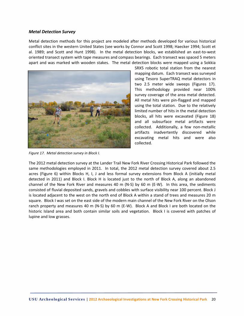
Metal detection methods for this project are modeled after methods developed for various historical conflict sites in the western United States (see works by Connor and Scott 1998; Haecker 1994; Scott et al. 1989; and Scott and Hunt 1998). In the metal detection blocks, we established an east-to-west oriented transect system with tape measures and compass bearings. Each transect was spaced 5 meters apart and was marked with wooden stakes. The metal detection blocks were mapped using a Sokkia
SRX5 robotic total station from the nearest mapping datum. Each transect was surveyed using Tesoro SuperTRAQ metal detectors in two 2.5 meter wide sweeps (Figures 17). This methodology provided near 100% survey coverage of the area metal detected. All metal hits were pin-flagged and mapped using the total station. Due to the relatively limited number of hits in the metal detection blocks, all hits were excavated (Figure 18) and all subsurface metal artifacts were collected. Additionally, a few non-metallic artifacts inadvertently discovered while excavating metal hits and were also collected.
Figure 17. Metal detection survey in Block I. The 2012 metal detection survey at the Lander Trail New Fork River Crossing Historical Park followed the same methodologies employed in 2011. In total, the 2012 metal detection survey covered about 2.5 acres (Figure 6) within Blocks H, I, J and less formal survey extensions from Block A (initially metal detected in 2011) and Block I. Block H is located just to the north of Block A, along an abandoned channel of the New Fork River and measures 40 m (N-S) by 60 m (E-W). In this area, the sediments consisted of fluvial deposited sands, gravels and cobbles with surface visibility near 100 percent. Block J is located adjacent to the west on the north end of Block A within a stand of trees and measures 20 m square. Block I was set on the east side of the modern main channel of the New Fork River on the Olson ranch property and measures 40 m (N-S) by 60 m (E-W). Block A and Block I are both located on the historic Island area and both contain similar soils and vegetation. Block I is covered with patches of lupine and low grasses.
USU Archeological Services | 2012 Archaeological Investigations at New Fork Crossing Historical Park 21
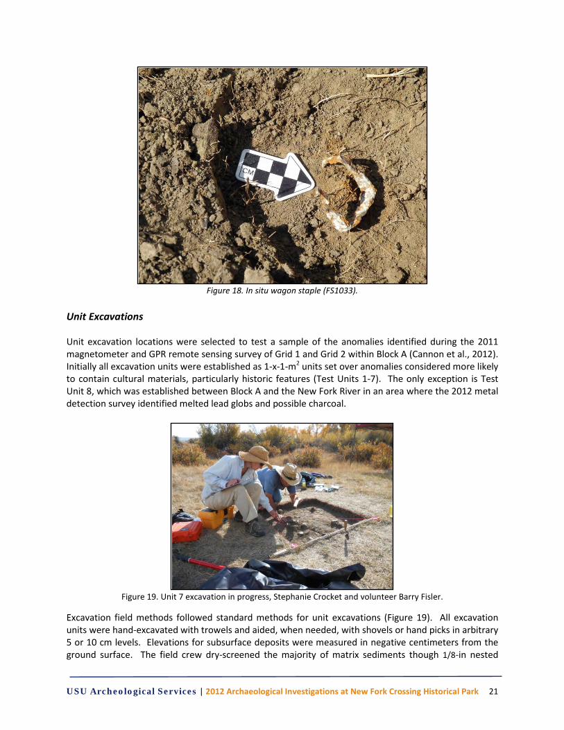
Figure 18. In situ wagon staple (FS1033).
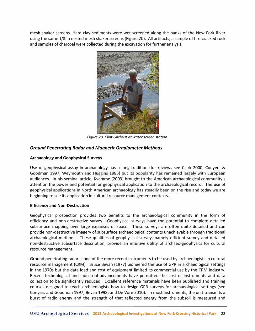
Unit Excavations Unit excavation locations were selected to test a sample of the anomalies identified during the 2011 magnetometer and GPR remote sensing survey of Grid 1 and Grid 2 within Block A (Cannon et al., 2012). Initially all excavation units were established as 1-x-1-m2 units set over anomalies considered more likely to contain cultural materials, particularly historic features (Test Units 1-7). The only exception is Test Unit 8, which was established between Block A and the New Fork River in an area where the 2012 metal detection survey identified melted lead globs and possible charcoal.
Figure 19. Unit 7 excavation in progress, Stephanie Crocket and volunteer Barry Fisler.
Excavation field methods followed standard methods for unit excavations (Figure 19). All excavation units were hand-excavated with trowels and aided, when needed, with shovels or hand picks in arbitrary 5 or 10 cm levels. Elevations for subsurface deposits were measured in negative centimeters from the ground surface. The field crew dry-screened the majority of matrix sediments though 1/8-in nested
USU Archeological Services | 2012 Archaeological Investigations at New Fork Crossing Historical Park 22
mesh shaker screens. Hard clay sediments were wet screened along the banks of the New Fork River using the same 1/8-in nested mesh shaker screens (Figure 20). All artifacts, a sample of fire-cracked rock and samples of charcoal were collected during the excavation for further analysis.
Figure 20. Clint Gilchrist at water screen station.
Ground Penetrating Radar and Magnetic Gradiometer Methods
Archaeology and Geophysical Surveys
Use of geophysical assay in archaeology has a long tradition (for reviews see Clark 2000; Conyers & Goodman 1997; Weymouth and Huggins 1985) but its popularity has remained largely with European audiences. In his seminal article, Kvamme (2003) brought to the American archaeological community’s attention the power and potential for geophysical application to the archaeological record. The use of geophysical applications in North American archaeology has steadily been on the rise and today we are beginning to see its application in cultural resource management contexts.
Efficiency and Non-Destruction
Geophysical prospection provides two benefits to the archaeological community in the form of efficiency and non-destructive survey. Geophysical surveys have the potential to complete detailed subsurface mapping over large expanses of space. These surveys are often quite detailed and can provide non-destructive imagery of subsurface archaeological contents unachievable through traditional archaeological methods. These qualities of geophysical survey, namely efficient survey and detailed non-destructive subsurface description, provide an intuitive utility of archaeo-geophysics for cultural resource management.
Ground penetrating radar is one of the more recent instruments to be used by archaeologists in cultural resource management (CRM). Bruce Bevan (1977) pioneered the use of GPR in archaeological settings in the 1970s but the data load and cost of equipment limited its commercial use by the CRM industry. Recent technological and industrial advancements have permitted the cost of instruments and data collection to be significantly reduced. Excellent reference materials have been published and training courses designed to teach archaeologists how to design GPR surveys for archaeological settings (see Conyers and Goodman 1997; Bevan 1998; and De Vore 2010). In most instruments, the unit transmits a burst of radio energy and the strength of that reflected energy from the subsoil is measured and
USU Archeological Services | 2012 Archaeological Investigations at New Fork Crossing Historical Park 23
recorded. It is the combination of the time and the strength of the reflected signal that provides the data necessary to infer anomalous readings. There is a tradeoff between depth penetration of a signal and detail. Lower frequency antennas have longer wavelengths and therefore can penetrate to lower depths but they cannot resolve objects or strata that are as small as those detected by higher frequency antenna. Depth is also dependent upon soil conditions. Soils that retain high moisture levels will absorb more of the radio energy of the transmitted signal making object identification difficult. GPR processing permits the analyst to view the data in profile along transects to see the reflected energy at multiple depth levels as well as a composite plan image. The plan maps must be viewed at one depth or time slice interval.
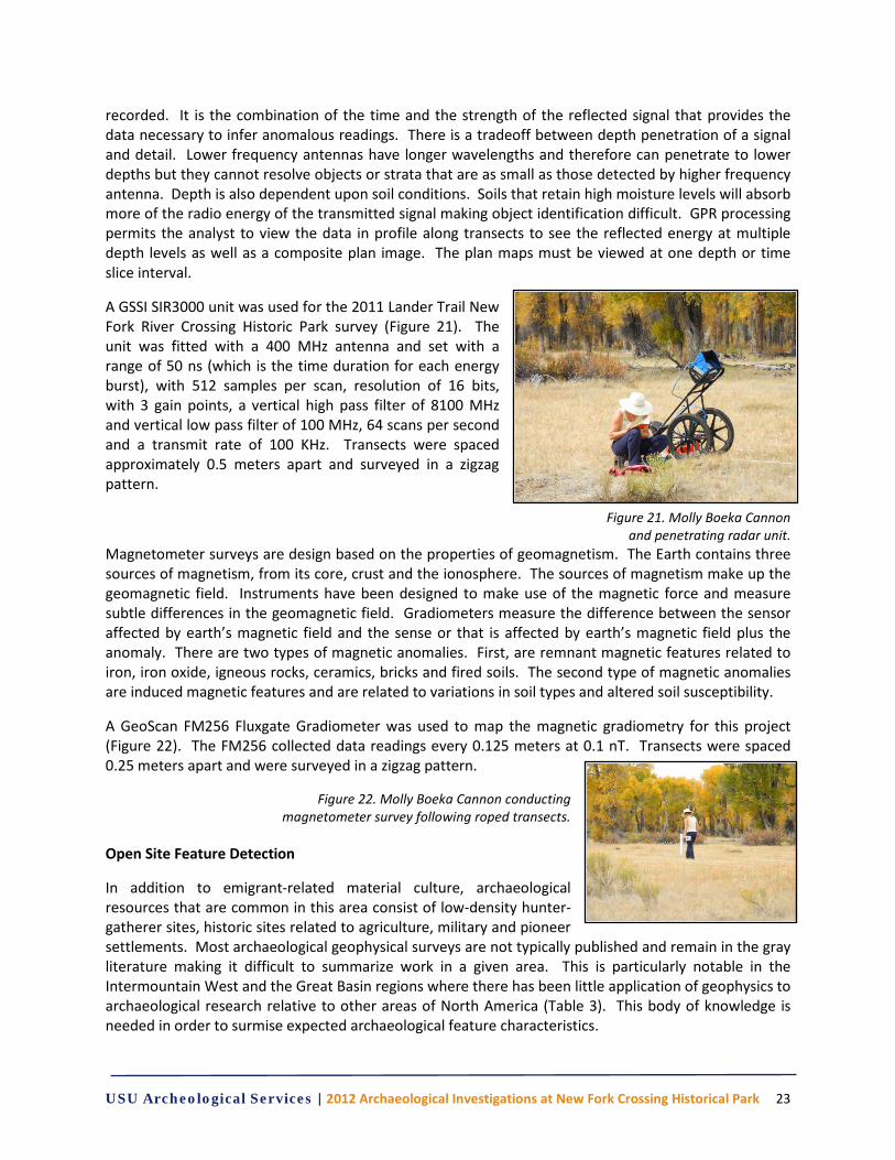
A GSSI SIR3000 unit was used for the 2011 Lander Trail New Fork River Crossing Historic Park survey (Figure 21). The unit was fitted with a 400 MHz antenna and set with a range of 50 ns (which is the time duration for each energy burst), with 512 samples per scan, resolution of 16 bits, with 3 gain points, a vertical high pass filter of 8100 MHz and vertical low pass filter of 100 MHz, 64 scans per second and a transmit rate of 100 KHz. Transects were spaced approximately 0.5 meters apart and surveyed in a zigzag pattern.
Figure 21. Molly Boeka Cannon and penetrating radar unit.
Magnetometer surveys are design based on the properties of geomagnetism. The Earth contains three sources of magnetism, from its core, crust and the ionosphere. The sources of magnetism make up the geomagnetic field. Instruments have been designed to make use of the magnetic force and measure subtle differences in the geomagnetic field. Gradiometers measure the difference between the sensor affected by earth’s magnetic field and the sense or that is affected by earth’s magnetic field plus the anomaly. There are two types of magnetic anomalies. First, are remnant magnetic features related to iron, iron oxide, igneous rocks, ceramics, bricks and fired soils. The second type of magnetic anomalies are induced magnetic features and are related to variations in soil types and altered soil susceptibility.
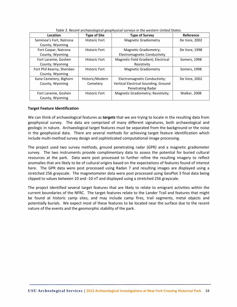
A GeoScan FM256 Fluxgate Gradiometer was used to map the magnetic gradiometry for this project (Figure 22). The FM256 collected data readings every 0.125 meters at 0.1 nT. Transects were spaced 0.25 meters apart and were surveyed in a zigzag pattern.
Figure 22. Molly Boeka Cannon conducting magnetometer survey following roped transects.
Open Site Feature Detection
In addition to emigrant-related material culture, archaeological resources that are common in this area consist of low-density hunter-gatherer sites, historic sites related to agriculture, military and pioneer settlements. Most archaeological geophysical surveys are not typically published and remain in the gray literature making it difficult to summarize work in a given area. This is particularly notable in the Intermountain West and the Great Basin regions where there has been little application of geophysics to archaeological research relative to other areas of North America (Table 3). This body of knowledge is needed in order to surmise expected archaeological feature characteristics.
USU Archeological Services | 2012 Archaeological Investigations at New Fork Crossing Historical Park 24
Table 3. Recent archaeological geophysical surveys in the western United States. Location Type of Site Type of Survey Reference
Seminoe’s Fort, Natrona County, Wyoming
Historic Fort Magnetic Gradiometry De Vore, 2002
Fort Caspar, Natrona County, Wyoming
Historic Fort Magnetic Gradiometry; Electromagnetic Conductivity
De Vore, 1998
Fort Laramie, Goshen County, Wyoming
Historic Fort Magnetic Field Gradient; Electrical Resistivity
Somers, 1998
Fort Phil Kearny, Sheridan County, Wyoming
Historic Fort Magnetic Gradiometry Somers, 1998
Kane Cemetery, Bighorn County, Wyoming
Historic/Modern Cemetery
Electromagnetic Conductivity; Vertical Electrical Sounding, Ground
Penetrating Radar
De Vore, 2002
Fort Laramie, Goshen County, Wyoming
Historic Fort Magnetic Gradiometry; Resistivity; Walker, 2008
Target Feature Identification
We can think of archaeological features as targets that we are trying to locate in the resulting data from geophysical survey. The data are comprised of many different signatures, both archaeological and geologic in nature. Archaeological target features must be separated from the background or the noise in the geophysical data. There are several methods for achieving target feature identification which include multi-method survey design and sophisticated computational image processing.
The project used two survey methods, ground penetrating radar (GPR) and a magnetic gradiometer survey. The two instruments provide complimentary data to assess the potential for buried cultural resources at the park. Data were post processed to further refine the resulting imagery to reflect anomalies that are likely to be of cultural origins based on the expectations of features found of interest here. The GPR data were post processed using Radan 7 and resulting images are displayed using a stretched 256 grayscale. The magnetometer data were post processed using GeoPlot 3 final data being clipped to values between 10 and -10 nT and displayed using a stretched 256 grayscale.
The project identified several target features that are likely to relate to emigrant activities within the current boundaries of the NFRC. The target features relate to the Lander Trail and features that might be found at historic camp sites, and may include camp fires, trail segments, metal objects and potentially burials. We expect most of these features to be located near the surface due to the recent nature of the events and the geomorphic stability of the park.
USU Archeological Services | 2012 Archaeological Investigations at New Fork Crossing Historical Park 25
CHAPTER 5 RESULTS
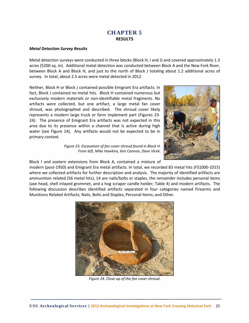
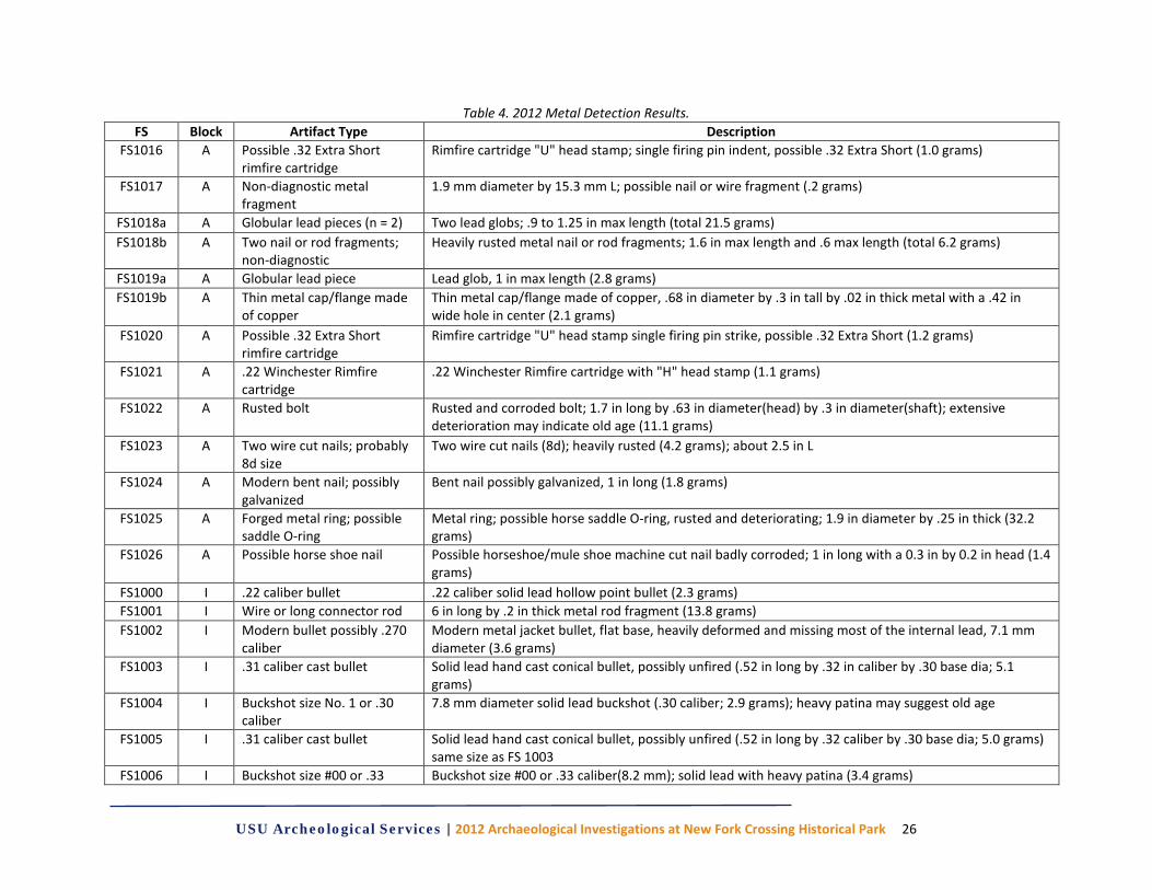
Metal Detection Survey Results Metal detection surveys were conducted in three blocks (Block H, I and J) and covered approximately 1.3 acres (5200 sq. m). Additional metal detection was conducted between Block A and the New Fork River, between Block A and Block H, and just to the north of Block J totaling about 1.2 additional acres of survey. In total, about 2.5 acres were metal detected in 2012. Neither, Block H or Block J contained possible Emigrant Era artifacts. In fact, Block J contained no metal hits. Block H contained numerous but exclusively modern materials or non-identifiable metal fragments. No artifacts were collected, but one artifact, a large metal fan cover shroud, was photographed and described. The shroud cover likely represents a modern large truck or farm implement part (Figures 23-24). The presence of Emigrant Era artifacts was not expected in this area due to its presence within a channel that is active during high water (see Figure 14). Any artifacts would not be expected to be in primary context.
Figure 23. Excavation of fan cover shroud found in Block H. From left, Mike Hawkins, Ken Cannon, Dave Vlcek.
Block I and eastern extensions from Block A, contained a mixture of modern (post-1950) and Emigrant Era metal artifacts. In total, we recorded 83 metal hits (FS1000-1015) where we collected artifacts for further description and analysis. The majority of identified artifacts are ammunition related (56 metal hits), 14 are nails/bolts or staples, the remainder includes personal items (axe head, shell inlayed grommet, and a hog scraper candle holder; Table 4) and modern artifacts. The following discussion describes identified artifacts separated in four categories named Firearms and Munitions Related Artifacts; Nails, Bolts and Staples; Personal Items; and Other.
Figure 24. Close-up of the fan cover shroud.
USU Archeological Services | 2012 Archaeological Investigations at New Fork Crossing Historical Park 26
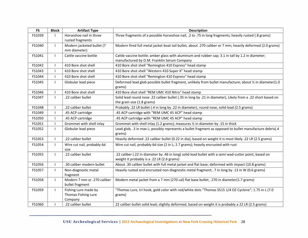
Table 4. 2012 Metal Detection Results. FS Block Artifact Type Description
FS1016 A Possible .32 Extra Short rimfire cartridge
Rimfire cartridge "U" head stamp; single firing pin indent, possible .32 Extra Short (1.0 grams)
FS1017 A Non-diagnostic metal fragment
1.9 mm diameter by 15.3 mm L; possible nail or wire fragment (.2 grams)
FS1018a A Globular lead pieces (n = 2) Two lead globs; .9 to 1.25 in max length (total 21.5 grams) FS1018b A Two nail or rod fragments;
non-diagnostic Heavily rusted metal nail or rod fragments; 1.6 in max length and .6 max length (total 6.2 grams)
FS1019a A Globular lead piece Lead glob, 1 in max length (2.8 grams) FS1019b A Thin metal cap/flange made
of copper Thin metal cap/flange made of copper, .68 in diameter by .3 in tall by .02 in thick metal with a .42 in wide hole in center (2.1 grams)
FS1020 A Possible .32 Extra Short rimfire cartridge
Rimfire cartridge "U" head stamp single firing pin strike, possible .32 Extra Short (1.2 grams)
FS1021 A .22 Winchester Rimfire cartridge
.22 Winchester Rimfire cartridge with "H" head stamp (1.1 grams)
FS1022 A Rusted bolt Rusted and corroded bolt; 1.7 in long by .63 in diameter(head) by .3 in diameter(shaft); extensive deterioration may indicate old age (11.1 grams)
FS1023 A Two wire cut nails; probably 8d size
Two wire cut nails (8d); heavily rusted (4.2 grams); about 2.5 in L
FS1024 A Modern bent nail; possibly galvanized
Bent nail possibly galvanized, 1 in long (1.8 grams)
FS1025 A Forged metal ring; possible saddle O-ring
Metal ring; possible horse saddle O-ring, rusted and deteriorating; 1.9 in diameter by .25 in thick (32.2 grams)
FS1026 A Possible horse shoe nail Possible horseshoe/mule shoe machine cut nail badly corroded; 1 in long with a 0.3 in by 0.2 in head (1.4 grams)
FS1000 I .22 caliber bullet .22 caliber solid lead hollow point bullet (2.3 grams) FS1001 I Wire or long connector rod 6 in long by .2 in thick metal rod fragment (13.8 grams) FS1002 I Modern bullet possibly .270
caliber Modern metal jacket bullet, flat base, heavily deformed and missing most of the internal lead, 7.1 mm diameter (3.6 grams)
FS1003 I .31 caliber cast bullet Solid lead hand cast conical bullet, possibly unfired (.52 in long by .32 in caliber by .30 base dia; 5.1 grams)
FS1004 I Buckshot size No. 1 or .30 caliber
7.8 mm diameter solid lead buckshot (.30 caliber; 2.9 grams); heavy patina may suggest old age
FS1005 I .31 caliber cast bullet Solid lead hand cast conical bullet, possibly unfired (.52 in long by .32 caliber by .30 base dia; 5.0 grams) same size as FS 1003
FS1006 I Buckshot size #00 or .33 Buckshot size #00 or .33 caliber(8.2 mm); solid lead with heavy patina (3.4 grams)

USU Archeological Services | 2012 Archaeological Investigations at New Fork Crossing Historical Park 27
FS Block Artifact Type Description caliber
FS1007 I Buckshot size No. 1 or .30 caliber
7.8 mm diameter solid lead buckshot (2.9 grams) with heavy patina
FS1008 I Six wire cut nails; 8d and 10d size
Six modern wire cut nails including five 2.5 in long (8d) and one 3 in long (10d); all straight (total 21.5 grams)
FS1009 I Wire cut nail size 8d Wire cut nail 2.5 in long (2.9 grams); probably 8d FS1010 I 410 Bore shot shell 410 Bore shot shell cartridge; “WESTERN 410 SUPER X MADE IN USA” head stamp FS1011 I Two bent rusty nails Two possible nail fragments, heavily rusted; both about 1 ½ in long by .16 in thick (total 6.1 grams) FS1012 I Broken axe/hatchet head Axe or hatchet head, broken at haft; heavily rusted and flaking measures 3.5 in max wide by 3.5 in max
long by 1.0 in thick FS1013 I .300 SAV cartridge .300 SAV cartridge; "SUPER-X 300 SAV" head stamp, crushed FS1014 I .22 caliber bullet Solid lead, slightly deformed (indicating it was fired), round nose bullet, just shy of .22 caliber (.21 in
dia); its size and weight (1.8 grams) suggest it is a .22 Short bullet FS1015 I .44 WCF cartridge .44 WCF cartridge "W.R.A. Co. 44 W.C.F" head stamp (5.4 grams) FS1027 I Possible horse shoe nail Possible horseshoe/mule shoe machine cut nail; 2 in long with head .34 in by .25 in (2.5 grams) FS1028 I Buckshot size No. 4 or .22
caliber Buckshot No. 4 size; deformed about 5.6 mm diameter (.22 in; .9 grams)
FS1029 I Percussion cap (unfired) Unfired percussion cap; either No. 10 or No. 11 size; .2 grams; .232 in tall by .19 in diameter at cap FS1030 I .22 caliber bullet Probably .22 LR modern bullet solid lead round nose; .45 in long by 0.22 in diameter (2.4 grams) FS1031 I .22 caliber bullet Solid lead , slightly deformed (indicating it was fired), round nose bullet, just shy of .22 caliber; .38 in
long by .21 in diameter; possible .22 Short bullet (1.8 grams) FS1032 I Possible thick can or
container fragments Possible can body and rim fragments; heavily rusted; about 10 fragments; between ½ and 4 in max length (64.0 grams)
FS1033 I Wagon staple Staple measuring 1 ¾ in by .6 in (head) with 1.5 in long spikes FS1034 I Tent stake 11 in long, .25-.32 in thick, metal rod with a bend over head and a rounded sharp point opposite end,
appears to be a tent stake; corroded (68.4 grams) FS1035 I Candle holder “Hog Scraper” "Hog Scraper"; possible wax and ash within the tube; missing base, partially crushed or run-over by a
wagon? (52.9 grams) FS1036 I Possible deformed .31
caliber bullet Solid lead bullet heavily deformed possible .31 Caliber (5.4 grams); matches closely FS1003
FS1037 I Non-diagnostic metal fragment
Metal fragment; rusted and corroded; unidentifiable; 1.2 in long by .7 in W by .2 in thick (5.9 grams)
FS1038 I Six shot size 5 pellets Eleven shotgun shot size 5 pellets; diameter 3 mm (.12 in) diameter(1.8 grams total)
USU Archeological Services | 2012 Archaeological Investigations at New Fork Crossing Historical Park 28
FS Block Artifact Type Description FS1039 I Horseshoe nail in three
rusted fragments Three fragments of a possible horseshoe nail, .2 to .75 in long fragments; heavily rusted (.8 grams)
FS1040 I Modern jacketed bullet (7 mm diameter)
Modern fired full metal jacket boat tail bullet, about .270 caliber or 7 mm; heavily deformed (2.0 grams)
FS1041 I Cattle vaccine bottle Cattle vaccine bottle; amber glass with aluminum and rubber cap; 3.1 in tall by 1.2 in diameter; manufactured by O.M. Franklin Serum Company
FS1042 I 410 Bore shot shell 410 Bore shot shell "Remington 410 Express" head stamp FS1043 I 410 Bore shot shell 410 Bore shot shell "Western 410 Super X” head stamp FS1044 I 410 Bore shot shell 410 Bore shot shell "Remington 410 Express" head stamp FS1045 I Globular lead piece Deformed lead glob possible bullet fragment, unlikely from bullet manufacture; about ½ in diameter(1.0
grams) FS1046 I 410 Bore shot shell 410 Bore shot shell "REM UMC 410 Nitro" head stamp FS1047 I .22 caliber bullet Solid lead round nose .22 caliber bullet (.35 in long by .21 in diameter), Likely from a .22 short based on
the grain size (1.8 grams) FS1048 I .22 caliber bullet Probably .22 LR bullet (.4 in long by .22 in diameter), round nose, solid lead (2.5 grams) FS1049 I .45 ACP cartridge .45 ACP cartridge with "REM UMC 45 ACP" head stamp FS1050 I .45 ACP cartridge .45 ACP cartridge with "REM UMC 45 ACP" head stamp FS1051 I Grommet with shell inlay Grommet with shell inlay (1.2 grams); measures ½ in diameter by .15 in thick FS1052 I Globular lead piece Lead glob, .3 in max L; possibly represents a bullet fragment as opposed to bullet manufacture debris(.4
grams) FS1053 I .22 caliber bullet Heavily deformed .22 caliber bullet (0.22 in dia); based on weight it is most likely .22 LR (2.5 grams) FS1054 I Wire cut nail, probably 6d
size Wire cut nail, probably 6d size (2 in L; 2.7 grams); heavily encrusted with rust
FS1055 I .22 caliber bullet .22 caliber (.22 in diameter by .46 in long) solid lead bullet with a semi wad-cutter point, based on weight it probably is a .22 LR (2.6 grams)
FS1056 I .30 caliber modern bullet About .30 caliber bullet with full metal jacket and flat base; deformed with impact (10.8 grams) FS1057 I Non-diagnostic metal
fragment Heavily rusted and encrusted non-diagnostic metal fragment; .7 in long by .13 in W (0.6 grams)
FS1058 I Modern 7 mm or .270 caliber bullet fragment
Modern metal jacket from a 7 mm (270 cal) flat base bullet; .270 in diameter(1.7 grams)
FS1059 I Fishing Lure made by Thomas Fishing Lure Company
"Thomas Lure, tri hook, gold color with red/white dots "Thomas S515 1/4 OZ Cyclone"; 1.75 in L (7.0 grams)
FS1060 I .22 caliber bullet 22 caliber bullet solid lead; slightly deformed, based on weight it is probably a 22 LR (2.5 grams)
USU Archeological Services | 2012 Archaeological Investigations at New Fork Crossing Historical Park 29
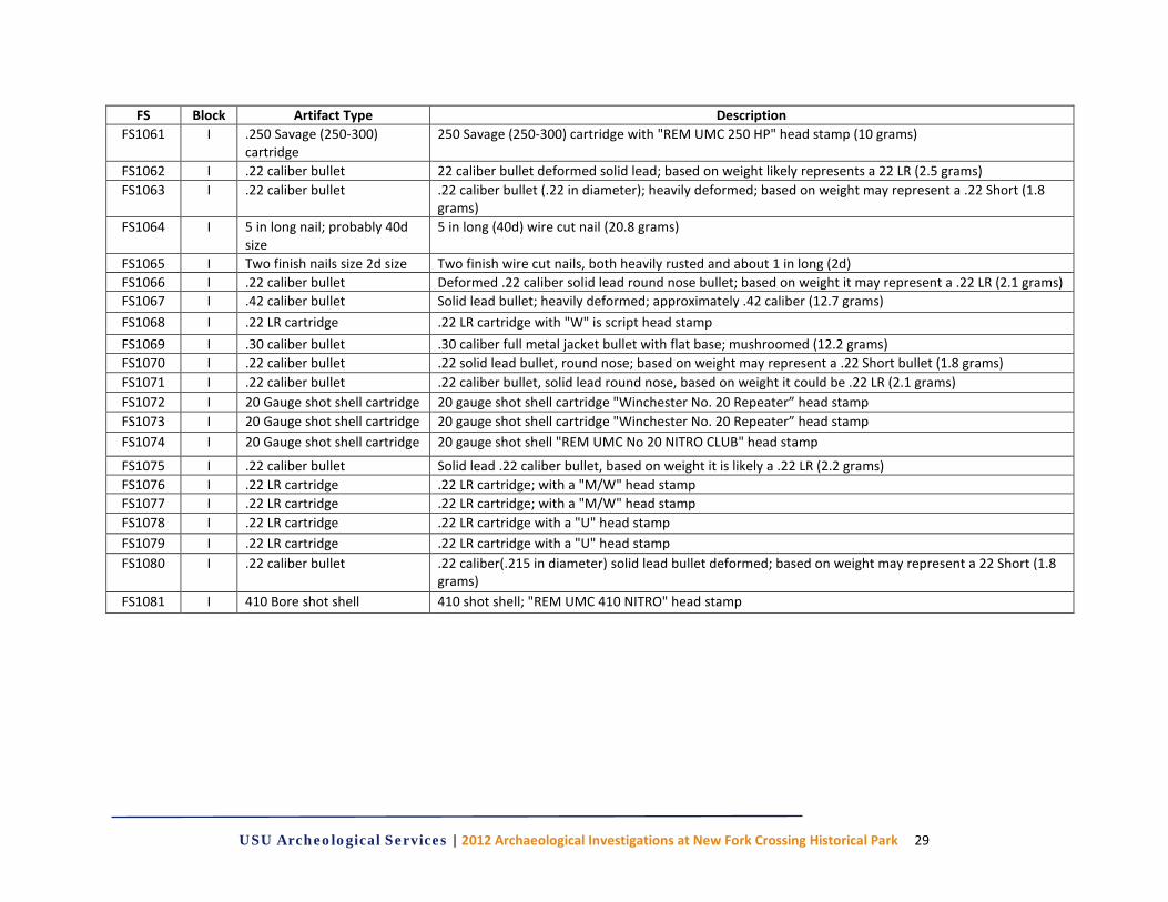
FS Block Artifact Type Description FS1061 I .250 Savage (250-300)
cartridge 250 Savage (250-300) cartridge with "REM UMC 250 HP" head stamp (10 grams)
FS1062 I .22 caliber bullet 22 caliber bullet deformed solid lead; based on weight likely represents a 22 LR (2.5 grams) FS1063 I .22 caliber bullet .22 caliber bullet (.22 in diameter); heavily deformed; based on weight may represent a .22 Short (1.8
grams) FS1064 I 5 in long nail; probably 40d
size 5 in long (40d) wire cut nail (20.8 grams)
FS1065 I Two finish nails size 2d size Two finish wire cut nails, both heavily rusted and about 1 in long (2d) FS1066 I .22 caliber bullet Deformed .22 caliber solid lead round nose bullet; based on weight it may represent a .22 LR (2.1 grams) FS1067 I .42 caliber bullet Solid lead bullet; heavily deformed; approximately .42 caliber (12.7 grams) FS1068 I .22 LR cartridge .22 LR cartridge with "W" is script head stamp FS1069 I .30 caliber bullet .30 caliber full metal jacket bullet with flat base; mushroomed (12.2 grams) FS1070 I .22 caliber bullet .22 solid lead bullet, round nose; based on weight may represent a .22 Short bullet (1.8 grams) FS1071 I .22 caliber bullet .22 caliber bullet, solid lead round nose, based on weight it could be .22 LR (2.1 grams) FS1072 I 20 Gauge shot shell cartridge 20 gauge shot shell cartridge "Winchester No. 20 Repeater” head stamp FS1073 I 20 Gauge shot shell cartridge 20 gauge shot shell cartridge "Winchester No. 20 Repeater” head stamp FS1074 I 20 Gauge shot shell cartridge 20 gauge shot shell "REM UMC No 20 NITRO CLUB" head stamp
FS1075 I .22 caliber bullet Solid lead .22 caliber bullet, based on weight it is likely a .22 LR (2.2 grams) FS1076 I .22 LR cartridge .22 LR cartridge; with a "M/W" head stamp FS1077 I .22 LR cartridge .22 LR cartridge; with a "M/W" head stamp FS1078 I .22 LR cartridge .22 LR cartridge with a "U" head stamp FS1079 I .22 LR cartridge .22 LR cartridge with a "U" head stamp FS1080 I .22 caliber bullet .22 caliber(.215 in diameter) solid lead bullet deformed; based on weight may represent a 22 Short (1.8
grams) FS1081 I 410 Bore shot shell 410 shot shell; "REM UMC 410 NITRO" head stamp
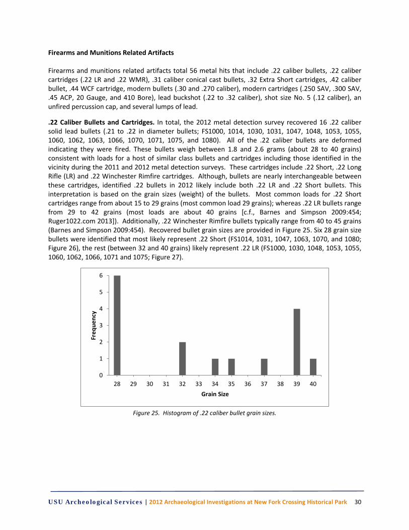
USU Archeological Services | 2012 Archaeological Investigations at New Fork Crossing Historical Park 30
Firearms and Munitions Related Artifacts Firearms and munitions related artifacts total 56 metal hits that include .22 caliber bullets, .22 caliber cartridges (.22 LR and .22 WMR), .31 caliber conical cast bullets, .32 Extra Short cartridges, .42 caliber bullet, .44 WCF cartridge, modern bullets (.30 and .270 caliber), modern cartridges (.250 SAV, .300 SAV, .45 ACP, 20 Gauge, and 410 Bore), lead buckshot (.22 to .32 caliber), shot size No. 5 (.12 caliber), an unfired percussion cap, and several lumps of lead.
.22 Caliber Bullets and Cartridges. In total, the 2012 metal detection survey recovered 16 .22 caliber solid lead bullets (.21 to .22 in diameter bullets; FS1000, 1014, 1030, 1031, 1047, 1048, 1053, 1055, 1060, 1062, 1063, 1066, 1070, 1071, 1075, and 1080). All of the .22 caliber bullets are deformed indicating they were fired. These bullets weigh between 1.8 and 2.6 grams (about 28 to 40 grains) consistent with loads for a host of similar class bullets and cartridges including those identified in the vicinity during the 2011 and 2012 metal detection surveys. These cartridges include .22 Short, .22 Long Rifle (LR) and .22 Winchester Rimfire cartridges. Although, bullets are nearly interchangeable between these cartridges, identified .22 bullets in 2012 likely include both .22 LR and .22 Short bullets. This interpretation is based on the grain sizes (weight) of the bullets. Most common loads for .22 Short cartridges range from about 15 to 29 grains (most common load 29 grains); whereas .22 LR bullets range from 29 to 42 grains (most loads are about 40 grains [c.f., Barnes and Simpson 2009:454; Ruger1022.com 2013]). Additionally, .22 Winchester Rimfire bullets typically range from 40 to 45 grains (Barnes and Simpson 2009:454). Recovered bullet grain sizes are provided in Figure 25. Six 28 grain size bullets were identified that most likely represent .22 Short (FS1014, 1031, 1047, 1063, 1070, and 1080; Figure 26), the rest (between 32 and 40 grains) likely represent .22 LR (FS1000, 1030, 1048, 1053, 1055, 1060, 1062, 1066, 1071 and 1075; Figure 27).
Figure 25. Histogram of .22 caliber bullet grain sizes.
0
1
2
3
4
5
6
28 29 30 31 32 33 34 35 36 37 38 39 40
Freq
uenc
y
Grain Size
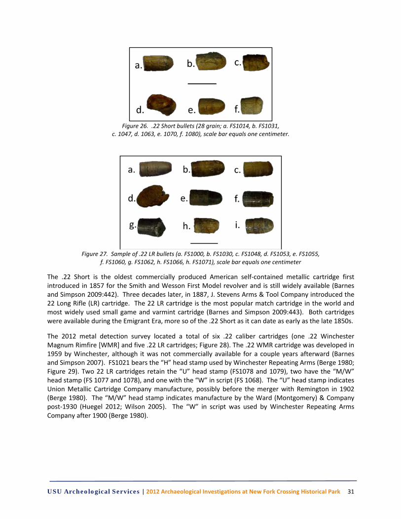
USU Archeological Services | 2012 Archaeological Investigations at New Fork Crossing Historical Park 31
Figure 26. .22 Short bullets (28 grain; a. FS1014, b. FS1031,
c. 1047, d. 1063, e. 1070, f. 1080), scale bar equals one centimeter.
Figure 27. Sample of .22 LR bullets (a. FS1000, b. FS1030, c. FS1048, d. FS1053, e. FS1055,
f. FS1060, g. FS1062, h. FS1066, h. FS1071), scale bar equals one centimeter
The .22 Short is the oldest commercially produced American self-contained metallic cartridge first introduced in 1857 for the Smith and Wesson First Model revolver and is still widely available (Barnes and Simpson 2009:442). Three decades later, in 1887, J. Stevens Arms & Tool Company introduced the 22 Long Rifle (LR) cartridge. The 22 LR cartridge is the most popular match cartridge in the world and most widely used small game and varmint cartridge (Barnes and Simpson 2009:443). Both cartridges were available during the Emigrant Era, more so of the .22 Short as it can date as early as the late 1850s.
The 2012 metal detection survey located a total of six .22 caliber cartridges (one .22 Winchester Magnum Rimfire [WMR] and five .22 LR cartridges; Figure 28). The .22 WMR cartridge was developed in 1959 by Winchester, although it was not commercially available for a couple years afterward (Barnes and Simpson 2007). FS1021 bears the “H” head stamp used by Winchester Repeating Arms (Berge 1980; Figure 29). Two 22 LR cartridges retain the “U” head stamp (FS1078 and 1079), two have the “M/W” head stamp (FS 1077 and 1078), and one with the “W” in script (FS 1068). The “U” head stamp indicates Union Metallic Cartridge Company manufacture, possibly before the merger with Remington in 1902 (Berge 1980). The “M/W” head stamp indicates manufacture by the Ward (Montgomery) & Company post-1930 (Huegel 2012; Wilson 2005). The “W” in script was used by Winchester Repeating Arms Company after 1900 (Berge 1980).
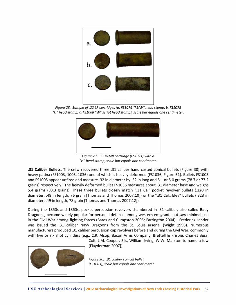
USU Archeological Services | 2012 Archaeological Investigations at New Fork Crossing Historical Park 32
Figure 28. Sample of .22 LR cartridges (a. FS1076 “M/W” head stamp, b. FS1078
“U” head stamp, c. FS1068 “W” script head stamp), scale bar equals one centimeter.
Figure 29. .22 WMR cartridge (FS1021) with a
“H” head stamp, scale bar equals one centimeter.
.31 Caliber Bullets. The crew recovered three .31 caliber hand casted conical bullets (Figure 30) with heavy patina (FS1003, 1005, 1036) one of which is heavily deformed (FS1036; Figure 31). Bullets FS1003 and FS1005 appear unfired and measure .32 in diameter by .52 in long and 5.1 or 5.0 grams (78.7 or 77.2 grains) respectively. The heavily deformed bullet FS1036 measures about .31 diameter base and weighs 5.4 grams (83.3 grains). These three bullets closely match ".31 Cal" pocket revolver bullets (.320 in diameter, .48 in length, 76 grain [Thomas and Thomas 2007:10]) or the ".31 Cal., Eley" bullets (.323 in diameter, .49 in length, 78 grain [Thomas and Thomas 2007:12]).
During the 1850s and 1860s, pocket percussion revolvers chambered in .31 caliber, also called Baby Dragoons, became widely popular for personal defense among western emigrants but saw minimal use in the Civil War among fighting forces (Bates and Cumpston 2005; Farrington 2004). Frederick Lander was issued the .31 caliber Navy Dragoons from the St. Louis arsenal (Wight 1993). Numerous manufacturers produced .31 caliber percussion cap revolvers before and during the Civil War, commonly with five or six shot cylinders (e.g., C.R. Alsop, Bacon Arms Company, Brettell & Frisbie, Charles Buss,
Colt, J.M. Cooper, Ells, William Irving, W.W. Marston to name a few [Flayderman 2007]).
Figure 30. .31 caliber conical bullet (FS1003), scale bar equals one centimeter.
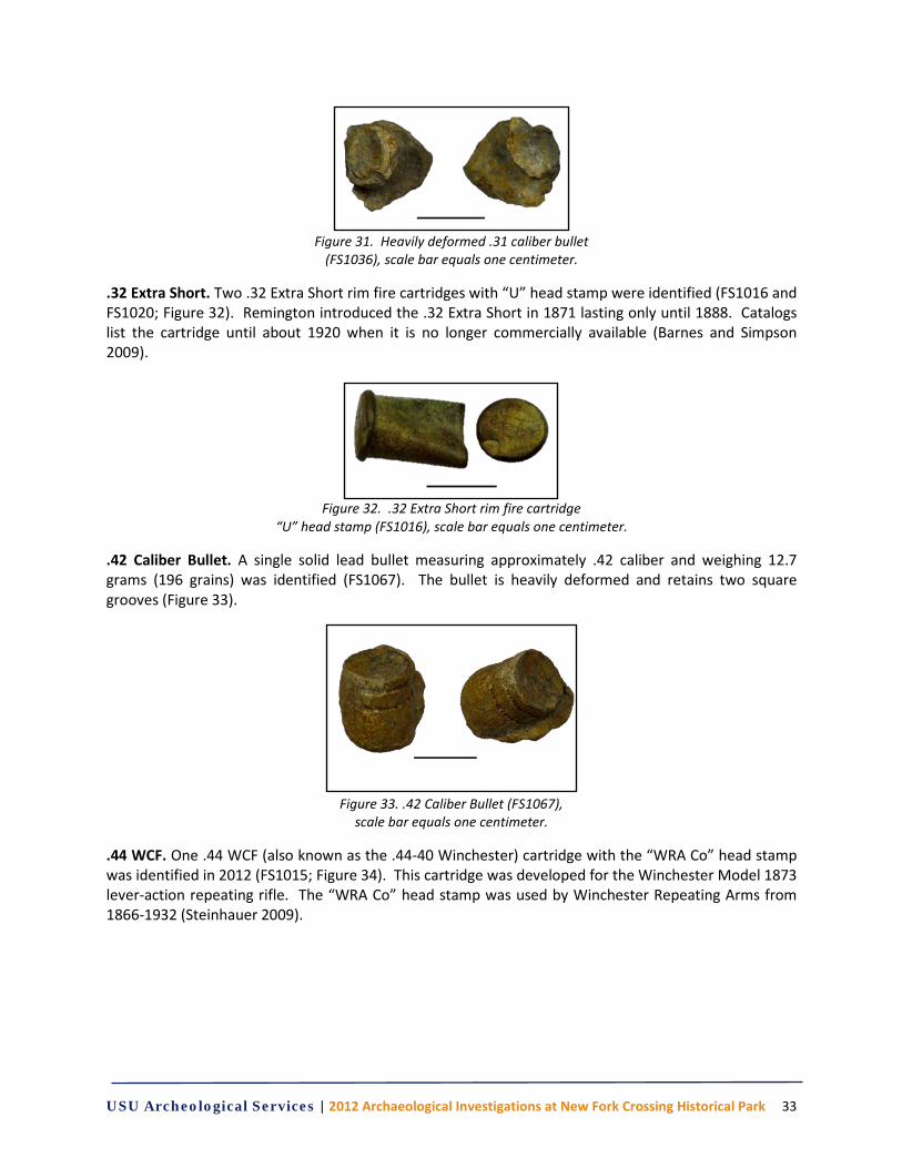
USU Archeological Services | 2012 Archaeological Investigations at New Fork Crossing Historical Park 33
Figure 31. Heavily deformed .31 caliber bullet
(FS1036), scale bar equals one centimeter.
.32 Extra Short. Two .32 Extra Short rim fire cartridges with “U” head stamp were identified (FS1016 and FS1020; Figure 32). Remington introduced the .32 Extra Short in 1871 lasting only until 1888. Catalogs list the cartridge until about 1920 when it is no longer commercially available (Barnes and Simpson 2009).
Figure 32. .32 Extra Short rim fire cartridge
“U” head stamp (FS1016), scale bar equals one centimeter.
.42 Caliber Bullet. A single solid lead bullet measuring approximately .42 caliber and weighing 12.7 grams (196 grains) was identified (FS1067). The bullet is heavily deformed and retains two square grooves (Figure 33).
Figure 33. .42 Caliber Bullet (FS1067),
scale bar equals one centimeter.
.44 WCF. One .44 WCF (also known as the .44-40 Winchester) cartridge with the “WRA Co” head stamp was identified in 2012 (FS1015; Figure 34). This cartridge was developed for the Winchester Model 1873 lever-action repeating rifle. The “WRA Co” head stamp was used by Winchester Repeating Arms from 1866-1932 (Steinhauer 2009).
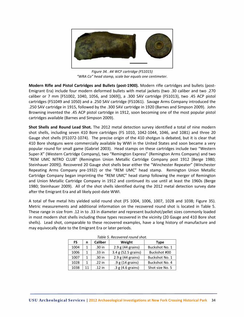
USU Archeological Services | 2012 Archaeological Investigations at New Fork Crossing Historical Park 34
Figure 34. .44 WCF cartridge (FS1015)
“WRA Co” head stamp, scale bar equals one centimeter.
Modern Rifle and Pistol Cartridges and Bullets (post-1900). Modern rifle cartridges and bullets (post-Emigrant Era) include four modern deformed bullets with metal jackets (two .30 caliber and two .270 caliber or 7 mm [FS1002, 1040, 1056, and 1069]), a .300 SAV cartridge (FS1013), two .45 ACP pistol cartridges (FS1049 and 1050) and a .250 SAV cartridge (FS1061). Savage Arms Company introduced the .250 SAV cartridge in 1915, followed by the .300 SAV cartridge in 1920 (Barnes and Simpson 2009). John Browning invented the .45 ACP pistol cartridge in 1912, soon becoming one of the most popular pistol cartridges available (Barnes and Simpson 2009).
Shot Shells and Round Lead Shot. The 2012 metal detection survey identified a total of nine modern shot shells, including seven 410 Bore cartridges (FS 1010, 1042-1044, 1046, and 1081) and three 20 Gauge shot shells (FS1072-1074). The precise origin of the 410 shotgun is debated, but it is clear that 410 Bore shotguns were commercially available by WWI in the United States and soon became a very popular round for small game (Gabriel 2003). Head stamps on these cartridges include two “Western Super-X” (Western Cartridge Company), two “Remington Express” (Remington Arms Company) and two “REM UMC NITRO CLUB” (Remington Union Metallic Cartridge Company post 1912 [Berge 1980; Steinhauer 2009]). Recovered 20 Gauge shot shells bear either the “Winchester Repeater” (Winchester Repeating Arms Company pre-1932) or the “REM UMC” head stamp. Remington Union Metallic Cartridge Company began imprinting the “REM UMC” head stamp following the merger of Remington and Union Metallic Cartridge Company in 1912 and continued its use until at least the 1960s (Berge 1980; Steinhauer 2009). All of the shot shells identified during the 2012 metal detection survey date after the Emigrant Era and all likely post-date WWI.
A total of five metal hits yielded solid round shot (FS 1004, 1006, 1007, 1028 and 1038; Figure 35). Metric measurements and additional information on the recovered round shot is located in Table 5. These range in size from .12 in to .33 in diameter and represent buckshot/pellet sizes commonly loaded in most modern shot shells including those types recovered in the vicinity (20 Gauge and 410 Bore shot shells). Lead shot, comparable to these recovered examples, have a long history of manufacture and may equivocally date to the Emigrant Era or later periods.
Table 5. Recovered round shot. FS n Caliber Weight Type
1004 1 .30 in 2.9 g (44 grains) Buckshot No. 1 1006 1 .33 in 3.4 g (52.5 grains) Buckshot #00 1007 1 .30 in 2.9 g (44 grains) Buckshot No. 1 1028 1 .22 in .9 g (14 grains) Buckshot No. 4 1038 11 .12 in .3 g (4.6 grains) Shot size No. 5
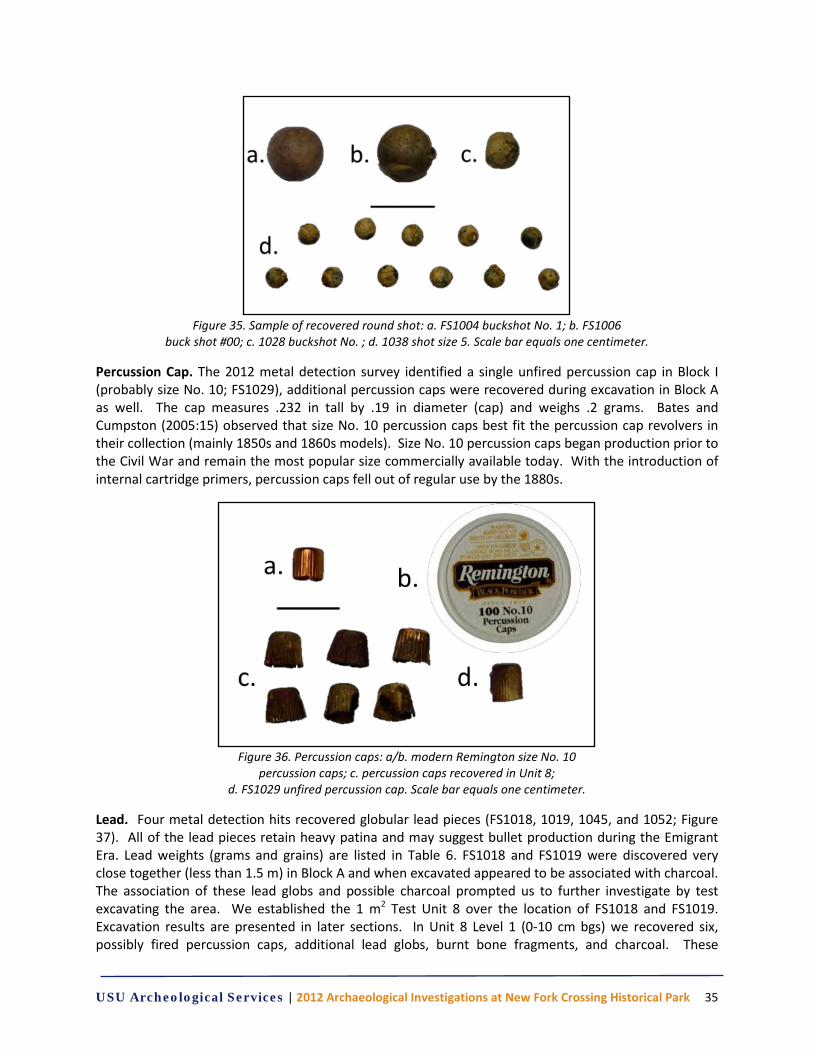
USU Archeological Services | 2012 Archaeological Investigations at New Fork Crossing Historical Park 35
Figure 35. Sample of recovered round shot: a. FS1004 buckshot No. 1; b. FS1006
buck shot #00; c. 1028 buckshot No. ; d. 1038 shot size 5. Scale bar equals one centimeter.
Percussion Cap. The 2012 metal detection survey identified a single unfired percussion cap in Block I (probably size No. 10; FS1029), additional percussion caps were recovered during excavation in Block A as well. The cap measures .232 in tall by .19 in diameter (cap) and weighs .2 grams. Bates and Cumpston (2005:15) observed that size No. 10 percussion caps best fit the percussion cap revolvers in their collection (mainly 1850s and 1860s models). Size No. 10 percussion caps began production prior to the Civil War and remain the most popular size commercially available today. With the introduction of internal cartridge primers, percussion caps fell out of regular use by the 1880s.
Figure 36. Percussion caps: a/b. modern Remington size No. 10
percussion caps; c. percussion caps recovered in Unit 8; d. FS1029 unfired percussion cap. Scale bar equals one centimeter.
Lead. Four metal detection hits recovered globular lead pieces (FS1018, 1019, 1045, and 1052; Figure 37). All of the lead pieces retain heavy patina and may suggest bullet production during the Emigrant Era. Lead weights (grams and grains) are listed in Table 6. FS1018 and FS1019 were discovered very close together (less than 1.5 m) in Block A and when excavated appeared to be associated with charcoal. The association of these lead globs and possible charcoal prompted us to further investigate by test excavating the area. We established the 1 m2 Test Unit 8 over the location of FS1018 and FS1019. Excavation results are presented in later sections. In Unit 8 Level 1 (0-10 cm bgs) we recovered six, possibly fired percussion caps, additional lead globs, burnt bone fragments, and charcoal. These
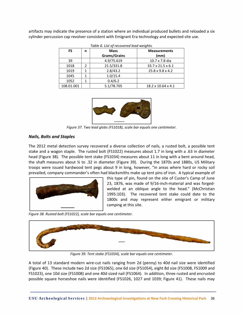
USU Archeological Services | 2012 Archaeological Investigations at New Fork Crossing Historical Park 36
artifacts may indicate the presence of a station where an individual produced bullets and reloaded a six cylinder percussion cap revolver consistent with Emigrant Era technology and expected site use.
Table 6. List of recovered lead weights. FS n Mass
Grams/Grains Measurements
(mm) 39 4.9/75.619 10.7 x 7.8 dia
1018 2 21.5/331.8 33.7 x 21.5 x 6.1 1019 1 2.8/43.2 25.8 x 9.8 x 4.2 1045 1 1.0/15.4 1052 1 0.4/6.2
108.01.001 5.1/78.705 18.2 x 10.64 x 4.1
Figure 37. Two lead globs (FS1018), scale bar equals one centimeter.
Nails, Bolts and Staples
The 2012 metal detection survey recovered a diverse collection of nails, a rusted bolt, a possible tent stake and a wagon staple. The rusted bolt (FS1022) measures about 1.7 in long with a .63 in diameter head (Figure 38). The possible tent stake (FS1034) measures about 11 in long with a bent around head, the shaft measures about ¼ to .32 in diameter (Figure 39). During the 1870s and 1880s, US Military troops were issued hardwood tent pegs about 9 in long, however, “in areas where hard or rocky soil prevailed, company commander’s often had blacksmiths make up tent pins of iron. A typical example of
this type of pin, found on the site of Custer’s Camp of June 23, 1876, was made of 9/16-inch-material and was forged-welded at an oblique angle to the head.” (McChristian 1995:103). The recovered tent stake could date to the 1800s and may represent either emigrant or military camping at this site.
Figure 38. Rusted bolt (FS1022), scale bar equals one centimeter.
Figure 39. Tent stake (FS1034), scale bar equals one centimeter.
A total of 13 standard modern wire-cut nails ranging from 2d (penny) to 40d nail size were identified (Figure 40). These include two 2d size (FS1065), one 6d size (FS1054), eight 8d size (FS1008, FS1009 and FS1023), one 10d size (FS1008) and one 40d sized nail (FS1064). In addition, three rusted and encrusted possible square horseshoe nails were identified (FS1026, 1027 and 1039; Figure 41). These nails may
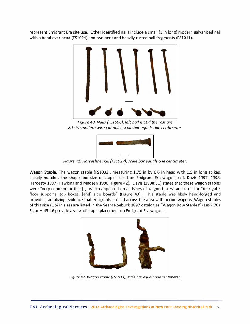
USU Archeological Services | 2012 Archaeological Investigations at New Fork Crossing Historical Park 37
represent Emigrant Era site use. Other identified nails include a small (1 in long) modern galvanized nail with a bend over head (FS1024) and two bent and heavily rusted nail fragments (FS1011).
Figure 40. Nails (FS1008), left nail is 10d the rest are
8d size modern wire-cut nails, scale bar equals one centimeter.
Figure 41. Horseshoe nail (FS1027), scale bar equals one centimeter.
Wagon Staple. The wagon staple (FS1033), measuring 1.75 in by 0.6 in head with 1.5 in long spikes, closely matches the shape and size of staples used on Emigrant Era wagons (c.f. Davis 1997, 1998; Hardesty 1997; Hawkins and Madsen 1990; Figure 42). Davis (1998:31) states that these wagon staples were “very common artifact[s], which appeared on all types of wagon boxes” and used for “rear gate, floor supports, top boxes, [and] side boards” (Figure 43). This staple was likely hand-forged and provides tantalizing evidence that emigrants passed across the area with period wagons. Wagon staples of this size (1 ¾ in size) are listed in the Sears Roebuck 1897 catalog as “Wagon Bow Staples” (1897:76). Figures 45-46 provide a view of staple placement on Emigrant Era wagons.
Figure 42. Wagon staple (FS1033), scale bar equals one centimeter.
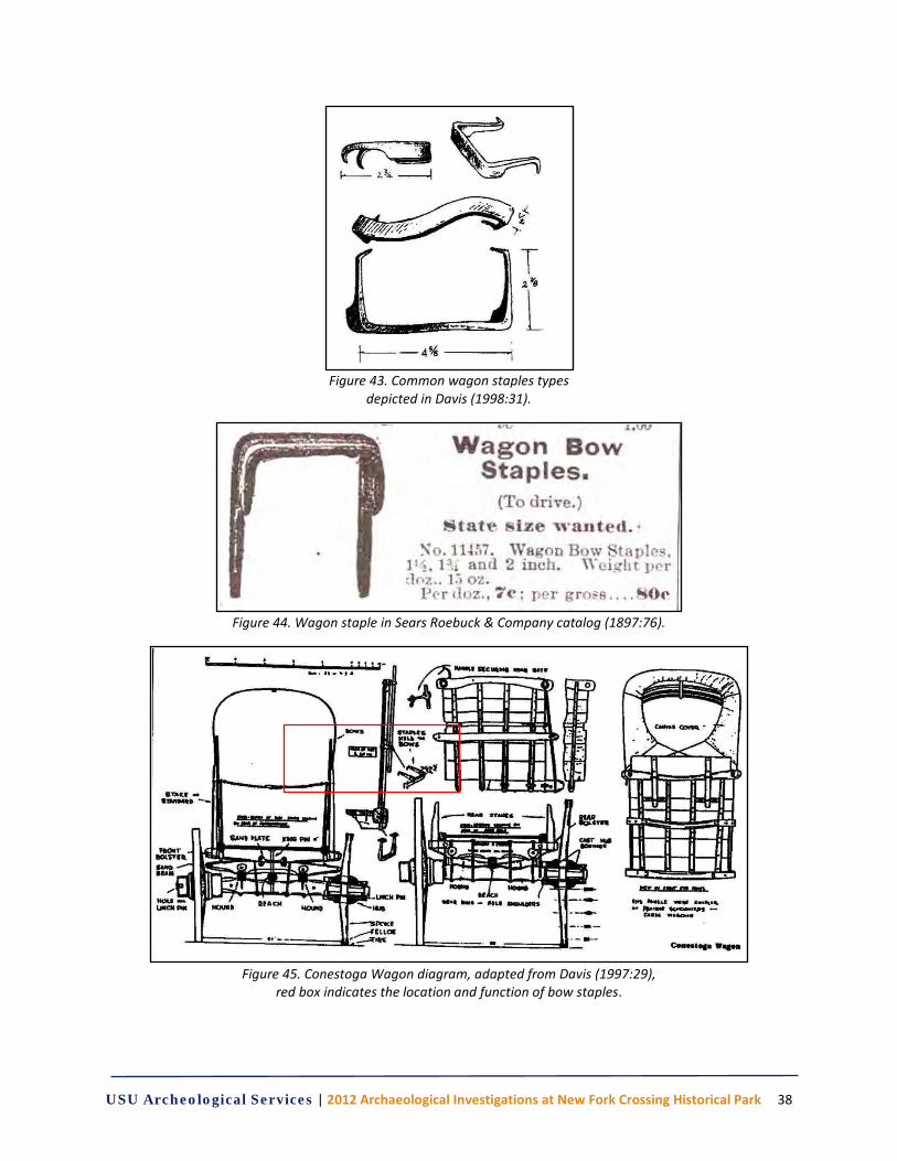
USU Archeological Services | 2012 Archaeological Investigations at New Fork Crossing Historical Park 38
Figure 43. Common wagon staples types
depicted in Davis (1998:31).
Figure 44. Wagon staple in Sears Roebuck & Company catalog (1897:76).
Figure 45. Conestoga Wagon diagram, adapted from Davis (1997:29),
red box indicates the location and function of bow staples.
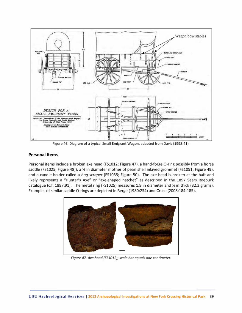
USU Archeological Services | 2012 Archaeological Investigations at New Fork Crossing Historical Park 39
Figure 46. Diagram of a typical Small Emigrant Wagon, adapted from Davis (1998:41).
Personal Items
Personal items include a broken axe head (FS1012; Figure 47), a hand-forge O-ring possibly from a horse saddle (FS1025; Figure 48)), a ½ in diameter mother of pearl shell inlayed grommet (FS1051; Figure 49), and a candle holder called a hog scraper (FS1035; Figure 50). The axe head is broken at the haft and likely represents a “Hunter’s Axe” or “axe-shaped hatchet” as described in the 1897 Sears Roebuck catalogue (c.f. 1897:91). The metal ring (FS1025) measures 1.9 in diameter and ¼ in thick (32.3 grams). Examples of similar saddle O-rings are depicted in Berge (1980:254) and Cruse (2008:184-185).
Figure 47. Axe head (FS1012), scale bar equals one centimeter.
Wagon bow staples
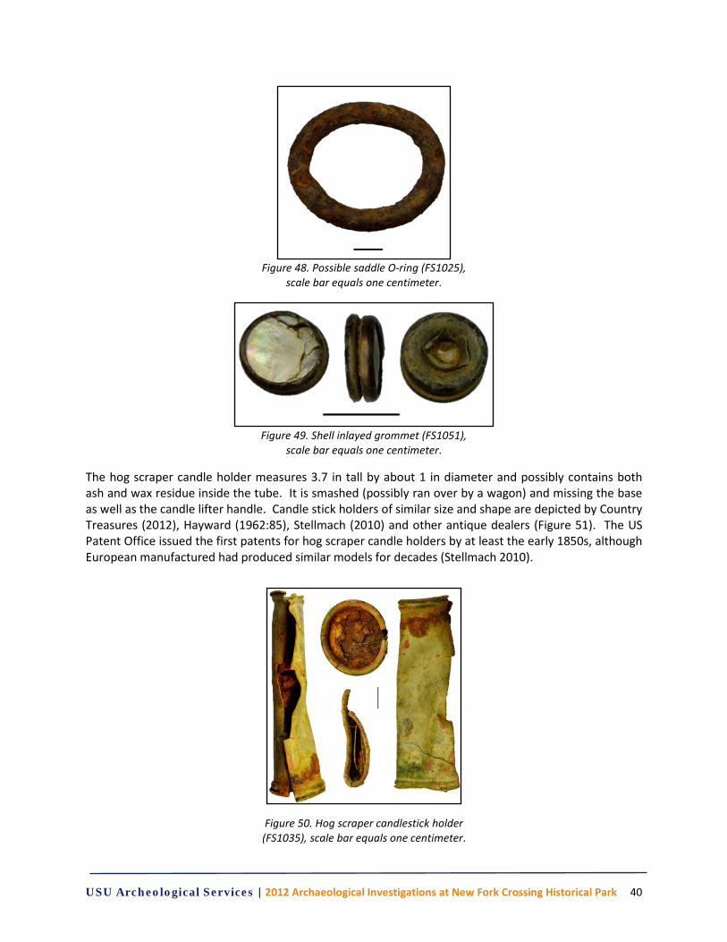
USU Archeological Services | 2012 Archaeological Investigations at New Fork Crossing Historical Park 40
Figure 48. Possible saddle O-ring (FS1025),
scale bar equals one centimeter.
Figure 49. Shell inlayed grommet (FS1051),
scale bar equals one centimeter.
The hog scraper candle holder measures 3.7 in tall by about 1 in diameter and possibly contains both ash and wax residue inside the tube. It is smashed (possibly ran over by a wagon) and missing the base as well as the candle lifter handle. Candle stick holders of similar size and shape are depicted by Country Treasures (2012), Hayward (1962:85), Stellmach (2010) and other antique dealers (Figure 51). The US Patent Office issued the first patents for hog scraper candle holders by at least the early 1850s, although European manufactured had produced similar models for decades (Stellmach 2010).
Figure 50. Hog scraper candlestick holder (FS1035), scale bar equals one centimeter.
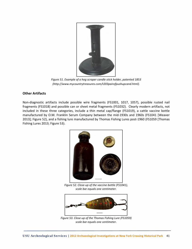
USU Archeological Services | 2012 Archaeological Investigations at New Fork Crossing Historical Park 41
Figure 51. Example of a hog scraper candle stick holder, patented 1853 (http://www.mycountrytreasures.com/t203pairofpushupcand.html).
Other Artifacts Non-diagnostic artifacts include possible wire fragments (FS1001, 1017, 1057), possible rusted nail fragments (FS1018) and possible can or sheet metal fragments (FS1032). Clearly modern artifacts, not included in these three categories, include a thin metal cap/flange (FS1019), a cattle vaccine bottle manufactured by O.M. Franklin Serum Company between the mid-1930s and 1960s (FS1041 [Weaver 2013]; Figure 52), and a fishing lure manufactured by Thomas Fishing Lures post-1960 (FS1059 [Thomas Fishing Lures 2013; Figure 53).
Figure 52. Close-up of the vaccine bottle (FS1041),
scale bar equals one centimeter.
Figure 53. Close-up of the Thomas Fishing Lure (FS1059)
scale bar equals one centimeter.
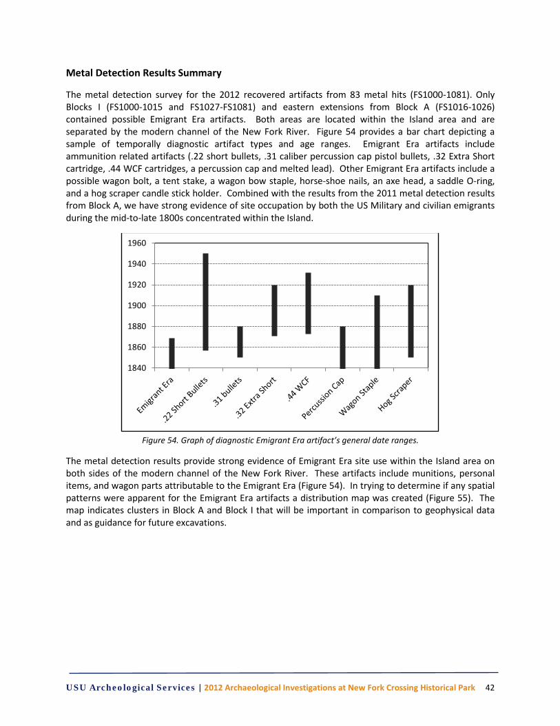
USU Archeological Services | 2012 Archaeological Investigations at New Fork Crossing Historical Park 42
Metal Detection Results Summary
The metal detection survey for the 2012 recovered artifacts from 83 metal hits (FS1000-1081). Only Blocks I (FS1000-1015 and FS1027-FS1081) and eastern extensions from Block A (FS1016-1026) contained possible Emigrant Era artifacts. Both areas are located within the Island area and are separated by the modern channel of the New Fork River. Figure 54 provides a bar chart depicting a sample of temporally diagnostic artifact types and age ranges. Emigrant Era artifacts include ammunition related artifacts (.22 short bullets, .31 caliber percussion cap pistol bullets, .32 Extra Short cartridge, .44 WCF cartridges, a percussion cap and melted lead). Other Emigrant Era artifacts include a possible wagon bolt, a tent stake, a wagon bow staple, horse-shoe nails, an axe head, a saddle O-ring, and a hog scraper candle stick holder. Combined with the results from the 2011 metal detection results from Block A, we have strong evidence of site occupation by both the US Military and civilian emigrants during the mid-to-late 1800s concentrated within the Island.
Figure 54. Graph of diagnostic Emigrant Era artifact’s general date ranges.
The metal detection results provide strong evidence of Emigrant Era site use within the Island area on both sides of the modern channel of the New Fork River. These artifacts include munitions, personal items, and wagon parts attributable to the Emigrant Era (Figure 54). In trying to determine if any spatial patterns were apparent for the Emigrant Era artifacts a distribution map was created (Figure 55). The map indicates clusters in Block A and Block I that will be important in comparison to geophysical data and as guidance for future excavations.
1840
1860
1880
1900
1920
1940
1960
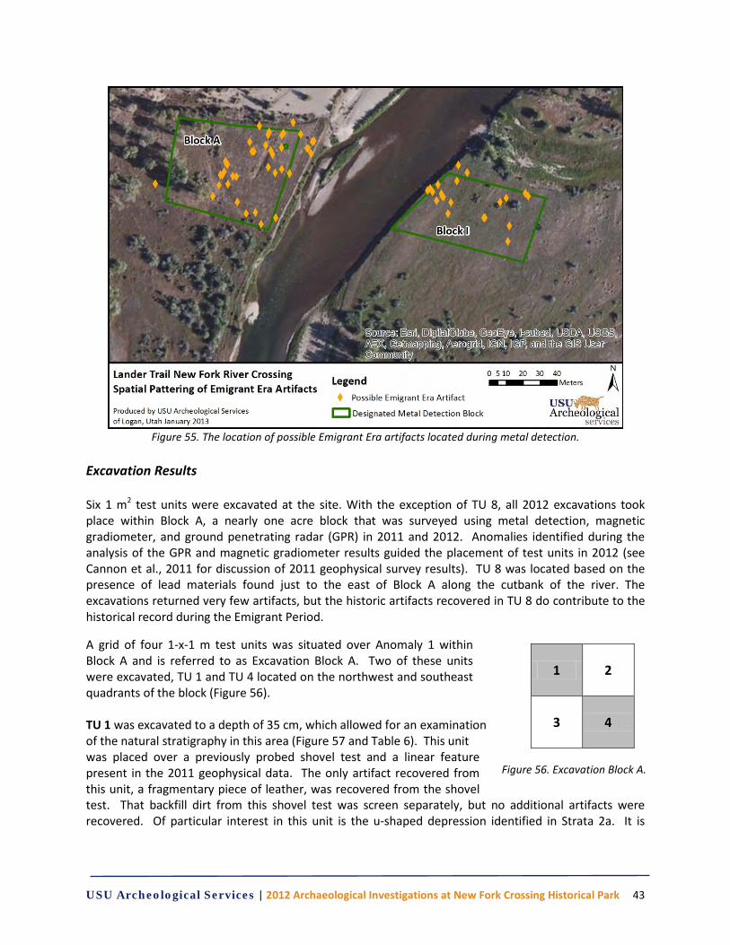
USU Archeological Services | 2012 Archaeological Investigations at New Fork Crossing Historical Park 43
Figure 55. The location of possible Emigrant Era artifacts located during metal detection.
Excavation Results Six 1 m2 test units were excavated at the site. With the exception of TU 8, all 2012 excavations took place within Block A, a nearly one acre block that was surveyed using metal detection, magnetic gradiometer, and ground penetrating radar (GPR) in 2011 and 2012. Anomalies identified during the analysis of the GPR and magnetic gradiometer results guided the placement of test units in 2012 (see Cannon et al., 2011 for discussion of 2011 geophysical survey results). TU 8 was located based on the presence of lead materials found just to the east of Block A along the cutbank of the river. The excavations returned very few artifacts, but the historic artifacts recovered in TU 8 do contribute to the historical record during the Emigrant Period.
A grid of four 1-x-1 m test units was situated over Anomaly 1 within Block A and is referred to as Excavation Block A. Two of these units were excavated, TU 1 and TU 4 located on the northwest and southeast quadrants of the block (Figure 56). TU 1 was excavated to a depth of 35 cm, which allowed for an examination of the natural stratigraphy in this area (Figure 57 and Table 6). This unit was placed over a previously probed shovel test and a linear feature present in the 2011 geophysical data. The only artifact recovered from this unit, a fragmentary piece of leather, was recovered from the shovel test. That backfill dirt from this shovel test was screen separately, but no additional artifacts were recovered. Of particular interest in this unit is the u-shaped depression identified in Strata 2a. It is
1 2
3 4
Figure 56. Excavation Block A.
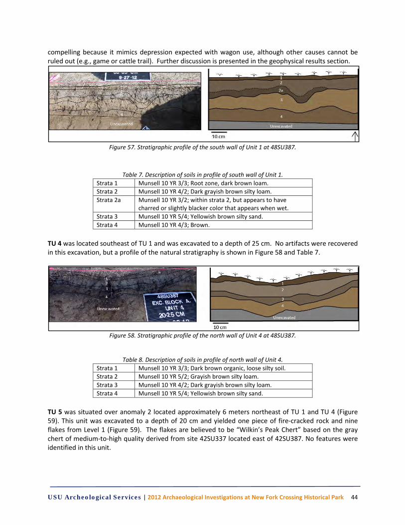
USU Archeological Services | 2012 Archaeological Investigations at New Fork Crossing Historical Park 44
compelling because it mimics depression expected with wagon use, although other causes cannot be ruled out (e.g., game or cattle trail). Further discussion is presented in the geophysical results section.
Figure 57. Stratigraphic profile of the south wall of Unit 1 at 48SU387.
Table 7. Description of soils in profile of south wall of Unit 1. Strata 1 Munsell 10 YR 3/3; Root zone, dark brown loam. Strata 2 Munsell 10 YR 4/2; Dark grayish brown silty loam. Strata 2a Munsell 10 YR 3/2; within strata 2, but appears to have
charred or slightly blacker color that appears when wet. Strata 3 Munsell 10 YR 5/4; Yellowish brown silty sand. Strata 4 Munsell 10 YR 4/3; Brown.
TU 4 was located southeast of TU 1 and was excavated to a depth of 25 cm. No artifacts were recovered in this excavation, but a profile of the natural stratigraphy is shown in Figure 58 and Table 7.
Figure 58. Stratigraphic profile of the north wall of Unit 4 at 48SU387.
Table 8. Description of soils in profile of north wall of Unit 4. Strata 1 Munsell 10 YR 3/3; Dark brown organic, loose silty soil. Strata 2 Munsell 10 YR 5/2; Grayish brown silty loam. Strata 3 Munsell 10 YR 4/2; Dark grayish brown silty loam. Strata 4 Munsell 10 YR 5/4; Yellowish brown silty sand.
TU 5 was situated over anomaly 2 located approximately 6 meters northeast of TU 1 and TU 4 (Figure 59). This unit was excavated to a depth of 20 cm and yielded one piece of fire-cracked rock and nine flakes from Level 1 (Figure 59). The flakes are believed to be “Wilkin’s Peak Chert” based on the gray chert of medium-to-high quality derived from site 42SU337 located east of 42SU387. No features were identified in this unit.

USU Archeological Services | 2012 Archaeological Investigations at New Fork Crossing Historical Park 45
Figure 59. Profile view of north wall of Unit 5.
TU 6 was located 43 meters southwest of TU 4 and is situated over anomaly 4. This unit was excavated to a depth of 25 cm and yielded one fragment of burnt bone, likely from a medium to large sized mammal, and four pieces of sandstone fire-cracked rock from Level 2. Three pieces of charcoal were collected, including one from the side wall at a depth of 5.25 cm (Figure 60; Table 8). The remaining pieces of charcoal were collected from the screen from Levels 2 and 3. No features were identified in this unit.
Figure 60. Stratigraphic profile of the west wall of Unit 6 at 48SU387.
Table 9. Munsell colors of soils in Unit 6. Strata 1 Munsell 10 YR 3/2 Strata 2 Munsell 10 YR 2/1 Strata 3 Munsell 10 YR 4/2
TU 7 was situated 4 meters east of TU 6. This test unit was located over anomaly 5 and yielded one feature, Feature 1, containing 20 pieces of fire cracked rock, as well as 26 additional pieces of fire-cracked rock from various depths and locations within the unit (Figures 61-64; Table 9). In addition to FCR one sample of charcoal was collected from dirt screened from the feature. No temporally diagnostic cultural materials were found in association with Feature 1; therefore it is difficult to determine the age of the deposit, although its shallowness may indicate a recent age.
Figure 61. Stratigraphic profile of the north wall of Unit 7 at 48SU387.
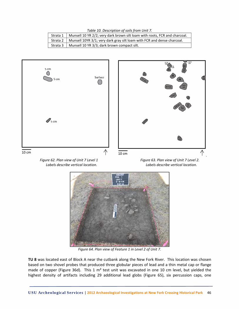
USU Archeological Services | 2012 Archaeological Investigations at New Fork Crossing Historical Park 46
Table 10. Description of soils from Unit 7. Strata 1 Munsell 10 YR 2/2; very dark brown silt loam with roots, FCR and charcoal. Strata 2 Munsell 10YR 3/1; very dark gray silt loam with FCR and dense charcoal. Strata 3 Munsell 10 YR 3/3; dark brown compact silt.
. Figure 62. Plan view of Unit 7 Level 1 Figure 63. Plan view of Unit 7 Level 2.
Labels describe vertical location. Labels describe vertical location.
Figure 64. Plan view of Feature 1 in Level 2 of Unit 7.
TU 8 was located east of Block A near the cutbank along the New Fork River. This location was chosen based on two shovel probes that produced three globular pieces of lead and a thin metal cap or flange made of copper (Figure 36d). This 1 m² test unit was excavated in one 10 cm level, but yielded the highest density of artifacts including 29 additional lead globs (Figure 65), six percussion caps, one
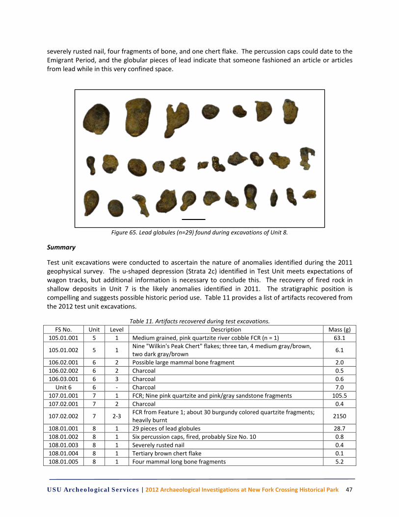
USU Archeological Services | 2012 Archaeological Investigations at New Fork Crossing Historical Park 47
severely rusted nail, four fragments of bone, and one chert flake. The percussion caps could date to the Emigrant Period, and the globular pieces of lead indicate that someone fashioned an article or articles from lead while in this very confined space.
Figure 65. Lead globules (n=29) found during excavations of Unit 8.
Summary
Test unit excavations were conducted to ascertain the nature of anomalies identified during the 2011 geophysical survey. The u-shaped depression (Strata 2c) identified in Test Unit meets expectations of wagon tracks, but additional information is necessary to conclude this. The recovery of fired rock in shallow deposits in Unit 7 is the likely anomalies identified in 2011. The stratigraphic position is compelling and suggests possible historic period use. Table 11 provides a list of artifacts recovered from the 2012 test unit excavations.
Table 11. Artifacts recovered during test excavations. FS No. Unit Level Description Mass (g)
105.01.001 5 1 Medium grained, pink quartzite river cobble FCR (n = 1) 63.1
105.01.002 5 1 Nine "Wilkin's Peak Chert" flakes; three tan, 4 medium gray/brown, two dark gray/brown 6.1
106.02.001 6 2 Possible large mammal bone fragment 2.0 106.02.002 6 2 Charcoal 0.5 106.03.001 6 3 Charcoal 0.6
Unit 6 6 - Charcoal 7.0 107.01.001 7 1 FCR; Nine pink quartzite and pink/gray sandstone fragments 105.5 107.02.001 7 2 Charcoal 0.4
107.02.002 7 2-3 FCR from Feature 1; about 30 burgundy colored quartzite fragments; heavily burnt 2150
108.01.001 8 1 29 pieces of lead globules 28.7 108.01.002 8 1 Six percussion caps, fired, probably Size No. 10 0.8 108.01.003 8 1 Severely rusted nail 0.4 108.01.004 8 1 Tertiary brown chert flake 0.1 108.01.005 8 1 Four mammal long bone fragments 5.2
USU Archeological Services | 2012 Archaeological Investigations at New Fork Crossing Historical Park 48
Results of the Geophysical Survey
Block A
Block A is located in the Island area in the southeast portion of the park (Figure 66). Three additional geophysical survey grids were placed within Block A situated in between and adjacent to Grids 1 and 2 surveyed in 2011. Grid 3 is a 20-x-20-m block oriented north-south. Grid 4, a 15-x-20-m block, was placed just west of Grid3. Grid 5 is a 15-x-15-m placed north of Grid 4. The soil conditions in this region of the park permitted GPR data collection to depths approaching four meters. A total of fifteen anomalies are identified and discussed for Block A (Table 11).
Table 12. Identified anomalies within Block A.
Feature Grid Description Anomaly 1 Grid 3 Scarp Anomaly 2 Grids 1 & 3 Potential Trail Anomaly 3 Grid 3 Potential Hearth Anomaly 4 Grid 3 Potential Hearth Anomaly 5 Grid 3 Circular Anomaly 6 Grid 3 Circular Anomaly 7 Grids 4 & 5 Potential Trail Anomaly 8 Grids 4 & 5 Potential Trail Anomaly 9 Grid 4 Potential Trail
Anomaly 10 Grids 4 & 3 Possibly Related to Scarp
Anomaly 11 Grid 4 Circular Anomaly 12 Grid 4 Circular Anomaly 13 Grid 4 Potential Hearth Anomaly 14 Grid 5 Potential Hearth Anomaly 15 Grids 2 , 4, & 3 Potential Trail
Grid 3. A large scarp is visible on the surface as well as in the aerial photograph and is located in the northwestern portion of Grid 3 (Figure 66). This scarp is noticeable in the resulting magnetic gradiometer data marked by a dashed blue line (Figure 67). A linear feature is present in the eastern portion of the grid identified by a dashed red line (Figure 68). The feature aligns with a previously noted feature illustrated in the 2011 data for Grid 1. Test excavations from Test Unit 1 revealed that change in soil profile that likely represents a portion of a trail segment (see test excavation above section above and Figure 57). Four additional anomalies are of interest and illustrated by red ovals (Figure 67). The two smaller features (Anomalies 3 & 4) as well as anomaly 6 have the size, shape, and signal characteristics of hearth features. Anomaly 5 is larger than expected for a hearth-like feature and may relate to the adjacent scarp.
The GPR confirms Anomalies 3, 4, and 5 as well as the scarp feature Anomaly 1 (Figure 67). The GPR however did not clearly detect linear features within this block.
Grid 4. Several linear features bisect Grid 4 and are marked with dashed red lines (Figure). Anomaly 7 has a much stronger magnetic signature than any of the other linear features within the block. This may relate to buried materials associated with the feature or differences in soil characteristics. However, the subtle expression of the anomaly in Grid 5 suggests that the calibration of the instrument during data

USU Archeological Services | 2012 Archaeological Investigations at New Fork Crossing Historical Park 49
collection may account for the difference. Anomalies 8 and 9 have similar signatures to anomaly 2. Anomaly 12 likely represents a buried metal object whereas anomalies 11 and 13 have signatures similar to hearth features observed at the site.
The GPR detected anomalies that match magnetic gradiometer signatures for anomalies 11 and 12 (Figure 68). Three additional anomalies are noted in the GPR data and are represented by dashed red ovals (Figure 68). These features fall along the line of Anomaly 7 and may represent points of stronger reflectance within that linear feature.
Grid 5. One additional anomaly is of interest in Grid 5. Anomaly 14 likely represents a hearth like feature. The prominent anomalous reading in the eastern portion of the grid is a pin flag left from the metal detecting survey.
The GPR data for this block is relatively homogenous; however Anomaly 14 is confirmed in this dataset as well as in the magnetic gradiometer data (Figure 69).
Recommendations for Block A
It is difficult to ascertain from the geophysical survey data alone if the linear features observed in the images above represent historic emigrant trail segments or other features such as wildlife or domestic animal trails. Further excavation efforts coupled with OSL dating could confirm if these features are in fact cultural and date to the emigrant period. Each of the features identified in this report consist of geophysical signatures that are consistent with target features such as hearths and should be investigate for their potential to yield information about the use of the landscape.
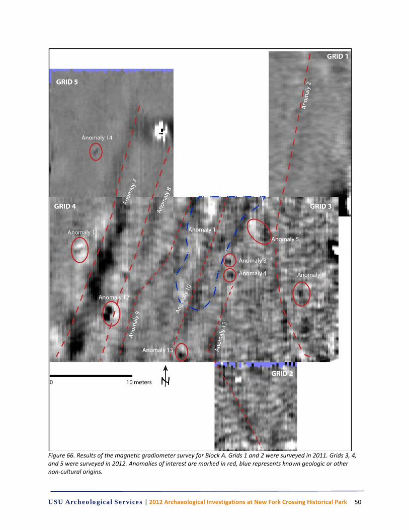
USU Archeological Services | 2012 Archaeological Investigations at New Fork Crossing Historical Park 50
Figure 66. Results of the magnetic gradiometer survey for Block A. Grids 1 and 2 were surveyed in 2011. Grids 3, 4, and 5 were surveyed in 2012. Anomalies of interest are marked in red, blue represents known geologic or other non-cultural origins.
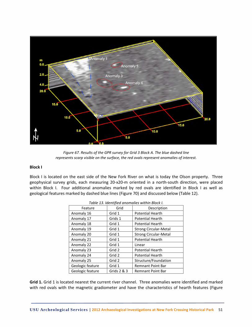
USU Archeological Services | 2012 Archaeological Investigations at New Fork Crossing Historical Park 51
Figure 67. Results of the GPR survey for Grid 3 Block A. The blue dashed line represents scarp visible on the surface, the red ovals represent anomalies of interest.
Block I
Block I is located on the east side of the New Fork River on what is today the Olson property. Three geophysical survey grids, each measuring 20-x20-m oriented in a north-south direction, were placed within Block I. Four additional anomalies marked by red ovals are identified in Block I as well as geological features marked by dashed blue lines (Figure 70) and discussed below (Table 12).
Table 13. Identified anomalies within Block I. Feature Grid Description
Anomaly 16 Grid 1 Potential Hearth Anomaly 17 Grids 1 Potential Hearth Anomaly 18 Grid 1 Potential Hearth Anomaly 19 Grid 1 Strong Circular-Metal Anomaly 20 Grid 1 Strong Circular-Metal Anomaly 21 Grid 1 Potential Hearth Anomaly 22 Grid 1 Linear Anomaly 23 Grid 2 Potential Hearth Anomaly 24 Grid 2 Potential Hearth Anomaly 25 Grid 2 Structure/Foundation Geologic feature Grid 1 Remnant Point Bar Geologic feature Grids 2 & 3 Remnant Point Bar
Grid 1. Grid 1 is located nearest the current river channel. Three anomalies were identified and marked with red ovals with the magnetic gradiometer and have the characteristics of hearth features (Figure
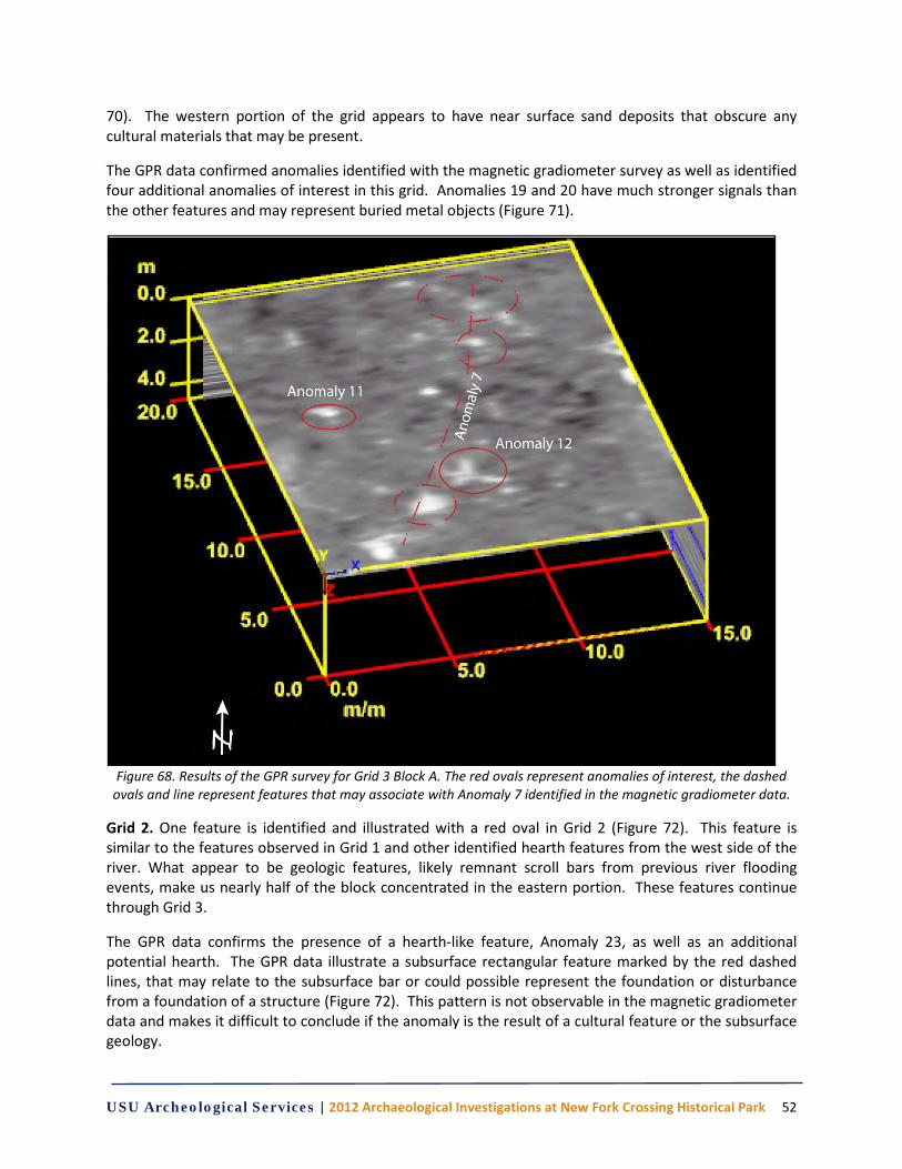
USU Archeological Services | 2012 Archaeological Investigations at New Fork Crossing Historical Park 52
70). The western portion of the grid appears to have near surface sand deposits that obscure any cultural materials that may be present.
The GPR data confirmed anomalies identified with the magnetic gradiometer survey as well as identified four additional anomalies of interest in this grid. Anomalies 19 and 20 have much stronger signals than the other features and may represent buried metal objects (Figure 71).
Figure 68. Results of the GPR survey for Grid 3 Block A. The red ovals represent anomalies of interest, the dashed
ovals and line represent features that may associate with Anomaly 7 identified in the magnetic gradiometer data.
Grid 2. One feature is identified and illustrated with a red oval in Grid 2 (Figure 72). This feature is similar to the features observed in Grid 1 and other identified hearth features from the west side of the river. What appear to be geologic features, likely remnant scroll bars from previous river flooding events, make us nearly half of the block concentrated in the eastern portion. These features continue through Grid 3.
The GPR data confirms the presence of a hearth-like feature, Anomaly 23, as well as an additional potential hearth. The GPR data illustrate a subsurface rectangular feature marked by the red dashed lines, that may relate to the subsurface bar or could possible represent the foundation or disturbance from a foundation of a structure (Figure 72). This pattern is not observable in the magnetic gradiometer data and makes it difficult to conclude if the anomaly is the result of a cultural feature or the subsurface geology.
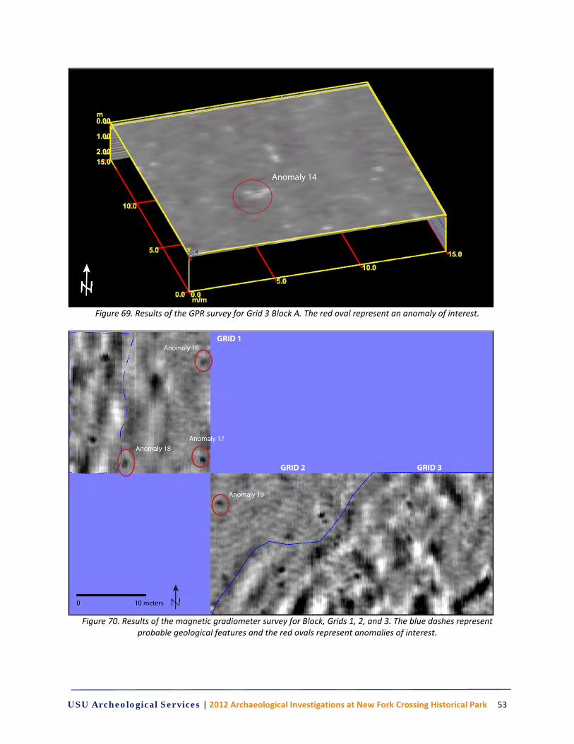
USU Archeological Services | 2012 Archaeological Investigations at New Fork Crossing Historical Park 53
Figure 69. Results of the GPR survey for Grid 3 Block A. The red oval represent an anomaly of interest.
Figure 70. Results of the magnetic gradiometer survey for Block, Grids 1, 2, and 3. The blue dashes represent
probable geological features and the red ovals represent anomalies of interest.
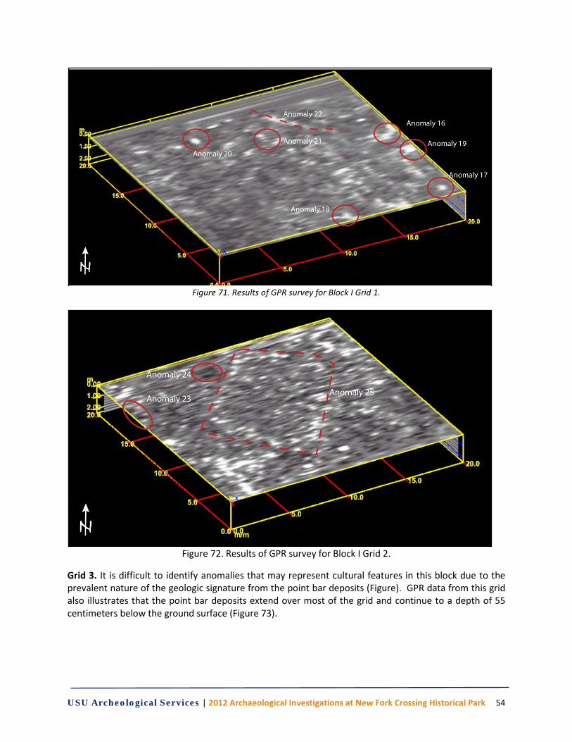
USU Archeological Services | 2012 Archaeological Investigations at New Fork Crossing Historical Park 54
Figure 71. Results of GPR survey for Block I Grid 1.
Figure 72. Results of GPR survey for Block I Grid 2.
Grid 3. It is difficult to identify anomalies that may represent cultural features in this block due to the prevalent nature of the geologic signature from the point bar deposits (Figure). GPR data from this grid also illustrates that the point bar deposits extend over most of the grid and continue to a depth of 55 centimeters below the ground surface (Figure 73).
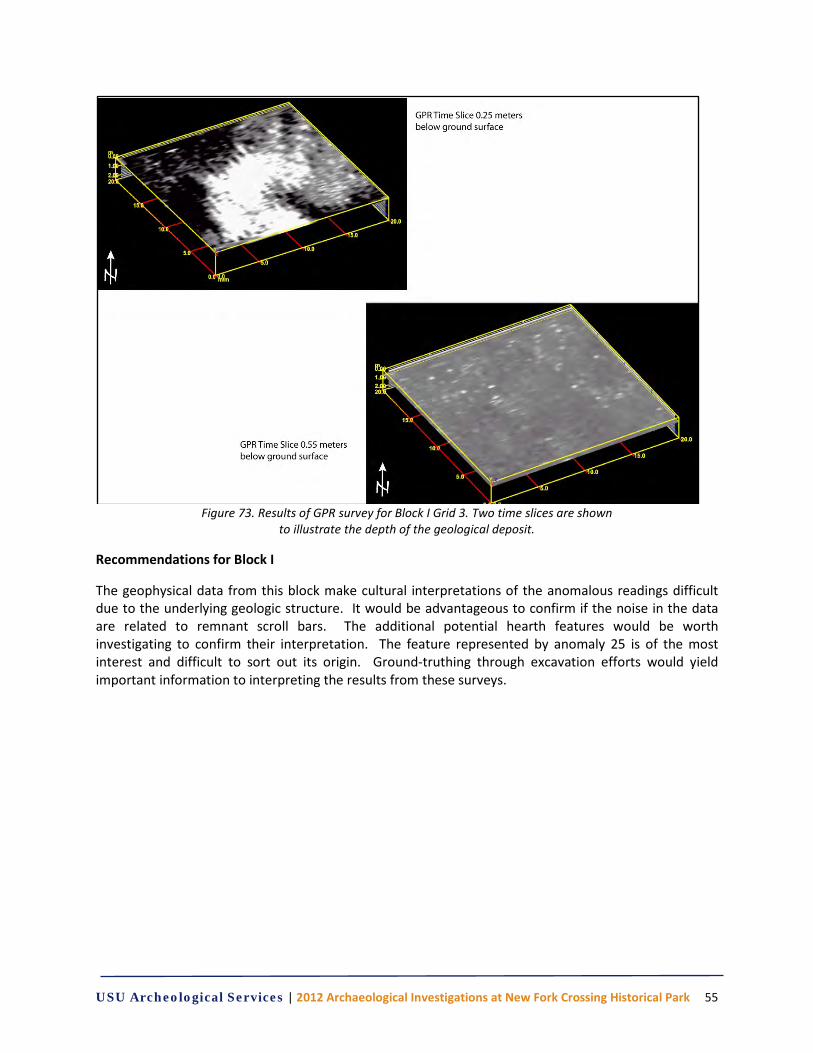
USU Archeological Services | 2012 Archaeological Investigations at New Fork Crossing Historical Park 55
Figure 73. Results of GPR survey for Block I Grid 3. Two time slices are shown
to illustrate the depth of the geological deposit.
Recommendations for Block I
The geophysical data from this block make cultural interpretations of the anomalous readings difficult due to the underlying geologic structure. It would be advantageous to confirm if the noise in the data are related to remnant scroll bars. The additional potential hearth features would be worth investigating to confirm their interpretation. The feature represented by anomaly 25 is of the most interest and difficult to sort out its origin. Ground-truthing through excavation efforts would yield important information to interpreting the results from these surveys.

USU Archeological Services | 2012 Archaeological Investigations at New Fork Crossing Historical Park 56
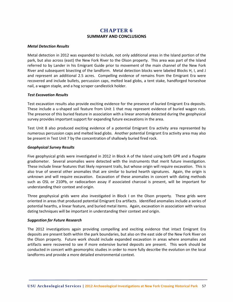
USU Archeological Services | 2012 Archaeological Investigations at New Fork Crossing Historical Park 57
CHAPTER 6 SUMMARY AND CONCLUSIONS
Metal Detection Results
Metal detection in 2012 was expanded to include, not only additional areas in the Island portion of the park, but also across (east) the New Fork River to the Olson property. This area was part of the Island referred to by Lander in his Emigrant Guide prior to movement of the main channel of the New Fork River and subsequent bisecting of the landform. Metal detection blocks were labeled Blocks H, I, and J and represent an additional 2.5 acres. Compelling evidence of remains from the Emigrant Era were recovered and include bullets, percussion caps, melted lead globs, a tent stake, handforged horseshoe nail, a wagon staple, and a hog scraper candlestick holder.
Test Excavation Results
Test excavation results also provide exciting evidence for the presence of buried Emigrant Era deposits. These include a u-shaped soil feature from Unit 1 that may represent evidence of buried wagon ruts. The presence of this buried feature in association with a linear anomaly detected during the geophysical survey provides important support for expanding future excavations in the area.
Test Unit 8 also produced exciting evidence of a potential Emigrant Era activity area represented by numerous percussion caps and melted lead globs. Another potential Emigrant Era activity area may also be present in Test Unit 7 by the concentration of shallowly buried fired rock.
Geophysical Survey Results
Five geophysical grids were investigated in 2012 in Block A of the Island using both GPR and a fluxgate gradiometer. Several anomalies were detected with the instruments that merit future investigation. These include linear features that likely represent trails, but whose origin will require excavation. This is also true of several other anomalies that are similar to buried hearth signatures. Again, the origin is unknown and will require excavation. Excavation of these anomalies in concert with dating methods such as OSL or 210Pb, or radiocarbon assay if associated charcoal is present, will be important for understanding their context and origin.
Three geophysical grids were also investigated in Block I on the Olson property. These grids were oriented in areas that produced potential Emigrant Era artifacts. Identified anomalies include a series of potential hearths, a linear feature, and buried metal items. Again, excavation in association with various dating techniques will be important in understanding their context and origin.
Suggestion for Future Research
The 2012 investigations again providing compelling and exciting evidence that intact Emigrant Era deposits are present both within the park boundaries, but also on the east side of the New Fork River on the Olson property. Future work should include expanded excavation in areas where anomalies and artifacts were recovered to see if more extensive buried deposits are present. This work should be conducted in concert with geomorphic studies in order to more fully describe the evolution on the local landforms and provide a more detailed environmental context.

USU Archeological Services | 2012 Archaeological Investigations at New Fork Crossing Historical Park 58
USU Archeological Services | 2012 Archaeological Investigations at New Fork Crossing Historical Park 59
REFERENCES CITED
Barnes, Frank C. and Layne Simpson (editor) 2009 Cartridges of the World: A Complete and Illustrated Reference for Over 1500 Cartridges 12th Edition. Gun Digest Books. Iola, Wisconsin. Bates, Johnny and Mike Cumpston 2005 Percussion Pistols and Revolvers. History, Performance and Practical Use. iUniverse , Inc., New York. Bevan, B. 1977 Ground-Penetrating Radar at Valley Forge. Geophysical Survey Systems, North Salem, New Hampshire. 1998 Geophysical Exploration for Archaeology: An Introduction to Geophysical Exploration. Midwest Archeological Center Special Report No. 1, Midwest Archeological Center, Lincoln, Nebraska. Bureau of Land Management (BLM) 2009 Wyoming Cultural Property Form for site 48.SU.387. Pinedale Field Office. Document on file at the Wyoming State Historic Preservation Office. 2012 The Official Federal Land Records Site. Electronic document, http://www.glorecords.blm.gov/, accessed January 25, 2012. Cannon, Kenneth P., Jonathan M. Peart, Molly Boeka Cannon, Stephanie Crockett, Jason M. Patten and Courtney Johnson 2012 Archaeological Investigations at the Lander Trail New Fork River Crossing Historical Park, Sublette County, Wyoming. USUAS Technical Report No. 2012-005. USU Archeological Services, Inc. Logan, Utah. Clark, Oliver Anthony 2000 Seeing Beneath the Soil: Prospection Methods in Archaeology. Reprinted. Routledge, London. Originally published 1990, B.T. Batsford Ltd., London. Country Treasures 2013 A Collection of 18th and 19th Century Lighting. Electronic document, htt://www.mycountrytreasures.com/antiqueironandlighting.html, accessed 21 January 2013. Connor, M. and D. Scott 1998 Metal Detector Use in Archaeology: An Introduction. Historical Archaeology 32(4):76-85. Conyers, L.B., and D. Goodman 1997 Ground-Penetrating Radar: An Introduction for Archaeologists. AltaMira Press, London. Cruse, J. Brett 2008 Battles of the Red River War: Archaeological Perspectives on the Indian Campaign of 1874. Texas A&M University Press. College Station, Texas. Davis, Richard M. 1997 Where Have all the Wagons Gone? (Part I). Overland Journal 15(3):16-39. 1998 Where Have all the Wagons Gone? (Part II). Overland Journal 16(2):24-41.
USU Archeological Services | 2012 Archaeological Investigations at New Fork Crossing Historical Park 60
De Vore, S.L. 2002 Magnetic Gradient Survey of Seminoe's Fort on the Tom Sun Ranch along the Oregon and California National Historic Trails, Natrona County, Wyoming. Midwest Archeological Center, Technical Report No. 77. Lincoln, Nebraska. 2002 Geophysical Investigations at the Kane Cemetery (48BH3104), Bighorn Canyon National Recreation Area, Wyoming, Midwest Archeological Center, Lincoln, Nebraska.
1998 Geophysical Investigations of the Western Part of Fort Caspar Park, Natrona County, Wyoming. National Park Service, Intermountain Support Office, Denver, Colorado. Prepared for the Office of the State Archaeologist, Laramie, Wyoming. Ecelbarger, G.L. 2000 Frederick W. Lander: The Great Natural American Soldier. Louisiana State University Press, Baton Rouge. Farrington, Dusan P. 2004 Arming & Equipping the United States Cavalry (1865-1902). Andrew Mowbray Publishers. Lincoln, Rhode Island. Flayderman, Norman
2007 Flayderman’s Guide to Antique American Firearms … and Their Values. 9th Edition. Krause Publications. Iola, Wisconsin. Haeker, Charles 1994 A Thunder of Canon: Archaeology of the Mexican American War Battlefield of Palo Alto. Southwestern Cultural Resources Center Professional Papers No. 52. Division of Anthropology and History, Southwest Regional Office. National Park Service. Sante Fe, New Mexico. Gabriel, Ronald S. 2003 America & British 410 Shotguns. Krause Publications. Iola, Wisconsin. Hardesty, Donald L. 1997 The Archaeology of the Donner Party. University of Nevada Press. Reno, Nevada. Harstad, P.T. 2010 We Saw the Elephant: Overland Diaries from the Lander Trail. Jackpine Press, Lakeville, Minnesota. Hawkins, Bruce R. and David B. Madsen 1990 Excavation of the Donner-Reed Wagons: Historic Archaeology Along the Hastings Cutoff. University of Utah Press. Salt Lake City, Utah. Hayward, Arthur H. 1962 Colonial and Early American Lighting. Reprint. Dover Publications, Inc. Mineda, New York. Huegel, Roger E. 2012 Montgomery Wards U.S.A. .22 Rim Fire Boxes of the U.S.A. ID Reference. Electronic Document, http://22box-id.com/Dunn/Mont-Ward.pdf, accessed 22 January 2012. International Ammunition Association, Inc. 2011 Headstamp Codes to Identify Makers. http://cartridgecollectors.org/?headstampcodes.htm, accessed December 21, 2011.
USU Archeological Services | 2012 Archaeological Investigations at New Fork Crossing Historical Park 61
Jackson, W.T. 1952 Wagon Roads West: A Study of the Federal Road Surveys and Construction in the Trans-Mississippi West 1846-1869. University of California Press, Berkeley. Kvamme, K.L. 2003 Geophysical Surveys as Landscape Archaeology. American Antiquity 68(3):435-457. 2006 Integrating Multidimensional Geophysical Data. Archaeological Prospection, 13:57-72. McChristian, Douglas C. 1995 The U.S. Army in the West, 1870-1880. Uniforms, Weapons, and Equipment. University of Oklahoma Press. Norman, Oklahoma. McKee, W. Reid and M.E. Mason Jr. 1975 Civil War Projectiles II: Small Arms and Field Artillery. Privately published by authors. National Park Service, Department of the Interior (NPS). Morgan, A., and K. Mitchell 2011 The Beckwourth Emigrant Trail: Using Historical Accounts to Guide Archaeological Fieldwork in the Plumas National Forest. Society of California Archaeology Proceedings 25:1-14. 2011 Fencing the Great Plains: The History of Barbed Wire. Electronic document, http://www.nps.gov/home/planyourvisit/upload/Barbed%20wire%20Brochure,%20final.pdf, accessed December 10, 2011. National Resources Conservation Service (NRCS), United States Department of Agriculture 2012 Web Soil Survey. Electronic document, http://websoilsurvey.nrcs.usda.gov/app/WebSoilSurvey.aspx, accessed January 25, 2012. Rock, James T. 1984 Cans in the Countryside. Historical Archaeology 18(2):97-111. Ruger1022.com 2013 .22 Rimfire Ballistics Tables. Electronic document, http://www.ruger1022.com/docs/22lrballistics.htm, accessed 18 January 2013. Scott, Douglas D., Richard A. Fox Jr., Melissa Connor and Dick Harmon 1989 Archaeological Perspectives on the Battle of the Little Bighorn. University of Oklahoma Press, Norman. Scott, Douglas D., and William Hunt 1998 The Archaeology of the Monroe’s Crossroads Battle, Fort Bragg, North Carolina. Southeast Archaeological Center, National Park Service. Tallahassee, Florida. Sears Roebuck & Company 1897 1897 Sears Roebuck & Company Catalogue. Chicago. Somers, L.E. 1998 Geophysical Remote Sensing Survey of the Quartermaster Depot Dump at Fort Laramie National Historic Site. In Archaeology at the Fort Laramie Quartermaster Dump Area, 1994-1996. D.N. Walker, ed. pp. 81-90. U.S. Department of the Interior, National Park Service, Rocky Mountain Region, Division of Cultural Resources, Selections Series, No. 13, Denver, Colorado. 1998 http://www.archaeophysics.com/kearny/index.html

USU Archeological Services | 2012 Archaeological Investigations at New Fork Crossing Historical Park 62
Steinhauer, Curtus
2009 Centerfire Cartridges Headstamp Identification (US, Canadian & British). http://members.shaw.ca/cstein0/uscenter.htm Accessed September 29, 2009. 2011 Shot Shell Head Stamp Identification. Electronic document, http://members.shaw.ca/cartridgecorner/shotgun.htm, accessed January 10, 2012. Stellmach, Judi 2010 Hog Scraper Candlesticks. Blue Dog Antiques. Electronic document, http://bluedogantiques.blogspot.com/2010/01/hog-scraper-candlestick.html, accessed 21 January 2013. Stringfield, Dotty and Seal, Pat
2011 Illusion Jewels Presents: Researching Costume Jewelry. Electronic document, http://www.illusionjewels.com/costumejewelrymarksr.html, accessed December 22, 2011. Sublette County Planning Commission 2005 Sublette County Comprehensive Plan: County Vision, Goals and Practice. A Citizen-based Planning Effort. Electronic document, http://www.sublettewyo.com/DocumentView.aspx?DID=206, accessed January 25, 2012. Thomas, James E. and Dean S. Thomas 1996 A Handbook of Civil War Bullets and Cartridges. Thomas Publications. Gettysburg, Pennsylvannia. Thomas Fishing Lures 2013 History. Thomas Fishing Lures Company. Electronic document, http://thomaslures.com/history.htm, accessed 22 January 2013. Walker, Danny N., and Steven L. De Vore 2008 Final Report on 2002–2005 Geo physical Surveys at Fort Laramie National Historic Site, Wyoming. University of Wyoming. Submitted to Fort Laramie National Historic Site. On file, Fort Laramie National Historic Site, Wyoming. Walter, John 2006 Rifles of the World. 3rd Edition. Krause Publications. Iola, Wisconsin. Watson, Albert III 1987 Small-Caliber Ammunition Identification Guide (U): Volume 1 Small-Arms Cartridges up to 15 mm (U). US Army Intelligence Agency, Foreign Science and Technology Center. Charlottesville, Virginia. Weaver, Bobby D. 2013 O.M. Franklin Serum Company, Handbook of Texas Online. Electronic document, http://www.tshaonline.org/handbook/online/articles/awo01, accessed 16 January 2013. Weymouth, J.W. and Huggins, R. 1985 Geophysical Surveying of Archaeological Sites. In Rapp, G. and Gifford, J. (Eds.), Archaeological Geology. Yale University Press. Whitton, David 2011 Glass Manufacturers’ Marks on Bottles. Electronic document, http://www.myinsulators.com/glass- factories/bottlemarks.html, accessed December 15, 2011. Wight, J.B. 1993 Frederick W. Lander and the Lander Trail. Star Valley Llama, Bedford, Wyoming.

USU Archeological Services | 2012 Archaeological Investigations at New Fork Crossing Historical Park 63
Wilson, Mark R. 2005 Ward (Montgomery) & Co. In, Encyclopediameter of Chicago, Dictionary of Leading Chicago Businesses (1820-2000). Electronic document, http://www.encyclopedia.chicagoohistory.org/pages/2895.html, accessed 18 January 2013. Wolf Performance Ammunition 2011 Wolf Performance Ammunition Home Page. Electronic document, http://www.wolfammo.com/, accessed January 17, 2012.
Related Documents


