2012-2022 TEN YEAR MAINTENANCE DREDGING SEA DISPOSAL PERMIT FOR NEWCASTLE PORT Long Term Monitoring and Management Plan Level 7, 116 Miller Street, Sydney NSW 2060 04 January 2013

Welcome message from author
This document is posted to help you gain knowledge. Please leave a comment to let me know what you think about it! Share it to your friends and learn new things together.
Transcript
2012-2022 TEN YEAR MAINTENANCE DREDGING SEA DISPOSAL PERMIT FOR NEWCASTLE PORT Long Term Monitoring and Management Plan
Level 7, 116 Miller Street, Sydney NSW 2060
04 January 2013
LONG TERM MONITORING AND MANAGEMENT PLAN FOR THE 2011-2021 TEN YEAR DREDGING SEA DISPOSAL PERMIT FOR NEWCASTLE PORT
PROJECT 301015-02409 - LONG TERM MONITORING AND MANAGEMENT PLAN FOR THE 2011-2021 TEN YEAR DREDGING SEA DISPOSAL PERMIT FOR NEWCASTLE PORT
REV DESCRIPTION ORIG REVIEW WORLEY- PARSONS APPROVAL
DATE CLIENT APPROVAL
DATE
A DRAFT Issued for discussion
P Lawless K Panayotou
G Britton
7-2-11 N/A
B DRAFT issued for TACC review
P Lawless
K Panayotou
G Britton
C FINAL issued to SEWPaC
P Lawless
K Panayotou
G Britton 3-3-11
D Reissued to SEWPaC
O Murray
A Watters
G Britton
9-11-11
E Reissued to SEWPaC
A Watters
O Murray
A Watters
7-12-11
F Reissued to SEWPaC
D Lam
AF Nielsen
AF Nielsen
21-05-12
G Reissued to SEWPaC
D Lam AF Nielsen
AF Nielsen
07-08-12
REV DESCRIPTION ORIG REVIEW NPC APPROVAL
DATE
H Reissued to SEWPaC
D Lam
J Spiteri
R Sorensen
04.01.13
Page ii
Disclaimer
This report has been prepared on behalf of and for the exclusive use of Newcastle Port Corporation, and is subject to and issued in accordance with the agreement between Newcastle Port Corporation and WorleyParsons. WorleyParsons accepts no liability or responsibility whatsoever for it in respect of any use of or reliance upon this report by any third party.
Copying this report without the permission of Newcastle Port Corporation or WorleyParsons is not permitted.
Long Term Monitoring and Management Plan for the 2011-2021 Ten Year Dredging Sea Disposal Permit for Newcastle Port
Page iii A375087 : Rev G : 30 January 2013
CONTENTS 1. INTRODUCTION ................................................................................................................ 6
1.1 General ............................................................................................................................... 6
1.2 Environmental Objectives ................................................................................................... 7
1.2.1 General .................................................................................................................. 7
1.2.2 Objectives of the LTMMP ....................................................................................... 7
1.3 Structure and Use of the LTMMP ....................................................................................... 7
1.4 Overall Environmental Management Framework ............................................................... 8
2. PROJECT OVERVIEW ..................................................................................................... 10
2.1 Dredging ........................................................................................................................... 10
2.2 Disposal ............................................................................................................................ 13
2.2.1 Offshore Dump Ground ........................................................................................ 13
2.2.2 Nourishment of Stockton Beach .......................................................................... 13
2.2.3 Temporary Storage in the Channel ...................................................................... 14
3. STATUTORY AND LEGISLATIVE FRAMEWORK .......................................................... 20
3.1 Sea Dumping Act .............................................................................................................. 20
3.2 Crown Lands Act............................................................................................................... 20
3.3 Coastal Protection Act ...................................................................................................... 20
3.4 Protection of the Environment Operations Act ................................................................. 21
3.5 Beach Nourishment Approvals ......................................................................................... 21
4. DESCRIPTION OF THE EXISTING ENVIRONMENT ..................................................... 24
4.1 Processes and Climate ..................................................................................................... 24
4.1.1 Tidal Hydrodynamics ........................................................................................... 24
4.1.2 Wind ..................................................................................................................... 25
4.1.3 Flooding ............................................................................................................... 25
4.1.4 Turbidity ............................................................................................................... 26
4.1.5 Offshore Wave Climate and Currents .................................................................. 26
4.2 Maintenance Dredge Areas .............................................................................................. 27
4.2.1 Physical and Chemical Description of Material .................................................... 27
4.2.2 Introduced Marine Organisms .............................................................................. 28
4.3 Offshore Dump Ground .................................................................................................... 29
4.3.1 Previous Dump Ground Use ................................................................................ 29
Long Term Monitoring and Management Plan for the 2011-2021 Ten Year Dredging Sea Disposal Permit for Newcastle Port
Page iv A375087 : Rev G : 30 January 2013
4.3.2 Disposal Route ..................................................................................................... 29
4.3.3 Description of Dump Ground ............................................................................... 29
4.4 Fisheries ........................................................................................................................... 31
4.5 Indigenous Cultural Resources ......................................................................................... 31
4.6 Non-Indigenous Cultural Resources ................................................................................. 32
5. POTENTIAL IMPACTS AND MANAGEMENT STRATEGIES ......................................... 33
5.1 General ............................................................................................................................. 33
5.2 Potential Impacts and Management Strategies ................................................................ 33
5.2.1 Turbidity Levels and Dispersal of Sediment ........................................................ 33
5.2.2 Physical Impacts at the Dump Ground ................................................................ 33
5.2.3 Sediment Quality .................................................................................................. 34
5.2.4 Effects on Marine Life .......................................................................................... 34
5.2.5 Impacts on the Water Column ............................................................................. 34
5.2.6 Air Quality ............................................................................................................. 35
5.2.7 Noise .................................................................................................................... 35
5.2.8 Threatened Species and Communities ................................................................ 35
5.2.9 Changes in Bathymetry ........................................................................................ 35
6. IMPLEMENTATION OF THE LTMMP .............................................................................. 36
6.1 Introduction ....................................................................................................................... 36
6.2 Responsibilities for Environmental Management ............................................................. 36
6.3 Training ............................................................................................................................. 36
6.4 Materials to be Dumped .................................................................................................... 37
6.5 Dumping of Dredged Material ........................................................................................... 37
6.6 Record Keeping ................................................................................................................ 37
6.7 Cetacean Monitoring ......................................................................................................... 38
6.8 Introduced Marine Species ............................................................................................... 38
6.9 Sediment Sampling ........................................................................................................... 39
6.9.1 Maintenance Dredge Areas ................................................................................. 39
6.9.2 Dump Ground ....................................................................................................... 40
6.10 Bathymetric Surveys .................................................................................................... 40
6.11 Spill and Waste Management ...................................................................................... 41
6.12 Reporting ...................................................................................................................... 41
6.13 Environmental Inspections ........................................................................................... 42
Long Term Monitoring and Management Plan for the 2011-2021 Ten Year Dredging Sea Disposal Permit for Newcastle Port
Page v A375087 : Rev G : 30 January 2013
6.14 Contingency Measures ................................................................................................. 42
6.14.1 Breakdown of the David Allan .............................................................................. 43
6.14.2 Nearby Contaminated Sediments ........................................................................ 43
6.14.3 Flood Related Dredging ....................................................................................... 43
6.15 Auditing and Monitoring of Compliance with Approval Conditions............................... 44
6.16 Consultation and Review of the LTMMP ...................................................................... 45
6.17 Continuous Improvement ............................................................................................. 45
6.18 Publication of the LTMMP ............................................................................................ 46
6.19 Summary ...................................................................................................................... 46
7. REFERENCES ................................................................................................................. 53
8. GLOSSARY ...................................................................................................................... 55
List of Figures
FIGURE 1.1 MAINTENANCE DREDGE AREAS
FIGURE 2.1 FLOWCHART WITH INDICATIVE TIMING OF OVERALL PROJECT
FIGURE 2.2 PROPOSED DUMP GROUND LOCATION DIAGRAM
FIGURE 2.3 TSHD DAVID ALLAN SWELL WORKABILITY PLOT
FIGURE 2.4 PROPOSED TARGET AREAS FOR GRAB DREDGING
FIGURE 2.5 PROPOSED TEMPORARY STORAGE SITE
FIGURE 4.1 WIND ROSE FOR NEWCASTLE PORT FROM UNSW (2003)
FIGURE 4.2 OFFSHORE WAVE ROSES, WAVE HEIGHT (TOP) AND WAVE PERIOD (BOTTOM)
FIGURE 4.3 INDICATIVE AREA FROM DREDGING AREA TO DUMP GROUND
FIGURE 4.4 CONCEPTUAL MODEL FAR FIELD DISPERSION OF DREDGE MATERIAL
FIGURE 4.5 LOCATION OF ENVIRONMENTALLY SENSITIVE AREAS
APPENDIX A: NPC’S ENVIRONMENTAL POLICY
APPENDIX B: EPBC ACT PROTECTED MATTERS REPORT
APPENDIX C: NPC MATERIAL RELOCATION RECORD SHEET
APPENDIX D: NPC OPERATING LOG SHEET
APPENDIX E: SEWPAC WHALE AND DOLPHIN IDENTIFICATION GUIDE
APPENDIX F: SAP FOR MAINTENANCE DREDGE AREAS, 2011-2021
APPENDIX G: SAP FOR OFFSHORE DUMP GROUND, 2011-2021

LONG TERM MONITORING AND MANAGEMENT PLAN FOR THE 2011-2021 TEN YEAR DREDGING SEA DISPOSAL PERMIT FOR NEWCASTLE PORT
Page 6 A375087: Rev H : 04 January 2013
1. INTRODUCTION
1.1 General
The Port of Newcastle is recognised as a major economic centre for both the Hunter Region and New South Wales (NSW). It is the world’s largest coal exporting port and also has facilities to handle general cargo, break-bulk goods and containers. Trade throughput for 2009-10 totalled 103.02 million tonnes which was valued at $13.05 billion. The volume of trade was an increase of 7.18 million tonnes on the previous year (2008-09).
Infrastructure within the Port includes coal terminals operated by Port Waratah Coal Services (PWCS) and Newcastle Coal Infrastructure Group (NCIG), a bulk liquid terminal for vegetable oils, agri-food storage and loading, local and national road and rail access and storage sheds adjacent to berths. Much of the recent and current Port infrastructure has been constructed on reclaimed areas of Kooragang Island or is planned for construction of remediated land in Mayfield.
In addition to shipping, the Port includes berthing for cruise liners, an 80 berth marina, the Queens wharf entertainment precinct and a floating ship repair dock. A ferry service operates within the Port between Newcastle and the northern suburb of Stockton.
Newcastle Port Corporation (NPC) is responsible for maintaining the declared depths of the navigation channels and berthing boxes throughout the Port of Newcastle (refer Figure 1.1).
Dredging commenced in the Port in 1859 and has been virtually continuous since that time. Total dredging quantities up to 1993 are estimated to have been greater than 130 million cubic metres (Patterson Britton, 1992).
The Department of Sustainability, Environment, Water, Population and Communities (SEWPaC), granted NPC a ten year maintenance dredging Sea Dumping Permit on 14 March 2012 which is valid until 14 March 2022. Details of recent Sea Dumping Permits granted to NPC are shown in Table 1.1 below. The total annual volume of material dredged from the Port of Newcastle between the years 2000 and 2010 varied from 236,088 m3 to 444,922 m3.
Table 1.1 Previous disposal permits
Date Volume Granted / Refused
June 2000 500,000 m3 per yr (maintenance) Granted (5 yr)
March 2001 290,000 m3 (capital) Granted
June 2006 500,000 m3 per yr (maintenance) Granted (5 yr)
June 2011 500,000 m3 per yr (maintenance) Granted (1 year extension)
March 2012 645,000 m3 per yr (maintenance) Granted (10 yr)

LONG TERM MONITORING AND MANAGEMENT PLAN FOR THE 2011-2021 TEN YEAR DREDGING SEA DISPOSAL PERMIT FOR NEWCASTLE PORT
Page 7 A375087: Rev H : 04 January 2013
1.2 Environmental Objectives
1.2.1 General
NPC’s environmental objectives relating to maintenance dredging activities include:
• Prevention, mitigation and management of any potential environmental impacts associated with maintenance dredging activities;
• Ensuring that environmental management is undertaken in accordance with relevant legislative and policy requirements, including the Sea Dumping Permit; and
• Ensuring that maintenance dredging is undertaken with due care to the environment, which includes the promotion of environmental awareness amongst NPC employees, contractors, customers, port users, visitors and members of the public..
1.2.2 Objectives of the LTMMP
LTMMPs set out both the framework and specific measures for management, mitigation and monitoring of impacts with agreed performance criteria for specified acceptable levels of environmental harm. The LTMMP demonstrates how the environment at the Port and surrounds will be protected over the longer term and provides the Port with an opportunity to showcase their role as a steward for the marine environment. LTMMPs identify responsible parties, and also include mechanisms for the regular review of compliance with permit conditions, as well as a process for continuous improvement of environmental management and performance over the life of the permit.
Specifically, this LTMMP incorporates details of maintenance dredging for the Port of Newcastle and the associated disposal of the dredge spoil.. Management strategies that ensure minimal impact on the environment have been developed for the LTMMP and are described in Sections 5 and 6.
1.3 Structure and Use of the LTMMP
This LTMMP has been prepared in accordance with draft guidelines provided by SEWPaC to enable its utilisation as a management tool for all personnel involved in the activities associated with the sea disposal of material derived from maintenance dredging of the Port of Newcastle. In particular, this Plan contains an outline of:
(i) background to the project;
(ii) project proposal;
(iii) statutory and regulatory requirements for the activities;
(iv) identification of key environmental issues associated with the phases of the project;
(v) procedures for the implementation, monitoring and management of control provisions necessary to protect the environment during the project;
(vi) responsibilities for the implementation, monitoring and management of control provisions necessary to protect the environment during operation; and
(vii) procedures for reporting and corrective action as required.
LONG TERM MONITORING AND MANAGEMENT PLAN FOR THE 2011-2021 TEN YEAR DREDGING SEA DISPOSAL PERMIT FOR NEWCASTLE PORT
Page 8 A375087: Rev H : 04 January 2013
Items addressed in this Plan are listed in Table 1.2, with a cross-reference to where each item is addressed in this Plan.
Table 1.2 Items Addressed in this LTMMP
Item LTMMP Reference
Overall environmental management framework for the Port 1.4
Context of the regional and local environment, including a brief history of all dredging and disposal activities
1.1
Information on approvals and policy context 3
Description of the dredging and disposal activities, including materials to be dumped
2
Description of the existing environment 4
Description of potential impacts 5
Management strategies and actions 5 and 6
Contingency planning 6.14
Provisions for maintaining current sediment quality data over the life of the permit 6.9
Auditing requirements 6.15
Reporting 6.12
Continuous improvement 6.17
Stakeholder consultation, including the operation of a Technical Advisory and Consultative Committee (TACC)
6.16
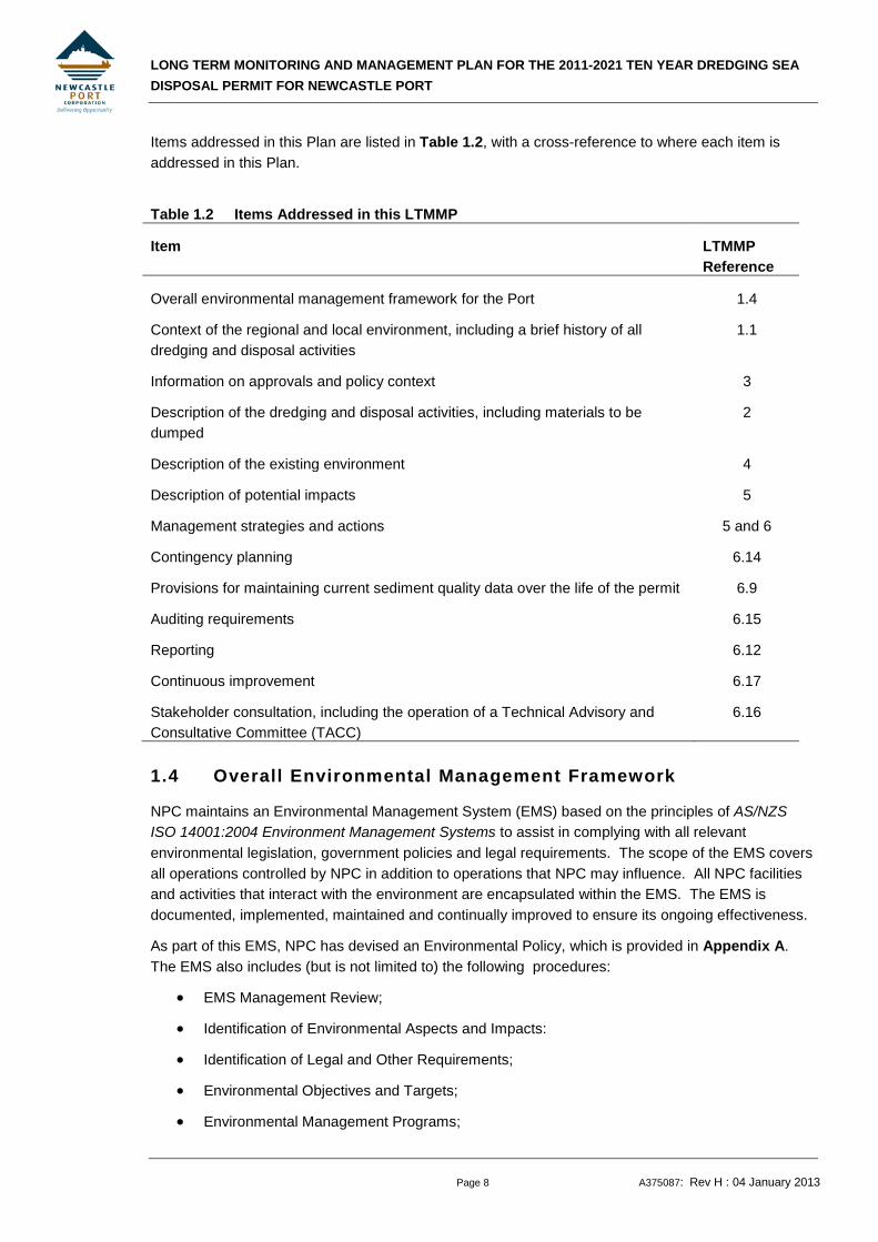
1.4 Overall Environmental Management Framework
NPC maintains an Environmental Management System (EMS) based on the principles of AS/NZS ISO 14001:2004 Environment Management Systems to assist in complying with all relevant environmental legislation, government policies and legal requirements. The scope of the EMS covers all operations controlled by NPC in addition to operations that NPC may influence. All NPC facilities and activities that interact with the environment are encapsulated within the EMS. The EMS is documented, implemented, maintained and continually improved to ensure its ongoing effectiveness.
As part of this EMS, NPC has devised an Environmental Policy, which is provided in Appendix A. The EMS also includes (but is not limited to) the following procedures:
• EMS Management Review;
• Identification of Environmental Aspects and Impacts:
• Identification of Legal and Other Requirements;
• Environmental Objectives and Targets;
• Environmental Management Programs;

LONG TERM MONITORING AND MANAGEMENT PLAN FOR THE 2011-2021 TEN YEAR DREDGING SEA DISPOSAL PERMIT FOR NEWCASTLE PORT
Page 9 A375087: Rev H : 04 January 2013
• Training;
• Environmental Incident Response and Reporting;
• Environmental Emergency Response;
• Waste Handling and Disposal;
• Monitoring and Evaluation;
• Control of Non-Conformances;
• Internal Auditing; and
• Identification of Heritage and Conservation Requirements.
• Dredging;
• Bunkering;
• Environmental Inspections;
• Fuel Tank Leak and Spill Response; and
• Identifying Significant Environmental Aspects.
Forms and work instructions contained in the EMS which are relevant to dredging activities include:
• Marine Refuelling Instructions;
• Dredge Monthly Environmental Inspection; and
• Internal EMS Audit Schedule.
This Plan has been developed in accordance with the principles of NPC’s Environmental Management System and Environmental Policy.
LONG TERM MONITORING AND MANAGEMENT PLAN FOR THE 2011-2021 TEN YEAR DREDGING SEA DISPOSAL PERMIT FOR NEWCASTLE PORT
Page 10 A375087: Rev H : 04 January 2013
2. PROJECT OVERVIEW
2.1 Dredging
NPC undertakes maintenance dredging of the navigation channels and berthing boxes throughout the port entrance and along the South Arm of the Hunter River. This dredging is required to remove accumulated sediment and maintain safe, navigable depth in the Port.
The area in which maintenance dredging will be undertaken during the life of the new Sea Dumping Permit is shown in Figure 1.1. For the purposes of the management of dredging activities, NPC has subdivided the Port into seven areas (Areas A, B, C, D, E, F and G) based on the nature of the sedimentation in the Port and the layout of the port area. The area in which maintenance dredging has been undertaken to date comprises Areas A, B, C, D, E and F as represented by the blue shaded area in Figure 1.1.
Additional berths in the Port of Newcastle will become operational during the life of the new Sea Dumping Permit. NPC will assume responsibility for the maintenance dredging of these berths and the adjacent shipping channel at the timings outlined in Table 2.1. A flowchart showing the indicative timing of activities for the overall project is provided in Figure 2.1. With the exception of Dyke Berth 3 (Area B) and Mayfield 1 and 2 (Area A), these berths and the adjacent shipping channel will comprise maintenance dredge area G, as represented by the green shaded area in Figure 1.1.
Table 2.1 Additional berths to be introduced during life of Permit
Berth Maintenance Dredge Area
Expected timing when NPC will assume responsibility for maintenance dredging1
Dyke Berth 3 B 2013
Mayfield 1 and 2 A 2013
K10 G 2013
T4 G 2015
The maintenance dredging in Areas A, B, C, D, E and F involves the removal of material to design dredge depths between 10.0 m and 16.5 m below Chart Datum, as indicated on Figure 1.1. The type of material removed for maintenance purposes comprises mostly silt and clay (mud) for Areas A to D and F with the proportion of sand being typically less than 30% by weight and often less than 10%. The material for Area E typically comprises poorly sorted sand with less than 8% fines. Dredged material will be derived only from the maintenance dredging of the:
• berths and port area specified as areas A, B, C, D, E and F throughout the life of the new Sea Dumping Permit; and
• additional berths (and adjacent port areas) in area G, in addition to Dyke Berth 3 (Area B) and Mayfield 1 and 2 (Area A), as they fall under the responsibility of NPC to maintain during the life of the new Sea Dumping Permit (refer Table 2.1).
1 These timings are based on the best available information at the current time, although it should be noted that these timings
may change due to a range of factors. DSEWPC will be notified of any changes to the timings presented herein.
LONG TERM MONITORING AND MANAGEMENT PLAN FOR THE 2011-2021 TEN YEAR DREDGING SEA DISPOSAL PERMIT FOR NEWCASTLE PORT
Page 11 A375087: Rev H : 04 January 2013
Table 2.2 shows the total annual volume of material removed from the five maintenance dredging Areas A, B, C, D, E and F(2012 only) over the past 12 years.
Table 2.2 Annual volume of maintenance dredge material in Port, 2000 to 2012
Year Total Volume of Dredged Material (m3)
2000 345,287
2001 353,600
2002 379,955
2003 316,484
2004 303,826
2005 444,922
2006 342,646
2007 377,144
2008 285,533
2009 347,365
2010 236,088
2011 220,767
2012 669,968
Approximate Area (m2) 4,321,000
Approximate Sedimentation Rate (mm/year)
90
The maintenance quantities dredged from the Port have varied from year to year, due to the dynamic and variable processes of siltation throughout the Port. The total annual volume of material dredged from Areas A, B, C, D, E and F varied from 236,088 m3 to 669,968m3 between the years 2000 and 2012.
Annual dredge volumes from Areas G will generally increase over the life of the new Sea Dumping Permit as additional berths fall under the responsibility of NPC to maintain (refer Table 2.1). Anticipated dredge volumes for Area G, has been estimated as a proportion of the dredge volumes outlined above for Areas A, B, C, D, E and F based on the total size of Area G (relative to the total size of Areas A, B, C, D, E and F) and an estimated sedimentation rate. These volumes are summarised in Table 2.3.
LONG TERM MONITORING AND MANAGEMENT PLAN FOR THE 2011-2021 TEN YEAR DREDGING SEA DISPOSAL PERMIT FOR NEWCASTLE PORT
Page 12 A375087: Rev H : 04 January 2013
Table 2.3 Anticipated Annual Dredge Volumes, 2011-2021
Maintenance Dredge Area
Total Area (ha)
Estimated Sedimentation Rate (mm/year)
Anticipated Volume (m3)
Normal Conditions Flood Years
A, B, C, D, E and F
438 90 380,000 540,000
G 48 90 45,000 60,000
TOTAL 486 425,000 600,000
As outlined in Table 2.3, it is anticipated that the total average annual volume that may need to be dredged from the Port in any one year in the 10 year permit could be in the order of 425,000 m3, while in any one year depending upon the occurrence of flooding events in the Hunter River, dredging volumes could be in excess of 600,000 m3.
In addition to the above analysis of average annual volumes, some sediment build up has been identified on the channel batters throughout Areas A, B and D. In order to return the channel batters to the design profile and allow for the occurrence of flooding events, dredging of 750,000m3 per annum for a period of 3 years commencing at the start of the 10 year permit is required.
Therefore, in summary, in years 1 to 3 of the permit dredging of 750,000 m3 may be required to remove the sediment build up on the channel batters and to allow for the occurrence of flooding events, while in years 4 to 10 of the permit, dredging of 600,000 m3 may be required depending on the occurrence of flooding events.
Maintenance dredging in Newcastle Port is undertaken by NPC’s dredger the David Allan. This is a trailing suction hopper dredger which is also fitted with a grab. The vessel has a hopper capacity of 1000 m3. Where necessary, depending on the rate of siltation in the Port, a contract dredger is employed to supplement the work of the David Allan. This vessel would also be a trailing suction hopper dredger. Any dredge vessel in connection with the dumping activities and any associated vessels must comply with the relevant state, national or international standards with respect to seaworthiness, safety and environmental requirements, or any rules or conditions laid down by the certifying classification society, and be capable of dumping the dredged material at the dump site in accordance with the permit.
The majority of the maintenance dredging undertaken by the David Allan is carried out in trailing suction mode. This mode typically accounts for about 96% of all dredging. The trailing suction method is employed in both channel areas and berth areas, but channel dredging accounts for most of the trailer work. The typical cut depth in trailing suction mode is 0.3 to 0.4 m with a maximum of about 1 m and minimum of about 0.1 m. The width of the drag head is 1.2 m. The width of influence of the drag head is dependent on the material type but would be expected to be at least 3 to 4 m.
The grab fitted to the David Allan has a capacity of 8 m3. The maximum depth of cut is about 1 m and the minimum about 0.1 m. The typical cut height is dependent on the type of material and operating location. Grab dredging is generally only undertaken where there is a constraint to operation in trailing suction mode such as safety.
LONG TERM MONITORING AND MANAGEMENT PLAN FOR THE 2011-2021 TEN YEAR DREDGING SEA DISPOSAL PERMIT FOR NEWCASTLE PORT
Page 13 A375087: Rev H : 04 January 2013
2.2 Disposal
2.2.1 Offshore Dump Ground
The dump ground off the Port of Newcastle is situated approximately 3 km south-east of Nobbys Head in 25 to 30 m of water (refer Figure 2.2). This dump ground is the same site used for the 2006-2011 five year permit.
The area is approximately rectangular in shape as defined by the following coordinates in WGS84:
32○ 56.10’ S 151○48.94’ E
32○ 55.77’ S 151○49.40’ E
32○ 56.16’ S 151○49.79’ E
32○ 56.49’ S 151○49.32’ E
The David Allan will track its position over the dump ground during the disposal activities to ensure disposal is within the defined co-ordinates, using a Global Positioning System (GPS). NPC will ensure that maintenance dredge material will only be dumped in the area specified by the above WGS84 co-ordinates.
The David Allan generally operates one shift a day, five days per week (Monday to Friday). Up to five loads per day are removed from the Port area which is equivalent to about 1200 m3 in situ. The offshore disposal would continue over the 10 year period, 2011 - 2021.
During the transport of the dredged material from the dredge area to the offshore dump ground, and on the return journey, the vessel would observe all requirements of the Harbour Master in terms of vessel speed and other navigation requirements. Also, any appropriate maritime notices would be issued in relation to dredging and offshore disposal activities.
The dredger would navigate along the prescribed route and once at the dump ground would open the hopper (‘doors’ on vessel’s hull) to release the dredged material over the dump ground.
In the longer term, the fine fraction of the sediment from the dredging (sediment in the silt and clay size fraction, i.e. mud, and some very fine sands) would be expected to disperse from the dump ground in the manner described in previous sediment mobility studies (Patterson Britton; 1989, 1992, 2002). In these studies, the dispersion pathway of mud from the dump ground was found to be relatively contained, bounded generally within a zone 5 km north and 6 to 7 km south of the dump ground and out to a water depth of 60 to 100 m. The longer-term movement of dredge spoil is primarily offshore from the dump ground into the adjacent Commonwealth Marine Area.
2.2.2 Nourishment of Stockton Beach
In addition to the Sea Dumping Permit, several other approvals are required for sea disposal including concurrence from the NSW Minister for the Environment, who administers the Coastal Protection Act 1979, to dispose of material in the coastal zone. This is discussed in further detail in Section 3. 1 This concurrence was issued by the NSW Department of Natural Resources, which was responsible for administering the
Coastal Protection Act 1979 at this time 2 In general, approvals will be granted if it can be demonstrated that the material is suitable for the beneficial purpose of beach
nourishment and will not result in any significant environmental impacts.

LONG TERM MONITORING AND MANAGEMENT PLAN FOR THE 2011-2021 TEN YEAR DREDGING SEA DISPOSAL PERMIT FOR NEWCASTLE PORT
Page 14 A375087: Rev H : 04 January 2013
The conditional concurrence provided by the Minister’s Delegate, dated 30 January 20072
An annual survey of the Port demonstrated an accumulation of up to 100,000 m3 of material at the Port entrance within Area E (WorleyParsons, 2009a). If this material was not dredged, a reduction in depth of the channel would need to be declared by NPC. In turn, this depth reduction would decrease the loading capacity of coal vessels in the Port of Newcastle. Any disruption to NPC’s maintenance dredging and disposal operations would therefore have a significant economic impact on Port operations.
, excluded maintenance dredge material from Area E (the Port entrance) from disposal at the designated offshore dump ground, as this material had previously been shown to contain a relatively high proportion of sand in comparison to the other maintenance dredging areas. It was preferred that material dredged from Area E be placed off Stockton Beach for the beneficial purpose of beach nourishment to address erosion issues along the beach.
NPC obtained the necessary approvals for the placement of maintenance dredge material from Area E off Stockton Beach for the beneficial purpose of beach nourishment, as described in Section 3.4. It should be noted that this approvals process is separate to the Sea Dumping Permit application process. Maintenance dredging in Area E was carried out in June 2010 with material placed off Stockton Beach.
It is likely that maintenance dredging of Area E during the life of the new 10 year permit will also involve placement of dredged material off Stockton Beach, provided that ongoing approvals are obtained3
. Nevertheless, for completeness and flexibility, it is the intention that the new Sea Dumping Permit will include provision for disposal of material dredged from Area E at the dump ground. If it is determined that this material will continue to be used for the beneficial purposes of beach nourishment, SEWPaC will be notified accordingly.
2.2.3 Temporary Storage in the Channel
The sea going passage of the David Allan dredge is limited by offshore swell conditions, and at times the dredge maintains on standby within the Port until swell conditions improve. NPC proposes to undertake dredging in difficult areas to access in the Port during these swell bound conditions and to temporarily place the material within a suitable area within the Port channel limits for subsequent re-dredging and offshore disposal during more favourable conditions.
This section of the LTMMP is to support NPC’s application for Ministerial approval.
2.2.3.1 CONDTIONS
The David Allan has a ‘swell workability’ limit relationship (refer Figure 2.3) that is used to determine wheterh bottom dumping activities can be carried out safely in a given swell condition. The limit of safe operation is represented by a curve that is dependant on both wave height (Hmax) and wave period (Tp). Combinations of Hmax and Tp that fall below the curve represent conditions for which it is safe to proceed to sea for dumping operations, combinations above the curve represent conditions for which it is safe.
LONG TERM MONITORING AND MANAGEMENT PLAN FOR THE 2011-2021 TEN YEAR DREDGING SEA DISPOSAL PERMIT FOR NEWCASTLE PORT
Page 15 A375087: Rev H : 04 January 2013
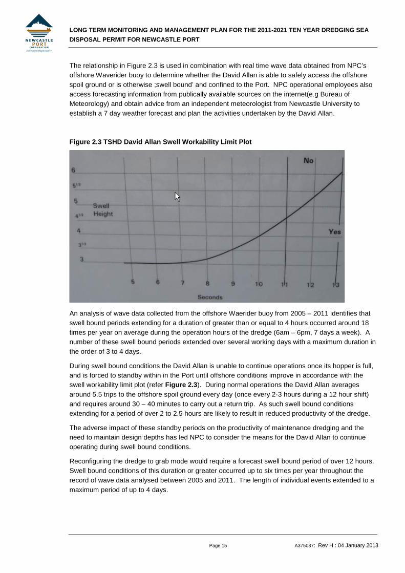
The relationship in Figure 2.3 is used in combination with real time wave data obtained from NPC’s offshore Waverider buoy to determine whether the David Allan is able to safely access the offshore spoil ground or is otherwise ;swell bound’ and confined to the Port. NPC operational employees also access forecasting information from publically available sources on the internet(e.g Bureau of Meteorology) and obtain advice from an independent meteorologist from Newcastle University to establish a 7 day weather forecast and plan the activities undertaken by the David Allan.
Figure 2.3 TSHD David Allan Swell Workability Limit Plot
An analysis of wave data collected from the offshore Waerider buoy from 2005 – 2011 identifies that swell bound periods extending for a duration of greater than or equal to 4 hours occurred around 18 times per year on average during the operation hours of the dredge (6am – 6pm, 7 days a week). A number of these swell bound periods extended over several working days with a maximum duration in the order of 3 to 4 days.
During swell bound conditions the David Allan is unable to continue operations once its hopper is full, and is forced to standby within in the Port until offshore conditions improve in accordance with the swell workability limit plot (refer Figure 2.3). During normal operations the David Allan averages around 5.5 trips to the offshore spoil ground every day (once every 2-3 hours during a 12 hour shift) and requires around 30 – 40 minutes to carry out a return trip. As such swell bound conditions extending for a period of over 2 to 2.5 hours are likely to result in reduced productivity of the dredge.
The adverse impact of these standby periods on the productivity of maintenance dredging and the need to maintain design depths has led NPC to consider the means for the David Allan to continue operating during swell bound conditions.
Reconfiguring the dredge to grab mode would require a forecast swell bound period of over 12 hours. Swell bound conditions of this duration or greater occurred up to six times per year throughout the record of wave data analysed between 2005 and 2011. The length of individual events extended to a maximum period of up to 4 days.
LONG TERM MONITORING AND MANAGEMENT PLAN FOR THE 2011-2021 TEN YEAR DREDGING SEA DISPOSAL PERMIT FOR NEWCASTLE PORT
Page 16 A375087: Rev H : 04 January 2013
Therefore it is anticipated that the temporary storage site would be used around 6 times per year and require the capacity to receive a maximum of around 2000 in-situ m3 of dredged material (i.e. 4 days of production in grab mode ate a rate of 475m3 in-situ per 12 hour day).
2.2.3.2 PROPOSED LOCATIONS TO BE DREDGED DURING SWELL BOUND CONDITIONS
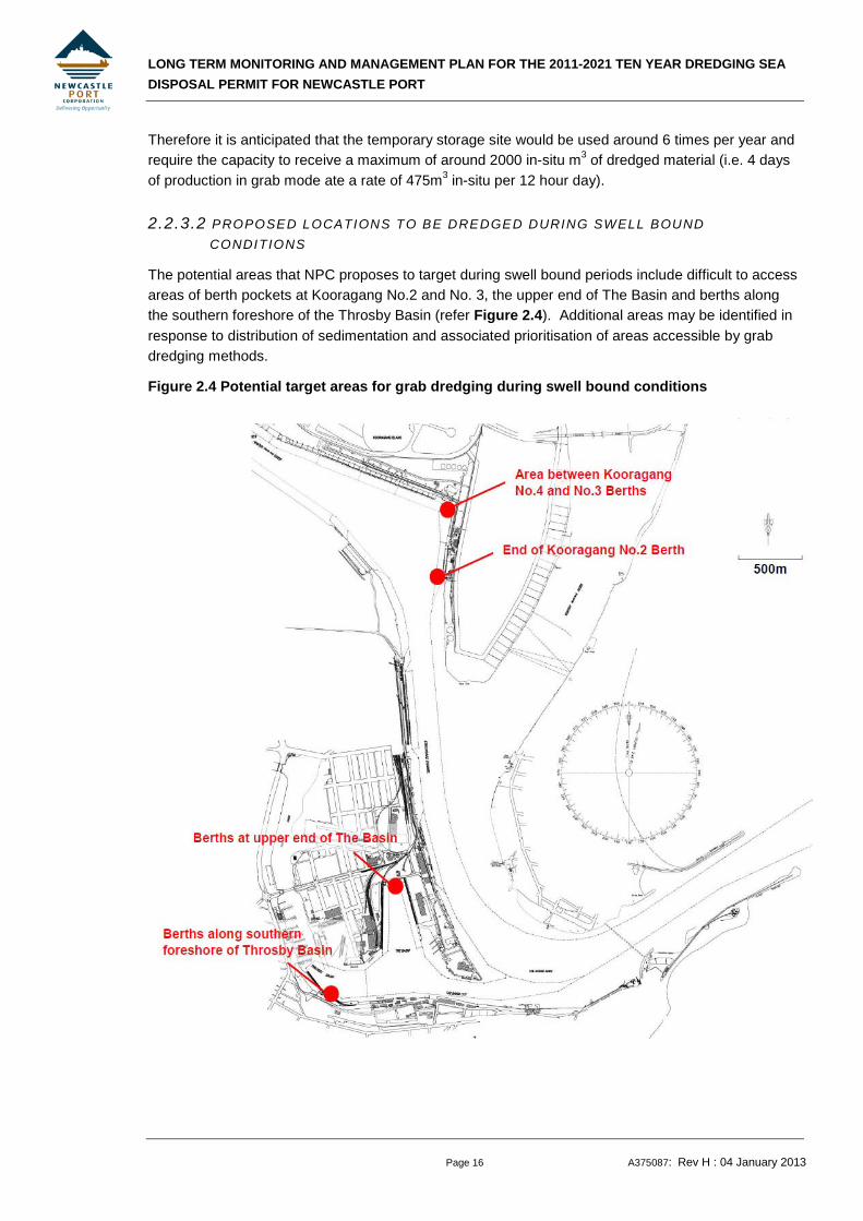
The potential areas that NPC proposes to target during swell bound periods include difficult to access areas of berth pockets at Kooragang No.2 and No. 3, the upper end of The Basin and berths along the southern foreshore of the Throsby Basin (refer Figure 2.4). Additional areas may be identified in response to distribution of sedimentation and associated prioritisation of areas accessible by grab dredging methods.
Figure 2.4 Potential target areas for grab dredging during swell bound conditions

LONG TERM MONITORING AND MANAGEMENT PLAN FOR THE 2011-2021 TEN YEAR DREDGING SEA DISPOSAL PERMIT FOR NEWCASTLE PORT
Page 17 A375087: Rev H : 04 January 2013
2.2.3.3 PROPOSED TEMPORARY STORAGE SITE
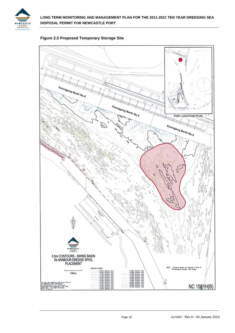
The preferred area for temporary storage of dredge material during swell bound conditions is a depression within the existing ‘Kooragang Swing Basin’ area in the vicinity of Kooragang Berth No. 4 (refer Figure 2.5).
The site has a bed level consistently below design depth of the shipping channel (i.e. deeper that 15.2 metres below Newcastle Harbour Tide Gauge Zero [NHTGZ] datum) and would therefore have the storage capacity to temporarily receive dredged material without adversely impacting on navigation. Based on a recent survey undertaken by NPC, the depression in the Swing Basin areas has a maximum depth of around 17m NHGTZ datum (1.8m below the design depth). The estimated storage capacity within the area indicated in Figure 2.5 is approximately 84,000m3 below a level of – 15.2 NHTGZ (design depth) and around 38,000m3 below a level of -16, NHTGZ (approximate existing bed level around the perimeter of the area).
2.2.3.4 PROCEDURE FOR RE-DREDGING AND DISPOSAL OF STORED MATERIAL
The use of the grab will enable an ‘in-situ ‘ bite to be taken from the seabed an d placed within the dredge hopper with less water entrainment that dredging using hydraulic action in ‘trailing mode’. Once the hopper is at its capacity, the dredge would retrieve its anchors and transport the dredged material through the Port to the nominated temporary storage area (refer Figure 2.5). In grab mode the David Allan would be able to achieve a maximum production rate of 475 insitu m3 per 12 hour working day.
The David Allan has a hopper capacity of 1000m3. If the dredge is swell bound for a number of days, the dredge would be filled to capacity prior to disposal at the temporary placement areas in order to reduce the number of bottom dumping events in the Swing Basin. This may involve holding the material in the dredge overnight and recommencing grab dredging the following day.
If at the end of a day of grab dredging, the forecast indicates an improvement in swell conditions, the dredge material would be held overnight in the David Allan and disposed of to the offshore spoil ground the following day.
Any material placed in the temporary storage site would not be placed there indefinitely. Once adverse sea conditions subside, the David Allan would proceed as a priority to re-dredge the temporarily stored material, operating in its more efficient trailing mode. Re-dredging of the temporarily stored material in trailing mode would involve less than one day of dredging, noting that in trailing mode the average daily production rate is about 2500 in-situ m3 per 12 hour day. The material would be transported out of the harbour for bottom dumping at the nominated offshore spoil ground for NPC maintenance dredge material as described in Section 2.1.
The ten year sea dumping permit allows NPC to dredge up to 6, 450,000m3 of maintenance dredge material from throughout the Port for the ten year period from March 2012, including those areas proposed to be dredged during swell bound conditions and the area containing the temporary storage site. All maintenance dredge material has been geochemically characterised and approved by SEWPaC for unconfined sea disposal. NPC would re-dredge an equivalent in-situ volume of the material from the temporary storage site.
LONG TERM MONITORING AND MANAGEMENT PLAN FOR THE 2011-2021 TEN YEAR DREDGING SEA DISPOSAL PERMIT FOR NEWCASTLE PORT
Page 18 A375087: Rev H : 04 January 2013
Figure 2.5 Proposed Temporary Storage Site
LONG TERM MONITORING AND MANAGEMENT PLAN FOR THE 2011-2021 TEN YEAR DREDGING SEA DISPOSAL PERMIT FOR NEWCASTLE PORT
Page 19 A375087: Rev H : 04 January 2013
2.2.3.5 PROCEDURE FOR ACCOUNTING FOR VOLUME DREDGED AND DISPOSED IN PORT CHANNEL VERSUS VOLUMES RE-DREDGED AND DISPOSED OF AT THE OFFSHORE SPOIL GROUND
In accordance with Condition 17 of Sea Dumping Permit SD2011/1942, NPC maintain daily records for the time and date of each dredge run and dumping run (commencement and finishing); the position of the vessel at the beginning and end of each run and the volume of dredge material dumped. These records are maintained through the use of a daily vessel log and also a dredging summary spreadsheet.
The process that will be used to account for the volume dredged and disposed in the channel versus volumes re-dredged and disposed of at the offshore dump ground will be as follows:
The volume (in situ cubic metres) of material collected during operations in grab mode will be recorded in the dredging summary spreadsheet separately to that collected in suction mode. As mentioned previously (Section 2.2.3.4) this material may go to the offshore spoil ground if conditions are within the swell workability limits (Figure 2.3).
Each time material is temporarily deposited at the specified temporary storage ground the volume (in situ cubic metres) will be recorded in the dredging summary spreadsheet separately to the volume of material that is deposited at the offshore spoil ground.
The spoil ground is located within Area A of the channel (ref Figure 1.1), once adverse sea conditions subside, the David Allan would proceed as a priority to re-dredge the temporarily stored material, operating in its more efficient trailing mode. The volume of material dredged from the temporary storage location would be an equivalent to that placed there during the previous temporary storage operation. The volume of material re-dredged would be recorded in the vessel log and also in the dredging summary spreadsheet as part of the Area A totals. A comment would be inserted on the Area A total for the day to identify the portion derived from the temporary storage ground. The total volume deposited at the spoil ground for the day would be recorded in the dredging summary sheet.
NPC’s vessel log also records details of weather conditions that will correlate with the use of the temporary storage ground records maintained in the dredging summary sheet.
As per Condition 10 of SD2011/1942 nominees of the department will be granted access to witness, inspect, examine or audit any part of the operations. NPC will ensure that all records are maintained in a clear, accurate and traceable manner at all times.
LONG TERM MONITORING AND MANAGEMENT PLAN FOR THE 2011-2021 TEN YEAR DREDGING SEA DISPOSAL PERMIT FOR NEWCASTLE PORT
Page 20 A375087: Rev H : 04 January 2013
3. STATUTORY AND LEGISLATIVE FRAMEWORK
3.1 Sea Dumping Act
The Environment Protection (Sea Dumping) Act 1981 provides for the environmental assessment of the dredging and disposal of dredged material in Australian waters. Commonwealth approval from SEWPaC is required under the Environment Protection (Sea Dumping) Act 1981 for the dredging and disposal at sea of maintenance dredged material from the Port of Newcastle.
Under the Environment Protection (Sea Dumping) Act 1981 SEWPaC issued NPC with Sea Dumping Permit SD2011/1942 on 14 March 2012. The permit allows NPC to dump up to 6,450,000 cubic metres of sea bed material derived from maintenance dredging in the Port of Newcastle..
3.2 Crown Lands Act
Under the Crown Lands Act 1989, administered by the NSW Minister for the Environment, a license for dredging and disposal of dredge material on Crown land is required. The license for maintenance dredging only pertains to that part of Area E beyond a line joining the position of mean high water mark at the outermost points of the northern and southern breakwaters, as this defines the boundary between NSW Maritime channel ownership (for which all maintenance dredging approvals are in place) and Crown land further offshore. A licence for the sea disposal of the maintenance dredge material is also required as the dump ground is located on Crown land inshore from the three nautical mile limit of Coastal Waters in NSW.
NPC was granted licences under the Crown Lands Act 1989 from the Minister for the Environment for their maintenance dredging and disposal operations on 6 August 2009 (Licence Numbers RI 450958 and RI 450488 respectively). Licence RI 450958 is valid until revoked, licence RI 450488 has expired on 31 December 2012 and has since been replaced with new Licence RI 500434, dated 01 January 2013. This licence has been granted for a period of ten years in line with the ten year Sea Dumping Permit.
3.3 Coastal Protection Act
The Coastal Protection Act 1979, administered by the NSW Minister for the Environment does not have application to maintenance dredging within Newcastle Port since the Coastal Protection Regulation 2004 removes the need to obtain the concurrence of the Minister to carry out development on any estuary4
However, the Coastal Protection Act 1979 does have application to the sea disposal operations as the disposal ground is located inshore from the three nautical mile limit of Coastal Waters in NSW. NPC has been granted concurrence under the Coastal Protection Act 1979 from the Minister for the Environment for their maintenance dredging and disposal operations on 10th July 2012, which is valid until 30 June 2017. NPC will request ongoing concurrence from the Minister as required during the life of the new 10 year permit.
that forms part of the coastal zone.
4 ‘estuary’ includes any part of a river whose level is periodically or intermittently affected by coastal tides
LONG TERM MONITORING AND MANAGEMENT PLAN FOR THE 2011-2021 TEN YEAR DREDGING SEA DISPOSAL PERMIT FOR NEWCASTLE PORT
Page 21 A375087: Rev H : 04 January 2013
3.4 Protection of the Environment Operations Act
The Protection of the Environment Operations Act, 1997 (POEO Act) is the primary Act regulating pollution control and waste disposal in NSW. The Act gives the NSW Office of Environment and Heritage (OEH) the authority to issue licences and environment protection notices. Under the POEO Act, dredging of more than 30,000 m3 per year is classified as a scheduled activity and an environment protection licence (EPL) is required. Accordingly, NPC hold a current EPL (number 3373) for their maintenance dredging program. This licence has a Review Due Date of 5th September 2013 and will be amended as required during the life of the new 10 year permit.
3.5 Beach Nourishment Approvals
As noted in Section 2.2.2, the approvals process for the placement of maintenance dredge material from Area E off Stockton Beach for the beneficial purpose of beach nourishment is separate to the Sea Dumping Permit application. In a letter to NPC dated 9 July 2009, the Department of Environment, Heritage, Water and the Arts (DEWHA), now SEWPaC, confirmed that a permit under the Environment Protection (Sea Dumping) Act 1981 is not required for the placement of dredged sand off Stockton Beach for the purpose of beach nourishment as this activity is genuinely for a purpose other than the mere disposal of material. SEWPaC does however require notification of the activity occurring and that the material will not be disposed of at the disposal ground; and requires verification that the material from Area E is clean and of similar nature to the material at Stockton Beach.
Dredging of uncontaminated material from Area E and its placement off Stockton Beach fall under Part 5 of the Environmental Planning and Assessment Act 1979 (EP&A Act) and requires preparation of a Review of Environmental Factors (REF) or, depending on the potential environmental impact, an Environmental Impact Statement (EIS).
The following is a summary of the approvals that were obtained before the maintenance dredging in Area E and placement of dredged material off Stockton Beach was undertaken in June 2010:
• Crown Lands Act 1989 – Licenses for dredging and placement of dredge material on Crown land (Licence Numbers RI 450958 and RI 450488 respectively) were granted by the Minister on 6 August 2009. Licence RI 450958 is valid until revoked while licence RI 450488 has been replaced with Licence RI 500434 for a period of ten years in line with the sea dumping permit. Further renewals will be sought as required during the life of the new 10 year permit
• Coastal Protection Act 1979 – Concurrence was granted by the Minister for the Environment on 7 July 2011 for the maintenance dredging of up to 150,000 m3 of material from Area E and the disposal of the material offshore of Stockton Beach. This concurrence is valid until 30 June 2015. Further concurrence will be obtained as required during the life of the new 10 year permit.
• Protection of the Environment Operations Act 1997 – Dredging and placement activities associated with the nourishment of Stockton Beach are also bound by the conditions set out in EPL number 3373.
• Fisheries Management Act 1994 – Notification to the Minister of Primary Industries was given and issues raised by the Minister were considered during formulation of the project proposal and preparation of the REF.
LONG TERM MONITORING AND MANAGEMENT PLAN FOR THE 2011-2021 TEN YEAR DREDGING SEA DISPOSAL PERMIT FOR NEWCASTLE PORT
Page 22 A375087: Rev H : 04 January 2013
3.6 Temporary Storage Approvals
Existing Approvals
Maintenance dredging has been carried out on an almost continuous basis since dredging commenced in the Port in 1859 (WP, 2009a). The maintenance dredging and the offshore disposal of the material at the designated spoil ground are approved under a Commonwealth 10 year sea dumping permit and are managed via a long term monitoring and management plan (as described above). NPC also hold a NSW environmental protection licence (EPL) for the dredging within the Port.
As NPC’s maintenance dredging activities pre-date legislation such as the EP&A Act and EP&A Regulation, an environmental assessment, such as a REF, has not been completed for the Port’s on-going maintenance dredging activities. However, for activities outside the usual maintenance dredging and offshore disposal activities, environmental assessments have been undertaken by NPC and approvals sought. Specifically, in addition to this REF for the temporary placement of dredge material within the Port during swell bound conditions, an REF was prepared for the Area E Port entrance dredging and beach nourishment activities.
NSW Planning and Approvals
The statutory basis for planning and environmental assessment in New South Wales is set out in the Environmental Planning and Assessment Act 1979 (EP&A Act) and the Environmental Planning and Assessment Regulation 2000 (EP&A Regulation). The proposal, as an activity, would be undertaken under Part 5 of the EP&A Act. In accordance with the requirements of the Act a Review of Environmental Factors (REF) has been prepared and submitted to Newcastle Port Corporation as the determining authority for the activity.
Licences and Approvals
Roads and Maritime Service (RMS) is the owner of the bed within Newcastle Port. As such, NPC is required to obtain land owners consent from RMS. Upon receiving the Part 5 approval this along with a copy of the REF will be submitted to RMS.
Relevant additional State Legislation that applies to the activity is as follows:
• Protection of the Environment Operations Act 1997 (POEO Act) – Environmental Protection
Licence
An Environment Protection Licence (EPL) from the NSW Environment Protection Authority (EPA) is required for the dredging of more than 30,000 m3 per annum. NPC currently holds an EPL for the dredging (L3373) for > 500,000 to 2,000,000 m3 of water-based extractive activities.

LONG TERM MONITORING AND MANAGEMENT PLAN FOR THE 2011-2021 TEN YEAR DREDGING SEA DISPOSAL PERMIT FOR NEWCASTLE PORT
Page 23 A375087: Rev H : 04 January 2013
The EPA has advised that as the project does not fall into the definition of a scheduled activity for the purposes of the POEO Act, it does not legally require an EPL. The project falls within NPC’s existing licence requirements for dredging activities.
• Fisheries Management Act 1994 (FM Act), Clause 199 - Notification to the Minister for Primary
Industries
Whilst no formal approval is required for the proposed activities under the FM Act, in accordance with Clause 199 of the FM Act, NPC as a public authority, is required to provide notification to the Minister administering the FM Act prior to undertaking or authorising any dredging work. NPC is also required to consider any matters raised by the Minister.
Commonwealth Legislation
An EPBC Act Protected Matters Search was undertaken using a 5km buffer around the Port. Following review of the search results, it was considered that the proposed temporary storage and re-dredging of maintenance dredge material would not significantly impact on matters of NES or the environment. Therefore, referral to the Minister and approval under the EPBC Act is not considered to be required.
The proposed temporary storage of sediment within the Port is to be undertaken wholly inside waters within the limits of the State and is regulated by State legislation, i.e. does not require approval under the Environment Protection (Sea Dumping) Act 1981. However, the re-dredging of the material for the purpose of sea disposal is regulated under the EPSD Act and therefore issues raised by SEWPaC were considered in the REF. A letter issued by Department of Sustainability, Environment, Water, Populations and Communities (SEWPaC) on 23 November 2012 stated that the re-dredging of the material would not require a variation to NPC’s current Ten Year Sea Dumping Permit issued by the Minister on 14th March 2012 but would require amendment of this LTMMP to include the proposed temporary storage activity and approval of the amended LTMMP by SEWPaC.
LONG TERM MONITORING AND MANAGEMENT PLAN FOR THE 2011-2021 TEN YEAR DREDGING SEA DISPOSAL PERMIT FOR NEWCASTLE PORT
Page 24 A375087: Rev H : 04 January 2013
4. DESCRIPTION OF THE EXISTING ENVIRONMENT
4.1 Processes and Climate
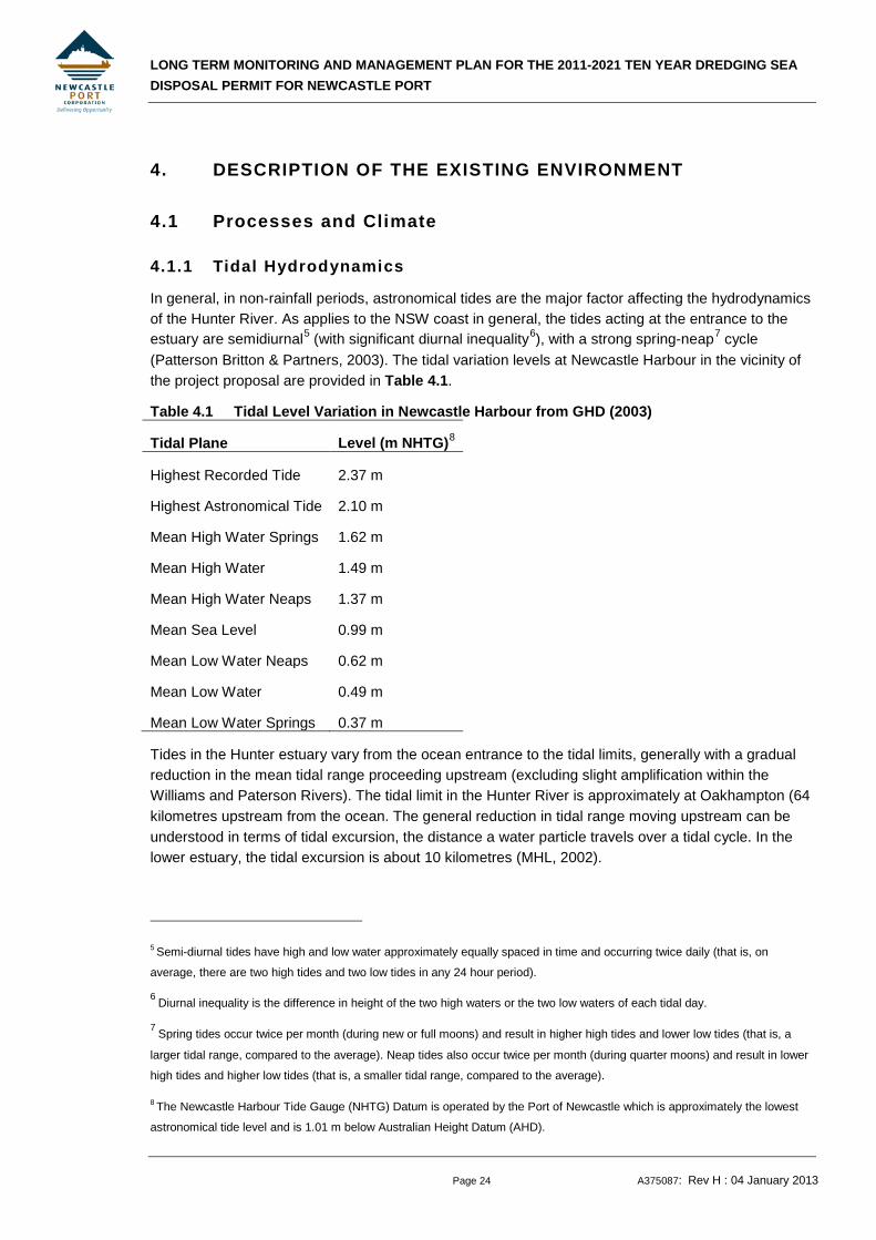
4.1.1 Tidal Hydrodynamics
In general, in non-rainfall periods, astronomical tides are the major factor affecting the hydrodynamics of the Hunter River. As applies to the NSW coast in general, the tides acting at the entrance to the estuary are semidiurnal5 (with significant diurnal inequality6), with a strong spring-neap7
Table 4.1 Tidal Level Variation in Newcastle Harbour from GHD (2003)
cycle (Patterson Britton & Partners, 2003). The tidal variation levels at Newcastle Harbour in the vicinity of the project proposal are provided in Table 4.1.
Tidal Plane Level (m NHTG)8
Highest Recorded Tide 2.37 m
Highest Astronomical Tide 2.10 m
Mean High Water Springs 1.62 m
Mean High Water 1.49 m
Mean High Water Neaps 1.37 m
Mean Sea Level 0.99 m
Mean Low Water Neaps 0.62 m
Mean Low Water 0.49 m
Mean Low Water Springs 0.37 m
Tides in the Hunter estuary vary from the ocean entrance to the tidal limits, generally with a gradual reduction in the mean tidal range proceeding upstream (excluding slight amplification within the Williams and Paterson Rivers). The tidal limit in the Hunter River is approximately at Oakhampton (64 kilometres upstream from the ocean. The general reduction in tidal range moving upstream can be understood in terms of tidal excursion, the distance a water particle travels over a tidal cycle. In the lower estuary, the tidal excursion is about 10 kilometres (MHL, 2002).
5 Semi-diurnal tides have high and low water approximately equally spaced in time and occurring twice daily (that is, on
average, there are two high tides and two low tides in any 24 hour period).
6 Diurnal inequality is the difference in height of the two high waters or the two low waters of each tidal day.
7 Spring tides occur twice per month (during new or full moons) and result in higher high tides and lower low tides (that is, a
larger tidal range, compared to the average). Neap tides also occur twice per month (during quarter moons) and result in lower
high tides and higher low tides (that is, a smaller tidal range, compared to the average).
8 The Newcastle Harbour Tide Gauge (NHTG) Datum is operated by the Port of Newcastle which is approximately the lowest
astronomical tide level and is 1.01 m below Australian Height Datum (AHD).
LONG TERM MONITORING AND MANAGEMENT PLAN FOR THE 2011-2021 TEN YEAR DREDGING SEA DISPOSAL PERMIT FOR NEWCASTLE PORT
Page 25 A375087: Rev H : 04 January 2013
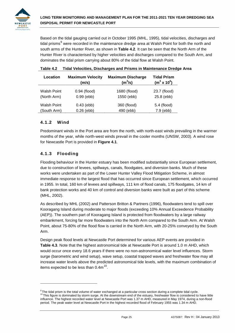
Based on the tidal gauging carried out in October 1995 (MHL, 1995), tidal velocities, discharges and tidal prisms9
Table 4.2 Tidal Velocities, Discharges and Prisms in Maintenance Dredge Area
were recorded in the maintenance dredge area at Walsh Point for both the north and south arms of the Hunter River, as shown in Table 4.2. It can be seen that the North Arm of the Hunter River is characterised by higher velocities and discharges compared to the South Arm, and dominates the tidal prism carrying about 80% of the tidal flow at Walsh Point.
Location Maximum Velocity (m/s)
Maximum Discharge (m3/s)
Tidal Prism (m3 x 106)
Walsh Point (North Arm)
0.94 (flood) 0.99 (ebb)
1680 (flood) 1550 (ebb)
23.7 (flood) 25.8 (ebb)
Walsh Point (South Arm)
0.43 (ebb) 0.26 (ebb)
360 (flood) 490 (ebb)
5.4 (flood) 7.9 (ebb)
4.1.2 Wind
Predominant winds in the Port area are from the north, with north-east winds prevailing in the warmer months of the year, while north-west winds prevail in the cooler months (UNSW, 2003). A wind rose for Newcastle Port is provided in Figure 4.1.
4.1.3 Flooding
Flooding behaviour in the Hunter estuary has been modified substantially since European settlement, due to construction of levees, spillways, canals, floodgates, and diversion banks. Much of these works were undertaken as part of the Lower Hunter Valley Flood Mitigation Scheme, in almost immediate response to the largest flood that has occurred since European settlement, which occurred in 1955. In total, 160 km of levees and spillways, 111 km of flood canals, 175 floodgates, 14 km of bank protection works and 40 km of control and diversion banks were built as part of this scheme (MHL, 2002).
As described by MHL (2002) and Patterson Britton & Partners (1996), floodwaters tend to spill over Kooragang Island during moderate to major floods (exceeding 10% Annual Exceedence Probability (AEP)). The southern part of Kooragang Island is protected from floodwaters by a large railway embankment, forcing far more floodwaters into the North Arm compared to the South Arm. At Walsh Point, about 75-80% of the flood flow is carried in the North Arm, with 20-25% conveyed by the South Arm.
Design peak flood levels at Newcastle Port determined for various AEP events are provided in Table 4.3. Note that the highest astronomical tide at Newcastle Port is around 1.0 m AHD, which would occur once every 18.6 years if there were no non-astronomical water level influences. Storm surge (barometric and wind setup), wave setup, coastal trapped waves and freshwater flow may all increase water levels above the predicted astronomical tide levels, with the maximum combination of items expected to be less than 0.4m10
9 The tidal prism is the total volume of water exchanged at a particular cross section during a complete tidal cycle.
.
10 This figure is dominated by storm surge. At the downstream end of the estuary, freshwater flow is considered to have little influence. The highest recorded water level at Newcastle Port was 1.37 m AHD, measured in May 1974, during a non-flood period. The peak water level at Newcastle Port in the highest recorded flood of February 1955 was 1.34 m AHD.

LONG TERM MONITORING AND MANAGEMENT PLAN FOR THE 2011-2021 TEN YEAR DREDGING SEA DISPOSAL PERMIT FOR NEWCASTLE PORT
Page 26 A375087: Rev H : 04 January 2013
Table 4.3 Design Peak Flood Levels at Newcastle Port from PWD (1994)
Peak Flood Level (m AHD) for Design Event AEP
20% 10% 5% 2% 1%
3.49 4.12 4.57 4.91 5.55
4.1.4 Turbidity
Sanderson and Redden (2001) compiled and analysed 28 years of water quality measurements taken throughout the Hunter River estuary, including turbidity. Observations of this work included:
• high turbidity values were common, with turbidity values highest during large freshwater flows; and,
• the mean turbidity value was 15 NTU, with increasing values moving upstream.
More recently, Patterson Britton and Partners (now Worley Parsons) undertook a substantial real-time water quality monitoring program at five background and near field station within the South Arm of the Hunter River as a component of the environmental obligations for the capital dredging works recently undertaken by Newcastle Coal Infrastructure Group (NCIG) (PBP, 2008).
Background turbidity levels in the Hunter River vary widely from close to 0 NTU to over 100 NTU, with a long term average of 14 NTU at Ironbark Creek. Episodes of elevated turbidity >100 NTU can last for hours or days. Major factors affecting turbidity are tidal currents, river flow, local rainfall and vessel movements in the port.
The results of the baseline monitoring study indicated that the Hunter estuary is a highly dynamic and naturally turbid environment. Therefore, it is generally expected that any turbidity impacts related to maintenance dredging activities would be minimal.
4.1.5 Offshore Wave Climate and Currents
The dump ground is located in the south-west Pacific at around 33°S and receives waves generated in the southern Coral and Tasman Seas and the Southern Ocean. The annual wave climate is both energetic and highly variable with a distinct seasonality present. Based on a recent analysis of long-term records the months of March and June-July experience the largest average monthly wave heights (Harley et al, 2009). Although moderate waves dominate the climate, large waves (Hs
11
Manly Hydraulics Laboratory (MHL), part of the NSW Department of Service Technology and Administration, operates a network of Waverider buoys in deep water along the NSW coast. Wave data collected by the Sydney Waverider Buoy is considered to be representative of offshore wave conditions at the dump ground. Available MHL wave data from the Sydney Waverider Buoy covered the period from 10 October 1985 to 31 August 2008.
>4 m) and/or low swell may occur in any month (Short and Trenaman, 1992). Extreme events (Hs>6m) occur predominately in autumn and winter. Waves in the region are generated by five typical meteorological systems: east-coast lows, tropical cyclones, mid-latitude cyclones, zonal anticyclonic highs and local summer sea breezes (Short and Trenaman, 1992).
11 Hs is the significant wave height, which is the average height of the highest one third of waves recorded in a given monitoring period.

LONG TERM MONITORING AND MANAGEMENT PLAN FOR THE 2011-2021 TEN YEAR DREDGING SEA DISPOSAL PERMIT FOR NEWCASTLE PORT
Page 27 A375087: Rev H : 04 January 2013
Figure 4.2 shows the wave height and wave period roses for the entire dataset. Wave roses show that the majority (approximately 65%) of offshore wave energy propagates from the S-SE sector (i.e. S, SSE and SE cardinal directions). S-SE waves originate from storms and swell in the Tasman Sea and Southern Ocean and can occur during any season. Easterly waves (i.e. ESE, E and ENE cardinal directions) make up approximately 30% of the total offshore wave energy. N-NE waves make up approximately 3% of the offshore wave energy and are generated by summer sea breeze systems and tropical cyclones in the Coral Sea. The largest period waves typically occur from the S-SE sector in the winter months. The median wave direction was 148° (SSE), with the weighted vector average storm wave direction equal to 140° (SE).
The dump ground experiences south-westerly currents over 60% of the time (predominantly in summer) with a current reversal in winter.
4.2 Maintenance Dredge Areas
4.2.1 Physical and Chemical Description of Material
A sediment sampling and testing program was undertaken in April 2012 to provide current sediment quality data for the maintenance dredge material derived from areas A to F. Details of the program are provided in Worley Parsons (301015-02409).
.Sediment from within Areas A, B, C and D was observed to be generally uniform and comprises mainly silt and clay, while the material for Area E typically comprises poorly sorted sand. The results of the five representative samples taken from each of the dredge areas A, B, C, D and E indicate that:
• The physical characteristics of sediments in Area F are generally similar and consisted predominantly of a dark grey mud (<63µm) with mud content ranging from 35% to 100% higher proportions of sand were found in near the banks of the channel in this area..
• samples from Areas A, B, C and D consisted predominantly of dark brown or grey muds (<63µm) with mud content ranging from 12% to 99%;
• sediment in Area E consisted predominantly of poorly sorted sand (>63µm 2mm) with a content ranging from 70% to 84%;
• sand content in samples increased closer to the Port entrance, ranging from <1% to 80% in Areas A, B, C, D and F and up to 89% in Area E,; and
• Significant amounts of gravel (>2 mm) were reported from 3 sediment samples; Area F, one sample comprising 12%; Area E one sample comprising 10% and Area A one sample comprising 3%. Four other samples comprised of 1% of gravel..
The results of the sediment sampling and testing exercise were compared to the National Assessment Guidelines for Dredging (NAGD) (Commonwealth of Australia, 2009). The results were also compared to data for previously tested maintenance dredge material. The main findings of the investigation were as follows:
• the 95% upper confidence limit (UCL) of the mean concentration of Sb, As, Cd, Cr, Cu, Pb, Ag, Hg, PAHs, OC pesticides and PCBs were below NAGD screening levels;
• the 95% UCL of the mean concentration of Ni and Zn exceeded NAGD screening levels In Areas F. However concentrations of Zn and Ni were comparable to those observed in the 2009
LONG TERM MONITORING AND MANAGEMENT PLAN FOR THE 2011-2021 TEN YEAR DREDGING SEA DISPOSAL PERMIT FOR NEWCASTLE PORT
Page 28 A375087: Rev H : 04 January 2013
investigation. Previous studies undertaken by CSIRO have shown that these metals in sediments from the South Arm of the Hunter River are not bio-available.
• the 95% UCL of the mean concentration of Ni and Zn exceeded NAGD screening levels in Areas A – E. Concentrations of Zn were comparable to those observed in the 2009 investigation; however the 95% UCL of the mean concentration of Ni was slightly higher. Previous studies undertaken by CSIRO have shown that these metals in sediments from the South Arm of the Hunter River are not bio-available.
• the 95% UCL of the mean concentration of tributyltin (TBT) for Areas A, B, D, E and F was below the NAGD screening level;
• elevated concentrations of TBT were observed within The Basin (Area C);
• the 95% UCL of the mean concentration of TBT within The Basin was 11.4 μgSn/kg which exceeded the NAGD screening level but was less than half of that observed in the 2009 investigation (29.4μgSn/kg); and
• elutriate testing showed that elutriate TBT concentrations were below the ANZECC/ARMCANZ (2000) water quality guidelines for TBT (95% protection of species) without taking dilution into account indicating the TBT contamination is unlikely to result in adverse impacts during dredging and disposal.
The results of the April 2012sampling and testing program have indicated that the maintenance dredge material from Areas A, B, C, D and E is suitable for unconfined sea disposal.
It is expected that the maintenance dredge material for Area G will largely comprise sediments deposited by fluvial processes and should therefore be relatively similar to maintenance dredge material derived from Areas A, B, C, D and F, i.e. suitable for unconfined sea disposal. This will be verified by sediment sampling and testing programs that will provide current sediment quality data for the maintenance dredge material in Area G. These programs will be implemented prior to the commencement of maintenance dredging operations in these areas, as described in Section 6.2.3.
4.2.2 Introduced Marine Organisms
A survey of introduced marine organisms was undertaken by the Centre for Research on Introduced Marine Pests (CRIMP) for the Newcastle Port Corporation between 23 August and 3 September, 1997, with results documented in CRIMP (1999). The survey was undertaken as part of the Australian Association of Port and Marine Authorities (AAPMA)/CRIMP national port survey initiative.
The national survey is designed to determine the distribution and abundance of a targeted group of introduced species in each port. These targeted species are made up of:
• those species listed on the Australian Ballast Water Management Advisory Council (ABWMAC) schedule of introduced pest species;
• a group of species which are major pests in overseas ports and which, on the basis of their invasive history and projected shipping movements, might be expected to colonise Australian ports; and
• those known exotic species in Australian waters that currently are not assigned pest status.
Two ABWMAC targeted pest species were recorded in the Port of Newcastle during the survey. The pest species included the toxic dinoflagellates Alexandrium catenella and A. minutum. These two
LONG TERM MONITORING AND MANAGEMENT PLAN FOR THE 2011-2021 TEN YEAR DREDGING SEA DISPOSAL PERMIT FOR NEWCASTLE PORT
Page 29 A375087: Rev H : 04 January 2013
species were distributed throughout the commercial areas of the Port. No other ABWMAC targeted pest species were recorded from the Port or adjacent areas.
Several other introduced and cryptogenic (i.e., of unknown origin) species were recorded in the region. These species are recognised as having been transferred to Australia in both historic and modern times, but do not pose significant economic or environmental threat (CRIMP, 1999).
The Newcastle Introduced Species Survey report (CRIMP, 1999) includes an assessment of the risk of translocation of introduced species found in the Port. The report notes that of the introduced species detected in the port, the majority of species are not restricted to estuarine environments and may be capable of extending their range beyond the Newcastle locale.
However, dredging practices are considered unlikely to influence the distribution of species in the Port with the exception of toxic dinoflagellate species. The potential for these organisms to be transported in the dredged material is evident as cysts of both species have been identified at the dredge spoil dump grounds.
4.3 Offshore Dump Ground
4.3.1 Previous Dump Ground Use
Dredging commenced in the Port in 1859 and has been virtually continuous since that time. Total dredging quantities up to 1993 are estimated to have been greater than 130 million cubic metres, almost all of which, some 120 million cubic metres, has been deposited in the current dump ground (Patterson Britton & Partners, 1992). Four different dump grounds have been used at various times over the years (refer Figure 2.2).
The current dump ground corresponds to the approximate position of the original dump ground. It was used for more than a century prior to establishment of the dump ground for major port deepening in 1978. The current dump ground was re-introduced in February 1997. It is now well established and is the disposal area currently approved by SEWPaC. There is no evidence in the available data to indicate any significant adverse environmental impacts from use of this area for disposal of dredged material.
4.3.2 Disposal Route
The dump ground is located within NSW Coastal Waters offshore of Newcastle. Water depth at the dump ground ranges from 25 to 30 m below Chart Datum. The route taken by the vessel transporting dredged material from the dredge area to the dump ground is shown on Figure 4.3. The vessel takes the most direct route from the dredge area to the port entrance. Once out of the port entrance, the vessel turns southeast, travels to the dump ground, swings around and when heading back to the entrance dumps material over the dump ground.
4.3.3 Description of Dump Ground
A number of studies have been undertaken to characterise the offshore area and to ascertain the fate of material placed in the various dump grounds over time. Studies have included chemical and physical sediment analyses, sidescan sonar, biological sampling and Remotely Operated Vehicle (ROV) video surveys. A more detailed description of the findings of the studies is presented in the maintenance dredging permit application. An overview of the key characteristics of the dump ground is provided below.

LONG TERM MONITORING AND MANAGEMENT PLAN FOR THE 2011-2021 TEN YEAR DREDGING SEA DISPOSAL PERMIT FOR NEWCASTLE PORT
Page 30 A375087: Rev H : 04 January 2013
The most recent sediment sampling and testing program was undertaken in December 2008 and January 2009 to provide current sediment quality data for the dump ground, in addition to broader sampling required to confirm the dispersion pathway of the sediment using the chemical and physical properties of the sediment as tracers. Details of the program are provided in Worley Parsons (2009c), which included the following findings:
• Sediments at the current dump ground differ from the sediments in similar depths elsewhere off Newcastle, in that they contain significant, albeit variable, quantities of mud and other material derived from dumping activities.
• The mud fraction disperses from the dump ground in a south easterly direction before settling in water depths of 60 to 100 m where elevated concentrations of contaminants (compared to the clean sands of the inner shelf) were found in the muddy sediment. These concentrations were compared to other sediment quality data for the NSW Coast and overseas and were found to be in the typical range of background levels.
• A zone with boundaries approximately 5 km north of the spoil ground and out to a water depth of around 60 m is influenced by sediments dispersed from the spoil ground.
• Sampling at the two inshore locations confirmed the offshore movement of the spoil from the dump ground, i.e. the inshore samples had a very low mud content, low contamination concentrations and no “exotic” rock fragments typical of dumped material. However, it was recommended that a greater sampling density could be adopted in any future sampling to provide more information on the mud content and contamination concentrations inshore of the current dump ground.
A conceptual model of the far field dispersion of dumped dredge material is provided in Figure 4.4.
Chemical testing of sediment samples retrieved from the dump ground and surrounding offshore area during the 2009 sediment sampling and testing exercise included analysis for:
• a suite of heavy metals (As, Cd, Co, Cr, Cu, Ni, Pb, Hg, Se, Zn);
• Polycyclic Aromatic Hydrocarbons (PAH’s); and
• total organic carbon (TOC).
The investigations showed that the mean concentration and the 95% upper confidence limit of the mean concentration for all areas investigated were below the NAGD screening level (Worley Parsons, 2009c).
Sampling of the existing benthic communities within the dump ground and two nearby control areas was undertaken by The Ecology Lab in 2001. The investigations showed that the biodiversity and benthic productivity in the sediments at the dump ground is reduced compared to nearby areas in similar water depths, situated beyond the influence of the dumping activities. This is likely to be due to the differing physical characteristics of the sediment samples from the dump ground, i.e. mud content, rather than due to contamination concentrations since the concentrations of contaminants in the samples from the dump ground were generally below the then NODGDM Screening Levels (hence there is a low probability there would be effects on benthic biota).
An ROV investigation undertaken in 2001 showed that the dump ground contained areas of gravel, rock and boulders, particularly the south-eastern portion of the dump ground, which would have been the result of the capital dredging activities associated with the major port deepening between 1978
LONG TERM MONITORING AND MANAGEMENT PLAN FOR THE 2011-2021 TEN YEAR DREDGING SEA DISPOSAL PERMIT FOR NEWCASTLE PORT
Page 31 A375087: Rev H : 04 January 2013
and 1983. The investigations showed that these areas are providing habitat for sponges, bryozoans and filamentous algae. Juvenile snapper were also observed in the vicinity of the rocks and boulders.
The Interactive Map Search facility on SEWPaC’s Environment Protection and Biodiversity Conservation Act (EPBC) web page was used to provide an indication of flora and fauna potentially present within the dump ground. The results of this search are provided in Appendix B. The search identified 36 Threatened species, 65 Migratory species and 83 Marine protected species that are likely to exist (or their habitat may exist) within the defined search area. Of the threatened species identified, 18 are marine birds and comprise Albatross and Petrel species, three are whales (Blue, Southern Right and Humpback), four are sharks (Grey Nurse, Great White and Whale Shark, and Sawfish), and five are marine reptiles (various turtle species). These species are all reported as being covered by migratory provisions of the EPBC Act, 1999.
Of the 83 Marine Protected Species, 22 comprise seahorses and pipefish, and the balance is made up of marine birds, mammals and reptiles, the majority of which are included above. The exceptions are the Yellow-bellied Sea snake and a number of bird species that are not classified as marine species, but that ‘overfly’ the marine area.
4.4 Fisheries
Along the Newcastle coastline there are several areas identified as fish breeding reefs and others regarded as angling reefs. These areas, such as Mudhole Reef and The Pinnacles, as well as rock reefs found directly along the coastline from Nobby’s Head south to Redhead Point, are several kilometres inshore from the proposed dump ground (refer Figure 4.5).
Patterson Britton & Partners (2005) investigated possible effects of disposal activities on recreational and commercial fishing near the dump ground. Discussions held with the Newcastle District Angler’s Association revealed that the offshore dump ground locations are apparently highly regarded by recreational line fishers. Particularly sought after are immature reef species such as young snapper and bream. It is thought that the success of the dump ground for recreational fishing is due to the existence of “solid” objects on the seabed, being the rock from the harbour deepening project that was evident in the 1992 sidescan sonar records (Patterson Britton & Partners, 1992). Commercial fishermen operating in trawl fisheries avoid the dump grounds due to the higher risk of damage to nets and other trawl gear in this area. Indeed, correspondence with the Newcastle Commercial Fisherman’s Cooperative indicated that commercial fishers only utilise areas seaward of the dump grounds, i.e. Commonwealth Waters immediately offshore.
As outlined in GHD (2003), there are a number of commercial oyster leases towards the eastern end of the North Arm (approximately two kilometres north of where the North and South Arms of the Hunter River rejoin before discharging to the ocean). Some commercial fishing takes place within both the North and South Arms, while the main recreational uses are fishing from boats and the banks of the South Arm.
4.5 Indigenous Cultural Resources
The Interactive Map Search facility on SEWPaC’s EPBC web page (refer Appendix B for search results) listed one indigenous site within the study area as a place on the Register of the National Estate (RNE). This place is Nobbys Head (Former Island), and its heritage value is protected under the EPBC Act.

LONG TERM MONITORING AND MANAGEMENT PLAN FOR THE 2011-2021 TEN YEAR DREDGING SEA DISPOSAL PERMIT FOR NEWCASTLE PORT
Page 32 A375087: Rev H : 04 January 2013
A search of OEH’s Declared Aboriginal Places in NSW web page was undertaken on 25 January 2011. No sites within the study area were identified from the search.
A survey of the northern bank of the South Arm of the Hunter River was undertaken as part of the EIS reported in GHD (2003). No Aboriginal heritage sites were located during the survey given that a large proportion of the study area consists of imported fill. A survey of the southern bank of the South Arm of the Hunter River was deemed unnecessary given the significant disturbance that has occurred to land in this area as a result of reclamation and industrial activities.
4.6 Non-Indigenous Cultural Resources
The Interactive Map Search facility on SEWPaC’s EPBC web page (refer Appendix B for search results) listed six historic sites within the study area as places on the RNE whose heritage values are protected under the EPBC Act.
Several shipwrecks exist just offshore of Newcastle, with all but one wreck identified as being several kilometres either north or inshore of the dump ground, as indicated on Figure 4.5. One unnamed wreck, lying approximately 2 km south of the dump ground, has been reported by Kapola. However, as outlined in Patterson Britton & Partners (2005), it is understood that this wreck and other areas offshore of the Newcastle Harbour entrance are not utilised frequently for diving, due to the consistently poor visibility encountered.
An Environmental Assessment was recently completed on behalf of Industry & Investment NSW for deploying three Offshore Artificial Reefs (OARs) in the vicinity of Newcastle, Sydney and Wollongong to improve recreational fishing opportunities in NSW (Cardno Ecology Lab, 2010). It is proposed that the Newcastle OAR would be deployed approximately 3.6 km offshore from Blacksmiths Beach and the entrance to Swansea Channel at a depth of around 28 m, which would allow for a depth of water over the OAR of around 16 m. Given that the proposed OAR site is approximately 30 km from the dump ground, and with reference to the dispersion pathway shown in Figure 4.4, it is not expected that dumping activities will impact on ecological conditions at the OAR.
LONG TERM MONITORING AND MANAGEMENT PLAN FOR THE 2011-2021 TEN YEAR DREDGING SEA DISPOSAL PERMIT FOR NEWCASTLE PORT
Page 33 A375087: Rev H : 04 January 2013
5. POTENTIAL IMPACTS AND MANAGEMENT STRATEGIES
5.1 General
A detailed assessment of the projected physical, chemical and biological impacts on the dump ground and surrounding areas has been undertaken in support of NPC’s 10 year Sea Dumping Permit application. This information has not been repeated in full in this LTMMP. However, an overview of the potential impacts that may result as a consequence of the dredging and disposal activities is provided below. Relevant management strategies for the project are also described and will be adhered to at all times.
5.2 Potential Impacts and Management Strategies
5.2.1 Turbidity Levels and Dispersal of Sediment
Turbidity is considered to be visually unappealing, symptomatic of land degradation and probably impacting many benthic processes (Patterson Britton & Partners, 2003). However, high turbidity also limits light penetration into the water and therefore limits phytoplankton blooms and growth of undesirable plants and algae. Given the high nutrient loads into the Hunter estuary, high turbidity levels are therefore considered to have some desirable side effects as far as phytoplankton control is concerned.
Negative impacts of high turbidity can occur. One ecosystem that can be affected is seagrasses. In the case of Newcastle Port, there are no seagrasses present in the port area or offshore dump ground. However, it has been suggested that high turbidity is the reason for the small numbers of oysters present in the Hunter estuary. Increases in turbidity may also affect the foraging behaviour of fish, and suspended sediments may abrade the protective mucus coats on fish, thereby increasing their susceptibility to disease, clogging gill filaments, or suffocating the fish (MHL, 2002).
An environmental advantage of using a trailing suction hopper dredger such as the David Allan is that the suction-head draws most of the fine materials (silts and clays) into the suction pipe, with minimal fines escaping during dredging. Further, as the hopper fills, water collected in the hopper is discharged below the water line (‘overflow dredging’). By ensuring that all discharges will occur below the surface, the dispersal of material within the upper portion of the water column will be reduced.
Assessment of the dump ground has indicated that for the 25 to 30 m water depths at the dump ground, the dumped material would be largely intact when it impacts with the bed with only 1% to 5% by weight of the material remaining in the water column, so called ‘convective descent’. As only a small amount of the dumped material is available in the water column to create turbidity and disperse, no management strategy is considered necessary for the mitigation of turbidity at the dump ground.
5.2.2 Physical Impacts at the Dump Ground
Due to the current use of the dump ground for disposal of maintenance dredge material, as well as the regular impacts of significant natural sediment output from the Hunter River, it is not expected that placement of further maintenance dredged material would significantly affect the environment in the disposal area. As such, no management strategy is considered necessary for the physical impacts (e.g. smothering of biota and change in substrate) of the disposal of the dredged material.
LONG TERM MONITORING AND MANAGEMENT PLAN FOR THE 2011-2021 TEN YEAR DREDGING SEA DISPOSAL PERMIT FOR NEWCASTLE PORT
Page 34 A375087: Rev H : 04 January 2013
Nevertheless, NPC will ensure that each load of dredged material is dumped at a different location within the dump ground so that the dumped material is distributed evenly.
5.2.3 Sediment Quality
As discussed in Section 4.2.1, recent sediment quality investigations have shown that the maintenance dredge material from Areas A, B, C, D, E and F is suitable for unconfined sea disposal. Furthermore, chemical testing of sediment within the dump ground showed that levels of contamination were below NAGD screening levels.
Sediment sampling of the maintenance dredge material within the Port and at the dump ground is therefore only proposed to confirm contamination levels and support the next maintenance dredging permit application. Details of the proposed sampling are discussed in Sections 6.9.1 and 6.9.2 for the dredge and disposal areas respectively.
5.2.4 Effects on Marine Life
Large marine fauna, such as cetaceans and turtles, can be impacted upon due to dredging activities. However, these mammals are mobile and can generally avoid dredging activities. The management strategy that will be implemented for the protection of cetaceans includes the following:
• during June to October inclusive, NPC will check, using binoculars from a suitable, high observation platform on the dredge vessel, for cetaceans/turtles within the monitoring zone, i.e. within 300m of an intended dumping run;
• dumping activities will only commence if no cetaceans/turtles have been observed in the monitoring zone for 10 minutes immediately preceding commencement; and
• if any cetaceans/turtles are sighted in the monitoring zone, dumping activities must not commence until 20 minutes after the last cetacean is observed to leave the monitoring zone.
The strategy is discussed in further detail in Section 6.7.
As discussed in Section 4.3.3, sampling of the existing benthic communities within the dump ground and two nearby control areas was undertaken by The Ecology Lab in 2001. The investigations showed that the biodiversity and benthic productivity in the sediments at the dump ground is reduced compared to nearby areas in similar water depths, situated beyond the influence of the dumping activities.
Details of the proposed biological monitoring as part of this LTMMP are discussed in Section 6.9.2.
5.2.5 Impacts on the Water Column
The potential for environmental impacts to occur within the water column due to dumping has been examined in several CSIRO studies involving dredge plume monitoring, elutriate testing, acid soluble metal analyses, acid volatile sulphide (AVS) and simultaneously extractable metals (SEM) analyses, and bioaccumulation monitoring of oysters deployed in the dump ground above the seabed (Hunter Environmental Monitoring Program). The results from these studies are noted in three long-term sea dumping strategy documents prepared on behalf of NPC by Patterson Britton & Partners (1996, 2000) and Worley Parsons (2009b). These studies have concluded that there are unlikely to be significant environmental impacts within the water column during the sea disposal of maintenance dredging material from the Port of Newcastle.
LONG TERM MONITORING AND MANAGEMENT PLAN FOR THE 2011-2021 TEN YEAR DREDGING SEA DISPOSAL PERMIT FOR NEWCASTLE PORT
Page 35 A375087: Rev H : 04 January 2013
5.2.6 Air Quality
Impact on the air quality is expected to be negligible, being sourced only from the vessel’s exhaust.
5.2.7 Noise
Due to the location of the dredge works, noise impact on the local community is not expected to be an issue of concern. Noise generated from the dredging activities will be no greater than noise generated from the numerous commercial and recreational vessels using the Port of Newcastle. There is no record of noise complaints from operation of the David Allan.
5.2.8 Threatened Species and Communities
As noted in Section 4.3.3, an EPBC Act Interactive Map Search has identified Threatened, Migratory and Marine protected species that may occur (or their habitat occurs) in the vicinity of the dump ground.
The listed threatened species and marine protected species (seabirds, sharks, whales, sea snakes, seahorses/pipefish and sea turtles) should not be adversely affected by the disposal activities. A primary area of concern would be any nearshore reef / seagrass / marine algae beds on which the protected seahorses and pipefish would depend. However, these areas occur along the shoreline, well inshore from disposal activities and it is well established that the sediment deposited at the dump ground disperses in the offshore direction into deeper water.
Other species, such as protected seabirds, marine reptiles and most marine mammals, range over a much larger area than the scale of the disposal operations and are therefore not expected to be significantly impacted by the process.
Some species do, however, need to be considered more carefully. For instance, Humpback Whales migrate annually past Newcastle during the winter (travelling north) and spring / early summer (returning south), while Southern Right Whales migrate to southern Australia in winter to give birth. A management strategy for the protection of cetaceans is outlined in Section 5.2.4, and is discussed in further detail in Section 6.7.
5.2.9 Changes in Bathymetry
Significant changes in bathymetry may result in navigation hazards, including grounding or damage to vessels, and altered wave conditions and currents.
However, as outlined in Section 4.3.3, the results of recent sediment sampling and testing has confirmed the offshore movement of the spoil from the dump ground in a south easterly direction before settling beyond the 60 m contour. As such, it is not expected that significant changes in bathymetry will be experienced at the dump ground and the dump ground is therefore expected to have capacity for the maintenance dredge material over the life of the ten year permit. The management strategy that will be adopted to confirm this involves annual bathymetric surveys of the dump ground, as described in Section 6.10.
Post-dredging surveys of the port area are also undertaken on a regular basis to ensure that design depths are maintained.

LONG TERM MONITORING AND MANAGEMENT PLAN FOR THE 2011-2021 TEN YEAR DREDGING SEA DISPOSAL PERMIT FOR NEWCASTLE PORT
Page 36 A375087: Rev H : 04 January 2013
6. IMPLEMENTATION OF THE LTMMP
6.1 Introduction
Environmental management of the maintenance dredging at the Port of Newcastle and sea disposal of the spoil will ensure that NPC achieves its commitment of undertaking the maintenance dredging in an environmentally responsible and safe manner in accordance with the requirements established during the permit application process. This includes the objective of continuous improvement in environmental management practices.
This section of the document outlines the requirements for the environmental management of the maintenance dredging in terms of the following:
• responsibilities;
• training;
• monitoring;
• reporting;
• contingency plans;
• auditing and monitoring of compliance with approval conditions;
• complaints management;
• review and revision of the LTMMP; and
• publication of the LTMMP.
6.2 Responsibilities for Environmental Management
Responsibility for environmental management of this project rest ultimately with NPC. NPC will have suitably experienced and qualified people engaged for the dredging and dumping activities.
NPC will ensure that all persons engaged in the dumping activities authorised under the permit, including owners and persons in charge of the vessel/s are made aware of and comply with the LTMMP, the permit, and the requirements of the Environmental Protection (Sea Dumping) Act 1981.
6.3 Training
It is the responsibility of the General Manager Operations that any new personnel associated with the permit has an induction module specific to the operation of the permit. Ongoing staff will have periodic refresher courses on the permit requirements.
NPC will ensure that all NPC staff on board the dredger the David Allan and any other dredger that may be used in the project, are suitably trained for dredging and disposal activities. This includes record keeping and cetacean monitoring (refer Sections 6.6 and 6.7).

LONG TERM MONITORING AND MANAGEMENT PLAN FOR THE 2011-2021 TEN YEAR DREDGING SEA DISPOSAL PERMIT FOR NEWCASTLE PORT
Page 37 A375087: Rev H : 04 January 2013
6.4 Materials to be Dumped
Dredged material is to be derived only from the maintenance dredging of the:
• berths and port area specified as areas A, B, C, D, E and F throughout the life of the new Sea Dumping Permit (refer Figure 1.1); and
• additional berths (and adjacent port areas) in area G, in addition to Dyke Berth 3 (Area B) and Mayfield 1 and 2 (Area A), as they fall under the responsibility of NPC to maintain during the life of the new Sea Dumping Permit (refer Figure 1.1 and Table 2.1).
This is the responsibility of the Dredge Master. In addition, the General Manager Operations will ensure that no material derived from capital dredging projects is dumped at sea as part of the maintenance dredging and disposal activities under the 10 year permit.
6.5 Dumping of Dredged Material
It is the responsibility of the Dredge Master that NPC will only dump the maintenance dredge material within the area defined by the following coordinates in WGS84:
32○ 56.0990’ S 151○48.9355’ E
32○ 55.7731’ S 151○49.4000’ E
32○ 56.1648’ S 151○49.7865’ E
32○ 56.4908’ S 151○49.3219’ E
The David Allan is equipped with an electronic chart that has a visual display of both the WGS84 co-ordinates and the vessel position, therefore ensuring that material will be dumped in the appropriate position.
The David Allan will track its position over the dump ground during the disposal activities to ensure disposal is within the defined co-ordinates using a Global Positioning System (GPS). The Dredge Master will ensure that each load of dredged material is dumped at a different location within the dump ground so that the dumped material is distributed evenly. It is part of the Dredge Master’s duties to maintain a record of individual dump locations on the Material Relocation record sheet (refer Appendix C). Each record sheet identifies the position of approximately 50 loads.
6.6 Record Keeping
NPC will ensure that the following record keeping is undertaken:
• NPC will record the quantities of all material dredged and dumped (in cubic metres) on a daily basis to ensure that the quantities dumped are within the total amount approved under the permit. It is the responsibility of the Dredge Master to record these quantities on the David Allan Operating Log (refer Appendix D);
• NPC will keep records comprising either weekly plotting sheets or a certified extract of the ship’s log which detail the following:
a) the times and dates at which each dumping run is commenced and finished. This information will be maintained by the Dredge Master of the David Allan in an Operating Log;
LONG TERM MONITORING AND MANAGEMENT PLAN FOR THE 2011-2021 TEN YEAR DREDGING SEA DISPOSAL PERMIT FOR NEWCASTLE PORT
Page 38 A375087: Rev H : 04 January 2013
b) the position (as determined by GPS) of the vessel at the beginning and end of each dredging run. This information will be maintained by the Dredge Master of the David Allan in an Operating Log;
c) the position (as determined by GPS) of the vessel at the beginning and end of each dumping run with the inclusion of the path of each disposal run. This information will be recorded by the Dredge Master on the Materials Relocation record sheet (refer Section 6.5);
d) the volume of dredge spoil (in-situ cubic metres) dumped for the specific operational period. This information will be maintained by the Dredge Master of the David Allan in an Operating Log; and,
e) a means of estimating, from the reported amount, the quantity in both dry tonnes and cubic metres. The current density factor being used by NPC is 1.4. Fieldwork will be undertaken during the course of the permit to “calibrate” this figure. This is the responsibility of the Dredge Master.
6.7 Cetacean/Turtle Monitoring
Monitoring and mitigation for the protection of cetaceans and turtles will be undertaken by NPC during the disposal activities. Cetacean monitoring is the responsibility of the Dredge Master. During the months of June – October (inclusive), NPC will check for cetaceans within the monitoring zone. Current watch keeping arrangements comprise a watch kept at all times from the bridge of the David Allan. A copy of SEWPaC’s whale and dolphin identification guide and sea turtle fact sheet is included in Appendix E.
Dumping activities will only commence if no cetaceans/turtles have been observed in the monitoring zone (i.e. within 300 m of an intended dumping run) for 10 minutes immediately preceding commencement of the dumping activity. Any sightings will be noted on a separate Materials Relocation records sheet noting date, time, cetacean location and dump location.
If any cetaceans/turtles are sighted in the monitoring zone, dumping activities will not commence until 20 minutes after the last cetacean/turtle is observed to leave the monitoring zone. An alternative dumping location may be selected more than 300 m from any sightings of cetaceans and within the approved dump ground. If the vessel relocates to an alternate dumping location, the mitigation measures for protection of cetaceans, as described above, will still be met.
6.8 Introduced Marine Species
Australian Quarantine and Inspection Service (AQIS) is the lead agency for the management of ballast water taken up overseas with the intention of discharge within an Australian port. AQIS is responsible for ensuring all international ballast water has been managed in accordance with the Australian ballast water management requirements before permitting its discharge inside Australia's territorial sea (12 nautical limit generally applies).
Any ballast water that has been exchanged at sea, by an approved method, is deemed to be acceptable for discharge in Australian ports / waters. Vessels must retain all ballast water records in the AQIS ballast water log and any relevant vessel logbooks, and make these available to quarantine officers on request.

LONG TERM MONITORING AND MANAGEMENT PLAN FOR THE 2011-2021 TEN YEAR DREDGING SEA DISPOSAL PERMIT FOR NEWCASTLE PORT
Page 39 A375087: Rev H : 04 January 2013
Australian ballast water management requirements are consistent with International Maritime Organisation (IMO) guidelines for minimising the risk of translocation of harmful aquatic species in ships' ballast water.
AQIS officers in the Port of Newcastle are responsible for regulating the management of internationally sourced ballast water.
With respect to domestically sourced ballast water (i.e. ballast water taken up within Australian waters) a new National System is being developed addressing the potential risks associated with marine pests and domestically sourced ballast water. NPC will meet any obligations imposed on it through the new National System, including any monitoring requirements.
Any international dredger contracted to undertake maintenance dredging within the Port of Newcastle will be subject to an underwater inspection to determine the presence of any marine pests. SEWPaC will be advised by NPC if an international dredger is to be used for maintenance dredging activities. Any further management requirements will be as agreed by NPC and SEWPaC.
Management associated with introduced marine species is the responsibility of the General Manager Operations.
6.9 Sediment Sampling
6.9.1 Maintenance Dredge Areas
NPC will undertake (or contract a third party to undertake) sediment sampling and analysis in accordance with the NAGD current at the time of sampling. This is the responsibility of the NPC Safety and Environment Manager. The Sampling and Analysis Plan (SAP) for maintenance dredge areas that will be implemented during the life of the new 10 year permit is provided in Appendix F. Any amendments to an approved SAP will be submitted by NPC for approval by SEWPaC prior to sampling.
As part of the SAP, investigations of TBT levels in The Basin (Area C on Figure 1.1) to determine the nature and extent of the contamination over time will be undertaken. This is described in further detail in the SAP (refer Appendix F).
The SAP for maintenance dredge material in the Port of Newcastle outlines that sampling will be undertaken on two occasions during the life of the new 10 year permit, while the interval between these sampling events will be no longer than five years. The most recent sediment sampling exercise was undertaken for Areas A, B, C, D, E and F in 2012, meaning that the next sediment sampling exercise for these areas will be undertaken no later than 2017.. Sediment sampling exercises for Areas A, B, C, D, E and F would adopt similar sampling locations and tests used for the 2012 investigations and would be undertaken in accordance with the Maintenance Dredge Areas SAP (Worley Parsons, 2011) prepared for the 10 year permit application.
As described in Section 2.1, NPC will assume responsibility for the maintenance dredging of the various berths that comprise Area G (and some new berths in Areas A and B) at different times throughout the life of the new 10 year permit (refer Table 2.1). As such, sediment sampling and testing programs will be implemented for these berths following capital dredging works and prior to the commencement of maintenance dredging operations. This will ensure that current sediment quality data is available before maintenance dredging commences in any part of Area G (and the new berths in Areas A and B). Subsequent sediment sampling and testing for these berths will be undertaken within 5 years of the initial maintenance dredge areas sediment investigations. Based on

LONG TERM MONITORING AND MANAGEMENT PLAN FOR THE 2011-2021 TEN YEAR DREDGING SEA DISPOSAL PERMIT FOR NEWCASTLE PORT
Page 40 A375087: Rev H : 04 January 2013
the current program NPC propose to implement the SAP in 2017 (refer Figure 2.1). Where possible, NPC would ideally prefer to undertake sediment sampling and testing for the new additional berths (i.e. those in Areas A, B, and G) at the same time. However, the timing on this is dependent on the capital dredging being completed and the berths coming into NPC’s ownership. Accordingly, additional SAPs may need to be implemented for these additional berths. This will be confirmed throughout the life of the new 10 year permit.
SEWPaC will be informed in advance of the timings of all sediment sampling exercises that will be undertaken in the maintenance dredge areas during the life of the new 10 year permit.
It is expected that the material to be dredged from the maintenance areas will be suitable for unconfined sea disposal at the current dump ground, as has been the case in the previous five year permits. However, if the sediment sampling and analysis shows that the material is not suitable for unconfined sea disposal, NPC will ensure that an appropriate methodology for disposal of the material will be developed in accordance with the NAGD and in consultation with SEWPaC. In addition, the chemical and physical testing of samples from the dump ground and adjacent areas would be brought forward, and a biological testing program would be undertaken.
6.9.2 Dump Ground
The behaviour of the dumped material offshore of Newcastle is well understood and the results of recent studies indicate that frequent ongoing monitoring of the dump ground and adjacent areas is unnecessary. However, in accordance with the NAGD and best management practices in environmental monitoring, it is considered prudent that a SAP for the dump ground is prepared and implemented midway through the 10 year permit to confirm the biological, chemical and physical properties of the sediment at the dump ground and adjacent areas (see below). The SAP for the dump ground that will be implemented during the life of the new 10 year permit is provided in Appendix G. Any amendments to an approved SAP will be submitted by NPC for approval by the SEWPaC prior to sampling.
Benthic sampling and analysis of the sediment will be undertaken to determine whether dredged material disposal has had a measurable effect on benthic community structure (diversity and abundance) in the dump ground.
Broader sampling will also be undertaken to confirm the dispersion pathway using the chemical and physical properties of the sediment as tracers. This approach has been successfully adopted for several previous investigations in the offshore area during 1989, 1992, 2002 and 2009.
It is recommended that the interval between sampling events should be no longer than 10 years. Given that the previous sampling exercise at the dump ground was undertaken in 2009, the next exercise will be undertaken no later than 2019. For planning purposes, Figure 2.1 shows the sampling exercise being implemented in 2017. SEWPaC will be informed in advance of the timing of this sediment sampling exercise.
6.10 Bathymetric Surveys
NPC will undertake an annual bathymetric survey of the dump ground. This is the responsibility of the Port Surveyor. NPC currently undertakes annual bathymetric surveys of the dump ground. Within one month of completing the bathymetric survey, NPC will provide a digital copy of the survey to the RAN Hydrographer at the following address:
RAN Hydrographer

LONG TERM MONITORING AND MANAGEMENT PLAN FOR THE 2011-2021 TEN YEAR DREDGING SEA DISPOSAL PERMIT FOR NEWCASTLE PORT
Page 41 A375087: Rev H : 04 January 2013
Locked Bag 8801
South Coast Mail Centre
NSW 2521
Within two months of completing the above survey, NPC will provide a report to SEWPaC. This report will include a chart showing change in sea floor bathymetry as a result of the dumping and include a written commentary on the volumes of material disposed that appear to have been retained within the dump ground. This is the responsibility of the Port Surveyor.
NPC will also undertake regular bathymetric surveys of the maintenance dredge areas. These surveys will generally be undertaken prior to and following maintenance dredging exercises.
6.11 Spill and Waste Management
NPC will ensure that all vessels associated with maintenance dredging and sea dumping activities are maintained in a manner that minimises the potential for oil and grease leaks/spills. This includes making sure that all vessels have spill response kits on board. The locations of spill response kits will be clearly indicated on all vessels, and all crew will be familiar with spill response procedures.
In accordance with the Marine Pollution Act 1987, the vessel master shall, without delay, notify the Harbour Master, NSW Maritime, and NPC. In turn, NPC shall notify SEWPaC and OEH. As described in NPC’s EMS, the incidence of any spills shall be investigated, including the collection and analysis of relevant information.
NPC’s Environmental Management System (EMS) includes waste handling and disposal procedures. These have been developed to:
• ensure the appropriate disposal of materials and waste produced through NPC operations; and
• comply with the requirements of the Waste Reduction and Purchasing Policy (WRAPP) that forms part of the NSW Government Sustainability Policy.
NPC’s waste handling and disposal procedures cover Port areas, ships at anchor off Newcastle Port, vessels visiting commercial berths at Newcastle Port (including product transfer) and the David Allen dredge.
NPC will ensure that all vessels associated with maintenance dredging and sea dumping activities comply with the waste handling and disposal procedures.
6.12 Reporting
As outlined in Section 6.6, NPC will record quantities of material dredged and dumped, and will keep records of either weekly plotting sheets or the ship’s log. These records are to be retained for auditing purposes.
As outlined in Section 6.10, a report on the annual bathymetric survey will be completed and submitted to SEWPaC.
NPC will submit annual compliance reports to SEWPaC (on 31 January each year) in order to facilitate reporting to the International Maritime Organisation. This requirement is noted in NPC’s business calendar and is the responsibility of the NPC Safety and Environment Manager. The report will include the following:

LONG TERM MONITORING AND MANAGEMENT PLAN FOR THE 2011-2021 TEN YEAR DREDGING SEA DISPOSAL PERMIT FOR NEWCASTLE PORT
Page 42 A375087: Rev H : 04 January 2013
• permit start date;
• permit expiry date;
• approved dumping site;
• nature of dumped material;
• permit quantity;
• quantity dumped the previous year; and
• dumping method used.
In accordance with the EPL Condition R1, NPC will provide an Annual Return to OEH comprising a Statement of Compliance and a Monitoring and Complaints Summary. This is the responsibility of the Safety and Environment Manager. The Annual Return will be submitted to OEH within 60 days of the EPL anniversary date of 28 January each year while the current EPL (Number 3373) is in force.
6.13 Environmental Inspections
The General Manager Operations is responsible for ensuring that regular environmental inspections are undertaken on all vessels and properties owned and operated by NPC. This will include:
• Weekly Port Inspection - including details of any environmental incidents;
• Dredge Master’s Monthly Report – undertaken by the Dredge Master, including details regarding waste storage and disposal, and incident management for the dredge vessel; and
• Survey Monthly Inspection – undertaken by NPC’s Senior Hydrographic Surveyor, including details regarding waste storage and disposal, and incident management for survey vessels.
6.14 Contingency Measures
The General Manager Operations is responsible for the contingency measures and their implementation. The NPC contact for this project in the case of an incident occurring is the General Manager Operations, who can be contacted on (02) 4985 8229.
If, at any time during the course of dredging/dumping activities, an environmental incident occurs or environmental risk is identified, NPC will implement measures to mitigate the risk or impact. NPC will notify SEWPaC within 24 hours of any incident or identified risk, which will include:
• details of the incident or risk;
• measures taken;
• success of those measures in addressing the incident or risk; and
• any additional measures proposed to be undertaken.
It is the responsibility of the Dredge Master/Vessel Plant Maintenance Officer that the David Allan complies with the relevant state, national or international standards with respect to seaworthiness, safety and environmental requirements, or any rules or conditions laid down by the certifying classification society, and be capable of dumping the dredged material to the dump site in accordance with this LTMMP. In particular, the David Allan is kept under “Class” in accordance with the classification requirements of Lloyd’s Register. This ensures compliance with international regulations adopted by the International Maritime Organisation. The safety equipment onboard the
LONG TERM MONITORING AND MANAGEMENT PLAN FOR THE 2011-2021 TEN YEAR DREDGING SEA DISPOSAL PERMIT FOR NEWCASTLE PORT
Page 43 A375087: Rev H : 04 January 2013
David Allan is in accordance with requirements of the Australian Maritime Safety Authority (AMSA). Any other vessel undertaking maintenance dredging within the Port will be subject to these same or equivalent requirements through means of contract documentation.
6.14.1 Breakdown of the David Allan
In case of a breakdown of the David Allan causing dredging and disposal activities to cease temporarily, another suitable vessel may be used if possible or dredging activities may be ceased until the David Allan is repaired.
If another vessel is used to undertake the dredging, the vessel will comply with the relevant state, national or international standards with respect to sea worthiness, safety and environmental requirements. In addition, the Conditions of the Permit and this LTMMP would apply at the vessel.
6.14.2 Nearby Contaminated Sediments
Capital dredging will be undertaken in Area G and the new berths in Areas A and B, during the life of the new 10 year permit at the berths listed in Table 2.1 (refer Section 2.1), with the exception of Kooragang berths K7, K8 and K9 where capital dredging was recently completed. Capital dredging works undertaken for K7, K8 and K9 berth development included the dredging and land based treatment and disposal of contaminated sediment located adjacent to the former BHP Steelworks site. NPC recognises that sediment designated for capital dredging from other berths in Areas A, B and G may be potentially contaminated12
Capital dredging work is subject to its own separate approvals process. The conditions of approval and selected work methods would likely take into account the need to avoid any dispersal of contaminated material, should it exist, and the appropriate treatment of that material. Prior to the removal of any contaminated sediment, mitigation, monitoring and management measures such as the installation of a sheet pile wall and/or turbidity curtains would likely be implemented.
.
Accordingly, it is not expected that sediment from these activities will impact on any of the maintenance dredging activities. However, if sediment from these activities does become dispersed within any of the maintenance dredge areas, maintenance dredging will be temporarily halted until the contamination levels in the sediment within the maintenance dredge areas can be assessed and a course of action agreed with regulatory agencies.
Responsibility for removal of any dispersed contaminants will remain with the party undertaking the capital dredging, and will need to be in accordance with the approvals applicable to the capital dredging.
6.14.3 Flood Related Dredging
The process of siltation within the Port is a complex process. It involves interaction between the longitudinal and vertical variations of salinity in the Port, which affect flocculation and settling of silt particles, and gravitational circulations (Patterson Britton & Partners, 2000). Since the silt load of the
12 The nature and extent of any existing contamination would be determined from sediment sampling and testing programs
implemented prior to capital dredging works. The preparation and implementation of these programs is outside the scope of
this LTMMP and 10 year maintenance dredging permit application.

LONG TERM MONITORING AND MANAGEMENT PLAN FOR THE 2011-2021 TEN YEAR DREDGING SEA DISPOSAL PERMIT FOR NEWCASTLE PORT
Page 44 A375087: Rev H : 04 January 2013
river and the salinity structure of the Port vary during any individual flood event and from one flood to another, the processes of siltation are dynamic and variable throughout the Port.
It is anticipated that the total annual volume that could need to be dredged from Areas A, B, C, D, E, F and G in any one year may be 600,000 m3 depending upon the occurrence of flooding events in the Hunter River. As discussed in Section 2.1, an additional allowance for dredging up to 750,000 m3 is required for the first three years of the permit to remove some sediment build up identified on the channel batters in Areas A, B and D. NPC’s 10 year maintenance dredging permit allows for dredging and disposal of up to 6,450,000 m3 over the life of the permit.
As noted in Section 6.6, NPC will record the quantities of all material dredged and dumped (in cubic metres) on a daily basis to ensure that the quantities dumped are within the total amount permitted under the permit. If due to flood related events, NPC is approaching the permitted volume of material to be disposed of offshore (i.e. 6,450,000 m3), a submission will be made to SEWPaC to seek approval to dredge and dispose additional material. NPC will seek this approval from SEWPaC when their records indicate that disposal volume is approaching the upper limit.
6.15 Auditing and Monitoring of Compliance with Approval Conditions
Activities relating to the dredging and disposal may be audited by SEWPaC to verify that the activities are meeting the specified and defined requirements.
Audit conditions that NPC will adhere to include:
• all records will be retained for auditing purposes (refer Section 6.4); and
• NPC will afford access to at least two Australian Government nominees to witness, inspect, examine or audit any part of the operations, including any dumping or monitoring activity, the vessel or any other equipment, or any documented records, and will be provided with any necessary assistance in carrying out their duties. This will be the responsibility of the Dredge Master. NPC operating procedures for the David Allan state that a maximum of two persons may board the David Allan at any given time. The number of persons allowed is dictated by safety equipment and other requirements outlined in the relevant state, national or international standards. Additionally, any person boarding the David Allan will be subjected to the induction requirements of NPC and operating procedures of the vessel.
NPC also undertakes regular internal auditing to determine compliance to relevant legislation and standards with regard to Quality Assurance (QA), Occupational Health and Safety (OHS), and Electronic Information Security (EIS) Management Systems. Table 6.1 summarises the scheduling of internal audits.
Table 6.1 Internal Auditing Scheduling and Responsibilities
Management System Frequency Responsibility
QA QA procedures and work instructions - annual
QA Policy – every two years
General Manager Operations
OHS Every two years General Manager Operations
EMS Every two years General Manager

LONG TERM MONITORING AND MANAGEMENT PLAN FOR THE 2011-2021 TEN YEAR DREDGING SEA DISPOSAL PERMIT FOR NEWCASTLE PORT
Page 45 A375087: Rev H : 04 January 2013
Operations
EIS Annual General Manager – Finance & Corporate
Unscheduled audits are also undertaken if deemed necessary. Any non-conformances identified during an internal audit are documented, while any corrective actions or suggested improvements are implemented within their respective branches.
6.16 Consultation and Review of the LTMMP
This LTMMP has been prepared in consultation with the Newcastle Port Technical Advisory Consultative Committee (TACC). The TACC was established to address the long-term management of the Sea Dumping Permit by providing advice and oversight on research and monitoring, a forum for discussion and reconciliation of different viewpoints, a focus for long-term planning, and continuity of effort and direction.
Groups represented by the TACC include:
• NPC;
• OEH;
• Newcastle City Council;
• Hunter Central Rivers Catchment Management Authority;
• Community Representative;
• Industry & Investment NSW;
• OceanWatch Australia;
• Department of Lands;
• Hunter Water Corporation; and
• SEWPaC.
NPC will review the LTMMP if there are any changes to the dredging, disposal or monitoring activities. Notification and where necessary consultation with the TACC will be undertaken for any modifications to the LTMMP. Any modifications to the LTMMP will be submitted to SEWPaC for approval. The General Manager Operations will be responsible for this review and consultation.
6.17 Continuous Improvement
As part of NPC’s EMS procedures, programs are regularly reviewed and revised to reflect progress against environmental objectives and targets, ensuring continual improvement in environmental management. Improvement could refer to physical matters and processes, and include changes to specific actions, operations, responsibilities, resources and timeframes.
Specifically, NPC will implement the following mechanisms in order to identify opportunities for continuous improvement to the maintenance dredging and disposal operations over the life of the new 10 year permit:
• Regular consultation and review of the LTMMP with the TACC, as described in Section 6.16; and

LONG TERM MONITORING AND MANAGEMENT PLAN FOR THE 2011-2021 TEN YEAR DREDGING SEA DISPOSAL PERMIT FOR NEWCASTLE PORT
Page 46 A375087: Rev H : 04 January 2013
• Review the Dredging Operational Procedure (contained in the EMS) on an annual basis or more regularly as required.
A recent example of improvement implemented by NPC was the identification of the possible beneficial renourishment of Stockton Beach using sand dredged from Area E of the Port. By using sand dredged from Area E to renourish Stockton Beach, erosion issues were addressed; in addition, this approach meant less volume of sediment was deposited in the offshore dump ground under the 2006-2011 five year permit.
6.18 Publication of the LTMMP
To ensure transparency and stakeholder understanding and acceptance of the environmental management of the Port, both the LTMMP and any monitoring or research results derived from it, should be published on the Port’s website (http://www.newportcorp.com.au).
6.19 Summary
A summary of the key monitoring and reporting tasks for the LTMMP is provided in Table 6.2. The anticipated timing for each task has also been identified. A summary of the potential triggers for management response that may arise during the life of the new 10 year permit is provided in Table 6.3. Actions that would be implemented in response to these triggers have also been identified.
LONG TERM MONITORING AND MANAGEMENT PLAN FOR THE 2011-2021 TEN YEAR DREDGING SEA DISPOSAL PERMIT FOR NEWCASTLE PORT
Page 47 A375087: Rev H : 04 January 2013
Table 6.2 Proposed Monitoring, Reporting and Management Practices, 2011-2021
Activity Purpose Timing/Frequency Responsibility
Maintenance Dredging Remove accumulated sediment and maintain safe, navigable depth in the
Port
Continually, seven days per week, 52 weeks per year NPC
Record Keeping Ensure that the quantities dumped are within the total amount approved
under the permit.
Maintain thorough records of all dredging and disposal activities.
Daily records of dredge quantities.
Weekly plotting sheets or certified extract of ship’s log which detail the following:
a) the times and dates at which each dumping run is commenced and finished. This information will be maintained by
the Dredge Master of the David Allan in an Operating Log;
b) the position of the vessel at the beginning and end of each dredging run. This information will be maintained by the
Dredge Master of the David Allan in an Operating Log;
c) the position of the vessel at the beginning and end of each dumping run with the inclusion of the path of each
disposal run. This information will be recorded by the Dredge Master on the Materials Relocation record sheet
(refer Section 6.5);
d) the volume of dredge spoil (in cubic metres) dumped for the specific operational period. This information will be
maintained by the Dredge Master of the David Allan in an Operating Log; and,
e) a means of estimating, from the reported amount, the quantity in both dry tonnes and cubic metres. The current
density factor being used by NPC is 1.4. Fieldwork will be undertaken during the course of the permit to “calibrate”
this figure.
Dredge Master
Cetacean Monitoring Protection of cetaceans Annually during June to October inclusive Dredge Master
Sediment Sampling and Testing (Areas A to
E) refer Figure 2.1
Provide current sediment quality data for the maintenance dredge material in
Areas A to E
Twice during 10 year permit at an interval no longer than five years. The next sediment sampling exercise will be undertaken
no later than 2014 (currently set down for 2012 and 2017).
Safety and Environment Manager
Sediment Sampling and Testing (new
berths in Areas F and G) refer Figure 2.1
Provide current sediment quality data for the maintenance dredge material in
Areas F and G
Following capital dredging works and prior to the commencement of maintenance dredging operations. Subsequent sediment
sampling and testing to be undertaken within 5 years of the initial investigations.
Safety and Environment Manager
Sediment Sampling and Testing (dump
ground) refer Figure 2.1
Provide current sediment quality data for the dump ground. Confirm the
dispersion pathway of the sediment. Determine whether dredged material
disposal has had a measurable effect on benthic community structure
(diversity and abundance) in the dump ground
Once during 10 year permit, no later than 2019 (currently set down for 2017). Safety and Environment Manager
Bathymetric Survey (dump ground) Confirm there has not been significant change in sea floor bathymetry as a
result of the dumping
Annual bathymetric survey reports submitted to SEWPaC. Port Surveyor
Bathymetric Survey (maintenance dredge
areas)
Pre-dredging survey required to indicate required extent of dredging. Post-
dredging survey required to confirm dredging was undertaken as planned
Regular surveys, generally pre and post maintenance dredging exercises Port Surveyor
Training Ensure that staff are suitably aware of the permit requirements New staff to have an induction module specific to the operation of the permit. Ongoing staff to have periodic refresher
courses on permit requirements.
General Manager Operations
Compliance Reporting Compliance with Permit Annual compliance reports submitted to SEWPaC every 31 January, including:
• permit start date;
• permit expiry date;
Safety and Environment Manager
LONG TERM MONITORING AND MANAGEMENT PLAN FOR THE 2011-2021 TEN YEAR DREDGING SEA DISPOSAL PERMIT FOR NEWCASTLE PORT
Page 48 A375087: Rev H : 04 January 2013
Activity Purpose Timing/Frequency Responsibility
• approved dumping site;
• nature of dumped material;
• permit quantity;
• quantity dumped the previous year; and
• dumping method used.
EPL Annual Return Compliance with EPL Condition R1 Annual Return submitted to OEH within 60 days of the EPL anniversary date of 28 January each year while the current EPL
(Number 3373) is in force, comprising:
• Statement of Compliance; and
• Monitoring and Complaints Summary.
Safety and Environment Manager
Environmental Inspections Ensure that NPC achieves its commitment of undertaking weekly and
monthly environmental inspections on all properties and vessels owned and
operated by NPC
Weekly Port Inspection - including details of any environmental incidents.
Dredge Master’s Monthly Report – undertaken by the Dredge Master, including details regarding waste storage and disposal,
and incident management for the dredge vessel.
Survey Monthly Inspection – undertaken by NPC’s Senior Hydrographic Surveyor, including details regarding waste storage
and disposal, and incident management for survey vessels.
General Manager Operations
Dredge Master
Senior Hydrographic Surveyor
Contingency Measures (Overall) Mitigate environmental risks or impacts If, at any time during the course of dredging/dumping activities, an environmental incident occurs or environmental risk is
identified, NPC will implement measures to mitigate the risk or impact. NPC will notify SEWPaC within 24 hours of any
incident or identified risk, which will include:
• details of the incident or risk;
• measures taken;
• success of those measures in addressing the incident or risk; and
• any additional measures proposed to be undertaken.
General Manager Operations
Contingency Measures (Breakdown of
David Allan)
Ensure that dredging and disposal activities do not need to be delayed while
the David Allan is unavailable
As required Dredge Master
Port Services Manager
Contingency Measures (Nearby
Contaminated Sediments)
Mitigate the potential dispersal of any contaminated sediments As required Party undertaking capital dredging
Contingency Measures (Flood Related
Dredging)
Remove accumulated sediment and maintain safe, navigable depth in the
Port following flood events
As required Safety and Environment Manager
Auditing (at discretion of SEWPaC) Verify that the activities are meeting the specified and defined requirements As required SEWPaC
Auditing (Internal) Determine compliance to relevant legislation and standards with regard to
QA, OHS and EIS Management Systems
Annual - QA procedures and work instructions, EIS audits
Every two years – QA Policy, OHS audits
General Manager Operations (QA,
OHS audits)
General Manager – Finance &
Corporate (EIS audits)
LONG TERM MONITORING AND MANAGEMENT PLAN FOR THE 2011-2021 TEN YEAR DREDGING SEA DISPOSAL PERMIT FOR NEWCASTLE PORT
Page 49 A375087: Rev H : 04 January 2013

LONG TERM MONITORING AND MANAGEMENT PLAN FOR THE 2011-2021 TEN YEAR DREDGING SEA DISPOSAL PERMIT FOR NEWCASTLE PORT
Page 50 A375087: Rev H : 04 January 2013
Table 6.3 Proposed Mitigation Measures, 2011-2021
Issue Mitigation Measures Performance Indicator Responsibility
Dispersal of suspended sediment during dredging Dredging will be undertaken by a trailing suction hopper dredger with a suction-head that draws most of the fine materials (silts and clays) into the
suction pipe, with minimal fines escaping during dredging. By ensuring that all discharges will occur below the surface, the dispersal of material within
the upper portion of the water column will be reduced.
No instances of overflow from
the dredge
Dredge Master
Transport of dredge material to dump ground The dredge vessel takes the most direct route from the dredge area to the port entrance.
The dredge vessel will observe all relevant maritime notices, navigational requirements, and any requirements of the NPC Harbour Master, including
coordination of vessel movements with commercial shipping in the Port.
Zero incidents during transit Dredge Master
Ensure that dredge material is derived from Areas A, B, C, D, E, F and G
only
The dredge vessel will be fitted with GPS to ensure accurate positioning.
No material derived from
capital dredging projects to be
dumped at the maintenance
dredging dump ground under
the 10 year permit.
Dredge Master
General Manager Operations
Ensure that dredged material is dumped within designated dump ground,
i.e. the area defined by the following coordinates in WGS84:
32○ 56.10’ S 151○48.94’ E
32○ 55.77’ S 151○49.40’ E
32○ 56.16’ S 151○49.79’ E
32○ 56.49’ S 151○49.32’ E
The David Allan is equipped with an electronic chart that has a visual display of both the WGS84 co-ordinates and the vessel position, therefore
ensuring that material will be dumped in the appropriate position.
The David Allan will track its position over the dump ground during the disposal activities to ensure disposal is within the defined co-ordinates using a
GPS.
No disposal of dredge material
outside boundary of dump
ground
Dredge Master
Significant changes in bathymetry at the dump ground Ensure that each load of dredged material is dumped at a different location within the dump ground so that the dumped material is distributed evenly.
A record of individual dump locations shall be maintained on the Material Relocation record sheet (refer Appendix C).
Annual bathymetric surveys at the dump ground
No instances of repeated
dumping of dredge material at
one location
Dredge Master
Port Surveyor
Protection of cetaceans During the months of June – October (inclusive), NPC will check for cetaceans within the monitoring zone (i.e. within 300 m of an intended dumping
run). Current watch keeping arrangements comprise a watch kept at all times from the bridge of the David Allan.
Dumping activities will only commence if no cetaceans have been observed in the monitoring zone for 10 minutes immediately preceding
commencement of the dumping activity. Any sightings will be noted on a separate Materials Relocation records sheet noting date, time, cetacean
location and dump location.
If any cetaceans are sighted in the monitoring zone, dumping activities will not commence until 20 minutes after the last cetacean is observed to
leave the monitoring zone. An alternative dumping location may be selected more than 300 m from any sightings of cetaceans and within the
approved dump ground. If the vessel relocates to an alternate dumping location, the mitigation measures for protection of cetaceans, as described
above, will still be met.
No injury or mortality incidents
to marine mammals
attributable to dredging
Dredge Master
Dispersal of contaminated sediments from elsewhere in the Port into
maintenance dredge areas
Maintenance dredging will be temporarily halted until the contamination levels in the sediment within the maintenance dredge areas can be assessed
and a course of action agreed with regulatory agencies.
No instances of cross
contamination of maintenance
dredge areas

LONG TERM MONITORING AND MANAGEMENT PLAN FOR THE 2011-2021 TEN YEAR DREDGING SEA DISPOSAL PERMIT FOR NEWCASTLE PORT
Page 51 A375087: Rev H : 04 January 2013
Issue Mitigation Measures Performance Indicator Responsibility
Introduced marine species Vessels must retain all ballast water records in the AQIS ballast water log and any relevant vessel logbooks, and make these available to quarantine
officers on request.
Australian ballast water management requirements are consistent with IMO guidelines for minimising the risk of translocation of harmful aquatic
species in ships' ballast water.
AQIS officers in the Port of Newcastle are responsible for regulating the management of internationally sourced ballast water.
With respect to domestically sourced ballast water (ie. ballast water taken up within Australian waters) a new National System is being developed
addressing the potential risks associated with marine pests and domestically sourced ballast water. NPC will meet any obligations imposed on it
through the new National System, including any monitoring requirements.
Any international dredger contracted to undertake maintenance dredging within the Port of Newcastle will be subject to an underwater inspection to
determine the presence of any marine pests. SEWPaC will be advised by NPC if an international dredger is to be used for maintenance dredging
activities. Any further management requirements will be as agreed by NPC and SEWPaC.
Zero establishment of
Introduced Marine Pests as a
result of the dredging and
spoil disposal activities
Safety and Environment
Manager
Spill and Waste management The locations of spill response kits will be clearly indicated on all vessels, and all crew will be familiar with spill response procedures.
In accordance with the Marine Pollution Act 1987, the vessel master shall, without delay, notify the Harbour Master, NSW Maritime, and NPC. In
turn, NPC shall notify SEWPaC and OEH.
The incidence of any spills shall be investigated, including the collection and analysis of relevant information.
Zero incidents involving the
loss of oil, grease or any other
waste into the marine
environment
Dredge Master
Safety and Environment
Manager
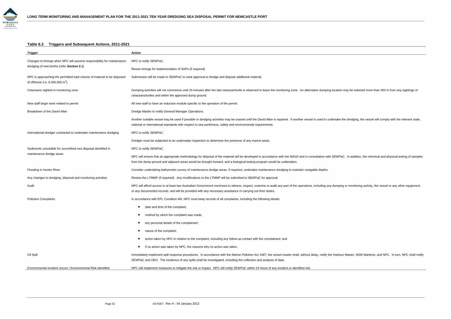
LONG TERM MONITORING AND MANAGEMENT PLAN FOR THE 2011-2021 TEN YEAR DREDGING SEA DISPOSAL PERMIT FOR NEWCASTLE PORT
Page 52 A375087: Rev H : 04 January 2013
Table 6.3 Triggers and Subsequent Actions, 2011-2021
Trigger Action
Changes to timings when NPC will assume responsibility for maintenance
dredging of new berths (refer Section 2.1)
NPC to notify SEWPaC.
Revise timings for implementation of SAPs (if required)
NPC is approaching the permitted total volume of material to be disposed
of offshore (i.e. 6,450,000 m3)
Submission will be made to SEWPaC to seek approval to dredge and dispose additional material.
Cetaceans sighted in monitoring zone Dumping activities will not commence until 20 minutes after the last cetacean/turtle is observed to leave the monitoring zone. An alternative dumping location may be selected more than 300 m from any sightings of
cetaceans/turtles and within the approved dump ground.
New staff begin work related to permit All new staff to have an induction module specific to the operation of the permit.
Breakdown of the David Allan Dredge Master to notify General Manager Operations.
Another suitable vessel may be used if possible or dredging activities may be ceased until the David Allan is repaired. If another vessel is used to undertake the dredging, the vessel will comply with the relevant state,
national or international standards with respect to sea worthiness, safety and environmental requirements.
International dredger contracted to undertake maintenance dredging NPC to notify SEWPaC.
Dredger must be subjected to an underwater inspection to determine the presence of any marine pests.
Sediments unsuitable for unconfined sea disposal identified in
maintenance dredge areas
NPC to notify SEWPaC.
NPC will ensure that an appropriate methodology for disposal of the material will be developed in accordance with the NAGD and in consultation with SEWPaC. In addition, the chemical and physical testing of samples
from the dump ground and adjacent areas would be brought forward, and a biological testing program would be undertaken.
Flooding in Hunter River Consider undertaking bathymetric survey of maintenance dredge areas. If required, undertake maintenance dredging to maintain navigable depths.
Any changes to dredging, disposal and monitoring activities Review the LTMMP (if required). Any modifications to the LTMMP will be submitted to SEWPaC for approval.
Audit NPC will afford access to at least two Australian Government nominees to witness, inspect, examine or audit any part of the operations, including any dumping or monitoring activity, the vessel or any other equipment,
or any documented records, and will be provided with any necessary assistance in carrying out their duties.
Pollution Complaints In accordance with EPL Condition M4, NPC must keep records of all complaints, including the following details:
• date and time of the complaint;
• method by which the complaint was made;
• any personal details of the complainant;
• nature of the complaint;
• action taken by NPC in relation to the complaint, including any follow-up contact with the complainant; and
• if no action was taken by NPC, the reasons why no action was taken.
Oil Spill Immediately implement spill response procedures. In accordance with the Marine Pollution Act 1987, the vessel master shall, without delay, notify the Harbour Master, NSW Maritime, and NPC. In turn, NPC shall notify
SEWPaC and OEH. The incidence of any spills shall be investigated, including the collection and analysis of data.
Environmental Incident occurs / Environmental Risk identified NPC will implement measures to mitigate the risk or impact. NPC will notify SEWPaC within 24 hours of any incident or identified risk.

LONG TERM MONITORING AND MANAGEMENT PLAN FOR THE 2011-2021 TEN YEAR DREDGING SEA DISPOSAL PERMIT FOR NEWCASTLE PORT
Page 53 A375087: Rev H : 04 January 2013
7. REFERENCES
ANZECC/ARMCANZ (2000) Australian and New Zealand Guidelines for Fresh and Marine Water Quality, Australian and New Zealand Environment and Conservation Council/Agriculture and Resource Management Council of Australia and New Zealand, October 2000.
Cardno Ecology Lab, 2010, Offshore Artificial Reefs (Newcastle, Sydney & Wollongong, Environmental Assessment / Draft Public Environment Report. Prepared on behalf of Industry and Investment NSW, February 2010.
Centre for Research on Introduced Marine Pests (1999), Introduced Species Survey, Newcastle. Prepared for NPC.
Commonwealth of Australia (2009) National Assessment Guidelines for Dredging.
Connell Hatch (2006), NCIG Coal Export Terminal Preliminary Contaminated Site Investigation Area D and Proposed Dredging Area. Prepared for Newcastle Coal Infrastructure Group, May 2006.
Environment Australia (2002) National Ocean Disposal Guidelines for Dredged Material. Commonwealth of Australia, Canberra.
GHD (2003), Proposed Extension of Shipping Channels, Port of Newcastle, Environmental Impact Statement. Prepared for Waterways Authority, November 2003.
Harley, M. D., Turner, I. L., Short, A. D. & Ranasinghe, R. (2009), Interannual variability and controls of the Sydney wave climate, International Journal of Climatology, Royal Meteorological Society.
Manly Hydraulics Laboratory [MHL] (1995), Hunter River Data Collection 9 October 1995, MHL Report 750
Manly Hydraulics Laboratory [MHL] (2002), Hunter Estuary Processes Study, Draft Report MHL 1095, NSW Department of Public Works and Services, for Newcastle City Council, December, ISBN 0 7347 4163 4.
NSW Government (1998), Environmental Management System Guidelines.
Patterson Britton & Partners (1989), Mobility Study, Dumped Dredge Spoil, Port of Newcastle. Prepared for MSB Hunter Port Authority, December 1989.
Patterson Britton & Partners (1992), Mobility Study, Dumped Dredge Spoil, Port of Newcastle Stage 2. Prepared for MSB Hunter Port Authority, November 1992.
Patterson Britton & Partners (1996), Discussion Paper: Relocation of Dump Ground.
Patterson Britton & Partners (2000), Long Term Sea Dumping Strategy for the Port of Newcastle for the Five Year Period 2000 to 2005.
Patterson Britton & Partners (2002), SAP Offshore Sediment Sampling and Testing. Prepared for NPC, May 2002.
Patterson Britton & Partners (2003), Potential Impacts of Proposed Dredging of South Arm on Tidal Hydrodynamics, Flooding and Water Quality. Prepared for GHD, October 2003.
Patterson Britton & Partners (2005), Five Year Maintenance Dredging Sea Disposal Permit Application. Prepared for NPC, March 2005.
LONG TERM MONITORING AND MANAGEMENT PLAN FOR THE 2011-2021 TEN YEAR DREDGING SEA DISPOSAL PERMIT FOR NEWCASTLE PORT
Page 54 A375087: Rev H : 04 January 2013
Patterson Britton & Partners (2006), Five Year Maintenance Dredging Sea Disposal Permit Application: Supplementary Sampling and Analysis Plan.
Patterson Britton & Partners (20080, Kooragang Coal Export Terminal: Baseline and Initial Dredging Period Water Quality and Water Level Monitoring, September 2007 to February 2008.
Public Works Department [PWD] (1994), Lower Hunter Flood Study (Green Rocks to Newcastle), for Newcastle City Council and Port Stephens Council, August 1994, Report No. PWD 91077, ISBN 07305 86472.
Sanderson, Dr Brian G and Dr Anna M Redden (2001), Hunter River Estuary Water Quality Data Review and Analysis, report submitted to Manly Hydraulics Laboratory, Centre for Sustainable Use of Coasts and Catchments, University of Newcastle, December
Short, A. D. & Trenaman, N. L. (1992), Wave climate of the Sydney region, an energetic and highly variable ocean wave regime, Australian Journal of Marine and Freshwater Research, 1992, 43, 765-91.
Standards Australia/Standards New Zealand (1996), AS/NZS ISO14001:2004 Environmental Management Systems – Requirements with Guidance for Use.
UNSW (2003), Odour Impact Assessment: Proposed extension of shipping channels, Port of Newcastle, Environmental Odour Laboratory, Centre for Water and Waste Technology, School of Civil and Environmental Engineering, UNSW.
WorleyParsons (2009a), Area E Maintenance Dredging and Placement of Dredged Material off Stockton – Review of Environmental Factors, July 2009.
WorleyParsons (2009b), Newcastle Maintenance Dredge Areas Mid-permit Sediment Sampling and Testing, September 2009.
WorleyParsons (2009c), Newcastle Offshore Dump Ground Sediment Investigation for the 2006-2011 Five Year Maintenance Dredging Sea Dumping Permit, September 2009.
WorleyParsons (2011), Maintenance Dredge Areas Sampling and Analysis Plan, 2011-2021 Ten Year Maintenance Dredging Sea Dumping Permit, February 2011.
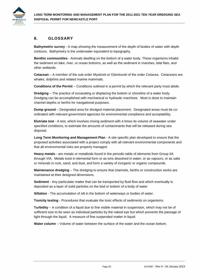
LONG TERM MONITORING AND MANAGEMENT PLAN FOR THE 2011-2021 TEN YEAR DREDGING SEA DISPOSAL PERMIT FOR NEWCASTLE PORT
Page 55 A375087: Rev H : 04 January 2013
8. GLOSSARY
Bathymetric survey - A map showing the measurement of the depth of bodies of water with depth contours. Bathymetry is the underwater equivalent to topography.
Benthic communities - Animals dwelling on the bottom of a water body. These organisms inhabit the sediment on lake, river, or ocean bottoms, as well as the sediment in marshes, tidal flats, and other wetlands.
Cetacean – A member of the sub-order Mysticeti or Odontoceti of the order Cetacea. Cetaceans are whales, dolphins and related marine mammals.
Conditions of the Permit – Conditions outlined in a permit by which the relevant party must abide.
Dredging – The practice of excavating or displacing the bottom or shoreline of a water body. Dredging can be accomplished with mechanical or hydraulic machines. Most is done to maintain channel depths or berths for navigational purposes.
Dump ground – Designated area for dredged material placement. Designated areas must be co-ordinated with relevant government agencies for environmental compliance and acceptability.
Elutriate test - A test, which involves mixing sediment with 4 times its volume of seawater under specified conditions, to estimate the amounts of contaminants that will be released during sea disposal.
Long Term Monitoring and Management Plan - A site specific plan developed to ensure that the proposed activities associated with a project comply with all relevant environmental components and that all environmental risks are properly managed.
Heavy metals - are metals or metalloids found in the periodic table of elements from Group IIA through VIA. Metals exist in elemental form or as ions dissolved in water, or as vapours, or as salts or minerals in rock, sand, and dust, and form a variety of inorganic or organic compounds.
Maintenance dredging – The dredging to ensure that channels, berths or construction works are maintained at their designed dimensions.
Sediment - Any particulate matter that can be transported by fluid flow and which eventually is deposited as a layer of solid particles on the bed or bottom of a body of water
Siltation - The accumulation of silt in the bottom of waterways or bodies of water.
Toxicity testing - Procedures that evaluate the toxic effects of sediments on organisms.
Turbidity – A condition of a liquid due to fine visible material in suspension, which may not be of sufficient size to be seen as individual particles by the naked eye but which prevents the passage of light through the liquid. A measure of fine suspended matter in liquid.
Water column – Volume of water between the surface of the water and the ocean bottom.
LONG TERM MONITORING AND MANAGEMENT PLAN FOR THE 2011-2021 TEN YEAR DREDGING SEA DISPOSAL PERMIT FOR NEWCASTLE PORT
Appendix 301015-02409 : Rev G : 30 January 2013
Appendix A: NPC’s ENVIRONMENTAL POLICY
LONG TERM MONITORING AND MANAGEMENT PLAN FOR THE 2011-2021 TEN YEAR DREDGING SEA DISPOSAL PERMIT FOR NEWCASTLE PORT
Appendix 301015-02409 : Rev G : 30 January 2013
Appendix B: EPBC ACT PROTECTED MATTERS REPORT
Water Treatment
Plant Water treatment plant
Southern Site (approximate)

LONG TERM MONITORING AND MANAGEMENT PLAN FOR THE 2011-2021 TEN YEAR DREDGING SEA DISPOSAL PERMIT FOR NEWCASTLE PORT
Appendix 301015-02409 : Rev G : 30 January 2013
Appendix C: MATERIAL RELOCATION RECORD SHEET
LONG TERM MONITORING AND MANAGEMENT PLAN FOR THE 2011-2021 TEN YEAR DREDGING SEA DISPOSAL PERMIT FOR NEWCASTLE PORT
Appendix 301015-02409 : Rev G : 30 January 2013
Appendix D: NPC OPERATING LOG SHEET
LONG TERM MONITORING AND MANAGEMENT PLAN FOR THE 2011-2021 TEN YEAR DREDGING SEA DISPOSAL PERMIT FOR NEWCASTLE PORT
Appendix 301015-02409 : Rev G : 30 January 2013
Appendix E: SEWPAC WHALE AND DOLPHIN IDENTIFICATION GUIDE
LONG TERM MONITORING AND MANAGEMENT PLAN FOR THE 2011-2021 TEN YEAR DREDGING SEA DISPOSAL PERMIT FOR NEWCASTLE PORT
Appendix 301015-02409 : Rev G : 30 January 2013
Appendix F: SAP FOR MAINTENANCE DREDGE AREAS, 2011-2021
LONG TERM MONITORING AND MANAGEMENT PLAN FOR THE 2011-2021 TEN YEAR DREDGING SEA DISPOSAL PERMIT FOR NEWCASTLE PORT
Appendix 301015-02409 : Rev G : 30 January 2013
Appendix G: SAP FOR OFFSHORE DUMP GROUND, 2011-2021
Related Documents