155 THE PARANÁ RIVER: FROM PLEISTOCENE TO THE PRESENT The Paraná River: The Paraná River: The Paraná River: The Paraná River: The Paraná River: from Pleistocene to the Present from Pleistocene to the Present from Pleistocene to the Present from Pleistocene to the Present from Pleistocene to the Present ORFEO Oscar 1 ; PARSONS Daniel 2 ; BEST Jim 3 ; LUTZ Alicia I. 4 and ZURITA Alfredo E. 1 INTRODUCTION INTRODUCTION INTRODUCTION INTRODUCTION INTRODUCTION DAY 1: Paleontology of Paraná river paleodeposits DAY 1: Paleontology of Paraná river paleodeposits DAY 1: Paleontology of Paraná river paleodeposits DAY 1: Paleontology of Paraná river paleodeposits DAY 1: Paleontology of Paraná river paleodeposits Geographic location of the Corrientes province Geographic location of the Corrientes province Geographic location of the Corrientes province Geographic location of the Corrientes province Geographic location of the Corrientes province Empedrado Empedrado Empedrado Empedrado Empedrado Geomorphology Geomorphology Geomorphology Geomorphology Geomorphology Stratigraphy of the Corrientes province Stratigraphy of the Corrientes province Stratigraphy of the Corrientes province Stratigraphy of the Corrientes province Stratigraphy of the Corrientes province THE PLIOCENE IN THE PLIOCENE IN THE PLIOCENE IN THE PLIOCENE IN THE PLIOCENE IN THE CORRIENTES PROVINCE THE CORRIENTES PROVINCE THE CORRIENTES PROVINCE THE CORRIENTES PROVINCE THE CORRIENTES PROVINCE Ituzaingó Formation Ituzaingó Formation Ituzaingó Formation Ituzaingó Formation Ituzaingó Formation Lithological description Lithological description Lithological description Lithological description Lithological description Relationship Relationship Relationship Relationship Relationship Age and correlations Age and correlations Age and correlations Age and correlations Age and correlations Fossils Fossils Fossils Fossils Fossils THE PLEISTOCENE IN THE PLEISTOCENE IN THE PLEISTOCENE IN THE PLEISTOCENE IN THE PLEISTOCENE IN THE CORRIENTES PROVINCE THE CORRIENTES PROVINCE THE CORRIENTES PROVINCE THE CORRIENTES PROVINCE THE CORRIENTES PROVINCE Geology Geology Geology Geology Geology Late Pleistocene Late Pleistocene Late Pleistocene Late Pleistocene Late Pleistocene DAY 2: Contemporary fluvial environments: DAY 2: Contemporary fluvial environments: DAY 2: Contemporary fluvial environments: DAY 2: Contemporary fluvial environments: DAY 2: Contemporary fluvial environments: modern morphodynamic processes and modern morphodynamic processes and modern morphodynamic processes and modern morphodynamic processes and modern morphodynamic processes and sedimentology sedimentology sedimentology sedimentology sedimentology Synopsis Synopsis Synopsis Synopsis Synopsis Introduction Introduction Introduction Introduction Introduction The Confluence The Confluence The Confluence The Confluence The Confluence 3D Bedforms 3D Bedforms 3D Bedforms 3D Bedforms 3D Bedforms Mid-Channel Bar Mid-Channel Bar Mid-Channel Bar Mid-Channel Bar Mid-Channel Bar DAY 3: Large geomorphological units in the DAY 3: Large geomorphological units in the DAY 3: Large geomorphological units in the DAY 3: Large geomorphological units in the DAY 3: Large geomorphological units in the middle stretch of the Paraná river middle stretch of the Paraná river middle stretch of the Paraná river middle stretch of the Paraná river middle stretch of the Paraná river Major channels Major channels Major channels Major channels Major channels Minor channels Minor channels Minor channels Minor channels Minor channels Water-bodies Water-bodies Water-bodies Water-bodies Water-bodies REFERENCES REFERENCES REFERENCES REFERENCES REFERENCES INTRODUCTION INTRODUCTION INTRODUCTION INTRODUCTION INTRODUCTION The Paraná is the most important river of Argentina, one of the three largest in South America and is the sixth largest by discharge in the world. This four-day excursion offers a general overview of this huge fluvial system, including its geological evolution, past and present sedimentary deposits, an exploration of current morphodynamics, and insight on huma- ninduced changes on system function, which includes a visit to the large hydroelectric dam at Yacyretá. The field trip will showcase several strategic sites spaced over ~300 km following the main channel of the Paraná, beginning in Corrientes and ending in Posadas City. The trip will incorporate a full day on the Paraná at Paso de la Patria, and will include a visit to the Paraná- Paraguay confluence, where the river 1 CONICET and Universidad Nacional del Nordeste, Argentina. 2 University of Leeds, UK. 3 University of Illinois, USA 4 Universidad Nacional del Nordeste and CONICET, Argentina. changes drastically in terms of sedimentary discharge. This field guide was organized into three parts. The first will describe the Geology and Paleontology of the ancient deposits of the Paraná River. The second part deal with the modern morphody- namic processes and sedimentology of the contemporary fluvial environments. The third part describes the general geomor- phologic characteristics of the Paraná River in the study area. DAY 1: DAY 1: DAY 1: DAY 1: DAY 1: PALEONTOLOGY OF PARANÁ RIVER PALEODEPOSITS G G G EOGRAPHIC EOGRAPHIC EOGRAPHIC EOGRAPHIC EOGRAPHIC LOCATION LOCATION LOCATION LOCATION LOCATION OF OF OF OF OF THE THE THE THE THE C C C ORRIENTES ORRIENTES ORRIENTES ORRIENTES ORRIENTES PROVINCE PROVINCE PROVINCE PROVINCE PROVINCE In Argentina the Mesopotamic region is located in an area comprised by the Argentinean Fluvial Basins IESGLO, Basin Analysis Series, I: 155-186 Ibañez, L. M.; Moyano, M. S. and Aceñolaza, G. F. (Eds.) Tucumán, 2009 | ISSN - 1852 - 4796

Welcome message from author
This document is posted to help you gain knowledge. Please leave a comment to let me know what you think about it! Share it to your friends and learn new things together.
Transcript
155THE PARANÁ RIVER: FROM PLEISTOCENE TO THE PRESENT
The Paraná River:The Paraná River:The Paraná River:The Paraná River:The Paraná River:from Pleistocene to the Presentfrom Pleistocene to the Presentfrom Pleistocene to the Presentfrom Pleistocene to the Presentfrom Pleistocene to the Present
ORFEO Oscar1; PARSONS Daniel2; BEST Jim3; LUTZ Alicia I.4 and ZURITA Alfredo E.1
INTRODUCTIONINTRODUCTIONINTRODUCTIONINTRODUCTIONINTRODUCTION
DAY 1: Paleontology of Paraná river paleodepositsDAY 1: Paleontology of Paraná river paleodepositsDAY 1: Paleontology of Paraná river paleodepositsDAY 1: Paleontology of Paraná river paleodepositsDAY 1: Paleontology of Paraná river paleodepositsGeographic location of the Corrientes provinceGeographic location of the Corrientes provinceGeographic location of the Corrientes provinceGeographic location of the Corrientes provinceGeographic location of the Corrientes provinceEmpedradoEmpedradoEmpedradoEmpedradoEmpedradoGeomorphologyGeomorphologyGeomorphologyGeomorphologyGeomorphologyStratigraphy of the Corrientes provinceStratigraphy of the Corrientes provinceStratigraphy of the Corrientes provinceStratigraphy of the Corrientes provinceStratigraphy of the Corrientes province
THE PLIOCENE INTHE PLIOCENE INTHE PLIOCENE INTHE PLIOCENE INTHE PLIOCENE INTHE CORRIENTES PROVINCETHE CORRIENTES PROVINCETHE CORRIENTES PROVINCETHE CORRIENTES PROVINCETHE CORRIENTES PROVINCEItuzaingó FormationItuzaingó FormationItuzaingó FormationItuzaingó FormationItuzaingó FormationLithological descriptionLithological descriptionLithological descriptionLithological descriptionLithological descriptionRelationshipRelationshipRelationshipRelationshipRelationshipAge and correlationsAge and correlationsAge and correlationsAge and correlationsAge and correlationsFossilsFossilsFossilsFossilsFossils
THE PLEISTOCENE INTHE PLEISTOCENE INTHE PLEISTOCENE INTHE PLEISTOCENE INTHE PLEISTOCENE INTHE CORRIENTES PROVINCETHE CORRIENTES PROVINCETHE CORRIENTES PROVINCETHE CORRIENTES PROVINCETHE CORRIENTES PROVINCE
GeologyGeologyGeologyGeologyGeologyLate PleistoceneLate PleistoceneLate PleistoceneLate PleistoceneLate Pleistocene
DAY 2: Contemporary fluvial environments:DAY 2: Contemporary fluvial environments:DAY 2: Contemporary fluvial environments:DAY 2: Contemporary fluvial environments:DAY 2: Contemporary fluvial environments:modern morphodynamic processes andmodern morphodynamic processes andmodern morphodynamic processes andmodern morphodynamic processes andmodern morphodynamic processes andsedimentologysedimentologysedimentologysedimentologysedimentologySynopsisSynopsisSynopsisSynopsisSynopsisIntroductionIntroductionIntroductionIntroductionIntroductionThe ConfluenceThe ConfluenceThe ConfluenceThe ConfluenceThe Confluence3D Bedforms3D Bedforms3D Bedforms3D Bedforms3D BedformsMid-Channel BarMid-Channel BarMid-Channel BarMid-Channel BarMid-Channel Bar
DAY 3: Large geomorphological units in theDAY 3: Large geomorphological units in theDAY 3: Large geomorphological units in theDAY 3: Large geomorphological units in theDAY 3: Large geomorphological units in themiddle stretch of the Paraná rivermiddle stretch of the Paraná rivermiddle stretch of the Paraná rivermiddle stretch of the Paraná rivermiddle stretch of the Paraná riverMajor channelsMajor channelsMajor channelsMajor channelsMajor channelsMinor channelsMinor channelsMinor channelsMinor channelsMinor channelsWater-bodiesWater-bodiesWater-bodiesWater-bodiesWater-bodies
REFERENCESREFERENCESREFERENCESREFERENCESREFERENCES
INTRODUCTIONINTRODUCTIONINTRODUCTIONINTRODUCTIONINTRODUCTION
The Paraná is the most important riverof Argentina, one of the three largest inSouth America and is the sixth largest bydischarge in the world. This four-dayexcursion offers a general overview of thishuge fluvial system, including its geologicalevolution, past and present sedimentarydeposits, an exploration of currentmorphodynamics, and insight on huma-ninduced changes on system function,which includes a visit to the largehydroelectric dam at Yacyretá.
The field trip will showcase severalstrategic sites spaced over ~300 kmfollowing the main channel of the Paraná,beginning in Corrientes and ending inPosadas City. The trip will incorporate afull day on the Paraná at Paso de la Patria,and will include a visit to the Paraná-Paraguay confluence, where the river
1 CONICET and Universidad Nacional del Nordeste, Argentina.2 University of Leeds, UK.3 University of Illinois, USA4 Universidad Nacional del Nordeste and CONICET, Argentina.
changes drastically in terms of sedimentarydischarge.
This field guide was organized intothree parts. The first will describe theGeology and Paleontology of the ancientdeposits of the Paraná River. The secondpart deal with the modern morphody-namic processes and sedimentology of thecontemporary fluvial environments. Thethird part describes the general geomor-phologic characteristics of the Paraná Riverin the study area.
DAY 1:DAY 1:DAY 1:DAY 1:DAY 1: PALEONTOLOGY OFPARANÁ RIVER PALEODEPOSITS
GGGGGEOGRAPHICEOGRAPHICEOGRAPHICEOGRAPHICEOGRAPHIC LOCATIONLOCATIONLOCATIONLOCATIONLOCATION OFOFOFOFOF THETHETHETHETHE
CCCCCORRIENTESORRIENTESORRIENTESORRIENTESORRIENTES PROVINCEPROVINCEPROVINCEPROVINCEPROVINCE
In Argentina the Mesopotamic regionis located in an area comprised by the
Argentinean Fluvial Basins IESGLO, Basin Analysis Series, I: 155-186Ibañez, L. M.; Moyano, M. S. and Aceñolaza, G. F. (Eds.) Tucumán, 2009 | ISSN - 1852 - 4796
ORFEO O.; PARSONS D.; BEST J.; LUTZ A. I. AND ZURITA A. E.156
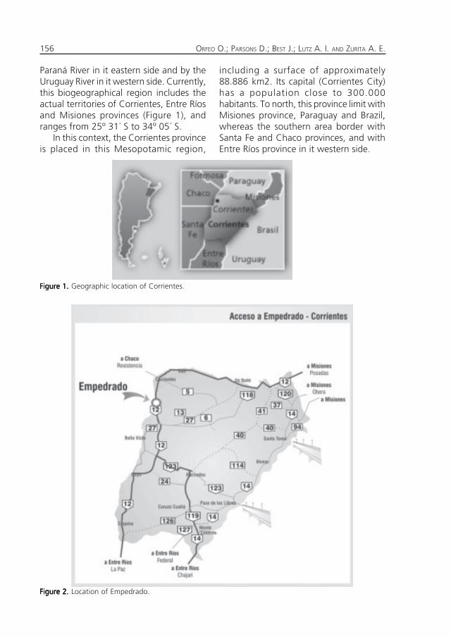
Paraná River in it eastern side and by theUruguay River in it western side. Currently,this biogeographical region includes theactual territories of Corrientes, Entre Ríosand Misiones provinces (Figure 1), andranges from 25º 31´ S to 34º 05´ S.
In this context, the Corrientes provinceis placed in this Mesopotamic region,
including a surface of approximately88.886 km2. Its capital (Corrientes City)has a population close to 300.000habitants. To north, this province limit withMisiones province, Paraguay and Brazil,whereas the southern area border withSanta Fe and Chaco provinces, and withEntre Ríos province in it western side.
Figure 1.Figure 1.Figure 1.Figure 1.Figure 1. Geographic location of Corrientes.
Figure 2.Figure 2.Figure 2.Figure 2.Figure 2. Location of Empedrado.
157THE PARANÁ RIVER: FROM PLEISTOCENE TO THE PRESENT
EEEEEMPEDRADOMPEDRADOMPEDRADOMPEDRADOMPEDRADO
Empedrado Department has a surfaceof approximately 1998 km 2. It is borderedto the north by the CorrientesDepartment, north-western by San Luis delPalmar Department, to the south-easternby Mburucuyá Department, to southernwith Saladas Department and to westernwith Santa Fe province.
It occupies the west riverside of ParanáRiver, between the «Sombrero» stream inthe North and the San Lorenzo River tothe south, and it extends eastern toLonganiza and other estuaries that formthe «Empedrado» stream.
On the banks of the Paraná River it ispossible to observe a series of Tertiary-Quaternary profiles, which will berecognized in this trip.
Empedrado was founded by PedroFerré in 1825, and is situated in the north-western part of the Corrientes province,to approximately 55 km to the capital cityfollowing the national route nº 12 (Figure2).
The subtropical weather is characte-rized by a dry winter and by a very hotand rainy summer. The average annualrain is close to 1100 mm. Usually there isno drought in the entire territory and theaverage summer temperature is above 21º C, while in the winter is around 10 º C.
GGGGGEOMORPHOLOGYEOMORPHOLOGYEOMORPHOLOGYEOMORPHOLOGYEOMORPHOLOGY
The most noticeable characteristic isthe erosive surfaces belonging to ancientslopes with landscapes of successivestaggered wide hills. The drainagenetworks are dendritic- dendritic blocks.The canyons of the Paraná coast descendgradually to the South until they disappearcompletely and reappear near the city ofBella Vista.
The soil of Empedrado shows a diverseclassification, and it can be consulted inthe «Mapas de Suelos de la Provincia deCorrientes» (see INTA 1970).
SSSSSTRATIGRAPHYTRATIGRAPHYTRATIGRAPHYTRATIGRAPHYTRATIGRAPHY OFOFOFOFOF THETHETHETHETHE
CCCCCORRIENTESORRIENTESORRIENTESORRIENTESORRIENTES PROVINCEPROVINCEPROVINCEPROVINCEPROVINCE
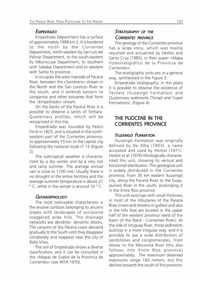
The geology of the Corrientes provincehas a large story, which was mainlyresumed and actualized by Herbst andSanta Cruz (1985), in their paper «Mapalitoestratigráfico de la Provincia deCorrientes».
The stratigraphic units are, in a generalway, synthesized in the Figure 3.
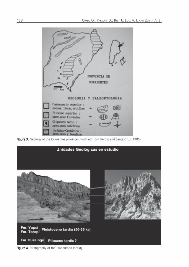
Empedrado stratigraphy: in this placeit is possible to observe the existence ofTertiary (Ituzaingó Formation) andQuaternary sediments (Toropí and YupoíFormations). (Figure 4).
THE PLIOCENE IN THETHE PLIOCENE IN THETHE PLIOCENE IN THETHE PLIOCENE IN THETHE PLIOCENE IN THECORRIENTES PROVINCECORRIENTES PROVINCECORRIENTES PROVINCECORRIENTES PROVINCECORRIENTES PROVINCE
IIIIITUZAINGÓTUZAINGÓTUZAINGÓTUZAINGÓTUZAINGÓ F F F F FORMATIONORMATIONORMATIONORMATIONORMATION
Ituzaingó Formation was originallydefined by De Alba (1953), a nameaccepted and used by Herbst (1971).Herbst et al. (1976) lithologically characte-rized this unit, showing its vertical andhorizontal distribution. This geological unitis widely distributed in the Corrientesprovince, from 30 km eastern Ituzaingócity, along the Paraná River to the Guay-quiraró River in the south, prolonging itin the Entre Ríos province.
This unit outcrops with small thicknessin most of the tributaries of the ParanáRiver (rivers and streams in gullies) and alsoin the hills that are located in the upperhalf of the western province (west of thebasin of the Iberá - Corrientes River). Atthe side of Uruguay River, those sedimentsoutcrop in a more irregular way, and it ispossible to see a wide distribution ofsandstones and conglomerates, fromAlvear to the Mocoretá River (this alsofollows into Entre Ríos province)approximately. The maximum observedexposures range 160 meters, but thisdecline towards the south of the province.
ORFEO O.; PARSONS D.; BEST J.; LUTZ A. I. AND ZURITA A. E.158
Figure 3.Figure 3.Figure 3.Figure 3.Figure 3. Geology of the Corrientes province (modified from Herbst and Santa Cruz, 1985).
Figure 4.Figure 4.Figure 4.Figure 4.Figure 4. Stratigraphy of the Empedrado locality.
159THE PARANÁ RIVER: FROM PLEISTOCENE TO THE PRESENT
At the Uruguay River banks this exposureis very thin, ranging 15-20 metersthickness.
LLLLLITHOLOGICALITHOLOGICALITHOLOGICALITHOLOGICALITHOLOGICAL DESCRIPTIONDESCRIPTIONDESCRIPTIONDESCRIPTIONDESCRIPTION
This unit is composed of sand andsandstone with varying degrees of consis-tency, from very friable to completelyconsolidated. Size range from fine andmedium sand to very coarse, occasionallyup conglomerates with boulders.
It coloration is very diverse, comprisingfrom white and yellow to reddish-brownhues and dark brown. Usually it existintercalated thin layers or lenses of finematerial, silt and clay, coloured green, grayand even black. In that concerning thelithology it is frequent to find mainly quartzsand.
The light fraction contains potassiummoonstones and sour plagioclasas. Theheavy fraction corresponds to opaque inits majority and continues in a decreasingmanner with zircon, tourmaline, cianita,estaurolita, epidoto, and granate. Thegrains brought together are generallyproduced for «ferric oxides» and clays.
RRRRRELATIONSHIPELATIONSHIPELATIONSHIPELATIONSHIPELATIONSHIP
Below the Ituzaingó Formation, it ispossible to observe the Paraná Formation(in the western part and in the north-southborder). Towards the east, the Paraná For-mation can be replaced by the Fray BentosFormation, or by the basalt and sandstonebelonging to the Solari Formation.
Upper the Ituzaingó Formation, we cansee (in most of the cases) the ToropíFormation, or the Yupoí Formation if thethe Toropí Formation is absent.
AAAAAGEGEGEGEGE ANDANDANDANDAND CORRELATIONSCORRELATIONSCORRELATIONSCORRELATIONSCORRELATIONS
At the present day there is not enoughevidence to assign a specific age to thisunit. In this context, it is possible that theso-called «conglomerado osífero» thatappear near to Paraná city (Entre Ríos)
compose the lowest part of the ItuzaingóFormation. This «conglomerado osífero»includes a «mixed» palaeofauna. Most ofthe registered taxa permits to infer amiddle-upper Pliocene age, but it isimportant to remark that this paleofau-nistic correlation is not clearly established.As a consequence of this, we consider thatthe age correspond to Pliocene sensu lato,probably upper Pliocene.
FFFFFOSSILSOSSILSOSSILSOSSILSOSSILS
The Mesopotamic region comprises avery particular biotic geographic area.Here, and from a zoogeographic point ofview, this area congregates faunas of Brazilancestry with those of the central andPampean regions. This area of biologicalintergradations is present at least sincelate Miocene, when the «ConglomeradoOsífero» of the Ituzaingó Formation wasdeposited (late Miocene-Pliocene).
In this framework, and although thepaleontological study of the Mesopota-mian region of Argentina has not yet seenthe level of development in the Pampeanregion (Carlini et al., 2004; Cione andTonni, 2005), the evidence suggests that,at least since the «Mesopotamian» (lateMiocene-early Pliocene), the Mesopotamicregion developed an unique paleobiogeo-graphic identity (Scillato-Yané, 1976;Pascual and Bondesio, 1982; Cione et al.,2000; Carlini et al., 2000; Aceñolaza,2004).
It is probably in this moment in wherethe septentrional half of the actualArgentinean territory was divided in twobig areas longitudinally located: one ofthem parallel and to the east of theCordillera de los Andes, and the other oneon a region that could have been a largedrainage basin along the pre-Paraná river(Cione et al. 2000).
In a paleobiogeographic context, it ishighly possible that this area had acted asa biogeographical connection corridor
ORFEO O.; PARSONS D.; BEST J.; LUTZ A. I. AND ZURITA A. E.160
between the Pampean region and morenorthern areas (Cozzuol, 1993; Carlini etal., 2000), a situation that could help toexplain (at least partially) the presence inthe «Conglomerado Osífero» of somerelictual taxa, characteristic of Chasicoan,Huayquerian and Montehermosan Ages(late Miocene-early Pliocene), with apredominance of Huayquerian palaeofau-na. Another possibility is considering thatthis palaeofaunitic association may repre-sent, in fact, a diachronic assemblage.
The Tardigrada (Mammalia, Xenarthra)show here it Mio-Pliocene major diversifi-cation, with close to 37 recognized species(Carlini et al., 2000); among them theFamily Megalonychidae are the mostcommon, while the Mylodontidae Scelido-theriinae are very scarce. In addition, theGlyptodontidae (Mammalia, Cingulata) arecharacterized by a predominace of theHoplophorinae Palaehoplophorini (Palae-hoplophorus, Chlamyphractus Castellanos
and Protoglyptodon Ameghino; seeCastellanos, 1940; Ameghino, 1885;Cione et al., 2000). Other well representedgroups are the Plohophorini: Parahoplo-phorus Castellanos and PlohophorusAmeghino, and the Doedicurinae: Eleuthe-rocercus Koken and Comaphorus Ameg-hino. In this sense, there are registered,for the first time, the Neuryurini: Pseudo-euryurus Ameghino (Ameghino, 1889)and Urotherium Castellanos (Castellanos,1926).
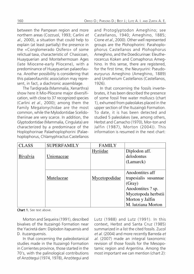
In that concerning the fossils inverte-brates, it has been described the presenceof some fossil free water molluscs (chart1), exhumed from paleolakes placed in theupper section of the Ituzaingó Formation.To date, it is has been detected andstudied 5 paleolakes (see, among others,Herbst and Camacho (1970), Mor-ton andJalfin (1987), Morton (2004)). Thisinformation is resumed in the next chart:
CLASS SUPERFAMILY FAMILY Bivalvia
Unionaceae
Hyriidae
Diplodon aff. delodontus (Lamarck)
Mutelaceae
Mycetopodidae
Anodontites aff trapesialis susannae (Gray) Anodontites ? sp. Mycetopoda herbstii Morton y Jalfin M. lutziana Morton
Morton and Sequeira (1991), describedbivalves of the Ituzaingó Formation nearthe Yaciretá dam: Diplodon itapuensis andD. ituzanguensis.
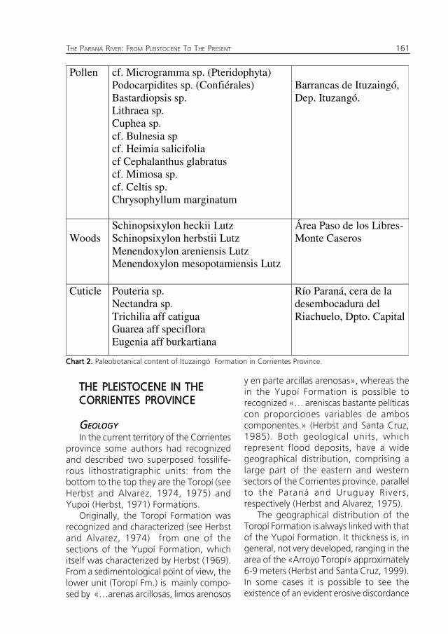
In that concerning the paleobotanicalstudies made in the Ituzaingó Formationin Corrientes province, those started in the70’s, with the palinological contributionsof Anzótegui (1974, 1978), Anzótegui and
Lutz (1988) and Lutz (1991). In thiscontext, Herbst and Santa Cruz (1985)summarized in a list the cited fossils. Zucolet al. (2004) and more recently Barreda etal. (2007) made an integral taxonomicrevision of those fossils for the Mesopo-tamic region and Argentina. Among themost important we can mention (chart 2):
Chart 1.Chart 1.Chart 1.Chart 1.Chart 1. See text above.
161THE PARANÁ RIVER: FROM PLEISTOCENE TO THE PRESENT
Pollen
cf. Microgramma sp. (Pteridophyta) Podocarpidites sp. (Confiérales) Bastardiopsis sp. Lithraea sp. Cuphea sp. cf. Bulnesia sp cf. Heimia salicifolia cf Cephalanthus glabratus cf. Mimosa sp. cf. Celtis sp. Chrysophyllum marginatum
Barrancas de Ituzaingó, Dep. Ituzangó.
Woods
Schinopsixylon heckii Lutz Schinopsixylon herbstii Lutz Menendoxylon areniensis Lutz Menendoxylon mesopotamiensis Lutz
Área Paso de los Libres-Monte Caseros
Cuticle Pouteria sp. Nectandra sp. Trichilia aff catigua Guarea aff speciflora Eugenia aff burkartiana
Río Paraná, cera de la desembocadura del Riachuelo, Dpto. Capital
THE PLEISTOCENE IN THETHE PLEISTOCENE IN THETHE PLEISTOCENE IN THETHE PLEISTOCENE IN THETHE PLEISTOCENE IN THECORRIENTES PROVINCECORRIENTES PROVINCECORRIENTES PROVINCECORRIENTES PROVINCECORRIENTES PROVINCE
GGGGGEOLOGYEOLOGYEOLOGYEOLOGYEOLOGY
In the current territory of the Corrientesprovince some authors had recognizedand described two superposed fossilife-rous lithostratigraphic units: from thebottom to the top they are the Toropí (seeHerbst and Alvarez, 1974, 1975) andYupoí (Herbst, 1971) Formations.
Originally, the Toropí Formation wasrecognized and characterized (see Herbstand Alvarez, 1974) from one of thesections of the Yupoí Formation, whichitself was characterized by Herbst (1969).From a sedimentological point of view, thelower unit (Toropí Fm.) is mainly compo-sed by «…arenas arcillosas, limos arenosos
y en parte arcillas arenosas», whereas thein the Yupoí Formation is possible torecognized «… areniscas bastante pelíticascon proporciones variables de amboscomponentes.» (Herbst and Santa Cruz,1985). Both geological units, whichrepresent flood deposits, have a widegeographical distribution, comprising alarge part of the eastern and westernsectors of the Corrientes province, parallelto the Paraná and Uruguay Rivers,respectively (Herbst and Alvarez, 1975).
The geographical distribution of theToropí Formation is always linked with thatof the Yupoí Formation. It thickness is, ingeneral, not very developed, ranging in thearea of the «Arroyo Toropí» approximately6-9 meters (Herbst and Santa Cruz, 1999).In some cases it is possible to see theexistence of an evident erosive discordance
Chart 2.Chart 2.Chart 2.Chart 2.Chart 2. Paleobotanical content of Ituzaingó Formation in Corrientes Province.
ORFEO O.; PARSONS D.; BEST J.; LUTZ A. I. AND ZURITA A. E.162
between Toropí Formation and the lowerunit, the Ituzaingó Formation (lateMiocene-early Pliocene). In change, theYupoí Formation overlies the ToropíFormation.
Between both Pleistocene units it isremarkable the presence of a calcareousscab, which is, sporadically, replaced by aclay horizon of a few centimetres thick,that implies «…un momentáneo cambiode las condiciones de sedimentación»(Herbst and Santa Cruz, 1999: 42). Thethickness of this unit is similar to thatobserved for Toropí Formation. At thebanks of the Paraná River this unit reachesbetween 6-10 meters, but in the inner ofthe Corrientes province is much smaller,with a thickness ranging between 1 and3 meters.
Recently, Iriondo (1996: 18) hasproposed the unification of both units,nominated by him as Toropí-YupoíFormation. The main argument is theevident mineralogical similarity. The sameauthor (Iriondo, 1996: 17) mentioned thepresence of the Hernandarias Formation.in Corrientes, but none fossils have beenexhumed from there.
From a chronological perspective, bothPleistocene units (Toropí and Yupoí) werefirstly assigned (based on it mammalfossils) to the Ensenadan Age (earlyPleistocene-middle Pleistocene; ca. 1.8-0.4Ma) and to Lujanian sensu lato Age;middle Pleistocene-early Holocene; ca.0.40-0.085 Ma), respectively (see Herbstand Álvarez, 1972; Álvarez, 1974; Herbstand Santa Cruz, 1999). More recentpaleontological contributions by Scillato-Yané et al. (1998) suggest that the entiresequence (Toropí/Yupoí) must beassignable to the Lujanian sensu lato(Bonaerian + Lujanian); however, thoseauthors remarked the possible persistenceof some relictual taxa, which in thePampean region of Argentina werechronological limited to the Ensenadan
(eg. Phyllophaga Scelidodon; CervidaeAntifer cf. A. ensenadensis; CanidaeTheriodictys; Cingulata Panochthus cf. P.intermedius). Consistent with this, Noriegaet al. (2000) have observed that the ToropíFormation could be of Bonaerian age(middle Pleistocene-late Pleistocene), whileCione and Tonni (1999) inferred aprobable Lujanian sensu stricto age (latePleistocene-early Holocene) for the YupoíFormation.
Finally, recent OSL dating (OpticallyStimulated Luminescence) shows that bothunits could belong to the latest Pleistocene(ca. 50-35 ka; OIS 3) (Tonni et al., 2005;Tonni, 2007). From a paleoenvironmentalpoint of view, these units includefloodplain deposits (Herbst and Alvarez,1972; Herbst and Santa Cruz, 1999; Tonni,2007), from a system associated to theParaná River.
LLLLLATEATEATEATEATE P P P P PLEISTOCENELEISTOCENELEISTOCENELEISTOCENELEISTOCENE
This particular biogeographic scenerypreviously described extended until thelate Pleistocene, since the paleozoological,paleobotanic, palynological and sedimen-tological evidence suggest that theMesopotamic region could have develo-ped some wetter and warmer palaeocli-matic-enviromental process than thoseinferred in the Pampean region andcentre-north of Argentina (Iriondo andGarcía, 1993; Tonni, 1992; Oliveira, 1996,1999; Scillato-Yané et al., 1998; Noriegaet al., 2004; Carlini et al., 2004; OrtizJaureguizar and Cladera, 2006; Ferreroand Noriega, 2007).
Oliveira (1996) and Cartelle and Lessa(1988) observed that, from the south andtowards the centre-northern regions ofSouth America, the megafauna was mainlyassociated to arid and cooler conditions,but from 22º S and toward eastern, thismegafauna was linked to wetter andwarmer climatic condition.
163THE PARANÁ RIVER: FROM PLEISTOCENE TO THE PRESENT
Modern studies suggest that theMesopotamic region of Argentina had, atleast during a large part of the Pleistocene,a series of paleofaunistic and paleoenvi-ronmental particularities which differentia-ted it from the Pampean region andCentre-North of Argentina. Congruent tothis, Mesopotamic region shows certainsimilarity with the south-eastern sector ofBrazil and with the western sector ofUruguay (see Carlini et al. 2004; Tonni,2007; Ortiz Jaureguizar and Cladera,2006; Noriega and Ferrero, 2007), possiblymore evident during the humid and warmpulses of the Pleistocene.
Within this framework, the Mesopota-mic region is characterized in the late Pleis-tocene by the presence of some intertro-pical mammals (eg. Pteronura sp., Tapirusmesopotamicus, Stegomastodon waringi,Homesina paulacoutoi) (see Carlini et al.,2002; Scillato-Yané et al., 2005; Ferreroand Noriega, 2007; Ferrero, 2007),together with other typical Pampean-Patagonian taxa (Toxodon platensis,Machrauchenia patachonica). In this sense,it is interesting to hypothesize that theregistered wet and warm pulses stimulatedthe income in the Mesopotamic region oftypical intertropical palaeofauna, while inthe colder pulses it could happen aretraction of this palaeofauna and an ageographical expansion in the of thetypically Pampean-Patagonian taxa.
It is important to remark that these kindof differences are not only limited to thepresence-absence of some taxa, but to itrelative frequency. In this sense, is evidentthe scarcity of Doedicurinae andHoplophorini glyptodonts (Noriega et al.,2001), which in the Pleistocene wereclearly adapted to colder and more aridenvironments (Zurita et al., 2005).
This palaeofaunistic assemblage is alsocomplemented by some probably endemictaxa (Glyptodontidae: Neuryurus trabecu-latus Zurita and Ferrero in press; Scelido-theriinae: Scelidodon n. sp.; Tapiridae:
Tapirus mesopotamicus Ferrero andNoriega, 2007). To this, it is important toadd other paleofaunistic particularities,such as the notable scarcity of Megatheri-nae and, among Cingulata, the poor re-presentation of the Hoplophorini Glypto-dontidae (Zurita et al., 2005; Zurita, 2007).
Thus, taking into account thePleistocene Glyptodontidae frequentlyregistered in the Pampean region(Doedicurus, Glyptodon, Panochthus,Neosclerocalyptus), in the Mesopotamicregion there are only well represented bythe genus Glyptodon and Panochthus.Those ones are probably the greaterlatitudinal extended glyptodonts, with awide ecological tolerance (Tonni andScillato-Yané, 1997).
In turn, the Pleistocene outcropping atArroyo Toropí contains one of the highestregistered diversities of Cervidae(Artiodactyla) in one locality (Alcaraz andCarlini, 2003; Alcaraz and Zurita, 2004).
In summary, one of the most commontaxa (Xenarthra) in the area of the ArroyoToropí is composed by an association ofsome taxa which present differentecological requirements (e.g. P. typum vsH. paulacoutoi), but this, probably, doesnot represent a synchronic event.
In consequence, this situation could beexplained through some expansion andretraction migratory process of the biotastimulated by the constant and recurrentclimatic environmental fluctuations of thelate Pleistocene (Tonni et al., 1999, 2003;Carlini et al., 2004; Rabassa et al., 2005,Albino and Carlini, 2007, in press). Duringthese periodic fluctuations the fauna ofthe Mesopotamic region could have beenmore related to the Chaco-Pampeanregion in some moments and to thesouthern region of Brazil and westernUruguay during other moments. Inaddition to this, the existence of somepossible endemism (e.g. Scelidotheriinaey Glyptodontidae) may be correlated tosome phenomena of insularity and
ORFEO O.; PARSONS D.; BEST J.; LUTZ A. I. AND ZURITA A. E.164
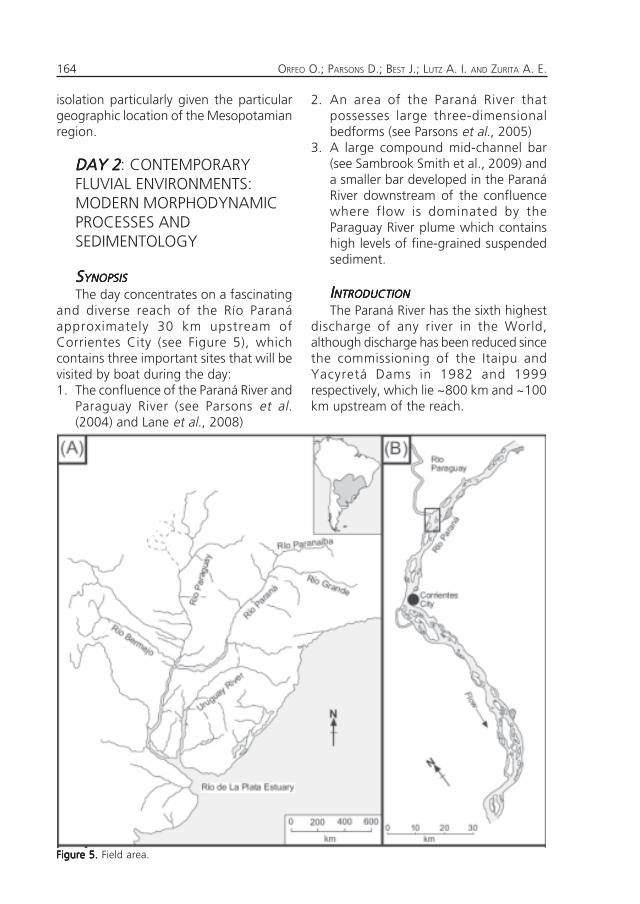
Figure 5.Figure 5.Figure 5.Figure 5.Figure 5. Field area.
isolation particularly given the particulargeographic location of the Mesopotamianregion.
DAY 2DAY 2DAY 2DAY 2DAY 2: CONTEMPORARYFLUVIAL ENVIRONMENTS:MODERN MORPHODYNAMICPROCESSES ANDSEDIMENTOLOGY
SSSSSYNOPSISYNOPSISYNOPSISYNOPSISYNOPSIS
The day concentrates on a fascinatingand diverse reach of the Río Paranáapproximately 30 km upstream ofCorrientes City (see Figure 5), whichcontains three important sites that will bevisited by boat during the day:1. The confluence of the Paraná River and
Paraguay River (see Parsons et al.(2004) and Lane et al., 2008)
2. An area of the Paraná River thatpossesses large three-dimensionalbedforms (see Parsons et al., 2005)
3. A large compound mid-channel bar(see Sambrook Smith et al., 2009) anda smaller bar developed in the ParanáRiver downstream of the confluencewhere flow is dominated by theParaguay River plume which containshigh levels of fine-grained suspendedsediment.
IIIIINTRODUCTIONNTRODUCTIONNTRODUCTIONNTRODUCTIONNTRODUCTION
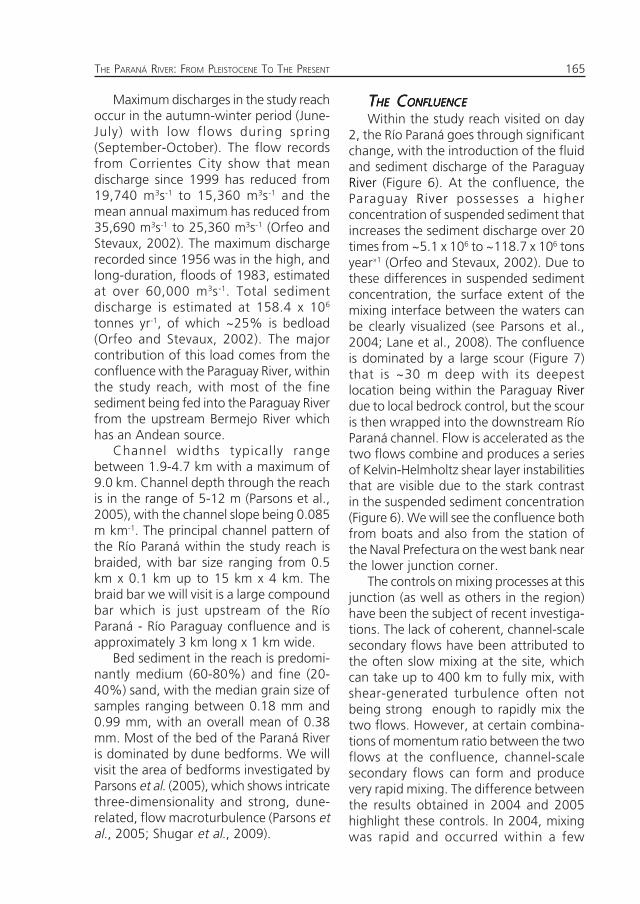
The Paraná River has the sixth highestdischarge of any river in the World,although discharge has been reduced sincethe commissioning of the Itaipu andYacyretá Dams in 1982 and 1999respectively, which lie ~800 km and ~100km upstream of the reach.
165THE PARANÁ RIVER: FROM PLEISTOCENE TO THE PRESENT
Maximum discharges in the study reachoccur in the autumn-winter period (June-July) with low flows during spring(September-October). The flow recordsfrom Corrientes City show that meandischarge since 1999 has reduced from19,740 m3s-1 to 15,360 m3s-1 and themean annual maximum has reduced from35,690 m3s-1 to 25,360 m3s-1 (Orfeo andStevaux, 2002). The maximum dischargerecorded since 1956 was in the high, andlong-duration, floods of 1983, estimatedat over 60,000 m3s-1. Total sedimentdischarge is estimated at 158.4 x 10⁶
tonnes yr-1, of which ~25% is bedload(Orfeo and Stevaux, 2002). The majorcontribution of this load comes from theconfluence with the Paraguay River, withinthe study reach, with most of the finesediment being fed into the Paraguay Riverfrom the upstream Bermejo River whichhas an Andean source.
Channel widths typically rangebetween 1.9-4.7 km with a maximum of9.0 km. Channel depth through the reachis in the range of 5-12 m (Parsons et al.,2005), with the channel slope being 0.085m km-1. The principal channel pattern ofthe Río Paraná within the study reach isbraided, with bar size ranging from 0.5km x 0.1 km up to 15 km x 4 km. Thebraid bar we will visit is a large compoundbar which is just upstream of the RíoParaná - Río Paraguay confluence and isapproximately 3 km long x 1 km wide.
Bed sediment in the reach is predomi-nantly medium (60-80%) and fine (20-40%) sand, with the median grain size ofsamples ranging between 0.18 mm and0.99 mm, with an overall mean of 0.38mm. Most of the bed of the Paraná Riveris dominated by dune bedforms. We willvisit the area of bedforms investigated byParsons et al. (2005), which shows intricatethree-dimensionality and strong, dune-related, flow macroturbulence (Parsons etal., 2005; Shugar et al., 2009).
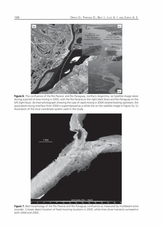
TTTTTHEHEHEHEHE C C C C CONFLUENCEONFLUENCEONFLUENCEONFLUENCEONFLUENCE
Within the study reach visited on day2, the Río Paraná goes through significantchange, with the introduction of the fluidand sediment discharge of the ParaguayRiver (Figure 6). At the confluence, theParaguay River possesses a higherconcentration of suspended sediment thatincreases the sediment discharge over 20times from ~5.1 x 10⁶ to ~118.7 x 10⁶ tonsyear»1 (Orfeo and Stevaux, 2002). Due tothese differences in suspended sedimentconcentration, the surface extent of themixing interface between the waters canbe clearly visualized (see Parsons et al.,2004; Lane et al., 2008). The confluenceis dominated by a large scour (Figure 7)that is ~30 m deep with its deepestlocation being within the Paraguay Riverdue to local bedrock control, but the scouris then wrapped into the downstream RíoParaná channel. Flow is accelerated as thetwo flows combine and produces a seriesof Kelvin-Helmholtz shear layer instabilitiesthat are visible due to the stark contrastin the suspended sediment concentration(Figure 6). We will see the confluence bothfrom boats and also from the station ofthe Naval Prefectura on the west bank nearthe lower junction corner.
The controls on mixing processes at thisjunction (as well as others in the region)have been the subject of recent investiga-tions. The lack of coherent, channel-scalesecondary flows have been attributed tothe often slow mixing at the site, whichcan take up to 400 km to fully mix, withshear-generated turbulence often notbeing strong enough to rapidly mix thetwo flows. However, at certain combina-tions of momentum ratio between the twoflows at the confluence, channel-scalesecondary flows can form and producevery rapid mixing. The difference betweenthe results obtained in 2004 and 2005highlight these controls. In 2004, mixingwas rapid and occurred within a few
ORFEO O.; PARSONS D.; BEST J.; LUTZ A. I. AND ZURITA A. E.166
Figure 6.Figure 6.Figure 6.Figure 6.Figure 6. The confluence of the Río Parana´ and Rio Paraguay, northern Argentina. (a) Satellite image takenduring a period of slow mixing in 2005, with the Río Paraná on the right (dark blue) and Río Paraguay on theleft (light blue). (b) Inset photograph showing the case of rapid mixing in 2004 viewed looking upstream; theassociated mixing interface from 2004 is superimposed as a white line on the satellite image in Figure 5a. (c)Illustration of the local coordinate system used in the study.
Figure 7.Figure 7.Figure 7.Figure 7.Figure 7. Bed morphology of the Río Paraná and Río Paraguay confluence as measured by multibeam echosounder. Crosses depict location of fixed mooring locations in 2005, while lines show transects surveyed inboth 2004 and 2005.
167THE PARANÁ RIVER: FROM PLEISTOCENE TO THE PRESENT
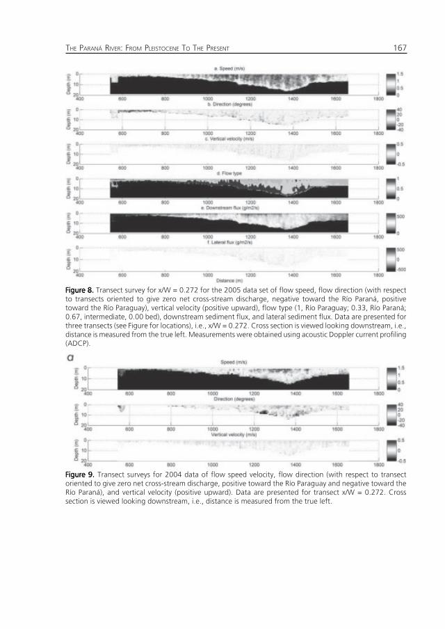
Figure 8.Figure 8.Figure 8.Figure 8.Figure 8. Transect survey for x/W = 0.272 for the 2005 data set of flow speed, flow direction (with respectto transects oriented to give zero net cross-stream discharge, negative toward the Río Paraná, positivetoward the Río Paraguay), vertical velocity (positive upward), flow type (1, Río Paraguay; 0.33, Río Paraná;0.67, intermediate, 0.00 bed), downstream sediment flux, and lateral sediment flux. Data are presented forthree transects (see Figure for locations), i.e., x/W = 0.272. Cross section is viewed looking downstream, i.e.,distance is measured from the true left. Measurements were obtained using acoustic Doppler current profiling(ADCP).
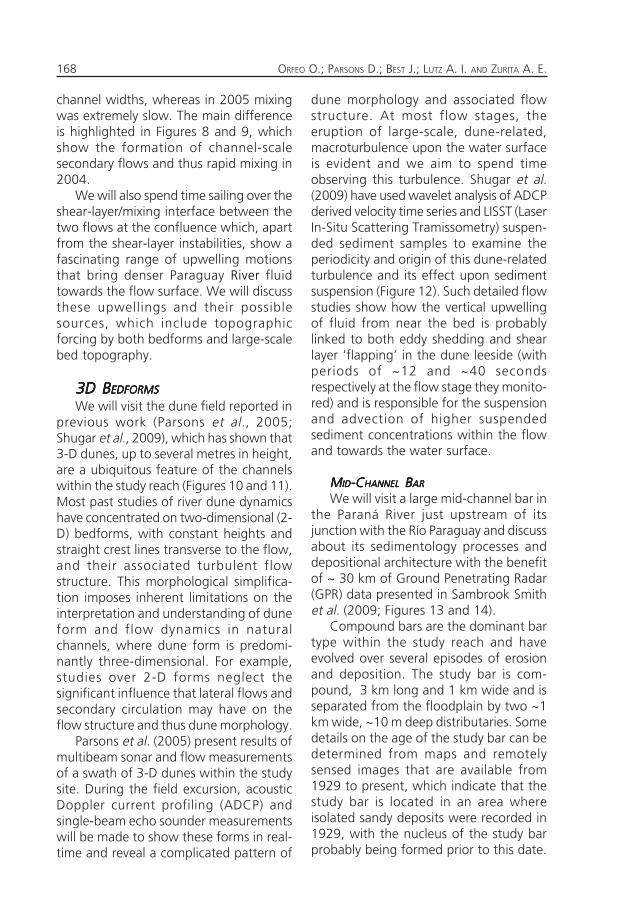
Figure 9.Figure 9.Figure 9.Figure 9.Figure 9. Transect surveys for 2004 data of flow speed velocity, flow direction (with respect to transectoriented to give zero net cross-stream discharge, positive toward the Río Paraguay and negative toward theRío Paraná), and vertical velocity (positive upward). Data are presented for transect x/W = 0.272. Crosssection is viewed looking downstream, i.e., distance is measured from the true left.
ORFEO O.; PARSONS D.; BEST J.; LUTZ A. I. AND ZURITA A. E.168
channel widths, whereas in 2005 mixingwas extremely slow. The main differenceis highlighted in Figures 8 and 9, whichshow the formation of channel-scalesecondary flows and thus rapid mixing in2004.
We will also spend time sailing over theshear-layer/mixing interface between thetwo flows at the confluence which, apartfrom the shear-layer instabilities, show afascinating range of upwelling motionsthat bring denser Paraguay River fluidtowards the flow surface. We will discussthese upwellings and their possiblesources, which include topographicforcing by both bedforms and large-scalebed topography.
3D B3D B3D B3D B3D BEDFORMSEDFORMSEDFORMSEDFORMSEDFORMS
We will visit the dune field reported inprevious work (Parsons et al., 2005;Shugar et al., 2009), which has shown that3-D dunes, up to several metres in height,are a ubiquitous feature of the channelswithin the study reach (Figures 10 and 11).Most past studies of river dune dynamicshave concentrated on two-dimensional (2-D) bedforms, with constant heights andstraight crest lines transverse to the flow,and their associated turbulent flowstructure. This morphological simplifica-tion imposes inherent limitations on theinterpretation and understanding of duneform and flow dynamics in naturalchannels, where dune form is predomi-nantly three-dimensional. For example,studies over 2-D forms neglect thesignificant influence that lateral flows andsecondary circulation may have on theflow structure and thus dune morphology.
Parsons et al. (2005) present results ofmultibeam sonar and flow measurementsof a swath of 3-D dunes within the studysite. During the field excursion, acousticDoppler current profiling (ADCP) andsingle-beam echo sounder measurementswill be made to show these forms in real-time and reveal a complicated pattern of
dune morphology and associated flowstructure. At most flow stages, theeruption of large-scale, dune-related,macroturbulence upon the water surfaceis evident and we aim to spend timeobserving this turbulence. Shugar et al.(2009) have used wavelet analysis of ADCPderived velocity time series and LISST (LaserIn-Situ Scattering Tramissometry) suspen-ded sediment samples to examine theperiodicity and origin of this dune-relatedturbulence and its effect upon sedimentsuspension (Figure 12). Such detailed flowstudies show how the vertical upwellingof fluid from near the bed is probablylinked to both eddy shedding and shearlayer ‘flapping’ in the dune leeside (withperiods of ~12 and ~40 secondsrespectively at the flow stage they monito-red) and is responsible for the suspensionand advection of higher suspendedsediment concentrations within the flowand towards the water surface.
MMMMMIDIDIDIDID-C-C-C-C-CHANNELHANNELHANNELHANNELHANNEL B B B B BARARARARAR
We will visit a large mid-channel bar inthe Paraná River just upstream of itsjunction with the Río Paraguay and discussabout its sedimentology processes anddepositional architecture with the benefitof ~ 30 km of Ground Penetrating Radar(GPR) data presented in Sambrook Smithet al. (2009; Figures 13 and 14).
Compound bars are the dominant bartype within the study reach and haveevolved over several episodes of erosionand deposition. The study bar is com-pound, 3 km long and 1 km wide and isseparated from the floodplain by two ~1km wide, ~10 m deep distributaries. Somedetails on the age of the study bar can bedetermined from maps and remotelysensed images that are available from1929 to present, which indicate that thestudy bar is located in an area whereisolated sandy deposits were recorded in1929, with the nucleus of the study barprobably being formed prior to this date.
169THE PARANÁ RIVER: FROM PLEISTOCENE TO THE PRESENT
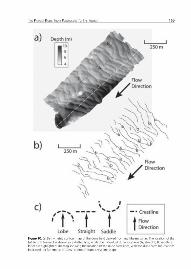
Figure 10.Figure 10.Figure 10.Figure 10.Figure 10. (a) Bathymetric contour map of the dune field derived from multibeam sonar. The location of thefull length transect is shown as a dotted line, while the individual dune locations (A, straight; B, saddle; C,lobe) are highlighted. (b) Map showing the location of the dune crest lines, with the dune crest bifurcationsindicated. (c) Schematic of classification of dune crest line shape.
ORFEO O.; PARSONS D.; BEST J.; LUTZ A. I. AND ZURITA A. E.170
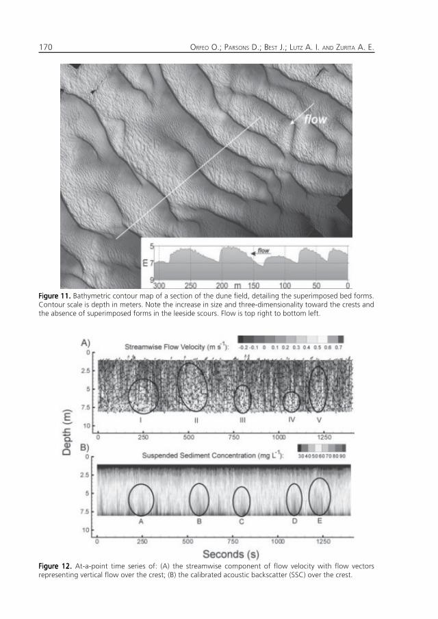
Figure 11.Figure 11.Figure 11.Figure 11.Figure 11. Bathymetric contour map of a section of the dune field, detailing the superimposed bed forms.Contour scale is depth in meters. Note the increase in size and three-dimensionality toward the crests andthe absence of superimposed forms in the leeside scours. Flow is top right to bottom left.
Figure 12.Figure 12.Figure 12.Figure 12.Figure 12. At-a-point time series of: (A) the streamwise component of flow velocity with flow vectorsrepresenting vertical flow over the crest; (B) the calibrated acoustic backscatter (SSC) over the crest.
171THE PARANÁ RIVER: FROM PLEISTOCENE TO THE PRESENT
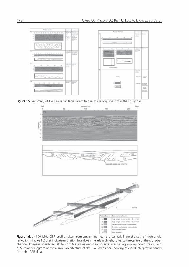
Figure 14.Figure 14.Figure 14.Figure 14.Figure 14. a) Image of the study bar taken on 26th August 2001. Stage was very low at this time, 1.66 m (astage of ~4.3 m is required to overtop the bar). Also seen (arrowed) are small lobate unit bars accretingaround the bartail and barhead. b) image of the study bar at the time of the GPR survey in May 2005. c) andd) oblique aerial photographs taken of the barhead in April 2007 showing how low-relief dunes are steeredaround the upstream end of the bar. e) topographic map of the study bar derived from dGPS surveys of thebar surface in May 2005.
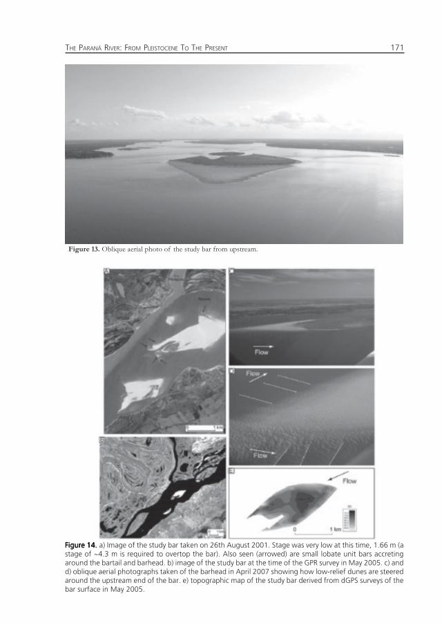
Figure 13. Oblique aerial photo of the study bar from upstream.
ORFEO O.; PARSONS D.; BEST J.; LUTZ A. I. AND ZURITA A. E.172
Figure 16.Figure 16.Figure 16.Figure 16.Figure 16. a) 100 MHz GPR profile taken from survey line near the bar tail. Note the sets of high-anglereflections (facies 1b) that indicate migration from both the left and right towards the centre of the cross-barchannel. Image is orientated left to right (i.e. as viewed if an observer was facing looking downstream) andb) Summary diagram of the alluvial architecture of the Río Paraná bar showing selected interpreted panelsfrom the GPR data.
Figure 15.Figure 15.Figure 15.Figure 15.Figure 15. Summary of the key radar facies identified in the survey lines from the study bar.
173THE PARANÁ RIVER: FROM PLEISTOCENE TO THE PRESENT
The study bar appears to have beenattached to the left bank until some timebetween 1967 and 1990, but from at least1990 has maintained a similar location andplanform to the present bar form. Annualchange is modest: for example, changebetween 2001 and 2005 was predomi-nantly restricted to minor reworking ofboth bartail limbs and barhead accretion.
GPR profiles, with depth of penetrationup to 12 m below the bar surface, werecollected in 2005 on a grid with a 200 to400 m spacing across the whole bar andare presented in Sambrook Smith et al.(Figures 15 and 16 below). Two facieswere found to dominate the sedimentaryarchitecture. The principal facies (~83%of total facies) comprises trough andplanar cross-strata related to the migrationof dunes, with the thickness of the cross-strata decreasing towards the bar surface.The second significant facies (~15%) ishigh-angle (generally 10o-20o) strata thattypically form by accretion at the barmargins or bartail. Clay drapes (<2%) andcross-bar channels (<1%) were found tocomprise only a minor part of the deposits.We will walk the bar to examine thesurface bedforms present, and aim to digsome shallow trenches.
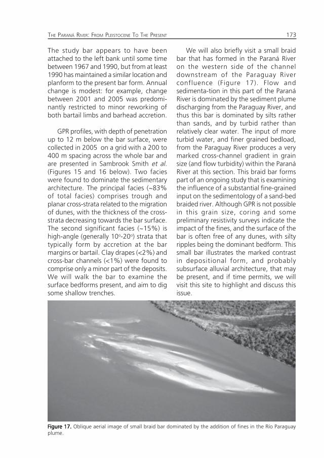
We will also briefly visit a small braidbar that has formed in the Paraná Riveron the western side of the channeldownstream of the Paraguay Riverconfluence (Figure 17). Flow andsedimenta-tion in this part of the ParanáRiver is dominated by the sediment plumedischarging from the Paraguay River, andthus this bar is dominated by silts ratherthan sands, and by turbid rather thanrelatively clear water. The input of moreturbid water, and finer grained bedload,from the Paraguay River produces a verymarked cross-channel gradient in grainsize (and flow turbidity) within the ParanáRiver at this section. This braid bar formspart of an ongoing study that is examiningthe influence of a substantial fine-grainedinput on the sedimentology of a sand-bedbraided river. Although GPR is not possiblein this grain size, coring and somepreliminary resistivity surveys indicate theimpact of the fines, and the surface of thebar is often free of any dunes, with siltyripples being the dominant bedform. Thissmall bar illustrates the marked contrastin depositional form, and probablysubsurface alluvial architecture, that maybe present, and if time permits, we willvisit this site to highlight and discuss thisissue.
Figure 17.Figure 17.Figure 17.Figure 17.Figure 17. Oblique aerial image of small braid bar dominated by the addition of fines in the Río Paraguayplume.
ORFEO O.; PARSONS D.; BEST J.; LUTZ A. I. AND ZURITA A. E.174
Figure 19.Figure 19.Figure 19.Figure 19.Figure 19. Islands (relict bars).
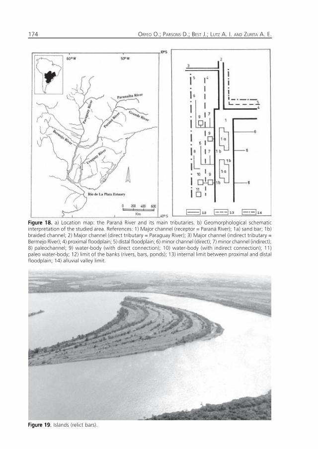
Figure 18.Figure 18.Figure 18.Figure 18.Figure 18. a) Location map: the Paraná River and its main tributaries. b) Geomorphological schematicinterpretation of the studied area. References: 1) Major channel (receptor = Paraná River); 1a) sand bar; 1b)braided channel; 2) Major channel (direct tributary = Paraguay River); 3) Major channel (indirect tributary =Bermejo River); 4) proximal floodplain; 5) distal floodplain; 6) minor channel (direct); 7) minor channel (indirect);8) paleochannel; 9) water-body (with direct connection); 10) water-body (with indirect connection); 11)paleo water-body; 12) limit of the banks (rivers, bars, ponds); 13) internal limit between proximal and distalfloodplain; 14) alluvial valley limit.
175THE PARANÁ RIVER: FROM PLEISTOCENE TO THE PRESENT
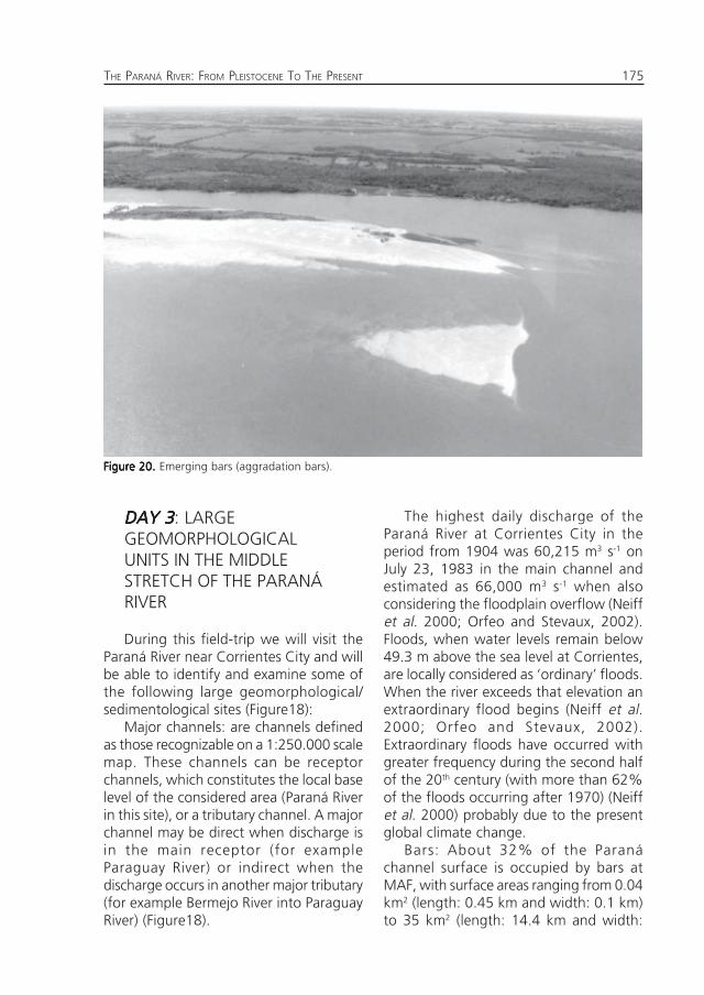
Figure 20.Figure 20.Figure 20.Figure 20.Figure 20. Emerging bars (aggradation bars).
DAY 3DAY 3DAY 3DAY 3DAY 3: LARGEGEOMORPHOLOGICALUNITS IN THE MIDDLESTRETCH OF THE PARANÁRIVER
During this field-trip we will visit theParaná River near Corrientes City and willbe able to identify and examine some ofthe following large geomorphological/sedimentological sites (Figure18):
Major channels: are channels definedas those recognizable on a 1:250.000 scalemap. These channels can be receptorchannels, which constitutes the local baselevel of the considered area (Paraná Riverin this site), or a tributary channel. A majorchannel may be direct when discharge isin the main receptor (for exampleParaguay River) or indirect when thedischarge occurs in another major tributary(for example Bermejo River into ParaguayRiver) (Figure18).
The highest daily discharge of theParaná River at Corrientes City in theperiod from 1904 was 60,215 m3 s-1 onJuly 23, 1983 in the main channel andestimated as 66,000 m3 s-1 when alsoconsidering the floodplain overflow (Neiffet al. 2000; Orfeo and Stevaux, 2002).Floods, when water levels remain below49.3 m above the sea level at Corrientes,are locally considered as ‘ordinary’ floods.When the river exceeds that elevation anextraordinary flood begins (Neiff et al.2000; Orfeo and Stevaux, 2002).Extraordinary floods have occurred withgreater frequency during the second halfof the 20th century (with more than 62%of the floods occurring after 1970) (Neiffet al. 2000) probably due to the presentglobal climate change.
Bars: About 32% of the Paranáchannel surface is occupied by bars atMAF, with surface areas ranging from 0.04km2 (length: 0.45 km and width: 0.1 km)to 35 km2 (length: 14.4 km and width:
ORFEO O.; PARSONS D.; BEST J.; LUTZ A. I. AND ZURITA A. E.176
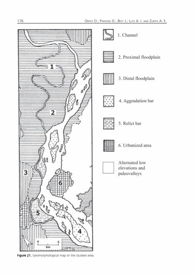
Figure 21.Figure 21.Figure 21.Figure 21.Figure 21. Geomorphological map of the studied area.
177THE PARANÁ RIVER: FROM PLEISTOCENE TO THE PRESENT
4.1 km). According to the subaerialexposition of the bar surface and the waterlevel at the time, these bars may beclassified in islands (when they remainemergent during the ordinary floods)(Figure 19), and emerging bars (floodedevery year) (Figure 20).
The bars can be genetically groupedinto aggradation bars (from the accumu-lation of load material) (Figure 20) andrelict bars (from the erosive processes thatisolated portions of the alluvial plain intothe channel) (Figure19). In this case, therelict bars are essentially parts of old alluvialplains abandoned by the Paraná during thelateral migration. The Parana has basicallyslowly captured portions of the ParaguayRiver (Orfeo, 1998). This has resulted inan upstream migration of this majorconfluence, and it is thus possible toidentify some ancient Paraná-Paraguayfluvial confluence areas, the southernmostof which is located 40 km to the south-west of the present confluence.
A general overview of this area isshowed in Figure 21.
Minor channels: are defined astributaries with a non-recognizable widthusing the mentioned scale. These can alsobe direct (when discharge is in a majorchannel) or indirect (when discharge inanother minor channel). These channels,mainly located in the large alluvial plainof the Paraná River, may be active when aconstant discharge is active or inactivewhen the water movement occurs onlyoccasionally (Figures 23 and 24).
The headwaters of these kind of riversare located in large wetlands and the bedof the channels are covered by fine alluvialsediments (silt and cohesive clays withmean size corresponding to silt fraction)and very poorly sorted (Orfeo, 2006).Some of these tributaries have a constantincrement in the sand content and meansize, combined with an improvement of
its sorting coefficient, this sandy sedimenthas been deposited previously by theParaná fluvial system and explains thisapparent anomaly.
Typically these types of rivers registeredthe following dynamics in three mainstages:
(a) Low water period: the fluvial systemis reduced to its minimal conditionfacilitating the sedimentation of finematerial (<4µm). Most of the channel andwater-logged areas are rapidly colonizedby aquatic vegetation, bringing abundantorganic matter that is added to theincoming organic matter from the wethighlands. The high concentration ofsuspended sediment corresponds to theminimal discharge, therefore the overallsediment transport is low.
(b) Beginning of the flood period: Therainfall mobilizes this autochthonousfluvial network, generating the movementof organic and inorganic material deposi-ted on the bed channel and adjacent areas.The suspended sediment concentrationincreases together with the discharge, sothat the total solid transport in thismoment is very high.
(c) High water period: Most of the bedchannels remain free of non-cohesiveaccumulation, which is exported as washload to the Paraná River. The discharge canreach high magnitudes but the suspendedsediment concentration is often low dueto depletion in supply. At the headwaters,the exposed bed is often characterized bya cohesive clay base. However in the lowerstretches of the rivers, the channel issometimes covered by clean sand whenpaleodeposits of Paraná River are exposed.
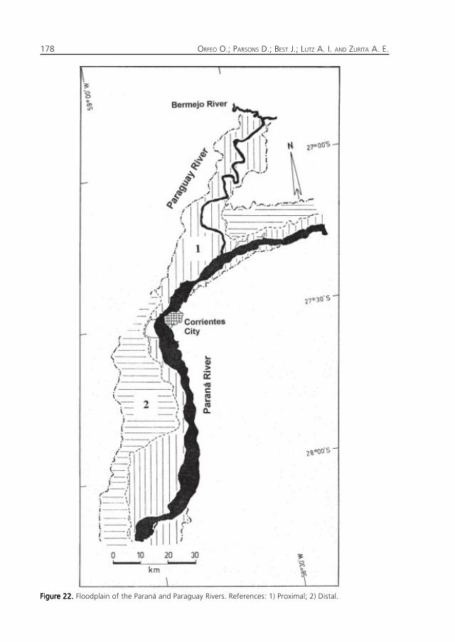
Flood-plain: In this area (Figure 18) it ispossible to recognize two main unitswithout typical terraces according to theirelevation above the water level, (a)proximal floodplain that is directlyconnected with the Paraná main channel,and (b) a distal floodplain (Figure 22). In across section from the river, the latter is
ORFEO O.; PARSONS D.; BEST J.; LUTZ A. I. AND ZURITA A. E.178
Figure 22.Figure 22.Figure 22.Figure 22.Figure 22. Floodplain of the Paraná and Paraguay Rivers. References: 1) Proximal; 2) Distal.
179THE PARANÁ RIVER: FROM PLEISTOCENE TO THE PRESENT
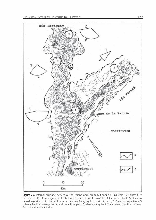
Figure 23.Figure 23.Figure 23.Figure 23.Figure 23. Internal drainage pattern of the Paraná and Paraguay floodplain upstream Corrientes City.References: 1) Lateral migration of tributaries located at distal Paraná floodplain circled by 1; 2), 3) and 4)lateral migration of tributaries located at proximal Paraguay floodplain circled by 2, 3 and 4, respectively; 5)internal limit between proximal and distal floodplain; 6) alluvial valley limit. The arrows show the dominantflow direction at each site.
ORFEO O.; PARSONS D.; BEST J.; LUTZ A. I. AND ZURITA A. E.180
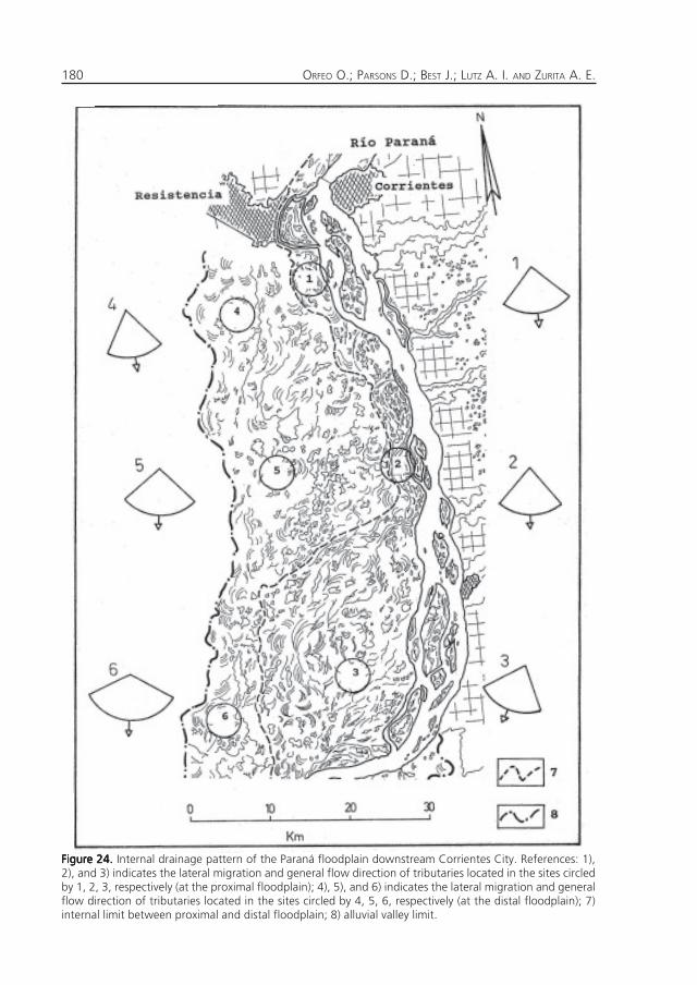
Figure 24.Figure 24.Figure 24.Figure 24.Figure 24. Internal drainage pattern of the Paraná floodplain downstream Corrientes City. References: 1),2), and 3) indicates the lateral migration and general flow direction of tributaries located in the sites circledby 1, 2, 3, respectively (at the proximal floodplain); 4), 5), and 6) indicates the lateral migration and generalflow direction of tributaries located in the sites circled by 4, 5, 6, respectively (at the distal floodplain); 7)internal limit between proximal and distal floodplain; 8) alluvial valley limit.
181THE PARANÁ RIVER: FROM PLEISTOCENE TO THE PRESENT
Figure 25.Figure 25.Figure 25.Figure 25.Figure 25. Water-bodies of the studied area.
ORFEO O.; PARSONS D.; BEST J.; LUTZ A. I. AND ZURITA A. E.182
located beyond the proximal floodplainand is topographically higher and floodedwith less frequency (Figure 22). In generalthe main channel covers around 20% ofthe total fluvial surface in the analyzedarea. The rest is occupied by the floodplain(proximal 35%; distal 45%) (Figure 22).
The Paraná River in the studied areaflows across a region composed of severalstructural blocks elongated in the N-Sdirection, most of them are tilted slightlyto the east. From the Paraná-Paraguayconfluence, the Paraná flows 75 km on asunken block, widening the floodplainfrom 13 to 45 km (Iriondo, 1988).
For that reason, the floodplain of theParaná River in the studied area isasymmetrical, developed practically onlyon the right side of the river due to verticalmovements of buried tectonic blocks ofbasaltic composition, Cretaceous in age.These movements were related related tothe growing of the Andes Mountainsduring the Tertiary Period. In consequence,the left side of the Paraná River atCorrientes City is about 8 m highercompared with the right, and the generalflow direction is E-W and N-S upstreamand downstream of Corrientes City,showing a clear structural control (Figure22).
The width of the proximal flood-plainranges from 0.4 to 3 km upstream ofCorrientes City (mean width 1.9 km)(Figure23) and from 0.3 to 20 km (meanwidth 8.1 km) downstream (Figure 24).This elongated and narrow area in contactwith the main channel of the Paraná, isaffected almost annually by the ordinaryfloods of the river.
The distal floodplain is wider than theproximal one (mean value 12.6 km;maximum 21.4 km). During extraordinaryfloods the water reaches this region, sothat the entire flooded area measures 20.7km in the average width (ranging from 9.6to 26.1 km).
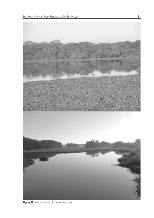
Water-bodies: are shallow depressionswith direct or indirect connection with anychannel (Figure 18). May remain or notentirely flooded during the completehydrological cycle, depending on hydro-metric variation of the major channels, thedistance between them, the topographicposition and the rainfall supply (Figure 25).
REFERENCESREFERENCESREFERENCESREFERENCESREFERENCES
Aceñolaza, F.G.Aceñolaza, F.G.Aceñolaza, F.G.Aceñolaza, F.G.Aceñolaza, F.G. (2004) Paleobiogeografía de laregión Mesopotámica. Revista del InstitutoSuperior de Correlación Geológica (Misceláneas)12: 25-29. Tucumán
Albino, A. and Carlini, A.A.Albino, A. and Carlini, A.A.Albino, A. and Carlini, A.A.Albino, A. and Carlini, A.A.Albino, A. and Carlini, A.A. (2008) First Record ofBoa constrictor (Serpentes, Boidae) in theQuaternary of South America. Journal ofHerpetology 42 (1): 82-88.
Alcaraz, M.A. and Carlini, A.A.Alcaraz, M.A. and Carlini, A.A.Alcaraz, M.A. and Carlini, A.A.Alcaraz, M.A. and Carlini, A.A.Alcaraz, M.A. and Carlini, A.A. (2003) Los cérvidos(Mammalia, Artiodactyla) de las formacionesToropí y Yupoí (Pleistoceno Medio-Tardío) de laprovincia de Corrientes, Argentina. Ameghiniana40 (4): 50R.
Alcaraz, M.A. and Zurita, A.E.Alcaraz, M.A. and Zurita, A.E.Alcaraz, M.A. and Zurita, A.E.Alcaraz, M.A. and Zurita, A.E.Alcaraz, M.A. and Zurita, A.E. (2004) Nuevosregistros de cérvidos poco conocidos:Epieuryceros cf. proximus Castellanos y Antifersp. (Mammalia, Artiodactyla, Cervidae). Revistadel Museo Argentino de Ciencias Naturales 6(1): 41-48.
Alvarez, B. B.Alvarez, B. B.Alvarez, B. B.Alvarez, B. B.Alvarez, B. B. (1974) Los mamíferos fósiles delCuaternario de Arroyo Toropí, Corrientes,Argentina. Ameghiniana, 11(3):295-311.
Álvarez, B.B.Álvarez, B.B.Álvarez, B.B.Álvarez, B.B.Álvarez, B.B. (1974) Los mamíferos fósiles delCuaternario de Arroyo Toropí, Corrientes,Argentina. Ameghiniana 11 (3): 295-311.
Ameghino, F.Ameghino, F.Ameghino, F.Ameghino, F.Ameghino, F. (1885) Nuevos restos de mamíferosfósiles oligocenos recogidos por el Profesor PedroScalabrini y pertenecientes al Museo Provinciade la ciudad de Paraná. Boletín de la AcademiaNacional de Ciencias, Córdoba 8: 5-207.
Ameghino, F.Ameghino, F.Ameghino, F.Ameghino, F.Ameghino, F. (1889) Contribución al conocimientode los mamíferos fósiles de la RepúblicaArgentina. Actas de la Academia Nacional deCiencias de Córdoba 6: 1-1027.
Carlini, A. A., Scillato-Yané, G. J., Noriega, J. I.Carlini, A. A., Scillato-Yané, G. J., Noriega, J. I.Carlini, A. A., Scillato-Yané, G. J., Noriega, J. I.Carlini, A. A., Scillato-Yané, G. J., Noriega, J. I.Carlini, A. A., Scillato-Yané, G. J., Noriega, J. I.andandandandand Aceñolaza, F. Aceñolaza, F. Aceñolaza, F. Aceñolaza, F. Aceñolaza, F. (2000) Perezosos terrestres(Xenarthra, Tardigrada) del «Mesopotamiense»(Fm. Ituzaingó, Mioceno tardío-Pliocenotemprano) de la provincia de Entre Ríos,Argentina. Stvdia Geológica Salmaticensia 36:13-27.
Carlini, A.A., Tonni, E.P. and Noriega, J.I.Carlini, A.A., Tonni, E.P. and Noriega, J.I.Carlini, A.A., Tonni, E.P. and Noriega, J.I.Carlini, A.A., Tonni, E.P. and Noriega, J.I.Carlini, A.A., Tonni, E.P. and Noriega, J.I. (2002)El primer registro paleontológico del lutrinogigante Pteronura (Carnívora, Mustelidae) en la
183THE PARANÁ RIVER: FROM PLEISTOCENE TO THE PRESENT
Argentina. Su importancia paleobiogeográfica.1° Congreso Latinoamericano de Paleontologíade Vertebrados, resúmenes: 25
Carlini, A.A., Zurita, A., Gasparini, G.M. andCarlini, A.A., Zurita, A., Gasparini, G.M. andCarlini, A.A., Zurita, A., Gasparini, G.M. andCarlini, A.A., Zurita, A., Gasparini, G.M. andCarlini, A.A., Zurita, A., Gasparini, G.M. andNoriega, J. I .Noriega, J. I .Noriega, J. I .Noriega, J. I .Noriega, J. I . (2004) Los mamíferos delPleistoceno de la Mesopotamia argentina y surelación tanto con aquéllos del Centro Norte dela Argentina, Paraguay y Sur de Bolivia, comocon los del Sur de Brasil y Oeste de Uruguay:Paleobiogeografía y Paleoambientes. Revista delInstituto Superior de Correlación Geológica(Misceláneas) 12: 83-90. Tucumán.
Cartelle, C. Cartelle, C. Cartelle, C. Cartelle, C. Cartelle, C. andandandandand Lessa, G. Lessa, G. Lessa, G. Lessa, G. Lessa, G. (1988) Presença deMyocator coypus (Molina, 1782), Rodentia,Myocatoridae, do Pleistoceno final-Holoceno nocentro-oeste da Bahia, Brasil.11º CongressoBrasilero de Paleontología, Actas 1: 583-591.
Castellanos, A.Castellanos, A.Castellanos, A.Castellanos, A.Castellanos, A. (1926) Sobre un nuevo gliptodóntidochapadmalense. Urotherium simplex n. gen. n.sp. y las formas afines. Anales del MuseoNacional de Historia Natural «BernardinoRivadavia» 60: 263-278. Buenos Aires.
Castellanos, A.Castellanos, A.Castellanos, A.Castellanos, A.Castellanos, A. (1940) A propósito de los génerosPlohophorus, Nopachthus y Panochthus.Publicaciones del Instituto de Fisiografía yGeología, 1 (6): 1-279, figs. 1-82.
Cione, A.L. and Tonni, E.P.Cione, A.L. and Tonni, E.P.Cione, A.L. and Tonni, E.P.Cione, A.L. and Tonni, E.P.Cione, A.L. and Tonni, E.P. (1999) Biostratigraphyand crhonological scale of upper-most Cenozoicin the Pampean area. En: Rabassa, J. y M.Salemme, (eds.). Quaternary of South Americaand Antarctic Peninsula, 12: 22-51.
Cione, A.L. Cione, A.L. Cione, A.L. Cione, A.L. Cione, A.L. andandandandand Tonni, E.P. Tonni, E.P. Tonni, E.P. Tonni, E.P. Tonni, E.P.( 2005) Bioestratigrafíabasada en mamíferos del Cenozoico Superior dela provincia de Buenos Aires, Argentina. 16°Congreso Geológico Argentino, Relatorio: 183-200.
Cione, A.L., Azpelicueta, M.M., Bond, M. Carlini,Cione, A.L., Azpelicueta, M.M., Bond, M. Carlini,Cione, A.L., Azpelicueta, M.M., Bond, M. Carlini,Cione, A.L., Azpelicueta, M.M., Bond, M. Carlini,Cione, A.L., Azpelicueta, M.M., Bond, M. Carlini,A.A., Casciotta, J.R., Cozzuol, M.A., de LaA.A., Casciotta, J.R., Cozzuol, M.A., de LaA.A., Casciotta, J.R., Cozzuol, M.A., de LaA.A., Casciotta, J.R., Cozzuol, M.A., de LaA.A., Casciotta, J.R., Cozzuol, M.A., de LaFuente, M., Gasparini, Z., Goin, F.J., Noriega,Fuente, M., Gasparini, Z., Goin, F.J., Noriega,Fuente, M., Gasparini, Z., Goin, F.J., Noriega,Fuente, M., Gasparini, Z., Goin, F.J., Noriega,Fuente, M., Gasparini, Z., Goin, F.J., Noriega,J.I., Scillato-Yané, G.J., Soibelzon, L., Tonni,J.I., Scillato-Yané, G.J., Soibelzon, L., Tonni,J.I., Scillato-Yané, G.J., Soibelzon, L., Tonni,J.I., Scillato-Yané, G.J., Soibelzon, L., Tonni,J.I., Scillato-Yané, G.J., Soibelzon, L., Tonni,E.P., Verzi, D. E.P., Verzi, D. E.P., Verzi, D. E.P., Verzi, D. E.P., Verzi, D. andandandandand Vucetich, M.G. Vucetich, M.G. Vucetich, M.G. Vucetich, M.G. Vucetich, M.G. (2000)Miocene vertebrates from Entre Ríos province,eastern Argentina. Revista del Instituto Superiorde Correlación Geológica. Serie CorrelaciónGeológica 14: 191-237.
Cozzuol, M.A.Cozzuol, M.A.Cozzuol, M.A.Cozzuol, M.A.Cozzuol, M.A. (1993) El Mesopotamiense ¿Mezclatemporal o vía de dispersión? Ameghiniana 30(1): 103 R
Ferrero, B.S. and Noriega, J.I.Ferrero, B.S. and Noriega, J.I.Ferrero, B.S. and Noriega, J.I.Ferrero, B.S. and Noriega, J.I.Ferrero, B.S. and Noriega, J.I.( 2007) A New Tapirfrom the upper Pleistocene of Argentina:phylogenetic remarks on the neotropical familydiversification. Journal of VertebratePalaeontology 27 (2): 504–511
Herbst, R.Herbst, R.Herbst, R.Herbst, R.Herbst, R. (1969) Nota sobre la geología deCorrientes. Actas IV Jornadas Geológicas deArgentina, 3: 87-95. Mendoza.
Herbst, R.Herbst, R.Herbst, R.Herbst, R.Herbst, R. (1971) Esquema estratigráfico de laprovincia de Corrientes, República Argentina.Revista de la Asociación Geológica Argentina 26(2):221-243
Herbst, R. and Álvarez, B.B.Herbst, R. and Álvarez, B.B.Herbst, R. and Álvarez, B.B.Herbst, R. and Álvarez, B.B.Herbst, R. and Álvarez, B.B. (1972) Nota sobre dosToxodontes (Toxodontidae, Notoungulata) delCuaternario de Corrientes, Argentina.Ameghiniana 9 (2): 149-158
Herbst, R. and Álvarez, B.B.Herbst, R. and Álvarez, B.B.Herbst, R. and Álvarez, B.B.Herbst, R. and Álvarez, B.B.Herbst, R. and Álvarez, B.B. (1975) Notas sobredos formaciones del Cuaternario en Corrientes.Anales de la Academia Brasilera de Ciencias 47:33-37
Herbst, R. and Álvarez, B.B.Herbst, R. and Álvarez, B.B.Herbst, R. and Álvarez, B.B.Herbst, R. and Álvarez, B.B.Herbst, R. and Álvarez, B.B. (1977) Nota sobre dosformaciones del Cuartario de Corrientes,República Argentina. FACENA 1:7-17.
Herbst, R. and J. N. Santa CruzHerbst, R. and J. N. Santa CruzHerbst, R. and J. N. Santa CruzHerbst, R. and J. N. Santa CruzHerbst, R. and J. N. Santa Cruz (1985) Mapalitoestratigráfico de la Provincia de Corrientes.D´Orbignyana: 1-69.
Iriondo, M.Iriondo, M.Iriondo, M.Iriondo, M.Iriondo, M. (1988) A comparisson between theAmazon and the Paraná River Systems. In:Degens, E., Kmpe, S., Naidu, S. (Eds.), Transportof Carbon and Minerals of Major World Rivers,Lakes and Stuaries: Part 5, Mitt. Geol. Palaont.Inst.Univ. Hamburg, SCOPE/UNEP, 66: 77-92.
Iriondo, M. Iriondo, M. Iriondo, M. Iriondo, M. Iriondo, M. andandandandand García, N. O. García, N. O. García, N. O. García, N. O. García, N. O. (1993) Climaticvariations in the Argentine plains during the last18.000 years. Palaeogeography, Palaeoclimato-logy, Palaeoecology 101: 209-220.
Iriondo, M.Iriondo, M.Iriondo, M.Iriondo, M.Iriondo, M. (1972) Mineralogía de las arenas de laFormación Yupoí. (Manuscrito).
Iriondo, M.Iriondo, M.Iriondo, M.Iriondo, M.Iriondo, M. (1996) Estratigrafía del Cuaternario dela Cuenca del Río Uruguay. Actas del 13ºCongreso Geológico Argentino y 3º Congresode Exploración de Hidrocarburos 4:15-25.
Lane, SN; Parsons, DR; Best, JL; Orfeo, O;Lane, SN; Parsons, DR; Best, JL; Orfeo, O;Lane, SN; Parsons, DR; Best, JL; Orfeo, O;Lane, SN; Parsons, DR; Best, JL; Orfeo, O;Lane, SN; Parsons, DR; Best, JL; Orfeo, O;Kostaschuk, RA; Hardy, RJKostaschuk, RA; Hardy, RJKostaschuk, RA; Hardy, RJKostaschuk, RA; Hardy, RJKostaschuk, RA; Hardy, RJ (2008) Causes ofrapid mixing at a junction of two large rivers:Rio Parana and Rio Paraguay, Argentina, JGEOPHYS RES-EARTH, 113(F2), . doi:10.1029/2006JF000745
Mapa de SuelosMapa de SuelosMapa de SuelosMapa de SuelosMapa de Suelos de la Provincia de Corrientes. (1970)INTA.
Morton, L. S.Morton, L. S.Morton, L. S.Morton, L. S.Morton, L. S. Moluscos fósiles de agua dulce de laFormación Ituzaingó, Plioceno de Corrientes,Argentina-Miscelanea 12- INSUGEO
Neiff, J., Mendiondo, E., Depettris, C.Neiff, J., Mendiondo, E., Depettris, C.Neiff, J., Mendiondo, E., Depettris, C.Neiff, J., Mendiondo, E., Depettris, C.Neiff, J., Mendiondo, E., Depettris, C. (2000) ENSOfloods on river ecosystems: catastrophes ormyths? In Toenmsnann, F., Koch, M. (Eds.), RiverFlood Defense, Kassel Reports of HydraulicEngineering No. 9/2000, Vol. I. Verlag, Kassel,pp. F141-F152, Section F: Flood risk, floodplain,and floodplain management.
Noriega, J.I., Carlini, A.A. Noriega, J.I., Carlini, A.A. Noriega, J.I., Carlini, A.A. Noriega, J.I., Carlini, A.A. Noriega, J.I., Carlini, A.A. andandandandand Tonni, E.P. Tonni, E.P. Tonni, E.P. Tonni, E.P. Tonni, E.P. (2004)Vertebrados del Pleistoceno tardío de la cuencadel arroyo Ensenada (Departamento Diamante,provincia de Entre Ríos, Argentina). Revista delInstituto Superior de Correlación Geológica(Misceláneas) 12: 71-76.
Noriega, J.I., Manzano, A.S., De la Fuente, M.S.Noriega, J.I., Manzano, A.S., De la Fuente, M.S.Noriega, J.I., Manzano, A.S., De la Fuente, M.S.Noriega, J.I., Manzano, A.S., De la Fuente, M.S.Noriega, J.I., Manzano, A.S., De la Fuente, M.S.andandandandand Tonni, E. Tonni, E. Tonni, E. Tonni, E. Tonni, E.P. (2000) Un Testudininae gigante(Chelonii: Criptodira) del Pleistoceno de laprovincia de Corrientes, Argentina. Ameghiniana37 (3): 321-326.
ORFEO O.; PARSONS D.; BEST J.; LUTZ A. I. AND ZURITA A. E.184
Oliveira, E. V.Oliveira, E. V.Oliveira, E. V.Oliveira, E. V.Oliveira, E. V. (1992) Mamíferos fósseis doQuaternario do Estado do Rio Grande do Sul,Brasil. Dissertação de Mestrado (UniversidadeFederal do Río Grande do Sul), 118 pp.
Oliveira, E.V.Oliveira, E.V.Oliveira, E.V.Oliveira, E.V.Oliveira, E.V. (1999) Quaternary vertebrates andclimates from southern Brazil. Quternary ofSouth America and Antarctic Penninsula 12, 61-73.
Oliveira, E.V.Oliveira, E.V.Oliveira, E.V.Oliveira, E.V.Oliveira, E.V. (1996) Mamíferos Xenarthra (Edentata)do Quaternario do Estado do Rio Grande do Sul,Brasil. Ameghiniana 33 (1): 65-75.
Orfeo, O.Orfeo, O.Orfeo, O.Orfeo, O.Orfeo, O. (1998) Reconstrucción morfológica ypaleohidrológica de un tramo abandonado delrío Paraguay inferior. Revista de la AsociaciónGeológica Argentina, 53 (3): 348-353.
Orfeo, O. and Stevaux, J.Orfeo, O. and Stevaux, J.Orfeo, O. and Stevaux, J.Orfeo, O. and Stevaux, J.Orfeo, O. and Stevaux, J. (2002) Hydraulic andmorphological characteristics of middle andupper reaches of the Paraná River (Argentina andBrazil) Geomorphology, Volume 44, Issues 3-4,1 May 2002, Pages 309-322.
Orfeo, O.Orfeo, O.Orfeo, O.Orfeo, O.Orfeo, O. (2006) Dynamcs of sediment transport intwo subtropical plain rivers of South America.Z. Geomorph. N.F., Suppl. Vol 145: 229-241.
Ortiz JaureguizarOrtiz JaureguizarOrtiz JaureguizarOrtiz JaureguizarOrtiz Jaureguizar, E. , E. , E. , E. , E. and Claderaand Claderaand Claderaand Claderaand Cladera, G.A., G.A., G.A., G.A., G.A. (2006)Paleoenvironmental evolution of Southern SouthAmerica during the Cenozoic. Journal of AridEnvironments 66: 498-532.
Pascual, R. and Bondesio, P.Pascual, R. and Bondesio, P.Pascual, R. and Bondesio, P.Pascual, R. and Bondesio, P.Pascual, R. and Bondesio, P. (1982) Un roedorCardiatheriinae (Hydrochoerydae) de la EdadHuayqueriense (Mioceno tardío) de La Pampa.Sumario de los ambientes terrestres en laArgentina durante el Mioceno. Ameginiana 29(1-2): 19-35.
Parsons, D; Best, JL; Orfeo, O; Hardy, RJ;Parsons, D; Best, JL; Orfeo, O; Hardy, RJ;Parsons, D; Best, JL; Orfeo, O; Hardy, RJ;Parsons, D; Best, JL; Orfeo, O; Hardy, RJ;Parsons, D; Best, JL; Orfeo, O; Hardy, RJ;Kostaschuk, RA; Lane, SN.Kostaschuk, RA; Lane, SN.Kostaschuk, RA; Lane, SN.Kostaschuk, RA; Lane, SN.Kostaschuk, RA; Lane, SN. (2005) Morphologyand flow fields of three-dimensional dunes, RioParaná, Argentina: Results from simultaneousmultibeam echo sounding and acoustic Dopplercurrent profiling, Journal of GeophysicalResearch, 110(F4), pp1-9. doi:10.1029/2004JF000231
Parsons, D; Best, JL; Lane, SN; Orfeo, O;Parsons, D; Best, JL; Lane, SN; Orfeo, O;Parsons, D; Best, JL; Lane, SN; Orfeo, O;Parsons, D; Best, JL; Lane, SN; Orfeo, O;Parsons, D; Best, JL; Lane, SN; Orfeo, O;Kostaschuk, RA; Hardy, RJ; Franklin, MC.Kostaschuk, RA; Hardy, RJ; Franklin, MC.Kostaschuk, RA; Hardy, RJ; Franklin, MC.Kostaschuk, RA; Hardy, RJ; Franklin, MC.Kostaschuk, RA; Hardy, RJ; Franklin, MC.(2004) The morphology and sediment dynamicsof a large river confluence: the Rio Parana andRio Paraguay, NE Argentina, In: M Greco, ACarravetta, R Della Morte (Ed) River Flow 2004,Proceedings of the second internationalconference on fluvial hydraulics, 1, A.A.Balkema, Leiden, pp43-49.
Parsons, DR; Best, JL; Lane, SN; Orfeo, O; Hardy,Parsons, DR; Best, JL; Lane, SN; Orfeo, O; Hardy,Parsons, DR; Best, JL; Lane, SN; Orfeo, O; Hardy,Parsons, DR; Best, JL; Lane, SN; Orfeo, O; Hardy,Parsons, DR; Best, JL; Lane, SN; Orfeo, O; Hardy,RJ; Kostaschuk, R.RJ; Kostaschuk, R.RJ; Kostaschuk, R.RJ; Kostaschuk, R.RJ; Kostaschuk, R. (2007) Form roughness andthe absence of secondary flow in a largeconfluence-diffluence, Rio Parana, Argentina,EARTH SURF PROC LAND, 32(1), pp155-162.doi:10.1002/esp.1457
Rabassa, J., Coronato, A.M., Salemme, M.Rabassa, J., Coronato, A.M., Salemme, M.Rabassa, J., Coronato, A.M., Salemme, M.Rabassa, J., Coronato, A.M., Salemme, M.Rabassa, J., Coronato, A.M., Salemme, M. (2005)Chronology of the Late Cenozoic Patagonianglaciations and their correlation with
bistratigraphic units of the Pampean region(Argentina). Journal of South American EarthSciences 20 (1-2): 81-103
Sambrook Smith, G.H., Ashworth, P.J., Best, J.L.,Sambrook Smith, G.H., Ashworth, P.J., Best, J.L.,Sambrook Smith, G.H., Ashworth, P.J., Best, J.L.,Sambrook Smith, G.H., Ashworth, P.J., Best, J.L.,Sambrook Smith, G.H., Ashworth, P.J., Best, J.L.,Lunt, I.A., Orfeo, O., and Parsons, D.R.Lunt, I.A., Orfeo, O., and Parsons, D.R.Lunt, I.A., Orfeo, O., and Parsons, D.R.Lunt, I.A., Orfeo, O., and Parsons, D.R.Lunt, I.A., Orfeo, O., and Parsons, D.R. (2009)The sedimentology and alluvial architecture of alarge braid bar, Río Paraná, Argentina, Journalof Sedimentary Research.
Scillato-Yané, G.J., Carlini, A.A., Tonni, E.P. andScillato-Yané, G.J., Carlini, A.A., Tonni, E.P. andScillato-Yané, G.J., Carlini, A.A., Tonni, E.P. andScillato-Yané, G.J., Carlini, A.A., Tonni, E.P. andScillato-Yané, G.J., Carlini, A.A., Tonni, E.P. andNoriega, J.I.Noriega, J.I.Noriega, J.I.Noriega, J.I.Noriega, J.I. (2005) Paleobiogeography of thelate Pleistocene pampatheres of South America.Journal of South American Earth Sciences 20:131-138.
Scillato-Yané, G.J., Tonni, E. P., Carlini, A.A. andScillato-Yané, G.J., Tonni, E. P., Carlini, A.A. andScillato-Yané, G.J., Tonni, E. P., Carlini, A.A. andScillato-Yané, G.J., Tonni, E. P., Carlini, A.A. andScillato-Yané, G.J., Tonni, E. P., Carlini, A.A. andNoriega J.I.Noriega J.I.Noriega J.I.Noriega J.I.Noriega J.I. (1998) Nuevos Hallazgos deMamíferos del Cuaternario en el Arroyo Toropí,Corrientes, Argentina. AspectosBioestratigráficos, Paleoambientales yPaleozoogeograficos. 6° CongresoLatinoamericano de Geología y 10° CongresoNacional de Geología Económica, Actas 1: 263-268.
Shugar, D., Kostaschuk, R., Best, J., Parsons, D.R.,Shugar, D., Kostaschuk, R., Best, J., Parsons, D.R.,Shugar, D., Kostaschuk, R., Best, J., Parsons, D.R.,Shugar, D., Kostaschuk, R., Best, J., Parsons, D.R.,Shugar, D., Kostaschuk, R., Best, J., Parsons, D.R.,Lane, S.N., Orfeo, O., and Hardy, R.J.Lane, S.N., Orfeo, O., and Hardy, R.J.Lane, S.N., Orfeo, O., and Hardy, R.J.Lane, S.N., Orfeo, O., and Hardy, R.J.Lane, S.N., Orfeo, O., and Hardy, R.J. (2009)On the relationship between flow and sedimenttransport over a crest of a dune, Rio Parana,Argentina, Sedimentology.
Tonni, E. P.Tonni, E. P.Tonni, E. P.Tonni, E. P.Tonni, E. P. (1992) Tapirus Brisson, 1762 (Mammalia,Perissodactyla) en el Lujanense (Pleistocenosuperior-Holoceno inferior) de la provincia deEntre Ríos, República Argentina. Ameghiniana21 (1): 3-8.
Tonni, E. P. Tonni, E. P. Tonni, E. P. Tonni, E. P. Tonni, E. P. andandandandand Scillato-Yané, G. J. Scillato-Yané, G. J. Scillato-Yané, G. J. Scillato-Yané, G. J. Scillato-Yané, G. J. (1997) Unanueva localidad con mamíferos pleistocenos enel Norte de la Argentina. Aspectospaleozoogeográficos. 6° Congreso daAssociacao Brasileira de Estudos do Quaternarioe Reuniao sobre o Quaternario da America doSul, Anais: 345-348. Curitiba, Brasil.
Tonni, E. P., Huarte, R., Carbonari, J. E. and Figini,Tonni, E. P., Huarte, R., Carbonari, J. E. and Figini,Tonni, E. P., Huarte, R., Carbonari, J. E. and Figini,Tonni, E. P., Huarte, R., Carbonari, J. E. and Figini,Tonni, E. P., Huarte, R., Carbonari, J. E. and Figini,A. J.A. J.A. J.A. J.A. J. (2003) New radiocarbon chronology for theGuerrero Member of the Luján Formation(Buenos Aires, Argentina): palaeoclimaticsignificance. Quaternary International 109-110:45-48.
Tonni, E.P.Tonni, E.P.Tonni, E.P.Tonni, E.P.Tonni, E.P. (2007) Geología del Cuanternario de lasregiones Mesopotamica y Pampeana de laArgentina. Sessäo Geologia Quaternário do rs:Integrando Conhecimentos. Resumos 17-18R
Tonni, E.P., Carlini, A. A. Zurita, A. E., Frechen,Tonni, E.P., Carlini, A. A. Zurita, A. E., Frechen,Tonni, E.P., Carlini, A. A. Zurita, A. E., Frechen,Tonni, E.P., Carlini, A. A. Zurita, A. E., Frechen,Tonni, E.P., Carlini, A. A. Zurita, A. E., Frechen,M., Gasparini, G., Budziad, D. and Kruck, W.M., Gasparini, G., Budziad, D. and Kruck, W.M., Gasparini, G., Budziad, D. and Kruck, W.M., Gasparini, G., Budziad, D. and Kruck, W.M., Gasparini, G., Budziad, D. and Kruck, W.(2005) Cronología y bioestratigrafía de las faunasdel Pleistoceno aflorantes en el Arroyo Toropí,provincia de Corrientes, Argentina. 2º CongresoLatino-Americano Paleontología de Vertebrados.Río de Janeiro, Brasil.
Tonni, E.P., Cione, A.L. and Figini, A.J.Tonni, E.P., Cione, A.L. and Figini, A.J.Tonni, E.P., Cione, A.L. and Figini, A.J.Tonni, E.P., Cione, A.L. and Figini, A.J.Tonni, E.P., Cione, A.L. and Figini, A.J. (1999)Predominance of arid climates indicated bymammals in the pampas of Argentina during the

185THE PARANÁ RIVER: FROM PLEISTOCENE TO THE PRESENT
Late Pleistocene and Holocene. Palaeogeogra-phy, Palaeoclimatology, Palaeoecology 147: 257-281.
Zurita, A. E. and A. I. Lutz.Zurita, A. E. and A. I. Lutz.Zurita, A. E. and A. I. Lutz.Zurita, A. E. and A. I. Lutz.Zurita, A. E. and A. I. Lutz. (2001) La faunaPleistocena de la Formación Toropí en laProvincia de Corrientes (Argentina).Mastozoología Neotropical. 9(1): 47-56.
Zurita, A. E., Scillato-Yané, G. J. Zurita, A. E., Scillato-Yané, G. J. Zurita, A. E., Scillato-Yané, G. J. Zurita, A. E., Scillato-Yané, G. J. Zurita, A. E., Scillato-Yané, G. J. andandandandand Carlini, A. Carlini, A. Carlini, A. Carlini, A. Carlini, A.A.A.A.A.A. (2005) Palaeozoogeographic, biostratigraphicand systematic aspects of the genus Sclerocaly-
ptus Ameghino 1891 (Xenarthra, Glyptodonti-dae) of Argentina. Journal of South AmericanEarth Sciences 20: 120-129.
Zurita, A. E.Zurita, A. E.Zurita, A. E.Zurita, A. E.Zurita, A. E. (2007) Sistemática y evolución de losHoplophorini (Xenarthra, Glyptodontidae,Hoplophorinae. Mioceno tardío-Holocenotemprano). Importancia bioestratigráfica,paleobiogeográfica y paleoambiental. TesisDoctoral (Inédita), Universidad Nacional de LaPlata, 367 p.

ORFEO O.; PARSONS D.; BEST J.; LUTZ A. I. AND ZURITA A. E.186
Related Documents