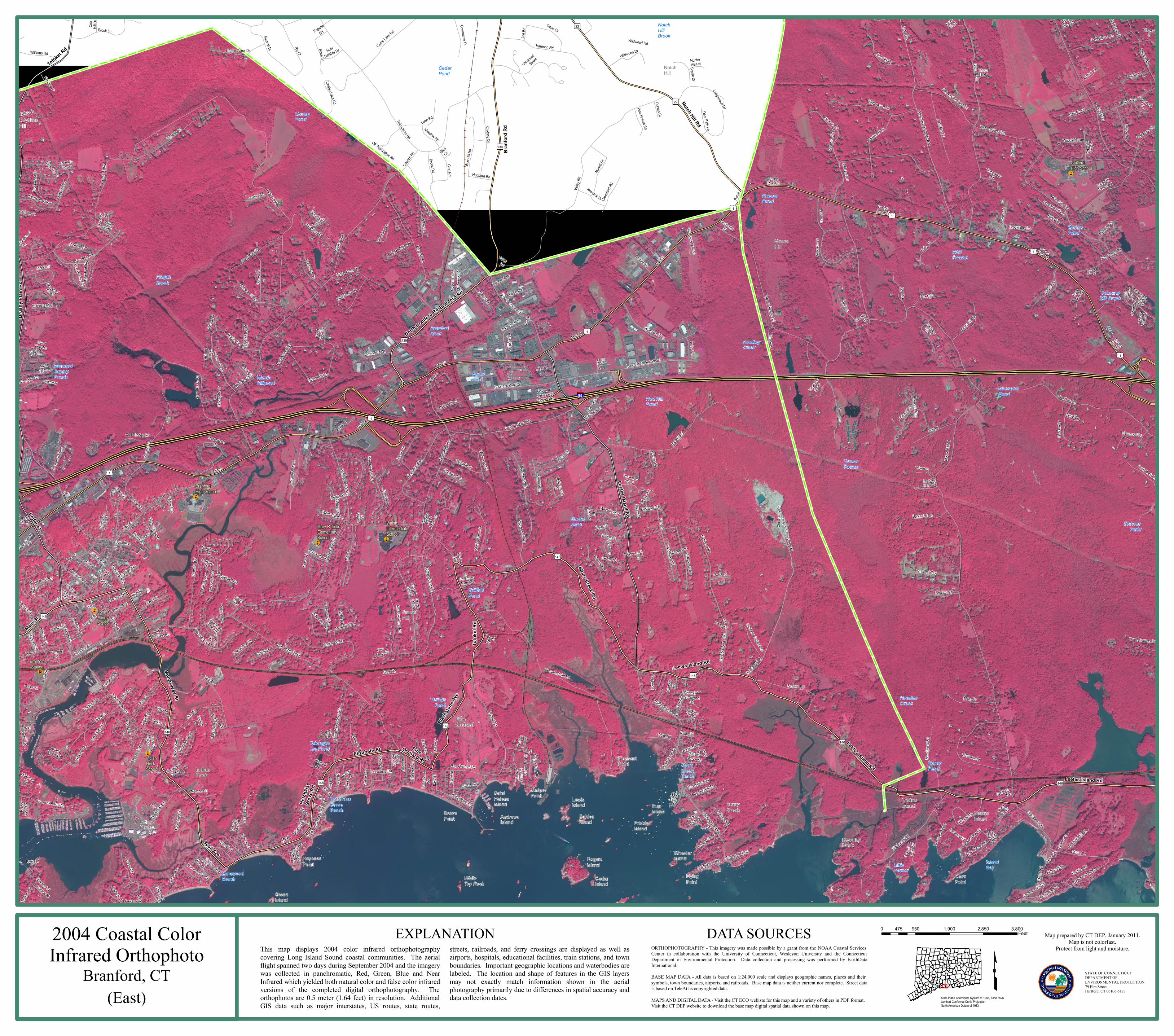
146 146 139 146 146 22 146 146 146 139 22 146 Branford Rd Leetes Island Rd Totoket Rd Cedar St Leetes Island Rd Montowese St Totoket Rd Sybil Ave Elizabeth St Main St Pine Orchard Rd Leetes Island Rd Hotchkiss Grove Rd Brushy Plain Rd North Branford Rd Blackstone Ave Notch Hill Rd Branford Rd Stony Creek Rd Leetes Island Rd Unnamed Street Coachlamp Ln Thimble Island Rd Long Point Rd Mirror Ln Long Hill Rd Driveway Ashman Ct Tyler St Bruce Ln Copper Hill Dr Driveway Island View Ave Old Pawson Rd Melrose Ave Ivy St Granite Rd Queach Rd Mirage Dr School Ground Rd Moose Hill Rd Taintor Dr Pasadena Rd Featherbed Ln Ridge Rd Ramp Unnamed Street Sybil Creek Pl Ferndale Rd Blackstone Ave New Quarry Rd Unnamed Street Homestead Pl Lake Pl River Rd Rockledge Cir Stonegate Dr Catullo Dr Windmill Hill Rd Christopher Rd Eades St Brookridge Ln Totoket Rd Old Pine Orchard Rd Soffer Pl Valley Rd Thimble Island Rd Hilltop Dr Linden Ave Brook Ln Pine Hollow Rd Bittersweet Farms Whortleberry Rd Prospect St 9th Ave Side Hill Rd Driveway Goldsmith Rd Shell Beach Rd Off Twin Lakes Rd Goodsell Point Rd Harrison Rd Andrews Rd Beechwood Rd Indian Neck Ave Halls Point Rd Fir Tree Dr Kirkham St Dowd Ct Pump Ln 4th Ave Ramp Kira Ln Katie Ln 8th Ave Seaview Ave Harbor View Ave Arrowhead Ln Harbor View Rd Jennifers Dr Hotchkiss Grove Rd Penn Cir Ramblewood Dr Spinnaker Run Tyler Ave Island Bay Cir Selden Ave Birch Rd Twin Lakes Rd Squaw Brook Rd Barker Hill Dr Hunter Hill Rd Towner Swamp Rd Main St Sachem Rd Ledgewood Dr Pin Oak Dr Palmer Woods Cir Eastwood Dr Balaurel Dr Maple St Indian Woods Rd Ridge Acres Rd Parkside Village Rd Driveway Orchard View Rd Oakdale Rd Mountain Top Dr 1st Ave Unnamed Street Harrison Ave Great Harbor Rd Juniper Knls Totoket Rd Deer Path Rd Farview Dr Riverside Dr Flat Rock Road Ext Wellsweep Rd Deforest Dr Rocky Ledge Ln Watrous Ave Rice Rd Old Quarry Rd Squire Ln Montowese St Driveway Sycamore Way Debra Ln Glen Cir Crossfield Rd Copper Ridge Cir Hamre Ln Dunham Dr Abbotts Ln Marshall Pl Red Rock Rd Quarry Dock Rd Elm St Spring Rock Rd Huntington Dr Cedrus Ct Meadow St Overland Ct Bay Path Way Short Rocks Rd Hillside Ave Monroe St Pawson Trl Ocean View Rd Woodvale Rd Holly Ln Richill Rd Rose St 7th Ave Ely St Cottage St Redwood Rd Aceto St Rolling Hill Rd Unnamed Street Damascus Rd Field Rd Regetta Rd School St Pawson Rd Oakdale Pl Main St Dogwood Ct 6th Ave Pheasant Run Hubbard Rd Wallace Rd Damberg Pl Beach Rd Tweed Rd Flax Mill Rd Flag Marsh Rd Fernwood Dr Wildwood Dr Joseph Way Wingate Rd Sanborn Rd Village Green Ct New England Rd O'Connell Ct Tanglewood Dr Cedar Lake Rd Ark Rd White Birch Ln Old New England Rd Meadow Circle Rd Denison Dr Unnamed Street Hemlock Dr Linsley Lake Rd Bailey Dr Pine Tree Dr Bartholomew Rd Queach Rd Woodside Dr Crestwood Dr Todds Hill Rd Valley Rd Northford Rd Gaylea Dr Thorn Hill Rd Driveway Devon Ct Acorn Rd Indian Point Rd Lantern View Dr Buckley Rd Ledgerock Ash Creek Rd Lea Rd Church St Driveway Oak Hill Dr Laurelbrook Dr Hickory Rd Granite Rd Howd Ave 5th Ave Harbor St Brookwood Dr Jacqueline Way Corbin Cir Driftwood Ln Hammer Pl McKinnel Ct Carriage Hill Dr Hudson Ct Svea Ave Fern Ct Glen Rd Corvan Ct Rose Ln Chestnut St Rice Ter Willow Rd Marks Ct Boston Post Rd Woodvale Road Ext Dudley Ave Hart Ave Orchard Ave Hawthorne Ter Haystack Rd Town Hall Dr Squire Dr Buttonwood Dr Research Dr Hoadley Creek Cir Granite Rd Zuwalick Ln Zuwallack Ln Pine Orchard Rd Terhune Ave Birch Grv Chestnut Hl Thimble Farm Rd Field Pl Club Pkwy Pond View Ter Riverside Ct Frank St Victoria Dr Curve St Island View Ter Fawn Hill Ct Old Rd Inwood Dr Seastrand Rd Fern Ln Oneill Ln Laurel Hill Rd Grove Ave Marshall Rd Fellsmere Farm Rd Manorwood Dr Pine Wood Rd Brookwood Rd Rogers St Schoolside Ln Woodlawn Ave Wellesley Dr Halstead Ln Carriage Hill Dr Beach Pl Barker Pl Sound View Hts Russell St Crouch Rd Rock Crest Dr Linden Point Rd Pasture Ln Kenneth Cir Lake Rd Victor Hill Dr Laurel St Cricket Trl Circle Dr Jeffrey Ln Hickory Ln Pepperwood Ln Old Quarry Rd Pinebrook Cir Haycock Point Rd Woodside Rd Crestwood Rd Sawmill Rd Pin Oak Dr Lomartra Ln Deer Path Ln Anchorage Rd Holly Heights Dr 3rd Ave High Plains Rd Bradley Ave Weir St Sylvia St Bowhay Hill Rd Unnamed Street Briarwood Dr Wilderwood Dr Robin Ln Driveway Waverly Park Rd Newton Rd Prospect Hill Rd Unnamed Street Conifer Dr Mustang Dr Stonewall Ln Bear Path Rd Three Elms Rd Governor John Davis Lodge Tpke Highwoods Dr Wilford Ave Redcoat Ln Cocheco Ave Fitzgerald Ln Marbar St Unnamed Street Woods End Rd Park Pl Flax Mill Holw Unnamed Street Elizabeth St Buena Vista Rd Pine Hollow Rd Meadow Rd Hopson Ave Collins Dr Baldwin Dr Brightwood Ln Main St Tipping Dr Joshua Point Rd Coachman Dr Jefferson Dr Hunting Ridge Farms Rd Brook Rd Griffing Pond Rd Surrey Ln Medley Ln Leighton Trl Linden Shrs Main St Juniper Point Rd Juniper PT Rd Wilford Rd Little Harbor Rd Unnamed Street 2nd Ave Fox Rdg Yowago Ave Oak Hollow Rd Three Corners Rd Point Rd Flying Point Rd Averill Pl Silver St Pleasant Point Rd Palmer Rd Commercial St Burr Hill Rd Piscitello Dr Unnamed Street Baldwin Dr Oak Ridge Rd Corncrib Hill Rd Harrison Point Rd Boulder Rd Whitewood Dr Pine Orchard Rd McDermott Dr McDermott Rd Fox Run Unnamed Street Mill Plain Rd Commerce Dr Oakgate Dr Brookhills Rd Harding Ave Heritage Hill Rd Williams Rd Dunk Rock Rd Summit Dr Dorchester Ln Red Hill Rd Hoyt Ln Coon Ledge Rd Sandra Dr Boston Post Rd Pineview Dr Dromara Rd Flat Rock Rd Lake Ave Wildwood Dr Wildwood Rd Toole Dr Stony Hill Rd Surrey Ln Austin Ryer Ln Chidsey Dr Dolan Dr Partridge Ln Whiting Farm Rd Main St Old New England Rd Industrial Dr Industrial Rd Applewood Rd Ric Ct Norwill Dr Janeway Dr Lake Ave West Lake Ave Knollwood Dr Patrick Ln Milo Dr Boston Post Rd Landons Way Industrial Dr Industrial Rd Block Island Rd Long Hill Farms Rd Hickory Hill Ln Hickory Hill Rd Jackson Dr Jamestown Dr Boston Post Rd Old Hickory Ln Main St Peddlers Rd Tabor Dr Gould Rd Gould Ln Meadow Wood Rd Sunset Hill Dr Sunset Hill Rd Buttermilk Ln Stony Creek Quarry Rd Old Quarry Rd Business Park Dr 95 1 1 1 1 1 1 1 Branford Station Branford High School Guilford High School Indian Neck School John B Sliney School Mary R Tisko Elementary School Walsh Intermediate School White Top Rock Wolf Swamp Towner Swamp Little Harbor Island Bay Bishops Pond Branford Supply Ponds Cedar Pond Cooke Pond Emery Pond Enders Pond Griffins Pond Kneuer Pond Linsley Pond Marcus Pond Moosehill Pond Red Hill Pond Talmages Ice Pond Wards Millpond Youngs Pond Branford River Hoadley Creek Hoadley Creek Notch Hill Brook Pisgah Brook Spinning Mill Brook Hotchkiss Grove Beach Limewood Beach Stony Creek Beach Pleasant Point Juniper Point Brown Point Leetes Island Clark Point Haycock Point Flying Point Indian Neck Saint Helena Island Lewis Island Andrews Island Burr Island Belden Island Frisbie Island Wheeler Island Rogers Island Cedar Island Green Island Notch Hill Lidyhites Hill Moose Hill Sunset Hill Pine Orchard Leetes Island Stony Creek Hoadley Neck Indian Neck 0 950 1,900 2,850 3,800 475 Feet State Plane Coordinate System of 1983, Zone 3526 Lambert Conformal Conic Projection North American Datum of 1983 STATE OF CONNECTICUT DEPARTMENT OF ENVIRONMENTAL PROTECTION 79 Elm Street Hartford, CT 06106-5127 Map prepared by CT DEP, January 2011. Map is not colorfast. Protect from light and moisture. EXPLANATION DATA SOURCES ORTHOPHOTOGRAPHY - This imagery was made possible by a grant from the NOAA Coastal Services Center in collaboration with the University of Connecticut, Wesleyan University and the Connecticut Department of Environmental Protection. Data collection and processing was performed by EarthData International. BASE MAP DATA - All data is based on 1:24,000 scale and displays geographic names, places and their symbols, town boundaries, airports, and railroads. Base map data is neither current nor complete. Street data is based on TeleAtlas copyrighted data. MAPS AND DIGITAL DATA - Visit the CT ECO webiste for this map and a variety of others in PDF format. Visit the CT DEP website to download the base map digital spatial data shown on this map. 2004 Coastal Color Infrared Orthophoto Branford, CT (East) This map displays 2004 color infrared orthophotography covering Long Island Sound coastal communities. The aerial flight spanned two days during September 2004 and the imagery was collected in panchromatic, Red, Green, Blue and Near Infrared which yielded both natural color and false color infrared versions of the completed digital orthophotography. The orthophotos are 0.5 meter (1.64 feet) in resolution. Additional GIS data such as major interstates, US routes, state routes, streets, railroads, and ferry crossings are displayed as well as airports, hospitals, educational facilities, train stations, and town boundaries. Important geographic locations and waterbodies are labeled. The location and shape of features in the GIS layers may not exactly match information shown in the aerial photography primarily due to differences in spatial accuracy and data collection dates.

Welcome message from author
This document is posted to help you gain knowledge. Please leave a comment to let me know what you think about it! Share it to your friends and learn new things together.
Transcript
146
146
139
146
146
22
146146
146
139
22
146
Bran
ford R
d
Leetes Island Rd
Totoket Rd
Cedar St
Leetes Island Rd
Montowese St
Totok
et Rd
Sybil Ave
Elizabeth St
Main St
PineOrchard Rd
Leetes Island RdHo
tchkis
sGr
ove R
d
Brus
hy Pl
ain R
d
North Branford Rd
Blacks
tone A
ve
Notch Hill Rd
Branford Rd
Stony Creek Rd
Leetes Island Rd
Unnam
ed Str
eet
CoachlampLn
Thimble Island Rd
Long Point Rd
Mirror Ln
Long Hill Rd
Driveway
Ashman
Ct
Tyler St
Bruce Ln
CopperHill Dr
Drivew
ay
Island View Ave
OldPawson Rd
Melros
e Ave
Ivy St
Gran
ite Rd
Queach R
d
Mirage
Dr
School Ground Rd
Moose
Hill R
d
Taintor Dr
Pasadena Rd
Feathe
rbed L
n
Ridge Rd
Ramp
UnnamedStreet
Sybil
Creek
Pl
Ferndale Rd
Blacks
tone
Ave
New Q
uarry R
d
UnnamedStreet
Homestead Pl
Lake
Pl
River Rd
Rockledge Cir
Stone
gate
Dr
Catullo D
r
Windmill Hill Rd
Christopher Rd
EadesSt
Brookridge Ln
Totoket Rd
Old PineOrchard Rd
Soffer Pl
ValleyRd
Thimble Island Rd
Hilltop Dr
Linden
Ave
Brook Ln
Pine Hollow Rd
Bittersweet Farms
Whortleb
erryRd
Prospect S
t
9thAve
Side H
ill Rd
Driveway
GoldsmithRd
Shell Beach Rd
Off Twin Lakes Rd
Goodsell Point Rd
Harrison Rd
Andrews Rd
Beechwood Rd
Indian Neck Ave
Halls P
oint Rd
FirTree Dr
Kirkham StDo
wd Ct
Pump Ln
4th Ave
Ramp
KiraLn
Katie L
n
8th Ave
Seavi
ew Av
eHarbo
rVie
w Ave
Arrowhead Ln
Harbor
View Rd
Jennifers Dr
Hotch
kiss G
rove R
d
Penn Cir
Ramble
wood
Dr
SpinnakerRun
Tyler Av
e
Island
Bay Cir
Selde
n Ave
Birch Rd
Twin Lakes Rd
SquawBrook Rd
Barker Hill Dr
HunterHill Rd
Towner Swamp Rd
Main St
Sachem Rd
Ledgewood Dr
PinOak Dr
PalmerWoods Cir
Eastwood Dr
Balaurel D
r
Maple
St
Indian Woods Rd
Ridge Acres Rd
ParksideVillage Rd
Driveway
OrchardView Rd
Oakda
le Rd
MountainTop Dr
1st Ave
Unnamed
Street
Harrison Ave
Great Harbor RdJuniper Knls
TotoketRd
Deer Path Rd
Farview Dr
Rivers
ide Dr
Flat R
ock Ro
ad Ex
t
Wellsweep Rd
Deforest Dr
Rocky
Ledge
Ln
Watro
usAv
e
RiceRd
Old Quarry R
d
Squire Ln
Montowese St
Driveway
Sycamore Way
Debra Ln
GlenCir
Crossf
ield Rd
Coppe
rRid
ge Ci
r
Hamre Ln
Dunham Dr
Abbotts Ln
Marsh
all Pl
Red Rock Rd
QuarryDock Rd
Elm St
SpringRock Rd
Huntington Dr
Cedrus Ct
Meadow St
Overland Ct
BayPathWay
Short
Rocks
Rd
Hillside Ave
Monroe St
Pawson Trl
Ocean View Rd
Wood
vale R
d
HollyLn
Richill Rd
Rose St
7th Ave
Ely St
Cottage St
Redwood Rd
Aceto St
RollingHill Rd
Unnam
ed Str
eet
Dama
scus R
d
Field R
d
RegettaRd
Schoo
l St
Pawson
Rd
OakdalePl
Main St
Dogwood Ct
6th Ave
Pheasant Run
Hubbard Rd
Wallace Rd
Damberg Pl
Beach
Rd
TweedRd
Flax Mill Rd Flag Marsh Rd
Fernwood Dr
Wildwood Dr
JosephWay
Wingate Rd
SanbornRd
Village Green Ct
New England Rd
O'Connell Ct
Tanglewood Dr
Cedar La
ke Rd
Ark Rd
White Birch Ln
Old New England Rd
Meadow Circle Rd
Denis
on Dr
UnnamedStreet
Hemlock Dr
Linsley Lake Rd
Bailey Dr
Pine Tree Dr
Barth
olome
w Rd
Queach Rd
Woods
ide Dr
Crestwood Dr
ToddsHill Rd
Valley
Rd
Northf
ord Rd
Gayle
a Dr
ThornHill Rd
Driveway
Devon
Ct
Acorn Rd
Indian
Point
Rd
Lantern View Dr
BuckleyRd
Ledgerock
AshCreek Rd
Lea Rd
Church St
Drivew
ay
Oak
Hill D
r
Laurelbrook Dr
Hickor
y Rd
GraniteRd
Howd
Ave
5th Ave
Harbor St
Brookw
ood D
r
Jacqueline Way
Corbi
nCir
Driftwood Ln
HammerPl
McKinnelCt
CarriageHill Dr
Hudson Ct
Svea Ave
Fern Ct
Glen Rd
Corvan Ct
Rose Ln
Chest
nut St
Rice Ter
Willow Rd
Marks Ct
Boston
Post Rd
WoodvaleRoad Ext
DudleyAve
Hart A
ve
OrchardAve
HawthorneTer
Hayst
ack Rd
TownHall Dr
Squire Dr
ButtonwoodDr
Research Dr
HoadleyCreek Cir
Granite Rd
Zuwalick LnZuw
allack
Ln
Pine Orchard Rd
Terhune
Ave
Birch G
rvChestnut
Hl
Thimb
leFa
rm Rd
Field Pl
Club Pkwy
Pond
View T
er
RiversideCt
Frank St
Victoria Dr
Curve St
IslandView Ter
FawnHill C
t
Old Rd
Inwoo
d Dr
SeastrandRd
Fern Ln
Oneill Ln
Laure
l Hill R
d
Grove Ave
Marshall Rd
FellsmereFarm Rd
ManorwoodDr
PineWood Rd
BrookwoodRd
Rogers St
Schoolside Ln
WoodlawnAve
Wellesley Dr
Halste
ad Ln
Carriage Hill Dr
Beach Pl
Barker Pl
Sound
View Hts
Russell St
Crouch Rd
Rock
Crest D
r
LindenPoint Rd
Pasture Ln
Kenn
eth Ci
r
Lake Rd
Victor Hill Dr
Laurel St
Cricket Trl
Circle Dr
Jeffrey Ln
Hickor
y Ln
Pepperwood Ln
Old Quarr
y Rd
Pinebrook Cir
HaycockPoint Rd
Woodside Rd
Crestwood
Rd
Sawmill Rd
Pin Oak Dr
Lomartra Ln
Deer Path Ln
Anchorage Rd
HollyHeights Dr
3rd Ave
High P
lains R
d
Bradley Ave
Weir St
Sylvia St
BowhayHill Rd
Unnam
edStre
et
Briarwood Dr
Wilderwood Dr
Robin
Ln
Driveway
Waver
lyPa
rk Rd
Newton Rd
Prospect Hill Rd
UnnamedStreet
Conifer Dr
Mustang D
r
Stonewall Ln
Bear
Path
Rd
Three Elms Rd
GovernorJohn DavisLodge Tpke
Highwoods Dr
Wilford Ave
Redcoat Ln
Cocheco Ave
Fitzgerald Ln
Marbar St
Unnam
ed Str
eet
WoodsEnd Rd
Park Pl
Flax Mill Holw
UnnamedStreet
Elizab
eth St
Buena Vista Rd
Pine Hollow RdMeadow Rd
Hopson Ave
Collins Dr
Baldwin Dr
Brightw
ood Ln
Main St
Tipping Dr
Joshua Point Rd
Coachman Dr
Jefferson Dr
Huntin
gRid
geFar
ms Rd
Brook RdGriffing Pond Rd
Surrey Ln
Medley Ln
Leighton Trl
Linden Shrs
Main St
Juniper Point RdJunipe
r PT R
d
Wilford RdLittle Harbor Rd
Unnamed Street
2nd Ave
Fox Rdg
Yowago Ave
Oak Hollow Rd Three Corners Rd
Point Rd
Flying Point Rd
Averill Pl
Silver
St
Pleasant Point Rd
Palmer Rd
Commercial St
Burr H
ill Rd
Piscitello Dr
Unnamed Street
Baldwin Dr
Oak R
idge R
d
Corncrib H
ill Rd
Harris
onPo
int Rd
Boulder Rd
Whitewood Dr
Pine Orchard Rd
McDe
rmott
DrMc
Derm
ott Rd
Fox Run
UnnamedStreet
Mill Plain Rd
Commerce Dr
Oakgate Dr
Brookhills Rd
Harding Ave
Heritage Hill Rd
Williams Rd
Dunk Rock Rd
Summit Dr
Dorchester Ln
Red Hill R
d
Hoyt Ln
Coon Ledge Rd
Sandr
a Dr
BostonPost Rd
Pineview Dr
Dromara Rd
Flat Rock Rd
Lake Ave
Wildwood Dr
Wildwood Rd
Toole D
r
Stony Hill R
d
Surre
y Ln
AustinRyer Ln
Chidsey Dr
Dolan Dr
Partrid
ge Ln
Whitin
g Farm
Rd
Main St
Old New England Rd
Industrial Dr
Industrial Rd
Applew
ood Rd
Ric Ct
Norwi
ll Dr
Janeway Dr
Lake Ave
West Lake Ave
Knollwood Dr
Patrick Ln
Milo D
r
BostonPost Rd
Landons Way
Industrial DrIndustrial Rd
Block Is
land Rd
Long Hill
Farms Rd
Hickory Hill Ln
Hickor
yHil
l Rd
Jackson Dr
Jamest
own D
r
BostonPost Rd
Old Hickory Ln
Main St
Peddlers Rd
Tabor Dr
Gould RdGould Ln
Meadow Wood Rd
SunsetHill Dr
SunsetHill Rd
Buttermilk Ln
Stony Creek Quarry Rd
Old Qu
arry R
d
Business Park Dr
95
1
1
1
1
1
1
1
BranfordStation
BranfordHigh School
GuilfordHigh School
IndianNeckSchool
John BSlineySchool
Mary R TiskoElementarySchool
WalshIntermediateSchool
WhiteTop Rock
WolfSwamp
TownerSwamp
LittleHarbor
IslandBay
BishopsPond
BranfordSupplyPonds
CedarPond
CookePond
EmeryPond
EndersPond
GriffinsPond
KneuerPond
LinsleyPond
MarcusPond
MoosehillPond
Red HillPond
TalmagesIce Pond
WardsMillpond
YoungsPond
BranfordRiver
HoadleyCreek
HoadleyCreek
NotchHillBrook
PisgahBrook
SpinningMill Brook
HotchkissGroveBeach
LimewoodBeach
StonyCreekBeach
PleasantPoint
JuniperPoint
BrownPoint
LeetesIsland
ClarkPoint
HaycockPoint
FlyingPoint
IndianNeck
SaintHelenaIsland
LewisIsland
AndrewsIsland
BurrIsland
BeldenIsland Frisbie
Island
WheelerIslandRogers
Island
CedarIsland
GreenIsland
NotchHill
LidyhitesHill
MooseHill
SunsetHill
PineOrchard
LeetesIslandStony
Creek
HoadleyNeck
IndianNeck
0 950 1,900 2,850 3,800475Feet
State Plane Coordinate System of 1983, Zone 3526Lambert Conformal Conic ProjectionNorth American Datum of 1983
STATE OF CONNECTICUTDEPARTMENT OF ENVIRONMENTAL PROTECTION79 Elm StreetHartford, CT 06106-5127
Map prepared by CT DEP, January 2011.Map is not colorfast.
Protect from light and moisture.EXPLANATION DATA SOURCES
ORTHOPHOTOGRAPHY - This imagery was made possible by a grant from the NOAA Coastal ServicesCenter in collaboration with the University of Connecticut, Wesleyan University and the ConnecticutDepartment of Environmental Protection. Data collection and processing was performed by EarthDataInternational.BASE MAP DATA - All data is based on 1:24,000 scale and displays geographic names, places and theirsymbols, town boundaries, airports, and railroads. Base map data is neither current nor complete. Street datais based on TeleAtlas copyrighted data.
MAPS AND DIGITAL DATA - Visit the CT ECO webiste for this map and a variety of others in PDF format.Visit the CT DEP website to download the base map digital spatial data shown on this map.
2004 Coastal ColorInfrared Orthophoto
Branford, CT(East)
This map displays 2004 color infrared orthophotographycovering Long Island Sound coastal communities. The aerialflight spanned two days during September 2004 and the imagerywas collected in panchromatic, Red, Green, Blue and NearInfrared which yielded both natural color and false color infraredversions of the completed digital orthophotography. Theorthophotos are 0.5 meter (1.64 feet) in resolution. AdditionalGIS data such as major interstates, US routes, state routes,
streets, railroads, and ferry crossings are displayed as well asairports, hospitals, educational facilities, train stations, and townboundaries. Important geographic locations and waterbodies arelabeled. The location and shape of features in the GIS layersmay not exactly match information shown in the aerialphotography primarily due to differences in spatial accuracy anddata collection dates.
Related Documents