Karnup Sand Mining Project URE15096_01 R002 Rev 0 30-Jun-15 7 2. Existing environment 2.1 Regional setting The Project is located approximately 48 km south of the Perth CBD in an area of mixed land uses including sand mining, transport (Kwinana Freeway), rural residential and agriculture. The Project is also surrounded by conservation reserves including Rockingham Lakes Regional Park located approximately 5 km southwest, Lake Walyungup approximately 5 km northwest and Serpentine National Park located approximately 22 km east of the Project area. The Project area is located within the Perth Basin on the Swan Coastal Plain. The Perth Basin is an intensely faulted trough, extending north to northwest for approximately 1000 km (GHD 2014). The basin has filled with a sedimentary sequence of varying continental and marine origin, thinning towards the east and overlain with coastal dune, alluvial and colluvial deposits (Davidson 1995). 2.2 Geology The Rockingham Mapsheet in the Perth Metropolitan Region 1:50,000 Environmental Geology Series describes the geology across the majority of the Project area as ‘Bassendean Sand’ (Figure 4) which comprises predominately of light grey sand at the surface, becoming yellow with depth, fine to medium grained, sub-rounded, moderately well sorted sand of aeolian origin (Gozzard 1983). The underlying geology at six pockets in the Project area is described as ‘Peaty Clay’ comprising dark grey and black peaty clay with variable organic content and some sand in places, of lacustrine origin (Gozzard 1983). These pockets are associated with the six wetlands present in the Project area. Two small slithers of ‘Sand derived from Tamala Limestone’ occur within the Project area adjacent to the western boundary which is described as pale yellowish brown, medium to coarse-grainer, sub angular quartz, trace of feldspar, moderately sorted, or residual origin (Gozzard 1983). The balance of M70/1262 and the low lying land adjacent to the Serpentine River east of the Project Area is described as ‘Guildford Formation clay ’ and comprises a strong brown and dark grey clay, plastic in places, soft when wet, with variable silt content and of alluvial origin (Gozzard 1983). The geology to the west of the Project area is described as ‘Sand derived from Tamala Limestone’. The topography of the Project area is influenced by a north-south ridge located along the western Project area boundary and a gentle slope towards the banks of the Serpentine River in the east (Golder Associates 2006). The Project area remains relatively consistent with the pre-plantation topography and elevations vary between approximately 2 m and 13 m Australian Height Datum (AHD) (Figure 5). Approximately 310 760 m 3 is proposed to be extracted annually and 1 553 800 m 3 extracted over the five year mine life. The sand will be used predominantly in the construction industry.

Welcome message from author
This document is posted to help you gain knowledge. Please leave a comment to let me know what you think about it! Share it to your friends and learn new things together.
Transcript
Karnup Sand Mining Project
URE15096_01 R002 Rev 0
30-Jun-15 7
2. Existing environment
2.1 Regional setting
The Project is located approximately 48 km south of the Perth CBD in an area of mixed land uses including
sand mining, transport (Kwinana Freeway), rural residential and agriculture. The Project is also
surrounded by conservation reserves including Rockingham Lakes Regional Park located approximately
5 km southwest, Lake Walyungup approximately 5 km northwest and Serpentine National Park located
approximately 22 km east of the Project area.
The Project area is located within the Perth Basin on the Swan Coastal Plain. The Perth Basin is an
intensely faulted trough, extending north to northwest for approximately 1000 km (GHD 2014). The basin
has filled with a sedimentary sequence of varying continental and marine origin, thinning towards the east
and overlain with coastal dune, alluvial and colluvial deposits (Davidson 1995).
2.2 Geology
The Rockingham Mapsheet in the Perth Metropolitan Region 1:50,000 Environmental Geology Series
describes the geology across the majority of the Project area as ‘Bassendean Sand’ (Figure 4) which
comprises predominately of light grey sand at the surface, becoming yellow with depth, fine to medium
grained, sub-rounded, moderately well sorted sand of aeolian origin (Gozzard 1983). The underlying
geology at six pockets in the Project area is described as ‘Peaty Clay’ comprising dark grey and black
peaty clay with variable organic content and some sand in places, of lacustrine origin (Gozzard 1983).
These pockets are associated with the six wetlands present in the Project area.
Two small slithers of ‘Sand derived from Tamala Limestone’ occur within the Project area adjacent to the
western boundary which is described as pale yellowish brown, medium to coarse-grainer, sub angular
quartz, trace of feldspar, moderately sorted, or residual origin (Gozzard 1983).
The balance of M70/1262 and the low lying land adjacent to the Serpentine River east of the Project Area
is described as ‘Guildford Formation clay ’ and comprises a strong brown and dark grey clay, plastic in
places, soft when wet, with variable silt content and of alluvial origin (Gozzard 1983). The geology to the
west of the Project area is described as ‘Sand derived from Tamala Limestone’.
The topography of the Project area is influenced by a north-south ridge located along the western Project
area boundary and a gentle slope towards the banks of the Serpentine River in the east (Golder
Associates 2006). The Project area remains relatively consistent with the pre-plantation topography and
elevations vary between approximately 2 m and 13 m Australian Height Datum (AHD) (Figure 5).
Approximately 310 760 m3 is proposed to be extracted annually and 1 553 800 m
3 extracted over the five
year mine life.
The sand will be used predominantly in the construction industry.
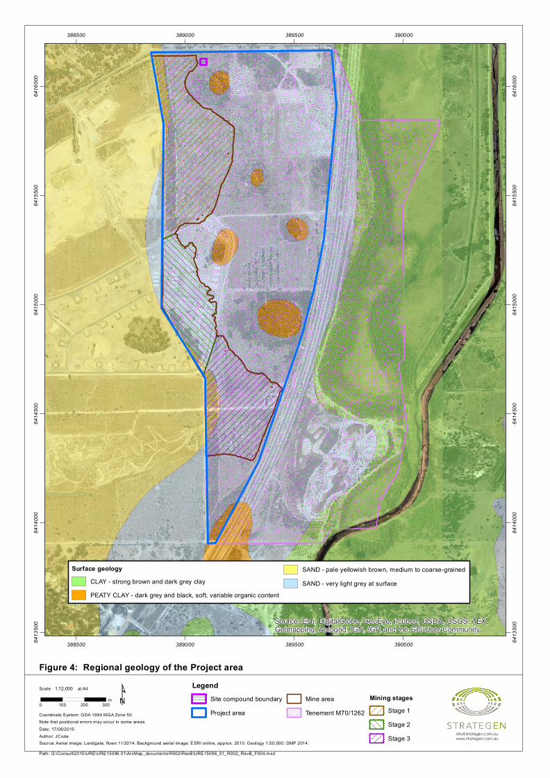
Figure 4: Regional geology of the Project area
Source: Esri, DigitalGlobe, GeoEye, i-cubed, USDA, USGS, AEX,Getmapping, Aerogrid, IGN, IGP, and the GIS User Community
388500
388500
389000
389000
389500
389500
390000
3900006413
500
6413
500
6414
000
6414
000
6414
500
6414
500
6415
000
6415
000
6415
500
6415
500
6416
000
6416
000
Path: Q:\Consult\2015\URE\URE15096.01\ArcMap_documents\R002\RevB\URE15096_01_R002_RevB_F004.mxd
Scale at A4
Source: Aerial image: Landgate, flown 11/2014. Background aerial image: ESRI online, approx. 2010. Geology 1:50,000: DMP 2014.
Note that positional errors may occur in some areas
0 100 200 300m
1:12,000
Coordinate System: GDA 1994 MGA Zone 50
Date: 17/06/2015Author: JCrute
¹
Surface geologyCLAY - strong brown and dark grey clayPEATY CLAY - dark grey and black, soft, variable organic content
SAND - pale yellowish brown, medium to coarse-grainedSAND - very light grey at surface
LegendSite compound boundaryProject area
Mine areaTenement M70/1262
Mining stagesStage 1Stage 2Stage 3
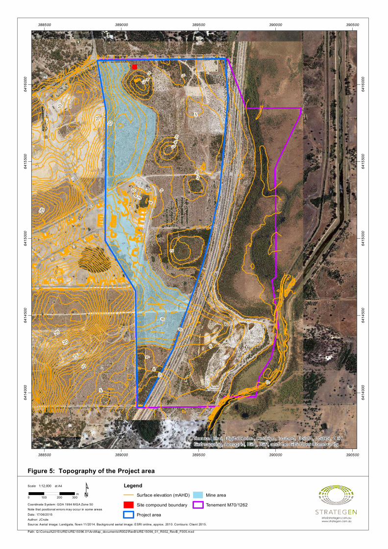
Figure 5: Topography of the Project area
2520
15
10
50
5
5 5
5
5
55
25
10
15
10
43
43
43
28
8
4
43
4
4
3
Source: Esri, DigitalGlobe, GeoEye, i-cubed, USDA, USGS, AEX,Getmapping, Aerogrid, IGN, IGP, and the GIS User Community
388500
388500
389000
389000
389500
389500
390000
390000
390500
390500
6414
000
6414
000
6414
500
6414
500
6415
000
6415
000
6415
500
6415
500
6416
000
6416
000
Path: Q:\Consult\2015\URE\URE15096.01\ArcMap_documents\R002\RevB\URE15096_01_R002_RevB_F005.mxd
Scale at A4
Source: Aerial image: Landgate, flown 11/2014. Background aerial image: ESRI online, approx. 2010. Contours: Client 2015.
Note that positional errors may occur in some areas
0 100 200 300m
1:12,000
Coordinate System: GDA 1994 MGA Zone 50
Date: 17/06/2015Author: JCrute
¹ LegendSurface elevation (mAHD)Site compound boundaryProject area
Mine areaTenement M70/1262
Karnup Sand Mining Project
URE15096_01 R002 Rev 0
30-Jun-15 10
2.3 Characterisation of waste rock and tailings
No waste rock or tailings will be generated as a result of the mining operations.
2.4 Soils and soil profiles
The Project area is located within the Swan Coastal Plain 2 (SWA2 – Swan Coastal Plain subregion) of
Western Australia (Mitchell et al. 2002). The Swan Coastal Plain comprises five major geomorphological
systems that lie parallel to the coast, namely (from west to east) the Quindalup Dunes, Spearwood Dunes,
Bassendean Dunes, Pinjarra Plain and Ridge Hill Shelf (Churchward & McArthur 1980; Gibson et al.
1994). Each major system is composed of further subdivisions in the form of detailed geomorphological
units (Churchward & McArthur 1980; Semeniuk 1990; Gibson et al.1994). Beard (1990) describes the
Swan Coastal Plain as a low-lying coastal plain, often swampy, with sandhills also containing dissected
country rising to the duricrusted Dandaragan plateau on Mesozoic, mainly sandy, yellow soils.
The Project area is characterised predominately by Bassendean Sand (Figure 4). Mining will target these
Bassendean Sands that are predominately light grey at the surface before becoming yellow at depth and
of aeolian origin.
2.4.1 Acid sulfate soils
Acid sulphate soils (ASS) are naturally occurring soils, sediments and peats that contain iron sulfide or
sulfide oxidation products. When ASS are disturbed and exposed to oxidising conditions, the iron sulfides
can oxidise to produce sulfuric acid, iron precipitates and low pH groundwater with elevated concentrations
of dissolved metals such as aluminium, iron and arsenic. Although ASS are typically benign when
undisturbed in the natural environment as they are in an anoxic state, the dewatering, excavation and/or
stockpiling of ASS that lies below the naturally occurring watertable may promote the oxidation of these
soils and the occurrence of these adverse environmental impacts (DoE 2003).
A search of the WA Atlas ASS Swan Coastal Plain risk map (Landgate 2015) (search conducted
21 April 2015) located six areas classified as Class 1 (High to Moderate risk of ASS occurring within 3 m of
natural soil surface) within the Project area associated with the ‘Peaty Clay’ underlying the wetlands
(Figure 6). The majority of the balance of the Project area is classified as Class 2 (Moderate to Low risk of
ASS occurring within 3 m of natural soil surface) associated with the mapped ‘Bassendean Sand’;
however, there are two slithers of land adjacent the western Project area that is mapped as having nil ASS
risk and are associated with the mapped ‘Sand derived from Tamala Limestone’ (Figure 6).
The mining area is mapped as either have a Class 2 or nil risk of ASS being encountered within the top
3 m of natural soil surface (Figure 6).
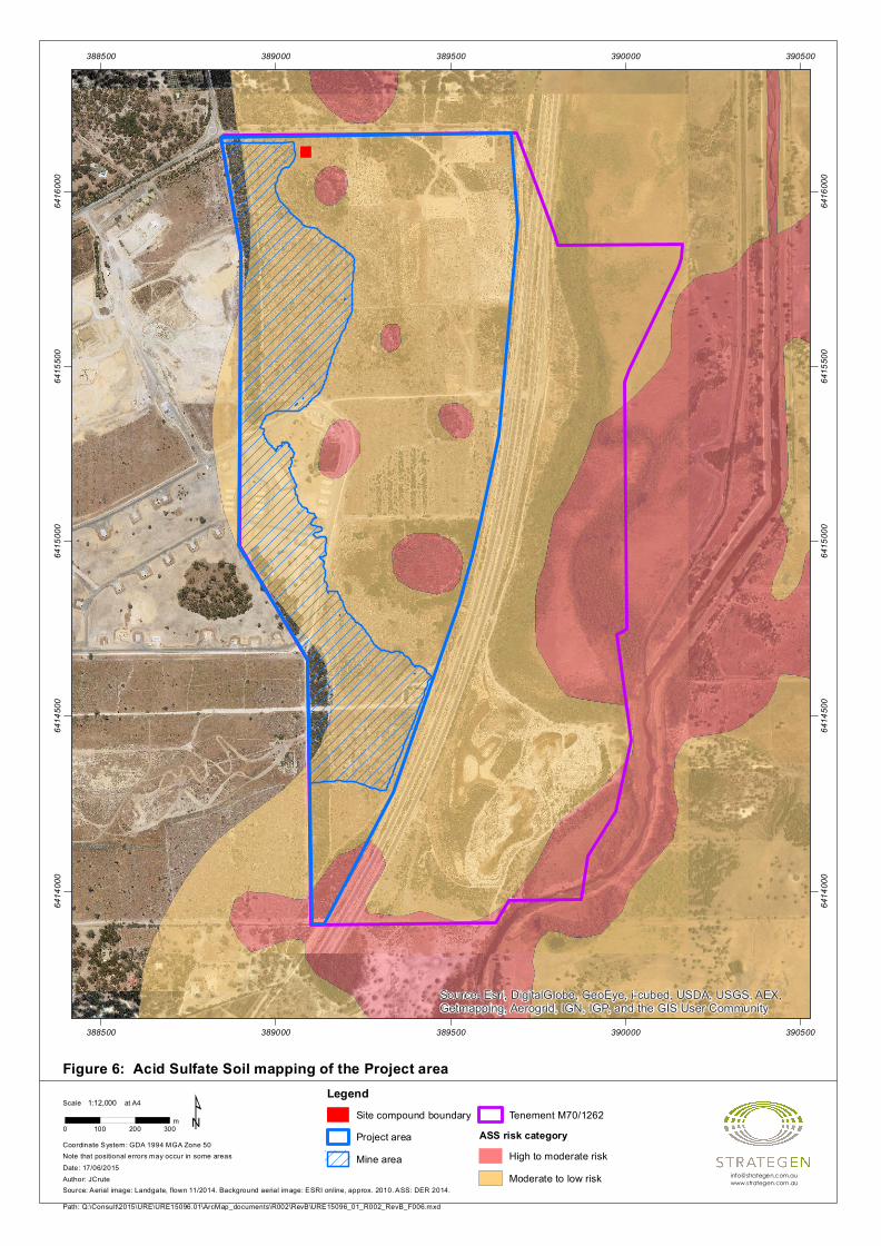
Figure 6: Acid Sulfate Soil mapping of the Project area
Source: Esri, DigitalGlobe, GeoEye, i-cubed, USDA, USGS, AEX,Getmapping, Aerogrid, IGN, IGP, and the GIS User Community
388500
388500
389000
389000
389500
389500
390000
390000
390500
390500
6414
000
6414
000
6414
500
6414
500
6415
000
6415
000
6415
500
6415
500
6416
000
6416
000
Path: Q:\Consult\2015\URE\URE15096.01\ArcMap_documents\R002\RevB\URE15096_01_R002_RevB_F006.mxd
Scale at A4
Source: Aerial image: Landgate, flown 11/2014. Background aerial image: ESRI online, approx. 2010. ASS: DER 2014.
Note that positional errors may occur in some areas
0 100 200 300m
1:12,000
Coordinate System: GDA 1994 MGA Zone 50
Date: 17/06/2015Author: JCrute
¹Legend
Site compound boundaryProject areaMine area
Tenement M70/1262ASS risk category
High to moderate riskModerate to low risk

Karnup Sand Mining Project
URE15096_01 R002 Rev 0
30-Jun-15 12
2.5 Hydrology
2.5.1 Surface water
The Project area lies in the catchment of the Serpentine River which flows the Peel-Harvey Estuary
approximately 20 km south of the Project area. A small portion of the Project area near the north-eastern
boundary is located within the 1 in 100-year Average Return Interval (ARI) floodway and flood fringe of
Serpentine River (Figure 7); however, this part of the Project area will not be disturbed by the Project.
Rain falling on the Project area is expected to infiltrate due to the high permeability of the local sands.
Surface water is not expected to flow from the Project area in the 1 in 100-year ARI event. The Project
area is considered unlikely to receive runoff from the land adjacent to the west, given that this land is
comprised of Tamala Limestone sands also with high infiltration rates.
If, during high rainfall events, there is surface water flow across the Project area, surface water would be
expected to characteristically follow the natural topography to the east towards Kwinana Freeway and
Serpentine River. The wetlands in and east of the Project Area, adjacent to the Serpentine River, are
subject to seasonal inundation (Golder Associates 2006). Surface water management infrastructure is
already be present along Kwinana Freeway and would convey any flows from the Project area (if any) to
Serpentine River.
Wetlands
A north-south running chain of seasonally damp and inundated wetlands occur in the eastern portion of the
Project area. The wetlands are isolated from each other by sparse areas of regrowth following pine
plantation clearing, range from 0.3 to 3.1 ha in size and comprise predominately of remnant paperbark
(Figure 7). All wetlands within the Project area were assessed in 2006 to have been in a degraded state
and substantially invaded by weeds (Bancroft & Bamford 2006; Appendix 1). A recent inspection of these
wetlands in May 2015 confirmed that the 2006 findings are still valid and the wetlands are degraded
(Strategen 2015, Appendix 1).
Wetlands located within the Project area are ephemeral sumplands (i.e. only seasonally inundated) and
include both Resource Enhancement and Conservation Category wetlands as determined by DER
(Strategen 2010). These wetlands are considered to represent an expression of local groundwater levels.
2.5.2 Groundwater
Regional groundwater
The Project area is located within the Stakehill Mound groundwater subregion of the Perth Basin (GHD
2014). The subregion covers an area of approximately 150 km2 and occurs within the superficial
formations flow system that is recharged directly by rainfall infiltration (Golder Associates 2010). It is
estimated that the average thickness of the aquifer is approximately 20 m with a minimum transmissivity of
approximately 1000 m2/day (Golder Associates 2010).
Groundwater levels and flow direction
Golder Associates undertook monthly groundwater level monitoring of the Project area and surrounds
between March 2007 and March 2010 (Golder Associates 2010) and further quarterly groundwater
monitoring was undertaken by Strategen between April 2013 and January 2014 (Strategen 2014).
Groundwater levels beneath the Project area fluctuate by approximately 1 m annually. Levels are
generally at their maximum in September/October following winter, and minimum in April/May (Golder
Associates 2010).
Karnup Sand Mining Project
URE15096_01 R002 Rev 0
30-Jun-15 13
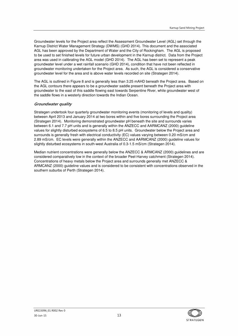
Groundwater levels for the Project area reflect the Assessment Groundwater Level (AGL) set through the
Karnup District Water Management Strategy (DWMS) (GHD 2014). This document and the associated
AGL has been approved by the Department of Water and the City of Rockingham. The AGL is proposed
to be used to set finished levels for future urban development in the Karnup district. Data from the Project
area was used in calibrating the AGL model (GHD 2014). The AGL has been set to represent a peak
groundwater level under a wet rainfall scenario (GHD 2014), condition that have not been reflected in
groundwater monitoring undertaken for the Project area. As such, the AGL is considered a conservative
groundwater level for the area and is above water levels recorded on site (Strategen 2014).
The AGL is outlined in Figure 8 and is generally less than 3.25 mAHD beneath the Project area. Based on
the AGL contours there appears to be a groundwater saddle present beneath the Project area with
groundwater to the east of this saddle flowing east towards Serpentine River, while groundwater west of
the saddle flows in a westerly direction towards the Indian Ocean.
Groundwater quality
Strategen undertook four quarterly groundwater monitoring events (monitoring of levels and quality)
between April 2013 and January 2014 at two bores within and five bores surrounding the Project area
(Strategen 2014). Monitoring demonstrated groundwater pH beneath the site and surrounds varies
between 6.1 and 7.7 pH units and is generally within the ANZECC and AARMCANZ (2000) guideline
values for slightly disturbed ecosystems of 6.5 to 8.5 pH units. Groundwater below the Project area and
surrounds is generally fresh with electrical conductivity (EC) values varying between 0.20 mS/cm and
2.89 mS/cm. EC levels were generally within the ANZECC and AARMCANZ (2000) guideline values for
slightly disturbed ecosystems in south-west Australia of 0.3-1.5 mS/cm (Strategen 2014).
Median nutrient concentrations were generally below the ANZECC & ARMCANZ (2000) guidelines and are
considered comparatively low in the context of the broader Peel-Harvey catchment (Strategen 2014).
Concentrations of heavy metals below the Project area and surrounds generally met ANZECC &
ARMCANZ (2000) guideline values and is considered to be consistent with concentrations observed in the
southern suburbs of Perth (Strategen 2014).
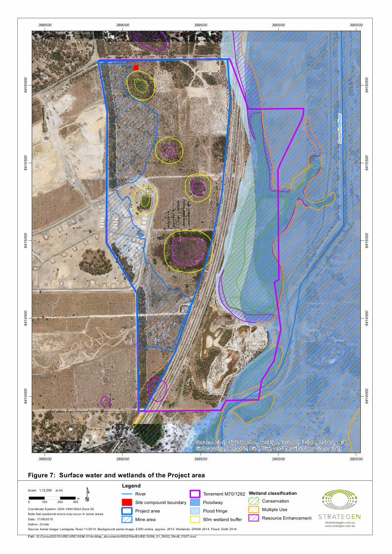
Figure 7: Surface water and wetlands of the Project area
Serpe
ntine
Rive
r
Source: Esri, DigitalGlobe, GeoEye, i-cubed, USDA, USGS, AEX,Getmapping, Aerogrid, IGN, IGP, and the GIS User Community
388500
388500
389000
389000
389500
389500
390000
390000
390500
390500
6414
000
6414
000
6414
500
6414
500
6415
000
6415
000
6415
500
6415
500
6416
000
6416
000
Path: Q:\Consult\2015\URE\URE15096.01\ArcMap_documents\R002\RevB\URE15096_01_R002_RevB_F007.mxd
Scale at A4
Source: Aerial image: Landgate, flown 11/2014. Background aerial image: ESRI online, approx. 2010. Wetlands: DPAW 2014. Flood: DoW 2014.
Note that positional errors may occur in some areas
0 100 200 300m
1:12,000
Coordinate System: GDA 1994 MGA Zone 50
Date: 17/06/2015Author: JCrute
¹Legend
RiverSite compound boundaryProject areaMine area
Tenement M70/1262FloodwayFlood fringe50m wetland buffer
Wetland classificationConservationMultiple UseResource Enhancement
Figure 8: Groundwater of the Project area
BQ09
BQ05
BQ02
BP07
BP06
BP03
BP01
3
2.75
2.52
3.25
2.25
1.75
1.52
2.52.5
2.25
2.25
388500
388500
389000
389000
389500
389500
390000
390000
6414
000
6414
000
6414
500
6414
500
6415
000
6415
000
6415
500
6415
500
6416
000
6416
000
Path: Q:\Consult\2015\URE\URE15096.01\ArcMap_documents\R002\RevB\URE15096_01_R002_RevB_F008.mxd
Scale at A4
Source: Aerial image: Landgate, flown 11/2014. Background aerial image: ESRI online, approx. 2010. GW data: LandCorp 2014.
Note that positional errors may occur in some areas
0 100 200 300m
1:10,500
Coordinate System: GDA 1994 MGA Zone 50
Date: 17/06/2015Author: JCrute
¹
LegendBoresGroundwater level (mAHD)Site compound boundaryProject areaMine areaTenement M70/1262
Depth to assessment groundwater levelAbove Surface0 - 0.5m0.5 - 1.5m1.5 - 3m3 - 6mGreater than 6m
Karnup Sand Mining Project
URE15096_01 R002 Rev 0
30-Jun-15 16
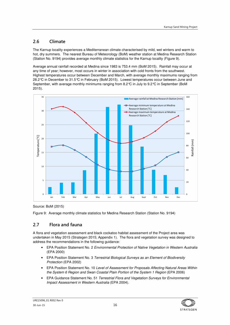
2.6 Climate
The Karnup locality experiences a Mediterranean climate characterised by mild, wet winters and warm to
hot, dry summers. The nearest Bureau of Meteorology (BoM) weather station at Medina Research Station
(Station No. 9194) provides average monthly climate statistics for the Karnup locality (Figure 9).
Average annual rainfall recorded at Medina since 1983 is 753.4 mm (BoM 2015). Rainfall may occur at
any time of year; however, most occurs in winter in association with cold fronts from the southwest.
Highest temperatures occur between December and March, with average monthly maximums ranging from
28.2°C in December to 31.5°C in February (BoM 2015). Lowest temperatures occur between June and
September, with average monthly minimums ranging from 8.2°C in July to 9.2°C in September (BoM
2015).
Source: BoM (2015)
Figure 9: Average monthly climate statistics for Medina Research Station (Station No. 9194)
2.7 Flora and fauna
A flora and vegetation assessment and black cockatoo habitat assessment of the Project area was
undertaken in May 2015 (Strategen 2015; Appendix 1). The flora and vegetation survey was designed to
address the recommendations in the following guidance:
• EPA Position Statement No. 2 Environmental Protection of Native Vegetation in Western Australia
(EPA 2000)
• EPA Position Statement No. 3 Terrestrial Biological Surveys as an Element of Biodiversity
Protection (EPA 2002)
• EPA Position Statement No. 10 Level of Assessment for Proposals Affecting Natural Areas Within
the System 6 Region and Swan Coastal Plain Portion of the System 1 Region (EPA 2006)
• EPA Guidance Statement No. 51 Terrestrial Flora and Vegetation Surveys for Environmental
Impact Assessment in Western Australia (EPA 2004).
0
20
40
60
80
100
120
140
160
0
5
10
15
20
25
30
35
Jan Feb Mar Apr May Jun Jul Aug Sept Oct Nov Dec
Average rainfall at Medina Research Station [mm]
Average minimum temperature at Medina
Research Station [°C]
Average maximum temperature at Medina
Research Station [°C]
Ra
infa
ll (m
m)
Te
mp
era
ture
[°C
]
Karnup Sand Mining Project
URE15096_01 R002 Rev 0
30-Jun-15 17
Results of a desktop fauna assessment identified three Environmental Protection and Biodiversity
Conservation Act 1999 (EPBC Act) listed black cockatoo species as the most likely species to occur in the
Project area; consequently a field assessment of the Project area was undertaken in terms of its potential
as habitat for these species (refer to Section 2.7.3 for further detail).
In addition to the black cockatoo species, the Rainbow Bee-eater is likely to occur in the general area in
sandy soiled areas and surrounding wetlands; however, the habitat most likely to support the Rainbow
Bee-eater is associated with wetland areas that will not be impacted by the Project. Therefore a detailed
habitat assessment for the species was not undertaken.
2.7.1 Vegetation
Regional
The Project area occurs within the Swan Coastal Plain 2 ‘Interim Biogeographic Regionalisation for
Australia’ subregion which is dominated by Banksia or Tuart on sandy soils, Casuarina obesa on outwash
plains and paperbark (Melaleuca) in swampy areas (Mitchell et al. 2002).
The project area occurs within the Drummond Botanical Subdistrict which is characterised by low Banksia
woodlands on leached sands; Melaleuca swamps on poorly-drained depressions; and Eucalyptus
gomphocephala (Tuart), Eucalyptus marginata (Jarrah) and Corymbia calophylla (Marri) woodlands on
less leached soils (Beard 1990).
The Project area occurs at the interface between the Serpentine River and Karrakatta System 6 vegetation
complexes as mapped by Heddle et al. (1980). These complexes can be described as:
• Serpentine River – closed scrub of Melaleuca spp. and fringing woodland of Eucalyptus rudis and
M. rhaphiophylla along streams
• Karrakatta – predominantly open forest of Eucalyptus gomphocephala – E. marginata –
C. calophylla and woodland of E. marginata – Banksia spp.
Project area
The flora and vegetation assessment and black cockatoo habitat assessment surveyed the majority of the
Project area however did not include the Explosives Reserve Facility due to restricted access. The
vegetation associated with this area has been inferred and a high level of confidence on this inference
exists.
The majority of the Project area was identified to be in various stages of natural regeneration following the
clearing of existing pine plantations from 2004 (approx.) (Strategen 2015; Appendix 1). Whilst the majority
of this vegetation meets the definition of Good condition on the Keighery scale, it should be noted that this
is reflective more of the amount of weed present and the vegetation structure based on species observed.
The vegetation on site is immature, open and in the main could be readily traversed by a 4WD vehicle.
Five native vegetation types (VTs), in addition to cleared areas and residual pine plantation, were defined
and mapped within the Project area (Strategen 2015; Figure 10) and are summarised in Table 3. The total
area mapped within the Project area is 94.94 ha which includes cleared areas and pine plantations
(Table 3). The dominant VT within the Project area was VT 1 which can be broadly described as an open
shrubland of Macrozamia fraseri, Daviesia triflora and Acacia stenoptera with isolated Xylomelum
occidentale and Eucalyptus rudis trees.
Karnup Sand Mining Project
URE15096_01 R002 Rev 0
30-Jun-15 18
Table 3: Vegetation types mapped in the Project area
Vegetation Type
Description Area (ha) within the
survey area
Area (ha) within the
mining area and site
compound
1 Macrozamia fraseri, Daviesia triflora and Acacia stenoptera mid open shrubland over Lyginia barbata, Conostylis aculeata and Phlebocarya ciliata low open sedgeland with Xylomelum occidentale and Eucalyptus rudis occurring as isolated trees.
Natural regeneration of cleared pine plantation.
59.37 22.97
2 Banksia menziesii, B. attenuata, Allocasuarina fraseriana and Eucalyptus marginata open woodland over Kunzea glabrescens, Acacia pulchella and Macrozamia fraseri mid sparse shrubland over Hibbertia hypericoides, Conostephium pendulum and Gompholobium tomentosum low sparse shrubland.
Including 1.02 ha inferred VT2 within Explosives Reserve.
Remnant vegetation.
7.91 6.54
3 Jacksonia sternbergiana and Adenanthos cygnorum subsp. cygnorum mid shrubland over Conostylis aculeata and Lyginia barbata low sparse sedgeland.
Natural regeneration of cleared pine plantation.
2.02 1.32
41 Banksia menziesii, B. attenuata, Eucalyptus marginata and
Allocasuarina fraseriana low open woodland over Jacksonia
furcellata, Regelia ciliata and B. sessilis mid sparse shrubland over Tetraria octandra and Ficinia nodosa low sparse sedgeland.
Natural regeneration with rehabilitation.
9.36 -
5 Eucalyptus sp. (planted) open woodland over Acacia saligna, Jacksonia furcellata and Kunzea glabrescens tall sparse shrubland over *Eragrostis curvula low sparse tussock grassland.
Mixture of naturally regenerated vegetation with additional planting.
7.11 -
P2 Pine plantation (Pinus pinaster). 3.29 -
C2 Cleared areas. 5.88 1.77
- Explosives Reserve (excludes 1.02 ha inferred VT2 within reserve).
- 9.36
TOTAL 94.94 41.96
1 This vegetation type appears to be the result of rehabilitation activities.
2 Cleared areas and pine plantations have been mapped but are not counted as a unique VT.
Vegetation condition within areas of natural regeneration was identified as Good as outlined by Figure 11.
The vegetation condition for the balance of the Project area was mapped as follows (Strategen 2015;
Appendix 1):
• Very good: retained Banksia woodland in the vegetated strip of land on the western boundary of
the Project area
• Good: Eucalyptus/Acacia woodland along the southern boundary of the Project area
• Completely Degraded: cleared areas and pine plantations.
No Threatened Ecological Communities (TECs) or Priority Ecological Communities (PECs) were identified
as having the potential to occur within the Project area. The closest PEC identified in proximity to the
Project area was SCP 25 (Southern Eucalyptus gomphocephala – Agonis flexuosa woodlands). The outer
edge of the Parks and Wildlife buffer for this community is approximately 1.3 km from the Project area
(Strategen 2015; Appendix 1).
Karnup Sand Mining Project
URE15096_01 R002 Rev 0
30-Jun-15 19
2.7.2 Flora
A desktop assessment identified 108 native vascular plant taxa from 40 plant families that have the
potential to occur within the vicinity of the Project area, the majority of taxa were from within the
Cyperaceae (15 taxa), Myrtaceae (9 taxa) and Fabaceae (8 taxa) families (Strategen 2015; Appendix 1).
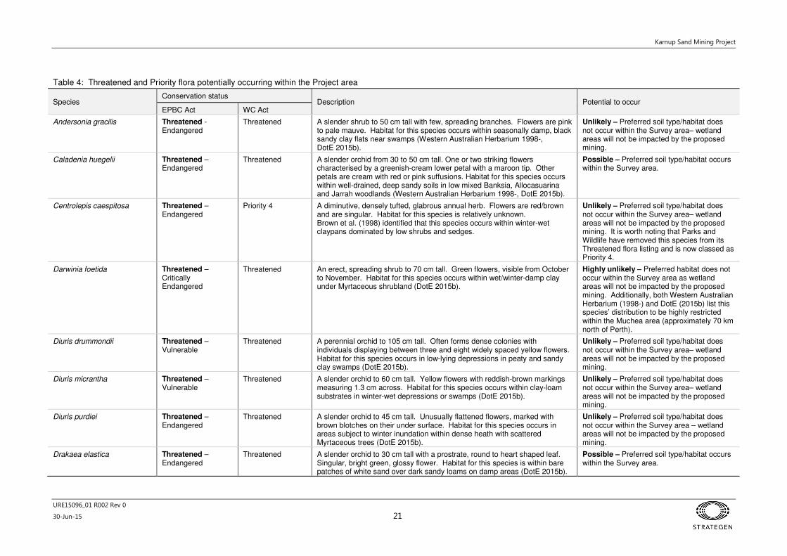
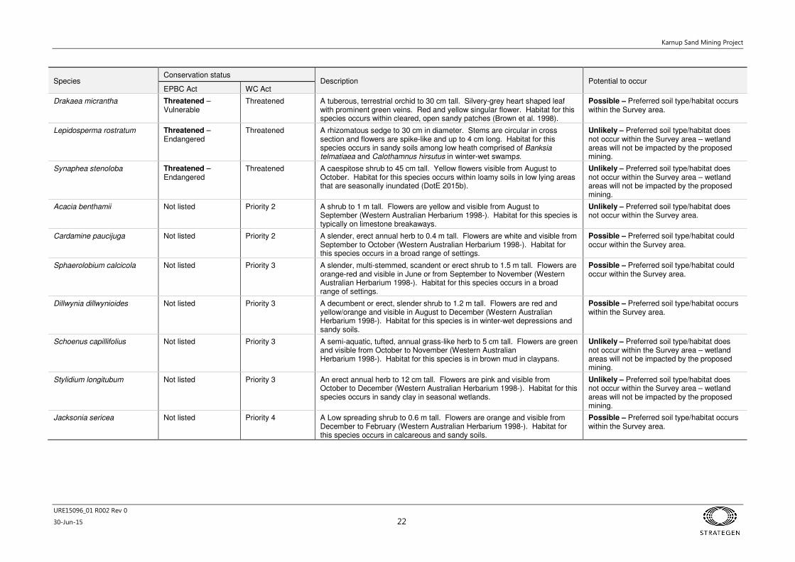
Of these 18 Threatened and Priority flora species potentially occurring within the Project area as outlined
by Table 4; however, only three Threatened flora species (Caladenia huegelii, Drakaea elastica and
Drakaea micrantha) and four Priority flora species (Cardamine paucijuga, Sphaerolobium calcicola,
Dillwynia dillwynioides and Jacksonia sericea) were considered to have the potential to occur in the Project
area based on specific habitat requirements (Strategen 2015; Appendix 1).
A total of 41 native vascular plant taxa from 34 plant genera and 18 plant families were recorded within the
Project area during the Level 1 survey (Strategen 2015; Appendix 1). The majority of taxa were recorded
within the Fabaceae (8 taxa), Myrtaceae (6 taxa) and Proteaceae (5 taxa) families.
No Threatened flora species pursuant to Schedule 1 of the Wildlife Conservation Act (WC Act) (as listed by
Parks and Wildlife) or Priority flora species (as listed by Western Australian Herbarium) were recorded
within the Project area (Strategen 2015; Appendix 1).
Database searches of Naturemap and the Parks and Wildlife Threatened Flora Database were undertaken
to determine whether any Threatened or Priority flora species are known from within a 5 km radius of the
Project area (Strategen 2015; Appendix 1). Dillwynia dillwynioides and Schoenus capillifolius were
recorded in 2006 in wetlands which do not form part of the Project area. The location of these species and
other known locations of Threatened and Priority Flora species in the area are shown in Figure 12.
2.7.3 Fauna
A desktop fauna assessment was conducted using a series of databases including NatureMap and the
EPBC Protected Matters Search Tool. Bamford Consulting Ecologists undertook a fauna survey of an
area encompassing some parts of the Project area and adjacent wetlands (Bancroft & Bamford 2006). It
should be noted that in 2006, the majority of the Project area would have been occupied by pine
plantation. During the most recent assessment undertaken by Strategen in 2015, the Project area
comprised remnant native woodland vegetation, historical pine plantations and natural regeneration in
areas which were previously cleared (Strategen 2015; Appendix 1).
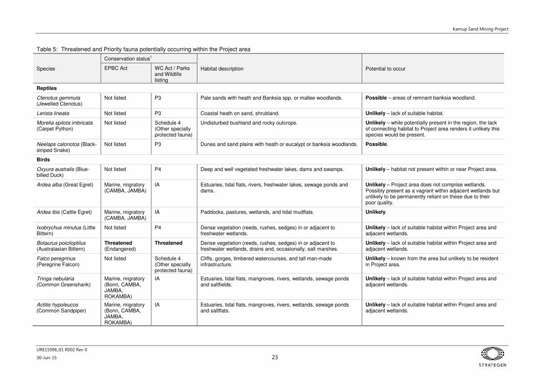
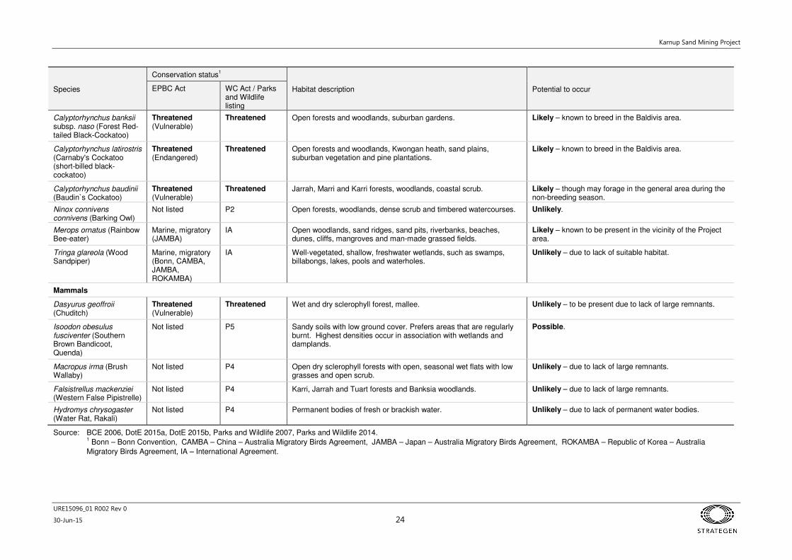
A desktop assessment of the likelihood of conservation significant (Threatened or Priority) species
occurring within the Project area was undertaken based on results presented by Bancroft & Bamford
(2006) and results are presented in Table 5. The conservation status of each species was updated based
on current listings provided by Parks and Wildlife (2007, 2014d) and Department of the Environment
(DotE) (2015a, 2015b). Likelihood of occurrence was also updated (where required) based on the change
in vegetation within the Project area between 2006 and 2015.
The only conservation significant fauna species considered to have suitable habitat present within the
Project area and therefore are likely to occur are three species of black cockatoo (Carnaby’s, Forest Red-
tailed and Baudin’s) and the Rainbow Bee-eater (Strategen 2015; Appendix 1). Threatened native
mammals and ground-dwelling birds are unlikely to occur due to lack of suitable habitat and presence of
introduced predators and competitors (cat footprints were observed and the area is home to a large
number of goats). Migratory birds have the potential to utilise the Project area for habitat due to the
presence of wetlands, but are unlikely to be present for prolonged periods of time (Strategen 2015;
Appendix 1).
Black cockatoo habitat assessment
A summary of the value of each vegetation type as foraging habitat for black cockatoo species is
presented in Table 6 (Groom 2011, Johnstone 2010a, Johnstone 2010b, Johnstone et al. 2011).

Karnup Sand Mining Project
URE15096_01 R002 Rev 0
30-Jun-15 20
The highest quality foraging habitat for black cockatoos was noted within VT 2 which contained high
densities of black cockatoo food species including eucalypts and Banksia spp. at canopy and midstorey
levels. The lowest quality foraging habitat for black cockatoos (not including cleared areas) was noted
within VT 5 which contained limited potential food resources for all three species of black cockatoos (refer
to footnote following Table 6) and in the pine plantation which provides limited food resources for
Carnaby’s Black Cockatoo (CBC) only. Based on the results of the foraging assessment, the Project will
result in the clearing of 6.54 ha of very good quality foraging habitat and 24.29 ha of low quality foraging
habitat for CBC, Baudin’s Black Cockatoo (BBC) and Forest Red-tailed Black Cockatoo (FRTBC) as
outlined in Table 6 and Table 7. Signs of CBC foraging were observed in scattered occurrences within
VT 2 (Strategen 2015; Appendix 1).
Karnup Sand Mining Project
URE15096_01 R002 Rev 0
30-Jun-15 21
Table 4: Threatened and Priority flora potentially occurring within the Project area
Species Conservation status
Description Potential to occur EPBC Act WC Act
Andersonia gracilis Threatened - Endangered
Threatened A slender shrub to 50 cm tall with few, spreading branches. Flowers are pink to pale mauve. Habitat for this species occurs within seasonally damp, black sandy clay flats near swamps (Western Australian Herbarium 1998-, DotE 2015b).
Unlikely – Preferred soil type/habitat does not occur within the Survey area– wetland areas will not be impacted by the proposed mining.
Caladenia huegelii Threatened – Endangered
Threatened A slender orchid from 30 to 50 cm tall. One or two striking flowers characterised by a greenish-cream lower petal with a maroon tip. Other petals are cream with red or pink suffusions. Habitat for this species occurs within well-drained, deep sandy soils in low mixed Banksia, Allocasuarina and Jarrah woodlands (Western Australian Herbarium 1998-, DotE 2015b).
Possible – Preferred soil type/habitat occurs within the Survey area.
Centrolepis caespitosa Threatened – Endangered
Priority 4 A diminutive, densely tufted, glabrous annual herb. Flowers are red/brown and are singular. Habitat for this species is relatively unknown. Brown et al. (1998) identified that this species occurs within winter-wet claypans dominated by low shrubs and sedges.
Unlikely – Preferred soil type/habitat does not occur within the Survey area– wetland areas will not be impacted by the proposed mining. It is worth noting that Parks and Wildlife have removed this species from its Threatened flora listing and is now classed as Priority 4.
Darwinia foetida Threatened – Critically Endangered
Threatened An erect, spreading shrub to 70 cm tall. Green flowers, visible from October to November. Habitat for this species occurs within wet/winter-damp clay under Myrtaceous shrubland (DotE 2015b).
Highly unlikely – Preferred habitat does not occur within the Survey area as wetland areas will not be impacted by the proposed mining. Additionally, both Western Australian Herbarium (1998-) and DotE (2015b) list this species’ distribution to be highly restricted within the Muchea area (approximately 70 km north of Perth).
Diuris drummondii Threatened – Vulnerable
Threatened A perennial orchid to 105 cm tall. Often forms dense colonies with individuals displaying between three and eight widely spaced yellow flowers. Habitat for this species occurs in low-lying depressions in peaty and sandy clay swamps (DotE 2015b).
Unlikely – Preferred soil type/habitat does not occur within the Survey area– wetland areas will not be impacted by the proposed mining.
Diuris micrantha Threatened – Vulnerable
Threatened A slender orchid to 60 cm tall. Yellow flowers with reddish-brown markings measuring 1.3 cm across. Habitat for this species occurs within clay-loam substrates in winter-wet depressions or swamps (DotE 2015b).
Unlikely – Preferred soil type/habitat does not occur within the Survey area– wetland areas will not be impacted by the proposed mining.
Diuris purdiei Threatened – Endangered
Threatened A slender orchid to 45 cm tall. Unusually flattened flowers, marked with brown blotches on their under surface. Habitat for this species occurs in areas subject to winter inundation within dense heath with scattered Myrtaceous trees (DotE 2015b).
Unlikely – Preferred soil type/habitat does not occur within the Survey area – wetland areas will not be impacted by the proposed mining.
Drakaea elastica Threatened – Endangered
Threatened A slender orchid to 30 cm tall with a prostrate, round to heart shaped leaf. Singular, bright green, glossy flower. Habitat for this species is within bare patches of white sand over dark sandy loams on damp areas (DotE 2015b).
Possible – Preferred soil type/habitat occurs within the Survey area.
Karnup Sand Mining Project
URE15096_01 R002 Rev 0
30-Jun-15 22
Species Conservation status
Description Potential to occur EPBC Act WC Act
Drakaea micrantha Threatened – Vulnerable
Threatened A tuberous, terrestrial orchid to 30 cm tall. Silvery-grey heart shaped leaf with prominent green veins. Red and yellow singular flower. Habitat for this species occurs within cleared, open sandy patches (Brown et al. 1998).
Possible – Preferred soil type/habitat occurs within the Survey area.
Lepidosperma rostratum Threatened – Endangered
Threatened A rhizomatous sedge to 30 cm in diameter. Stems are circular in cross section and flowers are spike-like and up to 4 cm long. Habitat for this species occurs in sandy soils among low heath comprised of Banksia telmatiaea and Calothamnus hirsutus in winter-wet swamps.
Unlikely – Preferred soil type/habitat does not occur within the Survey area – wetland areas will not be impacted by the proposed mining.
Synaphea stenoloba Threatened – Endangered
Threatened A caespitose shrub to 45 cm tall. Yellow flowers visible from August to October. Habitat for this species occurs within loamy soils in low lying areas that are seasonally inundated (DotE 2015b).
Unlikely – Preferred soil type/habitat does not occur within the Survey area – wetland areas will not be impacted by the proposed mining.
Acacia benthamii Not listed Priority 2 A shrub to 1 m tall. Flowers are yellow and visible from August to September (Western Australian Herbarium 1998-). Habitat for this species is typically on limestone breakaways.
Unlikely – Preferred soil type/habitat does not occur within the Survey area.
Cardamine paucijuga Not listed Priority 2 A slender, erect annual herb to 0.4 m tall. Flowers are white and visible from September to October (Western Australian Herbarium 1998-). Habitat for this species occurs in a broad range of settings.
Possible – Preferred soil type/habitat could occur within the Survey area.
Sphaerolobium calcicola Not listed Priority 3 A slender, multi-stemmed, scandent or erect shrub to 1.5 m tall. Flowers are orange-red and visible in June or from September to November (Western Australian Herbarium 1998-). Habitat for this species occurs in a broad range of settings.
Possible – Preferred soil type/habitat could occur within the Survey area.
Dillwynia dillwynioides Not listed Priority 3 A decumbent or erect, slender shrub to 1.2 m tall. Flowers are red and yellow/orange and visible in August to December (Western Australian Herbarium 1998-). Habitat for this species is in winter-wet depressions and sandy soils.
Possible – Preferred soil type/habitat occurs within the Survey area.
Schoenus capillifolius Not listed Priority 3 A semi-aquatic, tufted, annual grass-like herb to 5 cm tall. Flowers are green and visible from October to November (Western Australian Herbarium 1998-). Habitat for this species is in brown mud in claypans.
Unlikely – Preferred soil type/habitat does not occur within the Survey area – wetland areas will not be impacted by the proposed mining.
Stylidium longitubum Not listed Priority 3 An erect annual herb to 12 cm tall. Flowers are pink and visible from October to December (Western Australian Herbarium 1998-). Habitat for this species occurs in sandy clay in seasonal wetlands.
Unlikely – Preferred soil type/habitat does not occur within the Survey area – wetland areas will not be impacted by the proposed mining.
Jacksonia sericea Not listed Priority 4 A Low spreading shrub to 0.6 m tall. Flowers are orange and visible from December to February (Western Australian Herbarium 1998-). Habitat for this species occurs in calcareous and sandy soils.
Possible – Preferred soil type/habitat occurs within the Survey area.
Karnup Sand Mining Project
URE15096_01 R002 Rev 0
30-Jun-15 23
Table 5: Threatened and Priority fauna potentially occurring within the Project area
Species
Conservation status1
Habitat description Potential to occur EPBC Act WC Act / Parks and Wildlife listing
Reptiles
Ctenotus gemmula (Jewelled Ctenotus)
Not listed P3 Pale sands with heath and Banksia spp. or mallee woodlands. Possible – areas of remnant banksia woodland.
Lerista lineata Not listed P3 Coastal heath on sand, shrubland. Unlikely – lack of suitable habitat.
Morelia spilota imbricata (Carpet Python)
Not listed Schedule 4 (Other specially protected fauna)
Undisturbed bushland and rocky outcrops. Unlikely – while potentially present in the region, the lack of connecting habitat to Project area renders it unlikely this species would be present.
Neelaps calonotos (Black-striped Snake)
Not listed P3 Dunes and sand plains with heath or eucalypt or banksia woodlands. Possible.
Birds
Oxyura australis (Blue-billed Duck)
Not listed P4 Deep and well vegetated freshwater lakes, dams and swamps. Unlikely – habitat not present within or near Project area.
Ardea alba (Great Egret) Marine, migratory (CAMBA, JAMBA)
IA Estuaries, tidal flats, rivers, freshwater lakes, sewage ponds and dams.
Unlikely – Project area does not comprise wetlands. Possibly present as a vagrant within adjacent wetlands but unlikely to be permanently reliant on these due to their poor quality.
Ardea ibis (Cattle Egret) Marine, migratory (CAMBA, JAMBA)
IA Paddocks, pastures, wetlands, and tidal mudflats. Unlikely.
Ixobrychus minutus (Little Bittern)
Not listed P4 Dense vegetation (reeds, rushes, sedges) in or adjacent to freshwater wetlands.
Unlikely – lack of suitable habitat within Project area and adjacent wetlands.
Botaurus poiciloptilus (Australasian Bittern)
Threatened (Endangered)
Threatened Dense vegetation (reeds, rushes, sedges) in or adjacent to freshwater wetlands, drains and, occasionally, salt marshes.
Unlikely – lack of suitable habitat within Project area and adjacent wetlands.
Falco peregrinus (Peregrine Falcon)
Not listed Schedule 4 (Other specially protected fauna)
Cliffs, gorges, timbered watercourses, and tall man-made infrastructure.
Unlikely – known from the area but unlikely to be resident in Project area.
Tringa nebularia (Common Greenshank)
Marine, migratory (Bonn, CAMBA, JAMBA, ROKAMBA)
IA Estuaries, tidal flats, mangroves, rivers, wetlands, sewage ponds and saltfields.
Unlikely – lack of suitable habitat within Project area and adjacent wetlands.
Actitis hypoleucos (Common Sandpiper)
Marine, migratory (Bonn, CAMBA, JAMBA, ROKAMBA)
IA Estuaries, tidal flats, mangroves, rivers, wetlands, sewage ponds and saltflats.
Unlikely – lack of suitable habitat within Project area and adjacent wetlands.
Karnup Sand Mining Project
URE15096_01 R002 Rev 0
30-Jun-15 24
Species
Conservation status1
Habitat description Potential to occur EPBC Act WC Act / Parks and Wildlife listing
Calyptorhynchus banksii subsp. naso (Forest Red-tailed Black-Cockatoo)
Threatened (Vulnerable)
Threatened Open forests and woodlands, suburban gardens. Likely – known to breed in the Baldivis area.
Calyptorhynchus latirostris (Carnaby's Cockatoo (short-billed black-cockatoo)
Threatened (Endangered)
Threatened Open forests and woodlands, Kwongan heath, sand plains, suburban vegetation and pine plantations.
Likely – known to breed in the Baldivis area.
Calyptorhynchus baudinii (Baudin`s Cockatoo)
Threatened (Vulnerable)
Threatened Jarrah, Marri and Karri forests, woodlands, coastal scrub. Likely – though may forage in the general area during the non-breeding season.
Ninox connivens connivens (Barking Owl)
Not listed P2 Open forests, woodlands, dense scrub and timbered watercourses. Unlikely.
Merops ornatus (Rainbow Bee-eater)
Marine, migratory (JAMBA)
IA Open woodlands, sand ridges, sand pits, riverbanks, beaches, dunes, cliffs, mangroves and man-made grassed fields.
Likely – known to be present in the vicinity of the Project area.
Tringa glareola (Wood Sandpiper)
Marine, migratory (Bonn, CAMBA, JAMBA, ROKAMBA)
IA Well-vegetated, shallow, freshwater wetlands, such as swamps, billabongs, lakes, pools and waterholes.
Unlikely – due to lack of suitable habitat.
Mammals
Dasyurus geoffroii (Chuditch)
Threatened (Vulnerable)
Threatened Wet and dry sclerophyll forest, mallee. Unlikely – to be present due to lack of large remnants.
Isoodon obesulus fusciventer (Southern Brown Bandicoot, Quenda)
Not listed P5 Sandy soils with low ground cover. Prefers areas that are regularly burnt. Highest densities occur in association with wetlands and damplands.
Possible.
Macropus irma (Brush Wallaby)
Not listed P4 Open dry sclerophyll forests with open, seasonal wet flats with low grasses and open scrub.
Unlikely – due to lack of large remnants.
Falsistrellus mackenziei (Western False Pipistrelle)
Not listed P4 Karri, Jarrah and Tuart forests and Banksia woodlands. Unlikely – due to lack of large remnants.
Hydromys chrysogaster (Water Rat, Rakali)
Not listed P4 Permanent bodies of fresh or brackish water. Unlikely – due to lack of permanent water bodies.
Source: BCE 2006, DotE 2015a, DotE 2015b, Parks and Wildlife 2007, Parks and Wildlife 2014.
1 Bonn – Bonn Convention, CAMBA – China – Australia Migratory Birds Agreement, JAMBA – Japan – Australia Migratory Birds Agreement, ROKAMBA – Republic of Korea – Australia
Migratory Birds Agreement, IA – International Agreement.
Karnup Sand Mining Project
URE15096_01 R002 Rev 0
30-Jun-15 25
Table 6: Vegetation types and black cockatoo foraging species within the Project area
Vegetation type
Description Black cockatoo foraging species Survey area (ha) Mining and site compound area (ha)
1 Macrozamia fraseri, Daviesia triflora and Acacia stenoptera mid open shrubland over Lyginia barbata, Conostylis aculeata and Phlebocarya ciliata low open sedgeland with Xylomelum occidentale and Eucalyptus rudis occurring as isolated trees.
CBC – E. rudis
BBC – Nil
FRTBC – Nil.
59.37 22.97
2 Banksia menziesii, B. attenuata, Allocasuarina fraseriana and Eucalyptus marginata open woodland over Kunzea glabrescens, Acacia pulchella and Macrozamia fraseri mid sparse shrubland over Hibbertia hypericoides, Conostephium pendulum and Gompholobium tomentosum low sparse shrubland.
Including 1.02 ha inferred VT2 within Explosives Reserve.
CBC – B. menziesii, B. attenuata, A. fraseriana, E. marginata
BBC – A. fraseriana, E. marginata
FRTBC – A. fraseriana, E. marginata.
7.91 6.54
3 Jacksonia sternbergiana and Adenanthos cygnorum subsp. cygnorum mid shrubland over Conostylis aculeata and Lyginia barbata low sparse sedgeland.
CBC – Nil
BBC – Nil
FRTBC – Nil.
2.02 1.32
4 Banksia menziesii, B. attenuata, Eucalyptus marginata and Allocasuarina fraseriana low open woodland over Jacksonia furcellata, Regelia ciliata and
B. sessilis mid sparse shrubland over Tetraria octandra and Ficinia nodosa low sparse sedgeland.
CBC – B. menziesii, B. attenuata, B. sessilis, A. fraseriana, E. marginata, J. furcellata
BBC – B. sessilis, A. fraseriana, E. marginata
FRTBC – A. fraseriana, E. marginata.
9.36 -
5 Eucalyptus sp. (planted) open woodland over Acacia saligna, Jacksonia furcellata and Kunzea glabrescens tall sparse shrubland over *Eragrostis curvula low sparse tussock grassland.
CBC – A. saligna, J. furcellata, E. sp. (planted)*
BBC – E. sp. (planted)*
FRTBC – E. sp. (planted)*.
7.11 -
P Pine plantation (Pinus pinaster). CBC – P. pinaster
BBC – Nil
FRTBC – Nil.
3.29 -
C Cleared areas. CBC – Nil
BBC – Nil
FRTBC – Nil.
5.88 1.77
*The Eucalyptus species present in this vegetation type was unable to be identified at the time of assessment. The species did not appear to be native to Western Australia and was likely planted in the
Project area. All three species of black cockatoos may forage on this species; however this is not likely to constitute significant foraging species for black cockatoos.

Karnup Sand Mining Project
URE15096_01 R002 Rev 0
30-Jun-15 26
Table 7: Quality of black cockatoo foraging habitat within the Project area
Vegetation type Foraging quality Justification
1 Low Low density of species suitable for foraging by black cockatoos (i.e. foliage cover of suitable species 10-20%) and presence of food sources at only one stratum (i.e. canopy).
2 Very good High density of species suitable for foraging by black cockatoos (i.e. foliage cover of suitable species >60%) and presence of food sources at several strata (i.e. canopy, midstorey and understorey).
3 Nil No suitable foraging species for black cockatoos present.
4 Good High density of species suitable for foraging by black cockatoos (i.e. foliage cover of suitable species >60%) but food sources only present at one or two strata (i.e. canopy and midstorey).
5 Low Low density of species suitable for foraging by black cockatoos (i.e. foliage cover of suitable species 10-20%) and presence of food sources at only one stratum (i.e. canopy).
Pine plantation Low (CBC only) Low density of species suitable for foraging by black cockatoos (i.e. foliage cover of suitable species 10-20%) and presence of food sources at only one stratum (i.e. canopy).
Cleared areas Nil Cleared areas - no vegetation present.
Figure 10: Vegetation types mapped within the Project area
388000
388000
388250
388250
388500
388500
388750
388750
389000
389000
389250
389250
389500
389500
389750
389750
6414
000
6414
000
6414
250
6414
250
6414
500
6414
500
6414
750
6414
750
6415
000
6415
000
6415
250
6415
250
6415
500
6415
500
6415
750
6415
750
6416
000
6416
000
6416
250
6416
250
LegendSite compound boundary50m wetland bufferProject areaMining areaNot surveyedVT1: Macrozamia fraseri, Daviesia triflora and Acaciastenoptera mid open shrubland over Lyginia barbata,Conostylis aculeata and Phlebocarya ciliata low opensedgeland with Xylomelum occidentale and Eucalyptusrudis occurring as isolated trees. Natural regeneration of cleared pine plantation. VT2: Banksia menziesii, B. attenuata, Allocasuarina fraserianaand Eucalyptus marginata open woodland over Kunzeaglabrescens, Acacia pulchella and Macrozamia fraseri midsparse shrubland over Hibbertia hypericoides, Conostephiumpendulum and Gompholobium tomentosum low sparse shrubland.Remnant vegetation.VT3: Jacksonia sternbergiana and Adenanthos cygnorum subsp.cygnorum mid shrubland over Conostylis aculeata and Lyginiabarbata low sparse sedgeland.Natural regeneration of cleared pine plantation.VT4: Banksia menziesii, B. attenuata, Eucalyptus marginata andAllocasuarina fraseriana low open woodland over Jacksoniafurcellata, Regelia ciliata and B. sessilis mid sparse shrublandover Tetraria octandra and Ficinia nodosa low sparse sedgeland.Natural regeneration with rehabilitation. VT5: Eucalyptus sp. (planted) open woodland over Acacia saligna,Jacksonia furcellata and Kunzea glabrescens tall sparse shrublandover *Eragrostis curvula low sparse tussock grassland.Mixture of naturally regenerated vegetation with additional planting.Pine PlantationsCleared Areas
Path: Q:\Consult\2015\URE\URE15096.01\ArcMap_documents\R002\RevB\URE15096_01_R002_RevB_F010.mxd
Scale at A4
Source: Aerial image: Landgate, flown 11/2014.
Note that positional errors may occur in some areas
0 50 100 150 200 250Meters
1:10,997
Coordinate System: GDA 1994 MGA Zone 50
Date: 30/06/2015Author: JCrute
¹
Kwina
na Fr
eewa
y
Figure 11: Vegetation condition mapped within the Project area
388000
388000
388250
388250
388500
388500
388750
388750
389000
389000
389250
389250
389500
389500
389750
389750
6414
000
6414
000
6414
250
6414
250
6414
500
6414
500
6414
750
6414
750
6415
000
6415
000
6415
250
6415
250
6415
500
6415
500
6415
750
6415
750
6416
000
6416
000
6416
250
6416
250
LegendSite compound boundary50m wetland bufferProject areaMining areaNot surveyed
Vegetation conditionVery GoodGoodCompletely Degraded
Path: Q:\Consult\2015\URE\URE15096.01\ArcMap_documents\R002\RevB\URE15096_01_R002_RevB_F011.mxd
Scale at A4
Source: Aerial image: Landgate, flown 11/2014.
Note that positional errors may occur in some areas
0 50 100 150 200 250Meters
1:10,997
Coordinate System: GDA 1994 MGA Zone 50
Date: 17/06/2015Author: JCrute
¹
Kwina
na Fr
eewa
y
Figure 12: Location of Threatened and Priority Flora, TECs and PECs surrounding the Project area
!(
!(
#*#*
!(!(
!(
#*
!(
!(
!(!(
#*
")
")
")!(
#*
!(
!(!(
!(
#*
#*
#*
Source: Esri, DigitalGlobe, GeoEye, i-cubed, USDA, USGS, AEX,Getmapping, Aerogrid, IGN, IGP, and the GIS User Community
384000
384000
385000
385000
386000
386000
387000
387000
388000
388000
389000
389000
390000
390000
391000
391000
392000
392000
393000
393000
394000
394000
6409
000
6409
000
6410
000
6410
000
6411
000
6411
000
6412
000
6412
000
6413
000
6413
000
6414
000
6414
000
6415
000
6415
000
6416
000
6416
000
6417
000
6417
000
6418
000
6418
000
6419
000
6419
000
6420
000
6420
000
6421
000
6421
000
Path: Q:\Consult\2015\URE\URE15096.01\ArcMap_documents\R002\RevB\URE15096_01_R002_RevB_F012.mxd
Scale at A4
Source: Aerial image: Landgate, flown 11/2014. Background aerial image: : ESRI online, approx. 2010. TEC/PEC & Flora: DPAW 2015.
Note that positional errors may occur in some areas
0 0.5 1 1.5 2km
1:60,000
Coordinate System: GDA 1994 MGA Zone 50
Date: 17/06/2015Author: JCrute
¹
Kwina
na Fr
eewa
y
LegendSite compound boundaryProject areaPECsTECsMining area
Conservation status and species") T, Diuris drummondii#* T, Drakaea elastica!( P2, Acacia benthamii#* P2, Cardamine paucijuga!( P3, Dillwynia dillwynioides#* P3, Schoenus capillifolius
") P3, Sphaerolobium calcicola!( P4, Jacksonia sericea
Karnup Sand Mining Project
URE15096_01 R002 Rev 0
30-Jun-15 30
2.8 Social environment
2.8.1 Aboriginal heritage
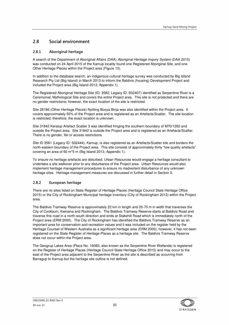
A search of the Department of Aboriginal Affairs (DAA) Aboriginal Heritage Inquiry System (DAA 2015)
was conducted on 24 April 2015 of the Karnup locality found one Registered Aboriginal Site, and one
Other Heritage Places within the Project area (Figure 13).
In addition to the database search, an indigenous cultural heritage survey was conducted by Big Island
Research Pty Ltd (Big Island) in March 2013 to inform the Baldivis (housing) Development Project and
included the Project area (Big Island 2013; Appendix 1).
The Registered Aboriginal Heritage Site (ID: 3582; Legacy ID: S02407) identified as Serpentine River is a
Ceremonial, Mythological Site and covers the entire Project area. This site is not protected and there are
no gender restrictions; however, the exact location of the site is restricted.
Site 28186 (Other Heritage Places) Nyitting Booya Binja was also identified within the Project area. It
covers approximately 50% of the Project area and is registered as an Artefacts/Scatter. The site location
is restricted; therefore, the exact location is unknown.
Site 31842 Keralup Artefact Scatter 3 was identified fringing the southern boundary of M70/1262 and
outside the Project area. Site 31842 is outside the Project area and is registered as an Artefacts/Scatter.
There is no gender, file or access restrictions.
Site ID 3561 (Legacy ID: S02444), Karnup, is also registered as an Artefacts/Scatter site and borders the
north-eastern boundary of the Project area. This site consists of approximately thirty “low quality artefacts”
covering an area of 60 m*5 m (Big Island 2013; Appendix 1).
To ensure no heritage artefacts are disturbed, Urban Resources would engage a heritage consultant to
undertake a site walkover prior to any disturbance of the Project area. Urban Resources would also
implement heritage management procedures to ensure no inadvertent disturbance of any unknown
heritage sites. Heritage management measures are discussed in further detail in Section 5.
2.8.2 European heritage
There are no sites listed on State Register of Heritage Places (Heritage Council State Heritage Office
2015) or the City of Rockingham Municipal heritage inventory (City of Rockingham 2012) within the Project
area.
The Baldivis Tramway Reserve is approximately 22 km in length and 20-70 m in width that traverses the
City of Cockburn, Kwinana and Rockingham. The Baldivis Tramway Reserve starts at Baldivis Road and
traverse this road in a north-south direction and ends at Stakehill Road which is immediately north of the
Project area (ERM 2000). The City of Rockingham has identified the Baldivis Tramway Reserve as an
important area for conservation and recreation values and it was included on the register held by the
Heritage Counsel of Western Australia as a significant heritage area (ERM 2000); however, it has not been
registered on the State Register of Heritage Places as a heritage site. The Baldivis Tramway Reserve
does not occur within the Project area.
The Geogrup Lakes Area (Place No. 16083, also known as the Serpentine River Wetlands) is registered
on the Register of Heritage Places (Heritage Council State Heritage Office 2015) and may occur to the
east of the Project area adjacent to the Serpentine River as the site is described as occurring from
Barragup to Karnup but the heritage site outline is not defined.
Karnup Sand Mining Project
URE15096_01 R002 Rev 0
30-Jun-15 31
2.8.3 Other social receptors
Residents
Baldivis comprises a combination of residential, rural and natural land use. Land neighbouring the Project
area is rural residential and rural, including properties with uncleared vegetation, market gardens, horse
paddocks and vineyard. The closest residents are located along Stakehill Road and the closest residence
is approximately 200 m north of the Project area.
Kwinana Freeway and local traffic
The Kwinana Freeway is a major state transport route providing access to the Perth CBD and major roads
between Perth and Pinjarra. A dedicated bicycle path traverses the same alignment immediately adjacent
to the freeway. Both the freeway and the bicycle path intersect Mining Tenement M70/1262 but are
located outside the Project area. It is expected that the civil design of the freeway and bike path would
currently manage any surface water overflow from the Project area as it flows east towards the Serpentine
River.
There is no direct access from the freeway to Stakehill Road and the nearest freeway access from the
Project area would be approximately 2 km via Baldivis and Karnup Rd approximately. The increased
levels of traffic in the local area (up to 260 truck movements per day) from the Project area is expected to
integrate with the current traffic from the adjacent Holcim sand mining operation and local traffic. The
increase in traffic as a result of the Project would not be expected to have a significant impact on the
capacity of the existing intersections.
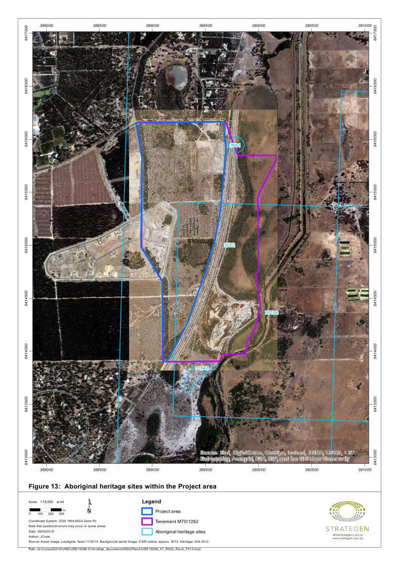
Figure 13: Aboriginal heritage sites within the Project area
3582
28186
31842
3561
Source: Esri, DigitalGlobe, GeoEye, i-cubed, USDA, USGS, AEX,Getmapping, Aerogrid, IGN, IGP, and the GIS User Community
388000
388000
388500
388500
389000
389000
389500
389500
390000
390000
390500
390500
391000
391000
6413
000
6413
000
6413
500
6413
500
6414
000
6414
000
6414
500
6414
500
6415
000
6415
000
6415
500
6415
500
6416
000
6416
000
6416
500
6416
500
6417
000
6417
000
Path: Q:\Consult\2015\URE\URE15096.01\ArcMap_documents\R002\RevA\URE15096_01_R002_RevA_F013.mxd
Scale at A4
Source: Aerial image: Landgate, flown 11/2014. Background aerial image: ESRI online, approx. 2010. Heritage: DIA 2012.
Note that positional errors may occur in some areas
0 100 200 300m
1:18,000
Coordinate System: GDA 1994 MGA Zone 50
Date: 29/05/2015Author: JCrute
¹ LegendProject areaTenement M70/1262Aboriginal heritage sites
Karnup Sand Mining Project
URE15096_01 R002 Rev 0
30-Jun-15 33
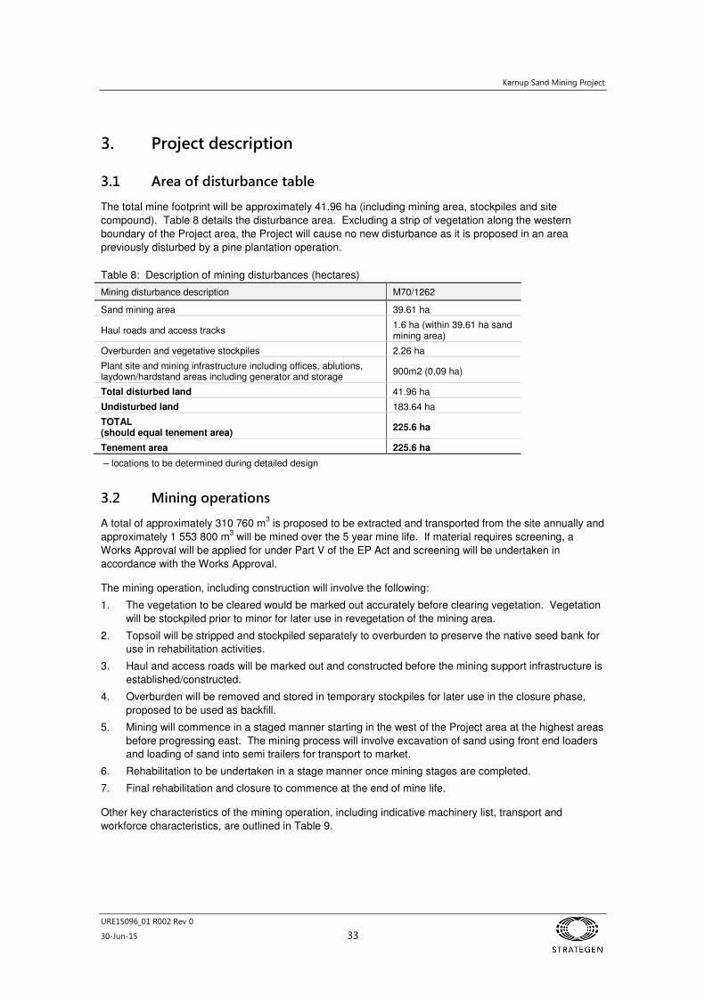
3. Project description
3.1 Area of disturbance table
The total mine footprint will be approximately 41.96 ha (including mining area, stockpiles and site
compound). Table 8 details the disturbance area. Excluding a strip of vegetation along the western
boundary of the Project area, the Project will cause no new disturbance as it is proposed in an area
previously disturbed by a pine plantation operation.
Table 8: Description of mining disturbances (hectares)
Mining disturbance description M70/1262
Sand mining area 39.61 ha
Haul roads and access tracks 1.6 ha (within 39.61 ha sand mining area)
Overburden and vegetative stockpiles 2.26 ha
Plant site and mining infrastructure including offices, ablutions, laydown/hardstand areas including generator and storage
900m2 (0.09 ha)
Total disturbed land 41.96 ha
Undisturbed land 183.64 ha
TOTAL (should equal tenement area)
225.6 ha
Tenement area 225.6 ha
– locations to be determined during detailed design
3.2 Mining operations
A total of approximately 310 760 m3 is proposed to be extracted and transported from the site annually and
approximately 1 553 800 m3 will be mined over the 5 year mine life. If material requires screening, a
Works Approval will be applied for under Part V of the EP Act and screening will be undertaken in
accordance with the Works Approval.
The mining operation, including construction will involve the following:
1. The vegetation to be cleared would be marked out accurately before clearing vegetation. Vegetation
will be stockpiled prior to minor for later use in revegetation of the mining area.
2. Topsoil will be stripped and stockpiled separately to overburden to preserve the native seed bank for
use in rehabilitation activities.
3. Haul and access roads will be marked out and constructed before the mining support infrastructure is
established/constructed.
4. Overburden will be removed and stored in temporary stockpiles for later use in the closure phase,
proposed to be used as backfill.
5. Mining will commence in a staged manner starting in the west of the Project area at the highest areas
before progressing east. The mining process will involve excavation of sand using front end loaders
and loading of sand into semi trailers for transport to market.
6. Rehabilitation to be undertaken in a stage manner once mining stages are completed.
7. Final rehabilitation and closure to commence at the end of mine life.
Other key characteristics of the mining operation, including indicative machinery list, transport and
workforce characteristics, are outlined in Table 9.
Karnup Sand Mining Project
URE15096_01 R002 Rev 0
30-Jun-15 34
Table 9: Key characteristics of the mining operation
Mining operation component Description of key characteristic
Indicative machinery list
Water cart 40 000 and 12 000 kL capacity, used for dust suppression of haul road, pit floor and stockpiles.
Front end loaders Two Komatsu 470 loaders or similar.
Semi trailers Would be provided by customers and expected to range in six from 10 m3 to 25 m
3
capacity. Vehicles used will be classified as General Access by Main Roads Western Australia (i.e. Total mass <50 tonnes).
Grader One JD 872 grader or similar will be utilised on site for maintaining roads on an as required basis.
Service truck A service truck with a 5000 L diesel fuel capacity will be used to re-fuel site equipment as required. The service truck will also have tanks for separate lubricants, including a waste oil tank and evacuation pump and will only brought on site as required.
Light vehicles Two for site operators.
Power generation Diesel generators for the supply of power to offices.
Water supply Bottled water will be supplied to staff as drinking water. Rainwater will be captured and stored on site. Additional water for purposes such as dust suppression will be trucked on site using a water cart as required.
Transport
Truck movements and hours Approximately 260 loaded and return truck movements per day of operation (depending on truck size).
Workforce
Operation 2–3 personnel during operations.
Hours of operation 0600 to 1800 Monday to Saturday.
Mining will be undertaken in three main stages as identified in Figure 3 due to access constraints and
agreements with DMP and LandCorp related to the presence and re-location of the DMP Explosives
Reserve Facility. Stage 1 will involve mining north of the DMP Explosives Facility and buffer, Stage 2 will
involve mining the DMP Explosives Facility and buffer once it has been re-located off site and Stage 3 will
involve mining south of the DMP Explosives Facility.
Dewatering is not required for mining operations as mining of sand will occur down to 4.2 – 4.5 m mAHD
which is expected to be at least 1.2 m above the AGL.
The stockpiles for overburden will be located at the edge of the mining area up to 20 m from the extent of
mining. Overburden material is expected to consist of organic matter and some rock, and is likely to be up
to 2 m high. Volumes are unknown but overburden depth is expected to be minimal due to the nature of
the sand mining process.
Product stockpiles will be located within the mining area. Allowance will be made to store enough product
to supply the market for up to seven days if excavation activities were to cease temporarily.
Excavation will begin on the western-most side of each stage, to allow easy access. A fence will surround
each excavation area, with lockable gates securing the access road entrances outside of operating hours.
The indicative machinery proposed for the Project is listed in Table 9.
3.3 Sand processing
Due to the nature of the sand mine, sand will not be processed on site.
3.4 Tailings storage
There will not be any tailings or any other waste produced by the Project; however, cleared vegetation,
topsoil and overburden which will consist of organic material (mostly pine tree roots) and any rocky
material present, will be stored in temporary stockpiles before being used for rehabilitation purposes.
Karnup Sand Mining Project
URE15096_01 R002 Rev 0
30-Jun-15 35
3.5 Support facilities
Support facilities at a site compound area will include (Figure 3):
• temporary office (donga)
• temporary ablutions block equipped with pump out septic tanks
• bottled water will be provided to quarry personnel
• hardstand for staff and visitor vehicle parking area
• static wheel wash (washdown bay) on limestone
• generator (20 kVA) (no fuel will be stored on site).
3.6 Workforce
Personnel will commute to the site each day. During the construction phase, there will be 2-3 personnel
on site. During operations there will be approximately 2–3 personnel on site.
Operating hours will be Monday to Saturday 0600 to 1800 for the duration of the mine life. The site will not
operate on Sundays or public holidays.
3.7 Transportation corridors
A purpose built haul road from the active mining areas to Stakehill Road will be used to access and haul
sand from the site during Stage 1. Following completion of Stage 1, Holcim will construct a haul road
within Miscellaneous Licence tenement L70/160 to be used by both Holcim and Urban Resources staff and
customers. Urban Resources will extend the haul road to access and transport sand from Stages 2 and 3.
The haul road will be constructed of crushed limestone with a usable running surface width of 8 m. The
haul road will not be sealed. Dust will be managed via wetting of the haul road surface with water when
necessary with a water cart or sprinkler system. The total width of disturbance of the haul road is assumed
to be 12 m, allowing for 2 m buffer on either side. A grader will be used on an as required basis to
maintain access roads.
Customers will be responsible for transporting the product unless otherwise agreed with Urban Resources.
This entails supplying the trucks, choosing the appropriate transport route once departing the site and
managing any transportation impacts.
There will be approximately 260 loaded and return truck movements per day, depending on the size of
truck used and customer demand. All loads leaving the site will be loaded using ‘Loadrite’ scale system
equipped front end loaders. Urban Resources personnel will advise customers that all loads are to be
covered upon leaving the Project area for transport to market.
The Project area will be fenced with an access gate near Stakehill Road. The access gate will be secure
and locked outside of operating hours. Warning signs will be erected to the standard required by the City
of Rockingham and DMP.
3.8 Resource requirements
3.8.1 Power supply
One 20kva diesel generator will be established on site to provide power to the site compound area.
Diesel, oil, lubricant will be brought on site as required by a mobile service truck.
3.8.2 Water supply
Bottled water will be supplied to staff as drinking water. Additional water for purposes such as dust
suppression will be trucked on site using a water cart as required.

Karnup Sand Mining Project
URE15096_01 R002 Rev 0
30-Jun-15 36
3.9 Compliance with legalisation and other approvals
3.9.1 Tenement conditions
No tenement conditions have yet been assigned to M70/1262 or L70/160 by DMP as these tenements
have not yet been granted and are still pending.
3.9.2 Environmental approvals
Various environmental approvals may be required for the Project under legislation other than the
Mining Act 1978. These include:
1. Native Vegetation Clearing Permit (NVCP) under Part V of the EP Act (delegated authority). The
application for the NVCP is expected to be submitted to and assessed by DMP concurrently with the
Mining Proposal.
2. Works Approval, Prescribed Premises Licence and/or Registration under Part V of the EP Act for the
construction and operation of the mobile screening plant if required. The relevant documentation for
these approvals will be prepared and submitted to Department of Environment Regulation for
assessment under Part V of the EP Act a minimum of three months before construction of the
Prescribed Premises commences.
The Project is to be referred to the DotE under the EPBC Act for the Australian Government to determine if
the Project will significantly impact National Matters of Environment Significance (MNES) that are
protected under the Act. The requirement for the referral relates to the clearing of foraging habitat for
Black Cockatoo species. The potential impact to these species will also be considered during the NVCP
application.
The Project will not be referred under Part IV of the EP Act as it is considered that the Project will impact
minimal environmental factors and these can be assessed and managed under the Mining Act 1978 in
accordance with the MOU between the EPA and DMP.
A ‘5C Licence to Take Groundwater’ is not required under the Rights in Water and Irrigation Act 1914 as
groundwater will not be abstracted at the site. Water for operations will be trucked to site by water carts
and stored in tanks on site.
Karnup Sand Mining Project
URE15096_01 R002 Rev 0
30-Jun-15 37
4. Environmental impacts and management
4.1 Land clearing
A total of 30.83 ha of vegetation will be cleared to facilitate sand mining within M70/1262 during the life of
the Project for construction and operation of the mine.
The following activities or aspects of the sand mining operation requiring management to minimise the
following potential land clearing impacts:
• direct removal of vegetation communities
• direct loss of habitat for terrestrial fauna
• wetland and land degradation.
Land clearing impacts have the potential to affect surface water, flora, fauna and ecosystems within and
surrounding the Project area. In addition, clearing if not managed appropriately may result in indirect
impacts to surrounding residents as a result of dust and noise impacts. Management measures to be
implemented for dust and noise are described further in Section 4.9.1.
Land clearing will be managed through implementation of the following measures including but not limited
to:
• minimising clearing to include the mining area, haul road and required infrastructure
• obtaining clearing approvals and delineating clearing footprint boundaries prior to and during
clearing
• stockpiling cleared vegetation for reuse in future rehabilitation
• stripping topsoil and overburden prior to construction earthworks and managing these materials
for closure.
4.2 Water
4.2.1 Surface water
Potential surface water impacts of the Project include:
• erosion or scour at drainage outlets, occurring when the velocity of surface flows are increased by
drainage design
• changes to natural hydrology (surface flows, erosion, inundation and surface/groundwater
interaction).
Due to the sandy nature of the Project area, there is expected to be minimal stormwater runoff from the
mine area as the Bassendean Sands have a high hydraulic conductivity and rainfall infiltrates rapidly.
Flooding is not considered an issue in the mine areas due to the high infiltration capacity of the sands and
the relatively high clearance to the groundwater table (greater than 1 m) in the area to be mined.
Karnup Sand Mining Project
URE15096_01 R002 Rev 0
30-Jun-15 38
The mine area will be designed, constructed and operated to avoid disruption of surface water flows and
ensure that potential contaminants are not released to the environment. The following management
practices will be implemented to manage the potential effects on water quality from the discharge of
stormwater with elevated sediment levels or any other contaminants:
• staged clearing and retention of tree stumps as long as possible prior to mining to assist with soil
stabilisation and reduce surface water flow velocities
• a buffer zone of 50 m will be maintained between mining operations and naturally vegetated
geomorphic wetlands
• each stage will be progressively rehabilitated at completion. Vegetation cover will be established
to encourage spreading and reduce velocities of surface water flow
• riffle zones and contour sills will be used downslope of the run of mine pad
• hydrocarbon management measures will ensure surface water contamination does not occur
• Urban Resources will provide spill response equipment at the site.
4.2.2 Groundwater
There are not expected to be any direct impacts to groundwater by the Project as there will be no
dewatering activities or groundwater abstraction for water supply to facilitate mining.
Adequate sand will be retained on the site (i.e. 1.2 m above AGL) to ensure that waterlogging and
inundation will not occur after rainfall events as a result of the Project. Groundwater flow directions will not
be affected by the Project.
Dewatering
No pit dewatering or groundwater abstraction for water supply is proposed as part of this Project and there
will be no impact to groundwater from such activities.
4.2.3 Storage and usage of hydrocarbons and chemicals
The storage and usage of hydrocarbons, chemicals and other materials at the Project area such as fuel,
oils, greases and degreasers, lubricants, solvents, detergents, glues, paints and sewage has the potential
to cause atmospheric, soil or water contamination and human health issues if incorrectly stored, used or
disposed of.
Minimal hydrocarbons and chemicals are proposed to be stored on site. Urban Resources will not service
machinery or construct a fuel farm on site. Fuel, oil, coolant and lubricant will be brought on site as
required by a fully contained mobile service truck. The service truck has separate tanks for lubricants,
including a waste oil tank and evacuation pump. As a result, there will be no storage of hydrocarbon waste
on site.
Any hydrocarbon or chemical leaks or spills have the potential to contaminate the surface water and seep
into the groundwater if not readily contained and cleaned up. The materials will be managed in
accordance with the measures detailed in Section 4.7.
Karnup Sand Mining Project
URE15096_01 R002 Rev 0
30-Jun-15 39
4.3 Flora, fauna and ecosystems
No threatened flora species pursuant to Schedule 1 of the WC Act or listed under the EPBC Act have been
recorded within the Project area (Strategen 2015). Dillwynia dillwynioides and Schoenus capillifolius were
recorded by Bennett (2006); however, these species were recorded in wetlands which will not be disturbed
as part of the Project.
No TECs or PECs were identified as having the potential to occur within the Project area (Strategen 2015).
No Declared Plant species pursuant to Section 22 of the Biosecurity and Agriculture Management
Act 2007 (BAM Act) were recorded within the Project area.
Three EPBC Act listed black cockatoo species were identified in a desktop assessment as the most likely
species to occur in the Project area. In addition to the black cockatoo species, the Rainbow Bee-eater is
likely to occur in the general area in sandy soiled areas and surrounding wetlands. The habitat most likely
to support the Rainbow Bee-eater is associated with wetland areas that will not be impacted by the Project.
A field survey conducted by Strategen (2015) assessed the potential for black cockatoo habitat. The
survey identified signs of Carnaby’s Black Cockatoo foraging within the Project area. The highest quality
foraging habitat for black cockatoos was noted within VT 2 which contained high densities of black
cockatoo food species including eucalypts and Banksia spp. at canopy and midstorey levels. The lowest
quality foraging habitat for black cockatoos (not including cleared areas) was noted within VT 5 which
contained limited potential food resources for all three species of black cockatoos.
Based on the results of the foraging assessment, the survey area is considered to contain 6.54 ha of very
good quality foraging habitat and 24.29 ha of low quality foraging habitat for CBC, BBC and FRTBC.
Six seasonally damp and inundated geomorphic wetlands also occur within the Project area, however
these are not impacted.
The following environmental activities or aspects of the sand mining operation have been identified as
requiring management to ensure protection of flora, fauna and ecosystem values:
• land clearing which may result in the direct loss of some individuals of conservation significant
flora species not identified during surveys of the Project area
• land clearing may reduce and/or fragment the habitat of conservation significant fauna species
• clearing and construction works may result in the death or injury of conservation significant fauna
species
• increased vehicular traffic may result in increased number of fauna road kills, and may promote
the spread of weeds
• increased human activities and rubbish may encourage habitation of introduced fauna species
• direct and indirect disturbance from light, noise and dust may reduce habitat quality in areas
surrounding the disturbance area.
The potential impacts associated with the Project will be managed and mitigated through the following
management measures:
• clearing to stay within approved footprint by clearly delineated clearing footprint boundaries
• access to non-operational areas will be restricted to authorised personnel and only on the
designated haul road, unless in case of emergency
• land clearing to take place in stages to allow for local migration of fauna into adjacent areas
• no clearing to be undertaken within 50 m of the naturally vegetated geomorphic wetlands within
the Project area
• designated vehicle routes (haul road) and appropriate speed limits to be enforced to minimise
fauna vehicle interactions
• any sightings of native or exotic fauna (including sightings, injuries and mortalities) to be reported
to the site manager
• include fauna awareness in inductions and environmental awareness training sessions
Karnup Sand Mining Project
URE15096_01 R002 Rev 0
30-Jun-15 40
• prohibit domestic pets on site
• installing relevant signage on roads and entry points to the mine noting presence of fauna.
Sand mining activities are highly unlikely to result in a change in status of conservation for any fauna or
flora species, and will not significantly impact the regional distribution of fauna habitat for conservation
species due to heavily impacted nature of the site and the wide extent of vegetation communities and
fauna habitat remaining in the local and regional area. Geographical distribution and productivity of fauna
at species and ecosystem levels will be maintained through the outlined management and mitigation
measures.
Rehabilitation will occur in a progressive manner as detailed further in the MCP (Appendix 2).
4.4 Topsoil and soil profiles
Prior to ground disturbance, the topsoil (nominally the top 15 cm of the soil profile) will be stripped and
stockpiled away from the mining area to create a bund of no more than 2 m high to maintain biological
integrity. Stockpiles will be located a sufficient distant from mining operations so that they will not be
disturbed prior to being used in rehabilitation.
As the proposed activities will not disturb the ground below the water table or any areas of high probability
of ASS occurrence, it is unlikely that any ASS will be exposed or disturbed.
According to the DEC guideline ‘Identification and investigation of acid sulphate soils and acidic
landscapes’, sites should be investigated for ASS if extractive industry works are proposed around high to
moderate risk PASS soils and wetlands as found in the proposed tenement. Accordingly, Urban
Resources will exclude mining from a 50 m buffer around mapped high to moderate risk PASS soils
(including 50 m around all wetlands whether mapped as high to moderate risk or not).
Urban Resources plan to manage ASS and overburden in the following manner:
• avoid disturbance of high ASS risk areas
• overburden will be stockpiled and used for rehabilitation
• excavation will not intersect the water table
• overburden and oversize material stockpiles will be used to backfill and rehabilitate the
excavations at mine closure and are thus temporary
• Urban Resources commits to the exclusion of mining from a 50 m buffer around mapped high to
moderate risk PASS soils (including 50 m around all wetlands whether mapped as high to
moderate risk or not).
4.5 Domestic and industrial waste products
Wastes will be managed in order to prevent visual impacts, contamination of groundwater, soil and surface
water, and human health issues. Urban Resources apply the waste management principles of reduce, re-
use and recycle. The following wastes may potentially be produced by the proposed project:
• hydrocarbon and chemical contaminated wastes (such as used oil, empty drums and containers,
spill absorbent materials etc). This will be minimal as no hydrocarbons will be stored on site, but
brought on site as required by a mobile service truck and removed immediately
• general waste (such as kitchen waste, paper, cardboard etc)
• sewage and domestic wastewater.
Hydrocarbons will be managed as per Section 4.7. All other wastes types will be contained on-site and be
removed by an appropriately licensed contractor.
Karnup Sand Mining Project
URE15096_01 R002 Rev 0
30-Jun-15 41
4.6 Waste rock management
There will be no waste rock associated with the Proposal.
4.7 Hydrocarbon management
During construction and operation of the Project, hydrocarbons will be required for a range of proposed
activities. The transport, storage and use of hydrocarbons on site can present risks to the environment if
not managed appropriately. Spills and leaks resulting from inappropriate storage or procedures may result
in contamination of soil, surface water and groundwater.
Minimal hydrocarbons are proposed to be stored on-site. Urban Resources will not service machinery or
construct a fuel farm on site. Fuel, oil, coolant and lubricant will be brought on site as required by a fully
contained mobile service truck. The service truck has separate tanks for lubricants, including a waste oil
tank and evacuation pump. As a result, there will be no storage of waste hydrocarbons on site.
Urban Resources will also implement the following management actions to minimise this risk to the
environment from hydrocarbons:
• purchase, storage and transport of fuel will comply with Poisons Act 1964, Poisons Regulations
1965, Mines Safety and Inspection Act 1994, Mines Safety and Inspection Regulations 1995,
Dangerous Goods Safety Act 2004, Dangerous Goods (Storage) Regulations 2007 and
Dangerous Goods (Road Transport) Amendment Regulations 1988
• all Hydrocarbon spills will be cleaned up and contaminated soil disposed offsite at a licensed
landfill, in the event that hydrocarbon spills occur.
4.8 Dangerous goods and hazardous substances
No dangerous goods or hazardous substances, other than hydrocarbons, will be used on the Project site.
Hydrocarbon management has been addressed in Section 4.7.
4.9 Atmospheric pollution and noise
4.9.1 Atmospheric pollution
Atmospheric pollution from the Project is limited primarily to dust emissions. Combustion emissions from
power generation and vehicles are also anticipated, however, these are not likely to lead to a decline in the
local air quality.
Excessive dust can have adverse impacts on both workers and health of surrounding vegetation. Dust
generated from the proposed mine is expected to be minor and localised. Dust may be generated by:
• earthworks during the construction and operational phase
• clearing and stripping
• excavation
• loading and transport
• movement of vehicles
• wind erosion of exposed surfaces.
Urban Resources have made allowance for water cart operation, and ensuring the disturbed area exposed
is kept to a minimum at all times. To satisfy the requirements of the Mines Safety and Inspection Act 1994
and Regulations 1995 in regard to occupational health risks from dust, Urban Resources will ensure that
all personnel will have access to efficient dust masks and that a water cart is available during mining
operations.
Karnup Sand Mining Project
URE15096_01 R002 Rev 0
30-Jun-15 42
Access roads and internal road will be constructed of compacted crushed limestone (they will not be
sealed). Dust will be managed via the use of water carts where necessary to prevent dust generation.
Standard dust suppression measures will be implemented during construction and operation to minimise
impacts on surrounding vegetation. Management strategies to be undertaken are as follows:
• dust suppression measures, such as water sprays/carts, will be implemented as necessary, in the
event that high levels of dust are observed
• dust will be visually monitored daily during operations and construction to ensure control
measures are effective
• areas will be progressively cleared and progressively rehabilitation to limit the area of bare earth
at any one time
• access roads will be constructed of crushed limestone
• activities with high dust-causing potential, such as stripping, will not be carried out in sensitive
areas during adverse wind conditions
• material drop heights between loaders and trucks and trucks to stockpiles will kept to the
minimum practical height
• any complaints will be investigated immediately.
A Dust Management Plan will be prepared, based on the DER publication (Department of Environment
and Conservation 2011).
4.9.2 Noise
Noise generated by the proposed mine is expected to be localised and due to:
• operation of earthmoving equipment throughout the construction and operational phases
• traffic along the transport routes.
Noise impacts are managed by providing all necessary hearing protection, and conducting inductions and
educational programs for all staff. There will be no blasting or breaking of a dense duricrust required due
to the local geology within the area. Operational noise for mining sand is expected to be less than other
forms of mining. Vibration disturbance is expected to be minimal as the proposal does not include
blasting. Urban Resources will also not be crushing or operating any particularly noise plant or processing
equipment.
Urban Resources does not expect significant noise issues to arise during their operations and the distance
between existing dwellings is considered to offer sufficient buffers to not adversely impact residents.
A noise impact assessment will be undertaken prior to the commencement of construction to confirm that
the noise emissions comply with the requirements of the Environmental Protection (Noise) Regulations
1997 and the Mining Act 1978 at all times.
Management measures that will be implemented to minimise noise emissions include:
• operations will occur between 0600 – 1800 Monday - Saturday to minimise the likelihood of noise
nuisance
• all mobile equipment will be maintained, with efficient mufflers and noise shielding
• mobile equipment without audible reversing alarms will be used if possible.
Any complaints received regarding noise disturbance will be recorded and investigated immediately.
Karnup Sand Mining Project
URE15096_01 R002 Rev 0
30-Jun-15 43
4.10 Summary of environmental impacts
The key environmental impacts and the management commitments to be implemented are detailed in Table 10.
Table 10: Summary of environmental impacts and management commitments
Environmental Impact Management commitment implementation Timelines
Direct loss of vegetation communities and associated fauna habitat
Wetland and land degradation
Minimising clearing to include the mining area, haul road and required infrastructure. At all times
Obtaining clearing approvals and delineating clearing footprint boundaries prior to and during clearing. Prior to commencement of land clearing
Stockpiling cleared vegetation for reuse in future rehabilitation. During clearing
Stripping topsoil and overburden prior to construction earthworks and managing these materials for closure. During clearing
Land clearing which may result in the direct loss of some individuals of conservation significant flora species not identified during surveys of the Project area
Clearing to stay within approved footprint by clearly delineated clearing footprint boundaries. At all times
Land clearing may reduce and/or fragment the habitat of conservation significant fauna species
Clearing to stay within approved footprint by clearly delineated clearing footprint boundaries. At all times
Revegetate black cockatoo habitat following mining. Completion of mining
Clearing and construction works may also result in the death or injury of conservation significant fauna species
Designated vehicle routes (haul road) and appropriate speed limits to be enforced to minimise fauna vehicle interactions.
At all times
Include in inductions fauna awareness and environmental awareness training sessions. Induction phase
Installing relevant signage on roads and entry points to the mine noting presence of fauna. At all times
Increased vehicular traffic may result in increased number of fauna road kills, and may promote the spread of weeds
Clearing to stay within approved footprint by clearly delineated clearing footprint boundaries. At all times
Land clearing to take place in stages to allow for local migration of fauna into adjacent areas. During clearing
Designated vehicle routes (haul road) and appropriate speed limits to be enforced to minimise fauna vehicle interactions.
At all times
increased human activities and rubbish may encourage habitation of introduced fauna species
Any sightings of native or exotic fauna (including sightings, injuries and mortalities) to be reported to the site manager.
At all times
Prohibit feeding of fauna on-site. At all times
Prohibit domestic pets on site. At all times
direct and indirect disturbance from light, noise and dust may reduce habitat quality in areas surrounding the disturbance area
Include in inductions fauna awareness and environmental awareness training sessions. Induction phase
Erosion as a result of surface water.
Changes to natural hydrology
Staged clearing and retention of tree stumps as long as possible prior to mining to assist with soil stabilisation and reduce surface water flow velocities.
During clearing
A buffer zone of 50 m will be maintained between mining operations and naturally vegetated geomorphic wetlands.
During mining activities
Karnup Sand Mining Project
URE15096_01 R002 Rev 0
30-Jun-15 44
Environmental Impact Management commitment implementation Timelines
Stockpiles of erodible material will be located away from limestone hardstand areas to minimise sediment transport in runoff.
During mining activities
Each stage will be progressively rehabilitated at completion.
Vegetation cover will be established to encourage spreading and reduce velocities of surface water flow.
Completion of each stage
Completion of mining
Riffle zones and contour sills will be used downslope of the run of mine pad. During mining activities
Bunds and v drains will be established at limestone hardstand areas of the Project area, such as the haul road and the site compound area, to contain stormwater runoff and capture sediment on site.
During mining activities
Hydrocarbon management measures will ensure surface water contamination does not occur. At all times
Urban Resources will provide spill response equipment at the site. At all times
Atmospheric, soil or water contamination Urban Resources will provide spill response equipment at the site. At all times
Disturbance to soils resulting expression of ASS
Avoid disturbance of high ASS risk areas. At all times
Overburden will be stockpiled and used for rehabilitation. During mining activities
Excavation will not intersect the water table. During mining activities
Overburden and oversize material stockpiles will be used to backfill and rehabilitate the excavations at mine closure.
Mine closure
Urban Resources commits to the exclusion of mining from a 50 m buffer around mapped high to moderate risk PASS soils (including 50 m around all wetlands whether mapped as high to moderate risk or not).
During mining activities
If mining is proposed within the 50 m buffer, Urban Resources commits to the provision of a management plan which will include the results of ASS investigations and will incorporate the results into management strategies.
Prior to mining within 50 m of a wetland
Contamination of groundwater, soil and surface water as a result of domestic and industrial waste products
Waste will be contained on site and be removed by an appropriately licensed waste contractor. During mining activities
Contamination of groundwater, soil and surface water as a result of hydrocarbon spills
Purchase, storage and transport of fuel will comply with Poisons Act 1964, Poisons Regulations 1965, Mines Safety and Inspection Act 1994, Mines Safety and Inspection Regulations 1995, Dangerous Goods Safety Act 2004, Dangerous Goods (Storage) Regulations 2007 and Dangerous Goods (Road Transport) Amendment Regulations 1988.
During mining activities
All Hydrocarbon spills will be cleaned up and contaminated soil disposed offsite at a licensed landfill, in the event that hydrocarbon spills occur.
At all times
Dust impacts on surrounding vegetation, wetlands and local amenity
Dust suppression measures, such as water sprays/carts, will be implemented as necessary, in the event that high levels of dust are observed.
During mining activities
Dust will be visually monitored daily during operations and construction to ensure control measures are effective.
During clearing and mining activities
Areas will be progressively cleared and progressively rehabilitation to limit the area of bare earth at any one time.
During clearing
Access roads will be constructed of crushed limestone. During construction
Activities with high dust-causing potential, such as stripping, will not be carried out in sensitive areas during adverse wind conditions.
During clearing and mining activities
Karnup Sand Mining Project
URE15096_01 R002 Rev 0
30-Jun-15 45
Environmental Impact Management commitment implementation Timelines
Material drop heights between loaders and trucks and trucks to stockpiles will kept to the minimum practical height.
During clearing and mining activities
Any complaints will be investigated immediately. At all times
Noise impacts to surrounding residents Stockpiles/bunding will be located to provide substantial noise suppression between the nearest dwellings. During mining activities
Operations will occur between 0600 – 1800 Monday - Saturday to minimise the likelihood of noise nuisance.
At all times
All mobile equipment will be maintained, with efficient mufflers and noise shielding. At all times
Mobile equipment without audible reversing alarms will be used if possible. At all times
Karnup Sand Mining Project
URE15096_01 R002 Rev 0
30-Jun-15 46
5. Social impacts
5.1 Heritage
5.1.1 European heritage
No European heritage sites were identified within the Project based on a search of the State Register of
Heritage Places (Heritage Council State Heritage Office 2015) or the City of Rockingham Municipal
heritage inventory (City of Rockingham 2012).
The City of Rockingham has identified the Baldivis Tramway Reserve as an important area for
conservation and recreation values and it was included on the register held by the Heritage Council of
Western Australia as a significant heritage area (ERM 2000); however, it has not been registered on the
State Register of Heritage Places as a heritage site. The Baldivis Tramway Reserve is outside of this
proposal and will not be impacted.
The Geogrup Lakes Area (Place No. 16083, also known as the Serpentine River Wetlands) is registered
on the Register of Heritage Places (Heritage Council State Heritage Office 2015) and may occur to the
east of the Project area adjacent to the Serpentine River as the site is described as occurring from
Barragup to Karnup but the heritage site outline is not defined.
No registered European heritage sites will be impacted as a result of the Project.
5.1.2 Aboriginal heritage
A search of the DAA Aboriginal Heritage Inquiry System (DAA 2015) and a Aboriginal Ethnographic and
Archaeological Heritage Assessment (Big Island 2013) have been undertaken of the Project area which
identified four sites of significance, including:
• the Serpentine River Registered Aboriginal Heritage (Site ID: 3582; Legacy ID: S02407) which is
registered as a ceremonial, Mythological site which covers the entire Project Area- . As the site is
related to the Serpentine River itself and there is no intersection of the river with the mining
tenement, the Project would not result in any impacts to the registered heritage site (Big Island
2013)
• the Nyitting Booya Binja Other Heritage Place (Site 28186) which is within and bordering the
Project area
• the Karnup site (Site ID 3561;Legacy ID: S02444), which is registered as an artefacts/scatter
within and bordering the Project area
• The Keralup Artefact Scatter 3 (Site 31842) which is registered as an artefacts/scatter fringing the
southern boundary of M70/1262. As the site is outside the Project area there are no anticipated
impacts to the registered heritage site.
None of the identified Sites are considered to have the potential to be impacted by the Project. All sites are
known or are likely to occur outside of the Project area. Site 28186, however the Site is mapped over a
wide area and the Project area is not situated centrally to the mapped area and therefore it is unlikely that
the Site intersects with the Project Area. Additionally Site 28186 is registered as an Artefacts/Scatter.
Areas of the Project area proposed to be disturbed have previously been disturbed by clearing, pine
plantation and clearing of the pine plantation again, including removal of stumps and roots.
To ensure no heritage artefacts are disturbed, Urban Resources proposes to consult with the relevant
aboriginal community to engage an appropriate community member to conduct site inspection prior to
topsoil removal.
Karnup Sand Mining Project
URE15096_01 R002 Rev 0
30-Jun-15 47
Should any aboriginal sites be uncovered, all activities will cease in accordance with Aboriginal Heritage
Act 1972-and an aboriginal heritage assessment will be undertaken by a recognised consultant. Prior to
the disturbance of any known sites a Section 18 application will be submitted to the Department of
Indigenous Affairs under the Aboriginal Heritage Act 1972.
Site inductions will brief personnel on:
• the potential for unidentified buried archaeological material to occur
• Urban Resources obligations under the Aboriginal Heritage Act 1972
• the response procedures in the event that unidentified buried material is found during sand
extraction. This includes ceasing work and reporting to the Mine Manager.
5.2 Land use and community
Baldivis comprises a combination of residential, rural and natural land use. The closest residents are
located along Stakehill Road with the closest residence 200 m north of the Project area. No impacts to this
residential home are anticipated.
Key impacts associated with sand extraction that have the potential to impact residents are dust and noise.
Management of these factors are detailed in Section 4.9.
5.3 Stakeholder consultation
The following stakeholder consultation has been undertaken:
1. City of Rockingham: consultation included discussion on final land use, groundwater levels and final
finished levels. Further information regarding impacts on flora and fauna were provided to the City.
The City will seek further information from the executive team once the proposed mine plan is
finalised.
2. DMP: consultation has included briefings with the DMP through meetings and email and telephone
correspondence in relation to the proposed mining operations and proposed final land use. Urban
Resources will continue to liaise with DMP through submission of the Mining Proposal and MCP
document and following approval.
3. LandCorp: consultation included discussion on final land use, groundwater levels and final finished
levels and future plans for the Project area. Outcomes of the consultation included agreement on
final groundwater levels, confirmation of proposed final land use and preparation of a proposed
schedule for presentation of proposed mine plan and submission of approvals documents.
4. Holcim: consultation included discussion regarding the Miscellaneous Licence.
5.4 Social environment
The Project will create a number of jobs for local people and work for businesses offering services such as
sand cartage, contract work and waste removal. The Project is therefore considered to have a positive
local social impact. No negative social impacts are anticipated as a result of the Project.
5.5 Workforce induction and training
Urban Resources will develop an environmental induction that all personnel must complete prior to work
commencing on site. The induction package will summarise the potential issues and relevant
environmental and social management strategies detailed in Sections 4 and 5.

Karnup Sand Mining Project
URE15096_01 R002 Rev 0
30-Jun-15 48
6. Mine closure
The following section outlines the decommissioning and rehabilitation that will be undertaken following
cessation of mining operations for relinquishment of Mining Lease M70/1262 to the State and transfer of
the site to LandCorp as a Parks and Recreation Reserve to support the adjacent future residential
development.
6.1 Post mining land use
Urban Resources proposed to develop agreed final landforms and post-mining land use(s) consistent with
stakeholder expectations. The overall post-mining land use is expected to that consistent with the site’s,
zoning of Parks and Recreation. The City of Rockingham have identified that the area is proposed to
support regional sporting facilities and open space support the adjacent proposed future residential
development and to satisfy a broader regional requirement for such facilities. The area will contain open
parklands suitable for active recreation and a vegetated linear corridor on the western boundary of the
Project area. This will provide passive recreation, serve as an ecological corridor and will provide food
resources for Black Cockatoos.
The key considerations in determining the final land use are:
1. Relevant to the environment in which the mine will operate.
2. Achievable in the context of post-mining land capability.
3. Acceptable to key stakeholders.
4. Ecologically sustainable in the context of the local and regional environment.
The land use hierarchy as presented in the mine closure planning guidelines (DMP & EPA 2015) will
provide a guide to determine post-mining land use(s) as follows:
1. “Natural” ecosystems will be reinstated as similar as possible to the original ecosystem.
2. An alternative land use with higher beneficial uses than the pre-mining land use will be developed.
3. The pre-mining land use will be reinstated.
4. An alternative land use will be developed with beneficial uses other than the pre-mining land use.
Acknowledging the final end land use of the site as primarily parks and recreation with potentially some
urban development, Urban Resources will establish a safe and stable landform consistent with LandCorp’s
and the City of Rockingham’s requirements until the site is developed.
It is understood that the post land use requirements for the condition of the project area at transfer of
ownership are:
• all infrastructure (including barriers, tracks, buildings and signs) to be removed unless retention is
agreed in writing with relevant Government agencies and the local Shire
• any overburden/topsoil/vegetative material stockpiles will backfilled into mine void or respread on
site
• all constructed landforms and disturbed areas are to be stable and resistant to erosion, or at least
comparable to naturally-occurring erosion in the area
• drainage should be consistent with LandCorp’s requirements for future land use
• flora and vegetation on the linear vegetated strip (Strategen 2015) is representative of the target
ecosystem as defined by species richness, diversity, and density, weed species number and
weed density targets to be developed.
Karnup Sand Mining Project
URE15096_01 R002 Rev 0
30-Jun-15 49
6.2 Rehabilitation
The objective of rehabilitation at the site is attainment of a stable landform, consistent with LandCorp’s and
the City of Rockingham’s requirements. Completion criteria will be developed and refined, where
applicable and appropriate, through the lifetime of the Project.
To achieve closure, the following processes will be implemented:
• stockpiling of cleared vegetation for use during rehabilitation
• stockpiling of topsoil in windrows to enable the soil profile to be reinstated during rehabilitation
• decommissioning and removal of mine and ancillary infrastructure
• treatment (or removal) of any localised soil contamination if required
• re-profiling of surfaces using site specific criteria developed from studies conducted to determine
final design and levels in accordance with the Mine Plan
• mechanical treatment of compacted surfaces (ripping and scarifying)
• replacement of topsoil
• spreading of stockpiled vegetation
• direct seeding of future development areas with pasture species
• potential revegetation of the linear corridor on the western boundary of the Project area via
seeding with appropriate local species to be confirmed following further discussion and
agreement with LandCorp, monitoring to collect data on revegetation and to demonstrate the
ability of the area to support the post-mining land use
• development of contingency actions to address any deficiencies identified from the rehabilitation
monitoring.
Following rehabilitation, sign off by landholders and other key stakeholders that rehabilitation is complete
will be required.
6.3 Strategic framework for mine closure
Regulatory agencies and industry bodies have established guidelines (industry best practice) to assist
mining companies achieve acceptable standards of mine rehabilitation and closure. Industry best practice
guidelines for rehabilitation and closure are included in the following key documents:
• Guidelines for Preparing Mine Closure Plans (DMP & EPA 2015)
• Strategic Framework for Mine Closure (ANZMEC & MCA 2000)
• Mine Closure and Completion Handbook (Department of Industry, Tourism and Resources [DITR]
2006).
All key documents mentioned above have been taken into consideration when preparing the MCP
(Appendix 2) to ensure the strategic framework for managing mine closure is in accordance with industry
best practice.
Karnup Sand Mining Project
URE15096_01 R002 Rev 0
30-Jun-15 50
6.4 Submission of Mine Closure Plan documents
This Mining Proposal is supported by a Mine Closure Plan (MCP; Appendix 2) in accordance with the
requirements of the Mining Act as amended in 2010 and in conformance with the Guidelines for Preparing
Mine Closure Plans (DMP & EPA 2015). The purpose of the MCP is to:
• consider legislative requirements and appropriate industry guidelines
• describe the closure strategy for the Proposal and outline the proposed closure vision, post
• closure land use and objectives for closure to meet these aims of the strategy
• outline the closure planning and review process
• outline the possible closure approach.
Information gaps in the MCP will be addressed in subsequent revisions. The MCP is considered a
dynamic document to be reviewed and updated throughout the life of mine as more information becomes
available. Given the short life of the mine, the MCP will be subject to review within the recommended
three year timeframe. The continued update of the MCP will be documented in the Annual Environmental
Report. The ultimate aim of this continual update is the Final Closure Plan which will contain specific
details on how closure will be achieved and include final objectives, completion criteria, management
measures and monitoring requirements to assess progress against completion criteria.
Karnup Sand Mining Project
URE15096_01 R002 Rev 0
30-Jun-15 51
7. References
ANZMEC & MCA 2000, Strategic Framework for Mine Closure, Australian and New Zealand Minerals and
Energy Council and Minerals Council of Australia, National Library Catalogue Data.
Bancroft W & Bamford M 2006, Fauna Values of the Wetland and Bushland Remnants within the Pine
Plantation south of Stakehill Road, Karnup, unpublished report prepared for Strategen, 15 September
2006.
Beard JS 1990, Plant Life of Western Australia. Kangaroo Press, Kenthurst, New South Wales.
Big Island 2013, Ethnographic and Archaeological Heritage Assessment Metropolitan Area Indigenous
Groups Landcorp Baldivis Development Project, prepared for Strategen on behalf of Landcorp, 25
March 2013.
Brown A, Thomson-Dans C & Marchant N 1998, Western Australia’s Threatened Flora, Department of
Conservation and Land Management, Perth.
Bureau of Meteorology (BoM) 2015, Climate statistics for Australian locations: Monthly climate statistics for
Medina Research Station, [Online], Commonwealth of Australia, available from:
http://www.bom.gov.au/climate/averages/tables/cw_009194.shtml [8 April 2015].
City of Rockingham 2012, Municipal Heritage Inventory, City of Rockingham, September 2012.
Churchward HM & McArthur WM 1980, ‘Landforms and Soils of the Darling System’, in Atlas of Natural
Resources, Darling System, Western Australia, eds Department of Conservation and Environment,
Perth, pp. 25-33.
Department of Aboriginal Affairs (DAA) 2015, Aboriginal Heritage Inquiry System [Online], Department of
Aboriginal Affairs < http://maps.dia.wa.gov.au/AHIS2/> [24 April 2015].
Davidson WA 1995, Hydrogeology and Groundwater Resources of the Perth Region, Bulletin 142,
Geological Survey of Western Australia.
Department of Environment (DoE) 2003, General Guidance on Managing Acid Sulphate Soils, August
2003, Department of Environment, Perth, Western Australia.
Department of the Environment (DotE) 2015a, EPBC Act Protected Matters Search Tool, [Online],
Australian Government. Available from: http://www.environment.gov.au/epbc/pmst/index.html
[5 May 2015].
Department of the Environment (DotE) 2015b, Species Profiles and Threats Database, [Online], Australian
Government. Available from: http://www.environment.gov.au/cgi-bin/sprat/public/sprat.pl [5 &
26 May 2015].
Department of Industry, Tourism and Resources [DITR] 2006, Mine Closure and Completion, Australian
Government, October 2006.
Department of Parks and Wildlife (Parks and Wildlife) 2014, Threatened Fauna (Schedule 1 of the Wildlife
Conservation (Specially Protected Fauna) Notice 2014), [Online], Government of Western Australia,
Available from: http://www.dpaw.wa.gov.au/images/documents/plants-animals/threatened-
species/Listings/Threatened_and_Priority_Fauna_Rankings.pdf [26 May 2015].
Department of Parks and Wildlife (Parks and Wildlife) 2007-, Naturemap, Mapping Western Australia’s
Biodiversity, [Online], Government of Western Australia, Available from:
http://naturemap.dec.wa.gov.au/default.aspx [5 May 2015].
DMP & EPA 2015, Guidelines for Preparing Mine Closure Plans, Government of Western Australia, May
2015.

Karnup Sand Mining Project
URE15096_01 R002 Rev 0
30-Jun-15 52
Eclipse Resources 2009, Schedule 1 Draft Mining Plan ML 70/1262 Stakehill Road, Baldivis, unpublished
reported prepared by Eclipse Resources Pty Ltd, Subiaco, WA, June 2009.
Environmental Protection Authority (EPA) 2000 Position statement 2: Environmental protection of
vegetation in Western Australia – Clearing of native vegetation, with particular reference to the
agricultural area, Government of Western Australia, Perth.
Environmental Protection Authority (EPA) 2002 Position statement 3: Terrestrial biological surveys as an
element of biodiversity protection, Government of Western Australia, Perth.
Environmental Protection Authority (EPA) 2004, Guidance for the assessment of environmental factors (in
accordance with the Environmental Protection Act 1986) No. 51 – Terrestrial flora and vegetation
surveys for environmental impact assessment in Western Australia. Government of Western
Australia, Perth.
Environmental Protection Authority (EPA) 2006, Level of Assessment for Proposals Affecting Natural
Areas Within the System 6 Region and Swan Coastal Plain Portion of the System 1 Region,
Government of Western Australia, Perth.
Environmental Resources Management (ERM) 2000, Baldivis Tramway Reserve Management Plan,
prepared for the City of Rockingham by ERM, Perth, September 2000.
Heddle EM, Loneragan OW & Havel JJ 1980, Darling System, Vegetation Complexes, Forest Department,
Perth.
Heritage Council State Heritage Office 2015, State Heritage Register, [Online], Government of Western
Australia, Available from: <http://inherit.stateheritage.wa.gov.au/public> [28 May 2015].
GHD 2014, Karnup District Water Management Strategy, report prepared for the City of Rockingham,
GHD, Perth, March 2014.
Gibson N, Keighery B, Keighery G, Burbidge A & Lyons M 1994, A Floristic survey of the southern Swan
Coastal Plain, report prepared for the Australian Heritage Commission, 1994.
Golder Associates 2006, Preliminary Site Investigation Summary Letter Baldivis Explosives Reserve
Crown Reserve 38575 and 37090 Karnup, unpublished report prepared for Strategen by Golder
Associates, September 2006.
Golder Associates 2010, Effects of Pine Deforestation, Sand Mining and Proposed Urban Development on
Groundwater Levels – Crown Reserves 38575 and 37090, Karnup, unpublished report prepared for
Strategen by Golder Associates, July 2010.
Gozzard JR 1983, Rockingham part Sheets 2033 III and 2033 II, Perth Metropolitan Region,
Environmental Geology Series, Geological Survey of Western Australia.
Groom C. 2011, Plants Used by Carnaby's Black Cockatoo, Department of Environment and
Conservation, Perth.
Johnstone R 2010a, Information sheet: Forest Red-tailed Black Cockatoo (Calyptorhynchus banksii naso),
Western Australian Museum, Perth.
Johnstone R 2010b, Information sheet: Baudin’s Cockatoo (Calyptorhynchus baudinii), Western Australian
Museum, Perth.
Johnstone R E, Johnstone C. and Kirkby T 2011, Black-cockatoos on the Swan Coastal Plain, report
prepared for the Department of Planning, Perth, 2011.
Mitchell D, Williams K & Desmond A 2002, ‘Swan Coastal Plain 2 (SWA2 – Swan Coastal Plain
subregion)’, in A biodiversity audit of Western Australia’s 53 Biogeographical Subregions in 2002, eds
Department of Conservation and Land Management, Perth, pp. 606-623.
Karnup Sand Mining Project
URE15096_01 R002 Rev 0
30-Jun-15 53
Semeniuk V 1990, ‘The geomorphology and soils of Yoongarillup Plain, in the Mandurah-Bunbury coastal
zone, southwestern Australia: a critical appraisal’, Journal of the Royal Society of Western Australia,
vol. 73, pp. 1-7.
Strategen 2010, Karnup (Baldivis Explosives Reserve) Development Land Wetland values and buffer
assessment, draft report prepared for Landcorp by Strategen, Leederville WA 6007, January 2010.
Strategen 2014, Phase 1 Karnup Residential Development – Local Water Management Strategy, prepared
for LandCorp by Strategen, Subiaco, December 2014.
Strategen 2015 Draft Karnup Sand Mining Project Environmental Investigations, unpublished report
prepared for Urban Resources by Strategen, Subiaco, May 2015.
Western Australian Herbarium 1998-, FloraBase – the Western Australian Flora, [Online], Government of
Western Australia, Available from: http://florabase.dpaw.wa.gov.au/ [15 May 2015].

Appendix 1
Environmental studies

!ETHNOGRAPHIC!AND!ARCHAEOLOGICAL!HERITAGE!ASSESSMENT!!FINAL!REPORT!!Metropolitan!Area!Indigenous!Groups!Landcorp!Baldivis!Development!Project!!!!!Prepared'for:'Strategen'on'behalf'of'Landcorp'''Survey'Date:''25'March'2013'''
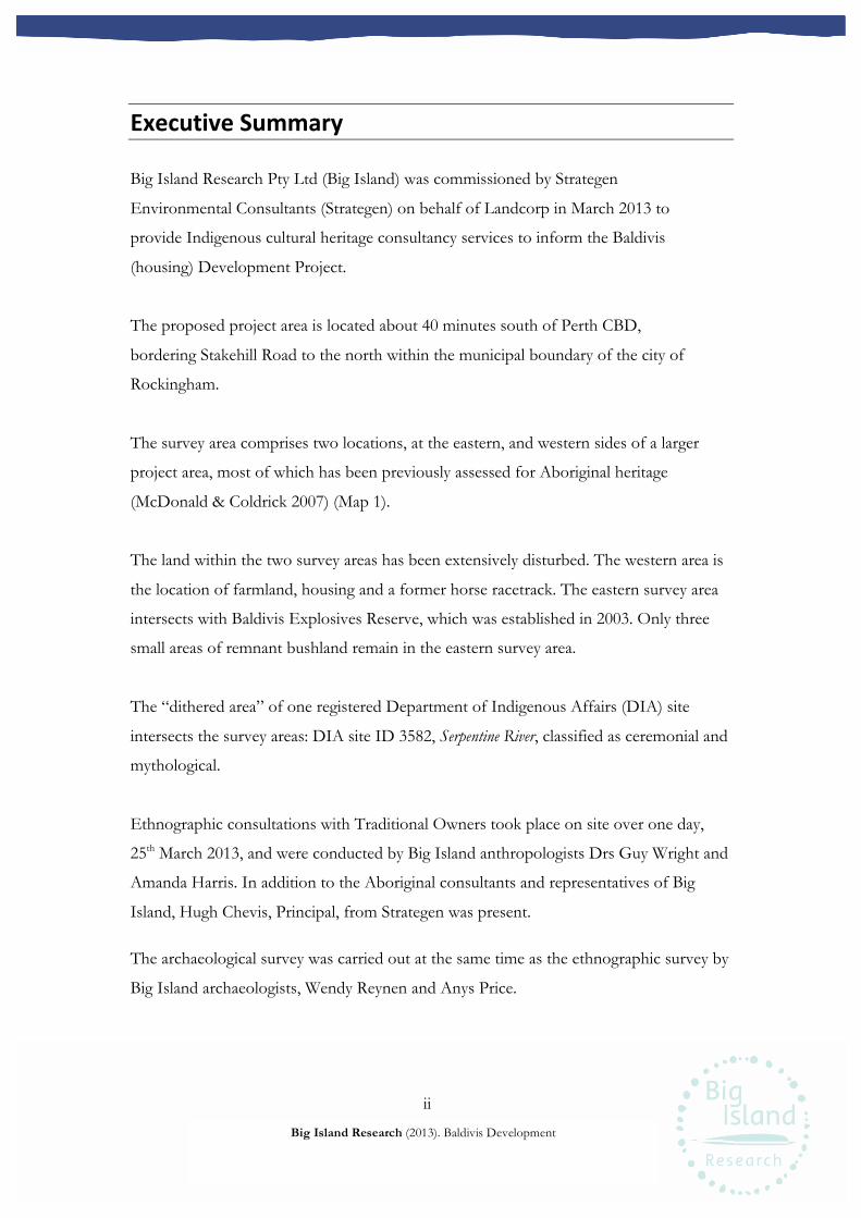
ii
Big Island Research (2013). Baldivis Development
Executive!Summary!
Big Island Research Pty Ltd (Big Island) was commissioned by Strategen
Environmental Consultants (Strategen) on behalf of Landcorp in March 2013 to
provide Indigenous cultural heritage consultancy services to inform the Baldivis
(housing) Development Project.
The proposed project area is located about 40 minutes south of Perth CBD,
bordering Stakehill Road to the north within the municipal boundary of the city of
Rockingham.
The survey area comprises two locations, at the eastern, and western sides of a larger
project area, most of which has been previously assessed for Aboriginal heritage
(McDonald & Coldrick 2007) (Map 1).
The land within the two survey areas has been extensively disturbed. The western area is
the location of farmland, housing and a former horse racetrack. The eastern survey area
intersects with Baldivis Explosives Reserve, which was established in 2003. Only three
small areas of remnant bushland remain in the eastern survey area.
The “dithered area” of one registered Department of Indigenous Affairs (DIA) site
intersects the survey areas: DIA site ID 3582, Serpentine River, classified as ceremonial and
mythological.
Ethnographic consultations with Traditional Owners took place on site over one day,
25th March 2013, and were conducted by Big Island anthropologists Drs Guy Wright and
Amanda Harris. In addition to the Aboriginal consultants and representatives of Big
Island, Hugh Chevis, Principal, from Strategen was present.
The archaeological survey was carried out at the same time as the ethnographic survey by
Big Island archaeologists, Wendy Reynen and Anys Price.
iii
Big Island Research (2013). Baldivis Development
Results!
No new ethnographic or archaeological sites or materials were identified during the
survey. The Gnaala Karla Booja survey team members concluded that there were no
ethnographic or archaeological impediments to the proposed works.
The eastern survey area sits within the dithered area for Site ID 3582, Serpentine River.
However, the survey area does not extend near to the river and consequently there
should be no need to further refer to the Aboriginal Heritage Act 1972 in respect of the
area.
Monitoring!
The survey participants requested that cultural monitoring should take place during
the initial ground disturbing activities to ensure that any artefacts that may exist sub-
surface might be found and preserved.
Recommendations!
Big Island Research Pty Ltd recommends the following.,
1. Aboriginal cultural monitors should be engaged on a rotational basis during future
ground disturbing works.
2. If, during ground excavations, any subsurface archaeological material is
encountered, all work in the vicinity should be stopped and archaeological material
left in situ while are notified and agreed management processes are determined,
with professional assistance as required.
3. If human skeletal material is uncovered the police must be notified immediately, as
required by law and the Department of Indigenous Affairs and the Gnaala Karla
Booja Traditional Owners notified to enable, if required, culturally appropriate
management of buried material.

iv
Big Island Research (2013). Baldivis Development
Ownership!of!Information!
This report has been prepared for submission to Strategen, acting on behalf of
Landcorp. Any cultural information contained within the report is the property of the
people who provided the information. This report and the information it contains
may not be copied in whole or part without written consent of the Landcorp and Big
Island Research Pty Ltd. However, it is written for the purpose of assisting the
Landcorp with its Aboriginal heritage approvals processes and any copying associated
with this purpose is permitted.
Report!Authors!
Ethnographic: Guy Wright PhD, Amanda Harris PhD
Archaeological: Wendy Reynen BA(Hons), Anys Price MSc
Disclaimer!
Big Island is not responsible for omissions and inconsistencies that may result from
information not available at the time this report was prepared.
v
Big Island Research (2013). Baldivis Development
Contents! Executive'Summary'..................................................................................................................................'ii!
Results'.......................................................................................................................................'iii!Monitoring'................................................................................................................................'iii!Recommendations'....................................................................................................................'iii!
Introduction'.............................................................................................................................................'1!Synopsis'...................................................................................................................................................'2!
Location,'Environment'and'Disturbance'...................................................................................'2!Survey'Areas'..............................................................................................................................'3!
Heritage'Framework'................................................................................................................................'5!Ethnographic'Context'................................................................................................................'5!Archaeological'Context'..............................................................................................................'5!Previously'Recorded'Sites'..........................................................................................................'6!
Survey'Participants'...................................................................................................................................'9!Ethnographic'Survey'..............................................................................................................................'11!
Survey'Method'........................................................................................................................'11!Results'......................................................................................................................................'11!
Archaeological'Survey'............................................................................................................................'14!Survey'Method'........................................................................................................................'14!Results'......................................................................................................................................'14!
General'Conclusions'...............................................................................................................................'15!Recommendations'.................................................................................................................................'16!References'.............................................................................................................................................'17!Appendix'1'–'Site'Definitions'.................................................................................................................'20!Appendix'2'–'Abbreviations'...................................................................................................................'21!Map'1.'Location'of'the'survey'areas'......................................................................................................'22!Map'2.'Location'of'DIA'sites'in'the'vicinity'of'the'survey'areas'............................................................'23!
' '
1
Big Island Research (2013). Baldivis Development
Introduction!
Big Island Research Pty Ltd (Big Island) was commissioned by Strategen Environmental
Consultants (Strategen) on behalf of Landcorp in March 2013 to provide Indigenous
cultural heritage consultancy services to inform the Baldivis Development Project.
Strategen has been commissioned by Landcorp to complete all environment and
planning approvals for the development.
The survey area comprises two locations at the eastern and western perimeter of the
larger project area, most of which has been previously surveyed (McDonald & Coldrick
2007) (Map 1).
The ultimate timeframe for completion of this development was said to be between 30
and 40 years. The purpose of these consultations is to assist Landcorp in addressing
heritage issues at the planning stage. The developmment will entail the construction of
housing and associated infrastructure.
Ethnographic consultations with Gnaala Karla Booja Traditional Owners took place on
site on 25th March 2013, and were conducted by Big Island anthropologists Drs Guy
Wright and Amanda Harris. In addition to the Aboriginal consultants and representatives
of Big Island, Hugh Chevis, Principal, from Strategen was present.
The archaeological survey was carried out at the same time as the ethnographic survey by
Big Island archaeologists, Wendy Reynen and Anys Price.
A total of eight Nyoongar individuals participated in the ethnographic consultations.
These people were drawn from a list of nominees provided by the South West
Aboriginal Land and Sea Council (SWALSC), as having a “right to speak” about cultural
matters in the Baldivis region.
2
Big Island Research (2013). Baldivis Development
Synopsis!
Location,!Environment!and!Disturbance!
The proposed project area is located about 50 kilometres south of Perth CBD, bordering
Stakehill Road to the north within the municipal boundary of the City of Rockingham
(Maps 1 and 2). The project area is on land owned by Landcorp (Map 2).
The project area is situated within a wider wetland region around a kilometre west of the
Serpentine River. Stakehill Swamp lies to the northwest of the project area and a series of
swamps remain to the east, running in a north-south direction. Remnant swamps remain
within the project area and at least one, according the Traditional Owners, has been filled
in within or close to the project area during previous developments. The swamps belong
to the Stakehill suite of wetlands, which are a series of local sumplands in inter-dunal
swales of the Spearwood dune system. The wetlands are seasonally inundated basins,
which have water above the ground for part of the year and are dry for the remainder
(WAPC 2010).
The land within the two survey areas has been extensively disturbed. The western area is
the location of farmland, housing and a former racetrack. The eastern survey area
intersects with Baldivis Explosives Reserve, which was established in 2003. Only three
areas of bushland remain in the eastern survey area. The rest of the area consists of
cleared land, storage facilities, roads and associated infrastructure. The remaining natural
vegetation includes remnant tuart (Eucalyptus gomphocephala), some marri (Corymbia
calophylla) and jarrah (Eucalyptus marginata) trees.
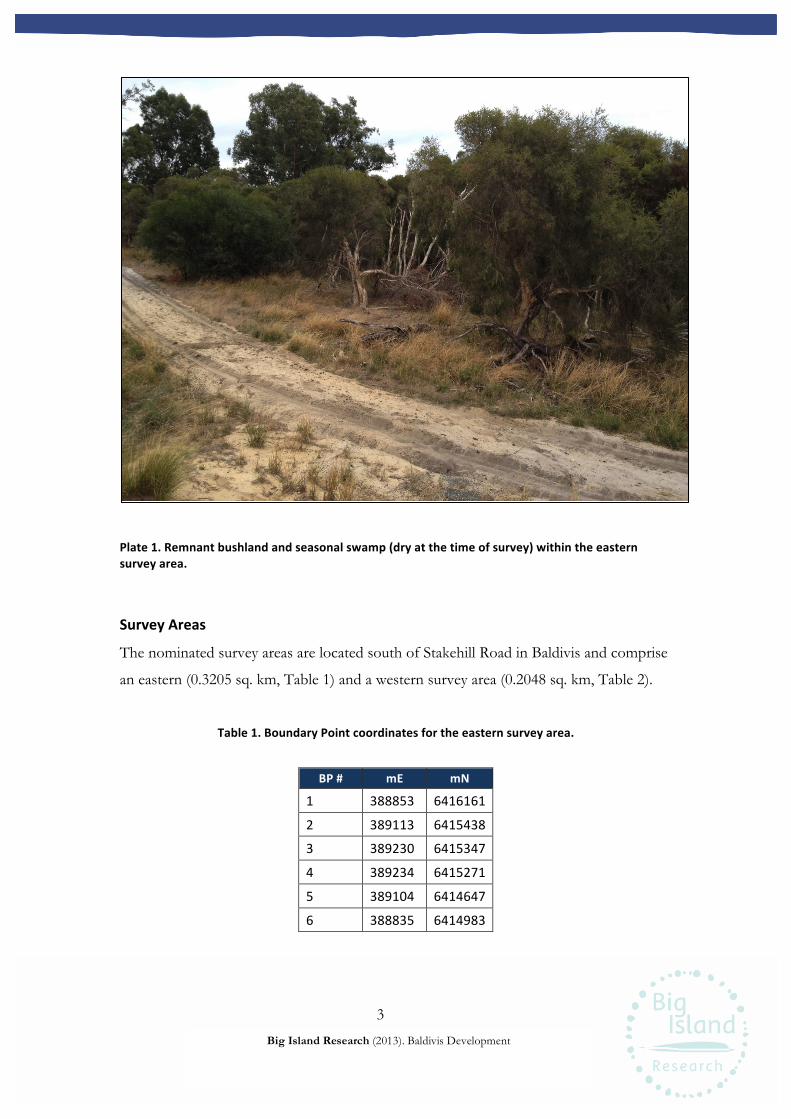
3
Big Island Research (2013). Baldivis Development
Plate!1.!Remnant!bushland!and!seasonal!swamp!(dry!at!the!time!of!survey)!within!the!eastern!survey!area.!
Survey!Areas!
The nominated survey areas are located south of Stakehill Road in Baldivis and comprise
an eastern (0.3205 sq. km, Table 1) and a western survey area (0.2048 sq. km, Table 2).
Table!1.!Boundary!Point!coordinates!for!the!eastern!survey!area.!
BP!#! mE! mN!
1' 388853' 6416161'
2' 389113' 6415438'
3' 389230' 6415347'
4' 389234' 6415271'
5' 389104' 6414647'
6' 388835' 6414983'!!
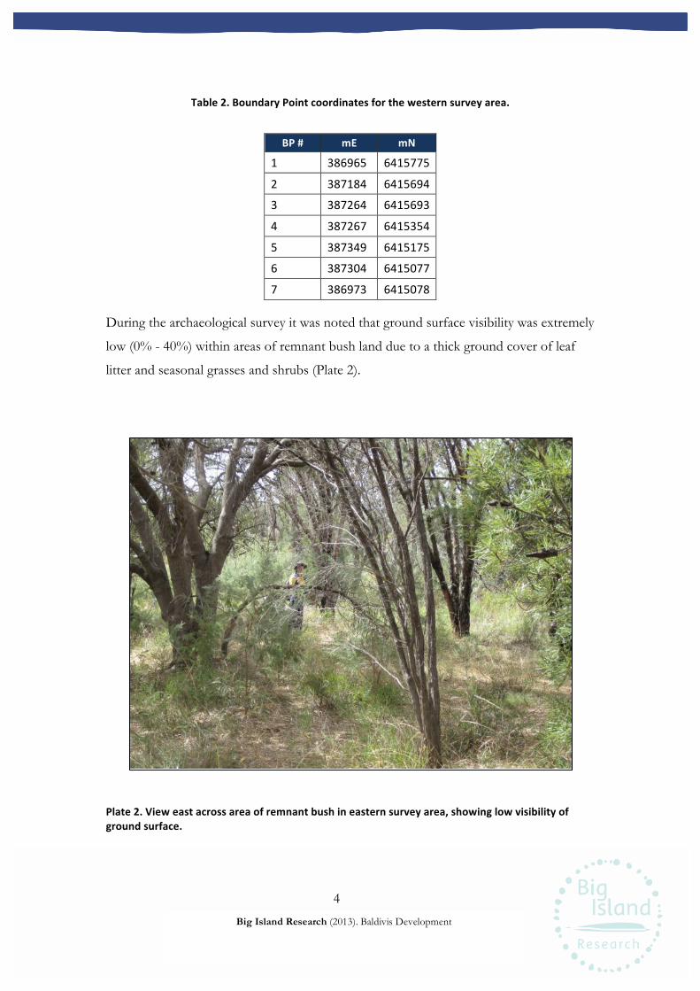
4
Big Island Research (2013). Baldivis Development
!!
Table!2.!Boundary!Point!coordinates!for!the!western!survey!area.!
BP!#! mE! mN!
1' 386965' 6415775'
2' 387184' 6415694'
3' 387264' 6415693'
4' 387267' 6415354'
5' 387349' 6415175'
6' 387304' 6415077'
7' 386973' 6415078'!During the archaeological survey it was noted that ground surface visibility was extremely
low (0% - 40%) within areas of remnant bush land due to a thick ground cover of leaf
litter and seasonal grasses and shrubs (Plate 2).
!
Plate!2.!View!east!across!area!of!remnant!bush!in!eastern!survey!area,!showing!low!visibility!of!ground!surface.!
5
Big Island Research (2013). Baldivis Development
Heritage!Framework!
Ethnographic!Context!
The identity of the Aboriginal peoples occupying the wider region of the survey areas
at the time of British contact was reported by both Tindale (1974) and Berndt (1979)
as the Pinjarup socio-linguistic group. An alternative picture is reported by Daisy
Bates (1979) who referred to the people of the area as the Kuri Wongi. According to
Bates the Kuri Wongi belonged to the larger grouping known as the Bibbulmun. Tindale
(1974) described the boundary of this group as delineated by a line than joined
Rockingham, or Mangles Bay, to Jarrahdale in the northeast, southeast to Collie and
then west to Bunbury.
As reported by a number of researchers, ethnographic and archaeological evidence
suggests that occupation of the land by Aboriginal groups was concentrated along the
riverways, inland lakes and wetlands. Movement into the coastal dunes was on an
opportunistic basis (Hallam 1975, O’Connor & Coldrick 2007, O’Connor,
Quartemaine & Bodney 1989, Lock & Harris 1990).
Currently the members of the Gnaala Karla Booja group claim native title rights
within the area and can be assumed to be descended from the groups who have lived
in this area from time immemorial. The Gaala Karla Booja native title claim group is
represented by the South West Aboriginal Land and Sea Council (SWALSC).
Archaeological!Context!
The Swan Coastal Plain and the adjoining Darling Scarp has been inhabited by
Aboriginal people for at least 40,000 years. The oldest known sites in this area are located
near major river systems on the Swan Coastal Plain, with the earliest evidence for
occupation radiocarbon dated to 39,500BP +/- 2300 years BP at Upper Swan Bridge
(Pearce and Barbetti 1981), and 27,000 years ago at Helena River, in Midland (Schwede
1983). Numerous other sites in this area have provided radiocarbon dates including
10,000 years ago at Minim Cove in Mosman Park (Clarke and Dortch 1977), 8,000 years
ago at Walyunga in Upper Swan (Pearce 1978), 4,500 years ago at Orchestra Shell Cave in
Wanneroo (Hallam 1975) and 2,500 years ago at Brigadoon in Millendon (Schwede
6
Big Island Research (2013). Baldivis Development
1990). These sites confirm the human occupation of the Swan Coastal Plain and Darling
Scarp over tens of thousands of years.
To date, more than 1,000 Aboriginal sites have been recorded in the greater Perth
Metropolitan area, mostly as a result of development-driven consulting. Archaeological
sites range from large, complex artefact scatters with diverse stone assemblages including
backed blades, grinding material and retouched artefacts to small discrete artefact scatters
dominated by unretouched quartz flakes (Hallam 1987: 20). Despite massive disturbance
from commercial and residential developments, surveys and excavations have established
that subsurface archaeological material including stone artefacts and human skeletal
remains is still found in the Perth Metropolitan area (Fisher et al 2002; Fisher et al 2000;
Przywolnik and Harrison 2000).
Ethnographic and historical documents highlight the importance of water sources such
as rivers, lakes and wetlands to Noongar land use patterns, ceremonial cycles and
mythological tracks (Hallam 1975; Hammond 1933). Archaeological research has
demonstrated that the lakes and wetlands of the coastal and riverine zones were more
intensively used than the Darling Scarp or the seaward margin of the coastal zone
(Hallam 1987:23). The majority of archaeological sites are found in close proximity to
water sources on the Swan Coastal Plain, with the largest sites located on elevated dunes
and sand ridges near the Swan River and its tributaries, and other lakes and wetlands
(Anderson 1984; Hallam 1975, 1987; Bowdler et al 1991; Strawbridge 1988). Lake,
wetland and riverine areas typically contain a high number of large artefact scatters with
diverse assemblages. Available evidence suggests a seasonal model of occupation in
which Noongar groups focused on the resource rich areas of the Swan Coastal Plains
during the summer months (November to March) and dispersed into smaller groups
through the wider hinterland of the Darling Scarp during the winter and spring (April to
October) (Anderson 1984: 36-38).
Previously!Recorded!Sites One registered DIA site intersects the survey areas: DIA site ID 3582, Serpentine River,
classified as ceremonial and mythological. The spatial boundary of site 3582 is denoted
by a two kilometre square and encompasses the entirety of the eastern survey area (Map
2). This large square is a ‘dithered’ area generated by DIA that extends well beyond the
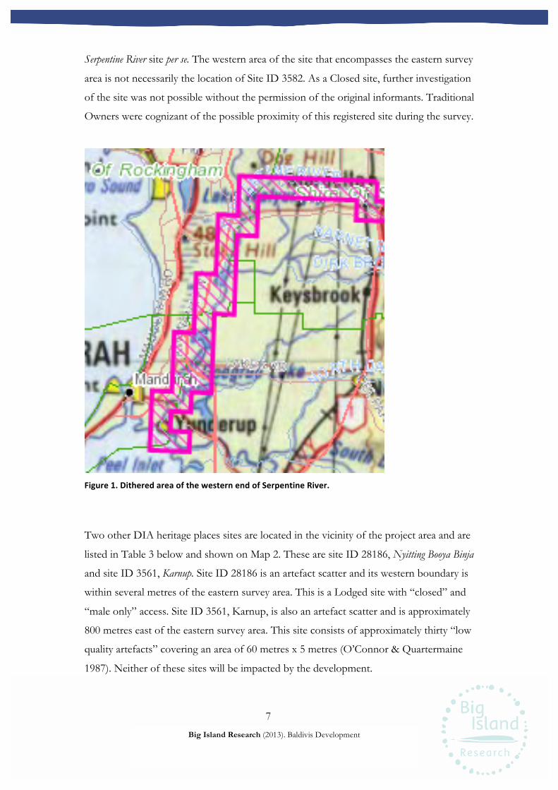
7
Big Island Research (2013). Baldivis Development
Serpentine River site per se. The western area of the site that encompasses the eastern survey
area is not necessarily the location of Site ID 3582. As a Closed site, further investigation
of the site was not possible without the permission of the original informants. Traditional
Owners were cognizant of the possible proximity of this registered site during the survey.
Figure!1.!Dithered!area!of!the!western!end!of!Serpentine!River.!
Two other DIA heritage places sites are located in the vicinity of the project area and are
listed in Table 3 below and shown on Map 2. These are site ID 28186, Nyitting Booya Binja
and site ID 3561, Karnup. Site ID 28186 is an artefact scatter and its western boundary is
within several metres of the eastern survey area. This is a Lodged site with “closed” and
“male only” access. Site ID 3561, Karnup, is also an artefact scatter and is approximately
800 metres east of the eastern survey area. This site consists of approximately thirty “low
quality artefacts” covering an area of 60 metres x 5 metres (O’Connor & Quartermaine
1987). Neither of these sites will be impacted by the development.
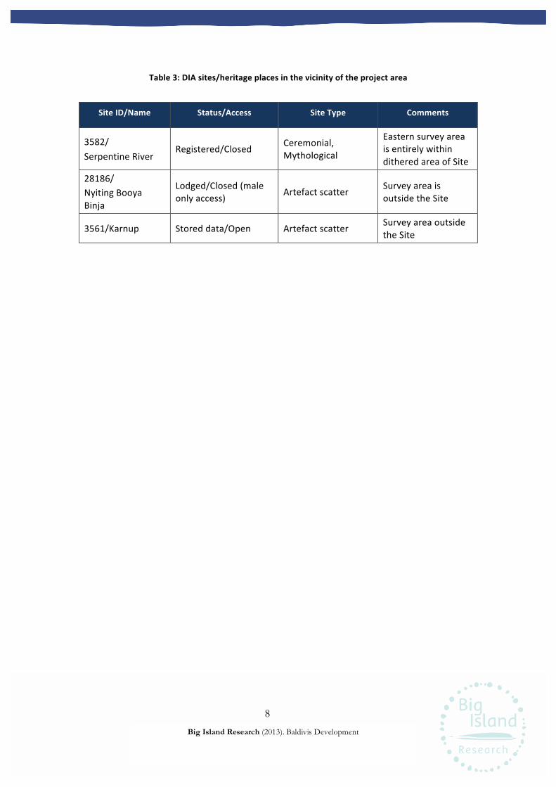
8
Big Island Research (2013). Baldivis Development
Table!3:!DIA!sites/heritage!places!in!the!vicinity!of!the!project!area!
Site!ID/Name! Status/Access! Site!Type! Comments!
3582/'Serpentine'River'
Registered/Closed' Ceremonial,'Mythological'
Eastern'survey'area'is'entirely'within'dithered'area'of'Site'
28186/''Nyiting'Booya'Binja'
Lodged/Closed'(male'only'access)' Artefact'scatter' Survey'area'is'
outside'the'Site'
3561/Karnup' Stored'data/Open' Artefact'scatter' Survey'area'outside'the'Site'
! !
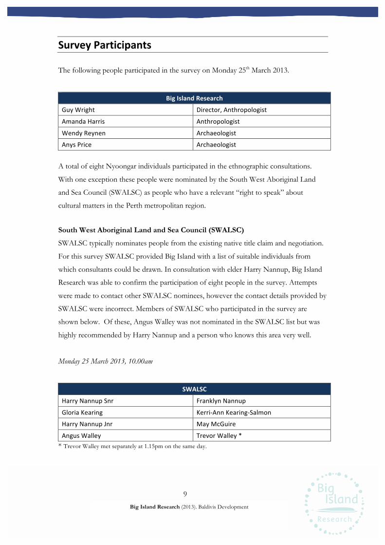
9
Big Island Research (2013). Baldivis Development
Survey!Participants!
The following people participated in the survey on Monday 25th March 2013.
Big!Island!Research!
Guy'Wright' Director,'Anthropologist'
Amanda'Harris' Anthropologist'
Wendy'Reynen' Archaeologist'
Anys'Price' Archaeologist' A total of eight Nyoongar individuals participated in the ethnographic consultations.
With one exception these people were nominated by the South West Aboriginal Land
and Sea Council (SWALSC) as people who have a relevant “right to speak” about
cultural matters in the Perth metropolitan region.
South West Aboriginal Land and Sea Council (SWALSC)
SWALSC typically nominates people from the existing native title claim and negotiation.
For this survey SWALSC provided Big Island with a list of suitable individuals from
which consultants could be drawn. In consultation with elder Harry Nannup, Big Island
Research was able to confirm the participation of eight people in the survey. Attempts
were made to contact other SWALSC nominees, however the contact details provided by
SWALSC were incorrect. Members of SWALSC who participated in the survey are
shown below. Of these, Angus Walley was not nominated in the SWALSC list but was
highly recommended by Harry Nannup and a person who knows this area very well.
Monday 25 March 2013, 10.00am
SWALSC!
Harry'Nannup'Snr' Franklyn'Nannup'
Gloria'Kearing' Kerri]Ann'Kearing]Salmon'
Harry'Nannup'Jnr' May'McGuire'
Angus'Walley' Trevor'Walley'*'* Trevor Walley met separately at 1.15pm on the same day.
!
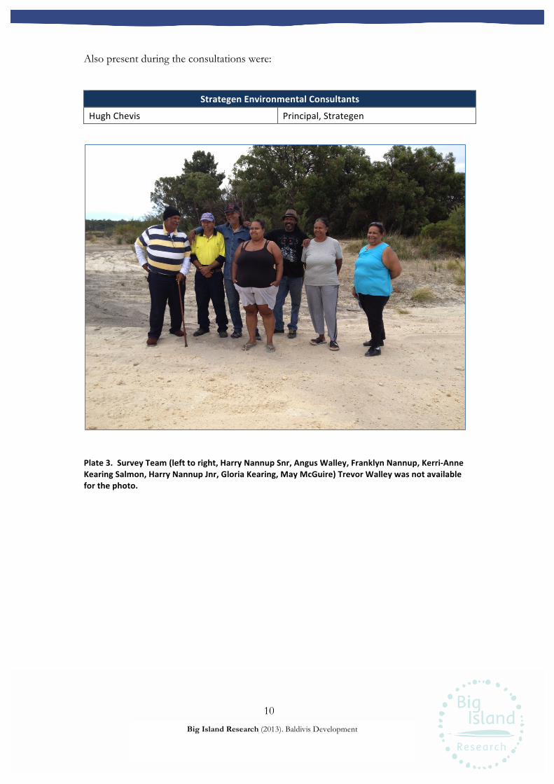
10
Big Island Research (2013). Baldivis Development
Also present during the consultations were:
Strategen!Environmental!Consultants!
Hugh'Chevis' Principal,'Strategen'
Plate!3.!!Survey!Team!(left!to!right,!Harry!Nannup!Snr,!Angus!Walley,!Franklyn!Nannup,!KerriXAnne!Kearing!Salmon,!Harry!Nannup!Jnr,!Gloria!Kearing,!May!McGuire)!Trevor!Walley!was!not!available!for!the!photo.! !

11
Big Island Research (2013). Baldivis Development
Ethnographic!Survey!
Survey!Method!
Anthropologists Guy Wright and Amanda Harris of Big Island met Hugh Chevis of
Strategen and the Gnaala Karla Booja (GKB) representatives at the corner of Stakehill
Road and Harvey Road on Monday 25th March 2013. Guy Wright provided an overview
of the project before Hugh Chevis of Strategen, briefed meeting participants on the
proposed works. The purpose of the project, background and timeline were explained
with the aid of maps made available to participants.
Consultations commenced at the eastern boundary of the western survey area. The
survey team travelled the length of the area to its south-eastern boundary along Harvey
Road and were given the opportunity to enter the survey areas at several locations. When
the GKB representatives agreed that they had seen sufficient of the western area, the
survey team drove to the eastern survey area. Entry was gained with the assistance of
staff at the Baldivis Explosive Reserve. Reserve staff accompanied the survey team while
on the Reserve.
Participants were given ample opportunity to traverse the survey areas, present their
views, discuss the project and ask questions. Trevor Walley attended the survey
separately. He and his sister, Cheryl Martin, came at 1330 and were shown through the
two survey areas in the same pattern as the other GKB representatives.
When the GKB representatives were satisfied with the survey and discussions, a private
discussion continued with the Big Island anthropologists. The position and views of the
group were discussed further and clarified.
Results!
The GKB representatives demonstrated their knowledge and association with the area.
Harry Nannup described the years he spent driving cattle through the area on horseback
from the western Stakehill Road area to the Serpentine River, before some of the
swamps were filled in, paddocks and fences existed, pine forests had been planted or the
12
Big Island Research (2013). Baldivis Development
Kwinana Freeway existed. “I’ve been around this area all my life”, he said. The group felt
that the trails he would have made and travelled along then were important to them.
Angus Walley described the waterholes that exist in the area. He showed the location of
past waterholes that have since been filled by development works. Franklyn Nannup
pointed out that while the Serpentine River would have been the place where Aboriginal
people would have more frequently lived, the waterholes would have been important
areas for trapping animals. “There would have been pockets of people here”, suggested
Angus, “not lots”. Like Harry Nannup, Angus’ family has also worked the area; they
played a part in establishing the pine plantations in the 1960s.
Franklyn Nannup placed the survey areas within the wider region by pointing out and
naming other places on the horizon. The group remarked on the extensive amount of
disturbance that had occurred in the area and the unlikeness of finding any material of
archaeological significance on the surface due to the disturbance and the high levels of
ground cover. However, their view was that artefacts could still exist beneath the
surface.
The group requested that Aboriginal monitors are present for all future ground
disturbing works. Hugh Chevis assured the group that the need for monitoring would be
taken into account prior to the commencment of ground disturbing works.
Trevor Walley spoke about the times he used to travel through the eastern survey area
and camp by the Serpentine River. He said he grown up in the area, mainly in camps
nearby and knew it well. He described the jilgies they used to catch and the kangaroo they
hunted. Trevor pointed out several edible plants growing within the survey areas
including the fruit of the “snotty gobble”, which is also one of his family’s totems, he
said. He spoke about the small spirit people, or woodarchies, they had seen in the area after
dark. Trevor also spoke about one particular karnup spirit, that of a woman who was
known to travel through the area and cry out thrice during the night.
13
Big Island Research (2013). Baldivis Development
The GKB representatives acknowledged the extensive disturbance that had already
occurred within the two survey areas. No ethnographic impediments to the proposed
works were identified.
!
14
Big Island Research (2013). Baldivis Development
Archaeological!Survey!
Survey!Method!
A series of parallel transects some 30-50 m apart was walked by archaeologists Wendy
Reynen and Anys Price along the length and breadth of the western survey area. Areas
of remnant bush were targeted as part of this approach. As much of the eastern survey
area has been extensively disturbed, a sampling method was used to inspect this area. It
was agreed, following discussion with the GKB representatives that there was no point in
looking for artefacts in the areas that had been extensively disturbed. The remaining
three areas that contained remnant bush were inspected on foot by a series of parallel
transects some 10-30 m apart. These remnant bush areas comprise 62,361 sq. m, or
approximately 20% of the eastern survey area.
Results!
Archaeological survey of nominated survey areas has been completed (Map 1). No
archaeological sites were identified during the survey.
!
15
Big Island Research (2013). Baldivis Development
General!Conclusions!
Traditional Owners said that they were satisfied with the conduct of the ethnographic
and archaeological surveys. No new ethnographic or archaeological sites or materials
were identified during the survey. The GKB representatives concluded that there were
no ethnographic or archaeological impediments to the proposed works.
The eastern survey area sits within the dithered area for Site ID 3582, Serpentine River.
However, Site ID 3582 is the Serpentine River itself. In the past, the Aboriginal Cultural
Material Committee, which has a responsibility to evaluate places alleged to be associated
with Aboriginal people, has taken a view that 30 metres landward from the ordinary
banks of major waterways should be accepted as being within the cultural site, where the
river constitutes a site. So, for example, the Swan and Canning rivers in Perth are sites
recognised by the AHA and are protected, including the area 30 metres from their banks.
Section 18 consent to use this land is required. In this case, the Serpentine River is more
than 30 metres away from the areas that were assessed for heritage values. Although the
“dithered” area shown on the DIA mapping extends into the eastern assessed area, this is
not a representation of the site per se.
Monitoring Requested
All participants requested that cultural monitoring should be supported to ensure
there is an appropriate Noongar presence during the disturbance of the spiritual
values of the sites, and that artefacts that may exist beneath the surface of the area
might be located.
!
16
Big Island Research (2013). Baldivis Development
Recommendations!
Big Island Research Pty Ltd recommends the following.
1. Aboriginal cultural monitors should be engaged on a rotational basis during
future ground disturbing works.
2. If, during ground excavations, any subsurface archaeological material is
encountered, all work in the vicinity should be stopped and archaeological
material left in situ while Gnaala Karla Booja Traditional Owners are notified and
agreed management processes are determined, with professional assistance as
required.
3. If human skeletal material is uncovered the police must be notified immediately,
as required by law and the Department of Indigenous Affairs and the Combined
Metropolitan Native Title Holders (CMNTH) notified to enable, if required,
culturally appropriate management of buried material.
17
Big Island Research (2013). Baldivis Development
References!
Anderson, J. 1983. Test pits and supplementary survey at Perth Airport, Western
Australia. Unpublished report for the Department of Housing and Construction.
Anderson, J 1984. Between Plateau and Plain. Occasional Papers in Prehistory, Research
School of Pacific Studies, ANU Canberra.
Blockly, E., K. Edwards, and A. Murphy. 1996. Addendum to a report of an Aboriginal
heritage survey proposed Tonkin Highway Extension (Option 1c). Unpublished report
for the Ministry of Planning.
Bowdler, S., Strawbridge, L. and M. Schwede. 1991. Archaeological mitigation in the
Perth Metropolitan Region. Australian Archaeology 32:21-25.
Clarke, J. and Dortch, C. 1977. A 10,000 year BP radiocarbon date for archaeological
finds within a soil of the Spearwood Dune System, Mosman Park, WA. Search 8: 36-38.
Edwards, E. And E. McDonald. 1998. Report of an Aboriginal Heritage Survey:
proposed Tonkin Highway Extension and Mundijong Road Realignment Project.
Unpublished report for Main Roads Western Australia.
Fisher, S., S. Corsini, M. Morris, & M Waite. 2002. Report on a Heritage Survey of the
Proposed Redevelopment of Perth Oval, Town of Vincent. Unpublished report for the
Town of Vincent.
Fisher, S., J. Dortch, & M. Waite. 2000. Report on a Heritage Survey of Proposed
Developments for the Upgrade of the City Foreshore, Perth W.A. Unpublished report
for the City of Perth.
Gozard, J.R. 2007. Geology and Landforms of the Perth Region. Geological Survey of Western
Australia: Perth.
18
Big Island Research (2013). Baldivis Development
Hallam, S. J. 1972. ‘An archaeological survey of the Perth area, Western Australia: a
progress report on art and artefacts, dates and demography’, Australian Institute of
Aboriginal Studies Newsletter 3(5): 11-19.
Hallam, S. J. 1975. Fire and Hearth: a study of Aboriginal usage and European usurpation in south-
western Australia. AIAS: Canberra.
Hallam , S. J. 1987. Yams, Alluvium and Villages on the West Coastal Plain. In. Smith, M.
Archaeology at ANZAAS. Anthropology Department, Western Australian Museum: Perth.
Hammond, J. E. 1933. Winjan’s people. Imperial Printing: Perth.
Lantzke, D. 2003. Report on an archaeological analysis of site S02956 (SEC/EA1) at Lot
5057 (formerley Lot 10) and Lot 5056 (formerly Lots 1 and 78) Allen Road, Forrestdale.
Unpublished report for Acacia Brook Pty Ltd.
Locke, R. G. and Harris, J. 1990. Report of an Archaeological and Ethnographic Survey
for Aboriginal Sites: Secret harbour. Unpublished report prepared for McDonald Hales
& Assoc. for Secret harbour Pty Ltd.
McDonald Hales and Associates Pty Ltd. 2001. A report on Aboriginal Heritage
Investigations of the Proposed Champion Lakes Development, Westfield. Unpublished
report for the City of Armadale.
McDonald Hales and Associates Pty Ltd. 1998. Report of an Aboriginal heritage survey:
proposed Tonkin Hwy extension and Mundijong Road Realignment Project.
Unpublished report for Main Roads WA and BSD Consultants Pty Ltd.
O’Connor, R. G. Quartermaine and C. Bodney. 1989. Report on an Investigation into
Aboriginal Significance of Wetlands and Rivers in the Perth- Bunbury Region. Western Australian
Water Resources Council: Leederville.
19
Big Island Research (2013). Baldivis Development
Pearce, R.H. 1978. Changes in artefact assemblages during the last 8000 years at
Walyunga, Western Australia. Journal of the Royal Society of Western Australia 61: 1-10.
Pearce, R.H. and M. Barbetti. 1981. A 38,000 year old archaeological site at Upper Swan,
Western Australia. Archaeology in Oceania 16:173-178.
Przywolnik, K., R Harrison, & S. Burke. 2000. Report of an archaeological survey of
Robertson park. Unpublished Report for the Town of Vincent.
Schwede, M. 1983. Supertrench – Phase 2, a report on excavation results. In Smith, M.
(ed) Archaeology at ANZAAS, pp 53-62. Western Australian Museum: Perth.
Schwede, M. 1990. Quartz, the Multifaceted Stone: A regional prehistory of the Helena
River Valley on the Swan Coastal Plain of Southwestern Australia. Unpublished PhD
Thesis.
Strawbridge, L. 1988. Aboriginal sites in the Perth metropolitan area: a management
scheme. Report to the Department of Aboriginal Sites, Western Australian Museum,
Perth.
Western Australian Planning Commission 2010. ‘Stakehill Swamp, Baldivis.
Environmental Management Plan, December 2010’.
Western Australian Tourism Commission, 1986. ‘Tourism Development Plan, Swan
Valley’, March.
Wright, G. and Harris A. 2011. ‘Ethnographic Heritage Consultation Report,
Metropolitan Area Indigenous Groups, Perth Waterfront Project Phase 3’, prepared for
the Government of Western Australia Department of Planning.
! !

20
Big Island Research (2013). Baldivis Development
Appendix!1!–!Site!Definitions!
The following links provide Aboriginal site definitions as defined by the Department of
Indigenous Affairs:
http://www.dia.wa.gov.au/en/Heritage-and-Culture/Aboriginal-heritage/Aboriginal-
sites/
and
http://www.dia.wa.gov.au/en/Heritage-and-Culture/Aboriginal-heritage/Aboriginal-
sites/Aboriginal-site-types/

21
Big Island Research (2013). Baldivis Development
Appendix!2!–!Abbreviations!
Big Island Big Island Research Pty Ltd
DIA Department of Indigenous Affairs
Strategen Strategen Environment Consultants
the Act The Aboriginal Heritage Act 1972
Related Documents


