A) Brazil Current B) Guinea Current C) Falkland Current D) California Current 1. Which ocean current transports warm water away from Earth’s equatorial region? A) warmer and drier B) warmer and more humid C) cooler and drier D) cooler and more humid 2. The Gulf Stream and North Atlantic Current modify the climate of northwestern Europe by making the climate A) 0º and 30º N B) 60º N and 60º S C) 30º N and 30º S D) 60º S and 90º S 3. At which latitudes do currents of dry, sinking air cause the dry conditions of Earth's major deserts? A) cool current, flowing north B) cool current, flowing south C) warm current, flowing north D) warm current, flowing south 4. The California Ocean Current, which flows along the west coast of North America, is a A) thermosphere B) mesosphere C) stratosphere D) troposphere 5. Most of Earth's weather events take place in the A) Wind direction is modified by the Earth's rotation. B) Wind direction is modified by land forms. C) Wind direction is modified by water areas. D) Wind direction is modified by the Sun's motion. 6. The diagram below shows the Earth's high and low air pressure belts and direction of prevailing winds for a particular time of the year. The winds do not appear to blow in a straight line from the high-pressure belts to the low-pressure belts. Which statement best explains this observation? A) London is located closer to the equator. B) London is located at a higher elevation. C) London’s climate is modified by the North Atlantic Ocean Current. D) London’s climate is modified by its longer duration of insolation. 7. London, England, is located at approximately 51° 30' north latitude and 0° longitude. Elmira, New York, is located at approximately 42° 10' north latitude and 76° 54' west longitude. What is one reason why London has a warmer average winter temperature than Elmira? A) low elevation and low latitude B) low elevation and high latitude C) high elevation and low latitude D) high elevation and high latitude 8. Which combination of climate factors generally results in the coldest temperatures?

Welcome message from author
This document is posted to help you gain knowledge. Please leave a comment to let me know what you think about it! Share it to your friends and learn new things together.
Transcript

A) Brazil Current B) Guinea CurrentC) Falkland Current D) California Current
1. Which ocean current transports warm water awayfrom Earth’s equatorial region?
A) warmer and drierB) warmer and more humidC) cooler and drierD) cooler and more humid
2. The Gulf Stream and North Atlantic Current modifythe climate of northwestern Europe by making theclimate
A) 0º and 30º N B) 60º N and 60º SC) 30º N and 30º S D) 60º S and 90º S
3. At which latitudes do currents of dry, sinking aircause the dry conditions of Earth's major deserts?
A) cool current, flowing northB) cool current, flowing southC) warm current, flowing northD) warm current, flowing south
4. The California Ocean Current, which flows along thewest coast of North America, is a
A) thermosphere B) mesosphereC) stratosphere D) troposphere
5. Most of Earth's weather events take place in the
A) Wind direction is modified by the Earth'srotation.
B) Wind direction is modified by land forms.C) Wind direction is modified by water areas.D) Wind direction is modified by the Sun's motion.
6. The diagram below shows the Earth's high and low airpressure belts and direction of prevailing winds for aparticular time of the year. The winds do not appearto blow in a straight line from the high-pressure beltsto the low-pressure belts. Which statement bestexplains this observation?
A) London is located closer to the equator.B) London is located at a higher elevation.C) London’s climate is modified by the North
Atlantic Ocean Current.D) London’s climate is modified by its longer
duration of insolation.
7. London, England, is located at approximately 51° 30'north latitude and 0° longitude. Elmira, New York, islocated at approximately 42° 10' north latitude and76° 54' west longitude. What is one reason whyLondon has a warmer average winter temperaturethan Elmira?
A) low elevation and low latitudeB) low elevation and high latitudeC) high elevation and low latitudeD) high elevation and high latitude
8. Which combination of climate factors generallyresults in the coldest temperatures?

A) revolution around the SunB) seasonal changesC) rotation on its axisD) tilted axis
9. The Earth's planetary winds are deflected as a resultof the Earth's
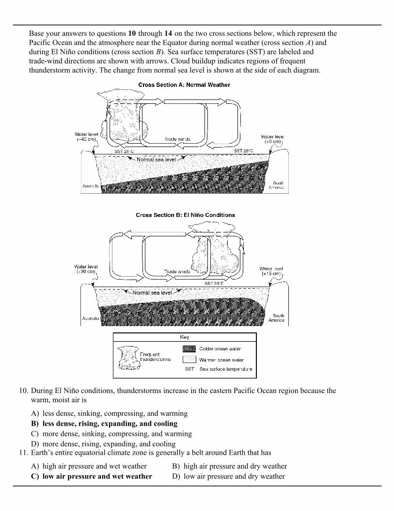
Base your answers to questions 10 through 14 on the two cross sections below, which represent thePacific Ocean and the atmosphere near the Equator during normal weather (cross section A) andduring El Niño conditions (cross section B). Sea surface temperatures (SST) are labeled andtrade-wind directions are shown with arrows. Cloud buildup indicates regions of frequentthunderstorm activity. The change from normal sea level is shown at the side of each diagram.
A) less dense, sinking, compressing, and warmingB) less dense, rising, expanding, and coolingC) more dense, sinking, compressing, and warmingD) more dense, rising, expanding, and cooling
10. During El Niño conditions, thunderstorms increase in the eastern Pacific Ocean region because thewarm, moist air is
A) high air pressure and wet weather B) high air pressure and dry weatherC) low air pressure and wet weather D) low air pressure and dry weather
11. Earth’s entire equatorial climate zone is generally a belt around Earth that has

A) decrease at both Australia and South AmericaB) decrease at Australia and increase at South AmericaC) increase at Australia and decrease at South AmericaD) increase at both Australia and South America
12. Compared to normal weather conditions, the shift of the trade winds caused sea levels during El Niñoconditions to
A) The sea surface temperatures are warmer than normal, and Pacific trade winds are fromthe west.
B) The sea surface temperatures are warmer than normal, and Pacific trade winds are from the east.C) The sea surface temperatures are cooler than normal, and Pacific trade winds are from the west.D) The sea surface temperatures are cooler than normal, and Pacific trade winds are from the east.
13. Which statement correctly describes sea surface temperatures along the South American coast andPacific trade winds during El Niño conditions?
A) changes in worldwide precipitation patternsB) the reversal of Earth’s seasonsC) increased worldwide volcanic activityD) decreased ozone levels in the atmosphere
14. The development of El Niño conditions over this region of the Pacific Ocean has caused
A) B)
C) D)
15. Which graph best shows the average annual amountsof precipitation received at different latitudes onEarth?
A) B) C) D)
16. Which map best represents the global prevailing surface wind patterns responsible for generatingAtlantic Ocean currents?
A) cooler and wetter B) cooler and drierC) warmer and wetter D) warmer and drier
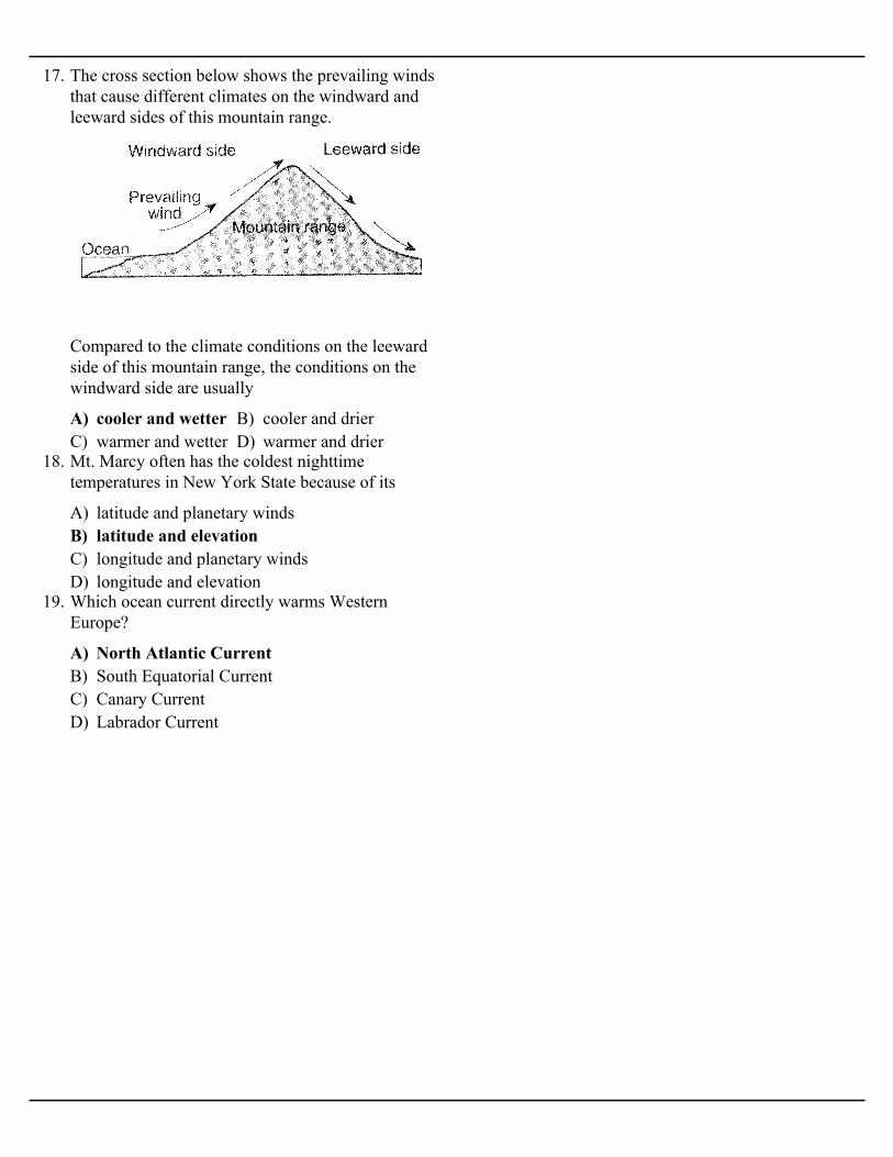
17. The cross section below shows the prevailing windsthat cause different climates on the windward andleeward sides of this mountain range.
Compared to the climate conditions on the leewardside of this mountain range, the conditions on thewindward side are usually
A) latitude and planetary windsB) latitude and elevationC) longitude and planetary windsD) longitude and elevation
18. Mt. Marcy often has the coldest nighttimetemperatures in New York State because of its
A) North Atlantic CurrentB) South Equatorial CurrentC) Canary CurrentD) Labrador Current
19. Which ocean current directly warms WesternEurope?

Base your answers to questions 20 through 23 on the maps and the passage below. The maps showdifferences in trade wind strength, ocean current direction, and water temperature associated withair-pressure changes from normal climate conditions to EI Niño conditions.
EI Niño Conditions
EI Niño conditions occur with a buildup of warm water in the equatorial Pacific Ocean off thecoast of South America. The immediate cause of this buildup is a change in air pressure that weakensthe southern trade winds. These are the planetary winds that move air from 30° S to the equator.Normally, these strong, steady winds, with the help of their counterparts in the Northern Hemisphere,push equatorial water westward away from South America. But, at intervals of two to seven years,these winds weaken, causing the westward water flow to reverse. This results in an accumulation ofunusually warm water on the east side of the equatorial Pacific Ocean. This warm water not onlychanges the characteristics of the air above it, but also is thought to be the cause of weather changesaround the world. EI Niño conditions may last only a few months, but often last a year or two.
A) northeast B) southeast C) northwest D) southwest
20. The trade winds between 30° S and the equator usually blow from the

A) cool water moving toward the equatorB) cool water moving away from the equatorC) warm water moving toward the equatorD) warm water moving away from the equator
21. Under normal climate conditions, what are the characteristics of the surface ocean current that flowsalong most of the west coast of South America?
A) falls in the western Pacific and rises in the eastern PacificB) falls in both the western and eastern PacificC) rises in the western Pacific and falls in the eastern PacificD) rises in both the western and eastern Pacific
22. Equatorial Pacific trade winds weaken during EI Niño conditions when air pressure
A) cooler and drier than usual B) cooler and wetter than usualC) warmer and drier than usual D) warmer and wetter than usual
23. During EI Niño conditions, air above the Pacific Ocean moving over the land on the equatorial westcoast of South America is likely to be .
A) B) C) D)
24. Which map represents the normal location of high and low air-pressure belts on the Earth?
A) northeast B) southeastC) southwest D) west
25. Surface ocean currents located at 40º south latitude,90º west longitude generally flow toward the
A) January, when winds blow from the landB) January, when winds blow toward high
pressureC) July, when winds blow from the oceanD) July, when winds blow toward high pressure
26. Arrows on the maps below show differences in thedirection of winds in the region of India and theIndian Ocean during January and July. Isobar valuesare recorded in millibars.
Heavy monsoon rains usually occur in India during

A) lower temperatures and less precipitationB) lower temperatures and more precipitationC) higher temperatures and less precipitationD) higher temperatures and more precipitation
27. The cross section below shows two cities, A and B at different elevations.
Compared to the yearly temperature and precipitation at city B, city A most likely has
A) The air over continents is drier than the air overoceans.
B) Cold airmasses usually originate overcontinents.
C) A large body of water modifies coastal airtemperatures.
D) Warm ocean currents flow along mostcoastlines.
28. Two cities are located at the same latitude andelevation. One city, located in the center of theUnited States, has cooler winters and warmersummers than the other city, which is located nearthe coast. Which statement best explains theseseasonal differences?
A) tsunami B) volcanic eruptionC) El Niño D) deforestation
29. Which event temporarily slows or reverses surfaceocean currents in the equatorial region of the PacificOcean, causing a disruption of normal weatherpatterns?
A) warm currents that flow away from the EquatorB) warm currents that flow toward the EquatorC) cool currents that flow away from the EquatorD) cool currents that flow toward the Equator
30. The Canaries Current along the west coast of Africaand the Peru Current along the west coast of SouthAmerica are both
A) Guinea Current and Labrador CurrentB) Brazil Current and Agulhas CurrentC) Alaska Current and Falkland CurrentD) Canaries Current and Gulf Stream Current
31. Which two ocean currents are both warm currentsthat primarily flow away from the equator?
A) converging and risingB) converging and sinkingC) diverging and risingD) diverging and sinking
32. The planetary wind and moisture belts indicate thatlarge amounts of rainfall occur at Earth's Equatorbecause air is
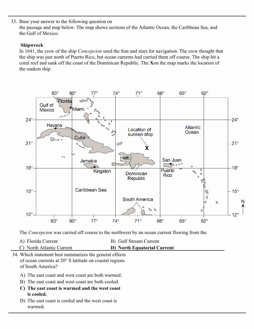
33. Base your answer to the following question on the passage and map below. The map shows sections of the Atlantic Ocean, the Caribbean Sea, andthe Gulf of Mexico.
Shipwreck In 1641, the crew of the ship Concepcion used the Sun and stars for navigation. The crew thought thatthe ship was just north of Puerto Rico, but ocean currents had carried them off course. The ship hit acoral reef and sank off the coast of the Dominican Republic. The Xon the map marks the location ofthe sunken ship.
A) Florida Current B) Gulf Stream CurrentC) North Atlantic Current D) North Equatorial Current
The Concepcion was carried off course to the northwest by an ocean current flowing from the
A) The east coast and west coast are both warmed.B) The east coast and west coast are both cooled.C) The east coast is warmed and the west coast
is cooled.D) The east coast is cooled and the west coast is
warmed.
34. Which statement best summarizes the general effectsof ocean currents at 20° S latitude on coastal regionsof South America?

A) Rising air compresses and cools, causing thewater droplets to evaporate.
B) Rising air compresses and warms, causing thewater vapor to condense.
C) Rising air expands and cools, causing thewater vapor to condense.
D) Rising air expands and warms, causing thewater droplets to evaporate.
35. The cross section below shows how prevailing windshave caused different climates on the windward andleeward sides of a mountain range.
Why does the windward side of this mountain have awet climate?
A) western coast of EuropeB) southern coast of South AmericaC) western coast of MexicoD) eastern coast of Africa
36. Waste produced by people in Delaware has beendumped into the Atlantic Ocean, where it isdistributed by surface ocean currents. Which coastalarea is most likely to become polluted by this waste?

37. Base your answer to the following question on the map below, which shows coral reef distributionand diversity (number of different coral types) around the world. Isolines on the map represent thenumber of different types of coral. Coral reefs are found mostly in shallow tropical waters and do notgrow when ocean temperatures fall below 18°C. The 18°C barrier represents the outer boundarieswithin which coral reefs normally grow. Points X and Y are locations on the map.
A) angle of the Sun's rays B) temperature of the ocean currentsC) distance from the equator D) seasonal air temperature range
Which factor most likely determines why a greater number of coral types are found farther southalong the east coast of southern Africa than along the west coast?
A) 0° B) 15° NC) 30° N D) 60° N
38. A high air-pressure, dry-climate belt is located atwhich Earth latitude?

Base your answers to questions 39 and 40 on thediagram below, which shows Earth's planetary windbelts and pressure belts.
A) high latitude to regions of low latitudeB) high pressure to regions of low pressureC) high elevation to regions of low elevationD) high temperature to regions of low temperature
39. The best inference that can be made from thisdiagram is that winds blow from regions of
A) revolution B) rotationC) gravitational field D) magnetic field
40. The surface winds shown in the diagram followcurving paths mainly due to Earth's
A) decreasing the average annual cloud coverB) decreasing the average annual
evapotranspirationC) increasing the average annual temperatureD) increasing the average annual air pressure
41. Arrows on the map represent ocean currents.
These ocean currents affect the climate pattern ofcity X by
A) at 2 a.m., when the air over land is 70°F and theair over the lake is 80°F
B) at 6 a.m., when the air over land is 70°F and theair over the lake is 70°F
C) at 2 p.m., when the air over land is 80°F andthe air over the lake is 70°F
D) at 10 p.m., when the air over land is 70°F andthe air over the lake is 72°F
42. The cross section below shows a house on the shoreof Lake Ontario in August.
Under which conditions would the wind shown inthe cross section most likely occur?

Base your answers to questions 43 through 46 on the satellite image below, which shows a NorthernHemisphere hurricane.
A) northwest B) northeast C) southwest D) southeast
43. When the eye of this hurricane reaches 43° N latitude, this hurricane will most likely be pushed byplanetary winds toward the
A) continental tropical B) maritime tropicalC) continental polar D) maritime polar
44. Which air mass is normally associated with the formation of hurricanes?
A) sinking, expanding, and cooling B) sinking, compressing, and warmingC) rising, expanding, and cooling D) rising, compressing, and warming
45. Clouds form in the hurricane because the air is
A) clockwise and outward B) clockwise and inwardC) counterclockwise and outward D) counterclockwise and inward
46. What is the usual surface wind pattern around the eye of Northern Hemisphere hurricanes?
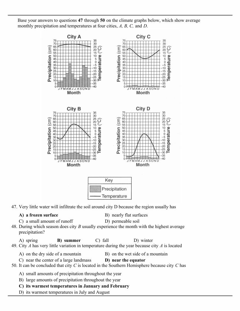
Base your answers to questions 47 through 50 on the climate graphs below, which show averagemonthly precipitation and temperatures at four cities, A, B, C, and D.
A) a frozen surface B) nearly flat surfacesC) a small amount of runoff D) permeable soil
47. Very little water will infiltrate the soil around city D because the region usually has
A) spring B) summer C) fall D) winter
48. During which season does city B usually experience the month with the highest averageprecipitation?
A) on the dry side of a mountain B) on the wet side of a mountainC) near the center of a large landmass D) near the equator
49. City A has very little variation in temperature during the year because city A is located
A) small amounts of precipitation throughout the yearB) large amounts of precipitation throughout the yearC) its warmest temperatures in January and FebruaryD) its warmest temperatures in July and August
50. It can be concluded that city C is located in the Southern Hemisphere because city C has

A) A B) B C) C D) D
51. The cross section below shows the flow ofprevailing winds over a mountain ridge.
Which location is most likely to receiveprecipitation?
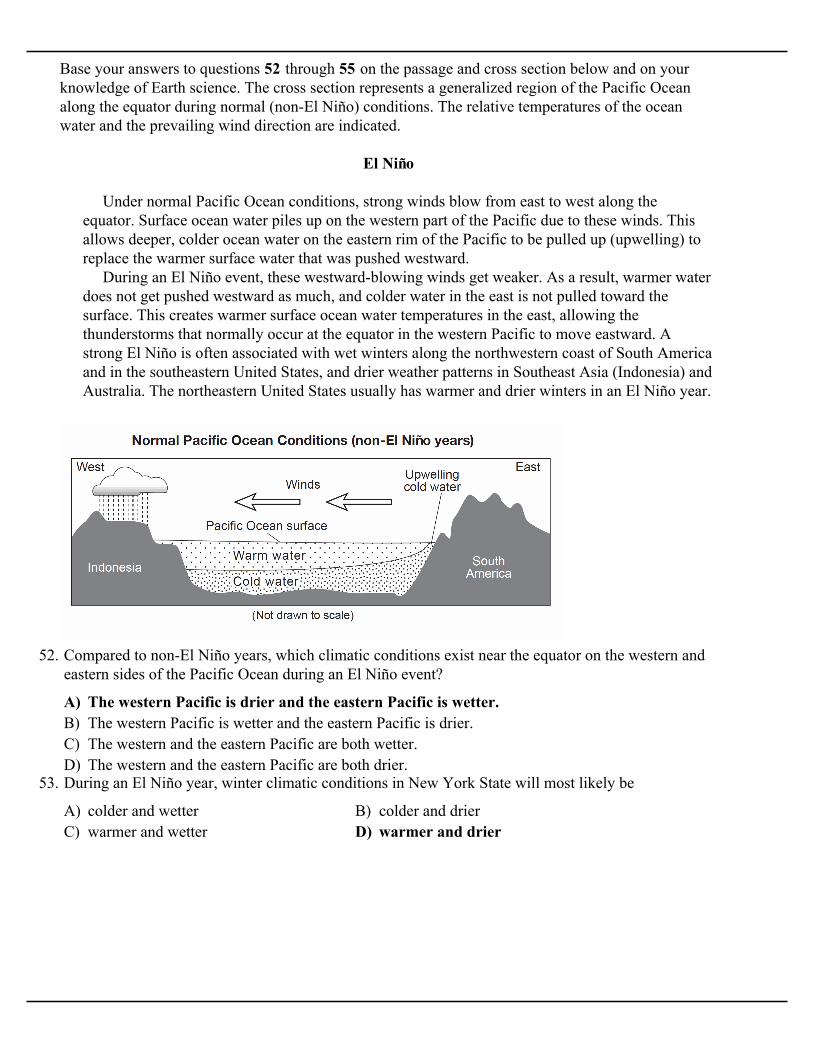
Base your answers to questions 52 through 55 on the passage and cross section below and on yourknowledge of Earth science. The cross section represents a generalized region of the Pacific Oceanalong the equator during normal (non-El Niño) conditions. The relative temperatures of the oceanwater and the prevailing wind direction are indicated.
El Niño
Under normal Pacific Ocean conditions, strong winds blow from east to west along theequator. Surface ocean water piles up on the western part of the Pacific due to these winds. Thisallows deeper, colder ocean water on the eastern rim of the Pacific to be pulled up (upwelling) toreplace the warmer surface water that was pushed westward. During an El Niño event, these westward-blowing winds get weaker. As a result, warmer waterdoes not get pushed westward as much, and colder water in the east is not pulled toward thesurface. This creates warmer surface ocean water temperatures in the east, allowing thethunderstorms that normally occur at the equator in the western Pacific to move eastward. Astrong El Niño is often associated with wet winters along the northwestern coast of South Americaand in the southeastern United States, and drier weather patterns in Southeast Asia (Indonesia) andAustralia. The northeastern United States usually has warmer and drier winters in an El Niño year.
A) The western Pacific is drier and the eastern Pacific is wetter.B) The western Pacific is wetter and the eastern Pacific is drier.C) The western and the eastern Pacific are both wetter.D) The western and the eastern Pacific are both drier.
52. Compared to non-El Niño years, which climatic conditions exist near the equator on the western andeastern sides of the Pacific Ocean during an El Niño event?
A) colder and wetter B) colder and drierC) warmer and wetter D) warmer and drier
53. During an El Niño year, winter climatic conditions in New York State will most likely be

A)
B)
C)
D)
54. Which cross section best represents the changed wind conditions and Pacific Ocean temperaturesduring an El Nino event? [Diagrams are not drawn to scale.]
A) Southwest and northwest winds diverge at the equator and blow toward the west.B) Southwest and northwest winds diverge at the equator and blow toward the east.C) Northeast and southeast winds converge at the equator and blow toward the west.D) Northeast and southeast winds converge at the equator and blow toward the east.
55. Which statement best describes the planetary wind belts that produce the winds represented in thecross section above?

Base your answers to questions 56 through 59 on the weather map below, which shows a hurricanethat was located over southern Florida. The isobars show air pressure in inches of mercury. Letters A through D represent four widely separated locations.
A) 26° N 81° W B) 26° N 89° W C) 34° N 81° W D) 34° N 89° W
56. What is the latitude and longitude at the center of the hurricane?
A) A B) B C) C D) D
57. At which location were the winds of this hurricane the strongest?
A) counterclockwise and away from the centerB) counterclockwise and toward the centerC) clockwise and away from the centerD) clockwise and toward the center
58. What was the direction of movement of surface winds associated with this hurricane?
A) B)
C) D)
59. Which map best shows the most likely track of this hurricane?
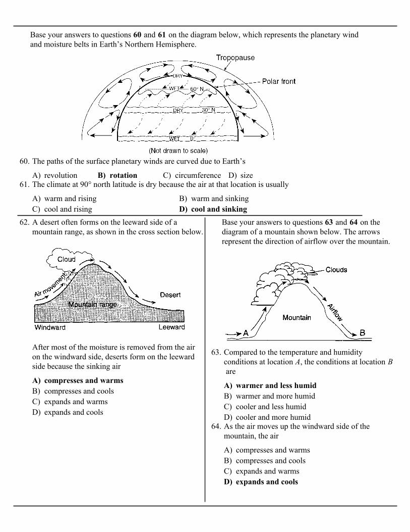
Base your answers to questions 60 and 61 on the diagram below, which represents the planetary windand moisture belts in Earth’s Northern Hemisphere.
A) revolution B) rotation C) circumference D) size
60. The paths of the surface planetary winds are curved due to Earth’s
A) warm and rising B) warm and sinkingC) cool and rising D) cool and sinking
61. The climate at 90° north latitude is dry because the air at that location is usually
A) compresses and warmsB) compresses and coolsC) expands and warmsD) expands and cools
62. A desert often forms on the leeward side of amountain range, as shown in the cross section below.
After most of the moisture is removed from the airon the windward side, deserts form on the leewardside because the sinking air
Base your answers to questions 63 and 64 on thediagram of a mountain shown below. The arrowsrepresent the direction of airflow over the mountain.
A) warmer and less humidB) warmer and more humidC) cooler and less humidD) cooler and more humid
63. Compared to the temperature and humidityconditions at location A, the conditions at location B are
A) compresses and warmsB) compresses and coolsC) expands and warmsD) expands and cools
64. As the air moves up the windward side of themountain, the air

A) nearness to a large body of waterB) elevationC) latitudeD) prevailing winds
65. The map below shows an eastern portion of NorthAmerica. Points A and B represent locations on theeastern shoreline.
Which factor is primarily responsible for location A having a lower average yearly temperature thanlocation B?
A) Alaska CurrentB) East Australia CurrentC) Peru CurrentD) North Atlantic Current
66. Which ocean current carries cool water towardEarth’s equator?
A) New York City B) BinghamtonC) Oswego D) Plattsburgh
67. Which New York State location is most likely toexperience the heaviest winter snowfall when thesurface winds are blowing from the west ornorth-west?
A) warm currents that flow northeastwardB) warm currents that flow southwestwardC) cool currents that flow northeastwardD) cool currents that flow southwestward
68. The Florida and Gulf Stream ocean currents alongthe east coast of North America are both
A) Earth's rotationB) the prevailing northeast windsC) ocean conduction currentsD) Atlantic Ocean hurricanes
69. The map below shows part of North America.
The arrows shown on the map most likely representthe direction of movement of
A) water has a higher specific heat than landhas
B) water reflects sunlight better than land doesC) land is more dense than water isD) winds blow from land areas toward the water
70. During winter, Lake Ontario is generally warmerthan adjacent land areas. The primary reason for thistemperature difference is that
A) monsoons B) volcanic eruptionsC) El Niño D) deforestation
71. Which natural event temporarily slows or reversessurface ocean currents in the equatorial region of thePacific Ocean, causing a disruption of normalweather patterns?
A) has a high densityB) contains condensation nucleiC) is risingD) is low in humidity
72. Precipitation often occurs along a frontal surfacebecause the air along a frontal surface

A) decreased air temperature and decreasedprecipitation
B) decreased air temperature and increasedprecipitation
C) increased air temperature and increasedprecipitation
D) increased air temperature and decreasedprecipitation
73. During an El Niño event, surface water temperaturesincrease along the west coast of South America.Which weather changes are likely to occur in thisregion?
A) elevation B) solar timeC) latitude D) longitude
74. The map below shows the major climate zones onEarth.
The primary factor controlling these climate zones is
A) warmer and wetter B) warmer and drierC) cooler and wetter D) cooler and drier
75. The arrows in the cross section below show theprevailing winds moving across northern New YorkState into Vermont during the summer.
Compared to the climate of location A, the climate oflocation B is
A) Tides are higher in August.B) Insolation is greater in August.C) The ocean is deeper in February.D) Ocean currents flow faster in February.
76. The graph below shows the ocean surfacetemperatures along part of the east coast of NorthAmerica in February and in August.
Which inference about this region is supported bythe data?
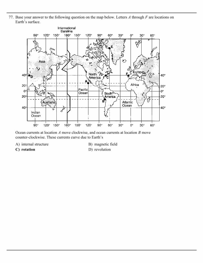
77. Base your answer to the following question on the map below. Letters A through F are locations onEarth’s surface.
A) internal structure B) magnetic fieldC) rotation D) revolution
Ocean currents at location A move clockwise, and ocean currents at location B movecounter-clockwise. These currents curve due to Earth’s
A) B)
C) D)
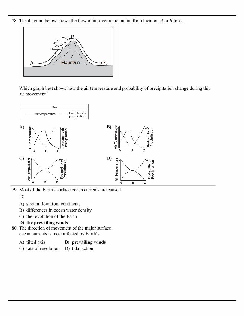
78. The diagram below shows the flow of air over a mountain, from location A to B to C.
Which graph best shows how the air temperature and probability of precipitation change during thisair movement?
A) stream flow from continentsB) differences in ocean water densityC) the revolution of the EarthD) the prevailing winds
79. Most of the Earth's surface ocean currents are causedby
A) tilted axis B) prevailing windsC) rate of revolution D) tidal action
80. The direction of movement of the major surfaceocean currents is most affected by Earth’s

A) arid, with a small difference between thehighest and lowest yearly temperatures
B) arid, with a large difference between thehighest and lowest yearly temperatures
C) humid, with a small difference between thehighest and lowest yearly temperatures
D) humid, with a large difference between thehighest and lowest yearly temperatures
81. The arrows on the map below show the prevailingwinds at a midlatitude coastal city.
This city most likely has a climate that is
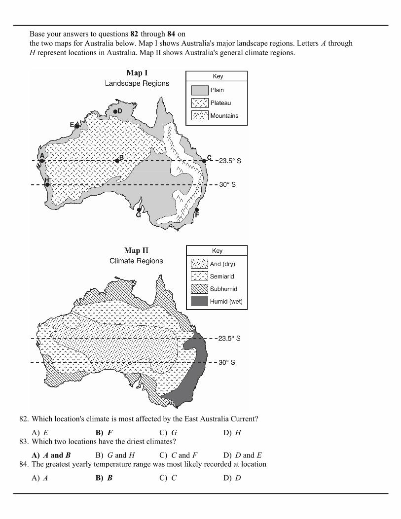
Base your answers to questions 82 through 84 on the two maps for Australia below. Map I shows Australia's major landscape regions. Letters A throughH represent locations in Australia. Map II shows Australia's general climate regions.
A) E B) F C) G D) H
82. Which location's climate is most affected by the East Australia Current?
A) A and B B) G and H C) C and F D) D and E
83. Which two locations have the driest climates?
A) A B) B C) C D) D
84. The greatest yearly temperature range was most likely recorded at location

Base your answers to questions 85 and 86 on thediagram below, which shows air movement over amountain range. The arrows indicate the direction ofairflow. Points 1 through 3 represent locations onEarth's surface.
A) expanding, and coolingB) expanding, and warmingC) compressing, and coolingD) compressing, and warming
85. Cloud formation at location 2 is the direct result ofair that is rising,
A) cooler and drierB) cooler and wetterC) warmer and drierD) warmer and wetter
86. Compared to the climate at location 1, the climate atlocation 3 is
A) on the leeward side, in a mP air massB) on the leeward side, in a cT air massC) on the windward side, in a mT air massD) on the windward side, in a cP air mass
87. The cross section below shows the flow of windsover a mountain ridge.
The heaviest rainfall would most likely occur onwhich side of this mountain and in which type of airmass?
A) southwest B) northwestC) southeast D) northeast
88. According to the Earth Science Reference Tables,the prevailing winds at 45º S latitude are from the
A) A B) B C) C D) D
89. The cross section below represents prevailing windsmoving over a coastal mountain range. Letters A through D represent locations on Earth's surface.
Which location will most likely have the leastannual precipitation?

A) cooler and drierB) cooler and wetterC) warmer and drierD) warmer and wetter
90. The diagram below shows wind flowing over amountain range.
As the wind flows down the leeward side of themountain range, the air becomes
A) stream flow from continentsB) differences in ocean water densityC) the revolution of the EarthD) the prevailing winds
91. Most of the Earth's surface ocean currents are causedby
A) A B) B C) C D) D
92. The map below shows four coastal locations labeled A, B, C, and D.
The climate of which location is warmed by anearby major ocean current?
Base your answers to questions 93 through 95 on themap below, which shows Earth's planetary windbelts.
A) cool and wet B) cool and dryC) warm and wet D) warm and dry
93. Which climatic conditions exist where the tradewinds converge?
A) Earth’s rotation on its axisB) the unequal heating of Earth’s atmosphereC) the unequal heating of Earth’s surfaceD) Earth’s gravitational pull on the Moon
94. The curving of these planetary winds is the result of
A) prevailing northwesterliesB) prevailing southwesterliesC) northeast tradesD) southeast trades
95. Which wind belt has the greatest effect on theclimate of New York State?
A) decrease B) increaseC) remain the same
96. As a sample of very moist air rises from sea level toa higher altitude, the probability of condensationoccurring in that air sample will

A) California CurrentB) North Pacific CurrentC) Florida CurrentD) Labrador Current
97. The shaded areas of the map below indicateconcentrations of pollutants along the coastlines ofNorth America.
Polluting material may have been carried to theAlaska area by the
A) the force of gravityB) the impact of precipitationC) prevailing windsD) river currents
98. Most of Earth’s surface ocean current patterns areprimarily caused by
A) California CurrentB) Florida CurrentC) Labrador CurrentD) North Pacific Current
99. What is the name of the warm ocean current thatflows along the east coast of the United States?
A) clockwise and outwardB) clockwise and inwardC) counterclockwise and outwardD) counterclockwise and inward
100. What is the usual surface wind pattern within aNorthern Hemisphere low-pressure system?

Base your answers to questions 101 and 102 on map below, which represents an imaginary continent.Locations A and B are on opposite sides of a mountain range on a planet similar to Earth. Location C is on the planet’s equator.
A) low air pressure and low precipitationB) low air pressure and high precipitationC) high air pressure and low precipitationD) high air pressure and high precipitation
101. Location C most likely experiences
A) warmer and more humid B) warmer and less humidC) cooler and more humid D) cooler and less humid
102. Compared to the climate at location A, the climate at location B would most likely be
A) cooling of rising air above the ocean surfaceB) evaporation of water from the ocean surfaceC) friction from planetary winds on the ocean
surfaceD) seismic waves on the ocean surface
103. Which interaction between the atmosphere and thehydrosphere causes most surface ocean currents?
A) changes in humidityB) changes in temperatureC) Earth's rotation on its axisD) Earth's gravitational force
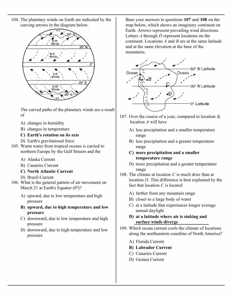
104. The planetary winds on Earth are indicated by thecurving arrows in the diagram below.
The curved paths of the planetary winds are a resultof
A) Alaska CurrentB) Canaries CurrentC) North Atlantic CurrentD) Brazil Current
105. Warm water from tropical oceans is carried tonorthern Europe by the Gulf Stream and the
A) upward, due to low temperature and highpressure
B) upward, due to high temperature and lowpressure
C) downward, due to low temperature and highpressure
D) downward, due to high temperature and lowpressure
106. What is the general pattern of air movement onMarch 21 at Earth's Equator (0º)?
Base your answers to questions 107 and 108 on themap below, which shows an imaginary continent onEarth. Arrows represent prevailing wind directions.Letters A through D represent locations on thecontinent. Locations A and B are at the same latitudeand at the same elevation at the base of themountains.
A) less precipitation and a smaller temperaturerange
B) less precipitation and a greater temperaturerange
C) more precipitation and a smallertemperature range
D) more precipitation and a greater temperaturerange
107. Over the course of a year, compared to location B, location A will have
A) farther from any mountain rangeB) closer to a large body of waterC) at a latitude that experiences longer average
annual daylightD) at a latitude where air is sinking and
surface winds diverge
108. The climate at location C is much drier than atlocation D. This difference is best explained by thefact that location C is located
A) Florida CurrentB) Labrador CurrentC) Canaries CurrentD) Guinea Current
109. Which ocean current cools the climate of locationsalong the northeastern coastline of North America?
A) high latitudeB) high elevationC) nearness to a cold ocean currentD) nearness to a high-pressure weather center
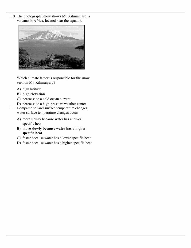
110. The photograph below shows Mt. Kilimanjaro, avolcano in Africa, located near the equator.
Which climate factor is responsible for the snowseen on Mt. Kilimanjaro?
A) more slowly because water has a lowerspecific heat
B) more slowly because water has a higherspecific heat
C) faster because water has a lower specific heatD) faster because water has a higher specific heat
111. Compared to land surface temperature changes,water surface temperature changes occur
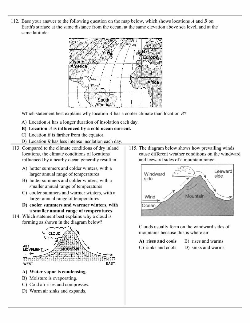
112. Base your answer to the following question on the map below, which shows locations A and B onEarth's surface at the same distance from the ocean, at the same elevation above sea level, and at thesame latitude.
A) Location A has a longer duration of insolation each day.B) Location A is influenced by a cold ocean current.C) Location B is farther from the equator.D) Location B has less intense insolation each day.
Which statement best explains why location A has a cooler climate than location B?
A) hotter summers and colder winters, with alarger annual range of temperatures
B) hotter summers and colder winters, with asmaller annual range of temperatures
C) cooler summers and warmer winters, with alarger annual range of temperatures
D) cooler summers and warmer winters, witha smaller annual range of temperatures
113. Compared to the climate conditions of dry inlandlocations, the climate conditions of locationsinfluenced by a nearby ocean generally result in
A) Water vapor is condensing.B) Moisture is evaporating.C) Cold air rises and compresses.D) Warm air sinks and expands.
114. Which statement best explains why a cloud isforming as shown in the diagram below?
A) rises and cools B) rises and warmsC) sinks and cools D) sinks and warms
115. The diagram below shows how prevailing windscause different weather conditions on the windwardand leeward sides of a mountain range.
Clouds usually form on the windward sides ofmountains because this is where air
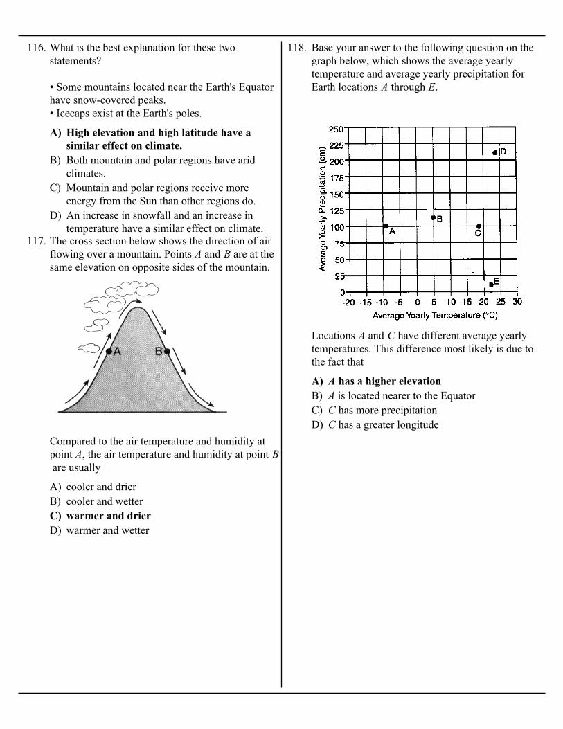
A) High elevation and high latitude have asimilar effect on climate.
B) Both mountain and polar regions have aridclimates.
C) Mountain and polar regions receive moreenergy from the Sun than other regions do.
D) An increase in snowfall and an increase intemperature have a similar effect on climate.
116. What is the best explanation for these twostatements?
• Some mountains located near the Earth's Equatorhave snow-covered peaks.• Icecaps exist at the Earth's poles.
A) cooler and drierB) cooler and wetterC) warmer and drierD) warmer and wetter
117. The cross section below shows the direction of airflowing over a mountain. Points A and B are at thesame elevation on opposite sides of the mountain.
Compared to the air temperature and humidity atpoint A, the air temperature and humidity at point B are usually
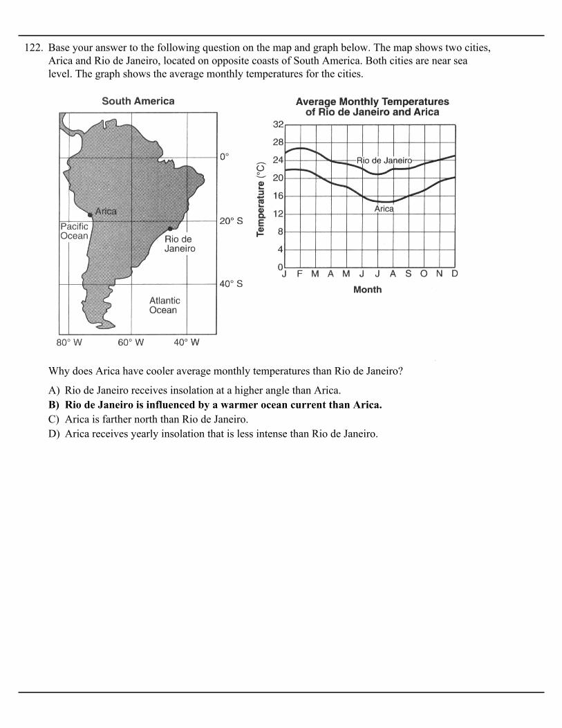
118. Base your answer to the following question on thegraph below, which shows the average yearlytemperature and average yearly precipitation forEarth locations A through E.
A) A has a higher elevationB) A is located nearer to the EquatorC) C has more precipitationD) C has a greater longitude
Locations A and C have different average yearlytemperatures. This difference most likely is due tothe fact that

A) warmer temperatures farther north and causesstorms to move more slowly
B) warmer temperatures farther north and causesstorms to move more rapidly
C) cooler temperatures farther south and causesstorms to move more slowly
D) cooler temperatures farther south andcauses storms to move more rapidly
119. The map below shows a typical position andaverage velocity of the polar front jet stream duringtwo different seasons.
For the eastern United States, the change of thepolar front jet stream from this summer position tothis winter position causes
A) expansion of rising airB) compression of rising airC) precipitation from cloudsD) evaporation from clouds
120. The diagram below shows the flow of planetarywinds over a mountain ridge.
As air rises on the windward side of the mountainridge, the air's temperature decreases. Whichprocess usually causes this temperature decrease?
A) lithosphere to atmosphereB) hydrosphere to lithosphereC) atmosphere to hydrosphereD) stratosphere to troposphere
121. Surface ocean currents resulting from theprevailing winds over the oceans illustrate atransfer of energy from
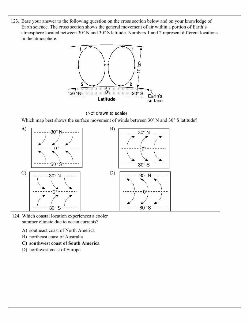
122. Base your answer to the following question on the map and graph below. The map shows two cities,Arica and Rio de Janeiro, located on opposite coasts of South America. Both cities are near sealevel. The graph shows the average monthly temperatures for the cities.
A) Rio de Janeiro receives insolation at a higher angle than Arica.B) Rio de Janeiro is influenced by a warmer ocean current than Arica.C) Arica is farther north than Rio de Janeiro.D) Arica receives yearly insolation that is less intense than Rio de Janeiro.
Why does Arica have cooler average monthly temperatures than Rio de Janeiro?
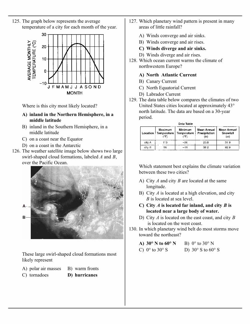
123. Base your answer to the following question on the cross section below and on your knowledge ofEarth science. The cross section shows the general movement of air within a portion of Earth’satmosphere located between 30° N and 30° S latitude. Numbers 1 and 2 represent different locationsin the atmosphere.
A) B)
C) D)
Which map best shows the surface movement of winds between 30º N and 30° S latitude?
A) southeast coast of North AmericaB) northeast coast of AustraliaC) southwest coast of South AmericaD) northwest coast of Europe
124. Which coastal location experiences a coolersummer climate due to ocean currents?
A) inland in the Northern Hemisphere, in amiddle latitude
B) inland in the Southern Hemisphere, in amiddle latitude
C) on a coast near the EquatorD) on a coast in the Antarctic
125. The graph below represents the averagetemperature of a city for each month of the year.
Where is this city most likely located?
A) polar air masses B) warm frontsC) tornadoes D) hurricanes
126. The weather satellite image below shows two largeswirl-shaped cloud formations, labeled A and B,over the Pacific Ocean.
These large swirl-shaped cloud formations mostlikely represent
A) Winds converge and air sinks.B) Winds converge and air rises.C) Winds diverge and air sinks.D) Winds diverge and air rises.
127. Which planetary wind pattern is present in manyareas of little rainfall?
A) North Atlantic CurrentB) Canary CurrentC) North Equatorial CurrentD) Labrador Current
128. Which ocean current warms the climate ofnorthwestern Europe?
A) City A and city B are located at the samelongitude.
B) City A is located at a high elevation, and city B is located at sea level.
C) City A is located far inland, and city B islocated near a large body of water.
D) City A is located on the east coast, and city B is located on the west coast.
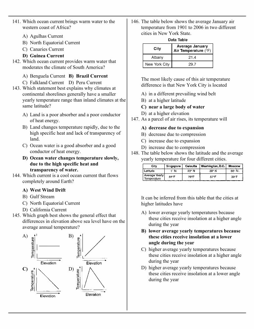
129. The data table below compares the climates of twoUnited States cities located at approximately 43°north latitude. The data are based on a 30-yearperiod.
Which statement best explains the climate variationbetween these two cities?
A) 30° N to 60° N B) 0° to 30° NC) 0° to 30° S D) 30° S to 60° S
130. In which planetary wind belt do most storms movetoward the northeast?

A) warm waters of the Atlantic Ocean insummer
B) warm land of the southeastern United States insummer
C) cool waters of the Atlantic Ocean in springD) cool land of the southeastern United States in
spring
131. Most of the hurricanes that affect the east coast ofthe United States originally form over the
A) clockwise surface winds moving toward thecolumns
B) clockwise surface winds moving away fromthe columns
C) counterclockwise surface winds movingtoward the columns
D) counterclockwise surface winds moving awayfrom the columns
132. Most tornadoes in the Northern Hemisphere arebest described as violently rotating columns of airsurrounded by
A) ocean currentsB) mountain barriersC) elevation above sea levelD) latitude
133. The map below shows average annual temperaturesin degrees Fahrenheit across the United States.
Which climatic factor is most important indetermining the pattern shown in the eastern half ofthe United States?
A) Windspeeds are greater over land than overoceans.
B) Air masses originate only over land.C) Land has a lower specific heat than water.D) Water changes temperature more rapidly than
land.
134. A city located near the center of a large continenthas colder winters and warmer summers than a cityat the same elevation and latitude located on thecontinent's coast. Which statement best explainsthe difference between the cities climates?
A) gains heat during evaporationB) is at a lower elevationC) has a higher specific heatD) reflects more radiation
135. During some winters in the Finger Lakes region ofNew York State, the lake water remains unfrozeneven though the land around the lakes is frozen andcovered with snow. The primary cause of thisdifference is that water

A) A B) B C) C D) D
136. The map below shows the general path of oceancurrents in a portion of the Northern Hemisphere.Locations A, B, C, and D are at the shoreline.
Which location most likely has the warmestclimate?
A) A B) B C) C D) D
137. The map below shows the location of four cities, A,B, C, and D, in the western United States whereprevailing winds are from the southwest.
Which city most likely receives the least amount ofaverage yearly precipitation?
A) 8 days B) 18 daysC) 24 days D) 32 days
138. The graph below shows the average number ofdays each year that thunderstorms occur at differentlatitudes on Earth.
According to the graph, what is the approximatenumber of days each year that thunderstorms occurat locations along the 40°N parallel of latitude?
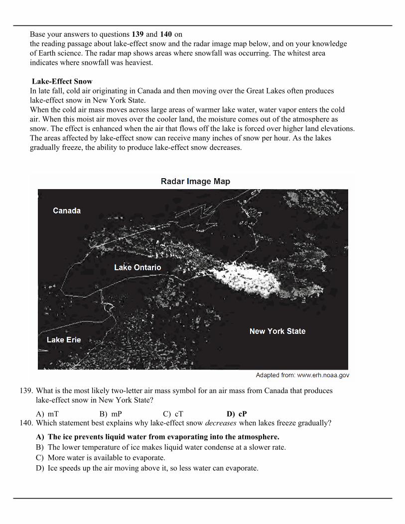
Base your answers to questions 139 and 140 on the reading passage about lake-effect snow and the radar image map below, and on your knowledgeof Earth science. The radar map shows areas where snowfall was occurring. The whitest areaindicates where snowfall was heaviest.
Lake-Effect SnowIn late fall, cold air originating in Canada and then moving over the Great Lakes often produceslake-effect snow in New York State.When the cold air mass moves across large areas of warmer lake water, water vapor enters the coldair. When this moist air moves over the cooler land, the moisture comes out of the atmosphere assnow. The effect is enhanced when the air that flows off the lake is forced over higher land elevations.The areas affected by lake-effect snow can receive many inches of snow per hour. As the lakesgradually freeze, the ability to produce lake-effect snow decreases.
A) mT B) mP C) cT D) cP
139. What is the most likely two-letter air mass symbol for an air mass from Canada that produceslake-effect snow in New York State?
A) The ice prevents liquid water from evaporating into the atmosphere.B) The lower temperature of ice makes liquid water condense at a slower rate.C) More water is available to evaporate.D) Ice speeds up the air moving above it, so less water can evaporate.
140. Which statement best explains why lake-effect snow decreases when lakes freeze gradually?
A) Agulhas CurrentB) North Equatorial CurrentC) Canaries CurrentD) Guinea Current
141. Which ocean current brings warm water to thewestern coast of Africa?
A) Benguela Current B) Brazil CurrentC) Falkland Current D) Peru Current
142. Which ocean current provides warm water thatmoderates the climate of South America?
A) Land is a poor absorber and a poor conductorof heat energy.
B) Land changes temperature rapidly, due to thehigh specific heat and lack of transparency ofland.
C) Ocean water is a good absorber and a goodconductor of heat energy.
D) Ocean water changes temperature slowly,due to the high specific heat andtransparency of water.
143. Which statement best explains why climates atcontinental shorelines generally have a smalleryearly temperature range than inland climates at thesame latitude?
A) West Wind DriftB) Gulf StreamC) North Equatorial CurrentD) California Current
144. Which current is a cool ocean current that flowscompletely around Earth?
A) B)
C) D)
145. Which graph best shows the general effect thatdifferences in elevation above sea level have on theaverage annual temperature?
A) in a different prevailing wind beltB) at a higher latitudeC) near a large body of waterD) at a higher elevation
146. The table below shows the average January airtemperature from 1901 to 2006 in two differentcities in New York State.
The most likely cause of this air temperaturedifference is that New York City is located
A) decrease due to expansionB) decrease due to compressionC) increase due to expansionD) increase due to compression
147. As a parcel of air rises, its temperature will
A) lower average yearly temperatures becausethese cities receive insolation at a higher angleduring the year
B) lower average yearly temperatures becausethese cities receive insolation at a lowerangle during the year
C) higher average yearly temperatures becausethese cities receive insolation at a higher angleduring the year
D) higher average yearly temperatures becausethese cities receive insolation at a lower angleduring the year
148. The table below shows the latitude and the averageyearly temperature for four different cities.
It can be inferred from this table that the cities athigher latitudes have

A) is located closer to the Atlantic OceanB) is located closer to the equatorC) has a greater average yearly duration of insolationD) has a greater average yearly intensity of insolation
149. The map below shows the locations of Virginia Beach, Virginia, and Springfield, Missouri.
Virginia Beach experiences cooler summers and warmer winters than Springfield because VirginiaBeach
A) warmer summers and cooler wintersB) warmer summers and warmer wintersC) cooler summers and cooler wintersD) cooler summers and warmer winters
150. Compared to a coastal location of the sameelevation and latitude, an inland location is likely tohave
A) A B) B C) C D) D
151. The cross section below represents four locationson a mountain. The arrow indicates the prevailingwind direction.
Which location has the warmest and most aridclimate?

A) Brazil CurrentB) Peru CurrentC) South Equatorial CurrentD) North Pacific Current
152. What is the name of the cool ocean current thatflows along, the west coast of South America?
A) They are at different longitudes.B) They are near different ocean currents.C) They have different angles of insolation.D) They have different numbers of daylight
hours.
153. Two coastal cities have the same latitude andelevation, but are located near different oceans.Which statement best explains why the two citieshave different climates?
A) These locations are on the leeward side ofmountain ranges.
B) These locations are on the windward side ofmountain ranges.
C) These locations receive more insolation thanthe other locations.
D) These locations receive less insolation thanthe other locations.
154. The diagram below shows the average yearlyprecipitation, in centimeters, at locations A through E across the State of Washington. Arrows indicatethe direction of prevailing winds.
Which statement best explains why location B andlocation E receive relatively low average yearlyprecipitation?
A) Labrador Current B) Falkland CurrentC) Gulf Stream D) West Wind Drift
155. Which surface ocean current transports warm waterto higher latitudes?
A) tidesB) precipitationC) atmospheric windsD) revolution of Earth
156. The northeastward flow of the Gulf Stream oceancurrent is caused primarily by
A) Benguela Current B) Brazil CurrentC) Falkland Current D) Peru Current
157. Which ocean current provides warm water thatmoderates the climate of South America?
A) warmer surface ocean waters along thenortheast coast of South America
B) warmer surface ocean waters along thenorthwest coast of South America
C) cooler surface ocean waters along thenortheast coast of South America
D) cooler surface ocean waters along thenorthwest coast of South America
158. During an El Nino event, the South EquatorialCurrent reverses direction and flows over the top ofnorthern portions of the Peru Current, causing

159. Base your answer to the following question on the map below, which shows the position of the jetstream relative to two air masses and a low-pressure center (L) over the United States.
A) counterclockwise and outward B) counterclockwise and inwardC) clockwise and outward D) clockwise and inward
What is the general movement of the surface winds around the center of this low-pressure area?

Base your answers to questions 160 and 161 on thegraph below, which shows the average monthlytemperature of two cities A and B.
A) is closer to the EquatorB) is farther from a large body of waterC) has more rainfallD) has stronger prevailing winds
160. Both cities have an average yearly temperature of11ºC, but city A has a much greater temperaturerange than city B has because city A most likely
A) on the side of a mountainB) on an islandC) in the Southern HemisphereD) at the North Pole
161. The temperature in city B is highest in January andlowest in July because city B is located
A) Location A is warmer and drier than location B.
B) Location A is cooler and wetter thanlocation B.
C) Location B is warmer and wetter than locationA.
D) Location B is cooler and drier than location A.
162. The arrows on the cross section below show theprevailing wind that flows over a mountain. Points A and B represent locations on opposite sides of themountain.
Which statement correctly describes the differencesin the climates of locations A and B?
A) B)
C) D)
163. The diagram below shows the flow of air over amountain from point A to point C. Which graphbest shows the approximate temperature change ofthe rising and descending air due to the adiabaticprocess?
A) water gains heat more rapidly than land doesB) water surfaces are flatter than land surfacesC) water temperatures are always lower than land
temperaturesD) water temperatures change more slowly
than land temperatures do
164. Bodies of water have a moderating effect onclimate primarily because
A) from 45º N latitude to 20º N latitudeB) from sea level to 5 km above sea levelC) from sea level on the windward side of a
mountain to sea level on the leeward sideD) from the ocean coast to an inland location
165. During the summer months, which change inlocation would most likely cause a decrease in theobserved daytime air temperatures?
A) warmer summers and cooler wintersB) warmer summers and warmer wintersC) cooler summers and cooler wintersD) cooler summers and warmer winters
166. Compared to an inland location of the sameelevation and latitude, a coastal location is likely tohave
A) New York City B) UticaC) Plattsburgh D) Watertown
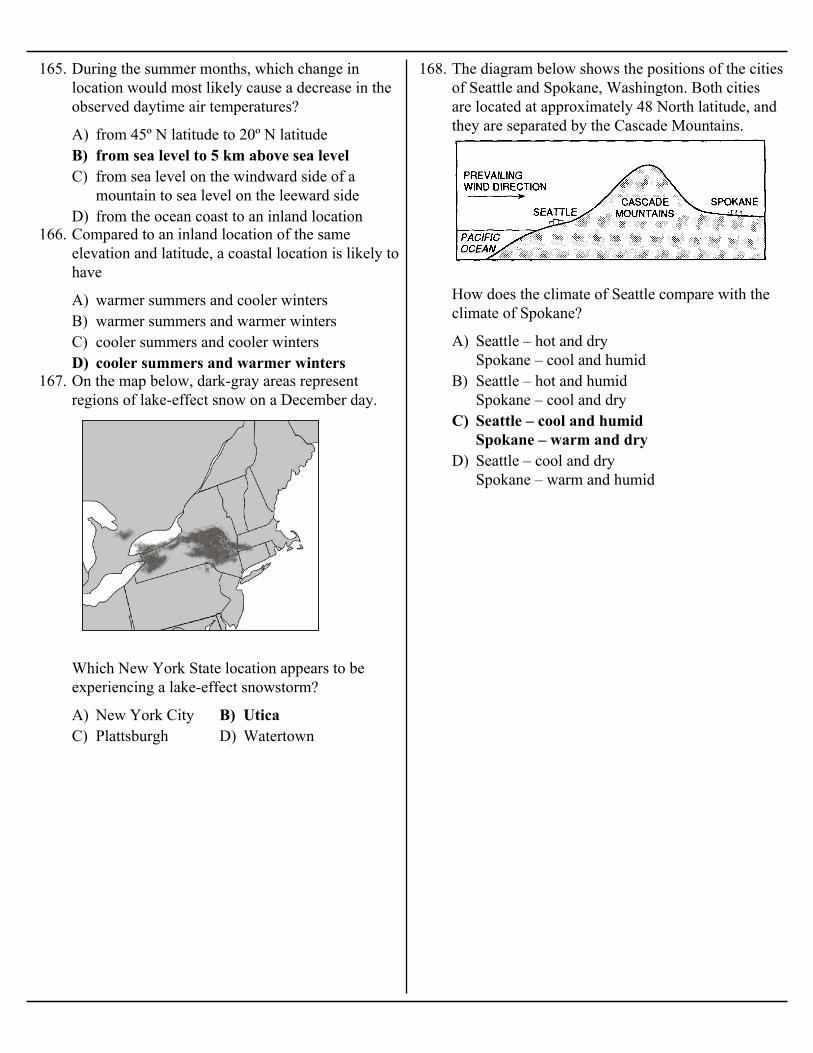
167. On the map below, dark-gray areas representregions of lake-effect snow on a December day.
Which New York State location appears to beexperiencing a lake-effect snowstorm?
A) Seattle – hot and drySpokane – cool and humid
B) Seattle – hot and humidSpokane – cool and dry
C) Seattle – cool and humidSpokane – warm and dry
D) Seattle – cool and drySpokane – warm and humid
168. The diagram below shows the positions of the citiesof Seattle and Spokane, Washington. Both citiesare located at approximately 48 North latitude, andthey are separated by the Cascade Mountains.
How does the climate of Seattle compare with theclimate of Spokane?

A) City B is located in a different planetary windbelt.
B) City B receives less yearly precipitationC) City B has a greater yearly duration of
insolation.D) City B is located near a large body of
water.
169. The graph below shows the average monthlytemperatures for two cities, A and B, which areboth located at 41° north latitude.
Which statement best explains the difference in theaverage yearly temperature range for the two cities?
A) rising and moist B) rising and dryC) sinking and moist D) sinking and dry
170. Snowfall is rare at the South Pole because the airover the South Pole is usually
A) South Equatorial Gulf Stream Labrador Benguela
B) South Equatorial Australia West WindDrift Peru
C) North Equatorial Koroshio NorthPacific California
D) North Equatorial Gulf Stream NorthAtlantic Canaries
171. The arrows labeled A through D on the map belowshow the general paths of abandoned boats thathave floated across the Atlantic Ocean.
Which sequence of ocean currents was responsiblefor the movement of these boats?
A) drier and warmerB) drier and coolerC) more humid and warmerD) more humid and cooler
172. The diagram below shows air movement over amountain.
Compared to the climate on the windward side ofthe mountain, the climate on the leeward side of themountain is

A) North America B) South AmericaC) Europe D) Africa
173. The hurricane shown on the map below isfollowing a normal storm track for the month ofSeptember.
From the position shown on the map, toward whichlandmass is the hurricane most likely traveling?
A) Ocean surfaces change temperature moreslowly than land surfaces.
B) Warm, moist air rises when it meets cool, dryair.
C) Wind speeds are usually greater over land thanover ocean water.
D) Water has a lower specific heat than land.
174. A city located on the coast of North America haswarmer winters and cooler summers than a city atthe same elevation and latitude located near thecenter of North America. Which statement bestexplains the difference between the climates of thetwo cities?
A) Florida CurrentB) California CurrentC) Canaries CurrentD) Alaska Current
175. Which ocean current cools the climate of somelocations along the western coastline of NorthAmerica?
A) the distance from the EquatorB) the extent of vegetative coverC) the degrees of longitudeD) the month of the year
176. Which single factor generally has the greatest effecton the climate of an area on the Earth's surface?
A) southwest toward the northeastB) northwest toward the southeastC) northeast toward the southwestD) southeast toward the northwest
177. The prevailing southwesterlies wind belt causesmost low-pressure weather systems to travel acrossthe United States from the
A) cooler winters and cooler summersB) cooler winters and warmer summersC) warmer winters and cooler summersD) warmer winters and warmer summers
178. Compared to an inland location, a location on anocean shore at the same elevation and latitude islikely to have
A) Gulf Stream B) CanariesC) Labrador D) North Atlantic
179. Which cold ocean current affects the climate of thenortheastern coast of North America?
A) Earth’s rotation and unequal heating ofEarth’s surface
B) Earth’s revolution and unequal heating ofEarth’s surface
C) Earth’s rotation and Sun’s gravitationalattraction on Earth’s atmosphere
D) Earth’s revolution and Sun’s gravitationalattraction on Earth’s atmosphere
180. The planetary wind belts in the troposphere areprimarily caused by the
A) density differences at various ocean depthsB) varying salt content in the oceanC) prevailing windsD) seismic activity
181. What controls the direction of movement of mostsurface ocean currents?
A)
B)
C)
D)
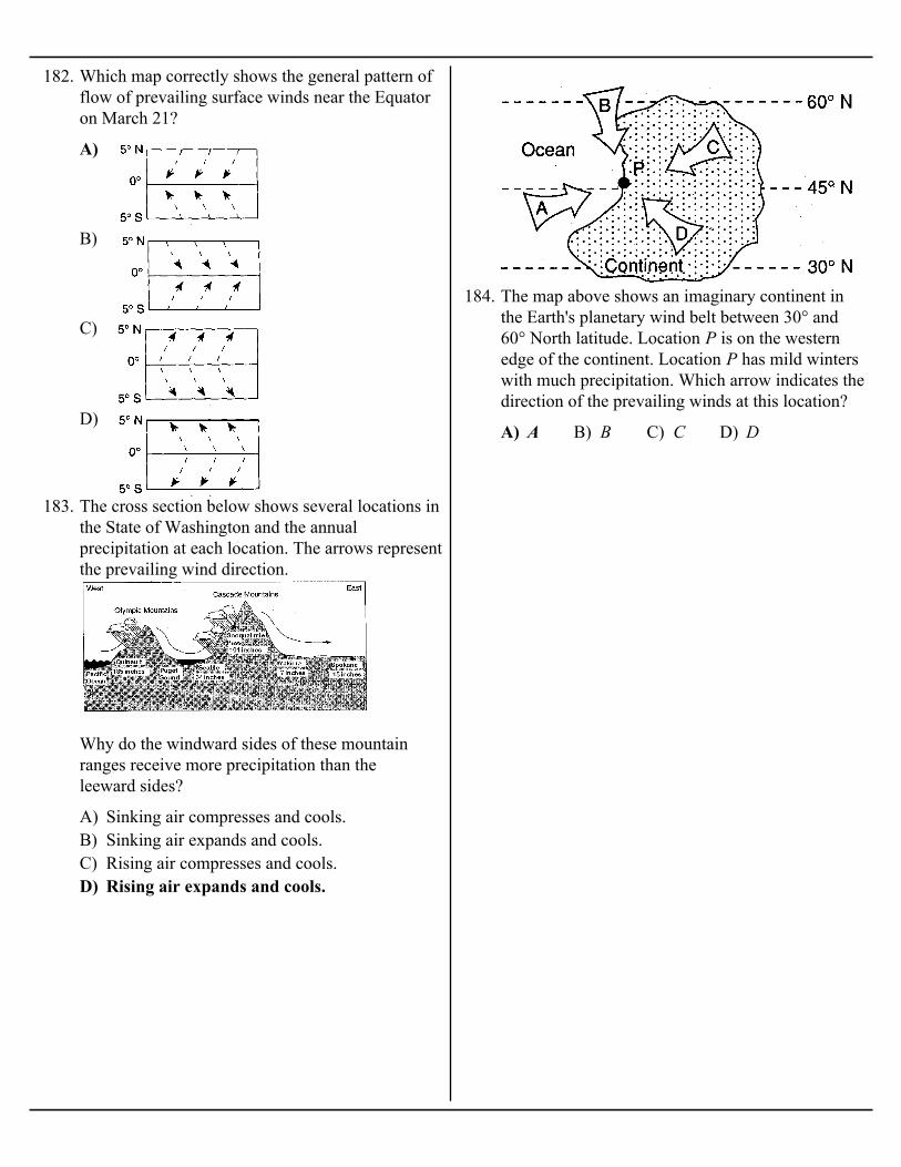
182. Which map correctly shows the general pattern offlow of prevailing surface winds near the Equatoron March 21?
A) Sinking air compresses and cools.B) Sinking air expands and cools.C) Rising air compresses and cools.D) Rising air expands and cools.
183. The cross section below shows several locations inthe State of Washington and the annualprecipitation at each location. The arrows representthe prevailing wind direction.
Why do the windward sides of these mountainranges receive more precipitation than theleeward sides?
A) A B) B C) C D) D
184. The map above shows an imaginary continent inthe Earth's planetary wind belt between 30° and60° North latitude. Location P is on the westernedge of the continent. Location P has mild winterswith much precipitation. Which arrow indicates thedirection of the prevailing winds at this location?

A) warmer and drier B) warmer and more moistC) cooler and drier D) cooler and more moist
185. The cross section below represents a prevailing wind flow that causes different climates on thewindward and leeward sides of a mountain range.
Compared to the temperature and moisture of the air rising on the windward side, the temperatureand moisture of the air descending at the same altitude on the leeward side will be
A) Gulf Stream B) North EquatorialC) California D) Labrador
186. Which ocean current flows northeast along theeastern coast of North America?
A) rotation of EarthB) duration of insolationC) distance from a large body of waterD) direction of prevailing winds
187. Which factor most likely causes two cities at thesame elevation and latitude to have different yearlyaverage temperature ranges?
A) warm water that flows southwestwardB) warm water that flows northeastwardC) cool water that flows southwestwardD) cool water that flows northeastward
188. Most of the Gulf Stream Ocean Current is
A) May B) JulyC) November D) January
189. EI Cuy is a South American city located at 40°south latitude. The first day of winter at thislocation occurs on June 21. During which monthwould the coldest day of the year most likely occurat this location?

A) B)
C) D)
190. Which diagram best illustrates how air rising over a mountain produces precipitation?
A) latitudeB) distance from a large body of waterC) direction of the planetary windsD) location of mountain barriers
191. The diagram below represents an imaginarycontinent and a nearby island.
Which climatic variable causes location A to havecooler winters and warmer summers than location B?
Related Documents